this document may be cited as: ministry for the
TRANSCRIPT


This document may be cited as: Ministry for the Environment. November 2019. National Planning Standards. Wellington: Ministry for the Environment.
Published in November 2019 by the Ministry for the Environment Manatū Mō Te Taiao PO Box 10362, Wellington 6143, New Zealand
ISBN: 978-1-98-857967-2 (online)
Publication number: ME 1482
© Crown copyright New Zealand 2019
This document is available on the Ministry for the Environment website: www.mfe.govt.nz.

Contents 1. Foundation Standard 5
2. Regional Policy Statement Structure Standard 8
3. Regional Plan Structure Standard 11
4. District Plan Structure Standard 14
5. Combined Plan Structure Standard 18
6. Introduction and General Provisions Standard 27
7. District-wide Matters Standard 32
8. Zone Framework Standard 36
9. Designations Standard 39
10. Format Standard 41
11. Regional Spatial Layers Standard 49
12. District Spatial Layers Standard 50
13. Mapping Standard 51
14. Definitions Standard 53
15. Noise and Vibration Metrics Standard 66
16. Electronic Accessibility and Functionality Standard 67
17. Implementation Standard 69

4
Tables Table 1: National Planning Standards relevant to each type of policy statement or plan 6
Table 2: Regional policy statement structure 9
Table 3: Regional plan structure 12
Table 4: District plan structure 15
Table 5: Plan structure for combined regional policy statement, regional plan and district plan 20
Table 6: Plan structure for a combined regional policy statement and regional plan 24
Table 7: Abbreviations 28
Table 8: Glossary 28
Table 9: National policy statements and New Zealand Coastal Policy Statement 28
Table 10: National environmental standards 29
Table 11: Regulations 29
Table 12: Water conservation orders 30
Table 13: Zone names and descriptions 36
Table 14: Designations 39
Table 15: Requiring authority unique identifiers 40
Table 16: Unique identifier table for chapters, sections and zone framework 46
Table 17: Spatial layers for regional policy statements, regional plans and regional components of combined plans table 49
Table 18: Spatial layers for district plans and district plan components of combined plans table 50
Table 19: Zone colour palette 51
Table 20: Symbol representation 52

Foundation Standard 5
1. Foundation Standard Purpose
The purpose of the first set of national planning standards (the planning standards) is to improve the efficiency and effectiveness of the planning system by providing nationally consistent:
• structure
• format
• definitions
• noise and vibration metrics
• electronic functionality and accessibility
for regional policy statements, regional plans, district plans and combined plans under the Resource Management Act 1991 (“RMA”).
The planning standards do not alter the effect or outcomes of policy statements or plans.
Interpretation of terms in the planning standards
1. ‘Policy statement or plan’ includes: a regional policy statement, a proposed regional policy statement, a proposed plan, a plan, a variation or a change.
2. ‘Combined plan’ means a plan that meets the RMA requirements of two or more of the following: a regional policy statement, a regional plan (including a regional coastal plan) or a district plan.
3. ‘ePlan’ means an online interactive policy statement or plan.
4. ‘Provisions’ means all content in a policy statement or plan, including but not limited to background content, issues, objectives, policies, methods, rules, and anticipated environmental results.
5. ‘Part [#]’ is a title only, which groups together one or more chapters, appendices or maps. It is shown in the planning standards as all-caps white text on navy blue background. Parts have no provisions separate from their underlying chapters, appendices or maps.
6. ‘Heading’ is a title only, which groups together one or more chapters under a common theme for the plan users’ ease of reference. It is shown in the planning standards as all-caps blue text. Headings have no provisions separate from their underlying chapters.
7. ‘Chapter’ is the main grouping of provisions in a policy statement or plan. It is shown in the planning standards as text to the right of a ‘Chapters:’ identifier.
8. ‘Section’ is a sub-grouping of provisions within a chapter. It is shown in the planning standards as text below or to the right of a ‘Sections:’ identifier.
9. ‘[square brackets]’ means the local authority must enter its own applicable title or content. ‘(Round brackets)’ have their standard grammatical meaning.
Mandatory directions
1. Every policy statement or plan must comply with the 1. Foundation Standard.
2. Except for the mandatory directions in 16.A Electronic accessibility and functionality, if a proposed policy statement or proposed plan complies with all the relevant planning standards, the operative policy statement or operative plan that will be replaced by the proposed policy statement or proposed plan does not have to comply with the planning standards.

6 Foundation Standard
3. The planning standards must be used in conjunction with each other where relevant. Table 1 sets out which planning standards are relevant to each type of policy statement or plan.
4. An appropriate term must be used wherever tangata whenua/mana whenua is shown in the planning standards. The appropriate term must be determined through engagement with affected groups, and may vary depending on the context. If agreement on an appropriate term cannot be reached through engagement, local authorities must use the term ‘tangata whenua’.
5. Tangata whenua/mana whenua content must be integrated throughout the policy statement or plan where the local authority determines it appropriate.
6. The local authority seal and date the policy statement or plan was made operative must be included, below the title of the policy statement or plan in accordance with RMA Schedule 1 clause 17(3).
7. Unless otherwise directed in these planning standards, local authorities may use cross-references and links within the policy statement or plan. Any references or links to external material not incorporated by reference under RMA Schedule 1 Part 3 must be identified as not having legal effect beyond the scope provided for in the policy statement or plan.
Table 1: National Planning Standards relevant to each type of policy statement or plan
Structure standards Chapter standards Form standards Other standards
Regional policy statements
2. Regional policy statement structure
6. Introduction and general provisions
10. Format
11. Regional spatial layers
13. Mapping
16. Electronic accessibility and functionality
14. Definitions
17. Implementation
Regional plans 3. Regional plan structure
6. Introduction and general provisions
10. Format
11. Regional spatial layers
13. Mapping
16. Electronic accessibility and functionality
14. Definitions
15. Noise and vibration metrics
17. Implementation
District plans 4. District plan structure
6. Introduction and general provisions
7. District-wide matters
8. Zone framework
9. Designations
10. Format
12. District spatial layers
13. Mapping
16. Electronic accessibility and functionality
14. Definitions
15. Noise and vibration metrics
17. Implementation
Combined regional policy statement, regional plan and district plan
5. Combined plan structure
6. Introduction and general provisions
7. District-wide matters: excluding the Strategic direction and Coastal environment directions, and replacing General district-wide matters heading with General matters heading
8. Zone framework
9. Designations
10. Format
11. Regional spatial layers
12. District spatial layers
13. Mapping
16. Electronic accessibility and functionality
14. Definitions
15. Noise and vibration metrics
17. Implementation

Foundation Standard 7
Structure standards Chapter standards Form standards Other standards
Combined regional policy statement and regional plan
5. Combined plan structure
6. Introduction and general provisions
10. Format
11. Regional spatial layers
13. Mapping
16. Electronic accessibility and functionality
14. Definitions
15. Noise and vibration metrics
17. Implementation
Combined plan –all others
5. Combined plan structure
6. Introduction and general provisions
7. District-wide matters
8. Zone framework
9. Designations
10. Format
11. Regional spatial layers
12. District spatial layers
13. Mapping
16. Electronic accessibility and functionality
14. Definitions
15. Noise and vibration metrics
17. Implementation

8 Regional Policy Statement Structure Standard
2. Regional Policy Statement Structure Standard
Mandatory directions
Directions for all parts
1. All parts and their titles in table 2 must be included, in the order shown. Additional parts must not be included.
2. Chapters and sections that are black in table 2 must be included, in the order shown.
3. Unless otherwise specified, chapters and sections that are grey in table 2 must be included if relevant to the regional policy statement, in the order shown.
4. If a chapter in table 2 is included, its associated heading must also be included.
5. Local authorities must add sections and subsections within chapters where appropriate to organise related provisions.
Directions for Parts 2 and 3 6. The Coastal environment chapter must set out the approach to managing the coastal environment and
giving effect to the New Zealand Coastal Policy Statement.
7. Any specific provisions relating to the coastal environment which are located in other topic chapters must be cross-referenced in the Coastal environment chapter.
8. Excluding the provisions in Part 2, provisions that apply to the coastal marine area must be located in the Coastal marine area section.
9. Provisions (excluding the provisions in Part 2) that:
a. apply predominantly to only one topic must be located in the relevant chapter under the Topics heading
b. apply to more than one topic must be located in the relevant chapters under the Domains heading.
10. Any other matter addressed by the regional policy statement not covered by the structure in table 2 must be included as a new chapter, inserted alphabetically under the Topics heading in Part 3. Additional chapters must not be synonyms or subsets of the chapters in table 2.
11. If overlays are used, their provisions must be located in the relevant Domain and Topic chapters and sections.
Directions for Part 5
12. Part 5 must be titled Appendices and Maps, or Appendices, or Maps depending on whether it contains appendices (including schedules and appendices not located within the relevant chapter) or static maps (in addition to or instead of a GIS viewer) or both.

Regional Policy Statement Structure Standard 9
Table 2: Regional policy statement structure
PART 1 – INTRODUCTION AND GENERAL PROVISIONS
INTRODUCTION
Chapters: Foreword or mihi
Contents
Purpose
Description of the region
HOW THE POLICY STATEMENT WORKS
Chapters: Statutory context
General approach
Cross boundary matters
INTERPRETATION
Chapters: Definitions
Abbreviations
Glossary
NATIONAL DIRECTION INSTRUMENTS
Chapters: National policy statements and New Zealand Coastal Policy Statement
National environmental standards
Regulations
Water conservation orders
[TANGATA WHENUA/MANA WHENUA]
Chapter: [Tangata whenua/mana whenua]
PART 2 – RESOURCE MANAGEMENT OVERVIEW
Chapters: Significant resource management issues for the region
Resource management issues of significance to iwi authorities in the region
Integrated management
PART 3 – DOMAINS AND TOPICS
DOMAINS
Chapters: Air
Coastal environment Section: Coastal marine area
Geothermal
Land and freshwater
TOPICS
Chapters: Ecosystems and indigenous biodiversity
Energy, infrastructure and transport
Hazards and risks
Historical and cultural values

10 Regional Policy Statement Structure Standard
Natural character
Natural features and landscapes
Urban form and development
PART 4 – EVALUATION AND MONITORING
Chapters: Monitoring the efficiency and effectiveness of the policy statement
PART 5 – [APPENDICES AND MAPS]
Chapters: Appendices
Maps

Regional Plan Structure Standard 11
3. Regional Plan Structure Standard Mandatory directions
Directions for all parts
1. All parts and their titles in table 3 must be included, in the order shown. Additional parts must not be included.
2. Chapters and sections that are black in table 3 must be included, in the order shown.
3. Unless otherwise specified, chapters and sections that are grey in table 3 must be included if relevant to the regional plan, in the order shown.
4. If a chapter in table 3 is included, its associated heading must also be included.
5. Local authorities must add sections and subsections within chapters where appropriate to organise related provisions.
Directions for Part 2
6. Objectives addressing the integrated management of resources or providing strategic direction on resource management, must be located in the Integrated objectives chapter.
7. Policies addressing the integrated management of resources or providing strategic direction on resource management, must be located in the integrated policies chapter.
8. The Coastal environment chapter must set out the approach to managing the coastal environment and giving effect to the New Zealand Coastal Policy Statement.
9. Any specific provisions relating to the coastal environment which are located in other topic chapters must be cross-referenced in the Coastal environment chapter.
10. The Coastal marine area section must be included unless a separate regional coastal plan or proposed regional coastal plan exists for the region.
11. If a regional plan does not include the Coastal environment chapter but includes the Coastal marine area section, that section becomes a chapter.
12. The Coastal marine area section must contain all coastal marine provisions, except for any coastal marine provisions under the integrated management heading, in the Coastal zones chapter or in the Coastal precincts (multi-zone) chapter.
13. Provisions that apply to the coastal marine area as a whole must be located in the Coastal marine area section and not in a zone.
14. Provisions (excluding the provisions under the Integrated management heading) that:
a. apply only to a freshwater management unit, catchment, identified area, coastal zone or coastal precinct must be located in the relevant chapter under the Area-specific matters heading
b. apply predominantly to only one topic (but not only to a freshwater management unit, catchment, identified area, coastal zone or coastal precinct) must be located in the relevant chapter under the Topics heading
c. apply to more than one topic must be located in the relevant chapter under the Domains heading.
15. Any other matter addressed by the regional plan not covered by the structure in table 3 must be included as a new chapter, inserted alphabetically under the Topics heading in Part 2. Additional chapters must not be synonyms or subsets of the chapters in table 3.

12 Regional Plan Structure Standard
16. Each catchment, freshwater management unit, identified area, coastal zone and multi-zone precinct under the Area-specific matters heading must have its own chapter.
17. If overlays are used, their provisions must be located in the relevant Domain, Topic, Freshwater management unit, Catchment, and Area chapters and sections.
Directions for Part 3
18. Part 3 must be titled Appendices and Maps, or Appendices, or Maps, depending on whether it contains appendices (including schedules and appendices not located within the relevant chapter) or static maps (in addition to or instead of a GIS viewer) or both.
Table 3: Regional plan structure
PART 1 – INTRODUCTION AND GENERAL PROVISIONS
INTRODUCTION
Chapters: Foreword or mihi
Contents
Purpose
Description of the region
HOW THE PLAN WORKS
Chapters: Statutory context
General approach
Cross boundary matters
Relationships between spatial layers
INTERPRETATION
Chapters: Definitions
Abbreviations
Glossary
NATIONAL DIRECTION INSTRUMENTS
Chapters: National policy statements and New Zealand Coastal Policy Statement
National environmental standards
Regulations
Water conservation orders
[TANGATA WHENUA/MANA WHENUA]
Chapter: [Tangata whenua/mana whenua]
PART 2 – MANAGEMENT OF RESOURCES
INTEGRATED MANAGEMENT
Chapters:
Integrated objectives
Integrated policies
DOMAINS
Chapters: Air

Regional Plan Structure Standard 13
Coastal environment Section: Coastal marine area1
Geothermal
Land and freshwater
TOPICS
Chapters: Ecosystems and indigenous biodiversity
Energy and infrastructure
Historic heritage
Natural character
Natural features and landscapes
Natural hazards
Sites and areas of significance to Māori
AREA-SPECIFIC MATTERS
Chapters: [Insert name of freshwater management unit] freshwater management unit
[Insert name of catchment] catchment
[Insert name of area] area
Coastal zones Section: [Insert name of coastal zone] zone
Coastal precincts (multi-zone) Section: [Insert name of coastal multi-zone precinct] precinct
PART 3 – [APPENDICES AND MAPS]
Chapters: Appendices
Maps
1 Refer to direction 10 in this standard.

14 District Plan Structure Standard
4. District Plan Structure Standard Mandatory directions
Directions for all parts
1. All parts and their titles in table 4 must be included, in the order shown. Additional parts must not be included.
2. Chapters and sections that are black in table 4 must be included, in the order shown.
3. Unless otherwise specified, chapters and sections that are grey in table 4 must be included if relevant to the district plan, in the order shown.
4. If a chapter in table 4 is included, its associated heading must also be included.
5. Local authorities must add sections and subsections within chapters where appropriate to organise related provisions.
Directions for Part 3
6. The zones chosen in Part 3 must be included, in the order shown in table 4.
7. If only one zone is chosen within a chapter, the zone name becomes the name of the chapter.
8. If used, the Settlement zone must be placed in either the Rural, Residential or the Commercial and mixed use zones chapters.
9. If used, the Natural open space zone must be placed in either the Rural zones or the Open space and recreation zones chapters.
10. If used, precincts that apply to only one zone must be located within the relevant zone chapter or section.
11. If used, precincts that apply to multiple zones, must use the Precincts (multi-zone) heading and each precinct must be a separate chapter.
12. If development areas are used, the Development areas heading must be included and each development area must be a separate chapter.
13. If overlays are used, their provisions must be located in the relevant District-wide matters chapters and sections.
Directions for Part 4
14. Part 4 must be titled Appendices and Maps, or Appendices, or Maps, depending on whether it contains appendices (including schedules and appendices not located within the relevant chapter) or static maps (in addition to or instead of a GIS viewer) or both.

District Plan Structure Standard 15
Table 4: District plan structure
PART 1 – INTRODUCTION AND GENERAL PROVISIONS
INTRODUCTION
Chapters: Foreword or mihi
Contents
Purpose
Description of the district
HOW THE PLAN WORKS
Chapters: Statutory context
General approach
Cross boundary matters
Relationships between spatial layers
INTERPRETATION
Chapters: Definitions
Abbreviations
Glossary
NATIONAL DIRECTION INSTRUMENTS
Chapters: National policy statements and New Zealand Coastal Policy Statement
National environmental standards
Regulations
Water conservation orders
TANGATA WHENUA/MANA WHENUA
Chapter: [Tangata whenua/mana whenua]
PART 2 – DISTRICT-WIDE MATTERS
STRATEGIC DIRECTION
Chapters: [Insert name of strategic direction matter]
Urban form and development
ENERGY, INFRASTRUCTURE, AND TRANSPORT
Chapters: [Insert name of chapter]
HAZARDS AND RISKS
Chapters: Contaminated land
Natural hazards
HISTORICAL AND CULTURAL VALUES
Chapters: Historical heritage
Notable trees
Sites and areas of significance to Māori
NATURAL ENVIRONMENT VALUES
Chapters: Ecosystems and indigenous biodiversity

16 District Plan Structure Standard
Natural character
Natural features and landscapes
Public access
SUBDIVISION
Chapters: [Insert name of chapter]
GENERAL DISTRICT-WIDE MATTERS
Chapters: Activities on the surface of water
Coastal environment
Earthworks
Light
Noise
Signs
Temporary activities
PART 3 – AREA-SPECIFIC MATTERS
ZONES
Chapters: Sections:
Residential zones Large lot residential zone
Low density residential zone
General residential zone
Medium density residential zone
High density residential zone
Rural zones General rural zone
Rural production zone
Rural lifestyle zone
Settlement zone
Commercial and mixed use zones Neighbourhood centre zone
Local centre zone
Commercial zone
Large format retail zone
Mixed use zone
Town centre zone
Metropolitan centre zone
City centre zone
Industrial zones Light industrial zone
General industrial zone
Heavy industrial zone
Open space and recreation zones Natural open space zone
Open space zone

District Plan Structure Standard 17
Sport and active recreation zone
Special purpose zones Airport zone
Corrections zone
Future urban zone
Hospital zone
Māori purpose zone
Port zone
Stadium zone
Tertiary education zone
[Additional Special Purpose] zone
PRECINCTS (MULTI-ZONE)
Chapters: [Insert name of multi-zone precinct] precinct
DEVELOPMENT AREAS
Chapters: [Insert name of development area] development area
DESIGNATIONS
Chapter: [Insert name of requiring authority]
PART 4 – [APPENDICES AND MAPS]
Chapters: Appendices
Maps

18 Combined Plan Structure Standard
5. Combined Plan Structure Standard Mandatory directions
All combined plans
Directions for all parts
1. A combined plan that joins together:
a. a regional policy statement, a regional plan and a district plan must use the structure in table 5
b. a regional policy statement and a regional plan must use the structure in table 6
c. a regional policy statement and a district plan must:
i. include Part 1 – Introduction and General Provisions and the [Appendices and Maps] part as directed in 4. District Plan Structure Standard, except that the ‘Description of the district’ chapter must be titled ‘Description of the region and district(s)’
ii. in between Part 1 – Introduction and General Provisions and the [Appendices and Maps] part, attach Parts 2–4 as directed in 2. Regional Policy Statement Structure Standard, followed by Parts 2–3 as directed in 4. District Plan Structure Standard
d. a regional plan and a district plan must:
i. include Part 1 – Introduction and General Provisions and the [Appendices and Maps] part as directed in 3. Regional Plan Structure Standard
ii. in between Part 1 – Introduction and General Provisions and the [Appendices and Maps] part, attach Part 2 as directed in 3. Regional Plan Structure Standard, followed by Parts 2–3 as directed in 4. District Plan Structure Standard.
2. All parts and their titles in tables 5 and 6 must be included, in the order shown. Additional parts must not be included.
3. Chapters and sections that are black in tables 5 and 6 must be included, in the order shown.
4. Unless otherwise specified, chapters and sections that are grey in tables 5 and 6 must be included if relevant to the plan, in the order shown.
5. If a chapter in tables 5 and 6 is included, its associated heading must also be included.
6. Local authorities must add sections and subsections within chapters where appropriate to organise related provisions.
Combined plan – regional policy statement, regional plan and district plan
Directions for Part 2
7. Provisions in Part 2 must be regional policy statement provisions.
8. Provisions that address the integrated management of resources across topics and domains must be located in the Integrated management chapter.
Directions for Parts 3 and 4
9. The Coastal environment chapter must set out the approach to managing the coastal environment and giving effect to the New Zealand Coastal Policy Statement.

Combined Plan Structure Standard 19
10. Any specific provisions relating to the coastal environment which are located in other topic chapters must be cross-referenced in the Coastal environment chapter.
11. The Coastal marine area section must be included unless a separate regional coastal plan or proposed regional coastal plan exists for the region.
12. If the combined plan does not include the Coastal environment chapter but includes the Coastal marine area section, that section becomes a chapter.
13. The Coastal marine area section must contain all coastal marine provisions, except for any coastal marine provisions in Part 2, in the Coastal zones chapter or in the Coastal precincts chapter.
14. Provisions that apply to the coastal marine area as a whole must be located in the Coastal marine area section and not in a zone.
15. If a zone occurs both landward and seaward of mean high water springs, it must be located as a section within the most appropriate zone chapter.
16. Any other matter addressed by the plan not covered by the structure in table 5 must be included as a new chapter, inserted alphabetically under the relevant Topic heading in Part 3. Additional chapters must not be synonyms or subsets of the chapters in table 5.
17. Any regional policy statement issues not significant for the region or to iwi authorities must be located in Parts 3 and 4, as significant issues for the region or to iwi authorities must be located in Part 2.
18. Provisions (excluding the provisions in Part 2) that:
a. apply only to a freshwater management unit, catchment, identified area or zone must be located in the relevant chapter or section of Part 4
b. apply predominantly to only one topic (but not only to a freshwater management unit, catchment, identified area or zone) must be located in the relevant topic chapter of Part 3
c. apply to more than one topic must be located in the relevant chapters under the Domains heading.
19. If overlays are used, their provisions must be located in the relevant Domain, Topic, Freshwater Management Unit, Catchment and Area chapters and sections.
Directions for Part 4
20. The zones chosen in Part 4 must be included, in the order shown in table 5.
21. If only one zone is chosen within a chapter, the zone name becomes the name of the chapter.
22. If used, the Settlement zone must be placed in either the Rural, Residential or the Commercial and mixed use zone chapters.
23. If used, the Natural open space zone must be placed in either the Rural zones or the Open space and recreation zones chapters.
24. If used, zones entirely in the coastal marine area must be separate sections within the Coastal zones chapter.
25. If used, zones that are both seaward and landward of mean high water springs must be placed in the most appropriate chapter of Part 4 in table 5.
26. If used, precincts (whether on land or in the coastal marine area) that apply to only one zone must be located within the relevant zone chapter or section.
27. If used, precincts landward of mean high water springs that apply to multiple zones, must use the Precincts (multi-zone) heading and each precinct must be a separate chapter.

20 Combined Plan Structure Standard
28. If used, precincts seaward of mean high water springs and precincts on both sides of mean high water springs that apply to multiple zones, must use the Coastal Precincts (multi-zone) chapter and each precinct must be a separate section.
29. If development areas are used, the Development areas heading must be included and each development area must be a separate chapter.
Directions for Part 6
30. Part 6 must be titled Appendices and Maps, or Appendices, or Maps, depending on whether it contains appendices (including schedules and appendices not located within the relevant chapter) or static maps (in addition to or instead of a GIS viewer) or both.
Table 5: Plan structure for combined regional policy statement, regional plan and district plan
PART 1 – INTRODUCTION AND GENERAL PROVISIONS
INTRODUCTION
Chapters: Foreword or mihi
Contents
Purpose
Description of the region
HOW THE PLAN WORKS
Chapters: Statutory context
General approach
Cross boundary matters
Relationship between spatial layers
INTERPRETATION
Chapters: Definitions
Abbreviations
Glossary
NATIONAL DIRECTION INSTRUMENTS
Chapters: National policy statements and New Zealand Coastal Policy Statement
National environmental standards
Regulations
Water conservation orders
[TANGATA WHENUA/MANA WHENUA]
Chapter: [Tangata whenua/mana whenua]
PART 2 – RESOURCE MANAGEMENT OVERVIEW
Chapters: Significant resource management issues for the region
Resource management issues of significance to iwi authorities
Integrated management
PART 3 – DOMAINS AND TOPICS

Combined Plan Structure Standard 21
DOMAINS
Chapters: Air
Coastal environment Section: Coastal marine area2
Geothermal
Land and freshwater
ENERGY, INFRASTRUCTURE AND TRANSPORT
Chapters: [Insert name of chapter]
HAZARDS AND RISKS
Chapters: Contaminated land
Natural hazards
HISTORICAL AND CULTURAL VALUES
Chapters: Historic heritage
Notable trees
Sites and areas of significance to Māori
NATURAL ENVIRONMENT VALUES
Chapters: Ecosystems and indigenous biodiversity
Natural character
Natural features and landscapes
Public access
SUBDIVISION
Chapters: [Insert name of chapter]
URBAN FORM AND DEVELOPMENT
Chapters: Urban form and development
GENERAL MATTERS
Chapters: Activities on the surface of water
Earthworks
Light
Noise
Signs
Temporary activities
PART 4 – AREA-SPECIFIC MATTERS
CATCHMENTS AND AREAS
Chapters: [Insert name of freshwater management unit] freshwater management unit
[Insert name of catchment] catchment
[Insert name of area] area
2 Refer to direction 11 in this standard.

22 Combined Plan Structure Standard
ZONES
Chapters: Sections:
Residential zones Large lot residential zone
Low density residential zone
General residential zone
Medium density residential zone
High density residential zone
Rural zones General rural zone
Rural production zone
Rural lifestyle zone
Settlement zone
Commercial and mixed use zones Neighbourhood centre zone
Local centre zone
Commercial zone
Large format retail zone
Mixed use zone
Town centre zone
Metropolitan centre zone
City centre zone
Industrial zones Light industrial zone
General industrial zone
Heavy industrial zone
Open space and recreation zones Natural open zone
Open space zone
Sport and active recreation zone
Coastal zones [Insert name of coastal zone] zone
Special purpose zones Airport zone
Corrections zone
Future urban zone
Hospital zone
Māori purpose zone
Port zone
Stadium zone
Tertiary education zone
[Additional special purpose zone]
PRECINCTS (MULTI-ZONE)
Chapters: [Insert name of multi-zone precinct] precinct

Combined Plan Structure Standard 23
Coastal precincts Section: [Insert name of coastal multi-zone precinct] precinct
DEVELOPMENT AREAS
Chapters: [Insert name of development area] development area
DESIGNATIONS
Chapters: [Insert name of requiring authority]
PART 5 – EVALUATION AND MONITORING
Chapters: Monitoring the efficiency and effectiveness of regional policy statement provisions
PART 6 – [APPENDICES AND MAPS]
Chapters: Appendices
Maps
Combined plan – regional policy statement and regional plan
Directions for Parts 2 and 3
31. If overlays are used, their provisions must be located in the relevant Domain, Topic, Freshwater Management Unit, Catchment and Area chapters and sections.
Directions for Part 2
32. Provisions in Part 2 must only be regional policy statement provisions.
33. Any other regional policy statement matter addressed by the plan not covered by Part 2 in table 6 must be included as a new chapter, inserted alphabetically under the Topics heading in Part 2. Additional matters must not be synonyms or subsets of the chapters in table 6.
34. Regional policy statement provisions addressing the integrated management of resources across topics and domains must be located in the Integrated management chapter.
35. The Coastal environment chapter in Part 2 must set out the regional policy statement approach to managing the coastal environment and giving effect to the New Zealand Coastal Policy Statement.
36. Any specific regional policy statement provisions relating to the coastal environment which are located within other topic chapters must be cross-referenced in the Coastal environment chapter in Part 2.
37. If the plan contains regional policy statement provisions that apply to the coastal marine area, these must be located in the Coastal marine area section in Part 2.
38. If provisions in the Sites and areas of significance to Māori chapter are also relevant to other domain or topic chapters in Part 2 – Regional Policy Statement, the other domain or topic chapters must contain a cross-reference to the relevant provisions in this chapter.
Directions for Part 3
39. Provisions in Part 3 must only be regional plan provisions.
40. Regional plan objectives addressing the integrated management of resources, or which provide strategic direction on resource management, must be located in the Integrated objectives chapter.
41. Regional plan policies addressing the integrated management of resources, or which provide strategic direction on resource management, must be located in the Integrated policies chapter.

24 Combined Plan Structure Standard
42. The Coastal environment chapter must set out the regional plan approach to managing the coastal environment and giving effect to the New Zealand Coastal Policy Statement.
43. Any specific regional plan provisions relating to the coastal environment which are located in other topic chapters must be cross-referenced to the Coastal environment chapter.
44. The Coastal marine area section in Part 3 must be included unless a separate regional coastal plan or proposed regional coastal plan exists for the region.
45. If Part 3 does not include the Coastal environment chapter but includes the Coastal marine area section, that section becomes a chapter.
46. The Coastal marine area section must contain all regional plan coastal marine provisions, except for any coastal marine provisions under the Integrated management heading, in the Coastal zones chapter or in the Coastal precincts (multi-zone) chapter.
47. Regional plan provisions that apply to the coastal marine area as a whole must be located in the Coastal marine area section and not in a zone.
48. Regional plan provisions (excluding the provisions in Part 2) that:
a. apply only to a freshwater management unit, catchment, identified area or zone must be located in the relevant chapter or section under the Area-specific matters heading.
b. apply predominantly to only one topic (but not only to a freshwater management unit, catchment, identified area or zone) must be located in the relevant chapter and section under the Topics heading.
c. apply to more than one topic must be located in the relevant chapters under the Domains heading.
49. Any other regional plan matter addressed by the plan not covered by Part 3 in table 6 must be included as a new chapter, inserted alphabetically in Part 3. Additional chapters must not be synonyms or subsets of the chapters in table 6.
50. If provisions in the Sites and areas of significance to Māori chapter are also relevant to other domain or topic chapters, the other domain or topic chapters must contain a cross-reference to the relevant provisions in this chapter.
51. Each catchment, freshwater management unit, geographic area or coastal zone under the Area-specific matters heading must have its own chapter.
Directions for Part 5
52. Part 5 must be titled Appendices and Maps, or Appendices, or Maps, depending on whether it contains appendices (including schedules and appendices not located within the relevant chapter) or static maps (in addition to or instead of a GIS viewer) or both.
Table 6: Plan structure for a combined regional policy statement and regional plan
PART 1 – INTRODUCTION AND GENERAL PROVISIONS
INTRODUCTION
Chapters: Foreword or mihi
Contents
Purpose
Description of the region
HOW THE PLAN WORKS
Chapters: Statutory context
General approach

Combined Plan Structure Standard 25
Cross boundary matters
Relationship between spatial layers
INTERPRETATION
Chapters: Definitions
Abbreviations
Glossary
NATIONAL DIRECTIONS INSTRUMENTS
Chapters: National policy statements and New Zealand Coastal Policy Statement
National environmental standards
Regulations
Water conservation orders
TANGATA WHENUA/MANA WHENUA
Chapter: [Tangata whenua/mana whenua]
PART 2 – REGIONAL POLICY STATEMENT
RESOURCE MANAGEMENT OVERVIEW
Chapters: Significant resource management issues for the region
Resource management issues of significance to iwi authorities
Integrated management
DOMAINS
Chapters: Air
Coastal environment Section: Coastal marine area
Geothermal
Land and freshwater
TOPICS
Chapters: Ecosystems and indigenous biodiversity
Energy, infrastructure and transport
Hazards and risks
Historical and cultural values
Natural character
Natural features and landscapes
Urban form and development
PART 3 – REGIONAL PLAN
INTEGRATED MANAGEMENT
Chapters: Integrated objectives
Integrated policies
DOMAINS
Chapters: Air

26 Combined Plan Structure Standard
Coastal environment Section: Coastal marine area3
Geothermal
Land and freshwater
TOPICS
Chapters: Ecosystems and indigenous biodiversity
Energy and infrastructure
Historic heritage
Natural character
Natural features and landscapes
Natural hazards
Sites and areas of significance to Māori
AREA-SPECIFIC MATTERS
Chapters: [Insert name of freshwater management unit] freshwater management unit
[Insert name of catchment] catchment
[Insert name of area] area
Coastal zones Section: [Insert name of coastal zone] zone
Coastal precincts (multi-zone) Section: [Insert name of coastal multi-zone precinct] precinct
PART 4 – EVALUATION AND MONITORING
Chapters: Monitoring the efficiency and effectiveness of regional policy statement provisions
PART 5 – [APPENDICES AND MAPS]
Chapters: Appendices
Maps
3 Refer to direction 45 in this standard.

Introduction and General Provisions Standard 27
6. Introduction and General Provisions Standard
Mandatory directions
Introduction
1. In paper or PDF versions of a policy statement or plan, a contents page detailing all parts, chapters, sections and any subsections must be included in the Contents chapter.
2. ePlans must include a form of navigation.
3. If the statutory purpose of the policy statement or plan is included, it must be located in the Purpose chapter.
4. If key information (including issues) about the region or district relevant from a resource management perspective is included in the policy statement or plan, it must be located in Description of the region, or Description of the district chapter.
How the policy statement or plan works
5. If the following matters are addressed, they must be located in the Statutory context chapter:
a. a list of all RMA planning documents relevant to the region or district, and how they relate to each other and to the policy statement or plan
b. how Māori and Treaty of Waitangi matters in Part 2 of the RMA including but not limited to sections 6(e), 6(f), 6(g), 7(a) and 8, are addressed
c. information or a reference and link to information, required by any existing or pending Treaty of Waitangi settlement legislation or related statutory documents
d. a list of other plans that are relevant to the context or content of the policy statement or plan under sections 61(2) and (2A), 66(2) and (2A) and 74(2) and (2A) of the RMA.
e. other legislation that directs changes to an RMA policy statement or plan.
6. If the following matters are addressed, they must be located in the General approach chapter:
a. an explanation of the approach to integrated management, including (where relevant) hapū or iwi management values or practices
b. the steps plan users should take to determine if an activity is provided for by the policy statement or plan
c. how resource consent applications subject to multiple zones or chapters are treated
d. an outline of administrative or other provisions of the RMA that apply
e. information to be submitted with a resource consent application
f. how controlled and restricted discretionary activities will be assessed in addition to the specific requirements in individual rules
g. any other matter that assists with the use of the policy statement or plan.
7. If the following matters are addressed, they must be located in the Cross boundary matters chapter:
a. processes and other provisions for dealing with issues that cross jurisdictional boundaries
b. processes and other provisions for dealing with issues between local authorities.

28 Introduction and General Provisions Standard
8. The relationships between spatial layers chapter must include an explanation of how spatial layers relate to one another (further detail may be included in specific chapters).
Interpretation
9. Definitions must be located in the Definitions chapter in accordance with 14. Definitions Standard.
10. Definitions must be included in a single list, which includes both terms required by the planning standards, and additional terms the local authority chooses to define.
11. The 10. Format Standard and 14. Definitions Standard provide the structure, form and content for this chapter.
12. Abbreviations must be located in the Abbreviations chapter, using table 7.
Table 7: Abbreviations
Abbreviations Full terms
NES National environmental standard
NPS National policy statement
NZCPS New Zealand Coastal Policy Statement
[Abbreviation] [Insert full term]
13. Abbreviations must be listed numerically and then alphabetically.
14. If a glossary is provided, it must be located in the Glossary chapter, using Table 8.
Table 8: Glossary
Term Explanation
[Term] [Explanation, and reference to any relevant legislation]
15. Terms must be listed numerically and then alphabetically.
National direction instruments
16. A national policy statement and New Zealand Coastal Policy Statement table must be provided in the form in table 9 in the National policy statements and New Zealand Coastal Policy Statement chapter.
17. Table 9 must be in accordance with the following directions:
a. Policy statements or plans must provide a link to the document listed in the first column.
b. The ‘Hauraki Gulf Marine Park Act 2000’ must be included in the first column when relevant to the region or district.
c. For each national policy statement or New Zealand Coastal Policy Statement insert one of the following options in the second column:
i. The [‘policy statement’ or ‘plan’] has been reviewed [insert any relevant review dates and references to relevant changes]
ii. This national policy statement does not apply to the [‘policy statement’ or ’plan’]
iii. The [‘policy statement’ or ’plan’] has not yet been reviewed
Table 9: National policy statements and New Zealand Coastal Policy Statement
National policy statements and New Zealand Coastal Policy Statement
National policy statements (NPSs) and the New Zealand Coastal Policy Statement (NZCPS) form part of the Resource Management Act’s policy framework and are prepared by central government. NPSs and the NZCPS contain objectives,

Introduction and General Provisions Standard 29
National policy statements and New Zealand Coastal Policy Statement
polices and methods that must be given effect to by policy statements and plans. NPSs and the NZCPS must also be given regard to by consent authorities when making decisions on resource consent applications, alongside other considerations.
The following table provides an overview of whether any relevant review/s of the [insert name of policy statement or plan] has been undertaken in relation to NPSs and the NZCPS.
National Policy Statement on Freshwater Management 2014 (amended in August 2017)
[insert the relevant option from instruction 17c]
National Policy Statement on Urban Development Capacity 2016 [insert the relevant option from instruction 17c]
National Policy Statement on Renewable Electricity Generation 2011 [insert the relevant option from instruction 17c]
New Zealand Coastal Policy Statement 2010 [insert the relevant option from instruction 17c]
National Policy Statement on Electricity Transmission 2008 [insert the relevant option from instruction 17c]
[Hauraki Gulf Marine Park Act 2000 (sections 7 and 8)] [insert the relevant option from instruction 17c]
18. A national environmental standards table must be provided in the form in table 10 in the National environmental standards chapter.
19. Plans must provide a link to the national environment standards listed in table 10 [or when a new national environmental standard is promulgated].
Table 10: National environmental standards
National environmental standards
National environmental standards (NESs) are prepared by central government and can prescribe technical standards, methods (including rules) and/or other requirements for environmental matters throughout the whole country or specific areas. If an activity doesn’t comply with an NES, it is likely to require a resource consent. NESs must be observed and enforced by local authorities. The following NESs are currently in force:
• Resource Management (National Environmental Standard on Plantation Forestry) Regulations 2017
• Resource Management (National Environmental Standards for Telecommunication Facilities) Regulations 2016
• Resource Management (National Environmental Standard for Assessing and Managing Contaminants in Soil to Protect Human Health) Regulations 2011
• Resource Management (National Environmental Standards for Electricity Transmission Activities) Regulations 2009
• Resource Management (National Environmental Standard for Sources of Drinking Water) Regulations 2007
• Resource Management (National Environmental Standards for Air Quality) Regulations 2004 (amended 2011)
20. A regulations table must be provided in the form in table 11 in the Regulations chapter.
21. Policy statements or plans must provide a link to the regulations listed in table 11 or when a new regulation is promulgated.
Table 11: Regulations
Regulations
The regulations included in this chapter come under the Resource Management Act 1991 (excluding the national environmental standards listed above). These regulations are:
• Resource Management (Discount on Administrative Charges) Regulations 2010
• Resource Management (Exemption) Regulations 1996
• Resource Management (Exemption) Regulations 2017
• Resource Management (Forms, Fees, and Procedure) Regulations 2003
• Resource Management (Infringement Offences) Regulations 1999
• Resource Management (Marine Pollution) Regulations 1998
• Resource Management (Measurement and Reporting of Water Takes) Regulations 2010

30 Introduction and General Provisions Standard
Regulations
• Resource Management (Network Utility Operations) Regulations 2016
• Resource Management (Transitional, Fees, Rents, and Royalties) Regulations 1991
22. A water conservation order table must be provided in the form of table 12 in the Water conservation orders chapter, if one or more water conservation orders are located in the region or district.
23. Table 12 must be in accordance with the following directions:
a. Policy statements or plans must provide a link to the water conservation order when it is included.
b. For each water conservation order insert one of the following options in the second column:
i. The [‘policy statement’ or ‘plan’] has been reviewed. [insert any relevant review dates and references to relevant changes]
ii. The [‘policy statement’ or ’plan’] has not yet been reviewed.
Table 12: Water conservation orders
Water conservation orders
Regional policy statements, regional plans and district plans cannot be inconsistent with the provisions of a water conservation order. A water conservation order can prohibit or restrict a regional council issuing new water and discharge permits, although it cannot affect existing permits.
The following table provides an overview of whether any relevant review/s of the [insert name of policy statement or plan] have been undertaken in relation to relevant water conservation orders.
[Insert name of water conservation order] [insert relevant option from 23b]
24. Local authorities must consider whether to include additional content in the National direction instruments chapters, including within tables 9-12. This content can address the implementation of national direction in the local setting.
Tangata whenua/mana whenua
25. The provisions under the [Tangata whenua/Mana whenua] heading must only include context and process-related provisions. Other tangata whenua/mana whenua provisions must be integrated throughout the policy statement or plan where the local authority determines it is appropriate.
26. Local authorities must consider the matters in direction 28, and may include provisions relating to these matters. These decisions must be made after engaging with tangata whenua/mana whenua. Provisions may include links to material outside the policy statement or plan.
27. Chapters and sections under this heading may be structured as appropriate, but must comply with 10. Format Standard.
28. Matters to consider for provisions under the [Tangata whenua/Mana whenua] heading:
a. Recognition of hapū and iwi
i. a history of the hapū or iwi within the rohe
ii. the relationship of hapū or iwi with their rohe
iii. environmental management perspectives and values of hapū or iwi
iv. a description of resources of significance to tangata whenua/mana whenua
v. where agreed with the iwi authorities, a list of relevant iwi authorities. Where possible this should include links to iwi authority websites
vi. where agreed with iwi authorities, a description of the relationship of hapū or iwi with ancestral lands, water, sites, wāhi tapu, and other taonga, and interests in resource management

Introduction and General Provisions Standard 31
vii. an explanation of how hapū or iwi values have been considered when preparing the policy statement or plan, or are reflected in the policy statement or plan
viii. an overview of resource management arrangements from any Treaty settlement and post-treaty settlement agreements
ix. a list of any statutory acknowledgements for the district and region, and a brief explanation of how they affect the policy statement or plan and are reflected in policy statement or plan provisions. Where possible this should include a link to the relevant statutory acknowledgement legislation
x. if a statutory acknowledgement requires a specific resource management processes, identification of that process.
b. Tangata whenua/mana whenua – local authority relationships
i. a list of formal relationships agreements between tangata whenua/mana whenua and the local authority as they relate to resource management functions. These may include memoranda of understanding, mana whakahono a rohe or iwi participation arrangements, co-management agreements, joint management agreements, or transfer of powers under RMA section 33. Where agreed with tangata whenua/mana whenua this list should include links to these relationship agreement documents.
c. Hapū and iwi planning documents
i. a list of hapū or iwi planning documents lodged with the local authority. Where agreed with tangata whenua/mana whenua this should include links to the planning documents
ii. a description of how the local authority has taken the hapū or iwi planning documents into account in the policy statement or plan
iii. an explanation of how hapū or iwi planning documents are used
iv. if relevant and agreed, parts of the hapū or iwi planning documents.
d. Involvement and participation with tangata whenua/mana whenua
i. any specific involvement and participation or RMA consultation processes with tangata whenua/mana whenua: required by the RMA, in relationship agreements, or in hapū or iwi planning documents
ii. a description of best practice involvement, participation or RMA consultation processes with hapū or iwi, as agreed with specific hapū or iwi. This may include a link or reference to external best practice processes documents
iii. an explanation of the purpose of any involvement, participation or RMA consultation processes
iv. how the involvement, participation or RMA consultation processes are given effect to.

32 District-wide Matters Standard
7. District-wide Matters Standard Mandatory directions
Strategic direction
1. If the following matters are addressed, they must be located under the Strategic direction heading:
a. an outline of the key strategic or significant resource management matters for the district
b. issues, if any, and objectives that address key strategic or significant matters for the district and guide decision making at a strategic level
c. policies that address these matters, unless those policies are better located in other more specific chapters
d. how resource management issues of significance to iwi authorities are addressed in the plan.
2. Rules must not be included under the Strategic direction heading.
3. An Urban form and development chapter must be included under the Strategic direction heading.
4. Each strategic direction matter must be its own chapter and be included alphabetically under the Strategic direction heading.
Energy, infrastructure and transport
5. Provisions relating to energy, infrastructure and transport that are not specific to the Special purpose zones chapter or sections must be located in one or more chapters under the Energy, infrastructure and transport heading. These provisions may include:
a. statement about the status of transport corridors eg, the adjoining zoning applies to the centre line of mapped roads
b. noise-related metrics and noise measurement methods relating to energy, infrastructure and transport, which must be consistent with the 15. Noise and vibration metrics Standard
c. the management of reverse sensitivity effects between infrastructure and other activities.
6. The chapters under the Energy, infrastructure and transport heading must include cross-references to any energy, infrastructure and transport provisions in a Special purpose zones chapter or sections.
7. Zone chapters must include cross-references to relevant provisions under the Energy, infrastructure and transport heading.
8. All chapters must be included alphabetically.
Hazards and risks
9. If provisions to manage contaminated land are addressed, they must be located in the Contaminated land chapter.
10. If provisions relating to natural hazards are addressed (except coastal hazards), they must be located in the Natural hazards chapter.
11. The Natural hazards chapter must include cross-references to any coastal hazards provisions in the Coastal environment chapter.
12. If provisions relating to hazardous substances are addressed, they must be located in a chapter titled Hazardous substances under the Hazards and risks heading.
13. If the following matters are addressed, they must be located in a Hazardous substances chapter:

District-wide Matters Standard 33
a. any provision required to manage the land use aspects of hazardous substances
b. provisions relating to the use, storage and disposal of hazardous substances on land that presents a specific risk to human or ecological health, safety and property
c. provisions required to manage land use in close proximity to major hazard facilities to manage risk and reverse sensitivity issues.
14. Any additional chapters to address other hazards and risks must be included alphabetically under the Hazards and risks heading.
Historical and cultural values
15. If the following matters are addressed, they must be located in the Historic heritage chapter:
a. identification of historic heritage
b. provisions to protect and manage historic heritage
c. heritage orders
d. schedule(s) of identified historic heritage and heritage orders. This may cross-reference an appendix.
16. If the following matters are addressed, they must be located in the Notable trees chapter:
a. identification of individual trees or groups of trees
b. provisions to manage trees or groups of trees
c. a schedule(s) of individual trees and groups of trees. This schedule must include a description of the tree(s) including the species of the tree(s). This may cross-reference an appendix.
17. If the following matters are addressed, they must be located in the Sites and areas of significance to Māori chapter:
a. descriptions of the sites and areas (eg, wāhi tapu, wāhi tūpuna, statutory acknowledgement, customary rights, historic site, cultural landscapes, taonga and other culturally important sites and areas) when there is agreement by Māori to include this information
b. provisions to manage sites and areas of significance to Māori
c. a description of agreed process of identification of sites and areas including an explanation of how tangata whenua or mana whenua are engaged
d. a schedule(s) that lists the specific or general location of sites and areas of significance to Māori when this information is provided. This may cross-reference an appendix
e. a description of any regulatory processes for identification.
18. Any additional chapters to address other historical and cultural values on a district-wide basis must be included alphabetically under the Historical and cultural values heading.
Natural environment values
19. If the following matters are addressed, they must be located in the Ecosystems and indigenous biodiversity chapter:
a. identification and management of significant natural areas, including under s6(c) of the RMA
b. maintenance of biological diversity
c. intrinsic values of ecosystems and indigenous biodiversity.
20. If provisions to protect the natural character of wetlands, lakes and rivers and their margins are addressed, they must be located in the Natural character chapter.

34 District-wide Matters Standard
21. If the following matters are addressed, they must be located in the Natural features and landscapes chapter:
a. identification of features and landscapes that are outstanding, significant or otherwise valued
b. provisions to protect and manage outstanding natural features and landscapes
c. provisions to manage other valued features and landscapes.
22. If provisions to maintain and enhance public access to and along the coastal marine area, lakes, and rivers are addressed they must be located in the Public access chapter.
23. Any additional chapters to address other natural environment values on a district-wide basis must be included alphabetically under the Natural environment values heading.
Subdivision
24. Subdivision provisions must be located in one or more chapters under the Subdivision heading. These provisions may include:
a. any technical subdivision requirements from Part 10 of the RMA
b. material incorporated by reference, such as Codes of Practice, under Part 3 of Schedule 1 of the RMA.
25. The chapters under the Subdivision heading must include cross-references to any relevant provisions under the Energy, infrastructure and transport heading.
26. All chapters must be included alphabetically.
General district-wide matters
27. If provisions for managing activities on the surface of water are addressed, they must be located in the Activities on the surface of water chapter.
28. If the district has a coastline, a Coastal environment chapter must be provided that:
a. sets out the approach to managing the coastal environment and giving effect to the NZCPS
b. sets out provisions for implementing the local authorities functions and duties in relation to the coastal environment, including coastal hazards
c. provides cross-references to any other specific coastal provisions that may be located within other chapters.
29. If provisions for managing earthworks are addressed, they must be located in the Earthworks chapter. This chapter may also include:
a. provisions for quarries and gravel extraction where managed on a district-wide basis
b. provisions for mining where they are managed on a district-wide basis.
30. The Earthworks chapter must include cross-references to any relevant earthworks provisions under the Energy, infrastructure, and transport heading.
31. The Earthworks chapter must include cross-references to any provisions for mining, quarries and or gravel extraction in a Special purpose zone or zone chapter or section.
32. If provisions for managing light are addressed, they must be located in the Light chapter. These provisions may include:
a. provisions for light spill and glare (including light spill limits) for different zones, receiving environments or other spatially defined area
b. specific requirements for common significant light generating activities.

District-wide Matters Standard 35
33. If provisions for managing noise are addressed, they must be located in the Noise chapter. These provisions may include:
a. noise provisions (including noise limits) for zones, receiving environments or other spatially defined area
b. requirements for common significant noise generating activities
c. sound insulation requirements for sensitive activities and limits to the location of those activities relative to noise generating activities.
34. Any noise-related metrics and noise measurement methods must be consistent with the 15. Noise and vibrations metrics Standard.
35. The Noise chapter must include cross-references to any relevant noise provisions under the Energy, infrastructure, and transport heading.
36. If provisions for managing signs are addressed, they must be located in the Signs chapter.
37. If provisions to manage temporary activities, buildings and events are addressed, they must be located in the Temporary activities chapter.
38. Any additional chapters to address other matters on a district-wide basis must be included alphabetically under the General district-wide matters heading.

36 Zone Framework Standard
8. Zone Framework Standard Mandatory directions
1. A district plan, and a combined plan with a district plan component (for areas landward of mean high water springs), must only contain the zones listed in table 13 consistent with the description of those zones, except for:
a. a special purpose zone when direction 3 is followed, or
b. in the case of a combined plan that includes a regional plan and district plan, a zone that is both seaward and landward of mean high water springs.
2. If an existing zone in a plan is consistent with the description of a zone in table 13, that existing zone must use that zone name in table 13, and the associated zone colour in 13. Mapping Standard table 19.
3. An additional special purpose zone must only be created when the proposed land use activities or anticipated outcomes of the additional zone meet all of the following criteria:
a. are significant to the district, region or country
b. are impractical to be managed through another zone
c. are impractical to be managed through a combination of spatial layers.
4. Provisions developed for each zone must manage the use, development, and protection of natural and physical resources in it, in accordance with Part 2 of the RMA.
Discretionary direction 5. Except for zones that are renamed through mandatory direction 2, a local authority must choose at least
one of the zones in table 13 to use in its plan.
Table 13: Zone names and descriptions
Zone name Description
Large lot residential zone Areas used predominantly for residential activities and buildings such as detached houses on lots larger than those of the Low density residential and General residential zones, and where there are particular landscape characteristics, physical limitations or other constraints to more intensive development.
Low density residential zone Areas used predominantly for residential activities and buildings consistent with a suburban scale and subdivision pattern, such as one to two storey houses with yards and landscaping, and other compatible activities.
General residential zone Areas used predominantly for residential activities with a mix of building types, and other compatible activities.
Medium density residential zone
Areas used predominantly for residential activities with moderate concentration and bulk of buildings, such as detached, semi-detached and terraced housing, low-rise apartments, and other compatible activities.
High density residential zone Areas used predominantly for residential activities with high concentration and bulk of buildings, such as apartments, and other compatible activities.
General rural zone Areas used predominantly for primary production activities, including intensive indoor primary production. The zone may also be used for a range of activities that support primary production activities, including associated rural industry, and other activities that require a rural location.

Zone Framework Standard 37
Zone name Description
Rural production zone Areas used predominantly for primary production activities that rely on the productive nature of the land and intensive indoor primary production. The zone may also be used for a range of activities that support primary production activities, including associated rural industry, and other activities that require a rural location.
Rural lifestyle zone Areas used predominantly for a residential lifestyle within a rural environment on lots smaller than those of the General rural and Rural production zones, while still enabling primary production to occur.
Settlement zone Areas used predominantly for a cluster of residential, commercial, light industrial and/or community activities that are located in rural areas or coastal environments.
Neighbourhood centre zone Areas used predominantly for small-scale commercial and community activities that service the needs of the immediate residential neighbourhood.
Local centre zone Areas used predominantly for a range of commercial and community activities that service the needs of the residential catchment.
Commercial zone Areas used predominantly for a range of commercial and community activities.
Large format retail zone Areas used predominantly for commercial activities which require large floor or yard areas.
Mixed use zone Areas used predominantly for a compatible mixture of residential, commercial, light industrial, recreational and/or community activities.
Town centre zone Areas used predominantly for:
• in smaller urban areas, a range of commercial, community, recreational and residential activities.
• in larger urban areas, a range of commercial, community, recreational and residential activities that service the needs of the immediate and neighbouring suburbs.
Metropolitan centre zone Areas used predominantly for a broad range of commercial, community, recreational and residential activities. The zone is a focal point for sub-regional urban catchments.
City centre zone Areas used predominantly for a broad range of commercial, community, recreational and residential activities. The zone is the main centre for the district or region.
Light industrial zone Areas used predominantly for a range of industrial activities, and associated activities, with adverse effects (such as noise, odour, dust, fumes and smoke) that are reasonable to residential activities sensitive to these effects.
General industrial zone Areas used predominantly for a range of industrial activities. The zone may also be used for activities that are compatible with the adverse effects generated from industrial activities.
Heavy industrial zone Areas used predominantly for industrial activities that generate potentially significant adverse effects. The zone may also be used for associated activities that are compatible with the potentially significant adverse effects generated from industrial activities.
Natural open space zone Areas where the natural environment is retained and activities, buildings and other structures are compatible with the characteristics of the zone.
Open space zone Areas used predominantly for a range of passive and active recreational activities, along with limited associated facilities and structures.
Sport and active recreation zone
Areas used predominantly for a range of indoor and outdoor sport and active recreational activities and associated facilities and structures.
Special purpose zones

38 Zone Framework Standard
Zone name Description
Airport zone Areas used predominantly for the operation and development of airports and other aerodromes as well as operational areas and facilities, administrative, commercial and industrial activities associated with airports and other aerodromes.
Corrections zone Areas used predominantly for the efficient operation and development of prisons and associated facilities and activities and the security requirements of prisons. The zone may also be used for new and changing approaches to prisoner reintegration and rehabilitation.
Future urban zone Areas suitable for urbanisation in the future and for activities that are compatible with and do not compromise potential future urban use.
Hospital zone Areas used predominantly for the operation and development of locally or regionally important medical, surgical or psychiatric care facilities, as well as health care services and facilities, administrative and commercial activities associated with these facilities.
Māori purpose zone Areas used predominantly for a range of activities that specifically meet Māori cultural needs including but not limited to residential and commercial activities.
Port zone Areas used predominantly for the operation and development of ports as well as operational areas and facilities, administrative, commercial and industrial activities associated with ports.
Stadium zone Areas used predominantly for the operation and development of large-scale sports and recreation facilities, buildings and structures. It may accommodate a range of large-scale sports, leisure, entertainment, art, recreation, and/or event and cultural activities.
Tertiary education zone Areas used predominantly for the operation and development of tertiary education facilities and associated activities.

Designations Standard 39
9. Designations Standard Mandatory directions
1. Each relevant requiring authority name must be a chapter under the Designations heading. Chapters must be included alphabetically.
2. Designation tables must be included numerically based on the number in the designation unique identifier.
Table 14: Designations
[Name of designation]
Designation unique identifier
Designation purpose
Site identifier
Lapse date
Designation hierarchy under section 177 of the Resource Management Act
[insert ‘Primary’, ‘Secondary’ or ‘Varies’]
Conditions [insert ‘Yes’ and a link to schedule or external document if not included below table or ‘No’]
Additional information [insert additional information or ‘n/a’]
3. A separate designation table in the form provided in table 14 must be used for each designation in a chapter.
4. Designation unique identifiers required in the right-hand column of table 14 must use the applicable requiring authority unique identifier in table 15 followed by a sequential number for each designation. All other requiring authority unique identifiers must be created in accordance with the 10. Format Standard.
5. Information included in the right-hand column of the site identifier row in table 14 must be one or more of the following:
a. a legal description
b. a physical address
c. a site name
d. a site description.
6. Information in the right-hand column of the lapse date row in table 14 may be:
a. the lapse date
b. identification that designation has been given effect.
7. Designation conditions must be included in the plan or referenced through one of the following means:
a. free form text below the relevant table
b. an appendix to the designations chapter
c. a link to an external document.

40 Designations Standard
Table 15: Requiring authority unique identifiers
Requiring authority unique identifiers
ACNZ Airways Corporation of New Zealand Ltd
CNZ Chorus NZ Ltd
KRH KiwiRail Holdings Ltd
KL Kordia Ltd
MSNZ Meteorological Service of New Zealand
MCHI Minister for Children
MCOR Minister of Corrections
MCOU Minister for Courts
MDEF Minister of Defence
MEDU Minister of Education
MPOL Minister of Police / NZ Police
MJUS Minister of Justice
MCON Minister of Conservation
MLAN Minister for Land Information
NZTA New Zealand Transport Agency
SPK Spark New Zealand Trading Ltd
NZME NZME (in respect of the radio networks)
TPR Transpower New Zealand Ltd

Format Standard 41
10. Format Standard Mandatory directions
Order and grouping of provision types
1. Unless otherwise stated, if a type of provision listed below is used, the title must be used, in the order shown and the provisions must be located beneath the title:
Regional policy statements Issues
Objectives
Policies
Methods
Principal reasons
Anticipated environmental results
Regional plans/district plans Issues (if stated)
Objectives
Policies
Rules (if any)
Methods other than rules (if stated)
Principal reasons (if stated)
Anticipated environmental results (if stated).
2. Unless otherwise stated, all of the provisions listed above included in a chapter, section or sub-section must be grouped according to provision type.
Matters associated with rules
3. Any rules must be ordered in the following way: permitted, controlled, restricted discretionary, discretionary, non-complying, prohibited. Where a single rule contains more than one activity status, this order must be used within the single rule.
4. Activity status must be located with the specific rule it applies to. Relevant matters of control or discretion must be located with or cross referenced in the rule they apply to.
5. If a activity status is abbreviated the following abbreviations must be used: ‘PER’ for permitted, ‘CON’ for controlled, ‘RDIS’ for restricted discretionary, ‘DIS’ for discretionary, ‘NC’ for non-complying and ‘PR’ for prohibited.
Differentiating provisions subject to change, variation or appeal
6. A means (eg, side-bar annotation or similar) to differentiate the status of policy statement or plan provisions must be included that indicates:
a. provisions that are subject to plan change or variation
b. provisions that are subject to appeal.

42 Format Standard
Differentiating the status of rules in proposed plans
7. In accordance with s86E of the RMA, proposed plans must include a means (eg, side-bar annotation or similar) to differentiate any rule that has legal effect from a date other than the date on which the decision on submissions relating to the rule is made and publicly notified under clause 10(4) of Schedule 1 to the RMA.
Differentiating provisions in combined plans
8. Combined plans must identify the type of provisions using the following abbreviations, placed next to each provision:
a. RPS – for regional policy statement provisions
b. RP – for regional plan excluding regional coastal plan provisions
c. RCP – for regional coastal plan provisions
d. DP – for district plan provisions.
9. The abbreviation in direction 8 must be placed next to the part, chapter, section or sub-section titles instead of next to specific provisions if all the provisions in the part, chapter, section or sub-section are provisions of one particular type.
Changes to policy statement or plan text
10. Where text in an ePlan is changed as a result of a change or variation, policy statements or plans must show the date and name of the relevant change or variation by a side bar annotation or similar means.
Differentiating defined terms
11. Unless the context otherwise requires, terms defined in a policy statement or plan must be differentiated (eg, by text highlighting, italicising or similar). This includes where that term is within another definition.
12. ePlans must include a means to view a definition (eg, a pop-up box, link to the Definitions chapter or similar) when the defined term is selected. For policy statements or plans otherwise displayed online, a link to the definition of the term in the Definitions chapter must be provided.
13. If a definition copies a definition from legislation or national direction the definition must be differentiated (eg, by text highlighting, italicising or similar) and must include the title and version of the source document.
Matters associated with schedules
14. Each schedule must include the following information for each site or item identified:
a. unique identifier (created by the local authority)
b. site identifier (eg, legal description, physical address, site name or description)
c. site type (including description of values)
d. map reference or link.
15. Local authorities must consider whether to include additional relevant information in schedules.

Format Standard 43
Identification of chapters, sections and sub-sections
Mandatory directions Examples
16. All chapters and sections must use the titles provided in table 16.
17. Local authorities must identify all chapters, sections and sub-sections in the Introduction and general provisions, Evaluation and monitoring, and Appendices and maps parts.
Part 1 – Introduction and general provisions
Introduction (heading)
1.1 Mihi
1.2 Purpose
1.3 Description of the region
(when a local authority chooses to apply this numbering sequence to the introduction heading in Part 1)
18. Additional chapters, excluding chapters in the Introduction and general provisions, Evaluation and monitoring, and Appendices and maps parts, must be identified with a unique identifier consisting of the key two to five letters of the chapter title in capital letters, a space, an en-dash, a space, and the chapter title.
‘MIN – Mining’ when a chapter on mining is included
19. Additional sections, excluding sections in the Introduction and general provisions, Evaluation and monitoring, and Appendices and maps parts, must be identified with a unique identifier consisting of the key two to five letters of the chapter title in capital letters, a space, an en-dash, a space, then the key two to five letters of the section title in capital letters, a en-dash, a space, and the section title.
‘CE – PA – Public access’ (when a section on public access is included in a coastal environment chapter of a regional plan)
20. Additional sub-sections must include a sub-section title. ‘Walkways’ (when a sub-section on walkways in a public access section is included)
21. If a local authority inserts an additional chapter or section, the key two to five letters must be unique and not duplicate any unique identifier specified in table 16.
Identification of freshwater management units, catchments, areas, precincts and development areas chapters
Mandatory directions Examples
22. Freshwater management units must be identified with ‘FMU’, followed by a sequential number, a space, an en-dash, a space, the freshwater management unit’s unique name, a space, and ‘freshwater management unit’.
FMU18 – Selwyn Te Waihora freshwater management unit
23. Catchments must be identified with ‘CAT’, followed by a sequential number, a space, an en-dash, a space, the catchment’s unique name, a space, and ‘catchment’.
CAT3 – Hutt River catchment
24. Areas must be identified with ‘AREA’, followed by a sequential number, a space, an en-dash, a space, and the area’s unique name, a space, and ‘area’.
AREA6 – Tutukaka area
25. Precincts must be identified with ‘PREC’, followed by a sequential number, a space, an en-dash, a space, the precinct’s unique name, a space, and ‘precinct’.
PREC1 – Arrowtown character precinct

44 Format Standard
Mandatory directions Examples
26. Development areas must be identified with ‘DEV’, followed by a sequential number, a space, an en-dash, a space, the development area’s unique name, a space, and ‘development area’.
DEV21 – One Tree Point development area
Identification of requiring authorities and designations
Mandatory directions Examples
27. The requiring authority unique identifier in table 15 of 9. Designations Standard must be used if applicable.
28. The requiring authority unique identifier of all additional requiring authorities relevant to a plan, must consist of the key two to five letters of the requiring authority name in capital letters.
29. Designations chapters must be identified with the requiring authority unique identifier, a space, an en-dash, a space and the name of the requiring authority.
CRLL – City Rail Link Limited
30. The designation unique identifier in table 15 of 9. Designations Standard must include the requiring authority unique identifier, a hyphen, and a sequential number.
MEDU-21
Identification of appendices and schedules
Mandatory directions Examples
31. Appendices must be identified with ‘APP’, followed by a sequential number, a space, an en-dash, a space, and the appendix title.
APP1 – Vehicle turning circle
32. Schedules must be identified with ‘SCHED’, followed by a sequential number, a space, an en-dash, a space, and the schedule title.
SCHED1 – Heritage buildings
33. When schedules are located in chapters, sections, or sub-sections, they must be identified with the chapter and/or section with a unique identifier, a hyphen, then ‘SCHED’, followed by a sequential number, a space, an en-dash, a space, and the schedule title.
HH-SCHED28 – Scheduled buildings
34. Where schedules are grouped as appendices in the Appendices and maps part, they may be included in a chapter labelled ‘Schedules’. Each schedule grouping must include a descriptive title.
35. Appendices must be grouped according to the content they address.
Identification of tables, diagrams or figures
Mandatory direction Examples
36. Each table, diagram or figure must be identified starting with ‘Table’, ‘Diagram’ or ‘Figure’, a space, followed by a sequential number (starting at the beginning of the policy statement or plan), a space, an en-dash, a space, and the table, diagram or figure title.
Table 1 – Contents table
Diagram 25 – Vehicle turning circle A

Format Standard 45
Numbering of issues, objectives, policies, rules, methods, principal reasons and anticipated environmental results
Mandatory directions Examples
37. When used in chapters and zone sections, issues, objectives, policies, rules, methods, principal reasons and anticipated environmental results must be numbered using the relevant chapter or zone section unique identifier, a hyphen, then the first letter(s) of the provision type, and then a sequential number.
RMIA-I1 (Issue in the Resource management issues of significance to iwi authorities chapter)
FMU18-O1 (Objective in a Freshwater Management Unit chapter)
TEMP-P1 (Policy in the Temporary activities chapter)
RLZ-R1 (Rule in the Rural lifestyle zone chapter)
GA-R1 (General or catch-all rule in the General approach chapter)
LF-M1 (Method in the Land and Freshwater chapter)
AIR-PR1 (Principal reason in the Air chapter)
38. When used in sections, issues, objectives, policies, rules, methods, principal reasons and anticipated environmental results must be numbered using the relevant chapter unique identifier, a hyphen, then a unique identifier consisting of the key 2-5 letters of the section title in capital letters, a hyphen, then the first letter(s) of the provision type, and then a sequential number.
39. When used in sub-sections, issues, objectives, policies, rules, methods, principal reasons and anticipated environmental results must be numbered following the directions in 38 above. No additional abbreviations must be added to the numbering sequence.
40. Local authorities must use the following first letters(s) of each provision type: ‘I’ for issues, ’O’ for objective, ’P’ for policy, ‘R’ for rule, ‘M’ for method, (other than rule) ‘PR’ for principal reasons, and ‘AER’ for anticipated environmental results when numbering these provisions.
41. Provision types included in each chapter must be sequentially numbered from the beginning of the chapter. Section and sub-section headings must not restart the chapter numbering sequence.
Numbering of subset issues, objectives, policies, rules, methods, principal reasons and anticipated environmental results
Mandatory directions Examples
42. For provision subset numbering, the first three tiers which are: number, letter, lower-case non-capitalised Roman numeral.
O1(1)(a)(i) (brackets are optional).
43. Additional sub-provisions must be uniquely identifiable.
Numbering of additional issues, objectives, policies, rules, methods, principal reasons and anticipated environmental results in a policy statement or plan
Mandatory direction Examples
44. If an additional provision is added, the next sequential number must be used.
CE-M1, CE-M2, CE-M5 (new provision), CE-M3, CE-M4
Numbering when issues, objectives, policies, rules, methods, principal reasons and anticipated environmental results in a policy statement or plan are deleted
Mandatory direction Examples
45. If an existing provision is deleted, adjacent provision numbers unaffected by the deletion must retain their existing numbers.

46 Format Standard
Table 16: Unique identifier table for chapters, sections and zone framework
Chapters, sections and zone framework Unique identifier
Chapters and sections AIR – Air AREA – Areas ASW – Activities on the surface of water CAT – Catchments CE – Coastal environment CL – Contaminated land CMA – Coastal marine area DEV – Development areas ECO – Ecosystems and indigenous biodiversity EI – Energy and infrastructure EIT – Energy, infrastructure and transport EW – Earthworks GEO – Geothermal HAZ – Hazards and risks HCV – Historical and cultural values HH – Historic heritage IM – Integrated management
IO – Integrated objectives
IP – Integrated policies LF – Land and freshwater LIGHT – Light NATC – Natural character NFL – Natural features and landscapes NH – Natural hazards NOISE – Noise PA – Public access PREC – Precincts RMIA – Resource management issues of significance to iwi authorities SIGN – Signs SRMR – Significant resource management issues for the region SASM – Sites and areas of significance to Maori SUB – Subdivision TEMP – Temporary activities TREE – Notable trees UFD – Urban form and development
Zone framework RESZ – Residential zones LLRZ – Large lot residential zone LRZ – Low density residential zone GRZ – General residential zone MRZ – Medium density residential zone HRZ – High density residential zone RURZ – Rural zones GRUZ – General rural zone RPROZ – Rural production zone RLZ – Rural lifestyle zone SETZ – Settlement zone CMUZ – Commercial and mixed use zones NCZ – Neighbourhood centre zone

Format Standard 47
Chapters, sections and zone framework Unique identifier
LCZ – Local centre zone COMZ – Commercial zone LFRZ – Large format retail zone MUZ – Mixed use zone TCZ – Town centre zone MCZ – Metropolitan centre zone
CCZ – City centre zone INZ – Industrial zones LIZ – Light industrial zone GIZ – General industrial zone HIZ – Heavy industrial zone OSRZ – Open space and recreation zones NOSZ – Natural open space zone OSZ – Open space zone SARZ – Sport and active recreation zone SPZ – Special purpose zones AIRPZ – Airport zone PORTZ – Port zone HOSZ – Hospital zone
TEDZ – Tertiary education zone STADZ – Stadium zone FUZ – Future urban zone MPZ – Māori purpose zone CORZ – Corrections zone
Example Format standard applied to a coastal environment chapter, with public access and reclamation sections and a walkways sub-section
Chapter
CE – Coastal environment (for the chapter heading)
CE-O1 and CE-O2 (for objectives)
CE-P1 to CE-P3 (for policies)
CE-R1 to CE-R26(1)(a)(i) with associated activity status and matters of control or discretion listed as they apply (for rules with sub-set numbering)
Sections and sub-section
CE-PA – Public access (for the section heading)
CE-PA-O3 to CE-PA-O5 (for objectives)
CE-PA-P4 to CE-PA-P6 (for policies)
CE-PA-R27 to CE-PA-R29(1)(a)(i) with associated activity status and matters of control or discretion listed as they apply (for rules with sub-set numbering)

48 Format Standard
Walkways (for the sub-section heading)
CE-PA-O6 to CE-PA-O7 (for objectives)
CE-PA-P7 to CE-PA-P8 (for policies)
CE-PA-R30 to CE-PA-R32(1)(a)(i) with associated activity status and matters of control or discretion listed as they apply (for rules with sub-set numbering)
CE – Reclamation (for the section heading)
CE-RC-O8 to CE-RC-O10 (for objectives)
CE-RC-P9 to CE-RC-P10 (for policies)
CE-RC-R33 to CE-RC-R35(1)(a)(i) with associated activity status and matters of control or discretion listed as they apply (for rules with sub-set numbering)
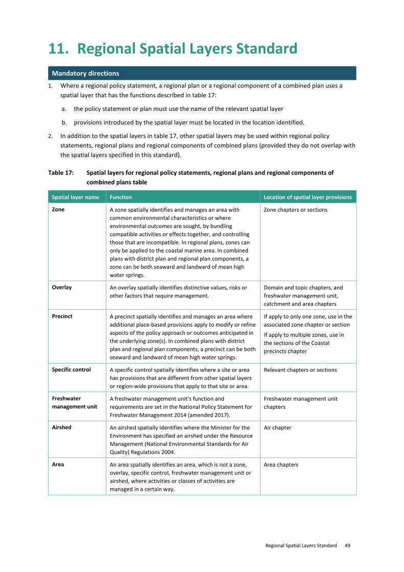
Regional Spatial Layers Standard 49
11. Regional Spatial Layers Standard Mandatory directions
1. Where a regional policy statement, a regional plan or a regional component of a combined plan uses a spatial layer that has the functions described in table 17:
a. the policy statement or plan must use the name of the relevant spatial layer
b. provisions introduced by the spatial layer must be located in the location identified.
2. In addition to the spatial layers in table 17, other spatial layers may be used within regional policy statements, regional plans and regional components of combined plans (provided they do not overlap with the spatial layers specified in this standard).
Table 17: Spatial layers for regional policy statements, regional plans and regional components of combined plans table
Spatial layer name Function Location of spatial layer provisions
Zone A zone spatially identifies and manages an area with common environmental characteristics or where environmental outcomes are sought, by bundling compatible activities or effects together, and controlling those that are incompatible. In regional plans, zones can only be applied to the coastal marine area. In combined plans with district plan and regional plan components, a zone can be both seaward and landward of mean high water springs.
Zone chapters or sections
Overlay An overlay spatially identifies distinctive values, risks or other factors that require management.
Domain and topic chapters, and freshwater management unit, catchment and area chapters
Precinct A precinct spatially identifies and manages an area where additional place-based provisions apply to modify or refine aspects of the policy approach or outcomes anticipated in the underlying zone(s). In combined plans with district plan and regional plan components, a precinct can be both seaward and landward of mean high water springs.
If apply to only one zone, use in the associated zone chapter or section
If apply to multiple zones, use in the sections of the Coastal precincts chapter
Specific control A specific control spatially identifies where a site or area has provisions that are different from other spatial layers or region-wide provisions that apply to that site or area.
Relevant chapters or sections
Freshwater management unit
A freshwater management unit’s function and requirements are set in the National Policy Statement for Freshwater Management 2014 (amended 2017).
Freshwater management unit chapters
Airshed An airshed spatially identifies where the Minister for the Environment has specified an airshed under the Resource Management (National Environmental Standards for Air Quality) Regulations 2004.
Air chapter
Area An area spatially identifies an area, which is not a zone, overlay, specific control, freshwater management unit or airshed, where activities or classes of activities are managed in a certain way.
Area chapters

District Spatial Layers Standard 50
12. District Spatial Layers Standard Mandatory directions
1. Where a district plan or a district plan component of a combined plan uses a spatial layer that has the functions described in table 18:
a. the plan must use the name of the relevant spatial layer
b. provisions introduced by the spatial layer must be located in the location identified.
2. Other than the spatial layers identified in table 18, no other spatial layers may be created.
Table 18: Spatial layers for district plans and district plan components of combined plans table
Spatial layer name Function Location of spatial layer provisions
Zones A zone spatially identifies and manages an area with common environmental characteristics or where environmental outcomes are sought, by bundling compatible activities or effects together, and controlling those that are incompatible.
Zone chapters or sections
Overlays An overlay spatially identifies distinctive values, risks or other factors which require management in a different manner from underlying zone provisions.
District-wide matters chapters for district plans
Domain and topic chapters for combined plans with a district component
Precincts A precinct spatially identifies and manages an area where additional place-based provisions apply to modify or refine aspects of the policy approach or outcomes anticipated in the underlying zone(s).
If apply to only one zone, in the associated zone chapter or section
If apply to multiple zones, in the multi-zone precincts chapters
Specific controls A specific control spatially identifies where a site or area has provisions that are different from other spatial layers or district-wide provisions that apply to that site or area (for example where verandah requirements apply, or where a different maximum height on a particular site applies).
Relevant chapters or sections
Development areas A development area spatially identifies and manages areas where plans such as concept plans, structure plans, outline development plans, master plans or growth area plans apply to determine future land use or development. When the associated development is complete, the development areas spatial layer is generally removed from the plan either through a trigger in the development area provisions or at a later plan change.
Development area chapters
Designations Spatially identifies where a designation is included in a plan under section 168 or section 168A or clause 4 of Schedule 1 of the RMA.
Designations chapters
Heritage orders Spatially identifies heritage orders enabled under section 189 of the RMA.
Historic heritage chapter

Mapping Standard 51
13. Mapping Standard Mandatory directions
1. District plan maps, and maps of combined plans with a district plan component, must use the corresponding colour from table 19 to map all zones applied from table 13 of 8. Zone framework Standard and, if required, zones may be labelled on maps.
2. A policy statement or plan must use the symbols in table 20 wherever maps display the features listed in that table and, if required:
a. an alternative vector type may be used to support data capture, but still represented in accordance with table 20 (eg, a polygon may be used for data capture associated with a line or point symbol).
b. symbols may be labelled on maps.
Table 19: Zone colour palette
Zone name Colour Description
Large lot residential zone RGB: 242, 235, 204
Low density residential zone RGB 255, 255, 190
General residential zone RGB: 245, 245, 122
Medium density residential zone RGB: 254, 219, 125
High density residential zone RGB: 255, 181, 97
General rural zone RGB: 200, 202, 160
Rural production zone RGB: 168, 181, 122
Rural lifestyle zone RGB: 227, 203, 154
Settlement zone RGB: 217, 222, 18
Neighbourhood centre zone RGB: 255, 181, 199
Local centre zone RGB: 245, 143, 148
Commercial zone RGB: 227, 97, 117
Large format retail zone RGB: 255, 115, 223
Mixed use zone RGB: 230, 0, 169
Town centre zone RGB: 199, 4, 111
Metropolitan centre zone RGB: 255, 181, 255; RGB: 168, 0, 132
Angle: 45.00
Separation: 10
City centre zone RGB: 137, 68, 101
Light industrial zone RGB: 207, 171, 245
General industrial zone RGB: 176, 115, 255
Heavy industrial zone RGB: 133, 80, 204
Natural open space zone RGB: 56, 173, 0
Open space zone RGB: 184, 240, 156
Sport and active recreation zone RGB: 137, 205, 102
Special purpose zones RGB: 204, 204,204

52 Mapping Standard
Table 20: Symbol representation
Symbol name Symbol Description
Coastal environment overlay
Polygon
Fill: None
Angle: 90.00
Line width: 1 pts
Line separation: 80 pts
RGB 28, 103, 148
Outline width: 2 pts
Designation
Polygon
Fill: None
RGB 20, 177, 231
Outline width: 1.5 pts
Designation unique identifier
Heritage area overlay Polygon
Fill: None
RGB: 132, 0, 168
Outline width: 2 pts
Heritage item overlay Point
RGB: 132, 0, 168
Heritage item overlay extent Polygon
Fill: None Angle 1: 0, Angle 2: 90
Line width 1 pts
Line separation: 5pts
RGB 132, 0, 168
Outline width: 1 pts
Marae overlay Point
RGB: 201, 53, 42
National grid line Line
RGB: 52, 52, 52
Line width: 2 pts
National grid underground cable Line
RGB: 52, 52, 52
RGB: 255, 255, 255
Line width: 3 pts
Noise control boundary overlay
Polygon
Fill: None
Angle: 45.00
Line width: 1 pts
Line separation: 5 pts
RGB 245, 130, 33
Outline width: 2 pts
Notable tree group overlay Polygon
Fill: None
RGB: 38, 115, 0
Outline width: 1 pts
Notable tree overlay Point
RGB: 38, 115, 0
Statutory acknowledgement areas
Polygon
Fill: RGB 255, 255,255 with default transparency of 70%
Outline width: 0.5 pts
Outline RGB: 255, 0, 0

Definitions Standard 53
14. Definitions Standard Mandatory directions
1. Where terms defined in the Definitions List are used in a policy statement or plan, and the term is used in the same context as the definition, local authorities must use the definition as defined in the Definitions List. However if required, they may define:
a. terms that are a subcategory of, or have a narrower application than, a defined term in the Definitions List. Any such definitions must be consistent with the higher level definition in the Definitions List.
b. additional terms that do not have the same or equivalent meaning as a term defined in the Definitions List.
2. Te reo Māori terms used in rules must be defined or translated in English in the Definitions chapter.
3. When a definition in the Definitions List is used, consequential amendments may be required to the policy statement or plan to ensure that the application of the definition does not alter the effect or outcomes of policy statements or plans.
4. Where the Definitions List incorporates a definition from legislation, the definition applied is the version included in the legislation on the date of gazettal of this standard.
5. Local authorities must consider whether to:
a. include, or cross reference to, diagrams to illustrate definitions
b. include instructions on how definitions relate to one another (eg, nesting tables or Venn diagrams).
6. If a term is used in more than one context (eg, ‘bed’ may relate to the bottom of a river or a place to sleep), local authorities must, in their Definitions chapter, add the context in which the term is defined in brackets after the term name eg, bed (in relation to lakes, rivers and the sea).
7. Definitions of terms, whether from the Definitions List or other sources, must be listed numerically and then alphabetically as one list.

54 Definitions Standard
Definitions List
Term Definition
abrasive blasting means the cleaning, smoothing, roughening, cutting or removal of part of the surface of any article by the use, as an abrasive, of a jet of sand, metal, shot or grit or other material propelled by a blast of compressed air or steam or water or by a wheel.
accessory building means a detached building, the use of which is ancillary to the use of any building, buildings or activity that is or could be lawfully established on the same site, but does not include any minor residential unit.
allotment has the same meaning as in section 218 of the RMA (as set out in the box below)
(2) In this Act, the term allotment means—
(a) any parcel of land under the Land Transfer Act 2017 that is a continuous area and whose boundaries are shown separately on a survey plan, whether or not—
(i) the subdivision shown on the survey plan has been allowed, or subdivision approval has been granted, under another Act; or
(ii) a subdivision consent for the subdivision shown on the survey plan has been granted under this Act; or
(b) any parcel of land or building or part of a building that is shown or identified separately—
(i) on a survey plan; or
(ii) on a licence within the meaning of subpart 6 of Part 3 of the Land Transfer Act 2017; or
(c) any unit on a unit plan; or
(d) any parcel of land not subject to the Land Transfer Act 2017.
(3) For the purposes of subsection (2), an allotment that is—
(a) subject to the Land Transfer Act 2017 and is comprised in 1 record of title or for which 1 record of title could be issued under that Act; or
(b) not subject to that Act and was acquired by its owner under 1 instrument of conveyance—
shall be deemed to be a continuous area of land notwithstanding that part of it is physically separated from any other part by a road or in any other manner whatsoever, unless the division of the allotment into such parts has been allowed by a subdivision consent granted under this Act or by a subdivisional approval under any former enactment relating to the subdivision of land.
(4) For the purposes of subsection (2), the balance of any land from which any allotment is being or has been subdivided is deemed to be an allotment.
amenity values has the same meaning as in section 2 of the RMA (as set out in the box below)
means those natural or physical qualities and characteristics of an area that contribute to people’s appreciation of its pleasantness, aesthetic coherence, and cultural and recreational attributes.
ancillary activity means an activity that supports and is subsidiary to a primary activity.
aquifer means a permeable geological formation, group of formations, or part of a formation, beneath the ground, capable of receiving, storing, transmitting and yielding water.

Definitions Standard 55
bed has the same meaning as in section 2 of the RMA (as set out in the box below)
means—
(a) in relation to any river—
(i) for the purposes of esplanade reserves, esplanade strips, and subdivision, the space of land which the waters of the river cover at its annual fullest flow without overtopping its banks:
(ii) in all other cases, the space of land which the waters of the river cover at its fullest flow without overtopping its banks; and
(b) in relation to any lake, except a lake controlled by artificial means,—
(i) for the purposes of esplanade reserves, esplanade strips, and subdivision, the space of land which the waters of the lake cover at its annual highest level without exceeding its margin:
(ii) in all other cases, the space of land which the waters of the lake cover at its highest level without exceeding its margin; and
(c) in relation to any lake controlled by artificial means, the space of land which the waters of the lake cover at its maximum permitted operating level; and
(d) in relation to the sea, the submarine areas covered by the internal waters and the territorial sea.
best practicable option has the same meaning as in section 2 of the RMA (as set out in the box below)
in relation to a discharge of a contaminant or an emission of noise, means the best method for preventing or minimising the adverse effects on the environment having regard, among other things, to—
(a) the nature of the discharge or emission and the sensitivity of the receiving environment to adverse effects; and
(b) the financial implications, and the effects on the environment, of that option when compared with other options; and
(c) the current state of technical knowledge and the likelihood that the option can be successfully applied.
bore means any hole drilled or constructed in the ground that is used to: (a) investigate or monitor conditions below the ground surface; or
(b) abstract gaseous or liquid substances from the ground; or
(c) discharge gaseous or liquid substances into the ground;
but it excludes test pits, trenches, soak holes and soakage pits.
boundary adjustment means a subdivision that alters the existing boundaries between adjoining allotments, without altering the number of allotments.
building means a temporary or permanent movable or immovable physical construction that is:
(a) partially or fully roofed; and
(b) fixed or located on or in land;
but excludes any motorised vehicle or other mode of transport that could be moved under its own power.
building coverage means the percentage of the net site area covered by the building footprint.
building footprint means, in relation to building coverage, the total area of buildings at ground floor level together with the area of any section of any of those buildings that extends out beyond the ground floor level limits of the building and overhangs the ground.
cleanfill area means an area used exclusively for the disposal of cleanfill material.

56 Definitions Standard
cleanfill material means virgin excavated natural materials including clay, gravel, sand, soil and rock that are free of:
(a) combustible, putrescible, degradable or leachable components;
(b) hazardous substances and materials;
(c) products and materials derived from hazardous waste treatment, stabilisation or disposal practices;
(d) medical and veterinary wastes, asbestos, and radioactive substances;
(e) contaminated soil and other contaminated materials; and
(f) liquid wastes.
coastal water has the same meaning as in section 2 of the RMA (as set out in the box below)
means seawater within the outer limits of the territorial sea and includes—
(a) seawater with a substantial fresh water component; and
(b) seawater in estuaries, fiords, inlets, harbours, or embayments.
commercial activity means any activity trading in goods, equipment or services. It includes any ancillary activity to the commercial activity (for example administrative or head offices).
community corrections activity
means the use of land and buildings for non-custodial services for safety, welfare and community purposes, including probation, rehabilitation and reintegration services, assessments, reporting, workshops and programmes, administration, and a meeting point for community works groups.
community facility means land and buildings used by members of the community for recreational, sporting, cultural, safety, health, welfare, or worship purposes. It includes provision for any ancillary activity that assists with the operation of the community facility.
contaminant has the same meaning as in section 2 of the RMA (as set out in the box below)
includes any substance (including gases, odorous compounds, liquids, solids, and micro-organisms) or energy (excluding noise) or heat, that either by itself or in combination with the same, similar, or other substances, energy, or heat—
(a) when discharged into water, changes or is likely to change the physical, chemical, or biological condition of water; or
(b) when discharged onto or into land or into air, changes or is likely to change the physical, chemical, or biological condition of the land or air onto or into which it is discharged.
contaminated land has the same meaning as in section 2 of the RMA (as set out in the box below)
means land that has a hazardous substance in or on it that—
(a) has significant adverse effects on the environment; or
(b) is reasonably likely to have significant adverse effects on the environment.
cultivation means the alteration or disturbance of land (or any matter constituting the land including soil, clay, sand and rock) for the purpose of sowing, growing or harvesting of pasture or crops.
discharge has the same meaning as in section 2 of the RMA (as set out in the box below)
includes emit, deposit, and allow to escape.
drain means any artificial watercourse designed, constructed, or used for the drainage of surface or subsurface water, but excludes artificial watercourses used for the conveyance of water for electricity generation, irrigation, or water supply purposes.
drinking water means water intended to be used for human consumption; and includes water intended to be used for food preparation, utensil washing, and oral or other personal hygiene.
dry abrasive blasting means abrasive blasting using materials to which no water has been added.

Definitions Standard 57
dust means all non-combusted solid particulate matter that is suspended in the air, or has settled after being airborne. Dust may be derived from materials including rock, sand, cement, fertiliser, coal, soil, paint, animal products and wood.
earthworks means the alteration or disturbance of land, including by moving, removing, placing, blading, cutting, contouring, filling or excavation of earth (or any matter constituting the land including soil, clay, sand and rock); but excludes gardening, cultivation, and disturbance of land for the installation of fence posts.
educational facility means land or buildings used for teaching or training by child care services, schools, or tertiary education services, including any ancillary activities.
effect has the same meaning as in section 3 of the RMA (as set out in the box below)
includes—
(a) any positive or adverse effect; and
(b) any temporary or permanent effect; and
(c) any past, present, or future effect; and
(d) any cumulative effect which arises over time or in combination with other effects—
regardless of the scale, intensity, duration, or frequency of the effect, and also includes—
(e) any potential effect of high probability; and
(f) any potential effect of low probability which has a high potential impact.
environment has the same meaning as in section 2 of the RMA (as set out in the box below)
includes—
(a) ecosystems and their constituent parts, including people and communities; and
(b) all natural and physical resources; and
(c) amenity values; and
(d) the social, economic, aesthetic, and cultural conditions which affect the matters stated in paragraphs (a) to (c) or which are affected by those matters.
esplanade reserve has the same meaning as in section 2 of the RMA (as set out in the box below)
means a reserve within the meaning of the Reserves Act 1977—
(a) which is either—
(i) a local purpose reserve within the meaning of section 23 of that Act, if vested in the territorial authority under section 239; or
(ii) a reserve vested in the Crown or a regional council under section 237D; and
(b) which is vested in the territorial authority, regional council, or the Crown for a purpose or purposes set out in section 229.
esplanade strip has the same meaning as in section 2 of the RMA (as set out in the box below)
means a strip of land created by the registration of an instrument in accordance with section 232 for a purpose or purposes set out in section 229.

58 Definitions Standard
fertiliser means a substance or biological compound or mix of substances or biological compounds in solid or liquid form, that is described as, or held out to be suitable for, sustaining or increasing the growth, productivity or quality of soils, plants or, indirectly, animals through the application to plants or soil of any of the following:
(a) nitrogen, phosphorus, potassium, sulphur, magnesium, calcium, chlorine, and sodium as major nutrients; or
(b) manganese, iron, zinc, copper, boron, cobalt, molybdenum, iodine, and selenium as minor nutrients; or
(c) fertiliser additives to facilitate the uptake and use of nutrients; or
(d) non-nutrient attributes of the materials used in fertiliser.
It does not include livestock effluent, human effluent, substances containing pathogens, or substances that are plant growth regulators that modify the physiological functions of plants.
fresh water has the same meaning as in section 2 of the RMA (as set out in the box below)
means all water except coastal water and geothermal water.
functional need means the need for a proposal or activity to traverse, locate or operate in a particular environment because the activity can only occur in that environment.
green infrastructure means a natural or semi-natural area, feature or process, including engineered systems that mimic natural processes, which are planned or managed to:
(a) provide for aspects of ecosystem health or resilience, such as maintaining or improving the quality of water, air or soil, and habitats to promote biodiversity; and
(b) provide services to people and communities, such as stormwater or flood management or climate change adaptation.
greywater means liquid waste from domestic sources including sinks, basins, baths, showers and similar fixtures, but does not include sewage, or industrial and trade waste.
gross floor area means the sum of the total area of all floors of a building or buildings (including any void area in each of those floors, such as service shafts, liftwells or stairwells) measured:
(a) where there are exterior walls, from the exterior faces of those exterior walls;
(b) where there are walls separating two buildings, from the centre lines of the walls separating the two buildings;
(c) where a wall or walls are lacking (for example, a mezzanine floor) and the edge of the floor is discernible, from the edge of the floor.
ground level (for the purposes of district plans and the district plan component of combined plans)
means:
(a) the actual finished surface level of the ground after the most recent subdivision that created at least one additional allotment was completed (when the record of title is created);
(b) if the ground level cannot be identified under paragraph (a), the existing surface level of the ground;
(c) if, in any case under paragraph (a) or (b), a retaining wall or retaining structure is located on the boundary, the level on the exterior surface of the retaining wall or retaining structure where it intersects the boundary.
groundwater means water occupying openings, cavities, or spaces in soils or rocks beneath the surface of the ground.
habitable room means any room used for the purposes of teaching or used as a living room, dining room, sitting room, bedroom, office or other room specified in the Plan to be a similarly occupied room.

Definitions Standard 59
hazardous substance has the same meaning as in section 2 of the RMA (as set out in the box below)
includes, but is not limited to, any substance defined in section 2 of the Hazardous Substances and New Organisms Act 1996 as a hazardous substance. The Hazardous Substances and New Organisms Act 1996 defines hazardous substances as meaning, unless expressly provided otherwise by regulations or an EPA notice, any substance—
(a) with 1 or more of the following intrinsic properties:
(i) explosiveness:
(ii) flammability:
(iii) a capacity to oxidise:
(iv) corrosiveness:
(v) toxicity (including chronic toxicity):
(vi) ecotoxicity, with or without bioaccumulation; or
(b) which on contact with air or water (other than air or water where the temperature or pressure has been artificially increased or decreased) generates a substance with any 1 or more of the properties specified in paragraph (a).
height
means the vertical distance between a specified reference point and the highest part of any feature, structure or building above that point.
height in relation to boundary
means the height of a structure, building or feature, relative to its distance from either the boundary of:
(a) a site; or
(b) another specified reference point.
historic heritage has the same meaning as in section 2 of the RMA (as set out in the box below)
(a) means those natural and physical resources that contribute to an understanding and appreciation of New Zealand’s history and cultures, deriving from any of the following qualities:
(i) archaeological:
(ii) architectural:
(iii) cultural:
(iv) historic:
(v) scientific:
(vi) technological; and
(b) includes—
(i) historic sites, structures, places, and areas; and
(ii) archaeological sites; and
(iii) sites of significance to Māori, including wāhi tapu; and
(iv) surroundings associated with the natural and physical resources.
home business means a commercial activity that is:
(a) undertaken or operated by at least one resident of the site; and
(b) incidental to the use of the site for a residential activity.
industrial activity means an activity that manufactures, fabricates, processes, packages, distributes, repairs, stores, or disposes of materials (including raw, processed, or partly processed materials) or goods. It includes any ancillary activity to the industrial activity.
industrial and trade waste
means liquid waste, with or without matter in suspension, from the receipt, manufacture or processing of materials as part of a commercial, industrial or trade process, but excludes sewage and greywater.

60 Definitions Standard
intensive indoor primary production
means primary production activities that principally occur within buildings and involve growing fungi, or keeping or rearing livestock (excluding calf-rearing for a specified time period) or poultry.
LA90 has the same meaning as the ‘Background sound level’ in New Zealand Standard 6801:2008 Acoustics – Measurement of Environmental Sound.
LAeq has the same meaning as ‘time-average A-weighted sound pressure level’ in New Zealand Standard 6801:2008 Acoustics -Measurement of Environmental Sound.
LAF(max) has the same meaning as the ‘maximum A-frequency weighted, F-time weighted sound pressure level’ in New Zealand Standard 6801:2008 Acoustics – Measurement Of Environmental Sound.
lake has the same meaning as in section 2 of the RMA (as set out in the box below)
means a body of fresh water which is entirely or nearly surrounded by land.
land has the same meaning as in section 2 of the RMA (as set out in the box below)
(a) includes land covered by water and the airspace above land; and
(b) in a national environmental standard dealing with a regional council function under section 30 or a regional rule, does not include the bed of a lake or river; and
(c) in a national environmental standard dealing with a territorial authority function under section 31 or a district rule, includes the surface of water in a lake or river.
land disturbance means the alteration or disturbance of land (or any matter constituting the land including soil, clay, sand and rock) that does not permanently alter the profile, contour or height of the land.
landfill means an area used for, or previously used for, the disposal of solid waste. It excludes cleanfill areas.
Ldn has the same meaning as the ‘Day night level, or day-night average sound level’ in New Zealand Standard 6801:2008 Acoustics – Measurement of Environmental Sound.
Lpeak has the same meaning as ‘Peak sound pressure level’ in New Zealand Standard 6801:2008 Acoustics – Measurement of Environmental Sound.
minor residential unit means a self-contained residential unit that is ancillary to the principal residential unit, and is held in common ownership with the principal residential unit on the same site.
natural and physical resources
has the same meaning as in section 2 of the RMA (as set out in the box below)
Includes land, water, air, soil, minerals, and energy, all forms of plants and animals (whether native to New Zealand or introduced), and all structures.
natural hazard has the same meaning as in section 2 of the RMA (as set out in the box below)
means any atmospheric or earth or water related occurrence (including earthquake, tsunami, erosion, volcanic and geothermal activity, landslip, subsidence, sedimentation, wind, drought, fire, or flooding) the action of which adversely affects or may adversely affect human life, property, or other aspects of the environment.

Definitions Standard 61
net floor area means the sum of any gross floor area; and
(a) includes:
(i) both freehold and leased areas; and
(ii) any stock storage or preparation areas; but
(b) excludes:
(i) void areas such as liftwells and stair wells, including landing areas;
(ii) shared corridors and mall common spaces;
(iii) entrances, lobbies and plant areas within a building;
(iv) open or roofed outdoor areas, and external balconies, decks, porches and terraces;
(v) off street loading areas;
(vi) building service rooms;
(vii) parking areas and basement areas used for parking, manoeuvring and access; and
(viii) non-habitable floor spaces in rooftop structures.
net site area means the total area of the site, but excludes: (a) any part of the site that provides legal access to another site;
(b) any part of a rear site that provides legal access to that site;
(c) any part of the site subject to a designation that may be taken or acquired under the Public Works Act 1981.
network utility operator has the same meaning as in s166 of the RMA (as set out in the box below)
means a person who—
(a) undertakes or proposes to undertake the distribution or transmission by pipeline of natural or manufactured gas, petroleum, biofuel, or geothermal energy; or
(b) operates or proposes to operate a network for the purpose of—
(i) telecommunication as defined in section 5 of the Telecommunications Act 2001; or
(ii) radio communication as defined in section 2(1) of the Radio Communications Act 1989; or
(c) is an electricity operator or electricity distributor as defined in section 2 of the Electricity Act 1992 for the purpose of line function services as defined in that section; or
(d) undertakes or proposes to undertake the distribution of water for supply (including irrigation); or
(e) undertakes or proposes to undertake a drainage or sewerage system; or
(f) constructs, operates, or proposes to construct or operate, a road or railway line; or
(g) is an airport authority as defined by the Airport Authorities Act 1966 for the purposes of operating an airport as defined by that Act; or
(h) is a provider of any approach control service within the meaning of the Civil Aviation Act 1990; or
(i) undertakes or proposes to undertake a project or work prescribed as a network utility operation for the purposes of this definition by regulations made under this Act,—
and the words network utility operation have a corresponding meaning.
noise has the same meaning as in section 2 of the RMA (as set out in the box below)
includes vibration.

62 Definitions Standard
noise rating level means a derived noise level used for comparison with a noise limit.
notional boundary means a line 20 metres from any side of a residential unit or other building used for a noise sensitive activity, or the legal boundary where this is closer to such a building.
official sign means all signs required or provided for under any statute or regulation, or are otherwise related to aspects of public safety.
operational need means the need for a proposal or activity to traverse, locate or operate in a particular environment because of technical, logistical or operational characteristics or constraints.
outdoor living space means an area of open space for the use of the occupants of the residential unit or units to which the space is allocated.
peak particle velocity means, to the extent used for the assessment of the risk of structural damage to a fixed structure, the instantaneous maximum velocity reached by a vibrating surface as it oscillates about its normal position.
primary production means:
(a) any aquaculture, agricultural, pastoral, horticultural, mining, quarrying or forestry activities; and
(b) includes initial processing, as an ancillary activity, of commodities that result from the listed activities in a);
(c) includes any land and buildings used for the production of the commodities from a) and used for the initial processing of the commodities in b); but
(d) excludes further processing of those commodities into a different product.
quarry means a location or area used for the permanent removal and extraction of aggregates (clay, silt, rock or sand). It includes the area of aggregate resource and surrounding land associated with the operation of a quarry and which is used for quarrying activities.
quarrying activities means the extraction, processing (including crushing, screening, washing, and blending), transport, storage, sale and recycling of aggregates (clay, silt, rock, sand), the deposition of overburden material, rehabilitation, landscaping and cleanfilling of the quarry, and the use of land and accessory buildings for offices, workshops and car parking areas associated with the operation of the quarry.
raft has the same meaning as in section 2 of the RMA (as set out in the box below)
means any moored floating platform which is not self-propelled; and includes platforms that provide buoyancy support for the surfaces on which fish or marine vegetation are cultivated or for any cage or other device used to contain or restrain fish or marine vegetation; but does not include booms situated on lakes subject to artificial control which have been installed to ensure the safe operation of electricity generating facilities.
reclamation means the manmade formation of permanent dry land by the positioning of material into or onto any part of a waterbody, bed of a lake or river or the coastal marine area, and:
(a) includes the construction of any causeway; but
(b) excludes the construction of natural hazard protection structures such as seawalls, breakwaters or groynes except where the purpose of those structures is to form dry land.
residential activity means the use of land and building(s) for people’s living accommodation.
residential unit means a building(s) or part of a building that is used for a residential activity exclusively by one household, and must include sleeping, cooking, bathing and toilet facilities.
retirement village means a managed comprehensive residential complex or facilities used to provide residential accommodation for people who are retired and any spouses or partners of such people. It may also include any of the following for residents within the complex: recreation, leisure, supported residential care, welfare and medical facilities (inclusive of hospital care) and other non-residential activities.

Definitions Standard 63
river has the same meaning as in section 2 of the RMA (as set out in the box below)
means a continually or intermittently flowing body of fresh water; and includes a stream and modified watercourse; but does not include any artificial watercourse (including an irrigation canal, water supply race, canal for the supply of water for electricity power generation, and farm drainage canal).
road has the same meaning as in section 2 of the RMA (as set out in the box below)
has the same meaning as in section 315 of the Local Government Act 1974; and includes a motorway as defined in section 2(1) of the Government Roading Powers Act 1989
Section 315 of the Local Government Act 1974 road definition:
road means the whole of any land which is within a district, and which—
(a) immediately before the commencement of this Part was a road or street or public highway; or
(b) immediately before the inclusion of any area in the district was a public highway within that area; or
(c) is laid out by the council as a road or street after the commencement of this Part; or
(d) is vested in the council for the purpose of a road as shown on a deposited survey plan; or
(e) is vested in the council as a road or street pursuant to any other enactment;—
and includes—
(f) except where elsewhere provided in this Part, any access way or service lane which before the commencement of this Part was under the control of any council or is laid out or constructed by or vested in any council as an access way or service lane or is declared by the Minister of Works and Development as an access way or service lane after the commencement of this Part or is declared by the Minister of Lands as an access way or service lane on or after 1 April 1988:
(g) every square or place intended for use of the public generally, and every bridge, culvert, drain, ford, gate, building, or other thing belonging thereto or lying upon the line or within the limits thereof;—
but, except as provided in the Public Works Act 1981 or in any regulations under that Act, does not include a motorway within the meaning of that Act or the Government Roading Powers Act 1989
Section 2(1) of the Government Roading Powers Act 1989 motorway definition
motorway—
(a) means a motorway declared as such by the Governor-General in Council under section 138 of the Public Works Act 1981 or under section 71 of this Act; and
(b) includes all bridges, drains, culverts, or other structures or works forming part of any motorway so declared; but
(c) does not include any local road, access way, or service lane (or the supports of any such road, way, or lane) that crosses over or under a motorway on a different level
rural industry means an industry or business undertaken in a rural environment that directly supports, services, or is dependent on primary production.
sewage means human excrement and urine.

64 Definitions Standard
sign means any device, character, graphic or electronic display, whether temporary or permanent, which:
(a) is for the purposes of:
(i) identification of or provision of information about any activity, property or structure or an aspect of public safety;
(ii) providing directions; or
(iii) promoting goods, services or events; and
(b) is projected onto, or fixed or attached to, any structure or natural object; and
(c) includes the frame, supporting device and any ancillary equipment whose function is to support the message or notice.
site (for district plans and the district plan component of combined plans )
means:
(a) an area of land comprised in a single record of title under the Land Transfer Act 2017; or
(b) an area of land which comprises two or more adjoining legally defined allotments in such a way that the allotments cannot be dealt with separately without the prior consent of the council; or
(c) the land comprised in a single allotment or balance area on an approved survey plan of subdivision for which a separate record of title under the Land Transfer Act 2017 could be issued without further consent of the Council; or
(d) despite paragraphs (a) to (c), in the case of land subdivided under the Unit Titles Act 1972 or the Unit Titles Act 2010 or a cross lease system, is the whole of the land subject to the unit development or cross lease.
special audible characteristic
has the same meaning as ‘special audible characteristic’ in section 6.3 of New Zealand Standard 6802:2008 Acoustics – Environmental Noise.
stormwater means run-off that has been intercepted, channelled, diverted, intensified or accelerated by human modification of a land surface, or run-off from the surface of any structure, as a result of precipitation and includes any contaminants contained within.
structure has the same meaning as in section 2 of the RMA (as set out in the box below)
means any building, equipment, device, or other facility, made by people and which is fixed to land; and includes any raft.
subdivision has the same meaning as “subdivision of land” in section 218 of the RMA (as set out in the box below)
means—
(a) the division of an allotment—
(i) by an application to the Registrar-General of Land for the issue of a separate certificate of title for any part of the allotment; or
(ii) by the disposition by way of sale or offer for sale of the fee simple to part of the allotment; or
(iii) by a lease of part of the allotment which, including renewals, is or could be for a term of more than 35 years; or
(iv) by the grant of a company lease or cross lease in respect of any part of the allotment; or
(v) by the deposit of a unit plan, or an application to the Registrar-General of Land for the issue of a separate certificate of title for any part of a unit on a unit plan; or
(b) an application to the Registrar-General of Land for the issue of a separate certificate of title in circumstances where the issue of that certificate of title is prohibited by section 226.

Definitions Standard 65
sustainable management
has the same meaning as in section 5 of the RMA (as set out in the box below)
means managing the use, development, and protection of natural and physical resources in a way, or at a rate, which enables people and communities to provide for their social, economic, and cultural well-being and for their health and safety while—
(a) sustaining the potential of natural and physical resources (excluding minerals) to meet the reasonably foreseeable needs of future generations; and
(b) safeguarding the life-supporting capacity of air, water, soil, and ecosystems; and
(c) avoiding, remedying, or mitigating any adverse effects of activities on the environment.
temporary military training activity
means a temporary activity undertaken for the training of any component of the New Zealand Defence Force (including with allied forces) for any defence purpose. Defence purposes are those purposes for which a defence force may be raised and maintained under section 5 of the Defence Act 1990 which are:
(a) the defence of New Zealand, and of any area for the defence of which New Zealand is responsible under any Act:
(b) the protection of the interests of New Zealand, whether in New Zealand or elsewhere:
(c) the contribution of forces under collective security treaties, agreements, or arrangements:
(d) the contribution of forces to, or for any of the purposes of, the United Nations, or in association with other organisations or States and in accordance with the principles of the Charter of the United Nations:
(e) the provision of assistance to the civil power either in New Zealand or elsewhere in time of emergency:
(f) the provision of any public service.
territorial authority has the same meaning as in section 5 of the Local Government Act 2002 (as set out in the box below)
means a city council or a district council named in Part 2 of Schedule 2.
visitor accommodation means land and/or buildings used for accommodating visitors, subject to a tariff being paid, and includes any ancillary activities.
wastewater means any combination of two or more the following wastes: sewage, greywater or industrial and trade waste.
water has the same meaning as in section 2 of the RMA (as set out in the box below)
(a) means water in all its physical forms whether flowing or not and whether over or under the ground:
(b) includes fresh water, coastal water, and geothermal water:
(c) does not include water in any form while in any pipe, tank, or cistern.
waterbody has the same meaning as in section 2 of the RMA (as set out in the box below)
means fresh water or geothermal water in a river, lake, stream, pond, wetland, or aquifer, or any part thereof, that is not located within the coastal marine area.
wet abrasive blasting means abrasive blasting using material to which water has been added.
wetland has the same meaning as in section 2 of the RMA (as set out in the box below)
includes permanently or intermittently wet areas, shallow water, and land water margins that support a natural ecosystem of plants and animals that are adapted to wet conditions.

District Spatial Layers Standard 66
15. Noise and Vibration Metrics Standard Mandatory directions
1. Any plan rule to manage noise emissions must be in accordance with the mandatory noise measurement methods and symbols in the applicable New Zealand Standards incorporated by reference into the planning standards and listed below:
New Zealand Standard 6801:2008 Acoustics – Measurement of environmental sound
New Zealand Standard 6802:2008 Acoustics – Environmental noise
New Zealand Standard 6803:1999 Acoustics – Construction noise
New Zealand Standard 6805:1992 Airport noise management and land use planning – measurement only
New Zealand Standard 6806:2010 Acoustics – Road-traffic noise – New and altered roads
New Zealand Standard 6807:1994 – Noise Management and Land Use Planning for Helicopter Landing Areas- excluding 4.3 Averaging
New Zealand Standard 6808:2010 Acoustics – Wind farm noise
New Zealand Standard 6809:1999 Acoustics – Port noise management and land use planning
2. Any plan rule to manage noise emissions must be consistent with the mandatory assessment methods in section 6 Rating Level and section 7 LMAX of New Zealand Standard 6802:2008 Acoustics – Environmental Noise (incorporated by reference into the planning standards), provided the type of noise emitted is within the scope of New Zealand Standard 6802:2008.
3. Any plan rule to manage damage to structures from construction vibration must be consistent with the metrics for peak particle velocity (ppv) in ISO-4866:2010 – Mechanical vibration and shock, incorporated by reference into the planning standards.

Electronic Accessibility and Functionality Standard 67
16. Electronic Accessibility and Functionality Standard
Mandatory directions
A. Electronic accessibility and functionality 1. Local authorities must ensure their policy statements and plans comply with the requirements of direction
2 within the timeframes specified in 17. Implementation Standard.
2. Electronic accessibility and functionality requirements:
a. Accessibility
i. Policy statements or plans must be hosted on a local authority webpage no more than three clicks (three pages or pop-ups) from the local authority’s home page.
ii. Up-to-date webpage addresses for policy statements and plans must be provided to the Ministry for the Environment.
b. Functionality
i. Policy statement and plans must have keyword search functionality.
c. Data standards
i. Publicly accessible digital datasets used in the preparation of a policy statement or plan, available under Creative Commons attribution CC BY 4.0 licensing, must be listed or uploaded to data.govt.nz in machine readable, non-proprietary format.
ii. Any amended planning map digital dataset must be uploaded to, or listed on, data.govt.nz in machine readable non-proprietary format, once they become operative or treated as operative.
iii. Datums and projections must be compliant with the New Zealand Geodetic Datum (NZGD2000) and New Zealand Transverse Mercator 2000 (NZTM2000).
iv. New policy statement or plan information incorporated through a policy statement or plan review, change or variation using a vertical datum must be compliant with New Zealand Vertical Datum 2016 (NZVD2016).
B. Online interactive policy statement or plan 1. Policy statements and plans must be in an online interactive format (ePlan) within the timeframes
specified in 17. Implementation Standard.
2. The ePlan must include:
a. a GIS viewer which:
i. includes all spatial layers of the policy statement or plan maps
ii. enables users to search for a specific property
iii. enables users to select which spatial layers are displayed on the viewer.
b. the ability for users to query the ePlan to display the plan provisions that apply to:
i. a specific property by entering an address and by selecting the property in the GIS viewer
ii. one or more specific activities managed by rules in the plan.

68 Electronic Accessibility and Functionality Standard
c. the ability to display the policy statement or plan version as at any date from when the policy statement or plan is in the ePlan, to the present (excluding interactive maps).
d. the ability to download and print a copy of any part of the policy statement or plan (excluding interactive maps).
e. the ability to link between provisions, including definitions of terms when viewing the term in the ePlan.
f. the electronic seal of the local authority and an electronic signature verifying its authenticity in the ePlan, and in any downloaded or printed copy of the policy statement or plan.
3. The ePlan must be accessible from the local authority’s website (in accordance with requirement 16.A.2(a)(i)), however an ePlan may be shared by two or more local authorities.
4. Local authorities must provide an opportunity to submit on a policy statement or plan online, either through the ePlan or through an online submission tool that is linked to the ePlan.
5. Directions 1-4 above for online interactive plans do not apply to the Chatham Islands Council and to the Minister of Local Government and Minister of Conservation in their roles as local authority for offshore and subantartic islands.

Implementation Standard 69
17. Implementation Standard Mandatory directions
For every policy statement or plan 1. Subject to the timeframes in 17. Implementation Standard and 1. Foundation Standard direction 2, a policy
statement or plan must be compliant with the relevant planning standards.
Regional policy statements
2. Regional councils, and unitary authorities with separate regional policy statements, must comply with the following planning standards: 1. Foundation, 2. Regional policy statement structure, 6. Introduction and general provisions, 10. Format, 11. Regional spatial layers, 13. Mapping, 14. Definitions through either a) or b) whichever is sooner:
a. Amendments to the regional policy statement made by three years from when the planning standards come into effect.
b. Notification of a proposed regional policy statement for submissions under clause 5, Schedule 1 RMA after the planning standards come into effect.
Regional plans
3. Regional councils, and unitary authorities with separate regional plans, must comply with the following planning standards: 1. Foundation 3. Regional plan structure, 6. Introduction and general provisions, 10. Format, 11. Regional spatial layers, 13. Mapping, 14. Definitions, 15. Noise and vibration metrics through either a) or b) whichever is sooner:
a. Amendments to the regional plan(s) made by 10 years from when the planning standards come into effect.
b. Notification of a proposed regional plan (but not a proposed change or variation) for submissions under clause 5, Schedule 1 RMA after the planning standards come into effect.
District plans
4. Territorial authorities not listed in direction 5, and unitary authorities with separate district plans, must comply with the following planning standards: 1. Foundation, 4. District plan structure, 6. Introduction and general provisions, 7. District-wide matters, 8. Zone framework, 9. Designations, 10. Format, 12. District spatial layers, 13. Mapping, 15. Noise and vibration metrics, through either a) or b) whichever is sooner:
a. Amendments to the district plan made by five years from when the planning standards come into effect.
b. Notification of a proposed district plan (but not a proposed change or variation) for submissions under clause 5, Schedule 1 RMA after the planning standards come into effect.
5. Territorial authorities listed below must comply with the following planning standards: 1. Foundation, 4. District plan structure, 6. Introduction and general provisions, 7. District-wide matters, 8. Zone framework, 9. Designations, 10. Format, 12. District spatial layers, 13. Mapping, 15. Noise and vibration metrics, through either a) or b) whichever is sooner:
a. Amendments to the district plan made by seven years from when the planning standards come into effect.
b. Notification of a proposed district plan (but not a proposed change or variation) for submissions under clause 5, Schedule 1 RMA after the planning standards come into effect.

70 Implementation Standard
─ Christchurch City Council
─ Dunedin City Council
─ Hurunui District Council
─ Invercargill City Council
─ Kāpiti Coast District Council
─ Opotiki District Council
─ Queenstown-Lakes District Council
─ South Taranaki District Council
─ Thames-Coromandel District Council
─ Any territorial authorities committed to a combined district plan (through a council resolution, MOU or similar statutory obligation) under section 80 (3) of the RMA.
6. Territorial authorities, and unitary authorities with separate district plans, must comply with 14. Definitions Standard through either a), b) or c) whichever is sooner:
a. Amendments to the district plan of a territorial authority in direction 4 above or of a unitary authority made by seven years from when the planning standards come into effect.
b. Amendments to the district plan of a territorial authority in direction 5 above made by nine years from when the planning standards come into effect.
c. Notification of a proposed district plan (but not a proposed change or variation) for submissions under clause 5, Schedule 1 RMA after the planning standards come into effect.
Implementation – Combined plan (regional policy statement, regional plan and district plan) by a unitary authority
7. Unitary authorities that have or produce a combined plan (regional policy statement–regional plan–district plan) must comply with the following planning standards: 1. Foundation, 5. Combined plan structure, 6. Introduction and general provisions, 7. District-wide matters (excluding the Strategic direction and Coastal environment directions, and replacing General district-wide matters heading with General matters heading), 8. Zone framework, 9. Designations, 10. Format, 11. Regional spatial layers, 12. District spatial layers, 13. Mapping, 14. Definitions, 15. Noise and vibration metrics, through either a) or b) whichever is sooner:
a. Amendments to the combined plan made by 10 years from when the planning standards come into effect.
b. Notification of a proposed combined plan (but not a proposed change or variation) for submissions under clause 5, Schedule 1 RMA after the planning standards come into effect.
Combined plan (regional policy statement and regional plan)
8. Regional councils that have or produce a combined plan (regional policy statement–regional plan) must comply with the following planning standards: 5. Combined plan structure, 6. Introduction and general provisions, 10. Format, 11. Regional spatial layers, 13. Mapping, 14. Definitions, 15. Noise and vibration metrics, through either a), b), or c) whichever is sooner:
a. Amendments to the regional policy statement components of the combined plan made by three years from when the planning standards come into effect.
b. Amendments to the regional plan components of the combined plan made by 10 years from when the planning standards come into effect.

Implementation Standard 71
c. Notification of a proposed combined plan (but not a proposed change or variation) for submissions under clause 5, Schedule 1 RMA after the planning standards come into effect.
Other combined plans
9. Local authorities that produce a combined plan (regional policy statement–district plan, regional plan–district plan, or regional policy statement–regional plan–district plan by a non-unitary authority) must comply with the following planning standards (as relevant): 5. Combined plan structure, 6. Introduction and general provisions, 7. District-wide matters, 8. Zone framework, 9. Designations, 10. Format, 11. Regional spatial layers, 12. District spatial layers, 13. Mapping, 14. Definitions, 15. Noise and vibration metrics, when the proposed combined plan is notified for submissions under clause 5, Schedule 1 RMA after the planning standards come into effect.
10. Until the proposed combined plan is notified for submissions under clause 5, Schedule 1 RMA, the local authorities’ precursor policy statement or plan must comply with 17. Implementation Standard directions 1–8.
Electronic accessibility and functionality and online interactive plans
11. Local authorities must comply with the mandatory directions of 16.A: Electronic accessibility and functionality by one year from when the planning standards come into effect.
12. Directions 1-4 in 16.B: Online interactive policy statement or plan do not apply to the Chatham Islands Council, or to the Minister of Local Government and Minister of Conservation in their roles as local authority for offshore and subantartic islands.
13. Local authorities not listed in directions 14 and 15 must comply with the mandatory directions of 16.B: Online interactive policy statement or plan by five years from when the planning standards come into effect.
14. Territorial authorities listed below must comply with the mandatory directions of 16.B: Online interactive policy statement or plan by seven years from when the planning standards come into effect.
─ Christchurch City Council
─ Dunedin City Council
─ Invercargill City Council
─ Kāpiti Coast District Council
─ Queenstown-Lakes District Council
─ Thames-Coromandel District Council
─ Any territorial authorities committed to a combined plan or a combined district plan (through a council resolution, MOU or similar statutory obligation) under section 80(3) of the RMA, excluding unitary authorities and those territorial authorities listed in direction 15.
15. Territorial authorities listed below, and all regional councils and unitary authorities, must comply with the mandatory directions of 16.B: Online interactive policy statement or plan by 10 years from when the planning standards come into effect.
− Central Hawke's Bay District Council
− Central Otago District Council
− Clutha District Council
− Gore District Council
− Hauraki District Council

72 Implementation Standard
− Hurunui District Council
− Kaikoura District Council
− Kawerau District Council
− Mackenzie District Council
− Manawatu District Council
− Matamata-Piako District Council
− Opotiki District Council
− Otorohanga District Council
− Rangitikei District Council
− Ruapehu District Council
− South Taranaki District Council
− South Waikato District Council
− Stratford District Council
− Tararua District Council
− Waimate District Council
− Wairoa District Council
− Waitaki District Council
− Waitomo District Council