this is a digital document from the collections of the...
TRANSCRIPT

This is a digital document from the collections of the Wyoming Water Resources Data System (WRDS) Library.
For additional information about this document and the document conversion process, please contact WRDS at [email protected] and include the phrase
“Digital Documents” in your subject heading.
To view other documents please visit the WRDS Library online at: http://library.wrds.uwyo.edu
Mailing Address: Water Resources Data System
University of Wyoming, Dept 3943 1000 E University Avenue
Laramie, WY 82071
Physical Address: Wyoming Hall, Room 249 University of Wyoming
Laramie, WY 82071
Phone: (307) 766-6651 Fax: (307) 766-3785
Funding for WRDS and the creation of this electronic document was provided by the Wyoming Water Development Commission
(http://wwdc.state.wy.us)


LEVEL I STUDY
RED LANE MASTER PLAN WATER SUPPLY PROJECT
EXECUTIVE SUMMARY
FUNDED BY: Wyoming Water Development Commission MEMBERS: William Bensel Dan S. Budd Floyd R. Canfield Mitchel Cottenoir, Chairman Dick Geving Shawn Hall Anne MacKinnon William Resor Kent Shurtleff James M. Wilson DIRECTOR: Michael K. Purcell, PE DEPUTY DIRECTOR PLANNING: Jon Wade PROJECT MANAGER: Jodie Pavlica CONSULTANT: Engineering Associates Julie L. Miller, PE Heath J. Overfield, PE 130 N. Bent Street 429 Broadway Powell, Wyoming 82435 Thermopolis, WY 82443 (307) 754‐2738 (307) 864‐5297 DATE: JULY 29, 2010
JOB NUMBER: 09084

RED LANE MASTER PLAN LEVEL I STUDY
TABLE OF CONTENTS I. PURPOSE ......................................................................................................................................... 2 II. FINDINGS ......................................................................................................................................... 3
A. PROJECT DEMANDS ......................................................................................................................... 3 B. WATER DEMAND VARIATIONS ........................................................................................................ 4
III. CONFIGURATIONS .......................................................................................................................... 4 A. OPTIONS .......................................................................................................................................... 4 1. OPTION 1 – New System with Town Of Thermopolis Service Line ............................................ 4 2. OPTION 2 – New System with Lucerne Pipeline Connection ..................................................... 5 3. OPTION 3 – Rehabilitate 22,000 Gallon Storage Tank ................................................................ 5 4. OPTION 4 – Construct 100,000 Gallon Storage Tank .................................................................. 5 5. OPTION 5 – Purchase Red Lane Domestic Water, Inc. ................................................................ 5 6A. OPTION 6A – Existing System with Black Willow Subdivision Extension .................................... 6 6B. OPTION 6B – Option 1 with Black Willow Subdivision Extension ............................................... 6 6C. OPTION 6C – Option 2 with Black Willow Subdivision Extension ............................................... 6 7. OPTION 7 – Lucerne Water and Sewer District Extension to Black Willow Subdivision ............. 6
B. RATE SCHEDULES ............................................................................................................................ 7 C. SUMMARY OF PROJECT COSTS ........................................................................................................ 7
V. CONCLUSIONS ................................................................................................................................ 8 A. SUMMARY ....................................................................................................................................... 8 B. CONCLUSIONS ................................................................................................................................. 9
C. RECOMMENDATIONS ..................................................................................................................... 9 D. PREFERRED ALTERNATIVES ........................................................................................................... 10
APPENDICES
A. DRAWING SHEETS 1. Existing Infrastructure Overview Map 2. Existing System 3. Option 1 Proposed System 4. Option 2 Proposed System 5. Option 6A: Existing System with Black Willow Subdivision Extension 6. Option 6B: Option 1 with Black Willow Subdivision Extension 7. Option 6C: Option 2 Black Willow Subdivision Extension 8. Option 7: Lucerne Water & Sewer District service to Black Willow Subdivision
i

I. PURPOSE The Wyoming Water Development Commission retained Engineering Associates to conduct a Level I Study to evaluate possible improvements to the water system providing service to the Red Lane Water and Sewer District (RLWSD). Specific items to be completed under this study will provide RLWSD the necessary information to decide if it is in their best interest to purchase the water system that currently provides them water. The following information is to be documented about the RLWSD service area and the existing water system that provides RLWSD their water:
• Gather and review existing information related to the water supply system, including contacting previous owners to build a comprehensive history of the system.
• Survey the location of each water line, service connection, meter pit, curb box, gas line, telephone line, and any other utility identified that may impact the cost of construction or repair of water system components, water tanks, vaults, and valves.
• Incorporate survey data relating water system components into a GIS model. • Review the existing water quality reports, and, if necessary, perform water quality
testing to provide recommendations concerning any water quality problems. • Review the status and provide a tabular inventory of the RLWSD water rights. • Evaluate the management and operation of the public water supply system in the area
to determine if procedural changes would be beneficial. • Prepare population projections for the potential service areas. • Evaluate the water metering system currently being used within the service area. • Generate demands for water use and prepare a water system model in WaterCAD to
evaluate the water system. Verify pipe sizes with existing District maps and information from past and present water system operators. Proposed systems will also be modeled in WaterCAD.
• Perform a leak detection survey if determined appropriate based upon water delivery to the system versus actual amounts billed to customers.
• Recommend potential improvements to the existing system based on the leak detection survey, water quality results, and pressure tests.
• Work with District personnel to identify priorities for system modifications, replacement and construction of transmission and distribution piping, and funding options.
The Red Lane Water and Sewer District is located in Hot Springs County, immediately north of Thermopolis, primarily along U.S. Highway 20. The land owners within the Red Lane Water and Sewer District currently purchase water from a private company called Red Lane Domestic Water, Inc. at a rate of $5.15 per 1,000 gallons and a base rate of $37.06. The Corporation is owned by Ronald A. and Arvedell Foote. There is some indication from local residents that Foote’s ownership of the water company may be a majority ownership with some outstanding shares still floating around in the community. The Corporation purchases water from the Town of Thermopolis at a rate of $3.78 per 1,000 gallons of water. Sanitary sewer service in the area is provided by individual on‐site septic systems. According to the Rules and Regulations filed with the Wyoming Utility Commission,
2
the Corporation has the ability to decline water service to a customer should the service “unfavorably affect service to other customers”. The Red Lane Water and Sewer District currently covers approximately 192 acres. In addition, the RLWSD has acquired easements within their boundary that were previously owned by the Red Lane Watershed Improvement District. During the project, easement documents were not able to be located. In 2001, the per capita income in Hot Springs County was just over $29,888. It is likely that many in the District have lower incomes than the Hot Springs County average, based on discussions with local residents. A few residents have groundwater wells located within the District that are used for irrigation purposes, but many obtain irrigation water from the artesian well located near the Fountain of Youth Campground, along the Big Horn River. Currently, the use of raw water for irrigation purposes greatly reduces the amount of potable water used within the District.
II. FINDINGS
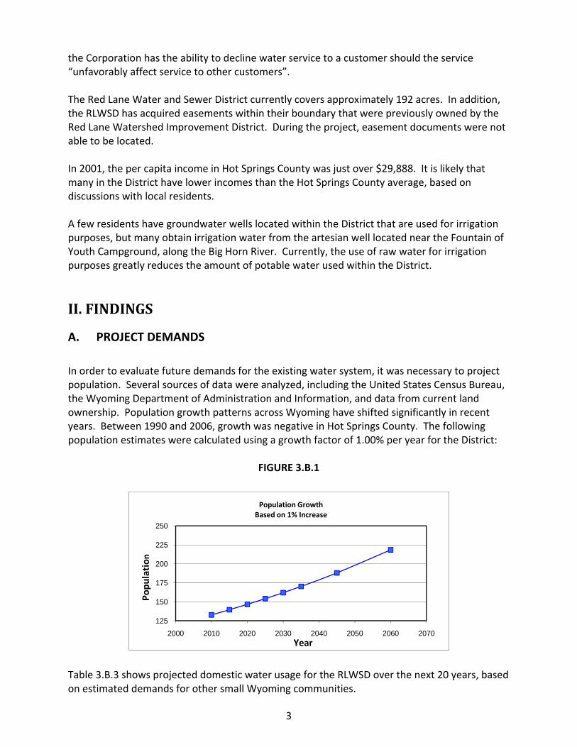
A. PROJECT DEMANDS In order to evaluate future demands for the existing water system, it was necessary to project population. Several sources of data were analyzed, including the United States Census Bureau, the Wyoming Department of Administration and Information, and data from current land ownership. Population growth patterns across Wyoming have shifted significantly in recent years. Between 1990 and 2006, growth was negative in Hot Springs County. The following population estimates were calculated using a growth factor of 1.00% per year for the District:
FIGURE 3.B.1
125
150
175
200
225
250
2000 2010 2020 2030 2040 2050 2060 2070
Popu
lation
Year
Population Growth Based on 1% Increase
Table 3.B.3 shows projected domestic water usage for the RLWSD over the next 20 years, based on estimated demands for other small Wyoming communities.
3

2010 2010 2030 2030ADD PEAK ADD PEAK
GPM 17 69 21 277GPCPD 185 740 185 740
TABLE 3.B.3Projected Domestic Water Demands
Total Projected Water Demand
Population projections for 2030 suggest that the population of the District could be 162 people. This would change the average daily demand (ADD) in 2030 to 21 gpm, and the maximum daily demand (MDD) to 46 gpm. Also, the District’s allowable water usage from the Town of Thermopolis is contractually allowed to increase ten percent (10%) each year, which is a considerably greater increase than we projected for demands in 2030. The projected water usage based on a ten percent increase of every year for the next 20 years results in a 2030 water demand of 80 gpm ADD. The population calculations indicate the water contract with the Town allows for more increase in water usage per year than the population projections indicate.
B. WATER DEMAND VARIATIONS An ADD of 83 GPCD was calculated from the Corporation’s monthly water consumption records provided by the Town of Thermopolis. A comparison of the average daily demand in the above table indicates the water use within the District is considerably lower than other communities. An analysis was done to compare historic water use data and water usage in other communities. An average daily demand of 185 GPCD (0.13 gpm per capita) was used in the WaterCAD water model. A comparison of the Red Lane MDD peaking factor with those of indicate the peaking factor for the maximum day demand for Red Lane is close to the community average. The actual calculations and assumptions are included in the Project Notebook.
III. CONFIGURATIONS
A. OPTIONS Extensive consideration was given to options that will improve fire protection and supply water to more of the property currently included in the District, without significantly increasing user costs, compromising public safety, or substantially increasing the complexity of the system.
1. OPTION 1 – New System with Town Of Thermopolis Service Line
This alternative was created after determining the existing system capacity is not adequate to provide raw water or fire protection flows. The pipes within the system were sized accordingly to provide raw water and fire protection flows within the District. Pipe improvements to the
4

4‐inch and 6‐inch diameter lines owned by the Town of Thermopolis water system were not incorporated into this alternative. Water is delivered to Option 1 at the location of the existing Red Lane Domestic Water, Inc. meter. A service line was then designed to provide water to a 100,000 gallon storage tank located near the vicinity of the existing 22,000 gallon storage tank. This option would increase the capacity and fire protection available within the District. This option does not address the need for the District to purchase easements for the waterline or storage tank. The layout of Option 1 is shown on a map in the Appendix.
2. OPTION 2 – New System with Lucerne Pipeline Connection This alternative was created after identifying the possibility of delivering water to the Red Lane area through the Lucerne Pipeline located along the highway. In 2012, the Lucerne Water and Sewer District will connect to BHR and no longer receive water from the Town of Thermopolis. Because the existing Corporation’s water system can not provide raw water or fire protection, this option provides larger pipe diameters to deliver sufficient water for domestic use, miscellaneous use, and fire protection. Pipe improvements to the existing 6‐inch diameter Lucerne Pipeline were not incorporated into this alternative. A 100,000 gallon storage tank was located near the vicinity of the existing 22,000 gallon storage tank to provide emergency storage and fire protection storage. This option does not address the need for the District to purchase easements for the waterline and storage tank. The layout of Option 2 is shown on a map in the Appendix.
3. OPTION 3 – Rehabilitate 22,000 Gallon Storage Tank The condition of the interior of the tank is currently unknown. However, based on the age and exterior appearance of the tank, it is likely rehabilitation will be necessary in the near future. Also, the tank does not have a property foundation and has reportedly tipped to one side in recent years. The existing tank base shows signs of uneven settlement and concrete degradation. Rehabilitation of this tank may be a cost effective approach. The funding scenario for this option was based on private ownership of the system.
4. OPTION 4 – Construct 100,000 Gallon Storage Tank This alternative provides a cost analysis of replacing the existing tank with a higher capacity tank. The cost estimate includes constructing a new tank and foundation. The tank would provide for the supply, fire, reserve, and bottom storage capacity previously discussed in the report.
5. OPTION 5 – Purchase Red Lane Domestic Water, Inc. In the event the District can not purchase easements in which the water transmission lines and storage tank could be located, they may want to explore purchasing the Red Lane Domestic
5

Water, Inc. system, to obtain their easements. The owner of the Corporation has indicated he would be willing to sell the system to the District. Specific details of the sale should be legally outlined prior to the District seeking funding for the system. In addition, the District will need to research any outstanding shares of the Corporation. Funding availability may be limited to the District if they were to purchase the entire infrastructure system and easements. Funding opportunities do exist to fund the purchase of easements.
6A. OPTION 6A – Existing System with Black Willow Subdivision Extension This alternative looked at the ability of the existing water system to provide water to the Black Willow Subdivision located approximately 7,900 feet to the northeast of the District. The proposed system is composed of a 6‐inch transmission line. The transmission line was extended to the eastern boundary of the subdivision to facilitate future water users to the north. The funding costs were based on the private ownership of the pipe network and that all the construction costs would be paid by all users of the Corporation. The funding scenario does not include the cost to purchase easements. A map of Option 6A is located in Appendix B.
6B. OPTION 6B – Option 1 with Black Willow Subdivision Extension In the event the District decided to construct and operate Option 1, they could provide water to the Black Willow Subdivision. A 6‐inch transmission line would connect to the supply line leaving the Red Lane Tank. The transmission line would cross the Big Horn River and follow the County road until it reached the subdivision. The 6‐inch transmission line was extended to the eastern boarder of the subdivision so future developments could connect to the pipeline. This option did not propose any improvements to the Town of Thermopolis distribution system near Monument Hill Cemetery. The layout of Option 6B is shown on a map in the Appendix. Raw water demands were not included in the MDD 2030 water demands. The funding scenario was based on the District ownership of the system and does not include the cost to purchase easements.
6C. OPTION 6C – Option 2 with Black Willow Subdivision Extension In the event the District decided to construct and operate Option 2, they could provide water to the Black Willow Subdivision. A 6‐inch transmission line would connect to the Lucerne Pipeline, cross the Big Horn River and follow the County road until it reached the east boundary of the subdivision. Due to the potential of developable land to the east, the transmission line was extended to the east end of the service area. This option did not propose any improvements to the Town of Thermopolis distribution system or the Lucerne Pipeline. The cost analysis does not include the purchase of utility easements. The layout of Option 6C is shown on a map in the Appendix. Raw water demands were not included in the MDD 2030 water demands.
7. OPTION 7 – Lucerne Water and Sewer District Extension to Black Willow Subdivision
6

Option 7 was developed in response to the landowner’s request to investigate the possibility of receiving the Lucerne Water and Sewer District (LW&SD). If the landowners of the District and the Black Willow Subdivision were to receive water from the Lucerne Water and Sewer District through the Lucerne Pipeline, they would need to pay the transmission fees and other operation and maintenance fees imposed by the Big Horn Regional Pipeline and the LW&SD. The cost analysis of Option 7 provides a cost analysis of only the construction costs to construct the improvements and minimal operation and maintenance expenses for the new pipelines. The cost analysis does not include the base rate fees imposed by Big Horn Regional or LW&SD or an estimate to purchase easements. A map of Option 7 is included in the Appendix.
B. RATE SCHEDULES Rate schedules can be set based on tap sizes, which correlate to EDUs (equivalent dwelling unit). The EDUs were established to consider all residential uses (5/8” meter, 5/8” x 3/4” meter, or 3/4” meter) equal to 1 EDU. Given that information, EDUs are calculated based on a ratio of the area of each meter size to a residential meter. It should be noted that tap sizes in the District are largely unknown, but based on conversations with the system owner, all but one tap was assumed to be 1 EDU.
Tap Size EDUTotal Taps
Base Rate Per Month**
Cost per Usage per 1,000 Gal for Residential and Commercial
Usage
Average Water Usage
Average Monthly
Bill
Annual Total of Monthly
Bills
3/4" 1 56 $37.06 $5.15 5,000 $62.81 $42,208.321 1/2" * 4 1 $37.06 $5.15 12,000 $98.86 $1,186.32
Total $43,394.64* 1 1/2" tap serves a RV park ** Includes 0 gallons for Residential and 0 gallons for Commercial
TABLE 6.F.1EXISTING WATER RATE SCHEDULE AND TREATED WATER INCOME
C. SUMMARY OF PROJECT COSTS Preliminary costs were developed from bid tabulations collected from recent water projects completed by Engineering Associates. These bid tabs provide the bid prices from 2010 for furnishing and installing pipelines and appurtenances. The total project costs were projected to 2013. The numbers can be adjusted forward to reflect the costs that can be anticipated for any particular construction year with the data provided.
7

Description of Cost
Option 1 New System with
Town of Thermopolis Service Line
Option 2New System with Lucerne Pipeline Connection
Option 6BOption 1 with Black Willow Sub. Ext.
Option 6COption 2 with Black Willow Sub. Ext.
Option 7**LW&SD supplies Black Willow Sub.
Capital Construction Costs $12,552.77 $11,528.73 $17,891.53 $16,403.57 $3,466.24 WWDC Repair Account $12,000.00 $12,000.00 $12,000.00 $12,000.00 $12,000.00 Operation & Maintenance Cost $18,200.00 $18,200.00 $18,200.00 $18,200.00 $18,200.00 Facility Depreciation* $34,986.00 $28,718.00 $59,334.00 $50,708.00 $9,302.00 Total $77,738.77 $70,446.73 $107,425.53 $97,311.57 $42,968.24
Description of Cost Option 1 Option 2 Option 6B Option 6C Option 7**
Capital Construction Cost $17.43 $16.01 $21.00 $19.25 $4.07 WWDC Repair Account $16.67 $17.54 $14.08 $14.08 $14.71 Operation & Maintenance Cost $25.28 $25.28 $21.36 $21.36 $21.36 Facility Depreciation $48.59 $39.89 $69.64 $59.52 $10.92
New Base Rate $107.97 $98.72 $126.09 $114.22 $51.05
Description of Cost
Option 3Rehabilitate 22,000
Gallon Tank
Option 4Construct 100,000 Gallon Storage Tank
Option 6AExisting System with Black Willow Sub. Ext.
Option 6AExisting System with Black Willow Sub. Ext.
Capital Construction Costs $7,211.01 $18,041.94 $ 61,507.30 $ 61,507.30 Operation & Maintenance Cost $25,362.72 $25,362.72 $ 4,894.56 $ 30,257.28 Facility Depreciation $1,960.00 $7,142.00 $ 24,348.00 $ 24,348.00
Total $34,533.73 $50,546.66 $ 90,749.86 $ 116,112.58
Description of Cost Option 3 Option 4Option 6A11 EDU's
Option 6A71 EDU's
Capital Construction Cost $10.02 $25.06 $72.19 $72.19 Operation & Maintenance Cost* $35.23 $35.23 $37.08 $35.51 Facility Depreciation $2.72 $9.92 $184.45 $28.58
New Base Rate $47.96 $70.20 $293.73 $136.28
TABLE 6.D.5.1ANNUAL COST SUMMARY
Total Annual Cost to DistrictDistrict Ownership and Operation of System
Proposed Monthly Cost for one Residential User (1 EDU)
Total Annual Cost
* The Original Facility Depreciation cost was decreased by the amount of funding required by the WWDC Repair Account.** The New Base Rate for this option does not include monthly base rates billed by the Lucerne Water & Sewer District or the Big Horn Regional Pipeline.
* The Operation & Maintenance Cost per Tap is $37.08.
Proposed Monthly Cost for one Residential User (1 EDU)
Private Ownership and Operation of System
V. CONCLUSIONS
A. SUMMARY The Red Lane Water and Sewer District Water System does not appear to have any major issues with water quality according to the EPA website and the water analysis completed during this study. Analysis of personal income levels of those living in the District and evaluation of the cost of potential improvements suggests that it will be very difficult for the District to
8

implement a significant upgrade program from a financial standpoint. The District is also in a unique situation where it does not own the infrastructure that provides the potable water to its residents. In addition, an analysis was done to determine if it was cost effective for the District to provide water to the Black Willow Subdivision. Cost estimates were determined based on assumptions about the ownership of the improvements. In the event the existing raw water system used to irrigate lawns is eliminated, the existing system is not capable of providing raw water. In addition, sizing the system to allow all residents to irrigate at one time would drastically increase the construction costs and may require additional flushing expenses in the winter to maintain water quality.
B. CONCLUSIONS Due to the private ownership of the existing system, minimal funding opportunities exist to improve the existing system. In the event the District purchased the existing system, the small population of the District when combined with the low average household income, limit the funding available to make improvements to the water system to provide fire flow and irrigating water. Should the existing system fail, it is in the best interest of the District to own and operate a new system or dissolve into a nearby entity to receive services. The cost estimates indicate the District could supply water to the Black Willow Subdivision with minimal adjustment to the monthly base rate.
C. RECOMMENDATIONS At a minimum, the District should encourage the Red Lane Water Corporation to rehabilitate the storage tank, meter all service lines, and continue its current flushing program to minimize stagnation problems. The entire water system should be flushed at least twice per year. This activity will also give the Corporation an opportunity to exercise the flushing hydrant and valves, which will be helpful for identifying items that need to be replaced. The Corporation should also be encouraged to take immediate steps to become part of the One Call of Wyoming system. This will help protect the water systems from being damaged during excavation efforts in the area. Due to the presence of numerous other utilities in the Red Lane area, having an opportunity to locate the underground pipelines and other components prior to excavation will be very valuable. The District should work with the Corporation to implement a program for updating the District’s system mapping on an annual basis. As new services are installed and old ones are found or abandoned, they should be recorded by the field personnel and compiled into a working document that can be used to update the electronic files on a regular basis. The District should also consider tracking the installation and location of any new or replacement valves, hydrants, piping, repair clamps, etc. that are installed in the system. Keeping track of this information will be very helpful to the Corporation as it continues to improve its operation and maintenance procedures.
9

10
The District should be aware of aquifer issues related to the Big Spring at the Hot Springs State Park. Raw water users who receive water from the Maytag Well should be aware the flows could be restricted to the historic consumptive use by the SEO. The residents should determine if it is in their best interest to be proactive and look for water efficiency grants to restrict the flow rate of the well. The residents should contact the SEO and Board of Control with any questions and comments. The District should evaluate all the design alternatives and costs estimates to determine if they are interested in owning and operating a treated water system. It is important that the District realize that should the existing system need substantial repairs or improvements, the current owner would rather sell the system to the District than construct the repairs or improvements. The cost estimates clearly indicate how grant opportunities allow public entities in low income area to construct improvements while minimizing monthly base rates to the customers. Should the system fail unexpectedly, homeowners may need to haul water for a substantial amount of time before funding, design and construction take place. In the event the Red Lane Domestic Water, Inc. decides to provide water to the Black Willow Subdivision, the residents should question how the Corporation will adjust the monthly base rate fee. Should the District decide to own and operate a treated water system, they should approach the Black Willow Subdivision to determine if the land owners would be willing to annex into the District and receive water.
D. PREFERRED ALTERNATIVES The RLWSD should consider applying for a Level II Study with the WWDC to further investigate its options for constructing a new water system should they desire to own and operate a treated water system. The Level II Study would consist of more comprehensive investigations into the recommendations of this current study, and provide cost estimates for the preferred alternatives in greater detail. If the Level II Study identifies issues with one or more of the preferred alternatives, acceptable solutions and modifications may be researched and presented to the District. Following the Level II Study, the District will likely be in a good position to apply for Level III funding to begin the design and construction of its selected system improvements. Should RLWSD decide not to own and operate a treated water system in the foreseeable future, it is recommended they approach the Corporation about rehabilitating the existing tank as discussed in Option 3.

APPENDIX
Drawing Sheets
• Existing Infrastructure Overview Map • Existing System • Option 1 Proposed System • Option 2 Proposed System • Option 6A: Existing System with Black Willow Subdivision Extension • Option 6B: Option 1 with Black Willow Subdivision Extension • Option 6C: Option 2 Black Willow Subdivision Extension • Option 7: Lucerne Water & Sewer District service to Black Willow
Subdivision

0 410 820205 FeetENGINEERING ASSOCIATES
THERMOPOLIS, WYOMINGCONSULTING ENGINEERS & SURVEYORS Existing Infrastructure Overview Map
Red Lane
Red Lane Master PlanLevel I Study - 20101" = 800'
Coventry Circle
Red Lane Tank
Red Lane Domestic Water, Inc. Meter
Hot Springs County ThermopolisMunicipal Airport
Big Horn River
Fountain of Youth RV Park
Railroad
Session Road
US Hwy 20
Road 5
Lane 3
LegendRed Lane District BoundaryWellWater ValveWater TankWater MeterHydrantCurb StopTreated Water Line MainsTreated Water Tap LinesCounty OwnershipRailroadRoad


