this page blank
TRANSCRIPT
It~=~
NEW
YO
RK S
TATE
Dep
artm
ent
of E
nvir
onm
enta
l Con
serv
atio
n D
IVIS
ION
OF
LAN
DS
& F
ORE
STS
Wat
son'
s Ea
st T
rian
gle
Wil
d F
ores
t an
d
Bear
Pon
d Pr
imiti
ve C
orri
dor
Tied
Lak
e Pr
imiti
ve C
orri
dor
and
Rive
r Are
a M
anag
emen
t Pla
ns fo
r:
Mid
dle
Bran
ch O
sweg
atch
ie R
iver
and
Wes
t Bra
nch
Osw
egat
chie
Riv
er
Un
it M
anag
emen
t P
lan
Tow
ns o
f Cro
ghan
, and
Wat
son
- Lew
is C
ount
y
Tow
n of
Web
b - H
erki
mer
Cou
nty
DA
VID
A. P
ATER
SON
PE
TER
M. I
WA
NO
WIC
Z
Gov
erno
r A
ctin
g Co
mm
issi
oner
For
Furt
her
Info
rmat
ion
Cont
act:
Keith
Riv
ers,
For
este
r N
ew Y
ork
Stat
e D
epar
tmen
t of E
nviro
nmen
tal C
onse
rvat
ion
7327
Sta
te R
oute
812
Lo
wvi
lle, N
Y 13
367
Phon
e: (3
15) 3
76-3
521
r6um
p@gw
.dec
.sta
te.n
y.us
D
ecem
ber
2010

This Page Intentionally Left Blank

AThe nation behaves well if it treats the natural resources as assets which it must turn over to the next generation
increased, and not impaired, in value.@ Theodore Roosevelt

This Page Intentionally Left Blank
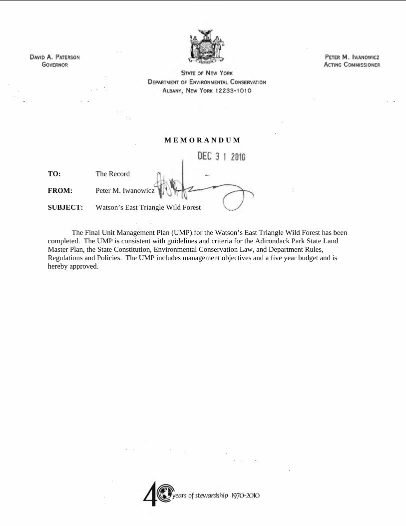
TO: The Record FROM: Peter M. Iwanowicz SUBJECT: Watson’s East Triangle Wild Forest
DAVID A. PATERSON
GOVERNOR
STATE OF NEW YORK
D EPARTMENT OF E NVIRONMENTAL C ONSERVATION
A LBANY, N EW YORK 12233· 1 0 I 0
DEC 3 1 2010
40-yeors of stewordship 1970-2010
PETER M. IWANOWICI ACTING C OMMISSIONER
M E M O R A N D U M
The Final Unit Management Plan (UMP) for the Watson’s East Triangle Wild Forest has been completed. The UMP is consistent with guidelines and criteria for the Adirondack Park State Land Master Plan, the State Constitution, Environmental Conservation Law, and Department Rules, Regulations and Policies. The UMP includes management objectives and a five year budget and is hereby approved.

This Page Intentionally Left Blank
, ♦4 .... Adironaack
parkagency
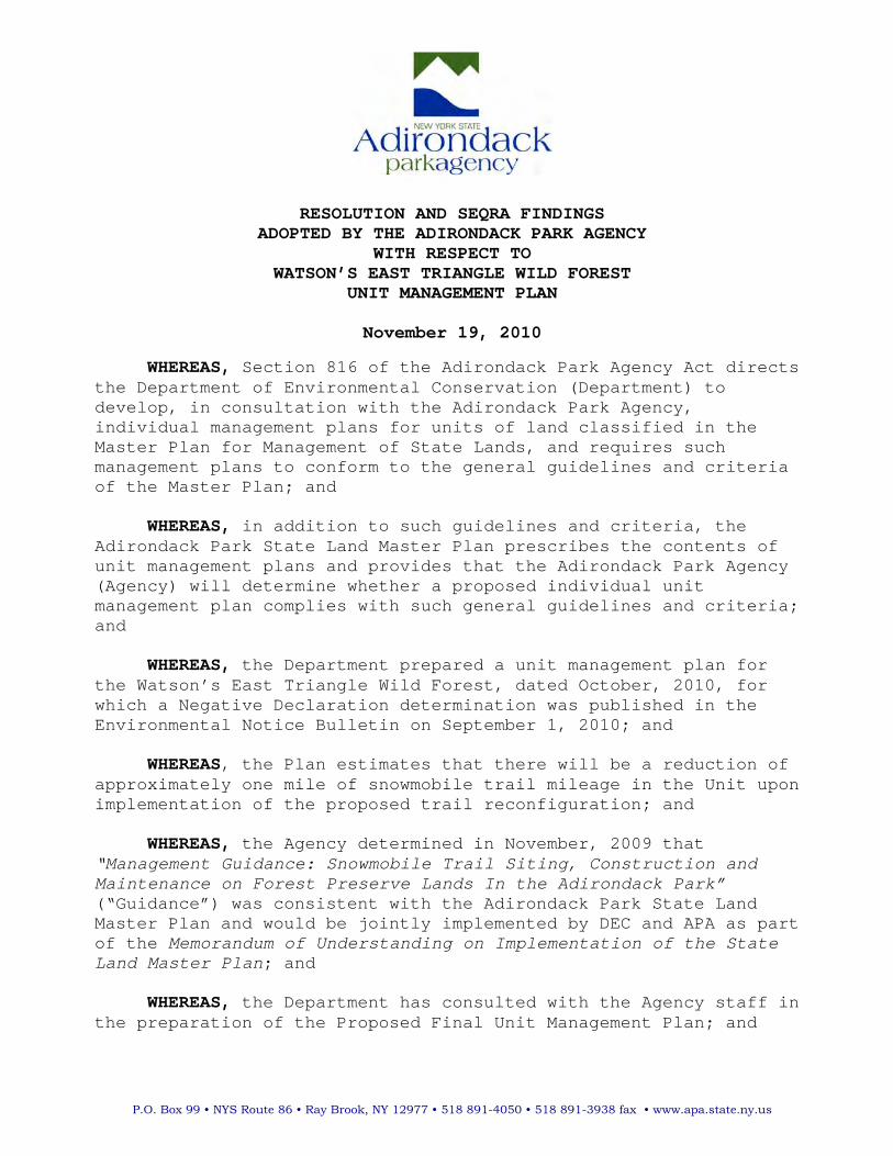
RESOLUTION AND SEQRA FINDINGSADOPTED BY THE ADIRONDACK PARK AGENCY
WITH RESPECT TO WATSON’S EAST TRIANGLE WILD FOREST
UNIT MANAGEMENT PLAN
November 19, 2010
WHEREAS, Section 816 of the Adirondack Park Agency Act directsthe Department of Environmental Conservation (Department) todevelop, in consultation with the Adirondack Park Agency,individual management plans for units of land classified in theMaster Plan for Management of State Lands, and requires suchmanagement plans to conform to the general guidelines and criteriaof the Master Plan; and
WHEREAS, in addition to such guidelines and criteria, theAdirondack Park State Land Master Plan prescribes the contents ofunit management plans and provides that the Adirondack Park Agency(Agency) will determine whether a proposed individual unitmanagement plan complies with such general guidelines and criteria;and
WHEREAS, the Department prepared a unit management plan forthe Watson’s East Triangle Wild Forest, dated October, 2010, forwhich a Negative Declaration determination was published in theEnvironmental Notice Bulletin on September 1, 2010; and
WHEREAS, the Plan estimates that there will be a reduction ofapproximately one mile of snowmobile trail mileage in the Unit uponimplementation of the proposed trail reconfiguration; and
WHEREAS, the Agency determined in November, 2009 that“Management Guidance: Snowmobile Trail Siting, Construction and Maintenance on Forest Preserve Lands In the Adirondack Park” (“Guidance”) was consistent with the Adirondack Park State LandMaster Plan and would be jointly implemented by DEC and APA as partof the Memorandum of Understanding on Implementation of the State Land Master Plan; and
WHEREAS, the Department has consulted with the Agency staff inthe preparation of the Proposed Final Unit Management Plan; and
P.O. Box 99 • NYS Route 86 • Ray Brook, NY 12977 • 518 891-4050 • 518 891-3938 fax • www.apa.state.ny.us

- 2 -
WHEREAS, the Guidance does not allow road-building equipmentto be used to construct or maintain snowmobile trails in the Unit and provides that trail work will be performed only under directDepartment supervision and oversight using low-impact landscapingequipment in a manner that will protect the wild forest setting;and
WHEREAS, the Department has updated the Adopt a NaturalResource (AANR) Agreements and Temporary Revocable Permits (TRPs)to ensure that the Guidance will be followed for new trail construction and maintenance; and
WHEREAS, the Department will develop and implement SnowmobileTrail Work Plans in direct consultation with Agency staff; and
WHEREAS, the reconfigured trail system in the Unit willprovide improved year-round recreational opportunities as well asimprovements to the snowmobile trail system; and
WHEREAS, the Agency is requested to determine whether theproposed final Watson’s East Triangle Unit Management Plan, datedOctober, 2010, is consistent with the general guidelines andcriteria of the Adirondack Park State Land Master Plan, and theAgency has reviewed the proposed final plan; and
NOW, THEREFORE, BE IT RESOLVED, that pursuant to Section 816of the Adirondack Park Agency Act, the Adirondack Park Agency findsthe proposed final Watson’s East Triangle Wild Forest UnitManagement Plan conforms with the general guidelines and criteriaof the Adirondack Park State Land Master Plan; and
BE IT FINALLY RESOLVED, that the Adirondack Park Agencyauthorizes its Executive Director to advise the Commissioner of Environmental Conservation of the Agency’s determination in thismatter. AYES: R. Booth, A. Lussi, F. Mezzano, C. Stiles, W. Thomas, L. Ulrich, F. W. Valentino, J. Fayle (DED), E. Lowe (DEC), R. Morgiewicz (DOS) NAYS: None ABSTENTIONS: None
ABSENCES: C. Wray

PREFACE The Watson=s East Triangle Wild Forest Unit Management Plan has been developed pursuant to, and is consistent with, relevant provisions of the New York State Constitution, the Environmental Conservation Law (ECL), the Executive Law, the Adirondack Park State Land Master Plan (APSLMP or AMaster Plan@), Department of Environmental Conservation (ADepartment@) rules and regulations, Department policies and procedures and the State Environmental Quality and Review Act. The State land which is the subject of this Unit Management Plan (UMP) is Forest Preserve land protected by Article XIV, Section 1 of the New York State Constitution. This Constitutional provision, which became effective on January 1, 1895 provides in relevant part: AThe lands of the state, now owned or hereafter acquired, constituting the Forest Preserve as now fixed by law, shall be forever kept as wild forest lands. They shall not be leased, sold or exchanged, or be taken by any corporation, public or private, or shall the timber thereon be sold, removed or destroyed.@
ECL ''3‐0301(1)(d) and 9‐0105(1) provide the Department with jurisdiction to manage Forest Preserve lands, including the Watson=s East Triangle Wild Forest. The APSLMP was initially adopted in 1972 by the Adirondack Park Agency (AAPA@), with advice from and in consultation with the Department, pursuant to Executive Law '807, now recodified as Executive Law '816. The APSLMP provides the overall general framework for the development and management of State lands in the Adirondack Park, including those State lands which are the subject of this UMP. The APSLMP places State land within the Adirondack Park into the following classifications: Wilderness; Primitive; Canoe; Wild Forest; Intensive Use; Historic; State Administrative; Wild, Scenic and Recreational Rivers; and Travel Corridors. The lands which are the subject of this UMP are classified by the APSLMP and described herein as the Watson=s East Triangle Wild Forest and the Bear Pond and Tied Lake Primitive Corridors. For all State lands falling within each major classification, the APSLMP sets forth management guidelines and criteria. These guidelines and criteria address such matters as: structures and improvements; ranger stations; the use of motor vehicles, motorized equipment and aircraft; roads, jeep trails and State truck trails; flora and fauna; recreation use and overuse; boundary structures and improvements and boundary markings. Executive Law '816 requires the Department to develop, in consultation with the APA, individual UMPs for each unit of land under the Department’s jurisdiction which is classified in one of the nine classifications set forth in the APSLMP. The UMPs must conform to the guidelines and criteria set forth in the APSLMP. Thus, UMPs implement and apply the APSLMPs general guidelines for particular areas of land within the Adirondack Park. Executive Law '816(1) provides in part that A(u)ntil amended, the master plan for management of state lands and the individual management plans shall guide the development and management of state lands in the Adirondack Park.@
Watson’s East Triangle Wild Forest Unit Management Plan – December 2010 i

Preface
Purpose and Need
Without a UMP, the management of these Forest Preserve lands can easily become a series of uncoordinated reactions to immediate problems. No new facility construction, designation, or major rehabilitation can be undertaken until a UMP is completed and approved, with current management limited to routine maintenance and emergency actions. A written plan stabilizes management despite changes in personnel and integrates related legislation, legal codes, rules and regulations, policies, and area specific information into a single reference document. Other benefits of the planning process that are valuable to the public include the development of area maps, fishing information handouts, and a greater awareness of recreational opportunities and needs within specific areas of the Adirondack Park. In view of tight budgets and competition for monetary resources, plans that clearly identify area needs have greater potential for securing necessary funding, legislative support, and public acceptance.
This document provides a comprehensive inventory of natural resources, existing facilities and uses, while identifying the special values which justify the protection of this area in perpetuity for future generations. The process involved the gathering and analysis of existing uses and conditions, regional context and adjacent land considerations, future trends, and the identification of important issues. Ordinarily, the plan will be revised on a five‐year cycle, but may be amended when necessary in response to changing resource conditions or administrative needs. Completion of the various management actions within this UMP will be dependent upon adequate manpower and funding. Where possible, the DEC will work with volunteer groups, local communities, town and county governments, and pursue alternative funding sources to accomplish some of the proposed projects or maintenance.
Organization of the Plan
This UMP is intended to be a working document, easily used by both State personnel and the public. Footnotes are placed at the bottom of the page and provide more detailed information. Specific references are cited and are included in the bibliography. The content of each section is briefly summarized below:
Section I introduces the area, provides a general description with information on the size and location of the unit, access, and a brief chronology of the history of the general area.
Section II provides an inventory of the natural, scenic, cultural, fish and wildlife, and associated resources along with an analysis of the areas ecosystems. Existing facilities for both public and administrative use are identified, along with an assessment of public use and carrying capacity. Adjacent land uses, access, and impacts are also discussed.
Section III includes descriptions of past management activities, existing management guidelines, management principles important for achieving the classification objectives for the unit, and an outline of issues identified through the inventory process with input from the planning team and public. This section lays the foundation for the development of specific management strategies necessary to attain the goals and objectives of the APSLMP. An assessment of needs and projected use are also discussed.
Section IV will identify specific management proposals as they relate to natural resources, uses, or facilities. These proposed actions will be consistent with the management guidelines and principles and
Watson’s East Triangle Wild Forest Unit Management Plan – December 2010 ii

Preface
will be based on information gathered during the inventory process, through public input and in consultation with the planning team. This section also identifies management philosophies for the protection of the area while providing for use consistent with its carrying capacity.
Section V includes a schedule for implementation and identifies the budget needs to carry out the work described in the UMP. At the end of the text is a list of cited references, general bibliography, and various technical appendices. Relevant definitions and APSLMP quotations used within this document are from the approved November 1987, Updated 2001 edition. Map inserts show detailed area information.
What the Plan Does Not Do
The proposed management actions identified in this plan are primarily confined to the Watson=s East Triangle Wild Forest. The Bear Pond and Tied Lake primitive corridors are included in this plan due to their connectivity to the WETWF road system. In the future these areas should be included in UMP=s for either the Five Ponds or Pepperbox Wilderness Areas. In addition, this UMP cannot suggest changes to Article XIV, Section 1 of the New York State Constitution or conflict with statutory mandates or DEC policies. All proposals must conform to the guidelines and criteria set forth in the APSLMP and cannot amend the Master Plan itself. State Environmental Quality Review Act (SEQRA).
The State Environmental Quality Review Act requires that all agencies determine whether the actions they undertake may have a significant impact on the environment. The intent of the legislation is to avoid or minimize adverse impact on the resource. The guidelines established in the APSLMP for developing unit management plans express these same concerns. Any development within the WETWF presented in the plan must take into consideration environmental factors to insure that such development does not degrade that environment. The overall intent of this UMP is to identify mitigating measures to avoid or minimize adverse impacts.
As required by SEQRA, during the planning process a range of alternatives were formulated to evaluate possible management approaches for dealing with certain issues or problem locations. Department staff considered the no‐action and other reasonable alternatives, whenever possible. Potential environmental impacts, resource protection, visitor safety, visitor use and enjoyment of natural resources, user conflicts, interests of local communities and groups, and short and long‐term cost‐effectiveness were important considerations in the selection of proposed actions. Efforts were made to justify reasons for the proposals throughout the body of the UMP so the public can clearly understand the issues and the rationale for Department decision making.
Due to the significance of potential environmental and/or social impacts, a positive declaration may be determined to be necessary. A Positive Declaration is issued through a press release/Notice of Intent document. The UMP then constitutes the Draft Environmental Impact Statement (EIS). In cases where impacts are deemed not to be significant, a negative declaration is issued.
The initial draft UMP or draft EIS is reviewed internally by DEC and APA staff, with necessary changes made prior to the draft UMP or draft EIS=s distribution for public review. At this time, a press release is issued and a public meeting scheduled to receive public comments on the draft plan. A Notice of Hearing will then be published in the Environmental News Bulletin and local newspapers, and the public meeting held in conjunction with a public hearing to comply with SEQRA requirements.
Watson’s East Triangle Wild Forest Unit Management Plan – December 2010 iii

Preface
A minimum 30‐day public comment period follows the public meeting, during which time written comments may also be submitted regarding the plan. At the end of the public comment period, all public comment received on the draft plan is assessed, and appropriate changes are made to the plan. If a DEIS has been prepared, a Final EIS is prepared, along with a SEQRA Findings Statement. The final UMP/final EIS is then reviewed by the APA staff and Commissioners to determine its consistency with the Adirondack Park State Land Master Plan. Subsequently, the final UMP/final EIS is approved by the Commissioner of Environmental Conservation, printed and distributed. A Notice of Completion of final EIS is issued and SEQRA findings are then filed.
No Action Alternative or Need for a Plan
From a legal perspective, the No Action alternative of not writing a UMP is not an option. DEC is required to prepare a management plan for the WETWF pursuant to the APSLMP and Executive Law ' 816. In addition a UMP serves as a mechanism for the Department to study and identify potential areas for providing access to the WETWF for persons with disabilities in accordance with the Americans with Disabilities Act (ADA of 1990). The UMP also serves as an administrative vehicle for the identification and removal of nonconforming structures as required by the APSLMP.
From an administrative perspective, the ANo Action@ alternative is not an option. The NYS Department of Environmental Conservation has the statutory responsibility under Environmental Conservation Law (ECL) ''3‐0301(1)(d) and 9‐0105(1), to provide for the care, custody, and control of these public lands. The UMP will provide the guidance necessary for staff to manage the area in a manner that protects the environment while at the same time providing for suitable outdoor recreation opportunities for the public. Without the development and future implementation of the UMP, sensitive environmental resources of the unit could be impacted negatively and it is highly likely that the public enjoyment of such resources would decrease. Public use problems would continue to occur.
Management of the WETWF via a UMP will allow the Department to improve public use and enjoyment of the area, avoid user conflicts and prevent over use of the resource (e.g., through trail designations, access restrictions, placement of campsites and lean‐tos away from sensitive resource, etc.). Management Alternatives were developed for some of the UMP proposals that may: (1) have significant environmental impacts, (2) involve facility closures, or (3) involve controversial actions changing existing public use, and can be found in Section IV of this document.
Watson’s East Triangle Wild Forest Unit Management Plan – December 2010 iv

CONTENTS
SECTION I: INTRODUCTION…………………………………………………………………………………………………………………..1 A. Planning Area Overview ...........................................................................................................1 B. Unit Geographic Information....................................................................................................1 C. General Location.......................................................................................................................2 D. Acreage.....................................................................................................................................2 E. General Access ..........................................................................................................................3 F. General History .........................................................................................................................3
SECTION II: INVENTORY, USE AND CAPACITY TO WITHSTAND USE..........................................................5 A. Natural Resources.....................................................................................................................5
1. Physical ........................................................................................................................5 2. Biological ....................................................................................................................11
B. Man‐Made Facilities ...............................................................................................................16 1. Roads..........................................................................................................................16 2. Designated Primitive Tentsites ..................................................................................18 3. Designated Foot Trails ...............................................................................................18 4. Snowmobile Trails......................................................................................................18 5. Boundary Lines...........................................................................................................20 6. Parking Areas .............................................................................................................20 7. Gates ..........................................................................................................................20 8. Dams ..........................................................................................................................20 9. Bridges .......................................................................................................................20 10. Signs .........................................................................................................................20 11. Accessible Waterway Access Sites ...........................................................................20
C. Past Influences ........................................................................................................................20 1. Cultural.......................................................................................................................21 2. Historical ....................................................................................................................21
D. Public Use ...............................................................................................................................22 1. Land Resources ..........................................................................................................22
E. Recreational Opportunities for Persons with Disabilities .......................................................25 F. Relationship of Unit to other Forest Preserve lands...............................................................25
1. State Lands under the Jurisdiction of DEC .................................................................25 G. Relationship Between Public and Private Land .....................................................................26 H. Capacity to Withstand Use .....................................................................................................27
1. Physical ......................................................................................................................30 2. Biological ....................................................................................................................31 3. Social ..........................................................................................................................33
I. Education, Interpretation and Research..................................................................................33 J. Economic Impact .....................................................................................................................33
III. MANAGEMENT AND POLICY ...............................................................................................................35 A. Past Management...................................................................................................................35
1. Land Management .....................................................................................................35 2. Wildlife Management ................................................................................................36 3. Fisheries Management ..............................................................................................38
B. Management Guidelines.........................................................................................................38 1. Guiding Documents....................................................................................................38
Watson’s East Triangle Wild Forest Unit Management Plan – December 2010 v
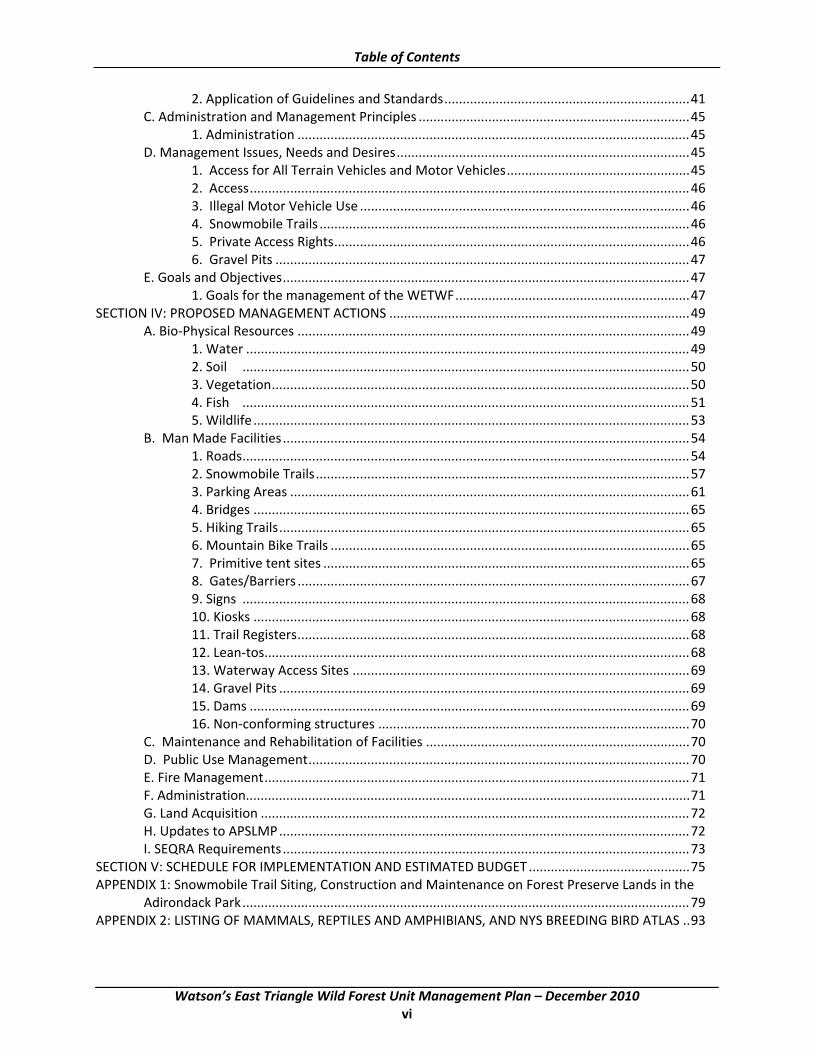
Table of Contents
2. Application of Guidelines and Standards...................................................................41 C. Administration and Management Principles ..........................................................................45
1. Administration ...........................................................................................................45 D. Management Issues, Needs and Desires................................................................................45
1. Access for All Terrain Vehicles and Motor Vehicles..................................................45 2. Access........................................................................................................................46 3. Illegal Motor Vehicle Use ..........................................................................................46 4. Snowmobile Trails .....................................................................................................46 5. Private Access Rights.................................................................................................46 6. Gravel Pits .................................................................................................................47
E. Goals and Objectives...............................................................................................................47 1. Goals for the management of the WETWF................................................................47
SECTION IV: PROPOSED MANAGEMENT ACTIONS ..................................................................................49 A. Bio‐Physical Resources ...........................................................................................................49
1. Water .........................................................................................................................49 2. Soil ..........................................................................................................................50 3. Vegetation..................................................................................................................50 4. Fish ..........................................................................................................................51 5. Wildlife .......................................................................................................................53
B. Man Made Facilities...............................................................................................................54 1. Roads..........................................................................................................................54 2. Snowmobile Trails......................................................................................................57 3. Parking Areas .............................................................................................................61 4. Bridges .......................................................................................................................65 5. Hiking Trails................................................................................................................65 6. Mountain Bike Trails ..................................................................................................65 7. Primitive tent sites ....................................................................................................65 8. Gates/Barriers ...........................................................................................................67 9. Signs ..........................................................................................................................68 10. Kiosks .......................................................................................................................68 11. Trail Registers...........................................................................................................68 12. Lean‐tos....................................................................................................................68 13. Waterway Access Sites ............................................................................................69 14. Gravel Pits ................................................................................................................69 15. Dams ........................................................................................................................69 16. Non‐conforming structures .....................................................................................70
C. Maintenance and Rehabilitation of Facilities ........................................................................70 D. Public Use Management........................................................................................................70 E. Fire Management....................................................................................................................71 F. Administration.........................................................................................................................71 G. Land Acquisition .....................................................................................................................72 H. Updates to APSLMP................................................................................................................72 I. SEQRA Requirements...............................................................................................................73
SECTION V: SCHEDULE FOR IMPLEMENTATION AND ESTIMATED BUDGET............................................75 APPENDIX 1: Snowmobile Trail Siting, Construction and Maintenance on Forest Preserve Lands in the
Adirondack Park..........................................................................................................................79 APPENDIX 2: LISTING OF MAMMALS, REPTILES AND AMPHIBIANS, AND NYS BREEDING BIRD ATLAS ..93
Watson’s East Triangle Wild Forest Unit Management Plan – December 2010 vi
Table of Contents
APPENDIX 3: FISH SPECIES, PONDED WATER SURVEY, AND PONDED WATER CHEMICAL AND FISHERIES DATA .........................................................................................................................................103
APPENDIX 4: BEAR POND ROAD WORK PLAN........................................................................................107 APPENDIX 5: CAMPSITE ASSESSMENT FORMS & PROCEDURES ............................................................147 APPENDIX 6: RIVER AREA PLANS............................................................................................................157 APPENDIX 7: DEEDED RIGHTS‐OF‐WAY .................................................................................................177 APPENDIX 8: STIPULATION AND ORDER, RESIDENTS COMMITTEE TO PROTECT THE ADIRONDACKS VS.
ADRIRONDACK PARK AGENCY ET AL.........................................................................................179 APPENDIX 9: DEFINITIONS AND ACRONYMS .........................................................................................183 APPENDIX 10: TRAIL CLASSIFICATIONS ..................................................................................................185 APPENDIX 11: BEST MANAGEMENT PRACTICES FOR STATE LANDS‐INVASIVE SPECIES........................187 APPENDIX 12: MOUNTAIN BIKE TRAIL STANDARDS AND GUIDELINES..................................................199 APPENDIX 13: PUBLIC COMMENT SUMMARY AND RESPONSES ...........................................................201 APPENDIX 14: UNIT MAPS .................................................................................................................... 209
Watson’s East Triangle Wild Forest Unit Management Plan – December 2010 vii

This page intentionally left blank
Watson’s East Triangle Wild Forest Unit Management Plan – December 2010 viii
ACKNOWLEDGMENTS
Planning Team
Keith Rivers‐Team Leader Division of Lands and Forests
David Smith‐ Regional Forester Division of Lands and Forests
Fred Munk‐ Associate Forester Division of Lands and Forests
Josh Clague Division of Lands and Forests
Bill Gordon Fisheries
Jim Farquhar Wildlife
Mark Craig Habitat
Michael Farrell Division of Operations
Michael Lewis Office of Public Protection
Walter Link Adirondack Park Agency
Contributors
Edwin Sykes Division of Lands and Forests
Rob Messenger Division of Lands and Forests
Tom Wolfe Division of Lands and Forests
Frank LaFlair Division of Operations
Peter Frank Division of Lands and Forests
Brian Finlayson Division of Lands and Forests
Frank La Flair Division of Operations
Watson’s East Triangle Wild Forest Unit Management Plan – December 2010 ix

This page intentionally left blank
Watson’s East Triangle Wild Forest Unit Management Plan – December 2010 x

ADIRONDACK PARK WATSON'S EAST TRIANGLE WILD FOREST AREA
Cl
~ =-~r:~~Lfl - WlLOCANl&'S
wa""""' ..... ~ "'MllM
(=:::::JWILDFOMST
mmnmm !WT(NSNI Ult
SW-C AOMl\ltSTRATfYl
Em Hl$TORtC
~ l't..,INO CLUl$1CATION
10 ,0
r:rnnne:n
Watson’s East Triangle Wild Forest Unit Management Plan – December 2010 xi

This Page Intentionally Left Blank
Watson’s East Triangle Wild Forest Unit Management Plan – December 2010 xii

SECTION I: INTRODUCTION
A. Planning Area Overview
The Watson=s East Triangle Wild Forest contains 13,417 acres of State owned Forest Preserve lands. There are no unclassified State lands in the unit. The phrase Aplanning area@ is used to describe a larger geographic area containing both public and private land that is shown as AManagement Complex Unit Boundary@ on the 11"x17" maps in the Appendix. The planning area boundary is used for administrative and planning purposes and does not have any legal connotation.
The WETWF is located within the Town of Webb, Herkimer County and the Town of Croghan, Lewis County. The Bear Pond and Tied Lake Primitive Corridors are being included in this plan in order to provide continuity with the management of public motor vehicle access within and beyond the WETWF. As access to both Primitive Corridors is via the Bear Pond Road the management of public access in the WETWF will directly affect current and future public use of these Primitive Corridors. Future management of individual Primitive Corridors will be addressed in the UMP for the area in which they are located. For the location of these Primitive Corridors please refer to the Watson=s East Triangle Facilities Map in the Appendix.
Bear Pond Primitive Corridor ‐ This primitive corridor is located in the Town of Webb, Herkimer County, and consists of two rights‐of‐ways providing access to two inholdings within the Five Ponds and Pepperbox Wilderness Areas. The main fork provides access to an in‐holding at Bear Pond within the Five Ponds Wilderness Area. The westerly fork provides access to an in‐holding at Loon Hollow Pond within the Pepperbox Wilderness Area. The APSLMP area description for the Bear Pond Primitive Corridor reads in part to Aavoid problems of motorized trespass on wilderness lands, this primitive corridor should be gated to public access in the immediate vicinity of the turn‐off to AOld Upper South Pond Road,@ and access beyond this point limited to private access only @(APSLMP, 2001 update, page 73).
Tied Lake Primitive Corridor ‐ This primitive corridor is in the Town of Webb, Herkimer County, and consists of a private right‐of‐way to an in‐holding within the Pepperbox Wilderness Area. The APSLMP area description for the Tied Lake Primitive Corridor reads in part: Ato avoid problems with motorized trespass on wilderness lands this primitive corridor should be gated to public access in the immediate vicinity of Tied Lake and access beyond that point limited to private use.@ (APSLMP, pages 80‐81)
B. Unit Geographic Information
Watson=s East Triangle Wild Forest: Lots/Ranges Tract 7.5 Minute Quad(s)
23‐27, 32‐38,42,43 Watson=s East Triangle Oswegatchie SE, SW 20‐24 North, Chassanis Tract Soft Maple, Stillwater Ranges 16‐19 East 23‐27 GT 4 Macombs Purchase 17‐N, 11‐E (GT‐5) Macombs Purchase Number Four
Watson’s East Triangle Wild Forest Unit Management Plan – December 2010 1

Section I: Introduction
18‐N, 11,12‐E (7.5x15 minute) 19‐N, 12‐E 20‐N, 12,13‐E
Bear Pond Primitive Corridor: 9,10,14,15,27 Watson=s East Triangle Stillwater (7.5x15 minute) Lots/Ranges Tract 7.5 Minute Quads Tied Lake Primitive Corridor: 8,16,26 Watson=s East Triangle Stillwater
(7.5x15 minute)
C. General Location
The Watson=s East Triangle Wild Forest lies within the Town of Webb, Herkimer County and the Town of Croghan, Lewis County. The WETWF is bounded on the east by the Five Ponds Wilderness Area, the south by the Pepperbox Wilderness Area, the north by the Aldrich Pond Wild Forest and on the west by the Oswegatchie Easement lands and several smaller private parcels. The western edge of the unit is approximately 12 miles east of the Village of Croghan.
The Bear Pond Primitive Corridor begins at the intersection of the Bear Pond Road and the Buck Pond Road, which coincides with the boundary between the WETWF, Five Ponds Wilderness Area and the Pepperbox Wilderness Area. From this point the Primitive Corridor follows Bear Pond Road to the in‐holding at Bear Pond. The westerly fork of the Primitive Corridor leaves the Bear Pond Road and follows a rough road to the in‐holding at Loon Hollow Pond. The boundary between Five Ponds and Pepperbox Wilderness Areas follows Bear Pond Road to the road leading to Loon Hollow Pond and then along that road to the private in‐holding. The Bear Pond Primitive Corridor is open for public motor vehicle use to the gate at the intersection with Old Upper South Pond Road.
The Tied Lake Primitive Corridor begins along the Bear Pond Primitive Corridor just west of the bridge over the Greggs Pond outlet. The corridor runs south past Hog Pond and Tied Lake and continues to the private in‐holding. The Tied Lake Primitive Corridor is open to public motor vehicle use to the gate at Tied Lake.
D. Acreage
Watson=s East Triangle Wild Forest 13,417 acres
Bear Pond Primitive Corridor 3.4 miles
Tied Lake Primitive Corridor 2.5 miles
Watson’s East Triangle Wild Forest Unit Management Plan – December 2010 2
Section I: Introduction
E. General Access
Access to the Watson=s East Triangle Wild Forest is via the Long Pond Road from the Village of Croghan. At the end of the Long Pond Road, the Bear Pond Road continues across the Oswegatchie Tract easement and then into and through the entire wild forest. Access to the Bear Pond Primitive Corridor and Tied Lake Primitive Corridor is via the Bear Pond Road.
F. General History
Human occupation of the Adirondack region took place immediately following the Wisconsin glaciation period (10,000‐8,00BC). Native American artifacts representing all periods of New York prehistory have been found throughout the region, most sites being associated with water bodies. The Oswegatchie River, which is an important resource for this unit, was a boundary between the easternmost of the Iroquois nations, the Mohawks and the Oneidas. Most of the recent history of this unit revolves around hopes and dreams of early speculators and the harvesting of timber. Unfortunately much of this history has gone undocumented. The major historical events and dates that influenced this unit are described below:
Pre 1770's‐ Occupied by Native American Indians
1792 ‐ Alexander Macomb purchase nearly 4,000,000 acres in northern New York for 84 an acre. Shortly following this purchase Macomb was sent to debtors prison. His holdings were taken over by his partner William Constable.
1796 ‐ James Watson acquires 61,433 acres in Herkimer and Lewis Counties comprised of two triangular pieces joined only by a narrow isthmus.
1809 ‐ James T. Watson inherits the lands of his father, James Watson.
1854 ‐ James T. Watson commits suicide; his holdings in the east triangle, are split among 44 surviving cousins.
1854‐1907 ‐ Through subsequent tax sales all of Watson=s former lands in the east triangle come into State ownership.
1907‐1912 ‐ Through tax sales the State Comptroller sells these same lands to the International Paper Company for a total of approximately $7,600.
1986 ‐ The State of New York acquires title to the remaining lands of International Paper within the Watson=s East Triangle.
1989 ‐ The State acquires 6,737 acres of the Lassiter Tract in fee, and purchases a conservation easement (Oswegatchie Tract) from the Nature Conservancy on 17,749 acres in Lewis County.
1999 ‐ Champion International sells its land holdings in New York State. The State acquires a conservation easement on 110,000 acres of these lands throughout the Adirondack Park, including the
Watson’s East Triangle Wild Forest Unit Management Plan – December 2010 3

Section I: Introduction
Croghan Tract. The State also acquires 29,000 acres of these lands for inclusion in the Forest Preserve. The lands acquired by the State in fee consist mostly of river corridors and other ecologically sensitive areas.
2000 ‐ The former IP lands are classified by APA, with much of the acreage going into Watson=s East Triangle Wild Forest, while some is classified wilderness along with reclassification of some existing acreage of WF to wilderness.
2006‐ Lands acquired in 1999 from Champion International are classified and added to the unit.
Watson’s East Triangle Wild Forest Unit Management Plan – December 2010 4
SECTION II: INVENTORY, USE AND CAPACITY TO WITHSTAND USE
A. Natural Resources
1. Physical
a. Geology
Approximately 1.3 billion years ago the Adirondack region was generally flat and covered by sedimentary rock at depths up to 30 kilometers. Extreme heat and temperatures at these depths resulted in a layer of metamorphic granite gneiss. Massive domal uplifting, followed by the erosion of the soft sedimentary covering left the Adirondack region much higher than the surrounding areas. This geologic region, known as the ACentral Highlands@ is part of the Grenville province which extends along the western edge of the Appalachian mountains from Labrador to Mexico. (Isachsen, 1991)
The arrival of the Pleistocene epoch or Aice age@ began approximately 1.6 million years ago. During this time climates cooled and large glacial ice sheets covered the region. These sheets would advance across the region and then retreat back to the north. The last glaciation of the region began around 21,750 years ago and is known as the Wisconsian stage. The Laurentide ice sheet which covered the region with up to 2 kilometers of ice retreated around 10,000 years ago. The result of glacial activity are the Adirondacks we know today. Characteristics of this area include gently curved ridges and valleys, long winding eskers, numerous lakes and ponds and radial drainage patterns. (Clarke, 1904)
b. Soils
All soils are formed by the chemical and physical breakdown of parent materials combined with the addition of organic material. However, like most of the Adirondacks, the soil composition within the WETWF is vastly different from the bedrock beneath. Most are derived from glacial deposits that have been moved and deposited as glaciers advanced and retreated. Soils across the planning area vary widely in degree of slope, depth to bedrock, stoniness and drainage. General meso‐soil maps for the planning area are available from the Adirondack Park Agency. These depict broad soil associations relative to a particular landscape type. The maps portray soil associations as patterns of similar soils based on their properties and constituents. These are useful in the management of large forested areas and watersheds, but are not suitable for planning areas less than 40 acres in size. For specific projects in small areas, such as placement of trails, parking facilities, camping areas, etc., detailed on‐site soil surveys may be required.
Soil names are usually reflective of their dominant characteristics followed by a list of minor components and limitations. For example, frequently observed soil series in the WETWF include: Colton ‐ The Colton series consists of very deep, excessively drained soils formed in glacial fluvial deposits. They are found on terraces, kames, eskers and outwash plains. Permeability is moderately rapid to very rapid and the available water capacity is very low. Slope ranges from 0 to 70 percent. The erosion hazard and equipment limitations are rated as slight on gentle slopes, but on strongly sloping and steep areas, the erosion hazard is moderate and the equipment restrictions are severe. Reaction is strongly or
Watson’s East Triangle Wild Forest Unit Management Plan – December 2010 5

Section II: Inventory, Use, and Capacity to Withstand Use
very strongly acidic. Vegetation in previously disturbed areas include birch, pine, bracken fern and blueberries. Forests include sugar maple, white pine, red pine and white spruce.
Potsdam ‐ The Potsdam series consists of very deep, well drained soils on glacial till plains. Slope varies from 3 to 60 percent and erosion hazard is moderate and increases with slope. Permeability is moderate in the layers above the substratum and slow below. Reaction is strongly acid to extremely acid. Forest vegetation includes sugar maple, beech, ash, hornbeam, oak, hemlock and white pine.
Berkshire ‐ The Berkshire series consists of very deep, well drained soils formed in till. Slopes range from 3 to 75 percent. Forest vegetation includes, beech, yellow birch, sugar maple, red maple, hemlock, red spruce, balsam fir, white pine, white ash and basswood.
Greenwood ‐ The Greenwood series consists of very deep, poorly drained soils formed in organic deposits. Greenwood soils are usually located in depressions with larger areas being on outwash or lake plains. Slope ranges from 0 to 2 percent and permeability is moderate to moderately rapid. Reaction is very strongly acidic to extremely acidic. Erosion hazard is low due to lack of slope but equipment limitations are high due to surface water. Few trees except some black spruce and tamarack grow on these soils. Ground cover is blueberries, bog rosemary, laurel, leatherleaf and sphagnum mosses.
Pillsbury ‐ The Pillsbury series consists of very deep, poorly and somewhat poorly drained soils on slopes ranging from 0 to 15 percent. Permeability is moderate and reaction is very strongly acid. Erosion hazard is low due to slope but, equipment limitations are moderate. Associated tree species include, sugar maple, white pine and red spruce.
Lyme ‐ The Lyme series consists of shallow, somewhat excessively drained soils formed in glacial till. They are located on rocky hills, mountains and high plateaus. Depth to bedrock ranges from 10 to 20 inches. Slopes range from 3 to 80 percent and permeability is moderately rapid. Reaction is very strongly acidic to extremely acidic. Erosion hazard is rated slight but increases with slope and equipment limitations are moderate on steeper slopes. Vegetation is mainly white pine, hemlock, red spruce, birch, sugar maple, beech, fir, white ash and basswood.
c. Terrain/Topography
The terrain of this unit is generally described as rolling hills with elevations ranging from 2025 feet above sea level at an unnamed hill in the vicinity of Moncrief Creek to 1,060 feet above sea level along the Soft Maple Reservoir. Detailed topographical information can be found on the Oswegatchie SE and SW, Stillwater and Soft Maple 7.5 minute quadrangles and also on the Number Four 7.5x15 minute quadrangle.
d. Water
(See 11" x 17" Hydrology Map in Appendix 14) Water in the planning area is comprised of portions of the Oswegatchie and Black River watersheds, that belong to the St. Lawrence River Drainage Basin. Overall, eighteen named lakes and ponds are located within the Watson=s East Triangle Unit. Combined, these waters total 595.2 acres and individually range in size from one to 331 acres (Appendix 3). A number of small, unnamed ponds are also located within the planning area. Mud Pond (69 acres) is an impoundment of the West Branch of the Oswegatchie River. Its dam, a low level wooden structure, is located just upstream of where the river crosses the Long Pond Road.
Watson’s East Triangle Wild Forest Unit Management Plan – December 2010 6

Section II: Inventory, Use, and Capacity to Withstand Use
In addition to ponded waters, the WETWF unit also contains more than 43 miles of rivers and streams. These include: portions of both the West and Middle Branches of the Oswegatchie Rivers; Massawepie, Hogs Back, Wolf, Desert, Compos, Burning, Montcrief, Cold Spring and Trout Lake and a number of smaller streams which are tributaries to the above waters.
Water quality is generally satisfactory with low productivity and fertility typical to the area. Acidification levels in WETWF unit waters appear to be very similar to those found in the Five Ponds Wilderness Area, located to the north and east of this unit, where a substantial number of lakes and ponds have lost their fish populations due to the impacts of acid deposition (Simonin 1990). Based on resource inventory data, 10 (50 %) of the unit=s 20 lakes and ponds (Soft Maple Reservoir was excluded since it has no wild forest or easement shoreline) have pH levels < 5.0, and are therefore considered unsatisfactory relative to fish survival (Appendix 3). Six of these acidified waters have ANC (acid neutralizing capacity) levels that are less than zero, indicating their natural acid buffering potential is non‐existent. Fish populations in these waters are either absent or severely restricted. The area=s 10 remaining lakes and ponds have pH levels ranging from 5.0 to a high of 6.6, indicative of waters impacted by acidification. Despite this limiting factor, area waters in this higher pH range support naturally spawning and/or stocking maintained fish populations.
The area=s rivers and streams are also known to be acid impacted, but not to the degree of the lakes and ponds. Most of the area=s named streams are either known or believed to support naturally spawning populations of brook trout and/or associated fish species such as black nosed dace, creek chub, white sucker, and brown bullhead. The area=s larger flowing water bodies, the Middle and West Branches of the Oswegatchie River, also support wild populations of brook trout and other associated fish species. These populations appear to be very depressed, however, due to a combination of acidification following severe spring pH depressions (associated with snow‐melt) and the limiting factors caused by siltation and warming water, which are believed to be related to beaver activity.
e. Wetlands
The wetlands of this unit possess great ecological, aesthetic, recreational and educational value. Wetlands have the capacity to receive, store and slowly release rainwater and meltwater, and protect water resources by stabilizing water flow and minimizing erosion and sedimentation. Many natural and man‐made pollutants are removed from water entering wetland areas. Also, because they constitute one of the most productive habitats for fish and wildlife, a greater diversity of plant and animal species are found in association with most wetlands. For the visitor, expanses of open space provide a visual contrast to the heavily forested setting. Both Massawepie Creek Bog and Desert Swamp have been included on the recent APA map of Acharismatic@ wetlands. (See Hydrology Map in the Appendix)
Watson=s East Triangle WF ‐Wetlands cover approximately 2,239 acres or 19% of the WETWF. The largest wetland complex on the unit is associated with Desert Creek and Hogs Back Creek in the southwestern portion of the unit. This complex covers approximately 100 acres.
f. Air/Climate
Climate
The region=s climate, in general terms, is best described as cool and moist. Climatic conditions vary considerably throughout the unit and are influenced by such factors as slope aspect, elevation, distance and direction from large water bodies, seasonal temperatures, precipitation, prevailing winds, and the location of natural barriers.
Watson’s East Triangle Wild Forest Unit Management Plan – December 2010 7

Section II: Inventory, Use, and Capacity to Withstand Use
Summers tend to be warm with cool nights. Maximum day‐time temperatures seldom exceed 90 degrees F. Frost can occur any month of the year. Temperatures of ‐40 degrees F are common, often accompanied by high winds. Annual precipitation is between 40 and 60 inches per year; snowfall ranges from 120‐140 inches per year.
Air Quality
Air quality in the region is good to excellent, rated Class II (moderately well controlled) by federal and state standards. The region receives weather flowing south from the Arctic Circle that tends to be cleaner than weather emanating from the west and southwest. Summit visibility is often obscured by haze caused by air pollutants when a large number of small diameter particles exist in the air. Air quality may be more affected by particulate matter blown in from outside pollution sources rather than from activities inside the Adirondack Park. The relative assimilation of outside pollutants, commonly referred to as Aacid rain,@ is under investigation and study by staff at the NYS Atmospheric Science Research Station located on Whiteface Mountain and other researchers. Whiteface=s preeminent feature as a high standing mountain apart from the other High Peaks, in the face of prevailing winds, and a long‐term collection center of weather research data, makes it an outstanding outdoor research laboratory.
In the Adirondack Mountains from 1992 through 1999, sulfates declined in 92 percent of a representative sample of lakes, selected by the Adirondack Lakes Survey Corporation (ALSC), but nitrates increased in 48 percent of those lakes. The decrease in sulfates is consistent with decreases in sulfur emissions and deposition, but the increase in nitrates is inconsistent with the stable levels of nitrogen emissions and deposition.
Continued monitoring by collection and analysis of acid deposition will allow the monitoring network to determine if improvements will continue, or begin, as a result of reductions of SO2‐ and NO4‐ legislated in the 1990 Clean Air Act Amendments.
Effects of Acidic Deposition on Forest Systems
At present, the mortality and decline of red spruce at high elevations in the Northeast and observed reductions in red spruce growth rates in the southern Appalachians are the only cases of significant forest damage in the United States for which there is strong scientific evidence that acid deposition is a primary cause (National Science and Technology Council Committee on Environment and Natural Resources, 1998). The following findings of the National Acid Precipitation Assessment Program (1998) provide a broad overview of the effects of acidic deposition on the forests of the Adirondacks.
The interaction of acid deposition with natural stress factors has adverse effects on certain forest ecosystems. These effects include increased mortality of red spruce in the mountains of the Northeast. This mortality is due in part to exposure to acid cloud water, which has reduced the cold tolerance of these red spruce, resulting in frequent winter injury and loss of foliage.
Reduced growth and/or vitality of red spruce across the high‐elevation portion of its range. Decreased supplies of certain nutrients in soils to levels at, or below, those required for healthy growth. Nitrogen deposition, in addition to sulfur deposition, is now recognized as an important contributor to declining forest ecosystem health both at low and at higher elevations. Adverse effects occur through direct impacts via increased foliar susceptibility to winter damage, foliar leaching, leaching of soil nutrients, elevation of soil aluminum levels, and/or creation of nutrient imbalances. Excessive amounts of
Watson’s East Triangle Wild Forest Unit Management Plan – December 2010 8

Section II: Inventory, Use, and Capacity to Withstand Use
nitrogen cause negative impacts on soil chemistry similar to those caused by sulfur deposition in certain sensitive high‐elevation ecosystems.
Sensitive Receptors
High‐elevation spruce‐fir ecosystems in the eastern United States epitomize sensitive soil systems. Base cation stores are generally very low, and soils are near or past their capacity to retain more sulfur or nitrogen. Deposited sulfur and nitrogen, therefore, pass directly into soil water, which leaches soil aluminum and minimal amounts of calcium, magnesium, and other base cations out of the root zone. The low availability of these base cation nutrients, coupled with the high levels of aluminum that interfere with roots taking up these nutrients can result in plants not having sufficient nutrients to maintain good growth and health.
Sugar maple decline has been studied in the eastern United States since the 1950s. One of the recent studies suggests that the loss of crown vigor and incidence of tree death is related to the low supply of calcium and magnesium to soil and foliage (Driscoll 2002).
Exposure to acidic clouds and acid deposition has reduced the cold tolerance of red spruce in the Northeast, resulting in frequent winter injury. Repeated loss of foliage due to winter injury has caused crown deterioration and contributed to high levels of red spruce mortality in the Adirondack Mountains of New York, the Green Mountains of Vermont, and the White Mountains of New Hampshire. Acid deposition has contributed to a regional decline in the availability of soil calcium and other base cations in high‐elevation and mid‐elevation spruce‐fir forests of New York and New England and the southern Appalachians. The high‐elevation spruce‐fir forests of the Adirondacks and northern New England are identified together as one of the four areas nationwide with a sensitive ecosystem and subject to high deposition rates.
Effects of Acidic Deposition on Hydrologic Systems
New York's Adirondack Park is one of the most sensitive areas in the United States affected by acidic deposition. The Park consists of over 6,000,000 acres of forest, lakes, streams and mountains interspersed with dozens of small communities, and a large seasonal population fluctuation. However, due to its geography and geology, it is one of the most sensitive regions in the United States to acidic deposition and has been impacted to such an extent that significant native fish populations have been lost and signature high elevation forests have been damaged.
There are two types of acidification which affect lakes and streams. One is a year‐round condition when a lake is acidic all year long, referred to as chronically or critically acidic. The other is seasonal or episodic acidification associated with spring melt and/or rain storm events. A lake is considered insensitive when it is not acidified during any time of the year. Lakes with acid‐neutralizing capability (ANC) values below 0 μeq/L are considered to be chronically acidic. Lakes with ANC values between 0 and 50 μeq/L are considered susceptible to episodic acidification; ANC may decrease below 0 μeq/L during high‐flow conditions in these lakes. Lakes with ANC values greater than 50 μeq/L are considered relatively insensitive to inputs of acidic deposition (Driscoll et al. 2001). Watersheds which experience episodic acidification are very common in the Adirondack Region. A 1995 EPA Report to Congress estimated that 70% of the target population lakes are at risk of episodic acidification at least once during the year.
In addition to sensitive lakes, the Adirondack region includes thousands of miles of streams and rivers which are also sensitive to acidic deposition. While it is difficult to quantify the impact, it is certain is that
Watson’s East Triangle Wild Forest Unit Management Plan – December 2010 9
Section II: Inventory, Use, and Capacity to Withstand Use
there are large numbers of Adirondack brooks that will not support native Adirondack brook trout. Over half of these Adirondack streams and rivers may be acidic during spring snowmelt, when high aluminum concentrations and toxic water conditions adversely impact aquatic life.
Permanent Long‐Term Monitoring (LTM) sites in and around this unit.
In 1986, the ALSC surveyed a total of eight waters in this unit (See Appendix 3). Summaries of those ponded waters data can be found at http://www.adirondacklakessurvey.com (see ALSC Pond Information). Since that time, the Adirondack Long‐Term Monitoring (LTM) program managed by the ALSC, has been sampling chemistry in 52 lakes across the Park on a monthly basis.
g. Wild, Scenic and Recreational Rivers
Within and adjacent to the unit the following rivers have been designated under the Wild, Scenic and Recreational Rivers Act. This designation includes a corridor generally 2 mile in width on State lands and 1/4 mile in width on private lands. Appendix 6 contains river area plans for those classified rivers within the WETWF.
Wild rivers:
1) Middle Branch of the Oswegatchie River ‐ Approximately fourteen and one half miles from the north boundary of lot 27, Watson=s East Triangle to a point one mile downstream of the confluence with Wolf Creek. (ECL '15‐2714 (1)(d));
Scenic rivers:
1) West Branch of the Oswegatchie River ‐ Approximately seven miles from the outlet of Buck Pond to a point approximately one mile upstream of Round Pond at the point where a foot and snowmobile bridge crosses the West branch. (ECL '15‐2714 (2)(u))
2) Middle Branch of the Oswegatchie River ‐ Approximately nine miles from the outlet of Walker Lake to the north bound boundary of lot 27, Watson=s East Triangle and approximately fourteen and two‐fifths miles from a point one mile downstream of the confluence of Wolf Creek to a point where the Middle Branch intersects the Adirondack Park boundary at the southeast boundary of lot 993, township of Diana, Macomb=s Purchase, great tract 4. (ECL '15‐2714 (2) (t)).
Recreational rivers:
1) West Branch of the Oswegatchie River ‐ Approximately six and 1/10 miles from a point approximately one mile upstream of Round Pond at the point where a foot and snowmobile bridge crosses the West Branch to a point where the river intersects the Adirondack Park boundary.
h. Visual/Scenic Resources
Much of the aesthetic appeal to this unit is in association with water bodies and wetlands. Some of the most attractive views on this area are associated with the Middle Branch of the Oswegatchie River. Along the Bear Pond Road at High Banks one looks down upon the Middle Branch of the Oswegatchie River 60
Watson’s East Triangle Wild Forest Unit Management Plan – December 2010 10
Section II: Inventory, Use, and Capacity to Withstand Use
feet below. In contrast to the surrounding forest, openings associated with wetlands provide scenic views of those areas and an opportunity to view species associated with those ecosystems.
i. Critical Habitat
The New York Natural Heritage Programs, Master Habitat Data Bank identifies two critical habitats within the planning area. The Middle Branch of the Oswegatchie River is classified as a Midreach stream, which is defined as having well defined patterns of alternating pool, riffle, and run sections. Most of the erosion is lateral and waterfalls and springs may be present. Common loon nesting sites at Sand Pond (located in the adjoining wilderness) are also identified as a critical habitat.
Eagle Canyon, which is just south of the Croghan Tract Easement has an active raven nesting site. The absence of additional records does not necessarily mean that rare or endangered elements, natural communities or other significant habitats do not exist on or adjacent to the unit, but rather that files do not currently contain any information which indicates their presence. For most sites, comprehensive field surveys have not been conducted. Existing information should not be substituted for on‐site surveys that may be required for environmental assessment for specific projects.
2. Biological
a. Vegetation
The WETWF represents a mosaic of plant communities that correspond to local variations in soil, temperature, moisture and past influences, both natural and man‐made. A majority of the unit, 59 %, is comprised of a mixed hardwood/softwood covertype. Sugar maple, beech and yellow birch are the most prevalent hardwood species while red spruce, hemlock and balsam fir represent the majority of the softwood component. Softwood cover occupies approximately 36 % of the area and forested wetlands containing mostly softwood species, occupy another 3 %. Some of these forested wetlands are similar to the boreal forests commonly found farther to the north and contain species such as tamarack and black spruce.
Past events such as fire, wind and logging have exerted a strong influence on present day conditions. During the early 1900s when great fires swept across most of the Adirondacks, portions of this unit were not exempt from their destructive powers. Fire, combined with the history of heavy logging activity, introduced adequate sunlight to the forest floor to allow reproduction of valuable, shade intolerant species, like black cherry, to occur. Many of those larger more valuable trees that managed to escape being harvested for lumber soon fell victim to natural events. On November 25, 1950, a severe hurricane laid waste hundreds of thousands of acres of privately‐owned and Forest Preserve lands, primarily in the Adirondacks. It was estimated that the timber on more than 400,000 acres in the Adirondack region had been seriously affected, with 75‐100 % of the area within being leveled. On July 15, 1995 a fast moving thunderstorm of near record proportions passed through the Adirondacks. Strong winds caused extensive damage to nearly one million acres of forest land in a triangular area bounded roughly by Governeur, Blue Mountain Lake and Lyons Falls. Within the Watson=s East Triangle Wild Forest six acres sustained severe damage, 76 acres moderate damage and 1,174 acres light damage. Although the results of these events may seem destructive, they provide opportunities for the establishment of species requiring more direct sunlight then is generally available under the closed canopy of the surrounding forest.
Watson’s East Triangle Wild Forest Unit Management Plan – December 2010 11

Section II: Inventory, Use, and Capacity to Withstand Use
The adjoining Conservation Easement lands will continue to be managed for the production of forest products. This management will provide a significant amount of acreage of trees in the younger age classes, in comparison to the adjoining Forest Preserve lands. This pattern of managed and preserved forests provides for a greater diversity of plant and animal species. For example, it is expected over time that shade intolerant species such as white ash and black cherry will decrease on Forest Preserve lands as they age into climax forests. As these species require direct sunlight in order to reproduce they should remain a viable component of the managed forest lands where openings in the forest canopy are created naturally or through harvesting.
Invasive Plant Species
Nonnative, invasive species directly threaten biological diversity and the high quality natural areas in the Adirondack Park. Invasive plant species can alter native plant assemblages, often forming monospecific stands of very low quality forage for native wildlife, and drastically impacting the ecological functions and services of natural systems. Not yet predominant across the Park, invasive plants have the potential to spread ‐ undermining the ecological, recreational, and economic value of the Park=s natural resources.
Because of the Adirondack Park=s continuous forested nature and isolation from the normal Acommerce@ found in other parts of the State, its systems are largely functionally intact. In fact, there is no better opportunity in the global temperate forested ecosystem to forestall and possibly prevent the alteration of natural habitats by invasive plant species.
Prevention of nonnative plant invasions, Early Detection/Rapid Response (ED/RR) of existing infestations, and monitoring are primary objectives in a national strategy for invasive plant management and necessitates a well‐coordinated, area‐wide approach. A unique opportunity exists in the Adirondacks to work proactively and collaboratively to detect, contain, or eradicate infestations of invasive plants before they become well established, and to prevent further importation and distribution of invasive species, thus maintaining a high quality natural landscape. The Department shares an inherent obligation to minimize or abate existing threats in order to prevent widespread and costly infestations.
The Department has entered into a partnership agreement with the Adirondack Park Invasive Plant Program (APIPP). The mission of APIPP is to document invasive plant distributions and to advance measures to protect and restore native ecosystems in the Park through partnerships with Adirondack residents and institutions. Partner organizations operating under a Memorandum of Understanding are the Adirondack Nature Conservancy, Department of Environmental Conservation, Adirondack Park Agency, Department of Transportation, and Invasive Plant Council of NYS. The APIPP summarizes known distributions of invasive plants in the Adirondack Park and provides this information to residents and professionals alike. Specific products include a geographic database for invasive plant species distribution; a central internet website for invasive plant species information and distribution maps; a list‐serve discussion group to promote community organization and communication regarding invasive species issues; and a compendium of educational materials and best management practices for management.
Terrestrial Invasive Plant Inventory
In 1998 the Adirondack Nature Conservancy=s Invasive Plant Project initiated ED/RR surveys along Adirondack Park roadsides. Expert and trained volunteers reported 412 observations of 10 plant species throughout the area surveyed, namely NYS DOT Right‐of‐Ways (ROW). In 1999 the Invasive Plant Project was expanded to include surveying back roads and the Abackcountry@ (undeveloped areas away from
Watson’s East Triangle Wild Forest Unit Management Plan – December 2010 12
Section II: Inventory, Use, and Capacity to Withstand Use
roads) to identify the presence or absence of 15 invasive plant species. Both surveys were conducted under the auspices of the Invasive Plant Council of New York ATop Twenty List@ of non‐native plants likely to become invasive within New York State. A continuum of ED/RR surveys now exists under the guidance of APIPP.
Assessments from these initial ED/RR surveys determined that four terrestrial plant species would be targeted for Control and Management based upon specific criteria such as geophysical setting, abundance and distribution, multiple transport vectors and the likelihood of human‐influenced disturbance. The four Priority terrestrial invasive plants species are Purple loosestrife (Lythrum salicaria), Common reed (Phragmites australis), Japanese knotweed (Polygonum cuspidatum) and Garlic mustard (Alliaria petiolata).
The Adirondack Park is susceptible to further infestation by invasive plant species intentionally or accidentally introduced to this ecoregion. While many of these species are not currently designated a priority species by APIPP, they may become established within or in proximity to a Unit and require resources to manage, monitor, and restore the site.
Infestations located within and in proximity to a Unit may expand and spread to uninfected areas and threaten natural resources within a Unit; therefore it is critical to identify infestations located both within and in proximity to a Unit and then assess high risk areas and prioritize ED/RR and management efforts.
Terrestrial Invasive Plant Locations
A comprehensive inventory of terrestrial invasive plants has not been conducted on this unit. In the summer of 2006, Early Detection Rapid Response Land Stewards spent approximately 20 hours surveying parts of the Watson's East Unit, namely roads, trails, pull‐offs, etc. They focused on disturbed and compromised areas as well as road fringe leading into State lands. No priority, terrestrial invasives documented within or in immediate proximity to Wild Forest lands.
Aquatic Invasive Plant Inventory
A variety of monitoring programs collect information directly or indirectly about the distribution of aquatic invasive plants in the Adirondack Park including the Department, Darrin Fresh Water Institute, Paul Smiths College Watershed Institute, lake associations, and lake managers. In 2001, the Adirondack Park Invasive Plant Program (APIPP) compiled existing information about the distribution of aquatic invasive plant species in the Adirondack Park and instituted a regional long‐term volunteer monitoring program. APIPP trained volunteers in plant identification and reporting techniques to monitor Adirondack waters for the presence of aquatic invasive plant species. APIPP coordinates information exchange among all of the monitoring programs and maintains a database on the current documented distribution of aquatic invasive plants in the Adirondack Park.
Aquatic invasive plant species documented in the Adirondack Park are Eurasian watermilfoil (Myriophyllum spicatum), Water chestnut (Trapa natans), Curlyleaf pondweed (Potamogeton crispus), Fanwort (Cabomba caroliniana), European frog‐bit (Hydrocharus morsus‐ranae), and Yellow floating‐heart (Nymphoides peltata). Species located in the Park that are monitored for potential invasibility include Variable‐leaf milfoil (Myriophyllum heterophyllum), Southern Naiad (Najas guadalupensis), and Brittle Naiad (Najas minor). Additional species of concern in New York State but not yet detected in the Park are Starry Stonewort (Nitellopsis obtusa), Hydrilla (Hydrilla verticillata), Water hyacinth (Eichhornia crassipes), and Brazilian elodea (Egeria densa).
Watson’s East Triangle Wild Forest Unit Management Plan – December 2010 13

Section II: Inventory, Use, and Capacity to Withstand Use
Infestations located within and in proximity to a Unit may expand and spread to uninfected areas and threaten natural resources within a Unit; therefore it is critical to identify infestations located both within and in proximity to a Unit to identify high risk areas and prioritize Early Detection Rapid Response (ED/RR) and management efforts.
Aquatic invasive plants are primarily spread via human activities, therefore lakes with public access, and those connected to lakes with public access, are at higher risk of invasion. Documentation of aquatic invasive plant distributions in the Park is limited by the number of lakes and ponds that have been surveyed and the frequency of monitoring. In some cases, only a portion of the water's shoreline has been surveyed. In other cases, a single specimen may have been identified without documentation as to its location within the waterbody. It follows that a negative survey result indicates only that an invasive plant has not been detected and does not preclude the possibility of its existence.
While a comprehensive survey for the presence of aquatic invasive plant species has not been completed at present, APIPP volunteers monitored sections of the following waters in proximity to the Unit: Clear Pond, Carry Falls Reservoir, and Jordan Lake. No aquatic invasive plants were detected during these surveys. The APIPP Park‐wide volunteer monitoring program aims to maintain a long‐term monitoring program on these and other lakes. All aquatic invasive species pose a risk of spreading via transport mechanisms which may include seaplanes, motorized and non‐motorized watercraft (canoes, kayaks, jet skies, motor boats etc.) and associated gear and accessories.
b. Wildlife
Wildlife present within the area are typical of those found in the western Adirondack foothills eco‐zone. Common large mammals include white‐tailed deer and black bear, and although uncommon, moose may also be present. Typical fur‐bearing species represented in Department harvest data for the area include beaver, coyote, fisher, otter, and bobcat. Pine marten have also recently become established in the general area. Avian diversity in the unit is relatively high due to the transitional nature of the landscape from agricultural fringe to Adirondack forest. Breeding Bird Atlas data for the unit from the 1980 census identified 124 confirmed, probable and possible breeding bird species in the 20 blocks covering the unit. (See Breeding Bird Atlas Map in Appendix 2) Although no systematic survey of the unit has been conducted for reptiles and amphibians, a volunteer based AHerp Atlas@ sponsored by the Department through the decade of the 1990s, identified 18 species occurring on or adjacent to the unit. There are no exotic species of concern known to exist within the unit, and nuisance wildlife issues are largely limited to beaver induced flooding and forest regeneration impacts caused by deer. (Appendix 2 contains a listing of mammals, reptiles and amphibians, and breeding bird atlas data)
The Northen Harrier was the only species identified on the unit, by the Breeding Bird Atlas, which is threatened or endangered. This species has been observed in the unit, but not confirmed as nesting. The preferred habitat of the Northen Harrier includes grasslands and open wetlands.
Within the unit there are six winter deer yards identified by the Department in surveys conducted in the 1970s through the 1980s. A deer yard or deer wintering area is any piece of landscape where deer tend to concentrate during winter. Deer yards typically have features which provide thermal benefits and/or mobility advantages during periods of cold and deep snow. In the Adirondacks, deer yards are often associated with dense conifer cover which helps to reduce rapid snow accumulation, provides shelter from winds, and limits radiational cooling during the evening. South‐facing slopes are also used by wintering deer, where lower snow accumulation and favorable sun exposure provide similar benefits.
Watson’s East Triangle Wild Forest Unit Management Plan – December 2010 14

Section II: Inventory, Use, and Capacity to Withstand Use
Better quality deer yards also have adjacent regenerating hardwood components which provide available woody browse during milder conditions. In the Adirondacks, deer use the same yarding areas annually, although the precise boundaries change over time as forest succession alters quantity and location of available deer browse. Deer use within yarding areas will also change annually in response to winter severity. The maintenance and protection of winter deer yards remains a concern of wildlife managers, particularly in the Adirondacks, as they fulfill a critical component of the seasonal habitat requirements of white‐tailed deer.
Potential Deer Wintering and Spruce Grouse Habitat (See map in Appendix 14)
A GIS model of potential deer wintering habitat based on forest type, elevation, and slope and was recently developed for the Adirondacks (J. Gagnon and S. McNulty, Adirondack Ecological Center, 2005). The GIS potential deer yard habitat model was applied to the WETWF. Initial results suggest that a large portion of the potential deer wintering habitat lies outside the wild forest boundaries, primarily on nearby private land. Deer selection of wintering areas is not completely understood. However, the identification of areas of potential wintering habitat in the unit, combined with the recent findings of Horst (2004), suggest that the current sizes and locations of deer yards within the unit may not reflect historical deer yard boundaries delineated by the Department in the 1960s and 1970s. Therefore, planning for the protection of deer wintering areas relative to recreational activities in the unit should consider the dynamic nature of these areas rather than the static representation of historical boundaries, and seek to update our understanding of wintering areas currently used by deer. The model was developed for the central Adirondacks and may be inaccurate along the periphery of the Park.
In addition to deer wintering habitat, GIS models were also developed for potential spruce grouse habitat (APA/Sun Plattsburg, 2004). Although potential spruce grouse habitat was identified within the WETWF, no spruce grouse have actually been observed within the WETWF based upon BBA data. The spruce grouse model is important not only for this species, but theoretically the whole suite of boreal forest birds and other wildlife that use lowland spruce‐fir habitats.
c. Fisheries
The waters of the WETWF support populations of both native Adirondack and non‐native fish species (Appendix 3). In general, the area=s waters are characterized by fish communities where brook trout are the dominant predator. Brown bullhead, the area=s most common fish species, white sucker, creek chub and pumpkinseed sunfish, all native Adirondack species, are commonly associated with brook trout in these waters. Naturalized populations of both yellow perch and largemouth bass have been documented in one and three area lake(s), respectively. Fortunately, neither yellow perch nor largemouth bass, known competitors with brook trout, have been detected in any of the area=s waters, which are managed as Adirondack Brook Trout Ponds.
Brook trout populations in three of the area=s lakes and ponds (Mud, Buck and Wolf Ponds) are maintained by annual stocking, because natural spawning by brook trout, if occurring at all, has not been adequate to maintain populations at satisfactory densities for angling. In addition to the above stocked populations, very low density wild brook trout populations have been identified in Desert, Lost and Little Mudhole Ponds, all located within the Desert Creek watershed. A recent inspection revealed that the ability to support trout in these waters is diminishing.
In contrast, fish in the area=s rivers and streams originate entirely from natural spawning. Most of the unit=s named streams are either known or believed to support naturally spawning populations of brook
Watson’s East Triangle Wild Forest Unit Management Plan – December 2010 15

Section II: Inventory, Use, and Capacity to Withstand Use
trout and/or associated fish species such as black nosed dace, creek chub, white sucker, and brown bullhead. Palmer Creek and its tributary streams, for example, support wild brook trout populations which are considered a heritage Adirondack genetic strain by Perkins et.al. (1993). A 2002 survey of remote sections of Wolf Creek documented wild brook trout throughout its 3.2 mile length as well. The area=s larger flowing water bodies, the Middle and West Branches of the Oswegatchie River, both support populations of native brook trout and associated minnows. These populations appear to be very depressed, however, due to a combination of acidification following severe spring pH depressions (associated with snow‐melt) and/or the limiting factors caused by siltation and warming water, which are believed to be the related to beaver activity.
B. ManMade Facilities
(See 11" x 17" Watson=s East Triangle Facilities Map in the Appendix)
1. Roads
Table 1: Public Motor Vehicle Roads
Road Miles Public use Public use Description Open Open post
1972@ UMP
Bear Pond 8.4 End of Town Road to Buck Pond ‐‐‐ 8.4 Road*
Creek Road 0.4 Bear Pond Road South to Desert Creek ‐‐‐ .25
Wolf Pond 0.4 Bear Pond Road north to Wolf Pond ‐‐‐ 0.4 Road*
Deep Cuts 1.1 Bear Pond Road to campsite ‐‐‐ 1.1 Road*
Buck Pond .25 Bear Pond Road to Buck Pond ‐‐‐ ‐‐‐Road*
Tunnel 0.6 County line east to AT@ ‐‐‐ 0.6 Road*
Mullins Flow .25 AT@ north to old camp ‐‐‐ ‐‐‐Road
No. 1 Road* 2.4 AT@ southeast to dead‐end ‐‐‐ 2.4
Spring Creek 0.4 Tunnel Road south to dead‐end ‐‐‐ ‐‐‐
@All of the wild forest classified lands in this unit were acquired after 1972, therefore there were no open roads over Forest Preserve lands in this unit previous to 1972.
Watson’s East Triangle Wild Forest Unit Management Plan – December 2010 16
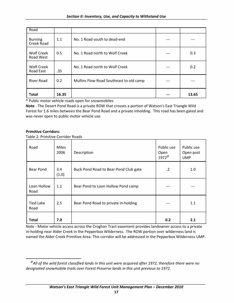
Section II: Inventory, Use, and Capacity to Withstand Use
Road Burning 1.1 No. 1 Road south to dead‐end ‐‐‐ ‐‐‐Creek Road Wolf Creek 0.5 No. 1 Road north to Wolf Creek ‐‐‐ 0.3 Road West Wolf Creek No. 1 Road north to Wolf Creek ‐‐‐ 0.2 Road East .35 River Road 0.2 Mullins Flow Road Southeast to old camp ‐‐‐ ‐‐‐
Total 16.35 ‐‐‐ 13.65
* Public motor vehicle roads open for snowmobiles Note ‐ The Desert Pond Road is a private ROW that crosses a portion of Watson's East Triangle Wild Forest for 1.6 miles between the Bear Pond Road and a private inholding. This road has been gated and was never open to public motor vehicle use.
Primitive Corridors: Table 2: Primitive Corridor Roads Road Miles Public use Public use
2006 Description Open Open post 1972@ UMP
Bear Pond 3.4 Buck Pond Road to Bear Pond Club gate .2 1.0
(1.0)
Loon Hollow 1.1 Bear Pond to Loon Hollow Pond camp ‐‐‐ ‐‐‐Road
Tied Lake 2.5 Bear Pond Road to private in‐holding ‐‐‐ 1.1 Road
Total 7.0 0.2 2.1
Note ‐ Motor vehicle access across the Croghan Tract easement provides landowner access to a private in‐holding near Alder Creek in the Pepperbox Wilderness. The ROW portion over wilderness land is named the Alder Creek Primitive Area. This corridor will be addressed in the Pepperbox Wilderness UMP.
@All of the wild forest classified lands in this unit were acquired after 1972, therefore there were no designated snowmobile trails over Forest Preserve lands in this unit previous to 1972.
Watson’s East Triangle Wild Forest Unit Management Plan – December 2010 17

Section II: Inventory, Use, and Capacity to Withstand Use
2. Designated Primitive Tentsites
All designated tentsites are conforming with APSLMP 1/4 mile spacing guidelines. WETWF 1‐ North side of Bear Pond Road at former Kelly Hill Club camp location. 1‐ Creek Road 1‐Mullins Flow Road South 1‐Wolf Pond 1‐Wolf Creek Road East 1‐Massawepie Pond 1‐Wolf Creek Road West 1‐ Buck Pond 3‐ Along Keck Trail 1‐ Deep Cuts Road 2‐ Along West branch of Oswegatchie River 2‐Mud Pond (canoe access only)
3. Designated Foot Trails
Keck Trail ‐4.8 miles ‐ Follows north shore of West Branch of Oswegatchie River to Deep Cuts Road. Massewepie Pond Trail ‐ 0.1 miles ‐ From Bear Pond Road to tent site. Campsite Trail East ‐ 0.1 miles ‐ From eastern most parking area along Long Pond Road to tent site. Campsite Trail West ‐ 0.1 miles ‐ From western most parking area along Long Pond Road to tent site.
4. Snowmobile Trails
Table 3: Snowmobile Trails ‐WETWF Trail Public Public Public use DEC Trail
use Description use Proposed Class2
Miles Open Proposed 2010 19721
Number One Bear Pond Road north ‐‐‐ NA Camp Trail 2.5 to No.1 Road 0
S‐82 and corridor C8
Steam Sleigh Long Pond Road south ‐‐‐ II Trail 1.0 to Prentice Road 1.0
S50
1 As defined in the Snowmobile Plan for the Adirondack Park Final GEIS. Further defined in the November 2009, Management Guidance‐ Snowmobile Trail Siting, Construction and Maintenance on Forest Preserve Lands in the Adirondack Park.
2 As defined in the Snowmobile Plan for the Adirondack Park Final GEIS. Further defined in the November 2009, Management Guidance‐ Snowmobile Trail Siting, Construction and Maintenance on Forest Preserve Lands in the Adirondack Park.
Watson’s East Triangle Wild Forest Unit Management Plan – December 2010 18
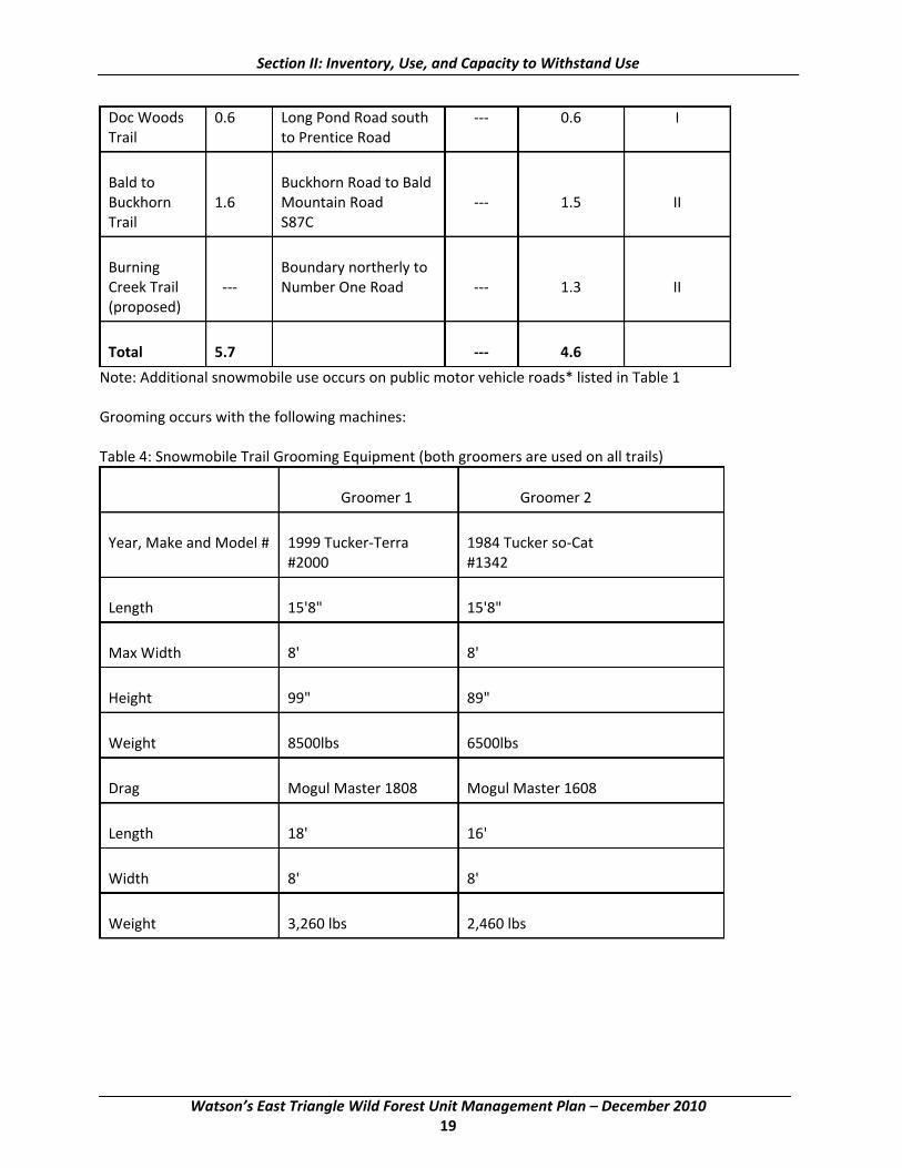
Section II: Inventory, Use, and Capacity to Withstand Use
Doc Woods 0.6 Long Pond Road south ‐‐‐ 0.6 I Trail to Prentice Road
Bald to Buckhorn Road to Bald Buckhorn 1.6 Mountain Road ‐‐‐ 1.5 II Trail S87C
Burning Boundary northerly to Creek Trail ‐‐‐ Number One Road ‐‐‐ 1.3 II (proposed)
Total 5.7 ‐‐‐ 4.6
Note: Additional snowmobile use occurs on public motor vehicle roads* listed in Table 1 Grooming occurs with the following machines: Table 4: Snowmobile Trail Grooming Equipment (both groomers are used on all trails) Groomer 1 Groomer 2
Year, Make and Model # 1999 Tucker‐Terra 1984 Tucker so‐Cat
#2000 #1342
Length 15'8" 15'8"
Max Width 8' 8'
Height 99" 89"
Weight 8500lbs 6500lbs
Drag Mogul Master 1808 Mogul Master 1608
Length 18' 16'
Width 8' 8'
Weight 3,260 lbs 2,460 lbs
Watson’s East Triangle Wild Forest Unit Management Plan – December 2010 19

Section II: Inventory, Use, and Capacity to Withstand Use
5. Boundary Lines
WETWF 69.4 miles
6. Parking Areas
Capacity
Mud Pond 4 cars (WETWF)
Long Pond Road 2 cars (WETWF)
Long Pond Road 2 cars (WETWF)
7. Gates
Bear Pond PC 3
Tied Lake PC 1
8. Dams
WETWF 1‐Mud Pond
9. Bridges
WETWF 1
BPRPC 2
10. Signs
WETWF 2 Unit identification sign
11. Accessible Waterway Access Sites
WETWF 1 Mud Pond
C. Past Influences
The archaeological inventory of the WETWF (Site file information provided by Charles Vandrei, 2006) reflects the known general characteristics of the area=s history. Archaeological sites are, simply put, any location where materials (artifacts, ecofacts) or modifications to the landscape reveal evidence of past human activity. Such sites can be entirely subsurface or can contain above ground remains such as foundation walls or earthwork features.
As a part of the inventory effort associated with the development of this plan the Department arranged for the archaeological site inventories maintained by the New York State Museum and the Office of Parks, Recreation and Historic Preservation to be searched in order to identify known archaeological resources that might be located within or near the unit. The two inventories overlap to an extent but do not entirely duplicate one another. The purpose of this effort was to identify any known sites that might be
Watson’s East Triangle Wild Forest Unit Management Plan – December 2010 20

Section II: Inventory, Use, and Capacity to Withstand Use
affected by actions proposed within the unit and to assist in understanding and characterizing past human use and occupation of the unit.
The quality of the site inventory information varies a great deal in all respects. Very little systematic archaeological survey has been undertaken in New York State and especially in the Adirondack region. Therefore all current inventories must be considered incomplete. Even fewer sites have been investigated to any degree that would permit their significance to be evaluated. Many reported site locations result from 19th century antiquarian information, artifact collector reports that have not been field verified. Often very little is known about the age, function or size of these sites. This means that reported site locations can be unreliable or be polygons that encompass a large area. Should a systematic archaeological inventory be undertaken at some point in the future it is very likely that additional resources will be identified. The results of these site file checks identified no sites within two miles of the unit boundary.
1. Cultural
The WETWF has been an important part of the cultural heritage of New York State. Prior to the 1900's, the primary cultural influence of this area was probably limited to that of trappers and fur traders. The influence of Native Americans in this area was likely limited to hunting parties as no evidence of Native American settlements exists. Much of the existing Forest Preserve Lands, once owned by large timber companies, were leased to individuals and groups for use as traditional hunting camps. These leases still continue on the easements lands which adjoin this unit and long term camping, under permit, occurs during the big‐game hunting season on the Forest Preserve lands. Now, following years of timber harvesting, an opportunity exists to witness the ability of nature to revert back to a wild state on the former timber company lands that are now Forest Preserve. In contrast, the adjacent easement lands provide an example of managed forest and the response of the natural world to that management. The remnants of an old sawmill and lumbering camps provide a glimpse of the past roles this area has played in shaping what exists today.
2. Historical
The entire management unit has a long history of lumbering. At the site of the Old Number 1 Camp are the remains of a sawmill and associated buildings. There is also an old steam boiler which was used to power the sawmill. The boiler, which weighs nearly 16 tons, was brought to the area by T.B. Basselin, a prominent early lumberman. As the timber supply within one area became depleted the boiler was relocated and another mill constructed.
A wooden dam exists on the West Branch of the Oswegatchie River creating Mud Pond. This dam was used for Sweet=s Sawmill during the 1800s.
Historical recreational uses of the area have revolved mostly around hunting and fishing. The road system on these areas provided access for hunting in remote areas and access to many lakes and ponds.
Watson’s East Triangle Wild Forest Unit Management Plan – December 2010 21
Section II: Inventory, Use, and Capacity to Withstand Use
D. Public Use
1. Land Resources
Much of the current public use of the Forest Preserve portions of this unit are in conjunction with hunting, fishing and snowmobiling. Some additional recreational use occurs in the form of mountain biking, canoeing and horseback riding. ATV riding as an activity on Forest Preserve roads was formally prohibited, through an administrative action by the Department, in September of 2004. This action closed to ATV use roads that were open to public motor vehicle use, including ATVs. The ATV prohibition was necessary to protect the natural resources and wild forest character of the area and to ensure that ATV use is in compliance with the Vehicle and Traffic Law and the Adirondack Park State Land Master Plan. The action also prevented further degradation on these roads and illegal use of ATVs off of the roads and into interior areas in both Wilderness and Wild Forest areas.
a. Hunting
The Watson=s East unit is located within the DEC Wildlife Management Unit (WMU) 6J. Primary wildlife related usage has historically centered around big game hunting, primarily for deer, although bear hunting, small game hunting and fur‐bearer trapping are also prominent.
While public hunting is permitted on Forest Preserve Lands it has generally been limited by poor access. The amount of time required to reach the interior portions of the unit led to the establishment of seasonal deer hunting camps. These camps generally consist of wall tents which are set up prior to the beginning of deer season and remain, under permit from the Department, until the close of big game season. In 2001, there were eight camping permits issued for the entire season and three for a camping visit of four to seven days. The local forest ranger estimates these numbers are increasing due to improvements to the Bear Pond Road which allows for easier access to the interior. The Forest Preserve lands which are readily accessible from town roads may receive slightly more hunting pressure, however, their relatively small size and proximity to residences and private camps may be a limiting factor in public use.
Chronic Wasting Disease in White‐tailed Deer
Chronic Wasting Disease (CWD) is a rare, fatal, neurological disease found in members of the deer family (cervids). It is a transmissible disease that slowly attacks the brain of infected deer and elk, causing the animals to progressively become emaciated, display abnormal behavior and invariably results in the death of the infected animal. Chronic Wasting Disease has been known to occur in wild deer and elk in the western U.S. for decades and its discovery in wild deer in Wisconsin in 2002 generated unprecedented attention from wildlife managers, hunters, and others interested in deer. Chronic Wasting Disease poses a significant threat to the deer and elk of North America and, if unchecked, could dramatically alter the future management of wild deer and elk. However, there is no evidence that CWD is linked to disease in humans or domestic livestock other than deer and elk.
In 2005, the New York State Department of Environmental Conservation (NYSDEC) received confirmation of CWD from two captive white‐tailed deer herds in Oneida County and subsequently detected the disease in 2 wild deer from this area. Until recently, New York was the only state in the northeast with a confirmed CWD case in wild deer. However, CWD was recently detected in a wild deer in West Virginia.
Watson’s East Triangle Wild Forest Unit Management Plan – December 2010 22
Section II: Inventory, Use, and Capacity to Withstand Use
The NYSDEC has established a containment area around the CWD‐positive samples and will continue to monitor the wild deer herd in New York State. No more deer have been positively identified with the disease in NY, after thousands have been tested since 2005. More information on CWD, New York=s response to this disease, the latest results from ongoing sampling efforts, and current CWD regulations are available on the NYSDEC website: http://www.dec.state.ny.us/website/dfwmr/wildlife/deer/currentcwd.html
b. Fishing
The WETWF stocked brook trout ponds ‐Mud, Buck and Wolf Ponds ‐ support an estimated 1,500 to 3,500 angler trips per year based on Adirondack brook trout pond angler use rates reported by Gordon (1994), Pfeiffer (1979), and Connelly, Brown and Knuth (1996). Survival and growth of stocked brook trout in these waters is considered satisfactory, but neither of these ponds have reputations for consistently providing quality angling experiences. Mud Pond is likely the most popular of the three due to its road‐side location and ease of access. Wolf Pond is considered the best of the three. It is also readily accessible via the Bear Pond Road. Opportunities for stream fishing are readily available on the area. The small size and remoteness of most of the area=s streams, however, coupled with the small sizes of the Awild@ brook trout which inhabit these waters, make them generally unattractive to anglers. It is believed that the area=s streams annually receive less than 50 angler hours of effort per acre.
c. Camping
Camping, other than that which is associated with hunting, has always been very sparse, with poor access being the most likely reason. Following State acquisition from International Paper Company of Watson's East Triangle in 1986, twelve campsites were designated by the Department. Most of these sites are at locations once occupied by former lease hunting camps. As almost all of the use of these sites is during the big game hunting season, impacts associated with campsite use are minimal. All designated campsites within the WETWF conform to APSLMP guidelines for separation distances. All of these sites with the exception of the Massewepie Pond site are motor vehicle accessible.
Four traditionally used campsites on the former Champion International lands, which were acquired in 1999, have been designated by the Department. Two of these sites are located along the West Branch of the Oswegatchie River and are accessed by canoe or by short trails from two parking areas along the Long Pond Road. Two additional designated sites are located downstream on the southern shore of Mud Pond. These sites are accessible by canoe only. All four of these sites comply with APSLMP guidelines for separation distances. Although permitted on easement lands, camping by the public is apparently not a popular use of those lands. Camping use of the WETWF is well below the areas capacity to withstand that use and is expected to remain so into the foreseeable future.
Since 2000, the only known camping to occur within the Watson=s East Triangle Wild Forest has been in the form of long‐term camping, under permit, during the big game hunting season. The number of permits issued annually averages between six and eight. This use occurs at currently designated primitive tentsites. Wall tents and camper trailers are generally used.
d. Mountain Biking
Although biking on the Forest Preserve lands occurs on open motor vehicle roads and snowmobile trails, numerous trails and old roads throughout the unit are suitable for bicycles. However, use of this area by
Watson’s East Triangle Wild Forest Unit Management Plan – December 2010 23
Section II: Inventory, Use, and Capacity to Withstand Use
bikers is minimal. The use of mountain bikes on this unit will continue under 6NYCRR Part 196.7[e], which states, AThe operation of bicycles is permitted on all roads and trails on Adirondack forest preserve wild forest areas except for those roads and trails posted as closed to bicycle operation@ At this time all roads and trails within the WETWF are open for the use of mountain bikes. If in the future the use of mountain bikes should increase within the WETWF, additional signage along wilderness boundaries will be required as many of the existing old roads and trails on this area continue into the adjoining wilderness areas.
e. Snowmobile Trails
The existing snowmobile trail system on this unit existed prior to the States acquisition of these lands. Continued use of existing snowmobile trails has been permitted by the Department under the guidelines provided by the APSLMP. This trail system provides a connecting link between the Croghan‐Belfort and Number Four Road‐Brantingham areas of Lewis County and the Star Lake area of St. Lawrence County. Main corridor trails cross both easements and a portion of the Forest Preserve Lands. The Number 1 Camp Trail provides a secondary alternate route through the WETWF. This route sees an increase in snowmobile traffic when winter timber harvesting operations necessitate the plowing of the Bald Mountain Road on the Oswegatchie Tract easement. The Number 1 Camp Trail follows an old road for approximately two‐thirds of its length and then connects to the Number 1 Road by following an old skid trail. Continuous illegal ATV use, combined with poor trail location, has resulted in extensive rutting in two wetland areas. These deep ruts make grooming of the snowmobile trail difficult and during mild winters the trail is not usable. A relocation of this trail is needed. The Steam Sleigh Trail and The Bald to Buckhorn Trail, located on recently acquired and classified Forest Preserve lands, provide connections between the trail system on the two easements. The Steam Sleigh Trail has been designated as part of Corridor C8 under the OPRHP snowmobile trail system. The Bald to Buckhorn Trail provides a connection to the trail system near Belfort and Croghan.
f. Motorized Access
The road system on the Watson=s East Triangle Wild Forest is a result of the area being commercial timberlands prior to state acquisition. The roads currently open for public motor vehicle use provide access not only to interior portions of this unit, but also to the Five Ponds and Pepperbox Wilderness Areas as well as the Middle Branch of the Oswegatchie River. The Bear Pond Road, the main access road in the unit, is also subject to private right‐of‐ways as it provides access to inholdings within both the Five Ponds Wilderness Area and the Pepperbox Wilderness area. Most public use of the road system occurs during the late spring‐early summer trout season or during the fall hunting season. Parking occurs at numerous old log landings and openings along the road system. This plan will address the need for designated parking areas in Section IV.
Illegal use of motor vehicles occurs not only within the WETWF but also onto the adjoining wilderness areas. This use occurs mostly in the form of ATVs using old logging roads to reach hunting or fishing destinations. An administrative action taken by the Department in the fall of 2004 has closed all roads within the WETWF to the use of ATVs. This action has alleviated much of the illegal ATV use on the WETWF as well as the neighboring wilderness areas. Recent site visits have confirmed some illegal ATV activity still occurs on the Steam Sleigh and Doc Woods snowmobile trails. Evidence of incursions into adjoining wilderness areas has been sporadic. A system to monitor the effects of this action will need to be developed for this unit.
Watson’s East Triangle Wild Forest Unit Management Plan – December 2010 24

Section II: Inventory, Use, and Capacity to Withstand Use
g. Hiking
Very little hiking occurs within any portions of the unit that is not associated with other recreational activities. The lack of mountain peaks, scenic vistas or other hiking destinations apparently limits the public=s interest in hiking in this unit.
h. Canoeing/ Kayaking
The Middle Branch of the Oswegatchie River provides some of the most challenging white water canoeing and kayaking in the Adirondacks. Although limited to times of high water, a trip down the Middle Branch will challenge the most experienced paddler with Class IV and V rapids.
The West branch offers some nice flat water paddling as well as access to several ponds including, Rock, Trout and Mud ponds.
i. Wildlife Observation
There is currently no assessment of non‐consumptive use available for the unit, although current public access provisions and facilities undoubtedly provide some direct or incidental wildlife viewing opportunities to users.
E. Recreational Opportunities for Persons with Disabilities
The Federal Americans with Disabilities Act of 1990 (AADA@) along with the Architectural Barriers Act of 1968 (ABA) and the Rehabilitation Act of 1973, have important implications for the management of all public lands, including the WETWF unit. A detailed explanation of the ADA and its influence on management actions is provided under Section III, B; Management Guidelines. Currently there are two universally accessible improvements in the WETWF. The facilities includes an accessible car‐top waterway access site near the inlet to Mud Pond (includes dock, parking and accessible trail) and the accessible waterway access site at Soft Maple Reservoir. In addition, the main haul road in the Croghan Tract provides access to an accessible parking area and path to Sand Pond within the Pepperbox Wilderness.
In 1997, DEC adopted policy CP‐3, Motor Vehicle Access to State Lands under Jurisdiction of the Department of Environmental Conservation for People with Disabilities, that establishes guidelines for issuing temporary revocable permits allowing people with qualifying disabilities to use motor vehicles to gain access to designated routes on certain state lands. Currently there are no designated CP‐3 roads on the unit.
F. Relationship of Unit to other Forest Preserve lands
1. State Lands under the Jurisdiction of DEC
Aldrich Pond Wild Forest (25,540 acres)
This unit forms the northern boundary of the WETWF. Existing motor vehicle roads and snowmobile trails on the Oswegatchie Tract easement connect these two Wild Forest units. There is no description for the Aldrich Pond Wild Forest in the APSLMP.
Watson’s East Triangle Wild Forest Unit Management Plan – December 2010 25
Section II: Inventory, Use, and Capacity to Withstand Use
Pepperbox Wilderness Area (22,560 acres prior to recent classifications) The APSLMP describes the unit as follows in part:
AThe area is classed as wilderness because of its remoteness and also due to the extensive wetland ecosystem involved. The flora and fauna associated with moist ecosystems, such as found in the Pepperbox, seem to exhibit more species diversity than any others in the Adirondacks. Bird life and small mammals are especially abundant. The protection afforded wilderness tracts will insure an outdoor laboratory of significant biological importance. ...Access is moderately difficult because of the distance from public roads and the lack of a trail system. There is little or no demand for a trail system, and this offers an opportunity to retain a portion of the Adirondack landscape in a state that even a purist might call wilderness@.
Five Ponds Wilderness Area (117,978 acres)
The APSLMP describes the unit as follows in part:
AThe terrain is low, rolling and interspersed with many small ponds. Swamp areas and small brooks are numerous. The forest cover varies from pole‐size hardwoods in the sections that were heavily logged and burned more than forty years ago to virgin pine and spruce stands. This is one of the few locations in the northeastern United States where stands of virgin timber can be found. ...The old growth pine and red spruce stand on the esker between Big Five, Little Five and Big Shallow, Little Shallow and Washbowl ponds is an example of this virgin timber. The pure pine stand at Pine Ridge along the Oswegatchie is another well known spot where examples of original growth timber may be seen. However, portions of the Pine Ridge stand were completely blown down in the 1950 hurricane and the timber was salvaged by a logging contractor.
The Five Ponds area is accessible to the public from the north and also from the south if one has a boat or canoe, from the east from the Lake Lila Primitive Area and along the Remsen to Lake Placid railroad. The area can also be reached from the southwest via the Raven Lake Primitive Corridor, and from the east, by boat or canoe, via the newly acquired Bog River/ Low=s Lake Tract. The western boundary in Herkimer County is accessible from the Bear Pond Road in the Aldrich Pond Wild Forest@.
G. Relationship between Public and Private Land
Private lands near or adjacent to this unit have the potential to both compliment and complicate DEC management. All of the private lands adjacent to this unit, with the exception of those protected through conservation easements, have the potential to be developed. Development of these properties could contribute to additional user demands on the unit. Like many regions of the Adirondack Park, this area could face a rise in development, residential and commercial, by those seeking to live in or near wild forest lands or by those who wish to exploit its attraction for recreationists for profit. Lands with recreational easement rights for the general public can also cause additional user demands on adjoining Forest Preserve lands.
Watson’s East Triangle Wild Forest Unit Management Plan – December 2010 26

Section II: Inventory, Use, and Capacity to Withstand Use
Large Landowners
Future Farmers of America (FFA) FFA owns and operates a youth summer camp and educational center adjacent to this unit. The property covers approximately 1,200 acres and borders directly on Forest Preserve lands and the Oswegatchie and Croghan easement properties. A Fish and Wildlife Management Association cooperators agreement between FFA and DEC allows for public access and fishing on Long Pond, Round Pond, Rock Pond and Trout Pond, as well as the West Branch of the Oswegatchie River and its tributaries. The camp occasionally utilizes areas of both easement lands and Forest Preserve for its activities.
Rayonier Forest Resources, L.P. Rayonier Forest Resources purchased the former Lassiter Inc. lands in 2008. The Oswegatchie Tract immediately adjacent to the WETWF contains approximately 21,854 acres. 16,958 acres of that tract are subject to a conservation easement acquired by New York State in 1989. The remaining, more developable lands were retained by Lassiter Inc. in fee ownership unencumbered by easements.
Desert Pond Club
This parcel is an inholding within the WETWF. The property is used primarily for hunting. Some hunting from this camp occurs on Forest Preserve lands.
Champion Realty Corp. Holdings include large subdivisions around Soft Maple Reservoir and Eagle Falls. Although not immediately adjacent to the unit, the increasing number of summer camps could potentially have an impact on the number of potential users of the unit.
Heartwood Forest Land Fund III Fee Lands The lands owned by The Heartwood Forest Land Fund III (HFFIII) contain 13,659 acres. The State of New York owns a conservation easement on 13,054 acres of the Croghan Tract within the Adirondack Park. HFFIII lands that lie outside of the Adirondack Park blue line are not subject to a conservation easement.
Other Adjacent Landowners Most other large privately owned tracts in the area are family owned and generally used for timber production and recreation by those owners.
Private Right of Ways (ROWs) over Public Lands The occurrence of private ROWs across Forest Preserve lands can complicate the management of the public=s use of State land. Issues concerning maintenance, type of vehicle use and illegal motor vehicle use are often associated with private ROWs across Forest Preserve lands. The issue of maintenance generally revolves around either the extent the road can be maintained or the impacts resulting from a total lack of proper maintenance. Most deeded ROWs are for ingress and egress to and from private lands. Illegal motor vehicle use often occurs when there are routes used legally as a ROW, but which are not open to the general public. Identifying users who have a right to use a certain road, under their deeded rights, and those who are using it illegally is difficult.
Watson’s East Triangle Wild Forest Unit Management Plan – December 2010 27

Section II: Inventory, Use, and Capacity to Withstand Use
H. Capacity to Withstand Use
Carrying Capacity Concepts
The WETWF cannot withstand ever‐increasing, unlimited visitor use without suffering the eventual loss of its essential, natural character. The challenge for managers is to determine how much use and what type of use the area, or particular sites within it, can withstand before the impacts of use cause serious degradation of the resource or recreational experience. At suitable locations, the Department will undertake a visitor use survey. Plans to address over use, illegal use, or improper use are identified in Section IV‐C.
The term carrying capacity has its roots in range and wildlife management sciences. As defined in the range management sciences, carrying capacity means Athe maximum number of animals that can be grazed on a land unit for a specific period of time without inducing damage to vegetation or related resources@ (Arthur Carhart National Wilderness Training Center, 1994). This concept, in decades past, was modified to address recreational uses as well, although in its application to recreational use it has been shown to be significantly flawed when used to determine the maximum number of people allowed to visit an area such as the WETWF. After many years of study, basic research showed that there was no linear relationship between the amount of use and the resultant amount of impact (Krumpe and Stokes, 1993). For many types of activities, low levels of use can cause observable impacts. For example, in sensitive areas the elimination of ground vegetation at a campsite can become significant after only a few camping parties have occupied it. Once moderate use levels have removed nearly all the vegetation, large increases in use cause relatively little additional impact. It has been discovered that such factors as visitor behavior, site resistance and resiliency and type of use may actually be more important in determining the degree of impact than the amount of use, although the total amount of use contributes to a significant extent (Hammit and Cole, 1987).
The shortcomings of a simple carrying capacity approach have become so apparent that the basic question has changed from the old one, AHow many is too many?@ to the new, more realistic one: AHow much change is acceptable?@ Because of the complex relationship between use and use impacts, the manager=s job is much more involved than simply counting, redirecting, or restricting the number of visitors in an area. Professionally‐informed judgments must be made so that carrying capacity is defined in terms of acceptable resource and social conditions. These conditions must be compared to real life situations, projections must be made, and management policies and actions must be drafted and enacted to maintain or restore the desired conditions. Shaping the types of use impacting an area can call not only for education and research, but also the formulation and enforcement of a set of regulations which some users are likely to regard as objectionable.
This strategy will help insure that in the WETWF, the Aessentially wild character@ contained in the APSLMP definition of wild forest will be retained. A central goal of this plan is to achieve resource protection while providing for public use in the WETWF.
Planning Approach
The approach to the development of a unit management plan for the WETWF involves a combination of two generally accepted wilderness planning methods: (1) the goal‐achievement framework; and (2) the Limits of Acceptable Change (LAC) model employed by the U.S. Forest Service and other agencies.
Watson’s East Triangle Wild Forest Unit Management Plan – December 2010 28

Section II: Inventory, Use, and Capacity to Withstand Use
Goal‐Achievement Framework
In wild forest areas, the Department is mandated by law to implement actions designed to realize the intent of the wild forest guidelines of the APSLMP. The goal‐achievement framework will be used to organize this management plan to direct the process of determining appropriate management actions through the careful development of goals and objectives. Goals are general descriptions of management direction reflecting legal mandates and general conditions to be achieved or maintained in the WETWF area. Wild forest goals, along with guidance for the future of the WETWF can be found in Section III‐E. Objectives are statements of more specific conditions whose achievement will be necessary to assure progress toward the attainment of the established goals and principles. In each category of management activity included in Section IV of this plan, the current management situation is assessed and assumptions about future trends and conditions are discussed. Proposed management objectives describing conditions to be achieved are presented and individual actions to meet the objectives are proposed.
However, this approach does not identify specific thresholds of unacceptable impact on particular resources or give managers or the public clear guidance as to when a particular restrictive management action is warranted. For these issues, the LAC process will be used.
Limits of Acceptable Change (LAC) Process
The LAC process employs carrying capacity concepts to prescribe‐‐not the total number of people who can visit an area‐‐but the desired resource and social conditions that should be maintained regardless of use. Establishing and maintaining acceptable conditions depends on explicit management objectives which draw on managerial experience, research, inventory data, assessments, projections and public input. Indicators, measurable variables that reflect conditions, are chosen and standards, representing the bounds of acceptable conditions, are set, so management efforts can address unacceptable changes. The LAC process relies on monitoring to provide systematic and periodic feedback to managers.
Though generally the levels of human impact within the WETWF are relatively low, a number of management issues could be addressed by the LAC process. Such issues may be categorized as conflicts between public use and resource protection, conflicts between users, and conflicts between outside influences and the objectives for natural resource or social conditions within the unit. For instance, two goals of management are protecting natural conditions and providing public recreational access. Yet the promotion of recreational use could have unacceptable impacts to natural resources, such as the soils and vegetation in a popular camping area. The LAC process could be used to determine the thresholds of acceptable soil and vegetation impacts and what management actions would be taken to protect resources from camping use. LAC does not work in every situation. For example, managers do not need a process to help them determine how much illegal ATV use is acceptable; because existing wild forest guidelines and regulations strictly limit public motor vehicle use, all illegal motor vehicle use is unacceptable.
The LAC process involves 10 steps:
Step 1: Define Goals and Desired Conditions Step 2: Identify Issues, Concerns and Threats Step 3: Define and Describe Acceptable Conditions Step 4: Select Indicators for Resource and Social Conditions Step 5: Inventory Existing Resource and Social Conditions Step 6: Specify Standards for Resource and Social Indicators for Each Opportunity Class
Watson’s East Triangle Wild Forest Unit Management Plan – December 2010 29
Section II: Inventory, Use, and Capacity to Withstand Use
Step 7: Identify Alternative Opportunity Class Allocations Step 8: Identify Management Actions for Each Alternative Step 9: Evaluate and Select a Preferred Alternative Step 10: Implement Actions and Monitor Conditions
The application of the LAC process will require a substantial commitment of staff time and public involvement. The full implementation of LAC for each unit will occur over a period of years. Of the 10 steps of the LAC process, this plan implements steps 1, 2 and 3, which apply to all the resources and conditions of the unit. The application of steps 4, 5 and 6 to selected issues is proposed for the next five years.
As a part of step two of LAC, this UMP identifies significant management issues affecting the WETWF. From the list in Section III‐F, issues suitable for the application of the LAC process will be selected. For these issues, the Department will implement the four major components of the LAC process:
$The identification of acceptable resource and social conditions represented by measurable indicators; $An analysis of the relationship between existing conditions and those desired; $Determinations of the necessary management actions needed to achieve and preserve desired conditions; and, $A monitoring program to see if objectives are being met over time.
Though LAC will not be fully implemented, this plan provides resource inventory information, sets goals founded on law, policy and the characteristics of the area, identifies management issues, and lays out proposed objectives and actions designed to meet management goals. Ultimately a monitoring system will be put in place, and management actions will be revised and refined over time in response to the results of periodic evaluation to assure that desired conditions will be attained or maintained.
Impacts of Public Use
The assessment of the impacts of public use within the WETWF has been limited to staff observations and initial assessments of primitive tent sites. While additional information is needed about overall public use of the WETWF and the impacts of use on the area=s physical and biological resources, as well as its social impacts, the planning team considered the best available information. For ease of organization, the capacity of the WETWF to withstand use is divided into three broad categories: physical, biological, and social. For each category, the definition of capacity will be followed by the known current situation within the WETWF. The management objectives and proposed management actions to deal with existing or potential future problems are presented in Section IV of this plan.
Physical capacity‐May include indicators that measure visitor impacts to physical resources (e.g. soil erosion on trails, campsites and access sites) and changes to environmental conditions (e.g. air and water quality).
Biological capacity‐May include indicators that measure visitor impacts to biological resources (e.g. vegetation loss at campsites or waterfront access sites) and changes in the ecosystem (e.g. diversity and distribution of plant and animal species).
Social capacity‐May include indicators that measure visitor impacts on other visitors (e.g. conflicts between user groups), the effectiveness of managerial conditions (e.g. noncompliant visitor behavior),
Watson’s East Triangle Wild Forest Unit Management Plan – December 2010 30

Section II: Inventory, Use, and Capacity to Withstand Use
and interactions with the area=s physical or biological capacity (e.g. noise on trails, campsites and access sites).
1. Physical
The physical capacity of a land area to withstand recreational use is the level of use beyond which the characteristics of the area=s soils, water and wetland resources, and topography undergo substantial unnatural changes. The capacity of a particular site is related to slope, soil type, ground and surface water characteristics, the type of vegetation that occupies the site, and the types or amount of recreational activity to which the site is subjected. In some cases physical impacts observed within the area are due to erosion brought on by inadequate or infrequent maintenance or poor layout and design, rather than actual use. In other instances impacts may be caused by illegal uses of the area.
Current user numbers for the WETWF are relatively low, based on staff observations, when compared to other units on the Forest Preserve. Overuse of designated or developed facilities does not appear to be a problem on the WETWF. The occurrence of illegal ATV use on the area has declined since 2004 when the Department took action to close all motor vehicle roads on the WETWF to ATV use. However, staff site visits and law enforcement actions indicate some illegal ATV use still continues.
Air quality in the region including the WETWF is largely a product of forces and activities originating outside the unit. The air quality impacts resulting from the building of campfires by visitors are limited and localized. Smoke from campfires is not known to have significant ecological effects. The effects of exhaust emissions from snowmobile use within this unit have not been comprehensively studied or documented.
As the demand for public outdoor recreational opportunities continues to grow, it would be expected the number of users of the WETWF would also continue to increase. Accurately estimating the extent of these future increases and trends is not always possible without devoting time and resources for monitoring those activities.
2. Biological
The biological capacity of a land area to withstand recreational use is the level of use beyond which the characteristics of the area=s plant and animal communities and ecological processes sustain substantial unnatural change. A review of available information indicates that the level of use within the unit does not appear to be exceeding the capacity of the biological resources to withstand use.
a. Plant life
Impacts from public use to area vegetation include illegal tree cutting, removal of brush, and loss of vegetation due to expansion of campsites. Additional impacts to this resource involve tree cutting allowed by easement or road and utility line maintenance (under TRP) or tree removal associated with trail maintenance, rehabilitation, and development. Another potential impact is the introduction of invasive species into the unit.
Watson’s East Triangle Wild Forest Unit Management Plan – December 2010 31

Similarly, fur‐bearer harvest can be estimated for the unit to illustrate population trends. Trapping effort is known to vary somewhat annually in response to weather conditions and pelt prices, but still provides some indication of population trends. Table 6: Estimated Fur‐bearer Take For Watson=s East‐ 2004‐05 to 2008‐09 Seasons
Year Beaver Bobcat Marten Fisher Otter
2004‐05 38 1 1 13 5
2005‐06 46 1 0 11 8
2006‐07 44 1 1 10 4
2007‐08 30 1 1 7 4
2008‐09 35 1 1 5 5
Watson’s East Triangle Wild Forest Unit Management Plan – December 2010 32
Section II: Inventory, Use, and Capacity to Withstand Use
b. Fish and Wildlife Resources
Wildlife
Present wildlife use is considered to be within sustainable levels and are not anticipated to change substantially in the short to mid‐term future. Most documented wildlife use is currently big game hunting related and a look at recent harvest trends suggests harvest is compatible with available resources. Annual hunting effort for these two species is fairly consistent from year to year, making the harvest trend information a relatively good indicator of population increases or decrease over time. Deer and bear harvests for the unit can be extrapolated from town data, and estimated based on the percentage of the total town area occupied by the WETWF. The four towns in which the unit is located or immediately adjacent to (Croghan, Diana, Watson and Webb) occupy 907 square miles, while the unit covers approximately 63 square miles, or 7% of the total. The table below shows the estimated deer and bear takes for the unit over a five year period.
Table 5: Estimated Deer and Bear Take for Watson=s East‐ 2005‐2009
Year Deer Harvest Bear Harvest*
2006 67 2
2007 88 3
2008 93 6
2009 78 7
Section II: Inventory, Use, and Capacity to Withstand Use
Although the current restrictions on public hunting will change in 2014 on the adjacent Croghan Tract and in 2019 on the adjacent Oswegatchie Tract, the Department does not project a significant change in use intensity due to the low peripheral human density and relatively remote nature of the unit. Some human uses do have the potential to affect wildlife resources on the unit, particularly relative to portions critical to deer survival in the winter. Some guidelines for use regulation in proximity to the identified deer wintering yards are listed in Section III
Fisheries
Currently, statewide angling regulations, which apply to all waters in the WETWF coupled with annual stocking strategies, and possession of baitfish prohibited regulations which apply to the area=s trout ponds, are adequate to protect area fish populations from over‐harvest by anglers and the introduction of un‐wanted Anew@ species. If future surveys indicate fisheries declines in specific waters, special regulations will be instituted to further protect these fish populations. At this time, no water resources, including the area=s and their wild trout populations, are believed to be over‐fished.
3. Social
The social capacity of a land area to withstand recreational use is the level of use beyond which the likelihood that a visitor will achieve his or her expectations for a recreational experience is significantly hampered. Social capacity is strongly influenced by an area=s land classification, which in turn determines the management objectives for the area and the degree of recreational development possible. While solitude may be managed for in some locations, it is not as important a component of the recreational experience in Wild Forest Areas as it is in Wilderness. Social conflicts mainly occur due to recreationists seeking different experiences. A source of tension can derive from different ideas of what constitutes a camping experience; some visitors anticipate spending a quiet evening observing their natural surroundings, while others look forward to a party atmosphere.
User satisfaction from recreating is a function of both perception and expectation with the presence, number and behavior of others encountered having a direct influence on the quality of the experience. Compatibility between uses usually involves how quiet or noisy an activity is, whether it is consumptive or non‐consumptive, whether it involves individuals or groups, and whether it is a traditional or newly introduced activity. A few recreationists feel that other users degrade the quality of their own experiences. Particularly controversial in this respect are motorized recreational activities to which people involved in non‐motorized activities often object.
Sound related impacts can cover a large area but are generally temporary in nature with little or no physical effect on the environment. Loud noise could impact area wildlife or alter the experience of a person seeking to escape the sounds of civilization. For other users, particularly those using motor vehicles such as snowmobiles, the sound is an expected normal part of the overall recreational experience.
According to available information and the low level of reports of user conflict, the current level of public use within the WETWF is not believed to be exceeding the social capacity of the area to withstand use.
Watson’s East Triangle Wild Forest Unit Management Plan – December 2010 33

Section II: Inventory, Use, and Capacity to Withstand Use
I. Education, Interpretation and Research
Currently there are no educational or interpretive activities occurring within this unit. This is a shortfall of not only this area but of many units throughout the Adirondacks. Providing information and education should be a fundamental goal of any UMP.
J. Economic Impact
The impact of the WETWF on local and regional economies can be measured in a variety of ways including a review of the types of industries and jobs in the Adirondacks that are associated with this unit. Although exact dollar figures do not exist for all indicators of economic activity associated with this unit, a general picture can be drawn.
Tourism is on the rise and is one of the most important industries in the Adirondacks. There are numerous guiding services, motels, bed and breakfasts, inns, camps, clubs, gas stations, restaurants, grocery stores and equipment stores that depend on the attraction of the Adirondack Forest Preserve to draw customers. Hikers, campers, fisherman, snowmobilers and hunters, especially deer hunters and snowmobilers , who use this unit spend a certain amount of money on services and lodging facilities. However, since neither public use figures nor estimates of local expenditures are available, an overall economic impact figure associated with users of the unit cannot be precisely determined.
The proximity of private land to Forest Preserve is often a selling point in real estate sales, and coupled with road access, land availability, proximity to multiple uses and waterfront, has a beneficial impact on land values. An Adirondack landowner survey (Kay, 1985) determined that proximity to State owned Forest Preserve can boost the value of single family homes by almost $6,000 from the median, and by $2,000 for parcels without homes.
There are also less tangible economic impacts provided by this unit. Due to the absence of industry and associated pollution on these lands, there are no polluting effects on downwind or downstream areas requiring costly mitigation measures. In fact, Forest Preserve lands including this unit, enhance the quality of the environment by filtering water and transported air pollutants and by providing oxygen to the atmosphere.
Additionally, the State makes substantial property tax payments to local governments. Section 532‐a of the Real Property Tax Law provides in part that A all wild or forest lands owned by the State within the Forest Preserve@ are subject to taxation for all purposes. The State pays the same rate of tax on unimproved forest lands as private landowners pay on their unimproved land. Pursuant of Real Property Tax Law, Section 533, the State pays taxes on conservation easement lands located within the Catskill and Adirondack Parks, which is equivalent to the change in the value of the lands subject to the easement.
Table 7: PROPERTY TAXES FOR 2009
ACREAGE County, Town School TOTAL TAX & Fire Tax Tax PAID
13,417 $112,955 $34,821 $147,776
Watson’s East Triangle Wild Forest Unit Management Plan – December 2010 34

III. MANAGEMENT AND POLICY
A. Past Management
The administration of Forest Preserve land is the responsibility of the Division of Lands and Forests. The responsibility for the enforcement of DEC rules and regulations lies with the Office of Public Protection. The Division of Operations conducts interior construction, maintenance and rehabilitation projects. The Bureau of Recreation within the Division of Operations operates and manages the public campgrounds adjacent to the unit. The Division of Fish, Wildlife and Marine Resources manages the state=s fish and wildlife resources.
1. Land Management
This is the first comprehensive management plan to be developed for the WETWF. Previous management actions, or lack of them, were generally geared toward responding to potential environmental impacts and to the needs and desires of users.
Following acquisition of the Watson=s East Triangle Wild Forest in 1986, and up until its classification in 1999, historic recreational uses were allowed to continue throughout the unit. Campsites were designated at locations which had been the sites of old hunting camps or that were already being used. The existing road system was left open with the exception of several roads which led into the adjoining Five Ponds Wilderness Area.
Beginning in 1999, rehabilitation of the surface of the Bear Pond Road, which provides access to a majority of the unit, was begun. In early 2000, work on the project was halted due to: wetlands violations; road work beyond ordinary maintenance, significant impacts on the wild forest character of the road corridor; and violation of the Department=s tree cutting policy. A memorandum of agreement (MOA) was reached between the APA and DEC for the remediation of the area and the wetlands portion of the work was completed in 2001. As part of the MOA a detailed work plan for the restoration of the road corridor was developed (See Appendix 4). Most of the work required by the work plan was completed in 2002.
In the case of Residents Committee to Protect the Adirondacks versus Adirondack Park Agency et. al.; (Albany County Supreme Court, Index Number 6513‐01), the legality of this MOA was challenged. The case was settled by the parties and so ordered by the Court on March 22, 2002. Among other things, this settlement included provisions for the scheduling of UMP development. See Appendix 8 for a copy of the full stipulation and order settling this case. The completion of this UMP will satisfy one aspect of the settlement agreement.
Stewardship Agreements
Under the Adopt‐a‐Natural Resource Policy, DEC enters into stewardship agreements with organizations and individuals. Such agreements are authorized by Section 9‐0113 of the Environmental Conservation Law for the purpose of preserving, maintaining or enhancing a State‐owned natural resource or portion thereof in accordance with the policies of the Department. A stewardship agreement is for a period of up to five years.
Watson’s East Triangle Wild Forest Unit Management Plan – December 2010 35
Section III: Management and Policy
Under an existing Adopt‐A‐Natural Resource (AANR) stewardship agreement, one snowmobile group, the Long Pond Snowmobile Club, performs maintenance on selected trails in the unit. Area trails are groomed by Tucker tracked groomers. (See Table 4 in Section II‐B.) In addition, the Desert Pond Club is authorized under an AANR to maintain a gate on their private ROW.
2. Wildlife Management
Wildlife management activities specific to the WETWF have not been conducted. Management on the area has been accomplished as part of the statewide or Wildlife Management Unit regulatory process.
Hunting and Trapping Regulations
Regulations controlling season dates, method of taking, and bag limits for wildlife have been the principal wildlife management techniques applied to unit lands. Early regulations were written consistent for all of northern New York (equivalent to the Northern Zone). In the past, DEC subdivided the State into numerous Deer Management Units (DMU) for big game and Wildlife Management Units (WMU) for small game and furbearers. Each unit was defined according to its distinctive ecological and social characteristics. In an effort to make hunting and trapping regulations more user friendly and easier to understand a single set of management units is now used for all species. Boundaries were adjusted when necessary and a new alpha‐numeric identification system was created. Decisions concerning wildlife management are ordinarily based upon these management units which are typically larger than individual Forest Preserve units. The WETWF occupies a portion of the larger forest stands and landforms within WMU 6J, the number indicating the wildlife region generally responsible for that unit. Waterfowl season parameters are largely established by Federal authority, but states have some flexibility for season modifications within the Federal framework.
Nuisance Wildlife Policy
The Bureau of Wildlife investigates nuisance wildlife complaints on a case‐by‐case basis. The DEC does not actively control nuisance wildlife except when the behavior of wildlife is deemed to threaten the lives of visitors. No major conflicts between visitors to the unit and resident wildlife have been reported. Beaver activity occasionally floods trails or roads in the unit.
Surveys and Inventories
Over the years, both game and non‐game species of wildlife and significant wildlife habitats have been the subjects of various surveys and inventories.* Maps showing the locations of significant wildlife habitats have been created and are continually updated by DEC's Wildlife Resources Unit. Significant habitats within the unit are described in the Section II‐A‐1‐I. Annual flights through the Adirondacks to inventory active osprey nests and to determine nesting success are conducted by the Bureau of Wildlife. Eagle and peregrine falcon nests, and deer wintering areas are monitored annually. Periodically, DEC and private agencies have surveyed common loon populations in the State. DEC's last loon survey was completed in 1985. The Breeding Bird Atlas Project was conducted from 1980 to 1985 and censussed breeding birds statewide. The Atlas 2000 project is currently repeating
*The New York Natural Heritage Program is a cooperative effort between the Nature Conservancy and DEC to inventory and manage the occurrence of rare plants, animals, and exemplary natural communities in New York State. It is closely related in scope and purpose to DEC's Significant Habitat Program. Natural Heritage and Significant Habitats jointly issue reports and maps assessing resource conditions.
Watson’s East Triangle Wild Forest Unit Management Plan – December 2010 36

Section III: Management and Policy
the survey to learn how breeding bird distribution has changed. As mentioned elsewhere, harvest figures are collected annually for a variety of game species.
Species Restoration
A number of wildlife species once native to the Adirondacks were extirpated either directly or indirectly as a result of human activities. In recent years, recognizing the desirability of at least partially restoring the composition of wildlife species originally present in the Adirondacks, DEC and others have launched projects to reintroduce the peregrine falcon, bald eagle, and Canada lynx.
DEC began an effort to reintroduce the peregrine falcon to the Adirondacks in 1981 by implementing a method of artificially rearing and releasing young birds to the wild called "hacking." Between 1983 and 1985, 55 bald eagles also hacked within the Adirondack region. The peregrine and bald eagle restorations have been very successful statewide, but no nesting activity by either species has been discovered within the unit since the end of the hacking program.
The State University of New York College of Environmental Science and Forestry, through the Adirondack Wildlife program, conducted an experimental project to reintroduce the Canada lynx to the Adirondack High Peaks region. Lynx were first released in 1989; a total of 83 animals were released by the spring of 1991. The restoration is considered to be a failure, as a lynx population has not been re‐established in the Adirondacks.
Invasive/Exotic Wildlife
A Non‐indigenous Aquatic Species Comprehensive Management Plan prepared by the Department in 1993 identifies strategies to eliminate or reduce environmental, public health, and safety risks associated with non‐indigenous aquatic species, particularly zebra mussels.
Other Fauna/Public Health Concerns
Wildlife occasionally can impact the health or enjoyment of outdoor recreationists. In some cases, area waters are treated with Bti to help reduce the numbers of black flies. This activity falls within the scope of Article 15 of the Environmental Conservation Law and an aquatic pesticide application permit and TRP are required under NYCRR Part 329. The more common potential health concerns include:
Chronic Wasting Disease (CWD) in White‐tailed Deer ‐ Chronic Wasting Disease (CWD) is a rare, fatal, neurological disease found in members of the deer family (cervids). It is a transmissible disease that slowly attacks the brain of infected deer and elk, causing the animals to progressively become emaciated, display abnormal behavior and invariably results in the death of the infected animal. Chronic Wasting Disease has been known to occur in wild deer and elk in the western U.S. for decades and its discovery in wild deer in Wisconsin in 2002 generated unprecedented attention from wildlife managers, hunters, and others interested in deer. Chronic Wasting Disease poses a significant threat to the deer and elk of North America and, if unchecked, could dramatically alter the future management of wild deer and elk. However, there is no evidence that CWD is linked to disease in humans or domestic livestock other than deer and elk.
In 2005, the New York State Department of Environmental Conservation (NYSDEC) received confirmation of CWD from two captive white‐tailed deer herds in Oneida County. Until recently, New York was the only state in the northeast with a confirmed CWD case in wild deer. However, CWD was recently detected in a wild deer in West Virginia.
Watson’s East Triangle Wild Forest Unit Management Plan – December 2010 37

Section III: Management and Policy
The NYSDEC has established a containment area around the CWD‐positive samples and will continue to monitor the wild deer herd in New York State. More information on CWD, New York=s response to this disease, the latest results from ongoing sampling efforts, and current CWD regulations are available on the NYSDEC website: http://www.dec.state.ny.us/website/dfwmr/wildlife/deer/currentcwd.html
Giardiasis ‐ This intestinal illness sometimes called Abeaver fever@ is caused by a microscopic parasite called Giardia lamblia. Even though many animals other than man can act as hosts, including the beaver, improper disposal of human excrement is one of the primary reasons for the increased numbers of this parasite in the interior.
Lyme disease ‐ This infection is caused by the bite of a deer tick carrying a bacterium, that often infects deer, field mice, humans and household pets.
West Nile Virus ‐ Is a relatively new viral disease that is carried by birds and can be transmitted to humans, in particular, through mosquito bites. It is often fatal to some species of birds, such as crows, but in most species it is not fatal. It can be fatal in humans, especially in those with compromised immune systems. The use of insect repellant will help reduce exposure.
Rabies ‐ Rabies is a viral infection that affects the nervous system of all mammals, including humans. It is usually transmitted by the bite of an infected animal to another. Like other viral infections, it does not respond to antibiotics and is almost always fatal once the symptoms appear. Major carriers of rabies include raccoons, skunks, bats and fox species but all mammals can be potential carriers.
3. Fisheries Management
Active management of fisheries in the WETWF began with the Biological Survey of 1932. Subsequent activities have included survey and inventory, fish stocking, pond reclamation and management of angler harvest by regulation. The above activities have intensified since the acquisition of public access to the lands in the 1980s.
B. Management Guidelines
1. Guiding Documents
This unit management plan has been developed within the guidelines set forth by Article XIV, Section 1 of the New York State Constitution, Article 9 of the Environmental Conservation Law, Parts 190‐199 of Title 6 NYCRR of the State of New York, the APSLMP, and established Department policy.
The lands of the WETWF are Forest Preserve lands protected by Article XIV, Section 1 of the New York State Constitution. This Constitutional provision, which became effective on January 1, 1895, provides in relevant part:
The lands of the state, now owned or hereafter acquired, constituting the forest preserve as now fixed by law, shall be forever kept as wild forest lands. They shall not be leased, sold or exchanged, or be taken by any corporation, public or private, nor shall the timber thereon be sold, removed or destroyed.
Watson’s East Triangle Wild Forest Unit Management Plan – December 2010 38

Section III: Management and Policy
ECL ''3‐0301(1)(d) and 9‐0105(1) provide the Department with jurisdiction over Forest Preserve lands.
The APSLMP was initially adopted in 1972 by the State Legislature and signed into Law by the Governor, with advice from and in consultation with the Department, pursuant to Executive Law '807, now recodified as Executive Law '816. The APSLMP provides the overall general framework for the development and management of State lands in the Adirondack Park, including those Forest Preserve lands which are the subject of this UMP.
The APSLMP places State land within the Adirondack Park into the following classifications: Wilderness, Primitive, Canoe, Wild Forest, Intensive Use, Historic, State Administrative, Wild, Scenic and Recreational Rivers, and Travel Corridors, and sets forth management guidelines for the lands falling within each major classification. Guidelines are set forth for such matters as: structures and improvements; ranger stations; the use of motor vehicles, motorized equipment and aircraft; roads, jeep trails and state truck trails, flora and fauna, recreation use and overuse; boundary structures and improvements and boundary markings. Actions by the State on lands covered by the APSLMP must be consistent with the provisions of the APSLMP.
Executive Law '816 requires this Department to develop, in consultation with the APA, individual UMPs for each unit of land under the Department's jurisdiction which is classified in one of the nine classifications set forth in the APSLMP. The UMPs must conform to the guidelines and criteria set forth in the APSLMP. Thus, UMPs implement and apply the APSLMP general guidelines for particular areas of land within the Adirondack Park.
Executive Law '816(1) provides in part that "(u)ntil amended, the master plan for management of state lands and the individual management plans shall guide the development and management of state lands in the Adirondack park." Thus, the APSLMP and the UMPs have the force of legislative enactment in guiding Department actions.
All actions undertaken pursuant to this UMP are also subject to the following laws, rules, regulations and policies:
Environmental Conservation Law (ECL): Article 9: Lands and Forests Article 11: Fish and Wildlife Article 15: Water Resources Article 23: Mineral Resources Article 24: Wetlands Article 33: Pesticides Article 71: Enforcement
New York Code of Rules and Regulations (NYCRR) ‐ Title 6: Chapter I: Fish and Wildlife Chapter II: Lands and Forests Chapter III: Air Resources Chapter IV: Quality Services Chapter V: Resource Management Services Chapter X: Division of Water Resources Chapter XI: Part 617; State Environmental Quality Review
Watson’s East Triangle Wild Forest Unit Management Plan – December 2010 39
Section III: Management and Policy
DEC policy has been developed for the public use and administration of Forest Preserve lands. Select policies relevant to the management of this unit include:
• Administrative Use of Motor Vehicles and Aircraft in the Forest Preserve (CP‐17). • Motor Vehicle Access to State Lands Under the Jurisdiction of DEC for People with Disabilities
(CP‐3). • Standards and Procedures for Boundary Line Maintenance (NR‐91‐2; NR‐95‐1). • Tree Cutting on Forest Preserve Land (O&D #84‐06). • Cutting and Removal of Trees in the Forest Preserve (LF‐91‐2). • Division Regulatory Policy (LF‐90‐2). • Adopt‐A‐Natural Resource (ONR‐1). • Policies and Procedures Manual Title 8400 ‐ Public Land Management. • Adirondack Subalpine Forest Bird Conservation Area‐Management Guidance. • Forest Preserve Roads (CP‐38). • Division of Lands & Forests Forest Preserve Policies of 1986:
o Fireplaces and Fire rings o Foot bridges o Foot trails o Primitive camping sites o Road barriers o Sanitary facilities o Trailheads
Guidance and Clarification Documents
• Memorandum of Understanding Between the Adirondack Park Agency and the Department of Environmental Conservation Concerning the Implementation of the State Land Master Plan for the Adirondack Park
• Guidelines for Motor Vehicle Use Proposals in Wild Forest UMPs Memorandum ‐ 7/25/2001 • Management Guidance ‐ Snowmobile Trail Siting, Construction and Maintenance on Forest
Preserve Lands in the Adirondack Park, November 2009
SEQRA
The recommendations presented in this unit management plan are subject to the requirements of the State Environmental Quality and Review Act of 1975. All proposed management activities will be reviewed and significant environmental impacts and alternatives will be assessed.
State of New York Snowmobile Trail Plan
The Statewide Snowmobile Plan was completed by OPRHP in October, 1989. The overall goals of the plan are to provide a statewide snowmobile trail system while protecting the environment and properly addressing the concerns of the non‐snowmobiling public. The Statewide Snowmobile Plan provided a trail classification system and conceptual corridor trail system. While the Adirondacks were included within the Statewide Snowmobile Plan, the classification and standards for snowmobile trails on Forest Preserve lands in the Adirondacks were refined in the Snowmobile Plan for the Adirondack Park/ FEIS of 2006 (2006 Snowmobile Plan) and subsequently in the Management Guidance. The 2006 Snowmobile Plan/ FEIS includes the identification of a conceptual system of community connections, balanced with interior trail re‐designations for non‐motorized use only, and other possible mitigative actions. New and
Watson’s East Triangle Wild Forest Unit Management Plan – December 2010 40

Section III: Management and Policy
reconfigured trails contemplated for State lands pursuant to the Management Guidance will require specific authorization in an approved UMP for each individual location.
The Biodiversity Act
The Biodiversity Act of 1993 mandates that DEC identify, manage and conserve plants, animals and ecological communities that are rare in New York State, and that are located on State‐owned lands under the jurisdiction of the Department. The Act also establishes the New York Natural Heritage Program to identify, locate, rank and maintain records on the status of rare plants, animals and ecological communities, for the purpose of conserving and managing the States biological diversity.
Historic Preservation
The New York State Historic Preservation Act of 1980 (SHPA, Article 14 of Parks, Recreation and Historic Preservation Law) and its implementing regulations (9 NYCRR 426, 427 and 428) created the State Register of Historic Places and recognizes the National Register of Historic Places. The statute further obligates State agencies to act as stewards of historic properties (buildings, structures, objects and archaeological sites) they own and requires that agencies identify, evaluate and mitigate impacts to historic properties that might be affected by actions they undertake, fund or permit. The Department is also specifically charged with providing historic sites and services within the Adirondack Park in ECL Articles 9 and 41.
The historic and archaeological sites located within the WETWF, as well as additional unrecorded sites that may exist on the property, are protected by the provisions of the New York State Historic Preservation Act, Article 9 of Environmental Conservation Law, 6 NYCRR Section 190.8 (g) and Section 233 of Education Law. Unauthorized excavation and removal of materials from any of these sites is prohibited by Article 9 of Environmental Conservation Law and Section 233 of Education Law. In some cases additional protection may be afforded these resources by the federal Archaeological Resources Protection Act (ARPA).
2. Application of Guidelines and Standards
All projects will be developed in accordance with the above mentioned laws, rules, regulations and policies and will incorporate the use of Best Management Practices (BMPs), including but not limited to such considerations as:
Construction Projects
• Locating improvements to minimize necessary cut and fill; • Locating improvements away from streams, wetlands, and unstable slopes; • Use of proper drainage devices such as water bars and broad‐based dips; • Locating trails to minimize grade; • Using stream crossings with low, stable banks, firm stream bottom and gentle approach slopes; • Constructing stream crossings at right angles to the stream; • Limiting stream crossing construction to periods of low or normal flow; • Avoiding areas where habitats of threatened and endangered species are known to exist; • Using natural materials to blend the structure into the natural surroundings.
Lean‐tos
• Locating lean‐tos to minimize necessary cut and fill;
Watson’s East Triangle Wild Forest Unit Management Plan – December 2010 41

Section III: Management and Policy
• Locating lean‐tos to minimize tree cutting; • Locating lean‐tos away from streams, wetlands, and unstable slopes; • Use of drainage structures on trails leading to lean‐to sites, to prevent water flowing into site; • Locating lean‐tos on flat, stable, well‐drained sites; • Limiting construction to periods of low or normal rainfall.
Parking Lots
• Locating parking lots to minimize necessary cut and fill; • Locating parking lots away from streams, wetlands, and unstable slopes wherever possible; • Locating parking lots on flat, stable, well‐drained sites using gravel or other permeable material
for surfacing; • Locating parking lots in areas that require a minimum amount of tree cutting; • Limiting construction to periods of low or normal rainfall; • Wherever possible, using wooded buffers to screen parking lots from roads; • Limiting the size of the parking lot to the minimum necessary to address the intended use.
Trails
• Locating trails to minimize necessary cut and fill; • Wherever possible, lay out trails on existing old roads or clear or partially cleared areas; • Locating trails away from streams, wetlands, and unstable slopes wherever possible; • Use of proper drainage devices such as water bars and broad‐based dips; • Locating trails to minimize grade; • Using stream crossings with low, stable banks, firm stream bottom and gentle approach slopes; • Constructing stream crossings at right angles to the stream; • Limiting stream crossing construction to periods of low or normal flow; • Using stream bank stabilizing structures made of natural materials such as rock or wooden
timbers; • Using natural materials to blend the structure into the natural surroundings.
Bridges
• Minimizing channel changes and the amount of cut or fill needed; • Limiting construction activities in the water to periods of low or normal flow; • Minimizing the use of equipment in the stream; • Installing bridges at right angles to the stream channel; • Constructing bridges to blend into the natural surroundings; • Using stream bank stabilizing structures made of natural materials such as rock or wooden
timbers; • Stabilizing bridge approaches with aggregate or other suitable material; • Using soil stabilization practices on exposed soil around bridges immediately after construction; • Designing, constructing and maintaining bridges to avoid disrupting the migration or movement
of fish and other aquatic life; • Consultation with the Adirondack Park Agency in cases where existing bridge abutments must be
replaced.
Watson’s East Triangle Wild Forest Unit Management Plan – December 2010 42

Section III: Management and Policy
Mountain Bike Trails
• Look for and identify control points (i.e wetlands, rocks outcrops, scenic vistas). • Avoid sensitive areas; wetlands and wherever water collects. Keep trails below 2,000 ft. • Use existing roadways where possible that do not exceed grades of 10%. • Clear new trails to a maximum width of 4 feet to establish a single track route. • Keep tread width less than 18" along a rolling grade. • Remove vegetation at the root level‐not at ground level. • Keep routes close to the contour and avoid fall lines where water is likely to flow downhill. • On side slopes, following the contour, cut full benches to construct the tread. • Cuts and fills will be minimized to the maximum extent possible. Cuts and fills will be undertaken
so as not to cause root damage and will not exceed a total of 18 inches. Side slopes will be dressed and tapered within the width of the trail.
• Build flow into the trail with open and flowing designs with broad sweeping turns. • Streams should be crossed at ninety‐degree angles preferably across rock or gravel. • Bridges may be used where steep banks prevent normal stream crossings. The latter may require
an APA Wetlands Permit. • Do not construct skid berms or extensive banked turns that may accelerate erosion. • Avoid acute, sharp angle turns. • Plan trails for beginners to intermediate levels of riders. Maintain an overall grade of 10% or less. • Allow short changes in grade to avoid obstacles. • Design grade dips to break up long, straight linear sections, and to help divert runoff from the
tread. • Monitor and inspect all trails semi‐annually. Address water problems immediately.
Liming
All liming projects will be in compliance with the Final Generic Environmental Impact Statement on the New York State Department of Environmental Conservation Program of Liming Selected Acidified Waters, dated October 1990, as well as the Division of Fish, Wildlife and Marine Resources liming policy.
Fish Stocking
All fish stocking projects will be in compliance with the Programmatic Environmental Impact Statement on Fish Species Management Activities of the Department of Environmental Conservation, dated December 1979.
Guidelines for protection of deer‐wintering areas
The maintenance and protection of deer‐wintering areas are important in maintaining deer in the northern portions of their range. Activities which substantially diminish the quality or characteristics of the site should be avoided, but this does not mean human use is always detrimental. Forest stewardship activities (including softwood harvest), pass through trails, and other uses can be compatible with a deer yard if carefully considered. The most important characteristic of an Adirondack deer yard is the habitat configuration making up a Acore@ and travel corridors to and from the core. The core is typically an area (or areas) of dense conifer cover used by deer in severe conditions. Travel corridors are dense but narrow components which allow access to food resources in milder conditions. Management conditions which afford protection of core sections and avoid fragmenting travel corridors are acceptable in many situations. Certain types of recreation trails, such as ski trails or snowmobile trails, particularly if the traffic is not prone to stopping or off‐trail excursions, are not considered to have significant negative
Watson’s East Triangle Wild Forest Unit Management Plan – December 2010 43

Section III: Management and Policy
impacts on deer yards. These types of trails in or adjacent to deer wintering areas can provide firm, packed surfaces readily used by deer for travel during periods of deep snow. They can, however, also create access for free‐roaming dogs if the location is close to human habitation; thus, trails should avoid deer yards in these situations. High levels of snowmobile or cross‐country ski use can disturb deer and may cause them to run, placing higher energy demands on deer already stressed by winter. The following are some general guidelines to follow for protecting deer wintering areas.
Deer Yard Protection in the Adirondacks
• Maintain a minimum 100 foot forested buffer on either side of streams to protect winter habitat and travel corridors between core yard components.
• Avoid placement of ski trails through core segments of deer yards to reduce disturbance associated with skiers stopping to observe deer.
• Trails should not traverse core segments of deer yards in densely populated areas such as hamlets, villages, or along roadsides developed with human habitation because they provide access for free roaming dogs.
The Departments= Northern Zone deer biologist do not presently feel snowmobile activity has a significant adverse impact on deer populations. Care, however, should be used in the planning of snowmobile trails in or adjacent to deer wintering areas. Increased human activity within the core of a yarding area can result in an increased energy demand to deer present in the immediate vicinity of the trail. During portions of the day when use is limited however, the same trail may also provide a firm, packed surface readily used by deer for travel between yard components during periods of deep snow.
Application of the Americans with Disabilities Act (ADA)
The Americans with Disabilities Act (ADA), along with the Architectural Barriers Act of 1968 (ABA) and the Rehabilitation Act of 1973; Title V, Section 504, have had a profound effect on the manner by which people with disabilities are afforded equality in their recreational pursuits. The ADA is a comprehensive law prohibiting discrimination against people with disabilities in employment practices, use of public transportation, use of telecommunication facilities and use of public accommodations. Title II of the ADA requires, in part, that reasonable modifications must be made to the services and programs of public entities, so that when those services and programs are viewed in their entirety, they are readily accessible to and usable by people with disabilities. This must be done unless such modification would result in a fundamental alteration in the nature of the service, program or activity or an undue financial or administrative burden.
Consistent with ADA requirements, the Department incorporates accessibility for people with disabilities into the planning, construction and alteration of recreational facilities and assets supporting them. This UMP incorporates an inventory of all the recreational facilities or assets supporting the programs and services available on the unit, and an assessment of the programs, services and facilities on the unit to determine the level of accessibility provided. In conducting this assessment, DEC employs guidelines which ensure that programs are accessible, including buildings, facilities, and vehicles, in terms of architecture and design, transportation and communication to individuals with disabilities. A federal agency known as the Access Board has issued the ADA Accessibility Guidelines (ADAAG) for this purpose.
An assessment was conducted, in the development of this UMP, to determine appropriate accessibility enhancements which may include developing new or upgrading of existing facilities or assets. The Department is not required to make each of its existing facilities and assets accessible so long as the
Watson’s East Triangle Wild Forest Unit Management Plan – December 2010 44
Section III: Management and Policy
Department’s programs, taken as a whole, are accessible. New facilities, assets and accessibility improvements to existing facilities or assets proposed in this UMP are identified in the Proposed Management Actions section.
For copies of any of the above mentioned laws or guidelines relating to accessibility, contact Carole Fraser, DEC Universal Access Program Coordinator at 518‐402‐9428 or [email protected].
C. Administration and Management Principles
1. Administration
The WETWF is administered by DEC=s Region 6, Sub‐Office located in Lowville. Day‐to‐day Lands and Forests activities are the responsibility of the Regional Forester. Forest Preserve lands within the Lowville working circle (Lewis and northern Herkimer Counties) are administered by a Supervising Forester and a Forest Preserve Forester/Planner. The latter is responsible for planning and implementation of Forest Preserve programs in several separate Forest Preserve units as well as several Conservation Easements. The Division of Lands and Forests, Fish and Wildlife, Operations and the Office of Public Protection all have management responsibilities on the unit.
In accordance with Article 9, ECL all wildfires are suppressed on Forest Preserve lands. With each fire start, DEC managers consider the most appropriate response and tactics which result in minimum cost and resource damage.
D. Management Issues, Needs and Desires
Several issues were of concern to the Department and the public in the development of this plan. Information and feedback on issues was obtained from the public by way of an Open House, held on May 24, 2001 at Beaver River School, by mail, and e‐mail. The following list of issues, needs and desires were received from the public and DEC staff. Some of the issues, needs and desires have not resulted in Proposed Management Actions being developed. Where this has occurred, a justification for the exclusion is provided. The issues identified by the public for this unit were expressed in general terms, for the unit as a whole, rather than a specific use at a specific location. Section IV will address specific proposed management actions, some of which are in response to input received through the participation of groups and individuals.
1. Access for All Terrain Vehicles and Motor Vehicles
Increasing the mileage of roads and trails available for ATV use was the most common issue raised by the public. There was a strong desire expressed to provide new routes that connect roads that were currently posted open to ATVs, as well as provide access to additional areas of state land. The appropriateness of providing routes for ATVs must be weighed against APSLMP guidelines, the New York State Vehicle and Traffic (V&T) Law '2403 and '2405, Public Highway Law, natural resources protection, impact of illegal ATV use and access provided for recreational opportunities. The detailed considerations of these factors are discussed in more detail under AProposed Management Actions.@ (See Section IV‐B‐1.)
Watson’s East Triangle Wild Forest Unit Management Plan – December 2010 45
Section III: Management and Policy
Related to this issue is use of ATVs and other motor vehicles by landowners who have a ROW or easement over a DEC road to their lands. Use of a road for private purposes under a deeded ROW or easement by a landowner, guest, invitees, etc. may be a legitimate exercise of a deeded right, so not subject to DEC control. This may complicate enforcement of vehicle restrictions on some roads.
2. Access
Current access to the unit is relatively good, however improvement of access to the Oswegatchie Tract easement from the north would enhance public access to the adjoining WETWF. Current public motor vehicle access to the northern section of the WETWF is across the Oswegatchie Tract easement from the south via the Bald Mountain Road from Long Pond, across the Oswegatchie easement.
3. Illegal Motor Vehicle Use
This is the most serious issue relating to resource impacts identified by DEC staff on the Forest Preserve portions of this unit. Numerous old logging roads and trails provide tempting places for people to illegally drive ATVs. Some of these old roads lead into the interior of the Five Ponds and Pepperbox Wilderness Areas and have been used as traditional access to lakes and ponds. Hunting season brings additional illegal use, as hunters use ATVs to reach areas inaccessible by car or truck. Past management actions to curtail this activity have included gating, increasing patrols by Forest rangers and Environmental Conservation Officers and signing, with only limited success. In September of 2004 through an administrative action the Department closed all roads within the WETWF to ATV use. This administrative action did not address the issue of whether adjoining landowners on specific DEC roads have legal rights to use ATVs on those roads as part of their ROW or easement rights. This complex legal issue complicates enforcement against illegal ATV use.
4. Snowmobile Trails
The Number One Camp snowmobile trail currently impacts two significant wetlands. This trail, also an old road with private rights, was originally constructed on corduroy across these locations. As the underlying corduroy has disappeared and illegal ATV use has increased environmental impacts have arisen. Public comments received supported either the rehabilitation of this trail or relocating it to a more appropriate location.
5. Private Access Rights
There are four private properties within the Five Ponds and Pepperbox Wilderness Areas, and one in the WETWF, which have deeded rights across certain roads in this unit. The rights are limited to a ROW for ingress and egress and the right to take gravel (Bear Pond Club), at the discretion of the Department, for maintenance purposes. A portion of the Number One Camp snowmobile trail is subject to these rights. The acquisition of those rights from willing sellers on roads that are unsuitable for motor vehicle traffic is desirable. Under the current situation the ROW holder has no obligation to conduct any maintenance on these roads, while their use of the road cannot be controlled. Appendix 7 includes a listing of known rights‐of‐ways for this unit.
Watson’s East Triangle Wild Forest Unit Management Plan – December 2010 46

Section III: Management and Policy
6. Gravel Pits
The Bear Pond Clubs have deeded rights to use gravel from existing gravel pits along the Bear Pond Road for maintenance of their right‐of‐way across Forest Preserve. This right must be exercised at the discretion of the fee holder (NYS) and has been conducted under TRP in the past.
E. Goals and Objectives
1. Goals for the management of the WETWF
a. Protect the natural wild forest setting. b. Provide a variety of compatible outdoor recreational opportunities without degrading
the resource or impairing the wild forest character. These opportunities must be consistent with the guidelines set forth in the APSLMP and with Department policies.
Watson’s East Triangle Wild Forest Unit Management Plan – December 2010 47

This page intentionally left blank
Watson’s East Triangle Wild Forest Unit Management Plan – December 2010 48

SECTION IV: PROPOSED MANAGEMENT ACTIONS This section describes specific proposed management actions for the administration of the WETWF. Some proposed management actions are in response to issues identified by DEC staff, oral and written comments received at the public open house and comments received via mail, e‐mail and phone during the development of this plan. Proposed actions are consistent with the goals and objectives stated in Section III. When writing management proposals, DEC managers are restricted by Article XIV, Section 1 of the New York State Constitution and the APSLMP and their respective legislative histories, the Environmental Conservation Law (ECL), DEC rules and regulations and policies. (See 11" x 17" Existing and Proposed Facilities map in the Appendix)
A. BioPhysical Resources
1. Water
Present Situation and Assumptions:
Water quality studies have been conducted throughout the Adirondacks by the ALSC, researching the effects of acid deposition, and the Bureau of Fisheries routinely conducts biological surveys of area waters. No studies have been conducted to determine the effects of recreation use on water quality. As focal points for visitation, streams, springs, lakes, ponds, and wetlands are on the receiving end of more human disturbance than upland forest areas. Visitors must be advised that the water is not considered potable and must be properly treated before consumption.
Objectives:
• Seek to achieve and maintain high water quality within the WETWF. • Reduce the potential for pathogenic contamination from all water sources. • Reduce or eliminate aquatic invasive plant species found within the unit. • Reduce the direct impact of human activities on water quality by improving user awareness of
the effect of polluting activities. • Reduce the impact on water quality caused by the use and construction of facilities by locating
facilities adequate distances from water bodies and adhering to BMPs during construction.
Management Actions:
• Develop LAC indicators and standards for vegetation in riparian areas near lakes and streams. • Aquatic and riparian habitats will be maintained and/or improved. Any new use which could
prove damaging to the character of riparian vegetation will be monitored. • Train DEC staff working within the unit to identify and document the location of key invasive
plant species. • Monitor for the location and extent of aquatic invasive plant species found within the unit. • Management of identified populations of invasive plant species should be undertaken. These
actions may be carried out by NYSDEC personnel or by members of APIPP or other volunteers under supervision of NYSDEC through an Adopt a Natural Resource Agreement.
• Biological survey work will be incorporated in all future water related planning activities. • Advise adjoining landowners on the use of Best Management Practices to protect water quality.
Watson’s East Triangle Wild Forest Unit Management Plan – December 2010 49
Section IV: Proposed Management Actions
• Advise the public through DEC information and education programs to treat all water prior to consumptive use.
2. Soil
Present Situation and Assumptions:
Broad soil types (accurate to an area about 40 acres in size) were delineated on aerial photographs by the Natural Resource Conservation Service. Little information has been documented on wide‐spread soil loss and deposition.
Objective:
• Keep soil erosion and compaction caused by recreational use within acceptable limits that closely approximates the natural erosion process.
Management Actions:
• Inventory, map, and monitor soil conditions affected by recreational use. • Develop LAC indicators and standards for soil erosion. • Relocate any trail, designated campsite, or lean‐to which is causing significant soil erosion. • Continue to restrict motor vehicle use during the spring breakup and during periods of
excessively wet weather. • Target trail and road maintenance to heavily eroded trails and roads; develop a priority list based
on resource need rather than on user convenience. • Request voluntary compliance with seasonal closures of trails during periods of wet weather;
usually from November 1 ‐ December 15 and April 1 ‐May 15, or at appropriate times set by the area manager.
3. Vegetation
Present Situation and Assumptions:
Much of the WETWF vegetated landscape has been altered by wind, fire, insects and disease, pre‐Forest Preserve logging, and recreational use. Despite these influences, the unit has several unique ecosystems requiring special attention. These areas include, small portions of old growth forest, wetland communities, and potentially some areas not yet identified through the unit management planning process. Plant inventories and ecological mapping are on‐going; however, not all areas have been inventoried.
Prior to implementing targeted containment and/or eradication controls, terrestrial invasive plant infestations occurring within the Watson East Triangle Wild Forest need to be assessed on a site‐by‐site basis. The geophysical setting and the presence, or absence, of sensitive native flora within or adjacent to the targeted infestation often predicts the Best Management Practices (BMPs) and limitations of the control methodology. Infestations occurring within specific jurisdictional settings may trigger a permitting process, as do most terrestrial infestations occurring within an aquatic setting. The species itself often dictates whether manual management controls, e.g. hand‐pulling or cutting, or the judicious, surgical application of herbicides is warranted in order to best control that specific species in that exacting infestation and setting. No single BMP guarantees invasive plant containment or eradication. Many infestations require multiple, seasonal control efforts to reduce the density and biomass at that
Watson’s East Triangle Wild Forest Unit Management Plan – December 2010 50

Section IV: Proposed Management Actions
setting. Adaptive Management protocols suggest that implementation of integrated control methodologies may provide the best over‐all efficacy at specific infestations.
It is suggested that NYS DEC view all Aeasy to contain B low abundance@ terrestrial infestations within the Watson East Triangle Wild Forest as immediate targets for containment and/or eradication controls. Minimizing the spread of newly documented and immature infestations before they have the chance to become well‐established should be considered a priority management action.
Objectives:
• Allow natural processes to play out their roles to insure that the succession of plant communities is not altered by human impacts.
• Preserve and protect known locations of Threatened, and Endangered species. • Continue and enhance programs to identify and map Threatened, and Endangered species. • Assist natural forces in restoring natural plant associations and communities where they have
been severely altered by human activity. • Reduce or eliminate terrestrial invasive plant species found within the unit. • Support scientific research projects on the WETWF through the issuance of TRPs.
Management Actions:
• Develop LAC indicators and standards for condition of vegetation in camping areas. • All vegetation protection and restoration programs will emphasize information and education as
the primary means to reduce impacts and slow unnatural change. • Continue botanical surveys to produce a more complete inventory of Threatened and
Endangered species. • Ecological inventorying and mapping will be correlated with recreation, and fish and wildlife
project plans to prevent unintended and undesirable impacts to Threatened and Endangered species.
• Minimum impact techniques will be used to revegetate sites where concentrated use has destroyed natural vegetation. Native seedlings, trees, shrubs, and grasses will be planted to accelerate return to natural conditions when necessary.
• Vegetation at primitive tent sites will be monitored in conjunction with the campsite monitoring program described in the section on campsites.
• Contract with APIPP to conduct an inventory of non‐native invasive species on the WETWF. • Train DEC staff working within the unit to identify and document the location of key invasive
plant species. • Control known infestations of invasive species using BMPs found in Appendix 11. These actions
may be carried out by NYSDEC personnel or by members of APIPP or other volunteers under supervision of NYSDEC through an Adopt a Natural Resource Agreement.
4. Fish
Present Situation and Assumptions:
Appendix 3 contains a brief description of the WETWF=s fisheries resources, grouped according to management classifications developed by Pfeifer (1979). Their current and proposed future management is discussed here and noted in Appendix 3.
Watson’s East Triangle Wild Forest Unit Management Plan – December 2010 51

Section IV: Proposed Management Actions
Adirondack Brook Trout Ponds ‐ Adirondack Zone ponds which support and are managed for populations of brook trout, sometimes in company with other salmonid fish species. These waters generally lack warmwater fishes, but frequently support bullheads.
Relative to the WETWF, Mud, Buck, Wolf, Desert, Lost and Little Mudhole Ponds are considered Adirondack Brook Trout Ponds. The Mud, Buck and Wolf Pond brook trout populations are maintained by annual stocking, because natural spawning by brook trout in these waters has not been adequate to maintain populations at satisfactory densities for angling. Desert, Lost and Little Mudhole Ponds are also managed for Adirondack Brook Trout. These three currently support low density Awild@ populations.
The stocked ponds noted above were recently surveyed in 2001 or 2002. Therefore their resource inventory data is considered up‐to‐date. It is unlikely these will be resurveyed within the next five years, except for water chemistry monitoring, which usually occurs more frequently than biological surveys.
The area=s Awild@ brook trout ponds (Desert, Lost and Little Mudhole Ponds) are all located within the Desert Creek watershed. A recent inspection revealed that these ponds, and their respective abilities to support trout, are shrinking as their bog wetland fringes mature and enlarge. Management for these very small waters will include trout population (by periodic angling surveys) and water quality monitoring.
Whenever re‐survey data documents the presence of non‐native species in Adirondack brook trout waters at densities that present a negative impact on stocked brook trout fisheries or native fish communities, reclamation may be recommended. Post reclamation objectives will be to restore and enhance either the brook trout fisheries or restored native fish communities. If a reclamation is determined to be necessary, the WETWF plan will be amended to include it in the schedule of implementation.
Depressed pH levels have been documented for all of the area=s stocked brook trout ponds. These ponds are not considered liming candidates at this time however, as their flush rates are all higher than the minimum (2/year) established by the Division of Fish, Wildlife and Marine Resources pond liming policy and the Final Generic Environmental Statement on the New York State Department of Environmental Conservation Program of Liming Selected Acidified Waters (Simonin 1990).
Coldwater Streams ‐ Adirondack Zone rivers and streams which support and are managed for populations of brook trout.
Brook trout populations located in area rivers and streams will be monitored periodically by either electrofishing or angling surveys. Trout populations in the area=s other rivers and streams will continue to be managed extensively by periodic biological survey, and maintenance of statewide angling regulations. Warmwater Lakes and Ponds ‐Waters which support and are managed for populations of warmwater game fishes and lack significant populations of salmonid fishes.
The WETWF unit contains eight warmwater lakes and ponds (see Appendix 3). In general these waters support natural spawning populations of brown bullhead, white sucker, pumpkinseed, and yellow perch. Recognized gamefish species, such as largemouth bass, are noticeably absent from these waters. As angling resources, none of these waters is particularly noteworthy. No additional management actions are proposed for these waters at this time.
Fishless / Acidified Ponds ‐ Ponds with depressed pH levels ( < 5.0) and documented as fishless.
Watson’s East Triangle Wild Forest Unit Management Plan – December 2010 52

Section IV: Proposed Management Actions
There are five ponds in the WETWF unit which are both fishless and/or acidified. Due to flush rate and other pond liming policy concerns, none of these is considered a liming candidate. As a result, their potential for fishery development is very low. No management action is proposed at this time.
Unknown (Unclassified) Waters ‐Waters which could not be assigned a management category due to a paucity or complete lack of survey information.
There are a few very small remotely located unnamed waters of this category located within the WETWF. Mainly these are beaver ponds associated with streams. Therefore they are not permanent ponded water bodies and as such, are not included in the area=s inventory at this time.
Objectives:
• Perpetuate and enhance a diverse, high quality fishing experience in accordance with sound biological management practices.
• Maintain the diversity of coldwater and warmwater fish populations in the unit. • Encourage and promote angler use of the waters in the unit through routine fish management
practices including hotlines, correspondence and contact with the public by Department staff.
Management Action:
• Conduct biological surveys of all ponds within the unit as required.
5. Wildlife
Present Situation and Assumptions:
A number of changes have occurred over the past several decades that have impacted a variety of wildlife species within the Watson=s East Triangle Wild Forest. Habitat changes have resulted from pre‐Forest Preserve logging, wildfires, acid precipitation, recreational use, natural plant succession, protection of the forest and wildlife species through legislation, attempted reintroduction of extirpated species of wildlife and immigration of extirpated species back into the area. One of the original factors attracting visitors to the Adirondacks, in general, was the vast array of hunting, fishing and trapping opportunities. The APSLMP indicates that these uses are legitimate and compatible with Forest Preserve concepts. DEC policy encourages these activities as part of a larger Forest Preserve experience, not just a quest for game (Doig, 1976). Habitat areas heavily used by wildlife are often also choice locations for human trails and campsites (Hendee and others, 1990). Bears often scrounge for food and garbage where people habitually camp. While negative human/bear encounters in this unit are minimal, the concentration of camping in distinct locations poses the potential for this to be a problem in the future. Domestic pets, mainly dogs, may also harass and stress wildlife.
Objectives: • Re‐establish self‐sustaining wildlife populations of species that are Endangered, Threatened or of
Special Concern in habitats where their existence will be compatible with other elements of the ecosystem.
• Monitor and afford extra protection, where warranted, to species which are Endangered, Threatened or of Special Concern that are currently using the WETWF.
• Maintain and perpetuate annual hunting and trapping seasons as legitimate uses of the wildlife resources compatible with Wild Forest recreation.
Watson’s East Triangle Wild Forest Unit Management Plan – December 2010 53

Section IV: Proposed Management Actions
• Provide information, advice and assistance to individuals, groups, organizations and agencies interested in wildlife, whose activities and actions may affect, or are affected by, the wildlife resources or the users of wildlife.
Management Actions:
• Monitor the occurrence of Endangered or Threatened species on the unit. • Promote educational efforts to protect spruce grouse from accidental shooting by small game
hunters. • Monitor moose that enter the area through visual observation, reports from the public and by
radio collaring moose whenever the opportunity presents itself. • Continue pelt sealing of species to determine level of harvest, guarding against over harvest for
species especially vulnerable to trapping (marten and fisher). • Promote education efforts stressing multiple use and hunting seasons that are concurrent with
other anticipated uses of the area. Advise visitors of the fact that there is hunting in the area so that they may dress and act accordingly during the hunting season.
• Advise visitors to the area that the potential for conflict with wildlife exists and suggest means of avoiding conflicts through a combination of on‐site signage, printed Department media, and direct contact with Department staff.
B. Man Made Facilities
1. Roads
Present Situation and Assumptions:
The roads within the WETWF (formerly IP lands) were acquired by the State in the 1980's. Although the road system at that time was privately owned, public use of those roads was occurring. Most roads were allowed to remain open for public motor vehicle use following the State=s acquisition and prior to classification as allowed for in the APSLMP. These lands were classified in 2000. Several of the classification alternatives considered by the APA for this area were based on to what extent public motor vehicle access would be allowed. The chosen alternative placed most of the existing road system within a wild forest classification, thus making motor vehicle access a conforming use. Additionally, portions of two primitive corridors, within adjoining wilderness areas, were allowed to remain open for public motor vehicle access.
The lands making up the balance of the WETWF (formerly Champion) were acquired in 1999 and classified in 2006. There are no motor vehicle roads on these lands.
Currently there are 13 roads open to public passenger vehicle use within the Watson=s East Triangle Wild Forest. Eight of these roads were previously posted open to both public passenger vehicle use and public ATV use, but were closed to public ATV use in September of 2004 through an administrative action by the Department. This was done when a determination was made that the use of these roads by ATVs was not compliant with '2405(1) of the Vehicle and Traffic Law.
ATV Use
There are a number of factors which must be considered before a management decision regarding public ATV use of a public road is made. These considerations are detailed below.
Watson’s East Triangle Wild Forest Unit Management Plan – December 2010 54

Section IV: Proposed Management Actions
1. Legal Considerations There are some key legal considerations regarding the appropriateness of opening roads to public motor vehicle use, including ATVs. The APSLMP and the Vehicle & Traffic Law, as well as the Highway Law, determine whether roads can be designated.
$ Compliance with the APSLMP (not applicable to easement roads): The APSLMP, on page 33 Basic guideline #4 states APublic use of motor vehicles will not be encouraged and there will not be any material increase in the mileage of roads and snowmobile trails open to public motorized use by the public in wild forest areas that conformed to the APSLMP at the time of its original adoption in 1972.@ On page 35 of the APSLMP under AMotor Vehicles, Motorized Equipment and Aircraft,@ guideline 2(d) authorizes the use of ATVs Aonly on existing public roads or Department of Environmental Conservation roads open to such vehicles, as specified in (b) above@(guideline 2‐b). Guideline 2‐b specifies that the use of motor vehicles will be permitted only on: Aexisting public roads; on Department of Environmental Conservation roads now or hereafter designated as open for public use by motor vehicles...; or on rivers, lakes and ponds now and hereafter designated as suitable...for such motorized uses.@ Both of these guidelines are subject to Basic guideline #4. The definition of Aroad@ in the APSLMP is Aan improved way or partially improved way designed for travel by automobiles and which may also be used by other types of motor vehicles ...@. Taken together these three sections of the APSLMP limit ATV use to existing public roads. Further, the APSLMP provides that Anothing in the guidelines for lands falling within each major classification shall be deemed to prevent the Department of Environmental Conservation, or any other state agency administering such lands, from providing for more restrictive management where necessary to comply with constitutional requirements or to protect the natural resources of such lands.@
$ Compliance with the Vehicle and Traffic Law : Vehicle and Traffic Law '2405(1) authorizes the DEC, by rule or regulation, to post public highways as open for ATV travel upon DEC determination that Ait is otherwise impossible for ATVs to gain access to areas or trails adjacent to the highway@ that are legally open to public ATV use. Vehicle and Traffic Law '118 defines a highway as Athe entire width...of every way publicly maintained when any part thereof is open to the use of the public for purposes of vehicular travel,@ and therefore includes any DEC road or easement road open to public motor vehicle use. Therefore, opening Apublic highways@ to provide public ATV riding opportunities can only occur if the road provides access to areas or trails that are open to ATV use, and such areas or trails cannot be accessed by ATVs except via such road.
$ 6 NYCRR '196.1 Pursuant to 6 NYCRR §196.1(b)(3), public motor vehicle use in the Forest Preserve is only permitted on roads that are specifically marked by the Department for motorized use.
In summary, the APSLMP and V&T law together yield the following direction and guidance:
C There is opportunity for continued public passenger vehicle use on Forest Preserve lands, primarily on existing roads;
C Since the APSLMP does not provide for use of ATVs on trails or areas, and V&TL '2405(1) does not allow ATV use on public highways except to provide access to areas or trails open to ATV use, they collectively prohibit the Department from allowing the public use of ATVs in Wild Forest
Watson’s East Triangle Wild Forest Unit Management Plan – December 2010 55
Section IV: Proposed Management Actions
Areas. However, situations may arise where roads could be legally opened to ATVs in Wild Forest Areas. For example, a Forest Preserve road open to public motor vehicle use that adjoins two areas (such as easement lands) that are open to ATV use could legally be opened to public ATV use, when it is otherwise impossible to access the areas;
Management Actions:
Based on the assessment of the public motor vehicle roads in the Watson=s East Triangle Wild Forest with respect to the above considerations, specific roads or road segments will be permanently closed to public motor vehicle use. In total, five roads (Burning Creek Road, Spring Creek Road, River Road, Buck Pond Road, and the Mullins Flow Road south of the Middle Branch) totaling 2.2 miles will be closed entirely. The Burning Creek Road will be open to snowmobiles as part o a proposed new community connector. Three roads (Creek Road, Wolf Creek Road West, and Wolf Creek Road East) totaling 0.5 miles will be partially closed. In addition, this plan proposes to construct lean‐tos at Buck Pond and on the Mullins Flow Road. In order to avoid issues with motorized access to lean‐tos and to provide a more traditional experience, the Buck Pond Road and the Mullins Flow Road will be closed to motor vehicle use following construction of the lean‐tos. The roads, once closed, will be converted into accessible access routes, if feasible, to the lean‐to locations. Recommendations regarding the status of the following roads are as follows:
• Research the issue of ATV use by adjoining landowners on those roads in the unit identified as part of their ROW or easement rights.
• Complete road work, as defined in the APA/DEC MOA and RCPA settlement, (Appendix 8) on the Bear Pond Road (WETWF). Work is mostly completed on the section of the Bear Pond Road from the Herkimer County line east about 8 miles as per the APA/DEC MOA and subsequent work plans. Some gravel for the completion of this road work will be obtained from the Parquet Hill pit.
• Monitor all roads for illegal motor vehicle use and develop a strategy to control such use if it is found to be occurring.
• Develop work plans, in consultation with the APA, for completion of the rehabilitation of the Bear Pond Road from the end of the portion currently being worked on (near the Kelley Pond Road) to the gate on the Bear Pond Primitive Corridor as well as for the spur roads open to public motor vehicle use off of the Bear Pond Road. 1.45 miles
• Close the Burning Creek Road to public motor vehicle use. This road does not provide significant access to recreation opportunities. 1.1 miles
• Close the Spring Creek Road to public motor vehicle use. This road is flooded by beaver activity at 0.3 miles, is in poor condition, and does not provide significant access to recreation opportunities. 0.4miles
• Close the River Road to public motor vehicle use. The road is in poor condition and is located immediately adjacent to a scenic river and is therefore within the scenic river corridor.
0.2 miles • Close the Creek Road to public motor vehicle use beyond the campsite. The road is in poor
condition beyond the campsite and does not provide significant access to recreation programs. 0.15 miles
• Close Wolf Creek Road West to public motor vehicle use beyond the campsite to prevent illegal motor vehicle use into the Five Ponds Wilderness Area. 0.2 miles
Watson’s East Triangle Wild Forest Unit Management Plan – December 2010 56

Section IV: Proposed Management Actions
• Close Wolf Creek Road East to public motor vehicle use beyond the new campsite to prevent illegal motor vehicle use into the Five Ponds Wilderness Area. 0.15 miles
• Close the Buck Pond Road (0.25 miles) and the Mullins Flow Road (0.25 miles) to motor vehicle use, by installing rock barriers, following the construction of lean‐tos at those locations. Convert the roads into accessible routes to the lean‐tos, if deemed feasible.
2. Snowmobile Trails
Present Situation and Assumptions:
The DEC system of snowmobile trails has been used by the NYS Office of Parks, Recreation, and Historic Preservation (OPRHP) to identify a snowmobile trail corridor system within the unit as part of OPRHP=s statewide snowmobile trail network. OPRHP=s snowmobile trail classification plays a major role in the amount of funding available for grooming and trail maintenance. Trails designated by OPRHP as snowmobile Acorridor@ or Asecondary@ trails are eligible for OPRHP funding to support maintenance and grooming. Unfunded snowmobile trails may be kept clear to their allowed width only where cutting of trees or other woody growth over 3" DBH is not necessary. DEC, as per the Management Guidance, however, utilizes a different trail classification system and standards than that of OPRHP.
Class II (Community Connector Trails) ‐ Snowmobile trails or trail segments that serve to connect communities and provide the main travel routes for snowmobiles within a unit are Community Connector Trails. These trails are located in the periphery of Wild Forest or other Forest Preserve areas. They are always located as close as possible to motorized travel corridors, given safety, terrain and environmental constraints, and only rarely are any segments of them located further than one mile away from the nearest of these corridors. They are not duplicated or paralleled by other snowmobile trails. Some can be short, linking communities to longer Class II trails that connect two or more other communities.
Class I (Secondary Snowmobile Trails) ‐ All other snowmobile trails that are not Community Connector Trails are Secondary Snowmobile Trails. These trails are located in the periphery of Wild Forest and other Forest Preserve areas where snowmobile trails are designated.** They may be spur trails (perhaps leading to population areas and services such as repair shops, service stations, restaurants and lodging), short loop trails or longer recreational trails. If directly connected to Class II trails, new and rerouted Class I trails are always located as close as possible to ‐ and no farther than one mile from ‐motorized travel corridors, although some ‐ with high recreational value ‐may be located beyond one mile and may approach a remote interior area.
Snowmobile Use on Roads DEC management of all such roads for motor vehicle use, including snowmobiles, is guided by the Department=s ACP‐38 Forest Preserve Roads@ policy.
A Park‐wide Perspective on Snowmobile Planning
Until recently snowmobile trail planning and development was accomplished through individual unit management plans on a unit by unit basis. Throughout the development of recent UMPs, the need to consider a broader approach to snowmobile trail planning became evident. When the Adirondack Park snowmobile trail network is viewed in its entirety, it becomes obvious that there are numerous gaps in
*Snowmobile trails may also be located in some Primitive areas and in Wilderness areas within 500 feet of the Wilderness boundary.
Watson’s East Triangle Wild Forest Unit Management Plan – December 2010 57
Section IV: Proposed Management Actions
the trail network, as well as redundant trails. These gaps isolate individual towns and villages and without connections to other regions may limit opportunities for riding to local trails. In other cases ice crossings, necessitated by the lack of ground routes, adversely affects when adjoining trails may be used. These situations not only limit for some communities the opportunity to take advantage of the economic benefits of snowmobiling but also tend to focus more intensive use of areas with a more developed snowmobile trail network.
Developing a better park‐wide network will not only improve snowmobiling opportunities throughout the Park, but will offer opportunities to enhance areas within the interior by reducing impacts associated with snowmobile use. Interior trail closures should focus on dead‐end trails, those requiring ice crossings, trails that are redundant and those that are in proximity to either wilderness boundaries or areas of the unit that are relatively primitive in character. Although the balance of new long distance connections versus interior back country opportunities may not achieve the desires of all snowmobilers, it is consistent with the direction of snowmobiling on the forest preserve, where the emphasis is on providing trail connections that cross the forest preserve in lieu of trails that utilize the forest preserve as a destination for riding. These concepts are outlined in the 2006 Snowmobile Plan and the Management Guidance.
New connecting routes should follow public highway corridors or be as peripheral to the unit as possible. The overall goal of this approach is to focus motor vehicle use in or near travel corridors while making interior portions of the unit more primitive in character.
Trail Closures
The Number One Camp Trail needs to be relocated due to impacts on two wetlands. Designated as a secondary trail, this trail provides an alternative route to the corridor trail which crosses the Oswegatchie Easement. However, during winter logging operations on the easement lands, when the corridor trail may be closed for safety concerns, this trail receives a significant increase in use. It then becomes the primary route between the Long Pond Road and the Mullins Flow Bridge.
Existing trails and Trail Designations
The Steam Sleigh Trail ‐ This Trail provides a corridor trail connection between the Croghan Tract Easement and the Oswegatchie Tract easement. The trail utilizes an old winter logging road as well as old skid roads. Several sections of this trail have been severely damaged by illegal ATV use. Illegal ATV use has declined in the past several years, due to the closing of public roads to ATV use and increased enforcement actions by Forest Rangers. To better control illegal ATV use on this trail, gates will be installed at both ends. Some minor reroutes of bad trail sections are planned. This trail will be maintained as a Class II trail.
The Doc Woods Trail ‐ This trail provides a secondary trail connection to services. The trail is seldom used by thru‐traffic, but will be retained as many area residents utilize it to reach the main corridor trail. This trail will be maintained as a Class I trail.
The Bald to Buckhorn Trail ‐ This trail provides a route from the main corridor trail coming from the Croghan/Belfort area to the Bald Mountain Road, the main corridor to Star Lake. A portion of this trail follows an old road along the north side of the West Branch of the Oswegatchie River. To protect the integrity of the river corridor this section of trail will be relocated to a more appropriate location away from the river. This trail will be maintained as a Class II Trail.
Watson’s East Triangle Wild Forest Unit Management Plan – December 2010 58

Section IV: Proposed Management Actions
The Bear Pond Road, Buck Pond, Wolf Pond and Deep Cuts Roads are also designated as snowmobile trails. These routes are not groomed and are mostly used by hunters, trappers or inholders to reach their camps during the winter months. Limited opportunity for connecting routes from this area will make future demands for snowmobiling opportunities unlikely.
New Snowmobile Trail Proposals
As stated above, the Number One Camp Trail needs to be relocated to avoid impacts on wetlands. Originally, a route following along Wolf Creek was proposed as the selected route for the new trail. However, as that route would also follow the wilderness boundary, the planning team reassessed the possibility of finding another, more peripheral, route. Combining roads/trails on easement lands and a short section of new trail on an old road across Forest Preserve, a new route was located that would provide the desired connection. This route is needed as a community connector alternative to avoid easement roads that may be plowed for winter logging operations. The portion of this trail located on the OswegatchieTract Easement will be proposed in the recreation management plan for that area and be reviewed pursuant to the DEC/APA MOU on conservation easement lands.
Trail Construction Before any portion of trail is constructed, a detailed Snowmobile Trail Work Plan will be developed as per the Management Guidance. The final layout will utilize existing roads, trails and natural openings to the greatest extent possible. Wetland permits will be obtained from APA if required. It is possible that soil and grade conditions would make the trail suitable for the use of bicycles during the summer and fall months. The location of the proposed route would lend itself to the creation of a number of bicycle trail loops of various lengths. Trail construction will conform with current snowmobile trail policy standards
Projected Use and Potential Impacts
Any increase in use due to the construction of new routes is offset by the closure of existing trails within the interior of the unit. Not only is the mileage of proposed trail closures greater than the mileage proposed to be constructed, but with regard to the general effects on wild forest character, the beneficial effects resulting from the removal of interior trails are likely to exceed the negative impacts caused by the construction of peripheral trails. Some tree cutting and the removal of other vegetation will be necessary for the construction of proposed trails. Other possible adverse impacts may include temporary disturbance to streams and wetlands, such as increased soil erosion and siltation and stream bottom disturbance. There may be minor noise impacts during construction. Potential environmental impacts will be minimized through the application of best management practices during route selection and trail construction. Monitoring will be important to ensure that environmental degradation of the trail is minimized. If degradation were to occur, the Department would take appropriate mitigation actions, including increased maintenance activities, education and other management actions. The Department would work with local snowmobile clubs to monitor use and to coordinate maintenance activities through the use of temporary revocable permits or Adopt‐a‐Natural‐Resource Stewardship Agreements.
Discussion of ANo Material Increase@
The APSLMP requires that there be no Amaterial increase in the mileage of roads and snowmobile trails open to motorized use by the public in wild forest areas that conformed to the master plan at the time of its original adoption in 1972". Further, the APSLMP states that Athe mileage of snowmobile trails lost in the designation of wilderness, primitive and canoe areas may be replaced in wild forest areas with existing roads or abandoned wood roads as a basis of such new snowmobile trail construction, except in
Watson’s East Triangle Wild Forest Unit Management Plan – December 2010 59

Section IV: Proposed Management Actions
rare circumstances requiring the cutting of new trails;@ and that Awherever feasible such replacement mileage should be located in the general area as where mileage is lost due to wilderness, primitive or canoe classification.@
The mileage of snowmobile trails in the Watson=s East Triangle Wild Forest shown in the draft UMP was based on a GPS survey of all known existing snowmobile trails on Adirondack Forest Preserve lands. This survey was conducted by DEC in the winter of 2001. Since the State acquired these lands after 1972, all of the existing snowmobile trail mileage is considered new mileage.
While the material increase provision applies to all wild forest areas on a Park‐wide basis, efforts are made during the planning process for each unit to close unsuitable snowmobile trails to help compensate for new snowmobile trail mileage necessary for trail relocations or new community connector links where they may be determined to be possible and desirable. In order to determine what contribution proposals of this UMP would make to a Amaterial increase@ or decrease in trail mileage, it was necessary to document historic mileage in the unit and compare that mileage to the total mileage proposed in this plan. Implementation of all the proposed snowmobile trail changes in this UMP will result in the closure of 2.6 miles of existing trails open to snowmobiling, rerouting a .5 mile section of the Bald to Buckhorn Trail and the creation of approximately 1.3 miles of new trails. This will result in a total of 4.4 miles of snowmobile trails that did not exist on Forest Preserve prior to 1972.
In March of 2008 the Adirondack Park Agency adopted a resolution which found that existing DEC policy, which places a cap on the total snowmobile trail mileage on all wild forest units at 848.88 miles, is consistent with the APSLMP. The resolution also outlined the format in which snowmobile trail mileage should be presented in future unit management plans. This table is presented below.
This Unit Management Plan Base Snowmobile Trail Mileage: 18.28 (all post 1972) Proposed Closure Mileage: 2.98 (0.6 miles of which are a trail reroute) Proposed New Trail Mileage: 1.86 Table 11: Park‐wide Trail Mileage: 1972 Mileage Estimated Proposed Net New Total Total Allowable
Existing Gain/(Loss) of Mileage Estimated Wild Forest Mileage in All in WETWF Mileage in All Mileage * Wild Forest Wild Forest *Mileage beyond Units Units which would be
considered a “material increase”
740 804.75 (1.12) 803.63 848.88
Snowmobile Trails Within Designated River Corridors
Several sections of existing snowmobile trails and motor vehicle roads open to snowmobiles on the unit are within designated river corridors. Snowmobile use of these roads and trails existed prior to the State acquiring these lands. A portion of the Bald to Buckhorn Trail, where it is immediately adjacent to the river, will be relocated away from the river if a suitable alternative route can be located. No new trails are planned to be constructed within any of the river corridors on the unit.
Watson’s East Triangle Wild Forest Unit Management Plan – December 2010 60
Section IV: Proposed Management Actions
Snowmobile Trail Grooming
Current snowmobile trail grooming is done under an existing Adopt‐A‐Natural Resource Agreement with the Long Pond Snowmobile Club. DEC will continue to allow grooming by tracked groomers on trails designated as Class II trails within the WETWF. As most of the trails on the unit utilize old woods roads, which are generally 12‐16 feet wide, a cooperative effort will be made with the snowmobile club to keep the maximum groomed width of the trail to a maximum of nine feet. Allowing the trail to Agrow in@ to the nine foot width will eventually restore the trail to having the character of a foot trail as called for in the APSLMP.
Management Actions:
Watson=s East Triangle Wild Forest: • Close the Number One Camp Trail to protect impacted wetlands. 2.22 miles • Create the Burning Creek Snowmobile Trail. 1.23 miles • Complete restoration/relocation work on the Steam Sleigh Trail. • Monitor grooming practices on all trails. • Annually monitor use levels through the use of trail counters. • Relocate the portion of the Bald to Buckhorn Trail that is adjacent to the West Branch of the
Oswegatchie River. 0.6 miles
3. Parking Areas
Present Situation and Assumptions:
WETWF ‐ Existing designated parking for this area is adequate for current use levels. When the Buck Pond and Mullins Flow Roads are closed, additional parking will be needed at both locations. This will be accomplished by converting a short segment of the existing road surface into two car parking areas, with one space being accessible.
Bear Pond Road Primitive Corridor ‐ Currently the “Old Upper South Pond Road” is not gated. This allows for motor vehicle access to the informal parking area approximately 1000 feet from the Bear Pond Road. To eliminate motor vehicle use within the river corridor and to deter illegal use of motor vehicles into the adjoining wilderness area parking will be redirected to a new parking area along the Bear Pond Road.
The construction of new parking facilities is intended to provide adequate, safe parking while protecting natural resources and is not intended nor anticipated to increase use of facilities. Current existing
Management Actions:
• Construct a four car parking area adjacent to the Bear Pond Road just north of the existing gate near Old Upper South Pond Road. This will provide parking for hiking, canoeing and fishing. (BPRPC)
• Convert portions of the Buck Pond and Mullins Flow Roads into two car parking areas, with one accessible space, following closure.
Watson’s East Triangle Wild Forest Unit Management Plan – December 2010 61

Section IV: Proposed Management Actions
This page intentionally left blank
Watson’s East Triangle Wild Forest Unit Management Plan – December 2010 62

Adirondack Forost Prcsorvo
Proposed Snowmobile Trail System WATSON'S EAS
• . • ' . •
. :· ..........
Forosl Preserve Snowmoblle Trail$
Class If snowmobile ttal
Snowmotlile trail on For~ Pres.erw road
.:··· .. ..
. ··· ·" .. . . . .
_......Trad« road on~ $OO'WITIOOl1e use to be <asconln.led C&ass I &nowmobile tr.iii
Con.seNatlon Easement SnowmobUe Trill
.
.. ~ ·aEncln,;i,ngff-W6:fF~1
OUwOE.Cl,nd
DEC CcnH!'YIIIOn Easernet'II
- . I I•
f '•r1PMr,
ES, NN 1-2f'l'littll'OMtl'IOtOttl:ed!M
~ AIH<(.tfflll""°'moeotb:e<IUM
+ I Stpt,tl'llbtt 20,0 I
Section IV: Proposed Management Actions
Watson’s East Triangle Wild Forest Unit Management Plan – December 2010 63

Section IV: Proposed Management Actions
This page intentionally left blank
Watson’s East Triangle Wild Forest Unit Management Plan – December 2010 64
Section IV: Proposed Management Actions
4. Bridges
Present Situation and Assumptions:
WETWF ‐ At the end of the Creek Road there is the remnants of an old bridge across Desert Creek. This bridge needs to be removed not only for safety reasons, as it is in poor condition, but also to prevent future illegal ATV use.
Management Action:
• Remove the old foot bridge across Desert Creek at the south end of the Creek Road. This bridge existed prior to State ownership and is currently in poor condition and serves no useful purpose.
5. Hiking Trails
Present Situation and Assumptions:
WETWF ‐ There is a designated campsite located at Massewepie Pond but the access trail is not marked. In order to direct campers to this location the trail will be designated and signed. Two additional foot trails provide access to the primitive tent sites along the West Branch of the Oswegatchie.
Management Action:
• Designate the trail to the campsite on Massawepie Pond.
6. Mountain Bike Trails
Present Situation and Assumptions:
Currently all roads and designated trails are suitable for mountain bike use. . At current levels of mountain bike use, no significant environmental impacts are likely to occur on these trails. Assessments of current mountain bike trails and potential trails not currently designated should be accomplished prior to the revision of the UMP. Assessments should focus on identifying both areas which may be designated in the future for bicycle use and on areas where bicycle use should be prohibited due to environmental impacts or user conflicts.
Management Action:
• Monitor mountain bike use within the unit.
7. Primitive tent sites
Present Situation and Assumptions:
Existing camping regulations require camping to be either at designated sites or undesignated sites that are at least 150 feet or more from a road, trail or water (6 NYCRR §190.3(b)). The latter is referred to as the “150 foot rule” which permits “at‐large” camping subject to those requirements. The APSLMP guidelines for primitive tent sites in Wilderness areas (page 21) define conforming primitive tent sites as meeting the following criteria;
“‐ primitive tent sites below 3,500 feet in elevation that are out of sight and sound and generally one‐quarter mile from any other primitive tent site or lean‐to:”
Watson’s East Triangle Wild Forest Unit Management Plan – December 2010 65

Section IV: Proposed Management Actions
“‐ where severe terrain constraints prevent the attainment of the guideline for a separation distance of generally one‐quarter mile between primitive tent sites, individual unit management plans may provide, on a site‐specific basis, for lesser separation distances, provided such sites remain out of sight and sound from each other, be consistent with the carrying capacity of the affected area and are generally not less than 500 feet from any other primitive tent site;”
Under guidelines for management and use of Wild Forest areas (page 36), the APSLMP additionally allows:
“Small groupings of primitive tent sites designed to accommodate a maximum of 20 people per grouping under group camping conditions may be provided at carefully selected locations in wild forest areas, even though each individual site may be within sight or sound and less than approximately one‐quarter mile from any other site within such grouping, subject to the following criteria:
‐ such groupings will only be established or maintained on a site specific basis in conformity with a duly adopted unit management plan for the wild forest area in question;
‐ such groupings will be widely dispersed (generally a mile apart) and located in a manner that will blend with the surrounding environment and have a minimum impact on the wild forest character and natural resource quality of the area;
‐ all new, reconstructed or relocated tent sites in such groupings will be set back a minimum of 100 feet from the mean high water mark of lakes, ponds, rivers and major streams and will be located so as to be reasonably screened from the water body to avoid intruding on the natural character of the shoreline and the public enjoyment and use thereof.”
Currently there are 16 primitive tent sites within the WETWF. All of these sites meet APSLMP guidelines for site separation distance. Most camping that occurs on this area is in conjunction with the big game hunting season. Traditionally camping permits are issued for the entire hunting season. In the past these permits have been used to allow camping at pull‐offs along the roads that are not designated sites. The Department proposes to allow the temporary use of these locations for big game hunting season camping to continue. Camping will be “By permit only” at these locations. Any roadside location that a permit is issued for must meet separation distance guidelines from any designated site.
The site on the Wolf Creek Road East is poorly located and should be relocated to a more desirable location. A natural opening approximately 0.15 miles west of the current site location will be designated as the new site. This relocation moves the site away from Wolf Creek and away from the Five Ponds Wilderness Area boundary. An assessment of all designated primitive tent sites has been completed using the campsite assessment procedures found in Appendix 5. All sites were determined to be in condition class 1. This data will be used to monitor sites for environmental impacts and site expansion from use.
Large groups of people (10 or more individuals) have not utilized the WETWF for camping in the past. Consistent with APSLMP guidelines, wilderness UMPs are proposing a maximum overnight group size of eight people. A limit on the size of overnight groups in wilderness areas may put increasing pressure on wild forest areas to accommodate group camping activities. Since the need and/or desire for specific group camping locations has not been determined, the planning team decided that there was no immediate need for the formal designation of group camping sites during the term of this plan. If use
Watson’s East Triangle Wild Forest Unit Management Plan – December 2010 66

Section IV: Proposed Management Actions
patterns change and large groups require places to camp within the WETWF, the plan will be amended to accommodate this use in appropriate areas.
Management Actions:
• Designate a new campsite on Wolf Creek Road east 0.2 miles from intersection with Number One Rd. The current site is poorly located and needs to be moved. (WETWF)
• So‐called “at‐large” camping will be permitted in accordance with 6 NYCRR, §190.3(b). This regulation prohibits camping within 150 feet of any road, trail, spring, stream, pond, or other body of water except at camping areas designated by the Department. Groups of nine or more need a permit; groups over twenty will need a TRP. In both cases a condition of the permit shall be that groups must camp at least one‐quarter mile from a designated tent site.
• All primitive tent sites within the unit will be monitored for damage due to overuse. Where ease of access by motor vehicle appears to be contributing to overuse of primitive tent sites the least intrusive measures, such as education and/or site remediation, will be implemented. If these are not successful in reducing user impacts, more stringent measures will be considered and appropriate management actions taken. However, consideration will be given to maintaining motor vehicle access to tent sites that provide recreational opportunities for people with mobility impairments.
• Reassess all designated sites during year five of this plan using procedures contained in Appendix 5.
8. Gates/Barriers
Present Situation and Assumptions:
The installation of gates and barriers is intended to curtail illegal or undesirable uses of specific roads or trails. Although gates and barriers provide a deterrent, they are often circumvented, especially by ATVs. Evidence of illegal use around gates and barriers is an indication that current management strategies need to be reevaluated and new management actions proposed.
Management Actions:
• Install boulders at the end of Wolf Pond Road to prevent illegal motorized use. • Install rock barrier at the new parking area at the intersection of the River Road and the Mullins
Flow Road south to prevent illegal motor vehicle use. • Install a new gate at the intersection of Burning Creek Road and the Number One Road to
prevent illegal motor vehicle use on the proposed snowmobile trail. • Install rock barrier just south of first campsite on Creek Road to prevent illegal motor vehicle
use. • Install rock barriers at two locations beyond the campsite on Deep Cuts Road to prevent illegal
motor vehicle use. • Install rock barrier at north end of Number One Camp snowmobile trail to prevent illegal motor
vehicle use. • Install rock barrier just beyond campsite on Wolf Creek Road west to prevent illegal motor
vehicle use. • Install rock barrier just beyond new campsite on Wolf Creek Road east to prevent illegal motor
vehicle use. • Install a rock barrier on the Old Upper South Pond Road 30 feet east of Bear Pond Road to
prevent illegal motor vehicle use. (BPRPC)
Watson’s East Triangle Wild Forest Unit Management Plan – December 2010 67

Section IV: Proposed Management Actions
• Install new gates on both ends of the Steam Sleigh Trail to prevent illegal motor vehicle use. • Install a new gate on the both ends of the Doc Woods Snowmobile Trail to prevent illegal motor
vehicle use. • Install rock barriers on the Buck Pond Road and Mullins Flow Road to prevent motor vehicle
access to the lean‐to sites.
9. Signs
Present Situation and Assumptions:
Current unit identification signage throughout this unit is adequate. With different guidelines for public use throughout the unit, users need to be informed where the boundaries between adjoining units are. Access in general to this unit is on County and Town roads. For this reason a sign was installed in 2004 along State Route 812 directing users to the area. Additional unit identification signs were installed in 2002 or 2003, and most recently in 2006 at the Soft Maple Reservoir.
Management Action:
• Appropriately sign newly designated trails.
10. Kiosks
Present Situation and Assumptions:
Providing information to users through the use of informational kiosks not only enhances their enjoyment of the area but also educates them to guidelines, areas of interest and other opportunities available within the unit. A new kiosk was constructed on private lands along the Long Pond Road in 2007. This kiosk provides information on access to the WETWF, the Five Ponds and Pepperbox Wilderness Areas, as well as the adjacent Croghan and Oswegatchie easements.
Management Action:
• Provide an information kiosk at Bergens Clearing at the entrance to the Bear Pond Road (WETWF, OCE).
11. Trail Registers
Present Situation and Assumptions:
Currently there are no trail registers located on this unit. As the use of registers is one of the few ways to gather user numbers, registers will be installed at several locations.
Management Actions:
• Install a new register at Bergens Clearing at the beginning of the Bear Pond Road. (WETWF, OCE) • Install a register at the new parking area near “Old Upper South Pond Road. (BPRPC)
12. Leantos
Present Situation and Assumptions:
Prior to the advent of light weight backpack tents lean‐tos were erected for user convenience and to provide shelter from inclement weather. History and nostalgia make lean‐tos attractive destinations,
Watson’s East Triangle Wild Forest Unit Management Plan – December 2010 68

Section IV: Proposed Management Actions
especially among novice users. The construction of accessible lean‐tos on this unit will provide facilities that will allow people with disabilities the opportunity to enjoy a traditional Adirondack lean‐to experience.
Management Actions:
• Construct a new accessible lean‐to and accessible privy at Buck Pond. • Construct a new accessible lean‐to and accessible privy at the north end of the Mullins Flow
Road south, near the site of the former hunting camp but at least five hundred feet from the river bank.
• New, reconstructed or relocated lean‐tos will be set back a minimum distance of 100 feet or more from the water as required by the APSLMP (page 33). This same minimum setback will also apply to trails where feasible.
13. Waterway Access Sites
Present Situation and Assumptions:
Currently access to the areas waters is gained through the use of informal sites. Constructing formal access sites on some waters will provide for safer managed access to those waters. Constructing these facilities to accessibility guidelines will help meet the Departments goals of providing recreational opportunities for people with disabilities.
Fishing and waterway access sites are defined in the APSLMP, 2001, page 17 to include: “a site for fishing or other water access with attendant parking which does not contain a ramp for or otherwise permit the launching of trailered boats.” Access to Buck Pond will be limited to cartop launching only, with the site barricaded with a suitable barrier to prevent trailered launching by the public.
Management Action:
• Construct an accessible access trail and waterway access site at Buck Pond.
14. Gravel Pits
Present Situation and Assumptions:
The Bear Pond Clubs have a deeded right to use gravel from gravel pits along the Bear Pond Road that existed at the time they acquired their lands. The use of this gravel is limited to maintenance of their right‐of‐way over the lands of the Grantor (formerly IP now NYS) and is subject to the discretion of the Grantor. The Department has issued TRP’s in the past allowing the club to exercise these rights.
Management Actions:
• Continue to monitor and control inholders’ use of existing gravel pits. • Issue TRP’s when inholders use of gravel pits is consistent with their deeded rights.
15. Dams
Present Situation and Assumptions:
The existing 125 year old wooden dam at Mud Pond is in need of rehabilitation. When the State acquired the Champion lands in 1999, the Department made a commitment to maintain the dam which
Watson’s East Triangle Wild Forest Unit Management Plan – December 2010 69

Section IV: Proposed Management Actions
is now on Forest Preserve. To determine the extent of work needed to rehabilitate the dam an engineering study will be required.
Management Actions:
• Conduct a study of the Mud Pond dam to determine the extent of work needed for its rehabilitation.
• Rehabilitate the Mud Pond Dam if necessary. Rehabilitation, if necessary, will be done utilizing natural materials to the greatest extent possible.
16. Nonconforming structures
Present Situation and Assumptions:
When the State acquired the lands of Champion International in 1999, several leased camps were allowed to remain on the property until 2004. Two of these camps were situated on lands that are now part of the WETWF. One camp was removed in 2004 and the other in 2008.
Management Action:
• Remove nonconforming structures located on the unit when such structures are found.
C. Maintenance and Rehabilitation of Facilities
Various facilities require annual maintenance at the support levels indicated in Section V, Schedule of Implementation. It is of the utmost importance that the existing facilities receive adequate maintenance in order for the public to safely use them, to protect environmental values, and to preclude more costly rehabilitation efforts at a future date. Department staff who use motor vehicles to reach and maintain Forest Preserve facilities must adhere to Commissioner’s Policy CP‐17, Record keeping and Reporting of Administrative Use of Motor Vehicles in the Forest Preserve.
D. Public Use Management
Present Situation and Assumptions:
Current public use management of the Forest Preserve lands included in this management unit has focused on the continuation of traditional uses that occurred prior to State acquisition. Some of these uses may not be compatible with Forest Preserve values or may cause unwanted impacts on natural resources. Future public use management will include management actions to eliminate uses which are in conflict with the goals and objectives for this area. Future educational efforts will focus on providing adequate information to users to direct them on appropriate uses of Forest Preserve lands. Public use management of easement lands is guided by the language of each respective easement.
Management Actions:
• As permitted under 6NYCRR Part 190.4(a), continue to provide season long camping permits during the big game season.
• Produce a map and brochure which adequately describes facility locations, restrictions and promotes the responsible use of the unit.
Watson’s East Triangle Wild Forest Unit Management Plan – December 2010 70

Section IV: Proposed Management Actions
E. Fire Management
Present Situation and Assumptions:
DEC is required by law (Article 9 of the ECL) to suppress all human‐caused and natural fires. Fire activity within this unit has been historically low. The predominantly hardwood forests combined with abundant annual precipitation lessens the likelihood of major fires. Short term droughts can increase the potential for fires.
Management Actions:
• Fire prevention activities will consist of public education by the integration of fire safety awareness information disseminated through brochures and signing at informational kiosks.
• Use restriction may be imposed on Forest Preserve lands during periods of high fire danger.
F. Administration
Present Situation and Assumptions:
Historically, the management of Forest Preserve lands by DEC has been divided along the lines separating program divisions. The individual responsibilities of the Divisions of Lands and Forests; Operations; Fish, Wildlife and Marine Resources; and Forest Rangers have been only loosely coordinated. In addition, the jurisdiction of the staff within each division has been delineated generally by county lines rather than the boundaries of Forest Preserve management units. Making the Forest Preserve unit the focus of management and improving coordination among program divisions would benefit the public by giving them a single contact for information about the unit and making the unit more identifiable as an entity with a consistent recreational atmosphere. The changes would benefit the Department by allowing staff to work more cooperatively and consistently in meeting Forest Preserve management goals.
The interaction between the Department and APA is governed by a Memorandum of Understanding. The various divisions of the Department have attended to the procedures laid out in the MOU in an uncoordinated manner. Better coordination could improve efficiency in meeting management goals within and between the two agencies.
A systematic way of tracking real property tax information for the unit needs to be implemented. This information is important in illustrating the economic benefits of State ownership of these lands.
Objectives:
• Make the WETEF a focus of Department management. • Improve the management of the WETWF through better coordination among Department
program divisions and between the Department and APA.
Management Actions:
• Develop a system to annually track real property tax information for all taxable parcels within the unit.
• Designate a unit manager for the WETWF who would coordinate all management activities to make the management of the unit as efficient and consistent as possible, and to facilitate
Watson’s East Triangle Wild Forest Unit Management Plan – December 2010 71

Section IV: Proposed Management Actions
communication with the public about the management of the unit. The unit manager would be appointed by the appropriate Regional Director. Staff from all DEC program divisions with Forest Preserve management responsibilities would keep the unit manager informed about planned activities, natural resource conditions, and anything else that would have a bearing on Forest Preserve management or public communication.
For each unit under his or her jurisdiction, the unit manager would be responsible for: o Overseeing the preparation, periodic update and revision, amendment, and
implementation of Unit Management Plans; o Coordinating the preparation of budget requests; o Assuring that the management activities of all DEC divisions comply with applicable
laws, regulations, policies, the APSLMP and unit management plans; o Coordinating trailhead management and all Department signage within the unit; o Fostering communication about management activities within DEC, between DEC and
APA, and between DEC and the public; o Continue the Assistant Forest Ranger program on the unit; and
o Appoint a management team as another measure to advance the cause of coordinating the management of the WETWF. The management team would be appointed by the Regional Director. The activities of the team would be overseen by the unit manager.
For each unit, the unit management team typically would be composed of: o The unit manager; o One Forester; o Staff from the Office of Public Protection to include at least one Forest Ranger, and if
appropriate, an Environmental Conservation Officer; o One fisheries Biologist; o One wildlife Biologist; o One Operations Supervisor; and o One representative of the Bureau of Real Property.
The unit management team will be responsible for: o Preparing, periodically updating and revising, amending, and implementing the unit
management plan; o Monitoring resource conditions and public use, and assessing the effectiveness of the
unit management plan in addressing resource and public use needs; o Preparing budget requests for the unit; and o Communicating regularly with each other, their program divisions, the unit manager,
and the public.
G. Land Acquisition
Present Situation and Assumptions:
Future land acquisition efforts will be directed by recommendations set forth in the New York State Open Space Conservation Plan (NYS DEC, 2002).
Watson’s East Triangle Wild Forest Unit Management Plan – December 2010 72

Section IV: Proposed Management Actions
Management Actions:
• Pursue acquisition of parcels identified in the Open Space Plan from willing sellers. • The Number 1 Camp Trail (road) is impassable due to vehicle use in wetlands and continued use
by any motor vehicle will further increase wetland impacts. The acquisition of the existing private rights‐of‐way from willing sellers should be pursued. Alternatives may include the exchange of rights over the currently used route for those on routes that are not environmentally sensitive. This alternative would require an amendment to Article XIV, Section 1 of the New York State Constitution.
H. Updates to APSLMP
Management Action:
• The next revision of the Adirondack Park State Land Master Plan should include a description of the Watson’s East Triangle Wild Forest.
I. SEQRA Requirements
An environmental assessment form and a negative declaration have been prepared for this plan.
Watson’s East Triangle Wild Forest Unit Management Plan – December 2010 73

This page intentionally left blank
Watson’s East Triangle Wild Forest Unit Management Plan – December 2010 74

SECTION V: SCHEDULE FOR IMPLEMENTATION AND ESTIMATED BUDGET The following tables outline a schedule for implementation of the proposed management actions and their estimated costs. Accomplishments are contingent upon sufficient staffing levels and available funding. The estimated costs of implementing these projects are based on historical costs incurred by the Department for similar projects. Values for some projects are based on projected costs for service contracting. These cost estimates do not include capital expenditures for items such as equipment, nor do they include the value of program staff salaries. The abbreviation ‘MD’ in the table stands for man days.
Annual Maintenance and other Activities Estimated Cost
Road Maintenance (grade, rake, mow) 15.75 miles @ $1,500/mile $28,265
Trail Maintenance (brushing, blowdown removal) 9.7 miles @ $700/mile $6,790
Maintenance of signs, registers and kiosks $500/ea/yr $2,000
Maintenance of gates $100/ea/yr $400
Bridge maintenance $1000/ea/yr $1,000
Waterway Access site maintenance $1000/ea/yr $1,000
Parking area maintenance $100/ea/yr $300
Boundary Line Maintenance 138.4 miles@ $200/mile over 5 year rotation $2,776
Stock fish in unit waters consistent with Bureau of Fisheries policies and the Final Programmatic Environmental Impact Statement on Fish Species Management Activities of the Department of Environmental Conservation Division of Fish and Wildlife (1980)
Contract with APIPP to monitor unit for invasive plants. $1,000
Conduct biological and chemistry surveys of selected unit waters to assess 3 md management needs and to determine progress towards the objectives stated in this plan.
Compile tax data for all parcels on the unit. 2 md
When a reclamation or pond liming is determined to be necessary, the UMP will be amended to include it in the schedule for implementation.
Total annual maintenance $37,531/5md
Watson’s East Triangle Wild Forest Unit Management Plan – December 2010 75
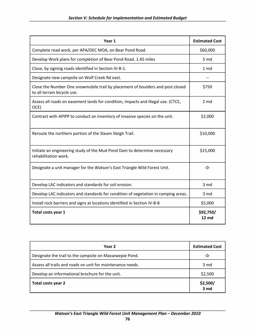
Section V: Schedule for Implementation and Estimated Budget
Year 1 Estimated Cost
Complete road work, per APA/DEC MOA, on Bear Pond Road. $60,000
Develop Work plans for completion of Bear Pond Road. 1.45 miles 5 md
Close, by signing roads identified in Section IV‐B‐1. 1 md
Designate new campsite on Wolf Creek Rd east. ‐‐
Close the Number One snowmobile trail by placement of boulders and post closed $750 to all terrain bicycle use.
Assess all roads on easement lands for condition, impacts and illegal use. (CTCE, 2 md OCE)
Contract with APIPP to conduct an inventory of invasive species on the unit. $2,000
Reroute the northern portion of the Steam Sleigh Trail. $10,000
Initiate an engineering study of the Mud Pond Dam to determine necessary $15,000 rehabilitation work.
Designate a unit manager for the Watson’s East Triangle Wild Forest Unit. ‐0‐
Develop LAC indicators and standards for soil erosion. 3 md
Develop LAC indicators and standards for condition of vegetation in camping areas. 3 md
Install rock barriers and signs at locations identified in Section IV‐B‐8 $5,000
Total costs year 1 $92,750/ 12 md
Year 2 Estimated Cost
Designate the trail to the campsite on Massewepie Pond. ‐0‐
Assess all trails and roads on unit for maintenance needs. 3 md
Develop an informational brochure for the unit. $2,500
Total costs year 2 $2,500/ 3 md
Watson’s East Triangle Wild Forest Unit Management Plan – December 2010 76

Section V: Schedule for Implementation and Estimated Budget
Year 3 Estimated Cost
Install new gates on both ends of the Doc Woods Trail to prevent illegal motor $3,000 vehicle use.
Install a new rock barrier on the Old Upper South Pond Road. $250
Total costs year 3 $3,250
Year 4 Estimated Cost
Remove the old bridge over Desert Creek at end of Creek Road. $6,800
Construct a four car parking area adjacent to the Bear Pond Road near the South $1,500 Ponds Trail intersection.
Total cost year 4 $8,300
Year 5 Estimated Cost
Construct new accessible lean‐tos, and privies at Buck Pond and at old camp $19,700 location at north end of the Mullins Flow Road south ( $9,850 ea)
Construct an accessible trail and waterway access site at Buck Pond. $2,500
Close the Buck Pond and Mullins Flow Roads to public motor vehicle use by $8,000 installing rock barriers and convert each road into an accessible access route to the lean‐to locations.
Construct two car parking areas at the beginning of the Buck Pond and Mullins $1,500 Flow Roads.
Rehabilitate the Mud Lake Dam if required. $350,000
Reassess all designated campsites on the unit. 5 md
Construct informational kiosks at Bergens Clearing. $2,000
Total costs year 5 $383,700/ 5 md
Watson’s East Triangle Wild Forest Unit Management Plan – December 2010 77

This page intentionally left blank
Watson’s East Triangle Wild Forest Unit Management Plan – December 2010 78

APPENDIX 1: Snowmobile Trail Siting, Construction and Maintenance on Forest Preserve Lands in the Adirondack Park
I. Adirondack Park Snowmobile Trail System
The October 2006, Snowmobile Plan for the Adirondack Park/Final Generic Environmental Impact Statement (2006 Snowmobile Plan) presents a conceptual snowmobile plan with the goal of creating a system of snowmobile trails between communities in the Adirondack Park. The 2006 Snowmobile Plan outlines the concept of reconfiguring the existing snowmobile trail network across the Forest Preserve through the UMP process. Implementation is supported by this “Management Guidance…” establishing a new DEC snowmobile trail classification system with new standards and guidelines for snowmobile trail siting, construction and maintenance.
The designation of a new class of snowmobile trail to establish and improve community connections (Class II trails) will be complemented by the designation of another new class of trail (Class I trails) intended to preserve a more traditional type of Adirondack snowmobiling experience. Some existing snowmobile trails (most likely within the interior of Wild Forest areas or adjacent to private inholdings) will be redesignated for non‐motorized use or abandoned as trails altogether. These actions will serve to ensure available, wintertime recreational opportunities in Wild Forest areas are not dominated by snowmobile use to the exclusion or near exclusion of passive recreational uses. All snowmobile trails, regardless of class, will be carefully sited, constructed and maintained to preserve the most essential characteristics of foot trails and to serve, where appropriate, hiking, mountain biking and other non‐motorized recreational pursuits in spring, summer and fall. Additionally, this guidance helps ensure protection of sensitive natural resources on public lands and the minimization of snowmobiling safety hazards.
Implementing the broad recommendations of the 2006 Snowmobile Plan will also result in the establishment of important new routes on private lands through the acquisition of easements or other access rights from willing sellers. This Guidance does not address the management of those trails, but instead provides standards and guidelines solely for the management of DEC snowmobile trails on Forest Preserve lands throughout the Adirondack Park.
In many locations, designated snowmobile routes of varying lengths exist on Forest Preserve roads, rather than on trails. DEC’s management of all such roads for motor vehicle use, including snowmobiles, is guided by DEC’s “CP‐38 Forest Preserve Roads” policy and not by this Guidance.
Snowmobile Trail Classification
The classification system for designated snowmobile trails (not on roads) in the Forest Preserve is presented below. It establishes two classes of trails,1 for which the following definitions apply:
The classification scheme outlined in the 2006 Snowmobile Plan differed from the scheme presented here. Class I trails were presented as snowmobile trails on Forest Preserve roads, Class II trails (of two subtypes) as secondary trails and Class III trails as community connector trails.
Watson’s East Triangle Wild Forest Unit Management Plan – December 2010 79
1

Appendix 1: Snowmobile Management Guidance
“Motorized travel corridor” – non‐snowmobile public motor vehicle routes2 and motorized waterbodies.
“Motorized waterbodies” – waterbodies upon which year‐round, public motorized uses (including snowmobiling) occur to a moderate or great extent, typically facilitated by direct motorized route access to shorelines and boat launching facilities.
“Periphery” – the geographic area within two miles of a motorized travel corridor.
“Remote interior” – the geographic area more distant than two miles from the nearest motorized travel corridors in all directions.
Class II Trails: Community Connector Trails
Snowmobile trails or trail segments that serve to connect communities and provide the main travel routes for snowmobiles within a unit are Community Connector Trails. These trails are located in the periphery of Wild Forest or other Forest Preserve areas. They are always located as close as possible to motorized travel corridors, given safety, terrain and environmental constraints, and only rarely are any segments of them located further than one mile away from the nearest of these corridors. They are not duplicated or paralleled by other snowmobile trails. Some can be short, linking communities to longer Class II trails that connect two or more other communities.
Class I Trails: Secondary Snowmobile Trails
All other snowmobile trails that are not Community Connector Trails are Secondary Snowmobile Trails. These trails are located in the periphery of Wild Forest and other Forest Preserve areas where snowmobile trails are designated.3 They may be spur trails (perhaps leading to population areas and services such as repair shops, service stations, restaurants and lodging), short loop trails or longer recreational trails. If directly connected to Class II trails, new and rerouted Class I trails are always located as close as possible to – and no farther than one mile from – motorized travel corridors. If not directly connected to Class II trails, they are generally located within one mile of motorized travel corridors, although some – with high recreational value – may be located beyond one mile and may approach a remote interior area.
2 Including routes where rights for motorized access to private in‐holdings exist, but generally not including DEC administrative roads.
3 Snowmobile trails may also be located in some Primitive areas and in Wilderness areas within 500 feet of the Wilderness boundary.
Watson’s East Triangle Wild Forest Unit Management Plan – December 2010 80

Appendix 1: Snowmobile Management Guidance
II. Reconfiguration of the Snowmobile Trail System
Establishment of Community Connections
The establishment of a Park‐wide community‐connection snowmobile trail system will provide north‐to‐south and east‐to‐west routes that will link many Adirondack communities together. Designation of Class II, Community Connector snowmobile trails on Forest Preserve lands will create essential portions of the system, the use of which will result in a significant shifting of snowmobile use away from some remote interior areas of these lands to the periphery. Within the periphery, these Class II trails will intentionally be located as close to motorized travel corridors as practicable without locating them within – nor within sight of – road rights‐of‐way wherever such locations can be avoided. The actual, on‐the‐ground routes that establish the connections through Forest Preserve will be determined through the UMP process. Many of the connections already exist and the focus will be on improving them through proper siting, construction and trail maintenance work.
A small number of existing4 DEC snowmobile trails in the Park shown to be located partly within remote interior areas may receive Class II designation due to their importance and may be retained and kept open, as long as either of the following conditions are met: 1) the remote interior area of concern is small – no more than 750 acres in area; or, 2) the trail segments of concern are located very near the boundary of the remote interior area, with no trail segment located further than one‐half mile into the interior from any boundary. DEC will give high priority to relocating out of the remote interior area any Class II trails or trail segments so retained.
No existing DEC snowmobile trails in the Park that receive Class I designation may be retained and kept open with any portion of the trail located within a remote interior area.
Redesignation and Abandonment of Existing Trails
Actions taken under this Guidance will also include the re‐designation of some existing Forest Preserve snowmobile trails as either Class I, Secondary Snowmobile Trails or as non‐snowmobile trails (such as foot trails or horse trails) for non‐motorized recreational uses. The re‐designation of some snowmobile trails for non‐motorized uses will occur consequent to management actions called for in adopted UMPs or UMP amendments and will be guided by the primary goal: To provide a net benefit to the Forest Preserve through reconfiguring the trail system and revising trail management practices5 . In some instances, the re‐designation of particular snowmobile trail segments – such as the far portions of some dead‐end trails – may be the preferred alternative over re‐designation or abandonment of the entire trail. Such actions can provide for a new type of recreational opportunity – a combined or hybrid type (motorized/non‐motorized), in which the last stretches of some routes are undertaken by means of skis or snowshoes.
Snowmobile trails that receive the new Class I designation or are re‐designated for non‐snowmobile use will be revegetated to narrower widths that conform to their specific trail classification standards where they are wider. In many locations, this will serve to restore a more consistently closed canopy, thereby improving the aesthetic experience of trail users and enhancing ecological integrity.
“Existing,” as used here and in the paragraph immediately below, means existing at the time of DEC’s adoption of this guidance.
5 For a discussion of the “net benefit” concept, see page 187 of the Snowmobile Plan for the Adirondack Park/Final Generic Environmental Impact Statement, October 2006.
Watson’s East Triangle Wild Forest Unit Management Plan – December 2010 81
4

Appendix 1: Snowmobile Management Guidance
Criteria for Redesignation or Abandonment of Trails
Removing some snowmobile trails or trail segments from the existing network is central to the balance sought in providing a net benefit to the Forest Preserve while also providing for key improvements in snowmobile riding in the Park. In proposing trails or trail segments for redesignation or abandonment, management will seek to eliminate those that:
• do not provide safe snowmobiling conditions; • ∙penetrate the more remote areas of large Wild Forest parcels6 or traverse an existing
undeveloped forest corridor connecting two or more remote interior areas in the Forest Preserve;
• are located near Wilderness area boundaries; • are redundant trails, or are part of an unnecessarily dense, local snowmobile trail network
where opportunities for quiet, non‐motorized use of trails are rare or nonexistent; • are no longer used or receive only minimal public use; • might encourage illegal motorized access to public and private lands or create significant
potential conflicts with adjacent property owners; • incur unusually high snowmobile trail maintenance costs.
Additional Environmental Benefits
By restricting use of tracked groomers to the more developed Class II trails (see “Motor Vehicle Use Guidelines”), and by allowing Class I snowmobile trails to acquire a less developed and less maintained character, this Guidance is intended to clearly distinguish between two important types of snowmobiling opportunities in the Adirondacks while shifting the highest snowmobile use to the outer periphery of Forest Preserve lands. Consequently, the wilder, more remote areas of the Forest Preserve will be less impacted by motorized traffic. There will be lower noise levels, lower exhaust emission levels, decreased impacts on wildlife and reduced user conflicts between users participating in motorized and non‐motorized forms of recreation. DEC’s responsibility to manage and monitor snowmobile use and impacts will also be made easier.
III. Standards and Guidelines for Snowmobile Trail Siting, Construction and Maintenance on the Forest Preserve
The following standards will apply to siting and designating snowmobile trails on Forest Preserve lands in the Adirondack Park and carrying out construction and maintenance activities on them.
Specific Trail Siting Criteria for New and Rerouted Snowmobile Trails
Class I Trails: Secondary Snowmobile Trails
New and rerouted Class I trails will be sited within the periphery of State lands and may only be sited beyond one mile from motorized travel corridors when the recreational value of the newly sited or rerouted trail segment is high and
6 Trails providing access to frozen surfaces of waterbodies located wholly or partly within remote interior area should be rerouted or abandoned to prevent possible incursion into the remote areas via the frozen surfaces.
Watson’s East Triangle Wild Forest Unit Management Plan – December 2010 82

Appendix 1: Snowmobile Management Guidance
potential impacts to sensitive interior areas are minimal as carefully assessed and described in a UMP.
All new and rerouted Class I trails directly connected to Class II Trails will be sited as close as possible to motorized travel corridors and, without exception, will be sited no farther than one mile from these corridors.
Class II Trails: Community Connector Trails
New and rerouted Class II Trails on State lands will be sited as close as possible to motorized travel corridors. No new or rerouted trail segments will be sited farther than one mile from these corridors unless terrain or environmental constraints dictate otherwise, or such siting of a new or rerouted trail segment within the periphery is necessary to connect important, existing trail segments that together will form the same Community Connector Trail.
Snowmobile Trail Siting Standards
1. In cases where closure or abandonment of a motorized travel corridor results in an existing snowmobile trail location being inconsistent with these guidelines, such trail will, if practicable and as soon as possible, be relocated or reclassified to comply with these guidelines.
2. New and rerouted snowmobile trails will be sited, when possible, along existing routes or previously existing old routes such as foot trails, woods roads, utility rights of way and abandoned railroad beds in lieu of constructing entirely new trails.
3. New and rerouted snowmobile trails will be sited with an objective to avoid locations that present safety hazards such as the edges of ravines or ledges, major highway crossings and crossings of frozen surfaces of water bodies such as rivers, lakes and ponds. If suitable alternative routes are designated or developed, trails that lead riders to unsafe locations will be closed to snowmobile use in favor of the alternative routes in order to lower risks and eliminate unnecessary snowmobile trail mileage.
4. New and rerouted snowmobile trails will be sited with an objective to avoid areas considered environmentally sensitive, such as: wetlands; endangered plant or animal populations that might be harmed by the trails and/or their use; remote interior areas as defined by these guidelines and forested corridors connecting such remote interior areas; and deer wintering areas and other significant habitats, so that the values of these areas are not diminished.
5. New and rerouted snowmobile trails will not be established without an evaluation of potential significant impacts on adjacent private holdings.
6. New and rerouted snowmobile trails, including spur trails, will not provide access to private lands where public snowmobile access is not permitted.
7. New and rerouted snowmobile trails, through the acquisition of easements or other access rights from willing sellers, will be sited on private lands rather than State lands wherever possible to minimize impacts on the Forest Preserve.
Watson’s East Triangle Wild Forest Unit Management Plan – December 2010 83

Appendix 1: Snowmobile Management Guidance
Snowmobile Route Design, Construction and Maintenance Standards
Snowmobile route design, construction and non‐ordinary maintenance activities7 will be carried out pursuant to Snowmobile Trail Work Plans developed by DEC staff in consultation with APA staff. The following standards will be followed and reflected in the development of these Work Plans in order to preserve the trail‐like character of snowmobile trails while ensuring they are appropriately safe to ride. When undertaking any of the types of work described below with motorized landscaping equipment (almost exclusively on Class II Trails), only careful use of appropriate low‐impact landscaping equipment will be approved, as determined by a “minimum requirement” decision making approach set forth in the Snowmobile Trail Work Plan. For example, use of bulldozers and creation of “dugways” will not be approved. Operators of low‐impact landscaping equipment will conduct their work in optimal environmental conditions and in a manner that will not contribute to any potential degradation of the wild forest setting. All work will be done with appropriate DEC oversight.
For new snowmobile trails of both classes to retain essential characteristics of foot trails, management practices must integrate thorough knowledge of the standards and guidance below, with efforts to appropriately balance them and the underlying concerns as the trails are sited, constructed and maintained thereafter. The end result should be trails that are both enjoyable and safe to ride for essentially the same reason – for the way the trails snake through the wild landscape of the Adirondacks in a natural fashion… construction and maintenance practices having altered the terrain enough to allow for an acceptable degree of riding comfort, but not so much as to create potential for high‐speed, disruptive and unsafe snowmobiling experiences.
Many existing snowmobile trails are sited on old woods roads and other routes originally constructed and maintained for use of motor vehicles other than snowmobiles. In such cases, the standards set forth below may also be used to reroute or otherwise minimally alter such trails with the objective to achieve the same end result.
Alignment and Grade:
Trail alignment will not result in blind curves and abrupt changes in either horizontal or vertical direction; trails will be designed to ensure:
a) Sight distance will be 50 feet or more wherever possible; b) Curves will have a radius of at least 25 feet; c) The maximum grade of trails will not exceed 20% unless deemed necessary to minimize
environmental impacts associated with trail construction; d) Trails will not normally be laid out on existing cross slopes greater than 12%;
1. To the greatest extent possible, trails will not be aligned with long straight sections. Trails will follow the natural contours of the terrain as much as possible and will be laid out to balance and minimize necessary tree cutting, rock removal and terrain alteration.
7 Ordinary maintenance activities are defined in the “Memorandum of Understanding Between the Adirondack Park Agency and the Department of Environmental Conservation Concerning Implementation of the State Land Master Plan for the Adirondack Park” (APA/DEC MOU).
Watson’s East Triangle Wild Forest Unit Management Plan – December 2010 84
Appendix 1: Snowmobile Management Guidance
2. Trails will be laid out to avoid rocky areas and drainage features such as wetlands and streams to the greatest possible extent.
3. In locations where serious environmental or safety conditions exist along a trail, the trail will be rerouted rather than rehabilitated at that location.
Trail Width:
1. Class I Trails may be maintained to an 8‐foot maximum cleared trail width.
2. Class II Trails may be maintained to a 9‐foot maximum cleared trail width except on sharp curves (inside turning radius of 25‐35 feet) and steep running slopes (over 15%) where they may be maintained to a 12‐foot maximum cleared trail width.
Class I and II trails wider than their classification allows will be actively restored to these limits.
Tree Cutting:
DEC policy requires that cutting trees should be minimized, but where cutting is required, trees must be identified, tallied and included in a Work Plan in accordance with DEC Program Policy LF91‐2 Cutting and Removal of Trees in the Forest Preserve.
1. Cutting of overstory trees will be avoided in order to maintain a closed canopy wherever possible. Large and old growth trees should be protected.
2. Cutting trees to expand a trail from its current width or otherwise improve a trail will be carried out only pursuant to a Work Plan.
3. All snowmobile trails may be kept clear to a height of 12 feet, as measured from ground level.
4. No trees, except trees that due to structural problems or fallen/tipped conditions present an immediate hazard to the safe use of the trail by snowmobilers, will be cut outside the cleared trail width.
5. Trees should be felled away from the trail to minimize the amount of material that needs to be moved. If the tree trunks are not used to help delineate the trail, felled trees should be delimbed and cut into short enough lengths to lie flat on the ground. Once delimbed and cut up, the short lengths should be dispersed and not left in piles next to the trail. If the tree trunks are used to help delineate the trail, the cut ends of the trunks should be located outside the intended edge of the trail by at least one foot for safety reasons.
6. When trees are cut within the cleared trail width, they will be cut flush with the ground, and the preference will be to leave the root masses in place.
a) On Class II trails, if it is important to remove a root mass because it presents an obstacle in the trail surface, the preference will be to grind the stump and roots. If grinding is not feasible, the root mass may be dug up, rolled or placed off the trail into the woods without removing intervening vegetation and organic matter; the root mass will be set down so as to have the lowest profile possible.
Watson’s East Triangle Wild Forest Unit Management Plan – December 2010 85
Appendix 1: Snowmobile Management Guidance
b) Grinding will not occur on Class I trails.
7. No brushing will occur outside the cleared trail width of any snowmobile trails.
Trail Surface:
1. Grading:
a) Class I Trails. Trail surfaces should generally follow the existing contours of the natural forest floor and not be graded flat. While limited leveling and grading may be undertaken, this work will be done using hand tools almost exclusively. In rare circumstances, appropriate low‐impact landscaping equipment may be used as specified in a Work Plan.
b) Class II Trails. Trail surfaces should generally follow the existing contours of the natural
forest floor and not be graded flat. Limited leveling and grading may be undertaken using appropriate low‐impact landscaping equipment as specified in a Work Plan.
2. Rock Removal:
a) Removal of boulders and rocks from snowmobile trail surfaces will be minimized to the greatest
extent possible and will be described in a Work Plan. Methods of removal will be specified in the Work Plan. No boulders or rocks will be removed outside the cleared trail width.
i. On Class I Trails, rock removal will occur using hand tools only, except in rare
circumstances in new trail construction and trail reconstruction when use of low‐impact landscaping equipment may be approved. Rock removal on Class I trails will be primarily limited to uncommon, major obstacles that present demonstrable safety hazards to snowmobile riders and which cannot be avoided by appropriate trail layout or rerouting.
ii. On Class II Trails, rock removal may occur using low‐impact landscaping equipment and may include removal of rocks determined to present demonstrable safety hazards to snowmobile riders or to be very likely to damage grooming equipment. Many rocks in snowmobile trails, due to their specific shapes and/or locations, do not present themselves so as to cause these problems, and these may not be removed regardless of how high above the trail surface they project. Conversely, some rocks in snowmobile trails – while small – do present themselves so as to cause these problems, and if they are identified in an approved Work Plan, they may be removed.
b) Boulders and rocks removed from trails will preferably be buried in
the trails to minimize disturbance. Earth moved to dig the holes into which the boulders or rocks are to be placed will be used to fill the holes that result from the rock removal. When removed boulders and rocks are not buried, but are instead set to the side of the trail, they will be dispersed with care and not left in windrows or piles next to the trail. If
Watson’s East Triangle Wild Forest Unit Management Plan – December 2010 86

Appendix 1: Snowmobile Management Guidance
a boulder or rock is used to help delineate the trail, it should be placed outside the intended edge of the trail by at least one foot for safety reasons.
c) Alternatives to rock removal should be considered to minimize the need for disturbance of the ground, to reduce the likelihood of creating drainage problems and to reduce the potential need for fill. Such alternatives may include covering or minor relocation of the trail where a boulder or rock may be too large or the number too great to deal with by any other method.
d) Removal of boulders and rocks from the surrounding natural, wild forest setting for use in snowmobile trail construction and maintenance work will be minimized and may occur only on a limited, carefully selective basis for small‐scale projects. On Class II trails, where large‐scale trail construction projects using stone material may be approved, importation of native stone from appropriate, specified sources may occur.
3. Side Slope Management:
a) On Class I trails, elimination or reduction of side slopes by means of bench cuts will be accomplished using hand tools exclusively. The need for bench cuts will be minimized through proper trail layout. The maximum amount of cut, measured vertically, will be 20% of the tread width. Side slopes of newly constructed trails and reroutes will be dressed and tapered within the cleared trail width; side slopes of some existing, degraded trails may be dressed and tapered outside the cleared trail width if this is determined the best way to address the degradation and restore environmentally sound, safe conditions.
b) On Class II trails, elimination or reduction of side slopes will be accomplished primarily by means of full bench cuts for which appropriate landscaping equipment may be used. The need for bench cuts will be minimized through proper trail layout. The tapering of side slopes will be allowed outside the cleared trail width. The areas dressed and tapered will be re‐vegetated to restore stability and natural site conditions after the full bench cut is created.
Drainage:
1. Adequate drainage will be provided within the cleared trail width to prevent trail erosion and washout and to maintain a safe trail. All snowmobile trails will be constructed so as not to intercept groundwater to the greatest extent possible; natural drainage patterns will be maintained. In areas where the natural drainage patterns may be affected, bridges will be the preferred method for crossing wet areas as authorized in a Work Plan. Bridges will be constructed pursuant to approved snowmobile trail bridge designs.
2. Water bars and broad‐based dips may extend beyond the cleared trail width to the extent necessary to effectively remove water from the trail surface, provided that no trees are cut outside the cleared trail width. Culverts will not be installed as drainage devices. Any existing culverts will be removed unless the culverts are very large and their removal is essentially not possible.
Watson’s East Triangle Wild Forest Unit Management Plan – December 2010 87

Appendix 1: Snowmobile Management Guidance
Wetlands:
1. Wetlands will be avoided to the greatest extent possible.
2. When wetlands crossings or trail locations adjacent to wetlands are proposed, the trail will be designed to minimize potential adverse impacts.
3. Any activity in a wetland or that may impact a wetland will be undertaken with prior consultation with the APA and with recognition of Army Corps of Engineers’ permit requirements.
Motor Vehicle Use Guidelines
1. Snowmobile route design, construction and non‐ordinary maintenance will be carried out pursuant to Snowmobile Trail Work Plans (Work Plans) developed by DEC staff in consultation with APA staff.
2. Administrative personnel, equipment and materials will be brought to work sites by the least intrusive means possible, as determined by a “minimum requirement” decision making approach set forth in the Snowmobile Trail Work Plan and as identified in priority order below:
a) By non‐motorized means or, during periods of sufficient snow and ice cover, by snowmobile.
b) By aircraft. c) By appropriate motor vehicles other than snowmobiles. Such motor vehicle use
will only be approved when alternative means of transportation (non‐motorized means, snowmobiles, aircraft) are not feasible or are inadequate. The motor vehicles used will be those which are suitable for the particular activities but have the least potential adverse impact on the environment. Even when such motor vehicle use has been approved, administrative personnel will utilize motor vehicles only to the minimum extent necessary.
3. Proposed motor vehicle or aircraft use will also be described in a Conceptual Use Plan, per CP 17, “Record Keeping and Reporting of Administrative Use of Motor Vehicles and Aircraft in the Forest Preserve” or any successor policy.
4. Any motor vehicle used will display an official “DEC Administrative Use” sign, unless otherwise prominently identified as a DEC vehicle.
5. All motorized uses will be supervised by an individual who has attended and completed DEC training concerning guidelines and policies for snowmobile trail construction and maintenance.
6. All activities involving landscaping equipment will be directly supervised by DEC staff.
7. A detailed Work Plan, approved by DEC Lands & Forests staff must be prepared for all work to be done on snowmobile trails except for the Initial Annual Maintenance Trips described below
Watson’s East Triangle Wild Forest Unit Management Plan – December 2010 88

Appendix 1: Snowmobile Management Guidance
and immediate removal of fallen or tipped trees that present safety hazards as described above, under “Tree Cutting.”
8. A Snowmobile Trail Maintenance Log (Trail Log) will be used to record all work done on snowmobile trails.
9. Work requiring use of aircraft or motor vehicles other than snowmobiles should be done, whenever possible, when environmental conditions allow during the months of August, September, and October.
Maintenance Trips involving Snowmobiles and other Motor Vehicles:
1. Initial Annual Maintenance Trips. These trips will be authorized under an AANR or TRP and are undertaken solely for the purpose of removing fallen branches and trees that obstruct the trail and maintaining drainage features.
a) AANRs and TRPs will identify trail names, trail class and authorized motor vehicles to be used for Initial Annual Maintenance Trips.
b) Motor vehicle use will be limited to one trip per trail per year. c) Trips will only be conducted when environmental conditions allow in the months
of August, September, and October. d) All activities undertaken during Initial Annual Maintenance Trips will be recorded
in Snowmobile Trail Maintenance Logs. e) During Initial Annual Maintenance Trips an assessment of necessary trail
construction and maintenance work will be conducted. Necessary work will be recorded in Snowmobile Trail Maintenance Logs by specific location and will be used to develop Work Plans.
2. Maintenance, Rehabilitation and Construction Trips. These trips include all work trips on snowmobile trails except for “Initial Annual Maintenance Trips,” described above, and “Grooming and Associated Winter Maintenance Trips,” described below. They are undertaken primarily for the purposes of snowmobile route design, construction and non‐ordinary maintenance activities (i.e., most “trail work,” bridge construction, etc.) and so are a primary focus of the standards and guidelines set forth earlier in this section of the Guidance.
a) All motor vehicle use associated with work of this type will be undertaken by the least intrusive means possible, as identified in priority order set out under “Motor Vehicle Guidelines,” Section 1.
b) All work of this type will require an approved, detailed Work Plan as describe under “Snowmobile Route Design, Construction and Maintenance Standards,” above.
3. Grooming and Associated Winter Maintenance Trips. Grooming will be tailored to the Class of the snowmobile trail; it must not alter a trail’s width or physical character and will not be used to gather snow from outside the allowable cleared width of the trail. Grooming equipment will be operated only by administrative personnel including DEC staff or volunteers under an
Watson’s East Triangle Wild Forest Unit Management Plan – December 2010 89

Appendix 1: Snowmobile Management Guidance
agreement with the DEC (AANR or TRP) and covered by appropriate insurance. The type of equipment allowed will be as follows:
Class I Trails: Snowmobile with a drag, as the 8‐foot cleared width and layout of the trail will allow8 and as approved in an AANR, TRP or pursuant to a Work Plan.
Class II Trails: Snowmobile with a drag, or, grooming equipment with tractor and drag width sufficiently less than the 9‐foot to 12‐foot trail width9 to allow for grooming that will not cause tree damage. Type and dimensions of grooming equipment to be identified and approved in an AANR, TRP and pursuant to a Work Plan.
Associated Winter Maintenance Trips will occur only when snow and ice cover is sufficient to protect the trail. They will normally be performed by use of snowmobiles but may also involve use of tracked groomers or other motor vehicles, where appropriate, as approved in an AANR, TRP and pursuant to a Work Plan. These trips may include any of the following activities:
a) Removing fallen or tipped trees that present immediate safety hazards as described above, under “Tree Cutting.”
b) Placing trail signs or markers. c) Pruning vegetation. d) Taking building materials, supplies and tools to a construction site for immediate work or for
staging them for an upcoming construction season; e) In rare instances, installing temporary trail safety or natural resource protection features or
structures. f) Removing materials from the Forest Preserve that were staged during previous work
projects. g)
Department Oversight of Motor Vehicle Use:
1. The Regional Natural Resource Supervisor, or a Departmental designee, will be notified no less than 48 hours prior to commencement of motor vehicle use and will determine whether or not trail conditions are suitable for such work and vehicle use prior to such use.
2. The Regional Natural Resource Supervisor, or a Departmental designee, will be responsible for ensuring Department staff periodically monitor and inspect all construction and maintenance work to ensure compliance with approved Work Plans.
a) Department staff shall inspect the snowmobile trail work at times which are intended to coincide with the use of equipment that has the greatest potential to cause environmental damage.
b) All construction activities involving landscaping equipment will be directly supervised by DEC staff.
c) Within seven days of completion of authorized construction and maintenance activities, the Regional Natural Resource Supervisor will verify the work was satisfactorily
8 The drag should not be wider than 7 ½ feet on Class I trails. 9 The drag should not be wider than 8 ½ feet on Class II trails.
Watson’s East Triangle Wild Forest Unit Management Plan – December 2010 90
Appendix 1: Snowmobile Management Guidance
completed according to Standards and Guidelines for Snowmobile Trail Construction and Maintenance and, if applicable, that any AANR or TRP terms and conditions were met.
d) If the terms and conditions of an AANR, TRP and associated Work Plan are violated at any time, the AANR/TRP may be amended or revoked, with the determination to be made by the Director of the Division of Lands and Forests.
IV. Implementation and Review
Implementation of this Guidance – and the appending of it to the APA/DEC MOU – is intended to establish snowmobile trail management practices that conform to the guidelines and criteria of the Adirondack Park State Land Master Plan.
Some activities may require a freshwater wetlands permit from the Agency. Some activities will qualify by MOU definition as ordinary maintenance, rehabilitation, and minor relocation of snowmobile trails. In addition to these considerations, implementation of this Guidance may occur through: authorization granted directly via an approved UMP or UMP amendment; interagency consultation on Work Plans authorized by UMP’s or UMP amendments; and APA/DEC staff observations and monitoring of off‐season snowmobile trail management practices and trail character.
This Guidance does not prevent DEC, via individual UMP’s or other means, from providing more restrictive management where necessary to protect the character of Forest Preserve lands.
Staff of both the APA and DEC will document examples of the implementation of this guidance in order to: 1) verify that implementation is producing the desired results; and, 2) identify specific aspects of the guidance that may need to be clarified or otherwise revised by APA and DEC in order to achieve, or more fully achieve, the desired results. APA staff will report regularly to the Agency State Land Committee concerning such review and any recommendations that may stem from it.
Watson’s East Triangle Wild Forest Unit Management Plan – December 2010 91

This page intentionally left blank
Watson’s East Triangle Wild Forest Unit Management Plan – December 2010 92
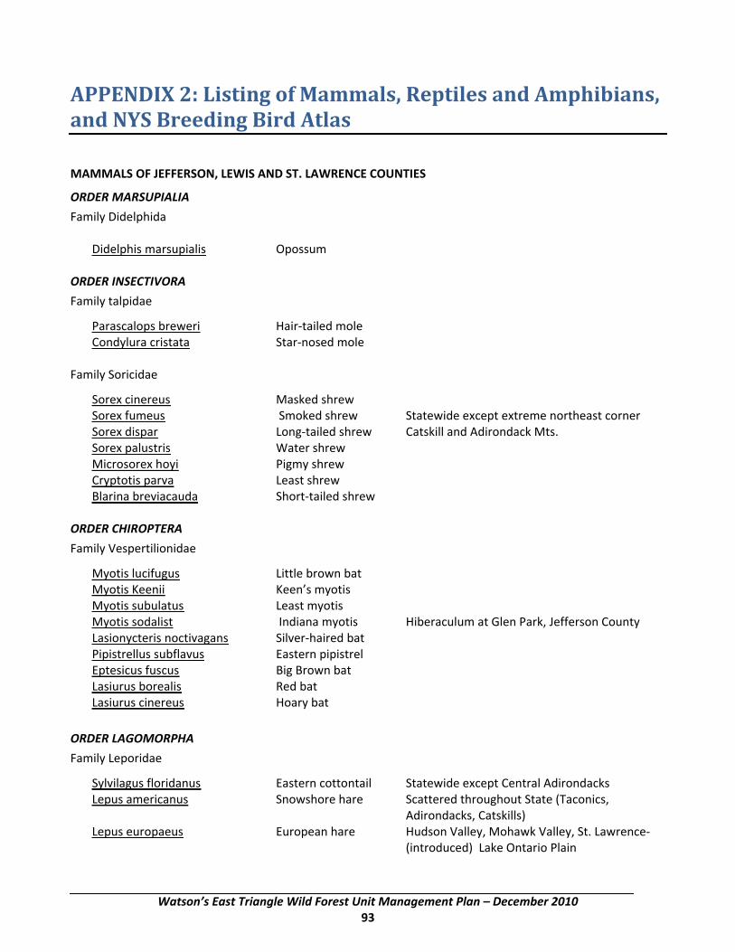
APPENDIX 2: Listing of Mammals, Reptiles and Amphibians, and NYS Breeding Bird Atlas
MAMMALS OF JEFFERSON, LEWIS AND ST. LAWRENCE COUNTIES
ORDER MARSUPIALIA
Family Didelphida Didelphis marsupialis Opossum ORDER INSECTIVORA
Family talpidae
Parascalops breweri Hair‐tailed mole Condylura cristata Star‐nosed mole Family Soricidae
Sorex cinereus Masked shrew Sorex fumeus Smoked shrew Statewide except extreme northeast corner Sorex dispar Long‐tailed shrew Catskill and Adirondack Mts. Sorex palustris Water shrew Microsorex hoyi Pigmy shrew Cryptotis parva Least shrew Blarina breviacauda Short‐tailed shrew ORDER CHIROPTERA
Family Vespertilionidae
Myotis lucifugus Little brown bat Myotis Keenii Keen’s myotis Myotis subulatus Least myotis Myotis sodalist Indiana myotis Hiberaculum at Glen Park, Jefferson County Lasionycteris noctivagans Silver‐haired bat Pipistrellus subflavus Eastern pipistrel Eptesicus fuscus Big Brown bat Lasiurus borealis Red bat Lasiurus cinereus Hoary bat
ORDER LAGOMORPHA
Family Leporidae
Sylvilagus floridanus Eastern cottontail Statewide except Central Adirondacks Lepus americanus Snowshore hare Scattered throughout State (Taconics,
Adirondacks, Catskills) Lepus europaeus European hare Hudson Valley, Mohawk Valley, St. Lawrence‐
(introduced) Lake Ontario Plain
Watson’s East Triangle Wild Forest Unit Management Plan – December 2010 93

Appendix 2: Listing of Mammals, Reptiles and Amphibians and NYS Breeding Bird Atlas
ORDER RODENTIA
Family Sciurade
Tamias striatus Eastern chipmunk Marmota monax Eastern woodchuck Sciurus carolinensis Eastern gray squirrel Statewide except Central Adirondacks Tamiasciurus hudsonicus Red Squirrel Statewide Glaucomys volans Eastern flying squirrel Southern two‐thirds of State Glaucomys sabrinus Northern flying squirrel Catskills & Adirondacks (?) Family Castoridae
Castor canadensis Beaver Family Cricetidae
Peromyscus leucopus Wood mouse Peromyscuc maniculaus Deer mouse Clethrionomys gapperi Red‐backed mouse Microtus pennsylvanicus Meadow vole Microtus chrotorrhinus Rock vole Catskills and Adirondacks (Yellowstone Vole) Microtus pinetorum Pine vole Ondatra zibethicus Muskrat Synaptomys cooperti Southern bog lemming Family Muridae (Introduced)
Rattus rattus Black rat Rattus norvegicus Brown or Norway rat Mus musculus House mouse Family Zapodidee
Zapus hudsonius Meadow jumping mouse Napaeozapus insignis Woodland jumping mouse Family Erethizontidae
Erethizon dorsatum Porcupine ORDER CARNIVORA
Suborder Fissipedia Family Canidae
Canis latrans Coyote Vulpes fulva Red fox Urocyon cinereoargenteus Gray fox
Watson’s East Triangle Wild Forest Unit Management Plan – December 2010 94
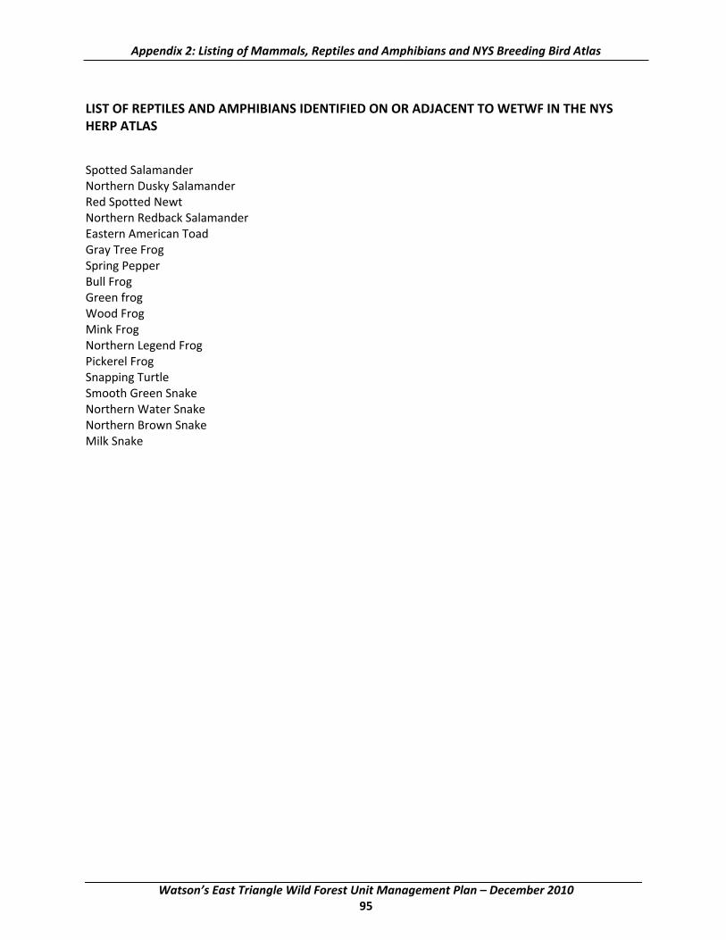
Appendix 2: Listing of Mammals, Reptiles and Amphibians and NYS Breeding Bird Atlas
LIST OF REPTILES AND AMPHIBIANS IDENTIFIED ON OR ADJACENT TO WETWF IN THE NYS HERP ATLAS
Spotted Salamander Northern Dusky Salamander Red Spotted Newt Northern Redback Salamander Eastern American Toad Gray Tree Frog Spring Pepper Bull Frog Green frog Wood Frog Mink Frog Northern Legend Frog Pickerel Frog Snapping Turtle Smooth Green Snake Northern Water Snake Northern Brown Snake Milk Snake
Watson’s East Triangle Wild Forest Unit Management Plan – December 2010 95
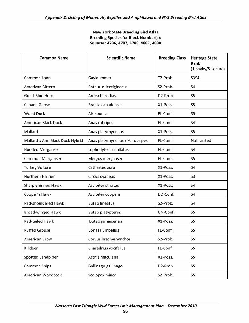
Appendix 2: Listing of Mammals, Reptiles and Amphibians and NYS Breeding Bird Atlas
New York State Breeding Bird Atlas Breeding Species for Block Number(s): Squares: 4786, 4787, 4788, 4887, 4888
Common Name Scientific Name Breeding Class Heritage State
Rank (1‐shaky/5‐secure)
Common Loon Gavia immer T2‐Prob. S3S4
American Bittern Botaurus lentiginosus S2‐Prob. S4
Great Blue Heron Ardea herodias D2‐Prob. S5
Canada Goose Branta canadensis X1‐Poss. S5
Wood Duck Aix sponsa FL‐Conf. S5
American Black Duck Anas rubripes FL‐Conf. S4
Mallard Anas platyrhynchos X1‐Poss. S5
Mallard x Am. Black Duck Hybrid Anas platyrhynchos x A. rubripes FL‐Conf. Not ranked
Hooded Merganser Lophodytes cucullatus FL‐Conf. S4
Common Merganser Mergus merganser FL‐Conf. S5
Turkey Vulture Cathartes aura X1‐Poss. S4
Northern Harrier Circus cyaneus X1‐Poss. S3
Sharp‐shinned Hawk Accipiter striatus X1‐Poss. S4
Cooper’s Hawk Accipiter cooperii DD‐Conf. S4
Red‐shouldered Hawk Buteo lineatus S2‐Prob. S4
Broad‐winged Hawk Buteo platypterus UN‐Conf. S5
Red‐tailed Hawk Buteo jamaicensis X1‐Poss. S5
Ruffed Grouse Bonasa umbellus FL‐Conf. S5
American Crow Corvus brachyrhynchos S2‐Prob. S5
Killdeer Charadrius vociferus FL‐Conf. S5
Spotted Sandpiper Actitis macularia X1‐Poss. S5
Common Snipe Gallinago gallinago D2‐Prob. S5
American Woodcock Scolopax minor S2‐Prob. S5
Watson’s East Triangle Wild Forest Unit Management Plan – December 2010 96

Appendix 2: Listing of Mammals, Reptiles and Amphibians and NYS Breeding Bird Atlas
Common Name Scientific Name Breeding Class Heritage State Rank (1‐shaky/5‐secure)
Rock Dove Columba livia NY‐Conf. SE‐Exotic
Mourning Dove Zenaida macroura X1‐Poss. S5
Black‐billed Cuckoo Coccyzus erythropthalmus X1‐Poss. S5
Great Horned Owl Bubo virginianus X1‐Poss. S5
Barred Owl Strix varia T2‐Prob. S5
Long‐eared Owl Asio otus X1‐Poss. S3
Northern Saw‐whet Owl Aegolius acadicus X1‐Poss. S3
Whip‐poor‐will Caprimulgus vociferus S2‐Prob. S4
Chimney Swift Chaetura pelagica X1‐Poss. S5
Ruby‐throated Hummingbird Archilochus colubris NE‐Conf. S5
Belted Kingfisher Ceryle alcyon NY‐Conf. S5
Red‐headed Woodpecker Melanerpes erythrocephalus X1‐Poss. S4
Yellowed‐bellied Sapsucker Sphyrapicus varius NY‐Conf. S5
Downy Woodpecker Picoides pubescens FY‐Conf. S5
Hairy Woodpecker Picoides villosus FY‐Conf. S5
Black‐backed Woodpecker Picoides arcticus X1‐Poss. S3
Northern Flicker Colaptes auratus ON‐Conf. S5
Pileated Woodpecker Dryocopus pileatus FY‐Conf. S5
Olive‐sided Flycatcher Contopus cooperi NE‐Conf. S5
Eastern Wood‐Pewee Contopus virens T2‐Prob. S5
Yellow‐bellied Flycatcher Empidonax flaviventris T2‐Prob. S3
Alder Flycatcher Empidonax alnorum FY‐Conf. S5
Least Flycatcher Empidonax minimus FY‐Conf. S5
Eastern Phoebe Sayornis phoebe NY‐Conf. S5
Great Crested Flycatcher Myiarchus crinitus FY‐Conf. S5
Eastern Kingbird Tyrannus tyrannus NE‐Conf. S5
Watson’s East Triangle Wild Forest Unit Management Plan – December 2010 97

Appendix 2: Listing of Mammals, Reptiles and Amphibians and NYS Breeding Bird Atlas
Common Name Scientific Name Breeding Class Heritage State Rank (1‐shaky/5‐secure)
Horned Lark Eremophila alpestris X1‐Poss. S5
Tree Swallow Tachycineta bicolor NY‐Conf. S5
Bank Swallow Riparia riparia ON‐Conf. S5
Cliff Swallow Petrochelidon pyrrhonota NE‐Conf. S5
Barn Swallow Hirundo rustica NY‐Conf. S5
Gray Jay Perisoreus canadensis X1‐Poss. S3
House Sparrow Passer domesticus X1‐Poss. SE‐Exotic
Blue Jay Cyanocitta cristata FY‐Conf. S5
Common Raven Corvus corax UN‐Conf. S4
Black‐capped Chickadee Poecile atricapillus NY‐Conf. S5
White‐breasted Nuthatch Sitta carolinensis FY‐Conf. S5
Brown Creeper Certhia americana FY‐Conf. S5
House Wren Troglodytes aedon NY‐Conf. S5
Winter Wren Troglodytes troglodytes NE‐Conf. S5
Golden‐crowned Kinglet Regulus satrapa FY‐Conf. S5
Ruby‐crowned Kinglet Regulus calendula S2‐Prob. S3
Eastern Bluebird Sialia sialis P2‐Prob. S5
Veery Catharus fuscescens FY‐Conf. S5
Swainson’s Thrush Catharus ustulatus T2‐Prob. S5
Hermit Thrush Catharus guttatus FL‐Conf. S5
Wood Thrush Hylocichla mustelina FY‐Conf. S5
American Robin Turdus migratorius NY‐Conf. S5
Gray Catbird Dumetella carolinensis FY‐Conf. S5
Brown Thrasher Toxostoma rufum X1‐Poss. S5
Cedar Waxwing Bombycilla cedrorum B2‐Prob. S5
European Starling Sturnus vulgaris ON‐Conf. SE
Watson’s East Triangle Wild Forest Unit Management Plan – December 2010 98

Appendix 2: Listing of Mammals, Reptiles and Amphibians and NYS Breeding Bird Atlas
Common Name Scientific Name Breeding Class Heritage State Rank (1‐shaky/5‐secure)
Blue‐headed Vireo Vireo solitarius FY‐Conf. S5
Yellow‐throated Vireo Vireo flavifrons X1‐Poss. S5
Warbling Vireo Vireo gilvus X1‐Poss. S5
Red‐eyed Vireo Vireo olivaceus FY‐Conf. S5
Nashville Warbler Vermivora ruficapilla FY‐Conf. S5
Northern Parula Parula americana FY‐Conf. S3S4
Yellow Warbler Dendroica petechia T2‐Prob. S5
Chestnut‐sided Warbler Denroica pensylvanica NE‐Conf. S5
Magnolia Warbler Denroica magnolia FY‐Conf. S5
Black‐throated Blue Warbler Dendroica caerulescens FY‐Conf. S5
Yellow‐rumped Warbler Dendroica coronata FY‐Conf. S5
Black‐throated Green Warbler Denroica virens FY‐Conf. S5
Blackburnian Warbler Dendroica fusca FY‐Conf. S5
Pine Warbler Denroica pinus FY‐Conf. S5
Black‐and‐white Warbler Mniotilta varia FY‐Conf. S5
Ovenbird Seiurus aurocapillus NY‐Conf. S5
Northern Waterthrush Seiurus noveboracensis FY‐Conf. S5
Mourning Warbler Oporornis philadelphia FL‐Conf. S5
Common Yellowthroat Geothlypis trichas FY‐Conf. S5
Canada Warbler Wilsonia canadensis FY‐Conf. S5
Scarlet Tanager Piranga olivacea NE‐Conf. S5
Rose‐breasted Grosbeak Pheucticus ludovicianus FY‐Conf. S5
Indigo Bunting Passerina cyanea X1‐Poss. S5
Eastern Towhee Pipilo erythrophthalmus FL‐Conf. S5
Chipping Sparrow Spizella passerina NY‐Conf. S5
Field Sparrow Spizella pusilla X1‐Poss. S5
Watson’s East Triangle Wild Forest Unit Management Plan – December 2010 99

Appendix 2: Listing of Mammals, Reptiles and Amphibians and NYS Breeding Bird Atlas
Common Name Scientific Name Breeding Class Heritage State Rank (1‐shaky/5‐secure)
Vesper Sparrow Pooecetes gramineus X1‐Poss. S5
Savannah Sparrow Passerculus sandwichensis X1‐Poss. S5
Song Sparrow Melospiza melodia FY‐Conf. S5
Lincoln’s Sparrow Melospiza lincolnii FY‐Conf. S4
Swamp Sparrow Melospiza georgiana FY‐Conf. S5
White‐throated Sparrow Zonotrichia albicollis NE‐Conf. S5
Dark‐eyed Junco Junco hyemalis FY‐Conf. S5
Bobolink Dolichonyx oryzivorus FY‐Conf. S5
Red‐winged Blackbird agelaius phoeniceus FY‐Conf. S5
Eastern Meadowlark Sturnella magna X1‐Poss. S5
Rusty Blackbird Euphagus carolinus FY‐Conf. S3
Common Grackle Quiscalus quiscula FY‐Conf. S5
Brown‐headed Cowbird Molothrus ater FL‐Conf. S5
Baltimore Oriole Icterus galbula X1‐Poss. S5
Purple Finch Carpodacus purpureus FY‐Conf. S5
Red Crossbill Loxia curvirostra X1‐Poss. S3
White‐winged Crossbill Loxia leucoptera X1‐Poss. S2S3
Pine Siskin Carduelis pinus X1‐Poss. S5
American Goldfinch Carduelis tristis P2‐Prob. S5
Evening Grosbeak Coccothraustes vespertinus X1‐Poss. S5
Watson’s East Triangle Wild Forest Unit Management Plan – December 2010 100
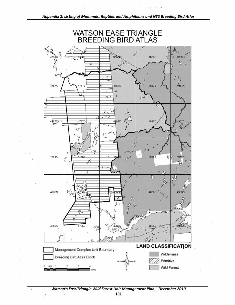
WATSON EASE TRIANGLE BREEDING BIRD ATLAS
f)
4786A (? . 0
(J
4786C t
4785A
D Management Complex Unit Boundary
C:J Breeding Bird Alias Block
0 0~ 1 2 3 4
~r,~-~-~-~~~--~~~,~~
w
N
. -
<\
◊ ,
0
4886D ./, "· '-tt
LAND CLASSIFICATJON _
Witdemess
e ~ Primitive
[=:l Witd Forest
Appendix 2: Listing of Mammals, Reptiles and Amphibians and NYS Breeding Bird Atlas
Watson’s East Triangle Wild Forest Unit Management Plan – December 2010 101

This page intentionally left blank
Watson’s East Triangle Wild Forest Unit Management Plan – December 2010 102

APPENDIX 3: Fish Species, Ponded Water Survey, and Ponded Water Chemical and Fisheries Data
FISH SPECIES COMMON NAME SCIENTIFIC NAME ABBREVIATION
Blacknose dace Rhinichthys atratulus BND
Brook trout Salvelinus fontinalis ST
Brown bullhead Ameriurus nebulosus BB
Creek chub Semotilus atromaculatus CC
Largemouth bass Micropterus salmoides LMB
Pumpkinseed Lepomis gibbosus PS
White sucker Catostomus commersoni WS
Yellow perch Perca flavescens YP
Watson’s East Triangle Wild Forest Unit Management Plan – December 2010 103
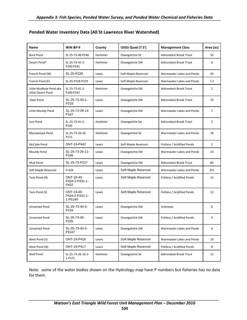
Appendix 3: Fish Species, Ponded Water Survey, and Ponded Water Chemical and Fisheries Data
Ponded Water Inventory Data (All St Lawrence River Watershed)
Name WIN &P # County USGS Quad (7.5') Management Class Area (ac)
Buck Pond SL‐25‐73‐46‐P246 Herkimer Oswegatchie SE Adirondack Brook Trout 10
Desert Pond* SL‐25‐73‐41‐2‐ Herkimer Oswegatchie SW Adirondack Brook Trout 6 P240‐P241
French Pond (W) SL-25-P228 Lewis Soft Maple Reservoir Warmwater Lakes and Ponds 20
French Pond (E) SL‐25‐P228‐P229 Lewis Soft Maple Reservoir Warmwater Lakes and Ponds 7.2
Little Mudhole Pond aka SL‐25‐73‐41‐2‐ Herkimer Oswegatchie SW Adirondack Brook Trout 1 Little Desert Pond P240‐P242
Deer Pond SL-25-73-40-1- Lewis Oswegatchie SW Adirondack Brook Trout 19 P233
Little Mouldy Pond SL-25-73-26-13- Lewis Oswegatchie SW Warmwater Lakes and Ponds 7 P167
Lost Pond SL‐25‐73‐41‐2‐ Herkimer Oswegatchie Sw Adirondack Brook Trout 2 P240
Massawepie Pond SL‐25‐73‐26‐16‐ Herkimer Oswegatchie Se Warmwater Lakes and Ponds 18 P173
McCabe Pond ONT-19-P442 Lewis Soft Maple Reservoir Fishless / Acidified Ponds 2
Mouldy Pond SL-25-73-26-11- Lewis Oswegatchie SW Warmwater Lakes and Ponds 23 P166
Mud Pond SL-25-73-P227 Lewis Oswegatchie SW Adirondack Brook Trout 69
Soft Maple Reservoir P‐434 Lewis Soft Maple Reservoir Warmwater Lakes and Ponds 331
Twin Pond (N) ONT-19-40- Lewis Soft Maple Reservoir Fishless / Acidified Ponds 13 P434-2-P431-1-P432
Twin Pond (S) ONT-19-40- Lewis Soft Maple Reservoir Fishless / Acidified Ponds 13 P434-2-P431-1-1-P5149
Unnamed Pond SL-25-73-40-3- Lewis Oswegatchie SW Unknown 6 P234
Unnamed Pond SL-25-73-40- Lewis Oswegatchie SW Fishless / Acidified Ponds 3 P235
Unnamed Pond SL-25-73-40-3- Lewis Oswegatchie SW Warmwater Lakes and Ponds 6 P5167
West Pond (S) ONT-19-P416 Lewis Soft Maple Reservoir Warmwater Lakes and Ponds 19
West Pond (N) ONT-19-P417 Lewis Soft Maple Reservoir Fishless / Acidified Ponds 8
Wolf Pond SL‐25‐73‐26‐16‐3‐ Herkimer Oswegatchie Se Adirondack Brook Trout 12 1‐P171
Note: some of the water bodies shown on the Hydrology map have P numbers but fisheries has no data for them.
Watson’s East Triangle Wild Forest Unit Management Plan – December 2010 104

Most Recent Chemical Survey Most Recent Biological Survey ANC pH Cond.
Name Year Sourc (µeq/1 (µmhos Year Sourc Fish Species Present and e ) /cm) e Number Caught
Appendix 3: Fish Species, Ponded Water Survey, and Ponded Water Chemical and Fisheries Data
Ponded Water Chemical and Fisheries Data (All St Lawrence River Watershed)
Buck Pond 01 DEC 20.1 5.33 12.6 01 DEC ST (2)
Desert Pond 02 DEC 0.9 4.9 20.3 85 ALSC ST (2), BB (23)
French Pond (W) 99 DEC 11.8 5.93 10.9 99 DEC LMB (2), BB (8), YP (14), PS (5)
French Pond (E) 99 DEC ‐10.8 4.77 14.7 99 DEC YP (43), BB (3)
Little Mudhole Pond* 02 DEC 0.9 4.9 20.3 aka
Little Desert Pond
Little Deer Pond 02 DEC 43.6 6.6 17.4 02 DEC WS (4), CC (3)
Little Mouldy Pond 02 DEC ‐2.3 5.19 16.0 86 ALSC BB (37)
Lost Pond* 02 DEC 0.9 4.9 20.3
Massawepie Pond 01 DEC 18.9 5.46 19.4 86 ALSC BB (249)
Mccabe Pond 85 ALSC ‐30.5 4.46 25.3 85 ALSC NO FISH SAMPLED
Mouldy Pond 02 DEC 7.24 5.62 16.5 02 DEC NO FISH SAMPLED
Mud Pond 02 DEC 16.4 5.61 18.2 02 DEC ST (3), WS (8), BB (25)
Soft Maple Reservoir 86 ALSC 15 5.6 20.7 98 DEC BB, WS, SMB, CP, PS, TM, GS, YP, RB
Twin Pond (N) 02 DEC ‐9.8 4.9 19.6 85 ALSC NO FISH SAMPLED
Twin Pond (S) 02 DEC 3.74 4.9 16.9
Unnamed Pond P234 02 DEC 31.45 6.2 16.4
Unnamed Pond P235 02 DEC 4.52 4.9 17.7 86 ALSC NO FISH SAMPLED
Unnamed Pond P5167 02 DEC 37.5 6.4 17.5 02 DEC CC (21), NRD (2) (aka p234a)
West Pond (S) 85 ALSC ‐17 4.64 20.2 85 ALSC BB (1)
West Pond (N) 02 DEC ‐6.2 4.98 16.6 86 ALSC NO FISH SAMPLED
Wolf Pond 01 DEC 34.4 5.77 18.4 01 DEC ST (10), BB (12), WS (21)
Source: DEC ‐ Department of Environmental Conservation ‐ Reg. 6 Fisheries;
ALSC ‐ Adirondack Lakes Survey Corporation, Ray Brook, NY
* Desert, Lost and Little Mudhole Ponds, same water joined by Desert Creek
Watson’s East Triangle Wild Forest Unit Management Plan – December 2010 105

This page intentionally left blank
Watson’s East Triangle Wild Forest Unit Management Plan – December 2010 106

APPENDIX 4: Bear Pond Road Work Plan
Background
This restoration plan is prepared pursuant to the requirements of Section II of the August 1, 2001 Memorandum of Agreement (MOA) entered into between the Adirondack Park Agency (the Agency) and the Department of Environmental Conservation (the Department) to address work done by Department staff on the Bear Pond Road in the Watson’s East Triangle Wild Forest and Five Ponds Wilderness Area in the Town of Webb, Herkimer County. As specified in Section V of the MOA, this plan applies to the area between those points on Bear Pond Road referred to in the MOA as Location Points 1A and 39. It identifies the work needed to restore the wild forest nature of the road in a manner which is consistent with Article XIV, Section 1 of the New York State Constitution (the Forever Wild Clause) and The Adirondack Park State Land Master Plan (the Master Plan). Thus, it includes provisions for debris cleanup, stabilization of disturbed soils and slopes, and the planting and maintenance of native trees and herbaceous vegetation. To the extent necessary to achieve the restoration goal of restoring the wild forest character of the road, it also includes standards for road width and surfacing, ditching, side slopes, culverts and turnouts.
As noted in paragraph V of the MOA, this plan is limited to the specific goal of comprehensively remediating the areas of Bear Pond Road affected by the road work conducted by the Department. The terms of this restoration plan are not intended to set precedent or policy for maintenance standards for roads in the forest preserve, although both agencies agree to cooperate in developing such standards for future road maintenance activities. The terms of this restoration plan are also not intended to set permanent design criteria for Bear Pond Road and the Department and the Agency agree that such criteria may be determined through the unit management planning process and/or the cooperative development of standards for future road maintenance activities.
Goal
The goal of this plan is to restore the wild forest character consistent with the Forever Wild Clause and the Master Plan in the areas disturbed by work done by the Department in 1999 and 2000 as identified in the MOA. This will be accomplished by creating and maintaining conditions, as specified below, to nurture and expedite the development of a natural vegetative canopy over the disturbed portions of the road.
Responsibility for Implementation
The Division of Lands & Forests, Region 6 Regional Forester has overall responsibility for managing the easement lands and Forest Preserve that the Bear Pond Road passes through, so therefore has overall responsibility to assure that the restoration project is completed as described below, and shall include site visits as appropriate.
The Supervising Forester out of Lowville will direct regular oversight of the restoration, and coordinate with other divisions involved in the restoration work. The Supervising Forester will ensure on‐site supervision of the restoration work, including on‐site oversight of tree planting activities. The Supervising Forester or his designee shall, at a minimum, make weekly visits to the site while restoration work is occurring. The Supervising Forester or his designee shall make more frequent visits to the site when appropriate and after consultation with the Regional Forester.
Watson’s East Triangle Wild Forest Unit Management Plan – December 2010 107

Appendix 4: Bear Pond Road Work Plan
The on the ground work described in the plan will be primarily carried out by the Department’s Division of Operations. The work will be accomplished by the Lowville crew which will be under the direct supervision of a Conservation Operations Supervisor I, with oversight by a Conservation Operations Supervisor II.
All personnel involved in the restoration plan work will read and be familiar with the details contained in this restoration plan. Implementation of the restoration plan will proceed in accordance with the schedule set forth in Appendix D.
Monitoring/Reporting
Monitoring of and reporting on the effectiveness of the measures taken under this MOA will continue for the five year period commencing August 1, 2001 (The date of signing of the MOA). All restoration measures will be maintained for this five year period. Monitoring and reporting will primarily be the responsibility of the Supervising Forester or his designee, with supervision by the Regional Forester. The implementation plan in Appendix D includes scheduled dates for monitoring and reporting on the various components of this restoration plan.
Work Plan
The Department will develop a work plan that will be divided into appropriate segments of the road based on similar or related site conditions that includes disturbed areas subject to restoration. The work plan will set forth the work needed for each segment and will identify the location of: the disturbed area, including width; any ditches needed for erosion control purposes; any side slope work needed; tree species present and seedling planting needed; culvert work needed; proposed graveling to be done to facilitate restoration goals; and additional notes needed to describe the work that must be done. The work plan be developed by the Department after a joint site visit as early as possible in Spring, 2002 and the work plan for the road segments will be submitted to the Agency as follows: (1) 50% of the road segments within 15 days of the site visit; and (2) 50% of the road segments within 30 days of the site visit. When approved by the Agency, the work plan will be attached hereto as Appendix B and will serve as the instruction document to be implemented by the Supervising Forester for each road segment in accordance with the implementation schedule set forth in Appendix D. (Sample plans for road segments are included in Appendix B hereto for informational purposes.)
Based on field agreement between the Agency and the Department during the Spring, 2002 site visit, the Department may immediately commence implementation of restoration measures in agreed upon, designated road segments.
Additional maps and diagrams defining the restoration work proposed are located in the following appendices: location map showing location of road segments and location points referenced in the MOA in Appendix A; diagrams of typical road profiles, culverts, ditch profiles and turnouts in Appendix C. Restoration Standards
For purposes of implementing this restoration plan, the following set of general standards shall be applied:
Watson’s East Triangle Wild Forest Unit Management Plan – December 2010 108

Appendix 4: Bear Pond Road Work Plan
• No additional trees shall be cut anywhere along Bear Pond Road in connection with grading or other earth work required by the restoration plan without prior consultation between the two agencies.
• No gravel shall be used to surface the driving way except as described in the approved work plans to be attached hereto as Appendix B.
• The Department shall consult with the Agency and the New York State Department of Transportation regarding best management practices to preclude the distribution of invasive species in connection with the restoration work required hereby.
• The provisions of this restoration plan will not apply to portions of the Bear Pond Road that were not disturbed by the work carried out by the Department in 1999 and 2000. Any work on such portions of Bear Pond Road shall be subject to the terms of Section IV of the MOA.
The following paragraphs identify the performance standards to be met in implementing the restoration work for each of the road segments set forth in the work plan:
• Road Width ‐ will provide for the minimum width necessary to allow for passage of typical vehicles driven by the public as well as the Department vehicles required for maintenance of a gravel road.
• The road driving surface along the disturbed areas of the Bear Pond Road will be no more than 12 feet in width.
• The road driving surface shall be crowned so as to eliminate or minimize the need for out slopes as per the typical in Appendix C.
Ditches ‐ will be established, based on agreement between the agencies during the Spring, 2002 site visit, to direct water off and away from the driving surface to minimize erosion of the surface as well as minimize erosion of road materials off of the road onto adjacent lands and wetlands. The overall goal shall to avoid ditching and to maximize the wild forest character of the road. The work plan shall include basic information justifying the need for ditching for each road segment. Ditches will be located as follows:
• On flat grades there will normally be no ditching. If ditches are needed on flat grades due to site specific considerations, ditches up to two feet wide and up to 12 inches deep may be installed following consultation between Department and Agency staff.
• On gentle and steep grades ditches up to two feet wide and 12 inches deep may be installed after site‐specific consultation. The Department may propose larger ditches on gentle and steep grades where site specific conditions warrant, and there has been prior consultation between Department and Agency staff.
Watson’s East Triangle Wild Forest Unit Management Plan – December 2010 109

Appendix 4: Bear Pond Road Work Plan
• Ditches will be constructed immediately adjacent to the 12 foot wide road driving surface and will be properly stabilized. (See Appendix C for “Typicals” of ditches and stabilization measures, and Appendix B for proposed locations of ditches.)
Side Slopes ‐ Side slopes should be stable and include soils that incorporate the natural seed beds of the disturbed area where possible. Some side slopes have already been adequately stabilized temporarily with seeding of annual rye that was accomplished in the summer and fall of 2001 and will be further stabilized with the additional seeding and planting that will be carried out (described below) once downed trees are handled and side slopes stabilized.
• Side slopes on the Bear Pond Road shall normally be graded to no steeper than 1v:2h, incorporating the bulldozed spoils piles into the slopes to the maximum extent possible.
• Side slopes of steeper than 1v:2h shall be allowed if such areas are or can be stabilized and grading to achieve a 1v:2h steepness would require tree cutting.
• if any side slope reduction is necessary because the current slope is too steep to be stabilized it will be noted in the individual work plan tables for each segment of road listed in Appendix B.
Downed Trees ‐ Trees downed by road work have left soils exposed and susceptible to illegal ATV use, and have left significant piles of woody debris from tops and root wads. Also, the placement of the root wads out of the road corridor has significantly altered the natural topography. In order to correct these problems and to restore these road sides back closer to their original condition:
• All trees greater than 3" diameter at breast height which were downed within disturbed areas of Bear Pond Road shall be cut and stumps/root balls for all trees so cut shall be rolled back and seated. The goals for this activity are to facilitate stabilization and natural re‐vegetation of disturbed areas and, by seating the root balls, to restore some of the natural topography of the disturbed areas, and to minimize the potential for vehicle traffic through the disturbed areas.
• All cut trees will be limbed and laid flat or chipped and used for mulch along disturbed corridors. Chip piles should not be created.
• Root balls should be rolled back to an approximately vertical orientation and seated with a backhoe to the extent practical. The height of the stump should generally not exceed the diameter of the severed trunk.
Additional work may be necessary to reduce the windrows at the edge of and in the adjacent forest. These areas shall be identified during the site visit in Spring 2002.
Seeding and Tree Planting ‐ The cleared widths of the edges of the road corridor will be brought back to tree cover as soon as reasonably feasible in order to recreate the wild forest character of the roadside in accordance with the Forever Wild Clause and the Master Plan. Planting species appropriate for the area and encouraging regeneration by maintaining existing soils will shorten the time it takes for the roadsides to recover and for the trees to become reestablished, thereby facilitating the creation of the
Watson’s East Triangle Wild Forest Unit Management Plan – December 2010 110
Appendix 4: Bear Pond Road Work Plan
wild forest character in cleared areas adjacent to the roadway and a canopy over much of the road surface.
• The disturbed areas will all be seeded according to the implementation schedule set forth in Appendix D with a conservation mix agreed to by the agencies which includes seeds of native, herbaceous shrubs and native tree seeds, except, after consultation between Department and Agency staff, those areas showing significant natural regeneration.
• all disturbed areas have already been mulched with straw and seeded with annual rye. The annual rye will die over winter. The above ground stems will form additional mulch while the roots will stabilize the soil below ground. Prior to planting, in areas identified during the Spring, 2002 site visit, mulch will be pulled back where it would interfere with seed germination. After completion of downed tree cutting, side slope stabilization (where needed), and root ball seating, the planting will be the final step in beginning to restore the wild forest character of the disturbed portions along Bear Pond Road.
• Tree seedlings will be planted along the entire length of the disturbed area of Bear Pond Road.
• all dormant stock shall be planted in accordance the schedule set forth in Appendix D hereto.
• seedlings to be planted will be bare root or container grown yellow birch, red maple, balsam fir, white pine, eastern larch, and red spruce (as available) 2/0 stock. Wetter areas will receive 2/0 balsam fir or eastern larch.
• seedlings shall be planted no greater than one foot from the edge of the road surface where there are no ditches and less than one foot from the edge of ditches where ditches are present.
• seedlings shall be planted at a rate of 50 trees for every 400 linear feet of disturbed area, averaging 8 feet apart. Seedlings may be planted slightly closer together or farther apart than 8 feet where necessary due to topography, depth to bedrock, excessive moisture or to achieve a more natural, wild forest look.
• at locations where the disturbed area along the road is wider than 8 feet, a second row of seedlings shall be planted eight feet from the first row.
• at locations where the disturbed area along the road is wider than 16 feet, a third row of seedlings shall be planted eight feet from the second row.
• on a limited, site‐specific basis, Department staff may consult with the Agency about establishing different planting distances from the road or ditch line based on site specific safety or other concerns. Department staff will identify any such areas on maps in advance of a joint field inspection with Agency staff.
• Monitoring of and reporting on the success of replanting will be accomplished by the Department on an annual basis. The Supervising Forester assigned to the Lowville Office will annually, commencing the year after the seedlings are planted, monitor the survival rate of the seedlings and notify Agency staff of the results. On or about May 1st of each year, planted seedlings will be sampled to determine percent survival. Each work plan segment having less
Watson’s East Triangle Wild Forest Unit Management Plan – December 2010 111

Appendix 4: Bear Pond Road Work Plan
than 80% survival will be scheduled for replanting that spring, except that, after consultation between Department and Agency staff, those areas showing either significant natural regeneration or significant success from seeding need not be replanted.
Gravel Pits ‐ All gravel pits will be reclaimed per mining and reclamation plans subject to consultation between the agencies, and/or an adopted UMP. In anticipation of likely illegal use of these pits by motor vehicles and attendant erosion and failure of the reclamation efforts, the following actions will be taken once reclamation occurs:
• Gravel pits shall have their entrances blocked to prevent illegal motor vehicle traffic by locating stumps, slash and boulders taken from along the road in the entryways.
• 12 foot tall appropriate coniferous trees will be planted to further block the entrances. If any mortality of these trees occurs, the Department shall investigate the cause of mortality and, after consultation with Agency staff, may recommend corrective measures that my include site preparation or modification, or alternative species plantings.
The planting method shall follow the procedure found in Appendix C and labeled, “New Tree Planting Procedure”.
All dormant stock shall be planted in accordance with Appendix D.
Lands & Forests personnel will annually measure the effectiveness of these measures in late September. If these measures are found to be ineffective, additional measures, including blocking the entrances with additional stumps, slash and/or rocks taken from along the road, will be taken.
Turnouts ‐ Two temporary turnouts, 8 feet in width by no more than 75 feet in length, may be located on the edge of Bear Pond Road where large vehicles can pass each other without disturbing the plantings. Up to eight smaller, temporary turnouts, 8 feet in width by no more than 20 feet in length, may be located on Bear Pond Road for the same purpose.
These temporary turnouts shall be abandoned and shall cease to maintained after 5 years unless otherwise provided in an adopted UMP. Their locations shall be determined based on consultation between the agencies.
Culverts ‐ Culverts provide a low cost way to allow existing small streams and seeps to pass under the road, to divert drainage from ditches alongside the road to the side of the road where water can be dispersed safely away from wetlands or otherwise redirected to minimize erosion.
• Existing culverts will be replaced in kind if damaged.
• Existing culverts which are inadequate to disperse water may be replaced with larger culverts.
• New culverts will be installed where problems are known to exist or erosion shows that a culvert is needed.
Watson’s East Triangle Wild Forest Unit Management Plan – December 2010 112
Appendix 4: Bear Pond Road Work Plan
• Culverts will be installed as shown in the typicals included in Appendix C.
• Culverts are proposed to be placed or replaced at the locations shown on the photocopies of the topographic maps provided to and approved by the Agency as part the Wetlands Remediation and Erosion Control Work Plan as required by the MOA. The culvert locations as shown on the map are designated as either “R” or “N”. “R” stands for replacement of an existing culvert, while “N’ stands for a new culvert (although many “new” locations are actually where old culverts have already been ripped out). These locations will also be identified in the work program tables in Appendix B. Department staff shall consult with the Agency regarding replacement of existing culverts that are larger than the original, as well as for placement of new culverts, to ensure that wetland regulations are complied with.
Graveling ‐ Gravel resurfacing of the road would not normally be included in this restoration plan, which is intended to restore the wild forest character of the disturbed areas adjacent to the traveling surface of road. However, gravel resurfacing at certain site specific locations is needed immediately in order to control erosion and address other environmental factors and, consequently, further the implementation of the restoration plan. Furthermore, gravel resurfacing in other areas along the portion of Bear Pond Road included in this restoration plan, whenever it occurs, must be done in a manner which does not adversely impact that restoration work which has previously been completed.
Gravel resurfacing shall generally be crowned at the middle of the road to a depth of no greater than 6" and be tapered to a depth of no greater than 2" at the edge of width to which it is spread, except that after consultation with the Agency additional gravel may be placed at locations where necessary to address site specific environmental issues in compliance with the work plan set forth in Appendix B. Gravel shall be spread in a manner which is aimed at permanently containing it within the 12 foot wide traveling surface. Since gravel will tend to be pushed by the weight of traveling motor vehicles towards the shoulders of the road, gravel shall generally be spread to a width of 10‐11 feet. The gravel will also be compacted to reduce the likelihood that it will spread. This should help to ensure that gravel which is so migrating will continue to be contained within the 12 foot wide traveling surface, thereby fostering the success of the restoration work adjacent to the traveling surface.
Gravel resurfacing which is needed for environmental control shall occur in compliance with the work plans set forth in Appendix B. Gravel resurfacing at other locations along the portion of Bear Pond Road included in this restoration plan may occur, in accordance with the above guidelines, after the Spring, 2002 planting work is completed, provided that the Department’s first priority will be implementation of the restoration plan and such resurfacing work shall not interfere with efforts to implement the restoration plan or to divert personnel or resources otherwise dedicated to implementation of the restoration plan.
Implementation
The Department and the Agency shall make all reasonable efforts to ensure implementation of the restoration work in accordance with the schedule set forth in Appendix D hereto. In the event that, despite such efforts, the Department must seek a modification of the implementation schedule due to circumstances beyond its reasonable control, the Department may submit a written request to the Agency explaining those circumstances and proposing a reasonable extension of the schedule set forth in Appendix D hereto.
Watson’s East Triangle Wild Forest Unit Management Plan – December 2010 113
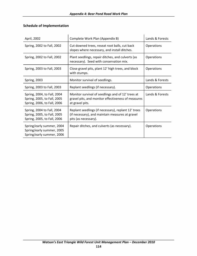
Appendix 4: Bear Pond Road Work Plan
Schedule of Implementation
April, 2002 Complete Work Plan (Appendix B) Lands & Forests
Spring, 2002 to Fall, 2002 Cut downed trees, reseat root balls, cut back Operations slopes where necessary, and install ditches.
Spring, 2002 to Fall, 2002 Plant seedlings, repair ditches, and culverts (as Operations necessary). Seed with conservation mix.
Spring, 2003 to Fall, 2003 Close gravel pits, plant 12' high trees, and block Operations with stumps.
Spring, 2003 Monitor survival of seedlings. Lands & Forests
Spring, 2003 to Fall, 2003 Replant seedlings (if necessary). Operations
Spring, 2004, to Fall, 2004 Monitor survival of seedlings and of 12' trees at Lands & Forests Spring, 2005, to Fall, 2005 gravel pits, and monitor effectiveness of measures Spring, 2006, to Fall, 2006 at gravel pits.
Spring, 2004 to Fall, 2004 Replant seedlings (if necessary), replant 12' trees Operations Spring, 2005, to Fall, 2005 (if necessary), and maintain measures at gravel Spring, 2005, to Fall, 2006 pits (as necessary).
Spring/early summer, 2004 Repair ditches, and culverts (as necessary). Operations Spring/early summer, 2005 Spring/early summer, 2006
Watson’s East Triangle Wild Forest Unit Management Plan – December 2010 114

Appendix 4: Bear Pond Road Work Plan
Station # OFF SET DESCRIPTION
00+00 L 19' COUNTY LINE MONUMENT. Beginning to 73+00. This segment of road has no, or only occasional minimal disturbance. No tree planting will be done here except for 20 white pine seedlings in a small reclaimed gravel pit at 32+50 right and 6 white pine seedlings to the south of the stone‐lined ditch at 52+00.
0+76L TOP OF HILL
1+00 L
2+00 L CURVE TO RIGHT
2+93 Install 24" culvert or the arch equivalent. The arch culvert is preferred.
3+00 L
4+00 L
4+74 END CURVE
5+00 L
5+90 CURVE LEFT
6+00 L
6+71 CULVERT 18"
7+00 L END CURVE
8+00 L
9+00 L CURVE RIGHT
9+50 END CURVE
10+00 L
10+46 CULVERT 15"
11+00 L
11+60 CREEK ROAD OFF TO RIGHT
12+00 L
13+00 L
13+10 CURVE LEFT
13+85 CULVERT 12" TO BE REPLACED
14+00 L END CURVE
15+00 L
Watson’s East Triangle Wild Forest Unit Management Plan – December 2010 115

Appendix 4: Bear Pond Road Work Plan
Station # OFF SET DESCRIPTION
16+00 L
16+92 CULVERT 18"
17+00 L
18+00 L
18+31 CURVE LEFT
19+00 L
19+34 END CURVE
19+77 CULVERT 14"
20+00 L 19'
21+00 L
22+00 L
22+72 CULVERT 15" TO BE REPLACED
23+00 L
23+44 CURVE LEFT
24+00 L Small pull off ‐ right.
24+71 END CURVE
25+00 L Pre‐disturbance opening left ‐ suitable for turn‐off.
26+00 L
26+96 CULVERT 12" TO BE REPLACED SHORT
26+98 CURVE LEFT
27+00 L
28+00 L
29+00 L
30+00 L 16'
31+00 L CURVE LEFT
31+31 CULVERT 12" TO BE REPLACED SMALL & SHORT
32+00 L END CURVE
32+50 Small reclaimed gravel pit right ‐ Plant 20 white pine seedlings
Watson’s East Triangle Wild Forest Unit Management Plan – December 2010 116

Appendix 4: Bear Pond Road Work Plan
Station # OFF SET DESCRIPTION
33+00 L
34+00 L
34 +55 CULVERT 12"
35+00 L
36+00 L CURVE LEFT
36+34 PULL OFF RIGHT
37+00 L END CURVE
37+56 CURVE RIGHT
37+59 NO CULVERT. Build up and crown road to control water.
38+00 R PARKING LOT ON LEFT ‐ Pre‐disturbance
39+00 L END CURVE
40+00 L 16'
40+50 CURVE LEFT
41+00 L
41+71 END CURVE
42+00 L
42+40 TOP OF HILL
43+00 L
43+80 BOTTOM HILL
44+00 L
44+61 No Culvert. Build up and crown road to control water. Maintain vernal pool.
44+71 BOTTOM HILL
45+00 L
46+00 R PULL OFF LEFT Old culvert off to side. Remove.
46+37 PULL OFF RIGHT
47+00 L
48+00 L
Watson’s East Triangle Wild Forest Unit Management Plan – December 2010 117

Appendix 4: Bear Pond Road Work Plan
Station # OFF SET DESCRIPTION
49+00 L
50+00 L 22'
51+00 L
51+56 CURVE LEFT
52+00 L Right side of road. Define ditch better to insure that water exits the road. Use additional 4" stone if necessary. Plant 6+ white pine seedlings to the south of the stone lined area. Left side of road. Establish a diversion ditch that enters the woods by the 50+60 marker. This diversion ditch will require the cutting of two yellow birch. Tree diameters are 4" and 6". Both are marked with blue paint. Below this establish a ditch to get run‐off out of the road. The ditch should have a three foot width and be one foot deep. Same as the typical ditch except for the three foot bottom. Line with 4" stone to a stone lined catch basin at the bottom of the hill.
53+00 L
53+65 CULVERT 12"
53+81 END CURVE
54+00 L
55+00 L
55+88 BOTTOM HILL
56+00 L
57+00 L TOP HILL
57+77 BOTTOM HILL
58+00 L
58+33 CURVE LEFT
58+62 CULVERT 12"
59+00 L Old road/Turn around on right.
59+22 TOP HILL
59+32 END CURVE
60+00 L 13'
60+42 CURVE RIGHT
Watson’s East Triangle Wild Forest Unit Management Plan – December 2010 118

Appendix 4: Bear Pond Road Work Plan
Station # OFF SET DESCRIPTION
61+00 L
62+00 L
62+10 BOTTOM HILL END CURVE
63+00 L
63+64 CURVE LEFT
64+00 L
64+40 END CURVE
64+97 CULVERT 5'
65+00 R
65+57 BOTTOM HILL CURVE RIGHT
66+00 L
67+00 L
67+89 END CURVE
68+00 L
68+84 BOTTOM HILL
69+00 L
70+00 L 17'
70+57 CURVE LEFT
71+00 L
71+50
72+00 L
72+16 END CURVE
72+83 CULVERT 15"
73+00 L 73+00 to 118+00. Generally light to moderate disturbance, with some undisturbed areas present. Planting averages one row of trees on either side of the road.
74+00 L
75+00 L
76+00 L
Watson’s East Triangle Wild Forest Unit Management Plan – December 2010 119

Appendix 4: Bear Pond Road Work Plan
Station # OFF SET DESCRIPTION
77+00 L
77+45 CURVE LEFT
78+00 L
78+76 END CURVE
79+80 BOTTOM HILL
80+00 L 22'
81+00 L
81+58 TOP HILL
82+00 L
83+00 L
83+69 CURVE RIGHT BOTTOM HILL
84+00 L
85+00 L
85+09 CULVERT 12"
86+00 L END CURVE
86+10 CURVE RIGHT
87+00 L
87+20 TOP HILL
88+00 L
89+00 L CULVERT 12"
89+71 CURVE LEFT
90+00 L 19'
90+10 END CURVE
90+66 BOTTOM HILL
91+00 L
91+69 TOP HILL
92+00 L
92+48 CURVE RIGHT
Watson’s East Triangle Wild Forest Unit Management Plan – December 2010 120

Appendix 4: Bear Pond Road Work Plan
Station # OFF SET DESCRIPTION
93+00 L
93+18 END CURVE
94+00 L
94+47 CURVE LEFT CULVERT 12"
95+00 L
95+48 END CURVE
96+00 L
96+11 CULVERT 12"
97+00 L
98+00 L
99+00 L
99+46 CULVERT 12"
99+92 #1 SNOW MOBILE TRAIL LEFT
100+00 L 36' TOP HILL
100+69 CURVE RIGHT
101+00 L
102+00 L
102+77 CULVERT 5'
103+00 L
103+26 END CURVE
104+00 L CURVE LEFT
105+00 L
105+71 END CURVE
106+00 L
106+56 BOTTOM HILL
107+00 L
107+64 CURVE LEFT
108+00 L
Watson’s East Triangle Wild Forest Unit Management Plan – December 2010 121

Appendix 4: Bear Pond Road Work Plan
Station # OFF SET DESCRIPTION
108+56 END CURVE
109+00 L
109+76 CURVE LEFT
110+00 L 17'
110+50 Pre‐disturbance opening ‐ not suitable for turnout
110+73 END CURVE
111+00 L
111+70 TOP HILL
112+00 L
112+57 BOTTOM HILL
112+85 CULVERT 14"
113+00 L CURVE RIGHT, BOTTOM HILL
114+00 L
114+10 END CURVE
115+00 L
115+05 TOP HILL
115+70 CURVE RIGHT
116+00 L
116+56 END CURVE
117+00 L
117+62 BOTTOM HILL
118+00 L 118+00 to 153+00. No or only occasional minimal disturbance. No tree planting.
119+00 L
119+14 Install 12"wide and deep crushed stone cross drain (French Drain). Use 4" stone wrapped with road fabric. Gravel as necessary over the top.
119+76 CURVE RIGHT
120+00 L 14'
121+00 L
Watson’s East Triangle Wild Forest Unit Management Plan – December 2010 122

Appendix 4: Bear Pond Road Work Plan
Station # OFF SET DESCRIPTION
122+00 L
122+21 CULVERT 15" TO BE REPLACED
122+49 CURVE LEFT
122+92 TOP HILL
123+00 L
123+70 BOTTOM HILL
124+00 L
125+00 L
126+00 L
126+59 CURVE LEFT
127+00 L
128+00 L
128+71 CURVE RIGHT
129+00 L TOP HILL
129+32 TOP HILL
130+00 L 12' END CURVE
130+70 Build up road to control water instead of installing water diversion bar.
131+00 L
132+00 L
132+65 BOTTOM HILL
133+00 L
133+51 CURVE LEFT
134+00 L
135+00 L
135+16 DESERT POND CAMP ROAD. Truck turn around.
135+69 CULVERT 15" TO BE REPLACED
136+00 L
136+46 CURVE LEFT
Watson’s East Triangle Wild Forest Unit Management Plan – December 2010 123

Appendix 4: Bear Pond Road Work Plan
Station # OFF SET DESCRIPTION
137+00 L
137+62 END CURVE
138+00 L
138+14 CULVERT 12"
138+25 CULVERT 30"
138+67 CULVERT 12"
138+72 BOTTOM HILL
139+00 L Predisturbance openings/borrow pits right and left. Not suitable for turnouts.
140+00 L 25' END CURVE
141+00 L
141+42 CURVE RIGHT
142+00 L
142+43 PARKING AREA , LOGGING ROAD RIGHT, END CURVE
143+00 L
144+00 L CURVE LEFT
144+36 CULVERT 15"
145+00 L
146+00 L
146+10 END CURVE
146+81 BOTTOM HILL
147+00 L
148+00 L TOP HILL
149+00 L
149+31 CULVERT 15", CURVE RIGHT
150+00 L 18'
150+41 END CURVE
151+00 L
Watson’s East Triangle Wild Forest Unit Management Plan – December 2010 124

Appendix 4: Bear Pond Road Work Plan
Station # OFF SET DESCRIPTION
151+19 CULVERT 18"
151+80 CURVE RIGHT
152+00 L
153+00 L 153+00 to 186+00. Variable with light to significant disturbance. Planting will average one row of trees on one or both sides of the road.
153+45 CULVERT 18"
154+00 L
154+36 END CURVE
155+00 L
156+00 L
157+00 L
158+00 L
159+00 L
160+00 L32' Replace silt fence and reseed.
160+44 CULVERT 18" TO BE REPLACED
160+50 CURVE RIGHT
161+00 L
162+00 L
162+20 WOLF POND ROAD LEFT, END CURVE
162+50 Pre‐disturbance opening right ‐ suitable for small pull‐off.
163+00 L
163+62 CURVE LEFT
164+00 L
164+10 CULVERT 15"
165+00 L
165+59 CURVE RIGHT
166+00 L
167+00 L Pre‐disturbance opening right ‐ suitable for small pull‐off.
Watson’s East Triangle Wild Forest Unit Management Plan – December 2010 125

Appendix 4: Bear Pond Road Work Plan
Station # OFF SET DESCRIPTION
168+00 L
168+43 END CURVE. Install crushed stone cross drain (French Drain) 12" wide and deep. Use 4" stone wrapped with road fabric. Gravel over the top.
169+00 L
170+00 L 36' Pre‐disturbance opening left. Suitable for turnout.
170+74 CULVERT REPLACED WITH 15"
171+00 L
171+49 CURVE RIGHT
172+00 L
173+00 L
174+00 L
175+00 L
175+50 END CURVE
176+00 L
176+44 CURVE LEFT
177+00 L
178+00 L
178+79 GRAVEL PIT LEFT, CURVE RIGHT
179+00 R
180+00 R 21'
180+85 END CURVE
181+00 L
181+93 Install 12" arch culvert.
182+00 L
182+90 CURVE LEFT
183+00 L
184+00 L
185+00 L
Watson’s East Triangle Wild Forest Unit Management Plan – December 2010 126

Appendix 4: Bear Pond Road Work Plan
Station # OFF SET DESCRIPTION
185+35 CULVERT REPLACED WITH 24"
185+80 Piece of old wire rope on left. Remove.
186+00 L 186+00 to 216+00. No or only occasional minimal disturbance. No tree planting.
186+56 ROAD Right
187+00 R PARKING AREA LEFT
187+94 BOTTOM HILL, CURVE RIGHT
188+00 L
188+09 2 CULVERT PIPES 24"
189+00 L
190+00 L 17'
191+00 L
191+35 PULL OFF LEFT
191+49 END CURVE
192+00 L
193+00 L
193+50 CURVE LEFT
194+00 L
194+08 CULVERT 12"
195+00 L
195+46 END CURVE
195+46 L
196+76
197+00 L
198+00 L
198+30 TOP PARQUET HILL
199+00 L TOP HILL, CURVE RIGHT. Pre‐disturbance small pull‐off on right.
200+00 L 17'
Watson’s East Triangle Wild Forest Unit Management Plan – December 2010 127

Appendix 4: Bear Pond Road Work Plan
Station # OFF SET DESCRIPTION
200+40 END CURVE
201+00 L
202+00 L
202+57 CURVE RIGHT
203+00 L
203+53
204+00 L END CURVE. Install 12" arch culvert with standard ditch.
204+50 Old culvert present on side of road. Remove.
205+00 L BOTTOM HILL
206+00 L
207+00 L
208+00 L
209+00 L
210+00 L 21"
210+30 CULVERT REPLACE WITH 15" MINIMUM
210+71 CURVE LEFT
211+00 L
212+00 L
213+00 L
214+00 L
215+00 L
215+34 ROAD RIGHT
216+00 L END CURVE. 216+00 to 223+00. Light disturbance. Generally one row of trees on one side of the road only.
216+10 PARKING AREA Right. Pre‐disturbance opening left. Not suitable for turnout.
216+48 12" CULVERT
216+80 Small piece of old culvert left. Remove.
217+00 L BOTTOM HILL
Watson’s East Triangle Wild Forest Unit Management Plan – December 2010 128

Appendix 4: Bear Pond Road Work Plan
Station # OFF SET DESCRIPTION
218+00 L
218+49 TOP HILL
219+00 L
220+00 L 19'
221+00 L
221+67 CULVERT 15"
222+00 L
223+00 L CURVE RIGHT. 223+00 to 238+00. No or only occasional minimal disturbance. No tree planting.
223+87 CULVERT 12" REPLACE WITH 12" arch culvert.
224+00 L
225+00 L TOP HILL
225+76 CURVE LEFT
226+00 L
227+00 L
228+00 L
228+02 CULVERT 12". REPLACE WITH 24" Culvert.
228+04 END CURVE, BOTTOM HILL
229+00 L
229+74 CURVE RIGHT
230+00 L 15'
231+00 L
232+00 L Pre‐disturbance opening right. Not suitable for turn out.
232+47 Install standard ditch on right from 233+00 to culvert at 232+47
233+00 L
234+00 L CURVE LEFT
235+00 L 235+00 to 236+50 Pre‐disturbance opening right. Not suitable as turn out.
236+00 L
Watson’s East Triangle Wild Forest Unit Management Plan – December 2010 129

Appendix 4: Bear Pond Road Work Plan
Station # OFF SET DESCRIPTION
237+0 L
237+34 CULVERT 15"
238+00 L 238+00 to 239+00 Pre‐disturbance openings left and right. Suitable for turn outs. Former site of Massawepie Camp. Part of old culvert right. Remove. 238+00 to 287+00. Light to moderate disturbance. About three‐fourths of the roadside requires tree planting. At 240+00 left is a vernal pool. The open area is to be planted with a mixture of balsam fir, hemlock, and white pine. At 243+00 is a reclaimed gravel pit to be planted with white pine in the dry areas, and balsam, hemlock, tamarack, and/or spruce in the wet areas.
238+75 PARKING AREA LEFT & RIGHT. Pre‐disturbance.
239+00 L
239+15 CULVERT 12" REPLACE WITH 36". Trees needing removal. Yellow Birch ‐5", 5", 4", Red Maple ‐ 4"
240+00 L 27' VERNAL POND LEFT, CURVE RIGHT. Plant open area with mixture of balsam fir, hemlock, and white pine.
241+00 L RECLAIMED GRAVEL PIT LEFT
242+00 L Unstable eroding bank right. This bank is too steep to be stabilized and a number of trees are already undermined and will eventually fall over. The flagged area will be cleared of trees and graded to a slope of no greater than 1v:2h. It will then be seeded mulched and planted with white pine seedlings. The tree count is Yellow Birch ‐ 13", 3", 3", 7", 4", 3", 3", 4". Beech ‐ 7", 6". Red Maple ‐ 14", 15". Striped Maple ‐ 6". Hard Maple ‐ 3". All these trees are marked with blue paint.
242+65 CURVE LEFT
243+00 L Install typical ditch from 243+00 to 245+00. ( to gravel pit.) Plant trees in Pit (White Pine).
244+00 L
244+12
245+00 L
246+00 L
246+48 CULVERT REPLACE WITH 18" arch culvert. BOTTOM HILL
247+00 l
247+70 CURVE LEFT
Watson’s East Triangle Wild Forest Unit Management Plan – December 2010 130

Appendix 4: Bear Pond Road Work Plan
Station # OFF SET DESCRIPTION
248+00 L
248+50 TOP HILL
249+00 L
250+00 L 18'
250+88 END CURVE
251+00 L
251+75 TOP HILL. Pre‐disturbance opening right. Old road to right. Suitable as small turn out.
252+00 L
252+50 252+50 to 253+00. Fill spring run‐off overflow area with 4" stone.
253+00 L
253+07 CULVERT 36"
254+00 L
254+80 CURVE LEFT, TOP HILL
255+00 L
255+50 Old culvert to side of road on right. Remove.
255+69 END CURVE
256+00 L PARKING AREA LEFT
256+80 BOTTOM HILL
257+00 L
258+00 L
258+65 CURVE RIGHT
259+00 L
260+00 L 21'
261+00 L
262+00 L TOP HILL, END CURVE
263+00 L
263+13 CULVERT 12"
Watson’s East Triangle Wild Forest Unit Management Plan – December 2010 131

Appendix 4: Bear Pond Road Work Plan
Station # OFF SET DESCRIPTION
264+00 L
265+00 L
265+45 CURVE RIGHT
266+00 L 266+00 to 268+50 Left. Pre‐disturbance Opening. Not suitable for turn out. 267+00 to 268+65 Right. Predisturbance Opening. Partially suitable for turn out.
267+00 L
267+47 WALLIS ROAD LEFT
268+00 L
268+70 END CURVE
269+00 L
270+00 L 16' CURVE RIGHT
271+00 L
272+00 L
272+64 END CURVE
273+00 L
273+41 CULVERT 12" REPLACE WITH 15"
274+00 L CURVE LEFT
274+50 Move road to right in order to establish ditch around bedrock outcropping and keep water off the road.
274+75 END CURVE
275+00 L CURVE RIGHT
275+47 BOTTOM HILL
276+00 L
276+56 CURVE RIGHT
277+00 L
277+82 TOP HILL
278+00 L
278+50 CURVE RIGHT
Watson’s East Triangle Wild Forest Unit Management Plan – December 2010 132
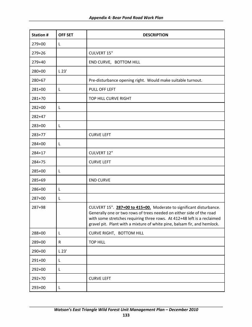
Appendix 4: Bear Pond Road Work Plan
Station # OFF SET DESCRIPTION
279+00 L
279+26 CULVERT 15"
279+40 END CURVE, BOTTOM HILL
280+00 L 23'
280+67 Pre‐disturbance opening right. Would make suitable turnout.
281+00 L PULL OFF LEFT
281+70 TOP HILL CURVE RIGHT
282+00 L
282+47
283+00 L
283+77 CURVE LEFT
284+00 L
284+17 CULVERT 12"
284+75 CURVE LEFT
285+00 L
285+69 END CURVE
286+00 L
287+00 L
287+98 CULVERT 15". 287+00 to 415+00. Moderate to significant disturbance. Generally one or two rows of trees needed on either side of the road with some stretches requiring three rows. At 412+48 left is a reclaimed gravel pit. Plant with a mixture of white pine, balsam fir, and hemlock.
288+00 L CURVE RIGHT, BOTTOM HILL
289+00 R TOP HILL
290+00 L 23'
291+00 L
292+00 L
292+70 CURVE LEFT
293+00 L
Watson’s East Triangle Wild Forest Unit Management Plan – December 2010 133

Appendix 4: Bear Pond Road Work Plan
Station # OFF SET DESCRIPTION
293+82 CULVERT 15"
294+00 L
294+10 BOTTOM HILL
295+00 L TOP HILL
296+00 L
296+80 CURVE LEFT
297+00 L
297+81 END CURVE
298+00 L BOTTOM HILL
298+35 CULVERT 24"
299+00 L
299+40 CURVE LEFT
300+00 L 22'
300+59 CURVE RIGHT
301+00 L
302+00 L
303+00 L
303+27 WALLIS ROAD FALSE LEFT. Remove this road sign.
304+00 L 304+50 to 307+00. Pre‐disturbance opening left. Suitable for turn out.
305+00 L 305+00 to 306+80. Pre‐disturbance opening right. Suitable for turn out.
305+36 CURVE RIGHT
306+00 L
307+00 L
307+20 CURVE LEFT
308+00 L
309+00 L
309+33 ROAD RIGHT
310+00 L 20'
Watson’s East Triangle Wild Forest Unit Management Plan – December 2010 134

Appendix 4: Bear Pond Road Work Plan
Station # OFF SET DESCRIPTION
311+00 L
312+00 L
312+35 END CURVE
313+00 L
313+50 Predisturbance opening left. Suitable for turnout.
314+00 L
314+40 CURVE LEFT
314+75 TOP HILL
315+00 L
315+35 END CURVE
316+00 L
317+00 L
317+90 CURVE RIGHT
318+00 L
319+00 L
320+00 L 13' CURVE LEFT. Install typical ditch on right side from 320+00 to 321+00.
321+00 L
321+90 END CURVE
322+00 L
323+00 L
323+65 CULVERT 12"
323+75 CULVERT 20"
324+00 L
324+36 BOTTOM HILL
325+00 L
326+00 L
326+79 BOTTOM HILL
327+00 L
Watson’s East Triangle Wild Forest Unit Management Plan – December 2010 135

Appendix 4: Bear Pond Road Work Plan
Station # OFF SET DESCRIPTION
327+79 BOTTOM HILL
328+00 L
329+00 L
329+35 CULVERT 15"
329+52 END CURVE
330+00 L 16'
330+18 CURVE LEFT
331+00 L Old culvert to the right in woods. Remove.
331+60 END CURVE
332+00 L
332+10 CULVERT 15"
333+00 L
333+23 CULVERT 15"
333+77 BOTTOM HILL
334+00 L CURVE LEFT
335+00 L
336+00 L
337+00 L TOP HILL
337+18 CURVE RIGHT
338+00 L Predisturbance opening left. Old landing. Not suitable for turn out.
338+57 CULVERT 15"
339+00 L BOTTOM HILL, CURVE LEFT
340+00 L 33'
341+00 L
342+00 L
342+56 END CURVE
343+00 L
344+00 L
Watson’s East Triangle Wild Forest Unit Management Plan – December 2010 136

Appendix 4: Bear Pond Road Work Plan
Station # OFF SET DESCRIPTION
344+20 TOP HILL
345+00L L
346+00 L
346+33 CULVERT 12"
347+00 L
348+00 L CURVE RIGHT
348+62 TOP HILL
349+00 L
349+30 END CURVE
350+00 L 21'
350+90 CURVE LEFT
351+00 L Pre‐disturbance opening left. (Old Landing) Not suitable for turn out.
352+00 L
353+00 L END CURVE, BOTTOM HILL
354+00 L
355+00 L
356+0 L CURVE LEFT. Possible turn out location right (disturbed)
357+00 L END CURVE, BOTTOM HILL
358+00 L
358+90 TOP HILL
359+00 L
360+00 L23'
360+95 CULVERT TO BE REPLACED 30" or arch equivalent. BOTTOM HILL
361+00 L
361+39 TOP HILL
362+00 L
362+34 CURVE RIGHT
363+00 L
Watson’s East Triangle Wild Forest Unit Management Plan – December 2010 137

Appendix 4: Bear Pond Road Work Plan
Station # OFF SET DESCRIPTION
364+00 L
365+00 L
366+00 L
367+00 L
367+08 CURVE LEFT
368+00 L
368+33 CURVE RIGHT
369+00 L
370+00 L 42' Pre‐disturbance opening left. Not suitable for turnout.
371+00 L
372+00 L
373+00 L
373+70 CURVE LEFT, BOTTOM HILL
374+00 L
374+25 PULL OFF RIGHT
375+00 L
375+13 TOP HILL
376+00 L
377+00 L
378+00 L
378+55 CULVERT TO BE REPLACED WITH 15". Hold the same invert. CURVE LEFT, BOTTOM HILL, Wetland to left.
379+00 L
380+00 L 22'
380+22 END CURVE
381+00 L
382+00 L
382+13 Install culvert 12"
Watson’s East Triangle Wild Forest Unit Management Plan – December 2010 138

Appendix 4: Bear Pond Road Work Plan
Station # OFF SET DESCRIPTION
383+00 L
384+00 L CURVE LEFT
385+00 L
386+00 L
386+92 CULVERT 12" REPLACE WITH 30" arch culvert.
387+00 L
387+29 BOTTOM HILL
388+00 L END CURVE
389+00 L Pre‐disturbance turn outs left and right.
390+00 L 27'
390+61 CURVE RIGHT
391+00 L
391+70 CULVERT 12" REPLACE WITH 12"
392+00 L
393+00 L
394+00 L
394+91 CULVERT REPLACE WITH 12"
395+00 L
395+88 TOP HILL
396+00 L
397+00 L
397+11 Install culvert 15"
397+52 CURVE LEFT
398+00 L
398+46 TOP HILL
398+81 TURN OUT #6
399+00 L
400+00 L 22'
Watson’s East Triangle Wild Forest Unit Management Plan – December 2010 139

Appendix 4: Bear Pond Road Work Plan
Station # OFF SET DESCRIPTION
400+22 CURVE RIGHT
401+00 L
402+00 L END CURVE
403+00 L
404+00 L
404+10 CULVERT 18" REPLACE WITH 24", BOTTOM HILL
405+00 L CURVE RIGHT
406+00 L
406+48 TOP HILL, CURVE LEFT
407+00 L
408+00 L
408+45 END CURVE, BOTTOM HILL
409+00 L
409+69 PIT ROAD LEFT
410+00 L 15'
411+00 R
412+00 L Pre‐disturbance opening left. Suitable for turn out.
412+44
412+48 RECLAIMED GRAVEL PIT LEFT. Plant with mixture of white pine, balsam fir and hemlock.
414+00 L
415+00 L END
415+50 Pre‐disturbance opening right. Suitable for turn out.
Bruce H. Robinson Modified by Fred Munk Land & Claims Adjuster Senior Forester 4/29/2002 5/15/02
Watson’s East Triangle Wild Forest Unit Management Plan – December 2010 140
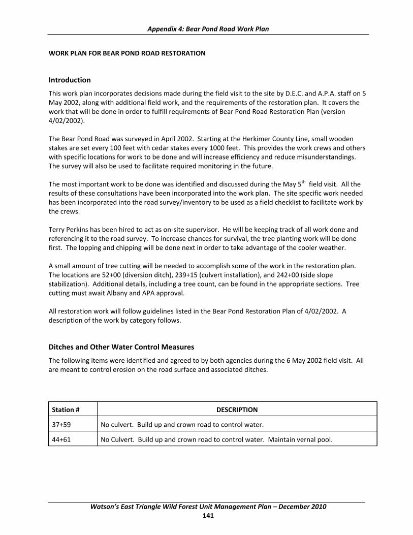
Appendix 4: Bear Pond Road Work Plan
WORK PLAN FOR BEAR POND ROAD RESTORATION
Introduction
This work plan incorporates decisions made during the field visit to the site by D.E.C. and A.P.A. staff on 5 May 2002, along with additional field work, and the requirements of the restoration plan. It covers the work that will be done in order to fulfill requirements of Bear Pond Road Restoration Plan (version 4/02/2002).
The Bear Pond Road was surveyed in April 2002. Starting at the Herkimer County Line, small wooden stakes are set every 100 feet with cedar stakes every 1000 feet. This provides the work crews and others with specific locations for work to be done and will increase efficiency and reduce misunderstandings. The survey will also be used to facilitate required monitoring in the future.
The most important work to be done was identified and discussed during the May 5th field visit. All the results of these consultations have been incorporated into the work plan. The site specific work needed has been incorporated into the road survey/inventory to be used as a field checklist to facilitate work by the crews.
Terry Perkins has been hired to act as on‐site supervisor. He will be keeping track of all work done and referencing it to the road survey. To increase chances for survival, the tree planting work will be done first. The lopping and chipping will be done next in order to take advantage of the cooler weather.
A small amount of tree cutting will be needed to accomplish some of the work in the restoration plan. The locations are 52+00 (diversion ditch), 239+15 (culvert installation), and 242+00 (side slope stabilization). Additional details, including a tree count, can be found in the appropriate sections. Tree cutting must await Albany and APA approval.
All restoration work will follow guidelines listed in the Bear Pond Restoration Plan of 4/02/2002. A description of the work by category follows.
Ditches and Other Water Control Measures
The following items were identified and agreed to by both agencies during the 6 May 2002 field visit. All are meant to control erosion on the road surface and associated ditches.
Station # DESCRIPTION
37+59 No culvert. Build up and crown road to control water.
44+61 No Culvert. Build up and crown road to control water. Maintain vernal pool.
Watson’s East Triangle Wild Forest Unit Management Plan – December 2010 141

Appendix 4: Bear Pond Road Work Plan
52+00 Right side of road. Define ditch better to insure that water exits the road. Use additional 4" stone if necessary. Plant at least 6 white pine seedlings to the south of the stone lined area. Left side of road. Establish a diversion ditch that enters the woods by the 50+60 marker. This diversion ditch will require the cutting of two yellow birch. Tree diameters are 4" and 6". Both are marked with blue paint. Below this establish a ditch to get run‐off out of the road. The ditch should have a three foot width and be one foot deep. Same as the typical ditch except for the three foot bottom. Line with 4" stone to a stone lined catch basin at the bottom of the hill.
130+70 Build up road to control water instead of installing water diversion bar.
160+00 Replace silt fence and reseed.
204+00 END CURVE. Install 12" arch culvert with standard ditch.
232+47 Install standard ditch on right from 233+00 to culvert at 232+47
243+00 Install typical ditch from 243+00 to 245+00. ( to gravel pit.) Plant trees in Pit (White Pine).
252+50 252+50 to 253+00. Fill spring run‐off overflow area with 4" stone.
274+50 Move road to right in order to establish ditch around bedrock outcropping and keep water off the road.
320+00 CURVE LEFT. Install typical ditch on right side from 320+00 to 321+00.
Side Slope Work Needed
During the field visit on May 6th it was noted that most of the side slopes have been stabilized by the rehabilitation work that was done during the summer of 2001 by Operations. This included stone lined diversion ditches, grading to less than 1v:2h along with seeding and mulching. Much of the area has already greened up with native grasses, small hardwood seedlings and other plants. This disturbed area will all be seeded with a conservation mix that has been approved.
One unstable side slope was identified during the field visit. It is adjacent to a reclaimed gravel pit located at 242+00.
Station # DESCRIPTION
242+00 Unstable eroding bank right. This bank is too steep to be stabilized and a number of trees are already undermined and will eventually fall over. The flagged area will be cleared of trees and graded to a slope of no greater than 1v:2h. It will then be seeded, mulched, and planted with white pine seedlings. The tree count is Yellow Birch ‐ 13", 3", 3", 7", 4", 3", 3", 4". Beech ‐ 7", 6". Red Maple ‐ 14", 15". Striped Maple ‐ 6". Hard Maple ‐ 3". All these trees are marked with blue paint.
Watson’s East Triangle Wild Forest Unit Management Plan – December 2010 142

Appendix 4: Bear Pond Road Work Plan
Culvert Work Needed
The following culvert work was identified and approved during the field visit. These culverts are meant to reduce erosion and sedimentation from the road to a minimum. Much of the work is needed to address old culverts that are no longer functioning properly due to damage, or from being undersized to handle normal peak flows. An arch culvert is the preferred type culvert to use. When specified it must be used.
Station # DESCRIPTION
2+93 Install 24" culvert or the arch equivalent. The arch culvert is preferred.
13+85 CULVERT 12" TO BE REPLACED
22+72 CULVERT 15" TO BE REPLACED
31+31 CULVERT 12" TO BE REPLACED SMALL & SHORT
119+14 Install 12"wide and deep crushed stone cross drain (French Drain). Use 4" stone wrapped with road fabric. Gravel as necessary over the top.
122+21 CULVERT 15" TO BE REPLACED
135+69 CULVERT 15" TO BE REPLACED
160+44 CULVERT 18" TO BE REPLACED
168+43 END CURVE. Install crushed stone cross drain (French Drain) 12" wide and deep. Use 4" stone wrapped with road fabric. Gravel over the top.
170+74 CULVERT REPLACED WITH 15"
181+93 Install 12" arch culvert.
185+35 CULVERT REPLACED WITH 24"
204+00 END CURVE. Install 12" arch culvert with standard ditch.
210+30 CULVERT REPLACE WITH 15" MINIMUM
223+87 CULVERT 12" REPLACE WITH 12" arch culvert.
228+02 CULVERT 12". REPLACE WITH 24" Culvert.
239+15 CULVERT 12" REPLACE WITH 36". Trees needing removal. Yellow Birch ‐ 5", 5", 4", Red Maple ‐ 4"
246+48 CULVERT REPLACE WITH 18" arch culvert. BOTTOM HILL
273+41 CULVERT 12" REPLACE WITH 15"
360+95 CULVERT TO BE REPLACED 30" or arch equivalent. BOTTOM HILL
378+55 CULVERT TO BE REPLACED WITH 15". Hold the same invert. CURVE LEFT, BOTTOM HILL, Wetland to left.
Watson’s East Triangle Wild Forest Unit Management Plan – December 2010 143
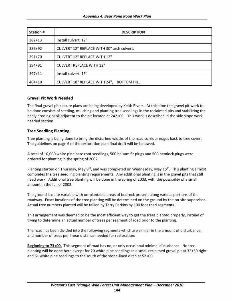
Appendix 4: Bear Pond Road Work Plan
Station # DESCRIPTION
382+13 Install culvert 12"
386+92 CULVERT 12" REPLACE WITH 30" arch culvert.
391+70 CULVERT 12" REPLACE WITH 12"
394+91 CULVERT REPLACE WITH 12"
397+11 Install culvert 15"
404+10 CULVERT 18" REPLACE WITH 24", BOTTOM HILL
Gravel Pit Work Needed
The final gravel pit closure plans are being developed by Keith Rivers. At this time the gravel pit work to be done consists of seeding, mulching and planting tree seedlings in the reclaimed pits and stabilizing the badly eroding bank adjacent to the pit located at 242+00. This work is described in the side slope work needed section.
Tree Seedling Planting
Tree planting is being done to bring the disturbed widths of the road corridor edges back to tree cover. The guidelines on page 6 of the restoration plan final draft will be followed.
A total of 10,000 white pine bare root seedlings, 500 balsam fir plugs and 500 hemlock plugs were ordered for planting in the spring of 2002.
Planting started on Thursday, May 9th, and was completed on Wednesday, May 15th. This planting almost completes the tree seedling planting requirements. Any additional planting is in the gravel pits that still need work. Additional tree planting will be done in the spring of 2003, with the possibility of a small amount in the fall of 2002.
The ground is quite variable with un‐plantable areas of bedrock present along various portions of the roadway. Exact locations of the tree planting will be determined on the ground by the on‐site supervisor. Actual tree numbers planted will be tallied by Terry Perkins by 100 foot road segments.
This arrangement was deemed to be the most efficient way to get the trees planted properly, instead of trying to determine an actual number of trees per segment of road prior to the planting.
The road has been divided into the following segments which are similar in the amount of disturbance, and number of trees per linear distance needed for restoration:
Beginning to 73+00. This segment of road has no, or only occasional minimal disturbance. No tree planting will be done here except for 20 white pine seedlings in a small reclaimed gravel pit at 32+50 right and 6+ white pine seedlings to the south of the stone‐lined ditch at 52+00.
Watson’s East Triangle Wild Forest Unit Management Plan – December 2010 144

Appendix 4: Bear Pond Road Work Plan
73+00 to 118+00. Generally light to moderate disturbance, with some undisturbed areas present. Planting averages one row of trees on either side of the road.
118+00 to 153+00. No or only occasional minimal disturbance. No tree planting.
153+00 to 186+00. Variable with light to significant disturbance. Planting will average one row of trees on one or both sides of the road.
186+00 to 216+00. No or only occasional minimal disturbance. No tree planting.
216+00 to 223+00. Light disturbance. Generally one row of trees on one side of the road only.
223+00 to 238+00. No or only occasional minimal disturbance. No tree planting.
238+00 to 287+00. Light to moderate disturbance. About three‐fourths of the roadside requires tree planting. At 240+00 left is a vernal pool. The open area is to be planted with a mixture of balsam fir, hemlock, and white pine. At 243+00 is a reclaimed gravel pit to be planted with white pine in the dry areas, and balsam, hemlock, tamarack, and/or spruce in the wet areas.
287+00 to 415+00. Moderate to significant disturbance. Generally one or two rows of trees needed on either side of the road with some stretches requiring three rows. At 412+48 left is a reclaimed gravel pit. Plant with a mixture of white pine, balsam fir, and hemlock.
Debris Removal
The large majority of debris (old culverts, etc.) was cleaned up during the 2001 season. A small amount is left as noted below.
Station # DESCRIPTION
46+00 PULL OFF LEFT Old culvert off to side.
185+80 Piece of old wire rope on left.
204+50 Old culvert present on side of road.
210+00 Small piece of old culvert right.
216+80 Small piece of old culvert left.
233+00 Piece of old culvert left.
237+50 Remains of old washing machine right. Old culvert inside woods left.
238+00 238+00 to 239+00 Pre‐disturbance openings left and right. Suitable for turn outs. Former site of Massawepie Camp. Part of old culvert right.
255+50 Old culvert to side of road on right.
331+00 Old culvert to the right in woods.
Watson’s East Triangle Wild Forest Unit Management Plan – December 2010 145

Appendix 4: Bear Pond Road Work Plan
Turn outs
On the field visit some stakes were noted marked turn out #1, #2, #3, #4, #5 and #6. Most of these were in poor locations for a turnout and none will be constructed.
Much of the road has pre‐disturbance openings present. Many of these are suitable as pull‐offs for one or two vehicles. Openings suitable as pull‐offs are noted below. No additional turn outs will be constructed as part of the restoration plan.
Location Location 24+00 25+00
36+34 38+00 46+00 46+37 59+00 142+43 162+50 167+00 170+00 187+00 191+35 199+00 216+10 238+00 to 239+00 238+75 251+75 256+00 267+00 to 268+65 280+67 281+00 304+50 to 307+00 (left) 305+00 to 306+80 (right) 313+50 374+25 389+00 412+00 415+50
Gravel
An additional 5000 yards of graveling will be done to reduce erosion and eliminate pot holes. Pot holes and boulder outcroppings etc. cause people to try and go around them. This tends to widen the road surface. Since this amount is only enough to do a limited portion of the road surface, it will be used first where specific problems were identified during the May 5th field visit. Any graveling will follow the guidelines in the restoration plan.
Downed Trees
Much work was accomplished on this during the 2001 season. Most of the additional work needed is on the stretches of road that required tree planting. Restoration plan guidelines will be adhered to.
The following (work inventory/road survey) document incorporates the specific work identified during the field visit of May 5, 2002. This, along with the restoration plan guidelines, will form the framework for accomplishing the Bear Pond Road Restoration.
Watson’s East Triangle Wild Forest Unit Management Plan – December 2010 146

________________________________________________________________________________________ __________________________________________________________
APPENDIX 5: Campsite Assessment Forms and Procedures
MONITORING FORM A 1)Old Site Number:_______ 1a) New Site Number________
2) Inventoried By:____________________ 3)Date:____/____/____
INVENTORY PARAMETERS
4) Substrate of site area: ( B=bedrock C=cobble S=sand O=soil) ______ 5) Number of Other Recreational Sites Visible: ______ 6) Fire Ring Present: (y or n) ______
Construction:(stone or metal) ______ Condition: ( 1=good, 2=poor, 3=replace) ______
7) Privy Present:(y or n) ______ Condition: ( 1= good, 2=poor, 3=replace) ______
8) Picnic Table Present: (y or n) ______ Condition: ( 1=good, 2=poor, 3=replace) ______
9) Tree Canopy Cover:(1=0‐25%,2=26‐50%,3=51‐75%,4=76‐100%) ______
IMPACT PARAMETERS ( Begin with Site Boundary Determination)
10) Condition Class: (3,4 or 5) ______ 11) Vegetative Ground Cover Onsite:(Use categories below) ______
(1=0‐5%, 2=6‐25%, 3=26‐50%, 4=51‐75% 5=76‐95%, 6=96‐100%) 12) Vegetative Ground Cover Offsite:( Use categories above) ______ 13) Soil exposure: ( use categories above) ______ 14) Tree Damage: None/Slight____, Moderate____, Severe_____ 15) Root Exposure: None/Slight____, Moderate_____, Severe_____ 16) Number of Tree Stumps: ______ 17) Number of Trails: ______ 18) Number of Fire Sites: ______ 19) Litter/Trash: (N=None, S=Some, M=Much) ______ 20) Human Waste: (N=none, S=Some, M=Much) ______ 21)Comments/Recommendations:____________________________________________________________
22) Take Center point and Site Photographs:
Watson’s East Triangle Wild Forest Unit Management Plan – December 2010 147
Appendix 5: Campsite Assessment Forms & Procedures
Site Center point References 1) 2) 3) 4)
Satellite Site Dimensions
Island Site Dimensions
Site area from Program: _________ +Satellite Area _________ ‐ Island Area _________= Total Site Area __________(sq ft)
Transect Data Azimuth
1) 2) 3) 4) 5) 6) 7) 8) 9) 10) 11) 12) 13) 14) 15) 16) 17) 18) 19) 20) 21) 22) 23) 24) 25)
Distance (ft)
Watson’s East Triangle Wild Forest Unit Management Plan – December 2010 148

DESIGNATED CAMPSITE MONITORING MANUAL DESCRIPTION OF PROCEDURES FEBRUARY 2001
Appendix 5: Campsite Assessment Forms & Procedures
MONITORING FORM B
1)Old Site Number:__________ 1a) New Site Number:_______
2)Fire Ring Present:____________ Condition:__________.
3) Privy Present:_______________ Condition:__________
4) Picnic Table Present:_________ Condition:__________
5) Condition Class ( 1 or 2 )______ Site Size:__________(ft2)
For the purpose of this manual, designated campsites are defined as those areas either designated by the Department with a yellow DEC designated campsite marker, or shown on an area brochure. In areas with multiple sites there may not always be undisturbed areas separating sites, and an arbitrary decision may be necessary to define separate sites. For each site, monitoring begins with an assessment of Condition Class:
CONDITION CLASS DEFINITIONS
• Class 1: Recreation site barely distinguishable; slight loss of vegetation cover and/ or minimal disturbance of organic litter.
• Class 2: Recreation site obvious; vegetation cover lost and/ or organic litter pulverized in primary use area.
• Class 3: Vegetation cover lost and/ or organic litter pulverized on much of the site, some bare soil exposed in primary use areas.
• Class 4: Nearly complete or total loss of vegetation cover and organic litter, bare soil widespread. • Class 5: Soil erosion obvious, as indicated by exposed tree roots and rocks and/or gullying.
For sites rated Condition Class 1 or 2, complete Form B; for sites rated Class 3, 4 or 5, complete Form A. Form B is an abbreviated version of Form A and greatly reduces the amount of field time. The rationale for this approach is that detailed information on lightly impacted sites is not as critical to management.
During subsequent surveys an attempt should be made to relocate and reassess all sites from the proceeding survey. Former designated sites that have been closed, and are still being used, should be
Watson’s East Triangle Wild Forest Unit Management Plan – December 2010 149

Appendix 5: Campsite Assessment Forms & Procedures
noted as illegal sites. Always note information regarding the history of site use under the comment parameter.
Materials: Compass, peephole or mirror type(not corrected for declination) GPS data recorder ( GPS point will be taken at each sites center point ) Tape measure, 100‐foot ( marked in tenths) Flagged wire pins ( 25 min), one large steel center point stake. Digital camera Clipboard, pencil, field forms, field procedures Steel nails ( 5 inch )
Form A Procedures
Inventory Parameters
1. Site Number: All sites will be assigned an old site number as well as a new site number. Old site numbers will use the existing site numbering system, while new site numbers will be assigned following completion of the mapping of all sites. 2. Inventoried By: List the names of field personnel involved in data collection. 3. Date: Month, day and year the site was evaluated ( e.g., June 12, 1999 = 06/12/99) 4. Substrate of site area: Record the predominant substrate for the area of human disturbance for each site using the coded categories below. B=bedrock ‐ shelf bedrock C=cobble ‐ includes gravel size stone and up S=sand ‐ includes sandy soils that do not form a surface crust in trampled areas O=soil ‐ includes clays to loamy sands 5. Number of other sites visible: Record the number of other campsites, which if occupied, would be visible from this site. 6. Fire ring : if present or not ( y or n)
a. Construction: stone/ masonry or metal b. Condition: good=intact, functional for cooking
Poor= missing stones, broken , not functional for cooking but will contain open fire. 7. Privy: if present or not ( y or n )
a. Condition: good= functional, has door, wood not deteriorated( would you use it? ) Poor= nonfunctional, door missing, wood rotten,
8. Picnic table: if present or not ( y or n) a. Condition: good= usable, no broken boards, table is solid
Poor=not usable, broken/rotten boards, not sturdy 9. Tree canopy cover: Estimate the percentage of tree canopy cover directly over the campsite.
1=0‐25%, 2=26‐50%, 3=51‐75%, 4=76‐100%
Impact Parameters
The first step is to establish the sites boundaries and measure its size. The following procedures describe use of the variable radial transect method for determining the sizes of recreational sites. This is accomplished by measuring the lengths of linear transects from a permanently defined center point to the recreation site boundary.
Watson’s East Triangle Wild Forest Unit Management Plan – December 2010 150
Appendix 5: Campsite Assessment Forms & Procedures
Step 1. Identify Recreation Site Boundaries and Flag Transect Endpoints. Walk the recreation site boundary and place flagged wire pins at locations which, when connected with straight lines, will define a polygon whose area approximates the recreation site area. Use as few pins as necessary, typical sites can be adequately flagged with 10‐15 pins. Look both directions along site boundaries as you place the flags and try to balance areas of the site that fall outside the lines with offsite(undisturbed) areas that fall inside the lines. Pins do not have to be placed on the site boundaries, as demonstrated in the diagram following these procedures. Project site boundaries straight across areas where trails enter the site. Identify site boundaries by pronounced changes in vegetation cover, vegetation height/disturbance, vegetation composition, surface organic litter, and topography. Many sites with dense forest over stories will have very little vegetation and it will be necessary to identify boundaries by examining changes in organic litter, i.e. leaves that are untrampled and intact versus leaves that are pulverized or absent. In defining the site boundaries, be careful to include only those areas that appear to have been disturbed from human trampling. Natural factors such as dense shade and flooding can create areas lacking vegetative cover. Do not include these areas if they appear "natural" to you. When in doubt, it may also be helpful to speculate on which areas typical visitors might use based on factors such as slope or rockiness.
Step 2. Select and Reference Site Center point. Select a site center point that is preferably a) visible from all site boundary pins, b) easily referenced by distinctive permanent features such as larger trees or boulders, and c) approximately 5 feet from a steel fire ring if present. Embed a 5 inch nail in the soil at the center point location so that the head is 3‐4 inches below the surface. During future sight assessments a magnetic pin locator can be used to locate the center point. Next, insert a large steel stake at the center point and reference it to at least three features. Try to select reference features in three opposing directions, as this will enable future workers to triangulate the center point location. For each feature, take a compass azimuth reading and measure the distance ( nearest 1/10 foot) from the center point to the center of trees or the highest point of boulders. Also measure the approximate diameter of reference trees at 4.5 feet above ground (dbh). Be extremely careful in taking these azimuths and measurements, as they are critical to relocating the center point in the future. Record this information on the back of the form.
Take a digital photograph that clearly shows the center point location in relation to nearby trees or other reference features, such as the fire ring, trees or boulders. Record a photo description, such as" center point location site 23 ", in the photo log. Options: Some sites may lack the necessary permanent reference features enabling the center point to be accurately relocated. If only one or two permanent reference features are available, use these and take additional photographs from several angles. If permanent features are unavailable, simply proceed with the remaining steps without permanently referencing the center point. This option will introduce more error in comparisons with future measurements, particularly if the site boundaries are not pronounced. Note your actions regarding use of these options in the comment section.
Step 3. Record Transect Azimuths and Lengths. Standing directly over the center point, identify and record the compass bearing(azimuth) of each site boundary pin working in a clockwise direction, starting with the first pin clockwise of north. Be careful not to miss any pins hidden behind vegetation or trees. Be extremely careful in identifying the correct compass bearings to these pins as error in these bearings will bias current and future measurements of site size. Next, anchor the end of your tape to the center point stake, measure and record the length of each transect(nearest 1/10 foot), starting with the same
Watson’s East Triangle Wild Forest Unit Management Plan – December 2010 151

Appendix 5: Campsite Assessment Forms & Procedures
boundary pin and in the same clockwise direction as before. Be absolutely certain that the appropriate pin distances are recorded adjacent to their respective compass bearing.
Step 4. Measure island and satellite areas. Identify any undisturbed islands of vegetation inside the site boundaries ( often due to the clumping of trees and shrubs) and disturbed satellite use areas outside the site boundaries ( often due to tent sites or cooking sites). Use site boundary definitions for determining the boundaries of these areas. Use the geographic figure method to determine the areas of these islands and satellites ( refer to the diagrams following these procedures). This method involves superimposing one or more imaginary geometric figures (rectangles, circles or right triangles) on island or satellite boundaries and measuring appropriate dimensions to calculate their areas. Record the types of figures used and their dimensions on the back of the form; the size of these areas should be computed in the office using a calculator.
Site Remeasurement: During site remeasurement use the data from the last monitoring period to reestablish the center point and all site boundary pins. If steel nails were embedded in the ground, a magnetic pin locator can assist in this process. Place flagged wire pins at each transect boundary point. Boundary locations based on the following procedures:
A. Keep the same transect length if that length still seems appropriate, i.e., there is no compelling reason to alter the initial boundary determination. B. Record a new transect length if the prior length is inappropriate ,i.e., there is compelling evidence that the present boundary does not coincide with the pin and the pin should be relocated either closer to or further away from the center point along the prescribed compass bearing. Use different colored flags to distinguish these current boundary points from the former boundaries. C. Repeat steps 1 and 3 from above to establish additional transects where necessary to accommodate any changes in the shape of recreation site boundaries ( diagram below). Also repeat step 4. D. Leave all pins in place until all procedures are completed. Pins identifying the former site boundaries are necessary for tree damage and root exposure assessments.
These additional procedures are designed to eliminate much of the measurement error associated with different individuals making subjective judgments on those sites or portions of sites where boundaries are not pronounced. These procedures may only be used for sites whose center points can be relocated.
Watson’s East Triangle Wild Forest Unit Management Plan – December 2010 152
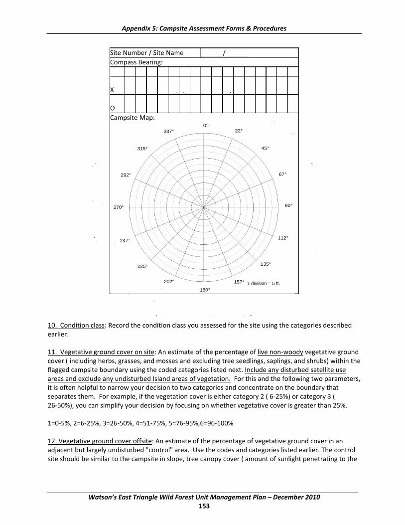
Appendix 5: Campsite Assessment Forms & Procedures
Site Number / Site Name ______/______ Compass Bearing: X O Campsite Map:
0° 337° 22°
315° 45°
292° 67°
90° 270°
112° 247°
135° 225°
202° 157° 1 division = 5 ft. 180°
10. Condition class: Record the condition class you assessed for the site using the categories described earlier.
11. Vegetative ground cover on site: An estimate of the percentage of live non‐woody vegetative ground cover ( including herbs, grasses, and mosses and excluding tree seedlings, saplings, and shrubs) within the flagged campsite boundary using the coded categories listed next. Include any disturbed satellite use areas and exclude any undisturbed Island areas of vegetation. For this and the following two parameters, it is often helpful to narrow your decision to two categories and concentrate on the boundary that separates them. For example, if the vegetation cover is either category 2 ( 6‐25%) or category 3 ( 26‐50%), you can simplify your decision by focusing on whether vegetative cover is greater than 25%.
1=0‐5%, 2=6‐25%, 3=26‐50%, 4=51‐75%, 5=76‐95%,6=96‐100%
12. Vegetative ground cover offsite: An estimate of the percentage of vegetative ground cover in an adjacent but largely undisturbed "control" area. Use the codes and categories listed earlier. The control site should be similar to the campsite in slope, tree canopy cover ( amount of sunlight penetrating to the
Watson’s East Triangle Wild Forest Unit Management Plan – December 2010 153

Appendix 5: Campsite Assessment Forms & Procedures
forest floor), and other environmental conditions. The intent is to locate an area that would closely resemble the campsite area had the site never been used. In instances where you cannot decide between two categories, select the category with less vegetative cover. The rationale for this is simply that, all other factors being equal, the first campers would have selected a site with the least amount of vegetation cover.
13. Soil exposure: An estimate of the percentage of soil exposure, defined as ground with very little or no organic litter (partially decomposed leaf, needle, or twig litter) or vegetation cover, within the campsite boundaries and satellite areas. Dark organic soil, which typically covers lighter colored mineral soil, should be assessed as bare soil. Assessments of soil exposure may be difficult when organic litter becomes highly decomposed and forms a patchwork with areas of bare soil. If patches of organic material are relatively thin and few in number, the entire area should be assessed as bare soil. Otherwise, the patches of organic litter should be mentally combined and excluded from assessments. Code as for vegetative cover.
14. Tree damage: Tally the number of live trees ( > 1 in, diameter at 4.5 ft.) Within the campsite boundaries, including trees in undisturbed islands and excluding trees in satellite areas, into one of the rating classes described below. Assessments are restricted to trees within the flagged campsite boundaries in order to ensure consistency with future measurements. Multiple tree stems from the same species that are joined at or above ground level should be counted as one tree when assessing damage to any of its stems. Assess a cut stem on a multiple‐stemmed tree as tree damage, not as a stump. Do not count tree stumps as tree damage. Take into account tree size. For example, damage for a small tree would be considerably less in size than damage for a large tree. Omit scars that are clearly not human‐caused (e.g., lightning strikes).
During site remeasurement, begin by assessing tree damage on all trees within the site boundaries identified in the last measurement period. Tally the number of trees in areas where the boundary has moved closer to the center point, i.e., former site areas that are not currently judged to be part of the site separately. Place a box around this number. Next, assess tree damage in areas where boundaries have moved further from the center point, i.e. expanded site areas that are newly impacted since the last measurement period. Circle these tallies. These additional procedures are necessary in order to accurately analyze changes in tree damage over time.
None/Slight‐ No or slight damage such as broken or cut smaller branches, one nail, or a few superficial trunk scars.
Moderate‐ Numerous small trunk scars and/or nails or one moderate‐sized scar.
Severe‐ Trunk scars numerous with many that are large and have penetrated to the inner wood; any complete girdling of trees ( cut through tree bark all the way around tree).
15. Root exposure: Tally the number of live trees ( > 1 in, diameter at 4.5 ft.) Within the campsite boundaries, including trees in undisturbed islands and excluding trees in satellite areas, into one of the rating classes described below. Assessments are restricted to trees within the flagged campsite boundaries in order to ensure consistency with future measurements. Where obvious, omit exposed roots that are clearly not human‐caused ( e.g., stream/river flooding). During site remeasurement, begin by assessing root exposure on all trees
Watson’s East Triangle Wild Forest Unit Management Plan – December 2010 154
Appendix 5: Campsite Assessment Forms & Procedures
within the site boundaries identified in the last measurement period. Tally the number of trees in areas where the boundary has moved closer to the center point, i.e., former site areas that are not currently judged to be part of the site separately. Place a box around this number. Next, assess root exposure in areas where boundaries have moved further from the center point, i.e. expanded site areas that are newly impacted since the last measurement period. Circle these tallies. These additional procedures are necessary in order to accurately analyze changes in root exposure over time.
None/Slight‐ No or slight root exposure such as is typical in adjacent offsite areas.
Moderate‐ Top half of many major roots exposed more than one foot from base of tree.
Severe‐ Three‐quarters or more of major roots exposed more than one foot from base of tree; soil erosion obvious.
16. Number of tree stumps: A count of the number of tree stumps (> 1 in. Diameter) within the campsite boundaries. Include trees within undisturbed islands and exclude trees in disturbed satellite areas. Do not include cut stems from a multiple‐stemmed tree.
During site remeasurement, begin by assessing stumps on all trees within the site boundaries identified in the last measurement period. Tally the number of trees in areas where the boundary has moved closer to the center point, i.e., former site areas that are not currently judged to be part of the site separately. Place a box around this number. Next, assess stumps in areas where boundaries have moved further from the center point, i.e. expanded site areas that are newly impacted since the last measurement period. Circle these tallies. These additional procedures are necessary in order to accurately analyze changes in stumps over time.
17 Number of trails: A count of all trails leading away from the outer campsite boundaries. Do not count extremely faint trails that have untrampled tall herbs present in their tread or trails leading out to any satellite sites.
18. Number of fire sites: A count of each fire site within campsite boundaries, including satellite areas. Include old inactive fire sites as exhibited by blackened rocks, charcoal, or ashes. Do not include areas where ashes or charcoal have been dumped. However, if it is not clear whether or not a fire was built on the site, always count questionable sites that are within site boundaries and exclude those that are outside site boundaries.
19. Litter/trash: Evaluate the amount of litter/trash on the site: n=None or less than a handful, S=some‐a handful up to enough to fill a 2‐1/2‐gallon bucket, M=Much‐more than a 2‐1/2‐gallon bucket.
20. Human waste: Follow all trails connected to the site to conduct a quick search of likely "toilet" areas, typically areas just out of sight of the campsite. Count the number of individual human waste sites, defined as separate locations exhibiting toilet paper and/or human feces. The intent is to identify the extent to which improperly disposed human feces is a problem. Use the following code categories: N=None, S=Some‐1‐3 sites, M=Much‐4 or more sites evident.
Watson’s East Triangle Wild Forest Unit Management Plan – December 2010 155
Appendix 5: Campsite Assessment Forms & Procedures
21. Comments/Recommendations: An informal list of comments concerning the site: note any assessments you felt were particularly difficult or subjective, problems with monitoring procedures or their application to this particular campsite, or any other comment.
22. Campsite photograph: Select a good vantage point for viewing the entire campsite, preferably one of the site boundary pins, and take a digital picture of the campsite. Note the azimuth and distance from the center point to the photo point and record on the form. The intent is to obtain a photograph that includes as much of the site as possible to provide a photographic record of site condition. The photo will also allow future workers to make a positive identification of the site. Label disks with date, and site number.
23. Total campsite area: Calculate the campsite area based on the recorded transect measurements. Add the area of any satellite sites and subtract the area of any undisturbed islands to obtain the Total
2Campsite Area. Record campsite area to nearest square foot (ft ).
Form B Procedures
Refer to the procedures described earlier, all procedures are the same with the exception of campsite size. Measure campsite size using the geometric figure method. Typically, class 1 and 2 campsites are quite small in size and this method should be both efficient and accurate. Be sure to record on form B the types of figures used ( rectangle, square, triangles...etc.) And all necessary dimensions. Record
2campsite area to nearest square foot (ft ).
Watson’s East Triangle Wild Forest Unit Management Plan – December 2010 156
APPENDIX 6: River Area Management Plans
A. Scenic River Area Management Plan for the Middle Branch of the Oswegatchie River
Preface
In 1972, State legislation was passed creating a wild, scenic, and recreational rivers system on State and private lands to protect and maintain certain designated rivers in their free‐flowing condition and natural setting. Statutory authority for the management of the rivers system is found in the Environmental Conservation Law Article 15, Title 27, Part 666; Regulation for Administration and Management of the Wild, Scenic and Recreational Rivers System in New York State Excepting Private Land in the Adirondack park. The purpose of this Part is to implement the Act by establishing statewide regulations for the management, protection, enhancement and control of land use and development in river areas on all designated wild, scenic and recreational rivers in New York State, except for private land in river areas within the Adirondack Park.
1. Introduction
The Middle Branch of the Oswegatchie River is classified as scenic, in two sections, for a total of approximately 23.5 miles. The upper section, approximately nine miles, runs from the outlet of Walker Lake to north boundary of Lot 27, Watson’s East Triangle, near the spot called High Banks along the Bear Pond Road. The lower section runs approximately 14.5 miles from a point approximately one mile downstream of the confluence of Wolf Creek to the Park boundary, and the portion on state lands is approximately 1.7 miles to the Oswegatchie Easement boundary. The section in between these two is classified as wild, but except for the last mile below the confluence with Wolf Creek, it is entirely within Five Ponds Wilderness and Aldrich Pond Wild Forest, so is not part of this plan (ECL §15‐2714 (2)(t)). Existing facilities within the one‐half mile river corridor include six motor vehicle roads, or portions thereof, including the Bear Pond Road, Buck Pond Road, Tunnel Road, Flow Road, River Road and Number One Road and two designated campsites. Two bridges cross the Middle Branch, one bridge on Bear Pond Road within the Bear Pond Primitive Corridor and one on the Oswegatchie Easement lands where the Tyler Road crosses, the latter not covered by this Scenic River Management Plan since it is on private land.
2. Management Goals and Objectives for the Middle Branch of the Oswegatchie River and its River Area
a) Preserve and enhance the natural character of the river and its immediate environs. b) Close or relocate existing primitive tent sites which are not adequately screened from the water. c) Identify areas where existing trails may be impacting the character of the river and its shoreline
and develop management alternatives to minimize those impacts. d) Do not develop new motorized trails within the river corridor.
Watson’s East Triangle Wild Forest Unit Management Plan – December 2010 157

Appendix 6: River Area Plans
3. MANAGEMENT GUIDELINES
a. ECL, Article 15, Title 27, Part 666
River Area Boundaries
Pursuant to Part §666.6(f), upon the designation of a river in this system and until final boundaries are established, the provisions of Part 666 (the regulations implementing the Wild, Scenic and Recreational Rivers program) are applicable within one‐half mile of each bank of the river.
Classes of rivers and management objectives for river areas
a) Wild rivers are generally five (5) miles or more in length, free of diversions and impoundments, and accessible only by water, foot or horse trail. Their river areas are primitive and undeveloped in nature. In general the minimum distance from the river to a public road or a private road open to the public is one‐half mile. Management of wild river areas will be directed to the perpetuation of their wild character.
b) Scenic rivers are generally free of diversions or impoundments with limited road access. Their river areas are essentially primitive and undeveloped or are use for agriculture, forest management and other dispersed human activities which do not in themselves substantially constrain public use and enjoyment of these rivers and their environs. Management of scenic river areas will be directed to preserving and restoring their natural scenic qualities.
c) Recreational rivers are generally readily accessible, and may have a significant amount of development in their river areas and may have been impounded or diverted in the past. Management of recreational river areas will be directed to preserving and restoring their natural, cultural, scenic and recreational qualities, except in areas delineated by the Department as communities, which will be managed to avoid adverse environmental impacts and loss of existing river corridor values.
b. Adirondack Park State Land Master Plan (APSLMP)
The APSLMP provides the following generic guidelines for management and use of all classified rivers:
1. No river or river area will be managed or used in a way that would be less restrictive in nature than the statutory requirements of the Wild, Scenic and Recreational Rivers Act, Article 15, title 27 of the Environmental Conservation Law, or than the guidelines for the management and use of the land classification within which the river area lies, but the river or river area may be administered in a more restrictive manner.
2. Rivers will be kept free of pollution and the water quality thereof kept sufficiently high to meet other management guidelines contained in this section.
3. No dam or other structure impeding the natural flow of a river will be constructed on a wild, scenic or recreational river, except for stream improvement structures for fisheries management purposes which are permissible on recreational and scenic rivers only.
Watson’s East Triangle Wild Forest Unit Management Plan – December 2010 158

Appendix 6: River Area Plans
4. The precise boundaries of the river area will be determined by the Department of Environmental Conservation, will be specified in the individual unit management plans for the river area or the unit of state land through which the river flows, and will normally be one‐half mile from the mean high water mark of the river, but in any case will not be less than one‐quarter mile.
Additionally, the APSLMP provides the following guidelines specific to rivers designated as scenic:
1. Scenic rivers and their river areas will be managed in accordance with the guidelines for the management of wild forest areas (except where such rivers flow through wilderness, primitive or canoe areas, where the more restrictive guidelines of the particular area will apply) and with the following additional guidelines.
2. Access points to the river shore or crossings of the river by roads, fire truck trails or other trails open to motor vehicle use by the public or administrative personnel will normally be located at least two miles apart.
3. Other motor vehicle roads or trails in the river area will not be encouraged and, where permitted, will normally be kept at least 500 feet from the river shore and will be screened by vegetation or topography from the river itself.
4. The natural character of the river and its immediate shoreline will be preserved.
5. The following structures and improvements may be located so as to be visible from the river itself:
• fishing and waterway access sites; • foot and horse trails and foot and horse trail bridges crossing the river; and, • motor vehicle bridges crossing the river.
6. All other new, reconstructed or relocated conforming structures and improvements ( other than individual lean‐tos, primitive tent sites and pit privies which are governed by the regular guidelines of the master plan) will be located a minimum of 250 feet from the mean high water mark of the river and will in all cases be reasonably screened by vegetation or topography from view from the river itself.
7. Motorboat usage of scenic rivers will not normally be permitted but may be allowed by the Department of Environmental Conservation, where such use is already established, is consistent with the character of the river and river area, and will not result in any undue adverse impacts upon the natural resource quality of the area.
Watson’s East Triangle Wild Forest Unit Management Plan – December 2010 159

Appendix 6: River Area Plans
4. Proposed Management Actions
a. River Area Boundary
Present Situation and Assumptions:
Under ECL Article 15, Title 27 the river area boundary for any river added to the system is one‐half mile from the mean high water mark until such time a river area plan is completed. The river area plan may amend the boundary so long as the proposed river area boundary meets or furthers the purposes of the Act. Additionally, consideration must also be given to uses that pre‐existed the statute. Where viable alternatives to relocate existing uses which are inconsistent with the Act exist, they should be explored as potential management options. Where no viable alternative exists, efforts should focus on enhancing vegetative screening between the river and the use.
Proposed management Actions:
• Establish the river area boundary at one‐half mile from the mean high water mark.
b. Primitive tent sites
Present Situation and Assumptions:
Within the one‐half mile river area of the Middle Branch of the Oswegatchie, there are two existing primitive tent sites. The existing sites conform with Part 666.
Proposed Management Actions:
• None at this time.
c. Roads
Present Situation and Assumptions:
There are sections of six roads within the one‐half mile river area boundary for the Middle Branch of the Oswegatchie. Approximately 2.9 miles of the Bear Pond Road, 0.6 miles of the Tunnel Road, 0.25 miles of the Mullins Flow Road, 0.2 miles of the River Road, 0.5 miles of the #1 Road and 0.25 miles of the Buck Pond Road are within the corridor. The Bear Pond Road, Tunnel Road, #1 Road and Buck Pond Road are all designated for use by snowmobiles in the winter.
Proposed Management Actions:
• Close the Buck Pond, Mullins Flow and River Roads to motor vehicle use as proposed in the WETWF UMP.
• Maintain roads within their current widths.
d. Snowmobile Trails
Present Situation and Assumptions:
There are no designated snowmobile trails within the one‐half mile river corridor of the Middle Branch. Use of the Bear Pond Road, Tunnel Road and #1 Road by snowmobiles will continue.
Watson’s East Triangle Wild Forest Unit Management Plan – December 2010 160

Appendix 6: River Area Plans
Proposed Management Actions: • None at this time.
5. Schedule for Implementation
The schedule for proposed management actions is contained in the schedule for implementation in the WETWF UMP.
Watson’s East Triangle Wild Forest Unit Management Plan – December 2010 161

Appendix 6: River Area Plans
This page intentionally left blank
Watson’s East Triangle Wild Forest Unit Management Plan – December 2010 162

,.,-_/ I
_,_,, _, ,. ,.,. ~~ ~
.. ~ ...r:,"'-
1/ 0 0.5
Miles
:.p •
y · ,,.✓
on's.Eal · gle ~-st
-(,..., !I ••
( Legend
.. J @ campsites
~~)"\ .._..,......... Proposed Snowmobile Trails
;.JI_. !llm! Pvt.land corridor
·• ~ Scenic river corridor
~ Wild river corridor
.......... Snowmobile Trails
- Roads
..___,! Conservation Easement
I · c::J Wild Forest
wilderness
Appendix 6: River Area Plans
Watson’s East Triangle Wild Forest Unit Management Plan – December 2010 163

Appendix 6: River Area Plans
This page intentionally left blank
Watson’s East Triangle Wild Forest Unit Management Plan – December 2010 164

Appendix 6: River Area Plans
B. Scenic River Area Management Plan for the West Branch of the Oswegatchie River
Preface
In 1972, State legislation was passed creating a wild, scenic, and recreational rivers system on State and private lands to protect and maintain certain designated rivers in their free‐flowing condition and natural setting. Statutory authority for the management of the rivers system is found in the Environmental Conservation Law Article 15, Title 27, Part 666; Regulation for Administration and Management of the Wild, Scenic and Recreational Rivers System in New York State Excepting Private Land in the Adirondack park. The purpose of this Part is to implement the Act by establishing statewide regulations for the management, protection, enhancement and control of land use and development in river areas on all designated wild, scenic and recreational rivers in New York State, except for private land in river areas within the Adirondack Park.
1. Introduction
The West Branch of the Oswegatchie River is classified as scenic for approximately seven miles from the outlet of Buck Pond to a point approximately one mile upstream of Round Pond at the point where a foot and snowmobile bridge crosses the West Branch. The state land portion is approximately 5.5 miles long from the outlet of Buck Pond to the Herkimer/Lewis County boundary (ECL §15‐2714 (2)(u)). Existing facilities within the one‐half mile river corridor include small sections of the Bear Pond Road and the Buck Pond Road. These roads are also included in the river area plan for the Middle Branch and any management actions are proposed in that plan. Four designated campsites and approximately 3.5 miles of the Keck Trail, a foot trail, are within the corridor.
2. Management Goals and Objectives for the West Branch of the Oswegatchie River and its River Area
• Preserve and enhance the natural character of the river and its immediate environs. • Close or relocate existing primitive tent sites which are not adequately screened from the water. • Identify areas where existing trails may be impacting the character of the river and its shoreline
and develop management alternatives to minimize those impacts. • Do not develop new motorized trails within the river corridor.
3. Management Guidelines
a. ECL, Article 15, Title 27, Part 666
River Area Boundaries
Pursuant to Part §666.6(f), upon the designation of a river in this system and until final boundaries are established, the provisions of Part 666 (the regulations implementing the Wild, Scenic and Recreational Rivers program) are applicable within one‐half mile of each bank of the river.
Watson’s East Triangle Wild Forest Unit Management Plan – December 2010 165
Appendix 6: River Area Plans
Classes of rivers and management objectives for river areas
(a) Wild rivers are generally five (5) miles or more in length, free of diversions and impoundments, and accessible only by water, foot or horse trail. Their river areas are primitive and undeveloped in nature. In general the minimum distance from the river to a public road or a private road open to the public is one‐half mile. Management of wild river areas will be directed to the perpetuation of their wild character.
(b) Scenic rivers are generally free of diversions or impoundments with limited road access. Their river areas are essentially primitive and undeveloped or are use for agriculture, forest management and other dispersed human activities which do not in themselves substantially constrain public use and enjoyment of these rivers and their environs. Management of scenic river areas will be directed to preserving and restoring their natural scenic qualities.
( c ) Recreational rivers are generally readily accessible, and may have a significant amount of development in their river areas and may have been impounded or diverted in the past. Management of recreational river areas will be directed to preserving and restoring their natural, cultural, scenic and recreational qualities, except in areas delineated by the Department as communities, which will be managed to avoid adverse environmental impacts and loss of existing river corridor values.
b. Adirondack Park State Land Master Plan (APSLMP)
The APSLMP provides the following generic guidelines for management and use of all classified rivers:
1. No river or river area will be managed or used in a way that would be less restrictive in nature than the statutory requirements of the Wild, Scenic and Recreational Rivers Act, Article 15, title 27 of the Environmental Conservation Law, or than the guidelines for the management and use of the land classification within which the river area lies, but the river or river area may be administered in a more restrictive manner.
2. Rivers will be kept free of pollution and the water quality thereof kept sufficiently high to meet other management guidelines contained in this section.
3. No dam or other structure impeding the natural flow of a river will be constructed on a wild, scenic or recreational river, except for stream improvement structures for fisheries management purposes which are permissible on recreational and scenic rivers only.
4. The precise boundaries of the river area will be determined by the Department of Environmental Conservation, will be specified in the individual unit management plans for the river area or the unit of state land through which the river flows, and will normally be one‐half mile from the mean high water mark of the river, but in any case will not be less than one‐quarter mile.
Additionally, the APSLMP provides the following guidelines specific to rivers designated as scenic:
1. Scenic rivers and their river areas will be managed in accordance with the guidelines for the management of wild forest areas (except where such rivers flow through wilderness, primitive or canoe areas, where the more restrictive guidelines of the particular area will apply) and with the following additional guidelines.
Watson’s East Triangle Wild Forest Unit Management Plan – December 2010 166
Appendix 6: River Area Plans
2. Access points to the river shore or crossings of the river by roads, fire truck trails or other trails open to motor vehicle use by the public or administrative personnel will normally be located at least two miles apart.
3. Other motor vehicle roads or trails in the river area will not be encouraged and, where permitted, will normally be kept at least 500 feet from the river shore and will be screened by vegetation or topography from the river itself.
4. The natural character of the river and its immediate shoreline will be preserved.
5. The following structures and improvements may be located so as to be visible from the river itself:
fishing and waterway access sites; foot and horse trails and foot and horse trail bridges crossing the river; and, motor vehicle bridges crossing the river.
6. All other new, reconstructed or relocated conforming structures and improvements ( other than individual lean‐tos, primitive tent sites and pit privies which are governed by the regular guidelines of the master plan) will be located a minimum of 250 feet from the mean high water mark of the river and will in all cases be reasonably screened by vegetation or topography from view from the river itself.
7. Motorboat usage of scenic rivers will not normally be permitted but may be allowed by the Department of Environmental Conservation, where such use is already established, is consistent with the character of the river and river area, and will not result in any undue adverse impacts upon the natural resource quality of the area.
4. Proposed Management Actions
a. River Area Boundary
Present Situation and Assumptions:
Under ECL Article 15, Title 27 the river area boundary for any river added to the system is one‐half mile from the mean high water mark until such time a river area plan is completed. The river area plan may amend the boundary so long as the proposed river area boundary meets or furthers the purposes of the Act. Additionally, consideration must also be given to uses that pre‐existed the statute. Where viable alternatives to relocate existing uses which are inconsistent with the Act exist, they should be explored as potential management options. Where no viable alternative exists, efforts should focus on enhancing vegetative screening between the river and the use.
Proposed management Actions:
• Establish the river area boundary at one‐half mile from the mean high water mark.
Watson’s East Triangle Wild Forest Unit Management Plan – December 2010 167
Appendix 6: River Area Plans
b. Primitive tent sites
Present Situation and Assumptions:
Within the one‐half mile river area of the West Branch of the Oswegatchie, there are four existing primitive tent sites. The existing sites conform with Part 666.
Proposed Management Actions:
• None at this time.
c. Roads
Present Situation and Assumptions:
The sections of the Bear Pond Road and the Buck Pond Road that are within this river corridor will be dealt with in the area plan for the Middle Branch of the Oswegatchie.
Proposed Management Actions:
• Maintain roads within their current widths.
d. Snowmobile Trails
Present Situation and Assumptions:
There are no designated snowmobile trails within the one‐half mile river corridor of the West Branch. Use of the Bear Pond Road by snowmobiles will continue.
Proposed Management Actions:
• None at this time.
5. Schedule for Implementation
The schedule for proposed management actions is contained in the schedule for implementation in the WETWF UMP.
Watson’s East Triangle Wild Forest Unit Management Plan – December 2010 168

-
Legend
@ campsites
=•~ Proposed Snowmobile Trails
Pvt. land corridor
mliJ Scenic river corridor
~ Wild river corridor
•••••• .... Snowmobile Trails
-- Roads
D Conservation Easement
D Wild Forest
wilderness
Appendix 6: River Area Plans
Watson’s East Triangle Wild Forest Unit Management Plan – December 2010 169

Appendix 6: River Area Plans
This page intentionally left blank
Watson’s East Triangle Wild Forest Unit Management Plan – December 2010 170

Appendix 6: River Area Plans
C. Recreational River Area Management Plan for the West Branch of the Oswegatchie River
Preface
In 1972, State legislation was passed creating a wild, scenic, and recreational rivers system on State and private lands to protect and maintain certain designated rivers in their free‐flowing condition and natural setting. Statutory authority for the management of the rivers system is found in the Environmental Conservation Law Article 15, Title 27, Part 666; Regulation for Administration and Management of the Wild, Scenic and Recreational Rivers System in New York State Excepting Private Land in the Adirondack park. The purpose of this Part is to implement the Act by establishing statewide regulations for the management, protection, enhancement and control of land use and development in river areas on all designated wild, scenic and recreational rivers in New York State, except for private land in river areas within the Adirondack Park.
1. Introduction
The West Branch of the Oswegatchie River is classified as recreational for approximately 6.1 miles from a point approximately one mile upstream of Round Pond at the point where a foot and snowmobile bridge crosses the West Branch downstream to a point where the river intersects the Adirondack Park boundary (ECL §15‐2714 (3)(o)). Approximately 2.4 miles of the West Branch flow through the WETWF. Existing DEC facilities within the one‐half mile river corridor include approximately 2.5 miles of existing snowmobile trails and four designated campsites. A private road and two town roads are within the river corridor adjacent to State land. Two bridges also cross the river in this vicinity.
2. Management Goals and Objectives for the West Branch of the Oswegatchie River and its River Area
• Preserve and enhance the natural character of the river and its immediate environs. • Close or relocate existing primitive tent sites which are not adequately screened from the water. • Identify areas where existing trails may be impacting the character of the river and its shoreline
and develop management alternatives to minimize those impacts.
3. MANAGEMENT GUIDELINES
a. ECL, Article 15, Title 27, Part 666
River Area Boundaries
Pursuant to Part §666.6(f), upon the designation of a river in this system and until final boundaries are established, the provisions of Part 666 (the regulations implementing the Wild, Scenic and Recreational Rivers program) are applicable within one‐half mile of each bank of the river.
Watson’s East Triangle Wild Forest Unit Management Plan – December 2010 171

Appendix 6: River Area Plans
Classes of rivers and management objectives for river areas
a) Wild rivers are generally five (5) miles or more in length, free of diversions and impoundments, and accessible only by water, foot or horse trail. Their river areas are primitive and undeveloped in nature. In general the minimum distance from the river to a public road or a private road open to the public is one‐half mile. Management of wild river areas will be directed to the perpetuation of their wild character.
b) Scenic rivers are generally free of diversions or impoundments with limited road access. Their river areas are essentially primitive and undeveloped or are use for agriculture, forest management and other dispersed human activities which do not in themselves substantially constrain public use and enjoyment of these rivers and their environs. Management of scenic river areas will be directed to preserving and restoring their natural scenic qualities.
c) Recreational rivers are generally readily accessible, and may have a significant amount of development in their river areas and may have been impounded or diverted in the past. Management of recreational river areas will be directed to preserving and restoring their natural, cultural, scenic and recreational qualities, except in areas delineated by the Department as communities, which will be managed to avoid adverse environmental impacts and loss of existing river corridor values.
b. Adirondack Park State Land Master Plan (APSLMP)
The APSLMP provides the following generic guidelines for management and use of all classified rivers:
1. No river or river area will be managed or used in a way that would be less restrictive in nature than the statutory requirements of the Wild, Scenic and Recreational Rivers Act, Article 15, title 27 of the Environmental Conservation Law, or than the guidelines for the management and use of the land classification within which the river area lies, but the river or river area may be administered in a more restrictive manner.
2. Rivers will be kept free of pollution and the water quality thereof kept sufficiently high to meet other management guidelines contained in this section.
3. No dam or other structure impeding the natural flow of a river will be constructed on a wild, scenic or recreational river, except for stream improvement structures for fisheries management purposes which are permissible on recreational and scenic rivers only.
4. The precise boundaries of the river area will be determined by the Department of Environmental Conservation, will be specified in the individual unit management plans for the river area or the unit of state land through which the river flows, and will normally be one‐half mile from the mean high water mark of the river, but in any case will not be less than one‐quarter mile.
Additionally, the APSLMP provides the following guidelines specific to rivers designated as recreational:
1. Recreational rivers and their river areas will be managed in accordance with the guidelines for the management of wild forest areas (except where such rivers flow through wilderness,
Watson’s East Triangle Wild Forest Unit Management Plan – December 2010 172
Appendix 6: River Area Plans
primitive or canoe areas, where the more restrictive guidelines of the particular area will apply) and with the following additional guidelines.
2. When a recreational river flows through an intensive use area, structures, improvements and uses permitted in intensive use areas will be permitted, provided the scale and intensity of these intensive uses do not adversely affect the recreational character of the river and the river area.
3. The natural character of the river and its immediate shoreline will be preserved and enhanced.
4. The following structures and improvements may be located so as to be visible from the river itself:
fishing and waterway access sites; docks; foot and horse trails and foot and horse trail bridges crossing the river; snowmobile trails, roads and truck trails; and motor vehicle bridges crossing the river.
5. All other new, reconstructed or relocated conforming structures and improvements ( other than individual lean‐tos and primitive tent sites which are governed by the regular guidelines of the master plan) will be located a minimum of 150 feet from the mean high water mark of the river and will in all cases be reasonably screened by vegetation or topography from view from the river itself.
6. Motorboat use of recreational rivers may be permitted, as determined by the Department of Environmental Conservation.
4. Proposed Management Actions
a. River Area Boundary
Present Situation and Assumptions:
Under ECL Article 15, Title 27 the river area boundary for any river added to the system is one‐half mile from the mean high water mark until such time a river area plan is completed. The river area plan may amend the boundary so long as the proposed river area boundary meets or furthers the purposes of the Act. Additionally, consideration must also be given to uses that pre‐existed the statute. Where viable alternatives to relocate existing uses which are inconsistent with the Act exist, they should be explored as potential management options. Where no viable alternative exists, efforts should focus on enhancing vegetative screening between the river and the use.
Proposed management Actions:
• Maintain the river area boundary at one‐half mile from the mean high water mark.
Watson’s East Triangle Wild Forest Unit Management Plan – December 2010 173

Appendix 6: River Area Plans
b. Primitive tent sites
Present Situation and Assumptions:
Within the one‐half mile river area of the West Branch of the Oswegatchie River, there are four existing primitive tent sites. These sites will be maintained.
Proposed Management Actions:
• Maintain existing primitive tent sites.
c. Roads
Present Situation and Assumptions:
There are two Town roads within the river corridor adjacent to State land and one private road, subject to a DEC easement for public access to easement lands.
Proposed Management Actions:
• Maintain roads within their current widths.
d. Snowmobile Trails
Present Situation and Assumptions:
There are approximately2.5 miles of designated snowmobile trails within the one‐half mile river corridor. Steam Sleigh Trail‐ Approximately .7 miles of this trail are within the one‐half mile corridor. A town road separates the trail from the river. This trail will be maintained as a Class II trail. Doc Woods Trail‐ Approximately .6 miles of this trail are within the river corridor. The first 0.25 miles of the route are over a private right‐of‐way. This trail will be maintained as a Class I trail. Bald to Buckhorn Trail‐ Approximately 1.2 miles of this trail are within the one‐half mile river corridor. Approximately 0.75 miles of the existing trail will be rerouted to a location that places it about 500 feet from the river. The new section of trail will be approximately 0.1 miles shorter than the existing route. No other alternatives exist for rerouting this trail. The trail will be managed as a Class II trail.
Proposed Management Actions:
• Reroute a section of the Bald to Buckhorn snowmobile trail. • Maintain snowmobile trails to the classifications stated above.
5. Schedule for Implementation
The schedule for proposed management actions is contained in the schedule for implementation in the MRPWF UMP.
Watson’s East Triangle Wild Forest Unit Management Plan – December 2010 174
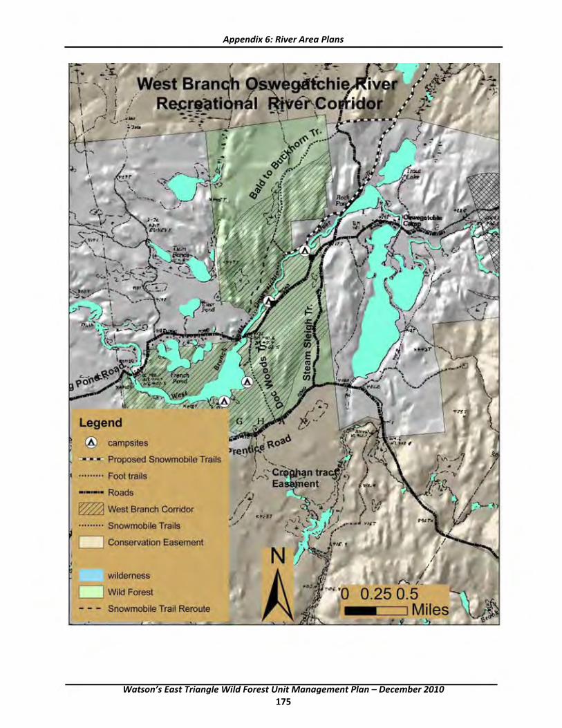
-~.._s-' • ·- I \ ....... ,,' -:-1
Q" '---• I
• ~,' T&h
' -. ... .,. ' ~~\.. . . (- '
<-:-: 1--!-- ....... ~
+--....... ,--,_,..51 • I ,
~-~ "r. ~ _.) ...... -... t i" ' {12', ··..ci=-
Legend
@ campsites
f
-.....:i Proposed Snowmobile Trails
......... Foot trails
- Roads
~ West Branch Corridor
••••••••• Snowmobile Trails
D Conservation Easement
wilderness
D Wild Forest
Snowmobile Trail Reroute
~ r-,; I .
0.25 0.5 Miles
Appendix 6: River Area Plans
Watson’s East Triangle Wild Forest Unit Management Plan – December 2010 175

This page intentionally left blank
Watson’s East Triangle Wild Forest Unit Management Plan – December 2010 176

APPENDIX 7: Deeded RightsOfWay
Owner’s Rights ‐Watson’s East Triangle
Kristopher LaPointe ‐ 100 acres
With old gate 200' from next owner. Non‐exclusive permanent right‐of‐way over road from end of public highway ( Long Pond Road ) to its intersection with the 100 acre parcel and right to repair, maintain, reconstruct, and improve in suitable conditions for logging or pulpwood operations, or another legal use of premises conveyed.
Alfred T. Murphey and Leroy Buckingham ‐ 1237.3 acres
Non‐exclusive and permanent right‐of‐way on "New Road" and "Jakes Pond Road" and the road connecting the two across lands conveyed to LaPointe with same terms as LaPointe right‐of‐way. Property subject to 20' right‐of‐way of Diamond International and East Triangle lessees and inholders. Note that property is subject to contract conveyance to 12 buyers.
Diamond International
Right‐of‐way granted by Leroy Buckingham et. Al. 3/15/1971. Liber 316 p 123 over Bald Mountain Lot Co. lands in Croghan.
Richard Widrick et. Al. ‐ 76.67 acres, Lot 36 ‐ Desert Road.
Non‐exclusive right‐of‐way on existing roadway "from Croghan Town Road" being same as Bald Mountain Lot to International Paper. 3/19/1954 Liber 230 p 41 permanent easement for logging, pulpwood, and other legal uses of any real property from westerly line of International Paper southwesterly to public highways; also to the extent located on Bald Mountain lands westerly from International Paper and northwesterly to the public highway to Harrisville; with right of International Paper and successors to repair, maintain, reconstruct, and improve not over 20' wide improved portion; also non‐exclusive 30' wide right‐of‐way over 2.5 miles of the main haul on International Paper to the Desert Road and 30' wide on the Desert Road to Widrick property with full authority to maintain. May cut down all dead trees and abnormal trees which constitute a danger to the use of the right‐of‐way. Damage caused by Grantee must be repaired in a reasonable time or 60 days of written notice and then Grantor may fix and bill Grantee if repairs are not made.
Champion International
Access to Lot 8, same right‐of‐way as Bald Mountain to International Paper 20' right‐of‐way; also 30' with 20' traveled portion across over International Paper lands on main haul road. Shown on map exhibited, with right to maintain and improve but not materially alter. Cut dead and abnormal trees hazardous to users. Mandate to repair damage caused by Champion contractors and lessees. 60 day written notice and failure to repair and Grantor can repair and bill costs to Champion International.
Donald J. Kampnich ‐ 285.5 acres, Lot 7
Same right‐of‐way as Bald Mountain to International Paper in 1954 for 20' easement. Also non‐exclusive right‐of‐way over existing International Paper road system for access to subject. Also " whatever rights possessed" by International Paper over New York State.
Watson’s East Triangle Wild Forest Unit Management Plan – December 2010 177
Appendix 7: Deeded Rights-of-Way
Gilbert Adams et.al. ‐ 167 acres, Lot 18
No mention of any access.
Reginald and Eva Hoch ‐ 152 acres, Lot 9
Same right‐of‐way as Bald Mountain to International Paper in 1954 for 20' easement. Also non‐exclusive right‐of‐way over existing road system on International Paper for access and egress to subject premises. Also " whatever rights" possessed by International Paper to a non‐exclusive right‐of‐way over the existing road system across lands of New York State.
James A. Schoff et. al. ‐ 693 acres, Lot 11
Same right‐of‐way as Bald Mountain to International Paper in 1954 20' over Bald Mountain; also non‐exclusive right‐of‐way over International Paper on existing road system or otherwise across lands owned by International Paper for access and egress; right to maintain and use earth along the roadway and gravel from the gravel pits along the right‐of‐way for such maintenance but subject to review and direction of the Grantor and successors. Also " whatever rights" possessed by International Paper to a non‐exclusive right‐of‐way over existing roads across New York State.
James R. Yousey et. al. ‐ 353 acres, Lot 12
Same right‐of‐way as Bald Mountain to International Paper in 1954 for 20' easement. Also non‐exclusive right‐of‐way over existing road system on International Paper for access and egress to Lot 12 ( APA stipulation for subdivision required gating Moynahan Road at east line of Lot 11 and mandated use of diagonal road across Lot 11 ). Also "whatever rights" possessed by International Paper to a non‐exclusive right‐of‐way over existing roads across New York State for access and egress to subject premises.
Watson’s East Triangle Wild Forest Unit Management Plan – December 2010 178
APPENDIX 8: Stipulation and Order, Residents Committee to Protect the Adirondacks vs. Adirondack Park Agency et al.
SUPREME COURT OF THE STATE OF NEW YORK COUNTY OF ALBANY
X
In the Matter of the Application of :STIPULATION RESIDENTS' COMMITTEE TO PROTECT : AND ORDER THE ADIRONDACKS, : : Index No. 6513‐01 Petitioner, : : For a Judgment Under Article 78 of the Civil : Practice Law and Rules, :
: ‐ against ‐ :
: THE NEW YORK STATE ADIRONDACK : PARK AGENCY and its Chairman RICHARD : LEFEBVRE and the NEW YORK STATE : DEPARTMENT OF ENVIRONMENTAL : CONSERVATION, :
: Respondents. :
:
‐‐‐‐‐‐‐‐‐‐‐‐‐‐‐‐‐‐‐‐‐‐‐‐‐‐‐‐‐‐‐‐‐‐‐‐‐‐‐‐‐‐‐‐‐‐‐‐‐‐‐‐‐‐‐‐‐‐‐‐‐ X IT IS HEREBY STIPULATED AND AGREED by petitioner Residents' Committee to Protect the
Adirondacks ("RCPA") and respondents New York State Adirondack Park Agency ("APA"), Richard Lefebvre and the New York State Department of Environmental Conservation ("DEC") (collectively, "Respondents") that this action be dismissed on consent of all parties under the terms set forth below:
1. The parties agree that respondents will amend the 1985 Memorandum of Understanding ("MOU") between APA and DEC regarding State Land Master Plan ("SLMP") activities within one (1) year of the entry of this Stipulation and Order to include a revised Section IV, State Land Project Management, to include:
a) A process for DEC to seek formal written consultation from APA for DEC‐proposed activities on forest preserve lands in the Adirondack Park;
b) Public notice in the Environmental Notice Bulletin ("ENB") notice of all activities on forest preserve lands for which DEC requests formal APA consultation;
c) Establishment of specific time frames for APA to respond to all DEC formal consultation requests; d) Establishment of criteria to govern APA's review of DEC consultation requests.
Watson’s East Triangle Wild Forest Unit Management Plan – December 2010 179
Appendix 8: Stipulation and Order, Residents Committee vs. APA
2. The parties agree that respondents will also create a new section in the MOU within one (1) year of entry of this Stipulation and Order entitled State Land Activity Compliance to establish a process for APA to review activities undertaken by DEC that may not be consistent with the State Land Master Plan, Unit Management Plan or the MOU. Key elements of this new MOU section will include:
a. A process to ensure that both DEC and APA will quickly notify each other of the discovery of any activities which may not comply with the SLMP, a UMP, or the MOU; b. Procedures, requirements and time frames for DEC investigation and reporting to
APA on the alleged noncomplying activity; c. Joint review by DEC and AP A of the investigation
information and materials and all reports; d. A process providing that where DEC and APA staff are unable to resolve an
alleged noncomplying activity, the MOU will include a mechanism for DEC or APA staff to elevate the matter to the
Agency chairman, who may take such action as he deems appropriate including, but not limited to, referring the matter to an appropriate standing committee of the APA;
e. Where DEC or AP A staff elevate the matter to the Agency chairman, notice of the matter will be provided in a monthly agency mailing package within a reasonable period of time following such elevation, to be specified in the MOU;
f. Where the Chairman refers such matters to an appropriate standing committee of the APA, notice will be included in the APA's monthly agenda and mailing package;
g. Procedures for issuance of a compliance agreement to be signed by the APA Executive Director and
appropriate DEC Regional Director, which will include: 1) a statement of facts; 2) a finding of noncompliance with the SLMP and UMP including a description of the action or activity leading to such a finding and the effects of such action or activity on the resources; 3) mitigation measures necessary to bring the activity into compliance; and 4) the terms of resolution including any remediation plan to restore the area consistent with SLMP classifications.
h. Public notice published in the ENB of the final compliance agreement upon execution, and of the finalization of any restoration or remediation plan subsequently developed pursuant to such agreement.
3. The parties agree that the substance of the MOU regarding the State Land Project Management and State Land Activity Compliance processes as discussed above will be incorporated into draft AP A regulations proposed for promulgation at 9 NYCRR Part 585
Watson’s East Triangle Wild Forest Unit Management Plan – December 2010 180

4
Appendix 8: Stipulation and Order, Residents Committee vs. APA
(subtitle Q: "Chapter V. State Land Planning") by APA and DEC staff to the APA Legal Affairs Committee for its consideration and any appropriate action, which draft regulations shall be proposed within three years (3) of entry of this Stipulation and Order.
4. The parties agree that respondents will incorporate the MOU provisions set forth above into all existing UMPs by reference, into all UMP amendments which are adopted in the future, and all new UMPs.
5. The parties agree that respondent DEC will have a draft of the Watson’s East Triangle UMP available for public comment in October 2002, with a final draft to the APA for its reviews by the end of February 2003.
6. The parties agree that respondents will adhere in substance and spirit to the process outlined above for compliance determinations for any matters on forest preserve lands which may arise after the signing of this Stipulation and Order until completion of the revised MOU.
7. The parties agree that respondents will pay petitioner’s attorneys fees totaling $5,500 within ninety (90) days of the entry of this Stipulation and Order.
Dated: North Creek, New York March , 2002 Resident’s Committee to Protect The Adirondacks PO Box 27 North Creek, NY 12853‐0027 By: ______________________ Peter Bauer Executive Director Dated: Ray Brook, New York March , 2002 ADIRONDACK PARK AGENCY RICHARD LEFEBRE PO Box 99 Route 86 Ray Brook, New york 12977 By: ______________________ John S. Banta, Esq. General Counsel Dated: Albany, New York March , 2002 NEW YORK STATE DEPARTMENT OF ENVIRONMENTAL CONSERVATION 625 Broadway Albany, New York 12233
Watson’s East Triangle Wild Forest Unit Management Plan – December 2010 181
By: _______________________ Peter S. Duncan Deputy Commissioner Division of Natural Resources SO ORDERED. Dated: Albany, New York March , 2002 ___________________________ New York State Supreme Court
Appendix 8: Stipulation and Order, Residents Committee vs. APA
Watson’s East Triangle Wild Forest Unit Management Plan – December 2010 182

APPENDIX 9: Definitions and Acronyms
Acronyms ADA American with Disabilities Act ADAAG American with Disabilities Act Accessibility Guidelines ADK Adirondack Mountain Club AFR Assistant Forest Ranger ALSC Adirondack Lakes Survey Corporation ANC Acid neutralizing capacity APA Adirondack Park Agency APLUDP Adirondack Park Land Use Development Plan APSLMP Adirondack Park State Land Master Plan ARTC Adirondack Regional Tourism Council ATV All Terrain Vehicle BCA Bird Conservation Area BP Before Present CAC Citizens' Advisory Committee CP‐3 Commissioner Policy #3‐Motor Vehicle Access to State lands under the Jurisdiction of
DEC for People with Disabilities DEC New York State Department of Environmental Conservation DMU Deer Management Unit DOC New York State Department of Corrections DOT New York State Department of Transportation ECL Environmental Conservation Law EIS Environmental Impact Statement EPA Environmental Protection Act of 1993 EQBA Environmental Quality Bond Act FAA Federal Aviation Administration FR Forest Ranger LAC Limits of Acceptable Change MOU Memorandum of Understanding NBWI Native‐But‐Widely‐Introduced NHPC Natural Heritage Plant Community NPS National Park Service NYCRR New York Code of Rules and Regulations NYS New York State NYSDOT New York State Department of Transportation OPRHP Office of Parks, Recreation and Historical Preservation OSP Open Space Plan RBU Raquette Boreal Unit SEQRA State Environmental Quality Review Act SUNY‐ESF State University of New York College of Environmental Science and Forestry TOP Temporary Revocable Permit TNC The Nature Conservancy UFAS Uniform Accessibility Standards
Watson’s East Triangle Wild Forest Unit Management Plan – December 2010 183
Appendix 9: Definitions and Acronyms
USGS United States Geologic Survey UMP Unit Management Plan USFS United States Forest Service WMF Wildlife Management Unit Definitions
Adirondack Brook Trout Ponds ‐ Adirondack Zone ponds which support and are managed for populations of brook trout, sometimes in company with other salmonid fish species. These waters generally lack warmwater fishes but frequently support bullheads.
Coldwater Ponds and Lakes ‐ Lakes and ponds which support and are managed for populations of several salmonids. These waters generally lack warmwater fishes but frequently support bullheads.
Other Ponds and Lakes ‐Waters containing fish communities consisting of native and nonnative fishes which will be managed for their intrinsic ecological value without any new species introductions.
Two‐Story Ponds and Lakes ‐Waters which simultaneously support and are managed for populations of Coldwater and warmwater game fishes. The bulk of the lake trout and rainbow trout resource fall within this class of waters.
Unknown Ponds and Lakes ‐Waters which could not be assigned to the subprogram categories specifically addressed in this document due to a lack of or paucity of survey information. These waters usually contain native and nonnative fishes which will be managed for their intrinsic ecological value without any new species introductions.
Warmwater Ponds and Lakes ‐Waters which support and are managed for populations of warmwater game fishes and lack significant populations of salmonid fishes.
Reclamation ‐ A management technique involving the application of a fish toxicant called rotenone to eliminate nonnative and/or competing fishes. Upon detoxification these waters are generally restocked with brook trout and or rainbow trout.
Watson’s East Triangle Wild Forest Unit Management Plan – December 2010 184

APPENDIX 10: Trail Classifications
TRAIL CLASSIFICATION SYSTEM
CLASS MARKING TREAD BARRIERS USE LEVEL ACCEPTABLE MAINTENANCE I Unmarked None Intermittently Natural Occasional None Route apparent, obstructions
relatively present, logs and undisturbed water courses organic soil horizon
II Path Intermittent Intermittently Same as Low, varies by Intermittent marking with consideration apparent, unmarked route location given to appropriate layout based on compaction of drainage, occasional barrier removal only to duff, mineral soils define appropriate route. occasionally exposed
III Primitive Trail markers, sign Apparent, soil Limited natural Low Drainage (native materials) where necessary
at junction with compaction obstructions (logs to minimize erosion, blowdown removed 2‐3 secondary or other evident and river fords) years, brushing as necessary to define trail upper level trail (every 5‐10 years).
Bridges only to protect resource (max ‐ 2 log width). Ladders only to protect exceptionally steep sections, Tread 14"‐18", clear: 3' wide, 3' high.
IV Secondary Markers, signs with Likely worn and Up to one year’s Moderate Drainage where needed to halt erosion and
basic information possibly quite accumulated limit potential erosion (using native eroded. blowdown, small materials), tread hardening with native Rocks exposed, streams. materials where drainage proves to be little or no duff insufficient to control erosion. Remove remaining blowdown annually. Brush to maintain trail
corridor. Higher use may warrant greater use of bridges (2––3 logs wide) for resource protection. Ladders on exceptionally steep rock faces. Tread 18"‐24". Clear 4' wide, 3' High.
V Trunk or Markers, signed Wider tread, Obstructions only High Same as above; Plus: regular blowdown Primary Trail with more worn and very rarely, small removal on designated ski trails, non‐native
information and evident. streams materials as last resort, warnings. Rock exposed, Extensive tread hardening when needed,
possibly very bridge streams (2––4 logs wide) difficult to eroded. cross during high water, priority given to
stream crossings below concentrations of designated camping. Tread 18"‐26", clear 6' wide, 8' high, actual turn piking limited to 2% of trail length.
VI Front Heavily marked, Groomed None Very High Extensive grooming, some paving, bark chips, Country detailed handicapped accessible.
interpretive signing This is to be implemented within 500' of wilderness boundary.
VII Horse Trail Marked as Trunk Wide tread, must Same as Trunk Moderate to High Same as trunk trail, except use techniques
or Secondary be rather smooth. Trail. appropriate for horses. Bridges: 6' minimum width with kick rails, nonnative dimensional materials preferred. Tread: 2'‐4' wide, clear 8' wide, 10' high.
Watson’s East Triangle Wild Forest Unit Management Plan – December 2010 185
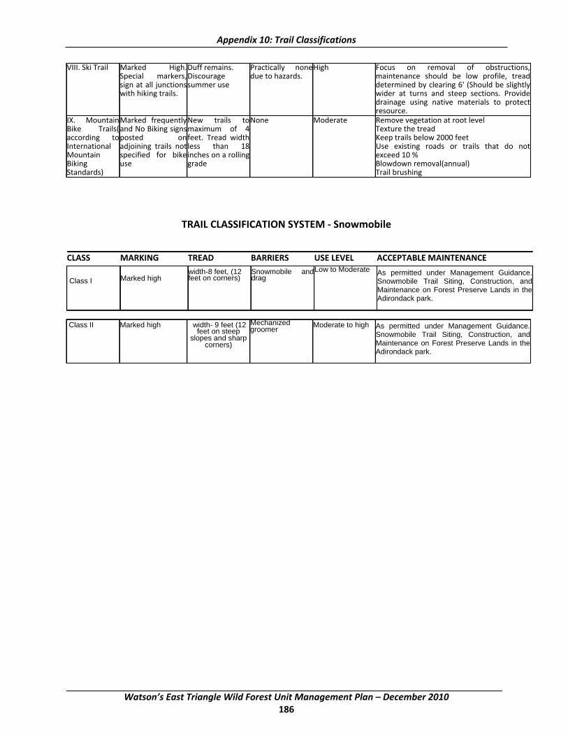
.------------.-~------.---------------.----1 -----,I
Appendix 10: Trail Classifications
VIII. Ski Trail Marked High. Duff remains. Practically none High Focus on removal of obstructions, Special markers,Discourage due to hazards. maintenance should be low profile, tread sign at all junctions summer use determined by clearing 6' (Should be slightly with hiking trails. wider at turns and steep sections. Provide
drainage using native materials to protect resource.
IX. Mountain Marked frequentlyNew trails toNone Moderate Remove vegetation at root level Bike Trails( and No Biking signsmaximum of 4 Texture the tread according to posted onfeet. Tread width Keep trails below 2000 feet International adjoining trails not less than 18 Use existing roads or trails that do not Mountain specified for bikeinches on a rolling exceed 10 % Biking use grade Blowdown removal(annual) Standards) Trail brushing
TRAIL CLASSIFICATION SYSTEM ‐ Snowmobile
CLASS MARKING TREAD BARRIERS USE LEVEL ACCEPTABLE MAINTENANCE width-8 feet, (12 Snowmobile and Low to Moderate As permitted under Management Guidance. Marked high feet on corners) drag Class I Snowmobile Trail Siting, Construction, and
I Maintenance on Forest Preserve Lands in the
I
Adirondack park.
Class II Marked high width- 9 feet (12 Mechanized Moderate to high As permitted under Management Guidance. feet on steep groomer
Snowmobile Trail Siting, Construction, and slopes and sharpcorners) Maintenance on Forest Preserve Lands in the
Adirondack park.
Watson’s East Triangle Wild Forest Unit Management Plan – December 2010 186

APPENDIX 11: Best Management Practices for State LandsInvasive Species
Applicability
These Best Management Practices (BMP’s) are intended for use by those applying for and implementing terrestrial invasive plant species management activities on State Lands under an Adopt‐A‐Natural‐Resource Agreement (AANR). The following document contains acceptable practices for control of the following four terrestrial invasive species: Purple loosestrife (Lythrum salicaria), Japanese knotweed (Polygonum cuspidatum), Common reed (Phragmites australis), Garlic mustard (Alliaria petiolata).
The following management options, should be selected with consideration for the location and size of the stands, the age of the plants, past methods used at the site, time of year, sensitive native flora within or adjacent to the target infestation, and adjoining and nearby land uses.
Other management approaches not identified here may be appropriate but must be approved by the Regional Land Manager of the NYS Department of Environmental Conservation in the region where the proposed invasive plant control activity will take place in consultation with the Adirondack Park Agency’s Director of Planning.
Within the Park there are several geographic settings (at the location of the target plant(s)) that need to be considered when determining appropriate BMP's and the regulatory instruments needed prior to their implementation. These settings and relevant action are:
1. In or within 100' of a wetland on private or public lands ‐‐ requires a general permit from the Adirondack Park Agency.
2. Forest Preserve lands ‐‐ requires an AANR from the Department of Environmental Conservation and, if wetlands are involved, an Adirondack Park Agency permit.
3. If the standing water is greater then one acre in size and/or has an outlet to surface waters, an aquatic pesticides permit is required pursuant to ECL 15‐0313(4) and 6 NYCRR 327.1 in which case application can only be made by a Certified Applicator or Technician or supervised Apprentice licensed in "Category 5 – Aquatic Vegetation Control".
GENERAL PRACTICES
1. Minimum Tools Approach – State land stewardship involving invasive plant species management practices should always incorporate the principles of the Minimum Tools Approach. Any group or individual implementing such practices on State land should only use the minimum tools, equipment, devices, force, actions or practices that will effectively reach the desired management goals. Implicit in this document is the stricture to implement a hierarchy of management practices based upon the target species and site conditions starting with the least intrusive and disruptive methods.
2. Notification ‐ The following best management practices are intended to be used only when invasive terrestrial plant species are identified on Forest Preserve lands. These management techniques are temporary activities and are implemented with the ultimate goal being protection and restoration of
Watson’s East Triangle Wild Forest Unit Management Plan – December 2010 187

Appendix 11: Best Management Practices for State Lands‐Invasive Species
native plant communities. Appropriate signage should be employed to explain the project. It may also be appropriate to issue press releases to explain the goals and techniques of the management activities.
3. Motorized Equipment – All use of motorized equipment on State lands under the jurisdiction of the DEC within the Adirondack Park shall be in compliance with Commissioner’s Policy Number 17 (CP17), and other pertinent DEC policy regarding the use of motorized equipment on Forest Preserve Lands.
4. Erosion Control ‐ Some of the methods described below require actual digging or pulling of plants from the soil. In all cases they require removal of vegetation whether or not there is actual soil disturbance. Each situation must be studied to determine if the proposed control method and extent of the action will destabilize soils to the point where erosion is threatened. Generally if more than 25 square feet of soil surface is cleared or plant removal occurs on steep slopes silt fence should be installed and maintained.
5. Revegetation ‐ All of the control methods below are aimed at reducing or eliminating invasive species so that natives are encouraged to grow and re‐establish stable conditions that are not conducive to invasive colonization. In most cases removal or reduction of invasive populations will be enough to release native species and re‐establish their dominance on a site. However, replanting or reseeding with native species may be required.
6. Herbicide Treatments ‐ The only herbicide application allowed is spot treatment to individual plants using a back pack or hand sprayer, wick applicator, cloth glove applicator, stem injection or herbicide clippers. No broadcast herbicide applications using, for example a truck mounted sprayer, are allowed. The only herbicides contemplated and approved for use are glyphosate and triclopyr. Glyphosate, in the correct formulation, may be used in situations where there is standing water including wetlands. Trichlopyr is to be used only in upland situations. In all cases all label restrictions must and shall be followed by a certified applicator in an appropriate category. The certified applicator or technician must have copies of the appropriate labels at the treatment site. Glyphosate and triclopyr are non‐selective herbicides that are applied to plant foliage or cut stems and are then translocated to the roots. The application methods described and allowed are designed to reduce or eliminate the possibility that non‐target species will be impacted by the herbicide use. All herbicide spot treatments require follow‐up inspection later in the growing season or the following year to re‐treat any individuals that were missed. Stem injections may be implemented using a large gauge needle or a specialized injection tool such as the JK Injection System (www.jkinjectiontools.com).
All herbicide mixing will be done in accordance with the label precautions and take place at a staging area (typically at a marshalling yard or a vehicle). No mixing shall take place on State lands unless at an approved location constructed for such use. Unused chemical and mixes shall be disposed of in a legal manner. No chemical or mix shall be disposed of on State lands unless at an approved location constructed for such use.
7. Sanitation ‐Management personnel must attempt to prevent invasive plant propagules from entering a treatment site or from being exported from it. Therefore, personnel must insure that their clothing including boots do not carry seeds or other propagules or weed seed infected soil clods. At the beginning of the field day personnel should inspect their clothing and boots at the staging area. Prior to leaving the treatment site personnel should conduct another inspection and remove any propagules or soil clods from their clothing or boots. Personnel must insure that all equipment used for invasive species control whether it be hand or power driven is cleaned prior to entering onto a control site and prior to leaving
Watson’s East Triangle Wild Forest Unit Management Plan – December 2010 188
Appendix 11: Best Management Practices for State Lands‐Invasive Species
the treatment site. Vehicles and equipment can be cleaned at a staging area that is distant from the control site after management activities if precautions are taken during transport to contain any propagules. This is an effort to reduce transport of plant propagules and reduce the potential for new invasive introductions. Use steam or hot water to clean equipment.
8. Material Collection and Transportation – While on the treatment site bag all cut material in heavy duty, 3 mil or thicker, black contractor quality plastic clean‐up bags. Securely tie the bags and transport from the site in a truck with a topper or cap to securely fasten the load, in order to prevent spread of the plant material from the project work site. Transport the material to a legal disposal location.
9. Composting ‐ Because of the extremely robust nature of invasive species, composting in a typical backyard compost pile or composting bin is not appropriate. However, methods can be used whereby sun‐generated heat can be used to destroy the harvested plant materials. For instance, storage in a sealed 3 mil thickness (minimum) black plastic garbage bags on blacktop in the sun until the plant materials liquefy is effective. If a larger section of blacktop is available, make a black plastic (4 mil thickness minimum) envelope sealed on the edges with sand bags. The plant material left exposed to the sun will liquefy in the sealed envelope without danger of dispersal by wind. The bags or envelopes must be monitored to make sure the plants do not escape through rips, tears or seams in the plastic. When composting is suggested later in the text it is understood that liquefying the plant material in or under plastic is the desired action; not disposal in backyard composters or open landfill composting piles.
CONTROL METHODS FOR PURPLE LOOSESTRIFE (Lythrum salicaria)
PLANT DESCRIPTION
Purple loosestrife is a wetland perennial native to Eurasia that forms large, monotypic stands throughout the temperate regions of the U.S. and Canada. It has a vigorous rootstock that serves as a storage organ, providing resources for growth in spring and regrowth if the plant has been damaged from cuttings. New stems emerge from the perennial roots enabling the plant to establish dense stands within a few years. Seedling densities can approach 10,000‐20,000 plants/m5 with growth rates exceeding 1 cm/day. A single, mature plant can produce more than 2.5 million seeds annually which can remain viable after 20 months of submergence in water. In addition, plant fragments produced by animals and mechanical clipping can contribute to the spread of purple loosestrife through rivers and lakes.
MANAGEMENT OPTIONS
1. Digging/pulling
Effectiveness: Can be effective in small stands i.e.:<100 plants, low‐med density(1‐75% area), & <3 acres, especially on younger plants in unconsolidated soils.
Methods: Hand‐pull plants <2 years old. Use mini‐tiller for plants>2 years ‐ gets most of roots w/minimum soil disturbance, has 3 heavy duty prongs on 1 side that are pushed under base of plant, then pry back on handle to leverage plant out of ground. Use weed wrench for plants > 2 years old ‐ good w/minimal soil disturbance. In mucky conditions, put base of wrench on small piece of wood (e.g.: piece of 2x4) to keep
Watson’s East Triangle Wild Forest Unit Management Plan – December 2010 189

Appendix 11: Best Management Practices for State Lands‐Invasive Species
wrench from sinking into mud. Use shovel for plants > 2 years old ‐ dig up plant, tamp down disturbed area and/or then replace soil and any existing cover.
Cautions: May increase habitat disturbance & increase spread of loosestrife. Requires follow‐up treatments of sites for 3 years to eliminate re‐sprouting from fragments left behind. Must pull/dig ENTIRE rootstock or resprouting will likely occur. Must pull/dig before the plants begin setting seed or must remove flower/seed heads first (cut into bags) to prevent spread of seeds. Also remove previous year=s dry seed heads. Erosion control may be necessary.
Disposal: Bag all plant parts & remove from site (compost at DOT Residency, dispose of in approved landfill or incinerate with appropriate permits)..
Sanitation: Clean all clothing, boots, & equipment to prevent spread of seed. See #4 under General Practices.
2. Cutting
Effectiveness: Can be effective in small stands i.e.<100 plants, low‐med density (1‐75% area), & <3 acres, especially on younger plants.
Methods: Remove flower heads before they go to seed, so seed isn=t spread when cutting or mowing. Must do repeated cutting & mulching to permit growth of grasses.
Cautions: Need to repeat for several years to reduce spread of plants. Doesn’t affect rootstalk & thus, cut pieces can be spread that will resprout. Once severed, stems are buoyant and may disperse to other areas and re‐sprout. Removal of seed heads should be done as late in the growing season as possible yet before seed set. Early cutting without additional seed head harvest could allow resprouting with greater subsequent seed production.
Disposal: Bag all plant parts & remove from site (compost at DOT Residency, dispose of in approved landfill or incinerate with appropriate permits).
Sanitation: Clean all clothing, boots, & equipment to prevent spread of seed. See #4 under General Practices.
3. Herbicide
Effectiveness: Use when>100 plants & <3‐4 acres in size.
Methods:
Watson’s East Triangle Wild Forest Unit Management Plan – December 2010 190

Appendix 11: Best Management Practices for State Lands‐Invasive Species
Use glyphosate formulations only. If possible treat seedlings before they reach 12" in height. Cut and bag flower heads before applying herbicide. Apply prior to or when in flower (late July/Aug) so plants are actively growing. For spot application use: ‐ sponge tip applicator w/wick. ‐ stem injection
Cautions: This herbicide is not selective (kills both monocots & dicots), thus should be applied carefully to prevent killing of non‐target species. All tank mixes should be mixed with clean (ideally distilled) water because glyphosate binds tightly to sediments, which reduces toxicity to plants. Do not apply in windy conditions because spray will drift and kill other plants. Do not apply if rain is forecast within 12 hours because herbicide will be washed away before it can act. Choose Glyphosate formulation for applications in standing water or along a shoreline.
4. Biocontrol
Two species of leaf‐feeding beetle, Galerucella calmariensis and G. pusilla, have been shown to be effective in controlling purple loosestrife. Over 5 million of these beetles have been released in 30 states including New York, the northeastern and midwestern states as well as all of the Canadian Provinces. The beetles have shown dramatic decreases in purple loosestrife populations with subsequent increases in populations of native species. The scientific literature indicates that the beetles are very specific to purple loosestrife with only minor Aspillover@ effects that do not compromise non‐target plant populations.
Effectiveness: Use if site has at least a half acre of purple loosestrife of medium to thick density. Best type of control for large patches of loosestrife>3‐4 acres.
Methods: The number of beetles released per site should be based on the size of the site, the density of loosestrife and the economics of purchase. More beetles are generally better than fewer.
Cautions: Use only if mowing, pesticide and herbicide use are not active practices on the site. The site must not be permanently flooded and should be sunny. Use only if winged loosestrife, (Lythrum alatum) and waterwillow (Decodon verticillatus) are not major components of the plant community on the release site. Please note that identification of winged loosestrife and waterwillow should be done by a professional botanist prior to treatment to determine if this biocontrol method is appropriate.
CONTROL METHODS FOR COMMON REED (Phragmites australis)
PLANT DESCRIPTION
Phragmites is a perennial grass that can grow to 14 feet in height. Flowering and seed set occur between July and September, resulting in a large feathery inflorescence, purple‐hued turning to tan. Phragmites is
Watson’s East Triangle Wild Forest Unit Management Plan – December 2010 191

Appendix 11: Best Management Practices for State Lands‐Invasive Species
capable of vigorous vegetative reproduction and often forms dense, virtually monospecific stands. It is unclear what proportion of the many seeds that Phragmites produces are viable. Please note that identification of phragmites should be done by a professional botanist prior to treatment to distinguish the invasive non‐native race from the non‐invasive native.
MANAGEMENT OPTIONS
1. Cutting and Pulling
Effectiveness: Need to repeat annually for several years to reduce spread of plants. Hand‐pulling, though labor intensive, is an effective technique for controlling phragmites in small areas with unconsolidated soils or sediments.
Methods: The best time to cut phragmites is when most of food reserves are in aerial portion of plant (when close to tassel stage‐e.g.: at end of July/early August to decrease plant’s vigor. Some patches may be too large to cut by hand, but repeated cutting of the perimeter of a stand can prevent vegetative expansion. Phragmites stems should be cut below the lowest leaf, leaving a 6" or shorter stump. Hand‐held cutters and gas‐powered hedge trimmers work well. Weed whackers with a circular blade were found to be particularly efficient, though dangerous.
Cautions: If cut before in tassel stage or at wrong time, stand density may increase because Phragmites is a grass. Remove cut shoots to prevent re‐sprouting and forming stolons.
Disposal: Cut or pulled material should be removed from the site and composted, land‐filled or incinerated. The harvested biomass can be disposed of onsite if the seed heads are removed and the cut stems are dispersed in an upland area.
Sanitation: Clean all clothing, boots, & equipment to prevent spread of seed. See #4 under General Practices.
2. Herbicide
Effectiveness: Herbicide use is a 2 year, 2 step process because the plants may need Atouch‐up@ application, especially in dense stands since subdominant plants are protected by thick canopy & may not receive adequate herbicide in the first application.
Methods: Use glyphosate formulations only. Cut Phragmites at waist‐height just before onset of tassel stage. Immediately squeeze/inject 5 mil of 50% solution of glyphosate into each individual, freshly‐cut stem. Secure all cut plant material, remove from site and dispose of at approved landfill or incinerator. 50% solution of glyphosate equates to a one to one mix with distilled water. After 2 to 3 weeks following application of glyphosate, cut or mow down the stalks to stimulate the emergence and growth of other
Watson’s East Triangle Wild Forest Unit Management Plan – December 2010 192

Appendix 11: Best Management Practices for State Lands‐Invasive Species
plants previously suppressed. Use spray bottle for individual foliar spot treatments or use swab or syringe w/large gauge needle or Nalgene® Unitary® wash bottle (or equivalent) to apply 1‐2 drops directly to cut stems if cutting done first, or cloth glove applicator.
Cautions: This herbicide is not selective (kills both monocots & dicots), thus should be applied carefully to prevent killing of non‐target species. All tank mixes should be mixed with clean (ideally distilled) water because glyphosate binds tightly to sediments, which reduces toxicity to plants. Do not apply in windy conditions because spray will drift and kill other plants. Do not apply if rain is forecast w/in 12 hours because herbicide will be washed away before it can act. Choose appropriate glyphosate formulation for applications in standing water or along a shoreline.
3. Plastic*
* This is a temporary use of plastic sheeting on Forest Preserve lands and should be used only if other non‐herbicide approaches are considered less effective. In any case where plastic sheeting is used on Forest Preserve lands signing should be employed to explain the project should be provided.
Effectiveness: Tarping can be effective in small stands i.e.:<100 plants, low‐med density(1‐75%area). Plants die off w/in 3‐10 days, depending on sun exposure.
Methods: Cut plants first to 6‐8" (hand clippers or loppers, hand‐pushed bush hog or weed whacker w/blade). After cutting a stand of phragmites, anchor a sheet of plastic over the cut area using sand bags or rocks. High temperatures under the plastic will eventually kill off the plants. This technique works best when the treated area is in direct sunlight. Black plastic is desirable, but clear plastic also works. Plastic should be at least 6 millimeters thick. Hold plastic in place with sandbags, rocks, etc. Can treat runners along edge w/spot application of glyphosate. Cut holes in plastic in Oct.‐ Nov. to promote germination of cattail shoots. The plastic can be removed the following year when the covered plants have been killed. A few phragmites shoots may return. These can be cut or hand‐pulled.
Cautions: Must monitor to determine if shoots are extending out from under the plastic.
Disposal: Can leave cut material under plastic or bag all plant parts & remove from site (compost at DOT Residency, dispose of in approved landfill or incinerate with appropriate permits. All plastic sheeting must be removed from State lands.
Sanitation: Clean all clothing, boots, & equipment to prevent spread of seed. See #4 under General Practices.
4. Cutting
Effectiveness: Can be effective in small stands i.e.<100 plants, low‐med density (1‐75%area) & <3 acres.
Watson’s East Triangle Wild Forest Unit Management Plan – December 2010 193

Appendix 11: Best Management Practices for State Lands‐Invasive Species
Methods: Cut just before the end of July, most of the food reserves produced that season are removed with the aerial portion of the plant reducing the plant’s vigor. This regime may eliminate a colony if carried out annually for several years. Can do after herbicides.
Sanitation: Clean all clothing, boots, & equipment to prevent spread of seed. See #4 under General Practices.
5. Pulling
Effectiveness: Can be effective in small stands i.e.<100 plants. Very labor intensive. Best with sandy soils.
Methods: Hand‐pull plants<2 years old. Use shovel for plants>2 years old‐dig up plant, then replace soil and any existing cover.
Disposal: Bag all plant parts & remove from site (compost at DOT Residency, dispose of in approved landfill or incinerate with appropriate permits).
Sanitation: Clean all clothing, boots, & equipment to prevent spread of seed. See #4 under General Practices.
6. Excavation
Effectiveness: Can be effective for patches up to 2 acre. Cost is the limiting factor.
Methods: When working in wetlands only tracked equipment shall be used. Rubber‐tired excavators can operate from adjacent pavement or upland areas. All use of motorized equipment on State lands under the jurisdiction of the DEC within the Adirondack Park shall be in compliance with Commissioner’s Policy Number 17 (CP17), and other pertinent DEC policy regarding the use of motorized equipment on Forest Preserve Lands.
Cautions: The patch should be excavated to below the depth of rhizome development. Follow‐ups later in the season or the following year must be conducted to verify that all the plants have been removed.
Disposal: Bag all plant parts & remove from site (compost at DOT Residency, dispose of in approved landfill or incinerate with appropriate permits).
Sanitation: Clean all clothing, boots, & equipment to prevent spread of seed. See #4 under General Practices.
CONTROL METHODS FOR GARLIC MUSTARD (Alliaria petiolata)
Watson’s East Triangle Wild Forest Unit Management Plan – December 2010 194

Appendix 11: Best Management Practices for State Lands‐Invasive Species
PLANT DESCRIPTION
Garlic mustard is a naturalized European biennial herb that typically invades partially shaded forested and roadside areas. It is capable of dominating the ground layer and excluding other herbaceous species. Its seeds germinate in early spring and develops a basal rosette of leaves during the first year. Garlic mustard produces white flowers between late April and June of the following spring. Plants die after producing seeds, which typically mature and disperse in August. Normally its seeds are dormant for 20 months and germinate the second spring after being formed. Seeds remain viable for up to 5 years.
MANAGEMENT OPTIONS
1. Pulling.
Effectiveness: Hand pulling is an effective method for removing small populations of garlic mustard, since plants pull up easily in most forested habitats. Plants can be pulled during most of the year. However, pulling also disturbs the soil and can increase rates of germination of buried seeds. In most cases cutting is the preferred hand control option.
Methods: Soil should be tamped down firmly after removing the plant. Soil disturbance can bring garlic mustard seeds to the surface, thus creating a favorable environment for their germination.
Cautions:
Care should be taken to minimize soil disturbance but to remove all root tissues. Re‐sprouting is uncommon but may occur from mature plants not entirely removed. Cutting is preferred to pulling due to potential for soil disturbance.
Disposal: If plants have capsules present, they should be bagged and disposed of to prevent seed dispersal. Bag all plant parts & remove from site (compost at DOT Residency, dispose of in approved landfill or incinerate with appropriate permits).
Sanitation: Clean all clothing, boots, & equipment to prevent spread of seed. See #4 under General Practices.
2. Cutting
Effectiveness: Cutting is effective for medium‐to large‐sized populations depending on available time and labor resources. Dormant seeds in the soil seed bank are unaffected by this technique due to minimal disturbance of the soil.
Methods: Cut stems when in flower (late spring/early summer) at ground level either manually (with clippers or a scythe) or with a motorized string trimmer. This technique will result in almost total mortality of existing plants and will minimize re‐sprouting.
Watson’s East Triangle Wild Forest Unit Management Plan – December 2010 195
Appendix 11: Best Management Practices for State Lands‐Invasive Species
Cautions: Cuttings should be conducted annually until the seedbank is depleted.
Disposal: Cut stems should be removed from the site when possible since they may produce viable seed even when cut. Bag all plant parts & remove from site (compost at DOT Residency, dispose in approved landfill or incinerate with appropriate permits).
Sanitation: Clean all clothing, boots, & equipment to prevent spread of seed. See #4 under General Practices.
3. Herbicide
Effectiveness: Glyphosate will not affect subsequent seedling emergence of garlic mustard or other plants.
Methods: Use glyphosate formulations only. Should be applied after seedlings have emerged, but prior to flowering of second‐year plants. Application should be by wick applicator or spray bottle for individual spot treatments.
Cautions: This herbicide is not selective (kills both monocots & dicots), thus should be applied carefully to prevent killing of non‐target species. All tank mixes should be mixed with clean (ideally distilled) water because glyphosate binds tightly to sediments, which reduces toxicity to plants. Do not apply in windy conditions because spray will drift and kill other plants. Do not apply if rain is forecast w/in 12 hours because herbicide will be washed away before it can act. Choose appropriate glyphosate formulation for applications in standing water or along a shoreline.
CONTROL METHODS FOR JAPANESE KNOTWEED (Polygonum cuspidatum)
PLANT DESCRIPTION
Japanese knotweed is an herbaceous perennial which forms dense clumps 1‐3 meters (3‐10 feet) high. Its broad leaves are somewhat triangular and pointed at the tip. Clusters of tiny greenish‐white flowers are borne in upper leaf axils during August and September. The fruit is a small, brown triangular achene. Knotweed reproduces via seed and by vegetative growth through stout, aggressive rhizomes. It spreads rapidly to form dense thickets that can alter natural ecosystems. Japanese knotweed can tolerate a variety of adverse conditions including full shade, high temperatures, high salinity, and drought. It is found near water sources, in low‐lying areas, waste places, and utility rights of way. It poses a significant threat to riparian areas, where it can survive severe floods.
MANAGEMENT OPTIONS
1. Digging
Watson’s East Triangle Wild Forest Unit Management Plan – December 2010 196
Appendix 11: Best Management Practices for State Lands‐Invasive Species
Effectiveness: This method is appropriate for very small populations.
Methods: Remove the entire plant including all roots and runners using a digging tool. Juvenile plants can be hand‐pulled depending on soil conditions and root development.
Cautions: Care must be taken not to spread rhizome or stem fragments. Any portions of the root system or the plant stem not removed will potentially re‐sprout.
Disposal: All plant parts, including mature fruit, should be bagged and disposed of in the trash to prevent re‐establishment (i.e. stockpile at DOT Residency with prior approval, dispose of in an approved landfill or incinerate with appropriate permits).
Sanitation: Clean all clothing, boots, & equipment to prevent spread of seed. See #4 under General Practices.
2. Cutting
Effectiveness: Repeated cutting may be effective in eliminating Japanese knotweed. Manual control is labor intensive, but is a good option where populations are small and isolated or in environmentally sensitive areas.
Methods: Cut the knotweed close to the ground at least 3 times a year. Plant locally prevalent native species as competitors as an alternative to continued treatment.
Cautions: This strategy must be carried out for several years to obtain success. Both mechanical and herbicidal control methods require continued treatment to prevent reestablishment of knotweed.
Disposal: Bag all plant parts & remove from site (i.e. stockpile at DOT Residency with prior approval, dispose of in an approved landfill or incinerate with appropriate permits).
Sanitation: Clean all clothing, boots, & equipment to prevent spread of seed. See #4 under General Practices.
3. Herbicide
Effectiveness: Glyphosate or trichlopyr treatments in late summer or early fall are much more effective in preventing regrowth of Japanese knotweed the following year.
Methods:
Watson’s East Triangle Wild Forest Unit Management Plan – December 2010 197
Appendix 11: Best Management Practices for State Lands‐Invasive Species
Use glyphosate or trichlopyr formulations only. Strategy: 1) Late June ‐ Cut down stalks. If stem injection is used stalks do not have to be cut. 2) Allow knotweed to regrow. 3) After August 1, implement foliar spray, cut stem swab or stem injection of knotweed with glyphosate
ndor trichlopyr. Stem injection should be below the 2 node above the ground level.
Cautions: Established stands of Japanese knotweed are difficult to eradicate even with repeated herbicide treatments. However, herbicide treatments will greatly weaken the plant and prevent it from dominating a site. Adequate control is usually not possible unless the entire stand of knotweed is treated (otherwise, it will re‐invade via creeping rootstocks from untreated areas). Empirical evidence is that trichlopyr is more effective than glyphosate in causing Japanese knotweed mortality.
These herbicides are not selective (kills both monocots & dicots), thus should be applied carefully to prevent killing of non‐target species. All tank mixes should be mixed with clean (ideally distilled) water because glyphosate binds tightly to sediments, which reduces toxicity to plants. Do not apply in windy conditions because spray will drift and kill other plants. Do not apply if rain is forecast w/in 12 hours because herbicide will be washed away before it can act. Choose appropriate glyphosate formulation for applications in standing water or along a shoreline.
Watson’s East Triangle Wild Forest Unit Management Plan – December 2010 198

APPENDIX 12: Mountain Bike Trail Standards and Guidelines
• Look for and identify control points (i.e. wetlands, rock outcrops, scenic vistas). • Avoid sensitive areas; wetlands and wherever water collects. • Keep trails below 2,000 ft. • Use existing roadways where possible that do not exceed grades of 10%. • Clear new trails to a maximum width of four feet to establish a single track route. • Keep tread width less than 18" along a rolling grade. • Remove vegetation at the root level‐ not at ground level. • Keep routes close to the contour and avoid fall lines where water is likely to flow downhill. • On side slopes, following the contour, cut full benches to construct the tread. Outsloping in this
manner helps to remove water from the trail. Vegetate backslopes. • Build flow into the trail with open and flowing designs with broad sweeping turns. • Streams should be crossed at ninety‐degree angles preferably across rock or gravel. • Bridges may be used where steep banks prevent normal stream crossings. The latter may require
an APA Wetlands Permit. • Do not construct skid berms or extensive banked turns that may accelerate erosion. • Avoid acute, sharp angle turns. • Plan trails for beginners to intermediate levels of riders. • Maintain an overall grade of 10% or less. • Allow short changes in grade to avoid obstacles. • Design grade dips to break up long, straight linear sections, and to help divert runoff from the
tread. • Monitor and inspect all trails semi‐annually. Address water problems immediately.
Watson’s East Triangle Wild Forest Unit Management Plan – December 2010 199

This page intentionally left blank
Watson’s East Triangle Wild Forest Unit Management Plan – December 2010 200
APPENDIX 13: Public Comment Summary and Responses
Comments on 2006 Draft UMP
The following is a summary of public comments received between September, 2006 and October, 2006 following the release of the Draft Watson’s East Triangle UMP. The Department received approximately 35 comments in the form of letters, e‐mails, and faxes. In addition, oral comments were received at a public meeting held on September 26, 2006 at the Beaver River Central School. The meeting was attended by 60 people with 18 making public comments. While the intent is to us actual excerpts where possible, in many cases it was necessary to condense and paraphrase. In some instances comments were too general for a specific response. Instances where public input pointed out minor factual mistakes, typos, etc. resulted in corrections or changes made directly to the plan.
General Comments regarding the content and format of the plan
1. Numerous general comments were received suggesting that no changes in uses or facilities should be made.
The goal behind the development of a UMP is to provide for management and use of Forest Preserve that conforms to the guidelines set forth in the APSLMP and is consistent with Department rules and regulations and policies. In order to accomplish this goal it is sometimes necessary to make changes in the way the public currently uses these lands. This may include proposing actions to facilitate, discourage or prohibit certain public uses.
2. Several comments received simply stated “increase in all recreational opportunities on the unit."
Forest preserve lands cannot withstand unlimited development of facilities and uses. Careful planning is necessary to insure proposals for additional opportunities do not have significant impacts on the natural resources of the area.
3. The Watson’s East triangle UMP should comply with the requirements in the APSLMP’s "UMP Development" section including required analyses, assessments and inventories.
The plan provides the required initial assessments and inventories called for in the APSLMP. Additionally the plan proposes for the assessments and inventories to be continued throughout the five year plan.
4. Management units are subunits of the whole Adirondack Park and Forest Preserve, but aren’t managed that way. Much more analysis of landscape level interactions and relationships between large wild areas should be included and relevant planning undertaken.
The APSLMP requires the development of management plans by units designated by the Department. UMPs also address the relationship between adjacent units of State lands as well as adjacent private lands.
Snowmobiling/Draft Comprehensive Snowmobile Plan (CSP)
Watson’s East Triangle Wild Forest Unit Management Plan – December 2010 201

Appendix 13: Public Comment Summary and Responses
1. Question the use of snowmobiles in Forest Preserve "protected" by the forever wild clause of the NYS Constitution, wondering how the word "wild" is being interpreted. The APSLMP allows snowmobile trails in units classified as Wild Forest. See pages 32‐38 of the APSLMP .
2. The DEC should be conducting an analysis of the current environmental impacts of snowmobiling and no expansion of the current system should be undertaken until this analysis is complete and made public. Environmental impacts caused by snowmobiles include air emissions and impacts to the natural soundscape.
Detailed data regarding all potential impacts for any particular recreational activity is beyond the scope of an individual plan. General information on snowmobile impacts can be found in the plan, under the headings, Physical, Biological, and Social. A cushion of snow tends to prevent resource degradation when snowmobile trails are covered, with land resource impacts generally minor.
3. Do not support a new snowmobile trail from Wolf Pond to the Number One Road. The proposed snowmobile route will lead to additional illegal trespass into the Five Ponds Wilderness Area.
The proposed route from Wolf pond north to the existing trail network utilizes old woods roads for much of the route. No additional routes could be located that avoided impacting streams and wetlands to provide this connection. Trespass is an enforcement issue and the plan proposes continued and additional enforcement to prevent illegal uses.
4. DEC mentions the "sound environment," but the DEC does not seem interested in protecting the valuable resource of natural sound. This is important not just for people, but for the wildlife that has to communicate and survive by using it. Some wildlife can get used to steady noise and moving vehicles on a highway, but in the case of backcountry, in winter, especially at night when most mammals have to do their hunting and birds are sleeping, the bouncing lights, noise, smell of snowmobiles must be terrifying to animals not subjected to them until this already stressful time. Deer yards are given some consideration (the SLMP says they should be avoided by snowmobile trails) but there are a host of other animals and birds, listed in this same document, which must be impacted by snowmobile sound, smell, speed, snow compaction, and pollution.
The impacts of loud sounds and artificial light on wildlife are difficult to measure and predict, and different species likely react differently to these stimuli. While individuals of a given species may respond behaviorally and/or physiologically to these stimuli, a population‐level response is unlikely.
Law Enforcement
1. Numerous comments suggested that existing illegal motor vehicle use requires increased Department Law enforcement presence.
If deemed necessary, the Watson’s East Triangle Unit will be given a higher priority for routine patrol and enforcement efforts. If these steps do not adequately control inappropriate use, DEC will re‐evaluate the need for additional more stringent regulations or further actions.
Watson’s East Triangle Wild Forest Unit Management Plan – December 2010 202

Appendix 13: Public Comment Summary and Responses
Motor Vehicles/All Terrain Vehicles (ATVs)
1. Incorporate a description and discussion of the two latest DEC policies on roads and ATV use.
The plan was amended to include general information about these two policies.
2. This plan does not address the needs of ATV riders and other 4‐wheel drive vehicles who are unfairly excluded from accessing state lands, even on seasonal roadways, in spite of their registration fees paid and willingness to participate in discussion on this subject.
Refer to previous answer regarding DEC policies on roads and ATV use.
3. DEC is giving way too much consideration to motorized access, facilitating illegal motor vehicle use of the Forest Preserve.
The plan proposes the closure of several roads within the unit and the continued use of existing motor vehicle roads for access to Department programs. Additionally, the plan calls for careful monitoring of motor vehicle use and the implementation of additional measures to prevent illegal use.
4. Supports the decision to close roads to ATV use but questions if DEC is attempting to implement draft ATV Policy through UMP.
The discussion on ATV use outlines what is permissible currently under the APSLMP, V&T Law and Easement agreements.
5. Restoration of damaged areas including Massawepie Pond Trail, Desert Pond Camp Trail, Grassy Pond Trail, Upper South Pond Trail, Number One Trail Road, Mullins Flow Road, Steam Sleigh Trail, Wolf Pond Road and Tied Lake Road.
Desert Pond Camp Trail is a private ROW and not open for public motor vehicle use. Grassy Pond and Upper South Ponds Trails are not within this unit but are located within the Five Ponds Wilderness Area. Of the remaining trails and roads within the WETWF only the Steam Sleigh Trail and Number One Camp Trail show signs of degradation. The plan calls for restoration of the Steam Sleigh trail and the closure of the Number One Camp Trail.
6. Support the use of ATVs on easement lands.
The future use of ATVs on easement lands will be guided by the Departments final ATV Policy.
7. The prohibition of ATVs on Forest Preserve lands needs to be codified in Law and regulation. This is best accomplished through a Park‐wide regulation and not on a unit by unit basis.
8. DEC should dedicate increased funding for enforcement of road closures to ATV use.
The plan supports the continuation of increased enforcement as has been occurring since roads were closed to ATV use in 2004.
9. Disagree with the proposed resurfacing of the Bear Pond Road and Main haul Road.
These roads provide the primary access to this unit as well as adjoining units, resurfacing is required to provide for safe public access.
Watson’s East Triangle Wild Forest Unit Management Plan – December 2010 203
Appendix 13: Public Comment Summary and Responses
10. Keep the Deep Cuts Road open farther to the south to allow better access to the West Branch of the Oswegatchie River.
The deep Cuts Road will remain open to the vicinity of the existing tent site. This is where the public has been allowed to drive since the State took acquisition of the property.
11. Do not restrict parking to designated parking areas only. Many sportsmen park along the roadside near the areas they are accessing.
Parking along roadsides will not be prohibited.
12. Oppose the closing of the Buck Pond Road.
The plan proposes a new leanto at Buck Pond and to maintain an Adirondack leanto experience it should not be accessible by motor vehicle. The existing road will be converted into an accessible trail for the .25 mile distance from the parking area to the pond.
13. The bridge over the Middle Branch of the Oswegatchie should be replaced to allow access to the Aldrich Pond Wild Forest.
This bridge was replaced in 2005.
Camping
1. A full assessment of all campsites should have been completed as part of this draft UMP in order to comply with the SLMP.
The existing campsites were recently assessed utilizing the campsite assessment procedures found in Appendix 17 of the plan. All existing sites were condition class 1.
2. The State should consider leasing one acre lots for hunting camps along the Bear Pond Road.
Article XIV of the New York State Constitution prohibits the leasing of State Forest Preserve lands. However, DEC can and does issue permits for setting up temporary hunting camps during the fall hunting season.
Wildlife
1. Although the SLMP calls for reintroduction of extirpated species when feasible, nothing is said here about trying to fulfill this requirement.
Reintroduction of extirpated species would likely not be limited to any single Forest Preserve unit. Rather, ecological and sociological factors would be considered over a larger scale to determine the feasibility of any reintroduction effort.
Other comments
1. The unit should be reclassified as part of the Bob Marshall Great Wilderness.
Classification and reclassification of state lands is undertaken by the Adirondack Park Agency.
Watson’s East Triangle Wild Forest Unit Management Plan – December 2010 204

Appendix 13: Public Comment Summary and Responses
2. Better and more complete ecological inventories are needed. These should include mapping natural communities, botanical and entomological inventories and monitoring for invasive species.
The plan supports and proposes to continue the inventorying of all ecological communities within the unit, and it is possible some of this work may be done within the next year by Natural Heritage.
3. Any relatively unspoiled lands that go on the market should be acquired and added to the Forest Preserve. The State should work to acquire from Lassiter the remaining development rights on unprotected lands adjacent to, or near enough to impact, the Forest preserve. The State should acquire, and retire, private right of ways (ROWs) over public lands.
State acquisitions are guided by the Open Space Plan.
4. Additional hiking trails should be designated from the Bear Pond Road into the Five Ponds Wilderness.
These would need to be addressed in the revision of the UMP for the Five Ponds Wilderness Area. The 1994 UMP for Five Ponds recommended a bridge and trail be constructed from adjacent unclassified lands across the Middle Branch at the former Upper South Pond Road with connections to Sand Pond and Upper South Pond. This bridge and route has not yet been constructed.
5. There should be a parking area and canoe access to the Middle Branch of the Oswegatchie.
A new parking area is proposed at the intersection of the Bear Pond Road and South Ponds Trail for this purpose.
6. Additional information on the economic value of conservation easements is needed. This should include harvest information, estimated stumpage value, basal area at time of purchase and at time of plan and age‐class diversification.
Much of this information is proprietary and is unavailable.
7. Does not support the expansion of the Kelly Pond Road gravel pit, but calls for its earliest closure and restoration without the proposed removal of nearly 400 trees.
The plan proposes to close and restore the Parquet Hill pit, which is immediately adjacent to the Bear Pond Road. Restoration of this site, as called for in the SLMP, would require the proposed tree removal in order to eventually restore the area to a natural condition. Similar sites which have been closed and attempted to minimize any tree cutting still resemble gravel mines and likely always will. The goal for this proposal is to eliminate the appearance of the mine ever existing.
8. There is a lack of access to the portion of the unit north of Mud Pond and west of Bald Mountain Road.
There is an existing foot trail on the Lassiter Easement that provides access to this area.
9. With actions and activities that may adversely affect the ecological integrity and wild character of the Park, careful assessments should be conducted before they are assumed to be legitimate uses of the Forest Preserve. Carrying capacity analyses should carefully answer such questions as, is the road density higher than that which is compatible with healthy populations of all native species, and if so what is a compatible road density?; Are hunting and trapping levels ecologically sustainable?; What trails are suffering from erosion?; What levels of exhaust emissions from snowmobiles and other motor vehicles begin to diminish air and water quality?; What noise levels disturb wildlife?
Watson’s East Triangle Wild Forest Unit Management Plan – December 2010 205
Appendix 13: Public Comment Summary and Responses
The plan proposes the use of the Limits of Acceptable Change (LAC) process for determining what levels of various types of uses are compatible and ecologically acceptable within the unit. Monitoring of resource conditions and use levels is proposed in the plan as a means to begin answering these questions. However, these actions require an investment of time and resources to complete, which the plan proposes and supports.
10. DEC’s negative declaration in the State Environmental Quality Review Act (SEQRA) Requirements section is woefully inadequate. A careful environmental assessment of the proposed Wolf Pond to Number One Road snowmobile trail and the Mud Pond Dam reconstruction are needed.
DEC determined that the relocation of the existing Number One Trail to the proposed Wolf Pond route will result in an overall positive environmental impact, as the existing trail impacts several wetlands where as the proposed route does not. Additionally, the proposed relocation will result in a net loss of snowmobile trail mileage within the unit. The reconstruction of the Mud Pond Dam will result in the maintenance of the existing aquatic communities created by the dam.
11. More specific tax information should be provided for the unit. This information should also be tracked over time to assess trends in Forest Preserve taxes paid.
A management action has been added to develop a system to accomplish this task.
12. There should be more opportunities for non‐motorized outdoor recreation activities.
The plan proposes new hiking trails to Rainbow Falls and Bald Mountain as well as the designation of roads and trails for mountain bike use.
13. Consider restricting motor boats to either low horsepower or electric motors and not banning them completely.
Water bodies within the unit are generally quite small and restricting the use of motors on them is appropriate.
Comments on the River Area Management Plans
On October 1, 2010 a public meeting was held at the Lowville DEC office regarding the addition of River Area Management Plans for the Middle and West Branches of the Oswegatchie Rivers to this UMP. Two persons attended with one submitting a written comment letter. One additional comment letter was received via email. The following is a summary and response to comments received.
1. Concerned with rerouting the Bald to Buckhorn trail to within 500 feet of the West Branch.
The Plan proposes to relocate a section of this trail that is currently within 1‐20 feet of the river to a location that is approximately 500 feet away from the river.
2. Upgrade the section of the West Branch of the Oswegatchie River in the Pepperbox Wilderness to wild status.
The river area plan included within this larger UMP addresses only the river area within the WETWF. As the boundary for the Pepperbox Wilderness is the north bank of the river, placing the river itself in the Wilderness area, the planning team feels any proposal to reclassify the river designation should be done in conjunction with the Pepperbox UMP.
Watson’s East Triangle Wild Forest Unit Management Plan – December 2010 206

Appendix 13: Public Comment Summary and Responses
3. Phase out motorized uses in river corridors, to reduce noise and water pollution and harassment of wildlife and spread of invasive species.
During the development of the UMP for the WETWF all roads were assessed to determine, first if they provided access to programs that was needed, and second if there were any resource impacts associated with each road. In some cases the plan proposes closing roads or road sections to eliminate impacts. Examples of roads being closed due to impacts on river areas include, River Road, Mullins Flow Road, and parts of the Wolf Creek Roads.
4. Recommend that language be included to specifically address the protection and advancement of native strains of brook trout and their actual and potential spawning areas.
The concern is addressed in the Fisheries Management section of the WETWF UMP.
5. The public comment period ends the same day as the public hearing, allowing little time to formulate comments.
Article 15, Title 27. Part 666 requires the Department to conduct a public hearing regarding the proposed river area plan. It does not, however, require any public comment period. In an effort to more fully involve stakeholders, the Department decided to accept comments on the river plans.
Watson’s East Triangle Wild Forest Unit Management Plan – December 2010 207

This page intentionally left blank
Watson’s East Triangle Wild Forest Unit Management Plan – December 2010 208

APPENDIX 14: Unit Maps
Watson’s East Triangle Wild Forest Unit Management Plan – December 2010 209
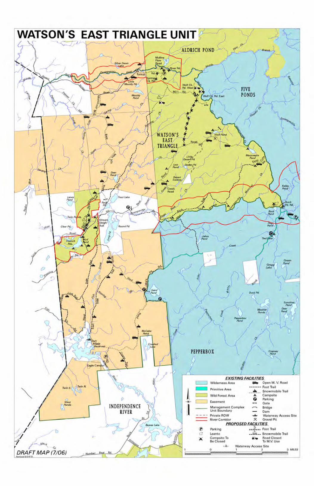
WATSON'S EAST TRIANGLE UNIT
l(, ~~)
"' .....L _,, ( ve, Dawn ,,...-;
(. -( ' . .. le,.
~ l I I
\ ~
\ .J
I
0
INDEPENDENCE RIVER
\ ~ iL
v I.
J-,Ulo"\ ,( ~
DRAFT MAP (7/06)
JALDRICH POND -"--
EXISTING FAC,ILITJES c::=J Wilderness Area liiilit, Open M. V. Road
! t::::J ............... Foot Trail Primitive Area
~... Snow mobile Trail ~ Wild Forest Area A Campsite
Q Parking - N - i==J Easement Gau1
__ Management Complex - Br;dgo
fl Unit Boundary Oam
==: - - - " Private ROW ....... Wsterway Access Site River Corr1dor ~ Gravel Pit
PROPOSEDELJ(;JJ.IIIES (f) Parking .,.,}!...~ Fool Trail ('.]' Leanto --~ -- Snowmobile Trail X Compoitc To t :• Rood Cloocd
Be Closed To M.V. Use
~ Waterway Ac:cB6s Site I 0 I 2 3 MILES
bw mzzr rn '

~
WATSON EAST TRIANGLE- --=--
.. " \
. r . ,., ••
,.
i~~ ...... t~~ ~
. .\L-~~.~-\_~~~u~:-~Zl
() Pepperbox
Pond
EXISTING FACILITIES c=J Wilderness Area c=J Easement
c=J Primitive Area Management Complex
c=J Wild Forest Area Unit Boundary
HYDROLOGYWatershed Megawetlands Boundary Boundary
c:::::::J Wetlands
NYS DESIGNATED RIVERS eeeee Wild • • • • • Scenic
TRAILS
Road Pr ivate ROW
Foot Trail0 3 MILES
~ffiWN0G®o®fflMOiWRR'BliruJ™MIDNYWm~
I • ff '·-, ·tr ~ ~-1
MAP (7/ 06) DRAFT
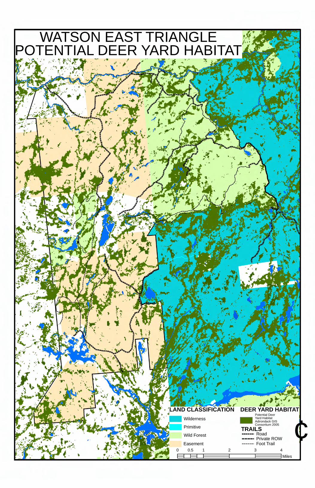
' .. '-r ·.l
I
- ' ..
.I-. . .. '. . . . ' .II
~t~ L:r• • , ;i,. .....
__ ..i .
. ' ·:·i
.., .. .. ...
-
WATSON EAST TRIANGLE POTENTIAL DEER YARD HABITAT
LAND CLASSIFICATION DEER YARD H ABITAT Potential Deer
Wilderness Y a rd ro H
i n d a bitat
Ad a c k GIS
Primitive Consortium 2005 TRAILS Wild Forest --===-· Road
===== Private ROW Easement Foot Trail
¢ 0 0.5 1 2 3 4
Fl Miles

.....
·, .l. -., . . . ·+- ......
""" .... .lri( ... "" '
I.
1 . ~--""' . , ... ---... .:. I .. ; ... ,,
I
, ... I
""./ I
I
' / ,
./
...
WATSON EAST TRIANGLE SPRUCE GROUSE HABITAT
LAND CLASSIFICATION SPRUCE GROUSE HABITAT Potential Spruce Grouse Habitat
Wilderness Adirondack GIS Consortium 2005
Primitive TRAILS Wild Forest
---===-· Road ===== Private ROW
Easement Foot Trail ¢
0 0.5 1 2 3 4 Fl Fl Miles