threerivers yes commingling application) no · location at surface 1475€fsl€€€1237€fwl€...
TRANSCRIPT

RECEIVED: August 21, 2013
STATE OF UTAHDEPARTMENT OF NATURAL RESOURCES
DIVISION OF OIL, GAS AND MINING
APPLICATION FOR PERMIT TO DRILL 1. WELL NAME and NUMBER
Three Rivers Federal 3-23-820
2. TYPE OF WORK
DRILL NEW WELL REENTER P&A WELL DEEPEN WELL 3. FIELD OR WILDCAT
THREE RIVERS
4. TYPE OF WELLOil Well Coalbed Methane Well: NO
5. UNIT or COMMUNITIZATION AGREEMENT NAME
6. NAME OF OPERATORAXIA ENERGY LLC
7. OPERATOR PHONE720 746-5200
8. ADDRESS OF OPERATOR1430 Larimer Ste 400, Denver, CO, 80202
9. OPERATOR [email protected]
10. MINERAL LEASE NUMBER(FEDERAL, INDIAN, OR STATE)
UTU85994
11. MINERAL OWNERSHIP
FEDERAL INDIAN STATE FEE 12. SURFACE OWNERSHIP
FEDERAL INDIAN STATE FEE
13. NAME OF SURFACE OWNER (if box 12 = 'fee')
14. SURFACE OWNER PHONE (if box 12 = 'fee')
15. ADDRESS OF SURFACE OWNER (if box 12 = 'fee')
16. SURFACE OWNER E-MAIL (if box 12 = 'fee')
17. INDIAN ALLOTTEE OR TRIBE NAME(if box 12 = 'INDIAN')
18. INTEND TO COMMINGLE PRODUCTION FROMMULTIPLE FORMATIONS
YES (Submit Commingling Application) NO
19. SLANT
VERTICAL DIRECTIONAL HORIZONTAL
20. LOCATION OF WELL FOOTAGES QTR-QTR SECTION TOWNSHIP RANGE MERIDIAN
LOCATION AT SURFACE 1475 FSL 1237 FWL NWSW 3 8.0 S 20.0 E S
Top of Uppermost Producing Zone 1980 FSL 1980 FWL NESW 3 8.0 S 20.0 E S
At Total Depth 1980 FSL 1980 FWL NESW 3 8.0 S 20.0 E S
21. COUNTYUINTAH
22. DISTANCE TO NEAREST LEASE LINE (Feet)1237
23. NUMBER OF ACRES IN DRILLING UNIT40
25. DISTANCE TO NEAREST WELL IN SAME POOL(Applied For Drilling or Completed)
40
26. PROPOSED DEPTHMD: 7111 TVD: 6955
27. ELEVATION - GROUND LEVEL
4745
28. BOND NUMBER
UTB000464
29. SOURCE OF DRILLING WATER /WATER RIGHTS APPROVAL NUMBER IF APPLICABLE
43-10988
Hole, Casing, and Cement Information
String Hole Size Casing Size Length Weight Grade & Thread Max Mud Wt. Cement Sacks Yield Weight
Surf 11 8.625 0 - 1000 24.0 J-55 LT&C 8.7 Premium Lite High Strength 120 2.97 11.5
Class G 115 1.16 15.8
Prod 7.875 5.5 0 - 7111 17.0 J-55 LT&C 9.2 Light (Hibond) 165 3.78 10.5
Premium Lite High Strength 330 2.31 12.0
ATTACHMENTS
VERIFY THE FOLLOWING ARE ATTACHED IN ACCORDANCE WITH THE UTAH OIL AND GAS CONSERVATION GENERAL RULES
WELL PLAT OR MAP PREPARED BY LICENSED SURVEYOR OR ENGINEER COMPLETE DRILLING PLAN
AFFIDAVIT OF STATUS OF SURFACE OWNER AGREEMENT (IF FEE SURFACE) FORM 5. IF OPERATOR IS OTHER THAN THE LEASE OWNER
DIRECTIONAL SURVEY PLAN (IF DIRECTIONALLY OR HORIZONTALLY DRILLED) TOPOGRAPHICAL MAP
NAME Don Hamilton TITLE Permitting Agent (Buys & Associates, Inc) PHONE 435 719-2018
SIGNATURE DATE 08/12/2013 EMAIL [email protected]
API NUMBER ASSIGNED
43047539530000
Permit Manager
APPROVAL
FORM 3
AMENDED REPORT
API Well Number: 43047539530000
CONFIDE
NTIAL
API Well Number: 43047539530000
FORM 3STATE OF UTAH
DEPARTMENTOF NATURALRESOURCES AMENDEDREPORTDIVISION OF OIL, GAS AND MINING
APPLICATION FOR PERMIT TO DRILL 1. WELL NAME ae R
veEsRFederal3-23-820
2. TYPE OF WORK 3. FIELD OR WILDCATDRILLNEWWELL REENTER P&AWELL DEEPEN WELLI THREE RIVERS
4. TYPE OF WELL 5. UNIT or COMMUNITIZATION AGREEMENT NAMEOil Well Coalbed Methane Well: NO
6. NAME OF OPERATOR 7. OPERATOR PHONEAXIAENERGY LLC 720 746-5200
8. ADDRESS OF OPERATOR 9. OPERATOR E-MAIL1430 Larimer Ste 400, Denver, CO, 80202 [email protected]
10. MINERAL LEASE NUMBER 11. MINERAL OWNERSHIP 12. SURFACE OWNERSHIP(FEDERAL,INDIAN,ORSTE)85994 FEDERAL INDIANISTATE FEE FEDERAL INDIAN STATE FEEI
13. NAME OF SURFACE OWNER (if box 12 = 'fee') 14. SURFACE OWNER PHONE (if box 12 = 'fee')
15. ADDRESS OF SURFACE OWNER (if box 12 = 'fee') 16. SURFACE OWNER E-MAIL (if box 12 = 'fee')
17. INDIAN ALLOTTEE OR TRIBE NAME 18. INTEND TO COMMINGLE PRODUCTION FROM 19. SLANT
(if box 12 = 'INDIAN')MULTIPLE FORMATIONS
YES (Submit Commingling Application) NO VERTICAL DIRECTIONAL HORIZONTAL
20. LOCATION OF WELL FOOTAGES QTR-QTR SECTION TOWNSHIP RANGE MERIDIAN
LOCATION ATSURFACE 1475 FSL 1237 FWL NWSW 3 8.0 S 20.0 E S
Top of Uppermost Producing Zone 1980 FSL 1980 FWL NESW 3 8.0 S 20.0 E S
At Total Depth 1980 FSL 1980 FWL NESW 3 8.0 S 20.0 E S
21. COUNTY 22. DISTANCE TO NEAREST LEASE LINE (Feet) 23. NUMBER OF ACRES IN DRILLING UNITUINTAH 1237 40
25. DISTANCE TO NEAREST WELL IN SAME POOL 26. PROPOSED DEPTH(Applied For Drilling or Completed) MD: 7111 TVD: 6955
40
27. ELEVATION - GROUND LEVEL 28. BOND NUMBER 29. SOURCE OF DRILLING WATERIWATER RIGHTS APPROVAL NUMBER IF APPLICABLE
4745 UTBOOO464 43-10988
Hole, Casing, and Cement Information
Hole Size Casing Size Length Weight Grade & Thread Max Mud Wt. Cement Sacks Yield Weight
11 8.625 0 - 1000 24.0 J-55 LT&C 8.7 Premium Lite High Strength 120 2.97 11.5
Class G 115 1.16 15.8
7.875 5.5 0 - 7111 17.0 J-55 LT&C 9.2 Light (Hibond) 165 3.78 10.5
Premium Lite High Strength 330 2.31 12.0
ATTACHMENTS
VERIFY THE FOLLOWING ARE ATTACHED IN ACCORDANCE WITH THE UTAH OIL AND GAS CONSERVATION GENERAL RULES
WELL PLATOR MAP PREPARED BY LICENSED SURVEYOR OR ENGINEER COMPLETE DRILLING PLAN
AFFIDAVIT OF STATUS OF SURFACE OWNER AGREEMENT(IF FEE SURFACE) FORM 5. IF OPERATOR IS OTHER THAN THE LEASE OWNER
DIRECTIONAL SURVEY PLAN (IF DIRECTIONALLYOR HORIZONTALLY DRILLED) TOPOGRAPHICAL MAP
NAME Don Hamilton TITLE Permitting Agent (Buys & Associates, Inc) PHONE 435 719-2018
SIGNATURE DATE 08/12/2013 EMAIL [email protected]
API NUMBER ASSIGNED APPROVAL43047539530000
Permit Manager
RECEIVED: August 21,
RECEIVED: August 12, 2013
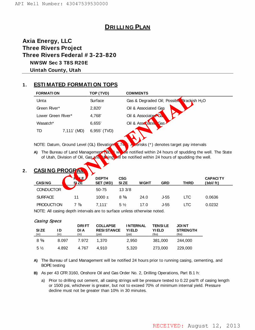
DRILLING PLAN
Axia Energy, LLC Three Rivers Project Three Rivers Federal #3-23-820
NWSW Sec 3 T8S R20E Uintah County, Utah
1. ESTIMATED FORMATION TOPS FORMATION TOP (TVD) COMMENTS
Uinta Surface Gas & Degraded Oil; Possible Brackish H2O
Green River* 2,820’ Oil & Associated Gas
Lower Green River* 4,768’ Oil & Associated Gas
Wasatch* 6,655’ Oil & Associated Gas
TD 7,111’ (MD) 6,955’ (TVD)
NOTE: Datum, Ground Level (GL) Elevation: 4,745’; Asterisks (*) denotes target pay intervals
A) The Bureau of Land Management (BLM) will be notified within 24 hours of spudding the well. The State of Utah, Division of Oil, Gas and Mining will be notified within 24 hours of spudding the well.
2. CASING PROGRAM
CASING HOLE SIZE
DEPTH SET (MD)
CSG SIZE WGHT GRD THRD
CAPACITY (bbl/ft)
CONDUCTOR 50-75 13 3/8
SURFACE 11 1000 ± 8 ⅝ 24.0 J-55 LTC 0.0636
PRODUCTION 7 ⅞ 7,111’ 5 ½ 17.0 J-55 LTC 0.0232 NOTE: All casing depth intervals are to surface unless otherwise noted.
Casing Specs
SIZE ID DRIFT DIA
COLLAPSE RESISTANCE
INTERNAL YIELD
TENSILE YIELD
JOINT STRENGTH
(in) (in) (in) (psi) (psi) (lbs) (lbs)
8 ⅝ 8.097 7.972 1,370 2,950 381,000 244,000
5 ½ 4.892 4.767 4,910 5,320 273,000 229,000
A) The Bureau of Land Management will be notified 24 hours prior to running casing, cementing, and BOPE testing
B) As per 43 CFR 3160, Onshore Oil and Gas Order No. 2, Drilling Operations, Part B.1 h:
a) Prior to drilling out cement, all casing strings will be pressure tested to 0.22 psi/ft of casing length or 1500 psi, whichever is greater, but not to exceed 70% of minimum internal yield. Pressure decline must not be greater than 10% in 30 minutes.
API Well Number: 43047539530000
CONFIDE
NTIAL
API Well Number: 43047539530000
DRILLING PLAN
Axia Energy, LLCThree Rivers ProjectThree Rivers Fecleral #3-23-820
NWSW Sec 3 TSS R20EUintah County, Utah
1. ESTIMATED FORMATION TOPSFORMATION TOP (TVD) COMMENTS
Uinta Surface Gas & Degraded Oil; Possible Brackish H2OGreen River* 2,820' Oil&Associated GasLower Green River* 4,768' Oil&Associated GasWasatch* 6,655' Oil&Associated GasTD 7,111' (MD) 6,955' (TVD)
NOTE: Datum, Ground Level (GL) Elevation: 4,745'; Asterisks (*)denotes target pay intervals
A) The Bureau of Land Management (BLM)will be notified within 24 hours of spudding the well. The Stateof Utah, Division of Oil,Gas and Mining will be notifiedwithin 24 hours of spudding the well.
2. CASING PROGRAMHOLE DEFTH CSG CAPACITY
CASING SIZE SET (MD) SIZE WGHT GRD THRD (bbl/ft)
CONDUCTOR 50-75 13 3/8SURFACE 11 1000 ± 8 ¾ 24.0 J-55 LTC 0.0636
PRODUCTION 7 ½ 7,111' 5 ½ 17.0 J-55 LTC 0.0232NOTE: Allcasing depth intervals are to surface unless otherwise noted.
Casing SpecsDRIFT COLLAPSE INTERNAL TENSILE JOINT
SIZE ID DIA RESISTANCE YIELD YIELD STRENGTH(in) (in) (in) (psi) (psi) (Ibs) (Ibs)
8 ¾ 8.097 7.972 1,370 2,950 381,000 244,000
5 ½ 4.892 4.767 4,910 5,320 273,000 229,000
A) The Bureau of Land Management will be notified 24 hours prior to running casing, cementing, andBOPE testing
B) As per 43 CFR 3160, Onshore Oiland Gas Order No. 2, Drilling Operations, Part B.1 h:
a) Prior to drillingout cement, all casing strings will be pressure tested to 0.22 psi/ft of casing lengthor 1500 psi, whichever is greater, but not to exceed 70% of minimum internal yield. Pressuredecline must not be greater than 10% in 30 minutes.
RECEIVED: August 12,
API Well Number: 43047539530000
DRILLING PLAN
Axia Energy, LLCThree Rivers ProjectThree Rivers Fecleral #3-23-820
NWSW Sec 3 TSS R20EUintah County, Utah
1. ESTIMATED FORMATION TOPSFORMATION TOP (TVD) COMMENTS
Uinta Surface Gas & Degraded Oil; Possible Brackish H2OGreen River* 2,820' Oil&Associated GasLower Green River* 4,768' Oil&Associated GasWasatch* 6,655' Oil&Associated GasTD 7,111' (MD) 6,955' (TVD)
NOTE: Datum, Ground Level (GL) Elevation: 4,745'; Asterisks (*)denotes target pay intervals
A) The Bureau of Land Management (BLM)will be notified within 24 hours of spudding the well. The Stateof Utah, Division of Oil,Gas and Mining will be notifiedwithin 24 hours of spudding the well.
2. CASING PROGRAMHOLE DEFTH CSG CAPACITY
CASING SIZE SET (MD) SIZE WGHT GRD THRD (bbl/ft)
CONDUCTOR 50-75 13 3/8SURFACE 11 1000 ± 8 ½ 24.0 J-55 LTC 0.0636
PRODUCTION 7 ½ 7,111' 5 ½ 17.0 J-55 LTC 0.0232NOTE: Allcasing depth intervals are to surface unless otherwise noted.
Casing SpecsDRIFT COLLAPSE INTERNAL TENSILE JOINT
SIZE ID DIA RESISTANCE YIELD YIELD STRENGTH(in) (in) (in) (psi) (psi) (Ibs) (Ibs)
8 ½ 8.097 7.972 1,370 2,950 381,000 244,000
5 ½ 4.892 4.767 4,910 5,320 273,000 229,000
A) The Bureau of Land Management will be notified 24 hours prior to running casing, cementing, andBOPE testing
B) As per 43 CFR 3160, Onshore Oiland Gas Order No. 2, Drilling Operations, Part B.1 h:
a) Prior to drillingout cement, all casing strings will be pressure tested to 0.22 psi/ft of casing lengthor 1500 psi, whichever is greater, but not to exceed 70% of minimum internal yield. Pressuredecline must not be greater than 10% in 30 minutes.
RECEIVED: August 12,
RECEIVED: August 12, 2013
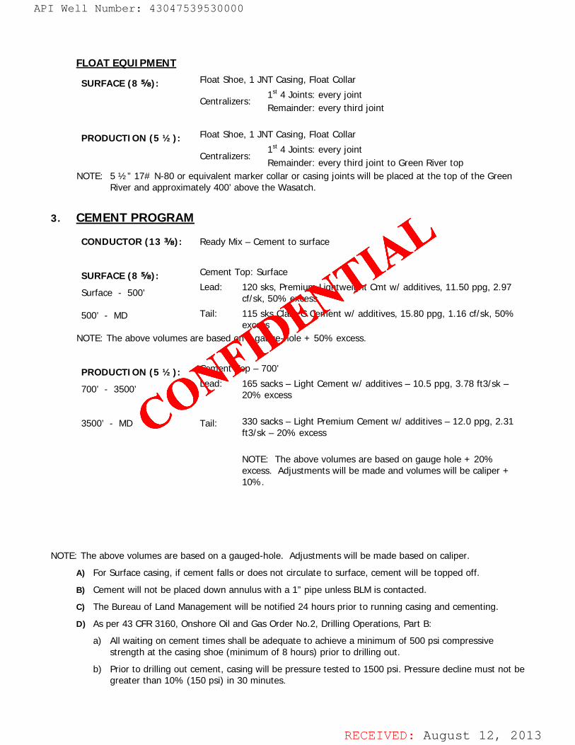
FLOAT EQUIPMENT
SURFACE (8 ⅝): Float Shoe, 1 JNT Casing, Float Collar
Centralizers: 1st 4 Joints: every joint Remainder: every third joint
PRODUCTION (5 ½): Float Shoe, 1 JNT Casing, Float Collar
Centralizers: 1st 4 Joints: every joint Remainder: every third joint to Green River top
NOTE: 5 ½” 17# N-80 or equivalent marker collar or casing joints will be placed at the top of the Green River and approximately 400’ above the Wasatch.
3. CEMENT PROGRAM
CONDUCTOR (13 ⅜): Ready Mix – Cement to surface
SURFACE (8 ⅝):
Surface - 500’ 500’ - MD
Cement Top: Surface
Lead: 120 sks, Premium Lightweight Cmt w/ additives, 11.50 ppg, 2.97 cf/sk, 50% excess
Tail: 115 sks Class G Cement w/ additives, 15.80 ppg, 1.16 cf/sk, 50% excess
NOTE: The above volumes are based on a gauge-hole + 50% excess.
PRODUCTION (5 ½):
700’ - 3500’ 3500’ - MD
Cement Top – 700’
Lead: Tail:
165 sacks – Light Cement w/ additives – 10.5 ppg, 3.78 ft3/sk – 20% excess 330 sacks – Light Premium Cement w/ additives – 12.0 ppg, 2.31 ft3/sk – 20% excess NOTE: The above volumes are based on gauge hole + 20% excess. Adjustments will be made and volumes will be caliper + 10%.
NOTE: The above volumes are based on a gauged-hole. Adjustments will be made based on caliper.
A) For Surface casing, if cement falls or does not circulate to surface, cement will be topped off.
B) Cement will not be placed down annulus with a 1” pipe unless BLM is contacted.
C) The Bureau of Land Management will be notified 24 hours prior to running casing and cementing.
D) As per 43 CFR 3160, Onshore Oil and Gas Order No.2, Drilling Operations, Part B:
a) All waiting on cement times shall be adequate to achieve a minimum of 500 psi compressive strength at the casing shoe (minimum of 8 hours) prior to drilling out.
b) Prior to drilling out cement, casing will be pressure tested to 1500 psi. Pressure decline must not be greater than 10% (150 psi) in 30 minutes.
API Well Number: 43047539530000
CONFIDE
NTIAL
API Well Number: 43047539530000
FLOAT EQUIPMENT
SURFACE (8 ¾): Float Shoe, 1 JNT Casing, Float Collar.
1* 4 Joints: every jointCentralizers:Remainder: every thirdjoint
PRODUCTION (5 ½): Float Shoe, 1 JNT Casing, Float Collar.
1* 4 Joints: every jointCentralizers: . .Remainder: every thirdjoint to Green River topNOTE: 5 ½" 17# N-80 or equivalent marker collaror casing joints will be placed at the top of the Green
River and approximately 400' above the Wasatch.
3. CEMENT PROGRAM
CONDUCTOR (13 ¾): Ready Mix - Cement to surface
SURFACE (8 ¾): Cement Top: Surface
Surface -
500, Lead: 120 sks, Premium Lightweight Cmt w/ additives, 11.50 ppg, 2.97cf/sk, 50% excess
500' - MD Tail: 115 sks Class G Cement w/ additives, 15.80 ppg, 1.16 cf/sk, 50%excess
NOTE: The above volumes are based on a gauge-hole + 50% excess.
PRODUCTION (5 ½): Cement Top - 700'
700' -
3500, Lead: 165 sacks - Light Cement w/ additives - 10.5 ppg, 3.78 ft3/sk -
20% excess
3500' - MD Tail: 330 sacks - Light Premium Cement w/ additives - 12.0 ppg, 2.31ft3/sk - 20% excess
NOTE: The above volumes are based on gauge hole + 20%excess. Adjustments will be made and volumes will be caliper +
10%.
NOTE: The above volumes are based on a gauged-hole. Adjustments will be made based on caliper.A) For Surface casing, if cement falls or does not circulate to surface, cement will be toppedoff.
B) Cement will not be placed down annulus with a 1" pipe unless BLMis contacted.C) The Bureau of Land Management will be notified 24 hours prior to running casing and cementing.D) As per 43 CFR 3160, Onshore Oiland Gas Order No.2, Drilling Operations, Part B:
a) Allwaiting on cement timesshall be adequate to achieve a minimumof 500 psi compressivestrength at the casing shoe (minimumof 8 hours) prior to drillingout.
b) Prior to drillingout cement, casing will be pressure tested to 1500 psi. Pressure decline must not begreater than 10% (150 psi) in 30 minutes.
RECEIVED: August 12,

RECEIVED: August 12, 2013
4. PRESSURE CONTROL EQUIPMENT A) The Bureau of Land Management will be notified 24 hours prior to all BOPE pressure tests. The State of
Utah, Division of Oil, Gas and Mining will be notified 24 hours prior to all BOPE pressure tests.
B) The BOPE shall be closed whenever the well is unattended.
C) As per 43 CFR 3160, Onshore Oil and Gas Order No. 2, Drilling Operations, Part A:
a) All BOPE connections subjected to well pressure will be flanged, welded, or clamped.
b) Choke Manifold:
i) Tee blocks or targeted ‘T’s will be used and anchored to prevent slip and reduce vibration.
ii) Two adjustable chokes will be used in the choke manifold.
iii) All valves (except chokes) in kill line choke manifold and choke line will not restrict the flow.
iv) Pressure gauges in the well control system will be designed for drilling fluid.
D) BOPE Testing:
a) BOPE shall be pressure tested when initially installed, whenever any seal subject to pressure testing is broken, or after repairs.
b) All BOP tests will be performed with a test plug in place.
c) BOP will be tested to full stack working pressure and annular preventer to 50% stack working pressure.
INTERVAL BOP EQUIPMENT
0 – 1000 ± 11” Diverter with Rotating Head
1000 ± – TD 3,000# Ram Double BOP & Annular with Diverter & Rotating Head NOTE: Drilling spool to accommodate choke and kill lines.
5. MUD PROGRAM A) Mud test will be performed at least every 24 hours and after mudding up to determine density,
viscosity, gel strength, filtration, and pH.
B) Gas-detecting equipment will be installed and operated in the mud-return system from top of Green River Formation to TD.
a) Flare line discharge will be located no less than 100 feet from the wellhead using straight or targeted ‘T’s and anchors.
INTERVAL MUD WGHT VISC FLUID LOSS COMMENTS
SURF – 1000 ± 8.4 – 8.7 ppg 32 NC Spud Mud
1000 ± – TD 8.6 – 9.2 ppg 40 NC DAP/Gel NOTE: Mud weight increases will be directed by hole conditions.
6. ABNORMAL CONDITIONS A) No abnormal pressures or temperatures are anticipated.
a) Estimated bottom hole pressure at TD will be approximately 3,012 psi (normal pressure gradient: 0.433 psi/ft).
b) Estimated maximum surface pressure will be approximately 1,530 psi (estimated bottom hole minus pressure of partially evacuated hole (gradient: 0.220 psi/ft)).
B) No hydrogen sulfide is anticipated.
API Well Number: 43047539530000
CONFIDE
NTIAL
API Well Number: 43047539530000
4. PRESSURE CONTROL EQUIPMENTA) The Bureau of Land Management will be notified 24 hours prior to all BOPE pressure tests. The State of
Utah, Division of Oil,Gas and Mining will be notified 24 hours prior to all BOPE pressure tests.B) The BOPE shall be closed whenever the well is unattended.C) As per 43 CFR 3160, Onshore Oiland Gas Order No. 2, Drilling Operations, Part A:
a) All BOPE connections subjected to well pressure will be flanged, welded, or clamped.
b) Choke Manifold:
i) Tee blocksor targeted 'T's will be used and anchored to prevent slip and reduce vibration.
ii) Two adjustable chokes will be used in the choke manifold.iii) Allvalves (except chokes) in kill line choke manifoldand choke line will not restrict the flow.
iv) Pressure gauges in the well control system will be designed for drillingfluid.
D) BOPETesting:
a) BOPEshall be pressure tested when initially installed, whenever any seal subject to pressuretesting is broken, or after repairs.
b) All BOP tests will be performed with a test plug in place.
c) BOP will be tested to full stack working pressure and annular preventer to 50% stack workingpressure.
INTERVAL BOP EQUIPMENT
0 - 1000 ± 11" Diverter with Rotating Head
1000 ± - TD 3,000# Ram Double BOP &Annular with Diverter & Rotating HeadNOTE: Drilling spool to accommodate choke and kill lines.
5. MUD PROGRAMA) Mud test will be performed at least every 24 hours and after mudding up to determine density,
viscosity, gel strength, filtration, and pH.
B) Gas-detecting equipment will be installed and operated in the mud-return system from top of GreenRiver Formation to TD.
a) Flare line discharge will be located no less than 100 feet from the wellhead using straight ortargeted 'T's and anchors.
INTERVAL MUD WGHT VISC FLUID LOSS COMMENTS
SURF - 1000 ± 8.4 - 8.7 ppg 32 NC Spud Mud
1000 ± - TD 8.6 - 9.2 ppg 40 NC DAP/GelNOTE: Mud weight increases will be directed by hole conditions.
6. ABNORMAL CONDITIONSA) No abnormal pressures or temperaturesare anticipated.
a) Estimated bottom hole pressure at TD will be approximately 3,012 psi (normal pressure gradient:0.433 psi/ft).
b) Estimated maximumsurface pressure will be approximately 1,530 psi (estimated bottom holeminus pressure of partially evacuated hole (gradient:0.220 psi/ft)).
B) No hydrogen sulfide is anticipated.
RECEIVED: August 12,

RECEIVED: August 12, 2013
INTERVAL CONDITION
SURF – 1000 ± Lost Circulation Possible
1000 ± – TD Lost Circulation Possible
7. AUXILIARY EQUIPMENT A) Choke Manifold
B) Upper and lower kelly cock with handle available
C) Stabbing valve
D) Safety valve and subs to fit all string connections in use
8. SURVEY & LOGGING PROGRAMS A) Cores: None anticipated.
B) Testing: None anticipated.
C) Directional Drilling: Directional tools will be used to locate the bottom hole per the attached directional plan +/-.
D) Open Hole Logs: TD to surface casing: resistivity, neutron density, gamma ray and caliper.
E) Mud Logs: None
9. HAZARDOUS MATERIALS
In accordance with Superfund Amendments and Reauthorization Act of 1986 (SARA) Title III, no chemicals subject to reporting in an amount equal to or greater than 10,000 pounds will be used, produced, stored, transported, or disposed of annually in association with the drilling of this well. Furthermore, no extremely hazardous substances, as defined in 40 CFR 355, in threshold planning quantities (TPQ), will be used, produced, stored, transported, or disposed of in association with the drilling of this well.
API Well Number: 43047539530000
CONFIDE
NTIAL
API Well Number: 43047539530000
INTERVAL CONDITION
SURF - 1000 ± Lost CirculationPossible
1000 ± - TD Lost CirculationPossible
7. AUXILIARY EQUIPMENTA) Choke Manifold
B) Upper and lower kelly cock with handle availableC) Stabbing valve
D) Safety valve and subs to fit all string connections in use
8. SURVEY & LOGGING PROGRAMSA) Cores: None anticipated.B) Testing: None anticipated.
C) Directional Drilling: Directional toolswill be used to locate the bottom hole per the attached directionalplan +/-.
D) Open Hole Logs: TD to surface casing: resistivity, neutron density, gamma ray and caliper.E) Mud Logs: None
9. HAZARDOUS MATERIALS
In accordance with Superfund Amendments and Reauthorization Act of 1986 (SARA)Title III, no chemicalssubject to reporting in an amount equal to or greater than 10,000 pounds will be used, produced, stored,transported,or disposed of annually in association with the drillingof this well. Furthermore, no extremelyhazardous substances, as defined in 40 CFR 355, in thresholdplanning quantities (TPQ),will be used,produced, stored, transported,or disposed of in association with the drillingof this well.
RECEIVED: August 12,

RECEIVED: August 12, 2013
ROBERT L.KAY
No. 161319
A
API Well Number: 43047539530000
CONFIDE
NTIAL
API Well Number: 43047539530000
TBS, R20E, S.L.B.&M. AXIA ENERGYWell location, THREE RIVERS FEDERAL #3-23-820,located as shown in the NW 1/4 SW 1/4 of
SB9°49'J4"W- 2631.48' (Meas.) SB9°17'56"W
- 2661.97' (Meas.) T7S Section 3, T8s, R20E, S.L.B.&M., Uintah County,
roun, reeserass cap, TBS 'BASIS OF ELEVATION
Rebar 0.5' HighE-W Fence
BENCH MARK (38EAM) LOCATED IN THE SW 1/4 OF SECTION9, T7S, R20E, S.L.B.&M. TAKEN FROM THE PELICAN LAKE,
LOT 4 LOT 3 LOT 2 LOT 1 QUADRANGLE,UTAH, UINTAH COUNTY, 7.5 MINUTE QUAD(TOPOGRAPHIC MAP) PUBLISHED BY THE UNITED STATESDEPARTMENTOF THE INTERIOR, GEOLOGICALSURVEY. SAIDELEVATIONIS MARKED AS BEING 4942 FEET.
BASIS OF BEARINGSBASIS OF BEARINGS IS A G.P.S. OBSERVATION.
1998 Priv. N
3 Alum. Cap,
Eound8' High
Nail
1980', Target Bottorn HO/e 9 $ b 2
1HREE R/VERS EEDERAL1237' /3-23-820
CERTIFICATEElev. Un ded Ground =
4745> g LANDI THIS IS TO CERTIFYTHAT THE ABOVE D
FIELD NOTES OF ACTUALSURVEYS M OR UNDESUPERVISIONAND THAT THE SAME U g I l g OBEST OF MY KNOWLEDGEAND BELIE
REGIS D LA DS ORREGISTR . 131STATE O 7g g
SB9;7'29"W - 5341.90' (Meas.) p,iv UINTAH ENGINEERING & LAND SURVEYINGA/u n. Cap Alum. Cap
85 SOUTH 200 EAST - VERNAL, UTAH 84078
(435) 789-1017LEGEND: SCALE DATE SURVEYED: DATE DRAWN:
1" = 1000' 06-24-13 06-28-13=
90° SYMBOL NAD 83 (TARGET BOTTOMHOLE) NAD 83 (SURFACE LOCATION) FARTY REFERENCESLATITUDE =40°08°59.82" (40.149950) LATITUDE =
40°08'54.74" (40.148539)= PROPOSED WELL HEAD. LONGITUDE=
109°39'25.46" (109.657072) LONGITUDE= 109'39'34.97" (109.659714) B.H. C.A. K.O. G.L.O. PLATNAD 27 (TARCET BOTTOMHOLE) NAD 27 (SURFACE LOCATION) WFATHFP FILE
A = SECTION CORNERS LOCATED LATITUDE = 40'08'59.95" (40.149986) LATITUDE = 40'08'54.87" (40.148575) HOT AXIA ENERGYLONGITUDE=109°39'22.96" (109.656378) LONGITUDE= 109'39'32.47" (109.659019)
RECEIVED: August 12,
API Well Number: 43047539530000
TBS, R20E, S.L.B.&M. AXIA ENERGYWell location, THREE RIVERS FEDERAL #3-23-820,located as shown in the NW 1/4 SW 1/4 of
SB9°49'J4"W- 2631.48' (Meas.) SB9°17'56"W
- 2661.97' (Meas.) T7S Section 3, T8s, R20E, S.L.B.&M., Uintah County,
roun, reeserass cap, TBS 'BASIS OF ELEVATION
Rebar 0.5' HighE-W Fence
BENCH MARK (38EAM) LOCATED IN THE SW 1/4 OF SECTION9, T7S, R20E, S.L.B.&M. TAKEN FROM THE PELICAN LAKE,
LOT 4 LOT 3 LOT 2 LOT 1 QUADRANGLE,UTAH, UINTAH COUNTY, 7.5 MINUTE QUAD(TOPOGRAPHIC MAP) PUBLISHED BY THE UNITED STATESDEPARTMENTOF THE INTERIOR, GEOLOGICALSURVEY. SAIDELEVATIONIS MARKED AS BEING 4942 FEET.
BASIS OF BEARINGSBASIS OF BEARINGS IS A G.P.S. OBSERVATION.
1998 Priv. N
3 Alum. Cap,
Eound8' High
Nail
1980', Target Bottorn HO/e 9 $ b 2
1HREE R/VERS EEDERAL1237' /3-23-820
CERTIFICATEElev. Un ded Ground =
4745> g LANDI THIS IS TO CERTIFYTHAT THE ABOVE D
FIELD NOTES OF ACTUALSURVEYS M OR UNDESUPERVISIONAND THAT THE SAME U g Ig OBEST OF MY KNOWLEDGEAND BELIE
REGIS D LA DS ORREGISTR . 131STATE O 7g g
SB9;7'29"W - 5341.90' (Meas.) p,iv UINTAH ENGINEERING & LAND SURVEYINGA/u n. Cap Alum. Cap
85 SOUTH 200 EAST - VERNAL, UTAH 84078
(435) 789-1017LEGEND: SCALE DATE SURVEYED: DATE DRAWN:
1" = 1000' 06-24-13 06-28-13=
90° SYMBOL NAD 83 (TARGET BOTTOMHOLE) NAD 83 (SURFACE LOCATION) FARTY REFERENCESLATITUDE =40°08°59.82" (40.149950) LATITUDE =
40°08'54.74" (40.148539)= PROPOSED WELL HEAD. LONGITUDE=
109°39'25.46" (109.657072) LONGITUDE= 109'39'34.97" (109.659714) B.H. C.A. K.O. G.L.O. PLATNAD 27 (TARCET BOTTOMHOLE) NAD 27 (SURFACE LOCATION) WFATHFP FILE
A = SECTION CORNERS LOCATED LATITUDE = 40'08'59.95" (40.149986) LATITUDE = 40'08'54.87" (40.148575) HOT AXIA ENERGYLONGITUDE=109°39'22.96" (109.656378) LONGITUDE= 109'39'32.47" (109.659019)
RECEIVED: August 12,

RECEIVED: August 12, 2013
Uintah Engineering & Land Survey ing85 South 200 East Vernal, Utah 84078(435) 789-1017 * FAX (435) 789-1813
R21E
R20E
LEGEND:
130907MONTH DAY YEAR A
TOPO
PROPOSED LOCATION
³ ACCESS ROADMAPUELS
AXIA ENERGY
Uintah Engineering & Land Surveying85 South 200 East Vernal, Utah 84078(435) 789-1017 * FAX (435) 789-1813 DRAWN BY: S.O. REVISION: 00-00-00SCALE: 1:100,000
STATE
HIGH
WAY 8
8
SEE TOPO "B" T8S T7S
¥
¥
U.S. H
IGHWA
Y 40 1
2.1 MI
. +/-
VERN
AL 26
.1 MI. +
/-
%
PROPOSED LOCATION: THREE RIVERS FEDERAL #3-13-820, #3-14-820, #3-23-820 & #3-24-820
THREE RIVERS FEDERAL#3-13-820, #3-14-820, #3-23-820 & #3-24-820
SECTION 3, T8S, R20E, S.L.B.&M.NW 1/4 SW 1/4
API Well Number: 43047539530000
CONFIDE
NTIAL
API Well Number: 43047539530000
PROPOSED LOCATION:THREE RIVERS FEDERAL
'A #3-13-820, #3-14-820,3-2 2
LEGEND: AXIA ENERGYPROPOSED LOCATION N THREE RIVERS FEDERAL
#3-13-820, #3-14-820, #3-23-820 & #3-24-820SECTION 3, T8S, R20E, S.L.B.&M.
NW 1/4 SW 1/4
- Uintah Engineering & Land Surveying ACCESS ROAD 07 09 1385 South 200 East Vernal, Utah 84078 M A P MONTH DAY YEAR
(435) 789-1017 * FAX (435) 789-1813 SCALE:1:100,000 DRAWNBY:S.O. REVISION:00-00-00
RECEIVED: August 12,

RECEIVED: August 12, 2013
Uintah Engineering & Land Survey ing85 South 200 East Vernal, Utah 84078(435) 789-1017 * FAX (435) 789-1813
BLM
130907MONTH DAY YEAR B
TOPO³ ACCESS ROADMAPUELS
R20E
AXIA ENERGY
T8S
Uintah Engineering & Land Surveying85 South 200 East Vernal, Utah 84078(435) 789-1017 * FAX (435) 789-1813 DRAWN BY: S.O. REVISION: 00-00-00SCALE: 1"= 2000'
EXISTING ROADSLEGEND:
%
PROPOSED LOCATION: THREE RIVERS FEDERAL #3-13-820, #3-14-820, #3-23-820 & #3-24-820
%
T7S
PROPOSED ACCESS ROAD
PROPOSED ACCESS 232' +/-
¥
¥
U.S. H
IGHWA
Y 40 1
2.1 MI
. +/-
VERN
AL 26
.1 MI. +
/-STA
TE HI
GHWA
Y 88
THREE RIVERS FEDERAL#3-13-820, #3-14-820, #3-23-820 & #3-24-820
SECTION 3, T8S, R20E, S.L.B.&M.NW 1/4 SW 1/4
%
THREE RIVERS FEDERAL#10-41-820 & #10-42-820
EXISTING PIPELINE%
PROPOSED ACCESS FOR THETHREE RIVERS FEDERAL#10-41-820 & #10-42-820 1,444' MI. +/-
API Well Number: 43047539530000
CONFIDE
NTIAL
API Well Number: 43047539530000
R20E
33 34
T7SWell
PR POSED ACCESS FOR THE- - -«4762 765
THREE RIVERS FEDERAL#10-41-820 & #10-42-820 1,444' MI. +/-
EXISTING PIPELINE
BLM
PROPOSED LOCATION:THREE RIVERS FEDERAL
-- +-- -- --
#3-13-820, #3-14-820,3-23- 0 & #3-24-820
,
THREE RIVERS FEDERAL#10-41-820 & #10 42-820 I c
10
LEGEND: AXIA ENERGYEXISTING ROADS N THREE RIVERS FEDERAL
------- PROPOSED ACCESS ROAD #3-13-820, #3-14-820, #3-23-820 & #3-24-820SECTION 3, T8S, R20E, S.L.B.&M.
NW 1/4 SW 1/4
- Uintah Engineering & Land Surveying ACCESS ROAD 07 09 13 |85 South 200 East Vernal, Utah 84078 M A P MONTH DAY YEAR g(435) 789-1017 * FAX (435) 789-1813 SCALE:1"=2000' DRAWNBY:S.O. REVISION:00-00-00
RECEIVED: August 12,
API Well Number: 43047539530000
R20E
33 34
T7SWell
PR POSED ACCESS FOR THE- - -«4762 765
THREE RIVERS FEDERAL#10-41-820 & #10-42-820 1,444' MI. +/-
EXISTING PIPELINE
BLM
PROPOSED LOCATION:THREE RIVERS FEDERAL
-- + #3-13-820, #3-14-820,3-23- 0 & #3-24-820
,
THREE RIVERS FEDERAL#10-41-820 & #10 42-820 I c
10
LEGEND: AXIA ENERGYEXISTING ROADS N THREE RIVERS FEDERAL
------- PROPOSED ACCESS ROAD #3-13-820, #3-14-820, #3-23-820 & #3-24-820SECTION 3, T8S, R20E, S.L.B.&M.
NW 1/4 SW 1/4
- Uintah Engineering & Land Surveying ACCESS ROAD 07 09 13 |85 South 200 East Vernal, Utah 84078 M A P MONTH DAY YEAR g(435) 789-1017 * FAX (435) 789-1813 SCALE:1"=2000' DRAWNBY:S.O. REVISION:00-00-00
RECEIVED: August 12,

RECEIVED: August 12, 2013
Uintah Engineering & Land Survey ing85 South 200 East Vernal, Utah 84078(435) 789-1017 * FAX (435) 789-1813
MM
NORTH OURAY UNIT 3
NORTH OURAY UNIT 2
THREE RIVERS 2-15-820
THREE RIVERS 2-23-820THREE RIVERS 2-13-820
THREE RIVERS FED 34-15-720
THREE RIVERS FEDERAL 3-32-820
130907MONTH DAY YEAR C
TOPO³ TOPOGRAPHICMAPUELS
R20E
AXIA ENERGY
T8S
Uintah Engineering & Land Surveying85 South 200 East Vernal, Utah 84078(435) 789-1017 * FAX (435) 789-1813 DRAWN BY: S.O. REVISION: 00-00-00SCALE: 1"= 2000'
LEGEND:
T7S
DISPOSAL WELLSPRODUCING WELLSSHUT IN WELLS
ABANDONED WELLSTEMPORARILY ABANDONED
(
!\M
··
%
PROPOSED LOCATION: THREE RIVERS FEDERAL #3-13-820, #3-14-820, #3-23-820 & #3-24-820
THREE RIVERS FEDERAL#3-13-820, #3-14-820, #3-23-820 & #3-24-820
SECTION 3, T8S, R20E, S.L.B.&M.NW 1/4 SW 1/4
API Well Number: 43047539530000
CONFIDE
NTIAL
API Well Number: 43047539530000
20E
33 34 35
NORTH OU UNIT•3
T7S- - so THREE RIVERS FED 34-15-720 Gas
We T8SI ,I
NORTH OURAY UNI 2
-- THREE RIVERS FEDEI L 3-32-820
THREE RIVERS 2-23-820
THREE RIVERS 2 1 820
PROPOSED LOCATION:THREE RIVERS FEDERAL THREE RIVERS 2-15-820
. #3-13-820, #3-14-820,‡3-23-8 & #3-24-820
- --4 /
15 14
LEGEND: AXIA ENERGYDISPOSAL WELLS N THREE RIVERS FEDERAL
® PRODUCING WELLS ABANDONED WELLS #3-13-820, #3-14-820, #3-23-820 & #3-24-820SECTION 3, T8S, R20E, S.L.B.&M.
-®--SHUT IN WELLS TEMPORARILY ABANDONED NW 1/4 SW 1/4
- Uintah Engineering & Land Surveying TOPOGRAPHIC 07 09 1385 South 200 East Vernal, Utah 84078 M A P MONTH DAY YEAR
(435) 789-1017 * FAX (435) 789-1813 SCALE:1"=2000' DRAWNBY:S.O. REVISION:00-00-00
RECEIVED: August 12,
API Well Number: 43047539530000
20E
33 34 35
NORTH OU UNIT•3
T7S- - so THREE RIVERS FED 34-15-720 Gas
We T8SI ,I
NORTH OURAY UNI 2
-- THREE RIVERS FEDEI L 3-32-820
THREE RIVERS 2-23-820
THREE RIVERS 2 1 820
PROPOSED LOCATION:THREE RIVERS FEDERAL THREE RIVERS 2-15-820
. #3-13-820, #3-14-820,‡3-23-8 & #3-24-820
- --4 /
15 14
LEGEND: AXIA ENERGYDISPOSAL WELLS N THREE RIVERS FEDERAL
® PRODUCING WELLS ABANDONED WELLS #3-13-820, #3-14-820, #3-23-820 & #3-24-820SECTION 3, T8S, R20E, S.L.B.&M.
-® -SHUT IN WELLS TEMPORARILY ABANDONED NW 1/4 SW 1/4
- Uintah Engineering & Land Surveying TOPOGRAPHIC 07 09 1385 South 200 East Vernal, Utah 84078 M A P MONTH DAY YEAR
(435) 789-1017 * FAX (435) 789-1813 SCALE:1"=2000' DRAWNBY:S.O. REVISION:00-00-00
RECEIVED: August 12,
RECEIVED: August 12, 2013
Uintah Engineering & Land Survey ing85 South 200 East Vernal, Utah 84078(435) 789-1017 * FAX (435) 789-1813
BLM
130907MONTH DAY YEAR D
TOPO³ TOPOGRAPHICMAPUELS
R20E
AXIA ENERGY
T8S
Uintah Engineering & Land Surveying85 South 200 East Vernal, Utah 84078(435) 789-1017 * FAX (435) 789-1813 DRAWN BY: S.O. REVISION: 00-00-00SCALE: 1"= 2000'
LEGEND:
T7S%
PROPOSED PIPELINE FOR THE THREE RIVERS FEDERAL#10-41-820 & #10-42-820
PROPOSED ACCESS ROADEXISTING ROADSEXISTING PIPELINEPROPOSED PIPELINEPROPOSED PIPELINE (SERVICING OTHER WELLS)
APPROXIMATE TOTAL PIPELINE DISTANCE = 256' +/-
%
EXISTING PIPELINE
SEE DETAIL "A"
DETAIL "A"
%
PROPOSED PIPELINE
%
PROPOSED ACCESS ROAD%
TIE-IN POINT
THREE RIVERS FEDERAL#10-41-820 & #10-42-820
THREE RIVERS FEDERAL#3-13-820, #3-14-820, #3-23-820 & #3-24-820
SECTION 3, T8S, R20E, S.L.B.&M.NW 1/4 SW 1/4
%
PROPOSED LOCATION: THREE RIVERS FEDERAL #3-13-820, #3-14-820, #3-23-820 & #3-24-820
API Well Number: 43047539530000
CONFIDE
NTIAL
API Well Number: 43047539530000
I e•e i e a
I
33 en|4811
I
IDETAIL "A"
T7ST8S
I trI
EXISTING PIPELINE4 2
SEE DE AIL A
PROPOSED LOCATION:THREE RIVERS FEDERAL#3-13-820, #3-14-820,#3-23-820 & #3-24-820
,
THREE RIVERS FEDERAL¯ #10-41-820 & #10-42-820
10
APPROXIMATE TOTAL PIPELINE DISTANCE = 256' +/-
LEGEND: AXIA ENERGYEXISTING ROADS N THREE RIVERS FEDERALPROPOSED ACCESS ROAD
------- EXISTING PIPELINE #3-13-820, #3-14-820, #3-23-820 & #3-24-820----------- PROPOSED PIPELINE SECTION 3, T8S, R20E, S.L.B.&M.----------- PROPOSED PIPELINE NW 1/4 SW 1/4
(SERVICING OTHER WELLS)
- Uintah Engineering & Land Surveying TOPOGRAPHIC 07 09 13 |85 South 200 East Vernal, Utah 84078 M A P AIONTH DAY YEAR |(435) 789-1017 * FAX (435) 789-1813 SCALE:1"=2000' DRAWNBY:S.O. REVISION:00-00-00
RECEIVED: August 12,

RECEIVED: August 12, 2013
Uintah Engineering & Land Survey ing85 South 200 East Vernal, Utah 84078(435) 789-1017 * FAX (435) 789-1813
BLM
130907MONTH DAY YEAR E
TOPO³ TOPOGRAPHICMAPUELS
R20E
AXIA ENERGY
T8S
Uintah Engineering & Land Surveying85 South 200 East Vernal, Utah 84078(435) 789-1017 * FAX (435) 789-1813 DRAWN BY: S.O. REVISION: 00-00-00SCALE: 1"= 2000'
LEGEND:
T7S
%
PROPOSED ACCESS ROADPROPOSED POWER LINEPROPOSED POWER LINE(SERVICING OTHER WELLS)
APPROXIMATE TOTAL POWER LINE DISTANCE 190' +/-
PROPOSED POWER LINE FOR THE THREE RIVERS FEDERAL #10-41-820 & #10-42-820SEE DETAIL "A"
DETAIL "A"
%
TIE-IN POINT
%
PROPOSED 30' POWERLINE RIGHT OF WAY
%
PROPOSED
ACCESS ROAD
THREE RIVERS FEDERAL#10-41-820 & #10-42-820
%
PROPOSED LOCATION: THREE RIVERS FEDERAL #3-13-820, #3-14-820, #3-23-820 & #3-24-820
THREE RIVERS FEDERAL#3-13-820, #3-14-820, #3-23-820 & #3-24-820
SECTION 3, T8S, R20E, S.L.B.&M.NW 1/4 SW 1/4
API Well Number: 43047539530000
CONFIDE
NTIAL
API Well Number: 43047539530000
..
R20E
334811
i r-
- --
DETAIL "A"
T8 S
SEE DE AIL " BLM
PROPOSED LOCATION:THREE RIVERS FEDERAL#3-13-820, #3-14-820,
3-23-820 & #3-24-820,
THREE RIVERS EDERAL-- - -- - #10-41-820 & #10-42-820
APPROXIMATE TOTAL POWER LINE DISTANCE 190' +/-
LEGEND: AXIA ENERGYPROPOSED ACCESS ROAD N THREE RIVERS FEDERALPROPOSED POWER LINE #3-13-820, #3-14-820, #3-23-820 & #3-24-820
PROPOSED POWER LINE SECTION 3, T8S, R20E, S.L.B.&M.(SERVICING OTHER WELLS) NW 1/4 SW 1/4
- Uintah Engineering & Land Surveying TOPOGRAPHIC 07 09 13 |85 South 200 East Vernal, Utah 84078 M A P MONTH DAY YEAR g(435) 789-1017 * FAX (435) 789-1813 SCALE:1"=2000' DRAWNBY:S.O. REVISION:00-00-00
RECEIVED: August 12,

RECEIVED: August 12, 2013
07-22-2013
1000
2000
3000
4000
5000
6000
7000
0 1000
1300 0° 1300 M.D. KOP/ Start Build
2477 24.25° 2513 M.D. End Build
2820 24.25° 2889 M.D. Top Green River
3160 24.25° 3262 M.D. Top Birds Nest
3351 24.25° 3472 M.D. Start Drop
3585 19.22° 3724 M.D. Base Birds Nest
3962 11.4° 4115 M.D. Temperature 120
4528 900' 0° 4684 M.D. Vertical Point
4768 0° 4924 M.D. Garden Gulch 4928 0° 5084 M.D. TGR3
6505 0° 6661 M.D. Top Uteland Butte 6655 0° 6811 M.D. Top Wasatch
6955 900' 0° 7111 M.D. TD
0 250
0
250
500
750
250 250 500 750 1000
Top Green RiverTop Birds NestBase Birds NestTemperature 120Garden GulchTGR3Top Uteland ButteTop Wasatch
2820’ TVD3160’ TVD3585’ TVD3962’ TVD4768’ TVD4928’ TVD6505’ TVD6655’ TVD
Vertical Point899.70' Displacement from S/L@ 53.98° Azimuth from S/LNorth-529.11' East-727.67' of S/LTVD-4528' MD-4684' Y=7228651', X=2155524.9'TDTVD-6955’ MD-7111’
Rate of Build2°/100'MD
Rate of Drop2°/100'MD
Vertical Section1” =1000’
Plane of Proposal53.98° Azimuth
Average Angle24.25°
Surface LocationY=7228121.84'X=2154797.21'NAD83
Horizontal Plan1” =500’
N
Axia EnergyThree Rivers 3-23-820
Uintah County, UT
BighornDirectional
Incorporated
Denver, Colorado303-463-1919
API Well Number: 43047539530000
CONFIDE
NTIAL
API Well Number: 43047539530000
Axia EnergyThree Rivers 3-23-820 Horizon5tal0Plan
Uintah County, UTN verticalpoint
899.70' Displacement from SIL@ 53.98° Azimuth from SILNorth-529.11' East-727.67' of SILTVD-4528' MD-4684'Y=7228651',X=2155524.9'TDWD-6955' MD-7111'
Plane of Proposal 750 -53.98° AzimuthVertical Section
1" =1000'
500 -1000
1300 0° 1300 M.D. KOP/ Start Build250 -
Rate of Build
O
2°/100'MD 02000
2477 24.25° 2513 M.D. End Build 250250 0 \ 250 500 750 1000
282024.25° 2889 M.D. Top Green River .
Average AnqIe Surface Location24.25° Y=7228121.84'
3000 X=2154797.21'3160 24.25° 3262 M.D. Top Birds Nest NAD83
3351 24.25° 3472 M.D. Start Drop
358519.22° 3724 M.D. Base Birds Nest Rate of Drop2°/100'MD
3962 400011.4° 4115 M.D. Temperature 120
4528 900',
0° 4684 M.D. Vertical PointTop Green River 2820' TVD4768 ,
0° 4924 M.D. Garden Gulch Top Birds Nest 3160' TVD4928 ,
0° 5084 M.D. TGR3 Base Birds Nest 3585' TVD5000 Temperature 120 3962' TVDGarden Gulch 4768' TVDTGR3 4928' TVDTop Uteland Butte 6505' TVDTop Wasatch 6655' TVD
6000
6505 c,0° 6661 M.D. Top Uteland Butte
6655 c,0° 6811 M.D. Top Wasatch
69557000
900',
0°7111 M.D. TD
BighornDirection
incorpor ed
10000 Denver, Colorado
303-463-1919
07-22-2013
RECEIVED: August 12,

RECEIVED: August 12, 2013
BighornDirectional
Incorporated
Denver, Colorado303-463-1919
Bighorn Directional, Inc.Axia EnergyThree Rivers 3-23-820Uintah County, UT
Plane of Vertical Section: 53.98°Slot Location: 7228121.84', 2154797.21'
Minimum of Curvature
MeasuredDepthFeet
B O R EInc
Degrees
H O L EDirectionDegrees
TrueVerticalDepthFeet
R E C T A N G U L A RC O O R D I N A T E S
North(-South) East(-West)Feet Feet
L A M B E R TC O O R D I N A T E S
Y XFeet Feet
C L O S U R E SDistance Direction
Feet Deg
VerticalSection
Feet
DoglegSeverityDeg/100'
Page: 1
1300.00 0.00 0.00 1300.00 0.00 0.00 7228121.8 2154797.2 0.00 0.000.00 0.00KOP/ Start Build
1400.00 2.00 53.98 1399.98 1.03 1.41 7228122.9 2154798.6 1.75 53.981.75 2.001500.00 4.00 53.98 1499.84 4.10 5.64 7228125.9 2154802.9 6.98 53.986.98 2.001600.00 6.00 53.98 1599.45 9.23 12.69 7228131.1 2154809.9 15.69 53.9815.69 2.001700.00 8.00 53.98 1698.70 16.40 22.55 7228138.2 2154819.8 27.88 53.9827.88 2.00
1800.00 10.00 53.98 1797.47 25.60 35.20 7228147.4 2154832.4 43.52 53.9843.52 2.001900.00 12.00 53.98 1895.62 36.82 50.63 7228158.7 2154847.8 62.60 53.9862.60 2.002000.00 14.00 53.98 1993.06 50.04 68.83 7228171.9 2154866.0 85.10 53.9885.10 2.002100.00 16.00 53.98 2089.64 65.27 89.76 7228187.1 2154887.0 110.98 53.98110.98 2.002200.00 18.00 53.98 2185.27 82.46 113.40 7228204.3 2154910.6 140.21 53.98140.21 2.00
2300.00 20.00 53.98 2279.82 101.60 139.73 7228223.4 2154936.9 172.77 53.98172.77 2.002400.00 22.00 53.98 2373.17 122.68 168.72 7228244.5 2154965.9 208.60 53.98208.60 2.002500.00 24.00 53.98 2465.21 145.66 200.32 7228267.5 2154997.5 247.67 53.98247.67 2.002512.76 24.25 53.98 2476.86 148.72 204.54 7228270.6 2155001.7 252.89 53.98252.89 2.00
End Build2889.12 24.25 53.98 2820.00 239.65 329.58 7228361.5 2155126.8 407.50 53.98407.50 0.00
Top Green River
3262.04 24.25 53.98 3160.00 329.74 453.48 7228451.6 2155250.7 560.69 53.98560.69 0.00Top Birds Nest
3471.69 24.25 53.98 3351.14 380.39 523.14 7228502.2 2155320.4 646.82 53.98646.82 0.00Start Drop
3571.69 22.25 53.98 3443.01 403.61 555.07 7228525.5 2155352.3 686.30 53.98686.30 2.003671.69 20.25 53.98 3536.21 424.93 584.39 7228546.8 2155381.6 722.55 53.98722.55 2.003723.53 19.22 53.98 3585.00 435.22 598.55 7228557.1 2155395.8 740.05 53.98740.05 2.00
Base Birds Nest
3823.53 17.22 53.98 3679.98 453.61 623.83 7228575.5 2155421.0 771.32 53.98771.32 2.003923.53 15.22 53.98 3776.00 470.03 646.42 7228591.9 2155443.6 799.24 53.98799.24 2.00
API Well Number: 43047539530000
CONFIDE
NTIAL
API Well Number: 43047539530000
Bighorn Directional, Inc.Page: 1Axia Energy
Three Rivers 3-23-820Bighorn Minimum of Curvature
Uintah County, UT Slot Location: 7228121.84', 2154797.21'wam Plane of Vertical Section: 53.98°
True RECTANGULAR LAMBERTMeasured BORE HOLE Vertical COORDINATES COORDINATES Vertical CLOSURES Dogleg
Depth Inc Direction Depth North(-South) East(-West) Y X Section Distance Direction SeverityFeet Degrees Degrees Feet Feet Feet Feet Feet Feet Feet Deg Deg/100'
1300.00 0.00 0.00 1300.00 0.00 0.00 7228121.8 2154797.2 0.00 0.00 0.00 0.00KOP/ Start Build
1400.00 2.00 53.98 1399.98 1.03 1.41 7228122.9 2154798.6 1.75 1.75 53.98 2.001500.00 4.00 53.98 1499.84 4.10 5.64 7228125.9 2154802.9 6.98 6.98 53.98 2.001600.00 6.00 53.98 1599.45 9.23 12.69 7228131.1 2154809.9 15.69 15.69 53.98 2.001700.00 8.00 53.98 1698.70 16.40 22.55 7228138.2 2154819.8 27.88 27.88 53.98 2.00
1800.00 10.00 53.98 1797.47 25.60 35.20 7228147.4 2154832.4 43.52 43.52 53.98 2.001900.00 12.00 53.98 1895.62 36.82 50.63 7228158.7 2154847.8 62.60 62.60 53.98 2.002000.00 14.00 53.98 1993.06 50.04 68.83 7228171.9 2154866.0 85.10 85.10 53.98 2.002100.00 16.00 53.98 2089.64 65.27 89.76 7228187.1 2154887.0 110.98 110.98 53.98 2.002200.00 18.00 53.98 2185.27 82.46 113.40 7228204.3 2154910.6 140.21 140.21 53.98 2.00
2300.00 20.00 53.98 2279.82 101.60 139.73 7228223.4 2154936.9 172.77 172.77 53.98 2.002400.00 22.00 53.98 2373.17 122.68 168.72 7228244.5 2154965.9 208.60 208.60 53.98 2.002500.00 24.00 53.98 2465.21 145.66 200.32 7228267.5 2154997.5 247.67 247.67 53.98 2.002512.76 24.25 53.98 2476.86 148.72 204.54 7228270.6 2155001.7 252.89 252.89 53.98 2.00
End Build2889.12 24.25 53.98 2820.00 239.65 329.58 7228361.5 2155126.8 407.50 407.50 53.98 0.00
Top Green River
3262.04 24.25 53.98 3160.00 329.74 453.48 7228451.6 2155250.7 560.69 560.69 53.98 0.00Top Birds Nest
3471.69 24.25 53.98 3351.14 380.39 523.14 7228502.2 2155320.4 646.82 646.82 53.98 0.00Start Drop
3571.69 22.25 53.98 3443.01 403.61 555.07 7228525.5 2155352.3 686.30 686.30 53.98 2.003671.69 20.25 53.98 3536.21 424.93 584.39 7228546.8 2155381.6 722.55 722.55 53.98 2.003723.53 19.22 53.98 3585.00 435.22 598.55 7228557.1 2155395.8 740.05 740.05 53.98 2.00
Base Birds Nest
3823.53 17.22 53.98 3679.98 453.61 623.83 7228575.5 2155421.0 771.32 771.32 53.98 2.003923.53 15.22 53.98 3776.00 470.03 646.42 7228591.9 2155443.6 799.24 799.24 53.98 2.00
RECEIVED: August 12,
API Well Number: 43047539530000
Bighorn Directional, Inc.Page: 1Axia Energy
Three Rivers 3-23-820Bighorn Minimum of Curvature
Uintah County, UT Slot Location: 7228121.84', 2154797.21'Plane of Vertical Section: 53.98°
True RECTANGULAR LAMBERTMeasured BORE HOLE Vertical COORDINATES COORDINATES Vertical CLOSURES Dogleg
Depth Inc Direction Depth North(-South) East(-West) Y X Section Distance Direction SeverityFeet Degrees Degrees Feet Feet Feet Feet Feet Feet Feet Deg Deg/100'
1300.00 0.00 0.00 1300.00 0.00 0.00 7228121.8 2154797.2 0.00 0.00 0.00 0.00KOP/ Start Build
1400.00 2.00 53.98 1399.98 1.03 1.41 7228122.9 2154798.6 1.75 1.75 53.98 2.001500.00 4.00 53.98 1499.84 4.10 5.64 7228125.9 2154802.9 6.98 6.98 53.98 2.001600.00 6.00 53.98 1599.45 9.23 12.69 7228131.1 2154809.9 15.69 15.69 53.98 2.001700.00 8.00 53.98 1698.70 16.40 22.55 7228138.2 2154819.8 27.88 27.88 53.98 2.00
1800.00 10.00 53.98 1797.47 25.60 35.20 7228147.4 2154832.4 43.52 43.52 53.98 2.001900.00 12.00 53.98 1895.62 36.82 50.63 7228158.7 2154847.8 62.60 62.60 53.98 2.002000.00 14.00 53.98 1993.06 50.04 68.83 7228171.9 2154866.0 85.10 85.10 53.98 2.002100.00 16.00 53.98 2089.64 65.27 89.76 7228187.1 2154887.0 110.98 110.98 53.98 2.002200.00 18.00 53.98 2185.27 82.46 113.40 7228204.3 2154910.6 140.21 140.21 53.98 2.00
2300.00 20.00 53.98 2279.82 101.60 139.73 7228223.4 2154936.9 172.77 172.77 53.98 2.002400.00 22.00 53.98 2373.17 122.68 168.72 7228244.5 2154965.9 208.60 208.60 53.98 2.002500.00 24.00 53.98 2465.21 145.66 200.32 7228267.5 2154997.5 247.67 247.67 53.98 2.002512.76 24.25 53.98 2476.86 148.72 204.54 7228270.6 2155001.7 252.89 252.89 53.98 2.00
End Build2889.12 24.25 53.98 2820.00 239.65 329.58 7228361.5 2155126.8 407.50 407.50 53.98 0.00
Top Green River
3262.04 24.25 53.98 3160.00 329.74 453.48 7228451.6 2155250.7 560.69 560.69 53.98 0.00Top Birds Nest
3471.69 24.25 53.98 3351.14 380.39 523.14 7228502.2 2155320.4 646.82 646.82 53.98 0.00Start Drop
3571.69 22.25 53.98 3443.01 403.61 555.07 7228525.5 2155352.3 686.30 686.30 53.98 2.003671.69 20.25 53.98 3536.21 424.93 584.39 7228546.8 2155381.6 722.55 722.55 53.98 2.003723.53 19.22 53.98 3585.00 435.22 598.55 7228557.1 2155395.8 740.05 740.05 53.98 2.00
Base Birds Nest
3823.53 17.22 53.98 3679.98 453.61 623.83 7228575.5 2155421.0 771.32 771.32 53.98 2.003923.53 15.22 53.98 3776.00 470.03 646.42 7228591.9 2155443.6 799.24 799.24 53.98 2.00
RECEIVED: August 12,

RECEIVED: August 12, 2013
BighornDirectional
Incorporated
Denver, Colorado303-463-1919
Bighorn Directional, Inc.Axia EnergyThree Rivers 3-23-820Uintah County, UT
Plane of Vertical Section: 53.98°Slot Location: 7228121.84', 2154797.21'
Minimum of Curvature
MeasuredDepthFeet
B O R EInc
Degrees
H O L EDirectionDegrees
TrueVerticalDepthFeet
R E C T A N G U L A RC O O R D I N A T E S
North(-South) East(-West)Feet Feet
L A M B E R TC O O R D I N A T E S
Y XFeet Feet
C L O S U R E SDistance Direction
Feet Deg
VerticalSection
Feet
DoglegSeverityDeg/100'
Page: 2
4023.53 13.22 53.98 3872.93 484.48 666.29 7228606.3 2155463.5 823.80 53.98823.80 2.004114.70 11.40 53.98 3962.00 495.90 682.00 7228617.7 2155479.2 843.24 53.98843.24 2.00
Temperature 1204214.70 9.40 53.98 4060.36 506.51 696.59 7228628.4 2155493.8 861.28 53.98861.28 2.004314.70 7.39 53.98 4159.28 515.10 708.40 7228636.9 2155505.6 875.88 53.98875.88 2.004414.70 5.39 53.98 4258.65 521.65 717.41 7228643.5 2155514.6 887.01 53.98887.01 2.00
4514.70 3.39 53.98 4358.35 526.16 723.61 7228648.0 2155520.8 894.68 53.98894.68 2.004614.70 1.39 53.98 4458.26 528.61 726.99 7228650.5 2155524.2 898.86 53.98898.86 2.004684.45 0.00 53.98 4528.00 529.11 727.67 7228651.0 2155524.9 899.70 53.98899.70 2.00
Vertical Point4924.45 0.00 53.98 4768.00 529.11 727.67 7228651.0 2155524.9 899.70 53.98899.70 0.00
Garden Gulch5084.45 0.00 53.98 4928.00 529.11 727.67 7228651.0 2155524.9 899.70 53.98899.70 0.00
TGR3
6661.45 0.00 53.98 6505.00 529.11 727.67 7228651.0 2155524.9 899.70 53.98899.70 0.00Top Uteland Butte
6811.45 0.00 53.98 6655.00 529.11 727.67 7228651.0 2155524.9 899.70 53.98899.70 0.00Top Wasatch
7111.45 0.00 53.98 6955.00 529.11 727.67 7228651.0 2155524.9 899.70 53.98899.70 0.00TDFinal Station Closure Distance: 899.70' Direction: 53.98°
API Well Number: 43047539530000
CONFIDE
NTIAL
API Well Number: 43047539530000
Bighorn Directional, Inc.Page: 2Axia Energy
Three Rivers 3-23-820Bighorn Minimum of Curvature
Uintah County, UT Slot Location: 7228121.84', 2154797.21'wam Plane of Vertical Section: 53.98°
True RECTANGULAR LAMBERTMeasured BORE HOLE Vertical COORDINATES COORDINATES Vertical CLOSURES Dogleg
Depth Inc Direction Depth North(-South) East(-West) Y X Section Distance Direction SeverityFeet Degrees Degrees Feet Feet Feet Feet Feet Feet Feet Deg Deg/100'
4023.53 13.22 53.98 3872.93 484.48 666.29 7228606.3 2155463.5 823.80 823.80 53.98 2.004114.70 11.40 53.98 3962.00 495.90 682.00 7228617.7 2155479.2 843.24 843.24 53.98 2.00
Temperature 1204214.70 9.40 53.98 4060.36 506.51 696.59 7228628.4 2155493.8 861.28 861.28 53.98 2.004314.70 7.39 53.98 4159.28 515.10 708.40 7228636.9 2155505.6 875.88 875.88 53.98 2.004414.70 5.39 53.98 4258.65 521.65 717.41 7228643.5 2155514.6 887.01 887.01 53.98 2.00
4514.70 3.39 53.98 4358.35 526.16 723.61 7228648.0 2155520.8 894.68 894.68 53.98 2.004614.70 1.39 53.98 4458.26 528.61 726.99 7228650.5 2155524.2 898.86 898.86 53.98 2.004684.45 0.00 53.98 4528.00 529.11 727.67 7228651.0 2155524.9 899.70 899.70 53.98 2.00
Vertical Point4924.45 0.00 53.98 4768.00 529.11 727.67 7228651.0 2155524.9 899.70 899.70 53.98 0.00
Garden Gulch5084.45 0.00 53.98 4928.00 529.11 727.67 7228651.0 2155524.9 899.70 899.70 53.98 0.00
TGR3
6661.45 0.00 53.98 6505.00 529.11 727.67 7228651.0 2155524.9 899.70 899.70 53.98 0.00Top Uteland Butte
6811.45 0.00 53.98 6655.00 529.11 727.67 7228651.0 2155524.9 899.70 899.70 53.98 0.00Top Wasatch
7111.45 0.00 53.98 6955.00 529.11 727.67 7228651.0 2155524.9 899.70 899.70 53.98 0.00TDFinal Station Closure Distance: 899.70' Direction: 53.98°
RECEIVED: August 12,
API Well Number: 43047539530000
Bighorn Directional, Inc.Page: 2Axia Energy
Three Rivers 3-23-820Bighorn Minimum of Curvature
Uintah County, UT Slot Location: 7228121.84', 2154797.21'Plane of Vertical Section: 53.98°
True RECTANGULAR LAMBERTMeasured BORE HOLE Vertical COORDINATES COORDINATES Vertical CLOSURES Dogleg
Depth Inc Direction Depth North(-South) East(-West) Y X Section Distance Direction SeverityFeet Degrees Degrees Feet Feet Feet Feet Feet Feet Feet Deg Deg/100'
4023.53 13.22 53.98 3872.93 484.48 666.29 7228606.3 2155463.5 823.80 823.80 53.98 2.004114.70 11.40 53.98 3962.00 495.90 682.00 7228617.7 2155479.2 843.24 843.24 53.98 2.00
Temperature 1204214.70 9.40 53.98 4060.36 506.51 696.59 7228628.4 2155493.8 861.28 861.28 53.98 2.004314.70 7.39 53.98 4159.28 515.10 708.40 7228636.9 2155505.6 875.88 875.88 53.98 2.004414.70 5.39 53.98 4258.65 521.65 717.41 7228643.5 2155514.6 887.01 887.01 53.98 2.00
4514.70 3.39 53.98 4358.35 526.16 723.61 7228648.0 2155520.8 894.68 894.68 53.98 2.004614.70 1.39 53.98 4458.26 528.61 726.99 7228650.5 2155524.2 898.86 898.86 53.98 2.004684.45 0.00 53.98 4528.00 529.11 727.67 7228651.0 2155524.9 899.70 899.70 53.98 2.00
Vertical Point4924.45 0.00 53.98 4768.00 529.11 727.67 7228651.0 2155524.9 899.70 899.70 53.98 0.00
Garden Gulch5084.45 0.00 53.98 4928.00 529.11 727.67 7228651.0 2155524.9 899.70 899.70 53.98 0.00
TGR3
6661.45 0.00 53.98 6505.00 529.11 727.67 7228651.0 2155524.9 899.70 899.70 53.98 0.00Top Uteland Butte
6811.45 0.00 53.98 6655.00 529.11 727.67 7228651.0 2155524.9 899.70 899.70 53.98 0.00Top Wasatch
7111.45 0.00 53.98 6955.00 529.11 727.67 7228651.0 2155524.9 899.70 899.70 53.98 0.00TDFinal Station Closure Distance: 899.70' Direction: 53.98°
RECEIVED: August 12,

RECEIVED: August 12, 2013
API Well Number: 43047539530000
CONFIDE
NTIAL
API Well Number: 43047539530000
3000 psi
B0P Equipment"°"'ANG
3000psi WPANNUI.AR
PREVENTOR
CHOKEMANIFOLD2° MIN. ADJUSTABLE 3000 psiCHOKE BLINDRAMS
TOMUD/GASSEPARATORORPlT ° O 3000 psio o o PIPERAMS
O3" MIN. MANUAL MANUAL
RATEDTO VALVE VALVE---- 3000 PSIG
0MANUAL REMOTEVALVE VALVE
¯2" LINE
LINEPlT 3" LINETOCHOKE ,,,,,,,aaaaapoooooopapaçoaço 3 0 pL
MANIFOLDCHECK
O VALVE
CASINGHEADWITHTHD'O
QUTLETSAND0 VALVES
2" WIN REMOTE
[
OPERATEDCHOKE
TO MUD/GASSEPARATORORPIT
RECEIVED: August 12,

RECEIVED: August 12, 2013
2580 Creekview Road Moab, Utah 84532 435/719-2018
August 12, 2013 Mrs. Diana Mason State of Utah Division of Oil Gas and Mining P.O. Box 145801 Salt Lake City, Utah 84114-5801 RE: Request for Exception to Spacing – Axia Energy, LLC – Three Rivers Federal 3-23-820 Surface Location: 1475’ FSL & 1237’ FWL, NW/4 SW/4, Section 3, T8S, R20E, Target Location: 1980’ FSL & 1980’ FWL, NE/4 SW/4, Section 3, T8S, R20E, SLB&M, Uintah County, Utah Dear Diana: Axia Energy, LLC respectfully submits this request for exception to spacing (R649-3-11) based on geology since the well is located less than 460 feet to the drilling unit boundary. Axia Energy, LLC is the only owner and operator within 460 feet of the surface and target location, as well as all points along the intended well bore path, and neither the surface nor target locations are within 460 feet of any uncommitted tracts or a unit boundary. Thank you very much for your timely consideration of this application. Please feel free to contact Jess A. Peonio of Axia Energy, LLC at 720-746-5212 or myself should you have any questions or need additional information. Sincerely,
Don Hamilton Agent for Axia Energy, LLC cc: Jess A. Peonio, Axia Energy, LLC
API Well Number: 43047539530000
CONFIDE
NTIAL
API Well Number: 43047539530000
2580 Creekview RoadMoab, Utah 84532435/719-2018
August 12, 2013
Mrs. Diana MasonState of UtahDivision of Oil Gas and MiningP.O. Box 145801Salt Lake City, Utah 84114-5801
RE: Request for Exception to Spacing - Axia Energy, LLC -
Three Rivers Federal 3-23-820Surface Location: 1475' FSL & 1237' FWL, NW/4 SW/4, Section 3, T8S, R20E,Target Location: 1980' FSL & 1980' FWL, NE/4 SW/4, Section 3, T8S, R20E,
SLB&M, Uintah County, Utah
Dear Diana:
Axia Energy, LLC respectfully submits this request for exception to spacing (R649-3-11) based ongeology since the well is located less than 460 feet to the drilling unit boundary. Axia Energy,LLC is the only owner and operator within 460 feet of the surface and target location, as well asall points along the intended well bore path, and neither the surface nor target locations arewithin 460 feet of any uncommitted tracts or a unit boundary.
Thank you very much for your timely consideration of this application. Please feel free tocontact Jess A. Peonio of Axia Energy, LLC at 720-746-5212 or myself should you have anyquestions or need additional information.
Sincerely,
Don HamiltonAgent for Axia Energy, LLC
cc: Jess A. Peonio, Axia Energy, LLC
RECEIVED: August 12,
API Well Number: 43047539530000
2580 Creekview RoadMoab, Utah 84532435/719-2018
August 12, 20 13
Mrs. Diana MasonState of UtahDivision of Oil Gas and MiningP.O. Box 145801Salt Lake City, Utah 84114-5801
RE: Request for Exception to Spacing - Axia Energy, LLC -
Three Rivers Federal 3-23-820Surface Location: 1475' FSL & 123T FWL, NW/4 SW/4, Section 3, TSS, R20E,Target Location: 1980' FSL & 1980' FWL, NE/4 SW/4, Section 3, TSS, R20E,
SLB&M, Uintah County, Utah
Dear Diana:
Axia Energy, LLC respectfully submits this request for exception to spacing (R649-3-11) based ongeology since the well is located less than 460 feet to the drilling unit boundary. Axia Energy,LLC is the only owner and operator within 460 feet of the surface and target location, as well asall points along the intended well bore path, and neither the surface nor target locations arewithin 460 feet of any uncommitted tracts or a unit boundary.
Thank you very much for your timely consideration of this application. Please feel free tocontact Jess A. Peonio of Axia Energy, LLC at 720-746-5212 or myself should you have anyquestions or need additional information.
Sincerely,
Don HamiltonAgent for Axia Energy, LLC
cc: Jess A. Peonio, Axia Energy, LLC
RECEIVED: August 12,

RECEIVED: August 12, 2013
ROBERT L.KAY
No. 161319
A
API Well Number: 43047539530000
CONFIDE
NTIAL
API Well Number: 43047539530000
AXIA ENERGY FIGURE #1LOCATION LAYOUT FOR SCALE: 1" = 60'
THREE RIVERS FEDERAL #3-13-820, DATE: 06-28-13
#3-14-820, #3-23-820 & #3-24-820 DRAWN BY: K.O.
SECTION 3, T8S, R20E, S.L.B.&M.NW 1/4 SW 1/4
Topsoil Stockpi/e E-16.O'C-8.9 E/. 2 O'
1d
C ner
OCut Slope E/. 42.5'I N_ Nolll
Flare Pit is to belocated a min. of 100from/the WeHHead
C-7.8' C-6.1 C-2.25508 49.1' E/ 5.2'
/ 0 E/. 32.2'(Strn. Pit) 45' 35 35 ' 5 T05' Sta. 1+70
SER VE P/ TS10' De p) C-5.5
r"an n LineNOTE:Earthwork Calculations Require a
- - Fill of 2.7' @ #3-24-820 Location \-'¯- N - Stake For Balance. All Fill is to- tal Pit C acity 5- be Compacted to a Minimum of-
re boa--- 95% of the Maximum Dry Density 0+70
cv '¯ Obtained by AASHTO Method t-99.
C-4.2 C-2.8'E/. 47.2' E/. 45.8'
-1
¯
\ \ 210' Sta. 0+00(Btrn. Pit)
-4.6
E/. 38.4'Reserve Pit Backfill
Existing Proposed2- Track¯ Access Road
E/ev. Ungraded Ground At /J-14-820 Loc. Stoke = 4745.2' UINTAH ENGINEERING & LAND SURVEYINGE/N/SHED GRADE ELEV A T /3-14-820 LOC. STAKE = 474 J. O' 85 So. 200 East * Vernal, Utah 84078 * (435) 789-1017
RECEIVED: August 12,
API Well Number: 43047539530000
AXIA ENERGY FIGURE #1LOCATION LAYOUT FOR SCALE: 1" = 60'
THREE RIVERS FEDERAL #3-13-820, DATE: 06-28-13
#3-14-820, #3-23-820 & #3-24-820 DRAWN BY: K.O.
SECTION 3, T8S, R20E, S.L.B.&M.NW 1/4 SW 1/4
Topsoil Stockpi/e E-16.O'C-8.9 E/. 2 O'
1d
C ner
OCut Slope E/. 42.5'I N_ No . 1 1
Elare Pit is to belocated a min. of 100from/the WeHHead
C-7.8' C-6.1 C-2.25508 49.1' E/ 5.2'
/ 0 E/. 32.2'(Strn. Pit) 45' 35 35 ' 5 T05' Sta. 1+70
SER VE P/ TS10' De p) C-5.5
r"an n LineNOTE:Earthwork Calculations Require a
- - Fill of 2.7' @ #3-24-820 Location \-'¯- N - Stake For Balance. All Fill is to- tal Pit C acity 5- be Compacted to a Minimum of-
re boa--- 95% of the Maximum Dry Density 0+70
cv '¯ Obtained by AASHTO Method t-99.
C-4.2 C-2.8'E/. 47.2' E/. 45.8'
-1
¯
\ \ 210' Sta. 0+00(Btrn. Pit)
-4.6
E/. 38.4'Reserve Pit Backfill
Existing Proposed2- Track¯ Access Road
E/ev. Ungraded Ground At /J-14-820 Loc. Stoke = 4745.2' UINTAH ENGINEERING & LAND SURVEYINGE/N/SHED GRADE ELEV A T /3-14-820 LOC. STAKE = 474 J. O' 85 So. 200 East * Vernal, Utah 84078 * (435) 789-1017
RECEIVED: August 12,

RECEIVED: August 12, 2013
ROBERT L.KAY
No. 161319
A
API Well Number: 43047539530000
CONFIDE
NTIAL
API Well Number: 43047539530000
AXIA ENERGY FIGURE #2×-section TYPICAL CROSS SECTIONS FOR '
ScaleTHREE RIVERS FEDERAL #3-13-820,
1" = 100 #3-14-820, #3-23-820 & #3-24-820g LAND
DATE: 06-28-13 SECTION 3, T8S, R20E, S.L.B.&M.DRAWN BY: K.O. ce
NW 1/4 SW 1/4 No. 16131
RO ..
SM. J+50
10' 100' 45' 35' 70' 105'
/J-14-82OLOCAT/ON STAKE
10' 100' 45' 210'I IIII I
155' 210'I II I
/LL Preconstruction
SM. 0+00
NOTE: APPROX/MATE ACREAGE
ITopsoil should not be WELLS/TE D/STURBANCE = ± J.634 ACRESSGrridpepedn
S bstrnctshreed
AreaACCESS ROAD D/STURBANCE = ± 0.159 ACRES
NOLUANT/TYINCLUDES
P/PELINE D/STURBANCE = ± 0.176 ACRES 5% FOR COMPACTIONTOTAL = ± J.969 ACRES
EXCESS MATERIAL = 5,430 Cu. Yds.APPROXIMATE YARDAGES Topsoil & Pit Backfill = 5,4JO Cu. Yds.
(1/2 Pit Vol.)(6") Topsoil Stripping = 2,580 Cu. Yds.
EXCESS UNBALANCE = 0 Cu. Yds.Remaining Location = 18,010 Cu. Yds.(After Interim Rehabilitation)
TOTAL CUT = 20,590 CU. YDS UINTAH ENGINEERING & LAND SURVEYINGFILL = 15, 160 CU. YDS- 85 So. 200 East * Vernal, Utah 84078 * (435) 789-1017
RECEIVED: August 12,
API Well Number: 43047539530000
AXIA ENERGY FIGURE #2×-section TYPICAL CROSS SECTIONS FOR '
ScaleTHREE RIVERS FEDERAL #3-13-820,
1" = 100 #3-14-820, #3-23-820 & #3-24-820g LAND
DATE: 06-28-13 SECTION 3, T8S, R20E, S.L.B.&M.DRAWN BY: K.O. ce
NW 1/4 SW 1/4 No.16131
RO ..
SM. J+50
10' 100' 45' 35' 70' 105'
/J-14-82OLOCAT/ON STAKE
10' 100' 45' 210'I IIII I
155' 210'I II I
/LL Preconstruction
SM. 0+00
NOTE: APPROX/MATE ACREAGE
ITopsoil should not be WELLS/TE D/STURBANCE = ± J.634 ACRESSGrridpepedn
S bstrnctshreed
AreaACCESS ROAD D/STURBANCE = ± 0.159 ACRES
NOLUANT/TYINCLUDES
P/PELINE D/STURBANCE = ± 0.176 ACRES 5% FOR COMPACTIONTOTAL = ± J.969 ACRES
EXCESS MATERIAL = 5,430 Cu. Yds.APPROXIMATE YARDAGES Topsoil & Pit Backfill = 5,4JO Cu. Yds.
(1/2 Pit Vol.)(6") Topsoil Stripping = 2,580 Cu. Yds.
EXCESS UNBALANCE = 0 Cu. Yds.Remaining Location = 18,010 Cu. Yds.(After Interim Rehabilitation)
TOTAL CUT = 20,590 CU. YDS UINTAH ENGINEERING & LAND SURVEYINGFILL = 15, 160 CU. YDS- 85 So. 200 East * Vernal, Utah 84078 * (435) 789-1017
RECEIVED: August 12,
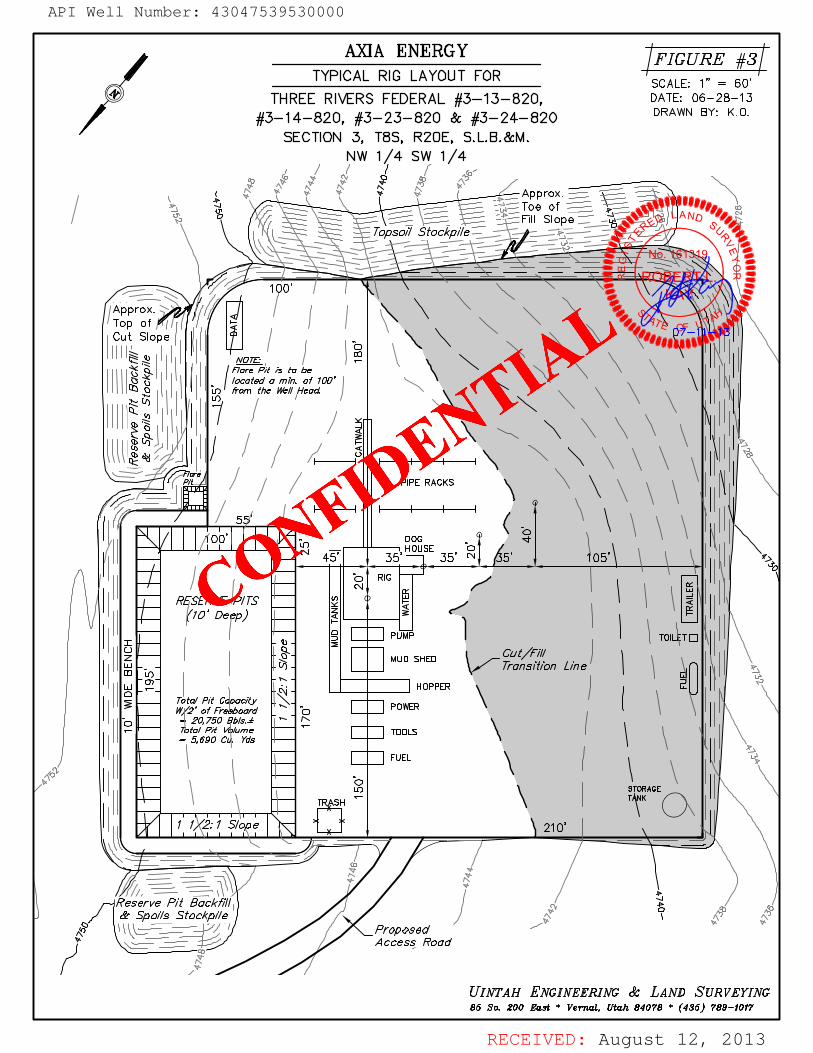
RECEIVED: August 12, 2013
ROBERT L.KAY
No. 161319
A
API Well Number: 43047539530000
CONFIDE
NTIAL
API Well Number: 43047539530000
AXIA ENERGY FIGURE #3TYPICAL RIG LAYOUT FOR ,, ,
THREE RIVERS FEDERAL #3-13-820, DSACAELEO6-28-6103
#3-14-820, #3-23-820 & #3-24-820 DRAWN BY: K.O.
SECTION 3, T8S, R20E, S.L.B.&M.NW 1/4 SW 1/4
opsoil Stockpile
O'
Slope
Nt is to be
located a min. of 100from the Well Head
PIPE RACKS
5
I/ 00 DOGI I I I I - HOUSE O
45' 35' 35' N 5 05
/ L,RIG ¯
PUMP TOIL TO
MUD SHED
2a acPO
RHOPPER
20, 750 ±- total Pit e TOOLS
- 5, 690 Yds
FUEL
1 1 210'
S RAGE
S/o
Reserve Pit Backfill& Spoi/s Stockp//e
<o \ \__------ ' / / Proposed¯~~¯---- Access Road
UINTAH ENGINEERING & LAND SURVEYING85 So. 200 East * Vernal, Utah 84078 * (435) 789-1017
RECEIVED: August 12,
API Well Number: 43047539530000
AXIA ENERGY FIGURE #3TYPICAL RIG LAYOUT FOR ,, ,
THREE RIVERS FEDERAL #3-13-820, DSACAELEO6-28-6103
#3-14-820, #3-23-820 & #3-24-820 DRAWN BY: K.O.
SECTION 3, T8S, R20E, S.L.B.&M.NW 1/4 SW 1/4
opsoil Stockpile -
located a min. of 100from the Well Head
PIPE RACKS
5
I/ 00 DOGI I I I I - HOUSE O
45' 35' 35' N 5 05
/ L,RIG ¯
PUMP TOIL TO
MUD SHED
2a acPO
RHOPPER
20, 750 ±- total Pit e TOOLSII - 5,690 Yds
FUEL
1 1 210'
S RAGE
S/o
Reserve Pit Backfill& Spoi/s Stockp//e
<o \ \__------ ' / / Proposed¯~~¯---- Access Road
UINTAH ENGINEERING & LAND SURVEYING85 So. 200 East * Vernal, Utah 84078 * (435) 789-1017
RECEIVED: August 12,

RECEIVED: August 12, 2013
ROBERT L.KAY
No. 161319
A
API Well Number: 43047539530000
CONFIDE
NTIAL
API Well Number: 43047539530000
AXIA ENERGY FIGURE #4INTERIM RECLAMATIONPLAN FOR SCALE: 1" = 60'
THREE RIVERS FEDERAL #3-13-820, DATE: 06-28-13
#3-14-820, #3-23-820 & #3-24-820 DRAWN BY: K.O.
SECTION 3, T8S, R20E, S.L.B.&M.NW 1/4 SW 1/4
Approx.L $ Toe ofe o Fill Slope
Approx.Top ofCut Slope
#3-24-820 o
#3-23-820 o \
#3-14-820 o
o #3-13-820
M er
ansition Line
ooooCombuster
Water
Treaters
Access Road
INTERIMRECLAMATION APPROX/MA1E ACREAGE UINTAH ENGINEERING & LAND SURVEYINGUN-RECLAIMED = ± 0.911 ACRES 85 So. 200 East * Vernal, UtaA 84078 * (435) 789-1017
RECEIVED: August 12,

RECEIVED: August 14, 2013
â
â
â â
â
â
â
â
â
ââ
â
â
â
â
â
ââ
â
â
â
â
â
â
ââ
â
â
â â
â
â
â
â
â
â
â
â
ª
ª
ª
D
D
'
HH
'
H
H
H
HH
H
HH
!!
!!
!!!!
10
08
02
05
34
09
11
03
32
33
35
04
NORTH OURAYUNIT 2
4304710604
NORTH OURAYUNIT 34304710605
FEDERAL 14304720450
PELICANLAKE 11-3-8-204304738445
PELICANLAKE 8-4-8-204304738446
THREERIVERS 2-11-820
4304751936
THREE RIVERS2-13-820
4304752687
THREE RIVERS2-23-820
4304752688
THREE RIVERS2-15-820
4304752689THREE
RIVERS 2-25-8204304752690
THREERIVERS FEDERAL 3-53-8204304752820THREE RIVERS FEDERAL3-54-8204304752860
THREE RIVERSFEDERAL 3-32-8204304752861
THREE RIVERS FEDERAL5-56-8204304752862
THREE RIVERSFEDERAL 5-55-8204304752863
THREERIVERS FEDERAL 3-33-820
4304752864
THREE RIVERSFED 4-31-8204304752874
THREERIVERS 4-21-820
4304752875
THREE RIVERSFED 10-41-8204304752948
THREE RIVERS FED10-42-8204304752949
THREE RIVERS FED3-11-820
4304752950THREE RIVERSFED 34-15-7204304752965
THREE RIVERS FED35-44-720
4304753008
ThreeRivers Federal 34-35-720
4304753282Three Rivers Federal34-25-7204304753283
Three Rivers Federal10-32-820
4304753415
ThreeRivers Federal 10-31-820
4304753437
Three Rivers4-33-820
4304753528
Three Rivers Federal33-14-720
4304753551
Three Rivers Federal4-32-8204304753552
Three RiversFederal 35-14-720
4304753553Three Rivers
Federal 35-13-7204304753554
Three Rivers Federal10-30-820
4304753555
ThreeRivers Federal 9-41-820
4304753556
Three Rivers Federal33-24-7204304753557
Three Rivers Federal4-41-8204304753911
ThreeRivers Federal 4-42-820
4304753913
Three RiversFederal 3-12-820
4304753914
Three Rivers2-24-820
4304753945
Three Rivers2-223-8204304753946
Three Rivers2-21-8204304753947
Three Rivers2-22-820
4304753948
Three Rivers Federal3-14-820
4304753952
Three Rivers Federal3-23-820
4304753953ThreeRivers Federal 3-24-8204304753954
Map Produced by Diana MasonMap Prepared:
F1,500 0 1,500750 Feet
1:14,255
UnitsSTATUS
ACTIVE
EXPLORATORY
GAS STORAGE
NF PP OIL
NF SECONDARY
PI OIL
PP GAS
PP GEOTHERML
PP OIL
SECONDARY
TERMINATED
TOOELE
SAN JUAN
MILLARD
KANE
JUAB
IRON
EMERY
UINTAH
BOX ELDER
GARFIELD
GRAND
UTAH
WAYNEBEAVER
DUCHESNE
SEVIER
SUMMIT
RICH
WASHINGTON
CARBON
SANPETE
CACHE
PIUTE
DAVIS
WASATCH
WEBER
SALT LAKE
DAGGETT
MORGAN
Location Map
Operator: AXIA ENERGY LLC
Well Name: Three Rivers Federal 3-23-820API Number: 4304753953
Township T08.0S Section 03Range R20.0EMeridian: SLBM
API Well Number: 43047539530000
CONFIDE
NTIAL
API Well Number: 43047539530000
Federr3e5e1R47e2
THREERI API Number: 4304753953
Tre0e47Re5r55 4330547454 0 Well Name: Three Rivers Federal 3-23-820
Federa 35-13-7204 04753554 35 Township TO8.0S Range R20.0E Section 03
34 Meridian: SLBMT ee Rivers ederal THRE RIVER D
RiveedThraee
720IRTHOURAY
F3EDEROA4L1 Operator: AXIA ENERGY LLC
4304753551 4304753557 4 4 50 82 43047106053 HREE RIVERS Three Rivers Federal NOPTW ni ipov
_
Map Prepared:
U 34-15-/20 >---MU UNIT2 Map Produced by Diana Mason
4 4752965 4304753283 4304710604
THREE
Three Riv sRI OR4S 11 820 Three Rivers
RIVERSO447251 THREE VEORS Federal 3-12-82 03 43024725234 < Three Rivers
43047528744304753914 hr Rivers Federal 2-21-820
Thre 4- 820 4304753947Rivers Federal 4-42-8 0 430 11 THREE
4304753 E1L3CAN RIVERS4FEDERAL643-33-820 G 0230K4E738844--20
HREE RIVERS TH E R820ERS s04 EDERAL 3-32-820 AcTivE
05Three Rivers Federal
04752861 43047 8ERIVERS
ExeLomaroev
4-32-820 THREE 2-13-820 oAssrosAGE
4304753552 RIVERSFEDERAL3-53-820 4304752687Thre Rivers 4304752820 NF sEcoNDARY
4- 3-820 THREE RIVERS FED. RAL '43 4753528
hree Riv 3-2eder2Thr
E 3 8-20 350445220860 2-h2r2e3e-8Riv0ers
43047539 ers Federal 3-24-820 4304753946 PP at
Three Rivers Feder 4304753954 Three Rivers a sEcoNDARY
3-14- 02-24-820
TERMiNarED
430475 952 THREERIV43ROS4753945
2-15-8204304752689
REE RIVERS HREE3D4ERAL653-55-820 ' ""
icHLocation Map
THRF
43 4752862 10-20-82043047 i3555 Three EE RIVERS FED I oucHEsN
hre ivers Federal 10-31-820 -42-820 UT^H T^H
Rivers Federal 9- 1-820 4304753437 304752949auAs
43047->3556 Three Rivers F: deral HREE RIVERS cAasoN
10-32-820 ED 10-41-820430475341 304752948
MiLLARDEMERy GRAND
09
10BEAvER PiuTE wAvNE
08 R°N G^RFIELD
mNauAN
WASHINGTON KANE
00 750 0 1.500Feet
1:14,255
RECEIVED: August 14,
API Well Number: 43047539530000
Federr3e5e1R47e2
THREERI API Number: 4304753953
Te0e47Re5r55 4330547454 0 Well Name: Three Rivers Federal 3-23-820
Federal 5-13-7204 04753554 35 Township TO8.0S Range R20.0E Section 03
34 Meridian: SLBMT ee Rivers ederal THRE RIVER D
RiveedThraee
720RTH OURAY 44F3E0D4
0A4 Operator: AXIA ENERGY LLC
4304753551 4304753557 4 4 50 82 +43047106053 HREE RIVERS hree Rivers Federal NOPTW ni ipov Map Prepared:
U 34-15-/20 >---MU UNIT2 Map Produced by Diana Mason
4 4752965 4304753283 4304710604
THREE
Three Riv sRI OR4S 11 820 Three2R2iver0si
RIVERSO447251 THREE VEORS Federal3-12-82 03 4304753948AThreeRivers
43047528744304753914 hr Rivers Federal 2-21-820
Thre 4- 820 4304753947Rivers Federal 4-42-8 0 430 11 THREE
4304753 13 RIVERS FEDERAL 3-33-820 G 02
E N44p-20 430 86H4REE
RIVERS TH E R820ERS s04 EDERAL 3-32-820 cTivE
05Three Rivers Federal
304752861 i4304 E8E
RIVERS4-32-820 THREE 2-13-8204304753552 RIVERSFEDERAL3-53-820 4304752687
Thre Rivers 4304752820 sEcoNDARY
4- 3-820 THREE RIVERS FED. RAL '43 4753528 PELICAN 3-54-820 ^8
ThreeRi 3-2eder2Thr
4LAK4E 4358-20 4304752860 2-h2r2e3e-8Riv0ers
43047539 ers Federal 3-24-820 304753946 at
Three Rivers Feder 4304753954 Three Rivers sEcoNDARY
3-14- 02-24-820
TERMiNarED4304753945430475 952 THREE RIVERS
2-15-82043047e52689
REE RIVERS HREE3HDR
R
5R
F DERAL
' ""icH
Location Map
Three Rivers F deral43 4752862 10-20-820
43047 i3555 Three EE RIVERS FED oucHEsN
hre ivers Federal 10-31-820 -42-820 ^H ^H
Rivers Federal 9- 1-820 4304753437 304752949auAs
43047->3556 Three Rivers Fe deral HREE RIVERS cAasoN
10-32-820 ED 10-41-820430475341 , 304752948
MiLLARDEMERY GRAND
09
10BEAvER PiuT wAvNE
08 "°N ^RFIE'O
mNauAN
WASHINGTON KANE
00 750 0 1.500Feet
1:14,255
RECEIVED: August 14,

RECEIVED: August 21, 2013
WORKSHEETAPPLICATION FOR PERMIT TO DRILL
APD RECEIVED: 8 /12 /2013 API NO. ASSIGNED: 43047539530000
WELL NAME: Three Rivers Federal 3-23-820
OPERATOR: AXIA ENERGY LLC (N3765) PHONE NUMBER: 435 719-2018
CONTACT: Don Hamilton
PROPOSED LOCATION: NWSW 03 080S 200E Permit Tech Review:
SURFACE: 1475 FSL 1237 FWL Engineering Review:
BOTTOM: 1980 FSL 1980 FWL Geology Review:
COUNTY: UINTAH
LATITUDE: 40.14850 LONGITUDE: -109.65958
UTM SURF EASTINGS: 614171.00 NORTHINGS: 4445101.00
FIELD NAME: THREE RIVERS
LEASE TYPE: 1 - Federal
LEASE NUMBER: UTU85994 PROPOSED PRODUCING FORMATION(S): WASATCH
SURFACE OWNER: 1 - Federal COALBED METHANE: NO
RECEIVED AND/OR REVIEWED: LOCATION AND SITING:
PLAT R649-2 -3 .
Bond: FEDERAL - UTB000464 Unit:
Potash R649-3-2. General
Oil Shale 190-5
Oil Shale 190-3 R649-3-3. Exception
Oil Shale 190-13 Drilling Unit
Water Permit: 43-10988 Board Cause No: R649-3-11
RDCC Review: Effective Date:
Fee Surface Agreement Siting:
Intent to Commingle R649-3-11. Directional Drill
Commingling Approved
Comments: Presite Completed
Stipulations: 1 - Exception Location - bhill 4 - Federal Approval - dmason 15 - Directional - dmason 23 - Spacing - dmason
API Well Number: 43047539530000
CONFIDE
NTIAL
API Well Number: 43047539530000
WORKSHEETAPPLICATION FOR PERMIT TO DRILL
I
I
APD RECEIVED: 8/12/2013 API NO. ASSIGNED: 43047539530000
WELL NAME: Three Rivers Federal 3-23-820
OPERATOR: AXIAENERGY LLC (N3765) PHONE NUMBER: 435 719-2018
CONTACT: Don Hamilton
PROPOSED LOCATION: NWSW 03 080S 200E Permit Tech Review:
SURFACE: 1475 FSL 1237 FWL Engineering Review:
BOTTOM: 1980 FSL 1980 FWL Geology Review:
COUNTY: UINTAH
LATITUDE: 40.14850 LONGITUDE: -109.65958
UTM SURF EASTINGS: 614171.00 NORTHINGS: 4445101.00
FIELD NAME: THREE RIVERS
LEASE TYPE: 1 - Federal
LEASE NUMBER: UTU85994 PROPOSED PRODUCING FORMATION(S): WASATCH
SURFACE OWNER: 1 - Federal COALBED METHANE: NO
I
RECEIVED ANDIOR REVIEWED: LOCATION AND SITING:
PLAT R649-2-3.
Bond: FEDERAL - UTBOOO464 Unit:
Potash R649-3-2. General
Oil Shale 190-5
Oil Shale 190-3 R649-3-3. Exception
Oil Shale 190-13 Drilling Unit
Water Permit: 43-10988 Board Cause No: R649-3-11
RDCC Review: Effective Date:
Fee Surface Agreement Siting:
Intent to Commingle R649-3-11. Directional Drill
Commingling Approved
I
Comments: Presite Completed
Stipulations: 1 - Exception Location - bhill4 - Federal Approval - dmason15 - Directional - dmason23 - Spacing - dmason
RECEIVED: August 21,

Permit To Drill******************
Well Name: Three Rivers Federal 3-23-820API Well Number: 43047539530000
Lease Number: UTU85994Surface Owner: FEDERAL Approval Date: 8 / 2 1 / 2 0 1 3
Issued to:AXIA ENERGY LLC, 1430 Larimer Ste 400, Denver, CO 80202
Authority:Pursuant to Utah Code Ann. 40-6-1 et seq. , and Utah Administrat ive CodeR649-3-1 et seq., the Utah Division of Oil, Gas and Mining issues conditions ofapproval, and permit to drill the listed well. This permit is issued in accordancewith the requirements of R649-3-11. The expected producing formation or pool isthe WASATCH Formation(s), completion into any other zones will require filing aSundry Notice (Form 9). Completion and commingling of more than one pool willrequire approval in accordance with R649-3-22.
Duration:This approval shall expire one year from the above date unless substantial andcontinuous operat ion is underway, or a request for extension is made prior to theexpirat ion date
Exception Location:Appropriate information has been submitted to DOGM and administrat ive approvalof the requested exception location is hereby granted.
General:Compliance with the requirements of Utah Admin. R. 649-1 et seq., the Oil and GasConservation General Rules, and the applicable terms and provisions of theapproved Application for permit to dril l .
Conditions of Approval:State approval of this well does not supercede the required federal approval, whichmust be obtained prior to dri l l ing.
In accordance with Utah Admin. R.649-3-11, Directional Drilling, the operator shallsubmit a complete angular deviation and directional survey report to the Divisionwithin 30 days following completion of the well.
This proposed well is located in an area for which drilling units (well spacingpatterns) have not been established through an order of the Board of Oil , Gas andMining (the “Board”). In order to avoid the possibility of waste or injury tocorrelative rights, the operator is requested, once the well has been drilled,
State of UtahDEPARTMENT OF NATURAL RESOURCES
- -/ MICHAELR.STYLER
GAR'R H BERTExoutimDrotor
comrmr Division of Oil, Gas and MiningGREGORY S. BELL JOHN R. BAZALieuterant Gowrær Busion Director
Permit To Drillkkkkkkkkkkkkkkkkkk
Well Name: Three Rivers Federal 3-23-820API Well Number: 43047539530000
Lease Number: UTU85994Surface Owner: FEDERALApproval Date: 8/21/2013
Issued to:AXIA ENERGY LLC, 1430 Larimer Ste 400, Denver, CO 80202
Authority:Pursuant to Utah Code Ann. 40-6-1 et seq., and Utah Administrative CodeR649-3-1 et seq., the Utah Division of Oil, Gas and Mining issues conditions ofapproval, and permit to drill the listed well. This permit is issued in accordancewith the requirements of R649-3-11. The expected producing formation or pool isthe WASATCH Formation(s), completion into any other zones will require filing aSundry Notice (Form 9). Completion and commingling of more than one pool willrequire approval in accordance with R649-3-22.
Duration:This approval shall expire one year from the above date unless substantial andcontinuous operation is underway, or a request for extension is made prior to theexpiration date
Exception Location:Appropriate information has been submitted to DOGM and administrative approvalof the requested exception location is hereby granted.
General:Compliance with the requirements of Utah Admin. R. 649-1 et seq., the Oil and GasConservation General Rules, and the applicable terms and provisions of theapproved Application for permit to drill.
Conditions of Approval:State approval of this well does not supercede the required federal approval, whichmust be obtained prior to drilling.
In accordance with Utah Admin. R.649-3-11, Directional Drilling, the operator shallsubmit a complete angular deviation and directional survey report to the Divisionwithin 30 days following completion of the well.
This proposed well is located in an area for which drilling units (well spacingpatterns) have not been established through an order of the Board of Oil, Gas andMining (the "Board"). In order to avoid the possibility of waste or injury tocorrelative rights, the operator is requested, once the well has been

completed, and has produced, to analyze geological and engineering data generatedtherefrom, as well as any similar data from surrounding areas if available. As soonas is practicable after completion of i ts analysis, and if the analysis suggests anarea larger than the quarter-quarter section upon which the well is located is beingdrained, the operator is requested to seek an appropriate order from the Boardestablishing drill ing and spacing units in conformance with such analysis by fil inga Request for Agency Action with the Board.
Notification Requirements:The operator is required to notify the Division of Oil, Gas and Mining of thefollowing actions during drilling of this well: • Within 24 hours following the spudding of the well - contact Carol Daniels at8 0 1 - 5 3 8 - 5 2 8 4 (please leave a voicemail message if not available) OR submit an electronic sundry notice (pre-registration required) via the Utah Oil &Gas website at ht tp:/ /oi lgas.ogm.utah.gov
Reporting Requirements:All reports, forms and submittals as required by the Utah Oil and Gas ConservationGeneral Rules will be promptly filed with the Division of Oil, Gas and Mining,including but not l imited to: • Entity Action Form (Form 6) - due within 5 days of spudding the well • Monthly Status Report (Form 9) - due by 5th day of the following calendarm o n t h • Requests to Change Plans (Form 9) - due prior to implementation • Written Notice of Emergency Changes (Form 9) - due within 5 days • Notice of Operations Suspension or Resumption (Form 9) - due prior toimplementa t ion • Report of Water Encountered (Form 7) - due within 30 days after completion • Well Completion Report (Form 8) - due within 30 days after completion orplugging
Approved By:
For John RogersAssociate Director, Oil & Gas
completed, and has produced, to analyze geological and engineering data generatedtherefrom, as well as any similar data from surrounding areas if available. As soonas is practicable after completion of its analysis, and if the analysis suggests anarea larger than the quarter-quarter section upon which the well is located is beingdrained, the operator is requested to seek an appropriate order from the Boardestablishing drilling and spacing units in conformance with such analysis by filinga Request for Agency Action with the Board.
Notification Requirements:The operator is required to notify the Division of Oil, Gas and Mining of thefollowing actions during drilling of this well:
• Within 24 hours following the spudding of the well - contact Carol Daniels at801-538-5284
(please leave a voicemail message if not available)ORsubmit an electronic sundry notice (pre-registration required) via the Utah Oil &
Gas websiteat http://oilgas.ogm.utah.gov
Reporting Requirements:All reports, forms and submittals as required by the Utah Oil and Gas ConservationGeneral Rules will be promptly filed with the Division of Oil, Gas and Mining,including but not limited to:
• Entity Action Form (Form 6) - due within 5 days of spudding the well• Monthly Status Report (Form 9) - due by 5th day of the following calendar
month• Requests to Change Plans (Form 9) - due prior to implementation• Written Notice of Emergency Changes (Form 9) - due within 5 days• Notice of Operations Suspension or Resumption (Form 9) - due prior to
implementation• Report of Water Encountered (Form 7) - due within 30 days after completion• Well Completion Report (Form 8) - due within 30 days after completion or
plugging
Approved By:
For John RogersAssociate Director, Oil &

STATEOFUTAHDEPARTMENT OF NATURALRESOURCES
DIVISIONOF OIL, GAS AND MINING
Request to Transfer Application or Permit to Drill
(This form should accompany a Sundry Notice, Form 9, requesting APD transfer)
Well name: See Attached List
API number:Location: Qtr-Qtr: Section: Township: Range:
Company that filed original application: Don Hamilton - Star Point Enterprises for Axia Energy, LLC
Date original permit was issued:Company that permit was issued to: Axia Energy
Check Desired Action:
/ Transfer pending (unapproved) Application for Permit to Drill to new operatorThe undersigned as owner with legal rights to drillon the property, hereby verifies thatthe information assubmitted in the pending Application for Permit to Drill,remains valid and does not require revision. The newowner of the applicationaccepts and agrees to the information and procedures as stated in the application.
Transfer approved Application for Permit to Drill to new operator
The undersigned as owner with legal rights to drillon the property as permitted, hereby verifies that theinformation as submitted in the previously approved application to drill, remains valid and does not requirerevision.
Following is a checklist of some items related to the application, which should be verified. Yes No
lf located on private land, has the ownership changed?
Ifso, has the surface agreement been updated?Have any wells been drilled in the vicinityof the proposed wellwhich would affect the spacing or sitingrequirements for thislocation?Have there been any unit or other agreements put in place that could affect the permitting or operationof thisproposed well?Have there been any changes to the access route including ownership or right-of-way, which couldaffect theproposed location?Has the approved source of water for drillingchanged?Have there been any physical changes to the surface location or access route which will require a change inplans from what was discussed at the onsite evaluation?Is bonding still in place, which covers this proposed well? Bond No.
Any desired or necessary changes to either a pending or approvedApplication for Permit to Drillthat is being transferred,should be filed on a Sundry Notice, Form 9, or amended Application for Permit to Drill,Form 3, as appropriate, withnecessary supporting information as required.
Name (please print) Mary Sharon Balakas Title Attomey in Fact
Representing (company name) Ultra Resources
The person signing this form must have legal authorityto represent the companyor individual(s) to be listed as the new operator on the Application forPermit to Drill.

Division of Oil, Gas and Mining ROUTINGOPERATOR CHANGE WORKSHEET (for state use only) CDW
X - Change of Operator (Well Sold) Operator Name Change/MergerThe operator of the well(s) listed below has changed, effective: 10/1/2013
FROM: (oldOperator): TO: ( New Operator):N3765-Axia Energy, LLC N4045-Ultra Resources, Inc.1430 Larimer Street, Suite 400 304 Inverness Way South, Suite 295Denver, CO 80202 Englewood, CO 80112
Phone: 1 (720) 746-5200 Phone: 1 (303) 645-9810
CA No. Unit: N/AWELL NAME SEC TWN RNG API NO ENTITY LEASE WELL WELL
NO TYPE TYPE STATUSSee Attached List
OPERATOR CHANGES DOCUMENTATIONEnter date after each listed item is completed1. (R649-8-10) Sundry or legal documentation was received from the FORMER operator on: 12/16/20132. (R649-8-10) Sundry or legal documentation was received from the NEW operator on: 12/16/20133. The new company was checked on the Department of Commerce, Division of Corporations Database on: 1/14/20144a. Is the new operator registered in the State of Utah: Business Number: 8861713-01435a. (R649-9-2)Waste Management Plan has been received on: N/A5b. Inspections of LA PA state/fee well sites complete on: N/A5c. Reports current for Production/Disposition & Sundries on: 1/14/20146. Federal and Indian Lease Wells: The BLM and or the BIA has approved the merger, name change,
or operator change for all wells listed on Federal or Indian leases on: BLM Not Yet BIA7. Federal and Indian Units:
The BLM or BIA has approved the successor of unit operator for wells listed on: N/A8. Federal and Indian Communization Agreements ("CA"):
The BLM or BIA has approved the operator for all wells listed within a CA on: N/A9. Underground Injection Control ("UIC") Division has approved UIC Form 5 Transfer of Authority to
Inject, for the enhanced/secondary recovery unit/project for the water disposal well(s) listed on: N/ADATA ENTRY:1. Changes entered in the Oil and Gas Database on: 1/14/20142. Changes have been entered on the Monthly Operator Change Spread Sheet on: 1/14/20143. Bond information entered in RBDMS on: 1/14/20144. Fee/State wells attached to bond in RBDMS on: 1/14/20145. Injection Projects to new operator in RBDMS on: N/A6. Receipt of Acceptance of Drilling Procedures for APD/New on: 1/14/20147. Surface Agreement Sundry from NEW operator on Fee Surface wells received on: YesBOND VERIFICATION:1. Federal well(s) covered by Bond Number: 220464002. Indian well(s) covered by Bond Number: 220464003a. (R649-3-1) The NEW operator of any state/fee well(s) listed covered by Bond Number 220463983b. The FORMER operator has requested a release of liability from their bond on: Not Yet
LEASE INTEREST OWNER NOTIFICATION:4. (R649-2-10) The NEW operator of the fee wells has been contacted and informed by a letter from the Division
of their responsibility to notify all interest owners of this change on: 1/14/2014COMMENTS:
Ultra Resources, Inc.xls

Axia Energy, LLC (N3765) to Ultra Resources, Inc. (N4045) Effective 10/1/2013
Well Name Sec TWN RNG API Number Entity Mineral Lease Well Type Well StatusTHREE RIVERS 2-41-820 2 080S 200E 4304752686 State OW APDTHREE RIVERS 2-25-820 2 080S 20S304752690 State OW APDTHREE RIVERS 36-21-720 36 070S 200E 4304752698 State OW APDTHREE RIVERS 36-13-720 36 070S 200E 4304752699 State OW APDTHREE RIVERS FEDERAL 3-54-82(3 080S 200E 4304752860 Federal OW APDTHREE RIVERS FEDERAL 3-33-82(3 080S 200E 4304752864 Federal OW APDTHREE RIVERS FED 35-34-720 35 070S 200E 4304753006 ederal OW APDTHREE RIVERS FED 35-42-720 35 070S 200E 4304753007 Federal OW APDTHREE RIVERS FED 35-44-720 35 070S 200E 4304753008 Federal OW APDThree Rivers 2-32-820 2 080S 200E 4304753274 State OW APDThree Rivers 18-21-821 18 080S 210E 4304753276 Fee OW APDThree Rivers 18-31-821 18 080S 210E 4304753277 Fee OW APDThree Rivers 27-34-720 34 070S 200E 4304753278 Fee OW APDThree Rivers 34-31T-720 4 070S 200E 4304753281 Fee OW APDThree Rivers Federal 35-14-720 35 070S 200E 4304753553 Federal OW APDThree Rivers Federal 35-13-720 35 070S 200E 4304753554 Federal OW APDThree Rivers 7-34-821 7 080S 210E 4304753558 Fee OW APDThree Rivers 7-23-821 7 080S 210E 4304753559 Fee OW APDThree Rivers 7-21-821 7 080S 210E 4304753560 Fee OW APDThree Rivers 7-22-821 7 080S 210E 304753561 Fee OW APDThree Rivers 7-12-821 7 080S 210E 4304753562 Fee OW APDThree Rivers 18-22-821 18 080S 210E 4304753620 Fee OW APDThree Rivers 18-32-821 18 080S 210E 4304753621 Fee OW APDThree Rivers D 16 080S 200E 4304753702 State WD APDThree Rivers Federal 4-41-820 4 080S 200E 4304753911 Federal OW APDThree Rivers Federal 4-42-820 4 080S 200E 4304753913 Federal OW APDThree Rivers Federal 3-12-820 4 080S 200E 4304753914 Federal OW APDThree Rivers Federal 34-42-720 35 070S 200E 4304753915 Federal OW APDThree Rivers Federal 34-43-720 35 070S 200E 4304753916 Federal OW APDThree Rivers Federal 35-12-720 35 070S 200E 4304753917 Federal OW APDThree Rivers Federal 35-43-720 70S 200E 4304753918 Federal OW APDThree Rivers Federal 35-442-720 35 070S 200E 4304753919 Federal OW APDThree Rivers Federal 35-21-720 35 070S 200E 4304753943 Federal OW APDThree Rivers Federal 35-11-720 35 070S 200E 4304753944 Federal OW APDThree Rivers 2-24-820 2 080S 200E 04753945 State OW APDThree Rivers 2-223-820 2 080S 200E 4304753946 State OW APDThree Rivers 2-21-820 2 080S 200E 304753947 State OW APDThree Rivers 2-22-820 2 080S 200E 4304753948 State OW APDThree Rivers 32-42-720 32 070S 200E 4304753949 Fee OW APDThree Rivers Federal 3-13-820 3 080S 200E 4304753951 Federal OW APDThree Rivers Federal 3-14-820 080S 200E 4304753952 Federal OW APDThree Rivers Federal 3-23-820 3 200E 4304753953 Federal OW APDThree Rivers Federal 3-24-820 3 080S 200E 4304753954 Federal OW APDThree Rivers 4-13-820 5 080S 200E 4304753956 Federal OW APDThree Rivers Federal 5-43-820 5 080S 200E 4304753957 Federal OW APDThree Rivers Federal 5-42-820 5 080S 200E 4304753958 Federal OW APDThree Rivers Federal 5-11-820 5 080S 200E 4304754204 Federal OW APDThree Rivers Federal 5-21-820 5 080S 20N04754205 Federal COW APDThree Rivers Federal 8-31-820 080S 200E 4304754211 Federal OW APDThree Rivers Federal 8-41-820 8 080S 200E 4304754212 Federal OW APDThree Rivers Federal 3-34-820 3 080S 200E 4304754213 Federal OW APDThree Rivers Federal 3-44-820 3 080S 200E 4304754214 Federal OW APDTHREE RIVERS 32-34-720 32 070S 200E 4304752735 19249 Fee OW DRLTHREE RIVERS FEDERAL 8-52-82 8 080S 200E 4304752770 19156 Federal OW DRLTHREE RIVERS 4-14-820 5 080S 200E 4304752863 19183 Fee OW DRLTHREE RIVERS FED 10-42-820 10 080S 200E 4304752949 19310 Federal OW DRLTHREE RIVERS FED 3-11-820 4 070S 200E 4304752950 19184 Federal OW DRLThree Rivers 16-21-820 16 080S 200E 4304753229 19024 State OW DRLThree Rivers 16-22-820 16 080S 200E 4304753230 18961 State OW DRL
1

Axia Energy, LLC (N3765) to Ultra Resources, Inc. (N4045) Effective 10/1/2013
Three Rivers Federal 34-35-720 34 070S 200E 4304753282 19287 Federal OW DRLThree Rivers Federal 34-25-720 34 070S 200E 4304753283 19288 Federal OW DRLThree Rivers Federal 10-32-820 10 080S 200E 4304753415 19275 Federal OW DRLThree Rivers Federal 10-31-820 10 080S 200E 4304753437 19276 Federal OW DRLThree Rivers 16-34-820 16 080S 200E 4304753472 19278 State OW DRLThree Rivers 16-44-820 16 080S 200E 4304753473 19268 State OW DRLThree Rivers 16-11-820 16 080S 200E 4304753474 19262 State OW DRLThree Rivers 16-12-820 16 080S 200E 4304753475 19263 State OW DRLThree Rivers 16-32-820 16 080S 200E 4304753494 19185 State OW DRLThree Rivers 16-31-820 16 080S 200E 4304753495 19269 State OW DRLThree Rivers 16-33-820 16 080S 200E 4304753496 19161 State OW DRLTHREE RIVERS FED 10-30-820 10 080S 200E 4304753555 19169 Federal OW DRLThree Rivers Federal 9-41-820 10 080S 200E 4304753556 19170 Federal OW DRLThree Rivers Federal 33-13-720 33 070S 200E 4304753723 19222 Federal OW DRLThree Rivers Federal 33-12-720 33 070S 200E 4304753724 19250 Federal OW DRLThree Rivers 32-3333-720 32 070S 200E 4304753950 19251 Fee OW DRLTHREE RIVERS 36-11-720 36 070S 200E 4304751915 18355 State OW PTHREE RIVERS 2-l l-820 2 080S 200E 4304751936 18354 State OW PTHREE RIVERS 34-31-720 34 070S 200E 4304752012 18326 Fee OW PTHREE RIVERS 16-42-820 16 080S 200E 4304752056 18682 State OW PTHREE RIVERS 16-43-820 16 080S 200E 4304752057 18683 State OW PTHREE RIVERS 16-41-820 16 080S 200E 4304752110 18356 State OW PTHREE RIVERS 2-51-820 2 080S 200E 4304752685 18941 State OW PTHREE RIVERS 2-13-820 2 080S 200E 4304752687 19014 State OW PTHREE RIVERS 2-23-820 2 080S 200E 4304752688 19015 State OW PTHREE RIVERS 2-15-820 2 080S 200E 4304752689 18770 State OW PTHREE RIVERS 36-31-720 36 070S 200E 4304752697 19086 State OW PTHREE RIVERS 32-25-720 32 070S 200E 4304752718 19033 Fee OW PTHREE RIVERS 36-23-720 36 070S 200E 4304752733 18769 State OW PTHREE RIVERS 32-33-720 32 070S 200E 4304752734 19016 Fee OW PTHREE RIVERS 32-15-720 32 070S 200E 4304752736 18767 Fee OW PTHREE RIVERS 32-35-720 32 070S 200E 4304752737 18766 Fee OW PTHREE RIVERS FEDERAL 8-53-82(8 080S 200E 4304752771 18992 Federal OW PTHREE RIVERS FEDERAL 3-53-82(3 080S 200E 4304752820 19104 Federal OW PTHREE RIVERS FEDERAL 3-32-82{ 3 080S 200E 4304752861 18942 Federal OW PTHREE RIVERS FEDERAL 5-56-82{ 5 080S 200E 4304752862 18993 Federal OW PTHREE RIVERS FED 4-31-820 4 080S 200E 4304752874 19023 Federal OW PTHREE RIVERS 4-21-820 4 080S 200E 4304752875 19048 Federal OW PTHREE RIVERS FED 34-23-720 34 070S 200E 4304752945 19049 Federal OW PTHREE RIVERS FED 34-33-720 34 070S 200E 4304752947 19050 Federal OW PTHREE RIVERS FED 10-41-820 10 080S 200E 4304752948 19137 Federal OW PTHREE RIVERS FED 34-15-720 34 070S 200E 4304752965 18960 Federal OW PTHREE RIVERS FED 35-32-720 35 070S 200E 4304753005 19138 Federal OW PThree Rivers 16-23-820 16 080S 200E 4304753231 19037 State OW PThree Rivers 16-24-820 16 080S 200E 4304753232 19038 State OW PThree Rivers 2-33-820 2 080S 200E 4304753273 18943 State OW PThree Rivers 4-33-820 4 080S 200E 4304753528 19167 Fee OW PThree Rivers Federal 33-14-720 33 070S 200E 4304753551 19107 Federal OW PThree Rivers Federal 4-32-820 4 080S 200E 4304753552 19168 Federal OW PThree Rivers Federal 33-24-720 33 070S 200E 4304753557 19108 Federal OW PThree Rivers 32-334-720 32 070S 200E 4304753710 19067 Fee OW PThree Rivers 5-31-820 32 070S 200E 4304753711 19068 Fee OW PThree Rivers Federal 33-11-720 32 070S 200E 4304753733 19109 Federal OW PThree Rivers 32-32-720 32 070S 200E 4304753734 19087 Fee OW PThree Rivers 32-333-720 32 070S 200E 4304753735 19088 Fee OW P
2

· Ultra Resources, Inc.
PETROLEUM
December 13, 2013
RECEiVED
DEC1 6 2013
DIV.OFOIL,GAS&MINING
Division of Oil, Gas, and Mining1594 West North TempleSalt Lake City, UT 84116Attn: Rachel Medina
Re: Transfer of OperatorThree Rivers Project AreaUintah County, Utah
Dear Ms. Medina:
Pursuant to Purchase and Sale Agreement dated effective October 1, 2013 Ultra Resources, Inc. ("Ultra") assumedthe operations of Axia Energy, LLC ("Axia") in the Three Rivers Area, Uintah County, Utah.
Accordingly, Ultra is submitting the following documents for your review and approval:
1) Request to Transfer Application or Permit to Drill for New, APD Approved & Drilled Wells2) Request to Transfer Application or Permit to Drill - APD Pending3) Two Completed Sundry Notice and Reports on Wells Form 9 regarding Change of Operator executed by
Ultra Resources, Inc. and Axia Energy, LLC4) Statewide Surety Bond in the amount of $120,000
As to all wells located on Fee Surface there are surface agreements in place. Ultra presently does not anticipatemaking any change in the drilling plans submitted by Axia.
Ultra has also submitted a Statewide Bond to the Bureau of Land Management. As soon as we receive theacknowledgement and approval by the BLM we will forward same to you for your files. A copy of our transferletter and bond is attached for your reference.
Should you need any further information at this time, please call me direct at (303) 645-9865 or emailmsbalakas ultrapetroleum.com.
incerely
Mary S on Balakas, CPLDirector of Land
cc: Cindy Turner, Axia Energy, LLC
304 Inverness Way South, Suite 295, Englewood, CO 80112Telephone 303-708-9740 Facsimile

STATE OF UTAH FORM 9DEPARTMENT OF NATURALRESOURCES
DIVISIONOF OIL, GAS AND MINING 5. LEASEDESIGNATIONANDSERIALNUMBER:
See Attached Well List6. IF INDIAN.ALLOTTEEOR TRIBE NAMESUNDRY NOTICES AND REPORTS ON WELLST UNITor CA AGREEMENT NAME:Do not use this form for proposals to drill new wells, significantlydeepen existing wells below current bottom-hole depth, reenter plugged wells, or to
drillhorizontal laterals. Use APPLICATION FOR PERMIT TO DRILLform for such proposals.1 TYPE OF WELL 8. WELLNAMEand NUMBER:OIL WELL GAS WELL Q OTHER
See Attached Well List2 NAMEOFOPERATOR: 9.APINUMBER:Ultra Resources, Inc. Ñ 645
3 ADDRESS OF OPERATOR: PHONE NUMBER: 10. FIELDAND POOL, OR WILDCAT:304 Inverness Way South cn Englewood
STATE CO ZIP 80112 (303) 645-98104 LOCATION OF WELL
FOOTAGES ATSURFACE: See Attached COUNTY: Uintah
QTRIQTR, SECTION, TOWNSHIP, RANGE, MERIDIAN: STATE:UTAH
9t CHECK APPROPRIATE BOXES TO INDICATENATURE OF NOTICE, REPORT, OR OTHER DATATYPE OF SUBMISSION TYPE OF ACTION
ACIDIZE DEEPEN REPERFORATE CURRENT FORMATIONNOTICE OF INTENT(Submit in Duplicate) ALTER CASING FRACTURE TREAT SIDETRACKTOREPAIR WELL
Approximate date woß willstart: CASING REPAIR NEW CONSTRUCTION TEMPORARILYABANDON
10/1/2013 CHANGE TO PREVIOUS PLANS OPERATOR CHANGE TUBINGREPAIR
O CHANGE TUBING PLUG ANDABANDON VENTOR FLARE
O SUBSEQUENT REPORT CHANGE WELL NAME PLUG BACK WATER DISPOSAL(Submit Original Form Only)
O CHANGE WELL STATUS PRODUCTION (START/RESUME) WATER SHUT-OFFDate ofwork completion:O COMMINGLEPRODUCING FORMATIONS RECLAMATIONOF WELL SITE OTHER:
O CONVERT WELL TYPE RECOMPLETE - DIFFERENT FORMATION
12 DESCRIBE PROPOSED OR COMPLETED OPERATIONS. Clearly show all pertinent details including dates, depths, volurnes, etc.
EFFECTIVE DATE: October 1, 2013FROM:Axia Energy, LLC1430 Larimer StreetSDe ve4r
CO 80202Bond Number: Blanket Statewide UT State/Fee Bond LPM9046682TO: DEC16 1033Ultra Resources, Inc.304 Inverness Way South
y OF L GASEnglewood, CO 80119Bond Number:
_0
Ultra Resources, c e dp s n r ms and conditions of the leases/wells for the operations conducted on theleased lands.
NAME(PLEASE PRINT) Mary Sharon BalakasTITLE Attorney in Fact
(This space for State use only)
JAN16 2013DIV.OIL GAS &MINING
(5/2000) (See Instructions on Reverse

i.TTACHMENTTO FORM 9 CHANGEOF OPERATORI.XIA ENERGYTO ULTRARESOURCEI EFFECTIVE10-01-2013
Axia Well Name State Actual DateState Well Name (for database sort Mineral Surface Well Well Status @ Apprvd
Listdownloaded 12-10-13 and consistency) Sec TWN RNG API Number Entity Lease Lease Type Status 12/12/13 Submitted DOGMTHREERIVERS2-11-820 Three Rivers 02-11-820 2 0805 200E 4304751936 18354 State State OW P PTHREERIVERS2-13-820 Three Rivers 02-13-820 2 0805 200E 4304752687 19014 State State OW DRL P 08/27/12THREERIVERS2-15-820 Three Rivers 02-15-820 2 0805 200E 4304752689 18770 State State OW P PThree Rivers 2-21-820 Three Rivers 02-21-820 210805 200E 4304753947 State State OW APD APRVD 10/15/13Three Rivers 2-223-820 Three Rivers 02-223-820 2 0805 200E 4304753946 State B OW APD APRVD 10/15/13Three Rivers 2-22-820 Three Rivers 02-22-820 2 080s 200E 4304753948 State State OW APD APRVD 10/15/13THREERIVERS2-23-820 Three Rivers 02-23-820 2 0805 200E 4304752688 19015 State State OW DRL P 08/27/12Three Rivers 2-24-820 Three Rivers 02-24-820 2 0805 200E 4304753945 State State OW APD APRVD 10/15/13THREERIVERS2-25-820 Three Rivers 02-25-820 2 0805 200E 4304752690 State State OW APD APRVD 08/27/12Three Rivers 2-32-820 Three Rivers 02-32-820 2 0805 200E 4304753274 State State OW APD APRVD 12/11/12Three Rivers 2-33-820 Three Rivers 02-33-820 2 080S 200E 4304753273 18943 State State OW P PTHREERIVERS2-41-820 Three Rivers 02-41-820 2 0805 200E 4304752686 State State OW APD APRVD 08/27/12!THREERIVERS2-51-820 Three Rivers 02-51-820 2 0805 200E 4304752685 18941 State State OW P PThree Rivers 4-13-820 Three Rivers 04-13-820 5 0805 200E 4304753956 Fee Federal OW APD PERPEND 08/19/13THREERIVERS4-14-820 Three Rivers 04-14-820 5 0805 200E 4304752863 19183 Fee Federal OW DRL PThree Rivers 4-33-820 Three Rivers 04-33-820 4 0805 200E 4304753528 19167 Fee Fee OW DRL PThree Rivers 5-31-820 Three Rivers 05-31-820 32 0705 200E 4304753711 19068 Fee Fee OW DRL PThree Rivers 7-12-821 Three Rivers 07-12-821 7 0805 210E 4304753562 Fee Fee OW APD PERPEND 04/15/13Three Rivers 7-21-821 Three Rivers 07-21-821 7 0805 210E 4304753560 Fee Fee OW APD PERPEND 04/15/13Three Rivers 7-22-821 Three Rivers 07-22-821 7 0805 210E 4304753561 Fee Fee OW APD PERPEND 04/15/13Three Rivers 7-23-821 Three Rivers 07-23-821 7 0805 210E 4304753559 Fee Fee OW APD PERPEND 04/15/13Three Rivers 7-34-821 Three Rivers 07-34-821 7 0805 210E 4304753558 Fee Fee OW APD PERPEND 04/15/13Three Rivers 16-11-820 Three Rivers 16-11-820 16 0805 200E 4304753474 19262 State State OW DRL SCS 03/12/13Three Rivers 16-12-820 Three Rivers 16-12-820 16 0805 200E 4304753475 19263 State State OW DRL SCS 03/12/13Three Rivers 16-21-820 Three Rivers 16-21-820 16 0805 200E 4304753229 19024 State State OW DRL P 12/11/12Three Rivers 16-22-820 Three Rivers 16-22-820 16 0805 200E 4304753230 18961 State State OW DRL P 12/11/12Three Rivers 16-23-820 Three Rivers 16-23-820 16 0805 200E 4304753231 19037 State State OW DRL P 12/11/12Three Rivers 16-24-820 Three Rivers 16-24-820 16 0805 200E 4304753232 19038 State State OW P PThree Rivers 16-31-820 Three Rivers 16-31-820 16 0805 200E 4304753495 State State OW APD CCS 03/12/13Three Rivers 16-32-820 Three Rivers 16-32-820 16 0805 200E 4304753494 19185 State State OW DRL WOC 03/12/13Three Rivers 16-33-820 Three Rivers 16-33-820 16 0805 200E 4304753496 19161 State State OW DRL WOC 03/12/13Three Rivers 16-34-820 Three Rivers 16-34-820 16 0805 200E 4304753472 State State OW APD CCS 03/12/13THREERIVER516-41-820 Three Rivers 16-41-820 16 0805 200E 4304752110 18356 State State OW P PTHREERIVERS16-42-820 Three Rivers 16-42-820 16 0805 200E 4304752056 18682 State State OW P PTHREERIVERS16-43-820 Three Rivers 16-43-820 16 0805 200E 4304752057 18683 State State OW P PThree Rivers 16-44-820 Three Rivers 16-44-820 16 0805 200E 4304753473 State State OW APD CCS 03/12/13Three Rivers 18-21-821 Three Rivers 18-21-821 18 0805 210E 4304753276 Fee Fee OW APD PERPEND 12/17/12Three Rivers 18-22-821 Three Rivers 18-22-821 18 0805 210E 4304753620 Fee Fee OW APD PERPEND 04/15/13Three Rivers 18-31-821 Three Rivers 18-31-821 18 0805 210E 4304753277 Fee Fee OW APD PERPEND 12/19/12Three Rivers 18-32-821 Three Rivers 18-32-821 18 0805 210E 4304753621 Fee Fee OW APD PERPEND 04/15/13Three Rivers 27-34-720 Three Rivers 27-34-720 34 0705 200E 4304753278 Fee Fee OW APD PERPEND 12/19/12THREERIVERS32-15-720 Three Rivers 32-15-720 32 070S 200E 4304752736 18767 Fee Fee OW P PTHREERIVERS32-25-720 Three Rivers 32-25-720 32 0705 200E 4304752718 19033 Fee Fee OW P PThree Rivers 32-32-720 Three Rivers 32-32-720 32 0705 200E 4304753734 19087 Fee Fee OW DRL P 06/12/13Three Rivers 32-3333-720 Three Rivers 32-3333-720 32 0705 200E 4304753950 19251 Fee Fee OW DRL SCS 10/15/13Three Rivers 32-333-720 Three Rivers 32-333-720 32 0705 200E 4304753735 19088 Fee Fee OW DRL P 06/12/13Three Rivers 32-334-720 Three Rivers 32-334-720 32 0705 200E 4304753710 19067 Fee Fee OW DRL P 05/22/13THREERIVERS32-33-720 Three Rivers 32-33-720 32 0705 200E 4304752734 19016 Fee Fee OW DRL P 08/29/12THREERIVERS32-34-720 Three Rivers 32-34-720 32 0705 200E 4304752735 19249 Fee Fee OW DRL DRLG 08/29/12THREERIVERS32-35-720 Three Rivers 32-35-720 32 0705 200E 4304752737 18766 Fee Fee OW P PThree Rivers 32-42-720 Three Rivers 32-42-720 32 070S 200E 4304753949 Fee Fee OW APD APRVD 10/15/13THREERIVERS34-31-720 Three Rivers 34-31-720 34 0705 200E 4304752012 18326 Fee Fee OW P PThree Rivers 34-31T-720 Three Rivers 34-31T-720 34 0705 200E 4304753281 Fee Fee OW APD APRVD 12/11/12THREERIVERS36-11-720 Three Rivers 36-11-720 36 070S 200E 4304751915 18355 State State OW P PTHREERIVERS36-13-720 Three Rivers 36-13-720 36 070S 200E 4304752699 State State OW APD APRVD 08/29/12THREERIVERS36-21-720 Three Rivers 36-21-720 36 070s 200E 4304752698 State State OW APD APRVD 08/29/12THREERIVERS36-23-720 Three Rivers 36-23-720 36 0705 200E 4304752733 18769 State State OW P PTHREERIVERS36-31-720 Three Rivers 36-31-720 36 0705 200E 4304752697 19086 State State OW DRL P 08/29/12Three Rivers D Three Rivers D 16 0805 200E 4304753702 State State WD APD APRVD 07/15/13THREERIVERSFED3-11-820 Three Rivers Fed 03-11-820 34 0705 200E 4304752950 19184 Federal Fee OW DRL WOC 02/22/13Three Rivers Federal 3-12-820 Three Rivers Fed 03-12-820 4 080S 200E 4304753914 Federal Federal OW APD APRVD 08/01/13Three Rivers Federal 3-13-820 Three Rivers Fed 03-13-820 3 0805 200E 4304753951 Federal Federal OW APD PERPEND 08/12/13Three Rivers Federal 3-14-820 Three Rivers Fed 03-14-820 3 0805 200E 4304753952 Federal Federal OW APD PERPEND 08/12/13Three Rivers Federal 3-23-820 Three Rivers Fed 03-23-820 3 0805 200E 4304753953 Federal Federal OW APD PERPEND 08/12/13 .Three Rivers Federal 3-24-820 Three Rivers Fed 03-24-820 3 0805 200E 4304753954 Federal Federal OW APD PERPEND 08/12/13THREERIVERSFEDERAL3-32-820 Three Rivers Fed 03-32-820 3 0805 200E 4304752861 18942 Federal Federal OW P PTHREERIVERSFEDERAL3-33-820 Three Rivers Fed 03-33-820 3 0805 200E 4304752864 Federal Federal OW APD APRVD 12/24/12THREERIVERSFEDERAL3-53-820 Three Rivers Fed 03-53-820 3 0805 200E 4304752820 19104 Federal Federal OW DRL P 12/24/12THREERIVERSFEDERAL3-54-820 Three Rivers Fed 03-54-820 3 080S 200E 4304752860 Federal Federal OW APD APRVD 12/24/12
Page 1 of 2 12/11/2013 2:02

ATTACHMENTTO FORM 9 CHANGEOF OPERATORAXIAENERGYTOULTRARESOURCESEFFECTIVE10-01-2013
Axia Well Name State Actual DateState Well Name (for database sort Mineral Surface Well Well Status @ Apprvd
List downloaded 12-10-13 and consistency) Sec TWN RNG API Number Entity Lease Lease Type Status 12/12/13 Submitted DOGMTHREE RIVERS4-21-820 Three Rivers Fed 04-21-820 4 0805 200E 4304752875 19048 Federal Fee OW DRL P 02/22/13THREERIVERSFED4-31-820 Three Rivers Fed 04-31-820 4 0805 200E 4304752874 19023 Federal Fee OW DRL P 02/22/13Three Rivers Federal4-32-820 Three Rivers Fed 04-32-820 4 0805 200E 4304753552 19168 Federal Fee OW DRL P 08/26/13Three Rivers Federal 4-41-820 Three Rivers Fed 04-41-820 4 0805 200E 4304753911 Federal Federal OW APD APRVD 08/01/13Three Rivers Federal4-42-820 Three Rivers Fed 04-42-820 4 0805 200E 4304753913 Federal Federal OW APD APRVD 08/01/13Three Rivers Federal 5-11-820 Three Rivers Fed 05-11-820 5 0805 200E 4304754204 Federal Federal Ow NEW PERPEND 12/03/13Three Rivers Federal 5-21-820 Three Rivers Fed 05-21-820 5 0805 200E 4304754205 Federal Federal OW NEW PERPEND 12/03/13Three Rivers Federal 5-42-820 Three Rivers Fed 05-42-820 5 0805 200E 4304753958 Federal Federal OW APD PERPEND 08/19/13Three Rivers Federal 5-43-820 Three Rivers Fed 05-43-820 5 0805 200E 4304753957 Federal Federal OW APD PERPEND 08/19/13THREE RIVERSFEDERAL5-56-820 Three Rivers Fed 05-56-820 5 080S 200E 4304752862 18993 Federal Federal OW P PTHREE RIVERSFEDERAL8-52-820 Three Rivers Fed 08-52-820 8 080S 200E 4304752770 19156 Federal Federal OW DRL P 02/22/13THREE RIVERSFEDERAL8-53-820 Three Rivers Fed 08-53-820 8 0805 200E 4304752771 18992 Federal Federal OW P PThree Rivers Federal9-41-820 Three Rivers Fed 09-41-820 10 OSOS 200E 4304753556 19170 Federal Federal OW DRL P 08/20/13THREERIVERSFED10-30-820 Three Rivers Fed 10-30-820 10 0805 200E 4304753555 19169 Federal Federal OW DRL P 08/20/13Three Rivers Federal 10-31-820 Three Rivers Fed 10-31-820 10 0805 200E 4304753437 Federal Federal OW APD CCS 08/21/13Three Rivers Federal 10-32-820 Three Rivers Fed 10-32-820 10 0805 200E 4304753415 Federal Federal OW APD CCS 08/21/13THREE RIVERSFED10-41-820 Three Rivers Fed 10-41-820 10 0805 200E 4304752948 19137 Federal Federal OW DRL P 02/22/13THREERIVERSFED10-42-820 Three Rivers Fed 10-42-820 10 OSOS 200E 4304752949 Federal Federal OW APD APRVD 02/22/13Three Rivers Federal 33-11-720 Three Rivers Fed 33-11-720 32 0705 200E 4304753733 19109 Federal Fee OW DRL P 07/17/13Three Rivers Federal 33-12-720 Three Rivers Fed 33-12-720 33 0705 200E 4304753724 19250 Federal Fee OW DRL WOC 09/16/13Three Rivers Federal 33-13-720 Three Rivers Fed 33-13-720 33 0705 200E 4304753723 19222 Federal Fee OW DRL WOC 09/16/13Three Rivers Federal 33-14-720 Three Rivers Fed 33-14-720 33 0705 200E 4304753551 19107 Federal Fee OW DRL P 09/16/13Three Rivers Federal 33-24-720 Three Rivers Fed 33-24-720 33 0705 200E 4304753557 19108 Federal Fee OW DRL P 07/09/13THREE RIVERSFED34-15-720 Three Rivers Fed 34-15-720 34 0705 200E 4304752965 18960 Federal Fee OW P PTHREERIVERSFED34-23-720 Three Rivers Fed 34-23-720 34 070S 200E 4304752945 19049 Federal Fee OW DRL P 02/12/13Three Rivers Federal 34-25-720 Three Rivers Fed 34-25-720 34 070S 200E 4304753283 Federal Fee OW APD APRVD 06/10/13THREE RIVERSFED34-33-720 Three Rivers Fed 34-33-720 34 0705 200E 4304752947 19050 Federal Fee OW DRL P 02/22/13Three Rivers Federal 34-35-720 Three Rivers Fed 34-35-720 34 0705 200E 4304753282 Federal Fee OW APD APRVD 06/10/13Three Rivers Federal 34-42-720 Three Rivers Fed 34-42-720 35 0705 200E 4304753915 Federal Federal OW APD APRVD 08/01/13Three Rivers Federal 34-43-720 Three Rivers Fed 34-43-720 35 0705 200E 4304753916 Federal Federal OW APD APRVD 08/01/13Three Rivers Federal 35-11-720 Three Rivers Fed 35-11-720 35 0705 200E 4304753944 Federal Federal OW APD PERPEND 07/25/13Three Rivers Federal 35-12-720 Three Rivers Fed 35-12-720 35 0705 200E 4304753917 Federal Federal OW APD APRVD 08/01/13Three Rivers Federal 35-13-720 Three Rivers Fed 35-13-720 35 0705 200E 4304753554 Federal Federal OW APD APRVD 08/20/13Three Rivers Federal 35-14-720 Three Rivers Fed 35-14-720 35 0705 200E 4304753553 Federal Federal OW APD APRVD 08/22/13Three Rivers Federal 35-21-720 Three Rivers Fed 35-21-720 35 0705 200E 4304753943 Federal Federal OW APD PERPEND 07/25/13THREE RIVERSFED35-32-720 Three Rivers Fed 35-32-720 35 070S 200E 4304753005 19138 Federal Federal OW DRL APRVD 02/22/13THREERIVERSFED35-34-720 Three Rivers Fed 35-34-720 35 0705 200E 4304753006 Federal Federal OW APD APRVD 02/22/13THREE RIVERSFED35-42-720 Three Rivers Fed 35-42-720 35 0705 200E 4304753007 Federal Federal OW APD APRVD 02/22/13Three Rivers Federal 35-43-720 Three Rivers Fed 35-43-720 35 0705 200E 4304753918 Federal Federal OW APD APRVD 08/01/13Three Rivers Federal 35-442-720 Three Rivers Fed 35-442-720 35 0705 200E 4304753919 Federal Federal OW APD APRVD 08/01/13THREERIVERSFED35-44-720 Three Rivers Fed 35-44-720 35 0705 200E 4304753008 Federal Federal OW APD APRVD 02/22/13Three Rivers Fed 03-34-820 Three Rivers Fed 03-34-820 3 0805 200E Federal NA SUB 12/10/13Three Rivers Fed 03-44-820 Three Rivers Fed 03-44-820 3 0805 200E Federal NA SUB 12/10/13Three Rivers Fed 08-31-820 Three Rivers Fed 08-31-820 8 0805 200E Federal NA SUB 12/07/13Three Rivers Fed 08-41-820 Three Rivers Fed 08-41-820 9 0805 200E Federal NA SUB 12/07/13
Page 2 of 2 12/11/2013 2:02

STATEOFUTAH FORM9DEPARTMENT OF NATURALRESOURCES
DIVISIONOF OlL, GAS AND MINING 5 LEASE DESIGNATIONAND SERIAL NUMBER:
See Attached Well List6 IF INDIAN,ALLOTTEEOR TRIBE NAMESUNDRY NOTICES AND REPORTS ON WELLS7 UNITor CA AGREEMENT NAME:Do not use this form for proposals to drillnew wells, significantly deepen existing wells below current bottom-hole depth, reenter plugged wells, or to
drillhorizontal laterals. Use APPLICATION FOR PERMIT TO DRILLform forsuch proposals1 TYPE OF WELL 8 WELL NAMEand NUMBER:OIL WELL GAS WELL OTHER See Attached Well List2 NAMEOF OPERATOR: 9. API NUMBER:Axia Energy, LLC
3. ADDRESS OF OPERATOR: PHONE NUMBER: 10 FIELD AND POOL OR WILDCAT:1430 Larimer Street, Ste 400 CITY Denver STATE CO z,p 80202 (720) 746-5200
4. LOCATIONOF WELL
FOOTAGES AT SURFACE: See Attached COUNTY: Uintah
QTRIQTR, SECTION, TOWNSHIP, RANGE, MERID1AN: STATE:UTAH
n. CHECK APPROPRIATE BOXES TO INDICATE NATURE OF NOTICE, REPORT, OR OTHER DATATYPE OF SUBMISSION TYPE OF ACTION
O ^CIDIZE DEEPEN REPERFORATE CURRENT FORMATIONNOTICE OF INTENT(Submit in Duplicate) ALTER CASING FRACTURE TREAT SIDETRACK TO REPAIR WELL
Approximate date work willstart: CASING REPAIR NEW CONSTRUCTION. TEMPORARILYABANDON
10/1/2013 CHANGE TO PREVIOUS Pl.ANS OPERATOR CHANGE TUBINGREPAIR
O CHANGE TUBING PLUG AND ABANDON VENT OR FLARE
SUBSEQUENT REPORT CHANGE WELL NAME PLUG BACK WATER DISPOSAL(Submit Original Form Only)
O CHANGE WELLSTATUS PRODUCTION (STARTIRESUME) WATER SHUT-OFFDate ofwork completion:
O COMMINGLEPRODUCING FORMATIONS RECLAMATIONOF WELL SITE OTHER:
O CONVERT WELL TYPE RECOMPLETE - DIFFERENT FORMATION
12 DESCRIBE PROPOSED OR COMPLETED OPERATIONS. Clearly show all pertinent details including dates, depths, volumes, etc.
EFFECTIVE DATE: October 1, 2013FROM:Axia Energy, LLC1430 Larimer StreetSuite 400
g ODenver, CO 80202 'B d Number: Blanket Statewide UT State/Fee Bond LPM9046682 DEC16 100Ultra Resources, Inc.304 Inverness Way South gy y OL GAS&Englewood, CO 80112Bond Number: \ (( \
Ultra Resources, Inc. willbe responsible under the terms and conditions of the leases/wells for the operations conducted on theleased lands.
NAME(PLEASEP ) Daniel G. BlpnchardTITLE Pf6Sident
SIGNATURE DATE
(ThisspaceforStateuseonly APPROVEDJAN16 2013
(5/2000) (SeelnstructionsonReverseSide) V.OIL GAS &

ATTACHMENTTO FORM 9 CHANGEOF OPERATORAXIAENERGYTO ULTRARESOURCE'-EFFECTIVE10-01-2013
Axia Well Name State Actual DateState Well Name (for database sort Mineral Surface Well Well Status @ Apprvd
List downloaded 12-10-13 and consistency) Sec TWN RNG API Number Entity Lease Lease Type Status 12/12/13 Submitted DOGMTHREERIVERS2-11-820 Three Rivers 02-11-820 2 0805 200E 4304751936 18354 State State OW P P \THREERIVERS2-13-820 Three Rivers 02-13-820 2 0805 200E 4304752687 19014 State State OW DRL P $ 08/27/12THREERIVERS2-15-820 Three Rivers 02-15-820 2 0805 200E 4304752689 18770 State State OW P PThree Rivers 2-21-820 Three Rivers 02-21-820 2 0805 200E 4304753947 State State OW APD APRVD 10/15/13Three Rivers 2-223-820 Three Rivers 02-223-820 2 0805 200E 4304753946 State & OW APD APRVD 10/15/13Three Rivers 2-22-820 Three Rivers 02-22-820 2 OSOS 200E 4304753948 State State OW APD APRVD Âg 10/15/13THREERIVERS2-23-820 Three Rivers 02-23-820 2 080S 200E 4304752688 19015 State State OW DRL P 08/27/12Three Rivers 2-24-820 Three Rivers 02-24-820 2 0805 200E 4304753945 State State OW APD APRVD 10/15/13THREERIVERS2-25-820 Three Rivers 02-25-820 2 0805 200E 4304752690 5tate State OW APD APRVD 08/27/12Three Rivers 2-32-820 Three Rivers 02-32-820 2 0805 200E 4304753274 State State OW APD APRVD 12/11/12Three Rivers 2-33-820 Three Rivers 02-33-820 2 080s 200E 4304753273 18943 State State OW P PTHREERIVERS2-41-820 Three Rivers 02-41-820 2 0805 200E 4304752686 State State OW APD APRVD 08/27/12THREERIVERS2-51-820 Three Rivers 02-51-820 2 OSOS 200E 4304752685 18941 State State OW P PThree Rivers 4-13-820 Three Rivers 04-13-820 5 080S 200E 4304753956 Fee Federal OW APD PERPEND 08/19/13THREERIVERS4-14-820 Three Rivers 04-14-820 5 0805 200E 4304752863 19183 Fee Federal OW DRL PThree Rivers 4-33-820 Three Rivers 04-33-820 4 0805 200E 4304753528 19167 Fee Fee OW DRL PThree Rivers 5-31-820 Three Rivers 05-31-820 32 0705 200E 4304753711 19068 Fee Fee OW DRL PThree Rivers 7-12-821 Three Rivers 07-12-821 7 0805 210E 4304753562 Fee Fee OW APD PERPEND 04/15/13 yThree Rivers 7-21-821 Three Rivers 07-21-821 7 0805 210E 4304753560 Fee Fee OW APD PERPEND 04/15/13Three Rivers 7-22-821 Three Rivers 07-22-821 7 080S 210E 4304753561 Fee Fee OW APD PERPEND 04/15/13Three Rivers 7-23-821 Three Rivers 07-23-821 7 080S 210E 4304753559 Fee Fee OW APD PERPEND 04/15/13Three Rivers 7-34-821 Three Rivers 07-34-821 7 0805 210E 4304753558 Fee Fee OW APD PERPEND 04/15/13Three Rivers 16-11-820 Three Rivers 16-11-820 16 0805 200E 4304753474 19262 State State OW DRL SCS 03/12/13Three Rivers 16-12-820 Three Rivers 16-12-820 16 0805 200E 4304753475 19263 State State OW DRL SCS 03/12/13Three Rivers 16-21-820 Three Rivers 16-21-820 16 0805 200E 4304753229 19024 State State OW DRL P 12/11/12Three Rivers 16-22-820 Three Rivers 16-22-820 16 0805 200E 4304753230 18961 State State OW DRL P 12/11/12Three Rivers 16-23-820 Three Rivers 16-23-820 16 0805 Z00E 4304753231 19037 State State OW DRL P 12/11/12Three Rivers 16-24-820 Three Rivers 16-24-820 16 080s 200E 4304753232 19038 State State OW P PThree Rivers 16-31-820 Three Rivers 16-31-820 16 0805 200E 4304753495 State State OW APD CCS 03/12/13Three Rivers 16-32-820 Three Rivers 16-32-820 16 0805 200E 4304753494 19185 State State OW DRL WOC 03/12/13Three Rivers 16-33-820 Three Rivers 16-33-820 16 0805 200E 4304753496 19161 State State OW DRL WOC 03/12/13Three Rivers 16-34-820 Three Rivers 16-34-820 16 OSOS 200E 4304753472 State State OW APD CCS 03/12/13THREERIVERS16-41-820 Three Rivers 16-41-820 16 0805 200E 4304752110 18356 State State OW P PTHREERIVERS16-42-820 Three Rivers 16-42-820 16 0805 200E 4304752056 18682 State State OW P PTHREERIVERS16-43-820 Three Rivers 16-43-820 16 080S 200E 4304752057 18683 State State OW P PThree Rivers 16-44-820 Three Rivers 16-44-820 16 0805 200E 4304753473 State State OW APD CCS 03/12/13Three Rivers 18-21-821 Three Rivers 18-21-821 18 0805 210E 4304753276 Fee Fee OW APD PERPEND 12/17/12 *g
Three Rivers 18-22-821 Three Rivers 18-22-821 18 0805 210E 4304753620 Fee Fee OW APD PERPEND 04/15/13Three Rivers 18-31-821 Three Rivers 18-31-821 18 0805 210E 4304753277 Fee Fee OW APD PERPEND 12/19/12Three Rivers 18-32-821 Three Rivers 18-32-821 18 0805 210E 4304753621 Fee Fee OW APD PERPEND 04/15/13Three Rivers 27-34-720 Three Rivers 27-34-720 34 0705 200E 4304753278 Fee Fee OW APD PERPEND 12/19/12THREERIVERS32-15-720 Three Rivers 32-15-720 32 0705 200E 4304752736 18767 Fee Fee OW P PTHREERIVERS32-25-720 Three Rivers 32-25-720 32 0705 200E 4304752718 19033 Fee Fee OW P PThree Rivers 32-32-720 Three Rivers 32-32-720 32 0705 200E 4304753734 19087 Fee Fee OW DRL P 06/12/13Three Rivers 32-3333-720 Three Rivers 32-3333-720 32 0705 200E 4304753950 19251 Fee Fee OW DRL SCS 10/15/13Three Rivers 32-333-720 Three Rivers 32-333-720 32 0705 200E 4304753735 19088 Fee Fee OW DRL P 06/12/13Three Rivers 32-334-720 Three Rivers 32-334-720 32 070S 200E 4304753710 19067 Fee Fee OW DRL P 05/22/13THREERIVERS32-33-720 Three Rivers 32-33-720 32 0705 200E 4304752734 19016 Fee Fee OW DRL P 08/29/12THREERIVERS32-34-720 Three Rivers 32-34-720 32 0705 200E 4304752735 19249 Fee Fee OW DRL DRLG 08/29/12THREERIVERS32-35-720 Three Rivers 32-35-720 32 0705 200E 4304752737 18766 Fee Fee OW P PThree Rivers 32-42-720 Three Rivers 32-42-720 32 0705 200E 4304753949 Fee Fee OW APD APRVD 10/15/13THREERIVERS34-31-720 Three Rivers 34-31-720 34 0705 200E 4304752012 18326 Fee Fee OW P PThree Rivers 34-31T-720 Three Rivers 34-31T-720 34 0705 200E 4304753281 Fee Fee OW APD APRVD 12/11/12THREERIVERS36-11-720 Three Rivers 36-11-720 36 0705 200E 4304751915 18355 State State OW P PTHREERIVERS36-13-720 Three Rivers 36-13-720 36 0705 200E 4304752699 State State OW APD APRVD 08/29/12THREERIVERS36-21-720 Three Rivers 36-21-720 36 0705 200E 4304752698 5tate State OW APD APRVD 08/29/12THREERIVERS36-23-720 Three Rivers 36-23-720 36 0705 200E 4304752733 18769 State State OW P PTHREERIVERS36-31-720 Three Rivers 36-31-720 36 070S 200E 4304752697 19086 State State OW DRL P 08/29/12Three Rivers D Three Rivers D 16 OSOS 200E 4304753702 State State WD APD APRVD 07/15/13THREERIVERSFED3-11-820 Three Rivers Fed 03-11-820 34 0705 200E 4304752950 19184 Federal Fee OW DRL WOC 02/22/13Three Rivers Federal 3-12-820 Three Rivers Fed 03-12-820 4 0805 200E 4304753914 Federal Federal OW APD APRVD 08/01/13Three Rivers Federal 3-13-820 Three Rivers Fed 03-13-820 3 0805 200E 4304753951 Federal Federal OW APD PERPEND 08/12/13Three Rivers Federal 3-14-820 Three Rivers Fed 03-14-820 3 0805 200E 4304753952 Federal Federal OW APD PERPEND 08/12/13Three Rivers Federal 3-23-820 Three Rivers Fed 03-23-820 3 0805 200E 4304753953 Federal Federal OW APD PERPEND 08/12/13Three Rivers Federal 3-24-820 Three Rivers Fed 03-24-820 3 0805 200E 4304753954 Federal Federal OW APD PERPEND 08/12/13THREERIVERSFEDERAL3-32-820 Three Rivers Fed 03-32-820 3 0805 200E 4304752861 18942 Federal Federal OW P PTHREERIVERSFEDERAL3-33-820 Three Rivers Fed 03-33-820 3 0805 200E 4304752864 Federal Federal OW APD APRVD 12/24/12THREERIVERSFEDERAL3-53-820 Three Rivers Fed 03-53-820 3 0805 200E 4304752820 19104 Federal Federal OW DRL P 12/24/12THREERIVERSFEDERAL3-54-820 Three Rivers Fed 03-54-820 3 0805 200E 4304752860 Federal Federal OW APD APRVD 12/24/12
Page 1 of 2 12/11/2013 2:02
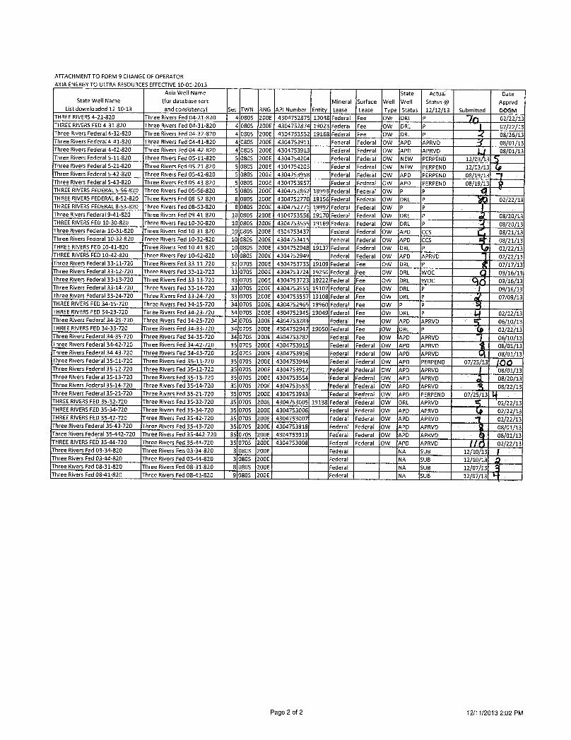
ATTACHMENTTO FORM 9 CHANGEOF OPERATORAXIAENERGYTO ULTRARESOURCESEFFECTIVE10-01-2013
Axia Well Name State Actual DateState Well Name (for database sort Mineral Surface Well Well Status @ Apprvd
List downloaded 12-10-13 and consistency) Sec TWN RNG API Number Entity Lease Lease Type Status 12/12/13 Submitted DOGMTHREERIVERS4-21-820 Three Rivers Fed 04-21-820 4 0805 200E 4304752875 19048 Federal Fee OW DRL P 02/22/13THREERIVERSFED4-31-820 Three Rivers Fed 04-31-820 4 0805 200E 4304752874 19023 Federal Fee OW DRL P 02/22/13Three Rivers Federal4-32-820 Three Rivers Fed 04-32-820 4 0805 200E 4304753552 19168 Federal Fee OW DRL P 08/26/13Three Rivers Federal 4-41-820 Three Rivers Fed 04-41-820 4 0805 200E 4304753911 Federal Federal OW APD APRVD 08/01/13Three Rivers Federal 4-42-820 Three Rivers Fed 04-42-820 4 0805 200E 4304753913 Federal Federal OW APD APRVD 08/01/13Three Rivers Federal 5-11-820 Three Rivers Fed 05-11-820 5 0805 200E 4304754204 Federal Federal OW NEW PERPEND 12/03 3Three Rivers Federal 5-21-820 Three Rivers Fed 05-21-820 5 0805 200E 4304754205 Federal Federal OW NEW PERPEND 12/03/13Three Rivers Federal 5-42-820 Three Rivers Fed 05-42-820 5 0805 200E 4304753958 Federal Federal OW APD PERPEND 08/19/13Three Rivers Federal 5-43-820 Three Rivers Fed 05-43-820 5 0805 200E 4304753957 Federal Federal OW APD PERPEND 08/19/13THREERIVERSFEDERALS-56-820 Three Rivers Fed 05-56-820 5 0805 200E 4304752862 18993 Federal Federal OW P PTHREERIVERSFEDERAL8-52-820 Three Rivers Fed 08-52-820 8 0805 200E 4304752770 19156 Federal Federal OW DRL P 02/22/13THREERIVERSFEDERAL8-53-820 Three Rivers Fed 08-53-820 8 OSOS 200E 4304752771 18992 Federal Federal OW P PThree Rivers Federal9-41-820 Three Rivers Fed 09-41-820 10 0805 200E 4304753556 19170 Federal Federal OW DRL P 08/20/13THREERIVERSFED 10-30-820 Three Rivers Fed 10-30-820 10 080S 200E 4304753555 19169 Federal Federal OW DRL P 08/20/13Three Rivers Federal 10-31-820 Three Rivers Fed 10-31-820 10 0805 200E 4304753437 Federal Federal OW APD CCS 08/21/13Three Rivers Federal 10-32-820 Three Rivers Fed 10-32-820 10 0805 200E 4304753415 Federal Federal OW APD CCS 08/21/13THREERIVERSFED 10-41-820 Three Rivers Fed 10-41-820 10 0805 200E 4304752948 19137 Federal Federal Ow DRL P 02/22/13THREERIVERSFED 10-42-820 Three Rivers Fed 10-42-820 10 0805 200E 4304752949 Federal Federal OW APD APRVD 02/22/13Three Rivers Federal 33-11-720 Three Rivers Fed 33-11-720 32 0705 200E 4304753733 19109 Federal Fee OW DRL P 07/17/13Three Rivers Federal 33-12-720 Three Rivers Fed 33-12-720 33 0705 200E 4304753724 19250 Federal Fee OW DRL WOC 09/16/13Three Rivers Federal 33-13-720 Three Rivers Fed 33-13-720 33 0705 200E 4304753723 19222 Federal Fee OW DRL WOC 09/16/13Three Rivers Federal33-14-720 Three Rivers Fed 33-14-720 33 0705 200E 4304753551 19107 Federal Fee OW DRL P 09/16/13Three Rivers Federal 33-24-720 Three Rivers Fed 33-24-720 33 0705 200E 4304753557 19108 Federal Fee OW DRL P 07/09/13THREERIVERSFED34-15-720 Three Rivers Fed 34-15-720 34 0705 200E 4304752965 18960 Federal Fee OW P PTHREERIVERSFED34-23-720 Three Rivers Fed 34-23-720 34 0705 200E 4304752945 19049 Federal Fee OW DRL P 02/12/13Three Rivers Federal 34-25-720 Three Rivers Fed 34-25-720 34 0705 200E 4304753283 Federal Fee OW APD APRVD 06/10/13THREERIVERSFED34-33-720 Three Rivers Fed 34-33-720 34 0705 200E 4304752947 19050 Federal Fee OW DRL P 02/22/13Three Rivers Federal 34-35-720 Three Rivers Fed 34-35-720 34 0705 200E 4304753282 Federal Fee OW APD APRVD 06/10/13Three Rivers Federal 34-42-720 Three Rivers Fed 34-42-720 35 070S 200E 4304753915 Federal Federal OW APD APRVD 08/01/13Three Rivers Federal 34-43-720 Three Rivers Fed 34-43-720 35 0705 200E 4304753916 Federal Federal OW APD APRVD 08/01/13Three Rivers Federal 35-11-720 Three Rivers Fed 35-11-720 35 0705 200E 4304753944 Federal Federal OW APD PERPEND 07/25/13 QQThree Rivers Federal 35-12-720 Three Rivers Fed 35-12-720 35 0705 200E 4304753917 Federal Federal OW APD APRVD 08/01/13Three Rivers Federal 35-13-720 Three Rivers Fed 35-13-720 35 0705 200E 4304753554 Federal Federal OW APD APRVD 08/20/13Three Rivers Federal 35-14-720 Three Rivers Fed 35-14-720 35 0705 200E 4304753553 Federal Federal OW APD APRVD 08/22/13Three Rivers Federal 35-21-720 Three Rivers Fed 35-21-720 35 0705 200E 4304753943 Federal Federal OW APD PERPEND 07/25/13THREERIVERSFED35-32-720 Three Rivers Fed 35-32-720 35 0705 200E 4304753005 19138 Federal Federal OW DRL APRVD 02/22/13THREERIVERSFED35-34-720 Three Rivers Fed 35-34-720 35 0705 200E 4304753006 Federal Federal OW APD APRVD 02/22/13THREERIVERSFED35-42-720 Three Rivers Fed 35-42-720 35 0703 200E 4304753007 Federal Federal OW APD APRVD 02/22/13Three Rivers Federal 35-43-720 Three Rivers Fed 35-43-720 35 0705 200E 4304753918 Federal Federal OW APD APRVD 08/01/13Three Rivers Federal 35-442-720 Three Rivers Fed 35-442-720 35 0705 200E 4304753919 Federal Federal OW APD APRVD 08/01/13THREERIVERSFED35-44-720 Three Rivers Fed 35-44-720 35 0705 200E 4304753008 Federal Federal OW APD APRVD 02/22/13Three Rivers Fed 03-34-820 Three Rivers Fed 03-34-820 3 0805 200E Federal NA SUB 12/10/13Three Rivers Fed 03-44-820 Three Rivers Fed 03-44-820 3 0805 200E Federal NA SUB 12/10/13Three Rivers Fed 08-31-820 Three Rivers Fed 08-31-820 8 0803 200E Federal NA SUB 12/07/13Three Rivers Fed 08-41-820 Three Rivers Fed 08-41-820 9 080S 200E Federal NA SUB 12/07/13
Page 2 of 2 12/11/2013 2:02

RECEIVEDForm 3160-3 FORMAPPROVED(August2007) OMB No. 1004-0136UNITED STATES Expires July 31, 2010
DEPARTMENT OF THE INTERIOR ABUREAU OF LAND MANAGEMENT 5. Lease Serial No.
UTU85994APPLICATION FOR PERMIT TO DRILL OR REENTELM 6. IfIndian, Allottee or Tribe Name
l a. Type of Work: O DRILL O REENTER C NFIDENTIAL 7. If Unit or CA Agreement, Name and No.
8. Lease Name and We11No.lb. Type of Well: O Oil Well O Gas Well O Other O Multiple Zone g Single Zone THREE RIVERS FED 3-23-8202. Name of Operator Contact: DON S HAMILTON 9. API Well No.Ultra Resources, Inc. E-Mail: [email protected]
3a. Address 3b. Phone No. (include area code) 10. Field and Pool, or Exploratory304 Inverness Way South, Suite 295 Ph: 435-719-2018 UNDESIGNATEDEnglewood, CO 80112 Fx: 435-719-2019
4. Location of Well (Report location clearly and in accordance with any State requirements.*) 11. Sec., T., R., M., or Blk. and Survey or AreaAt surface NWSW 1475FSL 1237FWL 40.148539 N Lat, 109.659714 W Lon Sec 3 T8S R20E Mer SLBAtproposedprod. zone NESW 1980FSL 1980FWL 40.149950 N Lat, 109.657072 W Lon
14. Distance in miles and direction from nearest town or post office* 12. County or Parish 13. State26.4 MILES SOUTHWEST OF VERNAL, UTAH UINTAH UT15. Distance from proposed location to nearest property or 16. No. of Acres in Lease 17. Spacing Unit dedicated to this welllease line, ft. (Also to nearest drig. unit line, if any)
1237 1818.00 40.0018. Distance from proposed location to nearest well, drilling, 19. Proposed Depth 20. BLM/BIA Bond No. on filecompleted, applied for, on this lease, ft.
40 7111 MD UTBOOO5936955 TVD RECEIVED
21. Elevations (Show whether DF, KB, RT, GL, etc. 22. Approximate date work will start 23. Estimated duration4745 GL 08/25/2013 60 DAYS
24. AttachmentsThe following, completed in accordance with the requirements of Onshore Oil and Gas Order No. 1, shall be attached to this form: DIV.Ul-CIL,GAS&MININC1. Well plat certified by a registered surveyor. 4. Bond to cover the operations unless covered by an existing bond on file (see2. A Drilling Plan. Item 20 above).3. A Surface Use Plan (if the location is on National Forest System Lands, the 5. Operator certificationSUPO shall be filed with the appropriate Forest Service Office). 6. Such other site specific informationand/or plans as may be required by the
authorized of5cer.
25. Signature Name (Printed/Typed) Date(Electronic Submission) DON S HAMILTON Ph: 435-719-2018 08/12/2013Title
PERMITTINGAGENTApproved by (Signatur Name (Printed/Typed)
Title ngMgidManage; Omce VERNALFIELDOFFICE&MineralResourcesApplication approval does not warrant or certify the applicant holds legal or equitable title to those rights in the subject leasewhich would entitle the applicant to conductoperations thereon.Conditionsof approval, if any, are attached.
Title 18 U.S.C. Section 1001 and Title 43 U.S.C. Section 1212, make it a crime for any person knowingly and willfully to make to any department or agency of the UnitedStates any false, fictitious or fraudulent statements or representations as to any matter within its jurisdiction.
Additional Operator Remarks (see next page)
Electronic Submission #216769 verified by the BLM Well Information System
NOTICEOFAPPROVALCONDITIONSOFAPPROVALATTACHED
** OPERATOR-SUBMITTED " OPERATOR-SUBMITTED ** OPERATOR-SUBMITTED

UNITED STATES DEPARTMENT OF THE INTERIORBUREAU OF LAND MANAGEMENT
VERNAL FIELD OFFICE170 South 500 East VERNAL, UT 84078 (435) 781-4400
CONDITIONS OF APPROVAL FOR APPLICATION FOR PERMIT TO DRILL
Company: Ultra Resources, Inc. Location: NWSW, Sec. 3, T8S, R20EWell No: Three Rivers Fed 3-23-820 Lease No: UTU-85994API No: 43-047-53953 Agreement: NIA
OFFICE NUMBER: (435) 781-4400
OFFICE FAX NUMBER: (435) 781-3420
A COPY OF THESE CONDITIONS SHALL BE FURNISHED TO YOURFIELD REPRESENTATIVE TO INSURE COMPLIANCE
All lease and/or unit operations are to be conducted in such a manner that full compliance is made with the applicablelaws, regulations (43 CFR Part 3160), and this approved Application for Permit to Drill including Surface andDownhole Conditions of Approval. The operator is considered fully responsible for the actions of his subcontractors.A copy of the approved APD must be on location during construction, drilling, and completion operations. Thispermit is approved for a two (2) year period, or until lease expiration, whichever occurs first. An additionalextension, up to two (2) years, may be applied for by sundry notice prior to expiration.
NOTIFICATION REQUIREMENTS
Location Construction - Forty-Eight (48) hours prior to construction of location and |(Notify Environmental Scientist) access roads.
Location Completion - Prior to moving on the drilling rig.(Notify Environmental Scientist)
Spud Notice - Twenty-Four (24) hours prior to spudding the well.(Notify Petroleum Engineer)
Casing String & Cementing - Twenty-Four (24) hours prior to running casing and(Notify Supv. Petroleum Tech.) cementing all casing strings to:
blm ut vn [email protected] & Related Equipment Tests - Twenty-Four (24) hours prior to initiating pressure tests.(Notify Supv. Petroleum Tech.)
First Production Notice - Within Five (5) business days after new well begins or(Notify Petroleum Engineer) production resumes after well has been offproduction for
more than ninety (90)

Page 2 of 6Well: Three Rivers Fed. 3-23-820
3/20/2014
SURFACE USE PROGRAMCONDITIONSOF APPROVAL (COAs)
• All new and replacement internal combustion gas field engines of less than or equal to 300 design-rated horsepower must not emit more than 2 gms of NOxper horsepower-hour. This requirementdoes not apply to gas field engines of less than or equal to 40 design-rated horsepower.
• All and replacement internal combustion gas field engines of greater than 300 design ratedhorsepower must not emit more than 1.0 gms of NOx per horsepower-hour.
• Ifthere is an active Gilsonite mining operation within 2 miles of the well location, operator shallnotify the Gilsonite operator at least 48 hours prior to any blasting during construction.
• If paleontological materials are uncovered during construction, the operator is to immediately stopwork and contact the Authorized Officer (AO). A determination willbe made by the AO as to whatmitigation may be necessary for the discovered paleontologic material before construction cancontinue.
SITE SPECIFIC COAs:
• 300 design-rated horse power must not emit more than 2 grams of NOx per horsepower-hour. This requirement does not apply to gas field engines of less than or equal to 40design-rated horsepower-hour.
• AIIvehicles and equipment shall be cleaned either through power-washing, or otherapproved method, if the vehicles or equipment were brought in from areas outside theUinta Basin, to prevent AII new and replacement internal combustion gas field engines ofless than or equal to weed seed introduction.
• Project activities are not allowed from March 1 - August 31 to minimize impacts duringburrowing owl nesting season. This Condition of Approval only applies to the following welllocations:
• Three Rivers # 5-42-820, 5-43-820, and 4-13-820;• Three Rivers # 3-13-820, 3-14-820, 3-23-820,and 3-24-820;• Three Rivers # 35-11-720 and

Page 3 of 6Well: Three Rivers Fed. 3-23-820
3/20/2014
DOWNHOLE PROGRAMCONDITIONS OF APPROVAL (COAs)
SITE SPECIFIC DOWNHOLE COAs:
• Cement for the surface casing shall be circulated to the surface. Cement for the production casingshall be brought up to a minimum of 200 feet above the surface casing shoe.
• A CBL shall be run from TD to TOC in the Production Casing.
• Cement sample shall be caught and tested for compressibility for the lead and tailcement for thesurface and production casing. The results shall be reported with the completion report.
AII provisions outlined in Onshore Oil & Gas Order #2 Drilling Operations shall be strictly adheredto. The following items are emphasized:
DRILLINGICOMPLETIONIPRODUCING OPERATINGSTANDARDS
• The spud date and timeshall be reported orallyto Vernal Field Office within24 hours of spudding.
• Notify Vernal Field Office Supervisory Petroleum Engineering Technician at least 24 hours inadvance of casinq cementing operations and BOPE &casinq pressure tests.
• All requirements listed in Onshore Order #2 III. E. Special Drilling Operations are applicable for airdrilling of surface hole.
• Blowout prevention equipment (BOPE) shall remain in use untilthe well is completed orabandoned. Closing unit controls shall remain unobstructed and readily accessible at all times.Choke manifolds shall be located outside of the rig substructure.
• All BOPE components shall be inspected daily and those inspections shall be recorded in the dailydrilling report. Components shall be operated and tested as required by Onshore Oil & Gas OrderNo. 2 to insure good mechanical working order. All BOPE pressure tests shall be performed by atest pump with a chart recorder and by the rig pumps. Test shall be reported in the driller'slog.
• BOP drills shall be initially conducted by each drilling crew within 24 hours of drillingout from underthe surface casing and weekly thereafteras specified in Onshore Oil & Gas Order No. 2.
• Casing pressure tests are required before drilling out from under all casing strings set andcemented in place.
• No aggressivelfresh hard-banded drill pipe shall be used withincasing.
• Cement baskets shall not be run on surface casing.
• The operator must report all shows of water or water-bearing sands to the BLM. Ifflowing water isencountered it must be sampled, analyzed, and a copy of the analyses submitted to the BLMVernalField

Page 4 of 6Well: Three Rivers Fed. 3-23-820
3/20/2014
• The operator must report encounters of all non oil & gas mineral resources (such as Gilsonite, tarsands, oilshale, trona, etc.) to the Vernal Field Office, in writing,within 5 working days of eachencounter. Each report shall include the well namelnumber, well location, date and depth (from KBor GL) of encounter, vertical footage of the encounter and, the name of the person making thereport (along with a telephone number) should the BLM need to obtain additional information.
• A complete set of angular deviation and directional surveys of a directional wellwillbe submitted tothe Vernal BLM office engineer within 30 days of the completion of the well.
• While actively drilling, chronologic drilling progress reports shall be filed directly with the BLM,Vernal Field Office on a weekly basis in sundry, letter format or e-mail to the Petroleum Engineersuntilthe well is completed.
• A cement bond log (CBL) will be run from the production casing shoe to the top of cement and shallbe utilizedto determine the bond quality for the production casing. Submit a field copy of the CBLto this office.
• Please submit an electronic copy of all other logs run on this well in LAS format [email protected]. This submission will supersede the requirement for submittalof paper logs to the BLM.
• There shall be no deviation from the proposed drilling, completion, and/or workover program asapproved. Safe drilling and operating practices must be observed. Any changes in operation musthave prior approval from the BLM Vernal Field
Page 5 of 6Well: Three Rivers Fed. 3-23-820
3/20/2014
OPERATING REQUIREMENT REMINDERS:
• All wells, whether drilling, producing, suspended, or abandoned, shall be identified in accordancewith43 CFR 3162.6. There shall be a sign or marker with the name of the operator, lease serialnumber, well number, and surveyed description of the well.
• For information regarding production reporting, contact the Office of Natural Resources Revenue (ONRR) atwww.ONRR.gov.
• Should the well be successfully completed for production, the BLMVernal Field office must benotifiedwhen it is placed in a producing status. Such notificationwillbe by written communicationand must be received in this officeby not later than the fifth business day following the date onwhich the well is placed on production. The notificationshall provide, as a minimum,the followinginformational items:
o Operator name, address, and telephone number.
o Well name and number.
o Well location (¼¼,Sec., Twn, Rng, and P.M.).
o Date well was placed in a producing status (date of first production for which royaltywillbepaid).
o The nature of the well's production, (i.e., crude oil,or crude oil and casing head gas, ornatural gas and entrained liquid hydrocarbons).
o The Federal or Indian lease prefix and number on which the well is located; otherwise thenort-Federal or non-Indian land category, i.e., State or private.
o Unitagreement and/or participating area name and number, if applicable.
o Communitization agreement number, if applicable.
• Any venting or flaring of gas shall be done in accordance with Notice to Lessees (NTL) 4A andneeds prior approval from the BLMVernal Field Office.
• All undesirable events (fires, accidents, blowouts, spills, discharges) as specified in NTL 3A will bereported to the BLM, Vernal Field Office. Majorevents, as defined in NTL3A, shall be reportedverbally within 24 hours, followed by a written report within 15 days. "Other than Major Events" willbe reported in writing within 15 days. "Minor Events" will be reported on the Monthly Report ofOperations and Production.
• Whether the well is completed as a dry hole or as a producer, "WellCompletion and RecompletionReport and Log" (BLM Form 3160-4) shall be submitted not later than 30 days after completion ofthe well or after completion of operations being performed, in accordance with 43 CFR 3162.4-1.Two copies of all logs run, core descriptions, and all other surveys or data obtained and compiledduring the drilling, workover, and/or completion operations, shall be filed on BLM Form 3160-4.Submit with the well completion report a geologic report including, at a minimum, formation tops,and a summary and conclusions. Also include deviation surveys, sample descriptions, strip
Page 6 of 6Well: Three Rivers Fed. 3-23-820
3/20/2014
core data, drill stem test data, and results of production tests if performed. Samples (cuttings, fluid,and/or gas) shall be submitted only when requested by the BLM,Vernal Field Office.
• All off-lease storage, off-lease measurement, or comminglingon-lease or off-lease, shall have priorwritten approval from the BLMVernal Field Office.
• Oiland gas meters shall be calibrated in place prior to any deliveries. The BLMVernal Field OfficePetroleum Engineers will be provided with a date and timefor the initial meter calibration and allfuture meter proving schedules. A copy of the meter calibration reports shall be submitted to theBLMVernal Field Office. All measurement facilities will conform to the API standards for liquidhydrocarbons and the AGA standards for natural gas measurement. AIImeasurement points shallbe identified as the point of sale or allocation for royalty purposes.
• A schematic facilities diagram as required by Onshore Oil & Gas Order No. 3 shall be submitted tothe BLMVernal Field Office within 30 days of installation or first production, whichever occurs first.AIIsite security regulations as specified in Onshore Oil & Gas Order No. 3 shall be adhered to. AIIproduct lines entering and leaving hydrocarbon storage tanks will be effectivelysealed inaccordance with Onshore Oil & Gas Order No. 3.
• Any additional construction, reconstruction, or alterations of facilities, including roads, gatheringlines, batteries, etc., which will result in the disturbance of new ground, shall require the filing of asuitable plan and need prior approval of the BLM Vernal Field Office. Emergency approval may beobtained orally, but such approval does not waive the written report requirement.
• No location shall be constructed or moved, no well shall be plugged, and no drilling or workoverequipment shall be removed from a well to be placed in a suspended status without prior approvalof the BLMVernal Field Office. Ifoperations are to be suspended for more than 30 days, priorapproval of the BLMVernal Field Office shall be obtained and notificationgiven before resumptionof operations.
• Pursuant to Onshore Oil & Gas Order No. 7, this is authorization for pit disposal of water producedfrom thiswell for a period of 90 days from the date of initial production. A permanent disposalmethod must be approved by this office and in operation prior to the end of this 90-day period. Inorder to meet this deadline, an application for the proposed permanent disposal method shall besubmitted along with any necessary water analyses, as soon as possible, but no later than 45 daysafter the date of first production. Any method of disposal which has not been approved prior to theend of the authorized 90-day period willbe considered as an Incident of Noncompliance and will begrounds for issuing a shut-in order untilan acceptable manner for disposing of said water isprovided and approved by this office.
• Unless the plugging is to take place immediately upon receipt of oral approval, the Field OfficePetroleum Engineers must be notifiedat least 24 hours in advance of the plugging of the well, inorder that a representative may witness plugging operations. If a well is suspended or abandoned,all pits must be fenced immediately untilthey are backfilled. The "Subsequent Report ofAbandonment" (Form BLM 3160-5) must be submitted within30 days after the actual plugging ofthe well bore, showing location of plugs, amount of cement in each, and amount of casing left inhole, and the current status of the surface
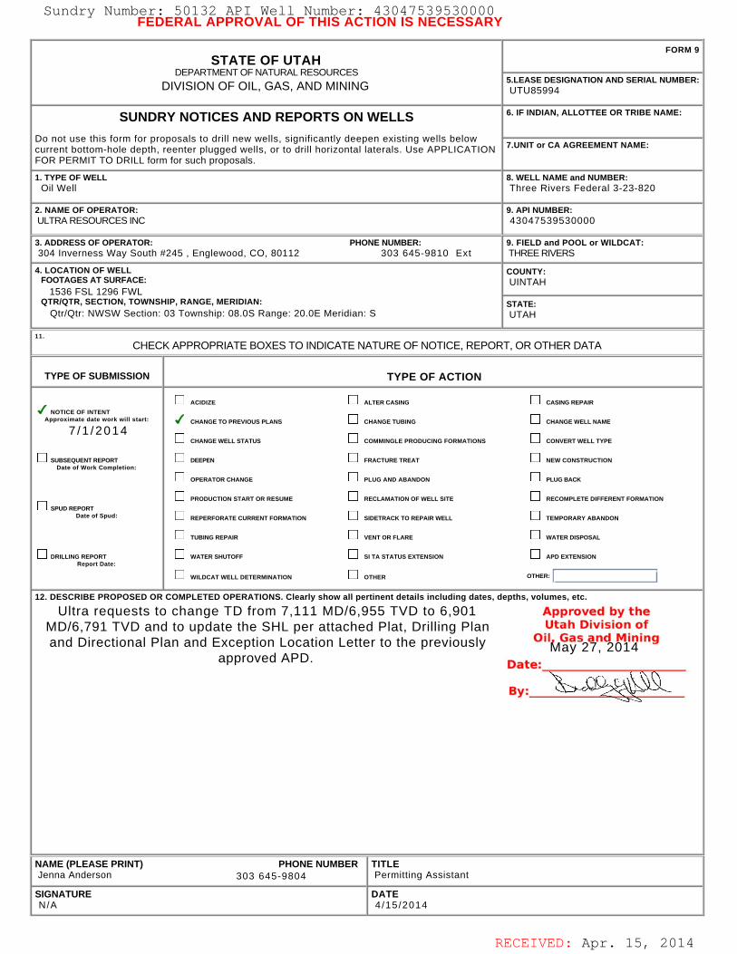
RECEIVED: Apr. 15, 2014
FEDERAL APPROVAL OF THIS ACTION IS NECESSARY
STATE OF UTAHDEPARTMENT OF NATURAL RESOURCES
DIVISION OF OIL, GAS, AND MINING
FORM 9
5.LEASE DESIGNATION AND SERIAL NUMBER: UTU85994
SUNDRY NOTICES AND REPORTS ON WELLS
Do not use this form for proposals to drill new wells, significantly deepen existing wells belowcurrent bottom-hole depth, reenter plugged wells, or to drill horizontal laterals. Use APPLICATIONFOR PERMIT TO DRILL form for such proposals.
6. IF INDIAN, ALLOTTEE OR TRIBE NAME:
7.UNIT or CA AGREEMENT NAME:
1. TYPE OF WELL Oil Well
8. WELL NAME and NUMBER: Three Rivers Federal 3-23-820
2. NAME OF OPERATOR: ULTRA RESOURCES INC
9. API NUMBER: 43047539530000
3. ADDRESS OF OPERATOR: PHONE NUMBER: 304 Inverness Way South #245 , Englewood, CO, 80112 303 645-9810 Ext
9. FIELD and POOL or WILDCAT: THREE RIVERS
4. LOCATION OF WELL FOOTAGES AT SURFACE: 1536 FSL 1296 FWL QTR/QTR, SECTION, TOWNSHIP, RANGE, MERIDIAN: Qtr/Qtr: NWSW Section: 03 Township: 08.0S Range: 20.0E Meridian: S
COUNTY: UINTAH
STATE: UTAH
11.
CHECK APPROPRIATE BOXES TO INDICATE NATURE OF NOTICE, REPORT, OR OTHER DATA
TYPE OF SUBMISSION TYPE OF ACTION
NOTICE OF INTENTApproximate date work will start:
7 /1 /2014
SUBSEQUENT REPORTDate of Work Completion:
SPUD REPORTDate of Spud:
DRILLING REPORTReport Date:
ACIDIZE ALTER CASING CASING REPAIR
CHANGE TO PREVIOUS PLANS CHANGE TUBING CHANGE WELL NAME
CHANGE WELL STATUS COMMINGLE PRODUCING FORMATIONS CONVERT WELL TYPE
DEEPEN FRACTURE TREAT NEW CONSTRUCTION
OPERATOR CHANGE PLUG AND ABANDON PLUG BACK
PRODUCTION START OR RESUME RECLAMATION OF WELL SITE RECOMPLETE DIFFERENT FORMATION
REPERFORATE CURRENT FORMATION SIDETRACK TO REPAIR WELL TEMPORARY ABANDON
TUBING REPAIR VENT OR FLARE WATER DISPOSAL
WATER SHUTOFF SI TA STATUS EXTENSION APD EXTENSION
WILDCAT WELL DETERMINATION OTHER OTHER:
12. DESCRIBE PROPOSED OR COMPLETED OPERATIONS. Clearly show all pertinent details including dates, depths, volumes, etc.
Ultra requests to change TD from 7,111 MD/6,955 TVD to 6,901MD/6,791 TVD and to update the SHL per attached Plat, Drilling Planand Directional Plan and Exception Location Letter to the previously
approved APD.
NAME (PLEASE PRINT) PHONE NUMBER Jenna Anderson 303 645-9804
TITLE Permitting Assistant
SIGNATURE N/A
DATE 4 /15 /2014
May 27, 2014
Sundry Number: 50132 API Well Number: 43047539530000Sundry Number: 50132 API Well Number: 43047539530000FEDERAL APPROVAL OF THIS ACTION IS NECESSARY
FORM 9STATE OF UTAH
DEPARTMENTOF NATURALRESOURCES5.LEASE DESIGNATION AND SERIAL NUMBER:DIVISION OF OIL, GAS, AND MINING UTU85994
SUNDRY NOTICES AND REPORTS ON WELLS 6. IF INDIAN, ALLOTTEE OR TRIBE NAME:
Do not use this form for proposals to drill new wells, significantly deepen existing wells belowcurrent bottom-hole depth, reenter plugged wells, or to drill horizontal laterals. Use APPLICATION 7.UNITor CA AGREEMENT NAME:
FOR PERMIT TO DRILL form for such proposals.
1. TYPE OF WELL 8. WELL NAME and NUMBER:Oil Well Three Rivers Federal 3-23-820
2. NAME OF OPERATOR: 9. API NUMBER:ULTRARESOURCES INC 43047539530000
3. ADDRESS OF OPERATOR: PHONE NUMBER: 9. FIELD and POOL or WILDCAT:304 Inverness Way South #245 , Englewood, CO, 80112 303 645-9810 Ext THREE RIVERS
4. LOCATION OF WELL COUNTY:FOOTAGESATSURFACE: UINTAH
1536 FSL 1296 FWLQTRIQTR, SECTION, TOWNSHIP, RANGE, MERIDIAN: STATE:
QtrlQtr: NWSW Section: 03 Township: 08.0S Range: 20.0E Meridian: S UTAH
CHECK APPROPRIATE BOXES TO INDICATENATURE OF NOTICE, REPORT, OR OTHER DATA
TYPE OF SUBMISSION TYPE OF ACTION
ACI DIZE ALTER CASING CASING REPAIRNOTICE OF INTENT
Approximate date work will start: CHANGE TO PREVIOUS PLANS CHANGE TUBING CHANGE WELL NAME
7/1/2014CHANGE WELL STATUS COMMINGLE PRODUCING FORMATIONS CONVERT WELL TYPE
SUBSEQUENT REPORT DEEPEN FRACTURE TREAT NEW CONSTRUCTIONDate of Work Completion:
OPERATOR CHANGE PLUG AND ABANDON PLUG BACK
PRODUCTION START OR RESUME RECLAMATION OF WELL SITE RECOMPLETE DIFFERENT FORMATIONSPUD REPORT
Date of Spud: REPERFORATE CURRENT FORMATION SIDETRACK TO REPAIR WELL TEMPORARY ABANDON
TUBING REPAIR VENT OR FLARE WATER DISPOSAL
DRILLING REPORT WATER SHUTOFF SI TA STATUS EXTENSION APD EXTENSIONReport Date:
WILDCATWELLDETERMINATION OTHER OTHER:
12. DESCRIBE PROPOSED OR COMPLETED OPERATIONS. Clearly show all pertinent details including dates, depths, volumes, etc.
Ultra requests to change TD from 7,111 MD/6,955 TVD to 6,901 Approved by theMD/6,791 TVD and to update the SHL per attached Plat, Drilling Plan utah Division ofand Directional Plan and Exception Location Letter to the previously aas2and OM14ning
approved APD. Date:
By:
NAME (PLEASE PRINT) PHONE NUMBER TITLEJenna Anderson 303 645-9804 Permitting Assistant
SIGNATURE DATEN/A 4/15/2014
RECEIVED: Apr. 15,
Sundry Number: 50132 API Well Number: 43047539530000FEDERAL APPROVAL OF THIS ACTION IS NECESSARY
FORM 9STATE OF UTAH
DEPARTMENTOF NATURALRESOURCES5.LEASE DESIGNATION AND SERIAL NUMBER:DIVISION OF OIL, GAS, AND MINING UTU85994
SUNDRY NOTICES AND REPORTS ON WELLS 6. IF INDIAN, ALLOTTEE OR TRIBE NAME:
Do not use this form for proposals to drill new wells, significantly deepen existing wells belowcurrent bottom-hole depth, reenter plugged wells, or to drill horizontal laterals. Use APPLICATION 7.UNITor CA AGREEMENT NAME:
FOR PERMIT TO DRILL form for such proposals.
1. TYPE OF WELL 8. WELL NAME and NUMBER:Oil Well Three Rivers Federal 3-23-820
2. NAME OF OPERATOR: 9. API NUMBER:ULTRARESOURCES INC 43047539530000
3. ADDRESS OF OPERATOR: PHONE NUMBER: 9. FIELD and POOL or WILDCAT:304 Inverness Way South #245 , Englewood, CO, 80112 303 645-9810 Ext THREE RIVERS
4. LOCATION OF WELL COUNTY:FOOTAGESATSURFACE: UINTAH
1536 FSL 1296 FWLQTRIQTR, SECTION, TOWNSHIP, RANGE, MERIDIAN: STATE:
QtrlQtr: NWSW Section: 03 Township: 08.0S Range: 20.0E Meridian: S UTAH
CHECK APPROPRIATE BOXES TO INDICATENATURE OF NOTICE, REPORT, OR OTHER DATA
TYPE OF SUBMISSION TYPE OF ACTION
ACI DIZE ALTER CASING CASING REPAIRNOTICE OF INTENT
Approximate date work will start: CHANGE TO PREVIOUS PLANS CHANGE TUBING CHANGE WELL NAME
7/1/2014CHANGE WELL STATUS COMMINGLE PRODUCING FORMATIONS CONVERT WELL TYPE
SUBSEQUENT REPORT DEEPEN FRACTURE TREAT NEW CONSTRUCTIONDate of Work Completion:
OPERATOR CHANGE PLUG AND ABANDON PLUG BACK
PRODUCTION START OR RESUME RECLAMATION OF WELL SITE RECOMPLETE DIFFERENT FORMATIONSPUD REPORT
Date of Spud: REPERFORATE CURRENT FORMATION SIDETRACK TO REPAIR WELL TEMPORARY ABANDON
TUBING REPAIR VENT OR FLARE WATER DISPOSAL
DRILLING REPORT WATER SHUTOFF SI TA STATUS EXTENSION APD EXTENSIONReport Date:
WILDCATWELLDETERMINATION OTHER OTHER:
12. DESCRIBE PROPOSED OR COMPLETED OPERATIONS. Clearly show all pertinent details including dates, depths, volumes, etc.
Ultra requests to change TD from 7,111 MD/6,955 TVD to 6,901 Approved by theMD/6,791 TVD and to update the SHL per attached Plat, Drilling Plan utah Division ofand Directional Plan and Exception Location Letter to the previously aas2and OM14ning
approved APD. Date:
By:
NAME (PLEASE PRINT) PHONE NUMBER TITLEJenna Anderson 303 645-9804 Permitting Assistant
SIGNATURE DATEN/A 4/15/2014
RECEIVED: Apr. 15,

RECEIVED: May. 15, 2014
â
â
â
â
â
â
â
ââ
â
â
â
â
â
ââ
â
â
â
â
â
â
ââ
â
â
â â
â
â
â
â
â
â
â
â
â
â â
ââ
â
â
â
â
â
â
â
â
â
â
â â
ª
ª
ª
'
''
'
'
'
''
''
'' ''
''
'
'
'
HH
''
'
HHH
''
H'
!!! !!!
!!!
10
03
05
3534
04
33
09 11
02
08
NORTH OURAYUNIT 24304710604
NORTH OURAYUNIT 34304710605
FEDERAL 14304720450
THREE RIVERS2-11-8204304751936
THREE RIVERS2-13-8204304752687
THREE RIVERS2-23-820
4304752688
THREE RIVERS2-15-8204304752689THREE RIVERS2-25-8204304752690
THREE RIVERSFEDERAL 3-53-8204304752820
THREE RIVERSFEDERAL 3-54-820
4304752860
THREE RIVERSFEDERAL 3-32-8204304752861
THREE RIVERSFED 4-31-8204304752874
THREE RIVERS4-21-820
4304752875
THREE RIVERSFED 10-41-8204304752948
THREE RIVERSFED 10-42-8204304752949
THREE RIVERSFED 3-11-8204304752950
THREE RIVERSFED 34-15-720
4304752965
THREE RIVERSFED 34-35-7204304753282Three RiversFederal 34-25-7204304753283
Three RiversFederal 10-32-820
4304753415
Three RiversFederal 10-31-820
4304753437
Three Rivers4-33-8204304753528
Three RiversFederal 33-14-7204304753551
Three RiversFederal 4-32-820
4304753552
Three RiversFederal 35-14-7204304753553
Three RiversFederal 35-13-720
4304753554
THREE RIVERSFED 10-30-8204304753555
Three RiversFederal 9-41-820
4304753556
Three RiversFederal 33-24-7204304753557
Three RiversFederal 4-41-8204304753911
THREE RIVERSFEDERAL 4-42-820
4304753913
Three RiversFederal 3-12-8204304753914
Three Rivers2-24-820
4304753945Three Rivers 2-223-820
4304753946
THREE RIVERS2-22-820
4304753947THREE RIVERS
2-21-8204304753948
Three RiversFederal 3-13-8204304753951
Three RiversFederal 3-14-820
4304753952Three RiversFederal 3-23-8204304753953
Three RiversFederal 3-24-820
4304753954Three RiversFederal 3-34-8204304754213
Three RiversFederal 3-44-820
4304754214
Three RiversFederal 33-133-7204304754247
Three RiversFederal 33-23-720
4304754251
Three RiversFed 4-311-8204304754254
Three RiversFed 33-34-720
4304754255
Three RiversFed 3-33-8204304754415
Three Rivers4-23-8204304754416
Three Rivers4-26T-820
4304754417Three Rivers4-24-8204304754418
Three Rivers4-36T-8204304754420
Three Rivers4-38T-8204304754421
Three Rivers4-34-820
4304754422
Three Rivers4-43-8204304754423
Three Rivers4-34T-820
4304754424Three Rivers 4-44T-8204304754425
Map Produced by Diana Mason
F1,400 0 1,400700 Feet
1:13,814
Wells QueryStatus
APD - Aproved Permit
H DRL - Spuded (Drilling Commenced)
4 GIW - Gas Injection
!) GS - Gas Storage
! LOC - New Location
7 OPS - Operation Suspended
ª PA - Plugged Abandoned
* PGW - Producing Gas Well
' POW - Producing Oil Well
¸ SGW - Shut-in Gas Well
· SOW - Shut-in Oil Well
6 TA - Temp. Abandoned
" TW - Test Well
¸ WDW - Water Disposal
¸ WIW - Water Injection Well
=) WSW - Water Supply Well
UnitsSTATUS
ACTIVE
EXPLORATORY
GAS STORAGE
NF PP OIL
NF SECONDARY
PI OIL
PP GAS
PP GEOTHERML
PP OIL
SECONDARY
TERMINATED
FieldsSTATUS
Unknown
ABANDONED
ACTIVE
COMBINED
INACTIVE
STORAGE
TERMINATED
TOOELE
SAN JUAN
MILLARD
KANE
JUAB
IRON
EMERY
UINTAH
BOX ELDER
GARFIELD
GRAND
UTAH
WAYNEBEAVER
DUCHESNE
SEVIER
SUMMIT
RICH
WASHINGTON
CARBON
SANPETE
CACHE
PIUTE
DAVIS
WASATCH
WEBER
SALT LAKE
DAGGETT
MORGAN
Location Map
API Number: 4304753953Well Name: Three Rivers Federal 3-23-820 Township: T08.0S Range: R20.0E Section: 03 Meridian: S
Operator: ULTRA RESOURCES INC
Map Prepared: 5/15/2014
Sundry Number: 50132 API Well Number: 43047539530000Sundry Number: 50132 API Well Number: 43047539530000
C ee Rivers hree RiversThree i Federal33-133-720 Feder 135-13-720 Three Rivers API Number: 4304753953Federal 33-23-720 4304754247 30475355 ederal 35-14-7204304754251 4304753553 Well Name: Three Rivers Federal 3-23-820
Three Rivers FEDERAL 35Federal 33-14-720 NORTH OURAY 430472045 Township: TO8.0S Range: R20.0E Section: 03 Meridian: S4 33
THREE RIVEHR3 82EORS THREE R5 2ROS
4347310605 Operator: ULTRA RESOURCES INC
Federal33-24-720 FED34-15-04752950 \4 753282
4304753557Three River ree Rivers
4304752\ NIO I I " Map Prepared: 5/15/2014
--, ,-oo Federal 34-25-720 UNIT 2 Map Produced by Diana Mason
43 7 304754254 4304753283 4304710604 RE8ERIVERS
4304751936THREE RIVERS THREE RIVERS Mlle Query Units
4321878420
THREER RSThre RiversTH 2E2RI20ERS sta s
APo AproveaPermit AcTivEFEDE 3LO44745910 4Fed al 4 411-820
THREE RIVERS753947 o ORL spudea<oriiiingcommenceci ExPtosAvomy
FedRi3-e1r2s-820 4304753948 es ssio,age NFPPoit
430 53 4 THREERIVERS e Loc NewtocaionNFsEcoNDARY
FEDERAL 3-32-820oPs opersion suspended
Thre Riv8er0sTh4ree82Rivers430475T e6e1Rivers
REE2RI EORIVERS se
43047 4 4 4423 Fed3-33-820 43047526 4304752687 Pow Producingoliwell
Bree River hree Rivers 4-44T-820 I 4304754415 _a_ saw s a casweii sEcoNDARY
Federal 4-32-820 Thre4e R47e54425THREE RIVERS THREE RIVERS sow sh inoliwei
TERMiNATED
4304753552 4-33-820 FEDERAL 3-54-820 4F3E0D4E78L230-53-820p TA -Temp aandonea
4304753528 402 0, 3°*,
Three Riv ^B^NDONEDThree 3rs Thre ivers Thre iversFeder -13-820 Th eRivers w waterinectionwei
ree Rivers 4-2 20 4-36T- O Federal 3-1 043 53951 2 4-8204-26T820 4754416 4 54420 430475395 43 753945 watersuppiyweii coMeiNED
4304754417 Three Rivers ree Rivers Three Rivers hree Rivers ree Rivers 2-223-82r iyers 4-34-820 8T-820 Federal 3-24-8 deral 3-23-820 Bree Rivers 430475394 ST°"
30-8M418 4304754422 4 754421 4304753 4 43 53953 Federh ee4R48e2rsFed4eral 3 34-820 T E8E20RIVERS
4 304752689
THREE RIVERS2-25-820 sox sto""
icLocation Map
4304752690
Three ivers THREE RIVERSFederal 9- -820 FED 10-30-820
oucHEsN
43047 556 4304753555 T e Rivers T EE RIVERS uvAH t TAH
Fede I 10-32-820 F 10-41-82043 4753415 04752948 auAs
cAasoN
Threr Rivers THREE RIVERSFederal i0-31-820 FED10-42-820
MieLARD4304 53437 4304752949 EMER
sEviER
0 10 BE^*ER PiuTE wAvNE
09 11 IRON GARFiELD
mNauAN
WASHINGTON KANE
1.400 Feet
I i 1:13,814
RECEIVED: May. 15,
Sundry Number: 50132 API Well Number: 43047539530000
C ee Rivers hree RiversThree i Federal33-133-720 Feder 135-13-720 Three Rivers API Number: 4304753953Federal 33-23-720 4304754247 30475355 ederal 35-14-7204304754251 4304753553 Well Name: Three Rivers Federal 3-23-820
Three Rivers FEDERAL 35Federal 33-14-720 NORTH OURAY 430472045 Township: TO8.0S Range: R20.0E Section: 03 Meridian: S4 33
THREE RIVEHR3 82EORS THREE R5 2ROS
4347310605 Operator: ULTRA RESOURCES INC
Federal33-24-720 FED34-15-04752950 \4 753282
4304753557Three River ree Rivers
4304752\ NIO I I " Map Prepared: 5/15/2014
--, ,-oo Federal 34-25-720 UNIT 2 Map Produced by Diana Mason
43 7 304754254 4304753283 4304710604 RE8ERIVERS
4304751936THREE RIVERS THREE RIVERS Mlle Query Units
4321878420
THREER RSThre RiversTH 2E2RI20ERS sta s
APo AproveaPermit AcTivEFEDE 3LO44745910 4Fed al 4 411-820
THREE RIVERS753947 o ORL spudea<oriiiingcommenceci ExPtosAvomy
FedRi3-e1r2s-820 4304753948 es ssio,age NFPPoit
430 53 4 THREERIVERS e Loc NewtocaionNFsEcoNDARY
FEDERAL 3-32-820oPs opersion suspended
Thre Riv8er0sTh4ree82Rivers430475T e6e1Rivers
REE2RI EORIVERS se
43047 4 4 4423 Fed3-33-820 43047526 4304752687 Pow Producingoliwell
Bree River hree Rivers 4-44T-820 I 4304754415 _a_ saw s a casweii sEcoNDARY
Federal 4-32-820 Thre4e R47e54425THREE RIVERS THREE RIVERS sow sh inoliwei
TERMiNATED
4304753552 4-33-820 FEDERAL 3-54-820 4F3E0D4E78L230-53-820p TA -Temp aandonea
4304753528 402 0, 3°*,
Three Riv ^B^NDONEDThree 3rs Thre ivers Thre iversFeder -13-820 Th eRivers w waterinectionwei
ree Rivers 4-2 20 4-36T- O Federal 3-1 043 53951 2 4-8204-26T820 4754416 4 54420 430475395 43 753945 watersuppiyweii coMeiNED
4304754417 Three Rivers ree Rivers Three Rivers hree Rivers ree Rivers 2-223-82r iyers 4-34-820 8T-820 Federal 3-24-8 deral 3-23-820 Bree Rivers 430475394 ST°"
30-8M418 4304754422 4 754421 4304753 4 43 53953 Federh ee4R48e2rsFed4eral 3 34-820 T E8E20RIVERS
4 304752689
THREE RIVERS2-25-820 sox sto""
icLocation Map
4304752690
Three ivers THREE RIVERSFederal 9- -820 FED 10-30-820
oucHEsN
43047 556 4304753555 T e Rivers T EE RIVERS uvAH t TAH
Fede I 10-32-820 F 10-41-82043 4753415 04752948 auAs
cAasoN
Threr Rivers THREE RIVERSFederal i0-31-820 FED10-42-820
MieLARD4304 53437 4304752949 EMER
sEviER
0 10 BE^*ER PiuTE wAvNE
09 11 IRON GARFiELD
mNauAN
WASHINGTON KANE
1.400 Feet
I i 1:13,814
RECEIVED: May. 15,

RECEIVED: May. 15, 2014
ROBERT L.KAY
No. 161319
A
Sundry Number: 50132 API Well Number: 43047539530000Sundry Number: 50132 API Well Number: 43047539530000
TBS, R20 E, S. L. B. &M. ULTRA RESOURCES, INC.Well location, THREE RIVERS FED #3-23-820,located as shown in the NW 1/4 SW 1/4 of
sne .49'J4"W- 2631.48' (Meas.) SB9°17'56"W
- 2661.97' (Meas.) - T7S Section 3, T8s, R20E, S.L.B.&M., Uintah County,
roun, reeserass cap, TBS 'BASIS OF ELEVATION
Rebar 0.5' HighE-W Fence
LOT 2 BENCH MARK (38EAM) LOCATED IN THE SW 1/4 OF SECTIONLOT 1 9, T7S, R20E, S.L.B.&M. TAKEN FROM THE PELICAN LAKE,
LOT 4 LOT 3 / QUADRANGLE,UTAH, UINTAH COUNTY, 7.5 MINUTE QUAD/ I , 1' (TOPOGRAPHIC MAP) PUBLISHED BY THE UNITED STATES
DEPARTMENTOF THE INTERIOR, GEOLOGICALSURVEY. SAIDELEVATIONIS MARKED AS BEING 4942 FEET.
1296 BASIS OF BEARINGSBASIS OF BEARINGS IS A G.P.S. OBSERVATION.
1/16 SectionLine
Detal/ "A"No Sca/e 1998 Priv. N
3 Alum. Cap,
Found0.8' High
Nail
Torget Bottom Ho/e o
1296' r SCALECERTIFICATE LAND
I THIS IS TO CERTIFYTHAT THE ABOVE Di See Detal/ "A THREE R/ VERS EED /3-23-820
y FIELD NOTES OF ACTUALSURVEYS M OR UNDE@ Above Right E/ev. Ungraded Ground = 4748' sPEROSIMONYKANNODDATETHAENDBMELEIE U Ig O
REGIS D LA DS ORREGISTR . 131STATE O 7g g3
REVISED: 03-17-14 S.S. ggSB9;7'29"W - 5341.90' (Meas.) p,iv UINTAH ENGINEERING & LAND SURVEYING
Alu,n. Cap Alum. Cap
85 SOUTH 200 EAST - VERNAL, UTAH 84078
(435) 789-1017LEGEND: SCALE DATE SURVEYED: DATE DRAWN:
1" = 1000' 06-24-13 06-28-13=
90° SYMBOL PARTY REFERENCES= PROPOSED WELL HEAD. B.H. C.A. K.O. G.L.O. PLAT
NAD 83 (TARGET BOTTOMHOLE) NAD 83 (SURFACE LOCATION) WFATHFP FILEA = SECTION CORNERS LOCATED LATITUDE =
40°08°59.82" (40.149950) LATITUDE =40°08'55.35" (40.148708) HOT ULTRA RESOURCES, INCLONGITUDE=
109°39'25.46" (109.657072) LONGITUDE= 109'39'34.21" (109.659503)
RECEIVED: May. 15,
Sundry Number: 50132 API Well Number: 43047539530000
TBS, R20 E, S. L. B. &M. ULTRA RESOURCES, INC.Well location, THREE RIVERS FED #3-23-820,located as shown in the NW 1/4 SW 1/4 of
sne .49'J4"W- 2631.48' (Meas.) SB9°17'56"W
- 2661.97' (Meas.) - T7S Section 3, T8s, R20E, S.L.B.&M., Uintah County,
roun, reeserass cap, TBS 'BASIS OF ELEVATION
Rebar 0.5' HighE-W Fence
LOT 2 BENCH MARK (38EAM) LOCATED IN THE SW 1/4 OF SECTIONLOT 1 9, T7S, R20E, S.L.B.&M. TAKEN FROM THE PELICAN LAKE,
LOT 4 LOT 3 / QUADRANGLE,UTAH, UINTAH COUNTY, 7.5 MINUTE QUAD/ I , 1' (TOPOGRAPHIC MAP) PUBLISHED BY THE UNITED STATES
DEPARTMENTOF THE INTERIOR, GEOLOGICALSURVEY. SAIDELEVATIONIS MARKED AS BEING 4942 FEET.
1296 BASIS OF BEARINGSBASIS OF BEARINGS IS A G.P.S. OBSERVATION.
1/16 SectionLine
Detal/ "A"No Sca/e 1998 Priv. N
3 Alum. Cap,
Found0.8' High
Nail
Torget Bottom Ho/e o
1296' r SCALECERTIFICATE LAND
I THIS IS TO CERTIFYTHAT THE ABOVE Di See Detal/ "A THREE R/ VERS EED /3-23-820
y FIELD NOTES OF ACTUALSURVEYS M OR UNDE@ Above Right E/ev. Ungraded Ground = 4748' sPEROSIMONYKANNODDATETHAENDBMELEIE U Ig O
REGIS D LA DS ORREGISTR . 131STATE O 7g g3
REVISED: 03-17-14 S.S. ggSB9;7'29"W - 5341.90' (Meas.) p,iv UINTAH ENGINEERING & LAND SURVEYING
Alu,n. Cap Alum. Cap
85 SOUTH 200 EAST - VERNAL, UTAH 84078
(435) 789-1017LEGEND: SCALE DATE SURVEYED: DATE DRAWN:
1" = 1000' 06-24-13 06-28-13=
90° SYMBOL PARTY REFERENCES= PROPOSED WELL HEAD. B.H. C.A. K.O. G.L.O. PLAT
NAD 83 (TARGET BOTTOMHOLE) NAD 83 (SURFACE LOCATION) WFATHFP FILEA = SECTION CORNERS LOCATED LATITUDE =
40°08°59.82" (40.149950) LATITUDE =40°08'55.35" (40.148708) HOT ULTRA RESOURCES, INCLONGITUDE=
109°39'25.46" (109.657072) LONGITUDE= 109'39'34.21" (109.659503)
RECEIVED: May. 15,

RECEIVED: May. 15, 2014
ULTRA RESOURCES, INC.
MASTER 8 - POINT DRILLING PROGRAM
Slim Hole Design
8 5/8” Surface & 5 ½” Production Casing Design
DATED: 04-15-14
Directional Wells located on Ultra leases in Three Rivers Project:
Three Rivers Fed 3-23-820
SHL: Sec 3 (NWSW) T8S R20E
Uintah, Utah
ONSHORE OIL & GAS ORDER NO. 1 Approval of Operations on Onshore
Federal and Indian Oil and Gas Leases
All lease and/or unit operations are to be conducted in such a manner that full compliance is made with the applicable laws, regulations (CFR 43, Part 3160) and the approved Application for Permit to Drill. The operator is considered fully responsible for the actions of his subcontractors. A copy of the approved APD must be on location during construction, drilling, and completion operations.
Sundry Number: 50132 API Well Number: 43047539530000Sundry Number: 50132 API Well Number: 43047539530000
ULTRA RESOURCES, INC.
MASTER8 - POINT DRILLING PROGRAM
Slim Hole Design8 5/8" Surface & 5 ½" Production Casing Design
DATED: 04-15-14
Directional Wells located on Ultra leases inThree Rivers Project:
Three Rivers Fed 3-23-820
SHL: Sec 3 (NWSW) T8S R20E
Uintah, Utah
ONSHORE OIL & GAS ORDER NO. 1Approval of Operations on Onshore
Federal and Indian Oil and Gas Leases
All lease and/or unit operations are to be conducted in such a manner that full compliance is made with the applicable laws,regulations (CFR 43, Part 3160) and the approved Application for Permit to Drill. The operator is considered fully responsiblefor the actions of his subcontractors. A copy of the approved APD must be on location during construction, drilling, andcompletion operations.
RECEIVED: May. 15,
Sundry Number: 50132 API Well Number: 43047539530000
ULTRA RESOURCES, INC.
MASTER8 - POINT DRILLING PROGRAM
Slim Hole Design8 5/8" Surface & 5 ½" Production Casing Design
DATED: 04-15-14
Directional Wells located on Ultra leases inThree Rivers Project:
Three Rivers Fed 3-23-820
SHL: Sec 3 (NWSW) T8S R20E
Uintah, Utah
ONSHORE OIL & GAS ORDER NO. 1Approval of Operations on Onshore
Federal and Indian Oil and Gas Leases
All lease and/or unit operations are to be conducted in such a manner that full compliance is made with the applicable laws,regulations (CFR 43, Part 3160) and the approved Application for Permit to Drill. The operator is considered fully responsiblefor the actions of his subcontractors. A copy of the approved APD must be on location during construction, drilling, andcompletion operations.
RECEIVED: May. 15,

RECEIVED: May. 15, 2014
Three Rivers Fed 3-23-820 Page 2 of 5 1. Formation Tops
The estimated tops of important geologic markers are as follows:
Formation Top Top (TVD) Comments Uinta Surface BMSW 1,601’ MD / 1,600’ TVD
Garden Gulch 4,826’ MD / 4,716’ TVD Oil & Associated Gas Lower Green River* 4,996’ MD / 4,886’ TVD Oil & Associated Gas Wasatch 6,701’ MD / 6,591’ TVD Oil & Associated Gas TD 6,901’ MD / 6,791’ TVD
Asterisks (*) denotes target pay intervals All shows of fresh water and minerals will be reported and protected. A sample will be taken of any water flows and a water analysis furnished to the BLM. Oil and gas shows will be adequately tested for commercial possibilities, reported and protected by casing and cement.
2. BOP Equipment
A) The BOPE shall be closed whenever the well is unattended The Bureau of Land Management will be notified 24
hours prior to all BOPE pressure tests. The State of Utah, Division of Oil, Gas and Mining will be notified 24 hours prior to all BOPE pressure tests.
B) The BOPE shall be closed whenever the well is unattended. C) As per 43 CFR 3160, Onshore Oil and Gas Order No. 2, Drilling Operations, Part A:
1) All BOPE connections subjected to well pressure will be flanged, welded, or clamped. 2) Choke Manifold 3) Tee blocks or targeted ‘T’s will be used and anchored to prevent slip and reduce vibration. 4) Two adjustable chokes will be used in the choke manifold. 5) All valves (except chokes) in kill line choke manifold and choke line will not restrict the
flow. 6) Pressure gauges in the well control system will be designed for drilling fluid.
D) BOPE Testing: 1) BOPE shall be pressure tested when initially installed, whenever any seal subject to pressure testing is broken,
or after repairs. 2) All BOP tests will be performed with a test plug in place. 3) BOP will be tested to full stack working pressure and annular preventer to 50% stack working pressure.
INTERVAL BOP EQUIPMENT 0 - 1,000’ MD / 1, 000’ TVD 11” Diverter with Rotating Head 1,000’ MD / 1, 000’ TVD – 6,901’ MD / 6,791’ TVD 3,000# Ram Double BOP & Annular with
Diverter & Rotating Head NOTE: Drilling spool to accommodate choke and kill lines.
3. Casing and Float Equipment Program
CASING:
Directional
Well Hole Size OD Depth MD/TVD Wt. Grade &
Connection Cond.
Surface 11” 8 5/8” 1,000’ MD / 1, 000’ TVD 24.0 ppf J-55, LTC New Production 7 7/8” 5 ½” 6,901’ MD / 6,791’ TVD 17.0 ppf J-55, LTC New
Sundry Number: 50132 API Well Number: 43047539530000Sundry Number: 50132 API Well Number: 43047539530000
Three Rivers Fed 3-23-820 Page 2 of 5
1. Formation TopsThe estimated tops of important geologic markers are as follows:
Formation Top Top (TVD) CommentsUinta SurfaceBMSW 1,601' MD / 1,600' TVDGarden Gulch 4,826' MD / 4,716' TVD Oil & Associated GasLower Green River* 4,996' MD / 4,886' TVD Oil & Associated GasWasatch 6,701' MD / 6,591' TVD Oil & Associated GasTD 6,901' MD / 6,791' TVD
Asterisks (*)denotes target pay intervalsAll shows of fresh water and minerals will be reported and protected. A sample will be taken of any water flows and awater analysis furnished to the BLM. Oil and gas shows will be adequately tested for commercial possibilities, reportedand protected by casing and cement.
2. BOP Equipment
A) The BOPE shall be closed whenever the well is unattended The Bureau of Land Management will be notified 24hours prior to all BOPE pressure tests. The State of Utah, Division of Oil, Gas and Mining will be notified 24 hoursprior to all BOPE pressure tests.
B) The BOPE shall be closed whenever the well is unattended.
C) As per 43 CFR 3160, Onshore Oil and Gas Order No. 2, Drilling Operations, Part A:
1) All BOPE connections subjected to well pressure will be flanged, welded, or clamped.2) Choke Manifold3) Tee blocks or targeted 'T's will be used and anchored to prevent slip and reduce vibration.4) Two adjustable chokes will be used in the choke manifold.5) All valves (except chokes) in kill line choke manifold and choke line will not restrict the
flow.6) Pressure gauges in the well control system will be designed for drilling fluid.
D) BOPE Testing:1) BOPE shall be pressure tested when initially installed, whenever any seal subject to pressure testing is broken,
or after repairs.2) All BOP tests will be performed with a test plug in place.3) BOP will be tested to full stack working pressure and annular preventer to 50% stack working pressure.
INTERVAL BOP EQUIPMENT0 - 1,000' MD / 1, 000' TVD 11" Diverter with Rotating Head1,000' MD / 1, 000' TVD - 6,901' MD / 6,791' TVD 3,000# Ram Double BOP & Annular with
Diverter & Rotating HeadNOTE: Drilling spool to accommodate choke and kill lines.
3. Casing and Float Equipment Program
CASING:
Hole Grade &Directional OD Depth MD/TVD Wt. Cond.Size ConnectionWellSurface 11" 8 5/8" 1,000' MD / 1, 000' TVD 24.0 ppf J-55, LTC NewProduction 7 7/8" 5 ½" 6,901' MD / 6,791' TVD 17.0 ppf J-55, LTC New
RECEIVED: May. 15,
Sundry Number: 50132 API Well Number: 43047539530000
Three Rivers Fed 3-23-820 Page 2 of 5
1. Formation TopsThe estimated tops of important geologic markers are as follows:
Formation Top Top (TVD) CommentsUinta SurfaceBMSW 1,601' MD / 1,600' TVDGarden Gulch 4,826' MD / 4,716' TVD Oil & Associated GasLower Green River* 4,996' MD / 4,886' TVD Oil & Associated GasWasatch 6,701' MD / 6,591' TVD Oil & Associated GasTD 6,901' MD / 6,791' TVD
Asterisks (*)denotes target pay intervalsAll shows of fresh water and minerals will be reported and protected. A sample will be taken of any water flows and awater analysis furnished to the BLM. Oil and gas shows will be adequately tested for commercial possibilities, reportedand protected by casing and cement.
2. BOP Equipment
A) The BOPE shall be closed whenever the well is unattended The Bureau of Land Management will be notified 24hours prior to all BOPE pressure tests. The State of Utah, Division of Oil, Gas and Mining will be notified 24 hoursprior to all BOPE pressure tests.
B) The BOPE shall be closed whenever the well is unattended.
C) As per 43 CFR 3160, Onshore Oil and Gas Order No. 2, Drilling Operations, Part A:
1) All BOPE connections subjected to well pressure will be flanged, welded, or clamped.2) Choke Manifold3) Tee blocks or targeted 'T's will be used and anchored to prevent slip and reduce vibration.4) Two adjustable chokes will be used in the choke manifold.5) All valves (except chokes) in kill line choke manifold and choke line will not restrict the
flow.6) Pressure gauges in the well control system will be designed for drilling fluid.
D) BOPE Testing:1) BOPE shall be pressure tested when initially installed, whenever any seal subject to pressure testing is broken,
or after repairs.2) All BOP tests will be performed with a test plug in place.3) BOP will be tested to full stack working pressure and annular preventer to 50% stack working pressure.
INTERVAL BOP EQUIPMENT0 - 1,000' MD / 1, 000' TVD 11" Diverter with Rotating Head1,000' MD / 1, 000' TVD - 6,901' MD / 6,791' TVD 3,000# Ram Double BOP & Annular with
Diverter & Rotating HeadNOTE: Drilling spool to accommodate choke and kill lines.
3. Casing and Float Equipment Program
CASING:
Hole Grade &Directional OD Depth MD/TVD Wt. Cond.Size ConnectionWellSurface 11" 8 5/8" 1,000' MD / 1, 000' TVD 24.0 ppf J-55, LTC NewProduction 7 7/8" 5 ½" 6,901' MD / 6,791' TVD 17.0 ppf J-55, LTC New
RECEIVED: May. 15,
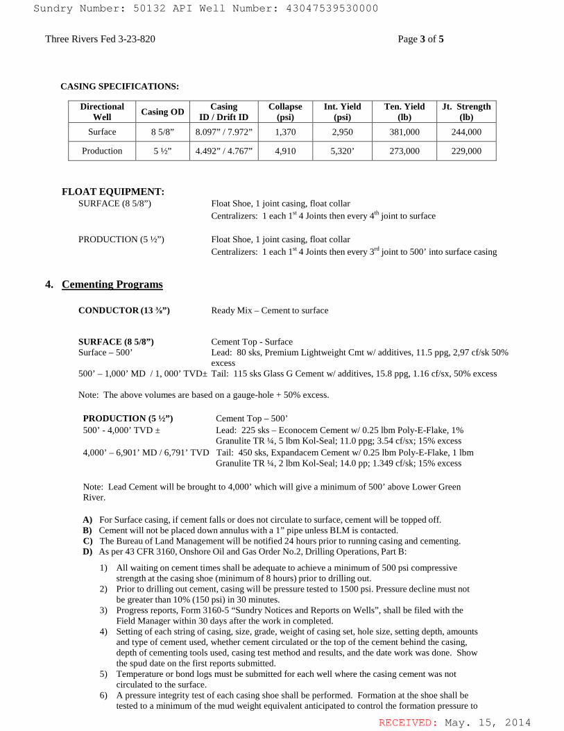
RECEIVED: May. 15, 2014
Three Rivers Fed 3-23-820 Page 3 of 5
CASING SPECIFICATIONS:
FLOAT EQUIPMENT:
SURFACE (8 5/8”) Float Shoe, 1 joint casing, float collar Centralizers: 1 each 1st 4 Joints then every 4th joint to surface PRODUCTION (5 ½”) Float Shoe, 1 joint casing, float collar Centralizers: 1 each 1st 4 Joints then every 3rd joint to 500’ into surface casing
4. Cementing Programs
CONDUCTOR (13 ⅜”) Ready Mix – Cement to surface
SURFACE (8 5/8”) Cement Top - Surface
Surface – 500’ Lead: 80 sks, Premium Lightweight Cmt w/ additives, 11.5 ppg, 2,97 cf/sk 50% excess
500’ – 1,000’ MD / 1, 000’ TVD± Tail: 115 sks Glass G Cement w/ additives, 15.8 ppg, 1.16 cf/sx, 50% excess
Note: The above volumes are based on a gauge-hole + 50% excess. PRODUCTION (5 ½”) Cement Top – 500’ 500’ - 4,000’ TVD ± Lead: 225 sks – Econocem Cement w/ 0.25 lbm Poly-E-Flake, 1%
Granulite TR ¼, 5 lbm Kol-Seal; 11.0 ppg; 3.54 cf/sx; 15% excess 4,000’ – 6,901’ MD / 6,791’ TVD Tail: 450 sks, Expandacem Cement w/ 0.25 lbm Poly-E-Flake, 1 lbm
Granulite TR ¼, 2 lbm Kol-Seal; 14.0 pp; 1.349 cf/sk; 15% excess Note: Lead Cement will be brought to 4,000’ which will give a minimum of 500’ above Lower Green River. A) For Surface casing, if cement falls or does not circulate to surface, cement will be topped off. B) Cement will not be placed down annulus with a 1” pipe unless BLM is contacted. C) The Bureau of Land Management will be notified 24 hours prior to running casing and cementing. D) As per 43 CFR 3160, Onshore Oil and Gas Order No.2, Drilling Operations, Part B:
1) All waiting on cement times shall be adequate to achieve a minimum of 500 psi compressive
strength at the casing shoe (minimum of 8 hours) prior to drilling out. 2) Prior to drilling out cement, casing will be pressure tested to 1500 psi. Pressure decline must not
be greater than 10% (150 psi) in 30 minutes. 3) Progress reports, Form 3160-5 “Sundry Notices and Reports on Wells”, shall be filed with the
Field Manager within 30 days after the work in completed. 4) Setting of each string of casing, size, grade, weight of casing set, hole size, setting depth, amounts
and type of cement used, whether cement circulated or the top of the cement behind the casing, depth of cementing tools used, casing test method and results, and the date work was done. Show the spud date on the first reports submitted.
5) Temperature or bond logs must be submitted for each well where the casing cement was not circulated to the surface.
6) A pressure integrity test of each casing shoe shall be performed. Formation at the shoe shall be tested to a minimum of the mud weight equivalent anticipated to control the formation pressure to
Directional Well Casing OD Casing
ID / Drift ID Collapse
(psi) Int. Yield
(psi) Ten. Yield
(lb) Jt. Strength
(lb) Surface 8 5/8” 8.097” / 7.972” 1,370 2,950 381,000 244,000
Production 5 ½” 4.492” / 4.767” 4,910 5,320’ 273,000 229,000
Sundry Number: 50132 API Well Number: 43047539530000Sundry Number: 50132 API Well Number: 43047539530000
Three Rivers Fed 3-23-820 Page 3 of 5
CASING SPECIFICATIONS:
Directional Casing Collapse Int. Yield Ten. Yield Jt. StrengthWell Casing OD ID / Drift ID (psi) (psi) (lb) (lb)
Surface 8 5/8" 8.097" / 7.972" 1,370 2,950 38 1,000 244,000
Production 5 ½" 4.492" / 4.767" 4,910 5,320' 273,000 229,000
FLOAT EQUIPMENT:SURFACE (8 5/8") Float Shoe, 1 joint casing, float collar
Centralizers: 1 each 16'4 Joints then every 4thjOinÍÍO SUTface
PRODUCTION (5 ½") Float Shoe, 1 joint casing, float collarCentralizers: 1 each 16'4 Joints then every 3rdjOint to 500' into surface casing
4. Cementing Programs
CONDUCTOR (13 ¾") Ready Mix - Cement to surface
SURFACE (8 5/8") Cement Top - SurfaceSurface - 500' Lead: 80 sks, Premium Lightweight Cmt w/ additives, l1.5 ppg, 2,97 cf/sk 50%
excess500' - 1,000' MD / 1, 000' TVD± Tail: 115 sks Glass G Cement w/ additives, 15.8 ppg, 1.16 cf/sx, 50% excess
Note: The above volumes are based on a gauge-hole + 50% excess.
PRODUCTION (5 ½") Cement Top - 500'500' - 4,000' TVD ± Lead: 225 sks - Econocem Cement w/ 0.25 lbm Poly-E-Flake, 1%
Granulite TR ¼, 5 lbm Kol-Seal; 11.0 ppg; 3.54 cf/sx; 15% excess4,000' - 6,901' MD / 6,791' TVD Tail: 450 sks, Expandacem Cement w/ 0.25 lbm Poly-E-Flake, l lbm
Granulite TR ¼, 2 lbm Kol-Seal; 14.0 pp; 1.349 cf/sk; 15% excess
Note: Lead Cement will be brought to 4,000' which will give a minimum of 500' above Lower GreenRiver.
A) For Surface casing, if cement falls or does not circulate to surface, cement will be topped off.B) Cement will not be placed down annulus with a 1" pipe unless BLM is contacted.C) The Bureau of Land Management will be notified 24 hours prior to running casing and cementing.D) As per 43 CFR 3160, Onshore Oil and Gas Order No.2, Drilling Operations, Part B:
1) All waiting on cement times shall be adequate to achieve a minimum of 500 psi compressivestrength at the casing shoe (minimum of 8 hours) prior to drilling out.
2) Prior to drilling out cement, casing will be pressure tested to 1500 psi. Pressure decline must notbe greater than 10% (150 psi) in 30 minutes.
3) Progress reports, Form 3160-5 "Sundry Notices and Reports on Wells", shall be filed with theField Manager within 30 days after the work in completed.
4) Setting of each string of casing, size, grade, weight of casing set, hole size, setting depth, amountsand type of cement used, whether cement circulated or the top of the cement behind the casing,depth of cementing tools used, casing test method and results, and the date work was done. Showthe spud date on the first reports submitted.
5) Temperature or bond logs must be submitted for each well where the casing cement was notcirculated to the surface.
6) A pressure integrity test of each casing shoe shall be performed. Formation at the shoe shall betested to a minimum of the mud weight equivalent anticipated to control the formation pressure to
RECEIVED: May. 15,
Sundry Number: 50132 API Well Number: 43047539530000
Three Rivers Fed 3-23-820 Page 3 of 5
CASING SPECIFICATIONS:
Directional Casing Collapse Int. Yield Ten. Yield Jt. StrengthWell Casing OD ID / Drift ID (psi) (psi) (lb) (lb)
Surface 8 5/8" 8.097" / 7.972" 1,370 2,950 38 1,000 244,000
Production 5 ½" 4.492" / 4.767" 4,910 5,320' 273,000 229,000
FLOAT EQUIPMENT:SURFACE (8 5/8") Float Shoe, 1 joint casing, float collar
Centralizers: 1 each 16'4 Joints then every 4thjOinÍÍO SUTface
PRODUCTION (5 ½") Float Shoe, 1 joint casing, float collarCentralizers: 1 each 16'4 Joints then every 3rdjOint to 500' into surface casing
4. Cementing Programs
CONDUCTOR (13 ¾") Ready Mix - Cement to surface
SURFACE (8 5/8") Cement Top - SurfaceSurface - 500' Lead: 80 sks, Premium Lightweight Cmt w/ additives, l1.5 ppg, 2,97 cf/sk 50%
excess500' - 1,000' MD / 1, 000' TVD± Tail: 115 sks Glass G Cement w/ additives, 15.8 ppg, 1.16 cf/sx, 50% excess
Note: The above volumes are based on a gauge-hole + 50% excess.
PRODUCTION (5 ½") Cement Top - 500'500' - 4,000' TVD ± Lead: 225 sks - Econocem Cement w/ 0.25 lbm Poly-E-Flake, 1%
Granulite TR ¼, 5 lbm Kol-Seal; 11.0 ppg; 3.54 cf/sx; 15% excess4,000' - 6,901' MD / 6,791' TVD Tail: 450 sks, Expandacem Cement w/ 0.25 lbm Poly-E-Flake, l lbm
Granulite TR ¼, 2 lbm Kol-Seal; 14.0 pp; 1.349 cf/sk; 15% excess
Note: Lead Cement will be brought to 4,000' which will give a minimum of 500' above Lower GreenRiver.
A) For Surface casing, if cement falls or does not circulate to surface, cement will be topped off.B) Cement will not be placed down annulus with a 1" pipe unless BLM is contacted.C) The Bureau of Land Management will be notified 24 hours prior to running casing and cementing.D) As per 43 CFR 3160, Onshore Oil and Gas Order No.2, Drilling Operations, Part B:
1) All waiting on cement times shall be adequate to achieve a minimum of 500 psi compressivestrength at the casing shoe (minimum of 8 hours) prior to drilling out.
2) Prior to drilling out cement, casing will be pressure tested to 1500 psi. Pressure decline must notbe greater than 10% (150 psi) in 30 minutes.
3) Progress reports, Form 3160-5 "Sundry Notices and Reports on Wells", shall be filed with theField Manager within 30 days after the work in completed.
4) Setting of each string of casing, size, grade, weight of casing set, hole size, setting depth, amountsand type of cement used, whether cement circulated or the top of the cement behind the casing,depth of cementing tools used, casing test method and results, and the date work was done. Showthe spud date on the first reports submitted.
5) Temperature or bond logs must be submitted for each well where the casing cement was notcirculated to the surface.
6) A pressure integrity test of each casing shoe shall be performed. Formation at the shoe shall betested to a minimum of the mud weight equivalent anticipated to control the formation pressure to
RECEIVED: May. 15,

RECEIVED: May. 15, 2014
Three Rivers Fed 3-23-820 Page 4 of 5
the next casing depth or at total depth of the well. This test shall be performed after drilling 5-10 feet of new hole.
5. Mud Program The proposed circulating mediums to be employed in drilling are as follows:
Interval Mud Type Viscosity Fluid Loss pH Mud Wt. (ppg)
0 – 1,000’ MD / 1, 000’ TVD Water/Spud Mud 32 No Control (NC) 7.0 -8.2 <8.8 1,000’ MD / 1, 000’ TVD - 6,901’ MD / 6,791’ TVD DAP System 40 - 60 10 - 18 7.0-8.2 <10.0
A) For Surface Sufficient quantities of mud materials will be maintained or readily accessible for the
purpose of assuring well control during the course of drilling operations. A mud test shall be performed every 24 hours after mudding up to determine, as applicable: density, viscosity, gel strength, filtration, and pH.
B) The mud monitoring equipment on location will be installed by top of Green River and will be able to monitor at a minimum the pit volume totalizer (PVT), stroke counter, and flow sensor
C) Flare line discharge will be located no less than 100 feet from the wellhead using straight or targeted
‘T’ and anchors.
6. Evaluation Program - Testing, Logging, and Coring A) Cores: None anticipated. B) Testing: None anticipated. C) Directional Drilling: Directional tools will be used to locate the bottom hole per the attached
directional plan +/-. D) Open Hole Logs: TD to surface casing: resistivity, neutron density, gamma ray and caliper. E) Mud Logs: None anticipated. F) Formation to TD; record and monitor gas shows and record drill times (normal mud logging duties).
7. Anticipated Pressures and H.S.
A) The expected bottom hole pressure is 3,500 – 3,650 psig. Normal pressures are anticipated from
surface to approximately TD. These pressures will be controlled by a blowout preventer stack, annular BOP, choke manifold, mud/gas separator, surface equipment and drilling mud. A supply of barite to weight the mud to a balancing specific gravity, if necessary, will be on location.
B) Maximum expected surface pressure will be based on the frac gradient of the casing shoe. The design of the casing assumes that the MASP will be the fracture pressure at the shoe less a column of gas.
C) No hydrogen sulfide gas is anticipated, however if H2S is encountered, the guidelines in Onshore Oil and Gas Order No. 6 will be complied with.
8. Other Information and Notification Requirements
A) There shall be no deviation from the proposed drilling and/or workover program as approved. Any
changes in operation must have prior approval from the Utah Division of Oil, Gas and Mining, and the BLM Vernal (when drilling on Federal leases). 1) Anticipated starting date will be upon approval. It is anticipated that completion operations will
begin within 15 days after the well has been drilled. 2) It is anticipated that the drilling and completion of this well will take approximately 90 days.
Sundry Number: 50132 API Well Number: 43047539530000Sundry Number: 50132 API Well Number: 43047539530000
Three Rivers Fed 3-23-820 Page 4 of 5
the next casing depth or at total depth of the well. This test shall be performed after drilling 5-10feet of new hole.
5. Mud Program
The proposed circulating mediums to be employed in drilling are as follows:
Mud WtInterval Mud Type Viscosity Fluid Loss pH °
(ppg)0 - 1,000' MD / 1, 000' Water/Spud MudTVD 32 No Control (NC) 7.0 -8.2 <8.8
1,000' MD / 1, 000' TVD -
DAP System 40 - 60 10 - 18 7.0-8.2 <10.06,901' MD / 6,791' TVD
A) For Surface Sufficient quantities of mud materials will be maintained or readily accessible for thepurpose of assuring well control during the course of drilling operations. A mud test shall beperformed every 24 hours after mudding up to determine, as applicable: density, viscosity, gel strength,filtration, and pH.
B) The mud monitoring equipment on location will be installed by top of Green River and will be able tomonitor at a minimum the pit volume totalizer (PVT), stroke counter, and flow sensor
C) Flare line discharge will be located no less than 100 feet from the wellhead using straight or targeted'T' and anchors.
6. Evaluation Program - Testing, Logging, and Coring
A) Cores: None anticipated.B) Testing: None anticipated.C) Directional Drilling: Directional tools will be used to locate the bottom hole per the attached
directional plan +/-.
D) Open Hole Logs: TD to surface casing: resistivity, neutron density, gamma ray and caliper.E) Mud Logs: None anticipated.F) Formation to TD; record and monitor gas shows and record drill times (normal mud logging duties).
7. Anticipated Pressures and H.S.
A) The expected bottom hole pressure is 3,500 - 3,650 psig. Normal pressures are anticipated fromsurface to approximately TD. These pressures will be controlled by a blowout preventer stack, annularBOP, choke manifold, mud/gas separator, surface equipment and drilling mud. A supply of barite toweight the mud to a balancing specific gravity, if necessary, will be on location.
B) Maximum expected surface pressure will be based on the frac gradient of the casing shoe. The designof the casing assumes that the MASP will be the fracture pressure at the shoe less a column of gas.
C) No hydrogen sulfide gas is anticipated, however if H2S is encountered, the guidelines in Onshore Oiland Gas Order No. 6 will be complied with.
8. Other Information and Notification Requirements
A) There shall be no deviation from the proposed drilling and/or workover program as approved. Anychanges in operation must have prior approval from the Utah Division of Oil, Gas and Mining,and the BLM Vernal (when drilling on Federal leases).1) Anticipated starting date will be upon approval. It is anticipated that completion operations will
begin within 15 days after the well has been drilled.2) It is anticipated that the drilling and completion of this well will take approximately 90 days.
RECEIVED: May. 15,
Sundry Number: 50132 API Well Number: 43047539530000
Three Rivers Fed 3-23-820 Page 4 of 5
the next casing depth or at total depth of the well. This test shall be performed after drilling 5-10feet of new hole.
5. Mud Program
The proposed circulating mediums to be employed in drilling are as follows:
Mud WtInterval Mud Type Viscosity Fluid Loss pH °
(ppg)0 - 1,000' MD / 1, 000' Water/Spud MudTVD 32 No Control (NC) 7.0 -8.2 <8.8
1,000' MD / 1, 000' TVD -
DAP System 40 - 60 10 - 18 7.0-8.2 <10.06,901' MD / 6,791' TVD
A) For Surface Sufficient quantities of mud materials will be maintained or readily accessible for thepurpose of assuring well control during the course of drilling operations. A mud test shall beperformed every 24 hours after mudding up to determine, as applicable: density, viscosity, gel strength,filtration, and pH.
B) The mud monitoring equipment on location will be installed by top of Green River and will be able tomonitor at a minimum the pit volume totalizer (PVT), stroke counter, and flow sensor
C) Flare line discharge will be located no less than 100 feet from the wellhead using straight or targeted'T' and anchors.
6. Evaluation Program - Testing, Logging, and Coring
A) Cores: None anticipated.B) Testing: None anticipated.C) Directional Drilling: Directional tools will be used to locate the bottom hole per the attached
directional plan +/-.
D) Open Hole Logs: TD to surface casing: resistivity, neutron density, gamma ray and caliper.E) Mud Logs: None anticipated.F) Formation to TD; record and monitor gas shows and record drill times (normal mud logging duties).
7. Anticipated Pressures and H.S.
A) The expected bottom hole pressure is 3,500 - 3,650 psig. Normal pressures are anticipated fromsurface to approximately TD. These pressures will be controlled by a blowout preventer stack, annularBOP, choke manifold, mud/gas separator, surface equipment and drilling mud. A supply of barite toweight the mud to a balancing specific gravity, if necessary, will be on location.
B) Maximum expected surface pressure will be based on the frac gradient of the casing shoe. The designof the casing assumes that the MASP will be the fracture pressure at the shoe less a column of gas.
C) No hydrogen sulfide gas is anticipated, however if H2S is encountered, the guidelines in Onshore Oiland Gas Order No. 6 will be complied with.
8. Other Information and Notification Requirements
A) There shall be no deviation from the proposed drilling and/or workover program as approved. Anychanges in operation must have prior approval from the Utah Division of Oil, Gas and Mining,and the BLM Vernal (when drilling on Federal leases).1) Anticipated starting date will be upon approval. It is anticipated that completion operations will
begin within 15 days after the well has been drilled.2) It is anticipated that the drilling and completion of this well will take approximately 90 days.
RECEIVED: May. 15,

RECEIVED: May. 15, 2014
Three Rivers Fed 3-23-820 Page 5 of 5 B) Notification Requirements for Utah Division of Oil, Gas and Mining:
• Within 24 hrs. of spud (Carol Daniels at 801/538-5284) • 24 hrs. prior to testing BOP equipment (Dan Jarvis 801/538-5338 or 231-8956) • 24 hrs. prior to cementing or testing casing (Dan Jarvis) • Within 24 hrs. of making any emergency changes to APD (Dustin Doucet 801/538-
5281 or 733-0983) C) Notification Requirements BLM Vernal when drilling on Federal leases as follows: (Cade T Taylor @ [email protected] and [email protected]:
• Within 24 hrs. of spud (Carol Daniels at 801/538-5284) • 24 hrs. prior to testing BOP equipment (Dan Jarvis 801/538-5338 or 231-8956) • 24 hrs. prior to cementing or testing casing (Dan Jarvis) • Within 24 hrs. of making any emergency changes to APD (Dustin Doucet 801/538-
5281 or 733-0983) D) Any changes in the program must be approved by the Utah Division of Oil, Gas and Mining and
or the BLM Vernal Office. “Sundry Notices and Reports on Wells” (form 3160-5) must be filed for all changes of plans. Emergency approval may be obtained orally, but such approval does not waive the written report requirement. 1) Should the well be successfully completed for production, the BLM Pinedale Field Office must be
notified when it is placed in a producing status. The notification shall provide, as a minimum, the following information items: . Operator name, address, and telephone number. . Well name and number. . Well location (1/4 1/4, Section, Township, Range and P.M.) . Date well was placed in a producing status (date of first production for which royalty will
be paid). . The nature of the well’s production, (i.e., crude oil, or crude oil and casing head gas, or
natural gas and entrained liquid hydrocarbons). . The Federal or Indian lease prefix and number on which the well is located. As
appropriate, the unit agreement name, number and participating area name. As appropriate, the communitization agreement number.
Sundry Number: 50132 API Well Number: 43047539530000Sundry Number: 50132 API Well Number: 43047539530000
Three Rivers Fed 3-23-820 Page 5 of 5
B) Notification Requirements for Utah Division of Oil, Gas and Mining:• Within 24 hrs. of spud (Carol Daniels at 801/538-5284)• 24 hrs. prior to testing BOP equipment (Dan Jarvis 801/538-5338 or 231-8956)• 24 hrs. prior to cementing or testing casing (Dan Jarvis)• Within 24 hrs. of making any emergency changes to APD (Dustin Doucet 801/538-
5281 or 733-0983)
C) Notification Requirements BLM Vernal when drilling on Federal leases as follows:(Cade TTaylor @[email protected] and [email protected]:• Within 24 hrs. of spud (Carol Daniels at 801/538-5284)• 24 hrs. prior to testing BOP equipment (Dan Jarvis 801/538-5338 or 231-8956)• 24 hrs. prior to cementing or testing casing (Dan Jarvis)• Within 24 hrs. of making any emergency changes to APD (Dustin Doucet 801/538-
5281 or 733-0983)
D) Any changes in the program must be approved by the Utah Division of Oil, Gas and Mining andor the BLM Vernal Office. "Sundry Notices and Reports on Wells" (form 3160-5) must be filed for allchanges of plans. Emergency approval may be obtained orally, but such approval does not waive thewritten report requirement.1) Should the well be successfully completed for production, the BLM Pinedale Field Office must be
notified when it is placed in a producing status. The notification shall provide, as a minimum, thefollowing information items:
. Operator name, address, and telephone number.
. Well name and number.
. Well location (1/4 1/4, Section, Township, Range and P.M.)
. Date well was placed in a producing status (date of first production for which royalty willbe paid).
. The nature of the well's production, (i.e., crude oil, or crude oil and casing head gas, ornatural gas and entrained liquid hydrocarbons).
. The Federal or Indian lease prefix and number on which the well is located. Asappropriate, the unit agreement name, number and participating area name. Asappropriate, the communitization agreement number.
RECEIVED: May. 15,
Sundry Number: 50132 API Well Number: 43047539530000
Three Rivers Fed 3-23-820 Page 5 of 5
B) Notification Requirements for Utah Division of Oil, Gas and Mining:• Within 24 hrs. of spud (Carol Daniels at 801/538-5284)• 24 hrs. prior to testing BOP equipment (Dan Jarvis 801/538-5338 or 231-8956)• 24 hrs. prior to cementing or testing casing (Dan Jarvis)• Within 24 hrs. of making any emergency changes to APD (Dustin Doucet 801/538-
5281 or 733-0983)
C) Notification Requirements BLM Vernal when drilling on Federal leases as follows:(Cade TTaylor @[email protected] and [email protected]:• Within 24 hrs. of spud (Carol Daniels at 801/538-5284)• 24 hrs. prior to testing BOP equipment (Dan Jarvis 801/538-5338 or 231-8956)• 24 hrs. prior to cementing or testing casing (Dan Jarvis)• Within 24 hrs. of making any emergency changes to APD (Dustin Doucet 801/538-
5281 or 733-0983)
D) Any changes in the program must be approved by the Utah Division of Oil, Gas and Mining andor the BLM Vernal Office. "Sundry Notices and Reports on Wells" (form 3160-5) must be filed for allchanges of plans. Emergency approval may be obtained orally, but such approval does not waive thewritten report requirement.1) Should the well be successfully completed for production, the BLM Pinedale Field Office must be
notified when it is placed in a producing status. The notification shall provide, as a minimum, thefollowing information items:
. Operator name, address, and telephone number.
. Well name and number.
. Well location (1/4 1/4, Section, Township, Range and P.M.)
. Date well was placed in a producing status (date of first production for which royalty willbe paid).
. The nature of the well's production, (i.e., crude oil, or crude oil and casing head gas, ornatural gas and entrained liquid hydrocarbons).
. The Federal or Indian lease prefix and number on which the well is located. Asappropriate, the unit agreement name, number and participating area name. Asappropriate, the communitization agreement number.
RECEIVED: May. 15,

RECEIVED: May. 15, 2014
Sundry Number: 50132 API Well Number: 43047539530000Sundry Number: 50132 API Well Number: 43047539530000
a. Ma · a aW I § A coa o
II
Sundry Number: 50132 API Well Number: 43047539530000
a. Ma · a aW I § A coa o
II
Sundry Number: 50132 API Well Number: 43047539530000
a. Ma · a aW I § A coa o
II
Sundry Number: 50132 API Well Number: 43047539530000
a. Ma · a aW I § A coa o
II

RECEIVED: May. 15, 2014
16in Conductor : 0.00° Inc, 120.00ft MD, 120.00ft TVD, 0.00ft VSBase Gravel : 0.00° Inc, 120.00ft MD, 120.00ft TVD, 0.00ft VSTie On : 0.00° Inc, 13.00ft MD, 13.00ft TVD, 0.00ft VS
8.625in Casing Surface : 0.00° Inc, 1000.00ft MD, 1000.00ft TVD, 0.00ft VS
2.00°/100ftBMSW : 8.03° Inc, 1601.31ft MD, 1600.00ft TVD, 28.06ft VS
End of Tangent : 0.00° Inc, 1200.00ft MD, 1200.00ft TVD, 0.00ft VS
End of Build (S) : 17.09° Inc, 2054.43ft MD, 2041.82ft TVD, 126.48ft VS
End of Tangent (S) : 17.09° Inc, 3971.43ft MD, 3874.18ft TVD, 689.79ft VS
2.00°/100ft
Mahogany : 11.89° Inc, 4231.60ft MD, 4126.00ft TVD, 754.85ft VS
Garden Gulch : 0.00° Inc, 4825.86ft MD, 4716.00ft TVD, 816.26ft VSDrop (S) : 0.00° Inc, 4825.86ft MD, 4716.00ft TVD, 816.26ft VS
Lower Green River : 0.00° Inc, 4995.86ft MD, 4886.00ft TVD, 816.26ft VS
5.5in Casing Production : 0.00° Inc, 6900.86ft MD, 6791.00ft TVD, 816.26ft VSWasatch : 0.00° Inc, 6700.86ft MD, 6591.00ft TVD, 816.26ft VS
TD : 0.00° Inc, 6900.86ft MD, 6791.00ft TVD, 816.26ft VSEnd of Tangent : 0.00° Inc, 6900.86ft MD, 6791.00ft TVD, 816.26ft VS
True
Ver
tical
Dep
th (f
t)
Vertical Section (ft)Azimuth 56.35° with reference 0.00 N, 0.00 E
Scale 1 inch = 1000 ft
Scal
e 1
inch
= 1
000
ft
Coordinates are in feet referenced to Slot
Mean Sea Level to Mud line (At Slot: Three Rivers Fed 3-23-820 (1536' FSL & 1296' FWL)): 0 feet
Rig on Three Rivers Fed 3-23-820 91536' FSL & 1296' FWL) (RT) to Mean Sea Level: 4761 feet
Measured depths are referenced to Rig on Three Rivers Fed 3-23-820 91536' FSL & 1296' FWL) (RT)
True vertical depths are referenced to Rig on Three Rivers Fed 3-23-820 91536' FSL & 1296' FWL) (RT)
Plot reference wellpath is Three Rivers Fed 3-23-820 PWP
Created by: ewilliams on 4/14/2014
Depths are in feet
Scale: True distance
North Reference: True north
Grid System: NAD83 / Lambert Utah SP, Central Zone (4302), US feet
Rig on Three Rivers Fed 3-23-820 91536' FSL & 1296' FWL) (RT) to Mean Sea Level
Mean Sea Level to Mud line (At Slot: Three Rivers Fed 3-23-820 (1536' FSL & 1296' FWL))
Rig on Three Rivers Fed 3-23-820 91536' FSL & 1296' FWL) (RT) to Mud line (At Slot: Three Rivers Fed 3-23-820 (1536' FSL & 1296' FWL))
Three Rivers Fed 3-23-820 (1536' FSL & 1296' FWL)
Slot
Sec.03-T8S-R20E
Facility Name
-1672.71
Local N (ft)
Location Information
-871.28
Local E (ft) Grid East (US ft)
Grid East (US ft)
2154854.943
2155691.488
7228184.769
Grid North (US ft)
7229874.935
Grid North (US ft)
4761ft
0ft
4761ft
40°08'55.350"N
Latitude
40°09'11.880"N
Latitude
109°39'34.210"W
Longitude
109°39'22.990"W
Longitude
End of TangentDrop (S)
End of Tangent (S)End of Build (S)End of Tangent
Tie OnDesign Comment
6900.864825.863971.432054.431200.0013.00MD (ft)
0.000 56.3470.000 56.34717.089 56.34717.089 56.3470.000 56.3470.000 56.347Inc (°) Az (°)
6791.004716.003874.182041.821200.0013.00
TVD (ft)Well Profile Data
452.34452.34382.2670.090.000.00
Local N (ft)
679.46679.46574.18105.28
Local E (ft)
0.000.00
0.002.000.002.000.000.00
DLS (°/100ft)
816.26816.26689.79126.480.000.00
VS (ft)
Facility:
Field:
Location:
ULTRA RESOURCES, INCSec.03-T8S-R20E
UINTAH COUNTY
Three Rivers
Wellbore:
Well:
Slot:
Three Rivers Fed 3-23-820 PWB
Three Rivers Fed 3-23-820
Three Rivers Fed 3-23-820 (1536' FSL & 1296' FWL)
Three Rivers Fed 3-23-820 Target On Plat 1980' FSL & 1980' FWL
Name
4500.00
MD (ft) TVD (ft) Local N (ft)
Targets
452.34 679.46
Local E (ft)
2155524.89
Grid East (US ft)
7228650.96
Grid North (US ft)
40°08'59.820"N
Latitude
109°39'25.460"W
Longitude
Three Rivers Fed 3-23-820Target On Plat
1980' FSL & 1980' FWL
Three Rivers Fed 3-23-820SHL:
(1536' FSL & 1296' FWL)
Northing (ft)
Easting (ft)Scale 1 inch = 400
Sundry Number: 50132 API Well Number: 43047539530000Sundry Number: 50132 API Well Number: 43047539530000
ULTRA RESOURCES, INCLocation Three Rivers Slot Three Rivers Fed 3-23-820 (1536 FSL & 1296 FWL)
Field UINTAH COUNTY Well Three Rivers Fed 3-23-820
Facility Sec.03-T8S-R20E Wellbore Three Rivers Fed 3-23-820 PWB
Targets
PETROLEUM Design Comment MD (ft) Inc P) Az (Well Profile Datcaal
N (ft) Local E (ft) DLS (/100ft) VS (ft)Tie On 13.00 0.000 56 347 13 00
End of Tangent 1200 00 0.000 56 347 1200.00 0.0End of Build (S) 2054 43 17.089 56 347 2041.82 70.09 105 28 2 00 126.48
End of Tangent (S) 3971 43 17.089 56 347 3874.18 382.26 574 18 0 00 689.79Drap (S) 4825 86 0 000 56 347 4716.00 452.34 679 46 2 00 816.26
End of Tangent 6900 86 0 000 56 347 6791.00 452.34 679 46 0 00 816.26
Location Information
-500 -
iotomrencemiipathisThreeRiversFeda2>s2oPwP
noeRiveraFeas2>s20eise Fsta129sFwt)(RT) endsymem NR>sattembeautansP centreizone(43o2;usset
essumadepthsammarencedtoRigonThreeRiversFeas2>s20eisseFsta129sFwt)(RT
nree Rivers Fed >2>s20 91536 Fst a 129s Fwt)(RT)to r,9
eveitor,9udiine(«siotThreeRiversFeas2>s2o(1saeFsta129sFut);omet
0 - Tie On : 0.00° Inc, 13.00ft MD, 13.00ft TVD, 0.00ft VSBase Gravel : 0.00° Inc, 120.00ft MD, 120.00ft TVD, 0.00ft VS16in Conductor : 0.00° Inc, 120.00ft MD, 120.00ft TVD, 0.00ft VS
600 -
1000 - 8.625in Casing Surface : 0.00° Inc, 1000.00ft MD, 1000.00ft TVD, 0.00ft VS
End of Tangent : 0.00° Inc, 1200.00ft MD, 1200.00ft TVD, 0.00ft VSScale 1 inch = 400 Easting (ft)
O 200 400 600 8001500- lilligggp3° Inc, 1601.31ft MD, 1600.00ft TVD, 28.06ft VS
- 600
Three Rivers Fed 3-23-820Target On Plat
2000 -
End of Build (S) : 17.09° Inc, 2054.43ft MD, 2041.82ft TVD, 126.48ft VS 1980' FSL & 1980' FWL -- 400
O2500 -
- 200
3000 -
Three Rivers Fed 3-23-820SHL: - 0
(1536' FSL & 1296' FWL)
3500 -
2 - -200
I-
End of Tangent (S) : 17.09° Inc, 3971.43ft MD, 3874.18ft TVD, 689.79ft VS4000 -
Mahogany : 11.89° Inc, 4231.60ft MD, 4126.00ft TVD, 754.85ft VS2.00°/100ft
4500 -
Garden Gulch : 0.00° Inc, 4825.86ft MD, 4716.00ft TVD, 816.26ft VSDrop (S) : 0.00° Inc, 4825.86ft MD, 4716.00ft TVD, 816.26ft VS
Lower Green River : 0.00° Inc, 4995.86ft MD, 4886.00ft TVD, 816.26ft VS5000 -
5500 -
6000 -
6500 -
Wasatch : 0.00° Inc, 6700.86ft MD, 6591.00ft TVD, 816.26ft VS5.5in Casing Production : 0.00° Inc, 6900.86ft MD, 6791.00ft TVD, 816.26ft VSEnd of Tangent : 0.00° Inc, 6900.86ft MD, 6791.00ft TVD, 816.26ft VSTD : 0.00° Inc, 6900.86ft MD, 6791.00ft TVD, 816.26ft VS
7000 -
IIIIIIIIO 500 1000 1500 2000 2500 3000 3500
Vertical Section (ft) Scale1inch=1000ft
Azimuth 56.35° with reference 0.00 N, 0.00 E
RECEIVED: May. 15,
Sundry Number: 50132 API Well Number: 43047539530000
ULTRA RESOURCES, INCLocation Three Rivers Slot Three Rivers Fed 3-23-820 (1536 FSL & 1296 FWL)
Field UINTAH COUNTY Well Three Rivers Fed 3-23-820
Facility Sec.03-T8S-R20E Wellbore Three Rivers Fed 3-23-820 PWB
Targets
PETROLEUM Design Comment MD (ft) Inc P) Az (Well Profile Datcaal
N (ft) Local E (ft) DLS (/100ft) VS (ft)Tie On 13.00 0.000 56 347 13 00
End of Tangent 1200 00 0.000 56 347 1200.00 0.0End of Build (S) 2054 43 17.089 56 347 2041.82 70.09 105 28 2 00 126.48
End of Tangent (S) 3971 43 17.089 56 347 3874.18 382.26 574 18 0 00 689.79Drap (S) 4825 86 0 000 56 347 4716.00 452.34 679 46 2 00 816.26
End of Tangent 6900 86 0 000 56 347 6791.00 452.34 679 46 0 00 816.26
Location Information
-500 -
iotomrencemiipathisThreeRiversFeda2>s2oPwP
noeRiveraFeas2>s20eise Fsta129sFwt)(RT) endsymem NR>sattembeautansP centreizone(43o2;usset
essumadepthsammarencedtoRigonThreeRiversFeas2>s20eisseFsta129sFwt)(RT
nree Rivers Fed >2>s20 91536 Fst a 129s Fwt)(RT)to r,9
eveitor,9udiine(«siotThreeRiversFeas2>s2o(1saeFsta129sFut);omet
0 - Tie On : 0.00° Inc, 13.00ft MD, 13.00ft TVD, 0.00ft VSBase Gravel : 0.00° Inc, 120.00ft MD, 120.00ft TVD, 0.00ft VS16in Conductor : 0.00° Inc, 120.00ft MD, 120.00ft TVD, 0.00ft VS
600 -
1000 - 8.625in Casing Surface : 0.00° Inc, 1000.00ft MD, 1000.00ft TVD, 0.00ft VS
End of Tangent : 0.00° Inc, 1200.00ft MD, 1200.00ft TVD, 0.00ft VSScale 1 inch = 400 Easting (ft)
O 200 400 600 8001500- lilligggp3° Inc, 1601.31ft MD, 1600.00ft TVD, 28.06ft VS
- 600
Three Rivers Fed 3-23-820Target On Plat
2000 -
End of Build (S) : 17.09° Inc, 2054.43ft MD, 2041.82ft TVD, 126.48ft VS 1980' FSL & 1980' FWL -- 400
O2500 -
- 200
3000 -
Three Rivers Fed 3-23-820SHL: - 0
(1536' FSL & 1296' FWL)
3500 -
2 - -200
I-
End of Tangent (S) : 17.09° Inc, 3971.43ft MD, 3874.18ft TVD, 689.79ft VS4000 -
Mahogany : 11.89° Inc, 4231.60ft MD, 4126.00ft TVD, 754.85ft VS2.00°/100ft
4500 -
Garden Gulch : 0.00° Inc, 4825.86ft MD, 4716.00ft TVD, 816.26ft VSDrop (S) : 0.00° Inc, 4825.86ft MD, 4716.00ft TVD, 816.26ft VS
Lower Green River : 0.00° Inc, 4995.86ft MD, 4886.00ft TVD, 816.26ft VS5000 -
5500 -
6000 -
6500 -
Wasatch : 0.00° Inc, 6700.86ft MD, 6591.00ft TVD, 816.26ft VS5.5in Casing Production : 0.00° Inc, 6900.86ft MD, 6791.00ft TVD, 816.26ft VSEnd of Tangent : 0.00° Inc, 6900.86ft MD, 6791.00ft TVD, 816.26ft VSTD : 0.00° Inc, 6900.86ft MD, 6791.00ft TVD, 816.26ft VS
7000 -
IIIIIIIIO 500 1000 1500 2000 2500 3000 3500
Vertical Section (ft) Scale1inch=1000ft
Azimuth 56.35° with reference 0.00 N, 0.00 E
RECEIVED: May. 15,

RECEIVED: May. 15, 2014
REFERENCE WELLPATH IDENTIFICATIONOperator ULTRA RESOURCES, INC Slot Three Rivers Fed 3-23-820 (1536' FSL & 1296' FWL)Area Three Rivers Well Three Rivers Fed 3-23-820Field UINTAH COUNTY Wellbore Three Rivers Fed 3-23-820 PWBFacility Sec.03-T8S-R20E
REPORT SETUP INFORMATIONProjection System NAD83 / Lambert Utah SP, Central Zone (4302), US feet Software System WellArchitect® 3.0.0North Reference True User EwilliamsScale 0.999914 Report Generated 4/14/2014 at 2:33:11 PMConvergence at slot n/a Database/Source file WellArchitectDB/Three_Rivers_Fed_3-23-820_PWB.xml
WELLPATH LOCATIONLocal coordinates Grid coordinates Geographic coordinates
North[ft] East[ft] Easting[US ft] Northing[US ft] Latitude LongitudeSlot Location -1672.71 -871.28 2154854.94 7228184.77 40°08'55.350"N 109°39'34.210"WFacility Reference Pt 2155691.49 7229874.94 40°09'11.880"N 109°39'22.990"WField Reference Pt 2156630.96 7236613.42 40°10'18.270"N 109°39'09.100"W
WELLPATH DATUMCalculation method Minimum curvature Rig on Three Rivers Fed 3-23-820 91536' FSL & 1296' FWL) (RT) to Facility Vertical DatumHorizontal Reference Pt Slot Rig on Three Rivers Fed 3-23-820 91536' FSL & 1296' FWL) (RT) to Mean Sea LevelVertical Reference Pt Rig on Three Rivers Fed 3-23-820 91536' FSL & 1296' FWL) (RT) Rig on Three Rivers Fed 3-23-820 91536' FSL & 1296' FWL) (RT) to Mud Line at Slot (Three Rivers Fed 3-23-820 (1536' FSL & 1296' FWMD Reference Pt Rig on Three Rivers Fed 3-23-820 91536' FSL & 1296' FWL) (RT) Section OriginField Vertical Reference Mean Sea Level Section Azimuth
Planned Wellpath ReportThree Rivers Fed 3-23-820 PWP
Page 1 of 5
Page 1 of 5
4/14/2014
Sundry Number: 50132 API Well Number: 43047539530000Sundry Number: 50132 API Well Number: 43047539530000 Page1of5
Planned Wellpath Report DYNAMICThree Rivers Fed 3-23-820 PWP GRAPHICS,INC.
Page 1 of 5PETROLELT1
REFERENCE WELLPATH IDENTIFICATIONOperator ULTRA RESOURCES, INC Slot Three Rivers Fed 3-23-820 (1536' FSL & 1296' FWL)Arca Three Rivers Well Three Rivers Fed 3-23-820
Field UINTAH COUNTY Wellbore Three Rivers Fed 3-23-820 PWB
Facility Sec.03-TSS-R20E
REPORT SETUP INFORMATIONProjection System NAD83 / Lambert Utah SP, Central Zone (4302), US feet Software System WellArchitect® 3.0.0North Reference Truc User Ewilliams
Scale 0.999914 Report Generated 4/14/2014 at 2:33:11 PM
Convergence at slot n/a Database/Source file WellArchitectDB/Three_Rivers_Fed_3-23-820_PWB.xml
WELLPATH LOCATIONLocal coordinates Grid coordinates Geographic coordinates
North[ft] East[ft] Easting[US ft] Northing[US ft] Latitude Longitude
SlotLocation -1672.71 -871.28 2154854.94 7228184.77 40°08'55.350"N 109°39'34.210"W
Facility Reference Pt 2155691.49 7229874.94 40°09'11.880"N 109°39'22.990"W
Field Reference Pt 2156630.96 7236613.42 40°10'18.270"N 109°39'09.100"W
WELLPATH DATUMCalculation method Minimum curvature Rig on Three Rivers Fed 3-23-820 91536'FSL & 1296' FWL) (RT) to Facility Vertical DatumIlorizontal Reference Pt Slot Rig on Three Rivers Fed 3-23-820 91536' FSL & 1296' FWL) (RT) to Mean Sea Level
Vertical Reference Pt Rig on Three Rivers Fed 3-23-820 91536' FSL & 1296' FWL) (RT) Rig on Three Rivers Fod 3-23-820 91536' FSL & 1296' FWL) (RT) to Mud Line at Slot (Three Rivers Fed 3-23-820 (1536' FSL & 1296' F3
MD Reference Pt Rig on Three Rivers Fed 3-23-820 91536' FSL & 1296' FWL) (RT) Section OriginField Vertical Reference Mean Sca Level Section Azimuth
Sundry Number: 50132 API Well Number: 43047539530000 Page1of5
Planned Wellpath Report DYNAMICThree Rivers Fed 3-23-820 PWP GRAPHICS,INC,
Page1of5PETROLELT1
REFERENCE MILLPATH IDENTIHCATIONOperator ULTRA RESOURCES, INC Slot Three Rivers Fed 3-23-820 (1536' FSL & 1296' FWL)
Area Three Rivers Well Three Rivers Fed 3-23-820
Field UINTAH COUNTY Wellbore Three Rivers Fed 3-23-820 PWB
Facility Sec.03-T8S-R20E
REPORT SETUP INFORMATIONProjection System NAD83 / Lambert Utah SP, Central Zone (4302), US feet Software System WellArchitect® 3.0.0
North Reference True User Ewilliams
Scale 0.999914 Report Generated 4/14/2014 at 2:33:11 PMConvergence at slot n/a Database/Source file WellArchitectDB/Three_Rivers_Fed_3-23-820_PWB.xml
MILLPATH LOCATIONLocal coordinates Grid coordinates Geographic coordinates
North[ft] East[ft] Easting[US ft] Northing[US ft] Latitude Longitude
SlotLocation -1672.71 -871.28 2154854.94 7228184.77 40°08'55.350"N 109°39'34.210"W
FacilityReferencePt 2155691.49 7229874.94 40°09'11.880"N 109°39'22.990"W
FieldReferencePt 2156630.96 7236613.42 40°10'18.270"N 109°39'09.100"W
MILLPATH DATUMCalculation method Minimum curvature Rig on Three Rivers Fed 3-23-820 91536' FSL & 1296' FWL) (RT) to Facility Vertical Datum
Horizontal Reference Pt Slot Rig on Three Rivers Fed 3-23-820 91536' FSL & 1296' FWL) (RT) to Mean Sea Level
Vertical Reference Pt Rig on Three Rivers Fed 3-23-820 91536' FSL & 1296' FWL) (RT) Rig on Three Rivers Fed 3-23-820 91536' FSL & 1296' FWL) (RT) to Mud Line at Slot (Three Rivers Fed 3-23-820 (1536' FSL & 1296' F3
MD Reference Pt Rig on Three Rivers Fed 3-23-820 91536' FSL & 1296' FWL) (RT) Section Origin
Field Vertical Reference Mean Sea Level Section Azimuth

RECEIVED: May. 15, 2014
REFERENCE WELLPATH IDENTIFICATIONOperator ULTRA RESOURCES, INC Slot Three Rivers Fed 3-23-820 (1536' FSL & 1296' FWL)Area Three Rivers Well Three Rivers Fed 3-23-820Field UINTAH COUNTY Wellbore Three Rivers Fed 3-23-820 PWBFacility Sec.03-T8S-R20E
Planned Wellpath ReportThree Rivers Fed 3-23-820 PWP
Page 2 of 5
WELLPATH DATA (80 stations) † = interpolated/extrapolated stationMD[ft]
Inclination[°]
Azimuth[°]
TVD[ft]
Vert Sect[ft]
North[ft]
East[ft]
Latitude Longitude DLS[°/100ft]
Comments
0.00† 0.000 56.347 0.00 0.00 0.00 0.00 40°08'55.350"N 109°39'34.210"W 0.00 13.00 0.000 56.347 13.00 0.00 0.00 0.00 40°08'55.350"N 109°39'34.210"W 0.00
113.00† 0.000 56.347 113.00 0.00 0.00 0.00 40°08'55.350"N 109°39'34.210"W 0.00 120.00† 0.000 56.347 120.00 0.00 0.00 0.00 40°08'55.350"N 109°39'34.210"W 0.00 Base Gravel213.00† 0.000 56.347 213.00 0.00 0.00 0.00 40°08'55.350"N 109°39'34.210"W 0.00 313.00† 0.000 56.347 313.00 0.00 0.00 0.00 40°08'55.350"N 109°39'34.210"W 0.00 413.00† 0.000 56.347 413.00 0.00 0.00 0.00 40°08'55.350"N 109°39'34.210"W 0.00 513.00† 0.000 56.347 513.00 0.00 0.00 0.00 40°08'55.350"N 109°39'34.210"W 0.00 613.00† 0.000 56.347 613.00 0.00 0.00 0.00 40°08'55.350"N 109°39'34.210"W 0.00 713.00† 0.000 56.347 713.00 0.00 0.00 0.00 40°08'55.350"N 109°39'34.210"W 0.00 813.00† 0.000 56.347 813.00 0.00 0.00 0.00 40°08'55.350"N 109°39'34.210"W 0.00 913.00† 0.000 56.347 913.00 0.00 0.00 0.00 40°08'55.350"N 109°39'34.210"W 0.00
1013.00† 0.000 56.347 1013.00 0.00 0.00 0.00 40°08'55.350"N 109°39'34.210"W 0.00 1113.00† 0.000 56.347 1113.00 0.00 0.00 0.00 40°08'55.350"N 109°39'34.210"W 0.00 1200.00 0.000 56.347 1200.00 0.00 0.00 0.00 40°08'55.350"N 109°39'34.210"W 0.00 1213.00† 0.260 56.347 1213.00 0.03 0.02 0.02 40°08'55.350"N 109°39'34.210"W 2.00 1313.00† 2.260 56.347 1312.97 2.23 1.23 1.85 40°08'55.362"N 109°39'34.186"W 2.00 1413.00† 4.260 56.347 1412.80 7.91 4.39 6.59 40°08'55.393"N 109°39'34.125"W 2.00 1513.00† 6.260 56.347 1512.38 17.08 9.47 14.22 40°08'55.444"N 109°39'34.027"W 2.00 1601.31† 8.026 56.347 1600.00 28.06 15.55 23.36 40°08'55.504"N 109°39'33.909"W 2.00 BMSW1613.00† 8.260 56.347 1611.57 29.72 16.47 24.74 40°08'55.513"N 109°39'33.891"W 2.00 1713.00† 10.260 56.347 1710.26 45.81 25.39 38.13 40°08'55.601"N 109°39'33.719"W 2.00 1813.00† 12.260 56.347 1808.33 65.33 36.21 54.38 40°08'55.708"N 109°39'33.510"W 2.00 1913.00† 14.260 56.347 1905.66 88.27 48.92 73.48 40°08'55.833"N 109°39'33.264"W 2.00 2013.00† 16.260 56.347 2002.13 114.59 63.50 95.38 40°08'55.978"N 109°39'32.982"W 2.00 2054.43 17.089 56.347 2041.82 126.48 70.09 105.28 40°08'56.043"N 109°39'32.854"W 2.00 2113.00† 17.089 56.347 2097.80 143.69 79.63 119.61 40°08'56.137"N 109°39'32.670"W 0.00 2213.00† 17.089 56.347 2193.39 173.07 95.91 144.07 40°08'56.298"N 109°39'32.355"W 0.00 2313.00† 17.089 56.347 2288.97 202.46 112.19 168.53 40°08'56.459"N 109°39'32.040"W 0.00 2413.00† 17.089 56.347 2384.56 231.84 128.48 192.99 40°08'56.620"N 109°39'31.725"W 0.00 2513.00† 17.089 56.347 2480.14 261.23 144.76 217.45 40°08'56.781"N 109°39'31.410"W 0.00 2613.00† 17.089 56.347 2575.73 290.61 161.05 241.91 40°08'56.941"N 109°39'31.095"W 0.00 2713.00† 17.089 56.347 2671.31 320.00 177.33 266.37 40°08'57.102"N 109°39'30.780"W 0.00 2813.00† 17.089 56.347 2766.90 349.38 193.62 290.83 40°08'57.263"N 109°39'30.465"W 0.00 2913.00† 17.089 56.347 2862.48 378.77 209.90 315.29 40°08'57.424"N 109°39'30.150"W 0.00 3013.00† 17.089 56.347 2958.07 408.15 226.18 339.75 40°08'57.585"N 109°39'29.835"W 0.00 3113.00† 17.089 56.347 3053.65 437.54 242.47 364.21 40°08'57.746"N 109°39'29.520"W 0.00 3213.00† 17.089 56.347 3149.24 466.92 258.75 388.67 40°08'57.907"N 109°39'29.205"W 0.00 3313.00† 17.089 56.347 3244.82 496.31 275.04 413.13 40°08'58.068"N 109°39'28.890"W 0.00 3413.00† 17.089 56.347 3340.41 525.69 291.32 437.59 40°08'58.229"N 109°39'28.575"W 0.00 3513.00† 17.089 56.347 3436.00 555.08 307.60 462.05 40°08'58.390"N 109°39'28.260"W 0.00 3613.00† 17.089 56.347 3531.58 584.46 323.89 486.51 40°08'58.551"N 109°39'27.945"W 0.00 3713.00† 17.089 56.347 3627.17 613.85 340.17 510.97 40°08'58.712"N 109°39'27.630"W 0.00 3813.00† 17.089 56.347 3722.75 643.23 356.46 535.43 40°08'58.872"N 109°39'27.315"W 0.00 3913.00† 17.089 56.347 3818.34 672.62 372.74 559.89 40°08'59.033"N 109°39'27.000"W 0.00
Page 2 of 5
4/14/2014
Sundry Number: 50132 API Well Number: 43047539530000Sundry Number: 50132 API Well Number: 43047539530000 Page2of5
Planned Wellpath Report DYNAMICThree Rivers Fed 3-23-820 PWP GRAPHICS,INC.
Page 2 of 5PETKOLEEN
REFERENCE WELLPATH IDENTIFICATIONOperator ULTRA RESOURCES, INC Slot Three Rivers Fed 3-23-820 (1536' FSL & 1296' FWL)Arca Three Rivers Well Three Rivers Fed 3-23-820
Field UINTAH COUNTY Wellbore Three Rivers Fed 3-23-820 PWB
Facility Sec.03-TSS-R20E
WELLPATH D ATA (80 stations) † = interpola edlextrapolate I stationMD Tuclination Azimuth TVD VertSect North East Latitude Longitude DTS Comments[ft) [°1 í°j [ft1 fft1 fft1 fft1 [°/100ft1
0.001 0.000 56.347 0.00 0.00 0.00 0.00 40°08'55.350"N 109°39'34.210"W 0.0013.00 0.000 56.347 13.00 0.00 0.00 0.00 40°08'55.350"N 109°39'34.210"W 0.00
113.001 0.000 56.347 113.00 0.00 0.00 0.00 40°08'55.350"N 109°39'34.210"W 0.00120.001 0.000 56.347 120.00 0.00 0.00 0.00 40°08'55.350"N 109°39'34.210"W 0.00 Base Gravel
213.001 0.000 56.347 213.00 0.00 0.00 0.00 40°08'55.350"N 109°39'34.210"W 0.00313.001 0.000 56.347 313.00 0.00 0.00 0.00 40°08'55.350"N 109°39'34.210"W 0.00413.001 0.000 56.347 413.00 0.00 0.00 0.00 40°08'55.350"N 109°39'34.210"W 0.00513.001 0.000 56.347 513.00 0.00 0.00 0.00 40°08'55.350"N 109°39'34.210"W 0.00613.001 0.00( 56.347 613.00 0.00 0.00 000 40°08'55.350"N 109°39'34.210"W (713.001 0.00( 56.347 713.00 0.00 0.00 000 40°08'55.350"N 109°39'34.210"W (813.001 0.00( 56.347 813.00 0.00 0.00 000 40°08'55.350"N 109°39'34.210"W (913.001 0.00( 56.347 913.00 0.00 0.00 000 40°08'55.350"N 109°39'34.210"W (
1013.001 0.000 56.347 1013.00 0.00 0.00 0.00 40°08'55.350"N 109°39'34.210"W 0.001113.001 0.000 56.347 1113.00 0.00 0.00 0.00 40°08'55.350"N 109°39'34.210"W 0.001200.00 0.000 56.347 1200.00 0.00 0.00 0.00 40°08'55.350"N 109°39'34.210"W 0.001213.001 0.26( 56.347 1213.00 0.03 0.02 0.02 40°08'55.350"N 109°39'34.210"W 2.001313.001 2.26( 56.347 1312.97 2.23 1.23 1.85 40°08'55.362"N 109°39'34.186"W 2.001413.001 4.26( 56.347 1412.80 7.91 4.39 6.59 40°08'55.393"N 109°39'34.125"W 2.001513.001 6.26( 56.347 1512.38 17.08 9.47 14.22 40°08'55.444"N 109°39'34.027"W 2.001601.311 8.02( 56.347 1600.00 28.06 15.55 23.36 40°08'55.504"N 109°39'33.909"W 2.00 BMSW
1613.001 8.26( 56.347 1611.57 29.72 16.47 24.74 40°08'55.513"N 109°39'33.891"W 2.001713.001 10.26( 56.347 1710.26 45.81 25.39 38.13 40°08'55.601"N 109°39'33.719"W 2.001813.001 12.26( 56.347 1808.33 65.33 36.21 54.38 40°08'55.708"N 109°39'33.510"W 2.001913.001 14.26( 56.347 1905.66 88.27 48.92 73.48 40°08'55.833"N 109°39'33.264"W 2.002013.001 16.26( 56.347 2002.13 114.59 63.50 95.38 40°08'55.978"N 109°39'32.982"W 2.002054.43 17.085 56.347 2041.82 126.48 70.09 105.28 40°08'56.043"N 109°39'32.854"W 2.002113.001 17.085 56.347 2097.80 143.69 79.63 119.61 40°08'56.137"N 109°39'32.670"W 0.002213.001 17.085 56.347 2193.39 173.07 95.91 144.07 40°08'56.298"N 109°39'32.355"W 0.002313.001 17.085 56.347 2288.97 202.46 112.19 168.53 40°08'56.459"N 109°39'32.040"W 0.002413.001 17.085 56.347 2384.56 231.84 128.48 192.99 40°08'56.620"N 109°39'31.725"W 0.002513.001 17.086 56.347 2480.14 261.23 144.76 217.45 40°08'56.781"N 109°39'31.410"W 0.002613.001 17.086 56.347 2575.73 290.61 161.05 241.91 40°08'56.941"N 109°39'31.095"W 0.002713.001 17.086 56.347 2671.31 320.00 177.33 266.37 40°08'57.102"N 109°39'30.780"W 0.002813.001 17.085 56.347 2766.90 349.38 193.62 290.83 40°08'57.263"N 109°39'30.465"W 0.002913.001 17.085 56.347 2862.48 378.77 209.90 315.29 40°08'57.424"N 109°39'30.150"W 0.003013.001 17.085 56.347 2958.07 408.15 226.18 339.75 40°08'57.585"N 109°39'29.835"W 0.003113.001 17.085 56.347 3053.65 437.54 242.47 364.21 40°08'57.746"N 109°39'29.520"W 0.003213.001 17.085 56.347 3149.24 466.92 258.75 388.67 40°08'57.907"N 109°39'29.205"W (3313.001 17.085 56.347 3244.82 496.31 275.04 413.13 40°08'58.068"N 109°39'28.890"W (3413.001 17.085 56.347 3340.41 525.69 291.32 437.59 40°08'58.229"N 109°39'28.575"W (3513.001 17.085 56.347 3436.00 555.08 307.60 462.05 40°08'58.390"N 109°39'28.260"W 0.003613.001 17.085 56.347 3531.58 584.46 323.89 486.51 40°08'58.551"N 109°39'27.945"W 0.003713.001 17.085 56.347 3627.17 613.85 340.17 510.97 40°08'58.712"N 109°39'27.630"W 0.003813.001 17.085 56.347 3722.75 643.23 356.46 535.43 40°08'58.872"N 109°39'27.315"W 0.003913.001 17.086 56.347 3818.34 672.62 372.74 559.89 40°08'59.033"N 109°39'27.000"W 0.00
Sundry Number: 50132 API Well Number: 43047539530000 Page2of5
Planned Wellpath Report DYNAMICThree Rivers Fed 3-23-820 PWP GRAPHICS,INC.
Page2of5PETROLEEP1
REFERENCE MILLPATH IDENTIFICATIONOperator ULTRA RESOURCES, INC Slot Three Rivers Fed 3-23-820 (1536' FSL & 1296' FWL)
Area Three Rivers Well Three Rivers Fed 3-23-820
Field UINTAH COUNTY Wellbore Three Rivers Fed 3-23-820 PWB
Facility Sec.03-T8S-R20E
WELLPATH D tTA (80 stations) † = interpola ed/extrapolate I stationMD Inclination Azimuth TVD VertSect North East Latitude Longitude DLS Commentsfft1 [°1 f°1 fft1 fal fal fal f°/100R1
0.001 0.000 56.347 0.00 0.00 0.00 0.00 40°08'55.350"N 109°39'34.210"W 0.0013.00 0.000 56.347 13.00 0.00 0.00 0.00 40°08'55.350"N 109°39'34.210"W 0.00
113.001 0.000 56.347 113.00 0.00 0.00 0.00 40°08'55.350"N 109°39'34.210"W 0.00120.001 0.000 56.347 120.00 0.00 0.00 0.00 40°08'55.350"N 109°39'34.210"W 0.00 Base Gravel
213.001 0.000 56.347 213.00 0.00 0.00 0.00 40°08'55.350"N 109°39'34.210"W 0.00313.001 0.000 56.347 313.00 0.00 0.00 0.00 40°08'55.350"N 109°39'34.210"W 0.00413.001 0.000 56.347 413.00 0.00 0.00 0.00 40°08'55.350"N 109°39'34.210"W 0.00513.001 0.000 56.347 513.00 0.00 0.00 0.00 40°08'55.350"N 109°39'34.210"W 0.00613.001 0.000 56.347 613.00 0.00 0.00 0.00 40°08'55.350"N 109°39'34.210"W 0.00713.001 0.000 56.347 713.00 0.00 0.00 0.00 40°08'55.350"N 109°39'34.210"W 0.00813.001 0.000 56.347 813.00 0.00 0.00 0.00 40°08'55.350"N 109°39'34.210"W 0.00913.001 0.000 56.347 913.00 0.00 0.00 0.00 40°08'55.350"N 109°39'34.210"W 0.00
1013.001 0.000 56.347 1013.00 0.00 0.00 0.00 40°08'55.350"N 109°39'34.210"W 0.001113.001 0.000 56.347 1113.00 0.00 0.00 0.00 40°08'55.350"N 109°39'34.210"W 0.001200.00 0.000 56.347 1200.00 0.00 0.00 0.00 40°08'55.350"N 109°39'34.210"W 0.001213.001 0.260 56.347 1213.00 0.03 0.02 0.02 40°08'55.350"N 109°39'34.210"W 2.001313.001 2.260 56.347 1312.97 2.23 1.23 1.85 40°08'55.362"N 109°39'34.186"W 2.001413.001 4.260 56.347 1412.80 7.91 4.39 6.59 40°08'55.393"N 109°39'34.125"W 2.001513.001 6.260 56.347 1512.38 17.08 9.47 14.22 40°08'55.444"N 109°39'34.027"W 2.001601.311 8.02( 56.347 1600.00 28.06 15.55 23.36 40°08'55.504"N 109°39'33.909"W 2.00 BMSW
1613.001 8.260 56.347 1611.57 29.72 16.47 24.74 40°08'55.513"N 109°39'33.891"W 2.001713.001 10.260 56.347 1710.26 45.81 25.39 38.13 40°08'55.601"N 109°39'33.719"W 2.001813.001 12.260 56.347 1808.33 65.33 36.21 54.38 40°08'55.708"N 109°39'33.510"W 2.001913.001 14.260 56.347 1905.66 88.27 48.92 73.48 40°08'55.833"N 109°39'33.264"W 2.002013.001 16.260 56.347 2002.13 114.59 63.50 95.38 40°08'55.978"N 109°39'32.982"W 2.002054.43 17.085 56.347 2041.82 126.48 70.09 105.28 40°08'56.043"N 109°39'32.854"W 2.002113.001 17.085 56.347 2097.80 143.69 79.63 119.61 40°08'56.137"N 109°39'32.670"W 0.002213.001 17.085 56.347 2193.39 173.07 95.91 144.07 40°08'56.298"N 109°39'32.355"W 0.002313.001 17.085 56.347 2288.97 202.46 112.19 168.53 40°08'56.459"N 109°39'32.040"W 0.002413.001 17.085 56.347 2384.56 231.84 128.48 192.99 40°08'56.620"N 109°39'31.725"W 0.002513.001 17.085 56.347 2480.14 261.23 144.76 217.45 40°08'56.781"N 109°39'31.410"W 0.002613.001 17.085 56.347 2575.73 290.61 161.05 241.91 40°08'56.941"N 109°39'31.095"W 0.002713.001 17.085 56.347 2671.31 320.00 177.33 266.37 40°08'57.102"N 109°39'30.780"W 0.002813.001 17.085 56.347 2766.90 349.38 193.62 290.83 40°08'57.263"N 109°39'30.465"W 0.002913.001 17.085 56.347 2862.48 378.77 209.90 315.29 40°08'57.424"N 109°39'30.150"W 0.003013.001 17.085 56.347 2958.07 408.15 226.18 339.75 40°08'57.585"N 109°39'29.835"W 0.003113.001 17.085 56.347 3053.65 437.54 242.47 364.21 40°08'57.746"N 109°39'29.520"W 0.003213.001 17.085 56.347 3149.24 466.92 258.75 388.67 40°08'57.907"N 109°39'29.205"W 0.003313.001 17.085 56.347 3244.82 496.31 275.04 413.13 40°08'58.068"N 109°39'28.890"W 0.003413.001 17.085 56.347 3340.41 525.69 291.32 437.59 40°08'58.229"N 109°39'28.575"W 0.003513.001 17.085 56.347 3436.00 555.08 307.60 462.05 40°08'58.390"N 109°39'28.260"W 0.003613.001 17.085 56.347 3531.58 584.46 323.89 486.51 40°08'58.551"N 109°39'27.945"W 0.003713.001 17.085 56.347 3627.17 613.85 340.17 510.97 40°08'58.712"N 109°39'27.630"W 0.003813.001 17.085 56.347 3722.75 643.23 356.46 535.43 40°08'58.872"N 109°39'27.315"W 0.003913.001 17.085 56.347 3818.34 672.62 372.74 559.89 40°08'59.033"N 109°39'27.000"W 0.00

RECEIVED: May. 15, 2014
REFERENCE WELLPATH IDENTIFICATIONOperator ULTRA RESOURCES, INC Slot Three Rivers Fed 3-23-820 (1536' FSL & 1296' FWL)Area Three Rivers Well Three Rivers Fed 3-23-820Field UINTAH COUNTY Wellbore Three Rivers Fed 3-23-820 PWBFacility Sec.03-T8S-R20E
Planned Wellpath ReportThree Rivers Fed 3-23-820 PWP
Page 3 of 5
WELLPATH DATA (80 stations) † = interpolated/extrapolated stationMD[ft]
Inclination[°]
Azimuth[°]
TVD[ft]
Vert Sect[ft]
North[ft]
East[ft]
Latitude Longitude DLS[°/100ft]
Comments
3971.43 17.089 56.347 3874.18 689.79 382.26 574.18 40°08'59.127"N 109°39'26.816"W 0.00 4013.00† 16.257 56.347 3914.01 701.71 388.87 584.11 40°08'59.193"N 109°39'26.688"W 2.00 4113.00† 14.257 56.347 4010.48 728.03 403.45 606.01 40°08'59.337"N 109°39'26.406"W 2.00 4213.00† 12.257 56.347 4107.81 750.96 416.15 625.10 40°08'59.462"N 109°39'26.160"W 2.00 4231.60† 11.885 56.347 4126.00 754.85 418.31 628.34 40°08'59.484"N 109°39'26.118"W 2.00 Mahogany4313.00† 10.257 56.347 4205.88 770.48 426.97 641.35 40°08'59.569"N 109°39'25.951"W 2.00 4413.00† 8.257 56.347 4304.57 786.56 435.89 654.74 40°08'59.657"N 109°39'25.778"W 2.00 4513.00† 6.257 56.347 4403.77 799.20 442.89 665.26 40°08'59.727"N 109°39'25.643"W 2.00 4613.00† 4.257 56.347 4503.34 808.36 447.96 672.88 40°08'59.777"N 109°39'25.545"W 2.00 4713.00† 2.257 56.347 4603.17 814.04 451.11 677.61 40°08'59.808"N 109°39'25.484"W 2.00 4813.00† 0.257 56.347 4703.14 816.23 452.33 679.44 40°08'59.820"N 109°39'25.460"W 2.00 4825.86 0.000 56.347 4716.001 816.26 452.34 679.46 40°08'59.820"N 109°39'25.460"W 2.00 Garden Gulch4913.00† 0.000 56.347 4803.14 816.26 452.34 679.46 40°08'59.820"N 109°39'25.460"W 0.00 4995.86† 0.000 56.347 4886.00 816.26 452.34 679.46 40°08'59.820"N 109°39'25.460"W 0.00 Lower Green River5013.00† 0.000 56.347 4903.14 816.26 452.34 679.46 40°08'59.820"N 109°39'25.460"W 0.00 5113.00† 0.000 56.347 5003.14 816.26 452.34 679.46 40°08'59.820"N 109°39'25.460"W 0.00 5213.00† 0.000 56.347 5103.14 816.26 452.34 679.46 40°08'59.820"N 109°39'25.460"W 0.00 5313.00† 0.000 56.347 5203.14 816.26 452.34 679.46 40°08'59.820"N 109°39'25.460"W 0.00 5413.00† 0.000 56.347 5303.14 816.26 452.34 679.46 40°08'59.820"N 109°39'25.460"W 0.00 5513.00† 0.000 56.347 5403.14 816.26 452.34 679.46 40°08'59.820"N 109°39'25.460"W 0.00 5613.00† 0.000 56.347 5503.14 816.26 452.34 679.46 40°08'59.820"N 109°39'25.460"W 0.00 5713.00† 0.000 56.347 5603.14 816.26 452.34 679.46 40°08'59.820"N 109°39'25.460"W 0.00 5813.00† 0.000 56.347 5703.14 816.26 452.34 679.46 40°08'59.820"N 109°39'25.460"W 0.00 5913.00† 0.000 56.347 5803.14 816.26 452.34 679.46 40°08'59.820"N 109°39'25.460"W 0.00 6013.00† 0.000 56.347 5903.14 816.26 452.34 679.46 40°08'59.820"N 109°39'25.460"W 0.00 6113.00† 0.000 56.347 6003.14 816.26 452.34 679.46 40°08'59.820"N 109°39'25.460"W 0.00 6213.00† 0.000 56.347 6103.14 816.26 452.34 679.46 40°08'59.820"N 109°39'25.460"W 0.00 6313.00† 0.000 56.347 6203.14 816.26 452.34 679.46 40°08'59.820"N 109°39'25.460"W 0.00 6413.00† 0.000 56.347 6303.14 816.26 452.34 679.46 40°08'59.820"N 109°39'25.460"W 0.00 6513.00† 0.000 56.347 6403.14 816.26 452.34 679.46 40°08'59.820"N 109°39'25.460"W 0.00 6613.00† 0.000 56.347 6503.14 816.26 452.34 679.46 40°08'59.820"N 109°39'25.460"W 0.00 6700.86† 0.000 56.347 6591.00 816.26 452.34 679.46 40°08'59.820"N 109°39'25.460"W 0.00 Wasatch6713.00† 0.000 56.347 6603.14 816.26 452.34 679.46 40°08'59.820"N 109°39'25.460"W 0.00 6813.00† 0.000 56.347 6703.14 816.26 452.34 679.46 40°08'59.820"N 109°39'25.460"W 0.00 6900.86 0.000 56.347 6791.00 816.26 452.34 679.46 40°08'59.820"N 109°39'25.460"W 0.00 TD
Page 3 of 5
4/14/2014
Sundry Number: 50132 API Well Number: 43047539530000Sundry Number: 50132 API Well Number: 43047539530000 Page3of5
Planned Wellpath Report DYNAMICThree Rivers Fed 3-23-820 PWP GRAPHICS,INC.
Page 3 of 5PETKOLEEN
REFERENCE WELLPATH IDENTIFICATIONOperator ULTRA RESOURCES, INC Slot Three Rivers Fed 3-23-820 (1536' FSL & 1296' FWL)Arca Three Rivers Well Three Rivers Fed 3-23-820
Field UINTAH COUNTY Wellbore Three Rivers Fed 3-23-820 PWB
Facility Sec.03-TSS-R20E
WELLPATH I ATA (80 station::) † = interp ilatedlextrapolited stationMD Inclination Azimuth TVT) VertSect North East Latitude Longitude DLS Comments[ft1 [°1 [°j fft1 [ft] fft1 [ft1 Í°ilA0ft]
3971.43 17.089 56.349 3874.18 689.79 382.26 574.18 40°08'59.127"N 109°39'26.816"W 0.004013.001 16.25 56.34; 3914.01 701.71 388.87 584.11 40°08'59.193"N 109°39'26.688"W 2.004113.001 14.25 56.34; 4010.48 728.03 403.45 606.01 40°08'59.337"N 109°39'26.406"W 2.004213.001 12.25 56.34; 4107.81 750.96 416.15 625.10 40°08'59.462"N 109°39'26.160"W 2.004231.601 11.88 56.34; 4126.00 754.85 418.31 628.34 40°08'59.484"N 109°39'26.ll8"W 2.00 Mahoaany
4313.001 10.25 56.34; 4205.88 770.48 426.97 641.35 40°08'59.569"N 109°39'25.951"W 2.004413.001 8.25 56.34; 4304.57 786.56 435.89 654.74 40°08'59.657"N 109°39'25.778"W 2.004513.001 6.25 56.34; 4403.77 799.20 442.89 665.26 40°08'59.727"N 109°39'25.643"W 2.004613.001 4.25 56.349 4503.34 808.36 447.96 672.88 40°08'59.777"N 109°39'25.545"W 2.004713.001 2.25 56.349 4603.17 814.04 451.11 677.61 40°08'59.808"N 109°39'25.484"W 2.004813.001 0.25 56.349 4703.14 816.23 452.33 679.44 40°08'59.820"N 109°39'25.460"W 2.004825.86 0.00( 56.349 4716.00' 816.26 452.34 679.4( 40°08'59.820"N 109°39'25.460"W 2.00 GardenGulch
4913.001 0.00( 56.349 4803.14 816.26 452.34 679.46 40°08'59.820"N 109°39'25.460"W 0.004995.861 0.00( 56.349 4886.00 816.26 452.34 679.46 40°08'59.820"N 109°39'25.460"W 0.00 LowerGreenRiver
5013.001 0.00( 56.349 4903.14 816.26 452.34 679.46 40°08'59.820"N 109°39'25.460"W 0.005113.001 0.000 56.349 5003.14 816.26 452.34 679.46 40°08'59.820"N 109°39'25.460"W 0.005213.001 0.000 56.349 5103.14 816.26 452.34 679.46 40°08'59.820"N 109°39'25.460"W 0.005313.001 0.000 56.349 5203.14 816.26 452.34 679.46 40°08'59.820"N 109°39'25.460"W 0.005413.001 0.000 56.349 5303.14 816.26 452.34 679.46 40°08'59.820"N 109°39'25.460"W 0.005513.001 0.000 56.34; 5403.14 816.26 452.34 679.46 40°08'59.820"N 109°39'25.460"W 0.005613.001 0.000 56.34; 5503.14 816.26 452.34 679.46 40°08'59.820"N 109°39'25.460"W 0.005713.001 0.000 56.34; 5603.14 816.26 452.34 679.46 40°08'59.820"N 109°39'25.460"W 0.005813.001 0.000 56.34; 5703.14 816.26 452.34 679.46 40°08'59.820"N 109°39'25.460"W 0.005913.001 0.000 56.34; 5803.14 816.26 452.34 679.46 40°08'59.820"N 109°39'25.460"W 0.006013.001 0.000 56.34; 5903.14 816.26 452.34 679.46 40°08'59.820"N 109°39'25.460"W 0.006113.001 0.000 56.34; 6003.14 816.26 452.34 679.46 40°08'59.820"N 109°39'25.460"W 0.006213.001 0.00( 56.34; 6103.14 816.26 452.34 679.46 40°08'59.820"N 109°39'25.460"W 0.006313.001 0.00( 56.34; 6203.14 816.26 452.34 679.46 40°08'59.820"N 109°39'25.460"W 0.006413.001 0.00( 56.34; 6303.14 816.26 452.34 679.46 40°08'59.820"N 109°39'25.460"W 0.006513.001 0.000 56.34; 6403.14 816.26 452.34 679.46 40°08'59.820"N 109°39'25.460"W 0.006613.001 0.000 56.34; 6503.14 816.26 452.34 679.46 40°08'59.820"N 109°39'25.460"W 0.006700.861 0.000 56.34; 6591.00 816.26 452.34 679.46 40°08'59.820"N 109°39'25.460"W 0.00 wasatch6713.001 0.00( _ 56.34; 6603.14 816.26 452.34 679.46 40°08'59.820"N 109°39'25.460"W 0.006813.001 0.000 56.34; 6703.14 816.26 452.34 679.46 40°08'59.820"N 109°39'25.460"W 0.006900.86 0.000 56.34; 6791.00 816.26 452.34 679.46 40°08'59.820"N 109°39'25.460"W 0.00 TD
Sundry Number: 50132 API Well Number: 43047539530000 Page 3 of 5
Planned Wellpath Report DYNAMICThree Rivers Fed 3-23-820 PWP GRAPHICS,INC.
Page3of5PETROLELE
REFERENCE MILLPATH IDENTIFICATIONOperator ULTRA RESOURCES, INC Slot Three Rivers Fed 3-23-820 (1536' FSL & 1296' FWL)
Area Three Rivers Well Three Rivers Fed 3-23-820
Field UINTAH COUNTY Wellbore Three Rivers Fed 3-23-820 PWB
Facility Sec.03-T8S-R20E
WILLPATH l ATA (80 station::) † = interp slated/extrapolsted stationMD Inclination Azimuth TVD VertSect North East Latitude Longitude DLS Commentsfft1 f°1 f°1 fft1 fft1 fft1 fft1 f°/100ft1
3971.43 17.08f 56.349 3874.18 689.79 382.26 574.18 40°08'59.127"N 109°39'26.816"W 0.004013.001 16.25 56.349 3914.01 701.71 388.87 584.11 40°08'59.193"N 109°39'26.688"W 2.004113.001 14.25 56.349 4010.48 728.03 403.45 606.01 40°08'59.337"N 109°39'26.406"W 2.004213.001 12.25 56.349 4107.81 750.96 416.15 625.10 40°08'59.462"N 109°39'26.160"W 2.004231.601 11.88 56.349 4126.00 754.85 418.31 628.34 40°08'59.484"N 109°39'26.118"W 2.00 Mahogany
4313.001 10.25 56.349 4205.88 770.48 426.97 641.35 40°08'59.569"N 109°39'25.951"W 2.004413.001 8.25 56.349 4304.57 786.56 435.89 654.74 40°08'59.657"N 109°39'25.778"W 2.004513.001 6.25 56.349 4403.77 799.20 442.89 665.26 40°08'59.727"N 109°39'25.643"W 2.004613.001 4.25 56.349 4503.34 808.36 447.96 672.88 40°08'59.777"N 109°39'25.545"W 2.004713.001 2.25 56.349 4603.17 814.04 451.11 677.61 40°08'59.808"N 109°39'25.484"W 2.004813.001 0.25 56.349 4703.14 816.23 452.33 679.44 40°08'59.820"N 109°39'25.460"W 2.004825.86 0.000 56.349 4716.001 816.26 452.34 679.46 40°08'59.820"N 109°39'25.460"W 2.00 GardenGulch
4913.001 0.000 56.349 4803.14 816.26 452.34 679.46 40°08'59.820"N 109°39'25.460"W 0.004995.861 0.000 56.349 4886.00 816.26 452.34 679.46 40°08'59.820"N 109°39'25.460"W 0.00 LowerGreenRiver
5013.001 0.000 56.349 4903.14 816.26 452.34 679.46 40°08'59.820"N 109°39'25.460"W 0.005113.001 0.000 56.349 5003.14 816.26 452.34 679.46 40°08'59.820"N 109°39'25.460"W 0.005213.001 0.000 56.349 5103.14 816.26 452.34 679.46 40°08'59.820"N 109°39'25.460"W 0.005313.001 0.000 56.349 5203.14 816.26 452.34 679.46 40°08'59.820"N 109°39'25.460"W 0.005413.001 0.000 56.349 5303.14 816.26 452.34 679.46 40°08'59.820"N 109°39'25.460"W 0.005513.001 0.000 56.349 5403.14 816.26 452.34 679.46 40°08'59.820"N 109°39'25.460"W 0.005613.001 0.000 56.34; 5503.14 816.26 452.34 679.46 40°08'59.820"N 109°39'25.460"W 0.005713.001 0.000 56.34; 5603.14 816.26 452.34 679.46 40°08'59.820"N 109°39'25.460"W 0.005813.001 0.000 56.34; 5703.14 816.26 452.34 679.46 40°08'59.820"N 109°39'25.460"W 0.005913.001 0.000 56.34; 5803.14 816.26 452.34 679.46 40°08'59.820"N 109°39'25.460"W 0.006013.001 0.000 56.34; 5903.14 816.26 452.34 679.46 40°08'59.820"N 109°39'25.460"W 0.006113.001 0.000 56.34; 6003.14 816.26 452.34 679.46 40°08'59.820"N 109°39'25.460"W 0.006213.001 0.000 56.34; 6103.14 816.26 452.34 679.46 40°08'59.820"N 109°39'25.460"W 0.006313.001 0.000 56.34; 6203.14 816.26 452.34 679.46 40°08'59.820"N 109°39'25.460"W 0.006413.001 0.000 56.34; 6303.14 816.26 452.34 679.46 40°08'59.820"N 109°39'25.460"W 0.006513.001 0.000 56.34; 6403.14 816.26 452.34 679.46 40°08'59.820"N 109°39'25.460"W 0.006613.001 0.000 56.34; 6503.14 816.26 452.34 679.46 40°08'59.820"N 109°39'25.460"W 0.006700.861 0.000 56.34; 6591.00 816.26 452.34 679.46 40°08'59.820"N 109°39'25.460"W 0.00 Wasatch
6713.001 0.000 56.34; 6603.14 816.26 452.34 679.46 40°08'59.820"N 109°39'25.460"W 0.006813.001 0.000 56.34; 6703.14 816.26 452.34 679.46 40°08'59.820"N 109°39'25.460"W 0.006900.86 0.000 56.34; 6791.00 816.26 452.34 679.46 40°08'59.820"N 109°39'25.460"W 0.00 TD

RECEIVED: May. 15, 2014
REFERENCE WELLPATH IDENTIFICATIONOperator ULTRA RESOURCES, INC Slot Three Rivers Fed 3-23-820 (1536' FSL & 1296' FWL)Area Three Rivers Well Three Rivers Fed 3-23-820Field UINTAH COUNTY Wellbore Three Rivers Fed 3-23-820 PWBFacility Sec.03-T8S-R20E
Planned Wellpath ReportThree Rivers Fed 3-23-820 PWP
Page 4 of 5
HOLE & CASING SECTIONS - Ref Wellbore: Three Rivers Fed 3-23-820 PWB Ref Wellpath: Three Rivers Fed 3-23-820 PWPString/Diameter Start MD
[ft]End MD
[ft]Interval
[ft]Start TVD
[ft]End TVD
[ft]Start N/S
[ft]Start E/W
[ft]End N/S
[ft]End E/W
[ft]16in Conductor 13.00 120.00 107.00 13.00 120.00 0.00 0.00 0.00 0.0012.25in Open Hole 120.00 1000.00 880.00 120.00 1000.00 0.00 0.00 0.00 0.008.625in Casing Surface 13.00 1000.00 987.00 13.00 1000.00 0.00 0.00 0.00 0.007.875in Open Hole 1000.00 6900.86 5900.86 1000.00 6791.00 0.00 0.00 452.34 679.465.5in Casing Production 13.00 6900.86 6887.86 13.00 6791.00 0.00 0.00 452.34 679.46
TARGETSName MD
[ft] TVD[ft]
North[ft]
East[ft]
Grid East[US ft]
Grid North[US ft]
Latitude Longitude Shape
1) Three Rivers Fed 3-23-820 Target On Plat 1980' FSL & 1980' FWL
4500.00 452.34 679.46 2155524.89 7228650.96 40°08'59.820"N 109°39'25.460"W point
Page 4 of 5
4/14/2014
Sundry Number: 50132 API Well Number: 43047539530000Sundry Number: 50132 API Well Number: 43047539530000 Page4of5
Planned Wellpath Report DYNAMICThree Rivers Fed 3-23-820 PWP GRAPHICS,INC.
Page 4 of 5PETKOLELTI
REFERENCE WELLPATH IDENTIFICATIONOperator ULTRA RESOURCES, INC Slot Three Rivers Fed 3-23-820 (1536' FSL & 1296' FWL)Arca Three Rivers Well Three Rivers Fed 3-23-820
Field UINTAH COUNTY Wellbore Three Rivers Fed 3-23-820 PWB
Facility Sec.03-TSS-R20E
HOLE & CASING SECTIONS - Ref Wellbore: Three Rivers Fed 3-23-820 PWB Ref Wellpath: Three Rivers Fed 3-23-820 PWP
String/Diameter Start MD End MD Interval Start TVD End TVD Start N/S Start E/W End N/S End E/WÍTil [ftl ÍTil [ftl [ftl [ftl [ftl ÍTil ÍTil
16in Conductor 13.00 120.00 107.00 13.0C 120.00 0.00 0.00 0.00 0.0012.25in Open Hole 120.00 1000.00 880.00 120.00 1000.00 0.00 0.00 0.00 0.00
8.625in Casing Surface 13.00 1000.00 987.00 13.00 1000.00 0.00 0.00 0.00 0.007.875in Open Ilole 1000.00 6900.86 5900.86 1000.0C 6791.00 0.00 0.00 452.34 679.46
5.Sin Casing Production 13.00 6900.86 6887.86 13.0C 6791.00 0.00 0.00 452.34 679.46
TARGETSName MD TVD North East Grid East Grid North Latitudc Longitudc Shape
[ftl Íftl Ïftl Ïftl [US ftl [US ft
1) Three Rivers Fed 3-23-820 Target On Plat 1980' 4500.00 452.34 679.46 2155524.89 7228650.96 40°08'59.820"N 109°39'25.460"W pointFSL & 1980' FWL
Sundry Number: 50132 API Well Number: 43047539530000 Page 4 of 5
Planned Wellpath Report DYNAMICThree Rivers Fed 3-23-820 PWP GRAPHICS,INC.
Page4of5PETROLELT1
REFERENCE MILLPATH IDENTIHCATIONOperator ULTRA RESOURCES, INC Slot Three Rivers Fed 3-23-820 (1536' FSL & 1296' FWL)
Area Three Rivers Well Three Rivers Fed 3-23-820
Field UINTAH COUNTY Wellbore Three Rivers Fed 3-23-820 PWB
Facility Sec.03-T8S-R20E
HOLE & CASING SECTIONS -RefWellbore: Three Rivers Fed 3-23-820 PWB RefWelipath: Three Rivers Fed 3-23-820 PWPString/Diameter Start MD End MD Interval Start TVD End TVD StartN/S StartE/W End N/S End E/W
[ft [ft [ft [ft [ft [ft [ft [ft [ft16in Conductor 13.00 120.00 107.00 13.00 120.00 0.00 0.00 0.0C 0.00
12.25inOpenHole 120.00 1000.00 880.00 120.00 1000.00 0.00 0.00 0.0C 0.008.625in Casing Surface 13.00 1000.00 987.00 13.00 1000.00 0.00 0.00 0.0C 0.00
7.875inOpenHole 1000.00 6900.86 5900.86 1000.00 6791.00 0.00 0.00 452.34 679.46
5.5inCasingProduction 13.00 6900.86 6887.86 13.00 6791.00 0.00 0.00 452.34 679.46
TARGETSName MD TVD North East GridEast GridNorth Latitude Longitude Shape
[ft] [ft] [ft] [ft] [US It [US It]
1) Three Rivers Fed 3-23-820 Target On Plat 1980' 4500.00 452.34 679.46 2155524.89 7228650.96 40°08'59.820"N 109°39'25.460"W pointFSL & 1980' FWL

RECEIVED: May. 15, 2014
REFERENCE WELLPATH IDENTIFICATIONOperator ULTRA RESOURCES, INC Slot Three Rivers Fed 3-23-820 (1536' FSL & 1296' FWL)Area Three Rivers Well Three Rivers Fed 3-23-820Field UINTAH COUNTY Wellbore Three Rivers Fed 3-23-820 PWBFacility Sec.03-T8S-R20E
Planned Wellpath ReportThree Rivers Fed 3-23-820 PWP
Page 5 of 5
WELLPATH COMMENTSMD[ft]
Inclination[°]
Azimuth[°]
TVD[ft]
Comment
120.00 0.000 56.347 120.00 Base Gravel1601.31 8.026 56.347 1600.00 BMSW4231.60 11.885 56.347 4126.00 Mahogany4825.86 0.000 56.347 4716.00 Garden Gulch4995.86 0.000 56.347 4886.00 Lower Green River6700.86 0.000 56.347 6591.00 Wasatch6900.86 0.000 56.347 6791.00 TD
Page 5 of 5
4/14/2014
Sundry Number: 50132 API Well Number: 43047539530000Sundry Number: 50132 API Well Number: 43047539530000 Page5of5
Planned Wellpath Report DYNAMICThree Rivers Fed 3-23-820 PWP GRAPHICS,INC.
Page 5 of 5PETKOLELT1
REFERENCE WELLPATH IDENTIFICATIONOperator ULTRA RESOURCES, INC Slot Three Rivers Fed 3-23-820 (1536' FSL & 1296' FWL)Arca Three Rivers Well Three Rivers Fed 3-23-820
Field UINTAH COUNTY Wellbore Three Rivers Fed 3-23-820 PWB
Facility Sec.03-TSS-R20E
WELLPATH COMMENTSMD Inclination Azimuth Til) CommentÍTil Í°l Í°l ÍTil
120.00 0.000 56.347 120.00 Base Gravel1601.31 8.026 56.347 1600.00 BMSW4231.60 11.885 56.347 4126.00 Mahogany
4825.86 0.000 56.347 4716.00 Garden Gulch4995.86 0.000 56.347 4886.00 Lower Green River6700.86 0.000 56.347 6591.00 Wasatch6900.86 0.000 56.347 6791.00 TD
Sundry Number: 50132 API Well Number: 43047539530000 Page5of5
Planned Wellpath Report DYNAMICThree Rivers Fed 3-23-820 PWP GRAPHICS,INC.
Page5of5PETROLEEP1
REFERENCE MILLPATH IDENTIHCATIONOperator ULTRA RESOURCES, INC Slot Three Rivers Fed 3-23-820 (1536' FSL & 1296' FWL)
Area Three Rivers Well Three Rivers Fed 3-23-820
Field UINTAH COUNTY Wellbore Three Rivers Fed 3-23-820 PWB
Facility Sec.03-T8S-R20E
WELLPATH COMMENTSMD Inclination Azimuth TVD Comment[ftl 1°l 1°l [ftl
120.00 0.000 56.347 120.00 Base Gravel1601.31 8.026 56.347 1600.00 BMSW4231.60 11.885 56.347 4126.00 Mahogany4825.86 0.000 56.347 4716.00 Garden Gulch4995.86 0.000 56.347 4886.00 Lower Green River6700.86 0.000 56.347 6591.00 Wasatch6900.86 0.000 56.347 6791.00 TD

RECEIVED: May. 15, 2014
May 15, 2014
Mr. Dustin Doucet Utah Division of Oil, Gas & Mining 1594 West North Temple Salt Lake City, Utah 84116
RE: Request for Exception to Spacing Three Rivers Fed 3-23-820 Surface Location: 1536’ FSL & 1296’ FWL, NWSW, Sec. 3, T8S, R20E Target Location: 1980’ FSL & 1980’ FWL, NESW, Sec. 3, T8S, R20E SLB&M, Uintah County, Utah Dear Mr. Doucet: Ultra Resources, Inc. (“Ultra”) respectfully submits this request for exception to spacing (Docket No. 2013-030 / Cause No. 270-02) based on geology since the well is located less than 100 feet to the drilling unit boundary. The adjacent drilling unit boundary is covered by the same lease and has the identical production interest owners in it. Ultra owns 100% of the leasehold within 460 feet of the surface and target location as well as all points along the intended well bore path. Thank you very much for your timely consideration of this application. Please feel free to contact me at 303-645-9810 should you have any questions or need additional information. Sincerely, Debbie Ghani Sr. Permitting Specialist /dg
Sundry Number: 50132 API Well Number: 43047539530000Sundry Number: 50132 API Well Number: 43047539530000
Ultra Resources, Inc.
PETROLEUM
May 15, 2014
Mr. Dustin DoucetUtah Division of Oil, Gas & Mining1594 West North TempleSalt Lake City, Utah 84116
RE: Request for Exception to SpacingThree Rivers Fed 3-23-820
Surface Location: 1536' FSL & 1296' FWL, NWSW, Sec. 3, T85, R20ETarget Location: 1980' FSL & 1980' FWL, NESW, Sec. 3, T8S, R20ESLB&M, Uintah County, Utah
Dear Mr. Doucet:
Ultra Resources, Inc. ("Ultra") respectfully submits this request for exception to spacing (DocketNo. 2013-030 / Cause No. 270-02) based on geology since the well is located less than 100 feet tothe drilling unit boundary.
The adjacent drilling unit boundary is covered by the same lease and has the identical productioninterest owners in it.
Ultra owns 100% of the leasehold within 460 feet of the surface and target location as well as allpoints along the intended well bore path.
Thank you very much for your timely consideration of this application. Please feel free to contactme at 303-645-9810 should you have any questions or need additional information.
Sincerely,
Debbie GhaniSr. Permitting Specialist
/dg
304 Inverness Way South, Suite 295, Englewood, CO 80112Telephone 303-708-9740 Facsimile 303-708-9748
RECEIVED: May. 15,
Sundry Number: 50132 API Well Number: 43047539530000
Ultra Resources, Inc.
PETROLEUM
May 15, 2014
Mr. Dustin DoucetUtah Division of Oil, Gas & Mining1594 West North TempleSalt Lake City, Utah 84116
RE: Request for Exception to SpacingThree Rivers Fed 3-23-820
Surface Location: 1536' FSL & 1296' FWL, NWSW, Sec. 3, T8S, R20ETarget Location: 1980' FSL & 1980' FWL, NESW, Sec. 3, T8S, R20ESLB&M, Uintah County, Utah
Dear Mr. Doucet:
Ultra Resources, Inc. ("Ultra") respectfully submits this request for exception to spacing (DocketNo. 2013-030 / Cause No. 270-02) based on geology since the well is located less than 100 feet tothe drilling unit boundary.
The adjacent drilling unit boundary is covered by the same lease and has the identical productioninterest owners in it.
Ultra owns 100% of the leasehold within 460 feet of the surface and target location as well as allpoints along the intended well bore path.
Thank you very much for your timely consideration of this application. Please feel free to contactme at 303-645-9810 should you have any questions or need additional information.
Sincerely,
Debbie GhaniSr. Permitting Specialist
/dg
304 Inverness Way South, Suite 295, Englewood, CO 80112Telephone 303-708-9740 Facsimile 303-708-9748
RECEIVED: May. 15,

RECEIVED: Jul. 16, 2014
STATE OF UTAHDEPARTMENT OF NATURAL RESOURCES
DIVISION OF OIL, GAS, AND MINING
FORM 9
5.LEASE DESIGNATION AND SERIAL NUMBER: UTU85994
SUNDRY NOTICES AND REPORTS ON WELLS
Do not use this form for proposals to drill new wells, significantly deepen existing wells belowcurrent bottom-hole depth, reenter plugged wells, or to drill horizontal laterals. Use APPLICATIONFOR PERMIT TO DRILL form for such proposals.
6. IF INDIAN, ALLOTTEE OR TRIBE NAME:
7.UNIT or CA AGREEMENT NAME:
1. TYPE OF WELL Oil Well
8. WELL NAME and NUMBER: Three Rivers Federal 3-23-820
2. NAME OF OPERATOR: ULTRA RESOURCES INC
9. API NUMBER: 43047539530000
3. ADDRESS OF OPERATOR: PHONE NUMBER: 304 Inverness Way South #295 , Englewood, CO, 80112 303 645-9810 Ext
9. FIELD and POOL or WILDCAT: THREE RIVERS
4. LOCATION OF WELL FOOTAGES AT SURFACE: 1536 FSL 1296 FWL QTR/QTR, SECTION, TOWNSHIP, RANGE, MERIDIAN: Qtr/Qtr: NWSW Section: 03 Township: 08.0S Range: 20.0E Meridian: S
COUNTY: UINTAH
STATE: UTAH
11.
CHECK APPROPRIATE BOXES TO INDICATE NATURE OF NOTICE, REPORT, OR OTHER DATA
TYPE OF SUBMISSION TYPE OF ACTION
NOTICE OF INTENTApproximate date work will start:
8 /16 /2014
SUBSEQUENT REPORTDate of Work Completion:
SPUD REPORTDate of Spud:
DRILLING REPORTReport Date:
ACIDIZE ALTER CASING CASING REPAIR
CHANGE TO PREVIOUS PLANS CHANGE TUBING CHANGE WELL NAME
CHANGE WELL STATUS COMMINGLE PRODUCING FORMATIONS CONVERT WELL TYPE
DEEPEN FRACTURE TREAT NEW CONSTRUCTION
OPERATOR CHANGE PLUG AND ABANDON PLUG BACK
PRODUCTION START OR RESUME RECLAMATION OF WELL SITE RECOMPLETE DIFFERENT FORMATION
REPERFORATE CURRENT FORMATION SIDETRACK TO REPAIR WELL TEMPORARY ABANDON
TUBING REPAIR VENT OR FLARE WATER DISPOSAL
WATER SHUTOFF SI TA STATUS EXTENSION APD EXTENSION
WILDCAT WELL DETERMINATION OTHER OTHER:
12. DESCRIBE PROPOSED OR COMPLETED OPERATIONS. Clearly show all pertinent details including dates, depths, volumes, etc.
Ultra respectfully requests a one year extension of the state permit forthe referenced well. This is the first extension that has been requested.
NAME (PLEASE PRINT) PHONE NUMBER Jenna Anderson 303 645-9804
TITLE Permitting Assistant
SIGNATURE N/A
DATE 7 /16 /2014
July 17, 2014
Sundry Number: 53560 API Well Number: 43047539530000Sundry Number: 53560 API Well Number: 43047539530000
FORM 9STATE OF UTAH
DEPARTMENTOF NATURALRESOURCES5.LEASE DESIGNATION AND SERIAL NUMBER:DIVISION OF OIL, GAS, AND MINING UTU85994
SUNDRY NOTICES AND REPORTS ON WELLS 6. IF INDIAN, ALLOTTEE OR TRIBE NAME:
Do not use this form for proposals to drill new wells, significantly deepen existing wells belowcurrent bottom-hole depth, reenter plugged wells, or to drill horizontal laterals. Use APPLICATION 7.UNITor CA AGREEMENT NAME:
FOR PERMIT TO DRILL form for such proposals.
1. TYPE OF WELL 8. WELL NAME and NUMBER:Oil Well Three Rivers Federal 3-23-820
2. NAME OF OPERATOR: 9. API NUMBER:ULTRARESOURCES INC 43047539530000
3. ADDRESS OF OPERATOR: PHONE NUMBER: 9. FIELD and POOL or WILDCAT:304 Inverness Way South #295 , Englewood, CO, 80112 303 645-9810 Ext THREE RIVERS
4. LOCATION OF WELL COUNTY:FOOTAGESAT SURFACE: UINTAH
1536 FSL 1296 FWLQTRIQTR, SECTION, TOWNSHIP, RANGE, MERIDIAN: STATE:
QtrlQtr: NWSW Section: 03 Township: 08.0S Range: 20.0E Meridian: S UTAH
CHECK APPROPRIATE BOXES TO INDICATENATURE OF NOTICE, REPORT, OR OTHER DATA
TYPE OF SUBMISSION TYPE OF ACTION
ACI DIZE ALTER CASING CASING REPAIRNOTICE OF INTENT
Approximate date work will start: CHANGE TO PREVIOUS PLANS CHANGE TUBING CHANGE WELL NAME
8/16/2014CHANGE WELL STATUS COMMINGLE PRODUCING FORMATIONS CONVERT WELL TYPE
SUBSEQUENTREPORT DEEPEN FRACTURETREAT NEWCONSTRUCTIONDate of Work Completion:
OPERATOR CHANGE PLUG AND ABANDON PLUG BACK
PRODUCTION START OR RESUME RECLAMATION OF WELL SITE RECOMPLETE DIFFERENT FORMATIONSPUD REPORT
Date of Spud: REPERFORATE CURRENT FORMATION SIDETRACK TO REPAIR WELL TEMPORARY ABANDON
TUBING REPAIR VENT OR FLARE WATER DISPOSAL
DRILLING REPORT WATER SHUTOFF SI TA STATUS EXTENSION APD EXTENSIONReport Date:
WILDCAT WELL DETERMINATION OTHER OTHER:
12. DESCRIBE PROPOSED OR COMPLETED OPERATIONS. Clearly show all pertinent details including dates, depths, volumes, etc.
Ultra respectfully requests a one year extension of the state permit for Approved by thethe referenced well. This is the first extension that has been requested. Ukd1; ib7yiRiikh‡of
OFI, Gas and Mining
Date:
NAME (PLEASE PRINT) PHONE NUMBER TITLEJenna Anderson 303 645-9804 Permitting Assistant
SIGNATURE DATEN/A 7/16/2014
RECEIVED: Jul. 16,
Sundry Number: 53560 API Well Number: 43047539530000
FORM 9STATE OF UTAH
DEPARTMENTOF NATURALRESOURCES5.LEASE DESIGNATION AND SERIAL NUMBER:DIVISION OF OIL, GAS, AND MINING UTU85994
SUNDRY NOTICES AND REPORTS ON WELLS 6. IF INDIAN, ALLOTTEE OR TRIBE NAME:
Do not use this form for proposals to drill new wells, significantly deepen existing wells belowcurrent bottom-hole depth, reenter plugged wells, or to drill horizontal laterals. Use APPLICATION 7.UNITor CA AGREEMENT NAME:
FOR PERMIT TO DRILL form for such proposals.
1. TYPE OF WELL 8. WELL NAME and NUMBER:Oil Well Three Rivers Federal 3-23-820
2. NAME OF OPERATOR: 9. API NUMBER:ULTRARESOURCES INC 43047539530000
3. ADDRESS OF OPERATOR: PHONE NUMBER: 9. FIELD and POOL or WILDCAT:304 Inverness Way South #295 , Englewood, CO, 80112 303 645-9810 Ext THREE RIVERS
4. LOCATION OF WELL COUNTY:FOOTAGESAT SURFACE: UINTAH
1536 FSL 1296 FWLQTRIQTR, SECTION, TOWNSHIP, RANGE, MERIDIAN: STATE:
QtrlQtr: NWSW Section: 03 Township: 08.0S Range: 20.0E Meridian: S UTAH
CHECK APPROPRIATE BOXES TO INDICATENATURE OF NOTICE, REPORT, OR OTHER DATA
TYPE OF SUBMISSION TYPE OF ACTION
ACI DIZE ALTER CASING CASING REPAIRNOTICE OF INTENT
Approximate date work will start: CHANGE TO PREVIOUS PLANS CHANGE TUBING CHANGE WELL NAME
8/16/2014CHANGE WELL STATUS COMMINGLE PRODUCING FORMATIONS CONVERT WELL TYPE
SUBSEQUENTREPORT DEEPEN FRACTURETREAT NEWCONSTRUCTIONDate of Work Completion:
OPERATOR CHANGE PLUG AND ABANDON PLUG BACK
PRODUCTION START OR RESUME RECLAMATION OF WELL SITE RECOMPLETE DIFFERENT FORMATIONSPUD REPORT
Date of Spud: REPERFORATE CURRENT FORMATION SIDETRACK TO REPAIR WELL TEMPORARY ABANDON
TUBING REPAIR VENT OR FLARE WATER DISPOSAL
DRILLING REPORT WATER SHUTOFF SI TA STATUS EXTENSION APD EXTENSIONReport Date:
WILDCAT WELL DETERMINATION OTHER OTHER:
12. DESCRIBE PROPOSED OR COMPLETED OPERATIONS. Clearly show all pertinent details including dates, depths, volumes, etc.
Ultra respectfully requests a one year extension of the state permit for Approved by thethe referenced well. This is the first extension that has been requested. Ukd1; ib7yiRiikh‡of
OFI, Gas and Mining
Date:
NAME (PLEASE PRINT) PHONE NUMBER TITLEJenna Anderson 303 645-9804 Permitting Assistant
SIGNATURE DATEN/A 7/16/2014
RECEIVED: Jul. 16,

RECEIVED: Jul. 16, 2014
The Utah Division of Oil, Gas, and Mining
- State of Utah- Department of Natural Resources
Electronic Permitting System - Sundry Notices
Request for Permit Extension Validation Well Number 43047539530000
API: 43047539530000Well Name: Three Rivers Federal 3-23-820
Location: 1536 FSL 1296 FWL QTR NWSW SEC 03 TWNP 080S RNG 200E MER SCompany Permit Issued to: ULTRA RESOURCES INC
Date Original Permit Issued: 8 /21 /2013
The undersigned as owner with legal rights to drill on the property as permitted above, hereby verifies that theinformation as submitted in the previously approved application to drill, remains valid and does not require revision.Following is a checklist of some items related to the application, which should be verified.
If located on private land, has the ownership changed, if so, has the surface agreement been updated? Yes No
Have any wells been drilled in the vicinity of the proposed well which would affect the spacing or sitingrequirements for this location? Yes No
Has there been any unit or other agreements put in place that could affect the permitting or operation of thisproposed well? Yes No
Have there been any changes to the access route including ownership, or rightof- way, which could affect theproposed location? Yes No
Has the approved source of water for drilling changed? Yes No
Have there been any physical changes to the surface location or access route which will require a change inplans from what was discussed at the onsite evaluation? Yes No
Is bonding still in place, which covers this proposed well? Yes No
Signature: Jenna Anderson Date: 7 /16 /2014
Title: Permitting Specialist Representing: ULTRA RESOURCES INC
Sundry Number: 53560 API Well Number: 43047539530000Sundry Number: 53560 API Well Number: 43047539530000
UTAH
DNR The Utah Division of Oil, Gas, and Mining'
- State of Utah- Department of Natural ResourcesElectronic Permitting System - Sundry Notices
OTI. EMI Pr N1NTrie
Request for Permit Extension Validation Well Number 43047539530000
API: 43047539530000Well Name: Three Rivers Federal 3-23-820
Location: 1536 FSL 1296 FWL QTR NWSW SEC 03 TWNP 080S RNG 200E MER SCompany Permit Issued to: ULTRARESOURCES INC
Date Original Permit Issued: 8/21/2013
The undersigned as owner with legal rights to drill on the property as permitted above, hereby verifies that theinformation as submitted in the previously approved application to drill, remains valid and does not require revision.Following is a checklist of some items related to the application, which should be verified.
* If located on private land, has the ownership changed, if so, has the surface agreement been updated? OYes No
• Have any wells been drilled in the vicinity of the proposed well which would affect the spacing or sitingrequirements for this location? O Yes No
• Has there been any unit or other agreements put in place that could affect the permitting or operation of thisproposed well? (_) Yes No
• Have there been any changes to the access route including ownership, or rightof- way, which could affect theproposed location? O Yes i No
· Has the approved source of water for drilling changed? O Yes No
• Have there been any physical changes to the surface location or access route which will require a change inplans from what was discussed at the onsite evaluation? Yes No
' Is bonding still in place, which covers this proposed well? Yes No
Signature: Jenna Anderson Date: 7/16/2014Title: Permitting Specialist Representing: ULTRARESOURCES INC
RECEIVED: Jul. 16,
Sundry Number: 53560 API Well Number: 43047539530000
UTAH
DNR The Utah Division of Oil, Gas, and Mining'
- State of Utah- Department of Natural ResourcesElectronic Permitting System - Sundry Notices
OTI. EMI Pr N1NTrie
Request for Permit Extension Validation Well Number 43047539530000
API: 43047539530000Well Name: Three Rivers Federal 3-23-820
Location: 1536 FSL 1296 FWL QTR NWSW SEC 03 TWNP 080S RNG 200E MER SCompany Permit Issued to: ULTRARESOURCES INC
Date Original Permit Issued: 8/21/2013
The undersigned as owner with legal rights to drill on the property as permitted above, hereby verifies that theinformation as submitted in the previously approved application to drill, remains valid and does not require revision.Following is a checklist of some items related to the application, which should be verified.
* If located on private land, has the ownership changed, if so, has the surface agreement been updated? OYes No
• Have any wells been drilled in the vicinity of the proposed well which would affect the spacing or sitingrequirements for this location? O Yes No
• Has there been any unit or other agreements put in place that could affect the permitting or operation of thisproposed well? (_) Yes No
• Have there been any changes to the access route including ownership, or rightof- way, which could affect theproposed location? O Yes i No
· Has the approved source of water for drilling changed? O Yes No
• Have there been any physical changes to the surface location or access route which will require a change inplans from what was discussed at the onsite evaluation? Yes No
' Is bonding still in place, which covers this proposed well? Yes No
Signature: Jenna Anderson Date: 7/16/2014Title: Permitting Specialist Representing: ULTRARESOURCES INC
RECEIVED: Jul. 16,

RECEIVED: Aug. 07, 2014
STATE OF UTAHDEPARTMENT OF NATURAL RESOURCES
DIVISION OF OIL, GAS, AND MINING
FORM 9
5.LEASE DESIGNATION AND SERIAL NUMBER: UTU85994
SUNDRY NOTICES AND REPORTS ON WELLS
Do not use this form for proposals to drill new wells, significantly deepen existing wells belowcurrent bottom-hole depth, reenter plugged wells, or to drill horizontal laterals. Use APPLICATIONFOR PERMIT TO DRILL form for such proposals.
6. IF INDIAN, ALLOTTEE OR TRIBE NAME:
7.UNIT or CA AGREEMENT NAME:
1. TYPE OF WELL Oil Well
8. WELL NAME and NUMBER: Three Rivers Federal 3-23-820
2. NAME OF OPERATOR: ULTRA RESOURCES INC
9. API NUMBER: 43047539530000
3. ADDRESS OF OPERATOR: PHONE NUMBER: 304 Inverness Way South #295 , Englewood, CO, 80112 303 645-9810 Ext
9. FIELD and POOL or WILDCAT: THREE RIVERS
4. LOCATION OF WELL FOOTAGES AT SURFACE: 1536 FSL 1296 FWL QTR/QTR, SECTION, TOWNSHIP, RANGE, MERIDIAN: Qtr/Qtr: NWSW Section: 03 Township: 08.0S Range: 20.0E Meridian: S
COUNTY: UINTAH
STATE: UTAH
11.
CHECK APPROPRIATE BOXES TO INDICATE NATURE OF NOTICE, REPORT, OR OTHER DATA
TYPE OF SUBMISSION TYPE OF ACTION
NOTICE OF INTENTApproximate date work will start:
SUBSEQUENT REPORTDate of Work Completion:
SPUD REPORTDate of Spud:
8 /7 /2014
DRILLING REPORTReport Date:
ACIDIZE ALTER CASING CASING REPAIR
CHANGE TO PREVIOUS PLANS CHANGE TUBING CHANGE WELL NAME
CHANGE WELL STATUS COMMINGLE PRODUCING FORMATIONS CONVERT WELL TYPE
DEEPEN FRACTURE TREAT NEW CONSTRUCTION
OPERATOR CHANGE PLUG AND ABANDON PLUG BACK
PRODUCTION START OR RESUME RECLAMATION OF WELL SITE RECOMPLETE DIFFERENT FORMATION
REPERFORATE CURRENT FORMATION SIDETRACK TO REPAIR WELL TEMPORARY ABANDON
TUBING REPAIR VENT OR FLARE WATER DISPOSAL
WATER SHUTOFF SI TA STATUS EXTENSION APD EXTENSION
WILDCAT WELL DETERMINATION OTHER OTHER:
12. DESCRIBE PROPOSED OR COMPLETED OPERATIONS. Clearly show all pertinent details including dates, depths, volumes, etc.
Ultra Resources will be moving ProPetro to spud the Three Rivers Fed3-23-820 (API#43-047-53953) on 8/7/2014.
NAME (PLEASE PRINT) PHONE NUMBER Jenna Anderson 303 645-9804
TITLE Permitting Assistant
SIGNATURE N/A
DATE 8 /7 /2014
August 07, 2014
Sundry Number: 54272 API Well Number: 43047539530000Sundry Number: 54272 API Well Number: 43047539530000
FORM 9STATE OF UTAH
DEPARTMENTOF NATURALRESOURCES5.LEASE DESIGNATION AND SERIAL NUMBER:DIVISION OF OIL, GAS, AND MINING UTU85994
SUNDRY NOTICES AND REPORTS ON WELLS 6. IF INDIAN, ALLOTTEE OR TRIBE NAME:
Do not use this form for proposals to drill new wells, significantly deepen existing wells belowcurrent bottom-hole depth, reenter plugged wells, or to drill horizontal laterals. Use APPLICATION 7.UNITor CA AGREEMENT NAME:
FOR PERMIT TO DRILL form for such proposals.
1. TYPE OF WELL 8. WELL NAME and NUMBER:Oil Well Three Rivers Federal 3-23-820
2. NAME OF OPERATOR: 9. API NUMBER:ULTRARESOURCES INC 43047539530000
3. ADDRESS OF OPERATOR: PHONE NUMBER: 9. FIELD and POOL or WILDCAT:304 Inverness Way South #295 , Englewood, CO, 80112 303 645-9810 Ext THREE RIVERS
4. LOCATION OF WELL COUNTY:FOOTAGESATSURFACE: UINTAH
1536 FSL 1296 FWLQTRIQTR, SECTION, TOWNSHIP, RANGE, MERIDIAN: STATE:
QtrlQtr: NWSW Section: 03 Township: 08.0S Range: 20.0E Meridian: S UTAH
CHECK APPROPRIATE BOXES TO INDICATENATURE OF NOTICE, REPORT, OR OTHER DATA
TYPE OF SUBMISSION TYPE OF ACTION
ACI DIZE ALTER CASING CASING REPAIR
NOTICE OF INTENT CHANGE TO PREVIOUS PLANS CHANGE TUBING CHANGE WELL NAMEApproximate date work will start:
CHANGE WELL STATUS COMMINGLE PRODUCING FORMATIONS CONVERT WELL TYPE
SUBSEQUENT REPORTDate of Work Completion: DEEPEN FRACTURE TREAT NEW CONSTRUCTION
OPERATOR CHANGE PLUG AND ABANDON PLUG BACK
SPUD REPORT PRODUCTION START OR RESUME RECLAMATION OF WELL SITE RECOMPLETE DIFFERENT FORMATIONDate of Spud:
8 / 7 / 2 0 14 REPERFORATE CURRENT FORMATION SIDETRACK TO REPAIR WELL TEMPORARY ABANDON
TUBING REPAIR VENT OR FLARE WATER DISPOSAL
DRILLING REPORTReport Date: WATER SHUTOFF SI TA STATUS EXTENSION APD EXTENSION
WILDCATWELLDETERMINATION OTHER OTHER:
12. DESCRIBE PROPOSED OR COMPLETED OPERATIONS. Clearly show all pertinent details including dates, depths, volumes, etc.
Ultra Resources will be moving ProPetro to spud the Three Rivers Fed Accepted by the3-23-820 (APl#43-047-53953) on 8/7/2014. Utah Division ofOil, Gas and Mining
FOR RECORD ONLYAugust 07, 2014
NAME (PLEASE PRINT) PHONE NUMBER TITLEJenna Anderson 303 645-9804 Permitting Assistant
SIGNATURE DATEN/A 8/7/2014
RECEIVED: Aug. 07,
Sundry Number: 54272 API Well Number: 43047539530000
FORM 9STATE OF UTAH
DEPARTMENTOF NATURALRESOURCES5.LEASE DESIGNATION AND SERIAL NUMBER:DIVISION OF OIL, GAS, AND MINING UTU85994
SUNDRY NOTICES AND REPORTS ON WELLS 6. IF INDIAN, ALLOTTEE OR TRIBE NAME:
Do not use this form for proposals to drill new wells, significantly deepen existing wells belowcurrent bottom-hole depth, reenter plugged wells, or to drill horizontal laterals. Use APPLICATION 7.UNITor CA AGREEMENT NAME:
FOR PERMIT TO DRILL form for such proposals.
1. TYPE OF WELL 8. WELL NAME and NUMBER:Oil Well Three Rivers Federal 3-23-820
2. NAME OF OPERATOR: 9. API NUMBER:ULTRARESOURCES INC 43047539530000
3. ADDRESS OF OPERATOR: PHONE NUMBER: 9. FIELD and POOL or WILDCAT:304 Inverness Way South #295 , Englewood, CO, 80112 303 645-9810 Ext THREE RIVERS
4. LOCATION OF WELL COUNTY:FOOTAGESATSURFACE: UINTAH
1536 FSL 1296 FWLQTRIQTR, SECTION, TOWNSHIP, RANGE, MERIDIAN: STATE:
QtrlQtr: NWSW Section: 03 Township: 08.0S Range: 20.0E Meridian: S UTAH
CHECK APPROPRIATE BOXES TO INDICATENATURE OF NOTICE, REPORT, OR OTHER DATA
TYPE OF SUBMISSION TYPE OF ACTION
ACI DIZE ALTER CASING CASING REPAIR
NOTICE OF INTENT CHANGE TO PREVIOUS PLANS CHANGE TUBING CHANGE WELL NAMEApproximate date work will start:
CHANGE WELL STATUS COMMINGLE PRODUCING FORMATIONS CONVERT WELL TYPE
SUBSEQUENT REPORTDate of Work Completion: DEEPEN FRACTURE TREAT NEW CONSTRUCTION
OPERATOR CHANGE PLUG AND ABANDON PLUG BACK
SPUD REPORT PRODUCTION START OR RESUME RECLAMATION OF WELL SITE RECOMPLETE DIFFERENT FORMATIONDate of Spud:
8 / 7 / 2 0 14 REPERFORATE CURRENT FORMATION SIDETRACK TO REPAIR WELL TEMPORARY ABANDON
TUBING REPAIR VENT OR FLARE WATER DISPOSAL
DRILLING REPORTReport Date: WATER SHUTOFF SI TA STATUS EXTENSION APD EXTENSION
WILDCATWELLDETERMINATION OTHER OTHER:
12. DESCRIBE PROPOSED OR COMPLETED OPERATIONS. Clearly show all pertinent details including dates, depths, volumes, etc.
Ultra Resources will be moving ProPetro to spud the Three Rivers Fed Accepted by the3-23-820 (APl#43-047-53953) on 8/7/2014. Utah Division ofOil, Gas and Mining
FOR RECORD ONLYAugust 07, 2014
NAME (PLEASE PRINT) PHONE NUMBER TITLEJenna Anderson 303 645-9804 Permitting Assistant
SIGNATURE DATEN/A 8/7/2014
RECEIVED: Aug. 07,

RECEIVED: Sep. 08, 2014
STATE OF UTAHDEPARTMENT OF NATURAL RESOURCES
DIVISION OF OIL, GAS, AND MINING
FORM 9
5.LEASE DESIGNATION AND SERIAL NUMBER: UTU85994
SUNDRY NOTICES AND REPORTS ON WELLS
Do not use this form for proposals to drill new wells, significantly deepen existing wells belowcurrent bottom-hole depth, reenter plugged wells, or to drill horizontal laterals. Use APPLICATIONFOR PERMIT TO DRILL form for such proposals.
6. IF INDIAN, ALLOTTEE OR TRIBE NAME:
7.UNIT or CA AGREEMENT NAME:
1. TYPE OF WELL Oil Well
8. WELL NAME and NUMBER: Three Rivers Federal 3-23-820
2. NAME OF OPERATOR: ULTRA RESOURCES INC
9. API NUMBER: 43047539530000
3. ADDRESS OF OPERATOR: PHONE NUMBER: 304 Inverness Way South #295 , Englewood, CO, 80112 303 645-9809 Ext
9. FIELD and POOL or WILDCAT: THREE RIVERS
4. LOCATION OF WELL FOOTAGES AT SURFACE: 1536 FSL 1296 FWL QTR/QTR, SECTION, TOWNSHIP, RANGE, MERIDIAN: Qtr/Qtr: NWSW Section: 03 Township: 08.0S Range: 20.0E Meridian: S
COUNTY: UINTAH
STATE: UTAH
11.
CHECK APPROPRIATE BOXES TO INDICATE NATURE OF NOTICE, REPORT, OR OTHER DATA
TYPE OF SUBMISSION TYPE OF ACTION
NOTICE OF INTENTApproximate date work will start:
SUBSEQUENT REPORTDate of Work Completion:
SPUD REPORTDate of Spud:
DRILLING REPORTReport Date:
9 /8 /2014
ACIDIZE ALTER CASING CASING REPAIR
CHANGE TO PREVIOUS PLANS CHANGE TUBING CHANGE WELL NAME
CHANGE WELL STATUS COMMINGLE PRODUCING FORMATIONS CONVERT WELL TYPE
DEEPEN FRACTURE TREAT NEW CONSTRUCTION
OPERATOR CHANGE PLUG AND ABANDON PLUG BACK
PRODUCTION START OR RESUME RECLAMATION OF WELL SITE RECOMPLETE DIFFERENT FORMATION
REPERFORATE CURRENT FORMATION SIDETRACK TO REPAIR WELL TEMPORARY ABANDON
TUBING REPAIR VENT OR FLARE WATER DISPOSAL
WATER SHUTOFF SI TA STATUS EXTENSION APD EXTENSION
WILDCAT WELL DETERMINATION OTHER OTHER:
12. DESCRIBE PROPOSED OR COMPLETED OPERATIONS. Clearly show all pertinent details including dates, depths, volumes, etc.
Monthly status report of drilling and completion attached.
NAME (PLEASE PRINT) PHONE NUMBER Jenna Anderson 303 645-9804
TITLE Permitting Assistant
SIGNATURE N/A
DATE 9 /8 /2014
September 09, 2014
Sundry Number: 55279 API Well Number: 43047539530000Sundry Number: 55279 API Well Number: 43047539530000
FORM 9STATE OF UTAH
DEPARTMENTOF NATURALRESOURCES5.LEASE DESIGNATION AND SERIAL NUMBER:DIVISION OF OIL, GAS, AND MINING UTU85994
SUNDRY NOTICES AND REPORTS ON WELLS 6. IF INDIAN, ALLOTTEE OR TRIBE NAME:
Do not use this form for proposals to drill new wells, significantly deepen existing wells belowcurrent bottom-hole depth, reenter plugged wells, or to drill horizontal laterals. Use APPLICATION 7.UNITor CA AGREEMENT NAME:
FOR PERMIT TO DRILL form for such proposals.
1. TYPE OF WELL 8. WELL NAME and NUMBER:Oil Well Three Rivers Federal 3-23-820
2. NAME OF OPERATOR: 9. API NUMBER:ULTRARESOURCES INC 43047539530000
3. ADDRESS OF OPERATOR: PHONE NUMBER: 9. FIELD and POOL or WILDCAT:304 Inverness Way South #295 , Englewood, CO, 80112 303 645-9809 Ext THREE RIVERS
4. LOCATION OF WELL COUNTY:FOOTAGESAT SURFACE: UINTAH
1536 FSL 1296 FWLQTRIQTR, SECTION, TOWNSHIP, RANGE, MERIDIAN: STATE:
QtrlQtr: NWSW Section: 03 Township: 08.0S Range: 20.0E Meridian: S UTAH
CHECK APPROPRIATE BOXES TO INDICATENATURE OF NOTICE, REPORT, OR OTHER DATA
TYPE OF SUBMISSION TYPE OF ACTION
ACI DIZE ALTER CASING CASING REPAIR
NOTICE OF INTENT CHANGE TO PREVIOUS PLANS CHANGE TUBING CHANGE WELL NAMEApproximate date work will start:
CHANGE WELL STATUS COMMINGLE PRODUCING FORMATIONS CONVERT WELL TYPE
SUBSEQUENT REPORTDate of Work Completion: DEEPEN FRACTURE TREAT NEW CONSTRUCTION
OPERATOR CHANGE PLUG AND ABANDON PLUG BACK
SPUD REPORT PRODUCTION START OR RESUME RECLAMATION OF WELL SITE RECOMPLETE DIFFERENT FORMATIONDate of Spud:
REPERFORATE CURRENT FORMATION SIDETRACK TO REPAIR WELL TEMPORARY ABANDON
TUBING REPAIR VENT OR FLARE WATER DISPOSAL
DRILLING REPORTReport Date: WATER SHUTOFF SI TA STATUS EXTENSION APD EXTENSION
9/8/2014WILDCAT WELL DETERMINATION OTHER OTHER:
12. DESCRIBE PROPOSED OR COMPLETED OPERATIONS. Clearly show all pertinent details including dates, depths, volumes, etc.
Monthly status report of drilling and completion attached. Accepted by theutah Division of
Oil, Gas and Mining
FOR RECORD ONLYSeptember 09, 2014
NAME (PLEASE PRINT) PHONE NUMBER TITLEJenna Anderson 303 645-9804 Permitting Assistant
SIGNATURE DATEN/A 9/8/2014
RECEIVED: Sep. 08,
Sundry Number: 55279 API Well Number: 43047539530000
FORM 9STATE OF UTAH
DEPARTMENTOF NATURALRESOURCES5.LEASE DESIGNATION AND SERIAL NUMBER:DIVISION OF OIL, GAS, AND MINING UTU85994
SUNDRY NOTICES AND REPORTS ON WELLS 6. IF INDIAN, ALLOTTEE OR TRIBE NAME:
Do not use this form for proposals to drill new wells, significantly deepen existing wells belowcurrent bottom-hole depth, reenter plugged wells, or to drill horizontal laterals. Use APPLICATION 7.UNITor CA AGREEMENT NAME:
FOR PERMIT TO DRILL form for such proposals.
1. TYPE OF WELL 8. WELL NAME and NUMBER:Oil Well Three Rivers Federal 3-23-820
2. NAME OF OPERATOR: 9. API NUMBER:ULTRARESOURCES INC 43047539530000
3. ADDRESS OF OPERATOR: PHONE NUMBER: 9. FIELD and POOL or WILDCAT:304 Inverness Way South #295 , Englewood, CO, 80112 303 645-9809 Ext THREE RIVERS
4. LOCATION OF WELL COUNTY:FOOTAGESAT SURFACE: UINTAH
1536 FSL 1296 FWLQTRIQTR, SECTION, TOWNSHIP, RANGE, MERIDIAN: STATE:
QtrlQtr: NWSW Section: 03 Township: 08.0S Range: 20.0E Meridian: S UTAH
CHECK APPROPRIATE BOXES TO INDICATENATURE OF NOTICE, REPORT, OR OTHER DATA
TYPE OF SUBMISSION TYPE OF ACTION
ACI DIZE ALTER CASING CASING REPAIR
NOTICE OF INTENT CHANGE TO PREVIOUS PLANS CHANGE TUBING CHANGE WELL NAMEApproximate date work will start:
CHANGE WELL STATUS COMMINGLE PRODUCING FORMATIONS CONVERT WELL TYPE
SUBSEQUENT REPORTDate of Work Completion: DEEPEN FRACTURE TREAT NEW CONSTRUCTION
OPERATOR CHANGE PLUG AND ABANDON PLUG BACK
SPUD REPORT PRODUCTION START OR RESUME RECLAMATION OF WELL SITE RECOMPLETE DIFFERENT FORMATIONDate of Spud:
REPERFORATE CURRENT FORMATION SIDETRACK TO REPAIR WELL TEMPORARY ABANDON
TUBING REPAIR VENT OR FLARE WATER DISPOSAL
DRILLING REPORTReport Date: WATER SHUTOFF SI TA STATUS EXTENSION APD EXTENSION
9/8/2014WILDCAT WELL DETERMINATION OTHER OTHER:
12. DESCRIBE PROPOSED OR COMPLETED OPERATIONS. Clearly show all pertinent details including dates, depths, volumes, etc.
Monthly status report of drilling and completion attached. Accepted by theutah Division of
Oil, Gas and Mining
FOR RECORD ONLYSeptember 09, 2014
NAME (PLEASE PRINT) PHONE NUMBER TITLEJenna Anderson 303 645-9804 Permitting Assistant
SIGNATURE DATEN/A 9/8/2014
RECEIVED: Sep. 08,
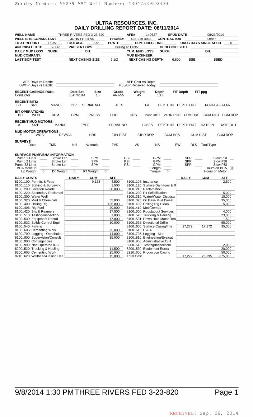
RECEIVED: Sep. 08, 2014
9/8/2014 1:30 PM Page 1THREE RIVERS FED 3-23-820
ULTRA RESOURCES, INC.DAILY DRILLING REPORT DATE: 08/11/2014
WELL NAME THREE RIVERS FED 3-23-820 AFE# 140627 SPUD DATE 08/23/2014WELL SITE CONSULTANT JOHN FREITAS PHONE# 435-219-4933 CONTRACTOR OtherTD AT REPORT 1,035' FOOTAGE 955' PRATE CUM. DRLG. HRS DRLG DAYS SINCE SPUD 0ANTICIPATED TD 6,866' PRESENT OPS Drilling at 1,035' GEOLOGIC SECT.DAILY MUD LOSS SURF: DH: CUM. MUD LOSS SURF: DH:MUD COMPANY: MUD ENGINEER:LAST BOP TEST NEXT CASING SIZE 5 1/2 NEXT CASING DEPTH 6,800 SSE SSED
AFE Days vs Depth: AFE Cost Vs Depth:DWOP Days vs Depth: # LL/BP Received Today:
RECENT CASINGS RUN: Date Set Size Grade Weight Depth FIT Depth FIT ppgConductor 08/07/2014 16 ARJ-55 45 100
RECENT BITS:BIT SIZE MANUF TYPE SERIAL NO. JETS TFA DEPTH IN DEPTH OUT I-O-D-L-B-G-O-R
BIT OPERATIONS:BIT WOB RPM GPM PRESS HHP HRS 24hr DIST 24HR ROP CUM HRS CUM DIST CUM ROP
RECENT MUD MOTORS:# SIZE MANUF TYPE SERIAL NO. LOBES DEPTH IN DEPTH OUT DATE IN DATE OUT
MUD MOTOR OPERATIONS:# WOB REV/GAL HRS 24hr DIST 24HR ROP CUM HRS CUM DIST CUM ROP
SURVEYSDate TMD Incl Azimuth TVD VS NS EW DLS Tool Type
SURFACE PUMP/BHA INFORMATIONPump 1 Liner Stroke Len SPM PSI GPM SPR Slow PSIPump 2 Liner Stroke Len SPM PSI GPM SPR Slow PSI
Pump 32 Liner Stroke Len SPM PSI GPM SPR Slow PSIBHA Makeup Length Hours on BHA 0
Up Weight 0 Dn Weight 0 RT Weight 0 Torque 0 Hours on Motor
DAILY COSTS DAILY CUM AFE DAILY CUM AFE8100..100: Permits & Fees 9,123 4,500 8100..105: Insurance 2,5008100..110: Staking & Surveying 1,500 8100..120: Surface Damages & R8100..200: Location Roads 30,000 8100..210: Reclamation8100..220: Secondary Reclamati 8100..230: Pit Solidification 5,0008100..300: Water Well 8100..310: Water/Water Disposa 10,0008100..320: Mud & Chemicals 55,000 8100..325: Oil Base Mud Diesel 35,0008100..400: Drilling Rig 135,000 8100..402: Drilling Rig Cleani 5,0008100..405: Rig Fuel 20,000 8100..410: Mob/Demob8100..420: Bits & Reamers 17,500 8100..500: Roustabout Services 4,0008100..510: Testing/Inspection/ 1,000 8100..520: Trucking & Hauling 23,0008100..530: Equipment Rental 17,000 8100..531: Down Hole Motor Ren 1,5008100..532: Solids Control Equi 10,000 8100..535: Directional Drillin 65,0008100..540: Fishing 8100..600: Surface Casing/Inte 17,272 17,272 35,0008100..605: Cementing Work 25,000 8100..610: P & A8100..700: Logging - Openhole 14,000 8100..705: Logging - Mud8100..800: Supervision/Consult 35,000 8100..810: Engineering/Evaluat8100..900: Contingencies 8100..950: Administrative O/H8100..999: Non Operated IDC 8200..510: Testing/Inspection/ 2,0008200..520: Trucking & Hauling 11,500 8200..530: Equipment Rental 20,0008200..605: Cementing Work 25,000 8210..600: Production Casing 50,0008210..620: Wellhead/Casing Hea 15,000 Total Cost 17,272 26,395 675,000
Sundry Number: 55279 API Well Number: 43047539530000Sundry Number: 55279 API Well Number: 43047539530000
ULTRA RESOURCES, INC.DAILY DRILLING REPORT DATE: 08/11/2014
WELL NAME THREE RIVERS FED 3-23-820 AFE# 140627 SPUD DATE 08/23/2014WELL SITE CONSULTANT JOHN FREITAS PHONE# 435-219-4933 CONTRACTOR OtherTD AT REPORT 1,035' FOOTAGE 955' PRATE CUM. DRLG. HRS DRLG DAYS SINCE SPUD 0ANTICIPATED TD 6,866' PRESENT OPS Drillingat 1,035' GEOLOGIC SECT.DAILY MUD LOSS SURF: DH: CUM. MUD LOSS SURF: DH:MUD COMPANY: MUD ENGINEER:LAST BOP TEST NEXT CASING SIZE 5 1/2 NEXT CASING DEPTH 6,800 SSE SSED
AFE Days vs Depth: AFE Cost Vs Depth:DWOP Days vs Depth: # LLIBP Received Today:
RECENT CASINGS RUN: Date Set Size Grade Weight Depth FIT Depth FIT ppgConductor 08/07/2014 16 ARJ-55 45 100
RECENT BITS:BIT SIZE MANUF TYPE SERIAL NO. JETS TFA DEPTH IN DEPTH OUT I-O-D-L-B-G-O-R
BIT OPERATIONS:BIT WOB RPM GPM PRESS HHP HRS 24hr DIST 24HR ROP CUM HRS CUM DIST CUM ROP
RECENT MUD MOTORS:# SIZE MANUF TYPE SERIAL NO. LOBES DEPTH IN DEPTH OUT DATE IN DATE OUT
MUD MOTOR OPERATIONS:# WOB REVIGAL HRS 24hr DIST 24HR ROP CUM HRS CUM DIST CUM ROP
SURVEYSDate TMD Incl Azimuth TVD VS NS EW DLS Tool Type
SURFACE PUMPIBHA INFORMATIONPump 1 Liner Stroke Len SPM PSI GPM SPR Slow PSIPump 2 Liner Stroke Len SPM PSI GPM SPR Slow PSI
Pump 32 Liner Stroke Len SPM PSI GPM SPR Slow PSIBHA Makeup Length Hours on BHA O
Up Weight 0 Dn Weight 0 RT Weight 0 Torque 0 Hours on Motor
DAILY COSTS DAILY CUM AFE DAILY CUM AFE8100..100: Permits & Fees 9,123 4,500 8100..105: Insurance 2,5008100..110: Staking & Surveying 1,500 8100..120: Surface Damages & R8100..200: Location Roads 30,000 8100..210: Reclamation8100..220: Secondary Reclamati 8100..230: Pit Solidification 5,0008100..300: Water Well 8100..310: Water/Water Disposa 10,0008100..320: Mud & Chemicals 55,000 8100..325: Oil Base Mud Diesel 35,0008100..400: Drilling Rig 135,000 8100..402: Drilling Rig Cleani 5,0008100..405: Rig Fuel 20,000 8100..410: MoblDemob8100..420: Bits & Reamers 17,500 8100..500: Roustabout Services 4,0008100..510: Testing/Inspection/ 1,000 8100..520: Trucking & Hauling 23,0008100..530: Equipment Rental 17,000 8100..531: Down Hole Motor Ren 1,5008100..532: Solids Control Equi 10,000 8100..535: Directional Drillin 65,0008100..540: Fishing 8100..600: Surface Casing/Inte 17,272 17,272 35,0008100..605: Cementing Work 25,000 8100..610: P &A8100..700: Logging - Openhole 14,000 8100..705: Logging - Mud8100..800: Supervision/Consult 35,000 8100..810: Engineering/Evaluat8100..900: Contingencies 8100..950: Administrative OlH8100..999: Non Operated IDC 8200..510: Testing/Inspection/ 2,0008200..520: Trucking & Hauling 11,500 8200..530: Equipment Rental 20,0008200..605: Cementing Work 25,000 8210..600: Production Casing 50,0008210..620: Wellhead/Casing Hea 15,000 Total Cost 17,272 26,395 675,000
9/8/2014 1:30 PM THREE RIVERS FED 3-23-820 Page 1
RECEIVED: Sep. 08,
Sundry Number: 55279 API Well Number: 43047539530000
ULTRA RESOURCES, INC.DAILY DRILLING REPORT DATE: 08/11/2014
WELL NAME THREE RIVERS FED 3-23-820 AFE# 140627 SPUD DATE 08/23/2014WELL SITE CONSULTANT JOHN FREITAS PHONE# 435-219-4933 CONTRACTOR OtherTD AT REPORT 1,035' FOOTAGE 955' PRATE CUM. DRLG. HRS DRLG DAYS SINCE SPUD 0ANTICIPATED TD 6,866' PRESENT OPS Drillingat 1,035' GEOLOGIC SECT.DAILY MUD LOSS SURF: DH: CUM. MUD LOSS SURF: DH:MUD COMPANY: MUD ENGINEER:LAST BOP TEST NEXT CASING SIZE 5 1/2 NEXT CASING DEPTH 6,800 SSE SSED
AFE Days vs Depth: AFE Cost Vs Depth:DWOP Days vs Depth: # LLIBP Received Today:
RECENT CASINGS RUN: Date Set Size Grade Weight Depth FIT Depth FIT ppgConductor 08/07/2014 16 ARJ-55 45 100
RECENT BITS:BIT SIZE MANUF TYPE SERIAL NO. JETS TFA DEPTH IN DEPTH OUT I-O-D-L-B-G-O-R
BIT OPERATIONS:BIT WOB RPM GPM PRESS HHP HRS 24hr DIST 24HR ROP CUM HRS CUM DIST CUM ROP
RECENT MUD MOTORS:# SIZE MANUF TYPE SERIAL NO. LOBES DEPTH IN DEPTH OUT DATE IN DATE OUT
MUD MOTOR OPERATIONS:# WOB REVIGAL HRS 24hr DIST 24HR ROP CUM HRS CUM DIST CUM ROP
SURVEYSDate TMD Incl Azimuth TVD VS NS EW DLS Tool Type
SURFACE PUMPIBHA INFORMATIONPump 1 Liner Stroke Len SPM PSI GPM SPR Slow PSIPump 2 Liner Stroke Len SPM PSI GPM SPR Slow PSI
Pump 32 Liner Stroke Len SPM PSI GPM SPR Slow PSIBHA Makeup Length Hours on BHA O
Up Weight 0 Dn Weight 0 RT Weight 0 Torque 0 Hours on Motor
DAILY COSTS DAILY CUM AFE DAILY CUM AFE8100..100: Permits & Fees 9,123 4,500 8100..105: Insurance 2,5008100..110: Staking & Surveying 1,500 8100..120: Surface Damages & R8100..200: Location Roads 30,000 8100..210: Reclamation8100..220: Secondary Reclamati 8100..230: Pit Solidification 5,0008100..300: Water Well 8100..310: Water/Water Disposa 10,0008100..320: Mud & Chemicals 55,000 8100..325: Oil Base Mud Diesel 35,0008100..400: Drilling Rig 135,000 8100..402: Drilling Rig Cleani 5,0008100..405: Rig Fuel 20,000 8100..410: MoblDemob8100..420: Bits & Reamers 17,500 8100..500: Roustabout Services 4,0008100..510: Testing/Inspection/ 1,000 8100..520: Trucking & Hauling 23,0008100..530: Equipment Rental 17,000 8100..531: Down Hole Motor Ren 1,5008100..532: Solids Control Equi 10,000 8100..535: Directional Drillin 65,0008100..540: Fishing 8100..600: Surface Casing/Inte 17,272 17,272 35,0008100..605: Cementing Work 25,000 8100..610: P &A8100..700: Logging - Openhole 14,000 8100..705: Logging - Mud8100..800: Supervision/Consult 35,000 8100..810: Engineering/Evaluat8100..900: Contingencies 8100..950: Administrative OlH8100..999: Non Operated IDC 8200..510: Testing/Inspection/ 2,0008200..520: Trucking & Hauling 11,500 8200..530: Equipment Rental 20,0008200..605: Cementing Work 25,000 8210..600: Production Casing 50,0008210..620: Wellhead/Casing Hea 15,000 Total Cost 17,272 26,395 675,000
9/8/2014 1:30 PM THREE RIVERS FED 3-23-820 Page 1
RECEIVED: Sep. 08,
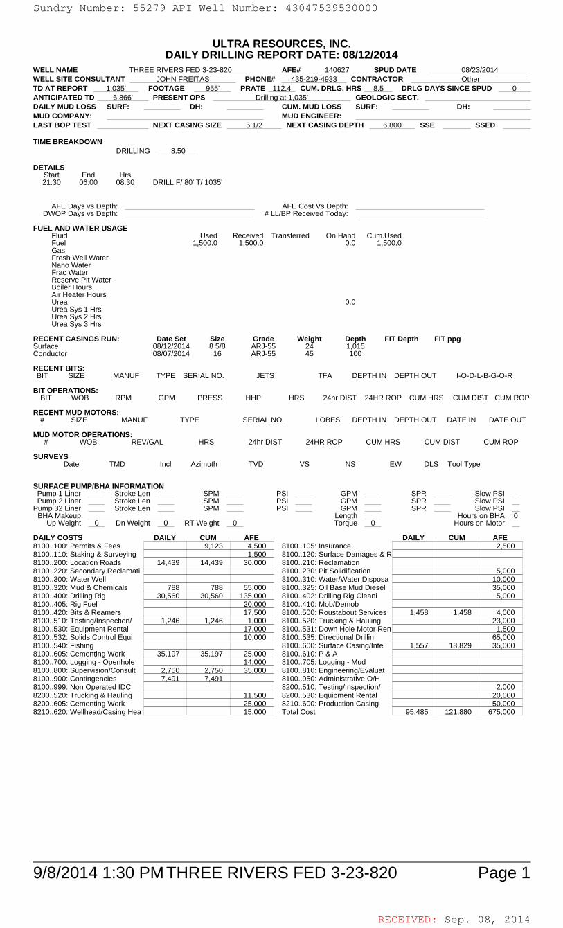
RECEIVED: Sep. 08, 2014
9/8/2014 1:30 PM Page 1THREE RIVERS FED 3-23-820
ULTRA RESOURCES, INC.DAILY DRILLING REPORT DATE: 08/12/2014
WELL NAME THREE RIVERS FED 3-23-820 AFE# 140627 SPUD DATE 08/23/2014WELL SITE CONSULTANT JOHN FREITAS PHONE# 435-219-4933 CONTRACTOR OtherTD AT REPORT 1,035' FOOTAGE 955' PRATE 112.4 CUM. DRLG. HRS 8.5 DRLG DAYS SINCE SPUD 0ANTICIPATED TD 6,866' PRESENT OPS Drilling at 1,035' GEOLOGIC SECT.DAILY MUD LOSS SURF: DH: CUM. MUD LOSS SURF: DH:MUD COMPANY: MUD ENGINEER:LAST BOP TEST NEXT CASING SIZE 5 1/2 NEXT CASING DEPTH 6,800 SSE SSED
TIME BREAKDOWNDRILLING 8.50
DETAILSStart End Hrs21:30 06:00 08:30 DRILL F/ 80' T/ 1035'
AFE Days vs Depth: AFE Cost Vs Depth:DWOP Days vs Depth: # LL/BP Received Today:
FUEL AND WATER USAGEFluid Used Received Transferred On Hand Cum.UsedFuel 1,500.0 1,500.0 0.0 1,500.0GasFresh Well WaterNano WaterFrac WaterReserve Pit WaterBoiler HoursAir Heater HoursUrea 0.0Urea Sys 1 HrsUrea Sys 2 HrsUrea Sys 3 Hrs
RECENT CASINGS RUN: Date Set Size Grade Weight Depth FIT Depth FIT ppgSurface 08/12/2014 8 5/8 ARJ-55 24 1,015Conductor 08/07/2014 16 ARJ-55 45 100
RECENT BITS:BIT SIZE MANUF TYPE SERIAL NO. JETS TFA DEPTH IN DEPTH OUT I-O-D-L-B-G-O-R
BIT OPERATIONS:BIT WOB RPM GPM PRESS HHP HRS 24hr DIST 24HR ROP CUM HRS CUM DIST CUM ROP
RECENT MUD MOTORS:# SIZE MANUF TYPE SERIAL NO. LOBES DEPTH IN DEPTH OUT DATE IN DATE OUT
MUD MOTOR OPERATIONS:# WOB REV/GAL HRS 24hr DIST 24HR ROP CUM HRS CUM DIST CUM ROP
SURVEYSDate TMD Incl Azimuth TVD VS NS EW DLS Tool Type
SURFACE PUMP/BHA INFORMATIONPump 1 Liner Stroke Len SPM PSI GPM SPR Slow PSIPump 2 Liner Stroke Len SPM PSI GPM SPR Slow PSI
Pump 32 Liner Stroke Len SPM PSI GPM SPR Slow PSIBHA Makeup Length Hours on BHA 0
Up Weight 0 Dn Weight 0 RT Weight 0 Torque 0 Hours on Motor
DAILY COSTS DAILY CUM AFE DAILY CUM AFE8100..100: Permits & Fees 9,123 4,500 8100..105: Insurance 2,5008100..110: Staking & Surveying 1,500 8100..120: Surface Damages & R8100..200: Location Roads 14,439 14,439 30,000 8100..210: Reclamation8100..220: Secondary Reclamati 8100..230: Pit Solidification 5,0008100..300: Water Well 8100..310: Water/Water Disposa 10,0008100..320: Mud & Chemicals 788 788 55,000 8100..325: Oil Base Mud Diesel 35,0008100..400: Drilling Rig 30,560 30,560 135,000 8100..402: Drilling Rig Cleani 5,0008100..405: Rig Fuel 20,000 8100..410: Mob/Demob8100..420: Bits & Reamers 17,500 8100..500: Roustabout Services 1,458 1,458 4,0008100..510: Testing/Inspection/ 1,246 1,246 1,000 8100..520: Trucking & Hauling 23,0008100..530: Equipment Rental 17,000 8100..531: Down Hole Motor Ren 1,5008100..532: Solids Control Equi 10,000 8100..535: Directional Drillin 65,0008100..540: Fishing 8100..600: Surface Casing/Inte 1,557 18,829 35,0008100..605: Cementing Work 35,197 35,197 25,000 8100..610: P & A8100..700: Logging - Openhole 14,000 8100..705: Logging - Mud8100..800: Supervision/Consult 2,750 2,750 35,000 8100..810: Engineering/Evaluat8100..900: Contingencies 7,491 7,491 8100..950: Administrative O/H8100..999: Non Operated IDC 8200..510: Testing/Inspection/ 2,0008200..520: Trucking & Hauling 11,500 8200..530: Equipment Rental 20,0008200..605: Cementing Work 25,000 8210..600: Production Casing 50,0008210..620: Wellhead/Casing Hea 15,000 Total Cost 95,485 121,880 675,000
Sundry Number: 55279 API Well Number: 43047539530000Sundry Number: 55279 API Well Number: 43047539530000
ULTRA RESOURCES, INC.DAILY DRILLING REPORT DATE: 08/12/2014
WELL NAME THREE RIVERS FED 3-23-820 AFE# 140627 SPUD DATE 08/23/2014WELL SITE CONSULTANT JOHN FREITAS PHONE# 435-219-4933 CONTRACTOR OtherTD AT REPORT 1,035' FOOTAGE 955' PRATE 112.4 CUM. DRLG. HRS 8.5 DRLG DAYS SINCE SPUD 0ANTICIPATED TD 6,866' PRESENT OPS Drillingat 1,035' GEOLOGIC SECT.DAILY MUD LOSS SURF: DH: CUM. MUD LOSS SURF: DH:MUD COMPANY: MUD ENGINEER:LAST BOP TEST NEXT CASING SIZE 5 1/2 NEXT CASING DEPTH 6,800 SSE SSED
TIME BREAKDOWNDRILLING 8.50
DETAILSStart End Hrs21:30 06:00 08:30 DRILL Fl80' TI 1035'
AFE Days vs Depth: AFE Cost Vs Depth:DWOP Days vs Depth: # LLIBP Received Today:
FUEL AND WATER USAGEFluid Used Received Transferred On Hand Cum.UsedFuel 1,500.0 1,500.0 0.0 1,500.0GasFresh Well WaterNano WaterFrac WaterReserve Pit WaterBoiler HoursAir Heater HoursUrea 0.0Urea Sys 1 HrsUrea Sys 2 HrsUrea Sys 3 Hrs
RECENT CASINGS RUN: Date Set Size Grade Weight Depth FIT Depth FIT ppgSurface 08/12/2014 8 5/8 ARJ-55 24 1,015Conductor 08/07/2014 16 ARJ-55 45 100
RECENT BITS:BIT SIZE MANUF TYPE SERIAL NO. JETS TFA DEPTH IN DEPTH OUT I-O-D-L-B-G-O-R
BIT OPERATIONS:BIT WOB RPM GPM PRESS HHP HRS 24hr DIST 24HR ROP CUM HRS CUM DIST CUM ROP
RECENT MUD MOTORS:# SIZE MANUF TYPE SERIAL NO. LOBES DEPTH IN DEPTH OUT DATE IN DATE OUT
MUD MOTOR OPERATIONS:# WOB REVIGAL HRS 24hr DIST 24HR ROP CUM HRS CUM DIST CUM ROP
SURVEYSDate TMD Incl Azimuth TVD VS NS EW DLS Tool Type
SURFACE PUMPIBHA INFORMATIONPump 1 Liner Stroke Len SPM PSI GPM SPR Slow PSIPump 2 Liner Stroke Len SPM PSI GPM SPR Slow PSI
Pump 32 Liner Stroke Len SPM PSI GPM SPR Slow PSIBHA Makeup Length Hours on BHA O
Up Weight 0 Dn Weight 0 RT Weight 0 Torque 0 Hours on Motor
DAILY COSTS DAILY CUM AFE DAILY CUM AFE8100..100: Permits & Fees 9,123 4,500 8100..105: Insurance 2,5008100..110: Staking & Surveying 1,500 8100..120: Surface Damages & R8100..200: Location Roads 14,439 14,439 30,000 8100..210: Reclamation8100..220: Secondary Reclamati 8100..230: Pit Solidification 5,0008100..300: Water Well 8100..310: Water/Water Disposa 10,0008100..320: Mud & Chemicals 788 788 55,000 8100..325: Oil Base Mud Diesel 35,0008100..400: Drilling Rig 30,560 30,560 135,000 8100..402: Drilling Rig Cleani 5,0008100..405: Rig Fuel 20,000 8100..410: MoblDemob8100..420: Bits & Reamers 17,500 8100..500: Roustabout Services 1,458 1,458 4,0008100..510: Testing/Inspection/ 1,246 1,246 1,000 8100..520: Trucking & Hauling 23,0008100..530: Equipment Rental 17,000 8100..531: Down Hole Motor Ren 1,5008100..532: Solids Control Equi 10,000 8100..535: Directional Drillin 65,0008100..540: Fishing 8100..600: Surface Casing/Inte 1,557 18,829 35,0008100..605: Cementing Work 35,197 35,197 25,000 8100..610: P &A8100..700: Logging - Openhole 14,000 8100..705: Logging - Mud8100..800: Supervision/Consult 2,750 2,750 35,000 8100..810: Engineering/Evaluat8100..900: Contingencies 7,491 7,491 8100..950: Administrative OlH8100..999: Non Operated IDC 8200..510: Testing/Inspection/ 2,0008200..520: Trucking & Hauling 11,500 8200..530: Equipment Rental 20,0008200..605: Cementing Work 25,000 8210..600: Production Casing 50,0008210..620: Wellhead/Casing Hea 15,000 Total Cost 95,485 121,880 675,000
9/8/2014 1:30 PM THREE RIVERS FED 3-23-820 Page 1
RECEIVED: Sep. 08,
Sundry Number: 55279 API Well Number: 43047539530000
ULTRA RESOURCES, INC.DAILY DRILLING REPORT DATE: 08/12/2014
WELL NAME THREE RIVERS FED 3-23-820 AFE# 140627 SPUD DATE 08/23/2014WELL SITE CONSULTANT JOHN FREITAS PHONE# 435-219-4933 CONTRACTOR OtherTD AT REPORT 1,035' FOOTAGE 955' PRATE 112.4 CUM. DRLG. HRS 8.5 DRLG DAYS SINCE SPUD 0ANTICIPATED TD 6,866' PRESENT OPS Drillingat 1,035' GEOLOGIC SECT.DAILY MUD LOSS SURF: DH: CUM. MUD LOSS SURF: DH:MUD COMPANY: MUD ENGINEER:LAST BOP TEST NEXT CASING SIZE 5 1/2 NEXT CASING DEPTH 6,800 SSE SSED
TIME BREAKDOWNDRILLING 8.50
DETAILSStart End Hrs21:30 06:00 08:30 DRILL Fl80' TI 1035'
AFE Days vs Depth: AFE Cost Vs Depth:DWOP Days vs Depth: # LLIBP Received Today:
FUEL AND WATER USAGEFluid Used Received Transferred On Hand Cum.UsedFuel 1,500.0 1,500.0 0.0 1,500.0GasFresh Well WaterNano WaterFrac WaterReserve Pit WaterBoiler HoursAir Heater HoursUrea 0.0Urea Sys 1 HrsUrea Sys 2 HrsUrea Sys 3 Hrs
RECENT CASINGS RUN: Date Set Size Grade Weight Depth FIT Depth FIT ppgSurface 08/12/2014 8 5/8 ARJ-55 24 1,015Conductor 08/07/2014 16 ARJ-55 45 100
RECENT BITS:BIT SIZE MANUF TYPE SERIAL NO. JETS TFA DEPTH IN DEPTH OUT I-O-D-L-B-G-O-R
BIT OPERATIONS:BIT WOB RPM GPM PRESS HHP HRS 24hr DIST 24HR ROP CUM HRS CUM DIST CUM ROP
RECENT MUD MOTORS:# SIZE MANUF TYPE SERIAL NO. LOBES DEPTH IN DEPTH OUT DATE IN DATE OUT
MUD MOTOR OPERATIONS:# WOB REVIGAL HRS 24hr DIST 24HR ROP CUM HRS CUM DIST CUM ROP
SURVEYSDate TMD Incl Azimuth TVD VS NS EW DLS Tool Type
SURFACE PUMPIBHA INFORMATIONPump 1 Liner Stroke Len SPM PSI GPM SPR Slow PSIPump 2 Liner Stroke Len SPM PSI GPM SPR Slow PSI
Pump 32 Liner Stroke Len SPM PSI GPM SPR Slow PSIBHA Makeup Length Hours on BHA O
Up Weight 0 Dn Weight 0 RT Weight 0 Torque 0 Hours on Motor
DAILY COSTS DAILY CUM AFE DAILY CUM AFE8100..100: Permits & Fees 9,123 4,500 8100..105: Insurance 2,5008100..110: Staking & Surveying 1,500 8100..120: Surface Damages & R8100..200: Location Roads 14,439 14,439 30,000 8100..210: Reclamation8100..220: Secondary Reclamati 8100..230: Pit Solidification 5,0008100..300: Water Well 8100..310: Water/Water Disposa 10,0008100..320: Mud & Chemicals 788 788 55,000 8100..325: Oil Base Mud Diesel 35,0008100..400: Drilling Rig 30,560 30,560 135,000 8100..402: Drilling Rig Cleani 5,0008100..405: Rig Fuel 20,000 8100..410: MoblDemob8100..420: Bits & Reamers 17,500 8100..500: Roustabout Services 1,458 1,458 4,0008100..510: Testing/Inspection/ 1,246 1,246 1,000 8100..520: Trucking & Hauling 23,0008100..530: Equipment Rental 17,000 8100..531: Down Hole Motor Ren 1,5008100..532: Solids Control Equi 10,000 8100..535: Directional Drillin 65,0008100..540: Fishing 8100..600: Surface Casing/Inte 1,557 18,829 35,0008100..605: Cementing Work 35,197 35,197 25,000 8100..610: P &A8100..700: Logging - Openhole 14,000 8100..705: Logging - Mud8100..800: Supervision/Consult 2,750 2,750 35,000 8100..810: Engineering/Evaluat8100..900: Contingencies 7,491 7,491 8100..950: Administrative OlH8100..999: Non Operated IDC 8200..510: Testing/Inspection/ 2,0008200..520: Trucking & Hauling 11,500 8200..530: Equipment Rental 20,0008200..605: Cementing Work 25,000 8210..600: Production Casing 50,0008210..620: Wellhead/Casing Hea 15,000 Total Cost 95,485 121,880 675,000
9/8/2014 1:30 PM THREE RIVERS FED 3-23-820 Page 1
RECEIVED: Sep. 08,

RECEIVED: Sep. 08, 2014
9/8/2014 1:30 PM Page 1THREE RIVERS FED 3-23-820
ULTRA RESOURCES, INC.DAILY DRILLING REPORT DATE: 08/21/2014
WELL NAME THREE RIVERS FED 3-23-820 AFE# 140627 SPUD DATE 08/23/2014WELL SITE CONSULTANT JOHN FREITAS PHONE# 435-219-4933 CONTRACTOR OtherTD AT REPORT (no data) FOOTAGE PRATE CUM. DRLG. HRS 8.5 DRLG DAYS SINCE SPUD 0ANTICIPATED TD 6,866' PRESENT OPS (nothing recorded) GEOLOGIC SECT.DAILY MUD LOSS SURF: DH: CUM. MUD LOSS SURF: DH:MUD COMPANY: MUD ENGINEER:LAST BOP TEST NEXT CASING SIZE NEXT CASING DEPTH SSE SSED
AFE Days vs Depth: AFE Cost Vs Depth:DWOP Days vs Depth: # LL/BP Received Today:
RECENT CASINGS RUN: Date Set Size Grade Weight Depth FIT Depth FIT ppgSurface 08/12/2014 8 5/8 ARJ-55 24 1,015Conductor 08/07/2014 16 ARJ-55 45 100
RECENT BITS:BIT SIZE MANUF TYPE SERIAL NO. JETS TFA DEPTH IN DEPTH OUT I-O-D-L-B-G-O-R
BIT OPERATIONS:BIT WOB RPM GPM PRESS HHP HRS 24hr DIST 24HR ROP CUM HRS CUM DIST CUM ROP
RECENT MUD MOTORS:# SIZE MANUF TYPE SERIAL NO. LOBES DEPTH IN DEPTH OUT DATE IN DATE OUT
MUD MOTOR OPERATIONS:# WOB REV/GAL HRS 24hr DIST 24HR ROP CUM HRS CUM DIST CUM ROP
SURVEYSDate TMD Incl Azimuth TVD VS NS EW DLS Tool Type
SURFACE PUMP/BHA INFORMATIONPump 1 Liner Stroke Len SPM PSI GPM SPR Slow PSIPump 2 Liner Stroke Len SPM PSI GPM SPR Slow PSI
Pump 32 Liner Stroke Len SPM PSI GPM SPR Slow PSIBHA Makeup Length Hours on BHA 0
Up Weight 0 Dn Weight 0 RT Weight 0 Torque 0 Hours on Motor
DAILY COSTS DAILY CUM AFE DAILY CUM AFE8100..100: Permits & Fees 9,123 4,500 8100..105: Insurance 2,5008100..110: Staking & Surveying 1,500 8100..120: Surface Damages & R8100..200: Location Roads 14,439 30,000 8100..210: Reclamation8100..220: Secondary Reclamati 8100..230: Pit Solidification 5,0008100..300: Water Well 8100..310: Water/Water Disposa 10,0008100..320: Mud & Chemicals 788 55,000 8100..325: Oil Base Mud Diesel 35,0008100..400: Drilling Rig 30,560 135,000 8100..402: Drilling Rig Cleani 5,0008100..405: Rig Fuel 20,000 8100..410: Mob/Demob8100..420: Bits & Reamers 17,500 8100..500: Roustabout Services 1,458 4,0008100..510: Testing/Inspection/ 1,246 1,000 8100..520: Trucking & Hauling 23,0008100..530: Equipment Rental 17,000 8100..531: Down Hole Motor Ren 1,5008100..532: Solids Control Equi 10,000 8100..535: Directional Drillin 65,0008100..540: Fishing 8100..600: Surface Casing/Inte 18,829 35,0008100..605: Cementing Work 35,197 25,000 8100..610: P & A8100..700: Logging - Openhole 14,000 8100..705: Logging - Mud8100..800: Supervision/Consult 2,750 35,000 8100..810: Engineering/Evaluat8100..900: Contingencies 7,491 8100..950: Administrative O/H8100..999: Non Operated IDC 8200..510: Testing/Inspection/ 2,0008200..520: Trucking & Hauling 11,500 8200..530: Equipment Rental 20,0008200..605: Cementing Work 25,000 8210..600: Production Casing 50,0008210..620: Wellhead/Casing Hea 15,000 Total Cost 121,880 675,000
Sundry Number: 55279 API Well Number: 43047539530000Sundry Number: 55279 API Well Number: 43047539530000
ULTRA RESOURCES, INC.DAILY DRILLING REPORT DATE: 08/21/2014
WELL NAME THREE RIVERS FED 3-23-820 AFE# 140627 SPUD DATE 08/23/2014WELL SITE CONSULTANT JOHN FREITAS PHONE# 435-219-4933 CONTRACTOR OtherTD AT REPORT (no data) FOOTAGE PRATE CUM. DRLG. HRS 8.5 DRLG DAYS SINCE SPUD 0ANTICIPATED TD 6,866' PRESENT OPS (nothing recorded) GEOLOGIC SECT.DAILY MUD LOSS SURF: DH: CUM. MUD LOSS SURF: DH:MUD COMPANY: MUD ENGINEER:LAST BOP TEST NEXT CASING SIZE NEXT CASING DEPTH SSE SSED
AFE Days vs Depth: AFE Cost Vs Depth:DWOP Days vs Depth: # LLIBP Received Today:
RECENT CASINGS RUN: Date Set Size Grade Weight Depth FIT Depth FIT ppgSurface 08/12/2014 8 5/8 ARJ-55 24 1,015Conductor 08/07/2014 16 ARJ-55 45 100
RECENT BITS:BIT SIZE MANUF TYPE SERIAL NO. JETS TFA DEPTH IN DEPTH OUT I-O-D-L-B-G-O-R
BIT OPERATIONS:BIT WOB RPM GPM PRESS HHP HRS 24hr DIST 24HR ROP CUM HRS CUM DIST CUM ROP
RECENT MUD MOTORS:# SIZE MANUF TYPE SERIAL NO. LOBES DEPTH IN DEPTH OUT DATE IN DATE OUT
MUD MOTOR OPERATIONS:# WOB REVIGAL HRS 24hr DIST 24HR ROP CUM HRS CUM DIST CUM ROP
SURVEYSDate TMD Incl Azimuth TVD VS NS EW DLS Tool Type
SURFACE PUMPIBHA INFORMATIONPump 1 Liner Stroke Len SPM PSI GPM SPR Slow PSIPump 2 Liner Stroke Len SPM PSI GPM SPR Slow PSI
Pump 32 Liner Stroke Len SPM PSI GPM SPR Slow PSIBHA Makeup Length Hours on BHA O
Up Weight 0 Dn Weight 0 RT Weight 0 Torque 0 Hours on Motor
DAILY COSTS DAILY CUM AFE DAILY CUM AFE8100..100: Permits & Fees 9,123 4,500 8100..105: Insurance 2,5008100..110: Staking & Surveying 1,500 8100..120: Surface Damages & R8100..200: Location Roads 14,439 30,000 8100..210: Reclamation8100..220: Secondary Reclamati 8100..230: Pit Solidification 5,0008100..300: Water Well 8100..310: Water/Water Disposa 10,0008100..320: Mud & Chemicals 788 55,000 8100..325: Oil Base Mud Diesel 35,0008100..400: Drilling Rig 30,560 135,000 8100..402: Drilling Rig Cleani 5,0008100..405: Rig Fuel 20,000 8100..410: MoblDemob8100..420: Bits & Reamers 17,500 8100..500: Roustabout Services 1,458 4,0008100..510: Testing/Inspection/ 1,246 1,000 8100..520: Trucking & Hauling 23,0008100..530: Equipment Rental 17,000 8100..531: Down Hole Motor Ren 1,5008100..532: Solids Control Equi 10,000 8100..535: Directional Drillin 65,0008100..540: Fishing 8100..600: Surface Casing/Inte 18,829 35,0008100..605: Cementing Work 35,197 25,000 8100..610: P &A8100..700: Logging - Openhole 14,000 8100..705: Logging - Mud8100..800: Supervision/Consult 2,750 35,000 8100..810: Engineering/Evaluat8100..900: Contingencies 7,491 8100..950: Administrative OlH8100..999: Non Operated IDC 8200..510: Testing/Inspection/ 2,0008200..520: Trucking & Hauling 11,500 8200..530: Equipment Rental 20,0008200..605: Cementing Work 25,000 8210..600: Production Casing 50,0008210..620: Wellhead/Casing Hea 15,000 Total Cost 121,880 675,000
9/8/2014 1:30 PM THREE RIVERS FED 3-23-820 Page 1
RECEIVED: Sep. 08,
Sundry Number: 55279 API Well Number: 43047539530000
ULTRA RESOURCES, INC.DAILY DRILLING REPORT DATE: 08/21/2014
WELL NAME THREE RIVERS FED 3-23-820 AFE# 140627 SPUD DATE 08/23/2014WELL SITE CONSULTANT JOHN FREITAS PHONE# 435-219-4933 CONTRACTOR OtherTD AT REPORT (no data) FOOTAGE PRATE CUM. DRLG. HRS 8.5 DRLG DAYS SINCE SPUD 0ANTICIPATED TD 6,866' PRESENT OPS (nothing recorded) GEOLOGIC SECT.DAILY MUD LOSS SURF: DH: CUM. MUD LOSS SURF: DH:MUD COMPANY: MUD ENGINEER:LAST BOP TEST NEXT CASING SIZE NEXT CASING DEPTH SSE SSED
AFE Days vs Depth: AFE Cost Vs Depth:DWOP Days vs Depth: # LLIBP Received Today:
RECENT CASINGS RUN: Date Set Size Grade Weight Depth FIT Depth FIT ppgSurface 08/12/2014 8 5/8 ARJ-55 24 1,015Conductor 08/07/2014 16 ARJ-55 45 100
RECENT BITS:BIT SIZE MANUF TYPE SERIAL NO. JETS TFA DEPTH IN DEPTH OUT I-O-D-L-B-G-O-R
BIT OPERATIONS:BIT WOB RPM GPM PRESS HHP HRS 24hr DIST 24HR ROP CUM HRS CUM DIST CUM ROP
RECENT MUD MOTORS:# SIZE MANUF TYPE SERIAL NO. LOBES DEPTH IN DEPTH OUT DATE IN DATE OUT
MUD MOTOR OPERATIONS:# WOB REVIGAL HRS 24hr DIST 24HR ROP CUM HRS CUM DIST CUM ROP
SURVEYSDate TMD Incl Azimuth TVD VS NS EW DLS Tool Type
SURFACE PUMPIBHA INFORMATIONPump 1 Liner Stroke Len SPM PSI GPM SPR Slow PSIPump 2 Liner Stroke Len SPM PSI GPM SPR Slow PSI
Pump 32 Liner Stroke Len SPM PSI GPM SPR Slow PSIBHA Makeup Length Hours on BHA O
Up Weight 0 Dn Weight 0 RT Weight 0 Torque 0 Hours on Motor
DAILY COSTS DAILY CUM AFE DAILY CUM AFE8100..100: Permits & Fees 9,123 4,500 8100..105: Insurance 2,5008100..110: Staking & Surveying 1,500 8100..120: Surface Damages & R8100..200: Location Roads 14,439 30,000 8100..210: Reclamation8100..220: Secondary Reclamati 8100..230: Pit Solidification 5,0008100..300: Water Well 8100..310: Water/Water Disposa 10,0008100..320: Mud & Chemicals 788 55,000 8100..325: Oil Base Mud Diesel 35,0008100..400: Drilling Rig 30,560 135,000 8100..402: Drilling Rig Cleani 5,0008100..405: Rig Fuel 20,000 8100..410: MoblDemob8100..420: Bits & Reamers 17,500 8100..500: Roustabout Services 1,458 4,0008100..510: Testing/Inspection/ 1,246 1,000 8100..520: Trucking & Hauling 23,0008100..530: Equipment Rental 17,000 8100..531: Down Hole Motor Ren 1,5008100..532: Solids Control Equi 10,000 8100..535: Directional Drillin 65,0008100..540: Fishing 8100..600: Surface Casing/Inte 18,829 35,0008100..605: Cementing Work 35,197 25,000 8100..610: P &A8100..700: Logging - Openhole 14,000 8100..705: Logging - Mud8100..800: Supervision/Consult 2,750 35,000 8100..810: Engineering/Evaluat8100..900: Contingencies 7,491 8100..950: Administrative OlH8100..999: Non Operated IDC 8200..510: Testing/Inspection/ 2,0008200..520: Trucking & Hauling 11,500 8200..530: Equipment Rental 20,0008200..605: Cementing Work 25,000 8210..600: Production Casing 50,0008210..620: Wellhead/Casing Hea 15,000 Total Cost 121,880 675,000
9/8/2014 1:30 PM THREE RIVERS FED 3-23-820 Page 1
RECEIVED: Sep. 08,

RECEIVED: Sep. 08, 2014
9/8/2014 1:30 PM Page 1THREE RIVERS FED 3-23-820
ULTRA RESOURCES, INC.DAILY DRILLING REPORT DATE: 08/22/2014
WELL NAME THREE RIVERS FED 3-23-820 AFE# 140627 SPUD DATE 08/23/2014WELL SITE CONSULTANT JOHN FREITAS PHONE# 435-219-4933 CONTRACTOR OtherTD AT REPORT 1,027' FOOTAGE 0' PRATE CUM. DRLG. HRS 8.5 DRLG DAYS SINCE SPUD 0ANTICIPATED TD 6,866' PRESENT OPS Pressure Test BOP at 1,027' GEOLOGIC SECT.DAILY MUD LOSS SURF: DH: CUM. MUD LOSS SURF: DH:MUD COMPANY: MUD ENGINEER:LAST BOP TEST NEXT CASING SIZE 5 1/2 NEXT CASING DEPTH 6,866 SSE 0 SSED 0
TIME BREAKDOWN
DETAILSStart End Hrs05:55 05:55 00:00 SAFETY MEETING DAYS: PINCH POINTS, WORKING AROUND THIRD PARTY TRUCKS, FORKLIFT SAFETY.
SAFETY MEETING NIGHTS: PINCH POINTS, WORKING AROUND THIRD PARTY TRUCKS.REGULATORY NOTICES: SENT NOTICE FOR BOP TEST ON THE 3-23-820.REGULATORY VISITS: NONE.INCIDENTS: NONE.SAFETY DRILLS: NONE.
AFE Days vs Depth: AFE Cost Vs Depth:DWOP Days vs Depth: # LL/BP Received Today:
RECENT CASINGS RUN: Date Set Size Grade Weight Depth FIT Depth FIT ppgSurface 08/12/2014 8 5/8 ARJ-55 24 1,015Conductor 08/07/2014 16 ARJ-55 45 100
RECENT BITS:BIT SIZE MANUF TYPE SERIAL NO. JETS TFA DEPTH IN DEPTH OUT I-O-D-L-B-G-O-R
BIT OPERATIONS:BIT WOB RPM GPM PRESS HHP HRS 24hr DIST 24HR ROP CUM HRS CUM DIST CUM ROP
RECENT MUD MOTORS:# SIZE MANUF TYPE SERIAL NO. LOBES DEPTH IN DEPTH OUT DATE IN DATE OUT
MUD MOTOR OPERATIONS:# WOB REV/GAL HRS 24hr DIST 24HR ROP CUM HRS CUM DIST CUM ROP
SURVEYSDate TMD Incl Azimuth TVD VS NS EW DLS Tool Type
SURFACE PUMP/BHA INFORMATIONPump 1 Liner Stroke Len SPM PSI GPM SPR Slow PSIPump 2 Liner Stroke Len SPM PSI GPM SPR Slow PSI
Pump 32 Liner Stroke Len SPM PSI GPM SPR Slow PSIBHA Makeup Length Hours on BHA 0
Up Weight 0 Dn Weight 0 RT Weight 0 Torque 0 Hours on Motor
DAILY COSTS DAILY CUM AFE DAILY CUM AFE8100..100: Permits & Fees 9,123 4,500 8100..105: Insurance 2,5008100..110: Staking & Surveying 1,500 8100..120: Surface Damages & R8100..200: Location Roads 14,439 30,000 8100..210: Reclamation8100..220: Secondary Reclamati 8100..230: Pit Solidification 5,0008100..300: Water Well 8100..310: Water/Water Disposa 10,0008100..320: Mud & Chemicals 788 55,000 8100..325: Oil Base Mud Diesel 35,0008100..400: Drilling Rig 30,560 135,000 8100..402: Drilling Rig Cleani 5,0008100..405: Rig Fuel 20,000 8100..410: Mob/Demob8100..420: Bits & Reamers 17,500 8100..500: Roustabout Services 1,458 4,0008100..510: Testing/Inspection/ 1,246 1,000 8100..520: Trucking & Hauling 23,0008100..530: Equipment Rental 17,000 8100..531: Down Hole Motor Ren 1,5008100..532: Solids Control Equi 10,000 8100..535: Directional Drillin 65,0008100..540: Fishing 8100..600: Surface Casing/Inte 18,829 35,0008100..605: Cementing Work 35,197 25,000 8100..610: P & A8100..700: Logging - Openhole 14,000 8100..705: Logging - Mud8100..800: Supervision/Consult 2,750 35,000 8100..810: Engineering/Evaluat8100..900: Contingencies 7,491 8100..950: Administrative O/H8100..999: Non Operated IDC 8200..510: Testing/Inspection/ 2,0008200..520: Trucking & Hauling 11,500 8200..530: Equipment Rental 20,0008200..605: Cementing Work 25,000 8210..600: Production Casing 50,0008210..620: Wellhead/Casing Hea 15,000 Total Cost 121,880 675,000
Sundry Number: 55279 API Well Number: 43047539530000Sundry Number: 55279 API Well Number: 43047539530000
ULTRA RESOURCES, INC.DAILY DRILLING REPORT DATE: 08/22/2014
WELL NAME THREE RIVERS FED 3-23-820 AFE# 140627 SPUD DATE 08/23/2014WELL SITE CONSULTANT JOHN FREITAS PHONE# 435-219-4933 CONTRACTOR OtherTD AT REPORT 1,027' FOOTAGE O' PRATE CUM. DRLG. HRS 8.5 DRLG DAYS SINCE SPUD 0ANTICIPATED TD 6,866' PRESENT OPS Pressure Test BOP at 1,027' GEOLOGIC SECT.DAILY MUD LOSS SURF: DH: CUM. MUD LOSS SURF: DH:MUD COMPANY: MUD ENGINEER:LAST BOP TEST NEXT CASING SIZE 5 1/2 NEXT CASING DEPTH 6,866 SSE O SSED 0
TIME BREAKDOWN
DETAILSStart End Hrs05:55 05:55 00:00 SAFETY MEETING DAYS: PINCH POINTS, WORKING AROUND THIRD PARTY TRUCKS, FORKLIFT SAFETY.
SAFETY MEETING NIGHTS: PINCH POINTS, WORKING AROUND THIRD PARTY TRUCKS.REGULATORY NOTICES: SENT NOTICE FOR BOP TEST ON THE 3-23-820.REGULATORY VISITS: NONE.INCIDENTS: NONE.SAFETY DRILLS: NONE.
AFE Days vs Depth: AFE Cost Vs Depth:DWOP Days vs Depth: # LLIBP Received Today:
RECENT CASINGS RUN: Date Set Size Grade Weight Depth FIT Depth FIT ppgSurface 08/12/2014 8 5/8 ARJ-55 24 1,015Conductor 08/07/2014 16 ARJ-55 45 100
RECENT BITS:BIT SIZE MANUF TYPE SERIAL NO. JETS TFA DEPTH IN DEPTH OUT I-O-D-L-B-G-O-R
BIT OPERATIONS:BIT WOB RPM GPM PRESS HHP HRS 24hr DIST 24HR ROP CUM HRS CUM DIST CUM ROP
RECENT MUD MOTORS:# SIZE MANUF TYPE SERIAL NO. LOBES DEPTH IN DEPTH OUT DATE IN DATE OUT
MUD MOTOR OPERATIONS:# WOB REVIGAL HRS 24hr DIST 24HR ROP CUM HRS CUM DIST CUM ROP
SURVEYSDate TMD Incl Azimuth TVD VS NS EW DLS Tool Type
SURFACE PUMPIBHA INFORMATIONPump 1 Liner Stroke Len SPM PSI GPM SPR Slow PSIPump 2 Liner Stroke Len SPM PSI GPM SPR Slow PSI
Pump 32 Liner Stroke Len SPM PSI GPM SPR Slow PSIBHA Makeup Length Hours on BHA O
Up Weight 0 Dn Weight 0 RT Weight 0 Torque 0 Hours on Motor
DAILY COSTS DAILY CUM AFE DAILY CUM AFE8100..100: Permits & Fees 9,123 4,500 8100..105: Insurance 2,5008100..110: Staking & Surveying 1,500 8100..120: Surface Damages & R8100..200: Location Roads 14,439 30,000 8100..210: Reclamation8100..220: Secondary Reclamati 8100..230: Pit Solidification 5,0008100..300: Water Well 8100..310: Water/Water Disposa 10,0008100..320: Mud & Chemicals 788 55,000 8100..325: Oil Base Mud Diesel 35,0008100..400: Drilling Rig 30,560 135,000 8100..402: Drilling Rig Cleani 5,0008100..405: Rig Fuel 20,000 8100..410: MoblDemob8100..420: Bits & Reamers 17,500 8100..500: Roustabout Services 1,458 4,0008100..510: Testing/Inspection/ 1,246 1,000 8100..520: Trucking & Hauling 23,0008100..530: Equipment Rental 17,000 8100..531: Down Hole Motor Ren 1,5008100..532: Solids Control Equi 10,000 8100..535: Directional Drillin 65,0008100..540: Fishing 8100..600: Surface Casing/Inte 18,829 35,0008100..605: Cementing Work 35,197 25,000 8100..610: P &A8100..700: Logging - Openhole 14,000 8100..705: Logging - Mud8100..800: Supervision/Consult 2,750 35,000 8100..810: Engineering/Evaluat8100..900: Contingencies 7,491 8100..950: Administrative OlH8100..999: Non Operated IDC 8200..510: Testing/Inspection/ 2,0008200..520: Trucking & Hauling 11,500 8200..530: Equipment Rental 20,0008200..605: Cementing Work 25,000 8210..600: Production Casing 50,0008210..620: Wellhead/Casing Hea 15,000 Total Cost 121,880 675,000
9/8/2014 1:30 PM THREE RIVERS FED 3-23-820 Page 1
RECEIVED: Sep. 08,
Sundry Number: 55279 API Well Number: 43047539530000
ULTRA RESOURCES, INC.DAILY DRILLING REPORT DATE: 08/22/2014
WELL NAME THREE RIVERS FED 3-23-820 AFE# 140627 SPUD DATE 08/23/2014WELL SITE CONSULTANT JOHN FREITAS PHONE# 435-219-4933 CONTRACTOR OtherTD AT REPORT 1,027' FOOTAGE O' PRATE CUM. DRLG. HRS 8.5 DRLG DAYS SINCE SPUD 0ANTICIPATED TD 6,866' PRESENT OPS Pressure Test BOP at 1,027' GEOLOGIC SECT.DAILY MUD LOSS SURF: DH: CUM. MUD LOSS SURF: DH:MUD COMPANY: MUD ENGINEER:LAST BOP TEST NEXT CASING SIZE 5 1/2 NEXT CASING DEPTH 6,866 SSE O SSED 0
TIME BREAKDOWN
DETAILSStart End Hrs05:55 05:55 00:00 SAFETY MEETING DAYS: PINCH POINTS, WORKING AROUND THIRD PARTY TRUCKS, FORKLIFT SAFETY.
SAFETY MEETING NIGHTS: PINCH POINTS, WORKING AROUND THIRD PARTY TRUCKS.REGULATORY NOTICES: SENT NOTICE FOR BOP TEST ON THE 3-23-820.REGULATORY VISITS: NONE.INCIDENTS: NONE.SAFETY DRILLS: NONE.
AFE Days vs Depth: AFE Cost Vs Depth:DWOP Days vs Depth: # LLIBP Received Today:
RECENT CASINGS RUN: Date Set Size Grade Weight Depth FIT Depth FIT ppgSurface 08/12/2014 8 5/8 ARJ-55 24 1,015Conductor 08/07/2014 16 ARJ-55 45 100
RECENT BITS:BIT SIZE MANUF TYPE SERIAL NO. JETS TFA DEPTH IN DEPTH OUT I-O-D-L-B-G-O-R
BIT OPERATIONS:BIT WOB RPM GPM PRESS HHP HRS 24hr DIST 24HR ROP CUM HRS CUM DIST CUM ROP
RECENT MUD MOTORS:# SIZE MANUF TYPE SERIAL NO. LOBES DEPTH IN DEPTH OUT DATE IN DATE OUT
MUD MOTOR OPERATIONS:# WOB REVIGAL HRS 24hr DIST 24HR ROP CUM HRS CUM DIST CUM ROP
SURVEYSDate TMD Incl Azimuth TVD VS NS EW DLS Tool Type
SURFACE PUMPIBHA INFORMATIONPump 1 Liner Stroke Len SPM PSI GPM SPR Slow PSIPump 2 Liner Stroke Len SPM PSI GPM SPR Slow PSI
Pump 32 Liner Stroke Len SPM PSI GPM SPR Slow PSIBHA Makeup Length Hours on BHA O
Up Weight 0 Dn Weight 0 RT Weight 0 Torque 0 Hours on Motor
DAILY COSTS DAILY CUM AFE DAILY CUM AFE8100..100: Permits & Fees 9,123 4,500 8100..105: Insurance 2,5008100..110: Staking & Surveying 1,500 8100..120: Surface Damages & R8100..200: Location Roads 14,439 30,000 8100..210: Reclamation8100..220: Secondary Reclamati 8100..230: Pit Solidification 5,0008100..300: Water Well 8100..310: Water/Water Disposa 10,0008100..320: Mud & Chemicals 788 55,000 8100..325: Oil Base Mud Diesel 35,0008100..400: Drilling Rig 30,560 135,000 8100..402: Drilling Rig Cleani 5,0008100..405: Rig Fuel 20,000 8100..410: MoblDemob8100..420: Bits & Reamers 17,500 8100..500: Roustabout Services 1,458 4,0008100..510: Testing/Inspection/ 1,246 1,000 8100..520: Trucking & Hauling 23,0008100..530: Equipment Rental 17,000 8100..531: Down Hole Motor Ren 1,5008100..532: Solids Control Equi 10,000 8100..535: Directional Drillin 65,0008100..540: Fishing 8100..600: Surface Casing/Inte 18,829 35,0008100..605: Cementing Work 35,197 25,000 8100..610: P &A8100..700: Logging - Openhole 14,000 8100..705: Logging - Mud8100..800: Supervision/Consult 2,750 35,000 8100..810: Engineering/Evaluat8100..900: Contingencies 7,491 8100..950: Administrative OlH8100..999: Non Operated IDC 8200..510: Testing/Inspection/ 2,0008200..520: Trucking & Hauling 11,500 8200..530: Equipment Rental 20,0008200..605: Cementing Work 25,000 8210..600: Production Casing 50,0008210..620: Wellhead/Casing Hea 15,000 Total Cost 121,880 675,000
9/8/2014 1:30 PM THREE RIVERS FED 3-23-820 Page 1
RECEIVED: Sep. 08,

RECEIVED: Sep. 08, 2014
9/8/2014 1:30 PM Page 1THREE RIVERS FED 3-23-820
ULTRA RESOURCES, INC.DAILY DRILLING REPORT DATE: 08/23/2014
WELL NAME THREE RIVERS FED 3-23-820 AFE# 140627 SPUD DATE 08/23/2014WELL SITE CONSULTANT JOHN FREITAS PHONE# 435-219-4933 CONTRACTOR Ensign 122TD AT REPORT 1,027' FOOTAGE 0' PRATE CUM. DRLG. HRS 8.5 DRLG DAYS SINCE SPUD 0ANTICIPATED TD 6,866' PRESENT OPS Pressure Test BOP at 1,027' GEOLOGIC SECT.DAILY MUD LOSS SURF: DH: CUM. MUD LOSS SURF: DH:MUD COMPANY: MUD ENGINEER:LAST BOP TEST 08/23/2014 NEXT CASING SIZE 5 1/2 NEXT CASING DEPTH 6,866 SSE 0 SSED 0
TIME BREAKDOWNNIPPLE UP B.O.P. 1.00 PRESSURE TEST B.O.P. 2.00 RIG REPAIRS 6.00
DETAILSStart End Hrs21:00 00:00 03:00 FIX PUMP MOTOR, CHANGE OUT DERRICK LIGHTS TO LED.00:00 01:00 01:00 NIPPLE UP ON THE THREE RIVERS FED 3-23-82001:00 04:00 03:00 REPLACE LIGHTS IN DERRICK, FIX PUMP IT WAS STILL NOT GETTING FULL BOOST OUT OF THE TURBO.04:00 06:00 02:00 PJSM, RIG UP TESTERS AND START TO TEST BOP.05:55 05:55 00:00 SAFETY MEETING DAYS: PINCH POINTS, WORKING AROUND THIRD PARTY TRUCKS, FORKLIFT SAFETY.
SAFETY MEETING NIGHTS: PINCH POINTS, WORKING AROUND THIRD PARTY TRUCKS.REGULATORY NOTICES: SENT NOTICE FOR BOP TEST ON THE 3-23-820.REGULATORY VISITS: NONE.INCIDENTS: NONE.SAFETY DRILLS: NONE.
AFE Days vs Depth: AFE Cost Vs Depth:DWOP Days vs Depth: # LL/BP Received Today:
FUEL AND WATER USAGEFluid Used Received Transferred On Hand Cum.UsedFuel 40.0 3,100.0 3,060.0 1,540.0GasFresh Well WaterNano WaterFrac WaterReserve Pit WaterBoiler HoursAir Heater HoursUrea 0.0Urea Sys 1 HrsUrea Sys 2 HrsUrea Sys 3 Hrs
RECENT CASINGS RUN: Date Set Size Grade Weight Depth FIT Depth FIT ppgSurface 08/12/2014 8 5/8 ARJ-55 24 1,015Conductor 08/07/2014 16 ARJ-55 45 100
RECENT BITS:BIT SIZE MANUF TYPE SERIAL NO. JETS TFA DEPTH IN DEPTH OUT I-O-D-L-B-G-O-R
BIT OPERATIONS:BIT WOB RPM GPM PRESS HHP HRS 24hr DIST 24HR ROP CUM HRS CUM DIST CUM ROP
RECENT MUD MOTORS:# SIZE MANUF TYPE SERIAL NO. LOBES DEPTH IN DEPTH OUT DATE IN DATE OUT
MUD MOTOR OPERATIONS:# WOB REV/GAL HRS 24hr DIST 24HR ROP CUM HRS CUM DIST CUM ROP
SURVEYSDate TMD Incl Azimuth TVD VS NS EW DLS Tool Type
08/23/2014 2,039 12.3 51.50 2,034 76.2 37.04 67.26 1.9 MWD Survey Tool08/23/2014 1,948 10.6 51.70 1,945 58.1 25.82 53.11 2.6 MWD Survey Tool08/23/2014 1,858 8.6 59.30 1,856 43.2 17.25 40.82 2.7 MWD Survey Tool
SURFACE PUMP/BHA INFORMATIONPump 1 Liner 6.5 Stroke Len 9.0 SPM 126 PSI 2,100 GPM 440 SPR Slow PSIPump 2 Liner Stroke Len SPM PSI GPM SPR Slow PSI
Pump 32 Liner Stroke Len SPM PSI GPM SPR Slow PSIBHA Makeup STEARABLE Length Hours on BHA 0
Up Weight 17,000 Dn Weight RT Weight Torque Hours on Motor 0
BHA MAKEUP:# Component OD ID Length Weight (ft/lb) Serial Number Description1 DRILL BIT 7.875 0.00 0 SMITH MDSI516 5X 12 .552
TFA2 7/8 5.7STG .28 1.5 7.000 3.250 0.00 0 1.5 DEG FBH 7/8 5.7 STG. .28
REV3 NON MAG MONEL 6.500 3.250 0.00 EN122-1 4.5 XH P x B4 EM GAP SUB 6.400 3.250 0.00 650-0053 4.5 XH P x B5 NON MAG FLEX MONEL 6.500 2.813 0.00 EN0815-12 4.5 XH P x B6 NON MAG FLEX MONEL 6.500 2.813 0.00 EN0814-12 4.5 XH P x B7 DRILL COLLAR 6.500 2.250 0.00 RIG 4.5 XH P x B8 18JTS HWDP 4.500 2.313 0.00 RIG 4.5 XH P x B9 DRILLING JARS 6.550 2.625 0.00 09190D 4.5 XH P x B(SMITH)HE JARS
10 6JTS HWDP 4.500 2.313 0.00 RIG 4.5 XH P x B
Sundry Number: 55279 API Well Number: 43047539530000Sundry Number: 55279 API Well Number: 43047539530000
ULTRA RESOURCES, INC.DAILY DRILLING REPORT DATE: 08/23/2014
WELL NAME THREE RIVERS FED 3-23-820 AFE# 140627 SPUD DATE 08/23/2014WELL SITE CONSULTANT JOHN FREITAS PHONE# 435-219-4933 CONTRACTOR Ension 122TD AT REPORT 1,027' FOOTAGE O' PRATE CUM. DRLG. HRS 8.5 DRLG DAYS SINCE SPUD 0ANTICIPATED TD 6,866' PRESENT OPS Pressure Test BOP at 1,027' GEOLOGIC SECT.DAILY MUD LOSS SURF: DH: CUM. MUD LOSS SURF: DH:MUD COMPANY: MUD ENGINEER:LAST BOP TEST 08/23/2014 NEXT CASING SIZE 5 1/2 NEXT CASING DEPTH 6,866 SSE O SSED 0
TIME BREAKDOWNNIPPLE UP B.O.P. 1.00 PRESSURE TEST B.O.P. 2.00 RIG REPAIRS 6.00
DETAILSStart End Hrs21:00 00:00 03:00 FIX PUMP MOTOR, CHANGE OUT DERRICK LIGHTS TO LED.00:00 01:00 01:00 NIPPLE UP ON THE THREE RIVERS FED 3-23-82001:00 04:00 03:00 REPLACE LIGHTS IN DERRICK, FIX PUMP IT WAS STILL NOT GETTING FULL BOOST OUT OF THE TURBO.04:00 06:00 02:00 PJSM, RIG UP TESTERS AND START TO TEST BOP.05:55 05:55 00:00 SAFETY MEETING DAYS: PINCH POINTS, WORKING AROUND THIRD PARTY TRUCKS, FORKLIFT SAFETY.
SAFETY MEETING NIGHTS: PINCH POINTS, WORKING AROUND THIRD PARTY TRUCKS.REGULATORY NOTICES: SENT NOTICE FOR BOP TEST ON THE 3-23-820.REGULATORY VISITS: NONE.INCIDENTS: NONE.SAFETY DRILLS: NONE.
AFE Days vs Depth: AFE Cost Vs Depth:DWOP Days vs Depth: # LLIBP Received Today:
FUEL AND WATER USAGEFluid Used Received Transferred On Hand Cum.UsedFuel 40.0 3,100.0 3,060.0 1,540.0GasFresh Well WaterNano WaterFrac WaterReserve Pit WaterBoiler HoursAir Heater HoursUrea 0.0Urea Sys 1 HrsUrea Sys 2 HrsUrea Sys 3 Hrs
RECENT CASINGS RUN: Date Set Size Grade Weight Depth FIT Depth FIT ppgSurface 08/12/2014 8 5/8 ARJ-55 24 1,015Conductor 08/07/2014 16 ARJ-55 45 100
RECENT BITS:BIT SIZE MANUF TYPE SERIAL NO. JETS TFA DEPTH IN DEPTH OUT I-O-D-L-B-G-O-R
BIT OPERATIONS:BIT WOB RPM GPM PRESS HHP HRS 24hr DIST 24HR ROP CUM HRS CUM DIST CUM ROP
RECENT MUD MOTORS:# SIZE MANUF TYPE SERIAL NO. LOBES DEPTH IN DEPTH OUT DATE IN DATE OUT
MUD MOTOR OPERATIONS:# WOB REVIGAL HRS 24hr DIST 24HR ROP CUM HRS CUM DIST CUM ROP
SURVEYSDate TMD Incl Azimuth TVD VS NS EW DLS Tool Type
08/23/2014 2,039 12.3 51.50 2,034 76.2 37.04 67.26 1.9 MWD Survey Tool08/23/2014 1,948 10.6 51.70 1,945 58.1 25.82 53.11 2.6 MWD Survey Tool08/23/2014 1,858 8.6 59.30 1,856 43.2 17.25 40.82 2.7 MWD Survey Tool
SURFACE PUMPIBHA INFORMATIONPump 1 Liner 6.5 Stroke Len 9.0 SPM 126 PSI 2_1)0 GPM 440 SPR Slow PSIPump 2 Liner Stroke Len SPM PSI GPM SPR Slow PSI
Pump 32 Liner Stroke Len SPM PSI GPM SPR Slow PSIBHA Makeup STEARABLE Length Hours on BHA O
Up Weight 1LOOO Dn Weight RT Weight Torque Hours on Motor 0
BHA MAKEUP:# Component OD ID Length Weight (ft/Ib) Serial Number Description1 DRILL BIT 7.875 0.00 0 SMITH MDSl516 5X 12 .552
TFA2 7/8 5.7STG .28 1.5 7.000 3.250 0.00 0 1.5 DEG FBH 7/8 5.7 STG. .28
REV3 NON MAG MONEL 6.500 3.250 0.00 EN122-1 4.5 XH PxB4 EM GAP SUB 6.400 3.250 0.00 650-0053 4.5 XH PxB5 NON MAG FLEX MONEL 6.500 2.813 0.00 ENO815-12 4.5 XH PxB6 NON MAG FLEX MONEL 6.500 2.813 0.00 ENO814-12 4.5 XH PxB7 DRILL COLLAR 6.500 2.250 0.00 RIG 4.5 XH PxB8 18JTS HWDP 4.500 2.313 0.00 RIG 4.5 XH PxB9 DRILLINGJARS 6.550 2.625 0.00 09190D 4.5 XH Px B(SMITH)HE JARS10 6JTS HWDP 4.500 2.313 0.00 RIG 4.5 XH PxB
9/8/2014 1:30 PM THREE RIVERS FED 3-23-820 Page 1
RECEIVED: Sep. 08,
Sundry Number: 55279 API Well Number: 43047539530000
ULTRA RESOURCES, INC.DAILY DRILLING REPORT DATE: 08/23/2014
WELL NAME THREE RIVERS FED 3-23-820 AFE# 140627 SPUD DATE 08/23/2014WELL SITE CONSULTANT JOHN FREITAS PHONE# 435-219-4933 CONTRACTOR Ension 122TD AT REPORT 1,027' FOOTAGE O' PRATE CUM. DRLG. HRS 8.5 DRLG DAYS SINCE SPUD 0ANTICIPATED TD 6,866' PRESENT OPS Pressure Test BOP at 1,027' GEOLOGIC SECT.DAILY MUD LOSS SURF: DH: CUM. MUD LOSS SURF: DH:MUD COMPANY: MUD ENGINEER:LAST BOP TEST 08/23/2014 NEXT CASING SIZE 5 1/2 NEXT CASING DEPTH 6,866 SSE O SSED 0
TIME BREAKDOWNNIPPLE UP B.O.P. 1.00 PRESSURE TEST B.O.P. 2.00 RIG REPAIRS 6.00
DETAILSStart End Hrs21:00 00:00 03:00 FIX PUMP MOTOR, CHANGE OUT DERRICK LIGHTS TO LED.00:00 01:00 01:00 NIPPLE UP ON THE THREE RIVERS FED 3-23-82001:00 04:00 03:00 REPLACE LIGHTS IN DERRICK, FIX PUMP IT WAS STILL NOT GETTING FULL BOOST OUT OF THE TURBO.04:00 06:00 02:00 PJSM, RIG UP TESTERS AND START TO TEST BOP.05:55 05:55 00:00 SAFETY MEETING DAYS: PINCH POINTS, WORKING AROUND THIRD PARTY TRUCKS, FORKLIFT SAFETY.
SAFETY MEETING NIGHTS: PINCH POINTS, WORKING AROUND THIRD PARTY TRUCKS.REGULATORY NOTICES: SENT NOTICE FOR BOP TEST ON THE 3-23-820.REGULATORY VISITS: NONE.INCIDENTS: NONE.SAFETY DRILLS: NONE.
AFE Days vs Depth: AFE Cost Vs Depth:DWOP Days vs Depth: # LLIBP Received Today:
FUEL AND WATER USAGEFluid Used Received Transferred On Hand Cum.UsedFuel 40.0 3,100.0 3,060.0 1,540.0GasFresh Well WaterNano WaterFrac WaterReserve Pit WaterBoiler HoursAir Heater HoursUrea 0.0Urea Sys 1 HrsUrea Sys 2 HrsUrea Sys 3 Hrs
RECENT CASINGS RUN: Date Set Size Grade Weight Depth FIT Depth FIT ppgSurface 08/12/2014 8 5/8 ARJ-55 24 1,015Conductor 08/07/2014 16 ARJ-55 45 100
RECENT BITS:BIT SIZE MANUF TYPE SERIAL NO. JETS TFA DEPTH IN DEPTH OUT I-O-D-L-B-G-O-R
BIT OPERATIONS:BIT WOB RPM GPM PRESS HHP HRS 24hr DIST 24HR ROP CUM HRS CUM DIST CUM ROP
RECENT MUD MOTORS:# SIZE MANUF TYPE SERIAL NO. LOBES DEPTH IN DEPTH OUT DATE IN DATE OUT
MUD MOTOR OPERATIONS:# WOB REVIGAL HRS 24hr DIST 24HR ROP CUM HRS CUM DIST CUM ROP
SURVEYSDate TMD Incl Azimuth TVD VS NS EW DLS Tool Type
08/23/2014 2,039 12.3 51.50 2,034 76.2 37.04 67.26 1.9 MWD Survey Tool08/23/2014 1,948 10.6 51.70 1,945 58.1 25.82 53.11 2.6 MWD Survey Tool08/23/2014 1,858 8.6 59.30 1,856 43.2 17.25 40.82 2.7 MWD Survey Tool
SURFACE PUMPIBHA INFORMATIONPump 1 Liner 6.5 Stroke Len 9.0 SPM 126 PSI 2_1)0 GPM 440 SPR Slow PSIPump 2 Liner Stroke Len SPM PSI GPM SPR Slow PSI
Pump 32 Liner Stroke Len SPM PSI GPM SPR Slow PSIBHA Makeup STEARABLE Length Hours on BHA O
Up Weight 1LOOO Dn Weight RT Weight Torque Hours on Motor 0
BHA MAKEUP:# Component OD ID Length Weight (ft/Ib) Serial Number Description1 DRILL BIT 7.875 0.00 0 SMITH MDSl516 5X 12 .552
TFA2 7/8 5.7STG .28 1.5 7.000 3.250 0.00 0 1.5 DEG FBH 7/8 5.7 STG. .28
REV3 NON MAG MONEL 6.500 3.250 0.00 EN122-1 4.5 XH PxB4 EM GAP SUB 6.400 3.250 0.00 650-0053 4.5 XH PxB5 NON MAG FLEX MONEL 6.500 2.813 0.00 ENO815-12 4.5 XH PxB6 NON MAG FLEX MONEL 6.500 2.813 0.00 ENO814-12 4.5 XH PxB7 DRILL COLLAR 6.500 2.250 0.00 RIG 4.5 XH PxB8 18JTS HWDP 4.500 2.313 0.00 RIG 4.5 XH PxB9 DRILLINGJARS 6.550 2.625 0.00 09190D 4.5 XH Px B(SMITH)HE JARS10 6JTS HWDP 4.500 2.313 0.00 RIG 4.5 XH PxB
9/8/2014 1:30 PM THREE RIVERS FED 3-23-820 Page 1
RECEIVED: Sep. 08,
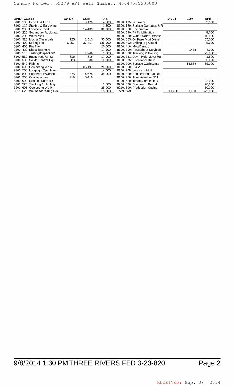
RECEIVED: Sep. 08, 2014
9/8/2014 1:30 PM Page 2THREE RIVERS FED 3-23-820
DAILY COSTS DAILY CUM AFE DAILY CUM AFE8100..100: Permits & Fees 9,123 4,500 8100..105: Insurance 2,5008100..110: Staking & Surveying 1,500 8100..120: Surface Damages & R8100..200: Location Roads 14,439 30,000 8100..210: Reclamation8100..220: Secondary Reclamati 8100..230: Pit Solidification 5,0008100..300: Water Well 8100..310: Water/Water Disposa 10,0008100..320: Mud & Chemicals 725 1,513 55,000 8100..325: Oil Base Mud Diesel 35,0008100..400: Drilling Rig 6,857 37,417 135,000 8100..402: Drilling Rig Cleani 5,0008100..405: Rig Fuel 20,000 8100..410: Mob/Demob8100..420: Bits & Reamers 17,500 8100..500: Roustabout Services 1,458 4,0008100..510: Testing/Inspection/ 1,246 1,000 8100..520: Trucking & Hauling 23,0008100..530: Equipment Rental 816 816 17,000 8100..531: Down Hole Motor Ren 1,5008100..532: Solids Control Equi 88 88 10,000 8100..535: Directional Drillin 65,0008100..540: Fishing 8100..600: Surface Casing/Inte 18,829 35,0008100..605: Cementing Work 35,197 25,000 8100..610: P & A8100..700: Logging - Openhole 14,000 8100..705: Logging - Mud8100..800: Supervision/Consult 1,875 4,625 35,000 8100..810: Engineering/Evaluat8100..900: Contingencies 919 8,410 8100..950: Administrative O/H8100..999: Non Operated IDC 8200..510: Testing/Inspection/ 2,0008200..520: Trucking & Hauling 11,500 8200..530: Equipment Rental 20,0008200..605: Cementing Work 25,000 8210..600: Production Casing 50,0008210..620: Wellhead/Casing Hea 15,000 Total Cost 11,280 133,160 675,000
Sundry Number: 55279 API Well Number: 43047539530000Sundry Number: 55279 API Well Number: 43047539530000
DAJLYCOSTS DAJLY CUM AFE DAJLY CUM AFE8100..100:Permits& Fees 9,123 4,500 8100..105:Insurance 2,5008100..110: Staking & Surveying 1,500 8100..120: Surface Damages & R8100..200:Location Roads 14,439 30,000 8100..210:Reclarnation8100..220:Secondary Reclamati 8100..230:PitSolidifcation 5,0008100..300:VVaterVVell 8100..310:Ø/ater/VVaterDisposa 10,0008100..320: Mud & Chemicals 725 1,513 55,000 8100..325: Oil Base Mud Diesel 35,0008100..400: Drilling Rig 6,857 37,417 135,000 8100..402: Drilling Rig Cleani 5,0008100..405: Rig Fuel 20,000 8100..410: MoblDemob8100..420: Bits & Reamers 17,500 8100..500: Roustabout Services 1,458 4,0008100..510:Testing/Inspection/ 1,246 1,000 8100..520:Trucking & Hauling 23,0008100..530: Equipment Rental 816 816 17,000 8100..531: Down Hole Motor Ren 1,5008100..532:Solids Control Equi 88 88 10,000 8100..535:DirectionalDrillin 65,0008100..540: Fishing 8100..600: Surface Casing/Inte 18,829 35,0008100..605: Cementing Work 35,197 25,000 8100..610: P &A8100..700:Logging-Openhole 14,000 8100..705:Logging-Mud8100..800: Supervision/Consult 1,875 4,625 35,000 8100..810: Engineering/Evaluat8100..900: Contingencies 919 8,410 8100..950: Administrative OlH8100..999:Non Operated IDC 8200..510:Testing/Inspection/ 2,0008200..520: Trucking & Hauling 11,500 8200..530: Equipment Rental 20,0008200..605:Cernenting VVork 25,000 8210..600:Production Casing 50,0008210..620:VVellhead/Casing Hea 15,000 Total cost 11,280 133,160 675,000
9/8/2014 1:30 PM THREE RIVERS FED 3-23-820 Page 2
RECEIVED: Sep. 08,
Sundry Number: 55279 API Well Number: 43047539530000
DAJLYCOSTS DAJLY CUM AFE DAJLY CUM AFE8100..100:Permits& Fees 9,123 4,500 8100..105:Insurance 2,5008100..110: Staking & Surveying 1,500 8100..120: Surface Damages & R8100..200:Location Roads 14,439 30,000 8100..210:Reclarnation8100..220:Secondary Reclamati 8100..230:PitSolidifcation 5,0008100..300:VVaterVVell 8100..310:Ø/ater/VVaterDisposa 10,0008100..320: Mud & Chemicals 725 1,513 55,000 8100..325: Oil Base Mud Diesel 35,0008100..400: Drilling Rig 6,857 37,417 135,000 8100..402: Drilling Rig Cleani 5,0008100..405: Rig Fuel 20,000 8100..410: MoblDemob8100..420: Bits & Reamers 17,500 8100..500: Roustabout Services 1,458 4,0008100..510:Testing/Inspection/ 1,246 1,000 8100..520:Trucking & Hauling 23,0008100..530: Equipment Rental 816 816 17,000 8100..531: Down Hole Motor Ren 1,5008100..532:Solids Control Equi 88 88 10,000 8100..535:DirectionalDrillin 65,0008100..540: Fishing 8100..600: Surface Casing/Inte 18,829 35,0008100..605: Cementing Work 35,197 25,000 8100..610: P &A8100..700:Logging-Openhole 14,000 8100..705:Logging-Mud8100..800: Supervision/Consult 1,875 4,625 35,000 8100..810: Engineering/Evaluat8100..900: Contingencies 919 8,410 8100..950: Administrative OlH8100..999:Non Operated IDC 8200..510:Testing/Inspection/ 2,0008200..520: Trucking & Hauling 11,500 8200..530: Equipment Rental 20,0008200..605:Cernenting VVork 25,000 8210..600:Production Casing 50,0008210..620:VVellhead/Casing Hea 15,000 Total cost 11,280 133,160 675,000
9/8/2014 1:30 PM THREE RIVERS FED 3-23-820 Page 2
RECEIVED: Sep. 08,

RECEIVED: Sep. 08, 2014
9/8/2014 1:30 PM Page 1THREE RIVERS FED 3-23-820
ULTRA RESOURCES, INC.DAILY DRILLING REPORT DATE: 08/24/2014
WELL NAME THREE RIVERS FED 3-23-820 AFE# 140627 SPUD DATE 08/23/2014WELL SITE CONSULTANT JOHN FREITAS PHONE# 435-219-4933 CONTRACTOR Ensign 122TD AT REPORT 3,090' FOOTAGE 2,063' PRATE 187.5 CUM. DRLG. HRS 19.5 DRLG DAYS SINCE SPUD 1ANTICIPATED TD 6,866' PRESENT OPS Directional Drilling at 3,090' GEOLOGIC SECT.DAILY MUD LOSS SURF: DH: CUM. MUD LOSS SURF: DH:MUD COMPANY: ANCHOR MUD ENGINEER: DAN KASTELLAST BOP TEST 08/24/2014 NEXT CASING SIZE 5 1/2 NEXT CASING DEPTH 6,866 SSE 0 SSED 0
TIME BREAKDOWNDIRECTIONAL DRILLING 11.00 PRESSURE TEST B.O.P. 4.00 RIG REPAIRS 5.00
RIG SERVICE 0.50 TRIPPING 3.00 WIRELINE 0.50
DETAILSStart End Hrs06:00 10:00 04:00 TEST BOP-(WALKER)PIPE RAMS, BLIND RAMS, CHOKE LINE & CHOKE VALVES, FOSV, INSIDE BOP, KILL
LINE AND VALVES, CHOKE MANIFOLD, HCR & MANUAL VALVE ALL @ 10 MIN 250 PSI LOW 10 MIN 3000 PSIHIGH - ANNULAR @ 10 MIN 1500 PSI HIGH 10 MIN 250 PSI LOW - CASING @ 30 MIN 1500 PSI -ACCUMULATOR FUNCTION TEST, RIG DOWN TESTER.
NOTE:THE RIG WAS STILL WORKING ON THE PUMPS WHILE WE TESTED BOP.
10:00 15:00 05:00 RIG REPAIR- WORK ON MUD PUMP # 2, REPAIR HPU, REPAIR PIPE ON GAS BUSTER.15:00 15:30 00:30 PICK UP DIR TOOLS.15:30 18:30 03:00 TRIP IN THE HOLE, TAG CEMENT AT 978', DRILL OUT CEMENT, FLOAT, CEMENT, SHOE.18:30 01:00 06:30 DIR DRILL F/ 1027' T/ 2315' 1288' @ 198.1 FT/HR - W/ 2-15K WT ON BIT - 440GPM - 55-65RPM - 400-600 DIFF -
7-10K TORQUE - 1600 PSI SPP.01:00 01:30 00:30 RIG SERVICE- LUBRICATE RIG (GREASE PIPEARMS, ROUGHNECK, WASH PIPE AND SHOCK SUB)
SERVICE AND INSPECT PUMP # 1 PUMP #2 AND HPU MOTORS.01:30 06:00 04:30 DIR DRILL F/ 2315' T/ 3090' 775' @ 172.2 FT/HR - W/ 6-15K WT ON BIT - 440GPM - 55-65RPM - 400-600 DIFF -
7-10K TORQUE - 1800 PSI SPP.ON BOTTOM ROP 282.605:55 05:55 00:00 SAFETY MEETING DAYS: PINCH POINTS, WORKING AROUND BOOM, FORKLIFT SAFETY, HOUSE
KEEPING.SAFETY MEETING NIGHTS: PINCH POINTS, WORKING AROUND BOOM, HOUSE KEEPING.REGULATORY NOTICES: NONE.REGULATORY VISITS: NONE.INCIDENTS: NONE.SAFETY DRILLS: BOP DRILL NIGHT CREW.
AFE Days vs Depth: AFE Cost Vs Depth:DWOP Days vs Depth: # LL/BP Received Today:
FUEL AND WATER USAGEFluid Used Received Transferred On Hand Cum.UsedFuel 820.0 2,240.0 2,360.0GasFresh Well WaterNano WaterFrac WaterReserve Pit WaterBoiler HoursAir Heater HoursUrea 0.0Urea Sys 1 HrsUrea Sys 2 HrsUrea Sys 3 Hrs
RECENT CASINGS RUN: Date Set Size Grade Weight Depth FIT Depth FIT ppgSurface 08/12/2014 8 5/8 ARJ-55 24 1,015Conductor 08/07/2014 16 ARJ-55 45 100
RECENT BITS:BIT SIZE MANUF TYPE SERIAL NO. JETS TFA DEPTH IN DEPTH OUT I-O-D-L-B-G-O-R1 7.875 SMITH MDSI516 JJ6088 12/12/12/12/12 0.552 1,027 -------
BIT OPERATIONS:BIT WOB RPM GPM PRESS HHP HRS 24hr DIST 24HR ROP CUM HRS CUM DIST CUM ROP1 65/123 440 1,600 2.93 11.00 2,063 187.55 11.00 2,063 187.55
RECENT MUD MOTORS:# SIZE MANUF TYPE SERIAL NO. LOBES DEPTH IN DEPTH OUT DATE IN DATE OUT1 6.500 DYNA-DRILL FIXED 650-106 7/8 5 1,027 08/23/2014
MUD MOTOR OPERATIONS:# WOB REV/GAL HRS 24hr DIST 24HR ROP CUM HRS CUM DIST CUM ROP1 24 0.28 11.00 2,063 187.55 11.00 2,063 187.55
SURVEYSDate TMD Incl Azimuth TVD VS NS EW DLS Tool Type
08/24/2014 2,763 18.9 55.20 2,723 295.8 172.61 240.22 0.7 MWD Survey Tool08/24/2014 2,673 19.5 55.00 2,638 266.2 155.67 215.95 0.8 MWD Survey Tool08/24/2014 2,582 19.3 52.90 2,552 236.0 137.89 191.51 0.8 MWD Survey Tool
MUD PROPERTIESType LSND Mud Wt 9.3 Alk. Sand % XS Lime lb/bbl
Temp. 100 Gels 10sec 2 Cl ppm 2,300 Solids % 4.0 Salt bblsVisc 36 Gels 10min 5 Ca ppm 20 LGS % 1.0 LCM ppb
PV 7 pH 9.1 pF 1.5 Oil % API WL cc 9.6YP 5 Filter Cake/32 2 Mf 4.5 Water % 96.0 HTHP WL cc
O/W Ratio ES WPSComments: SODIUM BICARBONATE 6,TRAILER RENTAL 1,ENGINEERING 1.
Flaring: Flare Foot-Minutes 0 Flared MCF 0.0 Cum. Flared MCF 0.0
SURFACE PUMP/BHA INFORMATIONPump 1 Liner 6.5 Stroke Len 9.0 SPM 126 PSI 2,100 GPM 440 SPR 43 Slow PSI 285Pump 2 Liner Stroke Len SPM PSI GPM SPR Slow PSI
Pump 32 Liner Stroke Len SPM PSI GPM SPR Slow PSIBHA Makeup STEARABLE Length 912.1 Hours on BHA 11
Up Weight 90,000 Dn Weight 65,000 RT Weight 78,000 Torque 8,000 Hours on Motor 11
Sundry Number: 55279 API Well Number: 43047539530000Sundry Number: 55279 API Well Number: 43047539530000
ULTRA RESOURCES, INC.DAILY DRILLING REPORT DATE: 08/24/2014
WELL NAME THREE RIVERS FED 3-23-820 AFE# 140627 SPUD DATE 08/23/2014WELL SITE CONSULTANT JOHN FREITAS PHONE# 435-219-4933 CONTRACTOR Ension 122TD AT REPORT 3,090' FOOTAGE 2,063' PRATE 187.5 CUM. DRLG. HRS 19.5 DRLG DAYS SINCE SPUD 1ANTICIPATED TD 6,866' PRESENT OPS Directional Drillingat 3,090' GEOLOGIC SECT.DAILY MUD LOSS SURF: DH: CUM. MUD LOSS SURF: DH:MUD COMPANY: ANCHOR MUD ENGINEER: DAN KASTELLAST BOP TEST 08/24/2014 NEXT CASING SIZE 5 1/2 NEXT CASING DEPTH 6,866 SSE O SSED 0
TIME BREAKDOWNDIRECTIONAL DRILLING 11.00 PRESSURE TEST B.O.P. 4.00 RIG REPAIRS 5.00
RIG SERVICE 0.50 TRIPPING 3.00 WIRELINE 0.50
DETAILSStart End Hrs06:00 10:00 04:00 TEST BOP-(WALKER)PIPE RAMS, BLIND RAMS, CHOKE LINE & CHOKE VALVES, FOSV, INSIDE BOP, KILL
LINEAND VALVES, CHOKE MANIFOLD, HCR & MANUALVALVEALL @ 10 MIN 250 PSI LOW 10 MIN 3000 PSIHIGH -ANNULAR @ 10 MIN 1500 PSI HIGH 10 MIN 250 PSI LOW- CASING @30 MIN 1500 PSI -
ACCUMULATOR FUNCTION TEST, RIG DOWN TESTER.
NOTE:THE RIG WAS STILL WORKING ON THE PUMPS WHILE WE TESTED BOP.
10:00 15:00 05:00 RIG REPAIR- WORK ON MUD PUMP #2, REPAIR HPU, REPAIR PIPE ON GAS BUSTER.15:00 15:30 00:30 PICK UP DIR TOOLS.15:30 18:30 03:00 TRIP IN THE HOLE, TAG CEMENT AT 978', DRILL OUT CEMENT, FLOAT, CEMENT, SHOE.18:30 01:00 06:30 DIR DRILL FI 1027' TI2315' 1288' @ 198.1 FTlHR - WI 2-15K WT ON BIT - 440GPM - 55-65RPM - 400-600 DIFF -
7-10K TORQUE - 1600 PSI SPP.01:00 01:30 00:30 RIG SERVICE- LUBRICATE RIG (GREASE PIPEARMS, ROUGHNECK, WASH PIPE AND SHOCK SUB)
SERVICE AND INSPECT PUMP #1 PUMP #2 AND HPU MOTORS.01:30 06:00 04:30 DIR DRILL FI 2315' TI 3090' 775' @ 172.2 FTlHR - WI 6-15K WT ON BIT - 440GPM - 55-65RPM - 400-600 DIFF -
7-10K TORQUE - 1800 PSI SPP.ON BOTTOM ROP 282.605:55 05:55 00:00 SAFETY MEETING DAYS: PINCH POINTS, WORKING AROUND BOOM, FORKLIFT SAFETY, HOUSE
KEEPING.SAFETY MEETING NIGHTS: PINCH POINTS, WORKING AROUND BOOM, HOUSE KEEPING.REGULATORY NOTICES: NONE.REGULATORY VISITS: NONE.INCIDENTS: NONE.SAFETY DRILLS: BOP DRILL NIGHT CREW.
AFE Days vs Depth: AFE Cost Vs Depth:DWOP Days vs Depth: # LLIBP Received Today:
FUEL AND WATER USAGEFluid Used Received Transferred On Hand Cum.UsedFuel 820.0 2,240.0 2,360.0GasFresh Well WaterNano WaterFrac WaterReserve Pit WaterBoiler HoursAir Heater HoursUrea 0.0Urea Sys 1 HrsUrea Sys 2 HrsUrea Sys 3 Hrs
RECENT CASINGS RUN: Date Set Size Grade Weight Depth FIT Depth FIT ppgSurface 08/12/2014 8 5/8 ARJ-55 24 1,015Conductor 08/07/2014 16 ARJ-55 45 100
RECENT BITS:BIT SIZE MANUF TYPE SERIAL NO. JETS TFA DEPTH IN DEPTH OUT I-O-D-L-B-G-O-R
1 7.875 SMITH MDSl516 JJ6088 12/12/12/12/12 0.552 1,027
BIT OPERATIONS:BIT WOB RPM GPM PRESS HHP HRS 24hr DIST 24HR ROP CUM HRS CUM DIST CUM ROP
1 65/123 440 1,600 2.93 11.00 2,063 187.55 11.00 2,063 187.55
RECENT MUD MOTORS:# SIZE MANUF TYPE SERIAL NO. LOBES DEPTH IN DEPTH OUT DATE IN DATE OUT1 6.500 DYNA-DRILL FIXED 650-106 7/8 5 1,027 08/23/2014
MUD MOTOR OPERATIONS:# WOB REVIGAL HRS 24hr DIST 24HR ROP CUM HRS CUM DIST CUM ROP1 24 0.28 11.00 2,063 187.55 11.00 2,063 187.55
SURVEYSDate TMD Incl Azimuth TVD VS NS EW DLS Tool Type
08/24/2014 2,763 18.9 55.20 2,723 295.8 172.61 240.22 0.7 MWD Survey Tool08/24/2014 2,673 19.5 55.00 2,638 266.2 155.67 215.95 0.8 MWD Survey Tool08/24/2014 2,582 19.3 52.90 2,552 236.0 137.89 191.51 0.8 MWD Survey Tool
MUD PROPERTIESType LSND Mud Wt 9.3 Alk. Sand % XS Lime Ib/bbl
Temp. 100 Gels 10sec 2 CI ppm 2,300 Solids % 4.0 Salt bblsVisc 36 Gels 10min 5 Ca ppm 20 LGS % 1.0 LCM ppb
PV 7 pH 9.1 pF 1.5 Oil % API WL cc 9.6YP 5 Filter Cake/32 2 Mf 4.5 Water % 96.0 HTHP WL cc
OlW Ratio ES WPSComments: SODIUM BICARBONATE 6,TRAILER RENTAL 1,ENGINEERING 1.
Flaring: Flare Foot-Minutes 0 Flared MCF 0.0 Cum. Flared MCF 0.0
SURFACE PUMPIBHA INFORMATIONPump 1 Liner 6.5 Stroke Len 9.0 SPM 126 PSI 2_S)0 GPM 440 SPR 43 Slow PSI 285Pump 2 Liner Stroke Len SPM PSI GPM SPR Slow PSI
Pump 32 Liner Stroke Len SPM PSI GPM SPR Slow PSIBHA Makeup STEARABLE Length 912.1 Hours on BHA 11
Up Weight 90 000 Dn Weight 65,000 RT Weight 785)0 Torque 8 )00 Hours on Motor 11
9/8/2014 1:30 PM THREE RIVERS FED 3-23-820 Page 1
RECEIVED: Sep. 08,
Sundry Number: 55279 API Well Number: 43047539530000
ULTRA RESOURCES, INC.DAILY DRILLING REPORT DATE: 08/24/2014
WELL NAME THREE RIVERS FED 3-23-820 AFE# 140627 SPUD DATE 08/23/2014WELL SITE CONSULTANT JOHN FREITAS PHONE# 435-219-4933 CONTRACTOR Ension 122TD AT REPORT 3,090' FOOTAGE 2,063' PRATE 187.5 CUM. DRLG. HRS 19.5 DRLG DAYS SINCE SPUD 1ANTICIPATED TD 6,866' PRESENT OPS Directional Drillingat 3,090' GEOLOGIC SECT.DAILY MUD LOSS SURF: DH: CUM. MUD LOSS SURF: DH:MUD COMPANY: ANCHOR MUD ENGINEER: DAN KASTELLAST BOP TEST 08/24/2014 NEXT CASING SIZE 5 1/2 NEXT CASING DEPTH 6,866 SSE O SSED 0
TIME BREAKDOWNDIRECTIONAL DRILLING 11.00 PRESSURE TEST B.O.P. 4.00 RIG REPAIRS 5.00
RIG SERVICE 0.50 TRIPPING 3.00 WIRELINE 0.50
DETAILSStart End Hrs06:00 10:00 04:00 TEST BOP-(WALKER)PIPE RAMS, BLIND RAMS, CHOKE LINE & CHOKE VALVES, FOSV, INSIDE BOP, KILL
LINEAND VALVES, CHOKE MANIFOLD, HCR & MANUALVALVEALL @ 10 MIN 250 PSI LOW 10 MIN 3000 PSIHIGH -ANNULAR @ 10 MIN 1500 PSI HIGH 10 MIN 250 PSI LOW- CASING @30 MIN 1500 PSI -
ACCUMULATOR FUNCTION TEST, RIG DOWN TESTER.
NOTE:THE RIG WAS STILL WORKING ON THE PUMPS WHILE WE TESTED BOP.
10:00 15:00 05:00 RIG REPAIR- WORK ON MUD PUMP #2, REPAIR HPU, REPAIR PIPE ON GAS BUSTER.15:00 15:30 00:30 PICK UP DIR TOOLS.15:30 18:30 03:00 TRIP IN THE HOLE, TAG CEMENT AT 978', DRILL OUT CEMENT, FLOAT, CEMENT, SHOE.18:30 01:00 06:30 DIR DRILL FI 1027' TI2315' 1288' @ 198.1 FTlHR - WI 2-15K WT ON BIT - 440GPM - 55-65RPM - 400-600 DIFF -
7-10K TORQUE - 1600 PSI SPP.01:00 01:30 00:30 RIG SERVICE- LUBRICATE RIG (GREASE PIPEARMS, ROUGHNECK, WASH PIPE AND SHOCK SUB)
SERVICE AND INSPECT PUMP #1 PUMP #2 AND HPU MOTORS.01:30 06:00 04:30 DIR DRILL FI 2315' TI 3090' 775' @ 172.2 FTlHR - WI 6-15K WT ON BIT - 440GPM - 55-65RPM - 400-600 DIFF -
7-10K TORQUE - 1800 PSI SPP.ON BOTTOM ROP 282.605:55 05:55 00:00 SAFETY MEETING DAYS: PINCH POINTS, WORKING AROUND BOOM, FORKLIFT SAFETY, HOUSE
KEEPING.SAFETY MEETING NIGHTS: PINCH POINTS, WORKING AROUND BOOM, HOUSE KEEPING.REGULATORY NOTICES: NONE.REGULATORY VISITS: NONE.INCIDENTS: NONE.SAFETY DRILLS: BOP DRILL NIGHT CREW.
AFE Days vs Depth: AFE Cost Vs Depth:DWOP Days vs Depth: # LLIBP Received Today:
FUEL AND WATER USAGEFluid Used Received Transferred On Hand Cum.UsedFuel 820.0 2,240.0 2,360.0GasFresh Well WaterNano WaterFrac WaterReserve Pit WaterBoiler HoursAir Heater HoursUrea 0.0Urea Sys 1 HrsUrea Sys 2 HrsUrea Sys 3 Hrs
RECENT CASINGS RUN: Date Set Size Grade Weight Depth FIT Depth FIT ppgSurface 08/12/2014 8 5/8 ARJ-55 24 1,015Conductor 08/07/2014 16 ARJ-55 45 100
RECENT BITS:BIT SIZE MANUF TYPE SERIAL NO. JETS TFA DEPTH IN DEPTH OUT I-O-D-L-B-G-O-R
1 7.875 SMITH MDSl516 JJ6088 12/12/12/12/12 0.552 1,027
BIT OPERATIONS:BIT WOB RPM GPM PRESS HHP HRS 24hr DIST 24HR ROP CUM HRS CUM DIST CUM ROP
1 65/123 440 1,600 2.93 11.00 2,063 187.55 11.00 2,063 187.55
RECENT MUD MOTORS:# SIZE MANUF TYPE SERIAL NO. LOBES DEPTH IN DEPTH OUT DATE IN DATE OUT1 6.500 DYNA-DRILL FIXED 650-106 7/8 5 1,027 08/23/2014
MUD MOTOR OPERATIONS:# WOB REVIGAL HRS 24hr DIST 24HR ROP CUM HRS CUM DIST CUM ROP1 24 0.28 11.00 2,063 187.55 11.00 2,063 187.55
SURVEYSDate TMD Incl Azimuth TVD VS NS EW DLS Tool Type
08/24/2014 2,763 18.9 55.20 2,723 295.8 172.61 240.22 0.7 MWD Survey Tool08/24/2014 2,673 19.5 55.00 2,638 266.2 155.67 215.95 0.8 MWD Survey Tool08/24/2014 2,582 19.3 52.90 2,552 236.0 137.89 191.51 0.8 MWD Survey Tool
MUD PROPERTIESType LSND Mud Wt 9.3 Alk. Sand % XS Lime Ib/bbl
Temp. 100 Gels 10sec 2 CI ppm 2,300 Solids % 4.0 Salt bblsVisc 36 Gels 10min 5 Ca ppm 20 LGS % 1.0 LCM ppb
PV 7 pH 9.1 pF 1.5 Oil % API WL cc 9.6YP 5 Filter Cake/32 2 Mf 4.5 Water % 96.0 HTHP WL cc
OlW Ratio ES WPSComments: SODIUM BICARBONATE 6,TRAILER RENTAL 1,ENGINEERING 1.
Flaring: Flare Foot-Minutes 0 Flared MCF 0.0 Cum. Flared MCF 0.0
SURFACE PUMPIBHA INFORMATIONPump 1 Liner 6.5 Stroke Len 9.0 SPM 126 PSI 2_S)0 GPM 440 SPR 43 Slow PSI 285Pump 2 Liner Stroke Len SPM PSI GPM SPR Slow PSI
Pump 32 Liner Stroke Len SPM PSI GPM SPR Slow PSIBHA Makeup STEARABLE Length 912.1 Hours on BHA 11
Up Weight 90 000 Dn Weight 65,000 RT Weight 785)0 Torque 8 )00 Hours on Motor 11
9/8/2014 1:30 PM THREE RIVERS FED 3-23-820 Page 1
RECEIVED: Sep. 08,

RECEIVED: Sep. 08, 2014
9/8/2014 1:30 PM Page 2THREE RIVERS FED 3-23-820
BHA MAKEUP:# Component OD ID Length Weight (ft/lb) Serial Number Description1 DRILL BIT 7.875 1.00 JJ6088 SMITH MDSI516 5X 12 .552
TFA2 7/8 5.7STG .28 1.5 7.000 3.250 26.69 650-106 1.5 DEG FBH 7/8 5.7 STG. .28
REV3 NON MAG MONEL 6.500 3.250 30.61 EN122-1 4.5 XH P x B4 EM GAP SUB 6.400 3.250 5.49 650-0053 4.5 XH P x B5 NON MAG FLEX MONEL 6.500 2.813 28.40 EN0815-12 4.5 XH P x B6 NON MAG FLEX MONEL 6.500 2.813 30.22 EN0814-12 4.5 XH P x B7 DRILL COLLAR 6.500 2.250 31.06 RIG 4.5 XH P x B8 18JTS HWDP 4.500 2.313 545.17 RIG 4.5 XH P x B9 DRILLING JARS 6.550 2.625 31.34 71617G 4.5 XH P x B(SMITH)HE JARS
10 6JTS HWDP 4.500 2.313 182.16 RIG 4.5 XH P x B
DAILY COSTS DAILY CUM AFE DAILY CUM AFE8100..100: Permits & Fees 9,123 4,500 8100..105: Insurance 2,5008100..110: Staking & Surveying 1,500 8100..120: Surface Damages & R8100..200: Location Roads 14,439 30,000 8100..210: Reclamation8100..220: Secondary Reclamati 8100..230: Pit Solidification 5,0008100..300: Water Well 8100..310: Water/Water Disposa 525 525 10,0008100..320: Mud & Chemicals 809 2,322 55,000 8100..325: Oil Base Mud Diesel 35,0008100..400: Drilling Rig 16,275 53,692 135,000 8100..402: Drilling Rig Cleani 5,0008100..405: Rig Fuel 20,000 8100..410: Mob/Demob8100..420: Bits & Reamers 17,500 8100..500: Roustabout Services 1,458 4,0008100..510: Testing/Inspection/ 2,300 3,546 1,000 8100..520: Trucking & Hauling 23,0008100..530: Equipment Rental 3,260 4,076 17,000 8100..531: Down Hole Motor Ren 1,5008100..532: Solids Control Equi 350 438 10,000 8100..535: Directional Drillin 14,425 14,425 65,0008100..540: Fishing 8100..600: Surface Casing/Inte 18,829 35,0008100..605: Cementing Work 35,197 25,000 8100..610: P & A8100..700: Logging - Openhole 14,000 8100..705: Logging - Mud8100..800: Supervision/Consult 5,000 9,625 35,000 8100..810: Engineering/Evaluat8100..900: Contingencies 4,730 13,140 8100..950: Administrative O/H8100..999: Non Operated IDC 8200..510: Testing/Inspection/ 2,0008200..520: Trucking & Hauling 11,500 8200..530: Equipment Rental 20,0008200..605: Cementing Work 25,000 8210..600: Production Casing 50,0008210..620: Wellhead/Casing Hea 15,000 Total Cost 47,674 180,834 675,000
Sundry Number: 55279 API Well Number: 43047539530000Sundry Number: 55279 API Well Number: 43047539530000
BHA MAKEUP:# Component OD ID Length Weight (ft/Ib) Serial Number Description1 DRILL BIT 7.875 1.00 JJ6088 SMITH MDSl516 5X 12 .552
TFA2 7/8 5.7STG .28 1.5 7.000 3.250 26.69 650-106 1.5 DEG FBH 7/8 5.7 STG. .28
REV3 NON MAG MONEL 6.500 3.250 30.61 EN122-1 4.5 XH PxB4 EM GAP SUB 6.400 3.250 5.49 650-0053 4.5 XH PxB5 NON MAG FLEX MONEL 6.500 2.813 28.40 ENO815-12 4.5 XH PxB6 NON MAG FLEX MONEL 6.500 2.813 30.22 ENO814-12 4.5 XH PxB7 DRILL COLLAR 6.500 2.250 31.06 RIG 4.5 XH PxB8 18JTS HWDP 4.500 2.313 545.17 RIG 4.5 XH PxB9 DRILLINGJARS 6.550 2.625 31.34 71617G 4.5 XH Px B(SMITH)HE JARS10 6JTS HWDP 4.500 2.313 182.16 RIG 4.5 XH PxB
DAILY COSTS DAILY CUM AFE DAILY CUM AFE8100..100: Permits & Fees 9,123 4,500 8100..105: Insurance 2,5008100..110: Staking & Surveying 1,500 8100..120: Surface Damages & R8100..200: Location Roads 14,439 30,000 8100..210: Reclamation8100..220: Secondary Reclamati 8100..230: Pit Solidification 5,0008100..300: Water Well 8100..310: Water/Water Disposa 525 525 10,0008100..320: Mud & Chemicals 809 2,322 55,000 8100..325: Oil Base Mud Diesel 35,0008100..400: Drilling Rig 16,275 53,692 135,000 8100..402: Drilling Rig Cleani 5,0008100..405: Rig Fuel 20,000 8100..410: MoblDemob8100..420: Bits & Reamers 17,500 8100..500: Roustabout Services 1,458 4,0008100..510: Testing/Inspection/ 2,300 3,546 1,000 8100..520: Trucking & Hauling 23,0008100..530: Equipment Rental 3,260 4,076 17,000 8100..531: Down Hole Motor Ren 1,5008100..532: Solids Control Equi 350 438 10,000 8100..535: Directional Drillin 14,425 14,425 65,0008100..540: Fishing 8100..600: Surface Casing/Inte 18,829 35,0008100..605: Cementing Work 35,197 25,000 8100..610: P &A8100..700: Logging - Openhole 14,000 8100..705: Logging - Mud8100..800: Supervision/Consult 5,000 9,625 35,000 8100..810: Engineering/Evaluat8100..900: Contingencies 4,730 13,140 8100..950: Administrative OlH8100..999: Non Operated IDC 8200..510: Testing/Inspection/ 2,0008200..520: Trucking & Hauling 11,500 8200..530: Equipment Rental 20,0008200..605: Cementing Work 25,000 8210..600: Production Casing 50,0008210..620: Wellhead/Casing Hea 15,000 Total Cost 47,674 180,834 675,000
9/8/2014 1:30 PM THREE RIVERS FED 3-23-820 Page 2
RECEIVED: Sep. 08,
Sundry Number: 55279 API Well Number: 43047539530000
BHA MAKEUP:# Component OD ID Length Weight (ft/Ib) Serial Number Description1 DRILL BIT 7.875 1.00 JJ6088 SMITH MDSl516 5X 12 .552
TFA2 7/8 5.7STG .28 1.5 7.000 3.250 26.69 650-106 1.5 DEG FBH 7/8 5.7 STG. .28
REV3 NON MAG MONEL 6.500 3.250 30.61 EN122-1 4.5 XH PxB4 EM GAP SUB 6.400 3.250 5.49 650-0053 4.5 XH PxB5 NON MAG FLEX MONEL 6.500 2.813 28.40 ENO815-12 4.5 XH PxB6 NON MAG FLEX MONEL 6.500 2.813 30.22 ENO814-12 4.5 XH PxB7 DRILL COLLAR 6.500 2.250 31.06 RIG 4.5 XH PxB8 18JTS HWDP 4.500 2.313 545.17 RIG 4.5 XH PxB9 DRILLINGJARS 6.550 2.625 31.34 71617G 4.5 XH Px B(SMITH)HE JARS10 6JTS HWDP 4.500 2.313 182.16 RIG 4.5 XH PxB
DAILY COSTS DAILY CUM AFE DAILY CUM AFE8100..100: Permits & Fees 9,123 4,500 8100..105: Insurance 2,5008100..110: Staking & Surveying 1,500 8100..120: Surface Damages & R8100..200: Location Roads 14,439 30,000 8100..210: Reclamation8100..220: Secondary Reclamati 8100..230: Pit Solidification 5,0008100..300: Water Well 8100..310: Water/Water Disposa 525 525 10,0008100..320: Mud & Chemicals 809 2,322 55,000 8100..325: Oil Base Mud Diesel 35,0008100..400: Drilling Rig 16,275 53,692 135,000 8100..402: Drilling Rig Cleani 5,0008100..405: Rig Fuel 20,000 8100..410: MoblDemob8100..420: Bits & Reamers 17,500 8100..500: Roustabout Services 1,458 4,0008100..510: Testing/Inspection/ 2,300 3,546 1,000 8100..520: Trucking & Hauling 23,0008100..530: Equipment Rental 3,260 4,076 17,000 8100..531: Down Hole Motor Ren 1,5008100..532: Solids Control Equi 350 438 10,000 8100..535: Directional Drillin 14,425 14,425 65,0008100..540: Fishing 8100..600: Surface Casing/Inte 18,829 35,0008100..605: Cementing Work 35,197 25,000 8100..610: P &A8100..700: Logging - Openhole 14,000 8100..705: Logging - Mud8100..800: Supervision/Consult 5,000 9,625 35,000 8100..810: Engineering/Evaluat8100..900: Contingencies 4,730 13,140 8100..950: Administrative OlH8100..999: Non Operated IDC 8200..510: Testing/Inspection/ 2,0008200..520: Trucking & Hauling 11,500 8200..530: Equipment Rental 20,0008200..605: Cementing Work 25,000 8210..600: Production Casing 50,0008210..620: Wellhead/Casing Hea 15,000 Total Cost 47,674 180,834 675,000
9/8/2014 1:30 PM THREE RIVERS FED 3-23-820 Page 2
RECEIVED: Sep. 08,

RECEIVED: Sep. 08, 2014
9/8/2014 1:30 PM Page 1THREE RIVERS FED 3-23-820
ULTRA RESOURCES, INC.DAILY DRILLING REPORT DATE: 08/25/2014
WELL NAME THREE RIVERS FED 3-23-820 AFE# 140627 SPUD DATE 08/23/2014WELL SITE CONSULTANTJOHN FREITAS/JARED MEJORADOPHONE# 435-219-4933 CONTRACTOR Ensign 122TD AT REPORT 6,074' FOOTAGE 2,984' PRATE 127.0 CUM. DRLG. HRS 43.0 DRLG DAYS SINCE SPUD 2ANTICIPATED TD 6,866' PRESENT OPS Directional Drilling at 6,074' GEOLOGIC SECT.DAILY MUD LOSS SURF: 0 DH: 20 CUM. MUD LOSS SURF: 0 DH: 20MUD COMPANY: ANCHOR MUD ENGINEER: DAN KASTELLAST BOP TEST 08/24/2014 NEXT CASING SIZE 5 1/2 NEXT CASING DEPTH 6,866 SSE 0 SSED 0
TIME BREAKDOWNDIRECTIONAL DRILLING 23.50 RIG SERVICE 0.50
DETAILSStart End Hrs06:00 12:30 06:30 DIR DRILL F/ 3090' T/ 4036' 946' @ 145.5 FT/HR - W/ 6-15K WT ON BIT - 440GPM - 55-65RPM - 400-600 DIFF -
7-10K TORQUE - 1800 PSI SPP.12:30 13:00 00:30 RIG SERVICE- LUBRICATE RIG (GREASE PIPEARMS, ROUGHNECK, WASH PIPE AND SHOCK SUB)
SERVICE AND INSPECT PUMP # 1 PUMP #2 AND HPU MOTORS.13:00 18:00 05:00 DIR DRILL F/ 4036' T/ 4625' 589' @ 117.8 FT/HR - W/ 6-15K WT ON BIT - 440GPM - 55-65RPM - 400-600 DIFF -
7-10K TORQUE - 1800 PSI SPP.18:00 00:00 06:00 DIR DRILL F/ 4625' T/ 5472' 847' @ 141.1 FT/HR - W/ 20-25K WT ON BIT - 440GPM - 55-65RPM - 400-600 DIFF -
7-10K TORQUE - 2425 PSI SPP.00:00 06:00 06:00 DIR DRILL F/ 5472' T/ 6074' 602' @ 100.3 FT/HR - W/ 20-25K WT ON BIT - 440GPM - 55-65RPM - 400-600 DIFF -
7-10K TORQUE - 2425 PSI SPP. ON BOTTOM ROP 208.5505:55 05:55 00:00 SAFETY MEETING DAYS: DIGGING DITCHES, FORKLIFT SAFETY, HOUSE KEEPING.
SAFETY MEETING NIGHTS: LIGHTNING, HOUSE KEEPING.REGULATORY NOTICES: PRODUCTION CASING, STATE AND BLM.REGULATORY VISITS: NONE.INCIDENTS: NONE.SAFETY DRILLS: BOP DRILL DAY CREW.
AFE Days vs Depth: AFE Cost Vs Depth:DWOP Days vs Depth: # LL/BP Received Today:
FUEL AND WATER USAGEFluid Used Received Transferred On Hand Cum.UsedFuel 1,600.0 3,000.0 3,640.0 3,960.0GasFresh Well WaterNano WaterFrac WaterReserve Pit WaterBoiler HoursAir Heater HoursUrea 0.0Urea Sys 1 HrsUrea Sys 2 HrsUrea Sys 3 Hrs
RECENT CASINGS RUN: Date Set Size Grade Weight Depth FIT Depth FIT ppgSurface 08/12/2014 8 5/8 ARJ-55 24 1,015Conductor 08/07/2014 16 ARJ-55 45 100
RECENT BITS:BIT SIZE MANUF TYPE SERIAL NO. JETS TFA DEPTH IN DEPTH OUT I-O-D-L-B-G-O-R1 7.875 SMITH MDSI516 JJ6088 12/12/12/12/12 0.552 1,027 -------
BIT OPERATIONS:BIT WOB RPM GPM PRESS HHP HRS 24hr DIST 24HR ROP CUM HRS CUM DIST CUM ROP1 65/123 440 2,250 3.08 23.50 2,984 126.98 34.50 5,047 146.29
RECENT MUD MOTORS:# SIZE MANUF TYPE SERIAL NO. LOBES DEPTH IN DEPTH OUT DATE IN DATE OUT1 6.500 DYNA-DRILL FIXED 650-106 7/8 5 1,027 08/23/2014
MUD MOTOR OPERATIONS:# WOB REV/GAL HRS 24hr DIST 24HR ROP CUM HRS CUM DIST CUM ROP1 24 0.28 23.50 2,984 126.98 34.50 5,047 146.29
SURVEYSDate TMD Incl Azimuth TVD VS NS EW DLS Tool Type
08/25/2014 6,840 1.6 166.40 6,721 826.7 452.49 693.13 0.0 Projected Survey Station08/25/2014 6,790 1.6 166.40 6,671 827.2 453.85 692.80 0.8 MWD Survey Tool08/25/2014 6,748 1.6 154.60 6,629 827.5 454.94 692.41 0.4 MWD Survey Tool
MUD PROPERTIESType LSND Mud Wt 9.7 Alk. Sand % XS Lime lb/bbl
Temp. 110 Gels 10sec 9 Cl ppm 2,500 Solids % 7.0 Salt bblsVisc 41 Gels 10min 18 Ca ppm 120 LGS % 5.0 LCM ppb
PV 10 pH 9.6 pF 2.5 Oil % API WL cc 9.6YP 12 Filter Cake/32 2 Mf 9.0 Water % 93.0 HTHP WL cc
O/W Ratio ES WPSComments: ANCO BAR 48, SODA ASH 13, CEDAR FIBER 3, DRISPAC REG 6, HI-YIELD GEL 11, LIGNITE 2, LIME 7, PHPA 6, SAWDUST 20,
FLOWZAN 3, MYA-CIDE 4, TRAILER RENTAL 1,ENGINEERING 1.
Flaring: Flare Foot-Minutes 0 Flared MCF 0.0 Cum. Flared MCF 0.0
SURFACE PUMP/BHA INFORMATIONPump 1 Liner 6.5 Stroke Len 9.0 SPM 126 PSI 2,150 GPM 440 SPR Slow PSIPump 2 Liner Stroke Len SPM PSI GPM SPR 43 Slow PSI 289
Pump 32 Liner Stroke Len SPM PSI GPM SPR Slow PSIBHA Makeup STEARABLE Length 912.1 Hours on BHA 35
Up Weight 135 Dn Weight 105 RT Weight 117 Torque 11,300 Hours on Motor 35
Sundry Number: 55279 API Well Number: 43047539530000Sundry Number: 55279 API Well Number: 43047539530000
ULTRA RESOURCES, INC.DAILY DRILLING REPORT DATE: 08/25/2014
WELL NAME THREE RIVERS FED 3-23-820 AFE# 140627 SPUD DATE 08/23/2014WELL SITE CONSULTANTOHN FREITAS/JARED MEJORADOPHONE# 435-219-4933 CONTRACTOR Ension 122TD AT REPORT 6,074' FOOTAGE 2,984' PRATE 127.0 CUM. DRLG. HRS 43.0 DRLG DAYS SINCE SPUD 2ANTICIPATED TD 6,866' PRESENT OPS Directional Drillingat 6,074' GEOLOGIC SECT.DAILY MUD LOSS SURF: 0 DH: 20 CUM. MUD LOSS SURF: 0 DH: 20MUD COMPANY: ANCHOR MUD ENGINEER: DAN KASTELLAST BOP TEST 08/24/2014 NEXT CASING SIZE 5 1/2 NEXT CASING DEPTH 6,866 SSE O SSED 0
TIME BREAKDOWNDIRECTIONAL DRILLING 23.50 RIG SERVICE 0.50
DETAILSStart End Hrs06:00 12:30 06:30 DIR DRILL FI 3090' TI 4036' 946' @ 145.5 FTlHR - WI 6-15K WT ON BIT - 440GPM - 55-65RPM - 400-600 DIFF -
7-10K TORQUE - 1800 PSI SPP.12:30 13:00 00:30 RIG SERVICE- LUBRICATE RIG (GREASE PIPEARMS, ROUGHNECK, WASH PIPE AND SHOCK SUB)
SERVICE AND INSPECT PUMP #1 PUMP #2 AND HPU MOTORS.13:00 18:00 05:00 DIR DRILL FI 4036' TI 4625' 589' @ 117.8 FTlHR - WI 6-15K WT ON BIT - 440GPM - 55-65RPM - 400-600 DIFF -
7-10K TORQUE - 1800 PSI SPP.18:00 00:00 06:00 DIR DRILL FI 4625' TI 5472' 847' @ 141.1 FTlHR - WI20-25K WT ON BIT - 440GPM - 55-65RPM - 400-600 DIFF -
7-10K TORQUE - 2425 PSI SPP.00:00 06:00 06:00 DIR DRILL FI 5472' TI 6074' 602' @ 100.3 FTlHR - WI20-25K WT ON BIT - 440GPM - 55-65RPM - 400-600 DIFF -
7-10K TORQUE - 2425 PSI SPP. ON BOTTOM ROP 208.5505:55 05:55 00:00 SAFETY MEETING DAYS: DIGGING DITCHES, FORKLIFT SAFETY, HOUSE KEEPING.
SAFETY MEETING NIGHTS: LIGHTNING, HOUSE KEEPING.REGULATORY NOTICES: PRODUCTION CASING, STATE AND BLM.REGULATORY VISITS: NONE.INCIDENTS: NONE.SAFETY DRILLS: BOP DRILL DAYCREW.
AFE Days vs Depth: AFE Cost Vs Depth:DWOP Days vs Depth: # LLIBP Received Today:
FUEL AND WATER USAGEFluid Used Received Transferred On Hand Cum.UsedFuel 1,600.0 3,000.0 3,640.0 3,960.0GasFresh Well WaterNano WaterFrac WaterReserve Pit WaterBoiler HoursAir Heater HoursUrea 0.0Urea Sys 1 HrsUrea Sys 2 HrsUrea Sys 3 Hrs
RECENT CASINGS RUN: Date Set Size Grade Weight Depth FIT Depth FIT ppgSurface 08/12/2014 8 5/8 ARJ-55 24 1,015Conductor 08/07/2014 16 ARJ-55 45 100
RECENT BITS:BIT SIZE MANUF TYPE SERIAL NO. JETS TFA DEPTH IN DEPTH OUT I-O-D-L-B-G-O-R
1 7.875 SMITH MDSl516 JJ6088 12/12/12/12/12 0.552 1,027
BIT OPERATIONS:BIT WOB RPM GPM PRESS HHP HRS 24hr DIST 24HR ROP CUM HRS CUM DIST CUM ROP
1 65/123 440 2,250 3.08 23.50 2,984 126.98 34.50 5,047 146.29
RECENT MUD MOTORS:# SIZE MANUF TYPE SERIAL NO. LOBES DEPTH IN DEPTH OUT DATE IN DATE OUT1 6.500 DYNA-DRILL FIXED 650-106 7/8 5 1,027 08/23/2014
MUD MOTOR OPERATIONS:# WOB REVIGAL HRS 24hr DIST 24HR ROP CUM HRS CUM DIST CUM ROP1 24 0.28 23.50 2,984 126.98 34.50 5,047 146.29
SURVEYSDate TMD Incl Azimuth TVD VS NS EW DLS Tool Type
08/25/2014 6,840 1.6 166.40 6,721 826.7 452.49 693.13 0.0 Projected Survey Station08/25/2014 6,790 1.6 166.40 6,671 827.2 453.85 692.80 0.8 MWD Survey Tool08/25/2014 6,748 1.6 154.60 6,629 827.5 454.94 692.41 0.4 MWD Survey Tool
MUD PROPERTIESType LSND Mud Wt 9.7 Alk. Sand % XS Lime Ib/bbl
Temp. 110 Gels 10sec 9 CI ppm 2,500 Solids % 7.0 Salt bblsVisc 41 Gels 10min 18 Ca ppm 120 LGS % 5.0 LCM ppb
PV 10 pH 9.6 pF 2.5 Oil % API WL cc 9.6YP 12 Filter Cake/32 2 Mf 9.0 Water % 93.0 HTHP WL cc
OlW Ratio ES WPSComments: ANCO BAR 48, SODA ASH 13, CEDAR FIBER 3, DRISPAC REG 6, HI-YlELD GEL 11, LIGNITE 2, LIME 7, PHPA 6, SAWDUST 20,
FLOWZAN 3, MYA-CIDE 4, TRAILER RENTAL 1,ENGINEERING 1.
Flaring: Flare Foot-Minutes 0 Flared MCF 0.0 Cum. Flared MCF 0.0
SURFACE PUMPIBHA INFORMATIONPump 1 Liner 6.5 Stroke Len 9.0 SPM 126 PSI 2 0 GPM 440 SPR Slow PSIPump 2 Liner Stroke Len SPM PSI GPM SPR 43 Slow PSI 289
Pump 32 Liner Stroke Len SPM PSI GPM SPR Slow PSIBHA Makeup STEARABLE Length 912.1 Hours on BHA 35
Up Weight 135 Dn Weight 105 RT Weight 117 Torque 11,300 Hours on Motor 35
9/8/2014 1:30 PM THREE RIVERS FED 3-23-820 Page 1
RECEIVED: Sep. 08,
Sundry Number: 55279 API Well Number: 43047539530000
ULTRA RESOURCES, INC.DAILY DRILLING REPORT DATE: 08/25/2014
WELL NAME THREE RIVERS FED 3-23-820 AFE# 140627 SPUD DATE 08/23/2014WELL SITE CONSULTANTOHN FREITAS/JARED MEJORADOPHONE# 435-219-4933 CONTRACTOR Ension 122TD AT REPORT 6,074' FOOTAGE 2,984' PRATE 127.0 CUM. DRLG. HRS 43.0 DRLG DAYS SINCE SPUD 2ANTICIPATED TD 6,866' PRESENT OPS Directional Drillingat 6,074' GEOLOGIC SECT.DAILY MUD LOSS SURF: 0 DH: 20 CUM. MUD LOSS SURF: 0 DH: 20MUD COMPANY: ANCHOR MUD ENGINEER: DAN KASTELLAST BOP TEST 08/24/2014 NEXT CASING SIZE 5 1/2 NEXT CASING DEPTH 6,866 SSE O SSED 0
TIME BREAKDOWNDIRECTIONAL DRILLING 23.50 RIG SERVICE 0.50
DETAILSStart End Hrs06:00 12:30 06:30 DIR DRILL FI 3090' TI 4036' 946' @ 145.5 FTlHR - WI 6-15K WT ON BIT - 440GPM - 55-65RPM - 400-600 DIFF -
7-10K TORQUE - 1800 PSI SPP.12:30 13:00 00:30 RIG SERVICE- LUBRICATE RIG (GREASE PIPEARMS, ROUGHNECK, WASH PIPE AND SHOCK SUB)
SERVICE AND INSPECT PUMP #1 PUMP #2 AND HPU MOTORS.13:00 18:00 05:00 DIR DRILL FI 4036' TI 4625' 589' @ 117.8 FTlHR - WI 6-15K WT ON BIT - 440GPM - 55-65RPM - 400-600 DIFF -
7-10K TORQUE - 1800 PSI SPP.18:00 00:00 06:00 DIR DRILL FI 4625' TI 5472' 847' @ 141.1 FTlHR - WI20-25K WT ON BIT - 440GPM - 55-65RPM - 400-600 DIFF -
7-10K TORQUE - 2425 PSI SPP.00:00 06:00 06:00 DIR DRILL FI 5472' TI 6074' 602' @ 100.3 FTlHR - WI20-25K WT ON BIT - 440GPM - 55-65RPM - 400-600 DIFF -
7-10K TORQUE - 2425 PSI SPP. ON BOTTOM ROP 208.5505:55 05:55 00:00 SAFETY MEETING DAYS: DIGGING DITCHES, FORKLIFT SAFETY, HOUSE KEEPING.
SAFETY MEETING NIGHTS: LIGHTNING, HOUSE KEEPING.REGULATORY NOTICES: PRODUCTION CASING, STATE AND BLM.REGULATORY VISITS: NONE.INCIDENTS: NONE.SAFETY DRILLS: BOP DRILL DAYCREW.
AFE Days vs Depth: AFE Cost Vs Depth:DWOP Days vs Depth: # LLIBP Received Today:
FUEL AND WATER USAGEFluid Used Received Transferred On Hand Cum.UsedFuel 1,600.0 3,000.0 3,640.0 3,960.0GasFresh Well WaterNano WaterFrac WaterReserve Pit WaterBoiler HoursAir Heater HoursUrea 0.0Urea Sys 1 HrsUrea Sys 2 HrsUrea Sys 3 Hrs
RECENT CASINGS RUN: Date Set Size Grade Weight Depth FIT Depth FIT ppgSurface 08/12/2014 8 5/8 ARJ-55 24 1,015Conductor 08/07/2014 16 ARJ-55 45 100
RECENT BITS:BIT SIZE MANUF TYPE SERIAL NO. JETS TFA DEPTH IN DEPTH OUT I-O-D-L-B-G-O-R
1 7.875 SMITH MDSl516 JJ6088 12/12/12/12/12 0.552 1,027
BIT OPERATIONS:BIT WOB RPM GPM PRESS HHP HRS 24hr DIST 24HR ROP CUM HRS CUM DIST CUM ROP
1 65/123 440 2,250 3.08 23.50 2,984 126.98 34.50 5,047 146.29
RECENT MUD MOTORS:# SIZE MANUF TYPE SERIAL NO. LOBES DEPTH IN DEPTH OUT DATE IN DATE OUT1 6.500 DYNA-DRILL FIXED 650-106 7/8 5 1,027 08/23/2014
MUD MOTOR OPERATIONS:# WOB REVIGAL HRS 24hr DIST 24HR ROP CUM HRS CUM DIST CUM ROP1 24 0.28 23.50 2,984 126.98 34.50 5,047 146.29
SURVEYSDate TMD Incl Azimuth TVD VS NS EW DLS Tool Type
08/25/2014 6,840 1.6 166.40 6,721 826.7 452.49 693.13 0.0 Projected Survey Station08/25/2014 6,790 1.6 166.40 6,671 827.2 453.85 692.80 0.8 MWD Survey Tool08/25/2014 6,748 1.6 154.60 6,629 827.5 454.94 692.41 0.4 MWD Survey Tool
MUD PROPERTIESType LSND Mud Wt 9.7 Alk. Sand % XS Lime Ib/bbl
Temp. 110 Gels 10sec 9 CI ppm 2,500 Solids % 7.0 Salt bblsVisc 41 Gels 10min 18 Ca ppm 120 LGS % 5.0 LCM ppb
PV 10 pH 9.6 pF 2.5 Oil % API WL cc 9.6YP 12 Filter Cake/32 2 Mf 9.0 Water % 93.0 HTHP WL cc
OlW Ratio ES WPSComments: ANCO BAR 48, SODA ASH 13, CEDAR FIBER 3, DRISPAC REG 6, HI-YlELD GEL 11, LIGNITE 2, LIME 7, PHPA 6, SAWDUST 20,
FLOWZAN 3, MYA-CIDE 4, TRAILER RENTAL 1,ENGINEERING 1.
Flaring: Flare Foot-Minutes 0 Flared MCF 0.0 Cum. Flared MCF 0.0
SURFACE PUMPIBHA INFORMATIONPump 1 Liner 6.5 Stroke Len 9.0 SPM 126 PSI 2 0 GPM 440 SPR Slow PSIPump 2 Liner Stroke Len SPM PSI GPM SPR 43 Slow PSI 289
Pump 32 Liner Stroke Len SPM PSI GPM SPR Slow PSIBHA Makeup STEARABLE Length 912.1 Hours on BHA 35
Up Weight 135 Dn Weight 105 RT Weight 117 Torque 11,300 Hours on Motor 35
9/8/2014 1:30 PM THREE RIVERS FED 3-23-820 Page 1
RECEIVED: Sep. 08,

RECEIVED: Sep. 08, 2014
9/8/2014 1:30 PM Page 2THREE RIVERS FED 3-23-820
BHA MAKEUP:# Component OD ID Length Weight (ft/lb) Serial Number Description1 DRILL BIT 7.875 1.00 JJ6088 SMITH MDSI516 5X 12 .552
TFA2 7/8 5.7STG .28 1.5 7.000 3.250 26.69 650-106 1.5 DEG FBH 7/8 5.7 STG. .28
REV3 NON MAG MONEL 6.500 3.250 30.61 EN122-1 4.5 XH P x B4 EM GAP SUB 6.400 3.250 5.49 650-0053 4.5 XH P x B5 NON MAG FLEX MONEL 6.500 2.813 28.40 EN0815-12 4.5 XH P x B6 NON MAG FLEX MONEL 6.500 2.813 30.22 EN0814-12 4.5 XH P x B7 DRILL COLLAR 6.500 2.250 31.06 RIG 4.5 XH P x B8 18JTS HWDP 4.500 2.313 545.17 RIG 4.5 XH P x B9 DRILLING JARS 6.550 2.625 31.34 71617G 4.5 XH P x B(SMITH)HE JARS
10 6JTS HWDP 4.500 2.313 182.16 RIG 4.5 XH P x B
DAILY COSTS DAILY CUM AFE DAILY CUM AFE8100..100: Permits & Fees 9,123 4,500 8100..105: Insurance 2,5008100..110: Staking & Surveying 1,500 8100..120: Surface Damages & R8100..200: Location Roads 14,439 30,000 8100..210: Reclamation8100..220: Secondary Reclamati 8100..230: Pit Solidification 5,0008100..300: Water Well 8100..310: Water/Water Disposa 525 10,0008100..320: Mud & Chemicals 5,370 7,691 55,000 8100..325: Oil Base Mud Diesel 35,0008100..400: Drilling Rig 19,425 73,117 135,000 8100..402: Drilling Rig Cleani 5,0008100..405: Rig Fuel 10,031 10,031 20,000 8100..410: Mob/Demob8100..420: Bits & Reamers 17,500 8100..500: Roustabout Services 1,458 4,0008100..510: Testing/Inspection/ 3,546 1,000 8100..520: Trucking & Hauling 23,0008100..530: Equipment Rental 3,260 7,336 17,000 8100..531: Down Hole Motor Ren 1,5008100..532: Solids Control Equi 350 788 10,000 8100..535: Directional Drillin 8,725 23,150 65,0008100..540: Fishing 8100..600: Surface Casing/Inte 18,829 35,0008100..605: Cementing Work 35,197 25,000 8100..610: P & A8100..700: Logging - Openhole 14,000 8100..705: Logging - Mud8100..800: Supervision/Consult 5,000 14,625 35,000 8100..810: Engineering/Evaluat8100..900: Contingencies 5,737 18,877 8100..950: Administrative O/H8100..999: Non Operated IDC 8200..510: Testing/Inspection/ 2,0008200..520: Trucking & Hauling 11,500 8200..530: Equipment Rental 20,0008200..605: Cementing Work 25,000 8210..600: Production Casing 50,0008210..620: Wellhead/Casing Hea 15,000 Total Cost 57,898 238,732 675,000
Sundry Number: 55279 API Well Number: 43047539530000Sundry Number: 55279 API Well Number: 43047539530000
BHA MAKEUP:# Component OD ID Length Weight (ft/Ib) Serial Number Description1 DRILL BIT 7.875 1.00 JJ6088 SMITH MDSl516 5X 12 .552
TFA2 7/8 5.7STG .28 1.5 7.000 3.250 26.69 650-106 1.5 DEG FBH 7/8 5.7 STG. .28
REV3 NON MAG MONEL 6.500 3.250 30.61 EN122-1 4.5 XH PxB4 EM GAP SUB 6.400 3.250 5.49 650-0053 4.5 XH PxB5 NON MAG FLEX MONEL 6.500 2.813 28.40 ENO815-12 4.5 XH PxB6 NON MAG FLEX MONEL 6.500 2.813 30.22 ENO814-12 4.5 XH PxB7 DRILL COLLAR 6.500 2.250 31.06 RIG 4.5 XH PxB8 18JTS HWDP 4.500 2.313 545.17 RIG 4.5 XH PxB9 DRILLINGJARS 6.550 2.625 31.34 71617G 4.5 XH Px B(SMITH)HE JARS10 6JTS HWDP 4.500 2.313 182.16 RIG 4.5 XH PxB
DAILY COSTS DAILY CUM AFE DAILY CUM AFE8100..100: Permits & Fees 9,123 4,500 8100..105: Insurance 2,5008100..110: Staking & Surveying 1,500 8100..120: Surface Damages & R8100..200: Location Roads 14,439 30,000 8100..210: Reclamation8100..220: Secondary Reclamati 8100..230: Pit Solidification 5,0008100..300: Water Well 8100..310: Water/Water Disposa 525 10,0008100..320: Mud & Chemicals 5,370 7,691 55,000 8100..325: Oil Base Mud Diesel 35,0008100..400: Drilling Rig 19,425 73,117 135,000 8100..402: Drilling Rig Cleani 5,0008100..405: Rig Fuel 10,031 10,031 20,000 8100..410: MoblDemob8100..420: Bits & Reamers 17,500 8100..500: Roustabout Services 1,458 4,0008100..510: Testing/Inspection/ 3,546 1,000 8100..520: Trucking & Hauling 23,0008100..530: Equipment Rental 3,260 7,336 17,000 8100..531: Down Hole Motor Ren 1,5008100..532: Solids Control Equi 350 788 10,000 8100..535: Directional Drillin 8,725 23,150 65,0008100..540: Fishing 8100..600: Surface Casing/Inte 18,829 35,0008100..605: Cementing Work 35,197 25,000 8100..610: P &A8100..700: Logging - Openhole 14,000 8100..705: Logging - Mud8100..800: Supervision/Consult 5,000 14,625 35,000 8100..810: Engineering/Evaluat8100..900: Contingencies 5,737 18,877 8100..950: Administrative OlH8100..999: Non Operated IDC 8200..510: Testing/Inspection/ 2,0008200..520: Trucking & Hauling 11,500 8200..530: Equipment Rental 20,0008200..605: Cementing Work 25,000 8210..600: Production Casing 50,0008210..620: Wellhead/Casing Hea 15,000 Total Cost 57,898 238,732 675,000
9/8/2014 1:30 PM THREE RIVERS FED 3-23-820 Page 2
RECEIVED: Sep. 08,
Sundry Number: 55279 API Well Number: 43047539530000
BHA MAKEUP:# Component OD ID Length Weight (ft/Ib) Serial Number Description1 DRILL BIT 7.875 1.00 JJ6088 SMITH MDSl516 5X 12 .552
TFA2 7/8 5.7STG .28 1.5 7.000 3.250 26.69 650-106 1.5 DEG FBH 7/8 5.7 STG. .28
REV3 NON MAG MONEL 6.500 3.250 30.61 EN122-1 4.5 XH PxB4 EM GAP SUB 6.400 3.250 5.49 650-0053 4.5 XH PxB5 NON MAG FLEX MONEL 6.500 2.813 28.40 ENO815-12 4.5 XH PxB6 NON MAG FLEX MONEL 6.500 2.813 30.22 ENO814-12 4.5 XH PxB7 DRILL COLLAR 6.500 2.250 31.06 RIG 4.5 XH PxB8 18JTS HWDP 4.500 2.313 545.17 RIG 4.5 XH PxB9 DRILLINGJARS 6.550 2.625 31.34 71617G 4.5 XH Px B(SMITH)HE JARS10 6JTS HWDP 4.500 2.313 182.16 RIG 4.5 XH PxB
DAILY COSTS DAILY CUM AFE DAILY CUM AFE8100..100: Permits & Fees 9,123 4,500 8100..105: Insurance 2,5008100..110: Staking & Surveying 1,500 8100..120: Surface Damages & R8100..200: Location Roads 14,439 30,000 8100..210: Reclamation8100..220: Secondary Reclamati 8100..230: Pit Solidification 5,0008100..300: Water Well 8100..310: Water/Water Disposa 525 10,0008100..320: Mud & Chemicals 5,370 7,691 55,000 8100..325: Oil Base Mud Diesel 35,0008100..400: Drilling Rig 19,425 73,117 135,000 8100..402: Drilling Rig Cleani 5,0008100..405: Rig Fuel 10,031 10,031 20,000 8100..410: MoblDemob8100..420: Bits & Reamers 17,500 8100..500: Roustabout Services 1,458 4,0008100..510: Testing/Inspection/ 3,546 1,000 8100..520: Trucking & Hauling 23,0008100..530: Equipment Rental 3,260 7,336 17,000 8100..531: Down Hole Motor Ren 1,5008100..532: Solids Control Equi 350 788 10,000 8100..535: Directional Drillin 8,725 23,150 65,0008100..540: Fishing 8100..600: Surface Casing/Inte 18,829 35,0008100..605: Cementing Work 35,197 25,000 8100..610: P &A8100..700: Logging - Openhole 14,000 8100..705: Logging - Mud8100..800: Supervision/Consult 5,000 14,625 35,000 8100..810: Engineering/Evaluat8100..900: Contingencies 5,737 18,877 8100..950: Administrative OlH8100..999: Non Operated IDC 8200..510: Testing/Inspection/ 2,0008200..520: Trucking & Hauling 11,500 8200..530: Equipment Rental 20,0008200..605: Cementing Work 25,000 8210..600: Production Casing 50,0008210..620: Wellhead/Casing Hea 15,000 Total Cost 57,898 238,732 675,000
9/8/2014 1:30 PM THREE RIVERS FED 3-23-820 Page 2
RECEIVED: Sep. 08,

RECEIVED: Sep. 08, 2014
9/8/2014 1:30 PM Page 1THREE RIVERS FED 3-23-820
ULTRA RESOURCES, INC.DAILY DRILLING REPORT DATE: 08/26/2014
WELL NAME THREE RIVERS FED 3-23-820 AFE# 140627 SPUD DATE 08/23/2014WELL SITE CONSULTANTJOHN FREITAS/JERAD MEJORADOPHONE# 435-219-4933 CONTRACTOR Ensign 122TD AT REPORT 6,840' FOOTAGE 766' PRATE 56.7 CUM. DRLG. HRS 56.5 DRLG DAYS SINCE SPUD 3ANTICIPATED TD 6,866' PRESENT OPS Logging at 6,840' GEOLOGIC SECT.DAILY MUD LOSS SURF: 0 DH: 30 CUM. MUD LOSS SURF: 0 DH: 50MUD COMPANY: ANCHOR MUD ENGINEER: DAN KASTELLAST BOP TEST 08/24/2014 NEXT CASING SIZE 5 1/2 NEXT CASING DEPTH 6,824 SSE 0 SSED 0
TIME BREAKDOWNCOND MUD & CIRCULATE 1.00 DIRECTIONAL DRILLING 13.50 TRIPPING 6.50
WIRELINE 3.00
DETAILSStart End Hrs06:00 12:00 06:00 DIR DRILL F/ 6074' T/ 6546' 472' @ 78.6 FT/HR - W/ 20-25K WT ON BIT - 440GPM - 55-65RPM - 400-600 DIFF -
7-10K TORQUE - 2500 PSI SPP.12:00 18:00 06:00 DIR DRILL F/ 6546' T/ 6753' 207' @ 34.5 FT/HR - W/ 20-25K WT ON BIT - 440GPM - 55-65RPM - 400-600 DIFF -
7-10K TORQUE - 2500 PSI SPP.18:00 19:30 01:30 DIR DRILL F/ 6753' T/ 6840'(TD) 87' @ 58 FT/HR - W/ 20-25K WT ON BIT - 440GPM - 55-65RPM - 400-600 DIFF
- 7-10K TORQUE - 2500 PSI SPP.ON BOTTOM ROP 167.52.19:30 20:30 01:00 CIRC HOLE CLEAN.20:30 00:00 03:30 PUMP & ROTATE OUT OF HOLE F/6840' T/ 6111' - PUMP DRY JOB - T.O.O.H. F/ 6111' T/ 2958'00:00 02:30 02:30 CONT. T.O.O.H. F/ 2958' T/ DIR TOOLS02:30 03:00 00:30 PULL MWD TOOL - L/D DIR TOOLS - DRAIN M/M - BREAK BIT - FUNCTION ALL B.O.P. COMPONENTS - FILL
HOLE W/ ACTIVE MUD SYSTEM CONTINUOUSLY 44BBLS03:00 06:00 03:00 RIG UP HALLIBURTON LOGGERS, HOLD A PJSM WITH HALLIBURTON, RUN IN WIRELINE TOOLS, LINE
SPEED DOWN 200 FPM, LINE SPEED UP 60 FPM / LOGGERS DEPTH 6333',TOOLS- RELEASABLE WIRELINECABLE HEAD,GAMMA TELEMTRY, DUEL SPACE NEUTRON, DNS DECENTRALIZER, SPECTRAL DENSITYTOOL,DENSITY INSITE PAD, ARRAY COMPENSATED TRUE RESISTIVITY INSTRUMENT SECTION, ARRAYCOMPENSATED RESISTIVITY SONDE SECTION, SP RING AND BULL NOSE.
05:55 05:55 00:00 SAFETY MEETING DAYS: INSPECTING EQUIPMENT, HOUSE KEEPING.SAFETY MEETING NIGHTS: LAYING DOWN DRILL PIPE, HOUSE KEEPING.REGULATORY NOTICES: NONE.REGULATORY VISITS: NONE.INCIDENTS: NONE.SAFETY DRILLS: NONE.
AFE Days vs Depth: AFE Cost Vs Depth:DWOP Days vs Depth: # LL/BP Received Today:
FUEL AND WATER USAGEFluid Used Received Transferred On Hand Cum.UsedFuel 1,300.0 2,340.0 5,260.0GasFresh Well WaterNano WaterFrac WaterReserve Pit WaterBoiler HoursAir Heater HoursUrea 0.0Urea Sys 1 HrsUrea Sys 2 HrsUrea Sys 3 Hrs
RECENT CASINGS RUN: Date Set Size Grade Weight Depth FIT Depth FIT ppgProduction 08/26/2014 5 1/2 J-55 17 6,824Surface 08/12/2014 8 5/8 ARJ-55 24 1,015Conductor 08/07/2014 16 ARJ-55 45 100
RECENT BITS:BIT SIZE MANUF TYPE SERIAL NO. JETS TFA DEPTH IN DEPTH OUT I-O-D-L-B-G-O-R1 7.875 SMITH MDSI516 JJ6088 12/12/12/12/12 0.552 1,027 6,840 3-3-BT-S-X-X-CT-TD
BIT OPERATIONS:BIT WOB RPM GPM PRESS HHP HRS 24hr DIST 24HR ROP CUM HRS CUM DIST CUM ROP1 65/123 440 2,250 3.12 13.50 766 56.74 48.00 5,813 121.10
RECENT MUD MOTORS:# SIZE MANUF TYPE SERIAL NO. LOBES DEPTH IN DEPTH OUT DATE IN DATE OUT1 6.500 DYNA-DRILL FIXED 650-106 7/8 5 1,027 6,840 08/23/2014 08/26/2014
MUD MOTOR OPERATIONS:# WOB REV/GAL HRS 24hr DIST 24HR ROP CUM HRS CUM DIST CUM ROP1 24 0.28 13.50 766 56.74 48.00 5,813 121.10
SURVEYSDate TMD Incl Azimuth TVD VS NS EW DLS Tool Type
08/25/2014 6,840 1.6 166.40 6,721 826.7 452.49 693.13 0.0 Projected Survey Station08/25/2014 6,790 1.6 166.40 6,671 827.2 453.85 692.80 0.8 MWD Survey Tool08/25/2014 6,748 1.6 154.60 6,629 827.5 454.94 692.41 0.4 MWD Survey Tool
MUD PROPERTIESType LSND Mud Wt 9.8 Alk. Sand % XS Lime lb/bbl
Temp. 128 Gels 10sec 6 Cl ppm 2,500 Solids % 9.0 Salt bblsVisc 43 Gels 10min 15 Ca ppm 60 LGS % 7.0 LCM ppb
PV 14 pH 9.4 pF 2.0 Oil % API WL cc 6.8YP 11 Filter Cake/32 2 Mf 6.5 Water % 91.0 HTHP WL cc
O/W Ratio ES WPSComments: ANCO DD 2,DRISPAC REG 9,LIGNITE 8, LIME 12, PHPA 1, SAWDUST 70, FLOWZAN 2, SOLTEX 20,WALNUT 90,MYA-CIDE 3,
TRAILER RENTAL 1,ENGINEERING 1.
Flaring: Flare Foot-Minutes 0 Flared MCF 0.0 Cum. Flared MCF 0.0
SURFACE PUMP/BHA INFORMATIONPump 1 Liner 6.5 Stroke Len 9.0 SPM 126 PSI 2,150 GPM 440 SPR 43 Slow PSI 390Pump 2 Liner Stroke Len SPM PSI GPM SPR Slow PSI
Pump 32 Liner Stroke Len SPM PSI GPM SPR Slow PSIBHA Makeup STEARABLE Length 912.1 Hours on BHA 48
Up Weight 160 Dn Weight 115 RT Weight 130 Torque 11,300 Hours on Motor 48
Sundry Number: 55279 API Well Number: 43047539530000Sundry Number: 55279 API Well Number: 43047539530000
ULTRA RESOURCES, INC.DAILY DRILLING REPORT DATE: 08/26/2014
WELL NAME THREE RIVERS FED 3-23-820 AFE# 140627 SPUD DATE 08/23/2014WELL SITE CONSULTANTOHN FREITAS/JERAD MEJORADOPHONE# 435-219-4933 CONTRACTOR Ension 122TD AT REPORT 6,840' FOOTAGE 766' PRATE 56.7 CUM. DRLG. HRS 56.5 DRLG DAYS SINCE SPUD 3ANTICIPATED TD 6,866' PRESENT OPS Loaqina at 6,840' GEOLOGIC SECT.DAILY MUD LOSS SURF: 0 DH: 30 CUM. MUD LOSS SURF: 0 DH: 50MUD COMPANY: ANCHOR MUD ENGINEER: DAN KASTELLAST BOP TEST 08/24/2014 NEXT CASING SIZE 5 1/2 NEXT CASING DEPTH 6,824 SSE O SSED 0
TIME BREAKDOWNCOND MUD & CIRCULATE 1.00 DIRECTIONAL DRILLING 13.50 TRIPPING 6.50
WIRELINE 3.00
DETAILSStart End Hrs06:00 12:00 06:00 DIR DRILL FI 6074' TI 6546' 472' @78.6 FTlHR - WI 20-25K WT ON BIT - 440GPM - 55-65RPM - 400-600 DIFF -
7-10K TORQUE - 2500 PSI SPP.12:00 18:00 06:00 DIR DRILL FI 6546' TI 6753' 207' @34.5 FTlHR - WI 20-25K WT ON BIT - 440GPM - 55-65RPM - 400-600 DIFF -
7-10K TORQUE - 2500 PSI SPP.18:00 19:30 01:30 DIR DRILL FI 6753' TI 6840'(TD) 87' @58 FTlHR - WI20-25K WT ON BIT - 440GPM - 55-65RPM - 400-600 DIFF
-7-10K TORQUE -2500 PSI SPP.ON BOTTOM ROP 167.52.19:30 20:30 01:00 CIRC HOLE CLEAN.20:30 00:00 03:30 PUMP & ROTATE OUT OF HOLE Fl6840' TI 6111'- PUMP DRY JOB - T.O.O.H. FI6111' TI2958'00:00 02:30 02:30 CONT. T.O.O.H. FI 2958' TI DIR TOOLS02:30 03:00 00:30 PULL MWD TOOL - L/D DIR TOOLS - DRAIN MIM - BREAK BIT - FUNCTION ALL B.O.P. COMPONENTS - FILL
HOLE WlACTIVE MUD SYSTEM CONTINUOUSLY 44BBLS03:00 06:00 03:00 RIG UP HALLIBURTON LOGGERS, HOLD A PJSM WITH HALLIBURTON, RUN IN WIRELINE TOOLS, LINE
SPEED DOWN 200 FPM, LINE SPEED UP 60 FPM / LOGGERS DEPTH 6333',TOOLS- RELEASABLE WIRELINECABLE HEAD,GAMMATELEMTRY, DUEL SPACE NEUTRON, DNS DECENTRALIZER, SPECTRAL DENSITYTOOL,DENSITY INSITE PAD, ARRAY COMPENSATED TRUE RESISTIVITY INSTRUMENT SECTION, ARRAYCOMPENSATED RESISTIVITY SONDE SECTION, SP RING AND BULL NOSE.
05:55 05:55 00:00 SAFETY MEETING DAYS: INSPECTING EQUIPMENT, HOUSE KEEPING.SAFETY MEETING NIGHTS: LAYINGDOWN DRILL PIPE, HOUSE KEEPING.REGULATORY NOTICES: NONE.REGULATORY VISITS: NONE.INCIDENTS: NONE.SAFETY DRILLS: NONE.
AFE Days vs Depth: AFE Cost Vs Depth:DWOP Days vs Depth: # LLIBP Received Today:
FUEL AND WATER USAGEFluid Used Received Transferred On Hand Cum.UsedFuel 1,300.0 2,340.0 5,260.0GasFresh Well WaterNano WaterFrac WaterReserve Pit WaterBoiler HoursAir Heater HoursUrea 0.0Urea Sys 1 HrsUrea Sys 2 HrsUrea Sys 3 Hrs
RECENT CASINGS RUN: Date Set Size Grade Weight Depth FIT Depth FIT ppgProduction 08/26/2014 5 1/2 J-55 17 6,824Surface 08/12/2014 8 5/8 ARJ-55 24 1,015Conductor 08/07/2014 16 ARJ-55 45 100
RECENT BITS:BIT SIZE MANUF TYPE SERIAL NO. JETS TFA DEPTH IN DEPTH OUT I-O-D-L-B-G-O-R
1 7.875 SMITH MDSl516 JJ6088 12/12/12/12/12 0.552 1,027 6,840 3-3-BT-S-X-X-CT-TD
BIT OPERATIONS:BIT WOB RPM GPM PRESS HHP HRS 24hr DIST 24HR ROP CUM HRS CUM DIST CUM ROP
1 65/123 440 2,250 3.12 13.50 766 56.74 48.00 5,813 121.10
RECENT MUD MOTORS:# SIZE MANUF TYPE SERIAL NO. LOBES DEPTH IN DEPTH OUT DATE IN DATE OUT1 6.500 DYNA-DRILL FIXED 650-106 7/8 5 1,027 6,840 08/23/2014 08/26/2014
MUD MOTOR OPERATIONS:# WOB REVIGAL HRS 24hr DIST 24HR ROP CUM HRS CUM DIST CUM ROP1 24 0.28 13.50 766 56.74 48.00 5,813 121.10
SURVEYSDate TMD Incl Azimuth TVD VS NS EW DLS Tool Type
08/25/2014 6,840 1.6 166.40 6,721 826.7 452.49 693.13 0.0 Projected Survey Station08/25/2014 6,790 1.6 166.40 6,671 827.2 453.85 692.80 0.8 MWD Survey Tool08/25/2014 6,748 1.6 154.60 6,629 827.5 454.94 692.41 0.4 MWD Survey Tool
MUD PROPERTIESType LSND Mud Wt 9.8 Alk. Sand % XS Lime Ib/bbl
Temp. 128 Gels 10sec 6 CI ppm 2,500 Solids % 9.0 Salt bblsVisc 43 Gels 10min 15 Ca ppm 60 LGS % 7.0 LCM ppb
PV 14 pH 9.4 pF 2.0 Oil % API WL cc 6.8YP 11 Filter Cake/32 2 Mf 6.5 Water % 91.0 HTHP WL cc
OlW Ratio ES WPSComments: ANCO DD 2,DRISPAC REG 9,LIGNITE 8, LIME 12, PHPA 1, SAWDUST 70, FLOWZAN 2, SOLTEX 20,WALNUT90,MYA-CIDE 3,
TRAILER RENTAL 1,ENGINEERING 1.
Flaring: Flare Foot-Minutes 0 Flared MCF 0.0 Cum. Flared MCF 0.0
SURFACE PUMPIBHA INFORMATIONPump 1 Liner 6.5 Stroke Len 9.0 SPM 126 PSI 2 0 GPM 440 SPR 43 Slow PSI 390Pump 2 Liner Stroke Len SPM PSI GPM SPR Slow PSI
Pump 32 Liner Stroke Len SPM PSI GPM SPR Slow PSIBHA Makeup STEARABLE Length 912.1 Hours on BHA 48
Up Weight 160 Dn Weight 115 RT Weight 130 Torque 11,300 Hours on Motor 48
9/8/2014 1:30 PM THREE RIVERS FED 3-23-820 Page 1
RECEIVED: Sep. 08,
Sundry Number: 55279 API Well Number: 43047539530000
ULTRA RESOURCES, INC.DAILY DRILLING REPORT DATE: 08/26/2014
WELL NAME THREE RIVERS FED 3-23-820 AFE# 140627 SPUD DATE 08/23/2014WELL SITE CONSULTANTOHN FREITAS/JERAD MEJORADOPHONE# 435-219-4933 CONTRACTOR Ension 122TD AT REPORT 6,840' FOOTAGE 766' PRATE 56.7 CUM. DRLG. HRS 56.5 DRLG DAYS SINCE SPUD 3ANTICIPATED TD 6,866' PRESENT OPS Loaqina at 6,840' GEOLOGIC SECT.DAILY MUD LOSS SURF: 0 DH: 30 CUM. MUD LOSS SURF: 0 DH: 50MUD COMPANY: ANCHOR MUD ENGINEER: DAN KASTELLAST BOP TEST 08/24/2014 NEXT CASING SIZE 5 1/2 NEXT CASING DEPTH 6,824 SSE O SSED 0
TIME BREAKDOWNCOND MUD & CIRCULATE 1.00 DIRECTIONAL DRILLING 13.50 TRIPPING 6.50
WIRELINE 3.00
DETAILSStart End Hrs06:00 12:00 06:00 DIR DRILL FI 6074' TI 6546' 472' @78.6 FTlHR - WI 20-25K WT ON BIT - 440GPM - 55-65RPM - 400-600 DIFF -
7-10K TORQUE - 2500 PSI SPP.12:00 18:00 06:00 DIR DRILL FI 6546' TI 6753' 207' @34.5 FTlHR - WI 20-25K WT ON BIT - 440GPM - 55-65RPM - 400-600 DIFF -
7-10K TORQUE - 2500 PSI SPP.18:00 19:30 01:30 DIR DRILL FI 6753' TI 6840'(TD) 87' @58 FTlHR - WI20-25K WT ON BIT - 440GPM - 55-65RPM - 400-600 DIFF
-7-10K TORQUE -2500 PSI SPP.ON BOTTOM ROP 167.52.19:30 20:30 01:00 CIRC HOLE CLEAN.20:30 00:00 03:30 PUMP & ROTATE OUT OF HOLE Fl6840' TI 6111'- PUMP DRY JOB - T.O.O.H. FI6111' TI2958'00:00 02:30 02:30 CONT. T.O.O.H. FI 2958' TI DIR TOOLS02:30 03:00 00:30 PULL MWD TOOL - L/D DIR TOOLS - DRAIN MIM - BREAK BIT - FUNCTION ALL B.O.P. COMPONENTS - FILL
HOLE WlACTIVE MUD SYSTEM CONTINUOUSLY 44BBLS03:00 06:00 03:00 RIG UP HALLIBURTON LOGGERS, HOLD A PJSM WITH HALLIBURTON, RUN IN WIRELINE TOOLS, LINE
SPEED DOWN 200 FPM, LINE SPEED UP 60 FPM / LOGGERS DEPTH 6333',TOOLS- RELEASABLE WIRELINECABLE HEAD,GAMMATELEMTRY, DUEL SPACE NEUTRON, DNS DECENTRALIZER, SPECTRAL DENSITYTOOL,DENSITY INSITE PAD, ARRAY COMPENSATED TRUE RESISTIVITY INSTRUMENT SECTION, ARRAYCOMPENSATED RESISTIVITY SONDE SECTION, SP RING AND BULL NOSE.
05:55 05:55 00:00 SAFETY MEETING DAYS: INSPECTING EQUIPMENT, HOUSE KEEPING.SAFETY MEETING NIGHTS: LAYINGDOWN DRILL PIPE, HOUSE KEEPING.REGULATORY NOTICES: NONE.REGULATORY VISITS: NONE.INCIDENTS: NONE.SAFETY DRILLS: NONE.
AFE Days vs Depth: AFE Cost Vs Depth:DWOP Days vs Depth: # LLIBP Received Today:
FUEL AND WATER USAGEFluid Used Received Transferred On Hand Cum.UsedFuel 1,300.0 2,340.0 5,260.0GasFresh Well WaterNano WaterFrac WaterReserve Pit WaterBoiler HoursAir Heater HoursUrea 0.0Urea Sys 1 HrsUrea Sys 2 HrsUrea Sys 3 Hrs
RECENT CASINGS RUN: Date Set Size Grade Weight Depth FIT Depth FIT ppgProduction 08/26/2014 5 1/2 J-55 17 6,824Surface 08/12/2014 8 5/8 ARJ-55 24 1,015Conductor 08/07/2014 16 ARJ-55 45 100
RECENT BITS:BIT SIZE MANUF TYPE SERIAL NO. JETS TFA DEPTH IN DEPTH OUT I-O-D-L-B-G-O-R
1 7.875 SMITH MDSl516 JJ6088 12/12/12/12/12 0.552 1,027 6,840 3-3-BT-S-X-X-CT-TD
BIT OPERATIONS:BIT WOB RPM GPM PRESS HHP HRS 24hr DIST 24HR ROP CUM HRS CUM DIST CUM ROP
1 65/123 440 2,250 3.12 13.50 766 56.74 48.00 5,813 121.10
RECENT MUD MOTORS:# SIZE MANUF TYPE SERIAL NO. LOBES DEPTH IN DEPTH OUT DATE IN DATE OUT1 6.500 DYNA-DRILL FIXED 650-106 7/8 5 1,027 6,840 08/23/2014 08/26/2014
MUD MOTOR OPERATIONS:# WOB REVIGAL HRS 24hr DIST 24HR ROP CUM HRS CUM DIST CUM ROP1 24 0.28 13.50 766 56.74 48.00 5,813 121.10
SURVEYSDate TMD Incl Azimuth TVD VS NS EW DLS Tool Type
08/25/2014 6,840 1.6 166.40 6,721 826.7 452.49 693.13 0.0 Projected Survey Station08/25/2014 6,790 1.6 166.40 6,671 827.2 453.85 692.80 0.8 MWD Survey Tool08/25/2014 6,748 1.6 154.60 6,629 827.5 454.94 692.41 0.4 MWD Survey Tool
MUD PROPERTIESType LSND Mud Wt 9.8 Alk. Sand % XS Lime Ib/bbl
Temp. 128 Gels 10sec 6 CI ppm 2,500 Solids % 9.0 Salt bblsVisc 43 Gels 10min 15 Ca ppm 60 LGS % 7.0 LCM ppb
PV 14 pH 9.4 pF 2.0 Oil % API WL cc 6.8YP 11 Filter Cake/32 2 Mf 6.5 Water % 91.0 HTHP WL cc
OlW Ratio ES WPSComments: ANCO DD 2,DRISPAC REG 9,LIGNITE 8, LIME 12, PHPA 1, SAWDUST 70, FLOWZAN 2, SOLTEX 20,WALNUT90,MYA-CIDE 3,
TRAILER RENTAL 1,ENGINEERING 1.
Flaring: Flare Foot-Minutes 0 Flared MCF 0.0 Cum. Flared MCF 0.0
SURFACE PUMPIBHA INFORMATIONPump 1 Liner 6.5 Stroke Len 9.0 SPM 126 PSI 2 0 GPM 440 SPR 43 Slow PSI 390Pump 2 Liner Stroke Len SPM PSI GPM SPR Slow PSI
Pump 32 Liner Stroke Len SPM PSI GPM SPR Slow PSIBHA Makeup STEARABLE Length 912.1 Hours on BHA 48
Up Weight 160 Dn Weight 115 RT Weight 130 Torque 11,300 Hours on Motor 48
9/8/2014 1:30 PM THREE RIVERS FED 3-23-820 Page 1
RECEIVED: Sep. 08,
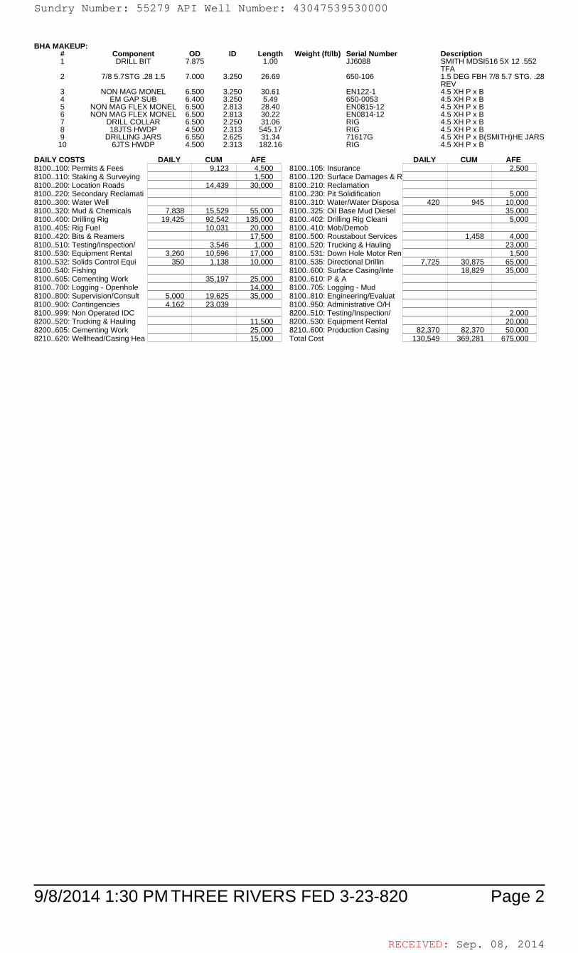
RECEIVED: Sep. 08, 2014
9/8/2014 1:30 PM Page 2THREE RIVERS FED 3-23-820
BHA MAKEUP:# Component OD ID Length Weight (ft/lb) Serial Number Description1 DRILL BIT 7.875 1.00 JJ6088 SMITH MDSI516 5X 12 .552
TFA2 7/8 5.7STG .28 1.5 7.000 3.250 26.69 650-106 1.5 DEG FBH 7/8 5.7 STG. .28
REV3 NON MAG MONEL 6.500 3.250 30.61 EN122-1 4.5 XH P x B4 EM GAP SUB 6.400 3.250 5.49 650-0053 4.5 XH P x B5 NON MAG FLEX MONEL 6.500 2.813 28.40 EN0815-12 4.5 XH P x B6 NON MAG FLEX MONEL 6.500 2.813 30.22 EN0814-12 4.5 XH P x B7 DRILL COLLAR 6.500 2.250 31.06 RIG 4.5 XH P x B8 18JTS HWDP 4.500 2.313 545.17 RIG 4.5 XH P x B9 DRILLING JARS 6.550 2.625 31.34 71617G 4.5 XH P x B(SMITH)HE JARS
10 6JTS HWDP 4.500 2.313 182.16 RIG 4.5 XH P x B
DAILY COSTS DAILY CUM AFE DAILY CUM AFE8100..100: Permits & Fees 9,123 4,500 8100..105: Insurance 2,5008100..110: Staking & Surveying 1,500 8100..120: Surface Damages & R8100..200: Location Roads 14,439 30,000 8100..210: Reclamation8100..220: Secondary Reclamati 8100..230: Pit Solidification 5,0008100..300: Water Well 8100..310: Water/Water Disposa 420 945 10,0008100..320: Mud & Chemicals 7,838 15,529 55,000 8100..325: Oil Base Mud Diesel 35,0008100..400: Drilling Rig 19,425 92,542 135,000 8100..402: Drilling Rig Cleani 5,0008100..405: Rig Fuel 10,031 20,000 8100..410: Mob/Demob8100..420: Bits & Reamers 17,500 8100..500: Roustabout Services 1,458 4,0008100..510: Testing/Inspection/ 3,546 1,000 8100..520: Trucking & Hauling 23,0008100..530: Equipment Rental 3,260 10,596 17,000 8100..531: Down Hole Motor Ren 1,5008100..532: Solids Control Equi 350 1,138 10,000 8100..535: Directional Drillin 7,725 30,875 65,0008100..540: Fishing 8100..600: Surface Casing/Inte 18,829 35,0008100..605: Cementing Work 35,197 25,000 8100..610: P & A8100..700: Logging - Openhole 14,000 8100..705: Logging - Mud8100..800: Supervision/Consult 5,000 19,625 35,000 8100..810: Engineering/Evaluat8100..900: Contingencies 4,162 23,039 8100..950: Administrative O/H8100..999: Non Operated IDC 8200..510: Testing/Inspection/ 2,0008200..520: Trucking & Hauling 11,500 8200..530: Equipment Rental 20,0008200..605: Cementing Work 25,000 8210..600: Production Casing 82,370 82,370 50,0008210..620: Wellhead/Casing Hea 15,000 Total Cost 130,549 369,281 675,000
Sundry Number: 55279 API Well Number: 43047539530000Sundry Number: 55279 API Well Number: 43047539530000
BHA MAKEUP:# Component OD ID Length Weight (ft/Ib) Serial Number Description1 DRILL BIT 7.875 1.00 JJ6088 SMITH MDSl516 5X 12 .552
TFA2 7/8 5.7STG .28 1.5 7.000 3.250 26.69 650-106 1.5 DEG FBH 7/8 5.7 STG. .28
REV3 NON MAG MONEL 6.500 3.250 30.61 EN122-1 4.5 XH PxB4 EM GAP SUB 6.400 3.250 5.49 650-0053 4.5 XH PxB5 NON MAG FLEX MONEL 6.500 2.813 28.40 ENO815-12 4.5 XH PxB6 NON MAG FLEX MONEL 6.500 2.813 30.22 ENO814-12 4.5 XH PxB7 DRILL COLLAR 6.500 2.250 31.06 RIG 4.5 XH PxB8 18JTS HWDP 4.500 2.313 545.17 RIG 4.5 XH PxB9 DRILLINGJARS 6.550 2.625 31.34 71617G 4.5 XH Px B(SMITH)HE JARS10 6JTS HWDP 4.500 2.313 182.16 RIG 4.5 XH PxB
DAILY COSTS DAILY CUM AFE DAILY CUM AFE8100..100: Permits & Fees 9,123 4,500 8100..105: Insurance 2,5008100..110: Staking & Surveying 1,500 8100..120: Surface Damages & R8100..200: Location Roads 14,439 30,000 8100..210: Reclamation8100..220: Secondary Reclamati 8100..230: Pit Solidification 5,0008100..300: Water Well 8100..310: Water/Water Disposa 420 945 10,0008100..320: Mud & Chemicals 7,838 15,529 55,000 8100..325: Oil Base Mud Diesel 35,0008100..400: Drilling Rig 19,425 92,542 135,000 8100..402: Drilling Rig Cleani 5,0008100..405: Rig Fuel 10,031 20,000 8100..410: MoblDemob8100..420: Bits & Reamers 17,500 8100..500: Roustabout Services 1,458 4,0008100..510: Testing/Inspection/ 3,546 1,000 8100..520: Trucking & Hauling 23,0008100..530: Equipment Rental 3,260 10,596 17,000 8100..531: Down Hole Motor Ren 1,5008100..532: Solids Control Equi 350 1,138 10,000 8100..535: Directional Drillin 7,725 30,875 65,0008100..540: Fishing 8100..600: Surface Casing/Inte 18,829 35,0008100..605: Cementing Work 35,197 25,000 8100..610: P &A8100..700: Logging - Openhole 14,000 8100..705: Logging - Mud8100..800: Supervision/Consult 5,000 19,625 35,000 8100..810: Engineering/Evaluat8100..900: Contingencies 4,162 23,039 8100..950: Administrative OlH8100..999: Non Operated IDC 8200..510: Testing/Inspection/ 2,0008200..520: Trucking & Hauling 11,500 8200..530: Equipment Rental 20,0008200..605: Cementing Work 25,000 8210..600: Production Casing 82,370 82,370 50,0008210..620: Wellhead/Casing Hea 15,000 Total Cost 130,549 369,281 675,000
9/8/2014 1:30 PM THREE RIVERS FED 3-23-820 Page 2
RECEIVED: Sep. 08,
Sundry Number: 55279 API Well Number: 43047539530000
BHA MAKEUP:# Component OD ID Length Weight (ft/Ib) Serial Number Description1 DRILL BIT 7.875 1.00 JJ6088 SMITH MDSl516 5X 12 .552
TFA2 7/8 5.7STG .28 1.5 7.000 3.250 26.69 650-106 1.5 DEG FBH 7/8 5.7 STG. .28
REV3 NON MAG MONEL 6.500 3.250 30.61 EN122-1 4.5 XH PxB4 EM GAP SUB 6.400 3.250 5.49 650-0053 4.5 XH PxB5 NON MAG FLEX MONEL 6.500 2.813 28.40 ENO815-12 4.5 XH PxB6 NON MAG FLEX MONEL 6.500 2.813 30.22 ENO814-12 4.5 XH PxB7 DRILL COLLAR 6.500 2.250 31.06 RIG 4.5 XH PxB8 18JTS HWDP 4.500 2.313 545.17 RIG 4.5 XH PxB9 DRILLINGJARS 6.550 2.625 31.34 71617G 4.5 XH Px B(SMITH)HE JARS10 6JTS HWDP 4.500 2.313 182.16 RIG 4.5 XH PxB
DAILY COSTS DAILY CUM AFE DAILY CUM AFE8100..100: Permits & Fees 9,123 4,500 8100..105: Insurance 2,5008100..110: Staking & Surveying 1,500 8100..120: Surface Damages & R8100..200: Location Roads 14,439 30,000 8100..210: Reclamation8100..220: Secondary Reclamati 8100..230: Pit Solidification 5,0008100..300: Water Well 8100..310: Water/Water Disposa 420 945 10,0008100..320: Mud & Chemicals 7,838 15,529 55,000 8100..325: Oil Base Mud Diesel 35,0008100..400: Drilling Rig 19,425 92,542 135,000 8100..402: Drilling Rig Cleani 5,0008100..405: Rig Fuel 10,031 20,000 8100..410: MoblDemob8100..420: Bits & Reamers 17,500 8100..500: Roustabout Services 1,458 4,0008100..510: Testing/Inspection/ 3,546 1,000 8100..520: Trucking & Hauling 23,0008100..530: Equipment Rental 3,260 10,596 17,000 8100..531: Down Hole Motor Ren 1,5008100..532: Solids Control Equi 350 1,138 10,000 8100..535: Directional Drillin 7,725 30,875 65,0008100..540: Fishing 8100..600: Surface Casing/Inte 18,829 35,0008100..605: Cementing Work 35,197 25,000 8100..610: P &A8100..700: Logging - Openhole 14,000 8100..705: Logging - Mud8100..800: Supervision/Consult 5,000 19,625 35,000 8100..810: Engineering/Evaluat8100..900: Contingencies 4,162 23,039 8100..950: Administrative OlH8100..999: Non Operated IDC 8200..510: Testing/Inspection/ 2,0008200..520: Trucking & Hauling 11,500 8200..530: Equipment Rental 20,0008200..605: Cementing Work 25,000 8210..600: Production Casing 82,370 82,370 50,0008210..620: Wellhead/Casing Hea 15,000 Total Cost 130,549 369,281 675,000
9/8/2014 1:30 PM THREE RIVERS FED 3-23-820 Page 2
RECEIVED: Sep. 08,

RECEIVED: Sep. 08, 2014
9/8/2014 1:30 PM Page 1THREE RIVERS FED 3-23-820
ULTRA RESOURCES, INC.DAILY DRILLING REPORT DATE: 08/27/2014
WELL NAME THREE RIVERS FED 3-23-820 AFE# 140627 SPUD DATE 08/23/2014WELL SITE CONSULTANTJOHN FREITAS/JARED MEJORADOPHONE# 435-219-4933 CONTRACTOR Ensign 122TD AT REPORT 6,840' FOOTAGE 0' PRATE CUM. DRLG. HRS 56.5 DRLG DAYS SINCE SPUD 3ANTICIPATED TD 6,866' PRESENT OPS Rig release at 6,840' GEOLOGIC SECT.DAILY MUD LOSS SURF: 0 DH: 0 CUM. MUD LOSS SURF: 0 DH: 50MUD COMPANY: ANCHOR MUD ENGINEER: DAN KASTELLAST BOP TEST 08/24/2014 NEXT CASING SIZE 2 7/8 NEXT CASING DEPTH 6,821 SSE SSED
TIME BREAKDOWNCASING & CEMENT 8.50 COND MUD & CIRCULATE 1.50 RIG UP / TEAR DOWN 2.00
WIRELINE 1.50
DETAILSStart End Hrs06:00 07:30 01:30 RIG DOWN LOGGING EQUIPMENT07:30 13:30 06:00 RIG UP AND RUN CASING. SHOE, FLOAT, THREAD LOCK SAME, 155 JOINTS OF 5.5" J-55 17# AND 2
MARKERS SET AT 5976', 5082' WITH CENTRALIZERS THE FIRST 4 JTS AND EVERY THIRD JT UP TO 500'13:30 15:00 01:30 CONDITION MUD BACK TO 40VIS FOR CEMENT JOB WHILE HALLIBURTON RIGGED UP EQUIPMENT ON
THE GROUND15:00 17:30 02:30 R/U HES TO FLOOR-CHECK HEAD: LOAD PLUG WITNESED BY CO-MAN. R/U HEAD & IRON.PUMP 3bbls
WTR & TEST LINES T/5,000psi. PUMP 50bbl TUNED SPACER III. MIX & PUMP 146bbls [email protected]/YIELD OF 3.5ft3/SK/20.92gal WTR/SK(235SKS),MIX & PUMP 107bbls [email protected]/1.35ft3/SK/5.82gal/SK=445 SKS. WASH UP. DROP PLUG & DISP/158.2bbls WTR.BUMPPLUG/2231=500psi OVER FCP OF 1731psi. BLED BACK 1.5bbls T/TRUCK. FLOATS HELD.***FULLRETURNS***20 BARRELS CEMENT TO SURFACE***
17:30 19:30 02:00 RIG DOWN FOR RIG SKID & CLEAN MUD TANKS - RIG RELEASED @ 19:30HRS 8/26/2014 FROM TR3-23-820 SKIDDING TO TR 3-14-820
05:55 05:55 00:00 SAFETY MEETING DAYS: RUNNING CASING & CEMENTING, HOUSE KEEPING.SAFETY MEETING NIGHTS: SKIDDING RIG, NIPPLE UP B.O.P. & TESTING B.O.P., HOUSE KEEPING.REGULATORY NOTICES: NONE.REGULATORY VISITS: NONE.INCIDENTS: NONE.SAFETY DRILLS: NONE.
AFE Days vs Depth: AFE Cost Vs Depth:DWOP Days vs Depth: # LL/BP Received Today:
FUEL AND WATER USAGEFluid Used Received Transferred On Hand Cum.UsedFuel 100.0 2,240.0 0.0 5,360.0GasFresh Well WaterNano WaterFrac WaterReserve Pit WaterBoiler HoursAir Heater HoursUrea 0.0Urea Sys 1 HrsUrea Sys 2 HrsUrea Sys 3 Hrs
CASING EQUIPMENTRIG UP AND RUN CASING. SHOE, FLOAT, THREAD LOCK SAME, 155 JOINTS OF 5.5" J-55 17# AND 2 MARKERS SET AT 5976', 5082' WITHCENTRALIZERS THE FIRST 4 JTS AND EVERY THIRD JT UP TO 500'
CEMENT JOB SUMMARYR/U HES TO FLOOR-CHECK HEAD: LOAD PLUG WITNESED BY CO-MAN. R/U HEAD & IRON.PUMP 3bbls WTR & TEST LINES T/5,000psi.PUMP 50bbl TUNED SPACER III. MIX & PUMP 146bbls LEAD [email protected]/YIELD OF 3.5ft3/SK/20.92gal WTR/SK(235SKS),MIX & PUMP 107bblsTAIL [email protected]/1.35ft3/SK/5.82gal/SK=445 SKS. WASH UP. DROP PLUG & DISP/158.2bbls WTR.BUMP PLUG/2231=500psi OVER FCP OF1731psi. BLED BACK 1.5bbls T/TRUCK. FLOATS HELD.***FULL RETURNS***20BBLS CEMENT TO SURFACE***
RECENT CASINGS RUN: Date Set Size Grade Weight Depth FIT Depth FIT ppgProduction 08/26/2014 5 1/2 J-55 17 6,824Surface 08/12/2014 8 5/8 ARJ-55 24 1,015Conductor 08/07/2014 16 ARJ-55 45 100
RECENT BITS:BIT SIZE MANUF TYPE SERIAL NO. JETS TFA DEPTH IN DEPTH OUT I-O-D-L-B-G-O-R1 7.875 SMITH MDSI516 JJ6088 12/12/12/12/12 0.552 1,027 6,840 3-3-BT-S-X-X-CT-TD
BIT OPERATIONS:BIT WOB RPM GPM PRESS HHP HRS 24hr DIST 24HR ROP CUM HRS CUM DIST CUM ROP1 65/123 440 2,250 3.12 13.50 766 56.74 48.00 5,813 121.10
RECENT MUD MOTORS:# SIZE MANUF TYPE SERIAL NO. LOBES DEPTH IN DEPTH OUT DATE IN DATE OUT1 6.500 DYNA-DRILL FIXED 650-106 7/8 5 1,027 6,840 08/23/2014 08/26/2014
MUD MOTOR OPERATIONS:# WOB REV/GAL HRS 24hr DIST 24HR ROP CUM HRS CUM DIST CUM ROP1 24 0.28 13.50 766 56.74 48.00 5,813 121.10
SURVEYSDate TMD Incl Azimuth TVD VS NS EW DLS Tool Type
08/25/2014 6,840 1.6 166.40 6,721 826.7 452.49 693.13 0.0 Projected Survey Station08/25/2014 6,790 1.6 166.40 6,671 827.2 453.85 692.80 0.8 MWD Survey Tool08/25/2014 6,748 1.6 154.60 6,629 827.5 454.94 692.41 0.4 MWD Survey Tool
MUD PROPERTIESType LSND Mud Wt 9.8 Alk. Sand % XS Lime lb/bbl
Temp. 128 Gels 10sec 3 Cl ppm 2,500 Solids % 9.0 Salt bblsVisc 41 Gels 10min 10 Ca ppm 60 LGS % 7.0 LCM ppb
PV 12 pH 9.2 pF 1.0 Oil % API WL cc 8.0YP 11 Filter Cake/32 2 Mf 6.0 Water % 91.0 HTHP WL cc
O/W Ratio ES WPSComments: ANCO BAR 40, LIME 3, SAWDUST 75, TRAILER RENTAL 1,ENGINEERING 1.
Flaring: Flare Foot-Minutes 0 Flared MCF 0.0 Cum. Flared MCF 0.0
Sundry Number: 55279 API Well Number: 43047539530000Sundry Number: 55279 API Well Number: 43047539530000
ULTRA RESOURCES, INC.DAILY DRILLING REPORT DATE: 08/27/2014
WELL NAME THREE RIVERS FED 3-23-820 AFE# 140627 SPUD DATE 08/23/2014WELL SITE CONSULTANTOHN FREITAS/JARED MEJORADOPHONE# 435-219-4933 CONTRACTOR Ension 122TD AT REPORT 6,840' FOOTAGE O' PRATE CUM. DRLG. HRS 56.5 DRLG DAYS SINCE SPUD 3ANTICIPATED TD 6,866' PRESENT OPS Rio release at 6,840' GEOLOGIC SECT.DAILY MUD LOSS SURF: 0 DH: O CUM. MUD LOSS SURF: 0 DH: 50MUD COMPANY: ANCHOR MUD ENGINEER: DAN KASTELLAST BOP TEST 08/24/2014 NEXT CASING SIZE 2 7/8 NEXT CASING DEPTH 6,821 SSE SSED
TIME BREAKDOWNCASING & CEMENT 8.50 COND MUD & CIRCULATE 1.50 RIG UP ITEAR DOWN 2.00
WIRELINE 1.50
DETAILSStart End Hrs06:00 07:30 01:30 RIG DOWN LOGGING EQUIPMENT07:30 13:30 06:00 RIG UP AND RUN CASING. SHOE, FLOAT, THREAD LOCK SAME, 155 JOINTS OF 5.5" J-55 17#AND 2
MARKERS SET AT 5976', 5082' WITH CENTRALIZERS THE FIRST 4 JTS AND EVERY THIRD JT UP TO 500'13:30 15:00 01:30 CONDITION MUD BACK TO 40VIS FOR CEMENT JOB WHILE HALLIBURTON RIGGED UP EQUIPMENT ON
THE GROUND15:00 17:30 02:30 RIU HES TO FLOOR-CHECK HEAD: LOAD PLUG WITNESED BY CO-MAN. RIU HEAD & IRON.PUMP 3bbls
WTR &TEST LINES Tl5,000psi. PUMP 50bbl TUNED SPACER III.MIX & PUMP 146bbls [email protected] OF 3.5ft3/SKl20.92gal WTR/SK(235SKS),MIX & PUMP 107bbls [email protected]/1.35ft3/SKl5.82gallŠK=445 SKS. WASH UP. DROP PLUG & DISP/158.2bbls WTR.BUMPPLUGl2231=500psi OVER FCP OF 1731psi. BLED BACK 1.5bbls TITRUCK. FLOATS HELD.***FULLRETURNS***20 BARRELS CEMENT TO SURFACE***
17:30 19:30 02:00 RIG DOWN FOR RIG SKID & CLEAN MUD TANKS - RIG RELEASED @ 19:30HRS 8/26/2014 FROM TR3-23-820 SKIDDING TO TR 3-14-820
05:55 05:55 00:00 SAFETY MEETING DAYS: RUNNING CASING & CEMENTING, HOUSE KEEPING.SAFETY MEETING NIGHTS: SKIDDING RIG, NIPPLE UP B.O.P. &TESTING B.O.P., HOUSE KEEPING.REGULATORY NOTICES: NONE.REGULATORY VISITS: NONE.INCIDENTS: NONE.SAFETY DRILLS: NONE.
AFE Days vs Depth: AFE Cost Vs Depth:DWOP Days vs Depth: # LLIBP Received Today:
FUEL AND WATER USAGEFluid Used Received Transferred On Hand Cum.UsedFuel 100.0 2,240.0 0.0 5,360.0GasFresh Well WaterNano WaterFrac WaterReserve Pit WaterBoiler HoursAir Heater HoursUrea 0.0Urea Sys 1 HrsUrea Sys 2 HrsUrea Sys 3 Hrs
CASING EQUIPMENTRIG UP AND RUN CASING. SHOE, FLOAT, THREAD LOCK SAME, 155 JOINTS OF 5.5" J-55 17# AND 2 MARKERS SET AT 5976', 5082' WITHCENTRALIZERS THE FIRST 4 JTS AND EVERY THIRD JT UP TO 500'
CEMENT JOB SUMMARYRIU HES TO FLOOR-CHECK HEAD: LOAD PLUG WITNESED BY CO-MAN. RIU HEAD & IRON.PUMP 3bbls WTR &TEST LINES Tl5,000psi.PUMP 50bbl TUNED SPACER III.MIX & PUMP 146bbls LEAD [email protected] OF 3.5ft3/SKl20.92gal WTR/SK(235SKS),MIX & PUMP [email protected]/1.35ft3/SKl5.82gallŠK=445 SKS. WASH UP. DROP PLUG & DISP/158.2bbls WTR.BUMP PLUGl2231=500psi OVER FCP OF1731psi. BLED BACK 1.5bbls TITRUCK. FLOATS HELD.***FULLRETURNS***20BBLS CEMENT TO SURFACE***
RECENT CASINGS RUN: Date Set Size Grade Weight Depth FIT Depth FIT ppgProduction 08/26/2014 5 1/2 J-55 17 6,824Surface 08/12/2014 8 5/8 ARJ-55 24 1,015Conductor 08/07/2014 16 ARJ-55 45 100
RECENT BITS:BIT SIZE MANUF TYPE SERIAL NO. JETS TFA DEPTH IN DEPTH OUT I-O-D-L-B-G-O-R
1 7.875 SMITH MDSl516 JJ6088 12/12/12/12/12 0.552 1,027 6,840 3-3-BT-S-X-X-CT-TD
BIT OPERATIONS:BIT WOB RPM GPM PRESS HHP HRS 24hr DIST 24HR ROP CUM HRS CUM DIST CUM ROP
1 65/123 440 2,250 3.12 13.50 766 56.74 48.00 5,813 121.10
RECENT MUD MOTORS:# SIZE MANUF TYPE SERIAL NO. LOBES DEPTH IN DEPTH OUT DATE IN DATE OUT1 6.500 DYNA-DRILL FIXED 650-106 7/8 5 1,027 6,840 08/23/2014 08/26/2014
MUD MOTOR OPERATIONS:# WOB REVIGAL HRS 24hr DIST 24HR ROP CUM HRS CUM DIST CUM ROP1 24 0.28 13.50 766 56.74 48.00 5,813 121.10
SURVEYSDate TMD Incl Azimuth TVD VS NS EW DLS Tool Type
08/25/2014 6,840 1.6 166.40 6,721 826.7 452.49 693.13 0.0 Projected Survey Station08/25/2014 6,790 1.6 166.40 6,671 827.2 453.85 692.80 0.8 MWD Survey Tool08/25/2014 6,748 1.6 154.60 6,629 827.5 454.94 692.41 0.4 MWD Survey Tool
MUD PROPERTIESType LSND Mud Wt 9.8 Alk. Sand % XS Lime Ib/bbl
Temp. 128 Gels 10sec 3 CI ppm 2,500 Solids % 9.0 Salt bblsVisc 41 Gels 10min 10 Ca ppm 60 LGS % 7.0 LCM ppb
PV 12 pH 9.2 pF 1.0 Oil % API WL cc 8.0YP 11 Filter Cake/32 2 Mf 6.0 Water % 91.0 HTHP WL cc
OlW Ratio ES WPSComments: ANCO BAR 40, LIME 3, SAWDUST 75, TRAILER RENTAL 1,ENGINEERING 1.
Flaring: Flare Foot-Minutes 0 Flared MCF 0.0 Cum. Flared MCF 0.0
9/8/2014 1:30 PM THREE RIVERS FED 3-23-820 Page 1
RECEIVED: Sep. 08,
Sundry Number: 55279 API Well Number: 43047539530000
ULTRA RESOURCES, INC.DAILY DRILLING REPORT DATE: 08/27/2014
WELL NAME THREE RIVERS FED 3-23-820 AFE# 140627 SPUD DATE 08/23/2014WELL SITE CONSULTANTOHN FREITAS/JARED MEJORADOPHONE# 435-219-4933 CONTRACTOR Ension 122TD AT REPORT 6,840' FOOTAGE O' PRATE CUM. DRLG. HRS 56.5 DRLG DAYS SINCE SPUD 3ANTICIPATED TD 6,866' PRESENT OPS Rio release at 6,840' GEOLOGIC SECT.DAILY MUD LOSS SURF: 0 DH: O CUM. MUD LOSS SURF: 0 DH: 50MUD COMPANY: ANCHOR MUD ENGINEER: DAN KASTELLAST BOP TEST 08/24/2014 NEXT CASING SIZE 2 7/8 NEXT CASING DEPTH 6,821 SSE SSED
TIME BREAKDOWNCASING & CEMENT 8.50 COND MUD & CIRCULATE 1.50 RIG UP ITEAR DOWN 2.00
WIRELINE 1.50
DETAILSStart End Hrs06:00 07:30 01:30 RIG DOWN LOGGING EQUIPMENT07:30 13:30 06:00 RIG UP AND RUN CASING. SHOE, FLOAT, THREAD LOCK SAME, 155 JOINTS OF 5.5" J-55 17#AND 2
MARKERS SET AT 5976', 5082' WITH CENTRALIZERS THE FIRST 4 JTS AND EVERY THIRD JT UP TO 500'13:30 15:00 01:30 CONDITION MUD BACK TO 40VIS FOR CEMENT JOB WHILE HALLIBURTON RIGGED UP EQUIPMENT ON
THE GROUND15:00 17:30 02:30 RIU HES TO FLOOR-CHECK HEAD: LOAD PLUG WITNESED BY CO-MAN. RIU HEAD & IRON.PUMP 3bbls
WTR &TEST LINES Tl5,000psi. PUMP 50bbl TUNED SPACER III.MIX & PUMP 146bbls [email protected] OF 3.5ft3/SKl20.92gal WTR/SK(235SKS),MIX & PUMP 107bbls [email protected]/1.35ft3/SKl5.82gallŠK=445 SKS. WASH UP. DROP PLUG & DISP/158.2bbls WTR.BUMPPLUGl2231=500psi OVER FCP OF 1731psi. BLED BACK 1.5bbls TITRUCK. FLOATS HELD.***FULLRETURNS***20 BARRELS CEMENT TO SURFACE***
17:30 19:30 02:00 RIG DOWN FOR RIG SKID & CLEAN MUD TANKS - RIG RELEASED @ 19:30HRS 8/26/2014 FROM TR3-23-820 SKIDDING TO TR 3-14-820
05:55 05:55 00:00 SAFETY MEETING DAYS: RUNNING CASING & CEMENTING, HOUSE KEEPING.SAFETY MEETING NIGHTS: SKIDDING RIG, NIPPLE UP B.O.P. &TESTING B.O.P., HOUSE KEEPING.REGULATORY NOTICES: NONE.REGULATORY VISITS: NONE.INCIDENTS: NONE.SAFETY DRILLS: NONE.
AFE Days vs Depth: AFE Cost Vs Depth:DWOP Days vs Depth: # LLIBP Received Today:
FUEL AND WATER USAGEFluid Used Received Transferred On Hand Cum.UsedFuel 100.0 2,240.0 0.0 5,360.0GasFresh Well WaterNano WaterFrac WaterReserve Pit WaterBoiler HoursAir Heater HoursUrea 0.0Urea Sys 1 HrsUrea Sys 2 HrsUrea Sys 3 Hrs
CASING EQUIPMENTRIG UP AND RUN CASING. SHOE, FLOAT, THREAD LOCK SAME, 155 JOINTS OF 5.5" J-55 17# AND 2 MARKERS SET AT 5976', 5082' WITHCENTRALIZERS THE FIRST 4 JTS AND EVERY THIRD JT UP TO 500'
CEMENT JOB SUMMARYRIU HES TO FLOOR-CHECK HEAD: LOAD PLUG WITNESED BY CO-MAN. RIU HEAD & IRON.PUMP 3bbls WTR &TEST LINES Tl5,000psi.PUMP 50bbl TUNED SPACER III.MIX & PUMP 146bbls LEAD [email protected] OF 3.5ft3/SKl20.92gal WTR/SK(235SKS),MIX & PUMP [email protected]/1.35ft3/SKl5.82gallŠK=445 SKS. WASH UP. DROP PLUG & DISP/158.2bbls WTR.BUMP PLUGl2231=500psi OVER FCP OF1731psi. BLED BACK 1.5bbls TITRUCK. FLOATS HELD.***FULLRETURNS***20BBLS CEMENT TO SURFACE***
RECENT CASINGS RUN: Date Set Size Grade Weight Depth FIT Depth FIT ppgProduction 08/26/2014 5 1/2 J-55 17 6,824Surface 08/12/2014 8 5/8 ARJ-55 24 1,015Conductor 08/07/2014 16 ARJ-55 45 100
RECENT BITS:BIT SIZE MANUF TYPE SERIAL NO. JETS TFA DEPTH IN DEPTH OUT I-O-D-L-B-G-O-R
1 7.875 SMITH MDSl516 JJ6088 12/12/12/12/12 0.552 1,027 6,840 3-3-BT-S-X-X-CT-TD
BIT OPERATIONS:BIT WOB RPM GPM PRESS HHP HRS 24hr DIST 24HR ROP CUM HRS CUM DIST CUM ROP
1 65/123 440 2,250 3.12 13.50 766 56.74 48.00 5,813 121.10
RECENT MUD MOTORS:# SIZE MANUF TYPE SERIAL NO. LOBES DEPTH IN DEPTH OUT DATE IN DATE OUT1 6.500 DYNA-DRILL FIXED 650-106 7/8 5 1,027 6,840 08/23/2014 08/26/2014
MUD MOTOR OPERATIONS:# WOB REVIGAL HRS 24hr DIST 24HR ROP CUM HRS CUM DIST CUM ROP1 24 0.28 13.50 766 56.74 48.00 5,813 121.10
SURVEYSDate TMD Incl Azimuth TVD VS NS EW DLS Tool Type
08/25/2014 6,840 1.6 166.40 6,721 826.7 452.49 693.13 0.0 Projected Survey Station08/25/2014 6,790 1.6 166.40 6,671 827.2 453.85 692.80 0.8 MWD Survey Tool08/25/2014 6,748 1.6 154.60 6,629 827.5 454.94 692.41 0.4 MWD Survey Tool
MUD PROPERTIESType LSND Mud Wt 9.8 Alk. Sand % XS Lime Ib/bbl
Temp. 128 Gels 10sec 3 CI ppm 2,500 Solids % 9.0 Salt bblsVisc 41 Gels 10min 10 Ca ppm 60 LGS % 7.0 LCM ppb
PV 12 pH 9.2 pF 1.0 Oil % API WL cc 8.0YP 11 Filter Cake/32 2 Mf 6.0 Water % 91.0 HTHP WL cc
OlW Ratio ES WPSComments: ANCO BAR 40, LIME 3, SAWDUST 75, TRAILER RENTAL 1,ENGINEERING 1.
Flaring: Flare Foot-Minutes 0 Flared MCF 0.0 Cum. Flared MCF 0.0
9/8/2014 1:30 PM THREE RIVERS FED 3-23-820 Page 1
RECEIVED: Sep. 08,

RECEIVED: Sep. 08, 2014
9/8/2014 1:30 PM Page 2THREE RIVERS FED 3-23-820
SURFACE PUMP/BHA INFORMATIONPump 1 Liner 6.5 Stroke Len 9.0 SPM 126 PSI 2,150 GPM 440 SPR 43 Slow PSI 390Pump 2 Liner Stroke Len SPM PSI GPM SPR Slow PSI
Pump 32 Liner Stroke Len SPM PSI GPM SPR Slow PSIBHA Makeup STEARABLE Length 912.1 Hours on BHA 48
Up Weight 160 Dn Weight 115 RT Weight 130 Torque 11,300 Hours on Motor 48
BHA MAKEUP:# Component OD ID Length Weight (ft/lb) Serial Number Description1 DRILL BIT 7.875 1.00 JJ6088 SMITH MDSI516 5X 12 .552
TFA2 7/8 5.7STG .28 1.5 7.000 3.250 26.69 650-106 1.5 DEG FBH 7/8 5.7 STG. .28
REV3 NON MAG MONEL 6.500 3.250 30.61 EN122-1 4.5 XH P x B4 EM GAP SUB 6.400 3.250 5.49 650-0053 4.5 XH P x B5 NON MAG FLEX MONEL 6.500 2.813 28.40 EN0815-12 4.5 XH P x B6 NON MAG FLEX MONEL 6.500 2.813 30.22 EN0814-12 4.5 XH P x B7 DRILL COLLAR 6.500 2.250 31.06 RIG 4.5 XH P x B8 18JTS HWDP 4.500 2.313 545.17 RIG 4.5 XH P x B9 DRILLING JARS 6.550 2.625 31.34 71617G 4.5 XH P x B(SMITH)HE JARS
10 6JTS HWDP 4.500 2.313 182.16 RIG 4.5 XH P x B
DAILY COSTS DAILY CUM AFE DAILY CUM AFE8100..100: Permits & Fees 9,123 4,500 8100..105: Insurance 2,5008100..110: Staking & Surveying 1,500 8100..120: Surface Damages & R8100..200: Location Roads 14,439 30,000 8100..210: Reclamation8100..220: Secondary Reclamati 8100..230: Pit Solidification 5,0008100..300: Water Well 8100..310: Water/Water Disposa 945 10,0008100..320: Mud & Chemicals 1,736 17,266 55,000 8100..325: Oil Base Mud Diesel 35,0008100..400: Drilling Rig 10,631 103,173 135,000 8100..402: Drilling Rig Cleani 5,0008100..405: Rig Fuel 10,031 20,000 8100..410: Mob/Demob8100..420: Bits & Reamers 13,095 13,095 17,500 8100..500: Roustabout Services 1,458 4,0008100..510: Testing/Inspection/ 3,546 1,000 8100..520: Trucking & Hauling 6,665 6,665 23,0008100..530: Equipment Rental 1,851 12,447 17,000 8100..531: Down Hole Motor Ren 1,5008100..532: Solids Control Equi 197 1,335 10,000 8100..535: Directional Drillin 7,725 38,600 65,0008100..540: Fishing 8100..600: Surface Casing/Inte 18,829 35,0008100..605: Cementing Work 35,197 25,000 8100..610: P & A8100..700: Logging - Openhole 12,121 12,121 14,000 8100..705: Logging - Mud8100..800: Supervision/Consult 2,500 22,125 35,000 8100..810: Engineering/Evaluat8100..900: Contingencies 8,362 31,401 8100..950: Administrative O/H8100..999: Non Operated IDC 8200..510: Testing/Inspection/ 2,0008200..520: Trucking & Hauling 11,500 8200..530: Equipment Rental 20,0008200..605: Cementing Work 38,751 38,751 25,000 8210..600: Production Casing 3,010 85,380 50,0008210..620: Wellhead/Casing Hea 15,000 Total Cost 106,645 475,926 675,000
Sundry Number: 55279 API Well Number: 43047539530000Sundry Number: 55279 API Well Number: 43047539530000
SURFACE PUMPIBHA INFORMATIONPump 1 Liner 6.5 Stroke Len 9.0 SPM 126 PSI 2 0 GPM 440 SPR 43 Slow PSI 390Pump 2 Liner Stroke Len SPM PSI GPM SPR Slow PSI
Pump 32 Liner Stroke Len SPM PSI GPM SPR Slow PSIBHA Makeup STEARABLE Length 912.1 Hours on BHA 48
Up Weight 160 Dn Weight 115 RT Weight 130 Torque 11,300 Hours on Motor 48
BHA MAKEUP:# Component OD ID Length Weight (ft/Ib) Serial Number Description1 DRILL BIT 7.875 1.00 JJ6088 SMITH MDSl516 5X 12 .552
TFA2 7/8 5.7STG .28 1.5 7.000 3.250 26.69 650-106 1.5 DEG FBH 7/8 5.7 STG. .28
REV3 NON MAG MONEL 6.500 3.250 30.61 EN122-1 4.5 XH PxB4 EM GAP SUB 6.400 3.250 5.49 650-0053 4.5 XH PxB5 NON MAG FLEX MONEL 6.500 2.813 28.40 ENO815-12 4.5 XH PxB6 NON MAG FLEX MONEL 6.500 2.813 30.22 ENO814-12 4.5 XH PxB7 DRILL COLLAR 6.500 2.250 31.06 RIG 4.5 XH PxB8 18JTS HWDP 4.500 2.313 545.17 RIG 4.5 XH PxB9 DRILLINGJARS 6.550 2.625 31.34 71617G 4.5 XH Px B(SMITH)HE JARS10 6JTS HWDP 4.500 2.313 182.16 RIG 4.5 XH PxB
DAILY COSTS DAILY CUM AFE DAILY CUM AFE8100..100: Permits & Fees 9,123 4,500 8100..105: Insurance 2,5008100..110: Staking & Surveying 1,500 8100..120: Surface Damages & R8100..200: Location Roads 14,439 30,000 8100..210: Reclamation8100..220: Secondary Reclamati 8100..230: Pit Solidification 5,0008100..300: Water Well 8100..310: Water/Water Disposa 945 10,0008100..320: Mud & Chemicals 1,736 17,266 55,000 8100..325: Oil Base Mud Diesel 35,0008100..400: Drilling Rig 10,631 103,173 135,000 8100..402: Drilling Rig Cleani 5,0008100..405: Rig Fuel 10,031 20,000 8100..410: MoblDemob8100..420: Bits & Reamers 13,095 13,095 17,500 8100..500: Roustabout Services 1,458 4,0008100..510: Testing/Inspection/ 3,546 1,000 8100..520: Trucking & Hauling 6,665 6,665 23,0008100..530: Equipment Rental 1,851 12,447 17,000 8100..531: Down Hole Motor Ren 1,5008100..532: Solids Control Equi 197 1,335 10,000 8100..535: Directional Drillin 7,725 38,600 65,0008100..540: Fishing 8100..600: Surface Casing/Inte 18,829 35,0008100..605: Cementing Work 35,197 25,000 8100..610: P &A8100..700: Logging - Openhole 12,121 12,121 14,000 8100..705: Logging - Mud8100..800: Supervision/Consult 2,500 22,125 35,000 8100..810: Engineering/Evaluat8100..900: Contingencies 8,362 31,401 8100..950: Administrative OlH8100..999: Non Operated IDC 8200..510: Testing/Inspection/ 2,0008200..520: Trucking & Hauling 11,500 8200..530: Equipment Rental 20,0008200..605: Cementing Work 38,751 38,751 25,000 8210..600: Production Casing 3,010 85,380 50,0008210..620: Wellhead/Casing Hea 15,000 Total Cost 106,645 475,926 675,000
9/8/2014 1:30 PM THREE RIVERS FED 3-23-820 Page 2
RECEIVED: Sep. 08,
Sundry Number: 55279 API Well Number: 43047539530000
SURFACE PUMPIBHA INFORMATIONPump 1 Liner 6.5 Stroke Len 9.0 SPM 126 PSI 2 0 GPM 440 SPR 43 Slow PSI 390Pump 2 Liner Stroke Len SPM PSI GPM SPR Slow PSI
Pump 32 Liner Stroke Len SPM PSI GPM SPR Slow PSIBHA Makeup STEARABLE Length 912.1 Hours on BHA 48
Up Weight 160 Dn Weight 115 RT Weight 130 Torque 11,300 Hours on Motor 48
BHA MAKEUP:# Component OD ID Length Weight (ft/Ib) Serial Number Description1 DRILL BIT 7.875 1.00 JJ6088 SMITH MDSl516 5X 12 .552
TFA2 7/8 5.7STG .28 1.5 7.000 3.250 26.69 650-106 1.5 DEG FBH 7/8 5.7 STG. .28
REV3 NON MAG MONEL 6.500 3.250 30.61 EN122-1 4.5 XH PxB4 EM GAP SUB 6.400 3.250 5.49 650-0053 4.5 XH PxB5 NON MAG FLEX MONEL 6.500 2.813 28.40 ENO815-12 4.5 XH PxB6 NON MAG FLEX MONEL 6.500 2.813 30.22 ENO814-12 4.5 XH PxB7 DRILL COLLAR 6.500 2.250 31.06 RIG 4.5 XH PxB8 18JTS HWDP 4.500 2.313 545.17 RIG 4.5 XH PxB9 DRILLINGJARS 6.550 2.625 31.34 71617G 4.5 XH Px B(SMITH)HE JARS10 6JTS HWDP 4.500 2.313 182.16 RIG 4.5 XH PxB
DAILY COSTS DAILY CUM AFE DAILY CUM AFE8100..100: Permits & Fees 9,123 4,500 8100..105: Insurance 2,5008100..110: Staking & Surveying 1,500 8100..120: Surface Damages & R8100..200: Location Roads 14,439 30,000 8100..210: Reclamation8100..220: Secondary Reclamati 8100..230: Pit Solidification 5,0008100..300: Water Well 8100..310: Water/Water Disposa 945 10,0008100..320: Mud & Chemicals 1,736 17,266 55,000 8100..325: Oil Base Mud Diesel 35,0008100..400: Drilling Rig 10,631 103,173 135,000 8100..402: Drilling Rig Cleani 5,0008100..405: Rig Fuel 10,031 20,000 8100..410: MoblDemob8100..420: Bits & Reamers 13,095 13,095 17,500 8100..500: Roustabout Services 1,458 4,0008100..510: Testing/Inspection/ 3,546 1,000 8100..520: Trucking & Hauling 6,665 6,665 23,0008100..530: Equipment Rental 1,851 12,447 17,000 8100..531: Down Hole Motor Ren 1,5008100..532: Solids Control Equi 197 1,335 10,000 8100..535: Directional Drillin 7,725 38,600 65,0008100..540: Fishing 8100..600: Surface Casing/Inte 18,829 35,0008100..605: Cementing Work 35,197 25,000 8100..610: P &A8100..700: Logging - Openhole 12,121 12,121 14,000 8100..705: Logging - Mud8100..800: Supervision/Consult 2,500 22,125 35,000 8100..810: Engineering/Evaluat8100..900: Contingencies 8,362 31,401 8100..950: Administrative OlH8100..999: Non Operated IDC 8200..510: Testing/Inspection/ 2,0008200..520: Trucking & Hauling 11,500 8200..530: Equipment Rental 20,0008200..605: Cementing Work 38,751 38,751 25,000 8210..600: Production Casing 3,010 85,380 50,0008210..620: Wellhead/Casing Hea 15,000 Total Cost 106,645 475,926 675,000
9/8/2014 1:30 PM THREE RIVERS FED 3-23-820 Page 2
RECEIVED: Sep. 08,

ECEIVED EP 022014
OIL, GAS & MINING
~.:
.".
3COOþ5i -
... F- o
r<
RECEl\/B)--- ;EP021014
3 DIV.C-Oi,GAS&MINING
maism i
C Ii I
. ! I s
1 3
3COOþ5i -
... F- o
r<
RECEl\/B)--- ;EP021014
3 DIV.C-Oi,GAS&MINING
maism i
C Ii I
. ! I s
1 3
3COOþ5i -
... F- o
r<
RECEl\/B)--- ;EP021014
3 DIV.C-Oi,GAS&MINING
maism i
C Ii I
. ! I s
1 3
3COOþ5i -
... F- o
r<
RECEl\/B)--- ;EP021014
3 DIV.C-Oi,GAS&MINING
maism i
C Ii I
. ! I s
1 3
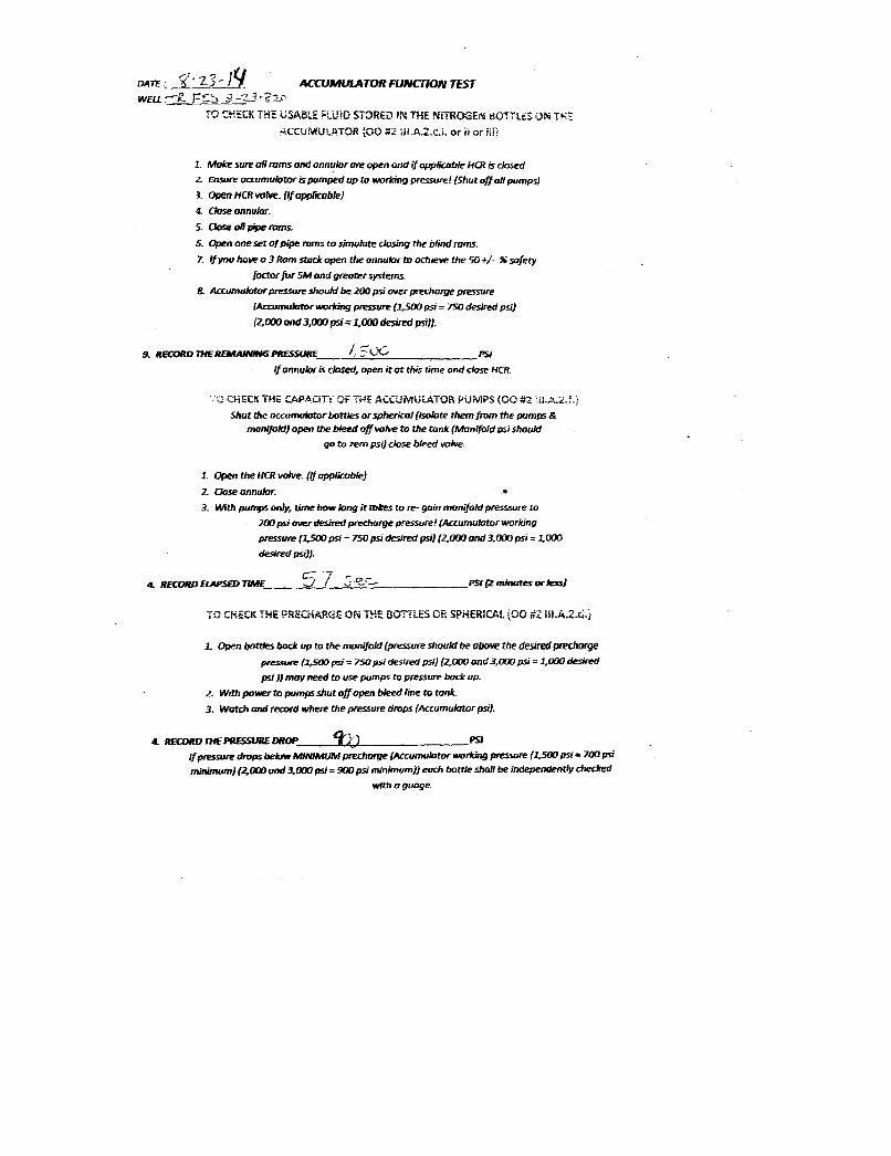
ACCUMULATOR FUNrnON TEST WEU:-r£" F~;::' :1 -~L3 .t?2.('
TO CK::CK THE lJSA8LE FLUiD STORED IN THE NiTROGEN BOTT'l.ES ON TK~
.ACCUMULATOR tOO #:2 Hi .A.2~cj~ or j: or iii)
1. Moke sure all rams and annular are open and if applic:oble HCR is dosed
Z. Ensure occumulalor is pumped up to. working pressure! (Shut off all pumps)
3. Open HCR \/IJM. (If apJJIicable)
4. CJase annular.
5. Close all pipe roms.. 5. Open one set of pipe roms to simulote dosing eM blind roms.
7. If you have a 3 Ram srock open the annular to adljeve the 50 +/. % SDfety
Joctor for SAlt and greatl!r systerr.s.
8. Accumulator pressure should be 200 psi O'IIer prer:harge pressure
{Accumulator working pressure (J.5(JO psi = 750 desired psi)
(2,000 and 3j}(J() psi '" 1,000 desired psi}).
!l. RECORD JHE REMAINING PfI:ESSURE~_....:/....:' ..:::;_L::.'.;:..C_·· ______ ,PSJ
If annular is dosed, open it at this time and clase HCR.
',J GiECK THE CAP,6..CiE OF THE ACCUMULATOR PUMPS (00 #2 'il.A.:2.;.)
Shut the accumulator bottles or spherical (Iwlate rMm {rom the pumps &
manifold) Opetl the bleed off valve to the tonk (Manifold psi should
go. to zero psi) r:lase bleed valve.
1. Open tM HCR valve. (1/ applicable)
2. Close annular. •
3. With pumps only, time how lang it tokes to reo gain manifold presssure to
200 psi over desired prer:horge pressure! (Acr:umulotor working
pressure (l.5OO psi = 750 psi desired psi) (2.000 and 3.000 psi = 1.000
desired psi)}.
c:::: -; 4. RECORD ELAPSED TINIE~_-----,::J::..!......!..._",::;....:·O.:::_:..:<:"-=-______ PSI (2 minutes orless)
TO CHECK THE ?RECHARGE ON THE BOTTLES OR SPHERICAL {GO #Z iil.A.2.ci.i
1.. Open bOtttes bade up to the monifold (pressure should be above the desired prechorge
pressure (:1,500 psi = 750 psi desired psi) (2.000 and 3,000 psi = 1.000 desired
psi )) may need to use pumps to pressure bode up.
Z. With power to pumps shut off open bleed line to tank.
3. Watch and record where the pressure drops (Accumulator psi).
4. RECORD THE PRESSURE DROP 4Of.{) PSI
1/ pn!5SUre drops below MINIMUM precharge (ACcumulator worldng pressure (1.500 psi = 700 psi
minimum) (2.000 and 3,000 psi = 900 psi minimum)) eHr:h bottle sholl be independently checked
with a guage.
OATE :' ACCUMULATOR FUNCTION 7EST
WEU.. Ê, Fíh 9 Î ·'èFTO CHiiCKTHEUSABLEFLUIDSTORED INTHE NITROGEN BOTTLili ON TRE
ACCUMULATOR (OO #2 ULA,2-c.i. or n or iii)
1 Make sure a/I rams and annuhrore open and if applicable HQt is closedz. Ensure accumueroris pumped up to working pressure! (Shut off all pumps)3. OpenfiCRuofwe.(ifoppliccole)
4. <bse annular.5. Gose oli pipe roms.6. Open one set of pipe rams to simulate closing the blind rums.7. If you have a 3 Ram stuck open the annular to achieve the 50 +/- % safety
JoctorforSM ond greater systems.8. Accumulatorpressure should be 200 psi over precharge pressure
(Accumuistor working pressure (1,500 psi = 750 desired psi)
(2,000 and 3,000 psi=1,000 desiredpsi))
R RECORD UfE AmfAN-G PRESSURE Ü PSI
If annular is closed, open it at this time and close HCR.
CHECKTHE CAPACITY OF THE ACCUMULATOR PUMPS (OO #2 NLA.2.¾-}
Shut the accumulator bottles orspherical Ilsolutethem from the pumps &manifokf} open the bleed off wolve to the tank (Manifold psi Should
go to zero psi) dose bleed volve.
1. Open the HCRvolve. (If applicoble)2 Cose annular. .÷
3. With pumps ong time how long it takes to re- gain manifold presssure to200 psi over desired precharge pmssure! (Accumulator working
pressure (1,500 psi = 750 psi desired psi) {2,000 and 3,000 psi = 1,000
desired psi)).
A RKORD W5m HME PSI (2 nunutes orless)
TO CHECK THE PRECHARGE ON THEBOTTLESORSPHERICAL(OC #2 ill.A.2.d.)
1. Open botties back up to the manifold {pressure should be above the desired prechargepressure ( psi= 750 psi desired psi) (2,000 and 3,000 psi = 1,000 desired
psi)) may need to use pumps to pressure back up.
2 With power to pumps shut off open bleed line to tank.3. Watch and record where the pressure drops {Accumulator psi).
RECORDHiEPRESSUREDROP ) ) PSI
If pressure drops below MINIMUM precharge (Accumulator working pressure (1,500psi= 700 psi
minimum) {2,000 and 3,000 psi= 900 psi minimum)) each bottle shall be independently checked

DUE: -·z?-/r~1IIQ 0 11". f;"'1\ /1-1.. WBl.ItAllEIk.,If" ~t;;:,. ~~- b2-g,l,l -- , Tane TestN!J. Result
-r.n· AM~ 1 M,· " ~lier Pass~o
6:0j AM~ 2 /}"""'L,j.· r Passetailo
_£.~ : ............... 3 ;" '~-..IY''\.. ..,- ".-' .. , "--I ..... i £,li" C;".-.; J-..\ .... -"'(J[",) . " ,.,-t "'~ailo -0 J! !;~
t 5b AMAi'M: 4 /feR /> •• " :k ./ I l._h-t.c: & ... -ttJ.v.. Pass_alo
," " AMmPuo 5 .r:'sid~_ ~A.-t..-::' ,:;' .. !r:- : ,
"".<. •• ', ':;,.' r Pass~O - . :>
7: '"v AM i;II'MI:: 6 \ .. '
l../ ...... T>"!C'.:l{'-. ."'!-fcv,;£~·'e· :/~;J?S Pass'tlfail 0
&':1 'J AMJIt'Mr: 7 Sl: ",,'r c./... K ... Pass)i;ifaif 0
6"'.''f~ AM~ 8 8·;;\ .. .-:' j(, ... .,...;,;. :D .. '" .. ...(.""ril . ..:>~~ .'-1'A,....:.:.: ,.{ :.~ J __ .t!.5 Pass)#ail 0 -
7.1-.1 AM~ 9 ~_ ..... s lwo") .. ~ . PassoFailo .-AMoPMr:: 10 PassDfail D
AMoPMIJ 11 PassofaUo
AMcPMI:J U PassoFailo
AMoPMo 13 PassoFaii 0
AM oI'UI::I 14 PilssoFal 0
AMDI'Mc Relrst PasscFaiJ 0
AMDPMIl Reb!st ._. PassoFaiI 0
AMcPMI: ReIest PassoFailo
AMoPMc Retest PassoFailo
AMcPMr:J Reb!st PassoFaiio
AMcPMr:J Relrst PassoFail 0
AMcPMc Retest Pass []fail 0
/Ia:.. TankSize W 0 uTm= IIiIL
.......... '"(3q~ BOP tESTING. CASING 1'ES'I1NG, 1.BAK OFF TES"l1NG. &:
_ 1NTEGRITY1BSTING NIPPLB UP CREWS, NI'l1t.OGEN CHARGING SERVICE.
,._----
numÑŒl Ýam mm 12-L wm mmas TRE'fD 3 I -¶20
r... Test« a..a39 AM 1 r Pass ÑaiDG¡ AM (Ulu 2 Pass gai o
I k 6 + im U /> AN .
PÁssgailo5 4 AM Ma 4 Passgai D
5 AM 5 R, C Pass ai o
7 AM Ma 6 PassgaB o
i f AMgMD 7 PassaíFaHo
9 L7 AMEgMn 9 Ces PassoFaila
AM aPuu 10 Pass aFail o
AM aPM 11 Pass oFail o
AMOPMG 12 PASSOFallo
AM aPMG 13 Pass DFaBD
AM oPMG 3A Pass GFail a
AM DPMG Relest Pass DFai o
AM aPME Reinst Pass DFaHo
AM DPMc notest Pass DFaBo
AM DPMG Batest Pass DFan o
AM DPMe Reinst Pass DFai o
AMDPMG Retest PassDFaio
AM DPMc Retest Pass aFall a
Acc. Tank sima(huh est i W D Ll÷2M= sal
aarwrmo.casmomrmo.umeonmmNG, &arisaarrY TElmNG
lwPI.BUP CREWS, NrfROGEN CHRGING

~ -1'·:.· .... '.-'0,.
/ ---.../
o '
6050
b 4
6RAPHICCONTROLSCORPORATION \ \BUFFALO NEW YORK \
o °
BR4638
S
6
Op ..
0 x
o '
6050
b 4
6RAPHICCONTROLSCORPORATION \ \BUFFALO NEW YORK \
o °
BR4638
S
6
Op ..
0 x
o '
6050
b 4
6RAPHICCONTROLSCORPORATION \ \BUFFALO NEW YORK \
o °
BR4638
S
6
Op ..
0 x
o '
6050
b 4
6RAPHICCONTROLSCORPORATION \ \BUFFALO NEW YORK \
o °
BR4638
S
6
Op ..
0 x
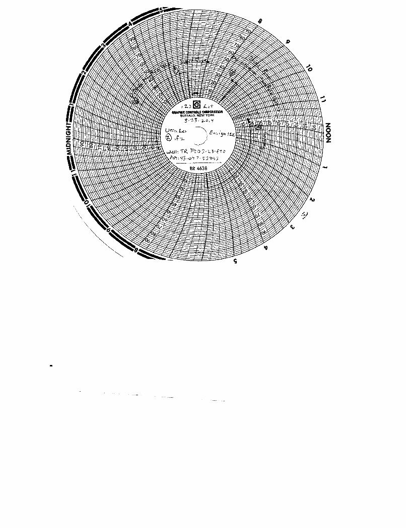
9
so
6
b
r
1
enwinecomraotsconauwro. NEW YOR
s 4 a aO Le
An o97-53½3\
BR
9
so
6
b
r
1
enwinecomraotsconauwro. NEW YOR
s 4 a aO Le
An o97-53½3\
BR
9
so
6
b
r
1
enwinecomraotsconauwro. NEW YOR
s 4 a aO Le
An o97-53½3\
BR
9
so
6
b
r
1
enwinecomraotsconauwro. NEW YOR
s 4 a aO Le
An o97-53½3\
BR
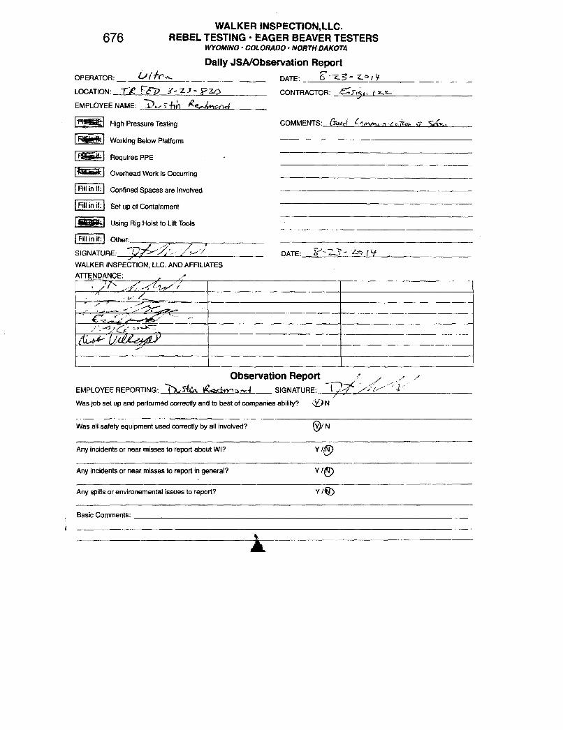
WALKER INSPECTION.LLC. 676 REBEL TESTING· EAGER BEAVER TESTERS
WYOMING· COLORADO· NORTH DAKOTA
Daily JSAlObservation Report OPERATOR: ____ ~£j~/A~r_~_~~ ______________ __ LOCATION: IE: F¢1> :I~ 'Z.J - Pz.o EMPLOYEE NAME: J)v ,-fin ~'?,rj,,,,oQ4
I !lSI High Pressure Testing
I ~ I Working Below Platform
I ~ Requires PPE
I~ Overhead Work is Occurring
I Fill in if: Confined Spaces are Involved
I Fill in if: Set up of Containment
I §!IiIiIk1 Using Rig Hoist to Lift Tools
I Fill in if: I Other: __ ----:,----",, __ ---,~_._-------SIGNATURE: cV/f"/;,:.>;/jj
2" WALKER INSPECTION, LLC. AND AFFILIATES
AmN,QANCE: L /#
DATE: ____ g>_-_-_~~3~-__ ~_O~/~¥ ________________ __
DATE: ~-2..'3- Lv f'i .
Observation Reportf ./ /--' EMPLOYEE REPORTING: 1>..t 5i!t.. vSgQ;IY'i).x4 SIGNATURE: T]-?S /j:!/ <j .
)'
Was job set up and performed correctly and to best of companies ability? IV N
Was all safety equipment used correctly by all involved? @I N
Any incidents or near misses to report about WI? Y I@
Any incidents or near misses to report in general? V I~
Any spills or environemental issues to report? Y I~
Basic Comments; ______________________________________________________________ __
WALKER INSPECTION,LLC.676 REBEL TESTING • EAGER BEAVERTESTERS
WYOMING• COLORADO • NORTH DAKOTA
Daily JSA/Observation ReportOPERATOR: DATE: $¯ L / ŸLOCATION: TX y-21- Ÿ10 CONTRACTOR: 67 y (:r-L
EMPLOYEENAME: u TAn ľÁnon<j.
High Pressure Testing COMMENTS: Üoaci »,men C< r
Working Below Platform
Requires PPE
Overhead Work is Occurring
Fillin if: Confined Spaces are involved
Fillin if: Set up of Containment
Using Rig Hoist to Lift Tools
Fill in if: Other:
SIGNATURE: DATE:
WALKERINSPECTION LLC.AND AFFILIATESATTENDANÇE:
Observation ReportEMPLOYEEREPORTING: 'e Å«fw,ad SIGNATURE:
Was job set up and performed correctly and to best of companies ability? (9 N
Was all safety equipment used correctly by all involved? / N
Any incidents or near misses to report about WI? Y /
Any incidents or near missesto report in general7 Y/
Any spills or environemental issues to report? Y /
Basic

RECEIVED: Sep. 29, 2014
STATE OF UTAHDEPARTMENT OF NATURAL RESOURCES
DIVISION OF OIL, GAS, AND MINING
FORM 9
5.LEASE DESIGNATION AND SERIAL NUMBER: UTU85994
SUNDRY NOTICES AND REPORTS ON WELLS
Do not use this form for proposals to drill new wells, significantly deepen existing wells belowcurrent bottom-hole depth, reenter plugged wells, or to drill horizontal laterals. Use APPLICATIONFOR PERMIT TO DRILL form for such proposals.
6. IF INDIAN, ALLOTTEE OR TRIBE NAME:
7.UNIT or CA AGREEMENT NAME:
1. TYPE OF WELL Oil Well
8. WELL NAME and NUMBER: Three Rivers Federal 3-23-820
2. NAME OF OPERATOR: ULTRA RESOURCES INC
9. API NUMBER: 43047539530000
3. ADDRESS OF OPERATOR: PHONE NUMBER: 304 Inverness Way South #295 , Englewood, CO, 80112 303 645-9809 Ext
9. FIELD and POOL or WILDCAT: THREE RIVERS
4. LOCATION OF WELL FOOTAGES AT SURFACE: 1536 FSL 1296 FWL QTR/QTR, SECTION, TOWNSHIP, RANGE, MERIDIAN: Qtr/Qtr: NWSW Section: 03 Township: 08.0S Range: 20.0E Meridian: S
COUNTY: UINTAH
STATE: UTAH
11.
CHECK APPROPRIATE BOXES TO INDICATE NATURE OF NOTICE, REPORT, OR OTHER DATA
TYPE OF SUBMISSION TYPE OF ACTION
NOTICE OF INTENTApproximate date work will start:
SUBSEQUENT REPORTDate of Work Completion:
9 /28 /2014
SPUD REPORTDate of Spud:
DRILLING REPORTReport Date:
ACIDIZE ALTER CASING CASING REPAIR
CHANGE TO PREVIOUS PLANS CHANGE TUBING CHANGE WELL NAME
CHANGE WELL STATUS COMMINGLE PRODUCING FORMATIONS CONVERT WELL TYPE
DEEPEN FRACTURE TREAT NEW CONSTRUCTION
OPERATOR CHANGE PLUG AND ABANDON PLUG BACK
PRODUCTION START OR RESUME RECLAMATION OF WELL SITE RECOMPLETE DIFFERENT FORMATION
REPERFORATE CURRENT FORMATION SIDETRACK TO REPAIR WELL TEMPORARY ABANDON
TUBING REPAIR VENT OR FLARE WATER DISPOSAL
WATER SHUTOFF SI TA STATUS EXTENSION APD EXTENSION
WILDCAT WELL DETERMINATION OTHER OTHER:
12. DESCRIBE PROPOSED OR COMPLETED OPERATIONS. Clearly show all pertinent details including dates, depths, volumes, etc.
First Production occurred on the TR3-23-820 on 09/28/2014.
NAME (PLEASE PRINT) PHONE NUMBER Jenna Anderson 303 645-9804
TITLE Permitting Assistant
SIGNATURE N/A
DATE 9 /29 /2014
October 01, 2014
Sundry Number: 56041 API Well Number: 43047539530000Sundry Number: 56041 API Well Number: 43047539530000
FORM 9STATE OF UTAH
DEPARTMENTOF NATURALRESOURCES5.LEASE DESIGNATION AND SERIAL NUMBER:DIVISION OF OIL, GAS, AND MINING UTU85994
SUNDRY NOTICES AND REPORTS ON WELLS 6. IF INDIAN, ALLOTTEE OR TRIBE NAME:
Do not use this form for proposals to drill new wells, significantly deepen existing wells belowcurrent bottom-hole depth, reenter plugged wells, or to drill horizontal laterals. Use APPLICATION 7.UNITor CA AGREEMENT NAME:
FOR PERMIT TO DRILL form for such proposals.
1. TYPE OF WELL 8. WELL NAME and NUMBER:Oil Well Three Rivers Federal 3-23-820
2. NAME OF OPERATOR: 9. API NUMBER:ULTRARESOURCES INC 43047539530000
3. ADDRESS OF OPERATOR: PHONE NUMBER: 9. FIELD and POOL or WILDCAT:304 Inverness Way South #295 , Englewood, CO, 80112 303 645-9809 Ext THREE RIVERS
4. LOCATION OF WELL COUNTY:FOOTAGESAT SURFACE: UINTAH
1536 FSL 1296 FWLQTRIQTR, SECTION, TOWNSHIP, RANGE, MERIDIAN: STATE:
QtrlQtr: NWSW Section: 03 Township: 08.0S Range: 20.0E Meridian: S UTAH
CHECK APPROPRIATE BOXES TO INDICATENATURE OF NOTICE, REPORT, OR OTHER DATA
TYPE OF SUBMISSION TYPE OF ACTION
ACI DIZE ALTER CASING CASING REPAIR
NOTICE OF INTENT CHANGE TO PREVIOUS PLANS CHANGE TUBING CHANGE WELL NAMEApproximate date work will start:
CHANGE WELL STATUS COMMINGLE PRODUCING FORMATIONS CONVERT WELL TYPE
SUBSEQUENT REPORTDate of Work Completion: DEEPEN FRACTURE TREAT NEW CONSTRUCTION
9/28/2014OPERATOR CHANGE PLUG AND ABANDON PLUG BACK
SPUD REPORT PRODUCTION START OR RESUME RECLAMATION OF WELL SITE RECOMPLETE DIFFERENT FORMATIONDate of Spud:
REPERFORATE CURRENT FORMATION SIDETRACK TO REPAIR WELL TEMPORARY ABANDON
TUBING REPAIR VENT OR FLARE WATER DISPOSAL
DRILLING REPORTReport Date: WATER SHUTOFF SI TA STATUS EXTENSION APD EXTENSION
WILDCAT WELL DETERMINATION OTHER OTHER:
12. DESCRIBE PROPOSED OR COMPLETED OPERATIONS. Clearly show all pertinent details including dates, depths, volumes, etc.
First Production occurred on the TR3-23-820 on 09/28/2014. Accepted by theutah Division of
Oil, Gas and Mining
FOR RECORD ONLYOctober 01, 2014
NAME (PLEASE PRINT) PHONE NUMBER TITLEJenna Anderson 303 645-9804 Permitting Assistant
SIGNATURE DATEN/A 9/29/2014
RECEIVED: Sep. 29,
Sundry Number: 56041 API Well Number: 43047539530000
FORM 9STATE OF UTAH
DEPARTMENTOF NATURALRESOURCES5.LEASE DESIGNATION AND SERIAL NUMBER:DIVISION OF OIL, GAS, AND MINING UTU85994
SUNDRY NOTICES AND REPORTS ON WELLS 6. IF INDIAN, ALLOTTEE OR TRIBE NAME:
Do not use this form for proposals to drill new wells, significantly deepen existing wells belowcurrent bottom-hole depth, reenter plugged wells, or to drill horizontal laterals. Use APPLICATION 7.UNITor CA AGREEMENT NAME:
FOR PERMIT TO DRILL form for such proposals.
1. TYPE OF WELL 8. WELL NAME and NUMBER:Oil Well Three Rivers Federal 3-23-820
2. NAME OF OPERATOR: 9. API NUMBER:ULTRARESOURCES INC 43047539530000
3. ADDRESS OF OPERATOR: PHONE NUMBER: 9. FIELD and POOL or WILDCAT:304 Inverness Way South #295 , Englewood, CO, 80112 303 645-9809 Ext THREE RIVERS
4. LOCATION OF WELL COUNTY:FOOTAGESAT SURFACE: UINTAH
1536 FSL 1296 FWLQTRIQTR, SECTION, TOWNSHIP, RANGE, MERIDIAN: STATE:
QtrlQtr: NWSW Section: 03 Township: 08.0S Range: 20.0E Meridian: S UTAH
CHECK APPROPRIATE BOXES TO INDICATENATURE OF NOTICE, REPORT, OR OTHER DATA
TYPE OF SUBMISSION TYPE OF ACTION
ACI DIZE ALTER CASING CASING REPAIR
NOTICE OF INTENT CHANGE TO PREVIOUS PLANS CHANGE TUBING CHANGE WELL NAMEApproximate date work will start:
CHANGE WELL STATUS COMMINGLE PRODUCING FORMATIONS CONVERT WELL TYPE
SUBSEQUENT REPORTDate of Work Completion: DEEPEN FRACTURE TREAT NEW CONSTRUCTION
9/28/2014OPERATOR CHANGE PLUG AND ABANDON PLUG BACK
SPUD REPORT PRODUCTION START OR RESUME RECLAMATION OF WELL SITE RECOMPLETE DIFFERENT FORMATIONDate of Spud:
REPERFORATE CURRENT FORMATION SIDETRACK TO REPAIR WELL TEMPORARY ABANDON
TUBING REPAIR VENT OR FLARE WATER DISPOSAL
DRILLING REPORTReport Date: WATER SHUTOFF SI TA STATUS EXTENSION APD EXTENSION
WILDCAT WELL DETERMINATION OTHER OTHER:
12. DESCRIBE PROPOSED OR COMPLETED OPERATIONS. Clearly show all pertinent details including dates, depths, volumes, etc.
First Production occurred on the TR3-23-820 on 09/28/2014. Accepted by theutah Division of
Oil, Gas and Mining
FOR RECORD ONLYOctober 01, 2014
NAME (PLEASE PRINT) PHONE NUMBER TITLEJenna Anderson 303 645-9804 Permitting Assistant
SIGNATURE DATEN/A 9/29/2014
RECEIVED: Sep. 29,

RECEIVED: Oct. 29, 2014
Form 3160-4 UNITED STATES FORM APPROVED(August 2007) DEPARTMENT OF THE INTERIOR OMB No. 1004-0137
BUREAU OF LAND MANAGEMENT Expires: July 31, 2010
WELL COMPLETION OR RECOMPLETION REPORT AND LOG 5. Lease Serial No.UTU85994
1a. Type of Well Oil Well Gas Well Dry Other
b. Type of Completion New Well Work Over Deepen Plug Back Diff. Resvr.
Other _________________________________
6. If Indian, Allottee or Tribe Name
7. Unit or CA Agreement Name and No.
2. Name of OperatorULTRA RESOURCES, INC.
Contact: JENNA ANDERSONE-Mail: [email protected]
8. Lease Name and Well No.THREE RIVERS FED 3-23-820
3. Address 304 INVERNESS WAY SOUTH SUITE 295ENGLEWOOD, CO 80112
3a. Phone No. (include area code)Ph: 303-645-9804
9. API Well No.43-047-53953
4. Location of Well (Report location clearly and in accordance with Federal requirements)*
At surface NWSW 1536FSL 1296FWL 40.148708 N Lat, 109.659503 W Lon
At top prod interval reported below NESW 2022FSL 1987FWL 40.150066 N Lat, 109.657046 W Lon
At total depth NESW 1980FSL 1994FWL 40.149950 N Lat, 109.657023 W Lon
10. Field and Pool, or ExploratoryTHREE RIVERS
11. Sec., T., R., M., or Block and Surveyor Area Sec 3 T8S R20E Mer SLB
12. County or ParishUINTAH
13. StateUT
14. Date Spudded08/07/2014
15. Date T.D. Reached08/25/2014
16. Date CompletedD & A Ready to Prod.09/27/2014
17. Elevations (DF, KB, RT, GL)*4745 GL
18. Total Depth: MD 6840TVD 6721
19. Plug Back T.D.: MD 6821TVD 6702
20. Depth Bridge Plug Set: MDTVD
21. Type Electric & Other Mechanical Logs Run (Submit copy of each)TRIPLE COMBO, CBL
22. Was well cored? No Yes (Submit analysis)Was DST run? No Yes (Submit analysis)Directional Survey? No Yes (Submit analysis)
23. Casing and Liner Record (Report all strings set in well)
Top Bottom Stage Cementer No. of Sks. & Slurry Vol.Hole Size Size/Grade Wt. (#/ft.) Cement Top* Amount Pulled
(MD) (MD) Depth Type of Cement (BBL)
24.000 16.000 ARJ-55 45.0 0 100 450 0
12.250 8.625 ARJ-55 24.0 0 1015 675 0
7.875 5.500 J-55 17.0 0 6824 680 0
24. Tubing Record
Size Depth Set (MD) Packer Depth (MD) Size Depth Set (MD) Packer Depth (MD) Size Depth Set (MD) Packer Depth (MD)
2.875 486025. Producing Intervals 26. Perforation Record
Formation Top Bottom Perforated Interval Size No. Holes Perf. Status
A) LOWER GR 5006 6706 5006 TO 6706 261 OPEN
B)
C)
D)27. Acid, Fracture, Treatment, Cement Squeeze, Etc.
Depth Interval Amount and Type of Material
5006 TO 6706 FRATURE/STIMULATE 7 STAGES
28. Production - Interval ADate First Test Hours Test Oil Gas Water Oil Gravity Gas Production MethodProduced Date Tested Production BBL MCF BBL Corr. API Gravity
09/27/2014 10/10/2014 24 32.0 37.0 407.0 GAS PUMPING UNIT
Choke Tbg. Press. Csg. 24 Hr. Oil Gas Water Gas:Oil Well StatusSize Flwg. Press. Rate BBL MCF BBL Ratio
SI POW
28a. Production - Interval BDate First Test Hours Test Oil Gas Water Oil Gravity Gas Production MethodProduced Date Tested Production BBL MCF BBL Corr. API Gravity
Choke Tbg. Press. Csg. 24 Hr. Oil Gas Water Gas:Oil Well StatusSize Flwg. Press. Rate BBL MCF BBL Ratio
SI
(See Instructions and spaces for additional data on reverse side)ELECTRONIC SUBMISSION #274440 VERIFIED BY THE BLM WELL INFORMATION SYSTEM
** OPERATOR-SUBMITTED ** OPERATOR-SUBMITTED ** OPERATOR-SUBMITTED **
Sundry Number: 57148 API Well Number: 43047539530000Sundry Number: 57148 API Well Number: 43047539530000
Fonn 3160-4 UNITED STATES FORM APPROVED(August 2007) DEPARTMENT OF THE INTERIOR OMB No. 1004-0137
BUREAU OF LAND MANAGEMENT Expires: July 31, 2010
WELL COMPLETION OR RECOMPLETION REPORT AND LOG 5. Lease Serial No.UTU85994
la. Type of Well Oil Well O Gas Well O Dry O other 6. If Indian, Allottee or Tribe Name
b. Type of Completion New Well O Work Over O Deepen O Plug Back O Diff. Resvr.
Other 7. Unit or CA Agreement Name and No.
2. Name of Operator Contact: JENNA ANDERSON 8. Lease Name and Well No.ULTRA RESOURCES, INC. E-Mail: [email protected] THREE RIVERS FED 3-23-820
3. Address 304 INVERNESS WAY SOUTH SUITE 295 3a. Phone No. (include area code) 9. API Well No.ENGLEWOOD, CO 80112 Ph: 303-645-9804 43-047-53953
4. Location of Well (Report location clearly and in accordance with Federal requirements)* 10. Field and Pool, or ExploratoryTHREE RIVERS
At surface NWSW 1536FSL 1296FWL 40.148708 N Lat, 109.659503 W Lon 11. Sec., T., R., M., or Block and Survey
At top prod interval reported below NESW 2022FSL 1987FWL 40.150066 N Lat, 109.657046 W Lon or Area Sec 3 T8S R20E Mer SLB12. County or Parish 13. State
At total depth NESW 1980FSL 1994FWL 40.149950 N Lat, 109.657023 W Lon UINTAH UT14. Date Spudded 15. Date T.D. Reached 16. Date Completed 17. Elevations (DF, KB, RT, GL)*
08/07/2014 08/25/2014 OD & A Ready to Prod. 4745 GL09/27/2014
18. Total Depth: MD 6840 19. Plug Back T.D.: MD 6821 20. Depth Bridge Plug Set: MDTVD 6721 TVD 6702 TVD
21. Type Electric & Other Mechanical Logs Run (Submit copy of each) 22. Was well cored? No O Yes (Submit analysis)TRIPLE COMBO, CBL Was DST run? No O Yes (Submit analysis)
Directional Survey? O No Yes (Submit analysis)
23. Casing and Liner Record (Report all strings set in well)
. Top Bottom Stage Cementer No. of Sks. & Slurry Vol.Hole Size Size/Grade Wt. (#/ft.) Cement Top* Amount Pulled
(MD) (MD) Depth Type of Cement (BBL)
24.000 16.000 ARJ-55 45.0 0 100 450 012.250 8.625 ARJ-55 24.0 0 1015 675 0
7.875 5.500 J-55 17.0 0 6824 680 0
24. Tubing Record
Size Depth Set (MD) Packer Depth (MD) Size Depth Set (MD) Packer Depth (MD) Size Depth Set (MD) Packer Depth (MD)
2.875 486025. Producing Intervals 26. Perforation Record
Formation Top Bottom Perforated Interval Size No. Holes Perf. Status
A) LOWER GR 5006 6706 5006 TO 6706 261 OPENB)C)D)27. Acid, Fracture, Treatment, Cement Squeeze, Etc.
Depth Interval Amount and Type of Material
5006 TO 6706 FRATURE/STIMULATE 7 STAGES
28. Production - Interval ADate First Test Hours Test Oil Gas Water Oil Gravity Gas Production MethodProduced Date Tested Production BBL MCF BBL Corr. API Gravity
09/27/2014 10/10/2014 24 32.0 37.0 407.0 GAS PUMPING UNITChoke Tbg. Press. Csg. 24 Hr. Oil Gas Water Gas:Oil Well Statussize Flwg. Press. Rate BBL MCF BBL Ratio
SI POW
28a. Production - Interval BDate First Test Hours Test Oil Gas Water Oil Gravity Gas Production MethodProduced Date Tested Product on BBL MCF BBL Corr. API Gravity
Choke Tbg. Press. Csg. 24 Hr. Oil Gas Water Gas:Oil Well Statussize Flwg. Press. Rate BBL MCF BBL Ratio
SI
(See Instructions and spaces for additional data on reverse side)ELECTRONIC SUBMISSION #274440 VERIFIED BY THE BLM WELL INFORMATION SYSTEM
** OPERATOR-SUBMITTED ** OPERATOR-SUBMITTED ** OPERATOR-SUBMITTED **
RECEIVED: Oct. 29,
Sundry Number: 57148 API Well Number: 43047539530000
Fonn 3160-4 UNITED STATES FORM APPROVED(August 2007) DEPARTMENT OF THE INTERIOR OMB No. 1004-0137
BUREAU OF LAND MANAGEMENT Expires: July 31, 2010
WELL COMPLETION OR RECOMPLETION REPORT AND LOG 5. Lease Serial No.UTU85994
la. Type of Well Oil Well O Gas Well O Dry O other 6. If Indian, Allottee or Tribe Name
b. Type of Completion New Well O Work Over O Deepen O Plug Back O Diff. Resvr.
Other 7. Unit or CA Agreement Name and No.
2. Name of Operator Contact: JENNA ANDERSON 8. Lease Name and Well No.ULTRA RESOURCES, INC. E-Mail: [email protected] THREE RIVERS FED 3-23-820
3. Address 304 INVERNESS WAY SOUTH SUITE 295 3a. Phone No. (include area code) 9. API Well No.ENGLEWOOD, CO 80112 Ph: 303-645-9804 43-047-53953
4. Location of Well (Report location clearly and in accordance with Federal requirements)* 10. Field and Pool, or ExploratoryTHREE RIVERS
At surface NWSW 1536FSL 1296FWL 40.148708 N Lat, 109.659503 W Lon 11. Sec., T., R., M., or Block and Survey
At top prod interval reported below NESW 2022FSL 1987FWL 40.150066 N Lat, 109.657046 W Lon or Area Sec 3 T8S R20E Mer SLB12. County or Parish 13. State
At total depth NESW 1980FSL 1994FWL 40.149950 N Lat, 109.657023 W Lon UINTAH UT14. Date Spudded 15. Date T.D. Reached 16. Date Completed 17. Elevations (DF, KB, RT, GL)*
08/07/2014 08/25/2014 OD & A Ready to Prod. 4745 GL09/27/2014
18. Total Depth: MD 6840 19. Plug Back T.D.: MD 6821 20. Depth Bridge Plug Set: MDTVD 6721 TVD 6702 TVD
21. Type Electric & Other Mechanical Logs Run (Submit copy of each) 22. Was well cored? No O Yes (Submit analysis)TRIPLE COMBO, CBL Was DST run? No O Yes (Submit analysis)
Directional Survey? O No Yes (Submit analysis)
23. Casing and Liner Record (Report all strings set in well)
. Top Bottom Stage Cementer No. of Sks. & Slurry Vol.Hole Size Size/Grade Wt. (#/ft.) Cement Top* Amount Pulled
(MD) (MD) Depth Type of Cement (BBL)
24.000 16.000 ARJ-55 45.0 0 100 450 012.250 8.625 ARJ-55 24.0 0 1015 675 0
7.875 5.500 J-55 17.0 0 6824 680 0
24. Tubing Record
Size Depth Set (MD) Packer Depth (MD) Size Depth Set (MD) Packer Depth (MD) Size Depth Set (MD) Packer Depth (MD)
2.875 486025. Producing Intervals 26. Perforation Record
Formation Top Bottom Perforated Interval Size No. Holes Perf. Status
A) LOWER GR 5006 6706 5006 TO 6706 261 OPENB)C)D)27. Acid, Fracture, Treatment, Cement Squeeze, Etc.
Depth Interval Amount and Type of Material
5006 TO 6706 FRATURE/STIMULATE 7 STAGES
28. Production - Interval ADate First Test Hours Test Oil Gas Water Oil Gravity Gas Production MethodProduced Date Tested Production BBL MCF BBL Corr. API Gravity
09/27/2014 10/10/2014 24 32.0 37.0 407.0 GAS PUMPING UNITChoke Tbg. Press. Csg. 24 Hr. Oil Gas Water Gas:Oil Well Statussize Flwg. Press. Rate BBL MCF BBL Ratio
SI POW
28a. Production - Interval BDate First Test Hours Test Oil Gas Water Oil Gravity Gas Production MethodProduced Date Tested Product on BBL MCF BBL Corr. API Gravity
Choke Tbg. Press. Csg. 24 Hr. Oil Gas Water Gas:Oil Well Statussize Flwg. Press. Rate BBL MCF BBL Ratio
SI
(See Instructions and spaces for additional data on reverse side)ELECTRONIC SUBMISSION #274440 VERIFIED BY THE BLM WELL INFORMATION SYSTEM
** OPERATOR-SUBMITTED ** OPERATOR-SUBMITTED ** OPERATOR-SUBMITTED **
RECEIVED: Oct. 29,

RECEIVED: Oct. 29, 2014
28b. Production - Interval CDate First Test Hours Test Oil Gas Water Oil Gravity Gas Production MethodProduced Date Tested Production BBL MCF BBL Corr. API Gravity
Choke Tbg. Press. Csg. 24 Hr. Oil Gas Water Gas:Oil Well StatusSize Flwg. Press. Rate BBL MCF BBL Ratio
SI
28c. Production - Interval DDate First Test Hours Test Oil Gas Water Oil Gravity Gas Production MethodProduced Date Tested Production BBL MCF BBL Corr. API Gravity
Choke Tbg. Press. Csg. 24 Hr. Oil Gas Water Gas:Oil Well StatusSize Flwg. Press. Rate BBL MCF BBL Ratio
SI
29. Disposition of Gas(Sold, used for fuel, vented, etc.)USED ON LEASE
30. Summary of Porous Zones (Include Aquifers): 31. Formation (Log) Markers
Show all important zones of porosity and contents thereof: Cored intervals and all drill-stemtests, including depth interval tested, cushion used, time tool open, flowing and shut-in pressuresand recoveries.
Top
Meas. DepthFormation Top Bottom Descriptions, Contents, etc. Name
UPPER GREEN RIVER 2800MAHOGANY 4212LOWER GREEN RIVER 4989WASATCH 6722
32. Additional remarks (include plugging procedure):Frac material used: 10000 gal HCI Acid, 848343 gal Fr-66 Water, 299088 gal DeltaFracFluid, 844688 lbs White Sand
33. Circle enclosed attachments:
1. Electrical/Mechanical Logs (1 full set req'd.) 2. Geologic Report 3. DST Report 4. Directional Survey
5. Sundry Notice for plugging and cement verification 6. Core Analysis 7 Other:
34. I hereby certify that the foregoing and attached information is complete and correct as determined from all available records (see attached instructions):
Electronic Submission #274440 Verified by the BLM Well Information System.For ULTRA RESOURCES, INC., sent to the Vernal
Name Title(please print) JENNA ANDERSON PERMITTING SPECIALIST
Signature (Electronic Submission) Date 10/28/2014
Title 18 U.S.C. Section 1001 and Title 43 U.S.C. Section 1212, make it a crime for any person knowingly and willfully to make to any department or agencyof the United States any false, fictitious or fradulent statements or representations as to any matter within its jurisdiction.
** ORIGINAL ** ORIGINAL ** ORIGINAL ** ORIGINAL ** ORIGINAL ** ORIGINAL ** ORIGINAL **
Sundry Number: 57148 API Well Number: 43047539530000Sundry Number: 57148 API Well Number: 43047539530000
28b. Production - Interval CDate First Test Hours Test Oil Gas Water Oil Gravity Gas Production MethodProduced Date Tested Production BBL MCF BBL Corr. API Gravity
Choke Tbg. Press. Csg. 24 Hr. Oil Gas Water Gas:Oil Well Statussize Flwg. Press. Rate BBL MCF BBL Ratio
SI
28c. Production - Interval DDate First Test Hours Test Oil Gas Water Oil Gravity Gas Production MethodProduced Date Tested Product on BBL MCF BBL Corr. API Gravity
Choke Tbg. Press. Csg. 24 Hr. Oil Gas Water Gas:Oil Well Statussize Flwg. Press. Rate BBL MCF BBL Ratio
SI
29. Disposition of Gas(Sold, used forfuel,vented, etc.)USED ON LEASE
30. Summary of Porous Zones (Include Aquifers): 31. Formation (Log) Markers
Show all important zones of porosity and contents thereof: Cored intervals and all drill-stemtests, including depth interval tested, cushion used, time tool open, flowing and shut-in pressuresand recoveries.
TopFormation Top Bottom Descriptions, Contents, etc. Name
Meas. Depth
UPPER GREEN RIVER 2800MAHOGANY 4212LOWER GREEN RIVER 4989WASATCH 6722
32. Additional remarks (include plugging procedure):Frac material used: 10000 gal HCI Acid, 848343 gal Fr-66 Water, 299088 gal DeltaFracFluid, 844688 lbs White Sand
33. Circle enclosed attachments:
1. Electrical/Mechanical Logs (1 full set req'd.) 2. Geologic Report 3. DST Report 4. Directional Survey
5. Sundry Notice for plugging and cement verification 6. Core Analysis 7 Other:
34. I hereby certify that the foregoing and attached information is complete and correct as determined from all available records (see attached instructions):
Electronic Submission #274440 Verified by the BLM Well Information System.For ULTRA RESOURCES, INC., sent to the Vernal
Name(please print) JENNA ANDERSON Title PERMITTING SPECIALIST
Signature (Electronic Submission) Date 10/28/2014
Title 18 U.S.C. Section 1001 and Title 43 U.S.C. Section 1212, make it a crime for any person knowingly and willfully to make to any department or agencyof the United States any false, fictitious or fradulent statements or representations as to any matter within its jurisdiction.
** ORIGINAL ** ORIGINAL ** ORIGINAL ** ORIGINAL ** ORIGINAL ** ORIGINAL ** ORIGINAL **
RECEIVED: Oct. 29,
Sundry Number: 57148 API Well Number: 43047539530000
28b. Production - Interval CDate First Test Hours Test Oil Gas Water Oil Gravity Gas Production MethodProduced Date Tested Production BBL MCF BBL Corr. API Gravity
Choke Tbg. Press. Csg. 24 Hr. Oil Gas Water Gas:Oil Well Statussize Flwg. Press. Rate BBL MCF BBL Ratio
SI
28c. Production - Interval DDate First Test Hours Test Oil Gas Water Oil Gravity Gas Production MethodProduced Date Tested Product on BBL MCF BBL Corr. API Gravity
Choke Tbg. Press. Csg. 24 Hr. Oil Gas Water Gas:Oil Well Statussize Flwg. Press. Rate BBL MCF BBL Ratio
SI
29. Disposition of Gas(Sold, used forfuel,vented, etc.)USED ON LEASE
30. Summary of Porous Zones (Include Aquifers): 31. Formation (Log) Markers
Show all important zones of porosity and contents thereof: Cored intervals and all drill-stemtests, including depth interval tested, cushion used, time tool open, flowing and shut-in pressuresand recoveries.
TopFormation Top Bottom Descriptions, Contents, etc. Name
Meas. Depth
UPPER GREEN RIVER 2800MAHOGANY 4212LOWER GREEN RIVER 4989WASATCH 6722
32. Additional remarks (include plugging procedure):Frac material used: 10000 gal HCI Acid, 848343 gal Fr-66 Water, 299088 gal DeltaFracFluid, 844688 lbs White Sand
33. Circle enclosed attachments:
1. Electrical/Mechanical Logs (1 full set req'd.) 2. Geologic Report 3. DST Report 4. Directional Survey
5. Sundry Notice for plugging and cement verification 6. Core Analysis 7 Other:
34. I hereby certify that the foregoing and attached information is complete and correct as determined from all available records (see attached instructions):
Electronic Submission #274440 Verified by the BLM Well Information System.For ULTRA RESOURCES, INC., sent to the Vernal
Name(please print) JENNA ANDERSON Title PERMITTING SPECIALIST
Signature (Electronic Submission) Date 10/28/2014
Title 18 U.S.C. Section 1001 and Title 43 U.S.C. Section 1212, make it a crime for any person knowingly and willfully to make to any department or agencyof the United States any false, fictitious or fradulent statements or representations as to any matter within its jurisdiction.
** ORIGINAL ** ORIGINAL ** ORIGINAL ** ORIGINAL ** ORIGINAL ** ORIGINAL ** ORIGINAL **
RECEIVED: Oct. 29,
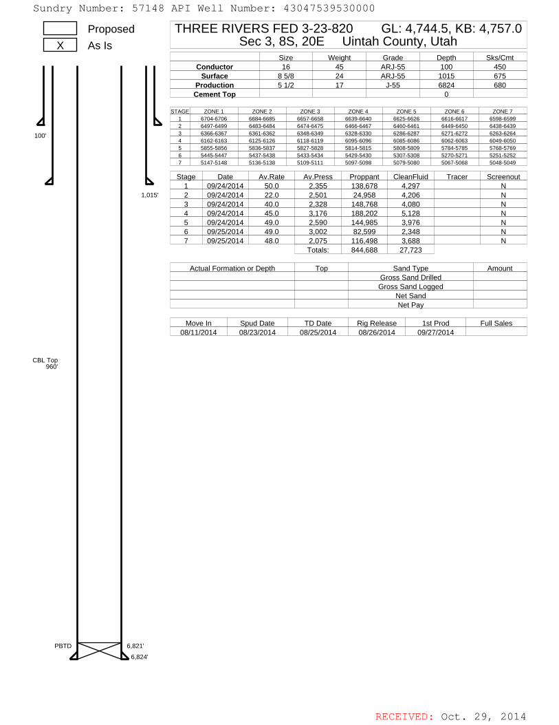
RECEIVED: Oct. 29, 2014
THREE RIVERS FED 3-23-820 GL: 4,744.5, KB: 4,757.0Sec 3, 8S, 20E Uintah County, Utah
Size Weight Grade Depth Sks/CmtConductor 16 45 ARJ-55 100 450
Surface 8 5/8 24 ARJ-55 1015 675Production 5 1/2 17 J-55 6824 680Cement Top 0
ProposedAs IsX
100'
1,015'
6,824'
6,821'PBTD
CBL Top960'
STAGE ZONE 1 ZONE 2 ZONE 3 ZONE 4 ZONE 5 ZONE 6 ZONE 71 6704-6706 6684-6685 6657-6658 6639-6640 6625-6626 6616-6617 6598-65992 6497-6499 6483-6484 6474-6475 6466-6467 6460-6461 6449-6450 6438-64393 6366-6367 6361-6362 6348-6349 6328-6330 6286-6287 6271-6272 6263-62644 6162-6163 6125-6126 6118-6119 6095-6096 6085-6086 6062-6063 6049-60505 5855-5856 5836-5837 5827-5828 5814-5815 5808-5809 5784-5785 5768-57696 5445-5447 5437-5438 5433-5434 5429-5430 5307-5308 5270-5271 5251-52527 5147-5148 5136-5138 5109-5111 5097-5098 5079-5080 5067-5068 5048-5049
Stage Date Av.Rate Av.Press Proppant CleanFluid Tracer Screenout1 09/24/2014 50.0 2,355 138,678 4,297 N2 09/24/2014 22.0 2,501 24,958 4,206 N3 09/24/2014 40.0 2,328 148,768 4,080 N4 09/24/2014 45.0 3,176 188,202 5,128 N5 09/24/2014 49.0 2,590 144,985 3,976 N6 09/25/2014 49.0 3,002 82,599 2,348 N7 09/25/2014 48.0 2,075 116,498 3,688 N
Totals: 844,688 27,723
Actual Formation or Depth Top Sand Type AmountGross Sand DrilledGross Sand Logged
Net SandNet Pay
Move In Spud Date TD Date Rig Release 1st Prod Full Sales08/11/2014 08/23/2014 08/25/2014 08/26/2014 09/27/2014
Sundry Number: 57148 API Well Number: 43047539530000Sundry Number: 57148 API Well Number: 43047539530000
Proposed THREE RIVERS FED 3-23-820 GL: 4,744.5, KB: 4,757.0x As is Sec 3, 8S, 20E Uintah County, Utah
Size Weight Grade Depth Sks/CmtConductor 16 45 ARJ-55 100 450
Surface 8 5/8 24 ARJ-55 1015 675Production 5 1/2 17 J-55 6824 680Cement Top 0
STAGE ZONE 1 ZONE 2 ZONE 3 ZONE 4 ZONE 5 ZONE 6 ZONE 7
k 2404 40
49 0 5 6
4100. 3 6366-6367 6361-6362 6348-6349 6328-6330 6286-6287 6271-6272 6263-6264
4 6162-6163 6125-6126 6118-6119 6095-6096 6085-6086 6062-6063 6049-60505 5855-5856 5836-5837 5827-5828 5814-5815 5808-5809 5784-5785 5768-57696 5445-5447 5437-5438 5433-5434 5429-5430 5307-5308 5270-5271 5251-52527 5147-5148 5136-5138 5109-5111 5097-5098 5079-5080 5067-5068 5048-5049
Stage Date Av.Rate Av.Press Proppant CleanFluid Tracer Screenout1 09/24/2014 50.0 2,355 138,678 4,297 N
1,015' 2 09/24/2014 22.0 2,501 24,958 4,206 N3 09/24/2014 40.0 2,328 148,768 4,080 N4 09/24/2014 45.0 3,176 188,202 5,128 N5 09/24/2014 49.0 2,590 144,985 3,976 N6 09/25/2014 49.0 3,002 82,599 2,348 N7 09/25/2014 48.0 2,075 116,498 3,688 N
Totals: 844,688 27,723
Actual Formation or Depth Top Sand Type AmountGross Sand DrilledGross Sand Logged
Net SandNet Pay
Move In Spud Date TD Date Rio Release 1st Prod Full Sales08/11/2014 08/23/2014 08/25/2014 08/26/2014 09/27/2014
CBL Top960'
PBTD 6,6828124'
RECEIVED: Oct. 29,
Sundry Number: 57148 API Well Number: 43047539530000
Proposed THREE RIVERS FED 3-23-820 GL: 4,744.5, KB: 4,757.0x As is Sec 3, 8S, 20E Uintah County, Utah
Size Weight Grade Depth Sks/CmtConductor 16 45 ARJ-55 100 450
Surface 8 5/8 24 ARJ-55 1015 675Production 5 1/2 17 J-55 6824 680Cement Top 0
STAGE ZONE 1 ZONE 2 ZONE 3 ZONE 4 ZONE 5 ZONE 6 ZONE 7
k 2404 40
49 0 5 6
4100. 3 6366-6367 6361-6362 6348-6349 6328-6330 6286-6287 6271-6272 6263-6264
4 6162-6163 6125-6126 6118-6119 6095-6096 6085-6086 6062-6063 6049-60505 5855-5856 5836-5837 5827-5828 5814-5815 5808-5809 5784-5785 5768-57696 5445-5447 5437-5438 5433-5434 5429-5430 5307-5308 5270-5271 5251-52527 5147-5148 5136-5138 5109-5111 5097-5098 5079-5080 5067-5068 5048-5049
Stage Date Av.Rate Av.Press Proppant CleanFluid Tracer Screenout1 09/24/2014 50.0 2,355 138,678 4,297 N
1,015' 2 09/24/2014 22.0 2,501 24,958 4,206 N3 09/24/2014 40.0 2,328 148,768 4,080 N4 09/24/2014 45.0 3,176 188,202 5,128 N5 09/24/2014 49.0 2,590 144,985 3,976 N6 09/25/2014 49.0 3,002 82,599 2,348 N7 09/25/2014 48.0 2,075 116,498 3,688 N
Totals: 844,688 27,723
Actual Formation or Depth Top Sand Type AmountGross Sand DrilledGross Sand Logged
Net SandNet Pay
Move In Spud Date TD Date Rio Release 1st Prod Full Sales08/11/2014 08/23/2014 08/25/2014 08/26/2014 09/27/2014
CBL Top960'
PBTD 6,6828124'
RECEIVED: Oct. 29,

RECEIVED: Oct. 29, 2014
Sundry Number: 57148 API Well Number: 43047539530000Sundry Number: 57148 API Well Number: 43047539530000
ULTRA RESOURCES, INCLocat>on Three Rivers Siel Three Rivers Fed 3 23 820 (1536 FSL & 129ΠFWL)
Feld UINTAMCOUNTY Well Three Rrvers Fed 3 23 820Feedily Sec 03 TSS R20E Wetbare Three Rivers Fed 323820 PWS
PETROLEUM-
500 -
1000 •
so--a Easting (ft)O 200 400 600I I I I1500 -
• 600Three Rivers Fed 3-23420
Top of Production2022' FSL & 1987 FWL2000 -
Three Rivers Fed 3-23-820BHL
1980' FSL & 1994' FWL
2500 -
2ooTop Green River: 18 86" inc.2800.00ft MD.2758 32ft TVD, 307.81ft VS
hree Rivers Fed 3-23-820SHL:
(1536' FSL & 1296' FWL) • ©
2 3500 -
J-
-200
4000 -
ahogany 13.79° Inc, 4212 00ft MD,4103 40ft TVD, 733.71ft VS
4500 -
Lower Green River 3.14' Inc. 4898 00ft MD,4779.71ft TVD.84303ft VSTop ofProducton 0 64' Inc. 5006 00ft MD.4887 64ft TVD, 846 40ft VS5000 -
5500 -
6000 •
lill11t!O 500 1000 1500 2000 2500 3000 3500Vertical Section (ft) '**·""°"
Mmuth 53 95· wathreference0 00 N, 0.00
Sundry Number: 57148 API Well Number: 43047539530000
ULTRA RESOURCES, INCLocat>on Three Rivers Siel Three Rivers Fed 3 23 820 (1536 FSL & 129ΠFWL)
Feld UINTAMCOUNTY Well Three Rrvers Fed 3 23 820Feedily Sec 03 TSS R20E Wetbare Three Rivers Fed 323820 PWS
PETROLEUM-
500 -
1000 •
so--a Easting (ft)O 200 400 600I I I I1500 -
• 600Three Rivers Fed 3-23420
Top of Production2022' FSL & 1987 FWL2000 -
Three Rivers Fed 3-23-820BHL
1980' FSL & 1994' FWL
2500 -
2ooTop Green River: 18 86" inc.2800.00ft MD.2758 32ft TVD, 307.81ft VS
hree Rivers Fed 3-23-820SHL:
(1536' FSL & 1296' FWL) • ©
2 3500 -
J-
-200
4000 -
ahogany 13.79° Inc, 4212 00ft MD,4103 40ft TVD, 733.71ft VS
4500 -
Lower Green River 3.14' Inc. 4898 00ft MD,4779.71ft TVD.84303ft VSTop ofProducton 0 64' Inc. 5006 00ft MD.4887 64ft TVD, 846 40ft VS5000 -
5500 -
6000 •
lill11t!O 500 1000 1500 2000 2500 3000 3500Vertical Section (ft) '**·""°"
Mmuth 53 95· wathreference0 00 N, 0.00

RECEIVED: Oct. 29, 2014
Sundry Number: 57148 API Well Number: 43047539530000Sundry Number: 57148 API Well Number: 43047539530000
Page l of 5
Actual Wellpath Report DYNAMICThree Rivers Fed 3-23-820 AWP GRAPHICS,INC.Page 1of 5
PETROLEUM
REFERENCE WELLPATH IDENTIFICATIONOperator ULTRA RESOURCES, INC Slot Three Rivers Fed 3-23-820 (1536' FSL & 1296' FWL)Area hree Rivers Well hree Rivers Fed 3-23-820Field UINTAH COUNTY Wellbore Three Rivers Fed 3-23-820 AWBFacility ec.03-T8S-R20E
REPORT SETUP INFORMATIONProjection System NAD83 / Lambert Utah SP, Central Zone (4302), Sofhvare System WellArchitect®3.0.0
US feetNorth Reference True User EwilliamsScale 0.999914 Report Generated 10/26/2014 at 8:27:13 PMConvergence at slot 1.18 East Database/Source file WellArchitectDBffhree Rivers Fed 3-23-820 AWB.xml
WELLPATH LOCATIONLocal coordinates Grid coordinates Geographic coordinates
Northlft! Eastjft! Easting|US ft| Northing|US ft! Latitude LongitudeSlotLocation -1672.71 -871.28 2154854.94 7228184.77 40°08'55.350"N 109°39'34.210"WFacility Reference Pt 2\55691.49 7229874.94 40°09'11.880"N 109°39'22.990"WField Reference Pt 2156630.96 7236613.42 40°10'l8.270"N 109°39'09.100"W
WELLPATH DATUMCalculation method Minimum curvature Ensign 122 (RT) to Facility Vertical Datum 4756.00ftHorizontal Reference Pt Slot Ensign 122 (RT) to Mean Sea Level 4756.00ftVertical Reference Pt Ensign 122 (RT) Ensign I22 (RT) to Mud Line at Slot (Three Rivers Fed 3-23-820 (1536' FSL & 1296' FWL)) 4756.00ftMD Reference Pt Ensign 122 (RT) Section Origin N 0.00, E 0.00 ftField Vertical Reference Mean Sea Level Section Azimuth 53.95*
Sundry Number: 57148 API Well Number: 43047539530000
Page l of 5
Actual Wellpath Report DYNAMICThree Rivers Fed 3-23-820 AWP GRAPHICS,INC.Page 1of 5
PETROLEUM
REFERENCE WELLPATH IDENTIFICATIONOperator ULTRA RESOURCES, INC Slot Three Rivers Fed 3-23-820 (1536' FSL & 1296' FWL)Area hree Rivers Well hree Rivers Fed 3-23-820Field UINTAH COUNTY Wellbore Three Rivers Fed 3-23-820 AWBFacility ec.03-T8S-R20E
REPORT SETUP INFORMATIONProjection System NAD83 / Lambert Utah SP, Central Zone (4302), Sofhvare System WellArchitect®3.0.0
US feetNorth Reference True User EwilliamsScale 0.999914 Report Generated 10/26/2014 at 8:27:13 PMConvergence at slot 1.18 East Database/Source file WellArchitectDBffhree Rivers Fed 3-23-820 AWB.xml
WELLPATH LOCATIONLocal coordinates Grid coordinates Geographic coordinates
Northlft! Eastjft! Easting|US ft| Northing|US ft! Latitude LongitudeSlotLocation -1672.71 -871.28 2154854.94 7228184.77 40°08'55.350"N 109°39'34.210"WFacility Reference Pt 2\55691.49 7229874.94 40°09'11.880"N 109°39'22.990"WField Reference Pt 2156630.96 7236613.42 40°10'l8.270"N 109°39'09.100"W
WELLPATH DATUMCalculation method Minimum curvature Ensign 122 (RT) to Facility Vertical Datum 4756.00ftHorizontal Reference Pt Slot Ensign 122 (RT) to Mean Sea Level 4756.00ftVertical Reference Pt Ensign 122 (RT) Ensign I22 (RT) to Mud Line at Slot (Three Rivers Fed 3-23-820 (1536' FSL & 1296' FWL)) 4756.00ftMD Reference Pt Ensign 122 (RT) Section Origin N 0.00, E 0.00 ftField Vertical Reference Mean Sea Level Section Azimuth 53.95*

RECEIVED: Oct. 29, 2014
Sundry Number: 57148 API Well Number: 43047539530000Sundry Number: 57148 API Well Number: 43047539530000Page 2 of 5
Actual Wellpath Report DYNAMICThree Rivers Fed 3-23-820 AWP GRAPHICS,INC.Page 2 of 5
PETROLEUPI
REFERENCE WELLPATH IDENTIFICATIONOperator ULTRA RESOURCES, INC Slot Three Rivers Fed 3-23-820 (1536' FSL & 1296' FWL)Area Three Rivers Well hree Rivers Fed 3-23-820'ield UINTAH COUNTY Wellbore hree Rivers Fed 3-23-820 AWBacility Sec.03-T8S-R20E
WELLPATH DATA (75 stations) † = interpolatedlextrapolated stationMD inclination Azimuth TVD Vert Sect North East Latitude Longitude DLS .ommentse o o
0. 0.0 104,50 0.00 0.00 0.00 0.00 40°08'55.350"N 109°39'34.210"W 0.0013.00 0.00 104.50 13.00 0.00 0.00 0.00 40°08'55.350"N 109°39'34.210"W 0.00
100.00 0.00 0.00 100.00 0.00 0.00 0.00 40°08'55.350"N 109°39'34.210"W 0.001015.00 0.00 0. 1015.00 0.00 0.00 0.00 40°08'55.350"N 109°39'34.210"W 0.001042.00 0.70 104.50 1042.00 0.10 -0.04 0.16 40°08'55.350"N 109°39'34.208"W 2.591133.00 0.7 115. 1132.99 0.72 -0.42 1.20 40°08'55.346"N 109°39'34.195"W 0.151223.00 0.7 109.5 1222.99 1.29 -0.85 2.21 40°08'55.342"N 109°39'34.182"W 0.091314.00 1.60 90. 1313.97 2.62 -1.05 4.00 40°08'55.340"N 109°39'34.158"W 1.061405.00 1.8 74.50 1404.93 4.97 -0.69 6.65 40°08'55.343"N 109°39'34.124"W 0.581495.00 3.4 64.50 1494.83 8 92 0.84 10.42 40°08'55.358"N 109°39'34.076"W 1.841586.00 4.70 58.2 1585.60 15.29 3.96 16.03 40°08'55.389"N 109°39'34.004"W l.511676.00 5.00 63.30 1675.28 22.84 7.67 22.67 40°08'55.426"N 109°39'33.918"W 0.581767.00 6.2 64.00 1765.85 31.59 11.60 30 63 40°08'55.465"N 109°39'33.816"W 1.321858.00 8.6 59.30 1856.08 43.20 17.23 40.89 40°08'55.520"N 109°39'33.683"W 2.721948.00 10.60 51.70 1944.82 58.18 25 80 53 18 40°08'55.605"N 109°39'33.525"W 2.632039.00 12.30 51.50 2034.01 76.23 37.02 67.33 40°08'55.716"N 109°39'33.343"W 1.872129.00 14.40 50.0 2121.57 96.97 50 18 83.41 40°08'55.846"N 109°39'33.136"W 2.362220.00 16.40 51.3 2209.30 121.09 65.49 102.11 40°08'55.997"N 109°39'32.895"W 2.232310.00 18.30 50.70 2295.20 147.90 82 39 122.96 40°08'56.164"N 109°39'32.627"W 2.122401.00 18.7 50.50 2381.50 176.72 100.71 145.27 40°08'56.345"N 109°39'32.339"W 0.452491.00 19.3 50.8 2466.59 205.97 119.29 167.93 40°08'56.529"N 109°39'32.047"W 0.682582.00 19.30 52.90 2552.48 236.03 137.87 191.58 40°08'56.712"N 109°39'31.743"W 0.762673.00 19.50 55.00 2638.31 266.25 155.65 216.01 40°08'56.888"N 109°39'31.428"W 0.802763.00 18. 55.2 2723.31 295.84 172.59 240.29 40°08'57.056"N 109°3931.116"W 0.672800.0 18.85 54.87 2758.32 307.81 179.45 250.10 40°08'57.123"N 109°39'30.989"W 0.30 o Green River2854.00 18.80 54.40 2809.43 325.24 189.53 264.31 40°08'57.223"N 109°39'30.806"W 0.302944.00 17.80 52.40 2894.88 353.49 206.37 287.00 40°08'57.389"N 109°39'30.514"W L313035.00 17.8 52.90 2981.52 381.30 223.25 309.12 40°08'57.556"N 109°39'30.229"W 0.173126.00 18.20 54. 3068.07 409.42 239.99 331.71 40°08'57.722"N 109°39'29.938"W 0.583216.00 19.90 54.30 3153.13 438.79 257.19 355.52 40°08'57.892"N 109°39'29.632"W 1.893307.00 20.3 54.60 3238.59 470.07 275.37 380.96 40°08'58.07]"N 109°39'29.304"W 0.453397.00 19.7 53.7 3323.16 500.85 293.40 405.92 40°08'58.249"N 109°39'28.983"W 0.753488.00 19.00 52.80 3409.02 530.99 311.43 430.08 40°08'58.428"N 109°39'28.672"W 0.843578.00 19.60 54.10 3493.96 560.74 329.14 453.97 40°08'58.603"N 109°39'28.364"W 0.823669.00 19.3 53.1 3579.77 591.04 347.12 478.36 40°08'58.780"N 109°39'28.050"W 0.493760.00 17.2 51.2 3666.19 619.52 364.58 500.88 40°08'58.953"N 109°39'27.760"W 2.403850.00 15.30 50.50 3752.59 644.66 380.48 520.41 40°08'59.110"N 109°39'27.508"W 2.123941.00 15.40 50.60 3840.34 668.71 395.78 539.01 40°08'59.261"N 109°39'27.269"W 0.114031.00 14.10 52.2 3927.38 691.60 410.09 556.91 40°08'59.402"N 109°39'27.038"W 1.514122.00 13. 57. 4015.85 712.90 422.46 574.26 40°08'59.525"N 109°39'26.815"W I.734212.00 13.791 57.69 4103.40 733.71 433.70 591.81 40°08'59.636"N 109°39'26.589"W 0.90 ahogany4213.00 13.80 57.70 4104.37 733.95 433 83 592.01 40°08'59.637"N 109°39'26.586"W 0.904303.00 12.50 59.5 4192.01 754.36 444.51 609.48 40°08'59.743"N 109°39'26.361"W l.514394.00 11.30 60.20 4281.05 773.02 453.94 625.70 40°08'59.836"N 109°39'26.152"W 1.334484.00 9.80 60.80 4369.52 789.39 462.06 640.04 40°08'59.916"N 109°39'25.968"W 1.67
Sundry Number: 57148 API Well Number: 43047539530000Page 2 of 5
Actual Wellpath Report DYNAMICThree Rivers Fed 3-23-820 AWP GRAPHICS,INC.Page 2 of 5
PETROLEUPI
REFERENCE WELLPATH IDENTIFICATIONOperator ULTRA RESOURCES, INC Slot Three Rivers Fed 3-23-820 (1536' FSL & 1296' FWL)Area Three Rivers Well hree Rivers Fed 3-23-820'ield UINTAH COUNTY Wellbore hree Rivers Fed 3-23-820 AWBacility Sec.03-T8S-R20E
WELLPATH DATA (75 stations) † = interpolatedlextrapolated stationMD inclination Azimuth TVD Vert Sect North East Latitude Longitude DLS .ommentse o o
0. 0.0 104,50 0.00 0.00 0.00 0.00 40°08'55.350"N 109°39'34.210"W 0.0013.00 0.00 104.50 13.00 0.00 0.00 0.00 40°08'55.350"N 109°39'34.210"W 0.00
100.00 0.00 0.00 100.00 0.00 0.00 0.00 40°08'55.350"N 109°39'34.210"W 0.001015.00 0.00 0. 1015.00 0.00 0.00 0.00 40°08'55.350"N 109°39'34.210"W 0.001042.00 0.70 104.50 1042.00 0.10 -0.04 0.16 40°08'55.350"N 109°39'34.208"W 2.591133.00 0.7 115. 1132.99 0.72 -0.42 1.20 40°08'55.346"N 109°39'34.195"W 0.151223.00 0.7 109.5 1222.99 1.29 -0.85 2.21 40°08'55.342"N 109°39'34.182"W 0.091314.00 1.60 90. 1313.97 2.62 -1.05 4.00 40°08'55.340"N 109°39'34.158"W 1.061405.00 1.8 74.50 1404.93 4.97 -0.69 6.65 40°08'55.343"N 109°39'34.124"W 0.581495.00 3.4 64.50 1494.83 8 92 0.84 10.42 40°08'55.358"N 109°39'34.076"W 1.841586.00 4.70 58.2 1585.60 15.29 3.96 16.03 40°08'55.389"N 109°39'34.004"W l.511676.00 5.00 63.30 1675.28 22.84 7.67 22.67 40°08'55.426"N 109°39'33.918"W 0.581767.00 6.2 64.00 1765.85 31.59 11.60 30 63 40°08'55.465"N 109°39'33.816"W 1.321858.00 8.6 59.30 1856.08 43.20 17.23 40.89 40°08'55.520"N 109°39'33.683"W 2.721948.00 10.60 51.70 1944.82 58.18 25 80 53 18 40°08'55.605"N 109°39'33.525"W 2.632039.00 12.30 51.50 2034.01 76.23 37.02 67.33 40°08'55.716"N 109°39'33.343"W 1.872129.00 14.40 50.0 2121.57 96.97 50 18 83.41 40°08'55.846"N 109°39'33.136"W 2.362220.00 16.40 51.3 2209.30 121.09 65.49 102.11 40°08'55.997"N 109°39'32.895"W 2.232310.00 18.30 50.70 2295.20 147.90 82 39 122.96 40°08'56.164"N 109°39'32.627"W 2.122401.00 18.7 50.50 2381.50 176.72 100.71 145.27 40°08'56.345"N 109°39'32.339"W 0.452491.00 19.3 50.8 2466.59 205.97 119.29 167.93 40°08'56.529"N 109°39'32.047"W 0.682582.00 19.30 52.90 2552.48 236.03 137.87 191.58 40°08'56.712"N 109°39'31.743"W 0.762673.00 19.50 55.00 2638.31 266.25 155.65 216.01 40°08'56.888"N 109°39'31.428"W 0.802763.00 18. 55.2 2723.31 295.84 172.59 240.29 40°08'57.056"N 109°3931.116"W 0.672800.0 18.85 54.87 2758.32 307.81 179.45 250.10 40°08'57.123"N 109°39'30.989"W 0.30 o Green River2854.00 18.80 54.40 2809.43 325.24 189.53 264.31 40°08'57.223"N 109°39'30.806"W 0.302944.00 17.80 52.40 2894.88 353.49 206.37 287.00 40°08'57.389"N 109°39'30.514"W L313035.00 17.8 52.90 2981.52 381.30 223.25 309.12 40°08'57.556"N 109°39'30.229"W 0.173126.00 18.20 54. 3068.07 409.42 239.99 331.71 40°08'57.722"N 109°39'29.938"W 0.583216.00 19.90 54.30 3153.13 438.79 257.19 355.52 40°08'57.892"N 109°39'29.632"W 1.893307.00 20.3 54.60 3238.59 470.07 275.37 380.96 40°08'58.07]"N 109°39'29.304"W 0.453397.00 19.7 53.7 3323.16 500.85 293.40 405.92 40°08'58.249"N 109°39'28.983"W 0.753488.00 19.00 52.80 3409.02 530.99 311.43 430.08 40°08'58.428"N 109°39'28.672"W 0.843578.00 19.60 54.10 3493.96 560.74 329.14 453.97 40°08'58.603"N 109°39'28.364"W 0.823669.00 19.3 53.1 3579.77 591.04 347.12 478.36 40°08'58.780"N 109°39'28.050"W 0.493760.00 17.2 51.2 3666.19 619.52 364.58 500.88 40°08'58.953"N 109°39'27.760"W 2.403850.00 15.30 50.50 3752.59 644.66 380.48 520.41 40°08'59.110"N 109°39'27.508"W 2.123941.00 15.40 50.60 3840.34 668.71 395.78 539.01 40°08'59.261"N 109°39'27.269"W 0.114031.00 14.10 52.2 3927.38 691.60 410.09 556.91 40°08'59.402"N 109°39'27.038"W 1.514122.00 13. 57. 4015.85 712.90 422.46 574.26 40°08'59.525"N 109°39'26.815"W I.734212.00 13.791 57.69 4103.40 733.71 433.70 591.81 40°08'59.636"N 109°39'26.589"W 0.90 ahogany4213.00 13.80 57.70 4104.37 733.95 433 83 592.01 40°08'59.637"N 109°39'26.586"W 0.904303.00 12.50 59.5 4192.01 754.36 444.51 609.48 40°08'59.743"N 109°39'26.361"W l.514394.00 11.30 60.20 4281.05 773.02 453.94 625.70 40°08'59.836"N 109°39'26.152"W 1.334484.00 9.80 60.80 4369.52 789.39 462.06 640.04 40°08'59.916"N 109°39'25.968"W 1.67

RECEIVED: Oct. 29, 2014
Sundry Number: 57148 API Well Number: 43047539530000Sundry Number: 57148 API Well Number: 43047539530000
Page 3 of 5
Actual Wellpath Report DYNAMICThree RiversaFe3d 3-23-820 AWP GRAPHICS,INC.PETROl£UPI
REFERENCE WELLPATH IDENTIFICATIONOperator ULTRA RESOURCES, INC lot Three Rivers Fed 3-23-820 (1536' FSL & 1296' FWL)Area three Rivers ell Three Rivers Fed 3-23-820Field UINTAH COUNTY ellbore Three Rivers Fed 3-23-820 AWBFacility Sec.03-T8S-R20E
WELLPA TH DATA (75 statio: sì † = it terpolater lextrapt lated st: tionMD Inclination Azimuth TVD Vert Sect North East Latitude Longitude DLS TommentsIft! (°i !©l lift (fli ift! tirl 1°fl00fr1
4575.00 9.900 59.600 4459.18 804.87 469.80 653.55 40°08'59.992"N 109°39'25.794"W 0.254665.00 8.600 56.800 4548.01 819.29 477.40 665.85 40°09'00.068"N 109°39'25.635"W l.534756.00 6.400 51.400 4638.23 831.15 484.29 675.51 40°09'00.136"N 109°39'25.511"W 2.544847.00 4.400 49.300 4728.82 839.70 489.73 682.12 40°09'00.\89"N 109°39'25.426"W 2.214898.001 3.14: 45.90( 4779.71 843.03 491.98 684.61 40°09'00.212"N 109°39'25.394"W 2.50 .ower Green River4937.00 2.20( 40.700 4818.67 844.82 493.29 685.87 40°09'00.225"N 109°39'25.378"W 2.505006.004 0.63; 12.385 4887.64 846.40 494.67 686.81 40°09'00.238"N 109°39'25.365"W 2.42 lopofProduction5028.00 0.40C 316.100 4909.64 846.48 494.84 686.78 40°09'00.240"N 109°39'25.366"W 2.425118.00 0.300 227.700 4999.64 846.20 494.91 686.39 40°09'00.241"N 109°39'25.371"W 0.555209.00 1.100 217.600 5090.63 845.13 494.06 685.68 40°09'00.232"N 109°39'25.380"W 0.895300.00 1.500 197.100 5181.61 843.34 492.23 684.80 40°09'00.214"N 109°39'25.391"W 0.675390.00 1.600 200.300 5271.58 841.35 489.92 684.02 40°09'00.191"N 109°39'25.401"W 0.155481.00 1.300 187.100 5362.55 839.58 487.71 683.45 40°09'00.169"N 109°39'25.409"W 0.495571.00 1.100 187.900 5452.53 838.29 485.84 683.20 40°09'00.151"N 109°39'25.412"W 0.225662.00 1.500 189.000 5543.51 836.84 483.80 682.90 40°09'00.131"N 109°39'25.416"W 0.445752.00 1.500 195.20E 5633.47 835.08 481.50 682.41 40°09'00.108"N 109°39'25.422"W 0.185843.00 1.600 187.90( 5724.44 833.27 479.09 681.92 40°09'00.084"N 109°39'25.428"W 0.245933.00 1.60C 170.100 5814,41 831.85 476.61 681.96 40°09'00.060"N 109°39'25.428"W 0.556024.00 1.700 167.600 5905.37 830.75 474.04 682.47 40°09'00.034"N 109°39'25.421"W 0.146115.00 1.50C 172.60( 5996.33 829.63 471.54 682.91 40°09'00.010"N 109°39'25.416"W 0.276205.00 1.700 153.500 6086.30 828.85 469.17 683.66 40°08'59.986"N 109°39'25.406"W 0.636296.00 1.800 163.400 6177.26 828.15 466.60 684.67 40°08'59.961"N 109°39'25.393"W 0.356386.00 1.800 130.600 6267.21 828.00 464.32 686.15 40°08'59.938"N 109°39'25.374"W 1.136477.00 1.900 134.50( 6358.17 828.58 462.33 688.31 40°08'59.919"N 109°39'25.346"W 0.186567.00 1.800 148.900 6448.12 828.71 460.08 690.10 40°08'59.896"N 109°39'25.323"W 0.536658.00 1.900 158.700 6539.07 828.20 457.45 691.39 40°08'59.870"N 109°39'25.306"W 0.366722.001 1.686 155.934 6603.04 827.73 455.60 692.16 40°08'59.852"N 109°39'25.296"W 0.36 Wasatch6748.00 l.60f 154.600 6629.03 827.59 454.92 692.47 40°08'59.845"N 109°39'25.292"W 0.366790.00 1.600 166.40( 6671.02 827.25 453.82 692.86 40°08'59.835"N 109°39'25.287"W 0.78 'inal Survey6840.00 1.60C 166.400 6721.00 826.72 452.47 693.19 40°08'59.821"N 109°39'25.283"W 0.00 'rojection To Bit
10/26/20
Sundry Number: 57148 API Well Number: 43047539530000
Page 3 of 5
Actual Wellpath Report DYNAMICThree RiversaFe3d 3-23-820 AWP GRAPHICS,INC.PETROl£UPI
REFERENCE WELLPATH IDENTIFICATIONOperator ULTRA RESOURCES, INC lot Three Rivers Fed 3-23-820 (1536' FSL & 1296' FWL)Area three Rivers ell Three Rivers Fed 3-23-820Field UINTAH COUNTY ellbore Three Rivers Fed 3-23-820 AWBFacility Sec.03-T8S-R20E
WELLPA TH DATA (75 statio: sì † = it terpolater lextrapt lated st: tionMD Inclination Azimuth TVD Vert Sect North East Latitude Longitude DLS TommentsIft! (°i !©l lift (fli ift! tirl 1°fl00fr1
4575.00 9.900 59.600 4459.18 804.87 469.80 653.55 40°08'59.992"N 109°39'25.794"W 0.254665.00 8.600 56.800 4548.01 819.29 477.40 665.85 40°09'00.068"N 109°39'25.635"W l.534756.00 6.400 51.400 4638.23 831.15 484.29 675.51 40°09'00.136"N 109°39'25.511"W 2.544847.00 4.400 49.300 4728.82 839.70 489.73 682.12 40°09'00.\89"N 109°39'25.426"W 2.214898.001 3.14: 45.90( 4779.71 843.03 491.98 684.61 40°09'00.212"N 109°39'25.394"W 2.50 .ower Green River4937.00 2.20( 40.700 4818.67 844.82 493.29 685.87 40°09'00.225"N 109°39'25.378"W 2.505006.004 0.63; 12.385 4887.64 846.40 494.67 686.81 40°09'00.238"N 109°39'25.365"W 2.42 lopofProduction5028.00 0.40C 316.100 4909.64 846.48 494.84 686.78 40°09'00.240"N 109°39'25.366"W 2.425118.00 0.300 227.700 4999.64 846.20 494.91 686.39 40°09'00.241"N 109°39'25.371"W 0.555209.00 1.100 217.600 5090.63 845.13 494.06 685.68 40°09'00.232"N 109°39'25.380"W 0.895300.00 1.500 197.100 5181.61 843.34 492.23 684.80 40°09'00.214"N 109°39'25.391"W 0.675390.00 1.600 200.300 5271.58 841.35 489.92 684.02 40°09'00.191"N 109°39'25.401"W 0.155481.00 1.300 187.100 5362.55 839.58 487.71 683.45 40°09'00.169"N 109°39'25.409"W 0.495571.00 1.100 187.900 5452.53 838.29 485.84 683.20 40°09'00.151"N 109°39'25.412"W 0.225662.00 1.500 189.000 5543.51 836.84 483.80 682.90 40°09'00.131"N 109°39'25.416"W 0.445752.00 1.500 195.20E 5633.47 835.08 481.50 682.41 40°09'00.108"N 109°39'25.422"W 0.185843.00 1.600 187.90( 5724.44 833.27 479.09 681.92 40°09'00.084"N 109°39'25.428"W 0.245933.00 1.60C 170.100 5814,41 831.85 476.61 681.96 40°09'00.060"N 109°39'25.428"W 0.556024.00 1.700 167.600 5905.37 830.75 474.04 682.47 40°09'00.034"N 109°39'25.421"W 0.146115.00 1.50C 172.60( 5996.33 829.63 471.54 682.91 40°09'00.010"N 109°39'25.416"W 0.276205.00 1.700 153.500 6086.30 828.85 469.17 683.66 40°08'59.986"N 109°39'25.406"W 0.636296.00 1.800 163.400 6177.26 828.15 466.60 684.67 40°08'59.961"N 109°39'25.393"W 0.356386.00 1.800 130.600 6267.21 828.00 464.32 686.15 40°08'59.938"N 109°39'25.374"W 1.136477.00 1.900 134.50( 6358.17 828.58 462.33 688.31 40°08'59.919"N 109°39'25.346"W 0.186567.00 1.800 148.900 6448.12 828.71 460.08 690.10 40°08'59.896"N 109°39'25.323"W 0.536658.00 1.900 158.700 6539.07 828.20 457.45 691.39 40°08'59.870"N 109°39'25.306"W 0.366722.001 1.686 155.934 6603.04 827.73 455.60 692.16 40°08'59.852"N 109°39'25.296"W 0.36 Wasatch6748.00 l.60f 154.600 6629.03 827.59 454.92 692.47 40°08'59.845"N 109°39'25.292"W 0.366790.00 1.600 166.40( 6671.02 827.25 453.82 692.86 40°08'59.835"N 109°39'25.287"W 0.78 'inal Survey6840.00 1.60C 166.400 6721.00 826.72 452.47 693.19 40°08'59.821"N 109°39'25.283"W 0.00 'rojection To Bit
10/26/20
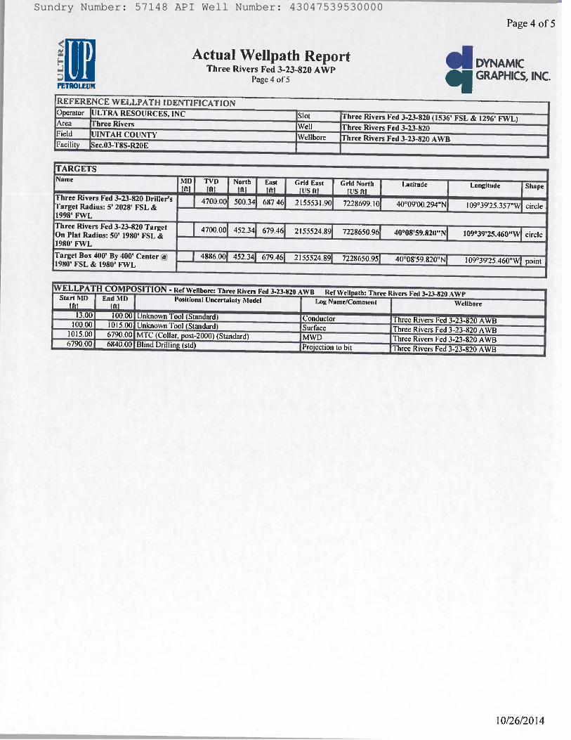
RECEIVED: Oct. 29, 2014
Sundry Number: 57148 API Well Number: 43047539530000Sundry Number: 57148 API Well Number: 43047539530000
Page 4 of 5
Actual Wellpath Report DYNAMICThree Rivers Fed 3-23-820 AWP GRAPHICS,INC.Page 4 of5PETROlÆUlit
REFERENCE WELLPATH IDENTIFICATIONOperator ULTRA RESOURCES, INC Slot hree Rivers Fed 3-23-820 (1536' FSL & 1296' FWL)Area Three Rivers Well hree Rivers Fed 3-23-820Field UINTAH COUNTY Wellbore hree Rivers Fed 3-23-820 AWBFacility Sec.03-T8S-R20E
TARGETSName MD TVD North East Grid East Grid North Latitude Longitude Shapetal iiti irti ift! Its it; ¡Us niThree Rivers Fed 3-23-820 Driller's 4700.00 500.34 687.46 2155531.90 7228699.10 40°09'00.294"N 109°39'25.357"W circleTarget Radius: 5' 2028' FSL &1998' FWLThree Rivers Fed 3-23-820 Target 4700.00 452.34 679.46 2155524.89 7228650.96 40°08'59.820"N 109°39'25.460"W circleOn Plat Radius: 50' 1980' FSL &1980' FWLTarget Box 400' By 400' Center @ 4886.00 452.34 679.46 2 I55524.89 7228650.95 40°08'59.820"N 109°39'25.460"W point1980' FSL & 1980' FWL
WELLPATH COMPOSITION - Ref Wellbore: Three Rivers Fed 3.23-820 AWB Ref Wellpath: Three Rivers Fed 3-23-820 AWPStart MD End MD Positional Uncertainty Model Log Name/Comment Wellbore
13.00 100.00 Unknown Tool (Standard) Conductor Three Rivers Fed 3-23-820 AWB100.00 1015.00 Unknown Tool (Standard) Surface Three Rivers Fed 3-23-820 AWB1015.00 6790.00 MTC (Collar, post-2000)(Standard) MWD Three Rivers Fed 3-23-820AWB6790.00 6840.00 Blind Drilling(std) Projection to bit Three Rivers Fed 3-23-820AWB
Sundry Number: 57148 API Well Number: 43047539530000
Page 4 of 5
Actual Wellpath Report DYNAMICThree Rivers Fed 3-23-820 AWP GRAPHICS,INC.Page 4 of5PETROlÆUlit
REFERENCE WELLPATH IDENTIFICATIONOperator ULTRA RESOURCES, INC Slot hree Rivers Fed 3-23-820 (1536' FSL & 1296' FWL)Area Three Rivers Well hree Rivers Fed 3-23-820Field UINTAH COUNTY Wellbore hree Rivers Fed 3-23-820 AWBFacility Sec.03-T8S-R20E
TARGETSName MD TVD North East Grid East Grid North Latitude Longitude Shapetal iiti irti ift! Its it; ¡Us niThree Rivers Fed 3-23-820 Driller's 4700.00 500.34 687.46 2155531.90 7228699.10 40°09'00.294"N 109°39'25.357"W circleTarget Radius: 5' 2028' FSL &1998' FWLThree Rivers Fed 3-23-820 Target 4700.00 452.34 679.46 2155524.89 7228650.96 40°08'59.820"N 109°39'25.460"W circleOn Plat Radius: 50' 1980' FSL &1980' FWLTarget Box 400' By 400' Center @ 4886.00 452.34 679.46 2 I55524.89 7228650.95 40°08'59.820"N 109°39'25.460"W point1980' FSL & 1980' FWL
WELLPATH COMPOSITION - Ref Wellbore: Three Rivers Fed 3.23-820 AWB Ref Wellpath: Three Rivers Fed 3-23-820 AWPStart MD End MD Positional Uncertainty Model Log Name/Comment Wellbore
13.00 100.00 Unknown Tool (Standard) Conductor Three Rivers Fed 3-23-820 AWB100.00 1015.00 Unknown Tool (Standard) Surface Three Rivers Fed 3-23-820 AWB1015.00 6790.00 MTC (Collar, post-2000)(Standard) MWD Three Rivers Fed 3-23-820AWB6790.00 6840.00 Blind Drilling(std) Projection to bit Three Rivers Fed 3-23-820AWB

RECEIVED: Oct. 29, 2014
Sundry Number: 57148 API Well Number: 43047539530000Sundry Number: 57148 API Well Number: 43047539530000
Page 5 of 5
Actual Wellpath Report DYNAMICThree Rivers Fed 3-23-820 AWP GRAPHICS,INC.Page 5 of5
PETROLEUM
REFERENCE WELLPATH IDENTIFICATIONOperator ULTRA RESOURCES, INC Slot Three Rivers Fed 3-23-820 (1536' FSL & 1296' FWL)Area hree Rivers Well hree Rivers Fed 3-23-820Field INTAH COUNTY ellbore Three Rivers Fed 3-23-820 AWBFacility ec.03-T8S-R20E
WELLPATH COMMENTSMD Inclination Azimuth TVD Comment
2800.00 18.859 54.876 2758.32 Top Green River4212.00 13.791 57.693 4103.40 Mahogany4898.00 3.145 45.900 4779.71 Lower Green River5006.00 0.637 12.382 4887.64 Top of Production6722.00 1.686 155.934 6603.04 Wasatch6790.00 1.60C 166.400 6671.02 Final Survey6840.00 1 600 166.400 6721.00 Projection To Bit
Sundry Number: 57148 API Well Number: 43047539530000
Page 5 of 5
Actual Wellpath Report DYNAMICThree Rivers Fed 3-23-820 AWP GRAPHICS,INC.Page 5 of5
PETROLEUM
REFERENCE WELLPATH IDENTIFICATIONOperator ULTRA RESOURCES, INC Slot Three Rivers Fed 3-23-820 (1536' FSL & 1296' FWL)Area hree Rivers Well hree Rivers Fed 3-23-820Field INTAH COUNTY ellbore Three Rivers Fed 3-23-820 AWBFacility ec.03-T8S-R20E
WELLPATH COMMENTSMD Inclination Azimuth TVD Comment
2800.00 18.859 54.876 2758.32 Top Green River4212.00 13.791 57.693 4103.40 Mahogany4898.00 3.145 45.900 4779.71 Lower Green River5006.00 0.637 12.382 4887.64 Top of Production6722.00 1.686 155.934 6603.04 Wasatch6790.00 1.60C 166.400 6671.02 Final Survey6840.00 1 600 166.400 6721.00 Projection To Bit
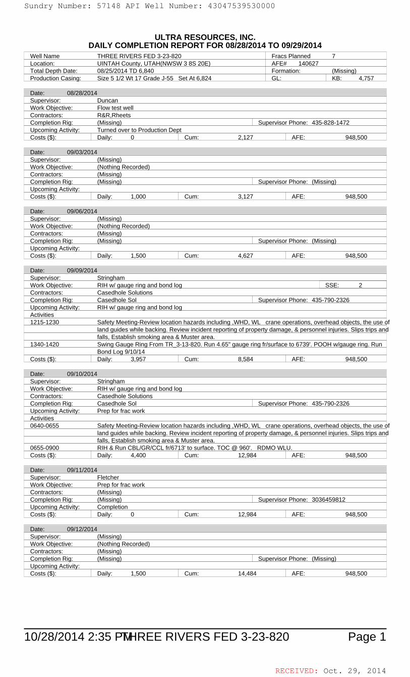
RECEIVED: Oct. 29, 2014
10/28/2014 2:35 PM Page 1THREE RIVERS FED 3-23-820
ULTRA RESOURCES, INC.DAILY COMPLETION REPORT FOR 08/28/2014 TO 09/29/2014
Well Name THREE RIVERS FED 3-23-820 Fracs Planned 7Location: UINTAH County, UTAH(NWSW 3 8S 20E) AFE# 140627Total Depth Date: 08/25/2014 TD 6,840 Formation: (Missing)Production Casing: Size 5 1/2 Wt 17 Grade J-55 Set At 6,824 GL: KB: 4,757
Date: 08/28/2014Supervisor: DuncanWork Objective: Flow test wellContractors: R&R,RheetsCompletion Rig: (Missing) Supervisor Phone: 435-828-1472Upcoming Activity: Turned over to Production DeptCosts ($): Daily: 0 Cum: 2,127 AFE: 948,500
Date: 09/03/2014Supervisor: (Missing)Work Objective: (Nothing Recorded)Contractors: (Missing)Completion Rig: (Missing) Supervisor Phone: (Missing)Upcoming Activity:Costs ($): Daily: 1,000 Cum: 3,127 AFE: 948,500
Date: 09/06/2014Supervisor: (Missing)Work Objective: (Nothing Recorded)Contractors: (Missing)Completion Rig: (Missing) Supervisor Phone: (Missing)Upcoming Activity:Costs ($): Daily: 1,500 Cum: 4,627 AFE: 948,500
Date: 09/09/2014Supervisor: StringhamWork Objective: RIH w/ gauge ring and bond log SSE: 2Contractors: Casedhole SolutionsCompletion Rig: Casedhole Sol Supervisor Phone: 435-790-2326Upcoming Activity: RIH w/ gauge ring and bond logActivities1215-1230 Safety Meeting-Review location hazards including ,WHD, WL crane operations, overhead objects, the use of
land guides while backing. Review incident reporting of property damage, & personnel injuries. Slips trips andfalls, Establish smoking area & Muster area.
1340-1420 Swing Gauge Ring From TR_3-13-820. Run 4.65" gauge ring fr/surface to 6739'. POOH w/gauge ring. RunBond Log 9/10/14
Costs ($): Daily: 3,957 Cum: 8,584 AFE: 948,500
Date: 09/10/2014Supervisor: StringhamWork Objective: RIH w/ gauge ring and bond logContractors: Casedhole SolutionsCompletion Rig: Casedhole Sol Supervisor Phone: 435-790-2326Upcoming Activity: Prep for frac workActivities0640-0655 Safety Meeting-Review location hazards including ,WHD, WL crane operations, overhead objects, the use of
land guides while backing. Review incident reporting of property damage, & personnel injuries. Slips trips andfalls, Establish smoking area & Muster area.
0655-0900 RIH & Run CBL/GR/CCL fr/6713' to surface. TOC @ 960'. RDMO WLU.Costs ($): Daily: 4,400 Cum: 12,984 AFE: 948,500
Date: 09/11/2014Supervisor: FletcherWork Objective: Prep for frac workContractors: (Missing)Completion Rig: (Missing) Supervisor Phone: 3036459812Upcoming Activity: CompletionCosts ($): Daily: 0 Cum: 12,984 AFE: 948,500
Date: 09/12/2014Supervisor: (Missing)Work Objective: (Nothing Recorded)Contractors: (Missing)Completion Rig: (Missing) Supervisor Phone: (Missing)Upcoming Activity:Costs ($): Daily: 1,500 Cum: 14,484 AFE: 948,500
Sundry Number: 57148 API Well Number: 43047539530000Sundry Number: 57148 API Well Number: 43047539530000
ULTRA RESOURCES, INC.DAILYCOMPLETION REPORT FOR 08/28/2014 TO 09/29/2014
Well Name THREE RIVERS FED 3-23-820 Fracs Planned 7Location: UINTAH County, UTAH(NWSW 3 8S 20E) AFE# 140627Total Depth Date: 08/25/2014 TD 6,840 Formation: (Missinq)Production Casinq: Size 5 1/2 Wt 17 Grade J-55 Set At 6,824 GL: KB: 4,757
Date: 08/28/2014Supervisor: DuncanWork Obiective: Flow test wellContractors: R&R,RheetsCompletion Riq: (Missinq) Supervisor Phone: 435-828-1472Upcominq Activity: Turned over to Production DeptCosts ($): Daily: 0 Cum: 2,127 AFE: 948,500
Date: 09/03/2014Supervisor: (Missinq)Work Objective: (Nothinq Recorded)Contractors: (Missinq)Completion Riq: (Missinq) Supervisor Phone: (Missinq)Upcominq Activity:Costs ($): Daily: 1,000 Cum: 3,127 AFE: 948,500
Date: 09/06/2014Supervisor: (Missinq)Work Objective: (Nothinq Recorded)Contractors: (Missinq)Completion Rig: (Missing) Supervisor Phone: (Missing)Upcominq Activity:Costs ($): Daily: 1,500 Cum: 4,627 AFE: 948,500
Date: 09/09/2014Supervisor: StringhamWork Obiective: RIH w/ gauge ring and bond loq SSE: 2Contractors: Casedhole SolutionsCompletion Riq: Casedhole Sol Supervisor Phone: 435-790-2326Upcominq Activity: RIH w/ qauqe rinq and bond loqActivities1215-1230 Safety Meetinq-Review location hazards includinq ,WHD, WL crane operations, overhead objects, the use of
land quides while backing. Review incident reporting of property damage, & personnel iniuries. Slips trips an dfalls, Establish smokinq area & Muster area.
1340-1420 Swinq Gauge Rinq From TR 3-13-820. Run 4.65" qauqe rinq fr/surface to 6739'. POOH w/qauqe rinq. RunBond Loq 9/10/14
Costs ($): Daily: 3,957 Cum: 8,584 AFE: 948,500
Date: 09/10/2014Supervisor: StringhamWork Objective: RIH w/ qauqe rinq and bond loqContractors: Casedhole SolutionsCompletion Riq: Casedhole Sol Supervisor Phone: 435-790-2326Upcominq Activity: Prep for frac workActivities0640-0655 Safety Meetinq-Review location hazards includinq ,WHD, WL crane operations, overhead objects, the use of
land quides while backing. Review incident reportinq of property damage, & personnel iniuries. Slips trips an dfalls, Establish smokinq area & Muster area.
0655-0900 RIH & Run CBL/GRICCL fr/6713' to surface. TOC @ 960'. RDMO WLU.Costs ($): Daily: 4,400 Cum: 12,984 AFE: 948,500
Date: 09/11/2014Supervisor: FletcherWork Objective: Prep for frac workContractors: (Missinq)Completion Riq: (Missinq) Supervisor Phone: 3036459812Upcoming Activity: CompletionCosts ($): Daily: 0 Cum: 12,984 AFE: 948,500
Date: 09/12/2014Supervisor: (Missinq)Work Objective: (Nothinq Recorded)Contractors: (Missing)Completion Riq: (Missinq) Supervisor Phone: (Missinq)Upcominq Activity:Costs ($): Daily: 1,500 Cum: 14,484 AFE: 948,500
10/28/2014 2:35 PEHREE RIVERS FED 3-23-820 Page 1
RECEIVED: Oct. 29,
Sundry Number: 57148 API Well Number: 43047539530000
ULTRA RESOURCES, INC.DAILYCOMPLETION REPORT FOR 08/28/2014 TO 09/29/2014
Well Name THREE RIVERS FED 3-23-820 Fracs Planned 7Location: UINTAH County, UTAH(NWSW 3 8S 20E) AFE# 140627Total Depth Date: 08/25/2014 TD 6,840 Formation: (Missinq)Production Casinq: Size 5 1/2 Wt 17 Grade J-55 Set At 6,824 GL: KB: 4,757
Date: 08/28/2014Supervisor: DuncanWork Obiective: Flow test wellContractors: R&R,RheetsCompletion Riq: (Missinq) Supervisor Phone: 435-828-1472Upcominq Activity: Turned over to Production DeptCosts ($): Daily: 0 Cum: 2,127 AFE: 948,500
Date: 09/03/2014Supervisor: (Missinq)Work Objective: (Nothinq Recorded)Contractors: (Missinq)Completion Riq: (Missinq) Supervisor Phone: (Missinq)Upcominq Activity:Costs ($): Daily: 1,000 Cum: 3,127 AFE: 948,500
Date: 09/06/2014Supervisor: (Missinq)Work Objective: (Nothinq Recorded)Contractors: (Missinq)Completion Rig: (Missing) Supervisor Phone: (Missing)Upcominq Activity:Costs ($): Daily: 1,500 Cum: 4,627 AFE: 948,500
Date: 09/09/2014Supervisor: StringhamWork Obiective: RIH w/ gauge ring and bond loq SSE: 2Contractors: Casedhole SolutionsCompletion Riq: Casedhole Sol Supervisor Phone: 435-790-2326Upcominq Activity: RIH w/ qauqe rinq and bond loqActivities1215-1230 Safety Meetinq-Review location hazards includinq ,WHD, WL crane operations, overhead objects, the use of
land quides while backing. Review incident reporting of property damage, & personnel iniuries. Slips trips an dfalls, Establish smokinq area & Muster area.
1340-1420 Swinq Gauge Rinq From TR 3-13-820. Run 4.65" qauqe rinq fr/surface to 6739'. POOH w/qauqe rinq. RunBond Loq 9/10/14
Costs ($): Daily: 3,957 Cum: 8,584 AFE: 948,500
Date: 09/10/2014Supervisor: StringhamWork Objective: RIH w/ qauqe rinq and bond loqContractors: Casedhole SolutionsCompletion Riq: Casedhole Sol Supervisor Phone: 435-790-2326Upcominq Activity: Prep for frac workActivities0640-0655 Safety Meetinq-Review location hazards includinq ,WHD, WL crane operations, overhead objects, the use of
land quides while backing. Review incident reportinq of property damage, & personnel iniuries. Slips trips an dfalls, Establish smokinq area & Muster area.
0655-0900 RIH & Run CBL/GRICCL fr/6713' to surface. TOC @ 960'. RDMO WLU.Costs ($): Daily: 4,400 Cum: 12,984 AFE: 948,500
Date: 09/11/2014Supervisor: FletcherWork Objective: Prep for frac workContractors: (Missinq)Completion Riq: (Missinq) Supervisor Phone: 3036459812Upcoming Activity: CompletionCosts ($): Daily: 0 Cum: 12,984 AFE: 948,500
Date: 09/12/2014Supervisor: (Missinq)Work Objective: (Nothinq Recorded)Contractors: (Missing)Completion Riq: (Missinq) Supervisor Phone: (Missinq)Upcominq Activity:Costs ($): Daily: 1,500 Cum: 14,484 AFE: 948,500
10/28/2014 2:35 PEHREE RIVERS FED 3-23-820 Page 1
RECEIVED: Oct. 29,

RECEIVED: Oct. 29, 2014
10/28/2014 2:35 PM Page 2THREE RIVERS FED 3-23-820
Date: 09/15/2014Supervisor: Stringham/DuncanWork Objective: Nipple up BOPContractors: Knight, R&R, RNICompletion Rig: (Missing) Supervisor Phone: 435-790-2326/435-828-1472Upcoming Activity: Prep for frac workActivities1000-1130 MINU Knight 5K BOP, set flow back and frac tanks.Costs ($): Daily: 3,242 Cum: 17,726 AFE: 948,500
Date: 09/16/2014Supervisor: Stringham/DuncanWork Objective: Pressure testContractors: RBS, R&R,RNICompletion Rig: (Missing) Supervisor Phone: 435-790-2326/435-828-1472Upcoming Activity: Prep for frac workActivities1030-1100 MIRU RBS Test Unit, and test csg, WH, Flow back lines, and BOP to 4,250 psig, good test. RDMO Testers.Costs ($): Daily: 8,516 Cum: 26,243 AFE: 948,500
Date: 09/17/2014Supervisor: FletcherWork Objective: Prep for frac workContractors: (Missing)Completion Rig: (Missing) Supervisor Phone: 3036459812Upcoming Activity: CompletionActivities0900-1100 Set Up Live Load Manifold0000-0000 Pre Fill Frac TanksCosts ($): Daily: 16,369 Cum: 42,612 AFE: 948,500
Date: 09/18/2014Supervisor: StringhamWork Objective: Prep for frac workContractors: R&R,Sunrise, RNI, TargetCompletion Rig: (Missing) Supervisor Phone: 435-790-2326Upcoming Activity: PerforatingCosts ($): Daily: 0 Cum: 42,612 AFE: 948,500
Date: 09/19/2014Supervisor: StringhamWork Objective: PerforatingContractors: Casedhole Solutions,R&R,RNI,Sunrise,TargetCompletion Rig: Casedhole Sol Supervisor Phone: 435-790-2326Upcoming Activity: Prep for frac workActivities0600-0615 Safety Meeting-Review location hazards including ,WHD, WL crane operations, overhead objects, the use of
land guides while backing. Review incident reporting of property damage, & personnel injuries. Slips trips andfalls, Establish smoking area & Muster area.
0615-0830 MIRU Casedhole WLU, Perforate Stage 1 @(6536'-6706).Costs ($): Daily: 6,419 Cum: 49,031 AFE: 948,500
Date: 09/22/2014Supervisor: (Missing)Work Objective: (Nothing Recorded)Contractors: (Missing)Completion Rig: (Missing) Supervisor Phone: (Missing)Upcoming Activity:Costs ($): Daily: 1,566 Cum: 50,597 AFE: 948,500
Date: 09/23/2014Supervisor: Stringham/DuncanWork Objective: Perf, Frac, and FlowbackContractors: HES, R&R, Target, Rhetts, SunriseCompletion Rig: Hal, HAL RED T4 Supervisor Phone: 435-790-2326/435-828-1472Upcoming Activity: Perf, Frac, and FlowbackActivities1450-1930 Wait On TR_3-14-820.1930-2215 Rig Down From TR_3-14-820 & 3-24-820 And Rig Up On The TR_3-13-820 And 3-23-8202215-2250 Prime Up & Pressure Test Good2250-0010 Frac Stage 1Costs ($): Daily: 17,326 Cum: 67,923 AFE: 948,500
Sundry Number: 57148 API Well Number: 43047539530000Sundry Number: 57148 API Well Number: 43047539530000
Date: 09/15/2014Supervisor: Stringham/DuncanWork Objective: Nipple up BOPContractors: Knight, R&R, RNICompletion Rig: (Missing) Supervisor Phone: 435-790-2326/435-828-1472Upcominq Activity: Prep for frac workActivities1000-1130 MINU Knight 5K BOP, set flow back and frac tanks.Costs ($): Daily: 3,242 Cum: 17,726 AFE: 948,500
Date: 09/16/2014Supervisor: Stringham/DuncanWork Objective: Pressure testContractors: RBS, R&R,RNICompletion Riq: (Missinq) Supervisor Phone: 435-790-2326/435-828-1472Upcominq Activity: Prep for frac workActivities1030-1100 MIRU RBS Test Unit, and test csq, WH, Flow back lines, and BOP to 4,250 psiq, good test. RDMO TestersCosts ($): Daily: 8,516 Cum: 26,243 AFE: 948,500
Date: 09/17/2014Supervisor: FletcherWork Obiective: Prep for frac workContractors: (Missinq)Completion Riq: (Missinq) Supervisor Phone: 3036459812Upcominq Activity: CompletionActivities0900-1100 Set Up Live Load Manifold0000-0000 Pre Fill Frac TanksCosts ($): Daily: 16,369 Cum: 42,612 AFE: 948,500
Date: 09/18/2014Supervisor: StringhamWork Objective: Prep for frac workContractors: R&R,Sunrise, RNI, TargetCompletion Riq: (Missing) Supervisor Phone: 435-790-2326Upcominq Activity: PerforatinqCosts ($): Daily: 0 Cum: 42,612 AFE: 948,500
Date: 09/19/2014Supervisor: StringhamWork Objective: PerforatinqContractors: Casedhole Solutions,R&R,RNI,Sunrise,TargetCompletion Riq: Casedhole Sol Supervisor Phone: 435-790-2326Upcominq Activity: Prep for frac workActivities0600-0615 Safety Meeting-Review location hazards including ,WHD, WL crane operations, overhead obiects, the use of
land quides while backing. Review incident reportinq of property damage, & personnel iniuries. Slips trips an dfalls, Establish smokinq area & Muster area.
0615-0830 MIRU Casedhole WLU, Perforate Stage 1 @(6536'-6706).Costs ($): Daily: 6,419 Cum: 49,031 AFE: 948,500
Date: 09/22/2014Supervisor: (Missinq)Work Objective: (Nothinq Recorded)Contractors: (Missinq)Completion Riq: (Missinq) Supervisor Phone: (Missinq)Upcominq Activity:Costs ($): Daily: 1,566 Cum: 50,597 AFE: 948,500
Date: 09/23/2014Supervisor: Stringham/DuncanWork Objective: Perf, Frac, and FlowbackContractors: HES, R&R, Target, Rhetts, SunriseCompletion Rig: Hal, HAL RED T4 Supervisor Phone: 435-790-2326/435-828-1472Upcominq Activity: Perf, Frac, and FlowbackActivities1450-1930 Wait On TR 3-14-820.1930-2215 Riq Down From TR 3-14-820 & 3-24-820 And Riq Up On The TR 3-13-820 And 3-23-8202215-2250 Prime Up & Pressure Test Good2250-0010 Frac Stage 1Costs ($): Daily: 17,326 Cum: 67,923 AFE: 948,500
10/28/2014 2:35 PEHREE RIVERS FED 3-23-820 Page 2
RECEIVED: Oct. 29,
Sundry Number: 57148 API Well Number: 43047539530000
Date: 09/15/2014Supervisor: Stringham/DuncanWork Objective: Nipple up BOPContractors: Knight, R&R, RNICompletion Rig: (Missing) Supervisor Phone: 435-790-2326/435-828-1472Upcominq Activity: Prep for frac workActivities1000-1130 MINU Knight 5K BOP, set flow back and frac tanks.Costs ($): Daily: 3,242 Cum: 17,726 AFE: 948,500
Date: 09/16/2014Supervisor: Stringham/DuncanWork Objective: Pressure testContractors: RBS, R&R,RNICompletion Riq: (Missinq) Supervisor Phone: 435-790-2326/435-828-1472Upcominq Activity: Prep for frac workActivities1030-1100 MIRU RBS Test Unit, and test csq, WH, Flow back lines, and BOP to 4,250 psiq, good test. RDMO TestersCosts ($): Daily: 8,516 Cum: 26,243 AFE: 948,500
Date: 09/17/2014Supervisor: FletcherWork Obiective: Prep for frac workContractors: (Missinq)Completion Riq: (Missinq) Supervisor Phone: 3036459812Upcominq Activity: CompletionActivities0900-1100 Set Up Live Load Manifold0000-0000 Pre Fill Frac TanksCosts ($): Daily: 16,369 Cum: 42,612 AFE: 948,500
Date: 09/18/2014Supervisor: StringhamWork Objective: Prep for frac workContractors: R&R,Sunrise, RNI, TargetCompletion Riq: (Missing) Supervisor Phone: 435-790-2326Upcominq Activity: PerforatinqCosts ($): Daily: 0 Cum: 42,612 AFE: 948,500
Date: 09/19/2014Supervisor: StringhamWork Objective: PerforatinqContractors: Casedhole Solutions,R&R,RNI,Sunrise,TargetCompletion Riq: Casedhole Sol Supervisor Phone: 435-790-2326Upcominq Activity: Prep for frac workActivities0600-0615 Safety Meeting-Review location hazards including ,WHD, WL crane operations, overhead obiects, the use of
land quides while backing. Review incident reportinq of property damage, & personnel iniuries. Slips trips an dfalls, Establish smokinq area & Muster area.
0615-0830 MIRU Casedhole WLU, Perforate Stage 1 @(6536'-6706).Costs ($): Daily: 6,419 Cum: 49,031 AFE: 948,500
Date: 09/22/2014Supervisor: (Missinq)Work Objective: (Nothinq Recorded)Contractors: (Missinq)Completion Riq: (Missinq) Supervisor Phone: (Missinq)Upcominq Activity:Costs ($): Daily: 1,566 Cum: 50,597 AFE: 948,500
Date: 09/23/2014Supervisor: Stringham/DuncanWork Objective: Perf, Frac, and FlowbackContractors: HES, R&R, Target, Rhetts, SunriseCompletion Rig: Hal, HAL RED T4 Supervisor Phone: 435-790-2326/435-828-1472Upcominq Activity: Perf, Frac, and FlowbackActivities1450-1930 Wait On TR 3-14-820.1930-2215 Riq Down From TR 3-14-820 & 3-24-820 And Riq Up On The TR 3-13-820 And 3-23-8202215-2250 Prime Up & Pressure Test Good2250-0010 Frac Stage 1Costs ($): Daily: 17,326 Cum: 67,923 AFE: 948,500
10/28/2014 2:35 PEHREE RIVERS FED 3-23-820 Page 2
RECEIVED: Oct. 29,
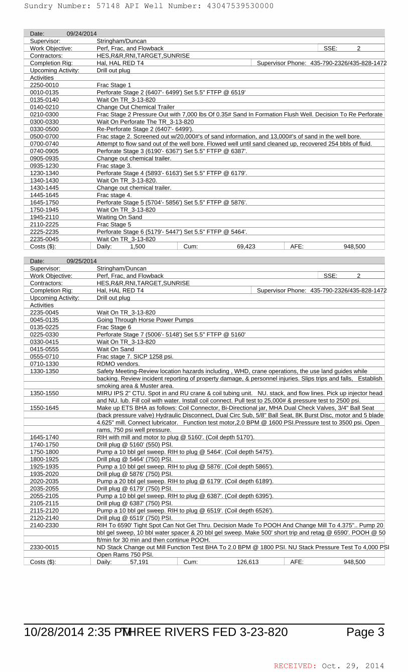
RECEIVED: Oct. 29, 2014
10/28/2014 2:35 PM Page 3THREE RIVERS FED 3-23-820
Date: 09/24/2014Supervisor: Stringham/DuncanWork Objective: Perf, Frac, and Flowback SSE: 2Contractors: HES,R&R,RNI,TARGET,SUNRISECompletion Rig: Hal, HAL RED T4 Supervisor Phone: 435-790-2326/435-828-1472Upcoming Activity: Drill out plugActivities2250-0010 Frac Stage 10010-0135 Perforate Stage 2 (6407'- 6499') Set 5.5" FTFP @ 6519'0135-0140 Wait On TR_3-13-8200140-0210 Change Out Chemical Trailer0210-0300 Frac Stage 2 Pressure Out with 7,000 lbs Of 0.35# Sand In Formation Flush Well. Decision To Re Perforate0300-0330 Wait On Perforate The TR_3-13-8200330-0500 Re-Perforate Stage 2 (6407'- 6499').0500-0700 Frac stage 2. Screened out w/20,000#'s of sand information, and 13,000#'s of sand in the well bore.0700-0740 Attempt to flow sand out of the well bore. Flowed well until sand cleaned up, recovered 254 bbls of fluid.0740-0905 Perforate Stage 3 (6190'- 6367') Set 5.5" FTFP @ 6387'.0905-0935 Change out chemical trailer.0935-1230 Frac stage 3.1230-1340 Perforate Stage 4 (5893'- 6163') Set 5.5" FTFP @ 6179'.1340-1430 Wait On TR_3-13-820.1430-1445 Change out chemical trailer.1445-1645 Frac stage 4.1645-1750 Perforate Stage 5 (5704'- 5856') Set 5.5" FTFP @ 5876'.1750-1945 Wait On TR_3-13-8201945-2110 Waiting On Sand2110-2225 Frac Stage 52225-2235 Perforate Stage 6 (5179'- 5447') Set 5.5" FTFP @ 5464'.2235-0045 Wait On TR_3-13-820Costs ($): Daily: 1,500 Cum: 69,423 AFE: 948,500
Date: 09/25/2014Supervisor: Stringham/DuncanWork Objective: Perf, Frac, and Flowback SSE: 2Contractors: HES,R&R,RNI,TARGET,SUNRISECompletion Rig: Hal, HAL RED T4 Supervisor Phone: 435-790-2326/435-828-1472Upcoming Activity: Drill out plugActivities2235-0045 Wait On TR_3-13-8200045-0135 Going Through Horse Power Pumps0135-0225 Frac Stage 60225-0330 Perforate Stage 7 (5006'- 5148') Set 5.5" FTFP @ 5160'0330-0415 Wait On TR_3-13-8200415-0555 Wait On Sand0555-0710 Frac stage 7. SICP 1258 psi.0710-1330 RDMO vendors.1330-1350 Safety Meeting-Review location hazards including , WHD, crane operations, the use land guides while
backing. Review incident reporting of property damage, & personnel injuries. Slips trips and falls, Establishsmoking area & Muster area.
1350-1550 MIRU IPS 2" CTU. Spot in and RU crane & coil tubing unit. NU. stack, and flow lines. Pick up injector headand NU. lub. Fill coil with water. Install coil connect. Pull test to 25,000# & pressure test to 2500 psi.
1550-1645 Make up ETS BHA as follows: Coil Connector, Bi-Directional jar, MHA Dual Check Valves, 3/4" Ball Seat(back pressure valve) Hydraulic Disconnect, Dual Circ Sub, 5/8" Ball Seat, 8K Burst Disc, motor and 5 blade4.625" mill. Connect lubricator. Function test motor,2.0 BPM @ 1600 PSI.Pressure test to 3500 psi. Openrams, 750 psi well pressure.
1645-1740 RIH with mill and motor to plug @ 5160'. (Coil depth 5170').1740-1750 Drill plug @ 5160’ (550) PSI.1750-1800 Pump a 10 bbl gel sweep. RIH to plug @ 5464'. (Coil depth 5475').1800-1925 Drill plug @ 5464' (750) PSI.1925-1935 Pump a 10 bbl gel sweep. RIH to plug @ 5876'. (Coil depth 5865').1935-2020 Drill plug @ 5876' (750) PSI.2020-2035 Pump a 20 bbl gel sweep. RIH to plug @ 6179'. (Coil depth 6189').2035-2055 Drill plug @ 6179' (750) PSI.2055-2105 Pump a 10 bbl gel sweep. RIH to plug @ 6387'. (Coil depth 6395').2105-2115 Drill plug @ 6387' (750) PSI.2115-2120 Pump a 10 bbl gel sweep. RIH to plug @ 6519'. (Coil depth 6526').2120-2140 Drill plug @ 6519' (750) PSI.2140-2330 RIH To 6590' Tight Spot Can Not Get Thru. Decision Made To POOH And Change Mill To 4.375".. Pump 20
bbl gel sweep, 10 bbl water spacer & 20 bbl gel sweep. Make 500' short trip and retag @ 6590'. POOH @ 50ft/min for 30 min and then continue POOH.
2330-0015 ND Stack Change out Mill Function Test BHA To 2.0 BPM @ 1800 PSI. NU Stack Pressure Test To 4,000 PSIOpen Rams 750 PSI.
Costs ($): Daily: 57,191 Cum: 126,613 AFE: 948,500
Sundry Number: 57148 API Well Number: 43047539530000Sundry Number: 57148 API Well Number: 43047539530000
Date: 09/24/2014Supervisor: Stringham/DuncanWork Objective: Perf, Frac, and Flowback SSE: 2Contractors: HES,R&R,RNI,TARGET,SUNRISECompletion Rig: Hal, HAL RED T4 Supervisor Phone: 435-790-2326/435-828-1472Upcominq Activity: Drillout pluqActivities2250-0010 Frac Stage 10010-0135 Perforate Stage 2 (6407'- 6499') Set 5.5" FTFP @ 6519'0135-0140 Wait On TR 3-13-8200140-0210 Change Out Chemical Trailer0210-0300 Frac Stage 2 Pressure Out with 7,000 lbs Of 0.35# Sand In Formation Flush Well. Decision To Re Perforate0300-0330 Wait On Perforate The TR 3-13-8200330-0500 Re-Perforate Stage 2 (6407'- 6499').0500-0700 Frac stage 2. Screened out w/20,000#'s of sand information, and 13,000#'s of sand in the well bore.0700-0740 Attempt to flow sand out of the well bore. Flowed well until sand cleaned up, recovered 254 bbls of fluid.0740-0905 Perforate Stage 3 (6190'- 6367') Set 5.5" FTFP @ 6387'.0905-0935 Change out chemical trailer.0935-1230 Frac stage 3.1230-1340 Perforate Stage 4 (5893'- 6163') Set 5.5" FTFP @ 6179'.1340-1430 Wait On TR 3-13-820.1430-1445 Change out chemical trailer.1445-1645 Frac stage 4.1645-1750 Perforate Stage 5 (5704'- 5856') Set 5.5" FTFP @ 5876'.1750-1945 Wait On TR 3-13-8201945-2110 Waitinq On Sand2110-2225 Frac Stage 52225-2235 Perforate Stage 6 (5179'- 5447') Set 5.5" FTFP @ 5464'.2235-0045 Wait On TR 3-13-820Costs ($): Daily: 1,500 Cum: 69,423 AFE: 948,500
Date: 09/25/2014Supervisor: Stringham/DuncanWork Objective: Perf, Frac, and Flowback SSE: 2Contractors: HES,R&R,RNI,TARGET,SUNRISECompletion Riq: Hal, HAL RED T4 Supervisor Phone: 435-790-2326/435-828-1472Upcominq Activity: Drillout pluqActivities2235-0045 Wait On TR 3-13-8200045-0135 Goinq Through Horse Power Pumps0135-0225 Frac Stage 60225-0330 Perforate Stage 7 (5006'- 5148') Set 5.5" FTFP @ 5160'0330-0415 Wait On TR 3-13-8200415-0555 Wait On Sand0555-0710 Frac stage 7. SICP 1258 psi.0710-1330 RDMO vendors.1330-1350 Safety Meeting-Review location hazards including , WHD, crane operations, the use land guides while
backing. Review incident reportinq of property damage, & personnel iniuries. Slips trips and falls, Establishsmokinq area & Muster area.
1350-1550 MIRU IPS 2" CTU. Spot in and RU crane & coil tubinq unit. NU. stack, and flow lines. Pick up iniector headand NU. lub. Fill coil with water. Install coil connect. Pull test to 25,000# & pressure test to 2500 psi.
1550-1645 Make up ETS BHA as follows: Coil Connector, Bi-Directional |ar, MHA Dual Check Valves, 3/4" Ball Seat(back pressure valve) Hydraulic Disconnect, Dual Circ Sub, 5/8" Ball Seat, 8K Burst Disc, motor and 5 blade4.625" mill. Connect lubricator. Function test motor,2.0 BPM @ 1600 PSI.Pressure test to 3500 psi. Openrams, 750 psi well pressure.
1645-1740 RIH with mill and motor to pluq @ 5160'. (Coil depth 5170').1740-1750 Drillpluq @ 5160' (550) PSI.1750-1800 Pump a 10 bbl qel sweep. RIH to pluq @ 5464'. (Coil depth 5475').1800-1925 Drillplug @ 5464' (750) PSI.1925-1935 Pump a 10 bbl qel sweep. RIH to pluq @ 5876'. (Coil depth 5865').1935-2020 Drillpluq @ 5876' (750) PSI.2020-2035 Pump a 20 bbl qel sweep. RIH to pluq @ 6179'. (Coil depth 6189').2035-2055 Drillpluq @ 6179' (750) PSI.2055-2105 Pump a 10 bbl qel sweep. RIH to pluq @ 6387'. (Coil depth 6395').2105-2115 Drillplug @ 6387' (750) PSI.2115-2120 Pump a 10 bbl qel sweep. RIH to pluq @ 6519'. (Coil depth 6526').2120-2140 Drillpluq @ 6519' (750) PSI.2140-2330 RIH To 6590' Tiqht Spot Can Not Get Thru. Decision Made To POOH And Change MillTo 4.375".. Pump 20
bbl qel sweep, 10 bbl water spacer & 20 bbl qel sweep. Make 500' short trip and retaq @ 6590'. POOH @ 50ft/min for 30 min and then continue POOH.
2330-0015 ND Stack Change out MillFunction Test BHA To 2.0 BPM @ 1800 PSI. NU Stack Pressure Test To 4,000 P3\Open Rams 750 PSI.
Costs ($): Daily: 57,191 Cum: 126,613 AFE: 948,500
10/28/2014 2:35 PEHREE RIVERS FED 3-23-820 Page 3
RECEIVED: Oct. 29,
Sundry Number: 57148 API Well Number: 43047539530000
Date: 09/24/2014Supervisor: Stringham/DuncanWork Objective: Perf, Frac, and Flowback SSE: 2Contractors: HES,R&R,RNI,TARGET,SUNRISECompletion Rig: Hal, HAL RED T4 Supervisor Phone: 435-790-2326/435-828-1472Upcominq Activity: Drillout pluqActivities2250-0010 Frac Stage 10010-0135 Perforate Stage 2 (6407'- 6499') Set 5.5" FTFP @ 6519'0135-0140 Wait On TR 3-13-8200140-0210 Change Out Chemical Trailer0210-0300 Frac Stage 2 Pressure Out with 7,000 lbs Of 0.35# Sand In Formation Flush Well. Decision To Re Perforate0300-0330 Wait On Perforate The TR 3-13-8200330-0500 Re-Perforate Stage 2 (6407'- 6499').0500-0700 Frac stage 2. Screened out w/20,000#'s of sand information, and 13,000#'s of sand in the well bore.0700-0740 Attempt to flow sand out of the well bore. Flowed well until sand cleaned up, recovered 254 bbls of fluid.0740-0905 Perforate Stage 3 (6190'- 6367') Set 5.5" FTFP @ 6387'.0905-0935 Change out chemical trailer.0935-1230 Frac stage 3.1230-1340 Perforate Stage 4 (5893'- 6163') Set 5.5" FTFP @ 6179'.1340-1430 Wait On TR 3-13-820.1430-1445 Change out chemical trailer.1445-1645 Frac stage 4.1645-1750 Perforate Stage 5 (5704'- 5856') Set 5.5" FTFP @ 5876'.1750-1945 Wait On TR 3-13-8201945-2110 Waitinq On Sand2110-2225 Frac Stage 52225-2235 Perforate Stage 6 (5179'- 5447') Set 5.5" FTFP @ 5464'.2235-0045 Wait On TR 3-13-820Costs ($): Daily: 1,500 Cum: 69,423 AFE: 948,500
Date: 09/25/2014Supervisor: Stringham/DuncanWork Objective: Perf, Frac, and Flowback SSE: 2Contractors: HES,R&R,RNI,TARGET,SUNRISECompletion Riq: Hal, HAL RED T4 Supervisor Phone: 435-790-2326/435-828-1472Upcominq Activity: Drillout pluqActivities2235-0045 Wait On TR 3-13-8200045-0135 Goinq Through Horse Power Pumps0135-0225 Frac Stage 60225-0330 Perforate Stage 7 (5006'- 5148') Set 5.5" FTFP @ 5160'0330-0415 Wait On TR 3-13-8200415-0555 Wait On Sand0555-0710 Frac stage 7. SICP 1258 psi.0710-1330 RDMO vendors.1330-1350 Safety Meeting-Review location hazards including , WHD, crane operations, the use land guides while
backing. Review incident reportinq of property damage, & personnel iniuries. Slips trips and falls, Establishsmokinq area & Muster area.
1350-1550 MIRU IPS 2" CTU. Spot in and RU crane & coil tubinq unit. NU. stack, and flow lines. Pick up iniector headand NU. lub. Fill coil with water. Install coil connect. Pull test to 25,000# & pressure test to 2500 psi.
1550-1645 Make up ETS BHA as follows: Coil Connector, Bi-Directional |ar, MHA Dual Check Valves, 3/4" Ball Seat(back pressure valve) Hydraulic Disconnect, Dual Circ Sub, 5/8" Ball Seat, 8K Burst Disc, motor and 5 blade4.625" mill. Connect lubricator. Function test motor,2.0 BPM @ 1600 PSI.Pressure test to 3500 psi. Openrams, 750 psi well pressure.
1645-1740 RIH with mill and motor to pluq @ 5160'. (Coil depth 5170').1740-1750 Drillpluq @ 5160' (550) PSI.1750-1800 Pump a 10 bbl qel sweep. RIH to pluq @ 5464'. (Coil depth 5475').1800-1925 Drillplug @ 5464' (750) PSI.1925-1935 Pump a 10 bbl qel sweep. RIH to pluq @ 5876'. (Coil depth 5865').1935-2020 Drillpluq @ 5876' (750) PSI.2020-2035 Pump a 20 bbl qel sweep. RIH to pluq @ 6179'. (Coil depth 6189').2035-2055 Drillpluq @ 6179' (750) PSI.2055-2105 Pump a 10 bbl qel sweep. RIH to pluq @ 6387'. (Coil depth 6395').2105-2115 Drillplug @ 6387' (750) PSI.2115-2120 Pump a 10 bbl qel sweep. RIH to pluq @ 6519'. (Coil depth 6526').2120-2140 Drillpluq @ 6519' (750) PSI.2140-2330 RIH To 6590' Tiqht Spot Can Not Get Thru. Decision Made To POOH And Change MillTo 4.375".. Pump 20
bbl qel sweep, 10 bbl water spacer & 20 bbl qel sweep. Make 500' short trip and retaq @ 6590'. POOH @ 50ft/min for 30 min and then continue POOH.
2330-0015 ND Stack Change out MillFunction Test BHA To 2.0 BPM @ 1800 PSI. NU Stack Pressure Test To 4,000 P3\Open Rams 750 PSI.
Costs ($): Daily: 57,191 Cum: 126,613 AFE: 948,500
10/28/2014 2:35 PEHREE RIVERS FED 3-23-820 Page 3
RECEIVED: Oct. 29,

RECEIVED: Oct. 29, 2014
10/28/2014 2:35 PM Page 4THREE RIVERS FED 3-23-820
Date: 09/26/2014Supervisor: Stringham/DuncanWork Objective: Drill out plug SSE: 2Contractors: IPS, ETS, R&R, RhettsCompletion Rig: IPS CT 2" Supervisor Phone: 435-790-2326/435-828-1472Upcoming Activity: Flow test wellActivities2330-0015 ND Stack Change out Mill Function Test BHA To 2.0 BPM @ 1800 PSI. NU Stack Pressure Test To 4,000 PSI
Open Rams 750 PSI.0015-0125 RIH with mill and motor to Tight Spot @ 6604' This Trip.0125-0220 Work through Tight Spot To (6606') With 10 Cycles, Torque Out each Time. Pull 8 To 10 K Over.0220-0315 POOH Close Bottom ram, SICP 800#.( Did Not Get To PBTD @ 6821').0315-0330 Bleed off stack. ND. stack and swing to TR_3-13-820.0330-0335 Hand well over to flow testers, open well on 16/64 choke. IP 800#.Costs ($): Daily: 64,511 Cum: 191,124 AFE: 948,500
Date: 09/27/2014Supervisor: DuncanWork Objective: Flow test wellContractors: R&R, RhettsCompletion Rig: (Missing) Supervisor Phone: 435-828-1472Upcoming Activity: Turned over to Production DeptCosts ($): Daily: 481 Cum: 191,605 AFE: 948,500
Date: 09/28/2014Supervisor: Duncan/StringhamWork Objective: Flow test wellContractors: RNI, R&RCompletion Rig: (Missing) Supervisor Phone: (Missing)Upcoming Activity: Turned over to Production DeptCosts ($): Daily: 11,996 Cum: 203,601 AFE: 948,500
Date: 09/29/2014Supervisor: FletcherWork Objective: Turned over to Production DeptContractors: (Missing)Completion Rig: (Missing) Supervisor Phone: 3036459812Upcoming Activity:Costs ($): Daily: 344,207 Cum: 547,808 AFE: 948,500
Sundry Number: 57148 API Well Number: 43047539530000Sundry Number: 57148 API Well Number: 43047539530000
Date: 09/26/2014Supervisor: Stringham/DuncanWork Objective: Drillout pluq SSE: 2Contractors: IPS, ETS, R&R, RhettsCompletion Rig: IPS CT 2" Supervisor Phone: 435-790-2326/435-828-1472Upcominq Activity: Flow test wellActivities2330-0015 ND Stack Change out MillFunction Test BHA To 2.0 BPM @ 1800 PSI. NU Stack Pressure Test To 4,000 P3\
Open Rams 750 PSI.0015-0125 RIH with mill and motor to Tiqht Spot @ 6604' This Trip.0125-0220 Work through Tight Spot To (6606') With 10 Cycles, Torque Out each Time. Pull 8 To 10 K Over.0220-0315 POOH Close Bottom ram, SICP 800#.( Did Not Get To PBTD @ 6821').0315-0330 Bleed off stack. ND. stack and swing to TR 3-13-820.0330-0335 Hand well over to flow testers, open well on 16/64 choke. IP 800#.Costs ($): Daily: 64,511 Cum: 191,124 AFE: 948,500
Date: 09/27/2014Supervisor: DuncanWork Objective: Flow test wellContractors: R&R, RhettsCompletion Riq: (Missinq) Supervisor Phone: 435-828-1472Upcominq Activity: Turned over to Production DeptCosts ($): Daily: 481 Cum: 191,605 AFE: 948,500
Date: 09/28/2014Supervisor: Duncan/StringhamWork Objective: Flow test wellContractors: RNI, R&RCompletion Rig: (Missing) Supervisor Phone: (Missing)Upcominq Activity: Turned over to Production DeptCosts ($): Daily: 11,996 Cum: 203,601 AFE: 948,500
Date: 09/29/2014Supervisor: FletcherWork Obiective: Turned over to Production DeptContractors: (Missinq)Completion Riq: (Missinq) Supervisor Phone: 3036459812Upcominq Activity:Costs ($): Daily: 344,207 Cum: 547,808 AFE: 948,500
10/28/2014 2:35 PEHREE RIVERS FED 3-23-820 Page 4
RECEIVED: Oct. 29,
Sundry Number: 57148 API Well Number: 43047539530000
Date: 09/26/2014Supervisor: Stringham/DuncanWork Objective: Drillout pluq SSE: 2Contractors: IPS, ETS, R&R, RhettsCompletion Rig: IPS CT 2" Supervisor Phone: 435-790-2326/435-828-1472Upcominq Activity: Flow test wellActivities2330-0015 ND Stack Change out MillFunction Test BHA To 2.0 BPM @ 1800 PSI. NU Stack Pressure Test To 4,000 P3\
Open Rams 750 PSI.0015-0125 RIH with mill and motor to Tiqht Spot @ 6604' This Trip.0125-0220 Work through Tight Spot To (6606') With 10 Cycles, Torque Out each Time. Pull 8 To 10 K Over.0220-0315 POOH Close Bottom ram, SICP 800#.( Did Not Get To PBTD @ 6821').0315-0330 Bleed off stack. ND. stack and swing to TR 3-13-820.0330-0335 Hand well over to flow testers, open well on 16/64 choke. IP 800#.Costs ($): Daily: 64,511 Cum: 191,124 AFE: 948,500
Date: 09/27/2014Supervisor: DuncanWork Objective: Flow test wellContractors: R&R, RhettsCompletion Riq: (Missinq) Supervisor Phone: 435-828-1472Upcominq Activity: Turned over to Production DeptCosts ($): Daily: 481 Cum: 191,605 AFE: 948,500
Date: 09/28/2014Supervisor: Duncan/StringhamWork Objective: Flow test wellContractors: RNI, R&RCompletion Rig: (Missing) Supervisor Phone: (Missing)Upcominq Activity: Turned over to Production DeptCosts ($): Daily: 11,996 Cum: 203,601 AFE: 948,500
Date: 09/29/2014Supervisor: FletcherWork Obiective: Turned over to Production DeptContractors: (Missinq)Completion Riq: (Missinq) Supervisor Phone: 3036459812Upcominq Activity:Costs ($): Daily: 344,207 Cum: 547,808 AFE: 948,500
10/28/2014 2:35 PEHREE RIVERS FED 3-23-820 Page 4
RECEIVED: Oct. 29,

RECEIVED: Oct. 29, 2014
10/28/2014 2:35 PM Page 1
ULTRA RESOURCES, INC.PERFORATION AND FRAC SUMMARY FOR THREE RIVERS FED 3-23-820
Well Name: THREE RIVERS FED 3-23-820 Fracs Planned: 7Location: UINTAH County, UTAH (NWSW 003 8S 20E)Stage 1 Frac Date: 09/24/2014 Avg Rate: 50.0 BPM Avg Pressure: 2,355 PSIInitial Completion Proppant: 138,678 lbs total Max Rate: 62.0 BPM Max Pressure: 3,577 PSI
138678 lbs OttawaInitial Annulus Pressure: 26 Final Annulus Pressure: 21 Pump Down Volume:
PreFrac SICP: ISIP: 2,033 PSI Base BBLS to Recover: 4,297 BBLsPseudo Frac Gradient: Pseudo Frac Gradient:0.736 PSI/FT 14.153 LB/GAL
Net Pressure: 728 psi Total BBLS to Recover: 4,297 BBLsBreakdown Pressure: 2761 Breakdown Rate: 2.9 Perfs Open:
ScreenOut: No Tracer: (None)Zones: Perf Date SPF Perf Interval: From To
12 09/19/2014 3 6,536 6,53711 09/19/2014 3 6,545 6,54610 09/19/2014 3 6,558 6,559
9 09/19/2014 3 6,567 6,5688 09/19/2014 3 6,589 6,5907 09/19/2014 3 6,598 6,5996 09/19/2014 3 6,616 6,6175 09/19/2014 3 6,625 6,6264 09/19/2014 3 6,639 6,6403 09/19/2014 3 6,657 6,6582 09/19/2014 3 6,684 6,6851 09/19/2014 3 6,704 6,706
Stage 2 Frac Date: 09/24/2014 Avg Rate: 22.0 BPM Avg Pressure: 2,501 PSIInitial Completion Proppant: 24,958 lbs total Max Rate: 57.0 BPM Max Pressure: 4,445 PSI
24958 lbs OttawaInitial Annulus Pressure: 15 Final Annulus Pressure: 0 Pump Down Volume:
PreFrac SICP: ISIP: 4,156 PSI Base BBLS to Recover: 4,206 BBLsPseudo Frac Gradient: Pseudo Frac Gradient:1.072 PSI/FT 20.618 LB/GAL
Net Pressure: 1238 psi Total BBLS to Recover: 4,206 BBLsBreakdown Pressure: 1543 Breakdown Rate: 6.2 Perfs Open:
ScreenOut: No Tracer: (None)Zones: Perf Date SPF Perf Interval: From To
10 09/24/2014 3 6,407 6,4089 09/24/2014 3 6,418 6,4198 09/24/2014 3 6,427 6,4287 09/24/2014 3 6,438 6,4396 09/24/2014 3 6,449 6,4505 09/24/2014 3 6,460 6,4614 09/24/2014 3 6,466 6,4673 09/24/2014 3 6,474 6,4752 09/24/2014 3 6,483 6,4841 09/24/2014 3 6,497 6,499
Stage 3 Frac Date: 09/24/2014 Avg Rate: 40.0 BPM Avg Pressure: 2,328 PSIInitial Completion Proppant: 148,768 lbs total Max Rate: 62.0 BPM Max Pressure: 4,201 PSI
148768 lbs OttawaInitial Annulus Pressure: 7 Final Annulus Pressure: 6 Pump Down Volume:
PreFrac SICP: ISIP: 1,616 PSI Base BBLS to Recover: 4,080 BBLsPseudo Frac Gradient: Pseudo Frac Gradient:0.687 PSI/FT 13.204 LB/GAL
Net Pressure: -1012 psi Total BBLS to Recover: 4,080 BBLsBreakdown Pressure: 1967 Breakdown Rate: 7.9 Perfs Open:
ScreenOut: No Tracer: (None)Zones: Perf Date SPF Perf Interval: From To
12 09/24/2014 3 6,190 6,19111 09/24/2014 3 6,217 6,21810 09/24/2014 3 6,227 6,228
9 09/24/2014 3 6,235 6,2368 09/24/2014 3 6,248 6,2497 09/24/2014 3 6,263 6,2646 09/24/2014 3 6,271 6,2725 09/24/2014 3 6,286 6,2874 09/24/2014 3 6,328 6,3303 09/24/2014 3 6,348 6,3492 09/24/2014 3 6,361 6,3621 09/24/2014 3 6,366 6,367
Sundry Number: 57148 API Well Number: 43047539530000Sundry Number: 57148 API Well Number: 43047539530000
ULTRARESOURCES,INC.PERFORATION AND FRAC SUMMARY FOR THREE RIVERS FED 3-23-820
Well Name: THREE RIVERS FED 3-23-820 Fracs Planned: 7Location: UINTAHCounty, UTAH (NWSW 003 8S 20E)Stage 1 Frac Date: 09/24/2014 Avg Rate: 50.0 BPM Avg Pressure: 2,355 PSIInitial Completion Proppant: 138,678 lbs total Max Rate: 62.0 BPM Max Pressure: 3,577 PSI
138678 lbs OttawaInitialAnnulus Pressure: 26 Final Annulus Pressure: 21 Pump Down Volume:
PreFrac SICP: ISIP: 2,033 PSI Base BBLS to Recover: 4,297 BBLsPseudo Frac Gradient: 0.736 PSI/FT Pseudo Frac Gradient: 14.153 LB/GAL
Net Pressure: 728 psi Total BBLS to Recover: 4,297 BBLsBreakdown Pressure: 2761 Breakdown Rate: 2.9 Perfs Open:
ScreenOut: No Tracer: (None)Zones: Perf Date SPF Perf Interval: From To
12 090MW2014 3 6,536 6,53711 090MW2014 3 6,545 6,54610 090MW2014 3 6,558 6,559
9 090MW2014 3 6,567 6,5688 090MW2014 3 6,589 6,5907 090MW2014 3 6,598 6,5996 090MW2014 3 6,616 6,6175 090MW2014 3 6,625 6,6264 090MW2014 3 6,639 6,6403 090MW2014 3 6,657 6,6582 090MW2014 3 6,684 6,6851 090MW2014 3 6,704 6,706
Stage 2 Frac Date: 09/24/2014 Avg Rate: 22.0 BPM Avg Pressure: 2,501 PSIInitial Completion Proppant: 24,958 lbs total Max Rate: 57.0 BPM Max Pressure: 4,445 PSI
24958 lbs OttawaInitialAnnulus Pressure: 15 Final Annulus Pressure: 0 Pump Down Volume:
PreFrac SICP: ISIP: 4,156 PSI Base BBLS to Recover: 4,206 BBLsPseudo Frac Gradient: 1.072 PSI/FT Pseudo Frac Gradient: 20.618 LB/GAL
Net Pressure: 1238 psi TotalBBLS to Recover: 4,206 BBLsBreakdown Pressure: 1543 Breakdown Rate: 6.2 Perfs Open:
ScreenOut: No Tracer: (None)Zones: Perf Date SPF Perf Interval: From To
10 0959U2014 3 6,407 6,4089 0959U2014 3 6,418 6,4198 0959U2014 3 6,427 6,4287 0959U2014 3 6,438 6,4396 0959U2014 3 6,449 6,4505 0959U2014 3 6,460 6,4614 0959U2014 3 6,466 6,4673 0959U2014 3 6,474 6,4752 0959U2014 3 6,483 6,4841 0959U2014 3 6,497 6,499
Stage 3 Frac Date: 09/24/2014 Avg Rate: 40.0 BPM Avg Pressure: 2,328 PSIInitial Completion Proppant: 148,768 lbs total Max Rate: 62.0 BPM Max Pressure: 4,201 PSI
148768 lbs OttawaInitialAnnulus Pressure: 7 Final Annulus Pressure: 6 Pump Down Volume:
PreFrac SICP: ISIP: 1,616 PSI Base BBLS to Recover: 4,080 BBLsPseudo Frac Gradient: 0.687 PSI/FT Pseudo Frac Gradient: 13.204 LB/GAL
Net Pressure: -1012 psi Total BBLS to Recover: 4,080 BBLsBreakdown Pressure: 1967 Breakdown Rate: 7.9 Perfs Open:
ScreenOut: No Tracer: (None)Zones: Perf Date SPF Perf Interval: From To
12 09524/2014 3 6,190 6,19111 0959U2014 3 6,217 6,21810 0959U2014 3 6,227 6,228
9 0959U2014 3 6,235 6,2368 0959U2014 3 6,248 6,2497 0959U2014 3 6,263 6,2646 0959U2014 3 6,271 6,2725 0959U2014 3 6,286 6,2874 0959U2014 3 6,328 6,3303 0959U2014 3 6,348 6,3492 0959U2014 3 6,361 6,3621 0959U2014 3 6,366 6,367
RECEIVED: Oct. 29,
Sundry Number: 57148 API Well Number: 43047539530000
ULTRARESOURCES,INC.PERFORATION AND FRAC SUMMARY FOR THREE RIVERS FED 3-23-820
Well Name: THREE RIVERS FED 3-23-820 Fracs Planned: 7Location: UINTAHCounty, UTAH (NWSW 003 8S 20E)Stage 1 Frac Date: 09/24/2014 Avg Rate: 50.0 BPM Avg Pressure: 2,355 PSIInitial Completion Proppant: 138,678 lbs total Max Rate: 62.0 BPM Max Pressure: 3,577 PSI
138678 lbs OttawaInitialAnnulus Pressure: 26 Final Annulus Pressure: 21 Pump Down Volume:
PreFrac SICP: ISIP: 2,033 PSI Base BBLS to Recover: 4,297 BBLsPseudo Frac Gradient: 0.736 PSI/FT Pseudo Frac Gradient: 14.153 LB/GAL
Net Pressure: 728 psi Total BBLS to Recover: 4,297 BBLsBreakdown Pressure: 2761 Breakdown Rate: 2.9 Perfs Open:
ScreenOut: No Tracer: (None)Zones: Perf Date SPF Perf Interval: From To
12 090MW2014 3 6,536 6,53711 090MW2014 3 6,545 6,54610 090MW2014 3 6,558 6,559
9 090MW2014 3 6,567 6,5688 090MW2014 3 6,589 6,5907 090MW2014 3 6,598 6,5996 090MW2014 3 6,616 6,6175 090MW2014 3 6,625 6,6264 090MW2014 3 6,639 6,6403 090MW2014 3 6,657 6,6582 090MW2014 3 6,684 6,6851 090MW2014 3 6,704 6,706
Stage 2 Frac Date: 09/24/2014 Avg Rate: 22.0 BPM Avg Pressure: 2,501 PSIInitial Completion Proppant: 24,958 lbs total Max Rate: 57.0 BPM Max Pressure: 4,445 PSI
24958 lbs OttawaInitialAnnulus Pressure: 15 Final Annulus Pressure: 0 Pump Down Volume:
PreFrac SICP: ISIP: 4,156 PSI Base BBLS to Recover: 4,206 BBLsPseudo Frac Gradient: 1.072 PSI/FT Pseudo Frac Gradient: 20.618 LB/GAL
Net Pressure: 1238 psi TotalBBLS to Recover: 4,206 BBLsBreakdown Pressure: 1543 Breakdown Rate: 6.2 Perfs Open:
ScreenOut: No Tracer: (None)Zones: Perf Date SPF Perf Interval: From To
10 0959U2014 3 6,407 6,4089 0959U2014 3 6,418 6,4198 0959U2014 3 6,427 6,4287 0959U2014 3 6,438 6,4396 0959U2014 3 6,449 6,4505 0959U2014 3 6,460 6,4614 0959U2014 3 6,466 6,4673 0959U2014 3 6,474 6,4752 0959U2014 3 6,483 6,4841 0959U2014 3 6,497 6,499
Stage 3 Frac Date: 09/24/2014 Avg Rate: 40.0 BPM Avg Pressure: 2,328 PSIInitial Completion Proppant: 148,768 lbs total Max Rate: 62.0 BPM Max Pressure: 4,201 PSI
148768 lbs OttawaInitialAnnulus Pressure: 7 Final Annulus Pressure: 6 Pump Down Volume:
PreFrac SICP: ISIP: 1,616 PSI Base BBLS to Recover: 4,080 BBLsPseudo Frac Gradient: 0.687 PSI/FT Pseudo Frac Gradient: 13.204 LB/GAL
Net Pressure: -1012 psi Total BBLS to Recover: 4,080 BBLsBreakdown Pressure: 1967 Breakdown Rate: 7.9 Perfs Open:
ScreenOut: No Tracer: (None)Zones: Perf Date SPF Perf Interval: From To
12 09524/2014 3 6,190 6,19111 0959U2014 3 6,217 6,21810 0959U2014 3 6,227 6,228
9 0959U2014 3 6,235 6,2368 0959U2014 3 6,248 6,2497 0959U2014 3 6,263 6,2646 0959U2014 3 6,271 6,2725 0959U2014 3 6,286 6,2874 0959U2014 3 6,328 6,3303 0959U2014 3 6,348 6,3492 0959U2014 3 6,361 6,3621 0959U2014 3 6,366 6,367
RECEIVED: Oct. 29,

RECEIVED: Oct. 29, 2014
10/28/2014 2:35 PM Page 2
Stage 4 Frac Date: 09/24/2014 Avg Rate: 45.0 BPM Avg Pressure: 3,176 PSIInitial Completion Proppant: 188,202 lbs total Max Rate: 61.0 BPM Max Pressure: 4,154 PSI
188202 lbs OttawaInitial Annulus Pressure: 3 Final Annulus Pressure: 4 Pump Down Volume:
PreFrac SICP: ISIP: 1,724 PSI Base BBLS to Recover: 5,128 BBLsPseudo Frac Gradient: Pseudo Frac Gradient:0.713 PSI/FT 13.702 LB/GAL
Net Pressure: -835 psi Total BBLS to Recover: 5,128 BBLsBreakdown Pressure: 2892 Breakdown Rate: 9.4 Perfs Open:
ScreenOut: No Tracer: (None)Zones: Perf Date SPF Perf Interval: From To
13 09/24/2014 3 5,893 5,89412 09/24/2014 3 5,935 5,93611 09/24/2014 3 5,949 5,95010 09/24/2014 3 5,968 5,969
9 09/24/2014 3 6,017 6,0188 09/24/2014 3 6,029 6,0307 09/24/2014 3 6,049 6,0506 09/24/2014 3 6,062 6,0635 09/24/2014 3 6,085 6,0864 09/24/2014 3 6,095 6,0963 09/24/2014 3 6,118 6,1192 09/24/2014 3 6,125 6,1261 09/24/2014 3 6,162 6,163
Stage 5 Frac Date: 09/24/2014 Avg Rate: 49.0 BPM Avg Pressure: 2,590 PSIInitial Completion Proppant: 144,985 lbs total Max Rate: 62.0 BPM Max Pressure: 3,935 PSI
144985 lbs OttawaInitial Annulus Pressure: 5 Final Annulus Pressure: 4 Pump Down Volume:
PreFrac SICP: ISIP: 1,964 PSI Base BBLS to Recover: 3,976 BBLsPseudo Frac Gradient: Pseudo Frac Gradient:0.768 PSI/FT 14.772 LB/GAL
Net Pressure: -206 psi Total BBLS to Recover: 3,976 BBLsBreakdown Pressure: 1459 Breakdown Rate: 6.1 Perfs Open:
ScreenOut: No Tracer: (None)Zones: Perf Date SPF Perf Interval: From To
13 09/24/2014 3 5,704 5,70512 09/24/2014 3 5,719 5,72011 09/24/2014 3 5,730 5,73110 09/24/2014 3 5,742 5,743
9 09/24/2014 3 5,758 5,7598 09/24/2014 3 5,762 5,7637 09/24/2014 3 5,768 5,7696 09/24/2014 3 5,784 5,7855 09/24/2014 3 5,808 5,8094 09/24/2014 3 5,814 5,8153 09/24/2014 3 5,827 5,8282 09/24/2014 3 5,836 5,8371 09/24/2014 3 5,855 5,856
Stage 6 Frac Date: 09/25/2014 Avg Rate: 49.0 BPM Avg Pressure: 3,002 PSIInitial Completion Proppant: 82,599 lbs total Max Rate: 61.0 BPM Max Pressure: 4,140 PSI
82599 lbs OttawaInitial Annulus Pressure: 0 Final Annulus Pressure: 0 Pump Down Volume:
PreFrac SICP: ISIP: 1,593 PSI Base BBLS to Recover: 2,348 BBLsPseudo Frac Gradient: Pseudo Frac Gradient:0.725 PSI/FT 13.947 LB/GAL
Net Pressure: -995 psi Total BBLS to Recover: 2,348 BBLsBreakdown Pressure: 2459 Breakdown Rate: 2.7 Perfs Open:
ScreenOut: No Tracer: (None)Zones: Perf Date SPF Perf Interval: From To
10 09/24/2014 3 5,179 5,1809 09/24/2014 3 5,212 5,2138 09/24/2014 3 5,219 5,2207 09/24/2014 3 5,251 5,2526 09/24/2014 3 5,270 5,2715 09/24/2014 3 5,307 5,3084 09/24/2014 3 5,429 5,4303 09/24/2014 3 5,433 5,4342 09/24/2014 3 5,437 5,4381 09/24/2014 3 5,445 5,447
Sundry Number: 57148 API Well Number: 43047539530000Sundry Number: 57148 API Well Number: 43047539530000
Stage 4 Frac Date: 09/24/2014 Avg Rate: 45.0 BPM Avg Pressure: 3,176 PSIInitial Completion Proppant: 188,202 lbs total Max Rate: 61.0 BPM Max Pressure: 4,154 PSI
188202 lbs OttawaInitialAnnulus Pressure: 3 Final Annulus Pressure: 4 Pump Down Volume:
PreFrac SICP: ISIP: 1,724 PSI Base BBLS to Recover: 5,128 BBLsPseudo Frac Gradient: 0.713 PSI/FT Pseudo Frac Gradient: 13.702 LB/GAL
Net Pressure: -835 psi Total BBLS to Recover: 5,128 BBLsBreakdown Pressure: 2892 Breakdown Rate: 9.4 Perfs Open:
ScreenOut: No Tracer: (None)Zones: Perf Date SPF Perf Interval: From To
13 0959U2014 3 5,893 5,89412 0959U2014 3 5,935 5,93611 0959U2014 3 5,949 5,95010 0959U2014 3 5,968 5,969
9 0959U2014 3 6,017 6,0188 0959U2014 3 6,029 6,0307 0959U2014 3 6,049 6,0506 0959U2014 3 6,062 6,0635 0959U2014 3 6,085 6,0864 0959U2014 3 6,095 6,0963 0959U2014 3 6,118 6,1192 0959U2014 3 6,125 6,1261 0959U2014 3 6,162 6,163
Stage 5 Frac Date: 09/24/2014 Avg Rate: 49.0 BPM Avg Pressure: 2,590 PSIInitial Completion Proppant: 144,985 lbs total Max Rate: 62.0 BPM Max Pressure: 3,935 PSI
144985 lbs OttawaInitialAnnulus Pressure: 5 Final Annulus Pressure: 4 Pump Down Volume:
PreFrac SICP: ISIP: 1,964 PSI Base BBLS to Recover: 3,976 BBLsPseudo Frac Gradient: 0.768 PSI/FT Pseudo Frac Gradient: 14.772 LB/GAL
Net Pressure: -206 psi Total BBLS to Recover: 3,976 BBLsBreakdown Pressure: 1459 Breakdown Rate: 6.1 Perfs Open:
ScreenOut: No Tracer: (None)Zones: Perf Date SPF Perf Interval: From To
13 0959U2014 3 5,704 5,70512 0959U2014 3 5,719 5,72011 0959U2014 3 5,730 5,73110 0959U2014 3 5,742 5,743
9 0959U2014 3 5,758 5,7598 0959U2014 3 5,762 5,7637 0959U2014 3 5,768 5,7696 0959U2014 3 5,784 5,7855 0959U2014 3 5,808 5,8094 0959U2014 3 5,814 5,8153 0959U2014 3 5,827 5,8282 0959U2014 3 5,836 5,8371 0959U2014 3 5,855 5,856
Stage 6 Frac Date: 09/25/2014 Avg Rate: 49.0 BPM Avg Pressure: 3,002 PSIInitial Completion Proppant: 82,599 lbs total Max Rate: 61.0 BPM Max Pressure: 4,140 PSI
82599 lbs OttawaInitialAnnulus Pressure: 0 Final Annulus Pressure: 0 Pump Down Volume:
PreFrac SICP: ISIP: 1,593 PSI Base BBLS to Recover: 2,348 BBLsPseudo Frac Gradient: 0.725 PSI/FT Pseudo Frac Gradient: 13.947 LB/GAL
Net Pressure: -995 psi Total BBLS to Recover: 2,348 BBLsBreakdown Pressure: 2459 Breakdown Rate: 2.7 Perfs Open:
ScreenOut: No Tracer: (None)Zones: Perf Date SPF Perf Interval: From To
10 0959U2014 3 5,179 5,1809 0959U2014 3 5,212 5,2138 0959U2014 3 5,219 5,2207 0959U2014 3 5,251 5,2526 0959U2014 3 5,270 5,2715 0959U2014 3 5,307 5,3084 0959U2014 3 5,429 5,4303 0959U2014 3 5,433 5,4342 0959U2014 3 5,437 5,4381 0959U2014 3 5,445 5,447
RECEIVED: Oct. 29,
Sundry Number: 57148 API Well Number: 43047539530000
Stage 4 Frac Date: 09/24/2014 Avg Rate: 45.0 BPM Avg Pressure: 3,176 PSIInitial Completion Proppant: 188,202 lbs total Max Rate: 61.0 BPM Max Pressure: 4,154 PSI
188202 lbs OttawaInitialAnnulus Pressure: 3 Final Annulus Pressure: 4 Pump Down Volume:
PreFrac SICP: ISIP: 1,724 PSI Base BBLS to Recover: 5,128 BBLsPseudo Frac Gradient: 0.713 PSI/FT Pseudo Frac Gradient: 13.702 LB/GAL
Net Pressure: -835 psi Total BBLS to Recover: 5,128 BBLsBreakdown Pressure: 2892 Breakdown Rate: 9.4 Perfs Open:
ScreenOut: No Tracer: (None)Zones: Perf Date SPF Perf Interval: From To
13 0959U2014 3 5,893 5,89412 0959U2014 3 5,935 5,93611 0959U2014 3 5,949 5,95010 0959U2014 3 5,968 5,969
9 0959U2014 3 6,017 6,0188 0959U2014 3 6,029 6,0307 0959U2014 3 6,049 6,0506 0959U2014 3 6,062 6,0635 0959U2014 3 6,085 6,0864 0959U2014 3 6,095 6,0963 0959U2014 3 6,118 6,1192 0959U2014 3 6,125 6,1261 0959U2014 3 6,162 6,163
Stage 5 Frac Date: 09/24/2014 Avg Rate: 49.0 BPM Avg Pressure: 2,590 PSIInitial Completion Proppant: 144,985 lbs total Max Rate: 62.0 BPM Max Pressure: 3,935 PSI
144985 lbs OttawaInitialAnnulus Pressure: 5 Final Annulus Pressure: 4 Pump Down Volume:
PreFrac SICP: ISIP: 1,964 PSI Base BBLS to Recover: 3,976 BBLsPseudo Frac Gradient: 0.768 PSI/FT Pseudo Frac Gradient: 14.772 LB/GAL
Net Pressure: -206 psi Total BBLS to Recover: 3,976 BBLsBreakdown Pressure: 1459 Breakdown Rate: 6.1 Perfs Open:
ScreenOut: No Tracer: (None)Zones: Perf Date SPF Perf Interval: From To
13 0959U2014 3 5,704 5,70512 0959U2014 3 5,719 5,72011 0959U2014 3 5,730 5,73110 0959U2014 3 5,742 5,743
9 0959U2014 3 5,758 5,7598 0959U2014 3 5,762 5,7637 0959U2014 3 5,768 5,7696 0959U2014 3 5,784 5,7855 0959U2014 3 5,808 5,8094 0959U2014 3 5,814 5,8153 0959U2014 3 5,827 5,8282 0959U2014 3 5,836 5,8371 0959U2014 3 5,855 5,856
Stage 6 Frac Date: 09/25/2014 Avg Rate: 49.0 BPM Avg Pressure: 3,002 PSIInitial Completion Proppant: 82,599 lbs total Max Rate: 61.0 BPM Max Pressure: 4,140 PSI
82599 lbs OttawaInitialAnnulus Pressure: 0 Final Annulus Pressure: 0 Pump Down Volume:
PreFrac SICP: ISIP: 1,593 PSI Base BBLS to Recover: 2,348 BBLsPseudo Frac Gradient: 0.725 PSI/FT Pseudo Frac Gradient: 13.947 LB/GAL
Net Pressure: -995 psi Total BBLS to Recover: 2,348 BBLsBreakdown Pressure: 2459 Breakdown Rate: 2.7 Perfs Open:
ScreenOut: No Tracer: (None)Zones: Perf Date SPF Perf Interval: From To
10 0959U2014 3 5,179 5,1809 0959U2014 3 5,212 5,2138 0959U2014 3 5,219 5,2207 0959U2014 3 5,251 5,2526 0959U2014 3 5,270 5,2715 0959U2014 3 5,307 5,3084 0959U2014 3 5,429 5,4303 0959U2014 3 5,433 5,4342 0959U2014 3 5,437 5,4381 0959U2014 3 5,445 5,447
RECEIVED: Oct. 29,
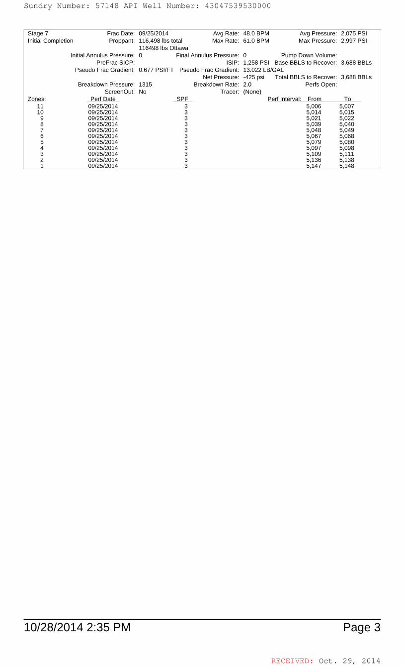
RECEIVED: Oct. 29, 2014
10/28/2014 2:35 PM Page 3
Stage 7 Frac Date: 09/25/2014 Avg Rate: 48.0 BPM Avg Pressure: 2,075 PSIInitial Completion Proppant: 116,498 lbs total Max Rate: 61.0 BPM Max Pressure: 2,997 PSI
116498 lbs OttawaInitial Annulus Pressure: 0 Final Annulus Pressure: 0 Pump Down Volume:
PreFrac SICP: ISIP: 1,258 PSI Base BBLS to Recover: 3,688 BBLsPseudo Frac Gradient: Pseudo Frac Gradient:0.677 PSI/FT 13.022 LB/GAL
Net Pressure: -425 psi Total BBLS to Recover: 3,688 BBLsBreakdown Pressure: 1315 Breakdown Rate: 2.0 Perfs Open:
ScreenOut: No Tracer: (None)Zones: Perf Date SPF Perf Interval: From To
11 09/25/2014 3 5,006 5,00710 09/25/2014 3 5,014 5,015
9 09/25/2014 3 5,021 5,0228 09/25/2014 3 5,039 5,0407 09/25/2014 3 5,048 5,0496 09/25/2014 3 5,067 5,0685 09/25/2014 3 5,079 5,0804 09/25/2014 3 5,097 5,0983 09/25/2014 3 5,109 5,1112 09/25/2014 3 5,136 5,1381 09/25/2014 3 5,147 5,148
Sundry Number: 57148 API Well Number: 43047539530000Sundry Number: 57148 API Well Number: 43047539530000
Stage 7 Frac Date: 09/25/2014 Avg Rate: 48.0 BPM Avg Pressure: 2,075 PSIInitial Completion Proppant: 116,498 lbs total Max Rate: 61.0 BPM Max Pressure: 2,997 PSI
116498 lbs OttawaInitialAnnulus Pressure: 0 Final Annulus Pressure: 0 Pump Down Volume:
PreFrac SICP: ISIP: 1,258 PSI Base BBLS to Recover: 3,688 BBLsPseudo Frac Gradient: 0.677 PSI/FT Pseudo Frac Gradient: 13.022 LB/GAL
Net Pressure: -425 psi Total BBLS to Recover: 3,688 BBLsBreakdown Pressure: 1315 Breakdown Rate: 2.0 Perfs Open:
ScreenOut: No Tracer: (None)Zones: Perf Date SPF Perf Interval: From To
11 095 W2014 3 5,006 5,00710 095 W2014 3 5,014 5,015
9 095 W2014 3 5,021 5,0228 095 W2014 3 5,039 5,0407 095 W2014 3 5,048 5,0496 095 W2014 3 5,067 5,0685 095 W2014 3 5,079 5,0804 095 W2014 3 5,097 5,0983 095 W2014 3 5,109 5,1112 095 W2014 3 5,136 5,1381 095 W2014 3 5,147 5,148
RECEIVED: Oct. 29,
Sundry Number: 57148 API Well Number: 43047539530000
Stage 7 Frac Date: 09/25/2014 Avg Rate: 48.0 BPM Avg Pressure: 2,075 PSIInitial Completion Proppant: 116,498 lbs total Max Rate: 61.0 BPM Max Pressure: 2,997 PSI
116498 lbs OttawaInitialAnnulus Pressure: 0 Final Annulus Pressure: 0 Pump Down Volume:
PreFrac SICP: ISIP: 1,258 PSI Base BBLS to Recover: 3,688 BBLsPseudo Frac Gradient: 0.677 PSI/FT Pseudo Frac Gradient: 13.022 LB/GAL
Net Pressure: -425 psi Total BBLS to Recover: 3,688 BBLsBreakdown Pressure: 1315 Breakdown Rate: 2.0 Perfs Open:
ScreenOut: No Tracer: (None)Zones: Perf Date SPF Perf Interval: From To
11 095 W2014 3 5,006 5,00710 095 W2014 3 5,014 5,015
9 095 W2014 3 5,021 5,0228 095 W2014 3 5,039 5,0407 095 W2014 3 5,048 5,0496 095 W2014 3 5,067 5,0685 095 W2014 3 5,079 5,0804 095 W2014 3 5,097 5,0983 095 W2014 3 5,109 5,1112 095 W2014 3 5,136 5,1381 095 W2014 3 5,147 5,148
RECEIVED: Oct. 29,

RECEIVED: Oct. 29, 2014
Hydraulic Fracturing Fluid Product Component Information Disclosure
Hydraulic Fracturing Fluid Composition:
Job Start Date: 9/23/2014Job End Date: 9/25/2014
State: UtahCounty: Uintah
API Number: 43-047-53953-00-00Operator Name: Ultra Resources
Well Name and Number: Three Rivers Federal 3-23-820Longitude: -109.65950300
Latitude: 40.14870800Datum: NAD27
Federal/Tribal Well: NOTrue Vertical Depth: 7,400
Total Base Water Volume (gal): 1,162,269
Trade Name Supplier Purpose Ingredients
ChemicalAbstract Service
Number(CAS #)
Maximum Ingredient
Concentration in Additive
(% by mass)**
Maximum Ingredient
Concentration in HF Fluid
(% by mass)**
Comments
Fresh Water Operator Base Fluid
Fresh Water 7732-18-5 100.00000 90.70103Density = 8.340
SAND - PREMIUM WHITE
Halliburton Proppant
Crystalline silica, quartz 14808-60-7 100.00000 8.11166
HYDROCHLORIC ACID 10-30%
Halliburton Solvent
Hydrochloric acid 7647-01-0 30.00000 0.25124
LoSurf-300D Halliburton Non-ionic Surfactant
Ethanol 64-17-5 60.00000 0.04881
Heavy aromatic petroleum naphtha
64742-94-5 30.00000 0.02440
Poly(oxy-1,2-ethanediyl), alpha-(4-nonylphenyl)-omega-hydroxy-, branched
127087-87-0 5.00000 0.00407
Naphthalene 91-20-3 5.00000 0.00407
1,2,4 Trimethylbenzene 95-63-6 1.00000 0.00081
WG-35 GELLING AGENT
Halliburton Gelling Agent
Guar gum 9000-30-0 100.00000 0.03609
BC-140 Halliburton Crosslinker
Monoethanolamine borate 26038-87-9 60.00000 0.02173
Total Base Non Water Volume: 0
Sundry Number: 57148 API Well Number: 43047539530000Sundry Number: 57148 API Well Number: 43047539530000
Hydraulic Fracturing Fluid Product Component Information DisclosureJob Start Date: 9/23/2014Job End Date: 9/25/2014
State: Utat
APINComb
r43-047-53953-00n-ti FracFocus
Operator Name: Ultra Resources Chemical Disclosure RegistryWell Name and Number: Three Rivers Federal 3-23-82C
Longitude: -109.65950300
Latitude: 40.1487080c GRO DWATERDatum: NAD27
Federal/Tribal Well: NcOi &Gas
True Vertical Depth: 7,40CTotal Base Water Volume (gal): 1,162,26ETotal Base Non Water Volume: C
Hydraulic Fracturing Fluid Composition:Maximum MaximumChemical
. In redient In redientAbstract ServiceTrade Name Supplier Purpose Ingredients concentrationin 3oncentration in CommentsNumber Additive HF Fluid(CAS #) (%by mass)** (%by mass)**Fresh Water Operator Base Fluid
Fresh Water 7732-18-5 100.0000C 90.70102Density = 8.340SAND - PREMIUM Halliburton ProppantWHITE
Crystalline silica, quartz 14808-60-7 100.0000C 8.1116EHYDROCHLORIC Halliburton SolventACID 10-30%
Hydrochloric acid 7647-01-0 30.0000C 0.25124LoSurf-300D Halliburton Non-ionic Surfactant
Ethanol 34-17-5 60.0000C 0.04881Heavy aromatic petroleum 34742-94-5 30.0000C 0.02440naphthaPoly(oxy-1,2-ethanediyl), alpha- 127087-87-0 5.0000C 0.00407(4-nonylphenyl)-omega-hydroxy-, branchedNaphthalene 91-20-3 5.0000C 0.004071,2,4 Trimethylbenzene 95-63-6 1.0000C 0.00081
WG-35 GELLING Halliburton Gelling AgentAGENT
Guar gum 9000-30-0 100.0000C 0.0360EBC-140 Halliburton Crosslinker
Monoethanolamine borate 26038-87-9 60.0000C 0.02172
RECEIVED: Oct. 29,
Sundry Number: 57148 API Well Number: 43047539530000
Hydraulic Fracturing Fluid Product Component Information DisclosureJob Start Date: 9/23/2014Job End Date: 9/25/2014
State: Utat
APINComb
r43-047-53953-00n-ti FracFocus
Operator Name: Ultra Resources Chemical Disclosure RegistryWell Name and Number: Three Rivers Federal 3-23-82C
Longitude: -109.65950300
Latitude: 40.1487080c GRO DWATERDatum: NAD27
Federal/Tribal Well: NcOi &Gas
True Vertical Depth: 7,40CTotal Base Water Volume (gal): 1,162,26ETotal Base Non Water Volume: C
Hydraulic Fracturing Fluid Composition:Maximum MaximumChemical
. In redient In redientAbstract ServiceTrade Name Supplier Purpose Ingredients concentrationin 3oncentration in CommentsNumber Additive HF Fluid(CAS #) (%by mass)** (%by mass)**Fresh Water Operator Base Fluid
Fresh Water 7732-18-5 100.0000C 90.70102Density = 8.340SAND - PREMIUM Halliburton ProppantWHITE
Crystalline silica, quartz 14808-60-7 100.0000C 8.1116EHYDROCHLORIC Halliburton SolventACID 10-30%
Hydrochloric acid 7647-01-0 30.0000C 0.25124LoSurf-300D Halliburton Non-ionic Surfactant
Ethanol 34-17-5 60.0000C 0.04881Heavy aromatic petroleum 34742-94-5 30.0000C 0.02440naphthaPoly(oxy-1,2-ethanediyl), alpha- 127087-87-0 5.0000C 0.00407(4-nonylphenyl)-omega-hydroxy-, branchedNaphthalene 91-20-3 5.0000C 0.004071,2,4 Trimethylbenzene 95-63-6 1.0000C 0.00081
WG-35 GELLING Halliburton Gelling AgentAGENT
Guar gum 9000-30-0 100.0000C 0.0360EBC-140 Halliburton Crosslinker
Monoethanolamine borate 26038-87-9 60.0000C 0.02172
RECEIVED: Oct. 29,

RECEIVED: Oct. 29, 2014
Ethylene glycol 107-21-1 30.00000 0.01086
Cla-Web™ Halliburton Additive
Ammonium salt Confidential 60.00000 0.02952Denise Tuck,Halliburton3000 N. Sam Houston Pkwy E.,Houston, TX 77032281-871-6226
MC MX 2-2822 Multi-Chem Scale Inhibitor
Phospate of a Diamine, Sodium Salt
8913 30.00000 0.01289
Methyl Alcohol 67-56-1 30.00000 0.01289
SandWedge® NT Halliburton Conductivity Enhancer
Dipropylene glycol monomethyl ether
34590-94-8 60.00000 0.02107
Heavy aromatic petroleum naphtha
64742-94-5 10.00000 0.00351
FE-1A ACIDIZING COMPOSITION
Halliburton Additive
Acetic anhydride 108-24-7 100.00000 0.00839
Acetic acid 64-19-7 60.00000 0.00503
FR-66 Halliburton Friction Reducer
Hydrotreated light petroleum distillate
64742-47-8 30.00000 0.01103
MC B-8614 Multi-Chem Biocide
Glutaraldehyde 111-30-8 30.00000 0.00558
Alkyl (C12-16) dimethylbenzylammonium chloride
68424-85-1 5.00000 0.00093
OPTIFLO-HTE Halliburton Breaker
Walnut hulls Mixture 100.00000 0.00214
Crystalline silica, quartz 14808-60-7 30.00000 0.00064
HAI-404M™ Halliburton Corrosion Inhibitor
Isopropanol 67-63-0 30.00000 0.00046
Methanol 67-56-1 30.00000 0.00046
Aldehyde Confidential 30.00000 0.00046
Quaternary ammonium salt Confidential 10.00000 0.00015
1-(Benzyl)quinolinium chloride 15619-48-4 10.00000 0.00015
SP BREAKER Halliburton Breaker
Sodium persulfate 7775-27-1 100.00000 0.00169
Other Ingredient(s)
Water 7732-18-5 0.95236
Other Ingredient(s)
Oxyalkylated phenolic resin Confidential 0.02440
Other Ingredient(s)
Polyacrylamide copolymer Confidential 0.01103
Other Ingredient(s)
Oxyalkylated phenolic resin Confidential 0.00813
Ingredients shown above are subject to 29 CFR 1910.1200(i) and appear on Material Safety Data Sheets (MSDS). Ingredients shown below are Non-MSDS.
Sundry Number: 57148 API Well Number: 43047539530000Sundry Number: 57148 API Well Number: 43047539530000
Ethylene glycol 107-21-1 30.0000C 0.0108ECla-WebTM Halliburton Additive
Ammonium salt Confidential 60.0000C 0.02952Denise Tuck,Halliburton3000 N. Sam Houston PkwyE.,Houston, TX 77032281-871-6226
MC MX 2-2822 Multi-Chem Scale InhibitorPhospate of a Diamine, Sodium 8913 30.0000C 0.0128ESaltMethyl Alcohol 37-56-1 30.0000C 0.0128E
SandWedge® NT Halliburton Conductivity EnhancerDipropylene glycol monomethyl 34590-94-8 60.0000C 0.02107stherHeavy aromatic petroleum 34742-94-5 10.0000C 0.00351naphtha
FE-1A ACIDIZING Halliburton AdditiveCOMPOSITION
Acetic anhydride 108-24-7 100.0000C 0.0083EAcetic acid 34-19-7 60.0000C 0.00502
FR-66 Halliburton Friction ReducerHydrotreated light petroleum 34742-47-8 30.0000C 0.01102distillate
MC B-8614 Multi-Chem BiocideGlutaraldehyde 111-30-8 30.0000C 0.0055EAlkyl(C12-16) 38424-85-1 5.0000C 0.00092dimethylbenzylammoniumchloride
OPTIFLO-HTE Halliburton BreakerWalnut hulls Mixture 100.0000C 0.00214Crystalline silica, quartz 14808-60-7 30.0000C 0.00064
HAl-404MTM Halliburton Corrosion InhibitorIsopropanol 87-63-0 30.0000C 0.00046Methanol 87-56-1 30.0000C 0.00046Aldehyde Confidential 30.0000C 0.00046Quaternary ammonium salt Confidential 10.0000C 0.0001E1-(Benzyl)quinolinium chloride 15619-48-4 10.0000C 0.00016
SP BREAKER Halliburton BreakerSodium persulfate 7775-27-1 100.0000C 0.0016E
Other Ingredient(s)Water 7732-18-5 0.9523E
Other Ingredient(s)Oxyalkylated phenolic resin Confidential 0.0244C
Other Ingredient(s)Polyacrylamide copolymer Confidential 0.01102
Other Ingredient(s)Oxyalkylated phenolic resin Confidential 0.00812
RECEIVED: Oct. 29,
Sundry Number: 57148 API Well Number: 43047539530000
Ethylene glycol 107-21-1 30.0000C 0.0108ECla-WebTM Halliburton Additive
Ammonium salt Confidential 60.0000C 0.02952Denise Tuck,Halliburton3000 N. Sam Houston PkwyE.,Houston, TX 77032281-871-6226
MC MX 2-2822 Multi-Chem Scale InhibitorPhospate of a Diamine, Sodium 8913 30.0000C 0.0128ESaltMethyl Alcohol 37-56-1 30.0000C 0.0128E
SandWedge® NT Halliburton Conductivity EnhancerDipropylene glycol monomethyl 34590-94-8 60.0000C 0.02107stherHeavy aromatic petroleum 34742-94-5 10.0000C 0.00351naphtha
FE-1A ACIDIZING Halliburton AdditiveCOMPOSITION
Acetic anhydride 108-24-7 100.0000C 0.0083EAcetic acid 34-19-7 60.0000C 0.00502
FR-66 Halliburton Friction ReducerHydrotreated light petroleum 34742-47-8 30.0000C 0.01102distillate
MC B-8614 Multi-Chem BiocideGlutaraldehyde 111-30-8 30.0000C 0.0055EAlkyl(C12-16) 38424-85-1 5.0000C 0.00092dimethylbenzylammoniumchloride
OPTIFLO-HTE Halliburton BreakerWalnut hulls Mixture 100.0000C 0.00214Crystalline silica, quartz 14808-60-7 30.0000C 0.00064
HAl-404MTM Halliburton Corrosion InhibitorIsopropanol 87-63-0 30.0000C 0.00046Methanol 87-56-1 30.0000C 0.00046Aldehyde Confidential 30.0000C 0.00046Quaternary ammonium salt Confidential 10.0000C 0.0001E1-(Benzyl)quinolinium chloride 15619-48-4 10.0000C 0.00016
SP BREAKER Halliburton BreakerSodium persulfate 7775-27-1 100.0000C 0.0016E
Other Ingredient(s)Water 7732-18-5 0.9523E
Other Ingredient(s)Oxyalkylated phenolic resin Confidential 0.0244C
Other Ingredient(s)Polyacrylamide copolymer Confidential 0.01102
Other Ingredient(s)Oxyalkylated phenolic resin Confidential 0.00812
RECEIVED: Oct. 29,

RECEIVED: Oct. 29, 2014
Other Ingredient(s)
Sodium chloride 7647-14-5 0.00430
Other Ingredient(s)
Quaternary ammonium compound
Confidential 0.00351
Other Ingredient(s)
Quaternary amine Confidential 0.00246
Other Ingredient(s)
Alcohols, C12-16, ethoxylated 68551-12-2 0.00199
Other Ingredient(s)
Ammonium chloride 12125-02-9 0.00184
Other Ingredient(s)
Fatty acid tall oil amide Confidential 0.00184
Other Ingredient(s)
Modified bentonite Confidential 0.00180
Other Ingredient(s)
Cured acrylic resin Confidential 0.00064
Other Ingredient(s)
Quaternary amine Confidential 0.00049
Other Ingredient(s)
Naphthenic acid ethoxylate 68410-62-8 0.00046
Other Ingredient(s)
Methanol 67-56-1 0.00038
Other Ingredient(s)
Sorbitan, mono-9-octadecenoate, (Z)
1338-43-8 0.00037
Other Ingredient(s)
Sorbitan monooleate polyoxyethylene derivative
9005-65-6 0.00037
Other Ingredient(s)
Ethoxylated nonylphenol Confidential 0.00036
Other Ingredient(s)
Silica, amorphous - fumed 7631-86-9 0.00036
Other Ingredient(s)
Fatty acids, tall oil Confidential 0.00015
Other Ingredient(s)
Polyethoxylated fatty amine salt 61791-26-2 0.00015
Other Ingredient(s)
Enzyme Confidential 0.00011
Other Ingredient(s)
Ethoxylated amine Confidential 0.00008
Other Ingredient(s)
Quaternary amine Confidential 0.00005
Other Ingredient(s)
Amine salts Confidential 0.00005
Other Ingredient(s)
Amine salts Confidential 0.00005
Sundry Number: 57148 API Well Number: 43047539530000Sundry Number: 57148 API Well Number: 43047539530000
Other Ingredient(s)Sodium chloride 7647-14-5 0.0043C
Other Ingredient(s)Quaternary ammonium Confidential 0.00351cornpound
Other Ingredient(s)Qtæternary amine Conñdential 0.0024E
Other Ingredient(s)Alcohols, C12-16, ethoxylated 38551-12-2 0.0019E
Other Ingredient(s)Ammonium chloride 12125-02-9 0.00184
Other Ingredient(s)Fatty acicItalloilamide Conñdential O 30184
Other Ingredient(s)Modiñed bentonite Conñdential 0.0018C
Other Ingredient(s)Cured acrylic resin Conñdential 0.00064
Other Ingredient(s)Qtæternary amine Conñdential 0.0004E
Other Ingredient(s)Naphthenic acid ethoxylate 38410-62-8 0.0004E
Other Ingredient(s)Methanol 37-56-1 0.0003E
Other Ingredient(s)Sorbitan,rnono-9- 1338-43-8 0.00037octadecenoate,(Z)
Other Ingredient(s)Sorbitan monoolmate 9005-65-6 0.00037polvoxvethylene derivative
Other Ingredient(s)lËthoxylated nonylphenol Conñdential 0.0003E
Other Ingredient(s)Silica, amorphous - fumed 7631-86-9 0.0003E
Other Ingredient(s)Fatty acids, talloil Confidential 0.0001E
Other Ingredient(s)3olyethoxylated fattyaminesalt 31791-26-2 0.0001E
Other Ingredient(s)Enzyme Conñdential 0.00011
Other Ingredient(s)Ë!thoxylated amine Conñdential 0.0000E
Other Ingredient(s)Qtæternary amine Conñdential 0.0000E
Other Ingredient(s)Amine salts Conñdential 0.0000E
Other Ingredient(s)Amine salts Conñdential 0.0000E
RECEIVED: Oct. 29,
Sundry Number: 57148 API Well Number: 43047539530000
Other Ingredient(s)Sodium chloride 7647-14-5 0.0043C
Other Ingredient(s)Quaternary ammonium Confidential 0.00351cornpound
Other Ingredient(s)Qtæternary amine Conñdential 0.0024E
Other Ingredient(s)Alcohols, C12-16, ethoxylated 38551-12-2 0.0019E
Other Ingredient(s)Ammonium chloride 12125-02-9 0.00184
Other Ingredient(s)Fatty acicItalloilamide Conñdential O 30184
Other Ingredient(s)Modiñed bentonite Conñdential 0.0018C
Other Ingredient(s)Cured acrylic resin Conñdential 0.00064
Other Ingredient(s)Qtæternary amine Conñdential 0.0004E
Other Ingredient(s)Naphthenic acid ethoxylate 38410-62-8 0.0004E
Other Ingredient(s)Methanol 37-56-1 0.0003E
Other Ingredient(s)Sorbitan,rnono-9- 1338-43-8 0.00037octadecenoate,(Z)
Other Ingredient(s)Sorbitan monoolmate 9005-65-6 0.00037polvoxvethylene derivative
Other Ingredient(s)lËthoxylated nonylphenol Conñdential 0.0003E
Other Ingredient(s)Silica, amorphous - fumed 7631-86-9 0.0003E
Other Ingredient(s)Fatty acids, talloil Confidential 0.0001E
Other Ingredient(s)3olyethoxylated fattyaminesalt 31791-26-2 0.0001E
Other Ingredient(s)Enzyme Conñdential 0.00011
Other Ingredient(s)Ë!thoxylated amine Conñdential 0.0000E
Other Ingredient(s)Qtæternary amine Conñdential 0.0000E
Other Ingredient(s)Amine salts Conñdential 0.0000E
Other Ingredient(s)Amine salts Conñdential 0.0000E
RECEIVED: Oct. 29,

RECEIVED: Oct. 29, 2014
* Total Water Volume sources may include fresh water, produced water, and/or recycled water ** Information is based on the maximum potential for concentration and thus the total may be over 100%
Note: For Field Development Products (products that begin with FDP), MSDS level only information has been provided.Ingredient information for chemicals subject to 29 CFR 1910.1200(i) and Appendix D are obtained from suppliers Material Safety Data Sheets (MSDS)
Other Ingredient(s)
Crystalline silica, quartz 14808-60-7 0.00004
Other Ingredient(s)
C.I. Pigment Red 5 6410-41-9 0.00002
Other Ingredient(s)
Cured acrylic resin Confidential 0.00002
Other Ingredient(s)
Ammonium phosphate 7722-76-1 0.00002
Other Ingredient(s)
Sodium iodide 7681-82-5 0.00002
Other Ingredient(s)
Naphthalene 91-20-3 0.00000
Other Ingredient(s)
Phosphoric Acid 7664-38-2 0.00000
Other Ingredient(s)
Sodium sulfate 7757-82-6 0.00000
Sundry Number: 57148 API Well Number: 43047539530000Sundry Number: 57148 API Well Number: 43047539530000
Other Ingredient(s)Crystalline silica, quartz 14808-60-7 0.00004
Other Ingredient(s)C.I. Pigment Red 5 3410-41-9 0.00002
Other Ingredient(s)Cured acrylic resin Confidential 0.00002
Other Ingredient(s)Ammonium phosphate 7722-76-1 0.00002
Other Ingredient(s)Sodium iodide 7681-82-5 0.00002
Other Ingredient(s)Naphthalene 91-20-3 0.0000C
Other Ingredient(s)Phosphoric Acid 7664-38-2 0.0000C
Other Ingredient(s)Sodium sulfate 7757-82-6 0.0000C
* Total Water Volume sources may include fresh water, produced water, and/or recycled water** Information is based on the maximum potential for concentration and thus the total may be over 100%
Note: For Field Development Products (products that begin with FDP), MSDS level only information has been provided.Ingredient information for chemicals subject to 29 CFR 1910.1200(i) and Appendix D are obtained from suppliers Material Safety Data Sheets (MSDS)
RECEIVED: Oct. 29,
Sundry Number: 57148 API Well Number: 43047539530000
Other Ingredient(s)Crystalline silica, quartz 14808-60-7 0.00004
Other Ingredient(s)C.I. Pigment Red 5 3410-41-9 0.00002
Other Ingredient(s)Cured acrylic resin Confidential 0.00002
Other Ingredient(s)Ammonium phosphate 7722-76-1 0.00002
Other Ingredient(s)Sodium iodide 7681-82-5 0.00002
Other Ingredient(s)Naphthalene 91-20-3 0.0000C
Other Ingredient(s)Phosphoric Acid 7664-38-2 0.0000C
Other Ingredient(s)Sodium sulfate 7757-82-6 0.0000C
* Total Water Volume sources may include fresh water, produced water, and/or recycled water** Information is based on the maximum potential for concentration and thus the total may be over 100%
Note: For Field Development Products (products that begin with FDP), MSDS level only information has been provided.Ingredient information for chemicals subject to 29 CFR 1910.1200(i) and Appendix D are obtained from suppliers Material Safety Data Sheets (MSDS)
RECEIVED: Oct. 29,

RECEIVED: Oct. 29, 2014
Well Name: 3-23-820 1 Green River
Date, Time & SO: 09/23/14 10:50 PM 901679259 Top & Bottom Perfs: 6536 TO 6658.0Mid-Perf: 6621 BHST: 161 °F
Liquid Additives-----------------------------------------------------------------------------------------------------------------Liquid AdditivesStage Stage Name Slurry Vol Pump Time Fluid Name Fluid Volume Proppant Slurry Max Slurry Pressure Pressure Pressure Prop Conc Prop Conc WG-35 BC 140 Sandwedge NT BA-20 LoSurf-300D CLA-Web MC MX 2-2822 Optiflo HTE SP FR-66 MC B-8614
9000-30-0 590-29-4 1310-58-3 631-61-8 7727-54-0 7775-27-1 7681-52-9Mass Rate Rate Ave Max Min Avg Max (Gel) (Xlinker) (Xlinker) (Buffer) (Clay Cont.) (Conduct. Enh.) (Breaker) (Breaker) (Fric Red) (Bacteriacide)
(bbl) (gal) (lb) (bpm) (bpm) (psi) (psi) (psi) (PPG) (PPG) (ppt) (gpt) (gpt) (gpt) (gpt) (gpt) (ppt) (ppt) (gpt) (gpt)
1 Pre-Pad 7 0:00:44 FR Water 308 0 2.3 3.8 1624 2761 70 0.00 0.00 0 1.00 0.50 0.50 0.202 0 PPG 24 0:02:23 15 % HCL Acid 1000 0 9.9 14.0 1679 2110 1461 03 0 PPG 1267 0:21:07 FR Water 53208 0 57.6 61.6 2467 3577 1530 0 1.00 0.50 0.47 0.50 0.204 0.35 PPG White Sand 1828 0:30:28 FR Water 75486 26,571 61.3 61.5 2376 2507 2232 0.35 0.38 0 1.00 0.50 0.47 0.50 0.205 0.35 PPG White Sand 121 0:02:01 FR Water 5013 1,755 61.2 61.2 2509 2525 2499 0.35 0.36 0 1.00 0.50 2.00 0.50 0.206 0.35 PPG White Sand 121 0:02:01 FR Water 4979 1,768 61.3 61.6 2567 2597 2519 0.36 0.37 7.00 0.72 0 1.00 0.50 0.25 0.40 0.30 0.50 0.207 0 PPG 0 0:00:00 18# Delta 140 0 0 0.008 2 PPG White Sand 430 0:07:10 18# Delta 140 16453 32,692 60.9 61.6 2630 2692 2547 1.99 2.13 18.00 1.80 0 1.00 0.50 0.25 1.00 0.50 0.209 4 PPG White Sand 268 0:04:28 18# Delta 140 9402 35,464 60.7 60.9 2555 2689 2452 3.77 3.99 18.00 1.80 0 1.00 0.50 0.25 1.00 0.50 0.20
10 6 PPG White Sand 250 0:04:10 18# Delta 140 8126 41,166 60.6 61.3 2389 2463 2059 5.07 5.89 17.00 1.57 1.70 0 0.85 0.50 0.87 0.44 0.20 0 0 0 0 0
11 Flush 154 0:02:34 FR Water 6487 0 61.0 61.5 2749 2340 3082 0.00 0.00 1.00 0.50 0.50 0.20 0
Growler @ Flush 57 2400 0 50.00 0.00 0.00 Calculated Amt 638.39 62.91 0.00 69.98 0.00 178.24 89.69 77.73 34.95 17.97 72.74 35.89
Actual Amt 647.00 62.10 70.70 177.30 88.70 77.90 34.40 17.20 72.60 35.40Percent Variance 1.3% 0.0% 0.0% 0.0% 0.0% 0.0% 0.0% 0.0% 0.0% 0.0% 0.0% 0.0%
Strap Amt 648.00 58.00 65.00 0.00 184.00 91.50 81.00 35.00 17.00 75.00 34.50Slurry (bbl) 4471 Percent Variance 1.5% -7.8% 0.0% -7.1% 0.0% 3.2% 2.0% 4.2% 0.0% 0.0% 3.1% -3.9%
Pump Time (Min) 1:17:06 Percent Variance is reported as 0% if variance is within 1 gallon.Clean Fluid (gal) 180462
Proppant (lb) 149187 (Use weight slips for below amounts) Variance HES Engineer: Ugoma Achebe
TOTAL PROPPANT PUMPED: 137,540 Lbs 0.0% Co. Rep: Bret Stringham% of Job Prop Mesh Quantity Units MB Vari SS Vari Dens Vari SC Vari Crew: RED C
Avg Rate 49.7 BPM 0% None 20/40 Lbs 1.4% 2.5% 0.8% 0.5% Equipment running well Avg Corrected Rate 54.9 BPM 0% TLC 20/40 Lbs Xlink samples look good
Max Rate 61.6 BPM 100% White Sand 20/40 137,540 Lbs Good job by CrewAverage Prop Con 2.0 3bbl overflush per Co RepAverage Pressure 2354.5 PSI Inital Annulus Pressure 26.3 PSI Average Annulus Pressure 22.5 PSI
Maximum Pressure 3577.0 PSI Final Annulus Pressure 20.6 PSI Change in Annulus Pressure -5.7 PSI
BREAKDOWN INFORMATION: CLEAN STREAM:Base Fluid: 8.39 PPG UV1 HRs UV2 HRs Transm.%
Wellhead Pressure: 70 PSI 496 496 73.1Broke Back: 2761 PSI @ 2.9 BPM
Pressure (Prop at Perfs) 2256 PSI @ 61.3 BPMInitial ISIP: PSI
ISDP: 2033 PSI @ 0.743 PSI/FT
Three Rivers
COMMENTS:
Sundry Number: 57148 API Well Number: 43047539530000Sundry Number: 57148 API Well Number: 43047539530000
Well Name: Three Rivers 3-23-820 1 Green River
Date, Time & SO: 09/23/14 10:50 PM 901679259Top & Bollom Perfs: 6536 TO 6658.0Mid-Perf: 6621 BHST: 161 F
Liauid Addith es------------------ -----------------------------------------------------------------------Liauid / ddithresStaae Staae Name SlurrvVol Pume Time Fluid Name Fluid Volume Proceant Slurrv Max Slurrv Pressure Pressure Pressure Pron Conc Pron Conc WG-35 BC 140 Sandwedae NT BA-20 LoSurf-300D CLA-Web MC MX 2-2822 Ootiflo HTE SP FR-66 MC B-8614
9000-30-0 590-29-4 1310-58-3 631-61-8 7727-54-0 7775-27-1 7681-52-9Mass Rate Rate Ave Max Min Ava Max (Gell (XIinkerì (XIinkerì (Bufferì (Clav Cont.] (Conduct. Enh.1 (Breakerì (Breakerì (Fric Redì (Bacteriacidel
(bblì (aall (Ibl (bomi (bomi (osil (osil (osil (PPG1 (PPG1 (Deti (actì (actì (actì (actì (actì (Deti (Deti (actì (actì
1 Pre-Pad 7 0 00 44 FR VVater 308 0 2.3 3.8 1624 2761 70 0.00 0.00 0 1.00 0.50 0.50 0.20
2 0 PPG 24 0 02 23 15 To HCLAcic 1000 0 9.9 14.0 1679 2110 1461 03 0 PPG 1267 0 21 37 FR VVater 53208 0 57.6 61.6 2467 3577 1530 0 1.00 0.50 0.47 0.50 0.204 0.35 PPG VVhiteSand 1828 0 30 28 FR VVater 75486 26,571 61.3 61.5 2376 2507 2232 0.35 0.38 0 1.00 0.50 0.47 0.50 0.205 0.35 PPG VVhiteSand 121 0 02 01 FR VVater 5013 1.755 61.2 61.2 2509 2525 2499 0.35 0.36 0 1.00 0.50 2.00 0.50 0.206 0.35 PPG VVhiteSand 121 0 02 01 FR VVater 4979 1.768 61.3 61.6 2567 2597 2519 0.36 0.37 7.00 0.72 0 1.00 0.50 0.25 0.40 0.30 0.50 0.207 0 PPG 0 0 00 00 18# Delta 140 0 0 0.008 2 PPG VVhiteSand 430 0 07 0 18# Delta 140 16453 32.692 60.9 61.6 2630 2692 2547 1.99 2.13 18.00 1.80 0 1.00 0.50 0.25 1.00 0.50 0.209 4 PPG White Sand 268 0 04 28 18# Delta 140 9402 35,464 60.7 60.9 2555 2689 2452 3.77 3.99 18.00 1.80 0 1.00 0.50 0.25 1.00 0.50 0.20
10 6 PPG White Sand 250 0 04 10 18# Delta 140 8126 41,166 60.6 61.3 2389 2463 2059 5.07 5.89 17.00 1.57 1.70 0 0.85 0.50 0.87 0.44 0.2000000
11 ush 154 0 02 34 FR VVater 6487 0 61.0 61.5 2749 2340 3082 0.00 0.00 1.00 0.50 0.50 0.20
0GrowderfD ush 57 2400 0 50.00 0.00 0.00
Calculated Amt 638.39 62.91 0.00 69.98 0.00 178.24 89.69 77.73 34.95 17.97 72.74 35.89ActualAmt 647.00 62.10 70.70 177.30 88.70 77.90 34.40 17.20 72.60 35.40
PercentVariance 1.3% 0.0% 0.0% 0.0% 0.0% 0.0% 0.0% 0.0% 0.0% 0.0% 0.0% 0.0%StranAmt 648.00 58.00 65.00 0.00 184.00 91.50 81.00 35.00 17.00 75.00 34.50
Slurry(bbl) 4471 PercentVariance 1.5% -7.8% 0.0% -7.1% 0.0% 3.2% 2.0% 4.2% 0.0% 0.0% 3.1% -3.9%
Pumo Time (Min) 1 17 06 Percent Variance is reported as 0% if variance i within 1 aallor .
Clean Fluid (gal) 180462ProDDantfibi 149187
(Useweightslipsforbelowamounts) Variance COMMENTS: HFSFnnineer UgomaAchebeTOTALPROPPANTPUMPED: 137.540 Lbs 0.0% Co.Rep BretStringham
¾_o Job ProR Mesh _Quantity Units MBVari SSVari DensVari SCVari Crew REDC
Ava Rate 49.7 BPM 0% None 20/40 Lbs 1.4% 2.5% 0.8% 0.5% Eauioment runnina wellAva Corrected Rate 54.9 BPM 0% TLC 20/40 Lbs XIink samples look good
Max Rate 61.6 BPM 100% White Sand 20/40 137,540 Lbs Good iob by CrewAA raaaaeePrreDssCu
235 PSI Inital Annulus Pressure 26.3 PSI Averaae Annulus Pressure 22.5 SI3bbl overflush Der Co Reo
Maximum Pressure 3577.0 PSI Final Annulus Pressure 20.6 PSI Chanae in Annulus Pressure -5.7 SI
BREAKDOWN INFORMAT ON: CLEAN STREAM:Base Fluid: 8.39 PPG UV1 HRs UV2 HRs Transm.%
Wellhead Pressure: 70 PSI 496 496 73.1 |BrokeBack: 2761 PSI 2.9 BPM
Pressure (Prop at Perfs) 2256 PSI 61.3 BPMInitial ISIP: PSI
ISDP: 2033 PSI 0.743 PSI/FT
RECEIVED: Oct. 29,
Sundry Number: 57148 API Well Number: 43047539530000
Well Name: Three Rivers 3-23-820 1 Green River
Date, Time & SO: 09/23/14 10:50 PM 901679259Top & Bollom Perfs: 6536 TO 6658.0Mid-Perf: 6621 BHST: 161 F
Liauid Addith es------------------ -----------------------------------------------------------------------Liauid / ddithresStaae Staae Name SlurrvVol Pume Time Fluid Name Fluid Volume Proceant Slurrv Max Slurrv Pressure Pressure Pressure Pron Conc Pron Conc WG-35 BC 140 Sandwedae NT BA-20 LoSurf-300D CLA-Web MC MX 2-2822 Ootiflo HTE SP FR-66 MC B-8614
9000-30-0 590-29-4 1310-58-3 631-61-8 7727-54-0 7775-27-1 7681-52-9Mass Rate Rate Ave Max Min Ava Max (Gell (XIinkerì (XIinkerì (Bufferì (Clav Cont.] (Conduct. Enh.1 (Breakerì (Breakerì (Fric Redì (Bacteriacidel
(bblì (aall (Ibl (bomi (bomi (osil (osil (osil (PPG1 (PPG1 (Deti (actì (actì (actì (actì (actì (Deti (Deti (actì (actì
1 Pre-Pad 7 0 00 44 FR VVater 308 0 2.3 3.8 1624 2761 70 0.00 0.00 0 1.00 0.50 0.50 0.20
2 0 PPG 24 0 02 23 15 To HCLAcic 1000 0 9.9 14.0 1679 2110 1461 03 0 PPG 1267 0 21 37 FR VVater 53208 0 57.6 61.6 2467 3577 1530 0 1.00 0.50 0.47 0.50 0.204 0.35 PPG VVhiteSand 1828 0 30 28 FR VVater 75486 26,571 61.3 61.5 2376 2507 2232 0.35 0.38 0 1.00 0.50 0.47 0.50 0.205 0.35 PPG VVhiteSand 121 0 02 01 FR VVater 5013 1.755 61.2 61.2 2509 2525 2499 0.35 0.36 0 1.00 0.50 2.00 0.50 0.206 0.35 PPG VVhiteSand 121 0 02 01 FR VVater 4979 1.768 61.3 61.6 2567 2597 2519 0.36 0.37 7.00 0.72 0 1.00 0.50 0.25 0.40 0.30 0.50 0.207 0 PPG 0 0 00 00 18# Delta 140 0 0 0.008 2 PPG VVhiteSand 430 0 07 0 18# Delta 140 16453 32.692 60.9 61.6 2630 2692 2547 1.99 2.13 18.00 1.80 0 1.00 0.50 0.25 1.00 0.50 0.209 4 PPG White Sand 268 0 04 28 18# Delta 140 9402 35,464 60.7 60.9 2555 2689 2452 3.77 3.99 18.00 1.80 0 1.00 0.50 0.25 1.00 0.50 0.20
10 6 PPG White Sand 250 0 04 10 18# Delta 140 8126 41,166 60.6 61.3 2389 2463 2059 5.07 5.89 17.00 1.57 1.70 0 0.85 0.50 0.87 0.44 0.2000000
11 ush 154 0 02 34 FR VVater 6487 0 61.0 61.5 2749 2340 3082 0.00 0.00 1.00 0.50 0.50 0.20
0GrowderfD ush 57 2400 0 50.00 0.00 0.00
Calculated Amt 638.39 62.91 0.00 69.98 0.00 178.24 89.69 77.73 34.95 17.97 72.74 35.89ActualAmt 647.00 62.10 70.70 177.30 88.70 77.90 34.40 17.20 72.60 35.40
PercentVariance 1.3% 0.0% 0.0% 0.0% 0.0% 0.0% 0.0% 0.0% 0.0% 0.0% 0.0% 0.0%StranAmt 648.00 58.00 65.00 0.00 184.00 91.50 81.00 35.00 17.00 75.00 34.50
Slurry(bbl) 4471 PercentVariance 1.5% -7.8% 0.0% -7.1% 0.0% 3.2% 2.0% 4.2% 0.0% 0.0% 3.1% -3.9%
Pumo Time (Min) 1 17 06 Percent Variance is reported as 0% if variance i within 1 aallor .
Clean Fluid (gal) 180462ProDDantfibi 149187
(Useweightslipsforbelowamounts) Variance COMMENTS: HFSFnnineer UgomaAchebeTOTALPROPPANTPUMPED: 137.540 Lbs 0.0% Co.Rep BretStringham
¾_o Job ProR Mesh _Quantity Units MBVari SSVari DensVari SCVari Crew REDC
Ava Rate 49.7 BPM 0% None 20/40 Lbs 1.4% 2.5% 0.8% 0.5% Eauioment runnina wellAva Corrected Rate 54.9 BPM 0% TLC 20/40 Lbs XIink samples look good
Max Rate 61.6 BPM 100% White Sand 20/40 137,540 Lbs Good iob by CrewAA raaaaeePrreDssCu
235 PSI Inital Annulus Pressure 26.3 PSI Averaae Annulus Pressure 22.5 SI3bbl overflush Der Co Reo
Maximum Pressure 3577.0 PSI Final Annulus Pressure 20.6 PSI Chanae in Annulus Pressure -5.7 SI
BREAKDOWN INFORMAT ON: CLEAN STREAM:Base Fluid: 8.39 PPG UV1 HRs UV2 HRs Transm.%
Wellhead Pressure: 70 PSI 496 496 73.1 |BrokeBack: 2761 PSI 2.9 BPM
Pressure (Prop at Perfs) 2256 PSI 61.3 BPMInitial ISIP: PSI
ISDP: 2033 PSI 0.743 PSI/FT
RECEIVED: Oct. 29,

RECEIVED: Oct. 29, 2014
Well Name: 3-23-820 2 Green River
Date, Time & SO: 09/24/14 2:12 AM 901679259 Top & Bottom Perfs: 6407 TO 6499.0Mid-Perf: 6453 BHST: 158 °F
Liquid Additives-----------------------------------------------------------------------------------------------------------------Liquid AdditivesStage Stage Name Slurry Vol Pump Time Fluid Name Fluid Volume Proppant Slurry Max Slurry Pressure Pressure Pressure Prop Conc Prop Conc WG-35 BC 140 Sandwedge NT BA-20 LoSurf-300D CLA-Web MC MX 2-2822 Optiflo HTE SP FR-66 MC B-8614
9000-30-0 590-29-4 1310-58-3 631-61-8 7727-54-0 7775-27-1 7681-52-9Mass Rate Rate Ave Max Min Avg Max (Gel) (Xlinker) (Xlinker) (Buffer) (Clay Cont.) (Conduct. Enh.) (Breaker) (Breaker) (Fric Red) (Bacteriacide)
(bbl) (gal) (lb) (bpm) (bpm) (psi) (psi) (psi) (PPG) (PPG) (ppt) (gpt) (gpt) (gpt) (gpt) (gpt) (ppt) (ppt) (gpt) (gpt)
1 Pre-Pad 4 0:00:21 FR Water 149 0 4.6 10.7 1249 2000 805 0.00 0.00 0 1.00 0.50 0.50 0.202 0 PPG 24 0:02:23 15 % HCL Acid 1000 0 10.9 19.9 1971 2009 1735 03 0 PPG 1079 0:17:59 FR Water 45331 0 44.5 52.7 3598 3997 1735 0 1.00 0.50 0.56 0.60 0.204 0.35 PPG White Sand 732 0:12:12 FR Water 30219 7,676 41.0 55.4 3365 4273 3782 0.25 0.41 0 1.00 0.50 0.56 0.90 0.205 0 PPG 8 0:00:08 FR Water 348 0 4.7 9.8 980 1193 878 0 1.00 0.50 0.50 0.206 0 PPG 24 0:00:24 15 % HCL Acid 1000 0 10.5 19.8 1306 1429 11937 0 PPG 1078 0:17:58 FR Water 45280 0 20.6 56.8 3540 4445 3572 0 1.00 0.50 0.56 0.50 0.208 0.35 PPG White Sand 1099 0:18:19 FR Water 45392 10,032 45.4 52.9 3686 4057 3455 0.22 0.39 1.25 0.20 0 1.00 0.50 0.56 0.10 0.05 0.50 0.209 0.35 PPG White Sand 0 0:00:00 FR Water 0 0 0 1.00 0.50 2.00 0.50 0.20
10 0.35 PPG White Sand 0 0:00:00 FR Water 0 0 0 1.00 0.50 0.25 0.50 0.2011 0 PPG 0 0:00:00 18# Delta 140 0 0 18.00 1.80 1.00 0.50 0.25 1.00 0.50 0.2012 2 PPG White Sand 207 0:03:27 18# Delta 140 7934 7,490 13.1 32.8 2813 4237 0 0.94 2.24 18.00 1.80 1.00 0.50 0.25 1.00 0.50 0.2013 4 PPG White Sand 0 0:00:00 18# Delta 140 0 0 18.00 1.80 1.00 0.50 0.25 1.00 0.50 0.2014 6 PPG White Sand 0 0:00:00 18# Delta 140 0 0 18.00 1.80 1.80 1.00 0.50 1.00 0.50 0.20
015 Flush 0 0:00:00 FR Water 0 0 0.00 0.00 1.00 0.50 0.50 0.20
0Growler @ Flush 57 2400 0 50.00 0.00 0.00
Calculated Amt 199.55 23.36 0.00 0.00 0.00 174.65 87.33 95.07 12.47 6.24 99.98 34.93Actual Amt 197.00 22.40 0.00 173.10 86.90 88.70 12.20 6.00 99.60 34.40
Percent Variance -1.3% 0.0% 0.0% 0.0% 0.0% -0.9% 0.0% -6.7% 0.0% 0.0% 0.0% 0.0%Strap Amt 197.00 25.00 175.00 85.00 90.00 12.00 6.00 100.00 35.00
Slurry (bbl) 4255 Percent Variance -1.3% 7.0% 0.0% 0.0% 0.0% 0.0% -2.7% -5.3% 0.0% 0.0% 0.0% 0.0%Pump Time (Min) 1:13:12 Percent Variance is reported as 0% if variance is within 1 gallon.Clean Fluid (gal) 176653
Proppant (lb) 42332 (Use weight slips for below amounts) Variance HES Engineer: Ugoma Achebe
TOTAL PROPPANT PUMPED: 33,100 Lbs 251.6% Co. Rep: Bret Stringham% of Job Prop Mesh Quantity Units MB Vari SS Vari Dens Vari SC Vari Crew: RED C
Avg Rate 21.7 BPM 0% None 20/40 Lbs -23.9% -5.9% 0.1% -0.3% Equipment running well Avg Corrected Rate 23.8 BPM 0% TLC 20/40 Lbs Xlink samples look good
Max Rate 56.8 BPM 100% White Sand 20/40 33,100 Lbs Good job by CrewAverage Prop Con 0.5Average Pressure 2500.9 PSI Inital Annulus Pressure 14.8 PSI Average Annulus Pressure 10.4 PSI Had to reduce rate due to a sharp increase in pressure in stage 3
Maximum Pressure 4445.0 PSI Final Annulus Pressure 0.0 PSI Change in Annulus Pressure -14.8 PSI Increased FR to 0.7 gpt per co. rep in stage 3. Increase FR to 1gpt per company rep in stage 4. Cut MCMX2-2822 per company rep.Per co. rep. came offline in stage 4 at 2:58; the zone was re-perforated. Clean stream number: 83.3%, UV 1: 497, UV 2: 497
BREAKDOWN INFORMATION: CLEAN STREAM: Re-opened well at 5:13. Per company rep, completely repumped design.Base Fluid: 8.40 PPG UV1 HRs UV2 HRs Transm.% Approximately 29,000gal into stage 3, came offline due to a leak at the wellhead.
Wellhead Pressure: 805 PSI 499 499 80.8 Cut sand in stage 4 after approximately 33300gal. Flushed the wellbore. Skipped all the way to stage 8 per company rep.Broke Back: 1543 PSI @ 6.2 BPM Approximately 7300gal into stage 8, cut sand per company rep.
Pressure (Prop at Perfs) 3762 PSI @ 54.7 BPM Pumped 33,131lbs. Designed 116,380lbs. 20,367lbs in formation. 12,900lbs in the wellbore.Initial ISDP: 1337 PSI Turned well over to flow back.
ISDP: 4156 PSI @ 1.081 PSI/FT
Three Rivers
COMMENTS:
Sundry Number: 57148 API Well Number: 43047539530000Sundry Number: 57148 API Well Number: 43047539530000
WelI Name: Three Rivers 3-23-820 2 Green River
Date, Time & SO: 09/24/14 2:12 AM 901679259Top & Bottom Perfs: _640Z__ 70 6499.0Mid-Perf: 6453 BHST: 158| °F
Liauid Addkives----------------- -------------------------------------------------------------------------------Liauid AddithresStaae StaaeName SlurrvVol PumoTime FluidName FluidVolume Proopant Slurrv MaxSlurrv Pressure Pressure Pressure ProoConc ProoConc WG-35 BC140 SandwedaeNT BA-20 LoSurf-300D CLA-Web MCMX2-2822 OptinoHTE SP FR-66 MCB-8614
9000-30-0 590-29-4 1310-58-3 631-61-8 7727-54-0 7775-27-1 7681-52-9Mass Rate Rate Ave Max Min Ava Max (Gell ()Ginker) (XIinker) (Buffer) (ClavCont.) (Conduct.Enh.) (Breaker) (Breaker) (FricRed) (Bacteriacidel
(bbl1 (aall (Ibl (bom] (bom] (osil (osil (osil (PPG1 (PPG1 (ootl (act] (act] (act] (act] (act] (ootl (ootl (act] (act]
1 Pre-Pad 4 00021 FRWater 149 O 4.6 10.7 1249 2000 805 0.00 0.00 0 1.00 0.50 0.50 0.20
2 0 PPG 24 00223 15%HCLAcid 1000 0 10.9 19.9 1971 2009 1735 03 0 PPG 1079 01759 FRWater 45331 0 44.5 52.7 3598 3997 1735 0 1.00 0.50 0.56 0.60 0.204 0.35 PPG WhiteSand 732 01212 FRWater 30219 7.676 41.0 55.4 3365 4273 3782 0.25 0.41 0 1.00 0.50 0.56 0.90 0.205 0 PPG 8 00008 FRWater 348 0 4.7 9.8 980 1193 878 0 1.00 0.50 0.50 0.206 0 PPG 24 00024 15%HCLAcid 1000 0 10.5 19.8 1306 1429 11937 0 PPG 1078 01758 FRWater 45280 0 20.6 56.8 3540 4445 3572 0 1.00 0.50 0.56 0.50 0.208 0.35 PPG WhiteSand 1099 01819 FRWater 45392 10.032 45.4 52.9 3686 4057 3455 0.22 0.39 1.25 0.20 0 1.00 0.50 0.56 0.10 0.05 0.50 0.209 0.35 PPG WhiteSand 0 00000 FRWater O O O 1.00 0.50 2.00 0.50 0.20
10 0.35 PPG WhiteSand 0 00000 FRWater O O O 1.00 0.50 0.25 0.50 0.2011 0 PPG 0 00000 18#Deka140 0 0 18.00 1.80 1.00 0.50 0.25 1.00 0.50 0.2012 2 PPG WhiteSand 207 00327 18#Deka140 7934 7,490 13.1 32.8 2813 4237 0 0.94 2.24 18.00 1.80 1.00 0.50 0.25 1.00 0.50 0.2013 4 PPG WhiteSand 0 00000 18#Deka140 0 0 18.00 1.80 1.00 0.50 0.25 1.00 0.50 0.2014 6 PPG WhiteSand 0 00000 18#Deka140 0 0 18.00 1.80 1.80 1.00 0.50 1.00 0.50 0.20
015 Flush 0 00000 FRWater O O 0.00 0.00 1.00 0.50 0.50 0.20
0Growler 8 Flush 57 2400 0 50.00 0.00 0.00
Calculated Amt 199.55 23.36 0.00 0.00 0.00 174.65 87.33 95.07 12.47 6.24 99.98 34.93Actual Amt 197.00 22.40 0.00 173.10 86.90 88.70 12.20 6.00 99.60 34.40
PercentVariance -1.3% 0.0% 0.0% 0.0% 0.0% -0.9% 0.0% -6.7% 0.0% 0.0% 0.0% 0.0%Stran Amt 197.00 25.00 175.00 85.00 90.00 12.00 6.00 100.00 35.00
Slurry(bbl)| 4255 PercentVariance -1.3% 7.0% 0.0% 0.0% 0.0% 0.0% -2.7% -5.3% 0.0% 0.0% 0.0% 0.0%Pumo Time (Minll 1:13 12 Percent Variance is reported as 0% if varianct is within 1 aal on.Clean Fluid (gal)| 176653
Pronnantfibil 42332(Use weight slips for below amounts) Variance COMMENTS: HFS Fnaineer Ugoma Achebe
70TALPROPPANTPUAPED: 33.100 Lbs 251.6% Co.Reo BretStrinahamb a _Mesh _Quantity Units MBVari SSVari DensVari SCVari Crew REDc
AvaRatel 21.7 BPM 0% None 20¼0 | Lbs | -23.9%\ -5.9%\ 0.1%\ -0.3% EauiomentrunninawellAva Corrected Ratel 23.8 BPM 0% TLC 20Mo | Lbs )Gink samples look good
Max Ratel 56.8 BPM 100% White sand 20¼0 | 33,100 Lbs Good iob by CrewAverage Pron Con 0.5Averaae Pressurel 2500.9| PSI Inital Annulus Pressurel 14.8| PSI Averaae Annulus Pressurel 10.4| PSI Had to reduce rate dueto a sharo increase in oressure in staae 3
Maximum Pressure| 4445.0| PSI Final Annulus Pressure| 0.0| PSI Change in Annulus Pressure -14.8| PSI Increased FR to 0.7 act Der co. reo in staae 3. Increase FR to 1aot Der companvreo in staae 4. Cut MCMX2-2822 per company reo.Per co. rep. came ofnine in stage 4 at 2 58, the zone was re-perforated. Clean stream number 83.3%, UV 1: 497, UV 2 497
BREAKDOWNINFORM4710N: CLEAN STREAM Re-opened well at 5 13. Per company rep, completely repumped design.Base Fluid:I 8.40 PPG \ UV1 HRsì UV2 HRsì Transm.% Acoronmatelv 29.000aal into staae 3. came ofnine due to a leak at the wellhead.
Wellhead Pressure:I 805 PSI | 499 | 499 | 80.8 | Cut sand in staae 4 after accroximatelv 33300aal. Flushed the wellbore. Skipped all the wavto staae 8 per company reo.Broke Back:I 1543 PSI | 6.2 | BPM Acoronmatelv 7300aal into staae 8. cut sand Der comoanv reo.
Pressure (Prop at Perfs)| 3762 PSI 54.7 | BPM Pumped 33,1311bs. Designed 116,380lbs. 20,367lbs in formation. 12,900Ibs in thewellbore.Initial ISDP:| 1337 PSI Turned well over to nowback.
ISDP:I 4156 PSI 1.081 PSI/FT
RECEIVED: Oct. 29,
Sundry Number: 57148 API Well Number: 43047539530000
WelI Name: Three Rivers 3-23-820 2 Green River
Date, Time & SO: 09/24/14 2:12 AM 901679259Top & Bottom Perfs: _640Z__ 70 6499.0Mid-Perf: 6453 BHST: 158| °F
Liauid Addkives----------------- -------------------------------------------------------------------------------Liauid AddithresStaae StaaeName SlurrvVol PumoTime FluidName FluidVolume Proopant Slurrv MaxSlurrv Pressure Pressure Pressure ProoConc ProoConc WG-35 BC140 SandwedaeNT BA-20 LoSurf-300D CLA-Web MCMX2-2822 OptinoHTE SP FR-66 MCB-8614
9000-30-0 590-29-4 1310-58-3 631-61-8 7727-54-0 7775-27-1 7681-52-9Mass Rate Rate Ave Max Min Ava Max (Gell ()Ginker) (XIinker) (Buffer) (ClavCont.) (Conduct.Enh.) (Breaker) (Breaker) (FricRed) (Bacteriacidel
(bbl1 (aall (Ibl (bom] (bom] (osil (osil (osil (PPG1 (PPG1 (ootl (act] (act] (act] (act] (act] (ootl (ootl (act] (act]
1 Pre-Pad 4 00021 FRWater 149 O 4.6 10.7 1249 2000 805 0.00 0.00 0 1.00 0.50 0.50 0.20
2 0 PPG 24 00223 15%HCLAcid 1000 0 10.9 19.9 1971 2009 1735 03 0 PPG 1079 01759 FRWater 45331 0 44.5 52.7 3598 3997 1735 0 1.00 0.50 0.56 0.60 0.204 0.35 PPG WhiteSand 732 01212 FRWater 30219 7.676 41.0 55.4 3365 4273 3782 0.25 0.41 0 1.00 0.50 0.56 0.90 0.205 0 PPG 8 00008 FRWater 348 0 4.7 9.8 980 1193 878 0 1.00 0.50 0.50 0.206 0 PPG 24 00024 15%HCLAcid 1000 0 10.5 19.8 1306 1429 11937 0 PPG 1078 01758 FRWater 45280 0 20.6 56.8 3540 4445 3572 0 1.00 0.50 0.56 0.50 0.208 0.35 PPG WhiteSand 1099 01819 FRWater 45392 10.032 45.4 52.9 3686 4057 3455 0.22 0.39 1.25 0.20 0 1.00 0.50 0.56 0.10 0.05 0.50 0.209 0.35 PPG WhiteSand 0 00000 FRWater O O O 1.00 0.50 2.00 0.50 0.20
10 0.35 PPG WhiteSand 0 00000 FRWater O O O 1.00 0.50 0.25 0.50 0.2011 0 PPG 0 00000 18#Deka140 0 0 18.00 1.80 1.00 0.50 0.25 1.00 0.50 0.2012 2 PPG WhiteSand 207 00327 18#Deka140 7934 7,490 13.1 32.8 2813 4237 0 0.94 2.24 18.00 1.80 1.00 0.50 0.25 1.00 0.50 0.2013 4 PPG WhiteSand 0 00000 18#Deka140 0 0 18.00 1.80 1.00 0.50 0.25 1.00 0.50 0.2014 6 PPG WhiteSand 0 00000 18#Deka140 0 0 18.00 1.80 1.80 1.00 0.50 1.00 0.50 0.20
015 Flush 0 00000 FRWater O O 0.00 0.00 1.00 0.50 0.50 0.20
0Growler 8 Flush 57 2400 0 50.00 0.00 0.00
Calculated Amt 199.55 23.36 0.00 0.00 0.00 174.65 87.33 95.07 12.47 6.24 99.98 34.93Actual Amt 197.00 22.40 0.00 173.10 86.90 88.70 12.20 6.00 99.60 34.40
PercentVariance -1.3% 0.0% 0.0% 0.0% 0.0% -0.9% 0.0% -6.7% 0.0% 0.0% 0.0% 0.0%Stran Amt 197.00 25.00 175.00 85.00 90.00 12.00 6.00 100.00 35.00
Slurry(bbl)| 4255 PercentVariance -1.3% 7.0% 0.0% 0.0% 0.0% 0.0% -2.7% -5.3% 0.0% 0.0% 0.0% 0.0%Pumo Time (Minll 1:13 12 Percent Variance is reported as 0% if varianct is within 1 aal on.Clean Fluid (gal)| 176653
Pronnantfibil 42332(Use weight slips for below amounts) Variance COMMENTS: HFS Fnaineer Ugoma Achebe
70TALPROPPANTPUAPED: 33.100 Lbs 251.6% Co.Reo BretStrinahamb a _Mesh _Quantity Units MBVari SSVari DensVari SCVari Crew REDc
AvaRatel 21.7 BPM 0% None 20¼0 | Lbs | -23.9%\ -5.9%\ 0.1%\ -0.3% EauiomentrunninawellAva Corrected Ratel 23.8 BPM 0% TLC 20Mo | Lbs )Gink samples look good
Max Ratel 56.8 BPM 100% White sand 20¼0 | 33,100 Lbs Good iob by CrewAverage Pron Con 0.5Averaae Pressurel 2500.9| PSI Inital Annulus Pressurel 14.8| PSI Averaae Annulus Pressurel 10.4| PSI Had to reduce rate dueto a sharo increase in oressure in staae 3
Maximum Pressure| 4445.0| PSI Final Annulus Pressure| 0.0| PSI Change in Annulus Pressure -14.8| PSI Increased FR to 0.7 act Der co. reo in staae 3. Increase FR to 1aot Der companvreo in staae 4. Cut MCMX2-2822 per company reo.Per co. rep. came ofnine in stage 4 at 2 58, the zone was re-perforated. Clean stream number 83.3%, UV 1: 497, UV 2 497
BREAKDOWNINFORM4710N: CLEAN STREAM Re-opened well at 5 13. Per company rep, completely repumped design.Base Fluid:I 8.40 PPG \ UV1 HRsì UV2 HRsì Transm.% Acoronmatelv 29.000aal into staae 3. came ofnine due to a leak at the wellhead.
Wellhead Pressure:I 805 PSI | 499 | 499 | 80.8 | Cut sand in staae 4 after accroximatelv 33300aal. Flushed the wellbore. Skipped all the wavto staae 8 per company reo.Broke Back:I 1543 PSI | 6.2 | BPM Acoronmatelv 7300aal into staae 8. cut sand Der comoanv reo.
Pressure (Prop at Perfs)| 3762 PSI 54.7 | BPM Pumped 33,1311bs. Designed 116,380lbs. 20,367lbs in formation. 12,900Ibs in thewellbore.Initial ISDP:| 1337 PSI Turned well over to nowback.
ISDP:I 4156 PSI 1.081 PSI/FT
RECEIVED: Oct. 29,

RECEIVED: Oct. 29, 2014
Well Name: 3-23-820 3 Green River
Date, Time & SO: 09/24/14 10:04 AM 901679259 Top & Bottom Perfs: 6190 TO 6349.0Mid-Perf: 6279 BHST: 155 °F
Liquid Additives-----------------------------------------------------------------------------------------------------------------Liquid AdditivesStage Stage Name Slurry Vol Pump Time Fluid Name Fluid Volume Proppant Slurry Max Slurry Pressure Pressure Pressure Prop Conc Prop Conc WG-35 BC 140 Sandwedge NT BA-20 LoSurf-300D CLA-Web MC MX 2-2822 Optiflo HTE SP FR-66 MC B-8614
9000-30-0 590-29-4 1310-58-3 631-61-8 7727-54-0 7775-27-1 7681-52-9Mass Rate Rate Ave Max Min Avg Max (Gel) (Xlinker) (Xlinker) (Buffer) (Clay Cont.) (Conduct. Enh.) (Breaker) (Breaker) (Fric Red) (Bacteriacide)
(bbl) (gal) (lb) (bpm) (bpm) (psi) (psi) (psi) (PPG) (PPG) (ppt) (gpt) (gpt) (gpt) (gpt) (gpt) (ppt) (ppt) (gpt) (gpt)
1 Pre-Pad 12 0:01:13 FR Water 512 0 5.0 10.6 1472 1967 926 0.00 0.00 0 1.00 0.50 0.30 0.202 0 PPG 48 0:04:46 15 % HCL Acid 2000 0 11.1 25.4 1621 1956 1386 03 0 PPG 1626 0:27:06 FR Water 68292 0 18.2 60.2 1417 4201 0 0 1.00 0.50 0.37 0.43 0.204 0.35 PPG White Sand 1191 0:19:51 FR Water 49192 14,512 59.7 60.2 3251 3530 2638 0.30 0.36 2.00 0.15 0 1.00 0.50 0.37 0.10 0.05 0.50 0.205 0.35 PPG White Sand 0 0:00:00 FR Water 0 0 0 1.00 0.50 2.00 0.50 0.206 0.35 PPG White Sand 0 0:00:00 FR Water 0 0 0 1.00 0.50 0.20 0.50 0.207 0 PPG 0 0:00:00 18# Delta 140 0 0 18.00 1.80 0 1.00 0.50 0.20 1.00 0.50 0.208 2 PPG White Sand 529 0:08:49 18# Delta 140 20244 34,253 59.7 60.2 3081 3503 2883 1.69 2.15 18.00 1.80 0 1.00 0.50 0.15 1.00 0.50 0.209 4 PPG White Sand 395 0:06:35 18# Delta 140 13867 47,439 59.5 59.7 2734 2902 2528 3.42 3.93 18.00 1.80 0.40 0 1.00 0.50 0.15 1.00 0.50 0.20
10 6 PPG White Sand 342 0:05:42 18# Delta 140 11097 52,933 59.7 62.5 2450 2548 2316 4.77 6.15 18.00 1.80 1.80 0 1.00 0.50 1.00 0.50 0.20 0 0 0 0 0
11 Flush 147 0:02:27 FR Water 6154 0 50.5 60.8 2600 3140 1535 0.00 0.00 1.00 0.50 0.30 0.20 0
Growler @ Flush 57 2400 0 50.00 0.00 0.00 Calculated Amt 912.13 88.75 0.00 114.25 0.00 169.36 84.68 48.59 50.13 25.06 55.96 33.87
Actual Amt 921.00 88.80 116.20 168.90 84.70 48.00 49.30 24.70 56.10 33.70Percent Variance 1.0% 0.0% 0.0% 1.7% 0.0% 0.0% 0.0% 0.0% 0.0% 0.0% 0.0% 0.0%
Strap Amt 921.00 88.80 115.00 170.00 85.00 50.00 50.00 25.00 60.00 35.00Slurry (bbl) 4290 Percent Variance 1.0% 0.0% 0.0% 0.0% 0.0% 0.0% 0.0% 2.9% 0.0% 0.0% 7.2% 3.3%
Pump Time (Min) 1:16:29 Percent Variance is reported as 0% if variance is within 1 gallon.Clean Fluid (gal) 171358
Proppant (lb) 179755 (Use weight slips for below amounts) Variance HES Engineer: Chelsey Hughes
TOTAL PROPPANT PUMPED: 148,300 Lbs 14.1% Co. Rep: Joe Duncan% of Job Prop Mesh Quantity Units MB Vari SS Vari Dens Vari SC Vari Crew: RED A
Avg Rate 40.4 BPM 0% None 20/40 Lbs 0.6% 0.7% 0.3% 2.0% Equipment running well Avg Corrected Rate 45.5 BPM 0% TLC 20/40 Lbs Xlink samples look good
Max Rate 62.5 BPM 100% White Sand 20/40 148,300 Lbs Good job by CrewAverage Prop Con 2.5 3bbl overflush per Co RepAverage Pressure 2328.3 PSI Inital Annulus Pressure 7.0 PSI Average Annulus Pressure 6.8 PSI In stage 3, pressure spiked and operator dropped rate. Company rep, said to increase rate again. Pressure spiked, kicking out all trucks.
Maximum Pressure 4201.0 PSI Final Annulus Pressure 6.0 PSI Change in Annulus Pressure -1.0 PSI Came offline approximately 21,500gal into stage 3 per company rep. Flow back will surge the well and crew will rig in more acid.Closed well at 10:27. Re-opened well at 11:15.
BREAKDOWN INFORMATION: CLEAN STREAM: Pumped another 1000gal of 15% acid and 4200gal of FR water in stage 3.Base Fluid: 8.40 PPG UV1 HRs UV2 HRs Transm.% Approximately 42,000gal into stage 4, company rep said to cut sand and start gel. Deviating from design, proppant concentraion will
Wellhead Pressure: 926 PSI 502 502 82.1 start at 1ppt and step increase prop con per company rep. Skipped stages 5-7.Broke Back: 1967 PSI @ 7.9 BPM Pumped 148,300lbs. Designed 168,280lbs.
Pressure (Prop at Perfs) 3530 PSI @ 59.5 BPMInitial ISIP: PSI
ISDP: 1616 PSI @ 0.694 PSI/FT
Three Rivers
COMMENTS:
Sundry Number: 57148 API Well Number: 43047539530000Sundry Number: 57148 API Well Number: 43047539530000
WelI Name: Three Rivers 3-23-820 3 Green River
Date, Time & SO: 09/24/14 10:04 AM 901679259Top & Bottom Perfs: _ 1)__ To 6349.0Mid-Perf: 6279 BHST: 155| °F
Liauid Addkives----------------- -------------------------------------------------------------------------------Liauid AddithresStaae StaaeName SlurrvVol PumoTime FluidName FluidVolume Proopant Slurrv MaxSlurrv Pressure Pressure Pressure ProoConc ProoConc WG-35 BC140 SandwedaeNT BA-20 LoSurf-300D CLA-Web MCMX2-2822 OptinoHTE SP FR-66 MCB-8614
9000-30-0 590-29-4 1310-58-3 631-61-8 7727-54-0 7775-27-1 7681-52-9Mass Rate Rate Ave Max Min Ava Max (Gell ()Ginker) (XIinker) (Buffer) (ClavCont.) (Conduct.Enh.) (Breaker) (Breaker) (FricRed) (Bacteriacidel
(bbl1 (aall (Ibl (bom] (bom] (osil (osil (osil (PPG1 (PPG1 (ootl (act] (act] (act] (act] (act] (ootl (ootl (act] (act]
1 Pre-Pad 12 001 13 FRVVater 512 0 5.0 10.6 1472 1967 926 0.00 0.00 0 1 30 0.50 0.30 0.20
2 0 PPG 48 00446 15%HCLAcid 2000 0 11.1 25.4 1621 1956 1386 03 0 PPG 1626 02706 FRWater 68292 0 18.2 60.2 1417 4201 0 0 1.00 0.50 0.37 0.43 0.204 0.35 PPG WhiteSand 1191 01951 FRWater 49192 14.512 59.7 60.2 3251 3530 2638 0.30 0.36 2.00 0.15 0 1.00 0.50 0.37 0.10 0.05 0.50 0.205 0.35 PPG WhiteSand 0 00000 FRWater O O O 1.00 0.50 2.00 0.50 0.206 0.35 PPG WhiteSand 0 00000 FRWater O O O 1.00 0.50 0.20 0.50 0.207 0 PPG 0 00000 18#Deka140 0 0 18.00 1.80 0 1.00 0.50 0.20 1.00 0.50 0.208 2 PPG WhiteSand 529 00849 18#Deka140 20244 34.253 59.7 60.2 3081 3503 2883 1.69 2.15 18.00 1.80 0 1.00 0.50 0.15 1.00 0.50 0.209 4 PPG WhiteSand 395 00635 18#Deka140 13867 47,439 59.5 59.7 2734 2902 2528 3.42 3.93 18.00 1.80 0.40 0 1.00 0.50 0.15 1.00 0.50 0.20
10 6 PPG WhiteSand 342 00542 18#Deka140 11097 52,933 59.7 62.5 2450 2548 2316 4.77 6.15 18.00 1.80 1.80 0 1.00 0.50 1.00 0.50 0.2000000
11 Flush 147 00227 FRWater 6154 0 50.5 60.8 2600 3140 1535 0.00 0.00 1.00 0.50 0.30 0.20
0Growler 8 Flush 57 2400 0 50.00 0.00 0.00
Calculated Amt 912.13 88.75 0.00 114.25 0.00 169.36 84.68 48.59 50.13 25.06 55.96 33.87Actual Amt 921.00 88.80 116.20 168.90 84.70 48.00 49.30 24.70 56.10 33.70
PercentVariance 1.0% 0.0% 0.0% 1.7% 0.0% 0.0% 0.0% 0.0% 0.0% 0.0% 0.0% 0.0%Stran Amt 921.00 88.80 115.00 170.00 85.00 50.00 50.00 25.00 60.00 35.00
Slurry(bbl)| 4290 PercentVariance 1.0% 0.0% 0.0% 0.0% 0.0% 0.0% 0.0% 2.9% 0.0% 0.0% 7.2% 3.3%Pumo Time (Minll 1:16 29 Percent Variance is reported as O'lo if varianct is within 1 aal on.Clean Fluid (gal)| 171358
Pronnantfibil 179755(Use weight slips for below amounts) Variance COMMENTS: HFS Fnaineer Chelsey Hughes
TOTALPROPPANTPUAPED: 148.300 Lbs 14.1% Co.Reo JoeDuncanb a _Mesh _Quantity Units MBVari SSVari DensVari SCVari Crew REDA
AvaRatel 40.4 BPM 0% None 20¼0 | Lbs | 0.6%\ 0.7%\ 0.3%\ 2.0% EauiomentrunninawellAva Corrected Ratel 45.5 BPM 0% TLC 20Mo | Lbs )Gink samples look good
Max Ratel 62.5 BPM 100% White sand 20¼0 | 148,300 Lbs Good iob by CrewAverage Pron Con 2.5 3bbl overnush Der Co ReoAveraae Pressurel 2328.3| PSI Inital Annulus Pressurel 7.0| PSI Averaae Annulus Pressurel 6.8| PSI In staae 3. Dressure soiked and ooerator droceed rate. Comoanv reo. saidto increase rate aaain. Pressure soiked. kickina out all trucks.
Maximum Pressure| 4201.0| PSI Final Annulus Pressure| 6.0| PSI Change in Annulus Pressure -1.0| PSI Came ofnine accroximatelv 21,500aal into staae 3 per company reo. Flow back will surae the well and crew will ria in more acid.Closed well at 10 27. Re-opened well at 11:15.
BREAKDOWNINFORM4710N: CLEAN STREAM Pumped another 1000gal of 15% acid and 4200gal of FR water in stage 3.Base Fluid:I 8.40 PPG \ UV1 HRsì UV2 HRsì Transm.% Acorommatelv 42.000aal into staae 4. comoanv reo said to cut sand and start ael. Dematina from desian. Droceant concentraion will
Wellhead Pressure:I 926 PSI | 502 | 502 | 82.1 | start at 1pot and steo increase prop con Der company reo. Skipped stages 5-7.Broke Back:I 1967 PSI | 7.9 | BPM Pumoed 148.300Ibs. Desianed 168.280lbs.
Pressure(PropatPerfs)| 3530 PSI 59.5 |BPMInitial ISIP:| PSI
ISDP:I 1616 PSI 0.694 PSI/FT
RECEIVED: Oct. 29,
Sundry Number: 57148 API Well Number: 43047539530000
WelI Name: Three Rivers 3-23-820 3 Green River
Date, Time & SO: 09/24/14 10:04 AM 901679259Top & Bottom Perfs: _ 1)__ To 6349.0Mid-Perf: 6279 BHST: 155| °F
Liauid Addkives----------------- -------------------------------------------------------------------------------Liauid AddithresStaae StaaeName SlurrvVol PumoTime FluidName FluidVolume Proopant Slurrv MaxSlurrv Pressure Pressure Pressure ProoConc ProoConc WG-35 BC140 SandwedaeNT BA-20 LoSurf-300D CLA-Web MCMX2-2822 OptinoHTE SP FR-66 MCB-8614
9000-30-0 590-29-4 1310-58-3 631-61-8 7727-54-0 7775-27-1 7681-52-9Mass Rate Rate Ave Max Min Ava Max (Gell ()Ginker) (XIinker) (Buffer) (ClavCont.) (Conduct.Enh.) (Breaker) (Breaker) (FricRed) (Bacteriacidel
(bbl1 (aall (Ibl (bom] (bom] (osil (osil (osil (PPG1 (PPG1 (ootl (act] (act] (act] (act] (act] (ootl (ootl (act] (act]
1 Pre-Pad 12 001 13 FRVVater 512 0 5.0 10.6 1472 1967 926 0.00 0.00 0 1 30 0.50 0.30 0.20
2 0 PPG 48 00446 15%HCLAcid 2000 0 11.1 25.4 1621 1956 1386 03 0 PPG 1626 02706 FRWater 68292 0 18.2 60.2 1417 4201 0 0 1.00 0.50 0.37 0.43 0.204 0.35 PPG WhiteSand 1191 01951 FRWater 49192 14.512 59.7 60.2 3251 3530 2638 0.30 0.36 2.00 0.15 0 1.00 0.50 0.37 0.10 0.05 0.50 0.205 0.35 PPG WhiteSand 0 00000 FRWater O O O 1.00 0.50 2.00 0.50 0.206 0.35 PPG WhiteSand 0 00000 FRWater O O O 1.00 0.50 0.20 0.50 0.207 0 PPG 0 00000 18#Deka140 0 0 18.00 1.80 0 1.00 0.50 0.20 1.00 0.50 0.208 2 PPG WhiteSand 529 00849 18#Deka140 20244 34.253 59.7 60.2 3081 3503 2883 1.69 2.15 18.00 1.80 0 1.00 0.50 0.15 1.00 0.50 0.209 4 PPG WhiteSand 395 00635 18#Deka140 13867 47,439 59.5 59.7 2734 2902 2528 3.42 3.93 18.00 1.80 0.40 0 1.00 0.50 0.15 1.00 0.50 0.20
10 6 PPG WhiteSand 342 00542 18#Deka140 11097 52,933 59.7 62.5 2450 2548 2316 4.77 6.15 18.00 1.80 1.80 0 1.00 0.50 1.00 0.50 0.2000000
11 Flush 147 00227 FRWater 6154 0 50.5 60.8 2600 3140 1535 0.00 0.00 1.00 0.50 0.30 0.20
0Growler 8 Flush 57 2400 0 50.00 0.00 0.00
Calculated Amt 912.13 88.75 0.00 114.25 0.00 169.36 84.68 48.59 50.13 25.06 55.96 33.87Actual Amt 921.00 88.80 116.20 168.90 84.70 48.00 49.30 24.70 56.10 33.70
PercentVariance 1.0% 0.0% 0.0% 1.7% 0.0% 0.0% 0.0% 0.0% 0.0% 0.0% 0.0% 0.0%Stran Amt 921.00 88.80 115.00 170.00 85.00 50.00 50.00 25.00 60.00 35.00
Slurry(bbl)| 4290 PercentVariance 1.0% 0.0% 0.0% 0.0% 0.0% 0.0% 0.0% 2.9% 0.0% 0.0% 7.2% 3.3%Pumo Time (Minll 1:16 29 Percent Variance is reported as O'lo if varianct is within 1 aal on.Clean Fluid (gal)| 171358
Pronnantfibil 179755(Use weight slips for below amounts) Variance COMMENTS: HFS Fnaineer Chelsey Hughes
TOTALPROPPANTPUAPED: 148.300 Lbs 14.1% Co.Reo JoeDuncanb a _Mesh _Quantity Units MBVari SSVari DensVari SCVari Crew REDA
AvaRatel 40.4 BPM 0% None 20¼0 | Lbs | 0.6%\ 0.7%\ 0.3%\ 2.0% EauiomentrunninawellAva Corrected Ratel 45.5 BPM 0% TLC 20Mo | Lbs )Gink samples look good
Max Ratel 62.5 BPM 100% White sand 20¼0 | 148,300 Lbs Good iob by CrewAverage Pron Con 2.5 3bbl overnush Der Co ReoAveraae Pressurel 2328.3| PSI Inital Annulus Pressurel 7.0| PSI Averaae Annulus Pressurel 6.8| PSI In staae 3. Dressure soiked and ooerator droceed rate. Comoanv reo. saidto increase rate aaain. Pressure soiked. kickina out all trucks.
Maximum Pressure| 4201.0| PSI Final Annulus Pressure| 6.0| PSI Change in Annulus Pressure -1.0| PSI Came ofnine accroximatelv 21,500aal into staae 3 per company reo. Flow back will surae the well and crew will ria in more acid.Closed well at 10 27. Re-opened well at 11:15.
BREAKDOWNINFORM4710N: CLEAN STREAM Pumped another 1000gal of 15% acid and 4200gal of FR water in stage 3.Base Fluid:I 8.40 PPG \ UV1 HRsì UV2 HRsì Transm.% Acorommatelv 42.000aal into staae 4. comoanv reo said to cut sand and start ael. Dematina from desian. Droceant concentraion will
Wellhead Pressure:I 926 PSI | 502 | 502 | 82.1 | start at 1pot and steo increase prop con Der company reo. Skipped stages 5-7.Broke Back:I 1967 PSI | 7.9 | BPM Pumoed 148.300Ibs. Desianed 168.280lbs.
Pressure(PropatPerfs)| 3530 PSI 59.5 |BPMInitial ISIP:| PSI
ISDP:I 1616 PSI 0.694 PSI/FT
RECEIVED: Oct. 29,
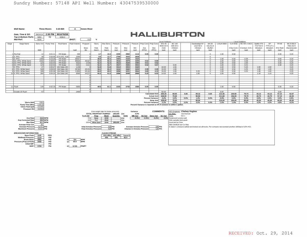
RECEIVED: Oct. 29, 2014
Well Name: 3-23-820 4 Green River
Date, Time & SO: 09/24/14 2:50 PM 901679259 Top & Bottom Perfs: 5893 TO 6096.0Mid-Perf: 6028 BHST: 152 °F
Liquid Additives-----------------------------------------------------------------------------------------------------------------Liquid AdditivesStage Stage Name Slurry Vol Pump Time Fluid Name Fluid Volume Proppant Slurry Max Slurry Pressure Pressure Pressure Prop Conc Prop Conc WG-35 BC 140 Sandwedge NT BA-20 LoSurf-300D CLA-Web MC MX 2-2822 Optiflo HTE SP FR-66 MC B-8614
9000-30-0 590-29-4 1310-58-3 631-61-8 7727-54-0 7775-27-1 7681-52-9Mass Rate Rate Ave Max Min Avg Max (Gel) (Xlinker) (Xlinker) (Buffer) (Clay Cont.) (Conduct. Enh.) (Breaker) (Breaker) (Fric Red) (Bacteriacide)
(bbl) (gal) (lb) (bpm) (bpm) (psi) (psi) (psi) (PPG) (PPG) (ppt) (gpt) (gpt) (gpt) (gpt) (gpt) (ppt) (ppt) (gpt) (gpt)
1 Pre-Pad 12 0:01:11 FR Water 500 0 4.7 10.3 2200 2892 1112 0.00 0.00 0 1.00 0.50 0.30 0.202 0 PPG 48 0:04:46 15 % HCL Acid 2000 0 9.6 12.7 2768 3043 2636 03 0 PPG 1406 0:23:26 FR Water 59057 0 38.8 60.3 3404 4154 1523 0 1.00 0.50 0.39 0.40 0.204 0.5 PPG White Sand 2332 0:38:52 FR Water 95620 49,627 53.4 60.3 3532 3879 3250 0.52 0.59 0 1.00 0.50 0.39 0.30 0.205 0.5 PPG White Sand 123 0:02:03 FR Water 5022 2,536 52.3 52.3 3513 3529 3494 0.51 0.52 0 1.00 0.50 2.00 0.30 0.206 0.5 PPG White Sand 123 0:02:03 FR Water 5031 2,611 52.4 52.7 3537 3565 3502 0.52 0.57 0.40 0 1.00 0.50 0.25 0.30 0.207 0 PPG 27 0:00:27 16# Delta 140 1148 0 52.8 53.8 3414 3553 3320 16.00 1.60 0 1.00 0.50 0.25 1.00 1.00 0.208 2 PPG White Sand 543 0:09:03 16# Delta 140 20760 43,243 59.2 60.3 3416 3582 3220 2.08 2.26 16.00 1.60 0 1.00 0.50 0.25 1.00 1.00 0.209 4 PPG White Sand 336 0:05:36 16# Delta 140 11803 45,442 60.0 60.5 3056 3231 2944 3.85 4.15 16.00 1.60 0.20 0 1.00 0.50 0.25 1.00 1.00 0.20
10 6 PPG White Sand 264 0:04:24 16# Delta 140 8565 44,572 60.3 61.0 2996 3049 2969 5.20 6.03 14.00 1.60 1.80 0 1.00 0.50 1.10 1.10 0.20 0 0 0 0 0
11 Flush 139 0:02:19 FR Water 5850 0 49.5 61.1 3103 3742 1584 0.00 0.00 1.00 0.50 0.30 0.20 0
Growler @ Flush 57 2400 0 50.00 0.00 0.00 Calculated Amt 659.29 69.65 0.00 89.32 0.00 213.36 106.68 79.73 43.13 43.13 57.23 42.67
Actual Amt 638.00 70.00 90.50 211.60 106.00 79.70 43.70 43.70 57.10 42.20Percent Variance -3.2% 0.0% 0.0% 1.3% 0.0% -0.8% 0.0% 0.0% 0.0% 0.0% 0.0% 0.0%
Strap Amt 638.00 70.00 90.00 210.00 105.00 80.00 45.00 45.00 60.00 40.00Slurry (bbl) 5353 Percent Variance -3.2% 0.0% 0.0% 0.0% 0.0% -1.6% -1.6% 0.0% 4.3% 4.3% 4.8% -6.3%
Pump Time (Min) 1:34:10 Percent Variance is reported as 0% if variance is within 1 gallon.Clean Fluid (gal) 215356
Proppant (lb) 192959 (Use weight slips for below amounts) Variance HES Engineer: Chelsey Hughes
TOTAL PROPPANT PUMPED: 188,600 Lbs 0.0% Co. Rep: Joe Duncan% of Job Prop Mesh Quantity Units MB Vari SS Vari Dens Vari SC Vari Crew: RED A
Avg Rate 44.8 BPM 0% None 20/40 Lbs -0.3% -2.3% -0.2% -3.0% Equipment running well Avg Corrected Rate 48.8 BPM 0% TLC 20/40 Lbs Xlink samples look good
Max Rate 61.1 BPM 100% White Sand 20/40 188,600 Lbs Good job by CrewAverage Prop Con 2.1 3bbl overflush per Co RepAverage Pressure 3176.3 PSI Inital Annulus Pressure 3.0 PSI Average Annulus Pressure 2.9 PSI In stage 3, pressure spiked and kicked out all trucks. Per company rep pumped another 1000gal of 15% HCl.
Maximum Pressure 4154.0 PSI Final Annulus Pressure 4.0 PSI Change in Annulus Pressure 1.0 PSI
BREAKDOWN INFORMATION: CLEAN STREAM:Base Fluid: 8.40 PPG UV1 HRs UV2 HRs Transm.%
Wellhead Pressure: 1114 PSI 505 505 82.4Broke Back: 2892 PSI @ 9.4 BPM
Pressure (Prop at Perfs) 3408 PSI @ 60.0 BPMInitial ISIP: PSI
ISDP: 1724 PSI @ 0.723 PSI/FT
Three Rivers
COMMENTS:
Sundry Number: 57148 API Well Number: 43047539530000Sundry Number: 57148 API Well Number: 43047539530000
WelI Name: Three Rivers 3-23-820 4 Green River
Date, Time & SO: 09/24/14 2:50 PM 901679259Top & Bottom Perfs: To 6096.0Mid-Perf: 6028 BHST: 152| °F
Liauid Addkives----------------- -------------------------------------------------------------------------------Liauid AddithresStaae StaaeName SlurrvVol PumoTime FluidName FluidVolume Proopant Slurrv MaxSlurrv Pressure Pressure Pressure ProoConc ProoConc WG-35 BC140 SandwedaeNT BA-20 LoSurf-300D CLA-Web MCMX2-2822 OptinoHTE SP FR-66 MCB-8614
9000-30-0 590-29-4 1310-58-3 631-61-8 7727-54-0 7775-27-1 7681-52-9Mass Rate Rate Ave Max Min Ava Max (Gell ()Ginker) (XIinker) (Buffer) (ClavCont.) (Conduct.Enh.) (Breaker) (Breaker) (FricRed) (Bacteriacidel
(bbl1 (aall (Ibl (bom] (bom] (osil (osil (osil (PPG1 (PPG1 (ootl (act] (act] (act] (act] (act] (ootl (ootl (act] (act]
1 Pre-Pad 12 001 11 FRVVater 500 0 4.7 10.3 2200 2892 1112 0.00 0.00 0 1 30 0.50 0.30 0.20
2 0 PPG 48 00446 15%HCLAcid 2000 0 9.6 12.7 2768 3043 2636 03 0 PPG 1406 02326 FRWater 59057 0 38.8 60.3 3404 4154 1523 0 1.00 0.50 0.39 0.40 0.204 0.5 PPG WhkeSand 2332 03852 FRWater 95620 49.627 53.4 60.3 3532 3879 3250 0.52 0.59 O 1.00 0.50 0.39 0.30 0.205 0.5 PPG WhkeSand 123 00203 FRWater 5022 2,536 52.3 52.3 3513 3529 3494 0.51 0.52 0 1.00 0.50 2.00 0.30 0.206 0.5 PPG WhkeSand 123 00203 FRWater 5031 2.611 52.4 52.7 3537 3565 3502 0.52 0.57 0.40 0 1.00 0.50 0.25 0.30 0.207 0 PPG 27 00027 16#Deka140 1148 0 52.8 53.8 3414 3553 3320 16.00 1.60 0 1.00 0.50 0.25 1.00 1.00 0.208 2 PPG WhiteSand 543 00903 16#Deka140 20760 43.243 59.2 60.3 3416 3582 3220 2.08 2.26 16.00 1.60 0 1.00 0.50 0.25 1.00 1.00 0.209 4 PPG WhiteSand 336 00536 16#Deka140 11803 45,442 60.0 60.5 3056 3231 2944 3.85 4.15 16.00 1.60 0.20 0 1.00 0.50 0.25 1.00 1.00 0.20
10 6 PPG WhiteSand 264 00424 16#Deka140 8565 44,572 60.3 61.0 2996 3049 2969 5.20 6.03 14.00 1.60 1.80 0 1.00 0.50 1.10 1.10 0.2000000
11 Flush 139 00219 FRWater 5850 0 49.5 61.1 3103 3742 1584 0.00 0.00 1.00 0.50 0.30 0.20
0Growler 8 Flush 57 2400 0 50.00 0.00 0.00
Calculated Amt 659.29 69.65 0.00 89.32 0.00 213.36 106.68 79.73 43.13 43.13 57.23 42.67Actual Amt 638.00 70.00 90.50 211.60 106.00 79.70 43.70 43.70 57.10 42.20
PercentVariance -3.2% 0.0% 0.0% 1.3% 0.0% -0.8% 0.0% 0.0% 0.0% 0.0% 0.0% 0.0%Stran Amt 638.00 70.00 90.00 210.00 105.00 80.00 45.00 45.00 60.00 40.00
Slurry(bbl)| 5353 PercentVariance -3.2% 0.0% 0.0% 0.0% 0.0% -1.6% -1.6% 0.0% 4.3% 4.3% 4.8% -6.3%
Pumo Time (Minll 1 34 10 Percent Variance is reported as 0% if varianct is within 1 aal on.Clean Fluid (gal)| 215356
Pronnantfibil 192959(Use weight slips for below amounts) Variance COMMENTS: HFS Fnaineer Chelsey Hughes
TOTALPROPPANTPUAPED: 188.600 Lbs 0.0% Co.Reo JoeDuncanb a _Mesh _Quantity Units MBVari SSVari DensVari SCVari Crew REDA
AvaRatel 44.8 BPM 0% None 20¼0 | Lbs | -0.3%\ -2.3%\ -0.2%\ -3.0% EauiomentrunninawellAva Corrected Ratel 48.8 BPM 0% TLC 20Mo | Lbs )Gink samples look good
Max Ratel 61.1 BPM 100% White sand 20¼0 | 188,600 Lbs Good iob by CrewAverage Pron Con 2.1 3bbl overnush Der Co ReoAveraae Pressurel 3176.3 PSI Inital Annulus Pressurel 3. PSI Averaae Annulus Pressurel 2.9 PSI In staae 3. Dressure soiked and kicked out all trucks. Per comoanvreo cumoed another 1000aal of 15% HCI
Maximum Pressure| 4154.0 PSI Final Annulus Pressure| 4. PSI Change in Annulus Pressure 1.0 PSI
BREAKDOWNINFORM4710N: CLEANSTREAMBase Fluid:I 8.40 PPG \ UV1 HRsì UV2 HRsì Transm.%
WellheadPressure:I 1114 PSI | 505 | 505 | 82.4 |BrokeBack:I 2892 PSI | 9.4 |BPM
Pressure(PropatPerfs)| 3408 PSI 60.0 |BPMInitial ISIP:| PSI
ISDP:I 1724 PSI 0.723 PSI/FT
RECEIVED: Oct. 29,
Sundry Number: 57148 API Well Number: 43047539530000
WelI Name: Three Rivers 3-23-820 4 Green River
Date, Time & SO: 09/24/14 2:50 PM 901679259Top & Bottom Perfs: To 6096.0Mid-Perf: 6028 BHST: 152| °F
Liauid Addkives----------------- -------------------------------------------------------------------------------Liauid AddithresStaae StaaeName SlurrvVol PumoTime FluidName FluidVolume Proopant Slurrv MaxSlurrv Pressure Pressure Pressure ProoConc ProoConc WG-35 BC140 SandwedaeNT BA-20 LoSurf-300D CLA-Web MCMX2-2822 OptinoHTE SP FR-66 MCB-8614
9000-30-0 590-29-4 1310-58-3 631-61-8 7727-54-0 7775-27-1 7681-52-9Mass Rate Rate Ave Max Min Ava Max (Gell ()Ginker) (XIinker) (Buffer) (ClavCont.) (Conduct.Enh.) (Breaker) (Breaker) (FricRed) (Bacteriacidel
(bbl1 (aall (Ibl (bom] (bom] (osil (osil (osil (PPG1 (PPG1 (ootl (act] (act] (act] (act] (act] (ootl (ootl (act] (act]
1 Pre-Pad 12 001 11 FRVVater 500 0 4.7 10.3 2200 2892 1112 0.00 0.00 0 1 30 0.50 0.30 0.20
2 0 PPG 48 00446 15%HCLAcid 2000 0 9.6 12.7 2768 3043 2636 03 0 PPG 1406 02326 FRWater 59057 0 38.8 60.3 3404 4154 1523 0 1.00 0.50 0.39 0.40 0.204 0.5 PPG WhkeSand 2332 03852 FRWater 95620 49.627 53.4 60.3 3532 3879 3250 0.52 0.59 O 1.00 0.50 0.39 0.30 0.205 0.5 PPG WhkeSand 123 00203 FRWater 5022 2,536 52.3 52.3 3513 3529 3494 0.51 0.52 0 1.00 0.50 2.00 0.30 0.206 0.5 PPG WhkeSand 123 00203 FRWater 5031 2.611 52.4 52.7 3537 3565 3502 0.52 0.57 0.40 0 1.00 0.50 0.25 0.30 0.207 0 PPG 27 00027 16#Deka140 1148 0 52.8 53.8 3414 3553 3320 16.00 1.60 0 1.00 0.50 0.25 1.00 1.00 0.208 2 PPG WhiteSand 543 00903 16#Deka140 20760 43.243 59.2 60.3 3416 3582 3220 2.08 2.26 16.00 1.60 0 1.00 0.50 0.25 1.00 1.00 0.209 4 PPG WhiteSand 336 00536 16#Deka140 11803 45,442 60.0 60.5 3056 3231 2944 3.85 4.15 16.00 1.60 0.20 0 1.00 0.50 0.25 1.00 1.00 0.20
10 6 PPG WhiteSand 264 00424 16#Deka140 8565 44,572 60.3 61.0 2996 3049 2969 5.20 6.03 14.00 1.60 1.80 0 1.00 0.50 1.10 1.10 0.2000000
11 Flush 139 00219 FRWater 5850 0 49.5 61.1 3103 3742 1584 0.00 0.00 1.00 0.50 0.30 0.20
0Growler 8 Flush 57 2400 0 50.00 0.00 0.00
Calculated Amt 659.29 69.65 0.00 89.32 0.00 213.36 106.68 79.73 43.13 43.13 57.23 42.67Actual Amt 638.00 70.00 90.50 211.60 106.00 79.70 43.70 43.70 57.10 42.20
PercentVariance -3.2% 0.0% 0.0% 1.3% 0.0% -0.8% 0.0% 0.0% 0.0% 0.0% 0.0% 0.0%Stran Amt 638.00 70.00 90.00 210.00 105.00 80.00 45.00 45.00 60.00 40.00
Slurry(bbl)| 5353 PercentVariance -3.2% 0.0% 0.0% 0.0% 0.0% -1.6% -1.6% 0.0% 4.3% 4.3% 4.8% -6.3%
Pumo Time (Minll 1 34 10 Percent Variance is reported as 0% if varianct is within 1 aal on.Clean Fluid (gal)| 215356
Pronnantfibil 192959(Use weight slips for below amounts) Variance COMMENTS: HFS Fnaineer Chelsey Hughes
TOTALPROPPANTPUAPED: 188.600 Lbs 0.0% Co.Reo JoeDuncanb a _Mesh _Quantity Units MBVari SSVari DensVari SCVari Crew REDA
AvaRatel 44.8 BPM 0% None 20¼0 | Lbs | -0.3%\ -2.3%\ -0.2%\ -3.0% EauiomentrunninawellAva Corrected Ratel 48.8 BPM 0% TLC 20Mo | Lbs )Gink samples look good
Max Ratel 61.1 BPM 100% White sand 20¼0 | 188,600 Lbs Good iob by CrewAverage Pron Con 2.1 3bbl overnush Der Co ReoAveraae Pressurel 3176.3 PSI Inital Annulus Pressurel 3. PSI Averaae Annulus Pressurel 2.9 PSI In staae 3. Dressure soiked and kicked out all trucks. Per comoanvreo cumoed another 1000aal of 15% HCI
Maximum Pressure| 4154.0 PSI Final Annulus Pressure| 4. PSI Change in Annulus Pressure 1.0 PSI
BREAKDOWNINFORM4710N: CLEANSTREAMBase Fluid:I 8.40 PPG \ UV1 HRsì UV2 HRsì Transm.%
WellheadPressure:I 1114 PSI | 505 | 505 | 82.4 |BrokeBack:I 2892 PSI | 9.4 |BPM
Pressure(PropatPerfs)| 3408 PSI 60.0 |BPMInitial ISIP:| PSI
ISDP:I 1724 PSI 0.723 PSI/FT
RECEIVED: Oct. 29,
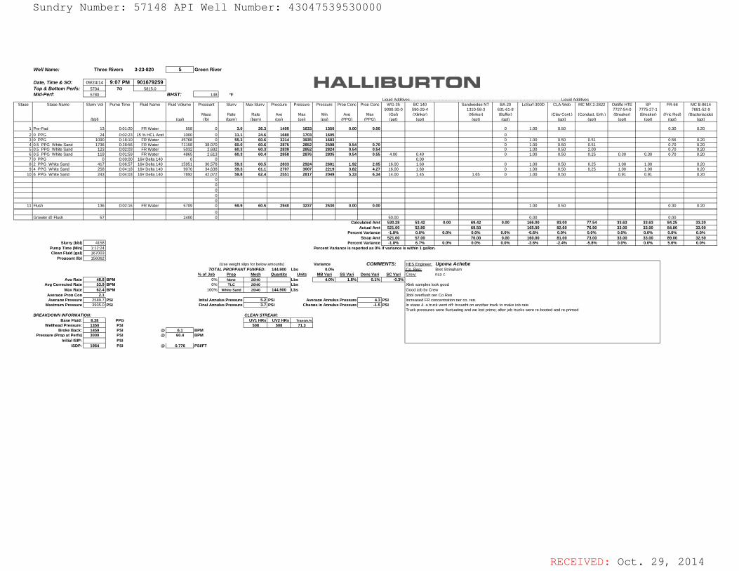
RECEIVED: Oct. 29, 2014
Well Name: 3-23-820 5 Green River
Date, Time & SO: 09/24/14 9:07 PM 901679259 Top & Bottom Perfs: 5704 TO 5815.0Mid-Perf: 5780 BHST: 148 °F
Liquid Additives-----------------------------------------------------------------------------------------------------------------Liquid AdditivesStage Stage Name Slurry Vol Pump Time Fluid Name Fluid Volume Proppant Slurry Max Slurry Pressure Pressure Pressure Prop Conc Prop Conc WG-35 BC 140 Sandwedge NT BA-20 LoSurf-300D CLA-Web MC MX 2-2822 Optiflo HTE SP FR-66 MC B-8614
9000-30-0 590-29-4 1310-58-3 631-61-8 7727-54-0 7775-27-1 7681-52-9Mass Rate Rate Ave Max Min Avg Max (Gel) (Xlinker) (Xlinker) (Buffer) (Clay Cont.) (Conduct. Enh.) (Breaker) (Breaker) (Fric Red) (Bacteriacide)
(bbl) (gal) (lb) (bpm) (bpm) (psi) (psi) (psi) (PPG) (PPG) (ppt) (gpt) (gpt) (gpt) (gpt) (gpt) (ppt) (ppt) (gpt) (gpt)
1 Pre-Pad 13 0:01:20 FR Water 558 0 3.0 26.3 1400 1633 1350 0.00 0.00 0 1.00 0.50 0.30 0.202 0 PPG 24 0:02:23 15 % HCL Acid 1000 0 11.1 24.6 1680 1703 1605 03 0 PPG 1090 0:18:10 FR Water 45768 0 55.3 60.6 3214 3935 1683 0 1.00 0.50 0.51 0.56 0.204 0.5 PPG White Sand 1736 0:28:56 FR Water 71158 38,070 60.0 60.6 2875 2852 2598 0.54 0.70 0 1.00 0.50 0.51 0.70 0.205 0.5 PPG White Sand 123 0:02:03 FR Water 5032 2,692 60.3 60.3 2839 2852 2824 0.54 0.54 0 1.00 0.50 2.00 0.70 0.206 0.5 PPG White Sand 119 0:01:59 FR Water 4865 2,613 60.3 60.4 2858 2876 2835 0.54 0.55 4.00 0.40 0 1.00 0.50 0.25 0.30 0.30 0.70 0.207 0 PPG 0 0:00:00 16# Delta 140 0 0 0.008 2 PPG White Sand 417 0:06:57 16# Delta 140 15951 30,578 59.3 60.5 2833 2924 2681 1.92 2.05 16.00 1.60 0 1.00 0.50 0.25 1.00 1.00 0.209 4 PPG White Sand 258 0:04:18 16# Delta 140 9070 34,638 59.3 61.1 2707 3007 2219 3.82 4.27 16.00 1.60 0 1.00 0.50 0.25 1.00 1.00 0.20
10 6 PPG White Sand 243 0:04:03 16# Delta 140 7892 42,072 59.8 62.4 2551 2817 2049 5.33 6.34 14.00 1.45 1.65 0 1.00 0.50 0.91 0.91 0.20 0 0 0 0 0
11 Flush 136 0:02:16 FR Water 5709 0 59.9 60.5 2940 3237 2530 0.00 0.00 1.00 0.50 0.30 0.20 0
Growler @ Flush 57 2400 0 50.00 0.00 0.00 Calculated Amt 530.28 53.42 0.00 69.42 0.00 166.00 83.00 77.54 33.63 33.63 84.25 33.20
Actual Amt 521.00 52.80 69.50 165.00 82.60 76.90 33.00 33.00 84.80 33.00Percent Variance -1.8% 0.0% 0.0% 0.0% 0.0% -0.6% 0.0% 0.0% 0.0% 0.0% 0.0% 0.0%
Strap Amt 521.00 57.00 70.00 0.00 160.00 81.00 73.00 33.00 33.00 89.00 32.50Slurry (bbl) 4158 Percent Variance -1.8% 6.7% 0.0% 0.0% 0.0% -3.6% -2.4% -5.8% 0.0% 0.0% 5.6% 0.0%
Pump Time (Min) 1:12:24 Percent Variance is reported as 0% if variance is within 1 gallon.Clean Fluid (gal) 167003
Proppant (lb) 156062 (Use weight slips for below amounts) Variance HES Engineer: Ugoma Achebe
TOTAL PROPPANT PUMPED: 144,900 Lbs 0.0% Co. Rep: Bret Stringham% of Job Prop Mesh Quantity Units MB Vari SS Vari Dens Vari SC Vari Crew: RED C
Avg Rate 48.8 BPM 0% None 20/40 Lbs 4.0% 1.8% 0.1% -0.3%Avg Corrected Rate 53.9 BPM 0% TLC 20/40 Lbs Xlink samples look good
Max Rate 62.4 BPM 100% White Sand 20/40 144,900 Lbs Good job by CrewAverage Prop Con 2.1 3bbl overflush per Co RepAverage Pressure 2589.7 PSI Inital Annulus Pressure 5.2 PSI Average Annulus Pressure 4.3 PSI Increased FR concentration per co. rep.
Maximum Pressure 3935.0 PSI Final Annulus Pressure 3.7 PSI Change in Annulus Pressure -1.5 PSI In stage 4, a truck went off; brought on another truck to make job rateTruck pressures were fluctuating and we lost prime; after job trucks were re-booted and re-primed
BREAKDOWN INFORMATION: CLEAN STREAM:Base Fluid: 8.38 PPG UV1 HRs UV2 HRs Transm.%
Wellhead Pressure: 1350 PSI 508 508 71.3Broke Back: 1459 PSI @ 6.1 BPM
Pressure (Prop at Perfs) 3000 PSI @ 60.4 BPMInitial ISIP: PSI
ISDP: 1964 PSI @ 0.776 PSI/FT
Three Rivers
COMMENTS:
Sundry Number: 57148 API Well Number: 43047539530000Sundry Number: 57148 API Well Number: 43047539530000
Well Name: Three Rivers 3-23-820 5 Green River
Date, Time & SO: 09/24/14 9:07 PM 901679259Top & Bollom Perfs: 5704 TO 5815.0Mid-Perf: 5780 BHST: 148 F
Liauid Addith es------------------ -----------------------------------------------------------------------Liauid / ddithresStaae Staae Name SlurrvVol Pume Time Fluid Name Fluid Volume Proceant Slurrv Max Slurrv Pressure Pressure Pressure Pron Conc Pron Conc WG-35 BC 140 Sandwedae NT BA-20 LoSurf-300D CLA-Web MC MX 2-2822 Ootiflo HTE SP FR-66 MC B-8614
9000-30-0 590-29-4 1310-58-3 631-61-8 7727-54-0 7775-27-1 7681-52-9Mass Rate Rate Ave Max Min Ava Max (Gell (XIinkerì (XIinkerì (Bufferì (Clav Cont.] (Conduct. Enh.1 (Breakerì (Breakerì (Fric Redì (Bacteriacidel
(bblì (aall (Ibl (bomi (bomi (osil (osil (osil (PPG1 (PPG1 (Deti (actì (actì (actì (actì (actì (Deti (Deti (actì (actì
1 Pre-Pad 13 0 01 20 FR VVater 558 0 3.0 26.3 1400 1633 1350 0.00 0.00 0 1.00 0.50 0.30 0.20
2 0 PPG 24 0 02 23 15 To HCLAcic 1000 0 11.1 24.6 1680 1703 1605 03 0 PPG 1090 0 8 0 FR VVater 45768 0 55.3 60.6 3214 3935 1683 0 1.00 0.50 0.51 0.56 0.204 0.5 PPG VVhke Sand 1736 0 28 56 FR VVater 71158 38,070 60.0 60.6 2875 2852 2598 0.54 0.70 0 1.00 0.50 0.51 0.70 0.205 0.5 PPG VVhke Sand 123 0 02 03 FR VVater 5032 2.692 60.3 60.3 2839 2852 2824 0.54 0.54 0 1.00 0.50 2.00 0.70 0.206 0.5 PPG VVhke Sand 119 0 01 59 FR VVater 4865 2.613 60.3 60.4 2858 2876 2835 0.54 0.55 4.00 0.40 0 1.00 0.50 0.25 0.30 0.30 0.70 0.207 0 PPG 0 0 00 00 16# Delta 140 0 0 0.008 2 PPG VVhiteSand 417 0 06 57 16# Delta 140 15951 30.578 59.3 60.5 2833 2924 2681 1.92 2.05 16.00 1.60 0 1.00 0.50 0.25 1.00 1.00 0.209 4 PPG White Sand 258 0 04 18 16# Delta 140 9070 34,638 59.3 61.1 2707 3007 2219 3.82 4.27 16.00 1.60 0 1.00 0.50 0.25 1.00 1.00 0.20
10 6 PPG White Sand 243 0 04 03 16# Delta 140 7892 42,072 59.8 62.4 2551 2817 2049 5.33 6.34 14.00 1.45 1.65 0 1.00 0.50 0.91 0.91 0.2000000
11 ush 136 0 02 6 FR VVater 5709 0 59.9 60.5 2940 3237 2530 0.00 0.00 1.00 0.50 0.30 0.20
0GrowderfD ush 57 2400 0 50.00 0.00 0.00
Calculated Amt 530.28 53.42 0.00 69.42 0.00 166.00 83.00 77.54 33.63 33.63 84.25 33.20ActualAmt 521.00 52.80 69.50 165.00 82.60 76.90 33.00 33.00 84.80 33.00
PercentVariance -1.8% 0.0% 0.0% 0.0% 0.0% -0.6% 0.0% 0.0% 0.0% 0.0% 0.0% 0.0%StranAmt 521.00 57.00 70.00 0.00 160.00 81.00 73.00 33.00 33.00 89.00 32.50
Slurry(bbl) 4158 PercentVariance -1.8% 6.7% 0.0% 0.0% 0.0% -3.6% -2.4% -5.8% 0.0% 0.0% 5.6% 0.0%Pumo Time (Min) 1 12 24 Percent Variance is reported as 0% if variance i within 1 aallor .
Clean Fluid (gal) 167003ProDDantfibi 156062
(Useweightslipsforbelowamounts) Variance COMMENTS: HFSFnnineer UgomaAchebeTOTALPROPPANTPUMPED: 144.900 Lbs 0.0% Co.Rep BretStringham
¾_o Job ProR Mesh _Quantity Units MBVari SSVari DensVari SCVari Crew REDC
Ava Rate 48.8 BPM 0% None 20/40 Lbs 4.0% 1.8% 0.1% -0.3%
Ava Corrected Rate 53.9 BPM 0% TLC 20/40 Lbs XIink samples look goodMax Rate 62.4 BPM 100% White Sand 20/40 144,900 Lbs Good iob by Crew
AA raaaaeePrreDssCu258 PSI Inital Annulus Pressure 5.2 PSI Averaae Annulus Pressure 4.3 PSI
3nbcb sRhcDoerrc tRaeonDer co. reo.
Maximum Pressure 3935.0| PSI Final Annulus Pressure 3.7 PSI Chanae in Annulus Pressure -1.5|PSI In staae 4. a truckwent off brought on another truckto make iob rateTruck pressures were fluctuating andwe lost prime; after iob truckswere re-booted and re-primed
BREAKDOWN INFORMAT ON: CLEAN STREAM:Base Fluid: 8.38 PPG UV1 HRs UV2 HRs Transm.%
Wellhead Pressure: 1350 PSI 508 508 71.3 |BrokeBack: 1459 PSI 6.1 BPM
Pressure (Prop at Perfs) 3000 PSI 60.4 BPMInitial ISIP: PSI
ISDP: 1964 PSI 0.776 PSI/FT
RECEIVED: Oct. 29,
Sundry Number: 57148 API Well Number: 43047539530000
Well Name: Three Rivers 3-23-820 5 Green River
Date, Time & SO: 09/24/14 9:07 PM 901679259Top & Bollom Perfs: 5704 TO 5815.0Mid-Perf: 5780 BHST: 148 F
Liauid Addith es------------------ -----------------------------------------------------------------------Liauid / ddithresStaae Staae Name SlurrvVol Pume Time Fluid Name Fluid Volume Proceant Slurrv Max Slurrv Pressure Pressure Pressure Pron Conc Pron Conc WG-35 BC 140 Sandwedae NT BA-20 LoSurf-300D CLA-Web MC MX 2-2822 Ootiflo HTE SP FR-66 MC B-8614
9000-30-0 590-29-4 1310-58-3 631-61-8 7727-54-0 7775-27-1 7681-52-9Mass Rate Rate Ave Max Min Ava Max (Gell (XIinkerì (XIinkerì (Bufferì (Clav Cont.] (Conduct. Enh.1 (Breakerì (Breakerì (Fric Redì (Bacteriacidel
(bblì (aall (Ibl (bomi (bomi (osil (osil (osil (PPG1 (PPG1 (Deti (actì (actì (actì (actì (actì (Deti (Deti (actì (actì
1 Pre-Pad 13 0 01 20 FR VVater 558 0 3.0 26.3 1400 1633 1350 0.00 0.00 0 1.00 0.50 0.30 0.20
2 0 PPG 24 0 02 23 15 To HCLAcic 1000 0 11.1 24.6 1680 1703 1605 03 0 PPG 1090 0 8 0 FR VVater 45768 0 55.3 60.6 3214 3935 1683 0 1.00 0.50 0.51 0.56 0.204 0.5 PPG VVhke Sand 1736 0 28 56 FR VVater 71158 38,070 60.0 60.6 2875 2852 2598 0.54 0.70 0 1.00 0.50 0.51 0.70 0.205 0.5 PPG VVhke Sand 123 0 02 03 FR VVater 5032 2.692 60.3 60.3 2839 2852 2824 0.54 0.54 0 1.00 0.50 2.00 0.70 0.206 0.5 PPG VVhke Sand 119 0 01 59 FR VVater 4865 2.613 60.3 60.4 2858 2876 2835 0.54 0.55 4.00 0.40 0 1.00 0.50 0.25 0.30 0.30 0.70 0.207 0 PPG 0 0 00 00 16# Delta 140 0 0 0.008 2 PPG VVhiteSand 417 0 06 57 16# Delta 140 15951 30.578 59.3 60.5 2833 2924 2681 1.92 2.05 16.00 1.60 0 1.00 0.50 0.25 1.00 1.00 0.209 4 PPG White Sand 258 0 04 18 16# Delta 140 9070 34,638 59.3 61.1 2707 3007 2219 3.82 4.27 16.00 1.60 0 1.00 0.50 0.25 1.00 1.00 0.20
10 6 PPG White Sand 243 0 04 03 16# Delta 140 7892 42,072 59.8 62.4 2551 2817 2049 5.33 6.34 14.00 1.45 1.65 0 1.00 0.50 0.91 0.91 0.2000000
11 ush 136 0 02 6 FR VVater 5709 0 59.9 60.5 2940 3237 2530 0.00 0.00 1.00 0.50 0.30 0.20
0GrowderfD ush 57 2400 0 50.00 0.00 0.00
Calculated Amt 530.28 53.42 0.00 69.42 0.00 166.00 83.00 77.54 33.63 33.63 84.25 33.20ActualAmt 521.00 52.80 69.50 165.00 82.60 76.90 33.00 33.00 84.80 33.00
PercentVariance -1.8% 0.0% 0.0% 0.0% 0.0% -0.6% 0.0% 0.0% 0.0% 0.0% 0.0% 0.0%StranAmt 521.00 57.00 70.00 0.00 160.00 81.00 73.00 33.00 33.00 89.00 32.50
Slurry(bbl) 4158 PercentVariance -1.8% 6.7% 0.0% 0.0% 0.0% -3.6% -2.4% -5.8% 0.0% 0.0% 5.6% 0.0%Pumo Time (Min) 1 12 24 Percent Variance is reported as 0% if variance i within 1 aallor .
Clean Fluid (gal) 167003ProDDantfibi 156062
(Useweightslipsforbelowamounts) Variance COMMENTS: HFSFnnineer UgomaAchebeTOTALPROPPANTPUMPED: 144.900 Lbs 0.0% Co.Rep BretStringham
¾_o Job ProR Mesh _Quantity Units MBVari SSVari DensVari SCVari Crew REDC
Ava Rate 48.8 BPM 0% None 20/40 Lbs 4.0% 1.8% 0.1% -0.3%
Ava Corrected Rate 53.9 BPM 0% TLC 20/40 Lbs XIink samples look goodMax Rate 62.4 BPM 100% White Sand 20/40 144,900 Lbs Good iob by Crew
AA raaaaeePrreDssCu258 PSI Inital Annulus Pressure 5.2 PSI Averaae Annulus Pressure 4.3 PSI
3nbcb sRhcDoerrc tRaeonDer co. reo.
Maximum Pressure 3935.0| PSI Final Annulus Pressure 3.7 PSI Chanae in Annulus Pressure -1.5|PSI In staae 4. a truckwent off brought on another truckto make iob rateTruck pressures were fluctuating andwe lost prime; after iob truckswere re-booted and re-primed
BREAKDOWN INFORMAT ON: CLEAN STREAM:Base Fluid: 8.38 PPG UV1 HRs UV2 HRs Transm.%
Wellhead Pressure: 1350 PSI 508 508 71.3 |BrokeBack: 1459 PSI 6.1 BPM
Pressure (Prop at Perfs) 3000 PSI 60.4 BPMInitial ISIP: PSI
ISDP: 1964 PSI 0.776 PSI/FT
RECEIVED: Oct. 29,

RECEIVED: Oct. 29, 2014
Well Name: 3-23-820 6 Green River
Date, Time & SO: 09/25/14 1:37 AM 901679259 Top & Bottom Perfs: 5179 TO 5447.0Mid-Perf: 5313 BHST: 141 °F
Liquid Additives-----------------------------------------------------------------------------------------------------------------Liquid AdditivesStage Stage Name Slurry Vol Pump Time Fluid Name Fluid Volume Proppant Slurry Max Slurry Pressure Pressure Pressure Prop Conc Prop Conc WG-35 BC 140 Sandwedge NT BA-20 LoSurf-300D CLA-Web MC MX 2-2822 Optiflo HTE SP FR-66 MC B-8614
9000-30-0 590-29-4 1310-58-3 631-61-8 7727-54-0 7775-27-1 7681-52-9Mass Rate Rate Ave Max Min Avg Max (Gel) (Xlinker) (Xlinker) (Buffer) (Clay Cont.) (Conduct. Enh.) (Breaker) (Breaker) (Fric Red) (Bacteriacide)
(bbl) (gal) (lb) (bpm) (bpm) (psi) (psi) (psi) (PPG) (PPG) (ppt) (gpt) (gpt) (gpt) (gpt) (gpt) (ppt) (ppt) (gpt) (gpt)
1 Pre-Pad 1 0:00:07 FR Water 50 0 4.9 10.4 2247 2635 1033 0.00 0.00 0 1.00 0.50 0.30 0.202 0 PPG 24 0:02:23 15 % HCL Acid 1000 0 10.9 20.8 2574 2645 2426 03 0 PPG 641 0:10:41 FR Water 26916 0 48.3 60.3 3430 4140 2457 0 1.00 0.50 0.95 0.45 0.204 0.5 PPG White Sand 888 0:14:48 FR Water 36399 17,326 60.2 60.3 3204 3384 3055 0.48 0.54 0 1.00 0.50 0.95 0.50 0.205 0.5 PPG White Sand 123 0:02:03 FR Water 5055 2,442 60.2 60.3 3101 3114 3092 0.48 0.49 0 1.00 0.50 2.00 0.50 0.206 0.5 PPG White Sand 119 0:01:59 FR Water 4861 2,406 60.3 60.5 3110 3122 3092 0.50 0.51 4.00 0.40 0 1.00 0.50 0.25 0.35 0.35 0.50 0.207 0 PPG 0 0:00:00 16# Delta 140 0 0 0.008 2 PPG White Sand 239 0:03:59 16# Delta 140 9135 17,786 60.1 60.5 3115 3183 3049 1.95 2.19 16.00 1.60 0 1.00 0.50 0.25 1.00 1.00 0.209 4 PPG White Sand 148 0:02:28 16# Delta 140 5185 19,677 60.0 60.2 3073 3165 2958 3.80 6.75 16.00 1.60 0 1.00 0.50 0.25 1.00 1.00 0.20
10 6 PPG White Sand 149 0:02:29 16# Delta 140 4848 23,944 60.0 61.2 2882 2977 2544 4.94 6.75 14.00 1.37 1.55 0 1.00 0.50 0.86 0.86 0.20 0 0 0 0 0
11 Flush 123 0:02:03 FR Water 5148 0 60.6 60.7 3281 3591 2788 0.00 0.00 1.00 0.50 0.30 0.20 0
Growler @ Flush 57 2400 0 50.00 0.00 0.00 Calculated Amt 316.44 31.52 0.00 37.11 0.00 97.60 48.80 74.91 20.18 20.18 36.83 19.52
Actual Amt 313.00 31.40 37.30 97.20 48.70 74.80 19.60 19.60 36.70 19.40Percent Variance -1.1% 0.0% 0.0% 0.0% 0.0% 0.0% 0.0% 0.0% 0.0% 0.0% 0.0% 0.0%
Strap Amt 312.00 32.50 39.00 0.00 97.00 48.00 72.50 20.00 20.00 34.00 20.50Slurry (bbl) 2454 Percent Variance -1.4% 0.0% 0.0% 5.1% 0.0% 0.0% 0.0% -3.2% 0.0% 0.0% -7.7% 0.0%
Pump Time (Min) 0:42:59 Percent Variance is reported as 0% if variance is within 1 gallon.Clean Fluid (gal) 98597
Proppant (lb) 91256 (Use weight slips for below amounts) Variance HES Engineer: Ugoma Achebe
TOTAL PROPPANT PUMPED: 82,800 Lbs 0.0% Co. Rep: Bret Stringham% of Job Prop Mesh Quantity Units MB Vari SS Vari Dens Vari SC Vari Crew: RED C
Avg Rate 48.5 BPM 0% None 20/40 Lbs 0.9% 1.2% -0.2% 0.5% Equipment running well Avg Corrected Rate 53.4 BPM 0% TLC 20/40 Lbs Xlink samples look good
Max Rate 61.2 BPM 100% White Sand 20/40 82,800 Lbs Good job by CrewAverage Prop Con 2.0 3bbl overflush per Co RepAverage Pressure 3001.7 PSI Inital Annulus Pressure 0.0 PSI Average Annulus Pressure 0.0 PSI Increased FR concentration per. Co. rep.
Maximum Pressure 4140.0 PSI Final Annulus Pressure 0.0 PSI Change in Annulus Pressure 0.0 PSI
BREAKDOWN INFORMATION: CLEAN STREAM:Base Fluid: 8.40 PPG UV1 HRs UV2 HRs Transm.%
Wellhead Pressure: 1033 PSI 509 509 79.7Broke Back: 2459 PSI @ 2.7 BPM
Pressure (Prop at Perfs) 3336 PSI @ 60.1 BPMInitial ISIP: PSI
ISDP: 1593 PSI @ 0.737 PSI/FT
Three Rivers
COMMENTS:
Sundry Number: 57148 API Well Number: 43047539530000Sundry Number: 57148 API Well Number: 43047539530000
Well Name: Three Rivers 3-23-820 6 Green River
Date, Time & SO: 09/25/14 1:37 AM 901679259Top & Bollom Perfs: 5179 TO 5447.0Mid-Perf: 5313 BHST: 141 F
Liauid AdditWes------------------ -----------------------------------------------------------------------Liauid / ddithresStaae Staae Name SlurrvVol Pume Time Fluid Name Fluid Volume Proceant Slurrv Max Slurrv Pressure Pressure Pressure Pron Conc Pron Conc WG-35 BC 140 Sandwedae NT BA-20 LoSurf-300D CLA-Web MC MX 2-2822 Ootiflo HTE SP FR-66 MC B-8614
9000-30-0 590-29-4 1310-58-3 631-61-8 7727-54-0 7775-27-1 7681-52-9Mass Rate Rate Ave Max Min Ava Max (Gell (XIinkerì (XIinkerì (Bufferì (Clav Cont.] (Conduct. Enh.1 (Breakerì (Breakerì (Fric Redì (Bacteriacidel
(bblì (aall (Ibl (bomi (bomi (osil (osil (osil (PPG1 (PPG1 (Deti (actì (actì (actì (actì (actì (Deti (Deti (actì (actì
1 Pre-Pad 1 0 00 07 FR VVater 50 0 4.9 10.4 2247 2635 1033 0.00 0.00 0 1.00 0.50 0.30 0.20
2 0 PPG 24 0 02 23 15% HCL Acid 1000 0 10.9 20.8 2574 2645 2426 03 0 PPG 641 0 10 41 FR Water 26916 0 48.3 60.3 3430 4140 2457 0 1.00 0.50 0.95 0.45 0.204 0.5 PPG White Sand 888 0 14 48 FR Water 36399 17,326 60.2 60.3 3204 3384 3055 0.48 0.54 0 1.00 0.50 0.95 0.50 0.2050.5PPGWhiteSand 123 00203 FRWater 5055 2.442 60.2 60.3 3101 3114 3092 0.48 0.49 0 1.00 0.50 2.00 0.50 0.206 0.5 PPG VVhke Sand 119 0 01 59 FR VVater 4861 2.406 60.3 60.5 3110 3122 3092 0.50 0.51 4.00 0.40 0 1.00 0.50 0.25 0.35 0.35 0.50 0.207 0 PPG 0 0 00 00 16# Delta 140 0 0 0.008 2 PPG VVhiteSand 239 0 03 59 16# Delta 140 9135 17.786 60.1 60.5 3115 3183 3049 1.95 2.19 16.00 1.60 0 1.00 0.50 0.25 1.00 1.00 0.209 4 PPG White Sand 148 0 02 28 16# Delta 140 5185 19,677 60.0 60.2 3073 3165 2958 3.80 6.75 16.00 1.60 0 1.00 0.50 0.25 1.00 1.00 0.20
10 6 PPG White Sand 149 0 02 29 16# Delta 140 4848 23,944 60.0 61.2 2882 2977 2544 4.94 6.75 14.00 1.37 1.55 0 1.00 0.50 0.86 0.86 0.2000000
11 ush 123 0 02 03 FR VVater 5148 0 60.6 60.7 3281 3591 2788 0.00 0.00 1.00 0.50 0.30 0.20
0GrowderfD ush 57 2400 0 50.00 0.00 0.00
Calculated Amt 316.44 31.52 0.00 37.11 0.00 97.60 48.80 74.91 20.18 20.18 36.83 19.52ActualAmt 313.00 31.40 37.30 97.20 48.70 74.80 19.60 19.60 36.70 19.40
PercentVariance -1.1% 0.0% 0.0% 0.0% 0.0% 0.0% 0.0% 0.0% 0.0% 0.0% 0.0% 0.0%Stran Amt 312.00 32.50 39.00 0.00 97.00 48.00 72.50 20.00 20.00 34.00 20.50
Slurry(bbl) 2454 PercentVariance -1.4% 0.0% 0.0% 5.1% 0.0% 0.0% 0.0% -3.2% 0.0% 0.0% -7.7% 0.0%Pumo Time (Min) O 42 59 Percent Variance is reported as 0% if variance i within 1 aallor .
Clean Fluid (gal) 98597ProDDantfibi 91256
(Useweightslipsforbelowamounts) Variance COMMENTS: HFSFnnineer UgomaAchebeTOTALPROPPANTPUMPED: 82.800 Lbs 0.0% Co.Rep BretStringham
¾_o Job ProR Mesh _Quantity Units MBVari SSVari DensVari SCVari Crew REDC
Ava Rate 48.5 BPM 0% None 20/40 Lbs 0.9% 1.2% -0.2% 0.5% Eauioment runnina wellAva Corrected Rate 53.4 BPM 0% TLC 20/40 Lbs XIink samples look good
Max Rate 61.2 BPM 100% White Sand 20/40 82,800 Lbs Good iob by CrewAA raaaaeePrreDssCu
300 PSI Inital Annulus Pressure 0.0 PSI Averaae Annulus Pressure 0.0 SI3nbcb sRhcDoerrc tRaeon
Der. Co. reo.Maximum Pressure 4140.0 PSI Final Annulus Pressure 0.0 PSI Chanae in Annulus Pressure 0.0 SI
BREAKDOWN INFORMAT ON: CLEAN STREAM:Base Fluid: 8.40 PPG UV1 HRs UV2 HRs Transm.%
Wellhead Pressure: 1033 PSI 509 509 79.7 |BrokeBack: 2459 PSI 2.7 BPM
Pressure (Prop at Perfs) 3336 PSI 60.1 BPMInitial ISIP: PSI
ISDP: 1593 PSI 0.737 PSI/FT
RECEIVED: Oct. 29,
Sundry Number: 57148 API Well Number: 43047539530000
Well Name: Three Rivers 3-23-820 6 Green River
Date, Time & SO: 09/25/14 1:37 AM 901679259Top & Bollom Perfs: 5179 TO 5447.0Mid-Perf: 5313 BHST: 141 F
Liauid AdditWes------------------ -----------------------------------------------------------------------Liauid / ddithresStaae Staae Name SlurrvVol Pume Time Fluid Name Fluid Volume Proceant Slurrv Max Slurrv Pressure Pressure Pressure Pron Conc Pron Conc WG-35 BC 140 Sandwedae NT BA-20 LoSurf-300D CLA-Web MC MX 2-2822 Ootiflo HTE SP FR-66 MC B-8614
9000-30-0 590-29-4 1310-58-3 631-61-8 7727-54-0 7775-27-1 7681-52-9Mass Rate Rate Ave Max Min Ava Max (Gell (XIinkerì (XIinkerì (Bufferì (Clav Cont.] (Conduct. Enh.1 (Breakerì (Breakerì (Fric Redì (Bacteriacidel
(bblì (aall (Ibl (bomi (bomi (osil (osil (osil (PPG1 (PPG1 (Deti (actì (actì (actì (actì (actì (Deti (Deti (actì (actì
1 Pre-Pad 1 0 00 07 FR VVater 50 0 4.9 10.4 2247 2635 1033 0.00 0.00 0 1.00 0.50 0.30 0.20
2 0 PPG 24 0 02 23 15% HCL Acid 1000 0 10.9 20.8 2574 2645 2426 03 0 PPG 641 0 10 41 FR Water 26916 0 48.3 60.3 3430 4140 2457 0 1.00 0.50 0.95 0.45 0.204 0.5 PPG White Sand 888 0 14 48 FR Water 36399 17,326 60.2 60.3 3204 3384 3055 0.48 0.54 0 1.00 0.50 0.95 0.50 0.2050.5PPGWhiteSand 123 00203 FRWater 5055 2.442 60.2 60.3 3101 3114 3092 0.48 0.49 0 1.00 0.50 2.00 0.50 0.206 0.5 PPG VVhke Sand 119 0 01 59 FR VVater 4861 2.406 60.3 60.5 3110 3122 3092 0.50 0.51 4.00 0.40 0 1.00 0.50 0.25 0.35 0.35 0.50 0.207 0 PPG 0 0 00 00 16# Delta 140 0 0 0.008 2 PPG VVhiteSand 239 0 03 59 16# Delta 140 9135 17.786 60.1 60.5 3115 3183 3049 1.95 2.19 16.00 1.60 0 1.00 0.50 0.25 1.00 1.00 0.209 4 PPG White Sand 148 0 02 28 16# Delta 140 5185 19,677 60.0 60.2 3073 3165 2958 3.80 6.75 16.00 1.60 0 1.00 0.50 0.25 1.00 1.00 0.20
10 6 PPG White Sand 149 0 02 29 16# Delta 140 4848 23,944 60.0 61.2 2882 2977 2544 4.94 6.75 14.00 1.37 1.55 0 1.00 0.50 0.86 0.86 0.2000000
11 ush 123 0 02 03 FR VVater 5148 0 60.6 60.7 3281 3591 2788 0.00 0.00 1.00 0.50 0.30 0.20
0GrowderfD ush 57 2400 0 50.00 0.00 0.00
Calculated Amt 316.44 31.52 0.00 37.11 0.00 97.60 48.80 74.91 20.18 20.18 36.83 19.52ActualAmt 313.00 31.40 37.30 97.20 48.70 74.80 19.60 19.60 36.70 19.40
PercentVariance -1.1% 0.0% 0.0% 0.0% 0.0% 0.0% 0.0% 0.0% 0.0% 0.0% 0.0% 0.0%Stran Amt 312.00 32.50 39.00 0.00 97.00 48.00 72.50 20.00 20.00 34.00 20.50
Slurry(bbl) 2454 PercentVariance -1.4% 0.0% 0.0% 5.1% 0.0% 0.0% 0.0% -3.2% 0.0% 0.0% -7.7% 0.0%Pumo Time (Min) O 42 59 Percent Variance is reported as 0% if variance i within 1 aallor .
Clean Fluid (gal) 98597ProDDantfibi 91256
(Useweightslipsforbelowamounts) Variance COMMENTS: HFSFnnineer UgomaAchebeTOTALPROPPANTPUMPED: 82.800 Lbs 0.0% Co.Rep BretStringham
¾_o Job ProR Mesh _Quantity Units MBVari SSVari DensVari SCVari Crew REDC
Ava Rate 48.5 BPM 0% None 20/40 Lbs 0.9% 1.2% -0.2% 0.5% Eauioment runnina wellAva Corrected Rate 53.4 BPM 0% TLC 20/40 Lbs XIink samples look good
Max Rate 61.2 BPM 100% White Sand 20/40 82,800 Lbs Good iob by CrewAA raaaaeePrreDssCu
300 PSI Inital Annulus Pressure 0.0 PSI Averaae Annulus Pressure 0.0 SI3nbcb sRhcDoerrc tRaeon
Der. Co. reo.Maximum Pressure 4140.0 PSI Final Annulus Pressure 0.0 PSI Chanae in Annulus Pressure 0.0 SI
BREAKDOWN INFORMAT ON: CLEAN STREAM:Base Fluid: 8.40 PPG UV1 HRs UV2 HRs Transm.%
Wellhead Pressure: 1033 PSI 509 509 79.7 |BrokeBack: 2459 PSI 2.7 BPM
Pressure (Prop at Perfs) 3336 PSI 60.1 BPMInitial ISIP: PSI
ISDP: 1593 PSI 0.737 PSI/FT
RECEIVED: Oct. 29,

RECEIVED: Oct. 29, 2014
Well Name: 3-23-820 7 Green River
Date, Time & SO: 09/25/14 5:56 AM 901679259 Top & Bottom Perfs: 5006 TO 5138.0Mid-Perf: 5077 BHST: 137 °F
Liquid Additives-----------------------------------------------------------------------------------------------------------------Liquid AdditivesStage Stage Name Slurry Vol Pump Time Fluid Name Fluid Volume Proppant Slurry Max Slurry Pressure Pressure Pressure Prop Conc Prop Conc WG-35 BC 140 Sandwedge NT BA-20 LoSurf-300D CLA-Web MC MX 2-2822 Optiflo HTE SP FR-66 MC B-8614
9000-30-0 590-29-4 1310-58-3 631-61-8 7727-54-0 7775-27-1 7681-52-9Mass Rate Rate Ave Max Min Avg Max (Gel) (Xlinker) (Xlinker) (Buffer) (Clay Cont.) (Conduct. Enh.) (Breaker) (Breaker) (Fric Red) (Bacteriacide)
(bbl) (gal) (lb) (bpm) (bpm) (psi) (psi) (psi) (PPG) (PPG) (ppt) (gpt) (gpt) (gpt) (gpt) (gpt) (ppt) (ppt) (gpt) (gpt)
1 Pre-Pad 12 0:01:13 FR Water 514 0 5.1 16.8 1172 1429 1016 0.00 0.00 0 1.00 0.50 0.30 0.202 0 PPG 24 0:02:23 15 % HCL Acid 1000 0 10.7 24.3 1448 1454 1429 03 0 PPG 990 0:16:30 FR Water 41591 0 54.9 60.4 2477 2997 1449 0 1.00 0.50 0.57 0.35 0.204 0.5 PPG White Sand 1548 0:25:48 FR Water 63459 29,508 60.3 60.4 2372 2479 2323 0.47 0.51 0 1.00 0.50 0.57 0.30 0.205 0.5 PPG White Sand 123 0:02:03 FR Water 5022 2,486 60.3 60.3 2350 2368 2324 0.50 0.51 0 1.00 0.50 2.00 0.30 0.206 0.5 PPG White Sand 123 0:02:03 FR Water 5036 2,357 60.4 60.7 2350 2368 2329 0.47 0.49 10.00 0.80 0 1.00 0.50 0.25 0.50 0.50 0.30 0.207 0 PPG 77 0:01:17 16# Delta 140 3216 0 60.7 60.8 2340 2349 2332 16.00 1.60 0 1.00 0.50 0.25 1.00 1.00 0.208 2 PPG White Sand 378 0:06:18 16# Delta 140 14444 26,476 60.2 60.8 2297 2424 2240 1.83 2.03 16.00 1.60 0 1.00 0.50 0.25 1.00 1.00 0.209 4 PPG White Sand 234 0:03:54 16# Delta 140 8227 30,662 60.2 60.3 2135 2251 2051 3.73 3.93 16.00 1.60 1.15 0 1.00 0.50 0.25 1.00 1.00 0.20
10 6 PPG White Sand 277 0:04:37 16# Delta 140 8983 26,877 60.3 60.6 2047 2193 1973 2.99 5.21 16.00 1.60 1.80 0 1.00 0.50 1.00 1.00 0.20 0 0 0 0 0
11 Flush 81 0:01:21 FR Water 3414 0 33.6 60.4 1835 2343 1204 0.00 0.00 1.00 0.50 0.30 0.20 0
Growler @ Flush 57 2400 0 50.00 0.00 0.00 Calculated Amt 608.28 59.82 0.00 83.64 0.00 153.91 76.95 77.77 37.39 37.39 37.79 30.78
Actual Amt 620.00 59.20 83.50 152.90 76.50 77.50 36.90 36.90 38.50 30.60Percent Variance 1.9% 0.0% 0.0% 0.0% 0.0% -0.7% 0.0% 0.0% 0.0% 0.0% 0.0% 0.0%
Strap Amt 620.00 60.00 85.00 150.00 75.00 80.00 36.00 36.00 39.00 30.00Slurry (bbl) 3866 Percent Variance 1.9% 0.0% 0.0% 1.6% 0.0% -2.5% -2.5% 2.9% -3.7% -3.7% 3.2% 0.0%
Pump Time (Min) 1:07:26 Percent Variance is reported as 0% if variance is within 1 gallon.Clean Fluid (gal) 154906
Proppant (lb) 152453 (Use weight slips for below amounts) Variance HES Engineer: Chelsey Hughes
TOTAL PROPPANT PUMPED: 131,702 Lbs -0.5% Co. Rep: Joe Duncan% of Job Prop Mesh Quantity Units MB Vari SS Vari Dens Vari SC Vari Crew: RED A
Avg Rate 47.9 BPM 0% None 20/40 Lbs -10.1% 4.9% -11.1% 1.9%Avg Corrected Rate 52.1 BPM 0% TLC 20/40 Lbs Xlink samples look good
Max Rate 60.8 BPM 100% White Sand 20/40 131,702 LbsAverage Prop Con 1.7Average Pressure 2074.8 PSI Inital Annulus Pressure 0.0 PSI Average Annulus Pressure 0.0 PSI In stage 6, proppant concentration began to drop. Castle 272 went empty when the scale was reading 16,250lbs left in the bin.
Maximum Pressure 2997.0 PSI Final Annulus Pressure 0.0 PSI Change in Annulus Pressure 0.0 PSI Went to flush when both castles were confirmed empty.
BREAKDOWN INFORMATION: CLEAN STREAM:Base Fluid: 8.43 PPG UV1 HRs UV2 HRs Transm.%
Wellhead Pressure: 1020 PSI 511 511 82.1Broke Back: 1315 PSI @ 2.0 BPM
Pressure (Prop at Perfs) 2398 PSI @ 60.3 BPMInitial ISIP: PSI
ISDP: 1258 PSI @ 0.686 PSI/FT
Three Rivers
COMMENTS:
Sundry Number: 57148 API Well Number: 43047539530000Sundry Number: 57148 API Well Number: 43047539530000
WelI Name: Three Rivers 3-23-820 7 Green River
Date, Time & SO: 09/25/14 5:56 AM 901679259Top & Bottom Perfs: _5006__ To 5138.0Mid-Perf: 5077 BHST: 137 °F
Liauid Addkives----------------- -------------------------------------------------------------------------------Liauid AddithresStaae StaaeName SlurrvVol PumoTime FluidName FluidVolume Proopant Slurrv MaxSlurrv Pressure Pressure Pressure ProoConc ProoConc WG-35 BC140 SandwedaeNT BA-20 LoSurf-300D CLA-Web MCMX2-2822 OptinoHTE SP FR-66 MCB-8614
9000-30-0 590-29-4 1310-58-3 631-61-8 7727-54-0 7775-27-1 7681-52-9Mass Rate Rate Ave Max Min Ava Max (Gell ()Ginker) (XIinker) (Buffer) (ClavCont.) (Conduct.Enh.) (Breaker) (Breaker) (FricRed) (Bacteriacidel
(bbl1 (aall (Ibl (bom] (bom] (osil (osil (osil (PPG1 (PPG1 (ootl (act] (act] (act] (act] (act] (ootl (ootl (act] (act]
1 Pre-Pad 12 001 13 FRVVater 514 0 5.1 16.8 1172 1429 1016 0.00 0.00 0 1 30 0.50 0.30 0.20
2 0 PPG 24 00223 15%HCLAcid 1000 0 10.7 24.3 1448 1454 1429 O3 0 PPG 990 01630 FRWater 41591 0 54.9 60.4 2477 2997 1449 O 1.00 0.50 0.57 0.35 0.204 0.5 PPG WhkeSand 1548 02548 FRWater 63459 29.508 60.3 60.4 2372 2479 2323 0.47 0.51 0 1.00 0.50 0.57 0.30 0.205 0.5 PPG WhkeSand 123 00203 FRWater 5022 2,486 60.3 60.3 2350 2368 2324 0.50 0.51 0 1.00 0.50 2.00 0.30 0.206 0.5 PPG WhkeSand 123 00203 FRWater 5036 2.357 60.4 60.7 2350 2368 2329 0.47 0.49 10.00 0.80 0 1.00 0.50 0.25 0.50 0.50 0.30 0.207 0 PPG 77 00117 16#Deka140 3216 0 60.7 60.8 2340 2349 2332 16.00 1.60 0 1.00 0.50 0.25 1.00 1.00 0.208 2 PPG WhiteSand 378 00618 16#Deka140 14444 26.476 60.2 60.8 2297 2424 2240 1.83 2.03 16.00 1.60 0 1.00 0.50 0.25 1.00 1.00 0.209 4 PPG WhiteSand 234 00354 16#Deka140 8227 30,662 60.2 60.3 2135 2251 2051 3.73 3.93 16.00 1.60 1.15 0 1.00 0.50 0.25 1.00 1.00 0.20
10 6 PPG WhiteSand 277 00437 16#Deka140 8983 26,877 60.3 60.6 2047 2193 1973 2.99 5.21 16.00 1.60 1.80 0 1.00 0.50 1.00 1.00 0.2000000
11 Flush 81 00121 FRWater 3414 0 33.6 60.4 1835 2343 1204 0.00 0.00 1.00 0.50 0.30 0.20
0Growler 8 Flush 57 2400 0 50.00 0.00 0.00
Calculated Amt 608.28 59.82 0.00 83.64 0.00 153.91 76.95 77.77 37.39 37.39 37.79 30.78Actual Amt 620.00 59.20 83.50 152.90 76.50 77.50 36.90 36.90 38.50 30.60
PercentVariance 1.9% 0.0% 0.0% 0.0% 0.0% -0.7% 0.0% 0.0% 0.0% 0.0% 0.0% 0.0%Stran Amt 620.00 60.00 85.00 150.00 75.00 80.00 36.00 36.00 39.00 30.00
Slurry(bbl)| 3866 PercentVariance 1.9% 0.0% 0.0% 1.6% 0.0% -2.5% -2.5% 2.9% -3.7% -3.7% 3.2% 0.0%Pumo Time (Minll 1 07 26 Percent Variance is reported as 0% if varianct is within 1 aal on.Clean Fluid (gal)| 154906
Pronnantfibil 152453(Use weight slips for below amounts) Variance COMMENTS: HFS Fnaineer Chelsey Hughes
TOTALPROPPANTPUAPED: 131.702 Lbs -0.5% Co.Reo JoeDuncanb a _Mesh _Quantity Units MBVari SSVari DensVari SCVari Crew REDA
AvaRatel 47.9 BPM 0% None 20¼0 | Lbs | -10.1%\ 4.9%\ -11.1%\ 1.9%Ava Corrected Ratel 52.1 BPM 0% TLC 20Mo | Lbs )Gink samples look good
MaxRatel 60.8 BPM 100% Whitesand 20¼0 | 131,702 LbsAverage Pron Con 1.7Averaae Pressurel 2074.8 PSI Inital Annulus Pressurel 0. PSI Averaae Annulus Pressurel 0.0 PSI In staae 6. Droceant concentration beaan to droo. Castle 272went emotvwhen the scale was readina 16.250lbs left in the bin
Maximum Pressure| 2997.0 PSI Final Annulus Pressure| 0. PSI Change in Annulus Pressure 0.0 PSI Wentto Bush when both castles were conBrmed emotv.
BREAKDOWNINFORM4710N: CLEANSTREAMBase Fluid:I 8.43 PPG \ UV1 HRsì UV2 HRsì Transm.%
WellheadPressure:I 1020 PSI | 511 | 511 | 82.1 |BrokeBack:I 1315 PSI | 2.0 |BPM
Pressure(PropatPerfs)| 2398 PSI 60.3 |BPMInitial ISIP:| PSI
ISDP:I 1258 PSI 0.686 PSI/FT
RECEIVED: Oct. 29,
Sundry Number: 57148 API Well Number: 43047539530000
WelI Name: Three Rivers 3-23-820 7 Green River
Date, Time & SO: 09/25/14 5:56 AM 901679259Top & Bottom Perfs: _5006__ To 5138.0Mid-Perf: 5077 BHST: 137 °F
Liauid Addkives----------------- -------------------------------------------------------------------------------Liauid AddithresStaae StaaeName SlurrvVol PumoTime FluidName FluidVolume Proopant Slurrv MaxSlurrv Pressure Pressure Pressure ProoConc ProoConc WG-35 BC140 SandwedaeNT BA-20 LoSurf-300D CLA-Web MCMX2-2822 OptinoHTE SP FR-66 MCB-8614
9000-30-0 590-29-4 1310-58-3 631-61-8 7727-54-0 7775-27-1 7681-52-9Mass Rate Rate Ave Max Min Ava Max (Gell ()Ginker) (XIinker) (Buffer) (ClavCont.) (Conduct.Enh.) (Breaker) (Breaker) (FricRed) (Bacteriacidel
(bbl1 (aall (Ibl (bom] (bom] (osil (osil (osil (PPG1 (PPG1 (ootl (act] (act] (act] (act] (act] (ootl (ootl (act] (act]
1 Pre-Pad 12 001 13 FRVVater 514 0 5.1 16.8 1172 1429 1016 0.00 0.00 0 1 30 0.50 0.30 0.20
2 0 PPG 24 00223 15%HCLAcid 1000 0 10.7 24.3 1448 1454 1429 O3 0 PPG 990 01630 FRWater 41591 0 54.9 60.4 2477 2997 1449 O 1.00 0.50 0.57 0.35 0.204 0.5 PPG WhkeSand 1548 02548 FRWater 63459 29.508 60.3 60.4 2372 2479 2323 0.47 0.51 0 1.00 0.50 0.57 0.30 0.205 0.5 PPG WhkeSand 123 00203 FRWater 5022 2,486 60.3 60.3 2350 2368 2324 0.50 0.51 0 1.00 0.50 2.00 0.30 0.206 0.5 PPG WhkeSand 123 00203 FRWater 5036 2.357 60.4 60.7 2350 2368 2329 0.47 0.49 10.00 0.80 0 1.00 0.50 0.25 0.50 0.50 0.30 0.207 0 PPG 77 00117 16#Deka140 3216 0 60.7 60.8 2340 2349 2332 16.00 1.60 0 1.00 0.50 0.25 1.00 1.00 0.208 2 PPG WhiteSand 378 00618 16#Deka140 14444 26.476 60.2 60.8 2297 2424 2240 1.83 2.03 16.00 1.60 0 1.00 0.50 0.25 1.00 1.00 0.209 4 PPG WhiteSand 234 00354 16#Deka140 8227 30,662 60.2 60.3 2135 2251 2051 3.73 3.93 16.00 1.60 1.15 0 1.00 0.50 0.25 1.00 1.00 0.20
10 6 PPG WhiteSand 277 00437 16#Deka140 8983 26,877 60.3 60.6 2047 2193 1973 2.99 5.21 16.00 1.60 1.80 0 1.00 0.50 1.00 1.00 0.2000000
11 Flush 81 00121 FRWater 3414 0 33.6 60.4 1835 2343 1204 0.00 0.00 1.00 0.50 0.30 0.20
0Growler 8 Flush 57 2400 0 50.00 0.00 0.00
Calculated Amt 608.28 59.82 0.00 83.64 0.00 153.91 76.95 77.77 37.39 37.39 37.79 30.78Actual Amt 620.00 59.20 83.50 152.90 76.50 77.50 36.90 36.90 38.50 30.60
PercentVariance 1.9% 0.0% 0.0% 0.0% 0.0% -0.7% 0.0% 0.0% 0.0% 0.0% 0.0% 0.0%Stran Amt 620.00 60.00 85.00 150.00 75.00 80.00 36.00 36.00 39.00 30.00
Slurry(bbl)| 3866 PercentVariance 1.9% 0.0% 0.0% 1.6% 0.0% -2.5% -2.5% 2.9% -3.7% -3.7% 3.2% 0.0%Pumo Time (Minll 1 07 26 Percent Variance is reported as 0% if varianct is within 1 aal on.Clean Fluid (gal)| 154906
Pronnantfibil 152453(Use weight slips for below amounts) Variance COMMENTS: HFS Fnaineer Chelsey Hughes
TOTALPROPPANTPUAPED: 131.702 Lbs -0.5% Co.Reo JoeDuncanb a _Mesh _Quantity Units MBVari SSVari DensVari SCVari Crew REDA
AvaRatel 47.9 BPM 0% None 20¼0 | Lbs | -10.1%\ 4.9%\ -11.1%\ 1.9%Ava Corrected Ratel 52.1 BPM 0% TLC 20Mo | Lbs )Gink samples look good
MaxRatel 60.8 BPM 100% Whitesand 20¼0 | 131,702 LbsAverage Pron Con 1.7Averaae Pressurel 2074.8 PSI Inital Annulus Pressurel 0. PSI Averaae Annulus Pressurel 0.0 PSI In staae 6. Droceant concentration beaan to droo. Castle 272went emotvwhen the scale was readina 16.250lbs left in the bin
Maximum Pressure| 2997.0 PSI Final Annulus Pressure| 0. PSI Change in Annulus Pressure 0.0 PSI Wentto Bush when both castles were conBrmed emotv.
BREAKDOWNINFORM4710N: CLEANSTREAMBase Fluid:I 8.43 PPG \ UV1 HRsì UV2 HRsì Transm.%
WellheadPressure:I 1020 PSI | 511 | 511 | 82.1 |BrokeBack:I 1315 PSI | 2.0 |BPM
Pressure(PropatPerfs)| 2398 PSI 60.3 |BPMInitial ISIP:| PSI
ISDP:I 1258 PSI 0.686 PSI/FT
RECEIVED: Oct. 29,

RECEIVED: May. 19, 2016
STATE OF UTAHDEPARTMENT OF NATURAL RESOURCES
DIVISION OF OIL, GAS, AND MINING
FORM 9
5.LEASE DESIGNATION AND SERIAL NUMBER: UTU85994
SUNDRY NOTICES AND REPORTS ON WELLS
Do not use this form for proposals to drill new wells, significantly deepen existing wells belowcurrent bottom-hole depth, reenter plugged wells, or to drill horizontal laterals. Use APPLICATIONFOR PERMIT TO DRILL form for such proposals.
6. IF INDIAN, ALLOTTEE OR TRIBE NAME:
7.UNIT or CA AGREEMENT NAME:
1. TYPE OF WELL Oil Well
8. WELL NAME and NUMBER: Three Rivers Federal 3-23-820
2. NAME OF OPERATOR: ULTRA RESOURCES INC
9. API NUMBER: 43047539530000
3. ADDRESS OF OPERATOR: PHONE NUMBER: 116 Inverness Drive East, Suite #400 , Englewood, CO, 80112 303 645-9809 Ext
9. FIELD and POOL or WILDCAT: THREE RIVERS
4. LOCATION OF WELL FOOTAGES AT SURFACE: 1536 FSL 1296 FWL QTR/QTR, SECTION, TOWNSHIP, RANGE, MERIDIAN: Qtr/Qtr: NWSW Section: 03 Township: 08.0S Range: 20.0E Meridian: S
COUNTY: UINTAH
STATE: UTAH
11.
CHECK APPROPRIATE BOXES TO INDICATE NATURE OF NOTICE, REPORT, OR OTHER DATA
TYPE OF SUBMISSION TYPE OF ACTION
NOTICE OF INTENTApproximate date work will start:
SUBSEQUENT REPORTDate of Work Completion:
10 /3 /2014
SPUD REPORTDate of Spud:
DRILLING REPORTReport Date:
ACIDIZE ALTER CASING CASING REPAIR
CHANGE TO PREVIOUS PLANS CHANGE TUBING CHANGE WELL NAME
CHANGE WELL STATUS COMMINGLE PRODUCING FORMATIONS CONVERT WELL TYPE
DEEPEN FRACTURE TREAT NEW CONSTRUCTION
OPERATOR CHANGE PLUG AND ABANDON PLUG BACK
PRODUCTION START OR RESUME RECLAMATION OF WELL SITE RECOMPLETE DIFFERENT FORMATION
REPERFORATE CURRENT FORMATION SIDETRACK TO REPAIR WELL TEMPORARY ABANDON
TUBING REPAIR VENT OR FLARE WATER DISPOSAL
WATER SHUTOFF SI TA STATUS EXTENSION APD EXTENSION
WILDCAT WELL DETERMINATION OTHER OTHER:
12. DESCRIBE PROPOSED OR COMPLETED OPERATIONS. Clearly show all pertinent details including dates, depths, volumes, etc.
This well was previously misreported for the date of first production.The first production date for this well was 10/3/2014. Ultra requests
that the State updates the records for this well to reflect this date.
NAME (PLEASE PRINT) PHONE NUMBER Jasmine Allison 307 367-5041
TITLE Sr. Permitting Analyst
SIGNATURE N/A
DATE 5 /19 /2016
May 19, 2016
Sundry Number: 71896 API Well Number: 43047539530000Sundry Number: 71896 API Well Number: 43047539530000
FORM 9STATE OF UTAH
DEPARTMENTOF NATURALRESOURCES5.LEASE DESIGNATION AND SERIAL NUMBER:DIVISION OF OIL, GAS, AND MINING UTU85994
SUNDRY NOTICES AND REPORTS ON WELLS 6. IF INDIAN, ALLOTTEE OR TRIBE NAME:
Do not use this form for proposals to drill new wells, significantly deepen existing wells belowcurrent bottom-hole depth, reenter plugged wells, or to drill horizontal laterals. Use APPLICATION 7.UNITor CA AGREEMENT NAME:
FOR PERMIT TO DRILL form for such proposals.
1. TYPE OF WELL 8. WELL NAME and NUMBER:Oil Well Three Rivers Federal 3-23-820
2. NAME OF OPERATOR: 9. API NUMBER:ULTRARESOURCES INC 43047539530000
3. ADDRESS OF OPERATOR: PHONE NUMBER: 9. FIELD and POOL or WILDCAT:116 Inverness Drive East, Suite #400 , Englewood, CO, 80112 303 645-9809 Ext THREE RIVERS
4. LOCATION OF WELL COUNTY:FOOTAGESATSURFACE: UINTAH
1536 FSL 1296 FWLQTRIQTR, SECTION, TOWNSHIP, RANGE, MERIDIAN: STATE:
QtrlQtr: NWSW Section: 03 Township: 08.0S Range: 20.0E Meridian: S UTAH
CHECK APPROPRIATE BOXES TO INDICATENATURE OF NOTICE, REPORT, OR OTHER DATA
TYPE OF SUBMISSION TYPE OF ACTION
ACI DIZE ALTER CASING CASING REPAIR
NOTICE OF INTENT CHANGE TO PREVIOUS PLANS CHANGE TUBING CHANGE WELL NAMEApproximate date work will start:
CHANGE WELL STATUS COMMINGLE PRODUCING FORMATIONS CONVERT WELL TYPE
SUBSEQUENT REPORTDate of Work Completion: DEEPEN FRACTURE TREAT NEW CONSTRUCTION
10/3/2014OPERATOR CHANGE PLUG AND ABANDON PLUG BACK
SPUD REPORT PRODUCTION START OR RESUME RECLAMATION OF WELL SITE RECOMPLETE DIFFERENT FORMATIONDate of Spud:
REPERFORATE CURRENT FORMATION SIDETRACK TO REPAIR WELL TEMPORARY ABANDON
TUBING REPAIR VENT OR FLARE WATER DISPOSAL
DRILLING REPORTReport Date: WATER SHUTOFF SI TA STATUS EXTENSION APD EXTENSION
WILDCATWELLDETERMINATION OTHER OTHER:
12. DESCRIBE PROPOSED OR COMPLETED OPERATIONS. Clearly show all pertinent details including dates, depths, volumes, etc.
This well was previously misreported for the date of first production. Accepted by theThe first production date for this well was 10/3/2014. Ultra requestS Utah Division of
that the State updates the records for this well to reflect this date. Oil, Gas and Mining
FOR RECORD ONLYMay 19, 2016
NAME (PLEASE PRINT) PHONE NUMBER TITLEJasmine Allison 307 367-5041 Sr. Permitting Analyst
SIGNATURE DATEN/A 5/19/2016
RECEIVED: May. 19,
Sundry Number: 71896 API Well Number: 43047539530000
FORM 9STATE OF UTAH
DEPARTMENTOF NATURALRESOURCES5.LEASE DESIGNATION AND SERIAL NUMBER:DIVISION OF OIL, GAS, AND MINING UTU85994
SUNDRY NOTICES AND REPORTS ON WELLS 6. IF INDIAN, ALLOTTEE OR TRIBE NAME:
Do not use this form for proposals to drill new wells, significantly deepen existing wells belowcurrent bottom-hole depth, reenter plugged wells, or to drill horizontal laterals. Use APPLICATION 7.UNITor CA AGREEMENT NAME:
FOR PERMIT TO DRILL form for such proposals.
1. TYPE OF WELL 8. WELL NAME and NUMBER:Oil Well Three Rivers Federal 3-23-820
2. NAME OF OPERATOR: 9. API NUMBER:ULTRARESOURCES INC 43047539530000
3. ADDRESS OF OPERATOR: PHONE NUMBER: 9. FIELD and POOL or WILDCAT:116 Inverness Drive East, Suite #400 , Englewood, CO, 80112 303 645-9809 Ext THREE RIVERS
4. LOCATION OF WELL COUNTY:FOOTAGESATSURFACE: UINTAH
1536 FSL 1296 FWLQTRIQTR, SECTION, TOWNSHIP, RANGE, MERIDIAN: STATE:
QtrlQtr: NWSW Section: 03 Township: 08.0S Range: 20.0E Meridian: S UTAH
CHECK APPROPRIATE BOXES TO INDICATENATURE OF NOTICE, REPORT, OR OTHER DATA
TYPE OF SUBMISSION TYPE OF ACTION
ACI DIZE ALTER CASING CASING REPAIR
NOTICE OF INTENT CHANGE TO PREVIOUS PLANS CHANGE TUBING CHANGE WELL NAMEApproximate date work will start:
CHANGE WELL STATUS COMMINGLE PRODUCING FORMATIONS CONVERT WELL TYPE
SUBSEQUENT REPORTDate of Work Completion: DEEPEN FRACTURE TREAT NEW CONSTRUCTION
10/3/2014OPERATOR CHANGE PLUG AND ABANDON PLUG BACK
SPUD REPORT PRODUCTION START OR RESUME RECLAMATION OF WELL SITE RECOMPLETE DIFFERENT FORMATIONDate of Spud:
REPERFORATE CURRENT FORMATION SIDETRACK TO REPAIR WELL TEMPORARY ABANDON
TUBING REPAIR VENT OR FLARE WATER DISPOSAL
DRILLING REPORTReport Date: WATER SHUTOFF SI TA STATUS EXTENSION APD EXTENSION
WILDCATWELLDETERMINATION OTHER OTHER:
12. DESCRIBE PROPOSED OR COMPLETED OPERATIONS. Clearly show all pertinent details including dates, depths, volumes, etc.
This well was previously misreported for the date of first production. Accepted by theThe first production date for this well was 10/3/2014. Ultra requestS Utah Division of
that the State updates the records for this well to reflect this date. Oil, Gas and Mining
FOR RECORD ONLYMay 19, 2016
NAME (PLEASE PRINT) PHONE NUMBER TITLEJasmine Allison 307 367-5041 Sr. Permitting Analyst
SIGNATURE DATEN/A 5/19/2016
RECEIVED: May. 19,

STATE OF UTAH FORM 6DEPARTMENTOF NATURALRESOURCES
DIVISION OF OIL, GAS AND MINING
ENTITY ACTION FORM
Operator: Ultra Petroleum Operator Account Number: N 4045
Address: 116 Inverness Drive East, Suite 400
city Englewood
state CO zip 80112 Phone Number: (303) 645-9839
Well 1
API Number Well Name OO Sec Twp Rng County4304753951 TR3-13-820 NWSW 3 8S 20E UintahAction Code Current Entity New Entity Spud Date Entity Assignment
Number Number EffectiveDate
D 19652 \ 8/19/2014 6/1/2018Comments:
Moving to new entity, 3-24TB
Well 2
API Number Well Name 00 Sec Twp Rng County4304753953 TR3-23-820 NWSW 3 8S 20E UintahAction Code Current Entity New Entity Spud Date Entity Assignment
Number Number Effective Date
D 19654 8/23/2014 6/1/2018Comments:
Moving to new entity, 3-24TB
Well 3
API Number Well Name OO Sec Twp Rn9 county4304753952 TR3-14-820 NWSW 3 8S 20E Uintah
Action Code Current Entity New Entity Spud Date Entity AssignmentNumber Number Effective Date
D 19653 8/27/2014 6/1/2018Comments:
Moving to new entity, 3-24TB
ACTION CODES:A - Establish new entity for new well (single well only) Jennifer BrownB - Add new well to existing entity (groupor unit well) Name (Please Print)C - Re-assign well from one existing entity to another existing entityD - Re-assign well from one existing entity to a new entity SignatureE - Other (Explain in 'comments' section) Engineering Technician 5/31/2018
Title Date