tidelands lease application - alaska department of natural
TRANSCRIPT


Submitted to: State of Alaska Department of Natural Resources
Division of Mining, Land, and Water
TIDELAND LEASE DEVELOPMENT PLAN
for the
Niblack Exploration Project
Marine Dock and Barge Landing Facilities
Submitted For:
Niblack Mining Corporation Darwin Green, V.P. Exploration
Suite 615 – 800 West Pender St. Vancouver, B.C. Canada, V63 2V6
Submitted By:
RTR Resource Management 1109 Main St - Suite 480
Boise, Idaho 83702
(208) 343-8727
January, 2007

TABLE OF CONTENTS
SECTION 1. INTRODUCTION .................................................................................... 1 SECTION 2. CONSTRUCTION DETAILS ................................................................... 2 SECTION 3. OPERATIONS........................................................................................... 4
3.1 Construction Best Management Practices ............................................................ 4 3.2 Operational Best Management Practices .............................................................. 5 3.3 Monitoring ............................................................................................................ 7 3. 4 Maintenance of the Dock and Barge Landing Facilities....................................... 7
SECTION 4. CLOSURE/ RECLAMATION PLAN....................................................... 8 SECTION 5. REFERENCES.......................................................................................... 9
LIST OF APPENDICES
Appendix A Niblack Drawing Sheets Sheet 1 Site Location Map Sheet 2 Niblack Facilities Arrangement Sheet 3 Niblack Marine Terminal Sheet 4 Niblack Cross Section Barge Landing Facility Sheet 5 Niblack Cross section Camp Barge Facility Marine Terminal Appendix B Tidelands Application Form Appendix C Niblack Wetlands Delineation Appendix D ACMP Coastal Zone Questionnaire Appendix E Environmental Risk Questionnaire Appendix F ACOE Permit Application
i.

Niblack Mining Corporation Tidelands Development Plan January, 2007
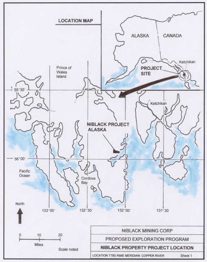
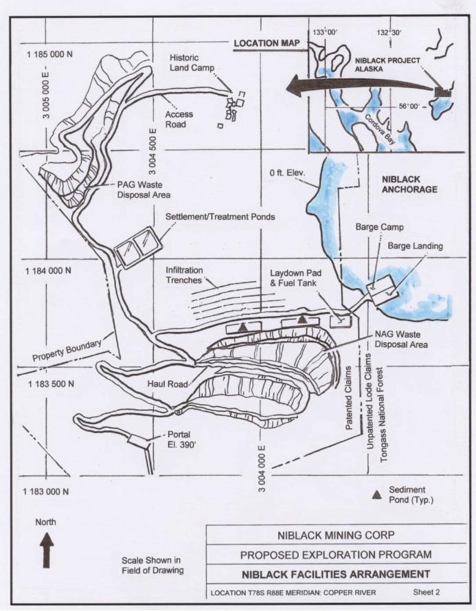
SECTION 1. INTRODUCTION This Development Plan is part of the Tidelands Lease Application for a proposed barge and landing craft ramp and a mooring terminal for the Niblack construction and exploration project located within Niblack Anchorage on Prince of Wales Island. The project is located approximately 24 miles southwest of Ketchikan (Sheet 1). The Niblack construction and exploration project is currently permitting for future activities associated with the ongoing evaluation of the mineral potential at this property. The proposed marine dock and barge landing facility is required to provide a means of delivering equipment and supplies to the project, primarily to complete an underground tunnel required to further define the mineral resource. The overall project siting arrangement is shown in Sheet 2. Construction activities are being permitted and overseen by the Alaska Department of Natural Resources Large Mine Project Team (ADNR-LMPT). The team also involves the Alaska Department of Environmental Conservation (ADEC), and the Alaska Department of Fish and Game (ADF&G).
1
Niblack Mining Corporation Tidelands Development Plan January, 2007
SECTION 2. CONSTRUCTION DETAILS The Tidelands Lease Application Form is presented in Appendix B. Niblack Mining Corporation (NMC), a Vancouver, British Columbia, Canada corporation has proposed the construction/exploration project, including those components which require a Tideland Lease Development Plan. There are presently no marine facilities to allow for docking of barges or landing craft at the Niblack project. It is planned to construct a new marine terminal that will accommodate the 20-foot tide variance and allow heavy equipment to be unloaded safely. A 500 ton bulk mining sample will also be mined and shipped off-site for metallurgical testing. The dock and barge load-out are needed for these activities. The barge and landing craft ramp will consist of a 10-foot high bulkhead constructed from cement blocks at the toe of the facility, which will then be backfilled with quarried rock to a 5% grade back to the access road. The structure will be approximately 24 feet wide and have an overall length of approximately 60 feet. This facility will be constructed between the 0 elevation contour and the 17 foot contour, just above the mean high water mark of 14.5 feet for this area. It is estimated that approximately 500 yards of fill will be required to construct the facility. The location of the proposed ramp is shown on Sheet 3, and a cross-section of the proposed facility is shown on Sheet 4. The proposed location of the mooring facility is also shown on Sheet 3, and a cross-section is provided in Sheet 4. The mooring facility consists of an elevated walkway secured to pilings, and two sets of mooring dolphins to accommodate the floating camp or transient barges (Sheet 5). The structures will be constructed of galvanized steel and timbers. The piles will be made of galvanized steel with a galvanized steel pile cap. Pressure-preservative treated timbers will be used for the stringers, cross beams, and the decking. The bullrails, handrails, and rubstrips will also be made of timber. The struts will be made of galvanized steel pipe. At a mean low low tide (0 foot elevation), approximately 20 feet of mooring dolphin will be exposed above the water level. There is no fill, other than the mooring dolphins, associated with the construction of this facility. The barge landing ramp and mooring facility will be designed to facilitate minimal disturbance of areas below high tide levels. To protect important eelgrass habitat in the lower intertidal and offshore areas, propulsion systems will not be used on landing craft, tugs, self-propelled barges or other craft using the barge landing site when tidal stage is less than half mean high water (7.6 foot contour). Minor supply needs and emergency requirements will be provided by floatplane or by boat. These smaller vessels will utilize a floating dock secured to the floating camp to provide safe, unencumbered access.
2

Niblack Mining Corporation Tidelands Development Plan January, 2007
The marine landing facilities have been designed to minimize the amount of excavation and construction in the intertidal and beach areas. The dock/landing facility construction will create a barge landing fill ramp and a small laydown yard for handling of cargo. Construction of the marine terminal facilities will involve approximately 500 cubic yards of fill within a footprint of approximately 1440 square feet. Essentially all of the fill volume will occur below the mean high water line on lands administered by the ANDR.
3

Niblack Mining Corporation Tidelands Development Plan January, 2007
SECTION 3. OPERATIONS Access to the marine dock/landing area will be via the portal access road. Staging at the marine facility is a necessary function of barging activities. A modest (50 foot by 50 foot) staging and storage area will be located at the marine facilities. The site is not in delineated wetlands. Appendix C, Niblack Wetlands Delineation (HDR, Alaska, 2006), is provided for easy reference. This will provide for temporary storage and staging of materials and containers, as well as spill response equipment and sorbent booms. All of the associated utilities for these new facilities will be provided by the camp barge which will be moored adjacent to this area. No water, sewer, or other utilities are planned to be located at the site. Portable toilets may be provided in the laydown area. Landing craft will transfer freight and equipment across the gravel ramp. Moorage will be temporary, while loading and unloading occurs. Vehicles will traverse the ramp and approach fill to get to the uplands staging and parking areas. The camp barge will breast against the mooring dolphins. Barge operators will secure mooring lines to the dolphins. The transfer bridge will be lowered onto the barge. Supplies for the camp will be transferred across the transfer bridge or across a floating dock tied off to the camp barge. All fuel transfers will be conducted in accordance with the specific requirements of the approved plans for applicable federal, state, and local regulations. Material delivery will be via isotainers (fuel) or other appropriate packaging as required by the Alaska Department of Transportation (ADOT). These supplies will be unloaded in a similar manner to other cargo. Fuel isotainers will be temporarily placed at the laydown areas in contained bermed storage areas. Forklifts will be utilized to remove containers from the barges and deliver them to storage areas or onto transfer vehicles for transport to the site working areas. Cargo will be containerized and palletized as required by ADOT and the respective cargo transport service. 3.1 Construction Best Management Practices The Best Management Practices (BMPs) that would be followed during the construction phase of the marine dock/landing area facility include those listed below:
• Hydraulic equipment used on barges will use vegetable oil or another biodegradable fluid rather than petroleum based oils.
• Refueling of construction equipment will be conducted on shore in a designated
area with containment (liner and berming).
4
Niblack Mining Corporation Tidelands Development Plan January, 2007
• Fuel transfers will incorporate level sensors, drip pans, and other precautionary measures, as appropriate.
• Oil spill response equipment will be readily available to respond to and contain
any oil spills (NMC, Revised Plan of Operations, 2007). Spill response equipment will include absorbent materials, containment booms, and appropriate personal protective equipment. Personnel that are trained in responding to spills will be at the scene during all operations that could result in a spill.
• Spills into coastal waters will be reported to the appropriate agency immediately
(ADEC, EPA, Coast Guard). Oil absorbent booms/socks will be placed around the spill sheen to contain it and to absorb as much of the petroleum product as possible.
• Reportable spills on land will be immediately cleaned up and reported to the
appropriate agency. • Upland disposal sites for waste cleanup will have silt curtains placed around the
disposal area. Straw bales will be placed in drainage swales at periodic intervals to contain and filter muddy waters.
The following (BMPs) would be incorporated during the construction and operation of the ancillary facilities:
• Runoff from the laydown areas, any topsoil stockpiles, and other ancillary construction sites and/or facilities will be filtered by silt fences, hay bales, or other appropriate methods. Sediment traps would be regularly inspected, cleaned, and maintained.
• The laydown areas and access roads will be surfaced with crushed gravel, to limit
erosion. • Boat or other vehicle maintenance activities would not allowed in the vicinity of
the marine dock/landing area. • Natural vegetation will be left in place along the shoreline wherever possible.
Disturbed and exposed soils would be revegetated as soon as practicable. Runoff would be diverted around exposed soils to heavily vegetated areas in the forest.
3.2 Operational Best Management Practices The following operational BMPs were taken from a compilation of recommended BMPs for Alaska Harbors by Neil Ross Consultants and Concepts Unlimited, 1995.
5

Niblack Mining Corporation Tidelands Development Plan January, 2007
Solid Waste
• Trash containers will be provided on shore at the marine terminal. • Waste receptacles will be placed on docks and secured, to prevent accidental
spillage into the water. Liquid Waste
• Spill absorbent pads and booms would be readily available in the event of a spill. • Propylene glycol based antifreeze (orange color) will be used in place of ethylene
glycol based antifreeze (green color) wherever possible, because it is less toxic. Petroleum Leaks and Spills
• An oil Spill Response Plan (SRP) would be developed for the marine docking/landing facility.
• Adequate spill response equipment will be easily accessible and located at a
clearly marked site. Phone numbers and directions on reporting spills would also be clearly posted at the same location.
• Used spill response equipment will be properly disposed of. • Biological cleaners, which consume and digest petroleum pollutants, will be used
to ensure complete remediation of spill waste material, wherever appropriate. Bilge Water
• Prior to discharging bilge water, the discharge will be inspected to ensure that no oil or fuel has been spilled into the bilge. Bilge water would not be discharged if it has a sheen or if it contains solvents, detergents or other additives.
• An oil/water separator will be installed in the bilge and in the bilge water pump
discharge line. The separator will be maintained regularly. • Niblack will recommend that oil-absorbing materials be used in bilge areas of
boats that have inboard engines. • Non-alkaline, biodegradable bilge cleaners will be used at the constructions site.
6

Niblack Mining Corporation Tidelands Development Plan January, 2007
3.3 Monitoring Baseline Niblack will collect pre-project environmental baseline marine water quality samples, consistent with the site-wide water quality monitoring plan in the vicinity of the dock/barge ramp landing area. These water quality conditions are summarized in a separate document. Niblack Water Quality Monitoring and Baseline Plan, Knight Piesold Consulting, January, 2007. This would include at least one set of chemical parameters and polycyclic aromatic hydrocarbons (PAH) from one to three sites, which can be indicative of pre-existing diesel fuel spills. Operational A similar set of samples will be collected and analyzed during the construction period. This will document any impacts related to construction activities and/or fueling. Reporting and Data Review This information will be submitted to the LMPT as part of the annual monitoring report. The Niblack Water Quality Monitoring Plan (January, 2007) is presented in a separate document. 3. 4 Maintenance of the Dock and Barge Landing Facilities The facilities will be constructed of materials that will require relatively little maintenance. All necessary maintenance will be performed by Niblack personnel or their contractors. Floats and walkways will be cleaned periodically. The galvanized coatings will also be maintained periodically. Cathodic protection systems will be installed and repaired when required. The ramp foundation will be inspected after major storm events, to ensure that the backfill rubble material was not displaced by large waves. Timbers will be inspected once per year. Damaged or rotten timbers will be repaired or replaced as necessary. When treatment is required, tarps and other means will be used as appropriate to prevent any hazardous substances from entering the water.
7
Niblack Mining Corporation Tidelands Development Plan January, 2007
SECTION 4. CLOSURE/ RECLAMATION PLAN All constructed facilities would be removed from the docksite area as part of the closure and reclamation activities. Scrap or demolition materials from the marine facilities will be disposed off-site. The fill in the landing approach would be removed and disposed of at the non-acid generating (NAG) waste rock storage site. The laydown area would be regraded and scarified. Any disturbed areas would then be seeded with approved vegetation.
8

Niblack Mining Corporation Tidelands Development Plan January, 2007
SECTION 5. REFERENCES 1. Neil Ross Consultants and Concepts Unlimited. 1995. BMP Examples for Alaska:
Compilation and Assessment for Harbor, Marina, boat Operations, Repair and Maintenance.
2. RTR Resource Management, Inc. 2006. Niblack Mining Corporation Lookout Unit
Storm Water Pollution Prevention Plan. 3. Knight Piesold Consulting. 2007. Water Quality Monitoring and Baseline Plan,
Niblack Construction and Exploration Project, January, 2007 4. Niblack Mining Corporation. 2007. Revised Niblack Construction/Exploration
Plan of Operations
9

Appendix A
Niblack Drawing Sheets
1


Appendix B
Tidelands Application Form
2

102-103 (Rev. 02/05)
STATE OF ALASKA DEPARTMENT OF NATURAL RESOURCES DIVISION OF MINING, LAND AND WATER
Resource Assessment and
Development Section 550 W 7th Ave., Suite 1050 Anchorage, AK 99501-3579 (907) 269-8534
Northern Region 3700 Airport Way Fairbanks, AK 99709 (907) 451-2740
Southcentral Region 550 W 7th Ave., Suite 900C Anchorage, AK 99501-3577 (907) 269-8552
Southeast Region 400 Willoughby, #400 Juneau, AK 99801 (907) 465-3400
APPLICATION FOR PURCHASE OR LEASE OF STATE LAND December 7, 2006 Date ADL # (assigned by DNR)
Applicant’s Name Paddy Nicols Doing business as: Niblack Mining Corporation
Address Suite 615 – 800 West Pender St. City/State/Zip Vancouver B.C. V63 2V6 E-Mail [email protected]
Message Phone ( ) Work Phone (604) 484-5045 Soc. Sec. # and/or Tax ID #
Is applicant a corporation qualified to do business in Alaska? yes no. Is the corporation in good standing with the State of Alaska, Dept. of Commerce and Economic Development? yes no. Is applicant 18 years or older? yes no. Are you applying for a lease or sale? What kind of lease or sale are you applying for? Tideland; Public/Charitable Use; Grazing; Millsite; Negotiated; Competitive. If a lease, how many years are you applying for? 55 years. (55 years Max.)
Legal Description: Lot(s) Block/Tract # _______________Survey/Subdivision ___________________
Other: ____________________________________________________________________________________________
Meridian, Township 78 South , Range 88 East , Section(s) 33/34
Acres
Municipality 30 miles Southwest of Ketchikan LORAN Reading (optional)
Geographic Location: South shore of Niblack Anchorage a protected bay in Moira Sound
What is the proposed use of and activity on the state land? Barge and landing craft ramp and a moorage dock facility.
Are there any improvements on the land now? yes no. If yes, who owns the improvements, and what is the
estimated value?
If yes, describe any existing improvements on the land.
Are there any improvements or construction planned? yes no. If yes, describe them and their estimated value.
Barge and landing craft ramp - $25,000 Moorage Dock - $35,000 estimate only
State the proposed construction date: March 2007 ; estimated completion date*: April 2007
Name and address of adjacent land owners and, if you are applying for tidelands, the name and address of the adjacent
upland owners: Private land under the control of Niblack Mining Corporation (applicant)
Are you currently in default on, or in violation of, any purchase contract, lease, permit or other authorization issued by the department under 11 AAC? yes no. Within the past three years, has the department foreclosed or terminated any purchase contract, lease, permit or other authorization issued to you? yes no. Non-refundable filing fee: $100 Date Stamp: (Fee may be waived under 11 AAC 05.010(c))


102-103 (Rev. 02/05)
APPLICANT ENVIRONMENTAL RISK QUESTIONNAIRE The purpose of this questionnaire is to help clarify the types of activities you propose to undertake. The questions are meant to help identify the level of environmental risk that may be associated with the proposed activity. The Division of Mining, Land and Water's evaluation of environmental risk for the proposed activity does not imply that the parcel or the proposed activity is an environmental risk from the presence or use of hazardous substances. Through this analysis, you may become aware of environmental risks that you did not know about. If so, you may want to consult with an environmental engineer or an attorney. Paddy Nichols Niblack Mining Corporation Applicant’s Name Doing Business As Suite 615 – 800 West Pender St. Vancouver B.C. BC V63 2V6 Address City State Zip ( ) (604) 484-5045 Darwin Green Message Phone Work Phone Contact Person Describe the proposed activity: The Niblack Exploration Project is in the initial stages of construction and underground development to further
evaluate the potential mineral resource located within the property boundaries.
In the course of your proposed activity will you generate, use, store, transport, dispose of, or otherwise come in contact with toxic and/or hazardous materials, and/or hydrocarbons? Yes [x] No [ ] If yes, please list the substances and the associated quantities. Use a separate sheet of paper, if necessary. Diesel Fuel – 20,000 gallons
Gasoline – 1,000 gallons
Ammonium Nitrate – 7,000 pounds
Explosives – 700 pounds
If the proposed activities involve any storage tanks, either above or below ground, address the following questions for each tank. Please use a separate sheet of paper, if necessary, and, where appropriate, include maps or plats: a. Where will the tank be located? Fuel storage tanks will be established in an engineered facility located within uplands, approximately 50 feet from the barge landing area as depicted in the sheets accompanying the development plan. b. What will be stored in the tank? Two large (10,000 gallon) tanks will store diesel fuel, a smaller (1,000 gallon) tank will store gasoline.


102-103 (Rev. 02/05)
DIVISION OF MINING, LAND, WATER INSTRUCTIONS for completing a Development Plan to lease State Land A development plan is a written statement (narrative) and a Diagram (drawing) which together describe and show how you intend to develop and use the land. This information should be a detailed part of or extension of your general business plan or plan of operations. The information contained in a development plan is needed to provide a complete review of the proposed use and development of the lease parcel, and helps in determining the terms and conditions of the lease. The amount and type of information included in the development plan will depend on the nature of the proposed use and level of development. Insufficient information or failure to provide a development plan may result in a delay in processing or rejection of the application as incomplete. The development plan must represent preconstruction plans for the proposed improvements and/or use areas. For existing or expiring leases without a current development plan or if the development plan is being updated, the plan must show existing improvements and/or use areas, and any desired changes. If your lease application is approved, the development plan becomes a part of the lease document. Authorized activities are limited only to those addressed in the development plan. The development plan must be updated whenever development changes are desired, or if there is a change in activity that was not addressed when the application was reviewed. GUIDELINES: The development plan must include: A. Narrative portion. A detailed written description of the type of activities or development planned for the parcel. Specify the timeframes of development including any planned phases. Discuss if any facilities are intended for commercial use, or will be rented out. Provide a description and explanation of the items shown on the Diagram (drawing). Following is a list of specific information to be included in the narrative, if applicable to the proposed project: ! Legal Description. Provide a legal description of the parcel, i.e. a metes and bounds description, survey, lot and block, aliquot part, or
other legal description. ! Timber Removal. Estimate amount of timber to be cut. ! Site preperation. Describe any plans for dredge and fill operations including material sources. ! Access. Describe existing and planned access, and mode of transportation. If public access is to be restricted, define possible
alternative public access routes. Discuss any utility access routes or needs involving the property. List adjacent property owners. ! Buildings and other structures. Describe each building or structure, whether permanent or temporary, including a description of the
foundation, and building construction type; when the structure is to be constructed, or placed on the parcel; duration of use; and what activities are to occur within each structure.
! Power source. Describe type and availability of power source to the site. ! Waste types, waste sources, and disposal methods. List the types of waste that will be generated on-site, including solid waste, the
source, and method of disposal. ! Hazardous substances. Describe the types and volumes of hazardous substances present or proposed, the specific storage location,
types of liners used for hazardous or toxic material storage, and spill plan and spill prevention methods. Describe any containment structure(s) and volume of containment structure(s), the type of lining material, and configuration of the containment structure. Attach appropriate Material Safety Data Sheets (MSDS). If your development or use will not result in Hazardous substances on the site then provide a statement to that effect.
! Water supply. Describe the water supply and wastewater disposal method. ! Parking areas and storage areas. Describe long term and short term parking and storage areas. Discuss areas where storage (for a
fee) will be provided for materials from other companies. Describe the items to be stored in all storage areas, and any measures that will be taken to minimize spills from leaking vehicles or equipment.
! Number of people using the site. Estimate the number of clients that will be accessing or using the site. ! Closure/Restoration plans. Disucss the expected means by which the lease area would be cleared of improvements and restored to a
vacant and orderly condition. [Provide a closure/reclamation plan, if required for the type of authorization being applied for, e.g. material sale.]
B. Development Diagram. The diagram must be drawn to scale, and each item labeled in such a way that the information contained in the drawing can be located in the narrative portion of the development plan (professional quality drafting and mechanical lettering is desired). Following is a list of information to be shown on the drawing, if applicable:

1. The vicinity map (located in the upper right hand corner of sheet 1) shall be traced from, or a copy of, the appropriate USGS Topographic map (1" = 1 mile) and contain the following information:
a) Section, Township and Range lines and numbers; b) Geographic names of key waterways, islands, landmarks, etc.; c) An ⊗ at the lease site; d) 1:63,000 quadrangle sheet name. (ie. Petersburg B6). 2. The PLAN VIEW of the proposed activity (as if you were looking straight down on it from above) should appropriately label and show the
following: a) The boundary of the proposed lease area (depict with broad lines and label all dimensions in feet). The area must encompass all
uses and improvements (buildings, tents, roads, towers, tanks, pipes, etc.) on public land. Additional sheets should be used as necessary to depict development details.
b) Location and dimensions of: all buildings and other permanent structures; any gravel fill pad, borrow pits, cleared areas, and
parking areas; c) Location of all storage areas including but not limited to ( solid materials, vehicles, snow, drill rigs, camps, pipe, water craft and
hazardous substances, which include but are not limited to oil, lubricants, fuel oil, gasoline, chemicals, solvents, and diesel fuel). Indicate method of storage (tank, drum, etc.), and any spill containment structures for the stored materials.
d) Label the lease area with legal description (lot,block,subdivision,survey), if applicable. Also label adjacent upland and or tideland
properties and list ownership in the narrative section. e) Major topographic features such as roads, water bodies, islands, land marks etc. which will aid in orientation shall be located and
labeled in the plan view. Also show the Mean High Water line of tidal waters and the ordinary high water line along streams, rivers, lakes and ponds.
f) Location of existing or proposed easements, and location of any buried or above ground utility lines (power, water, fuel, natural
gas, etc.), sewage facilities, including sewage and wastewater outfall point, and water source (if any). C. DIAGRAM DRAFTING STANDARDS 1. The format guide is the sample (8½ x 11) format provided. The title block, bar scale, legend, north arrow and graphics shall be
substantially shown. Blank Diagram Sheets are provided. Only sheet 1 needs a vicinity map unless appropriate. 2. All line work and lettering on the diagram must be in black ink or dark pencil, and may be accomplished with mechanical lettering
equipment or by legible hand lettering. 3. All property boundaries and Rights-of-Way centerlines shall be easily distinguishable. 5. The scale of the drawing shall be not more than 1 " = 200 feet. 6. Diagrams that are produced in a larger format which are reduced to 8½ x 11 will be acceptable as long as the information shown is in conformance with the other requirements of these instructions. instructions.

V I C I N I T Y M A P
Date Prepared:
Applicant's Name:
STATE OF ALASKA DEPARTEMENT OF NATURAL RESOURCES DIVISION OF LAND
LEASE DEVELOPMENT PLAN DIAGRAM
Sec.(s) T. S., R. E., CRM
Scale: 1"=
SHEET OF LEASE FILE # ADL

LEASE DEVELOPMENT PLAN DIAGRAM (Continued)
Scale: 1"= Sec.(s) T. S., R. E., CRM
SHEET OF LEASE FILE # ADL

Appendix C
Niblack Wetlands Delineation
3

Niblack Property Prince of Wales Island, Alaska
Preliminary Jurisdictional Determination
March 2006
Prepared for:
Niblack Mining Corp.
615-800 West Pender Street
Vancouver, BC
Canada V6C 2V6
Prepared by:
HDR Alaska, Inc.
2525 C Street, Suite 305
Anchorage, Alaska 99503

Niblack Property
Preliminary Jurisdictional Determination – March 2006
- 1 -
Approximate Project Area
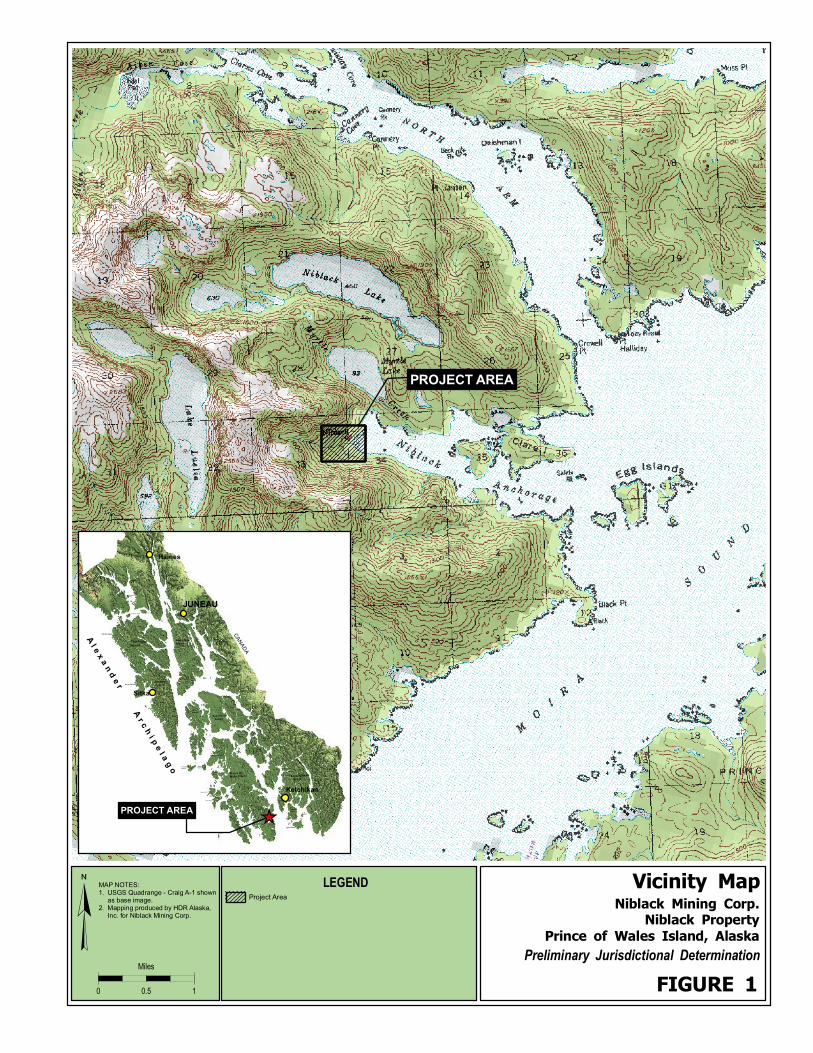
1.0 Introduction and Purpose
The purpose of this report is to identify and describe wetlands and other waters within an approximately
83.4-acre area on Prince of Wales Island in southeast Alaska (Figure 1). The area is within a patented
mining claim owned by the Niblack Mining Corporation.
This report describes locations within the project area that are subject to the jurisdiction of the USACOE
under authority of Section 404 of the Clean Water Act or under authority of Section 10 of the Rivers and
Harbors Act of 1899. By federal law (Clean Water Act) and associated policy, it is necessary to avoid project
impacts to wetlands wherever practicable, minimize impact where impact is not avoidable, and in some cases
compensate for the impact. The focus of this document is on delineation of wetlands. Wetlands, waters of
the U.S., and uplands (non-wetlands), as referenced in this report, are defined as:
Wetlands. “Those areas that are inundated or saturated by surface or groundwater at a frequency and
duration sufficient to support, and that under normal circumstances do support, a prevalence of
vegetation typically adapted for life in saturated soil conditions” (33 Code of Federal Regulations
[CFR] Part 328.3(b)). Wetlands are a subset of “waters of the U.S.” Note that the “wetlands”
definition does not include unvegetated areas such as streams and ponds.
Waters of the U.S. Waters of the U.S. include other waterbodies regulated by the U.S. Army Corps of
Engineers, including lakes, ponds, and streams, in addition to wetlands. The ponds mapped in the
project area are “waters of the U.S.” but not “wetlands”.
Uplands. Non-water and non-wetland areas are called uplands.
As described in the 1987 U.S. Army Corps of Engineers wetlands delineation manual, wetlands must
possess the following three characteristics:
1. Hydrophytic Vegetation: Vegetation community dominated by plant species that are typically
adapted for life in saturated soils.
2. Wetland Hydrology: Inundation or saturation of the soil during the growing season.
3. Hydric Soils: Soils that are saturated, flooded, or ponded long enough during the growing
season to develop anaerobic conditions.
1.1 Project Location and Environment
The project area is located near the head of
Niblack Anchorage, a small inlet on the
southeastern shore of Prince of Wales Island
(Figure 1). Most of the project area is
undeveloped and forested (see image at right). A
small mining camp with several outbuildings
exists near the coast. Specific legal and
geographic descriptions for the property required
for Preliminary Jurisdictional Determinations are
included in Table 1.

Niblack Property
Preliminary Jurisdictional Determination – March 2006
- 2 -
Table 1. Project Area Information
1. APPLICANT: Niblack Mining Corp. 2. WATERWAY: Niblack Anchorage 3. LOCATION:
A. Narrative: The project area is near the head of Niblack Anchorage on Prince of Wales Island, approximately 26 miles southwest of Ketchikan.
B. Legal Description: Sections: 33 and 34 Township: 78S Range: 88E Meridian: Copper River Latitude/Longitude (WGS84 Datum): N55.0667159 / W132.1461172 4. SOURCE(S): USGS Maps: Craig A-1 NWI Maps: Craig A-1 Soil Maps: None Corps Wetland Maps: None
Aerial Photographs: Digital black and white ortho-photography from US Forest Service. Other: Reconnaissance-level field survey with wetland data forms, written site observations, and photographs from HDR Alaska, Inc. site visit dated February 15-16, 2006.
2.0 Methods
Two steps were used to evaluate and produce an inventory of wetlands and waterbodies in the project area.
These two steps include:
2.1 Field Investigation
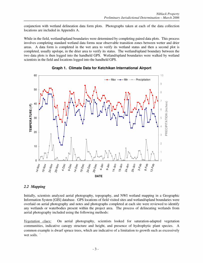
A two-day site visit was completed during February 15-16, 2006 to identify any wetlands and other waters
potentially under the jurisdiction of the USACOE. The field visit occurred outside of the USACOE
designated “growing season” (USACOE-SPN-2003-05). Temperature and precipitation data for the three
month period prior to the field investigation (November 14, 2005 through February 16, 2006) was
reviewed to determine the degree in which any recent climatic events (i.e., severe cold, dry conditions)
may have influenced field hydrology and vegetation indicators. USACOE guidance on Alaska’s growing
season references the end of the growing season to generally follow several continuous days below 28◦F.
Over the three month period preceding the field visit, the maximum daily temperature was below 28
degrees a single day (27 degrees on December 2nd
) and the minimum daily temperature was below 28
degrees for 22 out of the 94 days. Approximately 53 inches of precipitation fell during the three month
period (Graph 1). Climate data at the Ketchikan International Airport was obtained from the National
Weather Service.
During the field visit, no snow was present anywhere within the project area. Snow pack was above
1,000-ft. elevation. Areas of open water lacked ice and saturated soils investigated had no evidence of
seasonal frost. No problems were encountered in identifying and quantifying cover estimates for non-
evergreen herbaceous plants and deciduous shrubs, as many, some dead or lacking leaf-cover, still
persisted.
Specific data collected included detailed information on soil conditions, hydrology, and plant community
composition. Locations were studied, to the degree possible during winter conditions, using the U.S.
Corps of Engineers 1987 wetland delineation manual’s three-parameter method of determining an area’s
wetland status (USACOE, 1987). Standard Corps of Engineers data sheets were completed at these sites
and are included in Appendix A. Each location visited during the field visit was logged into a handheld
global positioning system (GPS) unit. Representative photographs and observational data were collected in
Niblack Property
Preliminary Jurisdictional Determination – March 2006
- 3 -
conjunction with wetland delineation data form plots. Photographs taken at each of the data collection
locations are included in Appendix A.
While in the field, wetland/upland boundaries were determined by completing paired data plots. This process
involves completing standard wetland data forms near observable transition zones between wetter and drier
areas. A data form is completed in the wet area to verify its wetland status and then a second plot is
completed, usually upslope, in the drier area to verify its status. The wetland/upland boundary between the
two data plots is then logged into the handheld GPS. Wetland/upland boundaries were walked by wetland
scientists in the field and locations logged into the handheld GPS.
Graph 1. Climate Data for Ketchikan International Airport
0
10
20
30
40
50
60
14
-No
v
19
-No
v
24
-No
v
29
-No
v
4-D
ec
9-D
ec
14
-De
c
19
-De
c
24
-De
c
29
-De
c
4-J
an
9-J
an
14
-Ja
n
19
-Ja
n
24
-Ja
n
29
-Ja
n
3-F
eb
8-F
eb
13
-Fe
b
DATE
TE
MP
ER
AT
UR
E (◦F
)
0
1
2
3
4
5
6
7
8
9
10
PR
EC
IPIT
AT
ION
(in
ch
es
)
Max Min Precipitation
2.2 Mapping Initially, scientists analyzed aerial photography, topography, and NWI wetland mapping in a Geographic
Information System [GIS] database. GPS locations of field visited sites and wetland/upland boundaries were
overlaid on aerial photography and notes and photographs completed at each site were reviewed to identify
any wetlands or waterbodies present within the project area. The process of delineating wetlands from
aerial photography included using the following methods:
Vegetation clues: On aerial photography, scientists looked for saturation-adapted vegetation
communities, indicative canopy structure and height, and presence of hydrophytic plant species. A
common example is dwarf spruce trees, which are indicative of a limitation to growth such as excessively
wet soils. ◦
Niblack Property
Preliminary Jurisdictional Determination – March 2006
- 4 -
Evidence of soil saturation: Visible evidence of wetland hydrology was sought, including surface water and
darker areas of photos indicating surface saturation. A site’s proximity to streams, open water habitat, and
marshes can be indicative of shallow subsurface water.
Topography: Evidence of topographic high points, sloped surfaces that would allow soils to drain, and dry
drainages were used to support classifying those areas as upland. Topographic depressions, toes of slopes,
and flat topography served as indicators of potentially poor soil drainage.
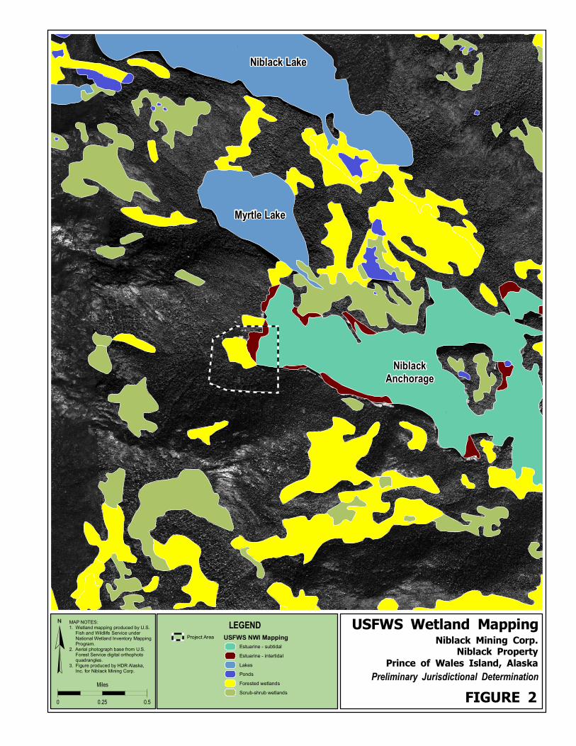
Existing mapping: Wetland mapping from the U.S. Fish and Wildlife’s National Wetland Inventory
Mapping program is available for the project area (USFWS 2006). This mapping is generally an effective
tool for large-scale planning and analysis of wetlands but not suitable for smaller site-specific projects
such as needed for this study. National Wetland Inventory mapping is primarily based on aerial
photographic interpretation with limited ground truthing, and therefore wetland boundaries tend to be
oversimplified with many smaller wetland complexes not included in the mapping. According to
available National Wetland Inventory Mapping for USGS quadrangle Craig A-1, forested wetlands occur
in the project area (Figure 2).
3.0 Preliminary Jurisdictional Determination
No detailed vegetation or soil mapping is available for the project area. Information presented below is
summarized from data collected at 15 wetland data form locations over the two-day field investigation
(Appendix A). Locations of each data collection location are displayed on Figure 3.
Vegetation
Approximately 57.9 acres of the project area is either forested or previously forested but since developed
by past mining activities. Developed areas include the mine camp and several small trails extending from
the camp. These developed areas are generally unvegetated. Approximately 25.5 acres of the mapped
project area is within Niblack Anchorage. This area includes subtidal waters (21.1 acres), unvegetated
intertidal beach (4.4 acres), and vegetated intertidal beach (1.1 acres). The vegetated intertidal beach is
located immediately downslope of the mine camp. Dominant plant species in this area include a mix of
coastal sedges (Carex sp.), grasses (Elymus sp.), and rushes (Juncus sp.).
Needleleaf forest covers most the project area. The forest community is generally dominated by a thick
overstory of western hemlock (Tsuga heterophylla), western red cedar (Thuja plicata), and Sitka spruce
(Picea sitchensis) with a sparse understory comprised of red huckleberry (Vaccinium parvifolium), red
elderberry (Sambucus racemosa), salal (Gaultheria shallon), bunchberry (Cornus canadensis), skunk
cabbage (Lysichiton americanus), deer fern (Blechnum spicant), sword fern (Polystichum munitum),
foamflower (Tiarella trifoliata), and fewflower sedge (Carex pauciflora). Hydrophytic plant
communities occur at 13 out of the 15 wetland data form sites (Table 2).

Niblack Property
Preliminary Jurisdictional Determination – March 2006
- 5 -
Table 2. Vegetation at Wetland Data Form Sites
Dominant Plant Species (by stratum)
Tree Stratum Shrub Stratum Herbaceous Stratum
Weste
rn h
em
lock
Tsuga h
ete
rophylla
Weste
rn r
ed c
edar
Thuja
plic
ata
Sitka s
pru
ce
Pic
ea s
itchensis
Red h
uckle
berr
y
Vaccin
ium
parv
ifoliu
m
Devils
clu
b
Oplo
panax h
orr
idus
Red e
lderb
err
y
Sam
bucus r
acem
osa
Sala
l G
aultheria s
hallo
n
Deer
fern
B
lechnum
spic
ant
Bunchberr
y
Corn
us c
anadensis
Sw
ord
fern
P
oly
stichum
munitum
Skunk c
abbage
Lysic
hiton a
mericanus
Foam
flow
er
Tia
rella
trifo
liata
Few
flow
er
sedge
Care
x p
auciflo
ra
Data
Fo
rm I
D
FAC FAC FACU NI FACU FACU NI FAC FACU NI OBL FAC OBL
S-3 X X X X X X
S-7 X X X X X X X
S-10 X X X X X
S-11 X X X X
S-12 X X X X X X
S-18 X X X X X
S-19 X X X X X
S-27 X X X X X
S-31 X X X X X
S-34 X X X X X
S-35 X X X X
S-39 X X X X X
S-41 X X X X X
S-43 X X X X X
S-44 X X X X X
Hydrology:
The project area is situated along the bottom and lower slopes of a small, steep-sided watershed that
drains directly into Niblack Anchorage. Two perennial streams generally referred to as Camp Creek and
Waterfall Creek, flow through the project area immediately south of the existing mine camp. Many small
intermittent drainages, swales, and rivulets flow through the project area and eventually feed into Camp
or Waterfall Creeks or directly into Niblack Anchorage.
At wetland data form locations, 14 out of the 15 sites had wetland hydrology (Table 3). Commonly seen
indicators included saturated soil, surface water, drainage channels, and sediment deposits.
Table 3. Hydrology at Wetland Data Form Sites
Data
Fo
rm I
D
Satu
rate
d in
U
pp
er
12
Inch
es
Wate
r M
ark
s
Sed
imen
t D
ep
osit
s
Dra
inag
e
Patt
ern
s i
n
Wetl
an
ds
Wate
r-S
tain
ed
L
eaves
Notes
S-3 X X saturated at 0 inches, seasonally inundated depressions present
S-7 X X saturated at 3 inches, inundated depressions present
S-10 X X saturated at 6 inches, small ephemeral drainage features present
S-11 X X X saturated at 3 inches, inundated depressions present
S-12 X saturated at 0 inches, flowing drainages present
S-18 X saturated at 0 inches
S-19 X X X X saturated at 0 inches, low inundated depressions present, likely

Niblack Property
Preliminary Jurisdictional Determination – March 2006
- 6 -
Data
Fo
rm I
D
Satu
rate
d in
U
pp
er
12
Inch
es
Wate
r M
ark
s
Sed
imen
t D
ep
osit
s
Dra
inag
e
Patt
ern
s i
n
Wetl
an
ds
Wate
r-S
tain
ed
L
eaves
Notes
groundwater discharge sites
S-27 X X X X saturated at 0 inches, drainage swale with surface water
S-31 X X X saturated at 5 inches, inundated depressions present
S-34 X X X saturated at 0 inches, inundated depressions present
S-35 None
S-39 X X X X saturated at 5 inches, flowing drainages present
S-41 X saturated at 4 inches
S-43 X X X X saturated at 6 inches, inundated depressions present
S-44 X X X X X saturated at 0 inches, inundated depressions present
Soils
Both hydric and non-hydric soil conditions were observed in soil pits examined during the field visit.
Hydric soils were encountered at 8 of the 15 wetland data form sites (Table 4). Indicators of hydric soil
included histosols, histic epipedons, and sulfidic odor.
Non-hydric soils had a shallow to moderately deep (3 to 7 inches deep) organic horizon at the ground
surface overlaying mineral soils. Specific characteristics of the sampled mineral soils, including color
and texture are included on the wetland data forms (Appendix A).
Table 4. Soils at Wetland Data Form Sites
Data Form ID
Hydric Soils Present Hydric Soil Indicators Observed
S-3 Yes Histosol
S-7 No None
S-10 No None
S-11 No None
S-12 Yes Histic epipedon, sulfidic odor
S-18 No None
S-19 Yes Histic epipedon, sulfidic odor
S-27 Yes Histic epipedon, sulfidic odor
S-31 No None
S-34 Yes Histosol, Sulfidic odor
S-35 No None
S-39 Yes Histic epipedon, sulfidic odor
S-41 No None
S-43 Yes Sulfidic odor
S-44 Yes Histosol, Sulfidic odor

Niblack Property
Preliminary Jurisdictional Determination – March 2006
- 7 -
3.1 Conclusion
Determinations were based on evidence observed outside of the growing season. Additional field
indicators supporting classifying an area as wetland or non-wetland may be present during the growing
season.
Wetland locations are based upon the dominance of hydrophytic vegetation, hydrologic indicators, and
hydric soil indicators. Based on the findings above, it has been determined that areas displayed as
wetlands on Figure 3 meet the USACOE criteria for being classified as wetland. Approximately 8.9
percent (7.4 acres) of the mapped 83.4 acres were determined to meet the USACOE requirements for
being classified as wetlands (Table 5). Project area wetlands are classified as saturated needleleaf forest
wetlands (PFO4B) and saturated needleleaf forest/broadleaf scrub-shrub mix wetlands (PFO4/SS1B).
These areas would be subject to jurisdiction under Section 404.
Approximately 30.6 percent (25.5 acres) of the mapped area occurs below high tide line in Niblack
Anchorage. These estuarine areas are classified as subtidal (E1UBL), unvegetated intertidal
(E2US1N), and vegetated intertidal (E2EM1P). Estuarine areas would be subject to jurisdiction
under both Section 404 and Section 10.
The remainder of the mapped project area, approximately 60.5 percent (50.5 acres) of the mapped
area lack one or more of the required three parameters to support classifying an area as wetland
(Table 5). These areas would not be subject to jurisdiction under Section 404.
Other jurisdictional waters in the project area include perennial streams (Camp and Waterfall Creeks),
and numerous smaller unnamed intermittent streams. Approximate locations of project area streams
are shown on Figure 3.
Table 5. Mapped Area Summary
Type NWI Mapping Code Approximate area (acres)
Saturated needleleaf forest wetland PFO4B 5.7
Saturated needleleaf forest/broadleaf scrub-shrub wetland PFO4/SS1B 1.7
Estuarine – emergent intertidal areas E2EM1P 1.0
Estuarine – unvegetated intertidal areas E2US1N 4.4
Estuarine – subtidal waters E1UBL 20.1
Upland (non-wetland) U 50.5
Total Mapped Area 83.4
Total Freshwater Wetland 7.4 acres (8.9%)
Total Estuarine 25.5 acres (30.6%)
Total Upland (non-wetland) 50.5 acres (60.5%)
DETERMINATION MADE BY:
Jeff Schively
Biologist
HDR Alaska, Inc.
Date: February 2006

Niblack Property
Preliminary Jurisdictional Determination – March 2006
- 8 -
Attachments
Figure 1: Vicinity Map
Figure 2: USFWS Wetland Mapping
Figure 3: Wetlands
REFERENCES CITED U.S. Army Corps of Engineers. 2003. Special Public Notice 03-05 – SPN 2003-05 - Wetland
Delineations Growing Season. Available online at:
http://www.poa.usace.army.mil/reg/SPN_Scanned/SPN-2003-05.pdf.
U.S. Army Corps of Engineers Environmental Laboratory (USACOEEL). 1987. Corps of Engineers
Wetlands Delineation Manual. Vicksburg, MS.
U.S. Federal Register. November 13, 1986 Part II. Rules and Regulations, Vol. 51, No. 219. U.S.
Department of Defense. Corps of Engineers, Department of the Army. 33 CFR Parts 320-330,
Regulatory Programs of the Corps of Engineers; Final Rule.
U.S. Fish and Wildlife Service. 2006. National Wetland Inventory Mapping for USGS Quadrangle Craig
A-1. Available online at:
http://enterprise.nwi.fws.gov/shapedata/alaska/
PROJECT AREA
¥0 10.5
Miles
MAP NOTES:1. USGS Quadrange - Craig A-1 shown as base image.2. Mapping produced by HDR Alaska, Inc. for Niblack Mining Corp.
Niblack Mining Corp.Niblack Property
Prince of Wales Island, Alaska
Vicinity Map
Preliminary Jurisdictional Determination
FIGURE 1
LEGENDProject Area
Haines
JUNEAU
Sitka
Ketchikan
CA
NA
DA
Yakobi Island
Lemesurier Is landPleasant Is land
Kru zo f Island
Kosciusko Is lan d
Noyes Is land
Baker Is land
Suemez Is land
Dal l Is
land
Long Is
land
Su
kk
wa
n Is
lan
d
Gr avina Is land
Willoughb y
Is lan d
Chichagof Island
Kuiu
Is land
Lulu
Is lan d
Zarembo
Islan d
Etol in
Islan d
Wr an gell
Islan d
Pr ince Of
Wales Island
An nette
Islan d
Revil lag igedo
Island
Kupreanof
Island
Admiralty
Island
Baranof
Island
Du ke Island
Mar y
Is lan d
Forr ester
Is lan d
Thorn e
Is lan d
Sh ru bb y
Is la n d
Doug la s
Isl and
Deer
Is lan d
Cone
Is lan d
Coronat ion
Isla nd
Warre n
Isla nd
Hec et a
Isla nd
A l e
x a
n d
e r A
r c h
i p e
l a g
o
PROJECT AREA
_̂
D
D
D
D
D
Myrtle Lake
Niblack Lake
Niblack
Anchorage
¥0 0.50.25
Miles
MAP NOTES:1. Wetland mapping produced by U.S. Fish and Wildlife Service under National Wetland Inventory Mapping Program.2. Aerial photograph base from U.S. Forest Service digital orthophoto quadrangles.3. Figure produced by HDR Alaska, Inc. for Niblack Mining Corp.
Niblack Mining Corp.Niblack Property
Prince of Wales Island, Alaska
USFWS Wetland Mapping
Preliminary Jurisdictional Determination
FIGURE 2
LEGEND
Project Area USFWS NWI Mapping
Estuarine - subtidal
Estuarine - intertidal
Lakes
Ponds
Forested wetlands
Scrub-shrub wetlands

!(
!(
kj
!(
!(
kj
kj
kj#
!(#
##!(
!(
##
#kj
kj
#
#!(
!(
#
!(
!(
!(
kj!(
!(
!(#
kj#
!(
#
!(
kj
!(
!(
kj
kj
!(#
!(
!(
kj
kj
#
!(
kj
kj
!(
Camp Creek
Waterfall C
reek
NIBLACK
ANCHORAGE
ExistingCamp
U
E1UBL
PFO4B
E2US1N
PFO/SS4B
E2EM1P
S1
S2
S3
S9
S8
S7
S5
S4
S45
S44
S43
S42
S41
S40
S39
S38
S37
S36
S35
S34
S33
S32
S31
S30
S29
S28
S27
S26
S24
S25
S23
S22
S21
S20
S19
S18
S17
S16S15
S14
S13
S12
S11
S10
¥0 400200
Feet
MAP NOTES:1. Aerial base from USFS Digital Orthophoto Quadrangle archive.2. Wetland mapping produced by HDR Alaska, Inc.3. Wetland mapping based on aerial photograph interpretation and February 2006 site reconnaissance survey.
Niblack Mining Corp.Niblack Property
Prince of Wales Island, Alaska
Wetlands
Preliminary Jurisdictional Determination
FIGURE 3
LEGEND
Surveyed Area
Data Collection Locations
kj Wetland Data Form
!( Note/Photo Point
# Drainage feature
Waterways
Perennial stream
Intermittent stream
Jurisdictional Waters of the U.S.
Estuarine - subtidal
Estuarine - unvegetated intertidal
Estuarine - emergent intertidal
Needleleaf forest/scrub-shrub wetland
Needleleaf forest wetland
E1UBL
E2US1N
E2EM1P
PFO/SS4B
PFO4B
NOTE: Stream locations are approximate

Appendix D
ACMP Coastal Zone Questionnaire
4
Revised 3/18/04 Page 1
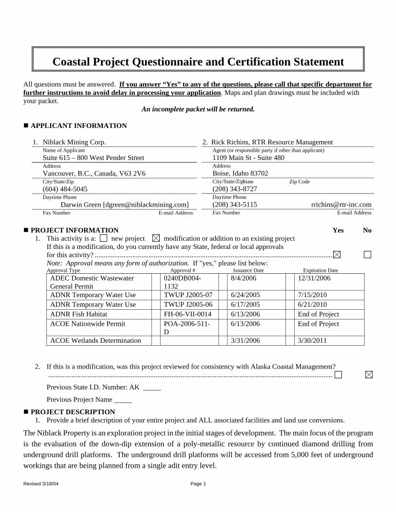
Coastal Project Questionnaire and Certification Statement
All questions must be answered. If you answer “Yes” to any of the questions, please call that specific department for further instructions to avoid delay in processing your application. Maps and plan drawings must be included with your packet. An incomplete packet will be returned.
APPLICANT INFORMATION 1. Niblack Mining Corp.
Name of Applicant Suite 615 – 800 West Pender Street Address Vancouver, B.C., Canada, V63 2V6 City/State/Zip tate Zip Code S(604) 484-5045 Daytime Phone Darwin Green [[email protected]] Fax Number E-mail Address
2. Rick Richins, RTR Resource Management
Agent (or responsible party if other than applicant) 1109 Main St - Suite 480 Address Boise, Idaho 83702 City/State/Zip (208) 343-8727 Daytime Phone (208) 343-5115 [email protected] Fax Number E-mail Address
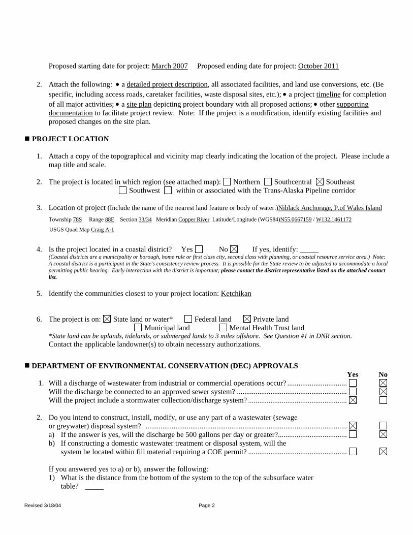
PROJECT INFORMATION Yes No
1. This activity is a: new project modification or addition to an existing project If this is a modification, do you currently have any State, federal or local approvals for this activity? ..................................................................................................................................... Note: Approval means any form of authorization. If "yes," please list below:
Approval Type Approval # Issuance Date Expiration Date ADEC Domestic Wastewater General Permit
0240DB004-1132
8/4/2006 12/31/2006
ADNR Temporary Water Use TWUP J2005-07 6/24/2005 7/15/2010 ADNR Temporary Water Use TWUP J2005-06 6/17/2005 6/21/2010 ADNR Fish Habitat FH-06-VII-0014 6/13/2006 End of Project ACOE Nationwide Permit POA-2006-511-
D 6/13/2006 End of Project
ACOE Wetlands Determination 3/31/2006 3/30/2011
2. If this is a modification, was this project reviewed for consistency with Alaska Coastal Management? ...............................................................................................................................................................
Previous State I.D. Number: AK
Previous Project Name
PROJECT DESCRIPTION 1. Provide a brief description of your entire project and ALL associated facilities and land use conversions.
The Niblack Property is an exploration project in the initial stages of development. The main focus of the program is the evaluation of the down-dip extension of a poly-metallic resource by continued diamond drilling from underground drill platforms. The underground drill platforms will be accessed from 5,000 feet of underground workings that are being planned from a single adit entry level.
Revised 3/18/04 Page 2
Proposed starting date for project: March 2007 Proposed ending date for project: October 2011 2. Attach the following: • a detailed project description, all associated facilities, and land use conversions, etc. (Be
specific, including access roads, caretaker facilities, waste disposal sites, etc.); • a project timeline for completion of all major activities; • a site plan depicting project boundary with all proposed actions; • other supporting documentation to facilitate project review. Note: If the project is a modification, identify existing facilities and proposed changes on the site plan.
PROJECT LOCATION
1. Attach a copy of the topographical and vicinity map clearly indicating the location of the project. Please include a
map title and scale. 2. The project is located in which region (see attached map): Northern Southcentral Southeast
Southwest within or associated with the Trans-Alaska Pipeline corridor 3. Location of project (Include the name of the nearest land feature or body of water.)Niblack Anchorage, P.of Wales Island
Township 78S Range 88E Section 33/34 Meridian Copper River Latitude/Longitude (WGS84)N55.0667159 / W132.1461172
USGS Quad Map Craig A-1
4. Is the project located in a coastal district? Yes No If yes, identify: (Coastal districts are a municipality or borough, home rule or first class city, second class with planning, or coastal resource service area.) Note:
A coastal district is a participant in the State's consistency review process. It is possible for the State review to be adjusted to accommodate a local permitting public hearing. Early interaction with the district is important; please contact the district representative listed on the attached contact list.
5. Identify the communities closest to your project location: Ketchikan
6. The project is on: State land or water* Federal land Private land Municipal land Mental Health Trust land
*State land can be uplands, tidelands, or submerged lands to 3 miles offshore. See Question #1 in DNR section. Contact the applicable landowner(s) to obtain necessary authorizations.
DEPARTMENT OF ENVIRONMENTAL CONSERVATION (DEC) APPROVALS Yes No
1. Will a discharge of wastewater from industrial or commercial operations occur? ................................ Will the discharge be connected to an approved sewer system? ........................................................... Will the project include a stormwater collection/discharge system? .....................................................
2. Do you intend to construct, install, modify, or use any part of a wastewater (sewage
or greywater) disposal system? ............................................................................................................ a) If the answer is yes, will the discharge be 500 gallons per day or greater?..................................... b) If constructing a domestic wastewater treatment or disposal system, will the
system be located within fill material requiring a COE permit? .....................................................
If you answered yes to a) or b), answer the following: 1) What is the distance from the bottom of the system to the top of the subsurface water table?

Revised 3/18/04 Page 3
2) How far is any part of the wastewater disposal system from the nearest surface water? 3) Is the surrounding area inundated with water at any time of the year? ........................................... 4) How big is the fill area to be used for the absorption system?
(Questions 1 & 2 will be used by DEC to determine whether separation distances are being met; Questions 3 & 4 relate to the required size of the fill if wetlands are involved.)
Yes No
3. Will your project require a mixing zone? ............................................................................................ (If your wastewater discharge will exceed Alaska water quality standards, you may apply for a mixing zone. If so, please contact DEC to discuss information required under 18 AAC 70.032.)
4. a) Will your project result in construction, operation, or closure of a facility for
solid waste disposal?...................................................................................................................... (Note: Solid waste means drilling wastes, household garbage, refuse, sludge, construction or demolition wastes, industrial solid waste, asbestos, and other discarded, abandoned, or unwanted solid or semi-solid material, whether or not subject to decomposition, originating from any source. Disposal means placement of solid waste on land.)
b) Will your project result in treatment of solid waste at the site?..................................................... (Examples of treatment methods include, but are not limited to: incineration, open burning, baling, and composting.)
c) Will your project result in storage or transfer of solid waste at the site?....................................... d) Will the project result in storage of more than 50 tons of materials for reuse, recycling,
or resource recovery?..................................................................................................................... e) Will any sewage solids or biosolids be disposed of or land-applied to the site? ...........................
(Sewage solids include wastes that have been removed from a wastewater treatment plant system, such as a septic tank, lagoon dredge, or wastewater treatment sludge that contain no free liquids. Biosolids are the solid, semi-solid, or liquid residues produced during the treatment of domestic septage in a treatment works which are land applied for beneficial use.)
5. Will your project require application of oil, pesticides, and/or any other broadcast
chemicals? ............................................................................................................................................ 6. a) Will you have a facility with industrial processes that are designed to process no less
than five tons per hour and needs air pollution controls to comply with State emission standards? .......................................................................................................................
b) Will you have stationary or transportable fuel burning equipment, including flares, with a total fuel consumption capacity no less than 50 million Btu/hour? ....................................
c) Will you have a facility with incinerators having a total charging capacity of no less than 1,000 pounds per hour?..........................................................................................................
d) Will you have a facility with equipment or processes that are subject to Federal New Source Performance Standards or National Emission Standards for hazardous air pollutants? .... i) Will you propose exhaust stack injection? ..............................................................................
e) Will you have a facility with the potential to emit no less than 100 tons per year of any regulated air contaminant?.............................................................................................................
f) Will you have a facility with the potential to emit no less than 10 tons per year of any hazardous air contaminant or 25 tons per year of all hazardous air contaminants?.......................
g) Will you construct or add stationary or transportable fuel burning equipment of no less than 10 million Btu/hour in the City of Unalaska or the City of St. Paul? ....................................
h) Will you construct or modify in the Port of Anchorage a volatile liquid storage tank with a volume no less than 9,000 barrels, or a volatile liquid loading rack with a design throughput no less than 15 million gallons? ..................................................................................
i) Will you be requesting operational or physical limits designed to reduce emissions from an existing facility in an air quality nonattainment area to offset an emission increase from another new of modified facility? .........................................................................................
7. Do you plan to develop, construct, install, or alter a public water system?........................................... 8. a) Will your project involve the operation of waterborne tank vessels or oil barges

Revised 3/18/04 Page 4
that carry crude or non-crude oil as bulk cargo, or the transfer of oil or other petroleum products to or from such a vessel or a pipeline system?...............................................
b) Will your project require or include onshore or offshore oil facilities with an effective aggregate storage capacity of greater than 5,000 barrels of crude oil or greater than 10,000 barrels of non-crude oil?............................................................................
Yes No
c) Will you operate facilities on land or water for exploration or production of hydrocarbons? ...........................................................................................................................
If you answered "No" to ALL questions in this section, continue to next section. If you answered "Yes" to ANY of these questions, contact the DEC office nearest you for information and application forms. Please be advised that all new DEC permits and approvals require a 30-day public notice period. DEC Pesticide permits take effect no sooner than 40 days after the permit is issued.
Based on your discussion with DEC, please complete the following:
Types of project approvals or permits needed and name of individual you contacted. Date application submitted Temporary Water Rights Application – John Dunker November, 2006 ADEC Waste Management – Kenwyn George December, 2006
9. Does your project qualify for a general permit for wastewater or solid waste?..................................... Note: A general permit is an approval issued by DEC for certain types of routine activities.
If you answered "Yes" to any questions in this section and are not applying for DEC permits, indicate reason:
(DEC contact) told me on that no DEC approvals are required on this project because
Other:
DEPARTMENT OF FISH AND GAME (DFG) APPROVALS Yes No
1. Is your project located in a designated State Game Refuge, Critical Habitat Area or State Game Sanctuary? ..........................................................................................................................
2. Does your project include construction/operation of a salmon hatchery? ............................................. 3. Does your project affect, or is it related to, a previously permitted salmon hatchery?.......................... 4. Does your project include construction of an aquatic farm?..................................................................
If you answered "No" to ALL questions in this section, continue to next section. If you answered "Yes" to ANY questions under 1-4, contact the ADF&G Commercial Fisheries Division headquarters for information and application forms
Based on your discussion with ADF&G, please complete the following:
Types of project approvals or permits needed. Date application submitted
If you answered "YES" to any questions in this section and are not applying for ADF&G permits, indicate reason:

Revised 3/18/04 Page 5
(ADF&G contact) told me on that no ADF&G approvals are required on this project because
Other:
DEPARTMENT OF NATURAL RESOURCES (DNR) APPROVALS Yes No
1. Is the proposed project on State-owned land or water or will you need to cross State-owned land for access? ("Access" includes temporary access for construction purposes. Note: In addition to State-owned uplands,
the State owns almost all land below the ordinary high water line of navigable streams, rivers and lakes, and below the mean high tide line seaward for three miles.) ........................................................................................................ a) Is this project for a commercial activity? ........................................................................................
2. Is the project on Alaska Mental Health Trust land (AMHT) or will you need to cross AMHT land?
Note: Alaska Mental Health Trust land is not considered State land for the purpose of ACMP reviews. .................................
3. Do you plan to dredge or otherwise excavate/remove materials on State-owned land?........................
Location of dredging site if different than the project site:
Township Range Section Meridian USGS Quad Map
4. Do you plan to place fill or dredged material on State-owned land?
Location of fill disposal site if other than the project site:
Township Range Section Meridian USGS Quad Map
Source is on: State Land Federal Land Private Land Municipal Land 5. Do you plan to use any of the following State-owned resources:..........................................................
Timber: Will you harvest timber? Amount:
Materials such as rock, sand or gravel, peat, soil, overburden, etc.:
Which material? Amount:
Location of source: Project site Other, describe:
Township Range Section Meridian USGS Quad Map
6. Do you plan to divert, impound, withdraw, or use any fresh water, except from an existing public water system or roof rain catchment system (regardless of land ownership)?............................
Amount (maximum daily, not average, in gallons per day): 170,000gpd
Source: Groundwater Intended Use: Dewatering exploration tunnel
If yes, will your project affect the availability of water to anyone holding water rights to that water? ............................................................................................................................................ 7. Do you plan to build or alter a dam (regardless of land ownership)? .................................................... 8. Do you plan to drill a geothermal well (regardless of land ownership)? ............................................... 9. At any one site (regardless of land ownership), do you plan any of the following?..............................
Mine five or more acres over a year's time Mine 50,000 cubic yards or more of materials (rock, sand or gravel, soil, peat, overburden, etc.) over a year's time
Revised 3/18/04 Page 6
Have a cumulative unreclaimed mined area of five or more acres
If yes to any of the above, contact DNR about a reclamation plan.
If you plan to mine less than the acreage/amount stated above and have a cumulative unreclaimed Yes No
mined area of less than five acres, do you intend to file a voluntary reclamation plan for approval? ............................................................................................................................................
10. Do you plan to explore for or extract coal? ........................................................................................... 11. a) Will you explore for or produce oil and/or gas?..............................................................................
b) Will you conduct surface use activities on an oil and/or gas lease or within an oil and/or gas unit?...........................................................................................................................................
12. Will you investigate, remove, or impact historical or archaeological or paleontological
resources (anything over 50 years old) on State-owned land?............................................................... 13. Is the proposed project located within a known geophysical hazard area?............................................
Note: 6 AAC 80.900(9) defines geophysical hazard areas as “those areas which present a threat to life or property from geophysical or geological hazards, including flooding, tsunami run-up, storm surge run-up, landslides, snowslides, faults, ice hazards, erosion, and littoral beach process." "known geophysical hazard area" means any area identified in a report or map published by a federal, state, or local agency, or by a geological or engineering consulting firm, or generally known by local knowledge, as having known or potential hazards from geologic, seismic, or hydrologic processes.
14. Is the proposed project located in a unit of the Alaska State Park System? .......................................... 15. Will you work in, remove water or material from, or place anything in, a stream, river or lake? (This includes work or activities below the ordinary high water mark or on ice, in the active flood plain, on islands, in or on the face of the banks, or, for streams entering or flowing through tidelands, above the level of mean lower low tide.)
Note: If the proposed project is located within a special flood hazard area, a floodplain development permit may be required. Contact the affected city or borough planning department for additional information and a floodplain determination.) ..............
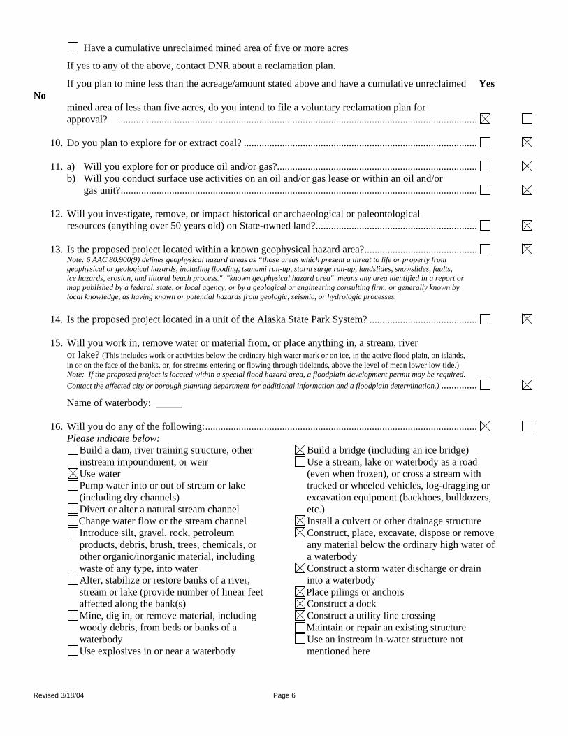
Name of waterbody: 16. Will you do any of the following:..........................................................................................................
Please indicate below: Build a dam, river training structure, other instream impoundment, or weir Use water Pump water into or out of stream or lake (including dry channels) Divert or alter a natural stream channel Change water flow or the stream channel Introduce silt, gravel, rock, petroleum products, debris, brush, trees, chemicals, or other organic/inorganic material, including waste of any type, into water Alter, stabilize or restore banks of a river, stream or lake (provide number of linear feet affected along the bank(s) Mine, dig in, or remove material, including woody debris, from beds or banks of a waterbody Use explosives in or near a waterbody
Build a bridge (including an ice bridge) Use a stream, lake or waterbody as a road (even when frozen), or cross a stream with tracked or wheeled vehicles, log-dragging or excavation equipment (backhoes, bulldozers, etc.) Install a culvert or other drainage structure Construct, place, excavate, dispose or remove any material below the ordinary high water of a waterbody Construct a storm water discharge or drain into a waterbody Place pilings or anchors Construct a dock Construct a utility line crossing Maintain or repair an existing structure Use an instream in-water structure not mentioned here

Revised 3/18/04 Page 7
If you answered "No" to ALL questions in this section, continue to next section. If you answered "Yes" to ANY questions under 1-16, contact the Area DNR, office for information and application forms. Based on your discussion with DNR, please complete the following:
Types of project approvals or permits needed. Date application submitted ADNR Fish Habitat Permit FH-06-VII-0014 6/13/2006 Temporary Tideland Lease – Brady Scott//Travis Guymon December, 2006 Waste Management Permit – Ed Emswiler Pending Waste Water Permit – Kenwyn George Pending Temporary Construction, Excavation Dewatering Permit – Kenwyn George Pending General Waste Permit (Barge) – Ed Emswiler Pending Temporary Water Use Permit – John Dunker Pending Corps Section 10 Permit – John Leeds Pending
If you answered "Yes" to any questions in this section and are not applying for DNR permits, indicate reason:
(DNR contact) told me on that no DNR approvals are required on this project because
FEDERAL APPROVALS Yes No
U.S. Army Corps of Engineers (COE) 1. Will you dredge or place structures or fills in any of the following:
tidal (ocean) waters? streams? lakes? wetlands*? ................................................................................. If yes, have you applied for a COE permit? ....................................................................................
Date of submittal: December 2006
Name of COE contact: (Note: Your application for this activity to the COE also serves as application for DEC Water Quality Certification.)
*If you are not certain whether your proposed project is in a wetlands (wetlands include muskegs), contact the COE, Regulatory Branch at 907-753-2712 for a wetlands determination (outside the Anchorage area call toll free 1-800-478-2712)
Bureau of Land Management (BLM) 2. Is the proposed project located on BLM land, or will you need to cross BLM land for access?...........
If yes, have you applied for a BLM permit or approval? ................................................................
Date of submittal:
Name of BLM contact: U.S. Coast Guard (USCG) 3. a) Do you plan to construct a bridge or causeway over tidal (ocean) waters, or navigable rivers,
streams or lakes?.............................................................................................................................. b) Does your project involve building an access to an island? ............................................................
c) Do you plan to site, construct, or operate a deepwater port?........................................................... If yes, have you applied for a USCG permit? ...........................................................................
Date of submittal:
Name of USCG contact:

Revised 3/18/04 Page 8
U.S. Environmental Protection Agency (EPA) 4. a) Will the proposed project have a discharge to any waters? (Stormwater Only) ....... b) Will you dispose of sewage sludge (contact EPA at 206-553-1941)? ............................................ If you answered yes to a) or b), have you applied for an EPA National Pollution Discharge Elimination System (NPDES) permit? .....................................................................................
Date of submittal: Pending
Name of EPA contact: (Note: For information regarding the need for an NPDES permit, contact EPA at 1-800-424-4372) c) Will construction of your project expose more than one acre of soil? (This applies to the total amount of Yes
No land disturbed, even if disturbance is distributed over more than one season, and also applies to areas that are part of a larger common plan of development or sale.) ...............................................................................................
d) Is your project an industrial facility that will have stormwater discharge directly related to manufacturing, processing, or raw materials storage areas at an industrial plant?..........
If you answered yes to c) or d), your project may require an NPDES Stormwater permit. Contact EPA at 206-553-8399.
Federal Aviation Administration (FAA) 5. a) Is your project located within five miles of any public airport?......................................................
b) Will you have a waste discharge that is likely to decay within 5,000 feet of any public airport? ............................................................................................................................................
If yes, please contact the Airports Division of the FAA at 907-271-5438. Federal Energy Regulatory Commission (FERC) 6. a) Does the project include any of the following: 1) a non-federal hydroelectric project on any navigable body of water........................................ 2) a location on federal land (including transmission lines) ......................................................... 3) utilization of surplus water from any federal government dam ................................................
b) Does the project include construction and operation, or abandonment of natural gas pipeline facilities under sections (b) and (c) of the Federal Power Act (FPA)?............................................
c) Does the project include construction for physical interconnection of electric transmission facilities under section 202 (b) of the FPA?....................................................................................
If you answered yes to any questions under number 6, did you apply for a permit from FERC?.......................................................................................................................................
Date of submittal:
Name of FERC contact: (Note: For information, Div. Hydropower-Environment and Engineering contact: Vince Yearek 202-502-6174 or Mike Henry 503-944-6762, 202-502 8700; (for Natural Gas Projects) Division of Pipeline Certificate 202-502-8625; for Alaska projects contact Richard Foley – 202-502-8955)
U.S. Forest Service (USFS) 7. a) Does the proposed project involve construction on USFS land? .................................................... b) Does the proposed project involve the crossing of USFS land with a water line?..........................
If the answer to either question is yes, did you apply for a USFS permit or approval?............
Date of submittal: ______
Name of USFS contact: Jeff DeFriest (Juneau Ranger District)

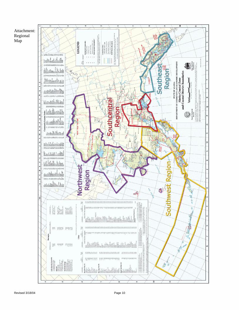
Attachment: Regional Map
Revised 3/18/04 Page 10

Appendix E
Environmental Risk Questionnaire
5

STATE OF ALASKA DEPARTMENT OF NATURAL RESOURCESDIVISION OF MINING, LAND AND WATER
Contract Administration550 W 7th Ave., Suite 640Anchorage, AK 99501-3576(907) 269-8594
Northern Region3700 Airport WayFairbanks, AK 99709(907) 451-2740
Southcentral Region550 W 7th Ave., Suite 900CAnchorage, AK 99501-3577(907) 269-8552
Southeast Region400 Willoughby, #400Juneau, AK 99801(907) 465-3400
APPLICANT ENVIRONMENTAL RISK QUESTIONNAIRE
The purpose of this questionnaire is to help clarify the types of activities you propose to undertake. The questions are meantto help identify the level of environmental risk that may be associated with the proposed activity. The Division of Mining,Landand Water's evaluation of environmental risk for the proposed activity does not imply that the parcel or the proposed activityis an environmental risk from the presence or use of hazardous substances.Through this analysis, you may become aware of environmental risks that you did not know about. If so, you may want toconsult with an environmental engineer or an attorney.
Niblack Mining Corporation (NMC)Applicant's Name Doing Business As
Suite 615-800 West Pender St. Vancouver, British Columbia, CANADA V6C 2V6Address State Zip
( 604 ) 484-5045 ( ) SAME [email protected] Darwin Green, V.P. ExplorationMessage Phone Work Phone E-Mail Contact Person
Describe the proposed activity:Niblack Mining Corporation (NMC) proposes to construct a 3090 ft. access drift, plus about 920 ft. of footwall drift and 1140 ft. of hangingwall drift for the purpose of exploring via underground drilling the Lookout Unit. About 50,000 ft. of diamond drilling is planned. The aditwill be 14.5 ft. wide and 13ft high. It will generate 60,900 yd3 of waste rock to be stored both permanently (NAG rock = 44,600 yd3) andtemporarily (PAG rock = 14,300 yd3 prior to placement back underground. Previously, a 16ft. wide access road was constructed froma barge landing area to the adit site.
In the course of your proposed activity will you generate, use, store, transport, dispose of, or otherwise come in contact withtoxic and/or hazardous materials, and/or hydrocarbons? Yes No
If yes, please list the substances and the associated quantities. Use a separate sheet of paper, ifnecessary.
NMC will use the following hazardous materials and quantities for this construction project:1) water gel explosives, stick power, blasting caps (7000 lbs ammonium nitrate+700 lbs powder+500 lbs. nonel+ 1000 ft. cord2) diesel fuel - 31,000 gal. stored (21 day cycle)3) gasoline & lubricating oils - 1000 gal. stored (21 day cycle)
Appropriate USDS sheets will be posted onsite. A explosives BMP plan has been prepared, ans a Spill Prevention and ContingencyPlan has been written and is maintained onsite, including annual refresher training. Other potential hazardous material handlinginvolves the temporary storage of about 13,000 yd3 of potentially acid generating (PAG) waste rock. This material will be stored aboutone half mile (2500 ft.) directly north of the underground adit on a lined (HDPE) storage site. The site also employs an engineeredstormwater facility and management plan to convey the 24hr., 25-year storm event around the site, and a synthetic plastic cover overthe wate rock storage pile. Water treatment is also provided for any stormwater runoff of leachate
102-4008A (Rev. 10/01)
Currently, a water treatment plant is planned to treat up to 140 gpm of water from the excavation dewatering at the adit consttuction, aswell as stormwater flows. A 24-person floating mancamp will accomodate the miners. It includes water, waste water, and solid wastemanagement systems, all self-contained. A dock and barge landing area will also be constructed in advance of the adit constructionduring early spring, 2007. Other planned facilities and activities are described in detail in the docment: Niblack Project UndergroundExploration Plan of Operations, Niblack Mining Corporation, December, 2006
Submit by Email


Appendix F
ACOE Permit Application
6

NIBLACK CONSTRUCTION/EXPLORATION PROJECT
APPLICATION FOR
DEPARTMENT OF ARMY CORPS OF ENGINEERS PERMIT FILED IN CONJUNCTION WITH
NATIONWIDE PERMIT POA-2006-511-D
January, 2007
Prepared for: Niblack Mining Corporation
Contact: Darwin Green, V.P. Exploration
Suite 615-800 West Pender Street Vancouver, B.C. Canada, V63 2V6
(604) 484-5045
Prepared by: RTR Resource Management, Inc
Contact: Robert (Rick) Richins 1109 W. Main Street
Suite 480 Boise, ID 83702 (208) 343-8727

Niblack Construction/Exploration Project, Alaska Corps of Engineers Permit Document January, 2007
i
NIBLACK CONSTRUCTION/EXPLORATION PROJECT NIBLACK MINING CORPORATION
DEPARTMENT OF ARMY CORPS OF ENGINEERS
Applicant Contact: Darwin Green Vice President Exploration Niblack Mining Corporation Suite 615 – 800 West Pender St. Vancouver, BC V63 2V6 Phone: (604) 484-5045 Permitting Contact: Robert T. (Rick) Richins President RTR Resource Management, Inc. 1109 W. Main Street Boise, ID 83702 Phone: (208) 343-8727 Fax: (208) 343-5115

Niblack Construction/Exploration Project, Alaska Corps of Engineers 404 Permit Document January, 2007
ii
TABLE OF CONTENTS
1.0 INTRODUCTION ...............................................................................................................1
1.1 Applicant:.................................................................................................................1 Niblack Mining Corporation....................................................................................1 1.2 Project Description...................................................................................................1 1.3 General Location......................................................................................................2 1.4 Site Maps .................................................................................................................2 1.5 Site Facilities and Construction Activities...............................................................3
2.0 PROJECT PURPOSE ..........................................................................................................8
3.0 SITE DESCRIPTION ..........................................................................................................9
4.0 NATURE OF ACTIVITY AND REASON FOR DISCHARGE ......................................11
4.1 Barge and Landing Craft Ramp .............................................................................11 4.2 Mooring Facility ....................................................................................................11
5.0 TYPES OF MATERIAL DISCHARGED AND AMOUNT.............................................12
5.1 Barge and Landing Craft Ramp .............................................................................12 5.2 Mooring Dock........................................................................................................12
6.0 SURFACE AREAS OF WETLANDS OR OTHER WATERS FILLED .........................13
7.0 CURRENT DISTURBANCE ............................................................................................14
8.0 WETLANDS IMPACTS AND MITIGATION MEASURES ..........................................15
8.1 General Construction BMPs ..................................................................................15 8.2 Surface Water Runoff, Erosion and Sedimentation Control..................................15 8.3 Final Reclamation and Post-Closure......................................................................15
8.3.1 Facility Shutdown, Reclamation and Wetland Development ....................15 8.3.1.1 Facility Shutdown and Decommissioning Activities...................16 8.3.1.2 Facility Shutdown and Decommissioning Activities...................16 8.3.1.3 Recontouring, Regrading and Revegetation ............................16
9.0 NAMES AND ADDRESSES OF ADJACENT PROPERTY OWNERS .........................17
10.0 LIST OF APPROVALS RECEIVED FROM OTHER AGENCIES ................................18
11.0 REFERENCES.................................................................................................................19
Niblack Construction/Exploration Project, Alaska Corps of Engineers 404 Permit Document January, 2007
iii
LIST OF APPENDICES
Appendix A Niblack Drawing Sheets Sheet 1 Site Location Map Sheet 2 Niblack Facilities Arrangement Sheet 3 Niblack Marine Terminal Sheet 4 Niblack Cross Section Barge Landing Facility Sheet 5 Niblack Cross section Camp Barge Facility Marine Terminal Appendix B ACOE Corps Application Form Appendix C Niblack Project – Wetlands Delineation Appendix D Tideland Lease Development Plan Appendix E ACMP Coastal Zone Questionnaire Appendix F Environmental Risk Questionnaire

Niblack Construction/Exploration Project, Alaska Corps of Engineers 404 Permit Document January, 2007
1.0 INTRODUCTION This report is prepared and submitted by RTR Resource Management, Inc on behalf of Niblack Mining Corporation (NMC) as technical support to ENG Form 4345, Application for Permit Modification, United States (U.S.) Department of the Army Corps of Engineers (COE) 404 Permit to authorize activities in, or affecting, navigable waters of the U.S. and the discharge of dredged or fill material into waters of the United States associated with construction and operation of a marine terminal for the Niblack Exploration Project (Project). This 404 Permit is specific to the placement of fill associated with the construction of a mooring facility and a barge and landing craft ramp in the intertidal zone; no other fill activities to waters of the U.S. are required or proposed for this project. The Project is in the preliminary exploration phase and requires the construction of an underground access tunnel to further evaluate the potential of an economic mineral resource within the project boundaries. The development of the proposed marine terminal is critical to the logistical support and safety required to advance the exploration effort. The Project is located approximately 30 miles southwest of Ketchikan, in Southeast Alaska (Sheet 1). The Project lands are under the full control of NMC. Sheets 1 through 5, pertaining to the permit application, are provided in Appendix A. Sheets 2, 3 and 4 show the general facilities arrangement and proposed areas of disturbance for the floating barge mancamp and barge landing facility. Sheet 2 shows the proposed locations for all exploration activities including wetlands areas, land application areas, temporary and permanent construction rock storage sites, roads, and water treatment facilities. No wetlands or waters of the U.S. would be impacted as a result of the surface facilities. About 1.03 total acres of intertidal area would be affected by the barge landing area and floating mancamp (Figure 3). Only 0.14 acres would be impacted by dredge or fill activities. This is for the actual barge landing area. Sheets 3 through 5 are plans and sections of the proposed marine terminal facilities. A copy of the permit application form can be found in Appendix B. 1.1 Applicant: Niblack Mining Corporation
Paddy Nicol, President Suite 615 – 800 West Pender St. Vancouver, B.C. V63 2V6
1.2 Project Description The NMC Property is in the initial stages of construction and underground exploration. The main focus of the program is the evaluation of the down-dip extension of a poly-metallic resource by continued diamond drilling from underground drill platforms. The underground drill
1

Niblack Construction/Exploration Project, Alaska Corps of Engineers 404 Permit Document January, 2007
platforms will be accessed from 5,000 total feet of new underground workings that are being planned from a single adit entry level. The drift will be driven at about the 390 ft. elevation. All surface disturbances including roads, characterization rock storage areas, portal, and ancillary facilities, will be confined to patented ground outside of delineated jurisdictional ground as defined in a recent study (Appendix C). The work camp will be located off-shore in a floating barge facility. 1.3 General Location The NMC property is located on Prince of Wales Island in south-eastern Alaska (Sheet 1). The claims lie to the south of Niblack Anchorage, a protected bay in Moira Sound (Sheet 2). The camp sits at the head of the Anchorage above a small tidal flat. The property is currently accessed by floatplane, boat, barge and helicopter. The terrain is mountainous and rugged with steep to moderate slopes. Elevations range from sea level to peaks of 2600 feet and greater. Lookout Mountain (elevation 2300 ft.) where the proposed underground drift will be constructed, is the primary exploration target and must be evaluated via underground access. Slopes are covered with temperate rain forest vegetation. Most of the planned surface facilities will be screened from the bay by this dense forest cover. The forest gives way to sparse vegetation only at the highest elevations, generally above 1800 feet. Temperatures are moderate and rainfall is high. The annual average precipitation is approximately 190 inches. Winter brings mixed snow and rain with January temperatures near the freezing point. 1.4 Site Maps Sheet 1 shows the general location of the overall project in Southeast Alaska. The project is located about 30 miles southwest of Ketchikan, Alaska. The property is comprised of 17 patented (Fee) claims, 101 lode claims, and two State of Alaska Tideland claims. All planned activities are located on Fee land. Sheet 2 presents a general facilities site map of the planned facility showing the following features:
• Proposed exploration development drift (nominal 14.5 ft. wide and 13 ft. in height) • Two development rock stockpile area locations (potentially acid-generating; non acid-
generating sites) • Main access road (already constructed) • Administration/operating area • Topsoil stockpile locations (proposed) • Laydown and storage areas (proposed) • Explosives magazine (proposed) • Fuel storage and maintenance areas (proposed)
2

Niblack Construction/Exploration Project, Alaska Corps of Engineers 404 Permit Document January, 2007
• Engineered storm water management facilities (proposed) • Locations and names of receiving water
In total, about 11.5 acres of patented land would be disturbed for all existing and proposed facilities. About 8 acres would be new disturbance. The largest single disturbance acreage is the existing road, which comprises 3.5 acres. The total area for the two development rock storage sites is about 4 acres. These sites are not located in wetlands or waters of the U.S. The overall project is described in detail in the document: Niblack Underground Construction and Exploration Plan of Operations, NMC, January, 2007. The potential acid-generating development rock stockpile site is temporary, as this material would be located back underground at final closure. 1.5 Site Facilities and Construction Activities The main focus of this initial underground construction and exploration program is to develop drilling platforms from the drift. These platforms are closer to the main areas of continued mineralization at depth. These zones are situated at depths greater than can be reliably accessed from surface drilling. In addition, the underground workings will progress through the mineralized zone during the development program, thereby allowing a more detailed geological evaluation of the system, and will allow NMC to collect a 500 ton “representative” bulk sample for metallurgical testing. The development of these underground drill platforms requires the following facilities. Underground Adit The proposed underground workings will be collared at the 390 foot elevation on the North Slope of Lookout Mountain. This site is located above the existing camp facilities at the head of Niblack Anchorage. A road has been constructed to connect the collar location of the adit with the camp and tidewater, as shown on Sheet 2. Appropriate and necessary environmental permitting preceded this construction activity including a ACOE Nationwide Permit (POA- 2006 -511-D) and ADNR Land Use Permit (LAS #25727). Underground water management and storm water controls by NMC for underground activities will be combined and involve a sequence of BMPs and water treatment scenarios at the site which include:
• Excavation water requiring management or discharge will be minimized to the extent
feasible by grouting, plugging, and separation (clean vs. dirty water). • Excavation water requiring management will be treated at the construction project via
settling sumps (underground), addition of flocculants in the pond, and skimmers as necessary to remove sediments and any hydrocarbons in the water.
3

Niblack Construction/Exploration Project, Alaska Corps of Engineers 404 Permit Document January, 2007
• Excavation water will also be put to beneficial use to the maximum extent feasible primarily as make up water for fire protection, road watering, etc., or recycled to the drilling process for construction excavation.
• A portion of the excess construction-related water requiring management will be directed
to the permitted land dispersion system for application by “drip emitters” (Sheet 2).
• Excavation dewatering water that cannot be put to beneficial use, recycled, and will be routed into the storm water pond management system, then land applied for optimum infiltration/dispersion.
In order to provide safe and efficient access as the underground development proceeds, remuck stations will be constructed at 500 ft. intervals. Forced air fans will also be installed for ventilation, in order to meet the Mine Safety and Health Act (MSHA) and the U.S. Environmental Protection Agency (EPA) health and environmental standards. Development Rock Stockpiles Two development rock stockpiles will be constructed with waste rock removed from the access tunnel. Development rock characterized as potentially acid generating (PAG) will be segregated and temporary stored at the location shown as “ARD Waste Disposal Area” (Sheet 3). This is a rock quarry site, which is contained from a drainage standpoint and ideal for temporary storage. The area will involve a limestone foundation base and HDPE liner. It will also be covered. Up to 500 tons of “ore” (commercial) material will be shipped off-site for the purpose of metallurgical testing. At final closure, this material (about 15,000 yds3) will be stored back underground. Non-acid generating material (NAG), about 46,600 yds3 , will be stockpiled in the facility labeled ‘Non-Acid Generating Waste Disposal Area”. Storm water runoff from these two facilities will be collected and routed either to BMPs, such as dispersion terraces and silt fences constructed down-gradient and then into the heavily forested area, or to the storm water detention pond for treatment prior to release. No fill to jurisdictional wetlands or discharges to waters of the U.S. are planned. Access Road An access road for the site has been constructed. Silt fences, dispersion terraces, and infiltration excavations have been installed to manage water quality through the winter season. The alignment for the temporary road to the old camp, portal and staging area is also shown in Sheet 2. The road is at a gradient of up to 8% with a 16 foot wide running surface. Total estimated length of the road is 5000 feet. Where appropriate, culverts were installed at minor drainage locations, and Camp Creek was crossed by a single span bridge as shown. Aside from the small staging area near the shore, the road will be located back from the beach in heavily forested areas. Minimal visual evidence of the road is apparent from Niblack Anchorage. An interim BMP program has already been installed at the site, as previously described.
4

Niblack Construction/Exploration Project, Alaska Corps of Engineers 404 Permit Document January, 2007
The following construction techniques were, and are currently being employed:
• All roads are constructed on properly surveyed alignment and grades. • All road cross culverts were installed at the time of road construction. • Equipment use in natural drainage channels was and will be held to an absolute
minimum. • Highly erosive soils are avoided, where practicable. • Straw bale dams with bale spills, were placed parallel to fill slopes to provide a
sediment barrier from road construction activities. The Alaska Department of Fish and Game, who is experienced with highway and logging road construction on Prince of Wales Island, recommended straw bale dams be installed instead of the more typical slash wind rows. These installations have been found to be more effective for the significant rain events typical of the area. NMC is following their direction where wind rows do not accomplish water management objectives.
• Cut-and-fill slopes have been stabilized by reducing their angle to a 2H:IV, where
practicable. • Permanent erosion control measures have been constructed to last the life of the
project, where practicable. Erosion control measures include straw bale dams with bale spills, shot rock ditch blocks, and drainage ditches that divert flow into areas of undisturbed forest floor. The Alaska Department of Fish and Game (ADF&G) has also recommended certain control measures as effective for containing sediment. The agency’s input was incorporated in the plan.
• A 50 ft. setback or buffer will be maintained from all perennial streams (except at
crossings). • Stormwater flows and drainage will be diverted or dispersed (dispersion
terraces/silt fencing) so as to maintain instream flows for anadromous fish.
• The road surface was covered with up to 12 inches of shot rock to reduce erosional features.
No fill or dredging occurred in jurisdiction wetlands as part of the road construction project. Floating Camp and Mooring Facilities NMC will use a fully permitted 24-man floating camp for housing personal. The camp will include an ADEC-approved wastewater treatment system and drinking water plant. The barge
5
Niblack Construction/Exploration Project, Alaska Corps of Engineers 404 Permit Document January, 2007
camp will be secured to the dock facility with shore access provide by a hinged walkway. NMC is currently applying for all required permits not already in place. The mooring facility will consist of an elevated walkway secured to two sets of pilings. The mooring facility will be designed to facilitate minimal disturbance of areas below high tide levels. To protect eelgrass habitat in the lower intertidal areas, siting will involve avoidance of this habitat to the extent possible. Also, propulsion systems will not be used on landing craft, tugs, self-propelled barges or other water craft using the barge landing site when tidal stage is less than half (7.6 ft. mean lower low water). A cross-section of the proposed facility is provided in Sheet 5 Minor supply needs and emergency requirements will be provided by regular floatplane, boat and/or helicopter. Deliveries will be made to the mancamp on an as needed basis. Barge and Landing Craft Ramp This barge and landing craft ramp is required to support the exploration activities at the Niblack Project. The barge and landing craft ramp will consist of a 10-foot high bulkhead constructed from cement blocks at the toe of the facility, which will then be backfilled with quarried rock to a 5% grade back to the access road. The structure will be approximately 24 feet wide and have an overall length of approximately 60 feet. This facility will be constructed between the 0 elevation contour and the 17 foot contour, just above the mean high water mark of 14.5 feet for this area. It is estimated that approximately 500 yards of fill in the intertidal zone will be required to construct the facility. The location of the proposed ramp is shown on Sheet 3. A cross-section of the proposed facility is shown on Sheet 4. The mooring facility and this ramp are the focus of this 404 permit modification application. No other fill activities will occur in waters of the U.S. Portal Platform – Ancillary Facilities The portal excavation platform will be completed to provide for the entrance to the underground, and also a level working area of sufficient size to allow for equipment repair and other uses such as shop/lunchroom, diesel generating facilities, ventilation equipment and a lay down area for supplies will also be constructed at the portal. The generator will power underground equipment, ventilation fans and auxiliary lighting. This facility is not located in delineated wetlands. Fuel Storage A fuel storage facility will be installed as shown on Sheet 3 Estimated daily fuel consumption for the underground work is 1,000 gallons of diesel per day. Based on a 14-day delivery schedule and a 7-day safety margin, on-site storage of 21,000 gallons will be required. An additional 1,000 gallons (maximum) of gasoline will be stored on site for service vehicles. NMC has prepared a Spill Contingency Plan for the site. This includes provisions for fuel containment, emergency response, minimum equipment, and regular emergency response
6

Niblack Construction/Exploration Project, Alaska Corps of Engineers 404 Permit Document January, 2007
training for all employees. The plan is posted on-site, and the response program is part of all new-hire and regular management training. This facility is not located in delineated wetlands. Magazine Locations A potential location for a powder magazine located near the portal. Subject to further investigation, an alternate site may be proposed. Any such site will be located at a safe distance from the camp location. Storage sites would meet all Mine Safety Health Act (MSHA) requirements. This facility is not located in delineated wetlands. Using a 30-day re-supply cycle, the maximum amount of explosives in the magazine at any one time is estimated at:
• 7,000 pounds of water gel explosives • 700 pounds of stick powder • 500 pounds of nonel • 1,000 feet of detonating cord
Equipment An underground water and Explosives Management Plan has been prepared for the project. This program addresses the use of ANFO, water gels, and emulsions to maintain existing water quality conditions at the site. It is included in a separate document: Niblack Lookout Unit Consolidated Construction/Exploration Project Temporary Excavation Dewatering General Permit (2004DB0101) Application Waste Water Management Permit Application, RTR, January, 2007. Surface equipment available onsite includes: two back-hoes, a 3 cubic yard front end loader, a single boom tracked mounted drill, a heavy duty pickup, and two 4-wheeled ATVs. Two diesel generators, one at the portal and a second at the mancamp, will also be located at the site. A third backup generator will also be available at the minesite.
7

Niblack Construction/Exploration Project, Alaska Corps of Engineers 404 Permit Document January, 2007
2.0 PROJECT PURPOSE The COE regulates activities in the nation’s waters, including the protection and utilization of the water resources. The COE 404 Permit is authorized by the following laws:
• Section 10 of the Rivers and Harbors Act of 1899 (33 U.S.C. 403), which prohibits the obstruction or alteration of navigable water of the U.S. without a permit.
• Section 404 of the Clean Water Act (33 U.S.C. 1344), which restricts discharges into
aquatic areas where less environmentally damaging, practicable alternatives exist.
• Section 301 of the Clean Water Act prohibits the discharge of dredged or fill material into waters of the U.S. without a permit.
• Section 103 of the Marine Protection, Research, and Sanctuaries Act of 1972, as
amended (33 U.S.C. 1413) which authorized the COE to issue permits for the transportation of dredged material for the purpose of dumping it into ocean waters.
The only component of the NMC Project that requires review and permitting under the COE 404 permit process is the proposed development of the marine terminal facility which includes mooring dolphins and a barge and landing craft ramp. This requires approximately 500 yards of fill in the intertidal zone. The facility is needed for safe personnel access. This proposed marine barge landing facility and dock is also needed to ensure the safe and reliable off-loading of industrial equipment required to develop the underground workings which are needed to advance the delineation of the mineral resource which exists within the Niblack property boundaries. The project does not require any dredging. Fill volumes associated with the ramp are estimated at approximately 500 yards of material. Plans and sections of the proposed marine facilities are illustrated in Sheets 1 through 5 (Appendix A).
8

Niblack Construction/Exploration Project, Alaska Corps of Engineers 404 Permit Document January, 2007
3.0 SITE DESCRIPTION The Niblack property is located on Prince of Wales Island in south-eastern Alaska. The claims lie to the south of Niblack Anchorage, a protected bay off Moira Sound. The camp sits at the head of the anchorage above a small tidal flat. The property is accessed by float plane, boat or helicopter. The terrain is mountainous and rugged, with steep to moderate slopes. Elevations range from sea level to peaks of 2600 feet and greater. Lookout Mountain, where the proposed adit will be built, has an elevation of 2300 feet. The slopes are covered with temperate rain forest. Most of the surface facilities will be screened from the bay by this dense forest cover. The forest gives way to sparse vegetation only at the highest elevations, generally 1800 feet and above. Temperatures are moderate and rainfall is high, with annual average precipitation of approximately 174 inches. Winter brings mixed snow, rain and sunshine, with January temperatures hovering around the freezing point. Specific vegetation, soils and hydrologic characteristics of the Project site are presented in Niblack Project - Preliminary Jurisdictional Determination, March 2006, (Appendix C), prepared by HDR Alaska, Inc. This includes a wetlands delineation, which shows wetlands in the main project area. The property is underlain by a bimodal sequence of volcanic flows and volcaniclastic rocks that have undergone regional greenschist facies metamorphism. The sequence has undergone three episodes of folding. Hydrothermal alteration has been documented visually and chemically, as has gossan development. Stratabound massive sulphide mineralization is found dominantly within the felsic rocks. Gossanous gold-rich material is present in spatial association with the massive sulphide. Gold-rich VMS mineralization is currently known to be present in four areas of the Niblack property: Dama, Lookout, Lindsy/88 and Niblack Mine. Massive pyritic VMS mineralization has also been found at other areas on surface. Sulphides are in steeply dipping lenses at Dama, Lookout and the Mine. Plunge direction is variable and may be shallow to 45o. Lens dimensions are best understood at Lookout, where maximum strike length is 1600 feet and dip extent is 800 feet, open down plunge and down dip. Monitoring of baseline surface water quality at the Niblack Project was initiated in the fall of 1996. Six monitoring stations were identified at key drainage locations around the project area. Water quality samples were obtained from each site in October, 1996; September, 1997; April, 2005; and February, 2006. Additional baseline sampling and analyses were conducted in 2006.
Based on guidelines from the Alaska Water Quality Criteria Manual for Toxic and Other Deleterious Organic and Inorganic Substances (2003), in October, 1996 naturally-occurring total and dissolved cadmium, total copper, and total and dissolved zinc were elevated at station WQ4. Total and dissolved lead concentrations were also elevated at station WQ6. Total and
9
Niblack Construction/Exploration Project, Alaska Corps of Engineers 404 Permit Document January, 2007
dissolved zinc concentrations were elevated at station WQ2. In September, 1997 baseline total and dissolved copper concentrations exceeded Alaska water quality criteria at station WQ2 and total zinc concentrations were elevated at station WQ1. These data represent pre-project environmental baseline conditions.
NMC has advised ADEC in writing regarding naturally occurring metals concentrations that exceed applicable state water quality standards at the site (see Niblack Lookout Unit Consolidated Construction/Exploration Project Temporary Excavation Dewatering General Permit (2004DB0101) Application/Waste Water Management Permit Application, RTR, January, 2007. This information will be considered as part of the ongoing regulatory program underway to address this issue. It is NMC’s understanding that adjustments to the current water quality standards are being considered in order to account for high naturally occurring water quality conditions and exceedences.
Trend monitoring had continued at the site through 2006 to establish high, average and low flow conditions for Camp Creek and Waterfall Creek. At the conclusion of the 2006 program, NMC has provided the Alaska Department of Natural Resources (ADNR) and the Alaska Department of Environmental Conservation (ADEC) with a summary report of monitoring results to date. This report is presented in the excavation dewatering general permit application: Water Quality Baseline and Monitoring Plan, Knight Piesold Consulting, January, 2007. The 2006 program results will be re-assessed at the conclusion of the season in order to consider future exploration and potential mining programs and monitoring needs.
10

Niblack Construction/Exploration Project, Alaska Corps of Engineers 404 Permit Document January, 2007
11
4.0 NATURE OF ACTIVITY AND REASON FOR DISCHARGE This application is specific to the proposed fill associated with the potential marine terminal for the Niblack Underground Construction Exploration Project. The marine terminal is required to support ongoing construction and exploration activities at the Niblack site by allowing the safe and reliable transfer of industrial equipment and supplies. Sheets included in this application, which provide a description of each of the Project components as it relates to the COE 404 permit, including the dimensions of the proposed structures. No excavations are proposed. 4.1 Barge and Landing Craft Ramp The barge and landing craft ramp are required to off-load equipment and supplies to support the ongoing Niblack exploration project. In particular, these facilities are necessary for the development of underground workings to further delineate the ore body. This requires machinery and supplies that are unable to be safely delivered to the site in its current configuration. 4.2 Mooring Facility A mooring facility is planned to provide safe moorage and access to a floating mancamp which will be used to support the exploration activities. The fill associated with this mooring facility is limited to the pilings that will be driven into the intertidal zone.

Niblack Construction/Exploration Project, Alaska Corps of Engineers 404 Permit Document January, 2007
12
5.0 TYPES OF MATERIAL DISCHARGED AND AMOUNT This section provides a description of the type(s) and amount of material being discharged. The fill material is non-acid generating, clean fill rock generated onsite at the rock quarry (Sheet 2, ultimate PAG storage site). Acid/base accounting analyses demonstrate that this material is not acid-generating showing a NP/MPA ration of 15.84. The same material was used to cap the main access road. The proposed facility locations are based on the preliminary engineering designs for the Project, and the locations and configurations may be modified slightly at the time of construction. The footprint areas for total disturbance and volumes for cut and fill activities, if changed at all, are expected to be reduced from the estimated values. 5.1 Barge and Landing Craft Ramp Fill material for the proposed ramp will consists of manufactured cement blocks and borrow material generated from the development of associated facilities located on the adjacent patented uplands. This involves about 0.14 acres. The total fill required to construct the barge and landing craft ramp is estimated at 500 cubic yards. The Dimensions and preliminary designs are shown on the Sheets located in Appendix A. 5.2 Mooring Dock Fill associated with the mooring dock is limited to the 7 galvanized steel pilings as shown on Sheet 5. An estimate of 30 yards of fill is required to establish the pilings as a mooring facility.

Niblack Construction/Exploration Project, Alaska Corps of Engineers 404 Permit Document January, 2007
6.0 SURFACE AREAS OF WETLANDS OR OTHER WATERS FILLED The construction of the marine facility is expected to involve 0.14 acres of fill in the intertidal zone. These facilities are shown on Sheets 3, 4, and 5.
13

Niblack Construction/Exploration Project, Alaska Corps of Engineers 404 Permit Document January, 2007
7.0 CURRENT DISTURBANCE The current exploration activities have disturbed approximately 4.47 total acres of patented land outside of the jurisdictional areas as delineated in the attached study included as Appendix C. A majority of this disturbance is associated with road construction.
14

Niblack Construction/Exploration Project, Alaska Corps of Engineers 404 Permit Document January, 2007
8.0 WETLANDS IMPACTS AND MITIGATION MEASURES This section contains a discussion of mitigation measures used to minimize and/or compensate for impacts to the intertidal zone. Mitigation measures will involve avoidance and minimization of adverse impacts by employing Best Management Practices (BMPs) from construction through closure, surface water management, and reclamation practices, including concurrent reclamation and re-creation of wetlands in the sedimentation ponds and borrow sites, as is practicable. The proposed efforts and measures to minimize and reduce the impacts to the inter-tidal zone are described in this section. 8.1 General Construction BMPs BMPs controlling erosion include diversion of runoff; minimizing the size of disturbed areas; limiting the time of exposure; sediment control devices; and establishing permanent vegetative cover. The goal is to prevent erosion where possible and to retain most of the sediment on site where erosion cannot be prevented. No creosote or ammonia cal copper zinc arsenate treated wood products would be used in constructing the dock facilities. No in-water work (pile-driving or filling) would be conducted between March 1 and June 30 to protect migrating juvenile salmon and potentially herring spawning. Other BMPs include requiring all construction equipment to be fueled on shore except for fueling barges, and having oil spill response equipment at the site to contain any oil spills. This would include: absorbent materials, containment booms and personnel protective equipment. Runoff from the laydown and fuel storage areas (Sheet 2) would be filtered using silt fences, hay bales and/or sediment traps. The laydown area would be surfaced with clean crushed gravel to increase infiltration, and runoff will be diverted to vegetates areas wherever feasible. 8.2 Surface Water Runoff, Erosion and Sedimentation Control All surface water runoff from disturbed portions of the site will be managed with BMPs. Runoff from all disturbed areas of the site, and discharges from temporary BMPs until the disturbance is stabilized, will undergo treatment for the settling of entrained sediment prior to release into the natural receiving waters. 8.3 Final Reclamation and Post-Closure The reclamation goals include the re-establishment of habitat to mimic pre-mining conditions by development of a diversity of wildlife habitat types, such as open water, uplands and wetlands. 8.3.1 Facility Shutdown, Reclamation and Wetland Development This section summarizes facility shutdown, reclamation, and wetland development detailed in the Plan of Operations Reclamation Plan (NMC, 2007).
15
Niblack Construction/Exploration Project, Alaska Corps of Engineers 404 Permit Document January, 2007
8.3.1.1 Facility Shutdown and Decommissioning Activities Facility shutdown and decommissioning ultimately involves removing all components from service that are not needed to complete reclamation and post-reclamation. These activities are considered operational and removal will be accomplished prior to reclamation. The temporary PAG storage site will be relocated back underground at the cessation of the construction and test exploration program. 8.3.1.2 Facility Shutdown and Decommissioning Activities The reclamation process requires several tasks designed to fulfill the reclamation objectives of protecting human health, water resources, soil stability, vegetation, wildlife and recreation. These reclamation tasks include: 1) demolition; 2) portal closure; 3) channel stabilization; 4) fill placement and grading; 5) excavations; 6) ripping; 7) growth media placement; 8) growth media grading; 9) scarification; 10) seeding, mulching, and fertilizing; and 11) monitoring. Project operations will, to some degree, alter the landscape and topography of the site. NMC will reclaim the site to the extent necessary to provide wildlife habitat use and minimize visual impacts. After implementing the reclamation tasks, most facilities will be returned to a configuration similar to the surrounding topography. The borrow areas and sedimentation ponds will resemble the surrounding topography with a portion converted to open water ponds and wetlands based on contouring, hydrology, and wetland species invasion. Open water will enhance wildlife habitat by creating a diversified system with alternate forms of vegetative cover. The full reclamation program is described in the document: Plan of Operations for the Niblack Lookout Unit Underground Construction and Exploration Project, NMC, 2007 Once the seedbed is prepared, the focus of revegetation is to mimic the pre-mining cover by establishing grasses for stabilization that allow for successional plant communities of forbs, alder, and muskeg/spruce. Grass seed mixes are proposed for the drier upland areas and wetland areas. Drier upland areas will include the mine area complex and development rock stockpiles, while much of the remaining area soils will normally be saturated resulting in wetlands. 8.3.1.3 Recontouring, Regrading and Revegetation At the end of post-closure/reclamation activities, most of the project area will be restored to mimic the pre-mining vegetative cover and returned to its pre-mining use as a wildlife habitat, recreational use and a subsistence hunting and trapping area.
16

Niblack Construction/Exploration Project, Alaska Corps of Engineers 404 Permit Document January, 2007
9.0 NAMES AND ADDRESSES OF ADJACENT PROPERTY OWNERS The proposed marine facility is to be constructed within the inter-tidal zone on lands administered by ADNR. About 0.14 acres is involved. The adjacent property above the high tide contour is privately owned and under the full control of NMC. The ADNR contact person is:
Mr. Brady Scott The State of Alaska Department of Natural Resources 400 Willoughby Avenue Juneau, Alaska 99801 (907) 465-2533
17

Niblack Construction/Exploration Project, Alaska Corps of Engineers 404 Permit Document January, 2007
10.0 LIST OF APPROVALS RECEIVED FROM OTHER AGENCIES Current operating permits for the Niblack construction/exploration project are shown in the following table. Certain applications for operating permits are also currently in progress.
Niblack Lookout Unit Current Permit Status PERMIT STATUS 1. ADNR Tideland Permit (Temporary Mancamp) 1. Pending, Temporary Permit Application
submitted in June 2006, new application to be filed for new barge/camp site.
2. ACOE Approved Jurisdictional Wetlands Determination
2. In-hand, dated 3/31/2006, valid for 5 years from issuance
3. ADEC Industrial Solid Waste Permit 3. for storage of underground excavation waste requiring special handling, Application submitted January, 2007
4. ACOE Authorization Under Nationwide Permit (NWP) No. 14, Linear Transportation Projects
4. In hand, File No. POA-2006-511-D, dated 6/13/2006, valid until the NWP is modified, reissued or revoked
5. ADEC Storm water Permit 5. Notification SWPPP filed October, 2006 6. ADEC General Permit for Marine Disposal of Secondary Treated Domestic Wastewater from Housing and Kitchen Facilities Built on Shore or Floating Barges
6. In-hand, Permit #0240DB004-1132 received by mancamp owner (8/4/2006)
7. ADNR Plan of Operations/Reclamation Plan for Lookout Unit Exploration (including bonding)
7. In review by LMPT (ADNR/ADEC) filed June 26, 2006
8. EPA Spill Prevention Counter Measure Control Plan for Exploration Project
8. Plan developed; copies clearly posted onsite; plan to be sent to EPA and ADEC prior to initiating 2007 work
9. ADNR Temporary Water Use Authorization
9. In hand, TWUP #J2005-06, dated 6/17/2005 for up to 750 gallons per day from an unnamed stream for domestic use in the camp facility
10. ADNR Temporary Water Use Authorization 10. In hand, TWUP#J2005-07, dated 6/24/2005, effective 7/15/2005 for up to 11,500 gallons per day from an unnamed stream for exploration drilling use
11. ADEC Air Quality Permit for Power Generation 11. To be submitted to ADEC 12. ACMP Checklist for Exploration Construction Activities (Appendix D)
12. Submitted January 2007 (attached)
13. ADNR State Historic Preservation Office 13. Concurrence that no historic properties will be affected, (6/16/2006), valid unless other historic sites are discovered during ground altering activities
14. ADNR Fish Habitat Permit 14. In hand, FH-06-VII-0014 for the bridge over Camp Creek (6/13/2006), expires at the end of the life of project
15. ACMP Environmental Risk Questionnaire 15. See Appendix E of this document. 16. Temporary Excavation Dewatering Permit (Consolidated)
16. Separate document submitted to ADEC January 2007
18

Niblack Construction/Exploration Project, Alaska Corps of Engineers 404 Permit Document January, 2007
11.0 REFERENCES
1. Alaska Department of Transportation and Public Facilities, Alaska Storm Water Pollution
Prevention Plan Guide. January 14, 2005. 2. Alaska Department of Environmental Conservation. 18 AAC 70, Water Quality
Standards, 2003.
3. HDR Alaska, Inc. Niblack Property Prince of Wales Island, Alaska Preliminary Jurisdictional Determination. March 2006.
4. Knight Piesold. Water Quality Monitoring and Baseline Plan Report for Niblack
Project, Alaska. January, 2007.
5. Niblack Mining Corp., Niblack Project – Revised Underground Construction Exploration Plan of Operations. January, 2007.
6. RTR Resource Management. Temporary Construction Excavation Dewatering General
Permit (2004 D130101) Application. January, 2007.
7. U.S. E.P.A., List of Drinking Water Contaminants and MCL’s, National Secondary Drinking Water Regulations, 2005.
8. U.S. Environmental Protection Agency, National Pollutant Discharge Elimination
System, General Permit for Discharges from Large and Small Construction Activities, as modified January 21, 2005.
19

Niblack Construction/Exploration Project, Alaska Corps of Engineers 404 Permit Document January, 2007
SEE SEPARATE APPENDICES
Appendix A Niblack Drawing Sheets Sheet 1 Site Location Map Sheet 2 Niblack Facilities Arrangement Sheet 3 Niblack Marine Terminal Sheet 4 Niblack Cross Section Barge Landing Facility Sheet 5 Niblack Cross section Camp Barge Facility Marine Terminal Appendix B Copy of 404 Permit Application Form Appendix C Niblack Project – Wetlands Delineation Appendix D Tideland Lease Development Plan Appendix E ACMP Coastal Zone Questionnaire Appendix F Environmental Risk Questionnaire
20