tiger grant benefit-cost analyses from tribal governments us-18
TRANSCRIPT

TIGER Grant Benefit-Cost Analyses from Tribal Governments US-18 South Dakota (SD) This application was submitted in TIGER I by the Pine Ridge Indian Reservation and the South Dakota DOT to reconstruct 15.6 miles of US Route 18 near the communities of Oglala and Pine Ridge, SD. While the application discusses qualitatively potential benefits in all five benefit categories, the analysis only made quantitative estimates of safety benefits. The analysis used data on past fatalities and injuries due to highway crashes, along with DOT’s guidance on Value of Statistical Life, to estimate the dollar value of the fatalities and injuries that would be prevented by the improvements provided by the project. There is some evidence suggesting that crash rates in the area are declining over time, so that past crash rates may not be an accurate indicator of future crash rates. Also, the analysis did not use FHWA crash reduction factors to estimate the likelihood that the project would have prevented the crashes that had occurred in the past (instead simply assuming that half of the crashes would have been prevented). The analysis also did not discount future benefits to estimate a present value of benefits (to compare with the present value of costs). The analysis also analyzed 40 years of benefits, but did not take into account the likely costs for re-paving that would be necessary over such a long period. Discounting the future benefits reduces the ratio of benefits to costs from 5.3 down to 1.8. The possibility that future crashes without the improvements provided by the project might be overestimated would reduce this ratio of benefits to costs still further; on the other hand, the analysis does not make any estimate of benefits related to state of good repair and livability, which could be significant. We therefore concluded that benefits probably exceed the costs.

1
TIGER DISCRETIONARY GRANT APPLICATION OVERVEIW
1. Applicant: South Dakota Department of Transportation (SDDOT) 2. Contact Information: Craig McIntyre, South Dakota Department of Transportation, 700
E. Broadway Avenue, Pierre, South Dakota 57501-2586, telephone: 605-773-4912, e-mail: [email protected]
3. County Project is Located: Shannon (Pine Ridge Indian Reservation) 4. U.S. Congressional District & Member’s Name: At Large Stephanie Herseth Sandlin 5. Project Title: Safety improvements, reconstruction and surfacing of US 18, and livability
improvements in communities of Oglala and Pine Ridge. 6. Project Location: Southwestern portion of South Dakota along US 18 beginning in the
community of Oglala at MRM 87.520 and proceeding east for 15.6 miles and ending in the community of Pine Ridge at MRM 103.27. The project is located in a primarily rural area, but includes activities in the two communities.
7. Proposed Work: The project will include grading, structures, interim surfacing, roadway
lighting, sidewalk, curb & gutter, storm sewer, and asphalt concrete surfacing from the community of Oglala to the community of Pine Ridge.
8. Eligibility: The reconstruction project is on US 18, which is part of the National Highway
System, and is eligible for funding under 23 U.S.C. 9. Project Purpose & Benefits: Six of the eleven poorest counties in the United States are
in South Dakota. The project is located in Shannon County, an Economically Distressed Area, and it is the second poorest county in the US. The project will create short-term construction related jobs, and facilitate long-term employment. The project will reconstruct and surface a deteriorating 15.6 mile segment of US 18. This segment has an accident rate more than 2.5 times that of South Dakota’s average rate. Shoulders with rumble strips will be constructed, and other measures will be taken to improve safety and diminish the high incidence of fatal runoff the road accidents. Within the communities of Oglala and Pine Ridge quality of life improvements will be implemented. Those improvements include adding sidewalks with lighting, improving access to transit, and curb and gutter and storm sewers will be constructed.
10. Total Project Cost: The project cost is estimated at $28,560,000. 11. Amount of Federal TIGER Funds Requested: $28,560,000 12. Technical Feasibility: The preliminary engineering (PE) is 98% complete. 13. Project Schedule: It is anticipated the project will be ready to let for bids in February
2010. Any funds received from this application will be obligated within 30 days after award of the project contract. The project will be completed by November, 2011.

2
TABLE OF CONTENTS
Application Overview 1 Table of Contents 2 Primary Selection Criteria 3
Secondary Selection Criteria 13
Distributional and Geographic Equity 14
Status of Environmental Approvals 17
Project Cost Estimate & Project Schedule 19
Certification of Federal Wage Rate Requirements 20

3
1. PRIMARY SELECTION CRITERIA
(a) Long-Term Outcomes for the region (i) State of Good Repair – improving the condition of existing
transportation facilities and system. Is the project part of or consistent with state, local, regional efforts to maintain transportation facilities or systems in a state of good repair?
Yes, the project is consistent with state efforts to maintain and improve the state highway system. The current roadway was constructed in 1943 and its seviceable life will soon be exceeded. Most sections of the highway lack shoulders and the pavement is deteriorating. Implementing the project will result in a safe and useable roadway for many years to come. The following pavement management graph indicates the imminent failure of the pavement. Reconstruction is the only viable option.
Is it an aim of the project to reconstruct or upgrade surface transportation projects that threaten future economic growth and stability due to their poor condition? If the project is not constructed, the result will threaten future economic growth, and the local economy of the Reservation will continue to be stifled. This is the second poorest county in the United States and the improvements will help people access employment, goods and services, and enhance movement of freight in and out of the area. Is the project appropriately capitalized up front and uses asset management approaches that optimize its long-term cost structure? The project is included in the STIP and is tentatively slated for FY 2010 and FY 2011. Although, SDDOT’s current funding situation is unsettled at

4
this time. If it is determined that federal funding is not available the project will be deferred. If federal funding is available and the project is implemented, it will become a component of the SDDOT Pavement Management System. The system will be used to assess the performance of the pavement and to determine optimum maintenance treatments. Is a sustainable source of revenue available for long-term operations and maintenance for the project? Yes, the long-term operation and maintenance of the project is assured. Once implemented, the project will be monitored and funds budgeted to keep the operation of the facility at a peak level. What is the current condition (metrics) and performance, and how will project improve the system’s condition, performance and/or long-term cost structure? The current roadway conditions and performance are as follows: Year Constructed – 1943 Year Last Overlayed - 1990 Surface Width – 24 feet (one lane each direction) Shoulder Width – 1 foot (each direction) Surface Condition - Good Year 2015, Best Benefit for Reconstruction (basis - pavement condition) Roughness (International Roughness Index) - 200 Transverse Cracking - Low Severity Fatigue Cracking – Low Severity Patching Deterioration – Low Severity Block Cracking – Low Severity Rut Index - .2” average rutting with .8” maximum rutting Average Daily Traffic – 2,133 cars and 106 trucks Accident Rate – In the past 5 years there have been 6 fatal crashes resulting in 6 fatalities. There have also been 22 injuries, and 3 property damage accidents. The accident rate calculates to 3.86; which is more than 2.5 times the rate for South Dakota’s state highway system (1.43 rate for 2008). Construction of the project will result in a modern roadway having 8 feet wide paved shoulders with edgeline rumble strips. The widened, paved shoulders will provide an abundant recovery area in order to diminish the number of run-off the road/rollover crashes. Additionally the ditch section will be sloped at a 5:1 ratio, and this will also be a factor in lowering the number of rollover crashes. Moderating the number of fatal crashes and injury crashes will positively impact the benefit/cost ratio of the project.
5
(ii) Economic Competitiveness of the U.S. over medium to long-term. Quality of jobs created, number of jobs in Economically Distressed Area.
• Improve long-term efficiency, reliability in movement of workers or goods
The current roadway conditions and accident rates on this section of US 18 are not conducive for economic development in this Economically Distressed Area. Once the improvements are made, the Pine Ridge Indian Reservation will be more accessible for goods and services to flow in and out of the area, and for employment opportunities to occur. Efforts are currently being made to the immediate west of the Reservation to provide connectivity. The Heartland Expressway will provide multilane divided-highway access between Rapid City and Denver by way of the Nebraska Panhandle. The first 47 miles of the project via SD 79 from Rapid City south to the junction with US 18 (Maverick Junction) are complete. Grading work is being done now on about 8 miles of US 18/385 between Maverick Junction and Smithwick Road. Those new lanes will be surfaced in 2010, and all four lanes will be open to traffic in the fall of next year. The project is farther along in construction thanks to a $67.5 million federal earmark dedicated to creating a four-lane roadway between Maverick Junction and Oelrichs. Oelrichs is at the intersection of US 18 and US 385, and the Pine Ridge Indian Reservation is just to the east of Oelrichs. The target completion date to Oelrichs is 2011. The Pine Ridge Indian Reservation is expected to benefit once those sections of the Heartland Expressway are completed, and if TIGER Discretionary Grant funds are secured to make the proposed improvements to US 18. The comprehensive approach of bringing to bear major resources is unlike any other transportation improvements seen in this area. • Improvements allow expansion, hiring, or growth of private
sector Providing long-term employment opportunities is a major goal of the proposed project. However, the benefits of immediate construction related employment cannot be overstated. The per capita income of Shannon County is $6,286 as compared to the U.S. per capita income of $39,751. The Pine Ridge Indian Reservation has an unemployment rate hovering around 80 percent. Any employment opportunities in this area are to be aggressively pursued, and greatly appreciated.
The Pine Ridge Indian Reservation has very few commercial businesses with private ownership, most employment is provided by the Oglala Sioux Tribe, Oglala Lakota College, Bureau of Indian Affairs, and the Indian Health Service. The tribe operates the Prairie Wind Casino, hotel and restaurant located on the western edge of the Reservation along US 18

6
and is accessed by the proposed project. The casino complex employs approximately 250 people and most are tribal members.
The South Dakota Department of Transportation has an agreement with the Oglala Sioux Tribe’s Tribal Employment Rights Office (TERO), and the agreement governs projects undertaken by the State on the Reservation. The agreement requires certain actions from contractors (and subcontractors) to recruit and hire workers. The TERO is notified of any job vacancies and its Job Skills Bank is used to assist the contractor in meeting the stipulated hiring goal for a project. The Job Skills Bank lists available Native Americans by job classification based on skill level to be used to fill job vacancies, new positions, or any other negotiated position. Native Americans are given preference for at least eighty percent (80%) of the project work force provided that sufficient qualified Native American applicants are available. The prime contractor pays a TERO fee of two percent (2%) and a training fee of one-half of one percent (0.5%) of the total contract dollar amount. The fees help to perpetuate the TERO training program effort. The construction related employment that will be created by the proposed project will be a major injection into the local economy. The project will be a catalyst for continued development of a large trained workforce. Another entity that works to develop a transportation related workforce is the Northern Plains Tribal Technical Assistance Program (NPTTAP). The Oglala Sioux Tribe is served by NPTTAP. Training is provided by NPTTAP in a number of job skill areas such as:
• Work zone traffic control • Heavy equipment operation and safety training • Welding • Forklift operation
It is hoped that further employment opportunities will develop once a larger pool of skilled laborers is developed. • Other methods such as better use of all transporation
infrastructure and benefits to more than one mode – emphasis area may include access to transit, and transport of workforce to jobsite.
The timing of the proposed project is quite fortuitous given the recent opening of the Oglala Sioux Transit program in May of 2009. Through a $2.8 million grant from the Federal Transit Administration a door has been opened to provide efficient transportation throughout the Reservation. A lack of employment opportunities is a major obstacle on the Pine Ridge Indian Reservation, and a compounding factor is the lack of transportation to jobsites. Most people on the Reservation do not have personal automobiles and daily life has been challenging. In order to get to work, shop, attend school, or seek medical care many residents have had no

7
choice but to walk, hitchhike or ask for rides from relatives and friends. Employers are reluctant to hire people with unreliable or only intermittent sources of transportation. The newly opened Oglala Sioux Transit Facility is housed in a building on the outskirts of Pine Ridge. The facility operates three 22 passenger buses and five 16 passenger buses. The buses will be integral in transporting workers to and from the jobsites along the proposed project and between the communities of Oglala and Pine Ridge. Once the construction project is completed the transit service will have a safer and better roadway on which to continue operating and expanding. It is difficult to convey how the Reservation’s lifestyle has changed because of the transit service. Transit is especially important when put into context; the Pine Ridge Indian Reservation has a land mass twice the size of Delaware.
(iii) Livability - Improving quality of living and working
environments and the experience for people in communities • Description of affected community and scale of project’s impact The proposed project will improve livability of people in the communities of Oglala and Pine Ridge and the Resevation as a whole. The 2000 Census reported a population of 1,229 in the community of Oglala, and Pine Ridge had a population of 3,771. The project components within the two communities will not only include roadway reconstruction, but also entail roadway lighting, sidewalk, curb & gutter, and storm sewer. Most sections of Pine Ridge and Oglala currently lack these amenities. With a disproportionate population of low income people, most are self-reliant, and walk to their destinations. While this is a healthy activity, it is not always an easy task. Without sidewalks people must walk in the roadway or along footpaths worn into the dirt along the roads. During wet conditions the footpaths become mud paths; in the winter they are buried by snow and obscured entirely; leaving the roadway as the only alternative. The challenges and dangers become magnified at night. A potentially life threatening situation is created when there are no sidewalks, and no lighting is available to help illuminate pedestrians walking in the roadway. In the winter months darkness conceals pedestrians by 5 PM. This scenario was in evidence when a person operating a wheelchair along this section of US 18 in Oglala was struck and killed by an automobile in January of 2005 just prior to 6 PM. Quality of life improvements such as curb and gutter, and storm sewer will help alleviate the conditions of pooling, stagnant water adjacent to the roadway. This will alleviate pedestrians having to frequently ford standing water in the two communities.

8
• Will project significantly enhance user mobility by creating convenient transportation options?
The project will significantly enhance the mobility of pedestrians by providing them a safe walking environment in the form of accessible, well lit sidewalks. It will further enhance their access to homes, businesses, and schools. • Does the project enhance points of modal connectivity, or reduce
congestion. While traffic rates are not overly high in the project area, the current conditions cause a concentration of motor vehicles and pedestrians, and puts them into conflict with one another. Vehicle traffic and pedestrian traffic will be in much better harmony once the project is completed. • Does the project improve accessibility and transport services for
economically disadvantaged population, non-drivers, senior citizens and person with disabilities, or make goods, commodities, and services more readily available to these groups?
Improved roadway facilities and adjacent, accessible pedestrian facilities will greatly improve the quality of life for residents of the Pine Ridge Indian Reservation. People will have safer access to transit stops along the route, and the transit buses will have a safer highway environment on which to operate. The population of the Reservation is predominantly economically disadvantaged, and has a low percentage of vehicle ownership. The improved transit access will mainly benefit those segments of the population. Since the Reservation encompasses a large, rural area, it is difficult for people to access goods, commodities, and services. The improved transportation system will help to facilitate access to those items and thereby improve the quality of life. • Is the project the result of a planning process that coordinated
transportation and land-use planning decisions and encouraged community participation in the process?
The proposed project is included in the Statewide Transportation Improvement Program (STIP) and has been discussed for several years at widely advertised public meetings. The proposed project has been discussed in several joint planning meetings involving the Oglala Sioux Tribe, the South Dakota Division of the Federal Highway Administration, and the South Dakota Department of Transportation. There has been only support for the project, no negative comments have been received.
(iv) Sustainability – improve energy efficiency, reducing
dependence on oil, reducing greenhouse gas emissions and benefitting the environment.

9
The proposed project will have modest impacts on improving energy efficiency, reducing dependence on oil, reducing greenhouse gas emissions and benefitting the environment. As previously noted, the project will benefit an economically disadvantaged population. The vehicles owned and operated by people on the Reservation tend to be older, and less energy efficient. By facilitating increased access to transit, and better operating conditions for transit buses and other vehicles, there will be modest benefits in each of the sustainability categories. (v) Safety – Assess project’s ability to reduce the number, rate
and consequences of surface transportation-related crashes, and injuries and fatalities among drivers and/or non-drivers.
The segment of roadway encompassed by the proposed project was the major influence in developing the safety emphasis area in the South Dakota Strategic Highway Safety Plan to reduce the number and severity of run-off the road accidents. South Dakota’s Strategic Highway Safety Plan was adopted in 2007 and uses four core strategies to reduce highway fatalities, injuries, and collisions. Education - Driver education is used to establish behaviors that keep people safe on our highways. Educational strategies also aim at changing behaviors that contribute to crashes, such as drunk driving, speeding, lack of safety restraint usage and inattentive driving. Educational efforts also can make good drivers better at using antilock brakes and other safety technologies. Enforcement - Enforcement of traffic laws boosts compliance. Greater compliance with seat belt laws, laws against drinking and driving, and speed limits will reduce fatalities, injuries and crashes. Engineering - Road design affects driver behavior and the severity of crashes. Modification of the roadway can be a solution in some crash-prone locations. Increasing the number of Road Safety Audits on key projects also could have benefits. Emergency Services - The difference between a fatal crash and an injury crash can be the length of time it takes to transport victims to appropriate medical care and the quality of care victims receive in transit. When rollovers are investigated by road class, rural interstate and rural local roads have the largest percentage of all fatal crashes. Rural local roads have the highest rollover fatal crash rate per 100 million VMT. The percentage of all South Dakota fatal crashes with a vehicle rollover coded as the first harmful event was nearly three times the national rate in 2003. Additionally, the study found that South Dakota’s fatal rollover rate per 100 million VMT has also been on the rise since 1998. An upward trend in total crashes with a rollover as the initial harmful event also was noted.

10
Road Safety Audit (RSA) and Road Safety Audit Review (RSAR) processes are being initiated at the South Dakota Department of Transportation. A RSAR was conducted on the proposed project by a review team and they analyzed safety-related deficiencies and discussed those issues with the design team. A significant number of roadway departures were noted for the proposed project segment. It was determined that many of the severe roadway departure crashes could be avoided if certain design conditions exist. Those conditions include ditch sections with gentle side slopes and firm soil to support a vehicle, and no fixed objects, road shoulder with adequate recovery area, rumble strips to alert drowsy or inattentive drivers. Adopting those elements into the project design will provide roadway conditions upon which a driver often can regain control of the vehicle. Eliminating all fatalities and injury accidents would be the ultimate desire of instituting the project. Accident rates will be reviewed each year to see if any trends develop, and to see if other measures can be adopted to improve safety. Data will be analyzed and a review of the goals will be conducted 5 years after construction of the project.
(b) Job Creation & Economic Stimulus - Quickly create and preserve
jobs, stimulate rapid increases in economic activity, particularly jobs that benefit economically distressed areas as defined by section 301 of the Public Works and Economic Development Act of 1965, as amended (42 U.S.C. 3161) (“Economically Distressed Areas”) The construction of the 15.6 mile long project is anticipated to employ 153 workers. Based on the Tribal Employment Rights Office (TERO) agreement the South Dakota Department of Transportation has with the Oglala Sioux Tribe, it is anticipated that between fifty and sixty percent (50 – 60%) of those positions can be filled by individuals enrolled in the TERO Job Skills Bank. The TERO agreement calls for Native Americans to be given preference for up to eighty percent (80%) of the jobs. If 153 jobs are created in this Economically Distressed Area, that will represent a significant boost to the local economy. Evaluation of Project Performance The project will be monitored and the number of jobs created will be documented. Follow-up with the TERO will be conducted to determine the number of jobs that were subsequently preserved, the number of new jobs created as a result of the project, and an estimate of expanded business employment. However, there will be a data limitation. There will likely be some non-tribal members that obtain jobs as a result of the project. TERO will not have the information on those non-tribal members. The SD Department of Labor will be consulted to see if data can be obtained on the employment in the county after project completion.

11
Given the location of the project, employment and business opportunities will benefit Economically Distressed Areas. The project’s procurement plan in conjunction with TERO will likely create some follow-on jobs and critical capital for manufacturers and suppliers related to the project.
Cost Benefit Analysis of the 5 long-term outcomes (i – v)
As with many projects, some of the outcomes are difficult to monetize in terms of cost/benefit. The following represents the best effort of the SDDOT to provide meaningful information.
(i) State of Good Repair – improving the condition of existing transportation facilities and system. Based on the SDDOT’s Pavement Management Program, the pavement on this section of US 18 will fail by the year 2020. The best benefit analysis projects that reconstruction should occur by 2015. (ii) Economic Competitiveness of the U.S. over medium to long-term. Quality of jobs created, number of jobs in Economically Distressed Area. It is estimated that 153 construction jobs will be created as a result of the project. That many jobs in an area with more than 80% unemployment will be a major boost for many households and the local economy. The 153 jobs directly created by the project represents approximately 12.3% of all jobs in Shannon County. The job skills obtained on the project will be able to be used on other job sites both on and off the Reservation. (iii) Livability - Improving quality of living and working environments and the experience for people in communities. The sidewalks with lighting, curb and gutter and storm sewers will provide quality of life benefits for the residents of Oglala and Pine Ridge. Although, monetizing the quality of life improvements cannot be done. (iv) Sustainability – improve energy efficiency, reducing dependence on oil, reducing greenhouse gas emissions and benefitting the environment. There is limited availability of automobiles because of the low income population on the Pine Ridge Indian Reservation. As a result, the ADT (average daily traffic) is only 2,133 on this section of US 18. Most vehicles on the Reservation are older, and are not fuel efficient. The jobs created by the project will provide income that will allow individuals to purchase more fuel efficient vehicles.
12
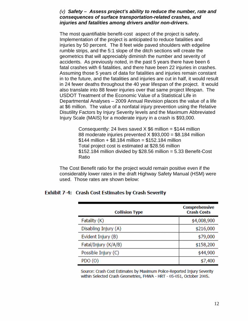
(v) Safety – Assess project’s ability to reduce the number, rate and consequences of surface transportation-related crashes, and injuries and fatalities among drivers and/or non-drivers. The most quantifiable benefit-cost aspect of the project is safety. Implementation of the project is anticipated to reduce fatalities and injuries by 50 percent. The 8 feet wide paved shoulders with edgeline rumble strips, and the 5:1 slope of the ditch sections will create the geometrics that will appreciably diminish the number and severity of accidents. As previously noted, in the past 5 years there have been 6 fatal crashes with 6 fatalities, and there have been 22 injuries in crashes. Assuming those 5 years of data for fatalities and injuries remain constant in to the future, and the fatalities and injuries are cut in half, it would result in 24 fewer deaths throughout the 40 year lifespan of the project. It would also translate into 88 fewer injuries over that same project lifespan. The USDOT Treatment of the Economic Value of a Statistical Life in Departmental Analyses – 2009 Annual Revision places the value of a life at $6 million. The value of a nonfatal injury prevention using the Relative Disutility Factors by Injury Severity levels and the Maximum Abbreviated Injury Scale (MAIS) for a moderate injury in a crash is $93,000.
Consequently: 24 lives saved X $6 million = $144 million 88 moderate injuries prevented X $93,000 = $8.184 million $144 million + $8.184 million = $152.184 million Total project cost is estimated at $28.56 million $152.184 million divided by $28.56 million = 5.33 Benefit-Cost Ratio
The Cost Benefit ratio for the project would remain positive even if the considerably lower rates in the draft Highway Safety Manual (HSM) were used. Those rates are shown below:

13
2. SECONDARY SELECTION CRITERIA
(a) Innovation – Innovative strategies to pursue long-term outcomes
There has been a concerted effort to bring a series of strategies together and focus them on accomplishing the project. Those strategies have been discussed throughout the previous sections of this application, but the following will re-cap them.
• Work is progressing on the Heartland Expressway to provide
connectivity between the Pine Ridge Indian Reservation and major markets between Denver and Rapid City.
• A Tribal Employment Rights Office (TERO) agreement has been negotiated and entered into by the Oglala Sioux Tribe and the South Dakota Department of Transportation.
• Training of workers is being accomplished by TERO and they are being certified by the Tribe’s Job Skills Bank.
• A strategy is in place to transport trained workers from throughout the Reservation to the project jobsites using the recently opened Oglala Sioux Transit in conjunction with the Federal Transit Administration.
• The South Dakota Strategic Highway Safety Plan has been used to identify the proposed project as the highest priority.
• Roadway Safety Audit Review (RSAR) has been used to provide project construction strategies to reduce the extreme rate of fatal and injury crashes.
• Public meetings, meetings with Tribal officials, State officials, and FHWA officials have been used to identify the project and place it in the Statewide Transportation Improvement Program (STIP).
• Strategies to improve the quality of life in the communities of Oglala and Pine Ridge have been integrated into the project.
• The economic condition of the geographic region has been reviewed and the project area was identified as the top priority.
• Finally, the proposed project is the culmination of a comprehensive list of strategies to try and improve conditions in this Economically Distressed Area.
(b) Partnership – strong collaboration among a broad range of
participants and/or integration of transportation with other public service efforts.
As identified in the previous section, the proposed project has been the recipient of strong collaboration among a wide group of participants. The result is the development of a comprehensive list of strategies to try and make a real difference in the lives of people living in the area. If the project would have been developed in a void, few innovations would have occurred. Because of the wide participation of the public, Tribe, State, and Federal agencies, a myriad of innovative strategies have resulted because of the strong partnerships that have been formed.

14
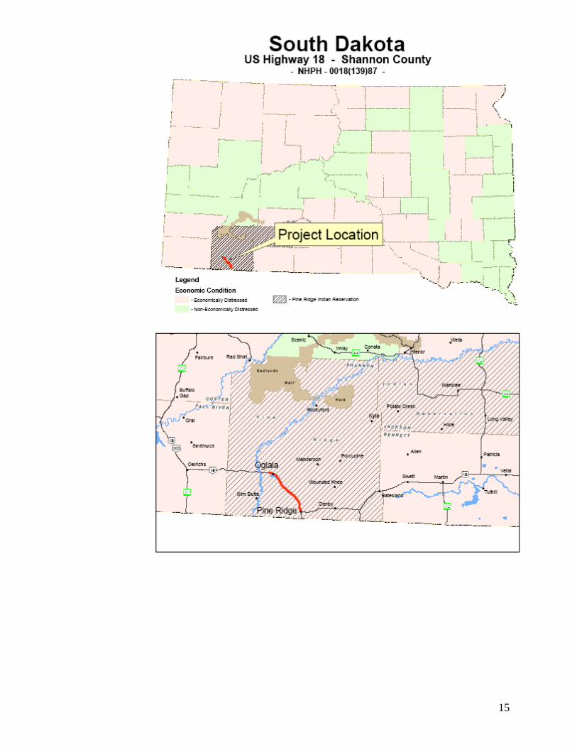
DISTRIBUTIONAL and GEOGRAPHIC EQUITY
The following two pages contain maps in support of the project.
• The first page contains two maps showing the economic distress in South Dakota. The maps also display the project as being in an economically distressed county.
• The second page contains two maps showing the unemployment in
the United States as a whole, and a separate map of the unemployment in South Dakota with the project county indicated.
Based on the following maps, the project is in an Economically Distressed Area, and the unemployment rate in the region is not as serious as in Shannon County. Receipt of TIGER discretionary funds would have a major impact on the current depressed economy of this area. The importance of transportation improvements to economic development was emphasized by an FHWA study entitled “Transportation Investments and Tourism Development at the Pine Ridge Indian Reservation”. That study can be accessed at: http://www.fhwa.dot.gov/planning/econdev/pineridge.htm
15

16

17
STATUS of ENVIRONMENTAL APPROVALS
The status of the project’s environmental approvals for the grading, structures, interim surfacing, roadway lighting, sidewalk, curb & gutters, storm sewer is as follows:
• Is currently being coordinated with the resource agencies for Categorical Exclusion (CE) classification
• Environmental approval not yet granted • Coordination is ongoing with SHPO for concurrence on 2 sites
The current status of the environmental coordination is shown below:
It is anticipated that a CE will be granted by all reviewing agencies by November, 2009.

18
The status of environmental approvals for the asphalt concrete surfacing portion of the project is as follows:
• A Categorical Exclusion (CE) classification was granted on 10/1/2008 through the Environmental Batch Report process
The following shows the tracking of the CE for the asphalt concrete surfacing project:

19
PROJECT COST ESTIMATE & PROJECT SCHEDULE
Grade & Drain $9,850,000 Structures & Approaches $3,750,000 Interim Surfacing $1,125,000 Surfacing $7,875,000 Storm Sewer $1,600,000 Curb & Gutter, ADA Curb Ramps, & Sidewalks $ 950,000 Lighting $ 475,000 Traffic Control $ 425,000 Fencing $ 360,000 PE $1,225,000 CE $ 925,000 Total Cost $28,560,000
1. Grading: The final grading design is 98% complete. Minor adjustments to grading design are needed, and then compile notes and quantities for final plans.
2. Traffic Control: Final design is nearing completion. Compiling notes and quantities are left to accomplish.
3. Erosion control: Final plans are nearing completion. 4. Structures: The final design is nearing completion. Compiling notes and
quantities needs to be accomplished. 5. Surfacing: Final plans are complete. The plans may need to be reviewed for
minor changes due to any late grading design changes. 6. Traffic: Final plans are nearing completion. 7. ROW Certification – Fee land is completed, and currently working on tribal land. 8. Utility Certification – Coordination with utility companies is underway. 9. Borrow – A site has been located. The design will be finalized pending final
earthwork computations. 10. Environmental – The 404 permit request has been initiated. Additional
information is being provided for SHPO clearance. Anticipated Project Schedule:
• Plans sent out for SDDOT and FHWA review - October 23, 2009 • Plan delivery to Bid Letting - December 11, 2009 • Bid Letting - February 3, 2010 • Award of contract – March, 2010 • Obligation of funds – April, 2010 • Project Construction Begins – May, 2010 • 70 % of project funds expended – December, 2010 • Project Surfacing Begins – May, 2011 • Project Completed – November, 2011

20

TIGER Grant Benefit-Cost Analyses from Tribal Governments US-101 Smith River Safety Corridor (CA) This application was submitted in TIGER 2011 from the Smith River Rancheria tribe in rural Northern California, to improve safety on US-101, which runs through tribal lands. The application analyzed benefits only from improvements in safety. The analysis provided good data on both the number of accidents (including number of fatalities and injuries) and on the causes of those accidents. The application uses FHWA crash reduction factors to estimate the likelihood that the proposed improvements would reduce the number of crashes and the number of fatalities. The analysis also used DOT’s guidance on Value of Statistical Life to calculate the monetary value of the lives saved and injuries avoided. There are some weaknesses in the analysis. It does not discount future crash-reduction benefits to estimate a present value of those future benefits. The analysis appears to have over-estimated the value of injuries by not converting injuries using the KABCO classification system to injuries using the AIS classification system properly. The analysis does not take into account operating and maintenance (O&M) costs of the project after it is completed (though these might have actually been less than the O&M costs of the current road), or any user costs during the construction period. It was possible for DOT’s TIGER Economics Team to make rough corrections for these problems, however (because the applicant provided useful data on crash rates and crash reduction factors), and calculate corrected estimates of benefits and costs. These corrected estimates showed that benefits were still greater than costs, though not by as large a margin as the applicant originally estimated.

Smith River Rancheria, CAA Federally-Recognized Tribal Government
TIGER III Discretionary Grant ApplicationOctober 31, 2011
U.S. 101 Multimodal Smith River Safety Corridor

Smith River Rancheria 140 Rowdy Creek Rd, Smith River, CA 95567-9525
Ph: 17071487-9255 Fax: 17071487-0930
Kara Brundin Miller Chairperson
Denise Padgette Vice Chairperson
loren Bommelyn Council Secretary
Joel Bravo Treasurer
Marian lopez Council Member
Dr. Joseph Giovannetti Council Member
lenora Hall Council Member
Russ Crabtree Tribal Administrator
October 31, 2011
U.S. Department of Transportation FY 2011 TIGER III Discretionary Grant Program Selection Committee
Subject: Smith River Rancheria US 101 Multimodal Smith River Safety Corridor
Dear TIGER Selection Committee :
The Smith River Rancheria, a federally-recognized tribal government, is pleased to submit this application for FY 2011 TIGER III funding to implement high-priority safety and context-sensitive livable community investments along a portion of US 101 in northwestern California.
This nationally-significant highway is also our community's main street. While it serves regional traffic well, it is a high-speed, dangerous highway that does not serve local needs or reflect our unique character and identity as well. According to Caltrans, there were 117 collisions, including nine fatalities, within our 10-mile planning area between 2005-2010. Our residents, including our children, are forced to walk along this highway with no sidewalks, lighting, or sometimes even shoulders to get to tribal housing, our Head Start program, our UIHS health clinic, or to a convenience store or restaurant.
We have been engaged in a ground-breaking corridor planning partnership with Caltrans, Del Norte (County) Local Transportation Commission, and FHWA to improve this corridor. This community-focused transportation planning partnership is the first of its kind in the country, according to FHWA, involving a Native American Tribe w ith regional, state, and federal agencies.
Our unique partnership has collaboratively developed our proposed TIGER project to begin implementing the partnership's shared long-term vision for community-based livability, safety, and mobility investments along US 101.
The US 101 Multimodal Smith River Safety Corridor project will implement walking and bicycling safety improvements along approximately 1.3 miles with in the predetermined 4.1 miles of this Gateway Area of US 101 just south of the Oregon border. Specific project elements include unique colorized, stamped shoulder treatments, new signage, lighting, and related improvements. The objectives of
Waa-saa-ghitlh- 'a'" Wee-ni Naa-ch 'aa-ghitlh-ni Our Heritage Is Why We Are Strong

Smith River Rancheria
these investments are to increase safety, especially for pedestrians, bicyclists, and other vulnerable users, as well as calm traffic, expand travel choices, and enhance community identity and livability.
We believe our project embodies the TIGER program's objectives of funding a high-priority, projectready multimodal surface transportation project with local and regional benefit that increases safety, transportation choices, economic opportunity, and community livability. Additiona"y, the Rancheria has committed 20 percent local match funding towards project implementation if TIGER funds are awarded.
We appreciate your consideration of our US 101 Multimodal Smith River Safety Corridor project. We welcome the opportunity to include TIGER funding and USDOT (along with FHWA) into our ground-breaking partnership as we" as implementing the first TIGER project in this region of the country.
Fina"y, as required by the TIGER program's NOFA, the Smith River Rancheria certifies that it wi" comply with the requirements of subchapter IV of chapter 31 of title 40, United States Code (Federal wage rate requirements), as required by the FY 2011 Continuing Appropriations Act.
Shu ' shaa nin-Ia (Thank you),
J I n ~(jJj . C~{_
Kara Brundin-Mi"er, Chairperson Smith River Rancheria Tribal Council
Waa-saa-ghitlh- 'a~ Wee-ni Naa-ch 'aa-ghitlh-ni Our Heritage Is Why We Are Strong
Page 2 of 2

US 101 Multimodal Smith River Safety Corridor Page 1
US 101 Multimodal Smith River Safety Corridor – Rural, Tribal Project
Project Narrative for FY 2011 TIGER III Discretionary Grant Program
I. Project Description
Project Overview
The Smith River Rancheria, a federally-recognized Native American tribe, has been collaborating with its local transportation commission and the California Department of Transportation (Caltrans) in a far reaching and innovative partnership to jointly plan the future of the US 101 corridor along the Pacific Ocean and in the heart of Redwood country in the far northwestern corner of California. This partnership, the first-of-its-kind in the country, has led to the Tribe seeking FY 2011 TIGER III Discretionary Grant funding to begin implementing the partnership’s shared long-term vision for community-based livability, safety, and mobility investments along US 101. The US 101 Multimodal Smith River Safety Corridor project will implement walking and bicycling safety improvements along approximately 1.3 miles within a previously defined 4.1 mile “gateway area” of rural US 101 in Smith River, California. Specific project elements include unique colorized, stamped shoulder treatments, new signage, lighting, and related small-scale improvements. The objective of these investments is to increase safety, especially for pedestrians, bicyclists, and other vulnerable users, as well as to calm traffic, expand travel choices, and enhance community identity and livability. This nationally-significant corridor is in desperate need of safety and livability investments. According to a safety analysis performed by Caltrans for this TIGER application, there have been 117 collisions, including nine fatalities, along the 10.4 mile stretch of US 101 through the Smith River area between 2005-2010. This stretch of highway averages only 7,300 VPD (2008 ADT), though with significantly greater traffic during the May-October tourist season. Pedestrians and bicyclists routinely walk and ride along the highway’s shoulders because there are no sidewalks or pathways anywhere within the entire corridor. Many highway sections have limited paved shoulders, with uneven and unsafe drop-offs at edge-of-pavement. Intersections do not have crosswalks, and most lack lighting, signage, and other minimal safety features. Most intersections are also very wide and misaligned, creating pedestrian barriers and unsafe conditions for all users.
Project Background
As noted, the Smith River Rancheria (Tribe) and Caltrans, along with Del Norte County and FHWA, have engaged in a ground-breaking partnership to jointly plan the future of the US 101 corridor. Most recently, the partnership collaborated to prepare a comprehensive conceptual corridor study, known in California as a Joint Roadside Safety Audit (RSA)/Value Analysis (VA) Study Report, or more simply as the RSA/VA report. As the report notes (Page 3), the

US 101 Multimodal Smith River Safety Corridor Page 2
RSA approach has been so successful that FHWA has included them as one of its nine “proven safety countermeasures.” To the Tribe’s knowledge, this is the first time that a Tribe has led an RSA/VA study effort with state and federal agencies in the United States. The RSA/VA report is available here: http://www.box.net/shared/urhfy3bpl4xj97z71197 The report identified a total of 54 corridor improvement solutions; 32 of these are known as Value Improvement Concepts (VICs), and the remaining 22 are design suggestions. These solutions (with emphasis on the VICs, which incorporate the design suggestions) were then classified by geographic area (gateway area and non-gateway VICs) and by timeframe/phasing:
� Short-term (one year or sooner) � Medium-term (1-5 years) � Long-term (5-20 years)
It should be emphasized that these implementation timeframes are closely related to, but do not directly reflect, relative project priorities. Rather, they are realistic estimates of implementation timeframe based on funding realities, anticipated environmental and other permitting needs, and other factors affecting how quickly individual concepts can be implemented. A final major element of this RSA/VA process is that Caltrans’ corridor planning and project development process must operate within several legal and legislative requirements. Chief among these is the requirement to set highway speeds at the 85th percentile of measured traffic speeds. Because of liability and other legal requirements, Caltrans cannot arbitrarily lower state highway speed limits. These legal requirements also constrains what project investments can occur within the US 101 corridor, and in what order. The highway’s current 55 mph speed limit precludes certain types of transformational investments, such as roundabouts, curb extensions/bulbouts, and other typically-urban strategies, until highway speeds decrease and the speed limit can be lowered. This means that certain projects and strategies need to be implemented first to set the stage for more dramatic investments subsequently. Given all of this background, the Tribe and Caltrans collaborated closely in defining a project worthy of TIGER funding that would:
� Address the Tribe’s (and Caltrans’) objectives to increase safety, transportation choices, livability, and other needs within this unique rural community;
� Meet TIGER’s project readiness guidelines, such as by not trigging a lengthy NEPA or other permitting process;
� Meet Caltrans’ requirements, described above, for a project that is consistent with US 101’s existing speed and design profile, and
� Given all of these factors, provide significant local and regional benefit, accelerate implementation of the RSA/VA report’s recommendations, and strengthen the Tribe/Caltrans collaborative partnership moving forward.
Accordingly, the US 101 Multimodal Smith River Safety Corridor project:
� Provides much-needed safety benefit along the highway, especially for pedestrians, bicyclists, and other vulnerable users;
� Enhances community identify and livability within this unique and beautiful corridor;

US 101 Multimodal Smith River Safety Corridor Page 3
Smith River
Rancheria
� Strategically begins to transform US 101 into a more livable and complete street corridor to address local mobility as well as regional and national traffic,
� Respects Caltrans’ planning and project requirements, advances the unique partnership process, and
� Minimizes NEPA and other permitting to be implemented and used quickly, as well as meet the TIGER program’s other requirements.
Project Location
The Smith River Rancheria’s Taa-laa-waa-dvn (Tolowa Ancestral Lands) are located along the Pacific Coast in far northwest California and southwest Oregon, straddling US 101 within the
project corridor. Besides the unincorporated community of Smith River, the closest cities are Crescent City, California, to the south and Brookings, Oregon, to the north. The RSA/VA report describes US 101 (Page 31) as the “lifeline to the north coast,” a nationally-significant highway that is “essential to the movement of goods and people in northwest California,” and throughout California and the Pacific Northwest portion of the country. The report also emphasizes US 101’s dual purpose of being a main street for communities. The report further notes that, “As population and traffic volumes increase, it will be necessary to plan and initiate projects to address the needs of both motorized and non-motorized traffic while considering potential impacts for both local and inter-regional travelers.”
The RSA/VA report studied the 10.6-mile stretch of US 101 from the Oregon state line south to Lake Earl Drive south of Smith River. In this section, US 101 has a two-lane or three-lane (TWLTL) section with a 55 mph speed limit. The two major communities of interest within this area are Smith River to the south and the area around Indian Road to the north. These are key areas within the Smith River Rancheria, with a population of about 1,200 tribal members. According to the RSA/VA report, important land uses and destinations within these two communities include the United Indian Health Services Medical/Dental Clinic, the Howonquet Hall Community Center, Howonquet Head Start and Day Care Facility, Lucky 7 Casino, elderly apartment housing, Tribal Administration offices, and a proposed rental housing project.

US 101 Multimodal Smith River Safety Corridor Page 4
The project itself encompasses the two “gateway area” sections of US 101 identified in the RSA/VA report, shown below.
Project Start & End Latitude Project Start & End Longitude
41.96030 - 41.92679 124.20331 - 124.14216
Connections to Existing Infrastructure
The project is located directly on US 101 in the gateway areas shown above of the Smith River Rancheria lands. The US 101 Multimodal Smith River Safety Corridor was specifically defined for this gateway area, not just because of the intrinsic importance of US 101 itself but because this gateway area encompasses key local streets, intersections, and travel sheds within the RSA/VA study area. In particular, North and South Indian Road, in the northern gateway area, is a critically important intersection and local street because of its adjacent land uses, such as the Lucky 7 Casino, health clinic, and tribal housing.
Project Importance/Benefit
As discussed previously, this project was developed through the unique Tribe/Caltrans joint planning partnership and accordingly incorporates the high-priority and high-benefit elements directly derived from the partnership’s recent RSA/VA (US 101 corridor conceptual study) report. The project is important for many reasons and has many benefits, including: � Safety: Directly addresses safety for the most vulnerable transportation users along US 101,
particularly pedestrians, bicyclists, and children; � National Significance: Provides multi-state benefit by improving this nationally-significant
highway;

US 101 Multimodal Smith River Safety Corridor Page 5
� Economic Activity: Creates construction activity and increases economic opportunity by making existing and planned land uses more accessible, attractive, and safer to reach by multiple modes;
� Project Readiness: Strategically-developed project to accelerate construction, with no ROW acquisition and minimal permitting;
� Livability: Increases community identity and cultural character for this unique destination gateway to California’s Redwoods, Oregon’s Rouge River area, and both states’ Pacific coast;
� Travel Choices: Catalyzes transformation of US 101 from a pass-through regional traffic highway into a context-sensitive, complete street corridor;
� Partnership: Significantly advances the long-term Smith River Rancheria-Caltrans joint US 101 planning partnership;
� Leveraging: Builds on previous joint partnership investments in the corridor conceptual planning process and Caltrans’ pending Transportation Enhancement application for the same area along US 101;
� Local Match: As discussed in Section III, the Smith River Rancheria will provide 20 percent non-federal match for this rural TIGER project, and
� Geographic and Community Diversity: Unique Tribal project in a TIGER-underfunded region of the country.
Transportation Challenges
The project has been strategically developed to address the following transportation challenges: � Safety: As documented previously, multimodal safety is an over-riding concern in this
corridor. This project is anchored around strategic, high-value investments that significantly increase safety through unique shoulder treatments, lighting, and signage.
� Community Identity & Livability: Though not an urban “main street,” US 101 is the lifeline of this culturally unique area and surrounding region. This project takes the first – and most difficult – steps of humanizing this high-speed, dangerous, pass-through highway into a context-sensitive, complete street corridor that works as well for this rural community as it does for the broader region. Unique, colorized shoulder treatments and signage will increase the sense of place and identity for both local and regional traffic.
� Economic Opportunity: While project construction itself will generate economic activity, the project’s primary economic objective is to make land uses and mobility more accessible, much safer, and attractive for local and regional travel. The concept of a “pedestrian-based economy” is applicable in this economically-disadvantaged area, where many local residents walk or bicycle because of limited transportation access. Conversely, this nationally-important highway attracts significant tourist and visitor travel. A context-sensitive highway that helps create a sense of place and destination, rather than high-speed pass through traffic, would also create more economic opportunity within the project area for visiting travelers and local employers.
� Project Development Process: As documented previously, the unique Tribe/Caltrans partnership has conducted significant planning along the US 101 corridor. Yet, the corridor’s current design characteristics and other constraints – including funding – limit project investment opportunities. This project provides the opportunity to catalyze implementation to effect tangible change, progress, and benefit within the corridor.

US 101 Multimodal Smith River Safety Corridor Page 6
Addressing Rural Needs
The project is located in a rural and remote section of northwestern California. It directly addresses the safety and mobility needs of the rural and Tribal communities it serves by making the highway safer and more accessible for non-motorized transportation travel by local residents, employees, and visitors to the major destinations in this area. A unique perspective on the Smith River Rancheria/Caltrans joint planning process, the value and challenges of US 101 within these rural communities, and the rural needs this project is designed to help address, is provided in a June 27th, 2011 feature article in the Daily Yonder, an online publication reporting on rural issues across the country. That feature article is accessible here: http://www.box.net/shared/urhfy3bpl4xj97z71197
Benefits to the Region/Nation
As noted previously, the RSA/VA report describes US 101 as the “lifeline to the north coast,” a nationally-significant highway that is “essential to the movement of goods and people in northwest California,” and throughout California and the Pacific Northwest portion of the country. US 101 is the only major north-south highway in this entire region of California and Oregon, almost 100 miles (and several mountain ranges away) from Interstate 5 to the east. This unique Tribe/Caltrans partnership is intended to a create a context-sensitive livability transformation of US 101 such that a nationwide best-practice collaborative planning process (as cited) by FHWA can develop a nationwide best-practice project outcome on nationally-significant US 101.
Project Scaling & Independent Utility
This project has been carefully developed, designed, and scoped to address the specific needs, challenges, and benefits described above. The Tribe intends to construct it as one integrated project, and doing so will maximize the project’s functionality and benefit. If absolutely necessary, the project could be most-easily scaled by application to one gateway area instead of both. While the project could theoretically also include less community lighting, or fewer community gateway signs, doing so does not significantly reduce project cost. The core of this project are the unique colorized highway shoulder treatments, and these are the most important to the Tribe to implement, again for primarily safety and mobility reasons, as well as community livability and identity benefits.

US 101 Multimodal Smith River Safety Corridor Page 7
II. Project Parties
As discussed in Section I, this project represents a major implementation milestone for the Tribe-Del Norte County-Caltrans-FHWA joint US 101 corridor planning process. The Smith River Rancheria is the lead applicant for TIGER funding. In this role, the Tribe will be responsible for (if awarded TIGER funds):
� Administering awarded TIGER funds � Administering other project funds � Collaborating with Caltrans to complete environmental and other permitting � Constructing and collaborating with Caltrans to maintain the project
Caltrans is providing a key support role to implement the project in terms of assisting with project design, permitting, and other pre-construction activities. Recognizing the project’s regional significance and multi-state benefit, Representatives Mike Thompson (CA-01) and Peter DeFazio (OR-04) are providing a joint letter of support to USDOT for this project’s TIGER funding worthiness. Other entities supporting this project include Caltrans and the Del Norte Local Transportation Commission. Additionally, the Smith River Rancheria Tribal Council adopted Resolution 11-23 on October 18th committing local funds, affirming this project as a high priority project for the Tribe, and supporting this TIGER funding application. All of these materials are available here: http://www.box.net/shared/urhfy3bpl4xj97z71197

US 101 Multimodal Smith River Safety Corridor Page 8
III. Grant Funds & Sources/Uses of Project Funds
As shown in the table below, the Smith River Rancheria is requesting $2,499,840 in FY 2011 TIGER III discretionary grant funds to construct the US 101 Multimodal Smith River Safety Corridor. This amount will be matched with $624,960 in committed local funds for a total project cost and funding of $3,124,800.
Though local match is not required of rural TIGER projects, the Tribal Council of the Smith River Rancheria has committed Indian Reservation Roads (IRR) funds as 20 percent local match to help fund project construction if awarded TIGER funding. The Tribal Council’s October 18th, 2011 resolution committing these IRR funds to the project upon TIGER award is available here: http://www.box.net/shared/urhfy3bpl4xj97z71197
The second table below shows proposed funding by major project phase (pre-construction and construction). If awarded TIGER funding, the Tribe would allocate all TIGER funding to project construction, using its local match funding to complete final design/engineering and other pre-construction activities.
Category Entity Funding Type Amount Percent
Local Smith River Rancheria Indian Reservation Roads (IRR)/Tribal Funds $624,960.00 20.0%
Federal TIGER Requested FY 2011 TIGER III Discretionary Grant Funds $2,499,840.00 80.0%
Total Project Cost & Funding $3,124,800.00 100.0%
Project Costs by Funding Source & Allocation
US 101 Multimodal Smith River Safety Corridor
Major Project Phase Funding Type Amount Percent
Complete pre-construction activities IRR/Tribal Funds $520,800.00 16.7%
Construct project IRR/Tribal Funds $104,160.00 3.3%
Construct project Requested FY 2011 TIGER III Discretionary Grant Funds $2,499,840.00 80.0%
Total Project Cost & Funding $3,124,800.00 100.0%
US 101 Multimodal Smith River Safety Corridor
Project Costs by Major Project Phase
US 101 Multimodal Smith River Safety Corridor Page 9
IV. Selection Criteria
The Smith River Rancheria, in collaboration with Caltrans, is pursuing TIGER funding because it strongly believes the proposed US 101 Multimodal Smith River Safety Corridor project compellingly addresses the TIGER program’s selection criteria and project funding intent.
a. Long-Term Outcomes
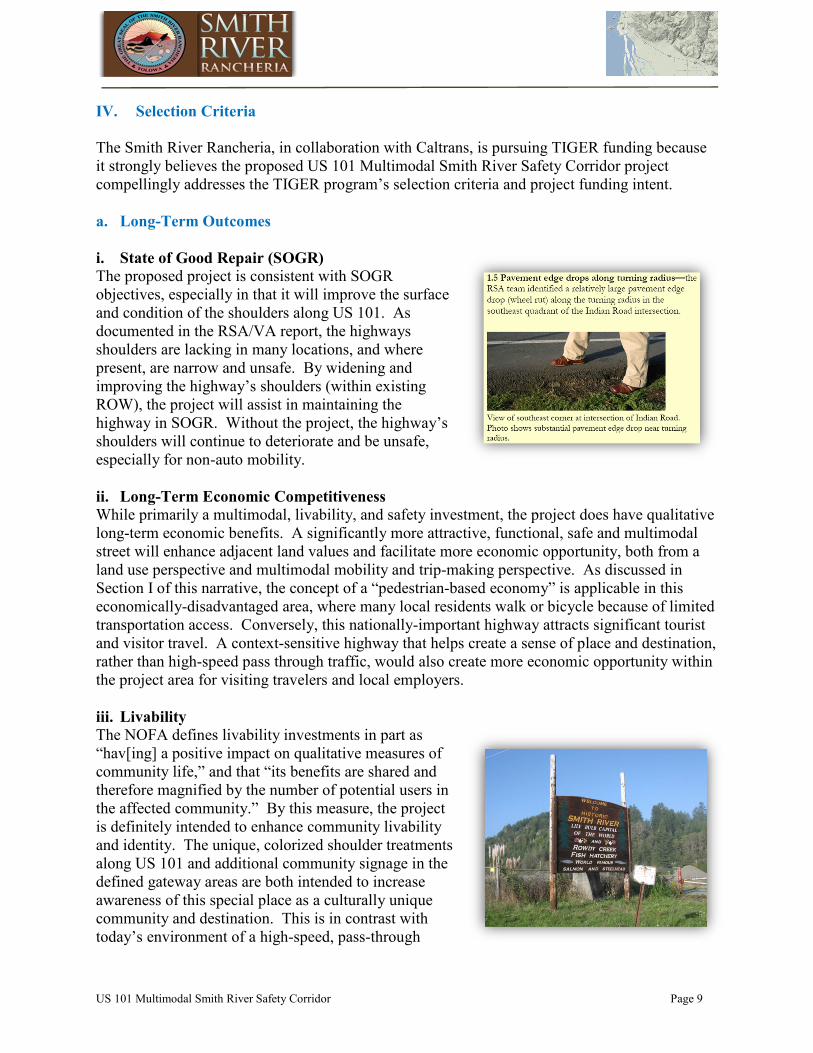
i. State of Good Repair (SOGR)
The proposed project is consistent with SOGR objectives, especially in that it will improve the surface and condition of the shoulders along US 101. As documented in the RSA/VA report, the highways shoulders are lacking in many locations, and where present, are narrow and unsafe. By widening and improving the highway’s shoulders (within existing ROW), the project will assist in maintaining the highway in SOGR. Without the project, the highway’s shoulders will continue to deteriorate and be unsafe, especially for non-auto mobility.
ii. Long-Term Economic Competitiveness
While primarily a multimodal, livability, and safety investment, the project does have qualitative long-term economic benefits. A significantly more attractive, functional, safe and multimodal street will enhance adjacent land values and facilitate more economic opportunity, both from a land use perspective and multimodal mobility and trip-making perspective. As discussed in Section I of this narrative, the concept of a “pedestrian-based economy” is applicable in this economically-disadvantaged area, where many local residents walk or bicycle because of limited transportation access. Conversely, this nationally-important highway attracts significant tourist and visitor travel. A context-sensitive highway that helps create a sense of place and destination, rather than high-speed pass through traffic, would also create more economic opportunity within the project area for visiting travelers and local employers.
iii. Livability
The NOFA defines livability investments in part as “hav[ing] a positive impact on qualitative measures of community life,” and that “its benefits are shared and therefore magnified by the number of potential users in the affected community.” By this measure, the project is definitely intended to enhance community livability and identity. The unique, colorized shoulder treatments along US 101 and additional community signage in the defined gateway areas are both intended to increase awareness of this special place as a culturally unique community and destination. This is in contrast with today’s environment of a high-speed, pass-through

US 101 Multimodal Smith River Safety Corridor Page 10
corridor with limited community identity characteristics. With almost 8,000 daily users (ADT) on US 101 and another 1,200 local residents, livability-based highway improvements will benefit everyone – local residents and regional travelers – who all use the highway, sometimes several times a day. Another primary project objective is to increase livability by increasing transportation choices. An excerpt from the RSA/VA report (Page 15) is shown below discussing pedestrian use and mobility along the highway shoulders, as well as the suggested concept that forms this proposed TIGER project – unique, colorized shoulder treatments, specifically to increase non-auto transportation choices.

US 101 Multimodal Smith River Safety Corridor Page 11
A final point about the livability merits of this project, again from the RSA/VA report (Page 23 excerpt shown) is the wide range of users and travel purposes along US 101 in the project area. While there is of course some recreational use, most travel is utilitarian and for essential daily living activities. While this excerpt focuses on safety implications, safety and livability are inextricably linked, and this project is designed to address both together.
iv. Environmental Sustainability
This project addresses environmental sustainability on two fronts. First, it is located within exiting and developed Caltrans ROW within the US 101 cross-section, precluding any impacts on environmentally-sensitive lands. Second, as a context-sensitive multimodal corridor, the project is specifically designed to increase walking and bicycling.
v. Safety
As emphasized throughout this project narrative, safety is a cornerstone of this project. Caltrans prepared a crash analysis in support of this TIGER funding application; for the period July 1, 2005 through June 30, 2010, the 10.4-mile section of the US 101 corridor within the project area had 117 total collisions, with nine fatalities. Caltrans plotted the location of the collisions, shown on the next page with the two project gateways superimposed. Caltrans’ additional safety analysis materials are located here: http://www.box.net/shared/d7grsl45lsk0ho46yx48 Additionally, the RSA/VA report notes that the project-area segment of US 101 is already in the 97th percentile statewide for fatal crashes (Page 6), based on an older collision analysis that Caltrans updated for this project narrative. The new collision analysis shows even worse safety conditions (117 total collisions vs. 68, and nine fatalities vs. six). Another major safety element included in this project and discussed in the RSA/VA report (Page 14, excerpt shown) is pedestrian crossing safety along the highway and at intersections. While the speed limit issue discussed previously precludes significant pedestrian crossing investments at this time, the project scope includes new pedestrian signage, beacons, and markings at the key gateway-area intersections.

US 101 Multimodal Smith River Safety Corridor Page 12
Project
Gateway
Areas

US 101 Multimodal Smith River Safety Corridor Page 13
b. Job Creation & Near-Term Economic Activity
As discussed previously, while primarily a multimodal, livability, and safety investment, the project does have some economic benefits. A significantly more attractive, functional, safe and multimodal street will enhance adjacent land values and facilitate more economic opportunity, both from a land use perspective and multimodal mobility and trip-making perspective. As discussed in Section I of this narrative, the concept of a “pedestrian-based economy” is applicable in this formally-designated economically-disadvantaged area, where many local residents walk or bicycle because of limited transportation access. Conversely, this nationally-important highway attracts significant tourist and visitor travel. A context-sensitive highway that helps create a sense of place and destination, rather than high-speed pass through traffic, would also create more economic opportunity within the project area for visiting travelers and local employers. As required by the NOFA, an estimate of near-term job creation activity was prepared using the methodology contained in the Estimates of Job Creation from the ARRA of 2009 (May 2009)
report. Job creation estimates based on this analysis are shown in the table below.
c. Innovation
The project has two innovations. First, as discussed at length in this narrative, including below, is the ground-breaking Tribal-led corridor planning partnership with Caltrans, Del Norte County, and FHWA which has jointly planned the US 101 corridor for several years, providing the genesis for this proposed TIGER project. Second, the project itself is innovative, with colorized (and stamped) shoulder treatments being relatively rare in California and around the country.
d. Partnership
One of the hallmarks of the US 101 Multimodal Smith River Safety Corridor project is its roots in the ground-breaking partnership, believed to be the first of its kind in the country, where a Tribe is leading collaboration with its transportation partners – Caltrans, the Del Norte (County) Local Transportation Commission, and FHWA – to jointly plan the future of the US 101 corridor. The partnership has a shared transportation and land use vision for the corridor that emphasizes context-sensitive and community-based livability, safety, and mobility investments along US 101.
Pre-Const. Const. Total
Project Expenditure $520,800 $2,604,000 $3,124,800
One Job Year
Total Project Job Years 5.66 28.30 33.97
Direct Job Years (64%) 3.62 18.11 21.74
Induced Job Years (36% ) 2.04 10.19 12.23
$92,000
US 101 Multimodal Smith River Safety Corridor
Near-Term Job Creation Activity

US 101 Multimodal Smith River Safety Corridor Page 14
e. Benefit-Cost Analysis (BCA) Summary Results The BCA was structured around safety, as is this is a major project benefit and the most directly measurable. Various aspects of safety benefits were researched and monetized for this analysis, and two versions of the BCA were performed. One version was very conservative in estimating project benefits (low version); the second version was less conservative but still very reasonable (high version). Under the low version, the estimated BCA ratio is 6.02, and is calculated by dividing the total estimated 20-year benefit ($18,806,640) by the total project cost ($3,124,800). It is the Tribe’s understanding that project costs do not need to be “grown out” for the 20-year period to perform this calculation. Similarly, project benefits were not discounted back to NPV because they also were not grown out (in terms of growth rate or inflation). Using the same methodology described above, under the high version, the estimated BCA ratio is 11.95 ($37,326,039/$3,124,800). The full BCA calculations are available here: http://www.box.net/shared/cpsy8ad62idutllc0yz7 They consist of two Excel spreadsheets (low and high scenarios). For each spreadsheet, the “CRF-Applied” tab summarizes the total benefit calculations used in discussion above. Although, as explained above, other project benefits were not monetized or calculated, they are still very important for this project. A context-sensitive highway section with unique, colorized shoulder treatments and gateway signs provide an obvious benefit to community identity and livability. The ground-breaking partnership that has led to this proposed project is an important benefit from the Tribe’s perspective. Finally, a “no-build” scenario is difficult to calculate. This narrative has documented that total and fatal collisions continue to increase in the project area. They will presumably increase even more as growth and development in the project area also continue to increase. While the Tribe and Caltrans will continue to make incremental improvements along the US 101 corridor, there is no other funding for this proposed TIGER project.

US 101 Multimodal Smith River Safety Corridor Page 15
Project Readiness & NEPA
Project Schedule & Readiness
The proposed project schedule is shown in the table below. The Smith River Rancheria and Caltrans will need to complete the US 101 Final Engineered Feasibility Study and complete other pre-construction activities. However, the project scope has been designed to optimize project-readiness, such as by not requiring additional ROW and minimizing NEPA/environmental permitting. Both agencies have already started some pre-construction activities, and the Smith River Rancheria is committed to having this project ready for construction before May 30th, 2013.
Caltrans STIP Status
The US 101 Multimodal Smith River Safety Corridor project is not yet listed in Caltrans’ STIP because the project is so far unfunded. However, given the unique Tribe-Caltrans-FHWA planning partnership, this project is already following Caltrans’ project development and programming process. The RSA/VA report has been completed, the US 101 Final Engineered Feasibility Study is underway and scheduled for completion in early 2012, and Caltrans will automatically include the project in its STIP should the Tribe receive a TIGER funding award that would allow the project to move forward.
NEPA Status & Environmental Approvals
The Tribe collaborated closely with Caltrans in developing this project to minimize environmental impacts and permitting needs to accelerate project readiness and construction. All project elements and investments will occur within existing Caltrans ROW and within the already-developed and paved cross-section of US 101. For all of these reasons, a Categorical Exclusion (CE) is expected under the NEPA process. The Tribe and Caltrans will initiate the NEPA process upon completion in early 2012 of the currently-underway US 101 Final Engineered Feasibility Study, the current milestone in the Tribe-Caltrans-FHWA joint US 101 corridor planning process. Because of the “minimal-impact” aspect of the proposed project as designed, a CE determination is expected no later than September 2012.
Project Phase Start Date Completion Date
Complete final design & engineering Underway September 15th, 2012
ROW Acquisition
Complete NEPA, Obtain CE April 15th, 2012 September 15th, 2012
Start bidding process, award project February 15th, 2013 May 1st, 2013
Start project construction
Complete project construction
US 101 Multimodal Smith River Safety Corridor
Proposed Project Schedule & Major Milestones
Not Needed
May 15th, 2013
September 15th, 2013
US 101 Multimodal Smith River Safety Corridor Page 16
Legislative Approvals
This project will not require any legislative approvals to move forward. The unique and unprecedented joint planning collaboration between the Tribe, Caltrans, and FHWA has aligned and streamlined project development and prioritization. TIGER funding will leverage this planning and pre-construction investment and provide the capstone to fund and construct the project.
State & Local Planning
The project will not require any additional approvals or actions by state or local planning agencies.
Technical & Financial Feasibility
The Smith River Rancheria has the technical and financial feasibility necessary to competently, efficiently, and comprehensively administer awarded TIGER funds and to successfully implement the proposed project. The Smith River Rancheria has extensive experience administering federal and state grant funds as well as successfully constructing complex capital projects on time and within budget.
V. Federal Wage Rate Certificate
Please refer to the cover letter of this Project Narrative for the signed statement committing that the Smith River Rancheria will comply with the requirements of subchapter IV of chapter 31 of title 40, United States Code (Federal wage rate requirements), as required by the FY 2011 Continuing Appropriations Act.
VI. Changes from Pre-Application
The TIGER grant request has been adjusted slightly downward. There are no other changes from the Pre-Application.

TIGER Grant Benefit-Cost Analyses from Tribal Governments Snake Road Segment 3 Improvement Project (FL) This application was submitted in TIGER 2011 by the Seminole Tribe of Florida to improve 2.25 miles of Snake Road, a rural highway. This is Segment 3 of an overall 19.6-mile project. The analysis provides crash rates to support the estimate of safety benefits, which were 72% of total benefits. We thought the assumption made in the analysis that the project would reduce crash rates by 50% was probably an overestimate; however, even if a more conservative 25% reduction in crashes were assumed, the benefits would still exceed the costs. The analysis also estimates benefits resulting from increasing vehicle speeds from 25 mph to 35 mph, as a result of widening of the traffic lanes and shoulders. The increased speeds provide time savings to users and reduce fuel costs and air pollution. The analysis uses the California Life-Cycle BCA Model to estimate benefits and costs. In some cases the analysis uses default values in the model that appear to be inappropriate for this analysis, but these inappropriate values don’t appear to result in any systematic bias in the eventual estimates of benefits and costs. Costs to highway users during the construction period were not included, but periodic repaving costs were. The project includes a sidewalk and wider shoulder to accommodate pedestrians, bicyclists, and ATVs, which seems likely to produce livability benefits, but no estimate of these benefits was offered. While the safety benefits may have been somewhat overestimated, and some costs were omitted, the livability benefits were not estimated at all, and this omitted benefit category seems likely to compensate for the possible overestimation of safety benefits. There are also probably some uncounted state-of-good-repair benefits. Overall, then, we concluded that the benefits are likely to exceed the costs.

TIGER III GRANT APPLICATION Project Narrative
1

TIGER III GRANT APPLICATION Project Narrative
2
Tiger III Grant Application
Snake Road Segment 3-B Improvement Project
Seminole Tribe of Florida
TABLE OF CONTENTS
I. Project Description ....................................................................................................................4
A. Alignment and Right-of-Way .................................................................................................5
1. Existing Condition ..............................................................................................................5
2. Proposed Improvement ......................................................................................................9
3. Right-of-Way ...................................................................................................................10
B. Construction Costs ...............................................................................................................11
C. User Benefits ........................................................................................................................12
D. Pedestrian and Bicycle Facilities ..........................................................................................12
E. Safety ....................................................................................................................................12
II. Project Parties ........................................................................................................................13
III. Grant Funds and Sources .....................................................................................................13
IV. Selection Criteria ...................................................................................................................14
A. Long Term Outcomes ............................................................................................................14
1. State of Good Repair ..........................................................................................................14
2. Economic Competitiveness ................................................................................................15
3. Livability ............................................................................................................................17
4. Sustainability ......................................................................................................................20
5. Safety ..................................................................................................................................20
B. Job Creation and Near-Term Economic Activity ..................................................................21
C. Innovation ..............................................................................................................................22
D. Partnership .............................................................................................................................22
E. Results of Benefit-Cost Analysis ...........................................................................................22
V. Project Readiness and NEPA .................................................................................................23
1. Project Schedule .................................................................................................................23
2. Environmental Approvals ...................................................................................................24
3. Legislative Approvals .........................................................................................................24

TIGER III GRANT APPLICATION Project Narrative
3
4. State and Local Planning ....................................................................................................24
5. Technical Feasibility ..........................................................................................................25
6. Financial Feasibility ...........................................................................................................25
VI. Federal Wage Rate Certification .........................................................................................25
Appendix A – Benefit Cost Analysis Appendix B – NEPA Documents Appendix C – U.S. Army Corps of Engineer’s Permit Appendix D – Letters of Support Appendix E – Federal Wage Rate Certification

TIGER III GRANT APPLICATION Project Narrative
4
I. Project Description
The Snake Road Improvement Project is a joint effort by the Seminole Tribe of Florida and the Miccosukee Tribe of Indians of Florida to address significant safety issues, improve livability and expand economic development potential on the Big Cypress and Alligator Alley Reservations. This $3.7 TIGER III grant request will complete the funding needed for construction of Segment 3-B, which runs through the heart of the Big Cypress Reservation. The corresponding project to the south, Segment 3-A, is fully funded and will start construction during the first quarter of 2012. This project is the final phase of reconstruction of the dangerous and substandard Segment 3 roadway.
Snake Road (BIA Route 1281) is a narrow and winding two-lane road that serves as the primary access road to the Seminole Tribe of Florida's Big Cypress Reservation, as well as the Miccosukee Tribe's Alligator Alley Reservation. Tribal members must travel the road on a daily basis to get to work and school, to shop and to visit family and friends. Snake Road supports tribal efforts at economic independence by providing access to tourist destinations on the reservations and is used by agricultural haulers and tribal employees commuting from Broward and Hendry Counties.
Why this Project:
• Economically viable – positive Benefit-Cost Ratio of 5.7 to 8.7 using the California Life-Cycle Benefit/Cost Analysis Model
• Jobs – immediate generation of 32 direct and indirect job-years in a rural, Economically Disadvantaged Area (19% unemployment – the highest in the State of Florida) with long-term enhancement of economic development
• Shovel ready – completed final plans for construction with permits and right-of-way • Approved Environmental Document - NEPA Type II Categorical Exclusion prepared
by FDOT and approved by the Federal Highway Administration • Demonstrated record of success – bridge replacement on the Snake Road Improvement
Project completed on time and under budget
What project will do:
• Improve safety and operation by reconstructing road to modern standards • Improve livability and economic well-being for tribal members through enhanced
transportation facilities on a critical road through the heart of the reservation • Provide greater modal choice to tribal members as bicyclists, pedestrians and drivers of
all-terrain vehicles through wider lanes, placement of sidewalk and multi-use path.

TIGER III GRANT APPLICATION Project Narrative
5
A. Alignment and Right-of-Way
1. Existing Condition
According to the Florida Department of Transportation’s (FDOT) Federal-Aid Report, Snake Road from the I-75 interchange to State Road 80 is classified as a Federal Highway – Emergency Relief rural major collector. Snake Road is also classified as a major collector and primary hurricane evacuation route in the Hendry County Long Range Transportation Plan. Given the central location of the county between the two coastal areas of Florida, it is critical that this evacuation route be maintained to control, minimize or rectify flood prone areas, and protect the corridor capacity to enhance the movement of goods and services not only for day-to-day function but also under mandatory evacuation orders.
Figure 1 – Project Map

TIGER III GRANT APPLICATION Project Narrative
6
For the purpose of evaluating alternative alignments, the project was divided into three
distinct segments (Figure 1) based on posted speed, adjacent land use, and existing roadway geometry. The project segments are as follows:
· Segment 1: From north of I-75 to 2.7 miles north of the Miccosukee/Seminole reservations boundary for a length of 8.7 miles.
· Segment 2: From 2.7 mi north of the Miccosukee/Seminole reservations boundary to
1000 feet (ft) east of Seminole Rodeo for a length of 6.6 miles. · Segment 3: From 1000 feet east of Seminole Rodeo to the northern boundary of the
Big Cypress Seminole Indian Reservation – a length of 4.3 miles. This has been further sub-divided into two halves, Segments 3-A and 3-B in order to maintain continuous progress in project delivery and to maximize use of available federal funding.
o Segment 3-A runs about 2.05 miles (including the limits of completed bridge
project) from just south of the Seminole Rodeo to Junior Buster Road near the Frank Billie Field House (old Family Investment Center). This project will be under construction in early 2012 using existing project funds and a fiscal year 2011 grant of Public Lands Highways Discretionary funding.
o Segment 3-B runs about 2.25 miles from Junior Buster Road to the northern
boundary of the Big Cypress Reservation (Figure 2). This Tiger III Discretionary grant application for $3.7 million is to allow completion of the Segment 3 project through construction of Segment 3-B.
Existing conditions in the Segment 1 section consist of two 10-foot lanes with narrow
unpaved shoulders varying from 2 to 4 feet in width. The posted speed limit is 45 miles per hour (mph). Roadside ditches/canals exist along both sides of the roadway.
Segment 2 consists of two 10-foot lanes and 10-foot unpaved shoulders, which were
recently constructed as an interim safety improvement project. The posted speed limit is 45 mph. A large canal parallels the roadway on the northern side and is offset approximately 30 to 40 foot from the roadway. This canal is part of a tribal / ACOE Joint everglades restoration project under the 1996 Critical Project authorization.
Segment 3 consists of two 10-foot-wide lanes and unpaved shoulders that vary from 2 to 4 foot in width. Within this area, the land use is a mix of residential, business, and community service centers. Storm-water is handled by roadside ditches and there are intermittent areas of existing narrow sub-standard sidewalk on the east side of the roadway to serve pedestrian traffic. Areas on the roadway shoulders and also behind the roadside ditches are worn due to constant use by all-terrain vehicles (ATVs) and there are many locations where shoulders have eroded resulting in significant drop-offs at the edge of pavement. The posted speed limit is 25 mph. The

TIGER III GRANT APPLICATION Project Narrative
7
existing bridge over the Northern Feeder Canal, within the Segment 3 limits, is a low-level, three-span canal crossing that was recently replaced in February 2011 using high priority bridge funds.
Figure 2 - Segment 3-B Project Limits

TIGER III GRANT APPLICATION Project Narrative
8
The only sidewalk within the limits of the Snake Road study area occurs in the
community area on the east side of Snake Road beginning north of the Big Cypress Family Investment Center and terminating at Horseshoe Road in Segment 3. There is an unpaved walking path along the east side of the Snake Road study area which begins at a driveway 1,918 feet south of the Ahfachkee School and terminates at the driveway entrance to the school in Segment 3. This path is approximately 85 to 95 feet from the northbound edge of pavement and is separated from the roadway by a canal. There is an unpaved shared use path along the east side of Snake Road beginning at Horseshoe Road and terminating 400 feet north of Hall Road in Segment 3.
The existing alignment contains thirty-four (34) horizontal curves, 17 of which are
substandard with design speeds less than 45 mph. The superelevation rates on all of the curves are substandard.
The existing two-lane roadway is sufficient to serve the capacity need from the
interchange with I-75 to the northern boundary of the Big Cypress Seminole Indian Reservation during the 20-year planning horizon. The 2030 annual average daily traffic (ADT) volumes along Snake Road are expected to be as great as 4,100 vehicles per day (vpd). The design hour volumes (DHV) are expected to be as great as 464 in 2030.The evaluation of future AADT volumes along the study corridor – assuming a two-lane undivided rural roadway – indicates that Snake Road is expected to operate at level of service (LOS) B conditions in 2030. The evaluation of the DHV indicates that the roadway corridor is expected to operate at LOS C in 2030. The projected traffic is summarized below1
(Table 1).
Table 1 - Snake Road Traffic Counts
1 FDOT, Project Traffic Memorandum, July 2006
COUNT LOCATIONS 2010
AADT 2010 DHV
2020 AADT
2020 DHV
2030 AADT
2030 DHV
Site 22 – Snake Road @ North Reservation Boundary
1,700 202 2,000 238 2,400 285
Site 19 – Snake Road @ West of School Building
2,900 328 3,500 396 4,100 464
Site 18 – Snake Road @ NE Canal Street
1,900 199 2,300 240 2,600 272
Site 89 – Josie Billie Highway @ North of Reservation Boundary
1,000 118 1,200 141 1,400 165
Site 14 – Snake Road @ South Reservation Boundary 800 100 900 113 1,100 138

TIGER III GRANT APPLICATION Project Narrative
9
There are no existing parallel facilities within several miles of Snake Road. New parallel corridors to the east or west of Snake Road from north of the I-75 interchange are not considered feasible.
2. Proposed Improvement
The 19.6 mile Snake Road Improvement Project is planned for construction in three distinct segments as indicated above. This Tiger III grant application for $3.7 million is to allow completion of the overall Segment 3 project through construction of Segment 3-B.
The alignment for Segment 1 begins north of the interchange with I-75 on a new alignment and continues for approximately 8.7 miles, where it ties into the existing large curve by Rock Pit Road (BIA 1294). This alignment minimizes maintenance-of-traffic impacts and minimizes canal impacts. The project will provide a two-lane, undivided rural roadway which contains 12-foot travel lanes and 8 foot shoulders (5 feet paved) (Figure 4).
Figure 4 – Segment 1 Typical Section
The alignment for Segment 2 continues toward the northwest along Snake Road centered on the existing roadway. The alignment continues toward the west and ties in to the portion of Snake Road 1,000 feet east of the Seminole Rodeo. The alternative has maintenance-of-traffic impacts to the existing roadway during construction however, with the introduction of guardrail, canal impacts are reduced and clear zone criteria is met.
Also, this alignment accomplishes the goal of the Seminole Tribe to minimize impacts to the adjacent leased cattle lands. Finally, this alignment improves the safety of the facility by meeting clear zone criteria to the existing canal and current design criteria for the proposed 50 mph design speed. The project will provide a two-lane undivided rural roadway containing two 12-foot travel lanes, 8 foot shoulder (5 feet paved) southbound and 10 foot paved shoulder northbound, with guardrail along the canal (Figure 5).

TIGER III GRANT APPLICATION Project Narrative
10
Figure 5 - Segment 2 Typical Section
The alignment for Segment 3 continues from 1000 feet east of the Seminole Rodeo to the northern boundary of the Big Cypress Seminole Indian Reservation and consists of approximately 4.3 miles of a two-lane roadway with one bridge structure over the North Feeder Canal. This typical section (Figure 6) is a two-lane divided urban roadway with a 16-foot paved median. It contains one 14-foot travel lane in each direction, a 12-ft multiuse path on the west side and a 5-foot sidewalk on the east side. The wide travel lane and gutters allow emergency vehicles and through traffic to pass inoperative vehicles. The proposed design speed for this typical section is 35 mph. This alternative minimizes wetland impacts, reduces right-of-way (R/W) impacts, and addresses the Seminole Tribe’s safety concerns.
Figure 6 – Segment 3 Typical Section
A rural typical section containing one 12-foot travel lane and an 8-foot shoulder with 7-foot paved in each direction is provided at the northern end of Segment 3 for a distance of about one mile to effect the transition from the urban section to the existing rural section beyond the reservation boundary. The proposed design speed for this typical section is 50 mph.
3. Right-of-Way
Segments 1A and 1B are on a new alignment in open tribal lands and will require right-of-way (R/W) grants for the majority of the roadway. The Segment 2 widening is contained

TIGER III GRANT APPLICATION Project Narrative
11
within existing roadway R/W with some additional R/W transfers required at the southern transition to Segment 1A. Segments 3-A and 3-B are largely contained within the existing R/W in the residential and commercial area of the reservation. The project will not require any residential or commercial relocation and only minimal property transfers of tribal leasehold interests for some alignment straightening and two storm-water management facilities.
Traditional eminent domain and R/W acquisition practices have limited applicability to tribal projects on federal trust lands. The Tribe has shown leasehold encumbrances on portions of properties required for the project with compensation paid to the leasehold owner for the taking of or injury to any building or improvement on the leased property. Said compensation is the cost to cure only, not the value of the land, which belongs to the Tribe. Legal descriptions and parcel sketches for each transfer would be modified and filed with the Land Title Office of the Bureau of Indian Affairs.
B. Construction Costs
Table 2 - Project Construction Costs
The total project costs for Segment 3-B of the Snake Road Improvement Project, as proposed under this TIGER III grant application, is estimated at $4.623 million and is summarized above (Table 2). Estimated costs for all project segment and for the whole of Segment 3 is also shown. The construction costs were calculated based on the FDOT’s unit cost database and were generated using January 2011 dollars.
SEGMENT 3-B SEGMENT 3
SEGMENTS 1,2 & 3
TOTALSDesign -$ -$ 3,700,000$ Construction 4,103,000$ 8,700,000$ 46,000,000$ CE&I(2) 520,000$ 1,100,000$ 3,300,000$
TOTALS 4,623,000$ 9,800,000$ 53,000,000$
NOTES:
SNAKE ROAD CONSTRUCTION COSTS
(1) Does not include bridge, administrative, contingency or sunk costs.
(2) Engineering services during construction including construction engineering and inspection.
(3) Design costs shown for Segments 1 & 2 only.
(3) Costs are present-day.

TIGER III GRANT APPLICATION Project Narrative
12
C. User Benefits
The public - consisting primarily of tribal members but also a significant number of visitors - will realize numerous benefits after the project is constructed. The primary benefit in monetary terms will be in the form on accident cost savings, followed by travel time savings, vehicle operating cost savings and finally emission cost savings. These are quantified in the benefit-cost analysis (BCA) provided with this grant application and summarized in Table 4 below. These benefits are estimated for cars and trucks only based on the traffic forecast and accident rates. The Segment 3-B project is estimated to provide about 37% of Segment 3 total benefits based on relative construction costs.
Additional user benefits are expected, but not quantified in the BCA, for pedestrians,
bicyclists and all-terrain-vehicles (ATV) – primarily in the Segment 3 area. ATV’s in particular are a widely used mode of travel in the Segment 3 area. These are used by tribal members commuting from home to shopping and to community facilities. The benefits accrued for these modes of travel are expected to be derived from the enhanced livability provided by the planned improvements. Using an ATV volume of 5% of total traffic as a proxy for these modes, user benefits would be estimated at $2.8 million over 20-years (based on 5% of travel time and accident cost savings).
Finally, the economic development potential provided by the project to existing and
planned tribal businesses must be considered a very important user benefit in such an economically disadvantaged area. However, these benefits are difficult to quantify and have not been included in the BCA.
D. Pedestrian and Bicycle Facilities
Pedestrians, bicyclists and ATV’s are accommodated in the urban typical section of Segment 3 via concrete sidewalks, wider travel lanes and the multi-use path. The wider travel lanes and shoulders of the rural typical sections for Segment 1, 2 and 3 provide accommodation for bicycles and ATV’s.
E. Safety
Based on the crash data and tremendous concern by both the Miccosukee Tribe and Seminole Tribe, safety enhancements and alignment modifications were identified as a top priority. Coordination between the Miccosukee and Seminole Tribes has therefore focused on the need for safety and operational improvements to reduce or eliminate the large number of crashes along the road. In the period from January 1997 to July 2001, 74 crashes, including 6 fatalities, were reported for the portion of Snake Road within Big Cypress Seminole Reservation. From February 2004 through November 2010, 129 crashes, including 2 fatalities and 46 injuries, were reported. Many of the accidents involved vehicles swerving off the roadway onto the

TIGER III GRANT APPLICATION Project Narrative
13
unpaved shoulder and drivers subsequently losing control of their vehicles and overturning or entering the ditch/canal. Another scenario involves drivers over-correcting while attempting to return to the paved roadway and striking an object or entering a canal on the opposite side. Another common crash type is that of ATV’s and automobiles. Use of ATV’s by tribal members is very common and they are forced to ride on the unpaved shoulders or share the road with cars. The frequency of these types of crashes supports the view that the roadway design is the major contributing factor, especially considering the many sub-standard curves, 10-foot lanes, the drop-offs to adjacent unpaved shoulders and lack of guardrails.
The shoulders, guardrail and curbed section provided by the new roadway facility are
expected to significantly reduce the incidence of crashes along Snake Road. The placement of sidewalks and multi-use paths in Segment 3 will provide safer pedestrian and multi-modal circulation. The design and alignment of the roadway will meet applicable safety standards. Adherence to the 50 mph design speed as it applies to establishing and setting minimum values on critical roadway design features will be followed for Segments 1 and 2. Also, adherence to the 35 mph design speed as it applies to establishing and setting minimum values on critical roadway design features have been followed for Segment 3. Roadway design elements including curvature, sight distance, horizontal and vertical widths and clearances will meet the applicable minimum roadway design standards.
II. Project Parties
This TIGER III grant application is submitted solely by the Seminole Tribe of Florida. Efforts to date on the project have been undertaken in collaboration with federal, state and county entities, as well as the Miccosukee Tribe of Indians of Florida. The Segment 3-B project will be wholly managed by the Seminole Tribe using in-house staff and private contractors.
III. Grant Funds and Sources
Snake Road is located in a rural area2
2 FDOT Federal Aid Report
, thus the Tribe is not required to provide matching funds. Nonetheless, the tribe has identified and committed $923,000 in local matching funds comprising tribal ($619,000 in existing account) and Indian Reservation Road (IRR) program fund allocations ($304,000 in existing account) to support the project. The Seminole Tribe was able to fund the construction of a new bridge over the North Feeder Canal using $3.35 million from an IRR Bridge High Priority Project grant. Construction began in April 2010 and was completed in February 2011, on-time and under budget.

TIGER III GRANT APPLICATION Project Narrative
14
Table 3 - Sources of Grant Funding
The Seminole Tribe has secured a total of $8,350,695 under its P.L. 93-638 contract with the BIA, including a $1.5 million fiscal year 2011 grant under the PLHD program. These grants are shown above (Table 3).
IV. Selection Criteria
A. Long-Term Outcomes:
The Snake Road Improvement Project will have a significant positive impact over the long term for Seminole and Miccosukee tribal members, Hendry and Broward County residents, agricultural haulers throughout the State of Florida, and tourists from all over the world visiting attractions on the Seminole and Miccosukee reservations.
1. State of Good Repair:
The project will provide urgently needed improvements to the condition of Snake Road and will minimize the life-cycle costs associated with maintaining the road. The BIA maintains an inventory of deferred maintenance needs on roadways throughout the various reservations. Each road is rated on a Level-of-Services (LOS) scale from 1 (Excellent) to 5 (Poor). Estimated annual maintenance costs are based on the LOS of each road. The weighted average LOS for the various Seminole Tribe Reservations is approximately 2.7, with the Big Cypress Reservation weighted LOS at about 2.9 and that for Snake Road at 3 (Fair).
A minimal amount of funding is made available to the tribe on an annual basis (currently
approximately $100,000) by the BIA to address deferred maintenance needs. An additional amount, on the order of $300,000 to $600,000 is provided for capital improvements under the Indian Reservation Roads Program. The tribe leverages these funds with its own resources and whatever grant funding may become available. Also, to the extent possible, the tribe utilizes its own materials (such as aggregate from its rock pits), equipment and labor to minimize maintenance costs.
Ammendment FEDERAL
BIA Bridge Funds 3,348,599$ BIA HPP Funds 1,000,000$
601,934$
8/25/2009 BIA F31 Funds 1 923,313$
6/22/2010 FY09 PLHD Appropriations Earmark 3 475,000$ 7/18/2011 FY10 PLHD Appropriations Earmark 4 500,000$ 8/9/2011 FY04 PLHD Appropriations Earmark 5 1,849$ 9/6/2011 FY 2011 PLHD Grant Award 7 1,500,000$
TOTAL 8,350,695$
Used for Segment 3-A construction
Used for Segment 3-A construction
Used for Segment 3-A constructionUsed for Segment 3-A constructionUsed for Segment 3-A construction
7/8/2009 Contract / AwardUsed for Segment 3 bridge construction.
Used for Segment 3-A constructionUsed for Segment 3-A construction
BIA 1281 (JOSIE BILLIE HIGHWAY)P.L. 93-638 CONTRACT
FUNDING
Date DescriptionSecured Funding
Comment

TIGER III GRANT APPLICATION Project Narrative
15
At various times the tribe has issued bonds for larger scale capital improvement and maintenance activities. A new bond offering has been under consideration but no final decision has been made. Should a bond offering be made, it would provide the tribe with an opportunity to address a large backlog of deferred maintenance needs.
Under FDOT design guidelines, the new bridge over the North Feeder Canal should last 75 years and the pavement 20 years on newly completed portions of the road. A benefit of the reconstruction of Snake Road is that the facility would be brought to an excellent condition, allowing the tribe to focus much needed resources elsewhere.
2. Economic Competitiveness:
The Project will contribute to the economic competitiveness of the United States over the medium- to- long-term by providing superior access to the Seminole Tribe of Florida’s Big Cypress Reservation, a culturally and historically significant site in the context of American and Seminole history. The project will also contribute over the long-term to growth in employment or job creation by facilitating development plans by the Seminole and Miccosukee Tribes. This includes plans to build service buildings across from the Big Cypress Rodeo Entertainment Center; plans for commercial, hotel and residential uses on the west side of the roadway just north of West Boundary Road. A town center strip mall is also planned on Snake Road across from the Junior Cypress Rodeo and Entertainment Complex. With completion of the project, mobility and development potential will be greatly enhanced.
Along the project area, land uses within the Miccosukee Reservation consist of large areas of improved pastures and wetlands. There is a Mobile gas station/convenience store on the south end of the project area at the I-75 interchange. In the Big Cypress Seminole Indian Reservation, the land uses in the project corridor consist of large areas of improved pastures, wetlands, and some scattered areas of medium density residential at the northern portion of the project. The Big Cypress Airstrip is a small private airport at the northern end of the project on the east side of the roadway. In addition, businesses and residents adjacent to the reservation benefit economically by improved mobility along Snake Road.
Snake Road provides access to commercial and tourist destinations on the Big Cypress Reservation that include:
Ah-Tah-Thi-Ki Museum – As an educational tool for both tribal members and the non-Seminole community, the Seminole Tribe has opened a full-scale museum on the Big Cypress Reservation. For calendar year 2009 there were 20,709 visitors to this venue.
Billie Swamp Safari – Take a ride on a "swamp buggy", see native and exotic animals from around the world, sleep in a Seminole Chickee, listen to Indian folklore around the campfire, or skim across a grass-and-water world in an airboat. For calendar year 2009 there were 94,284 visitors to this venue, many of them families and school children.
Big Cypress Rock Mine – providing construction aggregates to the surrounding community. The tribe is pursuing and expects to receive certification by the state for use of aggregates from this mine for construction on the state highway system. This should

TIGER III GRANT APPLICATION Project Narrative
16
substantially increase the volume of business done by the mine.
Junior Cypress Rodeo and Entertainment Complex Surrounding and complimenting this modern complex, is 360 acres of land that is available for large outside music festivals, concerts and other events that require an open area. This is state of the art facility with a newly renovated rodeo arena which seats about 3,000 people and modern stables with room for 86 horses.
–
Big Cypress RV Resort – campground facility used by the general public and an hour's drive from Miami, Fort Lauderdale, or Naples.
Big Cypress Citrus – Big Cypress Citrus Grove grows, processes and sells citrus products to the surrounding community.
The Seminole Tribe’s future land use plan for the Big Cypress Reservation is included below (Figure 7) to highlight the development potential of the area.
Figure 7 Big Cypress Reservation Future Land Use Plan
The Miccosukee Tribe's Alligator Alley Reservation is not as developed as the Big
Cypress Seminole Reservation due to the fact that the majority of the Miccosukee Tribal

TIGER III GRANT APPLICATION Project Narrative
17
members reside at the Miccosukee Reserved Area in Miami-Dade County. However, there are plans to expand the Miccosukee Service Plaza, to have a small motel/hotel, fast food restaurant, Eco-based Tourism, as well as minimum impact economic development, such as warehouses. The Community is expected to expand along with Government Services to include a school, expanded Police Department, Fire Department, Forestry Department, and Health Clinic. The Tribe would expect the traffic count on the Miccosukee Portion alone to triple by 2025.
Snake Road provides access to commercial and tourist destinations on the Miccosukee Alligator Alley Reservation that include:
Miccosukee Service Plaza – The Miccosukee Tribe has an automobile and trucking facility located just off of I-75 and Snake Road with 14 gasoline pumps, 1 aviation fuel pump for airboats, and 7 diesel fuel pumps, with a yearly output of 2.8 million gallons. The Service Plaza also serves as a convenience store with a fast food counter.
Breit-Burn Oil Trucking Facility – Breit-Burn, an independent oil company has a pipeline from the Raccoon Point Oil Field in the Big Cypress National Preserve that pumps crude oil to their Trucking Facility where it is stored in oil storage tanks and trucked to Port Everglades. Last year, there were 2,247 truckloads shipped to Port Everglades.
Seminole Cattle Grazing Lease – The Seminole Tribe of Florida, Inc., has a cattle lease on 10,000 acres with the Miccosukee Tribe with approximately 2,500 head of cattle.
Cellular Telephone Towers – The Tribe has one Cellular Telephone Tower of their own directly off of Snake Road and another one owned by AT&T that is indirectly accessed from Snake Road that provides cellular telephone Service to AT&T and Sprint-Nextel Customers.
Billboards
– There are 4 billboards on the Alligator Alley Reservation that are accessed from Snake Road that provide income to the Miccosukee Tribe.
3. Livability:
The Snake Road Improvement Project will have a positive impact on livability for Seminole and Miccosukee tribal members and on the quality of life on the Big Cypress and Alligator Alley Reservations. The project will reconstruct the existing roadway to current design standards without additional traffic capacity – no additional thru-lanes are proposed. Since the project involves improvements to an existing roadway, no splitting or isolation of neighborhoods will occur. The improvements will not isolate a portion of an ethnic group or neighborhood, separate residences from community facilities, or substantially change local traffic travel patterns. The project is not anticipated to harm elderly persons, handicapped individuals, non drivers and transit dependent individuals or minorities.
It is anticipated the project will benefit community cohesiveness by provision of more transportation choices through addition of bicycle accommodations, a sidewalk and all-terrain-vehicle multiuse-path. These additional modal choices may serve to improve economic

TIGER III GRANT APPLICATION Project Narrative
18
affordability by reducing transportation costs for local residents. In addition, the proposed action is expected to enhance the quality of life in the area due to the proposed safety improvements and contribute to healthy, safe and walkable neighborhoods. This project has been developed in compliance with Executive Order 12898, Environmental Justice, issued on February 11, 1994. Therefore, the proposed project is considered to have no adverse impact on community cohesiveness. As can be seen on the map below (Figure 8) the various tribal communities in South Florida are separated by substantial distances. Improved mobility on Snake Road should increase tribal cohesion by facilitating access to the various reservations throughout South Florida.
Figure 8 – Reservation Location Map
Project improvements such as the lighting, canal safety and addition of median turn lanes in the community area of the Big Cypress Reservation would help in nurturing livable communities through a place-based policy. Bicycle lanes, pedestrian and all terrain vehicle facilities will be developed along each side of roadway, which will contribute to greater traveler mobility through residential areas, public facilities such as schools, hospitals, parks and other commercial areas.
Since Segment 3 of the proposed project runs through the heart of the Big Cypress Community (Figure 9), access was a critical component. Access to businesses, schools and attractions was a major concern with both Miccosukee and Seminole Tribes. Straightening and widening the road will help in the consistency of the traffic level-of-service throughout the life of

TIGER III GRANT APPLICATION Project Narrative
19
the facility, mobility of people and goods, neighborhood enhancement and economic prosperity. Snake Road is the main route running through the residential and business areas that are the heart of the Big Cypress Reservation.
The Ahfachkee School and the Frank Billie Field House (formerly the Family Investment Center) are located on the east side adjacent to the roadway at Josie Jumper Trail. The Herman Osceola Gymnasium and Seminole Playground are located in the same location on the west side of the roadway.
The existing Health Department Clinic is located just west of the roadway on Josie Jumper Trail. The Department of Emergency Services Administrative Office is located on the east side of the roadway just south of North Horseshoe Road. A Seminole Fire Rescue BC Station, post office, Emergency Medical Services (EMS) facilities and the airport entrance are located in front of the airport, north of West Boundary Road.
Figure 9 - Big Cypress Reservation Community Area
Churches in the area include Big Cypress First Baptist Church on the west side of Snake

TIGER III GRANT APPLICATION Project Narrative
20
Road, north of South Horseshoe Road and New Testament Baptist located on the east side of the roadway, south of West Boundary Road.
4. Sustainability:
The project is able to maintain the ecological balance of the area by not exploiting the natural resources. Specific measures will be taken during the construction to avoid and mitigate environmental impacts. These include consultation with the U.S. Fish and Wildlife Service (USFWS) for the protection of the Florida Panther. This is applicable to both the Miccosukee Tribe of Indians of Florida and the Seminole Tribe of Florida.
To minimize potential impacts to the Eastern Indigo Snake, the Seminole Tribe of Florida will implement the measures outlined in its Water Resource Management Department’s Eastern Indigo Snake Identification and Protection brochure and the Miccosukee Tribe of Indians of Florida will utilize the USFWS Standard Protection Measures for the Eastern Indigo Snake (Service 2002a).
To compensate for impacts to wetlands the Seminole Tribe of Florida and Miccosukee Tribe of Indians of Florida have agreed to provide wetlands mitigation that complies with the USFWS Draft Supplemental Habitat Management Guidelines for the Wood Stork in the South Florida Ecological services Consultation Area (Service 2002b).
The Seminole Tribe of Florida has committed to resurveying the project area to determine the status of nesting Audubon’s Crested Caracaras prior to construction. In the event an active Caracara nest is observed within 1,500 feet of the project corridor, the Seminole Tribe of Florida has further committed that construction activities will not occur within 985 to 1,500 feet of an active caracara nest during nesting season. If construction activities are observed to disturb nesting caracaras, the work will be suspended and the USFWS will be contacted. Work will not resume until permission is given by the USFWS.
The Miccosukee Tribe of Indians of Florida has committed to resurveying the project area to determine the status of nesting Audubon’s crested caracaras prior to construction. In the event an active caracara nest is observed within 1,500 feet of the project corridor, the Miccosukee Tribe of Indians of Florida will contact the USFWS.
Permitting, construction and mitigation to offset wetland impacts will be the responsibility of the Seminole Tribe of Florida and Miccosukee Tribe of Indians of Florida for the project areas within each of their boundaries. Options for mitigating the loss of wetlands include mitigation banking, and wetland restoration, enhancement, and creation. The Seminole Tribe of Florida and Miccosukee Tribe of Indians of Florida will determine the appropriate mitigation required for their portion of the project.
5. Safety:
Safety issues associated with Snake Road are a primary concern of the Seminole and Miccosukee Tribes. The main objective of the Snake Road Improvement Project is to address these significant safety concerns.
In the period from January 1997 to July 2001, 74 crashes, including 6 fatalities, were

TIGER III GRANT APPLICATION Project Narrative
21
reported for the portion of Snake Road within Big Cypress Seminole Reservation. From February 2004 through November 2010, 129 crashes, including 2 fatalities and 46 injuries, were reported. Along with crash data, existing roadway and bridge deficiencies were also evaluated.3
The shoulders, guardrail and curbed section provided by the new roadway facility are expected to reduce the probability for crashes along Snake Road. The placement of sidewalks and multi-use paths will provide safer pedestrian circulation.
The existing alignment does not meet current minimum standard criteria for the 45 mile per hour (mph) posted speed limit. Most of the existing shoulders adjacent to Snake Road are of substandard width, have severe drop-offs, and appear to have not been properly stabilized. Based on a review of crash data and the existing substandard alignment, geometric improvements, roadway widening, shoulder widening and safety enhancements are needed.
The design and alignment of the new roadway will meet current safety standards. Adherence to the 50 mph design speed as it applies to establishing and setting minimum values on critical roadway design features will be followed for Segments 1 and 2. Also, adherence to the 35 mph design speed as it applies to establishing and setting minimum values on critical roadway design features will be followed for Segment 3. Roadway design elements including curvature, sight distance, horizontal and vertical widths and clearances will meet the applicable minimum roadway design standards. Access control techniques to promote safe and efficient traffic circulation will also be incorporated.
B. Job Creation and Near-Term Economic Activity
The Project will quickly create and preserve jobs that benefit the area. In accordance with Section 301(a)(2) of the Public Works and Economic Development Act, the Snake Road Improvement Project easily meets the criteria for classification as an economically distressed area. As of August 2011, the State of Florida has recorded an unemployment rate of 10.7 percent, a full 1.6 percentage points above the national average of 9.1 percent. The unemployment rate in Hendry County, where the Segment 3-B project is located, is even higher at 19.0 percent as of July 20114, the highest in the State of Florida. Also, 22.6 percent of residents in the project area live below the poverty line, a full 7.6 percentage points above the state poverty rate of 15.0 percent.5
The Segment 3-B project is estimated to generate 32 direct and indirect job-years with an additional 18 induced job-years of employment for a hard hit region
6
3 Snake Road Preliminary Engineering Report, FDOT, February 2007
. Therefore, in addition to resolving a critical safety concern, the project will also bring much needed job relief to our citizens. In addition, improved roadway conditions will promote new and expanded business opportunities in the continuing economic development of the area.
4 U.S. Bureau of Labor Statistics report for July 2011 (not seasonally adjusted). 5 U.S. Census Bureau, 2009 6 Based on “Estimates of Job Creation from the American Recovery and Reinvestment Act of 2009”, May 2009 memorandum from The Executive Office of the President, Council of Economic Advisors.

TIGER III GRANT APPLICATION Project Narrative
22
C. Innovation
A conventional design-bid-build procurement will be used for Segment 3-B since the project has advanced to the point where design is completed. No particularly innovative strategies are anticipated for this project.
D. Partnership
This TIGER III Grant application is submitted solely by the Seminole Tribe of Florida. Efforts to date on the project have been undertaken in collaboration with federal, state, county entities, as well as the Miccosukee Tribe of Indians of Florida. The Segment 3-B project will be wholly managed by the Seminole Tribe using in-house staff and private contractors.
E. Results of Benefit-Cost Analysis
A benefit-cost analysis (BCA) was performed using the California Life-Cycle Benefit/Cost Analysis Model7 developed by the California Department of Transportation (CALTRANS). This BCA was intended as a threshold level analysis to demonstrate the economic viability of the project. Adjustments were made to reflect Florida statewide crash data as well as project-specific geometric, traffic and crash data. The proposed project was analyzed against a baseline improvement that would mill and resurface each roadway segment, at 12-year intervals, during the evaluation period. Each project segment was analyzed individually and as a combined project for both 3-percent and 7-percent discount rates8
The analysis is summarized in the table below and shows that the Segment 3 project has a benefit-cost ratio (BCR) ranging from 5.7 to 8.7 against a baseline milling and resurfacing project. This result demonstrates that investment in the design, construction and maintenance of the proposed project will provide net positive benefits to the general public and is therefore a worthy expenditure of public funds. Also, an evaluation of the of the entire Snake Road Improvement project results in a BCR ranging from 2.1 to 3.1. These benefits include accident and travel time reduction, as well as vehicle operations and emissions cost savings over the twenty-year evaluation period. It also demonstrates independent utility for Segment 3 – the project can stand on its own from both an economic and construction perspective.
.
7(Cal-B/C) Version 4.0, February 2009, modified for TIGER Grants. 8 Discount rates are used to evaluate the time value of costs and benefits, as specified by grant instructions.

TIGER III GRANT APPLICATION Project Narrative
23
Table 4 - Benefit/Cost Analysis
V. Project Readiness and NEPA
The Florida Department of Transportation, on behalf of Federal Highway Administration and in cooperation with the Seminole Tribe of Florida, Miccosukee Tribe of Indians of Florida and the Bureau of Indian Affairs completed a Project Development and Environmental (PD&E) Study. A Type II Categorical Exclusion was prepared by the FDOT and approved by the Federal Highway Administration on February 15, 2007. An Environmental Assessment for the relocation of right-of-way was prepared and approved by the BIA on May 16, 2007.
The purpose of the PD&E was to analyze, document and evaluate various project alternatives and gain approval for cost effective improvements to Snake Road. In consultation with BIA, the project proposed by the Seminole Tribe of Florida and the Miccosukee Tribe of Indians of Florida will enhance the safety of Snake Road, meet current design criteria and mitigate the environmental impacts according to the National Environmental Policy Act of 1969 (NEPA). The PD&E satisfies the requirements of NEPA and other federal regulations. The documentation that has been prepared qualifies the project for federal funding. With design underway and the NEPA process complete, The Snake Road Improvement Project can begin construction quickly upon receipt of funding. Funds will be spent steadily and expeditiously once construction starts.
1. Project Schedule
The tribe will begin preparation of procurement documents immediately upon award of a grant. The request-for-proposals will be issued shortly thereafter and the contracts awarded within four months. It is expected that these contracts would be underway by the summer of 2012. The proposed schedule summary is shown below (Figure 10):
Travel Time Savings 12.9 Person-Hours of Time Saved 1,544,287 Life-Cycle Costs (mil. $) 7 Veh. Op. C ost Savings 3.7 Additional CO2 Emissions (tons) (14,790.00)Life Cycle Benefits (mil. $) 61.1 Accident Cost Savings 43.7 Additional CO2 Emissions (mil. $) (0.50)Net Present Value (mil. $) 54.1 Emission Cost Savings 0.7Benefit-Cost Ratio 8.7 TOTAL BENEFITS 61.1
Travel Time Savings 8.7 Person-Hours of Time Saved (1,544,287) Life-Cycle Costs (mil. $) 7.2 Veh. Op. C ost Savings 2.5 Additional CO2 Emissions (tons) (14,790.00)Life Cycle Benefits (mil. $) 41.1 Accident Cost Savings 29.4 Additional CO2 Emissions (mil. $) (0.30)Net Present Value (mil. $) 34 Emission Cost Savings 0.5Benefit-Cost Ratio 5.7 TOTAL BENEFITS 41.1
SEGMENT 3 IMPROVEMENT PROJECT
ITEMIZED BENEFITS (ove r 20-years)
ITEMIZED BENEFITS (ove r 20-years)
INVESTMENT ANALYSIS - SUMMARY RESULTS
DISCOUNT RATE OF 3%
DISCOUNT RATE OF 7% ITEMIZED BENEFITS (mil. $ over 20-years)
ITEMIZED BENEFITS (mil. $ over 20-years)

TIGER III GRANT APPLICATION Project Narrative
24
Figure 10 - Project Schedule
2. Environmental Approvals
In compliance with the National Environmental Policy Act a Type II Categorical Exclusion was prepared by FDOT and approved by the Federal Highway Administration on February 15, 2007. An Environmental Assessment for the relocation of right-of-way was prepared and approved by the BIA on May 16, 2007. Prior to construction of each phase an environmental re-evaluation will be conducted to verify that the conclusions of the original determination remain valid. As reflected in the NEPA documentation, the project is in keeping with environmental sustainability and appropriate measures have been taken in the project development to avoid or mitigate impacts.
The Seminole Tribe of Florida and Miccosukee Tribe of Indians of Florida have been delegated authority for Section 401 of the Clean Water Act and are responsible for maintaining water quality within the project area. The tribes are not subject to the state permitting requirements. However, the U.S. Army Corps of Engineers has reviewed project impacts and issued a permit on April 23, 2010 for the Segment 3 project. All permitting issues have been resolved for the Segment 3 Project.
3. Legislative Approvals
No legislative approvals are required to implement this project.
4. State and Local Planning
The project is included in the State Long Range Transportation Plan. The project is supported by federal, state and local partners as evidenced by letters of support that have been submitted.
TIGER III GRANT APPLICATION Project Narrative
25
5. Technical Feasibility
A reasonably substantial amount of engineering investigations and evaluations have been completed to assess the technical feasibility of the project under the Project Development Study completed by the FDOT. This includes aerial photography, preliminary design and geotechnical surveys, environmental surveys, and development of conceptual plans. Alternative development concepts have been thoroughly evaluated and vetted through a public involvement process involving the Seminole and Miccosukee Tribes. Accurate and conservative cost estimates have been developed from the FDOT’s Long Range Estimates system, based on a large database of statewide unit construction prices.
The tribe has acquired in-house technical expertise at the management level to provide adequate planning and oversight of federally-funded transportation projects. As an example, the Seminole Tribe’s construction of the Snake Road Bridge over the North Feeder Canal was completed on schedule and within budget. The implementation plan relies on use of private contractors for construction and construction management services. These services are currently readily available at very reasonable prices in the local market due to the current economic climate.
6. Financial Feasibility
The project is financially feasible upon receipt of sufficient grant funding.
VI. Federal Wage Rate Certification
A signed certification is attached that we will comply with subchapter IV of chapter 31 of title 40, U.S. Code.

Snake Road Segment 3-B Improvement Project APPENDIX A – BENEFIT COST ANALYSIS
Page 1
A. Benefit-Cost Analysis Model
A benefit-cost analysis (BCA) was performed using the California Life-Cycle Benefit/Cost Analysis Model1 developed by the California Department of Transportation (CALTRANS). This BCA was intended as a threshold level analysis to demonstrate the economic viability of the project. Adjustments were made to reflect Florida statewide crash data as well as project-specific geometric, traffic and crash data. The proposed project was analyzed against a baseline improvement that would mill and resurface each roadway segment, at 12-year intervals, during the twenty-year evaluation period. Each project segment was analyzed individually and as a combined project for both 3-percent and 7-percent discount rates2
The analysis is summarized in Table 4, presented in the project narrative, and shows that the Segment 3 project has a benefit-cost ratio (BCR) ranging from 5.7 to 8.7 against a baseline milling and resurfacing project. This result demonstrates that investment in the design, construction and maintenance of the proposed project will provide net positive benefits to the general public and is therefore a worthy expenditure of public funds. Also, an evaluation of the of the entire Snake Road Improvement project, including Segment 1, 2 and 3, results in a BCR ranging from 2.1 to 3.1. These benefits include accident and travel time reduction, as well as vehicle operations and emissions cost savings over the twenty-year evaluation period. It also demonstrates independent utility for Segment 3 – the project can stand on its own from both an economic and construction perspective.
.
All of the default values in the model were left unchanged. Inputs consisted of project specific length, traffic, cost and schedule data; project and statewide crash data; assumptions about the accident reductions expected from the project; and adjustment of the model base year from 2007 to 2011 by changes to the GDP deflator.
Cal-B/C Model Set-up
For the Segment 3 project adjustments to the “1) Project Information” tab included: selecting the general highway type for 2-way, 2-lane rural roads; selecting a length of peak-hour traffic at 5 hours; selecting the free-flow speed at 25 miles-per-hour; selecting the project length at 4.3 miles; selecting ADT of 3,140 for the beginning year of 2014 and 4340 for end year of 2034, based on a linear projection of the traffic forecast data; and setting truck traffic at 16% and traveling at a speed of 30 mph.
Actual 3-year accident data was entered as indicated in Figure 1, based on information compiled from the Florida Department of Transportation and the Seminole Police Department
1(Cal-B/C) Version 4.0, February 2009, modified for TIGER Grants. 2 Discount rates are used to evaluate the time value of costs and benefits, as specified by grant instructions.

Snake Road Segment 3-B Improvement Project APPENDIX A – BENEFIT COST ANALYSIS
Page 2
Figure 1 – CRASH DATA
Figure 2 - CRASH DISTRIBUTION

Snake Road Segment 3-B Improvement Project APPENDIX A – BENEFIT COST ANALYSIS
Page 3
for the years 2004 through 2010. The distribution of crashes is as shown in Figure 2. Segment 3 shows more crashes because of safety (design) issues and higher traffic volumes. Segment 1crashes appear primarily related to roadway alignment (design) issues.
The data differs somewhat from the crash record reflected in the Project Development & Environmental Study (years from January 1997 to July 2001), reflecting the general statewide trend towards a reduction in crash rates and crash severity over the last two decades (Figure 3).
Figure 3 - HISTORICAL CRASH DEATH RATES
Statewide average accident data was entered for the no-build condition based on information as shown on Figure 4. For the build condition it was assumed that a crash reduction of 50% would be achieved based on research presented in a report titled “Update of Florida Crash Reduction Factors and Countermeasures to Improve the Development of District Safety Improvement Projects”, prepared by the Lehman Center for Transportation Research at Florida International University.

Snake Road Segment 3-B Improvement Project APPENDIX A – BENEFIT COST ANALYSIS
Page 4
Figure 4 - STATEWIDE CRASH RATES
Project costs were entered as the net difference between the cost of the proposed project and the “baseline project” (Figure 5), as required by the model. For Segments 1 and 2 project support costs were spread over years one and two and construction over years three and four, reflecting the need to complete first design then construction. For Segment 3 project support and construction costs were spread over years one and two, reflecting the shovel-ready condition of the project. It was assumed that a baseline project would consist of milling and resurfacing the existing roadway segments on a 12-year interval, which is the typical cycle used by the Florida Department of Transportation (FDOT). The proposed project was assumed to have a pavement life of 20 years, again consistent with FDOT design standards3
for new construction. Cost estimates for milling and re-surfacing were derived from the FDOT Long Range Estimating system which indicated a cost-per-mile of $381,215 as of February 2011. An additional 20% was included to cover project support costs. These costs were again added to the model for the no-build conditions for years 10 through 13 (spread over 2 years for project support and 2 years for construction). Annual routine maintenance costs were considered a wash between the build and no-build condition and were not included in the model.
3 Flexible Pavement Design Manual, 2008, FDOT

Snake Road Segment 3-B Improvement Project APPENDIX A – BENEFIT COST ANALYSIS
Page 5
Figure 5 - BCA PROJECT COSTS

Snake Road Segment 3-B Improvement Project APPENDIX A – BENEFIT COST ANALYSIS
Page 6
The model tab “Parameters” was adjusted to reflect the begin project year of 2011, a GDP deflator factor of 1.07 to reflect a change in model base year from 2007 to 2011, and discount rates of 3% and 7%. A GDP deflator adjustment factor of 1.78% per year for four years was used as indicated in Figure 6 below. The model was similarly adjusted for project Segments 1 and 2 and the results reported separately for Segment 3 and for Segments 1 through 3 combined.
Figure 6 - GDP DEFLATOR
B. User Benefits and Costs
The public - consisting primarily of tribal members but also a significant number of visitors - will realize numerous benefits after the project is constructed. The primary benefit in monetary terms will be in the form of accident cost savings, followed by travel time savings, vehicle operating cost savings and finally emission cost savings. These are quantified in the benefit-cost analysis (BCA) provided with this grant application and summarized in Figure 7 below. These benefits are estimated for cars and trucks only based on the traffic forecast and accident rates. The Segment 3-B project is estimated to provide about 37% of Segment 3 total benefits based on relative construction costs. The relevant portions of the Cal-B/C model output are included as Attachment A for the Segment 3 project.

Snake Road Segment 3-B Improvement Project APPENDIX A – BENEFIT COST ANALYSIS
Page 7
Additional user benefits are expected, but not quantified in the BCA, for pedestrians, bicyclists and all-terrain-vehicles (ATV) – primarily in the Segment 3 area which is where the bulk of the community resides. ATV’s in particular are a widely used mode of travel in the
Figure 7 - Segment 3 Benefit Cost Analysis Results
Segment 3 area. These are used by tribal members commuting from home to shopping and to community facilities. The benefits accrued for these modes of travel are expected to be derived from the enhanced livability provided by the planned improvements. Using an ATV volume of 5% of total traffic as a proxy for these modes, user benefits would be estimated at $2.8 million over 20-years (based on 5% of travel time and accident cost savings). Considering that a fair number of crashes involve ATV’s this should be considered a conservative estimate.
Finally, the economic development potential provided by the project to existing and
planned tribal businesses must be considered a very important user benefit in such an economically disadvantaged area. However, these benefits are difficult to quantify and have not been included in the BCA.
BCA results for the entire project (Segment 1, 2 and 3 combined) are listed in Figure 8
below.
Figure 8 - BCA Results for Segments 1, 2 & 3 Combined

California Life-CycleBenefit/Cost Analysis Model
(Cal-B/C) Version 4.0 Modified for TIGER Grants
Office of Transportation EconomicsDivision of Transportation Planning
February 2009
For questions and comments, please contact:
Mahmoud Mahdavi (916) 653-9525 [email protected] Padilla (916) 653-9248 [email protected]
SNAKE ROAD SEGMENT 3 BCA WITH 3% DISCOUNT RATE

Transportation EconomicsCaltrans DOTP
Cal-B/C - 1) Project InformationSEGMENT 3_BCA_3PCT_r.xls
Page 110/7/2011
District: STOFEA:
PROJECT: PPNO:
1A PROJECT DATA 1C HIGHWAY ACCIDENT DATA
Type of Project Actual 3-Year Accident Data (from Table B)Select project type from list Count (No.) Rate
Total Accidents (Tot) 55 3.74 Project Location (enter 1 for So. Cal., 2 for No. Cal., or 3 for rural) 3 Fatal Accidents (Fat) 1 0.068
Injury Accidents (Inj) 20 1.33Length of Construction Period 2 years Property Damage Only (PDO) Accidents 35 2.34One- or Two-Way Data 2 enter 1 or 2
Current Statewide Basic Average Accident RateLength of Peak Period(s) (up to 24 hrs) 5 hours No Build Build
Rate GroupAccident Rate (per million vehicle-miles) 1.20 0.60
Percent Fatal Accidents (Pct Fat) 1% 1%1B HIGHWAY DESIGN AND TRAFFIC DATA Percent Injury Accidents (Pct Inj) 53% 27%
Highway Design No Build BuildRoadway Type (Fwy, Exp, Conv Hwy) C CNumber of General Traffic Lanes 2 2 1D RAIL AND TRANSIT DATANumber of HOV/HOT LanesHOV Restriction (2 or 3) Annual Person-Trips No Build BuildExclusive ROW for Buses (y/n) N Base (Year 1)
Forecast (Year 20)Highway Free-Flow Speed 25 35 Percent Trips during Peak Period 41%Ramp Design Speed (if aux. lane/off-ramp proj.) 35 35 Percent New Trips from Parallel Highway 100%Length (in miles) Highway Segment 4.3 4.3
Impacted Length 4.3 4.3 Annual Vehicle-Miles No Build BuildBase (Year 1)
Average Daily Traffic Forecast (Year 20)Current 3,140 Average Vehicles/Train (if rail project)
No Build BuildBase (Year 1) 3,254 3,254 Reduction in Transit AccidentsForecast (Year 20) 4,340 4,340 Percent Reduction (if safety project)
Average Hourly HOV/HOT Lane Traffic 0Percent of Induced Trips in HOV (if HOT or 2-to-3 conv.) 100% Average Transit Travel Time No Build Build
Percent Traffic in Weave 0.0% In-Vehicle Non-Peak (in minutes) 0.0Percent Trucks (include RVs, if applicable) 16% 16% Peak (in minutes) 0.0Truck Speed 30 Out-of-Vehicle Non-Peak (in minutes) 0.0 0.0
Peak (in minutes) 0.0 0.0On-Ramp Volume Peak Non-Peak
Hourly Ramp Volume (if aux. lane/on-ramp proj.) 0 0 Highway Grade Crossing Current Year 1 Year 20Metering Strategy (1, 2, 3, or D, if on-ramp proj.) Annual Number of Trains 0
Avg. Gate Down Time (in min.) 0.0Queue Formation (if queuing or grade crossing project) Year 1 Year 20
Arrival Rate (in vehicles per hour) 0 0 Transit Agency Costs (if TMS project) No Build BuildDeparture Rate (in vehicles per hour) 0 0 Annual Capital Expenditure $0
Annual Ops. and Maintenance Expenditure $0Pavement Condition (if pavement project) No Build Build
IRI (inches/mile) Base (Year 1)Forecast (Year 20) Model should be run for both roads for intersection or bypass highway projects, and
may be run twice for connectors. Press button below to prepare model to enterAverage Vehicle Occupancy (AVO) No Build Build data for second road. After data are entered, results reflect total project benefits.
General Traffic Non-Peak 1.30 1.30Peak 1.15 1.15
High Occupancy Vehicle (if HOV/HOT lanes) 2.15 2.15
General Highway
SNAKE ROAD - SEGMENT 3 (WITH 3% DISCOUNT RATE)
Prepare Model for Second Road
SNAKE ROAD SEGMENT 3 BCA WITH 3% DISCOUNT RATE

Transportation EconomicsCaltrans DOTP
Cal-B/C - 1) Project InformationSEGMENT 3_BCA_3PCT_r.xls
Page 210/7/2011
Enter all project costs (in today's dollars) in columns 1 to 7. Costs during construction should be entered in the first eight rows.Project costs (including maintenance and operating costs) should be net of costs without project.
1E PROJECT COSTS (enter costs in thousands of dollars)
Col. no. (1) (2) (3) (4) (5) (6) (7)
DIRECT PROJECT COSTS TransitINITIAL COSTS SUBSEQUENT COSTS Agency TOTAL COSTS (in dollars)
Year Project Maint./ Cost Constant PresentSupport R / W Construction Op. Rehab. Mitigation Savings Dollars Value
Construction Period1 $392 $3,517 $3,909,000 $3,909,0002 392 3,517 3,909,000 3,795,1463 0 04 0 05 0 06 0 07 0 08 0 0
Project Open1 $0 $02 0 03 0 04 0 05 0 06 0 07 0 08 0 09 0 010 (82 (82,000) (59,239)11 (82 (82,000) (57,513)12 (410 (410,000) (279,190)13 (410 (410,000) (271,058)14 0 015 0 016 0 017 0 018 0 019 0 020 0 0
Total $784 $0 $7,034 $0 ($984) $0 $0 $6,834,000 $7,037,146
Present Value = Future Value (in Constant Dollars) ( 1 + Real Discount Rate) ^ Year
SNAKE ROAD SEGMENT 3 BCA WITH 3% DISCOUNT RATE

Transportation EconomicsCaltrans DOTP
Cal-B/C - 3) ResultsSEGMENT 3_BCA_3PCT_r.xls
Page 110/7/2011
District: STOFEA:
PROJECT: SNAKE ROAD - SEGMENT 3 (WITH 3% DISCOUNT RATE) PPNO:
3 INVESTMENT ANALYSISSUMMARY RESULTS
Average Total OverLife-Cycle Costs (mil. $) $7.0 ITEMIZED BENEFITS (mil. $) Annual 20 YearsLife-Cycle Benefits (mil. $) $61.1 Travel Time Savings $0.6 $12.9Net Present Value (mil. $) $54.1 Veh. Op. Cost Savings $0.2 $3.7
Accident Cost Savings $2.2 $43.7Benefit / Cost Ratio: 8.7 Emission Cost Savings $0.0 $0.7
TOTAL BENEFITS $3.1 $61.1Rate of Return on Investment: 40.8%
Person-Hours of Time Saved 77,214 1,544,287Payback Period: 3 years Additional CO2 Emissions (tons) -740 -14,790
Additional CO2 Emissions (mil. $) -$0.0 -$0.5
Should benefit-cost results include:1) Induced Travel? (y/n) Y
Default = Y
2) Vehicle Operating Costs? (y/n) YDefault = Y
3) Accident Costs? (y/n) YDefault = Y
4) Vehicle Emissions? (y/n) Yincludes value for CO2e Default = Y
SNAKE ROAD SEGMENT 3 BCA WITH 3% DISCOUNT RATE

Transportation EconomicsCaltrans DOTP Cal-B/C Final Calculations
Page 110/7/2011
A NET PRESENT VALUE CALCULATION
PRESENT VALUE OF USER BENEFITS PRESENT VALUE OF USER BENEFITS (road 2)
Travel Vehicle Vehicle Travel Vehicle VehicleYear Time Op. Cost Accident Emission Time Op. Cost Accident Emission
Savings Savings Reductions Reductions Savings Savings Reductions ReductionsConstruction Period
12345678
Project Open1 $734,053 $210,955 $2,483,038 $42,4182 $725,187 $208,407 $2,453,047 $42,4113 $716,215 $205,828 $2,422,696 $42,3984 $707,150 $203,223 $2,392,033 $42,3795 $698,005 $200,595 $2,361,100 $42,3536 $688,793 $197,948 $2,329,940 $42,3237 $679,526 $195,285 $2,298,593 $42,2878 $670,214 $192,609 $2,267,094 $30,9219 $660,869 $189,923 $2,235,481 $31,03310 $651,499 $187,230 $2,203,786 $31,14111 $642,114 $184,533 $2,172,041 $31,24512 $632,723 $181,834 $2,140,275 $31,34613 $623,335 $179,136 $2,108,518 $31,44414 $613,956 $176,441 $2,076,794 $31,53915 $604,596 $173,751 $2,045,130 $31,63116 $595,259 $171,068 $2,013,548 $31,72017 $585,954 $168,394 $1,982,072 $31,80618 $576,686 $165,730 $1,950,720 $31,88919 $567,460 $163,079 $1,919,514 $31,97020 $558,283 $160,441 $1,888,470 $32,048
Total $12,931,876 $3,716,410 $43,743,892 $706,301 $0 $0 $0 $0
1,544,287 Person-Hours of Time Saved Person-Hours of Time Saved(14,790) Additional CO2 Emissions (tons) Additional CO2 Emissions (tons)
($469,093) Additional CO2 Emissions ($ PV) Additional CO2 Emissions ($ PV)
SNAKE ROAD SEGMENT 3 BCA WITH 3% DISCOUNT RATE

Transportation EconomicsCaltrans DOTP Cal-B/C Final Calculations
Page 210/7/2011
PRESENT VALUE OF USER BENEFITS Present Present (road 3) Value Value
Travel Vehicle Vehicle of Total of Total NETTime Op. Cost Accident Emission User Project PRESENT
Savings Savings Reductions Reductions Benefits Costs VALUE
$0 $3,909,000 ($3,909,000)$0 $3,795,146 ($3,795,146)$0 $0 $0$0 $0 $0$0 $0 $0$0 $0 $0$0 $0 $0$0 $0 $0
$3,470,464 $0 $3,470,464$3,429,052 $0 $3,429,052$3,387,137 $0 $3,387,137$3,344,784 $0 $3,344,784$3,302,054 $0 $3,302,054$3,259,005 $0 $3,259,005$3,215,691 $0 $3,215,691$3,160,838 $0 $3,160,838$3,117,305 $0 $3,117,305$3,073,655 ($59,239) $3,132,894$3,029,933 ($57,513) $3,087,446$2,986,179 ($279,190) $3,265,369$2,942,433 ($271,058) $3,213,491$2,898,731 $0 $2,898,731$2,855,107 $0 $2,855,107$2,811,595 $0 $2,811,595$2,768,225 $0 $2,768,225$2,725,025 $0 $2,725,025$2,682,022 $0 $2,682,022$2,639,243 $0 $2,639,243
$0 $0 $0 $0 $61,098,478 $7,037,146 $54,061,332
Person-Hours of Time SavedAdditional CO2 Emissions (tons)Additional CO2 Emissions ($ PV)
SNAKE ROAD SEGMENT 3 BCA WITH 3% DISCOUNT RATE
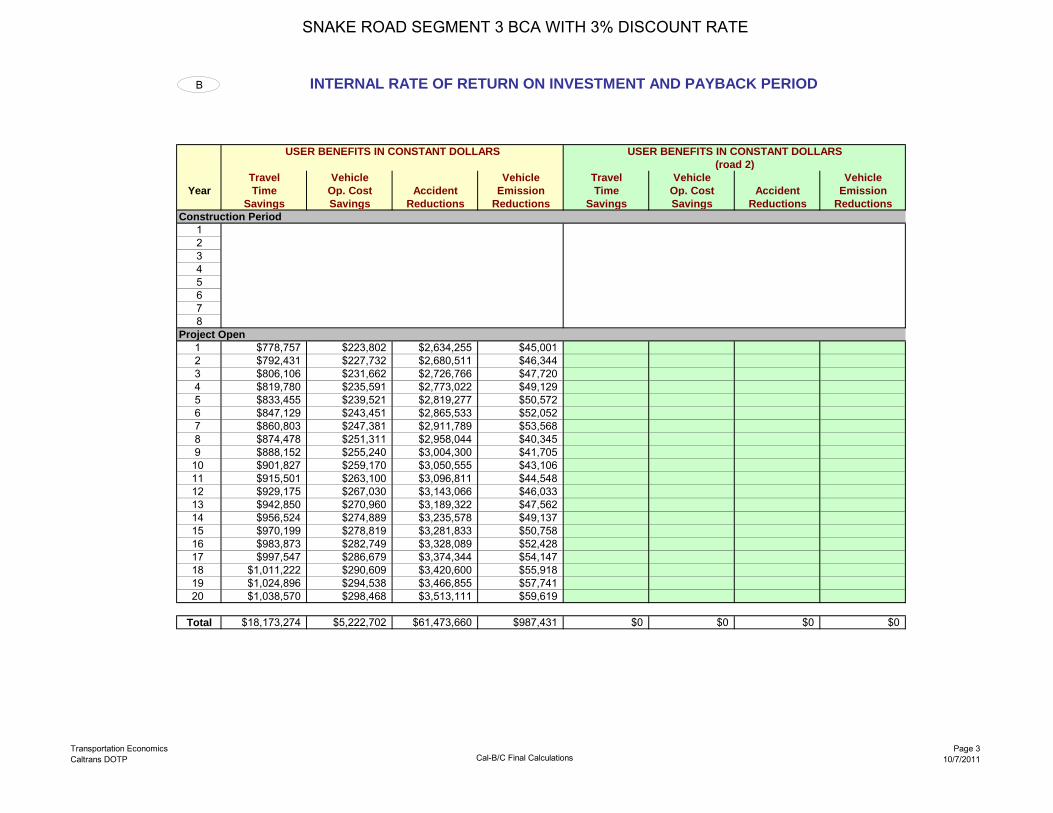
Transportation EconomicsCaltrans DOTP Cal-B/C Final Calculations
Page 310/7/2011
B INTERNAL RATE OF RETURN ON INVESTMENT AND PAYBACK PERIOD
USER BENEFITS IN CONSTANT DOLLARS USER BENEFITS IN CONSTANT DOLLARS (road 2)
Travel Vehicle Vehicle Travel Vehicle VehicleYear Time Op. Cost Accident Emission Time Op. Cost Accident Emission
Savings Savings Reductions Reductions Savings Savings Reductions ReductionsConstruction Period
12345678
Project Open1 $778,757 $223,802 $2,634,255 $45,0012 $792,431 $227,732 $2,680,511 $46,3443 $806,106 $231,662 $2,726,766 $47,7204 $819,780 $235,591 $2,773,022 $49,1295 $833,455 $239,521 $2,819,277 $50,5726 $847,129 $243,451 $2,865,533 $52,0527 $860,803 $247,381 $2,911,789 $53,5688 $874,478 $251,311 $2,958,044 $40,3459 $888,152 $255,240 $3,004,300 $41,70510 $901,827 $259,170 $3,050,555 $43,10611 $915,501 $263,100 $3,096,811 $44,54812 $929,175 $267,030 $3,143,066 $46,03313 $942,850 $270,960 $3,189,322 $47,56214 $956,524 $274,889 $3,235,578 $49,13715 $970,199 $278,819 $3,281,833 $50,75816 $983,873 $282,749 $3,328,089 $52,42817 $997,547 $286,679 $3,374,344 $54,14718 $1,011,222 $290,609 $3,420,600 $55,91819 $1,024,896 $294,538 $3,466,855 $57,74120 $1,038,570 $298,468 $3,513,111 $59,619
Total $18,173,274 $5,222,702 $61,473,660 $987,431 $0 $0 $0 $0
SNAKE ROAD SEGMENT 3 BCA WITH 3% DISCOUNT RATE

Transportation EconomicsCaltrans DOTP Cal-B/C Final Calculations
Page 410/7/2011
USER BENEFITS IN CONSTANT DOLLARS Total(road 3) Total User Project ANNUAL CUMULATIVE
Travel Vehicle Vehicle Benefits in Costs in RETURNS RETURNSTime Op. Cost Accident Emission Constant Constant ON AFTER
Savings Savings Reductions Reductions Dollars Dollars INVESTMENT PROJ OPENS
$0 $3,909,000 ($3,909,000)$0 $3,909,000 ($3,909,000)$0 $0 $0$0 $0 $0$0 $0 $0$0 $0 $0$0 $0 $0$0 $0 $0
$3,681,815 $0 $3,681,815 $3,681,815$3,747,018 $0 $3,747,018 $7,428,833$3,812,253 $0 $3,812,253 $11,241,086$3,877,522 $0 $3,877,522 $15,118,608$3,942,825 $0 $3,942,825 $19,061,433$4,008,165 $0 $4,008,165 $23,069,598$4,073,541 $0 $4,073,541 $27,143,138$4,124,177 $0 $4,124,177 $31,267,316$4,189,397 $0 $4,189,397 $35,456,713$4,254,658 ($82,000) $4,336,658 $39,793,371$4,319,960 ($82,000) $4,401,960 $44,195,331$4,385,305 ($410,000) $4,795,305 $48,990,635$4,450,693 ($410,000) $4,860,693 $53,851,329$4,516,128 $0 $4,516,128 $58,367,456$4,581,609 $0 $4,581,609 $62,949,065$4,647,138 $0 $4,647,138 $67,596,203$4,712,717 $0 $4,712,717 $72,308,921$4,778,348 $0 $4,778,348 $77,087,268$4,844,031 $0 $4,844,031 $81,931,299$4,909,769 $0 $4,909,769 $86,841,068
$0 $0 $0 $0 $85,857,068 $6,834,000 $79,023,068
Total Construction Costs $7,818,000
SNAKE ROAD SEGMENT 3 BCA WITH 3% DISCOUNT RATE

Transportation EconomicsCaltrans DOTP Cal-B/C Final Calculations
Page 510/7/2011
Years ANNUALAfter RETURNS
Construction ONBegins INVESTMENT
1 ($3,909,000)2 ($3,909,000)3 $3,681,8154 $3,747,0185 $3,812,2536 $3,877,5227 $3,942,8258 $4,008,1659 $4,073,54110 $4,124,17711 $4,189,39712 $4,336,65813 $4,401,96014 $4,795,30515 $4,860,69316 $4,516,12817 $4,581,60918 $4,647,13819 $4,712,71720 $4,778,34821 $4,844,03122 $4,909,76923 $024 $025 $026 $027 $028 $0
Internal Rate The INTERNAL RATE OF RETURN (IRR) is the discount rate at which benefits and costs break even (are equal). For a projectof Return 40.81% with an IRR greater than the Discount Rate, benefits are greater than costs, and the project has a positive economic value. The
IRR allows projects with different costs, different benefit flows, and different time periods to be compared.
Payback The PAYBACK PERIOD is the number of years it takes for the net benefits (benefits minus costs) to equal, or payback, the initialPeriod 3 years construction costs. For a project with a Payback Period longer than the life-cycle of the project, initial construction costs are not
recovered. The Payback Period varies inversely with the Benefit-Cost Ratio: shorter Payback Period yields higher Benefit-Cost.
SNAKE ROAD SEGMENT 3 BCA WITH 3% DISCOUNT RATE

Transportation EconomicsCaltrans DOTP Cal-B/C PARAMETERS
Page 110/7/2011
Parameters
This page contains all economic values and rate tables.To update economic values automatically, change "Economic Update Factor."
General Economic Parameters
Year of Current Dollars for Model 2011Economic Update Factor (Using GDP Deflator) 1.07 1
Real Discount Rate 3.0% 2Also use 7%
Travel Time Parameters Highway Operations ParametersValue Units Value Units
Statewide Average Hourly Wage $/hr 3 Maximum V/C Ratio 1.56 - 15
Transportation and Warehousing Percent ADT in Peak Period 41.0% %Average Hourly Wage $/hr 3 Percent ADT in Average Peak Hour 8.2% %Benefits and Costs $/hr 4
Annualization Factor 365 days/yrValue of Time
Automobile 11.20$ $/hr/per 5 Capacity Dep. RateTruck 18.10$ $/hr/veh 5 Alpha Beta (vphpl) (vphpl)Auto & Truck Composite $/hr/veh 6 Freeway 0.20 10 2,000 1,800 15, 16Transit 11.20$ $/hr/per 5 Expressway 0.20 10 2,000 1,800 15, 16Out-of-Vehicle Travel 2 times 5 Conventional Highway 0.05 10 800 1,400 16Incident-Related Travel 1 times 7 HOV Lanes 0.55 8 1,600 17
Vehicle Operating Cost Parameters Capacity
Non-HOV Lanes Alpha Beta (vphpl)
Average Fuel Price No Build 0.05 10 800Automobile (regular unleaded) $/gal 8 Build 0.05 10 800Truck (diesel) $/gal 8
Sales and Fuel Taxes Sources: 15) Highway Capacity Manual, 16) NCHRP 387, 17) PeMS dataState Sales Tax % 9Average Local Sales Tax % 9Federal Fuel Excise Tax (gasoline) $/gal 9Federal Fuel Excise Tax (diesel) $/gal 9State Fuel Excise Tax $/gal 9
Fuel Cost Per Gallon (Exclude Taxes)Automobile 3.46$ $/galTruck 3.46$ $/gal
Non-Fuel Cost Per MileAutomobile 0.321$ $/mi 10Truck 0.447$ $/mi 11, 12
Idling Speed for Op. Costs and Emissions 5 mph
Accident Cost Parameters
Cost of a Fatality 6,000,000$ $/event 13
Cost of an InjuryLevel A (Severe) 1,125,000$ $/event 13Level B (Moderate) 93,000$ $/event 13Level C (Minor) 12,000$ $/event 13
Cost of Property Damage 2,400$ $/event 13
Cost of Highway AccidentFatal Accident 7,300,000$ $/accidentInjury Accident 140,100$ $/accidentPDO Accident 7,800$ $/accidentAverage Cost 226,500$ $/accident
Statewide Highway Accident RatesFatal Accident 0.009 per mil veh-mi 14Injury Accident 0.31 per mil veh-mi 14PDO Accident 0.65 per mil veh-mi 14Non-Freeway 1.25 per mil veh-mi 14
Sources: 1) Office of Management and Budget (OMB), 2) Review of OMB and StateTreasurer's Office data, 3) Bureau of Labor Statistics (BLS) QCEW, 4) BLS EmploymentCost Inde, 5) USDOT Department Guidance, 6) California Department of TranportationTSI and Traffic Operations, 7) IDAS model, 8) AAA Daily Fuel Gauge Report, 9) TransportationFunding in California, 10) AAA Your Driving Costs, 11) FHWA Office of Freight Managementand Operations, 12) Zaniewski et al, 13) National Safety Council, 14) TASAS summary 2006
SNAKE ROAD SEGMENT 3 BCA WITH 3% DISCOUNT RATE

California Life-CycleBenefit/Cost Analysis Model
(Cal-B/C) Version 4.0 Modified for TIGER Grants
Office of Transportation EconomicsDivision of Transportation Planning
February 2009
For questions and comments, please contact:
Mahmoud Mahdavi (916) 653-9525 [email protected] Padilla (916) 653-9248 [email protected]
SNAKE ROAD SEGMENT 3 BCA WITH 7% DISCOUNT RATE

Transportation EconomicsCaltrans DOTP
Cal-B/C - 1) Project InformationSEGMENT 3_BCA_7PCT_r.xls
Page 110/7/2011
District: STOFEA:
PROJECT: PPNO:
1A PROJECT DATA 1C HIGHWAY ACCIDENT DATA
Type of Project Actual 3-Year Accident Data (from Table B)Select project type from list Count (No.) Rate
Total Accidents (Tot) 55 3.74 Project Location (enter 1 for So. Cal., 2 for No. Cal., or 3 for rural) 3 Fatal Accidents (Fat) 1 0.068
Injury Accidents (Inj) 20 1.33Length of Construction Period 2 years Property Damage Only (PDO) Accidents 35 2.34One- or Two-Way Data 2 enter 1 or 2
Current Statewide Basic Average Accident RateLength of Peak Period(s) (up to 24 hrs) 5 hours No Build Build
Rate GroupAccident Rate (per million vehicle-miles) 1.20 0.60
Percent Fatal Accidents (Pct Fat) 1% 1%1B HIGHWAY DESIGN AND TRAFFIC DATA Percent Injury Accidents (Pct Inj) 53% 27%
Highway Design No Build BuildRoadway Type (Fwy, Exp, Conv Hwy) C CNumber of General Traffic Lanes 2 2 1D RAIL AND TRANSIT DATANumber of HOV/HOT LanesHOV Restriction (2 or 3) Annual Person-Trips No Build BuildExclusive ROW for Buses (y/n) N Base (Year 1)
Forecast (Year 20)Highway Free-Flow Speed 25 35 Percent Trips during Peak Period 41%Ramp Design Speed (if aux. lane/off-ramp proj.) 35 35 Percent New Trips from Parallel Highway 100%Length (in miles) Highway Segment 4.3 4.3
Impacted Length 4.3 4.3 Annual Vehicle-Miles No Build BuildBase (Year 1)
Average Daily Traffic Forecast (Year 20)Current 3,140 Average Vehicles/Train (if rail project)
No Build BuildBase (Year 1) 3,254 3,254 Reduction in Transit AccidentsForecast (Year 20) 4,340 4,340 Percent Reduction (if safety project)
Average Hourly HOV/HOT Lane Traffic 0Percent of Induced Trips in HOV (if HOT or 2-to-3 conv.) 100% Average Transit Travel Time No Build Build
Percent Traffic in Weave 0.0% In-Vehicle Non-Peak (in minutes) 0.0Percent Trucks (include RVs, if applicable) 16% 16% Peak (in minutes) 0.0Truck Speed 30 Out-of-Vehicle Non-Peak (in minutes) 0.0 0.0
Peak (in minutes) 0.0 0.0On-Ramp Volume Peak Non-Peak
Hourly Ramp Volume (if aux. lane/on-ramp proj.) 0 0 Highway Grade Crossing Current Year 1 Year 20Metering Strategy (1, 2, 3, or D, if on-ramp proj.) Annual Number of Trains 0
Avg. Gate Down Time (in min.) 0.0Queue Formation (if queuing or grade crossing project) Year 1 Year 20
Arrival Rate (in vehicles per hour) 0 0 Transit Agency Costs (if TMS project) No Build BuildDeparture Rate (in vehicles per hour) 0 0 Annual Capital Expenditure $0
Annual Ops. and Maintenance Expenditure $0Pavement Condition (if pavement project) No Build Build
IRI (inches/mile) Base (Year 1)Forecast (Year 20) Model should be run for both roads for intersection or bypass highway projects, and
may be run twice for connectors. Press button below to prepare model to enterAverage Vehicle Occupancy (AVO) No Build Build data for second road. After data are entered, results reflect total project benefits.
General Traffic Non-Peak 1.30 1.30Peak 1.15 1.15
High Occupancy Vehicle (if HOV/HOT lanes) 2.15 2.15
General Highway
SNAKE ROAD - SEGMENT 3 (WITH 7% DISCOUNT RATE)
Prepare Model for Second Road
SNAKE ROAD SEGMENT 3 BCA WITH 7% DISCOUNT RATE

Transportation EconomicsCaltrans DOTP
Cal-B/C - 1) Project InformationSEGMENT 3_BCA_7PCT_r.xls
Page 210/7/2011
Enter all project costs (in today's dollars) in columns 1 to 7. Costs during construction should be entered in the first eight rows.Project costs (including maintenance and operating costs) should be net of costs without project.
1E PROJECT COSTS (enter costs in thousands of dollars)
Col. no. (1) (2) (3) (4) (5) (6) (7)
DIRECT PROJECT COSTS TransitINITIAL COSTS SUBSEQUENT COSTS Agency TOTAL COSTS (in dollars)
Year Project Maint./ Cost Constant PresentSupport R / W Construction Op. Rehab. Mitigation Savings Dollars Value
Construction Period1 $392 $3,517 $3,909,000 $3,909,0002 392 3,517 3,909,000 3,653,2713 0 04 0 05 0 06 0 07 0 08 0 0
Project Open1 $0 $02 0 03 0 04 0 05 0 06 0 07 0 08 0 09 0 010 (82 (82,000) (38,958)11 (82 (82,000) (36,409)12 (410 (410,000) (170,135)13 (410 (410,000) (159,005)14 0 015 0 016 0 017 0 018 0 019 0 020 0 0
Total $784 $0 $7,034 $0 ($984) $0 $0 $6,834,000 $7,157,764
Present Value = Future Value (in Constant Dollars) ( 1 + Real Discount Rate) ^ Year
SNAKE ROAD SEGMENT 3 BCA WITH 7% DISCOUNT RATE

Transportation EconomicsCaltrans DOTP
Cal-B/C - 3) ResultsSEGMENT 3_BCA_7PCT_r.xls
Page 110/7/2011
District: STOFEA:
PROJECT: SNAKE ROAD - SEGMENT 3 (WITH 7% DISCOUNT RATE) PPNO:
3 INVESTMENT ANALYSISSUMMARY RESULTS
Average Total OverLife-Cycle Costs (mil. $) $7.2 ITEMIZED BENEFITS (mil. $) Annual 20 YearsLife-Cycle Benefits (mil. $) $41.1 Travel Time Savings $0.4 $8.7Net Present Value (mil. $) $34.0 Veh. Op. Cost Savings $0.1 $2.5
Accident Cost Savings $1.5 $29.4Benefit / Cost Ratio: 5.7 Emission Cost Savings $0.0 $0.5
TOTAL BENEFITS $2.1 $41.1Rate of Return on Investment: 40.8%
Person-Hours of Time Saved 77,214 1,544,287Payback Period: 3 years Additional CO2 Emissions (tons) -740 -14,790
Additional CO2 Emissions (mil. $) -$0.0 -$0.3
Should benefit-cost results include:1) Induced Travel? (y/n) Y
Default = Y
2) Vehicle Operating Costs? (y/n) YDefault = Y
3) Accident Costs? (y/n) YDefault = Y
4) Vehicle Emissions? (y/n) Yincludes value for CO2e Default = Y
SNAKE ROAD SEGMENT 3 BCA WITH 7% DISCOUNT RATE

Transportation EconomicsCaltrans DOTP Cal-B/C Final Calculations
Page 110/7/2011
A NET PRESENT VALUE CALCULATION
PRESENT VALUE OF USER BENEFITS PRESENT VALUE OF USER BENEFITS (road 2)
Travel Vehicle Vehicle Travel Vehicle VehicleYear Time Op. Cost Accident Emission Time Op. Cost Accident Emission
Savings Savings Reductions Reductions Savings Savings Reductions ReductionsConstruction Period
12345678
Project Open1 $680,196 $195,477 $2,300,860 $39,3062 $646,860 $185,897 $2,188,095 $37,8313 $614,974 $176,734 $2,080,237 $36,4054 $584,492 $167,973 $1,977,126 $35,0285 $555,366 $159,603 $1,878,604 $33,6986 $527,549 $151,609 $1,784,510 $32,4157 $500,995 $143,978 $1,694,687 $31,1778 $475,658 $136,696 $1,608,980 $21,9459 $451,492 $129,751 $1,527,234 $21,20110 $428,451 $123,130 $1,449,297 $20,47911 $406,493 $116,820 $1,375,021 $19,78012 $385,575 $110,808 $1,304,261 $19,10213 $365,653 $105,083 $1,236,874 $18,44514 $346,688 $99,633 $1,172,722 $17,80915 $328,640 $94,446 $1,111,670 $17,19316 $311,469 $89,511 $1,053,588 $16,59717 $295,138 $84,818 $998,347 $16,02018 $279,611 $80,356 $945,824 $15,46219 $264,853 $76,114 $895,901 $14,92120 $250,828 $72,084 $848,462 $14,399
Total $8,700,983 $2,500,520 $29,432,301 $479,214 $0 $0 $0 $0
1,544,287 Person-Hours of Time Saved Person-Hours of Time Saved(14,790) Additional CO2 Emissions (tons) Additional CO2 Emissions (tons)
($306,486) Additional CO2 Emissions ($ PV) Additional CO2 Emissions ($ PV)
SNAKE ROAD SEGMENT 3 BCA WITH 7% DISCOUNT RATE

Transportation EconomicsCaltrans DOTP Cal-B/C Final Calculations
Page 210/7/2011
PRESENT VALUE OF USER BENEFITS Present Present (road 3) Value Value
Travel Vehicle Vehicle of Total of Total NETTime Op. Cost Accident Emission User Project PRESENT
Savings Savings Reductions Reductions Benefits Costs VALUE
$0 $3,909,000 ($3,909,000)$0 $3,653,271 ($3,653,271)$0 $0 $0$0 $0 $0$0 $0 $0$0 $0 $0$0 $0 $0$0 $0 $0
$3,215,840 $0 $3,215,840$3,058,683 $0 $3,058,683$2,908,350 $0 $2,908,350$2,764,620 $0 $2,764,620$2,627,271 $0 $2,627,271$2,496,083 $0 $2,496,083$2,370,838 $0 $2,370,838$2,243,279 $0 $2,243,279$2,129,677 $0 $2,129,677$2,021,357 ($38,958) $2,060,315$1,918,114 ($36,409) $1,954,523$1,819,746 ($170,135) $1,989,881$1,726,056 ($159,005) $1,885,061$1,636,853 $0 $1,636,853$1,551,949 $0 $1,551,949$1,471,165 $0 $1,471,165$1,394,323 $0 $1,394,323$1,321,253 $0 $1,321,253$1,251,790 $0 $1,251,790$1,185,773 $0 $1,185,773
$0 $0 $0 $0 $41,113,018 $7,157,764 $33,955,254
Person-Hours of Time SavedAdditional CO2 Emissions (tons)Additional CO2 Emissions ($ PV)
SNAKE ROAD SEGMENT 3 BCA WITH 7% DISCOUNT RATE

Transportation EconomicsCaltrans DOTP Cal-B/C Final Calculations
Page 310/7/2011
B INTERNAL RATE OF RETURN ON INVESTMENT AND PAYBACK PERIOD
USER BENEFITS IN CONSTANT DOLLARS USER BENEFITS IN CONSTANT DOLLARS (road 2)
Travel Vehicle Vehicle Travel Vehicle VehicleYear Time Op. Cost Accident Emission Time Op. Cost Accident Emission
Savings Savings Reductions Reductions Savings Savings Reductions ReductionsConstruction Period
12345678
Project Open1 $778,757 $223,802 $2,634,255 $45,0012 $792,431 $227,732 $2,680,511 $46,3443 $806,106 $231,662 $2,726,766 $47,7204 $819,780 $235,591 $2,773,022 $49,1295 $833,455 $239,521 $2,819,277 $50,5726 $847,129 $243,451 $2,865,533 $52,0527 $860,803 $247,381 $2,911,789 $53,5688 $874,478 $251,311 $2,958,044 $40,3459 $888,152 $255,240 $3,004,300 $41,70510 $901,827 $259,170 $3,050,555 $43,10611 $915,501 $263,100 $3,096,811 $44,54812 $929,175 $267,030 $3,143,066 $46,03313 $942,850 $270,960 $3,189,322 $47,56214 $956,524 $274,889 $3,235,578 $49,13715 $970,199 $278,819 $3,281,833 $50,75816 $983,873 $282,749 $3,328,089 $52,42817 $997,547 $286,679 $3,374,344 $54,14718 $1,011,222 $290,609 $3,420,600 $55,91819 $1,024,896 $294,538 $3,466,855 $57,74120 $1,038,570 $298,468 $3,513,111 $59,619
Total $18,173,274 $5,222,702 $61,473,660 $987,431 $0 $0 $0 $0
SNAKE ROAD SEGMENT 3 BCA WITH 7% DISCOUNT RATE

Transportation EconomicsCaltrans DOTP Cal-B/C Final Calculations
Page 410/7/2011
USER BENEFITS IN CONSTANT DOLLARS Total(road 3) Total User Project ANNUAL CUMULATIVE
Travel Vehicle Vehicle Benefits in Costs in RETURNS RETURNSTime Op. Cost Accident Emission Constant Constant ON AFTER
Savings Savings Reductions Reductions Dollars Dollars INVESTMENT PROJ OPENS
$0 $3,909,000 ($3,909,000)$0 $3,909,000 ($3,909,000)$0 $0 $0$0 $0 $0$0 $0 $0$0 $0 $0$0 $0 $0$0 $0 $0
$3,681,815 $0 $3,681,815 $3,681,815$3,747,018 $0 $3,747,018 $7,428,833$3,812,253 $0 $3,812,253 $11,241,086$3,877,522 $0 $3,877,522 $15,118,608$3,942,825 $0 $3,942,825 $19,061,433$4,008,165 $0 $4,008,165 $23,069,598$4,073,541 $0 $4,073,541 $27,143,138$4,124,177 $0 $4,124,177 $31,267,316$4,189,397 $0 $4,189,397 $35,456,713$4,254,658 ($82,000) $4,336,658 $39,793,371$4,319,960 ($82,000) $4,401,960 $44,195,331$4,385,305 ($410,000) $4,795,305 $48,990,635$4,450,693 ($410,000) $4,860,693 $53,851,329$4,516,128 $0 $4,516,128 $58,367,456$4,581,609 $0 $4,581,609 $62,949,065$4,647,138 $0 $4,647,138 $67,596,203$4,712,717 $0 $4,712,717 $72,308,921$4,778,348 $0 $4,778,348 $77,087,268$4,844,031 $0 $4,844,031 $81,931,299$4,909,769 $0 $4,909,769 $86,841,068
$0 $0 $0 $0 $85,857,068 $6,834,000 $79,023,068
Total Construction Costs $7,818,000
SNAKE ROAD SEGMENT 3 BCA WITH 7% DISCOUNT RATE

Transportation EconomicsCaltrans DOTP Cal-B/C Final Calculations
Page 510/7/2011
Years ANNUALAfter RETURNS
Construction ONBegins INVESTMENT
1 ($3,909,000)2 ($3,909,000)3 $3,681,8154 $3,747,0185 $3,812,2536 $3,877,5227 $3,942,8258 $4,008,1659 $4,073,54110 $4,124,17711 $4,189,39712 $4,336,65813 $4,401,96014 $4,795,30515 $4,860,69316 $4,516,12817 $4,581,60918 $4,647,13819 $4,712,71720 $4,778,34821 $4,844,03122 $4,909,76923 $024 $025 $026 $027 $028 $0
Internal Rate The INTERNAL RATE OF RETURN (IRR) is the discount rate at which benefits and costs break even (are equal). For a projectof Return 40.81% with an IRR greater than the Discount Rate, benefits are greater than costs, and the project has a positive economic value. The
IRR allows projects with different costs, different benefit flows, and different time periods to be compared.
Payback The PAYBACK PERIOD is the number of years it takes for the net benefits (benefits minus costs) to equal, or payback, the initialPeriod 3 years construction costs. For a project with a Payback Period longer than the life-cycle of the project, initial construction costs are not
recovered. The Payback Period varies inversely with the Benefit-Cost Ratio: shorter Payback Period yields higher Benefit-Cost.
SNAKE ROAD SEGMENT 3 BCA WITH 7% DISCOUNT RATE

Transportation EconomicsCaltrans DOTP Cal-B/C PARAMETERS
Page 110/7/2011
Parameters
This page contains all economic values and rate tables.To update economic values automatically, change "Economic Update Factor."
General Economic Parameters
Year of Current Dollars for Model 2011Economic Update Factor (Using GDP Deflator) 1.07 1
Real Discount Rate 7.0% 2Also use 7%
Travel Time Parameters Highway Operations ParametersValue Units Value Units
Statewide Average Hourly Wage $/hr 3 Maximum V/C Ratio 1.56 - 15
Transportation and Warehousing Percent ADT in Peak Period 41.0% %Average Hourly Wage $/hr 3 Percent ADT in Average Peak Hour 8.2% %Benefits and Costs $/hr 4
Annualization Factor 365 days/yrValue of Time
Automobile 11.20$ $/hr/per 5 Capacity Dep. RateTruck 18.10$ $/hr/veh 5 Alpha Beta (vphpl) (vphpl)Auto & Truck Composite $/hr/veh 6 Freeway 0.20 10 2,000 1,800 15, 16Transit 11.20$ $/hr/per 5 Expressway 0.20 10 2,000 1,800 15, 16Out-of-Vehicle Travel 2 times 5 Conventional Highway 0.05 10 800 1,400 16Incident-Related Travel 1 times 7 HOV Lanes 0.55 8 1,600 17
Vehicle Operating Cost Parameters Capacity
Non-HOV Lanes Alpha Beta (vphpl)
Average Fuel Price No Build 0.05 10 800Automobile (regular unleaded) $/gal 8 Build 0.05 10 800Truck (diesel) $/gal 8
Sales and Fuel Taxes Sources: 15) Highway Capacity Manual, 16) NCHRP 387, 17) PeMS dataState Sales Tax % 9Average Local Sales Tax % 9Federal Fuel Excise Tax (gasoline) $/gal 9Federal Fuel Excise Tax (diesel) $/gal 9State Fuel Excise Tax $/gal 9
Fuel Cost Per Gallon (Exclude Taxes)Automobile 3.46$ $/galTruck 3.46$ $/gal
Non-Fuel Cost Per MileAutomobile 0.321$ $/mi 10Truck 0.447$ $/mi 11, 12
Idling Speed for Op. Costs and Emissions 5 mph
Accident Cost Parameters
Cost of a Fatality 6,000,000$ $/event 13
Cost of an InjuryLevel A (Severe) 1,125,000$ $/event 13Level B (Moderate) 93,000$ $/event 13Level C (Minor) 12,000$ $/event 13
Cost of Property Damage 2,400$ $/event 13
Cost of Highway AccidentFatal Accident 7,300,000$ $/accidentInjury Accident 140,100$ $/accidentPDO Accident 7,800$ $/accidentAverage Cost 226,500$ $/accident
Statewide Highway Accident RatesFatal Accident 0.009 per mil veh-mi 14Injury Accident 0.31 per mil veh-mi 14PDO Accident 0.65 per mil veh-mi 14Non-Freeway 1.25 per mil veh-mi 14
Sources: 1) Office of Management and Budget (OMB), 2) Review of OMB and StateTreasurer's Office data, 3) Bureau of Labor Statistics (BLS) QCEW, 4) BLS EmploymentCost Inde, 5) USDOT Department Guidance, 6) California Department of TranportationTSI and Traffic Operations, 7) IDAS model, 8) AAA Daily Fuel Gauge Report, 9) TransportationFunding in California, 10) AAA Your Driving Costs, 11) FHWA Office of Freight Managementand Operations, 12) Zaniewski et al, 13) National Safety Council, 14) TASAS summary 2006
SNAKE ROAD SEGMENT 3 BCA WITH 7% DISCOUNT RATE
TIGER Grant Benefit-Cost Analyses from Tribal Governments 17-Mile Road (WY) This application was submitted in TIGER 2011 by the Wind River Indian Reservation in Wyoming, to improve conditions on 17-Mile Road (also known as Fremont County Road #334). The benefit-cost analysis focuses primarily on safety benefits, providing the record of crashes, fatalities, and injuries over the past 10 years, and estimating a benefit-cost ratio of 5.1. The analysis uses DOT’s guidance for estimating monetary values of fatalities and injuries to estimate the benefits. The analysis does not use crash reduction factors to estimate the number of crashes that would be prevented, but instead assumes that half of the crashes would be prevented (probably an overestimate). The analysis also does not discount future benefits back to the present, which also leads to an overstatement of benefits. The analysis also estimated benefits over a 40-year period, but did not consider the re-paving costs that would probably be necessary over such a long period. But even if we shorten the analysis period to 20 years, discount the benefits back to the present, and use a more conservative estimate of the percentage of crashes that would be prevented (25%), the benefits are still about 1.5 times the costs. There are also significant state-of-good-repair and livability benefits (as well as probably some economic competitiveness benefits from improved travel speeds and reduced operating costs) that were not quantified but that would raise the benefits more. So overall we were confident that the project would have benefits in excess of its costs.

Shoshone and Arapaho Tribes DUNS 182912493 17 – Mile Road
i
TABLE OF CONTENTS
PROGRAM NARRATIVE
I. Project Overview & Description p 1-8 Map of area
II. Project Parties p 8 III. Grant Funds and Sources p 9-10
Uses of Project Funds IV. Selection Criteria p 10-21
PRIMARY BENEFITS a. Long term Outcomes p 10-11
i. State of good repair p 11-12 ii. Economic Competitiveness p 12 iii. Livability p 12-20 iv. Environmental Sustainability p 20 v. Safety p 20-21
SECONDARY BENEFITS
b. Job Creation & p 21-23
Near-Term Economic Readiness c. Innovation p 23-24 d. Partnership p 24 e. Results of Benefit-Cost Analysis p 24-25 f. Evaluation p 25
V. Project Readiness and NEPA p 26 VI. Federal Wage Page Certificate p 26/attachment VII. Material changes- pre-application form p 26

Joint Business Council – Shoshone and Arapaho Tribes Tiger 3 Funding Opportunity 17-Mile Road
1
TIGER DISCRETIONARY GRANT APPLICATION OVERVIEW
1. Applicant: Eastern Shoshone and Northern Arapaho Tribes
2. Contact Information: John Smith, Eastern Shoshone and Northern Arapaho Tribes Transportation Director, 15 North Fork Road, Fort Washakie, WY 82514, Phone (3070 335-7669.
3. County Project Location: Fremont County, Wyoming
4. U.S. Congressional District & Members Name: Wyoming, Senators Barrasso & Enzi;
Representative Lummis.
5. Project Title: 17-Mile Road, West Section Connection
6. Project Location: West Central Wyoming west of Riverton.
7. Proposed Work: The project will include horizontal curve realignment, grading, drainage and culvert structures, irrigation facilities relocation, roadway surfacing including gravel and asphalt overlay for 8.31 miles.
8. Eligibility: The reconstruction is for17-Mile Road West Section infrastructure project.
The proposed project falls under the Eligible Projects Category (1) Highway or bridge projects eligible under title 23, United States Code, for Tiger Discretionary funds
9. Project Purpose & Benefits: The Wind River Indian Reservation is an economically
distressed Native American Reservation with poverty rates of over 70% and unemployment over 50%. The project will create short-term construction related jobs, and facilitate long-term employment though an improved safe access. A new transit system service is located on the route. The project will reconstruct and surface a substandard horizontal roadway segment that has driver/pedestrian fatality rates of one life every two years.
10. Total Project Costs: Total Project cost is $13,233,700
11. Tiger Funds Requested: Tiger funds in the amount of $8,233,700 will be requested. The
remaining $5,000,000 will be supplied by State of Wyoming Commission Road Improvement Program (CRIP) Funds
12. Technical Feasibility: The preliminary engineering is 98% complete. NEPA has been
completed and a categorical exclusion determined that it satisfactorily addressed environmental impacts associated with the project. Road and utility ROW is in the process of being acquired and to be completed in the next 90 days.

Joint Business Council – Shoshone and Arapaho Tribes Tiger 3 Funding Opportunity 17-Mile Road

Joint Business Council – Shoshone and Arapaho Tribes Tiger 3 Funding Opportunity 17-Mile Road
3
Project Description – 17-Mile Road West Section Project
Tiger-3 funding is requested by the Shoshone and Arapahoe Tribes for the 17-Mile Road West Section surface transportation infrastructure project. The proposed project falls under the Eligible Projects Category (1) Highway or bridge projects eligible under title 23, United States Code, Tiger Discretionary Grants to Tribal governments. The project will include highway reconstruction to include: horizontal curve realignment, grading, drainage and culvert structures, irrigation facilities relocation; road grading, draining work, placing crushed base and bituminous pavement surfacing; removal and replacement of structure, water and sanitary sewer lines, irrigation facilities, guardrail and fencing and miscellaneous work on 8.31 miles of 17-Mile Road, also known as Fremont County Road #334, beginning at R.M.0.51. The easterly section of this roadway is known as Wyoming Highway 137 and while the 17-mile road west section connects with state highway 132. By agreement of the tribes, state, and county, the roadway, located on the Wind River Indian Reservation will become a designated tribal roadway under the auspices of the Shoshone and Arapaho Tribes once it is constructed to current highway standards.
The 17-Mile Road Tiger 3 construction project will result in a modern roadway of 12 foot lanes with 8 feet wide paved shoulders with edge line rumble strips. The widened, paved shoulders will provide an abundant recovery area in order to diminish the number of run-off the road/rollover crashes. Additionally the ditch section will be sloped at a 6:1 ratio, and this will also be a factor in preventing rollover crashes. Moderating the number of fatal crashes and injury crashes will positively impact the benefit/cost ratio of the project.
Project location
The Wind River Indian Reservation (WRIR) covers more than 2.2 million rural acres, intersecting with three Wyoming counties, with the majority of the reservation lying within the area known as Fremont County. The 2010 US Census indicates a total reservation population of 26,290. There are no urbanized areas on the Wind River Indian Reservation and none in Fremont County, Wyoming.
17-Mile Road is the major east-west corridor on the Wind River Indian Reservation. The roadway connects the reservation to the outskirts of the City of Riverton on its eastern edge and with highway 132 (Blue Sky Highway) a major north-south collector at its western edge. This is the main transportation route sued by business, government and individual vehicles between the City of Riverton, the Greater Arapahoe area (the most populated area of the reservation) and the tribal government complexes and federal Indian Health Services (I.H.S.) on the reservation at Fort Washakie and Ethete.

Joint Business Council – Shoshone and Arapaho Tribes Tiger 3 Funding Opportunity 17-Mile Road
4
Coordinates for the 17-Mile Road West Section Project are as follows:
Beginning of Project Coordinates: 42.99730; -108.75648 End of Project Coordinates: 42.96266; -108.60187
Transportation challenge/relevant data
The 17-Mile Road is a major collector roadway on the WRIR for travel to commercial services and health care centers in Fremont County. 17-Mile is truly the only cross-cutting roadway on the Wind River Indian Reservation, connecting the east and west of the heartland of the reservation in much the same way as Interstate 90 connects eastern Washington State to western Washington State. When travel on this roadway has been hindered, as in 2009 when a springtime flood washed out a bridge on the roadway, the reservation was literally cut into two distinct inaccessible sections. Only by traveling off the reservation to state Highway 789 and literally circulating around the reservation core population areas, could a vehicle then re-enter at the other end of the roadway - a journey of at least one hour instead of a 15-20 minute drive. Roadway failure anywhere on the 17-Mile Road significantly impacts access to emergency services, employment, commercial areas - by residents on and off the WRIR.
17-Mile road has been subject to an assortment of jurisdictional and maintenance obligations involving federal, state, county and tribal governments. Maintenance of the county vs. state section of the roadway has been quite variable, based upon the priority or lack of priority of each transportation department, especially as the entire highway is on the WRIR. Wyoming’s temperature extremes over 100 degree in summer and to -25 below in winter causes expansion
WYOMING
FIGURE 1

Joint Business Council – Shoshone and Arapaho Tribes Tiger 3 Funding Opportunity 17-Mile Road
5
and contraction of the surface which increased the need for regular maintenance. Snowplowing of the roadway during Wyoming’s harsh winters has been especially problematic, especially on the unimproved county section of the roadway, as it does not receive priority service form Fremont County.
While not the most current of figures available WYDOT data calculated the average daily travel on the west portion of 17-Mile road at 2,360 vehicles per day (VPD) and 85 truck vehicles per day. The expanded count to year 2012 was estimated at 2510 VPD with a 15% DHV and 4% trucks. The roadway serves the most populated section of the WRIR, where housing and tribal facility growth is occurring.
17-Mile road is not built to adequate standards, has significant deficiencies, lacks many desirable safety features, and experiences serious traffic crashes at a rate far higher that other roads and highways on the reservation and in Fremont County. The roadway was laid out along the old wagon road which followed the ‘section lines’ of the individual land allotments. This section line ‘design’ accounts for the two sharp 90 degree “S” curves in the mid-section of 17-Mile road which only provide for a 40-45 mph design speed. These curves impact traffic congestion, emergency vehicle response time, and contribute to the accidents, crashes, and fatalities documented on this important reservation traffic corridor.
The following is a description of the need for the 17-Mile west project as stated by the Wyoming Department of Transportation in their October 11, 2011 letter (see attachment for complete letter).
“The unimproved portion of 17-mile Road is narrow with damaged pavement and significant roadside hazards. Shoulders and adequate drainage are also lacking in many places, making the route hazardous for bicycles and pedestrians. The road has high vehicle crash and fatality rates and the highest pedestrian fatality rate in the state.”
Address these challenges
Tiger 3 funding will enable the reconstruction of the roadway to current standards. It will allow for bringing the roadway up to AASHTO Collector Standards of two travel lanes of 12 feet each, with 8 foot paved shoulders to replace the current 1-3 foot shoulders in poor condition. Roadway ditch and fill slopes of 6.1 will be added for enhanced safety. Work will also include grade and drainage, drainage structures, interim surfacing, asphalt pavement surfacing, water line relocation, intersection lighting, traffic signing and right of way fencing. Existing horizontal alignment will remain where present and areas of undesirable curvature will be modified. The 17-Mile Road Tiger 3 construction project will result in a modern roadway.
The transportation departments – tribal, county, and state – have entered into joint planning efforts over the past decade to address the reservation roadways. To address the challenge of multi-jurisdictional road maintenance, a MOU was entered into providing for transfer of the

Joint Business Council – Shoshone and Arapaho Tribes Tiger 3 Funding Opportunity 17-Mile Road
6
entire roadway to the Shoshone and Arapahoe Tribes once it has been brought up to modern standards, to insure priority maintenance in future, given its importance in the reservation transportation system. Assumption of the road by the tribes will further local pride as it will be maintained entirely by the tribal Transportation Department staff – a 100% tribal employment force under a self-determination contract between the Bureau of Indian Affairs and the Joint Business Council of the Shoshone and Arapaho Tribes.
Need for the project to address rural concerns
The WRIR is an economically distressed rural area. Poverty rates are chronically above 50% by all federal measures (Temporary Assistance to Needy Families, BIA Bureau of Labor Statistics). In their 2011 report, TRIP a national transportation research group states that: “Because it impacts the time it takes to transport people and goods, as well as the cost of travel, the level of mobility provided by a transportation system and its physical condition play a significant role in determining a region’s economic effectiveness.” As the east-west highway collector for the reservation, 17-mile road is the backbone of the reservation transportation system playing a significant role in determining the region’s economic effectiveness.
The Wind River Indian Needs Determination Survey of 2010, the WINDS III, is the latest in three major censuses of the Wind River Indian Reservation (WRIR) completed by the Wyoming Statistical Analysis Center at the University of Wyoming. The original WINDS project was conducted in 1987 and a second was carried out in 1998. The purpose of WINDS III was to provide accurate measurement of both the strengths and needs of people of the WRIR. Like the original WINDS Project, it quantified the level of services used and needed on the WRIR (public transportation, health, job training, child care, social services, and so forth) in order to address problems in service provision and help solve these problems.
WINDS 3 transportation questions and the community responses to those questions include the following:
Q The condition of roads on the Reservation is generally good?
52.2 % of the reservation residents said they disagreed with this statement, including 51.7 % Northern Arapaho respondents living in the area served by the 17-Mile corridor (Table 114, WINDS III survey 2010)
Q. Snow removal on roads is a problem 77.3% agreed with this statement, including 77.5% of Northern Arapaho residents living in the area served by the 17-mile corridor (Table 117, WINDS III survey, 2010)
Q. On the Reservation animals present a hazard for drivers
87.4% agreed with this statement including 87.2% Northern Arapaho residents living in areas served by the 17-Mile road corridor (Table 116, WINDS III survey, 2010)

Joint Business Council – Shoshone and Arapaho Tribes Tiger 3 Funding Opportunity 17-Mile Road
7
The narrowness of the current 17-mile roadway west section compounds the rural nature of the roadway. It is not uncommon for farm animals, wildlife, and other domestic animals to wander onto the roadway, given its rural nature. Pedestrians also present a hazard, as not only are there no sidewalks, but the lack of paved shoulders provide no alternative but for individuals to walk in the narrow traffic lane or along footpaths worn into the dirt along the road. During wet conditions or when snow covered, walking in the roadway is the only alternative. These challenges and dangers are magnified at night as no lighting is available on the roadway. Intersections become especially dangerous at nighttime, which is early during winter months-5:00 p.m. Mountain Time.
Bureau of Indian Affairs (BIA) Law Enforcement also report that the lack of roadway shoulders and pull outs hinder highway safety enforcement, as pulling over a vehicle for a moving vehicle violation on the 17-mile west section creates a safety hazard for other vehicles on the roadway. This results in law enforcement refraining from traffic stops in this area. The lack of a pull out large enough to accommodate the BIA’s highway safety Impaired Driver Unit (known as the ‘Batmobile” for sobriety checkpoints, impairs DWUI enforcement on this busy road.
Resident safety concerns are confirmed by data collected through the Fremont County 911 Center. Carl Freeman, manager of the Fremont County 911 Center in the Sheriff Office indicates the following 911 dispatches to the 17-mile road project area:
911 Center Dispatch to 17-Mile road/Highway 187 corridor
Between January 2009-October 10, 2011
ALL EVENTS (an event may include dispatching of multiple emergency service units)
Total: 119 dispatch events
EMS dispatched 39 Fire department dispatched 23 Law enforcement dispatches 97 EVENTS OCCURRING ON THE 17-MILE PORTION OF THIS HIGHWAY
Total: 71 of the 159 events or 55% OCCURRED on 17-Mile road project specific area
911 Center Dispatch to 17-Mile road project specific area
Between January 2009-October 10, 2011
20 were crashes Property damage only 3 Accidents with injuries 13 * Fatals 3 Hit and run involving two vehicles 1

Joint Business Council – Shoshone and Arapaho Tribes Tiger 3 Funding Opportunity 17-Mile Road
8
(This figure represents only those killed at the scene or dead on arrival at the emergency room on what is known as a ‘scoop and run’ procedure-getting the injured to emergency rooms with LifeFlight capabilities. Others who may have died later as a result of their injuries are not included in this report. Given these statistics on this rural, reservation highway it is easy to see why 17-Mile Road carries a Safety Index rating of “D” by the Wyoming Department of Transportation (WYDOT). If Tiger – 3 funding is not realized for this project, the 17-Mile Road will continue to present the same issues as outlined in this application, namely an unsafe roadway whose substandard design contributes to vehicle accidents, injuries, and deaths. Economic growth will be stifled in terms of helping people access employment, goods and services and in moving agricultural products down the narrow roadway.
II. Project Parties
Participants in creation of the Tiger 3 application for funding of the 17-mile west section project include: two distinct Indian Nations, the Eastern Shoshone and the Northern Arapaho, coming together in a Joint Tribal application (Shoshone and Arapaho Tribes-Joint Business Council) and their Tribal Transportation Department, the State of Wyoming Department of Transportation, the Fremont County Commission and the Fremont County Transportation Department. As stated in the letter for support from the Wyoming Department of Transportation: “This Tiger III project is part of an ongoing cooperative effort among the tribes, Fremont County and the Wyoming Department of Transportation to improve this road on the Wind River Indian Reservation.”
The Wind River Indian Reservation is home to two distinct tribal nations and governments, the Eastern Shoshone Tribe and the Northern Arapaho Tribe. Each tribe has a Business Council of six elected officials to provide government and economic operations for their respective tribe. These two councils come together as a Shoshone and Arapahoe Joint Business Council (JBC) to provide for matters and services pertaining to the reservation lands, natural resources, justice, and transportation systems. The Joint Business Council of the Eastern Shoshone and the Northern Arapaho Tribes accept federal grants and contracts for the benefit of the trust land base known as the Wind River Indian Reservation (WRIR) and for government services conducted for the benefit of the trust land. The Transportation Department, Shoshone and Arapahoe Tribes is under the auspices of the JBC. Due to the significant impact of the project on the well-being for these two tribal nations, the JBC has prioritized the Tiger-3 funding opportunity for the 17-Mile Road West Section highway infrastructure project.
The Wyoming Department of Transportation (WYDOT) and the Fremont County Commission has provided letters of support for the Tiger 3 application (see attachment). Additional letters of support are also included in the attachment.

Joint Business Council – Shoshone and Arapaho Tribes Tiger 3 Funding Opportunity 17-Mile Road
9
III. Grant Funds and Sources/Uses of Project Funds (availability//commitment of funds, uses of all project funds, total project cost percentage of project costs paid for with Tiger funds identity of other providing funds and source)
$8,233,700 in Tiger-3 funding is requested. This amount will provide for the following roadway improvements:
Roadway reconstruction to provide 12 foot driving lanes including 8 foot paved shoulders with roadway ditch and fill slopes of 6:1. The work will include grade and drainage structures, interim surfacing, asphalt pavement surfacing, water line relocation, intersection lighting, guardrail, traffic signing, and right of way fencing.
Cost estimates include:
Construction: $10,650,000 Engineering: $1,065,000 (10% project costs for contract engineering costs) Right-of-Way: $500,000 (costs related to obtaining all necessary rights/permits) ICAP: $1,018,700 (indirect cost allocation plan – administration cost at 8.34% allowed) Estimated total cost: $13,233,700 CRIP Matching Funds: 5,000,000 credit
ANTICIPATED PROJECT SCHEDULE
Complete WYDOT Plans (including ROW): March 2012 Plan delivery to Tribal Transportation: 30 days of grant award Asphalt Surfacing/Structure Bid Letting: 60 days of grant award Award of Contract for Bids: 90 days of grant award Obligation of funds: 120 days of grant award
Construction by Tribal Transportation Department: 90 days of grant award 10% of project funds expended expected: 180 days of grant award Project Surfacing Begins July 2014 Project Completion September 2014 As a rural project, matching of Tiger 3 funding is not required and exemption is requested. However, the Wyoming Transportation Commission and Fremont have set aside $5 million in Commission Road Improvement Program (CRIP) funds to assist with the 17-Mile West Section project as leverage for the Tiger 3 project. CRIP is discretionary funding program created by the Wyoming Transportation Commission to address unique rural major collector road situations. The CRIP was created to provide a means of financing roadway construction projects on selected county collector roads. The Commission has discretion in selecting candidate projects from proposals received from individual counties.

Joint Business Council – Shoshone and Arapaho Tribes Tiger 3 Funding Opportunity 17-Mile Road
10
The 17-mile road West Section Project provides substantial completion of this major corridor project that builds upon previous funds utilized and/or being used for this important roadway. Funds already expended in the 17-mile road corridor improvement by WYDOT include:
-Project # ACSTP 100.22.0711003 – 17-Mile Road East, Project length 7.86 miles, May 2007-September 30, 2008, Project Cost: $13,128,104.26
-Project # FLH0.00CN10098 17 Mile West Bridge Replacement, Project length 0.86 miles November 2010 thru October 31,2011 Project Cost: $3,127,618.01
-Project # STP-CR0.00 CN10101 17 Mile West Coolidge Canal Bridge, Project length 0.5 miles
December 2011 thru September 30, 2012 Project Cost: $1,411,385.93 -Project CN10093 – 17-Mile West Connection, Project Length 8.38 (Tiger 3 Region) Preliminary Engineering and Project Development Costs: $449,406.50
WYDOT also allocated $1,805,546 in Federal Lands High Program funds in 1996 for the preliminary engineering costs for design, defining of right-of-way, cultural clearances, and NEPA work on the 17-mile road and connecting roadways, with this work directly benefiting the current 17-mile west section project.
Pursuant to a Memorandum of Understanding for the Preliminary Engineering of Seventeen Mile, Lander-Kinnear and Ethete to Hines Corner (Ft Washakie) in Fremont County executed July 29, 1996, by the Joint Business Council, Shoshone and Arapaho Tribes, the Bureau of Indian Affairs Area Director, the Fremont County Commission and the Governor of Wyoming, the State shall relegate existing right-a-way on State Highway 137 to the BIA when reconstruction is complete (Section A.5.b.) and Fremont County shall, once reconstruction is complete, transfer existing right-a-way to the BIA for county owned right-a-ways shown on Exhibit A (Section A 6. A of Memorandum, with 17-mile road west section indicated in Exhibit A-see attachment for copy of Memorandum). The Shoshone and Arapaho Tribes, under a PL-638 Self-Determination contract with the BIA will assume all maintenance for this roadway upon transfer.
IV. Selection Criteria
PRIMARY BENEFITS
a. Long term outcomes
Long term outcomes for the Tiger 3 - 17-mile road west section project consist of:
- 40-year lifespan for a major collector route for the WRIR - Reduction of fatalities and injury accidents on the highway by 50% estimated at
10 lives saved and 84 fewer injuries

Joint Business Council – Shoshone and Arapaho Tribes Tiger 3 Funding Opportunity 17-Mile Road
11
- Significant cost-saving to the Indian Health Services program for ‘life and limb’ contract health costs arising from highway accidents, with savings in these costs available for health care, disease treatment and prevention-at an average cost of $46,830 per accident this past year
- Tribal assumption of maintenance of the 17-mile roadway giving it priority maintenance designation with improved snow removal post reconstruction
i. State of Good Repair
Sections of 17-Mile road were constructed in the 1930’s to a graveled surface. It was originally widened to 22’-24’ wide with no shoulders and stabilized with plant road mix in the mid 1950’s. Since that time, it has received only routine maintenance and is presently in need for major upgrading type work as the pavement edges are broken down where it drives like a 22 foot wide facility. The road is considered a Fremont County route.The route is entirely within the WRIR boundaries and serves as a major collector road for local residents and farms, having numerous intersecting local roads and approaches, all generating additional traffic usage and causing the vehicle counts to fluctuate.
17-Mile Road is currently to be maintained by Fremont County in the western component while the eastern component of this roadway is maintained by the State of Wyoming and is known as Hwy 137. The west portion-highway 137-was resurfaced and improved by the state in 2009 to the county portion of the roadway (the 17-milr road west section). However, Fremont County has deferred maintenance of this portion known as17-Mile as soon as it was considered for reconstruction in 1995. Since that time, the county has not performed any crack sealing work on 17-Mile Road as: “we had considered it a waste of resources as the pavement had already filed and it was due to be reconstructed.” “We did apply cold mix patching work as a stop gap measure.” (Dave Pendleton, P.E. Superintendent, Fremont County transportation Department-email 10/12/11.) The tribal transportation Department has assisted with some road maintenance related to safety (snow plowing, grass mowing) as department resources have allowed.
Tiger 3 funds will be enable 17-mile road to be brought up to AASHTO Collector Standards of two 12 feet traveled ways with 8 foot shoulders on each side. Existing horizontal alignment will remain where present and areas of undesirable curvature will be modified. The right-of-way will be referenced with 45” high fence. The BIA and tribes are in process of securing all necessary right-of-way for the roadway, as well as construction permits for both detours and slope blending as needed for construction. Bike and walk paths will be considered and included in the design of the roadway for possible future construction as part of the tribal transportation department’s Pathways project.
The Shoshone and Arapaho Transportation Department is also in the preliminary stages of establishing a Pavement Management system centered around GPS survey grade technology for all roads on the reservation. Full development of data roadway database will enable the

Joint Business Council – Shoshone and Arapaho Tribes Tiger 3 Funding Opportunity 17-Mile Road
12
department to manage the all roadway deterioration over time. This will also allow the transportation department to better manage the resources allocations required to maintain their roadway system to meet the 40 year lifecycle criteria.
Tiger 3 improvements will provide the 17-Mile road with a 40 years useful lifespan.
ii. Economic competitiveness
Because it impacts the time it takes to transport people and goods, as well as the cost of travel, the level of mobility provided by a transportation system and its physical condition play a significant role in determining a region’s economic effectiveness.
The 17-Mile roadway serves as a backbone of the reservation’s economy, providing mobility to residents, visitors and businesses. This roadway allows residents to travel to work and school and to access recreation, healthcare, social and commercial activities. The 17-Mile road also allows the region’s industries to access customers, suppliers and employees. This has been especially critical for the areas energy sector, for the new tribal casino operations, as well as for the agriculture industries.
The current roadway conditions and accident rates on the 17-Mile road are not conducive for economic development on the economically distressed WRIR. Once the improvements are made, the reservation will be more accessible for goods and services to flow in and out of the area, and for employment opportunities to occur. This is especially important as the region recovers from its recent economic downturn and to address the chronic poverty and unemployment rates found on the WRIR.
iii. Livability The quality of life in rural reservation areas, and the health of its economy is reliant on the quality of the roads that serves it. These roads, which provide access from reservation homes, farms and small businesses to off-reservation markets, retail outlets, employment, health care, and other services, are especially important due to the limited access to these services on the rural reservation itself. An improved transportation system gives households better access to higher-paying jobs, a wider selection of competitively priced consumer goods, and additional housing and healthcare options, which is critical to the concentrated poverty found on the economically distressed WRIR.
The 2010 U.S. Census reports the total population of the WRIR (reservation and off-reservation trust land) as 26,490 citizens and 9,544 households. The reservation is a young population with 38% of all citizens under the age of 24. In an area where the population changes over time, it is necessary to predict what the change will be in order to properly plan for future transportation

Joint Business Council – Shoshone and Arapaho Tribes Tiger 3 Funding Opportunity 17-Mile Road
13
system needs. Wyoming Connects, the Wyoming Department of Transportation’s Long Range Transportation Plan, forecasts the population of Fremont County will grow at an annual rate of 0.6% for a total growth rate of 18.3% for Fremont County between 2000-2030. The Indian Health Services has projected that that the Indian population in Wyoming will increase steadily at an average annual rate of 3.28% population growth annually. These forecasts indicate the growing demand for efficient, safe transportation routes on the WRIR.
The most recent BIA Labor Market information available for the reservation (2005) indicates a 73% unemployment rate, compared to a 3% unemployment rate in Fremont County during the same time frame. The Fremont County unemployment rate has increased to 6.1% in August 2011. These figures can be compared to the unemployment figures collected by WINDS 3 which indicates an unemployment rate of over 52.6% on the reservation (see table below):
Q. Are you employed (have a paying job)?
Table 1. Employment status. N. Arapaho E. Shoshone Other Indian All Count % Count % Count % Count % Yes 443 43.1% 146 60.3% 64 51.2% 751 47.4% No 584 56.9% 96 39.7% 61 48.8% 834 52.6% Total Valid 1027 100.0% 242 100.0% 125 100.0% 1585 100.0% No Answer 19 9 0 30 Total Missing 19 9 0 30 Total 1046 251 125 1615
Unemployment rates however imply eligibility for unemployment. The WINDS III survey (2010) indicates that of those indicating they are unemployed, 93.7% are not are receiving benefits which takes them out of the unemployment index calculation, making the reservation unemployment rate even higher.
1. [If not employed] Are you currently collecting unemployment benefits? (q13) Table 2. Currently collecting unemployment benefits. N. Arapaho E. Shoshone Other Indian All Count % Count % Count % Count % Yes 21 6.1% 4 6.3% 2 5.7% 32 6.3% No 326 93.9% 59 93.7% 33 94.3% 476 93.7% Total Valid 347 100.0% 63 100.0% 35 100.0% 508 100.0% No Answer 237 33 26 326 System Missing 462 155 64 781 Total Missing 699 188 90 1107 Total 1046 251 125 1615

Joint Business Council – Shoshone and Arapaho Tribes Tiger 3 Funding Opportunity 17-Mile Road
14
Even those employed cannot escape the dire economic conditions with 53% of employed Northern Arapahos listed as living below the federal poverty guidelines - the working poor on the BIA Labor market report. Employment ameliorates poverty for only about seven in ten families with an employed head of household on the WRIR.
The U.S. Department of Housing and Urban Development (HUD) has indicated that affordability of living in a community not only involves paying a mortgage, but involves other costs like transportation, gas and utilities (August 30, 2011 press release, HUD No. 11-180). The proximity of housing to jobs, school and other services greatly affects affordability as transportation is usually a household’s second most significant expense. HUD reports that creating livable communities result in improved quality of life. Local transportation costs ($3.65 average cost per gallon of gasoline) for the 40-50 mile round-trip from home to off-reservation commercial centers present a major challenge for reservation low income households.
The WINDS 3 survey provides us with a recent picture of earnings picture: 90.7% of reservation households have earnings under $50,000 from all income sources, with 45% of these households containing four or more persons.
Q. What was your household's total income in 2009? (Include all income used to support the household, including Social Security and per capita payments, if applicable.)
Table 3. 2009 Household total income. N. Arapaho E. Shoshone Other All Count % Count % Count % Count % 0 - 7,000 dollars 202 22.1% 31 14.6% 22 20.2% 286 20.4% 7,001 - 12,000 dollars 172 18.9% 32 15.0% 11 10.1% 237 16.9%
12,001 - 18,500 dollars 154 16.9% 21 9.9% 16 14.7% 209 14.9%
18,501 - 26,000 dollars 186 20.4% 28 13.1% 20 18.3% 251 17.9%
26,001 - 39000 dollars 105 11.5% 33 15.5% 15 13.8% 181 12.9%
39001 - 50,000 dollars 54 5.9% 22 10.3% 10 9.2% 108 7.7%
50,001 or more dollars 39 4.3% 46 21.6% 15 13.8% 130 9.3%
Total Valid 912 100.0% 213 100.0% 109 100.0% 1402 100.0% No Answer 144 42 17 229 Total Missing 144 42 17 229 Total 1056 255 126 1631

Joint Business Council – Shoshone and Arapaho Tribes Tiger 3 Funding Opportunity 17-Mile Road
15
A good regional transportation system can provide mobility for people without access to private vehicles, including the elderly, disabled and people with lower incomes. The WINDS 3 survey (2010) asked the question: [If not employed] Do you need, but do not have access to, any of the following to get a job? (Mark all that apply.)
Table 4. Things needed access to find a job. N. Arapaho E. Shoshone Other Indian All Count % Count % Count % Count % Transportation 141 77.0% 15 55.6% 16 84.2% 188 75.8% Child care 60 32.8% 13 48.1% 3 15.8% 84 33.9% Telephone 38 20.8% 8 29.6% 5 26.3% 55 22.2% Total Valid 183 27 19 248 No Answer 401 69 42 586 System Missing 462 155 64 781 Total Missing 863 224 106 1367 Total 1046 251 125 1615
As can be seen, 77% ranked the need for transportation in order to improve their economic condition thorough employment.
Another WINDS 3 question concerned the need for public transportation on the WRIR to which 91.1% agreed.
Q. There should be public busses for use on the Reservation. Table 5. Public busses on the Reservation. N. Arapaho E. Shoshone Other All Count % Count % Count % Count % Agree 958 93.0% 226 90.4% 104 84.6% 1448 91.1% Disagree 72 7.0% 24 9.6% 19 15.4% 141 8.9% Total Valid 1030 100.0% 250 100.0% 123 100.0% 1589 100.0% No Answer 26 5 3 42 Total Missing 26 5 3 42 Total 1056 255 126 1631
Contributing to Affordable and convenient transportation choices
The timing of the 17-mile Road West Section Project is quite fortuitous, given the recent opening of the Wind River Transit program in May of 2009. Through a $2.8 million grant from the Federal Transit Administration a door has been opened to provide efficient transportation throughout the reservation.

Joint Business Council – Shoshone and Arapaho Tribes Tiger 3 Funding Opportunity 17-Mile Road
16
The new Wind River Transit Facility is located on the 17-mile road corridor. Three 22-passenger buses and five 16 passenger buses will transport workers to and from jobsites along the proposed improved roadway and between reservation communities. Once the Tiger 3 construction project is complete, the transit service will have a safer and better roadway on which to continue operating and expanding. It is difficult to convey how important transit services is to this economically distressed reservation which, to add context to its side, has a land mass twice the size of the State of Delaware. Transit system access provides provide public transportation for area citizens, including the elderly and disabled, to medical appointments, tribal and county service centers, and enable enhanced access to job sites on and near the WRIR.
Tiger 3 roadway improvements to the 17-mile road will have a direct positive and long standing impact on the provision of safe and economical transit services.
What it all really means
Tiger 3 funding for the 17-mile road west section project significantly contributes to the six livability principles as set forth by the Partnership for Sustainability Communities (PSC Principles).These principles will be referenced throughout this discussion on how the 17-mile Road project impacts the lives of those utilizing this important transportation corridor.
Let’s take a ride down this roadway.
The 19-mile roadway corridor
The west end of 17-mile road begins at the intersection of Highway 132. Within just a few miles of this intersection you will find:
- Mill Creek Elementary School, Wyoming Indian Junior High &Wyoming Indian High Schools
- Tribal health program offices, Head Start preschool
- St. Michael’s Mission with its Episcopal church as well as buildings housing tribal programs including Wind River Tribal Youth, group home, child advocacy center, cancer support center and game and fish offices
- Tribal commercial center of Laundromat, gas station, grocery store, café, senior center, convenience store
- Community powwow and rodeo grounds, and Blue Sky Community Hall, used for meetings, recreation, funerals, and educational offices
- Northern Arapaho government offices and the Wind River Tribal College
-Northern Arapaho Tribal Housing projects

Joint Business Council – Shoshone and Arapaho Tribes Tiger 3 Funding Opportunity 17-Mile Road
17
Further up the road is the Little Wind Casino and restaurant, a major area employer and tourist attraction, with highway 132 continuing to connect to state highway 789, a Scenic By-way route to Grand Teton and Yellowstone National Parks. Highway 789 literally ‘rings’ the core population areas of the WRIR reservation.
As this ‘tour’ suggests, 17-Mile road is the major route for travel to these tribal services and housing, government offices, educational facilities, commercial operations, and community centers from the other most populous areas for reservation citizens, namely the 17-mile Roadway corridor. (PSC Principles: Support existing communities, Value communities and neighborhoods)
Now let’s ride the 17-Mile roadway corridor from the beginning of the Tiger 3 construction area at Left Hand Ditch road east to where it connect with the newly improved state section of the 17- mile (called highway 137) to where it ends at Highway 789.
As we travel 17-mile road east, we find the Mill Creek Housing, a NATH –HUD housing complex whose children travel 17-Mile road to the elementary, junior high and high schools previously mentioned. Further down the road, we come to the Arapaho Farm, a tribal commercial haying operation whose roadway opens onto 17 Mile road just as you arrive at the first of two 90 degree “S” curves in the roadway. This 45 mile per hour curve takes you past a church, where you are reminded of you mortality as you quickly find yourself on another 90 degree “S” curve.
Remember- at this point, our highway has not been reconstructed. The lanes are narrow, without shoulders.
A bit farther down the roadway is the Northern Arapaho Utilities complex. Northern Arapaho Utilities is responsible for water and sewer services for the WRIR from the Ethete area east and along the 17-Mile corridor. They are also the provider of tribal Weatherization services under federal grants from the United States Department of Energy. They run three weatherization crews daily from their office on 17-mile road providing energy conservation audits and green energy solutions to homes throughout the reservation. (PSC Principles: Coordinate and leverage federal policies and investment, Enhance economic competitiveness)
Now is the section of 17-mile roadway corridor that has been improved by the state (highway 137. A driver often breathes a sigh of relief as the narrow roadway with ‘roll over and crash’ edges becomes a modern roadway of 12 foot lanes with 8 foot recovery capable shoulder. This enables safer options when wildlife, animals, or people are on the roadway as the driver can navigate the vehicle to avoid collision and a crash. If it is winter time, the driver has now come from the rarely plowed county serviced roadways onto a plowed roadway surface. Unfortunately, if driving from west to east on the current 17-mile route, the transition is from

Joint Business Council – Shoshone and Arapaho Tribes Tiger 3 Funding Opportunity 17-Mile Road
18
a good road to the poorly maintained, narrow roadway known as the 17-mile road west section, quite the surprise for many drivers.
Shortly after the bridge connecting the unimproved 17-mile road to the newly improved and significantly wider highway 187, is the Greater Arapahoe-Great Plains area where you find:
-The Northern Arapaho solid waste transfer station
-The Shoshone and Arapaho Tribes Transportation Department TRANSIT Service building. This new transit service brings a public transportation option to citizens along the entire 17-Mile corridor, providing for transportation to health care, employment, and social services. (PSC Principle: Provide more transportation choices)
-Northern Arapaho Tribal Language Immersions Preschool
-Northern Arapaho Family Services Office
-Early Head Start and Head Start preschools
-The Great Plains hall used as offices, recreation and community center
-The Black Coal Senior Center
-Indian Health Services Arapaho Clinic and eyeglass program
-Tribal health program offices
-NATH housing office
-Great Plains NATH-HUD low income housing area
-Ben Gay Heights-NATH-HUD Senior/disability housing area
In fact, when you look at the 232 household NATH – HUD low income housing units on the reservation, three are located on the 17-mile route and three additional units are within 3 miles of the route. The 17-mile corridor is located within the most populated and fastest growing area of the rural WRIR. (PSC Principles: Promote equitable, affordable housing, support existing communities, Value communities and neighborhoods).
Just past Great Plains on the 17-mile corridor is the Left Hand Ditch Road intersection which accesses the Northern Arapaho Department of Social Services offices and the Arapaho Schools (Charter High School, K-8 grade elementary school).
Continuing on, the roadway passes the St. Stephen’s BIA Elementary-High school and St. Stephen’s Catholic church and Mission (a favorite tourist site). Finally, this critical transportation corridor joins Scenic By-way Highway 789 within minutes of the major tribal enterprises of the

Joint Business Council – Shoshone and Arapaho Tribes Tiger 3 Funding Opportunity 17-Mile Road
19
789 truck stop and casino and the Wind River Casino. The Wind River Casino houses two restaurants and a gift shop with a 63 unit hotel to open in January 2012 on site and is the largest employer in Fremont County. Also minutes from this intersection is the Beaver Creek NATH housing complex and the site of the much awaited Prevention through Intervention (PTI) campus-a one-stop port of entry for youth and family services. With support from the United States Department of Justice and the Department of Health and Human Services, the PTI campus will provide for a multi-purposed youth detention and service center, family court house, rural health services, ceremonial and recreation prevention services. The Major Reservation access to this important campus is the 17-Mile transportation corridor. (PSC Principle: Enhance economic competitiveness, coordinate and leverage federal policies and investment)
The 17-mile road corridor is also the major access for WRIR residents to the City of Riverton, one mile from where the road intersects with highway 789. Riverton is the major commercial center for Fremont County with a Fremont County courthouse, the Central Wyoming College campus, and major stores and businesses such as Walmart, K-MART, banks, lumber yards, and the emergency outpatient, and inpatient health care services of Riverton Memorial Hospital. Riverton Memorial is one of two hospitals serving all of Fremont County, the other being in Lander, 15 miles beyond the reservation to the west. Health care emergencies and accident victims on the 17-mile road corridor past Left Hand Ditch Road generally are transported to the Riverton Memorial Hospital, which provides for helicopter transport to the Wyoming Medical Center in Casper, the regions only Level II trauma center, for critical cases. Emergency calls are frequent on the 17-mile route-119 events in the past thirty-three months, with 71 events on the area to be improved with Tiger 3 funds.
17-mile –the People’s Roadway
The 17-mile route is the only viable east-west corridor on the WRIR. It is the connection for multiple rural roads jobs, health care, schools, services, and commerce and sustains our communities. It is essential to economic growth, employment and livability for those who use the route to access jobs and services and for sustainable community development. The Northern Arapaho Tribe is looking to the area served by the 17-mile roadway for construction of the other 1,049 homes indicated by NATH as being needed. It is the People’s highway and needs to make the transition from paved wagon trail to modern highway standards. Tiger 3 funds are essential to enable this transition in 2013.
Reconstruction and improvement of this road clearly benefits the two tribal Nations residing on the WRIR. However, the 17-mile road project also benefits the south-central Wyoming region by provided a necessary rural collection route in Fremont County to its major commercial centers of Riverton and Lander, for transportation of agricultural products from the WRIR to these cities, and for the promotion of tourism in the region. It also benefits tourism to the nation’s most popular national park systems-Yellowstone and Great Teton National parks by providing a rural corridor for local traffic that would otherwise need to utilize the Scenic By-way of Highway 789

Joint Business Council – Shoshone and Arapaho Tribes Tiger 3 Funding Opportunity 17-Mile Road
20
– the main road to these national parks in Wyoming- which would add to existing traffic congestion on that route which itself is slated for improvement due to traffic volume by the state of Wyoming.
iv. Environmental Sustainability
Pursuant to a MOU executed by the JBC, Fremont County and the State of Wyoming, the improved 17-mile road and its east highway section (Highway 187) will become part of the tribal roadway system. The highway will be maintained by the Shoshone and Arapaho tribal transportation department and, as a major collector highway, will receive priority maintenance by the department. The tribal transportation department receives federal funds for maintenance as part of the self-determination efforts of the tribal and federal governments. The tribal transportation department will budget funds to keep the maintenance of the 17-mile roadway at a peak level. The roadway, as an Indian Reservation Roads (IRR), is eligible for maintenance funding from that resource as well.
v. Safety
The Wyoming Department of Transportation (WYDOT) Long Range Transportation Plan contains a Safety Index. The Safety Index categorizes highway segments into letter grades (A through F) to help make the information more meaningful for a wide range of safety purposes. The index incorporates all types of crashes, including fatalities, injuries, or property damage only. A weighting system is applied so that the more serious crashes lower the grade. The index is a running total of five years of data to smooth out isolated incidences (2005-2009).
The WYDOT Long Range Transportation Plan has given a Safety index of “D” for the 17-Mile/Hwy 137/Hwy132 transportation corridor (see Safety Index 2005-2009 map in attachments; note: the state highways which ‘bookend’ the 17-mile road section are highlighted in red-the 17-mile section, appears to be non-existent on the map but in fact connects the two relined roadways).
Data collected over the past ten years confirm the reported safety issues. Crash statistics for a ten year reporting period provided by the Wyoming Department of Transportation are as follows: STANDARD CRASH REPORT SUMMARY FOR HIGHWAY ROUTE (ML5827B) BETWEEN REFERENCE MARKERS 0.50 to 8.81 FOR YEARS: 2000- 2010 ALL REPORTED CRASHES *TOTAL CRASHES IN THIS REPORT - 56 PROPERTY DAMAGE ONLY CRASHES - 29 INJURY CRASHES - 23 FATAL CRASHES - 4 TOTAL PERSONS INJURED -42 TOTAL PERSONS KILLED - 5

Joint Business Council – Shoshone and Arapaho Tribes Tiger 3 Funding Opportunity 17-Mile Road
21
(A break out of this data as to roadway location/conditions has been provided by Tom Carpenter, Wyoming Highway Safety Officer in the Attachments). (This fatality data reports only those killed at the scene or dead on arrival at the emergency room on what is known as a ‘scoop and run’ procedure-getting the injured to emergency rooms with LifeFlight capabilities. Others who may have died later as a result of their injuries are not included in this report.)
The time it takes to respond to an accident has been called the ‘Golden Hour’ as medical experts agree that a severely injured victim’s chances of surviving and returning to a normal life are greatest if they can get the right treatment within an hour of their injury.
Information on emergency medical services (EMS) response time indicates a 20-40 minute response time to accidents on 17-mile road. Factors which influence this response time are:
-Fremont County Fire District is comprised of rural volunteer fire departments. Volunteers must be summons by siren and/or pagers to respond for duty.
- 17-mile road does not have a Fremont County Fire District station house on its entire length. EMS responders come from Fort Washakie, Milford, Kinnear, or Riverton fire stations, which are, at a minimum, 20 miles from each end of the 17-mile corridor, with arrival in the central part of the corridor reflecting the longer response times (the 90 degree, “S” curve areas or beyond). Once to the accident, the same 20 miles must be traveled back to either Riverton Memorial Hospital or Lander Medical Center for emergency care/LifeFlight services).
Lead researcher Dr. Renee Hsia, an emergency room doctor at San Franscisco General Hospital, in a recent Associated Press report at FORBES.com, stated that:” A 30-minute increase means half that time is wasted on driving.” In the case of 17-Mile road, 30 minutes is just the time to the accident, not to the emergency room and not to a trauma center. Any highway improvement that can lessen response time will result in improved outcomes for accident victims and less fatalities.
Given these statistics on a rural highway completely contained within the boundaries of the WRIR, it is easy to see why 17-Mile Road carries a Safety Index rating of “D”.
Job-creation and Near-Term Economic Activity
Poverty and unemployment are long standing issues for the WRIR, as demonstrated in this table from the WINDS 3 survey:
2. Are you employed (have a paying job)?

Joint Business Council – Shoshone and Arapaho Tribes Tiger 3 Funding Opportunity 17-Mile Road
22
Table 6. Employment status. N. Arapaho E. Shoshone Other Indian All Count % Count % Count % Count % Yes 443 43.1% 146 60.3% 64 51.2% 751 47.4% No 584 56.9% 96 39.7% 61 48.8% 834 52.6%
Total Valid 1027 100.0% 242 100.0
% 125 100.0% 1585 100.0
% No Answer 19 9 0 30 Total Missing 19 9 0 30 Total 1046 251 125 1615
Providing long-term employment opportunities is a major goal of the proposed project as we look to our reservation road system as the pathways to employment and economic opportunity. However, the benefits of immediate construction related employment cannot be overstated. With 83% of reservation residents overall reporting household incomes of under $39,000 (WINDS 3), all employment opportunities are to be aggressively pursued, and greatly appreciated.
The construction of the 17- mile Road project is anticipated to employ 80 -100 workers during the construction phase. This figure is based upon recent employee requirements for similar highway construction work done in the past year. The tribal transportation department plans on utilizing a work force that is 100 % American Indians from the WRIR area. These jobs and the bids for materials will represent a boost to the local economy, both on the reservation and in Fremont County.
The WINDS 3 survey (2010) asked the question: [If not employed] Do you need, but do not have access to, any of the following to get a job? (Mark all that apply.) (q14)
Table 7. Things needed access to find a job. N. Arapaho E. Shoshone Other Indian All Count % Count % Count % Count % Transportation 141 77.0% 15 55.6% 16 84.2% 188 75.8% Child care 60 32.8% 13 48.1% 3 15.8% 84 33.9% Telephone 38 20.8% 8 29.6% 5 26.3% 55 22.2% Total Valid 183 27 19 248 No Answer 401 69 42 586 System Missing 462 155 64 781
Total Missing 863 224 106 1367 Total 1046 251 125 1615

Joint Business Council – Shoshone and Arapaho Tribes Tiger 3 Funding Opportunity 17-Mile Road
23
As can be seen, 77% ranked the need for transportation in order to improve their economic condition thorough employment.
a. There should be public busses for use on the Reservation. Table 8. Public busses on the Reservation. N. Arapaho E. Shoshone Other All Count % Count % Count % Count % Agree 958 93.0% 226 90.4% 104 84.6% 1448 91.1% Disagree 72 7.0% 24 9.6% 19 15.4% 141 8.9%
Total Valid 1030 100.0% 250 100.0
% 123 100.0% 1589 100.0
% No Answer 26 5 3 42 Total Missing 26 5 3 42 Total 1056 255 126 1631
The Tiger 3 17-mile road project will improve the speed and efficiency for workers to access employment both on and off the reservation and aid the tribal transit system located on this corridor. This will support near and long term economic support in the region.
SECONDARY SELECTION CRITERIA
a. Innovation
The Tiger 3 project 17-mile road illustrated an innovative approach to transportation capacity building in Indian Country with its multi-governmental approach to planning, funding, project completion and self-termination. For over ten years, federal agencies (US DOT, BIA), state, county, and tribal transportation departments have been working to make the 17-mile road corridor safer and capable of sustaining economic and community growth and development. This common vision and innovative multi-governmental strategy has been driven by a desire to affect real solutions to identifiable problems and to make a real difference in the lives of people living on the WRIR. Though these efforts, a myriad of innovative strategies and funding solutions have been enlisted. The Tiger 3 application, when funded, is one of the final pieces to in this process.
In recognition of tribal Transportation Department efforts, the Wyoming Department of Transportation and the Wyoming Division of the Federal Highway Administration has nominated the Shoshone and Arapaho Transportation Department as a member of the Wyoming State Transportation Innovation Council (STIC). STIC is part of the new National Transportation Innovation Network.
Tribal pride in building the tribal transportation system is one reason the Tiger 3 road construction effort will be completed by the tribes Transportation Department. The Shoshone

Joint Business Council – Shoshone and Arapaho Tribes Tiger 3 Funding Opportunity 17-Mile Road
24
and Arapaho Transportation Departments 100% Native American Crews have been successfully constructing and reconstructing WRIR roads and bridges for since they assumed self-determination from the BIA in 2007. During this time they have successfully constructed and reconstructed over $21,514,000 worth roads, bridges and drainage projects to Wyoming Department of Transportation Standards. To maximize the positive financial impact of these Tiger 3 funds will have within this economically disadvantaged area 100% tribal crews will be used to reconstruct 17-Mile Road. Exceptions will be in the asphalt paving and specialty irrigation infrastructure placement and these aspects of construction will be bid out to the economic benefit of the region.
b. Partnerships
Participants in creation of the Tiger 3 application for funding of the 17-mile west section project include: two distinct Indian Nations, the Eastern Shoshone and the Northern Arapaho coming together in a Joint Tribal application (Shoshone and Arapaho Tribes-Joint Business Council) and their Tribal Transportation Department, the State of Wyoming Department of Transportation, and the Fremont County Commission and Fremont County Transportation Department. As stated in the letter for support from the Wyoming Department of Transportation: “This Tiger III project is part of an ongoing cooperative effort among the tribes, Fremont County and the Wyoming Department of Transportation to improve this road on the Wind River Indian Reservation.”
The project has been identified as needed and in various stages of planning and implementation by the parties since 1995. (see Attachments for copy of this agreement)
Letters of Support from partners and others concerned are contained in the Attachments.
c. Results of Benefits-Cost Analysis
The most quantifiable benefit vs cost aspect of the project is safety. Implementation of the project is anticipated to reduce fatality and injury accidents by 50 percent. The 8 feet wide paved shoulders and 6:1 slope of the ditch sections will create the geometrics that will appreciably diminish the number and severity of the accidents. As previously noted, through the limits of the project, there have need 56 accidents that resulted in 5 fatalities and 42 injuries within the past 10 years. Assuming the 10 years recorded data for fatalities and injuries remains constant through the 40 – year lifespan of the project, and the fatalities and injuries would be reduced by half, it would translate into saving 10 lives and result in 84 fewer injuries. The USDOT Treatment of the Economic Value of a Statistical Life in Departmental Analysis – 2011 Annual Revision places the value of a life at $6.2 million. The value for nonfatal injury prevention using the Relative Disutility Factors by Injury Severity levels and the Maximum Abbreviated Injury Scale (MAIS) for a moderate injury in a crash is $96,100.

Joint Business Council – Shoshone and Arapaho Tribes Tiger 3 Funding Opportunity 17-Mile Road
25
Benefit Summary: Lives Saved 10 X $6.2 Million = $62 Million Reduced Injury Accidents (Moderate) 84 x $96,100 = $8.07 Million Total Project Benefit Estimated @ $70.07 Million Construction Project Costs are estimated as follows: Construction Costs Summary: Grade & Drain $ 2,800,000 Structure & Approaches $ 1,750,000 Interim Surfacing $ 1,000,000 Surfacing $ 2,850,000 Water/Sewer Line $ 1,100,000 Misc (Lighting/Traffic Control/Fencing) $ 1,150,000 CE $ 1,065,000 Right-of-Way $ 500,000
ICAP (8.34%) $ 1,018,700 Total $13,233,700 Other costs that the department in developing this project since 1995 are as follows:
Project Development /Preliminary Engineering: $449,406.50 Total Previous Contribution $449,406.50 Total project costs are $13,233,700+$449,406.50 = $13,683,106.50 The Benefit /Cost Ratio for this project would be $70.07 Million/$13,683,106.50 = 5.1 Evaluation
The Tiger – 3 project will be monitored by the tribal transportation department and the number
of jobs created will be documented. This employment and business opportunities will benefit
the economically distressed WRIR and also provide critical capital for manufacturers and
suppliers related to the project.

Joint Business Council – Shoshone and Arapaho Tribes Tiger 3 Funding Opportunity 17-Mile Road
26
V. Project Readiness and NEPA
The Tiger 3, 17 – mile road west section project is ready for construction. The NEPA has been completed and a Categorical Exclusion has been determined that is satisfactory (see attachment). Wetlands have been banked during the work on the previous state section of the highway. Additional right-of-ways for the 17-Mile Road West Section are being pursued by the tribal transportation office department and the Bureau of Indian Affairs with completion of this processes expected in the next ninety days.
It is anticipated the project will be ready to construction within 90 days of the grant award. The tribal transportation department will complete the work with bids for any other necessary supplies/services to be issued within 90 days of grant award, with award within 30 days of acceptance of bids. Funds received from this application will be obligated within 120 days after the federal award letter is received by the tribes. The project will be completed by September 31, 2014. VI. Federal Wage Rate Certification (David-Bacon Act)
The Transportation Department, Shoshone and Arapahoe Tribes certifies that it will comply with subchapter IV of Chapter 31 of Title 40 United States Code regarding with the Federal wage rate requirements if a Tiger 3 Discretionary Grant is awarded for the reconstruction of 17-mile Road West Section on the Wind River Indian Reservation. (See executed certification in attachments)
VII. Pre-application changes:
TIGER DISCRETIONARY GRANT PRE-APPLICATION CHANGES 1. Applicant Organization Name: Shoshone and Arapahoe Tribes (this is the legal name of
the applicant rather than Eastern Shoshone/Northern Arapahoe)
2. Project Title: 17-Mile Road, West Section Connection
3. Proposed Work: The project will include horizontal curve realignment, grading, drainage and culvert structures, irrigation facilities relocation, roadway surfacing including gravel and asphalt overlay for 8.31 miles.
4. Co-Applicant: The Wyoming Department of Transportation is a partner on the project but
not a co-applicant as previously stated in the pre-application.
5. Tiger Funds Requested: Tiger funds in the amount of $8,233,371 will be requested. There was a reduction in Tiger 3 Funding from $14,000,000 to $8,233,700 because of revised estimate and the inclusion of Wyoming CRIP funds of $5,000,000..