time series of coarse resolution satellite imagery: some experiences and caveats agustín lobo...
TRANSCRIPT
Time series of coarse resolution satellite imagery: some experiences and caveats
Agustín Lobo
A contribution to the GLOBAL LAND COVER 2000

A. Lobo. Time series of coarse-resolution satellite imagery
2
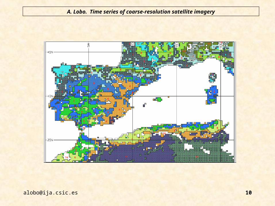
Classification of time series of Vegetation Index have produced vegetation charts at regional to global scales that are in general agreement with charts produced by compilation.


A. Lobo. Time series of coarse-resolution satellite imagery
4
Summer-peaking vegetation
Spring-peaking vegetation

A. Lobo. Time series of coarse-resolution satellite imagery
5
Summer-peaking vegetation
Spring-peaking vegetation


A. Lobo. Time series of coarse-resolution satellite imagery
7
Summer-peaking vegetation
Spring-peaking vegetation

A. Lobo. Time series of coarse-resolution satellite imagery
8
Summer-peaking vegetation
Spring-peaking vegetation


A. Lobo. Time series of coarse-resolution satellite imagery
12
Single-date imagery would never produce such a result, no matter how many spectral bands would be considered...
A. Lobo. Time series of coarse-resolution satellite imagery
13
...because time series of Vegetation Index are an estimate of the phenolgy of fPAR, which is a fundamental property of vegetation.

A. Lobo. Time series of coarse-resolution satellite imagery
14
Phenolgy of fPAR is shaped by climatic constraints (temperature and water availability) acting on the trade-offs of leaf maintenance, which implies that time series of Vegetation Index respond to climate.

A. Lobo. Time series of coarse-resolution satellite imagery
15
Nevertheless, there are two important shortcomings to be considered:
1. Phenology is also fine-tuned by meteorological conditions, which implies that there is significant inter-annual variation and, therefore, mean annual series should be preferred for land-cover classification.


A. Lobo. Time series of coarse-resolution satellite imagery
17
01-01-88 01-01-89 01-01-90 01-01-91 01-01-92
-0.2
0.0
0.2
0.4
Class 7
01-01-88 01-01-89 01-01-90 01-01-91 01-01-92
-0.2
0.0
0.2
0.4
Class 12
01-01-88 01-01-89 01-01-90 01-01-91 01-01-92
-0.2
0.0
0.2
0.4
Class 8
1/1/88 7/1/88 1/1/89 7/1/89 1/1/90 7/1/90 1/1/91 7/1/91 1/1/92 7/1/92 1/1/93
-0.2
0.0
0.2
0.4
ndvi
Class 1
1/1/88 7/1/88 1/1/89 7/1/89 1/1/90 7/1/90 1/1/91 7/1/91 1/1/92 7/1/92 1/1/93
-0.2
0.0
0.2
0.4
ndvi
Class 4
1/1/88 7/1/88 1/1/89 7/1/89 1/1/90 7/1/90 1/1/91 7/1/91 1/1/92 7/1/92 1/1/93
-0.2
0.0
0.2
0.4
ndvi
Class 6

A. Lobo. Time series of coarse-resolution satellite imagery
18
2. Although an important property, Phenology of fPAR is not enough to discriminate among some important land-cover types. Other properties should be measured from RS, such are:

A. Lobo. Time series of coarse-resolution satellite imagery
19
• Leaf/wood biomass ratio (“woodiness”)
• Leaf type and size
• Total biomass
• Height of dominant canopy
• “Layering” (vertical profile of leaf biomass)

A. Lobo. Time series of coarse-resolution satellite imagery
20
• Leaf type and sizeImportant to estimate the relative abundance of coastal conifers (i.e. P.
halepensis) and evergreen oaks, because of their different behavior against fire. Note that vegetation changes due to increased aridity in the Mediterranean will be mediated through wildfires.
RS Methods: angular effects?
• Total biomass
• Height of dominant canopy
• “Layering” (vertical profile of leaf biomass)RS Methods: Perhaps with SAR?

A. Lobo. Time series of coarse-resolution satellite imagery
21
Other important properties for vegetation
functioning (but not for land-cover
discrimination):
• Phenology of photosynthetic activity (PRI)
• Phenology of evapotranspiration
• Canopy roughness

A. Lobo. Time series of coarse-resolution satellite imagery
22
• Leaf/wood biomass ratio Important for the C budget, to estimate fuel load, and for land-cover
identification.
Methods: SWIR ?

A. Lobo. Time series of coarse-resolution satellite imagery
23
• In High resolution imagery, SWIR has been found to be important to discriminate forest types
CAN-1 (%) CAN-2 (%)
green 0.0435 (16.4) - 0.0448 (14.3)
red 0.0915 (34.5) 0.0190 ( 6.1)
nir -0.0447 (16.8) - 0.2027 (64.6)
swir 0.0855 (32.2) 0.0472 (15.0)

A. Lobo. Time series of coarse-resolution satellite imagery
24
• Using VEGETATION imagery, SWIR has been found also to be important to discriminate land cover types:
Canonical Axis 1
Ca
no
nic
al A
na
lysi
s 2
-6 -4 -2 0 2 4
-6-4
-20
22222
33
3
3
3
3
33
33
1
1
1
1
1
2
2
222
22
22
1
11
11
2
2 22 2
333
3 3
3
33 33
1
1
1
1
1
2
2
2 222
2
2
2
1
11
1
12
22
2 2
3
3
33
3
3
3
33
3
1
1
1
1
1
22
2
2
22
2
2
2
1
1
11
122 2
2
2
3
3
33
3
3
33
3 3
1
1
1
1
1
2
2
22
2
2
2
2
2
11111
22 2
2
2
3
3
3
33
3
3
3
3 3
1
1
1
1
1
2
2
22
2
222
2
11
111
55
5
5
5
3
3
33
3
3
33
3
3
1
1
1
1
1
2
2
2
222
2
2
2
11
11 1
1
2
3
5
Discriminant Plot
10 20 30 40 50
-0.2
-0.1
0.0
0.1
0.2
0.3
Day of the year
14040300200100
Fire
ND
(MIR
,R)
1
1
1
12
2 2
2
3
3
33
Wavelength (um)
0.6 0.8 1.0 1.2 1.4 1.6
0.0
0.0
20
.04
Scores
burned forest
arid vegetation
forest
irrigated fields

A. Lobo. Time series of coarse-resolution satellite imagery
25
0 10 20 30
50
10
01
50
20
02
50

A. Lobo. Time series of coarse-resolution satellite imagery
26
ND(NIR,R)
ND
(NIR
,MIR
)
0.0 0.2 0.4 0.6 0.8 1.0
-0.2
0.0
0.2
0.4
0.6
0.8


A. Lobo. Time series of coarse-resolution satellite imagery
28
ND(NIR,R)
ND
(NIR
,MIR
)
0.0 0.2 0.4 0.6 0.8 1.0
-0.2
0.0
0.2
0.4
0.6
0.8
1
2
3
4
5
6
789
10
1112
1314 15
16171819
202122232425
2627 28
293031
32
33
34
35
36
31t
(1-10 Jan)
(21-30 Feb)
(1-10 Jun)
(11-20 Nov)
(21-30 Dec)
(11-20 May)
Pyrenean shrubland of Genista balansae (31t)

A. Lobo. Time series of coarse-resolution satellite imagery
29
ND(NIR,R)
ND
(NIR
,MIR
)
0.0 0.2 0.4 0.6 0.8 1.0
-0.2
0.0
0.2
0.4
0.6
0.8
1
234 56
789
10 11
12
131415 16
17
181920
2122 23
24
252627
28
2930
3132
33 34
35
36
38bPastures

A. Lobo. Time series of coarse-resolution satellite imagery
30
ND(NIR,R)
ND
(NIR
,MIR
)
0.0 0.2 0.4 0.6 0.8 1.0
-0.2
0.0
0.2
0.4
0.6
0.8
12 345
67 89
1011121314
1516 17
181920
2122
2324 2526
27282930313233 343536
32nCistus and broom dry garrigues

A. Lobo. Time series of coarse-resolution satellite imagery
31
ND(NIR,R)
ND
(NIR
,MIR
)
0.0 0.2 0.4 0.6 0.8 1.0
-0.2
0.0
0.2
0.4
0.6
0.8
12
345 67 89
101112 1314 1516
171819
202122 2324252627
282930 3132
3334
3536
45eQuercus ilex forest and shrubland

A. Lobo. Time series of coarse-resolution satellite imagery
32
ND(NIR,R)
ND
(NIR
,MIR
)
0.0 0.2 0.4 0.6 0.8 1.0
-0.2
0.0
0.2
0.4
0.6
0.8
12
34
5 6789
10
1112 13
1415
1617
1819
20
21
22 23
24252627 282930
3132333435
36
45fQuercus rotundifolia shrubland

A. Lobo. Time series of coarse-resolution satellite imagery
33
ND(NIR,R)
ND
(NIR
,MIR
)
0.0 0.2 0.4 0.6 0.8 1.0
-0.2
0.0
0.2
0.4
0.6
0.8
12 3
456789
1011 12131415 1617
181920
2122 23242526
27 28293031 3233 343536
42aaP. halepensis with Q. rotundifolia understorey
A. Lobo. Time series of coarse-resolution satellite imagery
34
ND(NIR,R)
ND
(NIR
,MIR
)
0.0 0.2 0.4 0.6 0.8 1.0
-0.2
0.0
0.2
0.4
0.6
0.8
1
2
34
56
7
8
9
10
1112
13
14
1516171819202122
23
24 2526
27 282930
3132
33
34
35
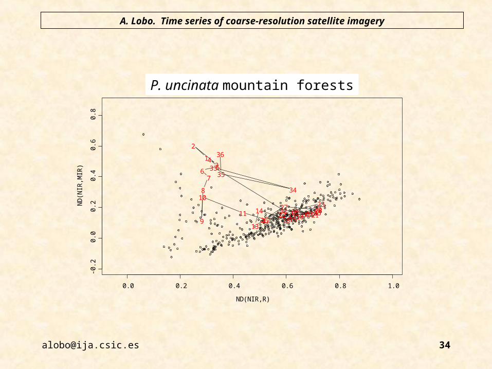
36
42fP. uncinata mountain forests
A. Lobo. Time series of coarse-resolution satellite imagery
35
Therefore, although there is some sensitivity to the wood/leaf ratio, the eventual presence of water complicates the problem.

36
A. Lobo. Time series of coarse-resolution satellite imagery
P-OVNI, S-NDVI, S-OVNI?
21 images
1999-09-16
to
1999-12-13
Burkina-Faso
(Lobo & Bartholome)


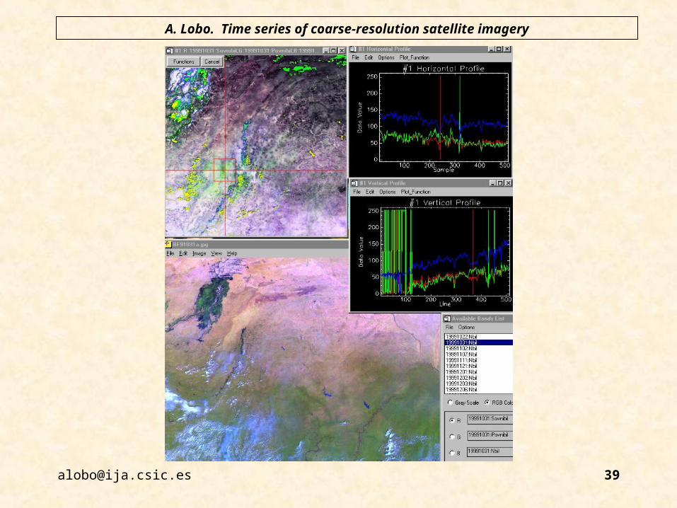
A. Lobo. Time series of coarse-resolution satellite imagery
38
S-NDVI P-OVNI
“S-OVNI”