tin-bearing pegmatites of the tinton district lawrence county, south
TRANSCRIPT
UNITED STATES DEPARTMENT OF THE INTERIOR Harold L. Ickes, Secretary
GEOLOGICAL SURVEY W. C. Mendenhall, Director
Bulletin 922-T
TIN-BEARING PEGMATITES
OF THE TINTON DISTRICT
LAWRENCE COUNTY, SOUTH DAKOTA
A PRELIMINARY REPORT
BY
WARD C. SMITH AND LINCOLN R. PAGE
Strategic Minerals Investigations, 1940
(Pages 595-630)
UNITED STATES
GOVERNMENT PRINTING OFFICE
WASHINGTON : 1941
For sale by the Superintendent of Documents, Washington, D. C. ------ - - Price $1.00

CONTENTS
Page
Abstract. ................................................ 595Introduction............................................. 595Geology.................................................. 599
General stratigraphy and structure................... 599Pre-Cambrian rocks............................... 600
Schists...................................... 600Pegmatites................................... 601
Paleozoic sedimentary rocks...................... 602Tertiary intrusive rocks......................... 602
Monzonite and syenite porphyries,, ........... 602Pseudoleucite- and nepheline-bearing rocks... 603Lamprophyre s................................. 603Relation to pegmatites....................... 603
Quaternary deposits.............................. 604Petrography of the pegmatites........................ 604
General relations................................ 604Oligoclase-quartz-muscovlte pegmatite............ 606Tourmaline-bearing pegmatite and quartz-tourma
line veins..................................... 608Albite-quartz pegmatite.......................... 608Spodumene-quartz pegmatite........................ 609Amblygonite lenses............................... 610Columbite-quartz-albite lenses................... 610Mlcrocline-quartz pegmatite...................... 611Alblte-quartz-muscovite veinlets and quartz
veins.......................................... 611Summary.......................................... 611
Mineral resources........................................ 613Distribution of cassiterite.......................... 613Localization of cassiterite.......................... 614Associations of cassiterite.......................... 615Reserves............................................. 618Mines and prospects.................................. 620
Rough & Ready mine............................... 620Giant-Volney prospects........................... 626Other prospects.................................. 628
Spearfish and adjoining claims............... 628Dakota Tin & Gold Co.'s property 0 ............ 630
III
ILLUSTRATIONS
Page
Plate 90. Geologic map and section of the Tintondistrict, South Dakota................. In pocket
91o Geologic map of the Rough & Ready andGiant-Volney claims.................... In pocket
92« Geologic map of the Rough & Ready mine,adit level............................. In pocket
93o Geologic maps of the Volney No. 1, Vol-ney No. 2, and Giant adits................. 622
94o Geologic sections of the Rough & Ready andGiant-Volney claims.................... In pocket
Figure 85. Index map showing the location of the Tin- ton district, S. Dak....................... 596
86. Geologic map of the Rough & Ready mine,winze level................................ 622
87. Geologic map of the Rough & Ready mine,intermediate level.......................... 623
88. Plan of the Rough & Ready mine............... 619
IV

TIN-BEARING PEGMATITES OF THE TINTON DISTRICT,
LAWRENCE COUNTY, SOUTH DAKOTA
A PRELIMINARY REPORT
By Ward C. Smith and Lincoln R. Page
ABSTRACT
The Tlnton district, which is in the northern part of the Black Hills, Lawrence County, South Dakota, produced 105,039 pounds of tin between 1903 and 1927.
The oldest rocks in the district are pre-Cambrlan quartz- mica, graphite, and hornblende schists, and pegmatite dikes in jected parallel to the foliation of the schists or nearly so. The pre-Cambrian rocks are unconformably overlain by the sedi mentary rocks of the Cambrian Deadwood formation. All these are cut by Tertiary intrusive rocks, divisible into three groups, which are, in order of age (1) monzonite and syenite porphyries intruding the pre-Cambrian schists as steeply dipping dikes and invading the Deadwood formation as flat-lying sills and lacco liths; (2) pseudoleucite- and nepheline-bearing dikes; and (3) lamprophyre dikes.
The deposits of potential tin ore are cassiterlte-rlch lenses in certain of the pegmatite dikes. The casslterite ap pears to have formed contemporaneously with the oldest and most abundant^variety of pegmatite, which is of magmatic origin. Several other varieties of pegmatite were formed as a result of successive replacements by solutions, and some of these contain tantalum and lithium minerals that have been mined.
Practically all the lode tin mined in the district has come from the Rough & Ready mine. On other properties only small de posits have been uncovered by prospecting. The probable re serves in ore bodies now partly developed in the Rough & Ready mine are estimated at about 215 tons of metallic tin. Inasmuch as the probable cost of mining and milling the ore would be more than twice the present market price of tin, the deposits cannot be mined commercially under present conditions.
INTRODUCTION
The Tinton district centers around the town of Tinton, on
Nigger Hill, in western Lawrence County, S. Dak., less than a
595

596
mile from the Wyoming boundary line (fig. 85). It is accessible
by surfaced highway and gravel road from Lead, 25 miles east,
and by gravel road from Spearfish, 23 miles north, but during
the heavy winter snows and spring thaws the last 12 miles Into
Tinton are for short periods almost impassable. The district
44' I04°30' 103°
Figure 85. Index map showing the location of the Tinton district, S. Dak.
covers a hilly area of 16 square miles. Geologically, it in
cludes most of a minor-uplift on the northwestern flank of the
great Black Hills dome. The pre-Cambrian schists and pegma
tites that are exposed in the central part of the area are cut
by Tertiary intrusive rocks and are encircled by outward-dipping
Paleozoic sedimentary rocks.

TIN-BEARING PEGMATITES, TINTON DISTRICT, S. DAK. 597
Gold, tin, and recently tantalum and lithium minerals have
been mined in the district. In the gold placers located by the
pioneers in 1876, cassiterite was soon identified, and its bed
rock occurrence in pegmatite seems to have been known at least
as early as 1886, when a sample lot of 6^ tons of tin ore is
said to have been shippedo Interest in tin became lively in
1902 and 1903, when the tin excitement of the southern Black
Hills was also at its peak; at that time the Nigger Hill dis
trict was thoroughly prospected and many claims were patented.
In 1908 and 1909 the Tinton Reduction Co. shipped a few tons of
ore from the area. During 1927 and 1928 the Black Hills Tin Co.
built the present camp at Tinton, constructed and equipped a
mill, and prepared for large-scale mining, but operations were
almost immediately abandoned.
The amount of tin mined in the district since 1902 is shown
in the following table.
I/ Tin produced at Tinton, S. Dak.
Year
1903 1909 19101927
Tinton Mining Co.... Tinton Reduction Co. .... ....do.. ........Black Hills Tin Co..
Concentrates(short tons)
40 24 50
o57104.57
TiPercent
62o5 34.82 5065
nPounds
50,000 16,714 38,000
325105,039
T/Q 1 11 A
$14,000 4,832
12,600200
$31,632
I/ U. S. Bur. Mines Kept. Inv. 3 140U, p. 1, 1938.
Tantalum was mined by the Pansteel Metallurgical Co. during
1936-38 from the Giant-Volney pegmatites just west of Tinton on
a minor crest of Nigger Hill known as Tantalum Hill. The ore
mineral is columbite, an iron and manganese columbate-tantalate (
During the same period a few tons of amblygonite (lithium-alumi
num fluo-phosphate) was mined and shipped.
I/ Hess, P. L., and Brjran, Barnabas, Jr., The pegmatites at Tinton, S. Dak.j U. S. Bur. Mines Kept. Inv. 3UoU, p. 1, June 1938.
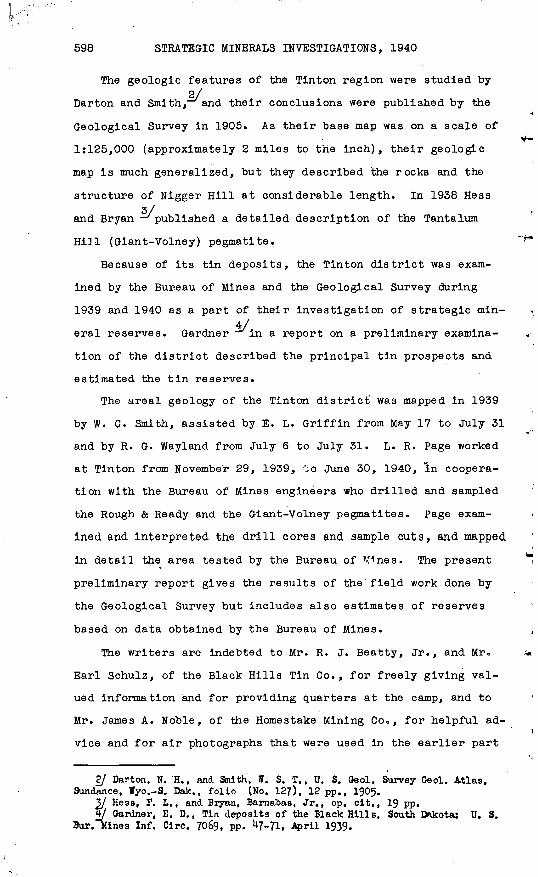
598 STRATEGIC MINERALS INVESTIGATIONS, 1940
2/ Carton and Smith, and their conclusions were published by the
Geological Survey in 1905. As their base map was on a scale of
1:125,000 (approximately 2 miles to the inch), their geologic
map is much generalized, but they described the rocks and the
structure of Nigger Hill at considerable length. In 1938 Hess3/
and Bryan 'published a detailed description of the Tantalum
Hi]l (Glant-Volney) pegmatite.
Because of its tin deposits, the Tinton district was exam
ined by the Bureau of Mines and the Geological Survey during
1939 and 1940 as a part of their investigation of strategic min-Veral reserves. Gardner in a report on a preliminary examina
tion of the district described the principal tin prospects and
estimated the tin reserves.
The areal geology of. the Tinton district' was mapped in 1939
by W. C. Smith, assisted by E. L. Griffin from May 17 to July 31
and by R. G. Wayland from July 6 to July 31. L. R. Page worked
at Tinton from November 29, 1939, ';o June 30, 1940, "in coopera
tion with the Bureau of Mines engineers who drilled and sampled
the Rough & Ready and the Giant-Volney pegmatites. Page exam
ined and interpreted the drill cores and sample cuts, and mapped
in detail the area tested by the Bureau of Mines. The present
preliminary report gives the results of the field work done by
the Geological Survey but includes also estimates of reserves
based on data obtained by the Bureau of Mines.
The writers are indebted to Mr. R. J. Beatty, Jr., and Mr.
Earl Schulz, of the Black Hills Tin Co., for freely giving val
ued information and for providing quarters at the camp, and to
Mr. James A. Noble, of the Homestake Mining Co 0 , for helpful ad
vice and for air photographs that were used in the earlier part
2/ Darton, N. H., and Smith', ff. S. T., U. S. Geol. Survey Oeol. Atlas, Sundance, Wyo.-S. Dak., folio (No. 127), 12 pp., 1905.
3/ Hess, P. L., and Bryan, Barnabas, Jr., op. cit,, 19 pp.§/ Gardner, E. D., Tin deposits of the Black Hills, South Dakota; U. S.
Bur. Mines Inf. Circ. 7069, pp. ^7-71, April 1939.

TIN-BEARING PEGMATITES, TINTON DISTRICT, S. DAK. 599
of the mapping. They also wish to thank Mr. W. P. Jahn, of the
Bureau of Mines, for constant cooperation during the detailed
work, Mr. D. P. Hewett and Mr. W. T. Schaller, of the Geological
Survey, for many valuable suggestions, and Miss Jewell Glass,
also of the Geological Survey, for her assistance with mineral-
ogical studies.
GEOLOGY
General stratigraphy and structure
The oldest rocks in the Tinton district (pi. 90) are pre-5/
Cambrian quartz-mica schists, in part graphitic, interlayered
with hornblende schists, part of which were originally igneous
rocks and part of which appear to have been sedimentary rocks.
Intrusive into the schists are pre-Cambrlan pegmatite dikeso
Some of these contain cassiterite and some also spodumene, am-
blygonite, and columbite and consequently are of direct economic
interest. The schists and pegmatites are unconformably overlain
by the conglomerates, sandstones, and shales of the Cambrian
Deadwood formation, and these in turn are overlain, conformably
or nearly so, by younger Paleozoic limestones and shales. All
the rocks are cut by Tertiary intrusive bodies. The oldest of
these are monzonite and syenite porphyries, which cut through
the pre-Cambrian schists and pegmatites as vertical or steeply
dipping dikes and spread between the beds of the Deadwood for
mation as flat-lying sills or laccoliths. Pseudoleucite- and
nepheline-bearing rocks were Injected later, and dikes of bio-
tite and augite lamprophyres last of all. The formation and
rock names here used are taken from the Sundance folio; none of
the rocks except tin ore specimens have been studied microscopi
cally by the present authors.
Barton, N. H., and Smith, W. S. T., op. cit., p. 1.
310943 O 41 2

600 STRATEGIC MINERALS INVESTIGATIONS, 1940
Pre-Cambrian rocks
Schists. The pre-Cambrian schists are exposed in the cen
tral part of the Tinton area (pi. 90). A well-exposed section
of them can be seen along Bear Gulch, and many masses of schist
stand out along the sharper ridges, but in most of the area the
schists are deeply weathered and their distribution must be
traced by their characteristic dark micaceous or hornblendic
soil.
The unweathered quartz-mica schists are fine-grained dark
brown, gray, or black rocks that are distinctly layered and are
easily split into thin plates. Quartz is generally the predomi
nant mineral, but the proportion of quartz varies widely. Brown
biotite is the principal mica, but sericite is common and green
mica was seen in a few specimens. Some layers of graphiticj>
quartz-mica schist grade into layers of graphite schist.
The hornblende schists are dark green to black and are com
posed chiefly of hornblende, with small amounts of plagioclase,
quartz, and biotite The bodies of hornblende schist that are
believed to represent intrusive rocks contain considerable feld
spar, are uniform in composition, and are rather coarse grained,
particularly in their centers. Although the rock that consti
tutes these bodies splits readily, it is not layered, and its
outcrops appear massive. Other bodies, which may originally
have been sedimentary rocks, are interlayered with quartz-blo-
tite schis.ts; they are finer-grained and contain less plagio
clase than the metamorphosed intrusive rocks»
The layering in the quartz-mica schist and in some of the
hornblende schist and the foliation in all the schist, strikes
from due north to N. 20° W. and 'dips 45°-70° W. In addition to
schistosity, the schists have a well-defined linear structure
that pitches 20°-45° NW<> This linear structure is especially

TIN-BEARING PEGMATITES, TINTON DISTRICT, S. DAK. 601
distinct in the hornblende schist, where it is marked by the
alinement of elongated grains of hornblende.
Pegma tlte s.--The schist is cut by a great number of pegma
tite dikes, which are easily recognized as coarsely crystalline
white or gray rocks composed mainly of feldspars, quartz, and
muscovite; they will be described in some detail on later pages.
The dikes are a few inches to 300 feet wide and as much as 1,500
feet long. They are largest and most numerous north and north
west of Tinton, where they are well-exposed in many prospects
along the crest of Nigger Hill. Being more resistant than the
schists, they generally stand in slight relief, and even where
weathering has been most thorough they may be traced by their
characteristic float of coarse quartz and muscovite.
Nearly all the pegmatite dikes are parallel to the prevail
ing schistosity in both strike and dip; but some dip more steep
ly and a few more gently. The pegmatite bodies near Tinton are
known to pitch northwest, more or less parallel to the linear
elements in the schist, and this is probably true of many other
dikes in the district.
Most of the pegmatite outcrops are long, narrow, and rather
straight and appear to be sections of elongate bodies that pitch
northwest. The outcrops of a few pegmatite bodies have a
branching pattern, which may express either the divergence of
offshoots from a principal mass or the coalescence of converging
lenses. This branching pattern is well exemplified on the Rough
& Ready and the Giant-Volney properties (pi. 91), where explora
tion has shown that it is not uncommon for one dike to divide
and reunite or for several dikes to coalesce. In other places,
groups of elongate lenses that are separate at the surface may
connect below the surface to form larger masses; others may
merely taper out at depth. The abundance and large size of the
pegmatite dikes northwest of Tinton suggest that there was in
that direction a source from which the pegmatitic material rose,

602 STRATEGIC MINERALS INVESTIGATIONS, 1940
following the direction of least resistance up the pitching
structural lines of the schist. Pegmatite dikes, or their feed
ers, may thus converge northwestward and downward and coalesce
at depths roughly comparable to the distances between the dikes
on the present surface.
Paleozoic sedimentary rocks
The oldest of the Paleozoic sedimentary series is the Cam
brian Deadwood formation, which is separated by an unconformity
of-the first magnitude from the schists and pegmatites and is
overlain without marked unconformity by limestones of the Ordo-
vician Whitewood and Carboniferous Englewood formations. The
Deadwood formation, which is 300 feet thick and consists of con
glomerate, sandstone, and shale, is prevailingly red or red-
brown, the shale being darkest; and the soil derived from the
formation also has a characteristic reddish color. Limestones
of the younger formations are exposed in the extreme southeast
ern corner of the district, but on the geologic map (pi. 90)
these are included with the Deadwood formation as undifferenti-
ated Paleozoic rocks.
In striking contrast to the Intensely metamorphosed steeply
dipping schists, the Paleozoic strata are only locally metamor
phosed and dip gently in all directions away from the Tinton
area, which is in the center of a relatively small dome on the
northwest flank of the Black Hills uplift.
Tertiary intrusive rocks
Monzonlte and syenite porphyries.--The oldest and most abun
dant of the Tertiary intrusive rocks are monzonite and syenite
porphyries. Wide dikes of these extend through the central
schist area, which is bordered on the north, east, and south by
nearly horizontal sills and laccolithic intrusions. Examples of
dikes connecting with sills may be seen on Potato Creek. The
TIN-BEARING PEGMATITES, TINTON DISTRICT, S. DAK. 603
porphyries are resistant to weathering and tend to form ridges,
crests, and crags such as The Needles, 2 miles northeast of Tin-
ton<> The porphyries show considerable diversity of texture and
mineral composition, but in general they are gray or gray green
and contain numerous phenocrysts of light feldspar and black
hornblende. The deeply weathered porphyry is covered with thin
soil composed of yellow or brown granules of feldspar-rich rock
but with none of the mica characteristic of the soils on the
pre-Cambrian rocks«
Pseudoleucite- and nepheline-bearing rocks«--The bulk -of6/
Mineral Hill," shown on the western margin of the Tinton topo
graphic map, is made up of pseudoleu'cite- and nepheline-bearing
rocks that range in composition from pyroxenite to syenite.
These rocks are so complex in structure and so poorly exposed
that no attempt was made to map the various types individually,
and only the limits of the complex are outlined on the map (pi.
90). Outside the Mineral Hill area are a few thin dikes of
pseudoleucite porphyry, distinguished from the monzonite por
phyry dikes by equidimensional phenocrysts of pseudoleucite, but
they are not shown on the geologic map of the district (pl« 90).
Lamprophyres* Many lamprophyre dikes are shown on the de
tailed maps of the Rough & Ready and Giant-Volney claims (plso
91 and 92), but as most of them are less than 2 feet thick only
a few are shown on the map of the district (pi. 90). On weath
ering the typical lamprophyre breaks down into angular iron-
stained dark-green to black blocks. Fresh surfaces of the rock
show scattered crystals of biotite or augite and small round to
oval patches of conspicuous white calcite in a fine-grained ma
trix.
Relation to pegmatites. On the small-scale generalized7/
geologic map and sections of the Sundance folio the 'central
6/ See Darton, N. H., and Smith, ff. S. T., op. cit., geologic map.I/ Darton, N. H., and Smith, W. S. T., op. clt., p. 12 and geologic .map.

604 STRATEGIC MINERALS INVESTIGATIONS, 1940
part of the Nigger Hill uplift is represented as a flat-lying
porphyry sheet in which are many inclusions of pre-Cambrian
schists and pegmatiteso It is suggested in the text, according
ly, that if the pegmatites are inclusions in the porphyry they
may extend only to a limited depth. The larger-scale more de
tailed map in the present report (pi. 90), on the contrary, rep
resents the country rock of the central area as consisting es
sentially of pre-Cambrian schists and pegmatites cut by many
long porphyry dikes. Most of the large porphyry dikes, like
those of pegmatite, follow the pre-Cambrian schistosity, and,
although a few large dikes and many small ones cut across the
schistosity and hence across the pegmatites, no large body of
pegmatite seems to be wholly enclosed in porphyry. This was
§/pointed out by Hess and Bryan, who concluded "that the pegma
tites still stand on their own bases and that the depth to which
they extend is not more than locally modified by the porphy
ries." This conclusion is obviously more encouraging to miners
than the earlier view 0
Quaternary deposits
Small patches of terrace gravel border Beaver Creek upstream
from Beaver Crossing, and larger areas occur in Bear Gulch at
Seventy Plats. Along the present stream channels are narrow
strips of Recent wash.
Petrography of the pegmatites
General relations
A general description of the pegmatites seems indispensable
to an understanding of the tin, tantalum, and lithium deposits,
for the ores are inseparably linked with the pegmatites in ori
gin. The dikes are composed of several varieties of pegmatite,
Hess, P. L., ard Bryan, Barnabas, Jr., op. cit., p. 3.
TIN-BEARING PEGMATITES, TINTON DISTRICT, S. DAK. 605
each representing a different stage in the alteration of a peg-9/
matite that appears to have crystallized from a magma. The ef
fects of the altering solutions were not uniform. Some early-
formed parts of the dikes remained unchanged, other parts were
wholly replaced, and still others were replaced repeatedly. The
total volume of pegmatite was increased, also, by deposition of
new material. The tin ores are local concentrations of cassit-
erite formed during crystallization of the primary pegmatite.
It is possible, however, that the magmatic pegmatite was not all
formed at the same time the cassiterite-bearing dikes, in par
ticular, may have been Injected at a time different from that of
the dikes barren of..cassiterite.
The description and interpretation that follow are based
mainly on study of the large bodies of pegmatites on the Rough
& Ready, Giant, and Volney claims, but they probably apply,
wholly or in part, to other dikes in the district.
The minerals found in the pegmatites, and their approximate
compositions are shown in the following list.
Minerals of the pegmatites
Major constituents:Oligoclase feldspar...sodium-calcium aluminum silicate.Alblte feldspar.......sodium-aluminum silicate.Microcline feldspar...potassium aluminum silicate.Quartz.................silica.Muscovite.............potassium aluminum silicate.
Ore minerals:Cassiterite o.......... tin dioxide.Columbite.............columbate-tantalate of iron and man
ganese.Spodumene.............lithium-aluminum silicate.Ainblygonite.»......... lithium-aluminum f luo-phosphate.
Minor constituents:Apatite............... calcium-fluorine phosphate.Tourmaline............boron-aluminum silicate containing
magnesium and iron.Beryl.................beryllium aluminum silicate.Lithiophlliteo........iron-manganese-lithium phosphate.
With respect to age the minerals may be classified in groups
formed in the following order: (1) oligoclase-quartz-muscovite
2/ See Hess, P. L., and Bryan, Barnabas, Jr., op. cit., p. 3.
606 STRATEGIC MINERALS INVESTIGATIONS, 1940
pegmatite, apparently containing cassiterite as a primary con
stituent, (2) tourmaline-bearing pegmatite and quartz-tourmaline
veins, (3) albite-quartz pegmatite, (4) spodumene-quartz pegma
tite, (5) amblygonite lenses, (6) columbite-quartz-albite lenses
(7) microcline-quartz pegmatite, (8) albite-quartz-muscovite
veinlets, and (9) quartz veins. This arrangement of the miner
als, in successive age groups is based principally on field ob
servations of the textures of the pegmatites.
Oligoclase-quartz-muscovite pegmatite
Most of the dikes in the district consist of oligoclase-
quartz-muscovite pegmatite or, briefly oligoclase pegmatite
mixed with more or less albite-quartz and microcline-quartz peg
matite. Oligoclase pegmatite forms the bulk of the dikes in the
Rough & Ready mine and the marginal part of the large Giant-Vol-
ney dike.
A typical dike has a border of fine-grained quartz and olig
oclase and a foliated, coarse-grained middle in which abundant
muscovite is mixed with the quartz, oligoclase, and minor min
erals. In large dikes, the middle part is layered. Gradations
between layers, some of them abrupt, occur along a dike as well
as across it, so that the length and depth of a layer cannot be
predicted in advance of exploration.
The layers differ in grain size or mineral composition or
botho Grains in the coarser material are as much as several
inches in length. In the fine-grained pegmatite, long, thin
lenses of minerals are interlayered to form a gneissic rock
that appears coarsely layered even though the individual grains
within the lenses may be very small. Part of the fine-grained
pegmatite seems to have been crushed and recrystallized. This10/
was also noted by Darton and Smith. The general mineral
10/ Darton, N. H., and Smith, ff. S. T., op. cit., p. U.
TIN-BEARING PEGMATITES, TINTON DISTRICT, S. DAK. 607
composition of a layer depends not only on the mineral composi
tion within lenses but also on the relative number of lenses of
definite composition, for example, quartz and oligoclaseo Most
layers differ from one another only in the relative proportions
of main rock-forming minerals Oligoclase, quartz, and muscov-
ite but some are distinctive because they contain an unusual
amount of a minor mineral, such as tourmaline or cassiterite.
The relative amounts of the minerals differ widely in vari
ous parts of the pegmatite. Oligoclase ranges from 5 to 95 per
cent, and quartz, the chief complementary mineral, has a similar
range. Muscovite attains a maximum of 30 percent, but in most
places it makes up less than 5 percent of the rock. Cassiterite
is nowhere more than a minor mineral as compared with the chief
constituents; the richest ore seen contains about 2 percent of
cassiterite.
The quartz-rich layers and lenses in the pegmatite are rela
tively simple mineraloglcally. Oligoclase, muscovite, and a
little apatite are the minor constituents everywhere present,
and tourmaline is abundant in places. Cassiterite is sparse.
The oligoclase-rich layers are more complex. In addition to
quartz, muscovite, tourmaline, and apatite in various propor
tions, they contain minerals rare in the more quartzose materi
al, and they contain most of the cassiterite, which is suffi
cient in some of the Oligoclase rock, though not in all, to form
potential ore bodies. Potash feldspar, apparently orthoclase
rather than microcline, was seen with Oligoclase in two thin
sections; further study is necessary to determine its relations.
Many stubby grains of amblygonite an inch or two long are thinly
coated with small muscovite flakes and stained with an unidenti
fied blue alteration product. Columbite accompanies the cassit
erite. Beryl is the rarest mineral. One cluster of white beryl
crystals associated with much tourmaline, cassiterite, columbite,
and spodumene was found in Oligoclase pegmatite in the main adit310943 O 41 3
608 STRATEGIC MINERALS INVESTIGATIONS, 1940
ii/ of the Rough & Ready mine. Hess and Bryan reported a single
crystal from the Giant-Vol.ney pegmatite. The mineral probably
is a product of late replacement. Albite-quartz pegmatite and
spodumene-quartz pegmatite form thin lenses in the oligoclase
pegmatite.
Tourmaline-bearing pegmatite and quartz-tourmaline veins
The place of tourmaline in the pegmatite sequence is uncer-
tain. In the oldest pegmatite are scattered crystals of tourma
line, and tourmaline forms as much as 3O percent of a few layers.
It also occurs in albite-quartz pegmatite. Along contacts be
tween dikes of primary oligoclase pegmatite and quartz-mica
schist at the Rough & Ready mine tourmaline is abundant both in
narrow and irregular selvages of the dikes and in the adjoining
schist. Tourmalinization here might seem to have been effected
by the pegmatite. The fact, on the other hand, that quartz-tour-,
maline veins an inch or two thick cut the pegmatite indicates
that at least part of the tourmaline is later. Possibly some of
the tourmaline concentrations in the primary pegmatite are prod
ucts of replacement., . The tourmaline in the selvages of the
dikes is brown schorlite and that in the middles is blue indico-
lite; this may or may not mean that there are two different gen
erations of tourmaline.
Albite-quartz pegmatite
Large masses in the complex pegmatite on the Giant-Volney
claims and many lenses in dikes of oligoclase pegmatite else
where consist of albite-quartz pegmatite, in which cassiterite,
tourmaline, apatite, and fine-grained muscovite occur as minor
constituentso
ll/ Hess, P. L,, and Bryan, Barnabas, Jr., op. cit., p. IS.
TIN-BEARING PEGMATITES, TINTON DISTRICT, So DAK. 609
Albite and oligoclase were first distinguished microscopi
cally. The oligoclase is seen in thin sections to be concentri
cally zoned, having cores of Abg,An and rims of Ab_0An. Q0
The albite grains are unzoned, and their composition is near
.AbggAn . After the first identifications had been mcde micro
scopically, it was found possible to distinguish the albite-
bearlng rocks from the oligoclase-bearing rocks megascopically
in the Rough & Ready and Giant-Volney pegmatites, which were ex
amined in detail. The albite-quartz pegmatite is finer-grained
than the oligoclase-bearing pegmatite, and its minerals are in
timately intergrown rather than separated in layers, although
the rock shows an indistinct layering, evidently a vestige of
the gneissic structure of the ollgoclase-quartz-muscovite pegma
tite that it replaced,, These field characteristics cannot be
relied upon in other pegmatites without preliminary microscopic
tests. A few such tests have shown that both oligoclase and al
bite are widespread in the district, but it was impracticable to
work out the details of their distribution.
Spodumene-quartz pegmatite
Spodumene-quartz pegmatite forms a large body near the mid
dle of the Giant-Volney pegmatite dike and scattered lenses in
the Rough & Ready dikes. Spodumene-quartz pegmatite at the
Giant-Volney claims has plainly replaced earlier pegmatite. It
is predominantly a fine-grained intergrowth, indistinctly lay
ered like the albite-quartz rock, from which it is distinguished
by an intricate criss-cross pattern of spodumene-quartz and
quartz veinlets. Minor portions preserve in varying degrees the
coarse texture of the oligoclase-quartz-muscovlte pegmatite and
contain large relict crystals of muscovite and plagioclas.e.

610 STRATEGIC MINERALS INVESTIGATIONS, 1940
Amblygonite lenses
Lenses of amblygonite several feet thick have been mined in
the Glant-Volney pegmatite. -They are recognizable by the cleav- _.
age faces of larger crystals and by their envelopes of fine
grained Muscovite, identical in character with those surrounding
the small stubby grains of amblygonite in the Rough & Ready peg
matite. The largest mass appears to have been more than 20 feet'Y'*
long and 4 to 8 feet thick. It lay at the west margin of the
glory hole, between spodumene-quartz rock and oligoclase pegma
tite. The location of other masses is indicated on the detailed12/
geologic map (pi. 91). Hess and Bryan pointed out that some
spodumene accompanies each amblygonite mass, and they believed
that the amblygonite was formed by replacement of spodumene.
The small amblygonite grains scattered through the oligoclase
pegmatite of the Rough & Ready mine probably were also formed by
replacement, although they were not observed to be everywhere
associated with spodumene.
Columbite-quartz-albite lenses
Irregular lenses of columbite-quartz-alblte rock containing
clusters of columbite crystals as much as 3 inches long were
mined from the Tantalum Hill glory hole and underground workings
in 1936. Underground examinations could not be made because the
workings were flooded, but one lens seen in the glory hole ap
pears to have been formed by replacement of spodumene-quartz13/
pegmatite. Hess and Bryan reported that coluuibite is concen
trated in a set of northwest-striking cracks in spodumene-quartz
pegmatite and that masses of columbite replace that rock as well
as microcline and amblygonite.
12/ Hess, B1. L., and Bryan, Barnabas, Jr., op. cit., p. 15. V5/ Idem, p. 16.

TIN-BEARING PEGMATITES, TINTON DISTRICT, S. DAK. 611
Microcline-quartz pegmatite
Microcline-quartz pegmatite forms a body 400 feet long and
100 feet wide in the Tantalum Hill dike and relatively small
masses in other pegmatite dikes. The microcline, which is the
dominant mineral, contains irregular blebs of quartz and is cut
by tiny veinlets of albite. Because of the disagreeable odor14/
that some of it emits when broken, Hess and Bryan referred to
it as fetid microcline or necronite. The structure of the mi
crocline -quartz rock appears relatively simple, because the
crystal cleavage of the microcline is uniformly oriented for
distances as great as 6 feeto
Layered structure apparently inherited from the older pegma
tite that had been replaced was seen in a few places, but the
best evidence for the late formation of some of the microcline
is that its cleavage, in masses exposed on Tantalum Hill, lo
cally cuts across the layers of albite-quartz and spodumene-
quartz pegmatite. It is possible, however, that a large part
of the mlcrocline-quartz aggregate on Tantalum Hill did not re
place old pegmatite but is a new body added to the older parts
of the dike. Small amounts of microcline in other pegmatite
bodies may have an earlier place in the sequence of pegmatite
development.
Albite-quartz-inuscovite veinlets and quartz veins
Tiny veinlets made up of albite, quartz, and muscovite cut
all the pegmatite minerals, and they in turn are cut by quartz
veins, which represent the final products of the mineralizing
solutions.
Summary
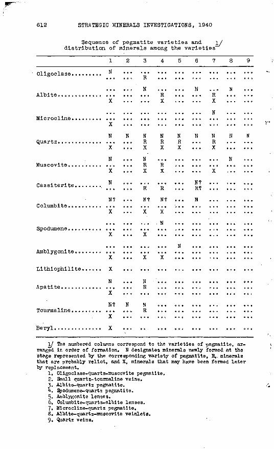
The probable order in which the several varieties of pegma
tite were formed and the distribution of minerals among the va
rieties are shown in the following table.
Hess, F. L., and Bryan, Barnabas, Jr., op. clt., p. 8.
612 STRATEGIC MINERALS INVESTIGATIONS, 1940
Sequence of pegmatite varieties and distribution of minerals among the varieties
AT V>4 4- fi
Microcline. ......
/""Ill Q 1^4- n
Cassiterite. . . . . .
Amblygonite ......
Lithiophilite
-
Beryl. ...........
1 2
N
N N
N
N
N? ...
N
N? N
X . . .
3456789
N ... ... N . . , NR TJ
v y
N 0
N N N N N N N R R R ... R ... ...Y v Y Y
N ... .. ... ... N .
R TJ
X Y Y
... 0.0 ... N? 0.. ,.. ...
R R ... R? ... ... ...
N? N? ... N ... ...
X Y
. . N ... .0. ... . , . 01
X .. ..
N ,
X Y
N .R ... ... ... ... ... ...
N ^R ... ... ... ... ... ...
I/ The numbered columns correspond to the varieties of pegmatite, ar ranged in order of formation. N designates minerals newly formed at the stage represented "by the corresponding variety of pegmatite, R,. minerals that are probably relict, and X, minerals that may have been formed later by replacement.
1. Oligoclase-quartz-nuscovite pegmatite.2. Small quartz-tourmaline veins.3. Albite-quartz pegmatite.4. Spodumene-quartz pegmatite.5. Amblygonite lenses.6. Columbite-quartz-albite lenses.7. Microcline-nuartz pegmatite.8. Albite-quartz-nruscovite veinlets.9. Quart.z veins.
TIN-BEARING PEGMATITES, TINTON DISTRICT, S. DAKo 613
As indicated by the symbols, each variety includes not only
its own characteristic minerals but also minor quantities of
relict minerals and minerals possibly introduced by replacement
after the main body of the rock was formed.
The primary constituents of the oldest pegmatite appear to
be oligoclase, quartz, muscovite, cassiterite, apatite, and per
haps tourmaline. Movements in the partly crystallized material
produced foliation, uneven distribution of minerals, and local
granulation. The rock also contains albite, spodumene, ambly-
gonite, llthiophilite, columbite, and microcline, but inasmuch
as all except lithiophilite are known to have been abundantly
formed elsewhere by replacement, their presence here may be a
result of the same process. These minerals are concentrated in
oligoclase-rich rather than quartz-rich rock, probably because
oligoclase was more susceptible to replacement than the other
original minerals. Much of the quartz also may be of replace
ment origin. The.minerals in the cassiterite-rich lenses that
constitute the potential ore bodies are unevenly distributed,
partly because of original unevenness of distribution and partly
because of uneven replacement.
MINERAL RESOURCES
Cassiterite, columbite, and amblygonite have been mined from
the Tinton pegmatites, which also contain potentially valuable
spodumene, albite, and microcline. Cassiterite is of chief in
terest here, and the other minerals are considered only insofar
as they are associated with cassiterite and as they affect the
value of potential tin ore bodies.
Distribution of cassiterite
All major attempts to mine tin have been directed to the
primary deposits in the pegmatite dikes, although some tin
614 STRATEGIC MINERALS INVESTIGATIONS, 1940
concentrates have been recovered, from stream gravels as a by
product of gold placer mining. Few dikes in the district con
tain enough cassiterite to be potential sources of tin. Al
though the authors saw about 240 pegmatite dikes during their
areal mapping, they found cassiterite in only about 40. In many
of these there are only a few scattered grains, but possibly a
dozen contain local concentrations of cassiterite in layers or
lenses. Although these deposits are not minable at a profit un
der present conditions they constitute a possible future source
of tin. They may thus be called potential ore bodies or, for
brevity, simply ore bodies, with the understanding that the term
is employed in this liberal sense. The richest of these bodies
is in oligoclase-quartz-muscovite pegmatite; others are in tour-
malinic pegmatite and albitic pegmatite.
The principal reserves of potential ore are in large dikes
at the Rough & Ready mine (pi. 91), where three ore bodies are
partly blocked out. A small deposit is now being prospected on
the property of the. Dakota Tin & Gold Co. The Spearfish claim
was unsuccessfully prospected in 1934. All other properties
known to contain some tin have been inactive for many years.
Localization of cassiterite
The ore deposits are found only in pegmatite; none is known
in the older schist and none in the younger porphyritic intru-
sives. Most of the cassiterite-bearing pegmatite dikes lie
along the crest of Nigger Hill or east of it, but a few dikes
in the headwaters of Cummings and Roena Gulches, west of Nigger
Hill, are also cassiterite-bearing.
The one general rule that appears to hold for the localiza
tion of the ore within a pegmatite body is that all the cassit
erite-bearing lenses or layers have the same strike, dip, and
pitch as the body. They occupy various positions relative to
the walls of the dikes: the largest one in the Rough & Ready

TIN-BEARING PEGMATITES, TINTON DISTRICT, S. DAK. 615
is near the hanging wall, but others are near the footwalls or
in the middle parts of dikes. These potential ore bodies have
irregular boundaries and grade in all directions into lean or
barren pegmatite. It seems impossible, therefore, to predict
the dimensions of an ore body or its probable grade in advance
of exploration.
Associations of cassiterlte
The dark brown cassiterite occurs in grains and clusters of
grains as large as 2 inches in diameter though much is in small
grains known as "pepper tin." Well-formed crystals are rare;
the best-formed are among the smallest. Nearly all the grains
are so crushed that they readily fall out of specimens, and many
are traversed by tiny quartz-albite-muscovite veinlets. In the
oldest pegmatite the cassiterite appears to accompany oligoclase
rather than quartz, muscovite, or tourmaline--two of the three
ore bodies at the Rough & Ready mine, for example, are in oligo-
clase-rich pegmatite yet much of the oligoclase-rich rock con
tains little cassiterite« Although both muscovite and cassiter
ite are conspicuous in some coarse-textured pegmatite, suggest
ing that coarse muscovite is an indicator of tin ore, assays
prove that the tin content is higher in fine-grained pegmatite
containing inconspicuous "pepper tin" and little muscovite.
Although one ore body in the Rough & Ready mine contains
abundant tourmaline, the amounts of tourmaline and cassiterite
vary independently. Neither the tourmaline-bearing selvages of
certain dikes nor the adjacent tourmalinized schist contain cas
siterite. Tourmaline is so widespread, however, that some is
present wherever cassiterite is found.
In the cassiterite-bearlng bodies the most common and abun~
dant material formed by replacement is albite-quartz pegmatite.
The Rough & Ready ore contains many albite-quartz lenses, and
the ore at the Dakota Tin & Gold Co» mine consists chiefly of310943 O 11 4
616 STRATEGIC MINERALS INVESTIGATIONS, 1940
fine-grained albite-quartz pegmatiteo Other cassiterlte-'bearlng
pegmatite dikes not studied in detail contain both oligoclase
and albiteo The masses of replacement spodumene and amblygonlte
in the Giant-Volney pegmatite contain little cassiterite. Some
spodumene and amblygonite, as well as columbite, tourmaline, and
beryl, are associated with cassiterite in one ore body at the
Rough & Ready mlne<>
Cassiterite and columbite are closely associated in all- the
Rough & Ready ore bodies and also in dikes as far distant as the
Jersey claim, ijg- miles to the south, and the Yeddo claim, half
a mile to the north. Thin sections of the tin ore from the
Rough & Ready mine show that columbite is present not only as
large grains identifiable in hand specimens but also as innumer
able tiny s.pecks within cassiterite crystals. This suggests
that a little columbite formed early in the pegmatite period,
along with the bulk of the cassiterite. The richest tin ore,
however, contains relatively little columbite, as is shown by
the following analysis of a composite sample of concentrates15/
from the Rough & Ready mine, cited by Gardner 0 The Giant-
Tin oxide..oo......... 66.36Iron sulphide........o 7 0 97Alumina............... 9o49Manganese oxide....... .89Silica................ 6.70Zinc oxideo........... 1.41
Calcium oxide 0 ..............Niobium and tantalum oxide.. Tungstic acid.o....o........Potassium and sodium oxide..
1.85 3»00
Trace 1.4
99.07
Volney tantalum ore, moreover, contains relatively little cas
siterite; the hand-sorted and milled concentrates shipped during16/
1936-38 averaged only 17 percent of tin. Some cassiterite hadI?/
been taken out during milling, but this may be approximately
offset by cassiterite that fell in from the cassiterite-bearing
oligoclase pegmatite which forms the hanging wall of the Giaiit-
Volney glory hole. As no thin sections of the Giant-Volney
15/ Gardner, E. D., op. cit., p. 51..lb/ Beatty, R. J., personal communication.1J/ Gardner, E. D., op. cit., p. 59.
TIN-BEARING PEGMATITES, TINTON DISTRICT, S. DAK. 617
tantalum ore have been made, the genetic relations, of the miner
als therein are unknown,. It is thus uncertain whether any cas-
siterite was formed as late as the period of maximum columbite
deposition,.
The mineral associations suggest that the cassiterite crys
tallized abundantly during one stage in the solidification of
the earliest pegmatite but that the fine-grained borders of the
dikes solidified too early and the quartz-rich parts too late
to include much cassiterite« The crystallization of oligoclase
began before that of cassiterite and continued later, so that
oligoclase not only is present in the ore but also makes up lean
or barren material that solidified in part before, in part after,
all or most of the cassiterite. The fact that the ores were
originally rich in oligoclase made them susceptible to replace
ment by albite, spodumene, amblygonite, microcline, and perhaps
tourmaline and columbite.
As the replacement minerals spodumene, amblygonite, colum
bite, .and to a less extent, albite are commercially valuable,
their presence in a tin ore body would enhance its value if a
milling process could be devised to concentrate each mineral
separately. The advantage of saving these minerals would be
greater if the dikes were mined from wall to wall than if the
tin-rich parts alone were mined, for in general the pegmatite
rich in tin contains only small amounts of these replacement
minerals and, conversely, the concentrations of spodumene, am
blygonite, and columbite contain relatively little cassiterite.
The addition of albite, spodumene, and amblygonite to a cassit-
erite-bearing pegmatite dike is of economic importance only in
sofar as these minerals replace less valuable oligoclase and
only if they are saved; if so much material is added that the
volume of the dike is increased, the ore is of course diluted
with respect to its tin content.

618
The only ore bodies in the district that have been suffi
ciently tested to establish their grade and size are in the
Rough & Ready mine. As the pegmatites have a wide range in tin
content, estimates of reserves will vary, depending on the mini
mum grade that is included as potential ore. What is probably
more important in such ores as those at Tinton is the Interpre
tation, based on geologic data, of the possible extension of
partly developed ore bodies.
The results of sampling and exploration conducted by the
Bureau of Mines indicate a reserve above the 135-foot level of
about 68,000 tons of tin-bearing pegmatite containing an averageIS/
of 6033 pounds of tin to the ton. Details of the assay data
and other pertinent information obtained by the Bureau of Mines
have not yet been published, but figure 88 shows approximately
the outlines of the richest parts of the tin-bearing pegmatite
in the Rough & Ready mine. None of these bodies can be mined
profitably for their tin content under present economic condi-19/
tions. Gardner's data on the cost of mining and milling in
dicate that if the Rough & Ready property was operated at the
capacity of the mill, or 150 tons a day, the tin produced would
cost $1.03 a pound. The average price of tin during 1939 was
50.323 cents a pound.
Work done elsewhere in the district indicates that no other
deposits approach the Rough & Ready as possible sources of tin.
No reserves are blocked out, but small lots of ore would proba
bly be mined if the Rough & Ready mine was operating, and Gard-20/
ner estimates that they would add about 10 percent to the re
serves of the district.
IS/ Calculated by ff. P. Jahn.1ft/ Gardner, E. D., op. clt., p. 53.20/ Idem, p. 71.
TIN-BEARING PEGMATITES, TINTON DISTRICT, S. DAK. 619
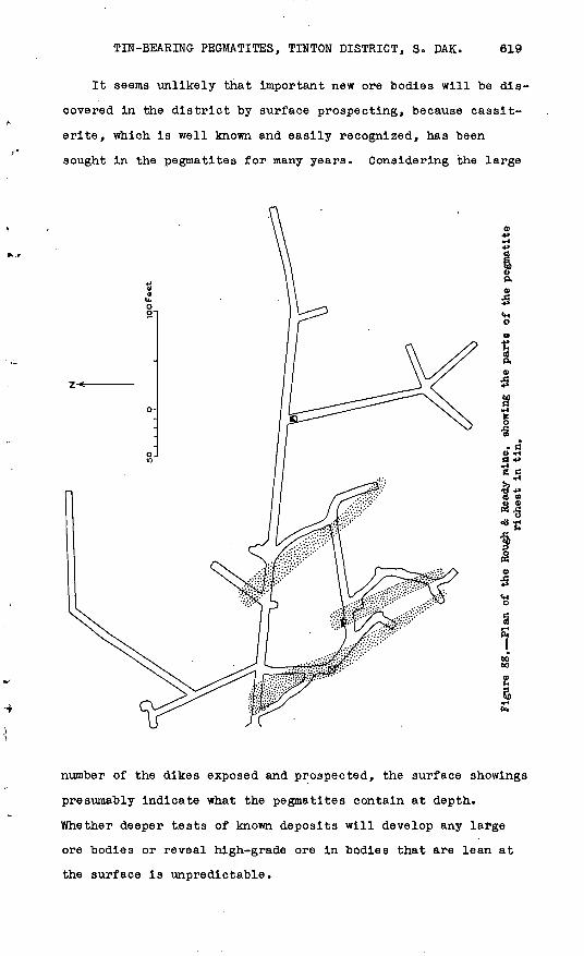
It seems unlikely that important new ore bodies will be dis
covered in the district by surface prospecting, because casslt-
erite, which is well known and easily recognized, has been
sought in the pegmatites for many years. Considering the large
P.
I<H O
(S P.
I
» CO -Ha »> *- E C
number of the dikes exposed and prospected, the surface showings
presumably indicate what the pegmatites contain at depth.
Whether deeper tests of known deposits will develop any large
ore bodies or reveal high-grade ore in bodies that are lean at
the surface is unpredictable.

620 STRATEGIC MINERALS INVESTIGATIONS, 1940
Practically all the tin-bearing pegmatites in the Tinton
district are covered by patented claims. More than 100 claims,
totaling about 2,700 acres, are held by the Black Hills Tin Co.,
which also owns the buildings at Tinton, mining equipment, and
a mill equipped to treat 150 tons of ore a day.o Groups of
claims are held by the Dakota Tin & Gold Co., Mrs. George White,
the Connors Tin Production Co., the Bear Gulch Mining Co 0 , and
A. J. Johnston and associates. Outstanding in the district are
the tin deposit on the Rough & Ready claim and the tin, tantalum,
and lithium deposits on the Giant-Volney claims, all of which
belong to the Black Hills Tin Co. The Spearfish claim, one of
the smaller prospects belonging to the Black Hills Tin Co., was
.prospected in 1934,. and the Dakota Tin & Gold Co. claims were
being developed when the writers were at Tinton in 1939 and
1940. No work of importance has been done on other claims for
many years.
The Rough & Ready mine, of the Black Hills Tin Co., is at
the center of the district, jus't west of Tinton. Practically
all the lode tin that has been mined in the district has been
taken from this property. The mine produced 14,330 tons of ore,21/
which yielded 104,987 pounds of metallic tin, prior to 1910,22/
but only 325 pounds of tin has been mined since then. The
latest development work by the company was done in 1928, when a
large steam-shovel cut was excavated west of the mine portal in
preparation for open-cut mining. In 1939 and 1940 the Bureau of
Mines sampled the mine and explored the ground below it with
diamond-drill holes totaling 4,000 feet in length.
21/ Gardner, E. D., op. cit., p. 50.22/ Hess, P. L., and Bryan, Barnabas, Jr., op. cit., p. 1.
TIN-BEARING PEGMATITES, TINTON DISTRICT, S. DAK. 621
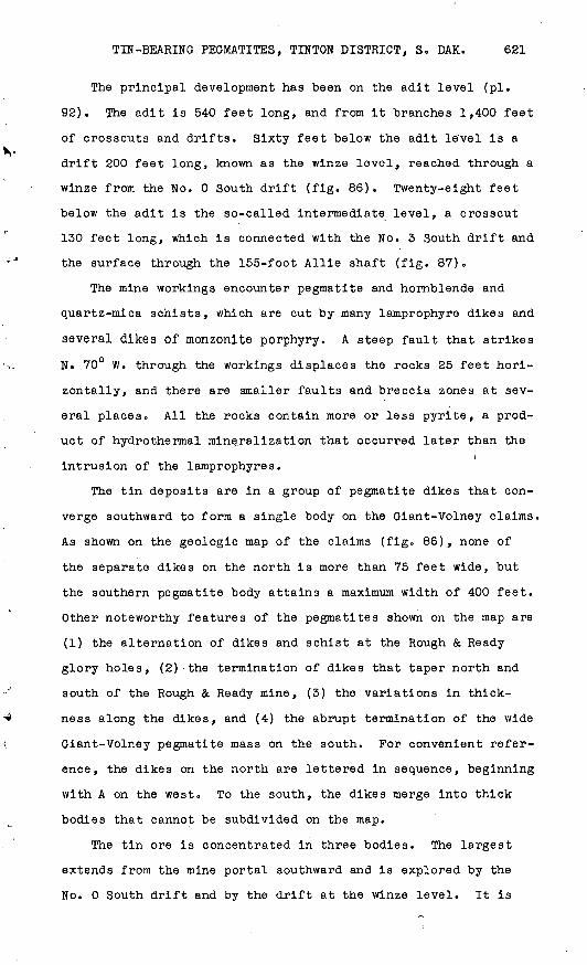
The principal development has been on the adit level (pi.
92). The adit is 540 feet long, and from it branches 1,400 feet
of crosscuts and drifts. Sixty feet below the adit le'vel is a
drift 200 feet long, known as the winze level, reached through a
winze from the No. 0 South drift (fig. 86). Twenty-eight feet
below the adit is the so-called intermediate, level, a crosscut
130 feet long, which is connected with the No. 3 South drift and
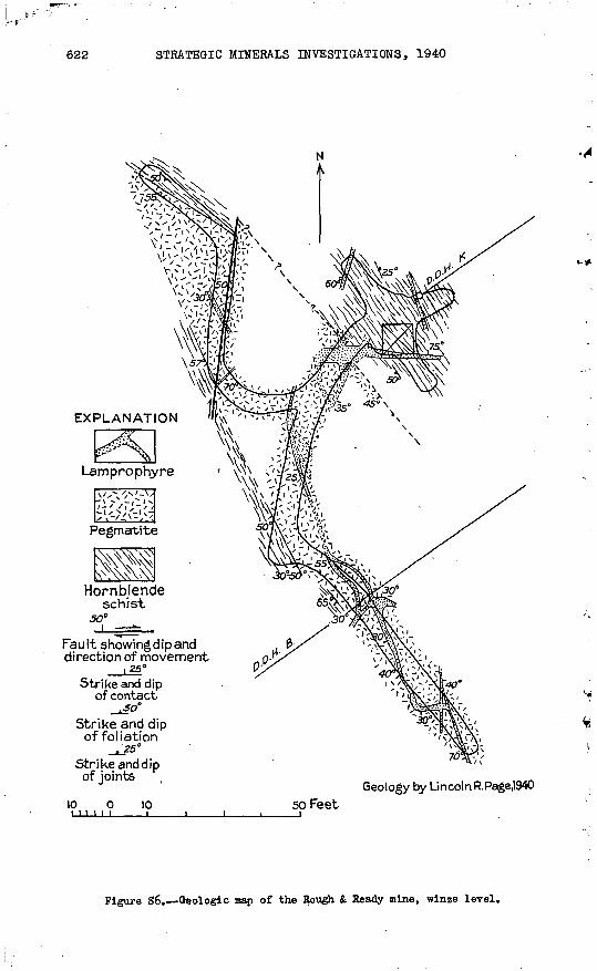
the surface through the 155-foot Allie shaft (fig. 87).
The mine workings encounter pegmatite and hornblende and
quartz-mica schists, which are cut by many lamprophyre dikes and
several dikes of monzonite porphyry. A steep fault that strikes
N. 70° W. through the workings displaces the rocks 25 feet hori
zontally, and there are smaller faults and breccia zones at sev
eral places. All the rocks contain more or less pyrite, a prod
uct of hydrothermal mineralization that occurred later than the/
intrusion of the lamprophyres.
The tin deposits are in a group of pegmatite dikes that con
verge southward to form a single body on the Giant-Volney claims.
As shown on the geologic map of the claims (fig. 86), none of
the separate dikes on the north is more than 75 feet wide, but
the southern pegmatite body attains a maximum width of 400 feet.
Other noteworthy features of the pegmatites shown on the map are
(1) the alternation of dikes and schist at the Rough & Ready
glory holes, (2)'the termination of dikes that taper north and
south of the Rough & Ready mine, (3) the variations in thick
ness along the dikes, and (4) the abrupt termination of the wide
Giant-Volney pegmatite mass on the south. For convenient refer
ence, the dikes on the north are lettered in sequence, beginning
with A on the westo To the south, the dikes merge into thick
bodies that cannot be subdivided on the map.
The tin ore is concentrated in three bodies. The largest
extends from the mine portal southward and is explored by the
No. 0 South drift and by the drift at the winze level. It is
622 STRATEGIC MINERALS INVESTIGATIONS, 1940
EXPLANATION
Fau It showing dip and direction of movement
{ Z5°
Strike and dip of contact.50°
Strike and dipof foliation
-*3S°Strike and dip of joints
10 0 10 111111____I
Geology by LincolnR.PageJ940
50 Feet
Figure 86. Geologic map of the Rough & Ready mine, winze level.

GEOLOGICAL SURVEY
SO 0**.Volney No.I adit
8.9 2.5 5.O
Tin. in pounds pen-ton Assays by Black Hi I Is Tin Co.
Volney No.2adrt
BULLETIN 922 PLATE 93
EXPLANATION
Spodumene-quartz Fetid microcline
Lamprophyre
Monzonite porphyry
Pseudo-leuciteC?) porphyry
sn-Cassiterj-te ta-Tantalite
Closely spaced shears parallel to banding r
Strike and dipof folia-tionvfr,
Strike and dip of joint plane
Strike of vertical joint plane
Geology by Lincoln R.Page 1940Giant adit
GEOLOGIC MAPS OF VOLNEY NoJ,VOLNEY No.2,AND GIANT ADITS,Tl NTON, S. DAK.
SOFeet
U. S. 60VERNHENT PRINTING OFFICE : 1941 O-310943
Fault z
on
e,v
ein
ed
schis
t, ault z
one,
qu
art
z v
ein
s
EX
PL
AN
AT
ION
Geolo
gy b
y L
inco
ln R
.Pag
e
Lam
pro
phyre
M
onzonite
Pe
gm
atite
H
orn
ble
nde a
nd
0 ,
mic
a schis
ts,
80
__ _
J_^
2!
6°
A
I 65°
Fault
* S
he
ar
Str
ike a
nd
dip
S
trik
e a
nd
dip
show
ing d
ip
show
ing d
ip
of f
olia
tio
n
of c
on
tact
10
o50 F
eet
1-3
S
I
Figure 87
. Ge
olog
ic map
of t
he H
ough & Heady m
ine. In
term
edia
te l
evel.
t-3
§ O M
03 H O Ol to O)
624 STRATEGIC MINERALS INVESTIGATIONS, 1940
near the hanging wall of the most westerly pegmatite body (dike
A), which is distinctly a dike on the winze level and where it
is crossed by drill holes, but merges into others on the adit
level to form a thick mass. This largest ore body is 240 feet
long, averages about 25 feet in thickness, and extends downward
at least 60 feet to the winze level. The ore consists of "pep
per tin" in fine-grained ollgoclase pegmatite lenses, which are
thickly spaced in coarser, more quartzose pegmatite,,
A second ore body extends along No. 5 South drift from the
No. 1 South crosscut, and it may extend southward beyond the
present workings, and also northward into a timbered section of
the adit. Its average thickness is 15 feet and its length at
least 70 feet. Inasmuch as it was not encountered by diamond-
drill holes below the drift, its vertical extent may not be more
than 50 feet. This ore body is near the junction of dikes B and
C and may be either in the footwall of dike B or the hanging
wall of dike C. The ore is similar to that of the first body.
The third ore body extends from the face of No. 2 South
drift northward at least as far as No. 1 South crosscut. It
probably continues northward, for what appears to be the same
body crosses the adit west of its junction with No. 2 South
drift. If it reaches the N. 70° W. fault beyond the adit, it is
offset by the fault 25 feet westward. The ore is in the middle
of a wide pegmatite mass that divides northward and downward
into dikes D and E» The maximum length of the ore body is 150
feet and its average width about 10 feet. Here also, an esti
mate of 50 feet for the vertical dimension would be liberal, for
the ore was not identified in drill holes that extend below the
drift. The ore contains much tourmaline and a little columbite,
spodumene, and amblygonite.
The pegmatites east and south of the No. 2 South drift con
tain small amounts of unevenly distributed casslterite, but no
ore body has been developed in them. The best showing is in

TIN-BEARING PEGMATITES, TINTON DISTRICT, S. DAK. 625
the No. 3 South crosscut, west of the No. 3 South drift. Fur
ther prospecting in this part of the mine might determine val
uable ore, but it seems advisable to first test the northward
and downward continuation of the three ore bodies already known.
Further details of the shapes and attitudes of the pegmatite
bodies, particularly their tendency to coalesce southward and to
pitch northward, are revealed in the underground workings (see
pis. 92-93 and figs. 86-87). South of the adit, where the dikes
coalesce, the workingo are almost wholly in pegmatite. The adit
cuts through pegmatite, hornblende schist, and quartz-mica
schist at an angle of 60° to their strike, which is about N.
30° W. The schists dip 40°-65° W., and all the pegmatites dip
in the same direction except one above the portal, which dips
60° E. In the adit, dikes F and G are distinctly separate bod
ies, but others merge and their limits are uncertain.. Two peg
matite dikes cut by the adit pitch northward and pass below the
No. 1 North crosscut, which is in schist for half its length.
The variations in thickness and the splitting of the pegma
tite bodies are also shown by the drill holes represented in the
sections (pi. 94). In section A-A , pegmatite dikes that are
narrow at their surface exposures swell to a maximum thickness
along the line of diamond drill hole A-l and pinch to a very
small thickness in drill hole A-2. Along section B-B , schist
and pegmatite alternate in the Rough & Ready glory holes, pegma
tite is nearly continuous on the adit level beneath,.and schist
again predominates in drill hole K, below the adit level. In
section C-C , the pegmatite is continuous at the adit level,
where normal to the dip it is 150 feet thick, but drill hole B,
below the adit and normal to the dikes, passed through four sep
arate pegmatite bodies, whose aggregate thickness is only 60
feet. In section D-D , through the Allie shaft, the complex
shapes of the pegmatite bodies are most impressively demonstrat-1
ed. Section E-E shows the thick monzonite porphyry dikes that
intersect in the middle of the area. -

626 STRATEGIC MINERALS INVESTIGATIONS, 1940
Giant-Volney prospects
The Giant-Volney property -of the Black Hills Tin Co. lies
south of the Rough & Ready mine and west of Tinton. The large
pegmatite body covered by the Giant claim on the east and the
Volney claim on the west is the southern extension of the dikes
that merge south of the Rough & Ready mine. It is variously
known as the Giant, the Giant-Volney, and the Tantalum Hill peg
matite. Tantalum and lithium were mined from it in 1935 and
1936, but no tin has been produced, although all the early work
was in search of tin. In 1939 and 1940 the Bureau of Mines
drilled three diamond-drill holes (E, G, and I), with a total
length of 1,122 feet, to explore the downward extension of the
pegmatite.
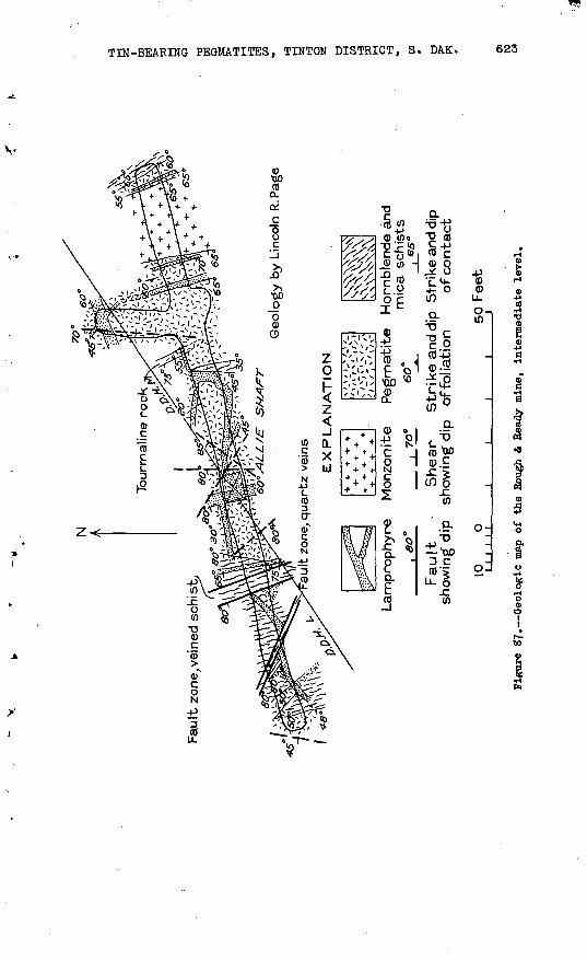
The tin prospects on the property include many surface cuts
and three adits the Volney No. 1 adit is 230 feet long;.the
Volney No.. 2 is 77 feet long; and the Giant is 140 feet long
(pi. 93). The Tantalum mine consists of a large glory hole, an
inclined shaft 60 feet deep, and 200 feet of drifts and cross
cuts. The mine was flooded while the writers were at Tlnton so
could not be examined.
The Giant-Volney pegmatite dike includes every variety of
pegmatite that has been described in this paper, pligoclase-
quartz-muscovite pegmatite forms a large mass along the west
margin of the dike and extends across the south end; and scat
tered exposures indicate that it may .also form the east and
north margins. The middle part of the dike consists of albite-
quartz, spodumene-quartz, and mlcrocline-quartz pegmatites,
formed by replacement, and it contains small bodies of columbite
ore and amblygonite. The pegmatite dips 35°-55° W. and pitches
about 20° N., as is shown by diamond-drill holes G and I, which
passed below the pegmatite and cut through schist for most of
their lengths (pi. 94, sections G-G , H-H ).
The three adits are all crosscuts, driven eastward from the
west margin of the pegmatite. The Giant adit, at the south end

TIN-BEARING PEGMATITES, TINTON DISTRICT, S. DAK. 627
of the dike, cuts two masses of pegmatite and for most of its
length is in schist, which dips 45°-55° W. One mass of pegma
tite, 30 feet from the portal, pitches south, but the larger
body, at the inner end of the adit, pitches northe Both appear
to be irregular apophyses from the main body. Dikes of lampro-
phyre and one dike of pseudoleucite (?) porphyry cut the schists
and the pegmatite,.
The Volney No. 2 adit, 30 feet north of the Giant, starts in
schist that dips 45° W., passes through about 5 feet of spodu-
mene-quartz pegmatite, and for the remaining distance is in
coarse-grained oligoclase-quartz-muscovlte pegmatite cut by two
lamprophyre dikes. Grains of cassiterite as much as an inch in
diameter are plentiful in the pegmatite.
The Volney No 0 1 adit is entirely in pegmatite. The first
140 feet of the adit is in layered oligoclase-quartz-muscovite
pegmatite, which contains both cassiterite and columbite and in
which there are lenses of spodumene-quartz pegmatite and a lens
of microcline. The adit then passes through an irregular body
of spodumene-quartz pegmatite 10 feet thick, and finally through
microcline-quartz pegmatite to the face. About a dozen .lampro
phyre dikes and one of monzonite cut the pegmatite.
Cassiterite is nowhere abundant in the Giant-Volney pegma
tite mass except in the oligoclase pegmatite cut by the Volney
adits. The richest ore is in the Volney No. 2 adit. Assays
indicate that one 10-foot section of the adit, 40 to 50 feet
from the hanging wall, contains 16.4 pounds of tin to the ton
and that the average for a 57-foot section beginning 30 feet23/
from the hanging wall is 8.2 pounds to the ton (see pi. 93).
These figures suggest that a fairly good ore body may continue
northward along the foliation of the pegmatite, but there is no
other evidence regarding the continuation of the ore unless it
is the fact that the first 9 feet of pegmatite at the portal of
23/ Gardner, E. D., op. cit., p. 60.
628 STRATEGIC MINERALS INVESTIGATIONS, 1940
24/ the Volney No. 1 adit averages 10.0 pounds of tin to the ton.
Here also the cassiterite Is in oligoclase-quartz-muscovite peg
matite near the hanging wall of the Giant-Volney body. As the
adits are 450 feet apart, it cannot safely be assumed that ore
extends continuously from one to the other. If further explora
tions for tin are undertaken, however, they should be in this
hanging-wall portion.
Other prospects
Cassiterite has been found in pegmatite as distant from Tin-
ton as the Jersey claim, 1^ miles south, and the Boston 'claim,
an equal distance north. The greatest number of cassiterite-
bearing dikes is near Tinton, east and northeast of the Rough &
Ready claim. Little is known about assay values or the extent
of tin-bearing pegmatite in- these dikes, but from inspection of
pits and natural exposures it appears evident that none contains
an ore body that approaches the Rough & Ready ore bodies in size
or average grade. The prospects, indeed, show so little promise
that no work has been done in recent years on any except those
on the Spearfish claim and on the property of the Dakota Tin &
Gold Co.
Spearfish and adjoining claims. The Spearfish claim is
3,000 feet southeast of Tinton, and extends from the east side
of Bear Creek to the Tinton-Iron Creek road. The claim, togeth
er with the Iron, Centaur, Van, and Yosemlte claims to the
southwest, is considered by the Black Hills Tin Co. to be the
most valuable .of its minor properties. Although no tin has been
produced from any of the claims, they cover a group of at least
10 cassiterite-bearing pegmatite dikes, including one at the
north end of the Spearfish that contains a small amount of ex
ceptionally rich ore.
Prospect work on the claims comprises a 400-foot adit driven
in 1934, a 60-foot adit and two shafts dug prior to 1910, and
Gardner, E. D., op. cit., p. 60.

TIN-BEARING PEGMATITES, TINTON DISTRICT, S. DAKo 629
several open cuts. The Spearfish claim was tested with a dia
mond drill in 1910.
At the edge of Bear Creek, on the north end of the Spearfish
claim, a 50-foot open cut leading to the portal of the 400-foot
adit exposes a pegmatite mass at least 15 feet thick and 30 feet
long. The pegmatite cannot be traced beyond the cut. The adit,
starts at the footwall of the pegmatite' and is in schist and
monzonite porphyry for its entire lengtho The pegmatite is a
coarse-grained muscovlte-rich rock; part of it contains cassit-
erite enough to assay perhaps 25 pounds to the ton, but most of
it contains only scattered crystals. In a 60-foot cut south of
the portal are two bodies of similar pegmatite, 10 and 20 feet
wide, separated by monzonite porphyry. Here the richest part is
a 3-foot layer that averages about 5 pounds of tin to .the ton<>
Thick float covers the bedrock on the hillside beyond the cut,
but the dike probably continues to a 45-foot shaft in pegmatite
about 250 feet south.
Of the other claims the most extensively prospected is the
Centaur. North of an old road leading from Bear Creek to the
Tinton-Iron Creek road are four open cuts, the largest 40 feet
long. These expose a pegmatite dike 200 feet long and as much
as 15 feet thick in places, part of which strikes N. 20° E. and
dips 45° W., parallel to the foliation of the enclosing schist,
and part of which cuts across the schist. The dike consists
mainly of coarse quartz-muscovite pegmatite but encloses lenses
of massive quartz and of fine-grained albitic pegmatite. It
contains scattered crystals of cassiterite and columblte, which
are cut by small quartz-albiter-muscovite ^elnlets. Its average
tin content is probably less than 5 pounds to the ton. Another
pegmatite body on the Centaur claim was explored with a 60-foot
adit, which .is now caved. Pour samples taken in the adit are25/
said to have averaged 1.6 pounds of tin to the ton»
Gardner, B. D., op. clt., p.

630 STRATEGIC MINERALS INVESTIGATIONS, 1940
The ore bodies exposed in the workings on the Spearfish
group are either too small or of too low grade to be worked sep
arately, and the pegmatites there are so widely spaced that they
probably do not coalesce at shallow depth to form a single ore
body that might be large enough to compensate for its low grade.
Dakota Tin & Gold Co.'s property. The Dakota Tin & Gold Co.
holds the unpatented John White claims on Potato Creek, a mile
southeast of Tintono The president and manager of the Company,
W. 0. Pillmore, reported shipping 500 pounds of concentrates
from placer grounds, but except one lot that was cobbed and
shipped to England in the early days no lode tin had been mined.
Old workings on the property, said to date from 1880, in
clude a group of surface cuts and a 50-foot shaft connected with
a 25-foot crosscut and 50 feet of drift. Recent work includes
a 175-foot adit to the old shaft and a new three-compartment
shaft, 130 feet deep, sunk in 1938 and 1939.
The development is on the most southeasterly cassiterite-
bearing pegmatite dike. In the drift the greatest thickness of
the dike is 9 feet, and it thins to 4 feet at the face. Both
at the surface and in the drift it strikes north and dips 45°
W. The new shaft farther west, planned to cut the downward ex
tension of the dike, was all in schist when visited.,
The pegmatite is a fine-grained, strongly foliated rock com
posed chiefly of quartz, albite, and muscovite, with a little
apatite. The cassiterite is in small grains, which in some26/
specimens are alined in layers. Gardner estimated that the
dike would average 3 or 4 pounds of tin to the ton. The block
between the drift and the surface represents about 1,000 tons of
pegmatite. _v : , ,
g6/ Gardner, E. D., op. cit., p. 50.
o