title application of flood forecasting and analysis model (ifas)...
TRANSCRIPT

Title Application of Flood Forecasting and Analysis Model (IFAS)for Wadi Flash Flood
Author(s) Tsuda, Morimasa; Iwami, Yoichi
CitationProceedings of the Second International Symposium on FlashFloods in Wadi Systems: Disaster Risk Reduction and WaterHarvesting in the Arab Region (2016): 78-83
Issue Date 2016-10
URL http://hdl.handle.net/2433/228074
Right
Type Presentation
Textversion author
Kyoto University

Application of Flood Forecasting and Analysis Model (IFAS) for Wadi Flash
Flood Morimasa Tsuda, Yoichi Iwami
International Centre for Water Hazard and Risk Management (ICHARM), PWRI), Japan
Email: [email protected], [email protected]
Keywords: Flood Forecasting, IFAS, Rainfall-Runoff Model, Satellite Based Rainfall
Flood early warning and timely evacuation is important for reducing loss of life and property
against flash floods in Wadi systems. Forecasting the magnitude of flood event is useful to
support evacuation during a flood. ICHARM has been studying flood forecasting and analysis
models, including Integrated Flood Analysis System (IFAS) to help such action.
IFAS is an all-in-one package for flood forecasting. It contains GIS functions to create a
rainfall-runoff model with interfaces to import rainfall data and display output results
effectively in a short period of time. Simulation engine is based on a tank model which
calculates river discharge. IFAS can utilize globally-available topographical datasets in case
local information is insufficient for model creation, and import not only ground-based rainfall
data but also satellite-based rainfall data (i.e., GSMaP, 3B42RT). Satellite-based rainfall
includes bias, therefore several types of bias correction techniques are connected to IFAS, such
as GSMaP-IF2, a bias correction function using ground observed rainfall developed by JAXA.
IFAS is also extremely cost-effective; the software is downloadable for free at the ICHARM
website.
Flood forecasting systems based on IFAS have been applied to some basins in the Asian
regions, such as the Solo river basin in Indonesia or the Indus river basin in Pakistan. Along
with practical use, IFAS can be a very useful training tool to learn about flood forecasting and
warning, because the system lets the user experience a series of tasks necessary for the purpose
on the interface, including the preparation of a runoff analysis model, the execution of runoff
calculation and the presentation of its results, and the development and operation of a flood
forecasting and warning system. ICHARM has provided IFAS training sessions for the
development and operation of a flood forecasting and warning system for over 1,000 river
engineers, researchers and students from about 50 countries. Up to recent years, IFAS has been
mainly applied to relatively wet Asian countries. However, it is now expected to use its capacity
for a wider range of areas and climate zones. In fact, an IFAS training session, “Training Workshop on Warning Systems and Geographical Information Systems (GIS) Courses,” was hosted by the UNESCO Cairo Office on December 15-16, 2015, for engineers of Egypt, Sudan,
Yemen and Jordan. This was the first case of large-scale IFAS training ever held for African
engineers and drew a great deal of media attention.
Applicability of IFAS on flush flood forecasting was tested in Gash Wadi on upper Nile and
Samail Wadi in Oman. Flush floods occur at Kassala point in Sudan, Gash Wadi. Most of
catchment area of Kassala is in Eritrea, then GSMaP is useful for simulation at Kassala. Several
flood peaks in 2010 were simulated properly by IFAS even with no ground observatory. Also,
bias corrected GSMaP using ground observed rainfall was applied to simulation on Samail
Wadi in Oman and showed good performance. These result suggests effectiveness of IFAS on
flush flood forecasting in insufficiently-gauged area in Wadi systems.
78 25-27 October 2016
The Second International Symposium on Flash Floods in Wadi Systems

Application of flood forecasting and
analysis model (IFAS) for Wadi
flash flood
Morimasa TsudaSenior Researcher
International Centre for Water Hazard and Risk Management
under the auspices of UNESCO
(ICHARM)
25-27 October 2016,
Techniche Universität Berlin,
Campas El Gouna, Egypt
“The Second International Symposium on Flash Floods in Wadi Systems
Disaster Risk Reduction and Water Harvesting in the Arab Region ”
1
Objectives
Applicability of IFAS (Integrated Flood Forecasting
System) on flush flood forecasting was tested
1. Wadi Gash (upper Nile)
2. Wadi Samail (Oman)
Flood early warning and timely evacuation is
important for reducing loss of life and property against
flash floods in Wadi systems
Bias corrected GSMaP (Satellite based rainfall by
JAXA) was applied
2
Ground-gauged and satellite
rainfall
Model creation
Run-off analysisRiver discharge, Water level,
Rainfall distribution
Courtesy of JAXA
Global data: topography, land
use, etc.
Aquifer model
River course
model
Surfacemodel
input
Discharge
reaches warning
level
Alert message by E-mail
and on the display for
river management
authoritiesEvacuate from dangerous areas
Judge by River
management
authorities
IFAS for flood forecasting
3
Country Basin (Area) Installment Model Project Remarks
IndonesiaSolo
(16,100km2)
January
2013IFAS ADB
PakistanIndus
(400,000km2)
June
2014IFAS + RRI UNESCO
Phase
(2016 )
PhilippinesCagayan
(27,280km2)June IFAS ADB
MalaysiaKelantan
(11,900km2)2015 IFAS
JST JICA
SATREPS
VietnamThai Bin
(27,200km2)2015 IFAS JICA
4
User friendly display of Indus-IFAS
INPUT DATA :
• Rainfall data (ground gauges, GSMaP
and forecasted)
• Real time observed discharges
OUTPUT DATA:
• Rainfall distribution maps
• Hydrographs at specified locations
• Inundation extents in mid low Indus
[m]
0.0-0.5
0.5-1.0
1.0-2.0
2.0-3.0
3.0-5.0
5.0-6.0
6.0-7.5
Inundation
area by RRI
Control panel for operation settings Hydrograph
Plain view
of rainfall,
discharge,
inundation
(Animation)5
ASEAN, IFAS training JICA
More than 1000 participants from 50 countries
October 5-9, 2015
AHA center (Jakarta, Indonesia)
Arab region Wadi flush flood
training UNESCO)
December 15-16, 2016
GUC (Egypt, Cairo)
6
79 25-27 October 2016
The Second International Symposium on Flash Floods in Wadi Systems

World rainfall map from GSMaP
Data:(http://sharaku.eorc.jaxa.jp/GSMaP/index.htm) made by JAXA
GSMaP_NRT : Near realtime product
(0.1 degree grid, hourly, 4 hours delay)
GSMaP_MVK : Standard product
(0.1 degree grid, hourly, 3-4 days delay)
GSMaP_Gauge : Gauge adjusted product
(0.1 degree grid, hourly, 3-4 days delay)
Satellite based rainfall by JAXA
7
Ground GSMaP_NRT
Corrected GSMaP GSMaP_IF2
8
Geo location correction (Shift)
Group1
Group2
GSMaP accumulated rainfall
Geo-location errors are
corrected in each defined
area group separately.
Geo-location errors are
corrected in each defined
group separately.
Correlation and Difference
GSMaP IF2 (JAXA, NTT DATA)
Courtesy of JAXA9
0
1
Rainfall correction (Scale & Offset)
High Rainfall : (Corrected rainfall) = (Original rainfall) * (Scale factor) * (Weight)
Small Rainfall : (Corrected rainfall) = (Original rainfall) + (Offset factor) * (Weight)
Formula
Before AfterCorrections at each
observatory are combined
based on weighted mean.
GSMaP IF2 (JAXA, NTT DATA)
Courtesy of JAXA10
Application to
Wadi Gash
11
Wadi Gash (Sudan)
Basin area (upper Nile,
blue):
about 250 thousands km2
Basin area upper Kassala,
red):
about 21 thousands km2
Population of Kassala:
about 400,000 (2009)
Estimated rainfall:
600 mm/year
Nile river
Ethiopia
Eritrea
Sudan
Kassala
Source: Urgent capacity
development for managing natural
disaster risks of flash floods, 201512
80 25-27 October 2016
The Second International Symposium on Flash Floods in Wadi Systems

IFAS simulation area
Kassala
Eritrea
Sudan
Ethiopia
30km (4hours)
13
River course model
14
IFAS simulation result (July 24- Aug 14, 2010)
15
Rainfall (July 24- Aug 14) GSMaP NRT
3B42RT
16
Rainfall distribution (Aug 2)
GSMaP NRT
3B42RT
17
IFAS simulation result (July 1- July 21)
18
81 25-27 October 2016
The Second International Symposium on Flash Floods in Wadi Systems
GSMaP NRT
3B42RT
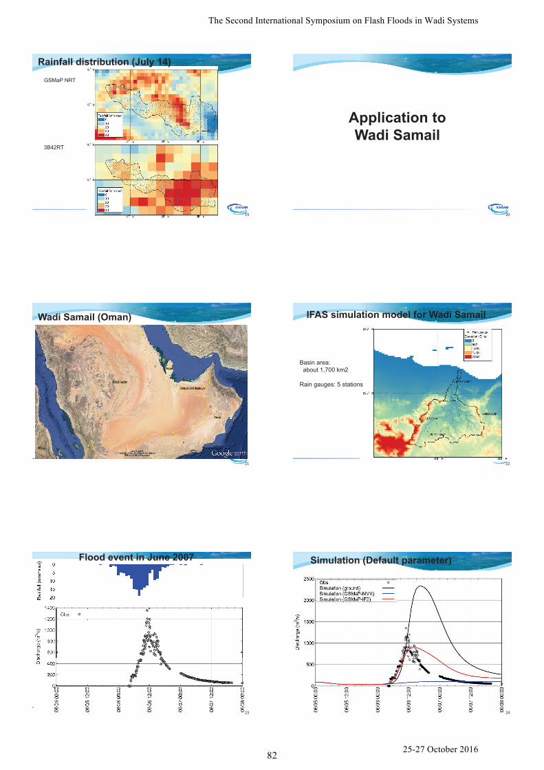
Rainfall distribution (July 14)
19
Application to
Wadi Samail
20
Wadi Samail (Oman)
21
IFAS simulation model for Wadi Samail
Basin area:
about 1,700 km2
Rain gauges: 5 stations
22
Flood event in June 2007
23
Simulation (Default parameter)
24
82 25-27 October 2016
The Second International Symposium on Flash Floods in Wadi Systems

Basin average rainfall
Ground
GSMaP MVK
GSMaP IF2
25
Daily rainfall distribution (June 6 4:00)Ground GSMaP_MVK
GSMaP_IF2
26
Daily rainfall distribution (June 6 5:00)Ground GSMaP_MVK
GSMaP_IF2
27
Simulation (Calibration, GSMaP-IF2)
28
• ICHARM has been studying flood forecasting and analysis models, including Integrated Flood Analysis System (IFAS)
• Result suggests usefulness of IFAS on flush flood forecasting in insufficiently-gauged area in Wadisystems
• Bias correction technique of satellite based rainfall was effectively applied
Summary
29
83 25-27 October 2016
The Second International Symposium on Flash Floods in Wadi Systems