title planning applications to: planning control committee ... agend… · ·although the...
TRANSCRIPT

Title Planning Applications
To: Planning Control Committee
On: 21 May 2019
By: Development Manager
Status: For Publication
Executive Summary
The attached reports present members with a description of various planning applications, theresults of consultations, relevant policies, site history and issues involved.
My recommendations in each case are given in the attached reports.
This report has the following implications
Township Forum/ Ward: Identified in each case.
Policy: Identified in each case.
Resources: Not generally applicable.
Equality Act 2010: All planning applications are considered in light of the Equality Act 2010 andassociated Public Sector Equality Duty, where the Council is required to have due regard for:The elimination of discrimination, harassment and victimisation;The advancement of equality of opportunity between persons who share a relevant protectedcharacteristic and person who do not share it;The fostering of good relations between persons who share a relevant protected characteristicand person who do not share it; which applies to people from the protected equality groups.
Human Rights: All planning applications are considered against the provisions of the HumanRights Act 1998.
Under Article 6 the applicants (and those third parties who have made representations) have theright to a fair hearing and to this end full consideration will be given to their comments.
Article 8 and Protocol 1 of the First Article confer a right to respect private and family life and aright to the protection of property, ie peaceful enjoyment of one's possessions which couldinclude a person's home, and other land and business assets.
In taking account of the Council policy as set out in the Bury Unitary Development Plan 1997 andall material planning considerations, I have concluded on balance that the rights conferred uponthe applicant/ objectors/ residents/ other interested party by Article 8 and Article 1 of the FirstProtocol may be interfered with, since such interference is in accordance with the law and isjustified in the public interest. Any restriction of these rights posed by refusal/ approval of theapplication is legitimate since it is proportionate to the wider benefits of such a decision, is based
upon the merits of the proposal, and falls within the margin of discretion afforded to the Councilunder the Town & Country Planning Acts.
The Crime and Disorder Act 1998 imposes (without prejudice to any other obligation imposed onit) a duty upon the Council to exercise its functions and have due regard to the likely effect of theexercise of its functions on, and the need to do all that it reasonably can to prevent crime anddisorder in its area. In so doing and on making planning decisions under the Town and CountryPlanning Acts, the Planning Control Committee shall have due regard to the provisions of theCrime and Disorder Act 1998 and its implications in the exercise of its functions.
Development Manager
Background Documents
1. The planning application forms and plans submitted therewith.2. Certificates relating to the ownership.3. Letters and Documents from objectors or other interested parties.4. Responses from Consultees.
FOR FURTHER INFORMATION ON THE CONTENTS OF EACH REPORT PLEASE CONTACTINDIVIDUAL CASE OFFICERS IDENTIFIED IN EACH CASE.

01 Township Forum - Ward: North Manor App No. 63038
Location: Barns 1 & 2, (adjacent to 1 Summerseat Lane), 27 Pot Green,Ramsbottom, Bury, BL0 9RG
Proposal: Change of use of existing barns to yoga and leisure use including glasslink between the barns for domestic use
Recommendation: Approve with Conditions Site Visit: N
------------------------------------------------------------------------------------------------------------------------02 Township Forum - Ward: North Manor App No. 63039
Location: Barns 1 & 2, (adjacent to 1 Summerseat Lane), 27 Pot Green,Ramsbottom, Bury, BL0 9RG
Proposal: Listed building consent for change of use of existing barns to yoga andleisure use including glass link between the barns for domestic use
Recommendation: Approve with Conditions Site Visit: N
------------------------------------------------------------------------------------------------------------------------03 Township Forum - Ward: Ramsbottom and Tottington -
RamsbottomApp No. 63617
Location: Land to the west of Manchester Road, Ramsbottom, Bury, BL0 0BZ Proposal: Reserved matters application relating to outline planning application -
60370 for the erection of 35 no. dwellings with approval sought for theremaining matters
Recommendation: Site Visit: N
------------------------------------------------------------------------------------------------------------------------04 Township Forum - Ward: Ramsbottom + Tottington - Tottington App No. 63785
Location: Elton High School, Walshaw Road, Bury, BL8 1RN Proposal: Creation of new artificial grass pitch (AGP) and installation of new 4.5m
high ball stop fencing and entrance gates to AGP perimeter, new 2.0mhigh and 1.2m high pitch perimeter barrier and entrance gates within AGPenclosure, new hard standing areas, new floodlight system and newmaintenance equipment store located within AGP enclosure
Recommendation: Approve with Conditions Site Visit: Y
------------------------------------------------------------------------------------------------------------------------05 Township Forum - Ward: Bury West - Elton App No. 63834
Location: Land north of Green Street, Bury, BL8 1TF Proposal: Erection of 2 no. semi-detached dwellings Recommendation: Approve with Conditions Site Visit: N
------------------------------------------------------------------------------------------------------------------------

Page No 1
Ward: North Manor Item 01
Applicant: Mrs Shelley Walsh
Location: Barns 1 & 2, (adjacent to 1 Summerseat Lane), 27 Pot Green, Ramsbottom, Bury,BL0 9RG
Proposal: Change of use of existing barns to yoga and leisure use including glass link betweenthe barns for domestic use
Application Ref: 63038/Full Target Date: 04/09/2018
Recommendation: Approve with Conditions
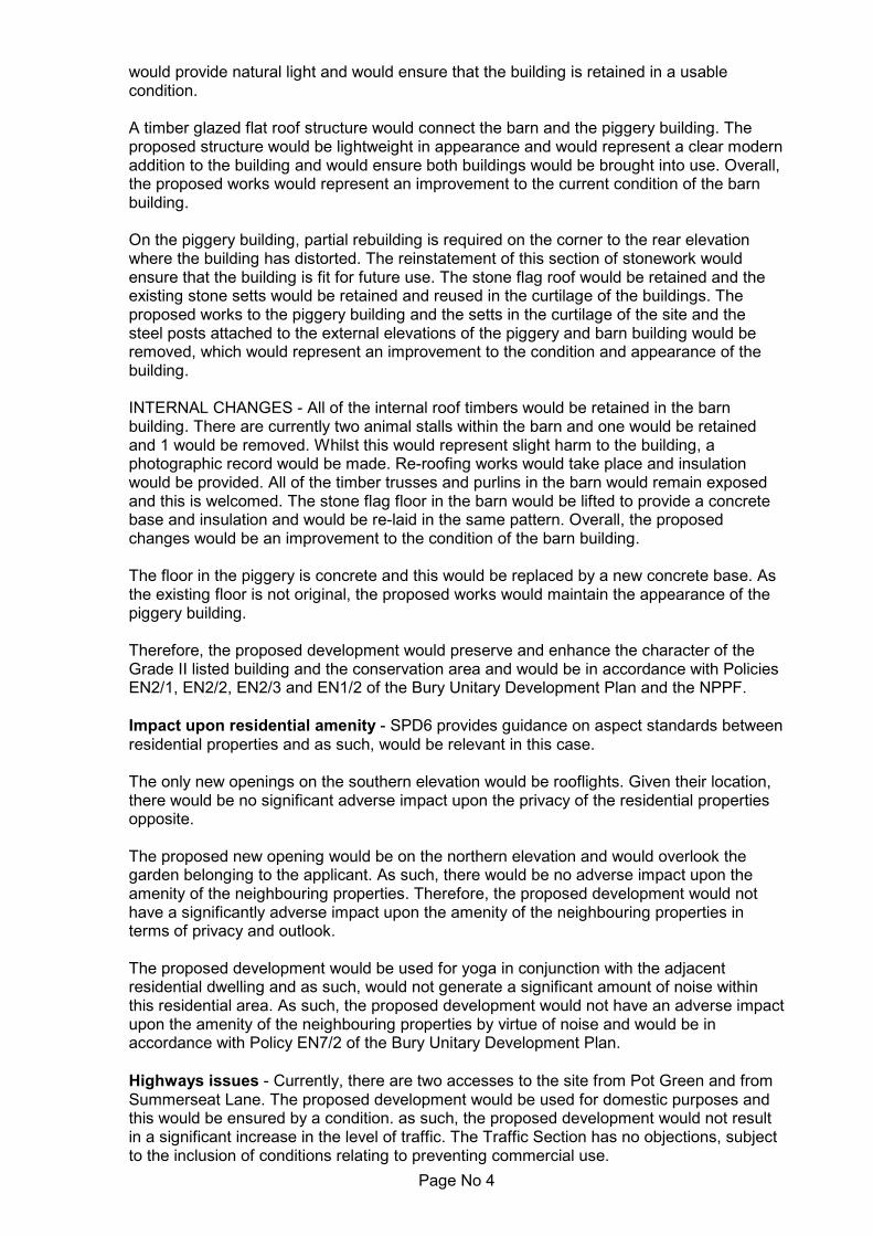
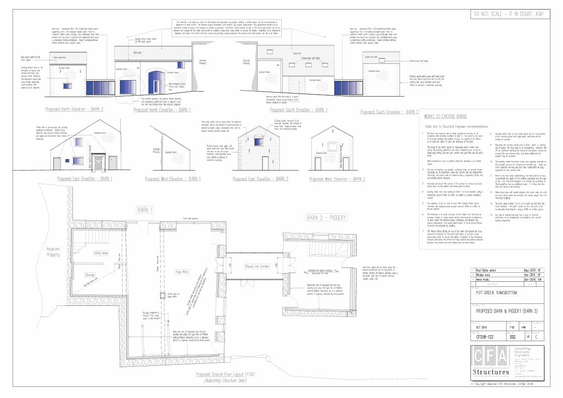
DescriptionThe site is located within the Pot Green Conservation Area and consists of a dwellinghouse (No. 27 Pot Green), a detached garage, a piggery building and a barn, which isattached to No. 1 Summerseat Lane, that is in a separate ownership. All the buildings areconstructed from stone and slate. As No. 1 Summerseat Lane is a Grade II listed building,the attached barn, which is the subject of this application is also listed.
The site is surrounded by residential dwellings to the east, south and west and residentialdwellings to the north beyond Holcombe Brook.
The proposed development involves the conversion of the existing barn and piggery to abuilding used for yoga and leisure for domestic purposes. A glazed link would connect thetwo buildings. All existing openings would be retained and there would be three newopenings to the barn. The rear elevation of the piggery building would be rebuilt where ithas bowed. Internally, one cattle stall would be removed and a second cattle stall would beretained.
The proposed building would be used as ancillary living accommodation and would not beused as a business - this would require planning permission. Access to the site would bevia the existing accesses from Pot Green and Summerseat Lane.
Relevant Planning History54366 - Two storey garage with first floor for use as home office (resubmission) at 27 potGreen, Bury. Approved with conditions - 12 October 2011.
54367 - Listed Building Consent: Conversion of barn (Building A) and outbuilding (BuildingB) to one dwelling with link in between; Construction of new dwelling (Building D) withalterations to existing garage (Building C) to add first floor for use as home office; New twostorey garage to no. 27 Pot Green (resubmission) at 27 Pot Green, Bury. Withdrawn - 20October 2011.Application was withdrawn as required an updated bat survey.
54368 - Conversion of barn (Building A) and outbuilding (Building B) to one dwelling withlink inbetween; Construction of new dwelling (Building D) with alterations to existing garage(Building C) to add first floor for use as home office (resubmission) at 27 Pot Green, Bury.Withdrawn - 20 October 2011.Application was withdrawn as required an updated bat survey
54574 - Erection of 1 no. dwelling at 27 Pot Green. Approved with conditions - 25 January2012.
56678 - Single storey extension at side/rear; Single storey extension at rear; Bay window at

Page No 2
side; Dormer at rear at 27 Pot Green, Bury. Approved with conditions - 12 November 2013.
57146 - Single storey extension at side/rear; Single storey extension at rear; Bay window atside; Dormer at rear (resubmission of 56678) with new bay window at 27 Pot Green, Bury.Approved with conditions - 10 March 2014.
63039 - Listed building consent for change of use of existing barns to yoga and leisure useincluding glass link between the barns for domestic use at Barns (1 & 2) (adjacent to 1Summerseat Lane, 27 Pot Green, Ramsbottom. Received - 10 July 2018.
PublicityThe neighbouring properties (15) were notified by means of a letter on 18 July 2018 and apress notice was published in the Bury Times on 26 July 2018. Site notices were posted on10 August 2018.
1 letter has been received from the occupiers of 62 Summerseat Lane, which has raisedthe following issues:
Although the resubmitted application asserts that the yoga and leisure facility is 'fordomestic use', we are told that it will still involve additional visitors using the premises,thereby generating further traffic, parking and access issues at this narrow top end ofSummerseat Lane (the main entry point to the property). There is already a problemwith overflow parking from Pot Green and commercial deliveries into that vicinity.Once established, we are concerned that there is little to prevent the project evolvingeither overtly or otherwise into a commercial venture (as already exists to some degreein the main building). If done correctly, this would require further planning permission,but once up-and-running, it's likely to weaken the case against, thus compounding theproblems referred to above.
The neighbouring properties were notified of revised plans on 7 May 2019.
If any further comments are received, these will be reported in the Supplementary Report.
ConsultationsTraffic Section - No objections, subject to the inclusion of a condition preventingcommercial use.Conservation Officer - No objections.Environmental Health - Pollution Control - No comments.
Unitary Development Plan and PoliciesEN1/1 Visual AmenityEN1/2 Townscape and Built DesignEN1/3 Landscaping ProvisionEN2/1 Character of Conservation AreasEN2/2 Conservation Area ControlEN2/3 Listed BuildingsEN6 Conservation of the Natural EnvironmentEN6/3 Features of Ecological ValueEN7 Pollution ControlEN7/2 Noise PollutionEN7/5 Waste Water ManagementH2/3 Extensions and AlterationsHT2/4 Car Parking and New DevelopmentHT6/2 Pedestrian/Vehicular ConflictSPD6 Supplementary Planning Document 6: Alterations & ExtensionsSPD11 Parking Standards in BuryNPPF National Planning Policy FrameworkH3/1 Assessing Non-Conforming Uses
Issues and Analysis

Page No 3
The following report includes analysis of the merits of the application against the relevantpolicies of both the National Planning Policy Framework (NPPF) and the adopted BuryUnitary Development Plan (UDP) together with other relevant material planningconsiderations. The policies of the UDP that have been used to assess this application areconsidered to be in accordance with the NPPF and as such are material planningconsiderations. For simplicity, just the UDP Policy will be referred to in the report, unlessthere is a particular matter to highlight arising from the NPPF where it would otherwise bespecifically mentioned.
Principle - Policy H2/3 states that applications for house extensions and alterations will beconsidered with regard to the following factors:
the size, shape, design and external appearance of the proposal;the character of the property in question and the surrounding area;the amenity of adjacent properties;visibility for pedestrians, cyclists and drivers of motor vehicles.
The proposed development would change the use of the barn and piggery buildings to aleisure use, specifically for yoga. The applicant has confirmed that the proposeddevelopment would be for domestic use only and would not include any classes. As such,this would be secured by a condition resticting the use of the building to domestic use only.
Design, layout and impact upon heritage - The NPPF sets out the Government'splanning policies and one of the core planning principles states that planning should'conserve heritage assets in a manner appropriate to their significance, so that they can beenjoyed for their contribution to the quality of life of this and future generations.'
Paragraph 192 of the NPPF states that when determining applications, local planningauthorities should take account of;
the desirability of sustaining and enhancing the significance of heritage assets andputting them to viable uses consistent with their conservation.the positive contribution that conservation of heritage assets can make to sustainablecommunities including their economic vitality; andthe desirability of new development making a positive contribution to local character anddistinctiveness.
Paragraph 193 states that when considering the impact of a proposed development on thesignificance of a designated heritage asset, great weight should be given to the asset'sconservation and the more important the asset, the greater the weight should be. This isirrespective of whether any potential harm amounts to substantial harm, total loss or lessthan substantial harm to its significance.
Paragraph 196 states that where a development proposal will lead to less than substantialharm to the significance of a heritage asset, this harm should be weighed against the publicbenefits of the proposal including, where appropriate, securing its optimum viable use.
In order to assess whether the proposed development would make a positive contribution tothe character of the conservation area and the listed building, the character of the buildingand the conservation area must be determined.
The building is a grade II listed building, which is attached to 1 Summerseat Lane. Theapplicant has submitted a heritage statement, which assesses the significance of thebuilding and the impact of the proposed development.
EXTERNAL CHANGES - There are existing openings within the barn, which are blocked upand these would be opened up using timber windows and doors. All of the existingopenings in the barn would be retained and lime pointing would be used on the externalelevations, where required. Conservation rooflights would be inserted and a new openingon the northern elevation would be created, which would have a vertical emphasis. Theproposed openings would have some impact upon the building, the proposed openings
Page No 4
would provide natural light and would ensure that the building is retained in a usablecondition.
A timber glazed flat roof structure would connect the barn and the piggery building. Theproposed structure would be lightweight in appearance and would represent a clear modernaddition to the building and would ensure both buildings would be brought into use. Overall,the proposed works would represent an improvement to the current condition of the barnbuilding.
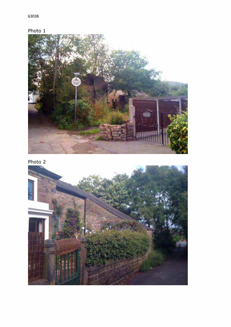
On the piggery building, partial rebuilding is required on the corner to the rear elevationwhere the building has distorted. The reinstatement of this section of stonework wouldensure that the building is fit for future use. The stone flag roof would be retained and theexisting stone setts would be retained and reused in the curtilage of the buildings. Theproposed works to the piggery building and the setts in the curtilage of the site and thesteel posts attached to the external elevations of the piggery and barn building would beremoved, which would represent an improvement to the condition and appearance of thebuilding.
INTERNAL CHANGES - All of the internal roof timbers would be retained in the barnbuilding. There are currently two animal stalls within the barn and one would be retainedand 1 would be removed. Whilst this would represent slight harm to the building, aphotographic record would be made. Re-roofing works would take place and insulationwould be provided. All of the timber trusses and purlins in the barn would remain exposedand this is welcomed. The stone flag floor in the barn would be lifted to provide a concretebase and insulation and would be re-laid in the same pattern. Overall, the proposedchanges would be an improvement to the condition of the barn building.
The floor in the piggery is concrete and this would be replaced by a new concrete base. Asthe existing floor is not original, the proposed works would maintain the appearance of thepiggery building.
Therefore, the proposed development would preserve and enhance the character of theGrade II listed building and the conservation area and would be in accordance with PoliciesEN2/1, EN2/2, EN2/3 and EN1/2 of the Bury Unitary Development Plan and the NPPF.
Impact upon residential amenity - SPD6 provides guidance on aspect standards betweenresidential properties and as such, would be relevant in this case.
The only new openings on the southern elevation would be rooflights. Given their location,there would be no significant adverse impact upon the privacy of the residential propertiesopposite.
The proposed new opening would be on the northern elevation and would overlook thegarden belonging to the applicant. As such, there would be no adverse impact upon theamenity of the neighbouring properties. Therefore, the proposed development would nothave a significantly adverse impact upon the amenity of the neighbouring properties interms of privacy and outlook.
The proposed development would be used for yoga in conjunction with the adjacentresidential dwelling and as such, would not generate a significant amount of noise withinthis residential area. As such, the proposed development would not have an adverse impactupon the amenity of the neighbouring properties by virtue of noise and would be inaccordance with Policy EN7/2 of the Bury Unitary Development Plan.
Highways issues - Currently, there are two accesses to the site from Pot Green and fromSummerseat Lane. The proposed development would be used for domestic purposes andthis would be ensured by a condition. as such, the proposed development would not resultin a significant increase in the level of traffic. The Traffic Section has no objections, subjectto the inclusion of conditions relating to preventing commercial use.

Page No 5
The proposed site plan indicates that there would be two parking spaces within theapplication site and a further two spaces plus a double garage within the wider site, all ofwhich are owned by the applicant. As the proposed use is for domestic purposes only, thelevel of parking provision would be acceptable. Therefore, the proposed development wouldnot be detrimental to highway safety.
Response to objectorsAll of the issues raised have been addressed in the report above.
Statement in accordance with Article 35(2) Town and Country Planning (DevelopmentManagement Procedure) (England) (Amendment) Order 2015
The Local Planning Authority worked positively and proactively with the applicant to identifyvarious solutions during the application process to ensure that the proposal comprisedsustainable development and would improve the economic, social and environmentalconditions of the area and would accord with the development plan. These wereincorporated into the scheme and/or have been secured by planning condition. The LocalPlanning Authority has therefore implemented the requirement in Paragraph 38 of theNational Planning Policy Framework.
Recommendation: Approve with Conditions
Conditions/ Reasons
1. The development must be begun not later than three years beginning with thedate of this permission.Reason. Required to be imposed by Section 91 Town & Country Planning Act1990.
2. This decision relates to drawings numbered CFS18-001 001, CFS18-122 002C,CFS18-122 003 and the development shall not be carried out except inaccordance with the drawings hereby approved.Reason. For the avoidance of doubt and to ensure a satisfactory standard ofdesign pursuant to the policies of the Bury Unitary Development Plan listed.
3. A sample panel of stonework and mortar, demonstrating the colour, texture, facebond and pointing, not less than 1 sq.m in size, shall be erected on site forinspection, and approval in writing, by the Local Planning Authority prior to thecommencement of the development. Samples of the roofing materials shall alsobe made available for inspection on site. Thereafter the development shall beconstructed in the approved materials and manner of construction.Reason. In the interests of visual amenity and to ensure a satisfactorydevelopment pursuant to Policy EN1/2 - Townscape and Built Design and PolicyEN2/3 - Listed Buildings of the Bury Unitary Development Plan
4. The animal stalls shall not be removed from the building unless or until aphotographic record of the anicam stall shas been submitted to and approved inwriting by the Local Planning Authority. One animal stall stall be reinstated into thebuilding before it is first brought into use.Reason. To allow for the proper recording of an item of historical importancebefore its disturbance by the works pursuant to Policy EN2/3 - Listed Buildings ofthe Bury Unitary Development Plan.
5. The re-pointing shall be carried out in an appropriate lime mortar mix and withoutcolour additives. Pointing shall be kept to the minimum which is structurallynecessary, with care taken to finish the joints to match the original work and withthe joints finished flushed, neatly and cleanly and the mortar brushed slightly back

Page No 6
from the face of the stone (or brickwork).Reason. In order to preserve the special architectural or historic interest of thebuilding pursuant to Policy EN2/3 - Listed Buildings of the Bury UnitaryDevelopment Plan.
6. No works to the roof shall commence unless or until details of the conservationstyle rooflights have been submitted to and approved in writing by the LocalPlanning Authority. Only the approved details shall be implemented as part of thedevelopment hereby approved.Reason. In order to preserve the special architectural or historic interest of thebuilding pursuant to Policy EN2/3 - Listed Buildings of the Bury UnitaryDevelopment Plan.
7. All new fenestration shall be set behind a reveal of 75 mm.Reason: To ensure that the development has regard to the general character andappearance of the immediate locality of the site pursuant to Policy EN2/3 - ListedBuildings of the Bury Unitary Development Plan.
8. The buildings hereby permitted shall be used for the domestic purposes only.They shall not be used in part or whole for any commercial use.Reason. In the interests of amenity having regard to the location of the sitepursuant to Policy H3/1 - Assessing Non Conforming Uses, Policy HT6/2 -Pedestrian/Vehicular Conflict and Policy EN7/2 - Noise Pollution of the BuryUnitary Development Plan.
9. The car parking indicated on the approved plans shall be surfaced, demarcatedand made available for use prior to the building hereby approved being broughtinto use.Reason. To ensure adequate off street car parking provision in the interests ofroad safety pursuant to Policy HT2/4 - Car Parking and New Development of theBury Unitary Development Plan.
For further information on the application please contact Helen Longworth on 0161 2535322

PLANNING APPLICATION LOCATION PLAN
Planning, Environmental and Regulatory Services
No Window
No Window
ADDRESS:
APP. NO 63038
Barns 1 & 2, 27 Pot GreenRamsbottom
(C) Crown Copyright and database right (2015). Ordnance Survey 100023063.
LB
79
1
1
2
1
77
Cherrytrees
62
27
Pot Green
Holly House
76
20
El Sub Sta
1
29
30
7
20a
21
18
11
21a
27
2Bank
23
21
1T
RE
ET
OP
S A
VE
NU
E
LAN
E
SUM
MER
SEAT
LO
NG
SIG
HT
RO
AD
Post
Tra
ck
162.2m
1
2
34
5
6
Viewpoints
63038
Photo 1
Photo 2
63038
Photo 3
Photo 4

63038
Photo 5
Photo 6


Page No 7
Ward: North Manor Item 02
Applicant: Mrs Shelly Walsh
Location: Barns 1 & 2, (adjacent to 1 Summerseat Lane), 27 Pot Green, Ramsbottom, Bury,BL0 9RG
Proposal: Listed building consent for change of use of existing barns to yoga and leisure useincluding glass link between the barns for domestic use
Application Ref: 63039/Listed Building Consent Target Date: 04/09/2018
Recommendation: Approve with Conditions
DescriptionThe site is located within the Pot Green Conservation Area and consists of a dwellinghouse (No. 27 Pot Green), a detached garage, a piggery building and a barn, which isattached to No. 1 Summerseat Lane, that is in a separate ownership. All the buildings areconstructed from stone and slate. As No. 1 Summerseat Lane is a Grade II listed building,the attached barn, which is the subject of this application is also listed.
The site is surrounded by residential dwellings to the east, south and west and residentialdwellings to the north beyond Holcombe Brook.
The proposed development involves the conversion of the existing barn and piggery to abuilding used for yoga and leisure for domestic purposes. A glazed link would connect thetwo buildings. All existing openings would be retained and there would be one new openingin the barn and rooflights would be installed. The rear elevation of the piggery buildingwould be rebuilt where it has bowed. Internally, one cattle stall would be removed and asecond cattle stall would be retained.
The proposed building would be used as ancillary living accommodation and would not beused as a business. Access to the site would be via the existing accesses from Pot Greenand Summerseat Lane.
Relevant Planning History54366 - Two storey garage with first floor for use as home office (resubmission) at 27 potGreen, Bury. Approved with conditions - 12 October 2011.
54367 - Listed Building Consent: Conversion of barn (Building A) and outbuilding (BuildingB) to one dwelling with link in between; Construction of new dwelling (Building D) withalterations to existing garage (Building C) to add first floor for use as home office; New twostorey garage to no. 27 Pot Green (resubmission) at 27 Pot Green, Bury. Withdrawn - 20October 2011.Application was withdrawn as required an updated bat survey.
54368 - Conversion of barn (Building A) and outbuilding (Building B) to one dwelling withlink in between; Construction of new dwelling (Building D) with alterations to existing garage(Building C) to add first floor for use as home office (resubmission) at 27 Pot Green, Bury.Withdrawn - 20 October 2011.Application was withdrawn as required an updated bat survey
54574 - Erection of 1 no. dwelling at 27 Pot Green. Approved with conditions - 25 January2012.

Page No 8
56678 - Single storey extension at side/rear; Single storey extension at rear; Bay window atside; Dormer at rear at 27 Pot Green, Bury. Approved with conditions - 12 November 2013.
57146 - Single storey extension at side/rear; Single storey extension at rear; Bay window atside; Dormer at rear (resubmission of 56678) with new bay window at 27 Pot Green, Bury.Approved with conditions - 10 March 2014.
63038 - Change of use of existing barns to yoga and leisure use including glass linkbetween the barns for domestic use at Barns (1 & 2) (adjacent to 1 Summerseat Lane, 27Pot Green, Ramsbottom. Received - 10 July 2018.
PublicityThe neighbouring properties (15) were notified by means of a letter on 18 July 2018 and apress notice was published in the Bury Times on 26 July 2018. Site notices were posted on10 August 2018.
1 letter of support has been received from the occupiers of 1 Summerseat Lane, which hasraised the following issues:
The propert in question is in a poor state of repair and badly needs to be restored.It is an eyesore and attracts passers by, who discard their rubbish over the boundary.The application can only enhance the surrounding buildings that have recently beenrestored and help to preserve this conservation area.
3 letters have been received from the occupiers of 62, 77 Summerseat Lane and 7 PotGreen, which have raised the following issues:
Although the re submitted application asserts that the yoga and leisure facility is 'fordomestic use', we are told that it will still involve additional visitors using the premises,thereby generating further traffic, parking and access issues at this narrow top end ofSummerseat Lane (the main entry point to the property). There is already a problemwith overflow parking from Pot Green and commercial deliveries into that vicinity.Once established, we are concerned that there is little to prevent the project evolvingeither overtly or otherwise into a commercial venture (as already exists to some degreein the main building). If done correctly, this would require further planning permission,but once up-and-running, it's likely to weaken the case against, thus compounding theproblems referred to above.I was previously unaware that the buildings were listed. In light of this, I feel even morestrongly that the proposed development, with additional clients and visitors would bemost unsuitable for this location.I have not seen bats around the property for some time now, which is unusual.Concerned about an increase of vehicles using Pot Green where parking is at apremium.I would be concerned if this was to become a commercial enterprise resulting in use allday and into the evenings. This would lead to increased noise and traffic.I agree that the upgrading of the derelict buildings, if done correctly, could be a benefitto the area.
The neighbouring properties were notified of revised plans on 7 May 2019.
If any further comments are received, these will be reported in the Supplementary Report.
Statutory/Non-Statutory ConsultationsConservation Officer - No objections.Listed buildings - National Amenity Societies - No response.
Pre-start Conditions -
Unitary Development Plan and PoliciesEN1/1 Visual Amenity

Page No 9
EN1/2 Townscape and Built DesignEN2/1 Character of Conservation AreasEN2/2 Conservation Area ControlEN2/3 Listed BuildingsNPPF National Planning Policy Framework
Issues and AnalysisThe following report includes analysis of the merits of the application against the relevantpolicies of both the National Planning Policy Framework (NPPF) and the adopted BuryUnitary Development Plan (UDP) together with other relevant material planningconsiderations. The policies of the UDP that have been used to assess this application areconsidered to be in accordance with the NPPF and as such are material planningconsiderations. For simplicity, just the UDP Policy will be referred to in the report, unlessthere is a particular matter to highlight arising from the NPPF where it would otherwise bespecifically mentioned.
Design, layout and impact upon heritage - The NPPF sets out the Government'splanning policies and one of the core planning principles states that planning should'conserve heritage assets in a manner appropriate to their significance, so that they can beenjoyed for their contribution to the quality of life of this and future generations.'
Paragraph 192 of the NPPF states that when determining applications, local planningauthorities should take account of;
the desirability of sustaining and enhancing the significance of heritage assets andputting them to viable uses consistent with their conservation.the positive contribution that conservation of heritage assets can make to sustainablecommunities including their economic vitality; andthe desirability of new development making a positive contribution to local character anddistinctiveness.
Paragraph 193 states that when considering the impact of a proposed development on thesignificance of a designated heritage asset, great weight should be given to the asset'sconservation and the more important the asset, the greater the weight should be. This isirrespective of whether any potential harm amounts to substantial harm, total loss or lessthan substantial harm to its significance.
Paragraph 196 states that where a development proposal will lead to less than substantialharm to the significance of a heritage asset, this harm should be weighed against the publicbenefits of the proposal including, where appropriate, securing its optimum viable use.
In order to assess whether the proposed development would make a positive contribution tothe character of the conservation area and the listed building, the character of the buildingand the conservation area must be determined.
The building is a grade II listed building, which is attached to 1 Summerseat Lane. Theapplicant has submitted a heritage statement, which assesses the significance of thebuilding and the impact of the proposed development.
EXTERNAL CHANGES - There are existing openings within the barn, which are blocked upand these would be opened up using timber windows and doors. All of the existingopenings in the barn would be retained and lime pointing would be used on the externalelevations, where required. Conservation rooflights would be inserted and a new openingon the northern elevation would be created, which would have a vertical emphasis. Theproposed openings would have some impact upon the building, the proposed openingswould provide natural light and would ensure that the building is retained in a usablecondition.
A timber glazed flat roof structure would connect the barn and the piggery building. Theproposed structure would be lightweight in appearance and would represent a clear modern

Page No 10
addition to the building and would ensure both buildings would be brought into use. Overall,the proposed works would represent an improvement to the current condition of the barnbuilding.
On the piggery building, partial rebuilding is required on the corner to the rear elevationwhere the building has distorted. The reinstatement of this section of stonework wouldensure that the building is fit for future use. The stone flag roof would be retained and theexisting stone setts would be retained and reused in the curtilage of the buildings. Theproposed works to the piggery building and the setts in the curtilage of the site and thesteel posts attached to the external elevations of the piggery and barn building would beremoved, which would represent an improvement to the condition and appearance of thebuilding.
INTERNAL CHANGES - All of the internal roof timbers would be retained in the barnbuilding. There are currently two animal stalls within the barn and one would be retainedand one would be removed. Whilst this would represent slight harm to the building, aphotographic record would be made. Re-roofing works would take place and insulationwould be provided. All of the timber trusses and purlins in the barn would remain exposedand this is welcomed. The stone flag floor in the barn would be lifted to provide a concretebase and insulation and would be re-laid in the same pattern. Overall, the proposedchanges would be an improvement to the condition of the barn building.
The floor in the piggery is concrete and this would be replaced by a new concrete base. Asthe existing floor is not original, the proposed works would maintain the appearance of thepiggery building.
Therefore, the proposed development would preserve and enhance the character of theGrade II listed building and the conservation area and would be in accordance with PoliciesEN2/1, EN2/2, EN2/3 and EN1/2 of the Bury Unitary Development Plan and the NPPF.
Response to objectorsThe issues relating to the design and heritage aspects have been addressed in thereport above and the planning aspects within 63038..The remaining issues raised are pertinent to the planning application and are notrelevant to the listed building consent application.
Statement in accordance with Article 35(2) Town and Country Planning (DevelopmentManagement Procedure) (England) (Amendment) Order 2015
The Local Planning Authority worked positively and proactively with the applicant to identifyvarious solutions during the application process to ensure that the proposal comprisedsustainable development and would improve the economic, social and environmentalconditions of the area and would accord with the development plan. These wereincorporated into the scheme and/or have been secured by planning condition. The LocalPlanning Authority has therefore implemented the requirement in Paragraph 38 of theNational Planning Policy Framework.
Recommendation: Approve with Conditions
Conditions/ Reasons
1. The development must be begun not later than the expiration of three yearsbeginning with the date of this permission.Reason - Required to be imposed pursuant to Section 18 of the Planning (ListedBuildings and Conservation Areas) Act 1990.
2. This decision relates to drawings numbered CFS18-001 001, CFS18-122 002C,CFS18-122 003, Heritage Statement and the development shall not be carried out

Page No 11
except in accordance with the drawings hereby approved.Reason. For the avoidance of doubt and to ensure a satisfactory standard ofdesign pursuant to the policies of the Bury Unitary Development Plan listed.
3. A sample panel of stonework and mortar, demonstrating the colour, texture, facebond and pointing, not less than 1 sq.m in size, shall be erected on site forinspection, and approval in writing, by the Local Planning Authority prior to thecommencement of the development. Samples of the roofing materials shall alsobe made available for inspection on site. Thereafter the development shall beconstructed in the approved materials and manner of construction.Reason. In the interests of visual amenity and to ensure a satisfactorydevelopment pursuant to Policy EN1/2 - Townscape and Built Design and PolicyEN2/3 - Listed Buildings of the Bury Unitary Development Plan
4. The animal stalls shall not be removed from the building unless or until aphotographic record of the anicam stall shas been submitted to and approved inwriting by the Local Planning Authority. One animal stall stall be reinstated into thebuilding before it is first brought into use.Reason. To allow for the proper recording of an item of historical importancebefore its disturbance by the works pursuant to Policy EN2/3 - Listed Buildings ofthe Bury Unitary Development Plan.
5. The re-pointing shall be carried out in an appropriate lime mortar mix and withoutcolour additives. Pointing shall be kept to the minimum which is structurallynecessary, with care taken to finish the joints to match the original work and withthe joints finished flushed, neatly and cleanly and the mortar brushed slightly backfrom the face of the stone (or brickwork).Reason. In order to preserve the special architectural or historic interest of thebuilding pursuant to Policy EN2/3 - Listed Buildings of the Bury UnitaryDevelopment Plan.
6. No works to the roof shall commence unless or until details of the conservationstyle rooflights have been submitted to and approved in writing by the LocalPlanning Authority. Only the approved details shall be implemented as part of thedevelopment hereby approved.Reason. In order to preserve the special architectural or historic interest of thebuilding pursuant to Policy EN2/3 - Listed Buildings of the Bury UnitaryDevelopment Plan.
7. All new fenestration shall be set behind a reveal of 75 mm.Reason: To ensure that the development has regard to the general character andappearance of the immediate locality of the site pursuant to Policy EN2/3 - ListedBuildings of the Bury Unitary Development Plan.
For further information on the application please contact Helen Longworth on 0161 2535322

PLANNING APPLICATION LOCATION PLAN
Planning, Environmental and Regulatory Services
No Window
No Window
ADDRESS:
APP. NO 63039
Barns 1 & 2, 27 Pot GreenRamsbottom
(C) Crown Copyright and database right (2015). Ordnance Survey 100023063.
LB
79
1
1
2
1
77
Cherrytrees
62
27
Pot Green
Holly House
76
20
El Sub Sta
1
29
30
7
20a
21
18
11
21a
27
2Bank
23
21
1T
RE
ET
OP
S A
VE
NU
E
LAN
E
SUM
MER
SEAT
LO
NG
SIG
HT
RO
AD
Post
Tra
ck
162.2m
1
2
34
5
6
Viewpoints

63039
Photo 1
Photo 2

63039
Photo 3
Photo 4

63039
Photo 5
Photo 6


Page No 12
Ward: Ramsbottom and Tottington -Ramsbottom
Item 03
Applicant: Eccleston Homes Ltd, Richard Langley Atherton & Janet Elizabeth Atherton
Location: Land to the west of Manchester Road, Ramsbottom, Bury, BL0 0BZ
Proposal: Reserved matters application relating to outline planning application - 60370 for theerection of 35 no. dwellings with approval sought for the remaining matters
Application Ref: 63617/Reserved matters Target Date: 18/04/2019
Recommendation: Minded to Approve
DescriptionThe site is 2.5 hectares in size and is located between Peel Brow and Bury New Road. Thesite consists of rough grassland and is allocated as Other Protected Open Land (OPOL) inthe Unitary Development Plan (UDP). There are no buildings on site, but there is a PublicRight of Way, which passes along Old Engine Lane and connects Bury New Road toManchester Road. The land slopes away from east to west and Manchester Road is some2.5 metres above the site.
There are two residential properties to the east, which front onto Manchester Road withFletcher Bank Quarry beyond. There are residential properties to the south and the M66motorway to the west, which is at a much lower level than the site.
Outline planning consent was granted in November 2016 for residential development ( up to50 dwellings) and included the means of access to the site, which was to be taken fromBury New Road.
The applicant seeks reserved matters consent for the erection of 35 dwellings. Theprinciple of the development was established with the grant of outline consent in November2016. As such, the only matters to be assessed as part of this application are the layout,scale, appearance and landscaping of the proposed development.
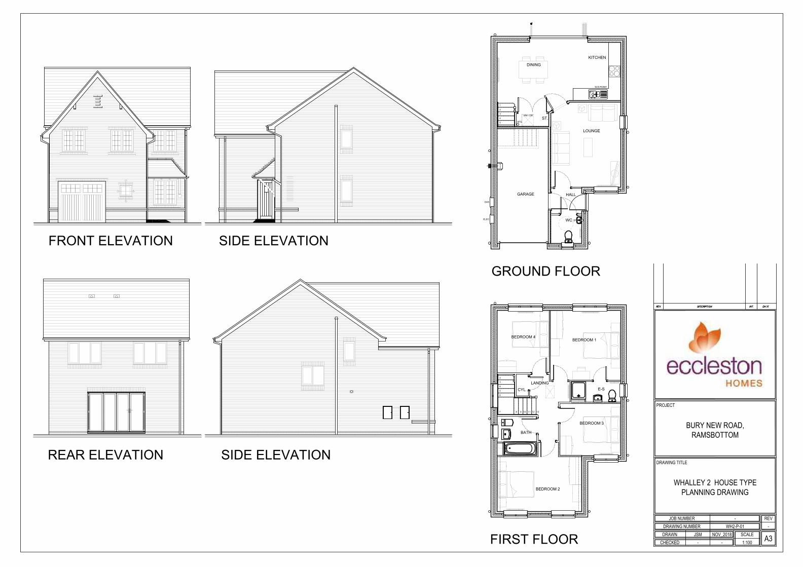
The proposed dwellings would be a mix of detached and terraced dwellings and would beconstructed from brick with a concrete tile roof.
The proposed development would be accessed from Bury New Road via the existingaccess. An area of public open space would be provided along the western boundary of thesite.
Relevant Planning History25253 - Outline - Residential development at land on Bury New Road, Ramsbottom.Refused - 8 August 1991.
27581 - Outline - Residential development on land to the north of Bury New Road and tothe west of Manchester Road, Ramsbottom. Refused - 2 June 1994.This application was refused as it would lead to an unacceptable loss of a Site of BiologicalInterest (SBI) and would lead to the loss of open land which is unallocated for development,contrary to the UDP.
60370 - Outline - residential development including means of access only at land to west ofManchester Road, Ramsbottom. Approved with conditions - 23 November 2016.

Page No 13
02018/E - Erection of 36 no. houses and associated engineering works at land to west ofManchester Road, Ramsbottom. Enquiry completed - 23 August 2017.
Adjacent site46193 - Erection of detached dwelling on land adjacent to 77 Bury New Road,Ramsbottom. Refused - 5 June 2006. Appeal dismissed - 28 March 2007.This application was refused for a number of reasons including housing oversupply, lack ofinformation in relation to levels, design, impact upon residential amenity, lack of turningfacilities, loss of parking and overdevelopment of the site.
PublicityThe neighbouring properties (450) were notified by means of a letter on 18 January 2019and a press notice was published in the Bury Times on 24 January 2019. Site notices wereposted on 23 January 2019.
2 letters of support have been received from the occupiers of Plunge Farm and 5 LindenAvenue, which have raised the following issues;
Will provide much needed larger family homes which are at a shortage in Ramsbottom.The small number of dwellings will have a negligible impact on traffic and the accessjunction will operate the same, if not better as the existing Maple Grove junction to thesouth. It will not form a cross roads and has achieved better visibility.Our broken housing market needs fixing - Theresa May, leader of the Conservatives in#Rammy and our Prime Minister
16 copies of a standard letter have raised the following issues:The application should be a committee decision and should not be delegated to officers.The site is an SBI and development of this land is inappropriate and breaches policiesin the UDP.The access road, visibility splays and footpath are below standards required by theCouncil and will result in almost 200 additional vehicle movements.The proposal will infill between Bury New Road and Peel Brow.There are not enough places at schools in the area.The flood risk assessment advises that there is a possibility of groundwater flooding andsurface water flooding affecting the site. The meadow should be retained to preventflooding onto the M66 motorway.
Letters have been received from the occupiers of the following properties:15, 23, 35, 39, 39, 41, 52, 54, 56, 76, 77, 79, 80, 83, 85, 91, 97 Bury New Road,165, 167, 173, 176, 178, 188, 192 Peel Brow, 22, 26, 32, 38 Manchester Road, 9 WhalleyRoad, 4 Cheshire Court, 5 Maple Grove, 6, 8 Shipper Bottom Lane, Nuttall Hall Cottages, 1Peel Court, 2 South Street, 3, 5, 7, 9 Linden Street, 1, 35, 45 Eliza Street, 717 WalmersleyRoad, 47 Marlborough Close, 140 Bolton Street, 6 Helmsdale Close, 17 Astley Hall Drive, 5Cross Street, 5 Conway Close, 15 The Spinnings, 9 The Hollow, 183 Rochdale Road, 79Brecon Drive, 46 Lansdowne Close, 25 Stanford Hall Crescent, 9 Spring Street, 267Heywood Old Road, 101 Dundee Lane, which have raised the following issues:
There are 2 developments under construction in Ramsbottom, which will createadditional traffic. This development will add to the burden on congested streets.Edgars field is a site of biological interest. The development is inappropriate and isprotected by law. There are bats on site, which are protected.Recent floods closed roads and caused traffic chaos. If this development is allowed togo ahead, residents will need boats.The houses that will be built will NOT be affordable housing and will not benefit localyoung people.We have little safe green space nearby for our children to play and it will be a tragedy tolose this little bit of green space.Have there been any consideration about access other than the proposed entrance onBury New Road?Access from Manchester Road would ease the road situationLocal schools and infrastructure are at capacity.

Page No 14
The housing will change the character of the area and would be infill. It is contrary to theUDP and GMSF.The access road and footpath widths are below standard and will not be adopted by theCouncil.Given that Council officers have made errors in their advice to committee over theoutline consent, this application should be heard by committee.The development will result in over 200 vehicle movements per dayThere is a natural spring passing through the site.The two houses in the top corner of the site will be able to see into our property due tothe difference in levels. These 2 houses should be rotated.Brownfield sites should be developed first for affordable housing.Local services are struggling to cope and there's no funding to improve these.It is a joke that Councillors are willing to put extra income before the wellbeing of thecommunity.The field was severely damaged to remove wildlife value to progress a future planningapplication. Destruction of wildlife to change the land designation is immoral andgranting planning consent to build on a SBI is immoral.The flood risk assessment advises that there is a possibility of groundwater flooding andsurface water flooding affecting the site. The meadow should be retained to preventflooding onto the M66 motorway.At a public inquiry into a scheme at Fletcher Bank Quarry, the capacity of the nearbysignalised junction was discussed and the Inspectors conclusion was that the road wasat or over capacity. The Inspector concluded that the increase in traffic was notsufficient as a standalone reason to refuse planning permission, it did weigh against thescheme.A refuse vehicle turning left will have to cross the white lines to leave the site.The application conflicts with many policies of the UDP.
The neighbouring properties and objectors were notified of revised plans on 11 March2019.
Letters have been received from the occupiers of 56, 76, 85, 91 Bury New Road, whichhave raised the following issues:
I wish to maintain my objection.In March 2019, the M66 flooded due to the River Irwell breaking its banks and trafficcame to a complete standstill on Manchester Road. More houses will mean moreflooding.The amount of pot holes will only increase.Planning was rejected in 1992 due to the SBI status. The SBI is the whole field, not justpart of it.The site regained its status as an SBI in September. The Council must base its decisionon the current status at the time of the application and not be influenced by the previousdesignation in 2016.The applicants suggestion that this marshland could become a public space, (drained ornot, managed or not) capable of supporting the, 'meadow', plant life that has resulted inEdgars field being recognised as an SBI is ridiculous.I wish to voice my utter disgust that this application is being considered. Do not ruinRamsbottom.Comments from GM Ecology Unit state that the 'current level of compensation for theloss of grassland as insufficient. The strip of wildflower grassland is too small to bemeaningful and is likely to be unsustainable.' As such, there is no evidence of anyoverriding need for 35 luxury houses.There are many alternative sites in the borough.All other amendments are totally irrelevant as the Council cannot grant consent on thissite without placing itself in breach of national and local planning
The objectors and supporters have been notified of the Planning Control Committeemeeting.

Page No 15
Statutory/Non-Statutory ConsultationsTraffic Section - Missing info from condition requiring details for RM application.Drainage Section - No response.Environmental Health Contaminated Land - No objections, subject to the inclusion ofconditions relating to contaminated land and radon gas.Environmental Health - Air Quality - No objections, subject to the inclusion of a conditionrelating to a scheme for electric vehicle charging points.Environmental Health Pollution Control - No comments.Public Rights of Way Officer - No objections, subject to the maintenance of the PublicRight of Way through the site.Waste Management - No response.Highways England - No objections.GM Ecology Unit - No objections, subject to the inclusion of a condition relating to thelandscaping/area of species rich grassland.The Coal Authority - No objections, subject to the inclusion of an informative relating tocoal mining.United Utilities - No objections, subject to the inclusion of a condition relating to thedrainage.Designforsecurity - No response.Environment Agency - No response.
Pre-start Conditions - Will be reported in the Supplementary Report.
Unitary Development Plan and PoliciesOL2/1 Development on Other Protected Open LandH1/2 Further Housing DevelopmentH2/1 The Form of New Residential DevelopmentH2/2 The Layout of New Residential DevelopmentH4/1 Affordable HousingEN1/1 Visual AmenityEN1/2 Townscape and Built DesignEN1/3 Landscaping ProvisionEN1/5 Crime PreventionEN1/7 Throughroutes and GatewaysEN2/1 Character of Conservation AreasEN2/2 Conservation Area ControlEN5/1 New Development and Flood RiskEN6 Conservation of the Natural EnvironmentEN6/4 Wildlife Links and CorridorsEN7 Pollution ControlEN7/1 Atmospheric PollutionEN7/2 Noise PollutionEN7/4 Groundwater ProtectionEN7/5 Waste Water ManagementEN8 Woodland and TreesEN8/2 Woodland and Tree PlantingEN9/1 Special Landscape AreasOL2/1 Development on Other Protected Open LandOL4/3 Development Impact on Farming AreasRT2/2 Recreation Provision in New Housing DevelopmentRT3/4 Recreational RoutesHT2/4 Car Parking and New DevelopmentHT2/5 Public Car ParksHT6/1 Pedestrian and Cyclist MovementHT6/2 Pedestrian/Vehicular ConflictRT2/2 Recreation Provision in New Housing DevelopmentSPD1 Open Space, Sport and Recreation ProvisionSPD2 DC Policy Guidance Note 2: Wildlife Links & Corridors
Page No 16
SPD3 DC Policy Guidance Note 3: Planning Out CrimeSPD5 DC Policy Guidance Note 5: Affordable HousingSPD6 Supplementary Planning Document 6: Alterations & ExtensionsSPD11 Parking Standards in BuryNPPF National Planning Policy Framework
Issues and AnalysisThe following report includes analysis of the merits of the application against the relevantpolicies of both the National Planning Policy Framework (NPPF) and the adopted BuryUnitary Development Plan (UDP) together with other relevant material planningconsiderations. The policies of the UDP that have been used to assess this application areconsidered to be in accordance with the NPPF and as such are material planningconsiderations. For simplicity, just the UDP Policy will be referred to in the report, unlessthere is a particular matter to highlight arising from the NPPF where it would otherwise bespecifically mentioned.
Principle - The principle of the development in relation to other protected open land andresidential development was established with the grant of outline planning consent inNovember 2016. The outline consent is still valid and requires the reserved matters to beconsidered in relation to the layout, scale, appearance and landscaping.
Design and layout - The proposed development would contain a mix of detached,semi-detached and terraced dwellings. The majority of the proposed dwellings would betwo storeys in height, except for plots 1 to 12, which would be split level dwellings to takeaccount of the levels which rise towards Manchester Road. The split level dwellings wouldbe three storeys at the front and two storeys at the rear. The proposed development wouldmatch the properties to the south in terms of height and scale and the cottages to the eastof the site are split level. As such, the proposed development would be appropriate in termsof height and scale.
The proposed development would be constructed from brick with concrete tile roofs, whichwould be similar in appearance to the existing properties in the locality. The inclusion ofheaders and cills, canopies and bay windows would add visual interest to the elevations.Therefore, the proposed development would not be unduly prominent in the locality and itwould be in accordance with Policies EN1/2, H2/1 and H2/2 of the Bury UnitaryDevelopment Plan.
All of the proposed dwellings would have a side or rear garden, which would provide asuitable level of private amenity space. There would be space within the rear or sidegardens for bin storage. Close boarded timber fencing would be provided to the reargardens with hedges marking the boundaries to the front, which would be acceptable.
Therefore, the proposed development would not be a prominent feature and would be inaccordance with Policies EN1/2, H2/1 and H2/2 of the Bury Unitary Development Plan.
Impact upon residential amenity - SPD6 provides guidance on aspect standards betweenresidential properties and as such, would be relevant in this case.
The aspect standards states that there should be a minimum of 20 metres between directlyfacing habitable windows and 13 metres between a habitable room window and a twostorey blank wall. If there is an additional storey in height or difference in levels of 2.5metres, a further 3 metres should be added to the aspect standard.
All of the relationships between the proposed dwellings within the site would comply withthe relevant aspect standards in SPD6.
There would be a minimum of 23 metres between the rear elevations of plots 9 to 12 andthe existing residential dwellings, which front onto Manchester Road, which would complywith the aspect standards.

Page No 17
There would be 31 metres between the rear elevation of No. 71 Bury New Road and thegable elevation of plot 19. There would be 22 metres and 25 metres between the rearelevations of No. 79 and 81 Bury New Road with the gable of plot 35 and plot 1. All of thesedistances would be well in excess of the 13 metres required.
Therefore, the proposed development would not have a significantly adverse impact uponthe amenity of the neighbouring properties.
Noise - The proposed layout of the site would result in plots 16 - 27 acting as a barrier toprovide mitigation form the noise generated by the adjacent motorway. The PollutionControl section has no objections to the proposed development. Therefore, the proposeddevelopment would not have a significant adverse impact upon the amenity of theneighbouring properties with regard to noise and would be in accordance with Policy EN7/2of the Bury Unitary Development Plan.
Ecology - The site was originally designated as a Site of Biological Interest (SBI) as itsupported relatively species-rich grassland, but was de-selected as an SBI in 2008 as thequality of the grassland had deteriorated in ecological terms. Over recent years, thegrassland has been managed more appropriately and plant diversity is recovering.
The land was surveyed by GM Ecology Unit (GMEU) at the time of the outline applicationand it was found that the grassland had been managed more appropriately and plantdiversity was recovering. This was borne out by the ecological report submitted with theoutline application.
GM Ecology Unit was consulted during the outline application stage and had no objections,subject to the inclusion of a condition requiring the creation and management of an area ofspecies-rich grassland as compensation for the loss of habitat across the whole site. Assuch, outline planning consent was granted for the proposed development.
The survey at the time of the outline application by GMEU formed the basis of the report tothe Planning Committee in September 2018, which updated the register of SBIs to includethe application site.
However, the designation of the site as an SBI is a constraint to be accommodated asoutline planning consent exists. At the time of considering the outline application, GMEUwere consulted on the application and as stated above, had no objections to the proposal.
Paragraph 70 (d) of the NPPF is more resillient to currnet and future pressures.
An SBI is a local designation. Nethertheless it is an intrinsic issue for the site must bebalanced in the decision making process. The layout and negotiations have sought torecognise that there is an existing planning permission, and also the site can contribute toother matters of relevance to the area including new housing provision.
Paragraph 175 (a) must apply as the principle of development is extant. The sites value asa **** SBI has re-established to a degree that ecology will play a part in the decision makingprocess and has retained and enhanced an area of 3,000 square metres within the site.The enhancement comprises planting of a grassland species mix, which on balance andconsideration of the competing demands and through consultation with GMEU isconsidered to be acceptable.
The current reserved matters application is seeking to establish the detailed layout, scaleand appearance of the proposed development. The proposed site plan and landscapingplan confirm that an area of 3,300 square metres of species rich grassland would belocated in one large area between the motorway and plots numbers 16 to 27. GM EcologyUnit have been consulted on the proposals and have no objections, subject to the inclusionof a condition relating to the species mix for the area of species rich grassland.

Page No 18
Therefore, the proposed development would not cause harm to the ecology of the area andwould be in accordance with Policies EN6 and EN6/3 of the Bury Unitary DevelopmentPlan.
Highways issues - The proposed development would be accessed from the existingaccess located between Nos 79 and 81 Bury New Road, as required by the outline consent.The internal road layout would be of an acceptable width and would have appropriate levelsof visibility. The proposed road layout would be acceptable, but would not meet the specificcriteria for adoption by the Highway Authority. As such, the maintenance of the roads wouldbe undertaken by a management company, which is nor an unreasonable proposal.Therefore, the proposed development would not be detrimental to highway safety andwould be in accordance with Policies H2/1, H2/2 and HT6/2 of the Bury UnitaryDevelopment Plan.
Public right of way - There is a public right of way passing through the site and connectsManchester Road to Bury New Road (along Old Engine Lane) to the west of No. 71 BuryNew Road. The proposed site plan indicates that the PROW would be maintained along theexisting route and would follow the access road through the development and become agravel path in the area of species rich grassland. The Public Rights of Way Officer has noobjections to the proposal. Therefore, the proposed development would be in accordancewith Policy RT3/4 of the Bury Unitary Development Plan.
Parking - SPD11 states that the maximum number of parking spaces is 3 spaces per 3bedroom dweling and 3 spaces per 4 bedroom dwelling and larger. This equates to 96spaces.
The proposed development would provide 67 spaces and there would be 22 single garagesand 4 double garages provided. Whilst garages are not normally taken into consideration,this would equate to 93 spaces. The site is located within walking distance of Bury NewRoad, where there are good transport links and walking distance to Ramsbottom towncentre. As such, the level of parking provision would be acceptable. Therefore, theproposed development would be in accordance with Policy HT2/4 of the Bury UnitaryDevelopment Plan and SPD11.
Planning obligations - The proposed development would provide informal recreationspace on site and 9 properties would be affordable. The affordable dwellings would besecured through a Section 106 agreement and represents full policy provision.
The proposed recreation space would be predominantly species rich grassland and wouldfunction as informal public open space. The proposed recreation space would assist inimproving connectivity with other areas of greenspace and would create an opportunity forsustainable urban drainage systems. This area of open space accommodates existingsewer and water mains and the public right of way would oass through the site. Given theabove, it is considered that the provision of on-site recreation space would be acceptable inthis instance.
Response to objectorsThe issues relating to the principle of the development, the number of vehiclemovements, traffic generation were assessed at the outline stage.The issues relating to loss of privacy, ecology and the designation of the SBI have beenaddressed in the report above.9 affordable houses will be provided on the site and will be secured via a legalagreement.An access from Manchester Road is not possible due to the significant difference inlevels between Manchester Road and the application site.Access roads do not have to meet adoption standards in order to grant planningconsent. The internal access roads and footpaths are acceptable, but would not beadopted by the Council. This means that the maintenance of the estate roads would be
Page No 19
undertaken by a management company.The ecological issues were fully assessed at the time of the outline application and theofficer recommendation to the Planning Control Committee was correct.The outline application was accompanied by a ecological report. This report providedevidence that the ecological status of the site was recovering and the outline applicationwas assessed on that basis.Issues relating to drainage and flood risk were assessed during the outline applicationand conditions 11, 12 and 13 deal with these issues on application 60370.There is no policy requirement for the developer to provide funding to improve existingservices or to provide additional school places.
Statement in accordance with Article 35(2) Town and Country Planning (DevelopmentManagement Procedure) (England) (Amendment) Order 2015
The Local Planning Authority worked positively and proactively with the applicant to identifyvarious solutions during pre-application discussions to ensure that the proposal comprisedsustainable development and would improve the economic, social and environmentalconditions of the area and would accord with the development plan. These wereincorporated into the scheme and/or have been secured by planning condition. The LocalPlanning Authority has therefore implemented the requirement in Paragraph 38 of theNational Planning Policy Framework.
Recommendation: Minded to Approve
Conditions/ Reasons
1. The development must be begun not later than the expiration of two yearsbeginning with the date of this permission.Reason. Required to be imposed pursuant to Section 51 of the Planning andCompulsory Purchase Act 2004
2. This decision relates to drawings numbered 101, 102 A, 103, HA-P-01, IN-P-01,IN-P-02, PK-P-01, PC-P-01, Pickmere House Type - Sheet 2, TA-P-01,WH2-P-01, WN-P-01, SG-P-01, DG-P-01, ENG-01 D, ENG-09 D, ENG-10 D, 11A, F02, 001-2, SSS-6771-Land At Ramsbottom Rev A (Sheet 1 of 2),SSS-6771-Land At Ramsbottom Rev A (Sheet 2 of 2), 4151 01 B,SCP/18105/SK01 and the development shall not be carried out except inaccordance with the drawings hereby approved.Reason. For the avoidance of doubt and to ensure a satisfactory standard ofdesign pursuant to the policies of the Bury Unitary Development Plan listed.
3. Following the provisions of Condition 4 of permission 60370, where radon gasremediation / protection measures are required, the approved RemediationStrategy must be carried out to the written satisfaction of the Local PlanningAuthority within approved timescales; andA Site Verification Report detailing the actions taken and conclusions at eachstage of the remediation works, including substantiating evidence, shall besubmitted to and approved in writing by the Local Planning Authority prior to thedevelopment being brought into use.Reason. To alleviate any possible risk associated with the production of landfillgas and ground gas in accordance with the recommendations of the EnvironmentAgency and pursuant to Chapter 15 - Conserving and enhancing the naturalenvironment of the National Planning Policy Framework.
4. Notwithstanding the landscaping scheme submitted, details of the species richgrassland seed mix shall be submitted to and approved in writing by the LocalPlanning Authority prior to the commencement of the development herebyapproved. Only the approved details shall be implemented as part of the approved

Page No 20
landscaping scheme.The approved scheme shall thereafter be implemented not later than 12 monthsfrom the date the building(s) is first occupied or within the first available treeplanting season; and any trees or shrubs removed, dying or becoming severelydamaged or becoming severely diseased within five years of planting shall bereplaced by trees or shrubs of a similar size or species to those originally requiredto be planted. Reason. To secure the satisfactory development of the site and in the interests ofvisual amenity pursuant to Policies H2/2 - The Layout of New ResidentialDevelopment, EN1/2 - Townscape and Built Design and EN8/2 - Woodland andTree Planting of the Bury Unitary Development Plan and chapter 15 - Conservingand enhancing the natural environment of the NPPF.
5. The car parking indicated on the approved plans shall be surfaced, demarcatedand made available for use prior to first occupation of any of the dwellings herebyapproved.Reason. To ensure adequate off street car parking provision in the interests ofroad safety pursuant to Policy HT2/4 - Car Parking and New Development of theBury Unitary Development Plan.
6. Details/Samples of the (materials/bricks) to be used in the external elevations,together with details of their manufacturer, type/colour and size, shall besubmitted to and approved in writing by the Local Planning Authority before thedevelopment is commenced. Only the approved materials/bricks shall be used forthe construction of the development.Reason. No material samples have been submitted and are required in theinterests of visual amenity and to ensure a satisfactory development pursuant toUDP Policy EN1/1 Visual Amenity.
7. Notwithstanding the terms of the Town and Country Planning (General PermittedDevelopment) (England) Order 2015, as subsequently amended, no developmentshall be carried out within the terms of Classes A to G of Part 1 of Schedule 2 ofthe Order, without the submission and approval of a relevant planning application.Reason. To ensure that future inappropriate alterations or extensions do not occurpursuant to policies of the Unitary Development Plan listed.
For further information on the application please contact Helen Longworth on 0161 2535322

PLANNING APPLICATION LOCATION PLAN
Planning, Environmental and Regulatory Services
No Window
No Window
ADDRESS:
APP. NO 63617
Land to the west of Manchester RoadRamsbottom
(C) Crown Copyright and database right (2015). Ordnance Survey 100023063.
86
89
99
93
4038
2232
28
El S
ub Sta
20
71
76
77
1
160
SOUTH STREET
PA
RK
AV
EN
UE
Track
181.7m
1
2
3
4
Viewpoints

63617
Photo 1
Photo 2

63617
Photo 3
Photo 4


BEDROOM 1
BEDROOM 3
BEDROOM 3
BEDROOM 2
ENSUITE
BATHROOM
ENSUITE
DAYROOM
WC
KITCHEN
UTILITY
BREAKFAST
LIVING
LANDING
DINING
GARAGE
Retaining Wall
HALL
ENSUITE
BEDROOM 5
SECOND FLOOR
FIRST FLOOR
GROUND FLOOR
CHECKED
JOB NUMBERDRAWING NUMBER
DRAWING TITLE
DRAWN SCALE A3
REV
PROJECT
BURY NEW ROAD,RAMSBOTTOM
INGLEWHITE HOUSE TYPEPLANNING DRAWING
SHEET 2
1:100--NOV_2018JSM
-IN-P-02-

BEDROOM 1
BEDROOM 2
ENSUITE
BEDROOM 3BEDROOM 4BEDROOM 5
LANDING
ENSUITE
BATHROOM
DAYROOM
WC
KITCHEN
UTILITY
BREAKFAST
LIVING
LANDING
DINING
GARAGE
Retaining Wall
GYM
WASHROOM
HALL
SECOND FLOOR
GROUND FLOOR
CHECKED
JOB NUMBERDRAWING NUMBER
DRAWING TITLE
DRAWN SCALE A3
REV
PROJECT
BURY NEW ROAD,RAMSBOTTOM
PICKMERE HOUSE TYPEPLANNING DRAWING
SHEET 2
-PC-P-02 -
JSM NOV_2018- - 1:100
FIRST FLOOR

KITCHEN
UTILITY
DAYROOM
BREAKFAST
LIVING
HALL
WC
GARAGE
Store
BEDROOM 1
BATH 1
BATH 2
BEDROOM 3
BEDROOM 2
BEDROOM 4
BATH 3
cyl
CHECKED
JOB NUMBERDRAWING NUMBER
DRAWING TITLE
DRAWN SCALE A3
REV
PROJECT
BURY NEW ROAD,RAMSBOTTOM
PARKGATE HOUSE TYPEPLANNING DRAWING
-PK-P-01 -
JSM NOV_2018- - 1:100
FRONT ELEVATION REAR ELEVATION
GROUND FLOOR
FIRST ELEVATION
SIDE
ELEVATION
SIDE
ELEVATION

RWP
RWP
RWP
RWP
3 4
6
7
8
5
RWP
9
10111213
Cyl
BED. 2
BED. 1
BED. 3
BATHROOM
E/S 1
LANDING
BED. 4
SVP
SVP
BO
ILE
R
RWP
GARAGE
RWP
RWP
W.E.POINT
SFG
RWP
LOUNGE
UTILITY
1 2 34
6
7
8
5
SFG
DC
ELE
C
GA
S
FAMILY
HALL
KITCHEN
WC
SVP
SFG
SVP
RWP
ST.
DINING
FRONT ELEVATION
FIRST FLOORGROUND FLOOR
SIDE ELEVATION
REAR ELEVATION
SIDE ELEVATION
CHECKED
JOB NUMBERDRAWING NUMBER
DRAWING TITLE
DRAWN SCALE A3
REV
PROJECT
BURY NEW ROAD,RAMSBOTTOM
WILLASTON HOUSE TYPEPLANNING DRAWING
-WN-P-01 -
JSM 28.11.18- - 1:100
DC
ELEC
GAS
W.E.POINT
SFG
1
2
3
4
5
KITCHEN
DINING
ST.
LOUNGE
GARAGE
HALL
WC
BO
ILE
R
SFG
WM / DR
SFG
BEDROOM 2
BEDROOM 1
BEDROOM 4
E-S
LANDING
BATH
BEDROOM 3
CYL.
2
3
4
5
6
7 8 9 10 11 12 13
SIDE ELEVATIONREAR ELEVATION
SIDE ELEVATIONFRONT ELEVATION
GROUND FLOOR
FIRST FLOOR CHECKED
JOB NUMBERDRAWING NUMBER
DRAWING TITLE
DRAWN SCALE A3
REV
PROJECT
BURY NEW ROAD,RAMSBOTTOM
WHALLEY 2 HOUSE TYPEPLANNING DRAWING
1:100--NOV_2018JSM
-WH2-P-01-

WCHALL
Store
LIVING
KITCHEN
WC HALL
Store
LIVING
KITCHEN
BATHROOM
BEDROOM 1
BEDROOM 2
BEDROOM 3
Store
Landing
BATHROOM
BEDROOM 1
BEDROOM 2
BEDROOM 3
Store
Landing
CHECKED
JOB NUMBERDRAWING NUMBER
DRAWING TITLE
DRAWN SCALE A3
REV
PROJECT
BURY NEW ROAD,RAMSBOTTOM
TARLETON HOUSE TYPEPLANNING DRAWING
1:100--NOV-2018JSM
-TA-P-01-
FRONT ELEVATION
GROUND FLOOR PLAN
SIDE ELEVATION REAR ELEVATION
SIDE ELEVATION
FIRST FLOOR PLAN

BEDROOM 2
BEDROOM 4
BEDROOM 1
BATH
BEDROOM 3
EN-SUITE
CYL
LANDING
2
3
4
5
6
7
8
9
10
11
12
13
SVP
SVP
W.C
HALL
ST.
RECEPTION
ROOM 1
RECEPTION
ROOM 2
UTILITY
KITCHEN
FAMILY
1
2
3
4
5
6
SVP
W.E.POINT
SFG
SFG
SFG
GAS
SVP
ELEC
FRONT ELEVATION
FIRST FLOORGROUND FLOOR
SIDE ELEVATION
REAR ELEVATION
SIDE ELEVATION
CHECKED
JOB NUMBERDRAWING NUMBER
DRAWING TITLE
DRAWN SCALE A3
REV
PROJECT
BURY NEW ROAD,RAMSBOTTOM
HAIGH HOUSE TYPEPLANNING DRAWING
-HA-P-01 -
JSM 28.11.18- - 1:100
Page No 21
Ward: Ramsbottom + Tottington - Tottington Item 04
Applicant: School Business Manager
Location: Elton High School, Walshaw Road, Bury, BL8 1RN
Proposal: Creation of new artificial grass pitch (AGP) and installation of new 4.5m high ballstop fencing and entrance gates to AGP perimeter, new 2.0m high and 1.2m highpitch perimeter barrier and entrance gates within AGP enclosure, new hard standingareas, new floodlight system and new maintenance equipment store located withinAGP enclosure
Application Ref: 63785/Full Target Date: 28/05/2019
Recommendation: Approve with Conditions
DescriptionThe application relates to grounds within Elton High School which has been redeveloped toprovide a replacement school building and sports hall and associated facilities. The schoolsite is bounded to the north by Walshaw Road, to the east by houses on CotswoldCrescent, to the south by Leigh Lane and to the west by Owlerbarrow Road.
The school building is set back into the site and part of the re-development included theprovision of sports playing pitches, one of which was to be located directly behind the newschool to the south. The pitch was to replace that which was to be lost as a result of thesiting of the main school building and essentially re-instated the grass surfacing whichcomprised the playing pitches.
The school have historically experienced problems with drainage on the site and state thatthe sports playing pitches are unusable for approximately nine months of the year due tofrequent waterlogging. The school have therefore sought to investigate whether therewould be any alternative and viable options which would solve this problem.
One such solution would be for the installation of an Artificial Grass Pitch (AGP) and as aresult of stakeholder discussions on this matter, the school have the opportunity to apply fora grant award which would part fund an investment into a new playing pitch. Theapplication states that not only would it deliver wide ranging benefits for the pupils of theschool, but it is also intended for a wider community use out of school hours, therebysignificantly improving the quality of sports facilities available in Elton and Bury.
This application therefore proposes the creation of a new AGP together with associatedfloodlighting, boundary treatment and equipment storage. Details comprise:
Installation of a 106m x 70m AGP to facilitate various football pitch sizes and trainingareas;Installation of 16 lighting units on 8 no. x 15m high floodlight columns along the northand south perimeter, with integrated fitted louvers/baffles;4.5m high ball stop fencing and entrance gates to the AGP perimeter;Perimeter pitch barrier - 1.2m and 2m high and gates within the fenced enclosure;Areas of hardstanding around the perimeter for access and maintenance;Maintenance equipment store, 6m x 2.4m x 2.59m.
The development would require some levelling works to be carried in the area and would
Page No 22
include a drainage scheme and landscaping along the perimeter of the school site withhouses on Cotswold Crescent.
The hours of use of the pitch have been amended by the applicant and are now proposedas:08.45 to 21.00 Monday to Friday (floodlights to extinguish at 21.10 to allow for safe exit) 09.00 to 20.00 Saturday and Sunday ( floodlights to extinguish at 20.10 to allow for safeexit)
The school car park would be available for community use and local football teams outsideof the school opening hours.
Relevant Planning History58279 - Demolition of existing school buildings; Erection of replacement school andassociated sports provision together with new accesses, car parking and landscaping -Approve with Conditions 18/03/201558794 - Erection of new substation and enclosure to the substation and bin store - Approvewith Conditions 24/07/201558853 - Variation of condition no.13 of approved planning application 58279 to read "Thedevelopment hereby approved shall be carried out in accordance with the surface waterdrainage scheme on Drawing Number (52)001 Rev P10 and implemented prior to the firstoccupation of the development hereby approved and thereafter maintained in accordancewith the approved details - Approve with Conditions 11/08/201559246 - Non-material amendment following grant of planning permission 58853 - Amendapproved drainage scheme Drawing Number (52)001 Rev P10 to allow relocation ofattenuation tank and connection to combined sewer. - Approve with Conditions 07/10/201560192 - Non-material amendment following granting of planning permission 58853 -Various minor amendments across the scheme to reflect the progression of further designdetails. - Approve 22/06/201660371 - Non-material amendment following granting of planning permission 58794 -Amendments to the design of enclosure to provide an alternative layout for the substationand bin storage area. - Approve 12/08/201660835 - Variation of conditions 2, 12 and 16 of planning permission 58853 to allow forchanges to the final ground levels and amendments to the landscaping and surface waterdrainage scheme - Withdrawn by Applicant 23/02/201762089 - Erection of 3 metre high ball-stop fence within school site - Approve with Conditions15/12/201715/0371 - Paving flags from the gate which turns into the school and the outside corner ofWalshaw Road are badly damaged and uneven - 27/08/201516/0069 - Creation of mounds / deposit of material - 25/02/201616/0203 - Breach of condition - 04/05/201616/0483 - In breach of planning permission 58853 - not complying with the requirementsregarding surface flooding - 16/12/201618/0142 - Breach of conditions (58279) - 21/05/201819/0071 - Breach of conditions 12 & 13 (drainage) of planning permission 58279 -
PublicityLetters sent to 62 properties on 5/4/19 to properties on Walshaw Road, Ettington Close,Owlerbarrow Road, Leigh Lane, Cotswold Crescent, Wellington Street, DearncammeClose, Pickering Close, Tottington Road, Prospect Terrace, Sefton Street, Harwood Road,Bradley Fold Road.
Objections received from Nos 6, 10 Ettington Close, 73, 125, 135 Cotswold Crescent, 5Owlerbarrow Road
We have regular minor flooding in our garden caused by run off from the school playingfields and are concerned that this will be exacerbated by the installation of artificialgrass pitch and hardstanding;The floodlighting will create a visual disturbance in our garden and property - there is noinformation where this will be sited and what time the floodlighting will be switched off;

Page No 23
There will be increased noise and disturbance in the evenings. No information aboutthe use of the pitch in the evenings.We require substantially more information about this application. We have not foundthe school to be considerate to residents concerns in the past and if there is an issueonce the pitch is in place we are concerned they won't be interested in resolving them.This facility was originally sited at the front of the school, but that has obviouslychanged. The 4.5m high fencing will totally affect our view and will not always preventballs from leaving the playing area.Evening sport will create noise until what time? Floodlighting will cause a sleep problemin our back 2 bedrooms where our Grandson sleeps. We were originally told that thearea behind our home "would be returned to its original usage of a football pitch and arunning track". Why has this changed without notifying us?We are already experiencing flooding in our back garden due to the failure to installproper drainage. An all weather pitch will increase that problem.The field is large enough for the facility to be built well away from current houses. Whyhas this avenue not been proposed?Noise - late night use, and additional noise at weekend;Object to it's position in relation to the school. It would surely be better to have the pitchin front of the school thus reducing the impact of the flood lighting and noise to localresidents, as far fewer resident would be affected by the noise and floodlighting.Having the pitch at the back of the school, out of site of the main road, would make sitesecurity more of a problem. Having it visible from the main road would reduce theopportunities for unauthorised use or for non users creating damage to school property.Concerned people will park on Walshaw roadOther AGPs at Castlebrook, Woodhey and Parrenthorn etc. have no nearby housing.Facilities also available at Play Football Bury, the college.The drainage IS a problem on the area behind the school as it is compacted with verylittle top soil, causing flooding to nearby gardens including mine, the rest of the fieldbecomes boggy in wet weather a 40 year+ problem limiting its use.The tree screening promised in the original school application has died but not removedor replacedGates have been erected outside my property - for what purpose?The litter situation is horrendous behind the fence.
Comments from No 127 Cotswold Crescent and 71 Cotswold CrescentI could not find exactly where the AGP will be sited on your website - will it be at theback or front of the school? Over the past few years the field at the back of the school has been holding water andthe water runs off, flooding the gardens of the houses which has been raised beforewith a Council representative at the meetings for the build of the new school;Before any works take place to build the AGP, may I suggest that proper drainage isput in so as the AGP can be laid correctly and used in a proper manner. Over the last few years the playing fields have not been used by the school or thecommunity due to the water logged field and so would be a waste of money puttingdown a AGP without proper drainage first.We neither object to, nor support this application however we would like to make thefollowing comments: consider the floodlights would be on too late and would ask theLPA to review a more suitable curfew, preferably no later than 9pm.The site is known to hold surface water in times of prolonged rainfall and so a clearsurface water drainage system should be submitted to the LPA for review. It is positiveto see the applicant proposing that no development shall begin until a detailedsustainable surface water drainage scheme for the site has been submitted. We wouldlike to stress the importance of this requirement to ensure that flood risk is notincreased to the adjacent properties up to and including the 1 in 100 year event, plus anallowance for climate change
Support letters received from Rota Engineering, 59 Tottington Road, 16 DearncammeClose, 10 Pickering Close, 169 Walshaw Road, 41 Sefton Street, 53-55 Harwood Road,Prospect Terrace, 252 Bradley Fold Road, 53 Elton fold Chase, 43 Grantham Drive, 147

Page No 24
Tottington Road, 58 Whitington CloseWhat a superb addition to the school and for the community this will be. Bury has beencrying out for modern sporting facilities of this kind for years. Many kids in the localcommunity will have a top class sporting venue to use.The modern day LED lighting will see very little light pollution with a focused beamgoing direct onto the pitch, like the new street lighting. No disturbance for theneighbours.As for the temporary road behind Cotswold Crescent, the build of the pitch will be overand done in 3 months.The 4.5m fence is just immediately around the pitch and will be of similar constructionto the current see-through fencing.Flooding has been significantly reduced since the new school was built. Drainage isnow good.As a manager of a local football team I believe that this facility will help aid the survivalof grass roots football in the local area. We constantly struggle to get games playedbecause of the weather and feel that there are not enough AGP in Bury compared toother local towns. This facility is a must and will help all sorts of sports to flourish.Facilitate football for young people through the winter months due to our generalchronic weather conditions.Hopefully the technology regarding LED lighting will ensure the facility is installed in asympathetic manner for the local residents.There is going to be an excellent drainage system which will reduce the water run off In these times of trying to counter childhood obesity, it would seem perverse if thecommunity was to be denied such a facility. The new pitch would also improve an areaof the school that is underused and is far enough away from any private residentialdwellings, so will not cause a nuisance.Restoration of the whole of the rear playing fields to the original plan would a better useof the £700K budget on the application site. This would provide a sporting facility allyear round for all disciplines not just football for the School and enhance its reputationwithin the local area.The school works tirelessly to fund raise for the extra money that they need to raise. Istrongly believe that The Elton High deserves this application to be granted if they meetthe conditions.
Those who have made representations have been informed of the Planning ControlCommittee meeting.
Statutory/Non-Statutory ConsultationsTraffic Section - No objection subject to conditions.Drainage Section - No objection subject to a condition to provide further details,calculations and maintenance proposals.Environmental Health - Contaminated Land - No comments to make.Environmental Health - Pollution Control - No objection subject to a condition too controlhours and provide noise attenuation barriers.Greater Manchester Police - designforsecurity - No response received.United Utilities (Water and waste) - No objection subject to conditionsSport England - No objection
Pre-start Conditions - Applicant/Agent has agreed with pre-start conditions
Unitary Development Plan and PoliciesNPPF National Planning Policy FrameworkEN1/2 Townscape and Built DesignEN1/3 Landscaping ProvisionEN5/1 New Development and Flood RiskEN7 Pollution ControlEN7/2 Noise PollutionRT2/3 Education Recreation FacilitiesRT2/4 Dual-Use of Education Facilities

Page No 25
RT3/5 Noisy SportHT2/4 Car Parking and New DevelopmentHT5/1 Access For Those with Special NeedsCF2 Education Land and BuildingsEN1/5 Crime Prevention
Issues and Analysis
The following report includes analysis of the merits of the application against the relevantpolicies of both the National Planning Policy Framework (NPPF) and the adopted BuryUnitary Development Plan (UDP) together with other relevant material planningconsiderations. The policies of the UDP that have been used to assess this application areconsidered to be in accordance with the NPPF and as such are material planningconsiderations. For simplicity, just the UDP Policy will be referred to in the report, unlessthere is a particular matter to highlight arising from the NPPF where it would otherwise bespecifically mentioned.
Principle - Paragraph 91 of Chapter 8 - Promoting healthy and safe communities - statesthat decisions should aim to achieve healthy, inclusive and safe places to enable andsupport healthy lifestyles, through the provision of safe and accessible infrastructureincluding sports facilities, and at Para 92 to provide the social, recreational and culturalfacilities and services the community needs and plan positively for the provision and use ofshared spaces and community facilities such as sports venues, to enhance thesustainability of communities and residential environments.
Para 97 of the NPPF states that existing open space, sports and recreational buildings andland, including playing fields, should not be built on unless :
an assessment has been undertaken which has clearly shown the open space,buildings or land to be surplus to requirements; orthe loss resulting from the proposed development would be replaced by equivalent orbetter provision in terms of quality and quantity in a suitable location; orthe development is for alternative sports and recreation provision, the benefits of whichclearly outweigh the loss of the current or former use.
UDP Policy RT2/3 - Education Recreation Facilities would not allow development where itwould result in the loss of education recreation facilities unless there is no long term need,significant demand or an adequate supply within the neighbourhood.
UDP Policy RT2/4 - Dual-Use of Education Facilities supports an increased level ofrecreational provision by looking favourably on proposals for the dual-use of educationfacilities and playing fields by the community.
The proposed development would provide a better quality and usable sports playing pitchfacility for the school which would meet the educational and sporting curriculumrequirements all year round. It would also be beneficial to the advancement of sportsactivity and engagement and provide a genuine asset and a much needed facility for localcommunity groups and sports organisations in the area which would help to deliver anational strategy for grassroots football.
Sport England are satisfied the proposed AGP would meet a strategic need and providesporting benefits that would outweigh the loss of the existing playing field.
As such, it is considered that the development would deliver educational and socialbenefits to both the school and local community, and would comply with the principles ofthe NPPF and UDP policies RT2/3 and RT2/4.
Siting and layout - The proposed AGP would be located directly behind the schoolbuilding to the south on land originally earmarked as a grassed sports pitch and thislocation best serves access to the pitch from the school and is close to the sports hall and

Page No 26
changing facilities. It would have a larger footprint than that previously approved but notextend further towards the eastern boundary and the houses on Cotswold Crescent. Assuch the siting of the proposed AGP would be considered acceptable. The AGP would becloser to houses on Owlerbarrow Road but at more than 50m away, it would still be aconsiderable distance from these properties.
The AGP itself would be laid out to provide a number of different sized football pitcheswhich would cater for different needs and enclosed by a 4.5m high mesh type fence withlockable gated entrances. There would be an area of hardstanding around the pitch butthis would not be excessive in area and would facilitate pedestrian access and circulationonly.
A relatively small storage container would be located on the north elevation within closeproximity to the AGP and on part of the identified hardstanding area and would be easilyaccessible to users of the pitch.
One marked difference of this scheme to that previously approved would be the proposal toinstall floodlighting to the perimeter of the site. There would be 16 lights mounted on 8columns of 15m in height. The floodlights would be equally spaced along the north andsouth perimeter of the pitch. The application states the number, position and height of thefloodlights are required to provide good uniformity lighting of the pitch whilst ensuringminimum light overspill.
In considering the erection of floodlighting in principle alone, given that the lighting wouldbe in association with a sporting facility, and given the slimline design and number of lightsto be provided, on balance they are considered acceptable to the scheme. Whether theposition of the lights and the luminance/light spillage would be acceptable in terms ofimpact on the nearby residential amenity, is discussed in more detail below.
This application proposes a 'dual use' facility, open to the community and sports groups inthe local area. Community use of the sports facilities at the school was envisaged as partof the complete re-development of the school site, and similar is proposed in thisapplication. In principle therefore, it has been accepted that a sports pitch in this locationout of normal school hours would be acceptable.
For community users, the pitch would be located without the need to walk through theschool building itself, and therefore it could operate as a separate facility. Some of theobjections raised by local residents have questioned the security of the siting of the pitchand the opportunities it would present for unauthorised use or potential for damage toschool property, particularly later in the evening.
The AGP would be a facility catering for groups of people, many of who would arrivetogether or meet in the car park beforehand. The facility would be lit by floodlights whichwould be kept on to extinguish 10 mins after the pitch use closed, which would allow for asafer exit from this area of the site and out of the school grounds. It would also be theresponsibility of the school and the community groups themselves to manage the securityand comings and goings of 'out of hours' users.
It is therefore considered that the siting and location of the proposed AGP would beacceptable in principle, would be located close to the school buildings and sports hall forthe school's use, and as a separate facility could cater for the needs of community groups.
As such, the layout and siting of the proposed development is considered acceptable andwould comply with UDP Policies RT2/3 - Education Recreation Facilities, RT2/4 - Dual-Useof Education Facilities and the principles of the NPPF.
Design and visual impact - The design and appearance of the proposed AGP would bedifferent to that of a grassed pitch, not only in terms of the surfacing, but would introducemultiple pitch markings of vibrant colours to distinguish the different pitch types. Whilst the
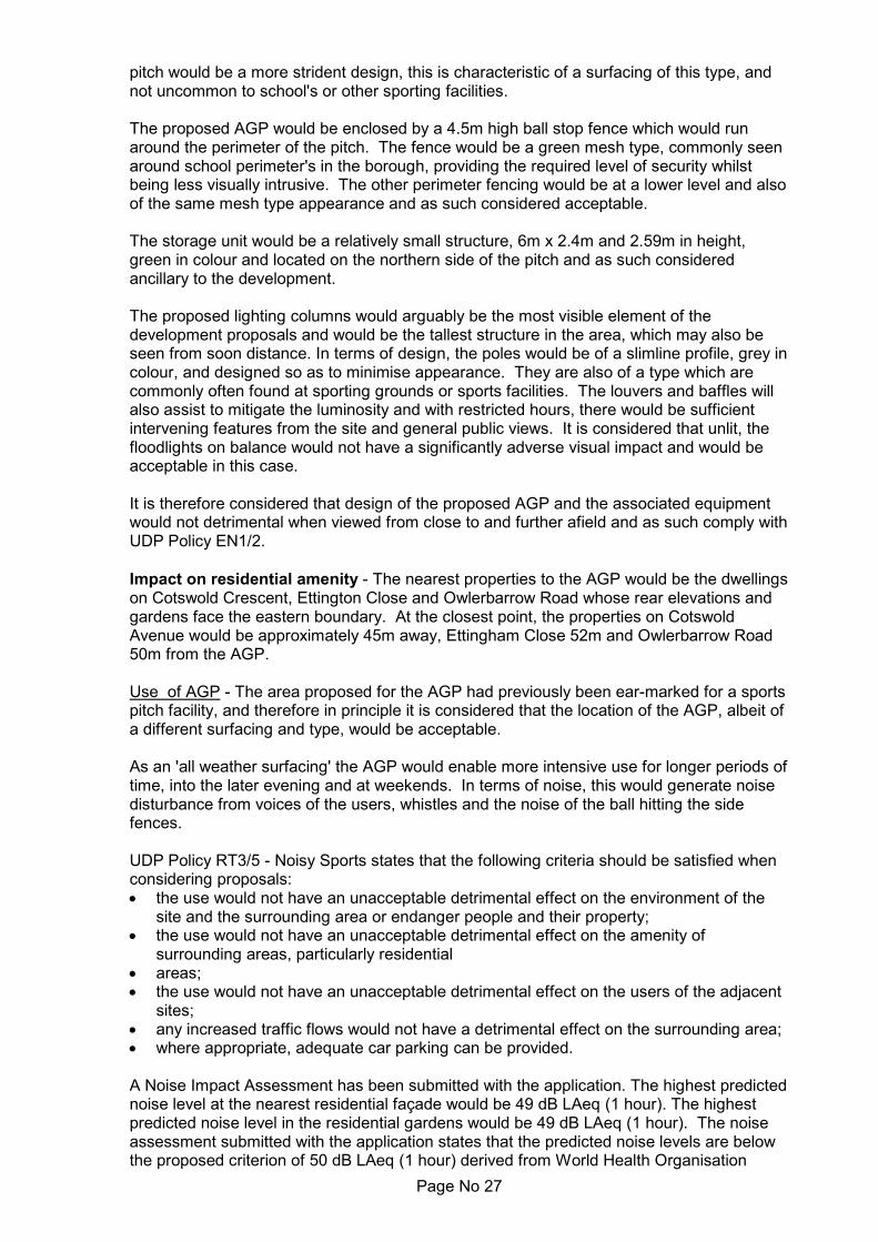
Page No 27
pitch would be a more strident design, this is characteristic of a surfacing of this type, andnot uncommon to school's or other sporting facilities.
The proposed AGP would be enclosed by a 4.5m high ball stop fence which would runaround the perimeter of the pitch. The fence would be a green mesh type, commonly seenaround school perimeter's in the borough, providing the required level of security whilstbeing less visually intrusive. The other perimeter fencing would be at a lower level and alsoof the same mesh type appearance and as such considered acceptable.
The storage unit would be a relatively small structure, 6m x 2.4m and 2.59m in height,green in colour and located on the northern side of the pitch and as such consideredancillary to the development.
The proposed lighting columns would arguably be the most visible element of thedevelopment proposals and would be the tallest structure in the area, which may also beseen from soon distance. In terms of design, the poles would be of a slimline profile, grey incolour, and designed so as to minimise appearance. They are also of a type which arecommonly often found at sporting grounds or sports facilities. The louvers and baffles willalso assist to mitigate the luminosity and with restricted hours, there would be sufficientintervening features from the site and general public views. It is considered that unlit, thefloodlights on balance would not have a significantly adverse visual impact and would beacceptable in this case.
It is therefore considered that design of the proposed AGP and the associated equipmentwould not detrimental when viewed from close to and further afield and as such comply withUDP Policy EN1/2.
Impact on residential amenity - The nearest properties to the AGP would be the dwellingson Cotswold Crescent, Ettington Close and Owlerbarrow Road whose rear elevations andgardens face the eastern boundary. At the closest point, the properties on CotswoldAvenue would be approximately 45m away, Ettingham Close 52m and Owlerbarrow Road50m from the AGP.
Use of AGP - The area proposed for the AGP had previously been ear-marked for a sportspitch facility, and therefore in principle it is considered that the location of the AGP, albeit ofa different surfacing and type, would be acceptable.
As an 'all weather surfacing' the AGP would enable more intensive use for longer periods oftime, into the later evening and at weekends. In terms of noise, this would generate noisedisturbance from voices of the users, whistles and the noise of the ball hitting the sidefences.
UDP Policy RT3/5 - Noisy Sports states that the following criteria should be satisfied whenconsidering proposals:
the use would not have an unacceptable detrimental effect on the environment of thesite and the surrounding area or endanger people and their property;the use would not have an unacceptable detrimental effect on the amenity ofsurrounding areas, particularly residentialareas;the use would not have an unacceptable detrimental effect on the users of the adjacentsites;any increased traffic flows would not have a detrimental effect on the surrounding area;where appropriate, adequate car parking can be provided.
A Noise Impact Assessment has been submitted with the application. The highest predictednoise level at the nearest residential façade would be 49 dB LAeq (1 hour). The highestpredicted noise level in the residential gardens would be 49 dB LAeq (1 hour). The noiseassessment submitted with the application states that the predicted noise levels are belowthe proposed criterion of 50 dB LAeq (1 hour) derived from World Health Organisation

Page No 28
(WHO) 1999 as being the threshold for the onset of moderate community annoyance. Itwould be reasonable to attach a condition requiring the AGP facility to operate only at theproposed hours of opening.
The Institute of Environmental Management and Assessment (IEMA) Guidelines forEnvironmental Noise Impact Assessment Version 1.2 (2014) categorises the significance ofchanges in noise levels at sensitive locations. On the basis of the IEMA guidelines, theproposals would result in a moderate increase in the existing noise climate.
The Noise Report concludes that it would be expected that the development wouldpotentially be noticeable but not intrusive and would result in 'no observed adverse effect'as defined in the Noise Policy Statement for England (NPSE) requirements.
The Report recommends that a noise management plan be implemented as part of thedevelopment to include an action plan of how complaints, if received by the school, wouldbe addressed. The Report also recommends that the perimeter fencing is fixed with'neoprene isolators' a measure used for noise prevention which are bolted to the supportposts and which reduce ratting and vibration associated with ball impacts on fencing.
The Pollution Control Section have been consulted on the proposals and have raised noobjection in principle, subject to a condition to control the hours of use of the pitch to thoseproposed and provide details of the scheme for the inclusion of neoprene isolators.
In terms of visual impact, the site area would require some ground works to create arelatively level platform for the pitch and this would be achieved by the creation of a plinth,which would result in the pitch being approximately 1m or so higher than the existingground level and the ground level of houses on Cotswold Crescent and Ettingham Close.The change in gradient would be viewed over a distance of over 45m, and given theseparation between the development and these properties, the change in levels would notbe significantly perceptible.
The view of the AGP would also be partly obscured by the landscaping which is proposedto the eastern boundary of the site. The AGP would be enclosed by a perimeter fence, of agreen mesh type which provides a secure area whilst less visually intrusive than otherboundary treatments. At a distance of 45m away, and with the proposed screening, it isconsidered the AGP would not cause significant harm to outlook.
The houses on Owlerbarrow Road would be 50m or more away and again, in considerationof the above factors, considered to be significant distance not to be seriously affected bythe siting of the AGP.
On balance, with the imposition of conditions for the implementation of the mitigationmeasures, it is considered impact on the amenity of the nearby occupiers from the siting ofthe AGP would not be significantly adverse and the proposed development would complywith UDP Policies EN1/2, EN7/2 and RT3/5.
Floodlighting - The most prominent feature of the AGP would be the proposed floodlighting,comprising 16 lights mounted on 8 poles of 15m in height.
The applicant has been asked to provide a justification for the reasoning behind thenecessity for such tall structures in comparison to what would be lesser visually intrusivelights of 10m/12m for example.
The 15m high poles would allow all luminaires to be mounted such that there would be lowvertical light overspill but would provide good uniformity on the playing field which isessential for safe play. By contrast masts higher than 15m demand more intensive lightingwhilst lower masts, for example 12m high, would result in a higher aiming angle resulting inincreased overspill and glare projected onto adjacent land. Lower masts would not providean acceptable solution and therefore 15m heights would provide the most effective solution

Page No 29
with the least impact on nearby residential properties.
The applicant has carried out a light impact assessment using BS EN 12193 whichspecifies lighting for indoor and outdoor sports events most practised in Europe andprovides lighting values for the design and control of sport lighting installations in terms ofilluminances, uniformity, glare restriction and colour properties of the light source. The Institute of Lighting Professionals (ILP):Guidance for Obtrusive Light is a documentwhich categorises the environment into 5 Zones. The application site would fall intoEnvironmental Zone 2, which is a rural location with low district brightness, for example avillage, rural or relatively dark outer suburban location.
Lighting intrusion from the proposed 15m high masts has been calculated such that theproposed luminaire intensity and light intrusion created whilst the floodlights are inoperation would be below the threshold for an environmental zone E2 location andtherefore would comply with guidance.
The applicant has stated that the proposed floodlights have been tested to check whetherlower masts heights would be possible. It was concluded from these tests that complianceuniformity of the pitch could not be achieved with 10m ,12m or 13m high masts, as notenough light would be projected into the centre of the football pitch which would be vital forsafe play. Lower masts would fall below the lighting standard necessary to comply with TheFootball Association Technical requirements. Every AGP project that is awarded capitalgrant aid by The Football Association must comply with these requirements in order tomake the pitch safe for play whenever floodlights are operated and the school isdependant on this grant to deliver the sports facility.
The floodlights would be fitted with control switches and time clocks to ensure that theywould not remain on past the permitted hours of operation and all the proposed floodlightswould be fitted with integral louvers or baffles which are designed to direct light and reducelight spill and these measures would therefore mitigate against towards reducing impact onthe nearby residential proprieties and the surrounding environment. These measureswould be conditioned.
Taking concerns and comments on board with regards to the hours of operation of thelights and the AGP itself, the applicant has revised the original proposed hours andsuggested that 8.45 to 21.00 Monday to Friday (floodlights to extinguish at 21.10) and9.00 to 20.00 Saturday and Sunday (floodlights to extinguish 20.10) would be moreneighbourly within this area. This is considered to be a more reasonable time, andespecially during the darker Winter months when residents would more likely to be insideand settling down for the evening.
It is accepted that the new structures would be visible from nearby residential propertiesand from wider views. However, the masts would offer a slim-line profile to minimisedaytime appearance and be as less visually intrusive as possible.
In conclusion, the applicant has provided evidence that a 15m high floodlight system wouldbe the only viable option which would satisfy the Football Association TechnicalRequirements for the proposed AGP and to qualify for the grant needed to fund thescheme. The project would also benefit the wider community to enable local clubs andgroups to deliver a football development plan in an area of strong local need and complywith the identified key areas of the Football Association's national game strategy, as well asthe sporting benefits which would be provided for the school.
On balance, the impact of the AGP would be considered limited and with the mitigationmeasures proposed and the control of hours, the proposal would be acceptable and complywith the NPPF and UDP Policies EN1/2, RT2/3, RT2/4 and RT3/5.
Drainage - The site has historically suffered from poor drainage not only experienced bythe school itself, with waterlogged and unusable playing fields and pitches, but by local

Page No 30
residents on Cotswold Crescent adjacent to the site boundary, have been affected bysurface water run off and flooding of their properties from water from the site. This isapparent not only from the objections which have been raised to the application but alsofrom complaints received by the LPA since the new school was built out.
It is therefore essential to ensure that the proposed development make no worse, butactually seeks to improve the drainage situation on the site given the current situation.
A Drainage Scheme has been submitted with the application. The scheme relies onpermeable layers beneath the pitch to act as attenuation but does not include maintenanceproposals which would likely be needed subsequent to construction. The scheme doesalso not include exceeding calculations and flow paths to demonstrate that neighbouringproperties would not be adversely affected.
Whilst the drainage proposals for this scheme suggest that surface water could bemanaged and disposed of within the site boundary via a connection to the existing surfacewater network within the school grounds, the applicant does not provide the LPA with thecomfort that existing systems would be capable of dealing with surface water run-off andparticularly in adverse weather conditions or heavy downfall.
In the Planning Statement, the applicant does however, suggest that prior to anydevelopment, a detailed sustainable surface water drainage strategy and maintenancemanagement plan would be submitted for approval.
The Drainage Engineer is satisfied that with a condition for details and further drainagemitigation measures, together with exceedance calculations and flow paths to demonstratethat neighbouring properties would not be affected, the proposed development would beacceptable.
As such, it is considered that the proposed development would comply with UDP policiesEN1/2 and EN5/1 and the principles of the NPPF.
Landscaping - It is proposed to deliver additional planting which would run along theeastern boundary of the school site behind the rear of properties on Cotswold Crescentwhich would face the development site. This area has been shown indicatively on a plan.The properties planting area would help to mitigate against the visual impact of the AGPand some of the associated equipment and would aid in screening the site from views fromthese properties. As such a detailed scheme would be required by a planning condition, towhich the applicant has agreed.
On a related matter, the applicant acknowledges that some of the landscaping along theeastern boundary of the site which had been planted as part of a condition of the planningapproval for the redevelopment of the school site has since died and has not been replaced(as is required by the condition). The applicant and the Education Funding Agency (EFA)who developed the site, have been made aware of this and it is understood thatreplacement planting will be carried out in the next planting season.
It is therefore considered that with additional planting along the boundary, the proposeddevelopment would be less visually intrusive to the adjacent residents and thereforeconsidered to be acceptable and comply with EN1/2 and EN1/3.
Access - For the school use, the pitch would be closely related to the main school buildingand sports hall and readily accessible to staff and pupils.
For the community use, the pitch would be available outside of school hours, and accesscould be gained via the main entrance. The school car park which is located at the front ofthe school would be available for use and footpaths from this leading to the pitch wouldfacilitate pedestrian access through the grounds.

Page No 31
It is considered that the location of the pitch and access to it would not raise any parking orhighway safety issues and as such the proposed development would comply with UDPPolicies EN1/2, HT2/4 and HT5/1.
Sport England - Sport England has considered the application in the light of the NationalPlanning Policy Framework (particularly Para 97) and Sport England's policy on planningapplications affecting playing fields 'A Sporting Future for the Playing Fields of England' .
Sport England's policy is to oppose the granting of planning permission for anydevelopment which would lead to the loss of, or prejudice the use of, all or any part of aplaying field, unless one or more of the five exceptions stated in its policy apply.
The AGP is a fixed structure that cannot be relocated or resized to meet demand for otherpitch sports in the future. The type of AGP proposed can only be used for one or twosports and therefore constitutes a loss of natural turf playing field which it is SportEngland's statutory remit to protect. This is because natural turf playing field can be usedto accommodate a wide range of pitches and sizes over time to meet changes in demandfor pitch sports. For that reason the sporting benefits and strategic need for the AGP thatoutweighs the loss of natural turf playing field need to be clearly demonstrated in order tomeet the requirements of paragraph 97(c) of the NPPF and Sport England's PolicyException E5.
This application relates to the provision of a new outdoor sports facility on the existingplaying field at the above site that results in the loss of natural turf playing field. It thereforeneeds to be considered against exception E5 of the above policy, which states:
"E5 - The proposed development is for an indoor or outdoor sports facility, the provision ofwhich would be of sufficient benefit to the development of sport as to outweigh thedetriment caused by the loss of the playing field or playing fields."
Both the applicant, via the Planning Statement, and consultation with the FootballFoundation on behalf of the Football Association, confirm the AGP would meet a strategicneed and provide sporting benefits that outweigh the loss of playing field. These relate to:
Meets an identified local or strategic need e.g. as set out in a local authority or NGBstrategy (rather than duplicating existing provision). The Council's 2018 Playing PitchStrategy identified a need for two AGP's to meet current and future demand in this area. An AGP on this site was specifically identified as a priority in the Local Authority'sPlaying Pitch Strategy to help meet a training need and reduce overplay on pitches inthe area.Fully secures sport related benefits for the local community. The Football Foundation isinvolved in the delivery of this AGP and a Football Development Plan will be preparedas part of the project.Complies with relevant Sport England and NGB design guidance. The FootballFoundation has confirmed the AGP has been designed to meet FIFA Quality Conceptfor Football Turf; andIs accessible by alternative transport modes to the car.
Given the above assessment, Sport England do not raise an objection as it is considered tomeet exception E5 of the above policy.
In terms of noise impact, Sport England note that the Noise Assessment concludes theimpact is within acceptable limits and no noise mitigation structures such as acousticfencing is required or proposed. However, Sport England conclude that the design of theAGP should include neoprene isolators (used for noise prevention) between the fencepanels and posts, which are suggested form a condition to ensure this design feature isincorporated within the constriction of the AGP.
Sport England also conclude that the AGP drainage proposal would comply with Sport

Page No 32
England guidance.
Response to objectorsThe applicant has amended the hours for the use of the AGP until 9pm Monday toFriday and 8pm at weekends which is considered to be an acceptable and reasonabletime in this particular area.The application area was previously ear-marked for a sports pitch and the proposedAGP would be located in the same area.Mitigation measures include control of proposed hours, noise prevention measures tobe fitted to the boundary fence, installation of control switches, time clocks and bafflesto be fitted as standard on the floodlights. A landscaping scheme would be required toaide screen the development site from neighbours views.The development seeks to better the current flooding and drainage situation of theschool and a drainage condition would be included to ensure as such.Parking out of school hours would be provided within the school site.The objections have been addressed and covered in the above report.
Statement in accordance with Article 35(2) Town and Country Planning (DevelopmentManagement Procedure) (England) (Amendment) Order 2015
The proposal complies with the development plan and would improve the economic, socialand environmental conditions of the area. It therefore comprises sustainable developmentand the Local Planning Authority worked proactively and positively to issue the decisionwithout delay. The Local Planning Authority has therefore implemented the requirement inParagraph 38 of the National Planning Policy Framework.
Recommendation: Approve with Conditions
Conditions/ Reasons
1. The development must be begun not later than three years beginning with thedate of this permission.Reason. Required to be imposed by Section 91 Town & Country Planning Act1990.
2. This decision relates to drawings and documents -AGP Additional Landscaping - 18-0360 BM25583 0424 12AGP Surface water drainage Strategy - 18-0360 BM25583 0424 11AGP Proposed sections - 18-0360 BM25583 0424 10AGP Proposed levels - 18-0360 BM25583 0424 09Site plan - 18-0360 BM25583 0424 02 Rev 02Location Plan - 18-0360 BM25583 0424 01 Rev 02AGP Plan - 18-0360 BM25583 0424 03 Rev 01AGP Layout - 18-0360 BM25583 0424 04 Rev 01AGP Floodlights - 18-0360 BM25583 0424 05 Rev 01AGP Elevations - 18-0360 BM25583 0424 0618-0360 BM25583 0424 - AGP Fixed Equipment Elevations - 07Playing Field Adjustments - 18-0360 BM25583 0424 08 Rev 01Noise Impact assessment Reference:7607/DO March 2019 by AcousticConsultants LTD
and the development shall not be carried out except in accordance with thedrawings hereby approved.Reason. For the avoidance of doubt and to ensure a satisfactory standard ofdesign pursuant to the policies of the Bury Unitary Development Plan listed.
3. The Artificial Grass Pitch hereby approved shall only be available for use betweenthe hours of 8:45 to 21:00 Monday to Friday and 09:00 and 20:00 Saturdays,

Page No 33
Sundays and Bank Holidays. Reason. To safeguard the amenities of the occupiers of nearby residentialaccommodation pursuant to Policies EN1/2 - Townscape and Built Design, EN7/2- Noise Pollution, RT2/4 - Dual-Use of Education Facilities and RT3/5 - Noisysports.
4. The floodlighting hereby approved shall remain switched off between the followingtimes:21:10 to 08:45 Monday to Friday and 20:10 to 09:00 Saturdays, Sundays andBank Holidays. Reason. To safeguard the amenities of the occupiers of nearby residentialaccommodation pursuant to Policies EN1/2 - Townscape and Built Design, EN7 -Pollution, RT2/4 - Dual-Use of Education Facilities and RT3/5 - Noisy sports.
5. Foul and surface water shall be drained on separate systems.Reason. To secure proper drainage and to manage the risk of flooding andpollution and to promote sustainable development and reduce flood risk pursuantto Unitary Development Plan Policies EN5/1- New Development and Flood Risk ,EN7/3 - Water Pollution and EN7/5 - Waste Water Management and chapter 14 -Meeting the challenge of climate change, flooding and coastal change of theNPPF.
6. Notwithstanding the submitted/approved drainage information and plans, nodevelopment shall commence unless and until surface water drainage proposalshave been submitted to and approved in writing by the Local Planning Authority.The scheme should be in accordance with the submitted Surface WaterSustainable Drainage Assessment and must be based on the hierarchy ofdrainage options in the National Planning Practice Guidance and be designed inaccordance with the Non-Statutory Technical Standards for Sustainable DrainageSystems (March 2015). This must include assessment of potential SuDS optionsfor surface water drainage with calculations up to 1:100 year event +40% forclimate change, test results and exceedance calculations and flow paths todemonstrate that neighbouring properties will not be adversely affected duringsuch an event, to support the chosen solution. Details of proposed maintenancearrangements should also be provided. The approved scheme only shall beimplemented prior to first use of the development hereby approved and thereaftermaintained.Reason. The current application contains insufficient information regarding theproposed drainage scheme to fully assess the impact. To promote sustainabledevelopment and reduce flood risk pursuant to Unitary Development Plan PoliciesEN5/1- New Development and Flood Risk , EN7/3 - Water Pollution and EN7/5 -Waste Water Management and chapter 14 - Meeting the challenge of climatechange, flooding and coastal change of the NPPF.
7. Prior to the construction of the Artificial Grass Pitch (AGP) hereby approved,details of a scheme for the inclusion of neoprene isolators between the fencepanels and posts shall be submitted to and approved by the Local PlanningAuthority. The approved details only shall be implemented in the developmenthereby approved and thereafter maintained.Reason. Information not submitted at application stage. To mitigate noise impactsin the interests of residential amenity pursuant to Bury Unitary Development PlanPolicies EN7/2 - Noise Pollution EN1/2 - Townscape and Built Design and RT3/5 -Noisy Sports.
8. Prior to the first use of the floodlights hereby approved, each lighting column shallbe fitted with an integral louvre as detailed in document 'LED Floodlighting' dated01-05-2019 9 (Code 0400231216). The approved louvres shall thereafter bemaintained in the approved positions. Reason. In the interests of residential amenity pursuant to Bury Unitary

Page No 34
Development Plan Policies EN1/2 - Townscape and Built Design, EC7 - Pollutionand CF2 - Education Land and Buildings.
9. Prior to the first use of the floodlights hereby approved, each lighting column shallbe fitted with control switches and time clocks to automatically switch thefloodlights off no later than 21:10 Monday to Friday and 20:10 Weekends andBank Holidays. The floodlights shall remain switched off in accordance with thehours approved in Condition 3 of the development hereby approved.Reason. In the interests of residential amenity pursuant to Bury UnitaryDevelopment Plan Policies EN1/2 - Townscape and Built Design, EC7 - Pollutionand CF2 - Education Land and Buildings.
10. No development shall commence unless and until a Noise Management Plan asrecommended in the Noise Impact assessment Reference:7607/DO March 2019,has been submitted to and approved by the Local Planning Authority. The NoiseManagement Plan shall be implemented on first use of the development herebyapproved and maintained throughout the duration of the use of the approveddevelopment.Reason. Information not submitted at application stage. In the interests ofresidential amenity to ensure good relationships between the school site andneighbouring properties pursuant to Bury Unitary Development Plan PoliciesEN1/2 - Townscape and Built Design, RT3/5 - Noisy Sports and EN7/2 - NoisePollution.
11. The development hereby approved shall comply with the maximum predictednoise levels stated in Section 13 - Summary and Conclusions of the Noise Impactassessment Reference: 7607/DO March 2019.Reason. In the interests of residential amenity pursuant to Bury UnitaryDevelopment Plan Policies EN1/2 - Townscape and Built Design, EN7/2 - NoisePollution and RT3/5 - Noisy Sports.
12. A landscaping scheme for planting along the eastern boundary of the site, asindicated on approved plan 18-0360 BM25583 0424 12, shall be submitted to, andapproved by the Local Planning Authority prior to the commencement of thedevelopment. The contents of the plan should include native tree and shrubplanting. The approved scheme shall thereafter be implemented within 3 monthsof the first use of the development hereby approved or within the first availabletree planting season,; and any trees or shrubs removed, dying or becomingseverely damaged or becoming severely diseased within five years of plantingshall be replaced by trees or shrubs of a similar size or species to those originallyrequired to be planted. Reason. Details not submitted at application stage. To secure the satisfactorydevelopment of the site and in the interests of residential and visual amenitypursuant to Policies EN1/2 - Townscape and Built Design and RT3/5 - NoisySports of the Bury Unitary Development Plan and chapter 15 - Conserving andenhancing the natural environment of the NPPF.
13. No development shall commence unless and until a 'Construction TrafficManagement Plan' (CTMP), has been submitted to and approved by the LocalPlanning Authority and shall confirm/provide the following:
Dilapidation survey, to a scope to be agreed, of the footways andcarriageways abutting the sites in the event that subsequent remedial worksare required following construction of the development;Access point and arrangements for all construction traffic from Walshaw Road;In connection with the above, assessment and swept path analysis of theexisting junction of the access with Walshaw Road and route through the sitein terms of their ability to accommodate the size of construction vehiclesanticipated to be generated by the proposed development, including all

Page No 35
permanent/temporary measures and/or highway works required on and off theadopted highway to ensure the safe operation of the junction and access routeduring construction;Hours of operation and number of vehicle movements;A scheme of appropriate warning/construction traffic speed signage in thevicinity of both sites and their accesses;Arrangements for the turning and manoeuvring of vehicles within the curtilageof both sites/at the cul-de-sac end of Morris Street, including any requisitephasing of the development to accommodate this;Parking on site of or on land within the applicant's control of operatives' andconstruction vehicles together with storage on site of construction materials,including any requisite phasing of the development to accommodate this;
Measures to ensure that all mud and other loose materials are not carried onthe wheels and chassis of any vehicles leaving the site and measures tominimise dust nuisance caused by the operations.
The approved plan shall be adhered to throughout the demolition/constructionperiods and the measures shall be retained and facilities used for the intendedpurpose for the duration of both periods. The areas identified shall not be used forany other purposes other than the turning/parking of vehicles and storage ofconstruction materials.Reason. Information not submitted at application stage. To mitigate the impact ofthe construction traffic generated by the proposed development on the adjacentresidential streets, and ensure adequate off street car parking provision andmaterials storage arrangements for the duration of the construction period andthat the adopted highways are kept free of deposited material from the groundworks operations, in the interests of highway safety pursuant to Bury UnitaryDevelopment Plan Policies EN1/2 - Townscape and Built Design and HT6/2 -Pedestrian/Vehicular Conflict.
For further information on the application please contact Jennie Townsend on 0161253-5320


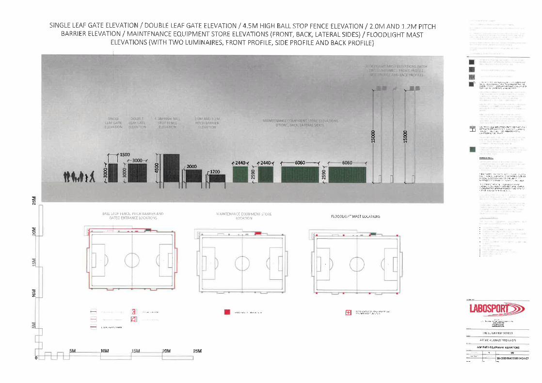

Page No 36
Ward: Bury West - Elton Item 05
Applicant: Ms Sharon Holt
Location: Land north of Green Street, Bury, BL8 1TF
Proposal: Erection of 2 no. semi-detached dwellings
Application Ref: 63834/Full Target Date: 03/05/2019
Recommendation: Approve with Conditions
DescriptionThe application site relates to a plot of land located on Green Street, a short cul de sac offTottington Road. The land was formally the car park for the adjacent Globe Pub which hasrecently been granted permission for conversion to 2 residential units with an office elementin part of the ground floor. It is understood conversion works are underway. The car parkis now in a separate ownership and no longer associated with this property.
The site is separated from 'The Globe' by a setted paved access which leads to a singlestorey commercial outbuilding currently being used for storage which is located behind thesite. The south east side of Green Street is characterised by traditional terraced properties,with No 1 Green Street in a former commercial use, now vacant. To the south west of thesite, directly adjacent and separated by a timber panelled boundary fence are Nos 2-6Green Street, a pair of more modern semi detached and a single detached property. Tothe rear of the site are houses on Lomond Drive which are screened by trees and a fencealong this boundary.
The application seeks to develop the site to provide a pair of 4 bed semi-detacheddwellings. The dwellings would be 2 storey with a rear dormer for a room in the roofspace.A 2 storey side outrigger would be added which would be slightly lower in height to the mainbuild and set back from the front elevation, accommodating a garage and bedroom above.Living accommodation would be located on the rest of the ground floor and bedroomsabove.
Each property would have its own access off Green Street which would lead to a drivewayfor 2 cars and the single garage. At the rear, a patio and garden area would provide privateoutdoor amenity space. Access would be retained to the outbuilding at the rear of the sitewhich is outside the application area.
Relevant Planning History62205 - Erection of 4 dwellings at land north of Green Street, Bury. Withdrawn - 16 January2018
63095 - Erection of 4 dwellings at land north of Green Street, Bury. Withdrawn - 13September 2018
Adjacent site61527 - Conversion of public house/bistro into 2 no. residential units at The Globe Inn, 325Tottington Road, Bury. Withdrawn - 21 July 2017.
61758 - Change of use of former public house/bistro (Class A4) to 2 no. residential units(Class C3) and change of use of part of ground floor to office (Class A2) with externalalterations at 325 Tottington Road, Bury. Approved with conditions - 14 September 2017

Page No 37
PublicityThe neighbouring properties were notified by means of a letter on 8/3/2019.
6 letters have been received from the occupiers of Nos 1, 5, 6, 7, 15 Green Street, BallanFamily Trust, which have raised the following issues:
Parking on Green Street is very congested. The residents and businesses on GreenStreet and residents and businesses on Tottington Road all park on Green Street.Do not object to building new houses on brownfield sites, this is preferable to the greenbelt, however the developers do not seem to have taken concerns into account and stillplan to block access to a large proportion of the on street parkingI would also like to hear from the developers regards how they would respect currentresidents access and daily lives during the build.The proposed development would reduce on-street parking.The proposed development should include 8 - 10 spaces in a car park for use byresidents and the public.In addition to residents, there is a large substation at the end of the street and access isrequiredThe height of the proposed dwellings will reduce light into my property in the afternoon.Concern about access by the emergency services.The best option for this land would be for the Council to buy it and build a car park foruse by Green Street residents.Concern that the proposed residential use would affect the long standing commercialuses in the area.There is a mix of residential properties and businesses on Green Street. A further 2houses will impact upon quality of life.The proposed three storey houses are not in keeping and out of scale for the street.The former public house, The Globe, is currently being converted with no parkingfacilities.The only turning facilities are outside my property and concerns about increaseddisturbance.Loss of privacy.The 'outbuilding' indicated on the proposed plan is rented and currently used for storagebut in the past used for other commercial activities. Concern the plans would affect thelong standing commercial use of the building.The developer has removed our fence without permission.
The neighbouring properties and objectors have been notified of revised site layout planson 12 April 2019.
2 letters have been received from the occupiers of Nos 1, 6 Green Street which have raisedthe following issues;
Due to the vehicle access required for the proposed houses, there would be a net lossof 2 parking spaces on the north side of the street. This is not acceptable.Unless there's no loss of the existing amount of space, or the development includesadditional public parking space (thus, increasing the amount), then the proposeddevelopment is unviable.Permit parking should be considered as vehicles from surrounding streets regularly parkon Green Street.Over development - There is a mix of residential properties and businesses on GreenStreet. A further 2 houses will impact upon quality of life and safety.The proposed three storey houses are not in keeping and out of scale for the street.The former public house, The Globe, is currently being converted with no parkingfacilities. Infact, the proposed plot was the original car park for the pub.The only turning facilities are outside my property and concerns about increaseddisturbance.Emergency services continue to have ongoing difficulties getting their service vehiclesinto the street due to lack of space. This street also has an Electrical Sub Station that

Page No 38
requires 24/7 entry.Most properties have 2+ cars and the street cannot sustain the amount ofproperties/traffic that use the street.Loss of privacy.
The objectors have been informed of the Planning Control Committee meeting.
Statutory/Non-Statutory ConsultationsTraffic Section - No objection subject to conditions.Drainage Section - No response received.Environmental Health - Contaminated Land - No objection subject to conditionsWaste Management - No response received.United Utilities - No objection in principle subject to a drainage condition. To note there isa public sewer which crosses the site.
Pre-start Conditions - Applicant/Agent has agreed with pre-start conditions
Unitary Development Plan and PoliciesH1/2 Further Housing DevelopmentH2/1 The Form of New Residential DevelopmentH2/2 The Layout of New Residential DevelopmentEN1/1 Visual AmenityEN1/2 Townscape and Built DesignEN1/3 Landscaping ProvisionEN5/1 New Development and Flood RiskEN7 Pollution ControlEN7/2 Noise PollutionEN7/3 Water PollutionEN7/5 Waste Water ManagementHT2/4 Car Parking and New DevelopmentHT6/2 Pedestrian/Vehicular ConflictSPD6 Supplementary Planning Document 6: Alterations & ExtensionsSPD11 Parking Standards in BuryNPPF National Planning Policy Framework
Issues and AnalysisThe following report includes analysis of the merits of the application against the relevantpolicies of both the National Planning Policy Framework (NPPF) and the adopted BuryUnitary Development Plan (UDP) together with other relevant material planningconsiderations. The policies of the UDP that have been used to assess this application areconsidered to be in accordance with the NPPF and as such are material planningconsiderations. For simplicity, just the UDP Policy will be referred to in the report, unlessthere is a particular matter to highlight arising from the NPPF where it would otherwise bespecifically mentioned.
PrincipleThe National Planning Policy Framework should be treated as a material planningconsideration and it emphasises the need for local planning authorities to boost the supplyof housing to meet local housing targets in both the short and long term. There is aparticular emphasis, as in previous national planning guidance, to identify a rolling five yearsupply of deliverable housing land.
Bury's Strategic Housing Land Availability Assessment sets out the latest housing supplyposition, which is made up with sites that have an extant planning permission and sites thathave potential to obtain planning permission in the future. This shows that there are anumber of sites within the Borough with the potential to deliver a significant amount ofhousing. However, not all of these sites will contribute to the five year supply calculationsas many sites will take longer than fives years to come forward and be fully developed (e.g.some large sites could take up to ten years to be completed). As such, latest monitoring
Page No 39
indicates that the Council is unable to demonstrate a five year supply of deliverable housingland and this needs to be treated as a material factor when determining applications forresidential developments.
Policy H1/2 states that the Council will have regard to various factors when assessing aproposal for residential development, including whether the proposal is within the urbanarea, the availability of infrastructure and the suitability of the site, with regard to amenity,the nature of the local environment and the surrounding land uses.
The site is located within the urban area and there is residential development to the east,west and south. As such, the proposed development would not conflict with the surroundingland uses. The site was previously used as a car park with the former adjacent pub and assuch, would be previously developed land. Therefore, the proposed development would beacceptable in principle and would be in accordance with Policy H1/2 of the Bury UnitaryDevelopment Plan and the NPPF.
UDP Policies H2/1 - The Form of New Residential Development and H2/2 - The Layout ofNew Residential Development takes into consideration factors relating to the height androof type of adjacent buildings, the impact of developments on residential amenity, thedensity and character of the surrounding area and the position and proximity ofneighbouring properties. Regard is also given to parking provision and access,landscaping and protection of trees/hedgerows and external areas.
Supplementary Planning Document 6 - Alterations and Extensions to Residential Propertiesprovides useful guidance in terms of acceptable aspect standards between dwellings anddesign criteria.
Details of the application and acceptability of the development regarding layout, design,access and parking are considered below.
LayoutThe proposed dwellings would front Green Street, set back into the site from the highwayby 8m and staggered just behind the front elevations of Nos 2-6 Green Street, and as suchconsidered to have a comparable footprint relationship within the context of the streetscene as the existing houses on this side of the street.
The proposed dwellings would have a patio and rear garden between approximately 10.5mand 11.5m in length and the level of private amenity space would be acceptable. Therewould be space within the rear and side garden for bin storage. The existing boundaryfencing would be retained and a 1.8m fence would separate the gardens of the 2 dwellingsat the rear and a 1.8m high fence would be erected behind the garden of Plot B to theoutbuilding at the rear.
Access to the plots would be provided by a separate driveway which would lead to adriveway for the parking of 2 cars and a single garage which would be attached to the sideof each property.
The access to the outbuilding behind plot B is outside the application site and would beretained and use of this building would not be affected by the development.
The proposed layout plan demonstrates that the proposed dwellings and associatedrequirements in terms of parking and amenity area could be successfully accommodatedwithin the site and would sit relative within the context of the street scene.
As such, the layout is considered acceptable and would be in accordance with PoliciesEN1/2, H2/1 and H2/2 of the Bury Unitary Development Plan.
Design and appearance - Fronting Green Street, the dwellings would be 2 storey in heightwith a 2 storey outrigger to the side and room in the roofspace incorporated within dormers
Page No 40
which would be located on the rear roof plane.
The 2 storey outriggers proposed at the side of each dwelling would add some scale andmassing of what are essentially fairly modest semi-detached dwellings. However, theoutriggers would be approximately 1m lower than the main part of the dwellings and setback from the front elevation and as such considered to be subservient additions. Moreover, these side elements would be typical in size and appearance to other 2 storeyside extensions which are added to semi-detached properties and which are prevalentthroughout the Borough. The dwellings would also be set back from Green Street by 8mand therefore considered would not be dominant and overbearing to the street scene.
The proposed dwellings would have a room in the roofspace, but would have theappearance of being 2 storey from Green Street as the ridge height of the proposeddwellings would only be slightly higher than Nos 2 and 4 by approximately 1.2m and theeaves level would also follow through at the same height as the adjacent houses. Thedormers would be on the rear elevation, would not project beyond the main roof ridge andgiven the setback of the properties into the site, the dormers would not be perceptible orvisible to public views. It is therefore considered that the height and scale of the dwellingswould maintain the rhythm and symmetry in the street scene.
The proposed dwellings would be constructed from brick and grey concrete roof tiles withstone headers, cills and front canopies to add visual interest to the elevations and notdissimilar in design to the adjacent houses, Nos 2 -6 Green Street. There are a variety ofmaterials in the locality comprising brick, render and painted blockwork and as such, it isconsidered that the proposed materials would be acceptable and characteristic of thesurrounding area. Details of the materials would be sought by condition.
As such, it is considered that the scale and design of the proposed dwellings would beappropriate within the context of the area and would comply with UDP Policies H2/1 - TheForm of New Residential Development and EN1/2 - Townscape and Built Design.
Impact upon residential amenitySPD6 provides guidance on aspect standards between residential properties and would berelevant in this case. SPD6 states that a minimum distance of 20m should be maintainedbetween habitable room windows, plus 3m for every additional storey or difference inlevels, 13m between habitable room windows and a 2 storey blank wall and 6.5mrelationship between a habitable room window and blank wall.
The property's opposite which would face the development would be Nos 1 and 3 GreenStreet. No 1 is a vacant property, and has a historical use as a workshop with part of thebuilding a shop front type appearance, also vacant. Above, there are windows to what areeither associated storage/offices or residential flats. It is unclear if these are used/habited.No 3 Green Street is a terraced property and has a window at ground and first floor tohabitable rooms.
The proposed site plan demonstrates there would be 18m between the proposed dwellingsand Nos 1 and 3 Green Street. It is noted that all but one window on the front elevations ofthe proposed dwellings would relate to a kitchen, bathroom or en-suite, which would not behabitable rooms in planning terms and therefore a separation of 18m would be acceptable.However, the window to bedroom 3 would be classed as habitable and requires ajustification for a reduced aspect standard.
There are already sub-standard distances on Green Street, with a separation of 16mbetween Nos 2-6 Green Street and the terraced houses opposite. Nos 2-6 have a moreconventional layout than the proposed dwellings, with habitable room windows at groundand first floor on the frontage, whereas the proposed dwellings would have one habitableroom window at 1st floor only. As the proposed dwellings would be set back a further 2m,equating to a separation of 18m, the relationship to the properties opposite would be lessharmful to privacy than already exists on the street.

Page No 41
The proposed development would be set back from Green Street by 8m and the frontgardens, driveways and intervening street would give some perception of separation andspace between the site and the properties opposite.
As there would only be one window in each of the new properties to a habitable room, andgiven there would be 18m separation and that there are already sub-standard distancesbetween the other dwellings on the street, it is considered that overlooking and privacywould not be significant to adversely affect the residential amenity of the propertiesopposite. On balance and in view of these factors, it is considered that the proposeddevelopment would be acceptable.
In relation to the adjacent property, No 2 Green Street, the proposed dwellings would beset back from the front elevation of this property by approximately 2m, with the 2 storeyelement a further 1m back, and as such there would not be a significant adverse impact onovershadowing or outlook from the front of this property. At the rear, the proposeddwellings would more or less follow the same building line as the rear elevation of No 2Green Street and as such there would not be an impact from the built development in termsof overshadowing or privacy.
Beyond the rear boundary of the site are Nos 1 and 3 Lomond Drive which are set at anoblique angle to the site. There would be a separation distance of over 23m between therear elevations of each property and taking into account the additional 'storey' created bythe dormer, aspect standards would be suitably satisfied.
The property to the east was formally a public house and has planning permission for itsconversion to 2 no. residential units and part ground floor office use. The approved plandemonstrates that the rear window which would face the site would be to a bedroom. SPD6requires a distance of 6.5m between a 1st floor habitable room window and a 2 storeyblank wall, which in this case would be the side of the proposed outrigger to Plot B. Therewould be a separation of 13.5m between the two properties and as such aspect standardssatisfied.
As such, it is considered that there would not be a significant detrimental impact onresidential amenity and the development would be in compliance with UDP Policies.
Highways issuesAccessEach property would have a separate access off Green Street and would lead to adriveway where there would be adequate space for a car to manoeuvre and exit the site ina forward gear. Whilst Green Street is a fairly narrow cul de sac, it is considered that 2additional dwellings would not significantly increase traffic on the street and would notadversely impact on highway safety.
Access to the outbuilding located to the rear of the site would be maintained and would beunaffected by the development proposals.
The Highway's section have no raised no objection to the proposal in principle, subject toconditions which would include further approval of highway works to the footway andprovision of the parking prior to the occupation of the dwellings. Therefore, the proposeddevelopment would not be detrimental to highway safety and would be in accordance withPolicies H2/1, H2/2 and HT6/2 of the Bury Unitary Development Plan.
ParkingSPD11 states that the maximum number of parking spaces is 3 spaces per 4 bed dwelling.
The proposed site plan indicates that 2 parking spaces would be provided within thedriveway area and there would also be a single garage for each dwelling, which totals 3spaces. A number of objections relate to the problems of parking already experienced on
Page No 42
Green Street, especially as the adjacent pub on Tottington Road has been converted andthat the development would add to parking issues on the street. Objectors also raised theissue that the development should provide parking for the residents and public in the area.
It is not in the gift of the residents on Green Street to use this land for parking nor for thedevelopment to provide parking for residents on Green Street. The residents of theterraced houses on the street have always had to park on street and this would not change. The fact that some may use the land at the moment is not a material planningconsideration as it is not in their ownership to do so.
In terms of the pub conversion, this application was assessed on its own merits and it wasconcluded that parking for the residential units would not be necessary due to thesustainable location of the property, 'buyer beware' and that the then closed pub withaccommodation could re-open at any time without the need for planning permission andwithout the car park. A space was provided for the office use.
It is therefore considered that given the development would provide in-curtilage parking foreach property, its close proximity to Tottington Road which has good access to publictransport and is in a sustainable location, the level of parking provision would beacceptable. Therefore, the proposed development would be in accordance with PoliciesH2/2 and HT2/4 of the Bury Unitary Development Plan and SPD11.
Drainage - United Utilities have been consulted on the proposals. A public sewer crossesthis site and United Utilities require an access strip width of 6m, 3m either side of thecentreline. It is the applicant's responsibility to demonstrate the exact relationship betweenany United Utilities' assets and the proposed development.
It is understood that the applicant has been in contact with UU and the siting of theproposed development has taken into account the location of the sewer pipe.
Notwithstanding the location of the sewer, United Utilities do not have an objection inprinciple to the proposed development, subject to a conditions that foul and surface waterare drained on separate systems and surface water drained in accordance with thehierarchy of drainage options.
Response to objectorsThe proposed plans show a 1.8m high fence to the perimeter of the outbuildingadjacent to the garden boundary of Plot B. Access to and use of the 'outbuilding' would not be affected by the proposeddevelopment. It is a private matter for future occupiers of Plot B to be aware of thelocation and potential activity associated with this building.A Construction Traffic Management Plan would be required by condition to identifyprovision for construction vehicles and materials storage, for approval by the LPA.All the other objections raised with regards to parking, access, design and scale of thedwellings and impact on residential amenity have been covered in the above report.
Statement in accordance with Article 35(2) Town and Country Planning (DevelopmentManagement Procedure) (England) (Amendment) Order 2015
The Local Planning Authority worked positively and proactively with the applicant to identifyvarious solutions during the application process to ensure that the proposal comprisedsustainable development and would improve the economic, social and environmentalconditions of the area and would accord with the development plan. These wereincorporated into the scheme and/or have been secured by planning condition. The LocalPlanning Authority has therefore implemented the requirement in Paragraph 38 of theNational Planning Policy Framework.

Page No 43
Recommendation: Approve with Conditions
Conditions/ Reasons
1. The development must be begun not later than three years beginning with thedate of this permission.Reason. Required to be imposed by Section 91 Town & Country Planning Act1990.
2. This decision relates to drawings - Red edge site location received 26 February2019; Proposed existing site layout - 19-06-Site B; Proposed site layout plan dwg19-06-C; Site layout - drainage dwg 19-06-drainage; Ground floor plan - 19-06-01;First floor plan 19-01-02; Second floor plan - 19-06-03; Elevations - 19-06-04;Semi-detached house elevations - 19-06-05. and the development shall not becarried out except in accordance with the drawings hereby approved.Reason. For the avoidance of doubt and to ensure a satisfactory standard ofdesign pursuant to the policies of the Bury Unitary Development Plan listed.
3. No development shall commence unless and until:-A contaminated land Preliminary Risk Assessment report to assess theactual/potential contamination and/or ground gas/landfill gas risks at the siteshall be submitted to, and approved in writing by, the Local Planning Authority;Where actual/potential contamination and/or ground gas/landfill gas risks havebeen identified, detailed site investigation and suitable risk assessment shallbe submitted to, and approved in writing by the Local Planning Authority;Where remediation/protection measures is/are required, a detailedRemediation Strategy shall be submitted to, and approved in writing by, theLocal Planning Authority.
Reason. The scheme does not provide full details of the actual contamination andsubsequent remediation, which is required to secure the satisfactory developmentof the site in terms of human health, controlled waters, ground gas and the widerenvironment and pursuant to National Planning Policy Framework Section 15 -Conserving and enhancing the natural environment.
4. Following the provisions of Condition 3 of this planning permission, whereremediation is required, the approved Remediation Strategy must be carried out tothe satisfaction of the Local Planning Authority within agreed timescales; andA Site Verification Report detailing the actions taken and conclusions at eachstage of the remediation works, including substantiating evidence, shall besubmitted to and approved in writing by the Local Planning Authority prior to thedevelopment being brought into use.Reason. To secure the satisfactory development of the site in terms of humanhealth, controlled waters and the wider environment and pursuant to NationalPlanning Policy Framework Section 15 - Conserving and enhancing the naturalenvironment.
5. No development shall commence unless and until a 'Construction TrafficManagement Plan' (CTMP), has been submitted to and approved by the LocalPlanning Authority and shall confirm/provide the following:
Access route for construction traffic from the highway network and restricted toa size of vehicle that can be accommodated on Green Street that serves thesite;Hours of operation and number of vehicle movements;Parking on site of operatives' and construction vehicles together with storageon site of construction materials, including any requisite phasing of thedevelopment to accommodate this.Measures to ensure that all mud and other loose materials are not carried onthe wheels and chassis of any vehicles leaving the site and measures to

Page No 44
minimise dust nuisance caused by the operations.
The approved plan shall be adhered to throughout the demolition/constructionperiod and the measures shall be retained and facilities used for the intendedpurpose for the duration of the demolition and construction periods. The areasidentified shall not be used for any other purposes other than the turning/parkingof vehicles and storage of demolition/construction materials.Reason. Information not submitted at application stage. To mitigate the impact ofthe construction traffic generated by the proposed development on the adjacentresidential streets, and ensure adequate off street car parking provision andmaterials storage arrangements for the duration of the construction period andthat the adopted highways are kept free of deposited material from the groundworks operations, in the interests of highway safety pursuant to Bury UnitaryDevelopment Plan Policies EN1/2 - Townscape and Built Design and HT6/2 -Pedestrian/Vehicular Conflict.
6. Notwithstanding the details shown indicatively on approved plan reference19-06-Proposed Site B, the development hereby approved shall not becommenced unless and until the position of the footway crossings serving bothdwellings, along with the scope of the proposed highway works required as aresult of the proposed development have been agreed on site. The workssubsequently approved, incorporating the reconstruction of the Green Streetfootway abutting the site and the demarcation of the limits of the adopted highway,shall be implemented to a specification to be agreed and to the written satisfactionof the Local Planning Authority prior to occupation of the development herebyapproved.Reason. Information not submitted at application stage. To ensure good highwaydesign and maintain the integrity of the adopted highway, in the interests ofhighway safety pursuant to Bury Unitary Development Plan Policies H2/2 - TheLayout of New Residential Development, EN1/2 - Townscape and Built Designand HT6/2 - Pedestrian/Vehicular Conflict.
7. The turning facilities indicated on approved plan reference 19-06-Proposed Site Bshall be provided before the dwellings are first occupied and the areas used forthe manoeuvring of vehicles shall subsequently be maintained free of obstructionat all times.Reason. To minimise the standing and turning movements of vehicles on thehighway in the interests of road safety pursuant to Bury Unitary Development PlanPolicies H2/2 - The Layout of New Residential Development, EN1/2 - Townscapeand Built Design and HT6/2 - Pedestrian/Vehicular Conflict.
8. The car parking indicated on approved plan reference A1826-PS-SP01 Revision Ashall be surfaced in a material, or incorporate measures, that prevents thedischarge of surface water onto the adopted highway and be made available foruse to the written satisfaction of the Local Planning Authority prior to thedevelopment hereby approved being occupied and thereafter maintained at alltimes. Reason. To ensure adequate off street car parking provision in the interests ofroad safety pursuant to policies H2/2 - The Layout of New ResidentialDevelopment, EN1/2 - Townscape and Built Design and HT2/4 - Car Parking andNew Development of the Bury Unitary Development Plan.
9. Foul and surface water shall be drained on separate systems.Reason. To promote sustainable development and reduce flood risk pursuant toUnitary Development Plan Policies EN5/1- New Development and Flood Risk ,EN7/3 - Water Pollution and EN7/5 - Waste Water Management and chapter 14 -Meeting the challenge of climate change, flooding and coastal change of theNPPF.

Page No 45
10. Surface water shall be drained in accordance with the hierarchy of drainageoptions in national planning practice guidance. In the event of surface waterdischarging to public sewer, the rate of discharge shall be restricted to the lowestpossible rate which shall be agreed with the statutory undertaker prior toconnection to the public sewer.Reason. To promote sustainable development and reduce flood risk and pollutionpursuant to Unitary Development Plan Policies EN5/1- New Development andFlood Risk , EN7/3 - Water Pollution and EN7/5 - Waste Water Management andchapter 14 - Meeting the challenge of climate change, flooding and coastalchange of the NPPF.
11. Details/Samples of the materials to be used in the external elevations, togetherwith details of their manufacturer, type/colour and size, shall be submitted to andapproved in writing by the Local Planning Authority before the development iscommenced. Only the approved materials shall be used for the construction of thedevelopment.Reason. No material samples have been submitted and are required in theinterests of visual amenity and to ensure a satisfactory development pursuant toUDP Policies EN1/2- Townscape and Built Design and H2/1 - The Form of NewResidential Development.
For further information on the application please contact Helen Longworth on 0161 2535322

PLANNING APPLICATION LOCATION PLAN
Planning, Environmental and Regulatory Services
No Window
No Window
ADDRESS:
APP. NO 63834
Land north of Green StreetBury
(C) Crown Copyright and database right (2015). Ordnance Survey 100023063.
Mast (telecommunication)
TCB
LB
76
Works
270
278
309
307
268
3
2
299
PH
Shelter
57
3 to 7
286
288
62
6
2
331
El
321
PH
Works
42
32
22
300
29429
8
304
296 292
290
308
2
9
320Garage
1
Sub Sta
16
15
30
325
15
11
1
29
15
48
21
11
1
2
322
322a
Car Park
ST
RE
ET
HIL
L'S
CO
UR
T
GR
EE
N S
TR
EE
T
BACK TOTTINGTON ROAD
MIL
L L
AN
E
CO
LLIN
GE
BA
CK
GO
OD
LA
D S
TR
EE
T
TO
TTIN
GTO
N R
OAD
CL
OS
E
108.8m
1
2
34
Viewpoints
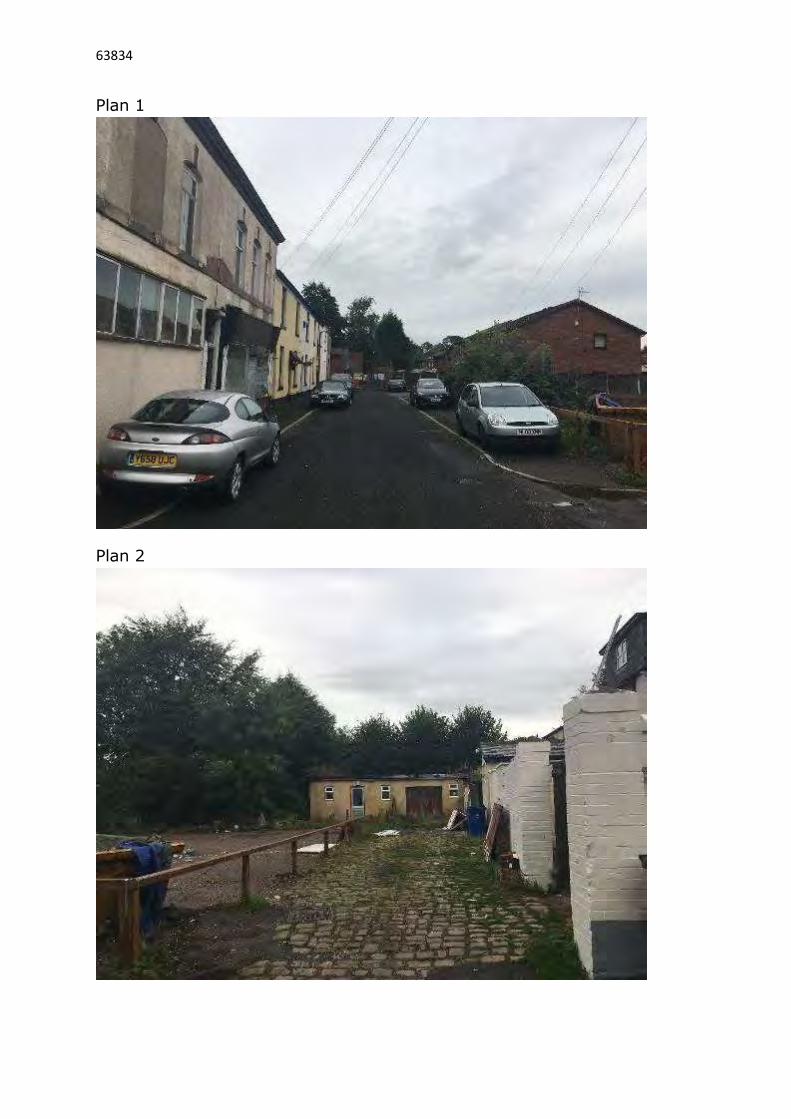
63834
Plan 1
Plan 2

63834
Plan 3
Plan 4

60
00
abacus architectural21 union street
ramsbottom
lancashire
bl0 9an
tel: 01706 824 777
email: [email protected]
this drawing is copyright and must not be copied without the express
permission of abacus architectural ltd.
this drawing is to be read in conjunction with all relevant consultants
drawings and documentation. any discrepancies or variations to be notified
to the contract administrator before the affected works commence.
all works to be carried out in accordance with current health and safety
regulations.
do not scale from prints.
contractor to check all dimensions on site prior to commencement of works.
client:
project: Green Street, Tottington
drawing: Site Layout
scale: 1/100 date: January 2019
drawing no.: 19-06-Proposed Site C
Green Street
2
1800mm conc post and timber wany lap fencing to boundaries,
with the exception of the frontage onto Green Street which will
remain 'open'.
Whole of the frontage to comprise of permeable block paving,
providing vehicle hardstanding and access.
Patios and pathways in concrete paviours.
All boundaries to be checked and agreed.
outbuilding
1.8
M fence
1.8
M fence
Ex fence
Ex fence
patio
Datum 100.000
MH 99.670
A B
bay
drop curb
99.745
100.130
100.385
100.075
100.125
100.350
flower beds flower beds
flo
wer
beds
Amendments
ARepresentation of vehicles added
March 2019
B
Drop curb added to property entrance
April 2019
C
House numbers to adjacent properties added
May 2019
ex tree
block paviours block paviours
drop curb
yard
yard
yard
yard
Former Globe PH
327
Works (no 1 Green St.) 3 5
1 Lomond Drive
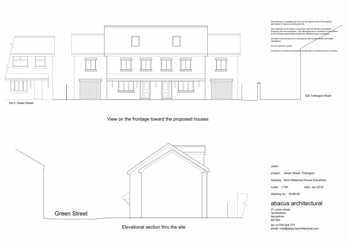
abacus architectural21 union street
ramsbottom
lancashire
bl0 9an
tel: 01706 824 777
email: [email protected]
this drawing is copyright and must not be copied without the express
permission of abacus architectural ltd.
this drawing is to be read in conjunction with all relevant consultants
drawings and documentation. any discrepancies or variations to be notified
to the contract administrator before the affected works commence.
all works to be carried out in accordance with current health and safety
regulations.
do not scale from prints.
contractor to check all dimensions on site prior to commencement of works.
client:
project: Green Street, Tottington
drawing: Semi Detached House Elevations
scale: 1/100 date: Jan 2019
drawing no.: 19-06-05
View on the frontage toward the proposed houses
Elevational section thru the site
Green Street
325 Tottington Road
No 2 Green Street

abacus architectural21 Union Street
Ramsbottom
Lancashire
BL0 9AN
tel: 01706 82 4777
email: [email protected]
This drawing is copyright and must not be copied without the express
permission of abacus architectural ltd.
This drawing is to be read in conjunction with all relevant schedules,
specifications and consultants information. Any discrepancies or
variations to be notified to the contract administrator prior to the
commencement of the affected works.
All works to be carried out in accordance with current health and
safety regulations.
Do not scale from prints.
Contractor to check all dimensions on site prior to commencement of
works.
client:
project: Site at Green Street, Tottington
drawing: Elevations
scale: 1/100 date: Jan 2019
drawing no.: 19-06-04
Front
Rear
Side
Side
Cavity construction with outer leaf comprising agreed facing brick.
Stone heads and cills.
Grey concreting interlocking roofing tiles to form roofs
Double glazed upvc window units and doors.

19850
93
00
73
00
abacus architectural21 Union Street
Ramsbottom
Lancashire
BL0 9AN
tel: 01706 82 4777
email: [email protected]
This drawing is copyright and must not be copied without the express
permission of abacus architectural ltd.
This drawing is to be read in conjunction with all relevant schedules,
specifications and consultants information. Any discrepancies or
variations to be notified to the contract administrator prior to the
commencement of the affected works.
All works to be carried out in accordance with current health and
safety regulations.
Do not scale from prints.
Contractor to check all dimensions on site prior to commencement of
works.
client:
project: Site at Green Street, Tottington
drawing: Ground Floor Plan
scale: 1/50 date: Jan 2019
drawing no.: 19-06-01
Garage Living Room GarageLiving Room
Kitchen Kitchen

abacus architectural21 Union Street
Ramsbottom
Lancashire
BL0 9AN
tel: 01706 82 4777
email: [email protected]
This drawing is copyright and must not be copied without the express
permission of abacus architectural ltd.
This drawing is to be read in conjunction with all relevant schedules,
specifications and consultants information. Any discrepancies or
variations to be notified to the contract administrator prior to the
commencement of the affected works.
All works to be carried out in accordance with current health and
safety regulations.
Do not scale from prints.
Contractor to check all dimensions on site prior to commencement of
works.
client:
project: Site at Green Street, Tottington
drawing: First Floor Plan
scale: 1/50 date: Jan 2019
drawing no.: 19-01-02
Bedroom 2 Bedroom 2
Bedroom 3
Bedroom 1 Bedroom 1
Bedroom 3

abacus architectural ltd21 Union Street
Ramsbottom
Lancashire
BL0 9AN
tel: 01706 82 4777
email: [email protected]
This drawing is copyright and must not be copied without the express
permission of abacus architectural ltd.
This drawing is to be read in conjunction with all relevant schedules,
specifications and consultants information. Any discrepancies or
variations to be notified to the contract administrator prior to the
commencement of the affected works.
All works to be carried out in accordance with current health and
safety regulations.
Do not scale from prints.
Contractor to check all dimensions on site prior to commencement of
works.
client:
project: Site at Green Street, Tottington
drawing: Second Floor Plan
scale: 1/50 date: Jan 2019
drawing no.: 19-06-03
Bedroom 4 Bedroom 4