tls transponder landing system - anpc · transponder landing system (tls). the tls is a precision...
TRANSCRIPT

tls ® transponder landing system

The Transponder Landing System (tls) is a technology breakthrough with unprecedented capability to improve airport safety and accessibility
[ introducing tls ]
anpc is the world’s only supplier of the Transponder Landing System (tls).
The tls is a precision landing system for use at airports where terrain or land constraints make Instrument Landing System (ils) installation infeasible or cost-prohibitive. anpc’s patented transponder tracking technology provides high-precision aircraft positioning in real-time for area surveillance and all-weather precision instrument approach to airports and landing areas worldwide.
Based on transponder multilateration, the tls is a performance-based system that complies with icao standards and recommended practices (sarps) for ils, secondary surveillance and precision approach radar (par).
The tls tracks aircraft using their Mode 3/A and Mode S transponders to provide practically any airport a precision ils approach.
[ tls applications ]
Precision approach for terrain-challenged airports with:
• Short runways that cannot comply with ils localizer siting standards
• Runways ending at a body of water
• Terrain upslope under the approach path that would prevent an ils glide slope transmission from passing flight inspection
Single system solution to deploying radar and ils capability with lower initial costs and lower operating costs than purchasing those systems separately
Terminal area surveillance for atc to monitor the approach and provide radar control services
Tactical atc solution for expeditionary forces
gca capability without the need for a separate, expensive precision approach radar (par)
Approach and landing on oil rigs
Quickly deployable for disaster recovery and emergency services
[ tls product overview ]
The tls is a precision approach guidance and surveillance system designed to provide all-weather airfield access and situational awareness for improved airport accessibility and safety. The tls provides the capabilities of an ils where traditional ils equipment cannot be sited due to rugged terrain or limited property. In a transportable configuration, the Transportable tls (ttls) is a highly mobile, rugged, and quickly deployable atc solution for expeditionary forces during contingency operations. Both tls and ttls provide approach guidance and terminal area surveillance.
The pilot training and airborne equipment required for tls approaches are identical to that for traditional ils or precision approach radar. Any aircraft equipped with an ils localizer and glide slope receiver, Horizontal Situation Indicator (hsi) or Course Deviation Indicator (cdi), and a Mode 3/A or Mode S compatible transponder can fly a tls approach. The guidance is presented to the pilot just as it would be for an ils approach.
For Ground Controlled Approach (gca) operations, the tls provides controllers with secondary radar display of area aircraft traffic. For landing multiple aircraft using precision approach radar consoles, up to four individual par consoles can be used for controllers to work independently guiding up to four aircraft simultaneously.
[ features + benefits]
Precision approach guidance
• Provides a stabilized ils glide path, the single most important safety improvement at terrain challenged landing areas • Provides precision ils Localizer to align the air- craft with the runway centerline for every landing
par operator console for military operations
An offset approach can be configured where required by pans-ops analysis
Marker tones are provided over the localizer audio so that no remote markers need to be installed
Allows achieving the proper precision tailored threshold width even on short runways or runways with obstacles where traditional ils localizer equipment would be installed
Uses standard ifr avionics - no aircraft modifications required
Configurable approach paths, linear, curved and segmented
Multilateration update rate provides superior aircraft positioning accuracy to a traditional radar
Inherently high signal strength operates in a gps denied environment
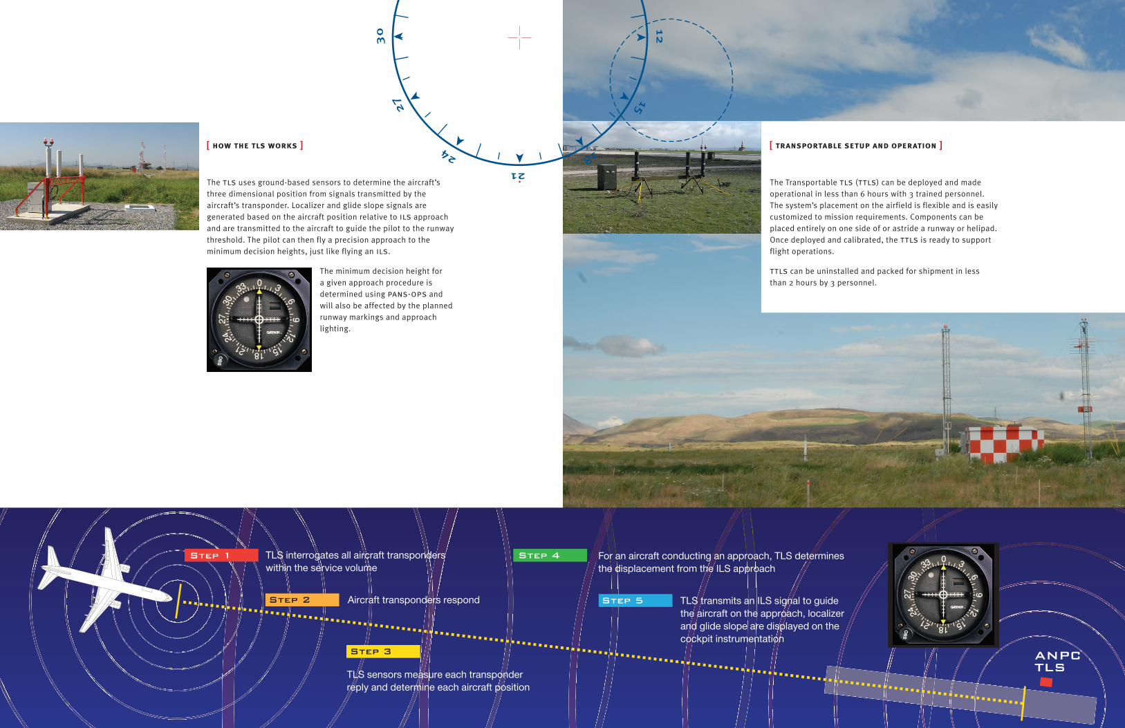
[ how the tls works ]
The tls uses ground-based sensors to determine the aircraft’s three dimensional position from signals transmitted by the aircraft’s transponder. Localizer and glide slope signals are generated based on the aircraft position relative to ils approach and are transmitted to the aircraft to guide the pilot to the runway threshold. The pilot can then fly a precision approach to the minimum decision heights, just like flying an ils.
The minimum decision height for a given approach procedure is determined using pans-ops and will also be affected by the planned runway markings and approach lighting.
[ transportable setup and operation ]
The Transportable tls (ttls) can be deployed and made operational in less than 6 hours with 3 trained personnel. The system’s placement on the airfield is flexible and is easily customized to mission requirements. Components can be placed entirely on one side of or astride a runway or helipad. Once deployed and calibrated, the ttls is ready to support flight operations.
ttls can be uninstalled and packed for shipment in less than 2 hours by 3 personnel.
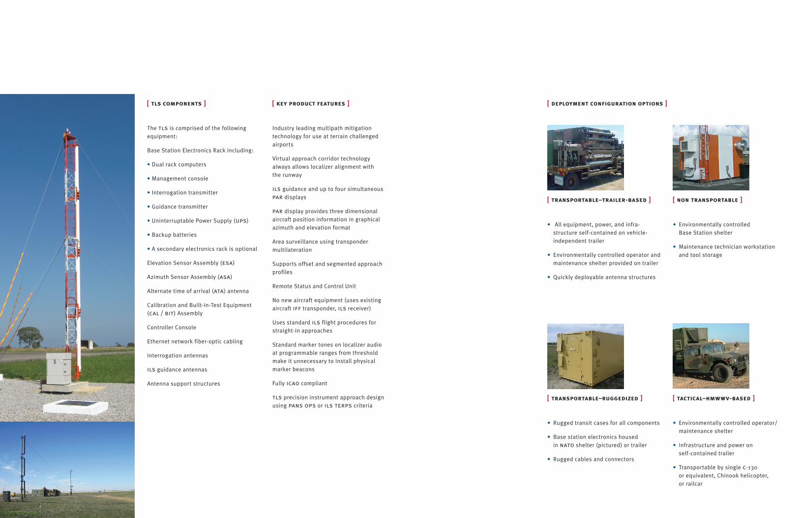
[ tls components ]
The tls is comprised of the following equipment:
Base Station Electronics Rack including:
• Dual rack computers
• Management console
• Interrogation transmitter
• Guidance transmitter
• Uninterruptable Power Supply (ups)
• Backup batteries
• A secondary electronics rack is optional
Elevation Sensor Assembly (esa)
Azimuth Sensor Assembly (asa)
Alternate time of arrival (ata) antenna
Calibration and Built-in-Test Equipment (cal / bit) Assembly
Controller Console
Ethernet network fiber-optic cabling
Interrogation antennas
ils guidance antennas
Antenna support structures
[ key product features ]
Industry leading multipath mitigation technology for use at terrain challenged airports
Virtual approach corridor technology always allows localizer alignment with the runway
ils guidance and up to four simultaneous par displays
par display provides three dimensional aircraft position information in graphical azimuth and elevation format
Area surveillance using transponder multilateration
Supports offset and segmented approach profiles
Remote Status and Control Unit
No new aircraft equipment (uses existing aircraft iff transponder, ils receiver)
Uses standard ils flight procedures for straight-in approaches
Standard marker tones on localizer audio at programmable ranges from threshold make it unnecessary to install physical marker beacons
Fully icao compliant
tls precision instrument approach design using pans ops or ils terps criteria
[ non transportable ]
• Environmentally controlled Base Station shelter
• Maintenance technician workstation and tool storage
[ transportable–trailer-based ]
• All equipment, power, and infra-structure self-contained on vehicle-independent trailer
• Environmentally controlled operator and maintenance shelter provided on trailer
• Quickly deployable antenna structures
[ tactical–hmwwv-based ]
• Environmentally controlled operator/maintenance shelter
• Infrastructure and power on self-contained trailer
• Transportable by single c-130 or equivalent, Chinook helicopter, or railcar
[ transportable–ruggedized ]
• Rugged transit cases for all components
• Base station electronics housed in nato shelter (pictured) or trailer
• Rugged cables and connectors
[ deployment configuration options ]
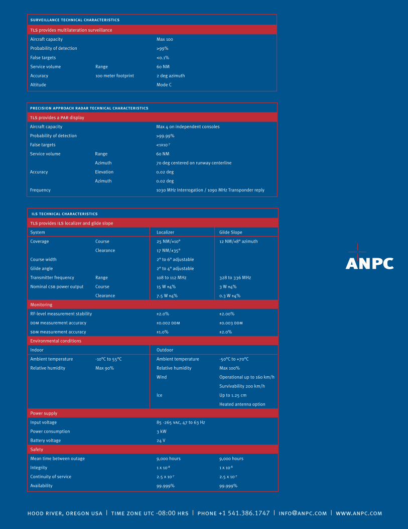
surveillance technical characteristics
tls provides multilateration surveillance
Aircraft capacity Max 100
Probability of detection >99%
False targets <0.1%
Service volume Range 60 NM
Accuracy 100 meter footprint 2 deg azimuth
Altitude Mode C
hood river, oregon usa | time zone utc -08:00 hrs | phone +1 541.386.1747 | [email protected] | www.anpc.com
precision approach radar technical characteristics
tls provides a par display
Aircraft capacity Max 4 on independent consoles
Probability of detection >99.99%
False targets <1x10⁻⁷
Service volume Range 60 NM
Azimuth 70 deg centered on runway centerline
Accuracy Elevation 0.02 deg
Azimuth 0.02 deg
Frequency 1030 MHz Interrogation / 1090 MHz Transponder reply
ils technical characteristics
tls provides ils localizer and glide slope
System Localizer Glide Slope
Coverage Course 25 NM/±10° 12 NM/±8° azimuth
Clearance 17 NM/±35°
Course width 2° to 6° adjustable
Glide angle 2° to 4° adjustable
Transmitter frequency Range 108 to 112 MHz 328 to 336 MHz
Nominal csb power output Course 15 W ±4% 3 W ±4%
Clearance 7.5 W ±4% 0.3 W ±4%
Monitoring
RF-level measurement stability ±2.0% ±2.00%
ddm measurement accuracy ±0.002 ddm ±0.003 ddm
sdm measurement accuracy ±1.0% ±2.0%
Environmental conditions
Indoor Outdoor
Ambient temperature -10°C to 55°C Ambient temperature -50°C to +70°C
Relative humidity Max 90% Relative humidity Max 100%
Wind Operational up to 160 km/h
Survivability 200 km/h
Ice Up to 1.25 cm
Heated antenna option
Power supply
Input voltage 85 -265 vac, 47 to 63 Hz
Power consumption 3 kW
Battery voltage 24 V
Safety
Mean time between outage 9,000 hours 9,000 hours
Integrity 1 x 10⁻⁸ 1 x 10⁻⁸
Continuity of service 2.5 x 10⁻⁷ 2.5 x 10⁻⁷
Availability 99.999% 99.999%