to all whom these presents shall come,...
TRANSCRIPT
Supplement to Amended Acknowledgment and Amended Notice of Acknowledgment of Acceptance of R.S. 2477 Right-of-Way Grant
THE STATE OF UTAH
TO ALL WHOM THESE PRESENTS SHALL COME, Greeting:
This Supplement to Amended Acknowledgment and Amended Notice of Acknowledgment and the affidavits
attached hereto as Exhibit A supplement and support the Amended Acknowledgment and Amended Notice of
Acknowledgment, previously made under Utah Code Sections 72-5-309 through 310 inclusive, as it pertains to
the highway located in Beaver County known as OLD RAMBLER HILL ROAD; County Road Number: B-
132; State Geographic Information Database (SGID) Road Identification Number: RD010032.
This document supplements and supports the information contained in the document first recorded at Ent 232857, Bk 408, Beg Pg 690, as modified by the Amended Acknowledgment and Amended Notice of Acknowledgment recorded on February 14, 2008 at Ent 235733, Bk 418, Beg Pg 183. A legal description is attached hereto as Exhibit B.
In Witness Whereof, I, John Harja, the official designee of the Governor of the State of Utah, in conformity to the laws of the State (Utah Code Sections 72-5-308 through 310 inclusive), have caused this Supplement to Amended Acknowledgment and Amended Notice of Acknowledgment to be made.
Signed by my hand in Salt Lake City, Utah, the.;2.f..'tt-day of_j.,~"l-----' 200 _fi_.
By the Governor's Designee
State of Utah ) SS
County of Salt Lake )
I hereby certify that the signer of the foregoing document, John Harja, is personally known by me, has made a voluntary signature and taken an oath stating that he is the official designee of the Governor of the State of Utah and is authorized to sign this document on the Governor's behalf pursuant to Utah Code Section 72-5-309. He further vouched that, based upon information and belief, the facts alleged therein are true.
Dated this :J J t~ay of ).UAL> , 200 ~
/W~J~ Notary Public
Supplement Page 1 of 1 SGID Road Identification Number RD ID: RDOl 0032

ExhibitA
Exhibit A
SGID Road Identification Number RD ID: RD010032
Ent 236.984 Bk 0423 P~ 0747
State of Utah
County of Beaver
AFFIDAVIT OF DEAN CARTER
OLD RAMBLER HILL ROAD
BEAVER COUNTY, UTAH
ROAD NUMBER B-132
) : SS.
)
DEAN CARTER, being first duly sworn, deposes and states as follows:
I. I am an adult competent to testify about the matters set forth below based upon
my personal knowledge. I currently reside in Minersville, Beaver County, Utah. I have lived in
Beaver County my entire life.
2. I have traveled and am familiar with a road in Beaver County known as Old
Rambler Hill Road. I am also familiar with the land the road traverses. When I first used and
observed the road in 1942, it followed the same route as in 2007 when I last observed it.
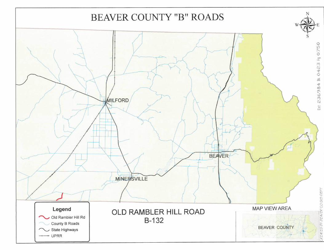
Attached is a Beaver County map showing Old Rambler Hill Road. To the best of my
knowledge and based upon my use of and familiarity with this road and the land it traverses, the
location and route of the road are correctly illustrated on the attached map.
3. I am informed that the County also identifies this road according to the road
number listed above.
4. I have observed that the road has been open to the public for all to use, to come
and go as they pleased, since at least as early as 1942 and continuing through 1976 to the present.
Throughout this time period I have observed travel on the road by means of trucks. Throughout
the time period from 1942 to 1976 the road was used daily and is presently used daily, weather
permitting.
5. Throughout the time period from 1942 to 2007, I have used the road myself for
livestock operations and hunting.

6. Throughout the time period described in the previous paragraph, I have observed
other vehicles from the general public using the road at various times for the uses described in
the previous paragraph, plus traveling in and through the area, recreation and sightseeing.
7. It is also the reputation in the community that this road has been open to the
public for all to use, to come and go as they pleased, since at least as early as the early 1900s and
continuing through 1976 to the present, for the uses described in the previous paragraphs.
8. Prior to 1976, I observed graders performing maintenance and construction
activities on the road.
DATED this _Jl_ day of January, 2007.
DEAN CARTER
SUBSCRIBED AND SWORN to before me thi~ day of January, 2007.
NOTARY PUBLIC
2 ~nt 236984 Fl<: 0423 Pg 074'-:J
\ \.
~\ ~~\ .,
/
/ ( I ~
Legend
""-' Old Rambler Hill Rd
County B Roads
~ State Highways
-UPRR
BEAVER COUNTY "B" ROADS
// ~/ , ~. 1
~·f
-~ -)£.~, ~~ ( ,.-:- -<
...-1' ~ v· ~-"":
L. ('"" '-y.? ~
/
~FORD / ?\ /::-~
'~\ w
I ' ' r-r r l ,r4
7 ...LL
~
'---, ( { OLD RAMBLER HILL ROAD
8-132
~ ~Ji ~-
:·p
\.......__
MAP VIEW AREA
BEAVER COUNTY
N W.E s
f
0 ti') I'· 0 -.::i.. M l'\I ~ 0 ~ .... ~ co Cl" 1.J:J i'l"J ('lJ , j
.: w
§ ~ 8 l:.(
~ lJ ~ )..,.
~
~ ~

State of Utah
County of Beaver
)
AFFIDAVIT OF JIMMY CRAW
OLD RAMBLER HILL ROAD
BEA VER COUNTY, UTAH
ROAD NUMBER B-132
: SS.
)
JIMMY CRAW, being first duly sworn, deposes and states as follows:
1. I am an adult competent to testify about the matters set forth below based upon
my personal knowledge. I currently reside in Minersville, Beaver County, Utah. I have lived in
Beaver County my entire life.
2. I have traveled and am familiar with a road in Beaver County known as Old
Rambler Hill Road. I am also familiar with the land the road traverses. When I first used and
observed the road in 1945, it followed the same route as in 2007 when I last observed it.
Attached is a Beaver County map showing Old Rambler Hill Road. To the best of my
knowledge and based upon my use of and familiarity with this road and the land it traverses, the
location and route of the road are correctly illustrated on the attached map.
3. I am informed that the County also identifies this road according to the road
number listed above.
4. I have observed that the road has been open to the public for all to use, to come
and go as they pleased, since at least as early as 1945 and continuing through 1976 to 2007.
Throughout this time period I have observed travel on the road by means of A TVs, trucks and
cars. Throughout the time period from 1945 to 2007 the road has been used daily, weather
permitting.
5. Throughout the time period from 1945 to 2007, I have used the road myself for
livestock operations and traveling in and through the area.
Cit 2.iE:.-384 Bk 042j ~·g 0751

6. Throughout the time period described in the previous paragraph, I have observed
other vehicles from the general public using the road at various times for the uses described in
the previous paragraph plus hunting and prospecting. It is also the reputation in the community
that this road has been open to the public for all to use, to come and go as they pleased, since at
least as early as the late 1800s and continuing through 1976 to the present, for the uses described
in the previous paragraphs.
7. Prior to 1976, I observed the graded surface of the road.
DATED this :lJ_ day of January, 2007.
SUBSCRIBED AND SWORN to before me this 314-day of January, 2007.
NOTARY PUBLIC
2

\
\
''\
(
/
/( \
I
\
.~v· /
/ ~J"J_
Legend
'"V Old Rambler Hill Rd
County B Roads
~ State Highways
-UPRR
BEAVER COUNTY "B" ROADS
jz;, -j
~>, "'\ / ) ""-- ) y--\ \ ,,,~-;, ~"(r?
11 - '"\ ~?
p --.,,,_ /
/ 7
x
l L MINEre;VILLE
_y ( '···- -, ( { OLD RAMBLER HILL ROAD
B-132
MAP VIEW AREA
BEAVER COUNTY
N W.E
~~
r
s f'!') l.i".l l'-0 .... •':I.
l"'i tl.J ~ 0 ~
~
i:o Ci' !..I) J"•') i:u ..... "'" LL.I
~ Cl
~ 8 fij ~ ~ ~ § ~ ~ ~ .

Exhibit B
Beginning & Ending Points and Township, Range, and Section References For:
Popular Name: OLD RAMBLER HILL ROAD County: Beaver County Road Number: B-132 State Geographic Information Database (SGID) Road Identification Number: RD010032. Total Road Length: 1.92 miles more or less.
Beginning at a point on the road centerline located at 38 degrees 08 minutes 54.72 seconds North Latitude and -113 degrees 09 minutes 35.42 seconds West Longitude, which can be converted to mapping accuracy State Plane Utah South Zone NAD 83 feet coordinates of X = 1, 163, 116.4 feet and Y = 10,386,320.2 feet based on the US Survey Foot conversion.
Ending at a point on the road centerline located at 38 degrees 10 minutes 1.9 seconds North Latitude and -113 degrees 08 minutes 25.03 seconds West Longitude, which can be converted to mapping accuracy State Plane Utah South Zone NAD 83 feet coordinates ofX = 1,168,857.9 feet and Y = 10,393,015.0 feet based on the US Survey Foot conversion.
This road may traverse:
Township 30 South Range 11 West, Section(s) 30, Salt Lake Base & Meridian Township 30 South Range 12 West, Section(s) 25,35,36, Salt Lake Base & Meridian Township 31 South Range 12 West, Section(s) 1, Salt Lake Base & Meridian
ExhibitB Page 1of1 SGID Road Identification Number RD ID: RDOl 0032