to download the entire booklet - the green valley institute
TRANSCRIPT

1
ConneCtionsGreen Valley
A Guide to Linking Regional Greenways, Blueways and Wildlife Corridors

2

i
a project of the Green Valley Institute
Holly DrinkuthLisa HaydenPaula Stahl
A Guide to Linking Regional Greenways, Blueways and Wildlife Corridors
ConneCtionsGreen Valley

ii
Copyright ©2011 University of Connecticut, College of Agriculture and Natural Resources, Storrs 06269-4067
All rights reserved.
Authorization to photocopy items for educational or personal use is hereby granted. Acknowledgement is appreciated.
The information in the book is for educational purposes. The recommendations contained are based on the best available knowledge at the time of publication.
Issued in furtherance of Cooperative Extension work, Acts of May 8 and June 30, 1914, in cooperation with the U.S. Department of Agriculture. The University of Connecticut is an equal opportunity and program provider.
Graphic Design by Rinn Siegrist
Printed in Connecticut on recycled paper.
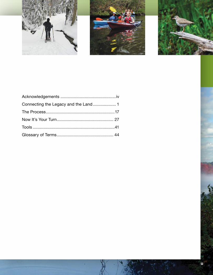
tABLe of Contents
iii
Acknowledgements ..............................................iv
Connecting the Legacy and the Land ................... 1
The Process .........................................................17
Now It’s Your Turn ............................................... 27
Tools ....................................................................41
Glossary of Terms ............................................... 44
ConneCtionsGreen Valley

iv
Acknowledgements
Special recognition is extended to Michael altshul, GIS specialist for the Green Valley Institute and the University of Connecticut, who developed the Co-occurring Resource mapping methodology and provided a wealth of mapping and technical support throughout the project.
We are also deeply indebted to Ruth cutleR, one of the earlier visionaries who led the charge years ago to map valuable natural resources as the first step in developing a land protection plan for the Quinebaug and Shetucket River Valleys.
The authors gratefully acknowledge the assistance, support and advice of other individuals and organizations in making this publication a reality. Collectively, their work provides an invaluable foundation for identifying, respecting, protecting and improving the greenways and blueways of the places we live.
the last GReen Valley, inc.
easteRn connecticut ResouRce conseRVation & DeVelopMent aRea, inc.
the natuRe conseRVancy in connecticut
GaRy BentRup, U.S. Department of Agriculture, author of the USDA publication Conservation Buffers: Design Guidelines for Buffers, Corridors, and Greenways. Images from that publication appear on Pages 11, 13 and 14.
KeRRy cRisley, The Nature Conservancy
lauRie Giannotti, Connecticut Department of Energy and Environmental Protection
leslie lewis, Connecticut Forest and Park Association
elizaBeth RoGeRs, USDA, Natural Resources Conservation Service
A picture is indeed worth a thousand words and we gratefully thank the following individuals for the use of their photographs:
toDD BolanD – Preening Black Duck (Page 25)
alan DaBRowsKi ([email protected]) – Kayaking the Quinebaug River, Eagle Family (cover insets); Kayaking near Fabian, Spotted Sandpiper, Early Morning Mist on the French River (Page iii); Autumn along the French River in Fall (Page 3); Fishing for Trout on the Quinebaug (Page 12); Wildlife (Pages 11, 13, 14 and 41); Source to Sea Sets Off from Killingly (Page 21); Kayaking the French River in Webster , River Clean-up (Page 23); Source to Sea Floats through Putnam (Page 42–43); Bridge Crossing (Page 44); Walking the Dog at Sunrise (back cover)
MeGhan RuMsey – Enjoying the Trail (cover inset)
G. leslie sweetnaM, whose aerial photography shows us a world we can only imagine; more of his images can be found at www.glsweetnam.com. Shetucket River in Sprague (cover); Scotland Windbreak (inside cover) Long Pond, Sturbridge (Page 1); The Quinebaug Flows Between Two Fields (Page 2); Fields Along the Quinebaug Growing Corn for the Farmer’s Cow (Page 17); the Village of Eagleville in Mansfield (Page 18)
alDen waRneR – Myers Pond (Page 25); Lost Pond, Union (Page 27); Joe Pye Weed Blooms in Myers Meadow (Page 44)
All other graphics and photographs have been provided by the authors.
The information provided here is the sole responsibility of the authors.
Funding for the research was provided in part by the University of Connecticut, the Quinebaug-Shetucket Heritage Corridor, Inc. and The Nature Conservancy. Funding for this guide was provided by a grant from the Connecticut Department of Environmental Protection.
1
Green Valley ConneCtions
Connecting the Legacy and the Land

2
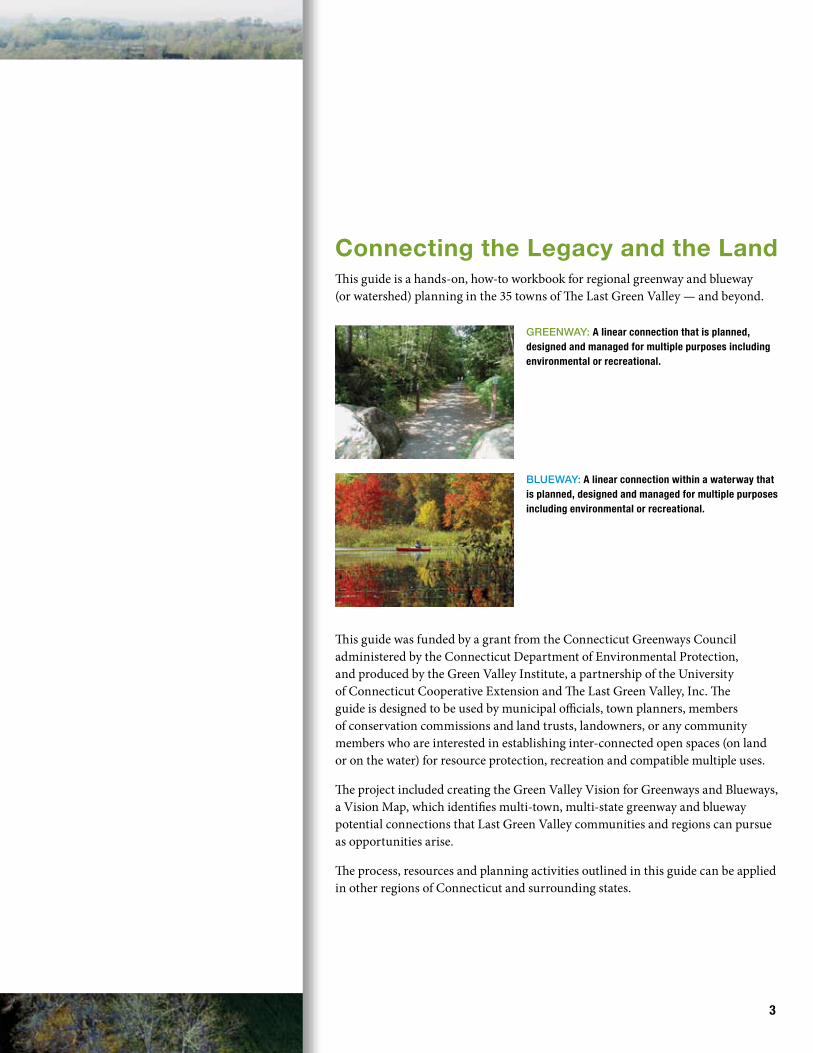
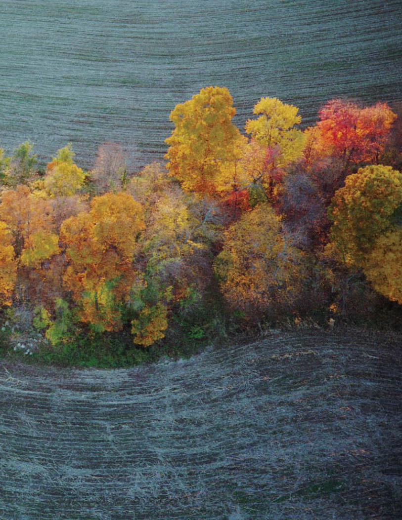
Connecting the Legacy and the Land This guide is a hands-on, how-to workbook for regional greenway and blueway (or watershed) planning in the 35 towns of The Last Green Valley — and beyond.
This guide was funded by a grant from the Connecticut Greenways Council administered by the Connecticut Department of Environmental Protection, and produced by the Green Valley Institute, a partnership of the University of Connecticut Cooperative Extension and The Last Green Valley, Inc. The guide is designed to be used by municipal officials, town planners, members of conservation commissions and land trusts, landowners, or any community members who are interested in establishing inter-connected open spaces (on land or on the water) for resource protection, recreation and compatible multiple uses.
The project included creating the Green Valley Vision for Greenways and Blueways, a Vision Map, which identifies multi-town, multi-state greenway and blueway potential connections that Last Green Valley communities and regions can pursue as opportunities arise.
The process, resources and planning activities outlined in this guide can be applied in other regions of Connecticut and surrounding states.
3
GReenway: A linear connection that is planned, designed and managed for multiple purposes including environmental or recreational.
Blueway: A linear connection within a waterway that is planned, designed and managed for multiple purposes including environmental or recreational.
4
HistoryMore than 15 years ago, a group of far-sighted individuals recognized the impor-tance of a rural, historic region, still rich with natural resources, remaining in the megalopolis sprawling along the Eastern Seaboard from Boston to New York. In 1994, following designation by Congress as the Quinebaug and Shetucket Rivers Valley National Heritage Corridor, this swath of forests and fields connected by rivers and interspersed with villages and mill towns was nationally recognized as a rural, green oasis amidst a highly urbanized region.
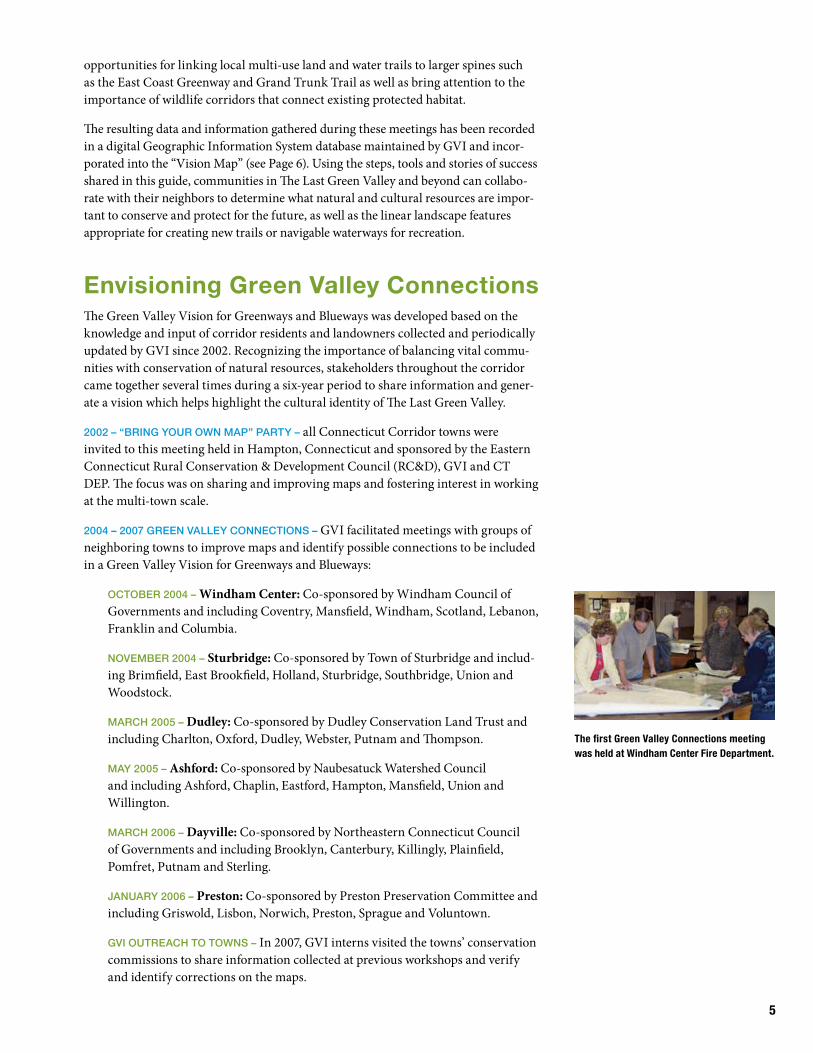
Viewed from the air, the region is noted for dark night skies and lush, green forests and fields by day — features which prompted pilots to nickname the area The Last Green Valley.
This satellite image of the east coast at night clearly shows the dense development from just south of Washington, D.C. to just north of Boston — except for the one large swath of darkness that is The Last Green Valley.
Acknowledging the significance of this rural region based on the watersheds of the Quinebaug and Shetucket Rivers, in 1999 Congress expanded the corridor to nine south-central Massachusetts towns and 26 northeastern Connecticut towns, enlarg-ing the area to 695,000 acres with a population of more than 300,000. In 2008 the Heritage Corridor officially changed its name to The Last Green Valley, Inc. (TLGV)and continues to promote and support partnerships at the local, state, regional and federal level to “enhance significant natural resources in the context of a vital economy and regional cultural identity.”
The Green Valley Institute (GVI) was established in 2000 as a non-regulatory, educa-tion and outreach partnership between the University of Connecticut and the Heritage Corridor to improve local knowledge for land-use decision-making and build capacity for protecting and managing the natural resources of this “rural island.”
Recognizing the importance of greenway connections as a critical land use tool for healthy, sustainable communities, GVI worked with the State of Connecticut Department of Environmental Protection (CT DEP) and other partners to promote planning for greenways and blueways at regional and local scales. Through a series of regional educational programs, GVI and its partners worked to identify and map
TLGV’s green maple leaf logo symbolizes the valley traversed by blue veins rep-resenting the Quinebaug and Shetucket Rivers – the “blueways” of The Last Green Valley. Our legacy of natural resources and culture are linked — from forest streams to historic centers; farm fields to mill villages — and our quality of life is connected to the land and waterways of the region. Our challenge is to maintain and improve these connec-tions across the landscape while encour-aging economic growth compatible with TLGV’s natural and cultural resources.
5
opportunities for linking local multi-use land and water trails to larger spines such as the East Coast Greenway and Grand Trunk Trail as well as bring attention to the importance of wildlife corridors that connect existing protected habitat.
The resulting data and information gathered during these meetings has been recorded in a digital Geographic Information System database maintained by GVI and incor-porated into the “Vision Map” (see Page 6). Using the steps, tools and stories of success shared in this guide, communities in The Last Green Valley and beyond can collabo-rate with their neighbors to determine what natural and cultural resources are impor-tant to conserve and protect for the future, as well as the linear landscape features appropriate for creating new trails or navigable waterways for recreation.
envisioning Green Valley Connections The Green Valley Vision for Greenways and Blueways was developed based on the knowledge and input of corridor residents and landowners collected and periodically updated by GVI since 2002. Recognizing the importance of balancing vital commu-nities with conservation of natural resources, stakeholders throughout the corridor came together several times during a six-year period to share information and gener-ate a vision which helps highlight the cultural identity of The Last Green Valley.
2002 – “BRinG youR own Map” paRty – all Connecticut Corridor towns were invited to this meeting held in Hampton, Connecticut and sponsored by the Eastern Connecticut Rural Conservation & Development Council (RC&D), GVI and CT DEP. The focus was on sharing and improving maps and fostering interest in working at the multi-town scale.
2004 – 2007 GReen Valley connections – GVI facilitated meetings with groups of neighboring towns to improve maps and identify possible connections to be included in a Green Valley Vision for Greenways and Blueways:
octoBeR 2004 – Windham Center: Co-sponsored by Windham Council of Governments and including Coventry, Mansfield, Windham, Scotland, Lebanon, Franklin and Columbia.
noVeMBeR 2004 – Sturbridge: Co-sponsored by Town of Sturbridge and includ-ing Brimfield, East Brookfield, Holland, Sturbridge, Southbridge, Union and Woodstock.
MaRch 2005 – Dudley: Co-sponsored by Dudley Conservation Land Trust and including Charlton, Oxford, Dudley, Webster, Putnam and Thompson.
May 2005 – Ashford: Co-sponsored by Naubesatuck Watershed Council and including Ashford, Chaplin, Eastford, Hampton, Mansfield, Union and Willington.
MaRch 2006 – Dayville: Co-sponsored by Northeastern Connecticut Council of Governments and including Brooklyn, Canterbury, Killingly, Plainfield, Pomfret, Putnam and Sterling.
JanuaRy 2006 – Preston: Co-sponsored by Preston Preservation Committee and including Griswold, Lisbon, Norwich, Preston, Sprague and Voluntown.
GVi outReach to towns – In 2007, GVI interns visited the towns’ conservation commissions to share information collected at previous workshops and verify and identify corrections on the maps.
The first Green Valley Connections meeting was held at Windham Center Fire Department.

The Vision for Greenways and BluewaysTHE VISION MAP (opposite page) is a summary of the vision created during this five-year process. It is a snapshot of potential greenways, blueways and wildlife corridors between existing trails and conservation areas. Some towns in The Last Green Valley have already adopted aspects of the envisioned greenway and blueway connections in their open space or master plans, but many of the potential connections identified on the map have not been approved by any municipal, regulatory or state agency. It is important to note that this map is not a plan, but a vision — a fluid, changing document intended to spur discussions and planning for regional greenways and blueways, both within municipalities, as well as across town and state borders.
GREEN VALLEY CONNECTIONS PART II: GREENWAYS AND BLUEWAYS MAPPING
WORKSHOPS – GVI conducted follow-up meetings with large-format maps rep-resenting the results of the previous Green Valley Connections workshops. These meetings sparked more discussion between groups of towns on potential connec-tions for trails and wildlife corridors and inclusion of greenways and blueways in town open space plans.
NOVEMBER 1, 2007 – Sprague Senior Center
NOVEMBER 7, 2007 – Windham County Extension Center in Brooklyn
NOVEMBER 8, 2007 – Dudley Grange Hall
At the Dudley Grange Hall, folks from the 12 northern Corridor towns reviewed the Area I Vision Map for Greenways and Blueways.
6

Green Valley Vision for Greenways and Blueways
LAST GREEN VALLEY MAJOR TRAILS
1 Grand Trunk Trail
2 Natchaug Trail
3 Nipmuck Trail
4 Airline Trail North
5 Airline Trail South
6 East Coast Greenway
7 Pachaug Trail
MAP DATA SOURCES
Data shown on this map were processed or generated from information courtesy of: United States Department of Agriculture, Natural Resources Conservation Service; The Nature Conservancy; Connecticut Department of Environmental Protection; Connecticut Office of Policy and Management; Massachusetts Executive Office of Energy and Environmental Affairs, Massachusetts Geographic Information System; Rhode Island Geographic Information System; Central Massachusetts Regional Planning Commission; University of Connecticut, Center for Land Use Education and Research; Windham Regional Council of Governments; Green Valley Institute; Attendees of Green Valley Connections Workshops and individuals possessing knowledge of permanently protected and other significant open space parcels, trails and waterways.
The geographic accuracy of data shown on this map cannot be guaranteed. These data may also not be complete and/or up to date. All measurements represented on this map are approximations.
Compiled by the Green Valley Institute, June 20117
8
new ConnectionsRegional mapping sessions conducted in The Last Green Valley between 2002 and 2007 provided opportunities for communication about existing multi-town connec-tion projects and fostered collaboration on several new projects.
The Willimantic River Greenway (nominated by the Willimantic River Alliance) was recognized in 2003, and joined the Airline Trail, Connecticut Blue-Blazed Trails, Hop River State Park Trail, Moosup Valley State Park Trail and the Quinebaug River Multi-Purpose Trail as officially designated Connecticut Greenways in The Last Green Valley.
Attendees of the March 2005 Green Valley Connections meeting in Dudley, Massachusetts were able to strengthen ties and establish partnerships across town boundaries. They built a strong coalition to meet the challenges of restoring a degraded watercourse while reintroducing residents to the splendor of the French River.
In 2006 four more greenways were nominated by multi-town groups in The Last Green Valley. The Fenton, Mount Hope and Natchaug River Greenways in Ashford, Chaplin, Eastford, Mansfield, Union, Willington, Windham and Woodstock as well as the Still River Greenway shared by Woodstock and Putnam were all recognized for their natural, historic and cultural resources — including protection of drinking water supplies.
While attending a regional follow-up session in November 2007, representatives from the towns of Killingly, Putnam and Thompson identified common goals for protec-tion of the Five-Mile River across the boundaries of each town. The three towns jointly nominated and received official greenway recognition for the Five-Mile River in 2010.
Since 2009, The Last Green Valley’s Water Trails Steering Committee has worked to create a close-to-home network of water trails throughout the region. By increasing recreational opportunities, the committee will make it easier for residents and visitors to enjoy the waterways, and to become advocates and caretakers of the river system.
In the last few years, the Steering Committee and its many partners have added new water trail segments, completed access site assessments and stewardship plans, devel-oped paddler’s guides, installed informational kiosks and a new webpage for water trails (www.tlgv.org). They have hosted multiple paddles for the public to enjoy and have sponsored several river clean-ups. A watershed newsletter, Currents from Source to Sea, helps increase volunteer stewardship capacity.
The Steering Committee continues to construct informational kiosks, design and implement launch site improvements, publish new paddler’s guides, and install water trail signage both on land and in the water. It plans to nominate 20 miles of water trails on the Willimantic River and 20 miles on the Quinebaug River for National Recreation Canoe Trail, complementing more than 10 miles already designated on the Quinebaug River.
The Last Green Valley continues to champion greenways, blueways and wildlife throughout the corridor in Vision 2020, The Next Ten Years.
The Last Green Valley and more than 90 part-ners launched the “Source to Sea Expedition” in April, 2009 beginning in the headwaters of the Quinebaug and Shetucket Rivers. Organized paddles, cleanups and riverside events highlighted the network of waterways throughout the watershed. The expedition traveled south along the mainstem rivers to the Thames River Estuary arriving in Long Island Sound in June 2009.
9
Building a Green Infrastructure
green infrastructure: a natural life support system
in • fra • struc • ture: noun the underlying foundation or basic framework (as of a system or organization) Merriam-Webster
Piecemeal, incremental and unplanned development of homes, businesses, roads and utilities is gradually fragmenting natural landscapes, such as the forests and wetlands, while adversely affecting freshwater resources and the species of wildlife that need these habitats for survival.
Acknowledging this trend of sprawling development, two researchers from the Conservation Fund have proposed a theory of conservation called “green infrastruc-ture” that recognizes the multiple values of natural, undeveloped lands for people and nature. Mark Benedict and Edward McMahon define green infrastructure as “an interconnected network of natural areas and other open spaces that conserves natural ecosystem values and functions, sustains clean air and water, and provides a wide array of benefits to people and wildlife.”
BUILDING A GREEN INFRASTRUCTURE
One type of infrastructure that we are all familiar with is our system of streets, roads and highways. It’s an interconnected system that allows us to easily move from one area to another. When we plan for and build a new road it is connected to the existing system of roads. Planning for green infrastructure incorporates the same strategic and proactive approach to conservation that is as necessary to community health and economic well-being as the built infrastructure of roads, bridges, sewers and electric grids.
Connecticut has begun to identify and plan for greenways at the state level. This is an important step and depends upon local and regional communities to fill in the gaps and bring these connections together. Green infrastructure can provide a useful conservation planning tool as connections for greenway trails and wildlife corridors, along rivers and through landscapes, are envisioned and implemented through this guide.
{ }

10
WHY DO WE NEED A GREEN INFRASTRUCTURE?
Our communities develop little by little, year by year. Without planning for green infrastructure, towns can be left with little or no significant open space for ecologi-cal or recreational uses. Towns often plan for the built environment — things like water mains and sewer lines — but without simultaneously planning for the green environment, open space is happenstance and consists of the left-over land that can’t easily be developed.
Several years ago, many towns felt that the best way to protect rural character and open spaces was to implement two-acre minimum lots. The result was that entire towns were completely developed with contiguous subdivisions and very little open space for public parks, water quality protection or the once scenic open fields and forests that defined the rural community character.
While Smart Growth designates areas appropriate for development, “smart conserva-tion” designates green infrastructure networks that prioritize conservation of open lands, trails and wildlife corridors to provide the natural resources necessary for clean water and healthy environments for people and nature.
There are many ecological and social benefits of open space and green infrastruc-ture including:
• Protecting water quality
• Controlling pollution
• Maintaining community character
• Conserving and buffering wildlife habitats
• Providing recreational opportunities
• Protecting open lands for future generations
Connecticut has experienced relatively slow population growth during the past 20 years, yet each year more than 8,000 acres are being converted from farms and forests to residential and commercial lands. Each time a parcel of land is developed near an existing greenway or valued wildlife corridor, the opportunity to connect green infrastructure is lost. Planning and identifying important connections today can help us protect these critical links for the future while we continue to grow our economies.
A LANDSCAPE IS MADE UP OF
THREE FUNDAMENTAL ELEMENTS:
Patch – a plant or animal community differing from the surrounding area
Corridor – a linear patch differing from the surrounding area
Matrix – the background area in which the patches and corridors exist

11
Components of Green infrastructure
greenwAys, BluewAys And wildlife corridors
greenwAys
The term “greenways” is used to describe a linear area for protection of natural or cultural resources and linkage to existing protected areas. Greenways provide connections between natural areas such as forests, wetlands and rivers. They create connections in the larger landscape. A greenway can include a hiking trail, or if in an area of sensitive habitats, it may just be a corridor for wildlife movement.
The communities of The Last Green Valley have many greenways that are recreational trail including the East Coast Greenway, Grand Trunk Trail and the CT Blue-Blazed trails. They shape the landscape of the Heritage Corridor and form the backbone — or “spines” — of our greenways.
“Greenways are networks of land containing linear elements that are planned, designed and managed for multiple purposes including ecological, recreational, cultural, aesthetic or other purposes compatible with the concept of sustainable land use.”
Jack Ahern, The University of Massachusetts Department of
Landscape Architecture and Regional Planning
Wildlife movement corridors provide a link for wildlife to move between habitats.
Sensitive greenways, such as along a waterway, provide a wildlife move-ment corridor while protecting the habitat; in some cases limiting human activity from an access trail may be appropriate.
The Greenway Spines of The Last Green ValleyThe East Coast Greenway, a trail from Florida to Maine, crosses the Last Green Valley. There are also several other major through-trails and CT Blue-Blazed Trails.

12
BLUEWAYS
Blueways can be defined in much the same way as greenways — waterways linking the landscape and serving multiple, compatible uses. The waters of The Last Green Valley serve many functions from drinking water reservoirs and hydro-power gen-eration to white-water kayaking, swimming holes and trophy trout fishing. Efforts to establish riverside trails and canoe- or kayak-friendly streams for recreation can encourage appreciation of local water resources by people who live nearby in the community and visitors to the region.
With enhanced understanding of the important connections and interrelationships between the land and the water that flows over it, Connecticut and many other states have begun to work toward implementing environmental protection at the watershed scale. A watershed is the geographic area within which all surface water drains into a particular body of water. As development increases, the ability of stormwater to seep into the ground is decreased. Runoff during storms picks up sediment and pollution that is carried to rivers, eventually flowing to the sea.
Identifying and designating blueways can help bring attention to a watershed and the importance of protecting and buffering waterways.
The communities of The Last Green Valley are located within the watersheds of the two largest freshwater streams in the Thames River Basin, the Quinebaug and Shetucket Rivers. They shape the landscape of the Heritage Corridor and form the backbone — or “spines” — of our blueways.
A watershed is the area that acts like a bowl to collect precipitation, rain and snow, that then flows downhill pulled by gravity eventually to a single outlet. In this illustration, rain that falls within the “bowl” of the watershed, travels down the hills in small streams that gather together and form a river that flows to the Long Island Sound. The top of hills, called the ridgeline, divides watersheds.
Water that falls within this bowl will pour out the spout; a watershed functions the same way.
The Blueway Spines of The Last Green Valley On the east, the French and Quinebaug RIvers flow from the north. In the west, the Willimantic, Mount Hope and Natchaug Rivers become the Shetucket. Farther south, the Quinebaug and Shetucket Rivers join to form the Thames River that flows to Long Island Sound.

13
wildlife corridors
Wildlife corridors are a type of greenway used to connect habitat areas for the benefit of plant and animal species. Also known by an array of other terms — ecological networks, biotic corridors, movement cor-ridors, landscape linkages — wildlife corridors can be designed at a variety of scales. In vast and remote wildland regions, corridors can cross continents and countries to connect territories — like the Rocky Mountain range or the Nile River. In more developed and densely popu-lated regions like heavily suburbanized Connecticut, wildlife corridors are smaller-scale, short-range linkages designed to help species move through inhospitable landscapes.
Fragmenting the landscape impacts the survival and distribution of many species. Protecting core natural areas for wildlife and providing linking corridors is an important conservation strategy. Environmental corridors are naturally occurring landscape features like wetlands, ridgelines and stream courses. Other important wildlife corridors can be the result of disturbances or management such as utility lines and vegetated strips along roadsides.
Corridors serve multiple functions for wildlife including: habitat, migration, reproduction, protection and filtration among others. The structure or physical components of wildlife corridors such as width, length, connectivity and vegetation determine how they are used by wildlife populations (See Corridor Width Summary on Page 14). Wildlife corridors may not provide all of the resources necessary for
Connecting habitats with corridors can benefit biodiversity by providing access to other areas of habitat, increasing population viability and providing additional habitat. Corridors that link different types of habitats required by a species also provide ecological connectivity.

14
a species but they can help animals travel through their range to successfully feed, breed, nest and reproduce. Stream (also known as riparian) corridors provide some of the most important wildlife connections in the landscape of The Last Green Valley. Vegetation near stream corridors is often more structurally diverse and abundant than some upland habitats. Riparian corridors can provide food and shelter — as well as water, insects, fish and other necessary resources for wildlife.

15
Co-occurring Resource inventory Model
A Green infrastructure Planning toolThe Co-occurring Resource Inventory Model (CoRI) is a planning tool to help com-munities see where multiple resources overlap. It was developed by the Green Valley Institute using geographic information system natural resource and uses data from a variety of sources. CoRI users are able to choose resource data (such forest blocks and soil types) and assign a “weight” or value to selected resources. The corresponding weights are entered into a computer model to create a map representing approximate locations of resources or “hot spots.” This information can be helpful in planning green infrastructure and open space planning.
Two different types of data sets can be processed within the CoRI model: Direct Resource — those that identify the location of the resource (e.g. wetland soils, potential aquifer areas, and parcels of certain acreage) and Resource Proximity — those that identify areas in close proximity to a particular natural resource (such as protected open space, wetlands and streams). These areas may serve a valuable function as a riparian buffer zone or wildlife habitat corridor. The CoRI users can vary proximity distance (or buffer width) for their analy-sis; for example; a buffer along a stream might be 25 feet for water quality protection, 100 feet for aquatic habitat protection, 150 feet for a small mammal, or 3+ miles for large mammals.
The CoRI employs an iterative process and helps users become familiar with the resources located in their town or region. Green Valley Institute has assisted 14 towns with these analyses as part of a comprehensive town-wide resource inventory and in their Plans of Conservation and Development. Several communities have used the informa-tion to help identify important resource areas for land protection efforts, wildlife corridors and Greenway Plans. The CoRI is also a valuable tool in the delineation of resource overlay zones such Aquifer Protection Zones, River Overlay Zones or Agricultural Zones.
This model was used extensively in developing the Green Valley Vision for Greenways and Blueways to highlight the areas of potential connections.
Canterbury, CT Co-occurring Resource Map The green areas depict the occurrence of multiple natural resources defined by the Canterbury Conservation Commission as pri-orities — the darker the green, the higher the resource value in that location. The town is using this information as a tool to help in planning green infrastructure.

16
co-occurring resource inVentory exAmple: leBAnon, ct
Working with GVI staff in 2007, the Lebanon Conservation Commission explored three scenarios for mapping their important resources. The CoRI model allowed them to assign values, or weights, to various resources and immediately see the resulting map.
The first scenario applied almost equal weight to Proximity to Protected Open Space (22%), Wetlands Soils (23%) and Wildlife Habitats/Corridors (23%), slightly more to Riparian Buffer Zone (26%) and the remaining 6% allocated to Potential Stratified Drift Aquifer. The green areas of the map depict co-occurring resources identified by the commission members; the darker the green, the higher the resource value in that location. Next, Commission mem-bers increased the importance of Proximity to Protected Open Space by using a 40% weight, and reduced the other values slightly. To focus on wildlife habitat potential, they eliminated Potential Stratified Drift from the equation. The third scenario explored whether considering parcel size impacted the resulting map.
The town selected Scenario 2 as the map result that best represented its goals for resource valuation. It is important to note that this analysis is not the “final answer” but simply one of the tools used to identify protection priorities. This type of analysis does not replace site level review or in-depth inventories, but it can help identify resource patterns on the landscape.
Co-occurring Map Legend
Scenario 1
Scenario 2
Scenario 3
Table 1: Co-occurring Resource Inventory Value Weights Assigned for Each Scenario

17
Green Valley ConneCtions the Process
18

19
the ProcessThis section of the guide is intended to give you an overview of the process of planning for greenways and blueways. The following sections include a step-by-step workbook and sources for information on planning a green infrastructure.
A green infrAstructure
Green Infrastructure has three components that sometimes interconnect, but should be planned for separately: Recreational Trails, Blueways and Wildlife Corridors. All start with getting to know your resources, their value and where they occur in the landscape.
getting stArted:
step 1. look At the Big picture. The first step in any planning process is to answer some basic questions about the goals of the project.
step 2. Build A teAm. Reach out to interested residents and partners within your town and region.
step 3. Build your knowledge BAse. Work with your team and resource specialists to gather more information about the area of interest.
step 4. drAw the connections. Yes! We mean draw! Pull your team together and schedule a map party, invite the people you have identified in Step 2 and any others that may be interested in participating.
step 5. plAn the connections. Engage folks by sharing the results of the map party with your community. Make a map of the vision and study it, look for shared or common goals, and think about the opportunities and obstacles for each.
step 6. mAke the connections hAppen. Incorporate the vision in town and regional plans. Develop an action plan for each connection. Assign each action to a responsible leader or team. Prioritize steps and identify a variety of tools useful for meeting each goal.
20
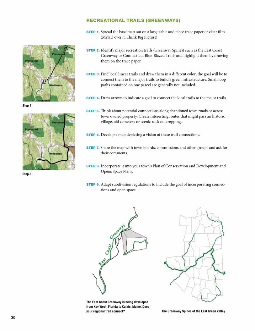
The East Coast Greenway is being developed from Key West, Florida to Calais, Maine. Does your regional trail connect?
recreAtionAl trAils (greenwAys)
step 1. Spread the base map out on a large table and place trace paper or clear film (Mylar) over it. Think Big Picture!
step 2. Identify major recreation trails (Greenway Spines) such as the East Coast Greenway or Connecticut Blue-Blazed Trails and highlight them by drawing them on the trace paper.
step 3. Find local linear trails and draw them in a different color; the goal will be to connect them to the major trails to build a green infrastructure. Small loop paths contained on one parcel are generally not included.
step 4. Draw arrows to indicate a goal to connect the local trails to the major trails.
step 5. Think about potential connections along abandoned town roads or across town owned property. Create interesting routes that might pass an historic village, old cemetery or scenic rock outcroppings.
step 6. Develop a map depicting a vision of these trail connections.
step 7. Share the map with town boards, commissions and other groups and ask for their comments.
step 8. Incorporate it into your town’s Plan of Conservation and Development and Opens Space Plans.
step 9. Adapt subdivision regulations to include the goal of incorporating connec-tions and open space.
The Greenway Spines of the Last Green Valley
Step 4
Step 5

W ith four miles of the Quinebaug River Multi-Use Trail complete, residents of
the town of Killingly are using their riverside path through downtown Danielson while waiting for missing trail links that will eventually connect the 3,000-mile East Coast Greenway from Maine to Florida.
At a trail dedication event on May 16, 2009, the National Park Service also dedicated a Blueway and canoe launch located at 31 Wauregan Road (Route 12) in Danielson to provide access to a sec-tion of the Quinebaug River that is being used to teach people how to canoe through Class 2 and Class 3 rapids.
The Quinebaug River Multi-Purpose Trail for bicycling, walking, running, horseback riding, skating, fishing and other non-motorized activities was recognized as a state of Connecticut Greenway in 2002, and is now paved and compliant with the Americans with Disabilities Act. The first section of the trail was built in 1996, and though funding for the third and fourth sec-tions was approved a year or two later it took until 2008 to receive the federal transportation funds for the trail con-struction to take place.
“It was almost a 10-year process to get the funding which can be very frustrat-ing,” says Eric Rumsey, Killingly Town Planner. “If a town or city can do this without using federal funding, there’s a lot less involved with it.”
Another barrier to progress in planning a trail route can be the reac-tion of property owners, Rumsey says. During the planning phases, the town sent letters to abutters and held public information meet-ings about the proposed trail. Many property owners whose lands border the trail “initially have a not-in-my-backyard attitude. Then when things are done, they tend to love it,” Rumsey said.
Some come to believe that the trail actually increases their property values, as the routine presence of trail users may decrease illicit
trespassing. A resident trooper patrols the Quinebaug River trail, for which the town holds the easements, and the parks and recreation department takes care of trash and mowing.
Killingly is planning for the final two phases of expansion. To complete the eventual vision for the East Coast Greenway through the town of Killingly, the completed four-mile portion of the trail needs to extend about a mile south to the border of Plainfield (from which the greenway would go on to Rhode Island), and another 10 to 12 miles north to the Putnam border. Meetings have been held with the towns of Putnam and Thompson, further north, to discuss where the trail could eventu-ally link into those communities.
Mostly along the Quinebaug River in its southern sections, the trail could potentially run along sections of the Five Mile River (a Quinebaug tributary) as it approaches Putnam. Rumsey said the town has sewer easements along both sides of the Five Mile River, and could modify the easements to allow the trail to run along the top. Remaining steps include:
1) funding (Killingly is applying for fed-eral funds for the northward expansion despite the challenges, and hopes to complete the mile south to Plainfield with town funds);
2) finalizing the route and working with property abutters;
3) bidding process for trail construction.
Once complete, the trail has proved worth the wait for community members. Rumsey says, “It’s packed every time I’ve been on it.” Though Rumsey was only on board for the most recent parts of the 15-year trail project, he advises “patience and persistence” to fellow trail volunteers and planners. “Don’t give up,” Rumsey says. “Get these things built, because once built, they’re going to be used.”
Quinebaug River Trail in Killingly:A Link to the east Coast Greenway
The trail and canoe launch have quickly become valued by community residents and visitors.
21

22
BluewAys
step 1. Spread the base map out on a large table and place trace paper or clear film (Mylar) over it and think about the Big Picture.
step 2. Identify major waterways (Blue Spines) and highlight those that pass through sensitive areas and protected open space.
step 3. Identify waterways that are less sensitive to human recreational activity, look for potential access points for fishing, boating or birdwatching.
step 4. Identify large areas of wetlands, as these may be important habitats.
step 5. Develop a map depicting the key sensitive waterways and share the map with other boards and commissions and ask for their comments.
step 6. Incorporate it into your town’s Plan of Conservation and Development and Opens Space Plans.
step 7. Implement an overlay zone that includes regulations to protect the sensitive waterways by regulating activity within a certain distance of the water.
step 8. Work with ConnDOT and the town’s public works department to create parking and access paths for appropriate waterways.
Overlay Zones are a way to simplify zoning regulations for unique situations that cross mul-tiple zoning districts. The base zoning district regulations still apply, but areas that fall within the overlay zone have additional development or use restrictions. This example of an Overlay Zone (shown as a blue grid) follows the river as it passes multiple zones. The Blueway Spines of the Last Green Valley
Step 3
Step 4
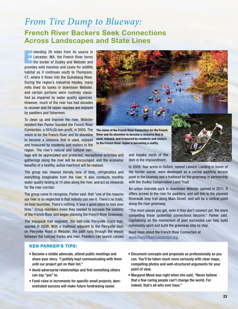
E xtending 26 miles from its source in Leicester, MA, the French River forms the border of Dudley and Webster and
provides wild marshes and coves for wildlife habitat as it continues south to Thompson, CT, where it flows into the Quinebaug River. During the region’s industrial heydey, many mills lined its banks in downtown Webster, and certain portions were routinely classi-fied as impaired by water quality agencies. However, much of the river has had decades to recover and its upper reaches are enjoyed by paddlers and fishermen.
To clean up and improve the river, Webster resident Ken Parker founded the French River Connection, a 501c(3) non-profit, in 2005. The vision is for the French River and its shoreline to become a resource that is used, enjoyed and treasured by residents and visitors to the region. The river’s natural and cultural heri-tage will be appreciated and protected, recreational activities and gatherings along the river will be encouraged, and the economic benefits of a healthy, active riverfront will be realized.
The group has cleaned literally tons of tires, refrigerators and everything imaginable from the river. It also conducts monthly water quality testing at 15 sites along the river, and act as stewards for the river corridor.
The group came to recognize, Parker said, that “one of the reasons our river is so neglected is that nobody can see it. There’s no trails, no boat launches. There’s nothing. It was a good place to toss your tires.” Group members knew they needed to increase the visibility of the French River and began planning the French River Greenway.
The inaugural trail segment, the half-mile Perryville Trace trail, opened in 2008. With a trailhead adjacent to the Perryville Dam on Perryville Road in Webster, the path runs through the woods between the railroad tracks and river. Paddlers can launch canoes
and kayaks north of the dam in the impoundment.
In 2009, four acres in Oxford, named Leovich Landing in honor of the former owner, were developed as a cartop paddling access point to the blueway and a trailhead for the greenway in partnership with the Dudley Conservation Land Trust.
An urban riverside park in downtown Webster opened in 2011. It offers access to the river for paddlers, and will link to the planned Riverwalk loop trail along Main Street, and will be a central point along the river greenway.
“The more pieces you get, even if they don’t connect yet, the more compelling those (potential) connections become,” Parker said. Capitalizing on the momentum of past successes can help build community spirit and build the greenway step by step.
Read more about the French River Connection at www.FrenchRiverConnection.org.
From Tire Dump to Blueway: french River Backers seek Connections Across Landscapes and state Lines
• Become a visible advocate, attend public meetings and share your story. “I politely kept communicating with them until our project got on their list.”
• Avoid adversarial relationships and find something others can say “yes” to.
• Fund-raise in increments for specific small projects; dem-onstrated success will make future fundraising easier.
• Document concepts and proposals as professionally as you can. You’ll be taken much more seriously with clear maps, compelling photos and well-structured arguments for your point of view.
• Margaret Mead was right when she said, “Never believe that a few caring people can’t change the world. For indeed, that’s all who ever have.”
The vision of the French River Connection for the French River and its shoreline to become a resource that is used, enjoyed, and treasured by residents and visitors to the French River region is becoming a reality.
23
ken pArker’s tips:

24
WILDLIFE CORRIDORS
STEP 1. Spread the base map out on a large table and place trace paper or clear film (Mylar) over it.
STEP 2. Identify key natural resources that provide habitat for wildlife and highlight them on the trace paper; these could be
• protected open space• wetlands• large areas of forest or grass land
and remember to look outside your town’s borders.
STEP 3. Look for potential connections between those resources and draw arrows on the trace paper; at this point don’t identify parcels or ownership, just indi-cate with an arrow that a connection would make sense. Remember to look outside the town boundaries.
STEP 4. Look for islands of unprotected areas surrounded by protected lands and/or wetlands and highlight them as key parcels
STEP 5. Step back and see if anything is missing. Look for other resources that might have been overlooked, or other potential connections. Are those connections a realistic goal?
STEP 6. Develop a map depicting a vision of these wildlife corridors and incorporate it into your town’s PoCD and opens space plans; share the map with other boards and commissions.
STEP 7. Develop a protection plan for valuable island parcels (see 4 above).
STEP 8. Within subdivision regulations, include the goal of incorporating these wildlife corridors into a subdivision’s open space planning.
Subdivisions can be designed to include wildlife corridors.
Step 3
Wetland regulations will limit the development potential of about a third of the area. The remaining five parcels could be developed.
If those five parcels were developed with conventional subdivisions, the potential for wildlife corridors is lost.
Those five parcels developed with conservation subdivisions with the same number of homes could included wildlife corridors and recreational trails.

T he Quinebaug Highlands Land-scape spans the border of the “quiet corner” of Northeastern
Connecticut and south-central Massa-chusetts. Comprised of a 34,000-acre forest block stretching across four towns in Connecticut (Ashford, Eastford, Union and Woodstock) and two in Massachusetts (Southbridge and Sturbridge), most of this natural area is contained within The Last Green Valley.
A remarkably rural and forested corri-dor, dense forests, crystalline rivers and vibrant farmlands are still found in the Quinebaug Highlands. Healthy stands of oak, hickory and Eastern hemlock forests, dotted with northern hardwoods like white birch, harbor wide ranging mammals like black bear, moose, bobcat and fisher. Threatened migratory songbirds also nest and breed in these vast, relatively intact forests. Several rare natural communities and plants thrive in the landscape’s rug-ged and remote stretches.
The Natchaug River System is recog-nized by federal, state, local and private agencies as a benchmark stream for water quality containing a rich diversity of aquatic and terrestrial plants and animals. The Natchaug, Fenton and Mount Hope Rivers provide trophy trout fishing, paddling, hiking, history and beauty to area residents and visitors. This network of forest and freshwater habitats also provides many benefits to people. The water is very high quality because it remains more than 75 percent forested. The highlands sustain the largest drinking water supply watershed in Connecticut, with benefits that trickle down all the way to Long Island Sound.
Despite its working farms and rural character, the Quinebaug Highlands has faced development pressure across the years. Much of the land here is privately owned and rising real estate prices demand cooperative, creative strategies to address changes in land use and other threats to wildlife populations.
In 2009, The Nature Conservancy, with assistance from 11 part-ners, was awarded a $1 million grant from the North American Wetlands Conservation Act Program — overseen by the U.S. Fish and Wildlife Service. The project resulted in the permanent
protection of 1,127 acres of wetlands and forests for wildlife habi-tat. The partnership includes three private landowners, the Green Valley Institute, Wyndham Land Trust, Norcross Wildlife Foundation, Connecticut DEP, USDA Natural Resources Conservation Service, and the towns of Eastford and Woodstock and leveraged more than $3 million in additional land preservation.
The network of protected streams and forests includes habitat for ringed boghaunter dragonfly and frosted elfin butterfly. Extensive wetland systems support the largest remnant population of breed-ing American black duck in Connecticut and provide critical places for migratory waterfowl to winter and rest. Secretive wetland birds like American bittern and sora still enjoy its undisturbed marshes including Myers Pond (above). Additionally, the 11 protected prop-erties create important links between the Nipmuck and Natchaug State Forests, Yale-Myers Forest and the critical streams to which they are connected. Partners working across town and state lines to identify common goals and cooperate at such a large scale help to ensure sufficient habitat for healthy animal, fish and plant popu-lations while providing significant benefits for people.
Wildlife Corridors:Partners Keeping Habitats Connected in Quinebaug Highlands
25
The Quinebaug Highlands NAWCA project links wildlife hab-itat between Nipmuck, Natchaug and Yale-Myers forests.
More than 1,100 acres of permanently protected forest and wetland provide important wintering and breeding grounds for native and migratory waterfowl like American Black Duck.

26

27
Green Valley ConneCtions now it’s Your turn
On the following pages is a workbook that you can use to guide you through the process of planning for, and building your community’s green infrastructure.
The left-hand pages have information on the steps to take, and the right-hand pages are for you to fill in with your town’s information as you proceed.
28
step 1. Look at the Big PictureThe first step in any planning process is to answer some basic questions about the goals of the project.
Where are you on the map? Planning for green infrastructure means you will generate a list of action items to meet the goals set by your community and your region. Start by identifying the priorities, the potential partners and who will take the lead.
What do you want to connect? Identify natural and cultural resources and determine what kinds of connections make sense for your community (greenways, blueways, trails, wildlife corridors or multi-use). A town’s Plan of Conservation and Development (PoCD) is the blueprint that outlines the future development and conservation pattern in your town. Check your plan for specific goals related to green infrastructure. Examples of language consistent with planning for green infrastructure include:
• Plan for and build a green infrastructure of trails and wildlife corridors
• Large blocks of forested lands and wildlife corridors are vital in maintaining habitats for the plants and animals that keep our ecosystem in balance. Development should be planned to keep these corridors open and to maintain as much unfragmented forest land as possible.
• Consider impact to natural resources in development approval process.
• Work to maintain existing and potential wildlife corridors, habitats whenever possible
• Work with surrounding towns to build a regional trail system
• Plan for a trail system that connects existing and proposed recreational areas
• Maintain riparian buffers for the protection of water quality.
Identify your community’s connection priorities.
For example:
• Provide accessible trail connection from village center to airline trail in neighboring community
• Provide fishing and boating access to river
• Maintain wildlife corridors between large blocks of forest
Note: If your town’s PoCD doesn’t mention the value of open space and greenways, talk with the planning commission and suggest that it incorporate building a green infrastructure in the next PoCD revision.
29
Town of _______________________________________________________________________________________________
Our town’s current Plan of Conservation and Development:
strongly supports planning for a green infrastructure by stating: _____________________________________________________________________________________________________
_____________________________________________________________________________________________________
_____________________________________________________________________________________________________
_____________________________________________________________________________________________________
has language that doesn’t mention green infrastructure but does state that open space, trails and wildlife habitat are important in sections:
_____________________________________________________________________________________________________
_____________________________________________________________________________________________________
_____________________________________________________________________________________________________
_____________________________________________________________________________________________________
does not mention the value of open space, trails and wildlife habitats (see note on left)
Our Community Connection Priorities are:
_____________________________________________________________________________________________________
_____________________________________________________________________________________________________
_____________________________________________________________________________________________________
_____________________________________________________________________________________________________
_____________________________________________________________________________________________________
_____________________________________________________________________________________________________
_____________________________________________________________________________________________________
_____________________________________________________________________________________________________
_____________________________________________________________________________________________________

30
step 2. Build a team
In planning for green infrastructure, you need to be mindful of the bigger picture. There may be a major trail or an important wildlife habitat just across your town’s borders. Working collaboratively with your neighboring towns in planning for green infrastructure will result in better connections and linkages. Try to include organizations with similar or complementary goals. It helps to identify a core group for your planning team and invite specialists to provide resource information as you refine your goals.
What connects you to other places? Some connections within your town or across boundaries are very clear. For example, a river, trail or other linear feature such as a canal. Some less obvious features, like ridges or wetlands, may provide opportunities for connections, too.
Who connects you? In other words, who are your natural partners in the town and region?
Examples of core planning team members include:
Town Planner or Elected Official
Municipal Commissioners – Conservation, Recreation, Planning and Zoning, Economic Development, and Park Planning.
Local Organizations – Land Trust, Hiking, Cycling, Horseback Riding Clubs, Boating Club, Tourism Organization, Chamber of Commerce, Historical Society
Natural and Cultural Resource Professionals – Extension Educators, Regional Planning Agency, CT DEP, Conservation Districts, State Archeologist

31
Our community is connected by: (examples: Quinebaug River, Airline Trail, Trap Rock Ridge)
________________________________________________________________________________________________________
________________________________________________________________________________________________________
________________________________________________________________________________________________________
Our community is connected to: (Surrounding towns and key contact information)
Abutting townsConservation Commission Chair,
Town Planner or other contact Contact Info
Potential Partners with similar interests are:
Name Organization Contact Info
Specialists that might have important resource information are:
Name Organization Contact Info

32
step 3. Build Your Knowledge BaseOnce you’ve identified the potential scope of your project — whether it is a multiple-use greenway, a blueway on a particular portion of a watershed, or a trail connecting existing open spaces — you’re ready to begin gathering more information about the area of interest.
By studying maps and other sources of information, you can build a more complete picture of your project and begin to refine your goals. Information about the surrounding community or the physical characteristics of the area can affect the scale of your project, the types of resources that might be included for protection, or the route of a trail or wildlife corridor.
Geographic Information Systems (GIS) mapping is a great tool for “seeing” different facets of your town. This type of mapping can be generated digitally or printed on paper or clear film (Mylar) which helps you to layer the maps and determine where multiple resources occur in the landscape. Examples of maps helpful for your green infrastructure database include:
Topography shows the surface terrain, the hills, valleys and lowlands. USGS topographic maps may include some land use features like buildings, roads, wetlands and fields.
Watershed Basin map shows the drainage area for surface water that flows to one outlet.
Hydrology and Watercourse depicts locations of surface water features.
Wetland can indicate wetland areas and/or wetland types. Wetlands can be a significant habitat for many species, and because they are usually protected from development and can serve as a connection in a wildlife corridor. Connecticut defines wetlands by soil types so this map is frequently called Wetland Soils.
Protected Open Space depicts lands that have been permanently protected and can never be developed in the future. CT DEP open space maps include undeveloped municipal and private recreation lands such as hunting clubs and golf courses which may not be permanently protected.
Natural Diversity Database depicts DEP information on known locations of threatened and endangered species, sometimes referred to as the blob map because only the general area is shown to avoid potential habitat damage.
Forest Fragmentation is a land use map based on remote sensing of land cover. The analysis conducted by the Center for Land Use Education and Research indicates large forest blocks and non-forested areas. This information can be very helpful for identifying wildlife connections.
Orthographic maps are aerial photographs of the land surface digitally aligned to minimize distortion and can help to visualize land use and potential connections.
Town Owned Lands may provide a connection for recreational trails, or may provide a goal for connecting parks or schools with a network of trails; these lands may be on the Open Space map.
Recreational Trails can include local, state-wide and regional trails for hiking, biking, water craft and multi-use purposes.
Cultural and Historic Resources may show areas of historic or prehistoric significance that could add to hikers’ experience if a trail were to connect to them.
Co-occurring Resource Map is a GIS tool to objectively analyze natural and cultural resources based on selected criteria and assigned weighted values.
If your community does not have some or any of these maps available, there are many resources available to help build your database. See the Tool Section for a list of possible resources.

33
nAturAl And culturAl resource mAps
Check off the map information available for your town. Some of the information may be combined with other maps.
Topography
Watershed Basins
Hydrology and Watercourses
Wetlands
Protected Open Space
Natural Diversity Database
Forest Fragmentation
Orthography
Town Owned Lands
Recreational Trails
Cultural and Historic Resources
Co-occurring Resource Map
_____________________________________________________________________________________________
_____________________________________________________________________________________________
_____________________________________________________________________________________________
Other maps and helpful information
CT Blue-Blazed Trail maps
Local Trail maps
Local Land Trust maps
Subdivision open space (if Protected Open Space Map is not current)
_____________________________________________________________________________________________
_____________________________________________________________________________________________
_____________________________________________________________________________________________
Don’t forget the Big Picture. Maps should include data outside the town boundary.

34
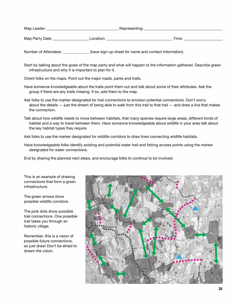
step 4. Draw the ConnectionsYes! We mean draw! Pull your team together and schedule a map party. Invite the people you have identified
in Step 2 and any others that may be interested in participating. Visualizing resources on maps helps folks understand what might be possible. Ask everyone to bring any maps or helpful information and their imagination.
All you’ll need is a room with large tables to spread out the maps, some markers and trace paper or clear film (Mylar).
One map that combines the necessary information from multiple maps is helpful in identifying priority resources. It’s even better if the map goes beyond your town’s boundaries or is regional in scope.
The map should show:
• Protected Open Space (indicate protection status)
• Large forest blocks
• Significant wetlands
• Watercourses
• Recreational trails
• Topography
Label the color markers — perhaps the green ones are wildlife corridors, the red are trail connections and the blue are for blueways.
Sometimes people will warm up to drawing if they first label places. Perhaps ask people to write the names of any trails they know.
Below is an example of a map waiting for connections to be drawn.
The darkest green shows protected lands. Look for areas in between the protected lands. Perhaps there’s opportunity for wildlife corridors.
The lighter green is the depiction of forest cover. Some may still be large forested blocks.
The blue areas are watercourses and wetlands. In some cases they might serve as a wildlife corridor.
The dotted dark green lines are trails. One is a major trail or spine.
35
This is an example of drawing connections that form a green infrastructure.
The green arrows show possible wildlife corridors.
The pink dots show possible trail connections. One possible trail takes you through an historic village.
Remember, this is a vision of possible future connections, so just draw! Don’t be afraid to dream the vision.
Map Leader: ______________________________________ Representing: _________________________________________
Map Party Date: ___________________ Location: ___________________________________ Time: ____________________
Number of Attendees: ______________ (have sign-up sheet for name and contact information)
Start by talking about the goals of the map party and what will happen to the information gathered. Describe green infrastructure and why it is important to plan for it.
Orient folks on the maps. Point out the major roads, parks and trails.
Have someone knowledgeable about the trails point them out and talk about some of their attributes. Ask the group if there are any trails missing. If so, add them to the map.
Ask folks to use the marker designated for trail connections to envision potential connections. Don’t worry about the details — just the dream of being able to walk from this trail to that trail — and draw a line that makes the connection.
Talk about how wildlife needs to move between habitats, that many species require large areas, different kinds of habitat and a way to travel between them. Have someone knowledgeable about wildlife in your area talk about the key habitat types they require.
Ask folks to use the marker designated for wildlife corridors to draw lines connecting wildlife habitats.
Have knowledgeable folks identify existing and potential water trail and fishing access points using the marker designated for water connections.
End by sharing the planned next steps, and encourage folks to continue to be involved.
36
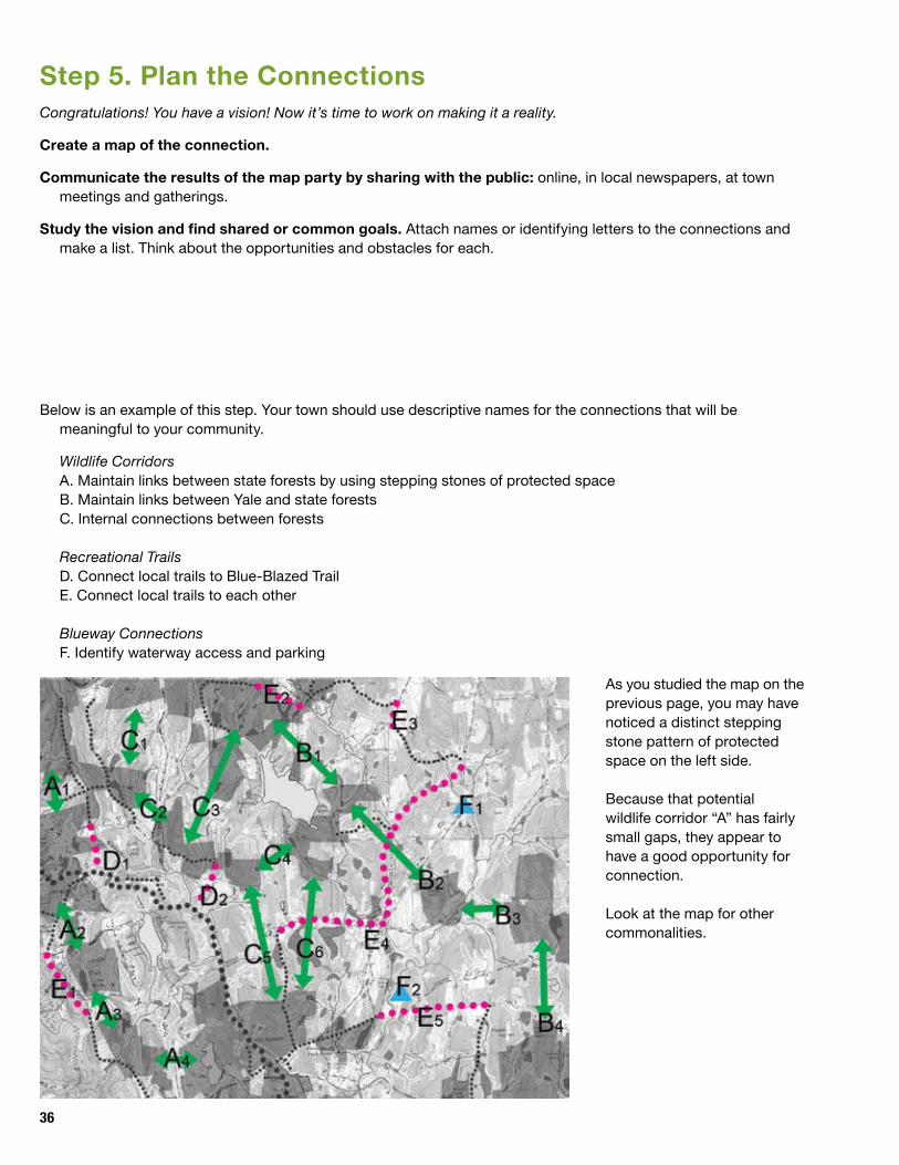
step 5. Plan the ConnectionsCongratulations! You have a vision! Now it’s time to work on making it a reality.
Create a map of the connection.
Communicate the results of the map party by sharing with the public: online, in local newspapers, at town meetings and gatherings.
Study the vision and find shared or common goals. Attach names or identifying letters to the connections and make a list. Think about the opportunities and obstacles for each.
Below is an example of this step. Your town should use descriptive names for the connections that will be meaningful to your community.
Wildlife CorridorsA. Maintain links between state forests by using stepping stones of protected spaceB. Maintain links between Yale and state forestsC. Internal connections between forests
Recreational TrailsD. Connect local trails to Blue-Blazed TrailE. Connect local trails to each other
Blueway ConnectionsF. Identify waterway access and parking
As you studied the map on the previous page, you may have noticed a distinct stepping stone pattern of protected space on the left side.
Because that potential wildlife corridor “A” has fairly small gaps, they appear to have a good opportunity for connection.
Look at the map for other commonalities.
37
Responsibility Leader and Core Team Members
Create Vision Map
Share with Town Commissions
Press Release to Newspapers/Websites
Plan the Connections
Wildlife corridor connection names/description:
________________________________________________________________________________________________________
________________________________________________________________________________________________________
________________________________________________________________________________________________________
________________________________________________________________________________________________________
________________________________________________________________________________________________________
________________________________________________________________________________________________________
________________________________________________________________________________________________________
Recreational trail connection names/description:
________________________________________________________________________________________________________
________________________________________________________________________________________________________
________________________________________________________________________________________________________
________________________________________________________________________________________________________
________________________________________________________________________________________________________
________________________________________________________________________________________________________
________________________________________________________________________________________________________
Blueway connection names/description:
________________________________________________________________________________________________________
________________________________________________________________________________________________________
________________________________________________________________________________________________________
________________________________________________________________________________________________________
________________________________________________________________________________________________________
________________________________________________________________________________________________________
________________________________________________________________________________________________________

38
step 6. Make the Connections HappenImplement the plan. Take Action!
Incorporate the Green Infrastructure Plan in town and regional planning documents, including any key connection goals. Help planning and zoning commissions revise their regulations.
Gain an understanding of the different protection tools available. These are explained in the Tools section that follows.
Outright purchase of the land for full value
Outright purchase of the land substantially below the value (bargain sale)
Donation of the land
Legal agreement that permits trail access
Long-term renewable lease of trail or public access
Easement for permanent trail or public access
Easement as permanent open space
Purchase of development rights
Town subdivision and zoning regulations
Most green infrastructure development is accomplished by using several of these tools.
Develop an action plan for each connection that uses a variety of tools. This makes the connections more flexible and allows the team to respond to opportunities as they arise. Example: A town purchases property, installs nature trail connects to new subdivision easement, connects to donated trail easement, connects to state forest).
Designate a leader for each connection. Every action item should be assigned a responsible person and/or team, an expected time table and a cost estimate. Some actions will be quick and inexpensive; some will take a longer period of time and require funding.
Make the easy connections first; successful connections will engage others and create momentum.

39
Responsibility Leader and Core Team Members
PoCD Inclusion
Regional Plan Inclusion
Prioritize Connections
Plan the Connections
First Priority Action Team
Second Priority Action Team
Third Priority Action Team
Fourth Priority Action Team
Fifth Priority Action Team
Priorities Name/Description Likely Protection Tools Used
1
2
3
4
5
Develop an action plan for each priority that includes:
• a list of tools and the associated responsible organizations
• name of entity that would be best to hold agreements, leases, easements or titles
• name of entity that would step in if first entity dissolved.
Form an action team for each priority based on the tools for that task, that will:
• meet with land owners to learn their needs and plans for the land
• adjust plan to meet the land owners needs
• work with entity(ies) involved.
40
And remember …Building a green infrastructure takes time; keep the big picture in mind, but focus on the little steps. Step-by-step is the only way connections can be made.
The plan will evolve as new opportunities arise, so it is good to keep the plan broad and allow for flexibility.
“Never believe that a few caring people can’t change the world. For indeed, that’s all who ever have.”
— Margaret Mead
41
ReGional planninG oRGanizations anD councils of
GoVeRnMent www.ct.gov/opm (keyword RPO) Focus on regional planning issues and may offer mapping services for their towns.
cleaR (the uniVeRsity of connecticut’s centeR
foR lanD use eDucation anD ReseaRch)
http://clear.uconn.edu provides workshops on land use planning topics.
coMMunity ResouRce inVentoRy http://www.clear.uconn.edu/data/interactive.htm Using publicly available GIS data sets, you can create an inven-tory online for your community that helps identify natural resources including: topography, soils, water resources, land and forest cover, habitats and open space.
foRest fRaGMentation
http://clear.uconn.edu/research/index.htm CLEAR has analyzed land cover data from 1985 to 2006 as part of Connecticut’s Changing Landscape study. Using CLEAR’s forest fragmentation tool, you can analyze forest cover in your watershed. Forest data can help identify areas appropriate for habitat protection, trails or buffer areas.
connecticut enViRonMental conDitions online http://www.cteco.uconn.edu A collection of online maps and tools for viewing environmental and natural resource data in Connecticut. CT ECO is a collaborative work of the CT DEP and CLEAR.
connecticut conseRVation anD DeVelopMent policies
plan http://www.ct.gov/opm
connecticut wilDlife action plan http://www.wildlifeactionplans.org/connecticut.html
connecticut Dep Gis Data
http://www.ct.gov/dep/gisdata CT DEP provides download-able data in Shapefile and File Geodatabase format for use with desktop GIS and CAD software programs.
natuRal DiVeRsity DataBase http://www.ct.gov/dep/gisdata Generalized location of known occurrences of threatened or endangered plant or animal species
uniteD states DepaRtMent of aGRictultuRe’s
CONsERvATION BuffERs: DEsIgN guIDELINEs fOR
BuffERs, CORRIDORs AND gREENWAYs
http://www.bufferguidelines.net is an illustrated manual with science-based guidelines for facilitating the planning and designing of conservation buffers.
the conseRVation funD http://ww.greeninfrastructure.net Resources and publications useful in planning for and understanding concepts of greenways and green infrastruc-ture including Green Infrastructure: Linking Landscapes and Communities by Mark A. Benedict and Edward T. McMahon, an illustrative review of advances in smart land conservation and large-scale thinking that provides a green solution to many of the problems associated with sprawling developments.
applyinG natuRe’s DesiGn: Corridors as a Strategy for Biodiversity Conservation http://cup.columbia.edu by Anthony B. Anderson and Clinton N. Jenkins offers a comprehensive and insightful overview of the design and effectiveness of corridors.
Green Valley ConneCtions tools
plAnning tools
42
connecticut GReenway council http://www.ct.gov/dep/greenways Information about gre-enways, how to nominate a greenway and possible funding sources in Connecticut
connecticut foRest anD paRK association
http://ctwoodlands.org The oldest conservation organization in Connecticut focuses on forest conservation and manages for than 800 miles of Connecticut Blue Trails.
aMeRican tRails http://www.americantrails.org Online Trails Resource: Offers information, advocacy, training and special events for planning, building and maintaining greenways and trail systems.
aMeRican RiVeRs http://www.americanrivers.org Advice and information about river protection, restoration and water trail management
connecticut wateR tRails association
http://connecticutwatertrails.com Provides information and advice for planning, building and managing water trails
Rails to tRails conseRVancy
http://www.railstotrails.org Information and assistance for conversion of former rail lines to trails
east coast GReenway http://www.greenway.org A 3,000 mile traffic-free path linking east coast cities from Calais, Maine to Key West, Florida. Information on the trail and helpful advice on trail advocacy.
connecticut RecReation tRails http://www.ct.gov/dep/rectrails Information about National Recreation Trails Program and funding opportunities.
aMeRican tRails funDinG souRces
http://www.americantrails.org/resources/funding/index.html Grants programs and fund raising ideas
aRMy coRp of enGineeRs
http://corpslakes.usace.army.mil/employees/trails/funding.cfm Natural Resources Management Gateway – information about federal funding available for trails and recreation projects
Rails to tRails conseRVancy funDinG souRces http://www.railstotrails.org Financing and funding greenway and trail projects
connecticut lanD conseRVation council
http://www.ctconservation.org/fundingprograms Funding programs for land protection
trAils And recreAtion tools funding And deVelopment tools

43
zoninG ReGulations: A variety of regulatory tools exist to protect natural resources and encourage community character. To learn more about regulatory tools: http://www.greenvalleyinstitute.org/publications.html
suBDiVision ReGulations: Conservation subdivisions allow development to better fit the resources of the land. They can be used to protect sensitive resources, buffer agricul-tural activities and make recreation or wildlife connections. To learn more about Conservation Subdivisions http://www.greenvalleyinstitute.org/publications.html
aGReeMents: A trail or use license is a written agreement that permits access to a property or portion of a property. License agreements are made between the property owners and the trail organization. They are not permanent and are nonbinding on future property owners. They usually have an agreement period, terminating on a specific date and detail the access and the responsibilities of the licensee.
leases: Agreements for a specified period of time (usually greater than 25 years) that allow the lessee most rights and responsibilities on a property. Long-term leases for recreation, wildlife or agriculture are tools that can help generate income for a landowner while the property remains undeveloped.
View saMple aGReeMents anD tRail easeMents: http://www.americantrails.org/resources/land/easements.html
easeMents: Easements are permanent legal agreements between a property owner (grantor) and the organization (grantee). Easements are flexible. They can include public use of a whole property or limit access to certain types of uses (like hiking and non-motorized vehicles) in a defined trail area. Trail easements grant use of a property to some-one other than the owner. Conservation easements (known in Connecticut as Restrictions) actually extinguish the rights of the land owner to do certain activities (like build houses), but they can include public access as well. Easements can be donated, sold for full value or at a bargain price. Some land owners can realize tax advantages if they donate some or all of the value of an easement to a qualified organiza-tion. Learn more about managing and enforcing easements. http://www.ctconservation.org
title tRansfeR: is the transfer of real property from one owner to another. Like easements, this can be in the form of a donation, a sale or a bargain sale (below the appraised value) and may provide tax benefits if the new title holder is a qualified organization. When developing your connec-tion plan, give careful consideration to the appropriate title holder for property — qualified organizations include towns, states and certain conservation organizations. Consider what would happen to the property should the organization dissolve in the future. Learn more about stra-tegic land protection: http://www.ctconservation.org
protection tools
44
Accessible: A term used to describe a trail or site that complies with the Americans with Disabilities Act Accessibility Guidelines.
Bikeway(s): A road or path desig-nated for bicycle travel which may or may not be shared with other modes of transportation.
Blue-Blazed Trails: A hiking trail system of more than 825 miles managed and maintained by the Connecticut Forest and Park Association.
Blueway(s): A linear connection within river and stream corridors designed and managed for multiple purposes include environmental, historic and recreational.
Buffer: Areas or strips of land designed to protect resources (riparian buffers, windbreaks, wildlife buffers, etc.)
Connectivity: The ability of organisms and energy to move from one point to another.
Conservation Subdivision: A regula-tory tool that provides for the clustering of house lots for the protection of natural and/or cultural resources.
Conservation Easement (Conservation Restriction): A perma-nent restriction of property rights for the protection of natural or cultural resources.
Co-occurring Resource Inventory: A GIS mapping tool for visualization of where resources exist in the landscape. The tool allows the user to see where multiple resources overlap.
Corridor: A linear patch that differs from the surrounding area in a landscape.
Cultural Resource(s): The physical remains of human activity having scien-tific, prehistoric, historic or social values.
Disturbance: An activity that disrupts the normal habitat or condition of a site.
Easement: Grants the right to use a spe-cific portion of land for a specific purpose or purposes. Easements can be perma-nent or expire after a period of time.
Ecology: The branch of biology that deals with the mutual relations among organisms and between organisms and their environment.
Ecosystem: Interaction between living organisms and their environment.
Eco-Tourism: Travel to and enjoyment of natural areas and resources.
Environment: The conditions — physical, biological, economic, and social — that influence the development of an organism.
Erosion: Natural processes — water, wind, ice, etc. — that detach soil par-ticles from the ground and cause them to move down-slope.
Flora: The plant populations of a particu-lar region.
Fauna: The animal populations of a particular region.
Forest Fragmentation: The breaking up of large forests into smaller parts.
Geographic Information Systems: Allows the user to store, manage and analyze graphical representations of spatial data.
Green: An open space available for unstructured recreation consisting of grassy areas and trees.
Greenway: A linear connection that is planned, designed and managed for multiple purposes including environmental or recreational.
Green Infrastructure: An interconnected network of waterways, wetlands, woodlands, wildlife habitats and other natural areas; greenways, parks and other conservation lands; working farms, ranches and forests; and wilderness and other open spaces that support native species, maintain natural ecological processes, sustain air and water resources and contribute to the health and quality of life for communities and people.
Green Valley ConneCtionsGlossary of terms
45
Greenbelt: A series of connected open spaces that may follow natural features such as ravines, creeks or streams. May surround cities and serve to conserve and direct urban and suburban growth.
Habitat: A place that supplies food, water and shelter necessary for a plant or animal population to survive.
Hiking Trail: Moderate- to long-distance trail with the primary function of providing long-distance walking experiences (usu-ally two miles or more).
Hydrology: The study of the distribution of water on earth, including the processes of precipitation, interception, run-off, infiltration, percolation, storage, evapora-tion and transpiration
Hydrography: Graphic representations of hydrological features such as rivers, streams, ponds and wetlands.
Infiltration: The portion of rainfall that percolates into the ground.
Infrastructure: The facilities, utili-ties and transportation systems of a community.
Invasive Exotic: Non-native plant or animal species that invades an area and alters the natural mix of species.
Land: The total natural and cultural envi-ronment of the solid surface of the earth.
Land, Private: Land owned by a farmer, corporation or individual (private landowner).
Land, Public: Federal, state or municipal land in trust for the governed populace (public landowner).
Land Transfer: The sale, exchange or other conveyance of land from one owner to another, especially under the authority of land disposal laws such as the Desert Land Act, Carey Act, Recreation and Public Purposes Act, FLPMA, etc.
Land Trust: A private, nonprofit con-servation organization formed to protect natural resources such as forest land, natural areas and recreational areas. Land trusts purchase and accept dona-tions of conservation easements.
Land Use: The way a section or par-cel of land is used. Examples of land uses include industrial, agricultural and residential.
Landscape: The characteristics that distinguish a certain kind of area on the earth’s surface — made up of three ele-ments — the matrix or background area, patches and corridors.
Connectivity: The ability of organ-isms and energy to move through the landscape.
Landscape Features: The land and water form, vegetation and structures that compose the characteristic landscape.
Lease: The temporary grant of an interest in land upon payment of a determined fee. The fee does not have to be monetary, but some consideration must be given for the right to use the land or the lease will not be legally binding.
License: Allows the licensed party to enter the land of the licensor without being deemed a trespasser.
Licensee: Person using a property for his or her benefit (i.e. hunting, hiking, etc.) with the implied or stated consent of the owner, but not for the benefit of the owner.
Linkage: Connection that enable trails and greenway systems to function by connecting them together.
Matrix: The background area, plant or animal community that makes up the majority of a landscape — including forest, fields or developed areas.
Multi-use Trail: A trail designed for use by pedestrians, bicyclists and other non-motorized transportation (i.e. equestrian, skate, ski, etc.)
Natural Resource(s): Natural features such as land, water, forests, soils and wetlands.
Open Space: Areas of natural quality, either publicly or privately owned, desig-nated for protection of natural resources, nature-oriented outdoor recreation or trail-related activities. In urban settings areas of land not covered by structures, driveways or parking lots.
Open Space, Private: Space that is pri-vately owned and not open to the public.
Open Space, Public: Territory that is owned and managed by a public agency for everybody’s benefit.
Orthography: Graphic map representa-tions of aerial photographs.
Patch: An area within a landscape that differs from the surrounding area.
Path: A trail that is not connected to a system.
Partner: One of two or more parties working jointly toward shared goals.
Partnership: Arrangement between two or more parties who have agreed to work cooperatively toward shared and/or compatible objectives and in which there is: shared authority and responsibility (for the delivery of programs and ser-vices, in carrying out a given action, or in policy development); joint investment of resources (time, work, funding, material, expertise, information); shared liability or risk-taking; and ideally, mutual benefits.
Plan: Document that shows the steps needed to develop a trail or greenway.
Plan, Action: A plan designed to provide details on a short-term activity.
Plan of Conservation and Development: A tool for identifying and implementing communities’ long-term goals. Connecticut state statute mandates each municipality to update its PoCD every 10 years. The planning commission is responsible for overseeing and approv-ing the plan.
46
Policy: Specific guidance or means to achieve a goal.
Public: Individuals or entities affected by or interested in public land management decisions.
Real Property: Real estate; land and anything growing on it or attached to it, such as trees, fences, and buildings.
Recreation: The refreshment of body and mind through leisure activities.
Right-of-Way: A linear corridor of land held in title, or an easement over another’s land for the purpose of access.
Riparian: A habitat influenced by water, occurring adjacent to streams, shorelines and wetlands.
Riparian Vegetation: Plant species growing adjacent to streams, shorelines and wetlands.
Riparian Zone: The land and plants adjacent to rivers, streams and shorelines.
Runoff: Water that is not absorbed by the soil and flows over the land surface into streams.
Scenic Area: An area whose landscape character exhibits a high degree of variety and harmony among the basic elements that results in a pleasant landscape to view.
Scenic View (Vista): A long-distance view that is pleasant and interesting.
Scenic Viewpoint: A location designed for viewing significant or pleasing features.
Shoreline: The line of contact between a body of water and the land.
Site: A parcel of land bounded by a prop-erty line or a designated portion of public right of way.
Spine Trail: A regional trail that acts as a backbone to a regional trail system.
Spur Trail: A trail that leads from primary, secondary or spine trails to points of user interests or overlooks, campsites, etc.
Stakeholder: A person or entity who can affect, or is affected by, the achievement of goals or policies.
State Land: Lands administered by a state agency.
Stewardship: Taking responsibility for the care and protection of a natural resources or trail.
Stream: Small body of running water moving in a natural channel or bed.
Stream, Intermittent: Natural channels that carry water during wet periods and are otherwise dry.
Stream, Perennial: Natural channels that carry water year round.
Sustainability: Use of natural resources that provides for continued use in the future.
Title: Rights of ownership of property; paper that indicates ownership.
Topography: The graphical representa-tion of physical features and elevation of the land surface.
Trail: Route on land or water with public access for recreation or transportation purposes.
Trail, Loop: Trail or trail systems designed so that the routes are closed circuits connecting a number of points of interest, giving users the option of not traveling the same section of trail more than once on a trip.
Trail System: A collection of individual trails that may or may not be connected to one another.
Utility: Public utilities lines and rights-of-way such as electric, telephone, water and sewage, pipelines, roads, levees and canals.
Unfragmented Forest: Large blocks of forest uninterrupted by significant patches or fragmenting features like major roads.
Vegetation: Plant life.
Water Course: A natural or built channel through which water flows.
Water Quality: The suitability of water for a particular use, based on physical, chemical and biological characteristics.
Watershed: The geographic area that drains to a river, stream or other surface water body.
Water Trail (River Trail, Canoe Trail): A recreational waterway on lake, river or ocean between specific points, con-taining access points for nonmotorized watercraft.
Wetland(s): A lowland area, such as a marsh or swamp, which is saturated with water, creating a unique, naturally occur-ring habitat for plants and wildlife.
Wildlife Corridors: Passages of land or water either private or public, designed to link fragmented habitat and help wildlife move across the landscape.
Zoning (Laws): Laws and regulations that specify land use in a particular location.
Source: American Trails Glossary, http://www.americantrails.org/glossary.html