to encode nautical chart symbol used in running textasmus/chartsymbolsinrunningtext-3.pdf ·...
TRANSCRIPT
1
Proposal to Encode Nautical Chart Symbol used in Running Text Date: 27‐Jan‐2012 – preliminary third draft Source: Asmus Freytag, Michel Suignard (SEI), Eberhard R. Hilf (ISN)
Summary This document presents a proposal to encode a subset of symbols used in nautical charts. As
documented, the characters in this particular occur regularly in running text and are therefore
suitable to encoding as characters. This document also provides background information on the
general nature of symbols used in nautical charts, with particular emphasis on those that appear
in publications in text form. Nautical chart symbols contain features that can be represented as
combining characters. Some of the symbols are similar to existing Unicode characters, requiring
the discussion of the extent of possible unification. The proposal concludes with a tabular listing
of the proposed repertoire of nautical chart symbols for use in running text.
1. Uses of Nautical Chart Symbol in Running Text
Charts vs. Running Text: Notice to Mariners The use of nautical charts (or their approved digital equivalent) is required for maritime navigation.
Unlike terrestrial maps, nautical charts contain and extensive set of landmarks plotted at their
individual positions as well as the location and nature of artificial aids to navigation from buoys to
lighthouses.
Whenever the location, characteristics or presence of these features change, charts must be
updated in order to satisfy the requirements of safe navigation. All publishers of charts, such as
NOAA in the US or the National Hydrographical Office in the UK (UKHO), issue weekly Notices to
Mariners with update information for the charts they maintain.
These notices are republished in a variety of places, for example in print, in boating magazines, by
makers and distributors of electronic navigation systems and digital nautical charts and others. Such
republication efforts go beyond merely hosting digital copies of the original notices, they involve
selection for the relevant audience and reformatting, whether for print or viewing on devices.
Unlike the charts themselves, which are drawings, the Notices to Mariners are text documents.
Nautical Chart Symbols in Running Text In many instances, primarily where they concern aids to navigation and designation of obstructions,
the Notices to Mariners refer to the feature to be updated by using the actual symbols, as they
appear in the charts. In other words, the subset of symbols used for these notices is the subset that
appears regularly (weekly) in running text. They are therefore a proper target for standardization as
characters.
2
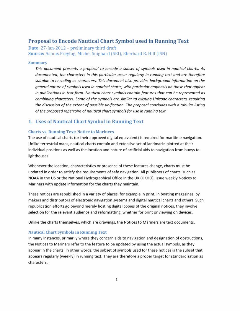
Here is a typical example from the weekly Notices to Mariners issued by UKHO with symbols for
various types of buoys and light floats occurring fully inline in the text.
II
3333* IRELAND - West Coast - River Shannon - Kilcredaun Point Eastwards and South-eastwards -Buoyage. Source: Commissioners of Irish Lights Chart 1547 [ previous update 1551/11 ] OSI DATUM Substitute B\dQ.R (sync) Kilcredaun for BöFl(2+1)R.10s
Kilcredaun 52° 34´·42N., 9° 41´·16W. Cb]Q.G (sync) Tail of Beal for GsXQ(9)15s Tail of Beal 52° 34´·37N., 9° 40´·71W. Cb]Fl(2)G.6s (sync) Beal Spit for GsXVQ(9)10s Beal Spit 52° 34´·80N., 9° 39´·94W. B\dFl(2)R.6s (sync) Carrigaholt for BdFl(2)R.6s Carrigaholt 52° 34´·90N., 9° 40´·47W.
The symbols, such as Cb] orGsX, that appear in this manner in running text form a more or less
well‐defined subset of the complete set of all symbols defined for nautical charts. A survey of such
Notices published by several European authorities yields broad agreement on which types of
symbols are included in the repertoire used for text documents.
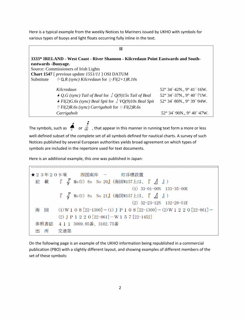
Here is an additional example, this one was published in Japan:
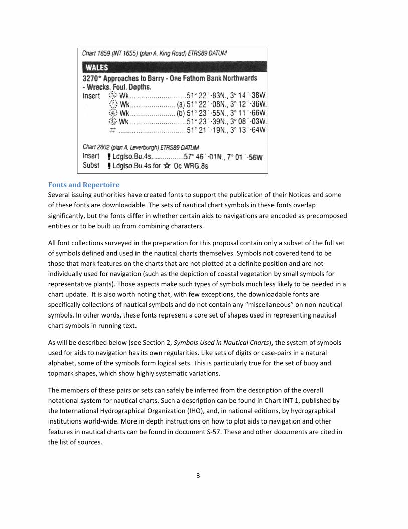
On the following page is an example of the UKHO information being republished in a commercial
publication (PBO) with a slightly different layout, and showing examples of different members of the
set of these symbols:
3
Fonts and Repertoire Several issuing authorities have created fonts to support the publication of their Notices and some
of these fonts are downloadable. The sets of nautical chart symbols in these fonts overlap
significantly, but the fonts differ in whether certain aids to navigations are encoded as precomposed
entities or to be built up from combining characters.
All font collections surveyed in the preparation for this proposal contain only a subset of the full set
of symbols defined and used in the nautical charts themselves. Symbols not covered tend to be
those that mark features on the charts that are not plotted at a definite position and are not
individually used for navigation (such as the depiction of coastal vegetation by small symbols for
representative plants). Those aspects make such types of symbols much less likely to be needed in a
chart update. It is also worth noting that, with few exceptions, the downloadable fonts are
specifically collections of nautical symbols and do not contain any “miscellaneous” on non‐nautical
symbols. In other words, these fonts represent a core set of shapes used in representing nautical
chart symbols in running text.
As will be described below (see Section 2, Symbols Used in Nautical Charts), the system of symbols
used for aids to navigation has its own regularities. Like sets of digits or case‐pairs in a natural
alphabet, some of the symbols form logical sets. This is particularly true for the set of buoy and
topmark shapes, which show highly systematic variations.
The members of these pairs or sets can safely be inferred from the description of the overall
notational system for nautical charts. Such a description can be found in Chart INT 1, published by
the International Hydrographical Organization (IHO), and, in national editions, by hydrographical
institutions world‐wide. More in depth instructions on how to plot aids to navigation and other
features in nautical charts can be found in document S‐57. These and other documents are cited in
the list of sources.
4
Because of the regularity of the system a basic validation would in principle suffice to show which
pairs or sets of related symbols are typically referred to in the Notices. For example, each of the
basic buoy shapes in the brief excerpt above exists in both black and white forms. It would be a
pointless exercise to track through the actual weekly notices to “discover” all permutations of these
well‐known forms. Even if at any time a citation for any particular white or black form may be
lacking, there is no reason to exclude it from this proposal.
Defining a Repertoire What then is a suitable way to arrive at a repertoire? The repertoire has to be based on a‐priori
knowledge of the notational system, but also on some indication whether a particular symbol is
liable of appearing in the kinds of text documents that form the basis for this proposal. In this
context, the available fonts created by the issuing authorities in and of themselves define a subset.
Given this, and given the overall context of use, it would make sense to treat these particular font
collections as de‐facto compatibility character sets. These character sets therefore provide the
needed starting point for a repertoire.
Some issuing authorities do not publish their font collection. In that case, additional symbols from
the actual published notices need to be considered using the more traditional method of citing
instances in text. However, whenever instances are found for one member of a pair or set, the
internal logic of the system demands that the full pair or set be covered simultaneously.
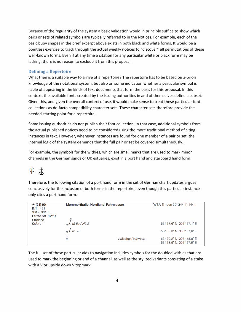
For example, the symbols for the withies, which are small marks that are used to mark minor
channels in the German sands or UK estuaries, exist in a port hand and starboard hand form:
Therefore, the following citation of a port hand form in the set of German chart updates argues
conclusively for the inclusion of both forms in the repertoire, even though this particular instance
only cites a port hand form.
The full set of these particular aids to navigation includes symbols for the doubled withies that are
used to mark the beginning or end of a channel, as well as the stylized variants consisting of a stake
with a V or upside down V topmark.

5
2. Symbols used in Nautical Charts This section gives some basic background on the system of symbols for nautical charts, with
emphasis on those found in running text.
Nautical charts contain a variety of symbols, including the symbols for navigational aids, landmarks
and obstructions. The use of these symbols is internationally standardized and documented in chart
INT 1 (or national equivalents thereof). National issuing authorities on occasion use certain national
only symbols either in addition or in place of the international symbols.
This section gives a brief overview of the basic features of this system, with emphasis on
characteristics of interest to character encoding.
Symbols for Aids to Navigation Symbols for aids to navigation designate the nature of the feature, its distinctive shape, color
markings and special attachments (called topmarks). Additional designators show the presence of
lights, radar reflectors or foghorns.
Examples of basic shapes:
A B N T
Each basic shape of a given aid for navigation could exist with a range of different topmarks and
colorings. The term topmark refers to the actual distinguishing marks added to a buoy or beacon,
not merely their graphical representation. Given the internal logic of the system of aids to
navigation not all combinations of topmark and base exist. However, the total number of possible
combinations is significant.
Examples:
HXs IV IWc I{ I ¿Dh{ In translating this to digital symbol sets, different issuing authorities have taken different routes.
Some are using “precomposed” symbols, while others use base symbols with overlays, something
that is akin to combining characters in Unicode. Where overlays (combining marks) are used,
designators that are typically printed in colors other than black and white in nautical charts, can be
shown as such in rich text, for example the indicator for a lighted mark can be shown in the standard
contrast color used for charts (magenta) or in its actual color (green): { {
6
Apparently, for that reason, this particular symbol tends to not get precomposed. However, the
topmarks are consistently shown in black or white only, and they exist in current practice both as
overlays and precomposed into the symbol.
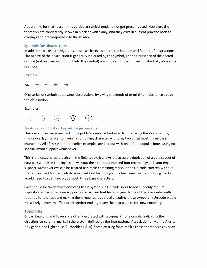
Symbols for Obstructions In addition to aids to navigations, nautical charts also mark the location and feature of obstructions.
The nature of the obstruction is generally indicated by the symbol, and the presence of the dotted
outline (not an overlay, but built into the symbol) is an indication that it rises substantially above the
sea floor.
Examples:
® ² .¾ ´ ^
One series of symbols represents obstructions by giving the depth of or minimum clearance above
the obstruction.
Examples:
2+ 2%+ 12,û 15%, 120-
No Advanced Font or Layout Requirements These examples were realized in the publicly available font used for preparing this document by
simple overlays, similar to having a combining character with one, two or (at most) three base
characters. All of these and the earlier examples are laid out with one of the popular fonts, using no
special layout support whatsoever.
This is the established practice in the field today. It allows the accurate depiction of a core subset of
nautical symbols in running text – without the need for advanced font technology or layout engine
support. Most overlays can be treated as simple combining marks in the Unicode context, without
the requirement for particularly advanced font technology. In a few cases, such combining marks
would need to span two or, at most, three base characters.
Care should be taken when encoding these symbols in Unicode so as to not suddenly require
sophisticated layout engine support, or advanced font technologies. None of these are inherently
required for the task and making them required as part of encoding these symbols in Unicode would
most likely adversely affect or altogether endanger any the migration to the new encoding.
Topmarks Buoys, beacons, and towers are often decorated with a topmark, for example, indicating the
direction for cardinal marks in the system defined by the International Association of Marine Aids to
Navigation and Lighthouse Authorities (IALA). Some existing fonts realize these topmarks as overlay
7
glyphs, hence the proposal to treat them as non‐spacing combining marks (above) in the Unicode
context.
Floating aids to navigation use symbols that are inclined, while fixed aids use symbols that are
upright. Likewise, the symbols for topmarks come in two varieties, inclined and upright. Fonts that
use overlays for topmarks therefore need two sets. These fonts are designed, incidentally, that the
overlay behavior works without any special layout engine support in regular word‐processing
software.
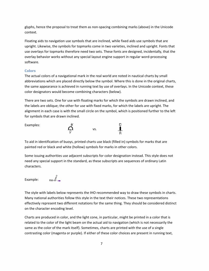
Colors The actual colors of a navigational mark in the real world are noted in nautical charts by small
abbreviations which are placed directly below the symbol. Where this is done in the original charts,
the same appearance is achieved in running text by use of overlays. In the Unicode context, these
color designators would become combining characters (below).
There are two sets. One for use with floating marks for which the symbols are drawn inclined, and
the labels are oblique; the other for use with fixed marks, for which the labels are upright. The
alignment in each case is with the small circle on the symbol, which is positioned further to the left
for symbols that are drawn inclined.
Examples:
vs.
To aid in identification of buoys, printed charts use black (filled in) symbols for marks that are
painted red or black and white (hollow) symbols for marks in other colors.
Some issuing authorities use adjacent subscripts for color designation instead. This style does not
need any special support in the standard, as these subscripts are sequences of ordinary Latin
characters.
Example: RWM̀
The style with labels below represents the IHO recommended way to draw these symbols in charts.
Many national authorities follow this style in the text their notices. These two representations
effectively represent two different notations for the same thing. They should be considered distinct
on the character encoding level.
Charts are produced in color, and the light cone, in particular, might be printed in a color that is
related to the color of the light beam on the actual aid to navigation (which is not necessarily the
same as the color of the mark itself). Sometimes, charts are printed with the use of a single
contrasting color (magenta or purple). If either of these color choices are present in running text,
8
they would require the use of styled text – there is nothing in this proposal that would encode color
display directly: the color designations are simply text labels explaining a real‐world color of a
navigational mark and they themselves are without exception printed in whatever standard text
color is used (black).
National Symbols For historical reasons many charts are still printed using national symbols in addition or in place of
the international symbols defined in chart INT 1. Because of that, it would be appropriate to encode
a subset of the most important national symbols as well.
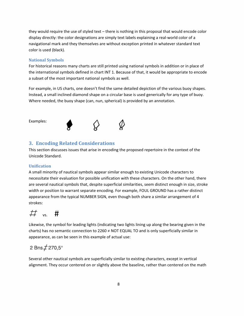
For example, in US charts, one doesn’t find the same detailed depiction of the various buoy shapes.
Instead, a small inclined diamond shape on a circular base is used generically for any type of buoy.
Where needed, the buoy shape (can, nun, spherical) is provided by an annotation.
Examples:
3. Encoding Related Considerations This section discusses issues that arise in encoding the proposed repertoire in the context of the
Unicode Standard.
Unification A small minority of nautical symbols appear similar enough to existing Unicode characters to
necessitate their evaluation for possible unification with these characters. On the other hand, there
are several nautical symbols that, despite superficial similarities, seem distinct enough in size, stroke
width or position to warrant separate encoding. For example, FOUL GROUND has a rather distinct
appearance from the typical NUMBER SIGN, even though both share a similar arrangement of 4
strokes:
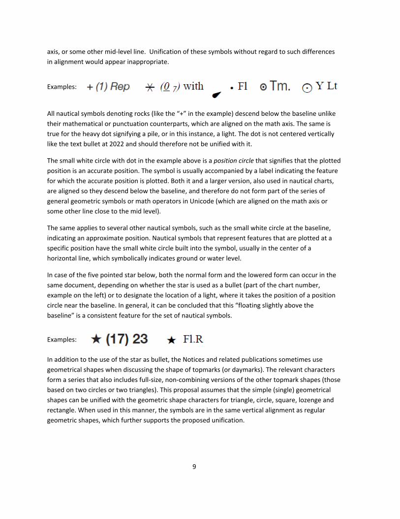
• vs. # Likewise, the symbol for leading lights (indicating two lights lining up along the bearing given in the
charts) has no semantic connection to 2260 ≠ NOT EQUAL TO and is only superficially similar in
appearance, as can be seen in this example of actual use:
Several other nautical symbols are superficially similar to existing characters, except in vertical
alignment. They occur centered on or slightly above the baseline, rather than centered on the math
9
axis, or some other mid‐level line. Unification of these symbols without regard to such differences
in alignment would appear inappropriate.
Examples:
All nautical symbols denoting rocks (like the “+” in the example) descend below the baseline unlike
their mathematical or punctuation counterparts, which are aligned on the math axis. The same is
true for the heavy dot signifying a pile, or in this instance, a light. The dot is not centered vertically
like the text bullet at 2022 and should therefore not be unified with it.
The small white circle with dot in the example above is a position circle that signifies that the plotted
position is an accurate position. The symbol is usually accompanied by a label indicating the feature
for which the accurate position is plotted. Both it and a larger version, also used in nautical charts,
are aligned so they descend below the baseline, and therefore do not form part of the series of
general geometric symbols or math operators in Unicode (which are aligned on the math axis or
some other line close to the mid level).
The same applies to several other nautical symbols, such as the small white circle at the baseline,
indicating an approximate position. Nautical symbols that represent features that are plotted at a
specific position have the small white circle built into the symbol, usually in the center of a
horizontal line, which symbolically indicates ground or water level.
In case of the five pointed star below, both the normal form and the lowered form can occur in the
same document, depending on whether the star is used as a bullet (part of the chart number,
example on the left) or to designate the location of a light, where it takes the position of a position
circle near the baseline. In general, it can be concluded that this “floating slightly above the
baseline” is a consistent feature for the set of nautical symbols.
Examples:
In addition to the use of the star as bullet, the Notices and related publications sometimes use
geometrical shapes when discussing the shape of topmarks (or daymarks). The relevant characters
form a series that also includes full‐size, non‐combining versions of the other topmark shapes (those
based on two circles or two triangles). This proposal assumes that the simple (single) geometrical
shapes can be unified with the geometric shape characters for triangle, circle, square, lozenge and
rectangle. When used in this manner, the symbols are in the same vertical alignment as regular
geometric shapes, which further supports the proposed unification.
10
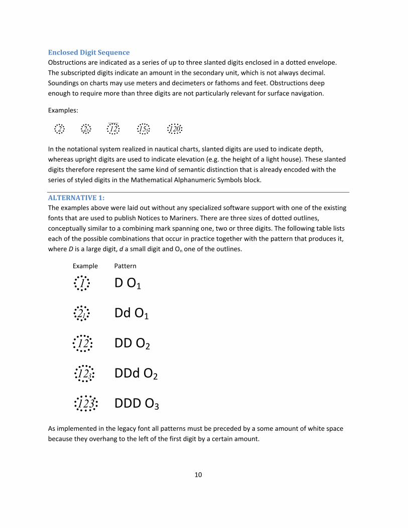
Enclosed Digit Sequence Obstructions are indicated as a series of up to three slanted digits enclosed in a dotted envelope.
The subscripted digits indicate an amount in the secondary unit, which is not always decimal.
Soundings on charts may use meters and decimeters or fathoms and feet. Obstructions deep
enough to require more than three digits are not particularly relevant for surface navigation.
Examples:
2+ 2%+ 12,û 15%, 120-
In the notational system realized in nautical charts, slanted digits are used to indicate depth,
whereas upright digits are used to indicate elevation (e.g. the height of a light house). These slanted
digits therefore represent the same kind of semantic distinction that is already encoded with the
series of styled digits in the Mathematical Alphanumeric Symbols block.
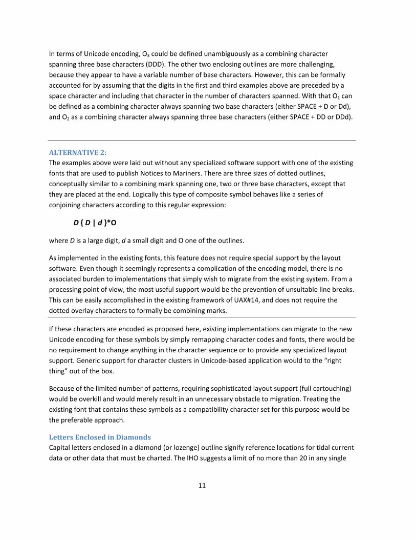
ALTERNATIVE 1: The examples above were laid out without any specialized software support with one of the existing
fonts that are used to publish Notices to Mariners. There are three sizes of dotted outlines,
conceptually similar to a combining mark spanning one, two or three digits. The following table lists
each of the possible combinations that occur in practice together with the pattern that produces it,
where D is a large digit, d a small digit and On one of the outlines.
Example Pattern
1+ D O1
2!+ Dd O1
12, DD O2
12#, DDd O2
123- DDD O3 As implemented in the legacy font all patterns must be preceded by a some amount of white space
because they overhang to the left of the first digit by a certain amount.
11
In terms of Unicode encoding, O3 could be defined unambiguously as a combining character
spanning three base characters (DDD). The other two enclosing outlines are more challenging,
because they appear to have a variable number of base characters. However, this can be formally
accounted for by assuming that the digits in the first and third examples above are preceded by a
space character and including that character in the number of characters spanned. With that O1 can
be defined as a combining character always spanning two base characters (either SPACE + D or Dd),
and O2 as a combining character always spanning three base characters (either SPACE + DD or DDd).
ALTERNATIVE 2: The examples above were laid out without any specialized software support with one of the existing
fonts that are used to publish Notices to Mariners. There are three sizes of dotted outlines,
conceptually similar to a combining mark spanning one, two or three base characters, except that
they are placed at the end. Logically this type of composite symbol behaves like a series of
conjoining characters according to this regular expression:
D { D | d }*O
where D is a large digit, d a small digit and O one of the outlines.
As implemented in the existing fonts, this feature does not require special support by the layout
software. Even though it seemingly represents a complication of the encoding model, there is no
associated burden to implementations that simply wish to migrate from the existing system. From a
processing point of view, the most useful support would be the prevention of unsuitable line breaks.
This can be easily accomplished in the existing framework of UAX#14, and does not require the
dotted overlay characters to formally be combining marks.
If these characters are encoded as proposed here, existing implementations can migrate to the new
Unicode encoding for these symbols by simply remapping character codes and fonts, there would be
no requirement to change anything in the character sequence or to provide any specialized layout
support. Generic support for character clusters in Unicode‐based application would to the “right
thing” out of the box.
Because of the limited number of patterns, requiring sophisticated layout support (full cartouching)
would be overkill and would merely result in an unnecessary obstacle to migration. Treating the
existing font that contains these symbols as a compatibility character set for this purpose would be
the preferable approach.
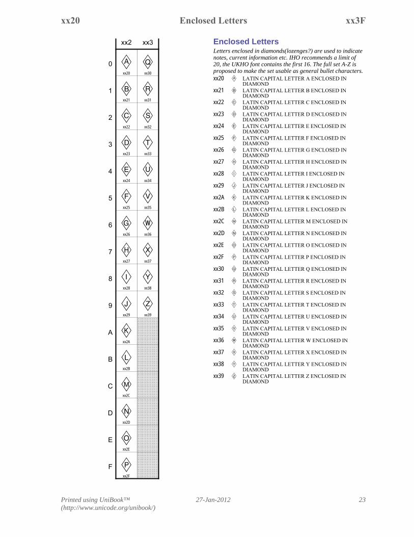
Letters Enclosed in Diamonds Capital letters enclosed in a diamond (or lozenge) outline signify reference locations for tidal current
data or other data that must be charted. The IHO suggests a limit of no more than 20 in any single
12
chart, the current proposal provides for the 16 found in actual fonts used for the purpose of printing
notices, plus the ten that would extend them to the full alphabetic set needed if these are to be
used outside the nautical context as well, which would seem likely. These characters should
therefore be encoded as general purpose enclosed letters and placed in an appropriate block.
While there is an existing combining character 20DF ENCLOSING DIAMOND, its use for this purpose
is not proposed. The primary reason is that the precedent for other enclosed letters has been to
encode them as single code points, and an additional reason is that using simple combining overlay
without glyph substitution will not yield the correct appearance – for the letter shapes are smaller
and are raised from the baseline.
Names and Naming Conventions In the context of the Unicode Standard, there is a precedent for naming symbols by their shape if
they can have many different meanings in different contexts. However, most nautical chart symbols
have very specific shapes that do not lend themselves to re‐use in other contexts.
Therefore, this proposal provides names for nautical chart symbols that are derived from their
description in chart INT 1 as far as possible. It is common practice in nautical charts to use symbols
for a variety of related functions, the precise nature of the feature being indicated by a label placed
next to it in the charts or following it in text. In that case, the character names proposed in this
proposal reflect the meaning of the unannotated symbol.
Many symbols exist in a filled in and hollow form, for which the Unicode Standard has the
convention of adding BLACK or WHITE to the character name. It is understood that the actual colors
of the navigational mark would be indicated by an explicit label anyway.
Topmarks are named in this proposal by shape and not by their function in the IALA system. This
allows a consistent convention for naming whether any given topmark is part of the IALA system or
not. This does not mean that all topmarks should be considered general purpose geometrical
shapes. Most configurations would seem fairly specialized and would only ever occur in a nautical
context.
The names in this proposal abbreviate the typical Unicode names for triangular shapes by
shortening “up‐pointing” to “up” and so on, in an attempt to make the names for topmarks less
unwieldy.
What IHO documents call a diamond shape is not in fact a turned square, so it might be preferable
to call the corresponding enclosing shape a “lozenge”.
In some cases, there’s evidence in IHO publications, such as S‐57, for a name for a symbol distinct
from what it symbolizes. The prime example is the POSITION CIRCLE signifying a fixed position.
13
The Authors Prof. Dr. Eberhard R. Hilf is CEO of the Institute for Science Networking Oldenburg (ISN)
(http://www.isn‐oldenburg.de/). Michel Suignard is VP and Secretary of the Unicode Consortium,
Project Editor of ISO/IEC 10646 and representing the Script Encoding Initiative (SEI)
(http://linguistics.berkeley.edu/sei/). Asmus Freytag ([email protected]) is a contributing editor
to ISO/IEC 10646 and former Technical VP of the Unicode Consortium.
References and Organizations IHO: International Hydrographic Organization (http://www.iho.int)
Examples of national publications of chart INT1 defining the symbols in chart INT1 together with
national symbols used in charts by the issuing authority.
Chart No. 1, United States of America, Nautical Chart Symbols, Abbreviations and Terms,
Eleventh Edition November 2011
(http://www.nauticalcharts.noaa.gov/mcd/chart1/ChartNo1.pdf)
Service hydrographique et océanographique de la marine, Ouvrage 1D, INT 1, Symboles,
abréviations et termes utilisés sur les cartes marines, Édition n° 4 – 2006
http://www.shom.fr/fr_page/fr_prod_ouvrage/og_num/1D_4.001_28112006.pdf
(excerpt only) BSH, Kartenzeiche für Sportbootkarten,
http://www.bsh.de/de/Produkte/Infomaterial/Kartenzeichen_und_Abkuerzungen/Kartenzei
chen.pdf
Cross reference from INT 1 to Document S‐57, which gives extensive notes on the intended use for
many of these symbols as well as documenting the notational conventions established by the IHO.
www.iho.int/iho_pubs/standard/S‐57Ed3.1/s57int1_xref.zip and http://www.caris.com/S‐
57/frames/S57catalog.htm
Examples of the use of nautical chart symbols in running text can be found in the Notices to
Mariners by different issuing authorities. The following is a non‐exhaustive sampling of such
publications:
http://www.ukho.gov.uk/ProductsandServices/MartimeSafety/WeeklyNms/30snii11_Week
30_2011.pdf
http://www.bsh.de/de/Schifffahrt/Sportschifffahrt/Berichtigungsservice_Karten/Sammelber
ichtigungen/gebiet21/krt0049.pdf
http://www1.kaiho.mlit.go.jp/TUHO/tuho/html/tuho/pdf/2012/suiro_eg/2012‐01.pdf
14
BSH: Bundesamt für Seeschiffahrt undHydrographie (http://bsh.de)
IALA: International Association of Marine Aids to Navigation and Lighthouse Authorities
(http://www.iala‐aism.org)
PBO: Practical Boat Owner, http://www.pbo.co.uk
SHOM: Service hydrographique et océanographique de la marine (http://www.shom.fr)
UKHO: The United Kingdom Hydrographic Office (http://www.ukho.gov.uk)
15
4. Proposed Repertoire The following pages contain a listing of the set of nautical chart symbol characters proposed for
encoding. Most of the symbols in the table are contained in fonts distributed by issuing authorities
for the purpose of publishing text documents for chart updates, and are shown with actual glyphs
from these fonts, where available. Because of they occur in the font collections created for showing
nautical symbols in Notices to Mariners, all characters in these font collections are presumed to be
occurring regularly in running text.
An extensive survey was nevertheless carried out, reviewing the Notices to Mariners for several
national authorities in Europe, the Americas and the Far East for the latter part of 2011 and the
early part of 2012. It was established that the repertoires contained in the fonts mentioned line up
nicely with the categories of symbols used in actual notices. This survey also netted a number of
additional symbols used by countries that do not release the fonts they use for publication.
Negotiations to acquire fonts from these sources are underway.
The proposed repertoire of symbols is listed with glyphs and accompanying identifying information
(“names” as well as annotations) in the familiar code chart and names list layout. The symbols have
been roughly sorted according to their classification in chart INT1. All duplicates between source
sets have been removed, except where there are national variations in shape for certain symbols.
Cross reference information to existing characters has been collected, usually in form of a cross
reference to the Unicode characters that are most similar. However, the number of characters
where a full unification seems possible is very small, and there are several characters that, despite
superficial similarities, seem distinct enough in size, stroke width or position to warrant separate
encoding (see Section 3, Encoding Consideration).
Code location It is anticipated that the code locations for digits and enclosed letters will be changed to one or
more different blocks during the encoding process, so they are shown as here as separate blocks.
NOTICE ABOUT PRESENTATION CONVENTIONS SPECIFIC TO THIS DOCUMENT: In the summary of the proposed repertoire, code positions for proposed characters are shown relative to the beginning of a block using an xxFF notation. Some glyphs are missing or defective and replaced by temporary bitmaps until they can be fixed.
Many combining marks are shown on a white spherical buoy symbol E(gray or dotted) or the white beaconLand not on the standard dotted circle. This makes it much easier to visualize the intended result for purposes of review (see discussion in the text). The symbols at xx05 E and xx0D L are the stand‐alone versions of these characters, all other instances of those shapes in the “Chart Symbols” block are placeholders.
Where dotted circles indicate combining characters, they have been grayed somewhat to distinguish them from characters where the dotted circle is part of the design, such as xxA0, xxA2, xxA5 and xxA7.
Printed using UniBook™(http://www.unicode.org/unibook/)
27-Jan-201216
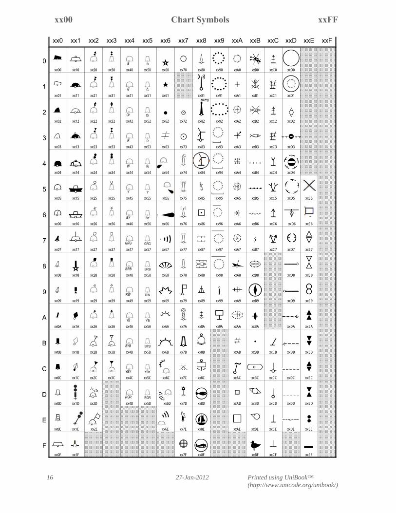
xxFFP Chart Symbolsxx00
xx0 xx1 xx2 xx3 xx4 xx5 xx6 xx7 xx8 xx9 xxA xxB xxC xxD xxE xxF
A
B
C
D
4E
F
I
G
H
J
K
M
L
N
P
O
Q
S
R
sxwê
QT
�
�
�
EU
EV
EW
EX
EY
EZ
E;
E\
E[
E:
E]
L<
L=
L>
L?
L¤
L¥
LÜ
L§
L¦
L©
L¨
Ea
Eb
Ec
Ed
Ee
Ef
Em
En
Eo
Ep
Eq
Er
Es
Eö
Lg
Lh
Li
Lj
Lk
Ll
Lt
Lu
Lv
Lw
Lx
Ly
Lz
L÷
ö·
Q
ç
{
`abc¿
V
à
™è
Í
Î
Ï
Ð
Ñ
°Ý
7Þ
í
ß
á
þ
46
ý
¼
Ë
Ì
º
»
î
ï
¶ß�
+
,
-
¾
Ã
Û
ú
û
ü
H
å
¯
.
ø
/
²
³
¬
®
^
´
«
ÿ
æ
Å
Æ
À
Ç
È
É
Ê
Á
¨
§
ã
é
ë
ì
ô
!
ù
�
�
�
�
�
�
�
�
�
�
T
Z
[
M
]
Í
Ô
xx00
xx01
xx02
xx03
xx04
xx05
xx06
xx07
xx08
xx09
xx0A
xx0B
xx0C
xx0D
xx0E
xx0F
xx10
xx11
xx12
xx13
xx14
xx15
xx16
xx17
xx18
xx19
xx1A
xx1B
xx1C
xx1D
xx1E xx2E
xx1F
xx20
xx21
xx22
xx23
xx24
xx25
xx26
xx27
xx28
xx29
xx2A
xx2B
xx2C
xx2D
xx30
xx31
xx32
xx33
xx34
xx35
xx36
xx37
xx38
xx39
xx3A
xx3B
xx3C
xx40
xx41
xx42
xx43
xx44
xx45
xx46
xx47
xx48
xx49
xx4A
xx4B
xx4C
xx4D
xx50
xx51
xx52
xx53
xx54
xx55 xx65
xx56
xx57
xx58
xx59
xx5A
xx5B
xx5C xx6C
xx5D xx6D
xx60
xx61
xx62
xx63
xx64
xx66
xx67
xx68
xx69
xx6A
xx6B
xx6E
xx70
xx72
xx73
xx74
xx75
xx76
xx77
xx78
xx79
xx7A
xx7B
xx7C
xx7D
xx7E
xx7F
xx80
xx81
xx82
xx83
xx84
xx85
xx86
xx87
xx88
xx89
xx8A
xx8B
xx8C
xx8D
xx8E
xx8F
xx90
xx91
xx92
xx93
xx94
xx95
xx96
xx97
xx98
xx99
xx9A
xxA0
xxA1
xxA2
xxA3
xxA4
xxA5
xxA6
xxA7
xxA8
xxA9
xxAA
xxAB
xxAC
xxAD
xxAE
xxB0
xxB1
xxB2
xxB3
xxB4
xxB5
xxB6
xxB7
xxB8
xxB9
xxBA
xxBB
xxBC
xxBD
xxBE
xxBF
xxC0
xxC1
xxC2
xxC3
xxC4
xxC5
xxC6 xxD6
xxC7
xxCB
xxCC
xxCD
xxCE
xxCF
xxD0
xxD1
xxD2
xxD3
xxD4
xxD5
xxD7
xxD8
xxD9
xxDA
xxDB
xxDC
xxDD
xxDE
xxE5
xxE6
xxE7
xxE8
xxE9
xxEA
xxEB
xxEC
xxED
xxEE
xxEF
0
1
2
3
4
5
6
7
8
9
A
B
C
D
E
F
Printed using UniBook™(http://www.unicode.org/unibook/)
27-Jan-2012 17
xx33Chart Symbolsxx00
Combining Topmarks for BuoysThese are topmarks for floating structures and thereforedrawn inclinedxx20 EU COMBINING BUOY TOPMARK TWO BLACK
TRIANGLES UP= North
xx21 EV COMBINING BEACON TOPMARK TWO BLACKTRIANGLES DOWN= South
xx22 EW COMBINING BUOY TOPMARK TWO BLACKTRIANGLES UP ABOVE DOWN= East
xx23 EX COMBINING BUOY TOPMARK TWO BLACKTRIANGLES DOWN ABOVE UP= West
xx24 EY COMBINING BUOY TOPMARK TWO BLACKCIRCLES= isolated danger mark
xx25 EZ COMBINING BUOY TOPMARK WHITE CIRCLE= safe water mark
xx26 E; COMBINING BUOY TOPMARK X= special mark
xx27 E\ COMBINING BUOY TOPMARK WHITE SQUARE= single white can topmark
xx28 E[ COMBINING BUOY TOPMARK BLACK SQUARE= single black can topmark
xx29 E: COMBINING BUOY TOPMARK WHITETRIANGLE UP= single white cone topmark
xx2A E] COMBINING BUOY TOPMARK BLACKTRIANGLE UP= single black cone topmark
Combining National Topmarks forBuoysxx2B COMBINING BUOY TOPMARK WHITE
TRIANGLE DOWN= used in French and German charts
xx2C COMBINING BUOY TOPMARK WHITE TOPHALF CIRCLE= used in French charts• glyph is incorrect, should be the top half
of a white circlexx2D COMBINING BUOY TOPMARK FISH
used in German chartsxx2E COMBINING BUOY TOPMARK WHITE FLAG
used in German charts
Combining Topmarks for Towers andBeaconsThese are topmarks for land-based structures and thereforedrawn uprightxx30 L< COMBINING TOWER TOPMARK TWO BLACK
TRIANGLES UP• North
xx31 L= COMBINING TOWER TOPMARK TWO BLACKTRIANGLES DOWN• South
xx32 L> COMBINING TOWER TOPMARK TWO BLACKTRIANGLES UP ABOVE DOWN• East
xx33 L? COMBINING TOWER TOPMARK TWO BLACKTRIANGLES DOWN ABOVE UP• West
Buoys, Beacons and other marksMooring buoys have a ring on topxx00 A BLACK CAN BUOYxx01 B WHITE CAN BUOYxx02 C BLACK NUN BUOYxx03 D WHITE NUN BUOYxx04 4 BLACK SPHERICAL BUOYxx05 E WHITE SPHERICAL BUOYxx06 F MULTICOLOR SPHERICAL BUOYxx07 I BLACK PILLAR BUOYxx08 G WHITE PILLAR BUOYxx09 H MULTICOLOR PILLAR BUOYxx0A J BLACK SPAR BUOYxx0B K BLACK BEACONxx0C M BLACK TOWER BEACONxx0D L WHITE TOWER BEACONxx0E N LATTICE BEACONxx0F P SUPER BUOYxx10 O SUPER MOORING BUOYxx11 Q BLACK BARREL BUOYxx12 S WHITE BARREL BUOYxx13 R BLACK BARREL MOORING BUOYxx14 s WHITE BARREL MOORING BUOYxx15 x BLACK LIGHT FLOATxx16 w WHITE LIGHT FLOATxx17 ê LANBYxx18 Q LIGHTED BEACON
• there are two forms, with the star and thehollow star, hollow seems to be morestandard
xx19 T LIGHTED BEACON ALTERNATE• there are two forms, with the star and the
hollow starxx1A BLACK DIAMOND SYMBOL FOR BUOY
= used in US charts for buoys independentof shape
xx1B WHITE DIAMOND SYMBOL FOR BUOY= used in US charts for buoys independent
of shapexx1C MULTICOLOR DIAMOND SYMBOL FOR BUOY
= used in US charts for multicolored buoysindependent of shape
Marked Submerged RockThe two black balls conform to IALA convention for isolateddanger and the usual convention about floating and fixedmarks (inclined or upright symbol) would applyIn principle only the base characters would have beenneeded, but the inclined symbol is more strongly inclined at45° and the full set of topmarks dpesnät applyxx1D � BEACON ON SUBMERGED ROCKxx1E � SPAR ON SUBMERGED ROCK
Leading Beaconxx1F � LEADING BEACON
• a pair will indicate a leading line• more prominent circle than std. beacon at
xx0B and more squat F363 ç leading line

Printed using UniBook™(http://www.unicode.org/unibook/)
27-Jan-201218
xx6EChart Symbolsxx34
xx53 Lj COMBINING COLOR RED BELOW ALTERNATExx54 Lk COMBINING COLOR WHITE BELOW
ALTERNATExx55 Ll COMBINING COLOR YELLOW BELOW
ALTERNATExx56 Lt COMBINING COLORS BLACK AND YELLOW
BELOW ALTERNATExx57 Lu COMBINING COLORS GREEN RED GREEN
BELOW ALTERNATExx58 Lv COMBINING COLORS BLACK RED BLACK
BELOW ALTERNATExx59 Lw COMBINING COLORS RED WHITE BELOW
ALTERNATExx5A Lx COMBINING COLORS YELLOW AND BLACK
BELOW ALTERNATExx5B Ly COMBINING COLORS BLACK YELLOW BLACK
BELOW ALTERNATExx5C Lz COMBINING COLORS YELLOW BLACK
YELLOW BELOW ALTERNATExx5D L÷ COMBINING COLORS RED GREEN RED BELOW
ALTERNATE
Lightsxx60 ö MAJOR LIGHT
• looks like a small hollow star, but sitslower 272B ✫ open centre black star
xx61 · MINOR LIGHT• sits lower than the black star
2605 ★ black starxx62 Q PILE
• similar dot is used on some charts forlights (with a light cone)
xx63 ç LEADING LIGHTS• two lights lining up at the bearing
indicated in the charts• character has no semantic connection to
2260 ≠ not equal to and is onlysuperficially similar in appearance 2260 ≠ not equal to
Combining Lightxx64 { COMBINING LIGHT CONE BELOW LEFT
• indicates a lighted navigational markxx65 COMBINING LIGHT CONE BELOW RIGHT
• indicates a lighted navigational mark
Sound and Light FeaturesThese symbols indicate additional equipment on buoysxx66 ` HORIZONTAL LIGHT CONExx67 a HORIZONTAL HORN
= fog hornxx68 b FLOOD LIGHTxx69 c STRIP LIGHTxx6A ¿ RADAR REFLECTOR
• a variant of this is found as combiningcharacter in some sources but this fontrenders it as base glyph
xx6B V RADAR REFLECTOR ALTERNATE• this deeper variant covers 180°
xx6C COMBINING RADAR REFLECTORxx6D COMBINING FLOOD LIGHT
• left belowxx6E COMBINING HORN
= fog horn• right above
xx34 L¤ COMBINING TOWER TOPMARK TWO BLACKCIRCLES= isolated danger mark
xx35 L¥ COMBINING TOWER TOPMARK WHITE CIRCLE= safe water mark
xx36 LÜ COMBINING TOWER TOPMARK X= special mark
xx37 L§ COMBINING TOWER TOPMARK WHITESQUARE= single white can topmark
xx38 L¦ COMBINING TOWER TOPMARK BLACKSQUARE= single white cone topmark
xx39 L© COMBINING TOWER TOPMARK WHITETRIANGLE UP= single black cone topmark
xx3A L¨ COMBINING TOWER TOPMARK BLACKTRIANGLE UP= single black can topmark
Combining National Topmarks forTowers and Beaconsxx3B COMBINING TOWER TOPMARK WHITE
TRIANGLE DOWN= used in French charts
xx3C COMBINING TOWER TOPMARK WHITE TOPHALF CIRCLEused in French charts• glyph is incorrect, should be the top half
of a white circle
Combining ColorsThese designate the actual color of a buoy or floating mark.In following the inclined depiction of these marks, the colorlabels are drawn pblicque and shifted to the left so they alingwith the small circle.Only a limited number of color designations are used.xx40 Ea COMBINING COLOR BLACK BELOWxx41 Eb COMBINING COLOR GREEN BELOWxx42 Ec COMBINING COLOR ORANGE BELOWxx43 Ed COMBINING COLOR RED BELOWxx44 Ee COMBINING COLOR WHITE BELOWxx45 Ef COMBINING COLOR YELLOW BELOWxx46 Em COMBINING COLORS BLACK AND YELLOW
BELOWxx47 En COMBINING COLORS GREEN RED GREEN
BELOWxx48 Eo COMBINING COLORS BLACK RED BLACK
BELOWxx49 Ep COMBINING COLORS BLACK RED WHITE
BLACK BELOWxx4A Eq COMBINING COLORS YELLOW AND BLACK
BELOWxx4B Er COMBINING COLORS BLACK YELLOW BLACK
BELOWxx4C Es COMBINING COLORS YELLOW BLACK
YELLOW BELOWxx4D Eö COMBINING COLORS RED GREEN RED BELOW
Combining Colors AlternateThese are color designators for land-based structures andtherefore drawn upright and centered.xx50 Lg COMBINING COLOR BLACK BELOW
ALTERNATExx51 Lh COMBINING COLOR GREEN BELOW
ALTERNATExx52 Li COMBINING COLOR ORANGE BELOW
ALTERNATE
Printed using UniBook™(http://www.unicode.org/unibook/)
27-Jan-2012 19
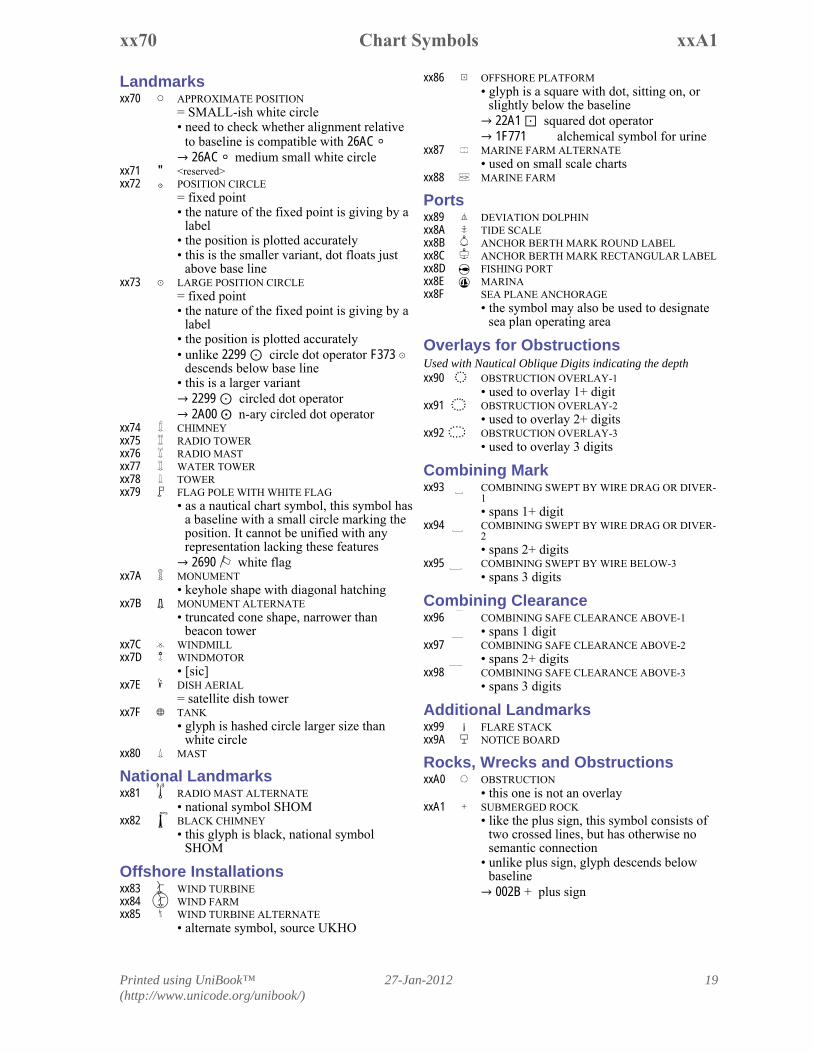
xxA1Chart Symbolsxx70
xx86 ¼ OFFSHORE PLATFORM• glyph is a square with dot, sitting on, or
slightly below the baseline 22A1 squared dot operator 1F771 �� alchemical symbol for urine
xx87 Ë MARINE FARM ALTERNATE• used on small scale charts
xx88 Ì MARINE FARM
Portsxx89 º DEVIATION DOLPHINxx8A » TIDE SCALExx8B î ANCHOR BERTH MARK ROUND LABELxx8C ï ANCHOR BERTH MARK RECTANGULAR LABELxx8D ¶ FISHING PORTxx8E ß MARINAxx8F � SEA PLANE ANCHORAGE
• the symbol may also be used to designatesea plan operating area
Overlays for ObstructionsUsed with Nautical Oblique Digits indicating the depthxx90 + OBSTRUCTION OVERLAY-1
• used to overlay 1+ digitxx91 , OBSTRUCTION OVERLAY-2
• used to overlay 2+ digitsxx92 - OBSTRUCTION OVERLAY-3
• used to overlay 3 digits
Combining Markxx93 ¾ COMBINING SWEPT BY WIRE DRAG OR DIVER-
1• spans 1+ digit
xx94 Ã COMBINING SWEPT BY WIRE DRAG OR DIVER-2• spans 2+ digits
xx95 Û COMBINING SWEPT BY WIRE BELOW-3• spans 3 digits
Combining Clearancexx96 ú COMBINING SAFE CLEARANCE ABOVE-1
• spans 1 digitxx97 û COMBINING SAFE CLEARANCE ABOVE-2
• spans 2+ digitsxx98 ü COMBINING SAFE CLEARANCE ABOVE-3
• spans 3 digits
Additional Landmarksxx99 H FLARE STACKxx9A NOTICE BOARD
Rocks, Wrecks and ObstructionsxxA0 å OBSTRUCTION
• this one is not an overlayxxA1 ¯ SUBMERGED ROCK
• like the plus sign, this symbol consists oftwo crossed lines, but has otherwise nosemantic connection
• unlike plus sign, glyph descends belowbaseline 002B + plus sign
Landmarksxx70 à APPROXIMATE POSITION
= SMALL-ish white circle• need to check whether alignment relative
to baseline is compatible with 26AC ⚬ 26AC ⚬ medium small white circle
xx71 " <reserved>xx72 ™ POSITION CIRCLE
= fixed point• the nature of the fixed point is giving by a
label• the position is plotted accurately• this is the smaller variant, dot floats just
above base linexx73 è LARGE POSITION CIRCLE
= fixed point• the nature of the fixed point is giving by a
label• the position is plotted accurately• unlike 2299 circle dot operator F373 è
descends below base line• this is a larger variant
2299 circled dot operator 2A00 n-ary circled dot operator
xx74 Í CHIMNEYxx75 Î RADIO TOWERxx76 Ï RADIO MASTxx77 Ð WATER TOWERxx78 Ñ TOWERxx79 ° FLAG POLE WITH WHITE FLAG
• as a nautical chart symbol, this symbol hasa baseline with a small circle marking theposition. It cannot be unified with anyrepresentation lacking these features 2690 ⚐ white flag
xx7A Ý MONUMENT• keyhole shape with diagonal hatching
xx7B 7 MONUMENT ALTERNATE• truncated cone shape, narrower than
beacon towerxx7C Þ WINDMILLxx7D í WINDMOTOR
• [sic]xx7E ß DISH AERIAL
= satellite dish towerxx7F á TANK
• glyph is hashed circle larger size thanwhite circle
xx80 þ MAST
National Landmarksxx81 4 RADIO MAST ALTERNATE
• national symbol SHOMxx82 6 BLACK CHIMNEY
• this glyph is black, national symbolSHOM
Offshore Installationsxx83 WIND TURBINExx84 WIND FARMxx85 ý WIND TURBINE ALTERNATE
• alternate symbol, source UKHO
Printed using UniBook™(http://www.unicode.org/unibook/)
27-Jan-201220
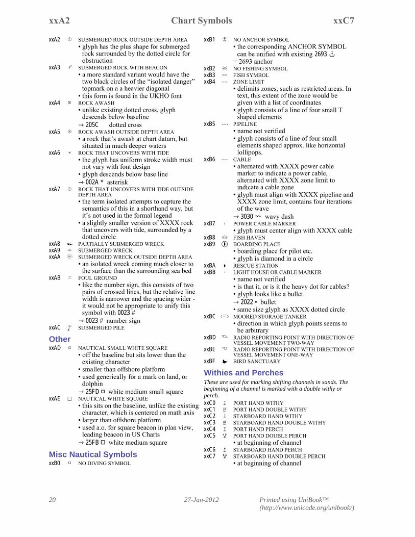
xxC7Chart SymbolsxxA2
xxB1 Å NO ANCHOR SYMBOL• the corresponding ANCHOR SYMBOL
can be unified with existing 2693 ⚓ = 2693 anchor
xxB2 Æ NO FISHING SYMBOLxxB3 À FISH SYMBOLxxB4 Ç ZONE LIMIT
• delimits zones, such as restricted areas. Intext, this extent of the zone would begiven with a list of coordinates
• glyph consists of a line of four small Tshaped elements
xxB5 È PIPELINE• name not verified• glyph consists of a line of four small
elements shaped approx. like horizontallollipops.
xxB6 É CABLE• alternated with XXXX power cable
marker to indicate a power cable,alternated with XXXX zone limit toindicate a cable zone
• glyph must align with XXXX pipeline andXXXX zone limit, contains four iterationsof the wave 3030 〰 wavy dash
xxB7 Ê POWER CABLE MARKER• glyph must center align with XXXX cable
xxB8 Á FISH HAVENxxB9 ¨ BOARDING PLACE
• boarding place for pilot etc.• glyph is diamond in a circle
xxBA § RESCUE STATIONxxBB ã LIGHT HOUSE OR CABLE MARKER
• name not verified• is that it, or is it the heavy dot for cables?• glyph looks like a bullet
2022 • bullet• same size glyph as XXXX dotted circle
xxBC é MOORED STORAGE TANKER• direction in which glyph points seems to
be arbitraryxxBD ë RADIO REPORTING POINT WITH DIRECTION OF
VESSEL MOVEMENT TWO-WAYxxBE ì RADIO REPORTING POINT WITH DIRECTION OF
VESSEL MOVEMENT ONE-WAYxxBF ô BIRD SANCTUARY
Withies and PerchesThese are used for marking shifting channels in sands. Thebeginning of a channel is marked with a double withy orperch.xxC0 PORT HAND WITHYxxC1 PORT HAND DOUBLE WITHYxxC2 STARBOARD HAND WITHYxxC3 STARBOARD HAND DOUBLE WITHYxxC4 PORT HAND PERCHxxC5 PORT HAND DOUBLE PERCH
• at beginning of channelxxC6 STARBOARD HAND PERCHxxC7 STARBOARD HAND DOUBLE PERCH
• at beginning of channel
xxA2 . SUBMERGED ROCK OUTSIDE DEPTH AREA• glyph has the plus shape for submerged
rock surrounded by the dotted circle forobstruction
xxA3 ø SUBMERGED ROCK WITH BEACON• a more standard variant would have the
two black circles of the “isolated danger”topmark on a a heavier diagonal
• this form is found in the UKHO fontxxA4 / ROCK AWASH
• unlike existing dotted cross, glyphdescends below baseline 205C � dotted cross
xxA5 ² ROCK AWASH OUTSIDE DEPTH AREA• a rock that’s awash at chart datum, but
situated in much deeper watersxxA6 ³ ROCK THAT UNCOVERS WITH TIDE
• the glyph has uniform stroke width mustnot vary with font design
• glyph descends below base line 002A * asterisk
xxA7 ¬ ROCK THAT UNCOVERS WITH TIDE OUTSIDEDEPTH AREA• the term isolated attempts to capture the
semantics of this in a shorthand way, butit’s not used in the formal legend
• a slightly smaller version of XXXX rockthat uncovers with tide, surrounded by adotted circle
xxA8 ® PARTIALLY SUBMERGED WRECKxxA9 ^ SUBMERGED WRECKxxAA ´ SUBMERGED WRECK OUTSIDE DEPTH AREA
• an isolated wreck coming much closer tothe surface than the surrounding sea bed
xxAB « FOUL GROUND• like the number sign, this consists of two
pairs of crossed lines, but the relative linewidth is narrower and the spacing wider -it would not be appropriate to unify thissymbol with 0023 # 0023 # number sign
xxAC SUBMERGED PILE
OtherxxAD ÿ NAUTICAL SMALL WHITE SQUARE
• off the baseline but sits lower than theexisting character
• smaller than offshore platform• used generically for a mark on land, or
dolphin 25FD ◽ white medium small square
xxAE æ NAUTICAL WHITE SQUARE• this sits on the baseline, unlike the existing
character, which is centered on math axis• larger than offshore platform• used a.o. for square beacon in plan view,
leading beacon in US Charts 25FB ◻ white medium square
Misc Nautical SymbolsxxB0 NO DIVING SYMBOL
Printed using UniBook™(http://www.unicode.org/unibook/)
27-Jan-2012 21
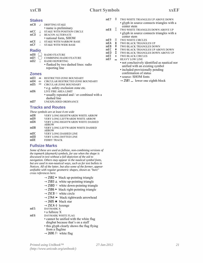
xxEFChart SymbolsxxCB
xxE7 TWO WHITE TRIANGLES UP ABOVE DOWN• glyph in source connects triangles with a
center stemxxE8 TWO WHITE TRIANGLES DOWN ABOVE UP
• glyph in source connects triangles with acenter stem
xxE9 T TWO WHITE CIRCLESxxEA Z TWO BLACK TRIANGLES UPxxEB [ TWO BLACK TRIANGLES DOWNxxEC M TWO BLACK TRIANGLES UP ABOVE DOWNxxED ] TWO BLACK TRIANGLES DOWN ABOVE UPxxEE Í TWO BLACK CIRCLESxxEF Ô HEAVY LOW LINE
• not conclusively identified as nautical norunified with an existing symbol
• included provisionally pendingconfirmation of status
• source: SHOM fonts 2581 lower one eighth block
StakesxxCB DRIFTING STAKE
• name is preliminaryxxCC STAKE WITH POSITION CIRCLExxCD ! BEACON ALTERNATE
• national form, SHOMxxCE STAKE WITH NARROW BASExxCF ù STAKE WITH WIDE BASE
RadioxxD0 RADIO FEATURExxD1 COMBINING RADIO FEATURExxD2 RADIO REPORTING
• flanked by two dashed lines: radioreporting line
ZonesxxD3 RESTRICTED ZONE BOUNDARYxxD4 CIRCULAR RESTRICTED ZONE BOUNDARYxxD5 CIRCULAR ZONE BOUNDARY
• e.g. safety exclusion zone etc.xxD6 LIVE FIRE AREA LIMIT
• usually repeated and / or combined with adashed line
xxD7 � UNEXPLODED ORDINANCE
Tracks and RoutesThese symbols are at least 4 em widexxD8 � VERY LONG RIGHTWARDS WHITE ARROWxxD9 � VERY LONG LEFTWARDS WHITE ARROWxxDA � VERY LONG RIGHTWARDS WHITE DASHED
ARROWxxDB � VERY LONG LEFTWARDS WHITE DASHED
ARROWxxDC � VERY LONG DASHED LINExxDD � VERY LONG DOTTED LINExxDE � FERRY TRACK
Fullsize MarksSome of these are used as fullsize, non-combining versions ofthe topmark (daymark) symbols, for use when the shape isdiscussed in text without a full depiction of the aid tonavigation. Others may appear in the nautical symbol fonts,but are used in non-nautical ways, such as for text bullets inNotices. All of the latter, but also some of the former, appearunifiable with regular geometric shapes, shown as "bare"cross references here.
25B2 ▲ black up-pointing triangle 25B3 white up-pointing triangle 25BD ▽ white down-pointing triangle 25B6 ▶ black right-pointing triangle 25CB ○ white circle 27A4 ➤ black rightwards arrowhead 2605 ★ black star 25CA ◊ lozenge
xxE5 � DAYMARK X• a fullsize X
xxE6 � DAYMARK WHITE FLAG• cannot be unified with the white flag
dingbat because that’s on a staff• this glyph clearly shows the flag flying
from a flagline 2690 ⚐ white flag
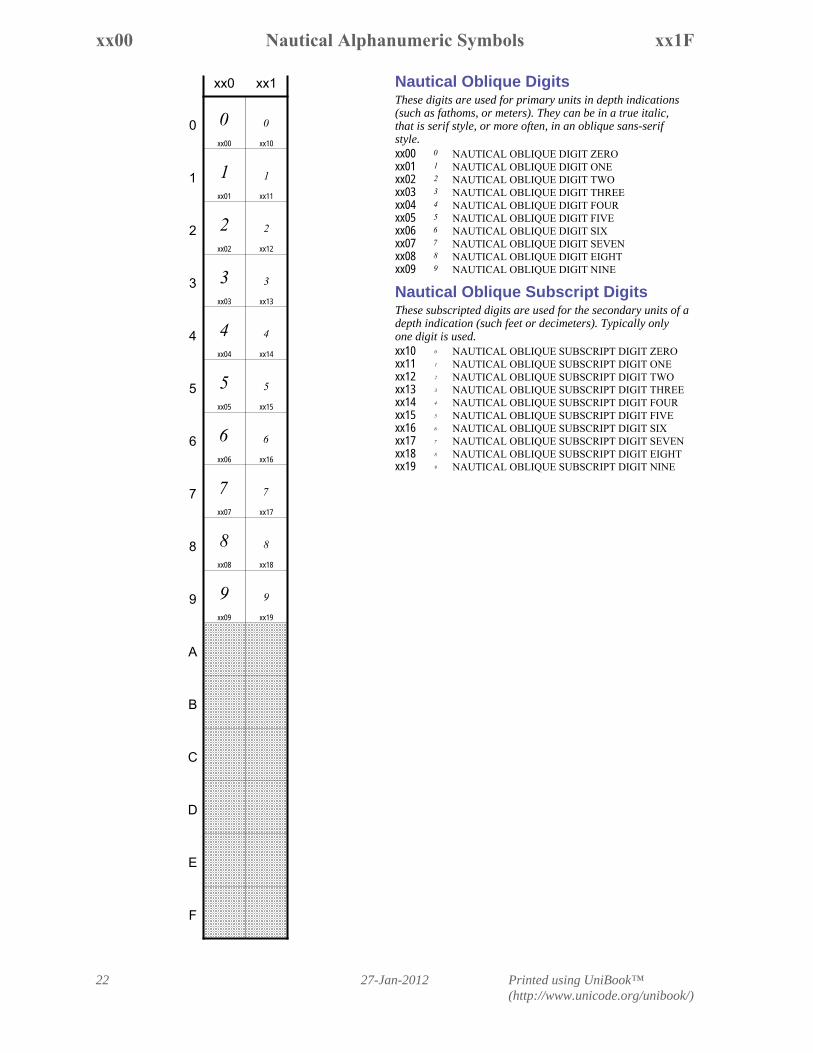
Nautical Oblique DigitsThese digits are used for primary units in depth indications(such as fathoms, or meters). They can be in a true italic,that is serif style, or more often, in an oblique sans-serifstyle.xx00 NAUTICAL OBLIQUE DIGIT ZEROxx01 NAUTICAL OBLIQUE DIGIT ONExx02 NAUTICAL OBLIQUE DIGIT TWOxx03 NAUTICAL OBLIQUE DIGIT THREExx04 NAUTICAL OBLIQUE DIGIT FOURxx05 NAUTICAL OBLIQUE DIGIT FIVExx06 NAUTICAL OBLIQUE DIGIT SIXxx07 NAUTICAL OBLIQUE DIGIT SEVENxx08 NAUTICAL OBLIQUE DIGIT EIGHTxx09 NAUTICAL OBLIQUE DIGIT NINE
Nautical Oblique Subscript DigitsThese subscripted digits are used for the secondary units of adepth indication (such feet or decimeters). Typically onlyone digit is used.xx10 NAUTICAL OBLIQUE SUBSCRIPT DIGIT ZEROxx11 NAUTICAL OBLIQUE SUBSCRIPT DIGIT ONExx12 NAUTICAL OBLIQUE SUBSCRIPT DIGIT TWOxx13 NAUTICAL OBLIQUE SUBSCRIPT DIGIT THREExx14 NAUTICAL OBLIQUE SUBSCRIPT DIGIT FOURxx15 NAUTICAL OBLIQUE SUBSCRIPT DIGIT FIVExx16 NAUTICAL OBLIQUE SUBSCRIPT DIGIT SIXxx17 NAUTICAL OBLIQUE SUBSCRIPT DIGIT SEVENxx18 NAUTICAL OBLIQUE SUBSCRIPT DIGIT EIGHTxx19 NAUTICAL OBLIQUE SUBSCRIPT DIGIT NINE
Printed using UniBook™(http://www.unicode.org/unibook/)
27-Jan-201222
xx1FNautical Alphanumeric Symbolsxx00
xx0 xx1
xx00
xx01
xx02
xx03
xx04
xx05
xx06
xx07
xx08
xx09
xx10
xx11
xx12
xx13
xx14
xx15
xx16
xx17
xx18
xx19
0
1
2
3
4
5
6
7
8
9
A
B
C
D
E
F
Enclosed LettersLetters enclosed in diamonds(lozenges?) are used to indicatenotes, current information etc. IHO recommends a limit of20, the UKHO font contains the first 16. The full set A-Z isproposed to make the set usable as general bullet characters.xx20 LATIN CAPITAL LETTER A ENCLOSED IN
DIAMONDxx21 LATIN CAPITAL LETTER B ENCLOSED IN
DIAMONDxx22 LATIN CAPITAL LETTER C ENCLOSED IN
DIAMONDxx23 LATIN CAPITAL LETTER D ENCLOSED IN
DIAMONDxx24 LATIN CAPITAL LETTER E ENCLOSED IN
DIAMONDxx25 LATIN CAPITAL LETTER F ENCLOSED IN
DIAMONDxx26 LATIN CAPITAL LETTER G ENCLOSED IN
DIAMONDxx27 LATIN CAPITAL LETTER H ENCLOSED IN
DIAMONDxx28 LATIN CAPITAL LETTER I ENCLOSED IN
DIAMONDxx29 LATIN CAPITAL LETTER J ENCLOSED IN
DIAMONDxx2A LATIN CAPITAL LETTER K ENCLOSED IN
DIAMONDxx2B LATIN CAPITAL LETTER L ENCLOSED IN
DIAMONDxx2C LATIN CAPITAL LETTER M ENCLOSED IN
DIAMONDxx2D LATIN CAPITAL LETTER N ENCLOSED IN
DIAMONDxx2E LATIN CAPITAL LETTER O ENCLOSED IN
DIAMONDxx2F LATIN CAPITAL LETTER P ENCLOSED IN
DIAMONDxx30 LATIN CAPITAL LETTER Q ENCLOSED IN
DIAMONDxx31 LATIN CAPITAL LETTER R ENCLOSED IN
DIAMONDxx32 LATIN CAPITAL LETTER S ENCLOSED IN
DIAMONDxx33 LATIN CAPITAL LETTER T ENCLOSED IN
DIAMONDxx34 LATIN CAPITAL LETTER U ENCLOSED IN
DIAMONDxx35 LATIN CAPITAL LETTER V ENCLOSED IN
DIAMONDxx36 LATIN CAPITAL LETTER W ENCLOSED IN
DIAMONDxx37 LATIN CAPITAL LETTER X ENCLOSED IN
DIAMONDxx38 LATIN CAPITAL LETTER Y ENCLOSED IN
DIAMONDxx39 LATIN CAPITAL LETTER Z ENCLOSED IN
DIAMOND
Printed using UniBook™(http://www.unicode.org/unibook/)
27-Jan-2012 23
xx3FEnclosed Lettersxx20
xx2 xx3
xx20
xx21
xx22
xx23
xx24
xx25
xx26
xx27
xx28
xx29
xx2A
xx2B
xx2C
xx2D
xx2E
xx2F
xx30
xx31
xx32
xx33
xx34
xx35
xx36
xx37
xx38
xx39
0
1
2
3
4
5
6
7
8
9
A
B
C
D
E
F