to: wwdc date: may 12, 2010 -...
TRANSCRIPT

TECHNICAL MEMORANDUM
1
TO: WWDC DATE: May 12, 2010 FROM: MWH REFERENCE: Wind-Bighorn Basin Plan SUBJECT: Task 6B– Water Quality The purpose of this technical memorandum is to document water quality issues in the Wind-Bighorn Basin (Basin) to support the Wind-Bighorn Basin Plan Update (Basin Plan Update). This information updates and expands on work completed during the previous Wind-Bighorn Basin Plan (previous Basin Plan) completed in 2003. Section 1 provides a brief summary of water quality issues reported in the previous Basin Plan. The remaining sections provide updated information. This technical memorandum contains the following sections.
Contents
Section 1 – Introduction ......................................................................................................................... 1
Section 2 – Watershed Management Planning ...................................................................................... 2
Watershed Management Programs .................................................................................................... 2
Watershed Planning Projects ............................................................................................................. 5
Section 3 – Water Quality Issues ......................................................................................................... 10
Section 4 – Summary........................................................................................................................... 12
Section 5 – References ........................................................................................................................ 12
Appendix A – NRCS Program Descriptions ......................................................................................... 14
Appendix B – WDEQ 303(d) Listings for the Wind-Bighorn Basin ........................................................ 26
Section 1 – Introduction The previous Basin Plan described water quality concerns, impairments and special considerations within the Basin. In addition, ongoing watershed planning by federal, state and local entities and opportunities for cooperative efforts was discussed. Ongoing watershed planning activities in the Basin included: 1) Conservation Districts’ water quality programs to reduce agricultural impacts, 2) Natural Resources Conservation Service (NRCS) programs including Wildlife Habitat Incentive Program (WHIP), Environmental Quality Incentives Program (EQIP), Conservation Reserve Program (CRP), and Wetlands Reserve Program (WRP). Other cooperative water quality management programs such as watershed planning studies and inter-agency water quality sampling programs were also discussed. Special environmental considerations in the previous Basin Plan included Yellowstone National Park, the Clark’s Fork River (Wyoming’s only congressionally designated Wild and Scenic River), and the Wind River Indian Reservation. Impacts to groundwater quality and potential groundwater protection programs for two areas in the Basin were identified in the previous Basin Plan. These areas included

2
the Upper Wind River aquifer in the vicinity of Riverton and the Madison/Bighorn aquifer within the Paintrock Anticline near Hyattville.
Section 2 – Watershed Management Planning Watershed management is the process of addressing water related issues upon all areas of land that drain to a common body of water. The goal of watershed management planning is to work toward an environmentally healthy and economically favorable watershed that benefits all stakeholders. Since water doesn’t recognize political boundaries, watershed management often requires working across jurisdictional borders where coordination between government agencies, interested organizations, and citizens is essential in order to address watershed concerns and to resolve water quality issues.
There are several ongoing watershed management activities and water quality monitoring programs in the Basin. Many of the watershed programs are federal programs designed to provide technical and financial assistance to landowners in the Basin. Programs are designed to address soil, water, and related natural resource concerns. Basin specific watershed plans have also been developed by several government entities including the conservation districts in the Basin, the Wyoming Department of Environmental Quality, and Wyoming Fish and Game Department. These plans typically address stream impairments or habitat concerns within the watershed.
Watershed Management Programs
This section describes federally managed watershed programs within the Basin. Watershed planning efforts by WWDC are discussed in Technical Memorandum 6E – Watershed Planning. Bureau of Land Management The Bureau of Land Management (BLM) does not have specific watershed management plans for the Basin. However, the Federal Land Policy and Management Act of 1976 requires the BLM to develop plans for the lands it oversees. These plans are called resource management plans (RMPs) and govern all resources including livestock grazing, recreation, and oil and gas development. These plans are based on the concept of “multiple use and sustained yield” (BLM 2009). The BLM develops these RMPs at the “field office” level of its organization and works with cooperating agencies such as tribal, state, and local governments throughout the planning process (BLM 2009). Currently, there are three main RMP’s for public lands management within the Basin: Grass Creek RMP, Washakie RMP and the Lander RMP. The BLM is in the process of combining these three RMP’s into a single RMP, referred to as the Bighorn Basin RMP. The revised Bighorn Basin RMP will provide future direction for approximately 3.2 million surface acres and 4.2 million acres of federal mineral estate in north-west Wyoming (BLM 2009b). The revised plan will do the following:
• establish goals and objectives for resource management;
• identify lands that are open or available for certain uses, including any restrictions and lands that are administratively unavailable to certain uses;
• provide comprehensive management direction for all resources and uses;
• make broad scale decisions guiding future site-specific implementation decisions.
The area includes 12 Wilderness Study Areas (WSAs), nine Areas of Critical Environmental Concern (ACECs), two areas of special designation, and seven special recreation management areas. The planning area includes part of Hot Springs, and all of Park, Washakie, and Big Horn counties (BLM 2009b).

3
Natural Resources Conservation Service The US Department of Agriculture has a number of watershed programs administered by its Natural Resources Conservation Service (NRCS). The Wind River, Big Horn and Clarks Fork basins are administered through a single NRCS district office located in Worland. NRCS initiatives related to water quality and environmental protection include: the Agricultural Management Assistance Program (AMA), the Conservation Reserve Program (CRP), the Conservation Technical Assistance (CTA) Program, the Environmental Quality Incentive Program (EQIP), the Wildlife Habitat Incentive Program (WHIP), and the Wetlands Reserve Program (WRP). A brief summary describing each of the programs offered by NRCS is provided below (NRCS 2009). A complete listing of all the NRCS supported projects in the Basin is provided in Appendix A. The AMA program provides financial assistance to agricultural producers to voluntarily address resource issues such as water management, water quality, invasive species control, and erosion control by incorporating conservation into their farming or ranching operations (NRCS 2009). Program priorities are based on recommendations from the Wyoming State Technical Committee (STC). The STC is made up of representatives from various producer groups, conservation organizations, agribusinesses, and federal, state, and tribal government agencies. Each year, consideration is given to determine which resource concerns pose the greatest risk to Wyoming agricultural operations. Currently there are 22 projects in the Basin funded through the NRCS AMA program (NRCS 2009b). The current priority of the STC is the removal of Russian olive and salt cedar along riparian areas in the Bighorn Basin. The NRCS field offices in Greybull, Lander, Thermopolis and Worland have been very proactive in using AMA funds to effect watershed-scale changes. Some of the watersheds receiving treatment to remove these invasive species include: Cottonwood Creek, Gooseberry Creek, the Nowood River, and Shell Creek. The CRP provides technical and financial assistance to eligible landowners to address natural resource concerns on their lands in an environmentally beneficial and cost-effective manner (NRCS 2009). The program provides assistance to landowners in complying with federal, state, and tribal environmental laws. The program encourages environmental enhancement. The Conservation Reserve Program reduces soil erosion, reduces sedimentation in streams, reduces sedimentation in lakes, improves water quality, establishes wildlife habitat, enhances forest resources and enhances wetland resources. Currently there are 19 projects in the Basin funded through the NRCS CRP program (NRCS 2009b). A majority of the projects are located in Washakie and Hot Springs counties. Projects supported by the CRP program in the Basin include: upland and wetland wildlife habitat management, irrigation water management, riparian forest buffer, spring development and watering facilities. The CTA Program provides technical assistance supported by science-based tools to help people voluntarily conserve, maintain, and improve their natural resources (NRCS 2009). The CTA Program provides the technical capability, including direct conservation planning, design, and implementation assistance. This assistance is provided to individuals, groups, and communities who make natural resource management decisions on non-federal lands. Currently there are 39 projects in the Basin funded through the NRCS CTA program (NRCS 2009b). Projects supported by the CTA program are located throughout the Basin and include: upland and wetland wildlife habitat management, irrigation water management, prescribed grazing, watering facilities, wetland enhancement, and restoration. EQIP provides technical assistance, cost share and incentive payments to agricultural producers to implement conservation practices on eligible agricultural land (NRCS 2009). The program promotes environmental quality in agricultural production and sets priorities based on recommendations from the

4
STC. The priorities of the program include: grazing lands management, water quality, irrigation water management, wetlands, streambank/riparian area protection, and fish and wildlife habitat. Currently there are 138 projects in the Basin funded through the NRCS EQIP program, 12 of which are supported under the Ground and Surface Water Conservation (GSWC) portion of the program. Projects supported under the GSWC are those that result in a net savings of groundwater or surface water resources in the agricultural operation of the producer (NRCS 2009b). Projects supported by the EQIP/GSWC program are located throughout the Basin. Those funded under the GSWC portion focus on irrigation improvements and water management. WHIP provides assistance to people who want to develop and improve wildlife habitat primarily on private land, with an emphasis on habitats of national and state significance and/or habitats experiencing declining or reduced populations (NRCS 2009). Program priorities are based on recommendations from the STC. The priorities of the program include:
Riparian and wetland areas projects that will benefit rare and declining species or species of concern, including but not limited to cold water fisheries, sage grouse, turkey, neotropical birds, bald eagle, waterfowl, deer, elk, moose, and amphibians. Practices focus on fencing with livestock management and off-site water developments, stream restoration, removal of barriers to fish movement, herbaceous or woody plantings, and creation or enhancement of shallow water areas for wetland dependent wildlife. Upland projects (grassland and shrub-steppe) that will benefit rare and declining species or species of concern, including but not limited to sage grouse, Cassin’s sparrow lark bunting, and sage sparrow. Other target species benefiting are antelope, mule deer and elk. Practices to be applied may include shrub thickets, grass or legume seedings, water facilities such as guzzlers, brush management, aspen stand regeneration, fencing and livestock management, water developments, and prescribed burnings.
Currently there are eight projects in the Basin funded through the NRCS WHIP program which are located in Bighorn, Fremont and Park Counties (NRCS 2009b). Projects include wetland enhancements, a fish passage, upland wildlife habitat management and grade stabilization structures.
The WRP is a voluntary program offering landowners the opportunity to protect, restore, and enhance wetlands on their property. The NRCS goal is to achieve the greatest wetland functions and values, along with optimum wildlife habitat, on every acre enrolled in the program. This program offers landowners an opportunity to establish long-term conservation and wildlife practices and protection. Based on the most current information available from WRP, there are seven WRP enhancement locations within the Basin (NRCS 2009b). The projects are located in Fremont and Hot Springs counties and include tree/shrub establishment, upland wildlife habitat management, structures for water control and nutrient management plans.
A summary of the current progress of all projects supported by the NRCS for the Basin by county is provided in Table 1 (NRCS 2009b).

5
Table 1. Summary of Progress for NRCS Programs in the Basin for 2009
Field Measures County
Bighorn Fremont Hot
Springs Park Washakie
Conservation plans written (acres) 13,651 21,600 39,276 41,535 67,981
Watershed or area-wide conservation plans developed (No.) -- 1 -- 3 8
Cropland with conservation applied to improve soil quality (acres) 8,773 6,756 1,699 3,398 2,888
Land with conservation applied to improve water quality (acres) 15,799 78,495 65,338 46,285 8,310
CNMP1 written (No.) 1 -- -- -- --
CNMP1 applied (No.) 3 1 2 1 1
Land with conservation applied to improve irrigation efficiency (acres)
9,355 22,228 1,176 3,864 3,184
Grazing and forest land with conservation applied to protect and improve the resource base (acres)
26,585 182,145 89,708 47,328 59,622
Non-federal land with conservation applied to improve fish and wildlife habitat quality (acres)
13,885 86,904 56,967 152 54,116
Wetlands created, restored or enhanced (acres) 269 3 20 5 121
Local businesses created or retained in rural communities (No.) -- 1 1 5 --
Note 1: CNMP = Comprehensive Nutrient Management Plan -- indicates no program progress to report in 2009 for that county
Wyoming Department of Environmental Quality: The Wyoming Department of Environmental Quality (WDEQ) Watershed Planning Program is responsible for a variety of planning and water quality project implementation activities. The major functions of the program include establishing water quality standards, non-point source management planning, water quality assessment and monitoring program, 401 certifications, wetlands protection, Total Maximum Daily Load (TMDL) coordination, and data quality assurance (WDEQ 2009). As part of the water quality assessment and monitoring program, the WDEQ develops five-year strategies to monitor water quality across the state (WDEQ 2009). The five-year strategy plans are designed to address the water quality issues facing Wyoming, while also complying with requirements of the Clean Water Act (CWA) and recent Environmental Protection Agency (EPA) guidance relating to the 10 critical elements of a state water monitoring and assessment program. Key pieces of the current five-year strategy (2004-2008) include increased focus on monitoring all water types, including lake monitoring and development of a wetland monitoring methodology, as well as randomized selection of monitoring sites. The WDEQ is currently in the planning and development phase of a new five-year monitoring strategy. The new monitoring strategy will build upon the successes of the 2004-2008 Water Quality Monitoring Strategy. The WDEQ projects that this new monitoring strategy will be implemented in 2010.
Watershed Planning Projects
Conservation Districts Ten of Wyoming’s 34 conservation districts are located in the Wind River, Big Horn and Clarks Fork Basins. All are part of the Wyoming Association of Conservation Districts (WACD). Districts in the Basin include the Powell Clarks Fork, Shoshone, Cody, South Big Horn, Meeteetse, Washakie County, Hot Springs County, Dubois Crowheart, Lower Wind River, and Popo Agie Conservation Districts (WACD 2009). These conservation districts conduct a variety of watershed planning projects, which are designed to minimize agricultural related impacts to the environment and water quality. In 2000,
6
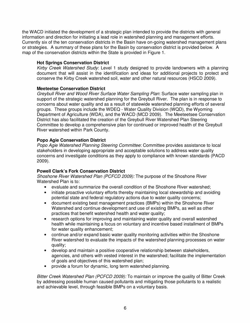
the WACD initiated the development of a strategic plan intended to provide the districts with general information and direction for initiating a lead role in watershed planning and management efforts. Currently six of the ten conservation districts in the Basin have on-going watershed management plans or strategies. A summary of these plans for the Basin by conservation district is provided below. A map of the conservation districts within the State is provided in Figure 1.
Hot Springs Conservation District Kirby Creek Watershed Study: Level 1 study designed to provide landowners with a planning document that will assist in the identification and ideas for additional projects to protect and conserve the Kirby Creek watershed soil, water and other natural resources (HSCD 2009). Meeteetse Conservation District Greybull River and Wood River Surface Water Sampling Plan: Surface water sampling plan in support of the strategic watershed planning for the Greybull River. The plan is in response to concerns about water quality and as a result of statewide watershed planning efforts of several groups. These groups include the WDEQ - Water Quality Division (WQD), the Wyoming Department of Agriculture (WDA), and the WACD (MCD 2009). The Meeteetsee Conservation District has also facilitated the creation of the Greybull River Watershed Plan Steering Committee to develop a comprehensive plan for continued or improved health of the Greybull River watershed within Park County. Popo Agie Conservation District Popo Agie Watershed Planning Steering Committee: Committee provides assistance to local stakeholders in developing appropriate and acceptable solutions to address water quality concerns and investigate conditions as they apply to compliance with known standards (PACD 2009). Powell Clark’s Fork Conservation District Shoshone River Watershed Plan (PCFCD 2009): The purpose of the Shoshone River Watershed Plan is to:
• evaluate and summarize the overall condition of the Shoshone River watershed;
• initiate proactive voluntary efforts thereby maintaining local stewardship and avoiding potential state and federal regulatory actions due to water quality concerns;
• document existing best management practices (BMPs) within the Shoshone River Watershed and continue development and use of existing BMPs, as well as other practices that benefit watershed health and water quality;
• research options for improving and maintaining water quality and overall watershed health while maintaining a focus on voluntary and incentive based installment of BMPs for water quality enhancement;
• continue and/or expand basic water quality monitoring activities within the Shoshone River watershed to evaluate the impacts of the watershed planning processes on water quality;
• develop and maintain a positive cooperative relationship between stakeholders, agencies, and others with vested interest in the watershed; facilitate the implementation of goals and objectives of this watershed plan;
• provide a forum for dynamic, long term watershed planning. Bitter Creek Watershed Plan (PCFCD 2009): To maintain or improve the quality of Bitter Creek by addressing possible human caused pollutants and mitigating those pollutants to a realistic and achievable level, through feasible BMPs on a voluntary basis.

7
Figure 1. Map of the Wyoming Conservations Districts in the State

8
South Big Horn Conservation District South Bighorn Watershed Plan: To achieve water quality and designated uses for water bodies in the district by identifying and documenting current water quality, educating the public about water quality and the steps they can take to enhance that quality, initiate action in the public through BMP’s and advising the district on non-point source prevention (SBHCD 2009). Washakie Conservation District Bighorn River Watershed Management Plan: The primary purpose of the Bighorn River Watershed Plan is to maintain or improve the quality of water within the watershed in Washakie County by focusing on addressing the WDEQ 303(d) list of threatened or impaired waterbodies, as well as develop and implement an effective public education program, focusing on water quality issues specific to the Bighorn River watershed in Washakie County (WCD 2009).
Wyoming Game and Fish Department In 2009 the Wyoming Game and Fish Department (WGFD) and its conservation partners updated and revised the Strategic Habitat Plan (SHP) to address the potential impacts and major issues facing wildlife and their habitats in the State of Wyoming (WGFD 2009). The revised SHP was developed to direct the state’s effort to conserve species of greatest conservation need and to allow the state to maintain eligibility for U.S. Fish and Wildlife Service administered state wildlife grant funding. The primary goal for the SHP was to identify crucial habitats for species of greatest conservation need, as well as designate enhancement areas for habitats that have been degraded. These habitat enhancement areas are areas where natural or man-caused habitat degradation is occurring or has occurred and where the WGFD can work with partners to improve habitat condition. The status of the wildlife species present, habitat abundance, habitat conditions, habitat connectivity, activities resulting in habitat loss, potential improvements and opportunity for partnering are all considered when delineating enhancement areas. Currently there are 12 designated aquatic habitat enhancement areas within the Basin. A list of each aquatic enhancement area and a summary of the habitat issues associated with each is provided below. Additional information and a map of the terrestrial and aquatic critical and habitat enhancement areas is provided in Tech memo 3D/3E, Recreational and Environmental Use.
Lower Bighorn River Complex Habitat Issues: Reduced water flows during irrigation, reduced water quality from overland and irrigation return flows, degraded stream banks, degraded riparian zone, and conversion of native vegetation to invasive species. Lower Shoshone River Habitat Issues: Low stream flow conditions, dewatering, disruption of upstream fish passage, fish entrainment, high sediment input into the stream, loss of instream habitat, and invasive plant species modifying native habitat. North Fork Shoshone River Habitat Issues: Habitat connectivity (upstream fish passage), fish loss (canal entrainment), reduced water quality due to sediment loads, dewatered stream reaches, unstable banks and substrate, and degraded in-stream habitat, banks, and riparian areas. South Fork Shoshone River Habitat Issues: Habitat connectivity (upstream fish passage) fish loss (canal entrainment), reduced water quality due to sediment loads, dewatered stream reaches, unstable banks and substrate, and degraded in-stream habitat, banks, and riparian areas.

9
Upper Bighorn River Habitat Issues: Water quantity, aquatic plant growth, sediment transport, instream habitat availability and quality, and riparian habitat are affected by the regulated flows of Boysen Reservoir; water quality is degraded by sediment from tributary streams, and stream quality and temperature is affected by the hot springs. Yellowstone Cutthroat Trout Habitat Habitat Issues: Water quantity, water quality, habitat connectivity, degraded streams, degraded riparian areas. Lower Sweetwater Watershed Habitat Issues: Erosion and sediment entrainment are natural processes in the lower Sweetwater drainage that have been extremely accelerated by human activities. Prolonged or intense annual herbivory. Increased drainage density associated with roads and trails, improperly engineered stream crossings. Reduced hydrologic function in upland habitats due to successional progression. Main Stem Wind River Habitat Issues: The main stem of the Wind River is impacted most by the sediment from the Absaroka Mountains from the north, channel modifications due to tie drives, active channelization, willow removal by all methods, extensive bank armoring, dike development, prolonged or intense annual herbivory, increased drainage density associated with roads and trails, improperly engineered stream crossings, reduced hydrologic function in upland habitats due to successional progression and lack of fish movement data for Yellowstone cutthroat. Ocean Lake Watershed Habitat Issues: Rangeland erosion, riparian zone overgrazing, stream bank modifications and stream channel destabilization, invasive weeds, water quality. Upper Sweetwater Watershed Habitat Issues: Prolonged or intense annual herbivory. Increased drainage density associated with roads and trails. Historic mining activities, active channelization of the rivers, reduced hydrologic function in upland habitats due to successional progression. Upper Wind River Basin Habitat Issues: Barriers to fish movement, fish loss into irrigation diversions, dewatering of stream sections, stream habitat fragmentation, overgrazing of riparian areas, winter habitat conflict on private land, increasing subdivision of private lands. Wind River Basin Sauger Habitat Issues: Barriers to fish movement, fish loss into irrigation diversions, dewatering of stream sections, habitat fragmentation, overgrazing of riparian areas, winter habitat conflict on private land and increasing subdivision of private lands, limited nursery habitat.
Wind River Environmental Quality Commission The Wind River Environmental Quality Commission (WREQC) is a joint program between the Eastern Shoshone and Northern Arapaho Tribes. The program provides information for air quality, water quality, oil and gas, solid wastes and emergency responses within the Wind River Indian Reservation. Through the EPA’s Clean Water Act 106, tribal program WREQC has compiled more than 5 1/2 years of water sampling data on 43 different sites on the reservation, completed the 305(b) Surface Water Condition Report in July 2000, and completed a Unified Watershed Assessment Report for the EPA.

10
WREQC continues to work with the State of Wyoming, Department of Environmental Quality, several federal agencies, and the University of Wyoming on a statewide watershed survey (WREQC 2009).
Section 3 – Water Quality Issues Water quality in the Wind-Bighorn Basin is strongly influenced by the geology and terrain of the Wind River Range and Bighorn Mountains (WDEQ 2008). Natural water quality is generally good in the mountain ranges, but changes as streams flow across the Basin into the main river channels where runoff from irrigation, discharge from oil and gas development and other human activities has the potential to degrade the water quality further (WDEQ 2008). Under section 303(d) of the Clean Water Act, states, territories, and authorized tribes are required to develop lists of impaired waters. These are waters that are too polluted or otherwise degraded to meet the water quality standards set by states, territories, or authorized tribes. The 2008 303(d) listing includes 27 reaches of impaired stream and one impaired lake (Ocean Lake) within the Wind-Bighorn Basin (WDEQ 2008). Locations of the 303(d) impaired streams are illustrated in Figure 2. With one exception, all impairment listings are due to bacteria that affects water bodies with recreation beneficial uses. Ocean Lake is impaired for aquatic life due to sediment. A complete listing of the 303(d) impaired streams is provided in Appendix B. Additional information on the water quality assessments and sub-basin water quality concerns for the Bighorn Basin can be found in the WDEQ 2008 305(b) Integrated State Water Quality Assessment Report (WDEQ 2008). Currently, in the Basin, there are some groundwater concerns over potential contamination from oil and gas operations. In August 2009, the EPA reported that, based on water analysis studies earlier this year, 11 of 39 domestic wells tested near the town of Pavillion showed traces of methane gas, hydrocarbons, lead and copper, among other substances (EPA 2009). Wells near the domestic wells that were tested are owned by a large oil and gas company. A spokesman from that company reports that there has not been any drilling in that area since 2007 (Colson 2009). The EPA report states that more tests are needed before any conclusions can be drawn as to whether nearby gas wells have caused the contamination. No other ground water or surface water concerns have been identified in the Basin.

11
Figure 2. Locations of the 303(d) Impaired Streams and Lakes for the Wind-Bighorn Basin

12
Section 4 – Summary There are six ongoing watershed management programs and eight watershed management plans in the Basin. Many of the watershed programs are federal programs designed to provide technical and financial assistance for landowners in the Basin to address soil, water, and related natural resource concerns. Basin specific watershed management plans to address stream impairments or habitat concerns have also been developed by several federal, state and local entities including the conservation districts in the Basin, the WDEQ and WGFD. The 2008 303(d) listing includes 27 reaches of impaired stream and one impaired lake (Ocean Lake) within the Wind-Bighorn Basin (WDEQ 2008). With one exception, all impairment listings are due to bacteria that affects water bodies with recreation beneficial uses. Ocean Lake is impaired for aquatic life due to sediment. Currently, in the Basin, there are some groundwater concerns over potential contamination from oil and gas operations. In August 2009, the EPA reported recently that, based on water analysis studies earlier this year, 11 of 39 domestic wells tested near the town of Pavillion showed traces of methane gas, hydrocarbons, lead and copper, among other substances (EPA 2009). The EPA report states that more tests are needed before any conclusions can be drawn as to whether nearby gas wells have caused the contamination. The management objectives of the watershed plans and programs are an important consideration to the future development of water resources in the Basin. Coordination between federal, state and local entities will ensure that the water quality and habitat concerns outlined in these programs are included in the development of water resource plans for the Basin.
Section 5 – References BLM 2009. Bureau of Land Management Federal Land Policy and Management Act of http://www.blm.gov/flpma/ Date accessed November 3, 2009. BLM 2009b. Bureau of Land Management Cody and Worland Field Offices. Resource Management Plans: Big Horn Basin. http://www.blm.gov/wy/st/en/programs/Planning/rmps/bighorn.html Date accessed November 3, 2009. Colson, John. 2009. Article entitled “EnCana answers critics about Wyoming gas field groundwater
study.” Post independent staff. Glenwood Springs, Colorado. September 7. Available online at http://www.postindependent.com/article/20090907/VALLEYNEWS/909069994/1083&ParentProfile=1074.
EPA 2009. Site Inspection – Analytical Results Report. Pavillion Area Groundwater Investigation Site.
Pavillion, Fremont County, Wyoming. CERCLIS ID# WYN000802735. August. Available online at http://www.earthworksaction.org/pubs-others/EPA_2009_Pavillion_Groundwater_Report.pdf
HSCD 2009. Hot Springs Conservation District. 2009. Watershed Management Plan. http://www.conservewy.com/Planning.html Date accessed November 3, 2009. MCD 2009. Meeteetse Conservation District. 2009. Watershed Management Plan http://www.meeteetsecd-wy.gov/page6.html Date accessed November 3, 2009. NRCS 2009. Natural Resources Conservation Service. 2009. Watershed Management Programs. http://www.nrcs.usda.gov/programs/ Date accessed November 3, 2009.
13
NRCS 2009b. Natural Resources Conservation Service. 2009. Personal communication with Don Gaddie District Conservationist for Riverton NRCS regional office. Information on participation and progress for NRCS programs in the Basin. November 16, 2009. PACD 2009. Popo Agie Conservation District. 2009. Watershed Management Plan http://www.popoagie.org/waterplan/index.php Date accessed November 3, 2009. SBHCD 2009. South Big Horn Conservation District Watershed Management Plan http://www.conservewy.com/sbhcd/Pdf%20files/SBHCDWatershedPlanFinal2.pdf Date accessed November 3, 2009. WACD 2009. Wyoming Association of Conservation Districts. 2009. http://www.conservewy.com/index.htm Date accessed November 3, 2009. WCD 2009. Conservation District Watershed Management Plan. http://www.conservewy.com/wtrsh.pdf Date accessed November 3, 2009. WDEQ 2008. Wyoming Department of Environmental Quality Wyoming’s 2008 305(b) Integrated State Water Quality Assessment Report and 2008 303(d) List of Waters Requiring TMDLs. 2008. http://deq.state.wy.us/wqd/watershed/Downloads/305b/2008/2008%20Integrated%20Report.pdf Date accessed November 3, 2009. WDEQ 2009. Wyoming Department of Environmental Quality Watershed Planning Program http://deq.state.wy.us/wqd/watershed/ Date accessed November 3, 2009. WGFD 2009. Wyoming Game and Fish Department. Strategic Habitat Plan. 2009. http://gf.state.wy.us/habitat/PriorityAreas/Cody/index.asp Date accessed November 3, 2009. WREQC 2009. Wind River Environmental Quality Commission. 2009. Watershed Management Plan. http://www.wreqc.com/wind_river_environmental_quality.htm Date accessed November 3, 2009.

14
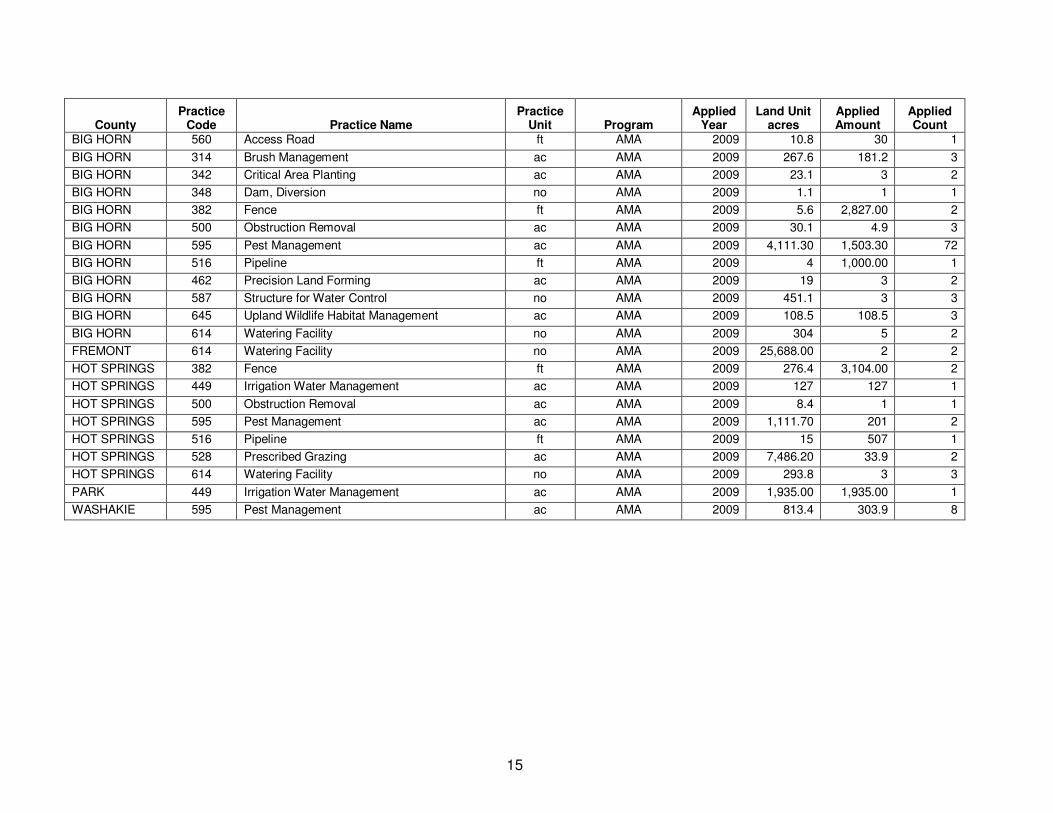
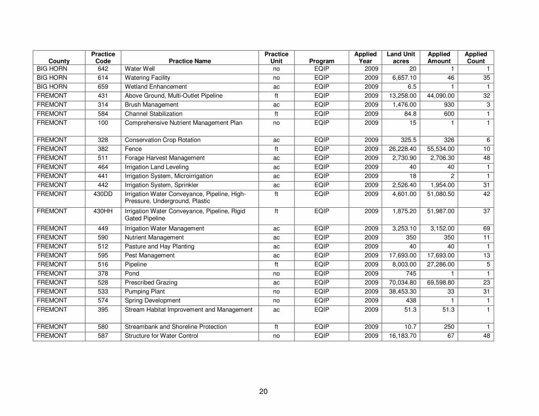
Appendix A – NRCS Program Descriptions
15
County Practice
Code Practice Name Practice
Unit Program Applied
Year Land Unit
acres Applied Amount
Applied Count
BIG HORN 560 Access Road ft AMA 2009 10.8 30 1
BIG HORN 314 Brush Management ac AMA 2009 267.6 181.2 3
BIG HORN 342 Critical Area Planting ac AMA 2009 23.1 3 2
BIG HORN 348 Dam, Diversion no AMA 2009 1.1 1 1
BIG HORN 382 Fence ft AMA 2009 5.6 2,827.00 2
BIG HORN 500 Obstruction Removal ac AMA 2009 30.1 4.9 3
BIG HORN 595 Pest Management ac AMA 2009 4,111.30 1,503.30 72
BIG HORN 516 Pipeline ft AMA 2009 4 1,000.00 1
BIG HORN 462 Precision Land Forming ac AMA 2009 19 3 2
BIG HORN 587 Structure for Water Control no AMA 2009 451.1 3 3
BIG HORN 645 Upland Wildlife Habitat Management ac AMA 2009 108.5 108.5 3
BIG HORN 614 Watering Facility no AMA 2009 304 5 2
FREMONT 614 Watering Facility no AMA 2009 25,688.00 2 2
HOT SPRINGS 382 Fence ft AMA 2009 276.4 3,104.00 2
HOT SPRINGS 449 Irrigation Water Management ac AMA 2009 127 127 1
HOT SPRINGS 500 Obstruction Removal ac AMA 2009 8.4 1 1
HOT SPRINGS 595 Pest Management ac AMA 2009 1,111.70 201 2
HOT SPRINGS 516 Pipeline ft AMA 2009 15 507 1
HOT SPRINGS 528 Prescribed Grazing ac AMA 2009 7,486.20 33.9 2
HOT SPRINGS 614 Watering Facility no AMA 2009 293.8 3 3
PARK 449 Irrigation Water Management ac AMA 2009 1,935.00 1,935.00 1
WASHAKIE 595 Pest Management ac AMA 2009 813.4 303.9 8

16
County Practice
Code Practice Name Practice
Unit Program Applied
Year Land Unit
acres Applied Amount
Applied Count
HOT SPRINGS 472 Access Control ac CRP 2009 246.1 246.1 7
HOT SPRINGS 382 Fence ft CRP 2009 496.8 32,152.80 6
HOT SPRINGS 516 Pipeline ft CRP 2009 86.7 3,635.00 2
HOT SPRINGS 533 Pumping Plant no CRP 2009 44.5 1 1
HOT SPRINGS 391 Riparian Forest Buffer ac CRP 2009 327.7 199.1 4
HOT SPRINGS 574 Spring Development no CRP 2009 66 3 3
HOT SPRINGS 612 Tree/Shrub Establishment ac CRP 2009 76 76 1
HOT SPRINGS 645 Upland Wildlife Habitat Management ac CRP 2009 38.5 25.7 3
HOT SPRINGS 614 Watering Facility no CRP 2009 86.7 3 2
HOT SPRINGS 644 Wetland Wildlife Habitat Management ac CRP 2009 171.6 92.3 4
PARK 382 Fence ft CRP 2009 92.5 2,376.00 1
PARK 595 Pest Management ac CRP 2009 4.3 4.3 1
PARK 612 Tree/Shrub Establishment ac CRP 2009 18.3 18.3 2
WASHAKIE 327 Conservation Cover ac CRP 2009 2,471.40 32.6 3
WASHAKIE 382 Fence ft CRP 2009 1,647.60 2,575.00 2
WASHAKIE 595 Pest Management ac CRP 2009 1,647.60 32.5 2
WASHAKIE 642 Water Well no CRP 2009 49 1 1
WASHAKIE 614 Watering Facility no CRP 2009 49 3 1
WASHAKIE 659 Wetland Enhancement ac CRP 2009 49 20 1

17
County Practice
Code Practice Name Practice
Unit Program Applied
Year Land Unit
acres Applied Amount
Applied Count
BIG HORN 331 Contour Orchard and Other Fruit Area ac CTA-GENRL 2009 13.2 1 1
BIG HORN 511 Forage Harvest Management ac CTA-GENRL 2009 80 80 2
BIG HORN 449 Irrigation Water Management ac CTA-GENRL 2009 20 20 1
BIG HORN 645 Upland Wildlife Habitat Management ac CTA-GENRL 2009 266.3 266.3 2
BIG HORN 659 Wetland Enhancement ac CTA-GENRL 2009 1,722.20 268.1 28
FREMONT 431 Above Ground, Multi-Outlet Pipeline ft CTA-GENRL 2009 19 1,170.00 1
FREMONT 328 Conservation Crop Rotation ac CTA-GENRL 2009 108 99 2
FREMONT 382 Fence ft CTA-GENRL 2009 44 3,097.00 1
FREMONT 511 Forage Harvest Management ac CTA-GENRL 2009 1,150.40 1,150.40 22
FREMONT 442 Irrigation System, Sprinkler ac CTA-GENRL 2009 233.9 176 5
FREMONT 430DD Irrigation Water Conveyance, Pipeline, High-Pressure, Underground, Plastic
ft CTA-GENRL 2009 245.9 5,333.50 7
FREMONT 430HH Irrigation Water Conveyance, Pipeline, Rigid Gated Pipeline
ft CTA-GENRL 2009 130 1,560.00 1
FREMONT 449 Irrigation Water Management ac CTA-GENRL 2009 1,517.70 1,415.00 17
FREMONT 516 Pipeline ft CTA-GENRL 2009 5,750.00 14,000.00 1
FREMONT 528 Prescribed Grazing ac CTA-GENRL 2009 1,845.60 1,845.60 3
FREMONT 533 Pumping Plant no CTA-GENRL 2009 121.9 3 3
FREMONT 587 Structure for Water Control no CTA-GENRL 2009 444.9 10 10
FREMONT 645 Upland Wildlife Habitat Management ac CTA-GENRL 2009 4,476.00 4,476.00 4
FREMONT 614 Watering Facility no CTA-GENRL 2009 9,194.00 5 4
FREMONT 644 Wetland Wildlife Habitat Management ac CTA-GENRL 2009 490.7 490.7 5
FREMONT 380 Windbreak/Shelterbelt Establishment ft CTA-GENRL 2009 54 1,935.00 1
HOT SPRINGS 511 Forage Harvest Management ac CTA-GENRL 2009 29.9 29.9 1
HOT SPRINGS 449 Irrigation Water Management ac CTA-GENRL 2009 14.2 14.2 1
HOT SPRINGS 528 Prescribed Grazing ac CTA-GENRL 2009 68 68 3
HOT SPRINGS 528A Prescribed Grazing ac CTA-GENRL 2009 41.8 41.8 2
HOT SPRINGS 645 Upland Wildlife Habitat Management ac CTA-GENRL 2009 3,371.90 3,352.40 6
HOT SPRINGS 614 Watering Facility no CTA-GENRL 2009 1,983.80 1 1
HOT SPRINGS 659 Wetland Enhancement ac CTA-GENRL 2009 76 11 1
HOT SPRINGS 657 Wetland Restoration ac CTA-GENRL 2009 10.7 5 1

18
County Practice
Code Practice Name Practice
Unit Program Applied
Year Land Unit
acres Applied Amount
Applied Count
HOT SPRINGS 644 Wetland Wildlife Habitat Management ac CTA-GENRL 2009 213.6 2 1
PARK 430DD Irrigation Water Conveyance, Pipeline, High-Pressure, Underground, Plastic
ft CTA-GENRL 2009 21.9 1,270.00 1
PARK 449 Irrigation Water Management ac CTA-GENRL 2009 21.9 21.9 1
PARK 528 Prescribed Grazing ac CTA-GENRL 2009 21.9 21.9 1
PARK 645 Upland Wildlife Habitat Management ac CTA-GENRL 2009 150.6 150.6 2
PARK 614 Watering Facility no CTA-GENRL 2009 658.8 1 1
PARK 644 Wetland Wildlife Habitat Management ac CTA-GENRL 2009 14.4 1.6 1
WASHAKIE 449 Irrigation Water Management ac CTA-GENRL 2009 594.3 594.3 4
WASHAKIE 659 Wetland Enhancement ac CTA-GENRL 2009 2,116.80 100.7 9
WASHAKIE 644 Wetland Wildlife Habitat Management ac CTA-GENRL 2009 371.2 348.2 4

19
County Practice
Code Practice Name Practice
Unit Program Applied
Year Land Unit
acres Applied Amount
Applied Count
BIG HORN 431 Above Ground, Multi-Outlet Pipeline ft EQIP 2009 1,145.40 29,270.00 29
BIG HORN 560 Access Road ft EQIP 2009 432.7 1,620.00 1
BIG HORN 100 Comprehensive Nutrient Management Plan no EQIP 2009 24 3 3
BIG HORN 102 Comprehensive Nutrient Management Plan - Written
no EQIP 2009 14.6 1 1
BIG HORN 328 Conservation Crop Rotation ac EQIP 2009 107.5 107.5 1
BIG HORN 342 Critical Area Planting ac EQIP 2009 219.4 5 3
BIG HORN 382 Fence ft EQIP 2009 15,397.50 52,877.60 44
BIG HORN 511 Forage Harvest Management ac EQIP 2009 838.1 838.1 27
BIG HORN 410 Grade Stabilization Structure no EQIP 2009 5.1 1 1
BIG HORN 561 Heavy Use Area Protection ac EQIP 2009 20 1 1
BIG HORN 442 Irrigation System, Sprinkler ac EQIP 2009 1,074.90 810.2 13
BIG HORN 428A Irrigation Water Conveyance, Ditch and Canal Lining, Plain Concrete
ft EQIP 2009 97.8 1,703.00 2
BIG HORN 430DD Irrigation Water Conveyance, Pipeline, High-Pressure, Underground, Plastic
ft EQIP 2009 1,762.30 35,978.00 28
BIG HORN 430HH Irrigation Water Conveyance, Pipeline, Rigid Gated Pipeline
ft EQIP 2009 808.1 12,213.00 10
BIG HORN 449 Irrigation Water Management ac EQIP 2009 7,481.90 7,476.30 157
BIG HORN 590 Nutrient Management ac EQIP 2009 171.4 171.4 2
BIG HORN 500 Obstruction Removal ac EQIP 2009 7.1 3 2
BIG HORN 595 Pest Management ac EQIP 2009 94.7 12.8 2
BIG HORN 516 Pipeline ft EQIP 2009 1,767.00 19,279.30 23
BIG HORN 378 Pond no EQIP 2009 64.5 1 1
BIG HORN 528 Prescribed Grazing ac EQIP 2009 1,601.40 1,601.40 1
BIG HORN 533 Pumping Plant no EQIP 2009 376 4 4
BIG HORN 391 Riparian Forest Buffer ac EQIP 2009 6.5 7.1 1
BIG HORN 574 Spring Development no EQIP 2009 20 1 1
BIG HORN 587 Structure for Water Control no EQIP 2009 2,031.60 20 18
BIG HORN 645 Upland Wildlife Habitat Management ac EQIP 2009 22,543.40 13,348.40 19
20
County Practice
Code Practice Name Practice
Unit Program Applied
Year Land Unit
acres Applied Amount
Applied Count
BIG HORN 642 Water Well no EQIP 2009 20 1 1
BIG HORN 614 Watering Facility no EQIP 2009 6,657.10 46 35
BIG HORN 659 Wetland Enhancement ac EQIP 2009 6.5 1 1
FREMONT 431 Above Ground, Multi-Outlet Pipeline ft EQIP 2009 13,258.00 44,090.00 32
FREMONT 314 Brush Management ac EQIP 2009 1,476.00 930 3
FREMONT 584 Channel Stabilization ft EQIP 2009 84.8 600 1
FREMONT 100 Comprehensive Nutrient Management Plan no EQIP 2009 15 1 1
FREMONT 328 Conservation Crop Rotation ac EQIP 2009 325.5 326 6
FREMONT 382 Fence ft EQIP 2009 26,228.40 55,534.00 10
FREMONT 511 Forage Harvest Management ac EQIP 2009 2,730.90 2,706.30 48
FREMONT 464 Irrigation Land Leveling ac EQIP 2009 40 40 1
FREMONT 441 Irrigation System, Microirrigation ac EQIP 2009 18 2 1
FREMONT 442 Irrigation System, Sprinkler ac EQIP 2009 2,526.40 1,954.00 31
FREMONT 430DD Irrigation Water Conveyance, Pipeline, High-Pressure, Underground, Plastic
ft EQIP 2009 4,601.00 51,080.50 42
FREMONT 430HH Irrigation Water Conveyance, Pipeline, Rigid Gated Pipeline
ft EQIP 2009 1,875.20 51,987.00 37
FREMONT 449 Irrigation Water Management ac EQIP 2009 3,253.10 3,152.00 69
FREMONT 590 Nutrient Management ac EQIP 2009 350 350 11
FREMONT 512 Pasture and Hay Planting ac EQIP 2009 40 40 1
FREMONT 595 Pest Management ac EQIP 2009 17,693.00 17,693.00 13
FREMONT 516 Pipeline ft EQIP 2009 8,003.00 27,286.00 5
FREMONT 378 Pond no EQIP 2009 745 1 1
FREMONT 528 Prescribed Grazing ac EQIP 2009 70,034.80 69,598.80 23
FREMONT 533 Pumping Plant no EQIP 2009 38,453.30 33 31
FREMONT 574 Spring Development no EQIP 2009 438 1 1
FREMONT 395 Stream Habitat Improvement and Management ac EQIP 2009 51.3 51.3 1
FREMONT 580 Streambank and Shoreline Protection ft EQIP 2009 10.7 250 1
FREMONT 587 Structure for Water Control no EQIP 2009 16,183.70 67 48

21
County Practice
Code Practice Name Practice
Unit Program Applied
Year Land Unit
acres Applied Amount
Applied Count
FREMONT 612 Tree/Shrub Establishment ac EQIP 2009 239 26.4 8
FREMONT 645 Upland Wildlife Habitat Management ac EQIP 2009 84,023.00 81,801.00 13
FREMONT 633 Waste Utilization ac EQIP 2009 15 15 1
FREMONT 642 Water Well no EQIP 2009 35,635.00 5 5
FREMONT 614 Watering Facility no EQIP 2009 75,591.00 15 15
FREMONT 644 Wetland Wildlife Habitat Management ac EQIP 2009 84.8 84.8 1
FREMONT 380 Windbreak/Shelterbelt Establishment ft EQIP 2009 54 1,650.00 1
HOT SPRINGS 431 Above Ground, Multi-Outlet Pipeline ft EQIP 2009 16.1 3,830.00 2
HOT SPRINGS 472 Access Control ac EQIP 2009 500 500 1
HOT SPRINGS 100 Comprehensive Nutrient Management Plan no EQIP 2009 16.8 2 2
HOT SPRINGS 342 Critical Area Planting ac EQIP 2009 7.6 3 1
HOT SPRINGS 382 Fence ft EQIP 2009 245.5 4,758.80 4
HOT SPRINGS 511 Forage Harvest Management ac EQIP 2009 1,215.30 350 13
HOT SPRINGS 388 Irrigation Field Ditch ft EQIP 2009 14.5 503 1
HOT SPRINGS 430DD Irrigation Water Conveyance, Pipeline, High-Pressure, Underground, Plastic
ft EQIP 2009 104.7 5,124.00 5
HOT SPRINGS 430HH Irrigation Water Conveyance, Pipeline, Rigid Gated Pipeline
ft EQIP 2009 487.8 14,348.40 11
HOT SPRINGS 449 Irrigation Water Management ac EQIP 2009 507 507 10
HOT SPRINGS 500 Obstruction Removal ac EQIP 2009 72.2 8 4
HOT SPRINGS 516 Pipeline ft EQIP 2009 25,349.20 51,446.50 8
HOT SPRINGS 378 Pond no EQIP 2009 251.9 2 2
HOT SPRINGS 528 Prescribed Grazing ac EQIP 2009 52,549.90 50,459.50 15
HOT SPRINGS 528A Prescribed Grazing ac EQIP 2009 3,103.60 3,103.60 4
HOT SPRINGS 574 Spring Development no EQIP 2009 11,441.70 5 5
HOT SPRINGS 587 Structure for Water Control no EQIP 2009 531.6 5 4
HOT SPRINGS 645 Upland Wildlife Habitat Management ac EQIP 2009 53,482.40 53,482.20 22
HOT SPRINGS 614 Watering Facility no EQIP 2009 17,856.80 13 7
HOT SPRINGS 657 Wetland Restoration ac EQIP 2009 19.1 4 1
PARK 431 Above Ground, Multi-Outlet Pipeline ft EQIP 2009 404.4 20,375.00 15

22
County Practice
Code Practice Name Practice
Unit Program Applied
Year Land Unit
acres Applied Amount
Applied Count
PARK 314 Brush Management ac EQIP 2009 410.5 64 1
PARK 100 Comprehensive Nutrient Management Plan no EQIP 2009 13.5 1 1 PARK 328 Conservation Crop Rotation ac EQIP 2009 56.3 56.3 3
PARK 342 Critical Area Planting ac EQIP 2009 14.4 0.5 1
PARK 402 Dam ac-ft EQIP 2009 14.4 8 1
PARK 382 Fence ft EQIP 2009 769 33,530.00 11
PARK 511 Forage Harvest Management ac EQIP 2009 580.8 580.8 10
PARK 430DD Irrigation Water Conveyance, Pipeline, High-Pressure, Underground, Plastic
ft EQIP 2009 353.2 8,510.00 7
PARK 430HH Irrigation Water Conveyance, Pipeline, Rigid Gated Pipeline
ft EQIP 2009 176.5 4,660.00 5
PARK 449 Irrigation Water Management ac EQIP 2009 1,282.80 1,282.80 39
PARK 466 Land Smoothing ac EQIP 2009 93.8 2 1
PARK 590 Nutrient Management ac EQIP 2009 101.5 101.5 5
PARK 500 Obstruction Removal ac EQIP 2009 13.5 1 1
PARK 512 Pasture and Hay Planting ac EQIP 2009 61.3 61.3 2
PARK 595 Pest Management ac EQIP 2009 5,243.00 5,243.00 4
PARK 516 Pipeline ft EQIP 2009 1,932.50 20,350.00 11
PARK 378 Pond no EQIP 2009 121.6 3 3
PARK 528 Prescribed Grazing ac EQIP 2009 5,842.10 5,484.00 14
PARK 528A Prescribed Grazing ac EQIP 2009 33,251.00 4,905.00 4
PARK 533 Pumping Plant no EQIP 2009 1,438.10 3 3
PARK 574 Spring Development no EQIP 2009 326.3 1 1
PARK 580 Streambank and Shoreline Protection ft EQIP 2009 14.4 220 1
PARK 587 Structure for Water Control no EQIP 2009 174.4 2 2
PARK 642 Water Well no EQIP 2009 2,845.10 2 2
PARK 614 Watering Facility no EQIP 2009 4,985.50 27 21
PARK 658 Wetland Creation ac EQIP 2009 14.4 1.6 1
WASHAKIE 560 Access Road ft EQIP 2009 21 21,700.00 1
WASHAKIE 100 Comprehensive Nutrient Management Plan no EQIP 2009 44.6 1 1

23
County Practice
Code Practice Name Practice
Unit Program Applied
Year Land Unit
acres Applied Amount
Applied Count
WASHAKIE 328 Conservation Crop Rotation ac EQIP 2009 1,292.60 1,292.60 15
WASHAKIE 382 Fence ft EQIP 2009 21 2,500.00 1
WASHAKIE 511 Forage Harvest Management ac EQIP 2009 89.5 89.5 1
WASHAKIE 442 Irrigation System, Sprinkler ac EQIP 2009 920.1 599.5 9
WASHAKIE 430DD Irrigation Water Conveyance, Pipeline, High-Pressure, Underground, Plastic
ft EQIP 2009 1,514.20 23,224.00 16
WASHAKIE 449 Irrigation Water Management ac EQIP 2009 1,815.30 1,807.90 26
WASHAKIE 590 Nutrient Management ac EQIP 2009 44 44 1
WASHAKIE 595 Pest Management ac EQIP 2009 1,295.60 1,288.20 15
WASHAKIE 516 Pipeline ft EQIP 2009 29,203.60 15,970.00 3
WASHAKIE 528 Prescribed Grazing ac EQIP 2009 3,245.00 3,245.00 5
WASHAKIE 533 Pumping Plant no EQIP 2009 865.6 8 8
WASHAKIE 329 Residue and Tillage Management, No-Till/Strip Till/Direct Seed
ac EQIP 2009 133.7 78 1
WASHAKIE 574 Spring Development no EQIP 2009 28,498.00 1 1
WASHAKIE 587 Structure for Water Control no EQIP 2009 202 6 4
WASHAKIE 645 Upland Wildlife Habitat Management ac EQIP 2009 53,768.10 53,768.10 16
WASHAKIE 642 Water Well no EQIP 2009 21 1 1
WASHAKIE 614 Watering Facility no EQIP 2009 28,609.20 3 3

24
County Practice
Code Practice Name Practice
Unit Program Applied
Year Land Unit
acres Applied Amount
Applied Count
BIG HORN 431 Above Ground, Multi-Outlet Pipeline ft EQIP-GSWC 2009 111 5,580.00 2
BIG HORN 442 Irrigation System, Sprinkler ac EQIP-GSWC 2009 359.8 318.1 3
BIG HORN 430DD Irrigation Water Conveyance, Pipeline, High-Pressure, Underground, Plastic
ft EQIP-GSWC 2009 438.3 7,724.00 5
BIG HORN 449 Irrigation Water Management ac EQIP-GSWC 2009 1,032.20 1,032.20 9
BIG HORN 533 Pumping Plant no EQIP-GSWC 2009 295.4 2 2
BIG HORN 587 Structure for Water Control no EQIP-GSWC 2009 97 2 2
FREMONT 442 Irrigation System, Sprinkler ac EQIP-GSWC 2009 180 87 2
FREMONT 430DD Irrigation Water Conveyance, Pipeline, High-Pressure, Underground, Plastic
ft EQIP-GSWC 2009 98 2,720.00 1
FREMONT 533 Pumping Plant no EQIP-GSWC 2009 180 2 2
WASHAKIE 442 Irrigation System, Sprinkler ac EQIP-GSWC 2009 60.1 60 1
WASHAKIE 430DD Irrigation Water Conveyance, Pipeline, High-Pressure, Underground, Plastic
ft EQIP-GSWC 2009 60.1 1,280.00 1
WASHAKIE 533 Pumping Plant no EQIP-GSWC 2009 60.1 1 1

25
County Practice
Code Practice Name Practice
Unit Program Applied
Year Land Unit
acres Applied Amount
Applied Count
BIG HORN 314 Brush Management ac WHIP 2009 1,595.20 706 18
BIG HORN 382 Fence ft WHIP 2009 171.6 7,067.00 3
BIG HORN 645 Upland Wildlife Habitat Management ac WHIP 2009 161.6 161.6 4
FREMONT 382 Fence ft WHIP 2009 20 1,600.00 1
FREMONT 396 Fish Passage mi WHIP 2009 1.9 226 1
FREMONT 410 Grade Stabilization Structure no WHIP 2009 3.8 108 2
PARK 314 Brush Management ac WHIP 2009 28 13 1
PARK 659 Wetland Enhancement ac WHIP 2009 28 3 1
County Practice
Code Practice Name Practice
Unit Program Applied
Year Land Unit
acres Applied Amount
Applied Count
FREMONT 382 Fence ft WRP 2009 18 3,000.00 1
FREMONT 587 Structure for Water Control no WRP 2009 18 1 1
HOT SPRINGS 472 Access Control ac WRP 2009 20.2 20.2 1
HOT SPRINGS 590 Nutrient Management ac WRP 2009 20.2 12.2 1
HOT SPRINGS 528A Prescribed Grazing ac WRP 2009 20.2 12.2 1
HOT SPRINGS 612 Tree/Shrub Establishment ac WRP 2009 20.2 5 1
HOT SPRINGS 645 Upland Wildlife Habitat Management ac WRP 2009 20.2 12.2 1

26
Appendix B – WDEQ 303(d) Listings for the Wind-Bighorn Basin

27
Basin ID 305(b) Name Class Location Miles/ acres Uses
Use Support
Cause(s) Source(s)
List Date Priority
Bighorn
WYBH100800140504_00
Shoshone River 2AB
From confluence with Big Horn Lake upstream an undetermined distance. 9.7
Recreation
Not Supporting
Fecal Coliform Unknown 2002 L
Bighorn
WYBH100800030207_01
Popo Agie River, Middle Fork 2AB
Undetermined distances upstream and downstream of City of Lander. 4
Recreation
Not Supporting E. coli Unknown 2002 L
Bighorn
WYBH100800050202_01
Ocean Lake
2ABww Ocean Lake 6075
Aquatic Life, Warm Water Fish
Not Supporting
Sediment
Irrigated Crop Production, Non-Point Source 1996 L
Bighorn
WYBH100800050404_01
Poison Creek 2AB
From Boysen Reservoir upstream an undetermined distance. 2.1
Recreation
Not Supporting E. coli Unknown 2002 L
Bighorn
WYBH100800050607_01
Muddy Creek 2AB
From Boysen Reservoir upstream to Wind River Indian Reservation 11.1
Recreation
Not Supporting E. coli Unknown 2002 L
Bighorn
WYBH100800070305_01 Owl Creek 2AB
Confluence with Bighorn River upstream an undetermined distance. 3.6
Recreation
Threatened
Fecal Coliform Unknown 2002 L
Bighorn
WYBH100800070500_01
Kirby Creek 2C
Confluence with the Bighorn River upstream to an undetermined distance above Lake 21.9
Recreation
Threatened
Fecal Coliform Unknown 2002 L
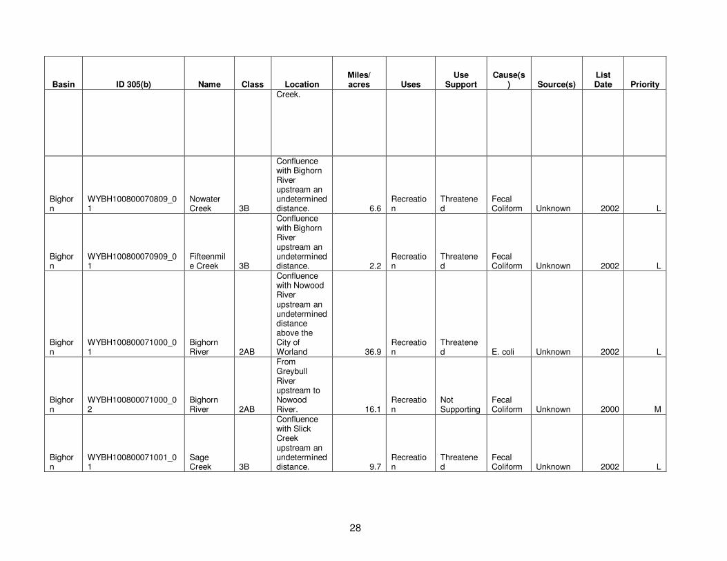
28
Basin ID 305(b) Name Class Location Miles/ acres Uses
Use Support
Cause(s) Source(s)
List Date Priority
Creek.
Bighorn
WYBH100800070809_01
Nowater Creek 3B
Confluence with Bighorn River upstream an undetermined distance. 6.6
Recreation
Threatened
Fecal Coliform Unknown 2002 L
Bighorn
WYBH100800070909_01
Fifteenmile Creek 3B
Confluence with Bighorn River upstream an undetermined distance. 2.2
Recreation
Threatened
Fecal Coliform Unknown 2002 L
Bighorn
WYBH100800071000_01
Bighorn River 2AB
Confluence with Nowood River upstream an undetermined distance above the City of Worland 36.9
Recreation
Threatened E. coli Unknown 2002 L
Bighorn
WYBH100800071000_02
Bighorn River 2AB
From Greybull River upstream to Nowood River. 16.1
Recreation
Not Supporting
Fecal Coliform Unknown 2000 M
Bighorn
WYBH100800071001_01
Sage Creek 3B
Confluence with Slick Creek upstream an undetermined distance. 9.7
Recreation
Threatened
Fecal Coliform Unknown 2002 L
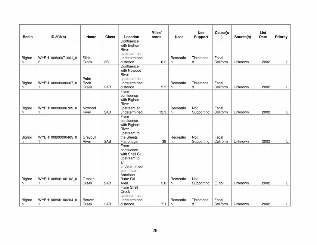
29
Basin ID 305(b) Name Class Location Miles/ acres Uses
Use Support
Cause(s) Source(s)
List Date Priority
Bighorn
WYBH100800071001_02
Slick Creek 3B
Confluence with Bighorn River upstream an undetermined distance 6.2
Recreation
Threatened
Fecal Coliform Unknown 2002 L
Bighorn
WYBH100800080607_01
Paint Rock Creek 2AB
Confluence with Nowood River upstream an undetermined distance. 5.2
Recreation
Threatened
Fecal Coliform Unknown 2002 L
Bighorn
WYBH100800080705_01
Nowood River 2AB
From confluence with Bighorn River upstream an undetermined 12.3
Recreation
Not Supporting
Fecal Coliform Unknown 2002 L
Bighorn
WYBH100800090405_01
Greybull River 2AB
From confluence with Bighorn River upstream to the Sheets Flat bridge. 38
Recreation
Not Supporting
Fecal Coliform Unknown 2002 L
Bighorn
WYBH100800100102_01
Granite Creek 2AB
From confluence with Shell Ck upstream to an undetermined point near Antelope Butte Ski Area. 5.8
Recreation
Not Supporting E. coli Unknown 2002 L
Bighorn
WYBH100800100204_01
Beaver Creek 2AB
From Shell Creek upstream an undetermined distance. 7.1
Recreation
Threatened
Fecal Coliform Unknown 2002 L

30
Basin ID 305(b) Name Class Location Miles/ acres Uses
Use Support
Cause(s) Source(s)
List Date Priority
Bighorn
WYBH100800100206_01
Shell Creek 2AB
From confluence with Bighorn River upstream an undetermined distance. 5.6
Recreation
Not Supporting
Fecal Coliform Unknown 2002 L
Bighorn
WYBH100800100301_01
Bighorn River 2AB
From Greybull River downstream an undetermined distance above Big Horn Lake. 10.5
Recreation
Not Supporting
Fecal Coliform Unknown 2002 L
Bighorn
WYBH100800110204_01 Dry Creek
2ABww
From Bighorn River upstream an undetermined distance. 4.4
Recreation
Threatened
Fecal Coliform Unknown 2002 L
Bighorn
WYBH100800140107_01 Dry Gulch 3B
From confluence with Shoshone River upstream an undetermined distance. 6.6
Recreation
Not Supporting E. coli Unknown 2008 L
Bighorn
WYBH100800140206_01
Bitter Creek 2AB
From Shoshone River upstream an undetermined distance above Powell. 13.9
Recreation
Not Supporting
Fecal Coliform Unknown 2000 M
Bighorn
WYBH100800140303_01
Whistle Creek 3B
From confluence with Shoshone River upstream an undetermined 8.7
Recreation
Not Supporting
Fecal Coliform Unknown 2002 L
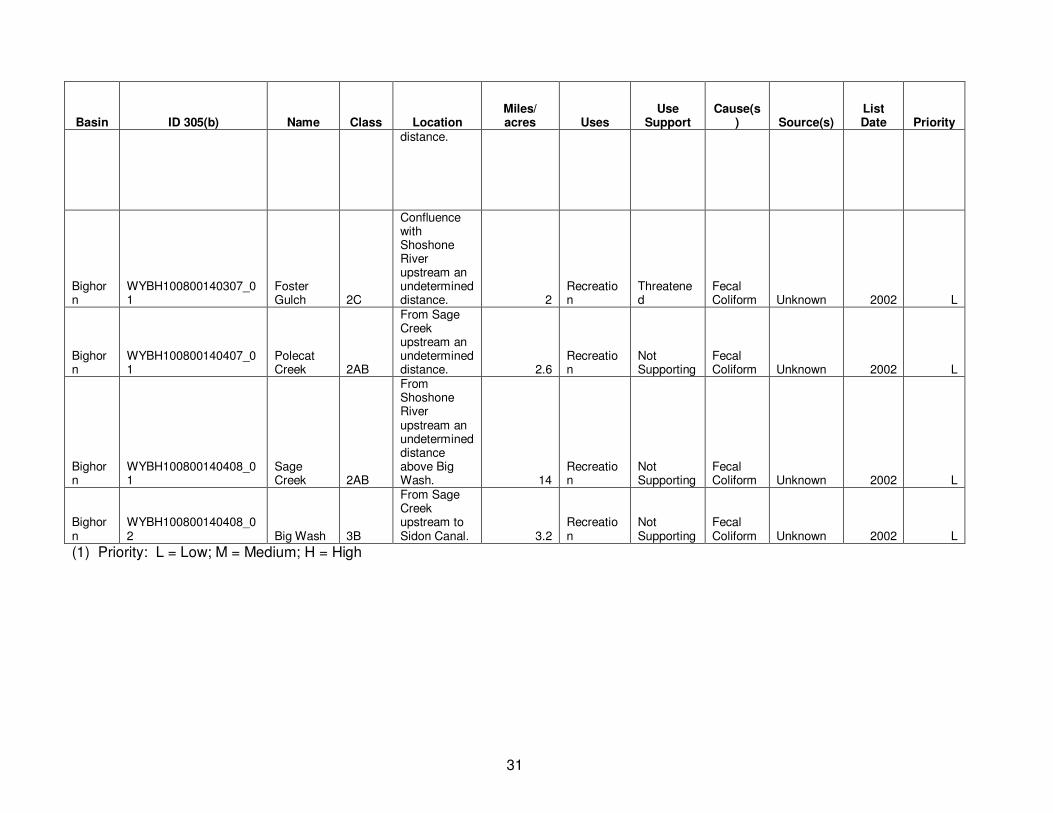
31
Basin ID 305(b) Name Class Location Miles/ acres Uses
Use Support
Cause(s) Source(s)
List Date Priority
distance.
Bighorn
WYBH100800140307_01
Foster Gulch 2C
Confluence with Shoshone River upstream an undetermined distance. 2
Recreation
Threatened
Fecal Coliform Unknown 2002 L
Bighorn
WYBH100800140407_01
Polecat Creek 2AB
From Sage Creek upstream an undetermined distance. 2.6
Recreation
Not Supporting
Fecal Coliform Unknown 2002 L
Bighorn
WYBH100800140408_01
Sage Creek 2AB
From Shoshone River upstream an undetermined distance above Big Wash. 14
Recreation
Not Supporting
Fecal Coliform Unknown 2002 L
Bighorn
WYBH100800140408_02 Big Wash 3B
From Sage Creek upstream to Sidon Canal. 3.2
Recreation
Not Supporting
Fecal Coliform Unknown 2002 L
(1) Priority: L = Low; M = Medium; H = High