tolko industries ltd. southern interior forest stewardship
TRANSCRIPT

Tolko Industries Ltd.
Southern Interior
Forest Stewardship Plan
Thompson/Okanagan Forest Region
Thompson Rivers Forest District – Kamloops TSA
Cascades Forest District – Merritt TSA
Okanagan-Shuswap Forest District – Okanagan TSA & TFL 49
Selkirk Natural Resource District – Arrow TSA
FSP Term: 5 Years (commencing 2019)
FSP ID# 684

ii
Preamble to FSP Tolko Southern Interior Woodlands has prepared this Forest Stewardship Plan (FSP) for operations within the Thompson Rivers, Cascades, Okanagan-Shuswap and Selkirk Natural Resource Districts.
The FSP defines Forest Development Units (FDU’s) within which timber harvesting and road construction activities may occur during the 5-year term of the plan. These activities must be conducted consistent with the results, strategies, measures and standards specified in the FSP, which in turn must be consistent with the objectives set by government for the resource values found within the FDU’s of the FSP.
This FSP is structured to include the following components:
- Administration and Interpretation (Part 1) provides definitions of terms used in the FSP; links to specific legislation; the overall organization of the FSP; provisions for cancellation and exemption; and authorities from government.
- Term (Part 2) provides details on the date the FSP was submitted to government for approval; the specified term of the FSP; and the commencement date of the FSP.
- Application of the FSP (Part 3) specifies what the FSP applies to, including which Licences and agreement holders and provides for dis-application of a licence or agreement holder from the FSP.
- Forest Development Units (Part 4) outlines five FDU’s applicable to the FSP, specifies which licences and agreement holders will operate within each FDU, and provides an FDU Overview Map.
- Results or Strategies (Part 5) specifies results or strategies consistent to the extent practicable with each applicable objective set by government. Each objective is summarized and sourced. In some instances, such as the objective for Soils, there exists a default practice requirement that has been adopted as the result or strategy for the FSP; in other instances, this plan either replaces the default or in situations in which there is no such default it proposes a result or strategy designed to be consistent with governments established objective. Sources of objectives addressed by the plan include:
• objectives prescribed under FRPA 149 (1); • objectives established under FPC and continued under FRPA 181 for Specified
Designations designated under FPC and continued under FRPA 180; • objectives established under section 93.4 of the Land Act, • objectives established under FPC section 3-5, and continued under Land Act section
93.8 as an objective established under Land Act section 93.4; and • objectives established through the Government Actions Regulation.
- Measures (Part 6), specifies measures for invasive plants and natural range barriers as required by FPPR sections 17 and 18.
- Stocking Standards (Part 7) provides background information on the requirements for stocking standards; the election of stocking standards generally for each cutblock and any specified variations from the stocking standards.

iii
- Signatures (Part 8), includes the signatures of the Preparing Forester, the person required to prepare the plan.
- Appendices include Stocking Standards (Appendix A); Objectives for Interpretive Forest Sites, Recreation Sites or Recreation Trails continued under FPPR section 181 (Appendix B); Fly Hills Marten RMZ Sub-units (Appendix C); FSP Maps (Appendix D); and FSP Notice, Review and Comment (Appendix E).

iv
Table of Contents
1 ADMINISTRATION AND INTERPRETATION ...................................................................................... 1
1.1 Definitions ...................................................................................................................................... 1 1.2 Relevant Date for Legislation and Objective References ............................................................. 4 1.3 Definition from Legislation ............................................................................................................. 4 1.4 Changes to Legislation .................................................................................................................. 4 1.5 Expressions Inclusive .................................................................................................................... 4 1.6 Organization .................................................................................................................................. 4 1.7 Headings and Preamble ................................................................................................................ 5 1.8 Appendices Part of FSP ................................................................................................................ 5 1.9 Application of Results and Strategies ........................................................................................... 5 1.10 Conditional Exemptions under FPPR section 12 .......................................................................... 5
2 TERM .................................................................................................................................................... 6
2.1 Date of Submission ....................................................................................................................... 6 2.2 Term .............................................................................................................................................. 6 2.3 Commencement of Term .............................................................................................................. 6
3 APPLICATION....................................................................................................................................... 6
3.1 Application to Agreements and Holders of Agreements ............................................................... 6 3.2 Dis-application of FSP ................................................................................................................... 7 3.3 Cutblocks or Roads Approved under a Previous FSP .................................................................. 7
4 FOREST DEVELOPMENT UNITS........................................................................................................ 8
4.1 Forest Development Units ............................................................................................................. 8 4.2 FDU Overview Map ....................................................................................................................... 9 4.3 Identifying Required Values within Forest Development Units ................................................... 10
5 RESULTS AND STRATEGIES ........................................................................................................... 11
5.1 Timber ......................................................................................................................................... 11 5.2 Soils ............................................................................................................................................. 11 5.3 Wildlife - FPPR section 7(1) Species at Risk and KHLPO Wildlife Objectives ........................... 12 5.4 Wildlife - OSLRMP LUO Wildlife Objectives ............................................................................... 26 5.5 Water, Fish, Wildlife and Biodiversity within Riparian Areas ...................................................... 33 5.6 Retention of Trees in a Riparian Management Zone .................................................................. 34 5.7 OSLRMP LUO Enhanced Riparian Management Zone Retention ............................................. 36 5.8 OSLRMP LUO Enhanced Riparian Reserves ............................................................................. 37 5.9 KHLPO Riparian Management Areas and Inland Fisheries ....................................................... 37 5.10 KHLPO Water Management ....................................................................................................... 38 5.11 KBHLPO Consumptive Use of Streams ...................................................................................... 39 5.12 Fisheries Sensitive Watersheds .................................................................................................. 40 5.13 Water in Community Watersheds ............................................................................................... 41 5.14 Wildlife and Biodiversity – Landscape Level ............................................................................... 42 5.15 Wildlife and Biodiversity – Stand Level ....................................................................................... 44 5.16 Old Growth Management ............................................................................................................ 46

v
5.17 OSLRMP LUO Basic Levels of Coarse Woody Debris Areas .................................................... 50 5.18 OSLRMP LUO Basic and Enhanced Levels of Coarse Woody Debris Areas ............................ 51 5.19 Visual Quality .............................................................................................................................. 52 5.20 Cultural Heritage Resources ....................................................................................................... 56 5.21 KHLPO Archaeological Assessments ......................................................................................... 58 5.22 Interpretive Forest Sites, Recreation Sites or Recreation Trails ................................................. 59 5.23 KHLPO Recreation and Tourism Zones ..................................................................................... 60 5.24 KHLPO Remote Recreation and Tourism Zones ........................................................................ 60 5.25 OSLRMP LUO Intensive Recreation Areas ................................................................................ 61 5.26 OSLRMP LUO Regionally Significant Trail Corridors ................................................................. 62 5.27 KHLPO Settlement Resource Management Zones .................................................................... 64 5.28 OSLRMP LUO Community/Crown Interface ............................................................................... 64 5.29 KHLPO Range............................................................................................................................. 65
6 Measures ............................................................................................................................................. 67
6.1 Invasive Plants ............................................................................................................................ 67 6.2 Natural Range Barriers ............................................................................................................... 70
7 Stocking Standards ............................................................................................................................. 72
7.1 Establishment of Free Growing Stands ...................................................................................... 72 7.2 Definitions .................................................................................................................................... 72 7.3 Stocking Standards FDU #1-Kamloops, FDU #2-Merritt ............................................................ 73 7.4 Stocking Standards FDU #3-Okanagan, FDU #4-TFL 49, FDU #5-Arrow ................................. 78
8 Signatures ........................................................................................................................................... 80
8.1 Signature of Preparing Forester .................................................................................................. 80 8.2 Signature of Person Required to Prepare the Plan..................................................................... 80
APPENDICES ............................................................................................................................................. 81
Appendix A – Stocking Standards .......................................................................................................... 81 Appendix B – Legal Objectives for Interpretive Forest Sites, Recreation Sites or Recreation Trails ... 116 Appendix C – Fly Hills Marten RMZ Sub-Units Map ............................................................................. 136 Appendix D – Forest Stewardship Plan Maps by FDU ......................................................................... 137 Appendix E – Notice, Review and Comment ........................................................................................ 138

1
1 ADMINISTRATION AND INTERPRETATION
1.1 Definitions Definitions appearing in the body of this FSP are presented in italics for ease of recognition.
In this FSP, unless this FSP specifies, or the context requires otherwise:
1. “Act” means the Forest and Range Practices Act RSBC 2002, c.69; 2. “adjacent” as defined in FPPR 65(1) means “an area that is sufficiently close to a cutblock that,
due to its location, could directly impact on, or be impacted by, a forest practice carried out within the cutblock”;
3. “administrative boundary” means features including but not limited to private property lines, area-based tenure boundaries, protected area boundaries, or boundaries associated with the buffer of an inventory permanent sample plot that may influence primary forest activities;
4. “agreement” means an agreement listed in Paragraph 3.1, unless this FSP no longer applies to that agreement;
5. “agreement holder” is defined in FPPR section 1 and “means a holder of an agreement under the Forest Act, other than a woodlot licence” and for the purpose of this FSP, applies to the agreement holders listed in Paragraph 3.1, or any successor or assignee of that agreement, unless this FSP no longer applies to that agreement holder;
6. “applicable SAR notice” means (i) a notice issued under FPPR section 7(2) entitled:
a) “NOTICE – INDICATORS OF THE AMOUNT, DISTRIBUTION AND ATTRIBUTES OF WILDLIFE HABITAT REQUIRED FOR THE SURVIVAL OF SPECIES AT RISK IN THE ARROW BOUNDARY FOREST DISTRICT” dated December 30, 2004;
b) “NOTICE –INDICATORS OF THE AMOUNT, DISTRIBUTION AND ATTRIBUTES OF WILDLIFE HABITAT REQUIRED FOR THE SURVIVAL OF SPECIES AT RISK IN THE OKANAGAN SHUSWAP FOREST DISTRICT” dated December 30, 2004;
c) “NOTICE – INDICATORS OF THE AMOUNT, DISTRIBUTION AND ATTRIBUTES OF WILDLIFE HABITAT REQUIRED FOR THE SURVIVAL OF SPECIES AT RISK IN THE CASCADES FOREST DISTRICT” dated December 30, 2004;
d) “NOTICE – INDICATORS OF THE AMOUNT, DISTRIBUTION AND ATTRIBUTES OF WILDLIFE HABITAT REQUIRED FOR THE SURVIVAL OF SPECIES AT RISK IN THE HEADWATERS FOREST DISTRICT” dated December 30, 2004; or
(ii) The undated document entitled “BACKGROUND INFORMATION FOR WILDLIFE HABITAT FOR SPECIES AT RISK OBJECTIVES UNDER THE KAMLOOPS LAND AND RESOURCE MANAGEMENT PLAN, IN THE KAMLOOPS FOREST DISTRICT”.
7. “BEC” means Biogeoclimatic Ecosystem Classification; 8. “CP” means a Cutting Permit; 9. “current” means, in the context of a FSP, timber sale licence, CP or RP, an approved document
that has not expired or been replaced; 10. “cutblock” means an area:
(i) in which a holder of a Licence has harvested timber under a CP or timber sale licence; or (ii) in which a holder of a Licence is authorized to harvest timber but where harvesting has
not occurred;

2
11. “dbh” means diameter breast height, a standard method of expressing the diameter of the bole of a tree, generally measured at a height 1.3 metres above the point of germination.
12. “established cutblock” means a cutblock that has been: (i) harvested under a licence to which this FSP applies; (ii) declared under this FSP; (iii) included within a current CP issued under a licence to which this FSP applies, whether
the CP is or is not subject to this FSP; or (iv) identified spatially in the BC Geographic Warehouse as a cutblock:
a) harvested under a timber sale licence or major licence to which this FSP does not apply; or
b) included in a timber sale licence or current CP issued under a major licence to which this FSP does not apply.
13. “established road” means a road that has been: (i) constructed under a CP or RP issued under or associated with a licence to which this
FSP applies; (ii) declared under this FSP; (iii) included within a current CP or RP issued under or associated with a licence to which this
FSP applies, whether the CP or RP is or is not subject to this FSP; (iv) identified spatially in the BC Geographic Warehouse as a road:
a) constructed by a person other than a holder of this FSP; or b) included within a CP or RP issued in respect of a Licence to which this FSP does not
apply. 14. “FDU” means a Forest Development Unit; 15. “Forest Act” means the Forest Act R.S.B.C. 1996, c.157; 16. “forested area” means an area of crown forest identified in the VRI as contributing to the forest
management land base, as indicated by the Forest Management Land base Indicator attribute. This attribute indicates whether a polygon is forested or has been forested and is capable of producing a stand of trees. Polygons classified as lakes, rock, alpine, shrub and wetland are not considered forested area.
17. “FPC” means the Forest Practices Code of British Columbia Act R.S.B.C. 1996, c. 159 and all regulations there under;
18. “FPPR” means the Forest Planning and Practices Regulation B.C. Reg. 14/2004; 19. “FRPA” means the “Act” and the regulations there under; 20. “FSP” means a Forest Stewardship Plan; 21. “FSP holder” or “holder” means the agreement holders listed in Paragraph 3.1, or any
successor or assignee of that agreement, unless this FSP no longer applies to that agreement holder;
22. “GAR” means the Government Actions Regulation B.C. Reg. 582/2004; 23. “government” means the government of British Columbia; 24. “height” means the average height of a specified forested area, as confirmed by VRI data or a
survey that is available to or completed by the FSP holder. 25. “initial silviculture activities” means, for the following activities on a cutblock, the activity that is
completed last: (i) site preparation; (ii) debris pile burning; or (iii) initial reforestation, including tree planting or direct seeding.
26. “KBHLPO” means the Kootenay Boundary Higher Level Plan Order, established pursuant to FPC sections 3(1), 3(2), and 9.1, objectives of which are continued under section 93.8 of the Land Act as objectives established by the minister under section 93.4 of the Land Act, and effective October 26, 2002;

3
27. “KHLPO” means the Kamloops Higher Level Plan Order, established pursuant to section 93.4 of the Land Act, and dated Jan 8, 2009;
28. “KLRMP” means the Kamloops Land and Resource Management Plan; 29. “legislated planning date” means:
(i) subject to Clause (ii), the date 4 months before the September 13, 2017 date of submission; or
(ii) if an enactment or an objective set by government requires that a date different than the date referred to in Clause (i) be applied under this FSP, then that different date;
30. “licence” means an agreement under the Forest Act; 31. “major licence” has the meaning given to it under the Forest Act; 32. “minister” means the minister responsible for the Forest Act; 33. “net area to reforest” or “NAR” has the meaning given to it in FPPR section 1 (2); 34. “OGMA” means an Old Growth Management Area as defined in Paragraphs 5.16.1.1, 5.16.3.1,
and 5.16.4.1; 35. “OSLRMP” means the Okanagan-Shuswap Land and Resource Management Plan; 36. “OSLRMP LUO” or “LUO” means the “PROVINCE OF BRITISH COLUMBIA, ORDER OF THE
MINISTER OF AGRICULTURE AND LANDS ESTABLISHING OBJECTIVES SET BY GOVERNMENT IN THE AREA COVERED BY THE OKANAGAN-SHUSWAP LAND AND RESOURCE MANAGEMENT PLAN IN THE OKANAGAN SHUSWAP FOREST DISTRICT”, established pursuant to section 93.4 of the Land Act, and effective March 1, 2007;
37. “practicable” means that which is feasible or performable in the circumstances, when the balance of all relevant factors (such as environment, social, economic, safety, usefulness) is considered;
38. “primary forest activity” has the meaning given to it in FPPR section 1, and “means one or more of the following:
(i) timber harvesting; (ii) silviculture treatments; or (iii) road construction, maintenance and deactivation”;
39. “proposed wildlife habitat area” means an area that is: (i) located outside of an established cutblock or established road; and (ii) identified by the ministry responsible for environment in a review and comment referral
package provided to the FSP holder not less than 12 months prior to a cutting authority application or amendment over that area, as being under consideration for establishment as a wildlife habitat area;
40. “qualified professional” means a registered member in good standing with a professional association whose training, ability and experience makes the member professionally competent in the relevant area of practice;
41. “range agreement” means a grazing tenure held by a range agreement holder and issued under the Range Act or Land Act. Spatial and attribute data for range agreements are housed in the BC Geographic Warehouse.
42. “road” has the meaning given to it in FPPR section1; 43. “RP” means a road permit; 44. “safety hazard” means a situation or circumstance the holder determines to be a potential
source of harm to workers based on WorkSafe BC regulations and policies, or the general public. Safety hazards include but are not limited to danger trees (snags), inadequate visibility, falling objects, steep slopes, or unstable terrain;
45. “scenic area” has the meaning given to it under FPPR section 1; 46. “THLB” means Timber Harvesting Land Base as defined in the Timber Supply Review document
for the Timber Supply Areas applicable to this FSP; 47. “timeline” means, in regards to a FSP result or strategy referral provided by the FSP holder to a
First Nation or stakeholder, the length of time specified in the referral that provides a reasonable opportunity for review and response. A referral response must be received by the FSP holder within the timeline specified in the referral in order to be considered as part of the result or strategy. The timeline will be:
(i) 60 days for First Nations; (ii) 30 days for stakeholders; or

4
(iii) another length of time where agreed to with a First Nation or stakeholder, or as indicated in a notice published in a newspaper.
48. “TSA” means a timber supply area; 49. “VRI” means Vegetation Resource Inventory, the photo-based inventory data of the BC
provincial forest which is housed in the BC Geographic Warehouse. The VRI data that is relevant to specific FSP results or strategies is the version of VRI that is available not less than 18 months prior to cutting authority application or amendment;
50. “wildlife habitat area” or “WHA” as defined in FPPR section1 “means a wildlife habitat area (i) continued under section 180 (b) [grandparenting specified designations] of the Act, or (ii) established under the Government Actions Regulation”.
1.2 Relevant Date for Legislation and Objective References In this FSP, unless this FSP specifies otherwise, reference to:
a) legislation; b) an established objective; c) a notice under FPPR section 7(2): d) the designation of a species to which such a notice or established objective applies; e) the establishment of an area referred to in FPPR section 14(3)(a) to (i); or f) an order made by government
means that legislation, established objective, notice, designation, area or order as it existed on the legislated planning date, unless it is repealed or cancelled, in which case the reference to that legislation, notice, designation, objective or order does not apply.
1.3 Definition from Legislation In this FSP, unless this FSP specifies, or the context requires otherwise, words and phrases defined in FRPA or the Forest Act and the regulations under them have the same meaning as those definitions, as they were on the Legislative Planning Date.
1.4 Changes to Legislation Subject to Paragraph 1.2, if legislation referred to in this FSP is renamed or a provision of legislation referred to in this FSP is renumbered, the reference in this FSP is to be construed as a reference to the provision as renamed or renumbered, as the case may be.
1.5 Expressions Inclusive In this FSP, unless this FSP specifies, or the context requires otherwise:
a) the singular includes the plural and the plural includes the singular; and b) the masculine, the feminine and the neuter are interchangeable and each includes the body
corporate.
1.6 Organization This FSP is divided into parts, paragraphs, subparagraphs, clauses, sub-clauses and sections, illustrated as follows:

5
1. Part; 1.1 Paragraph; (a) Subparagraph; (i) Clause; (A) Sub-clause; (I) Section, and a reference to a subparagraph, clause, sub-clause or section is to be construed as a reference to a subparagraph, clause, sub-clause or section of the paragraph, subparagraph, clause or sub-clause, as the case may be, in which the reference occurs.
1.7 Headings and Preamble The headings and Preamble in this FSP are for ease of reference only and are not to be construed as part of this FSP.
1.8 Appendices Part of FSP The Appendices to this FSP are a part of this FSP and any reference in this FSP to this FSP includes a reference to the Appendices.
1.9 Application of Results and Strategies Each result and strategy in this FSP applies to an area that is subject to a CP or RP held by an agreement holder. Notwithstanding the foregoing, in a proceeding in respect of an alleged failure to achieve a result or carry out a strategy, the result or strategy applies only to the agreement holder whose CP or RP is located in the area subject to the proceeding.
1.10 Conditional Exemptions under FPPR section 12 The FSP holder is exempt from the FPPR practice requirement sections specified in Table 1.10 by including an applicable result or strategy in this approved FSP:
Table 1.10 Conditional Exemptions Paragraph in this FSP
FPPR section providing Exemption
FPPR Practice Requirement section to which the Exemption Applies
5.2.1 12.2(1) 35 (adopted in strategy) 5.5.1 12.2(2) 36 (adopted in strategy) 5.5.1 12.3(1) 47(4) to (6) (adopted in strategy) 5.5.1 12.3(2) 48(3) to (5) (adopted in strategy) 5.5.1 12.3(3) 49 (2) (replaced by strategy) 5.5.1 12.3(3) 49(3) (adopted in strategy) 5.5.1 12.3(4) 50(1) (adopted in strategy) 5.5.1 12.3(5) 51(1) and (3) (adopted in strategy) 5.5.1 12.3(6) 52(2) (adopted in strategy) 5.5.1 12.3(7) 53 (adopted in strategy) 5.12.2 12.31(1) 55 (adopted in strategy)

6
5.12.2 12.31(2) 56 (adopted in strategy) 5.12.2 12.31(3) 57 (adopted in strategy) 5.13.2 12.32(1) 59 (adopted in strategy) 5.13.2 12.32(2) 60(2) (adopted in strategy) 5.13.2 12.32(3) 61 (adopted in strategy) 5.14.2 12.4(1) 64(1) (adopted in strategy) 5.14.2 12.4(2) 65(2) (replaced by strategy) 5.15.2 12.5 (1) 66 (replaced by strategy) 5.15.3 12.5 (2) 67 (replaced by strategy)
2 TERM
2.1 Date of Submission The date of submission of this FSP for approval is September 13, 2017.
2.2 Term For the purposes of section 6(1) (a) of the Act, the term of this FSP is 5 years, commencing on the date specified in Paragraph 2.3 unless:
a) the holders of this FSP elect to replace it with another approved FSP; or b) it is extended pursuant to FRPA.
2.3 Commencement of Term For the purposes of section 6(1) (b) of the Act, the term of this FSP commences on the date of approval by the Delegated Decision Maker (DDM), or another date as specified by the DDM.
3 APPLICATION
3.1 Application to Agreements and Holders of Agreements For the purposes of FRPA section 3(4), this FSP applies to each cutting permit issued and each road permit granted:
a) on or after the date the term of this FSP commences, as specified in Paragraph 2.3; b) within an FDU; and c) in respect of the agreements under the Forest Act and the agreement holders specified in Table
3.1.

7
Table 3.1 FSP Agreement Holders and Agreements
FDU Number FDU Name TSA/TFL Agreement Holder Forest Act Agreement
1 Kamloops Kamloops Tolko Industries Ltd. FLs A18686, A84658 1 Kamloops Kamloops Ashcroft Indian Band RFL A89985
1 Kamloops Kamloops Skeetchestn Indian Band RFL A89992 NRFLs A88945, A91367
1 Kamloops Kamloops Gilbert Smith Forest Products Ltd. FLs A18692, A89106
1 Kamloops Kamloops Neskonlith Indian Band RFL A89989 1 Kamloops Kamloops West Fraser FL A18694
1 Kamloops Kamloops Tk’emlupsemc Forestry Development Corp NRFL A73555, RFL A89987
2 Merritt Merritt Tolko Industries Ltd. FLs A18696, A18697, A74911 2 Merritt Merritt Upper Nicola Band FL A84497
3 Okanagan Okanagan Tolko Industries Ltd. FLs A18667, A18672,
A74912, TL T0816 3 Okanagan Okanagan Stella-Jones Inc. FLs A18632, A18666 3 Okanagan Okanagan Gorman Bros. Lumber Ltd. FL A18671
3 Okanagan Okanagan Yucwmenlucwu (“Caretakers
of the Land”) LLP RFL A89359 3 Okanagan Okanagan Monashee Community Forest K2X 3 Okanagan Okanagan Okanagan Indian Band FL A91117 4 TFL 49 TFL 49 Tolko Industries Ltd. TFL 49 5 Arrow Arrow Tolko Industries Ltd. FL A20191
5 Arrow Arrow Yucwmenlucwu (“Caretakers
of the Land”) LLP FL A73614
3.2 Dis-application of FSP At any time during the term of this FSP, an agreement holder may elect to dis-apply this FSP from an agreement it holds, as specified in Paragraph 3.1.
3.3 Cutblocks or Roads Approved under a Previous FSP Consistent with FRPA section 21(2), cutblocks or roads approved under a previous FSP or FDP will be subject to this FSP for a result or strategy under Part 5, a measure under Part 6 or a stocking standard under Part 7 if an amendment to the cutblock or road site plan states that the application of the current FSP provision applies.

8
4 FOREST DEVELOPMENT UNITS
4.1 Forest Development Units For the purposes of the FRPA section 5(1)(a)(ii) and FPPR section 14(1)(a), the FDUs that apply to agreement holders and agreements specified in Paragraph 3.1 are indicated in Table 4.1 and shown on the Forest Stewardship Plan Maps in Appendix D to this FSP. An overview map is shown in section 4.2 for illustrative purposes. This FSP is not applicable to area based tenures that are located within the identified FDU’s. Due to map scale limitations these area based tenures have not been mapped out, with the exception of Tree Farm Licences.
Table 4.1 Forest Development Units
FDU Number FDU Name Description
1 Kamloops Kamloops TSA, excluding KLRMP Battle Bluffs Habitat Resource Management Zone H10
2 Merritt Merritt TSA
3 Okanagan Okanagan TSA and Monashee Community Forest
4 TFL 49 TFL 49 Area
5 Arrow Portions of the Arrow TSA as indicated on the FSP maps in Appendix D

9
4.2 FDU Overview Map

10
4.3 Identifying Required Values within Forest Development Units For the purposes of FPPR sections 14(2) and (3), Table 4.2.1 and the Forest Stewardship Plan Maps in Appendix D to this FSP identify the things referred to in those sections that are in the FDUs and in effect as of the legislated planning date. These items include: ungulate winter range, wildlife habitat area, fisheries sensitive watershed, scenic area, community watershed, old growth management area, area in which commercial harvesting is prohibited by another enactment, and cutting permits and road permits that are held by the agreement holder if that is the person required to prepare the plan.
Table 4.2.1 Cutting Permits and Road Permits held by the agreement holder that is the person required to prepare the plan, and are in effect as of the legislated planning date FDU # Licence Cutting Permit/Road Permit
1 FL A18686
CP’s 252, 257, 258, 259, 260, 261, 363, 369, 373, 377, 378, 379, 382, 386, 393, 394, 398, 400, 401, 403. (timbermark prefix ES4) RP R13467
1 FL A84658 CP’s 112, 115, 116, 255, 390, 402, 994, 15K. (timbermark prefix DG2) RP R17009
2 FL A18696 CP’s 636, 811 (timbermark prefix EU5) RP R07748
2 FL A18697
CP’s 217, 229, 267, 289, 293, 295, 296, 346, 349, 350, 351, 456, 459, 544, 557, 558, 560, 566, 567, 568, 569, 570, 571, 572, 574, 630, 635, 637, 638, 740, 751, 752, 753, 764. (timbermark prefix EU6) RP R07753
2 FL A74911
CP’s 203, 204, 211, 214, 215, 265, 268, 290, 294, 298, 299, 352, 451, 454, 458, 551, 554, 559, 563, 573, 634, 639, 640, 641, 728, 744, 746, 748, 754, 812, 813, 814, 815. (timbermark prefix BJ5) RP R14883
3 FL A18667
CP’s 243, 247, 253, 361, 377, 400, 463, 467, 470, 473, 496, 497, 501, 533, 538, 539, 542, 545, 547, 548, 573, 577, 679, 689, 701, 702, 785, 806, 817, 930, 939, 982, 984, 988, 989. (timbermark prefix ER4) RP R07604
3 FL A18672
CP’s 101, 102, 104, 105, 106, 108, 109, 205, 313, 340, 348, 352, 361, 398, 412, 419, 420, 430, 445, 450, 454, 455, 458, 459, 460, 464, 466, 467, 468, 469, 470, 471, 473, 476, 479, 481, 484, 485, 487, 488, 489, 490, 492, 493, 494, 495, 496, 497, 498, 533, 534, 535, 536, 537, 538, 540, 543, 544, 546, 547, 549, 551, 553, 554, 555, 558, 559, 563, 564, 565, 566, 567, 568, 569, 607, 631, 632, 648, 653, 655, 656, 657, 658, 659, 660, 661, 662, 663, 664, 665, 667, 668, 670, 748, 781, 812, 813, 850, 912, 914, 915. (timbermark prefix ER9) RP R07605
3 FL A74912
CP’s 303, 328, 343, 388, 389, 532, 541, 589, 603, 604, 802, 919, 921, 922, 923, 924, 926, 927, 928, 929, 930, 931, 932, 933, 935, 936, 937, 938, 939, 940, 941, 942, 943, 945, 946, 947, 948, N66, N72, N76, N78, N86, N87, N90, N91, N94, N95, N96. (timbermark prefix BJ6) RP R14669
3 TL T0816
CP’s AC, AD, EB, GA, (timbermark prefix TAXB) CP J (timbermark prefix T0816) RP R07603
4 TFL 49
CP’s 571, 696, 698, 738, 745, 746, 750, 754, 760, 763, 764, 765, 766, 859, 860, 868, 981, 983, 989, 990, 991, 992, 993, 997, N64, N65, N73, N82, N89, N90, N97. (timbermark prefix 49/) RP R07602
5 FL A20191 CP 85 (timbermark prefix FA7) RP R04298

11
5 RESULTS AND STRATEGIES
5.1 Timber
Source of Objective: FPPR section 6 Timber The objectives set by government for timber are to a) Maintain or enhance an economically valuable supply of commercial timber from British Columbia’s forests, b) Ensure that delivered wood costs, generally, after taking into account the effect on them of the relevant provisions of this regulation and of the Act, are competitive in relation to equivalent costs in relation to regulated primary forest activities in other jurisdictions, and c) Ensure that the provisions of this regulation and of the Act that pertain to primary forest activities do not unduly constrain the ability of a holder of an agreement under the Forest Act to exercise the holder’s right under the agreement. Applicable FDUs: #1-Kamloops, #2-Merritt, #3-Okanagan, #4-TFL 49, #5-Arrow
Consistent with FPPR section 12(8), the FSP holder is exempt from the requirement to prepare a result or strategy for the objectives set by government for timber.
5.2 Soils
Source of Objective: FPPR section 5 Soils
The objective set by government for soils is, without unduly reducing the supply of timber from British Columbia's forests, to conserve the productivity and the hydrologic function of soils.
Applicable FDUs: #1-Kamloops, #2-Merritt, #3-Okanagan, #4-TFL 49, #5-Arrow
5.2.1 Result or Strategy for Soils
Applicable FDUs: #1-Kamloops, #2-Merritt, #3-Okanagan, #4-TFL 49, #5-Arrow
In relation to the objective set by government for soils that is set out in section 5 of the FPPR, the FSP holder adopts as a strategy, FPPR section 35 (Soil disturbance limits) and FPPR section 36 (Permanent access structure limits) as those sections were on the legislated planning date of this FSP.

12
5.3 Wildlife - FPPR section 7(1) Species at Risk and KHLPO Wildlife Objectives
5.3.1 KHLPO Mountain Goat
Source of Objective: FPPR section 7(1) Wildlife, triggered by a notice provided under FPPR 7(2).
The objective set by government for wildlife is, without unduly reducing the supply of timber from British Columbia's forests, to conserve sufficient wildlife habitat in terms of amount of area, distribution of areas and attributes of those areas, for (a) the survival of species at risk, (b) the survival of regionally important wildlife, and (c) the winter survival of specified ungulate species.
Source of Objective: KHLPO section 2.1.3.1
To conserve the diversity and abundance of native species and their habitats throughout the Kamloops LRMP.
Source of Objective: KHLPO section 2.1.12 Ensure habitat needs of all naturally occurring wildlife species are provided for. Special attention will be paid to those red- and blue-listed species, as defined by Ministry of Environment, and species designated as regionally important (e.g. Mule Deer). Source of Objective: KHLPO section 2.5.1
The overall objective of special resource management zones for habitat and wildlife management areas is to: maintain or enhance identified wildlife habitat areas.
Applicable FDUs: #1-Kamloops
5.3.1.1 Definitions
For the purposes of this result or strategy:
“Mountain Goat winter range” means areas that are identified as mountain goat winter range, provided as spatial data supporting the FPPR section 7(2) Notice for Mountain Goat.
“escape terrain” means rock outcrops or cliffs with slopes greater than 60%, within Mountain Goat Winter Range.
“early seral state” means a VRI polygon with an age less than 40 years as determined by VRI attribute PROJ_AGE_1.
5.3.1.2 Result or Strategy for KHLPO Mountain Goat
Applicable FDU: #1-Kamloops
In relation to the objectives set by government for the winter survival of Mountain Goat, where the FSP holder harvests a cutblock or constructs a road within Mountain Goat winter range, the FSP holder will:
1. not harvest VRI polygons comprised of >50% Douglas-fir, that are at least 12 metres in height, with a canopy closure exceeding 70%, unless that harvesting is required for road access and no practicable alternative road location exists;
2. at the conclusion of that harvesting, not cause there to be: a) more than 33% of the forested area within 200 metres (slope distance) of escape terrain in an
early seral state; and

13
b) less than 50% of the pre-harvest, non-lodgepole pine basal area retained within a cutblock, exclusive of road rights-of-way and landings;
3. not construct a new road, unless no practicable alternative road location exists; and 4. restrict access to new constructed road within Mountain Goat winter range to the extent that it is
non-passable to a standard four-wheel drive pickup truck within six months of the conclusion of harvesting the cutblock accessed by that road, where use of the road beyond the cutblock accessed by that road is not required by the FSP holder on an ongoing basis. Where the road is reactivated on a short-term basis to complete initial silviculture activities, restrict access to the road to the extent that it is non-passable to a standard four-wheel drive pickup truck within three months of the conclusion of the initial silviculture activities.
5.3.2 KHLPO Moose
Source of Objective: KHLPO section 2.1.12.2
[a] Maintain thermal and visual cover for moose, and enhance browse production. [b] Maintain suitable forest cover attributes with respect to thermal cover and forage production.
Source of Objective: KHLPO section 2.5.1 The overall objective of special resource management zones for habitat and wildlife management areas is to: maintain or enhance identified wildlife habitat areas. Source of Objective: KHLPO section 2.5.2 [H12 - Skwilatin Wildlife Habitat] Maintain or enhance forage production and habitat requirements in critical moose winter range. Applicable FDUs: #1-Kamloops
5.3.2.1 Definitions
For the purposes of this result or strategy:
“critical moose winter range” means, within FDU #1, the area identified as Critical Moose Winter Range on Map 1: Critical Deer & Moose Winter Range for Kamloops Higher Level Plan of the Kamloops Higher Level Plan Order, dated January 8, 2009.
“critical moose winter range planning cell” means each spatially separate and distinct polygon identified as critical moose winter range on Map 1: Critical Deer & Moose Winter Range for Kamloops Higher Level Plan of the Kamloops Higher Level Plan Order, dated January 8, 2009.
“moose habitat key element” means a W1, W2, W3 or W5 wetland, or a L1-A, L1-B, L2, L3 or L4 classified lake.
“moose management unit” means an area consisting of a moose habitat key element and a 200 metre (slope distance) zone applied to the outside edge of a moose habitat key element, inclusive of the riparian management area associated with the moose habitat key element.
“visual screen” means vegetation and/or topography that partially or completely obstructs the view from a road surface into an adjacent area.
“moose forage” means palatable species of plants that are a food source for moose, including willow (Salix spp.), birch (Betula spp.) and Red-osier dogwood (Cornus stolonifera).

14
5.3.2.2 Result or Strategy for KHLPO Moose
Applicable FDU: #1-Kamloops
In relation to the objectives set by government for moose in the KLRMP area, where the FSP holder harvests a cutblock, constructs a road or conducts silviculture treatments within a critical moose winter range planning cell, the FSP holder will:
1. at the conclusion of harvesting that cutblock: a) when the harvest area of the cutblock is added to the area of established cutblocks, not
cause: (i) less than 20% of the forested area within the critical moose winter range planning
cell to be less than 15 metres in height; (ii) more than 50% of the forested area in a moose management unit to be less than
5.0 metres in height; b) if less than 40% of the pre-harvest basal area is retained on that cutblock, ensure that no
point within that cutblock is greater than 400 metres from an area that is at least 100 meters in width and has conifer leading forest cover > 5 meters in height;
2. not harvest forest types identified as deciduous leading in the VRI that are greater than 3 hectares in area;
3. not construct a new permanent road within a moose management unit, unless no practicable alternative road location exists;
4. where new permanent road is constructed within a moose management unit, at the conclusion of the road construction and where practicable, retain a visual screen along and/or between the new permanent road and moose habitat, unless the safe use of the road warrants removal of the visual screen; and
5. retain moose forage at the conclusion of harvesting and silviculture treatments (including brushing, weeding and stand tending) where present and practicable, unless retaining moose forage impedes the ability of a stand to reach free growing status.
5.3.3 Merritt TSA Moose
Source of Objective: FPPR section 7(1) Wildlife, triggered by a notice provided under FPPR 7(2). The objective set by government for wildlife is, without unduly reducing the supply of timber from British Columbia's forests, to conserve sufficient wildlife habitat in terms of amount of area, distribution of areas and attributes of those areas, for (a) the survival of species at risk, (b) the survival of regionally important wildlife, and (c) the winter survival of specified ungulate species. Applicable FDUs: #2-Merritt
5.3.3.1 Definitions
For the purposes of this result or strategy:
“moose winter range” means, within FDU #2-Merritt, the area identified as moose winter range on Figure 2 Ungulate Winter Range in the Merritt Timber Supply Area, issued as part of the material supporting the FPPR section 7(2) Notice for Moose.

15
“landscape unit” means the landscape units established for the Merritt Timber Supply Area on June 30, 2004 pursuant to section 4(1) of the Forest Practices Code of British Columbia Act, in which a cutblock is located.
“moose winter range planning cell” means the area of moose winter range that is located with a unique landscape unit.
“cover” means the area of coniferous stands that are at least 16 metres in height, with a crown closure not less than 25%.
“early seral” means forest types identified in the VRI: (i) in the IDF or ICH BEC zones, with an age of less than 25 years; and (ii) in the MS or ESSF BEC zones, with an age of less than 35 years.
“patch” means the total area of contiguous forest types that meet the definition of cover.
5.3.3.2 Result or Strategy for Merritt TSA Moose
Applicable FDU: #2-Merritt
In relation to the objectives set by government for moose in the Merritt TSA, where the FSP holder harvests a cutblock that is located within a moose winter range planning cell, at the conclusion of harvesting that cutblock, the FSP holder will not cause:
1. the amount of early seral within that moose winter range planning cell to be less than 15% of the forested area;
2. the amount of cover within that moose winter range planning cell to be less than 20% of the forested area; and
3. less than 50% of the cover required by subsection (2), within that moose winter range planning cell, to be in patches less than 20 hectares in area.
5.3.4 KHLPO Deer
Source of Objective: KHLPO section 2.1.12.1 [a] Maintain or enhance forage production and habitat requirements in critical deer winter range. [b] Disperse the timber harvest throughout the winter range and spread it out evenly over the rotation. [c] Maintain at least 25% of forested area in thermal cover. Link thermal cover units together with suitable travel corridors, especially mature Douglas-fir vets on ridges. Source of Objective: KHLPO section 2.5.1
The overall objective of special resource management zones for habitat and wildlife management areas is to: maintain or enhance identified wildlife habitat areas.
Source of Objective: KHLPO section 2.5.2
[H11 - Skull Wildlife Habitat] Maintain or enhance forage production and habitat requirements in critical deer winter range.
Applicable FDUs: #1-Kamloops

16
5.3.4.1 Definitions
For the purposes of this result or strategy:
“critical deer winter range” means an area that: a) is identified as critical deer winter range on Map 1: Critical Deer & Moose Winter Range for
Kamloops Higher Level Plan of the Kamloops Higher Level Plan Order, dated January 8, 2009; or b) is within the Skull Wildlife Habitat Management Area.
“harvest area” means the area associated with harvesting a cutblock or road, where the harvest is conducted with a silviculture system other than a single tree or group selection, and less than 40% of the pre-harvest basal area is retained at the conclusion of harvesting “suitable snow interception cover” or “SIC” means:
1. a VRI polygon within critical deer winter range that: a) is greater than 0.25 hectares in size; b) is conifer leading (with preference given to Douglas-fir); and c) has a crown closure class of:
(i) 2 or greater in the PP or IDFxh BEC; (ii) 5 or greater in the ICH BEC; or (iii) 4 or greater in BEC zones or subzones not identified in (i) or (ii).
“planning cell” means a sub-unit of a Critical Deer Winter Range polygon with a maximum area of 800 hectares, that is designated and managed internally by the FSP holder.
“ridge” means a topographic feature consisting of a continuous elevated crest of land at least 50 metres in length, where the ground slope perpendicular and downslope of both sides of the crest exceeds 20% for a distance of at least 20 metres (all distances measured as slope distance).
“deer forage” means palatable species of plants that are a food source for deer, including Douglas maple (Acer glabrum), Trembling aspen (Populus tremuloides), Saskatoon (Amelanchier alnifolia), and Redstem ceonothus (Ceanothus sanguineus).
5.3.4.2 Result or Strategy for KHLPO Deer
Applicable FDU: #1-Kamloops
In relation to the objectives set by government for deer, where the FSP holder harvests a cutblock or constructs a road within critical deer winter range, the FSP holder will:
1. at the conclusion of that harvesting or road construction, when the harvest area of the cutblock or road is added to the harvest area of established cutblocks or established roads, not cause there to be less than 25% of the forested area in a planning cell retained as SIC; unless that harvesting is required to construct a road and no practicable alternative road location exists;
2. at the conclusion of that harvesting, road construction, or silviculture treatments on that cutblock (including brushing, weeding and stand tending):
a) for the purpose of establishing travel corridors, retain wildlife trees consistent with Paragraph 5.15.2 [Result or Strategy for Wildlife and Biodiversity – Stand Level], focusing retention on ridges where Douglas-fir >65cm dbh are located, where practicable; and
b) retain deer forage where present and practicable, unless retaining deer forage impedes the ability of a stand to reach free growing status.

17
5.3.5 Coastal Tailed Frog
Source of Objective: FPPR section 7(1) Wildlife, triggered by a notice provided under FPPR 7(2).
The objective set by government for wildlife is, without unduly reducing the supply of timber from British Columbia's forests, to conserve sufficient wildlife habitat in terms of amount of area, distribution of areas and attributes of those areas, for (a) the survival of species at risk, (b) the survival of regionally important wildlife, and (c) the winter survival of specified ungulate species.
Applicable FDUs: #2-Merritt
5.3.5.1 Definitions
For the purposes of this result or strategy:
“occurrence site” means the location on a stream having an occurrence of coastal tailed frogs, identified spatially:
a) in information provided as background to the applicable SAR notice; b) by the BC Conservation Data Centre not less than 12 months prior to cutting authority
application or amendment; or c) as a proposed wildlife habitat area for coastal tailed frog.
“tailed frog habitat” means the area within 100 metres (slope distance) upstream and downstream of an occurrence site, and 50 metres (slope distance) on each side of the stream as measured from the edge of the stream channel bank and perpendicular to the stream axis.
“core area” means the portion of the tailed frog habitat within 30 metres (slope distance) on each side of the stream as measured from the edge of the stream channel bank and perpendicular to the stream axis.
“management area” means the portion of the tailed frog habitat outside of the core area.
“tailed frog habitat crossing assessment” means an assessment completed by a qualified professional that evaluates potential impacts to tailed frog habitat at a proposed road crossing site and provides recommendations regarding crossing width, crossing structure type, sediment control measures timing of construction and access control, in order to:
a) ensure that the constructed crossing does not have a material adverse effect on the passage of tailed frog within the stream channel: and
b) mitigate a potential material adverse impact to tailed frog habitat.
5.3.5.2 Result or Strategy for Coastal Tailed Frog
Applicable FDU: #2-Merritt
In relation to the objectives set by government for Coastal Tailed Frog, when conducting harvesting, road construction or silviculture treatments within tailed frog habitat, the FSP holder will:
1. within a core area: a) not construct a new road unless required for a stream crossing and no practicable
alternative road location exists; and b) not harvest a cutblock;
2. within a management area: a) not cause there to be less than 70% of the pre-harvest basal area remaining at the
conclusion of harvesting; and

18
b) not construct a new road unless required for a stream crossing and no practicable alternative road location exists;
3. not employ the use of pesticides; 4. ensure a tailed frog habitat crossing assessment is completed prior to constructing a new road
within tailed frog habitat, and construct the crossing consistent with the recommendations of the assessment; and
5. if the FSP holder harvests a cutblock within a management area, establish the wildlife tree retention area that pertains to that cutblock in the core area or management area prior to harvesting the cutblock, where practicable and consistent with Paragraph 5.15.2, [Result or Strategy for Wildlife and Biodiversity – Stand Level].
5.3.6 Flammulated Owl
Source of Objective: FPPR section 7(1) Wildlife, triggered by a notice provided under FPPR 7(2).
The objective set by government for wildlife is, without unduly reducing the supply of timber from British Columbia's forests, to conserve sufficient wildlife habitat in terms of amount of area, distribution of areas and attributes of those areas, for (a) the survival of species at risk, (b) the survival of regionally important wildlife, and (c) the winter survival of specified ungulate species.
Applicable FDUs: #2-Merritt, #3-Okanagan, #5-Arrow
Source of Objective: KHLPO section 2.1.3.1
To conserve the diversity and abundance of native species and their habitats throughout the Kamloops LRMP.
Source of Objective: KHLPO section 2.1.12 Ensure habitat needs of all naturally occurring wildlife species are provided for. Special attention will be paid to those red- and blue-listed species, as defined by Ministry of Environment, and species designated as regionally important (e.g. Mule Deer). Source of Objective: KHLPO section 2.5.1
The overall objective of special resource management zones for habitat and wildlife management areas is to: maintain or enhance identified wildlife habitat areas.
Applicable FDUs: #1-Kamloops
5.3.6.1 Result or Strategy for Flammulated Owl
Applicable FDUs: #1-Kamloops, #2-Merritt, #3-Okanagan, #5-Arrow
In relation to the objectives set by government for Flammulated Owl, the strategies specified in the following Paragraphs are the strategies for Flammulated Owl:
1. Paragraph 5.3.4.2 [Result or Strategy for KHLPO Deer ] in FDU #1; 2. Paragraph 5.4.5.2 [Result or Strategy for OSLRMP LUO Williamson’s Sapsucker] in FDU #3; 3. Paragraph 5.16.1.2 [Result or Strategy for KLRMP Area Old Growth Management Areas] in FDU
#1; 4. Paragraph 5.16.3.2 [Result or Strategy for Non-Spatial Old Growth] in FDU #2 and FDU #3; and 5. Paragraph 5.16.4.2 [Result or Strategy for KBHLPO Old and Mature Forests] in FDU #5.

19
5.3.7 Great Basin Gopher Snake
Source of Objective: FPPR section 7(1) Wildlife, triggered by a notice provided under FPPR 7(2).
The objective set by government for wildlife is, without unduly reducing the supply of timber from British Columbia's forests, to conserve sufficient wildlife habitat in terms of amount of area, distribution of areas and attributes of those areas, for (a) the survival of species at risk, (b) the survival of regionally important wildlife, and (c) the winter survival of specified ungulate species.
Applicable FDUs: #2-Merritt , #3-Okanagan
5.3.7.1 Definitions
For the purposes of this or strategy:
“occurrence site” means the location of an occurrence of Great Basin Gopher Snake, identified spatially:
a) by the BC Conservation Data Centre not less than 12 months prior to cutting authority application or amendment; or
b) as a proposed wildlife habitat area for Great Basin Gopher Snake.
“core area” means an area within 200 metres (slope distance) of an occurrence site.
5.3.7.2 Result or Strategy for Great Basin Gopher Snake
Applicable FDUs: #2-Merritt, #3-Okanagan
In relation to the objectives set by government for Great Basin Gopher Snake, the FSP holder will: 1. within a core area:
a) not construct a new road unless no practicable alternative road location exists; b) not harvest a cutblock; c) not employ the use of pesticides; and
2. if the FSP holder constructs a new road within a core area: a) not construct that road between April and October of any given year; b) not remove or disturb rock outcrops, talus slopes or concentrations of boulders; and c) restrict access to that road to the extent that it is non-passable to a standard four-wheel
drive pickup truck within one year of the conclusion of initial silviculture activities on the cutblock accessed by that road, where use of that road beyond the cutblock accessed by that road is not required by the FSP holder within two years following the conclusion of initial silviculture activities on the cutblock.
5.3.8 Spotted Bat
Source of Objective: FPPR section 7(1) Wildlife, triggered by a notice provided under FPPR 7(2).
The objective set by government for wildlife is, without unduly reducing the supply of timber from British Columbia's forests, to conserve sufficient wildlife habitat in terms of amount of area, distribution of areas and attributes of those areas, for (a) the survival of species at risk, (b) the survival of regionally important wildlife, and (c) the winter survival of specified ungulate species.

20
Applicable FDUs: #2-Merritt , #3-Okanagan
Source of Objective: KHLPO section 2.1.3.1
To conserve the diversity and abundance of native species and their habitats throughout the Kamloops LRMP.
Source of Objective: KHLPO section 2.1.12 Ensure habitat needs of all naturally occurring wildlife species are provided for. Special attention will be paid to those red- and blue-listed species, as defined by Ministry of Environment, and species designated as regionally important (e.g. Mule Deer). Source of Objective: KHLPO section 2.5.1
The overall objective of special resource management zones for habitat and wildlife management areas is to: maintain or enhance identified wildlife habitat areas.
Applicable FDUs: #1-Kamloops
5.3.8.1 Definitions
For the purposes of this result or strategy:
“occurrence site” means the mapped location of an occurrence of Spotted Bat that where cliff features or talus slope is also present, and is identified spatially:
a) in information provided as background to the applicable SAR notice; b) by the BC Conservation Data Centre not less than 12 months prior to cutting authority
application or amendment; or c) as a proposed wildlife habitat area for Spotted Bat.
“core area” means an area not less than 5 hectares, incorporating an occurrence site.
“management area” is an area located 100 metres (slope distance) beyond the edge of a core area.
5.3.8.2 Result or Strategy for Spotted Bat
Applicable FDUs: #1-Kamloops, #2-Merritt, #3-Okanagan
In relation to the objectives set by government for Spotted Bat, the FSP holder will: 1. within a core area:
a) not construct a new road unless no practicable alternative road location exists; b) not harvest a cutblock;
2. within a management area: a) not construct a new road unless no practicable alternative road location exists; b) not cause there to be less than 50% of the pre-harvest basal area retained at the
conclusion of harvesting; c) retain single or grouped tree reserves at the conclusion of harvesting or silviculture
treatments, consistent with Paragraph 5.15.2 [Result or Strategy for Wildlife and Biodiversity – Stand Level];
d) not employ the use of pesticides; 3. if the FSP holder constructs a new road within a core area or management area:
a) not construct a road between March 1 and October 31 of any given year; b) not remove rock or talus; c) restrict access to that road to the extent that it is non-passable to a standard four-wheel
drive pickup truck within one year of the conclusion of initial silviculture activities on the

21
cutblock accessed by that road, where use of that road beyond the cutblock accessed by that road is not required by the FSP holder within two years following the conclusion of initial silviculture activities on the cutblock; and
4. if the FSP holder harvests a cutblock within a management area, establish the wildlife tree retention area that pertains to that cutblock in the core area or management area prior to harvesting that cutblock, where practicable and consistent with Paragraph 5.15.2 [Result or Strategy for Wildlife and Biodiversity – Stand Level].
5.3.9 Coeur d'Alene Salamander
Source of Objective: FPPR section 7(1) Wildlife, triggered by a notice provided under FPPR 7(2).
The objective set by government for wildlife is, without unduly reducing the supply of timber from British Columbia's forests, to conserve sufficient wildlife habitat in terms of amount of area, distribution of areas and attributes of those areas, for (a) the survival of species at risk, (b) the survival of regionally important wildlife, and (c) the winter survival of specified ungulate species.
Applicable FDUs: #5-Arrow
5.3.9.1 Definitions
For the purposes of this result or strategy:
“Coeur d'Alene Salamander habitat” means an area within the ICH BEC zone that is within 50 metres (slope distance) of continuously wet talus, continuously wet fissured bedrock, or waterfall splash zones, located between 500 and 1550 meters elevation.
“Coeur d'Alene Salamander habitat crossing assessment” means an assessment completed by a qualified professional that evaluates potential impacts to Coeur d'Alene Salamander habitat at a proposed road crossing location and provides recommendations regarding crossing width, crossing structure type, sediment control measures, timing of construction and access control, to mitigate a material adverse impact to Coeur d'Alene Salamander habitat.
5.3.9.2 Result or Strategy for Coeur d'Alene Salamander
Applicable FDU: #5-Arrow
In relation to the objectives set by government for Coeur d'Alene Salamander, the FSP holder will: 1. not harvest a cutblock within Coeur d'Alene Salamander habitat; 2. not construct a new road within Coeur d'Alene Salamander habitat, unless:
a) a qualified professional confirms that the area does not provide habitat for the Coeur d'Alene Salamander; or
b) there is no practicable alternative location for the road; 3. where a new road is constructed within Coeur d'Alene Salamander habitat, ensure that a Coeur
d'Alene Salamander habitat crossing assessment is completed prior to constructing the new road, and
4. construct the new road consistent with the recommendations of the Coeur d'Alene Salamander habitat crossing assessment.

22
5.3.10 Tiger Salamander
Source of Objective: FPPR section 7(1) Wildlife, triggered by a notice provided under FPPR 7(2).
The objective set by government for wildlife is, without unduly reducing the supply of timber from British Columbia's forests, to conserve sufficient wildlife habitat in terms of amount of area, distribution of areas and attributes of those areas, for (a) the survival of species at risk, (b) the survival of regionally important wildlife, and (c) the winter survival of specified ungulate species.
Applicable FDUs: #3-Okanagan
5.3.10.1 Definitions
For the purposes of this result or strategy:
“occurrence site” means the location of an occurrence of Tiger Salamander, identified spatially: a) in information provided as background to the applicable SAR notice; b) by the BC Conservation Data Centre not less than 12 months prior to cutting authority application
or amendment; or c) as a proposed wildlife habitat area for Tiger Salamander.
“core area” means an area not less than 5 hectares, incorporating an occurrence site and any aquatic habitat within 250 metres (slope distance) of the occurrence site.
“management area” is an area located 100 metres (slope distance) beyond the edge of a core area.
5.3.10.2 Result or Strategy for Tiger Salamander
Applicable FDU: #3-Okanagan
In relation to the objectives set by government for Tiger Salamander the FSP holder will: 1. within a core area:
a) not construct a new road unless not practicable alternative road location exists; b) not harvest a cutblock.
2. within a management area: a) not construct a new road unless not practicable alternative road location exists; b) not cause there to be less than 40% of the pre-harvest basal area retained at the
conclusion of harvesting or silviculture treatments; c) not employ the use of pesticides;
3. if the FSP holder constructs a new road within a core area or management area, restrict access to that road to the extent that it is non-passable to a standard four-wheel drive pickup truck within one year of conclusion of initial silviculture activities on the cutblock accessed by that road, where use of that road beyond the cutblock accessed by that road is not required by the FSP holder within two years following the conclusion of initial silviculture activities on the cutblock; and
4. if the FSP holder harvests a cutblock within a management area, establish the wildlife tree retention area that pertains to that cutblock in the core area or management area prior to harvesting the cutblock, where practicable and consistent with Paragraph 5.15.2 [Result or Strategy for Wildlife and Biodiversity – Stand Level].

23
5.3.11 Great Basin Spadefoot Toad
Source of Objective: FPPR section 7(1) Wildlife, triggered by a notice provided under FPPR 7(2).
The objective set by government for wildlife is, without unduly reducing the supply of timber from British Columbia's forests, to conserve sufficient wildlife habitat in terms of amount of area, distribution of areas and attributes of those areas, for (a) the survival of species at risk, (b) the survival of regionally important wildlife, and (c) the winter survival of specified ungulate species. Applicable FDUs: #3-Okanagan
5.3.11.1 Definitions
For the purposes of this result or strategy:
“occurrence site” means the location of an occurrence of Great Basin Spadefoot Toad, identified spatially:
a) in information provided as background to the applicable SAR notice; b) by the BC Conservation Data Centre not less than 12 months prior to cutting authority application
or amendment; or c) as a proposed wildlife habitat area for Great Basin Spadefoot Toad.
“core area” means an area not less than 5 hectares, incorporating an occurrence site and any aquatic habitat within 250 metres (slope distance) of the occurrence site.
“management area” is an area located 100 metres (slope distance) beyond the edge of a core area.
5.3.11.2 Result or Strategy for Great Basin Spadefoot Toad
Applicable FDUs: #3-Okanagan
In relation to the objectives set by government for Great Basin Spadefoot Toad, the FSP holder will: 1. within a core area:
a) not construct a new road unless not practicable alternative road location exists; b) not harvest a cutblock.
2. within a management area, when conducting primary forest activities on a cutblock: a) not construct a new road unless not practicable alternative road location exists; b) retain single or grouped tree reserves at the conclusion of harvesting or silviculture
treatments, consistent with Paragraph 5.15.2 [Result or Strategy for Wildlife and Biodiversity – Stand Level];
c) not employ the use of pesticides; 3. if the FSP holder constructs a new road within a core area or management area, restrict access
to that road to the extent that it is non-passable to a standard four-wheel drive pickup truck, within one year of the conclusion of initial silviculture activities on the cutblock accessed by that road, where use of that road beyond the cutblock accessed by that road is not required by the FSP holder within two years following the conclusion of initial silviculture activities on the cutblock; and
4. if the FSP holder harvests a cutblock within a management area, establish the wildlife tree retention area that pertains to the cutblock in the core area or management area prior to harvesting the cutblock, where practicable and consistent with Paragraph 5.15.2 [Result or Strategy for Wildlife and Biodiversity – Stand Level].

24
5.3.12 Fringed Myotis Bat
Source of Objective: FPPR section 7(1) Wildlife, triggered by a notice provided under FPPR 7(2).
The objective set by government for wildlife is, without unduly reducing the supply of timber from British Columbia's forests, to conserve sufficient wildlife habitat in terms of amount of area, distribution of areas and attributes of those areas, for (a) the survival of species at risk, (b) the survival of regionally important wildlife, and (c) the winter survival of specified ungulate species. Applicable FDUs: #3-Okanagan
5.3.12.1 Definitions
For the purposes of this result or strategy:
“occurrence site” means the location of an occurrence of Fringed Myotis Bat, identified spatially: a) by the BC Conservation Data Centre not less than 12 months prior to cutting authority application
or amendment; or b) as a proposed wildlife habitat area for Fringed Myotis Bat.
“core area” means an area not less than 3 hectares, incorporating an occurrence site and any rock outcrop features within 100 metres (slope distance) of the occurrence site.
“management area” is an area located 100 metres (slope distance) beyond the edge of a core area.
5.3.12.2 Result or Strategy for Fringed Myotis Bat
Applicable FDUs: #3-Okanagan
In relation to the objectives set by government for Fringed Myotis Bat the FSP holder will: 1. within a core area:
a) not construct a new road unless no practicable alternative road location exists; b) not harvest a cutblock;
2. within a management area: a) not construct a new road unless no practicable alternative road location exists; b) not harvest a cutblock between May 1 and August 31 of any given year; c) not disturb rocky outcrops, loose boulders or talus; d) not employ the use of pesticides; e) at the conclusion of harvesting a cutblock and where practicable, not cause there to be
less than three (3) of the largest Ponderosa Pine or Douglas-fir trees retained per hectare;
3. if the FSP holder constructs a new road within a core area or management area: a) not construct that road between May1 and August 31 of any given year; b) not remove rocky outcrops, loose boulders or talus; c) restrict access to that road to the extent that it is non-passable to a standard four-wheel
drive pickup truck within one year of the conclusion of initial silviculture activities on the cutblock accessed by that road, where use of that road beyond the cutblock accessed by that road is not required by the FSP holder within two years following the conclusion of initial silviculture activities on the cutblock; and
4. if the FSP holder harvests a cutblock within a management area, establish the wildlife tree retention area that pertains to the cutblock in the core area or management area prior to

25
harvesting the cutblock, where practicable and consistent with Paragraph 5.15.2 [Result or Strategy for Wildlife and Biodiversity – Stand Level].
5.3.13 Lewis’s Woodpecker
Source of Objective: KHLPO section 2.1.3.1
To conserve the diversity and abundance of native species and their habitats throughout the Kamloops LRMP.
Source of Objective: KHLPO section 2.1.12 Ensure habitat needs of all naturally occurring wildlife species are provided for. Special attention will be paid to those red- and blue-listed species, as defined by Ministry of Environment, and species designated as regionally important (e.g. Mule Deer). Source of Objective: KHLPO section 2.5.1
The overall objective of special resource management zones for habitat and wildlife management areas is to: maintain or enhance identified wildlife habitat areas. Applicable FDUs: #1-Kamloops
5.3.13.1 Definitions
For the purposes of this result or strategy:
“occurrence site” means the location of an occurrence of Lewis’s Woodpecker, identified spatially: a) in information provided as background to the applicable SAR notice; b) by the BC Conservation Data Centre not less than 12 months prior to cutting authority application
or amendment; or c) as a proposed wildlife habitat area for Lewis’s Woodpecker.
“core area” means an area located within 100 metres (slope distance) of an occurrence site.
“management area” is an area located 100 metres (slope distance) beyond the edge of an occurrence site.
“mature tree” means a lodgepole pine tree at least 12.5 cm dbh, or another tree species at least 17.5 cm dbh.
“stub” means a mature tree that is either mechanically felled or broken off at least 3m above the ground.
5.3.13.2 Result or Strategy for Lewis’s Woodpecker
Applicable FDUs: #1-Kamloops
In relation to the objectives set by government for Lewis’s Woodpecker the FSP holder will: 1. within a core area:
a) not construct a new road unless no practicable alternative road location exists; b) not harvest a cutblock;
2. within a management area: a) not construct a new road unless no practicable alternative road location exists; b) not employ the use of pesticides; c) at the conclusion of harvesting a cutblock and where practicable:
(i) not cause there to be less than six (6) dead standing mature trees or stubs per hectare of the largest diameter stems;

26
(ii) retain live ponderosa pine and black cottonwood trees great than 30 cm dbh; 3. if the FSP holder constructs a new road within a core area or management area, restrict access
to that road to the extent that it is non-passable to a standard four-wheel drive pickup truck within one year of the conclusion of initial silviculture activities on the cutblock accessed by that road, where use of that road beyond the cutblock accessed by that road is not required by the FSP holder within two years following the conclusion of initial silviculture activities on the cutblock; and
4. if the FSP holder harvests a cutblock within a management area, establish the wildlife tree retention area that pertains to the cutblock in the core area or management area prior to harvesting the cutblock, where practicable and consistent with Paragraph 5.15.2 [Result or Strategy for Wildlife and Biodiversity – Stand Level].
5.3.14 Wildlife – KHLPO General Wildlife Objectives
Source of Objective: KHLPO section 2.1.3.1 To conserve the diversity and abundance of native species and their habitats throughout the Kamloops LRMP. Source of Objective: KHLPO section 2.1.12 Ensure habitat needs of all naturally occurring wildlife species are provided for. Special attention will be paid to those red- and blue-listed species, as defined by Ministry of Environment, and species designated as regionally important (e.g. Mule Deer). Source of Objective: KHLPO section 2.5.1 The overall objective of special resource management zones for habitat and wildlife management areas is to: maintain or enhance identified wildlife habitat areas. Applicable FDUs: #1-Kamloops
5.3.14.1 Result or Strategy for KHLPO General Wildlife Objectives
Applicable FDUs: #1-Kamloops
In relation to the general wildlife objectives set by government, the FSP holder will be consistent with the results or strategies applicable to FDU #1 specified in:
1. Paragraph 5.3 [Wildlife - FPPR section 7(1) Species at Risk and KHLPO Wildlife]; 2. Paragraph 5.5 [Water, Fish, Wildlife and Biodiversity within Riparian Areas ]; 3. Paragraph 5.6 [Retention of Trees in a Riparian Management Zone]; 4. Paragraph 5.14 [Wildlife and Biodiversity – Landscape Level]; 5. Paragraph 5.15 [Wildlife and Biodiversity – Stand Level]; and 6. Paragraph 5.16 [Old Growth Management].
5.4 Wildlife - OSLRMP LUO Wildlife Objectives
5.4.1 OSLRMP LUO Elk Areas
Source of Objective: OSLRMP LUO Objective 6, Elk Areas
The objective for areas shown on Map 6 (of the Order) is to maintain congregation areas and movement corridors between summer and winter ranges for Elk.
Applicable FDUs: #3-Okanagan

27
5.4.1.1 Definitions
For the purposes of this result or strategy:
“elk corridor” means an area identified as Elk Habitat Corridor on the map titled Wildlife-Elk Habitat RMZ Corridor, on page WILDLIFE_ELK 4-6 of the OSLRMP.
“elk congregation area” means an area identified as an Elk Congregation Area on the map titled Wildlife-Elk Congregation Areas, on page WILDLIFE_ELK 4-7 of the OSLRMP.
“elk areas” means the areas identified as Elk Areas on LUO Map 6.
“mule deer winter range” means the ungulate winter range identified in GAR Order Ungulate Winter Range #U-8-001-Okanagan TSA.
“suitable snow interception cover” or “SIC” means: a) a VRI polygon that:
(i) is greater than 0.25 hectares in size; (ii) is Douglas-fir leading; (iii) is age class 8 or older; and (iv) has a crown closure class of 4 or greater.
“contributing snow interception cover” means an area in an elk congregation area that is: a) SIC and not in an established cutblock; b) not in an established cutblock and was SIC immediately prior to being harvested; c) SIC and is in an established cutblock where harvest is complete; or
in an established cutblock that is planned to be harvested in a manner that will provide SIC upon conclusion of harvesting.
5.4.1.2 Result or Strategy for OSLRMP LUO Elk Areas
Applicable FDUs: #3-Okanagan
In relation to the objectives set by government for elk areas, where the FSP holder harvests a cutblock within elk areas, the FSP holder will:
1. if the cutblock is within an elk corridor, at the conclusion of harvesting: a) not cause less than 30% of the forested area, including established cutblocks, within the elk
corridor to be greater than 16.0 metres in height; b) not cause more than 30% of the forested area, including established cutblocks, within the elk
corridor to be less than 3.0 metres in height; c) if less than 40% of the pre-harvest basal area in the harvested cutblock is retained at the
conclusion of harvesting, limit the maximum horizontal distance across the interior of the harvested cutblock to 425 metres (horizontal distance), measured from one outside cutblock edge to another; and
2. if the cutblock is within that portion of the elk congregation area that is outside of mule deer winter range, conduct harvesting consistent with GAR Order Ungulate Winter Range #U-8-001-Okanagan TSA point 9, Schedule 1 - General Wildlife Measures 2 through 9 and 12, and Table 1, not causing contributing snow interception cover to be less than the lesser of 33% of the forested area, or the amount that existed prior to harvesting the cutblock.

28
5.4.2 OSLRMP LUO Marten Areas
Source of Objective: OSLRMP LUO Objective 7, Marten Areas
The objective for areas shown on Map 7 (of the Order) is to maintain forage, cover and connectivity for Marten.
Applicable FDUs: #3-Okanagan, #4-TFL 49
5.4.2.1 Definitions
For the purposes of this result or strategy:
“marten areas” means the areas identified as Marten Areas on LUO Map 7.
“Fly Hills Marten RMZ” means the area identified as Marten Habitat on the map displayed on OSLRMP page WILDLIFE_MARTEN 4-4.
“Fly Hills Marten RMZ sub-units” means the five mapped sub-units which, when combined together comprise the Fly Hills Marten RMZ, as indicated on the map displayed in Appendix C of this FSP.
“marten corridors” means areas of retention established within the Fly Hills Marten RMZ, consisting of OGMA, Enhanced Riparian Reserve and wildlife tree retention, and managed internally by the FSP holder.
“debris pile” means an accumulation of woody debris mechanically piled to a height of at least 2 metres and a diameter of at least 5 metres, which is left on site at the conclusion of harvesting or site preparation activities.
5.4.2.2 Result or Strategy for OSLRMP LUO Marten Areas
Applicable FDUs: #3-Okanagan, #4-TFL 49
In relation to the objectives set by government for marten areas, where the FSP holder harvests a cutblock within marten areas, the FSP holder will:
1. prior to harvesting the cutblock, establish wildlife tree retention areas where practicable and consistent with Paragraph 5.15.2 [Result or Strategy for Wildlife and Biodiversity – Stand Level], within or adjacent to:
a) OGMA’s; b) enhanced riparian reserves; c) riparian management areas; or d) very xeric to xeric sites within or adjacent to the cutblock;
2. at the conclusion of harvesting and silviculture treatments on the cutblock, retain basic and enhanced levels of coarse woody debris consistent with Paragraph 5.18.2 [Result or Strategy for OSLRMP LUO Basic and Enhanced Levels of Coarse Woody Debris Areas] within;
a) that cutblock if it located within the Fly Hills Marten RMZ; b) the riparian management area of one stream per 40 hectares of harvest area for S4, S5
or S6 streams that do not have an enhanced riparian reserve (as defined in Paragraph 5.8.1), for marten areas that are located outside the Fly Hills Marten RMZ; and
3. if the cutblock is within the Fly Hills Marten RMZ, at the conclusion of harvesting and silviculture treatments:
a) not cause there to be less than 2300 hectares of marten corridors; b) retain where practicable at least one unburnt debris pile per hectare within the portion of
the cutblock that is located within 50 metres of: (i) riparian areas; or

29
(ii) cutblock edges directly adjacent to areas meeting the height requirements of Paragraph 5.14.2 [Result or Strategy for Wildlife and Biodiversity – Landscape Level]; and
c) not cause there to be less than 33% of the forested area that is within at least 4 of the 5 Fly Hills RMZ sub-units to be 19 metres or greater in height.
5.4.3 OSLRMP LUO Fisher Areas
Source of Objective: OSLRMP LUO Objective 8, Fisher Areas
The objective for areas shown on Map 8 (of the Order), is to maintain forage, cover and connectivity for Fisher.
Applicable FDUs: #3-Okanagan, #4-TFL 49
5.4.3.1 Definitions
For the purpose of this result or strategy:
“fisher areas” means the areas identified as Fisher Areas on LUO Map 8.
5.4.3.2 Result or Strategy for OSLRMP LUO Fisher Areas
Applicable FDUs: #3-Okanagan, #4-TFL 49
In relation to the objectives set by government for fisher areas, where the FSP holder harvests a cutblock within fisher areas, the FSP holder will:
1. prior to harvesting the cutblock, establish wildlife tree retention areas, where practicable and consistent with Paragraph 5.15.2 [Result or Strategy for Wildlife and Biodiversity – Stand Level], within or adjacent to:
a) OGMA’s; b) Enhanced Riparian Reserves as defined in Paragraph 5.8.1; c) riparian management areas; or d) areas 0.2 hectares or greater where cottonwood comprises > 80% of the trees per
hectare, measured by the number of standing stems greater than 17.4 cm dbh; and 2. at the conclusion of harvesting and silviculture treatments on the cutblock:
a) retain basic and enhanced levels of coarse woody debris within the riparian management area of S5 and S6 streams consistent with Paragraph 5.18.2 [Result or Strategy for OSLRMP LUO Basic and Enhanced Levels of Coarse Woody Debris Areas]; and
b) retain cottonwood trees greater than 75.0 cm dbh, where practicable.
5.4.4 OSLRMP LUO Bighorn Sheep Areas
Source of Objective: OSLRMP LUO Objective 9, Bighorn Sheep Areas
The objective for areas shown on Map 9 (of the Order), is, for the purposes of conserving the suitability of Bighorn Sheep habitat that is not in established deer winter ranges, to retain sufficient forest cover during primary forest activities, including sanitation and salvage activities, to provide for the thermal, snow interception and security requirements of Bighorn Sheep.
Applicable FDUs: #3-Okanagan, #4-TFL 49

30
5.4.4.1 Definitions
For the purposes of this result or strategy:
“bighorn sheep areas” means the areas identified on LUO Map 9.
“special features” means open grasslands, mineral licks, rutting areas, lambing areas and loafing sites identified by the ministry responsible for wildlife.
“bighorn sheep planning cell” means each spatially separate and distinct portion of the bighorn sheep areas identified on LUO Map 9.
“crown closure” means the percentage of ground area covered by the vertically projected crowns of the tree cover for each tree layer within the polygon and provides an estimate of the vertical projection of tree crowns upon the ground, as confirmed by:
a) VRI attribute CROWN_CLOSURE; or b) a survey of the forested area within the bighorn sheep planning cell that is available to or
completed by the FSP holder.
5.4.4.2 Result or Strategy for OSLRMP LUO Bighorn Sheep Areas
Applicable FDUs: #3-Okanagan, #4-TFL 49
In relation to the objectives set by government for bighorn sheep, where the FSP holder harvests a cutblock within bighorn sheep areas, the FSP holder will:
1. prior to harvesting the cutblock: a) refer a proposed cutblock to the ministry responsible for wildlife, requesting that special
features located within or adjacent to the cutblock be identified; b) where the ministry responsible for wildlife identifies special features within or adjacent to
the cutblock within the timeline specified in the referral, establish the wildlife tree retention area that pertains to the cutblock such that it encompasses or is adjacent to those special features that are identified within or adjacent to the cutblock, where practicable and consistent with Paragraph 5.15.2 [Result or Strategy for Wildlife and Biodiversity – Stand Level];
2. at the conclusion of harvesting the cutblock, when the harvest area of the cutblock is added to the area of established cutblocks in a bighorn sheep planning cell, not cause greater than 67% of the forested area to be less than 16 metres in height, with a crown closure less than 26%.
5.4.5 OSLRMP LUO Williamson’s Sapsucker
Source of Objective: OSLRMP LUO Objective 11, Williamson’s Sapsucker
The objective for Williamson’s Sapsucker is to conserve critical breeding habitat.
Applicable FDUs: #3-Okanagan
5.4.5.1 Definitions
For the purposes of this result or strategy:
“Williamson’s Sapsucker area of occupation” means an area: 1. identified in Figure 2, page 6 of “B.C. Ministry of Forests, Lands and Natural Resource
Operations. 2014. Best management practices for timber harvesting, roads, and silviculture for

31
Williamson’s Sapsucker in British Columbia: Okanagan-Boundary Area of Occupancy. B.C. Ministry of Forests, Lands and Natural Resource Operations, Nelson, BC. 15 pp”;
2. within a 500 meter radius (slope distance) of a Williamson’s Sapsucker breeding location, identified by the BC Conservation Data Centre not less than 12 months prior to cutting authority application or amendment; or
3. proposed by the ministry responsible for Environment as a Williamson’s Sapsucker wildlife habitat area, not less than 12 months prior to cutting authority application or amendment, which is located outside of an established cutblock or established road.
“Williamson’s Sapsucker primary forest activity design” means a design of primary forest activities, developed by a qualified professional that provides for the conservation of Williamson’s Sapsucker critical breeding habitat during harvesting, road construction and maintenance, and silviculture treatments by considering:
a) pre-harvest stand condition; b) forest health factors such as insect infestation, root disease, blowdown, and wildfire; c) site conditions that may affect worker or public safety; d) activity timing windows; e) critical breeding habitat suitability; f) forest stand management practices and g) Williamson’s Sapsucker critical breeding habitat requirements, including:
(i) nest tree retention and recruitment; (ii) live tree retention targets; (iii) sap tree habitat targets; and (iv) coarse woody debris retention.
5.4.5.2 Result or Strategy for OSLRMP LUO Williamson’s Sapsucker
Applicable FDUs: #3-Okanagan
In relation to the objectives set by government for Williamson’s Sapsucker, where the FSP holder carries out a primary forest activity that is located within a Williamson’s Sapsucker area of occupation, the FSP holder will:
1. prior to harvesting a cutblock or constructing a road, ensure a Williamson’s Sapsucker primary forest activity design is developed; and
2. conduct harvesting, road construction and maintenance, and silviculture treatments consistent with the Williamson’s Sapsucker primary forest activity design.
5.4.6 Wildlife - OSLRMP LUO Forest Road Construction
Source of Objective: OSLRMP LUO Objective 10b(i), Map 10
The objective for areas shown on LUO Map 10 is to limit the adverse impacts of forest road construction on the habitat values of Grizzly Bear, Moose, Mountain Goat, Mule Deer, grasslands and low elevation forests (Ecosystem – Natural Disturbance Type 4)
Applicable FDUs: #3-Okanagan, #4-TFL 49
Source of Objective: OSLRMP LUO Objective 10b(ii), Map 10
The objective for areas shown on LUO Map 10 is to limit the adverse impacts of forest road construction on walk-in lakes (listed in LUO Schedule);
Applicable FDUs: #3-Okanagan, #4-TFL 49

32
5.4.6.1 Definitions
For the purposes of this result or strategy:
“Grizzly Bear Habitat RMZ” means the specified area shown in the map set out in Schedule A of GAR ORDER – Grizzly Bear Specified Area # 8-232.
“critical grizzly bear habitat” means areas within the Grizzly Bear Habitat RMZ that include: a) avalanche tracks; b) glacier lily complexes; c) meadow/wetland complexes; d) riparian site series as per “OSLRMP Table 2 Riparian Site Series”, page “Wildlife_Grizzly 4-13”;or e) burn areas that no longer contribute to the THLB and are dominated by Vaccinium species.
“grizzly bear suitability areas” means those areas within the Grizzly Bear Habitat RMZ that: a) north of Highway 6, are identified on the map on page “Wildlife_Grizzly 4-15” of the OSLRMP as
“High-Moderate” or “High” grizzly habitat suitability b) south of highway 6, are identified on the map on page “Wildlife_Grizzly 4-15” of the OSLRMP as
“Moderate”, “High-Moderate” or “High” grizzly habitat suitability.
“critical moose winter habitat” means, within those specified areas shown in the map set out in Schedule A of GAR ORDER – Ungulate Winter Range #U-8-006 – Okanagan TSA, a zone extending 200 metres (slope distance) from the outer edge of a W1 wetland, a W3 wetland in the MSdm2 or MSxk BEC, or a W5 wetland.
“mountain goat plateau habitat” means the specified areas shown in the map set out in Schedule A of GAR ORDER – Ungulate Winter Range #U-8-005 – Okanagan TSA, as well as a zone extending 200 metres (slope distance) from the edge those areas.
“mule deer winter range” means the specified areas shown in the map set out in Schedule A of GAR ORDER - Ungulate Winter Range #U-8-001 – Okanagan TSA. “NDT4 areas” means ecosystems with frequent stand-maintaining fires located within the LUO Map 10 area, and identified as the following BEC’s:
a) Bunchgrass (all variants); b) Ponderosa Pine (all variants); and c) Interior Douglas-fir xh1 and xh2 variants.
“walk-in lakes” means the lakes listed in the OSLRMP LUO Schedule.
5.4.6.2 Result or Strategy for OSLRMP LUO Forest Road Construction
Applicable FDUs: #3-Okanagan, #4-TFL 49
In relation to the objectives set by government to limit the adverse impacts of forest road construction on identified habitat values established in OSLRMP LUO 10b(i, and ii), the FSP holder will:
1. not construct new road unless required for a stream crossing, or no other practicable road location exists, within:
a) critical grizzly bear habitat; b) grizzly bear suitability areas; c) critical moose winter habitat; d) 500 metres (slope distance) of a walk-in lake; e) mule deer winter range; or f) NDT 4 areas;
2. restrict access to that road to the extent that it is non-passable to a standard four-wheel drive pickup truck within one year of the conclusion of initial silviculture activities on the cutblock accessed by that road, where use of the road beyond the cutblock accessed by that road is not required by the FSP holder within two years following the conclusion of initial silviculture activities on the cutblock, if the FSP holder constructs a new road within:

33
a) critical grizzly bear habitat; b) grizzly bear suitability areas; or c) critical moose winter habitat;
3. if the FSP holder constructs a new road within mountain goat plateau habitat: a) restrict access to that road to the extent that it is non-passable to a standard four-wheel
drive pickup truck within six months of the conclusion of harvesting the cutblock accessed by that road, where use of the road beyond the cutblock accessed by that road is not required by the FSP holder on an ongoing basis; and
b) if that road is reactivated on a short-term basis to complete initial silviculture activities on a cutblock, restrict access to that road to the extent that it is non-passable to a standard four-wheel drive pickup truck within three months of the conclusion of the initial silviculture activities on that cutblock.
5.5 Water, Fish, Wildlife and Biodiversity within Riparian Areas
Source of Objective: FPPR section 8
The objective set by government for water, fish, wildlife and biodiversity within riparian areas is, without unduly reducing the supply of timber from British Columbia's forests, to conserve, at the landscape level, the water quality, fish habitat, wildlife habitat and biodiversity associated with those riparian areas.
Applicable FDUs: #1-Kamloops, #2-Merritt, #3-Okanagan, #4-TFL 49, #5-Arrow
5.5.1 Result or Strategy for Water, Fish, Wildlife and Biodiversity Within Riparian Areas
Applicable FDUs: #1-Kamloops, #2-Merritt, #3-Okanagan, #4-TFL 49, #5-Arrow
In relation to the objectives set by government for water, fish, wildlife and biodiversity within riparian areas set out in section 8 of the FPPR, the FSP holder:
1. adopts the following FPPR sections, as those sections were on the legislated planning date of this FSP, consistent with FPPR section 12.3, which provides for a conditional exemption from one or more of FPPR sections 47 to 53:
a) 47 (4) to (6) [Stream Riparian Classes]; b) 48 (3) to (5) [Wetland Riparian Classes]; c) 49 (3) [Lake Riparian Classes]; d) 50 (1) [Restrictions in a Riparian Management Area]; e) 51 (1) and (3) [Restrictions in a Riparian Reserve Zone]; f) 52 (2) [Restrictions in a Riparian Management Zone]; g) 53 [Temperature Sensitive Streams];
2. is conditionally exempt from FPPR section 49(2), consistent with FPPR section 12.3(3);
3. establishes for each riparian class of lake, the minimum riparian management area width, riparian reserve zone width and riparian management zone width as indicated in Table 5.5.1;
4. will, when harvesting or carrying out a silviculture treatment on a cutblock to which this FSP applies:
a) not permit the tracks or wheels of ground based machinery within 5 metres (slope distance) of a non-fish S4, S5, S6 or S6L stream bank unless:
(i) required to construct a stream crossing; (ii) operating the machinery more than 5 metres from the stream bank would create
a higher risk of sediment delivery to the stream; or

34
(iii) the harvesting or silviculture treatment is conducted in a manner that does not cause a material adverse effect to the stream bank and understory vegetation that is within 5 metres (slope distance) of the stream bank, and
b) fall and yard or skid trees away from the stream channel of non-fish S4, S5, or S6 streams where it is practicable to do so; and
5. will, within 12 months of the conclusion of harvesting within a riparian management zone that is within a cutblock to which this FSP applies, remove logging related debris that has been introduced to the stream channel of a non-fish S4, S5, S6 or S6L stream where that debris will have a material adverse effect on stream channel stability.
Table 5.5.1 Lake Class Riparian Zones
Riparian Class
RMA width (m)
RRZ width (m)
RMZ width (m)
L1-A lake 0 0 0 L1-B lake 30 10 20 L2 lake 30 10 20 L3 lake 30 0 30 L4 lake 30 0 30
5.6 Retention of Trees in a Riparian Management Zone
Source of Regulation: FPPR section 12(3)
Despite section 12.1(2) and (6), a person who prepares a forest stewardship plan must specify in it, for the objective set out in section 8, a result or strategy that addresses retention of trees in a riparian management zone.
Applicable FDUs: #1-Kamloops, #2-Merritt, #3-Okanagan, #4-TFL 49, #5-Arrow
5.6.1 Definitions
For the purposes of this result or strategy:
“RMZ affected area” means the area of riparian management zone contained within a cutblock to which this FSP applies. “RMZ retained basal area equivalency” or “RMZ RBAE” means, for an RMZ that has been partial cut, the proportion of RMZ tree basal area retained that is equivalent to RMZ area, determined from the following equation:
RMZ RBAE = basal area/ha of trees retained trees in the RMZ x RMZ harvest area basal area/ha of RMZ
“RMZ retention” means the treed proportion of the RMZ affected area retained at the conclusion of harvesting based on a combination of RMZ area reserved from harvest and RMZ RBAE, determined from the following equation:
% = (RMZ area reserved from harvest) + (RMZ RBAE) X 100 RMZ affected area

35
“S6L” means a stream as defined in FPPR section 47(3b) [Stream riparian classes], where the year-round wetted stream width is greater than 1.5m.
5.6.2 Result or Strategy for Retention of Trees in a Riparian Management Zone
Applicable FDUs: #1-Kamloops, #2-Merritt, #3-Okanagan, #4-TFL 49, #5-Arrow
In relation to the objectives set by government for retention of trees in a riparian management zone, the FSP holder will, at the conclusion of harvesting within a riparian management zone that is within a cutblock to which this FSP applies, not cause RMZ retention to be less than specified in Table 5.6.2, unless the harvesting is conducted:
1. to recover a tree that has been windthrown or has been damaged by fire, insects, disease or other causes, if the recovery of the tree will not have a material adverse impact on the riparian management zone; or
2. with a harvest system that is other than ground-based, and the use of a ground-based harvest system is not practicable due to terrain constraints; and
3. the FSP holder ensures that the RMZ retention specified in Table 5.6.2 is reduced only to the extent necessary to recover the windthrown or damaged tree, or conduct the non-ground based harvesting.
Table 5.6.2 Riparian Management Zone Tree Retention
Riparian Class
RMA width (m)
RRZ width
(m)
RMZ width
(m)
RMZ Retention
(%) S1-A Stream 100 0 100 50 S1-B stream 70 50 20 50 S2 stream 50 30 20 20 S3 stream 40 20 20 20 S4 stream (fish bearing) 30 0 30 30 S4 stream (non-fish bearing) 30 0 30 30 S5 stream 30 0 30 30 S6L stream 20 0 20 20 S6 stream 20 0 20 >0 L1-A lake 0 0 0 N/A L1-B lake 30 10 20 100 L2 lake 30 10 20 20 L3 lake 30 0 30 20 L4 lake 30 0 30 20 W1 wetland 50 10 40 20 W2 wetland 30 10 20 20 W3 wetland 30 0 30 20 W4 wetland 30 0 30 20 W5 wetland 50 10 40 20

36
5.7 OSLRMP LUO Enhanced Riparian Management Zone Retention
Source of Objective: OSLRMP LUO Objective 10c, Map 10
During primary forest activities, including sanitation and salvage activities, to provide for the conservation of water, fish, wildlife, and biodiversity associated with streams by maintaining (ii) an enhanced level of riparian management zone retention.
Applicable FDUs: #3-Okanagan, #4-TFL 49
5.7.1 Definitions
For the purpose of this result or strategy:
“enhanced RMZ retention” means the RMZ retention prescribed in Table 5.7.2 for each applicable stream riparian class, to achieve consistency with the objective.
5.7.2 Result or Strategy for OSLRMP LUO Enhanced Riparian Management Zone Retention
Applicable FDUs: #3-Okanagan, #4-TFL 49
In relation to the objective set by government to provide for the conservation of water, fish, wildlife, and biodiversity associated with streams by maintaining an enhanced level of riparian management zone retention, at the conclusion of harvesting a cutblock to which this FSP applies that includes a stream riparian management zone, the FSP holder will not cause enhanced RMZ retention to be less than specified in Table 5.7.2, unless the harvesting is conducted:
1. to recover a tree that has been windthrown or has been damaged by fire, insects, disease or other causes, if the recovery of the tree will not have a material adverse impact on the riparian management zone; or
2. with a harvest system that other than ground-based, and the use of a ground-based harvest system is not practicable due to terrain constraints; and
3. the FSP holder ensures that the RMZ retention specified in Table 5.7.2 is reduced only to the extent necessary to construct the road, recover the windthrown or damaged tree, or conduct the non-ground based harvesting.
Table 5.7.2 OSLRMP LUO Enhanced Riparian Management Zone Tree Retention
Riparian Class
Enhanced RMZ Retention
(%) S1-A Stream 50 S1-B stream 50 S2 stream 50 S3 stream 50 S4 stream (fish bearing) 30 S4 stream (non-fish bearing) 30 S5 stream 50 S6L stream 50 S6 stream >0

37
5.8 OSLRMP LUO Enhanced Riparian Reserves
Source of Objective: OSLRMP LUO Objective 10c, Map 10
During primary forest activities, including sanitation and salvage activities, to provide for the conservation of water, fish, wildlife, and biodiversity associated with streams by maintaining (i) enhanced riparian reserves over a total of 10,000 hectares of timber harvesting land base
Applicable FDUs: #3-Okanagan, #4-TFL 49
5.8.1 Definitions
For the purpose of this result or strategy:
“enhanced riparian reserve” or “ERR”, means a minimum 0.1 hectare reserve within the THLB, identified and tracked internally by the FSP holder, and supplemental to the statutory reserves specified under FPPR, that:
a) is within the riparian management zone of a stream; or b) is contiguous with a riparian management zone of a stream.
5.8.2 Result or Strategy for OSLRMP LUO Enhanced Riparian Reserves
Applicable FDUs: #3-Okanagan, #4-TFL 49
In relation to the objective set by government to provide for the conservation of water, fish, wildlife, and biodiversity associated with streams by maintaining an enhanced level of riparian reserves, at the conclusion of harvesting a cutblock the FSP holder will not cause there to be less than:
a) 3114 hectares of ERR identified for Tolko in FDU #3-Okanagan; b) 1057 hectares of ERR identified for Tolko in FDU #4-TFL 49; and c) 157 hectares of ERR for Stella-Jones in FDU #3-Okanagan.
5.9 KHLPO Riparian Management Areas and Inland Fisheries
Source of Objective: KHLPO section 2.1.2.1 Riparian Management Areas Manage riparian areas, including streams, wetlands and lakes in accordance with the Forest Planning and Practices Regulation and the Kamloops and Clearwater District Lakeshore Management Guidelines or other applicable management tools or agency agreements. Source of Objective: KHLPO section 2.1.5 Inland Fisheries
Maintain a mosaic of angling opportunities within the recreational spectrum (i.e. walk-in lakes, drive-to lakes, trophy lakes). Applicable FDUs: #1-Kamloops
5.9.1 Result or Strategy for KHLPO Riparian Management Areas and Inland Fisheries
Applicable FDUs: #1-Kamloops
In relation to the objective set by government for Riparian Management Areas and Inland Fisheries, the FSP holder will:

38
1. not construct new road within 200 metres (slope distance) of a L1, L2 or L3 lake, unless no practicable alternative road location exists;
2. if the FSP holder constructs a new road within 200 metres (slope distance) of a L1, L2 or L3 lake restrict access to that road to the extent that it is non-passable to a standard four-wheel drive pickup truck within one year of the conclusion of initial silviculture activities on the cutblock accessed by that road, where use of that road beyond the cutblock accessed by that road is not required by the FSP holder within two years following the conclusion of initial silviculture activities on that cutblock; and
3. ensure harvesting and road construction is consistent with results or strategies specified in: a) Paragraph 5.6.2 [Result or Strategy for Retention of Trees in a Riparian Management
Zone]; b) Paragraph 5.19 [Visual Quality]; and c) Paragraph 5.15.2 [Result or Strategy for Wildlife and Biodiversity – Stand Level].
5.10 KHLPO Water Management
Source of Objective: KHLPO 2.1.2
The objective set by government for water management is to ensure implementation of a referral process to notify all potentially impacted water licencees when development is proposed.
Applicable FDUs: #1-Kamloops
5.10.1 Definitions
For the purposes of this result or strategy:
“water licence” means a licence issued under the Water Sustainability Act or a former water licence related Act not less than 4 months prior to cutting authority application or amendment. Water licence spatial and attribute data is housed in the BC Geographic Warehouse.
“point of diversion” means the location where water is legally diverted for the purpose specified in a water licence.
“water management mitigation strategy” means a plan developed by a qualified professional in order to mitigate potential impacts to a water licence that are related to harvesting and road construction and identified by a water licence holder. The strategy specifies:
a) what actions are to be undertaken; b) who is responsible for undertaking the actions; c) where the actions will occur; and d) when the actions will be completed.
5.10.2 Result or Strategy for KHLPO Water Management
Applicable FDUs: #1-Kamloops
In relation to the objective set by government for water management, where the FSP holder proposes cutblock harvesting or road construction that is within the catchment area of an S3, S4, S5 or S6 stream upon which a point of diversion is established, and that proposed cutblock harvesting or road construction is located less than two kilometres (horizontal distance) upstream of that point of diversion, the FSP holder will:
1. prior to harvesting the cutblock or constructing the road:
39
a) refer the proposed cutblock harvesting or road construction activities to the holder of the water licence associated with the point of diversion, requesting that the water licence holder identify concerns about their water licence that may be related to the activities;
b) where the water licence holder responds within the timeline specified in the referral and identifies concerns, ensure that a water management mitigation strategy is developed that addresses the concerns of the water licence holder to the extent that it is practicable to do so;
c) communicate the water management mitigation strategy to the water licence holder; and 2. conduct harvesting or road construction consistent with the water management mitigation
strategy.
5.11 KBHLPO Consumptive Use of Streams
Source of Objective: KBHLP Order, Objective 6
To reduce the impacts of forest development on streams licensed for human consumption.
Applicable FDUs: #5-Arrow
5.11.1 Definitions
For the purposes of this result or strategy:
“water licence” means a licence issued under the Water Sustainability Act or a former water licence related Act that authorizes the diversion and use of water for the purpose of domestic consumption and was issued not less than 4 months prior to cutting authority application or amendment. Water licence spatial and attribute data is housed in the BC Geographic Warehouse.
“point of diversion” means the location where water is legally diverted for the purpose of domestic consumption, as authorized in a water licence.
“stream side management provisions” are as defined in KBHLPO Objective 6 (1)(a).
“stream side management zone” as defined in KBHLPO Objective 6 means “…from the edge of the stream channel bank or the outer edge of the active floodplain, to a minimum distance of 30 metres on each side of the stream, or to the top of the inner gorge, whichever is greater”.
5.11.2 Result or Strategy for KBHLPO Consumptive Use of Streams
Applicable FDUs: #5-Arrow
In relation to the objective set by government for consumptive use of streams, where the FSP holder proposes harvesting or road construction that is within the stream side management zone of a S5 or S6 stream where the stream side management provisions of KBHLPO Objective 6 apply, the FSP holder will:
1. comply with KBHLPO Objective 6; 2. comply with FPPR sections 59 [Protecting Water Quality], and 60(1) [Licenced Waterworks]; 3. prior to harvesting a cutblock or constructing a road within that stream side management zone,
provide a referral letter to licensed domestic water users who have a water intake within that stream side management zone. The referral will include a description of the proposed harvesting and/or road construction activities and provide a timeline for review and comment;

40
4. not construct a road within that stream side management zone unless one of the following applies:
a) locating the road outside the riparian management area would create a higher risk of sediment delivery to the stream;
b) there is no other practicable option for locating the road; or c) the road is required as part of a stream crossing; and
5. conduct cutblock harvesting and road construction consistent with: a) FSP section 5.5.1[Result or Strategy for Water, Fish, Wildlife and Biodiversity Within
Riparian Areas]; and b) FSP section 5.6.2 [Result or Strategy for Retention of Trees in a Riparian Management
Zone].
5.12 Fisheries Sensitive Watersheds Source of Objectives: Two Orders given under Government Actions Regulation sections 14(1) and 14(2): Order – Fisheries Sensitive Watersheds – Thompson Region dated March 28, 2007 Order – Fisheries Sensitive Watersheds – Okanagan Region dated March 28, 2007 For each Fisheries Sensitive Watershed identified by the Orders, the objective set by government is to: (i) Conserve the natural hydrologic conditions, natural stream bed dynamics and integrity of stream channels in the Fisheries Sensitive Watershed, (ii) Conserve the quality, quantity and timing of water flows required by fish in the Fisheries Sensitive Watershed, and (iii) Prevent the cumulative hydrological effects of primary forest activities in the Fisheries Sensitive Watershed from resulting in a material impact on the fish habitat in the watershed.
Applicable FDUs: #3-Okanagan, #4-TFL 49
5.12.1 Definitions
For the purposes of this result or strategy:
“fisheries sensitive watershed” means areas identified under GAR Order–Fisheries Sensitive Watersheds–Thompson Region dated March 28, 2007, and GAR Order–Fisheries Sensitive Watersheds–Okanagan Region dated March 28, 2007.
“fisheries sensitive watershed assessment” means a qualified professional assessment of a fisheries sensitive watershed that:
1. Includes a review of the: a) effects of existing and proposed human activities (including established cutblocks and
established roads) on the watershed characteristics and hydrological processes that affect the generation of stream flow; and
b) rates of hydrologic recovery within the watershed; 2. identifies the potential for primary forest activities to result in a material impact to:
a) natural hydrologic conditions, natural stream bed dynamics, and integrity of stream channels;
b) quality, quantity and timing of water flows required by fish; and c) fish habitat;
3. includes recommendations to mitigate potential material impacts identified in part 2 of the definition; and
4. where it relates to an existing assessment, is considered relevant if a qualified professional determines that the assessment recommendations continue to be valid.

41
5.12.2 Result or Strategy for Fisheries Sensitive Watersheds
Applicable FDUs: #3-Okanagan, #4-TFL 49
In relation to the objective set by government for fisheries sensitive watersheds established in the identified Orders, for the portions of FDU’s #3 and #4 that fall within a fisheries sensitive watershed, the FSP holder:
1. adopts FPPR sections 55 [Stream crossings], 56 [Fish passage], and 57 [Protection of fish and fish habitat] as those sections were on the legislated planning date of this FSP, consistent with the conditional exemptions provided by FPPR section 12.31;
2. will ensure that, prior to harvesting a cutblock or constructing a road within a fisheries sensitive watershed:
a) a fisheries sensitive watershed assessment has been completed for that fisheries sensitive watershed;
b) the assessment is considered relevant; and 3. will conduct cutblock harvesting and road construction consistent with the recommendations of
the fisheries sensitive watershed assessment.
5.13 Water in Community Watersheds
Source of Objective: FPPR section 8.2
The objective set by government for water being diverted for human consumption through a licenced waterworks in a community watershed is to prevent to the extent that it does not unduly reduce the supply of timber from British Columbia's forests the cumulative hydrological effects of primary forest activities within the community watershed from resulting in (a) a material adverse impact on the quantity of water or the timing of the flow of the water from the
waterworks, or (b) the water from the waterworks having a material adverse impact on human health that cannot be
addressed by water treatment required under (i) an enactment, or (ii) the licence pertaining to the waterworks.
Applicable FDU’s: #1-Kamloops, #2-Merritt, #3-Okanagan, #4-TFL 49, #5-Arrow
5.13.1 Definitions
For the purposes of this result or strategy:
“community watershed” has the meaning given to it in FPPR section 8.2(1), and contains a licenced waterworks through which water is being diverted for human consumption.
“community watershed assessment” means a qualified professional assessment of a community watershed that:
1. includes a review of the: a) effects of existing and proposed human activities (including established cutblocks and
established roads) on the watershed characteristics and hydrological processes that affect the generation of stream flow;
b) rates of hydrologic recovery within the watershed; and c) waterworks infrastructure.
2. identifies the potential for primary forest activities to result in: a) a material adverse impact on the quantity of water or the timing of the flow of the water
from the waterworks; and

42
b) the water from the waterworks having a material adverse impact on human health that cannot be addressed by required water treatment required under an enactment or the licence pertaining to the waterworks;
3. includes recommendations to mitigate potential material adverse impacts identified in part 2 of this definition; and
4. where it relates to an existing assessment, is considered relevant if a qualified professional determines that the assessment recommendations continue to be valid.
5.13.2 Result or Strategy for Water in Community Watersheds
Applicable FDU’s: #1-Kamloops, #2-Merritt, #3-Okanagan, #4-TFL 49, #5-Arrow
In relation to the objective for water in community watersheds, that is set out in section 8.2 of the FPPR, for the portions of all FDU’s that fall within a community watershed, the FSP holder:
1. adopts FPPR sections 59 [Protecting Water Quality], 60(2) [Licenced Waterworks], and 61 [Excavated or Bladed Trails], as those sections were on the legislated planning date of this FSP, consistent with conditional exemptions provided by FPPR section 12.32;
2. will ensure that, prior to harvesting a cutblock or constructing a road within a community watershed:
a) a community watershed assessment has been completed for that community watershed; b) the assessment is considered relevant; and
3. will conduct harvesting and road construction consistent with the recommendations of the community watershed assessment.
5.14 Wildlife and Biodiversity – Landscape Level
Source of Objective: FPPR section 9
The objective set by government for wildlife and biodiversity at the landscape level is, without unduly reducing the supply of timber from British Columbia's forests and to the extent practicable, to design areas on which timber harvesting is to be carried out that resemble, both spatially and temporally, the patterns of natural disturbance that occur within the landscape.
Applicable FDUs: #1-Kamloops, #2-Merritt, #3-Okanagan, #4-TFL 49, #5-Arrow
Source of Objective: KBHLPO Objective 4
To provide for more cost-effective timber harvesting based on section 68(4) of the Operational Planning Regulation (OPR), establish the green-up height as 2.5 metres for areas adequately stocked and 3.0 metres for areas not adequately stocked, based on the criteria in the regulations, except in: i. community watersheds; ii. visually sensitive areas to be defined and determined by the District Manager, Ministry of Forests (MOF), within known scenic areas as identified in objective 9; iii. Enhanced Resource Development Zones - Timber as identified in objective 7and iv. the specified fire-maintained ecosystems as identified in objective 8(d).
Applicable FDUs: #5-Arrow
Source of Objective: KBHLPO Objective 7 (2)
Pursuant to section 68(4) of the OPR, the green-up height for ERDZ-T’s as shown on Map 7.1 is established as successful regeneration of cutblocks provided this is consistent with any landscape unit patch size objectives that are established for any landscape unit that incorporates the ERDZ-T.
Applicable FDUs: #5-Arrow

43
5.14.1 Definitions
For the purposes of this result or strategy:
"existing cutblock" as defined in FPPR section 65(1) “means a cutblock that was previously harvested under an agreement other than a minor tenure”;
"new cutblock" as defined in FPPR section 65(1) “means a cutblock on which harvesting has not yet started and that is adjacent to an existing cutblock”;
"non-conforming portion" means an area within an existing cutblock for which the stocking and height requirements of paragraph 5.14.2 (3) have not been met.
5.14.2 Result or Strategy for Wildlife and Biodiversity – Landscape Level
Applicable FDU’s: #1-Kamloops, #2-Merritt, #3-Okanagan, #4-TFL 49, #5-Arrow
In relation to the objective for wildlife and biodiversity at the landscape level that is set out in FPPR Section 9, KBHLPO Objective 4, and KBHLPO Objective 7(2), and consistent with the exemption provided by FPPR sections 12.4(1) and (2), the FSP holder:
1. adopts as a result FPPR section 64(1) [Maximum cutblock size] as that section was on the legislated planning date of this FSP;
2. will not harvest timber on a new cutblock unless: a) all existing cutblocks that are adjacent to the new cutblock meet the requirements set out
in subsection 3, or b) the combined area of the new cutblock and any non-conforming portions that are
immediately adjacent to the new cutblock does not exceed the requirements relating to cutblock size set out in FPPR section 64(1) [maximum cutblock size];
3. for the purpose of subsection 2(a), an existing cutblock must meet the criteria set out in one of the following paragraphs:
a) at least 75% of the net area to be reforested of the existing cutblock is stocked such that the average height of the tallest 10% of the trees on the area is the minimum height established in Table 5.14.2, and
(i) is stocked in accordance with the applicable stocking standards for that cutblock, as described in Part 7 of this FSP; or
(ii) stocked with at least 700 trees per hectare of a commercially valuable species that are at least 1.3 metres in height;
b) the part of the net area to be reforested of the existing cutblock that is closest to the new cutblock
(i) must be at least half of the net area to be reforested, (ii) is stocked such that the average height of the tallest 10% of the trees on the
area is the minimum height established in Table 5.14.2; (iii) is stocked
A. in accordance with the applicable stocking standards for that cutblock, as described in Part 7 of this FSP, or
B. with at least 700 trees/ha of a commercially valuable species that are at least 1.3 m in height; and
4. Subparagraph 2 does not apply if FPPR sections 64 (2), (3) or (4) (as those sections were on the legislated planning date of this FSP), apply to the new cutblock.

44
Table 5.14.2 Green-Up Heights FDU Tree height to replace FPPR section 65(3)(a) 3m height #1-Kamloops 3 metres #2-Merritt 3 metres #3-Okanagan 2 metres, as specified in the District Manager letter of
September 26, 2001 entitled “Re: 2 metre Green-up height”. #4-TFL 49 2 metres, as specified in the District Manager letter of
September 26, 2001 entitled “Re: 2 metre Green-up height”. #5-Arrow within ERDZ-Timber The height of successful regeneration for areas adequately
stocked, as specified in KBHLPO Part 2, Objective 7. #5-Arrow within scenic areas and Community Watersheds and Connectivity Corridors
3 metres, as specified in KBHLPO Part 2, Objective 4(1).
#5-Arrow, excluding ERDZ-Timber, scenic areas, and Connectivity Corridors
2.5 metres, as specified in KBHLPO Part 2, Objective 4(1).
5.15 Wildlife and Biodiversity – Stand Level
Source of Objective: FPPR section 9.1
The objective set by government for wildlife and biodiversity at the stand level is, without unduly reducing the supply of timber from British Columbia's forests, to retain wildlife trees.
Applicable FDUs: : #1-Kamloops, #2-Merritt, #3-Okanagan, #4-TFL 49, #5-Arrow
5.15.1 Definitions
For the purposes of this result or strategy:
“block area” means the net area to be reforested of a cutblock combined with the area occupied by proposed permanent access structures within a cutblock.
“wildlife tree” as defined in FPPR section 1 means “…a tree or group of trees that (a) provide wildlife habitat, and (b) assist in the conservation of stand level biodiversity”.
“wildlife tree retention area” or “WTRa” as defined in FPPR section 1 means” an area occupied by wildlife trees that is located
a) in a cutblock, b) in an area that is contiguous to a cutblock, or c) in an area that is sufficiently close to the cutblock that the wildlife trees could directly impact on,
or be directly impacted by, a forest practice carried out in the cutblock”.
“wildlife tree retained basal area equivalency” or “WTRBAE” means the equivalent area of individual, clumps or groups of wildlife trees retained within a cutblock, determined by the following equation:
WTRBAE = basal area/ha of individual retained wildlife trees x block area basal area/ha of block

45
“wildlife tree retention” or “WTR” means the proportion of block area retained as wildlife trees at the conclusion of harvesting, based on a combination of distinct WTRa reserved from harvest and WTRBAE, determined from the following equation:
WTR % = (WTRa reserved from harvest) + (WTRBAE) X 100 block area
“equivalent” means equal to or better than, assessed by a qualified professional and based upon the following factors:
a) total area; b) number of trees; c) species composition; d) habitat values; and e) mature or old seral attributes.
5.15.2 Result or Strategy for Wildlife and Biodiversity – Stand Level
Applicable FDUs: #1-Kamloops, #2-Merritt, #3-Okanagan, #4-TFL 49, #5-Arrow
In relation to the objectives set by government for wildlife and biodiversity at the stand level set out in section 9.1 of the FPPR and consistent with FPPR section 12.5(1), which provides for a conditional exemption from FPPR section 66, where the FSP holder harvests timber on a cutblock to which this FSP applies, the FSP holder will ensure that:
1. at the conclusion of harvesting all cutblocks within a cutting permit, the wildlife tree retention that relates to the cutting permit will be not less than 7% of the total block area of the cutblocks within that cutting permit;
2. at the conclusion of harvesting a cutblock, the wildlife tree retention that relates to that cutblock will be not less than 3.5%; and
3. for the purposes of subsection (1) and (2), a wildlife tree retention area may relate to more than one cutblock if all of the cutblocks that relate to the wildlife tree retention area collectively meet the applicable requirements of this section.
5.15.3 Result or Strategy for Restrictions on Harvesting Wildlife Tree Retention
Applicable FDUs: #1-Kamloops, #2-Merritt, #3-Okanagan, #4-TFL 49, #5-Arrow
In relation to the objectives set by government for wildlife and biodiversity at the stand level set out in FPPR section 9.1, and consistent with FPPR section 12.5(2), which provides for a conditional exemption from FPPR section 67 [Restriction on harvesting], the FSP holder will:
1. not harvest wildlife tree retention unless: a) the trees on the net area to be reforested of the cutblock to which the WTRa relates have
developed attributes consistent with a mature seral condition; b) the harvesting is conducted for one or more of the following purposes, and is limited to
the extent necessary to accommodate the purpose: (i) to provide for guyline clearance and tailhold anchors, where no alternative
practicable option for locating a guyline or tailhold anchor exists; (ii) to provide road access where no alternative practicable option for road location
exists; or (iii) for the purpose of maintaining a road; and

46
2. where the FSP holder harvests an area within a WTRa for a purpose described in subsection 1b), and that harvest area is 0.1 ha or greater, prior to completing harvest on that WTRa, ensure that a qualified professional identifies in a Site Plan one or more replacement WTRa that is equivalent to the portion of the wildlife tree retention area from which the timber is being harvested.
5.16 Old Growth Management
5.16.1 KLRMP Area Old Growth Management Areas
Source of Objectives: Land Act section 93.4 Ministerial Order, Old Growth Management Objectives for the Kamloops LRMP Area, dated March 5, 2013
The objectives set by government for Old Growth Management are: 1. Conserve biodiversity by retaining old forest values and attributes, or rare features within
OGMAs across the landscape over time. 2. Maintain all timber within OGMAs except as required to accommodate the following
purposes: a) to prevent the spread of insect infestation or disease that pose a significant threat to
forested areas external to the OGMA; b) to address safety hazards associated with primary forest activities; c) to provide for guyline clearance and tailhold anchors; d) to address fuel management concerns and related safety hazards; e) to provide road access where no alternative practicable option for road location exists; or f) to facilitate timber harvesting that will result in operationally practicable cutblock boundaries.
3. Primary forest activities conducted for the purposes under Objective #2 must: a) be conducted to the minimum extent necessary to accommodate the purpose; and b) not exceed the lesser of two hectares or 10% of an individual OGMA polygon per 20 year
timeframe.
Applicable FDU: #1-Kamloops
5.16.1.1 Definitions
For the purpose of this result or strategy:
“Order” means Land Act section 93.4 Ministerial Order, Old Growth Management Objectives for the Kamloops LRMP Area, dated March 5, 2013.
5.16.1.2 Result or Strategy for KLRMP Area Old Growth Management Areas
Applicable FDU: #1-Kamloops
In relation to the objectives set by government for Old Growth Management Areas, the FSP holder will conduct primary forest activities consistent with the objectives of the Order.

47
5.16.2 Biodiversity Emphasis
Source of Objective: FPC section 4 Order, Order Establishing Provincial Non-Spatial Old Growth Objectives, effective June 30, 2004. 1. Biodiversity emphasis for landscape units For the purpose of implementing objective 2 below, biodiversity emphasis is assigned as listed in Appendix 1, Table 1. (Note: The objective set by government for biodiversity emphasis is required for the purpose of implementing old growth forest objectives in the Order. Biodiversity emphasis is assigned to landscape units as described in the Order).
Applicable FDU: #2-Merritt, #3-Okanagan, #4-TFL 49
Source of Objective: KBHLPO, Part 2, Objective 1 Biodiversity Emphasis
1. Biodiversity Emphasis: To contribute to the conservation of biodiversity, biodiversity emphasis is assigned to each landscape unit defined on Map 1.1 as outlined on Map 1.1. (Note: The objective set by government for biodiversity emphasis is required for the purpose of implementing old and mature forest objectives in the Order. Biodiversity emphasis is assigned to landscape units as described in the Order).
Applicable FDU: #5-Arrow
5.16.2.1 Definitions
For the purpose of this result or strategy:
“Order” means, in FDU’s #2, #3 and #4, Order Establishing Provincial Non-Spatial Old Growth Objectives, effective June 30, 2004, and in FDU #5 the KBHLPO.
5.16.2.2 Result or Strategy for Biodiversity Emphasis
Applicable FDU: #2-Merritt, #3-Okanagan, #4-TFL 49, #5-Arrow
In relation to the objectives set by government for Biodiversity Emphasis, the FSP holder will harvest a cutblock and construct a road within the FDU’s indicated only if that cutblock harvesting or construction is consistent with the biodiversity emphasis assigned within the applicable Order.
5.16.3 Non-Spatial Old Growth Objectives
Source of Objective: FPC section 4 Order, Order Establishing Provincial Non-Spatial Old Growth Objectives, effective June 30, 2004. The objective set by government for Non-Spatial Old Growth Management is to contribute to the conservation of biodiversity, by maintaining old forest to the levels specified in the Order, subject to specifications and provisions within the Order.
Applicable FDU: #2-Merritt, #3-Okanagan, #4-TFL 49
5.16.3.1 Definitions
For the purposes of this result or strategy:
“old growth management area” or “OGMA” means: a) within FDU #2-Merritt, a non-legal area, spatially identified as an OGMA to meet the objectives
specified in the Order. The OGMA source data is depicted on a OGMA Consolidated Map and

48
housed by the Ministry responsible for Forests in accordance with the Cascades Forest District Agreement For Managing OGMA Consolidation Mapping, as approved by the DOIT committee members on July 15, 2013; and
b) within FDU’s #3-Okanagan, and #4-TFL 49, a non-legal area, spatially identified as an OGMA to meet the objective specified in the Order. The OGMA source data is housed in the BC Geographic Warehouse as “Old Growth Management Areas – Non-Legal”. Changes to this data related to incursion and replacement are housed internally by the holder.
“OGMA consolidated map” means the most current depiction of OGMA source data. Within FDU #2, this information is hosted by the Cascades Forest District and updated from time to time in accordance with the Cascades Forest District Agreement For Managing OGMA Consolidation Mapping. Within FDU #3 and FDU #4, this information is hosted by the Okanagan Shuswap Forest District, and updated on an annual basis.
“minor OGMA incursion” means harvesting within an OGMA that does not exceed the lesser of 10 hectares or 10% of an individual OGMA polygon, and is conducted:
a) to maintain or construct a road where no alternative practicable option for road location exists; or b) to facilitate timber harvesting that will result in operationally practicable cutblock boundaries in
relation to a physical feature or administrative boundary.
“Order” means the Order Establishing Provincial Non-Spatial Old Growth Objectives, effective June 30, 2004.
5.16.3.2 Result or Strategy for Non-Spatial Old Growth
Applicable FDU: #2-Merritt, #3-Okanagan, #4-TFL 49
In relation to the objectives set by government for Non-Spatial Old Growth Management Areas, the FSP holder will:
1. not construct a road or harvest a cutblock within an OGMA unless the road construction or harvesting qualifies as a minor OGMA incursion;
2. if the FSP holder constructs a road or harvests a cutblock within an OGMA, and the minor OGMA incursion exceeds 1.0 hectares:
a) prior to reporting the harvest completion of the cutblock, the FSP holder will identify an area to replace the minor OGMA incursion that:
(i) is the same area or larger than the minor OGMA incursion; (ii) is within the same landscape unit and BEC as the minor OGMA incursion; (iii) is comprised of VRI polygons that are consistent with one of the following:
A. the age of old forest identified in section 2 of the Order; B. section 6 of the Order; or C. of equal or greater age class than the OGMA to be harvested; and
b) ensure that the host of the OGMA consolidated map is provided with the spatial and attribute data relevant to both the minor OGMA incursion and the replacement OGMA, within 12 months of the date of the minor OGMA incursion.

49
5.16.4 KBHLPO Old and Mature Forests
Source of Objective: KBHLPO, Part 2, Objective 2 and 5(3, 4 and 6) [old within connectivity corridors]
The objective set by government for Old and Mature Forest in the KBHLP area is to contribute to the conservation of biodiversity, by maintaining mature and old to the levels specified in the Order, subject to specifications and provisions within the Order. Applicable FDU: #5-Arrow
5.16.4.1 Definitions
For the purposes of this result or strategy:
“Order” means the KBHLPO.
“old growth management area” or “OGMA” means a non-legal area, spatially identified as an OGMA in order to meet the objective for Old forest specified in the Order. The OGMA source data is housed in the BC Geographic Warehouse as “Old Growth Management Areas – Non-Legal”. Changes to this data related to incursion and replacement are housed internally by the holder.
“minor OGMA incursion” means harvesting within an OGMA that does not exceed the lesser of 10 hectares or 10% of an individual OGMA polygon, and is conducted:
a) to maintain or construct a road where no alternative practicable option for road location exists; or b) to facilitate timber harvesting that will result in operationally practicable cutblock boundaries in
relation to a physical feature or administrative boundary.
“Mature” and “Old” forests have the meanings given to them in KBHLPO Objective 2.
5.16.4.2 Result or Strategy for KBHLPO Old and Mature Forests
Applicable FDU: #5-Arrow
In relation to the objectives set by government for Old and Mature Forest in the KBHLP area, the FSP holder will:
1. conduct harvesting and road construction within the KBHLPO area consistent with KBHLPO Objective 2;
2. with respect to KBHLPO Objective 2 Old forest levels: a) not construct a road or harvest a cutblock within an OGMA unless the road construction
or harvesting qualifies as a minor OGMA incursion; b) if the FSP holder constructs a road or harvests a cutblock with an OGMA and the minor
OGMA incursion exceeds 1.0 hectares, prior to reporting the harvest completion of the cutblock, identify an area to replace the minor OGMA incursion that:
(i) is the same area or greater than the minor OGMA incursion; (ii) is within the same landscape unit and BEC as the minor OGMA incursion; and (iii) is selected:
A. consistent with the requirements of KBHLPO Table 2.6; and B. in consideration of the factors identified in footnote k of the Order; and
3. with respect to KBHLPO Objective 2, Mature + Old and Old forest requirements, prior to harvesting a cutblock or constructing a road within a Landscape Unit where Mature + Old or Old forest requirements are specified:

50
a) complete a seral stage distribution spatial analysis of the forested area within the Landscape Unit where harvesting is proposed that includes the impact of the proposed harvesting, proposed roads, established cutblocks, and established roads to the seral stage distribution; and
b) if the result of the analysis indicates that the KBHLPO Objective 2 Mature + Old or Old targets will not be maintained, not harvest a cutblock or construct a road in Mature or Old stands unless, prior to cutblock harvesting or road construction, a Registered Professional Forester prepares a recruitment strategy to achieve the Mature + Old or Old forest requirements that is:
(i) consistent with KBHLPO Objective 2(5); (ii) prepared in consideration of the factors identified in footnote k of the Order; and (iii) shared with licensees with a designated operating area in that Landscape Unit.
5.17 OSLRMP LUO Basic Levels of Coarse Woody Debris Areas
Source of Objective: OSLRMP LUO Objective 1, Basic Levels of Coarse Woody Debris Areas
The objective for areas shown on LUO Map 1 is, for the purposes of conserving soil, wildlife habitat and biodiversity at the stand level, to retain basic levels of coarse woody debris, including but not limited to stub trees, standing trees, firmwood reject logs and poor quality grade 4 logs across sites subject to timber harvesting.
Applicable FDUs: #3-Okanagan, #4-TFL 49
5.17.1 Definitions
For the purposes of this result or strategy:
“basic levels of coarse woody debris areas” means the areas shown on OSLRMP LUO Map 1 as Basic Levels of Coarse Woody Debris Areas.
“mature tree” means a lodgepole pine tree at least 12.5 cm dbh, or another tree species at least 17.5 cm dbh, that is either alive or dead.
“stub” means a mature tree that is either mechanically felled or broken off at least 3m above the ground.
5.17.2 Result or Strategy for OSLRMP LUO Basic Levels of Coarse Woody Debris Areas
Applicable FDUs: #3-Okanagan, #4-TFL 49
In relation to the OSLRMP LUO Objective 1, Basic Levels of Coarse Woody Debris Areas, where the FSP holder harvests a cutblock:
a) within a basic levels of coarse woody debris area; b) that has a NAR greater than 20 hectares; c) that is not subject to a broadcast burn prescription; and d) that is harvested with a ground based harvest system;
at the conclusion of harvesting the cutblock, where practicable the FSP holder will not cause there to be less than an average 2 per hectare of:
(i) standing mature trees; (ii) stubs; or (iii) any combination thereof.

51
5.18 OSLRMP LUO Basic and Enhanced Levels of Coarse Woody Debris Areas
Source of Objective: OSLRMP LUO Objective 2, Basic and Enhanced Levels of Coarse Woody Debris Areas The objective for areas shown on LUO Map 2 is, for the purposes of conserving the suitability of Grizzly Bear, Marten and Fisher habitat at the stand level, and within landscape units of higher biodiversity emphasis, to retain basic and enhanced levels of coarse woody debris, including but not limited to, standing trees, stub trees and tree pieces across sites subject to timber harvesting.
Applicable FDUs: #3-Okanagan, #4-TFL 49
5.18.1 Definitions
For the purposes of this result or strategy:
“basic and enhanced levels of coarse woody debris areas” means the areas shown on OSLRMP LUO Map 2 as Basic and Enhanced Levels of Coarse Woody Debris Areas.
“mature tree” means a lodgepole pine tree at least 12.5 cm dbh, or another tree species at least 17.5 cm dbh, that is either alive or dead.
“stub” mean a mature tree that is either mechanically felled or broken off at least 3m above the ground.
“tree piece” means a portion of a tree at least 3 metres in length and a minimum diameter of 40 cm, or the next closest size where a 40 cm diameter tree piece is not available.
5.18.2 Result or Strategy for OSLRMP LUO Basic and Enhanced Levels of Coarse Woody Debris Areas
Applicable FDUs: #3-Okanagan, #4-TFL 49
In relation to the OSLRMP LUO Objective 2, Basic and Enhanced Levels of Coarse Woody Debris Areas, if the FSP holder harvests a cutblock:
a) within basic and enhanced levels of coarse woody debris areas: b) that has a NAR greater than 20 hectares; c) that is not subject to a broadcast burn prescription; d) that is harvested with a ground based harvest system; and e) if that cutblock is located within:
(i) an area mapped as “moderately-high” or “high” grizzly habitat suitability on page “Wildlife_Grizzly 4-15” of the OSLRMP;
(ii) the Fly Hills Marten RMZ (as defined in Paragraph 5.4.2.1); (iii) marten areas (as defined in Paragraph 5.4.2.1) located outside of the Fly Hills RMZ and
contains the riparian management area of an S4, S5 or S6 stream that does not have an enhanced riparian reserve (as defined in Paragraph 5.8.1);
(iv) fisher areas (as defined in Paragraph 5.4.3.1) and contains a riparian management area of an S5 or S6 stream;
(v) the Seymour, Upper Shuswap, and Ashnola landscape units; or (vi) the high biodiversity emphasis portion of the Anarchist landscape unit; then

52
at the conclusion of harvesting that cutblock and within those areas associated with that cutblock that are identified in clause e), where applicable and subject to Paragraphs 5.4.2.2 and 5.4.3.2, the FSP holder will not cause there to be less than an average 10 per hectare of:
A. standing mature trees; B. stubs; C. tree pieces; or D. any combination thereof.
5.19 Visual Quality
5.19.1 Definitions
For the purposes of these strategies:
“visual sensitivity class” or “VSC” is a component of the VLI and can be described as a relative measure of the sensitivity of a VSU to visual alteration, applied on a scale of 1 through 5, where the higher numerically the VSC, the less likely a visual alteration will cause concern and/or the more the VSU can be altered before causing concern.
“visual quality objective” or “VQO” has the meaning given to it in FPPR section 1. VQO spatial and attribute data is housed in the BC Geographic Warehouse.
“altered forest landscape”, as defined in FPPR section 1, “means forest landscape that a) is viewable from a significant public viewpoint, b) contains cutblocks or roads, and c) is in one of the categories prescribed under FPPR section 1.1”.
“categories of visually altered forest landscape” have the meaning given to them under FPPR section 1.1. They are defined by subjective measures of some or all of the following attributes:
a) scale (or size); b) ease of seeing (or visual acuity); and c) shape (or appearance).
5.19.2 KHLPO Visual Quality in Scenic Areas with a VSC, without a VQO
Source of Objective: FPPR section 9.2 (2)
The objective set by government in relation to visual quality for a scenic area, that a) was established on or before October 24, 2002, and b) for which there is no visual quality objective
is to ensure that the altered forest landscape for the scenic area c) in visual sensitivity class 1 is in either the preservation or retention category, d) in visual sensitivity class 2 is in either the retention or partial retention category, e) in visual sensitivity class 3 is in either the partial retention or modification category, f) in visual sensitivity class 4 is in either the partial retention or modification category, and g) in visual sensitivity class 5 is in either the modification or maximum modification category.
Applicable FDUs: #1-Kamloops (only applies to former Headwaters Forest District portion of FDU #1) Source of Objective: KHLPO section 2.1.14.1

53
The primary objective in Visually Sensitive Areas is to ensure that the levels of visual quality expected by society are achieved on Crown land in keeping with the concepts and principles of integrated resource management.
Applicable FDUs: #1-Kamloops
Source of Objective: KHLPO section 2.6.1
Maintain viewscapes in recreation and tourism areas to a standard that does not detract from the recreational enjoyment of users.
Applicable FDUs: #1-Kamloops, (portion within former Headwaters Forest District)
5.19.2.1 Definition
For the purposes of this strategy:
“visual assessment” means the process of assessing and planning a proposed forest landscape visual alteration to be consistent with an applicable category of visually altered forest landscape, as specified in FPPR section 9.2(2), and applied in accordance with FPPR Section 1.1, by:
a) designing the appearance of the alteration, having regard for the scale, shape and acuity of the alteration;
b) utilizing visual simulation of the alteration; and c) including the influence of established cutblocks and established roads on the alteration.
5.19.2.2 Result or Strategy for KHLPO Visual Quality in Scenic Areas without a VQO
Applicable FDUs: #1-Kamloops
In relation to the objectives set by government for visual quality in scenic areas, where the FSP holder harvests a cutblock or constructs a road within a scenic area for which there is no legally established visual quality objective, the FSP holder will ensure that:
1) prior to harvesting that cutblock or constructing that road, a qualified professional conducts a visual assessment of the altered forest landscape that will result from that cutblock harvesting or road construction; and
2) the completed cutblock harvesting and road construction is consistent with an applicable category of visually altered forest landscape, as specified in FPPR section 9.2(2), and applied in accordance with FPPR Section 1.1.

54
5.19.3 Visual Quality in Scenic Areas with a VQO
Source of Objective: FRPA section 181
The objectives set by government for visual quality in scenic areas are the established Visual Quality Objectives, applied in accordance with FPPR Section 1.1, [Categories of Visually Altered Forest Landscape].
Applicable FDUs: #1-Kamloops, #2-Merritt, #3-Okanagan, #4-TFL 49
Source of Objective: DM GAR section 7(2) Order, December 31, 2005 GAR 7(2) The minister responsible for the Forest Act by order may establish for a scenic area visual quality objectives that are consistent with subsection (1) and are within the categories of altered forest landscape prescribed under section 1.1 of the Forest Planning and Practices Regulation.
Applicable FDUs: #5-Arrow
Source of Objective: KHLPO section 2.1.14.1 The primary objective in Visually Sensitive Areas is to ensure that the levels of visual quality expected by society are achieved on Crown land in keeping with the concepts and principles of integrated resource management.
Applicable FDUs: #1-Kamloops
Source of Objective: KHLPO section 2.6.1
Maintain viewscapes in recreation and tourism areas to a standard that does not detract from the recreational enjoyment of users.
Applicable FDUs: #1-Kamloops
Source of Objective: OSLRMP LUO Objective 10a The objective for the area shown on LUO Map 10 is to maintain resources and values associated with Community/Crown Interface areas and scenic areas when planning and implementing forest health operations.
Applicable FDUs: #3-Okanagan, #4-TFL 49
5.19.3.1 Definition
For the purposes of this strategy:
“visual assessment” means the process of assessing and planning a proposed forest landscape visual alteration to be consistent with the established VQO, applied in accordance with FPPR Section 1.1, by:
a) designing the appearance of the alteration, having regard for the scale, shape and acuity of the alteration;
b) utilizing visual simulation of the alteration; and c) including the influence of established cutblocks and established roads on the alteration.

55
5.19.3.2 Result or Strategy for Visual Quality in Scenic Areas with a VQO
Applicable FDUs: #1-Kamloops, #2-Merritt, #3-Okanagan, #4-TFL 49, #5-Arrow
In relation to the objectives set by government for visual quality in scenic areas, where the FSP holder harvests a cutblock or constructs a road within a scenic area with an established visual quality objective, the FSP holder will ensure that:
1) prior to harvesting that cutblock or constructing that road, a qualified professional conducts a visual assessment of the altered forest landscape that will result from that cutblock harvesting or road construction; and
2) the completed cutblock harvesting and road construction is consistent with the established VQO, applied in accordance with FPPR Section 1.1.
5.19.4 KHLPO Visual Quality outside Visually Sensitive Areas
Source of Objective: KHLPO section 2.1.14.1
Areas outside the identified visually sensitive areas in the Kamloops LRMP are managed for landscape objectives as follows: alterations may dominate the characteristic landscape but must borrow from natural line and form to such an extent and on such a scale that they are compatible to natural occurrences.
Applicable FDUs: #1-Kamloops
5.19.4.1 Result or Strategy for KHLPO Visual Quality outside Visually Sensitive Areas
Applicable FDUs: #1-Kamloops
In relation to the KHLPO objective for areas outside the identified visually sensitive areas in the Kamloops LRMP (KLRMP Figure 5 Visually Sensitive Areas), where the FSP holder harvests a cutblock or constructs a road within an area that is either outside a visually sensitive area, or within a visually sensitive area that does not have either a visual quality objective or visual sensitivity class established, the FSP holder will ensure that, at the conclusion of that cutblock harvesting or road construction, the resulting altered forest landscape (including established cutblocks and established roads), is consistent to the extent practicable with the characteristics of the modification category of visually altered forest landscape, applied in accordance with FPPR Section 1.1(d).
5.19.5 OSLRMP LUO Tourism Areas Foreground Visual Quality
Source of Objective: OSLRMP LUO Objective 5 Tourism Areas
The objective for areas shown on LUO Map 5 is to maintain foreground visual quality from viewpoints on existing tourism areas, facilities, trails and natural features important for tourism.
Applicable FDUs: #3-Okanagan, #4-TFL 49
5.19.5.1 Definitions
For the purposes of this result or strategy:
“tourism areas” means the areas indicated on the OSLRMP LUO Map 5 as Tourism Areas.

56
5.19.5.2 Result or Strategy for OSLRMP LUO Tourism Areas Foreground Visual Quality
Applicable FDUs: #3-Okanagan, #4-TFL 49
In relation to the OSLRMP LUO Objective 5, Tourism Areas, where the FSP holder harvests a cutblock or constructs a road within a tourism area that is within 1 kilometre of a designated recreation site, recreation trail, interpretive forest site, tenured tourism facility or tenured tourism area, at the completion of harvesting or road construction and to the extent that it is practicable to do so, the FSP holder will ensure that:
1. cutblock boundaries utilize natural line and form or are irregular in shape; and 2. for the purpose of providing visual screening, trees or clumps of trees are retained adjacent to:
a) timbered cutblock boundaries; b) road locations; or c) landing locations.
5.20 Cultural Heritage Resources Source of Objective: FPPR section 10
The objective set by government for cultural heritage resources is to conserve, or, if necessary, protect cultural heritage resources that are (a) the focus of a traditional use by an aboriginal people that is of continuing importance to that people,
and (b) Not regulated under the Heritage Conservation Act.
Applicable FDUs: #1-Kamloops, #2-Merritt, #3-Okanagan, #4-TFL 49, #5-Arrow
5.20.1 Definitions
For the purposes of this result or strategy:
“potentially affected First Nations” means those First Nations with interest within an area where cutblock harvesting or road construction is proposed. A potentially affected First Nation will be identified either:
a) from the Consultative Area Database (or equivalent successor database maintained the provincial government); or
b) by a First Nation expressing that interest directly to the FSP holder.
“cultural heritage resource” or “CHR” means an object, a site or the location of a traditional societal practice that is of historical, cultural or archaeological significance to British Columbia, a community or an aboriginal people, that is the focus of a traditional use by an aboriginal people that is of continuing importance to that people, and that is not regulated under the Heritage Conservation Act.
“CHR evaluation” means a field or office based process to assess the potential direct impact of primary forest activities on a CHR, so that site information or recommendations for the development of strategies to mitigate the potential direct impact of primary forest activities on a CHR can be provided. A CHR evaluation is conducted by an authorized member of a potentially affected First Nation or a qualified professional and is conducted where the potentially affected First Nation has shared information with the FSP holder regarding the presence, relative value and abundance of a CHR.

57
A CHR evaluation conducted by a qualified professional will be shared with the potentially affected First Nation.
“CHR evaluation protocol” means a signed agreement or the portion of a signed agreement between the FSP holder and a potentially affected First Nations that defines the framework and timing of a CHR evaluation.
“CHR mitigation strategy” means a plan to mitigate the direct impact of primary forest activities on an identified CHR, based on:
a) the relative value or importance of a particular cultural heritage resource to a traditional use by an aboriginal people;
b) the relative abundance or scarcity of a cultural heritage resource that is the focus of a traditional use by an aboriginal people;
c) the historical extent of a traditional use by an aboriginal people of a cultural heritage resource; d) the impact on government granted timber harvesting rights of conserving or protecting a cultural
heritage resource that is the focus of a traditional use by an aboriginal people; and e) options for mitigating the impact that a forest practice might have on a cultural heritage resource
that is the focus of a traditional use by an aboriginal people.
5.20.2 Result or Strategy for Cultural Heritage Resources
Applicable FDUs: #1-Kamloops, #2-Merritt, #3-Okanagan, #4-TFL 49, #5-Arrow
In relation to the objective for cultural heritage resources that is set out in section 10 of the FPPR, the FSP holder will:
1. prior to harvesting a cutblock or constructing a road: (a) share information regarding the location of the proposed harvesting and road construction to
potentially affected First Nations, ensuring existing CHR evaluation protocols are followed where they exist, and request that the potentially affected First Nations:
(i) indicates the presence, relative value and abundance of a CHR; and (ii) identifies where a CHR evaluation is recommended;
(b) where a potentially affected First Nations responds within the timeline specified as part of the information sharing and identifies the need for a CHR evaluation, ensure a CHR evaluation is completed on the area of proposed harvesting and road construction;
(c) where a CHR evaluation includes recommendations to mitigate the direct impact of primary forest activities on a CHR, develop a CHR mitigation strategy;
(d) share the CHR mitigation strategy with the potentially affected First Nation; 2. conduct primary forest activities on the area that is the focus of the CHR evaluation consistent
with the CHR mitigation strategy; and 3. if a previously unidentified CHR is encountered during harvesting or road construction, modify or
stop these activities to the extent necessary to protect the CHR, and apply subparagraph 1 to the CHR, indicating to potentially affected First Nations that a previously unidentified CHR has been encountered.

58
5.21 KHLPO Archaeological Assessments
Source of Objective: KHLPO section 2.1.16
Undertake archaeological assessments in all High and Medium Potential areas identified in the Archaeological Overview Assessment.
Applicable FDUs: #1-Kamloops
5.21.1 Definitions For the purposes of this result or strategy:
“Archaeological Overview Assessment” or “AOA model” means the Kamloops TSA 2010 AOA model overview maps, or as amended from time to time, and housed by the Thompson Rivers Forest District. These maps indicate areas of low, medium or high archaeological potential within the Kamloops TSA.
“archaeological resource” means the physical remains of past human activity that is protected under the Heritage Conservation Act (RSBC 1996 Chap 187).
“archaeological assessment” means an evaluation of archaeological resources within and adjacent to the area where cutblock harvesting or road construction is proposed, which is conducted using the following process:
• Step 1 office review, completed by a participating First Nation, is an office review of applicable First Nations land use history and evidence of traditional or cultural use. Step 1 findings may determine that no further work is required or, when supported by a rationale, that the potential for archaeological resources on site warrants proceeding to Step 2;
• Step 2 preliminary field review (PFR), completed by a participating First Nation, is a field review of applicable First Nations land use history and evidence of traditional or cultural use. Step 2 findings may determine that no further work is required or, when supported by a rationale, that the potential for archaeological resources on site warrants proceeding to Step 3;
• Step 3 comprehensive field review, completed by a participating First Nation, is a more detailed field review of applicable First Nations land use history and evidence of traditional or cultural use. Step 3 findings may determine that no further work is required, or if archaeological evidence is found, mitigation recommendations can be put forward by the participating First Nation to avoid the site or proceed to Step 4; and
• Step 4 archaeological impact assessment (AIA), completed under permit from the Archaeology Branch by an archaeologist, evaluates the significance of the archaeological resource to be adversely affected, as well as an assessment of the nature and extent of the impacts expected. The purpose of the assessment is to provide recommendations as to the most appropriate manner in which the resource may be managed in light of the identified impacts. The recommendations may include alteration of proposed development plans to avoid resource impact or mitigative studies directed at retrieving resource values prior to impact.
“participating First Nations” means those First Nations communities listed in the “Implementation Guidelines for the Kamloops AOA model and process (Version September 2013 – Appendices updated Nov 2014)”, or as this document is amended from time to time.
5.21.2 Result or Strategy for KHLPO Archaeological Assessments Applicable FDUs: #1-Kamloops In relation to the objective set by government to undertake archaeological assessments in all High and Medium Potential areas identified in the Archaeological Overview Assessment, where a cutblock or road

59
is proposed within FDU #1-Kamloops in a High or Medium Potential area as identified in the AOA model, the FSP holder will, prior to harvesting that cutblock or constructing that road, undertake archaeological assessments consistent with the Implementation Guidelines for the Kamloops AOA model and process (Version September 2013 – Appendices updated Nov 2014), or as this document is amended from time to time.
5.22 Interpretive Forest Sites, Recreation Sites or Recreation Trails
Source of Objective: FRPA 181
Interpretive forest sites, recreation sites and recreation trails that were legally designated under FPC have been continued under FRPA section 180. Where objectives for these interpretive forest sites, recreation sites and recreation trails were legally established under FPC, the objectives have been continued under FRPA 181. Applicable FDUs: #1-Kamloops, #2-Merritt, #3-Okanagan, #4-TFL 49, #5-Arrow
5.22.1 Definitions
For the purposes of this result or strategy:
“objective” means, within the applicable FDU, the legally established objective(s) for: a) Recreation Sites and Trails in the Clearwater Forest District, dated March 24, 1997; b) Recreation Sites and Trails within the Salmon Arm Forest District, dated September 15, 1997; c) The Eagle Creek Recreation Trail in the Arrow Boundary Forest District, dated May 26, 1998; d) Recreation Sites and Trails within the Cascades Forest District, dated January 31, 2000; e) Rose Swanson Sensitive Area, Order to Establish a Sensitive Area and Objectives, dated April
30, 1997; and f) Recreation Sites and Trails within the Arrow TSA.
“site” means a recreation site or area legally designated under FPC, and continued under FRPA section 180, for which a legal objective is continued under FRPA section 181. The extent of these sites is identified spatially on files held in the B.C. Geographic Warehouse. The list of sites and objectives is included in Appendix B to this FSP; and
“trail” means a recreation trail legally designated under FPC, and continued under FRPA section 180 for which a legal objective is established under FRPA section 181. The location of these trails is identified spatially on files held in the B.C. Geographic Warehouse. The list of trails and objectives is included in Appendix B to this FSP.
“recreation site or trail management strategy” means a strategy developed by the FSP holder which ensures that cutblock harvesting and road construction is designed to be consistent with those legally established recreation site or trail objectives that pertain to the FSP holder.
5.22.2 Result or Strategy for Interpretive Forest Sites, Recreation Sites or Recreation Trails
Applicable FDUs: #1-Kamloops, #2-Merritt, #3-Okanagan, #4-TFL 49, #5-Arrow
In relation to the objectives set by government for interpretive forest sites, recreation sites and recreation trails, the FSP holder will:
1. prior to harvesting a cutblock or constructing a road within 100 metres (slope distance) of a site or trail:

60
a) refer proposed harvesting or road construction to the Ministry responsible for recreation, requesting input on the proposed harvesting or road construction as it relates to the established site or trail objectives;
b) develop a recreation site or trail management strategy, incorporating input from the Ministry responsible for recreation where they have responded within the timeline specified in the referral, and to the extent that it is practicable to do so;
c) communicate the recreation site or trail management strategy to the Ministry responsible for recreation;
d) receive authorization from a recreation officer to use the recreation site, recreation trail or interpretive forest site for an industrial activity, as required by Forest Recreation Regulation Section 16; and
2. conduct harvesting and road construction consistent with the recreation site or trail management strategy.
5.23 KHLPO Recreation and Tourism Zones
Source of Objective: KHLPO section 2.6.1.
Road and trail construction, maintenance and deactivation and other surface disturbances and construction will be undertaken in a manner that meets the management objectives of each recreation and tourism zone, in accordance with direction from an approved plan, local process, or enhanced referral
Applicable FDUs: #1-Kamloops
5.23.1 Definitions
For the purpose of this result or strategy:
“recreation and tourism RMZ” means the areas spatially identified on KLRMP Figure 11: Special Resource Management Recreation and Tourism, and labelled as Recreation and Tourism Resource Management Zones.
5.23.2 Result or Strategy for KHLPO Recreation and Tourism Zones
Applicable FDUs: #1-Kamloops
In relation to the objective set by government for recreation and tourism zones, where government initiates an access management plan or process for a recreation and tourism RMZ and the FSP holder has been provided an opportunity to participate in the planning process, the FSP holder will conduct cutblock harvesting, road construction and road deactivation within the recreation and tourism RMZ consistent with the direction provided in an approved access management plan or process, to the extent that it is practicable to do so.
5.24 KHLPO Remote Recreation and Tourism Zones
Source of Objective: KHLPO section 2.6.1.4
Extractive uses are permitted providing they are consistent with the objectives of the resource management zone.
Applicable FDUs: #1-Kamloops

61
5.24.1 Definitions For the purpose of this result or strategy:
“remote recreation and tourism RMZ” means the following areas spatially identified in KLRMP Figure 11: Special Resource Management Recreation and Tourism, labelled as Recreation and Tourism Resource Management Zones, and designated as Management Category: Remote in KLRMP section 2.6.2 Area-Specific Objectives and Strategies:
a) R2. Bischoff; b) R4. Bone; and c) R7. North Thompson Glacier.
5.24.2 Result or Strategy for KHLPO Remote Recreation and Tourism Zones Applicable FDUs: #1-Kamloops
In relation to the objective set by government for remote recreation and tourism zones, where the FSP holder proposes harvesting or road construction within a remote recreation and tourism RMZ, the FSP holder will:
1) prior to harvesting a cutblock within a remote recreation and tourism RMZ, ensure that a qualified professional designs the cutblock harvesting to be consistent with the structural characteristics and the temporal and spatial distribution of an opening that would result from a natural disturbance;
2) conduct harvesting consistent with the qualified professional design specified in subparagraph 1);
3) at the conclusion of harvesting that cutblock within a remote recreation and tourism RMZ, ensure, to the extent practicable, that the structural characteristics of that cutblock resemble an opening that would result from a natural disturbance; and
4) ensure that cutblock harvesting, road construction and road deactivation activities are consistent with Paragraph 5.23.2 [Result or Strategy for KHLPO Recreation and Tourism Zones ].
5.25 OSLRMP LUO Intensive Recreation Areas
Source of Objective: OSLRMP LUO Objective 3 Intensive Recreation Areas The objective for areas shown on LUO Map 3 is that primary forest activities, including sanitation and salvage activities, will not have a material adverse impact on the potential for a diverse range of quality recreational experiences that exist immediately before the activity.
Applicable FDUs: #3-Okanagan, #4-TFL 49
5.25.1 Definitions
For the purposes of this result or strategy:
“intensive recreation areas” means the areas shown on the OSLRMP LUO Map 3 as Intensive Recreation Areas. “intensive recreation area mitigation strategy” means a plan developed by the FSP holder to mitigate a material adverse impact on the potential for a diverse range of quality recreational experiences that is identified by a recreation user group. The strategy specifies:
a) what actions are to be undertaken; b) who is responsible for undertaking the actions; c) where the actions will occur; and d) when the actions will be completed.

62
5.25.2 Result or Strategy for OSLRMP LUO Intensive Recreation Area
Applicable FDUs: #3-Okanagan, #4-TFL 49
In relation to the OSLRMP LUO Objective 3, Intensive Recreation Areas, the FSP holder will:
1. prior to harvesting a cutblock or constructing a road within an intensive recreation area: a) refer the proposed harvesting or road construction to the Ministry responsible for
recreation, requesting that recreation user groups with an interest in the area where the FSP holder proposes the harvesting and road construction be identified;
b) where the Ministry responsible for recreation responds in writing within the timeline specified in the referral, and identifies recreation user groups with an interest in the area, refer the proposed harvesting and road construction to the identified recreation user groups, requesting that the group identify concerns about the proposed activities in relation to their recreation use;
c) where a recreation user group responds in writing within the timeline specified in the referral and identifies a concern, develop an intensive recreation area mitigation strategy to address the concern to the extent that it is practicable to do so, having regard to:
(i) the location of the recreation value in relation to the planned harvesting or road construction;
(ii) the existing condition of the recreation value; (iii) the frequency of use of the recreation value; (iv) the relative abundance or scarcity of the recreation value; (v) the potential direct impact of the planned primary forest activities on the
recreational feature; (vi) the impact on the agreement holder’s timber harvesting rights of conserving or
protecting that recreational feature; d) communicate the intensive recreation area mitigation strategy to the recreation user
group; and 2. conduct harvesting or road construction consistent with the intensive recreation area mitigation
strategy.
5.26 OSLRMP LUO Regionally Significant Trail Corridors
Source of Objective: OSLRMP LUO Objective 4 Regionally Significant Trail Corridors
The objective for regionally significant trail corridors shown on LUO Map 4 is that primary forest activities, including sanitation and salvage activities, will not have a material adverse impact on the potential for a diverse range of quality recreational experiences that exist immediately before the activity.
Applicable FDUs: #3-Okanagan, #4-TFL 49
5.26.1 Definitions
For the purposes of this result or strategy:
“regionally significant trail corridor” means a trail indicated on OSLRMP LUO Map 4 as a Regionally Significant Trail Corridor. The FSP holder acknowledges that the mapped trail locations may be inaccurate. The following strategies apply to the on-ground trail location at the time primary forest activities are being conducted. If there is a discrepancy between the trail location indicated on LUO Map 4 and the actual on-ground trail location, the location on the ground prevails.

63
“category A trail” means a trail indicated on Map 4 of the OSLRMP LUO as a regionally significant trail corridor and identified as a category A trail on page REC 4-5 of the OSLRMP, as summarized in Table 5.26.1.
“category B trail” means a trail indicated on Map 4 of the OSLRMP LUO as a regionally significant trail corridor, and identified as a category B trail on page REC 4-5 of the OSLRMP, as summarized in Table 5.26.1.
5.26.2 Result or Strategy for OSLRMP LUO Regionally Significant Trail Corridors
Applicable FDUs: #3-Okanagan, #4-TFL 49
In relation to the OSLRMP LUO Objective 4, Regionally Significant Trail Corridors, the FSP holder will:
1. not construct a new road within 100 metres (slope distance) either side of a category A trail unless the road is required to cross the trail or no other practicable alternative road location exists;
2. where a category A trail or category B trail is located within a scenic area with an established VQO, conduct harvesting and road construction consistent with Paragraph 5.19.3.1 [Result or Strategy for Visual Quality in Scenic Areas with a VQO];
3. where a category A trail or category B trail is not located within a scenic area with an established VQO, conduct harvesting and road construction consistent with Paragraph 5.19.5.2 [Result or Strategy for OSLRMP LUO Tourism Areas Foreground Visual Quality]; and
4. at the conclusion of harvesting the portion of a cutblock located within 100 metres (slope distance) either side of a category A trail, not cause there to be less than 66% of the pre-harvest basal area retained within that portion of the cutblock.
Table 5.26.1 Regionally Significant Trail Corridors List of Trails (source: OSLRMP List of Trails, page REC 4-5) Trail Category Brent Mountain Trails A Centennial Trail (located in the Ashnola/Joe Lake area, and only those portions outside of the Snowy protected area) A Isintok Trail, from the Brent Mountain protected area to Isintok Lake A Kettle Valley Railway A Mission Creek (Okanagan Lake to Greystokes) A Shingle Creek Trail A The trail from Big Meadow Lake to Corporation Lake to the Myra-Bellevue protected area A The trail from Lacoma Lake to Jackpine and Banana Lakes, and only those portions outside of the Trepanier protected area A The Canyon Rim Trail on the north side of Shorts Creek canyon A Big Meadow B Highland Trail (west and east side high level trail B Hudson’s Bay Company Brigade Trail (where identifiable) B Mara Lookout (from Owl Head) B McDougall Rim (trailhead to Hidden Lake) B Nuttal Lake B Okanagan High Rim B Powers Creek B

64
5.27 KHLPO Settlement Resource Management Zones
Source of Objective: KHLPO section 2.2
Manage land within community growth boundary to meet the objectives set out in approved community land use plans.
Applicable FDUs: #1-Kamloops
5.27.1 Definitions
For the purpose of this result or strategy:
“settlement resource management zones” means the areas spatially identified on KLRMP Figure 7: Settlement Resource Management Zones, and labelled as “Settlement”.
5.27.2 Result or Strategy for KHLPO Settlement Resource Management Zones
Applicable FDUs: #1-Kamloops
In relation to the objective set by government for Settlement Resource Management Zones, where government has developed and approved a community land use plan within an area identified as a settlement resource management zone, the FSP holder will conduct cutblock harvesting and road construction within the settlement resource management zone consistent with the objectives set out in the approved community land use plan, to the extent that it is practicable to do so.
5.28 OSLRMP LUO Community/Crown Interface
Source of Objective: OSLRMP LUO Objective 10a, Map 10 The objective for areas shown on LUO Map 10 is to maintain resources and values associated with Community/Crown Interface areas and scenic areas when planning and implementing forest health operations.
Applicable FDUs: #3-Okanagan, #4-TFL 49
5.28.1 Definitions
For the purposes of this result or strategy: “community/Crown interface area” means an area identified as Community/Crown Interface on the map titled Community/Crown Interface RMZ, on page CCI 4-9 of the OSLRMP.
“local government” means a local government as that term is defined in the Local Government Act, Chapter #323 (RSBC 1996), representing a regional district within a Community/Crown Interface Area.
5.28.2 Result or Strategy for OSLRMP LUO Community/Crown Interface
Applicable FDUs: #3-Okanagan, #4-TFL 49
In relation to the OSLRMP LOU Objective 10a Community/Crown Interface areas and scenic areas, where harvesting a cutblock or constructing a road is proposed within a community/Crown interface area, the FSP holder will:

65
1. if that harvesting or road construction is located within a scenic area, ensure that the harvesting or road construction is consistent to the extent practicable with the strategy described in Paragraph 5.19.3.1 [Result or Strategy for Visual Quality in Scenic Areas with a VQO];
2. if the FSP holder proposes to harvest a cutblock or construct a road for the purpose of implementing forest health operations, prior to harvesting the cutblock or constructing the road:
a) refer the proposed harvesting or road construction activity to the local government within that portion of the community/Crown interface area, requesting the identification of concerns it may have related to the activity;
b) where the local government responds in writing within the timeline specified in the referral and identifies a concern, develop a strategy to mitigate the concern to the extent that it is practicable to do so;
c) communicate with the local government, indicating how the concern has been addressed; and
3. where a strategy to mitigate a concern has been developed, conduct harvesting or road construction consistent with the mitigation strategy.
5.29 KHLPO Range
Source of Objective: KHLPO section 2.1.10
Minimize tree/grass/cattle conflicts through integrated management practices.
Applicable FDUs: #1-Kamloops
5.29.1 Definitions
For the purposes of this result or strategy:
“road deactivation project” means a project conducted by the FSP holder which is unrelated to cutblock harvesting or road construction, and that has the potential to reduce existing road access for cattle management.
“range referral” means communication to a range agreement holder or the Ministry responsible for range that:
a) identifies the location of proposed cutblock harvesting, road construction, or road deactivation projects that have not been previously referred;
b) includes a request that the range agreement holder or the Ministry responsible for range identify potential conflicts related to the integration of cattle management and the proposed cutblock harvesting, road construction, or road deactivation projects; and
c) specifies a timeline to respond to the referral.
“forest and range integrated practices plan” means a plan developed by a qualified professional as a result of a range referral, that minimizes potential conflicts between cattle management activities and primary forest activities by undertaking integrated management practices. The strategy will specify:
a) what practices are to be undertaken; b) who is responsible for undertaking the practices; c) where the actions practices will occur; and d) when the practices will be completed.

66
5.29.2 Result or Strategy for KHLPO Range
Applicable FDUs: #1-Kamloops
In relation to the objectives set by government to minimize tree/grass/cattle conflicts through integrated management practices, the FSP holder will:
1. prior to harvesting a cutblock, constructing a road or conducting a road deactivation project within a range agreement area:
a) if a range referral with respect to that cutblock harvesting, road construction or road deactivation project has not been conducted with a potentially affected range agreement holder within that range agreement area, conduct a range referral with that range agreement holder;
b) where that range agreement holder responds within the timeline specified in the range referral and identifies potential conflicts related to the integration of cattle management and that cutblock harvesting, road construction or road deactivation project, ensure that a forest and range integrated practices plan is developed which addresses the potential conflicts identified by the range agreement holder, to the extent that it is practicable to do so; and
c) communicate the forest and range integrated practices plan to the range agreement holder; or
d) if a range agreement is not assigned to a crown range area, conduct a range referral with respect to that cutblock harvesting, road construction or road deactivation project with the Ministry responsible for range;
e) where the Ministry responsible for range responds within the timeline specified in the range referral and identifies potential conflicts related to the integration of cattle management and that cutblock harvesting, road construction or road deactivation project, develop a forest and range integrated practices plan which addresses the potential conflicts identified by the Ministry responsible for range, to the extent that it is practicable to do so;
f) communicate the forest and range integrated practices plan to the Ministry responsible for range; and
2. where the FSP holder is specified within the forest and range integrated practices plan as having the responsibility of undertaking a practice, undertake that practice consistent with the forest and range integrated practices plan.

67
6 MEASURES
6.1 Invasive Plants Source of Legal Requirement: FPPR section 17
For the purposes of section 47 [invasive plants] of the Act, a person who prepares a forest stewardship plan must specify measures in the plan to prevent the introduction or spread of species of plants that are invasive plants under the Invasive Plants Regulation, if the introduction or spread is likely to be the result of the person’s forest practices.
Source of Objective: FRPA section 47
A person carrying out a forest practice or a range practice must carry out measures that are (a) specified in the applicable operational plan, or (b) authorized by the minister to prevent the introduction or spread of prescribed species of invasive plants.
Applicable FDUs: #1-Kamloops, #2-Merritt, #3-Okanagan, #4-TFL 49, #5-Arrow
6.1.1 Definition
For the purposes of this measure:
“invasive plant” means a species of plant prescribed in section 2 of the FRPA Invasive Plant Regulation.
“Invasive Plant Program” or “IAPP” means the invasive plant management program or successor, delivered and maintained by the ministry responsible for Forests: https://www.for.gov.bc.ca/hra/Plants/index.htm.
“invasive plant occurrence site” means a location of an invasive plant that is identified by the IAPP or personnel working on behalf of the FSP holder.
“invasive plant zone” means a zone determined by the FSP holder, encompassing an invasive plant occurrence site, and the area within a 500 meter radius (horizontal distance) of that site.
“grass seed” means Canada Common #1 or higher standard forage mixture, as defined by the Canada Seeds Act, and applied at manufacturer’s prescribed rates.
“personnel” means persons working on behalf of the FSP holder within a FDU to which this FSP applies, and conducting any of the following activities:
(i) road and cutblock development; (ii) cutblock harvesting and road construction supervision; and (iii) road inspections.
“priority invasive plants” means those plants specified by FDU in Table 6.1.2a.
“insufficiently revegetated” means an amount of vegetative cover that is inadequate to prevent the introduction or establishment of invasive plants, as determined by a qualified professional.

68
6.1.2 Invasive Plants Measures
Applicable FDUs: #1-Kamloops, #2-Merritt, #3-Okanagan, #4-TFL 49, #5-Arrow
In relation to the requirement established by government to specify measures to prevent the introduction or spread of invasive plants, the FSP holder will ensure that:
1. personnel are trained in the identification of the priority invasive plants specified in Table 6.1.2b that apply to the FDU in which the personnel conduct their activities, within six months of either:
a) the FSP commencement date; or b) the initial commencement of their activities on behalf of the FSP holder, if those activities
occur after the FSP commencement date; 2. personnel report a previously unidentified infestation of a priority invasive plant through the
Report-A-Weed application (www.gov.bc.ca/invasive-species), within 60 days of that new infestation being identified;
3. an invasive plant zone is documented within the Site Plan that applies to a cutblock or road, where an invasive plant occurrence site is located within 500 metres of the cutblock or road;
4. contractors and personnel: a) do not park vehicles or equipment on invasive plant infestations; b) visually inspect for and manually remove any vegetation from vehicles, mechanized
equipment, culverts, bridges and cattleguards prior to transport to or from a road or cutblock;
c) that are engaged in road construction visually inspect road fill and erosion control materials before transport and use, to ensure they are free of invasive plants; and
d) avoid locating log decks on invasive plant infestations, where practicable; 5. grass seed is applied based on the criteria specified in Table 6.1.2a, to areas of exposed mineral
soil that are the result of the FSP holders’ road construction or timber harvesting, unless grass seeding is unlikely to increase vegetative cover, due to the exposure site consisting of:
a) compact glacial till; b) rock; c) steep road cuts where seed will not adhere; or d) some other substrate that is unsuitable for supporting vegetation; and
6. if, within 24 months of grass seeding an area of exposed mineral soil as required by subparagraph (5), it is identified during road inspections that the area is insufficiently revegetated, then the area will be re-seeded one additional time within 12 months of the road inspection.
Table 6.1.2a Grass Seed Application Criteria Activity that results
in mineral soil exposure
Description of Soil Exposure Areas to be Seeded
Grass seed application timing
post exposure
Location of exposed mineral
soil Permanent road
construction, reconstruction,
deactivation
Road cut slopes, fill slopes, ditch lines and permanent landings at least 0.01 ha of contiguous area.
within 12 months of exposure and during the
first available spring or fall where practicable
Within an invasive plant zone at the time the activity takes place
Timber Harvesting Excavated trails, debris pile burn areas, that area at least 0.01 ha of contiguous area, except areas that
the FSP holder is contractually obligated to reforest
within 12 months of exposure and during the
first available spring or fall where practicable
Within an invasive plant zone at the time the activity takes place

69
Table 6.1.2b Priority Invasive Plants Regulated Invasive Plant FDU’s 1 and 2 FDU’s 3 and 4 FDU 5 Baby's breath X X Black knapweed X X X Blueweed X X X Brown knapweed X X X Common tansy X Field scabious X X X Gorse X Hoary alyssum X X X Hoary cress X X X Japanese knotweed X X Leafy spurge X X X Marsh plume thistle X X Meadow knapweed X X Nodding thistle X Orange hawkweed X X Perennial pepperweed X X Puncturevine X X Purple loosestrife X Rush skeletonweed X X X Russian knapweed X Scotch broom X X X Scotch thistle X X X Spotted knapweed X Sulphur cinquefoil X X Tansy ragwort X X X Teasel X X X Yellow Iris X X Yellow starthistle X Yellow toadflax X

70
6.2 Natural Range Barriers
Source of Legal Requirement: FPPR section 18
For the purposes of section 48 of the Act [natural range barriers], a person who prepares a forest stewardship plan must specify measures to mitigate the effect of removing or rendering ineffective natural range barriers.
Source of Objective: FRPA section 48
A person carrying out (a) a forest practice, or (b) a range practice that directly or indirectly removes or renders ineffective a natural range barrier must carry out measures that are (c) specified in an operational plan for the area, or (d) authorized by the minister to mitigate the removal or the ineffectiveness of the natural range barrier.
Applicable FDUs: #1-Kamloops, #2-Merritt, #3-Okanagan, #4-TFL 49, #5-Arrow
6.2.1 Definition For the purposes of this measure:
“natural range barrier” or “NRB” means a naturally occurring feature such as a river, rock face, or dense timber that stops or impedes livestock movement to and from an adjacent area for range management purposes.
“NRB referral” means communication to a range agreement holder or the Ministry responsible for range that:
a) identifies the location of proposed cutblock harvesting and road construction that has not been previously identified through referral;
b) includes a request that the range agreement holder or the Ministry responsible for range identify:
(i) the location of natural range barriers that may be rendered ineffective by the proposed cutblock harvesting or road construction;
(ii) preferred actions to mitigate a potential NRB breach; and (iii) preferred timing to undertake the mitigation actions.
c) specifies a timeline to respond to the NRB referral.
“mitigation actions” means activities or range development installations constructed or installed consistent with Ministry standards and subject to Ministry approval, that have the purpose of replacing a natural range barrier rendered ineffective by harvesting or road construction. These actions may include but are not limited to any or all of:
a) adjusting cutblock boundaries or road locations prior to cutting authority approval; or b) installing range developments such as logging debris fences, remedial fences, cattle
guards or gates, where the cost of the range development has been captured in a cutting authority appraisal.
“NRB mitigation strategy” is a plan developed to mitigate the removal or the rendering ineffective of a natural range barrier, that specifies:
a) what mitigation actions are to be undertaken; b) who is responsible for undertaking the mitigation actions; c) where the mitigation actions will occur; and d) when the mitigation actions will be completed.

71
6.2.2 Natural Range Barrier Measures
Applicable FDUs: #1-Kamloops, #2-Merritt, #3-Okanagan, #4-TFL 49, #5-Arrow
In relation to the requirement established by government to specify measures to mitigate the effect of removing or rendering ineffective natural range barriers, the FSP holder will:
1. where a range agreement is assigned to an area of crown range, prior to harvesting a cutblock or constructing a road within that range agreement area:
a) conduct a NRB referral with respect to the proposed cutblock harvesting or road construction with the potentially affected range agreement holder;
b) where that range agreement holder responds within the timeline specified in the NRB referral and identifies a natural range barrier that will be removed or rendered ineffective by that cutblock harvesting or road construction, develop a NRB mitigation strategy that incorporates the information communicated by the range agreement holder, to the extent that it is practicable to do so;
c) communicate the NRB mitigation strategy to the range agreement holder; d) provide maps of the proposed location of cutblock harvesting and road construction that
crosses range tenure or pasture boundaries to staff of the Ministry responsible for range, where requested by that staff;
2. where a range agreement is not assigned to a crown range area, prior to harvesting a cutblock or constructing a road within that crown range area:
a) conduct a NRB referral with respect to the proposed cutblock harvesting or road construction with the Ministry responsible for range;
b) where the Ministry responsible for range responds within the timeline specified in the NRB referral and identifies a natural range barrier that will be removed or rendered ineffective by that cutblock harvesting or road construction, develop a NRB mitigation strategy that incorporates the information communicated by the Ministry responsible for range, to the extent that it is practicable to do so; and
3. where the NRB mitigation strategy specifies that the FSP holder has the responsibility of undertaking a mitigation action, undertake that mitigation action consistent with the NRB mitigation strategy.

72
7 STOCKING STANDARDS
Background Information Regarding – Stocking Standards
Legal Reference: FPPR sections 16, 44, and 45; FRPA section 29(1). Note: These stocking standards, as previously approved, will remain in effect until changes are required to implement the updated Biogeoclimatic Ecosystem Classification (BEC) and associated Land Management Handbooks. When required, an amendment will be made to incorporate the stocking standards and variations, as developed by the Thompson Okanagan Stocking Standards Working Group.
7.1 Establishment of Free Growing Stands
A holder of this FSP that harvests a cutblock to which this FSP applies will establish a free growing stand as required by section 29 of the Act, in accordance with the stocking standards set out in this Part and in Appendix A to this FSP, as of the commencement of the term of this FSP.
The stocking standards as specified in this section and in Appendix A to this FSP may also be applied to cutblocks harvested under a previous FSP or FDP for licences specified in Table 3.1. For a cutblock harvested under the authority of a FDP or previous FSP, the amendment from a previous stocking standard to an applicable stocking standard under this FSP will take effect with an associated RESULTS submission by the holder of this FSP.
7.2 Definitions
For the purposes of this Part:
(a) “countable tree” means a coniferous tree that is:
(i) in an Even-Aged Stand at least:
(A) 50% of the median height of the preferred and acceptable well-spaced trees in the survey plot; if the median height is 2m or greater; or
(B) 30% of the median height of the preferred and acceptable well-spaced trees in the survey plot; if the median height is less than 2m; or
(ii) in an Multi-Layered Stand, is in Layer 3;
(b) “deviation from potential” or “DFP” means a survey method relevant to stands with substantial variation in the size and spatial arrangement of live trees retained after harvest with an even aged management regime. This method is described in section 9.2.3 of the Silviculture Surveys Procedures Manual, dated April 1, 2016, or as this document is amended from time to time.
(c) “disturbance from other causes” means disturbance not caused by a holder; and caused by human activities including, but not limited to, road construction, mineral exploration, or forest management activities done by a party other than a holder;
(d) “even-aged stand” means a post-harvest stand of trees consisting of:
(i) one or two Layers; or

73
(ii) consisting of three or more Layers with less than 100 total trees per hectare in Layer 1 and Layer 2 combined;
(e) “layer” means any of Layer 1, Layer 2, Layer 3 or Layer 4;
(f) “Layer 1” means mature trees at least 12.5 centimetres in diameter at breast height;
(g) “Layer 2” means pole trees 7.5 to 12.4 centimetres in diameter at breast height;
(h) “Layer 3” means sapling trees greater than 1.3 metres in height and up to 7.4 centimetres in diameter at breast height;
(i) “Layer 4” means regeneration trees less than 1.3 metres in height;
(j) “Multi-Layered Stand” means a post-harvest stand of trees consisting of 2 or more Layers;
(k) “root disease” means naturally occurring disturbance agents in forests that pose a significant threat to host trees and spread below ground at root contacts. These disturbance agents include laminated (or Phellinus) and Armillaria root disease. For the purposes of Paragraph 7.3.4.8, root disease will be considered moderate or heavy when the applicable host species susceptibility rating is indicated as Medium or High for the applicable BEC zone, as delineated in Table 1 of British Columbia’s southern interior forests: Armillaria root disease stand establishment decision aid, BC Journal of Ecosystems and Management: Volume 9(2):60-65; and/or Table 1 of Southern Interior Forest Region: Laminated root disease Stand Establishment Decision Aid, BC Journal of Ecosystems and Management 12(2): 17-20.
(l) “silvo-pasture” means a cutblock where:
(i) an agreement holder is working with MFLNRO to achieve objectives for both timber and domestic forage production; and
(ii) a Site Plan identifies the cutblock as silvo-pasture.
(m) “SU” means standard unit as indicated in a Site Plan.
(n) “well-spaced” means a distance between trees that is greater than or equal to the minimum inter-tree distance specified in Paragraph 7.3.3.7 and/or Paragraph 7.3.4.2.
7.3 Stocking Standards FDU #1-Kamloops, FDU #2-Merritt
7.3.1 Stocking Requirement
For the purposes of section 16(1) of the FPPR and section 29(1) of FRPA, section 44(1) of the FPPR will apply to each area to which this FSP applies where a holder of this FSP is required to establish a free growing stand.
7.3.2 Survey Standards
Unless indicated otherwise within this FSP, generally accepted silviculture survey rules will apply for blocks with stocking obligations under this FSP.

74
7.3.3 General Standards
7.3.3.1 Variations from General Standards
Paragraph 7.3.3 is subject to Paragraph 7.3.4.
7.3.3.2 Species, Free Growing Height, and Minimum Stocking
For Even-Aged Stands, the species, stocking and minimum free growing height for the relevant BEC zone, subzone and site series are as found in Appendix A to this FSP.
Where the BEC zone, subzone and site series for the applicable even-aged stand is not listed in Appendix A to this FSP, the preferred and acceptable species, stocking and minimum free growing heights identified in the “Reference Guide for FDP Stocking Standards” dated September 2016 will apply.
7.3.3.3 Notations Regarding Prescribed Species
Where:
a) white pine is planted, a blister rust resistant provenance will be used; and b) western larch is planted, it will not comprise more than 50% of the planted stand and will be
considered a preferred species where it is listed as an acceptable species in Appendix A to this FSP.
7.3.3.4 Stocking Density for Multi-Layered Stands
For a Multi-Layered Stand, the minimum stocking standard for the relevant BEC zone, subzone and site series, as determined from cross-referencing the Target Stocking from an Even-Aged Stand specified in Paragraph 7.3.3.2, will be as found in Appendix A to this FSP.
7.3.3.5 Maximum Density
Maximum density is:
a) 25,000 countable conifer stems per hectare where the lodgepole pine component of the coniferous component of the inventory of the SU is greater than or equal to 80% of the stems; or
b) 10,000 countable conifer stems per hectare for all other SUs.
7.3.3.6 Regeneration Date
Where applicable under Paragraph 7.3.1, the period for determining the regeneration date is not more than 7 years. In the declaration of the regeneration date, the stocking of temporary access structures will not be considered where ongoing access is required for future silviculture activities.
7.3.3.7 Minimum Inter-Tree Distance
The minimum inter-tree distance is 2.0 metres.
7.3.3.8 Tree Height to Brush Ratio
For a crop tree considered to be free growing it must be at least:
a) 125% above the brush in the ESSF, IDF, MS, SBPS, dry SBS (mesic or drier), PP and BG BGC zones;

75
b) 150% above the brush in the ICH and wet SBS (moister than mesic) BGC zones, or c) free of competitive brush species as determined by an acceptable survey procedure.
7.3.3.9 Standard for Area Subject to Intermediate Cutting
For harvesting referred to in sections 16(4) and 44(4) of the FPPR, 50% or more of the basal area of the stand immediately before harvesting will be retained at the conclusion of harvesting.
7.3.4 Variances from General Standards
7.3.4.1 Standard Units Consisting of a Mosaic or a Complex of Site Series
Where more than one site series is located within a standard unit:
a) the Minimum Stocking Standard that applies to the standard unit is that under Paragraph 7.3.3.2 that applies to the dominant site series within that standard unit; and
b) the preferred and acceptable species that apply to the standard unit are those that under Paragraph 7.3.3.2 apply to any of the site series within that standard unit.
7.3.4.2 Reduced Minimum Inter-Tree Distance Under Special Circumstances
The minimum inter-tree distance specified in Paragraph 7.3.3.7:
a) is reduced to no less than 0.80 metres on sites that: (i) have high water tables; (ii) cold soils which create hummocky stumps from trees growing on raised microsites; (iii) where snow or slash creep are expected due to snow depth and slope steepness; (iv) other areas where trees are frequently found to be growing in clumps; or (v) are within Riparian Management Areas;
b) is reduced to no less than 1.6 metres on sites that: (i) have stumps pulled from the soil; (ii) have high cattle use and trees are planted utilizing obstacles; (iii) are difficult to raw plant (heavy debris or rocky soils) and obstacle utilization is needed; (iv) on cutblocks or SUs which are replanted; or (v) Layers 3 and 4 within Multi-Layered Stands; and
c) does not apply for Layer 1 within a Multi-Layered Stand.
7.3.4.3 Stocking in Cattle Areas
Where damage to tree seedlings by cattle is observed on a cutblock by the holder of this FSP that harvested the cutblock, and the current or continuing use by cattle will or can reasonably be expected to, adversely affect the density, survival, or performance of conifer seedlings relative to the applicable stocking standard specified under Paragraph 7.3.3.2, that holder:
a) will notify the relevant range agreement holder, or holders; b) may contact an applicable Ministry representative; and c) where reforestation activities have included a site preparation and planting strategy that attempts
to mitigate the impacts of cattle damage and establishes initial stocking to a level identified as the Target Stocking applicable under Paragraph 7.3.3.2, then:
(i) for the purposes of Paragraph 7.3.3.2, the affected area, or areas will be stratified from the standard unit in which they occur;

76
(ii) the stocking standards under Paragraph 7.3.3.2 that would otherwise apply to of the affected area will be reduced to the extent necessary to reflect the differing growing environment and the level of seedling damage or mortality created by the cattle on the cutblock, and
d) notify the applicable ministry that Paragraph 7.3.4.3 has been applied.
7.3.4.4 Reduced Minimum Free Growing Height Under Special Circumstances
The minimum free growing height applicable under Paragraph 7.3.3.2 is reduced to:
a) 40 cm for Multi-Layered Stands within the Interior Douglas-fir zone; or b) 80% of the height specified in that Paragraph where greater than 20% of the basal area of
merchantable timber at the commencement of harvesting of a cutblock is retained as of the completion of harvesting to achieve a result or carry out a strategy in this FSP.
7.3.4.5 Douglas-fir Within Ungulate Winter Range
For the purpose of Paragraph 7.3.3.2, Douglas-fir is a preferred species within areas mapped as GAR Ungulate Winter Range.
7.3.4.6 Variance from Tree Height to Brush Ratio
For the purpose of Paragraph 7.3.2:
a) the tree height to brush ratio does not apply within the riparian management area of a stream; and
b) where mature deciduous trees are retained for biodiversity values, the stems will not be considered competing vegetation, irrespective of their inclusion or exclusion as an acceptable species.
7.3.4.7 Subalpine Fir as a Preferred Species
For the purposes of Paragraph 7.3.3.2, within the ESSF, subalpine fir is a preferred species:
a) above 1600 metres in elevation; or b) where it comprises greater than 50% of the stand volume immediately before harvesting.
7.3.4.8 Deciduous Acceptability
Existing Layer 1 Aspen, cottonwood or birch will be considered an acceptable species within an SU, where:
a) root disease is considered moderate to heavy and the presence of deciduous trees will assist in reducing the spread of the disease due to the presence of the mixed species; or
b) cutblocks are located within the lower elevation IDFdk and IDFxh BEC zones, adjacent to grassland dominated sites.
7.3.4.9 Late Free Growing
The late free growing duration will be 20 years from the commencement of harvesting for each cutblock, unless an amendment to extend the late free growing duration has been accepted by the District Manager.

77
7.3.4.10 Declaration of Free Growing
A cutblock or SU may be declared free growing when the stand has attained the free growing standards defined for it, and the stand is reasonably expected to continue to meet or exceed those standards. For the purposes of this declaration, temporary access structures will be considered part of the SU and not stratified separately.
7.3.4.11 Post Treatment Density
If spacing activities are necessary a holder of this FSP will select a post treatment density of 1200 to 4500 countable crop trees per hectare considering:
a) species composition; b) future health concerns; c) forest product expectations; and d) other forest management factors of the local area.
7.3.4.12 High Rock / Low Soil SUs
For sites that have:
a) shallow soil over rock (i.e., soil < 20 cm deep on 40% or more of a SU); or b) very high coarse fragment content (coarse fragments >75% on 40% or more of a SU),
the acceptable stocking levels will be:
(i) a target of 1000 stems per hectare; (ii) a minimum of 400 stems per hectare of the preferred and acceptable species; and (iii) a minimum of 300 stems per hectare of the preferred species,
for the species specified in the stocking standards in Appendix A to this FSP.
7.3.4.13 Silviculture Survey Plot Location
Where a silviculture survey plot, or plots, for a SU occurs within a Disturbance From Other Causes, or within a Riparian Management Zone specified in Paragraph 5.6.2, the plot, at the discretion of the surveyor, will:
a) not be included in the survey results; or b) be offset outside of the Disturbance From Other Causes or RMZ, unless the area of the survey
plot within the Disturbance From Other Causes or RMZ is similar to the vegetation type of the stratum being surveyed outside of the Disturbance From Other Causes or RMZ; then the plot will be included in the survey results for that SU or cutblock.
7.3.4.14 Stocking Standards and Crown Closure
Where standing trees are retained within the net area of a SU that:
a) results in an area, or areas, with a crown closure greater than 5%; and b) if a holder reasonably expects the standing trees to adversely affect the density, survival and
performance of conifer seedlings the holder may: (i) stratify the affected area, or areas, from the SU; and (ii) use the Deviation From Potential (DFP) stocking evaluation methodology.

78
7.4 Stocking Standards FDU #3-Okanagan, FDU #4-TFL 49, FDU #5-Arrow
7.4.1 Stocking Standards – Election
For the purposes of s.16(1) of the FPPR, section 44(1) of the FPPR will apply to each area to which this FSP applies where an agreement holder is required under s. 29(1) of the Act to establish a free growing stand.
7.4.2 Stocking Standards – General
Subject to Paragraph 7.4.4, for the purposes of s.16(3) of the FPPR, for each area to which this FSP applies where an agreement holder is required under s. 29(1) of the Act to establish a free growing stand, that agreement holder will do so in accordance with the stocking standards set out in Appendix A of this FSP. “Regen delay” specified Appendix A is synonymous with regeneration date.
7.4.3 Stocking Standards for Areas of Intermediate Cutting or Harvesting of Special Forest Products
For timber harvesting referred to in section 16(4) and 44(4) of the FPPR, a minimum of 20 m2 of basal area of ecologically suitable species (as determined by preferred or acceptable species in Appendix A for the site series) will be retained at the conclusion of harvesting.
7.4.4 Variations from General Stocking Standards
Despite Paragraph 7.4.2 an agreement holder may apply the following stocking standards in the following situations or circumstances:
a) the minimum inter-tree distance will be: (i) 1.0 metre on cutblocks that are developed as silvo-pastures; (ii) 1.6 metres on sites that:
A. are hygric or sub-hydric; or B. are within ESSF subzones dc1, dc2, vc, vv, wc2 and wc4; C. comprise no more than 20% of the survey plots in a block; and D. are clearly recorded on the survey cards
(iii) 2.0 metres on all other sites.
b) where more than one site series is located within a standards unit, and the additional site series are less than one hectare in size, the stocking standard in Appendix A that applies is the Standard applicable to the dominant site series. Additional preferred species may be added to the preferred species of the Standard from Appendix A from the subdominant site series for those specific areas of the mosaic or complex. Additional acceptable species may be added to the acceptable species of the Standard from Appendix A from the subdominant site series for those specific areas of the mosaic or complex.
c) on transitional sites occurring between two BEC units where each BEC unit cannot be clearly delineated or mapped, the stocking standard in Appendix A that applies is that applicable to the dominant BEC unit. Additional preferred species may be added to the preferred species of the Standard from Appendix A from the sub-dominant BEC unit. Additional acceptable species may

79
be added to the acceptable species of the Standard from Appendix A from the sub-dominant BEC unit.
d) the following maximum densities apply:
(i) 25,000 countable stems per hectare for Lodgepole Pine leading stands (Lodgepole Pine > 80% of the inventory); or
(ii) 10,000 countable stems per hectare for all other stands.
e) Douglas-fir (Fdi) is a preferred species within all GAR Mule Deer Ungulate Winter Ranges. f) where patches of mature trees are retained, under the clearcut silviculture system, for WTR or
structural diversity purposes and such patches are included in the NAR, when plots land in such a patch, silviculture surveyors will record a Forest Cover Label for the patch but otherwise, for the purposes of determining stocking/free growing, may offset, in a predetermined and consistent manner, any plots that fall wholly or partially within these patches.
g) where a layer 1 preferred or acceptable species comprises at least 10% of the pre-harvest stand
but is excluded from planting due to the elevational restrictions of footnotes 13 or 14, of the applicable stocking standard in Appendix A, that species may be planted to a maximum of 35% if it is a preferred species or to a maximum of 15% if it is an acceptable species.
h) Despite subparagraph 7.4.4 a), an election to apply Appendix A FSP Stocking Standards to specific cutblocks harvested under the FPC can be made via amendments to either a Silviculture Prescription or a Site Plan.
i) where a cutblock is developed as a silvo-pasture: (i) preferred and acceptable species will be those listed in the applicable stocking standard
from Appendix A of this FSP; (ii) target stocking will be 400 well-spaced stems per hectare; (iii) minimum preferred and acceptable stocking will be 0 (zero) well-spaced stems per
hectare; (iv) regen delay will be up to 4 years from the commencement date; (v) early free growing will be 0 (zero) years from the commencement date; (vi) late free growing will be no more than 4 years from the commencement date; (vii) minimum free growing height will be at least 15 centimeters; and
j) within FDU #5, in regard to height of trees relative to competing vegetation, in addition to being at
least the required minimum height, trees must be greater than the specified percentage height relative to competing vegetation in order to be free growing:
% Ht Above Competing Vegetation Location/Condition
125 ESSF
150 ICH

80
8 SIGNATURES
8.1 Signature of Preparing Forester
Preparing Forester
“I certify that the work described herein fulfills the standards expected of a member of the Association of British Columbia Forest Professionals and that I did personally supervise the work”
Jamie Skinner, R.P.F.
Forestry Superintendent, SI Woodlands
Tolko Industries Ltd.
8.2 Signature of Person Required to Prepare the Plan
Authorized Licencee Signature
Michael Bragg, R.P.F.
Woodlands Manager – Forestry, SI Woodlands
Tolko Industries Ltd.

81
APPENDICES
Appendix A – Stocking Standards
FDU #1– Kamloops – Even-Aged Stands BGC
Classification Species (conifer)
Stocking (well spaced/ha)
Free Growing
Zone / SZ Site Series
Preferred (p)
Acceptable (a)
Target Min pa
Min p
Latest Assessment
(yrs.)
Species Min ht (m)
ESSFdc2 01 Pl Sx Bl, Pa 1200 700 600 20 Pl 1.6 Others 0.8 02 - - - - - - - - 03 Pl Sx Bl Pa 1000 500 400 20 Pl 1.2 Others 0.6 04 Pl Sx Bl Pa 1000 500 400 20 Pl 1.2 Others 0.6 05 Pl Se Bl Pa 1000 500 400 20 Pl 1.2 Others 0.6 06 Pl Se Bl Pa 1200 700 600 20 Pl 1.6 Others 0.8 07 Pl Se Bl 1200 700 600 20 Pl 1.6 Others 0.8 08 Pl Se Bl 1000 500 400 20 Pl 1.2 Others 0.6 09 non-forested - - - - - - -
ESSFwc2 01 Bl Se Pl 1200 700 600 20 Pl 1.6 Others 0.8 02 Pl Se Bl 1000 500 400 20 Pl 1.2 Others 0.6 03 Se Pl Bl 1000 500 400 20 Pl 1.2 Others 0.6 04 Bl Se Pl 1200 700 600 20 Pl 1.6 Others 0.8 05 Bl Se Pl 1200 700 600 20 Pl 1.6 Others 0.8 06 Bl Se Pl 1200 700 600 20 Pl 1.6 Others 0.8 07 Bl Se Pl 1200 700 600 20 Pl 1.6 Others 0.8 08 Bl Se Pl 1000 500 400 20 Pl 1.2 Others 0.6 09 Pl Se Bl 400 200 200 20 Pl 1.2 Others 0.6 10 non-forested - - - - - - -

82
BGC Classification
Species (conifer)
Stocking (well spaced/ha)
Free Growing
Zone / SZ Site Series
Preferred (p)
Acceptable (a)
Target Min pa
Min p
Latest Assessment
(yrs.)
Species Min ht (m)
ICHmk2 01 Fd Pl Sx Bl Cw Lw 1200 700 600 20 Pl Lw 2.0
Fd 1.4 Sx 0.8 Others 1.0 02 Fd Pl Sx Lw 600 400 400 20 Pl Lw 1.4 Fd 1.0 Others 0.8 03 Fd Pl Sx Cw Lw 1000 500 400 20 Pl, Lw 1.4 Fd 1.0 Others 0.8 04 Fd Pl Sx Bl Cw Lw 1200 700 600 20 Pl Lw 2.0 Fd 1.4 Sx 0.8 Others 1.0 05 Fd Pl Sx Bl Cw Lw 1200 700 600 20 Pl Lw 2.0 Fd 1.4 Others 1.0 06 Pl Sx Fd Bl Cw Lw 1000 500 400 20 Pl Lw 1.4 Fd 1.0 Others 0.8
ICHmw3 01 Fd Sx Pw Cw Pl Bl Hw Lw 1200 700 600 20 Pl Pw 2.0 Lw 2.0 Fd 1.4 Others 1.0 01-YC Fd Cw Pw Sx Bl Hw Pl Lw 1200 700 600 20 Pl Pw 2.0 Lw 2.0 Fd 1.4 Others 1.0 02 Fd Pl Pw Cw Lw 1000 500 400 20 Pl Pw Lw 1.4 Fd 1.0 Others 0.8 03 Fd Pl Pw Cw Sx Bl Lw 1000 500 400 20 Pl Pw 1.4 Lw 1.4 Fd 1.0 Others 0.8 04 Fd Pl Pw Cw Sx Lw 1200 700 600 20 Pl Pw 2.0 Lw 2.0 Fd 1.4 Others 1.0 05 Fd Cw Sx Pw Bl Pl Lw 1200 700 600 20 Pl Pw 2.0 Lw 2.0 Fd 1.4 Others 1.0 06 Cw Fd Hw Sx Pw Bl Pl Lw 1200 700 600 20 Pl Pw 2.0

83
BGC Classification
Species (conifer)
Stocking (well spaced/ha)
Free Growing
Zone / SZ Site Series
Preferred (p)
Acceptable (a)
Target Min pa
Min p
Latest Assessment
(yrs.)
Species Min ht (m)
ICHmw3 (cont.)
Lw Fd
Others
2.0 1.4 1.0
07 Cw Sx Fd Pw Bl Hw Pl Lw 1200 700 600 20 Pl Pw 2.0 Lw 2.0 Fd 1.4 Others 1.0 08 Cw Hw Pl Sx Pw Bl 1000 500 400 20 Pl 1.4 Others 0.8 09 non-forested - - - - - - -
ICHvk1 01 Cw Sx Hw Bl Fd Pw 1200 700 600 20 Pw 2.0 Fd 1.4 Others 1.0 02 Fd Cw Sx Bl Hw Pw 1200 700 600 20 Pw 2.0 Fd 1.4 Others 1.0 03 Cw Fd Hw Sx Bl Pw 1200 700 600 20 Pw 2.0 Fd 1.4 Others 1.0 04 Cw Fd Hw Sx Bl Pw 1200 700 600 20 Pw 2.0 Fd 1.4 Others 1.0 05 Cw Sx Bl Hw Pw 1000 500 400 20 Pw 1.4 Others 0.8 06 Cw Hw Sx Bl Pw 1000 500 400 20 Others 0.8
ICHwk1 01 Cw Fd Hw Sx Bl Pw Lw 1200 700 600 20 Pw 2.0 Lw 2.0 Fd 1.4 Others 1.0 02 Fd Pl Cw Pw Sx 1000 500 400 20 Pl Pw 1.4 Fd 1.0 Others 0.8 03 Fd Cw Hw Pw Sx Lw 1200 700 600 20 Lw 2.0 Fd 1.4 Others 1.0 04 Fd Cw Sx Hw Pw Lw 1200 700 600 20 Pw 2.0 Lw 2.0 Fd 1.4 Others 1.0 05 Cw Sx Bl Fd Hw Pw 1200 700 600 20 Pw 2.0 Lw Lw 2.0

84
BGC Classification
Species (conifer)
Stocking (well spaced/ha)
Free Growing
Zone / SZ Site Series
Preferred (p)
Acceptable (a)
Target Min pa
Min p
Latest Assessment
(yrs.)
Species Min ht (m)
ICHwk1 (cont.)
Fd Others
1.4 1.0
06 Cw Sx Bl Hw Pw 1000 500 400 20 Pw 1.4 Others 0.8 07 Cw Hw Sx Bl1 1000 500 400 20 All 0.8 08 non-forested - - - - - - -
IDFdk1 01 Fd Pl Py Sx Lw 1000 500 400 20 Pl 1.0 Lw 1.0 Fd 0.8 Sx 0.6 Py 0.6 02 Fd Py 600 400 400 20 Fd 0.8 Py 0.6 03 Fd Pl Py 600 400 400 20 Pl 1.0 Fd 0.8 Py 0.6 04 Fd Pl Py Sx Lw 1000 500 400 20 Pl Lw 1.0 Fd 0.8 Others 0.6 05 Fd Sx Pl Bl Lw 1000 500 400 20 Pl Lw 1.0 Fd 0.8 Others 0.6 06 Pl Sx Fd Bl 1000 500 400 20 Pl 1.0 Fd 0.8 Others 0.6 07 non-forested - - - - - - -
IDFdk2 01 Fd Pl Py Sx Lw 1000 500 400 20 Pl Lw 1.0 Fd 0.8 Sx 0.6 Py 0.6 02 Fd Py 600 400 400 20 Fd 0.8 Py 0.6 03 Fd Pl Py 1000 500 400 20 Pl 1.0 Fd 0.8 Py 0.6 04 Fd Pl Sx Py Lw 1200 700 600 20 Pl Lw 1.4 Fd 1.0 Py Sx 0.8 05 Fd Sx Pl Cw Lw 1200 700 600 20 Pl Lw 1.4

85
BGC Classification
Species (conifer)
Stocking (well spaced/ha)
Free Growing
Zone / SZ Site Series
Preferred (p)
Acceptable (a)
Target Min pa
Min p
Latest Assessment
(yrs.)
Species Min ht (m)
IDFdk2 (cont.)
Fd Others
1.0 0.8
06 Pl Sx Fd Bl 1000 500 400 20 Pl 1.0 Fd 0.8 Others 0.6 07 Pl Sx Cw Bl 1000 500 400 20 Pl 1.0 Others 0.6 08 non-forested - - - - - - -
IDFmw2 01 Fd Pl Cw Sx Bl Lw 1200 700 600 20 Pl Lw 1.6 Fd 1.0 Others 0.8 01-YC Fd Pl Bl Sx Cw Lw 1200 700 600 20 Pl Lw 1.6 Fd 1.0 Others 0.8 01-YS Fd Pl Sx Bl Cw Lw 1200 700 600 20 Pl Lw 1.6 Fd 1.0 Others 0.8 02 Fd Pl Py Lw 600 400 400 20 Pl Lw 1.2 Fd 0.8 Py 0.6 03 Fd Pl Py Cw Sx Lw 1000 500 400 20 Pl Lw 1.6 Fd 1.0 Others 0.8 04 Fd Sx Pl Cw Lw 1200 700 600 20 Pl Lw 1.6 Fd 1.0 Others 0.8 05 Sx Pl Cw 400 200 200 20 Pl 1.2 Others 0.6
IDFxh2 01 Fd Py 1000 500 400 20 All 0.6 02 Py Fd 400 200 200 20 All 0.6 03 Py Fd 400 200 200 20 All 0.6 04 Py Fd 600 400 400 20 All 0.6 05 Fd Py 1000 500 400 20 All 0.6 06 Fd Py 1200 700 600 20 All 0.6 07 Fd Sx Py Cw 1200 700 600 20 All 0.6 08 Sx Fd Pl 1000 500 400 20 Pl 0.8

86
BGC Classification
Species (conifer)
Stocking (well spaced/ha)
Free Growing
Zone / SZ Site Series
Preferred (p)
Acceptable (a)
Target Min pa
Min p
Latest Assessment
(yrs.)
Species Min ht (m)
IDF xh2 (cont.)
Others 0.6
MSdm2 01 Pl Sx Fd Bl Lw 1200 700 600 20 Pl Lw 1.4 Others 0.8 02 non-forested - - - - - - 03 Fd Pl Bl Sx 1000 500 400 20 Pl 1.0 Others 0.6 04 Pl Fd Sx Bl Lw 1200 700 600 20 Pl Lw 1.4 Others 0.8 05 Pl Sx Fd Bl Cw Lw 1200 700 600 20 Pl Lw 1.4 Others 0.8 06 Pl Sx Fd Bl Lw 1200 700 600 20 Pl Lw 1.4 Others 0.8 07 Pl Sx Bl 1000 500 400 20 Pl 1.0 Others 0.6
MSxk 01 Pl Fd Sx Bl 1200 700 600 20 Pl 1.4 Others 0.8 02 Pl Fd Bl 1000 500 400 20 Pl 1.0 Others 0.6 03 non-forested - - - - - - - 04 non-forested - - - - - - - 05 Pl Fd Bl Sx 1000 500 400 20 Pl 1.0 Others 0.6 06 Pl Fd Sx Bl Lw 1200 700 600 20 Pl Lw 1.4 Others 0.8 07 Pl Fd Sx Bl 1200 700 600 20 Pl 1.4 Others 0.8 08 Pl Sx Fd Bl 1200 700 600 20 Pl 1.4 Others 0.8 09 Pl Sx Fd Bl 1000 500 400 20 Pl 1.0 Others 0.6
SBSmm 01 Pl Sx Fd Bl 1200 700 600 20 Pl 2.0 Fd 1.4 Others 1.0 02 Pl Fd Sx 1000 500 400 20 Pl 1.4 Fd 1.0 Others 0.8 03 Fd Pl Sx 1000 500 400 20 Pl 1.4 Fd 1.0 Others 0.8 04 Pl Fd Sx 1000 500 400 20 Pl 1.4 Fd 1.0 Others 0.8 05 Pl Fd Sx Bl 1200 700 600 20 Pl 2.0

87
BGC Classification
Species (conifer)
Stocking (well spaced/ha)
Free Growing
Zone / SZ Site Series
Preferred (p)
Acceptable (a)
Target Min pa
Min p
Latest Assessment
(yrs.)
Species Min ht (m)
Fd 1.4 Others 1.0
SBSmm 06 Pl Sx Fd Bl 1200 700 600 20 Pl Lw 2.0 (cont.) Fd 1.4
Others 1.0 07 Pl Sx Fd Bl Cw 1200 700 600 20 Pl 2.0 Fd 1.4 Others 1.0 08 Pl Sx Bl 1000 500 400 20 Pl 1.4 Others 0.8 09 non-forested - - - - - - -
SBPSmk 01 Fd Pl Sx 1200 700 600 20 Pl 1.6 Fd 1.0 Sx 0.8 02 Fd Pl Sx 1000 500 400 20 Pl 1.2 Fd 0.8 Sx 0.6 03 Fd Pl 1200 700 600 20 Pl 1.6 Fd 1.0 04 Fd Pl Sx 1200 700 600 20 Pl 1.6 Fd 1.0 Others 0.8 05 Fd Pl Sx 1200 700 600 20 Pl 1.6 Fd 1.0 Sx 0.8 06 Pl Sx 1200 700 600 20 Pl 1.6 Sx 0.8 07 Sx Pl Bl 1000 500 400 20 Pl 1.2 Others 0.6 08 Sx Pl Sb 400 200 200 20 Pl 1.2 Others 0.6

88
FDU #1– Kamloops – Multi-Layered Stands
Target Stocking from Even-Aged Stand
Layer Stocking (well-spaced/ha)
(well-spaced/ha) Target Minimum Preferred and Acceptable
Minimum Preferred
1200 1 600 300 250
2 800 400 300
3 1000 500 400
4 1200 700 600
1000 1 400 200 200
2 600 300 250
3 800 400 300
4 1000 500 400
900 1 400 200 200
2 500 300 250
3 700 400 300
4 900 500 400
800 1 300 150 150
2 400 200 200
3 600 300 300
4 800 400 400
600 1 300 150 150
2 400 200 200
3 500 300 300
4 600 400 400
400 1 200 100 100
2 300 125 125
3 300 150 150
4 400 200 200

89
FDU #2 – Merritt – Even Aged Stands BGC
Classification Species (conifer)
Stocking (well-spaced/ha)
Free Growing
Zone / SZ Site Series
Preferred (p)
Acceptable (a)
Target Min pa
Min p
Species Min ht (m)
ESSFdc1 01 Pl Sx Bl 1200 700 600 Pl 1.6 Others 0.8 02 Pl Bl Sx 1000 500 400 Pl 1.2 Others 0.6 03 Pl Bl Sx 1000 500 400 Pl 1.2 Others 0.6 04 Pl Sx Bl 1200 700 600 Pl 1.6 Others 0.8 05 Pl Sx Bl 1000 500 400 Pl 1.2 Others 0.6 06 Pl Sx Bl 1000 500 400 Pl 1.2 Others 0.6
ESSFdc2 01 Pl Sx Bl Pa 1200 700 600 Pl 1.6 Others 0.8 03 Pl Sx Bl Pa 1000 500 400 Pl 1.2 Others 0.6 04 Pl Sx Bl Pa 1000 500 400 Pl 1.2 Others 0.6 05 Pl Sx Bl Pa 1000 500 400 Pl 1.2 Others 0.6 06 Pl Sx Bl Pa 1200 700 600 Pl 1.6 Others 0.8 07 Pl Sx Bl 1200 700 600 Pl 1.6 Others 0.8 08 Pl Sx Bl 1000 500 400 Pl 1.2 Others 0.6
ESSFmw 01 Sx Pl Ba Bl Pw 1200 700 600 Pl 2.0 Others 1.0 02 Pl Fd Sx Bl Pa 1000 500 400 Pl 1.4 Others 0.8 03 Pl Fd Sx Bl Pa 1000 500 400 Pl 1.4 Others 0.8 04 Pl Sx Fd Ba Bl Pw Pa 1200 700 600 Pl 2.0 Others 1.0 05 Bl Sx Ba Pl Pw 1200 700 600 Pl 2.0 Others 1.0 06 Bl Sx Ba Pl Pw 1200 700 600 Pl 2.0 Others 1.0 07 Sx Ba Bl Pl Cw 1000 500 400 Pl 1.4 Others 0.8 08 Bl Sx Pl 1000 500 400 Pl 1.4 Others 0.8
ESSFxc 01 Pl Sx Bl 1200 700 600 Pl 1.6

90
BGC Classification
Species (conifer)
Stocking (well-spaced/ha)
Free Growing
Zone / SZ Site Series
Preferred (p)
Acceptable (a)
Target Min pa
Min p
Species Min ht (m)
Others 0.8 ESSFxc (cont.)
02 Pl Bl Sx 600 400 400 Pl 1.2
Others 0.6 05 Pl Sx Bl 1000 500 400 Pl 1.2 Others 0.6 06 Pl Sx Bl 1200 700 600 Pl 1.6 Others 0.8 07 Pl Sx Bl 1200 700 600 Pl 1.6 Others 0.8 08 Pl Sx Bl 1000 500 400 Pl 1.2 Others 0.6
IDFdk1 01 Fd Pl Py Sx Lw 1000 500 400 Pl 1.0 Lw 1.0 Fd 0.8 Sx 0.6 Py 0.6 02 Fd Py Pl 600 400 400 Pl 1.0 Fd 0.8 Py 0.6 03 Fd Pl Py 600 400 400 Pl 1.0 Fd 0.8 Py 0.6 04 Fd Pl Py Sx Lw 1000 500 400 Pl Lw 1.0 Fd 0.8 Others 0.6 05 Fd Sx Pl Bl Lw 1000 500 400 Pl Lw 1.0 Fd 0.8 Others 0.6 06 Pl Sx Fd Bl 1000 500 400 Pl 1.0 Fd 0.8 Others 0.6
IDFdk2 01 Fd Pl Py Sx Lw 1000 500 400 Pl Lw 1.0 Fd 0.8 Sx 0.6 Py 0.6 02 Fd Py Pl 600 400 400 Pl 1.0 Fd 0.8 Py 0.6 03 Fd Pl Py 1000 500 400 Pl 1.0 Fd 0.8 Py 0.6 04 Fd Pl Sx Py Lw 1200 700 600 Pl Lw 1.4 Fd
Sx Py 1.0 0.8

91
BGC Classification
Species (conifer)
Stocking (well-spaced/ha)
Free Growing
Zone / SZ Site Series
Preferred (p)
Acceptable (a)
Target Min pa
Min p
Species Min ht (m)
05 Fd Sx Pl Cw Lw Bl 1200 700 600 Pl Lw 1.4 IDFdk2 Fd 1.0 (cont.) Others 0.8
06 Pl Sx Fd Bl 1000 500 400 Pl 1.0 Fd 0.8 Others 0.6 07 Pl Sx Cw Bl 1000 500 400 Pl 1.0 Others 0.6
IDFdk3 01 Fd Pl Sx 1200 700 600 Pl 1.4 Fd 1.0 Sx 0.8 02 Fd Pl 1000 500 400 Pl 1.0 Fd 0.8 03 Fd Pl 600 400 400 Pl 1.0 Fd 0.8 04 Fd Pl 1200 700 600 Pl 1.4 Fd 1.0 05 Fd Pl 1200 700 600 Pl 1.4 Fd 1.0 06 Fd Pl 1200 700 600 Pl 1.4 Fd 1.0 07 Fd Pl Sx 1000 500 400 Pl 1.0 Fd 0.8 Sx 0.6 08 Fd Pl Sx Bl 1000 500 400 Pl 1.0 Fd 0.8 Sx Bl 0.6 09 Sx Pl Bl 1000 500 400 Pl 1.0 Sx Bl 0.6
IDFxh1 01 Fd Py Lw 1000 500 400 All 0.6 02 Py Fd 400 200 200 All 0.6 03 Py Fd 600 400 400 All 0.6 04 Py Fd 600 400 400 All 0.6 05 Fd Py 600 400 400 All 0.6 06 Fd Py Lw 1000 500 400 All 0.6 07 Fd Py Lw Cw 1000 500 400 All 0.6 08 Fd Pl Sx Cw 1200 700 600 Pl
Others 1.0 0.8

92
BGC Classification
Species (conifer)
Stocking (well-spaced/ha)
Free Growing
Zone / SZ Site Series
Preferred (p)
Acceptable (a)
Target Min pa
Min p
Species Min ht (m)
IDFxh2 01 Fd Py 1000 500 400 All 0.6 02 Py Fd 400 200 200 All 0.6 03 Py Fd 400 200 200 All 0.6 04 Py Fd 600 400 400 All 0.6 05 Fd Py 1000 500 400 All 0.6 06 Fd Py 1200 700 600 All 0.6 07 Fd Sx Py Cw 1200 700 600 All 0.6 08 Sx Fd Pl 1000 500 400 Pl 0.8 Others 0.6
MSdm2 01 Pl Sx Fd Bl Lw 1200 700 600 Pl Lw 1.4 Others 0.8 03 Fd Pl Bl Sx 1000 500 400 Pl 1.0 Others 0.6 04 Pl Fd Sx Bl Lw 1200 700 600 Pl Lw 1.4 Others 0.8 05 Pl Sx Fd Bl Cw Lw 1200 700 600 Pl Lw 1.4 Others 0.8 06 Pl Sx Fd Bl Lw 1200 700 600 Pl Lw 1.4 Others 0.8 07 Pl Sx Bl 1000 500 400 Pl 1.0 Others 0.6
MSxk 01 Pl Fd Sx Bl 1200 700 600 Pl 1.4 Others 0.8 02 Pl Fd Bl 1000 500 400 Pl 1.0 Others 0.6 05 Pl Fd Bl Sx 1000 500 400 Pl 1.0 Others 0.6 06 Pl Fd Sx Bl Lw 1200 700 600 Pl Lw 1.4 Others 0.8 07 Pl Fd Sx Bl 1200 700 600 Pl 1.4 Others 0.8 08 Pl Fd Sx Bl 1200 700 600 Pl 1.4 Others 0.8 09 Pl Sx Bl Fd 1000 500 400 Pl 1.0 Others 0.6
PPxh2 01 Py Fd 400 200 200 All 0.6 02 Py Fd 400 200 200 All 0.6

93
BGC Classification
Species (conifer)
Stocking (well-spaced/ha)
Free Growing
Zone / SZ Site Series
Preferred (p)
Acceptable (a)
Target Min pa
Min p
Species Min ht (m)
PPxh2 (cont.)
03 Py Fd 400 200 200 All 0.6
04 Py Fd 400 200 200 All 0.6 06 Fd Py 600 400 400 All 0.6 07 Pl Sx Fd Py 1000 500 400 All 0.6
CWHms1 01 Cw Fd Sx Hw Ba Yc Pw 900 500 400 Pw Fd 2.25 Cw Hw Yc 1.50 Sx 1.00 Ba 0.75 02 Pl Fd 400 200 200 Fd 1.50 Pl 1.25 03 Cw Fd Sx Ba 800 400 400 Fd 2.25 Cw 1.50 Sx 1.00 Ba 0.75 04 Cw Fd Sx Ba Hw Pw 900 500 400 Fd 3.00 Pw 2.50 Cw Hw 2.00 Sx 1.25 Ba 1.00 05 Cw Hw Yc Sx Ba 900 500 400 Cw Hw Yc 1.50 Sx 1.00 Ba 0.75 06 Cw Fd Yc Sx Ba Bg 900 500 400 Fd 3.00 Bg 2.50 Cw Yc 2.00 Sx 1.25 Ba 1.00 07 Ba Cw Ss Fd Sx 900 500 400 Ss 4.00 Fd 3.00 Cw 2.00 Sx 1.25 Ba 1.00 08 Cw Ba 900 500 400 Cw 2.00 Ba 1.00 10 Pl Cw 400 200 200 Pl 1.25 Cw 1.00 11 Cw Yc Pw Sx 800 400 400 Pw
Sx Cw Yc
2.50 2.00 1.00

94
FDU #2 – Merritt – Multi-Layered Stands
Target Stocking from Even-Aged Stand
Layer Stocking (well-spaced/ha)
(well-spaced/ha) Target Minimum Preferred and Acceptable
Minimum Preferred
1200 1 600 300 250
2 800 400 300
3 1000 500 400
4 1200 700 600
1000 1 400 200 200
2 600 300 250
3 800 400 300
4 1000 500 400
800 1 300 150 150
2 400 200 200
3 600 300 300
4 800 400 400
600 1 300 150 150
2 400 200 200
3 500 300 300
4 600 400 400

95
FDU #3 – Okanagan, FDU #4 – TFL 49, Even Aged Stands

96
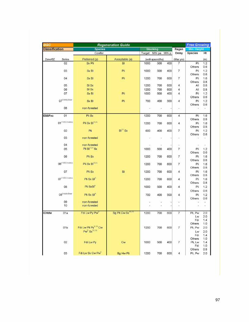
97

98

99

100

101

102

103

104

105

106
FDU #3 – Okanagan, FDU #4 – TFL 49, Uneven-aged Stands

107
FDU #3 – Okanagan, FDU #4 – TFL 49 Stocking Standard Footnotes

108
FDU #5 – Arrow – Even Aged Stands
BGC Regeneration Guide Free Growing Guide
Classification
Species
Stocking(i) Regen Delay Assessment
Min. Height(ii)
Conifer
Broadleaf Target MIN pa
MIN p
Earliest Latest Species Ht
Zone/SZ Series Primary Preferred (p) Secondary Acceptable
(a) Tertiary (well-spaced/ha) (Max
yrs) (yrs) (yrs) (m)
ESSFdc1 101 Se Bl201,202 Se Bl201,202 Pl Pl 1200 700 600 4 12 20 Pl 1.6 Others 0.8
102 Pl Se Pl Pa13,201 Se Bl202 Pa Bl202 1000 500 400 7 15 20 Pl 1.2 Others 0.6
103 Pl Se Pl Pa13,201 Se Bl202 Pa Bl202 1200 700 600 7 15 20 Pl 1.6 Others 0.8
104 Pl Se Pl Se Bl202 Bl202 1200 700 600 4 12 20 Pl 1.6 Others 0.8
110 Bl202 Se Bl202 Se 1200 700 600 4 12 20 Bl 0.8 Se 0.8
111 Bl32,202 Se32 Bl32,202 Se32 1200 700 600 4 12 20 Bl 0.8 Se 0.8
112 Bl1,32,202 Se1,32
Bl1,32,202 Se1,32 1000 500 400 4 12 20 Bl Se
0.6 0.6
ESSFdcw 101 Se Bl202 Se Bl202 1200 700 600 4 12 20 All 0.8
102 Se Bl202 Se Pa201 Bl202 Pl34 Pa Pl34 1000 500 400 7 15 20 Pl 1.2 Others 0.6
103 Se Bl202 Se Bl202 Pa , Pa 1200 700 600 7 15 20 All 0.8
110 Bl202 Se Bl202 Se 1000 500 400 4 12 20 All 0.6
ESSFmh 101 Bl202 Se Cw14,34,203 Bl202 Lw9,14,34 Se
Cw9,14 Lw9,14,34 Pl34
Pl34 Hw9,14
Fd9,14 Pw9,14,31
Hw9,14 Fd9,14
Pw9,14,31
Atb Actb 1200 700 600 4 12 20 Lw, Pw, Pl
Fd
2.0
1.4 Others 1.0
102 Fd9 Lw9 Fd9 Lw9 Pl Pl Se Bl202 Pa13
Se Bl202 Pa13
1000 500 400 7 15 20 Lw, Pl Fd
1.6 1.2
Others 0.8
103 Fd Lw Pl34 Fd Lw Pl34 Se Bl202 Se Cw Bl Pw14,31
Cw Pw14,31 1200 700 600 7 15 20 Lw, Pw, Pl
2.0

109
Fd 1.4 Others 1.0
104 Se Pl34 Se Pl34 Bl202 Bl202 1200 700 600 4 12 20 Pl 2.0 Others 1.0
105 Fd9 Lw9 Pl34 Se
Fd9 Lw9 Pl34 Se Bl202 Cw9 Bl202
Pw31 Cw
Pw9,14,31 1200 700 600 4 12 20 Lw, Pw,
Pl 2.0
Fd 1.4 Others 1.0
110 Bl202 Se Bl202 Se Hw14,32 Cw14,32
Hw14,32 Cw14,32
Actb 1200 700 600 4 12 20 All 1.0
111 Bl202 Se Bl202 Se Cw14,32 Hw14,32
Cw14,32 Hw14,32
Actb 1200 700 600 4 12 20 All 1.0
112 Bl1,32,202 Se1,32
Bl1,32,202 Se1,32 Actb 1000 500 400 4 12 20 All 0.8
ESSFwc4 101 Bl201,202 Se Bl201,202 Se 1200 700 600 4 12 20 Bl 0.8 Se 0.8
102 Se Se Pa201 Pl16,34 Pl16,34 Bl202 Bl202 Pa 1000 500 400 7 15 20 Pl 1.2 Others 0.6
103 Se Bl202 Se Bl202 Pl16,34 Pl16,34,200 Pa Pa 1200 700 600 7 15 20 Pl 1.6 Others 0.8
110 Bl Se Bl202 Se 1200 700 600 4 12 20 All 0.8
111 Bl1,32,202 Se1,32
Bl1,32,202 Se1,32 1200 700 600 4 12 20 All 0.8
112 Bl1,32,202 Se1,32
Bl1,32,202 Se1,32 1000 500 400 4 12 20 All 0.6
ESSFwcw 101 Bl202 Se Bl202 Se 1200 700 600 4 12 20 All 0.8
102 Se Bl202 Se Pa201 Bl202 Pl34 Pa Pl34 1000 500 400 7 15 20 Pl 1.2 Others 0.6
103 Se Bl202 Se Pa201 Bl202 Pa201 1200 700 600 7 15 20 All 0.8
104 Se Bl202 Se Bl202 La16 La16 1200 700 600 4 12 20 All 0.8
110 Bl202 Se Bl202 Se 1000 500 400 4 12 20 All 0.6
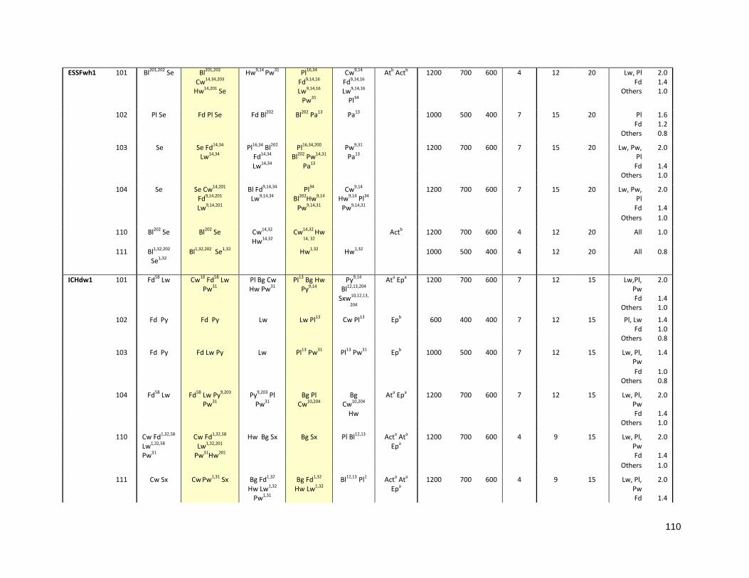
110
ESSFwh1 101 Bl201,202 Se Bl201,202 Cw14,34,203
Hw14,201 Se
Hw9,14 Pw31 Pl16,34 Fd9,14,16 Lw9,14,16
Pw31
Cw9,14 Fd9,14,16 Lw9,14,16
Pl34
Atb Actb 1200 700 600 4 12 20 Lw, Pl Fd
Others
2.0 1.4 1.0
102 Pl Se Fd Pl Se Fd Bl202 Bl202 Pa13 Pa13 1000 500 400 7 15 20 Pl 1.6 Fd 1.2 Others 0.8
103 Se Se Fd14,34
Lw14,34 Pl16,34 Bl202
Fd14,34 Lw14,34
Pl16,34,200 Bl202 Pw14,31
Pa13
Pw9,31 Pa13
1200 700 600 7 15 20 Lw, Pw, Pl
Fd
2.0
1.4 Others 1.0
104 Se Se Cw14,201
Fd9,14,201 Lw9,14,201
Bl Fd9,14,34 Lw9,14,34
Pl34 Bl202Hw9,14
Pw9,14,31
Cw9,14 Hw9,14 Pl34
Pw9,14,31
1200 700 600 7 15 20 Lw, Pw, Pl
Fd
2.0
1.4 Others 1.0
110 Bl202 Se Bl202 Se Cw14,32
Hw14,32 Cw14,32 Hw
14, 32 Actb 1200 700 600 4 12 20 All 1.0
111 Bl1,32,202 Se1,32
Bl1,32,202 Se1,32 Hw1,32 Hw1,32 1000 500 400 4 12 20 All 0.8
ICHdw1 101 Fd58 Lw Cw10 Fd58 Lw
Pw31 Pl Bg Cw Hw Pw31
Pl13 Bg Hw Py9,14
Py9,14 Bl12,13,204
Sxw10,12,13,
204
Ata Epa 1200 700 600 7 12 15 Lw,Pl, Pw Fd
Others
2.0
1.4 1.0
102 Fd Py Fd Py Lw Lw Pl13 Cw Pl13 Epb 600 400 400 7 12 15 Pl, Lw 1.4 Fd 1.0 Others 0.8
103 Fd Py Fd Lw Py Lw Pl13 Pw31 Pl13 Pw31 Epb 1000 500 400 7 12 15 Lw, Pl, Pw
1.4
Fd 1.0 Others 0.8
104 Fd58 Lw Fd58 Lw Py9,203 Pw31
Py9,203 Pl Pw31
Bg Pl Cw10,204
Bg Cw10,204
Hw
Ata Epa 1200 700 600 7 12 15 Lw, Pl, Pw Fd
2.0
1.4 Others 1.0
110 Cw Fd1,32,58
Lw1,32,58 Pw31
Cw Fd1,32,58
Lw1,32,201
Pw31Hw201
Hw Bg Sx Bg Sx Pl Bl12,13 Acta Ata Epa
1200 700 600 4 9 15 Lw, Pl, Pw Fd
2.0
1.4 Others 1.0
111 Cw Sx Cw Pw1,31 Sx Bg Fd1,32 Hw Lw1,32
Pw1,31
Bg Fd1,32 Hw Lw1,32
Bl12,13 Pl1 Acta Ata Epa
1200 700 600 4 9 15 Lw, Pl, Pw Fd
2.0
1.4

111
Others 1.0
112 Sx1 Cw1,32 Sx1 Cw1,32 Hw1,32 Hw1,32 Pw31
Bl12,13
Pw31 Actb Atb
Epa 1000 500 400 4 9 15 Pw
Others 1.4 0.8
113 Sx1 Cw1,32 Sx1 Cw1,32 Hw1,32 Hw1,32 Bl12,13 Actb Atb Epa
1000 500 400 4 9 15 Pw Others
1.4 0.8
ICHmw2 101 Fd58 Lw Fd58 Lw Cw
Hw201 Pw31 Cw Hw
Sx10,13 Pw31 Bl10,13,202
Sx10,13 Bl10,13 Actb Ata
Epa 1200 700 600 4 9 15 Lw, Pw
Fd 2.0 1.4
Others 1.0
102 Fd Pl Fd Pl Lw Lw Py9,14,203 Py9,14,203 Atb 1000 500 400 7 12 15 Lw,Pl Fd
Others
1.4 1.0 0.8
103 Fd Lw Fd Lw Pl200 Pw31
Cw13 Py9,14,203
Pl Pw31
Cw13 Py9,14,203
Ata Epb 1000 500 400 7 12 15 Lw, Pl, Pw Fd
2.0
1.4 Others 1.0
104 Fd58 Lw Cw10,201 Fd58 Lw Pw31
Cw Hw Pw31
Pl Hw
Py9,14,203
Sx10,13
Pl Sx10,13 Bl10,13
Py9,14,203
Ata Epa 1200 700 600 7 12 15 Lw, Pl, Pw Fd
2.0
1.4 Others 1.0
110 Cw Cw Hw201 Fd1,14,32,58 Lw1,14,32
Pw31Sx10,13,201
Fd1,14,32,58 Hw Lw1,14
Pw31 Sx10,13,201
Bl10,13 Acta Ata Epa
1200 700 600 4 9 15 Lw, Pw Fd
Others
2.0 1.4 1.0
111 Cw32 Sx Cw32 Pw1,31 Sx Hw32 Pw31 Fd1,14,32,58 Hw32
Lw1,14,32
Fd1,32 Lw1,32 Bl
Acta Ata Epa
1200 700 600 4 9 15 Lw, Pw Fd
Others
2.0 1.4 1.0
112 Sx Sx Cw1,32 Bl202 Cw1,32 Hw1,32 Bl202 Hw1,32 Acta 1200 700 600 4 9 15 All 1.0
113 Cw1,32 Sx1 Cw1,32 Sx1 Bl1,202 Hw1,32
Bl1,202 Hw1,32
Acta 1000 500 400 4 9 15 All 0.8
114 Cw1,32 Sx1 Cw1,32 Sx1 Bl1,202 Hw1,32
Bl1,202 Hw1,32
Acta 1000 500 400 4 9 15 All 0.8
ICHmw5 101 Fd58 Lw Cw Fd58 Hw201 Lw Pw31 Sx10,13
Cw Pl Pw31 Sx10,13
Bg14,16 Pl Bg Bl10,13 Hw
Actb Ata Epa
1200 700 600 4 9 15 Lw, Pl, Pw
2.0
Fd 1.4 Others 1.0
102 Fd Fd Pl Pl Lw Py9,14,16,203
Lw Py9,14,16,203 Ata Epa 1000 500 400 7 12 15 Lw, Pl,
Pw 1.4
Fd 1.0 Others 0.8

112
103 Fd Lw Fd Lw Pl Pl200 Pw31 Py9,14,16,203
Pw31 Py9,14,16
Ata Epa 1000 500 400 7 12 15 Lw, Pl, Pw
2.0
Fd 1.4 Others 1.0
104 Fd58 Lw Fd58 Lw Pw31 Cw201
Pl200 Pw31 Bg14,16 Hw Pl200
Py9,14,16 Sx10,13
Bg14,16 Bl10,13
Cw201 Hw Sx10,13
Ata Epa 1200 700 600 7 12 15 Lw, Pl, Pw Fd
Others
2.0
1.4 1.0
110 Cw Sx Cw Hw Fd1,14,32,58
Lw1,14,32 Sx
Hw Fd1,14,32,58 Lw1,14,32
Bl202 Pw31 Bl Pl Pw31 Acta Ata Epa
1200 700 600 4 9 15 Lw, Pl, Pw Fd
2.0
1.4 Others 1.0
111 Cw32 Sx Cw32 Sx Bl202 Fd1,32 Hw32 Lw1,32
Bl202 Fd1,32 Hw32 Lw1,32
Pw31
Pw31 Acta Ata Epa
1200 700 600 4 9 15 Lw, Pw Fd
Others
2.0 1.4 1.0
112 Sx1 Bl1,202,208 Sx1 Bl1,202 Hw1,32
Cw1,32 Hw1,32 Acta Atb
Epb 1200 700 600 4 9 15 All 1.0
113 Cw1,32 Sx1 Cw1,32 Sx1 Bl1,202 Hw1,32
Bl1,202 Hw1,32
Acta Atb Epb
1000 500 400 4 9 15 All 0.8
ICHwk1 01 Cw Fd9,14 Hw Sx
Cw Fd9,14 Hw Sx
Bl10,13 Bl10,13 Pw31 Lw9,14,23,32 Pl23,34,51
Pw31
Acta Ata Epa
1200 700 600 4 9 15 Pl, Pw Lw Fd
Others
2.0 2.0 1.4 1.0
02 Fd Pl51 Fd Pl51 Cw10,13 Pw31 Sx10,13 Bl10,13
Cw10,13 Hw10,13
1000 500 400 7 12 15 Pl, Pw Fd
Others
1.4 1.0 0.8
Pw31 Sx10,13
03 Fd Fd Cw10,13 Cw10,13
Hw10,13 Pl23,34,51
Hw10,13 Pw31 Sx10,13
Bl10,13 Lw9,14,23,32
Pw31 Sx10,13
1200 700 600 4 9 15 Pl, Lw Fd
Others
2.0 1.4 1.0
04 Fd9,14 Fd9,14 Cw Sx10,13
Cw Hw Sx10,13
Hw Pw31 Bl10,13 Lw9,14,23,32 Pl23,34,51
Pw31
Actb Ata Epa
1200 700 600 4 9 15 Pl, Pw Lw Fd
Others
2.0 2.0 1.4 1.0

113
05 Cw32 Sx Cw32 Sx Bl Fd1,14,32 Hw32
Lw1,9,14,23,32
Bl Fd1,14,32 Hw32 Pw31
Pl23,34,51 Pw31
Acta Ata Epa
1200 700 600 4 9 15 Pl, Pw Lw Fd
Others
2.0 2.0 1.4 1.0
06 Cw1,32 Sx1 Cw1,32 Sx1 Bl1 Hw1,32 Bl1 Hw1,32 Pw1,31
Pl1, 23,34,51 Pw1,31
Acta Atb Epa
1000 500 400 4 9 15 Pl, Pw Others
1.4 0.8
07 Cw1,32 Hw1,32 Sx1
Cw1,32 Hw1,32 Sx1
Bl1 Bl1 Pl23,34,51 Acta Atb Epb
1000 500 400 4 9 15 Pl Others
1.4 0.8
08 non-
forested - - - - - - - -

114
FDU #5 – Arrow – Stocking Standard Footnotes
Conifer Tree Species "Ba" means amabilis fir; "Bg" means grand fir; "Bl" means subalpine fir; "Bp" means noble fir; "Cw" means western red cedar; "Fd" means Douglas-fir; "Hm" means mountain hemlock; "Hw" means western hemlock; “Lt” means tamarack; "Lw" means western larch; “Pa” means whitebark pine; "Pl" means lodgepole pine; "Pw" means white pine; "Py" means ponderosa pine; “Sb” means black spruce; “Se” means Engelmann spruce; "Ss" means Sitka spruce; “Sw” means white spruce; "Sx" means hybrid spruce or interior spruce; "Sxs" means hybrid Sitka spruce; “Sxw” means hybrid white spruce; "Yc" means yellow cedar. Broadleaf Tree Species “Acb” means balsam poplar; “Act” means black cottonwood; “At” means trembling aspen; “Dr” means red alder; “Ep” means common paper birch; “Mb” means bigleaf maple; “Qg” means garry oak; “Ra” means arbutus; “Biogeoclimatic unit” or “BGC classification” means the zone, subzone, variant and site series described in the most recent field guide published by the Ministry of Forests for the identification and interpretation of ecosystems, as applicable to a harvested area. “MIN or “Min” means minimum.
Footnote # Footnote 1 suitable on elevated microsites 9 suitable on warm aspects 10 suitable on cool aspects 12 suitable on cold air drainage sites 13 suitable at upper elevations 14 suitable at lower elevations 16 suitable in the southern portion of biogeoclimatic unit 31 must use of blister rust resistant stock. See BC Journal of Ecosystems and
Management 10(1): 97-100 for supplementary information. 32 limited by growing-season frosts

115
34 risk of snow damage Localized Footnotes
58 South Area - Fd limited to a max 50% of preferred and acceptable well-spaced stems in the IDFmw and all subzones of the ICH due to root rot. See Root Rot Handbook (2017, in press)
200 Where there are no known forest health risks, Pl can be moved from acceptable to preferred if there is: • > 50% Pl in the pre-harvest stand, then Pl can be moved to preferred; • 25-50% Pl in the pre-harvest stand, then Pl can be moved to preferred with a maximum of 50% well-spaced stems; For areas with less than 25% Pl in the pre-harvest stand, Pl remains acceptable.
201 Maximum 50% of preferred and acceptable well-spaced trees 202 In addition to the FG damage criteria, Bl advanced regeneration can be counted as
well-spaced only where it meets the following criteria at free growing in even aged management: • apical dominance > 1 (as measured by comparing ratio of leader height to length of most recent branch whorl) at free growing • 75% live crown; • ≥ 10 cm long leader; and • no scars, forks, crooks, or sweeps, and; • where it is < 1.5 m ht at time of harvest.
203 Recommended on sites for climate change adaptation 204 Not recommended due to climate change concerns 208 In addition to the FG damage criteria, Bl advanced regeneration can be counted as
well-spaced only where it meets the following criteria at free growing in even aged management: • apical dominance > 1 (as measured by comparing ratio of leader height to length of most recent branch whorl) at free growing • 75% live crown; • ≥ 10 cm long leader; and • no scars, forks, crooks, or sweeps, and; • where it is < 1.5 m ht at time of harvest.
Broadleaf Management Constraints a productive, reliable, and feasible regeneration option b limited in productivity, reliability and/or feasibility

116
Appendix B – Legal Objectives for Interpretive Forest Sites, Recreation Sites or Recreation Trails
Following are the legally established objectives for Interpretive Forest Sites, Recreation Sites and Recreation Trails that were legally designated under FPC. The site and trail legal designations are continued under FRPA Section 180, and the legal objectives for these sites and trail are continued under FRPA Section 181.
FDU #1- Kamloops Recreation Sites and Trails
Recreation Site or Trail continued
Under FRPA section 180
Project No. 16660-20/ Recreation Site or Trail Objectives continued under FRPA section 181
Allan Creek Recreation Trail
4521 1997/03/24 Recreation Experience Objectives: To provide opportunities for semi-primitive motorized and modified roaded recreation experiences. Recreation Feature Objectives: To protect the alpine/high sub-alpine and small lake features. Recreation Activity Objectives: To provide opportunities for snowmobiling activities during winter season and hiking, scenic viewing and hunting (during the regulated season) during the remainder of the year. Public Recreation Objectives: Winter snowmobile trail head access is via a maintained public highway.
Boundary Lake Recreation Site
1993 1997/03/24 Recreation Experience Objectives: To provide opportunities for modified roaded recreation experiences. Recreation Feature Objectives: To protect the small lake, fish and developed campsite features. Recreation Activity Objectives: To provide opportunities for summer camping, sport fishing, canoeing and boating activities. Public Recreation Objective: To maintain summer, 2 wheel drive, forest road access to the site.
Chappel Recreation Trail
4555 1997/03/24 Recreation Experience Objectives: To provide opportunities for semi-primitive motorized and modified roaded recreation experiences. Recreation feature objective: To protect the small / mid lake and fisheries experience. Recreation activity objective: To provide opportunities for snowmobiling activities during winter season and hiking, scenic viewing and hunting. Public recreation objective: To maintain summer access to trailhead and winter access via maintained public highway.
Clemina Creek Recreation Trail
4703 1997/03/10 Recreation Experience Objectives: To provide opportunities for semi-primitive motorized and modified roaded recreation experiences. Recreation Feature Objectives: To protect the alpine/high sub-alpine, wetland vegetation and small lake features. Recreation Activity Objectives: To provide opportunities for snowmobiling activities during the winter season and hiking, scenic viewing and hunting (during the regulated season) during the remainder of the year. Public Recreation Access Objectives: Winter snowmobile trail head access is via a maintained public highway. Summer access is provided by Forest Service road (suitable for 4 wheel drive vehicles) to various points along the trail system beginning at approximately 3 km from the highway.
Coldscaur Lake North Recreation Site
1512 1997/03/24 Recreation Experience Objectives: To provide opportunities for modified roaded recreation experiences. Recreation Feature Objectives: To protect the mid-sized lake, fish and developed campsite features. Recreation Activity Objectives: To provide opportunities for summer camping, sport fishing and boating activities. Public Recreation Objectives: To maintain summer, 2 wheel drive, Forest Service road access to the site.
Coldscaur Lake South Recreation Site
1520 1997/03/24 Recreation Experience Objectives: To provide opportunities for modified roaded recreation experiences. Recreation Feature Objectives: To protect the mid-sized lake, rock arch, fish and developed campsite features. Recreation Activity Objectives: To provide opportunities for summer camping, sport fishing, canoeing, boating, scenic viewing and nature study/appreciation activities. Public Recreation Objectives: To maintain summer, 2 wheel drive, Forest Service road access to the site.
Dennis Lake Recreation Site
4506 1997/03/24 Recreation Experience Objectives: To provide opportunities for modified roaded recreation experiences. Recreation Feature Objectives: To protect the small lake, fish and developed campsite features. Recreation Activity Objectives: To provide opportunities for sport fishing, boating, canoeing, summer camping and scenic viewing activities. Public Recreation Objectives: To maintain summer, 2 wheel drive, Forest Service road access to the site.
Double Lakes Recreation Site
1908 1997/03/24 Recreation Experience Objectives: To provide opportunities for modified roaded recreation experiences. Recreation Feature Objectives: To protect the mid-sized lakes, fish and developed campsite features. Recreation Activity Objectives: To provide opportunities for summer camping, sport fishing, canoeing and boating activities. Public Recreation Access Objectives: To maintain summer, 2 wheel drive, Forest Service road access to the site.

117
Recreation Site or Trail continued
Under FRPA section 180
Project No. 16660-20/ Recreation Site or Trail Objectives continued under FRPA section 181
East Maury Lake Recreation Site
1997 1997/03/24 Recreation Experience Objectives: To provide opportunities for modified roaded recreation experiences. Recreation Feature Objectives: To protect the mid-sized lake, fish and developed campsite features. Recreation Activity Objectives: To provide opportunities for summer camping, sport fishing, canoeing and boating activities. Public Recreation Objectives: To maintain summer, 2 wheel drive, forest road access to the site.
Ejas Lake Recreation Site
1514 1997/03/24 Recreation Experience Objectives: To provide opportunities for modified roaded recreation experiences. Recreation Feature Objectives: To protect the mid-sized lake, fish and developed campsite features. Recreation Activity Objectives: To provide opportunities for summer camping, sport fishing, canoeing and boating activities. Public Recreation Objectives: To maintain summer, 2 wheel drive, forest road access to the site.
Fowler Lake Recreation Site
1816 1997/03/10 Recreation experience objectives: To provide opportunities for natural roaded recreation experiences. Recreation feature objectives: To protect the small lake, fish and regenerating stand features. Recreation activity objectives: To provide opportunities for sport fishing, and canoeing and potential for future summer camping activities. Public recreation access objectives: To maintain summer, 2 wheel drive, forest road access to the vicinity of the site while managing the lake as a walk-in access.
Gannet Lake Recreation Site
4503 1997/03/24 Recreation Experience Objectives: To provide opportunities for modified roaded recreation experiences. Recreation Feature Objectives: To protect the small lake, fish and developed campsite features. Recreation Activity Objectives: To provide opportunities for summer camping, fishing, canoeing and boating activities. Public Recreation Objective: To maintain summer, 2 wheel drive, Forest Service Road and spur road access to the site.
Gordon Bay Recreation Site
4502
1997/03/24 Recreation Experience Objectives: To provide opportunities for modified roaded recreation experiences. Recreation Feature Objectives: To protect the large lake, fine textured beach, fish and developed campsite features. Recreation Activity Objectives: To provide opportunities for summer camping, beach activities, swimming/bathing, sport fishing, canoeing and boating activities. Public Recreation Objectives: To maintain summer, 2 wheel drive, Forest Service Road access to the site
Graffunder Lakes North Recreation Site
1509 1997/03/24 Recreation Experience Objectives: To provide opportunities for modified roaded recreation experiences. Recreation Feature Objectives: To protect the small lake, fish and developed campsite features. Recreation Activity Objectives: To provide opportunities for summer camping, sport fishing, canoeing and boating activities. Public Recreation Access Objective: To maintain summer, 2 wheel drive, Forest Service Road and spur road access to the site.
Grizzle Lake East Recreation Site
4570 1997/03/24 Recreation Experience Objectives: To provide opportunities for modified roaded recreation experiences. Recreation Feature Objectives: To protect the small lake, fish, developed and cabin features. Recreation Activity Objectives: To provide opportunities for summer camping, sport fishing, canoeing, and boating activities. Public Recreation Objectives: To maintain summer, 2 wheel drive, Forest Service road access to the site.
Honeymoon Bay Recreation Site
4610 1997/03/24 Recreation Experience Objectives: To provide opportunities for modified roaded recreation experiences. Recreation Feature Objectives: To protect the large lake, fine textures beach, fish and developed campsite features. Recreation Activity Objectives: To provide opportunities for summer camping, beach activities, swimming/bathing, sport fishing and boating activities. Public Recreation Objectives: To maintain summer, 2 wheel drive, Forest Service Road and 4 wheel drive spur road access to the site.
Italia Lake Recreation Site
1515 1997/03/24 Recreation Experience Objectives: To provide opportunities for modified roaded recreation experiences. Recreation Feature Objectives: To protect the mid-sized lake, fish and developed campsite. Recreation Activity Objectives: To provide opportunities for summer camping, sport fishing, canoeing and boating activities. Public Recreation Objectives: To maintain summer, 2 wheel drive, Forest Service road access to the site.
Kitty Anne Lake Recreation Site
1517 1997/03/24 Recreation Experience Objectives: To provide opportunities for modified roaded recreation experiences. Recreation Feature Objectives: To protect the small lake, fish and developed campsite features. Recreation Activity Objectives: To provide opportunities for summer camping, sport fishing canoeing, boating and scenic viewing activities. Public Recreation Objective: To maintain summer, 2 wheel drive, forest road access to the site.
Lawrence Lake East Recreation Site
1516 1997/03/24 Recreation Experience Objectives: To provide opportunities for modified roaded recreation experiences. Recreation Feature Objectives: To protect the small lake, fish and developed campsite. Recreation Activity Objectives: To provide opportunities for summer camping, sport fishing, boating and canoeing, activities. Public Recreation Objectives: To maintain summer, 2 wheel drive, Forest Service road access to the site.

118
Recreation Site or Trail continued
Under FRPA section 180
Project No. 16660-20/ Recreation Site or Trail Objectives continued under FRPA section 181
Lawrence Lake West Recreation Site
4580 1997/03/24 Recreation Experience Objectives: To provide opportunities for modified roaded recreation experiences. Recreation Feature Objectives: To protect the small lake, fish and developed campsite features. Recreation Activity Objectives: To provide opportunities for summer camping, sport fishing, canoeing and boating activities. Public Recreation Objectives: To maintain summer, 2 wheel drive, Forest Service road access to the site.
Lolo Lake Recreation Site
1511 1997/03/24 Recreation Experience Objective: To provide opportunities for modified roaded recreation experiences. Recreation Feature Objective: To protect the small lake, fish and developed campsite features. Recreation Activity Objective: To provide opportunities for summer camping, sport fishing, canoeing, boating and scenic viewing activities. Public Recreation Objective: To maintain summer, 2 wheel drive, forest road access to the site.
McCorvie Lake North Recreation Site
1519 1997/03/24 Recreation Experience Objectives: To provide opportunities for modified roaded recreation experiences. Recreation Feature Objectives: To protect the small lake and fish features. Recreation Activity Objectives: To provide opportunities for sport fishing, canoeing and potential or future summer camping activities. Public Recreation Objective: To maintain summer, 2 wheel drive, forest road access to the site.
Messiter Lake Recreation Site
4758 1997/03/24 Recreation Experience Objectives: To provide opportunities for modified roaded recreation experiences. Recreation Feature Objectives: To protect the small lake and fish features. Recreation Activity Objectives: To provide opportunities for sport fishing and canoeing with potential for future summer camping activities. Public Recreation Objectives: To maintain summer, 2 wheel drive, forest road access to the site.
Moira Lake North Recreation Site
1998 1997/03/24 Recreation experience objectives: To provide opportunities for modified roaded recreation experiences. Recreation Feature Objectives: To protect the mid-sized lake, fish and regenerating stand features. Recreation Activity Objectives: To provide opportunities for sport fishing, boating, canoeing and potential for future summer camping activities. Public Recreation Objectives: To maintain summer, 2 wheel drive, forest road access to the site.
Moira Lake South Recreation Site
1513 1997/03/24 Recreation Experience Objectives: To provide opportunities for modified roaded recreation experiences. Recreation Feature Objectives: To protect the mid-sized lake, fish and developed campsite features. Recreation Activity Objectives: To provide opportunities for summer camping, sport fishing, canoeing and boating activities. Public Recreation Objectives: To maintain summer, 2 wheel drive, forest road access to the site.
Moose Lake Recreation Site
4582 1997/03/24 Recreation Experience Objectives: To provide opportunities for modified roaded recreation experiences. Recreation Feature Objectives: To protect the small lake, fish and developed campsite features. Recreation Activity Objectives: To provide opportunities for summer camping, sport fishing and canoeing activities. Public Recreation Objectives: To maintain summer, 2 wheel drive, forest road access to the site.
Mud Lake Recreation Trail
1793 1997/03/24 Recreation Experience Objectives: To provide opportunities for modified roaded recreation experiences. Recreation Feature Objectives: To protect the large lake, fish and developed campsite and land trail features. Recreation Activity Objectives: To provide opportunities for summer camping, hiking, sport fishing, canoeing and boating. Public Recreation Objectives: To maintain summer, 2 wheel drive, Forest Service Road and 4 wheel drive spur road access to the site.
Mystery Lake Recreation Site
1740 1997/03/10 Recreation experience objectives: To provide opportunities for modified roaded recreation experiences. Recreation feature objectives: To protect the small lake, fish and developed campsite features. Recreation activity objectives: To provide opportunities for summer camping, sport fishing and canoeing. Public recreation objectives: To maintain summer, 2 wheel drive, Forest Service Road and 2 wheel drive spur road access to the site.
North Thompson Crossing Recreation Site
1901 1997/03/10 Recreation experience objectives: To provide opportunities for modified roaded recreation experiences. Recreation feature objectives: To protect the large river and fish features. Recreation activity objectives: To provide opportunities for sport fishing, and canoeing and potential for future summer camping activities. Public recreation access objectives: To maintain summer, 2 wheel drive, Forest Service road access to the site.
Raft Mountain Recreation Trail
4527 1997/03/24 Recreation Experience Objectives: To provide opportunities for semi-primitive, natural roaded and modified roaded recreation experiences. Recreation Feature Objectives: To protect the alpine/high sub-alpine and small lake features. Recreation Activity Objectives: To provide opportunities for primarily snowmobiling as well as snow sport activities during winter season and hiking, scenic viewing and hunting (during the regulated season) during the remainder of the year. Public Recreation Objectives: Winter snowmobile trail head access is via a maintained public road. Summer access is provided by maintained Forest Service road (suitable for 2 wheel drive vehicles) to Moilliett Creek in the Raft River and to Caligata Lake at the headwaters of Spahats Creek. Rough Forest Service road (suitable for 4 wheel drive vehicles) provides summer access to the upper elevation areas in the vicinity of Willis Lake.

119
Recreation Site or Trail continued
Under FRPA section 180
Project No. 16660-20/ Recreation Site or Trail Objectives continued under FRPA section 181
Reflector Lake North Recreation Site
1524 1997/03/24 Recreation Experience Objectives: To provide opportunities for modified roaded recreation experiences. Recreation Feature Objectives: To protect the small lake and fish features. Recreation Activity Objectives: To provide opportunities for sport fishing, canoeing and potential for future summer activities. Public Recreation Objectives: To maintain summer, 2 wheel drive, Forest Service road access to the vicinity of the site.
Rocky Point Recreation Site
4705 1997/03/24 Recreation Experience Objectives: To provide opportunities for modified roaded recreation experiences. Recreation Feature Objectives: To protect the large lake, fish and developed campsite features. Recreation Activity Objectives: To provide opportunities for summer camping, swimming/bathing, sport fishing, canoeing and boating activities. Public Recreation Objectives: To maintain summer, 2 wheel drive, Forest Service Road and spur road access to the site.
Rock Island Recreation Site
4601 1997/03/24 Recreation Experience Objectives: To provide opportunities for modified roaded recreation experiences. Recreation Feature Objective: To protect the large lake, islets, fine textured beach and fish features. Recreation Activity Objectives: To provide opportunities for swimming/bathing, beach activities, nature study/appreciation, sport fishing, boating, canoeing activities with potential for future summer camping activities. Public Recreation Objectives: To maintain summer, 2 wheel drive, forest road access to the site.
Sicily Lake South Recreation Site
1518 1997/03/24 Recreation Experience Objective: To provide opportunities for modified roaded recreation experiences. Recreation Feature Objectives: To protect the small lake, fish and developed campsite. Recreation Activity Objectives: To provide opportunities for summer camping, sport fishing, boating and canoeing activities. Public Recreation Objectives: To maintain summer, 2 wheel drive, Forest Service road access to the site.
Silence Lake Recreation Site
1510 1997/03/24 Recreation Experience Objectives: To provide opportunities for natural roaded recreation experiences. Recreation Feature Objectives: To protect the mid-sized lake, fish and developed campsite features. Recreation Activity Objective: To provide opportunities for summer camping, sport fishing and boating activities. Public Recreation Access Objective: To maintain summer, 2 wheel drive, Forest Service Road and spur road access to the site.
Silvertip Falls Recreation Site
4600 1997/03/10 Recreation experience objectives: To provide opportunities for modified roaded recreation experiences. Recreation feature objectives: To protect the site specific waterfall, creek, developed trail and campsite features. Recreation activity objectives: To provide opportunities for summer camping, hiking and scenic viewing activities. Public recreation objectives: To maintain summer, 2WD Forest Service Road to the site.
Stukemapten Lake Recreation Site
4781 1997/03/24 Recreation Experience Objectives: To provide opportunities for modified roaded recreation experiences. Recreation Feature Objectives: To protect the small lake, fish and developed campsite features. Recreation Activity Objectives: To provide opportunities for summer camping, sport fishing, boating and canoeing activities. Public Recreation Objectives: To maintain summer, 2 wheel drive, Forest Service Road to the site.
Tsikwustum Creek North Recreation Site
4501 1997/03/24 Recreation Experience Objectives: To provide opportunities for modified roaded recreation experiences. Recreation Feature Objectives: To protect the large lake, fine textured beach, fish, creek and developed campsite features. Recreation Activity Objectives: To provide opportunities for summer camping, beach activities, swimming/bathing, sport fishing, canoeing and boating. Public Recreation Objectives: To maintain summer, 2 wheel drive, Forest Service Road access to the site.
Tsikwustum Creek South Recreation Site
1942 1997/03/24 Recreation Experience Objectives: To provide opportunities for modified roaded recreation experiences. Recreation Feature Objectives: To protect the large lake, fine textured beach, fish and developed campsite features. Recreation Activity Objectives: To provide opportunities for summer camping, beach activities, swimming/bathing, sport fishing, canoeing and boating. Public Recreation Objectives: To maintain summer, 2 wheel drive, Forest Service road and spur road access to the site.
White Lake Recreation Site
1991 1997/03/24 Recreation Experience Objectives: To provide opportunities for modified roaded recreation experiences. Recreation Feature Objectives: To protect the small lake, fish and developed campsite features. Recreation Activity Objectives: To provide opportunities for summer camping, sport fishing and canoeing activities. Public Recreation Objectives: To maintain summer, 2 wheel drive, forest road access to the site.
Windy Lake Recreation Site
1992 1997/03/24 Recreation Experience Objectives: To provide opportunities for modified roaded recreation experiences. Recreation Feature Objectives: To protect the small lake, fish and developed trail and campsite features. Recreation Activity Objectives: To provide opportunities for summer camping, sport fishing, boating and canoeing activities. Public Recreation Objectives: To maintain summer, 2 wheel drive, forest road access to the site.

120
FDU #2- Merritt Recreation Sites and Trails Recreation Site or
Trail continued Under FRPA section 180
Project No. 16660-20/ Recreation Site or Trail Objectives continued under FRPA section 181
Abbott Lake Recreation Site
1735 00/01/31 The objective is to manage the Abbott Lake recreation site for a roaded recreation experience. The campsite will be maintained and the lake shoreline and natural vegetation will be conserved. Opportunities for camping, picnicking, boating and swimming will be available at the site. Very rough road access to the site will be maintained for four-wheel drive vehicles.
Andy's Lake Recreation Site
5538
00-01-31 The objective is to manage the Andy's Lake recreation site for a roaded recreation experience. The campsite will be maintained and the lake shoreline and natural vegetation will be conserved. Opportunities for camping, picnicking, boating and swimming will be available at the site. Access to lake from recreation site is by non-motorized trail. It is also a part of the Thynne Mtn. snowmobile trail system. An emergency shelter is located across from the recreation site.
Another Lake Recreation Site
1842 00-01-31The objective is to manage Another Lake for a semi primitive non-motorized recreation experience. The lake shoreline and natural vegetation will be conserved. Opportunities for camping (no facilities on site), picnicking, boating and swimming will be available. Access is by non-motorized trail.
Antler Lake Recreation Site
1729 00-01-31 The objective is to manage the Antler Lake recreation site for a roaded and semi primitive non-motorized recreation experience. The trailhead, trail and the campsite will be maintained; the lake shoreline and natural vegetation will be conserved. Opportunities for camping, hiking, picnicking, boating and swimming will be available at the site. Camping facilities are available at the trailhead/parking area. Access to the lake is by non-motorized trail.
Billy Lake Recreation Site
1730 00-01-31 The objective is to manage the Billy Lake recreation site for a roaded recreation experience. The campsite will be maintained; the lake shoreline and natural vegetation will be conserved. Opportunities for camping, picnicking, boating and swimming will be available at the site.
Bluey Lake Recreation Site
1719 00-01-31 The objective is to manage the Bluey Lake recreation site for a roaded recreation experience. The campsite will be maintained; the lake shoreline and natural vegetation will be conserved. Opportunities for camping, picnicking, boating and swimming will be available at the site. Very rough road access to the site will be maintained for four-wheel drive vehicles.
Bob Lake E. Recreation Site
1884 00-01-31 The objective is to manage Bob Lake E. for a roaded recreation experience. The lake shoreline and natural vegetation will be conserved. Opportunities for camping (no facilities on site), picnicking, boating and swimming will be available. Very rough road access to the lake; also walk in access from Bob Lake West.
Bob Lake W. Recreation Site
1838 00-01-31 The objective is to manage the Bob Lake W. recreation site for a roaded recreation experience. The campsite will be maintained; the lake shoreline and natural vegetation will be conserved. Opportunities for camping, picnicking, boating and swimming will be available at the site. Very rough road access to the site will be maintained for four-wheel drive vehicles.
Bobs Lake Recreation Site
1737 00-01-31 The objective is to manage the Bobs Lake recreation site for a roaded experience. The campsite will be maintained; the lake shoreline and natural vegetation will be conserved. Opportunities for camping, picnicking, boating and swimming will be available at the site.
Boot Lake Recreation Site
1728 00-01-31 The objective is to manage the Boot Lake recreation site for a roaded recreation experience. The campsite will be maintained; the lake shoreline and natural vegetation will be conserved. Opportunities for camping, picnicking, boating and swimming will be available at the site. Very rough road access to the site will be maintained for four-wheel drive vehicles.
Boss Lake Recreation Site
1714 00-01-31 The objective is to manage the Boss Lake recreation site for a roaded recreation experience. The campsite will be maintained; the lake shoreline and natural vegetation will be conserved. Opportunities for camping, picnicking, boating and swimming will be available at the site. ATV opportunities are available nearby.
Brook Lake Recreation Site
1660 00-01-31 The objective is to manage Brook Lake for a semi primitive non-motorized recreation experience. The trailhead, trail and lake shoreline and natural vegetation will be conserved. Opportunities for camping (no facilities on site), picnicking, boating and swimming will be available at the site. Lake is located within a community watershed. Access is by non-motorized trail. Snowmobile activities are available in the winter.

121
Recreation Site or Trail continued
Under FRPA section 180
Project No. 16660-20/ Recreation Site or Trail Objectives continued under FRPA section 181
Buck Lake Recreation Site
6234 00-01-31 The objective is to manage the Buck Lake recreation site for a roaded recreation experience. The campsite will be maintained; the lake shoreline and natural vegetation will be conserved. Opportunities for camping, picnicking, boating and swimming will be available at the site.
Butler Lake Recreation Site
1777 00-01-31 The objective is to manage Butler Lake for a semi primitive non-motorized recreation experience. The trailhead, trail, lake shoreline and natural vegetation will be conserved. Opportunities for camping (no facilities on site), picnicking, boating and swimming will be available. Access is by a non-motorized trail.
Cabin Lake Recreation Site
4627 00-01-31 The objective is to manage the Cabin Lake recreation site for a roaded recreation experience. The campsite will be maintained; the lake shoreline and natural vegetation will be conserved. Opportunities for camping, picnicking, hiking, mountain biking and swimming will be available at the site. Very rough road access to the site will be maintained for four-wheel drive vehicles.
Calling Lake Recreation Site
6686 00-01-31 The objective is to manage the Calling Lake recreation site for a roaded recreation experience. The campsite will be maintained; the lake shoreline and natural vegetation will be conserved. Opportunities for camping, picnicking, hiking, mountain biking and swimming will be available at the site. Very rough road access to the site will be maintained for four-wheel drive vehicles.
Chain Lake W. Recreation Site
1649 00-01-31 The objective is to manage the Chain Lake W. recreation site for a roaded recreation experience. The campsite will be maintained; the lake shoreline and natural vegetation will be conserved. Opportunities for camping, picnicking, boating and swimming will be available at the site.
Centre Lake Recreation Site
1756 00-01-31 The objective is to manage Centre Lake for a roaded recreation experience. The lake shoreline and natural vegetation will be conserved. Opportunities for hiking, nature observation and picnicking will be available.
Clifford Lake Recreation Site
1636 00-01-31 The objective is to manage the Clifford Lake recreation site for a roaded recreation experience. The campsite will be maintained; the lake shoreline and natural vegetation will be conserved. Opportunities for camping, picnicking, boating and swimming will be available at the site.
Copper Creek Recreation Site
1629 00-01-31 The objective is to manage the Copper Creek recreation site for a roaded recreation experience. The campsite will be maintained; the river/creek shoreline and natural vegetation will be conserved. Opportunities for camping, picnicking and swimming will be available at the site. During the winter, the recreation site may serve as a trailhead for the Placer Mountain snowmobile trail.
Davis Lake Recreation Site
1713 00-01-31 The objective is to manage the Davis Lake recreation site for a roaded recreation experience. The campsite will be maintained; the lake shoreline and natural vegetation will be conserved. Opportunities for camping, picnicking, boating and swimming will be available at the site. Located within a Ducks Unlimited project area. ATV opportunities are available nearby.
Deadman Lake S. Recreation Site
1648 00-01-31 The objective is to manage Deadman Lake S. recreation site for a roaded recreation experience. The campsite will be maintained; the lake shoreline and natural vegetation will be conserved. Opportunities for camping, picnicking, boating and swimming will be available at the site.
Debbie Lake Recreation Site
4528 00-01-31 The objective is to manage Debbie Lake for a roaded recreation experience. The lake shoreline and natural vegetation will be conserved. Opportunities for camping (no facilities on site), picnicking, boating and swimming will be available. Access is by a rough four-wheel drive road.
Dewdney Recreation Site
1633 00-01-31 The objective is to manage the Dewdney recreation site for a roaded recreation experience. The campsite will be maintained; the river shoreline and natural vegetation will be conserved. Opportunities for camping, river canoeing, kayaking, picnicking and swimming will be available at the site. Hiking opportunities are available nearby on a portion of the historic Dewdney Trail.
Dot Lake Recreation Site
1823 00-01-31 The objective is to manage the Dot Lake recreation site for a roaded recreation experience. The campsite will be maintained; the lake shoreline and natural vegetation will be conserved. Opportunities for camping, picnicking, hiking, boating and swimming will be available at the site.
Eastmere / Westmere Lake Recreation Site
1761 00-01-31 The objective is to manage the Eastmere / Westmere Lake recreation site for a semi primitive non-motorized recreation experience. The lake shoreline and natural vegetation will be conserved. Opportunities for camping (no facilities on site), picnicking, boating and swimming will be available at the site. Access is by non-motorized trail.
Elkhart Lake Recreation Site
1736 00-01-31 The objective is to manage the Elkhart Lake recreation site for a roaded recreation experience. The campsite will be maintained; the lake shoreline and natural vegetation will be conserved. Opportunities for camping, picnicking, boating and swimming will be available at the site.

122
Recreation Site or Trail continued
Under FRPA section 180
Project No. 16660-20/ Recreation Site or Trail Objectives continued under FRPA section 181
Farr Lake Recreation Site
1830 00-01-31 The objective is to manage Farr Lake for a roaded recreation experience. The lake shoreline and natural vegetation will be conserved. Opportunities for camping (no facilities on site), picnicking, boating and swimming will be available at the site.
Garrison Lake Recreation Site
4530 00-01-31 The objective is to manage the Garrison Lake recreation site for a semi primitive non-motorized recreation experience. The campsite will be maintained; the lake shoreline and natural vegetation will be conserved. Opportunities for hiking, camping, picnicking and swimming will be available at the site. Access is by non-motorized trail.
Gill Lake Recreation Site
4640 00-01-31 The objective is to manage Gill Lake recreation site for a roaded recreation experience. The lake shoreline and natural vegetation will be conserved. Opportunities for camping (no facilities on site), picnicking, boating and swimming will be available. Access is by non-motorized trail from utility corridor.
Gillis Lake E. Recreation Site
1724 00-01-31 The objective is to manage Gillis Lake E. for a roaded recreation experience. The lake shoreline and natural vegetation will be conserved. Opportunities for camping (no facilities on site), picnicking, boating and swimming will be available at the site.
Gillis Lake W. Recreation Site
1876 00-01-31 The objective is to manage the Gillis Lake W. recreation site for a roaded recreation experience. The campsite will be maintained; the lake shoreline and natural vegetation will be conserved. Opportunities for camping, picnicking, boating and swimming will be available at the site.
Glimpse Lake N. Recreation Site
1828 00-01-31 The objective is to manage the Glimpse Lake N. recreation site for a roaded recreation experience. The campsite will be maintained; the lake shoreline and natural vegetation will be conserved. Opportunities for camping, picnicking, boating and swimming will be available at the site.
Glimpse Lake SW 1723 00-01-31 The objective is to manage the Glimpse Lake SW recreation site for a roaded recreation experience. The campsite will be maintained; the lake shoreline and natural vegetation will be conserved. Opportunities for camping, picnicking, boating and swimming will be available at the site.
Goose Lake N. Recreation Site
1641 00-01-31 The objective is to manage the Goose Lake N. recreation site for a roaded recreation experience. The campsite will be maintained; the lake shoreline and natural vegetation will be conserved. Opportunities for camping, picnicking, boating and swimming will be available at the site. Very rough road access to the site will be maintained for four-wheel drive vehicles.
Goose Lake S. Recreation Site
1791 00-01-31 The objective is to manage the Goose Lake S. recreation site for a roaded recreation experience. The campsite will be maintained; the lake shoreline and natural vegetation will be conserved. Opportunities for camping, picnicking, boating and swimming will be available at the site.
Gordon Lake Recreation Site
1731 00-01-31 The objective is to manage the Gordon Lake recreations site for a roaded recreation experience. The campsite will be maintained; the lake shoreline and natural vegetation will be conserved. Opportunities for camping, picnicking, boating and swimming will be available at the site. Very rough road access to the site will be maintained for four-wheel drive vehicles
Granite Creek Recreation Site
1653 00-01-31 The objective is to manage the Granite Creek recreation site for a roaded recreation experience. The campsite will be maintained; the river/creek shoreline and natural vegetation will be conserved. Opportunities for camping, picnicking, canoeing, kayaking and swimming will be available at the site.
Gus’ Pond Recreation Site
6523 00-01-31 The objective is to manage Gus' pond recreation site for a semi primitive non-motorized recreation experience. The lakeshore and adjacent vegetation will be conserved. Opportunities for camping (no facilities on site), picnicking, boating and swimming will be available; no motorized use permitted as per the Pennask LRUP.
Gwen Lake Recreation Site
1717 00-01-31 The objective is to manage Gwen Lake recreation site for a roaded recreation experience. The campsite will be maintained; the lake shoreline and natural vegetation will be conserved. Opportunities for camping, picnicking, boating and swimming will be available at the site. Very rough road access to the site will be maintained for four-wheel drive vehicles.
Gypsum Lake S. Recreation Site
1885 00-01-31 The objective is to manage Gypsum Lake S. for a roaded recreation experience. The lake shoreline and natural vegetation will be conserved. Opportunities for camping (no facilities on site), picnicking, boating and swimming will be available at the site.
Gypsum Lake W. Recreation Site
1734 00-01-31 The objective is to manage the Gypsum Lake W. recreation site for a roaded recreation experience. The campsite will be maintained; the lake shoreline and natural vegetation will be conserved. Opportunities for camping, hiking, picnicking, boating and swimming will be available at the site.
Hamilton Pond Recreation Site
1898 00-01-31 The objective is to manage Hamilton Lake for a roaded recreation experience. The lake shoreline and natural vegetation will be conserved. Opportunities for camping (no facilities on site), picnicking, boating and swimming will be available. Access is by a rough

123
Recreation Site or Trail continued
Under FRPA section 180
Project No. 16660-20/ Recreation Site or Trail Objectives continued under FRPA section 181
four-wheel drive road.
Harmon Lake East Recreation Site
1715 00-01-31 The objective is to manage the Harmon Lake E. recreation site for a roaded recreation experience. The campsite will be maintained; the lake shoreline and natural vegetation will be conserved. Opportunities for camping, picnicking, hiking, boating and swimming will be available at the site.
Harmon Lake West Recreation Site
6198 00-01-31 The objective is to manage the Harmon Lake W. recreation site for a roaded recreation experience. The campsite will be maintained; the lake shoreline and natural vegetation will be conserved. Opportunities for camping, picnicking, boating and swimming will be available at the site. This site also contains some walk-in sites.
Helmer Lake Recreation Site
1839 00-01-31 The objective is to manage the Helmer Lake recreation site for a roaded recreation experience. The campsite will be maintained; the lake shoreline and natural vegetation will be conserved. Opportunities for camping, picnicking, boating and swimming will be available at the site. Walk-in from nearby Helmer Interchange; gate locked Tuesday before May long weekend and open Friday before Thanksgiving weekend.
Hook Lake N. Recreation Site
1833 00-01-31 The objective is to manage the Hook Lake N. recreation site for a roaded recreation experience. The campsite will be maintained; the lake shoreline and natural vegetation will be conserved. Opportunities for camping, picnicking, boating and swimming will be available at the site. Very rough road access to the site, via the utility corridor.
Island Lake Recreation Site
1727 00-01-31 The objective is to manage the Island Lake recreation site for a roaded recreation experience. The campsite will be maintained; the lake shoreline and natural vegetation will be conserved. Opportunities for camping, picnicking, boating and swimming will be available at the site.
Jacobson Lake Recreation Site
4674 00-01-31 The objective is to manage the Jacobson Lake recreation site for a roaded recreation experience. The campsite will be maintained; the lake shoreline and natural vegetation will be conserved. Opportunities for camping, picnicking, hiking, boating, equestrian and swimming will be available at the site.
Jackson Lake Recreation Site
6522 00-01-31 The objective is to manage the Jackson Lake recreation for a semi primitive motorized recreation experience. The lakeshore and adjacent vegetation will be conserved. Opportunities for camping (no facilities on site), picnicking, boating and swimming will be available; no motorized use permitted as per the Pennask LRUP.
Jameson Lake Recreation Site
5879 00-01-31 The objective is to manage Jameson Lake for a roaded recreation experience. The lake shoreline and natural vegetation will be conserved. Opportunities for camping (no facilities on site), picnicking, boating and swimming will be available. Access is by rough four-wheel drive road.
Jim Kelly Creek Recreation Site
1814 00-01-31 The objective is to manage Jim Kelly Creek for a roaded recreation experience. The river shoreline and natural vegetation will be conserved. Opportunities for camping (no facilities on site), picnicking and swimming will be available.
Johnny Lake Recreation Site
1638 00-01-31 The objective is to manage the Johnny's Lake recreation site for a roaded recreation experience. The campsite will be maintained; the lake shoreline and natural vegetation will be conserved. Opportunities for camping, picnicking, boating and swimming will be available at the site.
John's Lake Recreation Site
1843 00-01-31 The objective is to manage John's Lake for a semi primitive non-motorized recreation experience. The lake shoreline and natural vegetation will be conserved. Opportunities for camping (no facilities on site), picnicking, boating and swimming will be available. Access is by non-motorized trail.
Jono Lake Recreation Site
4642 00-01-31 The objective is to manage Jono Lake for a roaded recreation experience. The lake shoreline and natural vegetation will be conserved. Opportunities for camping (no facilities on site), picnicking, boating and swimming will be available. Access is by rough four-wheel drive road.
Kane Lake Recreation Site
1877 00-01-31 The objective is to manage the Kane Lake recreation site for a roaded recreation experience. The campsite will be maintained; the lake shoreline and natural vegetation will be conserved. Opportunities for camping, equestrian, hiking, picnicking, boating and swimming will be available at the site. In the winter, there are opportunities for cross-country skiing.
Kump Lake Recreation Site
1646 00-01-31 The objective is to manage the Kump Lake recreation site for a roaded recreation experience. The campsite will be maintained; the lake shoreline and natural vegetation will be conserved. Opportunities for camping, picnicking, boating and swimming will be available at the site.
LeRoy Lake Recreation Site
6341 00-01-31 The objective is to manage the LeRoy Lake recreation site and trail for a roaded and semi primitive non-motorized recreation experience. The trailhead, trail and campsite will be maintained; the lake shoreline and natural vegetation will be conserved. Opportunities for hiking, mountain biking, equestrian use, camping, picnicking, boating and

124
Recreation Site or Trail continued
Under FRPA section 180
Project No. 16660-20/ Recreation Site or Trail Objectives continued under FRPA section 181
swimming will be available at the site. Roaded to trailhead, then walk-in to the site.
Lightning Lake Recreation Site
1835 00-01-31 The objective is to manage the Lightning Lake recreation site for a roaded recreation experience. The campsite will be maintained; the lake shoreline and natural vegetation will be conserved. Opportunities for camping, picnicking, boating and swimming will be available at the site. Very rough road access to the site will be maintained for four-wheel drive vehicles.
Lily Lake Recreation Site
1718 00-01-31 The objective is to manage the Lily Lake recreation site for a roaded recreation experience. The campsite will be maintained; the lake shoreline and natural vegetation will be conserved. Opportunities for camping, picnicking, boating and swimming will be available at the site.
Link Lake Recreation Site
1650 00-01-31 The objective is to manage the Link Lake recreation site for a roaded recreation experience. The campsite will be maintained; the lake shoreline and natural vegetation will be conserved. Opportunities for camping, picnicking, boating and swimming will be available at the site.
Little Box Canyon Recreation Site
4671 00-01-31 The objective is to manage the Little Box Canyon recreation site for a roaded recreation experience. The campsite will be maintained; the river/creek shoreline and natural vegetation will be conserved. Opportunities for camping (no facilities on site), picnicking, river boating and swimming will be available at the site. Very rough road access to the site.
Little Douglas Lake Recreation Site
1815 00-01-31 The objective is to manage the Little Douglas Lake recreation site for a semi primitive non-motorized recreation experience. The campsite will be maintained; the lake shoreline and natural vegetation will be conserved. Opportunities for camping (no facilities on site), picnicking, boating and swimming will be available at the site. Access is by non-motorized trail.
Little Mellin / Holmes Recreation Site
6520 00-01-31 The objective is to manage Little Mellin/Holmes recreation site for a semi primitive non-motorized recreation experience. The lakeshore and natural vegetation will be conserved. Opportunities for camping (no facilities on site), picnicking, boating and swimming will be available at the site. No motorized use permitted, as per the Pennask LRUP.
Little Spahomin Lake Recreation Site
6521 00-01-31 The objective is to manage Little Spahomin Lake Recreation site for a semi primitive non-motorized recreation experience. The trail will be maintained and natural vegetation will be conserved. Opportunities for camping (no facilities on site), picnicking, boating and swimming will be available at the site. No motorized use permitted, as per the Pennask LRUP.
Lodestone Lake Recreation Site
1631 00-01-31 The objective is to manage the Lodestone Lake recreation site for a roaded recreation experience. The lake shoreline and natural vegetation will be conserved. Opportunities for camping, picnicking, hiking, mountain biking, equestrian, boating and swimming will be available at the site. Access is by a rough four-wheel drive road.
Lodwick Lake N. Recreation Site
1643 00-01-31 The objective is to manage Lodwick Lake N. recreation site for a recreation experience. The campsite will be maintained; the lake shoreline and natural vegetation will be conserved. Opportunities for camping, picnicking, boating and swimming will be available at the site.
Lodwick Lake S. Recreation Site
1642 00-01-31 The objective is to manage Lodwick Lake S. recreation site for a roaded recreation experience. The campsite will be maintained; the lake shoreline and natural vegetation will be conserved. Opportunities for camping, picnicking, boating and swimming will be available at the site.
Loosemore Lake Recreation Site
6142 00-01-31 The objective is to manage the Loosemore Lake recreation site for a roaded recreation experience. The campsite will be maintained; the lake shoreline and natural vegetation will be conserved. Opportunities for camping, picnicking, boating and swimming will be available at the site.
Lundbom Lake E. Recreation Site
1711 00-01-31 The objective is to manage the Lundbom Lake E. recreation site for a roaded recreation experience. The campsite will be maintained; the lake shoreline and natural vegetation will be conserved. Opportunities for camping, picnicking, boating and swimming will be available at the site.
Lundbom Lake W. Recreation Site
1883 00-01-31 The objective is to manage the Lundbom Lake W. recreation site for a roaded recreation experience. The campsite will be maintained; the lake shoreline and natural vegetation will be conserved. Opportunities for camping, picnicking, boating, equestrian and swimming will be available at the site.
Mab Lake Recreation Site
1825 00-01-31 The objective is to manage Mab Lake for a roaded recreation experience. The lake shoreline and natural vegetation will be conserved. Opportunities for camping (no facilities on site), picnicking, boating and swimming will be available. Access is by a rough four-wheel drive road.

125
Recreation Site or Trail continued
Under FRPA section 180
Project No. 16660-20/ Recreation Site or Trail Objectives continued under FRPA section 181
Marquart Lake Recreation Site
1757 00-01-31 The objective is to manage the Marquart Lake recreation site for a roaded recreation experience. The campsite will be maintained; the lake shoreline and natural vegetation will be conserved. Opportunities for camping, picnicking, boating and swimming will be available at the site. Site on the west end is walk-in from the parking lot.
Mellin Lake Recreation Site
6260 00-01-31 The objective is to manage the Mellin Lake recreation site for a semi primitive non-motorized recreation experience. The trail will be maintained. The lake shoreline and adjacent natural vegetation will be conserved. Opportunities for camping (no facilities on site), picnicking, boating and swimming will be available. No motorized use permitted, as per the Pennask LRUP.
Michael Lake Recreation Site
5878 00-01-31 The objective is to manage Michael Lake for a roaded recreation experience. The lake shoreline and natural vegetation will be conserved. Opportunities for camping (no facilities on site), picnicking, boating and swimming will be available. Very rough access to the site will be maintained for four-wheel drive vehicles.
Missezula Lake N. Recreation Site
1722 00-01-31 The objective is to manage the Missezula Lake N. recreation site for a roaded recreation experience. The campsite will be maintained; the lake shoreline and natural vegetation will be conserved. Opportunities for camping, picnicking, boating and swimming will be available at the site.
Murphy Lake Recreation Site
1656 00-01-31 The objective is to manage the Murphy Lake recreation site for a roaded recreation experience. The campsite will be maintained; the lake shoreline and natural vegetation will be conserved. Opportunities for camping, picnicking, boating and swimming will be available at the site. Access to lake from the recreation site is by a non-motorized trail.
Murray Lake N. Recreation Site
1725 00-01-31 The objective is to manage the Murray Lake N. recreation site for a roaded recreation experience. The campsite will be maintained; the lake shoreline and natural vegetation will be conserved. Opportunities for camping, picnicking, boating and swimming will be available at the site.
Murray Lake S. Recreation Site
1738 00-01-31 The objective is to manage the Murray Lake S. recreation site for a roaded recreation experience. The campsite will be maintained; the lake shoreline and natural vegetation will be conserved. Opportunities for camping, picnicking, boating and swimming will be available at the site.
Mystery Lake Recreation Site
1808 00-01-31 The objective is to manage Mystery Lake for a semi primitive motorized recreation experience. The lake shoreline and natural vegetation will be conserved. Opportunities for camping (no facilities on site), picnicking, boating and swimming will be available. Very rough road access to the site via the utility corridor.
N'Kwala Recreation Site
5507 00-01-31 The objective is to manage the N'Kwala recreation site for a roaded recreation experience. The campsite will be maintained; the river shoreline and natural vegetation will be conserved. Opportunities for camping, picnicking, river canoeing, kayaking and swimming will be available at the site.
Old Hedley Road E. Recreation Site
1634 00-01-31 The objective is to manage the Old Hedley Road E. recreation site for a roaded recreation experience. The campsite will be maintained; the river shoreline and natural vegetation will be conserved. Opportunities for camping, picnicking, river canoeing, kayaking and swimming will be available at the site.
Old Hedley Road W. Recreation Site
1661 00-01-31 The objective is to manage the Old Hedley Road W. recreation site for a roaded recreation experience. The campsite will be maintained; the river shoreline and natural vegetation will be conserved. Opportunities for camping, picnicking, river canoeing, kayaking and swimming will be available at the site.
Osprey Lake N. Recreation Site
1651 00-01-31 The objective is to manage the Osprey Lake N. recreation site for a roaded recreation experience. The campsite will be maintained; the lake shoreline and natural vegetation will be conserved. Opportunities for camping, picnicking, boating and swimming will be available at the site.
Osprey Lake S. Recreation Site
1778 00-01-31 The objective is to manage Osprey Lake South for a semi primitive motorized recreation experience. The lake shoreline and natural vegetation will be conserved. Opportunities for camping (no facilities on site), picnicking, boating and swimming will be available. Access is by motorized trail.
Peter Hope Lake N. Recreation Site
1726 00-01-31 The objective is to manage the Peterhope Lake N. recreation site for a roaded recreation experience. The campsite will be maintained; the lake shoreline and natural vegetation will be conserved. Opportunities for camping, picnicking, boating and swimming will be available at the site.
Peterhope Lake S. Recreation Site
1845 00-01-31 The objective is to manage Peterhope Lake S. for a roaded recreation experience. The lake shoreline and natural vegetation will be conserved. Opportunities for camping (no facilities on site), picnicking, boating and swimming will be available.
Pimainus Lake Recreation Site
6053 00-01-31 The objective is to manage the Pimainus Lake recreation site for a roaded recreation experience. The campsite will be maintained; the lake shoreline and natural vegetation will be conserved. Opportunities for camping, picnicking, boating and swimming

126
Recreation Site or Trail continued
Under FRPA section 180
Project No. 16660-20/ Recreation Site or Trail Objectives continued under FRPA section 181
will be available at the site.
Placer Lake Recreation Site
1652 00-01-31 The objective is to manage the Placer Lake recreation site for a roaded recreation experience. The lake shoreline and natural vegetation will be conserved. Opportunities for camping (no facilities on site), picnicking, boating and swimming will be available at the site. Very rough road access to the site will be maintained for four-wheel drive vehicles.
Plateau Lake Recreation Site
1548 00-01-31 The objective is to manage the Plateau Lake recreation site for a roaded recreation experience. The campsite will be maintained; the lake shoreline and natural vegetation will be conserved. Opportunities for camping, picnicking, boating and swimming will be available at the site. Very rough road access to the site will be maintained for four-wheel drive vehicles.
Power Lake Recreation Site
4641 00-01-31 The objective is to manage Power Lake for a roaded recreation experience. The lake shoreline and natural vegetation will be conserved. Opportunities for camping (no facilities on site), picnicking, boating and swimming will be available. Access is by rough four-wheel drive road via the utility corridor.
Prosser Lake Recreation Site
1647 00-01-31 The objective is to manage the Prosser Lake recreation site for a roaded recreation experience. The campsite will be maintained; the lake shoreline and natural vegetation will be conserved. Opportunities for camping, picnicking, boating and swimming will be available at the site. Very rough access to the site will be maintained for four-wheel drive vehicles.
Rampart Lake Recreation Site
1655 00-01-31 The objective is to manage the Rampart Lake recreation site for a roaded recreation experience. The campsite will be maintained; the lake shoreline and natural vegetation will be conserved. Opportunities for camping, picnicking, boating and swimming will be available at the site.
Red Rock Canyon Recreation Site
5880 00-01-31 The objective is to manage the Red Rock Canyon for a roaded recreation experience. The river shoreline and natural vegetation will be conserved. Opportunities for camping (no facilities on site), kayaking, canoeing, picnicking and swimming will be available at the site.
Reservoir Lake Recreation Site
1836 00-01-31 The objective is to manage the Reservoir Lake recreation site for a roaded recreation experience. The campsite will be maintained; the lake shoreline and natural vegetation will be conserved. Opportunities for camping, picnicking, boating and swimming will be available at the site. Very rough road access to the site will be maintained for four-wheel drive vehicles.
Rey Lake Recreation Site
1840 00-01-31 The objective is to manage Rey Lake for a roaded recreation experience. The lake shoreline and natural vegetation will be conserved. Opportunities for camping (no facilities on site), picnicking, boating and swimming will be available. Access is by a very rough four-wheel drive road via the utility corridor.
Ricky Lake Recreation Site
1637 00-01-31 The objective is to manage the Ricky Lake recreation site for a roaded recreation experience. The campsite will be maintained; the lake shoreline and natural vegetation will be conserved. Opportunities for camping, picnicking, boating and swimming will be available at the site.
Robertson Lake Recreation Site
1645 00-01-31 The objective is to manage Robertson Lake for a roaded recreation experience. The lake shoreline and natural vegetation will be conserved. Opportunities for camping, picnicking, boating and swimming will be available at the site.
Rogene Lake Recreation Site
1841 00-01-31 The objective is to manage Rogene Lake for a semi primitive non-motorized recreation experience. The lake shoreline and natural vegetation will be conserved. Opportunities for camping (no facilities on site), picnicking, boating and swimming will be available. Access is via Bob's-Elkhart Trail (project 5877); no motorized use permitted.
Roscoe Lake Recreation Site
4741 00-01-31 The objective is to manage the Roscoe Lake recreation site for a roaded recreation experience. The campsite will be maintained; the lake shoreline and natural vegetation will be conserved. Opportunities for camping, picnicking, boating, hiking and swimming will be available at the site. Rough seasonal four-wheel drive access.
Shea Lake Recreation Site
1712 00-01-31 The objective is to manage the Shea Lake recreation site for a roaded recreation experience. The campsite will be maintained; the lake shoreline and natural vegetation will be conserved. Opportunities for camping, picnicking, boating and swimming will be available at the site.
Silver Lake Recreation Site
1834 00-01-31 The objective is to manage the Silver Lake recreation site for a roaded recreation experience. The campsite will be maintained; the lake shoreline and natural vegetation will be conserved. Opportunities for camping, picnicking, boating and swimming will be available at the site.

127
Recreation Site or Trail continued
Under FRPA section 180
Project No. 16660-20/ Recreation Site or Trail Objectives continued under FRPA section 181
Stevens Lake Recreation Site
6054 00-01-31 The objective is to manage Stevens Lake for a roaded recreation experience. The lake shoreline and natural vegetation will be conserved. Opportunities for camping (no facilities on site), picnicking, boating and swimming will be available at the site.
Stoney Lake Recreation Site
1644 00-01-31 The objective is to manage the Stoney Lake recreation site for a roaded recreation experience. The campsite will be maintained; the lake shoreline and natural vegetation will be conserved. Opportunities for camping, picnicking, boating and swimming will be available at the site.
Stringer Lake Recreation Site
1654 00-01-31 The objective is to manage the Stringer Lake recreation site for a roaded recreation experience. The campsite will be maintained; the lake shoreline and natural vegetation will be conserved. Opportunities for camping, picnicking, boating and swimming will be available at the site.
Surrey Lake Recreation Site
4676 00-01-31 The objective is to manage Surrey Lake for a roaded recreation experience. The lake shoreline and natural vegetation will be conserved. Opportunities for camping (no facilities on site), picnicking, boating and swimming will be available at the site.
Sussex Lake Recreation Site
4675 00-01-31 The objective is to manage the Sussex Lake recreation site for a roaded recreation experience. The campsite will be maintained; the lake shoreline and natural vegetation will be conserved. Opportunities for camping, picnicking, boating and swimming will be available at the site.
Sutter Creek Recreation Site
1659 00-01-31 The objective is to manage the Sutter Creek recreation site for a roaded recreation experience. The campsite will be maintained; the creek shoreline and natural vegetation will be conserved. Opportunities for camping, picnicking and swimming will be available at the site.
Tahla Lake Recreation Site
1822 00-01-31 The objective is to manage the Tahla Lake recreation site for a roaded recreation experience. The campsite will be maintained; the lake shoreline and natural vegetation will be conserved. Opportunities for camping, picnicking, boating and swimming will be available at the site.
Thalia Lake N. Recreation Site
1640 00-01-31 The objective is to manage the Thalia Lake N. recreation site for a roaded recreation experience. The campsite will be maintained; the lake shoreline and natural vegetation will be conserved. Opportunities for camping, picnicking, boating and swimming will be available at the site.
Thalia Lake S. Recreation Site
1639 00-01-31 The objective is to manage the Thalia Lake S. recreation site for a roaded recreation experience. The campsite will be maintained; the lake shoreline and natural vegetation will be conserved. Opportunities for camping, picnicking, boating and swimming will be available at the site.
The Keeper Recreation Site
5881 00-01-31 The objective is to manage The Keeper for a roaded recreation experience. The river shoreline and natural vegetation will be conserved. Opportunities for camping (no facilities on site), picnicking and swimming will be available. Access is by a rough four-wheel drive road.
Third Lake Recreation Site
6052 00-01-31 The objective is to manage the Third Lake recreation site for a roaded recreation experience. The campsite will be maintained; the lake shoreline and natural vegetation will be conserved. Opportunities for camping, picnicking, boating and swimming will be available at the site.
Tulameen Falls Recreation Site
5547 00-01-31 The objective is to manage Tulameen Falls for a semi primitive non-motorized recreation experience. The creek shoreline and natural vegetation will be conserved. Access is by non-motorized trail.
Tupper Lake Recreation Site
5933 00-01-31 The objective is to manage the Tupper Lake recreation site for a roaded recreation experience. The campsite will be maintained; the lake shoreline and natural vegetation will be conserved. Opportunities for camping, picnicking, boating and swimming will be available at the site.
Two Island Lake Recreation Site
6519 00-01-31 The objective is to manage Two Island Lake recreation site for a semi primitive non-motorized recreation experience. The trail will be maintained. The lake shoreline and natural vegetation will be conserved. Opportunities for camping (no facilities on site), picnicking, boating and swimming will be available. Access is by non-motorized trail as per the Pennask LRUP.
Tyner Lake Recreation Site
1733 00-01-31 The objective is to manage the Tyner Lake recreation site for a roaded recreation experience. The campsite will be maintained; the lake shoreline and natural vegetation will be conserved. Opportunities for camping, picnicking, boating and swimming will be available at the site.
Upper Boulder Lake Recreation Site
1844 00-01-31 The objective is to manage Upper Boulder Lake for a semi primitive non-motorized recreation experience. The trail, lake shoreline and natural vegetation will be conserved. Opportunities for camping (no facilities on site), picnicking, boating and swimming will be available. Access to the lake is by a non-motorized trail.

128
Recreation Site or Trail continued
Under FRPA section 180
Project No. 16660-20/ Recreation Site or Trail Objectives continued under FRPA section 181
Vinson Lake Recreation Site
1773 00-01-31 The objective is to manage Vinson Lake for a semi primitive non-motorized recreation experience. The trail, lake shoreline and natural vegetation will be conserved. Opportunities for camping (no facilities on site), picnicking, boating and swimming will be available. Access to the lake is by a non-motorized trail.
Vuich Falls Recreation Site
5544 00-01-31 The objective is to manage the Vuich Falls recreation site for a roaded recreation experience. The campsite will be maintained; the river/creek shoreline and natural vegetation will be conserved. Opportunities for camping, picnicking and swimming will be available at the site.
Wasley Lake Recreation Site
6261 00-01-31 The objective is to manage Wasley Lake recreation site for a semi primitive non-motorized recreation experience. The trail will be maintained. The lake shoreline and natural vegetation will be conserved. Opportunities for camping (no facilities on site), picnicking, boating and swimming will be available. Access is by non-motorized trail as per the Pennask LRUP.
Wells Lake Recreation Site
1630 00-01-31 The objective is to manage the Wells Lake recreation site for a roaded recreation experience. The lake shoreline and natural vegetation will be conserved. Opportunities for camping (no facilities on site), picnicking, boating and swimming will be available at the site. Very rough road access to the site will be maintained for four-wheel drive vehicles.
Zum Peak Recreation Site
5545 00-01-31 The objective is to manage the Zum Peak recreation site for a roaded recreation experience. The campsite will be maintained; the creek shoreline and natural vegetation will be conserved. Opportunities for camping, picnicking, hiking and swimming will be available at the site.
Godey Creek Interpretive Trail
5542 00-01-31 The objective is to manage Godey Creek interpretative trail for a semi primitive non-motorized recreation experience. The trail will be maintained. The natural vegetation will be conserved. Opportunities for nature study, hiking, viewing and picnicking will be available. The total width of the recreation trail right-of-way shall be 2.5 meters on either side of the centre line of the trail.
Harmon Lake Interpretive Trail
4740 00-01-31 The objective is to manage the Harmon Lake interpretative trail for a semi primitive non-motorized recreation experience. The trail will be maintained; and natural vegetation will be conserved. Opportunities for nature study, hiking, viewing and picnicking will be available. The total width of the recreation trail right-of-way shall be 2.5 meters on either side of the centre line of the trail.
Bob's - Elkhart Lake Trail
5877 00-01-31 The objective is to manage the Bob's - Elkhart Lake recreation trail for a semi primitive non-motorized recreation experience. The total width of the recreation trail right-of-way shall be 2.5 meters on either side of centre line of the trail. The trail will be maintained and adjacent vegetation conserved. Opportunities may include, but are not limited to, hiking, mountain biking and equestrian use. Facilities are only available at Bob's Lake recreation site trailhead.
China Ridge Recreation Trail
4560 00-01-31 In winter, when snow is on the ground, the objective is to manage the China Ridge recreation trail for a semi primitive non-motorized recreation experience, opportunities for cross country skiing are available, no motorized use permitted, other than for track-setting, trail grooming activities and at designated crossings. In the summer, during the snow-free season, the objective is to manage the trail for a roaded resource recreation experience. The trail will be maintained and adjacent vegetation conserved. The trail width of the recreation trail right-of-way shall be 2.5 meters on either side of centre line of the trail. Facilities include open shelters throughout the system and an emergency shelter issued under SUP 19107L.
Garrison Lake Recreation Trail
4677 00-01-31 The objective is to manage the Garrison Lake recreation trail for a semi primitive non-motorized recreation experience. The trail will be maintained and adjacent vegetation conserved. Opportunities for hiking, mountain biking and equestrian uses are available; no motorized use permitted. The total trail width of the recreation trail right-of-way shall be 2.5 meters on either side of the centre line of the trail.
Gill Lake Trail Recreation Site
4640 The objective is to manage Gill Lake Trail for a semi primitive non-motorized recreation experience. The trail and natural vegetation will be conserved. Opportunities for hiking, mountain biking, and equestrian uses are available; no motorized use permitted. The total width of the recreation trail right-of-way shall be 2.5 meters on either side of the centre line of the trail.
Gus’ Pond Recreation Trail
6523 00-01-31 The objective is to manage the Gus’ Pond recreation trail for as semi primitive non-motorized recreation experience. The trail will be maintained and adjacent vegetation conserved. Opportunities for hiking, mountain biking and equestrian uses are available, no motorized use permitted as per the Pennask LRUP. The total width of the recreation trail right-of-way shall be 2.5 meters either side of the centre line of the trail.
Gypsum Mountain Recreation Trail
5541 00-01-31 The objective is to manage the Gypsum Mtn. recreation trail for a semi primitive non-motorized recreation experience. The trail will be maintained and adjacent vegetation conserved. Opportunities for hiking, mountain biking and equestrian uses are available; no motorized use permitted. The total width of the recreation trail right-of-way shall be 2.5

129
Recreation Site or Trail continued
Under FRPA section 180
Project No. 16660-20/ Recreation Site or Trail Objectives continued under FRPA section 181
meters on either side of the centre line of the trail.
Jackson Lake Recreation Trail
6522 00-01-31 The objective is to manage the Jackson Lake recreation trail for a semi primitive non-motorized recreation experience. The trail will be maintained and adjacent vegetation conserved. Opportunities for hiking, mountain biking and equestrian uses are available; no motorized use permitted as per the Pennask LRUP. The total width of the recreation trail right-of-way shall be 2.5 meters on either side of the centre line of the trail.
Kane Valley Recreation Trail
4559 00-01-31 In winter, when snow is on the ground, the objective is to manage the Kane Valley recreation trail for a semi primitive non-motorized recreation experience. Opportunities for cross-country skiing are available; no motorized use permitted, other than for track-setting and trail grooming activities. In the summer, during the snow free season, the objective is to manage the trail for a roaded resource recreation experience; opportunities for hiking, equestrian, mountain biking and trail bike/ATV riding are available. The trail will be maintained and adjacent vegetation conserved. The total width of the recreation trail right-of-way shall be 2.5 meters on either side of the centre line of the trail.
Knight Lake Recreation Trail
5871 00-01-31 The objective is to manage the Knight Lake recreation trail for a semi primitive non-motorized recreation experience. The trail will be maintained and adjacent vegetation conserved. Opportunities for hiking, mountain biking and equestrian uses are available; no motorized use permitted. The total width of the recreation trail right-of-way shall be 2.5 meters on either side of the centre line of the trail.
Little Douglas Lake Recreation Trail
1846 00-01-31 The objective is to manage the Little Douglas Lake recreation trail for a semi primitive non-motorized recreation experience. The trail will be maintained and adjacent vegetation conserved. Opportunities for hiking, mountain biking and equestrian uses are available; no motorized use permitted. The total width of the recreation trail right-of-way shall be 2.5 meters on either side of centre line of the trail.
Little Mellin / Holmes Recreation Trail
6520 00/01/31 The objective is to manage Little Mellin / Holmes Lake recreation trail for a semi primitive non-motorized recreation experience. The trail will be maintained and natural vegetation will be conserved. Opportunities for hiking, mountain biking and equestrian uses are available. No motorized use permitted, as per the Pennask LRUP. The total width of the recreation trail right-of-way shall be 2.5 meters on either side of the centre line of the trail.
Little Spahomin Lake Recreation Trail
6521 00-01-31 The objective is to manage Little Spahomin Lake recreation trail for a semi primitive non-motorized recreation experience. The trail will be maintained and natural vegetation will be conserved. Opportunities for hiking, mountain biking and equestrian uses are available. No motorized use permitted, as per the Pennask LRUP. The total width of the recreation trail right-of-way shall be 2.5 meters on either side of the centre line of the trail.
Lundbom / Tent Mtn. Bike Trail
6675 00-01-31 The objective is to manage Lundbom / Tent Mountain trail for a semi primitive non-motorized recreation experience. The trail and natural vegetation will be conserved. Opportunities for hiking, mountain biking, and equestrian uses are available. No motorized use permitted. The total width of the recreation trail right-of-way shall be 2.5 meters on either side of centre line of the trail.
Mellin Lake Recreation Trail
6260 00-01-31 The objective is to manage the Mellin Lake recreation trail for a semi primitive non-motorized recreation experience. The trail will be maintained and adjacent vegetation conserved. Opportunities for hiking, mountain biking and equestrian uses are available; no motorized use permitted as per the Pennask LRUP. The total width of the recreation trail right-of-way shall be 2.5 meters on either side of the centre line of the trail.
Norgaard Lake Recreation Trail
6525 00-01-31 The objective is to manage the Norgaard Lake recreation trail for a semi primitive non-motorized recreation experience. The trail will be maintained and adjacent vegetation conserved. Opportunities for hiking, mountain biking and equestrian uses are available; no motorized use permitted as per the Pennask LRUP. The total width of the recreation trail right-of-way shall be 2.5 meters on either side of the centre line of the trail.
Rainbow Lake Recreation Trail
6524 00-01-31 The objective is to manage the Rainbow Lake recreation trail for a semi primitive non-motorized recreation experience. The trail will be maintained and adjacent vegetation conserved. Opportunities for hiking, mountain biking and equestrian uses are available; no motorized use permitted as per the Pennask LRUP. The total width of the recreation right-of-way shall be 2.5 meters on either side of the centre line of the trail.
Roscoe Lake Recreation Trail
4741 00-01-3 The objective is to manage the Roscoe Lake recreation trail for a semi-primitive non-motorized recreation experience. The trail will be maintained and adjacent vegetation conserved. Opportunities for hiking, mountain biking and equestrian uses are available; no motorized use permitted. The total width of the recreation trail right-of-way shall be 2.5 meters on either side of the centre line of the trail.

130
Recreation Site or Trail continued
Under FRPA section 180
Project No. 16660-20/ Recreation Site or Trail Objectives continued under FRPA section 181
Two Island Recreation Trail
6519 00-01-31 The objective is to manage the Two Island Lake recreation trail for a semi primitive non-motorized recreation experience. The trail will be maintained and adjacent vegetation conserved. Opportunities for hiking, mountain biking and equestrian uses are available; no motorized use permitted as per the Pennask LRUP. The total width of the recreation trail right-of-way shall be 2.5 meters on either side of the centre line of the trail.
Walker Lake Recreation Trail
6696 00-01-31 The objective is to manage the Walker Lake recreation trail for a semi primitive non-motorized recreation experience. The trail will be maintained and adjacent vegetation conserved. Opportunities for hiking, mountain biking and equestrian uses are available; no motorized use permitted as per the Pennask LRUP. The total width of the recreation trail right-of-way shall be 2.5 meters on either side of the centre line of the trail.
Wasley Lake Recreation Trail
6261 00-01-31 The objective is to manage the Wasley Lake recreation trail for a semi primitive non-motorized recreation experience. The trail will be maintained and adjacent vegetation conserved. Opportunities for hiking, mountain biking and equestrian uses are available; no motorized use permitted as per the Pennask LRUP. The total width of the recreation trail right-of-way shall be 2.5 meters on either side of the centre line of the trail.
FDU #3 and #4 - Okanagan Recreation Sites and Trails
FPC Sensitive Area File Number Sensitive Area Objectives Rose Swanson Sensitive Area
12500-20 Rose Swanson Established pursuant to FPC section 5, effective April 30, 1997.
The following objectives are established for the Rose Swanson Sensitive Area:
• Maintain and enhance trail network for use by recreationists.
• Protect visual quality of the area. • Maintain recreation values by limiting timber
harvesting to low impact silviculture systems. • Protect area against vandalism and timber theft.
Site or Trail continued Under FRPA section 180
Project No. 16660-20/ Site or Trail Objectives continued under FRPA section 181
Harper Lake Recreation Site
1561 The objectives are to manage Harper Lake recreation site for a roaded recreation experience. The Crown land portion of the shoreline and coniferous vegetation features will be retained. Opportunities for camping, picnicking, fishing, and boating will be provided at the site. Gravel road access to the site will be maintained for two wheel drive vehicles from late April to mid-October.
Skimikin Lake Recreation Site
1562 The objectives are to manage the Skimikin Lake Recreation Site for a roaded recreation experience. The Crown Land portion of the shoreline and coniferous vegetation features will be retained. Opportunities for camping, picnicking, boating fishing, hiking, and cross country skiing will be maintained. Paved road access will be maintained on a year round basis.
Wallensteen Lake Recreation Site
1563 The objectives are to manage the Wallensteen Lake recreation site for a roaded recreation experience. The lake shoreline and coniferous vegetation will be retained. Opportunities for camping, picnicking, fishing, and boating will be maintained. Gravel road access will be maintained for a two wheel drive vehicle from early June to mid-October.
Wap Lake Recreation Site
1564 The objectives are to manage Wap Lake West recreation site for a roaded recreation experience. The lake shoreline and the coniferous vegetation will be retained. Opportunities for camping, picnicking, fishing, scenic viewing, nature study and boating will be maintained. Access by gravel road and road maintenance will allow access from mid-April to mid-October via two wheel drive.
Queest Mountain Recreation Site
1554 The objectives are to manage the Queest Mountain recreation site for a roaded recreation experience. The alpine setting will be maintained in a natural state. Opportunities for camping, picnicking, viewing and hiking will be provided. Gravel road access will be maintained for four wheel drive vehicles from early July to mid-October.
Frog Falls Recreation Site
1566 The objectives are to manage the Frog Falls recreation site for a roaded recreation experience. The old growth cedar hemlock forest will be retained. Opportunities for camping, picnicking, viewing, hiking and nature study will be provided. Gravel road access will be maintained for two wheel drive vehicles from mid-April to mid-October.
Cooke Creek Recreation Site
1743 The objectives are to manage the Cooke Creek recreation site for a roaded recreation experience. The coniferous forested river banks will be retained. Opportunities for swimming, camping, picnicking, fishing, boating, canoeing, forest interpretation and hiking will be provided at the site. Paved road access to the site will be maintained year round.

131
Site or Trail continued Under FRPA section 180
Project No. 16660-20/ Site or Trail Objectives continued under FRPA section 181
Kidney Lake Recreation Site
1744 The objectives are to manage the Kidney Lake recreation site for a roaded recreation experience. The lake shoreline and the coniferous vegetation features will be retained. Opportunities for camping, picnicking, fishing, boating and viewing will be provided at the site. Gravel road access for two wheel drive vehicles will be maintained from late April to mid-November.
Dale Lake Recreation Site
1745 The objectives are to manage the Dale Lake recreation site for a roaded recreation experience. The lake shoreline of swamp complexes and coniferous vegetation will be retained. Opportunities for camping, picnicking, fishing, and canoeing will be provided at the site. Gravel road access to the site will be maintained for two wheel drive vehicles from late April to mid-November.
Elbow Lake Recreation Site
1746 The objectives are to manage the Elbow Lake recreation site for a roaded recreation experience. The lake shoreline and coniferous vegetation will be retained. Opportunities for camping, picnicking, fishing, and viewing will be provided at the site. Gravel road access to the site will be maintained for four wheel drive vehicles from late April to mid-November.
Grassy Lake Recreation Site
1747 The objectives are to manage the Grassy Lake recreation site for a roaded recreation experience. The lake shoreline and coniferous vegetation will be retained. Opportunities for camping, picnicking, fishing, boating and viewing will be provided at the site. Gravel road access will be maintained for four wheel drive vehicles from early June to early November.
Holiday Lake Recreation Site
1748 The objectives are to manage the Holiday Lake recreation site for a roaded recreation experience. The lake shoreline and coniferous vegetation will be retained. Opportunities for camping, picnicking, fishing, and viewing will be provided for at the site. Gravel road access will be maintained for four wheel drive vehicles from early June to early November.
Noreen Lake Recreation Site
1749 The objectives are to manage the Noreen Lake recreation site for a roaded recreation experience. The lake shoreline and coniferous vegetation will be retained. Opportunities for camping, picnicking, fishing, and boating will be provided at the site. Gravel road access will be maintained for four wheel drive vehicles from early June to early November.
Noisy Creek Recreation Site
1750 The objectives are to manage the Noisy Creek recreation site for a roaded recreation experience. The lake shore and coniferous vegetation will be retained. Opportunities for camping, picnicking, hiking, viewing, boating, fishing and water sports will be provided for at the site. Gravel road access will be maintained for two wheel drive vehicles from late April to mid-November.
Spruce Lake Recreation Site
1751 The objectives are to manage the Spruce Lake recreation site for a roaded recreation experience. The lake shoreline and coniferous forest vegetation will be retained. Opportunities for camping, picnicking, fishing, and canoeing will be provided at the site. Gravel road access will be maintained for four wheel drive vehicles from mid- June to late October.
Stoney Lake Recreation Site
1752 The objectives are to manage the Stoney Lake recreation site for a roaded recreation experience. The lake shoreline and coniferous vegetation will be retained. Opportunities for camping, picnicking, fishing, and canoeing will be provided at the site. Gravel road access will be maintained for four wheel drive vehicles from mid- June to late October.
Reeves Lake Recreation Site
1753 The objectives are to manage the Reeves Lake recreation site for a semi primitive non-motorized recreation experience. The lake shoreline and coniferous vegetation will be retained. Opportunities for hiking, camping, fishing, and viewing will be provided for at the site. A walk in trail of 2.5 kilometres will be maintained from early May to mid-October.
Cummins Lake Recreation Site
1764 The objectives are to manage the Cummins Lake recreation site for a roaded recreation experience. The lake shoreline and semi-alpine coniferous vegetation will be retained. Opportunities for camping, picnicking, canoeing and viewing will be provided for at the site. Gravel road access will be maintained for four wheel drive vehicles from mid- June to late October.
Cariboo Lake Recreation Site
1776 The objectives are to manage the Cariboo Lake recreation site for a semi primitive non-motorized recreation experience. Opportunities for hiking, camping, viewing, fishing, and canoeing will be provided for at the site. Gravel road access will be maintained for four wheel drive vehicles to the site boundary and a walk in trail of one kilometre to the lake will allow access from late June to early October. The coniferous forest and semi-alpine areas will be retained in their natural state.
Bryden Lake Recreation Site
1781 The objectives are to manage the Bryden Lake recreation site for a semi primitive non-motorized recreation experience. Opportunities for hiking, camping, fishing, canoeing and viewing will be provided for at the site. Gravel road access to the Pement-Bryden trail head will be maintained for four wheel drive vehicles from mid-May to late October. The hiking trail will be maintained for the same time period.
Nellie Lake Recreation Site
1792 The objectives are to manage the Nellie Lake recreation site for a roaded recreation experience. The lake shoreline and coniferous vegetation will be retained. Opportunities for camping, picnicking, fishing, boating and viewing will be provided for at the site. Gravel road access will be maintained for two wheel drive vehicles on a year round basis.

132
Site or Trail continued Under FRPA section 180
Project No. 16660-20/ Site or Trail Objectives continued under FRPA section 181
Humamilt Islands Recreation Site
1818 The objectives are to manage the Humamilt Islands recreation site for a semi primitive non-motorized recreation experience. The islands of this site will be retained in a natural state. Opportunities for camping, picnicking, fishing, boating and viewing will be provided for at the site. Access will be by boat only and the lake will be ice free from late April to early November.
Humamilt Lake South Recreation Site
1819 The objectives are to manage the Humamilt Lake South recreation site for a roaded recreation experience. The lake shoreline and coniferous vegetation will be retained. Opportunities for camping, picnicking, fishing, viewing, and boating will be provided for at the site. Gravel road access will be maintained for two wheel drive vehicles from mid-April to late November.
Seymour River Falls Recreation Site
1878 The objectives are to manage the Seymour Falls recreation site for a roaded recreation experience. The river banks and coniferous vegetation will be retained. Opportunities for camping, picnicking, viewing, hiking and fishing will be provided for at the site. Gravel road access will be maintained for two wheel drive vehicles from mid- April to late November.
Humamilt Lake East Recreation Site
1888 The objectives are to manage the Humamilt Lake East recreation site for a roaded recreation experience. The lake shoreline and coniferous vegetation features will be retained. Opportunities for camping, picnicking, boating, fishing, and hiking will be provided for at the site. Gravel road access will be maintained for two wheel drive vehicles from mid-April to late November.
Humamilt Lake West Recreation Site
1889 The objectives are to manage the Humamilt Lake West recreation site for a roaded recreation experience. The lake shoreline and coniferous vegetation features will be retained. Opportunities for camping, picnicking, boating, fishing, and viewing will be provided for at the site. Gravel road access will be maintained for two wheel drive vehicles from mid-April to late November.
Pement-Bryden Lake Trail
1890 The objectives are to manage the Pement-Bryden recreation trail for a semi primitive non-motorized experience. The coniferous vegetation will be retained. Opportunities for hiking and viewing will be provided at the trail. Access to the trail will be maintained for four wheel drive vehicles. Trail use will be for foot travel only – no motorized use allowed.
Pement Lake Recreation Site
1891 The objectives are to manage the Pement Lake recreation site for a semi primitive non-motorized recreation experience. Opportunities for hiking, camping, fishing, canoeing and viewing will be provided at the site. Gravel road access to the Pement-Bryden trail head will be maintained for four wheel drive vehicles from mid-May to late October. The hiking trail will be maintained for the same time period.
Herman Lake Recreation Site
1897 The objectives are to manage the Herman Lake recreation site for a roaded recreation experience. The lake shoreline of swamp complexes and the coniferous forests will be retained in a natural state. Opportunities for camping, picnicking, viewing, and canoeing will be provided at the site. Gravel road access for two wheel drive vehicles will be maintained from mid-April to mid-November.
Wap Lake East Recreation Site
1905 The objectives are to manage Wap Lake East recreation site for a roaded recreation experience. The lake shoreline of swamp complexes and the coniferous forest feature will be retained. Opportunities for camping, picnicking, fishing, scenic viewing, nature study and boating will be maintained. Access by gravel road and road maintenance will allow access from mid-April to mid-October via two wheel drive.
Larch Hills Trails 1916 The objectives are to manage Larch Hills recreation trails for both summer and winter recreation opportunities. In winter the trails will be managed for a semi-primitive non-motorized complex of cross country ski trails. In summer the trail system will provide opportunities for hiking, trail hiking, horseback riding, motor cycle riding and forest interpretation. Gravel road access for two wheel drive vehicles will be maintained on a year round basis
Gorge Creek Trail 1923 The objectives are to manage the Gorge Creek recreation trail for a roaded recreation experience. Opportunities for hiking, viewing and picnicking will be provided on this trail system. Paved road access will be maintained on a year round basis.
Kernaghan Lake North Recreation Site
1925 The objectives are to manage the Kernaghan Lake recreation site for a roaded recreation experience. The lake shoreline and coniferous forest features will be retained. Opportunities for camping, hiking, picnicking, fishing and viewing will be provided at the site. Gravel road access will be maintained for four wheel drive vehicles from early June to mid-November.
Kernaghan Lake South Recreation Site
1926 The objectives are to manage the Kernaghan Lake South recreation site for a roaded recreation experience. The lake shoreline and coniferous forest features will be retained. Opportunities for camping, fishing, picnicking, and viewing will be provided at the site. Gravel road access will be maintained for four wheel drive vehicles from early June to mid-November.
Kwikoit Creek Recreation Site
1927 The objectives are to manage the Kwikoit Creek recreation site for a roaded recreation experience. The coniferous forest features will be retained on site. Opportunities for camping, picnicking, fishing, viewing and hiking will be provided for at the site. Gravel road

133
Site or Trail continued Under FRPA section 180
Project No. 16660-20/ Site or Trail Objectives continued under FRPA section 181
access will be maintained for two wheel drive vehicles from mid-April to late November.
Rosemond Lake Recreation Site
1928 The objectives are to manage the Rosemond Lake recreation site for a roaded recreation experience. The lake shoreline and coniferous forest features will be retained. Opportunities for camping, picnicking, viewing, fishing, hiking and boating will be provided at the site. A gravel road will be maintained for four wheel drive vehicles from mid-April to early November.
Cottonbelt Trail 1930 The objectives are to manage the Cottonbelt recreation trail for a semi primitive recreation experience. Opportunities for hiking, exploring, viewing and non-site location camping is available along the trail. Gravel road access will be maintained to the trail head for two wheel drive vehicles from mid-May to late October. No motorized use will be permitted on the trail.
Seymour Lookout Trail
1931 The objectives are to manage the Seymour Lookout recreation trail for a semi primitive recreation experience. The coniferous forests and alpine features along the trail will be retained. Opportunities for hiking, viewing, and exploring will be available along the trail system. Gravel road access will be maintained for two wheel drive vehicles from mid-May to late October.
Mara Lookout Trail 1932 The objectives are to manage the Mara Lookout trail for a semi primitive experience. The coniferous and alpine forest features along the trail will be retained. Opportunities for hiking, camping, viewing, and exploring will be provided along the trail system. Gravel road access to the trail head will be maintained for four wheel drive vehicles from mid-June to early October. No motorized use will be allowed.
Eagle Pass Ridge Trails
1934 The objectives are to manage the Eagle Pass Ridge trail for a semi primitive recreation experience. The coniferous forest and alpine forest features will be retained. Opportunities for hiking, viewing, exploring and camping will be available along this trail system. A very rough gravel road access will be maintained for four wheel drive vehicles from mid-June to mid-October. No motorized use will be permitted on the trail.
Mount Ida Trail 1935 The objectives are to manage the Mount Ida trail for a roaded recreation experience. The coniferous forest along the trail system will be retained. Opportunities for hiking, viewing, exploring will be provided for along the trail system. Access to the trial head will be maintained for four wheel drive vehicles from early May to mid-October. No motorized use will be permitted on the trail system.
Pukeashun Trail 1938 The objectives are to manage the Pukeashun recreation trail for a semi primitive recreation experience. The coniferous forest features along the trail is maintained. Opportunities for hiking, viewing, and exploring will be provided in the summer months while snowmobiling will be a winter opportunity. Access to the trail head will be maintained for four wheel drive vehicles in the summer months and no access by vehicles will be maintained in the winter months.
Humamilt North Recreation Site
1949 The objectives are to manage the Humamilt Lake North recreation site for a roaded recreation experience. The lake shoreline and coniferous vegetation features will be retained. Opportunities for camping, picnicking, boating, fishing, and viewing will be provided for at the site. Gravel road access will be maintained for two wheel drive vehicles from mid-April to mid-October.
Crowfoot Mountain Trail
1980 The objectives are to manage the Pukeashun recreation trail for a roaded recreation experience in the summer months, while providing a semi primitive recreation experience in the winter months. In summer opportunities for hiking, trail bike riding, motor cycle riding and viewing will be available. In winter opportunities for snowmobiling and viewing will be the focus. In the summer months a gravel road will be maintained for two wheel drive vehicles, to the trail head. In winter access may vary depending on industrial operations.
Skimikin Trails 1982 The objectives for Skimikin recreation trails are to provide a roaded recreation experience. The coniferous forest features will be retained. In winter opportunities for cross country skiing will be available while in summer the trail system will provide opportunities for hiking, bike riding, viewing, and forest interpretation. A paved road is maintained year around to the site.
Willow Point Beach Recreation Site
1986 The objectives are to manage the Willow Point beach recreation site for a semi-primitive motorized recreation experience. Access to this site is only by boat. The coniferous forest features and the lake shoreline will be retained. Opportunities for camping, picnicking, boating, fishing and viewing will be provided at the site.
Tsuius Narrows Recreation Site
1987 The objectives are to manage the Tsuius Narrows recreation site for a semi-primitive motorized recreation experience. The lake shoreline and the coniferous forest features will be retained. Opportunities for camping, boating, viewing, fishing and swimming will be available at the site. Access to this site is by boat.

134
Site or Trail continued Under FRPA section 180
Project No. 16660-20/ Site or Trail Objectives continued under FRPA section 181
Pintail Lake Recreation Site
1990 The objectives are to manage the Pintail Lake recreation site for a roaded recreation experience. The lake shoreline and coniferous forest features will be retained. Opportunities for camping, picnicking, fishing, canoeing and viewing will be available at the site. Gravel road access four wheel drive vehicles will be maintained from mid-May to mid-November.
Cache Cabin Recreation Site
4584 The objectives are to manage the Cache Cabin recreation site for a semi-primitive non-motorized recreation experience in the summer months while managing a semi-primitive motorized experience in the winter months. The surrounding coniferous forest vegetation and swamp complexes will be retained. The cabin will be kept in good repair and open for public use. Opportunities are available for camping, hiking, snowmobiling, cross country skiing as the season dictates. Summer access for four wheel drive will be maintained to the Mara Mountain hiking trail. Winter access will vary due to industrial operations.
Carram Lake Recreation Site
4585 The objectives are to manage the Carram Lake recreation site for a roaded recreation experience. The lake shore and coniferous forest features will be retained. Opportunities for camping, picnicking, fishing and viewing will be provided at the site. Access will maintained for four wheel drive vehicles from mid-June to mid-October.
Mount Begbie Recreation Site
4711 The objectives are to manage the Mount Begbie recreation site for a semi-primitive non-motorized recreation experience. The coniferous forest and alpine feature will be retained. Opportunities for hiking, wilderness camping, viewing and photography will be provided throughout this mountainous site. Gravel road access will be maintained for four wheel drive vehicles to the trail head leading to this site. Access by vehicle will be late June to late September.
Mara Mountain Snowmobile Trail
5632 The objectives are to manage the Mara Snowmobile trail for a semi-primitive motorized recreation experience. The alpine and coniferous forest features along the trial will be maintained. Opportunities for snowmobiling, viewing and exploring will be provided on the trail system. Trail access will vary due to industrial operations and snow conditions. Access will be by four wheel drive.
Queest Mountain Snowmobile Trail
5942 The objectives are to manage the Queest Mountain snowmobile trail for a semi-primitive motorized recreation experience. The alpine and coniferous forest features along the trail system will be retained. Opportunities for snowmobiling, viewing and exploring will be provided on the trail network. Trail access will vary with the industrial operations and snow conditions. Access will be by four wheel drive.
FDU #5 - Arrow Recreation Sites and Trails
Recreation Site or Trail continued
Under FRPA section 180
Project No. 16660-20/ Recreation Site or Trail Objectives continued under FRPA section 181
Beaver Lake Recreation Site
2127 99/05/05 The objective is to manage the Beaver Lake recreation site for a roaded recreation experience. The campsite will be maintained; the lake shoreline and natural vegetation will be conserved. Opportunities for camping, picnicking and boating will be available at the site.
Idaho Peak Recreation Site
2128 99/05/05 The objective is to manage roaded portion of the Idaho Peak recreation site for a semi primitive recreation experience. The trails will be maintained; the alpine vegetation will be conserved. Opportunities for viewing and picnicking will be available. No mechanized or equestrian use on the Alamo and Idaho Peak Trails.
Box Lake Recreation Site
2129 99/05/05 The objective is to manage the Box Lake recreation site for a roaded recreation experience. The campsite will be maintained; the lake shoreline and natural vegetation will be conserved. Opportunities for camping, picnicking, boating and swimming will be available at the site.
Wilson Lake East Recreation Site
2131 99/05/05 The objective is to manage the Wilson Lake East recreation site for a roaded recreation experience. The campsite will be maintained; the lake shoreline and natural vegetation will be conserved. Opportunities for camping, picnicking and boating will be available at the site.
Little Wilson Lake Recreation Site
2142 99/05/05 The objective is to manage the Little Wilson recreation site for a roaded recreation experience. The campsite will be maintained; the lake shoreline and natural vegetation will be conserved. Opportunities for camping, picnicking and boating will be available at the site.

135
Recreation Site or Trail continued
Under FRPA section 180
Project No. 16660-20/ Recreation Site or Trail Objectives continued under FRPA section 181
Wilson Lake West Recreation Site
2378 98/05/26 The objective is to manage the Wilson Lake West recreation site for a lakeside, roaded resource recreation experience. The campsite will be maintained and the lake shoreline and natural vegetation conserved. Opportunities for camping, picnicking, swimming, boat launching and viewing will be available at the site. Access is by boat or road.
Silverton Creek Recreation Trail
2436 98/05/26 The objective is to manage the Silverton Creek recreation trail for a forested and subalpine semi primitive recreation experience. The trail will be maintained and adjacent vegetation conserved. Opportunities for hiking are available, no mechanized uses permitted.
Eagle Creek Recreation Trail
2437 98/05/26 The objective is to manage the Eagle Creek recreation trail for a forested and subalpine semi primitive recreation experience. The trail will be maintained and adjacent vegetation conserved. Opportunities for hiking, equestrian and viewing are available, no mechanized uses permitted.
Dennis Creek Recreation Trail
2439 98/05/26 The objective is to manage the Dennis Creek recreation trail for a forested and subalpine semi primitive recreation experience. The trail will be maintained and adjacent vegetation conserved. Opportunities for hiking and viewing are available, no mechanized uses permitted.
Kuskanux Creek Recreation Trail
2444 98/05/26 The objective is to manage the Kuskanax Creek recreation trail for a forested, semi primitive non-motorized recreation experience. The trail will be maintained and adjacent vegetation conserved. Opportunities for hiking and mountain biking are available.
Kimbol Lake Recreation Trail
2445 98/05/26 The objective is to manage the Kimbol Lake recreation trail for a forested, semi primitive non-motorized recreation experience. The trail will be maintained and adjacent vegetation conserved. Opportunities for hiking and viewing are available.
Cedar Grove Trail Recreation Site
2446 98/05/26 The objective is to manage the Cedar Gove recreation site for a forested non-motorized recreation experience. The trail will be maintained and adjacent vegetation conserved. Opportunities for hiking and viewing are available, no mechanized uses permitted
K&S Railroad Recreation Trail
5076 98/05/26 The objective is to manage the K & S Railroad recreation trail for a forested recreation experience. The trail will be maintained and adjacent vegetation conserved. Opportunities for hiking, mountain biking and viewing are available, no motorized use permitted.
Bannock Point Recreation Site
5077 98/05/26 The objective is to manage the Bannock Point recreation site for a lakeside recreation experience. The campsite and trail will be maintained; the lake shoreline and natural vegetation will be conserved. Opportunities for camping, picnicking, and swimming will be available at the site. Access is by non-motorized trail and boat.
Wensley X Country Recreation Site
5185 98/05/26 In winter, when cross country ski tracks are set, the objective is to manage the Wensley Cross Country recreation site for non-vehicle use, with the exception of snowmobiles used track setting, trail grooming and forest management activities. In summer, during the snow free season, the objective is to manage the trail for a forested, roaded resource recreation experience with opportunities for hiking, mountain biking and trail bike riding.
Wakefield Recreation Trail
5684 98/05/26 The objective is to manage the Wakefield recreation trail for a forested alpine/subalpine, semi primitive non-motorized recreation experience. The trail will be maintained and adjacent vegetation conserved. Opportunities for hiking, mountain biking and viewing uses are available, no motorized use permitted.
Alps Alturas Recreation Trail
5864 98/05/26 The objective is to manage the Alps Alturas recreation trail for a forested and subalpine semi primitive non-motorized recreation experience. The trail will be maintained and adjacent vegetation conserved. Opportunities for hiking and viewing uses are available, no mechanized uses permitted.
Kaslo River Trailway Recreation Trail
6115 98/03/31 The objective is to manage the Kaslo River Trailway recreation trail for a forested, semi primitive recreation experience. The trail will be maintained and adjacent vegetation conserved. Opportunities for historic interpretation, cross-country skiing, mountain biking, hiking and equestrian use. Sections for motorized use are available
Billy Valentine Recreation Trail
6305 98/05/26 The objective is to manage the Billy Valentine recreation trail for a forested and subalpine semi primitive non-motorized recreation experience. The trail will be maintained and adjacent vegetation conserved. Opportunities for hiking and viewing uses are available, no mechanized uses permitted.

136
Appendix C – Fly Hills Marten RMZ Sub-Units Map

137
Appendix D – Forest Stewardship Plan Maps by FDU
Individual FDU maps comprising Appendix D of this FSP are separate from this document due to file size limitations.

138
Appendix E – Notice, Review and Comment
Notice, review and comment information comprising Appendix E of this FSP are separate from this document due to file format limitations.