tompkins county hazard mitigation plan: 2013 update
TRANSCRIPT
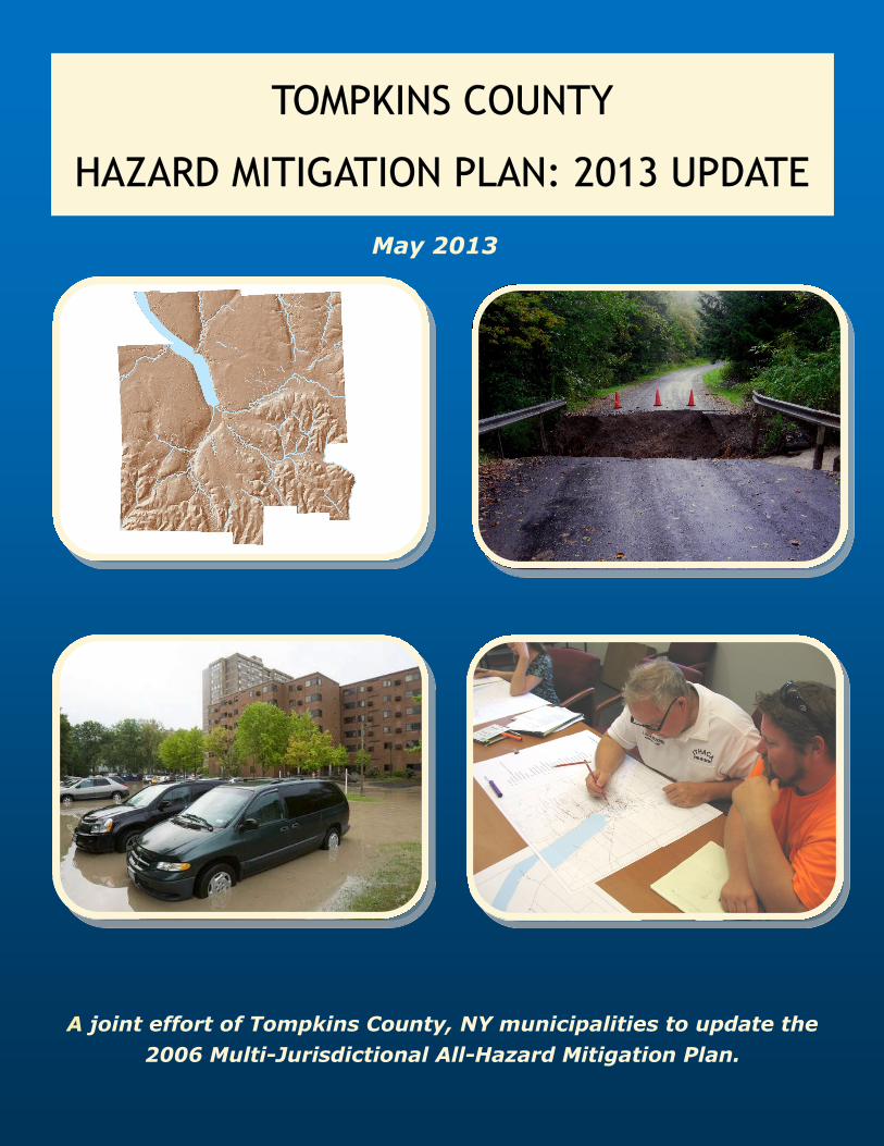
TOMPKINS COUNTY TOMPKINS COUNTY TOMPKINS COUNTY
HAZARD MITIGATION PLAN: 2013 UPDATE HAZARD MITIGATION PLAN: 2013 UPDATE HAZARD MITIGATION PLAN: 2013 UPDATE
A joint effort of Tompkins County, NY municipalities to update the
2006 Multi-Jurisdictional All-Hazard Mitigation Plan.
May 2013
This Multi-Jurisdictional All-Hazard Mitigation Plan Update has been completed by Barton &
Loguidice, P.C., under the direction and support of the Tompkins County Planning Department.
All jurisdictions within the County participated in this update process. A special thanks to the
representatives and various project team members, whose countless time and effort on this
project was instrumental in putting together a concise and meaningful document.
Tompkins County Planning Department
121 East Court Street
Ithaca, New York 14850
Tompkins County Department of Emergency Response
Emergency Response Center
92 Brown Road
Ithaca, New York 14850

Tompkins County Multi-Jurisdictional All-Hazard Mitigation Plan
560.018.001/5.13 - i - Barton & Loguidice, P.C.
Table of Contents
Section Page
Executive Summary .......................................................................................................................1
1.0 Introduction ........................................................................................................................3
1.1 Background ..............................................................................................................3
1.2 Plan Purpose.............................................................................................................4
1.3 Planning Participants ...............................................................................................6
1.4 Hazard Mitigation Planning Process ........................................................................8
2.0 Tompkins County Profile ..................................................................................................9
2.1 Geographic Location ................................................................................................9
2.2 Climate Change in Tompkins County....................................................................10
2.3 Historical Overview ...............................................................................................12
2.4 Demographics ........................................................................................................13
2.5 Land Use ................................................................................................................15
2.6 Economic Characteristics and Employment ..........................................................18
2.7 Transportation ........................................................................................................19
2.8 Community Facilities and Critical Infrastructure ..................................................21
2.9 Tompkins County Department of Emergency Response .......................................21
3.0 Planning Process ..............................................................................................................22 3.1 Resources and Information Collection...................................................................22
3.1.1 Planning Mechanisms and Capabilities .....................................................22
3.2 Planning Team and Technical Committee .............................................................25
3.3 Jurisdiction Participation .......................................................................................25
3.4 Public Participation ................................................................................................26
3.5 Coordination with Agencies and Neighboring Communities ................................26
4.0 Risk Assessment ...............................................................................................................27
4.1 Framing the Risk Assessment Using HIRA-NY ...................................................28
4.2 Hazard Identification .............................................................................................31
4.3 Results of the Tompkins County HIRA-NY ..........................................................37
4.4 Presidential Disaster Declaration ...........................................................................40
4.5 Natural Gas Drilling ...............................................................................................41
5.0 Hazard Histories and Future Potential .........................................................................43
5.1 Natural Hazard Profiles..........................................................................................44
5.1.1 Severe Storms and Hurricane.....................................................................44
5.1.2 Flash Flood.................................................................................................47
5.1.3 Earthquake .................................................................................................51
5.1.4 Lake Flood .................................................................................................55
5.1.5 Severe Winter Storm and Ice Storm ..........................................................56

Tompkins County Multi-Jurisdictional All-Hazard Mitigation Plan
560.018.001/5.13 - ii - Barton & Loguidice, P.C.
Table of Contents – Continued
Section Page
5.1.6 Ice Jams ......................................................................................................57
5.1.7 Landslides ..................................................................................................58
5.1.8 Drought ......................................................................................................60
5.1.9 Infestation ..................................................................................................61
5.1.10 Extreme Temperatures ...............................................................................66
5.1.11 Epidemic ....................................................................................................68
5.1.12 Tornado ......................................................................................................69
5.2 Technological and Human-Caused Hazard Profiles ..............................................71
5.2.1 Transportation Accident.............................................................................71
5.2.2 Fuel Shortage .............................................................................................73
5.2.3 Fire (Urban) ...............................................................................................74
5.2.4 Utility Failure .............................................................................................75
5.2.5 Water Supply Contamination .....................................................................76
5.2.6 Hazardous Materials in Transit ..................................................................77
5.2.7 Terrorism....................................................................................................78
5.2.8 Civil Unrest ................................................................................................80
6.0 Hazard Vulnerability .......................................................................................................82
6.1 Identify Assets .......................................................................................................82
6.2 Jurisdiction Vulnerabilities ....................................................................................82
6.3 Damage Potential ...................................................................................................83
6.4 Development Trends ..............................................................................................85
6.4.1 Affordable Housing ...................................................................................87
6.4.2 Development Focus Areas .........................................................................87
7.0 Hazard Mitigation and Adaptation ................................................................................88
7.1 Mitigation and Adaptation Goals ...........................................................................88
7.2 Mitigation and Adaptation Strategy .......................................................................88
7.2.1 Mitigation and Adaptation Actions ............................................................88
7.2.2 2006 Plan Implementation .........................................................................90
7.2.3 Mitigation and Adaptation Strategy ...........................................................90
7.2.4 Mitigation and Adaptation Action Prioritization .......................................97
8.0 National Flood Insurance Program ..............................................................................102
8.1 Tompkins County Flood Mapping .......................................................................102
8.2 Tompkins County NFIP Policy and Loss Statistics .............................................103
8.3 NFIP Mitigation Actions......................................................................................105
Tompkins County Multi-Jurisdictional All-Hazard Mitigation Plan
560.018.001/5.13 - iii - Barton & Loguidice, P.C.
Table of Contents – Continued
Page
9.0 Plan Maintenance Process .............................................................................................107
9.1 Plan Monitoring and Evaluation ..........................................................................107
9.2 Plan Updating.......................................................................................................108
9.3 Local Planning Considerations ............................................................................108
9.4 Public Involvement ..............................................................................................110
10.0 Works Cited ....................................................................................................................111
Figures
Figure 1.1 The Phases of Emergency Management ..................................................................3
Figure 1.2 Participating Jurisdictions ........................................................................................7
Figure 2.1 Average Annual Precipitation for New York State ............................... Appendix A
Figure 2.2 Average January Temperatures for New York State ............................. Appendix A
Figure 2.3 Average July Temperatures for New York State ................................... Appendix A
Figure 2.4 Population Diversity Graph ................................................................... Appendix A
Figure 2.5 Changes in Land Cover – 1969, 1995, and 2007 .................................. Appendix A
Figure 2.6 Mapped Agricultural Districts within Tompkins County ...................... Appendix A
Figure 2.7 Natural Feature and Agricultural Resources Focus Areas .....................................17
Figure 2.8 Transportation Facilities in Tompkins County ......................................................20
Figure 2.9 Critical Facilities in Tompkins County .................................................. Appendix A
Figure 4.1 Three Phases of Risk Assessment ..........................................................................27
Figure 4.2 The Risk Assessment Process ................................................................................28
Figure 4.3 Tompkins County Critical Facilities ...................................................... Appendix A
Figure 5.1 Probability for Severe Hail to Occur in the United States ..................... Appendix A
Figure 5.2 Wind Zones within the United States .................................................... Appendix A
Figure 5.3 Average Number of Thunderstorm Wind Days a Year, 1990-1999 ......................45
Figure 5.4 Shows the FEMA Floodplain Mapping for Tompkins County .............................48
Figure 5.5 Agricultural Properties that Intersect Flood Zones ................................ Appendix A
Figure 5.6 Seismic Activity within the Northeastern U.S. and Eastern Canada,
October 1975 – March 2010 .................................................................. Appendix A
Figure 5.7 Peak Ground Acceleration Values for New York State ......................... Appendix A
Figure 5.8 Special Acceleration Data for Tompkins County ..................................................53
Figure 5.9 Estimated Annual Earthquake Loss by County .....................................................54
Figure 5.10 Number of Ice Jam Incidents on New York State Rivers ...................... Appendix A
Figure 5.11 Landslide Susceptibility within New York State ...................................................60
Figure 5.12 Percentage of Ash per Total Basal per County in New York State .......................63
Figure 5.13 Emerald Ash Borer Infestation, Detection, and Quarantine Locations
within New York State...........................................................................................64
Figure 5.14 Asian Longhorn Beetle Susceptible Areas in United States .................. Appendix A
Figure 5.15 Hydrilla: 2012 Herbicide Application Plan ........................................... Appendix A

Tompkins County Multi-Jurisdictional All-Hazard Mitigation Plan
560.018.001/5.13 - iv - Barton & Loguidice, P.C.
Table of Contents – Continued
Figures (continued) Page
Figure 5.16 Percent of Populations Most Vulnerable to Extreme Temperature Events ...........67
Figure 5.17 Tornado Activity in United States, 1950-1998 ...................................... Appendix A
Figure 5.18 Tornado Risk Areas in the Continental Unites States ............................ Appendix A
Figure 5.19 Tornado Tracks within New York State, 1950-2005 .............................................70
Figure 5.20 State Route Transportation Network in Tompkins County ...................................72
Tables
Table 1 Approximate Areas for Jurisdictions Within Tompkins County .............................9
Table 2 Annual Temperature, Precipitation, and Snowfall Data Recorded Between
1951 and 2011 and Displayed as Decade Averages ..............................................11
Table 3 Tompkins County Population Data ........................................................................14
Table 4 Percentage of Acreage per Jurisdiction by Land Use Categories ..........................15
Table 5 Land Use and Land Cover Change in Tompkins County ......................................16
Table 6 Protected Natural Areas .........................................................................................17
Table 7 Change Observed in Total Number of Jobs in Different Industries
Between June 2011 and June 2012 – Ithaca Metropolitan Statistical Area ...........18
Table 8 Top Major Employers for Tompkins County – 2006 ............................................18
Table 9 Economic Characteristics of Tompkins County, 2006-2010 ................. Appendix A
Table 10 Airport Facilities Located Within Tompkins County ............................ Appendix A
Table 11 Planning Mechanisms and Capabilities for Each Participating Jurisdiction .........23
Table 12 Tompkins County Risk Assessment Hazard Rankings ..........................................38
Table 13 HIRA-NY Risk Assessment Rating Characteristics ..............................................39
Table 14 Primary Hazards Determined to Affect Tompkins County ...................................43
Table 15 Hazards Identified as Having the Potential to be Impacted by Climate Change ...44
Table 16 NOAA NCDC Query Results: Severe Storm Events ............................ Appendix A
Table 17 Tompkins County Flash Flood Events between October 2005 and
October 2012 ..........................................................................................................49
Table 18 NFIP Flood Damage Data for Tompkins County .................................. Appendix A
Table 19 Richter Magnitude Scale and Mercalli Intensity Scale Ratings .............................52
Table 20 NOAA NCDC Query Results: Severe Winter Storms ........................... Appendix A
Table 21 Ice Jam Database Events in Tompkins County...................................... Appendix A
Table 22 Enhanced F-scale System to Rate Tornado Events................................ Appendix A
Table 23 Historic Tornado Events for Tompkins County.....................................................69
Table 24 Housing Types .......................................................................................................83
Table 24 Age of Structures ...................................................................................................83
Table 25 Housing Values ......................................................................................................84
Table 26 Natural Hazards: Range of Potential Damages ($) to Vulnerable
Structures in Tompkins County .............................................................................85
Tompkins County Multi-Jurisdictional All-Hazard Mitigation Plan
560.018.001/5.13 - v - Barton & Loguidice, P.C.
Table of Contents – Continued
Tables (continued) Page Table 27 Estimated Property Values of Lands within Tompkins County ............ Appendix A Table 28 Individual Municipality Mitigation and Adaptation Action Strategies ................ 91 Table 29 Status and Details of 2006 HMP Mitigation Actions ........................... Appendix A Table 30 Benefit and Cost Prioritization Rankings ............................................................ 97 Table 31 HIGH PRIORITY Multi-Jurisdictional Mitigation and Adaptation Action Strategies ................................................................................................ 99 Table 32 Additional Mitigation Action Strategies – Lower Priority .................... Appendix A Table 33 Total Parcels Mapped in 100- and 500-Year Floodplains by Jurisdiction .......... 103 Table 34 NFIP Policy Statistics, Snapshot as of August 31, 2012.................................... 104 Table 35 NFIP Loss Statistics, as of August 31, 2012 for Losses Incurred Since January 1, 1978 ................................................................................................ 105 Table 36 Planning Mechanism Incorporation .................................................................. 109 Appendices Appendix A Additional Figures and Tables Appendix B Tompkins County Historical Information Appendix C Hazard Mitigation Plan Implementation Committee meeting notes – 2007 &
2008 Appendix D Website Links to Tompkins County Planning Resources Appendix E Hazard Mitigation Plan Update Process Meeting Timeline and Attendees Appendix F Plan Adoption Resolution and Sample Resolution Appendix G Tompkins County Community Facilities and Critical Infrastructure List Appendix H Tompkins County Transportation Infrastructure with Reoccurring Flooding
Issues Appendix I Hazard Mitigation Plan Update Process Checklist
Tompkins County Multi-Jurisdictional All-Hazard Mitigation Plan
560.018.001/5.13 - 1 - Barton & Loguidice, P.C.
Executive Summary
To collectively reduce Tompkins County’s hazard risk, each of the 17 jurisdictions in the County
worked together in producing this update to the Tompkins County Multi-Jurisdictional All-
Hazard Mitigation Plan. The initial mitigation plan was finalized and approved by FEMA in
1996. Having a FEMA-approved hazard mitigation plan allows communities to be eligible for
federal pre-disaster mitigation funds. Hazard mitigation is broadly defined as a method for
reducing or alleviating losses prior to a hazard event. Mitigation should not be confused with
the other distinctly different phases of emergency management which include preparedness,
response, and recovery. This Plan includes aspects of each of these other phases, though its focus
is on mitigation.
There are several aspects of the update which differ from the 1996 Plan. For one, the previous
Plan involved just a little over half of the County’s jurisdictions, whereas the update includes all
17 jurisdictions. Also, the 1996 Plan analyzed risks associated with just 12 hazards; the Plan
update examines 22. The most significant new aspect of the Plan update includes the
examination of future hazard risks, specifically as related to climate change and future potential
of horizontal hydraulic fractured gas drilling.
The 22 hazards identified were examined based on scope, cascading effect, frequency of
occurrence, time of onset, duration and recovery time. A group of community stakeholders
utilized these criteria in examining the hazard’s relative risk to Tompkins County. Those hazards
identified by the group as highest risk were transportation accidents, severe storms, flash floods,
and infestations. Infestations are events characterized as an excessive population of plants,
insects, rodents, or other animals requiring control measures due to their potential to carry
diseases, destroy crops, or harm the environment. The recent regional issues surrounding
invasive forest pests and the aquatic invasive, hydrilla, have elevated this hazard risk.
In further examining these hazards, both history and future potential for occurrence were
examined. As an example, flash floods, which were distinguished from lake floods, have
occurred 24 times over the last 19 years. This flooding has largely occurred within the nearly
10,000 acres of mapped floodplain. The total reported countywide annual losses associated with
flash floods are nearly $47,000. The New York State Energy Research and Development
Authority (NYSERDA)’s ClimAid technical report projects that average annual precipitation is
projected to increase by up to 5% by the 2020s, 10% by the 2050s and up to 15 percent by the
2080s. These increases would surely affect the frequency and severity of flash flooding events in
Tompkins County.
Recognizing that hazard risk does not respect political boundaries, every Town, City and Village,
along with Tompkins County, participated in the Plan update. To assist in guiding the update, a
Project Team was established and represented by at least one municipal representative from each
participating jurisdiction. The team was responsible for assisting in data collection, document
review, and coordination efforts. Additionally, a Technical Committee was established. The
Technical Committee includes researchers, practitioners, and others, whose task is to aid in
guiding and revising the plan based on their various interests and areas of expertise.

Tompkins County Multi-Jurisdictional All-Hazard Mitigation Plan
560.018.001/5.13 - 2 - Barton & Loguidice, P.C.
The Plan’s Project Team identified a number of actions designed to reduce community risk
associated with the identified hazards. The proposed actions are varied, but can be grouped into
the following six broad categories: prevention, property protection, public education and
awareness, natural resource protection, emergency services, and structural projects. Each
jurisdiction identified actions pertinent to their specific communities’ as well multi-jurisdictional
actions. Actions were evaluated based on an initial evaluation of costs and benefits. Of the
multi-jurisdictional actions, 15 were noted as high priority requiring implementation over the
next five years. High priority actions that were identified include developing a countywide debris
management plan, updating the County’s flood insurance rate maps, and conducting annual
climate science outreach to municipalities and large institutions.
The Plan is designed to be easily updated and implementable. As identified in the Plan
Maintenance Section (Section 9.0), the Plan will be evaluated annually by an Implementation
Committee which is made up of the participating jurisdictions. The Committee will evaluate a
number of aspects related to the Plan, including any issues associated with the implementation of
the priority actions.
The Plan update provides the jurisdictions of Tompkins County a path toward a future in which
the risks associated with natural, technological and man-made hazards can be collectively
reduced.

Tompkins County Multi-Jurisdictional All-Hazard Mitigation Plan
560.018.001/5.13 - 3 - Barton & Loguidice, P.C.
1.0 Introduction
1.1 Background
What is a Hazard?
A hazard is defined as a situation which poses a level of threat to life, health, property, and/or the
environment. A hazard can be natural, technological or human-caused.
What is Hazard Mitigation?
Hazard mitigation is broadly defined as a method for reducing or alleviating property loss,
reducing damage to the environment, and reducing the number and severity of injuries that occur
from hazard events through long and short-term strategies. Responsibility for implementing
mitigation measures runs community wide from individuals to industries, private business and all
levels of government.
Hazard Mitigation and the Other Phases of Emergency Management
Hazard mitigation is often considered just one of four phases of emergency management. The
other phases include preparedness, response and recovery. Each of these phases relate to and rely
upon each other, as illustrated by Figure 1.1.
Figure 1.1 – The Phases of Emergency Management
The overarching goal of all of these emergency management activities is the prevention or
minimizing of loss of life and property in disaster situations. The Tompkins County Department
of Emergency Response (DOER) serves as the lead local agency in promoting this goal. DOER’s
responsibilities include:
Provision of public preparedness information, including sharing of such information with
citizens, the private sector, municipalities, and non-governmental organizations (NGOs)
Tompkins County Multi-Jurisdictional All-Hazard Mitigation Plan
560.018.001/5.13 - 4 - Barton & Loguidice, P.C.
Participate in planning activities of many types and at many levels (keeper of the
County’s Comprehensive Emergency Plan) in partnership with other agencies involved in
emergency responses … authoring After Action Reports/Improvement Plans that identify
best practices as well as areas for improvement.
Coordination of fire and Emergency Medical Services (EMS) responses within the
County
911 Center Operations (Public Safety); communications systems
Liaison to State and Federal resources in times of disasters
Operation of the County’s Emergency Operations Center during the time of a
disaster/emergency; and
Coordination of recovery efforts after a disaster and liaison with State and Federal
agencies involved in this process.
It is important to note that this plan relates to several of these emergency management
phases, though its focus is mitigation.
FEMA and Hazard Mitigation
The Federal Emergency Management Agency (FEMA) provides assistance through the Robert T.
Stafford Disaster Relief and Emergency Assistance Act to local governments that are recovering
from a hazard event. The Federal Disaster Mitigation Act of 2000 (DMA 2000) recognized the
importance and cost-effectiveness of mitigation in specifying that local governments must have a
FEMA approved natural hazard mitigation plan in order to be eligible for mitigation project
funding.
DMA 2000 encourages and rewards local and state pre-disaster planning, promotes conservation
and sustainability, and seeks to integrate state and local planning with an overall goal of
strengthening statewide hazard mitigation planning. As of November 1, 2004, all local
governments were required to have a FEMA approved hazard mitigation plan to receive funding
through the Hazard Mitigation Grant Program (HMGP) for specified mitigation projects.
Tompkins County was awarded a pre-disaster mitigation grant to update their 2006 Multi-
Jurisdictional All-Hazard Mitigation Plan in order to maintain this eligibility.
1.2 Plan Purpose
Why Develop a Hazard Mitigation Plan?
The purpose of this Multi-Jurisdictional All-Hazard Mitigation Plan (HMP) is to effectively
reduce future disaster damages, public expenditure, private losses, and community hazard
vulnerability. This plan update provides an opportunity for Tompkins County and its
municipalities to develop a comprehensive risk assessment and to outline proposed mitigation
actions to minimize the costs and impacts of future disaster events.
The intention of this plan update is to meet the New York State and federal hazard mitigation
planning requirements established and managed by the New York State Office of Emergency
Tompkins County Multi-Jurisdictional All-Hazard Mitigation Plan
560.018.001/5.13 - 5 - Barton & Loguidice, P.C.
Management (NYS OEM) and FEMA. Jurisdictions that are participating in this plan update
will benefit from the planning and implementation of the mitigation actions proposed and
included within. The Pre-Disaster Mitigation Program (PDM) and the Flood Mitigation
Assistance Program (FMA) continue to require communities to have an active FEMA-approved
multi-hazard mitigation plan in-place prior to requesting project implementation funds.
Participating jurisdictions that are granted funds are able to implement and complete positive
mitigation actions to minimize impacts to their communities from hazard events. The following
resources are key documents which authorize and provided guidance for the preparation of this
plan update:
Section 404 of Robert T. Stafford Disaster Relief and Emergency Assistance Act, Public
Law 93-288, as amended by Public Law 100-707;
Federal Disaster Mitigation Act of 2000;
Hazard Mitigation Grant Program (HMGP), Pre-disaster Mitigation Program, Flood
Mitigation Assistance Program, Repetitive Floodplain Claims Program (RFC), Severe
Repetitive Loss Program (SRL);
Code of Federal Regulations (CFR) – 44 Part 201;
Hazard Mitigation and Relocation Assistance Act of 1993;
FEMA – 44 CFR Part 9 – Floodplain Management and Protection of Wetlands and 44
CFR Part 10 – Environmental Considerations;
New York State Executive Law, Article 2-B, Sections 23 and 28-a; and
New York State Hazard Mitigation Plan (2011).
The Tompkins County Planning Department (TCPD) organized the effort to update the
Tompkins County Multi-Jurisdictional All-Hazard Mitigation Plan that was originally adopted in
2006. The efforts made to update the original plan were made possible by a grant from FEMA
that was administered by the Tompkins County Planning Department. The five year plan
maintenance period has lapsed and Tompkins County contracted with Barton & Loguidice, P.C.,
hired through a formal request for qualifications (RFQ) process, to assist in the update effort. In
addition to the basic requirements of updating the plan, Tompkins County is seeking the
integration of three new features: the involvement of all 17 jurisdictions in Tompkins County,
the impacts and risks associated with anticipated climate change, and the impacts and risks
associated with anticipated widespread shale gas drilling. The continued monitoring and
evaluation of this updated HMP will be provided by the TCPD.
The development of a HMP update for Tompkins County provides the following benefits:
eligibility for federal funds to complete pre-disaster mitigation actions;
development of more sustainable and disaster-resistant communities;
formation of partnerships that support planning and mitigation efforts;
reduction in long-term impacts to structures and human-health associated with extreme
hazard events which are in some cases exacerbated by changing climactic conditions; and
Tompkins County Multi-Jurisdictional All-Hazard Mitigation Plan
560.018.001/5.13 - 6 - Barton & Loguidice, P.C.
increased understanding of the hazards that could potentially impact the County and its
municipalities.
Comments or questions about this plan should be addressed to the Tompkins County Planning
Department, 121 East Court Street, Ithaca, NY 14850. This office can also be reached by phone
at (607) 274-5560 and by email from their website http://www.tompkins-
co.org/planning/staff/contact.htm.
1.3 Planning Participants
The 2012 HMP Update for Tompkins County includes all 17 jurisdictions located within
Tompkins County: Tompkins County, nine towns (Caroline, Danby, Dryden, Enfield, Groton,
Ithaca, Lansing, Newfield, and Ulysses), six villages (Cayuga Heights, Dryden, Freeville,
Groton, Lansing, Trumansburg), and one city (Ithaca). Figure 1.2 shows the locations of these
municipalities within the County limits and the position of Tompkins County within New York
State.
The participation of all jurisdictions in the HMP Update process fulfills one of the main goals
that Tompkins County had for this effort, and greatly improves the quality and completeness of
this planning effort. The original 2006 HMP included only seven participating jurisdictions:
Tompkins County and the Towns of Caroline, Danby, Enfield, Groton, Ithaca, Lansing, and
Ulysses. The City of Ithaca and Dryden independently fulfilled DMA 2000 requirements
through the implementation of single jurisdiction mitigation plans. The historic documentation
and risk assessment data included in these single jurisdiction plans will be incorporated into this
Multi-Jurisdictional HMP Update.
All municipalities within Tompkins County were contacted by the TCPD to participate in the
plan update and were invited to attend a variety of meetings held throughout the planning
process. Each participating jurisdiction provided updated information about the hazards that
have historically occurred within their boundaries, with a focus on post-2006 events. Repair
costs and damage estimates associated with such hazard events were also provided. All
jurisdictions reviewed the critical facilities within their boundaries and the risk assessment and
vulnerability information provided within this Plan Update. TCPD coordinated data collection
and information review with jurisdictions and agencies unable to attend scheduled meetings.
A wide variety of additional resources were utilized to gather information concerning historic
and recent occurrences of hazard events within Tompkins County, vulnerabilities within the
County related to future hazard events, and costs and damages likely to occur as a result of a
hazard event. The goals and objectives included in the County’s 2006 HMP were reviewed and
updated, as appropriate. Goals are created to assist in the formulation of potential mitigation
actions that could be implemented to minimize the damage in Tompkins County that could occur
to life, property, and/or the environment as a result of hazard events.
Representatives from the participating jurisdictions made up the Project Team. A Technical
Committee was also assembled by the TCPD; this committee consisted of representatives from
the following agencies, groups, and entities: Town of Ulysses, Cornell University, Tompkins
County Department of Health, Tompkins County Soil and Water District, Bolton Point Water

Tompkins County Multi-Jurisdictional All-Hazard Mitigation Plan
560.018.001/5.13 - 7 - Barton & Loguidice, P.C.
Treatment Plant, City of Ithaca, New York State Electric & Gas (NYSEG), Town of Lansing
Highway Department, Tompkins County Department of Emergency Response, and United States
Geological Survey (USGS). Technical Committee members were selected and invited to
participate in this update process based upon their specialties and fields of interest. Further detail
about the Project Team and the Technical Committee are provided in Section 3.0.
Figure 1.2 – Participating Jurisdictions
Tompkins County Multi-Jurisdictional All-Hazard Mitigation Plan
560.018.001/5.13 - 8 - Barton & Loguidice, P.C.
1.4 Hazard Mitigation Planning Process
As with Tompkins County’s original HMP, all participating jurisdictions accomplished the
following objectives to support the plan update process:
Established a knowledgeable planning group to represent all participating jurisdictions;
Assessed numerous natural, technological, and human-caused hazards to determine those
that have the greatest possibility of impacting the County;
Analyzed and profiled all selected hazards;
Incorporated recent planning efforts and new updated scientific information into hazard
profiles and mitigation activities;
Updated critical facility mapping within the County;
Estimated damages and impacts that could occur as a result of various hazard events;
Developed pre-disaster mitigation strategies and actions for the various types of hazards
detailed in this document; and
Reviewed and revised the plan maintenance procedures associated with this Plan.
DMA 2000 only requires that communities evaluate the impact of natural hazards. Though 14
natural hazards are the focus of this Plan Update, Tompkins County and other participants also
chose to assess the County’s vulnerability to six technological hazards and two human-caused
hazards. All of these hazards are further described and profiled in Section 5 of this Plan Update.

Tompkins County Multi-Jurisdictional All-Hazard Mitigation Plan
560.018.001/5.13 - 9 - Barton & Loguidice, P.C.
2.0 Tompkins County Profile
This section details the existing environmental features, transportation networks, demographics,
history, and available facilities within Tompkins County. A profile of Tompkins County and its
existing features and facilities was not included in the original 2006 HMP. Section 2.0 is a new
section that has been added to help detail and identify the existing conditions, capabilities, and
vulnerabilities of Tompkins County and its 16 participating jurisdictions.
2.1 Geographic Location
Tompkins County is located in Upstate New York, northwest of the City of Binghamton and
southwest of the City of Syracuse. Tompkins County is located in the Finger Lakes Region and
is geographically positioned near the southern end of Cayuga Lake. Cayuga Lake is
approximately 40 miles long, 3.5 miles wide at its widest point, and approximately 435 feet deep
at its deepest point. Tompkins County shares government boundaries with six adjacent New
York State counties: Cayuga (north), Cortland (east), Tioga (south), Chemung (southwest),
Schuyler (west), and Seneca (northwest).
The City of Ithaca serves as the county seat for Tompkins County. The County includes one
City, nine Towns, six Villages, and 31 Hamlets. Tompkins County consists of a total land area
of 474.6 square miles and a total water area of 16.9 square miles (2010 Census Gazetteer files,
2012). In terms of total area, the Town of Dryden is the largest jurisdiction within Tompkins
County, totaling 94.2 square miles. This equates to almost 20 percent (20%) of the total area of
the County. The Town of Ithaca is the smallest Town in Tompkins County, totaling 30.3 square
miles in area, which represents only six percent of the total area of Tompkins County. Table 1
provides the total areas (in square miles) for each jurisdiction included within Tompkins County.
Table 1 – Approximate Areas for Jurisdictions Within Tompkins County
(City-Data, 2011)
Jurisdiction
Total Area
(square miles)
Total Land
(square miles)
Total Water
(square miles)
% of Total Area
in County
Tompkins County 491.6 474.6 16.9 100.00%
Caroline (Town) 55.1 55.0 0.1 11.2%
Danby (Town) 53.7 53.5 0.2 10.9%
Dryden (Town) 94.2 93.9 0.3 19.2%
Enfield (Town) 36.9 36.9 0.0 7.5%
Groton (Town) 49.6 49.5 0.1 10.0%
Ithaca (Town) 30.3 29.1 1.2 6.2%
Ithaca (City) 6.1 5.5 0.6 1.2%
Lansing (Town) 69.9 60.7 9.2 14.2%
Newfield (Town) 59.0 58.9 0.1 12.0%
Ulysses (Town) 36.8 33.0 3.9 7.5%

Tompkins County Multi-Jurisdictional All-Hazard Mitigation Plan
560.018.001/5.13 - 10 - Barton & Loguidice, P.C.
Table 1 – Approximate Areas for Jurisdictions Within Tompkins County
(City-Data, 2011)
Jurisdiction
Total Area
(square miles)
Total Land
(square miles)
Total Water
(square miles)
% of Total Area
in County
Cayuga Heights (Village) 1.8 1.8 0.0 -
Dryden (Village) 1.7 1.7 0.0 -
Freeville (Village) 1.1 1.1 0.0 -
Groton (Village) 1.7 1.7 0.0 -
Lansing (Village) 4.6 4.6 0.0 -
Trumansburg (Village) 1.2 1.2 0.0 -
The northern portion of the County consists of more gentle terrain associated with moderate to
high elevation areas, whereas the southern portion of the County is dominated by the highest
elevations and the greatest topographic relief. Overall topography in the County ranges from
approximately 400 feet above mean sea level (msl) to greater than 2,000 feet above msl. The
highest topographic point in the County, Connecticut Hill, is located in the Town of Newfield at
an elevation of 2,200 feet above msl. The lowest elevation within the County is noted as the
surface water level of Cayuga Lake, recorded at 382 feet above msl.
2.2 Climate Change in Tompkins County
The climate of Tompkins County is of the humid continental type, typical of the interior
northeastern United States (NYS Climate Office, 2010). Humid continental climates are known
for their variable weather conditions, due to their location between the polar and tropic air
masses. Polar air masses collide with tropical air masses, causing uplift of the moist tropical air
and resulting in precipitation.
Since Tompkins County is far removed from the moderating effects of the ocean, the climate
experiences great swings in seasonal temperature (Ritter, 2006). Temperatures average 70°F in
July with lows of about 24°F in January, and the year-round average temperature is about 47°F.
The average monthly rainfall increases from January (2.0 inches) to July (4.1 inches) and
decreases from July (4.1 inches) to December (2.4 inches). Rainfall averages 35.9 inches
annually, while annual snowfall exceeds 70.0 inches and provides snow cover for the majority of
winter (Weatherbase, 2012). Figures 2.1, 2.2, and 2.3, included in Appendix A, illustrate
Tompkins County’s climate compared to the rest of New York State. The location of Tompkins
County on these figures is indicated by the purple star symbol. Table 2 also shows the average
temperatures, precipitation, and seasonal snowfall that have been recorded at the regional
National Weather Service Forecast Office in Binghamton between 1951 and 2011.

Tompkins County Multi-Jurisdictional All-Hazard Mitigation Plan
560.018.001/5.13 - 11 - Barton & Loguidice, P.C.
Table 2 – Annual Temperature, Precipitation, and Snowfall Data Recorded Between
1951 and 2011 and Displayed as Decade Averages (NWS, 2012)
Years
Average Temperature
(ºF)
Average Precipitation
(inches)
Average Seasonal
Snowfall (inches)
2001-2011 46.9 40.97 89.00
1991-2001 46.2 38.90 92.06
1981-1991 46.7 37.84 72.10
1971-1981 45.6 39.23 78.52
1961-1971 45.2 33.93 84.63
1951-1961 46.8 37.28 89.78
Overall Average 46.23 38.03 84.35
The best, most recent, climate science indicates a future of increased temperatures and shifting
precipitation patterns for Tompkins County and New York State. Rates are projected to increase
much faster than historic natural rates over the coming century, and as a result extreme hazard
events may increase in frequency and intensity. The NYSERDA-commissioned report, ClimAID:
the Integrated Assessment for Effective Climate Change Adaptation Strategies in New York
State, released in November 2011, was written by scientists from Cornell University, Columbia
University, and the City University of New York. The report and adaptation guidance focus
exclusively on climate change adaptation strategies specific to New York State, and is geared to
assist local decision-makers in developing and adopting adaptation strategies. The ClimAID
report highlights the need for Tompkins County to prepare for the following impacts:
Heat waves will become more frequent and intense, increasing heat-related illness and
death and posing new challenges to the energy system, air quality, and agriculture.
Summer drought is projected to increase, affecting water supply, agriculture,
ecosystems, and energy production.
Heavy downpours are increasing and are projected to increase further. These can lead to
flooding and related impacts on water quality, infrastructure, and agriculture.
Major changes to ecosystems including species range shifts, population crashes, and
other sudden transformations could have wide-ranging impacts, not only for natural
systems but also for health, agriculture, and other sectors.
The ClimAID report predicts that temperatures will rise across the state, by 1.5 to 3°F by the
2020s, 3 to 5.5°F by the 2050s, and 4 to 9°F by the 2080s, with the lower ends of these ranges
expected under lower greenhouse gas emissions and the higher ends for higher emissions
scenarios. The report notes that these are not the best and worst cases, just the most likely; sharp
cuts in global emissions could result in temperature increases lower than the bottom ends of
these ranges, while a continuation of business-as-usual could result in increases higher than the
high ends.
The ClimAID report also projects that annual average precipitation will increase by up to 5
percent by the 2020s, up to10 percent by the 2050s, and up to 15 percent by the 2080s. This will
Tompkins County Multi-Jurisdictional All-Hazard Mitigation Plan
560.018.001/5.13 - 12 - Barton & Loguidice, P.C.
not be distributed evenly over the course of the year. Much of this additional precipitation is
likely to occur during the winter months as rain, with the possibility of slightly reduced
precipitation projected for the late summer and early fall. Continuing the observed trend, more
precipitation is expected to fall in heavy downpours and less in light rains.
Vulnerabilities specific to Tompkins County that are identified in the ClimAID report are
potential flooding increases, milk production losses in a region dominated by dairy, and location
at the front line for the state as invasive insects, weeds and other pests move north.
In addition, the report highlights that some areas, including Tompkins County, are vulnerable in
other ways: rural areas are more vulnerable to, and have less capacity to cope with, extreme
events such as floods, droughts, ice storms, and other climate-related stressors; regions that
depend on agriculture and tourism (such as fishing, skiing, and snowmobiling) may be especially
in need of adaptation assistance; and low-income urban neighborhoods, especially those within
flood zones, are less able to cope with climate impacts such as heat waves and flooding. New
York State’s 2100 Commission’s Recommendations to Improve the Strength and Resilience of
the Empire State’s Infrastructure (2013) identified a need to reduce inland vulnerability to
extreme weather events. It is important that the community promote mitigation and adaptation
strategies that enable incremental adaptations across sectors and communities over time.
Mitigation and Adaptation strategies are described later in this report, specifically in Table 31
and Appendix A – Table 32.
Specific groups of people that are identified in the ClimAID report as being particularly
vulnerable include elderly, disabled, and health compromised individuals who are more
vulnerable to climate hazards, including floods and heat waves; low-income groups that have
limited ability to meet higher energy costs; farm workers who may be exposed to more
chemicals if pesticide use increases in response to climate change; asthma sufferers who will be
more vulnerable to the decline in air quality during heat waves; and people who depend on
public transportation and lack private cars for evacuating during emergencies. Small businesses
are also identified as being particularly vulnerable, as they are typically less able to cope with
costly climate related interruptions and stresses, such as power and communication service
disruptions, than larger businesses. Climate Change projects by hazard are further detailed in the
natural hazard profiles included in Section 5.0.
2.3 Historical Overview
The earliest inhabitants of Tompkins County were the Cayugas, one of the five nations of the
Iroquois Confederacy. Settlement in the Tompkins County area began in 1792. Early settlers
consisted of squatters and others cashing in their Military Tract land allocations. In 1817,
Tompkins County was formally established through an act of the New York State Legislature.
Soon after, Cornell University was established (1865), bringing solidity to the County’s economy
by attracting students, faculty, and many new residents. Ithaca College opened almost thirty
years later in 1892 in downtown Ithaca. For more historic context, reference Appendix B.
Tompkins County Multi-Jurisdictional All-Hazard Mitigation Plan
560.018.001/5.13 - 13 - Barton & Loguidice, P.C.
2.4 Demographics
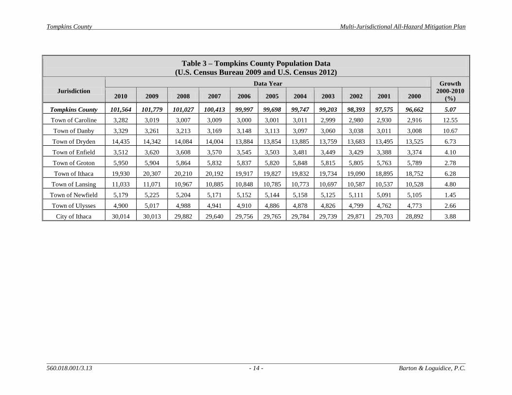
According to the U.S. Census, the population of Tompkins County totaled 101,564 in 2010,
reflecting a growth of 5,063 people when compared to the 2000 U.S. Census data (96,501
people). This increase in population over the past decade reflects steady growth within the
County. Table 3 provides population data for the County and its Cities and Towns (including
respective Villages) over the past decade (2000-2010). Within that time period, City of Ithaca
and all Towns within the County have seen positive population growth (2.0% or greater), while
growth within Tompkins County is documented at 5.29 percent.
Population age data indicated that 16,659 people were estimated to be under 18 years (16.4%)
and 10,929 people were estimated to be over the age of 65 (10.8%) (U.S. Census Bureau,
2010(2)). Overall, Tompkins County has a greater population of individual’s between the ages
of 18 and 65 than New York State.
The 2010 Census indicates that 82.6 percent (%) of Tompkins County’s population was White,
4.0% of the population was Black or African American, 9.0% Asian, 0.4% American Indian and
Alaska Native, 1.2% some other race, and 3.2% two or more races. In addition, 4.2% of
Tompkins County residents reported themselves as being Hispanic or Latino (of any race) (U.S.
Census Bureau, 2010(2)). Figure 2.4 in Appendix A graphs the population diversity of
Tompkins County using a pie chart format.
Tompkins County Multi-Jurisdictional All-Hazard Mitigation Plan
560.018.001/3.13 - 14 - Barton & Loguidice, P.C.
Table 3 – Tompkins County Population Data
(U.S. Census Bureau 2009 and U.S. Census 2012)
Jurisdiction
Data Year Growth
2000-2010
(%) 2010 2009 2008 2007 2006 2005 2004 2003 2002 2001 2000
Tompkins County 101,564 101,779 101,027 100,413 99,997 99,698 99,747 99,203 98,393 97,575 96,662 5.07
Town of Caroline 3,282 3,019 3,007 3,009 3,000 3,001 3,011 2,999 2,980 2,930 2,916 12.55
Town of Danby 3,329 3,261 3,213 3,169 3,148 3,113 3,097 3,060 3,038 3,011 3,008 10.67
Town of Dryden 14,435 14,342 14,084 14,004 13,884 13,854 13,885 13,759 13,683 13,495 13,525 6.73
Town of Enfield 3,512 3,620 3,608 3,570 3,545 3,503 3,481 3,449 3,429 3,388 3,374 4.10
Town of Groton 5,950 5,904 5,864 5,832 5,837 5,820 5,848 5,815 5,805 5,763 5,789 2.78
Town of Ithaca 19,930 20,307 20,210 20,192 19,917 19,827 19,832 19,734 19,090 18,895 18,752 6.28
Town of Lansing 11,033 11,071 10,967 10,885 10,848 10,785 10,773 10,697 10,587 10,537 10,528 4.80
Town of Newfield 5,179 5,225 5,204 5,171 5,152 5,144 5,158 5,125 5,111 5,091 5,105 1.45
Town of Ulysses 4,900 5,017 4,988 4,941 4,910 4,886 4,878 4,826 4,799 4,762 4,773 2.66
City of Ithaca 30,014 30,013 29,882 29,640 29,756 29,765 29,784 29,739 29,871 29,703 28,892 3.88

Tompkins County Multi-Jurisdictional All-Hazard Mitigation Plan
560.018.001/5.13 - 15 - Barton & Loguidice, P.C.
2.5 Land Use
Land use within Tompkins County is mixed, with the majority of tax parcel use reflected in the
following land use categories: agriculture, residential, commercial, and vacant land. Table 4
displays the percent of acreage for each jurisdiction in Tompkins County by land use category.
Figure 2.5 in Appendix A displays land use and land cover information for Tompkins County
from the Tompkins County Planning Department (2007). This figure illustrates changes in land
use and cover between the years 1969, 1995, and 2007. Table 5 shows the changes in land
use/land cover categories between 1969, 1995, and 2007 by percentage.
Table 4 – Percentage of Acreage per Jurisdiction by Land Use Categories
(Tompkins County Planning Department)
Ju
risd
icti
on
Ag
ricu
ltu
re
Ba
rren
Co
mm
erci
al
Ina
ctiv
e
Ag
ricu
ltu
re
Ind
ust
ria
l
Pu
bli
c/In
stit
u
tio
na
l
Rec
rea
tio
n
Res
iden
tia
l
Tra
nsp
ort
ati
o
n
Veg
eta
tiv
e
Co
ver
Wa
ter
Wet
lan
ds
(C) Ithaca 0% 1% 12% 0% 3% 8% 10% 35% 1% 19% 10% 1%
(T) Caroline 14% 0% 0% 4% 0% 0% 0% 4% 0% 73% 0% 3%
(T) Danby 8% 0% 0% 4% 0% 0% 0% 5% 0% 78% 1% 3%
(V) Dryden 7% 1% 4% 4% 1% 4% 2% 31% 0% 35% 0% 11%
(V) Freeville 25% 0% 1% 0% 0% 4% 1% 15% 0% 40% 3% 10%
(T) Dryden 18% 0% 0% 5% 1% 0% 0% 8% 0% 60% 1% 6%
(T) Enfield 31% 0% 0% 6% 0% 0% 1% 8% 0% 51% 1% 2%
(V) Groton 10% 0% 4% 2% 1% 6% 3% 30% 0% 40% 0% 4%
(T) Groton 37% 0% 0% 7% 0% 0% 1% 7% 0% 42% 0% 5%
(V) Cayuga Heights 0% 0% 2% 0% 0% 5% 2% 71% 1% 19% 0% 0%
(T) Ithaca 15% 1% 1% 3% 1% 3% 3% 19% 0% 49% 4% 1%
(V) Lansing 2% 1% 11% 0% 1% 2% 1% 19% 13% 47% 0% 3%
(T) Lansing 31% 0% 1% 4% 1% 0% 1% 9% 1% 36% 14% 2%
(T) Newfield 11% 0% 0% 3% 0% 0% 0% 6% 0% 78% 0% 1%
(V) Trumansburg 7% 0% 3% 4% 0% 6% 4% 46% 0% 28% 1% 1%
(T) Ulysses 34% 0% 1% 5% 0% 0% 1% 9% 0% 37% 11% 2%
Tompkins County Multi-Jurisdictional All-Hazard Mitigation Plan
560.018.001/5.13 - 16 - Barton & Loguidice, P.C.
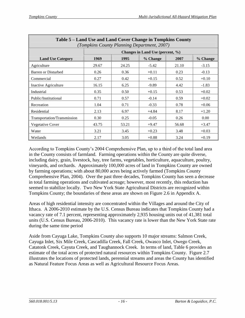
Table 5 – Land Use and Land Cover Change in Tompkins County
(Tompkins County Planning Department, 2007)
Land Use Category
Changes in Land Use (percent, %)
1969 1995 % Change 2007 % Change
Agriculture 29.67 24.25 -5.42 21.10 -3.15
Barren or Disturbed 0.26 0.36 +0.11 0.23 -0.13
Commercial 0.27 0.42 +0.15 0.52 +0.10
Inactive Agriculture 16.15 6.25 -9.89 4.42 -1.83
Industrial 0.35 0.50 +0.15 0.53 +0.02
Public/Institutional 0.71 0.57 -0.14 0.59 +0.02
Recreation 1.04 0.71 -0.33 0.78 +0.06
Residential 2.13 6.97 +4.84 8.17 +1.20
Transportation/Transmission 0.30 0.25 -0.05 0.26 0.00
Vegetative Cover 43.75 53.21 +9.47 56.68 +3.47
Water 3.21 3.45 +0.23 3.48 +0.03
Wetlands 2.17 3.05 +0.88 3.24 +0.19
According to Tompkins County’s 2004 Comprehensive Plan, up to a third of the total land area
in the County consists of farmland. Farming operations within the County are quite diverse,
including dairy, grain, livestock, hay, tree farms, vegetables, horticulture, aquaculture, poultry,
vineyards, and orchards. Approximately 100,000 acres of land in Tompkins County are owned
by farming operations; with about 80,000 acres being actively farmed (Tompkins County
Comprehensive Plan, 2004). Over the past three decades, Tompkins County has seen a decrease
in total farming operations and cultivated acreage; however, most recently, this reduction has
seemed to stabilize locally. Two New York State Agricultural Districts are recognized within
Tompkins County; the boundaries of these areas are shown on Figure 2.6 in Appendix A.
Areas of high residential intensity are concentrated within the Villages and around the City of
Ithaca. A 2006-2010 estimate by the U.S. Census Bureau indicates that Tompkins County had a
vacancy rate of 7.1 percent, representing approximately 2,935 housing units out of 41,381 total
units (U.S. Census Bureau, 2006-2010). This vacancy rate is lower than the New York State rate
during the same time period
Aside from Cayuga Lake, Tompkins County also supports 10 major streams: Salmon Creek,
Cayuga Inlet, Six Mile Creek, Cascadilla Creek, Fall Creek, Owasco Inlet, Owego Creek,
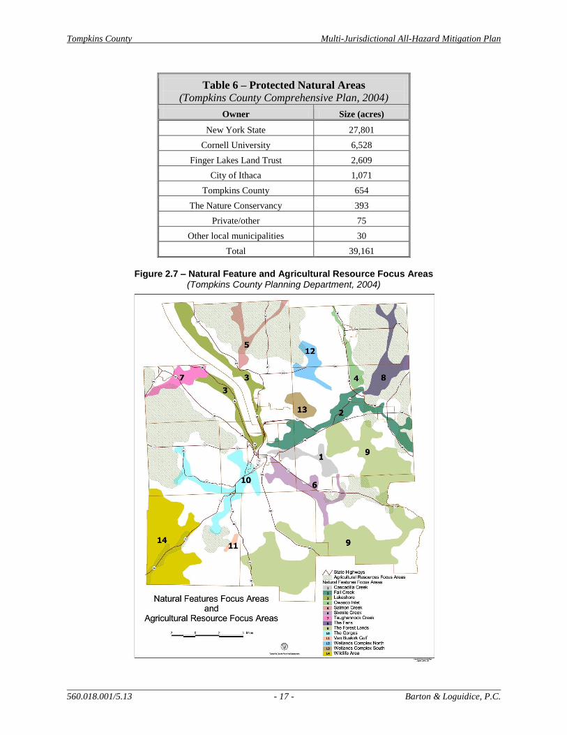
Catatonk Creek, Cayuta Creek, and Taughannock Creek. In terms of land, Table 6 provides an
estimate of the total acres of protected natural resources within Tompkins County. Figure 2.7
illustrates the locations of protected lands, perennial streams and areas the County has identified
as Natural Feature Focus Areas as well as Agricultural Resource Focus Areas.
Tompkins County Multi-Jurisdictional All-Hazard Mitigation Plan
560.018.001/5.13 - 17 - Barton & Loguidice, P.C.
Table 6 – Protected Natural Areas
(Tompkins County Comprehensive Plan, 2004)
Owner Size (acres)
New York State 27,801
Cornell University 6,528
Finger Lakes Land Trust 2,609
City of Ithaca 1,071
Tompkins County 654
The Nature Conservancy 393
Private/other 75
Other local municipalities 30
Total 39,161
Figure 2.7 – Natural Feature and Agricultural Resource Focus Areas
(Tompkins County Planning Department, 2004)
Tompkins County Multi-Jurisdictional All-Hazard Mitigation Plan
560.018.001/5.13 - 18 - Barton & Loguidice, P.C.
2.6 Economic Characteristics and Employment
The unemployment rate in Tompkins County has increased over the past year to approximately
6.4% (NYS Dept. of Labor, 2012), though it remains lower than the New York State
unemployment rate of 7.9%. The increase or decrease in numbers of jobs within different
industries between June 2011 and June 2012 is shown in Table 7. The data reported in this table
represents the Ithaca Metropolitan Statistical Area (IMSA), which includes all of Tompkins
County.
Table 7 – Change Observed in Total Number of Jobs in
Different Industries Between June 2011 and June 2012 –
Ithaca Metropolitan Statistical Area
(NYSDOL, 2012(2))
Industry
Change Observed
(# of jobs)
Education & Health Service -500
Manufacturing 0
Trade, Transportation, Utilities 0
Professional & Business Services +100
Financial Activities 0
Information -100
Natural Resources, Mining, Construction 0
Leisure & Hospitality +200
Other Services 0
The top 21 major employers for 2006 (most recent data available) in Tompkins County are listed
in Table 8.
Table 8 – Top Major Employers for Tompkins County - 2006
(Cornell University, 2006)
Company Name # of Employees
Cornell University 9,480
Ithaca College 1,525
Borg-Warner Automotive 1,500
Ithaca City School District 1,200
Cayuga Medical Center 1,000
County of Tompkins 750
Wegman’s Food Markets 570
Emerson Power Transmission 450
Franziska Racker Center 420
Tompkins/Seneca/Tioga BOCES 380

Tompkins County Multi-Jurisdictional All-Hazard Mitigation Plan
560.018.001/5.13 - 19 - Barton & Loguidice, P.C.
Table 8 – Top Major Employers for Tompkins County - 2006
(Cornell University, 2006)
Company Name # of Employees
Dryden Central School District 375
The CBORD Group 250
Therm, Inc. 225
Tompkins County Trust Co. 223
Tompkins Cortland Community College 200
Tops Friendly Markets 170
Thomas Group Architects and Engineers, PC 160
Boyce Thompson Institute 150
Hi-Speed Checkweigher 117
The Ithaca Journal 116
Holiday Inn Executive Towers 100-150 seasonal
Additional economic characteristics for Tompkins County are included as Table 9 in
Appendix A.
2.7 Transportation
In Tompkins County, roadway, rail, and air transportation options are available. Tompkins
County contains 15 State Routes that are maintained by the NYS Department of Transportation.
No Interstate Routes or U.S. Routes are located within Tompkins County. The County highway
system is comprised of approximately 88 routes (NYSDOT, 2011). Many of the County Routes
overlap with portions of State Routes. The locations of the major roadways in Tompkins County
are shown on Figure 2.8.
The Tompkins County Department of Public Works maintains more than 300 miles of County
roads and more than 100 bridges and is responsible for snow removal, maintaining County
buildings and parks, and maintaining the County’s vehicle fleet. The Department of Public
Works also operates the Tompkins County Regional Airport.
Cornell University owns and maintains over 15 miles of roadways, 61 miles of walkways, 114
acres of parking lots, and over 20 vehicle and pedestrian bridges. Cornell University Facilities
Management is responsible for the maintenance of these University transportation resources.
Many of these University transportation resources connect to and support community
transportation resources.
Only one active railroad remains in Tompkins County, the Norfolk Southern Railway Company.
Norfolk Southern operates a freight-only line that runs from the mainline of the former Lehigh
Valley track at the VanEtten Junction to just south of the former Ithaca station, and then along
the east shore of Cayuga Lake to Lake Ridge (HC Lee, 2008). The remaining historic railroad
segments have been abandoned and the tracks removed. Locations of active and abandoned
railroad segments are depicted on Figure 2.8.

Tompkins County Multi-Jurisdictional All-Hazard Mitigation Plan
560.018.001/5.13 - 20 - Barton & Loguidice, P.C.
In addition to the County’s Highway Department, there are nine Town Highway Departments,
one NYSDOT Barn, six Village Highway Departments and one City of Ithaca Department of
Streets and Facilities. The locations of these transportation maintenance facilities are denoted on
Figure 2.8.
In terms of air transportation, there are six public and private airports in Tompkins County. The
Ithaca Tompkins Regional Airport is the sole publicly owned airport in the County (Global
Aviation Navigator, 2012). The Ithaca Tompkins Regional Airport is owned and operated by
Tompkins County and is a division of the Department of Public Works. The airport has been
operated by Tompkins County since 1956. The Ithaca Tompkins Regional Airport recently
developed a Sustainable Master Plan and is the first airport to integrate sustainability into its
master plan. Table 10 in Appendix A details the active airport facilities within the County, and
Figure 2.8 depicts the locations of these airport facilities.
Figure 2.8 – Transportation Facilities in Tompkins County

Tompkins County Multi-Jurisdictional All-Hazard Mitigation Plan
560.018.001/5.13 - 21 - Barton & Loguidice, P.C.
2.8 Community Facilities and Critical Infrastructure
Many of the community facilities, including hospitals, medical facilities, and educational
facilities, identified for each participating jurisdiction, are clustered around the City of Ithaca,
and the Villages and Hamlets within the County. Community facilities identified for hazard
planning have been updated significantly since the 2006 Plan. Such facilities include utility
infrastructure (water tanks, electric substations, cell towers, etc.), banks, senior housing, mobile
home complexes, boatyards, bus terminals, municipal buildings, community centers, correctional
facilities, courthouses, dams, day care centers, schools, emergency operations, fire and police
departments, highway facilities, human services, major industrial locations, medical facilities and
hospitals, post offices, sports complexes and facilities, and locations of other public facilities.
For the sake of this planning effort “critical infrastructure” is defined as assets that are essential
for the functioning of the local society and economy. This includes hospitals, fire and police
stations, water treatment plants, transportation systems, emergency communication facilities, and
others. Figure 2.9, included in Appendix A of this document, shows the locations of community
facilities and critical infrastructure within Tompkins County. Appendix G includes a list of
several community facilities and critical infrastructure identified by each of the participating
communities and stakeholder agencies including Cornell University. The locations of key
community facilities and critical infrastructure were considered during the risk assessment and
hazard vulnerability components of this HMP process.
2.9 Tompkins County Department of Emergency Response
The Tompkins County Department of Emergency Response is responsible for the following
County-wide services:
Oversees emergency dispatch and communications system that allows residents to dial
911 to receive emergency medical, fire, police, or other emergency help from any phone
in the County;
Implements County Mutual Aid and Disaster Plans, which provide fire, emergency
medical, and other agency assistance when local services have exceeded their local
equipment and personnel resources; and
Provides emergency medical personnel training in coordination with Tompkins-Cortland
Community College and fire training with the NYS Office of Fire Prevention and
Control.
Tompkins County emergency information is posted on the TompkinsREADY website
(www.tompkinsready.org). Disaster and emergency information is also broadcast from local
radio stations: 870AM WHCU, 97.3FM WYXL, 1470 AM, WQNY 103.7 FM, 93.5 FM WVBR
and 91.7FM WICB. Tompkins County also participates in NY-Alert, NYS’s All-Hazards Alert
and Notification System. Participants can elect to receive emergency information such as road
closures and weather alerts through their cell phones (call or text message), E-mail, fax, or really
simple syndication (RSS) message.
Tompkins County Multi-Jurisdictional All-Hazard Mitigation Plan
560.018.001/5.13 - 22 - Barton & Loguidice, P.C.
3.0 Planning Process
This planning process section of the plan describes who was involved in the development of this
document, what steps were taken to complete all phases of the process, and how public
involvement was considered throughout plan development. Throughout the plan development
process, information was gathered from participating jurisdictions, as well as state, federal and
local agencies and groups, citizens and business owners in the community, and other
stakeholders. Project Team and Technical Committee representatives were also tasked with
collecting data and information from their respective jurisdictions or areas of expertise. The
information included in this plan represents the results of an extensive planning process that
involved the input of many jurisdictions and community members.
3.1 Resources and Information Collection
The planning process followed for the development of the Tompkins County Multi-Jurisdiction
All Hazard Mitigation Plan Update is consistent with the guidelines provided in the State and
Local Mitigation Planning, how-to guides (FEMA Report 386-2) and the Local Multi-Hazard
Mitigation Planning Guidance (FEMA, July 1, 2008).
In addition to these references and the original Hazard Mitigation Plan (2006), the following
County and municipal documents were also reviewed and considered during the development of
this document: Tompkins County Comprehensive Emergency Management Plan (2003),
Tompkins County Comprehensive Plan (2004), Tompkins County Comprehensive Plan – Energy
and Greenhouse Gas Emissions Element (2008), City of Ithaca Mitigation Plan (2002), Hazard
Analysis Report (County and Specified Towns) (2003), and the Town of Dryden – Hazard
Analysis Report (1999), Tompkins County Conservation Plan Part 1: A Strategic Approach to
Natural Resource Stewardship (2007), Tompkins County Conservation Plan Part II: A Strategic
Approach to Agricultural Resource Stewardship (2010), and Tompkins County Conservation
Strategy (2012) .
Much of the event-specific information and details came from the members of the Planning
Team and Technical Committee. The public and other interested parties were provided
numerous opportunities throughout the planning process to provide input and comments. After
the approval of Tompkins County’s original HMP in 2006, a Tompkins County Multi-
Jurisdictional All-Hazard Mitigation Plan Implementation Committee was formed. This group
initially met on an annual basis to review the HMP and discuss implementation efforts,
mitigation activity updates, and information distribution and resource updates. Though notes
from only 2007 and 2008 were available for review (Appendix C), these details provided
important information during the HMP Update process.
3.1.1 Planning Mechanisms and Capabilities
Another important objective of updating the HMP is to incorporate the document into existing
and future planning efforts and initiatives throughout the County. Elements of the plan will be
considered during municipal and County development and comprehensive planning efforts. The
approved HMP will also serve as an important resource for developing and updating emergency
Tompkins County Multi-Jurisdictional All-Hazard Mitigation Plan
560.018.001/5.13 - 23 - Barton & Loguidice, P.C.
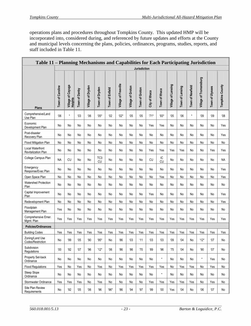
operations plans and procedures throughout Tompkins County. This updated HMP will be
incorporated into, considered during, and referenced by future updates and efforts at the County
and municipal levels concerning the plans, policies, ordinances, programs, studies, reports, and
staff included in Table 11.
Table 11 – Planning Mechanisms and Capabilities for Each Participating Jurisdiction
Plans
Jurisdiction
To
wn
of
Car
olin
e
Vill
age
of
Cay
ug
a H
eig
hts
To
wn
of
Dan
by
Vill
age
of
Dry
den
To
wn
of
Dry
den
To
wn
of
En
fiel
d
Vill
age
of
Fre
evill
e
Vill
age
of
Gro
ton
To
wn
of
Gro
ton
Cit
y o
f It
hac
a
To
wn
of
Ith
aca
Vill
age
of
Lan
sin
g
To
wn
of
Lan
sin
g
To
wn
of
New
fiel
d
Vill
age
of
Tru
man
sbu
rg
To
wn
of
Uly
sses
To
mp
kin
s C
ou
nty
Comprehensive/Land Use Plan
‘06 * ‘03 ‘06 ‘05* ‘02 ‘02* ‘05 ‘05 ‘71* ‘93* ‘05 ‘06 * ‘09 ‘09 ‘08
Economic Development Plan
No No No No No No No No No Yes Yes No No No No No Yes
Post-disaster Recovery Plan
No No No No No No No No No No No No No No No No Yes
Flood Mitigation Plan No No No No No No No No No No No No No No No No No
Local Waterfront Revitalization Plan
No No No No No No No No No Yes Yes Yes Yes No No Yes Yes
College Campus Plan NA CU No No
TC3 CU
No No No No CU IC CU
No No No No No NA
Emergency Response/Evac Plan
No No No No No No No No No No No No No No No No Yes
Open Space Plan No No No No No No No No No No Yes No No No No No Yes
Watershed Protection Plan
No No No No No No No No No No No No No No No No No
Capital Improvement Plan
No No No No No No No No No Yes No No No No No No Yes
Redevelopment Plan No No No No No No No No No No No No No No No No Yes
Floodplain Management Plan
Yes No No No No No No No No No No No No No No No No
Comprehensive Emer. Mgmt. Plan
Yes Yes Yes Yes Yes Yes Yes Yes Yes Yes Yes Yes Yes Yes Yes Yes Yes
Policies/Ordinances
Building Codes Yes Yes Yes Yes Yes Yes Yes Yes Yes Yes Yes Yes Yes Yes Yes Yes Yes
Zoning/Land Use Codes/Restriction
No ‘99 ‘05 ‘90 ‘95* No ‘86 ‘03 ‘11 ‘03 ‘03 ‘09 ‘04 No ‘12* ‘07 No
Subdivision Regulations
‘00 ‘92 ‘07 ‘96 ’12* ‘06 ‘86 ‘86 ‘70 ‘89 ‘96 ‘75 ‘04 No ‘90 ‘07 No
Property Set-back Ordinance
No No No No No No No No No No * No No No * Yes No
Flood Regulations Yes No Yes No Yes No Yes Yes Yes Yes Yes No Yes Yes No Yes No
Steep Slope Ordinance
No No No No No No No No No No * No No No No No No
Stormwater Ordinance Yes Yes Yes No Yes No No No No Yes Yes Yes Yes Yes No Yes No
Site Plan Review Requirements
No ‘92 ‘05 ‘06 ‘96 ‘96* ‘86 ‘94 ‘97 ‘99 ‘00 Yes ‘04 No ‘06 ‘07 No

Tompkins County Multi-Jurisdictional All-Hazard Mitigation Plan
560.018.001/5.13 - 24 - Barton & Loguidice, P.C.
Table 11 – Planning Mechanisms and Capabilities for Each Participating Jurisdiction
Plans
Jurisdiction
To
wn
of
Car
olin
e
Vill
age
of
Cay
ug
a H
eig
hts
To
wn
of
Dan
by
Vill
age
of
Dry
den
To
wn
of
Dry
den
To
wn
of
En
fiel
d
Vill
age
of
Fre
evill
e
Vill
age
of
Gro
ton
To
wn
of
Gro
ton
Cit
y o
f It
hac
a
To
wn
of
Ith
aca
Vill
age
of
Lan
sin
g
To
wn
of
Lan
sin
g
To
wn
of
New
fiel
d
Vill
age
of
Tru
man
sbu
rg
To
wn
of
Uly
sses
To
mp
kin
s C
ou
nty
Agricultural Plan No No No No No No No No No No Yes No No No No * Yes
Gas Drilling Prohibition Yes No Yes Yes Yes Yes No No No No Yes No + + Yes Yes No
Programs
NFIP Participant Yes Yes Yes Yes Yes No Yes Yes Yes Yes Yes Yes Yes Yes Yes Yes No
NFIP CRS Participating Community
No No No No No No No No No No No No No No No No No
Property Acquisition Program
No No No No No No No No No No No No No No No No No
Public Education/Awareness Prog.
Yes Yes Yes Yes Yes Yes Yes Yes Yes Yes Yes Yes Yes Yes Yes Yes Yes
Stream Maintenance Program
Yes No No No No No No No No No No No No No No No Yes
Storm Drainage Maint. Program
No No No No No No No No No Yes Yes No No No No No No
Studies/Reports
Hazard Analysis/Risk Assessment
Yes No Yes No Yes Yes Yes No Yes Yes Yes No Yes Yes No Yes Yes
Floodplain Maps/Insurance Studies
Yes No Yes Yes Yes No Yes Yes Yes Yes Yes Yes Yes Yes Yes Yes No
Staff/Development
Development Planner No No No Yes Yes No No No No Yes Yes No No No No Yes Yes
Building Code Official Yes Yes Yes Yes Yes Yes Yes Yes Yes Yes Yes Yes Yes Yes Yes Yes Yes
GIS and/or HAZUS Specialist
No No No No Yes No No No No Yes Yes No No No No No Yes
Engineer/Public Works Official
No Yes No Yes Yes No No No No Yes Yes No Yes No Yes No Yes
Local Floodplain Administrator
Yes No Yes No Yes No Yes Yes Yes Yes Yes No Yes Yes No Yes No
Environmental Cons. Specialist
No No No No Yes No No No No No Yes No No No No Yes Yes
Public Information Official
No No No No No No No No No No No No No No No No Yes
* = Draft, in progress + = Moratorium in place CU = Cornell University IC = Ithaca College TC3 = Tompkins County Community College
Links and web addresses to many of the Tompkins County resources listed above are located in
Appendix D for easy access.

Tompkins County Multi-Jurisdictional All-Hazard Mitigation Plan
560.018.001/5.13 - 25 - Barton & Loguidice, P.C.
3.2 Planning Team and Technical Committee
Three groups were created to assist in various facets of information collection and document
preparation and review: Project Team, Technical Committee, and Key Stakeholders. The Project
Team is represented by at least one municipal representative from each participating jurisdiction
or agency, and is responsible for assisting in data collection, document review, and coordination
efforts. The Technical Committee includes interest group representatives, researchers, educators,
and others, whose task is to aid in guiding and revising the plan based on their various interests
and areas of expertise. This committee consisted of representatives from the following agencies,
groups, and entities: Town of Ulysses, Cornell University, Tompkins County Department of
Health, Tompkins County Soil and Water District, Bolton Point Water Treatment Plant, City of
Ithaca, New York State Electric & Gas (NYSEG), Town of Lansing Highway Department,
Tompkins County Department of Emergency Response, and United States Geological Survey
(USGS). The Key Stakeholders group includes various members of the community such as local
elected officials, municipal employees, school officials, fire and emergency response personnel,
and other interested community members.
Meetings with these three groups of selected and interested individuals were held at strategic
points throughout the HMP development process. A County-wide risk assessment review was
also held to kick-off the HMP Update process. This event, which many different stakeholders
and agency representatives attended, helped set the stage for the remainder of the hazard
mitigation planning process. All meetings that were held during the development of the HMP
are located in Appendix E, including the notable accomplishments or objectives of each.
Participants and representatives that attended every meeting are also listed in Appendix E, along
with their affiliation, as it relates to the project.
3.3 Jurisdiction Participation
To be included in the Tompkins County Multi-Jurisdictional All-Hazard Mitigation Plan, all
interested jurisdictions needed to express their willingness to be a part of the process and needed
to remain an active participant throughout all stages of plan development. Active participation
for each jurisdiction was gauged based on the following factors: meeting attendance, information
collection and research, plan review and comment, mitigation action submission, public review
assistance, and final resolution to adopt the HMP. A jurisdiction did not have to meet all criteria
listed to be considered a participating member (for example, meeting attendance), but each
jurisdiction did have to show an effort to participate and provide relevant information (for
example, email follow-up after a missed meeting to discuss what was missed). The Tompkins
County Planning Department made a concerted effort to follow-up with jurisdictions that were
underrepresented at project meetings. Overall, it was determined that all jurisdictions within
Tompkins County met the participation requirements and are therefore included and considered
in this document. All participating jurisdictions have agreed to pass a resolution to adopt the
HMP after NYSOEM and FEMA review and approval. These resolutions will be added to
Appendix F, as they are adopted. For now, a sample resolution is provided.

Tompkins County Multi-Jurisdictional All-Hazard Mitigation Plan
560.018.001/5.13 - 26 - Barton & Loguidice, P.C.
3.4 Public Participation
During the Tompkins County Hazard Mitigation Plan Update process, public involvement was
included at two levels. At the local level, community input was sought during the hazard
vulnerability and assessment phase of the project. Each participating jurisdiction was
responsible for making sure their hazard history and vulnerabilities were accurately portrayed in
the draft HMP. The collection of this information often times involved individuals aside from
those on the Project Team.
The second level of public involvement for the County HMP was provided through two formal
public meetings, held at the Dryden Town Hall and Tompkins County Public Library on April
22, 2013, and the solicitation of comments during a publicly requested review of the Draft HMP.
Many announcements regarding the issuance of the HMP Update for public review and the
scheduling of a County-wide public meeting were included in area newspapers. The public was
invited to review the draft document and to provide comments and input on hazards, hazard
response, and hazard mitigation during the public meeting and for 30-days afterwards. This
meeting also provided a favorable forum in which to answer any questions from the public.
Aside from being available for review in hard copy form during the public meeting and at the
Tompkins County Planning Department in the City of Ithaca, the Draft Tompkins County Multi-
Jurisdictional All-Hazard Mitigation Plan was also available for review electronically on the
website of TCPD at www.tompkins-co.org/planning/haz_mit.htm. All comments received as part
of the public review were considered and incorporated into the HMP, as appropriate. A
summary of the public meeting participation and plan feedback is included in Appendix E.
3.5 Coordination with Agencies and Neighboring Communities
County, regional, state, and federal agencies were consulted for relevant information and
recommendations with regard to the Hazard Mitigation Plan Update effort. The contributions
from agencies and organizations that supported the update planning process include participation
in the HIRA-NY risk assessment, review and comment on portions of the Draft HMP, and the
collection and/or dissemination of information or data to be used in the planning process. These
agencies that provided the most assistance throughout this process include: FEMA, Tompkins
County Department of Emergency Response, NOAA, Tompkins County Planning Department,
Tompkins County Emergency Management Program, National Weather Service, NYSOEM,
Tompkins County Soil and Water Conservation District, NYS Electric and Gas Corporation
(NYSEG), and the U.S. Geological Survey.
Once the plan update was drafted, it was distributed for comment to each of the counties
surrounding Tompkins County. This included the Counties of Tioga, Cortland, Schuyler and
Seneca. In addition, the plan update draft was distributed to each County government and
Regional Planning Board which was, along with Tompkins County, a part of the Consortium for
the Cleaner Greener Southern Tier planning process (www.cleanergreenersoutherntier.org/ ). Some of the Consortium members include the Southern Tier Regional Planning Boards, as well
as Steuben, Chemung, Broome, Chenango and Delaware Counties. By reaching out to these
neighboring community stakeholders, the hope is that this multi-county area can collectively
continue to work together to reduce regional hazard risks.
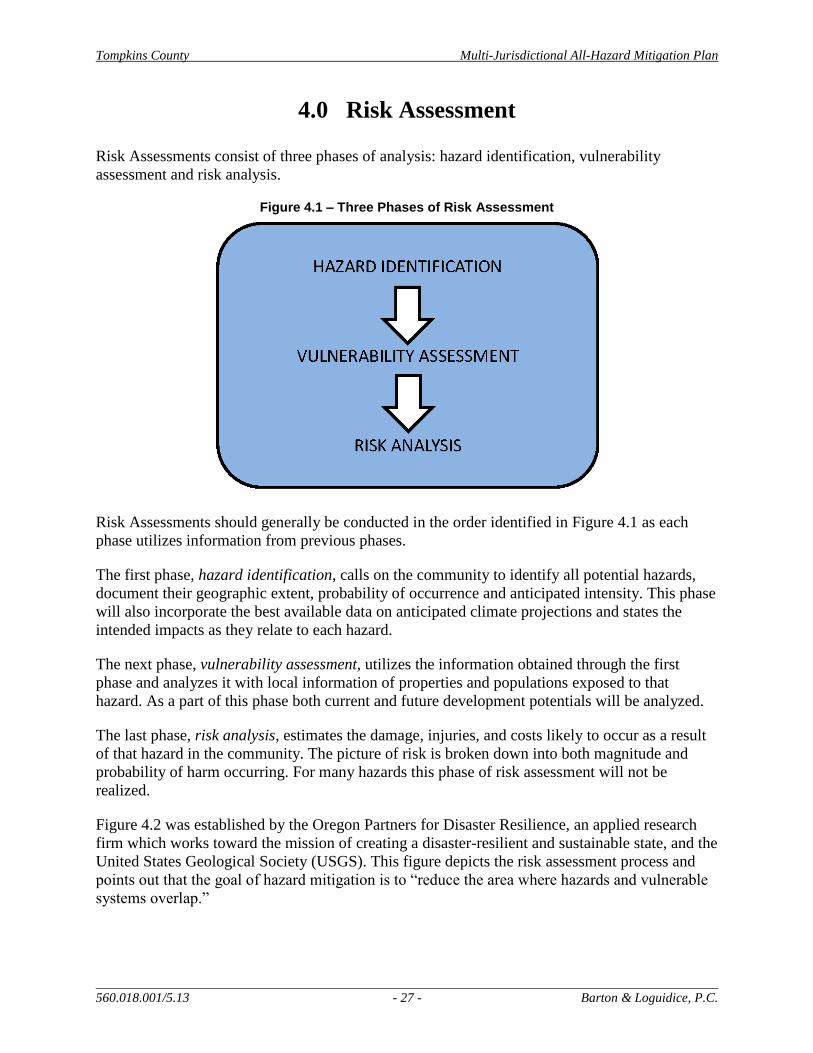
Tompkins County Multi-Jurisdictional All-Hazard Mitigation Plan
560.018.001/5.13 - 27 - Barton & Loguidice, P.C.
4.0 Risk Assessment
Risk Assessments consist of three phases of analysis: hazard identification, vulnerability
assessment and risk analysis.
Figure 4.1 – Three Phases of Risk Assessment
Risk Assessments should generally be conducted in the order identified in Figure 4.1 as each
phase utilizes information from previous phases.
The first phase, hazard identification, calls on the community to identify all potential hazards,
document their geographic extent, probability of occurrence and anticipated intensity. This phase
will also incorporate the best available data on anticipated climate projections and states the
intended impacts as they relate to each hazard.
The next phase, vulnerability assessment, utilizes the information obtained through the first
phase and analyzes it with local information of properties and populations exposed to that
hazard. As a part of this phase both current and future development potentials will be analyzed.
The last phase, risk analysis, estimates the damage, injuries, and costs likely to occur as a result
of that hazard in the community. The picture of risk is broken down into both magnitude and
probability of harm occurring. For many hazards this phase of risk assessment will not be
realized.
Figure 4.2 was established by the Oregon Partners for Disaster Resilience, an applied research
firm which works toward the mission of creating a disaster-resilient and sustainable state, and the
United States Geological Society (USGS). This figure depicts the risk assessment process and
points out that the goal of hazard mitigation is to “reduce the area where hazards and vulnerable
systems overlap.”

Tompkins County Multi-Jurisdictional All-Hazard Mitigation Plan
560.018.001/5.13 - 28 - Barton & Loguidice, P.C.
Figure 4.2 – The Risk Assessment Process (Oregon Partnership for Disaster Resilience Research Collaboration and USGS, 2006)
Tompkins County is vulnerable to numerous natural, technological, and human-caused hazards.
The historic documentation associated with past hazard events that was included in the County’s
2006 HMP has been expanded as part of the risk assessment to include the most recent data
available, as well as analysis of identified potential impacts from a changing climate and
widespread natural gas drilling in the region. Some of the key revisions that are included in this
section of the plan update include: results of Tompkins County’s 2012 risk assessment, profiles
of new hazards, and the establishment of updated hazard rankings and hazard mitigation
planning goals.
4.1 Framing the Risk Assessment Using HIRA-NY
All applicable hazards were evaluated, reviewed, and ranked during a risk assessment session
moderated by the New York State Office of Emergency Management (NYSOEM) using the
automated Hazard Identification and Risk Assessment (HIRA-NY) program. The selections
made in HIRA-NY are based on information entered into preformatted Microsoft Excel
spreadsheets recommended by FEMA and NYSOEM. The HIRA-NY risk assessment process
helps participating jurisdictions and agencies focus on the hazards that may potentially impact
the County and assists in detailing the most prevalent and highest ranking hazards. In order to
complete the risk assessment, consideration was given to details such as location or geographic
area that could be affected by a given hazard, extent or magnitude of each hazard event, previous
hazard occurrences, and probability of future occurrences.
Within the HIRA-NY program, there are five factors in which the answers provided during the
risk assessment process directly impact the ultimate hazard rankings. These five factors are
denoted and detailed below.

Tompkins County Multi-Jurisdictional All-Hazard Mitigation Plan
560.018.001/5.13 - 29 - Barton & Loguidice, P.C.
HIRA-NY Factor 1: Scope
This factor looks at two aspects of the overall scope of a hazard: what area or areas in the
jurisdiction could be impacted by the hazard, and what are the chances of the hazard triggering
another hazard and causing a cascade effect. Once the potential area of impact is determined, the
program requires the selection of one of the following impact area options:
A single location Several hazards can impact a single location
Several individual locations Many hazards are capable of impacting several individual
locations. This does not mean that the hazards occur
simultaneously, but that they could occur at one or several
locations at the same time.
Throughout a small region Where a single location or several individual locations
comprise a significant area.
Throughout a large region A larger region would extend for miles and comprise a
significant portion of the community being assessed.
The next part of the scope factor is to determine whether the hazard could potentially trigger
another hazard. When assessing this factor, the group evaluates various severity levels,
including a credible worst-case scenario. The options for the cascading effect potential of a
hazard are as follows: no, highly unlikely; yes, some potential; or yes, highly likely.
HIRA-NY Factor 2: Frequency
Frequency indicates how often a hazard results in an emergency situation or disaster event.
Frequency includes both historic occurrences and the likelihood that it will happen in the future.
The frequency of a hazard is not based on the worst-case scenario, but rather how often an event
would cause various types of damage within the community that would require activation of
emergency response forces. The program provides the following options when deciding the
frequency of a hazard event:
A rare event Occurs less than once every 50 years.
An infrequent event Occurs between once every 8 years and once every 50 years
(inclusive).
A regular event Occurs between once a year and once every 7 years
(inclusive).
A frequent event Occurs more than once a year.
HIRA-NY Factor 3: Impact
The impact of a hazard is assessed on various severity levels, including a credible worst-case
scenario. There are three types of impacts that are included in the HIRA-NY program: impacts
on the population, impacts on private property, and impacts on community infrastructure.

Tompkins County Multi-Jurisdictional All-Hazard Mitigation Plan
560.018.001/5.13 - 30 - Barton & Loguidice, P.C.
Impacts on populations include the ability of a hazard to cause serious injury and/or death to
surrounding human populations:
Serious injury or death is
unlikely
Serious injuries require immediate medical attention,
without which the injured person’s life or limb is
threatened.
Serious injury or death is
likely, but not in large
numbers
Applies when the casualties of a hazard can be adequately
treated through the normal operation of a community’s
emergency medical system.
Serious injury or death is
likely in large numbers
Applies when the number of casualties requires a full or
near full activation of a community’s medical facilities’
disaster plans.
Serious injury or death is
likely in extremely large
numbers
This option denotes a catastrophe and applies when the
numbers of casualties overwhelms the local emergency
medical system, and substantial outside assistance is
required.
Impacts on private property includes the potential for a hazard to physically or economically
damage private property, including industrial structures, homes and contents, commercial
businesses, belongings, and income in a community. The HIRA-NY options to denote a
hazard’s impact on private property include: little or no damage; moderate damage; or severe
damage.
The HIRA-NY program also requires the identification of precise types and numbers of
properties and structures that have the potential to be impacted. Impacts on community
infrastructure is related to the potential for a hazard to specifically cause structural damage to the
infrastructure that serves the community, including government buildings, roads, bridges, and
public utility lines, plants, and substations. The options provided in HIRA-NY to indicate a
hazard’s impact on community infrastructure include: little or no structural damage; moderate
structural damage; or severe structural damage.
As with private property, the above classification of damage should be supported by detailed
information regarding the type of public property likely to be impacted.
HIRA-NY Factor 4: Onset
The onset factor is related to the amount of time between the initial recognition of an
approaching hazard and when the hazard begins to impact the community. For some hazards,
ample warning time is available so that if plans and procedures have not been developed, there is
still time to accomplish such tasks before the hazard occurs. Other hazards provide no warning,
so the response to a hazard event depends on existing plans, if any. The choices for time of onset
are: no warning; several hours warning; one day warning; several days warning; or a week or
more of warning.

Tompkins County Multi-Jurisdictional All-Hazard Mitigation Plan
560.018.001/5.13 - 31 - Barton & Loguidice, P.C.
For a few hazards there may be different warning times depending on location. In this case, the
HIRA-NY tool suggests using the shortest warning time that is realistic and associated with a
credible worst-case event.
HIRA-NY Factor 5: Duration
There are two types of duration analyzed in the HIRA-NY program: 1) how long the hazard
remains active and 2) how long emergency operations continue after the hazard event has ended.
A third duration addressed in HIRA-NY, but not included in a community’s hazard analysis
report, is how long it takes the community to fully recover from the hazard event. The recovery
process continues until the operations of the community return to normal. The options provided
for the duration of the hazard are: less than one day; one day; two to three days; four days to a
week; or more than one week.
The program offers the following options for recovery time of a community after a hazard event:
less than one day, one to two days, three days to one week, or one week to two weeks.
4.2 Hazard Identification
In order to ascertain which hazards affect Tompkins County, several resources were accessed
and reviewed. Utilized sources included reviews of available reports or plans, consultation with
community experts, accessing available information online, and documenting information
provided by the public during public meetings.
On the basis of this review, the most prevalent and potentially the most damaging hazards that
could affect the County were included in the County’s HIRA-NY risk assessment. The chosen
hazards are mainly caused by various types of storms, especially those that create cascading
effects like power outages, flooding, or structural damage. Other hazards appear to occur on a
less frequent basis or normally have an insignificant impact based on the historic data collected.
The following hazards are those included in the HIRA-NY program, not just the hazard selected
for additional analysis during Tompkins County’s recent risk assessment event. These
descriptions, which include natural, technological, and human-caused hazards, summarize the
types of hazards and their applicability and ability to affect Tompkins County. This section of
the plan is mirrored after the step-by-step process outlined in FEMA’s publication 386-2 entitled
“Understanding Your Risks, identifying hazards and estimating losses.”
Air Contamination – Air contamination is indicative of pollution caused by atmospheric
conditions such as temperature invasion induced smoggy condition sufficiently serious to create
some danger to human health. Given Tompkins County’s rural landscapes and a lack of large
industrial areas and business parks outside of the City of Ithaca, air contamination is not a
concern at this time within the County. This hazard is not profiled further in this plan update.
Avalanche – An avalanche occurs when a significant amount of snow slides off mountainous
terrain. Although Tompkins County is subject to significant snow storms, no avalanches were
found to be an issue at this time. Therefore, this hazard is not profiled further in this mitigation
plan update.

Tompkins County Multi-Jurisdictional All-Hazard Mitigation Plan
560.018.001/5.13 - 32 - Barton & Loguidice, P.C.
Civil Unrest – Civil unrest is when an individual or collective action causes serious interference
with the peace, security, and/or functioning of a community. Due to the presence of two college
campuses in the central portion of Tompkins County, civil unrest events are a concern. For this
reason, civil unrest is further profiled in Section 5 of this plan update.
Coastal Storm – Coastal storms cause increases in tidal elevations, wind speed, and erosion,
caused both by extra-tropical events and tropical cyclones. Tompkins County is a mainland
County in New York State; only a portion of the County borders water (Cayuga Lake). Though
six (6) Tompkins County municipalities border Cayuga Lake, no portions are adjacent to any
tidal waters. Therefore, coastal storms are not recognized as an issue within the County and
were not included in the risk assessment.
Dam Failure – Dam failures consist of flood damage specifically caused by the structural failure
of a man-made water impoundment structure. Tompkins County has several significant water
impoundments that are controlled by dams. This hazard is not evaluated in Section 5 due to its
infrequent occurrence and limited impact on communities within the County. Furthermore, the
NYSDEC has recently revamped their dam regulatory program. Depending on the hazard code
for each dam, the owner may be required to complete frequent assessments and maintenance
actions on the structure(s), limiting the potential for structural failure and minimizing the threat
to public and private infrastructure and loss of life.
Drought – Drought is the loss of water supply due to the lack of rainfall. The majority of water
supply in Tompkins County is obtained from groundwater wells. Groundwater levels are less
susceptible to seasonal and droughty conditions than surface waters. None the less, drought
events have historically impacted Tompkins County, particularly in the 1960s. No recent
drought events have been recorded, though the unpredictability of weather patterns is always a
concern for the farming community since they seldom have local irrigation systems. The role
that climate change may have on future drought events is also of interest and concern and is
further detailed in the drought hazard profile in Section 5.
Earthquake – Earthquakes are described as a shaking or trembling of the earth that is volcanic or
tectonic in origin. There is potential for earthquake tremors to be felt within Tompkins County,
though no history of such impacts is available. The concerns surrounding this hazard are
compounded by the fact that Tompkins County is located approximately 15 miles outside of the
50-mile ingestion pathway for the nuclear power plants in Oswego County. Though this hazard
is not likely to cause extensive damage within Tompkins County, because of the County’s
location within New York State and its adjacency to the nuclear facilities’ 50-mile ingestion
pathway ring, it is included in the HMP Update risk assessment.
Epidemic – An epidemic is the spreading of a contagious disease on a mass basis. The majority
of significant epidemic history within Tompkins County focuses on agricultural epidemics and
diseases. The frequency of widespread human epidemics within Tompkins County is not high,
though the County’s vulnerability to such an event is elevated due to the large national and
international college student contingent that seasonally resides within the County. This hazard
was included in the risk assessment process and is further detailed in Section 5.
Tompkins County Multi-Jurisdictional All-Hazard Mitigation Plan
560.018.001/5.13 - 33 - Barton & Loguidice, P.C.
Explosion – Explosions included the rapid burning of material and gases yielding the violent
release of energy. There is no known history of explosions within the County. Therefore, this
hazard is not analyzed further in regards to its potential impacts on Tompkins County.
Extreme Temperatures – Extreme temperatures include extended periods of excessive hot or cold
weather with a serious impact on human and/or animal populations. Cascade effects can include
enhanced fire/wildfire potential and drought. In past years, periods of extreme heat have had a
greater impact within Tompkins County than extreme cold. Vulnerable populations, such as the
elderly, reside within the County, elevating the potential risk of an extreme temperature event.
Though this hazard was not assessed in the County’s original HMP, the effect that climate
change may have on yearly temperatures is a growing concern. Therefore, this hazard was
assessed and is documented in the hazard profile section.
Fire – Fire is the uncontrolled burning of residential, commercial, industrial, institutional, or
other property. As is common in many populated areas, structural fires frequently occur within
Tompkins County. Because of the potential damage that a large-scale fire could cause in the
City of Ithaca, for example, this hazard was included in the HIRA-NY risk analysis. Further
details regarding this hazard are included in this Plan Update.
Flash Flood – Flooding is the submergence of lands in the vicinity of rising waterway levels
generally adjacent to water bodies and drainage areas. A distinction was made as part of this
HMP Update between flash flooding, short-term, rapid flooding events, and lake flooding.
Almost all of the documented damage that has occurred in Tompkins County as a result of
flooding is related to flash flooding events. Such an event is normally caused by excessive
rainfall or rapid thaw of snow packs. Details surrounding this hazard event and how its
frequency, onset, and damage potential might change due to climate change are included in the
next Section.
Lake Flood – A general flood hazard was profiled in the 2006 HMP for Tompkins County.
During the 2012 risk assessment process, this hazard was further broken down into flash
flooding and lake flooding, which would be directly associated with Cayuga Lake. During lake
flood events, the water levels rise slowly because of the larger surface area of the waterbody.
Minimal damage is associated with such water level rises since there is more warning, a slower
onset, and the water levels in Cayuga Lake can be altered by the Canal Corporation if they
become too high. Historic occurrences and other details associated with lake flooding in
Tompkins County are included in the natural hazard profile section, below.
Food Shortage – A food shortage occurs when the normal distribution pattern and/or timely
delivery of foodstuffs to retail establishments for normal consumer demand is interrupted for a
substantial period of time. There is no historic documentation pointing to a food shortage within
Tompkins County; therefore this hazard is not analyzed further in this document.
Fuel Shortage – Similar to the above, a fuel shortage may occur when the normal distribution
pattern and/or timely delivery of fuel to retail establishments for normal consumer demand is
interrupted for a substantial period of time. The assessment of this hazard focused on potential
long-range impacts that could occur as the supply of fuel continues to decrease while the demand
increases. Few incidences of a fuel shortage have occurred within Tompkins County; however,
Tompkins County Multi-Jurisdictional All-Hazard Mitigation Plan
560.018.001/5.13 - 34 - Barton & Loguidice, P.C.
these historical events coupled with the hazard assessment assumption that a fuel shortage would
impact the entire County, elevated this hazard into the top five (5) highest rated hazards during
the risk assessment process. This hazard, which was not included in the 2006 HMP, is further
detailed in Section 5.
HAZMAT – Fixed Sites – Hazardous materials at fixed site locations is defined as the discharge
of hazardous materials (toxic, flammable or corrosive) into the environment from a facility
located at a specific location. Generally, HAZMAT issues from fixed sites in the County are
limited in nature and infrequent in occurrence. This hazard is not included in further
assessments.
HAZMAT – In Transit – Hazardous materials in transit is the discharge of hazardous materials
(toxic, flammable or corrosive) during their transport via a variety of transportation means
(motor vehicle, truck, train, boat or plane). Risk assessment discussion surrounding this hazard
focused on the potential for hydraulic fracturing operations to be sited within Tompkins County
in the future. High numbers of hazmat in transit events have been documented in Pennsylvania
associated with hydraulic fracturing operations. Because of the potential for such activities to
occur within Tompkins County, this hazard was included in the County’s risk assessment and
will be further detailed in Section 5.
Hurricane – A hurricane is a type of tropical cyclone with winds exceeding 74 miles per hour
(mph) accompanied by rain, thunder and lightning. High wind events are commonly
documented within Tompkins County, but by definition are classified in this Plan Update as
severe storm events. Weather patterns that begin as hurricanes are often re-classified as tropical
storms or tropical depressions (two other types of tropical cyclones) by the time they reach New
York State. Tropical storms are organized systems of strong thunderstorms with a defined
circulation and maximum sustained winds of 39 to 73 mph. Tropical depressions are organized
systems of clouds and thunderstorms with a defined circulation and maximum sustained winds of
38 mph or less. Despite the numerous definitions, one historic record of a hurricane that affected
Tompkins County does exist. Though this hazard has a moderately low potential, it is
recommended that it be reviewed as part of the mitigation planning process. Hurricane was
included in the County’s risk assessment process and will be further detailed below.
Ice Jam – Ice jams occur when water bodies are clogged with large blocks of ice. The ice is
normally formed by the freezing of the water body and becomes dislodged due to hydraulic
conditions whereby the ice floats and may jam at sections of the water body that have a limited
cross section (i.e., at bridges and natural channel contractions). Ice jam events have been
regularly reported throughout the County and are frequently associated with flash flood events in
the late winter/early spring. This is a newly added hazard to the Plan, and will receive further
detail in the next section.
Ice Storm – Ice storms include freezing rains which cause icing of roads, structures, and
vegetation, and can cause structural damages and create hazardous slippery conditions. Ice
storms have frequently occurred in the County based upon discussion during the risk assessment.
These events routinely cause trees to topple due to the weight of the ice which has the potential
to cause structural damage and utility failures. This hazard is profiled further in this plan.
Tompkins County Multi-Jurisdictional All-Hazard Mitigation Plan
560.018.001/5.13 - 35 - Barton & Loguidice, P.C.
Infestation – An infestation event is characterized by an excessive population of plants, insects,
rodents, or other animals requiring control measures due to their potential to carry diseases,
destroy crops, or harm the environment. The County is actively dealing with multiple species of
invasives, which was the driver behind the top five ranking of this hazard event. Information
regarding the occurrence of this hazard and how the effects might change in response to potential
climate changes will be reviewed in the next plan section. Infestation is a new hazard to the
2012 Plan Update and was not included in the original plan document.
Landslide – Landslides are defined as the downward movement of a sloped land mass under the
force of gravity. Based upon historic information, landslides have occurred in the County on a
localized basis. The potential for this hazard was determined to be low, though the potential for
cascading hazards to occur was noted. This hazard, which was not included in the 2006 Plan, is
profiled further in Section 5.
Mine Collapse – Mine collapse is the structural failure of an underground mine used to harvest
minerals from the earth. There are no known active mines in Tompkins County. Since no
historic mine collapse issues have been documented within the County, mine collapse was not
included in the risk assessment process.
Oil Spill – Oil spills include the discharge of oil into the environment by a fixed site or mobile
site (vehicles). This hazard is similar to what has been mentioned with respect to hazardous
material hazards. Historically, it is known that fuel oil spills have resulted due to the lack of
maintenance of oil storage facilities or due to damage as a consequence of a cascade effect
resulting in the structural damage of an oil containing vessel. Though minor spills occur, large
scale oil spills are not a concern within Tompkins County and a lengthy history of such events
does not exist. Concerns related to oil spills will be applied to the hazardous materials hazard
analyses, as this hazard will not be detailed further in this document.
Radiological – Fixed Site – Radiological materials at fixed sites is defined as the release or threat
of release of radioactive material from a nuclear power generating station or research reactor or
other stationary source of radioactivity. No nuclear power locations or other radiological
facilities exist within Tompkins County; therefore, this hazard is not profiled in the next section
of the plan.
Radiological – In Transit – Radiological materials in transit constitutes a release of radioactive
material into the environment while in transit due possibly to an accident or malfunction in the
container which holds the material. No historical data was available to indicate the release of
any radioactive material within the County. As no history of this hazard is documented within
Tompkins County, this hazard is not afforded further consideration in this plan.
Severe Storm – A severe storm hazard event includes hail storms, windstorms, and severe
thunderstorms (with associated severe wind events such as derechos, gustnados (ground based
gust vortex), and downbursts). Severe storm was included in the HIRA-NY risk assessment
completed by Tompkins County, ranking second among the highest rating. This hazard
frequently occurs within the County and therefore will be detailed further in the next section of
this plan.

Tompkins County Multi-Jurisdictional All-Hazard Mitigation Plan
560.018.001/5.13 - 36 - Barton & Loguidice, P.C.
Severe Thunderstorm – Severe thunderstorms can produce tornados, hail, flooding, or high
winds. These three potential side effects of severe thunderstorms are fully described and
included under the hazards severe storm (includes hail events and high winds) and tornado.
Therefore, this additional hazard will not be analyzed as part of this plan. Severe thunderstorms
will be incorporated under the severe storm hazard.
Structural Collapse – Structural collapse is the failure and caving in of a structure. In and of
itself, potential for the structural collapse of a structure within the County was not historically
found to be an issue, unless it was caused by another hazard. Generally, building code
enforcement prevents flagrant issues from arising. In addition, programs for the demolition of
abandoned structures have helped to remove abandoned structures before they collapse. Because
programs are in place to mitigate this potential hazard, structural collapse is not analyzed in this
plan.
Terrorism – Terrorism is the systematic use of violence committed by groups in order to
intimidate a population or government into granting their demands. Though no significant
locations that may be targeted by large-scale terrorist events exist in the County, when compared
to other areas across the Country, smaller scale events could potentially occur. Because of the
increased threat of terrorism in the past decade this hazard will be profiled further in this plan.
Tornado – Tornados are violent destructive whirling winds accompanied by a funnel-shaped
cloud that progresses in a narrow path over the land. Historic tornados have been recorded
within New York State. Though an infrequent event within in Tompkins County, such an event
has the potential to cause a large amount of damage. This was not assessed in the 2006 HMP,
but has been added to this Plan Update and will be profiled in Section 5.
Tsunami-wave Action – Tsunamis are a series of enormous waves created by an underwater
disturbance such as an earthquake, landslide, volcanic eruption, or meteorite. Due to Tompkins
County’s distance from the ocean, there is no potential for tsunamis to affect the County. No
historic data was uncovered to show otherwise. This hazard is not included further in this plan
update.
Transportation Accident – A transportation accident is an unexpected happening causing loss or
injury. Historically, minor traffic accidents frequently occur in Tompkins County. Some of
these events are due to the cascading effects caused by other hazards such as severe winter
weather or ice storms. More severe accidents are fairly common, especially within densely
populated areas of the County or on main transportation routes. Transportation accident, the
highest rated hazard during the County’s risk assessment process, will be included in Section 5
of this plan.
Utility Failure – Utility failure is defined as the loss of electric and/or natural gas supply,
telephone service, or public water supply, as a result of an internal system failure and not by the
effects of disaster agents. A few key historic utility failure events were documented during the
HIRA-NY analysis; however, the majority of utility failures occur as a cascading effect from
another hazard event. Regardless, this hazard was determined to have the potential to impact the
County. Further consideration of this hazard will be provided in the next section of this
document.

Tompkins County Multi-Jurisdictional All-Hazard Mitigation Plan
560.018.001/5.13 - 37 - Barton & Loguidice, P.C.
Water Supply Contamination – Water supply contamination includes the contamination or
potential contamination of surface or subsurface public water supply by chemical or biological
materials that results in restricted or diminished ability to use the water source. Water supply
contamination within Tompkins County is infrequently documented, as approximately 50-
percent of the County’s population is on public water. Concerns raised for this hazard were
associated with future potential effects from hydraulic fracturing operations. This hazard was
included in the County’s risk assessment and is detailed further in section 5 to discuss these
concerns.
Wildfire – Wildfires are described as the uncontrollable combustion of trees, brush, or grass
involving a substantial land area which may have the potential for threatening human life and
property. Though some areas of Tompkins County are heavily forested, few historic wildfire
events have been documented. Because of the low incidence and low probability of this hazard
to occur within the County, it is not included in further assessments.
Winter Storm (severe) – Winter storms include heavy snowfall and extreme cold and can
immobilize an entire region. Major snowstorms have occurred in Tompkins County in the past,
placing high demands on the Public Works Departments of the County, Towns, and Villages,
and adding risks for emergency response personnel. This hazard is included in the County’s risk
assessment due to its frequent occurrence.
4.3 Results of the Tompkins County HIRA-NY
On March 8, 2012, a group of County staff, local officials, agency/interest group representatives,
and technical experts was assembled to complete a HIRA-NY risk assessment process for
Tompkins County. Such a risk assessment was previously conducted as part of the County’s
original 2006 Hazard Mitigation Plan, and was performed again for this Plan Update.
NYSOEM Region IV personnel facilitated the March 2012 risk assessment and input the results
in the HIRA-NY computer program. Detailed meeting notes were recorded throughout the
process by Beth Harrington with the Department of Emergency Response, and reviewed by the
project team in subsequent meetings. The following individuals attended this event:
NYSOEM Region IV – Ronald Raymond, Tom McCartney
Tompkins County Department of Emergency Response – Lee Shurtleff, Beth Harrington,
Jessica Verfuss
Town of Caroline – Irene Weiser
Town of Ithaca – Creig Hebdon
Town of Dryden – David Sprout
Town of Enfield – Larry Stillwell
Town of Danby – Ric Dietrich, Susan Beeners
Town of Newfield – Richard Driscoll
City of Ithaca – Julie Holcomb
Town of Ulysses – Darby Kiley
Tompkins County Planning Department – Scott Doyle, Katie Borgella
Cornell University Horticulture Department – Jonathan Comstock
Cornell University Environmental Health and Safety – Dan Maas, Leah Stoner
Bolton Point Water Treatment Plant – Jack Rueckheim

Tompkins County Multi-Jurisdictional All-Hazard Mitigation Plan
560.018.001/5.13 - 38 - Barton & Loguidice, P.C.
U.S. Geological Society – Ed Bugliosi
Tompkins County Department of Public Works – Cheryl Nelson
National Weather Service – Dave Nicosia
American Red Cross – Kevin Carpenter
Tompkins County Public Information Office – Marcia Lynch
Tompkins County Sheriff’s Department – Bob Lampman
Tompkins County Administration – Paula Younger
Tompkins County Health Department – Adam Hartwig
Tompkins County Assessment Office – Al Fiorille
Barton & Loguidice – John Condino, Johanna Duffy
Based on the professional knowledge of those present, historical County data, hazard event
definitions, history from the National Weather Service, recent scientific reports on anticipated
impacts from climate change in New York and likely impacts from widespread natural gas
drilling in the region, and discussions that occurred amongst the group, 22 hazards were assessed
and ranked using the HIRA-NY program. The County’s top three rated hazards identified using
the HIRA-NY tool are: transportation accident, severe storm, and flash flood. The hazards that
were assessed, their 2012 rankings, and the original 2003 hazard rankings are included in
Table 12.
Table 12 – Tompkins County Risk Assessment Hazard Rankings
Tompkins County’s HIRA-NY risk assessment completed on March 8, 2012
Hazard
2012 Rank
(HMP Update)
2012 Risk
Assessment
Score
2003 Rank
(original
HMP)
2003 Risk
Assessment
Score
Transportation accident 1 289 8 217
Severe storm 2 281 4 236
Flash flood 3 232 1 297
Infestation 4 231 N/A N/A
Fuel shortage 5 212 N/A N/A
Fire 6 210 7 223
Tornado 7 207 N/A N/A
Utility failure 8 205 13 180
Ice storm 9 204 5 233
Epidemic 10 197 3 260
Water supply contamination 11 195 6 227
Hazmat in transit 12 194 12 196
Severe winter storm 12 194 10 201
Hurricane 13 193 9 215
Terrorism 14 192 2 295
Extreme temperatures 15 190 N/A N/A
Ice jam 15 190 N/A N/A
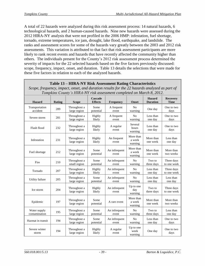
Tompkins County Multi-Jurisdictional All-Hazard Mitigation Plan
560.018.001/5.13 - 39 - Barton & Loguidice, P.C.
A total of 22 hazards were analyzed during this risk assessment process: 14 natural hazards, 6
technological hazards, and 2 human-caused hazards. Nine new hazards were assessed during the
2012 HIRA-NY analysis that were not profiled in the 2006 HMP: infestation, fuel shortage,
tornado, extreme temperatures, ice jam, drought, lake flood, earthquake, and landslide. The
ranks and assessment scores for some of the hazards vary greatly between the 2003 and 2012 risk
assessments. This variation is attributed to that fact that risk assessment participants are more
likely to rank recent events and hazards that have recently affected the community higher than
others. The individuals present for the County’s 2012 risk assessment process determined the
severity of impacts for the 22 selected hazards based on the five factors previously discussed:
scope, frequency, impact, onset, and duration. Table 13 details the selections that were made for
these five factors in relation to each of the analyzed hazards.
Table 13 – HIRA-NY Risk Assessment Rating Characteristics
Scope, frequency, impact, onset, and duration results for the 22 hazards analyzed as part of
Tompkins County’s HIRA-NY risk assessment completed on March 8, 2012.
Hazard Rating Scope
Cascade
Effects Frequency Onset
Hazard
Duration
Recovery
Time
Transportation
accident 289
Throughout a
large region
Some
potential
A frequent
event
No
warning One day
One to two
days
Severe storm 281 Throughout a
large region
Highly
likely
A frequent
event
No
warning
Less than
one day
One to two
days
Flash flood 232 Throughout a
large region
Highly
likely
A regular
event
Several
hours
warning
Less than
one day
One to two
days
Infestation 231 Throughout a
large region
Highly
likely
An frequent
event
More than
a week
warning
More than
one week
Less than
one day
Fuel shortage 212 Throughout a
large region
Some
potential
An infrequent
event
More than
a week
warning
More than
one week
More than
two weeks
Fire 210 Throughout a
small region
Some
potential
An infrequent
event
No
warning
Two to
three days
Three days
to one week
Tornado 207 Throughout a
large region
Highly
likely
An infrequent
event
No
warning
Less than
one day
Three days
to one week
Utility failure 205 Throughout a
large region
Some
potential
An infrequent
event
No
warning
Less than
one day
Less than
one day
Ice storm 204 Throughout a
large region
Highly
likely
An infrequent
event
Up to one
day
warning
Two to
three days
Three days
to one week
Epidemic 197 Throughout a
large region
Some
potential A rare event
More than
a week
warning
More than
one week
More than
two weeks
Water supply
contamination 195
Throughout a
large region
Some
potential
An infrequent
event
No
warning
Two to
three days
Less than
one day
Hazmat in transit 194 Throughout a
large region
Some
potential
An infrequent
event
No
warning
Less than
one day
One to two
days
Severe winter
storm 194
Throughout a
large region
Highly
likely
A regular
event
Up to one
week
warning
One day One to two
days

Tompkins County Multi-Jurisdictional All-Hazard Mitigation Plan
560.018.001/5.13 - 40 - Barton & Loguidice, P.C.
Table 13 – HIRA-NY Risk Assessment Rating Characteristics
Scope, frequency, impact, onset, and duration results for the 22 hazards analyzed as part of
Tompkins County’s HIRA-NY risk assessment completed on March 8, 2012.
Hazard Rating Scope
Cascade
Effects Frequency Onset
Hazard
Duration
Recovery
Time
Hurricane 193 Throughout a
large region
Highly
likely A rare event
Up to one
week
warning
One day More than
two weeks
Terrorism 192
Several
individual
locations
Some
potential A rare event
No
warning
Less than
one day
More than
two weeks
Extreme
temperatures 190
Throughout a
large region
Some
potential
A regular
event
Up to one
week
warning
Two to
three days
Less than
one day
Ice jam 190
Several
individual
locations
Some
potential
A regular
event
Several
hours
warning
Two to
three days
Less than
one day
Drought 181 Throughout a
large region
Some
potential
An infrequent
event
More than
a week
warning
More than a
week
Three days
to one week
Lake flood 172 Throughout a
small region
Highly
likely
An infrequent
event
Up to one
week
warning
More than
one week
Three days
to one week
Earthquake 166 Throughout a
large region
Some
potential A rare event
No
warning
Less than
one day
One to two
days
Civil unrest 160
Several
individual
locations
Some
potential
An infrequent
event
No
warning
Less than
one day
Less than
one day
Landslide 159
Several
individual
locations
Highly
likely
An infrequent
event
No
warning
Less than
one day
One to two
days
The County’s three highest rated hazards, transportation accident, severe storm, and flash flood,
have many factors in common, such as little warning, frequent or regular occurrences, and ability
to affect a large portion of the County. It is important to understand that the rating scores serve
to approximate the risks associated with each hazard. As previously mentioned, the extent of
risk varies depending on the group of individuals present during such an exercise and the health
and safety issues current at the time the assessment is completed. Based on the highest rated
hazards identified by the County HIRA risk assessment event, objectives were suggested and a
mitigation plan was formulated to minimize the potential loss and impact of these hazards.
These objectives and mitigation strategies are documented later on in this document.
4.4 Presidential Disaster Declaration
After a state has declared a State Disaster Area, as the result of a particular disaster event, that
state and its local governments will evaluate recovery options, capabilities, and costs. If the
damage from the disaster event is beyond the recovery capabilities of the state, the governor will
send a letter to the President, through FEMA, detailing the situation. The president then makes
the decision whether to declare a major disaster or emergency. After a presidential declaration is
made, FEMA designates the impacted area eligible for assistance and announces the types of

Tompkins County Multi-Jurisdictional All-Hazard Mitigation Plan
560.018.001/5.13 - 41 - Barton & Loguidice, P.C.
assistance available. FEMA provides supplemented assistance for the recovery of state and local
governments; the federal share will always be at least 75 percent of the total eligible costs
(FEMA, Presidential Disaster Declarations, 2009). According to the NYSOEM (NYSOEM GIS,
2010), damages within Tompkins County that occur from any given hazard event need to meet or
exceed $315,558 for a Presidential Disaster Declaration to be issued. Appendix A - Figure 4.3
shows the total number of Presidential Disaster Declarations that have occurred between 1954
and 2010 for every County in New York State. Tompkins County has had nine (9) declarations
within this time period.
One additional Presidential Disaster Declaration has been declared in New York State since 2010
that has included public assistance for Tompkins County. FEMA DR-4031 was issued as a result
of Tropical Storm Lee on September 13, 2011.
4.5 Natural Gas Drilling
The potential for natural gas drilling related to the Marcellus and Utica Shale deposits in
Tompkins County and throughout the Southern Tier Region of New York State, has created a
tremendous amount of concern in some communities regarding the possible environmental
effects of the horizontal drilling process. Drilling for natural gas in such shale deposits uses a
process termed hydraulic fracturing, also known as hydrofracking or fracking, in which the gas is
extracted through a horizontal well drilling technique which is not currently permitted in New
York State. Hydrofracking refers to the pumping of a mixture or water, chemical, and sand into
the rock formations creating fractures in the shale that allow for the natural gas to escape to a
production well where it is extracted and collected. The New York State Department of
Environmental Conservation (NYSDEC) has finished compiling a Supplemental Generic
Environmental Impact Statement (SGEIS) to review the potential environmental effects of this
process. The information in the SGEIS will be used by the NYSDEC to formulate and propose a
set of regulations, which the drilling companies will have to abide by to minimize the potential
impacts from these drilling activities.
While there are currently no horizontal natural gas wells within Tompkins County, it was
estimated in 2011 that 39-percent of the land within the County was leased for potential future
gas drilling operations. Tompkins County has established a Council of Governments Gas
Drilling Task Force to keep abreast of the latest developments regarding this topic. Concerns
within the County surrounding natural gas drilling include: site disturbance, loss of active
farmland, increased water consumption, chemical mixture used during drilling process, flowback
of water, increased truck traffic and access, and disposal/treatment of utilized water/chemical
mixture. Nearly all of jurisdictions within the County have already passed moratorium on the
process, or ordinances prohibiting the natural gas drilling within their municipal boundaries.
Many of the HMP planning process participants expressed concerns regarding potential
cascading effects that could result from natural gas drilling within their municipalities. While
horizontal natural gas drilling is not considered a natural hazard, there was strong concern
expressed among several participants that such drilling techniques present the potential to create
human-caused environmental impacts such as oil spills, explosions, fire, fixed site and in-transit
hazardous material spills, and water supply contamination. The NYSDEC’s SGEIS indicates
that, “though the potential for severe negative impacts from any one site is low, when all

Tompkins County Multi-Jurisdictional All-Hazard Mitigation Plan
560.018.001/5.13 - 42 - Barton & Loguidice, P.C.
activities in the State are considered together, the potential for negative impacts on water quality,
land use, endangered species, and sensitive habitats, increases significantly.”
As previously mentioned, natural gas hydrofracturing drilling is currently not permitted within
New York State, and the regulations surrounding the process which may be passed one day
cannot be speculated at this time with certainty. As this issue relates to the County’s HMP
Update, it is premature to attempt to identify and include all potential impacts that could result
from the allowance of such drilling techniques, since there is little or no history available
regarding such activities within New York State, but it is prudent to consider these potential
impacts when evaluating hazards in this document. As this issue continues to progress, it will be
tracked and discussed as part of future HMP reviews and 5-year updates. It will be imperative
that this section be reviewed and expanded or removed in the future to accommodate future
realities.
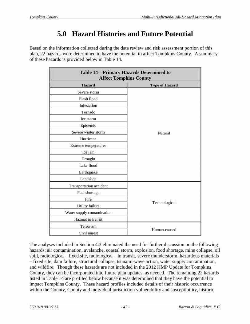
Tompkins County Multi-Jurisdictional All-Hazard Mitigation Plan
560.018.001/5.13 - 43 - Barton & Loguidice, P.C.
5.0 Hazard Histories and Future Potential
Based on the information collected during the data review and risk assessment portion of this
plan, 22 hazards were determined to have the potential to affect Tompkins County. A summary
of these hazards is provided below in Table 14.
Table 14 – Primary Hazards Determined to
Affect Tompkins County
Hazard Type of Hazard
Severe storm
Natural
Flash flood
Infestation
Tornado
Ice storm
Epidemic
Severe winter storm
Hurricane
Extreme temperatures
Ice jam
Drought
Lake flood
Earthquake
Landslide
Transportation accident
Technological
Fuel shortage
Fire
Utility failure
Water supply contamination
Hazmat in transit
Terrorism Human-caused
Civil unrest
The analyses included in Section 4.3 eliminated the need for further discussion on the following
hazards: air contamination, avalanche, coastal storm, explosion, food shortage, mine collapse, oil
spill, radiological – fixed site, radiological – in transit, severe thunderstorm, hazardous materials
– fixed site, dam failure, structural collapse, tsunami-wave action, water supply contamination,
and wildfire. Though these hazards are not included in the 2012 HMP Update for Tompkins
County, they can be incorporated into future plan updates, as needed. The remaining 22 hazards
listed in Table 14 are profiled below because it was determined that they have the potential to
impact Tompkins County. These hazard profiles included details of their historic occurrence
within the County, County and individual jurisdiction vulnerability and susceptibility, historic
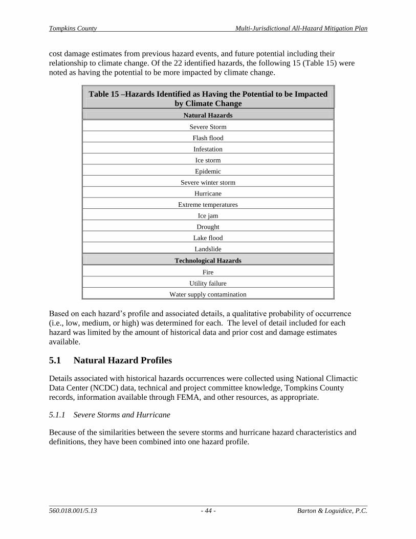
Tompkins County Multi-Jurisdictional All-Hazard Mitigation Plan
560.018.001/5.13 - 44 - Barton & Loguidice, P.C.
cost damage estimates from previous hazard events, and future potential including their
relationship to climate change. Of the 22 identified hazards, the following 15 (Table 15) were
noted as having the potential to be more impacted by climate change.
Table 15 –Hazards Identified as Having the Potential to be Impacted
by Climate Change
Natural Hazards
Severe Storm
Flash flood
Infestation
Ice storm
Epidemic
Severe winter storm
Hurricane
Extreme temperatures
Ice jam
Drought
Lake flood
Landslide
Technological Hazards
Fire
Utility failure
Water supply contamination
Based on each hazard’s profile and associated details, a qualitative probability of occurrence
(i.e., low, medium, or high) was determined for each. The level of detail included for each
hazard was limited by the amount of historical data and prior cost and damage estimates
available.
5.1 Natural Hazard Profiles
Details associated with historical hazards occurrences were collected using National Climactic
Data Center (NCDC) data, technical and project committee knowledge, Tompkins County
records, information available through FEMA, and other resources, as appropriate.
5.1.1 Severe Storms and Hurricane
Because of the similarities between the severe storms and hurricane hazard characteristics and
definitions, they have been combined into one hazard profile.
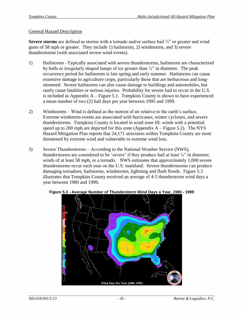
Tompkins County Multi-Jurisdictional All-Hazard Mitigation Plan
560.018.001/5.13 - 45 - Barton & Loguidice, P.C.
General Hazard Description
Severe storms are defined as storms with a tornado and/or surface hail ¾” or greater and wind
gusts of 58 mph or greater. They include 1) hailstorms, 2) windstorms, and 3) severe
thunderstorms (with associated severe wind events).
1) Hailstorms –Typically associated with severe thunderstorms, hailstorms are characterized
by balls or irregularly shaped lumps of ice greater than ¾” in diameter. The peak
occurrence period for hailstorms is late spring and early summer. Hailstorms can cause
extensive damage to agriculture crops, particularly those that are herbaceous and long-
stemmed. Severe hailstorms can also cause damage to buildings and automobiles, but
rarely cause fatalities or serious injuries. Probability for severe hail to occur in the U.S.
is included as Appendix A – Figure 5.1. Tompkins County is shown to have experienced
a mean number of two (2) hail days per year between 1995 and 1999.
2) Windstorms – Wind is defined as the motion of air relative to the earth’s surface.
Extreme windstorm events are associated with hurricanes, winter cyclones, and severe
thunderstorms. Tompkins County is located in wind zone III; winds with a potential
speed up to 200 mph are depicted for this zone (Appendix A – Figure 5.2). The NYS
Hazard Mitigation Plan reports that 24,171 structures within Tompkins County are most
threatened by extreme wind and vulnerable to extreme wind loss.
3) Severe Thunderstorms – According to the National Weather Service (NWS),
thunderstorms are considered to be ‘severe’ if they produce hail at least ¾” in diameter,
winds of at least 58 mph, or a tornado. NWS estimates that approximately 1,000 severe
thunderstorms occur each year on the U.S. mainland. Severe thunderstorms can produce
damaging tornadoes, hailstorms, windstorms, lightning and flash floods. Figure 5.3
illustrates that Tompkins County received an average of 4-5 thunderstorm wind days a
year between 1980 and 1999.
Figure 5.3 - Average Number of Thunderstorm Wind Days a Year, 1980 - 1999

Tompkins County Multi-Jurisdictional All-Hazard Mitigation Plan
560.018.001/5.13 - 46 - Barton & Loguidice, P.C.
Hurricanes, also termed tropical cyclones, are defined as storms with wind speeds of 74 mph or
greater which blow in a large spiral around an “eye” (calm center). Hurricanes are typically
downgraded to tropical storms or tropical depressions by the time they reach Tompkins County.
This hazard has a high potential to cause other cascading effects and extensive damage to life
and property.
Key Severe Storm and Hurricane Findings for Tompkins County:
Hailstorms – An average of one hailstorm occurs annually (1980-1999).
Windstorms – There is potential for winds up to 200 mph in Tompkins County
(Wind Zone III) (Appendix A – Figure 5.2).
Severe Thunderstorms – An average of four to five severe thunderstorms occur
annually (1980-1999).
Hurricanes – Tompkins County is not located within a hurricane-susceptible
region.
Historical Hazard Occurrence
Hurricane - No hurricane or tropical storm events were noted for Tompkins County, though
Hurricane Irene and Tropical Storm Lee had devastating impacts to adjacent counties, which
heightened awareness of these types of hazards in Tompkins County. The County’s geographic
location within the U.S. and New York State provides protection from full-strength hurricane
events. Historically, Tompkins County has however experienced high wind events; the most
severe of which are associated with remnants of hurricanes that have tracked up the Atlantic
Coast. Hurricane strength and severity generally decreases as the storm continues north and
inland to central New York. Therefore, the damage potential is relatively low and is mostly
associated with downed trees and interruptions to utility services. A list of hurricane force wind
events that have historically been reported within the County is provided below:
1935 – high wind event (eight to ten fatalities occurred)
1954 (October) – Remnants of Hurricane Hazel
1970s – extreme wind gusts
2003 – Remnants of Hurricane Isabel
2011 – Remnants of Hurricane Irene and Tropical Storm Lee
Severe Storms - NCDC data was queried to obtain records of severe storm events that have
occurred over the past six years (fall 2006 – fall 2012). Two reports of high wind events and 31
reports of severe thunderstorm were reported for Tompkins County. The occurrence details and
storm damages, if any, are summarized in Appendix A - Table 16.
The most significant severe storm event reported within the last six years occurred on April 28,
2011, in Danby, which included a tornado (detailed in Section 5.1.12). This storm consisted of a
straight line of winds of nearly 100 mph that resulted from a storm system that moved east across
New York State from the Great Lakes. Significant tree damage was reported as a result of this
Tompkins County Multi-Jurisdictional All-Hazard Mitigation Plan
560.018.001/5.13 - 47 - Barton & Loguidice, P.C.
storm, as well as multiple reports of roof and siding damage to residential housing. Hail
associated with the storm also struck homes and cars in the area. This storm resulted in an
estimated $100,000 in damages.
Historical Cost and Damage Estimates
Based on the NCDC’s damage reports, the majority of severe storm events within Tompkins
County resulted in $1,000 to $2,000 worth of damage. The total damages recorded over the
previous six years amount to $208,000, the majority of which was associated with residential
property damage. No fatalities or injuries have been reported over this time period. Based on
the NCDC damages included in Appendix A - Table 16, an average of $35,000 in losses
occurred annually between 2006 and 2012. Storms that occur between late spring and early fall
have a greater probability of damage to croplands. The majority of reported severe storm events
occurred within that window, during summer, from June to August. Impacts to public utilities
are commonly reported as a result of severe storm events. Such impacts require an immediate
response by utility company personnel and are often fixed quickly. Hail events can cause
minimal damage to private property, especially vehicles, but often do not result in an increased
need for County emergency services or other resources. The 2007 annualized crop loss estimate
(total annualized loss percent (0.2%)) for Tompkins County is reported in the NYS Hazard
Mitigation Plan as $28,742 (NYSOEM, 2011). Planted crops are more vulnerable to hail
damage than structures and other private property within Tompkins County. After a severe
storm event ends, the County and municipal public works departments are sometimes called
upon to clean up debris or fix infrastructure damage that may have occurred.
Future Potential Impacts
Based on recent literature related to climate change potential within New York State, including
the New York State Energy and Research Development Authority’s (NYSERDA) ClimAID
Report, weather patterns are projected to change and increase in severity. Annual average
precipitation is predicted to increase by up to 5% by the 2020s, up to 10% by the 2050s, and up
to 15% by the 2080s (NYSERDA, 2011). The greatest changes are projected to occur in
northern New York; however, no area of the state will be spared from climate change effects.
The majority of this additional precipitation is expected to fall as rain during winter and an
increase in heavy rainfalls is expected, with less incidence of light rain. Due to the projected
increase in precipitation and the increase in yearly average temperatures, severe storm events are
anticipated to increase in frequency and intensity.
5.1.2 Flash Flood
General Hazard Description
Floods are natural events for rivers and streams where excess water from snowmelt or rainfall
accumulates and overflows onto the banks and adjacent floodplains. FEMA has mapped 100-
year floodplains, which designates areas that, on average, have a 1-percent chance of flooding in
any given year. A large amount of rainfall over a short period of time can result in flash flood
conditions. Flash flood damage tends to occur in and around floodplains.
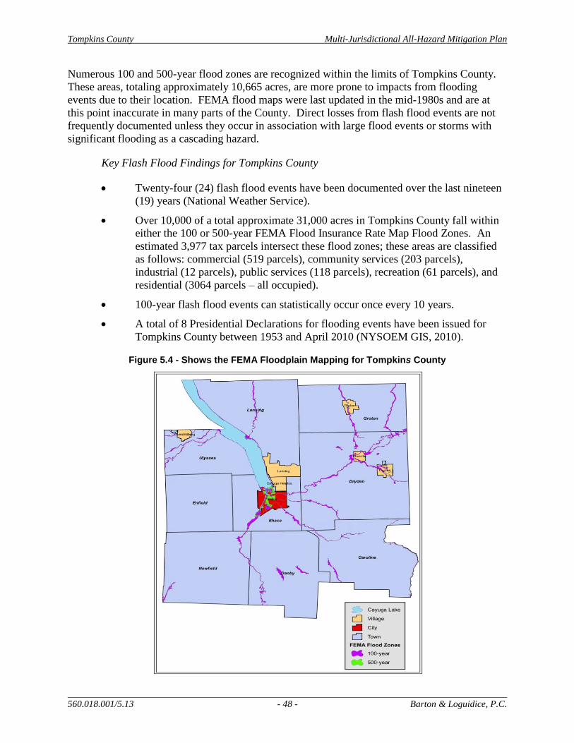
Tompkins County Multi-Jurisdictional All-Hazard Mitigation Plan
560.018.001/5.13 - 48 - Barton & Loguidice, P.C.
Numerous 100 and 500-year flood zones are recognized within the limits of Tompkins County.
These areas, totaling approximately 10,665 acres, are more prone to impacts from flooding
events due to their location. FEMA flood maps were last updated in the mid-1980s and are at
this point inaccurate in many parts of the County. Direct losses from flash flood events are not
frequently documented unless they occur in association with large flood events or storms with
significant flooding as a cascading hazard.
Key Flash Flood Findings for Tompkins County
Twenty-four (24) flash flood events have been documented over the last nineteen
(19) years (National Weather Service).
Over 10,000 of a total approximate 31,000 acres in Tompkins County fall within
either the 100 or 500-year FEMA Flood Insurance Rate Map Flood Zones. An
estimated 3,977 tax parcels intersect these flood zones; these areas are classified
as follows: commercial (519 parcels), community services (203 parcels),
industrial (12 parcels), public services (118 parcels), recreation (61 parcels), and
residential (3064 parcels – all occupied).
100-year flash flood events can statistically occur once every 10 years.
A total of 8 Presidential Declarations for flooding events have been issued for
Tompkins County between 1953 and April 2010 (NYSOEM GIS, 2010).
Figure 5.4 - Shows the FEMA Floodplain Mapping for Tompkins County

Tompkins County Multi-Jurisdictional All-Hazard Mitigation Plan
560.018.001/5.13 - 49 - Barton & Loguidice, P.C.
Historical Hazard Occurrences
Due to the topographic characteristics of Tompkins County, several municipalities are vulnerable
to flash floods and associated landslides, particularly the Towns of Dryden, Groton, Caroline, the
City of Ithaca, and the Villages of Freeville and Groton. Cornell University has also reported
multiple landslide events on their properties, which have resulted from flash flooding. Tompkins
County does not have a history of flood related deaths or serious injuries; however, flash
flooding was determined to be a priority hazard event within Tompkins County due to its
frequency as well as economic impacts related to property and infrastructure damage.
The NWS reported during the County’s HIRA-NY risk assessment event that twenty-four (24)
flash flood events have been documented within Tompkins County over the last nineteen (19)
years. This information is inaccessible online, but the NCDC was queried for records of flash
floods in Tompkins County. This data search resulted in 10 records of occurrence in Tompkins
County between January 1996 and October 2012. Four of these flash flood occurrences have
taken place since the County’s initial HMP in 2006. The NCDC records are detailed in Table 17,
below.
Table 17 –Tompkins County Flash Flood Events between
January 1996 and October 2012
(NOAA, NCDC, Storm Events Search, 2012)
Location Date Event
Deaths
(#)
Injuries
(#)
Property
Damage
($)
Crop
Damage
($)
Countywide 1/1996 Flash Flood 0 0 $19 million 0
Lansing 5/1996 Flash Flood 0 0 $12,000 0
Countywide 11/1996 Flash Flood 0 0 $900,000 0
Ithaca 7/2003 Flash Flood 0 0 $500,000 0
Countywide 4/2005 Flash Flood 0 0 $200,000 0
Caroline 6/2006 Flash Flood 0 0 $50,000 0
Groton 7/2006 Flash Flood 0 0 $3,000 0
McKinneys Point 8/2007 Flash Flood 0 0 $1,000 0
Ithaca 9/2011 Flash Flood 0 0 $20,000 0
Ellis Hollow 9/2011 Flash Flood 0 0 $400,000 0
Tompkins County did not sustain any significant damages associated with October 2012’s
Hurricane Sandy. The most significant recent flash flooding event was associated with Tropical
Storm Lee and Hurricane Irene (September 2011). A record rainfall of six to twelve (12) inches
resulted in the flash flooding of creeks in and around the Susquehanna River Basin. Damages
associated with this event in New York and Pennsylvania were estimated at close to 1 billion
dollars. Other historical occurrences of flash flooding in Tompkins County include Virgil Creek
flooding in Dryden, flooding at the Dryden Elementary School, Groton Nursing Home & Senior
Citizens building, and localized flooding along Little Egypt Creek and East Shore Drive Plaza.

Tompkins County Multi-Jurisdictional All-Hazard Mitigation Plan
560.018.001/5.13 - 50 - Barton & Loguidice, P.C.
Historical Costs and Damage Estimates
As illustrated by the NCDC property damage estimates above, a single flash flood event has
resulted in $1,000 - $400,000 in damage costs. To look at the average annual losses reported for
communities that participate in the National Flood Insurance Program (NFIP), flood damage data
was reviewed and is included in Appendix A - Table 18. As of 2007, Tompkins County had 299
NFIP policy holders. The Village of Groton reports the highest annual losses from flooding
events. The total average annual loss due to flooding in the County is reported as $46,858.85
based on the NFIP records. This number is conceivably higher during years where a significant
flash flooding event occurs. It is always important to remember that not all jurisdictions within
Tompkins County participate in the NFIP; therefore, additional losses are assumed to occur
every year.
Based on the data depicted in Appendix A - Figure 5.5, approximately 7,860 acres of agricultural
lands are within or immediately adjacent to 100-year or 500-year floodplains. This amount of
land represents an estimated value of $16,640,635.00, based on Tompkins County Real Property
records. Depending on the time of year and the type of agricultural enterprise, damages to these
lands from flash flooding could range from minimal ($500) to significant ($1,000,000), though
no significant agricultural damages have been recorded as a result of past flash flood events.
Flood events have the potential to quickly impact all structures and facilities. Large flood events
often include mandatory evacuations and the establishment of emergency shelters. Residential
properties are the property type most often located within mapped floodplains; therefore, impacts
to private houses are anticipated to be the largest structural impact that would result from a large
flood event. Tompkins County currently has eleven (11) Repetitive Loss properties. A Repetitive
Loss (RL) property is any insurable building for which two or more claims of more than $1,000
were paid by the NFIP within any rolling ten-year period, since 1978. These RL properties
consist of the following types: eight (8) are single family properties, two are multi-family
residential and one is commercial. The greatest number of RL properties, seven (7), fall within
the Town of Lansing boundaries. Of the remaining properties, one (1) falls within the Town of
Caroline, two (2) are located in the City of Ithaca, and one is located within the Town of Ithaca.
Since 1978, a total of $290,991.02 has been paid to these residents for both building and content
damages. Extensive impacts to transportation infrastructure, agricultural lands, and public
utilities can also occur from flash flooding.
As noted in the United States Army Corps of Engineers’ Hydraulic Analysis and Impacts of
Long Term Shoaling for Flood Risk Management Project, Cayuga Inlet, Ithaca, NY flooding is
most pronounced in the City of Ithaca downstream of Sixmile Creek, between State Street and
Cascadilla Creek. In this area flood waters often cross Meadow Street and inundate portions of
Adams, Fourth and Fifth streets. Also, Cascadilla Creek water will often back up and flood parts
of Lincoln and Dey streets. The report indicates that the flood risk to the residences and
businesses in these areas is increased due to the lack of regular maintenance of the Flood Risk
Management project on the Cayuga Inlet.
Tompkins County Multi-Jurisdictional All-Hazard Mitigation Plan
560.018.001/5.13 - 51 - Barton & Loguidice, P.C.
Future Potential Impacts
According to the climate projections noted in NYSERDA’s ClimAID technical report, annual
average precipitation is projected to increase by up to 5 percent by the 2020s, up to 10 percent by
the 2050s, and up to 15 percent by the 2080s. Such increases are sure to affect the frequency and
severity of flash flooding events within New York State. It is anticipated that these increase will
not be evenly distributed throughout the year. Reports indicate that the bulk of these increases
will be realized in the winter months and mainly come in the form of rain. More rain on frozen
ground will most likely increase the likelihood of flash flooding. Because Tompkins County is
located at the southern end of Cayuga Lake and has numerous freshwater streams within its
boundaries, the County will become increasingly vulnerable to potential impacts from flash
flooding events as precipitation increases in amount and frequency. Adverse flood impacts in
the City of Ithaca in the area mentioned in the Army Corps of Engineers’ report will continue if
dredging of the Inlet does not occur. To accurately track fluctuations in flood activity to assess
future potential impact, existing USGS stream gages should continue to be supported (2 in
Sixmile Creek, 1 in Fall Creek, 1 in Cayuga Lake Inlet). Added gages should be considered for
installation in Salmon Creek and Owasco Inlet. Due to the multiple benefits of these gages,
continued funding should be sought both with and without USGS support.
5.1.3 Earthquake
General Hazard Description
An earthquake is a sudden motion or trembling that is caused by a release of strain accumulated
within or along the edge of Earth’s tectonic plates. The effects of an earthquake can be felt at
distances beyond its actual occurrence, though they are less severe as the distance increases. As
Appendix A - Figure 5.6 illustrates, multiple earthquake events have been reported within New
York State, primarily in the North Country/Adirondack regions. Effects like ground shaking
have been frequently reported within the State even though the earthquake itself occurred outside
state borders.
The U.S. Geological Survey (USGS) produces seismic hazard maps. Earthquake probability on
these maps is commonly displayed in terms of peak ground acceleration (PGA). PGA
measurements indicate the geographic area affected, the probability of an earthquake at different
levels of severity, and the strength of ground movement (expressed in acceleration force of
gravity, % g). Appendix A - Figure 5.7 shows that Tompkins County is located in an area of low
peak acceleration, likely due to a low incidence rate and small maximum magnitude for nearby
earthquakes. Any jurisdiction that has a peak ground acceleration value of 3% or higher, is
required to fully profile the earthquake hazard to receive FEMA plan approval. As illustrated in
Appendix A – Figure 5.7, Tompkins County’s PGA value is between 2% and 3% g. Table 19
shows what PGA values equate to in terms of hazard intensity, damage potential, and magnitude.

Tompkins County Multi-Jurisdictional All-Hazard Mitigation Plan
560.018.001/5.13 - 52 - Barton & Loguidice, P.C.
Table 19 – Richter Magnitude Scale and Mercalli Intensity Scale Ratings
(USGS, Earthquake Hazards Program, 2010 and NYSOEM, State HMP, 2011)
Acceleration
PGA
(%g)
Mercalli
Intensity
Scale
Richter
Magnitude
Scale
Damage
Potential Intensity Scale Details
<0.17 I 1.0 – 3.0 None Not felt except by a few persons at rest under
favorable conditions
0.17 – 1.4 II – III 3.0 – 3.9 None Felt only by some at rest – felt noticeably
indoors, especially on upper floors
1.4 – 9.2 IV – V 4.0 – 4.9 None Felt by many indoors, some/many outdoors,
minor damage occurs
9.2 - 34 VI – VII 5.0 – 5.9 Light to
moderate
Felt by all, damage to inadequate structures,
many frightened
34 - 124 VIII – IX 6.0 – 6.9 Moderate to
heavy
Considerable damage to many types of structures,
structural collapse
>124 X or higher 7.0 and
higher
Very heavy Structures destroyed, bridges and rails bent,
objects thrown, line of sight & level distorted
Key Earthquake Findings for Tompkins County
There is no record of local earthquake occurrences.
Tompkins County’s PGA value is 2-3% g, which indicates limited seismic
activity, which typically results in minor damages.
Historical Hazard Occurrence
Earthquakes are designated as having a moderately low potential to impact Tompkins County.
Seismic maps provide the best estimates of earthquake probability expressed in terms of PGA
and also spectral acceleration (SA). SA is a measurement that describes the maximum
acceleration in an earthquake on an object. Figure 5.8 shows a map produced by the New York
State Geological Survey that shows the potential for lands within Tompkins County to accelerate
and amplify seismic waves based on surficial geology and soil data.

Tompkins County Multi-Jurisdictional All-Hazard Mitigation Plan
560.018.001/5.13 - 53 - Barton & Loguidice, P.C.
Figure 5.8 – Spectral Acceleration Data for Tompkins County (NYSOEM, State Hazard Mitigation Plan-GIS, 2007)
SA is expressed in “g”, which represents the acceleration due to Earth’s gravity. The map
represents the ground motion that can be reasonably expected in a 50 year period. The majority
of Tompkins County, as shown in the above figure, is located in an area of less than 25% g;
however a few areas are mapped within the County that exhibit 25-35% g. All of these values
indicate a low potential for seismic activity within the County. There are additionally no
historical records of an earthquake occurring within Tompkins County, or of a nearby earthquake
event that has significantly impacted the County. Despite this history, it is recommended that
projects involving new infrastructure construction strictly follow the existing New York State
Building Code with respect to where and when seismic design practices should be incorporated
into a facility design.
Historical Cost and Damage Estimates
The New York State Hazard Mitigation Plan (2011) has modeled potential loss to earthquakes by
County. This information, depicted by Figure 5.9, used surficial geology and soils data to
estimate earthquake risk and potential loss if such a hazard event were to occur. This mapping
illustrates that damages reported within Tompkins County could range from $4,215.30 to
$80,000.00.
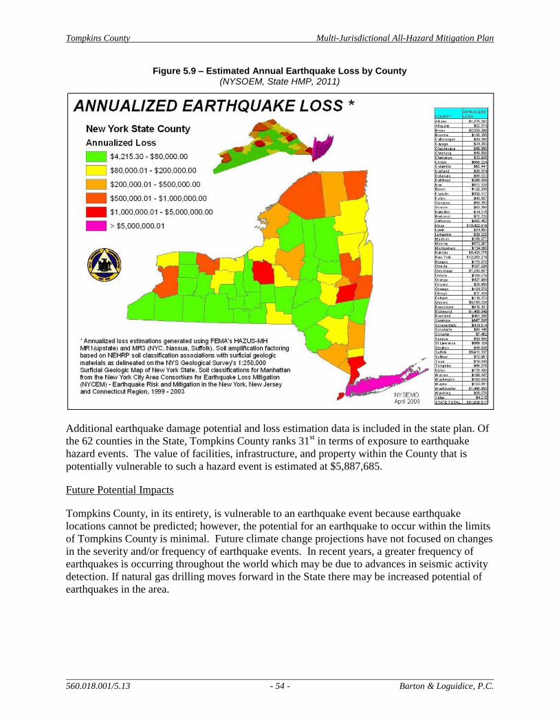
Tompkins County Multi-Jurisdictional All-Hazard Mitigation Plan
560.018.001/5.13 - 54 - Barton & Loguidice, P.C.
Figure 5.9 – Estimated Annual Earthquake Loss by County (NYSOEM, State HMP, 2011)
Additional earthquake damage potential and loss estimation data is included in the state plan. Of
the 62 counties in the State, Tompkins County ranks 31st in terms of exposure to earthquake
hazard events. The value of facilities, infrastructure, and property within the County that is
potentially vulnerable to such a hazard event is estimated at $5,887,685.
Future Potential Impacts
Tompkins County, in its entirety, is vulnerable to an earthquake event because earthquake
locations cannot be predicted; however, the potential for an earthquake to occur within the limits
of Tompkins County is minimal. Future climate change projections have not focused on changes
in the severity and/or frequency of earthquake events. In recent years, a greater frequency of
earthquakes is occurring throughout the world which may be due to advances in seismic activity
detection. If natural gas drilling moves forward in the State there may be increased potential of
earthquakes in the area.
Tompkins County Multi-Jurisdictional All-Hazard Mitigation Plan
560.018.001/5.13 - 55 - Barton & Loguidice, P.C.
5.1.4 Lake Flood
General Hazard Description
Lake flooding occurs when the water level of Cayuga Lake increases along the shoreline,
impacting properties along the lake and backing up water levels in the creeks that outlet to
Cayuga Lake. During the risk assessment discussion for this hazard, it was determined that the
water level of Cayuga Lake would have to reach an elevation of 387 feet to meet the definition of
a lake flood. At this elevation, impacts to the New York State Route 13 corridor begin to occur
and residential properties along the shoreline begin to flood. According to the New York State
Canal Corps, the entity in charge of adjusting the lake levels, 385 feet represents the flood stage
of Cayuga Lake.
Key Lake Flood Findings for Tompkins County
A lake flood hazard occurs when the water level in Cayuga Lake Exceeds 387
feet.
Lake flood events occur on average of once a decade, but due to climate change
projections, this rate is anticipated to increase in the future.
Historical Hazard Occurrence
The effects from lake flooding are amplified by the topographic characteristics of the County. A
notable amount of development within the County occurs along Cayuga Lake’s shoreline and the
valleys along the main creeks that outlet into the lake. This is most prevalent in the City of Ithaca
which is built around the southern end of the lake. Multiple jurisdictions within the County have
been susceptible to chronic lake flooding events, which cause the water levels in feeder creeks to
drain slowly. These jurisdictions include the towns of Ithaca, Lansing, and Ulysses, Village of
Cayuga Heights and the City of Ithaca. Lake flood events that have been documented over the
past 50 years include:
1972 – Hurricane Agnes
1993 – Unspecified storm event
2005 – Fall Creek Flooding ($100,000 in property damage) - connected with ice jam
near Ithaca High School
2011 – Hurricane Irene, Tropical Storm Lee (Lake water levels were reported at 383/384
feet)
Historical Cost and Damage Estimates
It was estimated that 50-60 houses would be impacted by a lake elevation of 387 feet in the
Town and Village of Lansing, specifically the Myers Corners and Ladoga Park areas. The towns
of Ulysses and Ithaca, and the City of Ithaca and Village of Cayuga Heights are also located
along the shoreline of Cayuga Lake though most of these structures are above this elevation.
Because the Canal Corps adjusts the water elevation in the lake at 385 feet, sustained and
increasing damage to shoreline and creek side properties in the County are not expected to be an

Tompkins County Multi-Jurisdictional All-Hazard Mitigation Plan
560.018.001/5.13 - 56 - Barton & Loguidice, P.C.
issue. Immediate and short-term damage to property may occur, resulting in around $50,000 to
$100,000 in damage for a lake flood hazard event. Fatalities and injuries are not anticipated to
occur as a result of such events. Lake floods do not pose as high a risk to loss of life and
property as flash floods, because they have greater warning times and slower rising water levels.
Future Potential Impacts
Should development continue along the shoreline of Cayuga Lake, lake flooding impacts to
developed property will increase. Climate change projections indicate that precipitation levels in
the future will increase. Such significant increases in rain and runoff levels will more often raise
the water level of the lake, inundating shoreline properties and low-lying areas adjacent to the
main creeks within the County. Due to these predicted changes in climate, it can be inferred that
more incidents of lake flooding will occur in the future. USGS data has also noted increases in
extreme water flows in recent years. To accurately track fluctuations in lake flooding to assess
future potential impact, existing USGS stream gages should continue to be supported (2 in
Sixmile Creek, 1 in Fall Creek, 1 in Cayuga Lake Inlet). The installation of additional gages
should also be considered, including in Salmon Creek and Owasco Inlet. Due to the multiple
benefits of these gages, continued funding should be sought both with and without USGS
support.
5.1.5 Severe Winter Storm and Ice Storm
General Hazard Description
Severe winter storms are denoted by the accumulation of 12”or more of snow in a 12-hour
period.
Ice storms are characterized by freezing rain which accumulates in a substantial glaze layer of
ice resulting in serious disruptions of normal transportation and possible downed power lines.
An ice storm occurs when ¼” of ice build-up is observed.
Key Severe Winter Storm Findings for Tompkins County
A severe winter storm occurs on average 3 times a year
A severe ice storm occurs just once every 3 to 5 years.
Historical Hazard Occurrence
Severe winter storms are annually encountered within Tompkins County. The NWS reports
that the County averages 3.3 annual severe winter storms that meet the definition outlined above.
Records of severe winter storm events reported by the NCDC are included in Appendix A –
Table 20.
Ice storms occur in the County once every 3 to 5 years. An ice storm in January 2003 left
thousands of residents without power for several days. A similar event, resulting in up to 0.5
inches of ice, also occurred within Tompkins County in March 2008. According to the NWS, 8
ice storms, resulting in ¼- ½” of ice, have occurred in Tompkins County over the past 19 years.
Tompkins County Multi-Jurisdictional All-Hazard Mitigation Plan
560.018.001/5.13 - 57 - Barton & Loguidice, P.C.
Historical Cost and Damage Estimates
Severe winter storms result in little or no private property or public infrastructure damage. Ice
storm events, or winter storms that have an ice component, can cause much more extensive
damage, mostly to utility infrastructure, but moderate damage to private property has been
documented. Actual damage costs can range from the thousands to millions, depending upon
severity, duration, and nature of the event. Elderly and impoverished populations are typically
more vulnerable during severe winter storm or ice storm events, especially if power failure
results. For this reason, particular care is provided to these populations including the
establishment of emergency and warming shelters during prolonged storm or power outage
events.
Future Potential Impacts
Climate change is extremely likely to bring warmer temperatures to most of the state. Total
annual precipitation is expected to increase, but mostly in the form of rain, or freezing rain, not
snow. The build-up of significant amounts of snow events may be less likely to occur in the
future due to the change in seasonal temperatures, however freezing rain and ice may be more
frequent. In the short-term, severe winter storms, and ice storms to a lesser degree, will continue
to be regular events within Tompkins County. Because of this frequency, the County must
continue to provide reliable and well-tested system to keep the County functioning and the
residents safe during such hazard events. The likelihood of ice storms in the future should be
incorporated into planning for utility and infrastructure needs.
5.1.6 Ice Jams
General Hazard Description
An ice jam is described as a large accumulation of ice in rivers or streams that interrupts the
normal flow of water and often leads to flooding conditions and/or damage to nearby structures.
Ice jam events are often short-lived and often affect only a localized reach or area of a body of
water (U.S. Army CRREL, 2004).
Key Ice Jam Findings for Tompkins County
Since 1926, 24 ice jam events have occurred, most frequently on Fall Creek, in
the City of Ithaca.
The NWS reports that ice jam events occur twice every 10 years.
All historic ice jam events have occurred between the months of December and
March.
Historical Hazard Occurrence
The NWS reported during the County’s 2012 risk assessment exercise that an ice jam has been
documented within Tompkins County twice in 10 years. Occurrences of ice jams in the County
are commonly associated with flash flooding events that mobilize the ice. The U.S. Army Corps
of Engineers’ (USACE) Ice Jam Database reports that 24 ice jams have been documented within
Tompkins County Multi-Jurisdictional All-Hazard Mitigation Plan
560.018.001/5.13 - 58 - Barton & Loguidice, P.C.
the City of Ithaca since 1926, the date of the first hazard report. The City of Ithaca is the only
Tompkins County location included in this database. The majority of the ice jam reports involve
Fall Creek. USACE database records of ice jam events that have historically occurred in
Tompkins County are included in Appendix A – Table 21.
Appendix A - Figure 5.10 depicts locations of frequent ice jam incidents within New York State.
Fall Creek has the highest rate of ice jam frequency within Tompkins County; 21 reports of ice
jam events are listed for this water resource between 1875 and 2007. Salmon Creek also has
issues with ice jams that threaten a railroad trestle that is used daily.
Historical Cost and Damage Estimates
Of the 24 historic ice jam reports, only two mentioned potential damage to infrastructure and
private property. Potential damage is associated with flooding caused by the ice jam and
resulting water level increases. Minor flooding to basements results in minimal damage,
estimated at $1,000 - $2,000 per affected property. Though no evidence of such major damage
exists, a large ice jam event could cause severe damage to highway or railroad bridges that cross
the main waterways in the County. The cost to repair a damaged bridge structure is estimated at
$500,000 - $1,000,000.
Future Potential Impacts
Recent climate change research initiatives, such as ClimAID, reports that increases in air
temperature will lead to increases in water temperature over the next handful of decades. Higher
water and air temperatures will likely decrease the potential for thick ice to cover water resources
within Tompkins County. Even if ice forms on the water surface, an increase in air and water
temperatures would quicken the melting process, thus discouraging the build-up of large blocks
of ice.
5.1.7 Landslides
General Hazard Description
Landslides are defined as the downward and outward movement of slope-forming materials
reacting to the force of gravity. Slide materials may be composed of natural rock, soil, artificial
fill, or combinations of these materials. Landslides are activated by storms, earthquakes,
volcanic eruptions, fires, freezing/thawing, and steepening of slopes by erosion or human
modification.
Key Landslide Findings for Tompkins County
Ten Landslide events have occurred locally (1837-2007).
Two locations of moderate landslide incidence are mapped within Tompkins
County.
Tompkins County Multi-Jurisdictional All-Hazard Mitigation Plan
560.018.001/5.13 - 59 - Barton & Loguidice, P.C.
Historical Hazard Occurrence
Historically, landslide events within Tompkins County have been infrequent and are commonly
triggered by heavy rainfall events. Multiple occurrences have been noted within the County in
recent years, though these events are primarily confined to localized areas adjacent to steep
slopes or waterways. Figure 5.11 shows that two locations of moderate landslide incidence are
mapped within Tompkins County, while the majority of the County is identified as a low
incidence area. The two moderate incidence locations correspond to lands surrounding Cayuga
Lake, and lands located within the Pleasant Valley area, extending to the Village of Dryden.
According to the data associated with this figure, 8.93 percent of the land area within Tompkins
County is represented by the two locations of moderate incidence. According to USGS
information included in the State Hazard Mitigation Plan, 10 landslide events have occurred in
Tompkins County between 1837 and 2007 (USGS Open File Report 94-615). The County’s most
active landslide is in the Town of Ulysses on South Street Extension abutting Taughannock
Creek. Small scale landslide activity among the region’s many gorges has caused adverse
impacts to human safety and recreation.
Historical Cost and Damage Estimates
A potable water pipeline that services the City of Ithaca is known to be located in a landslide
susceptible slope area; no back-up service main is currently in operation. A slope failure in this
area has the potential to result in infrastructure damage to the pipeline, but also to cause
interruptions in water service to many households in the City. Even a short-term service
interruption could cost an estimated $100,000 to repair and cost affected households the
inconvenience and additional cost associated with finding a secondary water source (i.e. family
member’s house, bottled water, etc.). This situation is hypothetical; no damage numbers are
available for documented landslide events that have occurred within Tompkins County.
Significant costs have additionally been incurred over the years to safely maintain the network of
gorge trail infrastructure.

Tompkins County Multi-Jurisdictional All-Hazard Mitigation Plan
560.018.001/5.13 - 60 - Barton & Loguidice, P.C.
Figure 5.11 – Landslide Susceptibility within New York State (USGS, NYS Hazard Mitigation Plan, 2011)
Future Potential Impacts
The majority of landslide incidents within Tompkins County are spurred by heavy rainfall
events. These heavy rainfall events are expected to increase in the future, mostly in areas that
have historically documented bank failures or slope subsidence. Annual average precipitation in
NYS is projected to increase by 5 to 10 percent by 2080 (ClimAID, 2012). With this the
frequency of landslides to occur in the County will likely increase. In addition, climate models
also project that the frequency of heavy rainfall events will increase. These predicted changes in
weather patterns are likely to result in an increase in the frequency of landslides, potentially with
greater levels of property damage.
5.1.8 Drought
General Hazard Description
A drought is defined as a prolonged period of limited precipitation affecting the supply and
quality of water. An absolute drought consists of a period of at least 15 consecutive days where
none of the days experience 0.01 inches of rain or greater. A partial drought is a period of at
least 20 consecutive days where the mean daily rainfall does not exceed 0.01 inches. A dry spell
consists of a period of at least 15 consecutive days where none of the days experience 0.04
inches or more of rainfall (USGS, 2009). Agricultural drought relates to agricultural impacts that
occur as a result of various meteorological characteristics, such as precipitation shortages and
Tompkins County Multi-Jurisdictional All-Hazard Mitigation Plan
560.018.001/5.13 - 61 - Barton & Loguidice, P.C.
soil water deficits. Hydrological drought relates to the effects that a lack or decrease in
precipitation has on surface or subsurface water supplies.
Key Drought Findings for Tompkins County
Tompkins County’s agricultural sector is that which is most vulnerable to
drought.
A 2005 drought event resulted in significant sugar maple die off.
Historical Hazard Occurrence
Periods of drought have had limited and localized impacts in Tompkins County. The largest
vulnerability that the County has related to this hazard is its strong agricultural industry.
Tompkins County agriculture was responsible for $60 million in revenue in 2011. A drought
event occurred in 2005, resulting in significant sugar maple die-off around the County. That
summer is reportedly the driest over the last 130 years. September 1999 was also a recorded dry
month that caused major crop failures and some wells to run dry within Central New York. Corn
and hay crops were most severely impacted.
Historical Cost and Damage Estimates
Aquifer recharge could potentially be affected by absolute or partial drought events. This may
result in impacts to drinking water supplies, since stream fed water systems are affected by
groundwater fluctuations. The agriculture industry would experience crop damage and plant
fatality as a result of a prolonged drought event. Many farms in the County do not have local
irrigation systems, so a lack of water would reduce crop production and survival. Drought
conditions also have the potential to impact livestock producers, through effects such as reduced
milk production, decreased stock weights, and high cost for feed. Damages from the 1999
drought event were reported to be as high as $17.7 million in Cayuga County. Specific damage
amounts were not available for Tompkins County, but are estimated to have ranged around $1
million. Over $60 million in agricultural products are produced annually by Tompkins County
farms. Those agencies who assist with agricultural practices will continue to play a key role in
mitigating impacts related to drought on farms.
Future Potential Impacts
The frequency and extent of drought conditions are expected to rise in the future due to climate
change. Summer drought is projected to affect water supply, agriculture, ecosystems and energy
production.
5.1.9 Infestation
General Hazard Description
Infestation is defined as an excessive population of insects, plants, rodents, or other animals
requiring control measures due to their potential to carry diseases, destroy crops, or harm the
environment.
Tompkins County Multi-Jurisdictional All-Hazard Mitigation Plan
560.018.001/5.13 - 62 - Barton & Loguidice, P.C.
Key Infestation Findings for Tompkins County
An increase in property, road and infrastructure damages is anticipated with
Emerald Ash Borer.
Research has indicated that the prevention and eradication of Hydrilla is far
cheaper than containment or management.
Historical Hazard Occurrence
Plant populations: Hydrilla is a highly invasive aquatic plant that was first detected in August
2011 in the Linderman Creek area of Cayuga Inlet. Hydrilla is a very aggressive growing plant,
which can grow up to a foot a day and can grow underwater of lengths up to 25 feet. It creates a
thick mat of vegetation when it grows to the water surface. This mat shades out other plants and
clogs waterways in a fashion that has the potential to increase lake flooding. This plant has most
immediate impacts to the City of Ithaca, but has far reaching regional impacts. Since discovering
Hydrilla in the Cayuga Inlet, extensive efforts have been undertaken to limit the spread of this
species into Cayuga Lake.
Insect populations: A detailed history of infestation events is not available for Tompkins County;
however recent events and concerns have been documented. For one, the emerald ash borer
(EAB) is an insect of increasing concern within NYS. This species was first confirmed in NYS
on June 17, 2009, but research indicates that it has been present in some areas since the mid
1990s. Tompkins County susceptibility to this species isn’t fully documented since the number
of ash trees within the area has never been quantified and the areas of greatest ash density are not
known. However, U.S. Forest Service (USFS) data estimates that 12 percent of the total tree
volume in Tompkins County is ash (Figure 5.12). An accurate inventory of trees in priority,
high-traffic areas needs to be completed so that liabilities can be calculated.

Tompkins County Multi-Jurisdictional All-Hazard Mitigation Plan
560.018.001/5.13 - 63 - Barton & Loguidice, P.C.
Figure 5.12 – Percentage of Ash per Total Basal per County in New York State (NYSDEC Forest Health and Protection, 2012)
Based on guidance from the Technical Committee, an EAB infestation can influence a
community for 10-20 years after it first descends upon an area. Figure 5.13 shows the currently
documented infestation locations of EAB within NYS. As shown, the closest identified
infestation is in the Town of Nichols, Tioga County; Tompkins County is located just 16 miles
north of this infestation location.
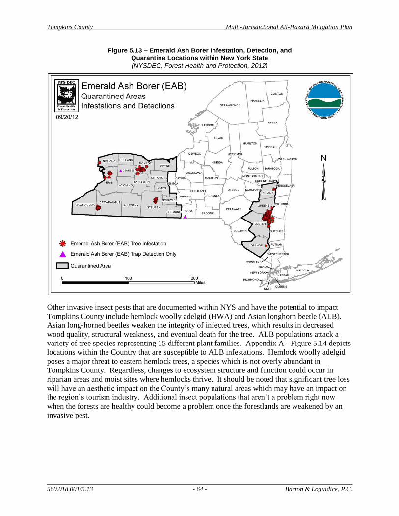
Tompkins County Multi-Jurisdictional All-Hazard Mitigation Plan
560.018.001/5.13 - 64 - Barton & Loguidice, P.C.
Figure 5.13 – Emerald Ash Borer Infestation, Detection, and Quarantine Locations within New York State (NYSDEC, Forest Health and Protection, 2012)
Other invasive insect pests that are documented within NYS and have the potential to impact
Tompkins County include hemlock woolly adelgid (HWA) and Asian longhorn beetle (ALB).
Asian long-horned beetles weaken the integrity of infected trees, which results in decreased
wood quality, structural weakness, and eventual death for the tree. ALB populations attack a
variety of tree species representing 15 different plant families. Appendix A - Figure 5.14 depicts
locations within the Country that are susceptible to ALB infestations. Hemlock woolly adelgid
poses a major threat to eastern hemlock trees, a species which is not overly abundant in
Tompkins County. Regardless, changes to ecosystem structure and function could occur in
riparian areas and moist sites where hemlocks thrive. It should be noted that significant tree loss
will have an aesthetic impact on the County’s many natural areas which may have an impact on
the region’s tourism industry. Additional insect populations that aren’t a problem right now
when the forests are healthy could become a problem once the forestlands are weakened by an
invasive pest.

Tompkins County Multi-Jurisdictional All-Hazard Mitigation Plan
560.018.001/5.13 - 65 - Barton & Loguidice, P.C.
Historical Cost and Damage Estimates
Plant populations: Ecological and economic impacts of Hydrilla are significant. This includes
shading of native plants, oxygen deficits, fish kills, habitat quality change, cyanobacteria
outbreaks and toxin production linkage with bald eagle. Due to the wide use of Cayuga Lake,
economic impacts to tourism, fishing, swimming, and property values have the potential to be
significant. The waterways affect the local economy in three primary ways; through flood
protection, property tax revenues and tourism spending, particularly spending associated with
recreational boating and water-dependent businesses. Property values in the waterfront are high;
although nearly 97% of waterfront properties are tax exempt, annual tax revenues from the
remaining 3% is over $2 million. Finally, water-dependent businesses generated over $2 million
in sales (nearly $700,000 of which came from docking fees) in 2008. Revenues from facilities
specializing in non-motorized boats are not included. The Inlet has four primary facilities
catering to non-motorized boaters: Cornell University and Ithaca College Crew facilities, a
business that rents and sells canoes and kayaks, and the Cascadilla Boat Club with approximately
175 members with annual membership and training fees of $60,000 (CCETC, 2012).
Based on the experience in Tompkins County the cost of maintenance associated with Hydrilla is
substantial. The local Hydrilla Task Force elected to utilize herbicide treatments of endothall and
fluridone to attempt to eradicate Hydrilla. An endothall treatment was applied on June, 26, 2012
and was deemed a success. A fluridone treatment was applied to the Cayuga Inlet area, including
Cascadilla Creek and Six Mile Creek, starting July 12, 2012 and ending October 31, 2012. The
funding for this effort was received from the New York State Department of Environmental
Conservation in the amount of $800,000. Appendix A – Figure 5.15 shows the specific locations
where the fluridone treatment was applied. Currently, the effectiveness of this treatment is being
analyzed; additional eradication efforts will likely be needed. Significant staff time of local
officials from the City of Ithaca, Cornell University, Tompkins County, Tompkins County Soil
and Water District and others have been used in this effort. The effort and funds expended to-
date are significant. Not including in-kind contributions, approximately $130,000 was spent in
2011 and $460,000 in 2012. The estimate for eradication efforts in future years is approximately
$500,000 per year. Eradication of this species from the waterways of Tompkins County
represents a realistic scenario that could occur at any time in association with additional invasive
plant species.
Insect populations: EAB damage will very likely result in the death of all untreated ash trees
within the County. Infested trees begin to fall in large sections soon after dying, causing a
significant potential threat to health, property, and public infrastructure. An increase in property
and road maintenance costs would likely occur and an increase in overhead utility service repair
requests. Falling ash debris also has the potential to accumulate in waterways and clog culvert
locations. Management efforts for the EAB and hemlock woolly adelgid often consist of
insecticide treatments and removal of infested trees. Such efforts will prove to be costly, when
they are needed in the future. Wood-boring pests in the U.S. cause an estimated $3.5 billion in
damage annually. When infestations are confirmed, state and national funding may be made
available to the affected areas to help with the pest management and hazard mitigation. Such
funds in other infested areas have ranged from $20 million to $65 million.
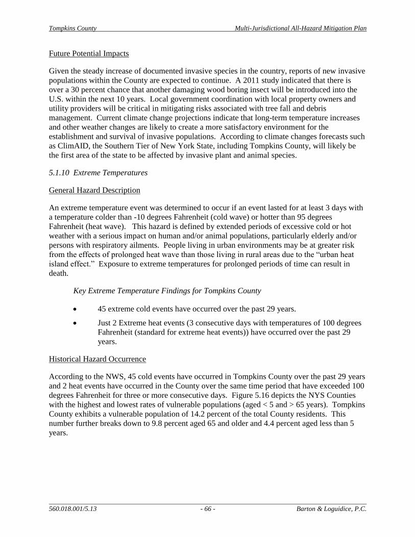
Tompkins County Multi-Jurisdictional All-Hazard Mitigation Plan
560.018.001/5.13 - 66 - Barton & Loguidice, P.C.
Future Potential Impacts
Given the steady increase of documented invasive species in the country, reports of new invasive
populations within the County are expected to continue. A 2011 study indicated that there is
over a 30 percent chance that another damaging wood boring insect will be introduced into the
U.S. within the next 10 years. Local government coordination with local property owners and
utility providers will be critical in mitigating risks associated with tree fall and debris
management. Current climate change projections indicate that long-term temperature increases
and other weather changes are likely to create a more satisfactory environment for the
establishment and survival of invasive populations. According to climate changes forecasts such
as ClimAID, the Southern Tier of New York State, including Tompkins County, will likely be
the first area of the state to be affected by invasive plant and animal species.
5.1.10 Extreme Temperatures
General Hazard Description
An extreme temperature event was determined to occur if an event lasted for at least 3 days with
a temperature colder than -10 degrees Fahrenheit (cold wave) or hotter than 95 degrees
Fahrenheit (heat wave). This hazard is defined by extended periods of excessive cold or hot
weather with a serious impact on human and/or animal populations, particularly elderly and/or
persons with respiratory ailments. People living in urban environments may be at greater risk
from the effects of prolonged heat wave than those living in rural areas due to the “urban heat
island effect.” Exposure to extreme temperatures for prolonged periods of time can result in
death.
Key Extreme Temperature Findings for Tompkins County
45 extreme cold events have occurred over the past 29 years.
Just 2 Extreme heat events (3 consecutive days with temperatures of 100 degrees
Fahrenheit (standard for extreme heat events)) have occurred over the past 29
years.
Historical Hazard Occurrence
According to the NWS, 45 cold events have occurred in Tompkins County over the past 29 years
and 2 heat events have occurred in the County over the same time period that have exceeded 100
degrees Fahrenheit for three or more consecutive days. Figure 5.16 depicts the NYS Counties
with the highest and lowest rates of vulnerable populations (aged < 5 and > 65 years). Tompkins
County exhibits a vulnerable population of 14.2 percent of the total County residents. This
number further breaks down to 9.8 percent aged 65 and older and 4.4 percent aged less than 5
years.
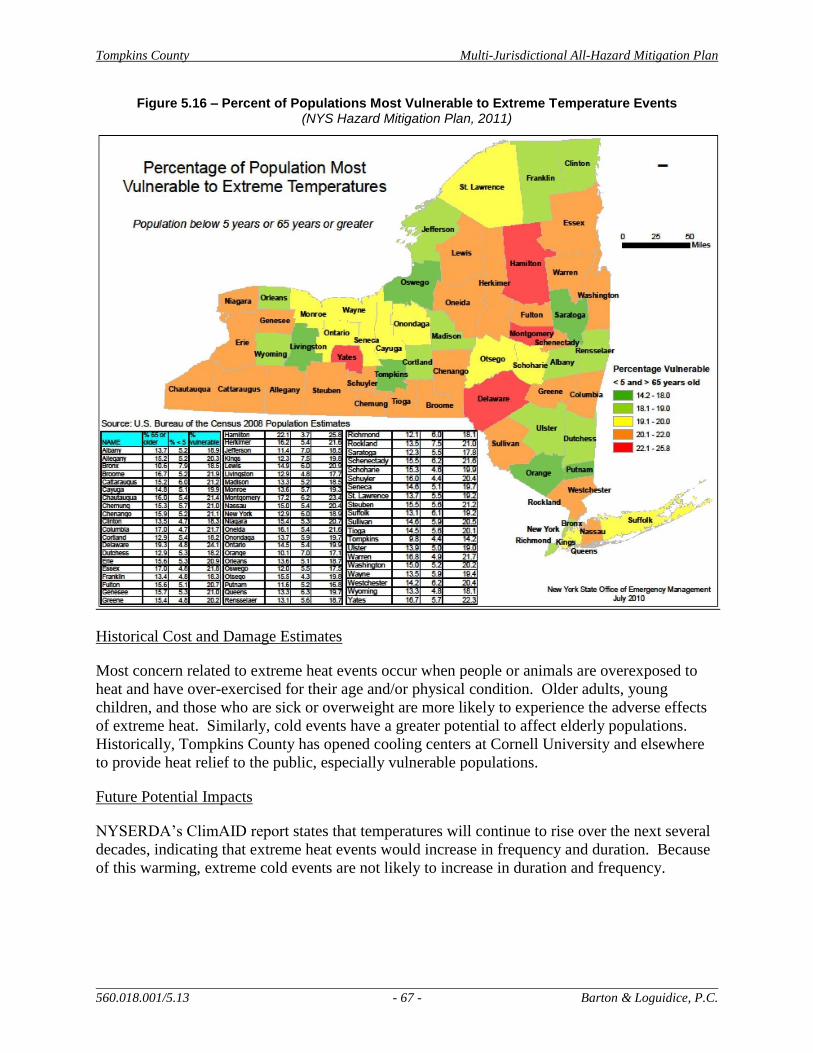
Tompkins County Multi-Jurisdictional All-Hazard Mitigation Plan
560.018.001/5.13 - 67 - Barton & Loguidice, P.C.
Figure 5.16 – Percent of Populations Most Vulnerable to Extreme Temperature Events (NYS Hazard Mitigation Plan, 2011)
Historical Cost and Damage Estimates
Most concern related to extreme heat events occur when people or animals are overexposed to
heat and have over-exercised for their age and/or physical condition. Older adults, young
children, and those who are sick or overweight are more likely to experience the adverse effects
of extreme heat. Similarly, cold events have a greater potential to affect elderly populations.
Historically, Tompkins County has opened cooling centers at Cornell University and elsewhere
to provide heat relief to the public, especially vulnerable populations.
Future Potential Impacts
NYSERDA’s ClimAID report states that temperatures will continue to rise over the next several
decades, indicating that extreme heat events would increase in frequency and duration. Because
of this warming, extreme cold events are not likely to increase in duration and frequency.
Tompkins County Multi-Jurisdictional All-Hazard Mitigation Plan
560.018.001/5.13 - 68 - Barton & Loguidice, P.C.
5.1.11 Epidemic
General Hazard Description
An epidemic is the occurrence or outbreak of disease to an unusual number of individuals or
proportion of the population, human or animal.
Key Epidemic Findings for Tompkins County
Tompkins County is considered to be notably vulnerable to this hazard because of
its significant number of international student populations.
The County’s active role in the H1N1 virus preparations (2009) has provided a
framework for epidemic risk reduction.
Historical Hazard Occurrence
There is no extensive record of historic epidemic events within Tompkins County. However,
because of the diverse global representation found on the Cornell University and Ithaca College
campuses, the County is notably vulnerable to human outbreaks of disease. Recent epidemic
events that have been previously documented in Tompkins County include avian flu (2003),
influenza A (H1N1) (2009), and severe acute respiratory syndrome (SARS). Agricultural
epidemics are also an important component of this hazard in Tompkins County. Historic
epidemics that have affected the agricultural community include leucosis, Marek’s disease, as
well as foot and mouth disease.
Historical Cost and Damage Estimates
A large-scale epidemic event could affect large numbers of people and has the potential to result
in mass care and/or mass casualties. Initiatives to quarantine and/or vaccinate residents to
prevent the spread of a particular disease would be an expensive, but needed, effort. Because
historic records of previous epidemic events are not available, it is difficult to estimate that total
damages that could occur from a widespread event. Because the majority of the County’s
economy relies on agriculture and farming, an increase in agricultural epidemics would also be
costly to the area.
Future Potential Impacts
Global trends indicate that pandemics occur in predictable cycles. The last mass pandemic was
the 1912 Spanish Flu; experts suggest that the next cycle is approaching and that jurisdictions
should begin preparing for this future occurrence. Because diseases are dynamic, it is difficult to
predict what types may appear in the future and what the most effective way is to combat these
potential events. Agricultural epidemics should also continue to be addressed through both
mitigation and response plans. Climate change may increase the likelihood of epidemics due to
increased floodwaters contaminating drinking water supplies and increasing temperatures
allowing more disease-causing agents and vector-borne diseases to flourish. One of the future
goals of Tompkins County, related to epidemic events, is to build partnerships with other
agencies and groups to prepare for such events.

Tompkins County Multi-Jurisdictional All-Hazard Mitigation Plan
560.018.001/5.13 - 69 - Barton & Loguidice, P.C.
5.1.12 Tornado
General Hazard Description
Tornadoes are described as local atmospheric storms, generally of short duration, formed by
winds rotating at very high speeds. The vortex of the tornado can be up to several hundred yards
wide and is visible to the observer as a whirlpool-like column of winds rotating about a hollow
cavity or funnel. Tornado winds have been estimated to be as high as 400 miles per hour.
During the County’s 2012 risk assessment discussion, it was determined that a credible worst-
case scenario for a tornado event is a F2 or F3 magnitude. Tornados of these magnitudes
commonly exhibit 3-second wind gusts between 110 and 209 mph (Appendix A – Table 22).
Key Tornado Findings for Tompkins County
Five historic tornado events have been documented for Tompkins County
between 1952 and 2009 (57 years).
The most recent tornado event to impact the County occurred in April 2011 in the
Town of Danby.
Historical Hazard Occurrence
As indicated by Appendix A - Figure 5.17, Tompkins County is mapped in a light yellow shaded
area, denoting that between one and five F3, F4, or F5 tornados have occurred within the County
for every 3,700 square miles. Appendix A – Figure 5.18 shows that Tompkins County, and the
majority of NYS, is not mapped within a high risk area for tornado events.
The State Hazard Mitigation Plan includes five records of tornados that occurred in Tompkins
County between 1952 and 2009; details of these hazard events are included in Table 23. Tracks
of these tornados are depicted on Figure 5.19. Anecdotal information indicates that a minor
tornado event occurred in Ulysses in the early 1990s, damaging a residence. The most recent
tornado recorded for Tompkins County, and the event reported by the NCDC, occurred on April
28, 2011, in the Town of Danby and the Town of Ithaca. The path of this tornado stretched from
the northern boundary of the Town of Danby and Route 96B, southwest, to the Town of Ithaca’s
western boundary. This event resulted in significant tree damage along this hazard route.
Table 23 – Historic Tornado Events for Tompkins County
(NYS Hazard Mitigation Plan, 2011)
Date Location Magnitude Details
08/25/1961 Tompkins Co F0 $25,000 in property damage
06/20/1969 Tompkins Co F1 $25,000 in property damage
06/18/1977 Tompkins Co Undetermined $3,000 in property damage
08/28/1988 Tompkins Co F1 $250,000 in property damage
8/21/1994 Dryden F0 $500,000 in property damage
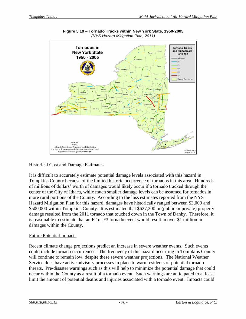
Tompkins County Multi-Jurisdictional All-Hazard Mitigation Plan
560.018.001/5.13 - 70 - Barton & Loguidice, P.C.
Figure 5.19 – Tornado Tracks within New York State, 1950-2005 (NYS Hazard Mitigation Plan, 2011)
Historical Cost and Damage Estimates
It is difficult to accurately estimate potential damage levels associated with this hazard in
Tompkins County because of the limited historic occurrence of tornados in this area. Hundreds
of millions of dollars’ worth of damages would likely occur if a tornado tracked through the
center of the City of Ithaca, while much smaller damage levels can be assumed for tornados in
more rural portions of the County. According to the loss estimates reported from the NYS
Hazard Mitigation Plan for this hazard, damages have historically ranged between $3,000 and
$500,000 within Tompkins County. It is estimated that $627,200 in (public or private) property
damage resulted from the 2011 tornado that touched down in the Town of Danby. Therefore, it
is reasonable to estimate that an F2 or F3 tornado event would result in over $1 million in
damages within the County.
Future Potential Impacts
Recent climate change projections predict an increase in severe weather events. Such events
could include tornado occurrences. The frequency of this hazard occurring in Tompkins County
will continue to remain low, despite these severe weather projections. The National Weather
Service does have active advisory processes in place to warn residents of potential tornado
threats. Pre-disaster warnings such as this will help to minimize the potential damage that could
occur within the County as a result of a tornado event. Such warnings are anticipated to at least
limit the amount of potential deaths and injuries associated with a tornado event. Impacts could
Tompkins County Multi-Jurisdictional All-Hazard Mitigation Plan
560.018.001/5.13 - 71 - Barton & Loguidice, P.C.
occur anywhere in the County and affect a wide range of existing infrastructure and properties.
The exact path and touchdown locations of a tornado are often difficult to predict.
5.2 Technological and Human-Caused Hazard Profiles
Details associated with the eight technological and human-caused hazards profiles in this section
were obtained using Geographic Information System (GIS) layers, technical and project
committee knowledge, Tompkins County records, NYS OEM and FEMA data and information,
and other resources, as appropriate.
5.2.1 Transportation Accident
General Hazard Description
A transportation accident is defined as a mishap involving one or more conveyances on land, sea,
and/or in the air, which can result in multiple casualties and/or substantial loss of property.
Key Transportation Accident Findings for Tompkins County
Approximately 2,500 transportation accidents occur in Tompkins County each
year. In 2010, 11 accidents resulted in fatalities, which is slightly above average.
The City of Ithaca has the highest crash rate within the County, but the lowest
deer collision rate.
Historical Hazard Occurrence
Transportation accidents are unpredictable, both in time, location, and frequency. On average,
there are less than 10 accidents a year in Tompkins County that result in fatalities (NYSDMV,
2000). The highest accident rates and most severe accidents occur on the State Routes (SR)
located within the County. These State Routes total approximately 176.3 miles in length and
include the following route numbers: 13, 13A, 222, 227, 327, 34, 34B, 366, 38, 392, 79, 89,
930F, 96, and 96B. The prevalence of accidents along these routes is likely attributed to higher
posted speed limits and a greater volume of traffic. Figure 5.20 shows the locations of State
Routes within Tompkins County.
Accident information and data for Tompkins County was obtained from the Ithaca-Tompkins
County Transportation Council (ITCTC). ITCTC created maps using the NYS Department of
Transportation’s Accident Location Information System (ALIS) 200-2009 data. The highest
crash rate within the County was reported for the City of Ithaca. Numerous roads within the City
report having between 9 and 15, or > 15, accidents per million vehicle miles. The severity of
accident data looks at the amount of fatalities and injuries per reported accident (severity index).
The severity index shows the occurrence of severe accidents throughout all portions of the
County, though six roads in particular have a rating >15: Shaffer Road (Town of Newfield),
Bostwick Road (Town of Ithaca), Fall Creek Road and West Dryden Road (Town of Dryden),
and Ridge Road (SR 34B) and Auburn Road (SR 34) (Town of Lansing). Accident data
involving pedestrians and bicyclists were also reviewed. The City of Ithaca had the highest rate
of accidents involving a pedestrian or a bicyclist.
Tompkins County Multi-Jurisdictional All-Hazard Mitigation Plan
560.018.001/5.13 - 72 - Barton & Loguidice, P.C.
Figure 5.20 – State Route Transportation Network in Tompkins County (NYSDOT, ALIS, 2004)
A healthy deer population in Tompkins County is also a variable linked to transportation
accidents. The City of Ithaca has the lowest deer collision rate in the County. In contrast, there
are 13 roads in the County where > 25 % of all accidents that occur involve deer collisions:
Bundy Road (Town of Ithaca), Ellis Hollow Road (Towns of Ithaca and Dryden), Bostwick Road
and Trumbulls Corners Road (Town of Enfield), Perry City Road (Town of Ulysses), Ridge
Road and North Triphammer Road (Town of Lansing), Asbury Road and Scofield Road (Towns
Tompkins County Multi-Jurisdictional All-Hazard Mitigation Plan
560.018.001/5.13 - 73 - Barton & Loguidice, P.C.
of Lansing and Dryden), West Dryden Road (Town of Dryden), and Sovocool Hill Road, Spring
Street Extension, and Cobb Street (Town of Groton).
No records of accidents involving other modes of transportation were available or located.
During the County’s risk assessment, it was estimated that a bus accident occurs about once per
year and that runaway truck accidents occur approximately once every other year.
Historical Cost and Damage Estimates
Often times, the damages involved in accidents, particularly vehicular, are the responsibility of
the drivers involved. When damage to public infrastructure occurs, the local jurisdictions may
be responsible to make repairs. A high frequency of transportation accidents occurs within
Tompkins County, but the majority does not result in loss of life or damage to property.
According to the New York Department of Transportation’s Accident Location Information
System (ALIS), the City of Ithaca does historically have the highest number of accidents (1,375
in 2010) though only a small percentage of those accidents result in fatalities (1 in 2010, or
0.1%). Fewer accidents occur in the surrounding rural areas, however of those accidents a higher
percentage are fatal. For example, in 2010 the Town of Enfield was noted as having 95
accidents, 20 of which (21.1%) resulted in injuries. Of these 2 (2.1%) resulted in fatalities.
Future Potential Impacts
Transportation accidents, particularly vehicular, will continue to occur within Tompkins County
and will be difficult to predict. With the potential of future shale gas drilling, truck traffic is
anticipated to increase throughout the region. The New York State Department of Environmental
Conservation’s Supplemental Generic Environmental Impact Statement (SGEIS) for High-
Volume Hydraulic Fracturing notes that truck traffic associated with this practice is two to three
times higher than traditional vertical well drilling. This increase is largely due to the need for
heavy truck water delivery. The SGEIS notes that a single well may produce nearly 6,000 truck
trips. Regional truck traffic would likely increase even if no wells are drilled in Tompkins
County. Local roads and minor collectors would likely experience the most level of congestion
and potentially accidents. The SGEIS indicates, “An increase in the amount of truck traffic, and
vehicular traffic in general, traveling on both higher and lower level local roads would most
likely increase the number of accidents and breakdowns in areas experiencing well development”
(NYSDEC, 2011).
5.2.2 Fuel Shortage
General Hazard Description
A fuel shortage is defined as a situation in which the normal quantity and/or timely delivery of
fuel supplies to distributors and retail establishments are interrupted. As part of this document,
the definition was further expanded to assume that a fuel shortage event would occur County-
wide.
Tompkins County Multi-Jurisdictional All-Hazard Mitigation Plan
560.018.001/5.13 - 74 - Barton & Loguidice, P.C.
Key Fuel Shortage Findings for Tompkins County
Fuel shortage events are limited to the 1973 oil crisis and the 1979 energy crisis.
The growth of alternative fuels and green living helps to reduce dependence on
fuel.
Historical Hazard Occurrence
Two documented occurrences of fuel shortages have historically affected Tompkins County.
The 1973 oil crisis resulted in gas rationing across the country, while the 1979 energy crisis
caused widespread panic and odd-even gas rationing in NYS.
Historical Cost and Damage Estimates
No cost figures were available to determine how much it cost the County or State to implement
and oversee gas rationing during the 1973 or 1979 events. No other fuel shortage events have
been recorded in the County, so damage estimates are not available.
Future Potential Impacts
World politics and natural hazards are hard to predict, especially in the long-term, so it is
difficult to know when a world event may occur that would threaten the U.S.’ supply and
acquisition of fuel. Regardless, as economic growth continues to trend toward alternative fuels
and alternative transportation options, the demand for fuel may decrease. If this decline is
achieved, it is likely to be slow, as alternative fuel use is still in its infancy in the County.
5.2.3 Fire (Urban)
General Hazard Description
Fire is defined as the uncontrolled burning in residential, commercial, industrial, institutional, or
other structures in developed areas. It is important to note that fire spreads quickly. Heat and
smoke from fire can be more dangerous than the flames themselves. Fire produces poisonous
gases that make a person disoriented and drowsy. Asphyxiation is the leading cause of fire
deaths. For the purposes of this document, a fire is defined as a block or neighborhood scale
event.
Key Urban Fire Findings for Tompkins County
Fire is defined as a block or neighborhood scale event.
As storm severity increases, the potential for fire to occur also increases.
Historical Hazard Occurrence
There is no historical evidence of fire events affecting Tompkins County. Numerous smaller
scale fires that have been isolated to one or two buildings or properties have occurred in the past;
a handful of such events occur within the County annually.

Tompkins County Multi-Jurisdictional All-Hazard Mitigation Plan
560.018.001/5.13 - 75 - Barton & Loguidice, P.C.
Historical Cost and Damage Estimates
Given that no urban fire events that match the hazard definition have occurred in Tompkins
County, damage estimates from such an event were not available. According to the TCPD, the
City of Ithaca has the highest full market assessed property value, totaling $17,701,001,320. The
City is home to 5,555 properties. A hypothetical scenario may consist of a block fire in the City
that impacts 5 houses at 80% of their total value. This hazard event scenario would result in
approximately $12,745,995 in total damages.
Future Potential Impacts
This hazard received a moderately low ranking due to its infrequent occurrence within the
County. As storm events increase in severity and frequency over the coming decades, as is
predicted by climate change research, the potential for fire to occur as a cascading hazard
increases.
5.2.4 Utility Failure
General Hazard Description
Utility failure includes the loss of electric power supply, telephone service, or public water
supply as a result of an internal system failure or by the effects of a natural disaster. A
widespread electrical power outage could cause traffic accidents, civil unrest, and failures to
other utility infrastructure that relies on electricity.
Key Utility Failure Findings for Tompkins County
Utility failure impacts every jurisdiction at least once a year.
The severity and frequency of utility failures are anticipated to increase in the
future, as storm occurrence and severity increases.
Historical Hazard Occurrence
For many of the natural disasters previously profiled, utility failure was identified as a cascading
hazard, meaning it results from another hazard. The frequency of a power failure is
approximately once a year in each jurisdiction, with typical duration of less than a single day
(less than 24 hours). Historical documented utility failures in Tompkins County include:
2000 – Town of Dryden
August 2003 – Northeast blackout – power restored by next day
May 2004 – Town of Dryden – electricity
June 2005 – Town of Dryden – power restored same day
May 2012 – Village and Town of Dryden
Tompkins County Multi-Jurisdictional All-Hazard Mitigation Plan
560.018.001/5.13 - 76 - Barton & Loguidice, P.C.
The most significant regional event listed was the 2003 blackout. Power was restored by the
following day; however, thousands of people were impacted. This power outage event was
declared a Presidential Disaster, authorizing up to $5 million in federal funding to reimburse
local and state governments that were negatively impacted.
Historical Cost and Damage Estimates
Although accurate figures were not found to assess the cost of power outages, the disruption of
services, spoiling of food, and loss of work production could range from the hundreds of
thousands to millions of dollars. Since utility failures rarely occur by themselves, and not as a
result of another hazard, specific data within Tompkins County is limited. A previous concern
revolved around the water treatment plants in the County in the event of a power failure. This is
less of a concern given that many of the plants are now installing full size generators in
preparation for such occurrences. Residents with private wells would however lose potable
water supply during a power failure.
Future Potential Impacts
NYSERDA’s climate change research points to an increased severity and frequency of extreme
weather events. Extreme weather events and utility failure go hand in hand; therefore, an
increase in the severity and frequency of utility failures is presumed.
5.2.5 Water Supply Contamination
General Hazard Description
Water supply contamination is defined as the contamination, or potential contamination, of
surface or subsurface public water supply by chemical or biological materials that results in
restricted or diminished ability to use the water source. Though single property events will be
discussed, this hazard was determined to occur if it affected a large region; the effects were
reviewed from a population standpoint and not based on affected geographic area.
Key Water Supply Contamination Findings for Tompkins County
Water supply contamination concerns are estimated to occur once or twice every
10 years.
Isolated contamination events are estimated to cause approximately $25,000 in
damages, while a larger scale event could result in millions of dollars in damages.
Historical Hazard Occurrence
Approximately fifty (50) percent of the County’s population receives public water; the remaining
households are on private well systems. During droughts and dry seasons, some well residents
have experienced inadequate water supplies. These wells are susceptible to contamination from
spills, herbicide and pesticide run-off, and leaking underground storage tanks. County residents
that receive public water are largely supplied by one of three water treatment plants (WTP):
Cornell WTP (withdraws from Fall Creek), City of Ithaca WTP (withdraws from Six Mile
Tompkins County Multi-Jurisdictional All-Hazard Mitigation Plan
560.018.001/5.13 - 77 - Barton & Loguidice, P.C.
Creek), and Bolton Point WTP (withdraws from Cayuga Lake). Other “village systems” serve
the Villages of Dryden, Groton and Trumansburg as well as the Hamlet of Newfield.
Documented events of water supply contamination that have occurred in Tompkins County
include:
MTBE and gasoline contamination in the Village of Groton as a result of a Smith Corona
spill, which has now been remediated.
The Town of Newfield’s Shelter Valley Water System has received multiple “do not
drink” orders from the County Department of Health in the past.
Prior to 1981, the City of Ithaca’s and Cornell’s WTPs were shut down on multiple
occasions because of high turbidity and nearby fuel oil spills.
In 1997 a fuel oil spill from a fuel truck resulted in a water supply outage at the Cornell
WTP for 6 days.
On December 4, 2009, an attempted theft of gasoline from the Caroline Highway Facility
resulted in 500 gallons of fuel leaking into Six Mile Creek.
Precautionary shutdown of the City of Ithaca’s water treatment plant occurred as a result
of an overturned truck on Burns Road that leaked diesel fuel into the reservoir.
Historical Cost and Damage Estimates
Contamination of the public water supplies within Tompkins County is a concern because of the
amount of people that rely on these systems. A history of both fuel and manure spills have
occurred in the County which has led to water supply contamination. Even short-term water
supply outages can cause hardships on residents. The spill event that occurred in 2009 resulted
in $25,000 in losses and damages. This contamination event represents a realistic hazard
scenario and damage estimate for Tompkins County. A larger scale water supply contamination
event has the potential to result in millions of dollars in damages due to the number of properties
and residents that would be affected.
Future Potential Impacts
Increased flooding expected as a result of climate change is likely to cause an increase in the
number of water supply contamination events in the future, beyond the current documented
water supply contamination events rate of one to two events every ten (10) years. While
numerous safeguards are put in place at the water treatment plants to account for short-term
outages or shut downs, it is likely that these safeguards will be relied upon more heavily in the
future. As an example, Bolton Point must now monitor for pesticides in their intake and finished
water. Another concern that was voiced during the County’s risk assessment was how
susceptible private well water supply, as is found in much of the rural areas of the county, would
be to contamination due to less predictable precipitation in the future.
One added area of increasing concern is the aging infrastructure of pipelines that cross several of
the County’s creeks. These pipelines carry a variety of potentially dangerous materials,
including sewage, oil, and natural gas. It is estimated that these pipelines cross at least 60 stream
locations in the County, many of which have been observed as being in poor condition. The

Tompkins County Multi-Jurisdictional All-Hazard Mitigation Plan
560.018.001/5.13 - 78 - Barton & Loguidice, P.C.
rupturing of these pipelines could have immediate adverse impacts to water quality and, in many
cases, could put drinking water supplies at risk. More detailed analysis and mitigation should be
undertaken by local government, pipeline owners, and local stakeholders to reduce this risk.
5.2.6 Hazardous Materials in Transit
General Hazard Description
Hazardous materials in transit events consist of an uncontrolled release of material during
transport, which when released can result in death or injury to people and/or damage to property
and the environment through the material’s flammability, toxicity, corrosiveness, chemical
instability, and/or combustibility.
Key Hazardous Materials in Transit Findings for Tompkins County
Historical hazardous materials in transit events have been minor with limited
clean-up needs and no long-term impacts.
The frequency and severity of hazardous material in transit occurrences may
increase if hydraulic fracturing is approved in New York State.
Historical Hazard Occurrence
In addition to rail transport, hazardous materials are transported through Tompkins County on
several of the State Routes that traverse the area. Rail car transport is limited to rock salt and
coal; no other hazardous materials are transported by rail in the County. These routes are major
transport corridors since interstate access to the County is limited. During peak traffic times, it is
estimated that over 400 freight trucks pass through the County every two hours. Often times, the
materials being transported by trucks or train are unknown, making it more difficult to deal with
a hazardous materials situation when it does occur. New York State does not require the
registration of vehicles that transport hazardous materials, or require that such vehicles follow a
set route; however it is required that federal codes be followed for marking and placarding of
such trucks (ITCTC, 2002). Historical hazardous material events noted within the County
include:
1988: A fuel truck overturned along NYS Route 96 in the Town of Ulysses.
1997: A train derailed in the Town of Dryden causing a fuel oil spill that led to the
shutdown of the Cornell WTP.
Historical Cost and Damage Estimates
Specific damage reports associated with previous hazardous materials in transit events were not
available. In cases of minor fuel oil spills, $10,000 would cover the cost of clean-up, but larger
events involving WTP shutdowns or prolonged road or railroad closures could result in much
larger costs.
Tompkins County Multi-Jurisdictional All-Hazard Mitigation Plan
560.018.001/5.13 - 79 - Barton & Loguidice, P.C.
Future Potential Impacts
Hazardous materials in transit concerns are expected to continue in the future given the
frequency of truck and train transportation within Tompkins County. Although prior hazard
events were mostly minor with short-term impacts, a growing concern among County residents is
the potential for hydraulic fracturing fluids to be transported through the area, especially if such
an activity is approved to occur within New York State in the future. As discussed under the
Transportation Accident hazard, the number of trucks traveling on roads in the County is
expected to rise dramatically if shale gas drilling is approved. The SGEIS for High Volume
Hydraulic Fracturing notes that trucks will be transporting potentially hazardous materials and
that “additional transport resulting from horizontal drilling poses an additional risk” (NYSDEC,
2011). Tompkins County Department of Emergency response does not anticipate hazardous
material transport associated with gas drilling to cause major disruptions, though the Department
is preparing a plan to address potential impacts related to drilling operations. This concern is
further detailed in Section 4.5.
5.2.7 Terrorism
General Hazard Description
Terrorism is defined as the threat or use of violence to achieve political or social ends usually
associated with community disruption and/or multiple injuries or deaths.
Key Terrorism Findings for Tompkins County
Cornell University received anthrax threats concurrent with the national anthrax
episodes post-September 2001.
Historical Hazard Occurrences
A major terrorist event has never been documented within Tompkins County; however, Cornell
University and other facilities received anthrax threats concurrent with the national anthrax
episodes post-September 2001. Because of the potential for mass casualties to occur as a result
of such a terrorist event, the fact that such events occur with no warning, and the concern that
such events are likely to increase in the Country in the future, this hazard was assessed as part of
Tompkins County’s HMP. Terrorism is determined to have a moderately low potential of
occurrence within the County, as there are no significant targets recognized within the area.
Historical Cost and Damage Estimates
Terrorism events can result in a wide range of damages and recovery costs. A small isolated
event may result in a minor disruption with low damage and cost implications, while a large-
scale event could take years of recovery and cost billions of dollars to clean up and re-build an
area. Given the unpredictable nature and variety of terrorist actions, it is difficult for the County
and municipalities to be prepared and secure the proper equipment for such an event.

Tompkins County Multi-Jurisdictional All-Hazard Mitigation Plan
560.018.001/5.13 - 80 - Barton & Loguidice, P.C.
Future Potential Impacts
An isolated terrorist event has a low potential to occur within Tompkins County. Though no
nationally significant targets were identified within the County, facilities such as airports,
municipal buildings, universities, and water/wastewater treatment plants have a potential of
being targeted in Tompkins County. Although occurrences have been relatively minor,
agricultural terrorism should continue to be addressed, largely through response plans.
5.2.8 Civil Unrest
General Hazard Description
Civil unrest is defined as an individual or collective action causing serious interference with the
peace, security, and/or functioning of a community. This hazard governs major disruptions, not
just civil disobedience events.
Key Civil Unrest Findings for Tompkins County
Incidents of civil unrest within Tompkins County are infrequent and are
commonly associated with Cornell University or Ithaca College.
Civil unrest and public demonstration events in Tompkins County are normally
peaceful and focused on a specific cause.
Historical Hazard Occurrences
Although public demonstrations are frequent events in Tompkins County, major incidents of
civil unrest are less frequent and are normally associated with Cornell University or Ithaca
College students in the City and Town of Ithaca. Campus parties and student activities,
including Slope Day at Cornell University and Fountain Day at Ithaca College, often require
additional law enforcement, medical services, or fire personnel to become involved. Noise
ordinances, particularly the ordinance implemented by the Town of Ithaca, have resulted in the
noted decrease in noise related events. The largest civil unrest occurrence in Tompkins County
occurred on the Cornell University campus in 1968 when a group of students took over Willard
Straight Hall. Other documented events include: a demonstration that blocked traffic on Green
Street, the occupying of Immaculate Conception Catholic Church on Seneca Street, and a
demonstration in the Town of Dryden on the ethical treatment of animals.
Historical Cost and Damage Estimates
Though civil unrest events have been known to cause property damage and vandalism, this is not
the case with the majority of the civil unrest events and public demonstrations in Tompkins
County. These events are normally peaceful and focused on a specific cause. The costs related
to the extra law enforcement required to deal with large or unruly events is the highest cost
associated with this hazard.

Tompkins County Multi-Jurisdictional All-Hazard Mitigation Plan
560.018.001/5.13 - 81 - Barton & Loguidice, P.C.
Future Potential Impacts
Civil unrest and organized demonstrations are unpredictable, though Tompkins County, with its
three institutions of higher education, may be at higher risk than surrounding counties for these
types of events to occur.
Tompkins County Multi-Jurisdictional All-Hazard Mitigation Plan
560.018.001/5.13 - 82 - Barton & Loguidice, P.C.
6.0 Hazard Vulnerability
The Tompkins County HIRA-NY risk assessment was completed to identify the hazards
with the highest potential to impact the County and associated jurisdictions. This information
was used to guide the subsequent ranking of such hazards in order of the most severe and/or
frequently occurring type, to help determine the highest priority of need with respect to
implementation of pre-disaster action, and to guide the focus for recommendations and
mitigation actions to be included in this HMP Update. After these pertinent hazards were
identified and profiled, the vulnerability assessment, as described below, was completed to
provide a quantitative estimate of the people and property that may be susceptible to a particular
hazard event.
Each Town and Village was asked to provide information concerning the occurrence of
hazards in their community and to help identify what areas these hazards affected. This
information was combined with information provided by FEMA, via the FEMA website, and
from the NYSOEM with respect to relative cost of damages reported for various declared
disaster events in New York State.
6.1 Identify Assets
Critical facilities identified within Tompkins County include, but are not limited to, the
E-911 Emergency Center, schools, fire departments, hospitals, medical centers, County and
Town highway garages, government agencies, Town and Village Halls, police departments, local
operational offices for telephone and electrical power utilities, airports, water supply facilities,
waste water treatment facilities, etc. These facilities represent the critical assets located within
the County. For the purpose of this planning document, lists of these critical facilities were
prepared using information provided by the County, Towns, and Villages and are provided as
Appendix G. A list of community assets and critical facilities was not identified in the original
plan.
6.2 Jurisdictional Vulnerabilities
To assist each participating jurisdiction with their mitigation strategy development, an
analysis of hazard prone areas and community-specific vulnerabilities was completed. This
analysis assisted each jurisdiction in focusing on the hazards of greatest threat within each
community and in proposing mitigation strategies to minimize the potential impact from such
hazards events. Overall, flood (flash and lake) was identified throughout the County as the
natural hazard of highest priority. This hazard is of greatest concern within the following
jurisdictions: Towns of Groton, Dryden, Caroline, Lansing and Ithaca, Village of Freeville, and
City of Ithaca. Major tributaries of Cayuga Lake flow through these jurisdictions. In addition,
the Town and City of Ithaca and the Village of Cayuga Heights surround the majority of the
southern end of the lake itself. Cayuga Inlet and 100-year floodplain locations are the most flood
prone areas, which was a focus during the formulation of mitigation strategies. The level of
development and impermeable surfaces and structures along the southern end of Cayuga Lake
and adjacent to streams is a noted concern particularly within the Town and City of Ithaca.. A

Tompkins County Multi-Jurisdictional All-Hazard Mitigation Plan
560.018.001/5.13 - 83 - Barton & Loguidice, P.C.
greater amount of public and private structures are particularly vulnerable to flooding in these
locations due to the density of development..
Though not identified as severe a threat, lake flood and flash flood were also identified as
priority hazards by many other participating jurisdictions. All communities, including Tompkins
County, considered the impacts of flooding during the mitigation action workshop. Another key
hazard that is recognized as a priority in the City of Ithaca is infestation. The recent discovery of
the aquatic invasive plant hydrilla within the Cayuga Lake Inlet has resulted in a greater
emphasis on invasive species populations and their wide ranging impacts. The City considered
pre-hazard mitigation strategies to improve coordination and eradication programs related to
current and future potential infestation events. Utility failure was considered a priority hazard by
the Town of Ithaca, City of Ithaca, Village of Lansing, and Town of Danby due to the frequency
of historic utility failures and the vulnerability of utility infrastructure within their jurisdictions.
Other vulnerable locations and hazards of concern were identified at a more moderate or lower
priority level, but were still considered during the mitigation strategy development, further
discussed in Section 7.0.
6.3 Damage Potential
The damage potential for housing within Tompkins County was estimated using housing
characteristics and housing values reported by the U.S. Census Bureau’s American Fact Finder.
In 2011, 39,000 occupied housing units were identified in Tompkins County; 22,000 (55 percent)
were owner occupied and 18,000 (45 percent) were renter occupied. These numbers represent an
approximate 7 percent vacancy rate among existing residential structures in the County.
Tables23, 24 and 25, below, further detail the housing type and values reported for the County.
Table 24 – Housing Types
(2009-2011 American Community Survey – U.S. Census Bureau)
Type of Housing
Percent of Total Occupied
Housing Units in County
Single unit structures 53%
Multi-unit structures 38%
Mobile homes 9%
Table 25 – Age of Structures
(2007-2011 American Community Survey – U.S. Census Bureau)
Structure Built Date
Percent of Total Owner Occupied
Housing Units in County
2000 or more recent 7.7%
1980 – 1999 25.2%
1960-1979 25.6%
1940-1959 13.3%
1939 or prior 28.1%
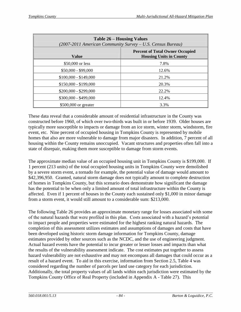
Tompkins County Multi-Jurisdictional All-Hazard Mitigation Plan
560.018.001/5.13 - 84 - Barton & Loguidice, P.C.
Table 26 – Housing Values
(2007-2011 American Community Survey – U.S. Census Bureau)
Value
Percent of Total Owner Occupied
Housing Units in County
$50,000 or less 7.8%
$50,000 - $99,000 12.6%
$100,000 - $149,000 21.2%
$150,000 - $199,000 20.3%
$200,000 - $299,000 22.2%
$300,000 - $499,000 12.4%
$500,000 or greater 3.3%
These data reveal that a considerable amount of residential infrastructure in the County was
constructed before 1960, of which over two-thirds was built in or before 1939. Older houses are
typically more susceptible to impacts or damage from an ice storm, winter storm, windstorm, fire
event, etc. Nine percent of occupied housing in Tompkins County is represented by mobile
homes that also are more vulnerable to damage from major disasters. In addition, 7 percent of all
housing within the County remains unoccupied. Vacant structures and properties often fall into a
state of disrepair, making them more susceptible to damage from storm events.
The approximate median value of an occupied housing unit in Tompkins County is $199,000. If
1 percent (213 units) of the total occupied housing units in Tompkins County were demolished
by a severe storm event, a tornado for example, the potential value of damage would amount to
$42,396,950. Granted, natural storm damage does not typically amount to complete destruction
of homes in Tompkins County, but this scenario does demonstrate how significant the damage
has the potential to be when only a limited amount of total infrastructure within the County is
affected. Even if 1 percent of houses in the County each sustained only $1,000 in minor damage
from a storm event, it would still amount to a considerable sum: $213,000.
The following Table 26 provides an approximate monetary range for losses associated with some
of the natural hazards that were profiled in this plan. Costs associated with a hazard’s potential
to impact people and properties were estimated for the highest ranking natural hazards. The
completion of this assessment utilizes estimates and assumptions of damages and costs that have
been developed using historic storm damage information for Tompkins County, damage
estimates provided by other sources such as the NCDC, and the use of engineering judgment.
Actual hazard events have the potential to incur greater or lesser losses and impacts than what
the results of the vulnerability assessment indicate. The cost estimates put together to assess
hazard vulnerability are not exhaustive and may not encompass all damages that could occur as a
result of a hazard event. To aid in this exercise, information from Section 2.5, Table 4 was
considered regarding the number of parcels per land use category for each jurisdiction.
Additionally, the total property values of all lands within each jurisdiction were estimated by the
Tompkins County Office of Real Property (included in Appendix A - Table 27). This
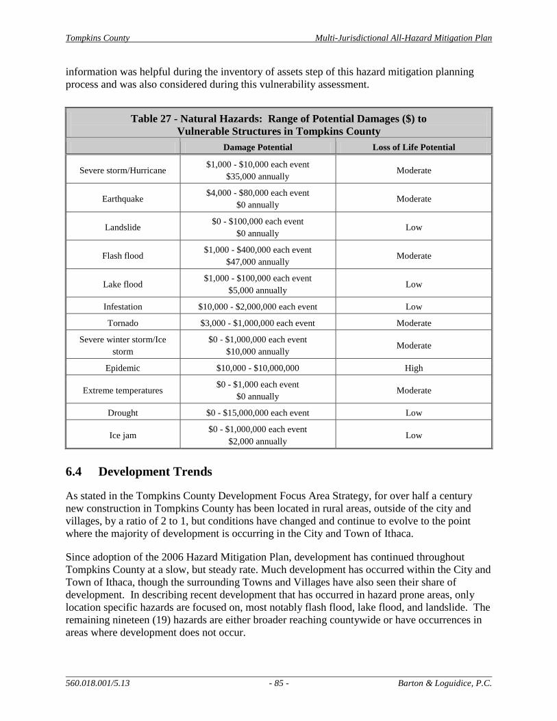
Tompkins County Multi-Jurisdictional All-Hazard Mitigation Plan
560.018.001/5.13 - 85 - Barton & Loguidice, P.C.
information was helpful during the inventory of assets step of this hazard mitigation planning
process and was also considered during this vulnerability assessment.
Table 27 - Natural Hazards: Range of Potential Damages ($) to
Vulnerable Structures in Tompkins County
Damage Potential Loss of Life Potential
Severe storm/Hurricane $1,000 - $10,000 each event
$35,000 annually Moderate
Earthquake $4,000 - $80,000 each event
$0 annually Moderate
Landslide $0 - $100,000 each event
$0 annually Low
Flash flood $1,000 - $400,000 each event
$47,000 annually Moderate
Lake flood $1,000 - $100,000 each event
$5,000 annually Low
Infestation $10,000 - $2,000,000 each event Low
Tornado $3,000 - $1,000,000 each event Moderate
Severe winter storm/Ice
storm
$0 - $1,000,000 each event
$10,000 annually Moderate
Epidemic $10,000 - $10,000,000 High
Extreme temperatures $0 - $1,000 each event
$0 annually Moderate
Drought $0 - $15,000,000 each event Low
Ice jam $0 - $1,000,000 each event
$2,000 annually Low
6.4 Development Trends
As stated in the Tompkins County Development Focus Area Strategy, for over half a century
new construction in Tompkins County has been located in rural areas, outside of the city and
villages, by a ratio of 2 to 1, but conditions have changed and continue to evolve to the point
where the majority of development is occurring in the City and Town of Ithaca.
Since adoption of the 2006 Hazard Mitigation Plan, development has continued throughout
Tompkins County at a slow, but steady rate. Much development has occurred within the City and
Town of Ithaca, though the surrounding Towns and Villages have also seen their share of
development. In describing recent development that has occurred in hazard prone areas, only
location specific hazards are focused on, most notably flash flood, lake flood, and landslide. The
remaining nineteen (19) hazards are either broader reaching countywide or have occurrences in
areas where development does not occur.

Tompkins County Multi-Jurisdictional All-Hazard Mitigation Plan
560.018.001/5.13 - 86 - Barton & Loguidice, P.C.
In the Town of Ithaca, several projects have been built or received approval focused on
expanding senior housing options. These projects have occurred on West Hill (Conifer Village
Senior Living Community, Conifer West Hill Development), South Hill (Longview Care Facility
Addition, Longview Patio Homes), as well as East Hill (Ellis Hollow Senior Apartments). Over
this same time period, substantial projects at Cornell University (CU) and Ithaca College (IC),
which have considerable portions of their campuses within the Town of Ithaca, have continued to
occur. The most substantial development on campus has been the Ithaca College Athletic and
Events Center. The facility opened at IC in 2011 and includes a 130,000 square foot field house
plus a 47,000 square foot aquatics pavilion. It is anticipated that the center will host some of the
largest events in the County. Other major projects at IC have included the building of a new
business school, the Peggy Williams Center, and the expansion of the Circle Apartments student
housing facility. Projects at CU, within the Town of Ithaca, include the Heat and Power Plant,
the Merrill Family Sailing Center on Cayuga Lake, the Physical Sciences building, and the East
Hill Office Building. Other noted projects within the Town of Ithaca include an expansion of
EcoVillage at Ithaca, Belle Sherman Cottages, Overlook at West Hill, and the approved
Holochuck Homes and Holly Creek subdivisions. In examining recent development in the Town
of Ithaca, the only completed project that has some vulnerability is Cornell’s Merrill Sailing
Center on Cayuga Lake. The Center has some vulnerability to lake flooding, though with its
water-dependent use and non-inhabitable space, that risk is quite minor.
The majority of development activity in the County has occurred within the City of Ithaca. In
2007, the City elected to rebuild their century old water treatment plant on its existing site. The
new plant, currently in planning stages, will continue to draw water from Sixmile Creek for
treatment and distribution throughout the City. The largest project to occur over the last several
years in the City is the Collegetown Terraces. The first phase of this project is now complete
and includes 80 graduate student apartments and 184 bedrooms. Downtown Ithaca’s major
projects include the mixed use Cayuga Green II and approvals for the Breckenridge Apartments
affordable housing project, the Holiday Inn Expansion, and Seneca Way mixed use building.
Projects within the City at CU included Milstein Hall. Approvals were also granted for the CU
law school addition as well as a new Computer and Information Services building. Other
significant projects in the City include the development of affordable housing on Floral Avenue
on the Cayuga Inlet, the expanded Ithaca College boathouse on Cayuga Inlet, the Coal Yard
Apartments on Maple Avenue, and the College Park Apartments on Eddy Street. In examining
the recent development in the City of Ithaca, the only completed project that has some
vulnerability is Ithaca College’s expanded boathouse on Cayuga Inlet. The boathouse has some
vulnerability to lake flooding, though given its water-dependent use and sheltered location, that
risk is quite minor.
Other notable projects include the development of dormitories in the Town of Dryden at the
Tompkins-Cortland Community College, the Poet’s Landing affordable housing project in the
Village of Dryden, and approved subdivisions in the Town of Lansing, including Lansing
Commons, Woodland Park, and Farm Pond Circle. Near the junction of Routes 34 and 34B in
the Town of Lansing, there is also added activity surrounding the new Lansing Market. In
examining development in other parts of the County, none of the major projects noted were built
in location specific hazard areas. Overall, hazard vulnerability has not increases with new
development in Tompkins County over the planning and review period.

Tompkins County Multi-Jurisdictional All-Hazard Mitigation Plan
560.018.001/5.13 - 87 - Barton & Loguidice, P.C.
6.4.1 Affordable Housing
Housing prices in Tompkins County continue to increase with median housing process
continuing to be 50 to 75 percent higher than in neighboring counties. As stated in the County’s
Comprehensive Plan (2004), barely half of the homes in the County are owner occupied. With
the high price of housing and low vacancy rates, affordable housing continues to be an issue,
which several jurisdictions are struggling to deal with and integrate into development proposals.
Some of the available “affordable housing” is located in high risk areas such as floodplains.
6.4.2 Development Focus Areas
A number of the new development proposals have occurred in areas identified by Tompkins
County as Development Focus Areas. These noted areas have existing public water, public
sewer, and transit infrastructure. By continuing to develop mixed-use compact development
within these areas, several benefits will be realized, including the improved resilience and
adaptation to changing energy markets as well as natural hazard events. Concentrating added
development in these Focus Areas and outside of floodplains will further reduce hazard
vulnerability in the County.

Tompkins County Multi-Jurisdictional All-Hazard Mitigation Plan
560.018.001/5.13 - 88 - Barton & Loguidice, P.C.
7.0 Hazard Mitigation and Adaptation
The 2006 HMP served as the basis for this Plan Update and all hazards, mitigation goals,
objectives, and actions in that original plan were reviewed and, if they were still deemed to be
relevant priorities, incorporated into the update. The planning process for the Plan Update
encouraged the evaluation of new information, emerging issues, ideas, and actions to ensure that
the plan is a living document that will be well-used by participants in the future.
7.1 Mitigation and Adaptation Goals
The prime objective of setting hazard mitigation and adaptation goals is to reduce or eliminate
losses and damages from hazard events well in advance of hazard occurrence. It is important to
create goals that are tangible. The goals identified below represent what the participants and
municipalities are hoping to achieve through the implementation of this hazard mitigation plan.
Goal 1: Protect Life and Property
Goal 2: Increase Public Education, Outreach, and Partnerships
Goal 3: Protect and Restore Natural Ecosystems
Goal 4: Enhance Emergency Services
These goals were developed based on the risk assessment results, County-wide vulnerabilities,
County and jurisdiction capabilities, and overall disaster preparedness. The addition of Goal 3:
Protect and Restore Natural Ecosystems reflects the region’s belief that natural systems play a
critical role in increasing hazard resilience, particularly in the face of increasing climate change
concerns. An example of this is the County’s emphasis on advancing watershed-based
approaches to flood hazard mitigation, where natural systems are utilized to build resilience in a
way that protects water quality and avoids adverse impacts both up and downstream. The
establishment of goals helped the jurisdictions to focus on effective and meaningful mitigation
actions.
7.2 Mitigation and Adaptation Strategy
7.2.1 Mitigation and Adaptation Actions
Numerous mitigation actions were proposed by participating jurisdictions to reduce the impact of
potential hazard events. These actions were evaluated in a public process and resulted in the
identification of 86 actions to be taken by jurisdictions and partners to help achieve the goals
outlined in the Plan Update. Of those actions there are 45 individual jurisdictional actions, 15
high priority multi-jurisdictional actions, and 26 other multi-jurisdictional actions. The proposed
mitigation actions are varied, but can be grouped into six broad categories as indicated by FEMA
386-3:
Prevention – Government administrative or regulatory actions or processes that
influence the way land and buildings are developed and built. These actions also include
public activities to reduce hazard losses. Examples include planning and zoning, building
Tompkins County Multi-Jurisdictional All-Hazard Mitigation Plan
560.018.001/5.13 - 89 - Barton & Loguidice, P.C.
codes, capital government programs, open space preservation, and storm water
management regulations.
Property Protection – Actions that involve the adaptation of existing buildings,
infrastructure systems, or structures to protect them from a hazard, or removal from the
hazard area. This includes the protection, upgrading, and/or strengthening of existing
systems. Examples include acquisition, elevation, relocation, structural retrofits, storm
shutters, and shatter-resistant glass.
Public Education and Awareness – Actions to inform and educate citizens, elected
officials, and property owners about the hazards and potential ways to mitigate and
increase resilience to them. Such actions include outreach projects, real estate disclosure,
hazard information centers, and school-age and adult education programs.
Natural Resource Protection – Actions that, in addition to minimizing hazard losses,
also preserve or restore the functions of natural systems. These actions include the use of
green infrastructure, sediment and erosion control, stream corridor restoration, watershed
management, forest and vegetation management, and wetland restoration and
preservation.
Emergency Services – Actions that protect people and property during and immediately
after a disaster or hazard event. Services include warning systems, emergency response
services, and protection of critical facilities.
Structural Projects – Actions that involve the construction of structures to reduce the
impact of a hazard. Such structures include dams, levees, floodwalls, seawalls, retaining
walls, and safe rooms.
All the mitigation and adaptation actions included in this Plan Update have been reviewed by
plan participants to ensure that they meet the goals of the plan. The proposed actions represent a
range of projects that are well distributed throughout the six categories of mitigation. It is
realized that some of the proposed actions included in this plan represent maintenance actions or
post-hazard actions, which are generally not eligible for funding under FEMA’s Hazard
Mitigation Assistance Program. Regardless, such actions were deemed important to the
community and are included in this plan. Other grants and funding sources will be sought to
complete such proposed efforts.
Each participating jurisdiction proposed at least one implementable, pre-disaster mitigation
activity to be included in this document. Table 28 outlines each individual jurisdiction’s list of
proposed mitigation measures. This table shows that all jurisdictions took an active role in the
planning of this document and considered what action(s) could be implemented to minimize
hazard vulnerabilities in their community. This list reflects the re-inclusion of some actions from
the original plan that are still relevant, but also incorporates many new actions that would also
minimize potential impacts to life and property as a result of hazard events. This list represents
mitigation actions that were proposed by participating jurisdictions, agencies, and members of
the public, based on need. Those actions identified as multi-jurisdictional are addressed in
section 7.2.4.
Tompkins County Multi-Jurisdictional All-Hazard Mitigation Plan
560.018.001/5.13 - 90 - Barton & Loguidice, P.C.
7.2.2 2006 Plan Implementation
Since the adoption of the 2006 Multi-Jurisdictional All-Hazard Mitigation Plan for Tompkins
County, numerous efforts have been made through the County, Town, Village, and support
agencies toward reducing the impacts of disasters on the community. The 2006 HMP mitigation
actions were reviewed to determine their statuses and implementation details. These actions are
included in Appendix A – Table 29, along with their statuses (active (re-included), inactive
(deleted), completed) and any additional details. Details associated with local mitigation
activities that have been implemented over the past five years are also included as part of the
2007 and 2008 Implementation Reports, completed by the HMP Implementation Committee.
These meeting notes are included in Appendix C for review.
7.2.3 Mitigation and Adaptation Strategy
There are many factors that must be considered when implementing an action or project. Table
28, below, contains specific implementation details associated with each proposed action
including goals achieved, implementing agency(ies), estimated costs, possible funding sources,
and implementation timeframes.
When detailed costs were not available, estimated price ranges were considered for each
mitigation action. The levels for the cost estimates are as follows:
Low: cost is estimated to be below $10,000
Medium: cost is estimated to be between $10,000 and $100,000
High: cost is estimated to be over $100,000
The implementation timeframes provided for each action are also estimated. Smaller, locally
funded projects are easier to implement and therefore have shorter timeframes, while larger,
complicated actions that involve funding applications, agency reviews, etc. will likely take five
years or longer to complete. The levels for the timeframe estimates for each mitigation action
are as follows:
Short: completion anticipated within 1-2 years
Moderate: completion anticipated within 5 years
Long: completion anticipated in greater than 5 years
Ongoing: action involves continued coordination or effort
For some actions, timeframe is presented as a range. This indicates that the action is currently
being implemented or should be implemented as soon as possible and that it will continue for an
extended period of time.

Tompkins County Multi-Jurisdictional All-Hazard Mitigation Plan
560.018.001/3.13 - 91 - Barton & Loguidice, P.C.
Table 28 – Individual Municipality Mitigation and Adaptation Action Strategies
# Mitigation Action
Hazard(s)
Mitigated
Goals
Met
Lead
Agency
Support
Agencies
Estimated
Cost Level
Potential
Funding
Sources
Implementation
Timeframe
Targeted
Development
(new or existing)
Tompkins County
TC 1
Improve general outreach information through
Tompkins Ready and other formats. Include in that outreach an increased awareness on what
warning and advisory systems mean.
All Natural Hazards 2 DOER
Tompkins County
Emergency Planning
Committee
Low ($2,000) County budget, FEMA HMGP
Short New & Existing
TC 2
Establish and promote undeveloped buffers for streams and wetlands. This should include
continuing the funding and administration of
the Tompkins County Stream Restoration and Flood Hazard Mitigation Program.
Flash Flood,
Landslide, Water
Contamination
1, 2, 3 TCPD TCSWCD
Medium
($25,000 per
year) to High
County budget Short Existing
TC 3
Replacement/rehabilitation or other resilient
actions for transportation infrastructure with reoccurring flooding issues (see list of specific
County locations in Appendix H)
Flash Flood, Severe Storm
1 TC Highway
Division Municipalities High
NYSDOT/FHWA
funding, County
budget
Long– Ongoing Existing
TC 4 Continue supporting aquifer studies to gain better understanding of regional groundwater
and to enhance their protection
Flood (Flash &
Lake) 1, 3 TCPD Municipalities
High ($4.5
million)
USGS, County,
Local Long N/A
TC 5
Increase collaboration between government and community organizations regarding the
containment and response plans for epidemic
events
Epidemic 1, 2 TC Health
Dept. ARC Low County budget Moderate N/A
TC 6
Improve farm health by participating in the
integrated disease prevention through the NYS
Cattle Health Assurance Program and supporting agricultural agencies that assist
farms in improve this health.
Epidemic 1 SWCD NRCS, CCE Low County budget Ongoing N/A
Town of Caroline
C1 Continue local stream bank stabilization
projects Flood 1, 3
Town of
Caroline
Watershed
Committee
TCSWCD, TCPD Medium
($30,000 per
year)
Local Moderate Existing
C2
Formalize protections and green infrastructure
practices along stream banks to encourage riparian vegetation for channel and floodplain
stabilization and wildlife habitat
Flash Flood 3
Town of
Caroline Watershed
Committee
TCSWCD, TCPD High
($100,000)
NYSDEC, County
& Municipal
Budgets
Long (6 years) New & Existing
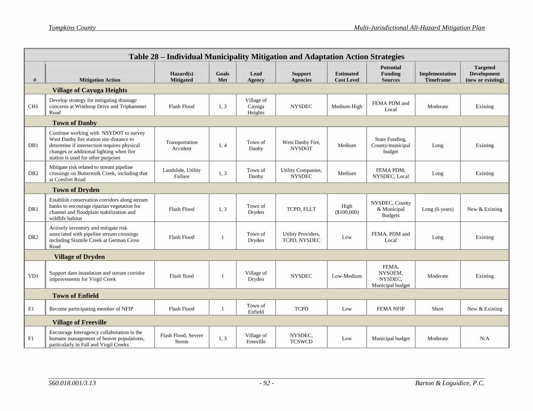
Tompkins County Multi-Jurisdictional All-Hazard Mitigation Plan
560.018.001/3.13 - 92 - Barton & Loguidice, P.C.
Table 28 – Individual Municipality Mitigation and Adaptation Action Strategies
# Mitigation Action
Hazard(s)
Mitigated
Goals
Met
Lead
Agency
Support
Agencies
Estimated
Cost Level
Potential
Funding
Sources
Implementation
Timeframe
Targeted
Development
(new or existing)
Village of Cayuga Heights
CH1
Develop strategy for mitigating drainage
concerns at Winthrop Drive and Triphammer Road
Flash Flood 1, 3
Village of
Cayuga Heights
NYSDEC Medium-High FEMA PDM and
Local Moderate Existing
Town of Danby
DB1
Continue working with NSYDOT to survey
West Danby fire station site distance to determine if intersection requires physical
changes or additional lighting when fire
station is used for other purposes
Transportation
Accident 1, 4
Town of
Danby
West Danby Fire,
NYSDOT Medium
State Funding, County/municipal
budget
Long Existing
DB2
Mitigate risk related to stream pipeline
crossings on Buttermilk Creek, including that
at Comfort Road
Landslide, Utility Failure
1, 3 Town of Danby
Utility Companies, NYSDEC
Medium FEMA PDM,
NYSDEC, Local Long Existing
Town of Dryden
DR1
Establish conservation corridors along stream
banks to encourage riparian vegetation for channel and floodplain stabilization and
wildlife habitat
Flash Flood 1, 3 Town of Dryden
TCPD, FLLT High
($100,000)
NYSDEC, County
& Municipal
Budgets
Long (6 years) New & Existing
DR2
Actively inventory and mitigate risk associated with pipeline stream crossings
including Sixmile Creek at German Cross
Road
Flash Flood 1 Town of
Dryden
Utility Providers,
TCPD, NYSDEC Low
FEMA, PDM and
Local Long Existing
Village of Dryden
VD1 Support dam inundation and stream corridor improvements for Virgil Creek
Flash flood 1 Village of
Dryden NYSDEC Low-Medium
FEMA,
NYSOEM, NYSDEC,
Municipal budget
Moderate Existing
Town of Enfield
E1 Become participating member of NFIP Flash Flood 1 Town of
Enfield TCPD Low FEMA NFIP Short New & Existing
Village of Freeville
F1 Encourage Interagency collaboration in the humane management of beaver populations,
particularly in Fall and Virgil Creeks
Flash Flood, Severe
Storm 1, 3
Village of
Freeville
NYSDEC,
TCSWCD Low Municipal budget Moderate N/A
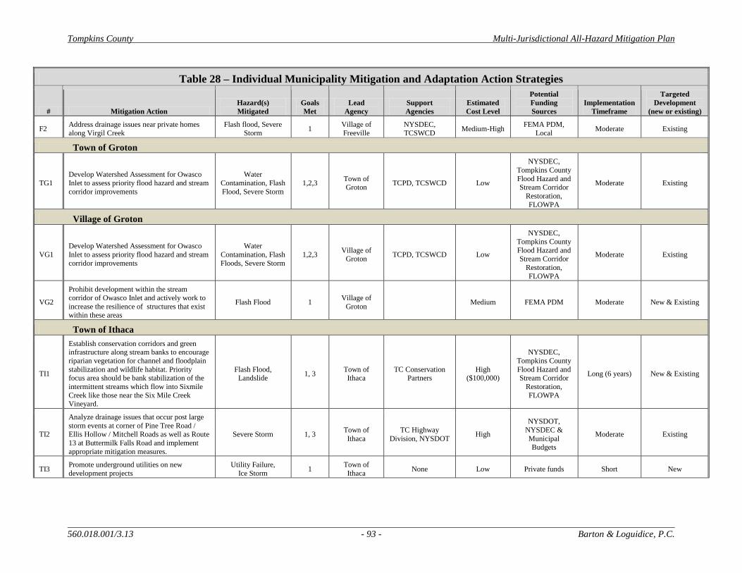
Tompkins County Multi-Jurisdictional All-Hazard Mitigation Plan
560.018.001/3.13 - 93 - Barton & Loguidice, P.C.
Table 28 – Individual Municipality Mitigation and Adaptation Action Strategies
# Mitigation Action
Hazard(s)
Mitigated
Goals
Met
Lead
Agency
Support
Agencies
Estimated
Cost Level
Potential
Funding
Sources
Implementation
Timeframe
Targeted
Development
(new or existing)
F2 Address drainage issues near private homes
along Virgil Creek
Flash flood, Severe
Storm 1
Village of
Freeville
NYSDEC,
TCSWCD Medium-High
FEMA PDM,
Local Moderate Existing
Town of Groton
TG1
Develop Watershed Assessment for Owasco
Inlet to assess priority flood hazard and stream
corridor improvements
Water
Contamination, Flash
Flood, Severe Storm
1,2,3 Town of
Groton TCPD, TCSWCD Low
NYSDEC,
Tompkins County
Flood Hazard and
Stream Corridor
Restoration,
FLOWPA
Moderate Existing
Village of Groton
VG1
Develop Watershed Assessment for Owasco
Inlet to assess priority flood hazard and stream
corridor improvements
Water
Contamination, Flash
Floods, Severe Storm
1,2,3 Village of
Groton TCPD, TCSWCD Low
NYSDEC,
Tompkins County
Flood Hazard and Stream Corridor
Restoration,
FLOWPA
Moderate Existing
VG2
Prohibit development within the stream
corridor of Owasco Inlet and actively work to
increase the resilience of structures that exist
within these areas
Flash Flood 1 Village of
Groton Medium FEMA PDM Moderate New & Existing
Town of Ithaca
TI1
Establish conservation corridors and green infrastructure along stream banks to encourage
riparian vegetation for channel and floodplain
stabilization and wildlife habitat. Priority focus area should be bank stabilization of the
intermittent streams which flow into Sixmile
Creek like those near the Six Mile Creek Vineyard.
Flash Flood, Landslide
1, 3 Town of Ithaca
TC Conservation Partners
High ($100,000)
NYSDEC,
Tompkins County
Flood Hazard and Stream Corridor
Restoration,
FLOWPA
Long (6 years) New & Existing
TI2
Analyze drainage issues that occur post large
storm events at corner of Pine Tree Road /
Ellis Hollow / Mitchell Roads as well as Route
13 at Buttermilk Falls Road and implement
appropriate mitigation measures.
Severe Storm 1, 3 Town of
Ithaca
TC Highway
Division, NYSDOT High
NYSDOT,
NYSDEC &
Municipal Budgets
Moderate Existing
TI3 Promote underground utilities on new
development projects
Utility Failure,
Ice Storm 1
Town of
Ithaca None Low Private funds Short New
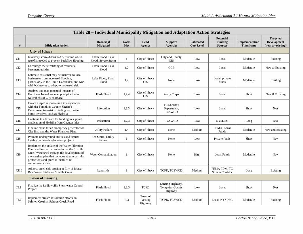
Tompkins County Multi-Jurisdictional All-Hazard Mitigation Plan
560.018.001/3.13 - 94 - Barton & Loguidice, P.C.
Table 28 – Individual Municipality Mitigation and Adaptation Action Strategies
# Mitigation Action
Hazard(s)
Mitigated
Goals
Met
Lead
Agency
Support
Agencies
Estimated
Cost Level
Potential
Funding
Sources
Implementation
Timeframe
Targeted
Development
(new or existing)
City of Ithaca
CI1 Inventory storm drains and determine where
retrofits needed to prevent backflow flooding
Flash Flood, Lake
Flood, Severe Storm 1 City of Ithaca
City and County
GIS Low Local Moderate Existing
CI2 Encourage the retrofitting of residential
basement utilities
Flash Flood, Lake
Flood 1,2 City of Ithaca CCE Low Local Moderate New & Existing
CI3
Estimate costs that may be incurred to local
businesses from increased flooding,
particularly in the Route 13 corridor, and work
with businesses to adapt to increased risk
Lake Flood, Flash
Flood 1,2
City of Ithaca
GIS None Low
Local, private
funds Moderate Existing
CI4
Analyze and map potential impacts of
Hurricane Irene/Lee level precipitation in
watersheds of City of Ithaca
Flash Flood 1,2,4 City of Ithaca
GIS Army Corps Low Local Short New & Existing
CI5
Create a rapid response unit in cooperation
with the Tompkins County Sheriff’s
Department to assist in dealing with water borne invasives such as Hydrilla
Infestation 1,2,3 City of Ithaca TC Sheriff’s Department,
TCSWCD
Low Local Short N/A
CI6 Continue to advocate for funding to support
eradication of Hydrilla from Cayuga Inlet Infestation 1,2,3 City of Ithaca TCSWCD Low NYSDEC Long N/A
CI7 Finalize plans for an emergency generator for
City Hall and the Water Filtration Plant Utility Failure 1,4 City of Ithaca None Medium
FEMA, Local
Funds Moderate New and Existing
CI8 Promote underground utilities and district heating on new development projects
Ice Storm, Utility failure
1 City of Ithaca None Low Private funds Short New
CI9
Implement the update of the Water Filtration
Plant and formalize protection of the Sixmile Creek Watershed through the development of
a watershed plan that includes stream corridor
protections and green infrastructure recommendations
Water Contamination 1 City of Ithaca None High Local Funds Moderate New
CI10 Address creek side erosion at City of Ithaca
Raw Water Intake on Sixmile Creek Landslide 1 City of Ithaca TCPD, TCSWCD Medium
FEMA PDM, TC
Stream Corridor Long Existing
Town of Lansing
TL1 Finalize the Ludlowville Stormwater Control
Project Flash Flood 1,2,3 TCPD
Lansing Highway,
Tompkins County Highway
Low Local Short N/A
TL2 Implement stream restoration efforts on
Salmon Creek at Salmon Creek Road Flash Flood 1, 3
Town of
Lansing Highway
TCPD, TCSWCD Medium Local, NYSDEC Moderate Existing

Tompkins County Multi-Jurisdictional All-Hazard Mitigation Plan
560.018.001/3.13 - 95 - Barton & Loguidice, P.C.
Table 28 – Individual Municipality Mitigation and Adaptation Action Strategies
# Mitigation Action
Hazard(s)
Mitigated
Goals
Met
Lead
Agency
Support
Agencies
Estimated
Cost Level
Potential
Funding
Sources
Implementation
Timeframe
Targeted
Development
(new or existing)
TL3
Assist with the retrofitting or acquisition of
properties with high exposure to lake flooding
in and around Myers Point/Lagoda Park
Lake Flood 1 Town of Lansing
DOER, NYSOEM High FEMA PDM Long Existing
TL4
Improve communication with the Department
of Environmental Conservation to assist in
clarifying the need and support for the permitting of regular maintenance of the
mouth of Salmon Creek to reduce flooding of
residences and community infrastructure
Flash Flood, Lake Flood, Ice Jam
1, 3 Town of Lansing
NYSDEC, Army Corps of Engineers
Low None Short Existing
Village of Lansing
VL1 Inventory business park and hazard risks, and
implement retrofits as appropriate Multi-Hazard 4
Village of
Lansing DOER Medium Local Funds Long Existing
VL2
Evaluate the intake area/building for Bolton
Point since that is located in the flood area for
the Village of Lansing and determine the impact if flooded
Lake Flood,
Flash Flood 1 Bolton Point
Village of Lansing,
DOER Low
FEMA, Local
Funds Short Existing
VL3
Assess the main raw water intake line for
Bolton Point to determine if there needs to be additional measures implemented in the event
that the current trunk line fails
Landslide, Water Contamination
1 Bolton Point Village of Lansing,
TCPD Low
NYSDEC, Local Funds
Short Existing
Town of Newfield
N1 Develop long term mitigation plans for Main Street Culvert
Flash Flood 1 Town of Newfield
Highway
NYSDEC, NYSOEM, TCPD
High FEMA PDM Long Existing
N2 Retrofit culvert on Douglas Road for added
resilience Flash Flood 1
Town of
Newfield NYSDEC Medium Local, FEMA Moderate Existing
Village of Trumansburg
VT1 Address erosion of stream bank at Village
material disposal area
Landslide, Flash
Flood 1, 3
Village Public
Works
Town of Ulysses,
TCSWCD High
FEMA PDM, NYSDEC and
Local Funds
Long Existing
Town of Ulysses
U1
Appoint a contact person for lakeshore
sandbagging (Maplewood Point or Willow
Point) and determine how the action is coordinated.
Lake Flood 1, 4 Town of
Ulysses DOER Low Local Short New
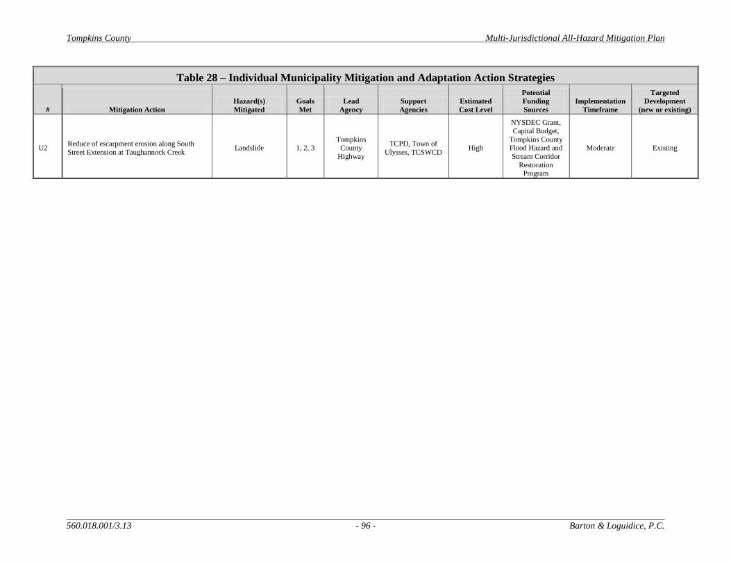
Tompkins County Multi-Jurisdictional All-Hazard Mitigation Plan
560.018.001/3.13 - 96 - Barton & Loguidice, P.C.
Table 28 – Individual Municipality Mitigation and Adaptation Action Strategies
# Mitigation Action
Hazard(s)
Mitigated
Goals
Met
Lead
Agency
Support
Agencies
Estimated
Cost Level
Potential
Funding
Sources
Implementation
Timeframe
Targeted
Development
(new or existing)
U2 Reduce of escarpment erosion along South
Street Extension at Taughannock Creek Landslide 1, 2, 3
Tompkins County
Highway
TCPD, Town of
Ulysses, TCSWCD High
NYSDEC Grant,
Capital Budget,
Tompkins County Flood Hazard and
Stream Corridor
Restoration Program
Moderate Existing
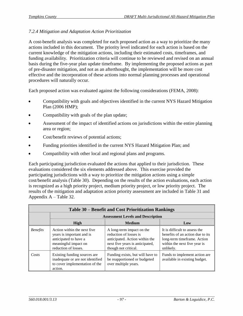
Tompkins County DRAFT Multi-Jurisdictional All-Hazard Mitigation Plan
560.018.001/3.13 - 97 - Barton & Loguidice, P.C.
7.2.4 Mitigation and Adaptation Action Prioritization
A cost-benefit analysis was completed for each proposed action as a way to prioritize the many
actions included in this document. The priority level indicated for each action is based on the
current knowledge of the mitigation actions, including their estimated costs, timeframes, and
funding availability. Prioritization criteria will continue to be reviewed and revised on an annual
basis during the five-year plan update timeframe. By implementing the proposed actions as part
of pre-disaster mitigation, and not as an afterthought, the implementation will be more cost
effective and the incorporation of these actions into normal planning processes and operational
procedures will naturally occur.
Each proposed action was evaluated against the following considerations (FEMA, 2008):
Compatibility with goals and objectives identified in the current NYS Hazard Mitigation
Plan (2006 HMP);
Compatibility with goals of the plan update;
Assessment of the impact of identified actions on jurisdictions within the entire planning
area or region;
Cost/benefit reviews of potential actions;
Funding priorities identified in the current NYS Hazard Mitigation Plan; and
Compatibility with other local and regional plans and programs.
Each participating jurisdiction evaluated the actions that applied to their jurisdiction. These
evaluations considered the six elements addressed above. This exercise provided the
participating jurisdictions with a way to prioritize the mitigation actions using a simple
cost/benefit analysis (Table 30). Depending on the results of the action evaluations, each action
is recognized as a high priority project, medium priority project, or low priority project. The
results of the mitigation and adaptation action priority assessment are included in Table 31 and
Appendix A – Table 32.
Table 30 – Benefit and Cost Prioritization Rankings
Assessment Levels and Description
High Medium Low
Benefits Action within the next five
years is important and is
anticipated to have a
meaningful impact on
reduction of losses.
A long-term impact on the
reduction of losses is
anticipated. Action within the
next five years is anticipated,
though not critical.
It is difficult to assess the
benefits of an action due to its
long-term timeframe. Action
within the next five year is
unlikely.
Costs Existing funding sources are
inadequate or are not identified
to cover implementation of the
action.
Funding exists, but will have to
be reapportioned or budgeted
over multiple years.
Funds to implement action are
available in existing budget.
Tompkins County DRAFT Multi-Jurisdictional All-Hazard Mitigation Plan
560.018.001/3.13 - 98 - Barton & Loguidice, P.C.
Actions recorded as having a benefit level equal to or higher than the cost level, were viewed as
cost-beneficial actions, therefore receiving a high priority ranking. This priority ranking process
should be viewed as a preliminary analysis. As the implementation of mitigation and adaptation
strategies progresses, the ranking system used during this evaluation will evolve based on input
from participating jurisdictions, agency representatives, and other branches of state and federal
government. Additional funding sources will be required for many of the proposed actions.
Coordination with agencies such as NYSOEM and FEMA will be necessary to secure funds for
proposed mitigation actions, especially those with high costs and long-term implementation
schedules.
Table 31 lists the 15 highest priority multi-jurisdictional actions being proposed as part of this
HMP Update. The plan update project team identified these actions as those with most
importance for implementation in the next five years. This list reflects the re-inclusion of some
actions from the original plan that are still relevant, but also incorporates many new actions that
would also minimize potential impacts to life and property as a result of hazard events. This list
represents actions that were proposed by participating jurisdictions, agencies, and members of
the public, based on need. Some of the proposed actions relate to a specific type of hazard event
or specific jurisdiction, while others are proposed to mitigate an array of hazards or will apply to
multiple jurisdictions. Appendix A – Table 32 includes the remaining list of 26 multi-
jurisdictional actions identified as a part of the update process.

Tompkins County Multi-Jurisdictional All-Hazard Mitigation Plan
560.018.001/3.13 - 99 - Barton & Loguidice, P.C.
Table 31 – HIGH PRIORITY Multi-Jurisdictional Mitigation and Adaptation Action Strategies
# Mitigation Action
Hazard(s)
Mitigated
Goals
Met
Lead
Agency
Support
Agencies
Estimated
Cost Level
Potential
Funding
Sources
Implementation
Timeframe
Targeted
Development
(new or existing)
Multi-Jurisdictional
1
Further identify vulnerable populations, including
disabled, elderly, children, non-native speakers, and the homeless and identify mitigation measures to
reduce adverse impacts to these groups from hazard
impacts
Multi-Hazard 1, 2, 4
County
Human
Services Cabinet
American Red
Cross of Tompkins and
Cortland
Counties
Low None Short New & Existing
2
Establish and implement a system for regularly
collecting detailed information about structural
damages, costs, injuries and other details relevant to tracking impacts of hazard events.
Multi-Hazard 1, 2 DOER TCPD, Insurance
Industry Low None Short Existing
3 Develop a County-wide debris management plan All Natural Hazards 1, 2
County
Public Works
Cabinet
DOER, SWCD
Moderate NYSDEC, Local
Funds Moderate Existing
4
Conduct annual climate science outreach to municipalities and other large institutions and
businesses to share latest climate change
information for use in the design of a variety of work, including capital projects
All Natural Hazards 2 TCPD NYSERDA,
Cornell Low None Short New & Existing
5
Meet annually with utilities to discuss needs and
operations to ensure preparation for increasing storm events, including tree trimming, supplies of
repair materials, and backup plans for outages. The meeting should also focus on increasing
communication and coordination, during, and after
events.
Severe Storm 1, 2 City of Ithaca
Village of
Groton, Municipalities,
Others
Low None Short New & Existing
6
Continue to advocate for the update of county Flood
Insurance Rate Maps. In addition look for ways to
map additional flood-related hazards and manage development in high risk areas. This could include
the development of a pilot project with USGS to
create interactive flood inundation maps for a stream corridor with regular flooding concerns, such
as Fall Creek or Sixmile Creek
Flood (Flash &
Lake) 1, 2, 4 TCPD
USGS, SWCD,
City GIS,
County GIS, Dryden GIS,
Municipalities
Moderate to
High
USGS Matching
Funds, FEMA Long New & Existing
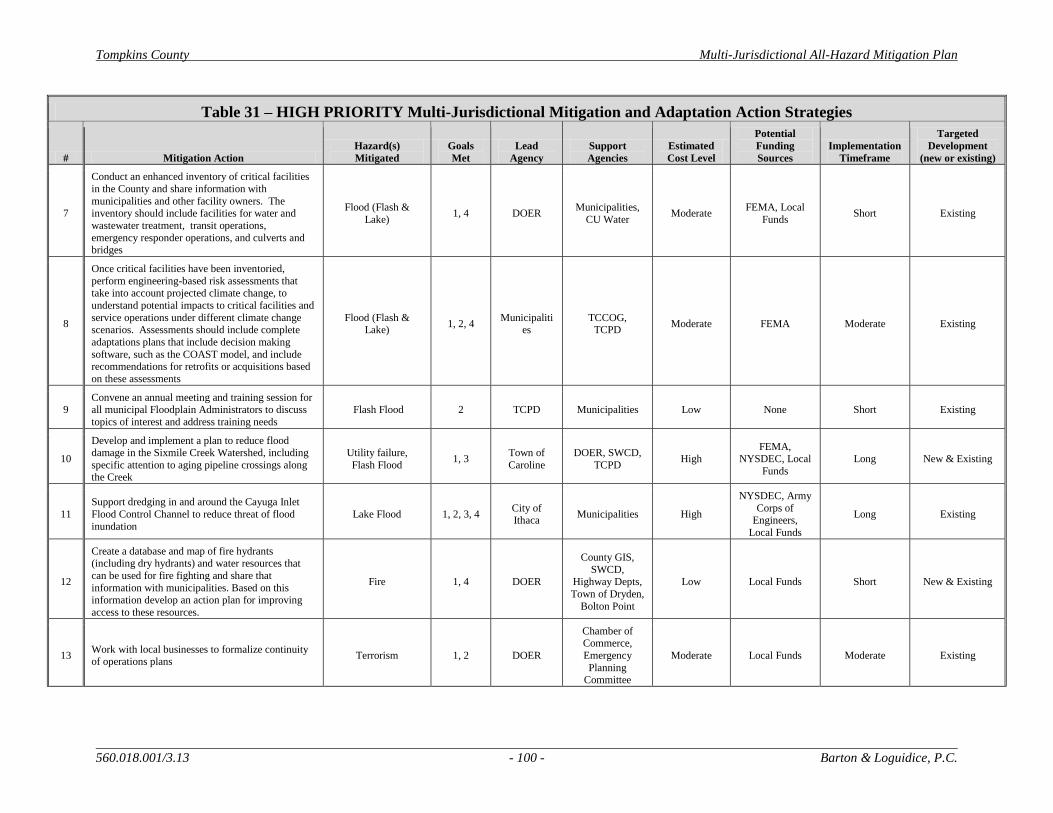
Tompkins County Multi-Jurisdictional All-Hazard Mitigation Plan
560.018.001/3.13 - 100 - Barton & Loguidice, P.C.
Table 31 – HIGH PRIORITY Multi-Jurisdictional Mitigation and Adaptation Action Strategies
# Mitigation Action
Hazard(s)
Mitigated
Goals
Met
Lead
Agency
Support
Agencies
Estimated
Cost Level
Potential
Funding
Sources
Implementation
Timeframe
Targeted
Development
(new or existing)
7
Conduct an enhanced inventory of critical facilities
in the County and share information with
municipalities and other facility owners. The inventory should include facilities for water and
wastewater treatment, transit operations,
emergency responder operations, and culverts and bridges
Flood (Flash &
Lake) 1, 4 DOER
Municipalities,
CU Water Moderate
FEMA, Local
Funds Short Existing
8
Once critical facilities have been inventoried,
perform engineering-based risk assessments that take into account projected climate change, to
understand potential impacts to critical facilities and
service operations under different climate change scenarios. Assessments should include complete
adaptations plans that include decision making
software, such as the COAST model, and include recommendations for retrofits or acquisitions based
on these assessments
Flood (Flash & Lake)
1, 2, 4 Municipaliti
es TCCOG,
TCPD Moderate FEMA Moderate Existing
9 Convene an annual meeting and training session for all municipal Floodplain Administrators to discuss
topics of interest and address training needs
Flash Flood 2 TCPD Municipalities Low None Short Existing
10
Develop and implement a plan to reduce flood damage in the Sixmile Creek Watershed, including
specific attention to aging pipeline crossings along the Creek
Utility failure,
Flash Flood 1, 3
Town of
Caroline
DOER, SWCD,
TCPD High
FEMA, NYSDEC, Local
Funds
Long New & Existing
11
Support dredging in and around the Cayuga Inlet
Flood Control Channel to reduce threat of flood
inundation
Lake Flood 1, 2, 3, 4 City of Ithaca
Municipalities High
NYSDEC, Army
Corps of Engineers,
Local Funds
Long Existing
12
Create a database and map of fire hydrants (including dry hydrants) and water resources that
can be used for fire fighting and share that
information with municipalities. Based on this information develop an action plan for improving
access to these resources.
Fire 1, 4 DOER
County GIS,
SWCD, Highway Depts,
Town of Dryden,
Bolton Point
Low Local Funds Short New & Existing
13 Work with local businesses to formalize continuity of operations plans
Terrorism 1, 2 DOER
Chamber of Commerce,
Emergency
Planning Committee
Moderate Local Funds Moderate Existing
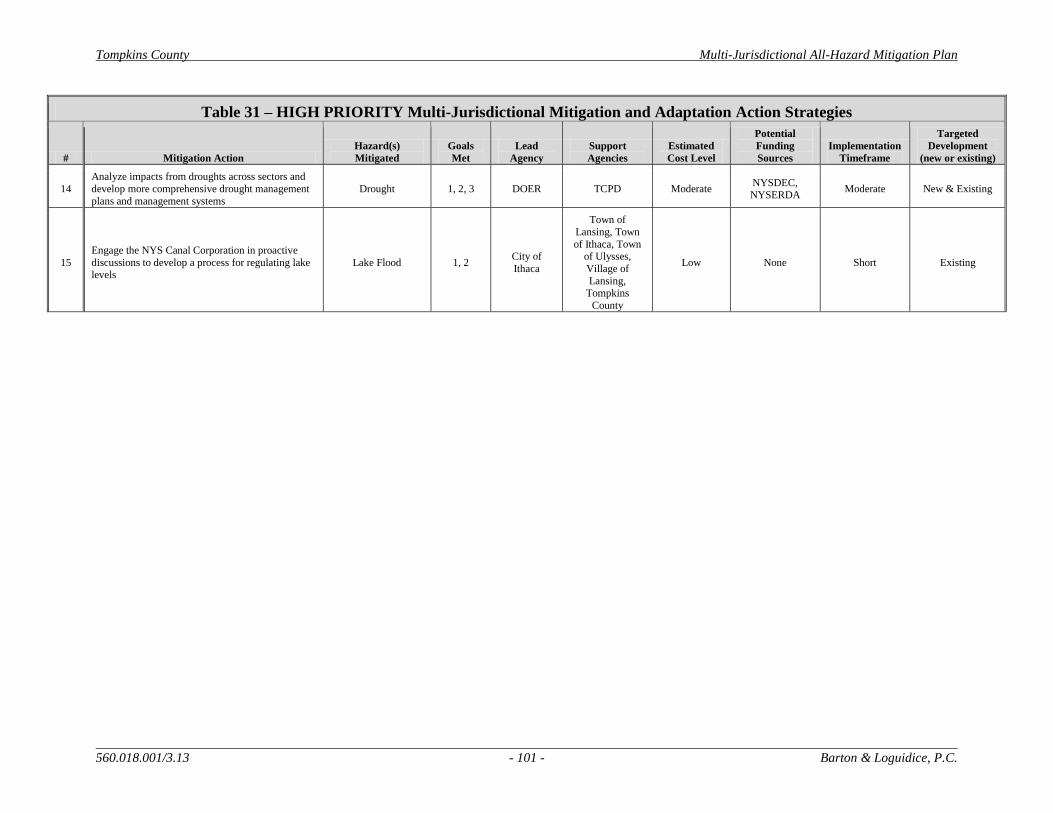
Tompkins County Multi-Jurisdictional All-Hazard Mitigation Plan
560.018.001/3.13 - 101 - Barton & Loguidice, P.C.
Table 31 – HIGH PRIORITY Multi-Jurisdictional Mitigation and Adaptation Action Strategies
# Mitigation Action
Hazard(s)
Mitigated
Goals
Met
Lead
Agency
Support
Agencies
Estimated
Cost Level
Potential
Funding
Sources
Implementation
Timeframe
Targeted
Development
(new or existing)
14
Analyze impacts from droughts across sectors and
develop more comprehensive drought management
plans and management systems
Drought 1, 2, 3 DOER TCPD Moderate NYSDEC, NYSERDA
Moderate New & Existing
15
Engage the NYS Canal Corporation in proactive
discussions to develop a process for regulating lake levels
Lake Flood 1, 2 City of
Ithaca
Town of
Lansing, Town
of Ithaca, Town of Ulysses,
Village of
Lansing, Tompkins
County
Low None Short Existing

Tompkins County Multi-Jurisdictional All-Hazard Mitigation Plan
560.018.001/5.13 - 102 - Barton & Loguidice, P.C.
8.0 National Flood Insurance Program
Long-term mitigation of potential flood impacts can be best achieved through comprehensive
floodplain management regulations and enforcement, particularly at a local level. The National
Flood Insurance Program (NFIP) is regulated by FEMA. The goal of this program is to reduce
the impact of flooding on private and public structures by providing affordable insurance for
property owners. The program encourages local jurisdictions to adopt and enforce floodplain
management regulations in order to mitigate the potential effects of flooding on new and existing
infrastructure (FEMA, 2009).
Communities that participate in the NFIP adopt floodplain ordinances that require that all insured
structures that are damaged over 50-percent of the property’s market value must comply with the
floodplain ordinance when the structure is repaired/re-built. These repairs could mean changes
to the elevation of the structure, acquisition and demolition by the municipality, or relocation to a
location outside of the floodplain. Insured structures that are located within floodplains
identified on FEMA’s Flood Insurance Rate Maps (FIRMs) receive funds if impacted by a
flooding disaster. These distributed funds are to be used to mitigate the risk of future flooding by
implementing pre-disaster mitigation actions, such as those previously referenced.
The NFIP and other flood mitigation actions are important for the protection of public and
private property and public safety. Flood mitigation is valuable to communities because (1) it
creates safer environments by reducing loss of life and decreasing property damage; (2) it allows
individuals to minimize post-flood disaster disruptions and to recover quicker (homes built to
NFIP standards receive less damage from flood events – when damage does occur, the flood
insurance program protects the homeowner’s investment); and (3) it lessens the financial impacts
on individuals, communities, and other involved parties (FEMA, 2009).
8.1 Tompkins County Flood Mapping
FEMA’s Q3 flood data, which is derived from their FIRMs, were reviewed for Tompkins
County. These datasets were last updated in 1996. Enfield is the only jurisdiction in the County
that has never been mapped by FEMA. The Village of Cayuga Heights has been mapped,
though there are no floodplains identified within the Village’s municipal boundary.
There are a total of about 6,464 acres of land in the County that are located within 100-year or
500-year mapped flood zones. A 100-year flood indicates a flood elevation that has a 1-percent
chance of being equaled or exceeded each year. Similarly, a 500-year flood indicates a flood
elevation that has 0.2-percent chance of being equaled or exceeded in any given year. The land
area in Tompkins County that is mapped within either of these flood zones accounts for, at least
portions of, 3,749 tax parcels. The full market value of these parcels, in their entirety, is
$7,423,609,047. Parcels located within mapped floodplains consist of the following land uses:
364 parcels – Commercial, 129 parcels – Community Services, 76 parcels – Forest, 9 parcels –
Industrial, 59 parcels – Public Services, 36 parcels – Recreation, 2475 parcels – Residential, 507
parcels – Vacant. As indicated, an overwhelming majority of lands mapped within 100- and
500-year floodplains are residential properties. The majority of identified parcels are located
adjacent to Salmon Creek, Taughannock Creek, Fall Creek, Cascadilla Creek, Sixmile Creek,
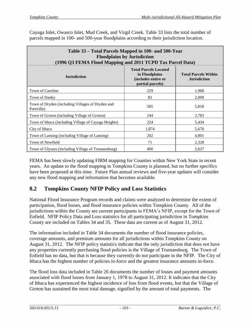
Tompkins County Multi-Jurisdictional All-Hazard Mitigation Plan
560.018.001/5.13 - 103 - Barton & Loguidice, P.C.
Cayuga Inlet, Owasco Inlet, Mud Creek, and Virgil Creek. Table 33 lists the total number of
parcels mapped in 100- and 500-year floodplains according to their jurisdiction location.
Table 33 – Total Parcels Mapped in 100- and 500-Year
Floodplains by Jurisdiction
(1996 Q3 FEMA Flood Mapping and 2011 TCPD Tax Parcel Data)
Jurisdiction
Total Parcels Located
in Floodplains
(includes entire or
partial parcels)
Total Parcels Within
Jurisdiction
Town of Caroline 229 1,968
Town of Danby 83 2,009
Town of Dryden (including Villages of Dryden and
Freeville) 585 5,818
Town of Groton (including Village of Groton) 244 2,783
Town of Ithaca (including Village of Cayuga Heights) 224 5,434
City of Ithaca 1,874 5,676
Town of Lansing (including Village of Lansing) 202 4,801
Town of Newfield 71 2,328
Town of Ulysses (including Village of Trumansburg) 400 2,637
FEMA has been slowly updating FIRM mapping for Counties within New York State in recent
years. An update to the flood mapping in Tompkins County is planned, but no further specifics
have been proposed at this time. Future Plan annual reviews and five-year updates will consider
any new flood mapping and information that becomes available.
8.2 Tompkins County NFIP Policy and Loss Statistics
National Flood Insurance Program records and claims were analyzed to determine the extent of
participation, flood losses, and flood insurance policies within Tompkins County. All of the
jurisdictions within the County are current participants in FEMA’s NFIP, except for the Town of
Enfield. NFIP Policy Data and Loss statistics for all participating jurisdiction in Tompkins
County are included on Tables 34 and 35. These data are current as of August 31, 2012.
The information included in Table 34 documents the number of flood insurance policies,
coverage amounts, and premium amounts for all jurisdictions within Tompkins County on
August 31, 2012. The NFIP policy statistics indicate that the only jurisdiction that does not have
any properties currently purchasing flood policies is the Village of Trumansburg. The Town of
Enfield has no data, but that is because they currently do not participate in the NFIP. The City of
Ithaca has the highest number of policies in-force and the greatest insurance amounts in-force.
The flood loss data included in Table 26 documents the number of losses and payment amounts
associated with flood losses from January 1, 1978 to August 31, 2012. It indicates that the City
of Ithaca has experienced the highest incidence of loss from flood events, but that the Village of
Groton has sustained the most total damage, signified by the amount of total payments. The
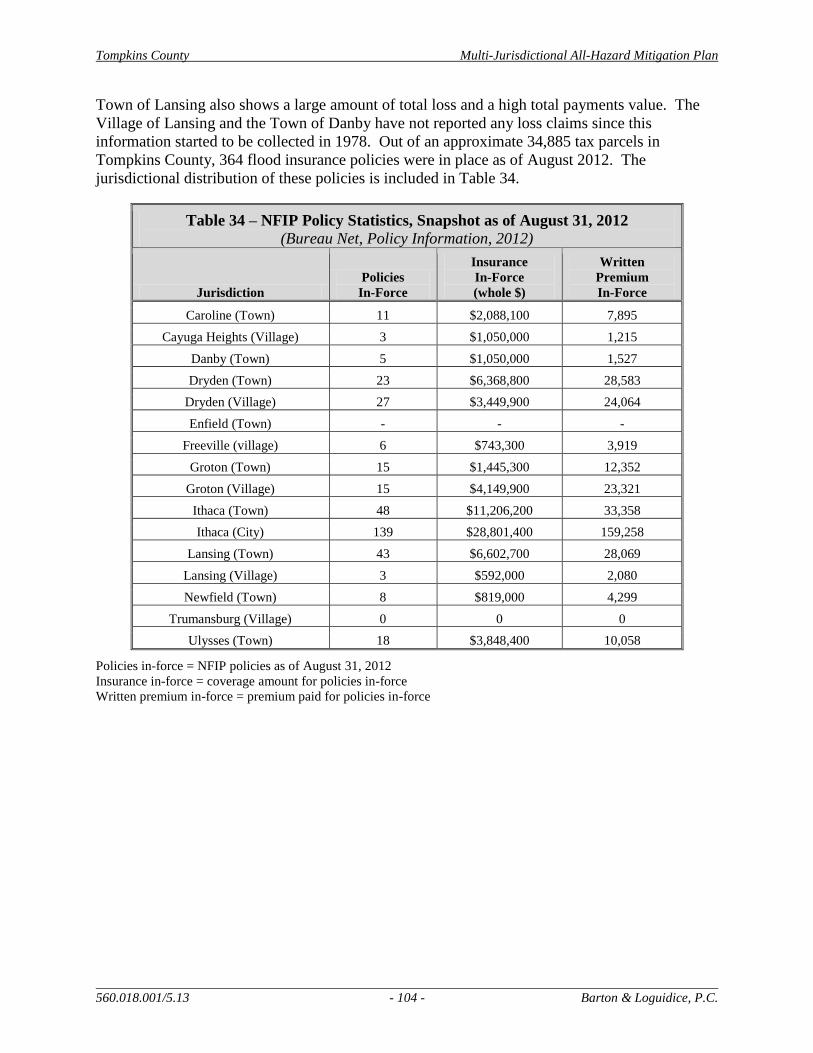
Tompkins County Multi-Jurisdictional All-Hazard Mitigation Plan
560.018.001/5.13 - 104 - Barton & Loguidice, P.C.
Town of Lansing also shows a large amount of total loss and a high total payments value. The
Village of Lansing and the Town of Danby have not reported any loss claims since this
information started to be collected in 1978. Out of an approximate 34,885 tax parcels in
Tompkins County, 364 flood insurance policies were in place as of August 2012. The
jurisdictional distribution of these policies is included in Table 34.
Table 34 – NFIP Policy Statistics, Snapshot as of August 31, 2012
(Bureau Net, Policy Information, 2012)
Jurisdiction
Policies
In-Force
Insurance
In-Force
(whole $)
Written
Premium
In-Force
Caroline (Town) 11 $2,088,100 7,895
Cayuga Heights (Village) 3 $1,050,000 1,215
Danby (Town) 5 $1,050,000 1,527
Dryden (Town) 23 $6,368,800 28,583
Dryden (Village) 27 $3,449,900 24,064
Enfield (Town) - - -
Freeville (village) 6 $743,300 3,919
Groton (Town) 15 $1,445,300 12,352
Groton (Village) 15 $4,149,900 23,321
Ithaca (Town) 48 $11,206,200 33,358
Ithaca (City) 139 $28,801,400 159,258
Lansing (Town) 43 $6,602,700 28,069
Lansing (Village) 3 $592,000 2,080
Newfield (Town) 8 $819,000 4,299
Trumansburg (Village) 0 0 0
Ulysses (Town) 18 $3,848,400 10,058
Policies in-force = NFIP policies as of August 31, 2012
Insurance in-force = coverage amount for policies in-force
Written premium in-force = premium paid for policies in-force

Tompkins County Multi-Jurisdictional All-Hazard Mitigation Plan
560.018.001/5.13 - 105 - Barton & Loguidice, P.C.
Table 35 – NFIP Loss Statistics, as of August 31, 2012 for Losses Incurred
Since January 1, 1978
(Bureau Net, Claim Information, 2012)
Jurisdiction Total
Losses
Closed
Losses
Open
Losses
Closed
without
Payment
Losses
Total
Payments
Caroline (Town) 21 17 0 4 $72,531.40
Cayuga Heights (Village) 4 3 0 1 $415,790.79
Danby (Town) 0 0 0 0 0
Dryden (Town) 5 5 0 0 $56,450.54
Dryden (Village) 16 12 0 4 $84,639.71
Enfield (Town) - - - - -
Freeville (village) 4 4 0 0 $17,760.16
Groton (Town) 6 4 0 2 $16,773.65
Groton (Village) 12 9 0 3 $614,682.96
Ithaca (Town) 17 13 0 4 $35,396.78
Ithaca (City) 86 63 0 23 $220,430.64
Lansing (Town) 52 41 0 11 $442,746.94
Lansing (Village) 0 0 0 0 0
Newfield (Town) 2 2 0 0 $9,297.04
Trumansburg (Village) 3 2 0 1 $902.32
Ulysses (Town) 1 1 0 0 $5,798.14
Total losses = all losses submitted regardless of status, total claims
Closed losses = losses that have been paid
Open losses = losses that have not been paid in full
CWOP losses = losses closed without payment
Total payments = total amount paid on losses
According to the NYSOEM State Mitigation Plan (NYSOEM, 2011) and County records, there
are 11 properties in Tompkins County that have repetitive flood loss (Section 5.1.2). The State
Plan includes an estimated value of structures located within 100-year mapped floodplains in
Tompkins County. This estimate includes a median sales price of $164,800 and an estimate of
997 structures in 100-year floodplains, for a total calculated estimated value of $164,305,600.
This potential flood loss estimate is based on 100-year floodplain mapping and estimated values
of structures.
8.3 NFIP Mitigation Actions
As part of the Tompkins County Hazard Mitigation Plan Update, each participating jurisdiction
was required to evaluate a specific set of mitigation actions aimed at continued compliance and
participation with FEMA’s NFIP. These mitigation actions are proposed in addition to the
mitigation actions already included in this plan. The mitigation actions, incorporated by FEMA
Tompkins County Multi-Jurisdictional All-Hazard Mitigation Plan
560.018.001/5.13 - 106 - Barton & Loguidice, P.C.
in their 2008 guidance, and included to reduce the impacts of future flood hazard events, consist
of the following:
Revisions to floodplain management ordinances in order to comply with FEMA’s latest
regulations and remain consistent with the FIRMs;
The designation of a Floodplain Administrator in each participating jurisdiction;
Ensuring that staff members have appropriate training to adequately enforce NFIP
regulations and ordinances;
Requiring staff involved in floodplain management and/or regulations to become
Certified Floodplain Managers (CFMs);
Joining the Community Rating System (CRS).
These NFIP specific mitigation actions are further detailed in the Multi-Jurisdictional mitigation
action strategies included in Table 32, located in Appendix A. In addition to these NFIP
mitigation actions, one of the specific pre-disaster mitigation actions proposed by the Town of
Enfield is to become a participating member of the NFIP. The Community Rating System is a
voluntary incentive program that recognizes and encourages floodplain management activities at
the community level. As a result of CRS participation, flood insurance premium rates are
discounted to reflect the reduced flood risk that results from community actions to meet the three
goals of the CRS: reduce flood loss, facilitate accurate insurance ratings, and promote flood
insurance awareness (FEMA, 2010).
Tompkins County Multi-Jurisdictional All-Hazard Mitigation Plan
560.018.001/5.13 - 107 - Barton & Loguidice, P.C.
9.0 Plan Maintenance Process
This section details the future maintenance process that will be followed for subsequent plan
updates. The Disaster Mitigation Act of 2000 requires that adopted mitigation plans define and
document the processes and mechanisms for maintaining and updating the hazard mitigation plan
at least once every five years in order for the participating jurisdictions to remain eligible for
funding. This hazard mitigation plan maintenance process must include: monitoring and
evaluating the plan; updating the plan; providing an implementation schedule; and outlining
steps for continued public involvement. A checklist to assist with the monitoring, evaluation,
and updating of this Hazard Mitigation Plan is included in Appendix I.
9.1 Plan Monitoring and Evaluation
The 2013 Tompkins County Hazard Mitigation Plan will be monitored on an annual basis to
ensure that the goals and objectives of the Plan remain relevant and that the proposed mitigation
actions are being implemented efficiently. The Tompkins County Multi-Jurisdictional All-
Hazard Mitigation Plan – Implementation Committee will continue to hold annual meetings to
review and discuss this document, recent hazard events, and how to incorporate this Plan into
other County-wide planning efforts. These annual meetings will be publicized and open to the
public, as a way to promote continued public involvement in this process. The Tompkins
County Planning Department will be in charge of scheduling and moderating the Implementation
Committee annual meetings, and will be responsible for compiling a meeting summary and
annual report at the end of every year. This annual report should detail changes made to the
HMP document, if any, and how and when these changes will be made. The meeting summary
will provide important information regarding hazard events that occurred during the previous
year and implementation details associated with the proposed mitigation actions included in the
HMP.
The implementation of proposed mitigation actions is important to review to determine whether
the plan is being executed correctly. Items that should be reviewed and recorded for each
completed mitigation action include the ultimate cost of the activity, the successes and failures of
the action in minimizing hazard impacts, and the funding sources used for the action. During
each annual meeting of the Implementation Committee, the following HMP components will be
assessed:
Whether the goals and objectives address current and expected conditions;
Whether the nature, magnitude, and/or type of risks have changed;
Whether the current resources are appropriate for implementing the plan;
Whether there are implementation problems or coordination issued with other agencies;
Whether the outcomes have occurred as expected, and
Whether agencies and other partners participated as originally proposed.
Tompkins County Multi-Jurisdictional All-Hazard Mitigation Plan
560.018.001/5.13 - 108 - Barton & Loguidice, P.C.
The schedule and tasks associated with the monitoring of Tompkins County’s HMP are included
in Appendix I. The annual reports compiled by the TCPD will be posted to the County’s website
for public review.
9.2 Plan Updating
The 2013 HMP will be updated by addendum at any time during the five-year execution period
in which the Implementation Committee determines that a significant change has occurred that
warrants such an action. In the event of a hazard occurrence, the goals, actions, and procedures
outlines in the Plan will be reviewed, as necessary. If any revisions or changes are warranted,
the plan will be updated immediately, or at the next five-year update timeframe, depending on
the importance of the proposed change(s) or revision(s). During the updating process, the
participating jurisdictions will be contacted to provide updated information concerning the
elements of the Plan applicable to their community. This process will be completed through the
issuance of a questionnaire to be returned to the Implementation Committee for review prior to
their annual meeting.
Approximately 18 months prior to the end of the current five-year execution period, the Plan
update process should be initiated. This document represents the first update to Tompkins
County’s original HMP, review and approved by NYSOEM and FEMA in 2006. Participant and
public review will continue to be completed during each five-year Plan Update process. All
future plan updates will be submitted for re-approval in accordance with the five-year review
schedule dictated in DMA 2000. Following FEMA conditional approval, each participating
jurisdiction must formally adopt the new Plan by resolution. These resolutions should be
collected and filed in Appendix F for documentation, and submitted to FEMA and NYSOEM for
final HMP approval. A user friendly checklist was formulated to aid Tompkins County in
competing future five-year updates to the HMP. A copy of this checklist is provided in
Appendix I. This checklist will help the County organize and complete revisions to future Plan
Updates and will assist the County in adequately meeting the five-year review timeframe
instituted by FEMA.
9.3 Local Planning Considerations
By adopting a resolution to accept the Multi-Jurisdictional All-Hazard Mitigation Plan, each
participating jurisdiction agrees to reference and incorporate the document into their future local
planning documents, codes, decisions, processes, and regulations. Plan elements will be
considered during municipal and County-wide development actions and comprehensive
planning. Planning mechanisms and current capabilities recognized among the participating
jurisdictions are demonstrated by Table 11 in Section 3.1.1. Table 11 will be revised as new
mechanisms and capabilities are adopted and updated by the participating jurisdictions. Table 36
shows how this HMP will be incorporated into the existing and future planning mechanisms and
opportunities of each jurisdiction.

Tompkins County Multi-Jurisdictional All-Hazard Mitigation Plan
560.018.001/5.13 - 109 - Barton & Loguidice, P.C.
Table 36 – Planning Mechanism Incorporation
Mechanism How Plan Will be Incorporated
Emergency Planning Plan will be added/referenced as an Appendix to the County’s
Emergency Response/Evacuation Plan (an annex of the CEMP).
Hazard risk assessment and vulnerability data included in the
mitigation plan will be reviewed during emergency planning and
Emergency Response/Evacuation Plan updates. Specific
mitigation activities will be incorporated into the annual work
plans of TC-DOER and the County Emergency Management
Planning Committee.
Annual Budget Mitigation actions will be considered when setting the annual
budgets within participating jurisdictions.
Plans and Programs Hazard Mitigation Plan information will be considered by each
participating jurisdiction during program and protection updates
and revisions.
Programs and plans will be compared to the Hazard Mitigation
Plan to ensure that goals and objectives are consistent among all
documents.
Grant Applications and
other Funding
Opportunities
Data and maps from the HMP may be used as supporting
documentation in grant applications.
Mitigation actions included in the Plan will be considered during
application submission and fund allocation.
Economic Development Hazard vulnerability information will be reviewed and utilized
during the siting of local development efforts within each
participating jurisdiction.
Capital Improvement
Planning
Current and future projects will be reviewed for hazard
vulnerability. Hazard resistant construction standards will be
incorporated into the design and location of potential projects, as
appropriate.
Some jurisdictions in Tompkins County are taking a more active role in sustainable
development, green infrastructure, disaster planning, etc. within their community. After a review
of the planning mechanisms and capabilities associated with each jurisdiction, a list of
recommended regulatory elements or planning documents was compiled. These potential efforts
include:
Comprehensive/Land Use Plan – Town of Enfield (Update) and City of Ithaca (Update)
Watershed Protection Plan – all jurisdictions, especially those with repetitive flood loss
Redevelopment Plan – City of Ithaca
Land Use Regulation – Towns of Enfield, Caroline, Newfield
Zoning Code Review and Update – Villages of Freeville and Dryden
Tompkins County Multi-Jurisdictional All-Hazard Mitigation Plan
560.018.001/5.13 - 110 - Barton & Loguidice, P.C.
Flood Regulations – Town of Enfield, Villages of Cayuga Heights, Dryden, Lansing and
Trumansburg
Participate in the NFIP – Town of Enfield
Numerous changes and additions were made to this document as part of the five-year HMP
Update process. These updates and reorganization have made the 2013 Plan more valuable as a
planning tool and more easily implementable. No evidence to support the integration of the 2006
HMP by participating jurisdictions into their local planning mechanisms or processes was noted.
No indications of such are included in the Implementation Committee annual meeting notes. An
emphasis on such efforts will be placed over the next five-year period. The incorporation of this
document in local planning efforts and processes will be reviewed and discussed on an annual
basis.
9.4 Public Involvement
It is the intent of Tompkins County and participating jurisdictions to keep the public informed
about the hazard mitigation planning efforts, actions, and projects that occur within the County.
To accomplish this goal, and in addition to the public involvement already incorporated into the
completion and review of this document, the following opportunities for ongoing public
involvement will be made available:
A web link will be provided on Tompkins County’s website that will include a digital
copy of the hazard mitigation plan and a list of upcoming planning activities and plan
updates;
Public announcements of, and invitations to, annual mitigation committee planning
meetings and five-year mitigation plan update events; and
Completion of public outreach and mitigation training events throughout the County,
especially in higher risk hazard areas.
Public outreach efforts will be documented in future plan updates through the inclusion of
samples, copies of notices, flyers, web announcements, and/or meeting minutes. If public
response is lacking during subsequent update processes, additional ways to expand participation
will be considered. Public outreach ideas that may be implemented to increase participation
include:
Distribute targeted questionnaires to local civic, community, and non-profit groups to
received public feedback;
Organize topic specific meetings with key individuals and experts to discuss particular
concerns and brainstorm solutions; and
Hold education programs during various community events to disseminate information
and engage the public in discussions on mitigation planning and hazard preparation.
Tompkins County Multi-Jurisdictional All-Hazard Mitigation Plan
560.018.001/5.13 - 111 - Barton & Loguidice, P.C.
10.0 Works Cited
2010 Census Gazetteer Files, 2012.
http://www.census.gov/geo/www/gazetteer/files/Gaz_cousubs_national.txt
U.S. Army Corps of Engineers. 2011. Hydraulic Analysis and Impacts of Long Term Shoaling
for Flood Risk Management Project, Cayuga Inlet, Ithaca, New York. USACE – Buffalo
District.
Burby, R. 1998. Cooperating with Nature. Washington, DC: Joseph Henry Press.
City-Data, 2011. http://www.city-data.com/. Accessed 2012.
College Board Big Future, 2012. https://bigfuture.collegeboard.org/college-search
Cornell University, 2012. Campus Photograph – ILR International Programs Webpage.
http://www.ilr.cornell.edu/international/visitingFellows/IncomingVF.html
Cornell University. 2006. Tompkins County’s Major Employers.
http://www.gradschool.cornell.edu
Family Search, 2012. Historic Map of Tompkins County.
https://familysearch.org/learn/wiki/en/Tompkins_County,_New_York.
Provided by the Church of Jesus Christ of Latter-day Saints.
FEMA. 2001. Understanding Your Risks – identifying hazards and estimating losses.
State and Local Mitigation Planning - how-to guide. FEMA 386-2. August 2001.
Fly Ithaca Tompkins Regional Airport.
http://www.flyithaca.com/images/category/aerial-views.html
Global Aviation Navigator Inc. 2012. New York Airports.
www.globalair.com/airport/airports_in_New_York.aspx
Higher Education in Tompkins County, 2009.
http://tbed.org/wp-content/uploads/Tompkins%20County-Joint-EIS-Report_Sept-
2009.pdf
Ithaca-Tompkins County Transportation Council (ITCTC). 2002. Tompkins County Freight
Transportation Study. ICTC and Sear Brown. www.tompkins-
co.org/itctc/projects/fts/FTS-finalreport-0502.pdf
Ithaca Tompkins Regional Airport. Accessed 2012. Fly Ithaca Tompkins Regional Airport.
http://flyithaca.com/. Photo obtained from the ‘The Airport’ page.

Tompkins County Multi-Jurisdictional All-Hazard Mitigation Plan
560.018.001/5.13 - 112 - Barton & Loguidice, P.C.
Kammen, C. 2004. Places Names of Tompkins County.
http://www.tompkins-co.org/historian/PlaceNames/PlaceNamesofTC.pdf
Lee, H.C. 2008. A History of Railroads in Tompkins County.
http://ecommons.library.cornell.edu/bitstream/1813/11518/6/A%20History%20of%20Rai
lroads%20in%20Tompkins%20County.pdf
National Oceanic and Atmospheric Administration (NOAA). 2012. Severe Weather.
www.noaawatch.gov/themes/severe.php
National Oceanic and Atmospheric Administration. 2010. Thunderstorms, Tornadoes,
Lightning…A Preparedness Guide.
www.nws.noaa.gov/om/severeweather/resources/ttl6-10.pdf
National Oceanic and Atmospheric Administration. 2009. National Severe Storms Laboratory -
Understanding Damages and Impacts. www.nssl.noaa.gov/primer/flood/fld_damage.html
National Weather Service, 2012.
http://www.erh.noaa.gov/bgm/climate/bgm/bgm_annual_totals.shtml
National Weather Service Forecast Office, Binghamton, New York.
National Weather Service. 2012(2). Lightning Safety.
www.lightningsafety.noaa.gov/fatalities.htm
New York State Climate Office, 2010. Climate of New York.
http://nysc.eas.cornell.edu/climate_of_ny.html
New York State Department of Environmental Conservation (NYSDEC). 2011. Revised Draft
SGEIS 2011, Sections 6.10 – 6.13.2.
www.dec.ny.gov/docs/materials_minerals_pdf/rdsgeisch6b0911.pdf
New York State Department of Labor. 2012. New York’s Economic Recovery.
http://www.labor.ny.gov/stats/pressreleases/pruistat.htm
New York State Department of Labor, 2012(2). Current Employment by Industry
http://www.labor.ny.gov/stats/cesemp.asp
New York State Department of Labor, 2012(3).
http://www.labor.ny.gov/stats/employ/tomhist.txt
New York State Department of Labor, 2012(4). Private Sector Jobs.
http://www.labor.ny.gov/stats/pdfs/cesjobs_map.pdf
New York State Department of Labor. 2012(5). Statewide Labor Market Overview.
http://www.labor.ny.gov/stats/
Tompkins County Multi-Jurisdictional All-Hazard Mitigation Plan
560.018.001/5.13 - 113 - Barton & Loguidice, P.C.
New York State Department of Labor. 2012(6). State Labor Department Releases May 2012
Area Unemployment Rates. http://www.labor.ny.gov/stats/pressreleases/prlaus.shtm
New York State Department of Labor. 2012(7). Unemployment Rates by County.
http://www.labor.ny.gov/stats/pdfs/ur_map.pdf
New York State Department of Labor. 2011. Significant Industries.
http://www.labor.ny.gov/stats/sou/index.shtm
New York State Department of Labor. 2011(2). Labor Statistics.
http://www.labor.ny.gov/stats/sou/index.shtm
New York State Department of Motor Vehicles. 2000. Accident Frequency Rate of Counties
According to Population and Vehicle Registrations.
http://www.dmv.ny.gov/Statistics/count2k.htm
New York State Department of Transportation. 2011. County Roads Listing.
https://www.dot.ny.gov/divisions/engineering/technical-services/hds-
respository/County%20Roads%20Reg%203%20-%20Tompkins%20County.pdf
New York Department of Transportation. 2010. Accident Location Information System (ALIS).
New York State 2100 Commission. 2013. Preliminary Report on Improving the Strength and
Resilience of New York State’s Infrastructure.
http://www.governor.ny.gov/NYS2100Commission
New York State Department of Transportation. 2003. List of State Routes in Tompkins County.
https://www.dot.ny.gov/divisions/engineering/technical-services/hds-
respository/tompkinstvbk.pdf
New York State Emergency Management Office (NYSEMO). 2008. NYS Hazard Mitigation
Plan. http://www.dhses.ny.gov/oem/mitigation/archive/hm-plan-2008.cfm
New York State Energy Research and Development Authority (NYSERDA). 2011. ClimAID:
Responding to Climate Change in New York State Synthesis Report. Report 11-18.
New York State Office of Emergency Management (NYSOEM). 2011. New York State Standard
Multi-Hazard Mitigation Plan (State Mitigation Plan).
http://www.dhses.ny.gov/oem/mitigation/plan.cfm
New York State Office of Emergency Management. 2010. Geographic Information System
Mapping
Oregon Partnership for Disaster Resilience (OPDR). 2012. http://csc.uoregon.edu/opdr/
Ritter, Michael E. The Physical Environment: an Introduction to Physical Geography. 2006.
www.uwsp.edu/geo/faculty/ritter/geog101/textbook/title_page.html

Tompkins County Multi-Jurisdictional All-Hazard Mitigation Plan
560.018.001/5.13 - 114 - Barton & Loguidice, P.C.
TCLocal, 2012. http://tclocal.org/
Tompkins County GIS Department. 2006. General School Districts.
http://www.tompkins-co.org/gis/maps/pdfs/School_Map_24_36.pdf
Tompkins County Historian. http://www.tompkins-co.org/historian/index.html
Tompkins County Planning Department. 2012. Tompkins County Conservation Strategy
Tompkins County Planning Department. 2010. Jobs and Business.
http://www.tompkins-co.org/planning/jobsbusiness/index.htm
Tompkins County Planning Department. 2007. Planning Maps: Tompkins County Land Use and
Land Cover and Land Use Land Cover Change Table.
http://www.tompkins-co.org/planning/Planning_Maps.htm
Tompkins County Planning Department. 2004. Natural Feature and Agricultural Resource Focus
Areas
Tompkins County Planning Department. 2004(2). Comprehensive Plan.
http://www.tompkins-co.org/planning/compplan/compplan_for_web.pdf
Tompkins County Planning Department. 2001. Natural Resource Inventory.
http://www.tompkins-co.org/planning/nri/inventory.pdf
Tompkins County Youth Services Department. 2011. School Listing, September 2011 – June
2011.
http://www.tompkins-co.org/youth/documents/11-12SchoolListtla_020.pdf
U. S. Army Corps of Engineers. Hydraulic Analysis and Impacts of Long Term Shoaling for
Flood Risk Management Project, Cayuga Inlet, Ithaca, New York.
http://www.ecologicllc.com/pdf/FEIS/FEIS.pdf
U.S. Census Bureau Fact Finder. 2012.
http://factfinder2.census.gov/faces/tableservices/jsf/pages/productview.xhtml?pid=ACS_
10_5YR_DP03&prodType=table
U.S. Census Bureau. 2010. 2010 Census Interactive Population Search.
http://www.census.gov/2010census/popmap/
U.S. Census Bureau. 2006-2010. American Community Survey – Selected Housing
Characteristics. 2006-2010 data no longer available, but 2007-2011 numbers available at
http://factfinder2.census.gov/faces/tableservices/jsf/pages/productview.xhtml?pid=ACS_
11_5YR_DP04&prodType=table

Tompkins County Multi-Jurisdictional All-Hazard Mitigation Plan
560.018.001/5.13 - 115 - Barton & Loguidice, P.C.
U.S. Census Bureau. 2010(2). American Fact Finder – Tompkins County.
http://factfinder2.census.gov/faces/nav/jsf/pages/community_facts.xhtml
U.S. Census Bureau. 2009. Population Estimates Minor Civil Divisions: 2000 to 2009.
http://www.census.gov/popest/data/cities/totals/2009/SUB-EST2009-5.html
U.S. Census Bureau. 2007. U.S. Department of Commerce U.S. Census Bureau
Geography Division. Census Block Groups – New York State. GIS Shapefile.
Weather Base Ithaca NY, 2012.
http://www.weatherbase.com/weather/weather.php3?s=56937&refer=&cityname=Ithaca-
New-York-United-States-of-America

Tompkins County Multi-Jurisdictional All-Hazard Mitigation Plan
560.018.001/5.13 Barton & Loguidice, P.C.
Appendix A
Additional Figures and Tables
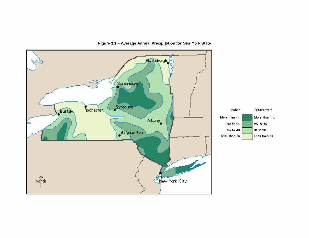
Figure 2.1 – Average Annual Precipitation for New York State

Figure 2.2 – Average January Temperatures for New York State

Figure 2.3 – Average July Temperatures for New York State
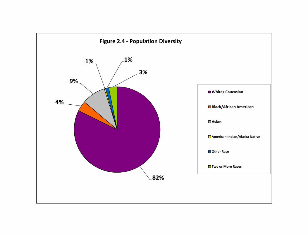
82%
4%
9%
1% 1%
3%
Figure 2.4 - Population Diversity
White/ Caucasian
Black/African American
Asian
American Indian/Alaska Native
Other Race
Two or More Races
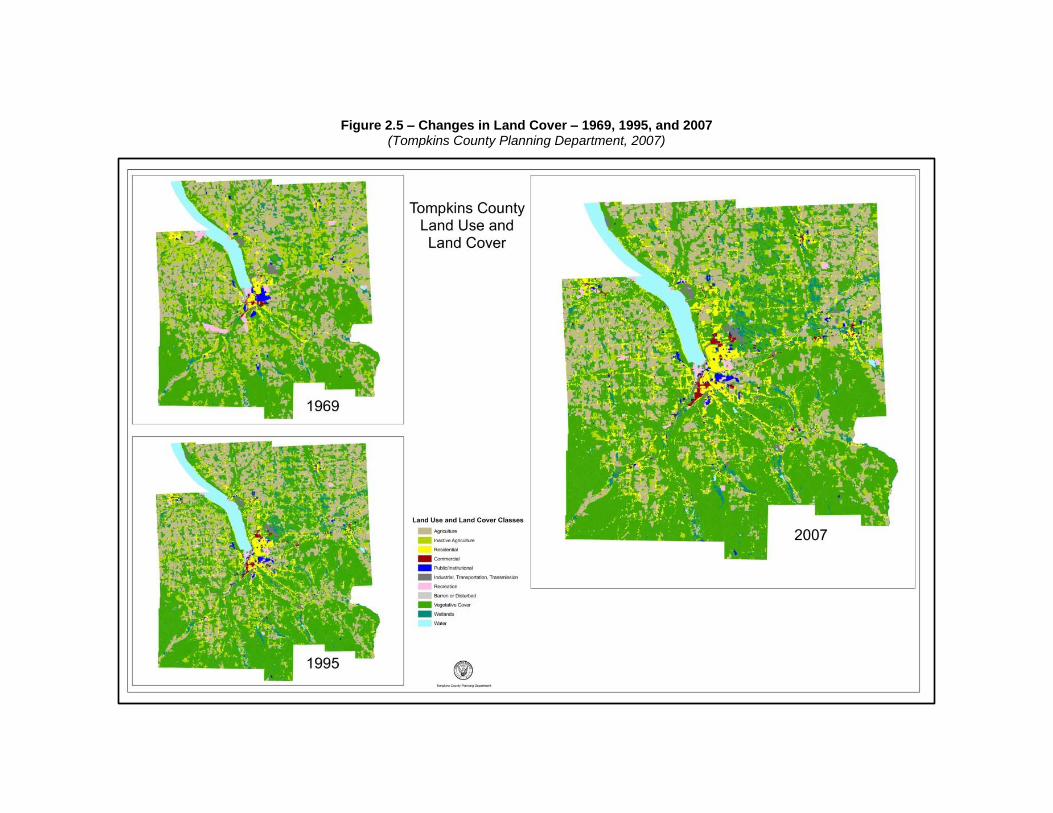
Figure 2.5 – Changes in Land Cover – 1969, 1995, and 2007 (Tompkins County Planning Department, 2007)

Figure 2.6 - Mapped Agricultural Districts within Tompkins County
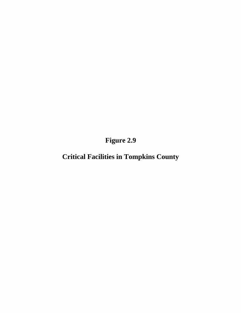
Figure 2.9
Critical Facilities in Tompkins County
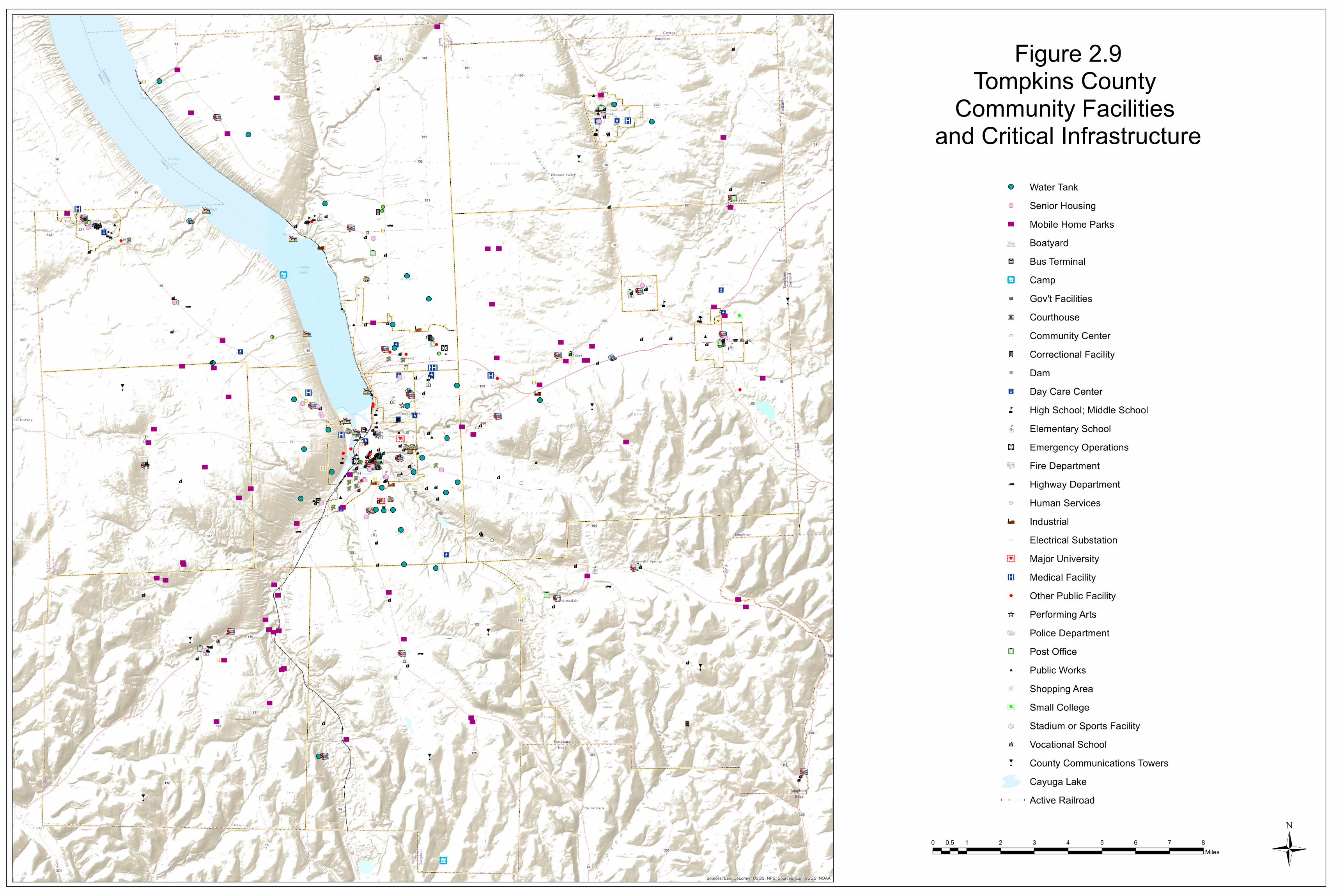
Ô
Ô
ÔÔ
Ô
Ô
ÔÔ
ÔÔÔ Ô
Ô
Ô
Ô
Ô
Ô ÔÔ
Ô
Ô
Ô
Ô
Ô Ô
Ô
ÔÔ
Ô
Ô
Ô
Ô
Ô
Ô
Ô Ô
Ô
Ô
Ô Ô
ÔÔ
ÔÔÔ Ô
Ô
Ô
ÔÔ
Ô
ÔÔ
Ô
Ô
ÔÔ
Ô
Ô
Ô
Ô
'
'
'
'
'
'
'
'
'
'
'
'
'
'
'
''
'
'
'
'
'
'
î
î
î
î
î
î
î
î
î
î
î
î
î
î
î
î
î
î
î
î
î
î
îî
î
î
î
î
î
î
î
î
î
î
î
îî
î
î
îî
î î
î
î
î îî
î
î
î
î
î
î
î
îî
îî
î
î
î
î
î
î
î
î
î
î
î
î
î
î
î
î
î
î
î
î
î
î
î
î
î
î
î
î
î
î
î
î
î
îîî
î
îî
Sources: Esri, DeLorme, USGS, NPS, Sources: Esri, USGS, NOAA
Figure 2.9Tompkins County
Community Facilities and Critical Infrastructure
0 1 2 3 4 5 6 7 80.5Miles
Water Tank' Senior Housing
Ô Mobile Home ParksBoatyard
U Bus Terminal!= Campñ Gov't Facilitiesñ Courthouse²³ Community Centerl Correctional Facility") DamJY Day Care Centerå High School; Middle School¹½ Elementary Schoolns Emergency Operations
Fire Departmentk Highway Department
Human ServicesA@ Industrial
Electrical Substation¥B¤ Major UniversityÆP Medical Facility% Other Public Facility_ Performing Arts
Police DepartmentPost Office
# Public WorksShopping Area
!B Small CollegeStadium or Sports Facility
k Vocational SchoolH County Communications Towers
Cayuga Lake Active Railroad
Ü
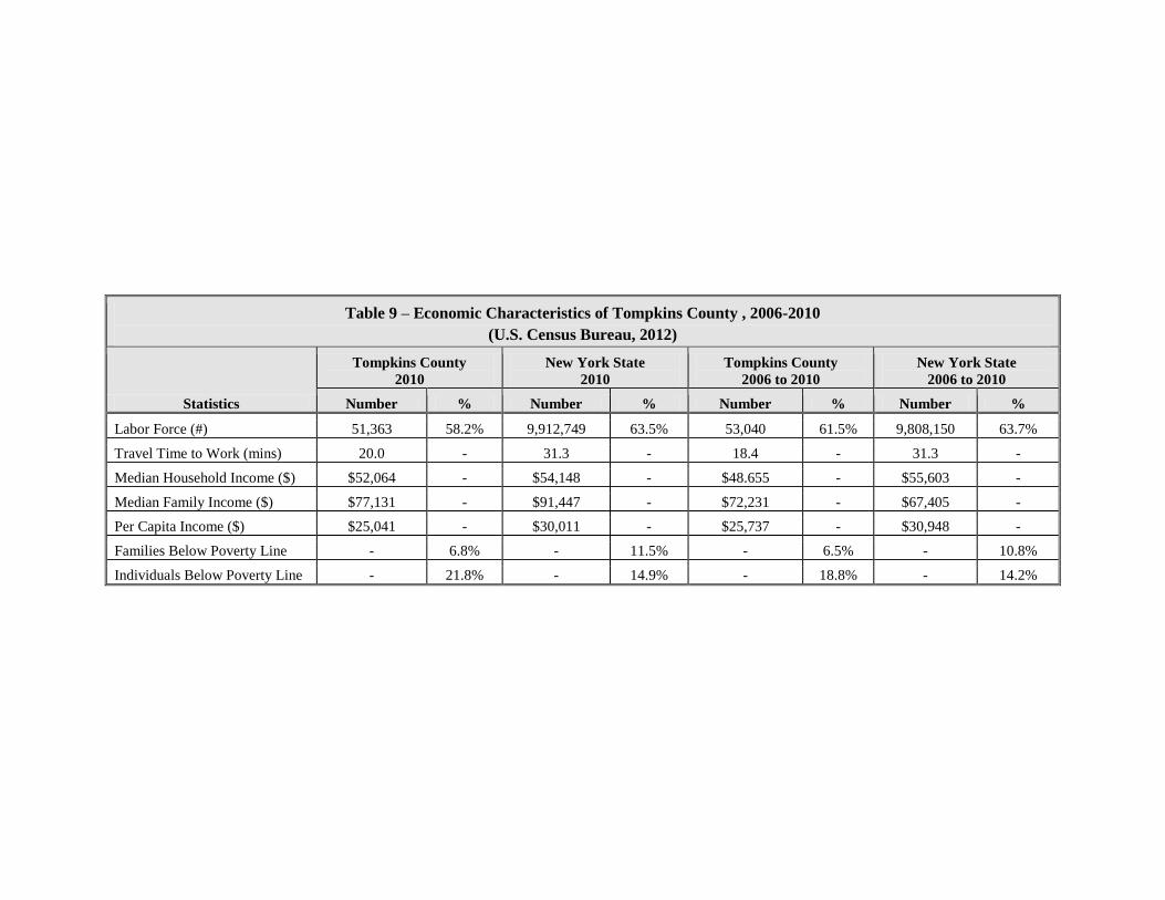
Table 9 – Economic Characteristics of Tompkins County , 2006-2010
(U.S. Census Bureau, 2012)
Statistics
Tompkins County
2010
New York State
2010
Tompkins County
2006 to 2010
New York State
2006 to 2010
Number % Number % Number % Number %
Labor Force (#) 51,363 58.2% 9,912,749 63.5% 53,040 61.5% 9,808,150 63.7%
Travel Time to Work (mins) 20.0 - 31.3 - 18.4 - 31.3 -
Median Household Income ($) $52,064 - $54,148 - $48.655 - $55,603 -
Median Family Income ($) $77,131 - $91,447 - $72,231 - $67,405 -
Per Capita Income ($) $25,041 - $30,011 - $25,737 - $30,948 -
Families Below Poverty Line - 6.8% - 11.5% - 6.5% - 10.8%
Individuals Below Poverty Line - 21.8% - 14.9% - 18.8% - 14.2%
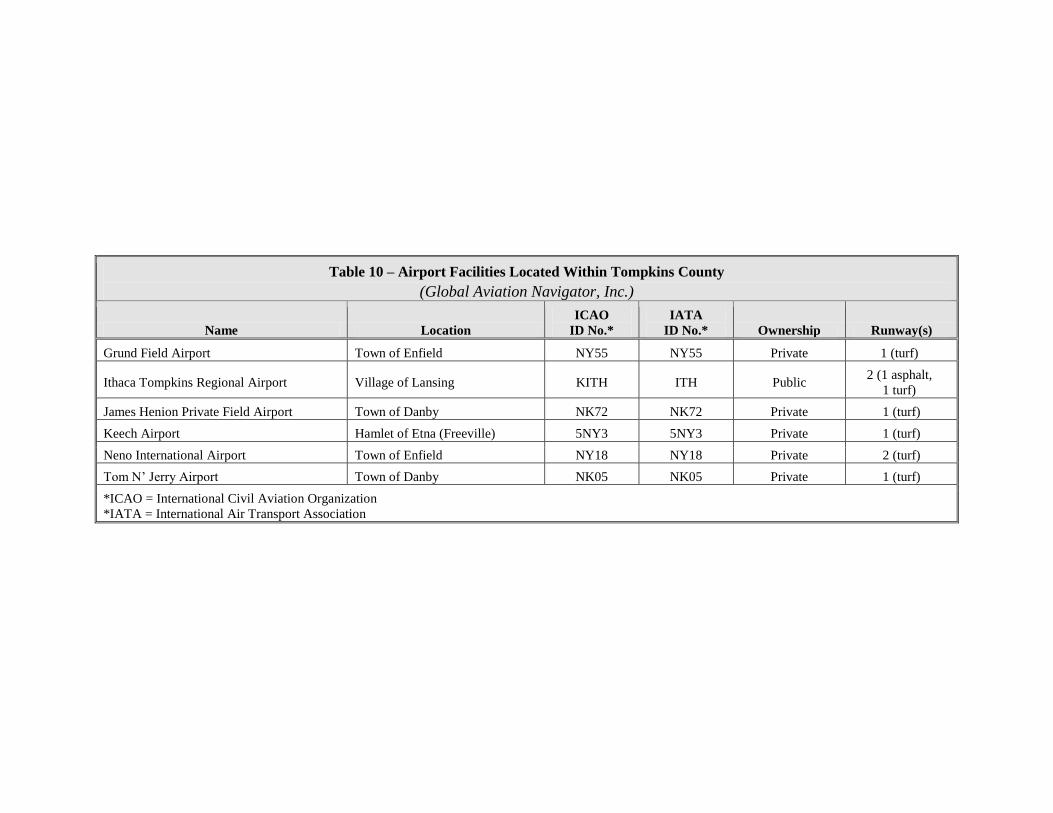
Table 10 – Airport Facilities Located Within Tompkins County
(Global Aviation Navigator, Inc.)
Name Location
ICAO
ID No.*
IATA
ID No.* Ownership Runway(s)
Grund Field Airport Town of Enfield NY55 NY55 Private 1 (turf)
Ithaca Tompkins Regional Airport Village of Lansing KITH ITH Public 2 (1 asphalt,
1 turf)
James Henion Private Field Airport Town of Danby NK72 NK72 Private 1 (turf)
Keech Airport Hamlet of Etna (Freeville) 5NY3 5NY3 Private 1 (turf)
Neno International Airport Town of Enfield NY18 NY18 Private 2 (turf)
Tom N’ Jerry Airport Town of Danby NK05 NK05 Private 1 (turf)
*ICAO = International Civil Aviation Organization
*IATA = International Air Transport Association
Figure 4.3 – Total Presidential Disaster Declarations for hazard events, displayed at the County level, 1954 – 2010
(NYSOEM, 2011 NYS Hazard Mitigation Plan)
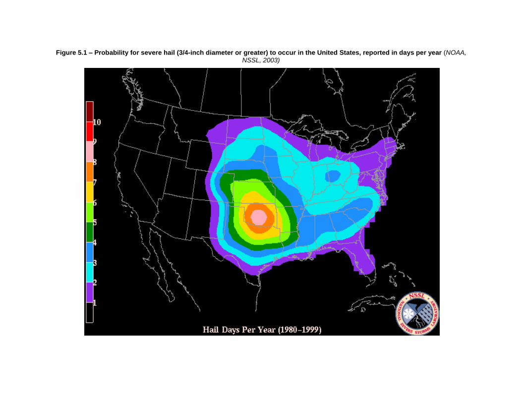
Figure 5.1 – Probability for severe hail (3/4-inch diameter or greater) to occur in the United States, reported in days per year (NOAA, NSSL, 2003)
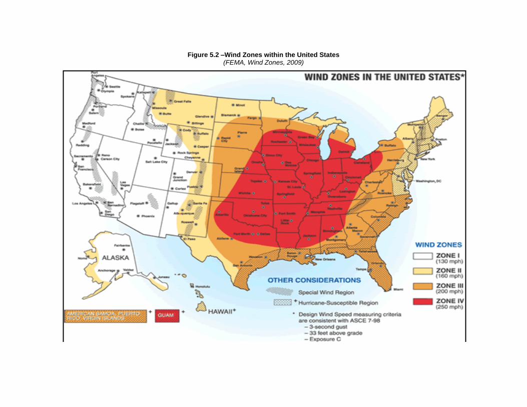
Figure 5.2 –Wind Zones within the United States (FEMA, Wind Zones, 2009)
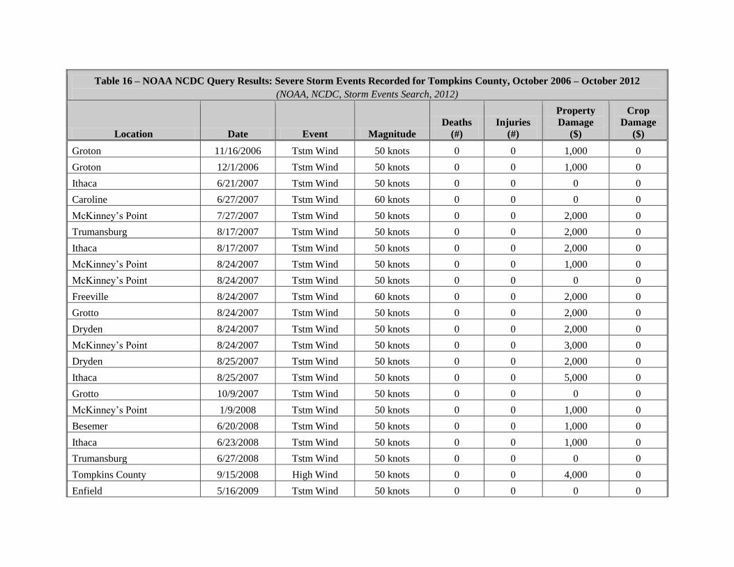
Table 16 – NOAA NCDC Query Results: Severe Storm Events Recorded for Tompkins County, October 2006 – October 2012
(NOAA, NCDC, Storm Events Search, 2012)
Location Date Event Magnitude
Deaths
(#)
Injuries
(#)
Property
Damage
($)
Crop
Damage
($)
Groton 11/16/2006 Tstm Wind 50 knots 0 0 1,000 0
Groton 12/1/2006 Tstm Wind 50 knots 0 0 1,000 0
Ithaca 6/21/2007 Tstm Wind 50 knots 0 0 0 0
Caroline 6/27/2007 Tstm Wind 60 knots 0 0 0 0
McKinney’s Point 7/27/2007 Tstm Wind 50 knots 0 0 2,000 0
Trumansburg 8/17/2007 Tstm Wind 50 knots 0 0 2,000 0
Ithaca 8/17/2007 Tstm Wind 50 knots 0 0 2,000 0
McKinney’s Point 8/24/2007 Tstm Wind 50 knots 0 0 1,000 0
McKinney’s Point 8/24/2007 Tstm Wind 50 knots 0 0 0 0
Freeville 8/24/2007 Tstm Wind 60 knots 0 0 2,000 0
Grotto 8/24/2007 Tstm Wind 50 knots 0 0 2,000 0
Dryden 8/24/2007 Tstm Wind 50 knots 0 0 2,000 0
McKinney’s Point 8/24/2007 Tstm Wind 50 knots 0 0 3,000 0
Dryden 8/25/2007 Tstm Wind 50 knots 0 0 2,000 0
Ithaca 8/25/2007 Tstm Wind 50 knots 0 0 5,000 0
Grotto 10/9/2007 Tstm Wind 50 knots 0 0 0 0
McKinney’s Point 1/9/2008 Tstm Wind 50 knots 0 0 1,000 0
Besemer 6/20/2008 Tstm Wind 50 knots 0 0 1,000 0
Ithaca 6/23/2008 Tstm Wind 50 knots 0 0 1,000 0
Trumansburg 6/27/2008 Tstm Wind 50 knots 0 0 0 0
Tompkins County 9/15/2008 High Wind 50 knots 0 0 4,000 0
Enfield 5/16/2009 Tstm Wind 50 knots 0 0 0 0
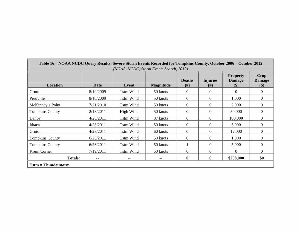
Table 16 – NOAA NCDC Query Results: Severe Storm Events Recorded for Tompkins County, October 2006 – October 2012
(NOAA, NCDC, Storm Events Search, 2012)
Location Date Event Magnitude
Deaths
(#)
Injuries
(#)
Property
Damage
($)
Crop
Damage
($)
Grotto 8/10/2009 Tstm Wind 50 knots 0 0 0 0
Peruville 8/10/2009 Tstm Wind 50 knots 0 0 1,000 0
McKinney’s Point 7/21/2010 Tstm Wind 50 knots 0 0 2,000 0
Tompkins County 2/18/2011 High Wind 50 knots 0 0 50,000 0
Danby 4/28/2011 Tstm Wind 87 knots 0 0 100,000 0
Ithaca 4/28/2011 Tstm Wind 50 knots 0 0 5,000 0
Groton 4/28/2011 Tstm Wind 60 knots 0 0 12,000 0
Tompkins County 6/23/2011 Tstm Wind 50 knots 0 0 1,000 0
Tompkins County 6/28/2011 Tstm Wind 50 knots 1 0 5,000 0
Krum Corner 7/19/2011 Tstm Wind 50 knots 0 0 0 0
Totals: -- -- -- 0 0 $208,000 $0
Tstm = Thunderstorm

Figure 5.5 – Agricultural Properties that Intersect Flood Zones
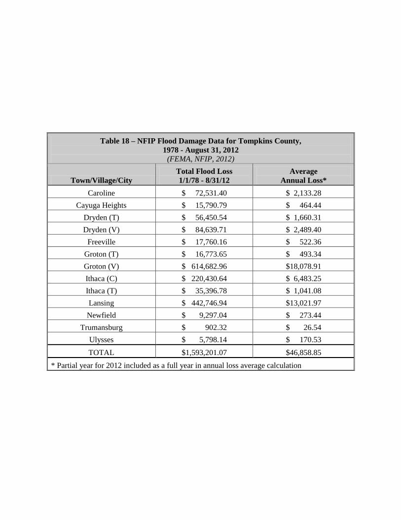
Table 18 – NFIP Flood Damage Data for Tompkins County,
1978 - August 31, 2012
(FEMA, NFIP, 2012)
Town/Village/City
Total Flood Loss
1/1/78 - 8/31/12
Average
Annual Loss*
Caroline $ 72,531.40 $ 2,133.28
Cayuga Heights $ 15,790.79 $ 464.44
Dryden (T) $ 56,450.54 $ 1,660.31
Dryden (V) $ 84,639.71 $ 2,489.40
Freeville $ 17,760.16 $ 522.36
Groton (T) $ 16,773.65 $ 493.34
Groton (V) $ 614,682.96 $18,078.91
Ithaca (C) $ 220,430.64 $ 6,483.25
Ithaca (T) $ 35,396.78 $ 1,041.08
Lansing $ 442,746.94 $13,021.97
Newfield $ 9,297.04 $ 273.44
Trumansburg $ 902.32 $ 26.54
Ulysses $ 5,798.14 $ 170.53
TOTAL $1,593,201.07 $46,858.85
* Partial year for 2012 included as a full year in annual loss average calculation
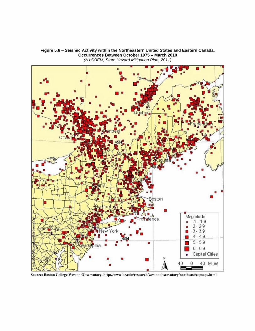
Figure 5.6 – Seismic Activity within the Northeastern United States and Eastern Canada, Occurrences Between October 1975 – March 2010
(NYSOEM, State Hazard Mitigation Plan, 2011)
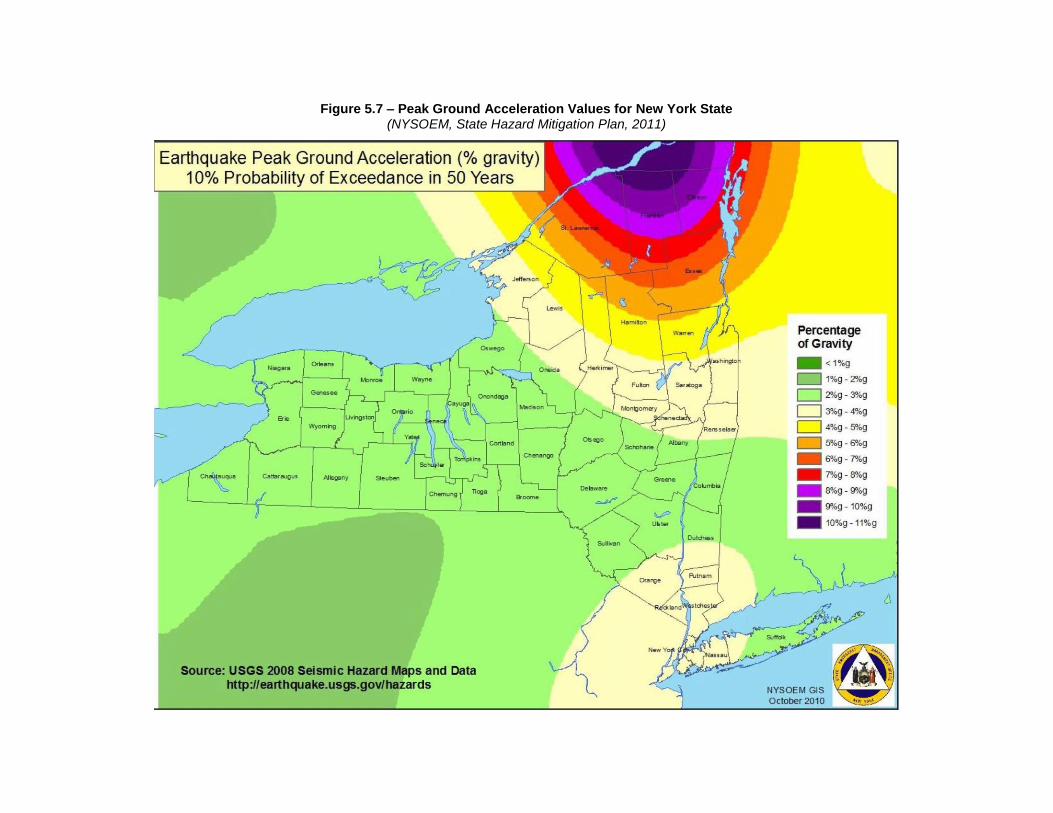
Figure 5.7 – Peak Ground Acceleration Values for New York State (NYSOEM, State Hazard Mitigation Plan, 2011)

Table 20 – NOAA NCDC Query Results: Severe Winter Storm Events Recorded for Tompkins County, October 2006 – October 2012
(NOAA, NCDC, Storm Events Search, 2012)
Location Date Event Magnitude
Deaths
(#)
Injuries
(#)
Property
Damage
($)
Crop
Damage
($)
County-wide 02/13/2007 Winter Storm N/A 0 0 0 0
County-wide 03/17/2007 Lake-Effect Snow N/A 0 0 0 0
County-wide 04/15/2007 Winter Storm N/A 0 0 0 0
County-wide 12/13/2007 Heavy Snow N/A 0 0 0 0
County-wide 02/26/2008 Winter Storm N/A 0 0 0 0
County-wide 12/11/2008 Winter Storm N/A 0 0 0 0
County-wide 12/19/2008 Winter Storm N/A 0 0 0 0
County-wide 02/25/2010 Winter Storm N/A 0 0 0 0
County-wide 02/25/2011 Winter Storm N/A 0 0 0 0
County-wide 03/06/2011 Heavy Snow N/A 0 0 0 0
County-wide 01/13/2012 Heavy Snow N/A 0 0 0 0
Totals: -- -- -- 0 0 $0 $0
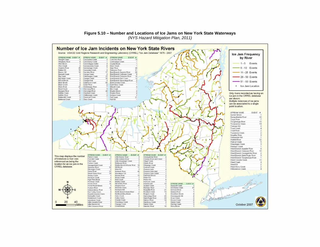
Figure 5.10 – Number and Locations of Ice Jams on New York State Waterways (NYS Hazard Mitigation Plan, 2011)
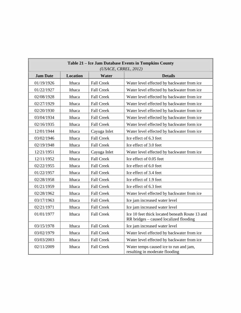
Table 21 – Ice Jam Database Events in Tompkins County
(USACE, CRREL, 2012)
Jam Date Location Water Details
01/19/1926 Ithaca Fall Creek Water level effected by backwater from ice
01/22/1927 Ithaca Fall Creek Water level effected by backwater from ice
02/08/1928 Ithaca Fall Creek Water level effected by backwater from ice
02/27/1929 Ithaca Fall Creek Water level effected by backwater from ice
02/20/1930 Ithaca Fall Creek Water level effected by backwater from ice
03/04/1934 Ithaca Fall Creek Water level effected by backwater from ice
02/16/1935 Ithaca Fall Creek Water level effected by backwater form ice
12/01/1944 Ithaca Cayuga Inlet Water level effected by backwater from ice
03/02/1946 Ithaca Fall Creek Ice effect of 6.3 feet
02/19/1948 Ithaca Fall Creek Ice effect of 3.0 feet
12/21/1951 Ithaca Cayuga Inlet Water level effected by backwater from ice
12/11/1952 Ithaca Fall Creek Ice effect of 0.05 feet
02/22/1955 Ithaca Fall Creek Ice effect of 6.0 feet
01/22/1957 Ithaca Fall Creek Ice effect of 3.4 feet
02/28/1958 Ithaca Fall Creek Ice effect of 1.9 feet
01/21/1959 Ithaca Fall Creek Ice effect of 6.3 feet
02/28/1962 Ithaca Fall Creek Water level effected by backwater from ice
03/17/1963 Ithaca Fall Creek Ice jam increased water level
02/21/1971 Ithaca Fall Creek Ice jam increased water level
01/01/1977 Ithaca Fall Creek Ice 10 feet thick located beneath Route 13 and
RR bridges – caused localized flooding
03/15/1978 Ithaca Fall Creek Ice jam increased water level
03/02/1979 Ithaca Fall Creek Water level effected by backwater from ice
03/03/2003 Ithaca Fall Creek Water level effected by backwater from ice
02/11/2009 Ithaca Fall Creek Water temps caused ice to run and jam,
resulting in moderate flooding
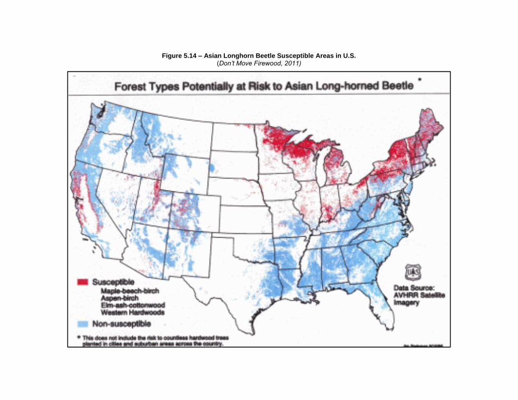
Figure 5.14 – Asian Longhorn Beetle Susceptible Areas in U.S. (Don’t Move Firewood, 2011)
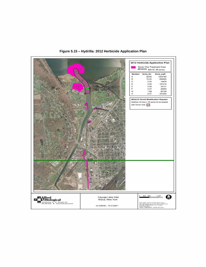
Figure 5.15 – Hydrilla: 2012 Herbicide Application Plan

Table 22 – Enhanced F-Scale System Used to Rate Magnitude of Tornado Events
(NOAA, Storm Prediction Center, Enhanced F-Scale)
Fujita Scale Derived EF Scale Operational EF Scale
F Number
Fastest ¼-mile
(mph)
3 Second Gust
(mph) EF Number
3 Second Gust
(mph) EF Number
3 Second Gust
(mph)
0 40-72 45-78 0 65-85 0 65-85
1 73-112 79-117 1 86-109 1 86-110
2 113-157 118-161 2 110-137 2 111-135
3 158-207 162-209 3 138-167 3 136-165
4 208-260 210-261 4 168-199 4 166-200
5 261-318 262-317 5 200-234 5 Over 200
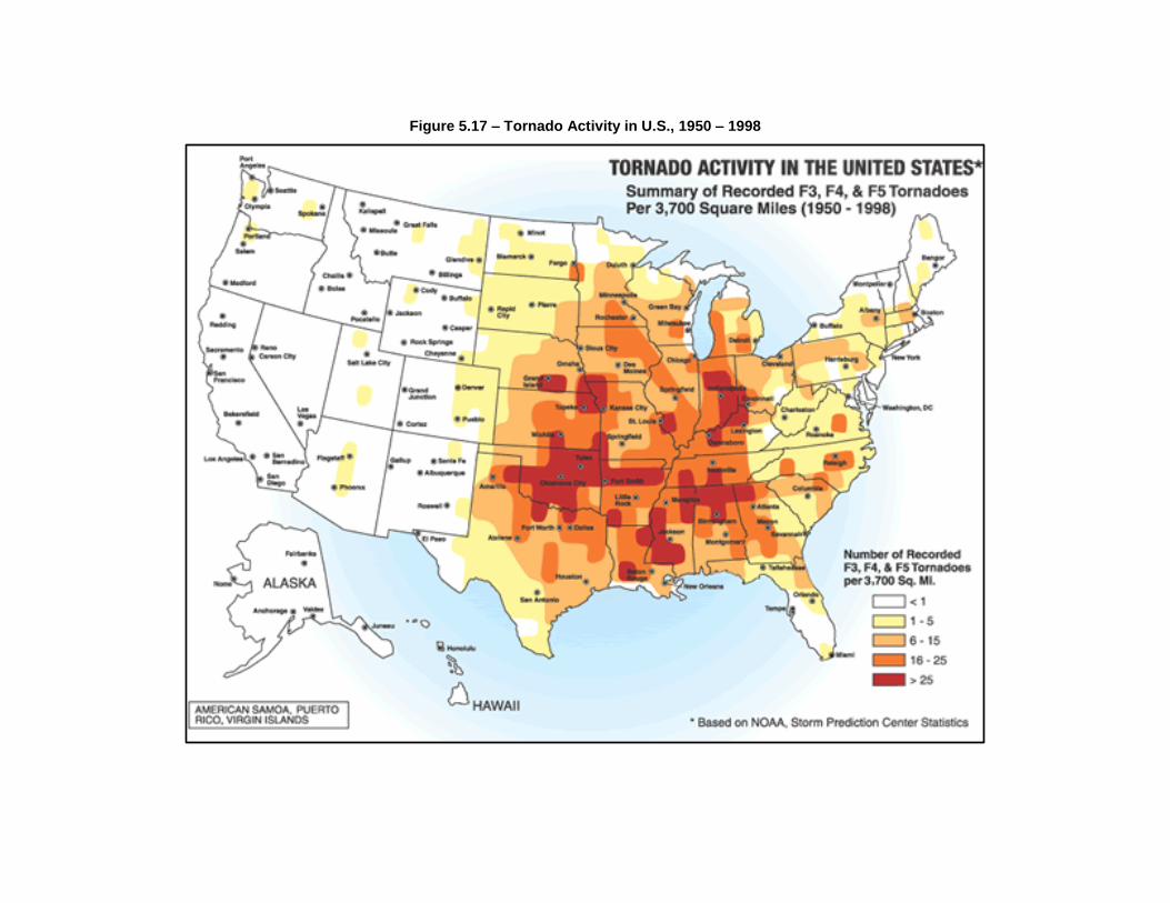
Figure 5.17 – Tornado Activity in U.S., 1950 – 1998
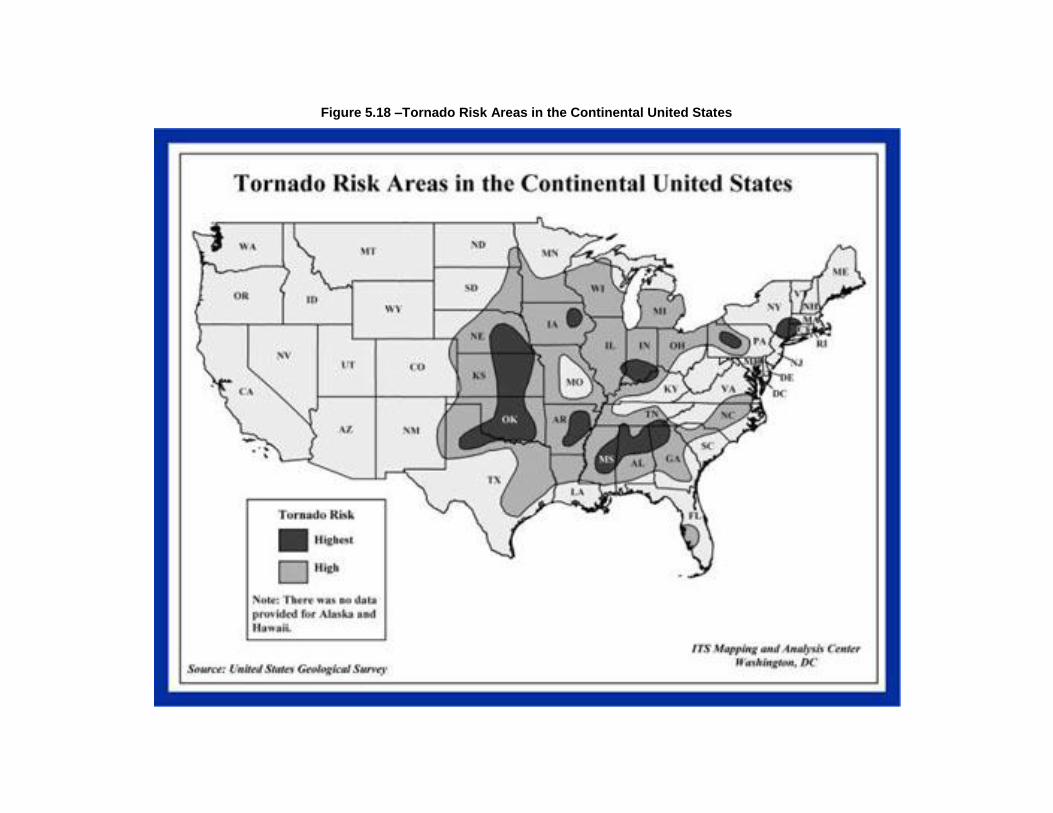
Figure 5.18 –Tornado Risk Areas in the Continental United States

Table 27 – Estimated Property Values of Lands within Tompkins County (TC Office of Real Property, 2012)
Jurisdiction # of Properties
Full Market Assessed Value
($)
Caroline (Town) 1968 249,429,396
Cayuga Heights (Village) 989 452,038,518
Danby (Town) 2016 268,870,442
Dryden (Town) 4799 891,283,394
Dryden (Village) 795 128,119,790
Enfield (Town) 1662 188,971,300
Freeville (village) 233 35,494,500
Groton (Town) 1871 209,018,898
Groton (Village) 908 122,905,410
Ithaca (Town) 4293 2,017,893,667
Ithaca (City) 5555 17,701,001,320
Lansing (Town) 3776 1,083,359,160
Lansing (Village) 1056 532,085,231
Newfield (Town) 2327 289,695,259
Trumansburg (Village) 710 137,661,412
Ulysses (Town) 1928 373,088,800
Table 29
Status and Details of 2006 HMP Mitigation Plan
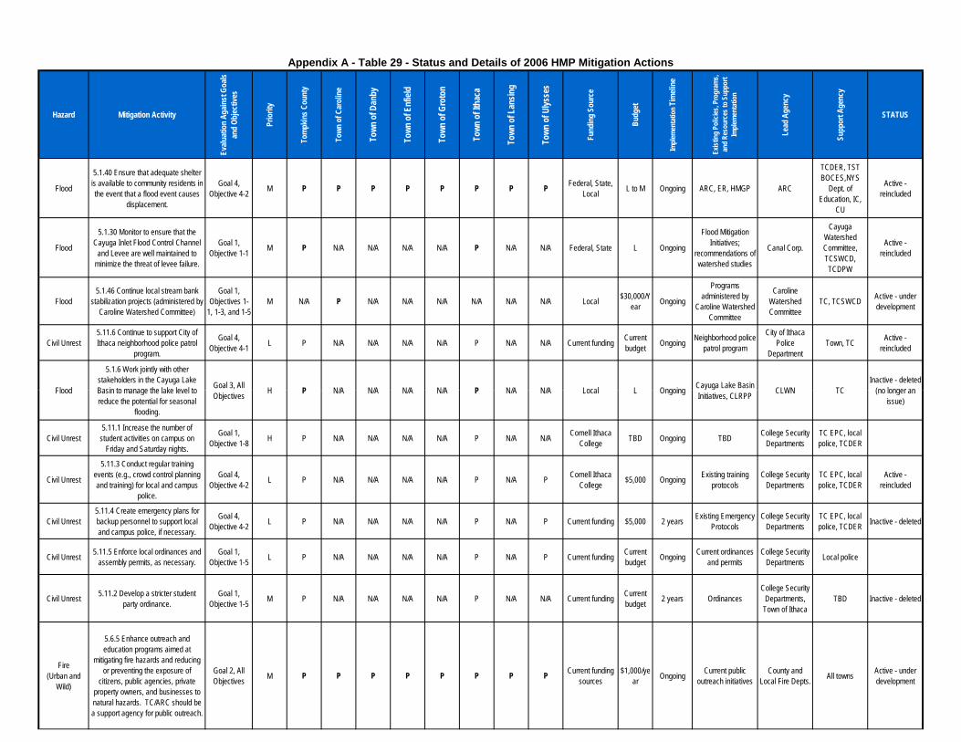
Hazard Mitigation Activity
Evalu
atio
n Ag
ainst
Goa
ls an
d Ob
jectiv
es
Prio
rity
Tom
pkin
s Cou
nty
Town
of C
arol
ine
Town
of D
anby
Town
of E
nfiel
d
Town
of G
roto
n
Town
of I
thac
a
Town
of L
ansin
g
Town
of U
lysse
s
Fund
ing
Sour
ce
Budg
et
Imple
men
tatio
n Tim
eline
Exist
ing
Polic
ies, P
rogr
ams,
and
Reso
urce
s to
Supp
ort
Imple
men
tatio
n
Lead
Age
ncy
Supp
ort A
genc
y
STATUS
Flood
5.1.40 Ensure that adequate shelter is available to community residents in the event that a flood event causes
displacement.
Goal 4, Objective 4-2 M P P P P P P P P Federal, State,
Local L to M Ongoing ARC, ER, HMGP ARC
TCDER, TST BOCES,NYS
Dept. of Education, IC,
CU
Active - reincluded
Flood
5.1.30 Monitor to ensure that the Cayuga Inlet Flood Control Channel
and Levee are well maintained to minimize the threat of levee failure.
Goal 1, Objective 1-1 M P N/A N/A N/A N/A P N/A N/A Federal, State L Ongoing
Flood Mitigation Initiatives;
recommendations of watershed studies
Canal Corp.
Cayuga Watershed Committee, TCSWCD, TCDPW
Active - reincluded
Flood5.1.46 Continue local stream bank
stabilization projects (administered by Caroline Watershed Committee)
Goal 1, Objectives 1-
1, 1-3, and 1-5M N/A P N/A N/A N/A N/A N/A N/A Local $30,000/Y
ear Ongoing
Programs administered by
Caroline Watershed Committee
Caroline Watershed Committee
TC, TCSWCD Active - under development
Civil Unrest5.11.6 Continue to support City of Ithaca neighborhood police patrol
program.
Goal 4, Objective 4-1 L P N/A N/A N/A N/A P N/A N/A Current funding Current
budget Ongoing Neighborhood police patrol program
City of Ithaca Police
DepartmentTown, TC Active -
reincluded
Flood
5.1.6 Work jointly with other stakeholders in the Cayuga Lake Basin to manage the lake level to Goal 3, All H P N/A N/A N/A N/A P N/A N/A Local L Ongoing Cayuga Lake Basin CLWN TC
Inactive - deleted (no longer an
Appendix A - Table 29 - Status and Details of 2006 HMP Mitigation Actions
Flood Basin to manage the lake level to reduce the potential for seasonal
flooding.
Goal 3, All Objectives H P N/A N/A N/A N/A P N/A N/A Local L Ongoing Cayuga Lake Basin
Initiatives, CLRPP CLWN TC (no longer an issue)
Civil Unrest5.11.1 Increase the number of
student activities on campus on Friday and Saturday nights.
Goal 1, Objective 1-8 H P N/A N/A N/A N/A P N/A N/A Cornell Ithaca
College TBD Ongoing TBD College Security Departments
TC EPC, local police, TCDER
Civil Unrest
5.11.3 Conduct regular training events (e.g., crowd control planning and training) for local and campus
police.
Goal 4, Objective 4-2 L P N/A N/A N/A N/A P N/A P Cornell Ithaca
College $5,000 Ongoing Existing training protocols
College Security Departments
TC EPC, local police, TCDER
Active - reincluded
Civil Unrest5.11.4 Create emergency plans for backup personnel to support local and campus police, if necessary.
Goal 4, Objective 4-2 L P N/A N/A N/A N/A P N/A P Current funding $5,000 2 years Existing Emergency
ProtocolsCollege Security
DepartmentsTC EPC, local police, TCDER Inactive - deleted
Civil Unrest 5.11.5 Enforce local ordinances and assembly permits, as necessary.
Goal 1, Objective 1-5 L P N/A N/A N/A N/A P N/A P Current funding Current
budget Ongoing Current ordinances and permits
College Security Departments Local police
Civil Unrest 5.11.2 Develop a stricter student party ordinance.
Goal 1, Objective 1-5 M P N/A N/A N/A N/A P N/A N/A Current funding Current
budget 2 years OrdinancesCollege Security
Departments, Town of Ithaca
TBD Inactive - deleted
Fire (Urban and
Wild)
5.6.5 Enhance outreach and education programs aimed at
mitigating fire hazards and reducing or preventing the exposure of
citizens, public agencies, private property owners, and businesses to natural hazards. TC/ARC should be a support agency for public outreach.
Goal 2, All Objectives M P P P P P P P P Current funding
sources$1,000/ye
ar Ongoing Current public outreach initiatives
County and Local Fire Depts. All towns Active - under
development
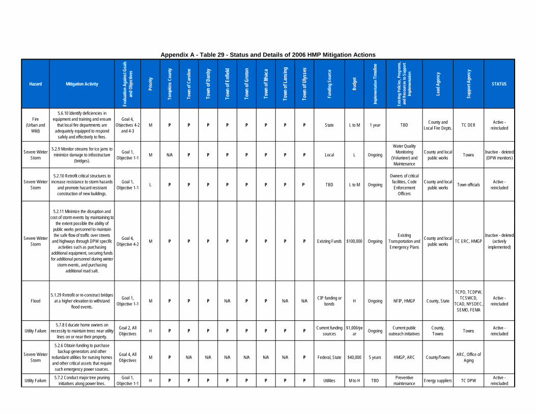
Hazard Mitigation Activity
Evalu
atio
n Ag
ainst
Goa
ls an
d Ob
jectiv
es
Prio
rity
Tom
pkin
s Cou
nty
Town
of C
arol
ine
Town
of D
anby
Town
of E
nfiel
d
Town
of G
roto
n
Town
of I
thac
a
Town
of L
ansin
g
Town
of U
lysse
s
Fund
ing
Sour
ce
Budg
et
Imple
men
tatio
n Tim
eline
Exist
ing
Polic
ies, P
rogr
ams,
and
Reso
urce
s to
Supp
ort
Imple
men
tatio
n
Lead
Age
ncy
Supp
ort A
genc
y
STATUS
Appendix A - Table 29 - Status and Details of 2006 HMP Mitigation Actions
Fire (Urban and
Wild)
5.6.10 Identify deficiencies in equipment and training and ensure
that local fire departments are adequately equipped to respond
safely and effectively to fires.
Goal 4, Objectives 4-2
and 4-3M P P P P P P P P State L to M 1 year TBD County and
Local Fire Depts. TC DER Active - reincluded
Severe Winter Storm
5.2.9 Monitor streams for ice jams to minimize damage to infrastructure
(bridges).
Goal 1, Objective 1-1 M N/A P P P P P P P Local L Ongoing
Water Quality Monitoring
(Volunteer) and Maintenance
County and local public works Towns Inactive - deleted
(DPW monitors)
Severe Winter Storm
5.2.10 Retrofit critical structures to increase resistance to storm hazards
and promote hazard resistant construction of new buildings.
Goal 1, Objective 1-1 L P P P P P P P TBD L to M Ongoing
Owners of critical facilities, Code Enforcement
Officers
County and local public works Town officials Active -
reincluded
5.2.11 Minimize the disruption and cost of storm events by maintaining to
Severe Winter Storm
cost of storm events by maintaining to the extent possible the ability of
public works personnel to maintain the safe flow of traffic over streets
and highways through DPW specific activities such as purchasing
additional equipment, securing funds for additional personnel during winter
storm events, and purchasing additional road salt.
Goal 4, Objective 4-2 M P P P P P P P P Existing Funds $100,000 Ongoing
Existing Transportation and Emergency Plans
County and local public works TC ERC, HMGP
Inactive - deleted (actively
implemented)
Flood5.1.29 Retrofit or re-construct bridges
at a higher elevation to withstand flood events.
Goal 1, Objective 1-1 M P P P N/A P P N/A N/A CIP funding or
bonds H Ongoing NFIP, HMGP County, State
TCPD, TCDPW, TCSWCD,
TCAD, NYSDEC, SEMO, FEMA
Active - reincluded
Utility Failure5.7.8 Educate home owners on
necessity to maintain trees near utility lines on or near their property.
Goal 2, All Objectives H P P P P P P P P Current funding
sources$1,000/ye
ar Ongoing Current public outreach initiatives
County,Towns Towns Active -
reincluded
Severe Winter Storm
5.2.6 Obtain funding to purchase backup generators and other
redundant utilities for nursing homes and other critical assets that require
such emergency power sources.
Goal 4, All Objectives M P N/A N/A N/A N/A N/A N/A P Federal, State $40,000 5 years HMGP, ARC County/Towns ARC, Office of
Aging
Utility Failure 5.7.2 Conduct major tree pruning initiatives along power lines.
Goal 1, Objective 1-1 H P P P P P P P P Utilities M to H TBD Preventive
maintenance Energy suppliers TC DPW Active - reincluded
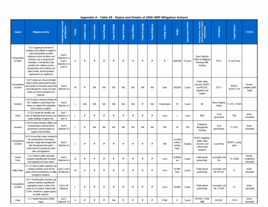
Hazard Mitigation Activity
Evalu
atio
n Ag
ainst
Goa
ls an
d Ob
jectiv
es
Prio
rity
Tom
pkin
s Cou
nty
Town
of C
arol
ine
Town
of D
anby
Town
of E
nfiel
d
Town
of G
roto
n
Town
of I
thac
a
Town
of L
ansin
g
Town
of U
lysse
s
Fund
ing
Sour
ce
Budg
et
Imple
men
tatio
n Tim
eline
Exist
ing
Polic
ies, P
rogr
ams,
and
Reso
urce
s to
Supp
ort
Imple
men
tatio
n
Lead
Age
ncy
Supp
ort A
genc
y
STATUS
Appendix A - Table 29 - Status and Details of 2006 HMP Mitigation Actions
TransportationAccident
5.8.1 Support procurement of hardware and software to support a
state transportation accident database to track accidents and estimate costs to respond and remediate. (Currently the State provides free software to track
transportation and accidents and detect trends, but the hardware requirements are significant).
Goal 2, Objective 2-3;
Goal 4, Objectives 4-3
and 4-4
H P P P P P P P P P $400,000 4-5 years
Data Collection Efforts for Mitigation
Planning; DMV tracking
ITCTC TC and Towns
TransportationAccident
5.8.9 Conduct an enhanced freight study to better understand the types
and volumes of hazardous waste that travel through the County and what routes are used to transport such
materials.
Goal 4, Objective 4-4 M P N/A N/A N/A N/A N/A N/A N/A State $50,000 2 years
Public safety concerns; NYDOT
and NYSDEC regulation and
support
ITCTC NYDOT, USDOT, EPA
Inactive - complete (2002
study)
Terrorism
5.10.9 Acquire a training simulator for the Tompkins County Airport that
mimics an airplane fire (originating from a wheel or engine).
Goal 4, Objective 4-3 L N/A N/A N/A N/A N/A N/A P N/A Federal grant M 5 years NA Ithaca Regional
Airport TC EPC, TCDER
from a wheel or engine).
Flood5.1.55 Evaluate the benefits and
costs of obtaining flood insurance for public buildings at highest risk.
Goal 1, Objectives 1-2
and 1-3L P P P P P P P P Local L 1 year NFIP Local
government TBD Active - reincluded
Terrorism
5.10.8 Provide redundant utilities and communications (internet link for government communications) to
support critical facilities.
Goal 4, Objective 4-3 L P N/A N/A N/A N/A N/A N/A N/A TBD M TBD
Emergency Management
Planning
local governments TC DITS Active -
reincluded
TransportationAccident
5.8.13 Ensure that carriers involved in the transportation of hazardous
materials comply with all applicable laws through proactive police
enforcement of commercial carrier rules and regulations.
Goal 4, Objective 4-2 L P P P P P P P P TBD
L to M (to enforce existing laws)
Ongoing
NYDOT regulation, public safety
concerns, local enforcement
programs
Local Police NYDOT, County police
Severe Storm
5.3.2 Enhance public education programs regarding both incoming and outgoing evacuation routes.
Goal 4, Objective 4-4 M P P P P P P P P Local $2,000/to
wn 2 years Public-private partnerships;
Local police and fire TC, SEMO
Inactive - combined & reincluded
Utility Failure
5.7.12 Enhance public awareness by creating a training course for the
public and local jurisdictions on utility emergency situations.
Goals 2 and 3, All Objectives M P P P P P P P P Local $2,000/
town 2 years Public-private partnerships
Local police and fire, NYSEG TC Active -
reincluded
TransportationAccident
5.8.11 Provide public education and outreach materials regarding the appropriate actions to take in the
event of a hazardous material spill. TC/ARC should be a support agency
for public outreach.
Goal 2, All Objectives L P P P P P P P P Local $2,000/ 2 years Public-private
partnershipsLocal police and
fire, TCDOH TC Active - reincluded
Flood 5.1.7 Update flood plain (FIRM) maps.
Goal 1, Objective 1-4 H P P P N/A P P P P FEMA H 5 years NYSDEC, FEMA
MMI NYSDEC TCPD Active - reincluded

Hazard Mitigation Activity
Evalu
atio
n Ag
ainst
Goa
ls an
d Ob
jectiv
es
Prio
rity
Tom
pkin
s Cou
nty
Town
of C
arol
ine
Town
of D
anby
Town
of E
nfiel
d
Town
of G
roto
n
Town
of I
thac
a
Town
of L
ansin
g
Town
of U
lysse
s
Fund
ing
Sour
ce
Budg
et
Imple
men
tatio
n Tim
eline
Exist
ing
Polic
ies, P
rogr
ams,
and
Reso
urce
s to
Supp
ort
Imple
men
tatio
n
Lead
Age
ncy
Supp
ort A
genc
y
STATUS
Appendix A - Table 29 - Status and Details of 2006 HMP Mitigation Actions
Flood
5.1.33 Develop flood insurance maps for Virgil Creek flood control project and downstream areas (See also
5.1.7).
Goal 1, Objective 1-4 M P N/A N/A N/A N/A N/A N/A N/A FEMA, State M to H 2 years NFIP, FEMA,
NYSDEC NYSDEC TCPD Inactive - deleted
Severe Winter Storm
5.2.2 Develop a buddy network of concerned citizens that will check in
on elderly, handicapped, low-income, or non-English speaking citizens during major or extended events.
Goal 2, All Objectives
and Goal 3, Objective 3-2
H P P P P P P P P Grants, revenues L OngoingOffice of Aging, ARC, Existing
church programsOffice of Aging ARC Active -
reincluded
SevereStorm
5.3.8 Retrofit critical facilities with wind resistant designs and
construction.
Goal 1, Objective 1-1 L P P P P P P P P Federal State
Local M 5 years HMGP Owners of critical facilities TC, SEMO Active -
reincluded
Fire (Urban and
Wild)
5.6.8 Retrofit existing critical facilities to bring them up to fire code, if they
are not already.
Goal 1, Objective 1-1 M P P P P P P P P TBD M Ongoing Code, enforcement,
and zoning Owners of critical
infrastructure TBD Inactive - deleted
Terrorism5.10.1 Enhance pre-emptive security
around critical facilities and Goal 1, H P P P P P P P P Federal, state, L to H Ongoing Current anti- Owners of facilities and TC EPC, TCDER Active - Terrorism around critical facilities and
infrastructure.
Goal 1, Objective 1-1 H P P P P P P P P Federal, state,
local L to H Ongoing Current anti-terrorism initiatives facilities and
infrastructureTC EPC, TCDER Active -
reincluded
Fire (Urban and
Wild)
5.6.7 Ensure that structures (especially places of public assembly) are maintained and comply with any
and all applicable fire and safety codes.
Goal 1, Objective 1-5 M P P P P P P P P TBD L Ongoing Code, enforcement
and zoning Owners of structures TBD Active -
reincluded
TransportationAccident
5.8.6 Improve reporting of minor accidents and engineering
investigations of collisions to determine patterns to improve
signals, traffic markings, and identify educational efforts needed to reduce
accidents.
Goal 1, Objective 1-1 M P P P P P P P P See 5.8.1 See 5.8.1 See 5.8.1 See 5.8.1 See 5.8.1 See 5.8.1 Inactive - deleted
TransportationAccident
5.8.5 Ensure rapid and coordinated response by emergency responders in the event of a hazardous materials spill event by enhancing the Chain of Command for Emergency Response Flow Chart and identifying notification
requirements.
Goal 4, Objective 4-2 M P P P P P P P P See Section
5.4.4
See Section
5.4.4
See Section 5.4.4 See Section 5.4.4 See Section
5.4.4See Section
5.4.4Active -
reincluded
Severe Storm
5.3.1 Develop and implement programs to keep trees from
threatening lives, property, and public infrastructure during storm events.
Goal 3, Objective 3-
1Goal 4, Objective 4-2
M P P P P P P P P See Table 5-4-1-2
See Table 5-4-1-2
See Table 5-4-1-2 See Table 5-4-1-2 See Table 5-4-1-
2See Table 5-4-1-
2
Inactive - combined & reincluded
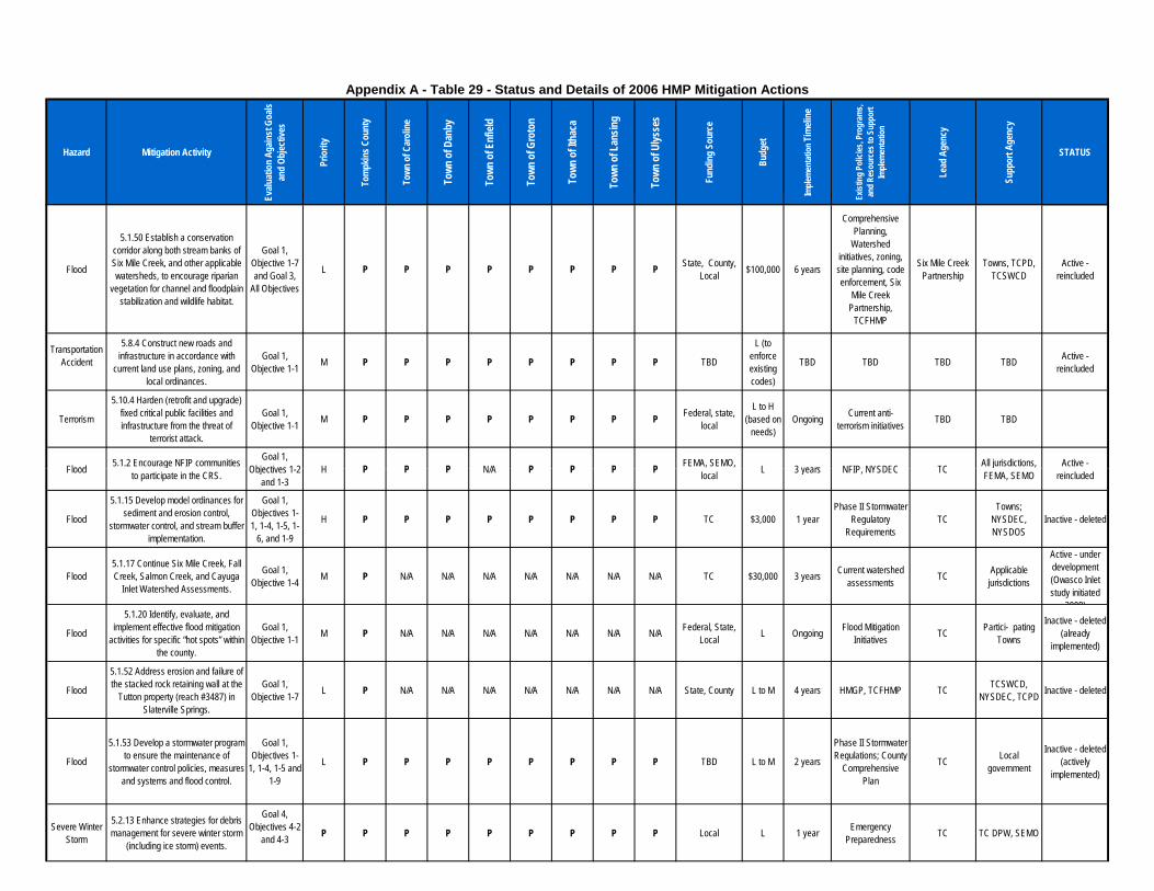
Hazard Mitigation Activity
Evalu
atio
n Ag
ainst
Goa
ls an
d Ob
jectiv
es
Prio
rity
Tom
pkin
s Cou
nty
Town
of C
arol
ine
Town
of D
anby
Town
of E
nfiel
d
Town
of G
roto
n
Town
of I
thac
a
Town
of L
ansin
g
Town
of U
lysse
s
Fund
ing
Sour
ce
Budg
et
Imple
men
tatio
n Tim
eline
Exist
ing
Polic
ies, P
rogr
ams,
and
Reso
urce
s to
Supp
ort
Imple
men
tatio
n
Lead
Age
ncy
Supp
ort A
genc
y
STATUS
Appendix A - Table 29 - Status and Details of 2006 HMP Mitigation Actions
Flood
5.1.50 Establish a conservation corridor along both stream banks of Six Mile Creek, and other applicable watersheds, to encourage riparian
vegetation for channel and floodplain stabilization and wildlife habitat.
Goal 1, Objective 1-7 and Goal 3,
All Objectives
L P P P P P P P P State, County, Local $100,000 6 years
Comprehensive Planning,
Watershed initiatives, zoning, site planning, code enforcement, Six
Mile Creek Partnership,
TCFHMP
Six Mile Creek Partnership
Towns, TCPD, TCSWCD
Active - reincluded
TransportationAccident
5.8.4 Construct new roads and infrastructure in accordance with
current land use plans, zoning, and local ordinances.
Goal 1, Objective 1-1 M P P P P P P P P TBD
L (to enforce existing codes)
TBD TBD TBD TBD Active - reincluded
Terrorism
5.10.4 Harden (retrofit and upgrade) fixed critical public facilities and infrastructure from the threat of
terrorist attack.
Goal 1, Objective 1-1 M P P P P P P P P Federal, state,
local
L to H (based on
needs)Ongoing Current anti-
terrorism initiatives TBD TBD
Flood 5.1.2 Encourage NFIP communities Goal 1, Objectives 1-2 H P P P N/A P P P P FEMA, SEMO, L 3 years NFIP, NYSDEC TC All jurisdictions, Active - Flood 5.1.2 Encourage NFIP communities
to participate in the CRS. Objectives 1-2 and 1-3
H P P P N/A P P P P FEMA, SEMO, local L 3 years NFIP, NYSDEC TC All jurisdictions,
FEMA, SEMOActive -
reincluded
Flood
5.1.15 Develop model ordinances for sediment and erosion control,
stormwater control, and stream buffer implementation.
Goal 1, Objectives 1-1, 1-4, 1-5, 1-
6, and 1-9
H P P P P P P P P TC $3,000 1 yearPhase II Stormwater
Regulatory Requirements
TCTowns;
NYSDEC, NYSDOS
Inactive - deleted
Flood5.1.17 Continue Six Mile Creek, Fall Creek, Salmon Creek, and Cayuga
Inlet Watershed Assessments.
Goal 1, Objective 1-4 M P N/A N/A N/A N/A N/A N/A N/A TC $30,000 3 years Current watershed
assessments TC Applicable jurisdictions
Active - under development (Owasco Inlet study initiated
2008)
Flood
5.1.20 Identify, evaluate, and implement effective flood mitigation
activities for specific “hot spots” within the county.
Goal 1, Objective 1-1 M P N/A N/A N/A N/A N/A N/A N/A Federal, State,
Local L Ongoing Flood Mitigation Initiatives TC Partici- pating
Towns
Inactive - deleted (already
implemented)
Flood
5.1.52 Address erosion and failure of the stacked rock retaining wall at the
Tutton property (reach #3487) in Slaterville Springs.
Goal 1, Objective 1-7 L P N/A N/A N/A N/A N/A N/A N/A State, County L to M 4 years HMGP, TCFHMP TC TCSWCD,
NYSDEC, TCPD Inactive - deleted
Flood
5.1.53 Develop a stormwater program to ensure the maintenance of
stormwater control policies, measures and systems and flood control.
Goal 1, Objectives 1-
1, 1-4, 1-5 and 1-9
L P P P P P P P P TBD L to M 2 years
Phase II Stormwater Regulations; County
Comprehensive Plan
TC Local government
Inactive - deleted (actively
implemented)
Severe Winter Storm
5.2.13 Enhance strategies for debris management for severe winter storm
(including ice storm) events.
Goal 4, Objectives 4-2
and 4-3 P P P P P P P P P Local L 1 year Emergency Preparedness TC TC DPW, SEMO

Hazard Mitigation Activity
Evalu
atio
n Ag
ainst
Goa
ls an
d Ob
jectiv
es
Prio
rity
Tom
pkin
s Cou
nty
Town
of C
arol
ine
Town
of D
anby
Town
of E
nfiel
d
Town
of G
roto
n
Town
of I
thac
a
Town
of L
ansin
g
Town
of U
lysse
s
Fund
ing
Sour
ce
Budg
et
Imple
men
tatio
n Tim
eline
Exist
ing
Polic
ies, P
rogr
ams,
and
Reso
urce
s to
Supp
ort
Imple
men
tatio
n
Lead
Age
ncy
Supp
ort A
genc
y
STATUS
Appendix A - Table 29 - Status and Details of 2006 HMP Mitigation Actions
Severe Storm
5.3.6 Encourage development and enforcement of wind-resistant building siting and construction codes. Focus
to be placed on vulnerable residencies first (i.e. mobile homes).
Goal 1, Objective 1-1 L P P N/A N/A P P P P TBD L TBD Building code,
enforcement TC TCPD Active - reincluded
Severe Storm
5.3.7 Enhance strategies for debris management for severe storm events.
Goal 3, Objective 3-1
Goal 4, Objectives 4-2
and 4-3
L P P P P P P P P TBD L 1 year Emergency Preparedness TC TCDPW, SEMO
Inactive - combined & reincluded
Fire (Urban and
Wild)
5.6.4 Encourage development and dissemination of maps relating to the fire hazard to help educate and assist
builders and homeowners in being engaged in fire mitigation activities
and to help guide emergency services during response.
Goal 2, All Objectives M P P P P P P P P State L 2 years
Community Technology Initiatives
TC TCDITS, Towns, TCGIS
Utility Failure
5.7.1 Implement physical mitigation activities (riprap, etc.), as necessary,
to the second, exposed gas pipe crossing the Six Mile Creek,
approximately 2,000 feet downstream of German Cross Road, to protect
against utility failure and water contamination.
Goal 1, Objectives 1-1
and 1-9H P N/A N/A N/A N/A N/A N/A N/A TBD L 5 years
Continued community
infrastructure maintenance
TC Pipeline Group Complete
Utility Failure 5.7.14 Retrofit critical facilities with the latest utility connections.
Goal 1, Objective 1-1 M P P P P P P P P Grants, general
revenues $18,000 1 year TBD TC Owners of critical facilities
Active - reincluded
Utility Failure
5.7.16 In the event of a utility failure, currently all communications need to
go through the City of Ithaca’s emergency communication systems because the County’s system can only support communication for 4 hours following a power failure. Acquire a generator to support
County communication systems as a more sustainable and long-term
solution.
Goal 4, Objective 4-3 M P N/A N/A N/A N/A N/A N/A N/A Federal, State $20,000 1 year TC communications
system TC TC DITS
TransportationAccident
5.8.14 Enhance public safety through awareness, by releasing timely public service announcements via various
media (television, radio) and supplying suggestions for alternate
routes.
Goal 2, All Objectives L P P P P P P P P Current
resourcesCurrent budgets Ongoing Newspapers, Radio,
Television, PSAs TC TCHD Active - reincluded
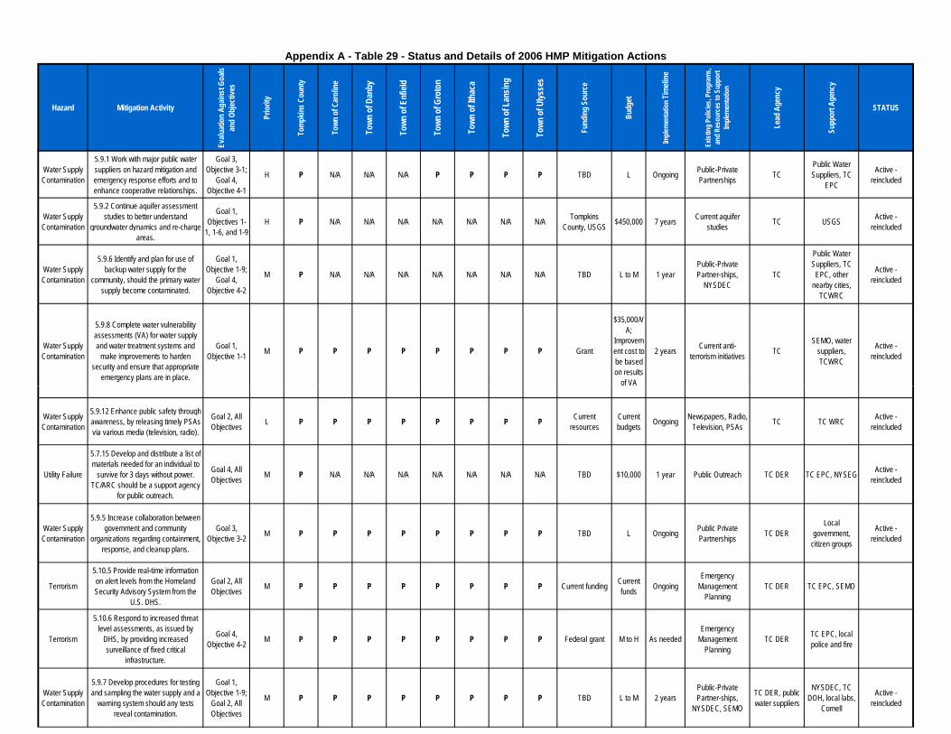
Hazard Mitigation Activity
Evalu
atio
n Ag
ainst
Goa
ls an
d Ob
jectiv
es
Prio
rity
Tom
pkin
s Cou
nty
Town
of C
arol
ine
Town
of D
anby
Town
of E
nfiel
d
Town
of G
roto
n
Town
of I
thac
a
Town
of L
ansin
g
Town
of U
lysse
s
Fund
ing
Sour
ce
Budg
et
Imple
men
tatio
n Tim
eline
Exist
ing
Polic
ies, P
rogr
ams,
and
Reso
urce
s to
Supp
ort
Imple
men
tatio
n
Lead
Age
ncy
Supp
ort A
genc
y
STATUS
Appendix A - Table 29 - Status and Details of 2006 HMP Mitigation Actions
Water Supply Contamination
5.9.1 Work with major public water suppliers on hazard mitigation and emergency response efforts and to enhance cooperative relationships.
Goal 3, Objective 3-1;
Goal 4, Objective 4-1
H P N/A N/A N/A P P P P TBD L Ongoing Public-Private Partnerships TC
Public Water Suppliers, TC
EPC
Active - reincluded
Water Supply Contamination
5.9.2 Continue aquifer assessment studies to better understand
groundwater dynamics and re-charge areas.
Goal 1, Objectives 1-
1, 1-6, and 1-9H P N/A N/A N/A N/A N/A N/A N/A Tompkins
County, USGS $450,000 7 years Current aquifer studies TC USGS Active -
reincluded
Water Supply Contamination
5.9.6 Identify and plan for use of backup water supply for the
community, should the primary water supply become contaminated.
Goal 1, Objective 1-9;
Goal 4, Objective 4-2
M P N/A N/A N/A N/A N/A N/A N/A TBD L to M 1 yearPublic-Private Partner-ships,
NYSDECTC
Public Water Suppliers, TC
EPC, other nearby cities,
TCWRC
Active - reincluded
Water Supply Contamination
5.9.8 Complete water vulnerability assessments (VA) for water supply and water treatment systems and
make improvements to harden security and ensure that appropriate
emergency plans are in place.
Goal 1, Objective 1-1 M P P P P P P P P Grant
$35,000/VA;
Improvement cost to be based on results
of VA
2 years Current anti-terrorism initiatives TC
SEMO, water suppliers, TCWRC
Active - reincluded
of VA
Water Supply Contamination
5.9.12 Enhance public safety through awareness, by releasing timely PSAs via various media (television, radio).
Goal 2, All Objectives L P P P P P P P P Current
resourcesCurrent budgets Ongoing Newspapers, Radio,
Television, PSAs TC TC WRC Active - reincluded
Utility Failure
5.7.15 Develop and distribute a list of materials needed for an individual to
survive for 3 days without power. TC/ARC should be a support agency
for public outreach.
Goal 4, All Objectives M P N/A N/A N/A N/A N/A N/A N/A TBD $10,000 1 year Public Outreach TC DER TC EPC, NYSEG Active -
reincluded
Water Supply Contamination
5.9.5 Increase collaboration between government and community
organizations regarding containment, response, and cleanup plans.
Goal 3, Objective 3-2 M P P P P P P P P TBD L Ongoing Public Private
Partnerships TC DERLocal
government, citizen groups
Active - reincluded
Terrorism
5.10.5 Provide real-time information on alert levels from the Homeland Security Advisory System from the
U.S. DHS.
Goal 2, All Objectives M P P P P P P P P Current funding Current
funds OngoingEmergency
Management Planning
TC DER TC EPC, SEMO
Terrorism
5.10.6 Respond to increased threat level assessments, as issued by
DHS, by providing increased surveillance of fixed critical
infrastructure.
Goal 4, Objective 4-2 M P P P P P P P P Federal grant M to H As needed
Emergency Management
PlanningTC DER TC EPC, local
police and fire
Water Supply Contamination
5.9.7 Develop procedures for testing and sampling the water supply and a
warning system should any tests reveal contamination.
Goal 1, Objective 1-9;
Goal 2, All Objectives
M P P P P P P P P TBD L to M 2 yearsPublic-Private Partner-ships,
NYSDEC, SEMO
TC DER, public water suppliers
NYSDEC, TC DOH, local labs,
Cornell
Active - reincluded
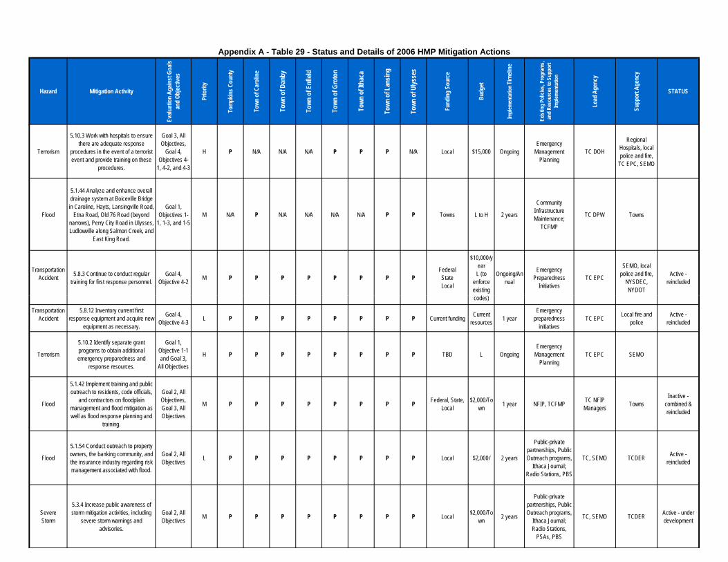
Hazard Mitigation Activity
Evalu
atio
n Ag
ainst
Goa
ls an
d Ob
jectiv
es
Prio
rity
Tom
pkin
s Cou
nty
Town
of C
arol
ine
Town
of D
anby
Town
of E
nfiel
d
Town
of G
roto
n
Town
of I
thac
a
Town
of L
ansin
g
Town
of U
lysse
s
Fund
ing
Sour
ce
Budg
et
Imple
men
tatio
n Tim
eline
Exist
ing
Polic
ies, P
rogr
ams,
and
Reso
urce
s to
Supp
ort
Imple
men
tatio
n
Lead
Age
ncy
Supp
ort A
genc
y
STATUS
Appendix A - Table 29 - Status and Details of 2006 HMP Mitigation Actions
Terrorism
5.10.3 Work with hospitals to ensure there are adequate response
procedures in the event of a terrorist event and provide training on these
procedures.
Goal 3, All Objectives,
Goal 4, Objectives 4-
1, 4-2, and 4-3
H P N/A N/A N/A P P P N/A Local $15,000 OngoingEmergency
Management Planning
TC DOH
Regional Hospitals, local police and fire,
TC EPC, SEMO
Flood
5.1.44 Analyze and enhance overall drainage system at Boiceville Bridge in Caroline, Hayts, Lansingville Road,
Etna Road, Old 76 Road (beyond narrows), Perry City Road in Ulysses, Ludlowville along Salmon Creek, and
East King Road.
Goal 1, Objectives 1-
1, 1-3, and 1-5M N/A P N/A N/A N/A N/A P P Towns L to H 2 years
Community Infrastructure Maintenance;
TCFMP
TC DPW Towns
TransportationAccident 5.8.3 Continue to conduct regular
training for first response personnel.Goal 4,
Objective 4-2 M P P P P P P P PFederalStateLocal
$10,000/year
L (to enforce existing codes)
Ongoing/Annual
Emergency Preparedness
InitiativesTC EPC
SEMO, local police and fire,
NYSDEC, NYDOT
Active - reincluded
codes)
TransportationAccident
5.8.12 Inventory current first response equipment and acquire new
equipment as necessary.
Goal 4, Objective 4-3 L P P P P P P P P Current funding Current
resources 1 yearEmergency
preparedness initiatives
TC EPC Local fire and police
Active - reincluded
Terrorism
5.10.2 Identify separate grant programs to obtain additional emergency preparedness and
response resources.
Goal 1, Objective 1-1 and Goal 3,
All Objectives
H P P P P P P P P TBD L OngoingEmergency
Management Planning
TC EPC SEMO
Flood
5.1.42 Implement training and public outreach to residents, code officials,
and contractors on floodplain management and flood mitigation as well as flood response planning and
training.
Goal 2, All Objectives, Goal 3, All Objectives
M P P P P P P P P Federal, State, Local
$2,000/Town 1 year NFIP, TCFMP TC NFIP
Managers TownsInactive -
combined & reincluded
Flood
5.1.54 Conduct outreach to property owners, the banking community, and the insurance industry regarding risk management associated with flood.
Goal 2, All Objectives L P P P P P P P P Local $2,000/ 2 years
Public-private partnerships, Public Outreach programs,
Ithaca Journal; Radio Stations, PBS
TC, SEMO TCDER Active - reincluded
Severe Storm
5.3.4 Increase public awareness of storm mitigation activities, including
severe storm warnings and advisories.
Goal 2, All Objectives M P P P P P P P P Local $2,000/To
wn 2 years
Public-private partnerships, Public Outreach programs,
Ithaca Journal; Radio Stations,
PSAs, PBS
TC, SEMO TCDER Active - under development

Hazard Mitigation Activity
Evalu
atio
n Ag
ainst
Goa
ls an
d Ob
jectiv
es
Prio
rity
Tom
pkin
s Cou
nty
Town
of C
arol
ine
Town
of D
anby
Town
of E
nfiel
d
Town
of G
roto
n
Town
of I
thac
a
Town
of L
ansin
g
Town
of U
lysse
s
Fund
ing
Sour
ce
Budg
et
Imple
men
tatio
n Tim
eline
Exist
ing
Polic
ies, P
rogr
ams,
and
Reso
urce
s to
Supp
ort
Imple
men
tatio
n
Lead
Age
ncy
Supp
ort A
genc
y
STATUS
Appendix A - Table 29 - Status and Details of 2006 HMP Mitigation Actions
Utility Failure
5.7.17 Work with Co-operative Extension to identify mitigation
activities for utility failure on dairy farms.
Goal 4. All objectives M P P P P P P P P Current funding Current
budget 2 years Public-Private Partnerships
TC,Towns CUCC, LF Active - under
development
TransportationAccident
5.8.16 Encourage adoption of County or local regulation requiring
identification of hazardous materials being transported through Tompkins
County.
Goal 2, Objective 2-3;
Goal 4, Objectives 4-3
and 4-4
M P P P P P P P P Local TBD 5 years Public safety concerns TC/Town TC/Town Active -
reincluded
Severe Winter Storm
5.2.5 Survey institutions that have specific needs populations to identify
their emergency needs.
Goal 4, All Objectives M P P P P P P P P Federal, State L 6 years TBD TCDER HNTF, TCDSS,
ARC
Inactive - combined & reincluded
Severe Winter Storm
5.2.12 Wherever practicable, coordinate emergency services,
public works departments, and public utility responses to winter storm events to ensure efficient use of
resources.
Goal 4, Objective 4-2 M P P P P P P P P Existing Funds Current
funds Ongoing TCDER, local highway agency TCDER SEMO, TC,
NYSEG
5.2.14 Enhance weather monitoring TCSWCD, Severe Winter
Storm
5.2.14 Enhance weather monitoring to attain earlier severe winter and ice
storm warnings.
Goal 2, All Objectives L P P P P P P P P State, County,
Local L to H Ongoing Weather Monitoring TCDER
TCSWCD, NOAA, NWS,
County and local public works
Epidemic (Human)
5.5.4 Identify and secure resources to build the appropriate medical
stockpile of medicines and medical supplies to address sizable
epidemics.
Goal 4, Objective 4-3 M P P P P P P P P
Grants (See table 2.3 and Appendix D)
M to H 2 years FEMA, SEMO, DHS preparedness efforts TCDER
TCEPC, TCDOH, Regional Hospitals
Inactive - deleted
Epidemic (Human)
5.5.5 Enhance public safety through awareness, by releasing timely public service announcements via various media (television, radio). TC/ARC
should be a support agency for public outreach.
Goal 2, All Objectives L P N/A N/A N/A N/A N/A N/A N/A Current
resourcesCurrent budget Ongoing Newspapers, Radio,
Television, PSAs TCDER TCEPC, planning group, TCDOH
Inactive - deleted (conducted via
NY Alert)
Fire (Urban and
Wild)
5.6.3 Enhance emergency services to increase the efficiency of wildfire response and recovery activities.
Goal 4, All Objectives M P N/A P N/A N/A N/A N/A N/A State M Ongoing Community safety TCDER
TCEPC County and Local Fire
Dept.
Terrorism5.10.7 Provide a wireless
communication command and control channel for use by TC.
Goal 4, Objective 4-3 L P N/A N/A N/A N/A N/A N/A N/A Federal grant M TBD
Emergency Management
PlanningTCDER TC EPC, TC
DITSActive -
reincluded
Severe Winter Storm
5.2.8 Increase public awareness of storm mitigation activities, including storm warnings and advisories. (See
also 5.2.1)
Goal 2, All Objectives M P P P P P P P P State, Local $2,000/juri
sdiction Ongoing
Public-private partnerships, Public Outreach programs,
Ithaca Journal, PSAs, Radio
Stations, PBS, EBS
TCDER, SEMO, Towns ARC, NOAA
Hazard Mitigation Activity
Evalu
atio
n Ag
ainst
Goa
ls an
d Ob
jectiv
es
Prio
rity
Tom
pkin
s Cou
nty
Town
of C
arol
ine
Town
of D
anby
Town
of E
nfiel
d
Town
of G
roto
n
Town
of I
thac
a
Town
of L
ansin
g
Town
of U
lysse
s
Fund
ing
Sour
ce
Budg
et
Imple
men
tatio
n Tim
eline
Exist
ing
Polic
ies, P
rogr
ams,
and
Reso
urce
s to
Supp
ort
Imple
men
tatio
n
Lead
Age
ncy
Supp
ort A
genc
y
STATUS
Appendix A - Table 29 - Status and Details of 2006 HMP Mitigation Actions
Epidemic (Human)
5.5.1 Enhance and strengthen communication between regional
hospitals and facilities about possible epidemic events.
Goal 3, Objective 3-1 M P N/A N/A N/A N/A N/A P N/A Current funding
sources L to M OngoingCurrent health care
communication systems
TCDOHTCEPC, Regional Hospitals
Epidemic (Human)
5.5.3 Continue to support the position of Bioterrorism Preparedness
Coordinator at the County level.
Goal 1, Objective 1-1; Goals 2 and 3, All Objectives
M P N/A N/A N/A N/A N/A N/A N/A Current Funding Current budget Ongoing Bioterrorism
preparedness efforts TCDOH TCEPC, TCDER
Flood
5.1.58 Map historical off road drainage ways so the County and
local highway departments can explore the possibility of getting access to them and improving
stormwater management.
Goal 1, Objective 1-1 L P N/A N/A N/A N/A N/A N/A N/A Local M 1 year Phase II Stormwater
Regulations; TCFMP TCDPW TCPD Active - reincluded
Severe Winter Storm
5.2.4 Develop and implement programs to coordinate maintenance and mitigation activities to reduce risk Goal 1,
Objective 1-1 M P N/A N/A N/A N/A N/A N/A N/A Federal, State, Local M Ongoing FEMA Programs TCDPW TCDERStorm to public infrastructure from severe
winter storms (including ice storms).
Objective 1-1 Local
Utility Failure 5.7.11 Maintain all gas pipes across creeks.
Goal 1, Objective 1-1 M P P P P P P P P TBD L Ongoing
Maintenance of County
infrastructureTCDPW TBD Active -
reincluded
Flood5.1.16 Develop system/process for
cleaning and maintaining stormwater drains and catch basins.
Goal 1, Objectives 1-1, 1-4, 1-5, 1-
6, and 1-9
H P P N/A N/A N/A P P P TC, Towns $5,000 2 years Phase II Stormwater Regulations TCDPW, Towns Private
landowners
Epidemic (Human)
5.5.2 Increase collaboration between government and community
organizations regarding containment and response plans for epidemic events involving human beings.
Goal 3, Objective 3-2 M P N/A N/A N/A N/A P N/A N/A
Grants (See table 2.3 and Appendix D)
L to M Ongoing TCEPC- planning group integration TCEPC
City of Ithaca, Regional academic
institutions, Regional hospitals
Active - reincluded
Fire (Urban and
Wild)
5.6.11 Enhance the Tompkins County Emergency Management Plan to include an emergency fire relief
program (to collaborate between the towns to expedite capabilities to fight
fires).
Goal 1, Objectives 1-7
and 1-8M P N/A N/A N/A N/A N/A N/A N/A Current funding Current
budget 1 year Procedural changes TCEPC TCPG
Fire (Urban and
Wild)
5.6.1 Conduct a study identifying all water resources in the jurisdictions for fire fighting (urban and wildland), map
locations, and develop fire fighting strategies based on this data.
Goal 4, Objective 4-2 H P P P P P P P P State L to M 2-5 years
Community Infrastructure Management
TCFPBTCEPC County and Local Fire
Dept.
Hazard Mitigation Activity
Evalu
atio
n Ag
ainst
Goa
ls an
d Ob
jectiv
es
Prio
rity
Tom
pkin
s Cou
nty
Town
of C
arol
ine
Town
of D
anby
Town
of E
nfiel
d
Town
of G
roto
n
Town
of I
thac
a
Town
of L
ansin
g
Town
of U
lysse
s
Fund
ing
Sour
ce
Budg
et
Imple
men
tatio
n Tim
eline
Exist
ing
Polic
ies, P
rogr
ams,
and
Reso
urce
s to
Supp
ort
Imple
men
tatio
n
Lead
Age
ncy
Supp
ort A
genc
y
STATUS
Appendix A - Table 29 - Status and Details of 2006 HMP Mitigation Actions
Fire (Urban and
Wild)
5.6.9 Investigate and, where feasible, implement programs that would
encourage and assist owners of older commercial structures in rehabilitating
and improving the fire resistance of their properties.
Goal 1, Objective 1-1 M P P P P P P P P TBD L Ongoing
Infrastructure management, code,
and zoningTCFPB Towns
Inactive - combined & reincluded
Fire (Urban and
Wild)
5.6.13 Educate personnel on Federal cost-share and grant programs, Fire Protection Agreements, and other
related Federal programs so the full array of assistance available to local
agencies is understood.
Goal 3, All Objectives L P P P P P P P P Federal L 4 years Interagency
cooperation TCFPBLocal and
County Fire Depts.
Fire (Urban and
Wild)
5.6.14 Inventory alternative firefighting water sources and encourage the development of
additional sources.
Goal 4, Objective 4-2 L P P P P P P P P TBD L to M TBD TBD TCFPB
Local and County Fire
Depts.
Inactive - combined & reincluded
5.6.15 Increase communication, coordination, and collaboration
Fire (Urban and
Wild)
coordination, and collaboration between wildland/urban interface property owners, local and county
planners, and fire prevention crews and officials to address risks, existing
mitigation activities, and Federal assistance programs.
Goal 2, All Objectives L P P P N/A P P N/A P TBD L TBD Public Private
Partnerships TCFPBPublic, Local and
County Fire Depts.
Fire (Urban and
Wild)
5.6.16 Undertake vegetation management activities to reduce
potential fuel for a wildfire (activities could include tree pruning, selective planting, and establishing vegetative
setback distances).
Goal 1, Objective 1-7 L P P P P P P P P TBD M TBD TBD TCFPB TBD
Inactive - combined & reincluded
Severe Storm
5.3.3 Map and publicize locations around the county that have the
highest incidence of severe-storm related impacts.
Goal 1, Objective 1-7;
Goal 2, Objective 2-3
M P P N/A N/A P P P P State $10,000 2 years
Community Technology
Initiatives, NOAA and NWS data
TCGIS TCDITS, SEMOInactive -
combined & reincluded
Flood
5.1.4 Enhance data and mapping for floodplains within the County and identify and map any flood-prone
areas outside of currently designated areas (see also 5.1.7).
Goal 1, Objective 1-4 H P P P P P P P P TBD M to H 2 years NYCDEC, NAF
ManagersTCGIS,
NYSDEC
TCPD, TCSWCDTCDIT
S
Fire (Urban and
Wild)
5.6.2 Obtain or create a map of existing and planned fire hydrants throughout the county and identify
areas that need fire hydrants.
Goal 1, Objective 1-1 H P N/A N/A N/A N/A N/A N/A N/A Local L 1 year
Community Technology Initiatives
TCGIS, TC TCDITS Active - reincluded
Flood
5.1.8 Continue to conduct engineering studies and watershed
assessments to support the reduction of flood potential.
Goal 1, Objective 1-4 H P P P P P P P P Local M 1 year TCFHMP TCPD WRC, TCSWCD Completed
Hazard Mitigation Activity
Evalu
atio
n Ag
ainst
Goa
ls an
d Ob
jectiv
es
Prio
rity
Tom
pkin
s Cou
nty
Town
of C
arol
ine
Town
of D
anby
Town
of E
nfiel
d
Town
of G
roto
n
Town
of I
thac
a
Town
of L
ansin
g
Town
of U
lysse
s
Fund
ing
Sour
ce
Budg
et
Imple
men
tatio
n Tim
eline
Exist
ing
Polic
ies, P
rogr
ams,
and
Reso
urce
s to
Supp
ort
Imple
men
tatio
n
Lead
Age
ncy
Supp
ort A
genc
y
STATUS
Appendix A - Table 29 - Status and Details of 2006 HMP Mitigation Actions
Flood
5.1.25 Continue maintenance to existing and planned structures, such as structural walls and other vertical
barriers.
Goal 1, Objective 1-1 M P P P P P P P P Local Current
funding Ongoing
Flood Mitigation Initiatives;
watershed study follow-up
TCPD TCDPW, TCSWCD
Active - reincluded
Flood
5.1.26 Encourage development of acquisition and management
strategies to preserve open space for flood mitigation, fish habitat, and
water quality in the floodplain.
Goal 1, Objective 1-7 M P P P P P P P P Federal, State,
Local $40,000 6 years
County Comprehensive
Plan, FLLT strategic plan
TCPD FLLT, Towns Active - under development
Flood
5.1.32 Further coordinate multi-jurisdictional mitigation activities as
outlined in the Flood Mitigation Needs Assessment for Six Mile Creek.
Goal 3, All Objectives M P P P N/A N/A P N/A N/A State, local L 6 years TCFHMP, 6 Mile
Creek Partnership TCPDLocal
government, TCSWCD
Active - under development
Flood5.1.41 Identify or update existing land
use in major stream corridors and floodplains in Tompkins County.
Goal 1, Objectives 1-4
and 1-6M P P P P P P P P County $1,000 1 year
Land Use and County
Comprehensive Planning
TCPD
5.1.49 Re-emphasize watershed
Flood
5.1.49 Re-emphasize watershed approaches by developing a strategy to address needs at the watershed
level, including cumulative flood mitigation activities and priorities.
Goal 1, Objective 1-4 L P N/A N/A N/A N/A N/A N/A N/A Local L Ongoing
Comprehensive Planning,
Watershed initiativesTCPD Towns,
TCSWCD
Inactive - combined & reincluded
Severe Winter Storm
5.2.7 Map and publicize locations around the county that have the
highest incidence of severe storms related events.
Goal 1, Objective 1-7 M P P P P P P P P State, County $10,000 2 years
NOAA and NWS data, HMGP,
TCFHMP, NYSDOTTCPD TC Municipal
Officials
Fire (Urban and
Wild)
5.6.6 Amend county policies to require the use of fire-retardant materials in new construction.
Goal 1, Objective 1-1 M P N/A N/A N/A N/A N/A N/A N/A TBD L TBD
Code, zoning, enforcement, engineering
TCPD TBD
Utility Failure
5.7.13 Enhance GIS coverage and analysis of existing and planned, future utility lines in the county.
Managed data security.
Goals 2 and 3, All Objectives M P P P P P P P P TBD M TBD County Information
Databank TCPD, TCGIS TCDITS Active - reincluded
Flood 5.1.9 Continue analysis of resistance of mobile homes to flood events.
Goal 1, Objectives 1-
1, 1-2, and 1-5H P P P P P P P P Current funding Current
resources OngoingCommunity
Infrastructure Improvements
TCPG Towns Inactive - deleted
Flood 5.1.61 Introduce programs/measures to reduce impervious surfaces
Goal 1, Objective 1-9 L P P P P P P P P Local M 4 years
Existing land use and stormwater management
programs; zoning
TCPG Towns
Utility Failure
5.7.5 Continue discussion with planning group and EPC on costs
and benefits of purchasing generators for critical facilities or installing
generator hook ups.
Goal 4, Objective 4-3 H P P P P P P P P Current funding
sourcesCurrent budget Ongoing TCPG, TCEPC TCPG TC EPC
Inactive - combined & reincluded

Hazard Mitigation Activity
Evalu
atio
n Ag
ainst
Goa
ls an
d Ob
jectiv
es
Prio
rity
Tom
pkin
s Cou
nty
Town
of C
arol
ine
Town
of D
anby
Town
of E
nfiel
d
Town
of G
roto
n
Town
of I
thac
a
Town
of L
ansin
g
Town
of U
lysse
s
Fund
ing
Sour
ce
Budg
et
Imple
men
tatio
n Tim
eline
Exist
ing
Polic
ies, P
rogr
ams,
and
Reso
urce
s to
Supp
ort
Imple
men
tatio
n
Lead
Age
ncy
Supp
ort A
genc
y
STATUS
Appendix A - Table 29 - Status and Details of 2006 HMP Mitigation Actions
Utility Failure
5.7.9 Support/encourage electrical utilities to use underground
construction methods where possible to reduce power outages from other
hazard events.
Goal 3, Objective 3-2 M P N/A N/A N/A N/A N/A N/A N/A TBD L TBD Zoning TCPG NYSEG Active -
reincluded
Utility Failure
5.7.3 Local agencies will work with NYSEG to ensure smooth
communication and response coordination with NYSEG’s principal crews, which are now located in the
County of Broome.
Goal 4, Objectives 4-1
and 4-2H P P P P P P P P Current funding Current
budget 1 year N/A TCPG, NYSEG TC EPCInactive -
combined & reincluded
Utility Failure
5.7.4 Identify contact point at NYSEG and work to evaluate and increase
responsiveness to utility failure. Increase coordination and
communication with NYSEG during and between emergencies.
Goal 3, Objective 3-2;
Goal 4, All Objectives
H P P P P P P P P Current funding Current budget 1 year N/A TCPG, NYSEG TC EPC
Inactive - combined & reincluded
Utility Failure
5.7.18 Conduct discussions with NYSEG about dispatching from
highway departments and work in
Goal 3, Objective 3-2;
Goal 4, All L P P P P P P P P Current funding Current budget 1 year N/A TCPG, NYSEG TC EPC Active -
reincludedteams with highway department to expedite response to power failure.
Goal 4, All Objectives
budget reincluded
Flood
5.1.3 Analyze repetitive loss properties within Tompkins County
and identify feasible mitigation options (through the Tompkins
County Flood Mitigation Program).
Goal 1, Objective 1-4 H P P P N/A P P N/A N/A USACE, TC,
FEMA M 1-2 years NFIP, TCFHMP TCSWCD TCPD Active - reincluded
Flood5.1.21 Construct synthetic floodways to disperse flow and reduce velocity
of water in the Six Mile Creek.
Goal 1, Objective 1-1 M P N/A N/A N/A N/A N/A N/A N/A Federal, State,
Local M to H 6 years (2010)
County Comprehensive
Planning, TCFHMP, OSC
TCSWCD TCPD Active - under development
Flood
5.1.22 Increase channel roughness of the Six Mile Creek, including
introducing large woody debris in the banks, creating boulder and log sills in the riverbed, installing individual
boulders and boulder clusters in the channel, and redefining the channel’s
thalweg.
Goal 1, Objective 1-1 M P N/A N/A N/A N/A N/A N/A N/A Federal, State L to M Ongoing
Flood Mitigation Initiatives;
recommendations of watershed studies;
EPF, EPA, NYSDEC
TCSWCD USFWS Inactive -
combined & reincluded
Flood
5.1.23 Construct additional detention ponds and wetlands upland and
upstream of the Six-Mile Creek, for other appropriate watersheds, and for
repeat flash flooding areas to help control peak runoff rates.
Goal 1, Objective 1-1 M P P P N/A N/A P N/A N/A Federal, State,
Private M to H Ongoing
Flood Mitigation Initiatives;
recommendations of watershed studies;
EPF, EPA, NYSDEC
TCSWCD FWS
Active - completed on Sixmile, under
development on Salmon Cr
Flood 5.1.48 Implement other Susquehanna initiatives.
Goal 1, Objectives 1-
1, 1-3, and 1-5M P P N/A N/A N/A N/A N/A N/A TCSWCD $200,000 2 years Susquehanna
initiatives TCSWCD TCSWCD Town

Hazard Mitigation Activity
Evalu
atio
n Ag
ainst
Goa
ls an
d Ob
jectiv
es
Prio
rity
Tom
pkin
s Cou
nty
Town
of C
arol
ine
Town
of D
anby
Town
of E
nfiel
d
Town
of G
roto
n
Town
of I
thac
a
Town
of L
ansin
g
Town
of U
lysse
s
Fund
ing
Sour
ce
Budg
et
Imple
men
tatio
n Tim
eline
Exist
ing
Polic
ies, P
rogr
ams,
and
Reso
urce
s to
Supp
ort
Imple
men
tatio
n
Lead
Age
ncy
Supp
ort A
genc
y
STATUS
Appendix A - Table 29 - Status and Details of 2006 HMP Mitigation Actions
Epidemic (Agricultural)
5.4.4 Increase coordination with organizations such as NYSCHAP and
CLEAR.
Goal 3, Objective 3-1 M P P P P P P P P TBD L Ongoing
TC, Agriculture & Farmland Protection
BoardTCSWCD TCSWCD,
CLEARCUCC
Inactive - combined & reincluded
Epidemic (Agricultural)
5.4.5 Distribute NYSCHAP assessment checklist.
Goal 2, All Objectives M P P P P P P P P TBD L 2 years
NYSCHAP checklist, local paper, mailer
to local farmersTCSWCD
TCSWCD, CLEAR, LF,
CUCC
Epidemic (Agricultural)
5.4.6 Distribute guidelines and specific procedures to prevent
Johnes Disease and Foot and Mouth Disease.
Goal 2, All Objectives M P P P P P P P P TBD L 1 year
local paper, mailer to local farmers, See
also 5.4.11TCSWCD
TCSWCD, CLEAR, LF,
,CUCC
Epidemic (Agricultural)
5.4.7 Increase awareness in farming communities of precautions for
livestock before shows, fairs, and other events.
Goal 2, All Objectives M P P P P P P P P TBD L Ongoing See 5.4.11 TCSWCD CLEAR, LF,
,CUCC, USDA
Inactive - combined & reincluded
Epidemic (Agricultural)
5.4.8 Increase awareness of precautions against zoonotic
diseases, including rabies, ringworm, water-borne pathogens, lyme
disease, anthrax, and west nile virus.
Goal 2, All Objectives M P P P P P P P P TBD L Ongoing See 5.4.11 TCSWCD CLEAR, LF,
,CUCC, USDAActive -
reincluded
Epidemic (Agricultural)
5.4.11 Advertise availability of the Tompkins County Emergency Action
Plan for Farms.
Goal 1, Objective 1-8;
Goal 3, All Objectives
M P P P P P P P P Current funding N/A 1 year Ithaca Journal , flyers, libraries TCSWCD CUCC
Inactive - combined & reincluded
Epidemic (Agricultural)
5.4.10 Enhance public safety through awareness, by releasing timely public service announcements via various
media (television, radio).
Goal 2, All Objectives L P N/A N/A N/A N/A N/A N/A N/A Current funding N/A Ongoing
Ithaca Journal , Radio & TV
announcementsTCSWCD CUCC Inactive - deleted
Epidemic (Agricultural)
5.4.1 Increase collaboration between government and community
organizations regarding containment and response plans for epidemic
events involving animals.
Goal 3, Objective 3-2 M P N/A N/A N/A N/A N/A N/A N/A TBD L to M Ongoing
TC, Agriculture & Farmland Protection
Board
TCSWCD, CLEAR LF, CUCC
Inactive - combined & reincluded
Epidemic (Agricultural)
5.4.2 Participate in the integrated disease prevention program with the
New York State Cattle Health Assurance Program (NYSCHAP)
Goal 1, Objective 1-1 M P P P P P P P P TBD M Ongoing Disease prevention
programsTCSWCD,
CLEARNYSCHAP, NYDAM, LF
Active - reincluded
Epidemic (Agricultural)
5.4.3 Strengthen communication with farmers regarding procedures to
prevent the entry of pathogens onto farms.
Goal 2, All Objectives M P P P P P P P P TBD L Ongoing
TC, Agriculture & Farmland Protection
Board
TCSWCD, CLEAR
NYSCHAP, NYDAM, LF,
CUCC
Active - reincluded
Flood5.1.35 Conduct a mailing campaign to property owners in the 100- and 500-
year flood plains.
Goal 2, All Objectives M P P P P P P P P State, Local $500 3 years TCFHMP TCWRC TCPD, TCGIS Active - under
development
Water Supply Contamination
5.9.9 Identify appropriate protection measures for groundwater drinking
water systems.
Goal 1, Objectives 1-
1, 1-6, and 1-9M P N/A P N/A P N/A N/A P TBD L (to
identify) 5 years SWAP TCWRC NYSDEC, USGSInactive -
combined & reincluded
Hazard Mitigation Activity
Evalu
atio
n Ag
ainst
Goa
ls an
d Ob
jectiv
es
Prio
rity
Tom
pkin
s Cou
nty
Town
of C
arol
ine
Town
of D
anby
Town
of E
nfiel
d
Town
of G
roto
n
Town
of I
thac
a
Town
of L
ansin
g
Town
of U
lysse
s
Fund
ing
Sour
ce
Budg
et
Imple
men
tatio
n Tim
eline
Exist
ing
Polic
ies, P
rogr
ams,
and
Reso
urce
s to
Supp
ort
Imple
men
tatio
n
Lead
Age
ncy
Supp
ort A
genc
y
STATUS
Appendix A - Table 29 - Status and Details of 2006 HMP Mitigation Actions
Water Supply Contamination
5.9.10 Support and implement measures to reduce contamination
potential of public groundwater wells.
Goal 1, Objectives 1-
1, 1-5, and 1-9M P N/A P N/A P N/A N/A P State
L, plus current SWAP funding
5 yearsSource Water Assessment
ProgramTCWRC NYSDEC, USGS
Inactive - combined & reincluded
Epidemic (Agricultural)
5.4.9 Include a reference in the Tompkins County Soil and Water
Conservation District Farm Emergency Management Plan to the
All Hazard Mitigation Plan.
Goal 1, Objective 1-8 M P N/A N/A N/A N/A N/A N/A N/A TBD L 1 year
Farm Emergency Management Plan, Multi-Jurisdictional
All Hazard Mitigation Plan
Tompkins County TCSWCD Inactive - deleted
Flood5.1.59 Complete the flood protection
berm at the Speedville Mill Road bridge site.
Goal 1, Objectives 1-
1, 1-3, and 1-5L P N/A N/A N/A N/A N/A N/A N/A Local Current
resources 1 year TCFMP Tompkins County DPW TC Inactive - deleted
Flood5.1.5 Identify and address
obstructions to surface water drainage.
Goal 1, Objective 1-4 H P P P P P P P P Local L to M Ongoing
TCFHMP, Ongoing highway official
work, stormwater programs
Town TCSWCD
Flood5.1.19 Conduct regular maintenance
and inspections on the local flood control dams.
Goal 1, Objective 1-1 M P N/A P N/A N/A P N/A N/A Local L Ongoing Joint ownership of
structures Town TC Active - under developmentcontrol dams.
Water Supply Contamination
5.9.3 Continue Six Mile, Virgil, and Willseyville Creek Aquifer Studies.
Goal 1, Objectives 1-
1, 1-6, and 1-9H P P N/A N/A N/A N/A N/A N/A Town, TC, USGS $750,000 6 years Current aquifer
studies Town TC, USGS Active - under development
Water Supply Contamination
5.9.4 Take thermal images of the lake front area to identify locations of
failing septic systems.
Goal 1, Objectives 1-
1, 1-6, and 1-9H N/A N/A N/A N/A N/A N/A N/A P Town $8,000 3 years
Current stormwater and water quality
initiativesTown TBD Inactive - deleted
Flood
5.1.13 Replace the pipes under West Jersey Hill Road at Lick Brook Creek to prevent further undermining of the
road.
Goal 1, Objectives 1-
1, 1-3, and 1-5H N/A N/A P N/A N/A N/A N/A N/A TBD (See table
2.3) M 1 year Current DPW activities Town TC DPW Inactive - deleted
Flood 5.1.14 Implement Barrile stream bank stabilization.
Goal 1, Objectives 1-
1, 1-3, and 1-5H P P N/A N/A N/A N/A N/A N/A Town, TC,
NYSDEC$250,000-$300,000 1 year Current stream bank
stabilization projects Town TC, NYSDEC Completed
Flood 5.1.45 Stabilize the Brooktondale Road stream bank.
Goal 1, Objectives 1-
1, 1-3, and 1-5M P P N/A N/A N/A N/A N/A N/A Towns TC L 1 year
Current stream stabilization
projects; Programs administered by
Caroline Watershed Committee
Town TC DPW
Flood 5.1.60 Restore West Creek.Goal 1,
Objectives 1-1, 1-3, and 1-5
L N/A P N/A N/A N/A N/A N/A N/A Town, TCSWCD, Tioga County L to H 3 years TCFMP; Interagency
Initiatives Town TCSWD, Tioga County Completed
Severe Winter Storm
5.2.15 Evaluate and develop, as appropriate, a parking ordinance for
emergency snow removal.
Goal 4, Objectives 4-2
and 4-3L N/A P N/A N/A N/A N/A N/A N/A Existing funds $3,000 Ongoing
Existing zoning policies and procedures
Town NA Active - under development emergency snow removal. and 4-3 procedures
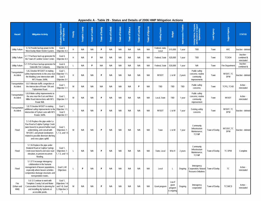
Hazard Mitigation Activity
Evalu
atio
n Ag
ainst
Goa
ls an
d Ob
jectiv
es
Prio
rity
Tom
pkin
s Cou
nty
Town
of C
arol
ine
Town
of D
anby
Town
of E
nfiel
d
Town
of G
roto
n
Town
of I
thac
a
Town
of L
ansin
g
Town
of U
lysse
s
Fund
ing
Sour
ce
Budg
et
Imple
men
tatio
n Tim
eline
Exist
ing
Polic
ies, P
rogr
ams,
and
Reso
urce
s to
Supp
ort
Imple
men
tatio
n
Lead
Age
ncy
Supp
ort A
genc
y
STATUS
Appendix A - Table 29 - Status and Details of 2006 HMP Mitigation Actions
Utility Failure 5.7.6 Provide backup power to the West Danby Water District System.
Goal 4, Objective 4-3 H N/A N/A P N/A N/A N/A N/A N/A Federal, state,
Local $15,000 1 year TBD Town ARC Inactive - deleted
Utility Failure 5.7.7 Purchase back up generator for the Town of Caroline Senior Center.
Goal 4, Objective 4-3 H N/A P N/A N/A N/A N/A N/A N/A Federal, State $20,000 1 year TBD Town TCDOH
Inactive - combined & reincluded
Utility Failure 5.7.19 Purchase backup generator for Slaterville Fire Company.
Goal 4, Objective 4-3 L N/A P N/A N/A N/A N/A N/A N/A Federal, State $20,000 1 year N/A Town Fire Department
Inactive - combined & reincluded
TransportationAccident
5.8.2 Involve NYSDOT in making safety improvements to the area near
the Walding Lane intersection with NYS Routes 34/96.
Goal 1, Objective 1-1;
Goal 3 Objective 3-1
H N/A N/A P N/A N/A N/A N/A N/A NYDOT L to M 2 years
Public safety concerns; routine
community improvements
Town NYDOT, TC DPW Inactive - deleted
TransportationAccident
5.8.7 Alleviate traffic congestion at the intersection of Route 13N and
Triphammer Road.
Goal 1, Objective 1-1 M N/A N/A N/A N/A N/A N/A P N/A TBD TBD TBD Public safety
concerns; Town TCPG, TCHD Active - reincluded
TransportationAccident
5.8.8 Make safety improvements to the area near the East and West
Miller Road intersections with NYS Route 96B.
Goal 1, Objective 1-1 M N/A N/A P N/A N/A N/A N/A N/A Local, State TBD 1 year
Public safety concerns; routine
community improvement
Town NYDOT Active - reincluded
5.8.15 Involve NYDOT in making Goal 1, TransportationAccident
5.8.15 Involve NYDOT in making additional safety improvements to the intersection of Sylvan Lane with NYS
Routes 34/96.
Goal 1, Objective 1-1;
Goal 3 Objective 3-1
L N/A N/A P N/A N/A N/A N/A N/A NYDOT L to M 1 year Existing safety concerns Town NYDOT, TC
DPW Inactive - deleted
Flood
5.1.43 Replace the pipe under La Rue Road at Sulphur Springs Creek (west branch) to prevent further road
undermining, and consult with NYSDEC and private landowners
related to possible diversion ditching and cross pipes uphill.
Goal 1, Objectives 1-
1, 1-3, and 1-5M N/A N/A P N/A N/A N/A N/A N/A Town L to M 1 year
Community Infrastructure Maintenance;
TCFMP
Town of Danby NYSDEC,TC DPW Inactive - deleted
Flood
5.1.56 Replace the pipe under Howland Road at Sulphur Springs Creek (east branch) and raise road
elevation, to prevent recurrent flooding.
Goal 1, Objectives 1-
1, 1-3, and 1-5L N/A N/A P N/A N/A N/A N/A N/A State, Local M to H 2 years
Community Infrastructure Maintenance;
TCFMP
Town of Danby TC DPW Complete
Flood
5.1.57 Encourage interagency collaboration in the humane
management of beaver populations, especially where beaver activities
compromise drainage structures and transportation routes.
Goal 3, All Objectives L P N/A P N/A N/A N/A N/A N/A Local L Ongoing
Interagency Cooperation; Natural Resource Initiatives
Town of Danby TC Active - reincluded
Fire (Urban and
Wild)
5.6.12 Continue to work with Tompkins County Soil and Water
Conservation District in planning for and installing dry hydrants at
accessible ponds.
Goal 1, Objectives 1-6 and 1-8, Goal 3, Objective 3-
1
M N/A N/A P N/A N/A N/A N/A N/A Grant program
Low if grant
program is ongoing
Ongoing Interagency cooperation Town of Danby TCSWCD Active -
reincluded
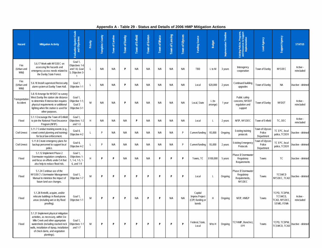
Hazard Mitigation Activity
Evalu
atio
n Ag
ainst
Goa
ls an
d Ob
jectiv
es
Prio
rity
Tom
pkin
s Cou
nty
Town
of C
arol
ine
Town
of D
anby
Town
of E
nfiel
d
Town
of G
roto
n
Town
of I
thac
a
Town
of L
ansin
g
Town
of U
lysse
s
Fund
ing
Sour
ce
Budg
et
Imple
men
tatio
n Tim
eline
Exist
ing
Polic
ies, P
rogr
ams,
and
Reso
urce
s to
Supp
ort
Imple
men
tatio
n
Lead
Age
ncy
Supp
ort A
genc
y
STATUS
Appendix A - Table 29 - Status and Details of 2006 HMP Mitigation Actions
Fire (Urban and
Wild)
5.6.17 Work with NYSDEC on assessing fire hazards and
emergency access needs related to the Danby State Forest.
Goal 1, Objectives 1-6 and 1-8, Goal 3, Objective 3-
1
L N/A N/A P N/A N/A N/A N/A N/A TBD L to M 3 years Interagency cooperation Town of Danby NYSDEC Active -
reincluded
Fire (Urban and
Wild)
5.6.18 Install supervised fire/security alarm system at Danby Town Hall.
Goal 1, Objective 1-1 L N/A N/A P N/A N/A N/A N/A N/A Local $20,000 2 years Continued building
upgrades Town of Danby NA Inactive - deleted
TransportationAccident
5.8.10 Arrange for NYDOT to survey West Danby fire station site distance to determine if intersection requires physical requirements or additional lighting when fire station is used for
other purposes.
Goal 1, Objective 1-1;
Goal 3 Objective 3-1
M N/A N/A P N/A N/A N/A N/A N/A Local, State L (to arrange) 1 year
Public safety concerns; NYDOT
regulation and support
Town of Danby NYDOT Active - reincluded
Flood5.1.1 Encourage the Town of Enfield to join the National Flood Insurance
Program (NFIP).
Goal 1, Objectives 1-2
and 1-3H N/A N/A N/A P N/A N/A N/A N/A Local L 2 years NFIP, NYSDEC Town of Enfield TC, DEC Active -
reincluded
5.11.7 Conduct training events (e.g., Goal 4, Existing training Town of Ulysses TC EPC, local Civil Unrest5.11.7 Conduct training events (e.g., crowd control planning and training)
for local law enforcement.
Goal 4, Objective 4-2 L P N/A N/A N/A N/A N/A N/A P Current funding $5,000 Ongoing Existing training
protocols
Town of Ulysses Police
Department
TC EPC, local police, TCDER Inactive - deleted
Civil Unrest5.11.8 Create emergency plans for backup personnel to support local
police.
Goal 4, Objective 4-2 L P N/A N/A N/A N/A N/A N/A P Current funding $5,000 2 years Existing Emergency
Protocols
Town of Ulysses Police
Department
TC EPC, local police, TCDER Inactive - deleted
Flood
5.1.12 Implement Phase 2 Stormwater regulation compliance, and focus on efforts under S4 that
also help to reduce flood risk.
Goal 1, Objectives 1-1, 1-4, 1-5, 1-
6, and 1-9
H P P N/A N/A N/A P P P Towns, TC $100,000 5 yearsPhase II Stormwater
Regulatory Requirements
Towns TC Inactive - deleted
Flood
5.1.24 Continue use of the NYSDEC’s Stormwater Management
Manual to minimize the impact of future land use changes.
Goal 1, Objective 1-7 M P P P P P P P P Local L Ongoing
Phase II Stormwater Regulatory
Requirements, NYSDEC
Towns TCSWCD NYSDEC, TCAD Inactive - deleted
Flood
5.1.28 Retrofit, acquire, and/or relocate buildings in flood-prone areas (including wet or dry flood
proofing).
Goal 1, Objective 1-1 M P P P N/A P P N/A N/A
Capital Improv.Project
(CIP) funding or bonds
H Ongoing NFIP, HMGP Towns
TCPD, TCDPW, TCSWCD,
TCAD, NYSDEC, SEMO, FEMA
Active - reincluded
Flood
5.1.31 Implement physical mitigation activities, as necessary, within Six-Mile Creek and other appropriate
watersheds (including stacked rock walls, installation of riprap, installation
of check dams, and vegetation plantings).
Goal 1, Objectives 1-1
and 1-7M P P P P P P P P Federal, State,
Local M to H Ongoing TCFHMP, Bond Act, EPF Towns TCPD, TCDPW,
TCSWCD, TCAD Inactive - deleted
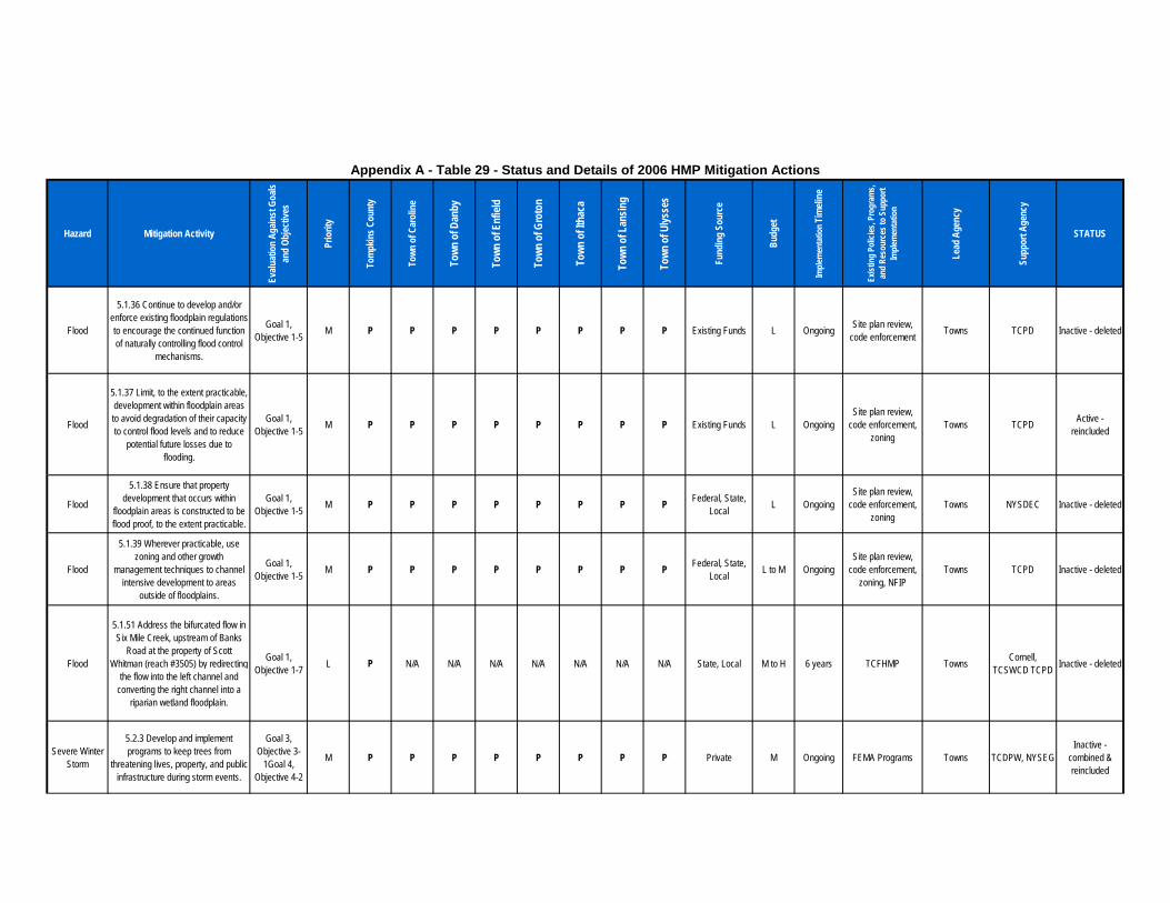
Hazard Mitigation Activity
Evalu
atio
n Ag
ainst
Goa
ls an
d Ob
jectiv
es
Prio
rity
Tom
pkin
s Cou
nty
Town
of C
arol
ine
Town
of D
anby
Town
of E
nfiel
d
Town
of G
roto
n
Town
of I
thac
a
Town
of L
ansin
g
Town
of U
lysse
s
Fund
ing
Sour
ce
Budg
et
Imple
men
tatio
n Tim
eline
Exist
ing
Polic
ies, P
rogr
ams,
and
Reso
urce
s to
Supp
ort
Imple
men
tatio
n
Lead
Age
ncy
Supp
ort A
genc
y
STATUS
Appendix A - Table 29 - Status and Details of 2006 HMP Mitigation Actions
Flood
5.1.36 Continue to develop and/or enforce existing floodplain regulations to encourage the continued function of naturally controlling flood control
mechanisms.
Goal 1, Objective 1-5 M P P P P P P P P Existing Funds L Ongoing Site plan review,
code enforcement Towns TCPD Inactive - deleted
Flood
5.1.37 Limit, to the extent practicable, development within floodplain areas to avoid degradation of their capacity to control flood levels and to reduce
potential future losses due to flooding.
Goal 1, Objective 1-5 M P P P P P P P P Existing Funds L Ongoing
Site plan review, code enforcement,
zoningTowns TCPD Active -
reincluded
Flood
5.1.38 Ensure that property development that occurs within
floodplain areas is constructed to be flood proof, to the extent practicable.
Goal 1, Objective 1-5 M P P P P P P P P Federal, State,
Local L OngoingSite plan review,
code enforcement, zoning
Towns NYSDEC Inactive - deleted
Flood
5.1.39 Wherever practicable, use zoning and other growth
management techniques to channel intensive development to areas
outside of floodplains.
Goal 1, Objective 1-5 M P P P P P P P P Federal, State,
Local L to M OngoingSite plan review,
code enforcement, zoning, NFIP
Towns TCPD Inactive - deleted
Flood
5.1.51 Address the bifurcated flow in Six Mile Creek, upstream of Banks
Road at the property of Scott Whitman (reach #3505) by redirecting
the flow into the left channel and converting the right channel into a
riparian wetland floodplain.
Goal 1, Objective 1-7 L P N/A N/A N/A N/A N/A N/A N/A State, Local M to H 6 years TCFHMP Towns Cornell,
TCSWCD TCPD Inactive - deleted
Severe Winter Storm
5.2.3 Develop and implement programs to keep trees from
threatening lives, property, and public infrastructure during storm events.
Goal 3, Objective 3-
1Goal 4, Objective 4-2
M P P P P P P P P Private M Ongoing FEMA Programs Towns TCDPW, NYSEGInactive -
combined & reincluded
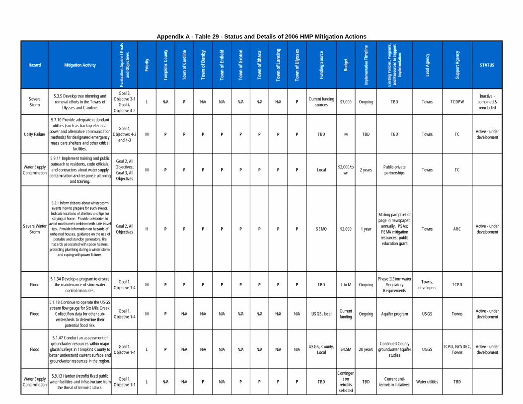
Hazard Mitigation Activity
Evalu
atio
n Ag
ainst
Goa
ls an
d Ob
jectiv
es
Prio
rity
Tom
pkin
s Cou
nty
Town
of C
arol
ine
Town
of D
anby
Town
of E
nfiel
d
Town
of G
roto
n
Town
of I
thac
a
Town
of L
ansin
g
Town
of U
lysse
s
Fund
ing
Sour
ce
Budg
et
Imple
men
tatio
n Tim
eline
Exist
ing
Polic
ies, P
rogr
ams,
and
Reso
urce
s to
Supp
ort
Imple
men
tatio
n
Lead
Age
ncy
Supp
ort A
genc
y
STATUS
Appendix A - Table 29 - Status and Details of 2006 HMP Mitigation Actions
SevereStorm
5.3.5 Develop tree trimming and removal efforts in the Towns of
Ulysses and Caroline.
Goal 3, Objective 3-1
Goal 4, Objective 4-2
L N/A P N/A N/A N/A N/A N/A P Current funding sources $7,000 Ongoing TBD Towns TCDPW
Inactive - combined & reincluded
Utility Failure
5.7.10 Provide adequate redundant utilities (such as backup electrical
power and alternative communication methods) for designated emergency mass care shelters and other critical
facilities.
Goal 4, Objectives 4-2
and 4-3M P P P P P P P P TBD M TBD TBD Towns TC Active - under
development
Water Supply Contamination
5.9.11 Implement training and public outreach to residents, code officials, and contractors about water supply
contamination and response planning and training.
Goal 2, All Objectives, Goal 3, All Objectives
M P P P P P P P P Local $2,000/town 2 years Public-private
partnerships Towns TC
5.2.1 Inform citizens about winter storm events how to prepare for such events. Indicate locations of shelters and tips for Mailing pamphlet or
Severe Winter Storm
Indicate locations of shelters and tips for staying at home. Provide advisories to
avoid road travel combined with safe travel tips. Provide information on hazards of
unheated houses, guidance on the use of portable and standby generators, fire
hazards associated with space heaters, protecting plumbing during a winter storm,
and coping with power failures.
Goal 2, All Objectives H P P P P P P P P SEMO $2,000 1 year
Mailing pamphlet or page in newspaper,
annually. PSAs; FEMA mitigation resources, public education grant
Towns ARC Active - under development
Flood5.1.34 Develop a program to ensure
the maintenance of stormwater control measures.
Goal 1, Objective 1-4 M P P P P P P P P TBD L to M Ongoing
Phase II Stormwater Regulatory
Requirements
Towns, developers TCPD
Flood
5.1.18 Continue to operate the USGS stream flow gauge for Six Mile Creek.
Collect flow data for other sub-watersheds to determine their
potential flood risk.
Goal 1, Objective 1-4 M P N/A N/A N/A N/A N/A N/A N/A USGS, local Current
funding Ongoing Aquifer program USGS Towns Active - under development
Flood
5.1.47 Conduct an assessment of groundwater resources within major
glacial valleys in Tompkins County to better understand current surface and groundwater resources in the region.
Goal 1, Objective 1-4 L P N/A N/A N/A N/A N/A N/A N/A USGS, County,
Local $4.5M 20 years Continued County
groundwater aquifer studies
USGS TCPD, NYSDEC, Towns
Active - under development
Water Supply Contamination
5.9.13 Harden (retrofit) fixed public water facilities and infrastructure from
the threat of terrorist attack.
Goal 1, Objective 1-1 L N/A N/A P N/A P P P P TBD
Contingent on
retrofits selected
TBD Current anti-terrorism initiatives Water utilities TBD

Hazard Mitigation Activity
Evalu
atio
n Ag
ainst
Goa
ls an
d Ob
jectiv
es
Prio
rity
Tom
pkin
s Cou
nty
Town
of C
arol
ine
Town
of D
anby
Town
of E
nfiel
d
Town
of G
roto
n
Town
of I
thac
a
Town
of L
ansin
g
Town
of U
lysse
s
Fund
ing
Sour
ce
Budg
et
Imple
men
tatio
n Tim
eline
Exist
ing
Polic
ies, P
rogr
ams,
and
Reso
urce
s to
Supp
ort
Imple
men
tatio
n
Lead
Age
ncy
Supp
ort A
genc
y
STATUS
Appendix A - Table 29 - Status and Details of 2006 HMP Mitigation Actions
Evalu
atio
n Ag
ainst
Goa
ls an
d Ob
jectiv
es
Tom
pkin
s Cou
nty
Town
of C
arol
ine
Town
of D
anby
Town
of E
nfiel
d
Town
of G
roto
n
Town
of I
thac
a
Town
of L
ansin
g
Town
of U
lysse
s
Fund
ing
Sour
ce
Imple
men
tatio
n
Exist
ing
Polic
ies, P
rogr
ams,
and
Reso
urce
s to
Supp
ort
Imple
men
tatio
n
Lead
Age
ncy
Supp
ort A
genc
y
Flood
5.1.27 Establish a framework to compile and coordinate surface water management plans and data across
the county.
Goal 1, Objective 1-4 M P N/A N/A N/A N/A N/A N/A N/A Local L 2 years WRC workplan,
CLWN, Cornell WRC TCPD, TCDOH

Table 32
Additional Mitigation Action Strategies
Lower Priority

Goals: 1-Protect Life and Property, 2-Increase Public Education, Outreach and Partnerships, 3-Protect and Restore Natural Ecosystems, 4-Enhance Emergency Services Agencies: DOER – Tompkins County Department of Emergency Response; TCPD – Tompkins County Planning Department; FEMA – Federal Emergency Management Agency, NYSOEM – New York State of Emergency Management; FLLT – Finger Lakes Land Trust; NRCS – US Natural Resource Conservation Service; IC – Ithaca College.
Appendix A – Table 32 - Additional Multi-Jurisdictional Mitigation and Adaptation Action Strategies
# Mitigation Action Hazard(s) Mitigated
Goals Met Lead Agency Support
Agencies Estimated Cost Level
Potential Funding Sources
Implementation Timeframe
Targeted Development
(new or existing)
Multi-Jurisdictional
A1
Encourage NFIP communities to participate in the Community Rating System (CRS) which would result in lower flood insurance premiums
Flood (Flash & Lake) 1 DOER
Municipalities, FEMA,
NYSOEM Low FEMA, NYSOEM,
Local Funds Moderate New & Existing
A2
Prioritize high risk floodplains for protection and conservation through acquisition, easement and green infrastructure improvements
Flood (Flash & Lake) 3 TCPD
Tompkins County
Conservation Partners
Medium ($40,000)
NYSDEC, NYSDAM,
Foundations Long Existing
A3
Develop regulations to prohibit future building in flood-prone areas as well as create incentives to encourage property owners to protect and improve streams and buffers. This should include improving gorge safety and carefully designed and maintained trails within these buffer areas.
Flood (Flash & Lake) 1 Municipalities
TCPD, NYSDEC,
FEMA, NYSOEM,
Cornell University, NYS
Parks
High
Capital Improvement Project (CIP)
funding or bonds
Ongoing New & Existing
A4 Support existing preparedness campaigns including sheltering in place during storm events
Severe Storms 2 DOER TC Public Info Low County budget Moderate N/A
A5
Identify wind-resistant building siting and construction codes and incorporate in code updates and work with vulnerable structures
Severe Storms 1 Municipalities Building Code Officials, FEMA Low Local budgets,
County budget Long New & Existing
A6
Develop a program that would encourage owners of older structures to make improvements for better fire resistance
Fire 1 CCE DOER Low-Medium County Budget Long Existing
A7
Identify deficiencies in equipment and training and ensure that local fire departments are adequately equipped to respond safely and effectively to fires
Fire 4 DOER Municipal Fire Departments Low Municipal budgets Long N/A
A8
Work with NYSDEC on assessing fire hazards and emergency access needs related to the Danby, Yellow Barn and Shindagin Hollow State Forests
Fire 3, 4 DOER NYSDEC Low NYSDEC grant, County budget Long N/A
A9 Encourage the use of underground utilities for new development Utility failure 1 Municipalities None Low N/A Long New

Goals: 1-Protect Life and Property, 2-Increase Public Education, Outreach and Partnerships, 3-Protect and Restore Natural Ecosystems, 4-Enhance Emergency Services Agencies: DOER – Tompkins County Department of Emergency Response; TCPD – Tompkins County Planning Department; FEMA – Federal Emergency Management Agency, NYSOEM – New York State of Emergency Management; FLLT – Finger Lakes Land Trust; NRCS – US Natural Resource Conservation Service; IC – Ithaca College.
Appendix A – Table 32 - Additional Multi-Jurisdictional Mitigation and Adaptation Action Strategies
# Mitigation Action Hazard(s) Mitigated
Goals Met Lead Agency Support
Agencies Estimated Cost Level
Potential Funding Sources
Implementation Timeframe
Targeted Development
(new or existing)
A10 Develop mitigation/response plan for oil and gas operations
Water supply contamination,
Trans. accidents, Hazmit In-transit
1, 2, 3, 4
TC Emergency Response Planning
Committee
TCCOG Medium State grant, County budget Short-Moderate New
A11 Identify model regulations that buffer aquifer recharge areas
Water supply contamination 3 TCPD Municipalities Medium
Enviro protection grant, state funds,
County budget Moderate New
A12
Complete water vulnerability assessment for water supply, water treatment systems and ground water systems and make recommended improvements
Water supply contamination 1, 3 TCPD
SWCD, Municipalities,
NYSDEC High
USDA funding, state grants,
County budget Long N/A
A13 Enhance pre-emptive security around critical facilities and infrastructure Terrorism 1 Municipalities None Medium County and
Municipal budgets Long Existing
A14
Assist farm support agencies in providing support and guidance for farm community in preparation for climate change including assisting dairies in building resilience to utility failures, extreme weather events and increasing drought conditions as well as working with crop farmers to assess the viability of current and potential future crops. This outreach should also include publicizing availability of TCSWCD’s Farm Emergency Action Plan.
Utility failure, All Natural Hazards 2, 3 TCSWCD NRCS, TCPD,
Municipalities Medium Federal, State Moderate New
A15
Inventory Ash and Hemlock trees to assist in preparations of entrance of invasives and plant native tree species known to have a broad range of environmental tolerances
Infestation 1, 3
Tompkins County
Conservation Partners
TCPD Medium NYSDEC WQIP Long New
A16 Develop and publicize heat response plan which includes the use of cooling centers
Extreme Temperatures 1, 2 DOER City of Ithaca,
Cornell, IC Low Federal and Local Short New

Goals: 1-Protect Life and Property, 2-Increase Public Education, Outreach and Partnerships, 3-Protect and Restore Natural Ecosystems, 4-Enhance Emergency Services Agencies: DOER – Tompkins County Department of Emergency Response; TCPD – Tompkins County Planning Department; FEMA – Federal Emergency Management Agency, NYSOEM – New York State of Emergency Management; FLLT – Finger Lakes Land Trust; NRCS – US Natural Resource Conservation Service; IC – Ithaca College.
Appendix A – Table 32 - Additional Multi-Jurisdictional Mitigation and Adaptation Action Strategies
# Mitigation Action Hazard(s) Mitigated
Goals Met Lead Agency Support
Agencies Estimated Cost Level
Potential Funding Sources
Implementation Timeframe
Targeted Development
(new or existing)
A17
Incentivize and regulate the use of Energy Star and LEED building rating systems which save energy while also building resilience to extreme temperature events
Extreme Temperatures 2 Municipalities TCPD Low Local Long New
A18
Encourage the use of green infrastructure to encourage water conservation, open space protection, and flood mitigation to reduce vulnerability, both in upstream areas and in urban areas. This should include the development of a watershed adaptation plan which prioritizes areas in which these improvements would have the most benefit in being implemented.
Drought, Flash Flood 3 Municipalities NYSDEC Medium TC Stream
Corridor and Local Ongoing New & Existing
A19
Promote the use of design techniques to shade buildings and windows or use highly reflective roof paints and surfaces to reduce warming in buildings from sun exposure
Extreme Temperatures 1 Municipalities TCPD Low (None) Moderate New
A20
Work with the scientific community to update and refine regional climate projections/impacts and utilize this information in planning and management
Multi-Hazard 2 TCPD Cornell, Federal
Agencies Low (None) Long N/A
A21 Enhance our understanding of the impacts of climate change on public health
Multi-Hazard 1, 2
Tompkins County Human
Services Cabinet
TCPD Low (None) Long N/A
A22
Create partnerships between the business and insurance industry to understand coverage and advance mitigation efforts
Multi-Hazard 1, 2
Tompkins County
Chamber of Commerce
TCPD Low (None) Moderate New

Goals: 1-Protect Life and Property, 2-Increase Public Education, Outreach and Partnerships, 3-Protect and Restore Natural Ecosystems, 4-Enhance Emergency Services Agencies: DOER – Tompkins County Department of Emergency Response; TCPD – Tompkins County Planning Department; FEMA – Federal Emergency Management Agency, NYSOEM – New York State of Emergency Management; FLLT – Finger Lakes Land Trust; NRCS – US Natural Resource Conservation Service; IC – Ithaca College.
Appendix A – Table 32 - Additional Multi-Jurisdictional Mitigation and Adaptation Action Strategies
# Mitigation Action Hazard(s) Mitigated
Goals Met Lead Agency Support
Agencies Estimated Cost Level
Potential Funding Sources
Implementation Timeframe
Targeted Development
(new or existing)
A23
Utilize NY State Accident Location Information System (ALIS) traffic accident database to analyze high risk locations based on vehicle classification and relay that information to municipalities to advance mitigation measures as needed.
Transportation Accident 1
Ithaca-Tompkins
County Transportation
Counicl
Municipalities Low None Short Existing
A24 Continue to support the funding of the USGS gage stations which assist in forecasting and mitigating flood risk
Flood (Flash and Lake Flood) 1,2,3,4 USGS Municipalities Medium Federal and Local Ongoing Existing
A25
Develop a plan with regional partners including local government, utility providers, agencies and engineers for analyzing and prioritizing pipeline crossings mitigation.
Water Supply Contamination 1,2,3 TCSWCD
TCPD, Municipalities,
Utility Providers Medium None Moderate Existing
A26
Develop a coordinated strategy for reducing risk and conservation damage associated with tree fall related to the anticipated arrival of the Emerald Ash Borer
Infestation 1,2,3
Tompkins County
Conservation Partners
Municipalities Low NYSDEC Short Existing

Tompkins County Multi-Jurisdictional All-Hazard Mitigation Plan
560.018.001/5.13 Barton & Loguidice, P.C.
Appendix B
Tompkins County Historical Information
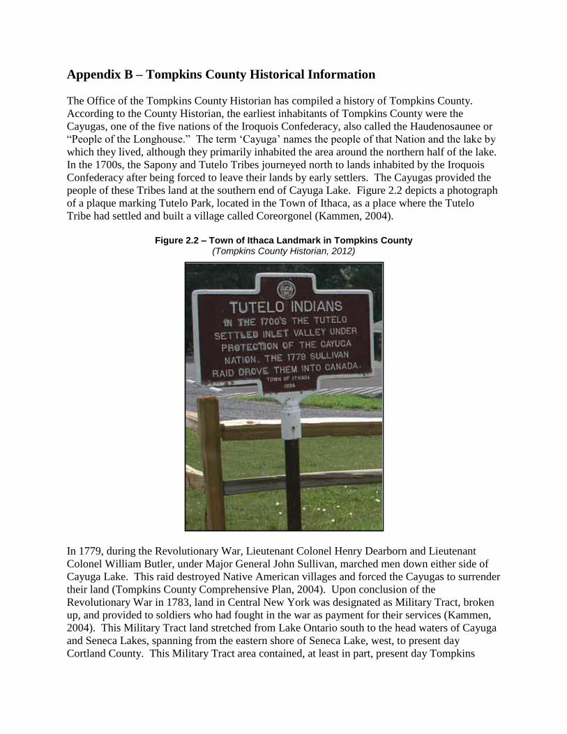
Appendix B – Tompkins County Historical Information
The Office of the Tompkins County Historian has compiled a history of Tompkins County.
According to the County Historian, the earliest inhabitants of Tompkins County were the
Cayugas, one of the five nations of the Iroquois Confederacy, also called the Haudenosaunee or
“People of the Longhouse.” The term ‘Cayuga’ names the people of that Nation and the lake by
which they lived, although they primarily inhabited the area around the northern half of the lake.
In the 1700s, the Sapony and Tutelo Tribes journeyed north to lands inhabited by the Iroquois
Confederacy after being forced to leave their lands by early settlers. The Cayugas provided the
people of these Tribes land at the southern end of Cayuga Lake. Figure 2.2 depicts a photograph
of a plaque marking Tutelo Park, located in the Town of Ithaca, as a place where the Tutelo
Tribe had settled and built a village called Coreorgonel (Kammen, 2004).
Figure 2.2 – Town of Ithaca Landmark in Tompkins County
(Tompkins County Historian, 2012)
In 1779, during the Revolutionary War, Lieutenant Colonel Henry Dearborn and Lieutenant
Colonel William Butler, under Major General John Sullivan, marched men down either side of
Cayuga Lake. This raid destroyed Native American villages and forced the Cayugas to surrender
their land (Tompkins County Comprehensive Plan, 2004). Upon conclusion of the
Revolutionary War in 1783, land in Central New York was designated as Military Tract, broken
up, and provided to soldiers who had fought in the war as payment for their services (Kammen,
2004). This Military Tract land stretched from Lake Ontario south to the head waters of Cayuga
and Seneca Lakes, spanning from the eastern shore of Seneca Lake, west, to present day
Cortland County. This Military Tract area contained, at least in part, present day Tompkins
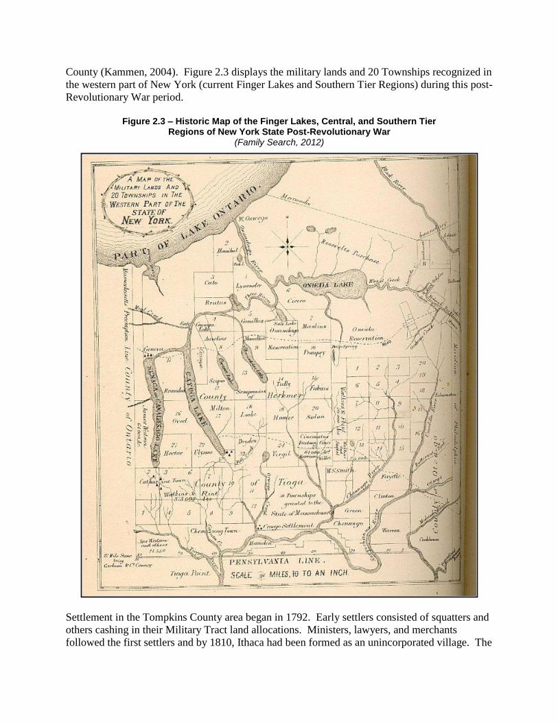
County (Kammen, 2004). Figure 2.3 displays the military lands and 20 Townships recognized in
the western part of New York (current Finger Lakes and Southern Tier Regions) during this post-
Revolutionary War period.
Figure 2.3 – Historic Map of the Finger Lakes, Central, and Southern Tier
Regions of New York State Post-Revolutionary War (Family Search, 2012)
Settlement in the Tompkins County area began in 1792. Early settlers consisted of squatters and
others cashing in their Military Tract land allocations. Ministers, lawyers, and merchants
followed the first settlers and by 1810, Ithaca had been formed as an unincorporated village. The
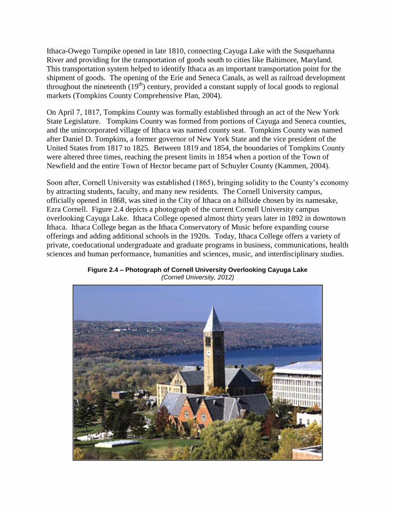
Ithaca-Owego Turnpike opened in late 1810, connecting Cayuga Lake with the Susquehanna
River and providing for the transportation of goods south to cities like Baltimore, Maryland.
This transportation system helped to identify Ithaca as an important transportation point for the
shipment of goods. The opening of the Erie and Seneca Canals, as well as railroad development
throughout the nineteenth (19th
) century, provided a constant supply of local goods to regional
markets (Tompkins County Comprehensive Plan, 2004).
On April 7, 1817, Tompkins County was formally established through an act of the New York
State Legislature. Tompkins County was formed from portions of Cayuga and Seneca counties,
and the unincorporated village of Ithaca was named county seat. Tompkins County was named
after Daniel D. Tompkins, a former governor of New York State and the vice president of the
United States from 1817 to 1825. Between 1819 and 1854, the boundaries of Tompkins County
were altered three times, reaching the present limits in 1854 when a portion of the Town of
Newfield and the entire Town of Hector became part of Schuyler County (Kammen, 2004).
Soon after, Cornell University was established (1865), bringing solidity to the County’s economy
by attracting students, faculty, and many new residents. The Cornell University campus,
officially opened in 1868, was sited in the City of Ithaca on a hillside chosen by its namesake,
Ezra Cornell. Figure 2.4 depicts a photograph of the current Cornell University campus
overlooking Cayuga Lake. Ithaca College opened almost thirty years later in 1892 in downtown
Ithaca. Ithaca College began as the Ithaca Conservatory of Music before expanding course
offerings and adding additional schools in the 1920s. Today, Ithaca College offers a variety of
private, coeducational undergraduate and graduate programs in business, communications, health
sciences and human performance, humanities and sciences, music, and interdisciplinary studies.
Figure 2.4 – Photograph of Cornell University Overlooking Cayuga Lake (Cornell University, 2012)

The land uses within Tompkins County slowly began to shift from an array of farms and mills to
an area of towns and villages, accessible by various forms of transportation (Tompkins County
Comprehensive Plan, 2004). Significant industries that came to be established in Tompkins
County in the early 1900s include the Ithaca Gun Company, the Thomas-Morse airplane
company, and the Groton Iron Bridge Company. Beginning in the 1960s, the local economy
began to shift again, this time from manufacturing and industry toward education and public
service sectors (Tompkins County Comprehensive Plan, 2004).
Tompkins County Multi-Jurisdictional All-Hazard Mitigation Plan
560.018.001/5.13 Barton & Loguidice, P.C.
Appendix C
Hazard Mitigation Plan Implementation Committee
Meeting Notes – 2007 & 2008
Tompkins County Multi-Jurisdictional All-HazardMitigation Plan (TCHMP) — 2007 Implementation ReportAs outlined in the 2006 TCHMP, “a report summarizing the previously mentioned activities will bewritten and maintained. These annual reports will provide data for the 5-year update of this planand will assist in pinpointing implementation challenges. By monitoring the implementation of theplan on an annual basis the planning group will be able to assess which projects are completed,which are no longer feasible, and if funding is being provided.”
l Meetings UpdateThe Tompkins County Multi-Jurisdictional All-Hazard Mitigation Plan — ImplementationCommittee was formed in December 2007 and met for the first time on January 30th 2008. Thegroup, made up of representatives of each of the municipalities involved In development of theTCHMP, met to both lay the groundwork for the plan’s update in 2011 and develop strategies forimplementation of the plan. The focus of the meeting was to examine the plan’s action items andupdate them based on accomplished items, repetition, and new realities. To assist with thisreview a consolidated list of hazard mitigation plan action items was built. This review documentnoted 181 actIon items over 11 hazards (flood, severe winter storm, severe storm, epidemic(agricultural), epidemic (human), fire (urban and wild), utility failure, transportation accident, watersupply contamination, terrorism, civil unrest). The action items were listed by hazards and by leadagency responsible for implementation. Just flood hazard action items (59 action items) wereexamined as a part of the January meeting, future meetings will address other action items.Based on clarification from New York State Emergency Management Office (SEMO) no formalreporting is required as of yet for this update process, though they do encourage a group beingformed. This group will meet annual for 2008 and 2009, and meet with 9reater regularity in 2010to prepare for the required update. Other results of themeeting included:
• Interest in reaching across County lines for assistance with various efforts.• Need to reconvene post-disaster event to see if mitigation measures have been useful,
what added steps need be taken.• Emergency awareness will be greatly enhance through obtaining LIDAR data (due
summer 2008).• Local communities could use assistance with grant development and implementation. A
“grants day’ was recommended.• The committee did not think the plan should take on an “adaptation” role in dealing with
global climate change at this juncture. They did indicate that “thinking green” certainly didrelate to hazard mitigation planning.
The Tompkins County Emergency Management Planning Group (TCEMPG) met bi-monthlythroughout 2007. Meetings were held the third Tuesday of the month beginning in February.Meetings were held February 20, April 17, June 19, August 21, October 16 and December 18.The TCEMPG is the group of representatives from throughout the County whom are involved inemergency management issues. This group includes representatives from County government,local fire/police, the area College and University, American Red Cross, local utilities and severalothers.
At the August 21st meeting a short presentation was made regarding the TCHMP maintenanceand implementation through a formal mitigation planning group. This group would include arepresentative from each of the jurisdictions involved with the development of the plan and wouldupdate aspects of the plan and evaluate the overall progress of mitigation action items. Theproposal for the formation of the mitigation planning group, which would be a formal reportingsubgroup to the TCEMPG, was formally submitted to the group at the October 16th Meeting.
Tompkins County Multi-Jurisdictional All-Hazard Mitigation Plan2007 Implementation Report Page 1 of 6
The August 21 meeting also served as an opportunity to update the group on a presentation thatthe County Emergency Manager, the County Hazard Mitigation Coordinator, Public WorksAdministrator and planning department staff provided to the Tompkins County Council ofGovernments (TCCOG). TCCOG is a representative body of the municipalities that lie withinTompkins County. The bulk of TCCOG participants represent jurisdictions covered by theTCHMP. Mayors, Town Board Members and Town Supervisors are among those who attend.The July 26th presentation outlined the four levels of emergency management (Preparedness,Response, Recovery and Mitigation) with a special emphasis on mitigation. The mitigationdiscussion outlined current activities and the need for the development of a mitigation planningcommittee to implement and update the mitigation plan.
A variety of Town-County and inter-County meetings laid the ground work for the items themitigation planning committee will tackle for annual meetings. In essence the plan’s action itemswill be revisited to determine what has moved forward, what hasn’t, what is still relevant and alsoexamine If any new risk assessment data is available to provide updates to the plan. Due to aturnover at the Hazard Mitigation Coordinator position and elections at several of the involvedmunicipalities the mitigation planning committee will not meet until the first quarter of 2008.
Tompkins County Multi-Jurisdictional All-Hazard Mitigation Plan2007 Implementation Report Page 2 of 6
II. Local Mitigation Activity UpdateA variety of mitigation activity happened throughout 2006 and 2007 that activity is outlined below.
• Ludlowville Stormwater Control Projecto Flood Action Item 5.1.44 — Analyze overall drainage system at Lansingville Road
The Tompkins County Planning Department applied for and receivedfunding from the NYS Department of Environmental Conservation’sWater Quality Improvement Program (WQIP) to study the drainage anddesign an engineered system to reduce property damage from areastormwater runoff.
• Watershed Assessmentso Flood Action Item 5.1.8 — Continue to conduct engineering studies and
watershed assessments to support the reduction of flood potentialo Flood Action Item 5.1 .17 — Continue Six Mile Creek, Fall Creek, Salmon Creek,
and Cayuga Inlet Watershed AssessmentsWatershed, flood mitigation needs assessment were conducted for SixMile Creek, Salmon Creek, Fall Creek & Cayuga Inlet. Priority issues andrecommendations were identified for each of these waterbodies.
• Reorganization of the Tompkins County Flood Hazard Mitigation Programo Flood Action Item 5.1.49 - Re-emphasize watershed approaches by developing a
strategy to address the needs at the watershed level, including cumulative floodmitigation activities and priorities
o Flood Action Item 5.1.20 - Identify, evaluate, and implement effective floodmitigation activities for specific “hot spots” within the county
• In using information gained from the previously mentioned watershedassessments the Tompkins County Flood Hazard Mitigation Programwas re-organized to provide a more watershed based approach. Severalof those projects were addressed in implementing the following actionitems.
• Implementation of the Barrile stream bank stabilizationo Flood Action Item 5.1.14 - Implement Barrile stream bank stabilizationo Flood Action Item 5.1.21 - Construct synthetic floodways to disperse flow and
reduce velocity of water in Six Mile Creeko Flood Action Item 5.1.22 - Increase channel roughness of Six Mile Creek
a Significant sized project helped to reduce flood risks for a number ofproperty owners in the Town of Caroline. Most recently the project wasvegetated through the County Flood Hazard Mitigation Program. TheTown of Caroline is currently planning a follow up project further downSix Mile Creek.
• As a part of the 2007 Tompkins County Flood Hazard Mitigation Program, the SalmonCreek Bank Erosion project was conducted that reduced erosion and dispersed the flowand velocity of Salmon Creek
o Flood Action Item 5.1.46 - Continue local stream bank stabilization projectso Flood Action Item 5.1.31 - Implement physical mitigation activities, as necessary
within Six Mile Creek and other appropriate watershedso Flood Action Item 5.1.45 - Stabilize the Brooktondale Road stream bank
• Banks Road — Six Mile Creek Readjustmento Flood Action Item 5.1.51 - Address the bifurcated flow in Six Mile Creek,
upstream of Banks Road• Funding allocated to implement a project on this site, though follow up
indicated that the Creek shifted and remained canalized, requiring noadded work
• The County financially committed to support the Tompkins County Soil and WaterDistrict’s contract to fly the County to collect LiDAR data that is the first step in updatingflood plain (FIRM) maps.
Tompkins County Multi-Jurisdictional All-Hazard Mitigation Plan2007 Implementation Report Page 3 of 6
o Flood Action Item 5.1.4 — Enhance data and mapping for floodplains within theCounty and identify and map any floodprone areas currently outside the County(see also 5.1.7)
o Flood Action Item 5.1.7 — Update flood plain (FIRM) maps.• Various municipalities have implemented aspects of their Phase 2 Stormwater
Regulations — efforts have been madeo Flood Action Item 5.1.12 — Implement Phase 2 Stormwater regulation
compliance, and focus on efforts under S4 that help to reduce flood risk.• Obtained grant to develop countywide stream buffer protection
o Flood Action Item 5.1.41 - Identify or update existing land use in major stramcorridors and floodplains in Tompkins County.
• Continuing to conduct aquifer studies in the Towns of Caroline, Danby and Dryden andactively initiating new studies
o Flood Action Item 5.1.47 — Conduct an assessment of groundwater resourceswithin major glacial valleys in Tompkins County to better understand currentsurface and groundwater resources in the region.
o Water Supply Contamination 5.9.2 — Continue aquifer assessment studies tobetter understand groundwater dynamics and re-charge areas.
o Water Supply Contamination 5.9.3 — Continue Six Mile, Virgil and WillseyvilleCreek Aquifer Studies.
• Help to coordinate funding for local USGS stream flow gauge operationo Flood Action Item 5.1.18 — Continue to operate the USGS stream flow gauge for
Six Mile Creek. Collect flow data for other sub-watersheds to determine theirpotential flood risk.
• The Tompkins County Planning Department coordinated the development of theTompkins County Conservation Plan which identifies priority protection areas throughoutthe County. This plan, among other things, sets forth a strategy to preserve open spacefor flood mitigation, fish habitat and water quality in the floodplain.
o Flood Action Item 5.1.26 — Encourage development of acquisition andmanagement strategies to preserve open space for flood mitigation, fish habitat,and water quality in the floodplain.
• The Town of Danby conducted surveys of special needs populations to help identifythose who may need extra assistance during a hazard event.
o Severe Winter Storm Action Item 5.2.5 — Survey institutions that have specificneeds populations to identify their emergency needs.
• The Town of Ithaca developed a stricter noise ordinance to assist in dealing withrecurring student party concerns on South Hill.
o Civil Unrest Action Item 5.11.2 — Develop a stricter student party ordinance• Other mitigation measures not previously mentioned...
Tompkins County Multi-Jurisdictional All-Hazard Mitigation Plan2007 Implementation Report Page 4 of 6
III. Information DistrIbution UpdateThe following information was distributed or obtained relating to the TCHMP this year:
• SEMO provided 3 mitigation funding opportunities in the fall of 2007 that was provided tothe local municipalities and interested parties within Tompkins County. This continues tobe a difficult process as the information from FEMA and SEMO is provided just weeks ordays prior to a formal Letter of Intent is requested.
• Conversations with SEMO indicated that a State Emergency Management Conferencewould likely be reinstituted in the approaching years. This is certainly something theCounty and mitigation team should be involved with as it is developed.
• A Tompkins County Planning Department staff member attended an energy/climatechange conference in November and indicated some discussion statewide of adaptationplanning for climate change — in essence conducting planning work to prepare forcommunity wide changes associated with climate change. At the first quarter, mitigationplanning group meeting in 2008 one agenda item will be this issue and its relationship tothe TCHMP.
Tompkins County Multi-Jurisdictional All-Hazard Mitigation Plan2007 Implementation Report Page 5 of 6

IV. Resource UpdateIn May 2007, Tompkins County hired a new Senior Planner, Scott Doyle, to assume recentdepartment vacancies, including that of County Hazard Mitigation Officer, Kate Hackett, Scott willassume the hazard mitigation coordinator role among others and coordinate the implementationand update of the Plan. He has previously worked on hazard mitigation planning issues, includingPDM, throughout the State of Oregon. He can be reached at 607-274-5560 or atokins-coor.
Tompkins County Multi-Jurisdictional All-Hazard Mitigation Plan2007 Implementation Report Page 6 of 6
Tompkins County Multi-Jurisdictional All-HazardMitigation Plan (TCHMP) — 2008 Implementation ReportAs outlined in the 2006 TCHMP, “a report summarizing the previously mentioned activities will bewritten and maintained. These annual reports will provide data for the 5-year update of this planand will assist in pinpointing implementation challenges. By monitoring the implementation ofaction items included in the plan on an annual basis the planning group will be able to assesswhich projects are completed, which are no longer feasible, and if funding is being provided.”
I. Meetings UpdateThe Tompkins County Multi-Jurisdictional All-Hazard Mitigation Plan — ImplementationCommittee was formed in December 2007 and met for the first time on January 30tu1 2008. Thegroup, made up of representatives of each of the municipalities involved in development of theTCHMP, met to both lay the groundwork for the plan’s update in 2011 and develop strategies forimplementation of the plan. The focus of the meeting was to examine the plan’s action items andupdate them based on accomplished items, repetition, and new realities. The initial meetingattendees included:
• Beth Harrington (Tompkins County Emergency Response)• Ric Dietrich (Danby)• Lee Shurtleff (Tompkins County Emergency Response)• Glenn Morey (Groton)• Dick Coogan (Ulysses)• Jessica Verfuss (Tompkins County Emergency Response)• Peter Hoyt (Caroline)• Charlie Purcell (Lansing)• Scott Doyle (Tompkins County Planning)
To assist with this review a consolidated list of hazard mitigation plan action items was built. Thisreview document noted 181 action items over 11 hazards (flood, severe winter storm, severestorm, epidemic (agricultural), epidemic (human), fire (urban and wild), utility failure,transportation accident, water supply contamination, terrorism, civil unrest). The action itemswere listed by hazards and by lead agency responsible for implementation. Just flood hazardaction items (59 action items) were examined as a part of the January meeting, future meetingswill address other action items. Based on clarification from New York State EmergencyManagement Office (SEMO) no formal reporting is required as of yet for this update process,though they do encourage a group being formed. This group will meet again in 2009 at least onetime, and meet with greater frequency in 2010 to prepare for the required update. An agenda ofthe 2008 meeting is attached. Other results of the meeting included:
• Interest in reaching across County lines for assistance with various efforts.• Need to reconvene post-disaster event to see if mitigation measures have been useful,
what added steps need be taken.• Emergency awareness will be greatly enhance through obtaining LIDAR data (Obtained
Summer 2008).• Local communities could use assistance with grant development and implementation. A
“grants daV’ was recommended.• The committee did not think the plan should take on an “adaptation” role in dealing with
global climate change at this juncture. They did indicate that “thinking green” certainly didrelate to hazard mitigation planning.
The 2009 meeting has been set for February 29, 2009.
Tompkins County Multi-Jurisdictional All-Hazard Mitigation Plan2008 Implementation Report Page 1 of 7
4
The Tompkins County Emergency Management Planning Group (TCEMPG) met bi-monthlythroughout 2008. Meetings were held the third Tuesday of the month beginning in February. TheTCEMPG is the group of representatives from throughout the County whom are involved inemergency management issues. This group Includes representatives from County government,local fire/police, Ithaca College, Cornell University, American Red Cross, local utilities and severalothers.
At the October 2008 meeting a short presentation was made regarding the TCHMP maintenanceand implementation through a formal mitigation planning group. A goal of updating all actionitems in early 2009 and mapping a timeline for the plan update
A variety of Town-County and inter-County meetings laid the ground work for the items themitigation planning committee will tackle for annual meetings. In essence the plan’s action itemswill be revisited to determine what has moved forward, what hasn’t, what is still relevant and alsoexamine if any new risk assessment data is available to provide updates to the plan.
Tompkins County Multi-Jurisdictional All-Hazard Mitigation Plan2008 Implementation Report Page 2 of 7
II. Local Mitigation Activity UpdateA variety of mitigation activity happened throughout 2008 which is outlined below.
• Ludlowville Stormwater Control Projecto Flood Action Item 5.1.44— Analyze overall drainage system at Lansingville Road
The Tompkins County Planning Department applied for and receivedfunding from the NYS Department of Environmental Conservation’sWater Quality Improvement Program (WQIP) to study the drainage anddesign an engineered system to reduce property damage from areastormwater runoff.A consultant, Barton & Loguidice, PC, was hired in the spring of 2008and has conducted an existing conditions analysis for the region. Onepublic meeting was held in 2008 to introduce the project. A follow upmeeting will be held in 2009 to detail the initial report and introduceproposed design solutions.
• Watershed Assessmentso Flood Action Item 5.1.8 — Continue to conduct engineering studies and
watershed assessments to support the reduction of flood potential.‘ Ground work was laid for watershed assessment for the Owasco Inlet.
o Flood Action Item 5.1.17 — Continue Six Mile Creek, Fall Creek, Salmon Creek,and Cayuga Inlet Watershed Assessments
• Watershed, flood mitigation needs assessment were conducted for SixMile Creek, Salmon Creek, Fall Creek & Cayuga Inlet. Priority issues andrecommendations were identified for each of these waterbodies. Severalof these projects were investigated and implemented in 2008.
• Reorganization of the Tompkins County Flood Hazard Mitigation Programo Flood Action Item 5.1.49 - Re-emphasize watershed approaches by developing a
strategy to address the needs at the watershed level, including cumulative floodmitigation activities and priorities
o Flood Action Item 5.1.20 - Identify, evaluate, and implement effective floodmitigation activities for specific “hot spots” within the county
• In using information gained from the previously mentioned watershedassessments the Tompkins County Flood Hazard Mitigation Programwas re-organized to provide a more watershed based approach. Severalof those projects were addressed in implementing the following actionitems.
• Implementation of the Barrile stream bank stabilizationo Flood Action Item 5.1.14 - Implement Barrile stream bank stabilizationo Flood Action Item 5.1.21 - Construct synthetic floodways to disperse flow and
reduce velocity of water in Six Mile Creeko Flood Action Item 5.1.22 - Increase channel roughness of Six Mile Creek
Significant sized project helped to reduce flood risks for a number ofproperty owners in the Town of Caroline. Most recently the project wasvegetated in 2007 through the County Flood Hazard Mitigation Program.The Town of Caroline is currently planning a follow up project furtherdown Six Mile Creek.
• As a part of the 2008 Tompkins County Flood Hazard Mitigation Program, the SalmonCreek Bank Erosion project was conducted that reduced erosion and dispersed the flowand velocity of Salmon Creek. Projects were identified, designed and implemented in theFall Creek, Salmon Creek, Cayuga Inlet and Sixmile Creek watersheds. These projectsincluded the stabilization of over 3,000 feet of stream bank and the vegetation of bankswith over 600 trees,
o Flood Action Item 5.1.46 - Continue local stream bank stabilization projectso Flood Action Item 5.1.31 - Implement physical mitigation activities, as necessary
within Six Mile Creek and other appropriate watersheds
Tompkhis County Multi-Jurisdictional All-Hazard Mitigation Plan2008 lmplementaUon Report Page 3 of 7
• Working closely with property owner, the project was stabilized with the assistance ofnatural in stream structures and a redesigned bank, vegetated with over 100 native treesand reseeded. The project runs 350’ along the bank of Sixmile Creek and has created aprotected 50’ Rlparian Buffer Area.
o Flood Action Item 5.1.45 - Stabilize the Brooktondale Road stream banko Flood Action Item 5.1.22 — Increase channel roughness of the Six Mile Creek,
including introducing large woody debris in the banks, creating boulder and logsills in the riverbed, installing individual boulders and boulder clusters in thechannel, and redefining the channel’s thalweg.
• Banks Road — Six Mile Creek Readjustment. Funding was allocated to implement aproject on this site, though follow up indicated that the Creek shifted and remainedchannelized, requiring no added work.
o Flood Action Item 5.1.51 - Address the bifurcated flow in Six Mile Creek,upstream of Banks Road
• Tompkins County Soil and Water District with some financial support from the Countyobtained LiDAR data that is useful in a number of projects and is the first step in updatingflood plain (FIRM) maps.
o Flood Action Item 5.1.4 — Enhance data and mapping for floodplains within theCounty and identify and map any floodprone areas currently outside the County(see also 5.1.7)
o Flood Action Item 5.1.7 — Update flood plain (FIRM) maps.• Various municipalities continue to implement aspects of their Phase 2 Stormwater
Regulations.o Flood Action Item 5.1.12 — Implement Phase 2 Stormwater regulation
compliance, and focus on efforts under S4 that help to reduce flood risk.• Obtained grant to develop countywide stream buffer protection and designed and
implemented a number of protection tools including a model riparian buffer ordinance.Outreach for these tools will be conducted in 2009.
o Flood Action Item 5.1.41 - Identify or update existing land use in major streamcorridors and floodplains in Tompkins County.
o Flood Action Item 5.1.15 — Develop model ordinances for sediment and erosioncontrol, stormwater control, and stream buffer implementation.
• Continuing to conduct aquifer studies in the Towns of Caroline, Danby and Dryden andactively initiating new studies. Outreach to the Towns of Newfield and Groton as well asthe Village of Groton regarding this program.
o Flood Action Item 5.1.47— Conduct an assessment of groundwater resourceswithin major glacial valleys in Tompkins County to better understand currentsurface and groundwater resources in the region.
o Water Supply Contamination 5.9.2 — Continue aquifer assessment studies tobetter understand groundwater dynamics and re-charge areas.
o Water Supply Contamination 5.9.3 — Continue Six Mile, Virgil and WilseyvilleCreek Aquifer Studies.
• Help to coordinate funding for local USGS stream flow gauge operation. A variety ofefforts were conducted to continue funding for gauges. One gauge, on Salmon Creek, didnot receive funding for continued use.
o Flood Action Item 5.1.18 — Continue to operate the USGS stream flow gauge forSix Mile Creek. Collect flow data for other sub-watersheds to determine theirpotential flood risk.
• The Tompkins County Planning Department coordinated the development of theTompkins County Conservation Plan which identifies priority protection areas throughoutthe County. This plan, among other things, sets forth a strategy to preserve open spacefor flood mitigation, fish habitat and water quality in the floodplain. A variety of outreachwas conducted for this planning effort.
Tompkins County Multi-Jurisdictional All-Hazard Mitigation Plan2008 Implementation Report Page 4 of 7
o Flood Action Item 5.1.26 — Encourage development of acquisition andmanagement strategies to preserve open space for flood mitigation, fish habitat,and water quality in the floodplain.
• Bridge upgrades in Tompkins County continue to be designed to support natural streamfunctions further withstand flooding events.
o Flood Action Item 5.1.29 — Retrofit or re-construct bridges at a higher elevation towithstand flood events.
• Retrofit of Caroline Town Barn to support streambank stabilizationo Severe Winter Storm Action Item 5.2.10 — Retrofit critical structures
• Obtained funding for purchasing backup generators in Caroline and Danbyo Severe Winter Storm Action Item 5.2.6 — Obtain funding to purchase backup
generators• Public awareness of storm mitigation activities, including warnings and advisories were
distributed via NY-ALERTo Severe Winter Storm Action Item 5.3.4 — Increase public awareness of storm
mitigation activitieso Epidemic (Human) Action Item 5.5.5 — Enhance public safety through
awareness, by releasing timely public service announcements via various media• Resources were secured and identified to build the appropriate medical stockpiles
o Epidemic (Human) Action Item 5.5.4 — Identify and secure resources to build theappropriate medical stockpile of medicines and medical supplies
• Outreach and education programs continue to be advanced by local fire departments inparticular, through national fire prevention month (October)
o Fire Action Item 5.6.5 — Enhance outreach and education programs aimed atmitigating fire hazards
• Fire and security alarm system installed at Danby Town Hallo Fire Action Item 5.6.18 — Install supervised firelsecurity alarm system at Danby
Town Hall• Backup power to West Danby Water District
o Utility Failure Action Item 5.7.6 — Provide backup power to the West DanbyWater District System
• Backup generator purchased for Slaterville Fire Companyo Utility Failure Action Item 5.7.19 — Purchase backup generator for Slaterville Fire
Company• Some signal improvements to improve safety around West Danby Fire Station
o Transportation Accident 5.8.10 — Arrange for NYSOT To survey West Danby firestation site distances
Tompkins County Multi-Jurisdictional All-Hazard Mitigation Plan2008 Implementation Report Page 5 of 7
III. Information Distribution UpdateThe following information was distributed or obtained relating to the TCHMP this year:
• SEMO provided 3 mitigation funding opportunities in the fall of 2008 that was provided tothe local municipalities and interested parties within Tompkins County. This continues tobe a difficult process as the information from FEMA and SEMO is provided just weeks ordays prior to a formal Letter of Intent is requested.
• Conversations with SEMO indicated that a State Emergency Management Conferencewould likely be reinstituted In the approaching years. This is certainly something theCounty and mitigation team should be involved with as it is developed.
• Emergency response and recovery training opportunities continue to be coordinatedthrough the Tompkins County Department of Emergency Response.
• It continues to be the goal of the Implementation Committee to have priority projectsready to implement as funding opportunities arise.
Tompkins County Multi-Jurisdictional All-Hazard Mitigation Plan2008 Implementation Report Page 6 of 7
IV. Resource UpdateScott Doyle continues to serve as the County Hazard Mitigation Officer and will coordinate theimplementation and update of the Plan. He has previously worked on hazard mitigation planningissues, including PDM, throughout the State of Oregon. He can be reached at 607-274-5560 or atmkin-co.or,
Tompkins County Multi-Jurisdictional All-Hazard Mitigation Plan2008 Implementation Report Page 7 of 7
Tompkins County Multi-Jurisdictional All-Hazard Mitigation Plan
560.018.001/5.13 Barton & Loguidice, P.C.
Appendix D
Website Links to Tompkins County
Planning Resources
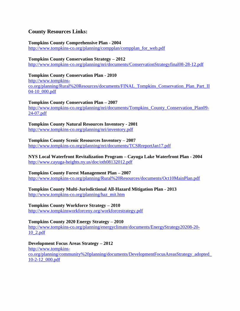
County Resources Links:
Tompkins County Comprehensive Plan - 2004
http://www.tompkins-co.org/planning/compplan/compplan_for_web.pdf
Tompkins County Conservation Strategy – 2012
http://www.tompkins-co.org/planning/nri/documents/ConservationStrategyfinal08-28-12.pdf
Tompkins County Conservation Plan - 2010
http://www.tompkins-
co.org/planning/Rural%20Resources/documents/FINAL_Tompkins_Conservation_Plan_Part_II
04-10_000.pdf
Tompkins County Conservation Plan – 2007
http://www.tompkins-co.org/planning/nri/documents/Tompkins_County_Conservation_Plan09-
24-07.pdf
Tompkins County Natural Resources Inventory - 2001
http://www.tompkins-co.org/planning/nri/inventory.pdf
Tompkins County Scenic Resources Inventory – 2007
http://www.tompkins-co.org/planning/nri/documents/TCSRreportJan17.pdf
NYS Local Waterfront Revitalization Program – Cayuga Lake Waterfront Plan - 2004
http://www.cayuga-heights.ny.us/doc/oth08132012.pdf
Tompkins County Forest Management Plan – 2007
http://www.tompkins-co.org/planning/Rural%20Resources/documents/Oct10MainPlan.pdf
Tompkins County Multi-Jurisdictional All-Hazard Mitigation Plan - 2013
http://www.tompkins-co.org/planning/haz_mit.htm
Tompkins County Workforce Strategy – 2010
http://www.tompkinsworkforceny.org/workforcestrategy.pdf
Tompkins County 2020 Energy Strategy – 2010
http://www.tompkins-co.org/planning/energyclimate/documents/EnergyStrategy20208-20-
10_2.pdf
Development Focus Areas Strategy – 2012
http://www.tompkins-
co.org/planning/community%20planning/documents/DevelopmentFocusAreasStrategy_adopted_
10-2-12_000.pdf
Tompkins County Multi-Jurisdictional All-Hazard Mitigation Plan
560.018.001/5.13 Barton & Loguidice, P.C.
Appendix E
Hazard Mitigation Plan Update
Process Meeting Timeline and Attendees

Appendix E
Hazard Mitigation Plan Update Process Meeting Timeline and Attendees
In updating the plan, the County established two committees assist in guiding the process,
the Steering Committee of municipal representation and the Technical Committee which
consists of local experts in fields addressed in the plan update. The following is a list of
that membership.
Hazard Mitigation Update Project Steering Committee
Name Municipality/Agency
Beth Harrington Tompkins County Department of Emergency Response
Lee Shurtleff Tompkins County Department of Emergency Response
Jessica Verfuss Tompkins County Department of Emergency Response
Katie Borgella Tompkins County Planning Department
Scott Doyle Tompkins County Planning Department
Cheryl Nelson Tompkins County Public Works
Kevin Romer Town of Ulysses
Don Barber Town of Caroline
Dominic Frongillo Town of Caroline
Irene Weiser* Town of Caroline
Jeff Overstrom* Town of Lansing
Creig Hebdon* Town of Ithaca
Dan Thaete Town of Ithaca
David Sprout* Town of Dryden
Mary Ann Sumner Town of Dryden
Elizabeth Thomas Town of Ulysses
Darby Kiley* Town of Ulysses
Susan Beeners* Town of Danby
Matt Cooper Town of Danby
Ric Dietrich Town of Danby
Richard Driscoll* Town of Newfield
Glenn Morey* Town of Groton
Julie Holcomb* City of Ithaca
Guy Van Benschoten City of Ithaca
Roy Barriere Town of Enfield

Name Municipality/Agency
Larry Stilwell* Town of Enfield
Ann Rider Town of Enfield
Don Hartill* V. Lansing
Marty Moseley V. Lansing
Tammy Morse V. Trumansburg
Martin Petorvic* V. Trumansburg
Randall Sterling* V. Dryden
Abby Homer V. Dryden
Kevin Ezell V. Dryden
Lotte Carpenter* V. Freeville
Stephanie Mulinos V. Freeville
Jeffery Evener V. Groton
Chuck Rankin* V. Groton
Kate Supron* V. Cayuga Heights
Mary Mills V. Cayuga Heights
James Steinmetz V. Cayuga Heights
George Tamborelle V. Cayuga Heights
Brent Cross V. Cayuga Heights
*Lead municipal contact
Hazard Mitigation Plan Technical Committee
Name Agency/Muni Field
Art Pearce Community Volunteer Gas Drilling
Darby Kiley Town of Ulysses, Former County Staff
for Gas Drilling Work
Gas Drilling
Jonathan Comstock Cornell Horticulture Climate/ClimAid
Frank Kruppa County Health Public Health
Craig Schutt Tompkins Co. Soil & Water
Conservation District (TCSWCD)
Ag +
Mark Whitmore Cornell Nat. Res. Invasives
Jack Rueckheim Bolton Point Water
Roxanna Johnston City of Ithaca Water
Bob Passe NYSEG Utilities

Name Agency/Muni Field
Jack French Lansing Highway Transp
Jessica Verfuss Emergency Response EM
Ed Bugliosi USGS Water
Bill Gray City of Ithaca Public Works
The following is the meetings held as a part of the plan update process and a list of
attendees.
Steering Committee Kick Off Meeting – September 20, 2011 –– Organizing meeting,
discussed why updating the plan, what new aspects we would explore, how we would
engage the public and other items. The meeting included the following attendees:
Beth Harrington, Tompkins County Department of Emergency Response (DOER)
Kevin Romer, Town of Ulysses
Don Barber, Town of Caroline
Jeff Overstrom, Town of Lansing
Creig Hebdon, Town of Ithaca
Katie Borgella, Tompkins County Planning Department (TCPD)
David Sprout, Town of Dryden
Elizabeth Thomas, Town of Ulysses
Lee Shurtleff, DOER
Jessica Verfuss, DOER
Susan Beeners, Town of Danby
Cheryl Nelson, Tompkins County Public Works
Richard Driscoll, Town of Newfield
Scott Doyle, TCPD
Technical Committee Meeting #1 – February 10, 2012 – Overview of the process,
discussion of committee’s role, risk assessment preparation, and other items. The meeting
included the following attendees:
Darby Kiley, Town of Ulyssess
Jonathan Comstock, Cornell University Horticulture
Frank Kruppa, Tompkins County Health Department
Roxy Johnston, City of Ithaca Water Treatment Plant
Craig Schutt, Tompkins County Soil and Water Conservation District
Mark Whitmore, Cornell University Department of Natural Resources
Jack French, Town of Lansing Highway Department
Ed Bugliosi, United States Geological Survey (USGS)
Katie Borgella, TCPD
Scott Doyle, TCPD
John Condino, Barton & Loguidice (B&L)
Johanna Duffy, B&L
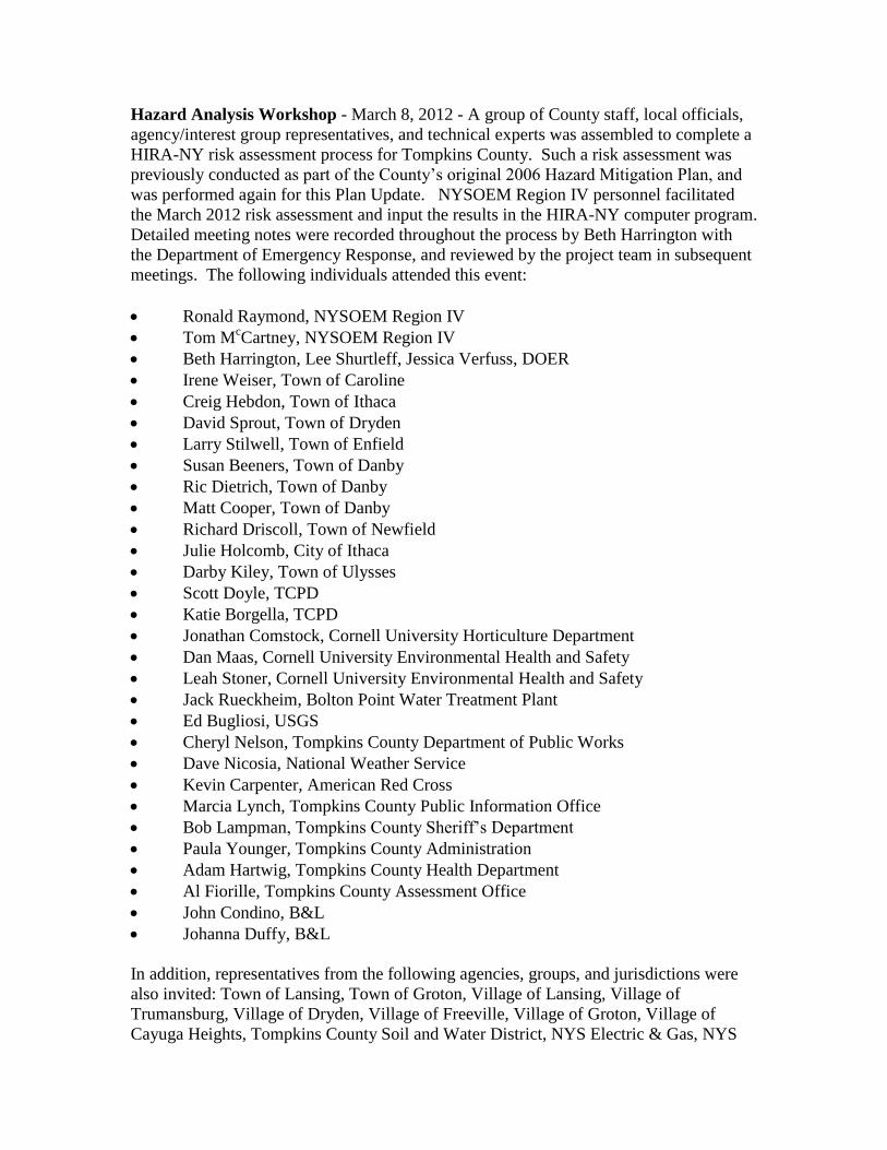
Hazard Analysis Workshop - March 8, 2012 - A group of County staff, local officials,
agency/interest group representatives, and technical experts was assembled to complete a
HIRA-NY risk assessment process for Tompkins County. Such a risk assessment was
previously conducted as part of the County’s original 2006 Hazard Mitigation Plan, and
was performed again for this Plan Update. NYSOEM Region IV personnel facilitated
the March 2012 risk assessment and input the results in the HIRA-NY computer program.
Detailed meeting notes were recorded throughout the process by Beth Harrington with
the Department of Emergency Response, and reviewed by the project team in subsequent
meetings. The following individuals attended this event:
Ronald Raymond, NYSOEM Region IV
Tom McCartney, NYSOEM Region IV
Beth Harrington, Lee Shurtleff, Jessica Verfuss, DOER
Irene Weiser, Town of Caroline
Creig Hebdon, Town of Ithaca
David Sprout, Town of Dryden
Larry Stilwell, Town of Enfield
Susan Beeners, Town of Danby
Ric Dietrich, Town of Danby
Matt Cooper, Town of Danby
Richard Driscoll, Town of Newfield
Julie Holcomb, City of Ithaca
Darby Kiley, Town of Ulysses
Scott Doyle, TCPD
Katie Borgella, TCPD
Jonathan Comstock, Cornell University Horticulture Department
Dan Maas, Cornell University Environmental Health and Safety
Leah Stoner, Cornell University Environmental Health and Safety
Jack Rueckheim, Bolton Point Water Treatment Plant
Ed Bugliosi, USGS
Cheryl Nelson, Tompkins County Department of Public Works
Dave Nicosia, National Weather Service
Kevin Carpenter, American Red Cross
Marcia Lynch, Tompkins County Public Information Office
Bob Lampman, Tompkins County Sheriff’s Department
Paula Younger, Tompkins County Administration
Adam Hartwig, Tompkins County Health Department
Al Fiorille, Tompkins County Assessment Office
John Condino, B&L
Johanna Duffy, B&L
In addition, representatives from the following agencies, groups, and jurisdictions were
also invited: Town of Lansing, Town of Groton, Village of Lansing, Village of
Trumansburg, Village of Dryden, Village of Freeville, Village of Groton, Village of
Cayuga Heights, Tompkins County Soil and Water District, NYS Electric & Gas, NYS

Police, Ithaca College, Tompkins County Community College, Cayuga Medical Center,
and T-S-T BOCES.
Technical Committee Meeting #2 – March 29, 2012 – Overview of hazard analysis
workshop and refinement of risk assessment data. The meeting included the following
attendees:
Frank Kruppa, Tompkins County Health Department
Ed Bugliosi, USGS
Craig Schutt, TCSWCD
Darby Kiley, Town of Ulysses
Roxanna Johnston, City of Ithaca
Mark Whitmore, Cornell University Department of Natural Resources
Katy Borgella, TCPD
Scott Doyle, TCPD
Jessica Verfuss, DOER
Steering Committee Meeting #2 – April 19, 2012 – Review of plan requirements, the
update process, hazard history refinement and action item updates. The meeting included
the following attendees:
David Sprout, Town of Dryden
Darby Kiley, Town of Ulysses
Larry Stilwell, Town of Enfield
Katie Borgella, TCPD
Creig Hebdon, Town of Ithaca
Kevin Ezell, Village of Dryden
Irene Weiser, Town of Caroline
Jeff Overstrom, Town of Lansing
Susan Beeners, Town of Danby
Jessica Verfuss, DOER
Beth Harrington, DOER
Glenn Morey, Town of Groton
Matt Cooper, Town of Danby
Julie Holcomb, City of Ithaca
Cheryl Nelson, Tompkins County Public Works
Dominic Frongillo, Town of Caroline
Scott Doyle, TCPD
Lee Shurtleff, DOER
John Condino, B&L
Johanna Duffy, B&L
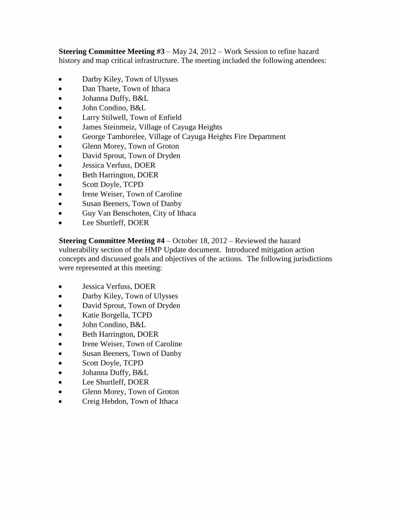
Steering Committee Meeting #3 – May 24, 2012 – Work Session to refine hazard
history and map critical infrastructure. The meeting included the following attendees:
Darby Kiley, Town of Ulysses
Dan Thaete, Town of Ithaca
Johanna Duffy, B&L
John Condino, B&L
Larry Stilwell, Town of Enfield
James Steinmeiz, Village of Cayuga Heights
George Tamborelee, Village of Cayuga Heights Fire Department
Glenn Morey, Town of Groton
David Sprout, Town of Dryden
Jessica Verfuss, DOER
Beth Harrington, DOER
Scott Doyle, TCPD
Irene Weiser, Town of Caroline
Susan Beeners, Town of Danby
Guy Van Benschoten, City of Ithaca
Lee Shurtleff, DOER
Steering Committee Meeting #4 – October 18, 2012 – Reviewed the hazard
vulnerability section of the HMP Update document. Introduced mitigation action
concepts and discussed goals and objectives of the actions. The following jurisdictions
were represented at this meeting:
Jessica Verfuss, DOER
Darby Kiley, Town of Ulysses
David Sprout, Town of Dryden
Katie Borgella, TCPD
John Condino, B&L
Beth Harrington, DOER
Irene Weiser, Town of Caroline
Susan Beeners, Town of Danby
Scott Doyle, TCPD
Johanna Duffy, B&L
Lee Shurtleff, DOER
Glenn Morey, Town of Groton
Creig Hebdon, Town of Ithaca
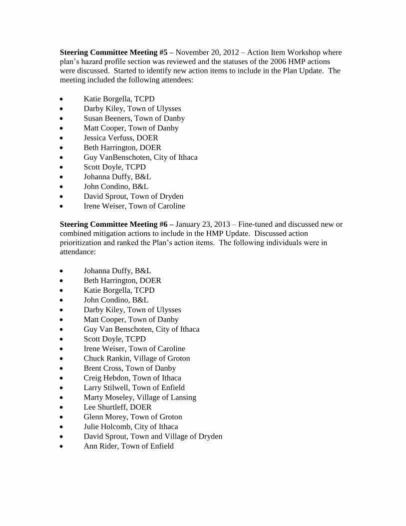
Steering Committee Meeting #5 – November 20, 2012 – Action Item Workshop where
plan’s hazard profile section was reviewed and the statuses of the 2006 HMP actions
were discussed. Started to identify new action items to include in the Plan Update. The
meeting included the following attendees:
Katie Borgella, TCPD
Darby Kiley, Town of Ulysses
Susan Beeners, Town of Danby
Matt Cooper, Town of Danby
Jessica Verfuss, DOER
Beth Harrington, DOER
Guy VanBenschoten, City of Ithaca
Scott Doyle, TCPD
Johanna Duffy, B&L
John Condino, B&L
David Sprout, Town of Dryden
Irene Weiser, Town of Caroline
Steering Committee Meeting #6 – January 23, 2013 – Fine-tuned and discussed new or
combined mitigation actions to include in the HMP Update. Discussed action
prioritization and ranked the Plan’s action items. The following individuals were in
attendance:
Johanna Duffy, B&L
Beth Harrington, DOER
Katie Borgella, TCPD
John Condino, B&L
Darby Kiley, Town of Ulysses
Matt Cooper, Town of Danby
Guy Van Benschoten, City of Ithaca
Scott Doyle, TCPD
Irene Weiser, Town of Caroline
Chuck Rankin, Village of Groton
Brent Cross, Town of Danby
Creig Hebdon, Town of Ithaca
Larry Stilwell, Town of Enfield
Marty Moseley, Village of Lansing
Lee Shurtleff, DOER
Glenn Morey, Town of Groton
Julie Holcomb, City of Ithaca
David Sprout, Town and Village of Dryden
Ann Rider, Town of Enfield
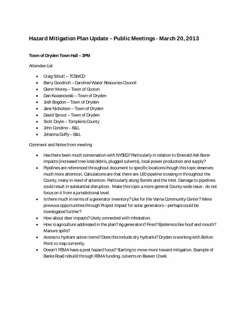
Hazard Mitigation Plan Update Public Meetings March 20, 2013
Town of Dryden Town Hall – 3PM
Attendee List
Craig Schutt – TCSWCD Barry Goodrich – Caroline/Water Resources Council Glenn Morey – Town of Groton Dan Kwasnowski – Town of Dryden Josh Bogdon – Town of Dryden Jane Nicholson – Town of Dryden David Sprout – Town of Dryden Scott Doyle – Tompkins County John Condino – B&L Johanna Duffy – B&L
Comment and Notes from meeting
Has there been much conversation with NYSEG? Particularly in relation to Emerald Ash Borer impacts (increased tree loss/debris, plugged culverts), local power production and supply?
Pipelines are referenced throughout document to specific locations though this topic deserves much more attention. Calculations are that there are 160 pipeline crossing in throughout the County, many in need of attention. Particularly along Sixmile and the Inlet. Damage to pipelines could result in substantial disruption. Make this topic a more general County-wide issue - do not focus on it from a jurisdictional level.
Is there much in terms of a generator inventory? Like for the Varna Community Center? Were previous opportunities through Project Impact for solar generators – perhaps could be investigated further?
How about deer impacts? Likely connected with infestation. How is agriculture addressed in the plan? Ag generators? Fires? Epidemics like hoof and mouth?
Manure spills? Access to hydrant action items? Does this include dry hydrants? Dryden is working with Bolton
Point to map currently. Doesn’t FEMA have a post hazard focus? Starting to move more toward mitigation. Example of
Banks Road rebuild through FEMA funding, culverts on Beaver Creek.
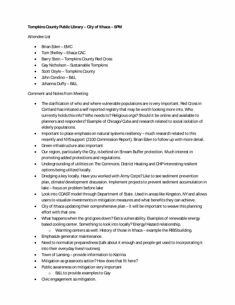
Tompkins County Public Library – City of Ithaca – 6PM
Attendee List
Brian Eden – EMC Tom Shelley – Ithaca CAC Barry Stein – Tompkins County Red Cross Gay Nicholson – Sustainable Tompkins Scott Doyle – Tompkins County John Condino – B&L Johanna Duffy – B&L
Comment and Notes from Meeting
The clarification of who and where vulnerable populations are is very important. Red Cross in Cortland has initiated a self reported registry that may be worth looking more into. Who currently holds this info? Who needs to? Religious orgs? Should it be online and available to planners and responders? Example of Chicago/Cuba and research related to social isolation of elderly populations.
Important to place emphasis on natural systems resiliency – much research related to this recently and NYS support (2100 Commission Report). Brian Eden to follow up with more detail.
Green infrastructure also important Our region, particularly the City, is behind on Stream Buffer protection. Much interest in
promoting added protections and regulations. Undergrounding of utilities on The Commons. District Heating and CHP interesting resilient
options being utilized locally. Dredging a key locally. Have you worked with Army Corps? Like to see sediment prevention
plan, climate/development discussion. Implement projects to prevent sediment accumulation in lake – focus on problem before lake
Look into COAST model through Department of State. Used in areas like Kingston, NY and allows users to visualize investments in mitigation measures and what benefits they can achieve.
City of Ithaca updating their comprehensive plan – it will be important to weave this planning effort with that one.
What happens when the grid goes down? Extra vulnerability. Examples of renewable energy based cooling center. Something to look into locally? Energy/Hazard relationship.
o Warming centers as well. History of those in Ithaca – example the RIBS building. Emphasize generator maintenance. Need to normalize preparedness (talk about it enough and people get used to incorporating it
into their everyday lives/routines) Town of Lansing – provide information to Katrina Mitigation as grassroots action? How does that fit here? Public awareness on mitigation very important
o B&L to provide examples to Gay Civic engagement as mitigation.
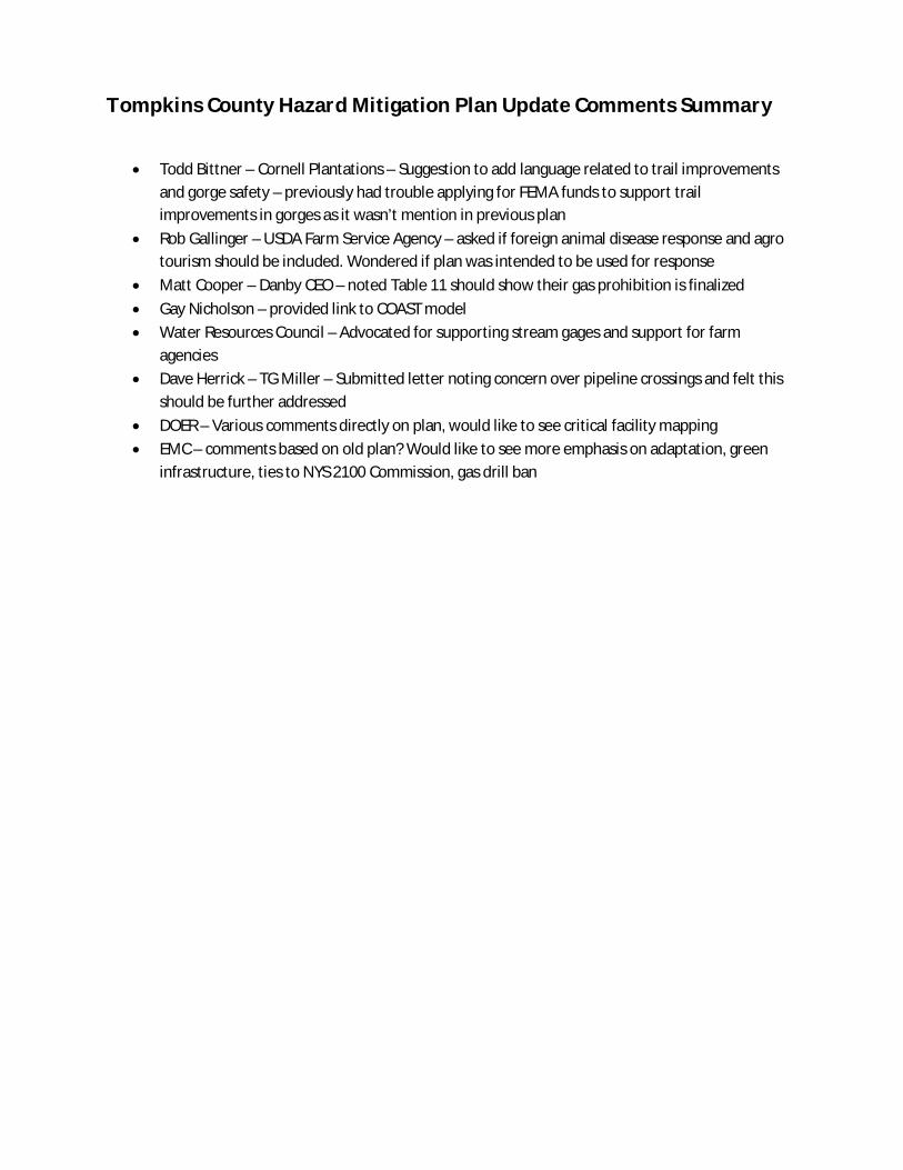
Tompkins County Hazard Mitigation Plan Update Comments Summary
Todd Bittner – Cornell Plantations – Suggestion to add language related to trail improvements and gorge safety – previously had trouble applying for FEMA funds to support trail improvements in gorges as it wasn’t mention in previous plan
Rob Gallinger – USDA Farm Service Agency – asked if foreign animal disease response and agro tourism should be included. Wondered if plan was intended to be used for response
Matt Cooper – Danby CEO – noted Table 11 should show their gas prohibition is finalized Gay Nicholson – provided link to COAST model Water Resources Council – Advocated for supporting stream gages and support for farm
agencies Dave Herrick – TG Miller – Submitted letter noting concern over pipeline crossings and felt this
should be further addressed DOER – Various comments directly on plan, would like to see critical facility mapping EMC – comments based on old plan? Would like to see more emphasis on adaptation, green
infrastructure, ties to NYS 2100 Commission, gas drill ban
Tompkins County Multi-Jurisdictional All-Hazard Mitigation Plan
560.018.001/5.13 Barton & Loguidice, P.C.
Appendix F
Plan Adoption Resolution and
Sample Resolution
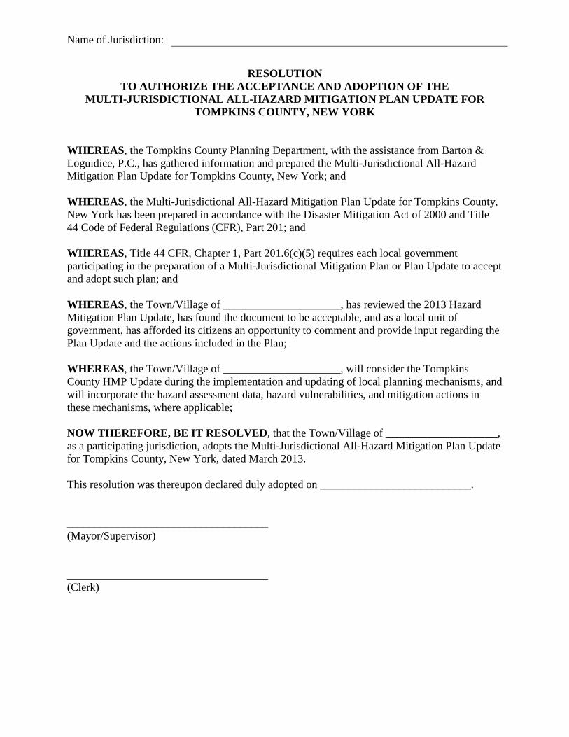
Name of Jurisdiction:
RESOLUTION
TO AUTHORIZE THE ACCEPTANCE AND ADOPTION OF THE
MULTI-JURISDICTIONAL ALL-HAZARD MITIGATION PLAN UPDATE FOR
TOMPKINS COUNTY, NEW YORK
WHEREAS, the Tompkins County Planning Department, with the assistance from Barton &
Loguidice, P.C., has gathered information and prepared the Multi-Jurisdictional All-Hazard
Mitigation Plan Update for Tompkins County, New York; and
WHEREAS, the Multi-Jurisdictional All-Hazard Mitigation Plan Update for Tompkins County,
New York has been prepared in accordance with the Disaster Mitigation Act of 2000 and Title
44 Code of Federal Regulations (CFR), Part 201; and
WHEREAS, Title 44 CFR, Chapter 1, Part 201.6(c)(5) requires each local government
participating in the preparation of a Multi-Jurisdictional Mitigation Plan or Plan Update to accept
and adopt such plan; and
WHEREAS, the Town/Village of _____________________, has reviewed the 2013 Hazard
Mitigation Plan Update, has found the document to be acceptable, and as a local unit of
government, has afforded its citizens an opportunity to comment and provide input regarding the
Plan Update and the actions included in the Plan;
WHEREAS, the Town/Village of _____________________, will consider the Tompkins
County HMP Update during the implementation and updating of local planning mechanisms, and
will incorporate the hazard assessment data, hazard vulnerabilities, and mitigation actions in
these mechanisms, where applicable;
NOW THEREFORE, BE IT RESOLVED, that the Town/Village of ____________________,
as a participating jurisdiction, adopts the Multi-Jurisdictional All-Hazard Mitigation Plan Update
for Tompkins County, New York, dated March 2013.
This resolution was thereupon declared duly adopted on ___________________________.
____________________________________
(Mayor/Supervisor)
____________________________________
(Clerk)
Tompkins County Multi-Jurisdictional All-Hazard Mitigation Plan
560.018.001/5.13 Barton & Loguidice, P.C.
Appendix G
Tompkins County Critical Facilities List

Appendix G Tompkins County Community Facilities and Critical Infrastructure List
As detailed in the plan this list includes both important Community Facilities and Critical Infrastructure as identified by participating jurisdictions and agencies. Locations of the majority of these facilities and infrastructure are displayed on Figure 2.9 in Appendix A. The County’s core critical infrastructure list is held and maintained by the Tompkins County Sherriff’s Department. Boatyards: Johnson’s Boatyard and Marina Treman Marina East Shore Sailing Ithaca Yacht Club Myers Point Taughannock Falls State Park Marina
Bus Terminals: Lansing CSD Bus Garage Ithaca Bus Terminal Ithaca Tompkins Transit Center
Camps: Empire State Speech and Hearing Camp Camp Barton Girl Scout Camp
Community Centers: Cayuga Nature Center Bethel Grove Community Center Ellis Hollow Community Center Enfield Community Center Brooktondale Community Center Hillside Children’s Center Southside Community Center Coddington Road Community Center Varna Community Association American Red Cross Community Center
Correctional Facilities: Lansing School for Girls Tompkins County Jail NYS McCormick Training Center
Dams: Jennings Pond Treman Lake at Buttermilk State Park Cayuga Inlet Fish Ladder Dryden Lake Dam Virgil Creek Dam Second Dam First Dam Van Natta Dam Flat Rock Beebe Lake
Day Care Centers: Groton Head Start TCAction Head Start FSA Child Care Center at Tompkins County Community College Ithaca Community Childcare at Kendal Community Nursery School Franziska Racker Center Coddington Child Care Center Drop-in Children’s Center Happy Way Child Care Ithaca Montessori School Stepping Stones Preschool Cornell Child Care Center Namaste Montessori IC3 Groton Day Care
Electrical Substations: Trumansburg Substation South Lansing Substation Cayuga Heights Substation South Hill Substation Etna Substation Peruville Substation Groton Substation Milliken Substation East Hill Substation County Hospital Substation Cornell University Electrical Substations 4th Street Substation West Hill Substation State Hospital Substation
Newfield Substation Brooktondale Substation Dryden Substation Ludlowville Substation Cayuga Rock Salt Substation
Elementary Schools: Montessori School Dryden Elementary School – Dryden Central School District Freeville Elementary School – Dryden Central School District Trumansburg Elementary School – Trumansburg Central School District Newfield Elementary School – Newfield Central School District Groton Elementary School – Groton Central School District Cassavant Elementary School – Dryden Central School District R.C. Buckley Elementary School – Lansing Central School District Caroline Elementary School – Ithaca City School District South Hill Elementary School – Ithaca City School District Northeast Elementary School – Ithaca City School District Beverly J Martin Elementary School – Ithaca City School District Fall Creek Elementary School – Ithaca City School District Enfield Elementary School – Ithaca City School District Cayuga Heights Elementary School – Ithaca City School District Belle Sherman Elementary School – Ithaca City School District
Emergency Operations: Tompkins County Emergency Response (EOC, 911 Center, County radio system)
Fire and EMS Departments and Facilities: Bangs Ambulance Neptune Hose – Company #1 Newfield Fire Company Varna Fire Station Ithaca Fire Department – Central Station West Danby Fire Hall Trumansburg Fire Department Speedsville Fire Hose Slaterville Springs Fire House McLean Fire Department Lansing Fire Department – Company #5 Lansing Fire Department – Company #4 Lansing Fire Department – Company #3 Lansing Fire Department – Central Station, Company #1 and #2 Ithaca Fire Department – College Avenue Station #9 Ithaca Fire Department – West Hill Station #6

Ithaca Fire Department – South Hill Station #5 Groton Fire Station Freeville Fire Department Etna Volunteer Fire Department Enfield Fire Station Danby Volunteer Fire Company Cayuga Heights Fire Department Brooktondale Fire Station Volunteer Ambulance Services including Dryden Ambulance Cornell University Environmental Health and Safety Ithaca College Center for Public Safety and General Services
Government Centers: Ithaca City Hall Ithaca City Courthouse Tompkins County Courthouse Post Offices Groton Town Hall Newfield Town Hall Enfield Town Hall Ithaca Town Hall Danby Town Hall Lansing Town Hall Ulysses Town Hall Caroline Town Hall Dryden Town Hall Dryden Village Hall Village of Freeville Office Lansing Village Office Cayuga Heights Village Office Trumansburg Village Office Groton Village Hall
High Schools and Vocational Schools: Lehman Alternative School William George Agency Newfield High School – Newfield Central School District Charles O. Dickerson High School – Trumansburg Central School District Dryden High School – Dryden Central School District Groton High School – Groton Central School District Lansing High School – Lansing Central School District Ithaca High School – Ithaca City School District Tompkins-Seneca-Tioga BOCES
Highway Departments: Town of Groton Highway Department Town of Lansing Highway Department Town of Dryden Highway Department Town of Caroline Highway Department Town of Danby Highway Department Town of Newfield Highway Department Town of Ithaca Highway Department Town of Enfield Highway Department Town of Ulysses Highway Department City of Ithaca Streets and Facilities NYSDOT Barn Cornell University Grounds Department Ithaca College Office of Facilities
Human Services: Franziska Racker Center Tompkins County Health Department Occupational Services of the Finger Lakes Loaves and Fishes Community Dispute Resolution Center Lansing Residential Center Finger Lakes Residential Center
Industrial: NYS Electric & Gas Borg Warner Emerson Power Transmission THERM, Inc. Cargill Salt Mine
Major University or Small College: Ithaca College Cornell University Tompkins County Community College Empire State College – SUNY TCCC Extension Center
Medical Facility: Parkview Medical Campus Convenient Care Cayuga Medical Center Guthrie Clinic Trumansburg Family Health Center
Groton Intermediate Care Facility Groton Community Health Care Center Five Star Urgent Gannett Health Center (Cornell) Ithaca College Hammond Health Center
Middle School: Boynton Middle School – Ithaca City School District DeWitt Middle School – Ithaca City School District Lansing Middle School – Lansing Central School District Groton Middle School – Groton Central School District Dryden Middle School – Dryden Central School District Russell I. Doig Middle School – Trumansburg Central School District Newfield Junior High School – Newfield Central School District
Other Public Facility: Chamber of Commerce Ithaca City Youth Bureau Tompkins County Airport Tompkins County Annex Building Old Jail Old Courthouse Tompkins County Mental Health NYS Department of Motor Vehicles Tompkins County Soil & Water Conservation District Clinton House Greater Ithaca Activities Center NYS Army National Guard NYS Department of Environmental Conservation Northeast Transit/Swarthout & Ferris US Coast Guard Auxiliary US Army Reserve Center US Geological Survey American Auto Association GIAC Community Pool State Theatre Trumansburg Fairgrounds YMCA Tompkins County Amateur Radio Association NYS Veterinary Diagnostic Laboratory
Performing Arts: Ballet Center of Ithaca Ithaca Academy of Dance
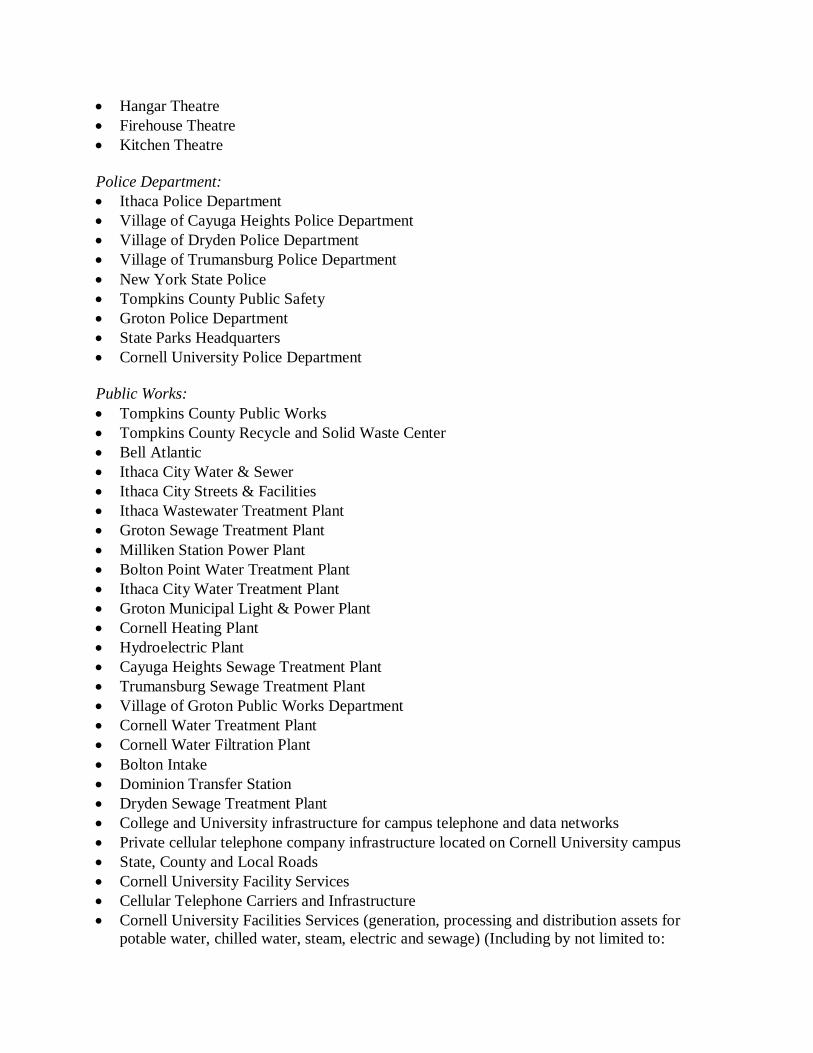
Hangar Theatre Firehouse Theatre Kitchen Theatre
Police Department: Ithaca Police Department Village of Cayuga Heights Police Department Village of Dryden Police Department Village of Trumansburg Police Department New York State Police Tompkins County Public Safety Groton Police Department State Parks Headquarters Cornell University Police Department
Public Works: Tompkins County Public Works Tompkins County Recycle and Solid Waste Center Bell Atlantic Ithaca City Water & Sewer Ithaca City Streets & Facilities Ithaca Wastewater Treatment Plant Groton Sewage Treatment Plant Milliken Station Power Plant Bolton Point Water Treatment Plant Ithaca City Water Treatment Plant Groton Municipal Light & Power Plant Cornell Heating Plant Hydroelectric Plant Cayuga Heights Sewage Treatment Plant Trumansburg Sewage Treatment Plant Village of Groton Public Works Department Cornell Water Treatment Plant Cornell Water Filtration Plant Bolton Intake Dominion Transfer Station Dryden Sewage Treatment Plant College and University infrastructure for campus telephone and data networks Private cellular telephone company infrastructure located on Cornell University campus State, County and Local Roads Cornell University Facility Services Cellular Telephone Carriers and Infrastructure Cornell University Facilities Services (generation, processing and distribution assets for
potable water, chilled water, steam, electric and sewage) (Including by not limited to:
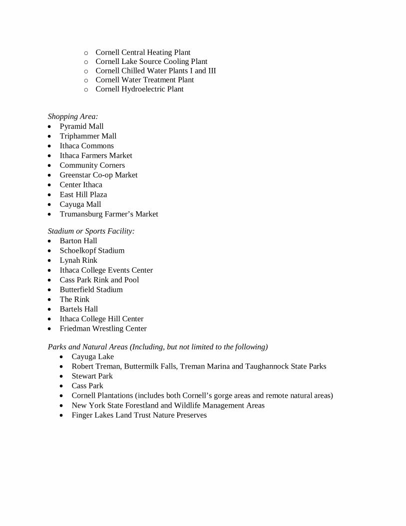
o Cornell Central Heating Plant o Cornell Lake Source Cooling Plant o Cornell Chilled Water Plants I and III o Cornell Water Treatment Plant o Cornell Hydroelectric Plant
Shopping Area: Pyramid Mall Triphammer Mall Ithaca Commons Ithaca Farmers Market Community Corners Greenstar Co-op Market Center Ithaca East Hill Plaza Cayuga Mall Trumansburg Farmer’s Market
Stadium or Sports Facility: Barton Hall Schoelkopf Stadium Lynah Rink Ithaca College Events Center Cass Park Rink and Pool Butterfield Stadium The Rink Bartels Hall Ithaca College Hill Center Friedman Wrestling Center
Parks and Natural Areas (Including, but not limited to the following)
Cayuga Lake Robert Treman, Buttermilk Falls, Treman Marina and Taughannock State Parks Stewart Park Cass Park Cornell Plantations (includes both Cornell’s gorge areas and remote natural areas) New York State Forestland and Wildlife Management Areas Finger Lakes Land Trust Nature Preserves

Tompkins County Multi-Jurisdictional All-Hazard Mitigation Plan
560.018.001/5.13 Barton & Loguidice, P.C.
Appendix H
Tompkins County Transportation Infrastructure
with Reoccurring Flooding Issues
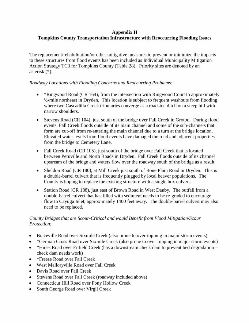
Appendix H
Tompkins County Transportation Infrastructure with Reoccurring Flooding Issues
The replacement/rehabilitation/or other mitigative measures to prevent or minimize the impacts
to these structures from flood events has been included as Individual Municipality Mitigation
Action Strategy TC3 for Tompkins County (Table 28). Priority sites are denoted by an
asterisk (*).
Roadway Locations with Flooding Concerns and Reoccurring Problems:
*Ringwood Road (CR 164), from the intersection with Ringwood Court to approximately
½-mile northeast in Dryden. This location is subject to frequent washouts from flooding
where two Cascadilla Creek tributaries converge as a roadside ditch on a steep hill with
narrow shoulders.
Stevens Road (CR 104), just south of the bridge over Fall Creek in Groton. During flood
events, Fall Creek floods outside of its main channel and some of the sub-channels that
form are cut-off from re-entering the main channel due to a turn at the bridge location.
Elevated water levels from flood events have damaged the road and adjacent properties
from the bridge to Cemetery Lane.
Fall Creek Road (CR 105), just south of the bridge over Fall Creek that is located
between Peruville and North Roads in Dryden. Fall Creek floods outside of its channel
upstream of the bridge and waters flow over the roadway south of the bridge as a result.
Sheldon Road (CR 180), at Mill Creek just south of Bone Plain Road in Dryden. This is
a double-barrel culvert that is frequently plugged by local beaver populations. The
County is hoping to replace the existing structure with a single box culvert.
Station Road (CR 188), just east of Brown Road in West Danby. The outfall from a
double-barrel culvert that has filled with sediment needs to be re-graded to encourage
flow to Cayuga Inlet, approximately 1400 feet away. The double-barrel culvert may also
need to be replaced.
County Bridges that are Scour-Critical and would Benefit from Flood Mitigation/Scour
Protection:
Boiceville Road over Sixmile Creek (also prone to over-topping in major storm events)
*German Cross Road over Sixmile Creek (also prone to over-topping in major storm events)
*Hines Road over Enfield Creek (has a downstream check dam to prevent bed degradation –
check dam needs work)
*Freese Road over Fall Creek
West Malloryville Road over Fall Creek
Davis Road over Fall Creek
Stevens Road over Fall Creek (roadway included above)
Connecticut Hill Road over Pony Hollow Creek
South George Road over Virgil Creek

Johnson Street over Virgil Creek
Dodge Road over Cascadilla Creek
Genung Road over Cascadilla Creek
Salmon Creek Road over Salmon Creek (prone to debris build-up during flood events)
Lockerby Hill Road over Salmon Creek
South Street Extension over Bolter Creek
Tompkins County Multi-Jurisdictional All-Hazard Mitigation Plan
560.018.001/5.13 Barton & Loguidice, P.C.
Appendix I
Hazard Mitigation Plan Update Process Checklist
Tompkins County
Multi-Jurisdiction All-Hazard Mitigation Plan
Monitoring, Evaluation and Update Checklist
Steps to be completed, at a minimum, at the end of Years 1, 2, 3, and 4:
Meeting
Identify members of the Hazard Mitigation Plan Implementation Committee
(may need to be revised year-to-year)
Set a meeting date and notify Implementation Committee members
Members should come prepared to specifically discuss status and details of pre-
disaster mitigation projects or actions executed by their respective
agency/organization
Publish meeting date in newspaper and online to invite public participants
Hold meeting – discuss hazard events that have occurred since last meeting or Plan
Update, including:
Type of hazard event
Damages incurred
Cost of repairs
Hazard response
Hazard duration and recovery time
Discuss how the HMP actions, strategies, and other information has been incorporated
into local planning mechanisms and agency efforts over the past year (if applicable)
Evaluate the HMP Update by assessing:
Whether the goals and objectives address current and expected conditions
Whether the nature, magnitude, and/or type of risks have changed
Whether the current resources are appropriate for implementing the plan
Whether there are implementation problems or coordination issues with other
agencies
Whether the outcomes, thus far, have occurred as expected
Update the HMP by addendum if any significant changes are needed
Documentation
Tompkins County Planning Department to prepare annual summary of collected
information, hazard occurrences and damages, completed mitigation actions and costs,
and other applicable information
Post this annual summary on County website for public review and keep in files for
next formal HMP Update process
Steps to be completed end of Year 3/early in Year 4:
Grant Funding
Submit application to FEMA for grant funding to complete next HMP Update
Steps to be completed in early/mid-way Year 4:
Plan Document
Determine who will be the primary author of Plan Update (Consultant or In-house)
Meeting
Inform Implementation Committee members of first meeting to begin formal Plan
Update process
HIRA-NY Risk Assessment (if needed)
Send email to participants with date and time of HIRA-NY event
Complete HIRA-NY program with NYSOEM facilitation
Steps to be completed in Year 5:
Plan Document
Update pertinent sections of the Plan, including Appendices
Add-in hazard related details that were collected during annual Implementation
Committee meetings

Meetings
Hold Implementation Committee meeting(s) to discuss and revise Plan Update
Hold meetings and discussions with participating jurisdictions to update information
relevant to each jurisdiction and revise each jurisdiction’s previous risk assessment
Discuss how the HMP actions, strategies, and other information has been
incorporated into local planning mechanisms since the last Plan Update
Hold public information meeting(s) to solicit comments on Plan Update
Plan Approval Process
Submit final draft to NYSOEM for review
Complete NYSOEM revisions and respond to comments, if necessary, and submit Plan
Update to NYSOEM/FEMA for pre-approval
Complete FEMA comments, if necessary, and re-submit
County and participating jurisdictions pass resolutions accepting the Plan Update –
include these in Appendix F