toms fuerte amador (panama city) cruise port guide: panama canal
TRANSCRIPT


Toms Fuerte Amador (Panama City) Port GuideMaps, photos & descriptions of sites in Casco Viejo (Casco Antiguo), Panama City, Panama Viejo ruins, and Miraflores Locks.
Panama City is the Pacific cruise port for passagethrough the canal. Ships anchor and tenderpassengers to Flamenco Marina. Bus and taxi toursdepart from the marina.Panama City was founded in 1519. It was on thetrade route to transport gold and silver to Spain. Theoriginal Panama City was destroyed by pirate HenryMorgan on January 26, 1671. The ruins at thatlocation are now called Panama Viejo. It's animportant archeological and tourist site.A new city was built on the peninsula in 1673. Thesecond site for Panama City is called Casco Antiguo by locals. Visitors and travel websites call it Old Town,Casco Viejo, or San Felipe. It is a very popular tourist site.The current location of Panama City has many high-rise buildings. It's the largest city, the capital of Panama,one of the most important cities in Central America, and an international banking and commerce center.Unfortunately, Panama City has a high crime rate. This guide includes citations from the US Department ofState Travel Advisory and the 2012 Crime Report. I used this data to assess risk and make travel plans. PleaseDO NOT consider MY BELIEFS on travel safety as a recommendation. Determine what is safe for you. Makeyour travel plans for your preferences and your risk tolerance. There are many tour options from the port. The train ride along the canal, the small boat tour of the locks, andtours into the countryside get rave reviews. This guide describes tourist sites of Casco Viejo (Casco Antiguo),Panama City, Panama Viejo ruins, and Miraflores Locks. We took a 3-hour taxi tour. We loved the tour, feltsafe, and found it very reasonably priced.
Table of Contents Subject PagesCruise Ship Tender Dock location 2Crime in Panama – US Department of State 3-4HopOn Bus Tour map 5-6Taxi Tour of Old Town & Panama City Area 7Using GPS coordinates to explore tourist areas 8“Old Town” Casco Viejo (Casco Antiguo) tourist sites and maps 8-10Walking Tour Map of Old Town 11Most important area to visit in Old Town 12Sources of information for Casco Viejo (Casco Antiguo) and Panama Viejo 13Panama Viejo ruins 13-15Panama Viejo taxi driving tour route 15Google 3-D Image of Cathedral Tower ruins 16Revolution tower 17Miraflores Locks 17Panama Canal map 18Photos of Panama Canal 19-20User Feedback, Copyright Notice, Terms and Conditions for use of Toms Port Guides 21CAVEATInformation contained herein is believed to be accurate. PLEASE verify the information you use for your travelplans. Opinions expressed are my own. This port guide is protected by copyright law - see the last page of thisguide for legal notices.Tom Sheridan
Panama-03-26-2013 Page 1 of 21 For more guides, see www.TomsPortGuides.com

Cruise Ship Tender Dock
Cruise ships anchor in the harbor and tender passengers in. The tender dock is shown on the map below. The“Old Town,” historic district is west of Center City. It is called Casco Viejo, Casco Antiguo, or San Felipe.
Tenders dock at Flamenco Marina (photo below). The marina has a few restaurants and the Amador Duty-Free store. To view merchandise sold in the store, go to the link below and check on “photos”
http://www.facebook.com/pages/Duty-Free-Amador/196430893712476You do NOT have to join Facebook to view this page.
It's an upscale marina. The building is modern, clean, and attractive. There is an office to purchase tickets forthe Hop-On bus. Taxis line up in the parking lot for private tours.
Panama-03-26-2013 Page 2 of 21 For more guides, see www.TomsPortGuides.com

CRIME in Panama - US Dept of State Travel Advisory & 2012 Crime ReportSee http://travel.state.gov/travel/cis_pa_tw/cis/cis_994.html#safety for the Travel Advisory See https://www.osac.gov/Pages/ContentReportDetails.aspx?cid=12333 for the 2012 Crime Report
Excerpts that caught my attention:• The provinces of Panama, Colon, and Chiriqui with the largest cities had the highest overall crime
rates. The entire city of Colon is a high crime area; travelers should use extreme caution anywhere inColon.
• Crimes include shootings, rapes, armed robberies, muggings, purse-snatchings, thefts from locked autosby breaking windows, thefts of unsecured items, and petty theft. “Express kidnappings” are also asource of worry for personnel moving about the city. This is an incident where armed robbers approachthe victim who is either on foot or stopped in a car and force the victim to accompany them to one ATMmachine after another until the account is depleted. The victims are released a short time later,unharmed.
• The use of handguns and knives in the commission of street robberies is common; however, gratuitousviolence is uncommon as long as the victim complies and hands over the property.
• Police continue to conduct vehicle check points at key intersections in the city in an effort to raise theirvisibility and hamper criminals’ movements.
• The high crime areas in and around Panama City are El Chorrillo, San Miguel, Santa Ana, Cabo Verde,Curundu, Veracruz Beach, Santa Librada, Rio Abajo, San Miguelito, Panama Viejo, and the MaddenDam Overlook. Casco Viejo (old town) is a high crime area, particularly at night.
• We advise against using the local city buses called Diablos Rojos or "Red Devils." A modern publictransit with new buses is being rolled out. It's premature to evaluate the security of the new transitsystem. Taxicabs are a better form of public transportation, especially radio-dispatched taxis.
Location of High Crime Areas Relative to Popular Panama City Area Tourist SitesMiraflores Locks is not a high crime area. My concern was around Panama City. The popular tourist site ofCasco Viejo (Old Town) is a high crime area and there are four high crime areas between the ship's tender dockand Panama City. Panama Viejo ruins, at the site of the original Panama City, is also a high crime area. I usedGPS coordinates for the center of the crime areas to determine proximity to my travel route.
High Crime Area GPS – Center of the Area My CommentsCasco Viejo (Casco Antiguo) N 8 57 10.84, W 79 32 8.07 A very popular tourist siteEl Chorrillo N 8 56 57.62, W 79 32 44.33 At the entrance to Casco Viejo (Old Town)Santa Ana N 8 57 24.69, W 79 32 31.53 At the entrance to Casco Viejo (Old Town)San Miguel N 8 57.950, W 79 32.530 Between Casco Viejo (Old Town) and center cityCurundu N 8 59 11.36, W 79 32 11.14 North of the road into Panama CityPanama Viejo N 9 0 27.03, W 79 29 6.59 Popular tourist site – original location of the cityRio Abajo N 9 1 10.46, W 79 30 5.13 North of center city PanamaAlajuelas - Madden Dam N 9 12 40.58, W 79 36 58.72 North of center city PanamaSanta Librada N 9 4 32.42, W 79 30 29.97 North of center city PanamaSan Miguelito N 9 4 14.96, W 79 28 54.30 North of center city PanamaCabo Verde N 8 53 57.54, W 79 35 1.53 West of center city PanamaVeracruz Beach N 8 53 34.15, W 79 36 55.90 West of center city Panama
Safe Travel TipsExperts recommend dressing down to blend-in. Do NOT wear expensive looking jewelry, watches, or carryvaluables. It's risky to wander around on your own in unfamiliar, high crime areas. Do NOT travel alone.Travel with, or stay near, a group. If possible, travel with a local guide. A guide familiar with the trouble spots,can recognize, and avoid problems. MY BELIEF is that the safest excursion to the Panama City areas is with alocal guide either on a ship's excursion or a private tour in a taxi. We opted for a private taxi tour.
Panama-03-26-2013 Page 3 of 21 For more guides, see www.TomsPortGuides.com

High Crime Areas Between the Tender Dock and Panama City (map below)
Safety of Excursions to Old Town Casco Viejo (Casco Antiguo) and the Panama City AreaPolice are stationed around Old Town (Casco Viejo) when ships are in port. Our ship arrived on December 23,2012. Police were everywhere. They stopped tourists from walking along the road into Old Town. The policesaid it was unsafe to walk, and had the tourists hire a cab into Old Town.
My Belief = Ship's tours are the safest travel option. Cruise lines are sophisticated companies. They arefully aware of risks and take every measure to protect passengers. The ship has a network of communicationwith their local agent in the port, the tour bus drivers, the guides on the buses, and police in the port city. Localguides on the buses are familiar with the areas. They can anticipate and avoid potential problems and theycarry cell phones.
This doesn't mean there will never be a safety issue, but you can be assured that everything has, and will bedone to anticipate, avoid, and respond to potential problems. We were on a Princess tour in Athens Greecewhen an unexpected demonstration began. Our tour guide was notified by cell phone. She changed the buspick-up point for our group. The bus driver was in phone contact with the ship. He took a different route backto the port to avoid the demonstration. It was a non-event for us. We were safe.
My Belief Regarding Taxicabs for Self-Guided Touring
The US Department of State recommends taxicabs with radios as the safest form of transportation in Panama.Some cruisers take a cab to Old Town and walk the area on their own. We wanted to minimize walking becausemy wife has arthritic knees. For us, a taxicab was the best option for self-guided touring. We could see andphotograph Old Town sites from the air-conditioned cab. We walked in the waterfront area near the bay. Ourdriver walked with us to explain the sites. I believe that walking with a taxi driver in Old Town is similar to thesafety of walking with the guide on the ship's excursion bus.
City-Sightseeing HopOn bus has a ticket office at the Amador Duty-Free store. The HopOn bus dropspassengers off near Old Town to walk the area. We did not want to walk near slums and stand on the streetcorner in high crime areas waiting for the next bus. The HopOn bus would have been OK to visit the locks anddrive through the city. However, we did not judge it safe for us to exit the bus and explore the areas on ourown. I wanted a local guide walking next to me.
City-Sightseeing is the largest HopOn bus company in the world. The tour is $ 29 USD per person and has tworoutes. Download the tour map shown below from https://static.city-sightseeing.com/documents/tours/375.pdf
Panama-03-26-2013 Page 4 of 21 For more guides, see www.TomsPortGuides.com

HopOn Bus Tour – LEFT Side of Map
The cruise ship's tender dock is stop number 6 shown on the lower left corner of the map above.
Panama-03-26-2013 Page 5 of 21 For more guides, see www.TomsPortGuides.com

HopOn Bus Tour – RIGHT Side of Map
Note that the HopOn bus map shows 55 tourist sites.
Panama-03-26-2013 Page 6 of 21 For more guides, see www.TomsPortGuides.com

Taxi Tour of Old Town (Casco Viejo) and the Panama City AreaA disadvantage of the ship's bus tour to Old Town is that you have to walk, single file, sweating in the hot sun,following your tour guide. A bus is too big to drive the narrow, crowded streets in Old Town.
A taxi is small enough to drive through narrow streets. Our driver stopped at sites, so I could step out of the air-conditioned cab to take a photo. He parked near the bay and walked with us to explain the sites.
Our taxi driver was Tomas Woodley email = [email protected] phone = 6504-5213.
Tomas spoke excellent English. He knew all the tourist sites. He would stop at the best spots for photos andhave me open the window or step out of the cab to take pictures. He recognized my wife's problem witharthritic knees and made sure she did not have to walk very far. Tomas is a charming man. He made us feelwelcome in Panama, as if we were with an old friend. We talked and laughed, took a lot of photos, felt safe, andhad a wonderful time. I highly recommend him for a taxi tour!!!
In 2012, taxi tour prices were about $ 55 for a 3-hour city area tour and $ 75 for a complete city tour, includingMiraflores Locks, the Causeway, and Ancon Hill area. I describe our 3-hour tour in this guide. Tomas wantedto take us to more sites, but the battery on my camera ran out (drats, curses, & rats!). And we were tired, so hetook us back to the dock.
Our tour route was from the ship's tender dock to “Old Town” (Casco Viejo - Casco-Antiguo), downtownPanama City, Panama Viejo (ruins at the original site of Panama City), and Miraflores Locks.
Map of Taxi Tour Route
I used these GPS coordinates in Google “Get Directions” to create the map aboveA) Cruise tender dock GPS = N 8 54 41.66, W 79 31 10.17 B) Casco Viejo (Old Town) GPS = N 8 57 10.84, W 79 32 8.07C) Panama Viejo GPS = N 9 0 27.03, W 79 29 6.59D) Miraflores Locks GPS = N 8 59 50.25, W 79 35 28.38
Panama-03-26-2013 Page 7 of 21 For more guides, see www.TomsPortGuides.com

Using GPS Coordinates to Explore Tourist AreasThroughout this guide, I use GPS coordinates to show the position of tourist sites, estimate travel distance andtime, create maps, etc. In this section of the guide, I'll show some slick ways to use these coordinates on yourhome computer to study, and become familiar with, the tourist areas. Open this guide in one window on yourcomputer and Google in a second window. Copy and paste the GPS coordinates into Google Maps.
Google shows the GPS coordinate location as a down pointing green arrow and places a red balloon at thenearest street address. The GPS green arrow is visible in street, terrain, satellite, and Google Earth map views.Even though there is no distance scale in terrain and Earth maps, you can still pinpoint exact locations.
If you use GPS coordinates in “Get Directions,” the locations shown are the closest street addresses (not theexact GPS location) with balloons lettered A, B, C, etc. I've created a walking tour map of Old Town.
Google has done a phenomenal job of creating 3-D images of tourist sites in Panama City. The images are onlyavailable in the Earth view. Use the GPS coordinates to explore tourist sites by rotating the view and changingthe angle to look at the front of the building. You can also create some slick walking route maps using the Earthview. I have illustrated several examples in this guide.
Tourist Sites in Old Town. It's called Casco Antiguo by locals and Casco Viejo by tourists.Casco Viejo was the second location for Panama City. The “original” Panama City was established in 1519 atthe site we now know as Panama Viejo. It's about 10 km east of Casco Viejo. The first settlement was used totransport gold and silver back to Spain. The city was attacked by pirate Henry Morgan on January 26, 1671.He destroyed the city and stole everything of value he could transport.
In 1673, a new “Panama City” was built at Casco Viejo. Parts ofsome of the buildings were relocated from the ruins of the “original”Panama City to Casco Viejo.
A) Iglesia de La Merced GPS = N 8 57 9.83, W 79 32 12.73 In 1680, the church facade was disassembled, moved from PanamaViejo, and reassembled at its current location. Today, the church it isa museum. (Photo at right)
B) Plaza Herrera GPS = N 8 57 7.02, W 79 32 12.43 There's a section of the old wall of the city and a statue of GeneralTomás Herrera. He fought in the wars of independence from Spainand Colombia. (Photo Below)
Panama-03-26-2013 Page 8 of 21 For more guides, see www.TomsPortGuides.com

C) Iglesia de San Jose (Altar de Oro) GPS = N 8 57 5.63, W 79 32 9.38 Saint Joseph Church has a gold leaf covered wood altar. (Photo at left). According to legend, a monkcoated the gold altar with silver oxide to make it look black and unfinished when the Henry Morgan, the pirate,was looting Old Panama. The disguise worked.
In 1675, after Old Panama was destroyed, the altar was moved and the churchwas rebuilt in Casco Viejo.
The church is 18th Century Baroque style. It has many beautiful features,including a window made in Florence Italy.
Saint Joseph Church is at Avenue A and Calle 8A (Eighth Street).
D) Ruinas de la Compania de Jesus GPS = N 8 57 5.92, W 79 32 6.97The Convent and Iglesia de la Compania de Jesus were originally built inPanama Viejo. See page 14 of this guide. They were rebuilt here, butdestroyed by a fire and an earthquake. Only the shell of the building remainswith an iron gate.
Our driver pulled over to the side of the road so I could step out of the air-conditioned cab to take a few photos.
On the next page, there is a 3-D Google Earth view of the tourist sites A through D described above.
Using GPS coordinates is an excellent way to explore the Old Town. You can rotate the image and change theangle to see the front entrance of the site and you can print the maps to create you personalized walking tour.
I almost like the 3-D Google Earth view better than my photos. I'd need a helicopter to get this perspective formy photos. I highly recommend using GPS coordinates to take a “virtual tour” of the area before you visit it.
Panama-03-26-2013 Page 9 of 21 For more guides, see www.TomsPortGuides.com

Google Earth View Map of Sites “A, B, C, D” in Casco Viejo
E) Museo del Canal Interoceanico GPS = N 8 57 9.22, W 79 32 6.45 The Canal Museum preserves, researches and disseminates information on the history of Panama Canal
F) Plaza Catedral o lndependencia GPS = N 8 57 11.32, W 79 32 7.70 The main square in Casco Viejo is a memorial to independence from Spain and Colombia. It is know by three names; namely, Plaza Independencia, Plaza Mayor, and Plaza Catedral.
G) Presidencia de la RepUblica GPS = N 8 57 12.82, W 79 32 4.15
H) Plaza Bolivar GPS = N 8 57 11.03, W 79 32 0.07
I) Iglesia Santa Ana GPS = N 8 57 10.14, W 79 31 59.10
J) Iglesia de San Francisco GPS = N 8 57 11.46, W 79 31 58.71 St. Francis of Assisi Church was damaged by fires in the 1700s. It was modernized in the early 1900s.
The tourist sites designated as K, L, M, and N (below) are must visit areas.K) Paseo Esteban Huertas GPS = N 8 57 2.82, W 79 31 54.75 This passageway is named after general Esteban Huertas. He played a key role in establishing independence ofPanama from Colombia. This is a must visit location. It has a bougainvillea canopy where Kuna women sellhandicrafts. The views and photo opportunities are outstanding of the Panama high-rise buildings, the Bridge ofthe Americas, tenements of El Chorrillo, and Panama Bay.
L) Las Bovedas GPS = N 8 56 58.48, W 79 31 54.63 The arched chambers in the wall of Plaza Francia were used as battlements and dungeons. Today, they are used for art exhibits and a French restaurant called Las Bóvedas.
M) Obelisk GPS = N 8 56 58.46, W 79 31 55.81
N) Plaza de Francia GPS = N 8 57 0.85, W 79 31 56.44 Plaza de Francia has an obelisk with a rooster at the top, a symbol of the French nation. Twelve marble slabsdescribe the history of the Panama Canal. There are busts of Panamanian engineer Pero J. Sosa and Frenchcitizens prominent in the construction of the Canal. This monument honors the 22,000 workers and engineerswho died (due to Yellow Fever & Malaria) working on the canal. You will also find the French Embassy, AnitaVillalaz Theatre, and the National Institute of Culture Building at this Plaza.
Panama-03-26-2013 Page 10 of 21 For more guides, see www.TomsPortGuides.com
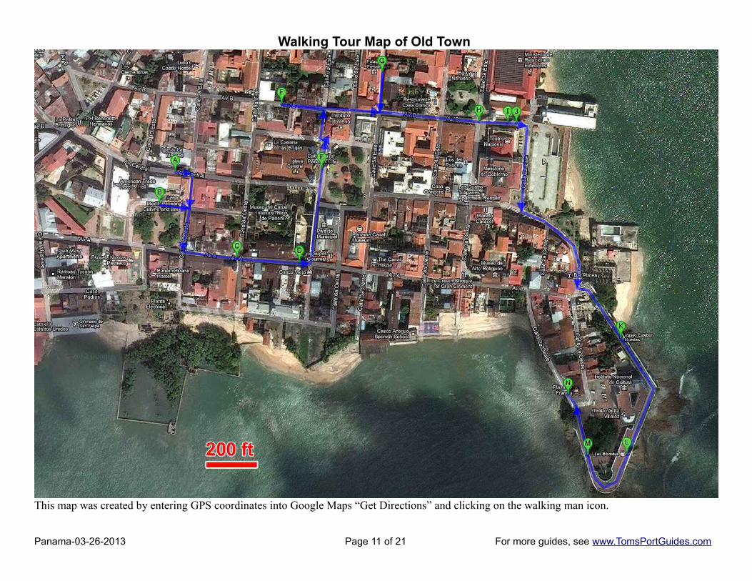
Walking Tour Map of Old Town
This map was created by entering GPS coordinates into Google Maps “Get Directions” and clicking on the walking man icon.
Panama-03-26-2013 Page 11 of 21 For more guides, see www.TomsPortGuides.com

The Earth view map below shows the most important area of Old Town to explore on foot.
This was the center of Panama City in the 1700s. Our cab driver parked and walked with us pointing out thesites. We walked along Paseo Esteban Huertas under the bougainvillea canopy to photograph high-risebuildings. “Revolution Tower” is the “glass corkscrew” with a white top in the center of the photo below.
We walked along LasBovedas to photograph theBridge of the Americas andships in the harbor.
Plaza de Francia offersphoto opportunities of thecanal memorial and manyscenic buildings.
Photos above: Rooster at top of Obelisk and whimsical metal art in the plaza .
Panama-03-26-2013 Page 12 of 21 For more guides, see www.TomsPortGuides.com

Sources of Information on Casco Viejo (Old Town)http://caanpa.blogspot.com/
http://www.cascoviejo.org/content/?cid=10&cat1=57&cat2=0&cat3=0&level=1&id=57
http://es.wikipedia.org/wiki/Casco_Antiguo_de_Panam%C3%A1
For a 3600 tour, see http://www.seeit360.com/360-virtual-tours/plaza-bol%C3%ADvar-casco-antiguo-panama
Panama Viejo GPS = N 9 0 27.03, W 79 29 6.59Panama Viejo is the ruins of the original Panama City established in 1519. It's 10 km east of Casco Viejo. For an overview and description of both Panama Viejo and Casco Viejo, see:
Archaeological Site of Panamá Viejo and Historic District of PanamáUNESCO website = http://whc.unesco.org/en/list/790/
There is an excellent archeological description of Panama Viejo ruins at:The Panama Viejo Archeological Organizationhttp://www.panamaviejo.org/monumentos/default.html
NOTE: Panama Viejo is listed by the US Department of State as a high crime area. The ruins cover a largearea. We felt safe in the cab. Our driver pointed out important ruins and stopped for photos. You can getremarkably good photos from the side of the road using a 5x zoom lens.
This list of ruins sites shows GPS coordinates. The letters A, B, C, etc, appear on the driving tour map.
A) Ruins next to Panama Viejo MuseumGPS = N 9 0 13.63, W 79 29 38.87
B) Ruins next to the road GPS = N 9 0 20.56, W 79 29 24.63
Panama-03-26-2013 Page 13 of 21 For more guides, see www.TomsPortGuides.com

C) Convento de Las Monjas de la Conception GPS = N 9 0 22.22, W 79 29 15.82
Ruins of the Convent of the Conception are well preserved withthe rest of the historic monuments of Panama Viejo. Accordingto John B. Sosa, the Convent of the Nuns became a sumptuousbuilding between recollection and devotion dedicated to the cityfor many concurrent and favorable circumstances.
Note: this is not my photo. My picture was taken from the sideof the road and does not show the front of the building.
D) Convento de la Compania de JesusGPS = N 9 0 22.48, W 79 29 13.39 This is “original” location of the convent and church. When the “original” Panama City was abandoned, a newchurch and convent were built in Casco Viejo. It's the church with the iron gate across the front of the structureshown on page 9 of this guide.
The photo below was taken from the taxicab at the side of the road with the lens at 5x zoom.
E) Cathedral Tower GPS = N 9 0 23.34, W 79 29 10.49
According to historians, the present cathedral was the third (or maybe fourth) church on that site. The present cathedral was built in 1619-1626. The cathedral tower is the most important architectural element in the area called “Plaza Mayor”.
Panama-03-26-2013 Page 14 of 21 For more guides, see www.TomsPortGuides.com

Cathedral Tower
Our taxi tour was an excellent way to see the ruins. Our driver called our attention to points of interest andstopped for me to take photos. As you can see in the map below, all of these ruins are close to the road.
Panama-03-26-2013 Page 15 of 21 For more guides, see www.TomsPortGuides.com

This Google Earth View Is a Respectable 3-D Image of the Ruins Near the Cathedral Tower
This aerial photo (below) shows the driving route along the Panama Viejo ruins
Convento de la Compania de Jesus is not visible in this photo; it's blocked by the trees.
Panama-03-26-2013 Page 16 of 21 For more guides, see www.TomsPortGuides.com

Revolution Tower GPS = N 8 58 43.83, W 79 31 0.08The Revolution Tower is an unforgettable icon in the heart of Panama City's Banking andBusiness district. This commercial tower offers units of 2000 to 6500 square meters, withprivate, secure working areas and superb views of the ocean and glittering city lights. It's233 meters high. (Photo left)
We drove through Panama City on our way to Panama Viejo. Tomas stopped the cab in aMcDonalds parking lot so I could take the photo. Then he drove us to the ruins.
When we left the ruins, we drove back through the city to Miraflores Locks.
Miraflores Locks GPS = N 8 59 50.25, W 79 35 28.38
Our driver dropped us off at the front door so we wouldn't have to walk far. He told us tobuy tickets to see the boats, not to visit the museum. The tickets were $ 5 USD per person.Tomas parked the cab and met us inside to point out areas of interest. We took the elevator tothe top floor. It was crowded, but we got to see everything and take a few photos before mycamera battery ran out.
The photos below show ships entering the locks. Note the two gates that seal the lock in the photo at right.
The photo below shows a 4-mast sailboat leaving the locks. The “mule” trains guide vessels via cables.
Panama-03-26-2013 Page 17 of 21 For more guides, see www.TomsPortGuides.com

Passage Through the Panama CanalWe sailed from Panama City on the Coral Princess on December 24, 2012. The ship raised the anchor around 5AM. It passed under the Bridge of the Americas around 6 AM. We were fortunate to have Bill Fall as our PortLecturer. He is extremely knowledgeable, an excellent speaker, and very personable. Bill narrated our passagethrough the locks on the ship's PA system. He called our attention to what we should look for, where to standfor photos, and explained the passage in great detail.
Here are the coordinates to map the passage:A) Panama CityTender Dock GPS = N 8 54 41.66, W 79 31 10.16B) Bridge of the Americas GPS = N 8 56 40.86, W 79 33 39.81 C) Miraflores Locks GPS = N 8 59 49.78, W 79 35 28.26 D) Pedro Miquel Locks GPS = N 9 1 4.70, W 79 36 45.82 E) Gatun Locks GPS = N 9 16 17.94, W 79 55 21.12
F) Colon GPS = N 9 21 31.97, W 79 53 57.07
The map below shows the canal passage as red dots. The road is shown as a blue line. It's 110 km and a 2hour drive from Panama City to Colon.
Panama-03-26-2013 Page 18 of 21 For more guides, see www.TomsPortGuides.com

Use GPS Coordinates with Google Maps to PREVIEW Your Cruise Through the Canal
The photo above is a Google satellite view of the Miraflores Locks at 200-foot map scale. Google Earth Viewis also quite good. Set the map scale to the resolution you prefer and use your mouse to “sail” down thePanama Canal. It's an easy and fun way to preview your cruise. If you use “Screen Capture” software, you canintegrate Google aerial photos with your pictures to create a slide show of your vacation.
An Educational, Enjoyable, Cruise ExperienceCoral Princess does a superb job on the Panama Canal cruise. Port Lecturer Bill Fall provides an in-depthintroduction to the canal, the amazing engineering accomplishment, and details on every aspect of it. Hislectures are complimented by a movie on the canal. The ship offers a variety of excursions from Panama Cityport to see the canal from different perspectives. There are bus excursions to the locks, train rides along thecanal, and small boat excursions into the locks. These excursions get rave reviews from passengers.
The day before we entered the canal, the captain explained timing for our sailing. Many of us got up early tosee the Bridge of the Americas and entrance of our ship into the locks. Bill Fall narrated what was happeningand provided tips on where to look and what to photograph. It was a great cruise experience.
Panama-03-26-2013 Page 19 of 21 For more guides, see www.TomsPortGuides.com
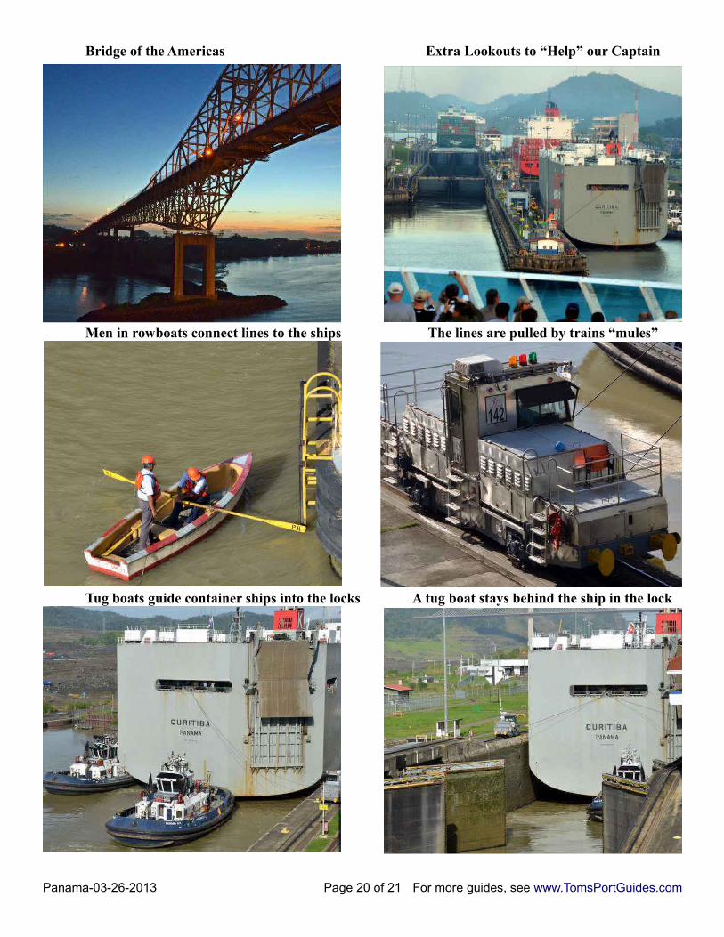
Bridge of the Americas Extra Lookouts to “Help” our Captain
Men in rowboats connect lines to the ships The lines are pulled by trains “mules”
Tug boats guide container ships into the locks A tug boat stays behind the ship in the lock
Panama-03-26-2013 Page 20 of 21 For more guides, see www.TomsPortGuides.com

User Feedback Is Welcome GoalMy guides are designed to help you plan a great cruise vacation by providing information such as where the ship docks, location of tourist sites, public transit, walking tour maps, things to see and do, travel issues unique to the port, etc. Knowledge of ports is important when planning shore excursions because you have to make many decisions and commitments long before your ship docks. I believe the information in this guide is accurate, however you are responsible to verify accuracy of the information that you use to plan your vacation.
Information on cruise ports frequently changes such as bus routes, admission fees to sites, rental car locations, etc. Cruise Critic is the best source for up-to-date, detailed information on travel details for shore excursions, reviews of cruise ships, etc. There are many knowledgeable people on Cruise Critic who are willing to share their expertise and travel experience. I highly recommend www.CruiseCritic.com; it's free to join.
Why feedback is importantUser feedback helps me make corrections and improve the format and content in my quest to produce the“ultimate” port guides. I welcome offers to collaborate with me or provide materials for use in my guides.
PLEASE Help “spread the word” about my websiteThe only negative feedback I get is, “I wish I knew about your port guides before my vacation”. Please tellyour friends and post a reference to my guides and website on the blogs. To receive email notification whennew guides are available, send your email address to me at [email protected]
Copyright Notice & Terms and Conditions for Use of My Guides
My port guides and everything on my website www.TomsPortGuides.com is copyrighted by Thomas Sheridanwith all rights reserved, and protected by international copyright laws.
PERMITTED USE: Personal, non-commercial use of my port guides and/or material from my website.
I allow individuals to take my guides apart for personal, non-commercial use. Many cruisers carry a map or afew pages from my guide on a shore excursion. That's OK. I also allow people to post my guides on websitesthey set up for fellow travelers to share information on shore excursions such as the websites set up by CruiseCritic members for the Roll Calls. That's OK. My guides are for use and enjoyment of individual travelers.
PROHIBITED USE of my port guides and/or material from my website.NO person, company, organization, website, etc. is permitted to use material from my website for a commercialpurpose, to sell, require a membership to download my port guides, or use my copyrighted material for acommercial purpose.
NO person, company, organization, website, etc. is permitted to distribute excerpts from my guides or materialfrom my website as electronic, digital, or paper copies. My Port Guides must be kept intact, as downloadedfrom my website, with this copyright notice.
NO Cruise Ship employee, representative, contractor, port lecturer, etc. is permitted to distribute excerpts frommy guides or material from my website as electronic, digital or paper copies. My Port Guides must be keptintact, as downloaded from my website, with this copyright notice. A blatant example of violation of mycopyright was a cruise ship docked in Copenhagen where the shore excursion desk personnel removed mapsfrom my guide, removed my name as the copyright owner, and copied/distributed my maps.
Fortunately, a friend of mine on that ship complained to the purser and the ship stopped violating my copyright.
If there is any question about use of my guides, contact me at [email protected]
Tom Sheridan
Panama-03-26-2013 Page 21 of 21 For more guides, see www.TomsPortGuides.com