tonkin highway corridor vegetation survey
TRANSCRIPT
12530063-75235-12/12530063-MEM_Tonkin Hwy Corridor Vegetation Survey.docx
30 November 2020
To Main Roads Western Australia
Copy to
From GHD Pty Ltd Tel +61 6222 8222
Subject Tonkin Highway Corridor
Hale Road Vegetation Assessment
Job no. 12530063
1 Introduction
1.1 Background
Main Roads Western Australia (Main Roads) is developing the Tonkin Grade Separated Interchanges
(Hale Road and Welshpool Road) (the project). Main Roads referred the project to the Environmental
Protection Authority (EPA) in November 2019. Main Roads requested the EPA suspend the public
comment period on the referral until Hale Road/Tonkin Highway intersection design options were
further considered and the preferred design option approved by the Minister. As well as revising the
Hale Road/Tonkin Highway intersection, Main Roads have also commissioned additional technical
studies including vegetation, flora and black cockatoo assessments to support the EPA referral.
1.2 Scope of works and purpose of this memorandum
Main Roads commissioned GHD Pty Ltd (GHD) to undertake a site visit to confirm the ecological
values of areas which were not previously surveyed by Woodman in 2019-2020. The purpose of the
site visit was to describe and map vegetation types and condition, clearly differentiating native
remnant vegetation from planted vegetation, and record and map potential and actual breeding
habitat and foraging habitat for black cockatoos. The vegetation type and condition mapping will align
with mapping from adjacent areas completed by Woodman (2020).
This memorandum documents the methods and results of the site visit and is intended to inform and
support the environmental approvals for the project.
1.3 Survey area
The survey area for the site visit included three small areas located in the vicinity of the Hale
Road/Tonkin Highway intersection. The survey area covered 0.73 hectares (ha).
12530063-75235-12/12530063-MEM_Tonkin Hwy Corridor Vegetation Survey.docx
1.4 Limitations and assumptions
This memorandum has been prepared by GHD for Main Roads and may only be used and relied on
by Main Roads for the purpose agreed between GHD and the Main Roads as set out in Section 1.2 of
this memorandum.
GHD otherwise disclaims responsibility to any person other than Main Roads arising in connection
with this memorandum. GHD also excludes implied warranties and conditions, to the extent legally
permissible. The services undertaken by GHD in connection with preparing this memorandum were
limited to those specifically detailed in the memorandum and are subject to the scope limitations set
out in the memorandum.
The opinions, conclusions and any recommendations in this memorandum are based on conditions
encountered and information reviewed at the date of preparation of the memorandum. GHD has no
responsibility or obligation to update this memorandum to account for events or changes occurring
subsequent to the date that the memorandum was prepared. The opinions, conclusions and any
recommendations in this memorandum are based on assumptions made by GHD described in this
memorandum. GHD disclaims liability arising from any of the assumptions being incorrect.
GHD has prepared this memorandum on the basis of information provided by Main Roads and others
who provided information to GHD (including Government authorities), which GHD has not
independently verified or checked beyond the agreed scope of work. GHD does not accept liability in
connection with such unverified information, including errors and omissions in the memorandum
which were caused by errors or omissions in that information.
2 Methodology
2.1 Desktop assessment
Prior to the field assessment, a desktop assessment was undertaken to identify relevant information
pertaining to the survey area. The desktop assessment included a review of:
Previous vegetation surveys and mapping provided by Main Roads that covered areas adjacent to
the survey area (e.g. Woodman 2020)
Aerial imagery of the survey area.
2.2 Vegetation assessment
GHD ecologist Erin Lynch (Flora collection licence: FB62000081-2) completed a vegetation
assessment of the survey area on 8 July 2020. The assessment was undertaken to identify and map
the vegetation types and condition within the survey area, clearly differentiating areas of native and
non-native vegetation.
The survey methodology employed by GHD was undertaken with reference to the EPA Technical
Guidance – Flora and Vegetation Surveys for Environmental Impact Assessment (EPA 2016).
12530063-75235-12/12530063-MEM_Tonkin Hwy Corridor Vegetation Survey.docx
Field survey methods involved traversing the survey area by foot and recording vegetation type and
condition as well as taking representative photographs. Vegetation types were identified and
boundaries delineated using field data/observations and confirmed by viewing aerial imagery. The
vegetation types described within the survey area were aligned with those described by Woodman
(2020) in the adjacent areas. Full floristics were not recorded.
The vegetation condition was assessed and mapped in accordance with the vegetation condition
rating scale for the South West and Interzone Botanical Provinces of WA (devised by Keighery (1994)
and adapted by EPA (2016)).
2.3 Black cockatoo habitat assessment
A targeted Black Cockatoo habitat assessment was undertaken in conjunction with the vegetation
survey to identify and map suitable foraging habitat and actual and potential breeding trees (suitable
breeding tree with a Diameter at Breast Height (DBH) greater than 500 mm) within the survey area.
The survey was conducted in accordance with the EPBC Act referral guidelines for three threatened
black cockatoo species: Carnaby’s Cockatoo (Endangered) Calyptorhynchus latirostris, Baudin’s
Cockatoo (Vulnerable) Calyptorhynchus baudinii, and Forest Red-tailed Black Cockatoo (Vulnerable)
Calyptorhynchus banksii naso (Department of Sustainability, Environment, Water, Populations, and
Communities (DSEWPaC 2012).
3 Results
3.1 Vegetation
The majority of the survey area has been cleared with minimal remnant native vegetation remaining.
Remnant native vegetation exists as individual or stands of trees consisting of Corymbia calophylla
and Eucalyptus rudis. Other vegetated areas remaining within the survey area are completely
dominated by introduced species including *Leptospermum laevigatum, *Acacia longiflora and
*Arundo donax and planted native (non-local) species such as Calothamnus rupestris and
Callistemon sp.
The condition of the vegetation remaining within the survey area is assessed as Completely
Degraded, with little to no native species remaining. The understorey has been completely cleared
throughout the survey area.
Previously cleared areas, including the existing road network infrastructure, has been mapped as
Cleared.
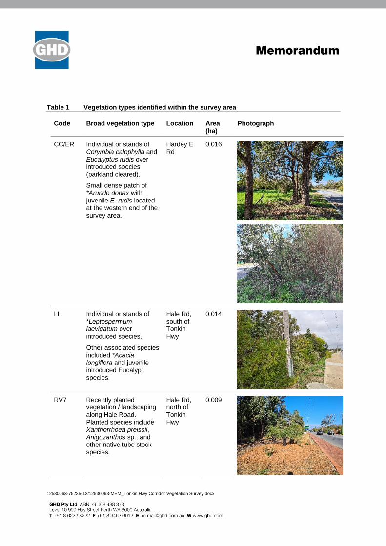
The results of the assessment and representative photographs of each vegetation type is presented
in Table 1. Mapping of the vegetation types and condition is presented in Figure 1, Attachment 1.
12530063-75235-12/12530063-MEM_Tonkin Hwy Corridor Vegetation Survey.docx
Table 1 Vegetation types identified within the survey area
Code Broad vegetation type Location Area (ha)
Photograph
CC/ER Individual or stands of Corymbia calophylla and Eucalyptus rudis over introduced species (parkland cleared).
Small dense patch of *Arundo donax with juvenile E. rudis located at the western end of the survey area.
Hardey E Rd
0.016
LL Individual or stands of *Leptospermum laevigatum over introduced species.
Other associated species included *Acacia longiflora and juvenile introduced Eucalypt species.
Hale Rd, south of Tonkin Hwy
0.014
RV7 Recently planted vegetation / landscaping along Hale Road. Planted species include Xanthorrhoea preissii, Anigozanthos sp., and other native tube stock species.
Hale Rd, north of Tonkin Hwy
0.009
12530063-75235-12/12530063-MEM_Tonkin Hwy Corridor Vegetation Survey.docx
Code Broad vegetation type Location Area (ha)
Photograph
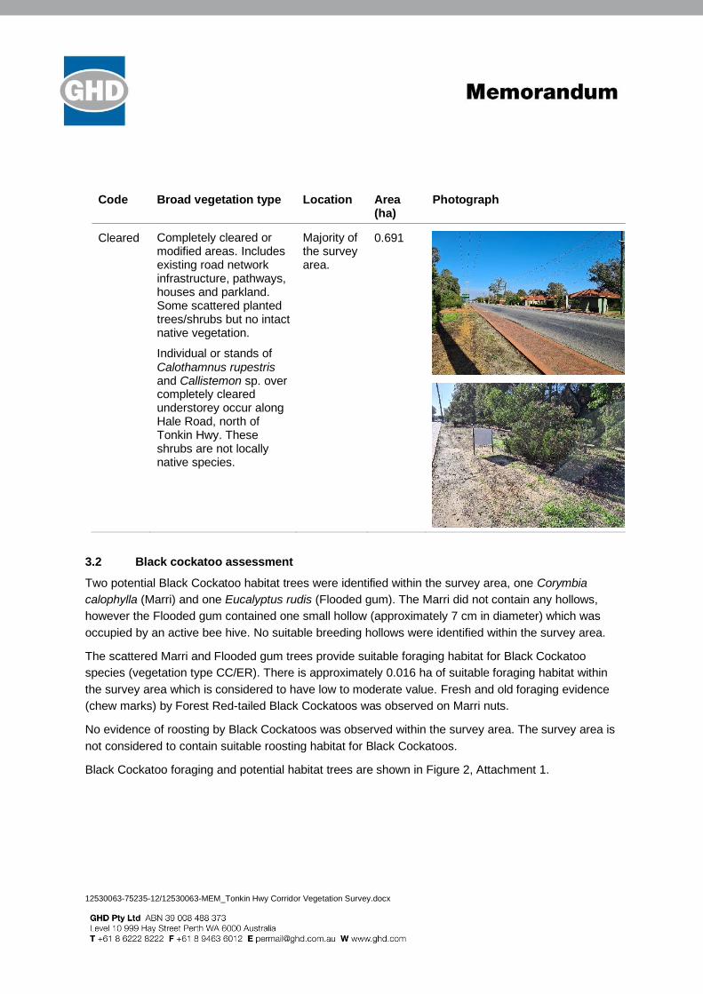
Cleared Completely cleared or modified areas. Includes existing road network infrastructure, pathways, houses and parkland. Some scattered planted trees/shrubs but no intact native vegetation.
Individual or stands of Calothamnus rupestris and Callistemon sp. over completely cleared understorey occur along Hale Road, north of Tonkin Hwy. These shrubs are not locally native species.
Majority of the survey area.
0.691
3.2 Black cockatoo assessment
Two potential Black Cockatoo habitat trees were identified within the survey area, one Corymbia
calophylla (Marri) and one Eucalyptus rudis (Flooded gum). The Marri did not contain any hollows,
however the Flooded gum contained one small hollow (approximately 7 cm in diameter) which was
occupied by an active bee hive. No suitable breeding hollows were identified within the survey area.
The scattered Marri and Flooded gum trees provide suitable foraging habitat for Black Cockatoo
species (vegetation type CC/ER). There is approximately 0.016 ha of suitable foraging habitat within
the survey area which is considered to have low to moderate value. Fresh and old foraging evidence
(chew marks) by Forest Red-tailed Black Cockatoos was observed on Marri nuts.
No evidence of roosting by Black Cockatoos was observed within the survey area. The survey area is
not considered to contain suitable roosting habitat for Black Cockatoos.
Black Cockatoo foraging and potential habitat trees are shown in Figure 2, Attachment 1.
12530063-75235-12/12530063-MEM_Tonkin Hwy Corridor Vegetation Survey.docx
4 References
Department of Sustainability, Environment, Water, Population and Communities (DSEWPaC) 2012,
EPBC Act Referral Guidelines for Three Threatened Black Cockatoo Species: Carnaby’s Black
Cockatoo, Baudin’s Black Cockatoo and Forest red-tailed Black Cockatoo, Canberra, Department of
Sustainability, Environment, Water, Population and Communities.
Environmental Protection Authority (EPA) 2016, Technical Guidance – Flora and Vegetation Surveys
for Environmental Impact Assessment, Perth, Environmental Protection Authority.
Keighery, BJ 1994, Bushland Plant Survey: A Guide to Plant Community Survey for the Community,
Nedlands, Australia, Wildflower Society of Western Australia (Inc.).
Woodman Environmental 2020, Tonkin Grade Separated Interchanges, Biological Survey and
Targeted Black Cockatoo Habitat Assessment. Unpublished report prepared for Main Roads Western
Australia.

12530063-75235-12/12530063-MEM_Tonkin Hwy Corridor Vegetation Survey.docx
Attachment 1 – Figures

WATTLE GROVE
FORRESTFIELD
Hale Rd
Reynolds Rd
Kelang Rd
Morrison Rd
Fennell Cr
Wimbridge R
d
CalcitePl
Ajax W
ay
Quartz Lane
Helidor Pl
Ruck St
Hardey East Rd
Platinum Way
Pulchella St
Slate St
The Pr
omena
de
Plumosa Way
AshcroftLoop
Tonkin Hwy
!(
PERTH
o DateRevision No.Project No.
Map Projection: Transverse MercatorHorizontal Datum: GDA 1994Grid: GDA 1994 MGA Zone 50
Paper Size ISO A3
\\ghdnet\ghd\AU\Perth\Projects\61\12530063\GIS\Maps\Working\12530063\12530063.aprx\12530063_001_VegetationMapping_RevBPrint date: 30 Nov 2020 - 16:29
Data source: Landgate_Subscription_Imagery\WANow: Landgate / SLIP. Created by: bmorgan
FIGURE 1
012530063
Vegetation Types and Condition
Tonkin Highway CorridorAdditional Areas Survey
Main Roads WA
23/11/2020
LegendRoads
TGSI Development Envelope
Additional Survey Area (GHD)07/07/2020
Vegetation Type (GHD) 13/07/2020
CC/ER
LL
RV7
Cleared
Vegetation Condition (GHD) 13/07/2020
CD - Completely Degraded
0 20 40 60 80
Metres

WATTLE GROVE
FORRESTFIELDFennell Cr
Hale Rd
Reynolds Rd
Kelang Rd
Morrison Rd
Ajax W
ay
Kwilena
Av
FennellCr
Fennell Cr
Wimbridge
Rd
CalcitePl
Ajax W
ay
Quartz Lane
Helidor Pl
Ruck St
FennellCr
Hardey East Rd
Platinum Way
Pulchella St
Ashcroft Loop
Slate StTonkin H
wy
The Promenade
Plumosa Way
AshcroftLoop
Tonkin HwyTonkin Hwy
!(
PERTH
o DateRevision No.Project No.
Map Projection: Transverse MercatorHorizontal Datum: GDA 1994Grid: GDA 1994 MGA Zone 50
Paper Size ISO A3
\\ghdnet\ghd\AU\Perth\Projects\61\12530063\GIS\Maps\Working\12530063\12530063.aprx\12530063_002_BlackCockatooHab_RevBPrint date: 30 Nov 2020 - 16:30
Data source: Landgate_Subscription_Imagery\WANow: Landgate / SLIP. Created by: bmorgan
FIGURE 2
012530063
Potential Black Cockatoo Habitat Trees
Tonkin Highway CorridorAdditional Areas Survey
Main Roads WA
23/11/2020
LegendRoads
Additional Survey Area (GHD)07/07/2020
TGSI Development Envelope
Potential Black Cockatoo Habitat Trees
Flooded Gum (Eucalyptus rudis), onesmall hollow (with active bee hive)
Marri (Corymbia calophylla), no hollows
Black Cockatoo Foraging Habitat (GHD)13/07/2020
3: low-moderate value
0 20 40 60 80
Metres