topic 4 volcanism
TRANSCRIPT
Topic 4Volcanism and Volcanoes
Topic 4 - Volcanism and Volcanoes
Outline
Introduction
Volcanic Products: Gases, Lava and Pyroclastics
Non-Explosive vs. Explosive Eruptions
Types of Volcanoes
Volcano Distribution
Prediction of Volcanic Eruptions
Index of Volcanic Explosivity
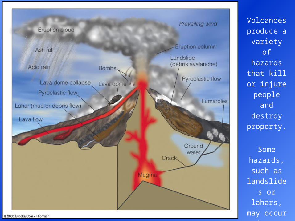
Volcanoes
produce a
variety of
hazards that
kill or injure
people and
destroy
property.
Some
hazards,
such as
landslides or
lahars, may
occur when
a volcano is
not erupting.
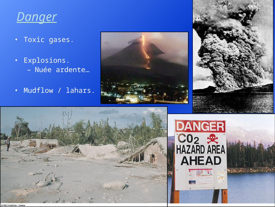
Danger
• Toxic gases.
• Explosions.– Nuée ardente…
• Mudflow / lahars.
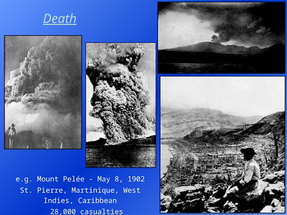
e.g. Mount Pelée - May 8, 1902
St. Pierre, Martinique, West Indies, Caribbean
28,000 casualties
Death
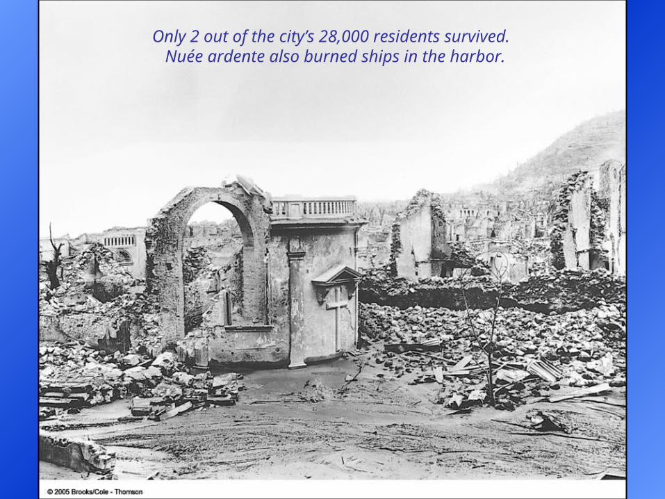
Only 2 out of the city’s 28,000 residents survived. Nuée ardente also burned ships in the harbor.
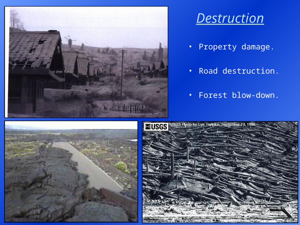
Destruction
• Property damage.
• Road destruction.
• Forest blow-down.
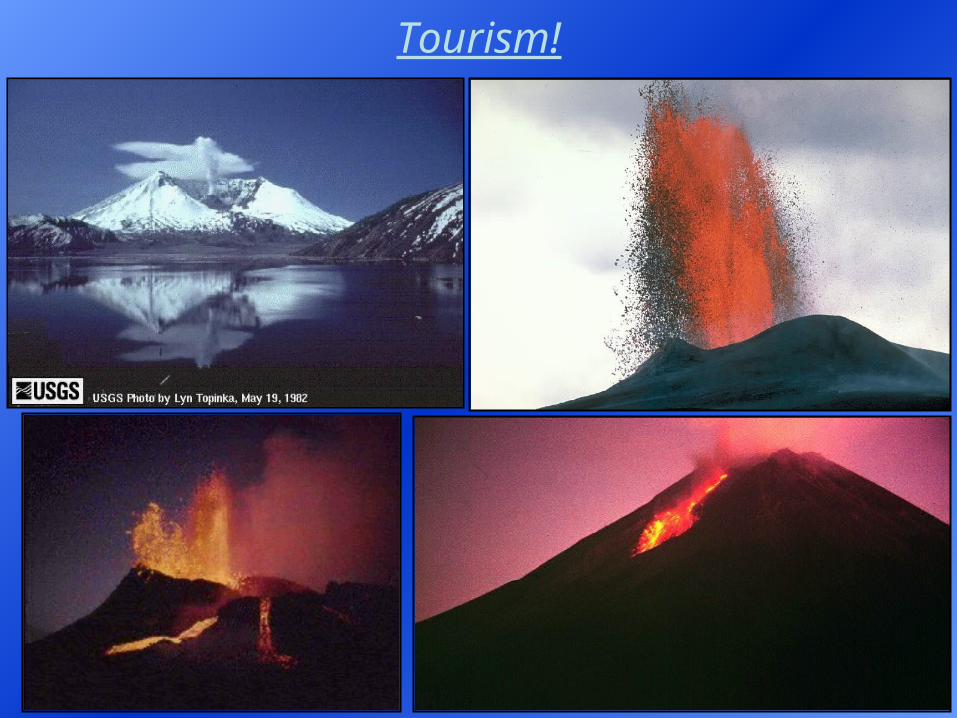
Tourism!
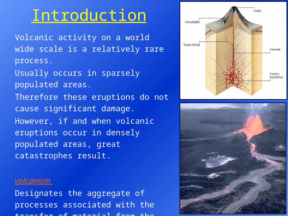
IntroductionVolcanic activity on a world wide scale is a
relatively rare process.
Usually occurs in sparsely populated areas.
Therefore these eruptions do not cause
significant damage.
However, if and when volcanic eruptions
occur in densely populated areas, great
catastrophes result.
volcanism
Designates the aggregate of processes
associated with the transfer of material from
the Earth’s interior to the surface and the
construction of various structures at the
surface.
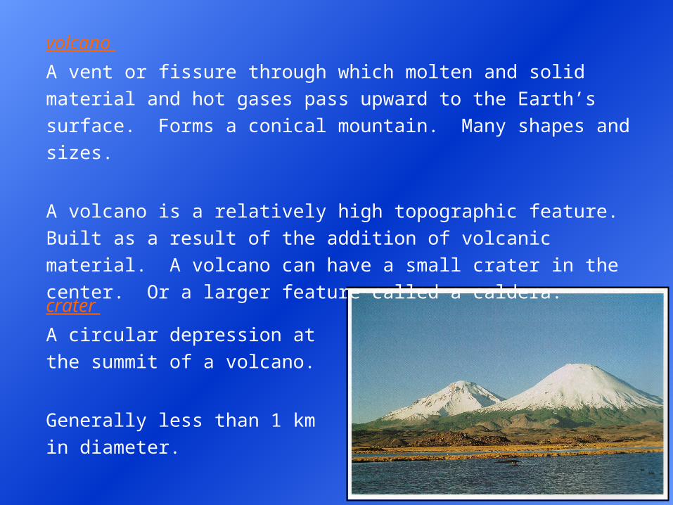
volcano
A vent or fissure through which molten and solid material and hot
gases pass upward to the Earth’s surface. Forms a conical mountain.
Many shapes and sizes.
A volcano is a relatively high topographic feature. Built as a result of
the addition of volcanic material. A volcano can have a small crater in
the center. Or a larger feature called a caldera.
crater
A circular depression at the
summit of a volcano.
Generally less than 1 km in
diameter.
caldera
A very large volcanic crater. > 1 km in diameter. May form via the
coalescence of several smaller craters, repeated explosions, collapse
or the stoping of surface rocks by a large underground magma
chamber.
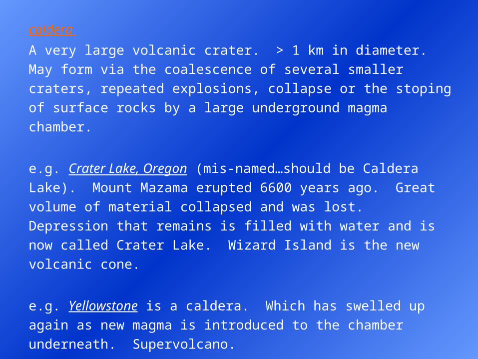
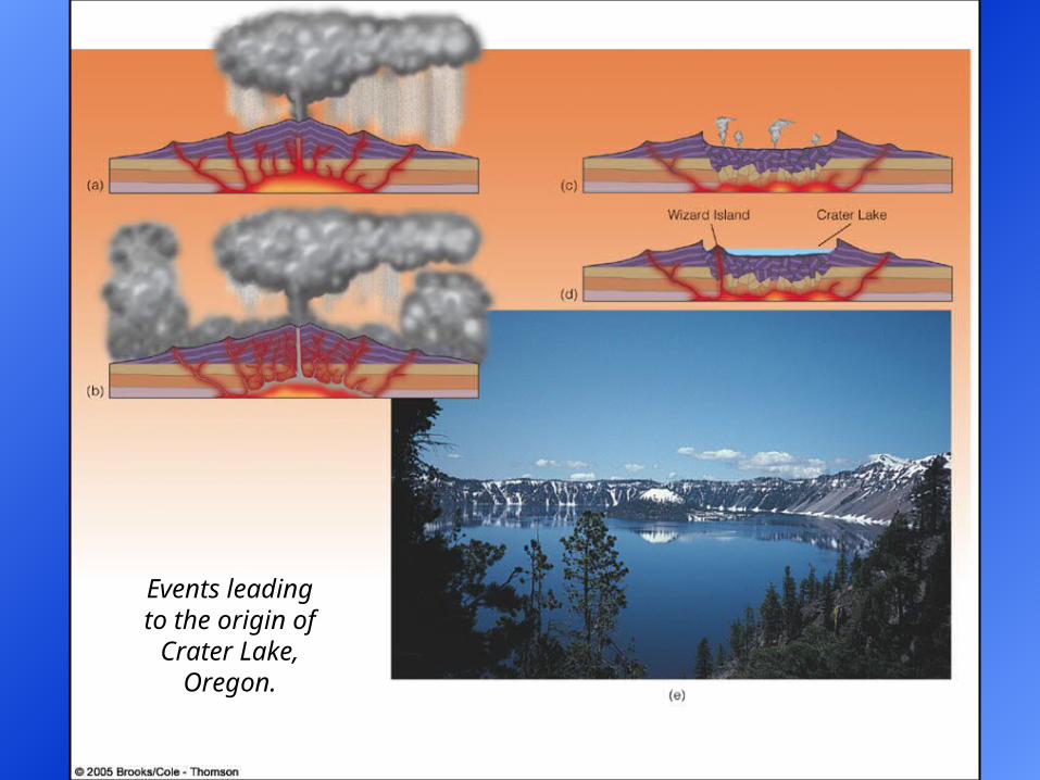
e.g. Crater Lake, Oregon (mis-named…should be Caldera Lake).
Mount Mazama erupted 6600 years ago. Great volume of material
collapsed and was lost. Depression that remains is filled with water and
is now called Crater Lake. Wizard Island is the new volcanic cone.
e.g. Yellowstone is a caldera. Which has swelled up again as new
magma is introduced to the chamber underneath. Supervolcano.
Volcanoes and extrusive igneous rocks can build various kinds of
landforms. More on this following the next section.
Events leading to the origin of Crater Lake,
Oregon.
Caldera Formation: Crater Lake
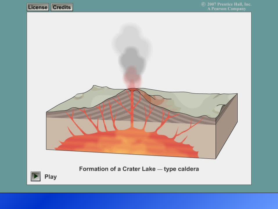
Yellowstone caldera.
Formed approximately
600,000 years ago.
Supervolcano.
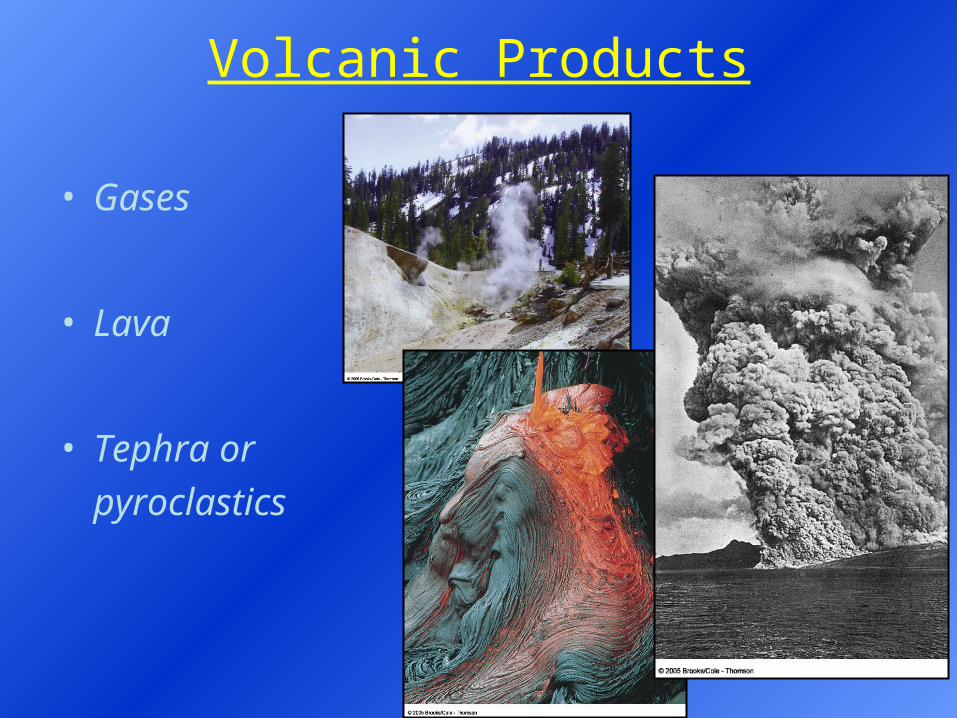
Volcanic Products
• Gases
• Lava
• Tephra or
pyroclastics
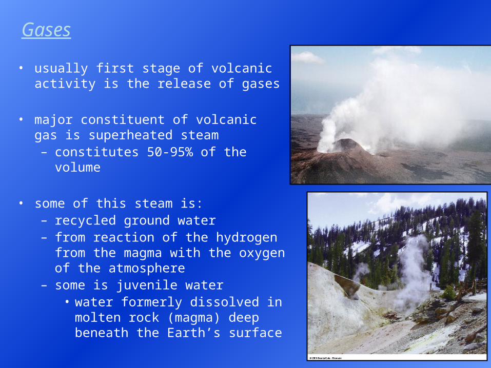
Gases
• usually first stage of volcanic activity is the release of gases
• major constituent of volcanic gas is superheated steam– constitutes 50-95% of the volume
• some of this steam is:– recycled ground water– from reaction of the hydrogen from
the magma with the oxygen of the atmosphere
– some is juvenile water• water formerly dissolved in molten
rock (magma) deep beneath the Earth’s surface
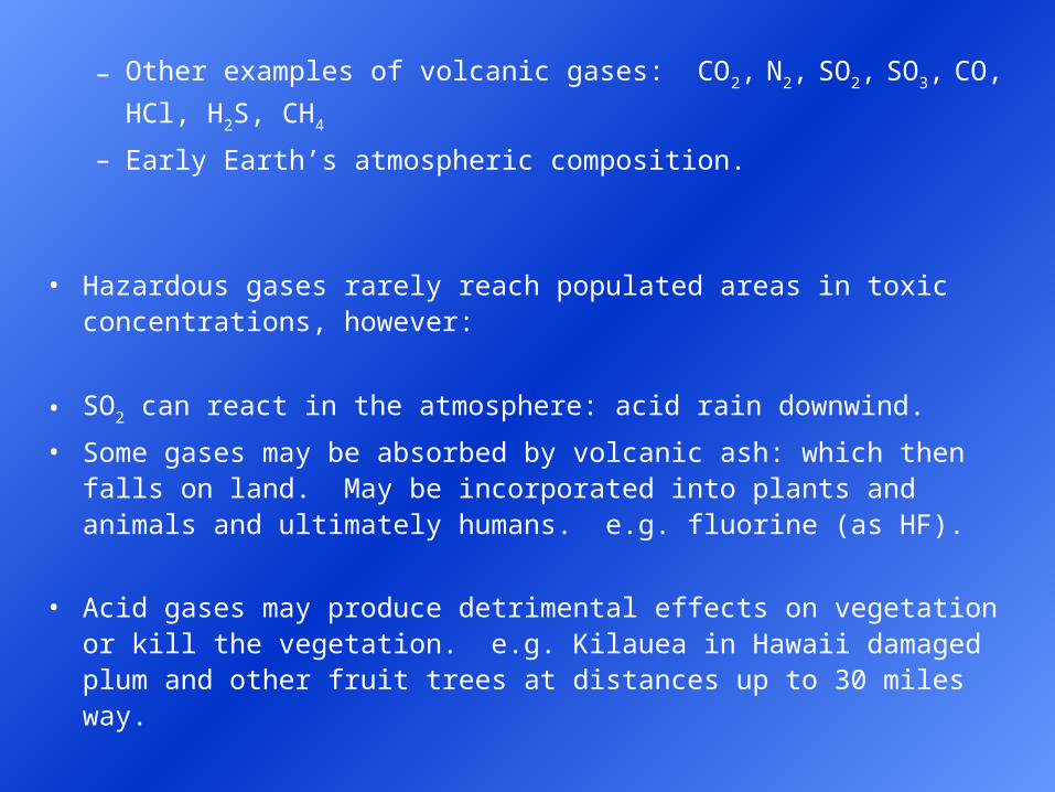
– Other examples of volcanic gases: CO2, N2, SO2, SO3, CO, HCl,
H2S, CH4
– Early Earth’s atmospheric composition.
• Hazardous gases rarely reach populated areas in toxic concentrations, however:
• SO2 can react in the atmosphere: acid rain downwind.
• Some gases may be absorbed by volcanic ash: which then falls on land. May be incorporated into plants and animals and ultimately humans. e.g. fluorine (as HF).
• Acid gases may produce detrimental effects on vegetation or kill the vegetation. e.g. Kilauea in Hawaii damaged plum and other fruit trees at distances up to 30 miles way.
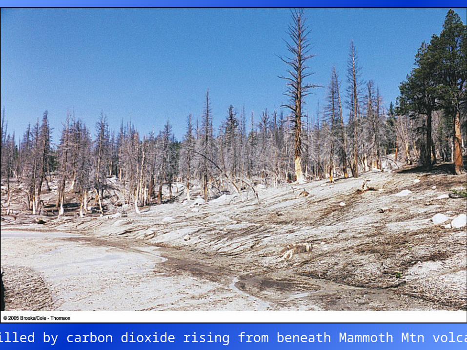
Trees killed by carbon dioxide rising from beneath Mammoth Mtn volcano, CA.
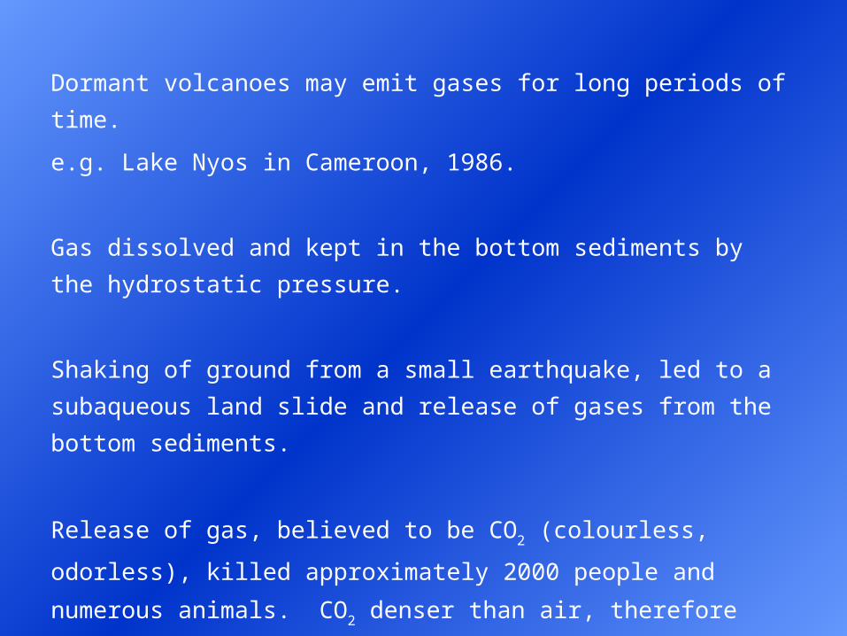
Dormant volcanoes may emit gases for long periods of time.
e.g. Lake Nyos in Cameroon, 1986.
Gas dissolved and kept in the bottom sediments by the hydrostatic
pressure.
Shaking of ground from a small earthquake, led to a subaqueous land
slide and release of gases from the bottom sediments.
Release of gas, believed to be CO2 (colourless, odorless), killed
approximately 2000 people and numerous animals. CO2 denser than
air, therefore flowed downhill along the surface.
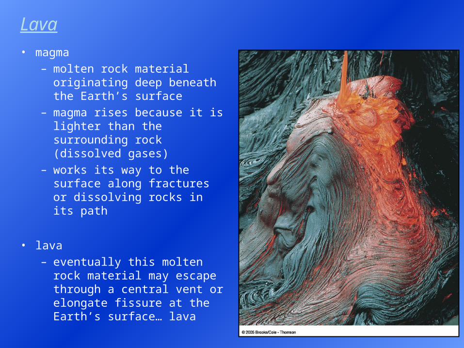
• magma – molten rock material
originating deep beneath the Earth’s surface
– magma rises because it is lighter than the surrounding rock (dissolved gases)
– works its way to the surface along fractures or dissolving rocks in its path
• lava – eventually this molten rock
material may escape through a central vent or elongate fissure at the Earth’s surface… lava
Lava
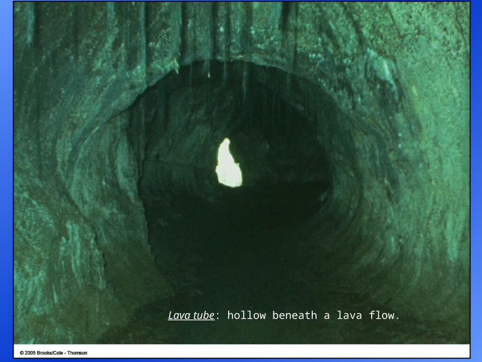
Lava tube: hollow beneath a lava flow.
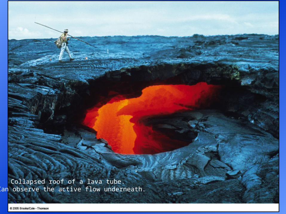
Collapsed roof of a lava tube. Can observe the active flow underneath.
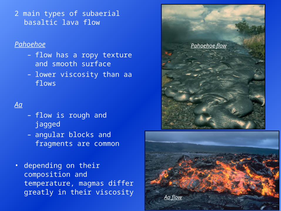
2 main types of subaerial basaltic lava flow
Pahoehoe
– flow has a ropy texture and smooth surface
– lower viscosity than aa flows
Aa
– flow is rough and jagged
– angular blocks and fragments are common
• depending on their composition and temperature, magmas differ greatly in their viscosity
Aa flow
Pahoehoe flow

Pahoehoe
lava flow in
Hawaii.
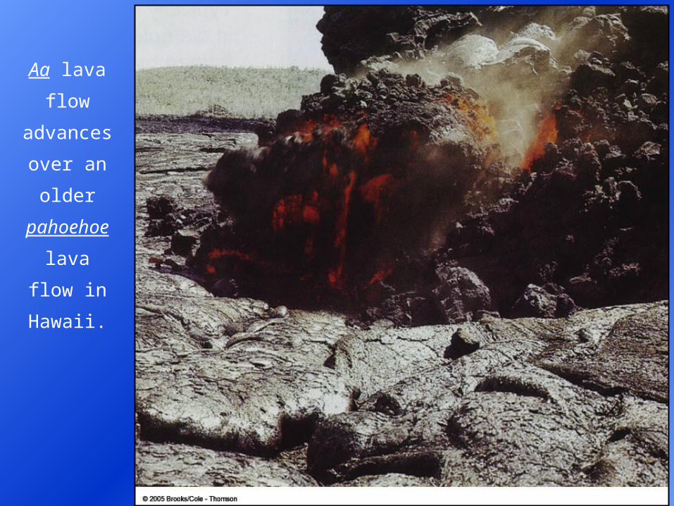
Aa lava
flow
advances
over an
older
pahoehoe
lava flow in
Hawaii.
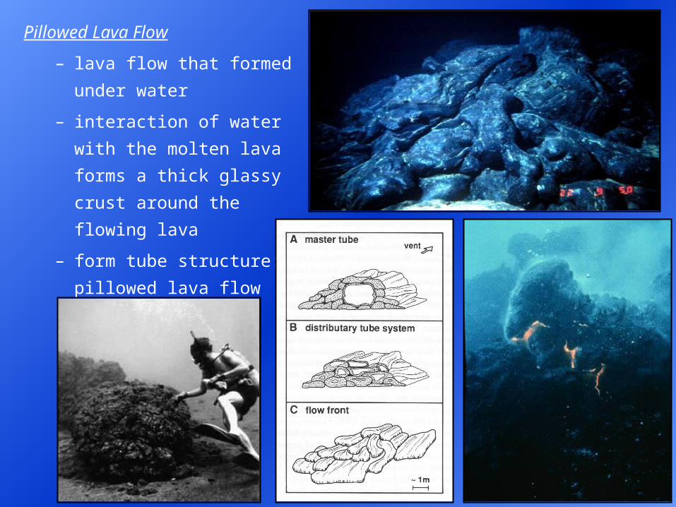
Pillowed Lava Flow
– lava flow that formed
under water
– interaction of water with
the molten lava forms a
thick glassy crust around
the flowing lava
– form tube structure:
pillowed lava flow
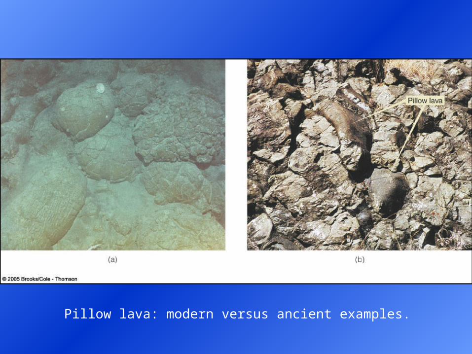
Pillow lava: modern versus ancient examples.
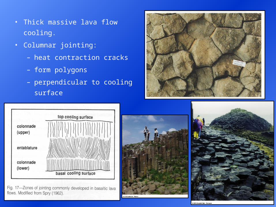
• Thick massive lava flow cooling.
• Columnar jointing:
– heat contraction cracks
– form polygons
– perpendicular to cooling
surface
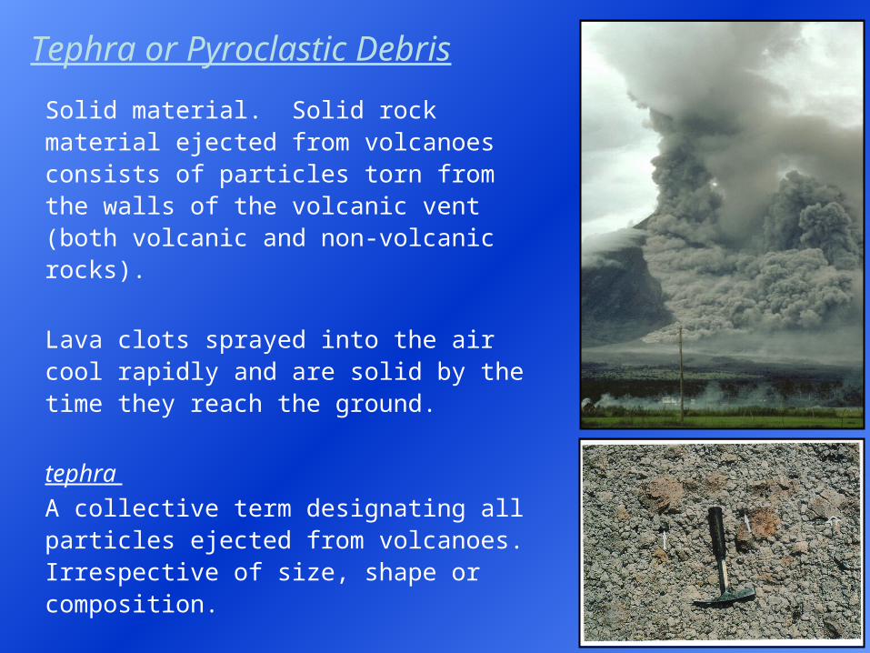
Tephra or Pyroclastic Debris
Solid material. Solid rock material ejected from volcanoes consists of particles torn from the walls of the volcanic vent (both volcanic and non-volcanic rocks).
Lava clots sprayed into the air cool rapidly and are solid by the time they reach the ground.
tephra
A collective term designating all particles ejected from volcanoes. Irrespective of size, shape or composition.
pyroclast
An individual particle ejected during a volcanic eruption. Classified according to size.
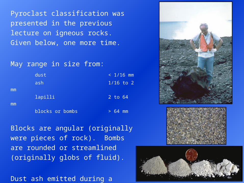
Pyroclast classification was presented in
the previous lecture on igneous rocks.
Given below, one more time.
May range in size from:
dust < 1/16 mm
ash 1/16 to 2
mm
lapilli 2 to 64 mm
blocks or bombs > 64 mm
Blocks are angular (originally were
pieces of rock). Bombs are rounded or
streamlined (originally globs of fluid).
Dust ash emitted during a volcanic
eruption may be blown high into the air.
Can be carried great distances by the
prevailing winds.
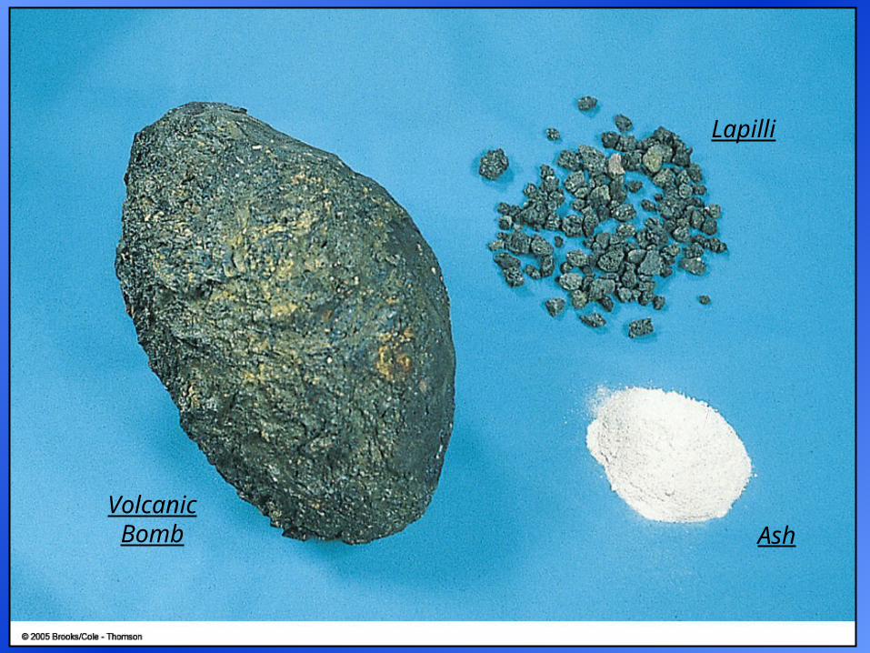
Lapilli
Volcanic Bomb Ash
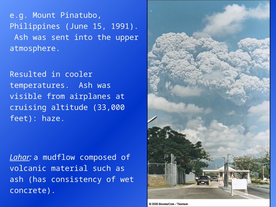
e.g. Mount Pinatubo, Philippines (June
15, 1991). Ash was sent into the
upper atmosphere.
Resulted in cooler temperatures. Ash
was visible from airplanes at cruising
altitude (33,000 feet): haze.
Lahar: a mudflow composed of
volcanic material such as ash (has
consistency of wet concrete).
Marella River valley, Philippines.
Tropical storm followed the volcanic
eruption.
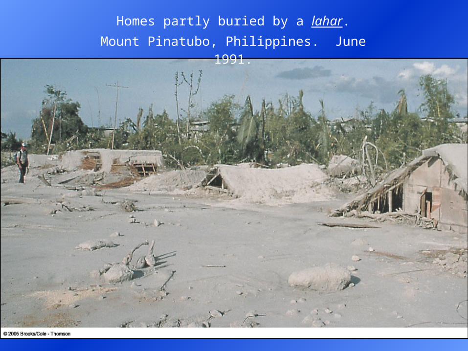
Homes partly buried by a lahar.
Mount Pinatubo, Philippines. June 1991.
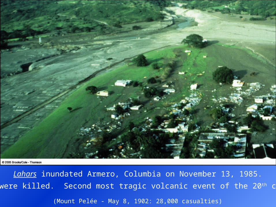
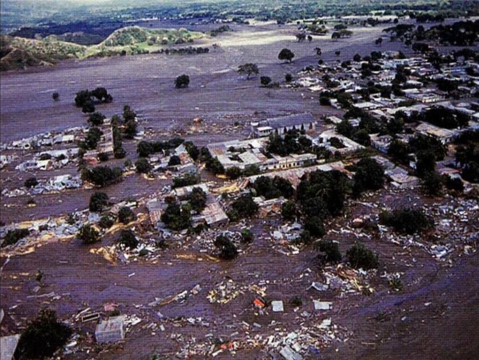
Lahars inundated Armero, Columbia on November 13, 1985.
23,000 were killed. Second most tragic volcanic event of the 20th century.
(Mount Pelée - May 8, 1902: 28,000 casualties)
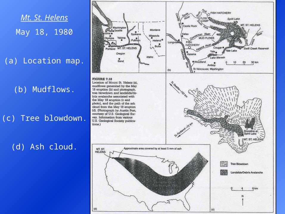
Mt. St. Helens
May 18, 1980
(a) Location map.
(b) Mudflows.
(c) Tree blowdown.
(d) Ash cloud.
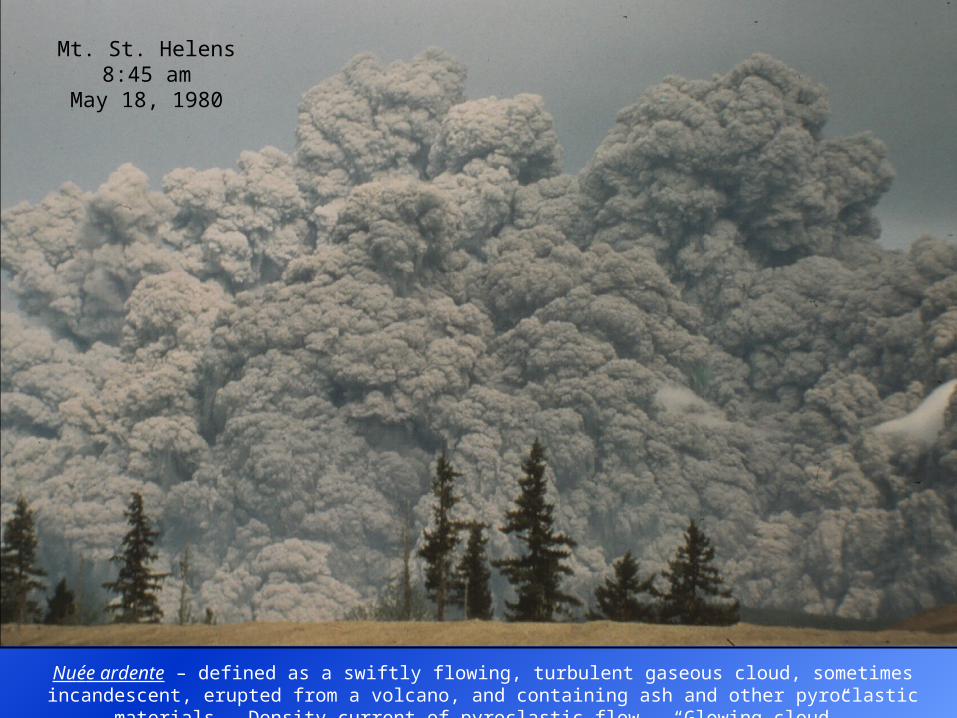
Nuée ardente – defined as a swiftly flowing, turbulent gaseous cloud, sometimes incandescent, erupted from a volcano, and containing ash and other pyroclastic materials. Density current of pyroclastic flow. “Glowing
cloud”.
Mt. St. Helens8:45 am
May 18, 1980
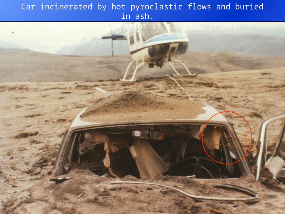
Car incinerated by hot pyroclastic flows and buried in ash. Note sun-visor remains (i.e. metal frame).
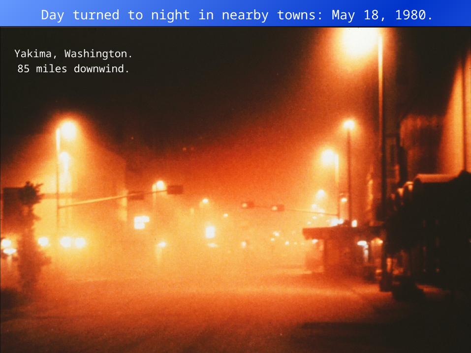
Day turned to night in nearby towns: May 18, 1980.
Yakima, Washington.
85 miles downwind.
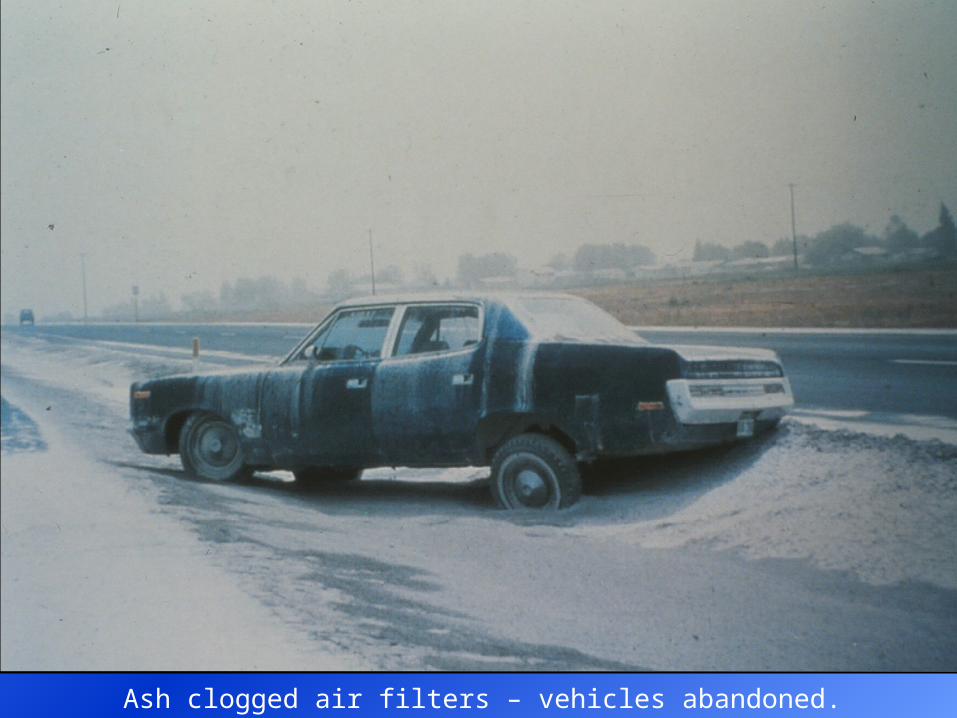
Ash clogged air filters – vehicles abandoned.
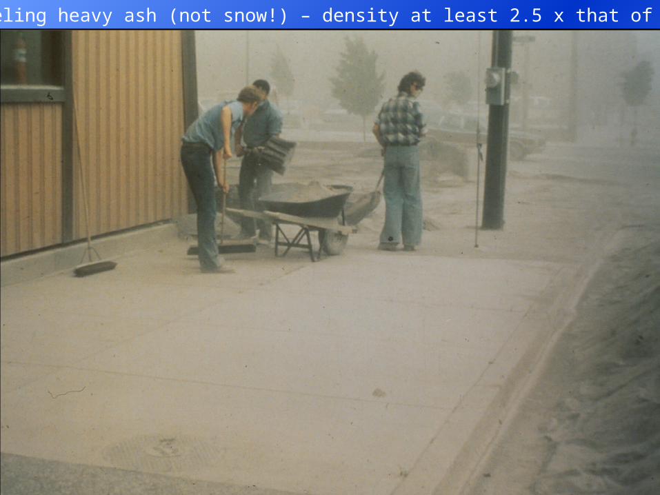
Shoveling heavy ash (not snow!) – density at least 2.5 x that of snow.
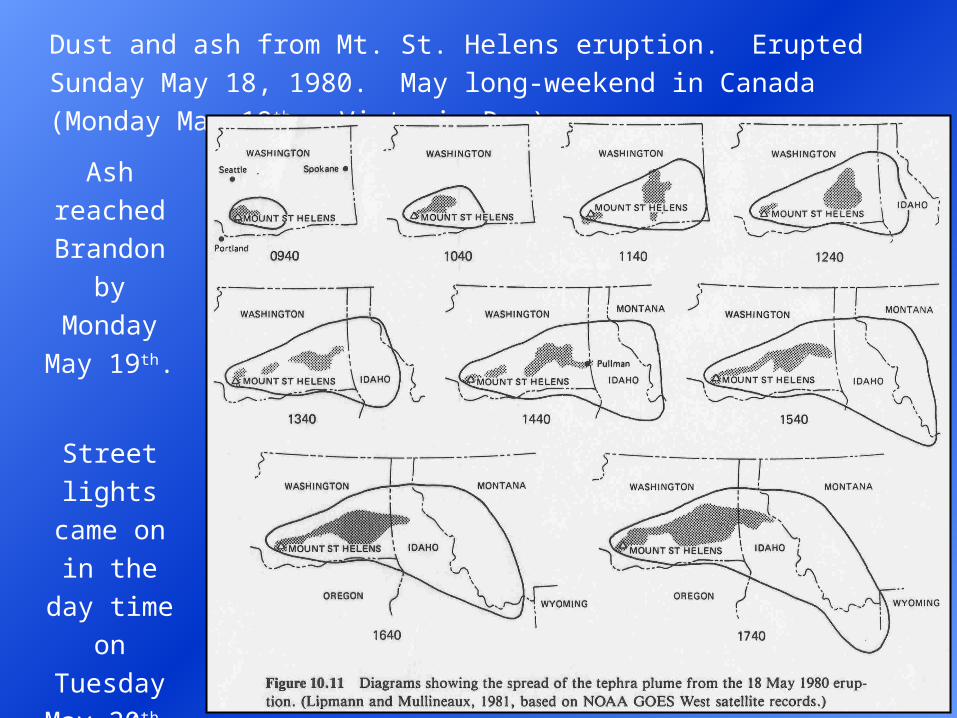
Dust and ash from Mt. St. Helens eruption. Erupted Sunday May 18,
1980. May long-weekend in Canada (Monday May 19th - Victoria Day).
Ash
reached
Brandon by
Monday
May 19th.
Street
lights came
on in the
day time
on
Tuesday
May 20th.
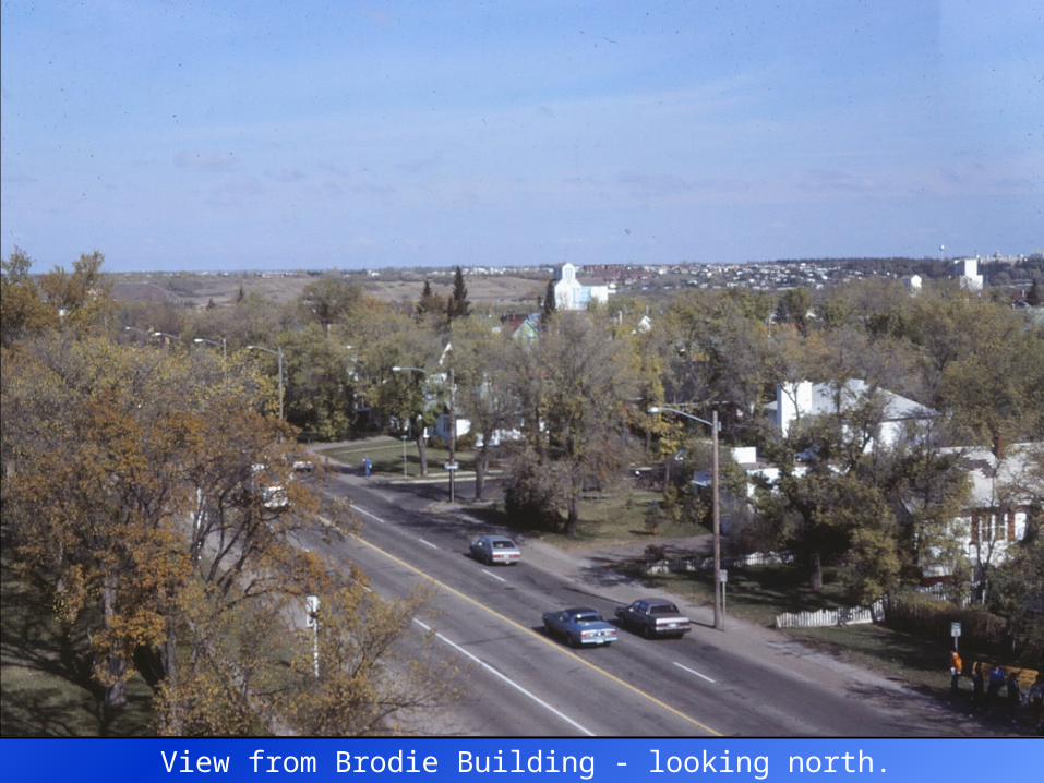
View from Brodie Building - looking north.
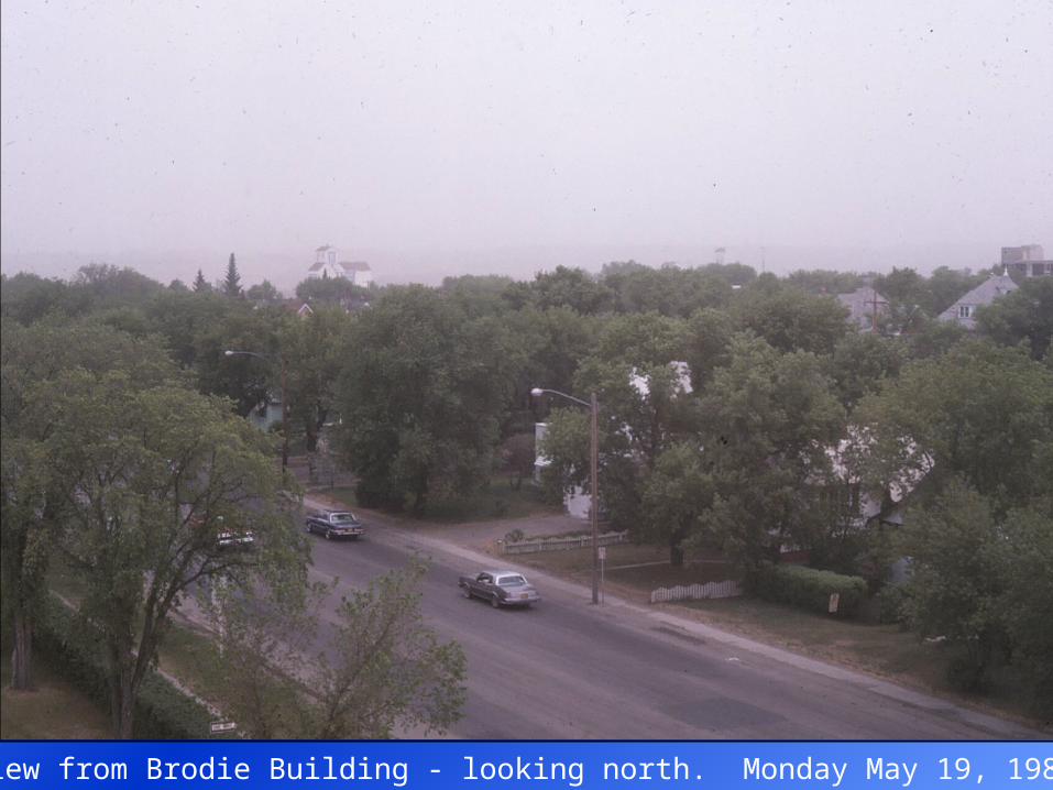
View from Brodie Building - looking north. Monday May 19, 1980.
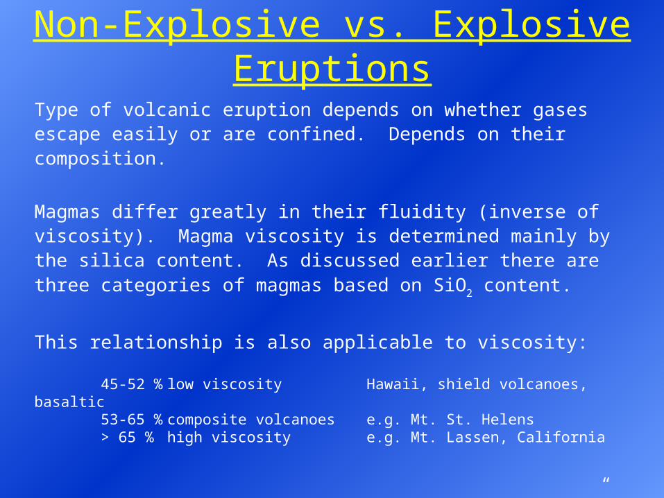
Non-Explosive vs. Explosive Eruptions
Type of volcanic eruption depends on whether gases escape easily or are confined. Depends on their composition.
Magmas differ greatly in their fluidity (inverse of viscosity). Magma viscosity is determined mainly by the silica content. As discussed earlier there are three categories of magmas based on SiO2 content.
This relationship is also applicable to viscosity:
45-52 % low viscosity Hawaii, shield volcanoes, basaltic53-65 % composite volcanoes e.g. Mt. St. Helens> 65 % high viscosity e.g. Mt. Lassen, California
Two types of eruptions are the result: “non-explosive” and explosive.
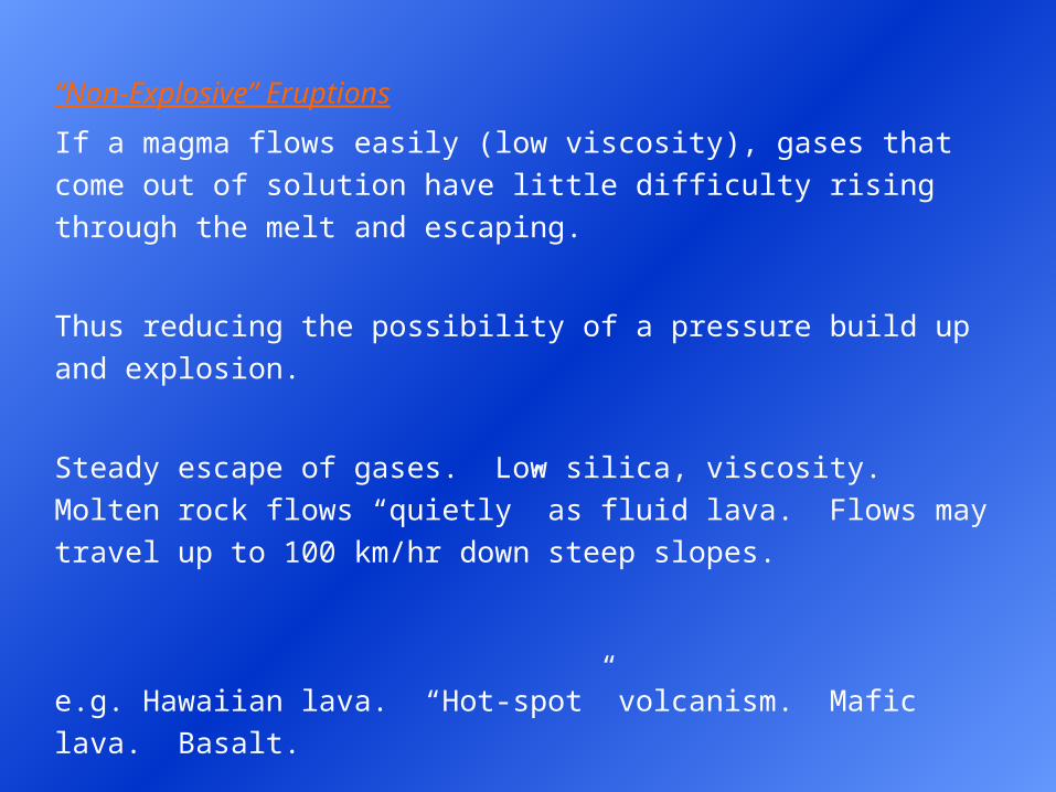
“Non-Explosive” Eruptions
If a magma flows easily (low viscosity), gases that come out of solution
have little difficulty rising through the melt and escaping.
Thus reducing the possibility of a pressure build up and explosion.
Steady escape of gases. Low silica, viscosity. Molten rock flows “quietly”
as fluid lava. Flows may travel up to 100 km/hr down steep slopes.
e.g. Hawaiian lava. “Hot-spot” volcanism. Mafic lava. Basalt.
e.g. Iceland lava. Mid-oceanic ridge volcanism. Mafic lava. Basalt.
e.g. “Non-Explosive” Eruptions
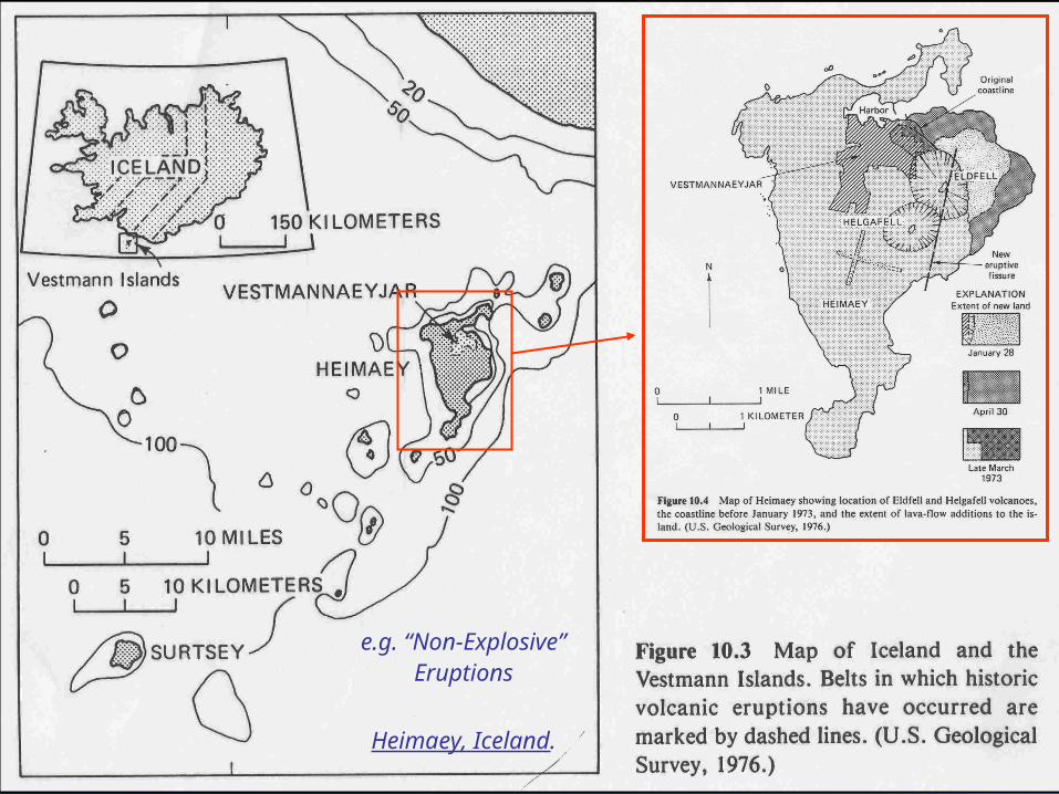
Heimaey, Iceland.
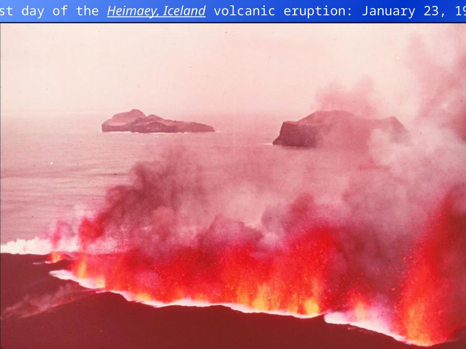
First day of the Heimaey, Iceland volcanic eruption: January 23, 1973.
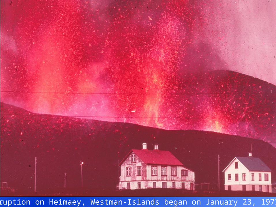
Eruption on Heimaey, Westman-Islands began on January 23, 1973.
Explosive Eruptions
In contrast, the escape of gases from high viscosity magma is hindered.
Gas pressure may build up to a critical level.
Finally released as an explosion.
e.g. Mt. St. Helens. Andesite to rhyolite (i.e. dacite).
Moderate to high silica content.
Moderate to high viscosity.
At the other extreme, explosive release of trapped gases when the magma
reaches the surface may disintegrate the magma into blebs and clots of
molten magma, partly solidified magma and fragments of the walls of the
volcanic vents are blown into the atmosphere.
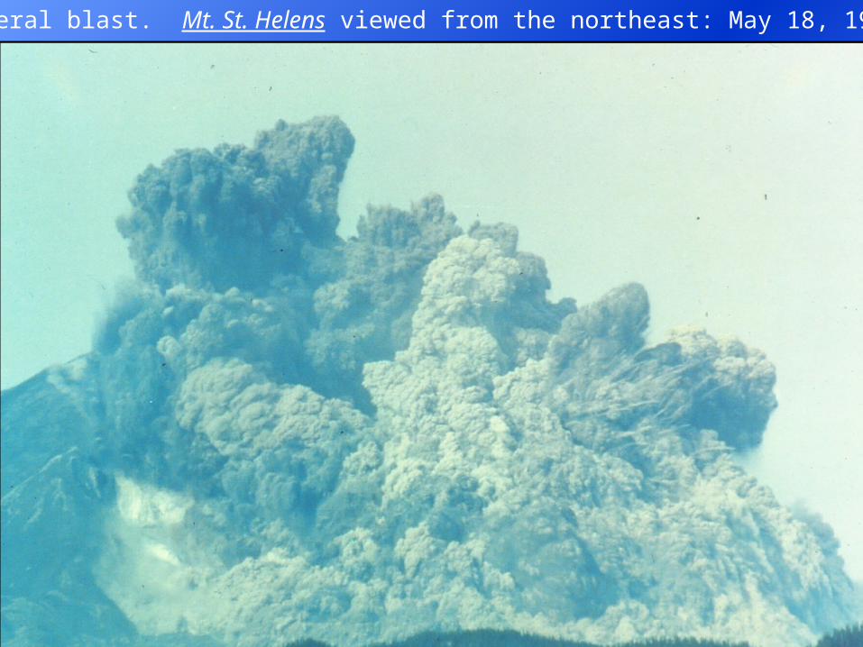
Lateral blast. Mt. St. Helens viewed from the northeast: May 18, 1980.
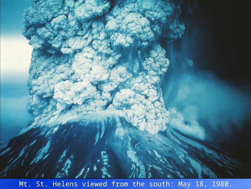
Mt. St. Helens viewed from the south: May 18, 1980.
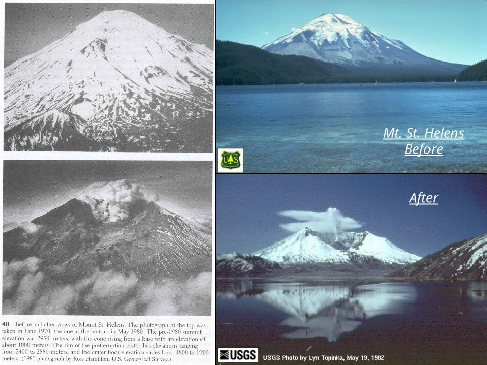
Mt. St. HelensBefore
After
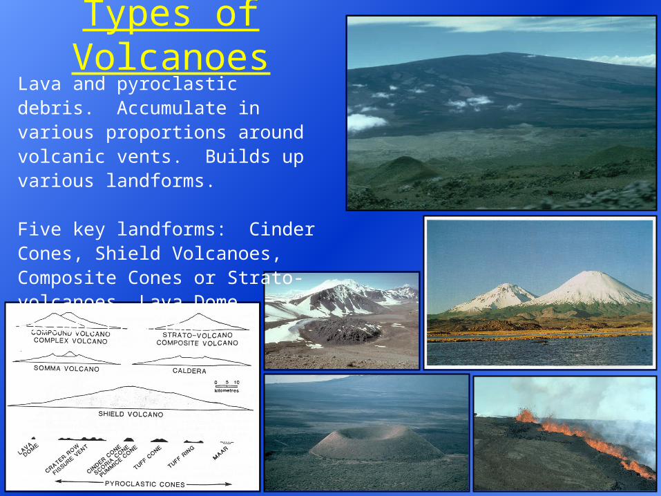
Types of VolcanoesLava and pyroclastic debris. Accumulate in various proportions around volcanic vents. Builds up various landforms. Five key landforms: Cinder Cones, Shield Volcanoes, Composite Cones or Strato-volcanoes, Lava Dome, Fissure Eruptions.
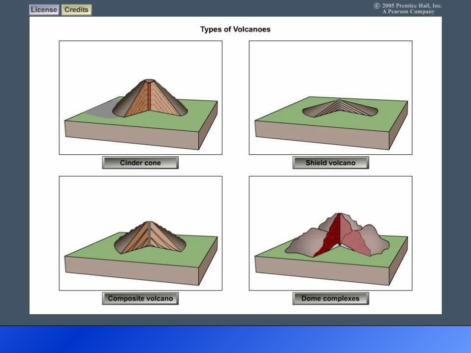
Volcano Types
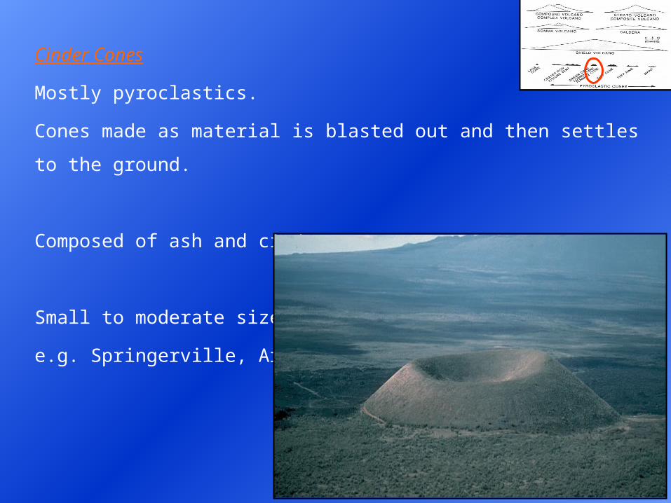
Cinder Cones
Mostly pyroclastics.
Cones made as material is blasted out and then settles to the ground.
Composed of ash and cinders.
Small to moderate size.
e.g. Springerville, Arizona.
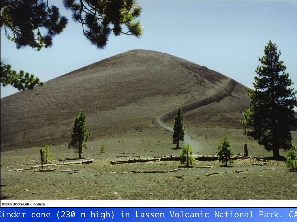
Cinder cone (230 m high) in Lassen Volcanic National Park, CA.
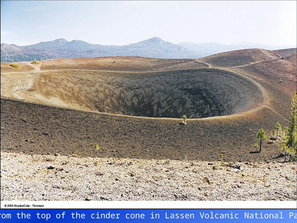
View from the top of the cinder cone in Lassen Volcanic National Park, CA.
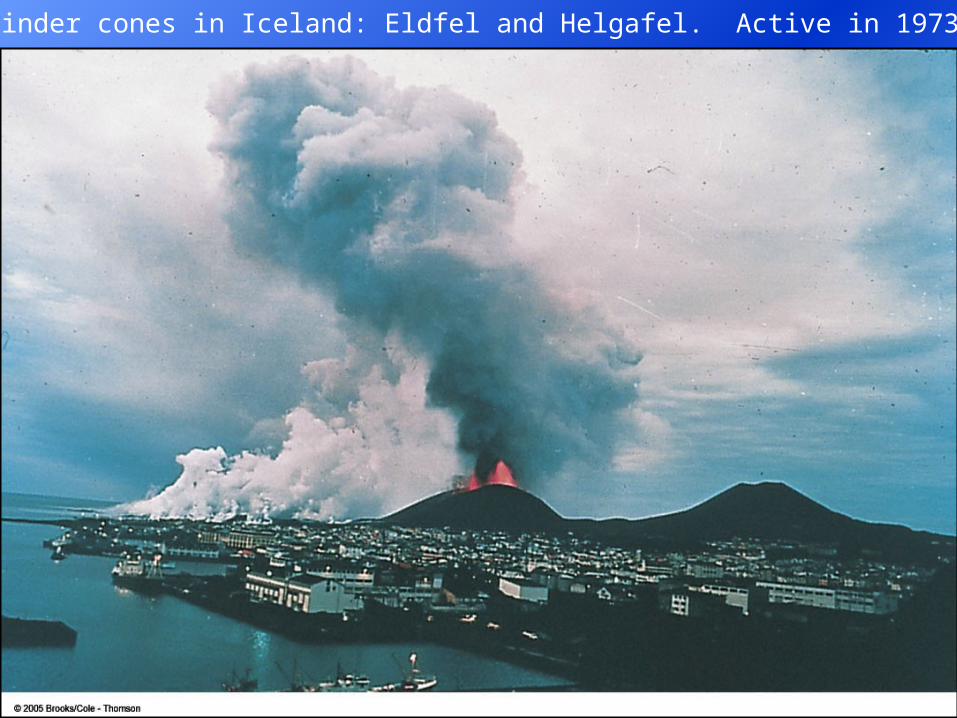
Cinder cones in Iceland: Eldfel and Helgafel. Active in 1973.
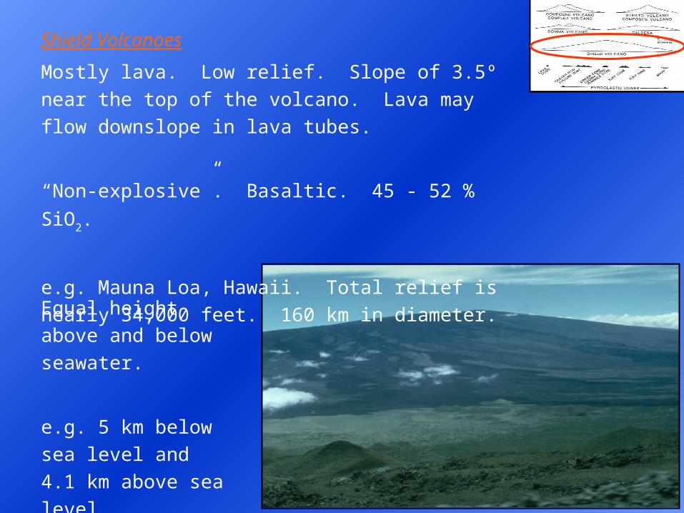
Shield Volcanoes
Mostly lava. Low relief. Slope of 3.5º near the top of the
volcano. Lava may flow downslope in lava tubes.
“Non-explosive”. Basaltic. 45 - 52 % SiO2.
e.g. Mauna Loa, Hawaii. Total relief is nearly 34,000
feet. 160 km in diameter.
Equal height above
and below seawater.
e.g. 5 km below sea
level and 4.1 km
above sea level.
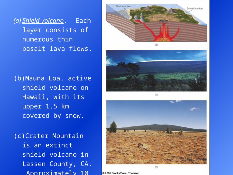
(a)Shield volcano. Each
layer consists of
numerous thin basalt
lava flows.
(b)Mauna Loa, active shield
volcano on Hawaii, with
its upper 1.5 km covered
by snow.
(c) Crater Mountain is an
extinct shield volcano in
Lassen County, CA.
Approximately 10 km
across and 460 m high.

Composite Cones or Stratovolcanoes
Interbedded lava and pyroclastics.
Formed from intermittent eruptions.
Steep-sided volcanic cone (30º). This equals the angle of repose.
Therefore can not get any steeper for pyroclastic deposits.
Produced by alternating layers of pyroclastic debris and lava flows.
Interbedded pyroclastics and intermediate silica lavas (» 60 % silica).
Produce majestic peaks in the Andes, Cascades, Alaska, B.C. and
Japan. e.g. Mt Fuji, Mt. St. Helens, Mt. Rainier. Composite volcanoes
are responsible for most volcanic hazards.
Why are composite volcanoes responsible for most
volcanic hazards? Explosive eruptions. Common
along convergent plate boundaries. Usually near
coastal areas: densely populated.
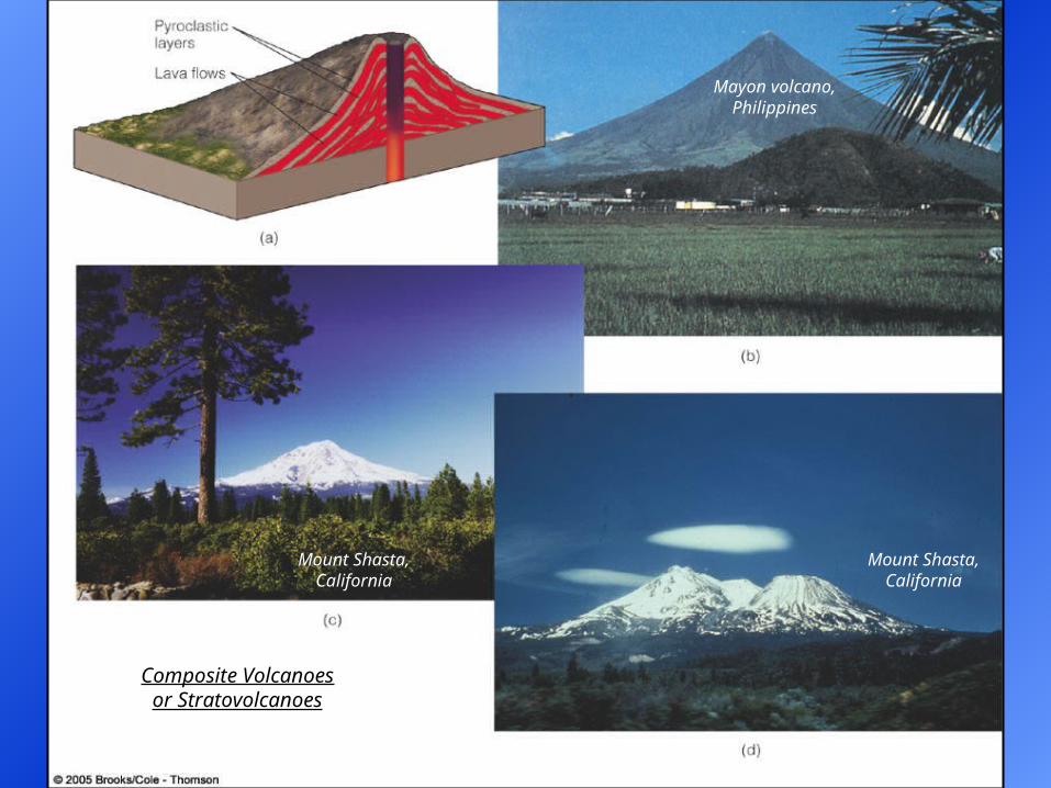
Mayon volcano, Philippines
Mount Shasta, California
Mount Shasta, California
Composite Volcanoes or Stratovolcanoes
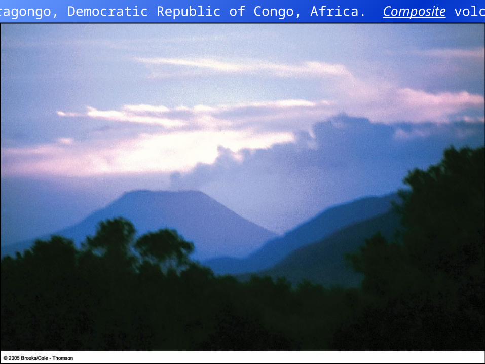
Nyiragongo, Democratic Republic of Congo, Africa. Composite volcano.
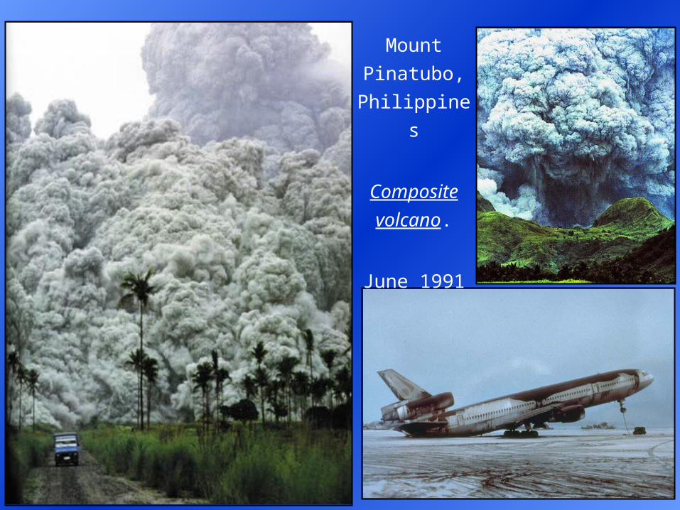
Mount
Pinatubo,
Philippines
Composite
volcano.
June 1991
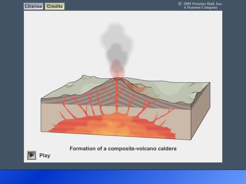
Caldera Formation
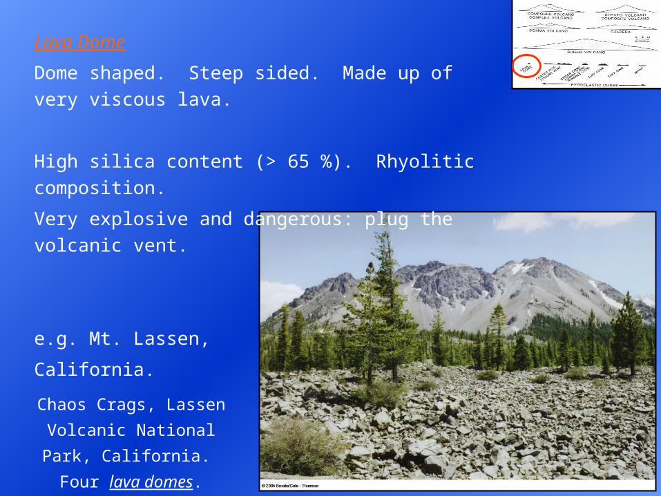
Lava Dome
Dome shaped. Steep sided. Made up of very viscous
lava.
High silica content (> 65 %). Rhyolitic composition.
Very explosive and dangerous: plug the volcanic vent.
e.g. Mt. Lassen,
California.
Chaos Crags, Lassen
Volcanic National Park,
California. Four lava domes.
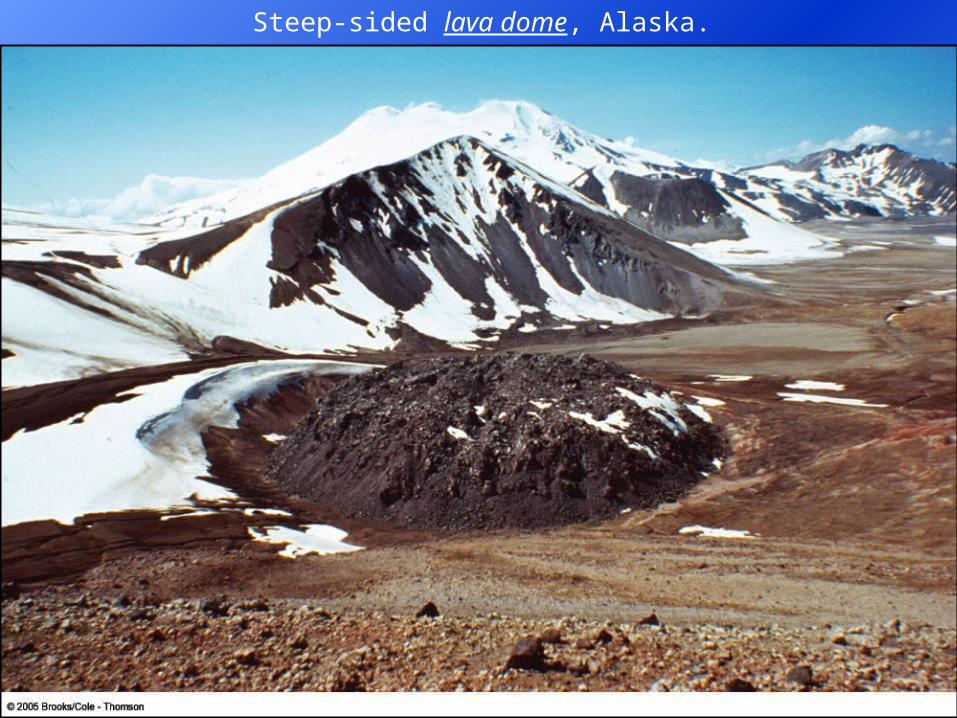
Steep-sided lava dome, Alaska.
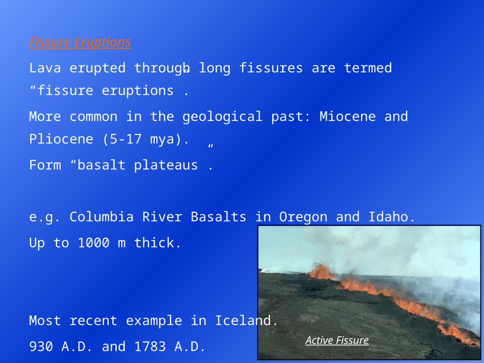
Active Fissure
Fissure Eruptions
Lava erupted through long fissures are termed “fissure eruptions”.
More common in the geological past: Miocene and Pliocene (5-17 mya).
Form “basalt plateaus”.
e.g. Columbia River Basalts in Oregon and Idaho.
Up to 1000 m thick.
Most recent example in Iceland.
930 A.D. and 1783 A.D.
Extensive basalt flows.
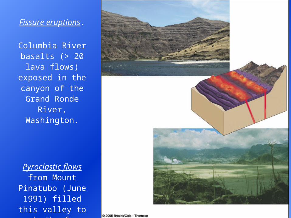
Fissure eruptions.
Columbia River basalts (> 20 lava flows) exposed in the canyon of the
Grand Ronde River, Washington.
Pyroclastic flows from Mount
Pinatubo (June 1991) filled this
valley to a depth of up to 200 m.
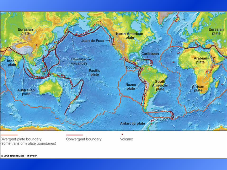
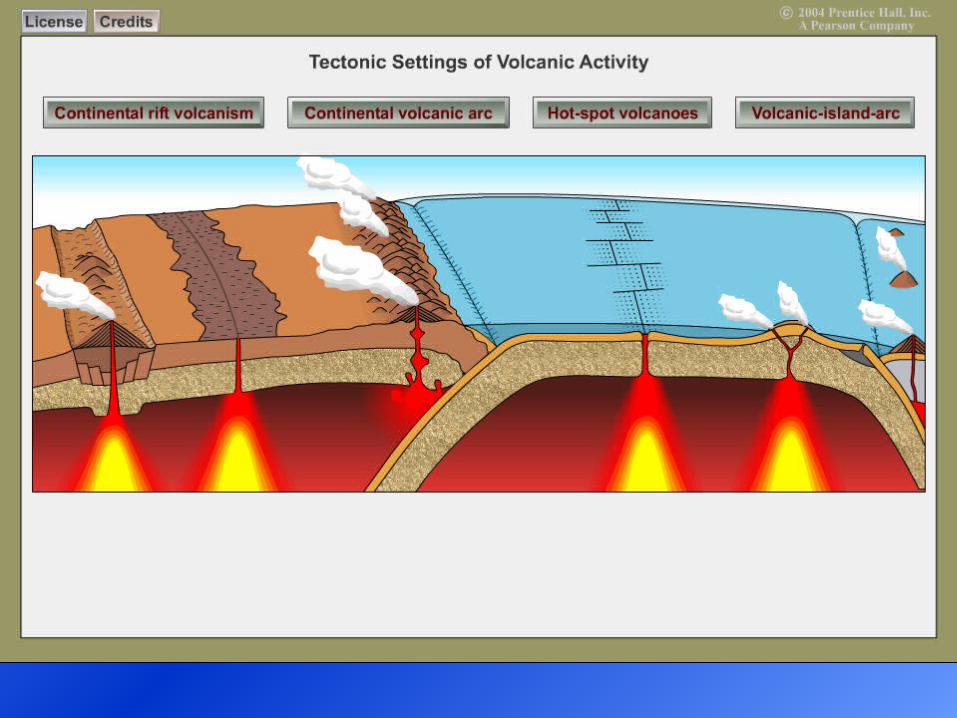
Volcano DistributionPrinciple active volcanoes of the Earth are located at the boundaries of lithospheric plates. Formation of new crustal material. Takes place between separating crustal plates by volcanic processes. This helps to explain the distribution of some active volcanoes. Much volcanic activity in zones of plate separation occur beneath the sea. But in places, such as Iceland, it is above sea level.
Approximately 80% of active volcanoes occur in the Circum Pacific Belt (“Ring of Fire”). Extending along western S.A., western N.A., Japan, Indonesia, etc.
Note: no volcanoes along the collision zone between India and Asia.Continent-to-continent convergent boundary. Note: Africa to Europe collision zone does have some volcanoes.Ocean crust is being subducted.
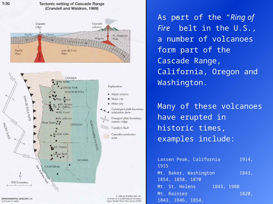
As part of the “Ring of Fire” belt
in the U.S., a number of
volcanoes form part of the
Cascade Range, California,
Oregon and Washington.
Many of these volcanoes have
erupted in historic times,
examples include:
Lassen Peak, California 1914, 1915
Mt. Baker, Washington 1843, 1854, 1858, 1870
Mt. St. Helens 1843, 1980
Mt. Rainier 1820, 1843, 1846, 1854,
1858, 1870, 1894
Mt. Gaschaldi 10,000 years BP
Mt. Meager 2500 years BP
Stikine Belt, B.C. 200, 1340 years BP
Yukon, White River Ash 1200, 1500 years BP
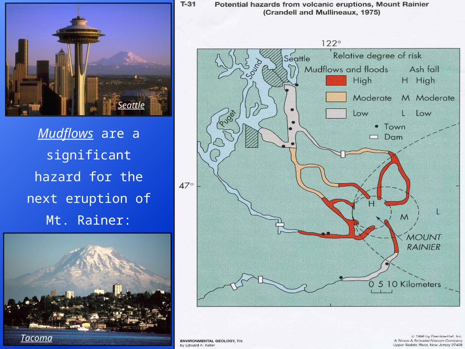
Mudflows are a
significant hazard for
the next eruption of Mt.
Rainer: Seattle and
Tacoma, Washington.
Tacoma
Seattle
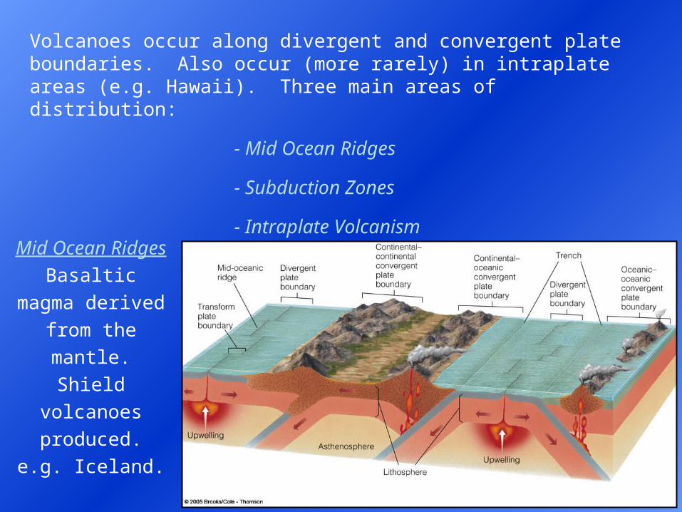
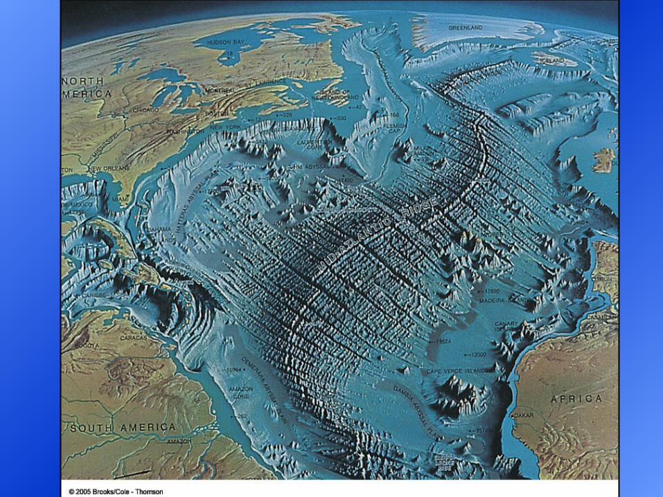
Mid Ocean Ridges
Basaltic magma
derived from the
mantle.
Shield volcanoes
produced.
e.g. Iceland.
Mid Atlantic
Ridge.
Volcanoes occur along divergent and convergent plate boundaries. Also occur (more rarely) in intraplate areas (e.g. Hawaii). Three main areas of distribution:
- Mid Ocean Ridges
- Subduction Zones
- Intraplate Volcanism
Subduction Zones
Andesitic volcanoes. Magma is mixed with both oceanic and continental
crust. Intermediate silica composition. Pacific Rim of North America:
California, Oregon, Washington, B.C. Related to the subduction of the
Juan de Fuca plate.
Ocean plate has
to be subducted
for melting to
occur.
Note: this can
occur at ocean-
ocean or ocean-
continent
boundaries, not
continent-
continent.
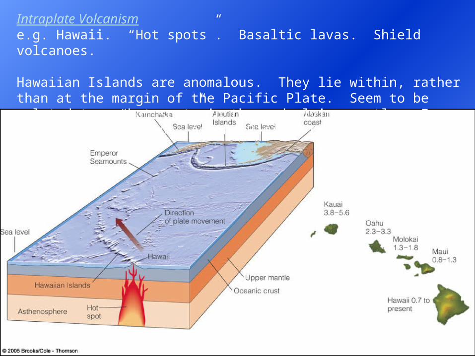
Intraplate Volcanisme.g. Hawaii. “Hot spots”. Basaltic lavas. Shield volcanoes. Hawaiian Islands are anomalous. They lie within, rather than at the margin of the Pacific Plate. Seem to be related to a “hot spot” in the underlying mantle. Forms a string of volcanoes as the Pacific plate migrates northwest.
Tectonic Settings and Volcanic Activity
Prediction of Volcanic EruptionsGeneralization: volcanic eruptions are predicted with a much higher
success rate than earthquakes.
If volcanic eruptions can be predicted then it may be possible to
significantly reduce the loss of life or property damage associated with
an eruption. People can be evacuated from a threatened area and
moveable property taken way from the area.
Predictions of the time at which a volcanic eruption is likely to occur are
of two types: General vs. Specific.
A general prediction consists of a statement that a volcano is likely to
erupt in the near future. “Near future” may be from hours to years.
Does serve to alert the population to the potential hazard.
However, there are many possible ramifications. Loss of business (e.g.
tourism). Volcanologist under extreme pressure to get the right answer.
Loss of life, if the evacuation is not successful.
Predictions of volcanic eruptions can be based on several lines of
evidence:
Past History
Behaviour of Fumaroles
Magnetic Properties of the Rock
Temperature
Swelling
Earthquakes
Past History
Where a long enough record of past history for a particular volcano
exists it may be found to have a more or less regular period of eruptive
cycles. In that case, once a period of average quiescence is completed,
another eruption can be expected in the near future.
Probably not a very accurate predictive tool since the length of quiet
periods for individual volcanoes varies greatly. Historical records are
not very good.
Also, the magnitude of the volcanic eruption also needs to be
considered. Magnitude varies. Might be a longer quiet period after a
huge blast because the pressure is greatly relieved.
Is this a good method for predicting volcanic eruptions?
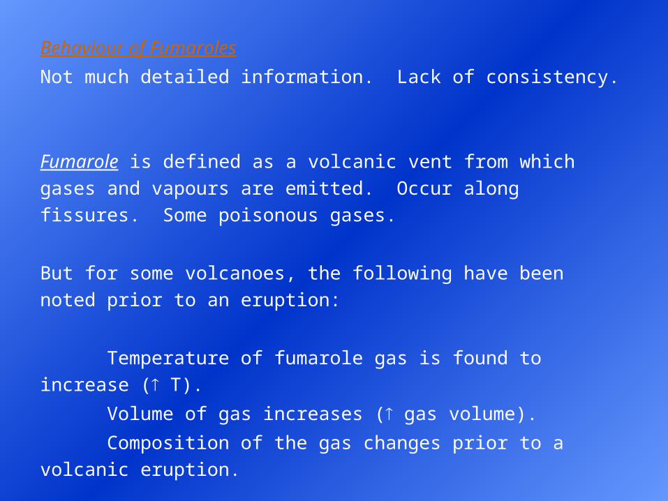
Behaviour of Fumaroles
Not much detailed information. Lack of consistency.
Fumarole is defined as a volcanic vent from which gases and vapours
are emitted. Occur along fissures. Some poisonous gases.
But for some volcanoes, the following have been noted prior to an
eruption:
Temperature of fumarole gas is found to increase ( T).
Volume of gas increases ( gas volume).
Composition of the gas changes prior to a volcanic eruption.
A change in volcanic gas chemistry preceded a later eruptive phase for
Mt. St. Helens: composition, volume, and temperature changes.
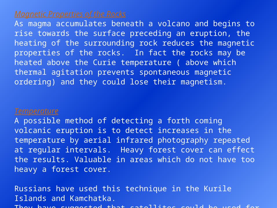
Magnetic Properties of the RocksAs magma accumulates beneath a volcano and begins to rise towards the surface preceding an eruption, the heating of the surrounding rock reduces the magnetic properties of the rocks. In fact the rocks may be heated above the Curie temperature ( above which thermal agitation prevents spontaneous magnetic ordering) and they could lose their magnetism. TemperatureA possible method of detecting a forth coming volcanic eruption is to detect increases in the temperature by aerial infrared photography repeated at regular intervals. Heavy forest cover can effect the results. Valuable in areas which do not have too heavy a forest cover. Russians have used this technique in the Kurile Islands and Kamchatka.They have suggested that satellites could be used for this purpose. This technique was used on Mt. St. Helens. With some success prior to the main eruption in May 1980.
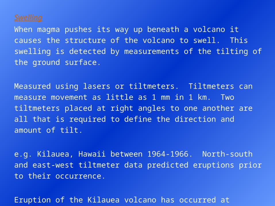
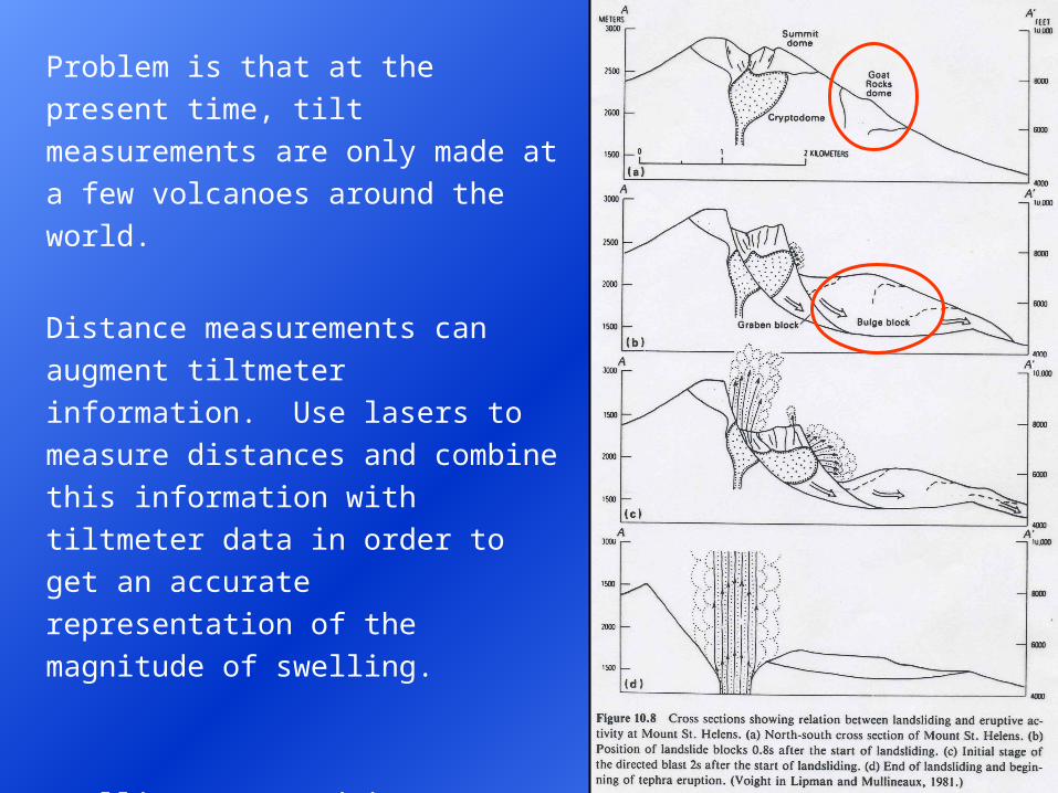
Swelling
When magma pushes its way up beneath a volcano it causes the
structure of the volcano to swell. This swelling is detected by
measurements of the tilting of the ground surface.
Measured using lasers or tiltmeters. Tiltmeters can measure movement
as little as 1 mm in 1 km. Two tiltmeters placed at right angles to one
another are all that is required to define the direction and amount of tilt.
e.g. Kilauea, Hawaii between 1964-1966. North-south and east-west
tiltmeter data predicted eruptions prior to their occurrence.
Eruption of the Kilauea volcano has occurred at various stages of tilting.
Long periods of increased tilting do not always lead to an eruption.
This indicates that the magma can recede or it begins to intrude into the
flanks of the volcano.
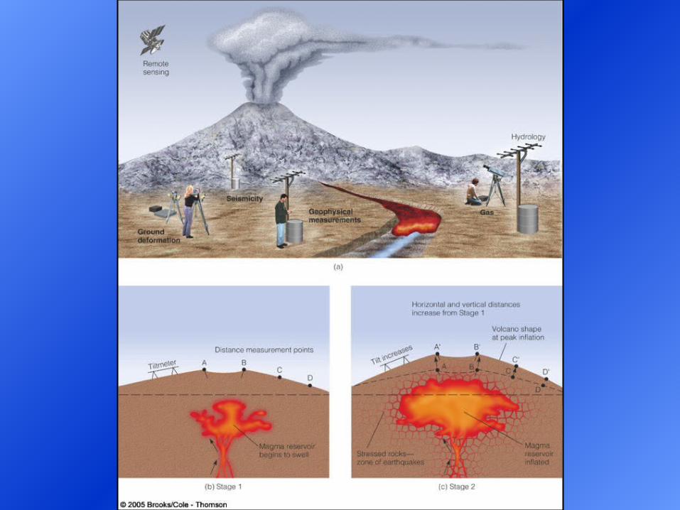
Problem is that at the present time, tilt
measurements are only made at a few
volcanoes around the world.
Distance measurements can augment
tiltmeter information. Use lasers to
measure distances and combine this
information with tiltmeter data in order
to get an accurate representation of the
magnitude of swelling.
Swelling occurred in Mt. St. Helens
prior to the March 1980 eruption. On
the north side of the mountain. Bulge
moved at 1.5 m per day!
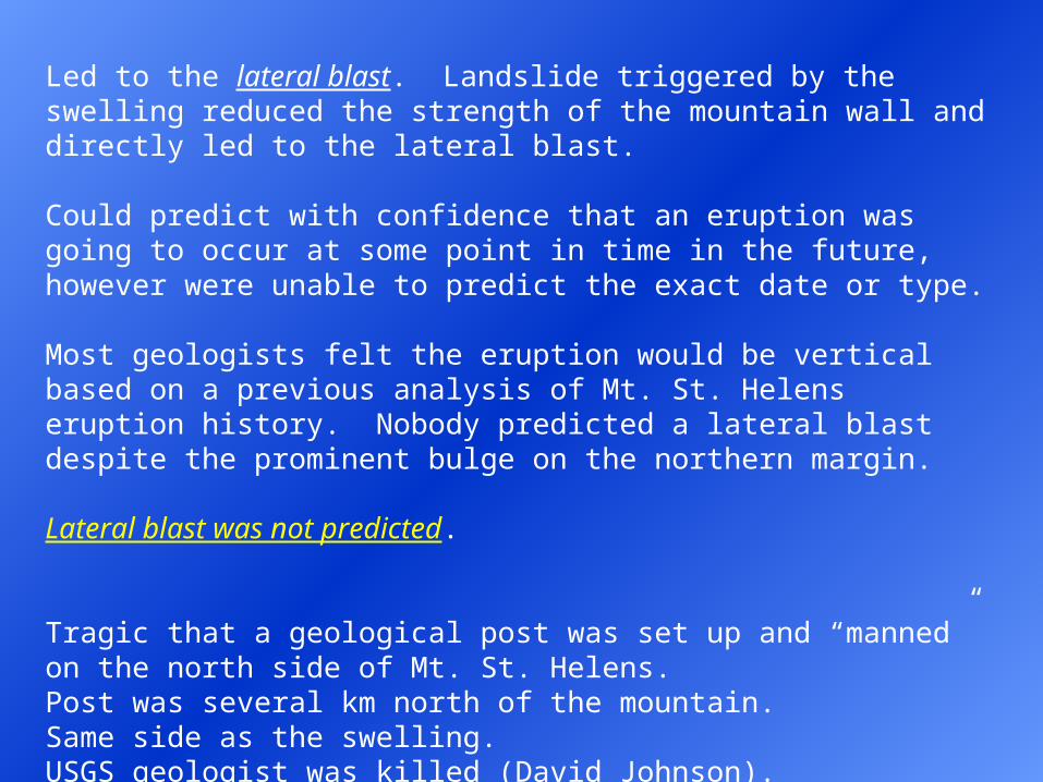
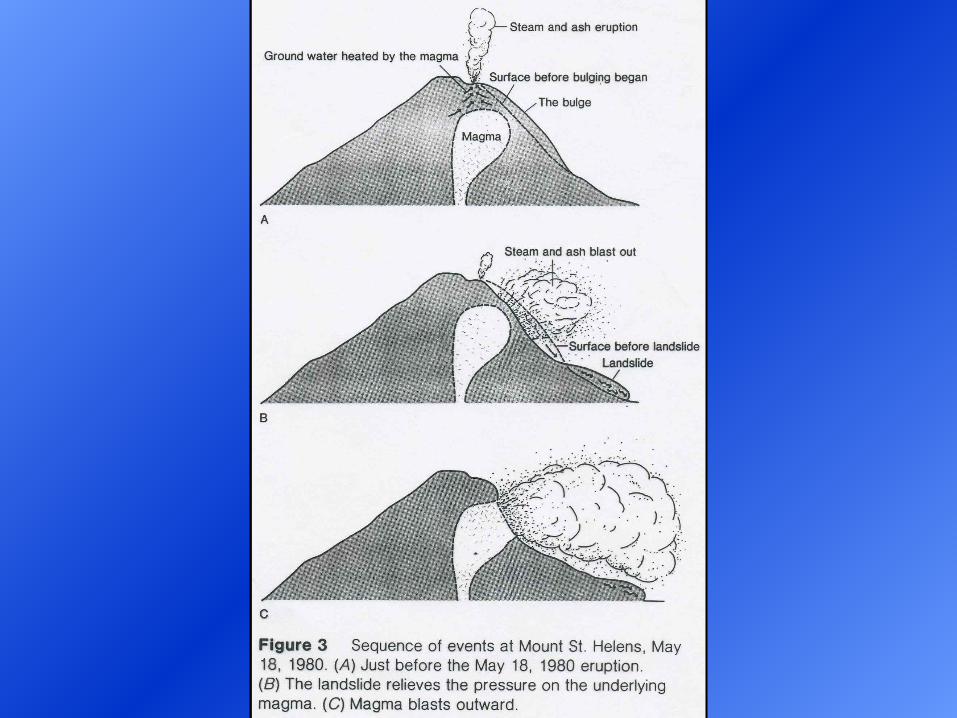
Led to the lateral blast. Landslide triggered by the swelling reduced the strength of the mountain wall and directly led to the lateral blast.
Could predict with confidence that an eruption was going to occur at some point in time in the future, however were unable to predict the exact date or type.
Most geologists felt the eruption would be vertical based on a previous analysis of Mt. St. Helens eruption history. Nobody predicted a lateral blast despite the prominent bulge on the northern margin.
Lateral blast was not predicted.
Tragic that a geological post was set up and “manned” on the north side of Mt. St. Helens.Post was several km north of the mountain.Same side as the swelling.USGS geologist was killed (David Johnson).
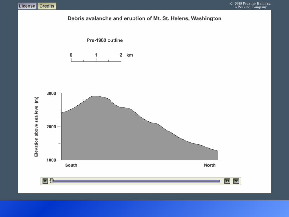
Mount St. Helens, Washington: Debris Avalanche and Eruption
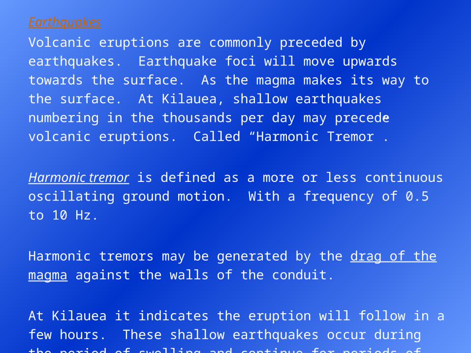
Earthquakes
Volcanic eruptions are commonly preceded by earthquakes.
Earthquake foci will move upwards towards the surface. As the magma
makes its way to the surface. At Kilauea, shallow earthquakes
numbering in the thousands per day may precede volcanic eruptions.
Called “Harmonic Tremor”.
Harmonic tremor is defined as a more or less continuous oscillating
ground motion. With a frequency of 0.5 to 10 Hz.
Harmonic tremors may be generated by the drag of the magma against
the walls of the conduit.
At Kilauea it indicates the eruption will follow in a few hours. These
shallow earthquakes occur during the period of swelling and continue
for periods of several days to several hours, commonly stopping with
the beginning of an eruption.
Similar swarms of earthquakes may also occur however during times of
magma recession when the top of the volcano is sinking. So shallow
earthquakes can only be used to indicate impending eruptions when the
character of ground tilting is also known.
Major earthquakes preceded the main Mt. St. Helens eruption and
increased earthquake activity occurred just hours before a later
(August) eruption. Similar pattern before the Mt Pinatubo eruption.
Evacuated a US air force base in the Philippines.
Pattern of Earthquake Behaviour:
(i) earthquakes increased in frequency
(ii) earthquakes increased in magnitude and intensity
(iii) earthquakes (foci) became shallower
Mt. St. Helens
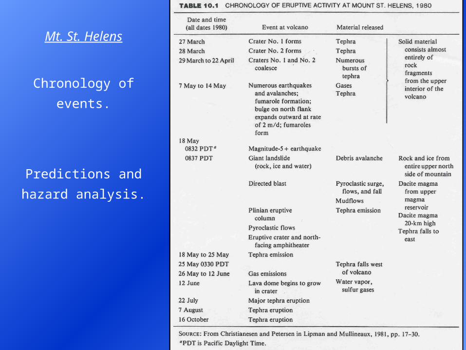
Chronology of events.
Predictions and
hazard analysis.
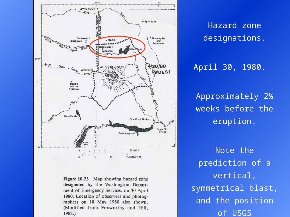
Hazard zone
designations.
April 30, 1980.
Approximately 2½ weeks
before the eruption.
Note the prediction of a
vertical, symmetrical
blast, and the position of
USGS geologists.
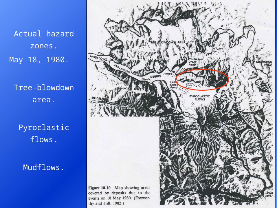
Actual hazard zones.
May 18, 1980.
Tree-blowdown area.
Pyroclastic flows.
Mudflows.
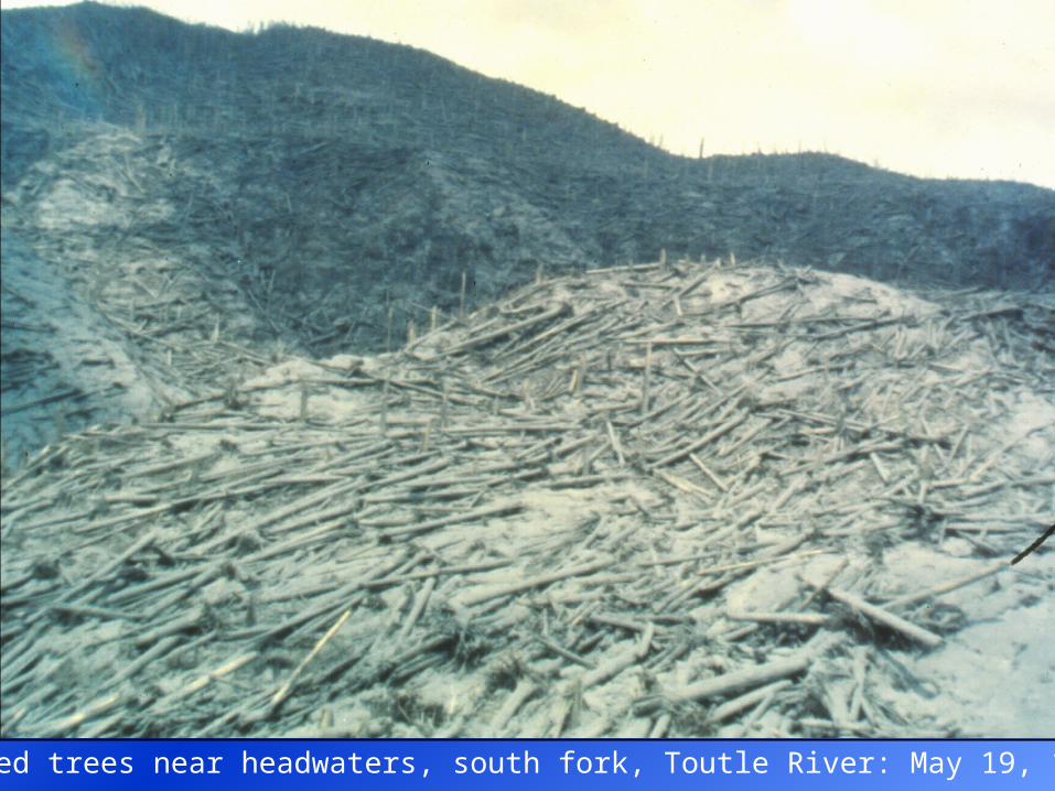
Downed trees near headwaters, south fork, Toutle River: May 19, 1980.
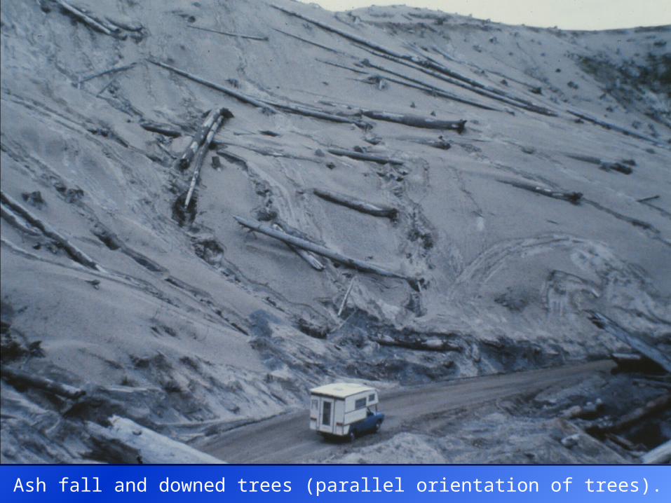
Ash fall and downed trees (parallel orientation of trees).
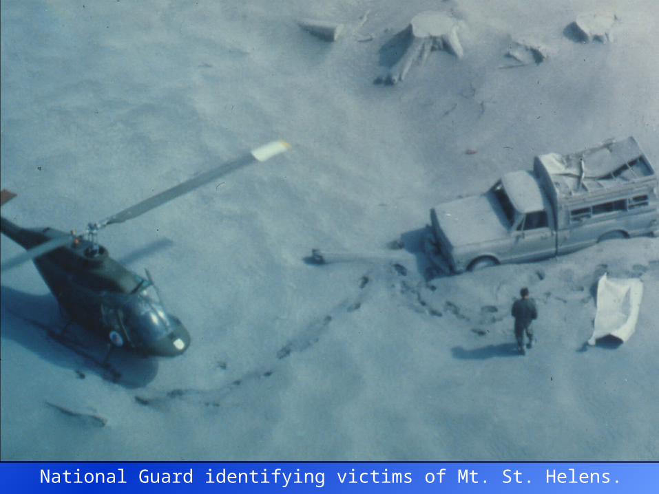
National Guard identifying victims of Mt. St. Helens.
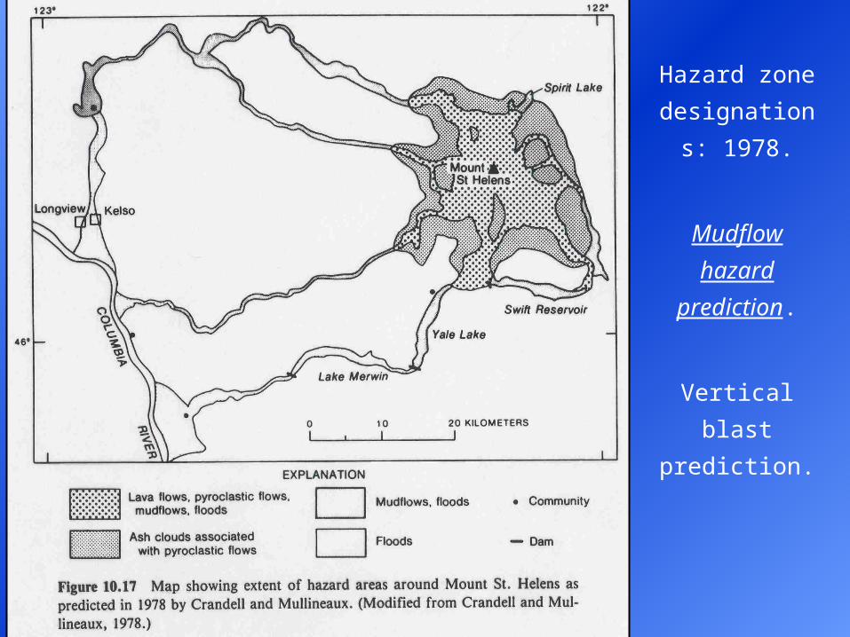
Hazard zone
designations:
1978.
Mudflow hazard
prediction.
Vertical blast
prediction.
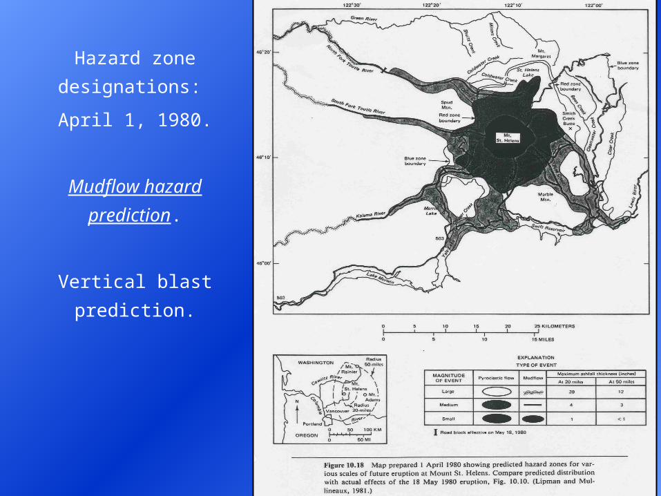
Hazard zone
designations:
April 1, 1980.
Mudflow hazard
prediction.
Vertical blast
prediction.
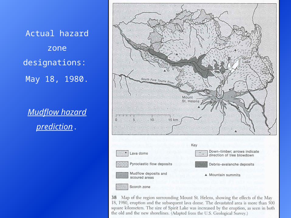
Actual hazard zone
designations:
May 18, 1980.
Mudflow hazard
prediction.
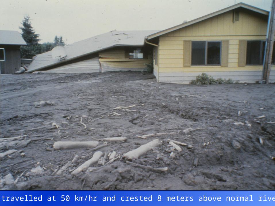
Mudflows travelled at 50 km/hr and crested 8 meters above normal river level.
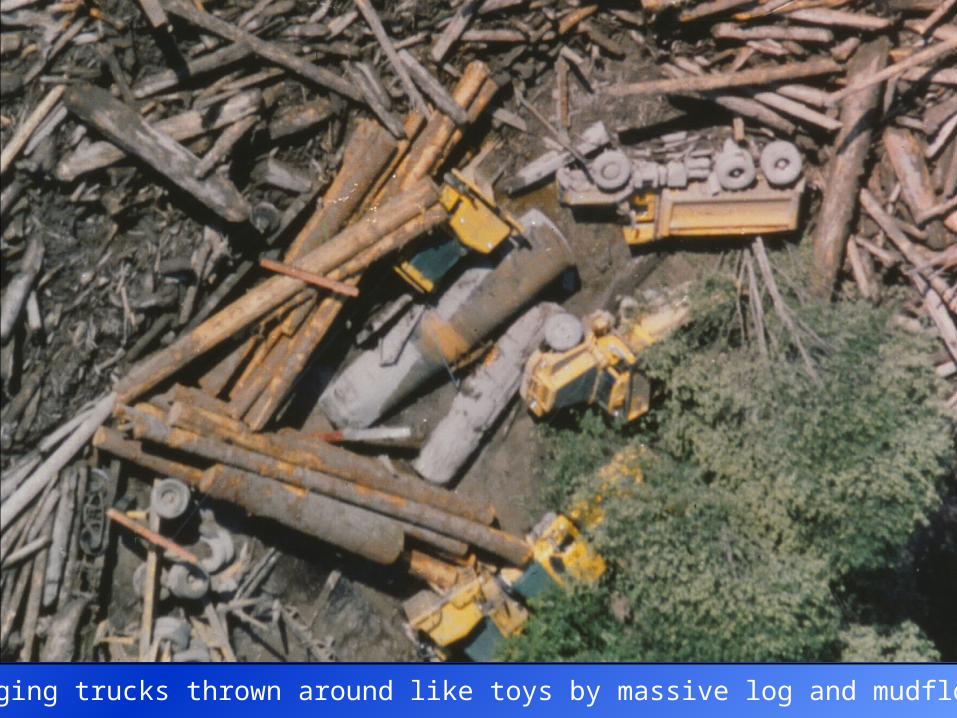
Logging trucks thrown around like toys by massive log and mudflows.
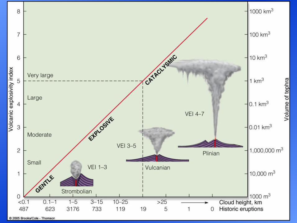
Index of Volcanic Explosivity
Volcanic Explosivity Index (VEI) is a semi-quantitative measure of the
destructiveness of a volcanic eruption.
VEI depends on: cloud height (km) and volume of tephra (km3).
Volume of lava, fatalities, and property damage are not considered.
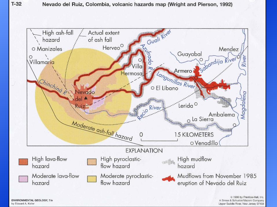
e.g. Nevado del Ruiz eruption (1985) in Columbia killed 23,000 people,
yet only had a VEI = 3.
e.g. Tambora eruption (1815) in Indonesia had a VEI = 7.