topographic data dictionary - spatial services
TRANSCRIPT
Topographic Data Dictionary NSW Topographic Data Model
No: 8 Date: 10 April 2015 Land and Property Information T: 1300 052 637 E: [email protected]
Topographic Data Dictionary v8.10
NSW Topographic Data Model
Data Dictionary
v8.10 April 2015
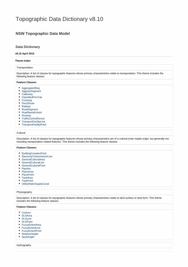
Theme Index
Transportation
Description: A list of classes for topographic features whose primary characteristics relate to transportation. This theme includes thefollowing feature classes:
Feature Classes:
AggregatedWayAggwaySegmentCablewayClassifiedFireTrailCrossingFerryRouteRailwayRoadSegmentRoadNameExtentRunwayTrafficControlDeviceTransportFacilityLineTransportFacilityPoint
Cultural
Description: A list of classes for topographic features whose primary characteristics are of a cultural (man made) origin, but generally notincluding transportation related features. This theme includes the following feature classes:
Feature Classes:
BuildingComplexPointElectricityTransmissionLineGeneralCulturalAreaGeneralCulturalLineGeneralCulturalPointPipelinePlaceAreaPlacePointTankAreaTankPointUtilityWaterSupplyCanal
Physiography
Description: A list of classes for topographic features whose primary characteristics relate to land surface or land form. This themeincludes the following feature classes:
Feature Classes:
ContourDLSAreaDLSLineDLSPointFuzzyExtentAreaFuzzyExtentLineFuzzyExtentPointRelativeHeightSpotHeight
Hydrography
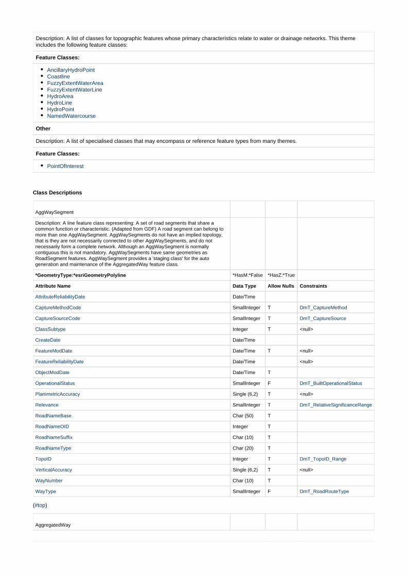
Description: A list of classes for topographic features whose primary characteristics relate to water or drainage networks. This themeincludes the following feature classes:
Feature Classes:
AncillaryHydroPointCoastlineFuzzyExtentWaterAreaFuzzyExtentWaterLineHydroAreaHydroLineHydroPointNamedWatercourse
Other
Description: A list of specialised classes that may encompass or reference feature types from many themes.
Feature Classes:
PointOfInterest
Class Descriptions
AggWaySegment
Description: A line feature class representing: A set of road segments that share acommon function or characteristic. (Adapted from GDF) A road segment can belong tomore than one AggWaySegment. AggWaySegments do not have an implied topology,that is they are not necessarily connected to other AggWaySegments, and do notnecessarily form a complete network. Although an AggWaySegment is normallycontiguous this is not mandatory. AggWaySegments have same geometries asRoadSegment features. AggWaySegment provides a 'staging class' for the autogeneration and maintenance of the AggregatedWay feature class.
*GeometryType:*esriGeometryPolyline *HasM:*False *HasZ:*True
Attribute Name Data Type Allow Nulls Constraints
AttributeReliabilityDate Date/Time
CaptureMethodCode SmallInteger T DmT_CaptureMethod
CaptureSourceCode SmallInteger T DmT_CaptureSource
ClassSubtype Integer T <null>
CreateDate Date/Time
FeatureModDate Date/Time T <null>
FeatureReliabilityDate Date/Time <null>
ObjectModDate Date/Time T
OperationalStatus SmallInteger F DmT_BuiltOperationalStatus
PlanimetricAccuracy Single (6,2) T <null>
Relevance SmallInteger T DmT_RelativeSignificanceRange
RoadNameBase Char (50) T
RoadNameOID Integer T
RoadNameSuffix Char (10) T
RoadNameType Char (20) T
TopoID Integer T DmT_TopoID_Range
VerticalAccuracy Single (6,2) T <null>
WayNumber Char (10) T
WayType SmallInteger F DmT_RoadRouteType
( )#top
AggregatedWay
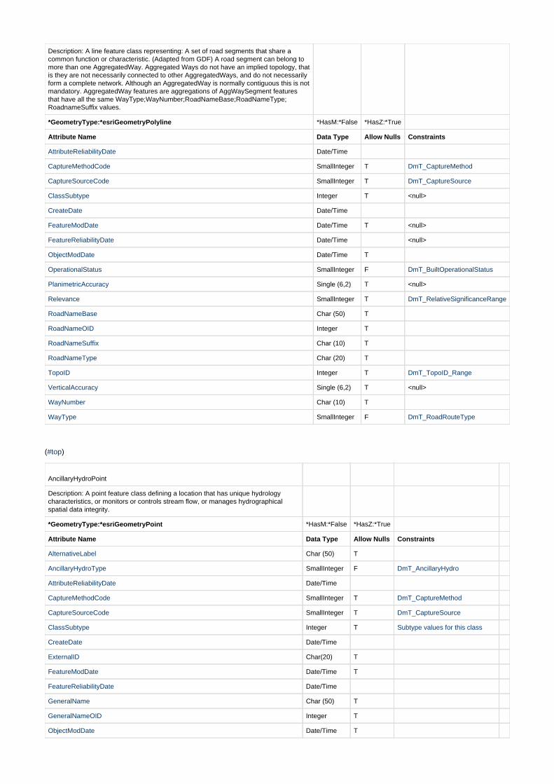
Description: A line feature class representing: A set of road segments that share acommon function or characteristic. (Adapted from GDF) A road segment can belong tomore than one AggregatedWay. Aggregated Ways do not have an implied topology, thatis they are not necessarily connected to other AggregatedWays, and do not necessarilyform a complete network. Although an AggregatedWay is normally contiguous this is notmandatory. AggregatedWay features are aggregations of AggWaySegment featuresthat have all the same WayType;WayNumber;RoadNameBase;RoadNameType;RoadnameSuffix values.
*GeometryType:*esriGeometryPolyline *HasM:*False *HasZ:*True
Attribute Name Data Type Allow Nulls Constraints
AttributeReliabilityDate Date/Time
CaptureMethodCode SmallInteger T DmT_CaptureMethod
CaptureSourceCode SmallInteger T DmT_CaptureSource
ClassSubtype Integer T <null>
CreateDate Date/Time
FeatureModDate Date/Time T <null>
FeatureReliabilityDate Date/Time <null>
ObjectModDate Date/Time T
OperationalStatus SmallInteger F DmT_BuiltOperationalStatus
PlanimetricAccuracy Single (6,2) T <null>
Relevance SmallInteger T DmT_RelativeSignificanceRange
RoadNameBase Char (50) T
RoadNameOID Integer T
RoadNameSuffix Char (10) T
RoadNameType Char (20) T
TopoID Integer T DmT_TopoID_Range
VerticalAccuracy Single (6,2) T <null>
WayNumber Char (10) T
WayType SmallInteger F DmT_RoadRouteType
( )#top
AncillaryHydroPoint
Description: A point feature class defining a location that has unique hydrologycharacteristics, or monitors or controls stream flow, or manages hydrographicalspatial data integrity.
*GeometryType:*esriGeometryPoint *HasM:*False *HasZ:*True
Attribute Name Data Type Allow Nulls Constraints
AlternativeLabel Char (50) T
AncillaryHydroType SmallInteger F DmT_AncillaryHydro
AttributeReliabilityDate Date/Time
CaptureMethodCode SmallInteger T DmT_CaptureMethod
CaptureSourceCode SmallInteger T DmT_CaptureSource
ClassSubtype Integer T Subtype values for this class
CreateDate Date/Time
ExternalID Char(20) T
FeatureModDate Date/Time T
FeatureReliabilityDate Date/Time
GeneralName Char (50) T
GeneralNameOID Integer T
ObjectModDate Date/Time T
OperationalStatus SmallInteger FDmT_BuiltOperationalStatus
PlanimetricAccuracy Single (6,2) T
Relevance SmallInteger T DmT_RelativeSignificanceRange
SymbolRotation SmallInteger F DmT_SymbolRotation
TopoID Integer T DmT_TopoID_Range
VerticalAccuracy Single (6,2) T <null>
( )#top
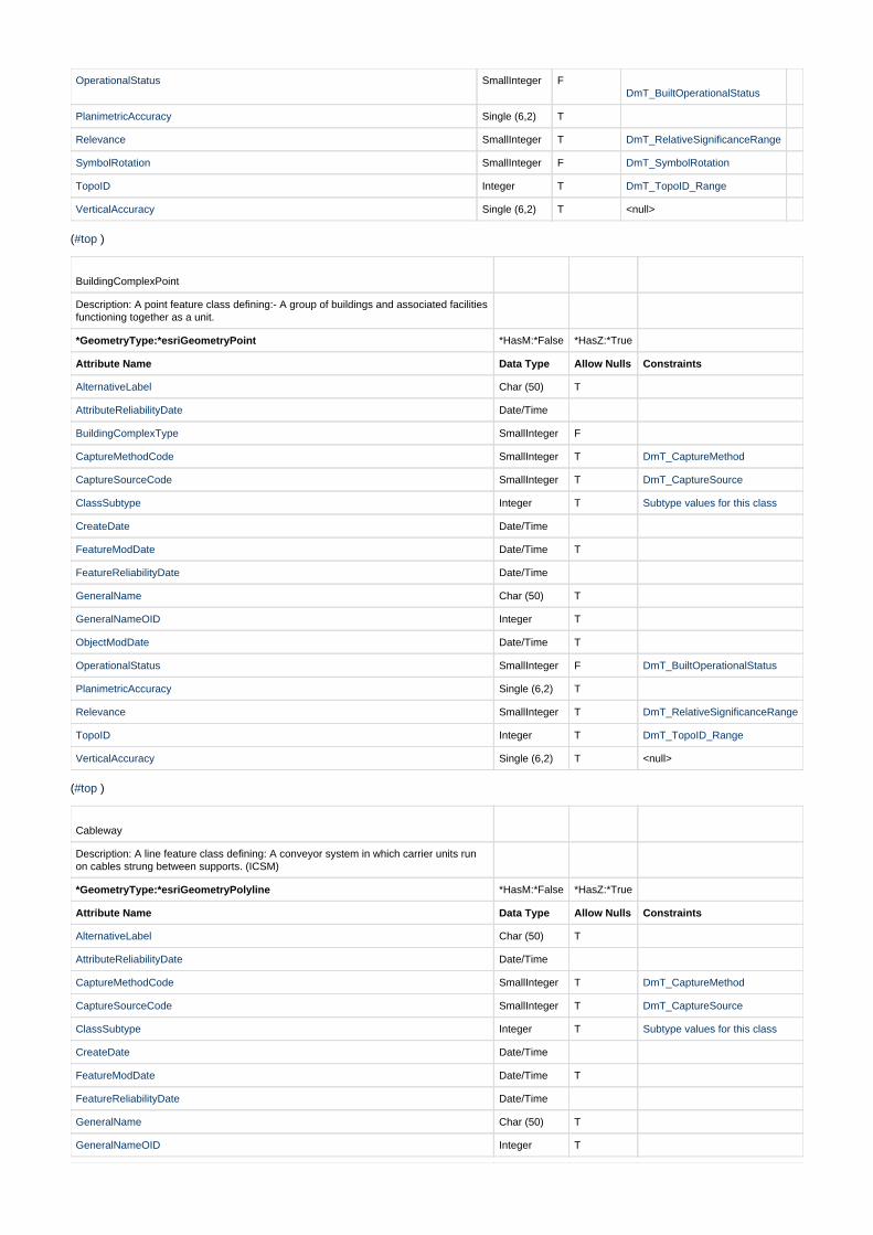
BuildingComplexPoint
Description: A point feature class defining:- A group of buildings and associated facilitiesfunctioning together as a unit.
*GeometryType:*esriGeometryPoint *HasM:*False *HasZ:*True
Attribute Name Data Type Allow Nulls Constraints
AlternativeLabel Char (50) T
AttributeReliabilityDate Date/Time
BuildingComplexType SmallInteger F
CaptureMethodCode SmallInteger T DmT_CaptureMethod
CaptureSourceCode SmallInteger T DmT_CaptureSource
ClassSubtype Integer T Subtype values for this class
CreateDate Date/Time
FeatureModDate Date/Time T
FeatureReliabilityDate Date/Time
GeneralName Char (50) T
GeneralNameOID Integer T
ObjectModDate Date/Time T
OperationalStatus SmallInteger F DmT_BuiltOperationalStatus
PlanimetricAccuracy Single (6,2) T
Relevance SmallInteger T DmT_RelativeSignificanceRange
TopoID Integer T DmT_TopoID_Range
VerticalAccuracy Single (6,2) T <null>
( )#top
Cableway
Description: A line feature class defining: A conveyor system in which carrier units runon cables strung between supports. (ICSM)
*GeometryType:*esriGeometryPolyline *HasM:*False *HasZ:*True
Attribute Name Data Type Allow Nulls Constraints
AlternativeLabel Char (50) T
AttributeReliabilityDate Date/Time
CaptureMethodCode SmallInteger T DmT_CaptureMethod
CaptureSourceCode SmallInteger T DmT_CaptureSource
ClassSubtype Integer T Subtype values for this class
CreateDate Date/Time
FeatureModDate Date/Time T
FeatureReliabilityDate Date/Time
GeneralName Char (50) T
GeneralNameOID Integer T
ObjectModDate Date/Time T
OperationalStatus SmallInteger F DmT_BuiltOperationalStatus
PlanimetricAccuracy Single (6,2) T
Relevance SmallInteger T DmT_RelativeSignificanceRange
TopoID Integer T DmT_TopoID_Range
VerticalAccuracy Single (6,2) T <null>
( )#top
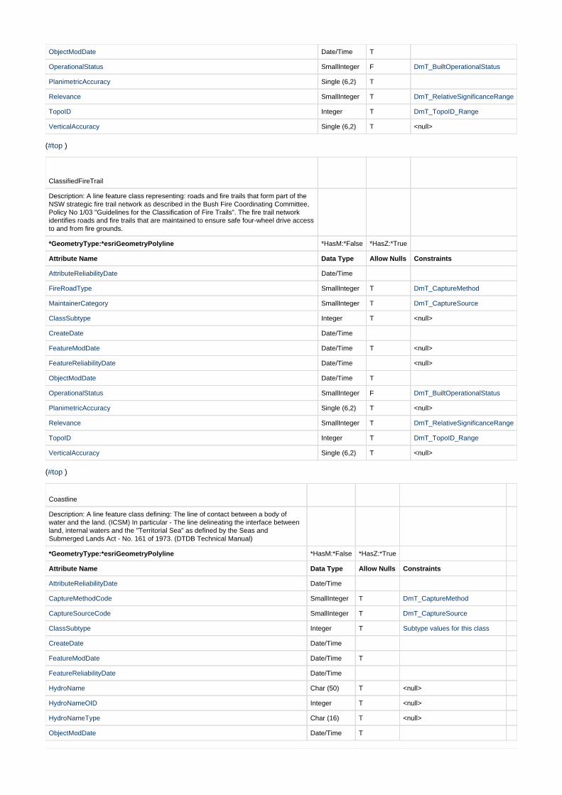
ClassifiedFireTrail
Description: A line feature class representing: roads and fire trails that form part of theNSW strategic fire trail network as described in the Bush Fire Coordinating Committee,Policy No 1/03 "Guidelines for the Classification of Fire Trails". The fire trail networkidentifies roads and fire trails that are maintained to ensure safe four-wheel drive accessto and from fire grounds.
*GeometryType:*esriGeometryPolyline *HasM:*False *HasZ:*True
Attribute Name Data Type Allow Nulls Constraints
AttributeReliabilityDate Date/Time
FireRoadType SmallInteger T DmT_CaptureMethod
MaintainerCategory SmallInteger T DmT_CaptureSource
ClassSubtype Integer T <null>
CreateDate Date/Time
FeatureModDate Date/Time T <null>
FeatureReliabilityDate Date/Time <null>
ObjectModDate Date/Time T
OperationalStatus SmallInteger F DmT_BuiltOperationalStatus
PlanimetricAccuracy Single (6,2) T <null>
Relevance SmallInteger T DmT_RelativeSignificanceRange
TopoID Integer T DmT_TopoID_Range
VerticalAccuracy Single (6,2) T <null>
( )#top
Coastline
Description: A line feature class defining: The line of contact between a body ofwater and the land. (ICSM) In particular - The line delineating the interface betweenland, internal waters and the "Territorial Sea" as defined by the Seas andSubmerged Lands Act - No. 161 of 1973. (DTDB Technical Manual)
*GeometryType:*esriGeometryPolyline *HasM:*False *HasZ:*True
Attribute Name Data Type Allow Nulls Constraints
AttributeReliabilityDate Date/Time
CaptureMethodCode SmallInteger T DmT_CaptureMethod
CaptureSourceCode SmallInteger T DmT_CaptureSource
ClassSubtype Integer T Subtype values for this class
CreateDate Date/Time
FeatureModDate Date/Time T
FeatureReliabilityDate Date/Time
HydroName Char (50) T <null>
HydroNameOID Integer T <null>
HydroNameType Char (16) T <null>
ObjectModDate Date/Time T
PlanimetricAccuracy Single (6,2) T
Relevance SmallInteger T DmT_RelativeSignificanceRange
TopoID Integer T DmT_TopoID_Range
VerticalAccuracy Single (6,2) T <null>
( )#top
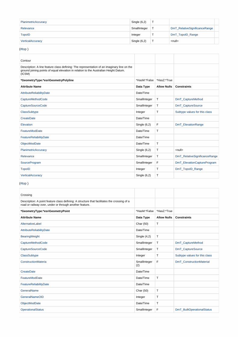
Contour
Description: A line feature class defining: The representation of an imaginary line on theground joining points of equal elevation in relation to the Australian Height Datum.(ICSM)
*GeometryType:*esriGeometryPolyline *HasM:*False *HasZ:*True
Attribute Name Data Type Allow Nulls Constraints
AttributeReliabilityDate Date/Time
CaptureMethodCode SmallInteger T DmT_CaptureMethod
CaptureSourceCode SmallInteger T DmT_CaptureSource
ClassSubtype Integer T Subtype values for this class
CreateDate Date/Time
Elevation Single (6,2) F DmT_ElevationRange
FeatureModDate Date/Time T
FeatureReliabilityDate Date/Time
ObjectModDate Date/Time T
PlanimetricAccuracy Single (6,2) T <null>
Relevance SmallInteger T DmT_RelativeSignificanceRange
SourceProgram SmallInteger F DmT_ElevationCaptureProgram
TopoID Integer T DmT_TopoID_Range
VerticalAccuracy Single (6,2) T
( )#top
Crossing
Description: A point feature class defining: A structure that facilitates the crossing of aroad or railway over, under or through another feature.
*GeometryType:*esriGeometryPoint *HasM:*False *HasZ:*True
Attribute Name Data Type Allow Nulls Constraints
AlternativeLabel Char (50) T
AttributeReliabilityDate Date/Time
BearingWeight Single (4,2) T
CaptureMethodCode SmallInteger T DmT_CaptureMethod
CaptureSourceCode SmallInteger T DmT_CaptureSource
ClassSubtype Integer T Subtype values for this class
ConstructionMateria SmallInteger(2)
F DmT_ConstructionMaterial
CreateDate Date/Time
FeatureModDate Date/Time T
FeatureReliabilityDate Date/Time
GeneralName Char (50) T
GeneralNameOID Integer T
ObjectModDate Date/Time T
OperationalStatus SmallInteger F DmT_BuiltOperationalStatus

PlanimetricAccuracy Single (6,2) T
Relevance SmallInteger T DmT_RelativeSignificanceRange
SymbolRotation SmallInteger(3)
T DmT_SymbolRotation
TopoID Integer T DmT_TopoID_Range
TrafficableHeight Single (4,2) T
TrafficableWidth Single (4,2) T
VerticalAccuracy Single (6,2) T <null>
( )#top
DLSArea
Description: A polygon feature class defining: Distinctive Land Surface features ofdiscrete extent.
*GeometryType:*esriGeometryPolygon *HasM:*False *HasZ:*True
Attribute Name Data Type Allow Nulls Constraints
AlternativeLabel Char (50) T
AttributeReliabilityDate Date/Time
CaptureMethodCode SmallInteger T DmT_CaptureMethod
CaptureSourceCode SmallInteger T DmT_CaptureSource
ClassSubtype Integer T Subtype values for this class
CreateDate Date/Time
FeatureModDate Date/Time T
FeatureReliabilityDate Date/Time
GeneralName Char (50) T
GeneralNameOID Integer T
ObjectModDate Date/Time T
PlanimetricAccuracy Single (6,2) T
Relevance SmallInteger T DmT_RelativeSignificanceRange
TopoID Integer T DmT_TopoID_Range
VerticalAccuracy Single (6,2) T <null>
( )#top
DLSLine
Description: A line feature class defining: Distinctive Land Surface features of discreteextent.
*GeometryType:*esriGeometryPolyline *HasM:*False *HasZ:*True
Attribute Name Data Type Allow Nulls Constraints
AlternativeLabel Char (50) T
AttributeReliabilityDate Date/Time
CaptureMethodCode SmallInteger T DmT_CaptureMethod
CaptureSourceCode SmallInteger T DmT_CaptureSource
ClassSubtype Integer T Subtype values for this class
CreateDate Date/Time
FeatureModDate Date/Time T
FeatureReliabilityDate Date/Time
GeneralName Char (50) T
GeneralNameOID Integer T
ObjectModDate Date/Time T
PlanimetricAccuracy Single (6,2) T
Relevance SmallInteger T DmT_RelativeSignificanceRange
TopoID Integer T DmT_TopoID_Range
VerticalAccuracy Single (6,2) T <null>
( )#top
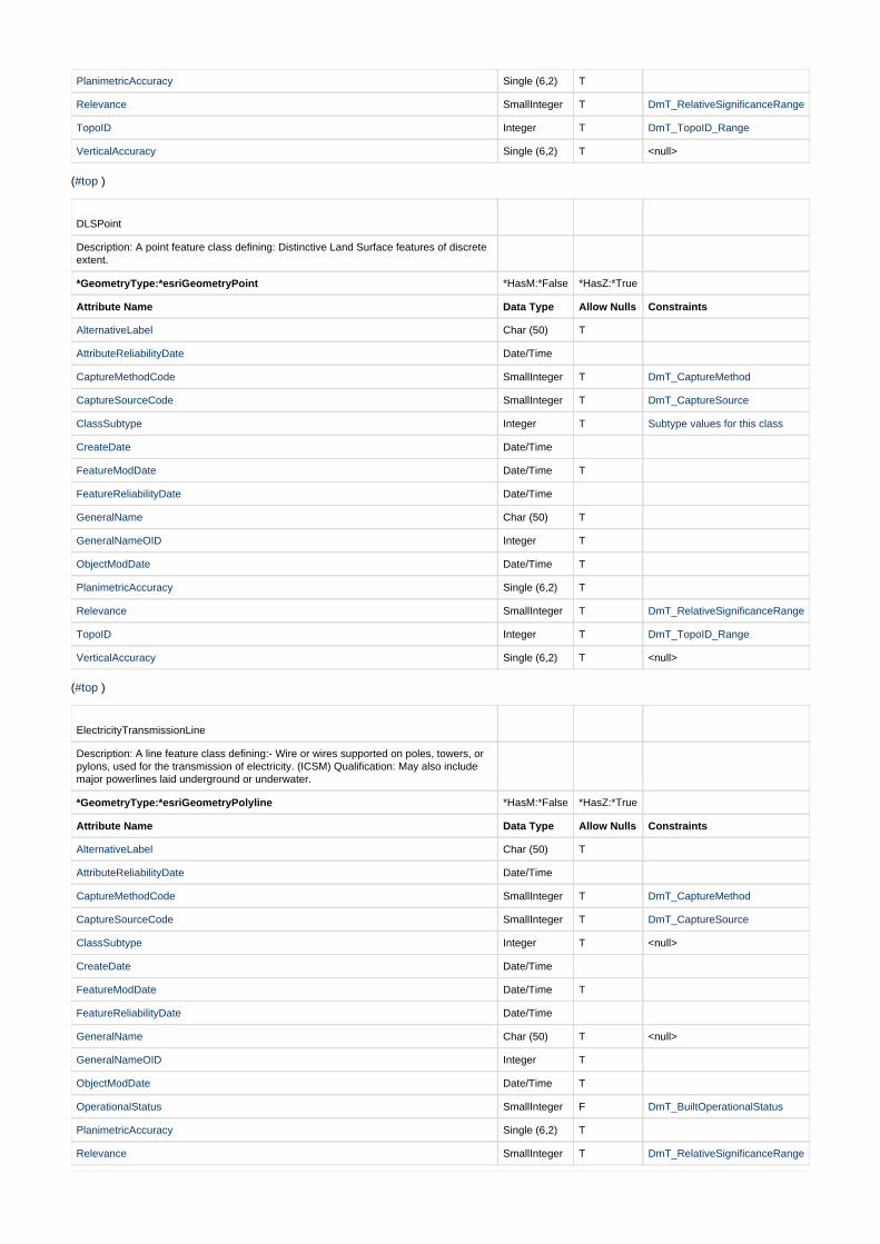
DLSPoint
Description: A point feature class defining: Distinctive Land Surface features of discreteextent.
*GeometryType:*esriGeometryPoint *HasM:*False *HasZ:*True
Attribute Name Data Type Allow Nulls Constraints
AlternativeLabel Char (50) T
AttributeReliabilityDate Date/Time
CaptureMethodCode SmallInteger T DmT_CaptureMethod
CaptureSourceCode SmallInteger T DmT_CaptureSource
ClassSubtype Integer T Subtype values for this class
CreateDate Date/Time
FeatureModDate Date/Time T
FeatureReliabilityDate Date/Time
GeneralName Char (50) T
GeneralNameOID Integer T
ObjectModDate Date/Time T
PlanimetricAccuracy Single (6,2) T
Relevance SmallInteger T DmT_RelativeSignificanceRange
TopoID Integer T DmT_TopoID_Range
VerticalAccuracy Single (6,2) T <null>
( )#top
ElectricityTransmissionLine
Description: A line feature class defining:- Wire or wires supported on poles, towers, orpylons, used for the transmission of electricity. (ICSM) Qualification: May also includemajor powerlines laid underground or underwater.
*GeometryType:*esriGeometryPolyline *HasM:*False *HasZ:*True
Attribute Name Data Type Allow Nulls Constraints
AlternativeLabel Char (50) T
AttributeReliabilityDate Date/Time
CaptureMethodCode SmallInteger T DmT_CaptureMethod
CaptureSourceCode SmallInteger T DmT_CaptureSource
ClassSubtype Integer T <null>
CreateDate Date/Time
FeatureModDate Date/Time T
FeatureReliabilityDate Date/Time
GeneralName Char (50) T <null>
GeneralNameOID Integer T
ObjectModDate Date/Time T
OperationalStatus SmallInteger F DmT_BuiltOperationalStatus
PlanimetricAccuracy Single (6,2) T
Relevance SmallInteger T DmT_RelativeSignificanceRange

TopoID Integer T DmT_TopoID_Range
VerticalAccuracy Single (6,2) T <null>
Voltage SmallInteger F DmT_Voltage
( )#top
FerryRoute
Description: A line feature class defining the approximate route of a regular ferryservice.
*GeometryType:*esriGeometryPolyline *HasM:*False *HasZ:*True
Attribute Name Data Type Allow Nulls Constraints
AlternativeLabel Char (50) T
AttributeReliabilityDate Date/Time
CaptureMethodCode SmallInteger T DmT_CaptureMethod
CaptureSourceCode SmallInteger T DmT_CaptureSource
ClassSubtype Integer T Subtype values for this class
CreateDate Date/Time
FeatureModDate Date/Time T
FeatureReliabilityDate Date/Time
GeneralName Char (50) T
GeneralNameOID Integer T
ObjectModDate Date/Time T
OperationalStatus SmallInteger F DmT_BuiltOperationalStatus
PlanimetricAccuracy Single (6,2) T
Relevance SmallInteger T DmT_RelativeSignificanceRange
TopoID Integer T DmT_TopoID_Range
VerticalAccuracy Single (6,2) T <null>
( )#top
FuzzyExtentArea
Description: A polygon feature class defining: the approximate extent of formally namedlandforms that have relatively indistinct name extent.
*GeometryType:*esriGeometryPolygon *HasM:*False *HasZ:*True
Attribute Name Data Type Allow Nulls Constraints
AlternativeLabel Char (50) T
AttributeReliabilityDate Date/Time
CaptureMethodCode SmallInteger T DmT_CaptureMethod
CaptureSourceCode SmallInteger T DmT_CaptureSource
ClassSubtype Integer T <null>
CreateDate Date/Time
FeatureModDate Date/Time T
FeatureReliabilityDate Date/Time
FuzzyAreaFeatureType SmallInteger F DmT_FuzzyFeatureTypeArea
GeneralName Char (50) T
GeneralNameOID Integer T
ObjectModDate Date/Time T
PlanimetricAccuracy Single (6,2) T
Relevance SmallInteger T DmT_RelativeSignificanceRange

TopoID Integer T DmT_TopoID_Range
VerticalAccuracy Single (6,2) T <null>
( )#top
FuzzyExtentLine
Description: A line feature class representing the approximate centreline of formallynamed landforms that have relatively indistinct name extent.
*GeometryType:*esriGeometryPolyline *HasM:*False *HasZ:*True
Attribute Name Data Type Allow Nulls Constraints
AlternativeLabel Char (50) T
AttributeReliabilityDate Date/Time
CaptureMethodCode SmallInteger T DmT_CaptureMethod
CaptureSourceCode SmallInteger T DmT_CaptureSource
ClassSubtype Integer T <null>
CreateDate Date/Time
FeatureModDate Date/Time T
FeatureReliabilityDate Date/Time
FuzzyLineFeatureType SmallInteger F DmT_FuzzyFeatureTypeLine
GeneralName Char (50) T
GeneralNameOID Integer T
ObjectModDate Date/Time T
PlanimetricAccuracy Single (6,2) T
Relevance SmallInteger T DmT_RelativeSignificanceRange
TopoID Integer T DmT_TopoID_Range
VerticalAccuracy Single (6,2) T <null>
( )#top
FuzzyExtentPoint
Description: A point feature class representing the approximate centre of formallynamed landforms that have relatively indistinct name extent.
*GeometryType:*esriGeometryPoint *HasM:*False *HasZ:*True
Attribute Name Data Type Allow Nulls Constraints
AlternativeLabel Char (50) T
AttributeReliabilityDate Date/Time
CaptureMethodCode SmallInteger T DmT_CaptureMethod
CaptureSourceCode SmallInteger T DmT_CaptureSource
ClassSubtype Integer T <null>
CreateDate Date/Time
FeatureModDate Date/Time T
FeatureReliabilityDate Date/Time
FuzzyPointFeatureType SmallInteger F DmT_FuzzyFeatureTypePoint
GeneralName Char (50) T
GeneralNameOID Integer T
ObjectModDate Date/Time T
PlanimetricAccuracy Single (6,2) T
Relevance SmallInteger T DmT_RelativeSignificanceRange
TopoID Integer T DmT_TopoID_Range

VerticalAccuracy Single (6,2) T <null>
( )#top
FuzzyExtentWaterArea
Description: A polygon feature class representing the approximate extent (bounds) offormally named water features that have relatively indistinct named extent.
*GeometryType:*esriGeometryPolygon *HasM:*False *HasZ:*True
Attribute Name Data Type Allow Nulls Constraints
AttributeReliabilityDate Date/Time
CaptureMethodCode SmallInteger T DmT_CaptureMethod
CaptureSourceCode SmallInteger T DmT_CaptureSource
ClassSubtype Integer T Subtype values for this class
CreateDate Date/Time
FeatureModDate Date/Time T
FeatureReliabilityDate Date/Time
HydroName Char (50) T
HydroNameOID Integer T
HydroNameType Char (16) T
ObjectModDate Date/Time T
PlanimetricAccuracy Single (6,2) T
Relevance SmallInteger T DmT_RelativeSignificanceRange
TopoID Integer T DmT_TopoID_Range
VerticalAccuracy Single (6,2) T <null>
( )#top
FuzzyExtentWaterLine
Description: A line feature class representing the approximate centreline of formallynamed water features that have relatively indistinct named extent.
*GeometryType:*esriGeometryPolyline *HasM:*False *HasZ:*True
Attribute Name Data Type Allow Nulls Constraints
AttributeReliabilityDate Date/Time
CaptureMethodCode SmallInteger T DmT_CaptureMethod
CaptureSourceCode SmallInteger T DmT_CaptureSource
ClassSubtype Integer T Subtype values for this class
CreateDate Date/Time
FeatureModDate Date/Time T
FeatureReliabilityDate Date/Time
HydroName Char (50) T
HydroNameOID Integer T
HydroNameType Char (16) T
ObjectModDate Date/Time T
PlanimetricAccuracy Single (6,2) T
Relevance SmallInteger T DmT_RelativeSignificanceRange
TopoID Integer T DmT_TopoID_Range
VerticalAccuracy Single (6,2) T <null>
( )#top
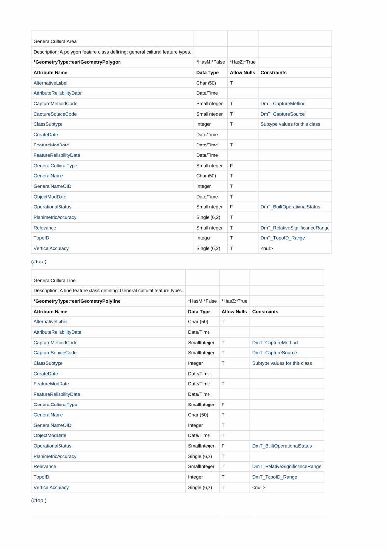
GeneralCulturalArea
Description: A polygon feature class defining; general cultural feature types.
*GeometryType:*esriGeometryPolygon *HasM:*False *HasZ:*True
Attribute Name Data Type Allow Nulls Constraints
AlternativeLabel Char (50) T
AttributeReliabilityDate Date/Time
CaptureMethodCode SmallInteger T DmT_CaptureMethod
CaptureSourceCode SmallInteger T DmT_CaptureSource
ClassSubtype Integer T Subtype values for this class
CreateDate Date/Time
FeatureModDate Date/Time T
FeatureReliabilityDate Date/Time
GeneralCulturalType SmallInteger F
GeneralName Char (50) T
GeneralNameOID Integer T
ObjectModDate Date/Time T
OperationalStatus SmallInteger F DmT_BuiltOperationalStatus
PlanimetricAccuracy Single (6,2) T
Relevance SmallInteger T DmT_RelativeSignificanceRange
TopoID Integer T DmT_TopoID_Range
VerticalAccuracy Single (6,2) T <null>
( )#top
GeneralCulturalLine
Description: A line feature class defining: General cultural feature types.
*GeometryType:*esriGeometryPolyline *HasM:*False *HasZ:*True
Attribute Name Data Type Allow Nulls Constraints
AlternativeLabel Char (50) T
AttributeReliabilityDate Date/Time
CaptureMethodCode SmallInteger T DmT_CaptureMethod
CaptureSourceCode SmallInteger T DmT_CaptureSource
ClassSubtype Integer T Subtype values for this class
CreateDate Date/Time
FeatureModDate Date/Time T
FeatureReliabilityDate Date/Time
GeneralCulturalType SmallInteger F
GeneralName Char (50) T
GeneralNameOID Integer T
ObjectModDate Date/Time T
OperationalStatus SmallInteger F DmT_BuiltOperationalStatus
PlanimetricAccuracy Single (6,2) T
Relevance SmallInteger T DmT_RelativeSignificanceRange
TopoID Integer T DmT_TopoID_Range
VerticalAccuracy Single (6,2) T <null>
( )#top
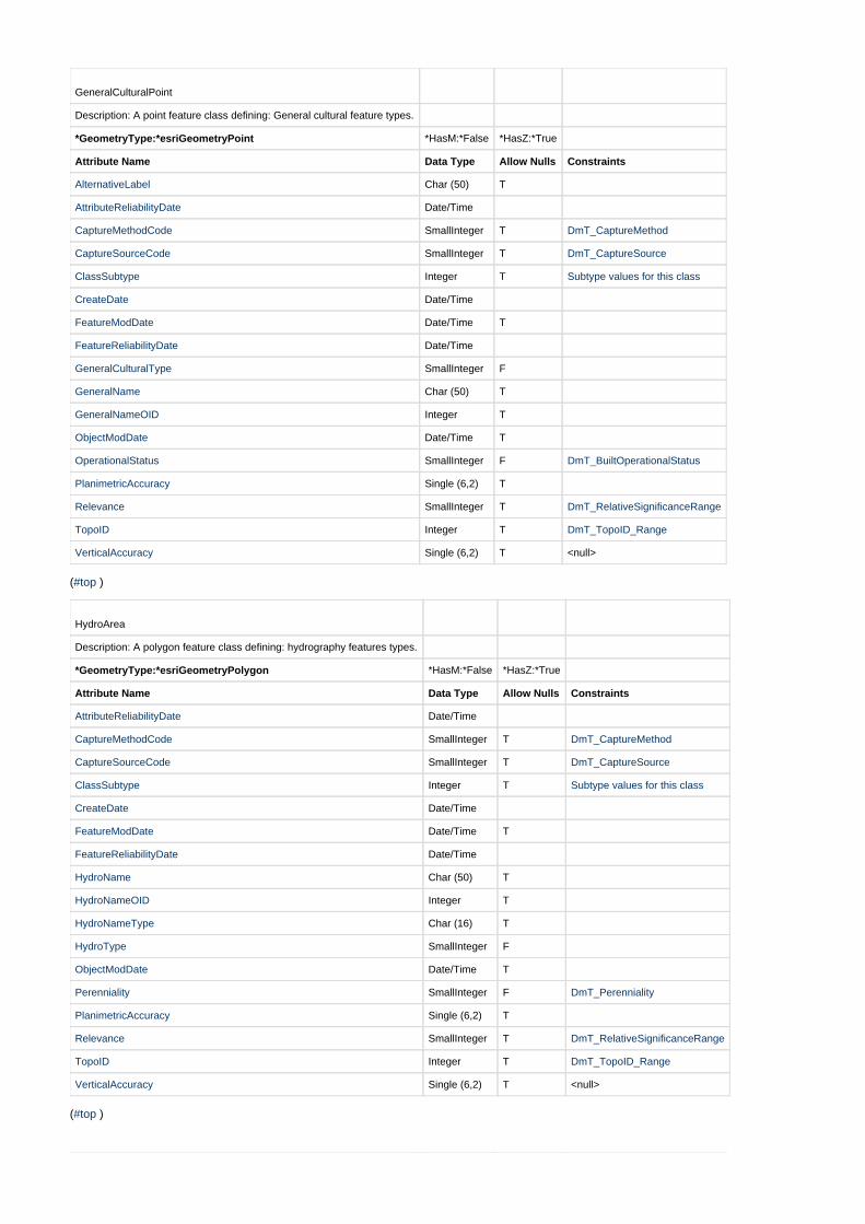
GeneralCulturalPoint
Description: A point feature class defining: General cultural feature types.
*GeometryType:*esriGeometryPoint *HasM:*False *HasZ:*True
Attribute Name Data Type Allow Nulls Constraints
AlternativeLabel Char (50) T
AttributeReliabilityDate Date/Time
CaptureMethodCode SmallInteger T DmT_CaptureMethod
CaptureSourceCode SmallInteger T DmT_CaptureSource
ClassSubtype Integer T Subtype values for this class
CreateDate Date/Time
FeatureModDate Date/Time T
FeatureReliabilityDate Date/Time
GeneralCulturalType SmallInteger F
GeneralName Char (50) T
GeneralNameOID Integer T
ObjectModDate Date/Time T
OperationalStatus SmallInteger F DmT_BuiltOperationalStatus
PlanimetricAccuracy Single (6,2) T
Relevance SmallInteger T DmT_RelativeSignificanceRange
TopoID Integer T DmT_TopoID_Range
VerticalAccuracy Single (6,2) T <null>
( )#top
HydroArea
Description: A polygon feature class defining: hydrography features types.
*GeometryType:*esriGeometryPolygon *HasM:*False *HasZ:*True
Attribute Name Data Type Allow Nulls Constraints
AttributeReliabilityDate Date/Time
CaptureMethodCode SmallInteger T DmT_CaptureMethod
CaptureSourceCode SmallInteger T DmT_CaptureSource
ClassSubtype Integer T Subtype values for this class
CreateDate Date/Time
FeatureModDate Date/Time T
FeatureReliabilityDate Date/Time
HydroName Char (50) T
HydroNameOID Integer T
HydroNameType Char (16) T
HydroType SmallInteger F
ObjectModDate Date/Time T
Perenniality SmallInteger F DmT_Perenniality
PlanimetricAccuracy Single (6,2) T
Relevance SmallInteger T DmT_RelativeSignificanceRange
TopoID Integer T DmT_TopoID_Range
VerticalAccuracy Single (6,2) T <null>
( )#top
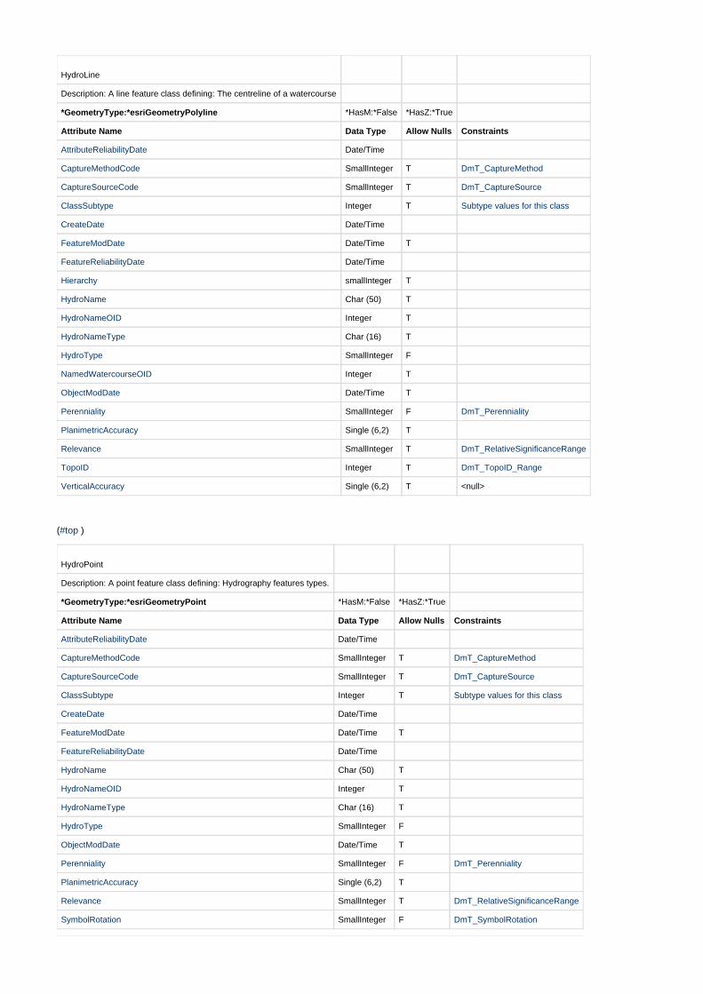
HydroLine
Description: A line feature class defining: The centreline of a watercourse
*GeometryType:*esriGeometryPolyline *HasM:*False *HasZ:*True
Attribute Name Data Type Allow Nulls Constraints
AttributeReliabilityDate Date/Time
CaptureMethodCode SmallInteger T DmT_CaptureMethod
CaptureSourceCode SmallInteger T DmT_CaptureSource
ClassSubtype Integer T Subtype values for this class
CreateDate Date/Time
FeatureModDate Date/Time T
FeatureReliabilityDate Date/Time
Hierarchy smallInteger T
HydroName Char (50) T
HydroNameOID Integer T
HydroNameType Char (16) T
HydroType SmallInteger F
NamedWatercourseOID Integer T
ObjectModDate Date/Time T
Perenniality SmallInteger F DmT_Perenniality
PlanimetricAccuracy Single (6,2) T
Relevance SmallInteger T DmT_RelativeSignificanceRange
TopoID Integer T DmT_TopoID_Range
VerticalAccuracy Single (6,2) T <null>
( )#top
HydroPoint
Description: A point feature class defining: Hydrography features types.
*GeometryType:*esriGeometryPoint *HasM:*False *HasZ:*True
Attribute Name Data Type Allow Nulls Constraints
AttributeReliabilityDate Date/Time
CaptureMethodCode SmallInteger T DmT_CaptureMethod
CaptureSourceCode SmallInteger T DmT_CaptureSource
ClassSubtype Integer T Subtype values for this class
CreateDate Date/Time
FeatureModDate Date/Time T
FeatureReliabilityDate Date/Time
HydroName Char (50) T
HydroNameOID Integer T
HydroNameType Char (16) T
HydroType SmallInteger F
ObjectModDate Date/Time T
Perenniality SmallInteger F DmT_Perenniality
PlanimetricAccuracy Single (6,2) T
Relevance SmallInteger T DmT_RelativeSignificanceRange
SymbolRotation SmallInteger F DmT_SymbolRotation
TopoID Integer T DmT_TopoID_Range
VerticalAccuracy Single (6,2) T <null>
( )#top
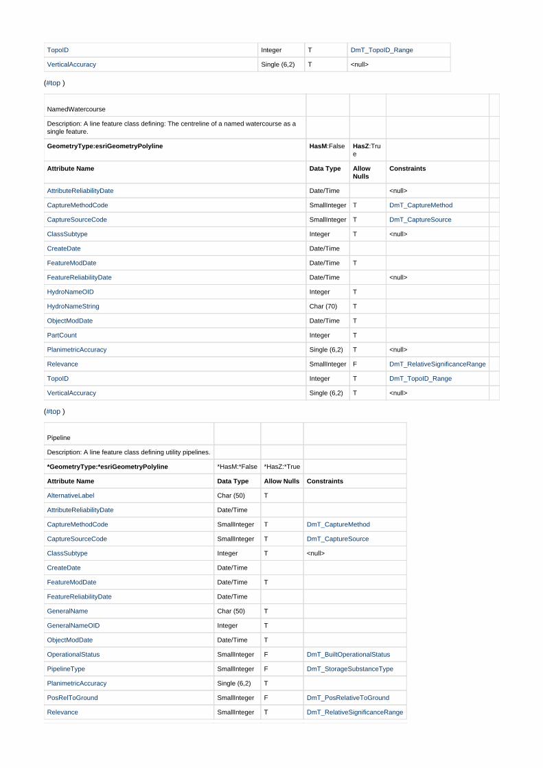
NamedWatercourse
Description: A line feature class defining: The centreline of a named watercourse as asingle feature.
GeometryType:esriGeometryPolyline HasM:False HasZ:True
Attribute Name Data Type AllowNulls
Constraints
AttributeReliabilityDate Date/Time <null>
CaptureMethodCode SmallInteger T DmT_CaptureMethod
CaptureSourceCode SmallInteger T DmT_CaptureSource
ClassSubtype Integer T <null>
CreateDate Date/Time
FeatureModDate Date/Time T
FeatureReliabilityDate Date/Time <null>
HydroNameOID Integer T
HydroNameString Char (70) T
ObjectModDate Date/Time T
PartCount Integer T
PlanimetricAccuracy Single (6,2) T <null>
Relevance SmallInteger F DmT_RelativeSignificanceRange
TopoID Integer T DmT_TopoID_Range
VerticalAccuracy Single (6,2) T <null>
( )#top
Pipeline
Description: A line feature class defining utility pipelines.
*GeometryType:*esriGeometryPolyline *HasM:*False *HasZ:*True
Attribute Name Data Type Allow Nulls Constraints
AlternativeLabel Char (50) T
AttributeReliabilityDate Date/Time
CaptureMethodCode SmallInteger T DmT_CaptureMethod
CaptureSourceCode SmallInteger T DmT_CaptureSource
ClassSubtype Integer T <null>
CreateDate Date/Time
FeatureModDate Date/Time T
FeatureReliabilityDate Date/Time
GeneralName Char (50) T
GeneralNameOID Integer T
ObjectModDate Date/Time T
OperationalStatus SmallInteger F DmT_BuiltOperationalStatus
PipelineType SmallInteger F DmT_StorageSubstanceType
PlanimetricAccuracy Single (6,2) T
PosRelToGround SmallInteger F DmT_PosRelativeToGround
Relevance SmallInteger T DmT_RelativeSignificanceRange
TopoID Integer T DmT_TopoID_Range
VerticalAccuracy Single (6,2) T <null>
( )#top
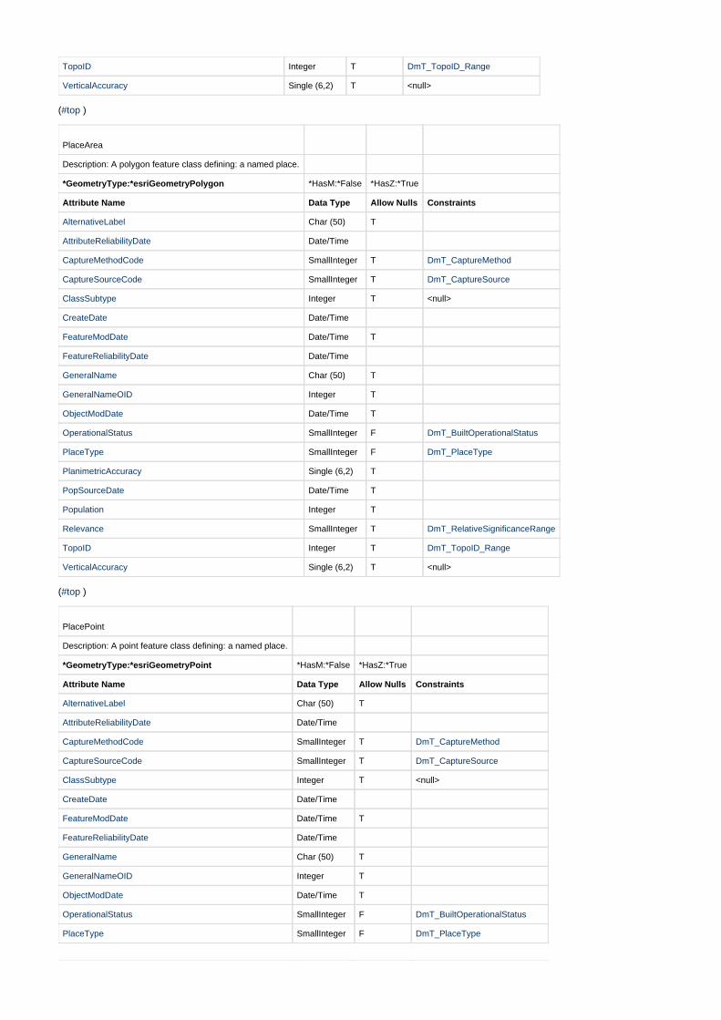
PlaceArea
Description: A polygon feature class defining: a named place.
*GeometryType:*esriGeometryPolygon *HasM:*False *HasZ:*True
Attribute Name Data Type Allow Nulls Constraints
AlternativeLabel Char (50) T
AttributeReliabilityDate Date/Time
CaptureMethodCode SmallInteger T DmT_CaptureMethod
CaptureSourceCode SmallInteger T DmT_CaptureSource
ClassSubtype Integer T <null>
CreateDate Date/Time
FeatureModDate Date/Time T
FeatureReliabilityDate Date/Time
GeneralName Char (50) T
GeneralNameOID Integer T
ObjectModDate Date/Time T
OperationalStatus SmallInteger F DmT_BuiltOperationalStatus
PlaceType SmallInteger F DmT_PlaceType
PlanimetricAccuracy Single (6,2) T
PopSourceDate Date/Time T
Population Integer T
Relevance SmallInteger T DmT_RelativeSignificanceRange
TopoID Integer T DmT_TopoID_Range
VerticalAccuracy Single (6,2) T <null>
( )#top
PlacePoint
Description: A point feature class defining: a named place.
*GeometryType:*esriGeometryPoint *HasM:*False *HasZ:*True
Attribute Name Data Type Allow Nulls Constraints
AlternativeLabel Char (50) T
AttributeReliabilityDate Date/Time
CaptureMethodCode SmallInteger T DmT_CaptureMethod
CaptureSourceCode SmallInteger T DmT_CaptureSource
ClassSubtype Integer T <null>
CreateDate Date/Time
FeatureModDate Date/Time T
FeatureReliabilityDate Date/Time
GeneralName Char (50) T
GeneralNameOID Integer T
ObjectModDate Date/Time T
OperationalStatus SmallInteger F DmT_BuiltOperationalStatus
PlaceType SmallInteger F DmT_PlaceType
PlanimetricAccuracy Single (6,2) T
PopSourceDate Date/Time T
Population Integer T
Relevance SmallInteger T DmT_RelativeSignificanceRange
TopoID Integer T DmT_TopoID_Range
VerticalAccuracy Single (6,2) T <null>
( )#top
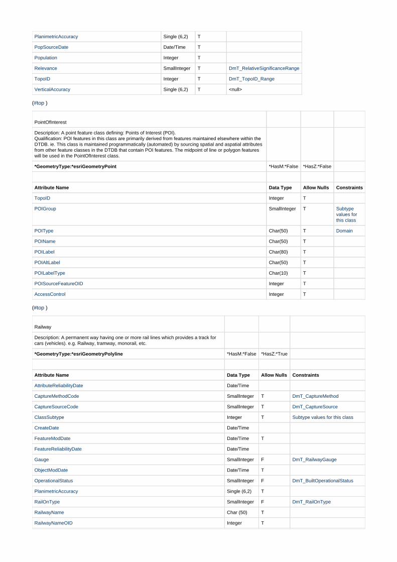
PointOfInterest
Description: A point feature class defining: Points of Interest (POI). Qualification: POI features in this class are primarily derived from features maintained elsewhere within theDTDB. ie. This class is maintained programmatically (automated) by sourcing spatial and aspatial attributesfrom other feature classes in the DTDB that contain POI features. The midpoint of line or polygon featureswill be used in the PointOfInterest class.
*GeometryType:*esriGeometryPoint *HasM:*False *HasZ:*False
Attribute Name Data Type Allow Nulls Constraints
TopoID Integer T
POIGroup SmallInteger T Subtypevalues forthis class
POIType Char(50) T Domain
POIName Char(50) T
POILabel Char(80) T
POIAltLabel Char(50) T
POILabelType Char(10) T
POISourceFeatureOID Integer T
AccessControl Integer T
( )#top
Railway
Description: A permanent way having one or more rail lines which provides a track forcars (vehicles). e.g. Railway, tramway, monorail, etc.
*GeometryType:*esriGeometryPolyline *HasM:*False *HasZ:*True
Attribute Name Data Type Allow Nulls Constraints
AttributeReliabilityDate Date/Time
CaptureMethodCode SmallInteger T DmT_CaptureMethod
CaptureSourceCode SmallInteger T DmT_CaptureSource
ClassSubtype Integer T Subtype values for this class
CreateDate Date/Time
FeatureModDate Date/Time T
FeatureReliabilityDate Date/Time
Gauge SmallInteger F DmT_RailwayGauge
ObjectModDate Date/Time T
OperationalStatus SmallInteger F DmT_BuiltOperationalStatus
PlanimetricAccuracy Single (6,2) T
RailOnType SmallInteger F DmT_RailOnType
RailwayName Char (50) T
RailwayNameOID Integer T
Relevance SmallInteger T DmT_RelativeSignificanceRange
TopoID Integer T DmT_TopoID_Range
VerticalAccuracy Single (6,2) T <null>
( )#top
RelativeHeight
Description: A point feature class defining: The relative height of a cliff face .
*GeometryType:*esriGeometryPoint *HasM:*False *HasZ:*True
Attribute Name Data Type Allow Nulls Constraints
AttributeReliabilityDate Date/Time
CaptureMethodCode SmallInteger T DmT_CaptureMethod
CaptureSourceCode SmallInteger T DmT_CaptureSource
ClassSubtype Integer T <null>
CreateDate Date/Time
FeatureModDate Date/Time T
FeatureReliabilityDate Date/Time
ObjectModDate Date/Time T
PlanimetricAccuracy Single (6,2) T
RelativeHeight SmallInteger F DmT_RelativeHeightRange
Relevance SmallInteger F DmT_RelativeSignificanceRange
TopoID Integer T DmT_TopoID_Range
VerticalAccuracy Single (6,2) T <null>
( )#top
RoadNameExtent
Description: A line feature class representing aggregated road segments that have thesame local road name and the segments are relatively contiguous.
*GeometryType:*esriGeometryPolyline *HasM:*False *HasZ:*True
Attribute Name Data Type Allow Nulls Constraints
AttributeReliabilityDate Date/Time
CaptureMethodCode SmallInteger T DmT_CaptureMethod
CaptureSourceCode SmallInteger T DmT_CaptureSource
ClassSubtype Integer T <null>
CreateDate Date/Time
FeatureModDate Date/Time T
FeatureReliabilityDate Date/Time
FunctionHierarchy SmallInteger F DmT_RoadFunctionHierarchy
ObjectModDate Date/Time T
OperationalStatus SmallInteger F DmT_BuiltOperationalStatus
PlanimetricAccuracy Single (6,2) T
Relevance SmallInteger F DmT_RelativeSignificanceRange
RoadNameString Char (80) F
RoadNameOID Integer T
PartCount smallInteger T
RoadNameSource SmallInteger T DmT_NameSource
CheckCode SmallInteger T

TopoID Integer T DmT_TopoID_Range
VerticalAccuracy Single (6,2) T <null>
( )#top
RoadSegment
Description: A line feature class representing the centreline of a section of road havingcommon attributes and terminating at its physical end or at an intersection with anotherroad at the same grade (same level).
*GeometryType:*esriGeometryPolyline *HasM:*False *HasZ:*True
Attribute Name Data Type Allow Nulls Constraints
AttributeReliabilityDate Date/Time
CaptureMethodCode SmallInteger T DmT_CaptureMethod
CaptureSourceCode SmallInteger T DmT_CaptureSource
ClassSubtype Integer T Subtype values for this class
CreateDate Date/Time
FeatureModDate Date/Time T
FeatureReliabilityDate Date/Time
FunctionHierarchy SmallInteger F DmT_RoadFunctionHierarchy
LaneCount SmallInteger F DmT_RoadLanesClassification
ObjectModDate Date/Time T
OperationalStatus SmallInteger F DmT_BuiltOperationalStatus
PlanimetricAccuracy Single (6,2) T
Relevance SmallInteger F DmT_RelativeSignificanceRange
RoadNameBase Char (50) T
RoadNameExtentOID Integer T
RoadNameOID Integer T
RoadNameSuffix Char (10) T
RoadNameType Char (20) T
RoadOnType SmallInteger F DmT_RoadOnType
Surface SmallInteger F DmT_RoadSurface
TopoID Integer T DmT_TopoID_Range
VerticalAccuracy Single (6,2) T <null>
( )#top
Runway
Description: A line feature class defining; a straight path used for landing and take-off ofaircraft. (Adapted from ICSM)
*GeometryType:*esriGeometryPolyline *HasM:*False *HasZ:*True
Attribute Name Data Type Allow Nulls Constraints
AlternativeLabel Char (50) T
AttributeReliabilityDate Date/Time
CaptureMethodCode SmallInteger T DmT_CaptureMethod
CaptureSourceCode SmallInteger T DmT_CaptureSource
ClassSubtype Integer T <null>
CreateDate Date/Time
FeatureModDate Date/Time T
FeatureReliabilityDate Date/Time
GeneralName Char (50) T
GeneralNameOID Integer T
ObjectModDate Date/Time T
OperationalStatus SmallInteger F DmT_BuiltOperationalStatus
PlanimetricAccuracy Single (6,2) T
Relevance SmallInteger F DmT_RelativeSignificanceRange
RunwayDefinition SmallInteger(2)
F DmT_RunwayDefinition
RunwaySurface SmallInteger(2)
F DmT_RunwaySurface
TopoID Integer T DmT_TopoID_Range
VerticalAccuracy Single (6,2) T <null>
( )#top
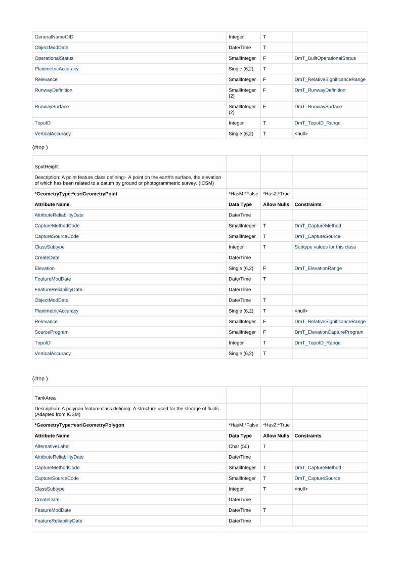
SpotHeight
Description: A point feature class defining:- A point on the earth's surface, the elevationof which has been related to a datum by ground or photogrammetric survey. (ICSM)
*GeometryType:*esriGeometryPoint *HasM:*False *HasZ:*True
Attribute Name Data Type Allow Nulls Constraints
AttributeReliabilityDate Date/Time
CaptureMethodCode SmallInteger T DmT_CaptureMethod
CaptureSourceCode SmallInteger T DmT_CaptureSource
ClassSubtype Integer T Subtype values for this class
CreateDate Date/Time
Elevation Single (6,2) F DmT_ElevationRange
FeatureModDate Date/Time T
FeatureReliabilityDate Date/Time
ObjectModDate Date/Time T
PlanimetricAccuracy Single (6,2) T <null>
Relevance SmallInteger F DmT_RelativeSignificanceRange
SourceProgram SmallInteger F DmT_ElevationCaptureProgram
TopoID Integer T DmT_TopoID_Range
VerticalAccuracy Single (6,2) T
( )#top
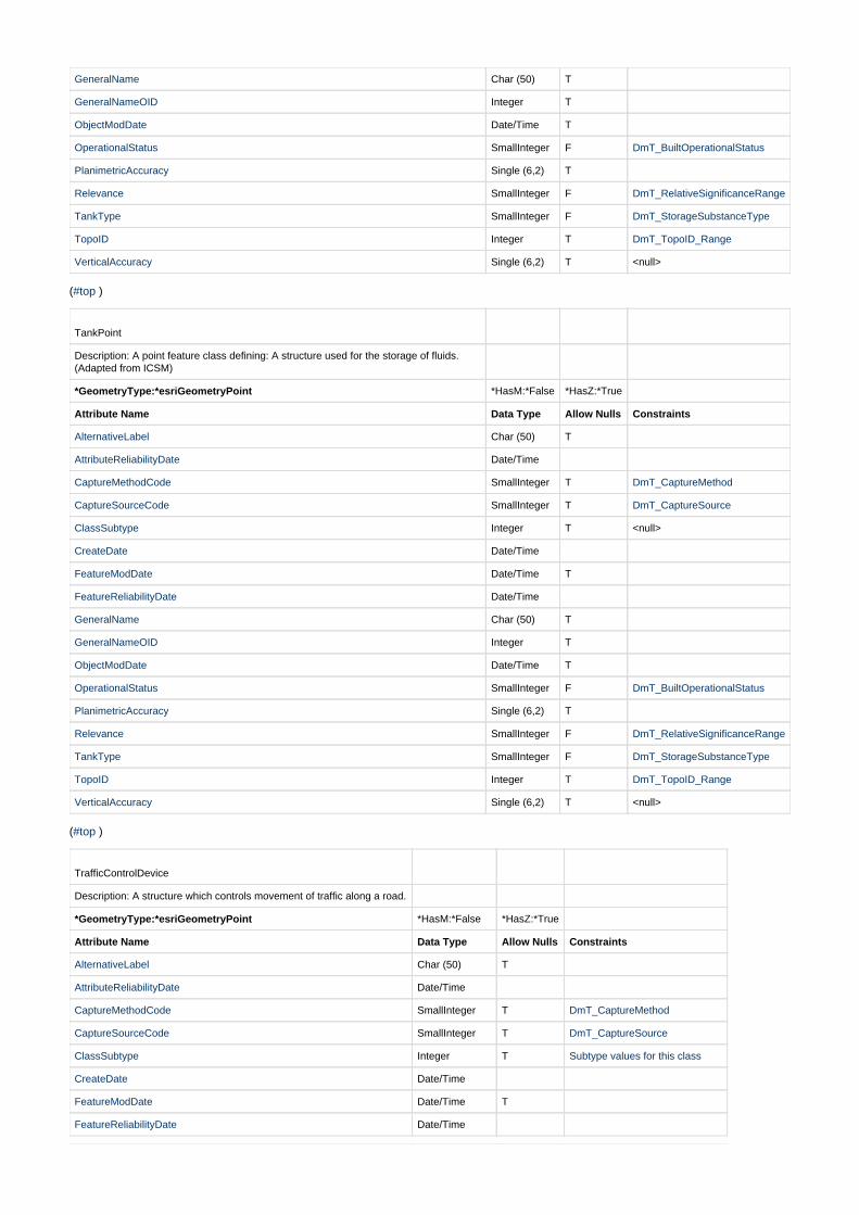
TankArea
Description: A polygon feature class defining: A structure used for the storage of fluids.(Adapted from ICSM)
*GeometryType:*esriGeometryPolygon *HasM:*False *HasZ:*True
Attribute Name Data Type Allow Nulls Constraints
AlternativeLabel Char (50) T
AttributeReliabilityDate Date/Time
CaptureMethodCode SmallInteger T DmT_CaptureMethod
CaptureSourceCode SmallInteger T DmT_CaptureSource
ClassSubtype Integer T <null>
CreateDate Date/Time
FeatureModDate Date/Time T
FeatureReliabilityDate Date/Time
GeneralName Char (50) T
GeneralNameOID Integer T
ObjectModDate Date/Time T
OperationalStatus SmallInteger F DmT_BuiltOperationalStatus
PlanimetricAccuracy Single (6,2) T
Relevance SmallInteger F DmT_RelativeSignificanceRange
TankType SmallInteger F DmT_StorageSubstanceType
TopoID Integer T DmT_TopoID_Range
VerticalAccuracy Single (6,2) T <null>
( )#top
TankPoint
Description: A point feature class defining: A structure used for the storage of fluids.(Adapted from ICSM)
*GeometryType:*esriGeometryPoint *HasM:*False *HasZ:*True
Attribute Name Data Type Allow Nulls Constraints
AlternativeLabel Char (50) T
AttributeReliabilityDate Date/Time
CaptureMethodCode SmallInteger T DmT_CaptureMethod
CaptureSourceCode SmallInteger T DmT_CaptureSource
ClassSubtype Integer T <null>
CreateDate Date/Time
FeatureModDate Date/Time T
FeatureReliabilityDate Date/Time
GeneralName Char (50) T
GeneralNameOID Integer T
ObjectModDate Date/Time T
OperationalStatus SmallInteger F DmT_BuiltOperationalStatus
PlanimetricAccuracy Single (6,2) T
Relevance SmallInteger F DmT_RelativeSignificanceRange
TankType SmallInteger F DmT_StorageSubstanceType
TopoID Integer T DmT_TopoID_Range
VerticalAccuracy Single (6,2) T <null>
( )#top
TrafficControlDevice
Description: A structure which controls movement of traffic along a road.
*GeometryType:*esriGeometryPoint *HasM:*False *HasZ:*True
Attribute Name Data Type Allow Nulls Constraints
AlternativeLabel Char (50) T
AttributeReliabilityDate Date/Time
CaptureMethodCode SmallInteger T DmT_CaptureMethod
CaptureSourceCode SmallInteger T DmT_CaptureSource
ClassSubtype Integer T Subtype values for this class
CreateDate Date/Time
FeatureModDate Date/Time T
FeatureReliabilityDate Date/Time

GeneralName Char (50) T
GeneralNameOID Integer T
ObjectModDate Date/Time T
OperationalStatus SmallInteger F DmT_BuiltOperationalStatus
PlanimetricAccuracy Single (6,2) T
Relevance SmallInteger F DmT_RelativeSignificanceRange
SymbolRotation SmallInteger (3) F DmT_SymbolRotation
TopoID Integer T DmT_TopoID_Range
VerticalAccuracy Single (6,2) T <null>
( )#top
TransportFacilityLine
Description: A line feature class defining a facility related to transport.
*GeometryType:*esriGeometryPolyline *HasM:*False *HasZ:*True
Attribute Name Data Type Allow Nulls Constraints
AlternativeLabel Char (50) T
AttributeReliabilityDate Date/Time
CaptureMethodCode SmallInteger T DmT_CaptureMethod
CaptureSourceCode SmallInteger T DmT_CaptureSource
ClassSubtype Integer T Subtype values for this class
CreateDate Date/Time
FeatureModDate Date/Time T
FeatureReliabilityDate Date/Time
GeneralName Char (50) T
GeneralNameOID Integer T
ObjectModDate Date/Time T
OperationalStatus SmallInteger F DmT_BuiltOperationalStatus
PlanimetricAccuracy Single (6,2) T
Relevance SmallInteger F DmT_RelativeSignificanceRange
TopoID Integer T DmT_TopoID_Range
VerticalAccuracy Single (6,2) T <null>
( )#top
TransportFacilityPoint
Description: A point feature class defining a facility related to transport.
*GeometryType:*esriGeometryPoint *HasM:*False *HasZ:*True
Attribute Name Data Type Allow Nulls Constraints
AlternativeLabel Char (50) T
AttributeReliabilityDate Date/Time
CaptureMethodCode SmallInteger T DmT_CaptureMethod
CaptureSourceCode SmallInteger T DmT_CaptureSource
ClassSubtype Integer T Subtype values for this class
CreateDate Date/Time
FeatureModDate Date/Time T
FeatureReliabilityDate Date/Time

GeneralName Char (50) T
GeneralNameOID Integer T
ObjectModDate Date/Time T
OperationalStatus SmallInteger F DmT_BuiltOperationalStatus
PlanimetricAccuracy Single (6,2) T
Relevance SmallInteger F DmT_RelativeSignificanceRange
TopoID Integer T DmT_TopoID_Range
VerticalAccuracy Single (6,2) T <null>
( )#top
UtilityWaterSupplyCanal
Description: A line feature class defining an artificial (built) watercourse to convey waterfor domestic use. Qualification: These canals are not part of the general hydrographicnetwork. Some sections may be covered, piped or travel underground.
*GeometryType:*esriGeometryPolyline *HasM:*False *HasZ:*True
Attribute Name Data Type Allow Nulls Constraints
AlternativeLabel Char (50) T
AttributeReliabilityDate Date/Time
CaptureMethodCode SmallInteger T DmT_CaptureMethod
CaptureSourceCode SmallInteger T DmT_CaptureSource
ClassSubtype Integer T <null>
CreateDate Date/Time
FeatureModDate Date/Time T
FeatureReliabilityDate Date/Time
GeneralName Char (50) T
GeneralNameOID Integer T
ObjectModDate Date/Time T
OperationalStatus SmallInteger F DmT_BuiltOperationalStatus
PlanimetricAccuracy Single (6,2) T
PosRelToGround SmallInteger F DmT_PosRelativeToGround
Relevance SmallInteger F DmT_RelativeSignificanceRange
SubSectionName Char (50) T
SubSectionNameOID Integer T
TopoID Integer T DmT_TopoID_Range
VerticalAccuracy Single (6,2) T <null>
( )#top
GeneralName
Description: A class (table) containing formal names used by general (not road, rail or hydrography) features.Qualification: A general name may or may not have a supplementary alternative label.
Attribute Name DataType
AllowNulls
AlternativeLabel Char (50) T
CreateDate Date/Time T
GeneralName Char (50) T
( )#top

HydrographyName
Description: A class (table) containing formal names used by hydrographic features.
Attribute Name Data Type Allow Nulls
HydroNameBase Char (50) T
HydroNameType Char (16) T
CreateDate Date/Time T
( )#top
HydroNameType
Description: A class (table) containing formal name types used by hydrographic features.
Attribute Name Data Type Allow Nulls
NameType Char (16) F
NameTypeCode Char (4) F
CreateDate Date/Time T
( )#top
RailwayName
Description: A class (table) of all known railway names.
Attribute Name Data Type Allow Nulls
RailwayName Char (50) F
CreateDate Date/Time T
( )#top
RoadName
Description: A class (table) of all known road names.
Attribute Name Data Type Allow Nulls
RoadNameBase Char (50) F
RoadNameType Char (20) F
RoadNameTypeCode Char (4) T
RoadNameSuffix Char (10) F
RoadNameSuffixCode Char (6) T
CreateDate Date/Time T
( )#top
RoadNameType
Description: A class defining the TYPE component of a road name, as defined by AS4212-1994Street Addressing Standard. eg. 'Street' in Prince Street West.
Attribute Name Data Type AllowNulls
Constraints
NameType Char (20) F
NameTypeCode Char (4) F
CreateDate Date/Time T

StandardCompliant SmallInteger T DmT_StandardCompliance
( ) Top| | | | |RoadNameSuffix
Description: A class defining the SUFFIX component of a road name as defined by AS4212-1994Street Addressing Standard. eg. 'West' in Prince Street West
Attribute Name Data Type AllowNulls
Constraints
NameSuffixCode Char (6) F
NameSuffix Char (10) F
CreateDate Date/Time T
StandardCompliant SmallInteger T DmT_StandardCompliance
Attributes
AccessControl Description: An attribute identifying the level of restriction on feature display / access. Default value = 1 (no restriction).
AlternativeLabel An attribute containing a short description of a feature type. An alternative label may be used to provide a moredescriptive explanation of a feature type beyond that afforded by the feature classification domain. eg.Classification may be 'Sports Field' and AlternativeLabel HOCKEY FIELD. Qualification: A feature may alsohave a proper name, which will be shown in the GeneralName attribute.
AncillaryHydroType Description: An attribute defining a type of hydrographic feature supplementary to the drainage network.Qualification: Primarily features that manage, monitor or impact on the hydrography.
AttributeReliabilityDate Description: The date that a feature instance's aspatial attributes where last validated. Note there may or maynot be a change in the spatial or aspatial record(s) of the feature at this time.
BearingWeight Description: An attribute defining the maximum vehicle weight of a crossing - in Tonnes. Qualification: Thisattribute is not currently maintained.
BuildingComplexType Description: An attribute that defines a BuildingComplex type. Qualification: The BuildingComplexType domainis controlled by the associated class subtype.
CaptureMethodCode Description: An attribute defining the capture method by which a feature instance was digitised.
CaptureSourceCode Description: An attribute defining the capture source program under which a feature instance was captured.
CheckCodeDescription: An attribute that identifies the validation status of a feature's name extent. Qualification: this is asystem process attribute.
ClassSubtype
Description: An attribute that identifies a class subtype value.
ConstructionMaterial Description: An attribute that defines; The specific mixture or combination of one or more elements oringredients. (ICSM) Qualification: Generally, a feature is classified by its most significant construction material.
CreateDate Description: The date/time a record for a feature was initially created.
Elevation Description: The distance along the vertical (direction of gravity) from the geoid (approximately mean sea level)to a point. (ICSM) Qualification: Based on Australian Height Datum (AHD)
ExternalID Description: A feature identifier provided from an external database.
FeatureModDate Description: The date/time that a modification to an existing feature's spatial or non-metadata aspatial recordwas commited into the database. Over time a feature may have many records; however the TopoID will remainthe same for all records created for that feature (The TopoID remains the same for the life of a feature).Metadata attributes include (TopoID, CreateDate, ObjectModDate, FeatureReliabilityDate,AttributeReliabilityDate, CaptureSourceCode, CaptureMethodCode, PlanimetricAccuracy, VerticalAccuracy).
FeatureReliabilityDate Description: The date that a feature instance was last validated as extant (still in existance). Note there may ormay not be a change in the spatial or aspatial record(s) of the feature at this time.
FunctionHierarchy Description: A road classification scheme based on the importance a road has within the total road network.(This may be a combination of legal status and / or physical form). Within this scheme a road is classifiedaccording to its highest function. Qualification: In the RoadNameExtent class, FunctionHierarchy will be thebest (lowest value) classification of all RoadSegments associated with a given RoadNameExtent.
FuzzyAreaFeatureType Description: An attribute that generally defines the type of a formally named landform.
FuzzyLineFeatureType Description: An attribute that generally defines the type of a formally named landform.
FuzzyPointFeatureType Description: An attribute that generally defines the type of a formally named landform.
Gauge Description: The distance between the two outer rails of a single railway track. (ICSM). Qualification: Thisattribute is not currently maintained.
GeneralCulturalType Description: An attribute defining general cultural types. The GeneralCulturalType domain is controlled by theassociated class subtype.
GeneralName Description: An attribute containing formal names used by general (not road, rail or hydrography) features.Qualification: A general name may or may not have a supplementary alternative label.
GeneralNameOIDDescription: A unique identifier for a general name and/or alternative descriptive label.
Hierarchy
Description: An attribute defining the importance of a hydrographic feature in relation to the entire hydrographicnetwork. Qualification: All values currently set to (0):Undefined.
HydroNameDescription: The base name component of a hydrographic name. eg."Dead Horse" from "Dead Horse Creek"
HydroNameString Description: A hydrographic name as one string. Ie. The combination of HydroName and HydroNameType.
HydroNameBase Description: The base name component of a hydrographic name. eg."Dead Horse" from "Dead Horse Creek".Qualification: This field name is only used in the HydroName table.
HydroNameOID Description: A unique identifier for a hydrographic name.
HydroNameType Description: The suffix component of a hydrographic name. eg."Creek" from "Dead Horse Creek"
HydroType Description: An attribute that defines a hydrographic feature's type. The HydroType domain is controlled by theassociated class subtype.
LaneCount Description: This attribute describes the general width of a road. Qualification: The width of a road may bedefined by the presence of road centreline markers, OR in the absence of road markers by the following rules:If the road formation allows standard passenger vehicles to pass one another without deviating from theirnormal speed or line of travel, that road will be assigned a value of 2. If the road formation does NOT allowstandard passenger vehicles to pass one another without deviating from their normal speed or line of travelthen that road will be assigned a value of 1. Roads not validated by these rules will be assigned a value of 0(zero). Note: This attribute does not indicate the total number of lanes.
NameTypeCode Description: The suffix component of a hydrographic name as an abbreviated code. eg."Ck" for "Creek" from"Dead Horse Creek"
NamedWatercourseOID Description: The OBJECTID of a feature in the NamedWatercourse feature class. A unique identifier for awatercourse name instance. Eg. Sandy Creek near Bathurst as a unique instance of all Sandy Creeks.
ObjectModDate Description: The date/time that a modification to an existing feature's spatial or aspatial record (includingmetadata attributes) was committed into the database. Over time a feature may have many records; howeverthe TopoID will remain the same for all records created for that feature (The TopoID remains the same for thelife of a feature).
OperationalStatus Description: An attribute that defines the current operational status of a feature.
PartCountDescription: An attribute that defines the number of parts to a multi-part feature. Qualification: This attributeonly applies to a limited number of line feature classes that allow multi-part features. eg. RoadNameExtent &NamedWatercourse. A negative eg -3 indicates at least one part of a mutli-part feature is disjointPartCountfrom the rest of the feature.
PerennialityDescription: An indicator as to the temporal continuity of flow of a watercourse (ICSM). Defines the generalseasonal availability of water within a hydrographic feature (LPI).
PipelineTypeDescription: An attribute that identifies the type (purpose) of a pipeline.
PlaceTypeDescription: An attribute defining a place type.
POIAltLabelDescription: An alternative descriptive label of the POI feature type. (if known)
POIGroupDescription: A high level classification of POI features into logical themes. eg. POITypes Primary School, High School, TAFE, University, etc will be assigned to POIGroup (2):Education
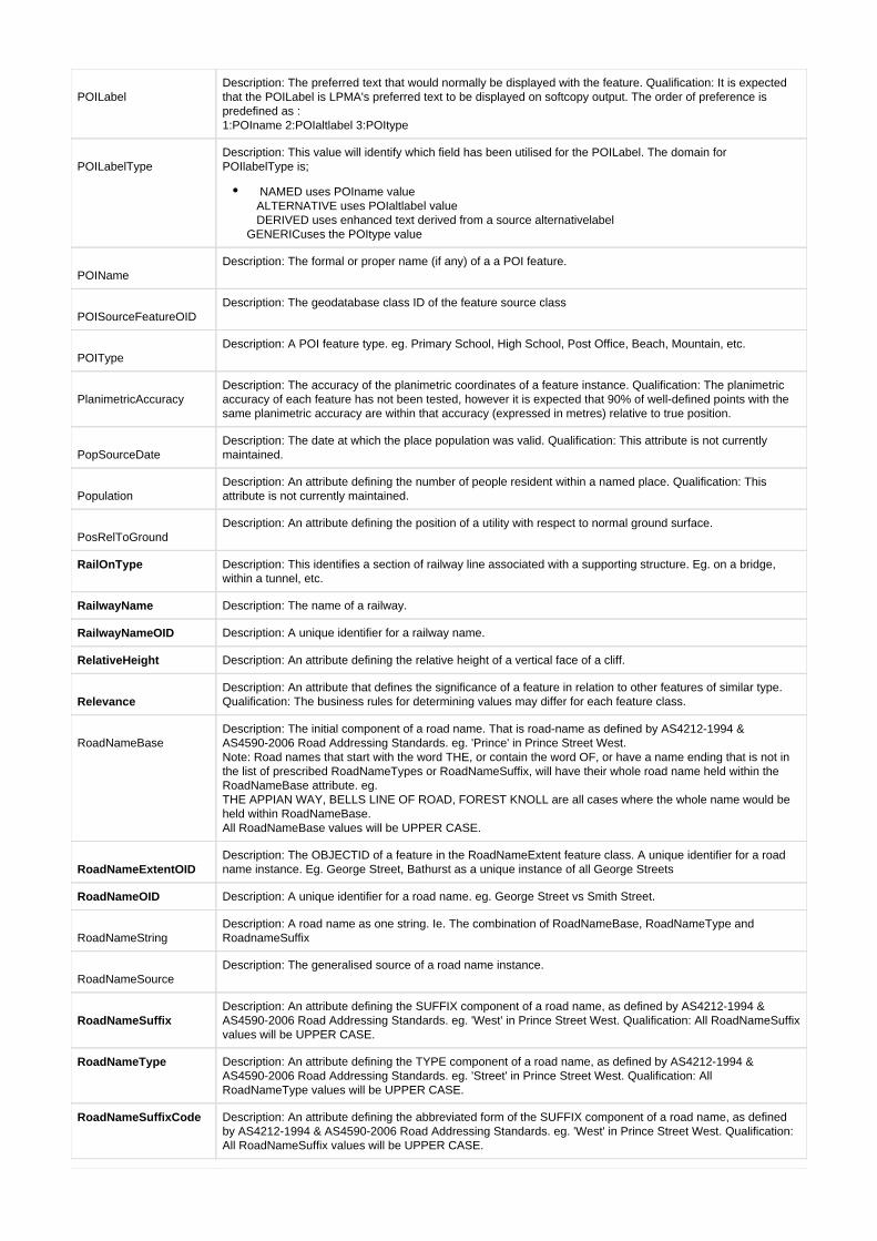
POILabelDescription: The preferred text that would normally be displayed with the feature. Qualification: It is expectedthat the POILabel is LPMA's preferred text to be displayed on softcopy output. The order of preference ispredefined as : 1:POIname 2:POIaltlabel 3:POItype
POILabelTypeDescription: This value will identify which field has been utilised for the POILabel. The domain forPOIlabelType is;
NAMED uses POIname value ALTERNATIVE uses POIaltlabel value DERIVED uses enhanced text derived from a source alternativelabel GENERICuses the POItype value
POINameDescription: The formal or proper name (if any) of a a POI feature.
POISourceFeatureOIDDescription: The geodatabase class ID of the feature source class
POITypeDescription: A POI feature type. eg. Primary School, High School, Post Office, Beach, Mountain, etc.
PlanimetricAccuracyDescription: The accuracy of the planimetric coordinates of a feature instance. Qualification: The planimetricaccuracy of each feature has not been tested, however it is expected that 90% of well-defined points with thesame planimetric accuracy are within that accuracy (expressed in metres) relative to true position.
PopSourceDateDescription: The date at which the place population was valid. Qualification: This attribute is not currentlymaintained.
PopulationDescription: An attribute defining the number of people resident within a named place. Qualification: Thisattribute is not currently maintained.
PosRelToGroundDescription: An attribute defining the position of a utility with respect to normal ground surface.
RailOnType Description: This identifies a section of railway line associated with a supporting structure. Eg. on a bridge,within a tunnel, etc.
RailwayName Description: The name of a railway.
RailwayNameOID Description: A unique identifier for a railway name.
RelativeHeight Description: An attribute defining the relative height of a vertical face of a cliff.
RelevanceDescription: An attribute that defines the significance of a feature in relation to other features of similar type.Qualification: The business rules for determining values may differ for each feature class.
RoadNameBaseDescription: The initial component of a road name. That is road-name as defined by AS4212-1994 &AS4590-2006 Road Addressing Standards. eg. 'Prince' in Prince Street West. Note: Road names that start with the word THE, or contain the word OF, or have a name ending that is not inthe list of prescribed RoadNameTypes or RoadNameSuffix, will have their whole road name held within theRoadNameBase attribute. eg. THE APPIAN WAY, BELLS LINE OF ROAD, FOREST KNOLL are all cases where the whole name would beheld within RoadNameBase. All RoadNameBase values will be UPPER CASE.
RoadNameExtentOIDDescription: The OBJECTID of a feature in the RoadNameExtent feature class. A unique identifier for a roadname instance. Eg. George Street, Bathurst as a unique instance of all George Streets
RoadNameOID Description: A unique identifier for a road name. eg. George Street vs Smith Street.
RoadNameStringDescription: A road name as one string. Ie. The combination of RoadNameBase, RoadNameType andRoadnameSuffix
RoadNameSourceDescription: The generalised source of a road name instance.
RoadNameSuffixDescription: An attribute defining the SUFFIX component of a road name, as defined by AS4212-1994 &AS4590-2006 Road Addressing Standards. eg. 'West' in Prince Street West. Qualification: All RoadNameSuffixvalues will be UPPER CASE.
RoadNameType Description: An attribute defining the TYPE component of a road name, as defined by AS4212-1994 &AS4590-2006 Road Addressing Standards. eg. 'Street' in Prince Street West. Qualification: AllRoadNameType values will be UPPER CASE.
RoadNameSuffixCode Description: An attribute defining the abbreviated form of the SUFFIX component of a road name, as definedby AS4212-1994 & AS4590-2006 Road Addressing Standards. eg. 'West' in Prince Street West. Qualification:All RoadNameSuffix values will be UPPER CASE.

RoadNameTypeCode Description: An attribute defining the abbreviated form of the TYPE component of a road name, as defined byAS4212-1994 & AS4590-2006 Road Addressing Standards. eg. 'Street' in Prince Street West. Qualification: AllRoadNameType values will be UPPER CASE.
RoadOnType Description: This identifies a section of road associated with a supporting structure. Eg. on a bridge, within atunnel, etc.
RunwayDefinition Description: An attribute that defines the form of runway spatial definition (Centreline or Perimiter).
RunwaySurface Description: An attribute identifying the runway surface type. Qualification: This attribute is not currentlymaintained.
SourceProgramDescription: The source program under which a contour line was captured or subsequently edited.
SubSectionNameOIDDescription: A unique identifier for the name of a subsection of a utility network.
SurfaceDescription: An attribute that identifies the road surface type.
SymbolRotationDescription: The rotation angle of a point marker symbol. Qualification: Values expressed as an integer, in therange +/- 180 degrees, referenced from an easterly origin.
TankTypeDescription: An attribute which identifies a tanks use.
TopoIDDescription: A unique identifier that remains associated with a feature for the life of that feature. A TopoID willnot change as a result of minor maintenance operations for example, a feature will retain its current TopoID ifthe digitised co-ordinates describing its geometry were replaced by more accurate values, or the feature'sname is changed.
TrafficableHeightDescription: An attribute defining the maximum vehicle height of a crossing. Qualification: This attribute is notcurrently maintained. Qualification: This attribute is not currently maintained.
TrafficableWidthDescription: An attribute defining the maximum vehicle width of a crossing. Qualification: This attribute is notcurrently maintained. Qualification: This attribute is not currently maintained.
VerticalAccuracyDescription: The accuracy of the elevation of a feature instance. Qualification: The vertical accuracy of eachfeature has not been tested, however it is expected that 90% of elevations with the same vertical accuracy arewithin that accuracy (expressed in metres) relative to true elevation.
Voltage Description: The voltage capacity of an electricity transmission line. Qualification: The normal rated capacity ofthe line is recorded. This may not be the same as the voltage actually being transmitted.
WayNumber Description: The number (or alpha numeric) assigned to an Aggregated Way by the relevant authority. eg.State Highway number, State Route number, etc.
WayType Description: An attribute that defines the type or context of a road aggregation.
( )#top
Subtype Descriptions - By Feature Class
AncillaryHydroPoint - Subtypes
OnEndNode: ClassSubtype value: 1 Description: A hydro management point that has a topological relationship to a HydroLine end node.: ClassSubtype value: OnCentreline 2 Description: A hydro management point that has a topological relationship to a HydroLine.: ClassSubtype value: OnBoundary 3 Description: A hydro management point that has a topological relationship to a HydroArea polygon
boundary.: ClassSubtype value: InHydroArea 4 Description: A hydro management point that has a topological relationship to a HydroArea polygon.: ClassSubtype value: NoTopology 5 Description: A hydro management point that has no topological relationship to another feature.
( )#top
BuildingComplexPoint - Subtypes
EducationFacility: ClassSubtype value: 1 Description: A facility for the act or process of educating; the imparting or acquisition of knowledge, skill, etc; systematic instruction or training. (ICSM) Associated Domain:DmT_EducationComplexType
CommunityFacility: ClassSubtype value: 2 Description: A type of BuildingComplex whose function is primarily for the benefit of the community. Associated Domain:DmT_CommunityComplexType
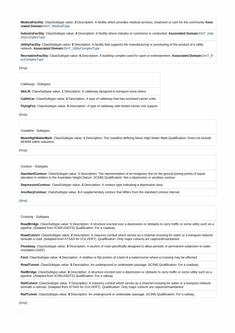
MedicalFacility: ClassSubtype value: 3 Description: A facility which provides medical services, treatment or care for the community Associated Domain:DmT_MedicalType
IndustryFacility: ClassSubtype value: 4 Description: A facility where industry or commerce is conducted. Associated Domain:DmT_IndustryComplexType
UtilityFacility: ClassSubtype value: 5 Description: A facility that supports the manufacturing or processing of the product of a utility network. Associated Domain:DmT_UtilityComplexType
RecreationFacility: ClassSubtype value: 6 Description: A building complex used for sport or entertainment. Associated Domain:DmT_RecComplexType
( )#top
Cableway - Subtypes
SkiLift: ClassSubtype value: 1 Description: A cableway designed to transport snow skiers.
CableCar: ClassSubtype value: 2 Description: A type of cableway that has enclosed carrier units.
FlyingFox: ClassSubtype value: 3 Description: A type of cableway with limited carrier unit support.
( )#top
Coastline - Subtypes
MeanHighWaterMark: ClassSubtype value: 1 Description: The coastline defining Mean High Water Mark.Qualification: Does not includeMHWM within estuaries.
( )#top
Contour - Subtypes
StandardContour: ClassSubtype value: 1 Description: The representation of an imaginary line on the ground joining points of equalelevation in relation to the Australian Height Datum. (ICSM) Qualification: Not a depression or ancillary contour.
DepressionContour: ClassSubtype value: 2 Description: A contour type indicating a depression area.
AncillaryContour: ClassSubtype value: 3 A supplementary contour that differs from the standard contour interval.
( )#top
Crossing - Subtypes
RoadBridge: ClassSubtype value: 1 Description: A structure erected over a depression or obstacle to carry traffic or some utility such as apipeline. (Adapted from ICSM-ASDTS) Qualification: For a roadway.
RoadCulvert: ClassSubtype value: 2 Description: A masonry conduit which serves as a channel-crossing for water or a transport networkbeneath a road. (Adapted from ATSAS for CULVERT). Qualification: Only major culverts are captured/maintained.
Floodway: ClassSubtype value: 3 Description: A section of road specifically designed to allow periodic or permanent subjection to waterinundation.(GDF)
Ford: ClassSubtype value: 4 Description: A shallow or flat portion of a bed of a watercourse where a crossing may be effected.
RoadTunnel: ClassSubtype value: 5 Description: An underground or underwater passage. (ICSM) Qualification: For a roadway.
RailBridge: ClassSubtype value: 6 Description: A structure erected over a depression or obstacle to carry traffic or some utility such as apipeline. (Adapted from ICSM-ASDTS) Qualification: For a railway.
RailCulvert: ClassSubtype value: 7 Description: A masonry conduit which serves as a channel-crossing for water or a transport networkbeneath a railroad. (Adapted from ATSAS for CULVERT). Qualification: Only major culverts are captured/maintained.
RailTunnel: ClassSubtype value: 8 Description: An underground or underwater passage. (ICSM) Qualification: For a railway.
( )#top
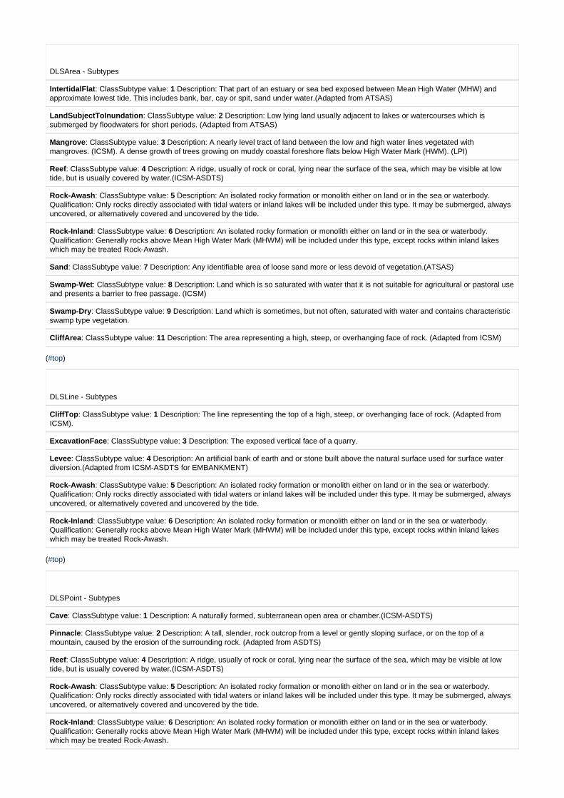
DLSArea - Subtypes
IntertidalFlat: ClassSubtype value: 1 Description: That part of an estuary or sea bed exposed between Mean High Water (MHW) andapproximate lowest tide. This includes bank, bar, cay or spit, sand under water.(Adapted from ATSAS)
LandSubjectToInundation: ClassSubtype value: 2 Description: Low lying land usually adjacent to lakes or watercourses which issubmerged by floodwaters for short periods. (Adapted from ATSAS)
Mangrove: ClassSubtype value: 3 Description: A nearly level tract of land between the low and high water lines vegetated withmangroves. (ICSM). A dense growth of trees growing on muddy coastal foreshore flats below High Water Mark (HWM). (LPI)
Reef: ClassSubtype value: 4 Description: A ridge, usually of rock or coral, lying near the surface of the sea, which may be visible at lowtide, but is usually covered by water.(ICSM-ASDTS)
Rock-Awash: ClassSubtype value: 5 Description: An isolated rocky formation or monolith either on land or in the sea or waterbody.Qualification: Only rocks directly associated with tidal waters or inland lakes will be included under this type. It may be submerged, alwaysuncovered, or alternatively covered and uncovered by the tide.
Rock-Inland: ClassSubtype value: 6 Description: An isolated rocky formation or monolith either on land or in the sea or waterbody.Qualification: Generally rocks above Mean High Water Mark (MHWM) will be included under this type, except rocks within inland lakeswhich may be treated Rock-Awash.
Sand: ClassSubtype value: 7 Description: Any identifiable area of loose sand more or less devoid of vegetation.(ATSAS)
Swamp-Wet: ClassSubtype value: 8 Description: Land which is so saturated with water that it is not suitable for agricultural or pastoral useand presents a barrier to free passage. (ICSM)
Swamp-Dry: ClassSubtype value: 9 Description: Land which is sometimes, but not often, saturated with water and contains characteristicswamp type vegetation.
CliffArea: ClassSubtype value: 11 Description: The area representing a high, steep, or overhanging face of rock. (Adapted from ICSM)
( )#top
DLSLine - Subtypes
CliffTop: ClassSubtype value: 1 Description: The line representing the top of a high, steep, or overhanging face of rock. (Adapted fromICSM).
ExcavationFace: ClassSubtype value: 3 Description: The exposed vertical face of a quarry.
Levee: ClassSubtype value: 4 Description: An artificial bank of earth and or stone built above the natural surface used for surface waterdiversion.(Adapted from ICSM-ASDTS for EMBANKMENT)
Rock-Awash: ClassSubtype value: 5 Description: An isolated rocky formation or monolith either on land or in the sea or waterbody.Qualification: Only rocks directly associated with tidal waters or inland lakes will be included under this type. It may be submerged, alwaysuncovered, or alternatively covered and uncovered by the tide.
Rock-Inland: ClassSubtype value: 6 Description: An isolated rocky formation or monolith either on land or in the sea or waterbody.Qualification: Generally rocks above Mean High Water Mark (MHWM) will be included under this type, except rocks within inland lakeswhich may be treated Rock-Awash.
( )#top
DLSPoint - Subtypes
Cave: ClassSubtype value: 1 Description: A naturally formed, subterranean open area or chamber.(ICSM-ASDTS)
Pinnacle: ClassSubtype value: 2 Description: A tall, slender, rock outcrop from a level or gently sloping surface, or on the top of amountain, caused by the erosion of the surrounding rock. (Adapted from ASDTS)
Reef: ClassSubtype value: 4 Description: A ridge, usually of rock or coral, lying near the surface of the sea, which may be visible at lowtide, but is usually covered by water.(ICSM-ASDTS)
Rock-Awash: ClassSubtype value: 5 Description: An isolated rocky formation or monolith either on land or in the sea or waterbody.Qualification: Only rocks directly associated with tidal waters or inland lakes will be included under this type. It may be submerged, alwaysuncovered, or alternatively covered and uncovered by the tide.
Rock-Inland: ClassSubtype value: 6 Description: An isolated rocky formation or monolith either on land or in the sea or waterbody.Qualification: Generally rocks above Mean High Water Mark (MHWM) will be included under this type, except rocks within inland lakeswhich may be treated Rock-Awash.

( )#top
FerryRoute - Subtypes
VehicularFerry: ClassSubtype value: 1 Description: A route across an inland water feature or the sea used by a vessel for the regulartransport of vehicles or passengers from one terminal point to another. (ICSM) Qualification: Only vehicular ferry routes are identifiedunder this category.
PassengerFerry: ClassSubtype value: 2 Description: A route across an inland water feature or the sea used by a vessel for the regulartransport of vehicles or passengers from one terminal point to another. (ICSM) Qualification: Only passenger ferry routes are identifiedunder this category.
( )#top
FuzzyExtentWaterArea - Subtypes
BayLike: ClassSubtype value: 1 Description: A named bay-like feature. Qualification: Includes GNB designations: Bays, Bights, Coves,Entrances, Gulfs, Harbours, Inlets, Ports and River Mouths.
RiverLike: ClassSubtype value: 2 Description: A named river-like feature of indefinite name extent. Qualification: Includes GNBdesignations: Anabranch, Arm, Bend, Canal, Channel, Cowal, Passage, Reach, River Bend, River Feature, and Strait that have not beenrepresented by another hydrographic feature class.
SeaLike: ClassSubtype value: 3 Description: A named sea-like waterbody. Qualification: Includes GNB designations: Sea and Ocean.
( )#top
FuzzyExtentWaterLine - Subtypes
RiverLike: ClassSubtype value: 2 Description: A named river-like feature of indefinite name extent. Qualification: Includes GNBdesignations: Anabranch, Arm, Bend, Canal, Channel, Cowal, Passage, Reach, River Bend, River Feature, and Strait that have not beenrepresented by another hydrographic feature class.
( )#top
GeneralCulturalArea - Subtypes
RestrictedArea: ClassSubtype value: 3 Description: An area over which public access is specifically restricted. Associated Domain:DmT_RestrictedAreaType
Building: ClassSubtype value: 5 Description: A relatively permanent structure roofed and/or usually walled. (ICSM-ASDTS) AssociatedDomain:DmT_BuildingUse
Plantation: ClassSubtype value: 6 Description: Land that has been plowed or otherwise cultivated. (ICSM) Qualification: Only orchards,vineyards, silviculture and crops of landmark significance are identified. Broadacre crops such as wheat, rice, canola, etc. are not
identified. Associated Domain:DmT_PlantationType
BuiltUpArea: ClassSubtype value: 7 Description: An area where the settlement is of an urban nature of dense or moderate housing withdefinite boundaries. (ICSM) An area where the cultural fabric of settlement is of an urban nature.The 'line' can loosely be thought of as the
demarcation between urban and non-urban land use activities.(Adapted from ATSAS) Associated Domain:DmT_Undefined
Pondage: ClassSubtype value: 9 Description: All areas of shallow water with walls or banks created for a specific purpose.(ICSM)Qualification: Only treatment ponds and swimming pools will be identified under this category. Other water bodies will be identified as
Inland Hydrography. Associated Domain:DmT_PondageType
DamBatter: ClassSubtype value: 10 Description: The inclined portion of a dam wall exposed behind the reservoir, which strengthens the wall and enables it to hold back large volumes of water. (ATSAS) Associated Domain:DmT_Undefined
( )#top
GeneralCulturalLine - Subtypes
ConveyorBelt: ClassSubtype value: 1 Description: A continuous belt or series of belts mounted on rollers and used to move large quantities of goods, especially grain or ore.(ICSM-ASDTS) Associated Domain:DmT_Undefined

Fence: ClassSubtype value: 2 Description: An enclosure made of wire, rails, slats or other relatively light material, as opposed to a wallwhich is of stone or other heavy material. (ICSM) Qualification: Only fences in the Western Division of NSW are currently captured.
Although rare, these may also include low stone walls. Associated Domain:DmT_Undefined
CulturalFeaturePerimeter: ClassSubtype value: 3 Description: A line representing the demarcation boundary between two land use types. Associated Domain:DmT_Undefined
DamWall: ClassSubtype value: 4 Description: A barrier constructed across a watercourse to control the flow or raise the level of water. (ICSM as dam) Associated Domain:DmT_Undefined
Breakwater: ClassSubtype value: 5 Description: A structure built to break the force of waves so as to protect a beach, harbour, or other waterfront facility. (ICSM for BREAKWATER). Associated Domain:DmT_Undefined
RaceTrack: ClassSubtype value: 6 Description: A course laid out for racing. Associated Domain:DmT_RaceTrackType
SpillwayEdge: ClassSubtype value: 7 Description: The bounding wall of a spillway. Associated Domain:DmT_Undefined
( )#top
GeneralCulturalPoint - Subtypes
GeneralRecreationPoint: ClassSubtype value: 1 Description: A feature that has been classified as general recreation and spatially represented as a point. Associated Domain:DmT_ExtRecreationType
Aquaculture: ClassSubtype value: 2 Description: Land used for the commercial breeding and keeping of aquatic animals or plants in tanks, ponds and leased areas within natural waterways.(Adapted from ANZLUC) Associated Domain:DmT_AquaCultureType
RestrictedArea: ClassSubtype value: 3 Description: An area over which public access is specifically restricted. Associated Domain:DmT_RestrictedAreaType
GeneralIndustryPoint: ClassSubtype value: 4 Description: A feature that has been classified as an industry and spatially represented as a point. Associated Domain:DmT_GenIndustryTypePoint
Building: ClassSubtype value: 5 Description: A relatively permanent structure roofed and/or usually walled. (ICSM-ASDTS) Associated Domain: DmT_BuildingUse
RaceTrack: ClassSubtype value: 6 Description: A course laid out for racing. Associated Domain:DmT_RaceTrackType
Tower: ClassSubtype value: 7 Description: A tall framework or structure, the elevation of which is functional. Associated Domain:DmT_Tower_Type
Cemetery: ClassSubtype value: 8 Description: An officially designated place for burying the dead.(ICSM-ASDTS) Associated Domain:DmT_CemeteryType
Pondage: ClassSubtype value: 9 Description: All areas of shallow water with walls or banks created for a specific purpose.(ICSM) )Qualification: Only treatment ponds and swimming pools will be identified under this category. Other water bodies will be identified as
Inland Hydrography. Associated Domain:DmT_PondageType
Beacon: ClassSubtype value: 12 Description: A fixed signal, mark or light, and associated facilities erected for guidance of mariners or aeroplane pilots.(ICSM-ASDTS) Qualification: Not a lighthouse Associated Domain:DmT_BeaconType
( )#top
HydroArea - Subtypes
WaterbodyArea: ClassSubtype value: 1 Description: A standard body of inland water - represented as a polygon. Any body of inland water of which the flow is minor.(Adapted from ICSM-ASDTS) Associated Domain:DmT_WaterbodyType
Watercourse: ClassSubtype value: 2 Description: A way or course through which water may or does pass. (ICSM) Associated Domain:DmT_WatercourseType
( )#top
HydroLine - Subtypes
WatercourseCentreline: ClassSubtype value: 1 Description: The centreline of a way or course through which water may or does pass. Associated Domain:DmT_WatercourseCentrelineType
Connector: ClassSubtype value: 2 Description:: A line used maintain continuity of a watercourse where that watercourse is not physically evident. Qualification: The notional centreline of watercourses through water bodies will be classified as classsubtype 1
Associated Domain:DmT_Undefined

( )#top
HydroPoint - Subtypes
WaterbodyPoint: ClassSubtype value: 1 Description: A standard body of inland water - represented as a point. Any body of inland water of which the flow is minor.(Adapted from ICSM-ASDTS) Associated Domain:DmT_WaterbodyType
( )#top
PointOfInterest - POIType
Community: ClassSubtype value: Description: A type of feature whose function is primarily for the benefit of the community. 1 Associated POIType(s):
Ambulance Station Art Gallery CemeteryChildrens HospitalCommunity Medical CentreConvent/Monastery Co-operative Court House Crematorium EmbassyFirestation - BushFirestation Gaol General Hospital Grave Homestead Integrated Helath ServiceLibrary Lighthouse Local Government Chambers Museum Multi-Purpose ServiceNursing HomeObservatory Place Of Worship Police Station Post Office Psychiatric Hospital Retirement Village SES Facility Shopping Centre Tourist Information CentreTourist Park / Home Village
Education: ClassSubtype value: 2 Description: A type of feature whose function is primarily related to education. Associated POIType(s):
Academy Combined Primary- Secondary School
High School Preschool
Primary School Research Station
Special SchoolTechnical CollegeUniversity
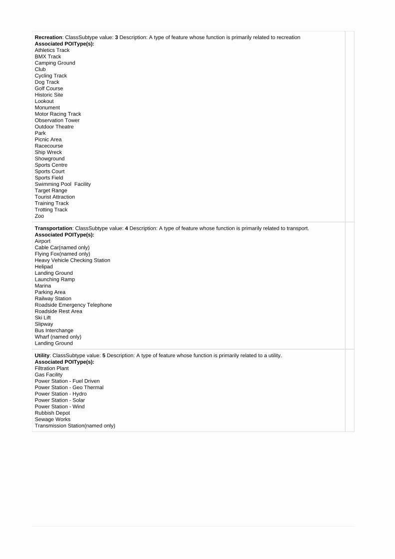
Recreation: ClassSubtype value: 3 Description: A type of feature whose function is primarily related to recreation Associated POIType(s):
Athletics Track BMX Track
Camping Ground Club
Cycling Track Dog Track
Golf Course Historic Site
Lookout Monument
Motor Racing Track Observation Tower
Outdoor Theatre Park
Picnic Area Racecourse Ship Wreck Showground
Sports Centre Sports Court Sports Field
FacilitySwimming Pool Target Range
Tourist Attraction Training Track Trotting Track
Zoo
Transportation: ClassSubtype value: 4 Description: A type of feature whose function is primarily related to transport. Associated POIType(s):
Airport Cable Car(named only)
Flying Fox(named only)Heavy Vehicle Checking Station
HelipadLanding Ground
Launching RampMarinaParking AreaRailway StationRoadside Emergency Telephone
Roadside Rest AreaSki Lift
SlipwayBus InterchangeWharf (named only)Landing Ground
Utility: ClassSubtype value: 5 Description: A type of feature whose function is primarily related to a utility. Associated POIType(s):
Filtration Plant Gas Facility
Power Station - Fuel DrivenPower Station - Geo ThermalPower Station - HydroPower Station - SolarPower Station - Wind
Rubbish Depot Sewage Works
Transmission Station(named only)

Hydrography: ClassSubtype value: 6 Description A type of feature whose function is primarily related to hydrography. Bay Like (named only)
Beach (named only) Bore(named only)
Breakwater(named only) Dam Wall(named only)
Island Like (named only) Lock(named only)
Manmade Waterbody(named only) Natural Waterbody(named only)
Rapids(named only) Reef(named only)
River Like(named only) Rock Awash(named only) Sandbar Like(named only)
Spring(named only) Swamp Like(named only)
Waterfall(named only)
Landform: ClassSubtype value: 7 Description: A type of feature whose function is primarily related to a landform. Associated POIType(s):
Cave(named only) Cliff Area(named only) Gap Like (named only)
Headland Like (named only) Mountain Like (named only)
Peninsula Like (named only)Plateau Like (named only)
Place: ClassSubtype value: 8 Description: A place with a prescribed name. Qualification: Includes City, Town, Suburb, Locality, etc
Associated POIType(s): Region
City Town
Village Suburb
Locality
Industry Facility: ClassSubtype value: activity.9 Description: A featur whose funciton primarily relates to industry or industrial POIType(s):Associated
ShipyardStock Sale YardSilo -CommercialMine - UndergroundQuarry - Open Cut
( )#top
Railway - Subtypes
HeavyRail: ClassSubtype value: 1 Description: A rail line that is part of the standard railway network that is not a siding.
LightRail: ClassSubtype value: 2 Description: Lightly constucted railways or tramways. (Adapted from ATSAS)
Monorail: ClassSubtype value: 3 Description: A single fixed rail transportation system.
HeavyRailSiding: ClassSubtype value: 4 Description: A rail line or lines that are often an offshoot of the main line, to which a train orgoods wagon can be shunted in order to clear the main line for other trains or for the purpose of loading or unloading freight.(ATSAS forSIDING / SPUR LINE)
( )#top
RoadSegment - Subtypes
StandardRoad: ClassSubtype value: 1 Description: A road not classified by a more specific subtype.
OnOffRamp: ClassSubtype value: 2 Description: An access ramp to or from one road to another to allow smooth integration of traffic.Qualification: Only access ramps associated with roads of arterial or higher status and generally longer than 100 metres will be identified.

DualCarriageway: ClassSubtype value: 3 Description: A road where opposing flows of traffic are usually separated by a physical median.Qualification: Where a physical median is less than 1.0 metre wide and less than 500 metres long, a road may be treated as a singlecarriageway road. (NSW RMS Divided Carriageway definition).
Roundabout: ClassSubtype value: 4 Description: A road segment that is part of a road intersection that has been designed to allowsmooth integration of traffic in the form of a roundabout. Qualification: Generally only roundabouts with a road centreline diameter greaterthan 15 metres (approx. equates to inside curb diameter of 10 metres) will be identified.
VehicularTrack: ClassSubtype value: 5 Description: An unimproved road, the construction of which is minimal. Also included aredriveways, regardless of construction. Qualification: These roads are generally only passable in two-wheel drive vehicles during fairweather and are used predominantly by local traffic. If the road's surface is attributed as Unsealed:Four-Wheel Drive then the road is onlysuitable for Four Wheel Drive type vehicles. VehicularTrack is a member of RoadSegement class subtype - a classification scheme basedon physical form. See also the attribute FunctionHierarchy -TrackVehicular.
Pathway: ClassSubtype value: 6 Description: A track that is not capable of and/or not permitted to carry vehicular traffic. Generally for useby pedestrians, horse riders and/or cyclists.
ContinuityLine: ClassSubtype value: 8 Description: A line used to maintain linear continuity of a road name through a roundabout or toindicate a continuity link over water (eg. ferry). Qualification: The location of a ContinuityLine is purely notional, as it does not represent aphysical road centreline.
( )#top
SpotHeight - Subtypes
StandardSpotHeight: ClassSubtype value: 1 Description: A point on the earth's surface, the elevation of which has been related to adatum by ground or photogrammetric survey. (ICSM) Qualification: Point is not within a depression.
DepressionSpotHeight: ClassSubtype value: 2 Description: A point on the earth's surface, the elevation of which has been related to adatum by ground or photogrammetric survey. (ICSM) Qualification: Point is within a depression.
( )#top
TrafficControlDevice - Subtypes
Gate: ClassSubtype value: 1 Description: An opening in a fence or wall for the passage of vehicles or animals and which may contain adevice to limit passage.(ICSM-ASDTS). Qualification: Only gates associated with roads/tracks are captured.
CattleGrid: ClassSubtype value: 2 Description: An open floored structure designed to be crossed by motor vehicles.(ATSAS)
TollBooth: ClassSubtype value: 3 Description: A structure on a road which requires the user to pay a toll or fee to use the road.
Impediment: ClassSubtype value: 4 Description: A structure generally associated with a road that controls or varies the normal travel ofvehicles or pedestrians.
LevelCrossing: ClassSubtype value: 5 Description: A place where a road and railway intersect at the same level.(Macq)
Roundabout: ClassSubtype value: 6 Description: The notional midpoint of a roundabout that has been constructed to allow smoothintegration of traffic. Qualification: Generally only roundabouts forming a road centreline diameter greater than 15 metres (approx. equatesto inside curb diameter of 10 metres) and associated with RoadSegments classified as 'Roundabout' will be identified under thisclassification
SmallRoundabout: ClassSubtype value: 7 Description: The notional midpoint of roundabout that has been constructed to allow smooth integration of traffic. Qualification: Generally only small roundabouts that are not associated with RoadSegments classified as
'Roundabout' will be identified under this classification
( )#top
TransportFacilityLine - Subtypes
LaunchingRamp: ClassSubtype value: 1 Description: A sloping construction to facilitate launching or retrieving boats from water. Mayhave rails or other aids.(DTDB-Technical Manual)
Slipway: ClassSubtype value: 2 Description: An inclined plane or ramp, especially one sloping to the water, serving as a landing place ora site on which vessels are built or repaired.(Macq)
Wharf: ClassSubtype value: 3 Description: Any structure on a waterfront, designed to make it possible for vessels to lie alongside and takeor unload cargo, passengers etc.
( )#top

TransportFacilityPoint - Subtypes
Airport: ClassSubtype value: 1 Description: A facility, either on land or water, where aircraft can take off or land; usually consists ofhard-surfaced landing strips, a control tower, hangars, and accommodations for passengers and cargo.(ICSM-ASDTS)
BusInterchange: ClassSubtype value: 2 Description: A connection or terminal point for long distance bus travellers or other majortransport interchange.
Helipad: ClassSubtype value: 3 Description: An area set aside or designated for the landing of helicopters. A transportation structure usedfor the landing of helicopters.
Marina: ClassSubtype value: 4 Description: A harbour facility for recreational craft where supplies, repairs, and various services areavailable. (ICSM) A facility comprising of floating platforms or fixed piers for mooring of non-residential, commercial and private seacraft. Amarina may be built on wholly tidal / inundated land. (Adapted from ANZLUC)
ParkingArea: ClassSubtype value: 5 Description: An area set aside for the parking of motor vehicles or aircraft.(ICSM-ASDTS)
RailwayStation: ClassSubtype value: 6 Description: A structure beside a railway line with facilities for passengers and freight. (NSW GNB)
RoadsideRestArea: ClassSubtype value: 7 Description: A formal area adjacent to the road enabling motorists to take fatigue breaks.
RoadsideEmergencyTelephone: ClassSubtype value: 8 Description: A dedicated telephone adjacent to a road that provides publicaccess to emergency services.
HeavyVehicleCheckStation: ClassSubtype value: 9 Description: A facility to ensure that heavy vehicles meet safety and roadworthinessstandards and that their drivers are complying with road transport laws.
Domain Descriptions
( ) #topDmT_AncillaryHydro|
Domain:
1: Bore Description: A pit or hole dug or bored into the earth, for the extraction of oil, water and other fluids and gases.(ICSM-ASDTS) 2: Lock Description: An enclosure in a water body with gates at each end to raise or lower vessels as they pass from one level to another.(ASDTS) 3: Rapids Description: An area of broken, fast flowing water in a stream, where the slope of the bed increases (but without a prominent break ofslope which might result in a waterfall), or where a gently dipping bar or harder rock outcrops. (ICSM) 4: Spring Description: The place where water issues from the ground naturally. 5: TidalLimitMarker Description: The location of the upper tidal limit of a estuary. Qualification: Only locations noted on topographic maps are identified. 6: Waterfall Description: A sudden descent of water over a step or ledge in the bed of a river.(ICSM-ASDTS) 7: DissipationPoint Description: The downstream point at which a watercourse dissipates and becomes indeterminate. 8: ContractedNode Description: A data control point on the drainage network established within the Australian Hydrographical GeoFabric (AHGF) dataset.. 9: HydroDataManagement Description: A fixed point used to manage the spatial integrity of hydrography data. 10: Regulator Description: A device to regulate the flow of a watercourse. Qualification: A floodgate or specialised barrier to control allocation of water. 11: Barrier Description: A barrier constructed across a watercourse to control the flow or raise the level of water. eg. a dam wall or weir. 12:RiverGauge Description: A fixed device for recording hydrographical attributes. 13: Sink Description: A location identified as a sink point ie. A point perceived to be of lower elevation than the surrounding land surface.
( )#top
DmT_AquaCultureType
Domain:
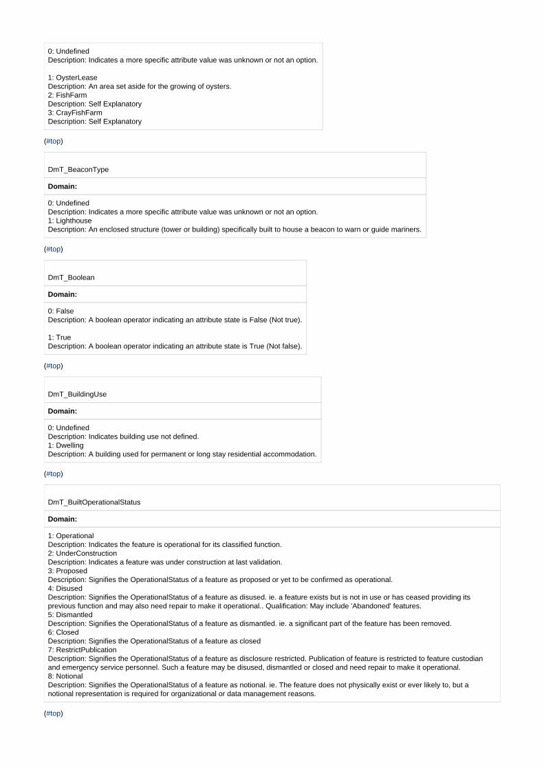
0: Undefined Description: Indicates a more specific attribute value was unknown or not an option.
1: OysterLease Description: An area set aside for the growing of oysters. 2: FishFarm Description: Self Explanatory 3: CrayFishFarm Description: Self Explanatory
( )#top
DmT_BeaconType
Domain:
0: Undefined Description: Indicates a more specific attribute value was unknown or not an option. 1: Lighthouse Description: An enclosed structure (tower or building) specifically built to house a beacon to warn or guide mariners.
( )#top
DmT_Boolean
Domain:
0: False Description: A boolean operator indicating an attribute state is False (Not true).
1: True Description: A boolean operator indicating an attribute state is True (Not false).
( )#top
DmT_BuildingUse
Domain:
0: Undefined Description: Indicates building use not defined. 1: Dwelling Description: A building used for permanent or long stay residential accommodation.
( )#top
DmT_BuiltOperationalStatus
Domain:
1: Operational Description: Indicates the feature is operational for its classified function. 2: UnderConstruction Description: Indicates a feature was under construction at last validation. 3: Proposed Description: Signifies the OperationalStatus of a feature as proposed or yet to be confirmed as operational. 4: Disused Description: Signifies the OperationalStatus of a feature as disused. ie. a feature exists but is not in use or has ceased providing itsprevious function and may also need repair to make it operational.. Qualification: May include 'Abandoned' features. 5: Dismantled Description: Signifies the OperationalStatus of a feature as dismantled. ie. a significant part of the feature has been removed. 6: Closed Description: Signifies the OperationalStatus of a feature as closed 7: RestrictPublication Description: Signifies the OperationalStatus of a feature as disclosure restricted. Publication of feature is restricted to feature custodianand emergency service personnel. Such a feature may be disused, dismantled or closed and need repair to make it operational. 8: Notional Description: Signifies the OperationalStatus of a feature as notional. ie. The feature does not physically exist or ever likely to, but anotional representation is required for organizational or data management reasons.
( )#top
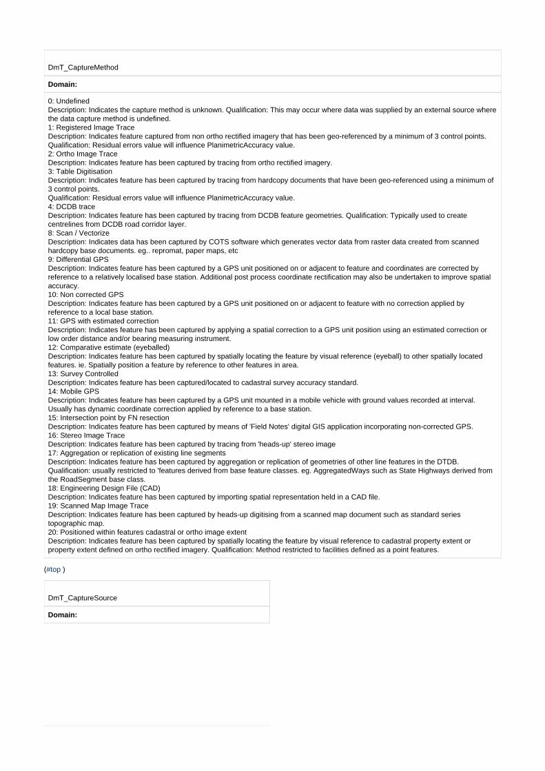
DmT_CaptureMethod
Domain:
0: Undefined Description: Indicates the capture method is unknown. Qualification: This may occur where data was supplied by an external source wherethe data capture method is undefined. 1: Registered Image Trace Description: Indicates feature captured from non ortho rectified imagery that has been geo-referenced by a minimum of 3 control points.Qualification: Residual errors value will influence PlanimetricAccuracy value. 2: Ortho Image Trace Description: Indicates feature has been captured by tracing from ortho rectified imagery. 3: Table Digitisation Description: Indicates feature has been captured by tracing from hardcopy documents that have been geo-referenced using a minimum of3 control points. Qualification: Residual errors value will influence PlanimetricAccuracy value. 4: DCDB trace Description: Indicates feature has been captured by tracing from DCDB feature geometries. Qualification: Typically used to createcentrelines from DCDB road corridor layer. 8: Scan / Vectorize Description: Indicates data has been captured by COTS software which generates vector data from raster data created from scannedhardcopy base documents. eg.. repromat, paper maps, etc 9: Differential GPS Description: Indicates feature has been captured by a GPS unit positioned on or adjacent to feature and coordinates are corrected byreference to a relatively localised base station. Additional post process coordinate rectification may also be undertaken to improve spatialaccuracy. 10: Non corrected GPS Description: Indicates feature has been captured by a GPS unit positioned on or adjacent to feature with no correction applied byreference to a local base station. 11: GPS with estimated correction Description: Indicates feature has been captured by applying a spatial correction to a GPS unit position using an estimated correction orlow order distance and/or bearing measuring instrument. 12: Comparative estimate (eyeballed) Description: Indicates feature has been captured by spatially locating the feature by visual reference (eyeball) to other spatially locatedfeatures. ie. Spatially position a feature by reference to other features in area. 13: Survey Controlled Description: Indicates feature has been captured/located to cadastral survey accuracy standard. 14: Mobile GPS Description: Indicates feature has been captured by a GPS unit mounted in a mobile vehicle with ground values recorded at interval.Usually has dynamic coordinate correction applied by reference to a base station. 15: Intersection point by FN resection Description: Indicates feature has been captured by means of 'Field Notes' digital GIS application incorporating non-corrected GPS. 16: Stereo Image Trace Description: Indicates feature has been captured by tracing from 'heads-up' stereo image 17: Aggregation or replication of existing line segments Description: Indicates feature has been captured by aggregation or replication of geometries of other line features in the DTDB.Qualification: usually restricted to 'features derived from base feature classes. eg. AggregatedWays such as State Highways derived fromthe RoadSegment base class. 18: Engineering Design File (CAD) Description: Indicates feature has been captured by importing spatial representation held in a CAD file. 19: Scanned Map Image Trace Description: Indicates feature has been captured by heads-up digitising from a scanned map document such as standard seriestopographic map. 20: Positioned within features cadastral or ortho image extent Description: Indicates feature has been captured by spatially locating the feature by visual reference to cadastral property extent orproperty extent defined on ortho rectified imagery. Qualification: Method restricted to facilities defined as a point features.
( )#top
DmT_CaptureSource
Domain:

1: Original 1:25000 Mapping Program 2: First PSMA Capture Program 3: Penguin Rd Atlas Capture Program 4: Standard Topographic Capture Program 5: Original 1:50000 Mapping Program 6: Original 1:100000 Mapping Program 7: RFS Field Update Program 8: ABS Cen2001 Update Program 9: Western Div. Capture Program 10: State Forests Data Integration Program 11: NPWS Data Integration Program 12: ACT Govt Data Integration Program 13: Large Scale 1 metre Contour Interval Mapping 14: Large Scale 2 metre Contour Interval Mapping 15: DTM Derived Small Scale Contours 16: LPI DTDB line segments 17: DCDB Road Corridor Centreline Program 18: RMS Classified Roads Integration Program 19: RIC Railways Integration Program 20: Local Govt Roads data Integration Program 21: GURAS Roads Update Program 22: Commonwealth Govt (Geoscience Aust) Topo Update Program
23: Crown Land Road Integration Program 24: Murray Irrigation Channel Integration Program 25: RMS Non-Classified Roads Integration Program 26: Forests NSW Data Integration Program 27: RMS Roads Pending Validation Program 28: Points of Interest Update Program 29: Hydrography Update Program30: RFS Notification Edit Service31: Police NSW32: Fire and Rescue NSW33: State Emergency Service NSW34: Rural Fire Service NSW35: Ambulance NSW36: Surf Life Saving Association NSW37: Local Council38: Transport NSW39: Civil Aviation Safety Authority40: Roads and Maritime Services NSW41: Fair Trading NSW42: Health NSW43: Clubs NSW44: Board of Studies NSW45: Department of Education and Communities NSW46: Attorney General's Department NSW47: Department of Foreign Affairs and Trade48: Corrective Service NSW49: Department of Local Government NSW50: Department of Primary Industries NSW51: Department of Health and Aging52: Australia Post53: Trade and Investment NSW54: Tourism NSW
( )#top
DmT_CemeteryType
Domain:
0: Cemetery Description: An officially designated place for burying the dead.(ASDTS) 1: Grave Description: A place within a graveyard used for burial or a burial site of landmark significance. (Adapted from ICSM)
2: Crematorium Description: A facility for the cremation of corpses.
( )#top
DmT_CommunityComplexType
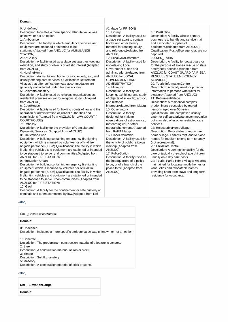
Domain:
0: Undefined Description: Indicates a more specific attribute value wasunknown or not an option. 1: Ambulance Description: The facility in which ambulance vehicles andequipment are stationed or intended to bestationed.(Adapted from ANZLUC for AMBULANCESTATION) 2: ArtGallery Description: A facility used as a place set apart for keeping,exhibition, and study of objects of artistic interest.(Adaptedfrom ANZLUC) 4: NursingHome Description: An institution / home for sick, elderly, etc, andusually offering care services. Qualification: RetirementVillages that offer self care/private accommodation aregenerally not included under this classification. 5: ConventMonastery Description: A facility used by religious organisations asresidential premises and/or for religious study. (Adaptedfrom ANZLUC) 6: CourtHouse Description: A facility used for holding courts of law and theoperation or administration of judicial authorities andcommissions.(Adapted from ANZLUC for LAW COURT /COURTHOUSE) 7: Embassy Description: A facility for the provision of Consular andDiplomatic Services. (Adapted from ANZLUC) 8: FireStation-Bush Description: A building containing emergency fire fightingequipment which is manned by volunteer or official firebrigade personnel.(ICSM) Qualification: The facility in whichfirefighting vehicles and equipment are stationed or intendedto be stationed to serve rural communities.(Adapted fromANZLUC for FIRE STATION) 9: FireStation-Urban Description: A building containing emergency fire fightingequipment which is manned by volunteer or official firebrigade personnel.(ICSM) Qualification: The facility in whichfirefighting vehicles and equipment are stationed or intendedto be stationed to serve urban communities.(Adapted fromANZLUC for FIRE STATION) 10: Gaol Description: A facility for the confinement or safe custody ofcriminals and others committed by law.(Adapted from Ref
#1 Macq for PRISON) 11: Library Description: A facility used asa place set apart to containbooks and other literarymaterial for reading, studyand reference.(Adapted fromANZLUC) 12: LocalGovtChambers Description: A facility used forundertaking LocalGovernment duties andadministration.(Adapted fromANZLUC for LOCALGOVERNMENT ANDADMINISTRATION) 14: Museum Description: A facility forkeeping, exhibiting, and studyof objects of scientific, artistic,and historicalinterest.(Adapted from Macq) 15: Observatory Description: A facilitydesigned for makingobservations of astronomical,meteorological, or othernatural phenomena.(Adaptedfrom Ref#1 Macq) 16: PlaceOfWorship Description: A facility used forthe activity of public religiousworship.(Adapted fromANZLUC) 17: PoliceStation Description: A facility used asthe headquarters of a policeforce, or of a branch of thepolice force.(Adapted fromANZLUC)
18: PostOffice Description: A facility whose primarybusiness is to handle and service mailand associated supplies ofequipment.(Adapted from ANZLUC)Qualification: Post office agencies are notcaptured. 19: SES_Facility Description: A facility for coast guard orfor the purpose of air-sea rescue or stateemergency services.(Adapted fromANZLUC for COAST GUARD / AIR SEARESCUE / STATE EMERGENCYSERVICES) 20: TouristInformationCentre Description: A facility used for providinginformation to persons who travel forpleasure.(Adapted from ANZLUC) 21: RetirementVillage Description: A residential complexpredominantly occupied by retiredpersons aged over 55 years.Qualification: The complexes usuallycater for self care/private accommodationbut may also offer other restricted careservices. 22: RelocatableHomeVillage Description: Relocatable manufacturehome village. Tenants rent land to placehomes for medium to long term tenancy(not recreational). 23: ChildCareCentre Desciprtion: A community facility for thecare of typically pre-school age children,usually on a day care basis.24: Tourist Park / Home Village: An areamaintained for locating mobile homes orvans, villas and relocatable homesproviding short term stays and long termresidency for occupants.
( )#top
DmT_ConstructionMaterial
Domain:
0: Undefined Description: Indicates a more specific attribute value was unknown or not an option.
1: Concrete Description: The predominant construction material of a feature is concrete. 2: Steel Description: A construction material of iron or steel. 3: Timber Description: Self Explanatory 5: Masonry Description: A construction material of brick or stone.
( )#top
DmT_ElevationRange
Domain:
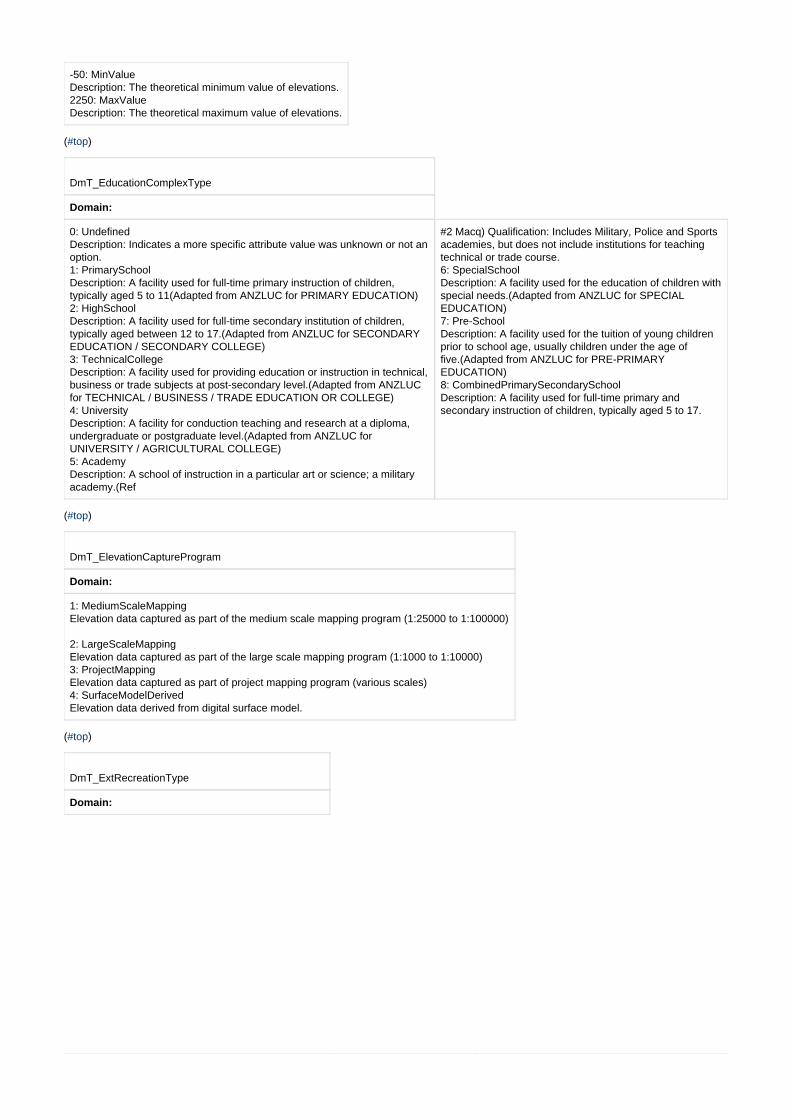
-50: MinValue Description: The theoretical minimum value of elevations. 2250: MaxValue Description: The theoretical maximum value of elevations.
( )#top
DmT_EducationComplexType
Domain:
0: Undefined Description: Indicates a more specific attribute value was unknown or not anoption. 1: PrimarySchool Description: A facility used for full-time primary instruction of children,typically aged 5 to 11(Adapted from ANZLUC for PRIMARY EDUCATION) 2: HighSchool Description: A facility used for full-time secondary institution of children,typically aged between 12 to 17.(Adapted from ANZLUC for SECONDARYEDUCATION / SECONDARY COLLEGE) 3: TechnicalCollege Description: A facility used for providing education or instruction in technical,business or trade subjects at post-secondary level.(Adapted from ANZLUCfor TECHNICAL / BUSINESS / TRADE EDUCATION OR COLLEGE) 4: University Description: A facility for conduction teaching and research at a diploma,undergraduate or postgraduate level.(Adapted from ANZLUC forUNIVERSITY / AGRICULTURAL COLLEGE) 5: Academy Description: A school of instruction in a particular art or science; a militaryacademy.(Ref
#2 Macq) Qualification: Includes Military, Police and Sportsacademies, but does not include institutions for teachingtechnical or trade course. 6: SpecialSchool Description: A facility used for the education of children withspecial needs.(Adapted from ANZLUC for SPECIALEDUCATION) 7: Pre-School Description: A facility used for the tuition of young childrenprior to school age, usually children under the age offive.(Adapted from ANZLUC for PRE-PRIMARYEDUCATION) 8: CombinedPrimarySecondarySchool Description: A facility used for full-time primary andsecondary instruction of children, typically aged 5 to 17.
( )#top
DmT_ElevationCaptureProgram
Domain:
1: MediumScaleMapping Elevation data captured as part of the medium scale mapping program (1:25000 to 1:100000)
2: LargeScaleMapping Elevation data captured as part of the large scale mapping program (1:1000 to 1:10000) 3: ProjectMapping Elevation data captured as part of project mapping program (various scales) 4: SurfaceModelDerived Elevation data derived from digital surface model.
( )#top
DmT_ExtRecreationType
Domain:

0: Undefined Description: Indicates a more specific attribute valuewas unknown or not an option. 1: CampingGround Description: The ground or area on which tents, huts,etc, are erected for temporary shelter. (ICSM) 2: GolfCourse Description: An area set aside for playing golf. (ICSM). Qualification: Only capture those courses where golfis played. 3: HistoricSite Description: A site of historical significance. 4: Monument Description: A structure erected as a memorial.(ICSM). A pillar, statue, or the like, erected in memoryof a person or event, etc, or a prominent andidentifying feature of the landscape.(Adapted fromRef
#1 Macq) 5: Lookout Description: A place on ahigh vantage point,especially a mountain, fromwhich one can admire theview.(Ref
#6 Macq) 6: OutdoorTheatre Description: An outdoor area consisting of a stageor other focal point, and an area where theaudience can be seated.(DTDB-Technical Manual)
7: Park Description: A place set aside for the recreationaluse or preservation of a cultural or naturalresource. Qualification: Only used where a morespecific classification is not applicable. 8: PicnicArea Description: An area of land, set aside by variousauthorities, where the public is permitted to picnicand use supplied facilities such as barbecues,benches, toilets, etc, (Adapted from ATSAS) 10: ShipWreck Description: A wrecked vessel, either submergedor visible, which is attached to or foul of the bottomor cast up on the shore. (ANZSDTS for WRECK) 11: Showground Description: A public area containing buildings,paddocks, etc, for the display of livestock,agricultural products, machinery,etc.(ICSM-ASDTS) 12: SportsCourt Description: A marked out, level area on which toplay tennis, netball, basketball, etc. 13: SportsField Description: A field on which sporting activities arecarried out. 14: TargetRange Description: A facility used for practice and sportsshooting.(Adapted from ANZLUC for SHOOTINGRANGE)
( )#top
DmT_FuzzyFeatureTypeArea
Domain:
3: DuneLike Description: A named dune-like landform. Qualification: Includes GNB designations: Dune, Sandhill & Sandridge. 4: FlatLike Description: A named flat-like landform. Qualification: Includes GNB designations: Flat, Plain, River Flat & Terrace. 5: GeneralPlace Description: A formally named general locality or place of indistinct extent not readily classified by a more specific feature classification. 7: IslandLike Description: A named Island-like landform, being an area of dry or relatively dry land surrounded by water or low wetland. (Adapted fromICSM) Qualification: Includes GNB designations: Island and Islet. 9: LandcoverLike Description: A named landcover land surface. Qualification: Includes GNB designations: Clearing, Desert, Moor & Scrub. 11: PeninsulaLike Description: A named peninsula-like landform. Qualification: Includes GNB designations: Cape, Peninsula and Spit. 12: PlateauLike Description: A named plateau-like landform. Qualification: Includes GNB designations: Mesa, Plateau and Tableland. 19: PromontoryLike Description: A named promontory-like landform. 16: SlopeLike Description: A named slope-like landform. Qualification: Includes GNB designations: Buttress, Cliff, Escarpment, Fault, Gradient, RockFace,Slope & Steeps. 17: SwampLike Description: A named swamp-like landform. Qualification: Includes GNB designations: Swamp and Marsh. Some swamp-like features maybe held as Swamp-Wet or Swamp-Dry subtypes of the DLS_Area feature class. 18: ValleyLike Description: A named valley-like landform. Qualification: Includes GNB designations: Amphitheatre, Basin, Bend, Canyon, Chasm,Crater,Cutting, Depression, Glen, Gorge, Gulf, Gullies, Hole, Ravine, Sink & Valley.
( )#top
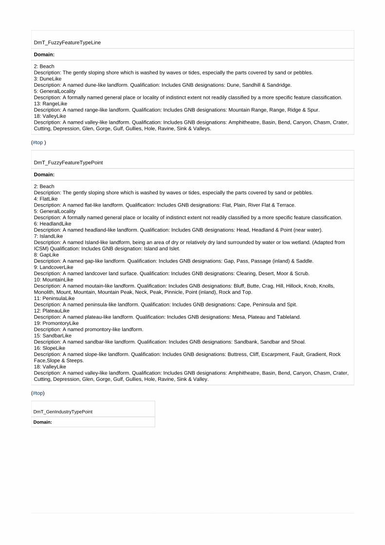
DmT_FuzzyFeatureTypeLine
Domain:
2: Beach Description: The gently sloping shore which is washed by waves or tides, especially the parts covered by sand or pebbles. 3: DuneLike Description: A named dune-like landform. Qualification: Includes GNB designations: Dune, Sandhill & Sandridge. 5: GeneralLocality Description: A formally named general place or locality of indistinct extent not readily classified by a more specific feature classification. 13: RangeLike Description: A named range-like landform. Qualification: Includes GNB designations: Mountain Range, Range, Ridge & Spur. 18: ValleyLike Description: A named valley-like landform. Qualification: Includes GNB designations: Amphitheatre, Basin, Bend, Canyon, Chasm, Crater,Cutting, Depression, Glen, Gorge, Gulf, Gullies, Hole, Ravine, Sink & Valleys.
( )#top
DmT_FuzzyFeatureTypePoint
Domain:
2: Beach Description: The gently sloping shore which is washed by waves or tides, especially the parts covered by sand or pebbles. 4: FlatLike Description: A named flat-like landform. Qualification: Includes GNB designations: Flat, Plain, River Flat & Terrace. 5: GeneralLocality Description: A formally named general place or locality of indistinct extent not readily classified by a more specific feature classification. 6: HeadlandLike Description: A named headland-like landform. Qualification: Includes GNB designations: Head, Headland & Point (near water). 7: IslandLike Description: A named Island-like landform, being an area of dry or relatively dry land surrounded by water or low wetland. (Adapted fromICSM) Qualification: Includes GNB designation: Island and Islet. 8: GapLike Description: A named gap-like landform. Qualification: Includes GNB designations: Gap, Pass, Passage (inland) & Saddle. 9: LandcoverLike Description: A named landcover land surface. Qualification: Includes GNB designations: Clearing, Desert, Moor & Scrub. 10: MountainLike Description: A named moutain-like landform. Qualification: Includes GNB designations: Bluff, Butte, Crag, Hill, Hillock, Knob, Knolls,Monolith, Mount, Mountain, Mountain Peak, Neck, Peak, Pinnicle, Point (inland), Rock and Top. 11: PeninsulaLike Description: A named peninsula-like landform. Qualification: Includes GNB designations: Cape, Peninsula and Spit. 12: PlateauLike Description: A named plateau-like landform. Qualification: Includes GNB designations: Mesa, Plateau and Tableland. 19: PromontoryLike Description: A named promontory-like landform. 15: SandbarLike Description: A named sandbar-like landform. Qualification: Includes GNB designations: Sandbank, Sandbar and Shoal. 16: SlopeLike Description: A named slope-like landform. Qualification: Includes GNB designations: Buttress, Cliff, Escarpment, Fault, Gradient, RockFace,Slope & Steeps. 18: ValleyLike Description: A named valley-like landform. Qualification: Includes GNB designations: Amphitheatre, Basin, Bend, Canyon, Chasm, Crater,Cutting, Depression, Glen, Gorge, Gulf, Gullies, Hole, Ravine, Sink & Valley.
( )#top
DmT_GenIndustryTypePoint
Domain:
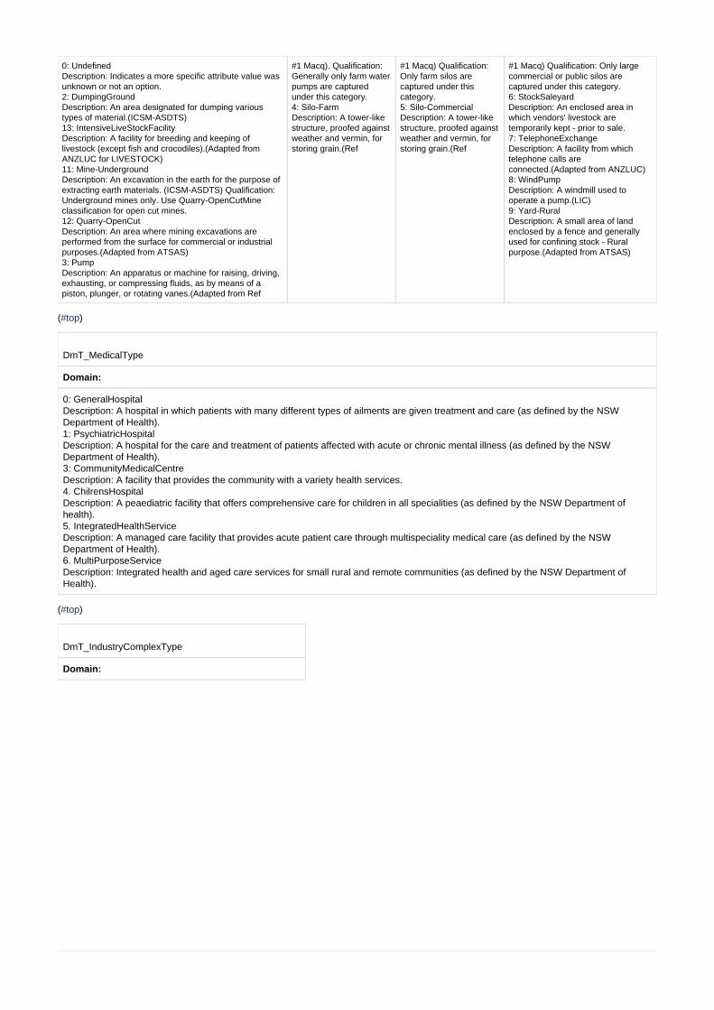
0: Undefined Description: Indicates a more specific attribute value wasunknown or not an option. 2: DumpingGround Description: An area designated for dumping varioustypes of material.(ICSM-ASDTS) 13: IntensiveLiveStockFacility Description: A facility for breeding and keeping oflivestock (except fish and crocodiles).(Adapted fromANZLUC for LIVESTOCK) 11: Mine-Underground Description: An excavation in the earth for the purpose ofextracting earth materials. (ICSM-ASDTS) Qualification:Underground mines only. Use Quarry-OpenCutMineclassification for open cut mines. 12: Quarry-OpenCut Description: An area where mining excavations areperformed from the surface for commercial or industrialpurposes.(Adapted from ATSAS) 3: Pump Description: An apparatus or machine for raising, driving,exhausting, or compressing fluids, as by means of apiston, plunger, or rotating vanes.(Adapted from Ref
#1 Macq). Qualification:Generally only farm waterpumps are capturedunder this category. 4: Silo-Farm Description: A tower-likestructure, proofed againstweather and vermin, forstoring grain.(Ref
#1 Macq) Qualification:Only farm silos arecaptured under thiscategory. 5: Silo-Commercial Description: A tower-likestructure, proofed againstweather and vermin, forstoring grain.(Ref
#1 Macq) Qualification: Only largecommercial or public silos arecaptured under this category. 6: StockSaleyard Description: An enclosed area inwhich vendors' livestock aretemporarily kept - prior to sale. 7: TelephoneExchange Description: A facility from whichtelephone calls areconnected.(Adapted from ANZLUC) 8: WindPump Description: A windmill used tooperate a pump.(LIC) 9: Yard-Rural Description: A small area of landenclosed by a fence and generallyused for confining stock - Ruralpurpose.(Adapted from ATSAS)
( )#top
DmT_MedicalType
Domain:
0: GeneralHospital Description: A hospital in which patients with many different types of ailments are given treatment and care (as defined by the NSWDepartment of Health). 1: PsychiatricHospital Description: A hospital for the care and treatment of patients affected with acute or chronic mental illness (as defined by the NSWDepartment of Health). 3: CommunityMedicalCentre Description: A facility that provides the community with a variety health services. 4. ChilrensHospital Description: A peaediatric facility that offers comprehensive care for children in all specialities (as defined by the NSW Department ofhealth). 5. IntegratedHealthService Description: A managed care facility that provides acute patient care through multispeciality medical care (as defined by the NSWDepartment of Health). 6. MultiPurposeService Description: Integrated health and aged care services for small rural and remote communities (as defined by the NSW Department ofHealth).
( )#top
DmT_IndustryComplexType
Domain:

0: Undefined Description: Indicates a more specific attribute valuewas unknown or not an option. 1: Abattoir Description: A facility for slaughtering animals, boning,freezing, preserving or packing meat, canning meat,manufacturing meals from abattoir by-products orrendering lard or tallow.(Adapted from ANZLUC forMEAT PROCESSING) 2: Brickworks Description: A facility for manufacturing claybricks.(Adapted from ANZLUC for CLAY BRICKMANUFACTURING) 3: Co-operative Description: A business undertaking owned andcontrolled by its members, and formed to provide themwith work or with goods at advantageousprices.(Adapted from Macq for COOPERATIVESOCIETY) 4: Depot Description: A facility used for the coordination ofmaintenance activities and compound for equipmentstorage. The storage of construction / maintenancematerials for roads or railways are included.(Adaptedfrom ANZLUC for WORKS DEPOT) 5: Depot-NRMA Description: An office or the depot of the NRMA.Qualification: Legacy feature type. Limitedmaintenance. 6: Factory Description: A building or group of buildings, usuallywith equipment, where goods are manufactured.(Ref
#1 Macq) 7: Homestead Description: A main residence ona horticultural or agriculturalfarm. (ICSM) The main residenceand associated facilities of afarm.(Adapted from Ref
#1 Macq for HOMESTEAD) 8: ResearchStation Description: A facility used primarily forscientific research and/or environmentalmonitoring.(Adapted from ANZLUC forSCIENTIFIC RESEARCH ANDMONITORING AREA) 9: Shipyard Description: A facility for manufacturing andrepairing vessels.(Adapted from ANZLUCfor SHIPBUILDING) 10: ShoppingCentre Description: A facility for integrated retailingof new or used goods and/or businessservices to final consumers for personal orhousehold consumption.(Adapted fromANZLUC for RETAIL TRADE)
( )#top
DmT_NameSource
Domain:
0: Undefined Description: Indicates the source of a road name is unknown. 1: GNB Submission Description: Indicates the source of a road name is from a name submission to GNB 2: Unsubstantiated Document / Data Description: Indicates the source of a road name is from an document or data supply but road names therein are unsubstantiated. 3: Govt Agency Document / Data Description: Indicates the source of a road name is from a government agency document or data supply 4: DCDB Roads layer Description: Indicates the source of a road name is from a DCDB feature class 5: Field Update / Signpost Description: Indicates the source of a road name is from field update and/or roadside signpost 6: Road Custodian Document / Data Description: Indicates the source of a road name is from a document or data supply from the road's custodian. Qualification: Does notinclude road names sourced from local government or RMS as these are classified separately. 7: RMS custodian Document / Data Description: Indicates the source of a road name is from a document or data supply from the road's custodian being the RMS.8: Local Govt Approved Document / Data Description:Indicates the source of a road name is from a document or data supply from the road's custodian being the local governmentauthority.9: GURAS Validated Description: Indicates the source of a road name has been validated by a GURAS group member. Qualification: In rare cases GURAS mayuse the addressable road name in preference to the gazetted road name. 10: Gazettal Description: Indicates the source of a road name is from a Gazettal.
( )#top
DmT_Perenniality
Domain:
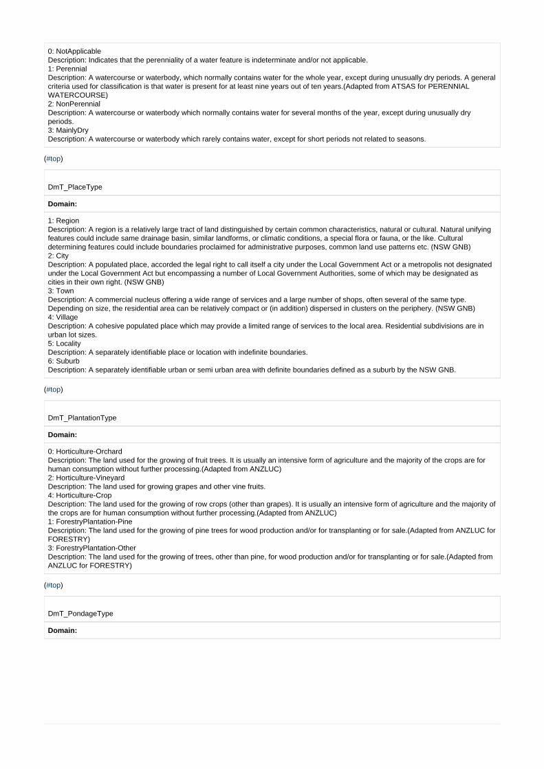
0: NotApplicable Description: Indicates that the perenniality of a water feature is indeterminate and/or not applicable. 1: Perennial Description: A watercourse or waterbody, which normally contains water for the whole year, except during unusually dry periods. A generalcriteria used for classification is that water is present for at least nine years out of ten years.(Adapted from ATSAS for PERENNIALWATERCOURSE) 2: NonPerennial Description: A watercourse or waterbody which normally contains water for several months of the year, except during unusually dryperiods. 3: MainlyDry Description: A watercourse or waterbody which rarely contains water, except for short periods not related to seasons.
( )#top
DmT_PlaceType
Domain:
1: Region Description: A region is a relatively large tract of land distinguished by certain common characteristics, natural or cultural. Natural unifyingfeatures could include same drainage basin, similar landforms, or climatic conditions, a special flora or fauna, or the like. Culturaldetermining features could include boundaries proclaimed for administrative purposes, common land use patterns etc. (NSW GNB) 2: City Description: A populated place, accorded the legal right to call itself a city under the Local Government Act or a metropolis not designatedunder the Local Government Act but encompassing a number of Local Government Authorities, some of which may be designated ascities in their own right. (NSW GNB) 3: Town Description: A commercial nucleus offering a wide range of services and a large number of shops, often several of the same type.Depending on size, the residential area can be relatively compact or (in addition) dispersed in clusters on the periphery. (NSW GNB) 4: Village Description: A cohesive populated place which may provide a limited range of services to the local area. Residential subdivisions are inurban lot sizes. 5: Locality Description: A separately identifiable place or location with indefinite boundaries.6: Suburb Description: A separately identifiable urban or semi urban area with definite boundaries defined as a suburb by the NSW GNB.
( )#top
DmT_PlantationType
Domain:
0: Horticulture-Orchard Description: The land used for the growing of fruit trees. It is usually an intensive form of agriculture and the majority of the crops are forhuman consumption without further processing.(Adapted from ANZLUC) 2: Horticulture-Vineyard Description: The land used for growing grapes and other vine fruits. 4: Horticulture-Crop Description: The land used for the growing of row crops (other than grapes). It is usually an intensive form of agriculture and the majority ofthe crops are for human consumption without further processing.(Adapted from ANZLUC) 1: ForestryPlantation-Pine Description: The land used for the growing of pine trees for wood production and/or for transplanting or for sale.(Adapted from ANZLUC forFORESTRY) 3: ForestryPlantation-Other Description: The land used for the growing of trees, other than pine, for wood production and/or for transplanting or for sale.(Adapted fromANZLUC for FORESTRY)
( )#top
DmT_PondageType
Domain:

0: SettlingPond Description: Shallow beds, usually segmented by constructed walls, for the treatment of sewage or other wastes. (ICSM) 1: WaterFiltrationBed Description: Shallow beds, usually segmented by constructed walls, for the treatment of water. (adapted from ICSM) 2: SwimmingPool-PublicOrCommercial Description: An enclosed or artificial pool, for swimming in, for public use. ie. Not a domestic swimming Pool. Qualification: This is theactual waterbody - not the facility. 3: SwimmingPool-Domestic Description: An enclosed or artificial pool, for swimming in, for domestic/private use only. ie. Not a public or commercial swimming pool. Qualification: Although included in data model, domestic pools are not currently captured.
( )#top
DmT_PosRelativeToGround
Domain:
0: Undefined Description: Indicates a more specific attribute value was unknown or not an option. 1: OnGround Description: Indicates a section of a utility network that lays on the ground surface. ie. Not affected by an associated structure such asbridge or tunnel. 2: BelowGround Description: That part of a feature that is below the surface of the ground. 3: Elevated Description: That part of a feature that is elevated above the normal surface of the ground. eg. On a bridge or supported on piers.
( )#top
DmT_RaceTrackType
Domain:
0: Undefined Description: Indicates a more specific attribute value was unknown or not an option. 1: AthleticsTrack Description: Self Explanatory 2: MotorRacingTrack Description: A track constructed for racing motorised vehicles. 3: CyclingTrack Description: A track designed for bicycle racing. Eg. velodrome 4: TrottingTrack Description: A track primarily used for the training or racing of trotting horses. 5: Racecourse Description: A place which has been licensed by government for the holding of horse races. (NSW GNB)
6: TrainingTrack Description: A track primarily used for the training of horses. 7: BMX_Track Description: A track for racing or recreational use of BMX bikes. 8: DogTrack Description: A track designed for dog racing.
( )#top
DmT_RailOnType
Domain:
1: OnGround Description: Indicates a section of a rail network that lays on the ground surface. ie. Not affected by an associated structure such as bridgeor tunnel. 2: OnBridge Description: Indicates a section of a rail network that is supported by a bridge or overpass. 3: InTunnel Description: Indicates a section of a rail network that passes underground or through a tunnel. 4: OnCulvert Description: Indicates a section of a rail network that passes over a major culvert.
( )#top

DmT_RailwayGauge
Domain:
0: Undefined Description: Indicates a more specific attribute value was unknown or not an option.
1: Standard Description: A railway gauge of 1.435 metres 2: Narrow Description: Any railway gauge less than 1.435 metres
( )#top
DmT_RecComplexType
Domain:
0: Undefined Description: Indicates a more specific attribute value was unknown or not an option. 2: CaravanPark Description: An area maintained for the parking of inhabited mobile homes. Qualification: This classification generally for recreationalpurposes. Long term 'Relocatable Mobile Homes' are classified separately. (DTDB Technical Manual) 3: Club Description: A facility used for providing hospitality services to members. The provision of food and beverages is a major activity. This mayinclude providing gambling, sporting and other social entertainment facilities.(Adapted from ANZLUC for CLUBS) 12: SportsCentre Description: A group of interconnected buildings and other facilities designed for playing of various sports.(Macq for SPORTS COMPLEX) 15: SwimmingPoolFacility Description: A facility with an enclosed or artificial pool, for swimming in. Qualification: Includes sea baths. The actual pool(s) may be heldas GeneralCulturalPoint or GeneralCulturalArea - ClassSubtype - Pondage 17: TouristAttraction Description: Land used for non-residential premises designed to attract tourists, including but not limited to tourist accommodationassociated with any of the uses. Examples: artefacts display and sale, feature building, fun park, hand weaving and sales, historicbuildings and machinery, pioneer village, plantation with tour facilities, pottery works and sales, rural industry display and sale, sanctuaryand animal park and ski slope.(ANZLUC) 18: Zoo Description: A place where wild animals are kept for exhibition and study.
( )#top
DmT_RelativeHeightRange
Domain:
0: MinValue Description: The minimum allowed value of a range. 1000: MaxValue Description: The maximum allowed value of a range.
( )#top
DmT_RelativeSignificanceRange |
Domain:
1: MinValue Description: The minimum allowed value of the range. Generally applies to features of highest significance. 10: MaxValue Description: The maximum allowed value of the range. Applies to features of lowest significance and is the default value.
( )#top
DmT_RestrictedAreaType
Domain:

0: Undefined Description: Indicates a more specific attribute value was unknown or not an option. 1: Defence Description: A restricted area designated for defence purposes. 2: Catchment Description: A drainage catchment area designated as having restricted public access. 3: SubmarineCableProtectionZone Description: An area designated as a restricted zone to provide protection for submarine cables from damage by commercial orrecreational activity.
( )#top
DmT_RoadFunctionHierarchy
Domain:
1: Motorway Description: A high traffic volume, high speed road, generally comprising dual carriageway and having full access control and gradeseparated intersections. Ie. no direct access from adjoining properties or side roads and all crossings are by means of overpass orunderpass bridges with traffic entering or leaving by means of ramps. Qualification: These roads may or may not be officially 'declared'motorway, freeway or expressway. 2: PrimaryRoad Description: Roads that are of importance in a national sense, and/or are a major intrastate through route, and/or are principal connectorroads between Capitals and/or major regions and/or key towns. (Adapted from ICSM proposal) Qualification: Most of these roads areNational or State Highways but there may be some exceptions. 3: ArterialRoad Description: A road which is the major connector between Freeways, and/or National or State Highways, and/or major centres, and/or keytowns, or have major tourist importance or which the main function is to form the principle avenue of travel for metropolitan trafficmovements not catered for by roads of a higher functional status. (Adapted from ICSM proposal) 4: SubArterialRoad Description: A road which acts as a connector between primary and/or arterial roads, or an alternate route for arterial roads, or thecommonly used link between smaller localities or a principal avenue for massive traffic movements not catered for by roads of a higherfunctional status. (Adapted from ICSM proposal) 5: DistributorRoad Description: A road which provides for major traffic movement between roads of a higher order or to distribute traffic to local streetsystems. (adapted from ICSM proposal) 6: LocalRoad Description: A sealed or improved unsealed road (not a vehicular track or urban service lane) providing property access. 7: UrbanServiceLane Description: A road in an urban environment that does not service a building frontage and only has one traffic lane. Generally these areservice lanes to access the back of a property and they are not utilised for a postal address. 8: Track-Vehicular Description: An unimproved road, the construction of which is minimal. Also included are driveways, regardless of construction.Qualification: These roads are generally only passable in two-wheel drive vehicles during fair weather and are used predominantly by localtraffic. If the road's surface is attributed as Unsealed: Four-Wheel Drive then the road is only suitable for Four-Wheel Drive type vehicles.Roads classified as Track-Vehicular are a subset of the RoadSegment subtype VehicularTrack. The difference being VehicularTrack is aclassification of road physical form, whereas Track-Vehicular is part of a classification based on highest function. eg. A VehicularTrackmay be functionally a Sub-arterial road. 9: Path Description: A track which is not capable of and/or not permitted to carry vehicular traffic. Generally for use by pedestrians, horse ridersand/or cyclists. Qualification: This is theoretically a replication of RoadSegment class subtype Pathway. 10:DedicatedBusWay Description: A road which has been dedicated as a rapid bus-only transit way. Qualification: Only buses, emergency vehicles and other authorised vehicles carrying special permits are allowed to use these roads. Thisclassification does not include those Tways that are merely a bus-only lane of a shared road. 11: AccessWay Description: A vehicular road/track generally only accessible by major service providers to maintain their infrastructure, and emergencyservice agencies. Qualification: The practical operability of these roads is unknown. In some cases there may be no physical formation. eg. AccessWay maybe an unmarked route across a sports field or car park. Many AccessWays are affected by locked gates.
( )#top
DmT_RoadLanesClassification
Domain:
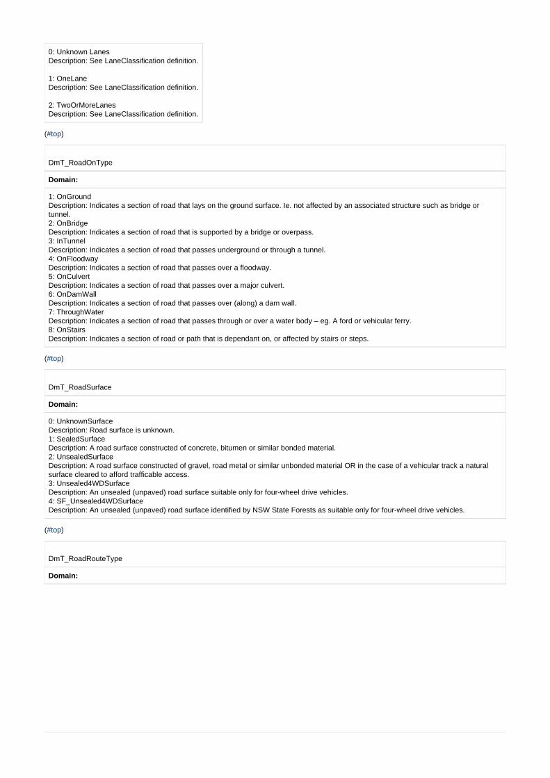
0: Unknown Lanes Description: See LaneClassification definition.
1: OneLane Description: See LaneClassification definition.
2: TwoOrMoreLanes Description: See LaneClassification definition.
( )#top
DmT_RoadOnType
Domain:
1: OnGround Description: Indicates a section of road that lays on the ground surface. Ie. not affected by an associated structure such as bridge ortunnel. 2: OnBridge Description: Indicates a section of road that is supported by a bridge or overpass. 3: InTunnel Description: Indicates a section of road that passes underground or through a tunnel. 4: OnFloodway Description: Indicates a section of road that passes over a floodway. 5: OnCulvert Description: Indicates a section of road that passes over a major culvert. 6: OnDamWall Description: Indicates a section of road that passes over (along) a dam wall. 7: ThroughWater Description: Indicates a section of road that passes through or over a water body – eg. A ford or vehicular ferry. 8: OnStairs Description: Indicates a section of road or path that is dependant on, or affected by stairs or steps.
( )#top
DmT_RoadSurface
Domain:
0: UnknownSurface Description: Road surface is unknown. 1: SealedSurface Description: A road surface constructed of concrete, bitumen or similar bonded material. 2: UnsealedSurface Description: A road surface constructed of gravel, road metal or similar unbonded material OR in the case of a vehicular track a naturalsurface cleared to afford trafficable access. 3: Unsealed4WDSurface Description: An unsealed (unpaved) road surface suitable only for four-wheel drive vehicles. 4: SF_Unsealed4WDSurface Description: An unsealed (unpaved) road surface identified by NSW State Forests as suitable only for four-wheel drive vehicles.
( )#top
DmT_RoadRouteType
Domain:
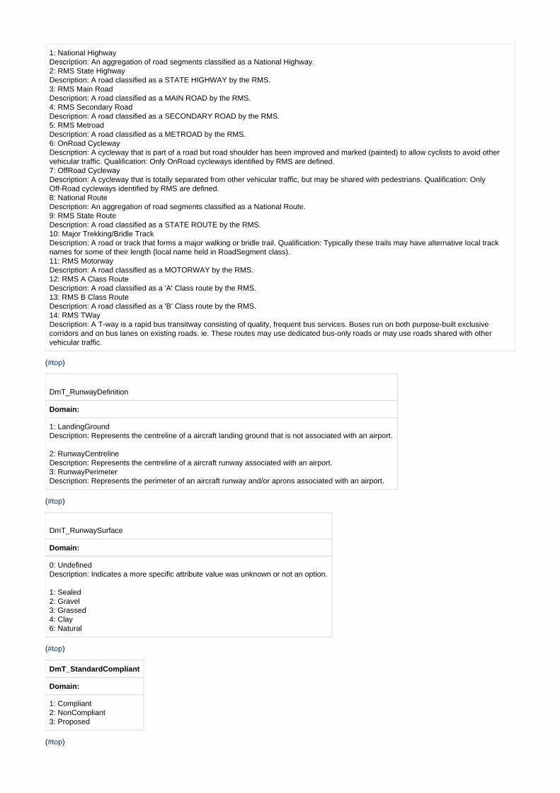
1: National Highway Description: An aggregation of road segments classified as a National Highway. 2: RMS State Highway Description: A road classified as a STATE HIGHWAY by the RMS. 3: RMS Main Road Description: A road classified as a MAIN ROAD by the RMS. 4: RMS Secondary Road Description: A road classified as a SECONDARY ROAD by the RMS. 5: RMS Metroad Description: A road classified as a METROAD by the RMS. 6: OnRoad Cycleway Description: A cycleway that is part of a road but road shoulder has been improved and marked (painted) to allow cyclists to avoid othervehicular traffic. Qualification: Only OnRoad cycleways identified by RMS are defined. 7: OffRoad Cycleway Description: A cycleway that is totally separated from other vehicular traffic, but may be shared with pedestrians. Qualification: OnlyOff-Road cycleways identified by RMS are defined. 8: National Route Description: An aggregation of road segments classified as a National Route. 9: RMS State Route Description: A road classified as a STATE ROUTE by the RMS. 10: Major Trekking/Bridle Track Description: A road or track that forms a major walking or bridle trail. Qualification: Typically these trails may have alternative local tracknames for some of their length (local name held in RoadSegment class). 11: RMS Motorway Description: A road classified as a MOTORWAY by the RMS. 12: RMS A Class Route Description: A road classified as a 'A' Class route by the RMS. 13: RMS B Class Route Description: A road classified as a 'B' Class route by the RMS. 14: RMS TWay Description: A T-way is a rapid bus transitway consisting of quality, frequent bus services. Buses run on both purpose-built exclusivecorridors and on bus lanes on existing roads. ie. These routes may use dedicated bus-only roads or may use roads shared with othervehicular traffic.
( )#top
DmT_RunwayDefinition
Domain:
1: LandingGround Description: Represents the centreline of a aircraft landing ground that is not associated with an airport.
2: RunwayCentreline Description: Represents the centreline of a aircraft runway associated with an airport. 3: RunwayPerimeter Description: Represents the perimeter of an aircraft runway and/or aprons associated with an airport.
( )#top
DmT_RunwaySurface
Domain:
0: Undefined Description: Indicates a more specific attribute value was unknown or not an option.
1: Sealed 2: Gravel 3: Grassed 4: Clay 6: Natural
( )#top
DmT_StandardCompliant
Domain:
1: Compliant 2: NonCompliant 3: Proposed
( )#top

DmT_StorageSubstanceType
Domain:
0: Undefined Description: Indicates a more specific attribute value was unknown or not an option.
1: Water Description: Self Explanatory 2: Gas Description: Self Explanatory 3: Petroleum Description: The type of substance stored or conveyed is a petroleum product. 4: Waste Description: Self Explanatory
( )#top
DmT_SymbolRotation
Domain:
-180: MinValue 180: MaxValue
( )#top
DmT_TopoID_Range
Domain:
0: MinValue Description: The theoretical minimum value of TopoIDs. Qualification: While zero (0) is within the range it is a reserved value indicating aTopoID has not been allocated. 999999999: MaxValue Description: The theoretical maximum value of TopoIDs.
( )#top
DmT_Tower_Type
Domain:
0: Undefined Description: Indicates a more specific attribute value was unknown or not an option. 1: Communication Description: A tower used for transmitting and/or receiving electronic communication signals. 2: Observation Description: A tower used for observation. 3: Intake Description: A type of tower where water, air or other gases are ingested. 4: Chimney Description: A structure containing a passage or flue for discharging smoke and gases from combustion. (ICSM)
5: WindGenerator Description: A tower for wind powered electricity generation.
( )#top
DmT_Undefined
Domain:
0: Undefined Description: Indicates a more specific attribute value was unknown or not an option.
( )#top
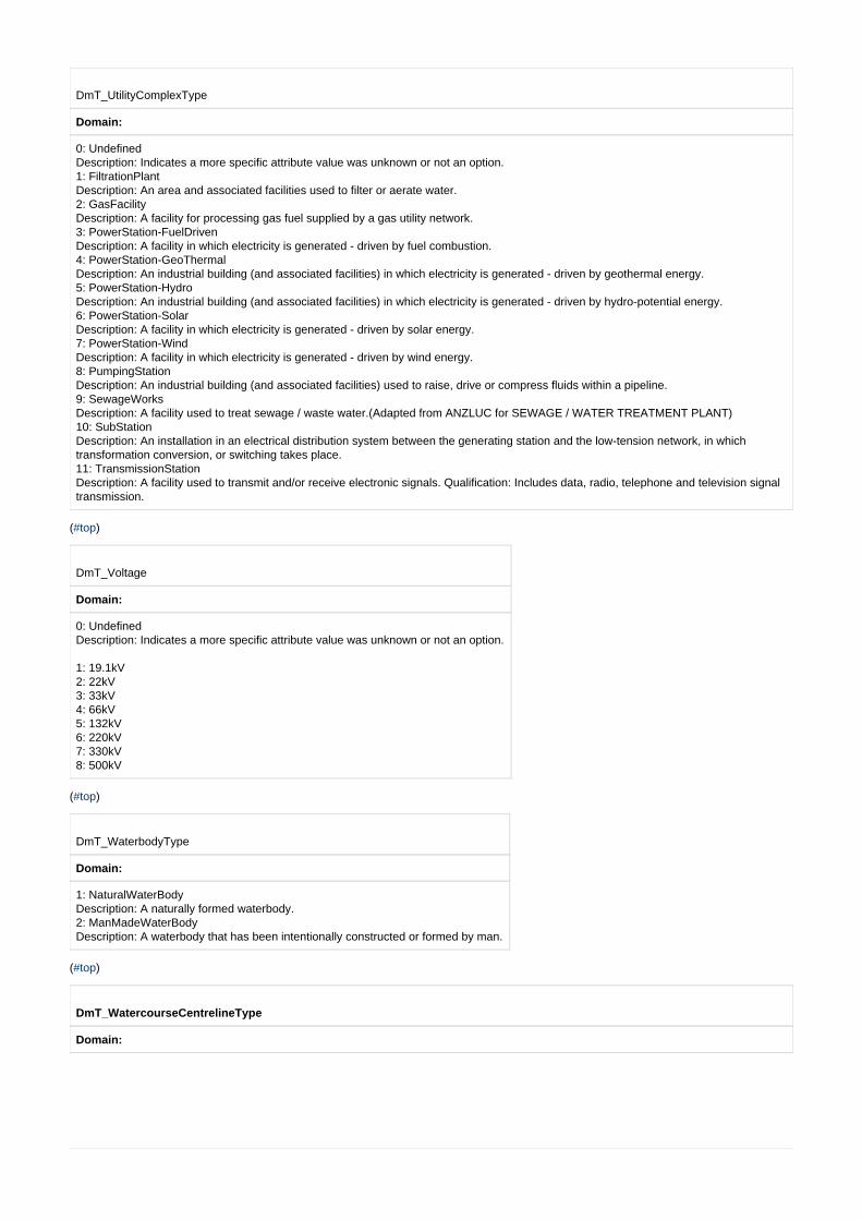
DmT_UtilityComplexType
Domain:
0: Undefined Description: Indicates a more specific attribute value was unknown or not an option. 1: FiltrationPlant Description: An area and associated facilities used to filter or aerate water. 2: GasFacility Description: A facility for processing gas fuel supplied by a gas utility network. 3: PowerStation-FuelDriven Description: A facility in which electricity is generated - driven by fuel combustion. 4: PowerStation-GeoThermal Description: An industrial building (and associated facilities) in which electricity is generated - driven by geothermal energy. 5: PowerStation-Hydro Description: An industrial building (and associated facilities) in which electricity is generated - driven by hydro-potential energy. 6: PowerStation-Solar Description: A facility in which electricity is generated - driven by solar energy. 7: PowerStation-Wind Description: A facility in which electricity is generated - driven by wind energy. 8: PumpingStation Description: An industrial building (and associated facilities) used to raise, drive or compress fluids within a pipeline. 9: SewageWorks Description: A facility used to treat sewage / waste water.(Adapted from ANZLUC for SEWAGE / WATER TREATMENT PLANT) 10: SubStation Description: An installation in an electrical distribution system between the generating station and the low-tension network, in whichtransformation conversion, or switching takes place. 11: TransmissionStation Description: A facility used to transmit and/or receive electronic signals. Qualification: Includes data, radio, telephone and television signaltransmission.
( )#top
DmT_Voltage
Domain:
0: Undefined Description: Indicates a more specific attribute value was unknown or not an option.
1: 19.1kV 2: 22kV 3: 33kV 4: 66kV 5: 132kV 6: 220kV 7: 330kV 8: 500kV
( )#top
DmT_WaterbodyType
Domain:
1: NaturalWaterBody Description: A naturally formed waterbody. 2: ManMadeWaterBody Description: A waterbody that has been intentionally constructed or formed by man.
( )#top
DmT_WatercourseCentrelineType
Domain:

0: Undefined Description: Indicates a more specific attribute value was unknown or not an option. 1: NaturalWatercourse Description: A naturally formed, watercourse. 3: Canal-Drain Description: An artificial (built) watercourse to convey water and/or to allow transportation upon.(DTDB Technical Manual) 4: Race Description: A narrow artificial channel to carry water to a water mill or mine wash. 5: Spillway Description: A constructed path or channel for excess water to pass over or beside a dam.(ICSM-ASDTS) 6: Tunnel-Siphon Description: An underground watercourse conveying water that has direct association with the hydrographic network. Also included aresiphons which is a man made or natural conduit in the form of an inverted U shape and filled until gravitational force or atmosphericpressure is sufficient to force water in one end of the pipe and out the other end thus conducting water beneath a depressed place.
( )#top
DmT_WatercourseType
Domain:
1: NaturalWaterCourse Description: A naturally formed watercourse. 2: Canal-Drain Description: An artificial (built) watercourse to convey water and/or to allow transportation upon.(DTDB Technical Manual)