topography, astronomy and dynastic history in …arian, b=abu gorab, s=abu sir, q=saqqara main field...
TRANSCRIPT

Mediterranean Archaeology and Archaeometry, Vol. 10, No.2, pp. 59‐74 Copyright © 2010 MAA
Printed in Greece. All rights reserved.
TOPOGRAPHY, ASTRONOMY AND DYNASTIC HISTORY IN THE ALIGNMENTS OF THE PYRAMID FIELDS
OF THE OLD KINGDOM Magli, G.
Faculty of Civil Architecture ‐ Politecnico di Milano, Piazza Leonardo da Vinci 32, 20133 Milan, Italy
Received: 12/10/2009 Accepted: 16/01/2010
Corresponding author: [email protected]
ABSTRACT It is known since the 19 century that in the layout of the pyramid field of the pharaohs of the 4th
Egyptian dynasty at Giza, a “main axis” exists. Indeed, the south‐east corners of these monuments align towards the site of the temple of Heliopolis, which was plainly visible in ancient times. It was later discovered that a similar situation occurs in the main pyramid field of the subsequent dynasty at Abu Sir. Here, the north‐west corners of three chronologically successive pyramids again volun‐tarily align towards Heliopolis. However, the temple was in this case not visible, due to the rock outcrop‐ today occupied by the Cairo citadel ‐ which blocks the view. In the present paper, a inter‐disciplinary approach based on historical, topographical and archaeoastronomical analysis is devel‐oped in an attempt at understanding such peculiar features, which governed from the very begin‐ning the planning of these wonderful monuments. A general pattern actually arises, which appears to have inspired the choice of the sites and the disposition on the ground of almost all the funerary complexes of the kings during the Old Kingdom. In particular, this pattern helps to explain the choices in the location of the funerary complexes of Niuserre in Abusir, of Unas in Saqqara and of the kings of the 6th dynasty at south Saqqara.
KEYWORDS: Giza pyramids, Abusir pyramids, Saqqara pyramids, Sacred Landscape, Ancient Astron‐omy

MAGLI, G. 60
1. INTRODUCTION An interesting feature exists in the layouts of
the pyramids of Giza and Abu Sir: the presence of a “main axis” directed to the area where the ancient temple of the sun of Heliopolis once stood, on the opposite bank of the Nile. These axes are connected with a process of “so‐larisation” of the pharaoh which probably started with Khufu, the builder of the Great Pyramid. At Giza, the axis (already discovered in the 18th century) runs across the south‐east corners of the main pyramids (Goedicke 2001, Lehner 1985a,b, Magli 2009a,b). In Abu Sir, a straight line connects the north‐west corners of the pyramids of three successive kings (Verner 2002). However, the view to Heliopolis is blocked here by the rock outcrop of the Cairo citadel (Jeffreys 1998). This “alignment” is, therefore, quite mysterious: its intentionality and relation‐ship with the cult of the sun are certain, but its aim seems to be failed. As a consequence, the very choice of the site of Abusir by the kings of the 5th dynasty remains unexplained (see dis‐cussions in Krejci 2001, Goedicke 2001).
The research presented here originally started as an attempt at solving this enigma; however, it turned out that what was necessary was a careful topographical and archaeoastronomical analysis of the whole set of monuments built between the 4th and the 6th dynasty, accurately taking into ac‐count what was known historically and archaeo‐logically about them. In the course of such an analysis, a general pattern was seen to arise, which inspired the location and planning of al‐most all monuments and in particular led to the choice of the Abu Sir plateau. This pattern ‐ which I will call, for a reason which will be clear soon, symbolic invisibility ‐ is based on a set of ra‐dial lines (“diagonals”) which connect in a ideal way Heliopolis with the sacred landscape built on the opposite bank of the Nile. Its origins ap‐pears to be connected with the ancient Egyptians’ religion, funerary cult and dynastic lineage, as well as with their astronomical knowledge. Fur‐ther, as we shall see, the idea of connecting a new funerary monument with the existing ones by means of “topographical alignments” remained alive also in the later times of the Old Kingdom, during the end of the 5th dynasty and the run of
the 6th. It lost, however, the “solar” character of connection towards Heliopolis.
Fig. 1 Map of the main Giza pyramids with the Giza
axis highlighted (from Lehner 1999)
Fig. 2 Map of the Abu Gorab ‐ Abu Sir area with the “Abu Sir diagonals” highlighted (numbering of the monuments in chronological order). 1‐ Userkaf Sun temple, 2/3/4 Pyramids of Sahure, Neferirkare, Nefere‐fre 5‐unfinished pyramid of Shepseskare 6a/6b/6c Niuserre Pyramid, Mastaba of Ptahshepses, Niuserre
Sun temple.
2. THE GEOGRAPHY OF THE MEMPHITE AREA AND THE HORIZON FORMULA
The geographical area of interest in the pre‐sent paper can be visualized as a triangle (Fig. 3). The western leg of the triangle follows the rock ridge of the desert on the west bank of the Nile from Abu Roash (A) to Abu Gorab (B) crossing Giza (G) and Zawiet el Arian (Z) , while the other two legs are defined by the posi‐

TOPOGRAPHY, ASTRONOMY AND DYNASTIC HISTORY IN THE ALIGNMENTS OF THE PYRAMID FIELDS 61
tion (H) of ancient Heliopolis, located on the east bank of the Nile (to visualize this area I have chosen as A the center of Djedefre Pyra‐mid, as B the center of the Userkaf Sun Temple and as H the position of the Middle Kingdom obelisk in the Heliopolis area). The leg H‐A is about 25 Kms long and crosses the flatland of the Nile valley; the leg H‐B is about 27.5 Kms long; it also crosses the Nile flatland but it is “tangent” to the rock outcrop located at the north‐west extreme of the Moqattam formation. This outcrop is today occupied by the Cairo citadel (K). Important in what follows will be also Abu Sir (S) which is a plateau located on the ridge of the desert some hundreds of meters south of Abu Gorab, the pyramid field of Saqqara (Q) further south, and the site of the Old Kingdom capital Memphis (M).
Fig. 3 The geographical area of interest. H=Heliopolis, K= Cairo Citadel, A=Abu Roash, G=Giza, Z=Zawiet el Arian, B=Abu Gorab, S=Abu Sir, Q=Saqqara main
field, M=Memphis
We shall concentrate here on the issue of mu‐tual visibility/invisibility between Heliopolis and the above‐mentioned sites. Since it is easy to find non‐scholarly publications where ancient monuments are allegedly supposed to be con‐nected by “invisible lines”, it is perhaps worth clarifying that the present work has nothing to do with most such speculations. Usually indeed they have little sense either because the sup‐posed lines are drawn on a plane chart (while the earth happens to be round) or because they connect sites which do not have any historical connections whatsoever (or because of both rea‐sons together). In the present paper, monu‐ments built in a relatively short period of time
by dynastically related rulers are discussed, and the specific issue of inter‐visibility is carefully addressed every time a interconnecting line is proposed. To this aim, we first notice that, as mentioned, the Moqattam formation blocks the view between H and any zone further south than Abu Gorab, the first of the invisible zones being the Abu Sir area. The leg HB is therefore the last possible inter‐visibility line from H to the west bank looking south. The triangle HAB includes only flat land and therefore there exists a theoretical inter‐visibility between all its points, in particular between H and places on the A‐B leg. Due to the relevant distances which come into play however, we have to take into account earthʹs curvature. To this aim, we briefly recall the so‐called horizon formula (actu‐ally a straightforward consequence of Pythago‐rasʹ theorem, see Fig. 4).
Fig. 4 The horizon formula
Given a point P located at vertical height h with respect to the earth surface P’, the farther‐most point W that can be seen from P is the point where passes the tangent to the earth circumfer‐ence from P. Clearly then the distance d=PW equals √(2rh+h²) where r is the earth radius. If the heights are very small with respect to r we can put d~√(2rh). Since 2r~13000 Km, we arrive at the so‐called “horizon formula”: the value of d in Kms approximately equals the square root of 13h if h is expressed in meters. It follows, for in‐stance, that a person 2 meters tall has a visible horizon slightly greater than 5 Kms. However, if the object sighted has a non negligible height, then the two sum up. As a consequence, a sun‐reflecting signal located in Heliopolis at ‐ say ‐ 20 meters above ground would have been easily visible from the west ridge, located at an average

MAGLI, G. 62
of some 20 meters above the plain. Such a signal might have been located e.g. on the “Petrieʹs mound”, a symbolic “primeval mound” which was probably there since the first dynasties (for a complete discussion on Heliopolis see Quirke 2001 and references therein) or, more simply, on an observation post located at the top of a provi‐sional wooden structure. Once the building sites of the pyramids reached a sufficient height, the upper courses became inter‐visible with Heliopo‐lis. The fascinating view of the Giza pyramids from Heliopolis was still enjoyable at the end of the 19‐century, as confirmed by some paintings of that times; attempts at a direct observation are doomed to failure today, due to modern build‐ings and pollution which strongly limits visibil‐ity.
3. GEOGRAPHICAL AND CHRONO‐LOGICAL ORDER OF THE MONUMENTS
In what follows we shall be interested in al‐most all the pyramidal complexes constructed during the Old Kingdom. The geographical lo‐cation of these monuments and their chrono‐logical order will both be essential (Fig. 5). Be‐fore going further however, it is worth recalling that the chronology of the Old Kingdom is sub‐ject to debates about the length of each single reign and the succession of a few of the kings. As a reliable working framework I follow here strictly the accession dates as given by Baines and Malek (1984) and adopted, for instance, by Lehner (1999).
Fig. 5 The pyramids, the Sun Temples and the Heliopolitan “diagonals” discussed in the paper: (1) Abu Roash diagonal, (2) Giza diagonal, (3) Abusir diagonal. The dotted straight line denotes invisibility. The stepped line
denotes the maximal Nile flood.
The “Age of the Pyramids” starts with the
Step Pyramid in Saqqara, built by the first 3th dynasty pharaoh Djoser (2630‐2611). After him, other pyramids will be built by kings of the same dynasty: the first is Sekhemkhet’s in Saqqara. After, the so‐called Layer Pyramid (Z1) was built at Zawiet el Arian and another very
far south, in Meidum. The attribution of these two is uncertain; the first might have been built by a king called Khaba, the second by Huni or by Snefru in the first years of his reign. Also un‐certain is the attribution of an unfinished, partly mud‐brick pyramid which is located in Abu Roash, the so called Lepsius 1 pyramid (A1);

TOPOGRAPHY, ASTRONOMY AND DYNASTIC HISTORY IN THE ALIGNMENTS OF THE PYRAMID FIELDS 63
anyhow the substructure excavated in the rock points to the end of the 3th /beginning of the 4th dynasty (Swelim 1983). The 4th dynasty begins with Snefru (2575 ‐ 2551), the builder of the two magnificent pyramids located in Dashour (South Saqqara). With the son of Snefru, Khufu, we enter into the period which is of direct inter‐est for us. 1) Khufu (2551 ‐ 2528) builds the Great Pyra‐
mid (G1) in Giza. 2) Djedefre (2528‐2520) builds his pyramid
(A2) in Abu Roash. Djedefre adds the solar “suffix” ‐re to his name, formalizing a proc‐ess of “solarisation” of the king which was certainly initiated by his father Khufu.
3) Khafre (2520 ‐ 2494) builds or finishes building the second pyramid of Giza (G2)1
4) Someone, perhaps an undocumented short‐reign king, starts the building of a huge project, comparable to that of G1, in Zawiet el Arian (Z1).
5) Menkaure ( 2490 ‐ 2472) builds the third pyramid of Giza (G3).
6) Shepsekaf (2472‐2467) appears to break the tradition. Indeed he does not build a pyra‐mid, but a giant Mastaba at Saqqara South (called today Mastaba El Faraun); the exis‐tence of a break in the funerary and reli‐gious customs is reflected also in the phar‐aohʹs title, which does not bring the ʺsolarʺ suffix (for a discussion of different view‐points see Verner 2002).
7) Userkaf (2465 ‐ 2458) returns to the tradi‐tion. He builds a pyramid in Saqqara, sig‐nificantly located as close as possible to the wall of the first pyramid ever constructed, Djoser’s. Userkaf also builds the first sun temple in the zone of Abu Gorab (B1). This temple was composed, like the “standard” pyramid’s two‐temples / causeway com‐plex, by a building set lower down and a monumental access ramp sloping upwards, giving access to a monumental area. Here, a huge stone basement was sustaining a high (non‐monolithic) obelisk. Such a monument was certainly devoted to the Sun God and its plan was probably conceived as a copy of the temple in Heliopolis.
8) Sahure (2458‐2446). With Sahure, whose name means ʺClose to Reʺ, we return to ʺso‐
larisedʺ kings. The pyramid of Sahure is lo‐cated in Abu Sir (S1).
9) Neferirkare (2446 ‐ 2426) builds his pyra‐mid in Abu Sir (S2)
10) Neferefre builds his (unfinished) pyramid in Abu Sir (S3)
11) Shepseskare probably builds his pyramid in Abu Sir (S4) as well (the attribution of this unfinished monument is not certain). It is not completely clear if really this king was the successor of Neferefre or rather vice‐versa, although, as we shall see, the re‐sults of the present paper strongly suggest the first option. In any case both reigns were very short, lasting as a whole 10 years or less (2426‐2416).
12) Niuserre (2416‐2388) builds his pyramid in Abu Sir (S5) and a sun temple (B2) in Abu Gorab. Niuserre was the last king to build his funerary complex in Abu Sir. The last kings of the 5th dynasty will indeed return to Saqqara, as well as all the subsequent pharaohs (Section 8).
4. VISIBILITY, INVISIBILITY, AND SYM‐BOLIC INVISIBILITY
The above list may, at a first glance, lead to conclude that each king decided in a somewhat random way to put his pyramid in one of the available sites on the west bank of the Nile, pro‐vided just that it was not too far from the capital Memphis. Actually, the placement of pyramidal complexes did have to take into account a series of practical factors (Barta 2005) such as presence of nearby stone outcrops ‐ to be transformed into quarries ‐ and accessibility of materials. Perhaps also the presence of the ‐ still active ‐ building site of the pyramid of the preceding pharaoh may have influenced the choice. How‐ever, there is no possible doubt on the fact that, at least in many cases, the pyramids were not constructed were reasonableness would have wanted. A clamorous example is that of the Menkaure pyramid (G3), which has been volun‐tarily built very far in the desert; similarly (and indeed for the very same reason, as we shall see) this holds for the Neferefre pyramid (S3). More generally, it must be remembered that we are speaking here about nothing less than some of

MAGLI, G. 64
the most magnificent, complicated and huge buildings of the whole human history. We do know that such monuments were designed with maniacal accuracy (especially during the 4th dy‐nasty) and that their construction deserved the efforts of thousands of specialized, well feed, skilled workers (Lehner 1999, Hawass 2006). The pyramids were the symbol of the power of the pharaoh over the death and, in reflection, of the continuity of life of the whole country. It is therefore natural to think that their placement was carefully chosen in order to satisfy also to a set of religious, symbolic criteria.
To investigate on such criteria our starting point is the so‐called “Giza diagonal” (Fig. 1). It is an ideal line which connects the south‐east corners of the three Giza pyramids with good accuracy (a line between the G1 and G3 corners leaves the G2 corner about 20 meters to the north). The existence of this line tells us two im‐portant things. The first one is just that the site of Giza was inter‐visible with Heliopolis and that this does not occur by chance: witness is the placement of the three monuments in accor‐dance with such a Heliopolis‐directed “diago‐nal”. The importance of this observation has been enhanced by a comprehensive study of the inter‐visibility between Heliopolis and the pyramids (Jeffreys 1998). In this study it is shown that the sites of the 4th dynasty pyramids whose owners first “declared an affinity” with the sun cult through their monuments and/or their names were chosen in such a way to be visible from Heliopolis. In the same study how‐ever it was also noticed for the first time that Abu Sir ‐ another burial place of “solarised” kings ‐ is not visible from Heliopolis: it actually stands just a few hundreds meters to the south of the last visible point. In spite of this, a Abu Sir “diagonal” ‐ very similar to that of Giza ‐ does exist. It connects the north‐west corners of the pyramids built by Sahure, Neferirkare and Neferefre and it does indeed ʺpointʺ to Heliopo‐lis, in spite of the fact that the place is in itself invisible. The intentionality of this alignment – which was, therefore, obtained using signals located half‐way on the outcrop ‐ has been con‐trolled beyond any possible doubt using transit survey measures (Verner 2002).
The “invisibility” of the Abu Sir diagonal – which governed from the very beginning the topography of three pyramid building sites there ‐ is a first hint that something of impor‐tance has yet to be understood in all this sce‐nario. Another hint comes from a simple obser‐vation. In consequence of the alignment, look‐ing from Heliopolis (or from any other point of the axis) the images of the Giza pyramids create a perspective effect: they “contract” on each other and merge into that of the Great Pyramid. Therefore, it can be said that the G2 and G3 pyramids were planned respecting two con‐straints (Magli 2009): 1) The chosen place is in plain view from
Heliopolis 2) In this place, the two buildings G2 and G3 are
located in the unique available positions which are actually invisible from the town, due to the presence of G1 While point (1) can be explained by the will
of the ruler of writing in the stones his close connection with the Sun God, point (2) seems to await for an explanation. As far as Abu Sir is concerned, the situation is even more intriguing. Indeed, here we have 1) The chosen place is the first available going south to be invisible from Heliopolis
2) In this place, the second and the third suc‐cessive buildings are disposed in such a way to be “symbolically” invisible from Heliopo‐lis. In other words, looking along the “Abu Sir diagonal” they become almost invisible (in the second phase of construction S2 was re‐planned to be higher than S1). To explain this chain of occurrences, I pro‐
pose that they correspond to a way of interpret‐ing and modeling the sacred landscape which ruled the placements of the pyramids of the “so‐larised” kings up to the end of the 5th dynasty. This model, which I propose to call symbolic in‐visibility, required the pyramids of dynastically‐related pharaohs to be built along a line of sight connecting a key element of the layout and then ideally extending up to the temple of Heliopolis. In this way, the direct lineage of the Pharaoh from the Sun God was “actualized” on the
TOPOGRAPHY, ASTRONOMY AND DYNASTIC HISTORY IN THE ALIGNMENTS OF THE PYRAMID FIELDS 65
ground (see the final section for further in‐sights).
To illustrate how the model works, we will now re‐run the succession of the kings men‐tioned earlier, putting in evidence if and how the location of their respective monuments fits into the framework. 1) Khufu selects Giza as the building place for
his pyramid. The Giza plateau is certainly suitable for the enterprise, but there are hints that the place might have been chosen also because it was sacred to the sun since the previous dynasties.
2) The first to conform to the ʺsymbolic invisi‐bilityʺ concept was Djedefre, Khufuʹs son. Indeed, if we plot the line which connects Heliopolis with his pyramidʹs south‐west corner, we see that it crosses near the south‐west corner of the Abu Roash pyramid A2, the so called Lepsius 1, which sits at the easternmost end of the Abu Roash hills. Rather than forming an Akhet sign (two coupled mountains with the sun setting at the center at the solstice) as has been re‐cently suggested (Shaltout et al. 2007) these two pyramids thus form a ʺAbu Roash di‐agonalʺ pointing to Heliopolis.
3) After, Khafre decided to conform himself to the model as well, but returning to Giza; perhaps he appropriated and finished the construction of the second pyramid, but in any case he wanted his tomb to be attached “modestly” to a pre‐existing project, that of Khufu, respecting the symbolic invisibility.
4) The very same choice was made by Menkaure, who arranged the layout of his funerary complex in order to harmonize with the pre‐existing one. The dynastic lineage of Khufu was thus actualized at Giza by the succession – which actually pro‐ceeds into the desert ‐ of the south‐east cor‐ners of G1, G2 and G3
5) The un‐attributed pyramid at Zawiet el Ar‐ian does not fit this scenario; some authors attribute it to the 3th dynasty (an attribution which of course would solve the problem here) but the similarity of its project with 4th dynasty pyramids is reported to be appar‐ent2 (for further discussion on this pyramid see sections 7 and 8).
6) Menkaure was succeeded by his son Shep‐sekaf, who broke the “solarised” tradition building his tomb as a Mastaba at Saqqara South, not far from Dashour and com‐pletely out of sight from Heliopolis; actu‐ally, this huge monument appears to be conceived as a sort of giant baseline for the “double mountains” symbol of the Snefru pyramids, if seen from the ancient access way to the Step Pyramid plateau.
7) After him, Userkaf actualized an ambitious building program, which consisted in ex‐hibiting a return and a close link to old tra‐ditions of both the 3th and the 4th dynasties. Indeed, to show is closeness to the 3th dy‐nasty kings he built his pyramid as close as possible to that of Djoser. To exhibit explic‐itly his connection with Heliopolis and the “solarised kings” tradition of the 4th dy‐nasty, Userkaf built the sun temple in Abu Gorab. Interestingly enough, the temple was constructed very near the southern‐most available point of the west bank of the Nile from which Heliopolis is still visible (Kaiser 1956, Jeffreys 1998).
8) With Sahure we definitively return to ʺso‐larisedʺ kings. According to the proposals of the present paper, we can infer that the natural choice for Sahure’s pyramid would have been Giza, with the construction of a fourth monument aligned along the “Giza diago‐nal”. However, building a pyramid com‐plex even more far away in the desert with respect to Menkaure´s would have been nearly impossible. Thus, the architect had to find a new idea to allow his king to con‐form to the “symbolic invisibility” model. This idea was to place the pyramid of Sa‐hure in the first available location in the south from which Heliopolis is not visible: Abu Sir.
9) Immediately after, Neferirkare inaugurated a new “dynastic diagonal” in this place, putting the north‐west corner of his pyra‐mid on the ideal line of sight to Heliopolis which crosses the corresponding corner of the Sahure pyramid (the apparently exag‐gerate distance between the monuments is due to the necessity of avoiding a slope lo‐cated in between, see Krejci 2001). Al‐

MAGLI, G. 66
though Abu Sir is invisible from Heliopolis, any person at the temple would have been aware, looking at the western horizon, that the brilliant obelisk of the Userkaf sun tem‐ple indicated the beginning of the sacred area, where the kings of the 5th dynasty de‐cided to be buried, and that their pyramids were actually disposed along a “diagonal” pointing to Heliopolis although “modestly” in an invisible way.
10) The fact that also the unfinished monument of Neferefre is aligned on the same diago‐nal is a strong hint to the idea that this king was the first successor of Neferirkare (Verner 2001). After him, his successor Shepseskare had to confront to the same problem which faced Sahure at Giza, namely, it was impossible to “attach” his pyramid to the pre‐existing 3‐pyramids “diagonal” without going very far in the desert. Thus, the architect of the pharaoh probably planned the pyramid in the space left between Userkaf’s sun temple and Sa‐hure’s pyramid, remaining in this way not just invisible, but “symbolically invisible” from Heliopolis.
5. THE NIUSERRE PROJECT AND THE MEANING OF THE SUN TEMPLES
The problem of finding a symbolically adequate place for the pyramid of the next king, Niuserre, became dramatic. In order not to go too far off in the desert the planners of his monument found no other way to exhibit the lineage of the king than placing his pyramid to the east side of an existing one, that of his father Neferirkare, a quite unique example of “intrusive” design. In this way ‐ although it may seem incredible ‐ they also managed to inaugurate yet another “diagonal” (Fig. 2). This “secondary” Abu Sir diagonal is a line (first discovered by Lehner 1985b) which “dynastically” connects the south‐east corner of Niuserre’s pyramid with those of the pyramids of Neferefre and Neferirkare and touches also the corner of the Mastaba of Ptahshepses, a very important personage who became a son‐in‐law of Niuserre. However, the main problem was still standing namely, the fact that the connection of the king with the sun
god was not “symbolically” expressed by his funerary complex. We can therefore speculate that perhaps exactly this was the reason which inspired the construction by Niuserre of his own Sun Temple, located north of the Userkaf’s one and therefore in plain view of Heliopolis. In this way (and although it may really seem in‐credible) his architects also managed to inaugu‐rate yet another “diagonal”. This diagonal is ‐ at least to the best of the author’s knowledge ‐ pre‐sented here for the first time. It is a 7 km line oriented ~45° south of east which originates from the center of the Great Pit in Zawiet el Ar‐ian and intersects the south‐west corner of the 3th dynasty pyramid in the same site. It then crosses over Abu Gorab intersecting with im‐pressive precision the basis of the obelisk in the Niuserre Sun Temple and the south‐west corner of Userkaf’s temple, and ends at the apex of the Niuserre pyramid.
Fig. 6 The Zawiet el Arian “diagonal”
The function of this diagonal is to exhibit a
close link between the funerary complex of the king and his Sun Temple. Actually, the true “meaning” and origin of the Sun Temples has never been explained satisfactorily. First of all, according to existing texts of the epoch, it seems that also Sahure, Neferefre, Neferirkare and Menkahour constructed one such monuments. However, these temples have never been found. As a consequence, some scholars have proposed that the texts actually refer to renewals made by such pharaohs to Userkafʹs temple, and thus that the unique other sun temple effectively

TOPOGRAPHY, ASTRONOMY AND DYNASTIC HISTORY IN THE ALIGNMENTS OF THE PYRAMID FIELDS 67
constructed after Userkaf’s was that of Niuserre (for a discussion see Verner 2002, Nuzzolo 2007 and references therein). Actually, at least in the present authorʹs view, it is almost impossible that the missing temples were completely dis‐mantled as to safely escape to the archaeological investigation of the very restricted area in which they should have been located, since it is obvi‐ous that they had to be on the west bank and in view from Heliopolis (the idea, sometimes put forward in the past, that they could have been located on the east bank is – at least in the au‐thorʹs view – definitively incompatible with their symbolic meaning of “counterparts” of Heliopolis).
Clearly, the approach presented in this paper supports the thesis that the missing temples (or at least those of Sahure, Neferefre and Neferirk‐are, whose pyramids are known) never existed. In fact, I propose that Niuserre constructed a new temple near Userkaf’s one because his pyramid was not symbolically linked to Helio‐polis, being out of the Abu Sir diagonal. If this theory is correct, then at least one of the sym‐bolic meanings of these temples can be further specified as follows: they were witness of the royal link with the Sun God whenever this link was not explicitly stated by the location of the funerary complex of the king. The theory proposed thus points to an extremely close connection between the construction of sun temples and that of the funerary complexes. Actually, the architectural complex composed by the “standard” elements Valley Temple/Causeway/Funerary Temple finds its first complete expression at Giza (in part it is already present at Meidum and Dashour). It starts therefore together with the “solarised kings” funerary complexes. If, as mentioned (Quirke 2001) the Sun Temples were a sort of replica of the Heliopolitan one, then also the pyramid’s temples complex ‐ with their similar “two buildings + causeway” scheme ‐ might have been conceived on the same basis. In this connection it may be noted that geological hints at a slight (a few centuries) pre‐dating of parts of the Sphinx complex and Khafre mortu‐ary temple to earlier dynasties exist (Reader 2001). If this ‐ currently much debated, see e.g. Vandecruys (2006) ‐ hypothesis will be con‐firmed by future research then these structures
might refer to a earlier “sun temple” visually connected with Heliopolis, where the sun cult is known to be active at least from the 2th dynasty.
6. THE “SOLARISED” KINGS AND THE PYRAMID’S GEOMETRY
As already mentioned, Niuserre was the last king to build his funerary complex in Abu Sir. The successive kings of the 5th dynasty, Menka‐hour, Djedkare and Unas, moved to Saqqara3 as well as the very last kings who constructed pyramids in the Old Kingdom, those of the 6th dynasty (Section 8).
Table 1. The slopes of the pyramids of the 4th, 5th and 6th dynasties starting from Khufu’s great Pyramid.4
KHUFU 14/11 DJEDEFRE 14/11 KHAFRE 4/3 MENKAURE 5/4 USERKAF 4/3 SAHURE 6/5 NEFERIRKARE 4/3 NEFERENRE ? NIUSERRE 14/11 MENKAHOUR ? DJEDKARE 14/11 UNAS 3/2 TETI 4/3 PEPI I 4/3 MERENRE 4/3 PEPI II 4/3 The end of the time of the solar kings is per‐
haps reflected not only in the definitive abandon of the solar suffix and of any topographical con‐nection with Heliopolis, but also in a “standardi‐zation” in the geometry of the pyramids them‐selves. To explore this issue, we refer to Table 1, in which the slopes of the pyramids from Khufu onward are reported in terms of the likely ra‐tional tangent which was used to construct them. With the exception of the very steep slope of the pyramid of Unas (a likely reason for such a slope will be discussed below), these values vary be‐tween 50° 12’ (Sahure) and 53° 10’ (Khafre). It has been recently noted that these slopes roughly correspond to the height of the sun when passing the first vertical at the summer solstice during the Old Kingdom. This means that a spectacular illumination effect took place for a few days in‐

MAGLI, G. 68
cluding the summer solstice: the west and south face were almost suddenly and fully illuminated by the ascending sun at the moment it crossed the first vertical (Belmonte and Zedda 2007). This observation furnishes an additional link between the pyramids and the solar cult and leads to speculate that different slopes were experi‐mented in the context of this “sun and shadow” effect. Among these slopes, that of the second Giza pyramid is the unique which corresponds to a Pythagorean triangle (3‐4‐5, all integer legs). Whether this triangle was considered “sacred” ‐ as passed on by much later, classical writers ‐ or not, there is no doubt that Pythagorean triangles were the best suited for construction, because the builders could immediately check the correctness of the slope of the casing blocks. From the table it is apparent that, with the end of the “time of the solar kings” the slope of the pyramids becomes a fixed standard, actually the most suitable among those previously experimented, i.e. the 4/3 slope.
7. POSSIBLE ASTRONOMICAL REFER‐ENCES OF THE HELIOPOLITAN “DI‐AGONALS”
The “symbolic invisibility” framework pro‐vides a feasible explanation for the “diagonal” disposition of the successive plans of the monu‐ments of the “solarised” kings. However, no doubt the funerary cult comprised, besides the “solar”, also a “stellar” component. This is shown, for instance, by the accuracy of orienta‐tion to true north of the pyramid’s bases and by the orientation of the shafts in the Khufu pyra‐mid, as well as being confirmed slightly later by the Pyramid Texts (see Magli 2009, Magli and Belmonte 2009 for complete overviews on this subject). It is, therefore, worth analyzing if the choice of the sites may have had also a “noctur‐nal” connection with Heliopolis, where, as is well known, astronomy was practiced (clearly, if ex‐isting, such a connection might have been con‐ceived and used also as an help in tracing the “diagonals”). To investigate this issue we check if the azimuths of the “diagonals” correspond to the setting of bright stars as viewed from Helio‐polis (Fig. 5), and the results are as follows: 1) The ʺAbu Roash diagonalʺ (~28° south of
west) is already known to be an astronomi‐
cally significant sight line (see discussion in Shaltout et al. 2007). It points quite precisely to the winter solstice sunset; it also points to the setting of Sirius (within one degree if Djedefre accessed in 2528). Perhaps this was connected to the name of the pyramid, which was “Djedefre is a star Sehedu” (we do not know the meaning of the term Sehedu).
2) The “Giza diagonalʺ (~45° south of west) points to the setting of the brightest part of the Milky Way. At those times an observer looking from Heliopolis would have seen the stars of the Southern Cross, followed by the very bright stars of Centaurus, ʺflowʺ to‐gether with the great celestial river and dis‐appear from view behind the apex of the Great Pyramid. In particular if Khufu is dated 2551 then the bright star Rigil sat in optimal alignment with the diagonal.
3) The “Abu Sir diagonal” (~71° south of west) corresponds to the setting of the star Canopus. As already mentioned, the site was “just” invisible from Heliopolis, and there‐fore the star was viewed to set over the out‐crop of the Cairo citadel. In particular if Sa‐hure is dated 2458 the agreement is within one degree. Of course, such occurrences might be acci‐
dental. In support of their being perhaps not accidental the following argument can be cited. All the above mentioned stars were Decans (Belmonte 2001; about Canopus see however also Belmonte and Lull 2006). The Decans were 36 celestial objects whose heliacal rising hap‐pened in successive ʺweeksʺ of 10 days. The (ritual) use of the Decans to count the hours of the night is documented in Egypt from the 9th Dynasty (2154 BC) but probably dates before. We thus have three decanal stars or groups of stars ‐ Sirius, Crux‐Centaurus, and Canopus ‐ which respectively sat in (approximate) align‐ment with the three “diagonals” ‐ Abu Roash, Giza, Abusir ‐ when viewed from Heliopolis. Further, these stars had heliacal settings (the last day in which the star is barely visible, immedi‐ately after sunset, and then sets) in successive periods going from north to south (Table 2).
It may be noticed that the unfinished pyra‐mid at Zawiet el Arian fits fairly well in the
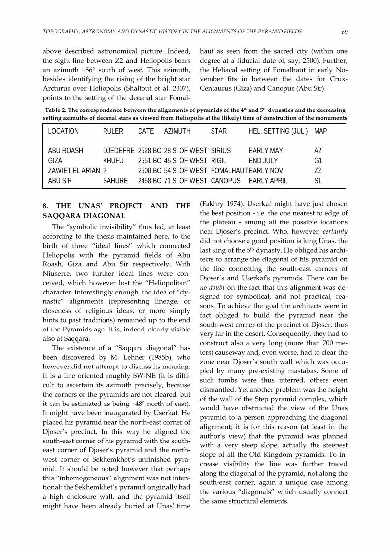
TOPOGRAPHY, ASTRONOMY AND DYNASTIC HISTORY IN THE ALIGNMENTS OF THE PYRAMID FIELDS 69
above described astronomical picture. Indeed, the sight line between Z2 and Heliopolis bears an azimuth ~56° south of west. This azimuth, besides identifying the rising of the bright star Arcturus over Heliopolis (Shaltout et al. 2007), points to the setting of the decanal star Fomal‐
haut as seen from the sacred city (within one degree at a fiducial date of, say, 2500). Further, the Heliacal setting of Fomalhaut in early No‐vember fits in between the dates for Crux‐Centaurus (Giza) and Canopus (Abu Sir).
Table 2. The correspondence between the alignments of pyramids of the 4th and 5th dynasties and the decreasing setting azimuths of decanal stars as viewed from Heliopolis at the (likely) time of construction of the monuments
LOCATION RULER DATE AZIMUTH STAR HEL. SETTING (JUL.) MAP
ABU ROASH DJEDEFRE 2528 BC 28 S. OF WEST SIRIUS EARLY MAY A2GIZA KHUFU 2551 BC 45 S. OF WEST RIGIL END JULY G1ZAWIET EL ARIAN ? 2500 BC 54 S. OF WEST FOMALHAUT EARLY NOV. Z2ABU SIR SAHURE 2458 BC 71 S. OF WEST CANOPUS EARLY APRIL S1
8. THE UNAS’ PROJECT AND THE SAQQARA DIAGONAL
The “symbolic invisibility” thus led, at least according to the thesis maintained here, to the birth of three “ideal lines” which connected Heliopolis with the pyramid fields of Abu Roash, Giza and Abu Sir respectively. With Niuserre, two further ideal lines were con‐ceived, which however lost the “Heliopolitan” character. Interestingly enough, the idea of “dy‐nastic” alignments (representing lineage, or closeness of religious ideas, or more simply hints to past traditions) remained up to the end of the Pyramids age. It is, indeed, clearly visible also at Saqqara.
The existence of a “Saqqara diagonal” has been discovered by M. Lehner (1985b), who however did not attempt to discuss its meaning. It is a line oriented roughly SW‐NE (it is diffi‐cult to ascertain its azimuth precisely, because the corners of the pyramids are not cleared, but it can be estimated as being ~48° north of east). It might have been inaugurated by Userkaf. He placed his pyramid near the north‐east corner of Djoser’s precinct. In this way he aligned the south‐east corner of his pyramid with the south‐east corner of Djoser’s pyramid and the north‐west corner of Sekhemkhet’s unfinished pyra‐mid. It should be noted however that perhaps this “inhomogeneous” alignment was not inten‐tional: the Sekhemkhet’s pyramid originally had a high enclosure wall, and the pyramid itself might have been already buried at Unasʹ time
(Fakhry 1974). Userkaf might have just chosen the best position ‐ i.e. the one nearest to edge of the plateau ‐ among all the possible locations near Djoser’s precinct. Who, however, certainly did not choose a good position is king Unas, the last king of the 5th dynasty. He obliged his archi‐tects to arrange the diagonal of his pyramid on the line connecting the south‐east corners of Djoser’s and Userkafʹs pyramids. There can be no doubt on the fact that this alignment was de‐signed for symbolical, and not practical, rea‐sons. To achieve the goal the architects were in fact obliged to build the pyramid near the south‐west corner of the precinct of Djoser, thus very far in the desert. Consequently, they had to construct also a very long (more than 700 me‐ters) causeway and, even worse, had to clear the zone near Djoser’s south wall which was occu‐pied by many pre‐existing mastabas. Some of such tombs were thus interred, others even dismantled. Yet another problem was the height of the wall of the Step pyramid complex, which would have obstructed the view of the Unas pyramid to a person approaching the diagonal alignment; it is for this reason (at least in the author’s view) that the pyramid was planned with a very steep slope, actually the steepest slope of all the Old Kingdom pyramids. To in‐crease visibility the line was further traced along the diagonal of the pyramid, not along the south‐east corner, again a unique case among the various “diagonals” which usually connect the same structural elements.

MAGLI, G. 70
Fig. 7 The “Saqqara diagonal” (numbering of the monuments in chronological order). 1‐ Djoser Step Pyramid, 2‐ Unfinished pyramid of Sekhemkhet, 3‐Pyramid of Userkaf, 4‐ Pyramid of Unas 5‐Pyramid of Teti
The placement of Unas’ pyramid closely re‐sembles that of Menkaure´s pyramid in Giza, to the point that the resemblance can hardly be considered casual. A similarity was already no‐ticed some years ago by Goedicke (2001), who observed that an unobstructed line of sight con‐nects the Userkaf pyramid with Khufuʹs. Actu‐ally, if similar connecting lines are traced be‐tween the summits of Djoser’s and Unas’ pyra‐mids with the apexes of Khafre’s and Menkaure´s monuments respectively, it be‐comes clear that the placement of Unas pyramid was conceived to realize a sort of (rough) copy of the arrangement of the Giza pyramid field. These lines are in fact about 14.5 Kms long (and therefore allowed a direct inter‐visibility) and, although they are not parallel, their relative de‐viation stays within 2°. Some years later, the Saqqara diagonal was further continued by Unas’ successor Teti. An old‐fashioned “sym‐bolic invisibility” would have required Teti to build his pyramid in a position very far in the desert, along the diagonal to the south‐west of the Unas one. This zone was partly occupied by the Sekhemkhetʹs unfinished complex, and/or the original symbolic meaning of the “diago‐
nals” was lost; in any case Teti avoided this in‐convenient position and actually choose to built his complex in the most favorable position along the Saqqara diagonal, aligning the north‐west corner of his pyramid and placing it to the north‐east of the Userkafʹs one, very near the ridge of the Saqqara plateau.
Prolongation of the line further north‐east shows that it passes very close to the southern limit of the area of the early‐dynastic mastabas (more precisely, the line passes some 70 meters south of the southernmost Mastaba 3507) and then crosses over the (un‐excavated) zone of archaic Memphis. People ascending on the Saqqara plateau from this direction thus experi‐enced a visual ʺsuperpositionʺ effect resembling that visible approaching Giza from Heliopolis.
The pyramid building site of Teti’s immedi‐ate successor, Userkare, has never been indi‐viduated (see next section). After Userkare, the king Pepi I built his pyramid in a position in south Saqqara, very near the ridge of the pla‐teau, while his successor Merenre moved fur‐ther south‐west (Fig. 8). In this way, he aligned the diagonal of his monument to that of Pepi I. Unfortunately, however, we shall never know if

TOPOGRAPHY, ASTRONOMY AND DYNASTIC HISTORY IN THE ALIGNMENTS OF THE PYRAMID FIELDS 71
Pepi II, successor of Merenre, would have liked to add his monument to this new diagonal, be‐cause the corresponding position to the south‐west would have been located in a Wadi (dried river), absolutely not suitable for building a pyramid. Perhaps as a consequence of this, he choose a position immediately south of the same Wadi, near Shepsekhaf’s monument.
9. MERIDIAN ALIGNMENTS AT SAQQARA SOUTH AND DASHOUR
The French Egyptologist George Goyon dis‐covered several “meridian” (i.e. north‐south) alignments between pyramids and previously constructed monuments “belonging to an ances‐tor or sacred sites” (Goyon 1977); the most fa‐mous of Goyonʹs alignment is that of Giza with the sacred site of Khem (Letopolis) located due north. A search for meridian alignments in the pyramid fields effectively gives quite surprising results, which can hardly be attributed to a chance. Further, the idea of meridian alignments appears before Giza, because it is already pre‐sent at Dashour. Indeed we have (in chronologi‐cal order): 1) The Red and the Bent pyramid of Snefru
are constructed in such a way that their west sides align with the two south corners of the so‐called Gisr el‐Mudir, a huge rec‐tangular enclosure located southwest of the Step Pyramid and probably constructed by a king of the first two dynasties, perhaps Khasekhemwy (Goyon already noticed at least one of such alignments, which he re‐fers to the “De Morgan” ‐ the discoverer of
the Gisr el‐Mudir – precinct). This align‐ment actually helps to explain why the Red Pyramid was constructed so far in the de‐sert, while the relative distance between the two remains something of a mystery.
2) The center of the valley temple of the Bent pyramid aligns with the apex of the Step Pyramid.
3) A meridian alignment connects the apex of Unas with the west side of Shepsekhafʹs Mastaba. On this line also the apex of Mer‐enreʹs pyramid was later constructed.
4) A meridian alignment connects the apex of Pepi I with that of Userkaf.
It appears, therefore, a possible intentionality in the successive planning of the Pepi I‐Merenre pyramids, which ideally connects them with the “Unas’ project” (Magli 2010). At a purely specu‐lative level, one might think that it was Userkare to initiate this new pyramid field. In this case, he might have located his pyramid in meridian alignment with that of Djoser, and therefore this monument might still be buried in the area between Pepi I and Merenre pyramids. Interestingly, a necropolis of dignitaries of the 6th dynasty has been recently discovered in the so‐called Tabbet al‐Guesh, namely the zone which separates the Saqqara central group from the Pepi I complex, giving many hints at the possibility that a pyramid has still to be discov‐ered at Saqqara south (Dobrev 2008). This area is actually crossed by yet another possibly non‐casual connecting line, since the northwest‐southeast diagonal of Pepi I points to the south‐east corner of the Gisr el‐Mudir.
Fig. 8 Meridian alignments between Dashour, Saqqara south and Saqqara (numbering of the monuments in chronological order). 1‐ Gisr el‐Mudir 2‐ Djoser Step Pyramid, 3a/3b/3c ‐ Red Pyramid, Bent Pyramid, Valley
Temple of the Bent Pyramid 4‐ Mastaba El Faraun 5‐Pyramid of Userkaf, 6‐ Pyramid of Unas 7‐Pyramid of Pepi I 8‐Pyramid of Merenre

MAGLI, G. 72
10. DISCUSSION Mircea Eliade once said (1978) that the sym‐
bolism contained in the sacred space is “so old and so familiar” that it may become impossible to recognize it. The present work represents an attempt at individuating the existence of a gen‐eral pattern which inspired the human‐made landscape during one of the greatest seasons of human civilization. We can call this period the time of the solar kings, those great rulers who were “close to the Sun God” as the name of Sa‐hure has it.
This period was inaugurated by Khufu. Ac‐cording to authoritative scholars indeed (Sta‐delmann 1991, Hawass 1993) Khufu depicted himself as the incarnation of Ra. In this connec‐tion Hawass notices that no relief is known showing Khufu making offerings to Gods, and perhaps this is not due to the lack of documen‐tation but rather is in accordance with the new “cult” which would have equated the king with the god himself. If this is true, then the “solar‐ised” kings would have had the necessity of showing in explicit, monumental terms their direct lineage from the Sun God in the funerary complexes. In the present paper, it has been pro‐posed that the way in which this will was actu‐alized was the intentional alignment of struc‐tural features of subsequent pyramids. This had the consequence of creating visual, perspective effects, in which the monuments progressively “merge” each other.
Of course, we cannot attempt here at devel‐oping a complete analysis of the possible conse‐quences in terms of dynastic (or simply “inspi‐ration”) relationships between successive kings who decided to connect visually their monu‐ments to those of previous pharaohs. However, at least a few observations in support of the non‐randomness of the “topographical order” we are discussing here can be made.
First of all, the ubiquitous (Giza, Zawiet el Arian‐Abu Sir, Saqqara) existence of survey lines oriented quarter‐cardinally in the pyramid fields is reflected in a fact which emerged very clearly from the recently completed survey of the orientations of virtually all the ancient Egyp‐tian temples (Belmonte et al. 2009). The analysis of the data indeed led the authors to identify a series of “families” of orientation; among others (like e.g., of course, a “solstitial” family) also a “quarter‐cardinal” family of orientations is clearly discernible, and comprises temples of any epoch.
As is well known, no contemporary textual evidence is available regarding the pyramidʹs projects and design. However, an echo of a Heliopolitan symbolism of “progressive ascen‐dance” can perhaps be seen in a passage of the pyramid texts, where it is said (PT 307) “My fa‐ther is an Onite, and I myself am an Onite, born in On [=Heliopolis] when Ra was ruler”. Perhaps an‐other echo appears in the traditional tales passed on in the Westcar papyrus (Lichtheim 1973). In this papyrus (dating to the Middle Kingdom) five stories which are told to Khufu by his sons are reported. In one such stories, the beginning of the 5th dynasty is directly linked to the sun in a quite intriguing way. Indeed, a ma‐gician called Dedi prophesies to Khufu that three sons of the wife of the chief priest of Ra in Heliopolis (and of Ra himself, at least according to some translations) will reign, the first of them being Userkaf. Khufu gets upset of this, but Dedi reassures the king that this will happen only after that Khufu’s son and grandson will reign. Of course, Pap. Westcar has not to be con‐sidered as an historical document; however, the tale clearly alludes to a discontinuity between the 4th and the 5th dynasties by “re‐scaling” the lineage of the kings directly to Heliopolis, ex‐actly ‐ one would be tempted to say ‐ as it hap‐pens on the ground.
ACKNOWLEDGMENTS
The author gratefully acknowledges Juan Belmonte for a careful reading of the first draft of the pre‐sent paper and many constructive comments.
REFERENCES Barta, M. (2005) Location of Old Kingdom pyramids in Egypt, Cambridge Arch. Journal 15 177‐191.

TOPOGRAPHY, ASTRONOMY AND DYNASTIC HISTORY IN THE ALIGNMENTS OF THE PYRAMID FIELDS 73
Baines J. and Malek, J. (1984) The Cultural Atlas of the World: Ancient Egypt, Oxford. Belmonte, J.A. (2001) The decans and the ancient egyptian skylore: an astronomer’s approach, Insap III Meeting,
Palermo. Belmonte, J.A., and Lull, J (2006) A Firmament Above Thebes: Uncovering the Constellations of Ancient
Egyptians, JHA 37, 373–392 Belmonte, J.A., Shaltout, M., and Fekri, M. (2009) On the Orientation of Ancient Egyptian Temples: (4)
Epilogue in Serabit el Khadim and Overview J.H.A. 39 Belmonte, J.A. & Zedda, M. (2007) Lights and shadows on the pyramids In Lights and shadows in cultural
astronomy ed. M. Zedda and J. Belmonte, Ass. Archeofila Sarda, Isili, p. 181‐211 Dobrev, V. (2008) Old Kingdom Tombs at Tabbet al‐Guesh (South Saqqara), in Abusir and Saqqara in the Year
2005 M. Barta, F. Coppens and J. Krejci eds. AVCR, Prague Eliade, M. (1978) Occultism, Witchcraft, and Cultural Fashions: Essays in Comparative Religion University of
Chicago Press Faulkner, R. (1998) The ancient Egyptian pyramid texts, Oxford University press, Oxford Fakhry, A. (1974) The Pyramids Univ of Chicago Press Goedicke H. (2001) Abusir ‐ Saqqara ‐ Giza in Abusir and Saqqara in the Year 2000 ed. M. Barta and J. Krejci,
AVCR, Prague. Goyon, J.L. (1977) The secrets of the pyramids’ builders, Pygmalion, Paris, 1977. Hawass, Z. The Great Sphinx at Giza: Date and Function In Sesto Congresso Internazionale di Egittologia. Ed.
G.M. Zaccone and T. Ricardi di Netro, pp. 177–195.Turin. Hawass, Z. (2006) Mountains of the Pharaohs: The Untold Story of the Pyramid Builders Doubleday, London Jeffreys, D. (1998) The topography of Heliopolis and Memphis: some cognitive aspects, Beitrage zur Kulturge‐
schichte Ägyptens, Rainer Stadelmann gewidmet (Mainz) 63‐71. Kaiser, W. (1956) Zu den Sonnenheiligtümern der 5. Dynastie, MDAIK 14, 104‐116. Krejci J. (2001) The origins and the development of the royal necropolis at Abusir during the Old King‐
dom. In Abusir and Saqqara in the Year 2000 ed. M. Barta and J. Krejci, AVCR, Prague. Lehner, M. (1985a) The development of the Giza Necropolis: The Khufu project, Mitteilungen des Deutschen
Archaologischen Instituts Abteilung Kairo, 41 Lehner, M., (1985b) A contextual approach to the Giza pyramids, Archiv fur Orientforsch. 31, 136‐158 Lehner, M. (1999) The complete pyramids, Thames and Hudson, London. Lichtheim, M. (1973) Ancient Egyptian Literature, University of California press, Berkeley Magli, G. (2009) Akhet Khufu: Archaeo‐astronomical Hints at a Common Project of the Two Main Pyra‐
mids of Giza, Egypt. NNJ‐ Architecture and Mathematics 11, 35‐50. Magli, G. (2009) Mysteries and Discoveries of Archaeoastronomy, Springer‐Verlag, NY (originally published
as Misteri e Scoperte dell’Archeoastronomia Newton & Compton eds., Roma 2005). Magli, G. (2010) Archaeoastronomy and archaeo‐topography as tools in the search for a missing egyptian pyramid
Preprint, Dept. of Mathematics, Politecnico di Milano. Magli, G., and Belmonte, J.A. (2009) The stars and the pyramids: facts, conjectures, and starry tales. In In
Search Of Cosmic Order ‐ selected Essays on Egyptian Archaeoastronomy Edited by J.A. Belmonte and M. Shaltout, SCA editions, Cairo, (in press).
Nuzzolo M., (2007) The Sun Temples of the Vth Dynasty: A Reassessment, SAK 36, 217‐247. Quirke, S. (2001) The Cult Of Ra Thames and Hudson, London. Reader, C. (2001) A geomorphical study of the Giza necropolis with implications for the development of
the site, Archeometry 43, p.149‐165 Rossi, C. (2003) Architecture and Mathematics in Ancient Egypt. London: Cambridge University Press. Stadelmann, R. (1991) Die agyptischen Pyramiden: Vom Ziegelbau zum Weltwunder: P. von Zabern, Meinz Swelim, N. (1983) Some Problems on the History of the Third Dynasty. Archaeol. Soc. Of Alexandria press. Vandecruys, G. (2006) The Sphinx: dramatising data… and dating. – PalArch’s Journal of Archaeology of
Egypt 1, 1–13 Verner, M. (2001) Who was Shepseskara, and when did he reign? in Abusir and Saqqara in the Year 2000 ed. M.
Barta and J. Krejci, AVCR, Prague. Verner, M. (2002) The Pyramids: The Mystery, Culture, and Science of Egyptʹs Great Monuments Grove Press

MAGLI, G. 74
NOTES 1. Recent hints point to the possibility that the original Khufu project enclosed also this pyramid and
Khafre finished it (Shaltout et al. 2007, Magli 2003, 2009), but this issue is not of special relevance here. 2. The monument lies inside a military base and is the unique site mentioned here that the author has
not personally surveyed. 3. The Menkhaour pyramid is identified, without certainity however, with the pyramid Lepsius 29 ly‐
ing east of the Teti complex; the pyramid of Djedkare was built in a prominent position on the ridge in South Saqqara; the Unas pyramid lies in Central Saqqara and will be discussed at length in section 8.
4. There can be little doubt about the fact that the slopes of the pyramids were chosen in the planning phase and controlled during the construction by means of rational tangents, i.e. choosing two integer numbers. We thus report here the “simplest” rational fractions (lowest possible numbers) giving a rea‐sonable rational approximation (within 1%) of the measured slopes. It should be noted, however, that in much later sources (such as the Rhind Papyrus) a quite awkward way of measuring the tangent of an angle, called seked, appears. The seked is how much one has to “slide” the base in order to achieve an height of one cubit. This measure has the obvious drawback of being dependent on the unit of measure, while angles are of course non‐dimensional ‐ and therefore easy‐to‐handle ‐ physical quantities. Although no proof of the use of the seked in the Old Kingdom exists, it is customary in the literature to try to express the slopes of the pyramids in this way (see e.g. Rossi 2003). Since the cubit was divided into 7 palms and the palm was divided into 4 fingers, even some eagerly simple slopes (such as 3/2) become utterly complicated when expressed into the seked system. There is no reason whatsoever to believe that the builders of the pyramids used this way of working, if only it is observed that workmen in charge of cutting casing block could use arbitrary units to check their work if the slope was instead given as a two‐integers numbers information.