town and country planning act 1990 cottage statement.pdf(2011-2031) and policy be2 of the...
TRANSCRIPT

1
STRATFORD-ON-AVON DISTRICT COUNCIL
Town and Country Planning Act 1990
Appeal refs: APP/J3720/C/19/3230367
LPA ref: 17/00392/HHENF
Appellant: Mr Robert McLachlan
Location: Land at River Cottage, Tiddington Road, Stratford-upon-Avon,
Warwickshire, CV37 7AE
Development: Without planning permission the erection of a 0.8m stained
wooden fence above an existing wall which cumulatively is 1.8m
in height and the erection of a stained wooden sliding gate 1.8m
in height (when measured from the public highway) both
adjacent to a highway used by vehicular traffic.
Start Date: 5 September 2019
List of Documents being submitted
Appendix 1 Plan of the Conservation Area with the site outlined in red
Appendix 2 Relevant extracts of the District Design Guide
Appendix 3 Relevant extracts from the Stratford Conservation Area Appraisal

2
1. INTRODUCTION
1.1 This appeal is against an Enforcement Notice which was issued on the 2nd May
2019 and alleges ‘Without planning permission the erection of a 0.8m
stained wooden fence above an existing wall which cumulatively is
1.8m in height and the erection of a stained wooden sliding gate 1.8m
in height (when measured from the public highway) both adjacent to a
highway used by vehicular traffic.’
1.2 The reasons for serving the Enforcement Notice are as follows:
1. The unauthorised fence and gate by reason of its height, materials and finish
is considered to introduce an adverse impact on the character experienced
within the ‘locality’ of the site. The fence and gates lie within a prominent
location which is visible from the public highway and fail to respect the open
character of the ‘locality’ of the site. The unauthorised development is
therefore contrary to Policy CS.9 of the Stratford-on-Avon Core Strategy
(2011-2031) and Policy BE2 of the Stratford-on-Avon Neighbourhood
Development Plan (2011-2031).
2. The unauthorised fence and gate by reason of its height, position and design
form a prominent feature which harmfully detracts from the open character
experienced within this part of the Stratford upon Avon Conservation Area. The
unauthorised development is considered to introduce ‘less than substantial
harm’ to the setting and special interest of the Conservation Area which is not
outweighed by any public benefits contrary to Policy CS.8 of the Stratford-on-
Avon Core Strategy (2011-2031) and Policy BE8 of the Stratford-on-Avon
Neighbourhood Development Plan (2011-2031).
The District Council does not consider that planning permission should be
granted because planning conditions could not overcome the objections to the
development.
1.3 A copy of the Enforcement Notice has been provided with the Councils appeal
questionnaire.

3
1.4 The Enforcement Notice appeal by Mr Robert McLachlan has been lodged on
Ground (a) only in that planning permission should be granted for what is
alleged in the notice.
1.5 The requirements of The Notice are to:
a) Remove the fence which has been erected above the existing wall and gates
along the alignment of A-B (as shown on the Plan) from the Land.
Or
b) Remove the fence which has been erected above the existing wall and
reduce the height of the sliding gate to no more than 1 metre in height as
identified along the alignment of A-B (as shown on the Plan) from the Land.
AND
C) Removal all the materials associated with points a) and b) above.
2. SITE AND SURROUNDING AREA
2.1 The appeal site River Cottage is a two-storey dwelling, located within the Built
up Area Boundary of Stratford-upon-Avon. The property sits in a prominent
position on the Tiddington Road, such that its gable end is adjacent to the
footpath along the Tiddington Road within the Stratford upon Avon
Conservation Area.
2.2 A plan with the site outlined in red to show the relationship of the site to the
Conservation Area is attached in Appendix 1.
2.3 The Conservation Area is characterised by stone-built dwellings, including
many period properties with stone and brick enclosures to gardens, along with
the presence of occasional grass verge, trees and planting.
2.4 Within the street scene mature vegetation and low stone walls are common
and distinctive features.

4
3. PLANNING HISTORY/BACKGROUND
3.1 The site was granted planning permission in 2005 (Reference 16/02663/FUL)
for a first floor extension to the cottage including internal alternations and the
conversation of the garage to a kitchen.
3.2 In 2016 a retrospective planning application was submitted (reference
16/03591/FUL) for the construction of a garden wall. After further discussions
with the case officer the application was withdrawn in November 2016.
3.3 A complaint was received in August 2017 that fencing had been added to the
boundary wall without planning permission. The site was inspected and it was
found that a 0.8m high stained wooden fence had been erected above the
existing wall. This resulted in the boundary treatment reaching 1.8m in height.
A stained wooden sliding gate 1.8m in height (when measured from the public
highway) had also been erected without the benefit of planning permission.
4. PLANNING POLICIES & GUIDANCE
4.1 The Development Plan for the Council is the adopted Stratford-on-Avon District
Core Strategy 2011 to 2031. The Stratford upon Avon Neighbourhood Plan was
also adopted on 17th December 2018 and as such the policies within it carry full
wright for decision making purposes. The following policies are considered
relevant to this appeal:
Stratford-on-Avon District Core Strategy (2011 to 2031)
Policy CS.8 – Historic Environment
Policy CS.9 – Design and Distinctiveness
Stratford upon Avon Neighbourhood Plan
Policy BE2 – Responding to Local Character
Policy BE8 –Designated Heritage Assets
4.2 Extracts of these policies were submitted with the Councils appeal
questionnaire.

5
Other guidance
4.3 The Council has guidance in the form of the Stratford-upon-Avon District
Development Requirements SPD (adopted July 2019).
4.4 The Council also has guidance in the Council's District Design Guide (April
2001).
4.5 Extracts of Stratford-upon-Avon District Development Requirements SPD were
submitted with the Councils appeal questionnaire, relevant extracts of the
District Design Guide are attached at Appendix 2.
The Stratford Conservation Area appraisal
4.6 The Stratford Conservation Area appraisal identifies that this section of the
Tiddington Road as characterised by houses set back from the road with well
established gardens containing mature trees. River cottage is not set back from
the road, the dwelling bounds the public highway with an overhanging bay
window at first floor, hence it is significantly prominent when viewed from the
Tiddington Road.
4.7 Relevant extracts from the Stratford Conservation Area Appraisal is attached at
Appendix 3.
5. CASE FOR THE APPELLANT
The Ground (a) appeal
5.1 The Appellant has appealed solely on Ground (a) in that planning permission
should be granted for what is alleged in the notice.
5.2 Section 38(6) of the Planning and Compulsory Purchase Act 2004 requires
that: ‘If regard is to be had to the Development Plan for the purpose of any
determination to be under the Planning Acts, the determination must be made
in accordance with the Plan unless material considerations indicate otherwise’.

6
The National Planning Policy Framework (NPPF) and Planning Practice Guidance
(PPG) are also a key material planning consideration.
5.3 In this instance, the Development Plan comprises Stratford-on-Avon District
Core Strategy (2011-2031) and the Stratford –upon-Avon Neighbourhood Plan.
5.4 Policy CS.1 of the Core Strategy attaches great importance to the presumption
in favour of sustainable development contained in the National Planning Policy
Framework (NPPF). Therefore, all proposals should contribute towards the
character and quality of the District and to the well-being of those who live and
work in and visit the District.
5.5 Policy AS.1 relates to development within Stratford upon Avon Town. It seeks
to ensure that proposals ensure that the town presents an attractive image.
Visual Impact/Impact on Stratford-upon-Avon Conservation Area
5.6 Core Strategy Policy CS.8 states: “The District’s historic environment will be
protected and enhanced for its inherent value and for the enjoyment of present
and future residents and visitors.” It also states: “Priority will be given to
protecting and enhancing the wide range of historic and cultural assets that
contribute to the character and identity of the District, including Listed
Buildings and their settings.”
5.7 In respect of proposals affecting the significance of heritage assets and their
settings, the policy states:
“Where a development proposal will lead to less than substantial harm
to the significance of a designated heritage asset, this harm must be justified
and weighed against the public benefits of the proposal, including securing its
optimum viable use.”
5.8 Finally, sub-section C (Appreciation, design and Management) of the policy
states:

7
“Proposals will be high quality, sensitively designed and integrated with
the historic context.”
5.9 Core Strategy Policy CS.9 relates to Design and Distinctiveness and seeks to
ensure that developments are sensitive to the setting, neighbouring uses,
topography and existing built form within the locality.
5.10 Policy BE2 of the Neighbourhood Plan is a general design policy to ensure that
development demonstrates a high standard of design, permeability, variety
and legitimacy.
5.11 Policy BE8 of the Stratford-upon-Avon Neighbourhood Plan also states that
‘Proposals which cause substantial harm to the special historical or
architectural fabric and interest of listed buildings and ancient monuments and
their settings or the Stratford-upon-Avon, Shottery or Alveston Conservation
Areas will be resisted including those which affect the town’s Historic Spine.
Proposals which result in less than substantial harm must demonstrate public
benefit outweighing that harm’.
5.12 Part D of the Development Requirements SPD states that ‘low walls and/or
metal railings (less than 1.2m in height) are more appropriate as front
boundary treatments in more urban areas along streets higher in the street
hierarchy’.
5.13 The District Design Guide seeks to ensure that boundary treatment is
appropriate to the plot, street, settlement and character of an area in terms of
its position, shape, size, construction and materials (para. 7.4.3).
5.14 The unauthorised development falls within the Stratford Conservation Area on
the Tiddington Road and approximately 140m from the Clopton Bridge (a
scheduled ancient monument) on the banks of the River Avon. The Stratford
Conservation Area appraisal identifies Clopton Bridge (a scheduled ancient
monument) as an important vehicular entrance and exit view to the town.
5.15 The site is located on one of the main approaches to town and views are
afforded of the site from the Tiddington Road.

8
5.16 The conservation area appraisal identifies that this section of Tiddington Road
as characterised by houses set back from the road with well-established
gardens containing mature trees.
5.17 River Cottage is not set back from the road, the dwelling bounds the public
footway with an overhanging bay window at first floor, hence it is significantly
prominent when viewed from Tiddington Road.
5.18 The existing boundary wall is physically attached to the side elevation of the
dwelling and immediately bounds the public footway. The unauthorised fencing
has been erected above the boundary wall adjacent to an unauthorised sliding
gate which is of the same height and constructed of stained wood fence panels.
5.19 This type of high wooden fencing is not typical of the area; Tiddington Road
within close proximity of the site is typically bound by mature vegetation or low
stone walls. This is considered to represent the ‘locality’ of the site. There are
examples within the street scene of taller solid boundary treatments however
no planning permission appears to have been granted for these enclosures.
5.20 The unauthorised fence and gate given its height, solid form and finish are
considered to introduce an adverse impact on the character experienced within
the ‘locality’ of the site and are not considered to preserve the character of the
conservation area.
5.21 The unauthorised fence is considered introduce ‘less than substantial harm’ to
the special interest and setting of the conservation area. There are not
considered to be any public benefits which outweigh the harm of the
development on the setting of the conservation area.
5.22 Having regard to the above, it is considered that the unauthorised
development is contrary to Core Strategy Policies CS.8 and CS.9, Policy BE8 of
the Stratford-Upon-Avon Neighbourhood, the Stratford-upon-Avon District
Development Requirements SPD and District Design Guide.

9
6. COMMENTS ON APPELLANT’S GROUNDS OF APPEAL
6.1 In support of their appeal, the Appellant has set out within their Statement of
Case the following arguments (as summarised):
1. That the Council have permitted similar means of enclosures in
the vicinity of the site.
2. That it was not within the public interest to proceed with formal
enforcement action.
3. That advice was provided during the consideration of a previous
planning application suggesting the current works would be
acceptable.
4. Breach of the Appellants Human Rights under Article 8 (Right to
respect for private and family life).
6.2 On pages 4 and 5 of the Appellants statement reference is made to a similar
means of enclosure near to the appeal site.
6.3 The Council would argue that the only similar example of a means of enclosure
would be that at number 53 which is approximately 300m away from the site.
This means of enclosure is similar in that it is immediately adjacent to the
pathway albeit it is a standard 1.8 metre panel fence. The Council would argue
that this fencing does cause harm to the character of the area experienced
within the locality of the site however its design is not as prominent and
harmful on the street scene when compared to the appeal site. The fencing at
number 53 appears to have been in situ for in excess of 4 years and as such
would be immune from enforcement action should the Local Planning Authority
investigate this as a new enforcement case.
6.4 The Council would also like to make the Inspector aware that an Enforcement
Notice has been served on the means of enclosure present at number 6a
Tiddington Road, almost opposite the gate at the appeal site. Whilst not
referenced by the Appellant this is similar to the means of enclosure at the

10
Appeal site in that it is immediately adjacent to the footway and the Council
took a similar view on the harm caused. This Enforcement Notice was served
on 18th September 2019 and is not subject to an appeal.
6.5 In regards to the other properties raised by the Appellant the Council does not
consider these to be comparable examples to the appeal site in terms of design
and their location on the street. Many of the examples provided are not set
immediately adjacent to the footpath and also have landscaping included
within the designs to mitigate the harm caused.
6.6 The Council considered that it was expedient and in the public interest to
pursue formal enforcement action for the reasons outlined in the Enforcement
Notice and outlined within this statement.
6.7 The Appellant submitted a planning application reference 16/03591/FUL for
consideration in 2016 which was for the erection of a garden wall. During the
consideration of the application the case officer advised the Appellant that the
application could not be supported and would be recommended for refusal. The
Appellant withdrew the application on 23.01.2017 and then continued to seek
advice from the case officer as to what alternatives to the initial scheme might
be considered more favourably.
6.8 The Appellant was provided clear advice that a wall under 1 metre in height
would be permitted development. Indeed at the time the Appellant was
advised that the current wall in situ was in excess of 1 metre in height however
in light of the slight increase over 1 metre it was not consider expedient to
pursue at the time. The case officer also advised that a more suitable proposal
could be a 1 metre high brick wall with some trellis above to allow natural
growth and reduce the visual impact from the street scene. At no point during
the correspondence was the Appellant advised that these works would be
permitted development, in fact it is the Councils view that the Appellant was
advised that any increase in height of the fencing would require planning
permission. The Appellant proceeded to carry out the works without planning
permission.
6.9 The Council also believe that the trellis recommended by the case officer at the

11
time would be standard trellis used on the top of many fences which allows
climbers and other planting to grow and fill the gaps in the wood. The
Appellant has placed large wooden panels on top of the existing wall which has
almost no gaps and does not allow for the growth of climbers or other planting
to mitigate the harsh impact on the street scene.
6.10 The Council therefore argues that the design of the means of enclosure is not
what the case officer advised might be acceptable and in any case this should
have formed the consideration of a planning application which was never
forthcoming.
6.11 The Appellant has included personal circumstances in the appeal statement for
the erection of the means of enclosure but then requested the details to be
redacted. This being the case the Council finds it difficult to comment in great
detail on these comments.
6.12 The Council does not dispute that the Appellants have a genuine need to
secure their garden land and/or provide themselves with adequate levels of
privacy.
6.13 However, the unauthorised fence has been subject to assessment by the
Council and found to be unacceptable in terms of planning harm. This decision
is made having regard to the provisions in the Development Plan and other
material considerations.
6.14 It should be noted that the decision to remove of the original hedge was that of
the Appellants, notwithstanding they could have erected a 2m high fence on
their land behind this hedge to provide greater security/privacy, without the
need for formal planning permission.
6.15 In addition, the Council has provided the Appellant with a potentially
acceptable alternative boundary treatment however the Appellant chose not to
follow this advice on site or submit a planning application for consideration.
6.16 In conclusion, whilst the Council has sympathy for the Appellant in wanting to
secure their garden area and provide privacy, the Council’s decision to seek its

12
removal, is fully justified having regard to the Appellant’s Human Rights under
Article 8.
7. CONCLUSION
7.1 The Appellant has appealed on ground (a) only in that planning permission
should be granted for what is alleged in the notice.
7.2 The Council contend that the the unauthorised fence and gate by reason of its
height, materials and finish is considered to introduce an adverse impact on
the character experienced within the ‘locality’ of the site. The fence and gates
lie within a prominent location which is visible from the public highway and fail
to respect the open character of the ‘locality’ of the site. The unauthorised
development is therefore contrary to Policy CS.9 of the Stratford-on-Avon Core
Strategy (2011-2031) and Policy BE2 of the Stratford-on-Avon Neighbourhood
Development Plan (2011-2031).
7.3 The unauthorised fence and gate by reason of its height, position and design
form a prominent feature which harmfully detracts from the open character
experienced within this part of the Stratford upon Avon Conservation Area. The
unauthorised development is considered to introduce ‘less than substantial
harm’ to the setting and special interest of the Conservation Area which is not
outweighed by any public benefits contrary to Policy CS.8 of the Stratford-on-
Avon Core Strategy (2011-2031) and Policy BE8 of the Stratford-on-Avon
Neighbourhood Development Plan (2011-2031).
7.4 The District Council does not consider that planning permission should be
granted because planning conditions could not overcome the objections to the
development.
7.5 The arguments put forward by the Appellant; do not justify planning
permission being granted for what’s alleged in the Notice.
7.6 The Inspector is therefore respectfully asked to dismiss this appeal.

13
8. WITHOUT PREJUDICE CONDITIONS
8.1 If the Inspectorate was mindful to grant planning permission for the
development then the Council would request that the following condition is
included within the decision.
8.2 Within 3 months of the date of this decision, a scheme for the staining of the
fence shall be submitted in writing to the Local Planning Authority for approval,
and shall thereafter be carried out in full accordance with the approved details.

")
")
")
")
E
E
E
E
E
")
E E
E
")
E
")
E
")
EE
")
E
E
")
E
E
E
")")
E
E
")
E
EE
E
E
EE
E
E
")
")
E
E
E
E
E
E
E
E E
EE
")")")
")
")
")
")
")
E
")
")
")
")
")
")
")
")
E
")
")
")
")
E
")
")
E
")
E
E
")
")
")
")
")
")
")")
")
")
")
")
")")")")")
")
")
")
")
")
")
")
")
")
")
")
")
E
")
E
")")
E
")
E
E
")
E
")
E
E
")
E
E
E
E
")
")
")")
")")
")
")
")")")")")")")")")")")")")")
")")
")
DD
D
D
D
D
D
D
D
D
D
D
D
D
D
D
D
D
D
D
D
D
D
D
D
D
D
D
D
D
D
D
D
D
D
D
D
D
D
D
D
D
D
D
DD
D
D
D
DD
D
D
D
D
D
D
D
D
D
D
D
D
D
D
D
D
D
D
D
D
D
DD
D
D
D
D
D
D
D
D
D
D
D
D
D
D
D D
D
D
D
D
D
D
D
D
D
D
D
D D
D
D
D
D
D
DDD D
D
D
D
D
DD
D
D
D
D
D
D
D
D
D D
DD
D
D
D
D
D
D
E
")
")
")
")
")
D
D
D
D
D
D
D
D
DD
D
D
D
D
D
D
D
D
D
D
D
D
D
D
D
Stratford-upon-Avon Conservation Area ±Reproduced from the Ordnance Survey mapping with the permission of the Controller of Her Majesty's Stationery Office © Crown CopyrightUnauthorised reproduction infringes Crown Copyright and may lead to proscecution or civil proceedings
Stratford-on-Avon District Council Licence Number 100024287 2000s

Stratford-on-Avon
ISSUE 1 APRIL 2001
DistrictDesignGuide
Planning

Stratford-on-Avon
ISSUE 1 APRIL 2001
DistrictDesignGuide
£18.00
SDC/0425/APR01

Published by Stratford-on-Avon District Council, April 2001 © Stratford-on-Avon District Council
This guide was produced, in part, with the participation of DistrictCouncil Members, District and County Council officers andmembers of the public. The guide builds on the CountrysideDesign Summary adopted as Supplementary Design Guidance inSeptember 1998. Character mapping and descriptions are basedon the Warwickshire Landscapes Guidelines, produced byWarwickshire County Council in partnership with the CountrysideCommission.
Editorial and Production TeamEditor: Karl Kropf
Editorial team: John Marshall, Andrew Wharton, Ruth Rose, SallyGriffiths, Viv Evans Mark Sturgess, Simon Payne, Jelle Koenen,Hugo Alefs
Layout and production: Stratford-on-Avon District CouncilDesign & Cartographic Division
Printed by: Stratford-on-Avon District Council Central Printing Division
The mapping contained in this guide is reproduced from the OrdnanceSurvey mapping with permission of The Controller of Her Majesty'sStationery Office. © Crown Copyright. Unauthorised reproductioninfringes Crown Copyright and may lead to prosecution or civilproceedings.Stratford on Avon District Council. Licence No. 100024287. 2001Published for planning design guidance. Use of this document islimited to viewing on-line and printing one copy.
Planning
Stratford-on-Avon District CouncilElizabeth House, Church StreetStratford-upon-Avon CV37 6HX
Telephone 01789 267575Facsimile 01789 260306Minicom 01789 260747DX700737 STRATFORD-ON-AVON 2
e-mail [email protected] www.stratford.gov.uk
If you find the text in this booklet difficult to readwe can supply it in a format better suited to your needs

Table of Contents
Introduction 10.1 The purpose of the guide 0.2 How the guide works 0.3 The structure of the guide 0.4 Context and support
Fundamental Concerns 31.1 Quality and design of the public realm 1.2 Character and identity 1.3 Sustainability and health 1.4 Why the concern? 1.5 Actual and visual density 1.6 Standard minimum dimensions 1.7 Highway design 1.8 Design, character and innovation
The Character of Stratford-on-Avon District 7
2.1 A general description 2.2 A character map of Stratford-on-Avon District 2.3 Character areas and descriptions
Arden Feldon Cotswold Fringe and Ironstone Uplands Avon Valley Stour Valley
Basic principles 133.1 A viewpoint on design 3.2 The importance of specific features 3.3 Character and sustainability 3.4 Using a settlement as a design resource 3.5 Innovation with a purpose
Looking at the design of Settlements 23
4.1 Design and landscape 4.2 The settlement as a whole in the landscape 4.3 The internal arrangement of settlements 4.4 Movement and street patterns 4.5 Landscape and open space as a network
Looking at the design of Streets 39
5.1 The street as a unit of character 5.2 Variation of character and position 5.3 The extent of the street 5.4 The parts and arrangement of a street 5.5 Visual integration within streets
Looking at the design ofHighways, open spaces and plot series 43
6.1 The components 6.2 Highways
Other sources of guidance Highways and open spaces within the street Design and use Carriageways, footways and islands
6.3 Plot series
Looking at the design of Plots 49
7.1 Variation and position Corner plots
7.2 Building position Frontage set-back Orientation to street
7.3 Density 7.4 Gardens and boundary features 7.5 Parking
Looking at the design of Buildings 55
8.1 Variation and position 8.2 Form, components and innovation 8.3 Extensions 8.4 Non-residential buildings
Looking at the design and choice of Details and materials 61
9.1 General principles 9.2 Examples and specific principles
Appendix AConversion of traditional agricultural buildings 71
A.1 The principle of conversion A.2 The setting of the barn A.3 Existing structure A.4 Repairs A.5 New structure A.6 Windows and doors A.7 Roofs A.8 External walls A.9 Extensions
Appendix BShopfronts and signage 75
B.1 General considerations B.2 Shopfronts B.3 Signs and advertisements
Appendix CList of principal villages in character areas 79
Appendix DSpecies lists 83
Appendix ESample planting specification 87
Appendix FSources of local stone 89

1
Subtle but identifiable differences characterise the landscapes and settlements ofStratford-on-Avon District. The photos above show the rolling landforms and honey
coloured stone of the Cotswold Fringe area and the more subtly undulatingtopography of the Avon and Stour Valleys with their brick and timber frame buildings.

1
PrefaceOn the face of it, a street is an ordinary thing. Streets are everywhere.We live and work along them. We use them most every day to do thethings we want to do. But while streets may be part of everyday life,they are not all the same. From a High Street to a small back lane,each route has its own distinctive character and identity. And eachtown or village, with its particular mix of streets, is equallydistinctive. The closer you look the more you find the differences.
If this guide has a single overall aim it is to encourage people to lookcarefully at what makes places different. As the guide makes clear,the idea of the street is a handy way of pulling those things together.The character of a town or village has a lot to do with the character ofits streets and lanes - not just the way they look but also the way theyare used and cared for.
The idea of character is central to this document. All the seeminglyminor features that make a place different add up to a distinctivecharacter. The landscape of Stratford-on-Avon District is not asdramatic as some but it is distinct and recognisable in its smallerdetails. It is also diverse. On the surface the differences may appearsubtle but the diversity is evident in many ways, from street patternsto building materials. The character map included at the beginning ofthe guide shows the wide range of different areas that make up theDistrict.
Diversity and character are not the result of a single act of design. Theplaces that we appreciate so much in our District are the product of acontinuous process of change involving many people over manyyears. The challenge we face now, and in the future, is to manage thatchange in order to foster and protect the identity of place. Planningmust be a positive force for achieving a balance between innovative,imaginative change and the positive qualities of the environment as itcomes down to us.
Stratford on Avon District Council is developing and using a range ofmethods and techniques to instil local character in new developmentand ensure what we do is sustainable. Village Design Statements andParish Appraisals, prepared by the public, are already influential inplanning decisions. The District has also been active in pursuing anumber of initiatives under Local Agenda 21.
I welcome this Guide as another tool the Council has for improvingthe quality of the environment and achieving development that islocal, sustainable and equitable. The District deserves nothing less.
Robert StevensLeader, Stratford on Avon District Council
C

The Arden and Feldon areas pictured above have been identified as distinct areassince at least the Middle Ages. The more wooded Arden has dispersed settlementsof mainly timber frame and brick while the more open Feldon is characterised by
compact settlements predominantly of Lias stone.

1 Introduction
Introduction0.1 The purpose of the guide0.2 How the guide works0.3 The structure of the guide0.4 Context and support
0 . 2 . 1 As a working document, the guide is intended toserve as a common source of information and guidancefor all those involved in the planning process. It is notintended as a detailed account of all parts of the Districtnor a source of ready-made design solutions. Rather,the guide sets out a range of general issues andprinciples concerning design that the Council regards asnecessary to consider in formulating specific designs.
0.2.2 Applicants for planning permission, including ListedBuilding Consent, Conservation Area Consent andExpress Consent for advertisements, must demonstratein the material submitted that they have given dueconsideration to the issues and principles set out in thisguide in the formulation of proposed designs. Fordetails concerning specific documents, drawings andother information required with applications, pleaserefer to application forms and Stratford-on-AvonDistrict Council’s Planning Practice Notes.
0 . 2 . 3 To achieve the objectives of this guide, the centralfocus is the distinctive, local, qualities of the District.The guidance works on the basis that new developmentshould share some of the characteristics that define thearea in which it is located. It should be clear that thenew development has features in common withbuildings and landscapes of a similar kind in thesurrounding area. The guide sets out general principlesand methods to help achieve this aim. Also, as becomesclear in the guide, achieving designs that are local canmake a significant step toward achieving developmentthat is sustainable and equitable. The focus on characterdoes not mean the other two main considerations areany less important.
0.2.4 The application procedure should, in outline, involvethe following:
• check the proposal is acceptable in policy terms;• determine requirements to be accommodated on site
as set out in the District Local Plan and PlanningPractice Notes and Development Briefs if applicable;
• identify the character area, as described in this guideor the Stratford-on-Avon District Character Map, withinwhich the development is proposed;
• read the information regarding that area in thisdocument and any relevant Village Design Statement,Conservation Area or other document;
• by visiting the site and using this guide, identify thespecific characteristics that make up the site and thearea in which the development is proposed;
• discuss proposals with planning and conservationofficers;
• demonstrate, in text and graphics, that the designsubmitted shares a sufficient number of thosecharacteristics or justify their absence.
The purpose of the guide0 . 1 . 1 The purpose of this guide is to provide design
guidance to applicants for planning permission,including Listed Building Consent, Conservation AreaConsent and Express Consent for advertisements, inStratford-on-Avon District. The main objective of theguidance is to help secure designs that are:
• Local• Sustainable• Equitable
How the guide works

2Introduction
The structure of the guide0.3.1 The guide is divided into nine principal chapters and
six appendices. The f irst chapter covers thefundamental concerns motivating the production of thisguide. The second includes a character map ofStratford-on-Avon District with descriptions of thedifferent character areas within the District. The thirdchapter introduces some basic principles of design.Chapters four to nine cover more detailed issues ofdesign working through levels of scale from thesettlement as a whole in the landscape down tomaterials and details. The appendices cover morespecific and technical matters.
Context and supportThe relationship of this guide to other policyand guidance documents0 . 4 . 1 This document is meant to be used alongside a
number of others that set out policy and guidancerelating to design. The diagram below shows theposition of this guide within the structure of policy andguidance operating in Stratford-on-Avon District.Those documents higher up the list cover larger areas.In the case of supplementary planning guidance, thedocuments are intended to be complementary. Thosecovering smaller areas provide more detailed advicelimited to a particular area. The documents listed beloware bound A5 or A4 documents unless otherwise noted.
Policy• Regional Planning Guidance for the West Midlands
Region• Warwickshire Structure Plan• Stratford-on-Avon District Local Plan
Supplementary Planning GuidanceCountywide
• Warwickshire Landscapes Guidelines• Roads and Transport for Developments
Districtwide• A Rural Strategy for Stratford-on-Avon District;• Planning Practice Notes;
❑ THIS GUIDE - Stratford-on-Avon District Design Guide;• Countryside Design Summary for Stratford-on-Avon
District, a summary of the District Design Guide inposter format;
• Access Design for People with Disabilities, advisoryleaflet;
• Landscape Design: Advice for new developmentsites, advisory leaflet;
Individual settlements or parts of settlements• A Sustainable Parking Strategy for Stratford-upon-
Avon;• Village Design Statements, in various formats;• Parish Appraisals;• Conservation Area Documents;• Signs and Advertisements in Conservation Areas,
advisory leaflet;
Specific sites• Development Briefs
0.4.2 Guidance in this document supersedes previousadvice contained in the Design Guide for ResidentialConversion of Redundant Farm Buildings.
0 . 4 . 3 The emerging Local Bio-diversity Action Plan anddocuments issued by the Cotswold Area of OutstandingNatural Beauty Joint Advisory Committee may alsocontain relevant policy and guidance for particular partsof the District.
0.4.4 Support for this guide is provided at various levelsincluding, Planning Policy Guidance notesPPG1(Revised): General Policy and Principles, PPG3,H o u s i n g and PPG7 (Revised): The Countryside-Environmental Quality and Economic and SocialDevelopment; the companion guide to Design Bulletin32, Places, Streets and Movement; the DETR/CABEguide, By Design , the Countryside Agency’sCountryside Character programme; WarwickshireStructure Plan 1996-2011; the Stratford-on-AvonDistrict Local Plan and the Stratford on Avon DistrictCouncil Eco-Management and Audit SchemeEnvironmental Programme. The guide was initiated byCouncil resolution and was produced, in part, with theparticipation of Council Members, District and CountyCouncil officers and members of the public includingspecialists in geology, landscape, ecology, architecture,urban design and history.
0.4.5 This guide builds on the Countryside DesignSummary adopted as Supplementary PlanningGuidance by the Strategy Committee on 7 September1998. The core, object ive information used inidentifying the character areas was provided by theWarwickshire Landscapes Guidelines, produced byWarwickshire County Council in partnership with theCountryside Commission.
0.4.6 A Consultation Draft of this guide was circulated fora period of six weeks from 28 April to 9 June 2000.600 copies were issued to a list of consultees thatincluded District and County Council Members,Parish/Town Councils/Meetings, District and CountyCouncil Officers, neighbouring Councils, amenitybodies and civic societies, housebuilders, developers,housing associations, architects and other agentsoperating in the District as well as relevant academicinstitutions.
0 . 4 . 7 This Guide was adopted as supplementary planningguidance by the Stratford-on-Avon District CouncilPlanning and Regulation Committee on 18 September2000.

3 1Section
Quality and design of the publicrealm1 . 1 . 1 There are several concerns that have prompted this
guide. One of the foremost is the overall quality of ourenvironment. Of particular concern are the streets, lanes,squares and greens that make up our villages and towns- more generally, the public realm. This concern isbased on the idea that any new development involvingp u b l i c streets or spaces entails a responsibility on thepart of private individuals or groups. That contributionshould be seen to improve the quality and character ofthe public realm for the benefit of the community as awhole. This is a general concern that has been voiced atthe national level in the form of recent documents andPlanning Policy Guidance Notes such as Quality inTown and Country, PPG1 (Revised), PPG3 and B yD e s i g n. These documents have firmly establisheddesign as a material consideration in planning. TheStratford-on-Avon District Design Guide is intended toclarify the Council's position toward design in thatcontext.
Character and identity1 . 2 . 1 Another, related concern is the identity and
distinctiveness of the towns, villages and landscapes inthe District. A common complaint is that newdevelopment tends to look the same wherever you go. Inmany cases developers strive to establish a nationalprofile at the expense of local character. The things thatmake places special, from street pattern to individualbuildings and materials, are too often ignored or at risk.Again this is a concern that has been voiced at the
national level. Recent documents such as PPG 1(Revised), PPG3, By Design and the companion toDesign Bulletin 32, Places, Streets and Movementunderline the importance of maintaining thecharacteristics and features that give places theiridentity. The guidance in this document aims to providemore specific means for identifying local character andcreating new designs that enhance the unique characterand qualities of the District for the good of both presentand future generations.
Sustainability and health1.3.1 A further general concern is the short and long term
health of the environment. At the local level, thepriorities of the District Council include promotingenvironmental sustainability, in particular accessibility,rural transport, conserving energy and resources andreducing pollution. This concern is reinforced at thenational level within the realm of planning in PPG 1(Revised) which gives it top priority under the generaldescription of sustainable development. Theimplications of sustainable development run through alllevels of design from the location of development tothe orientation of buildings down to the choice ofbuilding materials. Consequently, the issue is dealt withthroughout this guide as opposed to being left to aseparate section.
Fundamental Concerns1.1 Quality and design of the public realm1.2 Character and identity1.3 Sustainability and health1.4 Why the concern?1.5 Actual and visual density1.6 Standard minimum dimensions1.7 Highway design1.8 Design, character and innovation
High Street, Alcester, Arden area, the principalpublic street in the town
House built of local Hornton stone, Avon Dassett,Cotswold Fringe area
Hedge laying in Alderminister, Stour Valley area
1

41 Section
Why the concern?1 . 4 . 1 A concern for the quality and character of the
environment suggests something is not quite right withthe way things are going. What are the problems thatgive this impression? In outline they are the negativesides of the three concerns noted above. N e wdevelopment appears to be diminishing the quality andaccessibility of the public realm. It seems to be erodingthe character and identity of places and putting its longterm health at risk.
Actual and visual density1 . 5 . 1 Dealing in particular with residential development,
there are a number of specific aspects of recent designsthat give cause for concern. One is the actual and visual
density of development. This issue needs to be seen inrelation to traditional rural villages on the one hand andthe historic cores of larger villages and towns on theother. Rural villages generally have a very low densityand significant areas of open space and planting both inprivate gardens and public greens. Connection to thecountryside is also much more direct. In contrast, thehistoric centres of larger villages and towns tend to bebuilt at higher densities with terraced and attachedbuildings creating a distinct building line and welldefined street spaces.
Standard minimum dimensions1 . 6 . 1 The sense of crowding in new development, which
might be called ‘dense suburban’, is due to a number offactors arising from the attempt to create a suburbanideal using minimum dimensions. The ideal is adetached house set back from the street and surroundedby garden with significant trees and planting. Thereality is a detached house set back only far enough toallow for car parking which takes up most of the frontgarden while side gardens are reduced to the minimum,often as little as 2 metres, and the back garden islimited to 11 metres in order to achieve theconventional minimum distance of 21 metres betweenthe backs of houses. The effort to use detached housesin a space better suited to terraced houses has thebenefits of neither the rural village or town ideal. It givesneither the open space and planting of the rural village
nor the well defined building line and street space of thetown. There is little or no space for significant plantingbut there is no positive definition of the street space.
Highway design1.7.1 A further problem with dense suburban development is
that standard minimum dimensions are also applied tothe street itself in isolation from the arrangement of thehouses. Because these standards are applied uniformly itcontributes significantly to the apparent uniformity ofnew development and its lack of local character. Whereexisting villages and towns may have a main street witha wide carriageway, wide grass verge and a row of treescontrasting with side streets with only narrowpavements, new development is almost exclusively
made up of a standard width carriageway and standardwidth pavements. This problem is most pronounced inlarger developments where it is often difficult to tellone street from another. Often, in an effort to break upthe potential monotony of such layouts, the houses arearranged in groups. The groups tend to have littlerelation to the arrangement of streets and the result ismerely a fragmentation of the street with backs and sidesof houses facing the street in an unco-ordinated anddisorienting way.
A rural village,Preston Bagot, Arden Area
A small town centre,Shipston-on-Stour, Stour Valley area
Dense suburbia,Long Itchington, Feldon area
A dense suburbanlayout applyingminimum standarddimensions

5 1Section
1 . 7 . 2 The common use of culs-de-sac with standarddimension turning heads raises a number of issues. Oneconsequence of cul-de-sac development is that it tendsto concentrate traffic at the base of the street. All trafficmust come in and go out by the same route. Particularlyif there is a large ‘tree’ arrangement with severalsmaller culs-de-sac leading to streets that feed into a'distributor' cul-de-sac, the traffic at the base of the'trunk' of the tree will be very heavy. The quiet at thetop is paid for with the increased traffic, noise andpollution at the bottom.
In cases where there is a large cul-de-sac with severalbranches, the response is often to orient the housessolely onto the culs-de-sac. The road that serves theculs-de-sac is thus transformed into a corridor almostexclusively for the motor car. It is not enlivened by thefronts of houses with windows and front doors facingthe street, people working on gardens, getting in andout of cars, going in and out of houses. Rather, thestreet is lined by blank walls or fences, an environmentthat is generally inhospitable to the pedestrian.
Design, character and innovation1.8.1 The principal way this document seeks to address the
issues raised above is through the idea of character.Another way of saying 'character' is to say identity ordistinctiveness. Character is the combined effect of allthose features that make a place identifiable. What arethose features? It could be said that everything matters -all the features you could point out. Such a definition isclearly unworkable in practice. For the purposes of thisguide, the descriptions and principles will focus on aselection of aspects that contribute to the character ofthe countryside and settlements in the District.
1.8.2 The selection has been based on the need to choosecharacteristics that are readily observable as well asreadily taken as considerations in design. Again, thecentral focus of this design guidance is the distinctive,local, qualities of the District. The basis of the guidanceis that new development should share some of theaspects that contribute to the character of the settlementin which it is located.
1 . 8 . 3 The focus on the idea of character and localdistinctiveness is not intended to be a barrier toinnovation. Rather it should be seen as a kind of filterand stimulus for innovation. Local distinctiveness is aspecific context in which the energy and vitality drivinginnovation can be channelled and focused in particulardirections. Tradition and innovation are not pure andabsolute entities. Today’s tradition was yesterday’sinnovation. One cannot exist without the other. Theyare tied together in the longer term process ofcommunities, global and local, working and living inparticular places and responding to part icularcircumstances.
1.8.4 The aim of the guidance in this document is to makeuse of the connection between tradition and innovationand get away from the polarisation between the two. Theguide recognises that just as traditions do not havevalue purely because they are old and established,innovations do not have value purely because they arenew and fashionable. Both traditions and innovationsmust have a purpose and ideally more than one. Theymust fit into the web of people’s current activities andinterests. This guide encourages innovation butinnovation with explicit purposes within a particular,local context.
A result of cul-de-sacdevelopment: a blank,inhospitable estatedistributor road
New house, Loxley,Feldon area. Thedesign demonstratesa modernreinterpretation of atraditional, local type

Section1 6
The five main character areas within Stratford-on-Avon District
Avon & StourValleys
Arden
Feldon
IronstoneUplands
CotswoldFringe
Stratford-upon-Avon
Henley-in-Arden
Shipston-on-Stour
Alcester
Southam
RUGBY DISTRICT
WARWICK DISTRICT
SOLIHULL DISTRICT
WEST MIDLANDS
NORTHAMPTONSHIRE
BROMSGROVEDISTRICT
WYCHAVON DISTRICT
COTSWOLD DISTRICT
REDDITCH DISTRICT
WEST OXFORDSHIREDISTRICT
CHERWELL DISTRICT
DAVENTRYDISTRICT
OXFORDSHIREGLOUCESTERSHIRE
WORCESTERSHIRE
WORCESTERSHIREWARWICKSHIRE

Section7 2
The Character of Stratford-on-Avon District
2.1 A general description2.2 A character map of Stratford-on-Avon District2.3 Character areas and descriptions
ArdenFeldonCotswold Fringe and Ironstone UplandsAvon ValleyStour Valley
A general description2.1.1 In looking at the character of Stratford-on-Avon District
it is worthwhile to note that character is not entirely amatter of the physical aspects of a place. Firstly, thelocation of the District within a larger context influencesits perceived character. The setting and surroundingregions - the places you have to go through to get to theDistrict - contribute to its identity. This considerationunderlines the fact that character is only possible toidentify by comparison and the contrasts between oneplace and another. Secondly, character involves far morethan the bricks and mortar of a settlement. The humanactivities that have taken place and continue to takeplace in a settlement also make a significant contributionto character. The character of the District is the resultof an extended historical development, involving manygenerations of people living and working in particularplaces.
2 . 1 . 2 Stratford-on-Avon District lies in Midland Englandin the county of Warwickshire. It is a rural districtcorresponding to the southern third of historicWarwickshire and encompasses the historic towns ofStratford-upon-Avon, Henley-in-Arden, Alcester,Shipston-on-Stour and Southam. The general characterof Stratford-on-Avon District is one of rolling lowlandcountryside, much of it arable farmland. That characteris all the more obvious when compared with such areasas the flat fenland of the east Midlands, the mountainsof the Peak District or the estuaries of Essex. A closerlook reveals, however, that Stratford-on-Avon Districtlies at the confluence of several broader character areasand its own character is far from uniform. Thegeological features and climate of the area and theimpact of several thousand years of people living andworking on the land have created a landscape of subtlebut real variation. Travelling from north to south, forexample, the differences are clear. The hamlets,winding lanes and small fields of the more woodedArden in the north-west give way to the open areas ofgrazing and larger scale fields of the Avon and Stourvalleys with their closely built villages. From there,south, the ground rolls gently to the steep scarp slope ofEdgehill and the downland of the Cotswold fringe.The downland and broad valleys are marked bymedium scale fields of arable and pasture, dotted withcompact stone villages. These differences form thebasis for identifying distinct regions within the District.These regions, or character areas, in their turn providethe basis for design guidance. The features taken into
account include the underlying geology, the landform,the variety and number of trees and other plants, theshape and size of fields and the way they are managed,the pattern of roads and settlements and their internalstructure and the building materials out of which thetowns and villages are made.
A character map of Stratford-on-AvonDistrict2.2.1 There are five main character areas within Stratford-
on-Avon District as shown in the map to the left: theArden, the Avon and Stour Valleys, the Cotswold Fringe,the F e l d o n and the Ironstone Uplands. The Feldon andArden correspond in large part to historicallyrecognised regions. The terms Arden and Feldon werecurrent by medieval times. Arden derives from theBritish ardu meaning 'high, steep', Feldon from the OldEnglish f e l d meaning 'open land'. Further, earlysettlements and agricultural activity tended to centre onriver valleys, principally the Avon, Arrow, Alne andStour. It is also notable that while the District is anadministrative entity with 'artificial' boundaries, manyof those boundaries correspond to 'natural' boundariessuch as river basin divides. The District lies almostentirely within the drainage basin of the River Avon.The northern and southern boundaries of the Districtfall approximately on the divides with the greaterbasins of the Rivers Trent and Thames.
2 . 2 . 2 Each of the character areas is further divided intosub-areas to account for more local differences. Theareas and sub-areas are intended to provide a generalrecord of the character of the district as a whole but isnot intended to account fully for the details that makeplaces unique. The boundaries identify areas in whichthere is a degree of similarity in terms of landscape andsettlement pattern. The character map and later chaptersof this document describe some of the generalsimilarities as well as differences that make each areaidentifiable.
See Appendix C for a list of settlements indicating thecharacter area in which they are found.
2
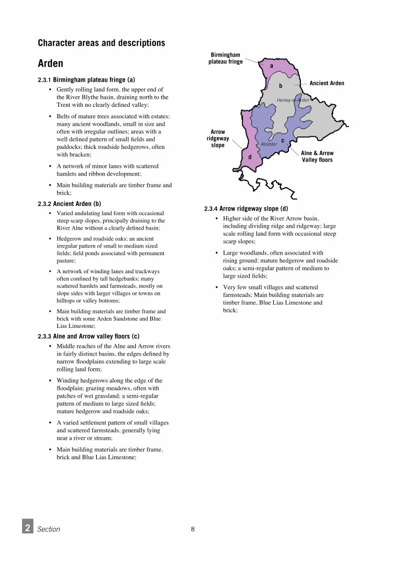
Arden2.3.1 Birmingham plateau fringe (a)
• Gently rolling land form, the upper end ofthe River Blythe basin, draining north to theTrent with no clearly defined valley;
• Belts of mature trees associated with estates;many ancient woodlands, small in size andoften with irregular outlines; areas with awell defined pattern of small fields andpaddocks; thick roadside hedgerows, oftenwith bracken;
• A network of minor lanes with scatteredhamlets and ribbon development;
• Main building materials are timber frame andbrick;
2.3.2 Ancient Arden (b)• Varied undulating land form with occasional
steep scarp slopes, principally draining to theRiver Alne without a clearly defined basin;
• Hedgerow and roadside oaks; an ancientirregular pattern of small to medium sizedfields; field ponds associated with permanentpasture;
• A network of winding lanes and trackwaysoften confined by tall hedgebanks; manyscattered hamlets and farmsteads, mostly onslope sides with larger villages or towns onhilltops or valley bottoms;
• Main building materials are timber frame andbrick with some Arden Sandstone and BlueLias Limestone;
2.3.3 Alne and Arrow valley floors (c)• Middle reaches of the Alne and Arrow rivers
in fairly distinct basins, the edges defined bynarrow floodplains extending to large scalerolling land form;
• Winding hedgerows along the edge of thefloodplain; grazing meadows, often withpatches of wet grassland; a semi-regularpattern of medium to large sized fields;mature hedgerow and roadside oaks;
• A varied settlement pattern of small villagesand scattered farmsteads, generally lyingnear a river or stream;
• Main building materials are timber frame,brick and Blue Lias Limestone;
2.3.4 Arrow ridgeway slope (d)• Higher side of the River Arrow basin,
including dividing ridge and ridgeway; largescale rolling land form with occasional steepscarp slopes;
• Large woodlands, often associated withrising ground; mature hedgerow and roadsideoaks; a semi-regular pattern of medium tolarge sized fields;
• Very few small villages and scatteredfarmsteads; Main building materials aretimber frame, Blue Lias Limestone andbrick;
82 Section
Character areas and descriptions
a
b
c
d
Birminghamplateau fringe
Ancient Arden
Alne & ArrowValley floors
Arrowridgeway
slope Alcester
Henley-in-Arden

2.3.5 Mudstone vale (e)• Small flat valley with occasional small
rounded hills, draining to the Avon at rightangles to the line of the valley; a further areaforms the foot of the River Itchen;
• A medium to large scale geometric fieldpattern; small areas of permanent pastureoften with well preserved ridge and furrow;wide roadside verges typically bounded by athick hedge and ditch; numerous hedgerowelm stumps;
• Scattered farmsteads and dwellings and thevillage of Long Itchington;
• Main building materials are Blue LiasLimestone and brick;
2.3.6 Lias uplands (f)• A varied rolling land form often associated
with steep wooded scarp slopes, mostlydraining to the Rivers Dene and Itchenwithout clearly defined basins;
• Many hedgerows and roadside trees; welldefined geometric pattern of small tomedium sized fields; disused quarries withsemi-natural grassland and scrub
• Compact villages sited on hill and ridgetops,hill sides and along narrow valley bottoms;
• Main building materials are White LiasLimestone (now known as Langport MemberLimestone), Blue Lias Limestone and brick;
2.3.7 Clay vale (g)• Broad flat valley with occasional small
rounded hills, the valley running at rightangles to the lines of the Rivers Stour, Deneand Itchen;
• A medium to large scale geometric fieldpattern; small areas of permanent pastureoften with well preserved ridge and furrow;wide roadside verges typically bounded by athick hedge and ditch; numerous hedgerowelm stumps;
• Relatively few, straight roads with few, smallcompact villages sited by streams along withscattered farmsteads and dwellings;
• Main building materials are Blue LiasLimestone, ‘Hornton Stone’ (Marlstone Rock Bed) and brick;
Ironstone Uplands
2.3.8 Ironstone Uplands (h)• Large scale rolling upland with occasional
prominent ironstone hills, includes the dividebetween the Rivers Leam and Cherwell; it isthe western edge of the NorthamptonshireUplands yet at the same time a continuationof the Cotswold/Edge Hill scarp;
• Large scale strongly hedged field pattern;small areas of permanent pasture with ridgeand furrow; wide roadside verges boundedby tall, thick hedgerows; steep hillsides withsemi-natural grassland and scrub;
• Small ironstone villages often situated onrising ground;
• Main building material is ‘Hornton Stone’(Marlstone Rock Bed);
9 2Section
Feldon
ef
g
h
i
Mudstone vale
Lias Uplands
IronstoneUplands
Scarp foot & slope(see Cotswold
Fringe)
Clay vale
f
Southam

Section2 10
Clay Vale (g) (see Feldon)
2.3.9 Scarp foot and slope (i)• The scarp slope leading down to the broad
flat Feldon Clay Vale, the scarp and valerunning at right angles to the lines of theRivers Stour, Dene and Itchen;
• Semi-improved grassland, scrub and woodon steep valley sides; a medium to largescale geometric field pattern on the foot ofthe scarp; small areas of permanent pastureoften with well preserved ridge and furrow;wide roadside verges typically bounded by athick hedge and ditch;
• Small compact villages sited at the foot ofthe scarp slope; many dry stone walls;
• Main building materials are ‘Hornton Stone’(Marlstone Rock Bed) and brick;
2.3.10 Ironstone plateau and valleylands (j)• Flat land at the top of the scarp slope, deeply
cut by steep sided river valleys, draining tothe Cherwell, the scarp edge forming thedivide between the greater Thames andSevern basins; Steep wooded slopes; largearable fields with red soils on the plateaux;semi-improved grassland and scrub on steepvalley sides;
• Roads run along ridgetops; small compactvillages sited at the rim of the valleys anddropping down along the valley sides; manydry stone walls;
• Main building materials are ‘Hornton Stone’(Marlstone Rock Bed) and brick;
2.3.11 Fringe downlands (k)• A varied rolling land form of rounded or flat
topped hills and secluded river valleys;includes Meon Hill, Ilmington Downs, andBrailes Hill;
• A medium to large scale geometric fieldpattern; rich red soils supporting productivearable farmland with some woodland onhigher ground; small areas of permanentpasture often with well preserved ridge andfurrow; steep hillsides with semi-improvedgrassland and scrub;
• Small compact stone villages, mostly sitedon ridgetops or the foot of the scarp slope;many dry stone walls;
• Main building materials are ‘Hornton Stone’(Marlstone Rock Bed), ‘CotswoldLimestone’ (Oolitic Limestone) and brick;
2.3.12 Broad valleys (l)• Valley floors with some varied undulation
and small rounded hills;
• A medium to large scale geometric fieldpattern with small areas of permanent pastureoften with well preserved ridge and furrow;
• Small compact stone villages, mainly on thevalley bottoms; many dry stone walls;
• Main building materials are ‘Hornton Stone’(Marlstone Rock Bed), ‘CotswoldLimestone’ (Oolitic Limestone) and brick;
Cotswold Fringe
i
i
g
j
k
k
k
l
l
Scarp foot & slope
Ironstone plateau& valleylands
Clay vale(see Feldon)
Fringe downlands
Broad valleys

Section 211
2.3.13 Avon ridgelands (m)• Steeper side of the Avon basin including the
ridge dividing the Rivers Avon and Alnewith a large scale rolling land form;
•A large scale often poorly defined field pattern;some large orchards on hilltops and southfacing slopes; prominent hilltop woodlands;steep wooded scarps and associated semi-improved grassland;
• Varied settlement pattern of small compactvillages, mostly on hilltops and ridges, andloose clusters of roadside dwellings;
• Main building materials are Blue LiasLimestone and brick;
2.3.14 Upper Avon (n)• Flatter side of the upper reach of the Avon
basin; narrow river corridors defined by flatfloodplains with steeply sloping, oftenwooded bluffs to the north west sideextending to broad flat gravel terraces on thesouth east side;
• Grazing meadows often with meanders,islands, steep banks and much marginalvegetation; fringing alders and scrub;winding hedgerows and ditches along theboundary of the floodplain; a large scalegeometric field pattern on the terraces withwell wooded streamlines and some smallarable plots growing a wide variety ofvegetable crops;
• Small compact villages generally on or nextto to a river; scattered greenhouses and otherhorticultural buildings;
• Main building materials are timber frame,Blue Lias Limestone and brick;
2.3.15 Avon and Arrow terraces (o)• Broad flat gravel terraces at the meeting of
the rivers Arrow and Avon;
• A large scale geometric field pattern; somesmall arable plots growing a wide variety ofvegetable crops; well wooded streamlines;
• Small compact villages, generally on or nextto to a river; scattered greenhouses and otherhorticultural buildings;
• Main building materials are timber frame,Blue Lias Limestone and brick;
2.3.16 Avon vale (p)• Flatter side of the lower Avon basin; narrow
river corridors defined by flat floodplainswith steeply sloping, often wooded bluffsextending out to broad flat valley withoccasional low rounded hills;
• Grazing meadows often with meanders,islands, steep banks and much marginalvegetation; fringing alders and scrub;winding hedgerows and ditches along theboundary of the floodplain; a medium tolarge scale geometric field pattern on thevalley land with many small often abandonedorchards;
• Straight roads with wide roadside vergestypically bounded by a tall hedge and ditch; astrongly nucleated settlement pattern ofmedium sized villages, often fringed bygreenhouses or other horticultural buildings;
• Main building materials are timber frame,Blue Lias Limestone, ‘Cotswold Limestone’(Oolitic Limestone) and brick;
Avon Valley
mno
p
Avon ridgelands
Upper Avon
Avon & Arrowterraces
Avon vale
Stratford-upon-Avon

Section2 12
2.3.17 Stour vale (q)• Flatter side of the lower Stour basin; broad
flat valley with occasional small roundedhills;
• A medium to large scale geometric fieldpattern; small areas of permanent pastureoften with well preserved ridge and furrow;wide roadside verges typically bounded by athick hedge and ditch; numerous hedgerowelm stumps;
• Small compact estate villages and clusters offarmsteads and dwellings;
• Main building materials are Blue LiasLimestone, ‘Cotswold Limestone’ (OoliticLimestone), ‘Hornton Stone’ (MarlstoneRock Bed) and brick;
2.3.18 Stour Feldon edge (r)• Steeper side of the lower Stour basin; large
scale rolling land form with occasional steepscarp slopes;
• Large woodlands often associated with risingground; many small coverts and belts oftrees; mature hedgerow and roadside oaks;
• Scattered farmsteads and a small compactvillage;
• Main building materials are White LiasLimestone (now known as Langport MemberLimestone) and brick;
2.3.19 Upper Stour (s)• Middle reach of the Stour valley, a distinct
basin defined by the rounded Tredington hillsand the flatter, rolling southern edge of theFeldon;
• A medium to large scale geometric fieldpattern; small areas of permanent pastureoften with well preserved ridge and furrow;wide roadside verges typically bounded by athick hedge and ditch; numerous hedgerowelm stumps;
• Compact valley bottom settlements andsmall estate villages;
• Main building materials are Blue LiasLimestone, ‘Hornton Stone’ (Marlstone RockBed), ‘Cotswold Limestone’ (OoliticLimestone) and brick;
Stour Valley
q
r
s
Stour vale
Upper Stour
StourFeldon edge
Shipston-on-Stour

Section 313
A viewpoint on design3.1.1 To begin, it is important to note that achieving an
acceptable form of development involves a balance ofissues. Every solution involves a compromise betweencompeting ideals. Achieving one ideal may exclude thepossibility of achieving another. While there is noformula for attaching importance to the concerns, theexistence of this guide is an indication that quality indesign should be given due consideration.
3.1.2 This document sets out ideals that must be balancedwith all the other considerations material to planning. Inseeking to achieve that balance, the approachrecommended here is not, 'does the development meetstandards' but 'how can the best design be achievedwithin the bounds of what is acceptable in other terms.'
3.1.3 In order to establish a workable basis for designguidance, it is worth clarifying what is encompassed bythe term design. When we talk about design, wegenerally talk about suitability to purpose. We also talkabout the overall shape and size of a thing such as abuilding. We talk about where it sits relative to otherbuildings, to the street as well as its position within ablock or the village as a whole. We also talk about theway the thing is put together, the parts of the buildingand the way the parts are arranged. This emphasisesthat design involves both the various objects werecognise and the way they are arranged. Generallyspeaking, settlements are all made up of the same kindsof elements - buildings, plots, streets, bridges,monuments, greens etc. Each town or village is distinctand has a specific character and identity, however,because it is made up of specific buildings, plots andstreets in specific locations.
Basic principles3.1 A viewpoint on design3.2 The importance of specific features3.3 Character and sustainability3.4 Using a settlement as a design resource3.5 Innovation with a purpose
High Street,Henley-in-Arden,looking northtoward St. John’sChurch and, right,in plan
In general terms,Henley High Streetis made up of acarriageway,footways and plotscontainingbuildings. It is aunique placebecause it is madeup of particularexamples of thoseelements in aparticulararrangement.
3

Section3 14
Patterns: objects and arrangements3.1.4 Whatever the element, an entire street or a single
w a l l, the design of the element is a matter of both theobjects that compose it and the relationship betweent h e m . Design involves selecting things and puttingthem together in a particular way - into a pattern - in aspecific place. We can then talk about the characterbecause we experience the pattern of objects in thatparticular place.
Drystone wall of Cotswold limestone Ashlar wall of Cotswold limestone and Horntonmarlstone
Concrete block wall
Part-to-whole: a stonewithin a wall
Part-to-whole: a plot withina plot series
3.1.5 Character is a matter of both material objects and theway they are arranged. Taking the example of a stonewall, as shown above, the character of the wall lies asmuch in the pattern or arrangement of the stones,(dependent on their shape and size) as in the type,colour, texture and veining of the stone itself. Equally,the character of the wall depends on its overall shapeand size as well as where the wall might sit relative toother features.
The part-to-whole relationship3 . 1 . 6 One of the most basic relationships involved in any
design is between the object as a whole and its parts.This is the relationship between a wall and theindividual stones, for example or between a plot andthe row of similar plots running down one side of astreet.
3.1.7 The individual plot is a part of the row, which canitself be outlined as a whole. Similarly, the individualplot, as a whole, is made up of a number of differentelements such as the main building, the garage oroutbuildings, front and back gardens and boundaryfeatures.

Section 315
Levels of scale3.1.8 Using the part-to-whole relationship, it is possible to
look at a settlement at different but related levels ofscale.
• Settlements in the landscape• Streets and neighbourhoods within a settlement • Plot series or blocks, highways and open spaces• Plots • Buildings• Details and materials
This viewpoint provides the framework around whichthis guide is built. It is also the basis for one of themore basic design principles.
3.1.9 Any development will fall within some level of scale,as part of something larger and with its own internalparts. Higher and lower levels of scale are important toboth large and small scale development. In this regardthere are four principal considerations in judging thequality of a proposal:
• its position as part of a larger element (more than onelevel may be involved);
• its shape and size as a whole (scale, massing);• the arrangement of parts;• the specific nature of the parts.
Each of these considerations needs to be seen in termsof the visual and aesthetic impact of the development aswell as its relation to the human activities it is meant toaccommodate.
The importance of specific features3.2.1 Despite the importance of pattern, specific features
can be of great importance within a settlement.Monuments and landmarks, historic buildings, greens,streets and squares, trees, hedges, gardens and otheropen spaces in many cases cannot be replaced without asignificant loss of character. Such elements tend topersist in settlements because they continue to bevalued and recognised as fundamental to the characterof the settlement.
3.2.2 Other features persist, particularly at higher levels ofscale, because they take more effort to change. Streetpatterns, for example, change little over the years.While the buildings may change along them, and thesurface of the street might change, the alignment - itsposition - stays much the same. This persistencecontributes to the overall character of the town.
3.2.3 As far as possible, existing features should be carriedforward into new development.
3 . 2 . 4 In particular it is important to preserve specificfeatures that have been identified as of value due to theirhistorical, archaeological, ecological and geologicalimportance.
3 . 2 . 5 As far as possible, traces of the position orarrangement of existing features, if not their substance,should be carried forward into new development. Forexample, the position and line of paths or routes shouldbe retained in the form of streets or roads, fieldboundaries as plot boundaries etc. Alternatively, the lineor position of a feature might be maintained while thenature of the feature might be changed - replace aboundary with a road, replace a building but retain thebuilding line.
A settlement in thelandscape,Whichford,Cotswold Fringearea, an element atthe highest level ofscale
A well-head,Ilmington, CotswoldFringe area, animportant specificfeature at a lowerlevel of scale

Character and sustainability
163 Section
Reduced energy use3.3.1 There is a correlation between the character of
settlements due to their historical development and theemerging notion of sustainability. In essence both sharethe principle of least energy use (which is distinct fromleast monetary cost). The form and character oftraditional settlements can in part be explained by thelimited availability of energy and resources. Thepersistence of street patterns, as described in theprevious paragraph for example, is partly a result ofindividuals and the community as a whole not beingable to afford the labour and material to demolishexisting streets and buildings and rebuild them. Theyused the least energy necessary to achieve an end.Similarly, the use of local materials was based on thesame principle. To import materials required moreenergy, either in the form of human and animal labouror money to pay for them.
3.3.2 Today, the widespread availability and relatively lowcost of fossil fuels has changed the equation. While themonetary cost of building, in terms of money andhuman energy, might be minimised for economy orprofit, the total energy cost in terms of fuel used isincreased. This makes a much wider range of materialsand types affordable and accessible in any given place -contributing to the homogenisation of the buil tenvironment and to the depletion of natural resources.
3.3.3 While this is a process that has been going on fornearly two hundred years, it has accelerated in the lastfifty. In place of the limits imposed by geography andthe state of technology, the notion of sustainabilityseeks to impose voluntary limits on energy andresource use in order to preserve them for futuregenerations. The principle of least energy use can thushelp to achieve the objective that new development beboth sustainable and local.
3.3.4 Stated as a general principle, the total energy used indevelopment should be minimised. This must be seen notjust in terms of actual construction but in terms of thetotal cost of the development, from material extraction orproduction and transport through construction tomaintenance and running costs.
3 . 3 . 5 Applying this principle to itself suggests that thestarting point for sustainability should be low cost,simple solutions.
3.3.6 In general, new development should make the best useof what exists, both natural and built, as opposed toerasing what exists and starting from scratch.
3 . 3 . 7 New development should respond to the location. Asfar as possible, existing levels, watercourses, vegetation,streets, field/plot patterns, buildings and landmarksshould be incorporated as part of the design. Alterationsto those features should be minimised.
3.3.8 Development should be adapted to the site not the siteto the development.
Reduced resource use3.3.9 Looking at the range of natural resources involved in
development, the principle of least energy use can begeneralised as one of temperate stewardship.
3.3.10 Resources used in development such as land, cleanwater, clean air, fertile soil and minerals should beminimised. In addition, stocks of the resources should beprotected from loss and degradation and, ideally, shouldbe increased. Again, this must be seen not just in termsof actual construction but in terms of the total cost of thedevelopment, from material extraction or production andtransport through construction to maintenance andrunning costs.
3 . 3 . 1 1 Waste or loss of resources through consumption ordegradation by pollution should be minimised.
House in Cherington. Local stone has been usedfor the walls, roof and boundary wall.
Kineton in 1885 and 1995. The street pattern has remained essentially the same.

17 3Section
Adaptability of built resources 3.3.12 Another principle that ties together character and
sustainability is a d a p t a b i l i t y. It is an extension of theleast energy use principle but concerns built as opposedto natural resources. Built resources are those that areused but not used up in the way that energy or waterare. They include, amongst other things, streets,buildings, car parks, parks and greens. The form andcharacter of many such elements in historicalsettlements have come about through the necessity ofgetting the most use out of a building using the leastenergy and materials. The simple way to do this is tocreate buildings that can accommodate a number ofdifferent activities with little or no change to thebuilding. Also, as buildings are changed over time,those that are most adaptable tend to be retained ratherthan being pulled down.
3.3.13 In some cases, streets for example, the differentuses are accommodated at the same time or within ashort period. Bridge Street in Stratford, for example,accommodates pedestrians, parked vehicles andmoving vehicles at the same time. It also periodicallyaccommodates (at different times) a market, a fair and aceremonial procession. In other cases, buildings thatwere originally intended for one purpose are later usedfor another. Some larger row houses, for example, wereoriginally built to house a single family and later cameto serve either as flats for several families or as a shopor offices.
3.3.14 As far as possible, existing built resources should bere-used and adapted with as little change as necessary.
3 . 3 . 1 5 As far as possible, new built resources should bedesigned as multi-functional elements.
3.3.16 New built resources should be robust and adaptable.
3.3.17 An indication of the specific ways in which theseprinciples can be put into practice is incorporated intothe guidance relating to the different levels of scale setout in the following sections.
In summary, it is worth repeating that the starting pointfor sustainability should be low cost, simple solutions.'High Tech' or 'Alternative' solutions are not necessarilythe most appropriate.
3.3.18 Things do not have to look different to besustainable.
A street space inShipston-on-Stouraccommodatesaccess to buildings,walking, driving,parking, shoppingand the possibilityfor many informalactivities
A large house inKineton built for asingle family nowused as a library
A purlin and rafterroof underconstruction. Easilyconverted to livingspace, this type ofroof providesgreater adaptabilityin comparison totrussed rafterconstruction

Using a settlement as a design resource
Section3 18
3.4.1 The villages and towns in the District, have evolvedover a long period of time. The process of theirevolution has involved hundreds of years of trial anderror accommodating human activities and needs. Theresult is a diversity of forms, particularly in terms ofregional and historical differences. This diversityshould be seen as an asset and resource. The variousforms that have been developed through active useoffer a starting point for new designs whichaccommodate similar activities.
3.4.2 Such a view treats 'heritage' and the historical builtenvironment not as a museum but as a library. Theexisting forms of an area can be viewed as potentialsolutions in the continuing task of accommodatinghuman needs in that place. If particular forms ofbuilding have proved satisfactory over time and a coreof human needs remains relatively unchanged, thoseforms provide the most sensible starting point for newones. Local forms of building that have proved mostadaptable provide a basis for new designs that helpboth to maintain character and offer continuedadaptability.
3 . 4 . 3 Ensuring that a range of local forms is taken as thestarting point promotes the richness of diversity andallows for flexibility of use.
3 . 4 . 4 New development should learn from and improve onwhat has already been done. It should take the existingforms from local settlements, proved through trial anderror as potential solutions as a point of departure forany proposed alternatives.
3.4.5 New development should use the experience embodiedin the settlements themselves (and in some casesdescribed in Conservation Area documents) and theknowledge of the local population, in particular as setout in parish appraisals and Village Design Statements.
3 . 4 . 6 Applicants must show they have exhausted thepossibili ties identified in such documents beforeproceeding along different lines.
3.4.7 Look for local solutions first.
3.4.8 Innovate by reinterpretion - make it new AND local.
Market Square,Kineton. Differenthouse types indifferent positionsform a clearlydefined space
Two different housetypes used to makethe best of a longnarrow plot in anew developmentoff High Street,Henley.

Section 319
Looking at settlements3 . 4 . 9 In order to use settlements as a resource, it is
necessary to look at them in detail. From the point ofview of this guide, therefore, analysis of the existingenvironment is imperative in the generation of designs.
3.4.10 Stratford-on-Avon District has 113 Parishes, somewith several villages or hamlets each. The District liesat the confluence of several character areas as identifiedin the Character Map of England: the Arden, AvonValley, Feldon, Cotswolds and Ironstone Uplands.
3.4.11 As a consequence of its size and diversity, theDistrict is far too large and varied to be summarised ina single - useful - document. The purpose of this guideis not, therefore, to provide a detailed account ofcharacteristic forms. It is meant, instead, to provide acommon means for looking for and identifying thoseforms and seeing them as a source for design. Gooddesign will not come from a catalogue of characteristicdetails and materials. A kit of parts with no instructionsis of little use.
3.4.12 Analysis fits into the overall recommended outlineprocedure set out previously:
• check the proposal is acceptable in policyterms;
• determine requirements to be accommodated onsite as set out in the Local Plan and PlanningPractice Notes;
• identify the character area within which thedevelopment is proposed;
• read the information regarding that area in thisdocument and any relevant Village DesignStatement, Conservation Area or otherdocuments;
• by visiting the site and using this guide, identify thespecific characteristics that make up the site and thearea in which the development is proposed;
• discuss proposals with planning andconservation officers;
• demonstrate, in text and graphics, that thedesign submitted shares a sufficient number of those characteristics or justify theirabsence.
3.4.13 To facilitate the inclusion of analyses in thedesign process, the following sections sets out both designprinciples and a sample analysis of a town within theD i s t r i c t . In addition, the results of analyses of selectedsettlements from the main character areas are shown toillustrate some of the features common to the areas.
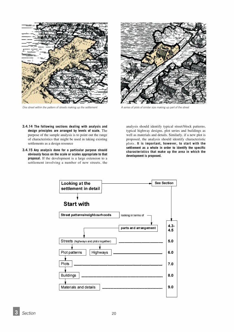
203 Section
3.4.14 The following sections dealing with analysis anddesign principles are arranged by levels of scale. T h epurpose of the sample analysis is to point out the rangeof characteristics that might be used in taking existingsettlements as a design resource
3 . 4 . 1 5 Any analysis done for a particular purpose shouldobviously focus on the scale or scales appropriate to thatp r o p o s a l . If the development is a large extension to asettlement involving a number of new streets, the
analysis should identify typical street/block patterns,typical highway designs, plot series and buildings aswell as materials and details. Similarly, if a new plot isproposed, the analysis should identify characteristicplots. It is important, however, to start with thesettlement as a whole in order to identify the specificcharacteristics that make up the area in which thedevelopment is proposed.
One street within the pattern of streets making up the settlement A series of plots of similar size making up part of the street

Section 321
3.4.16 A central and fundamental principle of this guide isthat new development should respond to its locationwithin a settlement or surroundings as a whole and allappropriate levels of scale.
3 . 4 . 1 7 The starting point for designs on a particular siteshould be existing forms on sites with a similar relativeposition.
3 . 4 . 1 8 New development may present exceptions. In suchcases, proposals must be accompanied by a statementthat sets out the considerations taken into account,demonstrating why the exceptions are justified and thelogic behind them.
3.4.19 The question to ask is, what is the best form ofdevelopment for a particular location? Which formsmake the best use of the site’s characteristic features?Again, a great deal of information about thecharacteristic forms of settlements has already beengathered and can be found in Conservation Areadocuments and Village Design Statements. Suchdocuments should be a starting point for analysis.
One plot within a series of plots The main building in the arrangement of parts making up the plot

The diversity of forms3.4.20 It is worth noting that the character of a settlement
is not necessarily, and very seldom is, uniform. Placesof a uniform character tend to be the exceptions. Moreoften, a place can best be characterised by diversity,that is, by the range and mix of different elements.High Street in Henley-in-Arden, for example, has aclear identity but one that is characterised by a range ofbuildings in terms of type and period of origin. This is,of course, a matter of degree. Some places have anarrower range of variation than others. The degree ofvariety is in itself a feature of a place. Whatever therange, it is unlikely that an analysis of a settlement willresult in a single characteristic type of house or street.
3.4.21 This raises a fundamental question about whatshould be considered 'characteristic' of an area. For thepurposes of this guide, the answer relates back to thequestion of character and sustainability. The mostcharacteristic local forms are those that respond to thelocation, making the best use of what exists, both naturaland built, with local resources. This should be seen inopposition to erasing what exists and starting fromscratch with imported resources. As with most things,this too is a matter of degree. Over time there has beena progressive tendency for design solutions andmaterials to be used over wider areas. From thedissemination of house designs in pattern books in theeighteenth century to the wider availability of materialssuch as Welsh slate and London brick in the nineteenth,house design has become more and more homogenisedacross England. As a result , there is a generalcorrelation between the degree of 'localness' and date oforigin. From about the fifteenth century (few examplesof earlier buildings survive) to the present, 'older'generally means 'more local'. In most cases of analysisthis tendency can be followed as a rule. As history wellattests, however, this tendency is NOT an historicalinevitability. Newer does not necessarily mean lesslocal and older does not necessarily mean more local.This is particularly relevant for new designs. A'contemporary' design can be very local and a'traditional' design can be very alien both in terms of theform and materials used.
Innovation with a purpose 3 . 5 . 1 While design guides are often criticised for stifling
creativity and innovation, any examination of the bestdesigns shows they are responses to both specific, localissues and as well as general, wider concerns. Mostsuccessful innovations have a purpose. The aim of thisguide is to promote successful, purposeful innovation.
3.5.2 If the success of an innovation is not to be a matter ofchance, the design should be based on previousexperience. The question is then, whose experience ismost relevant? It is the premise of this guide that themost relevant experience for innovation in the design ofthe built environment is that embodied in the
immediate environment itself. This is not to discountexperience developed elsewhere nor experimentationbut to say the starting point should be immediateexperience.
3.5.3 In attempting to evaluate innovation, it is necessaryto ask the question, why innovate? Innovation for itsown sake is rarely satisfactory. More satisfying isinnovation for a purpose. Ideally that purpose is notentirely personal but of wider significance. To that end,this guide seeks to encourage innovation that furthersthe overall aim that designs should be local, sustainableand equitable. As far as possible, any innovation shouldseek to improve the quality and design of the publicrealm, its character and identity and overall health.Innovations should help to reduce the total energy costand resource use of development and should seek toimprove the multi-purpose use and adaptability ofdevelopment.
223 Section
Interior of the School ofFarriery, Warwickshire College,Moreton Morrell. The form ofthe building - a traditionalcircular school with gallery -suits the purpose of instructionand integrates innovative useof materials and details into awell crafted whole
The similarity ofposition, orientationand relation toneighbours of thebuildings gives HenleyHigh Street a sense ofunity despite thevariety of buildingtypes

Section 423
Looking at the design of
Settlements4.1 Design and landscape4.2 The settlement as a whole in the landscape4.3 The internal arrangement of settlements4.4 Movement and street patterns4.5 Landscape and open space as a network
Design and landscape4.1.1 While the aim of this document is to provide design
guidance that takes account of the general character oflarge areas, the landscape as a whole is not itself theobject of design. The common unit of development,which is to say, the development site, tends to be a plotor field (in part, as a whole or several taken together)rather than an area of countryside. The concern must be,therefore, the cumulative effect of smaller scale changeson the countryside. Development within settlements thatchanges the built up area and skyline of a village canhave an effect on the landscape.
4.1.2 At this level, the following points should bedetermined in the design of new development.
• In which landscape character area is the developmentproposed and in which settlement within the area?[see chapter 2 and sections 4.2.1-4.2.2]
• What type of settlement is i t in terms of i tsrelationship to its site - its position relative to landforms, water features, other settlements and roads?[see sections 4.2.3-4.2.7]
• What is the extent of the built up area? [see sections4.2.8-4.2.14]
• What is the skyline and edge character of thesettlement, including landmarks visible from adistance? [see sections 4.2.16-4.2.21]
• What is the movement pattern within the settlement?[see sections 4.4.1-4.4.10]
• What is the nature of the landscape and open spacenetwork? [see sections 4.5.1-4.5.31]
• What is the arrangement of streets andneighbourhoods? [see sections 4.3.1-4.3.20 and 5]
The settlement as a whole in thelandscape4.2.1 It should be noted that within the context of the
District Local Plan, the location of development isprincipally a matter of policy and secondarily a matterof design. Policy considerations will, therefore, takeprecedence over design considerations. Designprinciples should thus be followed within the bounds ofwhat is acceptable in policy terms.
4.2.2 In terms of seeing settlements as a design resource,landscape character areas define a context fordevelopment in terms of the range of characteristicsettlement types, and their various components atdifferent levels of scale down to building types, detailsand materials. Each landscape character area has amore or less distinct range of typical forms, as set outin chapter 2 and as determined through looking at thesettlements. The range provides for choice while thelimits to the range help to define the character of theplace. Within an area, there is a choice of forms but notan unlimited choice.
Types of settlement4.2.3 Examination of settlements in the District suggests
there are two basic types of development: d i s p e r s e dhamlets and farmsteads on the one hand and c o m p a c tvillages and towns on the other.
4
A view of Long Compton,Cotswold Fringe area, lookingnorth over a field of ancientridge and furrow

Section4 24
Farmsteads and hamlets4.2.4 The character of historic farmsteads and hamlets is
rooted in the association between the buildings andproductive land. Dispersed settlements can thus becharacterised in terms of the size and number of fieldstraditionally associated with a given building or group ofbuildings. This leads to a characteristic density offarmstead buildings within open countryside. Thelocation of hamlets and farmsteads relative to land formsand water features tends to follow the same pattern asfor compact settlements.
Compact villages and townsTypes by position4.2.5 There are three types of compact settlement in terms
of the position of the village or town relative to theprincipal features of land forms and water features:
• hilltop or ridgetop;• hillside or hillside terrace;• valley bottom, usually at the foot of the valley side
and/or near a stream or river.
Each type has distinctive characteristics and sodifferent principles apply to each.
4 . 2 . 6 As a general design principle, settlements shouldremain identifiable as a particular type.
• For dispersed settlements, the density and pattern ofbuilding relative to field area should be maintained.
• For compact settlements, topographic limits todevelopment should be observed.
• Hilltop villages should, on the whole, remain above agiven level.
• Hillside or terrace settlements should, on the whole,remain within upper and lower limits.
• Valley bottom settlements should, on the whole,remain below a given level.
4.2.7 The reasoning behind the original choice of positionwill l ikely have been based on a number ofconsiderations. These may have included groundconditions (avoiding steep, wet or flood prone ground),distance to springs for fresh water, the presence of aford or bridge, orientation to the sun (to increase lightand warmth), protection from prevailing winds, thecrossing of main routes etc. Where the original reasonsfor the choice of position still apply they should befollowed in judging the acceptability of development.
The pattern of farmsteads in Ullenhall, AncientArden, Arden area
Hilltop village,Ardens Grafton, Avon ridgelands, AvonValley area
Hillside village, Sutton-under-Brailes, Fringe downlands,Cotswold Fringe area
Scarp slope valley bottom village, Radway,Scarp foot and slope, Cotswold Fringearea

Section 425
Sample Analysis SHEET 1Kineton, Lias Uplands, Feldon area
The Settlement on its site
What is the position of the settlement in thelandscape?
The village of Kineton, once a borough and site of amedieval market, lies at the crossroads of theWellesbourne to Banbury road and a routeconnecting villages along the south-eastern edge ofthe Lias Uplands. The latter route runs parallel to theClay Vale and Edge Hill scarp. Relative tosurrounding towns such as Stratford, Southam,Shipston and Banbury, Kineton is small andrelatively secluded. In relation to more immediatelysurrounding villages, Kineton is larger and morecentral.
The village sits on a rising site just on the edge of theLias Uplands alongside the River Dene. It extendspredominantly along an east-west axis parallel to theriver and the Wellesbourne-Banbury Road. The riverforms a barrier to growth to the south and the formerrailway line does the same to the north.
Kineton on its site
Great Alne, a river valley bottom settlement,Alne and Arrow Valley Floors, Arden area
The Graftons, ridge top settlements, AvonRidgelands, Avon Valley area
Harbury, a hilltop settlement, Lias Uplands,Feldon area
Priors Marston, a hillside settlement,Ironstone Uplands
Tredington, a valley bottom/hillside hybrid,Upper Stour, Stour Valley area
Radway, centre left, scarp foot valley bottomsettlement, scarp foot and slope, CotswoldFringe area. Ratley, lower right, is a hillsidetype
Examples of other settlements

Section4
Sample Analysis SHEET 2Kineton
The Settlement: extent, edgecharacter and views
What is the extent of the built up area?In terms of extent, Kineton is something of ahybrid. It follows the general pattern of both ahill top and valley bottom settlement. Like aridge top settlement it occupies a ridge andplateau and does not extend much below the80 metre contour. All roads rise up to thecentral core of the village. Like a valley bottomsettlement, it has extended along the mainroute, more or less parallel to the river. Asecondary route runs perpendicular to the mainroute down toward the river.
What is the edge character and what are theimportant views?
The main edge character is planted anddiffused, made up mainly by the river corridor,former railway line and large grounds orgardens. The tower of St. Peter's Church is theprincipal landmark of the village, visible from adistance on the northern and southernapproaches to the village. There are views outto the north-west and south-west to farmlandand parkland and to the south-east to Edge Hill.
26
Extent4.2.8 Once established, a settlement will, generally, tend
to expand along the main routes through it and onflatter ground not prone to flooding. The main routeprovides ready access and flatter ground is easier tobuild on. Secondarily, development tends to extend offfrom main routes connecting to other routes forming anetwork. This suggests four further principlesregarding position and built up area.
4.2.9 New development should extend along or gain accessfrom the main routes serving the settlement.
4 . 2 . 1 0 Development should occur on flatter rather thansteeper ground outside of flood plains.
4.2.11 Routes should connect to form a network.
4 . 2 . 1 2 If a connection is not possible at the time ofdevelopment, the design should not close off thepossibility of a future connection.
Patterns of growth4.2.13 Examination of a number of settlements across the
District reveals general patterns of growth.
• Dispersed hamlets and farmsteads tend to be locatedwithin an irregular pattern of lanes and an irregularplot pattern.
• Valley bottom settlements at the foot of the valley sidetend to extend along the line of the valley, that is,following the contour lines. Secondarily, they tend toextend out into the valley rather than up the slope.
• Valley bottom settlements adjacent to a river tend tosit on a terrace above the river level and extend alongthe line of the river or at right angles to it, dependingon the direction of the main route. Settlements thatcontour a river tend, secondarily, to extend away fromthe river, more or less at right angles to the mainroute. With the exception of the larger towns such asStratford and Southam, settlements tend to remain onone side of the river or stream.
• Hillside or hill terrace settlements tend to extendparallel to the contour l ines of the hillside.Secondarily they tend to extend downward along mainroutes.
• Hilltop or ridgetop settlements tend to extend alongridgelines and plateaux and secondarily downwardalong main routes.
4.2.14 New development should follow these tendencies inthe respective types of settlement.
4.2.15 Even a quick look at actual settlements will showthat there are many exceptions to these tendencies dueto the need to balance the range of considerations.
Plan diagram ofKineton showing hardand soft edgeelements
View of Kineton from the west

Section 427
Skyline and views4 . 2 . 1 6 The main issues affecting skyline are the relative
height and arrangement of buildings and other largefeatures. In most settlements the church with its spire ortower is the tallest landmark and is also often found ona rising site. Spires and towers are thus prominentlandmarks and an important part of the landscape.Other features in settlements such as large public orprivate buildings, monuments and trees can play asimilar part in the landscape.
4.2.17 New development should not block or obstruct viewsof important landmarks as seen from highways,footpaths, bridleways, public open spaces or other publicareas either outside or within the settlement.
4 . 2 . 1 8 Views out toward the countryside from w i t h i n asettlement (through gaps between buildings, downroads, streets and lanes and across open spaces) help toconnect it to its surroundings and are an important wayin which the settlement is rooted into the landscape.
4.2.19 New development should not block or obstruct viewsout as seen from highways, footpaths, bridleways, publicopen spaces or other public areas within the settlement(see also 4.5.5).
Edge character4.2.20 The edge of a settlement is in many cases s o f t,
mainly made up of trees and hedges or other planting.In other cases it is hard, made up of building walls orfences. The edge may be d i f f u s e d, made up of largeplots with detached houses, or dense, with terraced orother closely spaced buildings.
4.2.21 New development should maintain the most commontraditional edge character of the area in which it sits.
4 . 2 . 2 2 The nature of planting in the different characterareas varies significantly. Species used in buffer andedge planting should be appropriate to the character ofthe area in which it is proposed. For more detailedinformation please see Section 4.5 and the species listsfor the relevant areas in Appendix D taken from theWarwickshire Landscapes Guidelines.

Section4 28
The internal arrangement of settlementsThe pattern of streets and neighbourhoods4.3.1 In general, villages and towns are not developed in
an uncoordinated way, a building here and a housethere with no clear relation between them. Even thoughthey may appear haphazard and picturesque, nearly allsettlements do have an underlying structure. Bothplanned and piecemeal development tend to occur in asimilar basic pattern, usually a street or road lined onboth sides by plots containing buildings. That genericarrangement is principally a matter of minimisingexpense and human effort. In order to get to a buildingyou need a street or road. As roads and streets arerelatively costly, it makes sense to have as manybuildings as possible using the same road for access.
The street as a fundamental unit ofdevelopment4.3.2 The result has, in general, been buildings gaining
access from a street and facing each other across it.This is true of both traditional and new development.The unit of ‘carriageway with plots either side’ isclearly seen in the older villages within the District.Equally there are many new developments that followthe same generic pattern.
4.3.3 When settlements grow, they tend to expand by theaddition of plots along existing roads or by the additionof streets within or on the edges of the existingsettlement. Growth thus involves either the filling in orcreation of new streets.
4.3.4 For the purpose of this guidance, the term 'street' willrefer to the highway AND the plots that line it either side,including public open spaces, taken together as a unit.
4.3.5 In order to integrate development within a settlement,the street should be taken as the fundamental unit ofdevelopment. It should be seen as the starting point orcontext for design, whether the development involvesseveral new streets or modifications to an existing one.
4.3.6 Development should be conceived in terms of this unit.Highways and access roads must be designed togetherwith the plots, buildings and open spaces which they willserve. Likewise, buildings, plots and open spaces mustbe designed together with or taking account of thehighways that serve them.
View and plan of Main Street, Ardens Grafton,Avon Valley area
View and plan of Bridge Street,Kineton, Feldon area
View and plan of St. Andrews Crescent, Stratford-upon-Avon, Avon Valley area

29 4Section
Integration of streets into a street network4.3.7 In most cases, the growth of settlements has resulted
in the creation of an interconnected network of streetsand greens or squares lined by buildings.
4.3.8 A network of streets, as opposed to a treearrangement with culs-de-sac along a main spine, has anumber of advantages with respect to the goals ofsustainable, local and equitable development. Anetwork is 'permeable'. It offers a choice of relativelydirect routes from any one point to another. It avoidsthe concentration of traffic (and so congestion) at thebottom of culs-de-sac and on main 'collector' roads. Itmaintains the continuity of a clearly legible publicrealm of streets, cyclepaths and footpaths. In contrast,tree systems tend to restrict choice, increase distancetravelled, concentrate traffic onto a few routes thatbecome congested or 'race tracks' and createmonotonous and disorienting environments.
Street network in thecentre of Kineton
Cul-de-sac developmentoff the Warwick Road,Kineton
4 . 3 . 9 Any new development should reinforce or create anetwork of routes and allow for further connections. Theconnections may be selective, that is, allow forpedestrian or cycle but not vehicular movement.
4.3.10 There should be a logic to the network, that is, clearreasons for the location of a route.
4 . 3 . 1 1 Any particular route should normally lead to somedestination or feature such as:
• another street;• an actual connection out to the countryside by
footpath, cycleway or track (or any combination ofthose);
• an open view out to the countryside (not simply a gapbetween houses but across public open space);
• a significant public open space with large staturetrees;
• a building that is distinct from the others along thestreet, (for example a large house or agriculturalbuildings).The choice will depend on the context. Again, lookfor local solutions first.
4.3.12 The network of routes within a settlement should bea response to the physical characteristics of the site.See section 3.3 and in particular paragraph 3.3.7.
A dead-end lane in Harbury, Feldonarea, that leads to the site of theformer windmill and extends as apublic footpath out into thecountryside. The tall brick structureto the left is the base of the windmill

Section4 30
Large scale development and the term ‘estate’4.3.13 This guide is intended to apply equally to small
scale development and what are commonly referred toas housing or industrial ‘estates’. A word of caution isnecessary, however, with the use of the term estate.Much of the development that has been conceived andbuilt as estates is precisely the kind of development thisguide is seeking to avoid. The concept of the estatetends to result in development that is inward looking,isolated from the settlement of which it is a part anduniform and often alien in detailing. The estate conceptthus tends to become a barrier to integrating newdevelopment into a settlement and maintaining localdistinct iveness. All new development should beconceived of and appear as part of or an extension to anexisting settlement, not a self-contained ‘estate’. Thisemphasises the need for new development to makeconnections to and extend the existing movementnetwork.
Access, fronts and backs and orientation4.3.14 With the generic structure of buildings facing each
other across the street, the side of the building facingthe public highway has generally been considered the'public front'. It tends to be treated and used differentlycompared to the sides or backs. The distinctioncorresponds to that made between public and privatebehaviour. Some things are considered appropriate forthe public context and others for the private. The mostobvious expression of this in a building is keeping thefront 'presentable' and tidy and leaving the back for'messy' activities such as storage, services or washing.Likewise it is expressed in the greater investment inmaterials and details often found on the public frontrelative to the backs or sides. Orientation also hasimplications for security. Maintaining front-to-frontand back-to-back relationships avoids exposure of themore vulnerable back and side boundaries of plots.
4 . 3 . 1 5 In order to maintain the distinction of public andprivate realms, to maintain security and the character ofthe street, fronts should face fronts across the highway.
4 . 3 . 1 6 By implication, backs should be set against backswhen several streets run parallel or come together.
4 . 3 . 1 7 Responding to specific circumstances, in particularat corners (see 4.3.18), might require exceptions withinthe limits of a range, from most to least desirablerelationships.
Plots separated by a path, drive, lane, street, square,green:
• front-to-front, most desirable• side-to-side, .• front-to-side, .• front-to-back. least desirable
Plots sharing a boundary within a ‘block’:• back-to-back, • back-to-side, side-to-side.
These are general but not absolute rules. Applicantsmust demonstrate that they have exhausted thepossibilities of maintaining front-to-front and back-to-back relationships before submitting alternatives.
Front-to-front across a route orpublic highway. The buildingsare shown hatched and theheavy line is the frontage
Back-to-back betweenroutes
Street/block structure inTredington, Stour Valley area
Front-to-front relationship Back-to-back relationship

Turning corners4.3.18 In a network of streets, the junction of two or more
streets presents a special situation. For example, joiningtwo idealised streets at right angles to form a T-junctiongives rise to an 'overlap' of plots in the angles of thejunction.
4.3.19 Seen separately, each ideal street includes a plot atthe angle of the junction with a frontage on two streets.In order to fit the two streets together and complete thejunction, some adjustment must be made in the area ofoverlap or corner zones. One solution is to create a'corner plot' shared by both streets. The corner plotsthen potentially have access from, and public frontsonto, both streets. As detailed in the following section,corners present an opportunity. The transition from onecharacter to another tends to occur around a corner.
4.3.20 Corner plots thus gives rise to several questions. Ifthere is a concern to maintain the arrangement of frontsfacing fronts across a street, which street should thecorner plot face with its public front? If there is also aconcern to maintain a hierarchy of streets, should thecorner plot front on to the higher or lower weightedroute? How is the transition made from one street to theother in terms of components and character? Should thebuilding within the corner plot have two 'public' fronts,that is, two fronts with windows and appropriatedetailing (even if only one front includes the door)?These questions emphasise that corners present animportant design consideration, both as a challenge andan opportunity. There are many different solutions tothe 'corner problem' and the particular solutions foundin a settlement often contribute to its overall character.
4.3.20 The starting point for addressing the corner problemshould be the range of solutions for similar situationsfound in the settlement in which the new development isto occur. Again, look for local solutions first.
31 4Section
A herringbone arrangement of plots as a solutionto the corner problemIdeal main street with a gap between plots
to form T-junction.
Ideal side street with plots running up to T-junction.
A courtyard arrangement
A wide frontage plot with side garden on the sidestreet
Main and sides streets put together withcorner zones at T-junction in which plotsmight front either street.
corner zones
A herringbone arrangement of plots with a cornerbuilding

Movement and street patternsDifferent streets, different character4 . 4 . 1 Close examination of traditional settlements reveals
that many are composed of a number of different kinds ofstreet. Different streets have different character. Manysettlements have grown up along the main routes that leadfrom one place to another. Because they are through routes,they tend to be fairly wide. Also, in some cases such asStratford, Alcester and Shipston, the towns were originallylaid out to accommodate a market. In the latter cases boththe street space for the market and the plots along it weredeliberately designed using specific, often regulardimensions that are distinct from other streets. Thus, ingeneral, a High Street is distinct from a side street or backlane. In this respect, settlements tend to have a hierarchy ofroutes from primary main streets to secondary and lowerside streets. Differences in hierarchy and character tend tobe associated with different positions in the settlement.Main streets tend to lead from one settlement to anotheror connect one central feature to another, side streetstend to connect one main street with another or end atthe edge of the settlement.
Centre and periphery4.4.2 In general, the difference between main and side
streets corresponds to the difference between the centreand the periphery. On a purely geographical basis, allsettlements have a middle and an edge. In terms ofmovement, the centre is generally the place that the mostpeople can reach in the least time and with the least effort. Forthat reason the centre tends to be the busiest and is usually theplace where shops, offices and pubs are located. In general,the main street forms the central axis of a settlement.
4.4.3 Looking at a larger street network over a wholesettlement, there is a general tendency for a change inthe nature and character of streets moving away fromthe centre or central axis toward the periphery. In largersettlements, the distance from centre to edge is likely tobe greater and there is likely to be a larger range ofdifferences in character moving from the centre to theperiphery or vice versa. To account for the range ofdifferences, relative weight or values can be assigned tothe streets. The central, main streets leading in and outof a settlement are primary routes, while side streets,moving away from the main routes, are secondary,tertiary etc. The range of different routes in anysettlement may not easily fit into a simple numericalhierarchy. Any numerical or hierarchical value is,therefore, not as important as the differences incomponent elements and arrangement, which is to say,differences in character.
4.4.4 New development, of whatever scale, will necessarilyoccupy a position within a hierarchy of streets. Whetherat the centre, periphery or anywhere in between, thatposition will present a specific context in terms of thecharacter of the streets and the differences betweenthem.
4 . 4 . 5 Position in a hierarchy of streets is a fundamentalconsideration in design.
324 Section
The High Street is thecentral axis of Henley-in-Arden
Hierarchy of routes. The main route is yellow, secondary orange,tertiary routes are red, quaternary violet and footpaths dotted violet
Banbury Street, Kineton, a main route, in yellowand Mill Street, a side street, in red.
Banbury Street is wide with a grass verge andhouses set back from the footpath.
Mill Street is much narrower with houses close tothe footpath and carriageway.

Section33 4
Sample Analysis SHEET 3Kineton
Settlements: Street patterns
What is the range of different streets andtheir arrangement?
Following the general tendency of traditionalsettlements, the street is the basic unit ofdevelopment in Kineton. The street pattern ispredominantly one of through streets that fittogether to form a network. There are four‘main’ streets each with a different character,Warwick Road, Bridge Street, Banbury Streetand Southam Street. Connecting these aresmaller narrow traditional lanes: including MillLane and Manor Lane as well as modern‘estate’ roads. There are also some areas withculs-de-sac and loop roads that form deadends.
Though the pattern of streets in Kineton forms anetwork, vir tually all the junct ions are Tjunctions. Thus, even though Kineton is a'crossroads' village, it might better be called a'staggered' or 'skewed' crossroads. The fourmain routes converge on a central 'block'.Because the routes forming the block are ofdifferent weight and character, however, theblock has different character on different sides.The four main routes are the widest and arewell defined by buildings. The tertiary routesare narrower but less continuously defined bybuildings. They tend to connect one primary orsecondary route with another. Most of the culs-de-sac connect to the Warwick Road and theloops between Banbury Street and SouthamStreet.
Component streets
Hierarchy and character4.4.6 The differences in character corresponding to
differences in position can be seen at a number ofdifferent levels. Often the main street was an existingroad and as a result the street winds and varies inwidth. In some villages the main route has a wide grassverge while in towns there are often wide footways.Streets at the centre tend to have more small plots -often deep with narrow frontages - and buildingcoverage is high. Generally the buildings are older andtend to be set at the front of the plot (the back of thefootway), usually of two and sometimes three storeys.
4.4.7 Turning off the main street, the side streets tend tohave narrower carriageways, with or without footways.The geometry of streets tends to be more formal andregular. Plots are on average larger, building coveragelower with newer buildings. In larger settlements theperiphery tends to include areas of housing mixed with,for example, larger farm complexes, schools, marketsor industrial estates. Such generalisations illustrate the
point that different streets should have differentcharacter. While there are some common differences,each settlement is unique in terms of the specific detailsof each distinct street.
4.4.8 New development should reinforce or complement theexisting hierarchy in terms of range and character.
Thus, in the process of design, an essential question toask at an early stage is: what position does the siteoccupy relative to existing routes and where in ahierarchy of routes will any new streets fit?
4.4.9 In the case of large scale development involving thecreation of new streets, the development should berecognisable as an extension of the existing network interms of hierarchy.
•New streets must maintain a clear and appropriaterelation to the existing street network in terms ofweighting and character.
•Within the site there should be a clear distinctionbetween primary, secondary and any other lowerweighted routes appropriate to the size of the site andits position relative to the surrounding street network.
4.4.10 See chapter 5.0 for further principles concerningstreets.
Another aspectcontributing to thecharacter of streetsis the definition ofspaces as part of alandscape and openspace network.
See section 4.5

Landscape and open space as anetwork4.5.1 The combination of streets, squares and greens
making up a settlement generally forms a network ofpublic spaces defined by the public fronts of plots andbuildings as well as landscape features. The resultingpattern of spaces, including other public rights of waysuch as footpaths and bridleways, is an importantaspect of a settlement. The experience of walking,driving, riding or cycling from one space to another isthe basis for people's perception of the settlement.Moving through the sequence of spaces is the waypeople get to know and recognise its character andidentity. A trip from one point to another is not just ajourney from A to B. The landscape and open spacenetwork - defined by all its component parts - providesa series of cues and features that make it unique. Theterms commonly used to describe or define thelandscape and open space network include paths,edges, landmarks, gateways, nodes, central spaces,crossings, views and vistas. Spaces in the network tendto be defined by buildings and/or plants and describedin terms such as large/small, open/enclosed, narrow/wide,long/short, straight/curved, central/peripheral.
4.5.2 The position of a site within, and its contribution to,the pattern of spaces, defining buildings and boundariesand landscape features is an important consideration fordesign.
4 . 5 . 3 New development should maintain and extend thelandscape and open space network of an existingsettlement by taking best advantage of existing featuresand creating new features appropriate to the locationincluding:
•routeways of different kinds,•edges or boundaries between distinct areas,•landmarks,•gateways,•crossings,•central spaces,•views.
344 Section
Ardens Grafton, Avon Valley area. A view out overthe countryside accentuated by a tree in themiddle ground.
Harbury, Feldon area. The view down ChapelStreet is terminated by a magnificent beechtree.
Far too often views within new developments areinappropriately terminated by garages.
4.5.4 The boundaries, size and and sequence of openspaces, including highways and footpaths etc.,created by new development should extend andenhance the character of the landscape and openspace network of an existing settlement.
4.5.5 Views along streets are particularly importantin the integration of the landscape and openspace network. In many traditional settlements,for example, there is a visual link betweenlandmarks such as churches, other majorbuildings or trees and the main streets.Landmarks tend to mark the end of the vistadown the street. Equally, views out of thesettlement often incorporate the opencountryside as a visual feature.
4 . 5 . 6 New development should, wherever possible,incorporate surrounding landmarks or opencountryside as part of the landscape and openspace network of the settlement (see also4.2.18).
4 . 5 . 7 Views within new development should beadequately terminated.
4 . 5 . 8 The terminal feature should be visuallyappropriate, that is, a public building, majorlandscape feature, mature tree or, for example,the public front of a building, rather than a blindgable end or a garage. The feature should bestrong enough visually to catch the eye and standup to scrutiny.

The importance of landscape and planting4.5.9 It cannot be emphasised enough that both hard and
soft landscape features should be an integral part ofini tial design ideas. Submission of landscapeinformation at the outset should help to avoid change atlater stages with regard to the integration of the designinto the existing landscape network as well as its effecton highway safety, sewers and other undergroundservices.
4.5.10 Hard and soft landscape features must be conceivedof as an integral part of designs for new developmentAND as an integral part of the wider landscape and openspace network.
4.5.11 Concept information regarding landscape proposalsshould be submitted as early as possible in theapplication process, including indications ofarrangement within the overall landscape and openspacenetwork, arrangement within the site showing spacerequirements and general indications for species.
4.5.12 In certain circumstances District Local Plan policiesrequire new development to include a percentage ofpublic open space. For details of these requirements andrequirements for the maintenance of the space, pleaserefer to the current version of the District Local Plan. Thelocation and character of open spaces and landscapefeatures is a question of design and should be based onthe principles found in this guide, in particular theanalysis of the settlement in which development isproposed. For an assessment of the importance andcharacter of opens spaces within selected settlements,please also refer to the relevant Conservation Areadocuments and Village Design Statements.
4.5.13 For further details regarding landscape design,please refer to sections 6.2, 7.4 and Appendix D of thisdocument and to the advisory leaflet ‘Landscape Design’available from the Planning Department.
The uses of landscape4.5.14 Areas of planting should not be viewed solely as a
visual amenity but a resource with a number ofpotential benefits. A multi-purpose landscape will bemore robust and bet ter serve to integrate newdevelopment into its surroundings.
4 . 5 . 1 5 Landscape features should be designed as multi-purpose elements within the broader network, servingwhere possible as:
•public open space,•a visual amenity,•a buffer against temperature extremes,•a wildlife habitat,•a land drainage feature.
Maintenance4.5.16 The ongoing maintenance of plant material is crucial
to its effectiveness as part of new development. It istherefore essential that the responsibility formaintenance of planting in new development is clearlyestablished prior to the issue of planning consent.
4.5.17 Ideally, structure planting, corridor, screen and streettree planting should be within land normally maintainedby the Parish, District or County Councils or by someother public body or trust.
4 . 5 . 1 8 A financial contribution for the maintenance isnormally expected in the form of a commuted sum.
Edge, screen and corridor planting4.5.19 As noted in sections 4.2.18-4.2.21 above, the edge
character of a settlement is a fundamental aspect of itscharacter. In cases where the treatment is soft, theprincipal constituent of the edge is most often hedgeswith hedgerow trees and/or less formal screen planting.
4.5.20 To be effective, the space for this edge and screenplanting should be a minimum of 5 metres wide.
4 . 5 . 2 1 Buffer and corridor planting associated with majorroads, railway lines or other features as well asecological or wildlife corridors should be a minimum of16 metres wide. The corridors should be sufficient inlength to connect other major landscape features.
Specifications for such planting are included inAppendix E.
4 . 5 . 2 2 While often appropriate as an edge treatment,screening and hiding should not be the principalapproach to dealing with the boundaries between newdevelopment and other areas within a settlement.
Choice of species4.5.23 Particularly in a rural location, the impact of
planting on the character of a settlement can be verysignificant. For that reason, the choice of species forplanting proposals is extremely important.
4 . 5 . 2 4 Native and long established naturalised speciesshould be the dominant and most common species in anyproposal. Ideally, plant material of local provenanceshould be used, that is, material grown from local seedin local nurseries.
4.5.25 As the Warwickshire Landscapes Guidelinesmake clear, the range of species found in the differentcharacter areas within the District is not uniform.Different species are found in different areas. TheLandscapes Guidelines include species lists for thedifferent areas and indications for different specificlocations such as woodlands, hedgerows and riversides.The lists are included in this guide as Appendix D.
4 . 5 . 2 6 Use the appropriate species for a given landscapecharacter area and location as set out in Appendix D
35 4Section

Large stature trees4.5.27 Large stature trees are trees of certain species that
naturally grow to a large size such as oak, beech orlime. It is important to distinguish a large stature treefrom a large specimen. A large specimen is, generally,a tree of any species that is planted when it is older andhas reached a larger size (regardless of how large itmight get). Large stature trees like oak and lime oftenform an important part of the landscape and open spacenetwork of a settlement. Such trees are often located atthe end of vistas, on the outside of a bend in a street,along the street as street trees or in greens. It should benoted that whatever species is selected, there aredistinct advantages in planting young specimens. Youngspecimens are better able to adapt to particularconditions, will grow faster and taller and will be morelikely to survive than older, larger specimens.
4.5.28 In the appropriate circumstances, large stature treesshould be included in new development as focal points,street trees or part of structure planting.
4 . 5 . 2 9 The most suitable location will depend on thecharacter of the settlement and the specificcircumstances. Choice of location should be based on ananalysis of the settlement.
4 . 5 . 3 0 When large stature trees are included indevelopment, it is essential that the foundations ofsurrounding buildings are built to a sufficientspecification to withstand the conditions that result fromthe presence of roots.
Suggested species for large stature trees4.5.31 The following is a list of large stature trees that may
be appropriate within the district, depending on thelandscape character area and specific location in whichthe development is proposed.
•Horse Chestnut Aesculus hippocastanum•Maple Acer campestre•Beech Fagus sylvatica•Ash Fraxinus excelsior•Oak Quercus robur, petraea•Pine Pinus spp.•Willow Salix spp.•Yew Taxus bacata•Lime Tilia spp.
In some specific situations, the following may beappropriate.
•Cedar Cedrus atlantica, deodara - • limited use in large gardens within
settlements •Plane Platanus x hispanica (acerifolia,
hybrida) -• for urban areas
•Locust Robinia pseudoacacia - • for urban areas
Other species may be acceptable.
364 Section
Great Wolford,Cotswold FringeArea. A maturehorse chestnutterminates a view.Situated on theoutside of a bend,it is visible fromtwo directions.

37 4Section
Welford-on-Avon - Hierarchy of routes
Welford-on-Avon -Component streets
Welford-on-Avon -Landscape and openspace network
Stretton-on-Fosse - Hierarchy of routes
Stretton-on-Fosse - Component streets
Stretton-on-Fosse - Landscape and openspace network
Examples of route hierarchies, component streets and openspace networks from other settlements
Welford-on-Avon, Avon Valley area Stretton-on-Fosse, Cotswold Fringe area

384 Section
Sample Analysis SHEET 4Kineton
Streets
What makes a particular street different fromothers? What is its position?
The analysis will take Banbury Street as anexample. The street is a main route into the villagethat connects to the main crossroads with theWarwick Road and Southam Street. Though amain route, it runs for a significant length alongthe southern edge of the village, parallel to theRiver Dene. There are three junctions, one withthe secondary route, Manor Lane, the others withtertiary routes, Mill Street and Mill Lane. The lattergives access to the development to the north andconnect through to Southam Street. There is also aloop further to the east giving access to the HighSchool as well as a footpath connection to thesouth leading to the allotment gardens and afootpath leading north toward the old mill. Thestretch from Mill Street west to the junction withWarwick Road contains most of the shops, pubsand businesses in the village.
What is the shape and size of the street?As a main route, Banbury Street is quite long. Inoverall form, it has two sections, a straight lengthto just past Mill Street and a curving section fromthere to the junction with Warwick Road. Includingthe plots either side served by the street, the widthvaries from about 40 metres to about 120 metres.The southern boundary of the street (the backs ofthe plots) runs along the River Dene and so takesthe shape of the river. The northern boundary isshared with plots of development to the north andruns in a broken but geometric line more or lessparallel to the carriageway. It is also noticeablethat the street pinches down toward thecarriageway at the junctions with Mill Street andManor Lane.
What is the range of parts and what is theirinternal arrangement?
The main components of Banbury Street, Kinetonare plot series, including the allotment gardens,and the highway. The highway includes thecarriageway, verges, footpaths and, at the topbetween the junctions with Manor Lane andWarwick Road, an oblong island of grass with amonument. The overall arrangement is highwayflanked either side by plot series or allotments inmore or less parallel strips. There are thus twomain plots series with a single highway betweenthem. Access to the plot series is from the highwayso the fronts of the plot series face each otheracross the carriageway.
There are several different kinds of plot seriesalong Banbury Street. To the east, the allotmentsoccupy a relatively narrow stretch between thecarriageway and the River Dene. Moving westalong the southern side is a regular plot series ofmoderately wide and quite deep plots. Beyond,near the junction with Manor Lane there is adistinct series with small nearly square plots. Thenorth side is lined with a more or less irregular plotseries.
Banbury Street, Kineton
Banbury Streetwithin the village

39 5Section
Looking at the design of
Streets5.1 The street as a unit character5.2 Variation of character and position5.3 The extent of the street5.4 The parts and arrangement of a street 5.5 Visual integration within streets
The street as a unit of character5.1.1 As set out in section 4.3, the basic arrangement of a
street or road lined on both sides by plots containingbuildings is a common feature of vir tually allsettlements in the district. It was also noted in section4.4 that within settlements in the District, d i f f e r e n tstreets have different character. Therefore, in the sameway that the street, conceived as ‘highway with plotsei ther side’, is taken as a fundamental unit ofdevelopment, it is also taken as the fundamental unit ofcharacter.
5.1.2 In order to integrate development within a settlement,the street should be taken as the fundamental unit ofcharacter or a character area within a settlement. Thestreet should be seen as the starting point or context fordesign, whether the development involves several streetsor modifications to an existing one.
Variation of character and position5.2.1 The variation in character noted above and in section
4.4 tends to be a response to the position of the streeton the site, within the hierarchy of streets making upthe network and within the landscape and open spacenetwork.
5.2.2 In new development involving the creation of one ormore streets, the character of each street should be anappropriate response to the following:
• its position on the site, including such features astopography, proximity to rivers or other bodies ofwater, trees and other landscape features, the path ofthe sun, prevailing winds, landmarks both outside andwithin the site (see also paragraphs 3.2.5 and 3.3.7);
• its position within the hierarchy of routes making upthe settlement;
• its position within the landscape and open spacenetwork;
Site levels5.2.3 A specific and extremely important implication of the
above principles involves the issue of site levels.
5.2.4 Keeping in mind the street should be seen as the unitof development, the relative levels of carriageways andthe buildings they serve should be considered a centralfeature of the unit.
5.2.5 In particular, sites should not be filled and lifted solelyin order to achieve adequate drainage falls.
5.2.6 In order to evaluate schemes in this regard, there aretwo main points that must be made clear in anyproposal. One is the absolute change in levels and theimpact of that change on surrounding physical features,properties and the village as a whole. The other mainpoint to be made clear is the relative levels of proposedhouses and the streets serving them.
5 . 2 . 7 It is essential that level information is submitted asearly as possible in the application process.
•Existing and proposed level information must besubmitted together on the same plan.
•Proposed levels should include, as a minimum,finished floor levels of buildings, cover levels ofaccess holes and other surface equipment and streetlevels.
•The submitted information should clearly show therelative height of finished floor levels and the levels ofthe nearest adjacent carriageways or pavements.
•If the difference is sufficient to require treatment toretain the earth, details of the proposed treatment mustbe provided.
•On large sites, proposed contour information should beincluded in addition to spot levels.
The extent of the street5.3.1 Examination of settlements in the District shows that,
along with variation of character from street to street,the extent of a particular street of the same charactervaries with position. That is, main streets tend to belonger and the extent of the character area is largerrelative to side streets.
5 . 3 . 2 In new development involving the creation of one ormore streets, the extent or size of a street, as a characterarea should be appropriate to the position of the streetwithin the hierarchy.
•Primary routes should normally be more extensive.•Secondary and lower weighted routes should normallybe less extensive.
5

405 Section
High Street, a primary route with a relatively widehighway and plot series of large rectangular plots.
A primary route within Stretton-on-Fossedivided into two distinct parts, one with plot seriesof small regular plots, the other with mixed serieswith different plot sizes and shapes.
Chapel Street, a secondary route with a narrow highway and avariety of plot series in terms of plot size and shape.
Belcony, a primary route including anirregular highway and a combination oflinear and courtyard plot series.
Examples of streets from other settlements
Welford-on-Avon, Avon Valley area Stretton-on-Fosse, Cotswold Fringe area
Boat Lane, a cul-de-sac terminatingin a footpath leading into thecountryside. The plot series aremore or less regular but with amixture of plot sizes
Carson Close, a cul-de-sac with a‘standard’ highway and regular plotseries. Note the shorter plots by thecorner in response to the plot frontingthe main street.

Sample Analysis SHEET 5Kineton
Streets
Are there typical associations betweenlocation and the design of highways, openspaces and plot series?
The open spaces or 'squares' in Kineton tend to bewidenings of primary or secondary street spaces.Examples include Banbury Street, the top ofBridge Street and the lower section of SouthamStreet. Market Square is an exception bothbecause it is more regular and part of a tertiaryr o u t e .
The main open spaces are, in general, associatedwith junctions and tend to be triangular orrectangular in shape. Thus the top of Bridge Streetsplays to from a triangle at the junction withWarwick Road; the bend in Banbury Street nearthe junction with Manor Lane widens into atriangular form; the rectangular space near thejunction of Mill Street and Southam Street includesa grassed triangle. The Market Square is a furtherexample of a rectangular space though with abuilding in the middle.
Aside from the primary and secondary routes,there are very few long, straight streets. The tertiaryroutes tend to be short or include a sharp bend.Warwick Road and sections of Banbury Street arethe only long, dead straight streets. Most othershave very gradual bends or a distinct, more or lessninety degree bend.
The routes into the settlement tend to includeareas of planting so that the transition fromcountryside to settlement is gradual as opposed todistinct and clearly articulated. There is not,however, a distinct difference along the streetsmoving from centre to edge. The principaldifference is that the set-back of houses tends toincrease moving out from the centre. Houses onthe edge tend to be set back somewhat further.
There are differences in plot series depending onwhere they are found within the street. At junctionsand when there is some other physical boundaryor constraint the plots tend to be shallower.
The parts and arrangement of astreet 5.4.1 The structure of a street as set out in sections 4.3 and
5.1 includes two general components, a highway andplot series. A plot series is a row of plots usuallyforming a continuous frontage along a public highway.The plots making up the series are often of similar sizeand shape though analysis shows there are frequentlyvariations depending on specific circumstances. Seesection 6.1 for further discussions of plot series.
5.4.2 The highway is generally composed of a carriagewayand, in many cases, one or two footways or verges.Various other components are found in particularsituations as discussed in section 6.2.
5.4.3 All new development should follow the general patternof highway flanked by plot series either side as a basicstarting point for design.
5.4.4 The design of streets should vary to suit their positionon the site, within the hierarchy of routes, the characterareas and the landscape and open space networkmaking up the settlement.
5.4.5 In the case of a main street with a larger extent, thereshould be some variation along the street from centre toperiphery.
5.4.6 Variations in the arrangement of streets might include:
• the position of any proposed open spaces and squareswithin a street and relative to junctions with otherstreets;
• the shape (‘geometry’), size and component parts ofthe streets and open spaces
• the shape, size and component parts of the plot series5 . 4 . 7 They way in which streets vary should be based on
variations characteristic of similar circumstances in thesettlement in which the development takes place.
5 . 4 . 8 New designs to meet new requirements should beadaptations of existing arrangements. Particularattention should be paid to characteristic associationsbetween position and the geometry and arrangement ofparts.
41 5Section
Kineton centre
Southam Street
Market Square
Mill Street
Warwick Road
Bridge Street
Banbury Street

Visual integration within streets5.5.1 A common complaint made against much
contemporary development involving new roads is thathighway geometry seems to take precedence over allother considerations in the design of new development.Part of the problem is the tendency for the roads withtheir turning heads and parking areas to be conceived asmono-functional elements, solely for the use of motorcars. Whether this is actually the case in the designprocess or not, the issue is that the streets appearfragmented and there is little integration of the highwayand the plots and houses either side. Rather, thehighway seems to meander between arbitrarily placedhouses giving r ise to a sense of disorder anddisorientation.
5.5.2 A common example of this problem is thecombination of a curving road and rectangular plotslaid out parallel to each other. To accommodate thecurve, the plots are staggered in a saw-tootharrangement. The general sense of fragmentation isreinforced by the fact that there is little continuity ofelements along the highway. The different elements donot work with each other to reinforce the line of theroad. In contrast, the common solution to alignmentalong a curve in traditional settlements is to splay theplots to form a continuous line following the curve ofthe road. The various elements of the street tend toform an integrated whole.
5.5.3 In many examples of streets in the District, the ridgeline of the buildings, the front facade as well as thefront boundary feature tend to run more or less parallelto the edge of the carriageway. One element reinforcesthe other to create a coherent entity. The elements hang
together as an identifiable set of interlocking parts. Afootway or verge, for example, can be seen as a part ofboth the carriageway and the plots that front it.Similarly, plot frontages such as walls or hedges can beseen as part of both the plot and highway. When this isachieved, the carriageway is subservient to the designand character of the whole. Its specific role is notlimited to accommodating cars. This is not to excludevariation but to suggest that the variation ought tooccur within an acceptable range with elements that domaintain continuity.
5.5.4 On another front, the arrangement of housesoverlooking the street is generally agreed to lead tosafer streets because occupants can observe what goeson in the public realm with relative ease and also seewhen people have passed from the public into theprivate realm. Also, as recent research suggests, thisarrangement leads to better security because the flow ofpeople along the street can also observe what ishappening on the frontage of a house.
5 . 5 . 5 Highways and the plot series and open spaces theyserve should be seen as an interlocking arrangement ofcomponents not a collection of objects in proximity. Thecarriageway, footways and verges should all serve toreinforce the character of the whole not merely exist asmono-functional elements within it.
5 . 5 . 6 Speed control bends and turning heads should inparticular be clearly integrated with the plot series andbuildings around them in order to avoid the appearanceof a mono-functional element placed arbitrarily.
5 . 5 . 7 Each component part should appear as a distinctelement and at the same time to belong together with theothers. Footpaths, verges, and other elements of thehighway including planting areas and large stature treesshould appear as a positive extension of both the plotseries and highway.
5 . 5 . 8 See chapter 6.0 for further principles concerninghighways, open space and plot series.
425 Section
View and plan ofBanbury Street,Kineton.Façades, eaves androof ridges areparallel to and reinforce the line of thecarriageway.
A straight row ofrectangular plotsstaggered toaccommodate acurve. The roadappears isolatedand unrelated tothe houses.
The shared elementof footway andverge as anextension of theplot series
The highwaydefined by theshared element ofplot frontages

Looking at the design of
Highways, open spaces and plot series6.1 The components6.2 Highways
Other sources of guidanceHighways and open spaces within the streetDesign and use Carriageways, footways and islands
6.3 Plot series
43 6Section
The components of streets6 . 1 . 1 The various component parts of the street eachpresent a range of considerations for design. The previoussection dealt with the way the parts go together. Thissection deals with the design of each part as an element initself, first highways and open spaces, then plot series.
HighwaysOther sources of guidance6.2.1 The design of highways is subject to advice and
guidance at both the national and county levels. Theprincipal technical source for national advice onhighway design for residential areas is Design Bulletin32 Residential roads and footpaths (1977, 2nd edition1992). This has recently been updated by P l a c e s ,Streets and Movement: A companion to Design Bulletin32 (1998). Both are available through branches of HerMajesty's Stationary Office (HMSO) and theDepartment of the Environment, Transport and theRegions (Publications Sale Centre, Unit 8 GoldthorpeIndustrial Estate, Goldthorpe, Rotherham S63 9BL).Within Stratford-on-Avon District, additional guidanceis provided by Warwickshire County Council's R o a d sand Transport for Developments: The WarwickshireGuide 2000 (forthcoming) available from the CountyCouncil Office and Committee Services (Department ofPlanning Transport and Economic Strategy, Shire Hall,Warwick CV34 4SX, telephone 01926. 412395).
6.2.2 The information in these documents should form thebasis for the design of new highways. As stated inPlaces, Streets and Movement (page 12), 'localhighway standards are not statutory; nor are DB32 andthe many local design guides which reflect and interpretits precepts. However, all of these documents are vitalto the design process because of the guidance theyprovide on the overall layout and design of residentialroads and footpaths’. This guide aims to explain how thegeneral advice is to be interpreted and applied at thelocal level in order to take account of the character ofeach area.
6 . 2 . 3 In the design of new highways the most recentguidance should be consulted first.
6 . 2 . 4 To aid in the interpretation of the guidance and inorder to achieve a high standard of integrated design, itis essential that applicants contact a District CouncilPlanning Officer and County Council Highways Officer asearly as possible in the design process to clarifyquestions of transport and highway design.
This is particularly important with large scaledevelopment where provisions for public transport willnormally need to be considered.
Highways and open spaces within the street6.2.5 As set out in sections 4.3 and 5, development should
be conceived and designed in terms of the street as aunit with the plots it serves. The street in turncontributes to a hierarchy of routes and landscape andopen space network.
6.2.6 The overall design of development should not be led ordetermined by highway design. The alignment and detailsof the carriageway and footways should be designedtogether with the open spaces, plots and houses theyserve.
6.2.7 In many cases open spaces are incorporated within orclosely associated with the highway. In those cases theprinciples applying to highways in this and othersections also apply to open spaces.
6 . 2 . 8 The basic question applying to design, 'how can thebest design be achieved within the bounds of what isacceptable in other terms.' is particularly important inthe case of highway design.
6.2.9 The starting point for designs should be the geometryand arrangement of existing roads, streets, lanes andassociated open spaces in the area where developmentis to occur, not standard dimensions. Existing types ofhighway and open space should be adapted with as littlechange as necessary to make them acceptable in theterms of current optimum standards.
6 . 2 . 1 0 Depending on the circumstances, carriageway andfootway or verge widths should vary to suit the spacebetween plot series either side of the highway - which inturn should not be uniform. Variations in width should notbe arbitrary or too small in scale but associated with or aresponse to existing or proposed features.
6

6.2.11 It is generally expected that footways and vergesshould be included in the highway in order toaccommodate public utilities. Guidance on the locationand dimensions of service strips is found in Roads andTransport for Developments: The Warwickshire Guide2 0 0 0. There should be scope, however, for somevariation in location and dimensions depending on thespecific circumstances. To this end, applicants areadvised that it may be possible to negotiate with thestatutory undertakers in order to determine the actualrequirements in a particular case - which may differ fromthe standard locations and dimensions.
6.2.12 In many parts of villages and towns in the District thehighways are made up of a carriageway only, without anyfootways. In areas where this type of highway is prevalent,the most appropriate form of new road is likely to be ashared surface as defined in Design Bulletin 32. Existingtypes should serve as the basis for new designs in termsof geometry, arrangement and materials.
6 . 2 . 1 3 Bends, curves and chicanes should not be placedarbitrarily but should be associated with or as a responseto some other feature either existing or proposed such asground levels, trees, hedges, buildings, open spaces etc.This applies in particular to speed reduction featuressuch as bends, chicanes and pinch points.
6 . 2 . 1 4 Speed reduction features should be integrated intothe overall design of the street as a whole. To that end, amixture of measures should be used. Schemes employingonly speed reduction bends, for example, are unlikely tobe acceptable. Other features that should be consideredinclude pinch points, chicanes, priority changes atjunctions, staggered junctions and overwidenedjunctions.
6.2.15 Examination of existing settlements reveals there aremany specific points in highways that by chance manageto function as speed reduction features (see illustrationsright). Such examples should be used as a starting pointfor how best to design measures that are well integratedwith surrounding development.
Design and use6.2.16 Traditionally, streets have been used for a variety of
purposes not only the movement of pedestrians, cars,buses, lorries, horses and cycles but also, in manycases, other activities such as markets, fairs, paradesand street parties. While recognising that the principaluse of highways has been, and remains today,movement, they should be conceived and designed asmulti-functional spaces.
6 . 2 . 1 7 The detailed design of the carriageways, footwaysand verges should be simple and allow for a range ofpossible uses.
6.2.18 Kerb lines, for example, do not always have to beused to strictly delineate parking bays and turningheads. Space for on-street parking, bus stops and,where necessary, turning heads can be accommodatedin widened street spaces. Kerb lines should relate to,and be integrated with, surrounding plots, buildings andother features such as trees and public open space.Turning heads in particular should be integrated withother features so that they appear to be, and can be usedas spaces for other, informal, purposes.
6.2.19 Similarly, the design of open spaces should besimple and allow for a variety of activities rather than asingle use. For further indications for the design of openspace see section 4.5
6.2.20 Within the highway, shrub planting should be kept toa minimum with the exception of boundary or linearfeatures
446 Section
Pinch point, Shipston-on-Stour, Stour Valley area
Offset junction, Harbury,Feldon area
Pinch point, Harbury,Feldon area
An example of a turninghead integrated with thesurrounding plot series

Sample Analysis SHEET 6Kineton
Highways
What is the position of the highway?Looking at the specific example of the westernend of Banbury Street, this segment of thehighway is part of a primary route through thevillage and connects to the main junction withWarwick Road and Southam Street. The streetspace contains the War Memorial, a signific a n tlandmark in the village. In addition, the street atthis point widens out to form a space that is verynearly if not quite fully a square and containsmuch of the commercial activity of the village. Itis also worth not ing that this spaceaccommodates car parking and might allow fora market, fair or festival.
What is the shape and size of the highway?This portion of Banbury Street curves in a fairlyconstant arc. It is very likely that the carriagewayfollows the line of a route that existed before thesettlement was formed. It is equally likely thatthe line of the original route was a response tothe slope and the junction with Manor Lane,amongst other things. The carriageway takes afairly gradual route up from the river to thecrossroads and widens at the junction withManor Lane. Appropriate to its position as amain route, the highway is relatively wide. At the
junction with Warwick Road it is approximately16 metres wide, frontage-to-frontage, openingout to about 22 metres and at the junction withManor Lane the highway opens out to its widestpoint of about 30 metres. Further east, itnarrows down again to its narrowest of 10metres.
What is the internal arrangement of parts?Like many highways, this part of Banbury Streetincludes a carriageway flanked either side byfootways. In the widened area between thejunction with Manor Lane and Warwick Roadthere is a tapering oblong area of grass. Thissplits the carriageway into two, one slightlynarrower than the other. The wider of the twofollows the line of the main route. Because thereis a slope across the street and the grass area ismore or less flat, there is a retaining wall on thelower side. The War Memorial is located towardthe wider end of the grassed area and thus in amore central position within the street space asa whole.
Are there typical associations betweenposition and internal arrangement?
On primary and secondary streets in Kinetonthere are generally two footways, one on eachside of the street. On tertiary routes there aresometimes two and sometimes one or none, thenumber and width varying along the street. Onmodern culs-de-sac there are generally twostandard footpaths, one each side though insome cases (in general, older dead end lanes)the number and width is variable.
Islands tend to be used in widened areas of thestreet to define separate carriageways
45 6Section
The western end ofthe Banbury Streetcarriageway
A sectionthroughBanbury Streetlooking westtoward themonumentThe carriageway of
Banbury Streetwithin the village
Carriageways, footways and islands6.2.21 The arrangement of carriageways and footways
within the highway is such a familiar figure it hardlyseems necessary to specify the position of a footway,for example. But as becomes clear when looking atdifferent streets, the arrangement is not always the
same in detail. Also, position seen at higher levels cangive strong clues as to what is appropriate in detail forcarriageways, footways or islands.

6.2.22 The dimensions of an element of the highway shouldvary in response to the site, to its location within thesettlement as a whole and others features making up thestreet. For instance, wider footways are likely to be moreappropriate in the centre as opposed to the edge of thesettlement.
6.2.23 The materials used for highway surfaces and relatedelements should be appropriate to the settlement as awhole and the position of the highway within thesettlement and the range of materials acceptable for thepurposes of adoption.
466 Section
High Street, Welford-on-Avon, Avon Valleyarea, a primary route with (left to right)verge, carriageway, verge and footway
Church Lane, Welford-on-Avon, Avon Valleyarea, a secondary route with (left to right)verge, carriageway and verge
Main Street, Cherington, Cotswold Fringe area,a primary route with (left to right) footway,carriageway and footway
Wood Lane, Cherington,Cotswold Fringe area, a cul-de-sac with (left to right) smallverge, carriageway and footway
Examples of highways from other settlements
Henley Road, Great Alne, Arden area, a primaryroute with (left to right) footway, verge,carriageway and large verge with trees
Park Lane, Great Alne, Arden area, a secondaryroute with (left to right) verge with trees,carriageway and verge
Sample Analysis, SHEET 7Kineton
Carriageways,footways and islands
What is the shape and size of thecarriageways, footways and islands?
Within the bounds of the highway as a whole, thewidth of the carriageways, island and pavementsalong Banbury Street vary in a complex butcomplementary way. The close relationship betweenthe parts makes it difficult to discuss the shape andsize of any one part in isolation. The pavements varyin width relative to the building line but generallyexpand and contract with the overall width of thehighway. Similarly, the width of the carriageway
varies, kerb-to-kerb, expanding and contracting withthe overall width of the highway. The oblong islandoccupies the widest part of the highway, splitting thecarriageway into one larger and one smallercarriageway. The shape of the island varies so thewidth of the two carriageways either side remainsconstant as the overall width of the highway changes.The footpaths range from less than a metre to morethan four metres wide and the carriageway fromabout 7 metres to 25 at the widest point. The island is7 metres at its widest point.
It is noticeable that the variation of the widths issubtle and gradual, following generally, but notexactly, the curve of the building line. The kerblines define both the carriageway and footpaths insmooth, continuous curves. But while they aresmooth and continuous, they are not precise,circular curves. The result is a balance betweencontinuity and variability, formality and informality.

Sample Analysis SHEET 8Kineton
Plot series
What is the position of the plot series as partof the street as a whole?
Looking at the series on the north side of thewestern end of Banbury Street, Kineton, it is onthe inside curve of the street and backs onto anumber of plots that are part of Mill Streetincluding the single large plot of Court Close. At a
higher level of scale, the series is on the end ofthe street toward the centre of the village, near themain junction with Warwick Road and SouthamStreet. The series also faces the junction with ManorLane. The frontage of the series forms the boundarybetween the public realm of the highway and theprivate realms within the plots.
What is the shape and size of the plotseries?
Each plot has a straight front at a slight anglerelative to the plot either side and approximatesthe curve of the highway. The back boundary isshared with the back and side boundaries ofother plots and follows a broken line of straightsegments. The depth of the series varies fromabout 10 metres to 50.
What is the internal arrangement of parts?The main components of the plot series are, ofcourse, individual plots. There is a variety of plotsin terms of shape and size and the number,location and arrangement of buildings. For themost part the plots are deeper than they arewide. It is also noticeable that they are wider atthe front and taper down toward the back of theseries. This allows each plot to have a frontfollowing the line of the street and to extend moreor less straight back.
Plot series6.3.1 There is an important connection between the street
pattern and plots series. The connection is wellillustrated by the example of a curve in the street. Inorder to maintain a continuous building line of publicfronts along a curved street, the plot series must beadjusted from a standard rectangular shape. Onesolution is to splay the plots with each plot tapering tothe back. Examination of settlements in the Districtshows that, in general, plot series are adjusted to suitdifferent situations such as curves, junctions or physicalfeatures. Generally, the only place a regular series ofrectangular plots is found is along a straight section ofstreet between junctions The general principle thatfollows from this is one of the most important in thisguide.
6 . 3 . 2 The shape, size and arrangement of plots within aseries should VARY to suit the situation and positionwithin the street pattern.
6 . 3 . 3 A standard plot size and shape should not be usedthroughout a development. This applies in particular tocurving streets, junctions and irregular site boundaries.It is very unlikely, for example, that the staggering ofstandard rectangular plots to accommodate a curve willbe acceptable.
6.3.4 Specific proposals for plot series should be based onseries found in equivalent positions within the settlementwhere development is to occur. Attention should be paidto the characteristic associations between the position ofa series and its internal arrangement.
47 6Section
A series ofsplayed plotsaccommodating a curve
A series ofstaggered plots, anunacceptable wayof accommodatinga curve
Plot serieswithin the streetand village
The plot seriesmaking upBanbury Street,Kineton
Plot series,north westernend of BanburyStreet, Kineton

6.3.5 In general, within most parts of settlements in theDistrict, plot series are oriented to reinforce the line ofthe street. Buildings on the plots tend to be arrangedwith the main ridge line parallel to the line of the street.Other features such as front boundaries tend toreinforce that line. Further, there tends to be asignificant number of plots with the same orientationwithin a series in order to adequately define the streetspace. In particular, the orientation tends to remain thesame for not less than 5 plots.
6.3.6 Plot series should be oriented to reinforce the line ofthe street and of sufficient size in length along the streetto adequately define the street space.
6.3.7 Variations in orientation must be exceptions within anidentifiable tendency. Several significant changes inorientation over short distances along a street, areunlikely to be acceptable.
6.3.8 In certain circumstances, the area on the outside of asharp bend in an street presents a special situation. Thecorner creates a relatively ‘dead’ or inaccessible area. Acommon response to this situation is a sub-series with aprivate drive running off the corner of plots parallel toone leg of the street. This solution to the problem shouldbe avoided. A preferable solution would be to use thecorner space for parking with a shared access.
6.3.9 Within a more or less regular plot series along a straightstretch of street, there are often variations in plot sizewithin a limited range and occasional larger variations.
6.3.10 In new development, the plot widths within a seriesshould not be uniform across the whole series but shouldvary within a limited range. Exceptional, large plotsshould also be considered and in the appropriatecircumstances are encouraged.
6.3.11 An alternative to a large single plot is a 'sub-series'of smaller plots that work together visually as a largersingle plot, for example, a multiple occupancy detachedbuilding associated with a large garden or open space.
486 Section
A courtyard series, Upton, Haselor, Arden area A shallow series, Mill Street, Kineton
A series of wide, deep plots, High Street, Welford-on-Avon, Avon Valley area
A corner combination, Chapel Street/High Street,Welford-on-Avon, Avon Valley area
A series of deep, narrow plots, Chapel Street,Welford-on-Avon, Avon Valley area
A series with a courtyard combination, MainStreet, Cherington, Cotswold Fringe area
Unacceptablesolution to the‘dead corner’problem

Section49 7
Looking at the design of
Plots7.1 Variation and position
Corner plots7.2 Building position
Frontage set-backOrientation to street
7.3 Density7.4 Gardens and boundary features7.5 Parking
Variation and position7.1.1 Virtually every settlement includes a range of
different plots in terms of size, shape and thearrangement of the building or buildings. There is oftenvariation from centre to periphery across the settlementas a whole as well as variation along a street and withinan individual plot series.
7.1.2 There are four basic types of plot frequently found inmost settlements in the District - detached, semidetached, terraced and courtyard. These terms are morecommonly associated with house types. They applyequally - and in some ways more accurately - to plots. Itis the position of the main building within the plot,relative to the street and adjacent plots and buildings
that determines if a house is, for example, detached ors e m i - d e t a c h e d. Aside from the party wall, the housesthemselves may or may not be different.
7.1.3 The position of a plot within a series and the positionof the series within a street can present very differentcircumstances to which specific designs must respond.
7.1.4 New development should include a range of plot types.Larger developments using a single plot type are unlikelyto be acceptable.
7.1.5 Plots should vary in terms of size, shape and internalarrangement depending on the position of the plot withina series, within the street and within the settlement as awhole.
7.1.6 Variation of plots, within a series and along a street,should not be arbitrary but a response to particularcircumstance. The starting point for selecting whichtypes should be used in a particular position should bethe range found in similar positions within the existingsettlement.
7.1.7 New designs to meet new needs should be adaptationsof local types. Again, attention should be paid to typicalassociations between the position of a plot and itsinternal arrangement.
Corner plots7.1.8 The most common case where a variation of type is
appropriate is at corners. Even within a plot seriesadapted to a corner position, the plot in the vertex ofthe corner presents a special situation.
7 . 1 . 9 The plot occupying the corner should be a variationadapted to the position in terms of one or more of thefollowing aspects: shape, size, the arrangement of thebuilding or buildings, the building type and orientation ofaccess and openings.
Building positionFrontage set-back7.2.1 A particularly important aspect of plots is the
position of the main building relative to the street. Inmany settlements in the District, the arrangement ofbuildings on the plot results in a strong building line.
7 . 2 . 2 In cases where development is proposed within anexisting street with a well defined building line, proposedbuildings should normally maintain the established line.Exceptions may be considered in special circumstances.
7.2.3 In cases where the main building is set back from thehighway and the frontage is defined by a wall, hedge orfence, new development should maintain the frontageline with an appropriate treatment.
7.2.4 In development involving the creation of new streets,the amount of set back and resulting building line shouldbe appropriate to the character of the street and itsposition within the hierarchy of routes and the settlementas a whole.
Plots withhouses set ator near thefrontageforming aclear buildingline
Plots with thehouse set backfrom the highwaybut a well definedfrontage line
7

Section
7.2.5 The amount of set-back must be related to the streetas a whole and, as noted above with respect to streets,the front-to-front dimension should be appropriate to theposition of the street within the settlement.
While commonly accepted standards (70 feet/ 21metres) may be used as a point of reference they shouldnot be taken as rigid rules. At the same time, this shouldnot be deemed as tacit acceptance of smallerdimensions applied uniformly or mindlessly.
Orientation to street7 . 2 . 6 In general the main building should be oriented
parallel or perpendicular to a highway or plot boundary.This applies both to attached and detached types.
7.2.7 Exceptions are only likely to be acceptable in the caseof a detached house with very large gardens on all sides.
7.2.8 Detached houses set at arbitrary angles on small plotsshould be avoided.
Side-to-side distances7.2.9 In the case of detached and semi-detached types, the
set-back from the side boundary or boundaries should besuited to the position and size of the plot and the sizeand type of building.
7.2.10 Large houses with minimum side set-back should beavoided.
7 . 2 . 1 1 Narrow frontage, deep plan house types should notbe used as detached houses.
7.2.12 Narrow front deep plan houses are best rotated 90degrees to be wide frontage, shallow depth. Thisarrangement is more flexible. It can be more easilyadapted to different positions within a street and plotseries. It is also more easily altered internally andextended without a negative impact on daylighting.
7.2.13 In the appropriate circumstances, terraced types areencouraged for a number of reasons. They provide apositive definition of the street space leading to aclearer, less visually cluttered building line. Detachedtypes, on the contrary, tend to result in a crowdedappearance when used at current average densities.This is in part due to the fact that detached types raisethe expectation of larger gardens and more plantingwhich tends not to be fulfiled.
7.2.14 With terraced types, higher densities can beachieved reducing the amount of land taken up bydevelopment leaving more land for planting and otheruses. Because there are shared walls, terraced typesalso help reduce heat loss in individual houses and soreduce total energy consumption. It is essential thatterraced types have sufficient sound proofing. Theconstruction of party walls should result in a soundbarrier equivalent to detached types set at a minimumside-to-side distance.
507
Sample Analysis SHEET 9Kineton
Plots
What is the position of the plot as part of theseries as a whole?
Looking at the plot series on the north side of thewestern end of Banbury Street, the plot is in themiddle of the series. To either side is a plot witha terraced house set directly at the back of thepavement. These establish a distinct buildingline which is continued in both directions byfront boundary walls and other buildings to forma continuous 'street wall'. The plot in questionalso fronts the widest part of the street and sits
directly opposite the junction with Manor Lane.In that position it is subject to particular scrutinyfrom people entering Banbury Street from ManorLane.
What is the shape and size of the plot?The plot is approximately 8 metres wide and anaverage of 28 metres deep from the front to theback boundary. The plot is an 'L' shape with the'foot' of the L wrapping around a smaller plot tothe east.
What is the internal arrangement of parts?The main building sits on the frontage directly onthe boundary with the public highway and themain roof ridge is parallel to the street line. Thegable walls are on the side boundaries. The rearof the plot is occupied by garden with a small
outbuilding toward the rear.
A plot withinBanbury Street,Kineton
The componentsof a plot: house,outbuildings,garden andboundary features
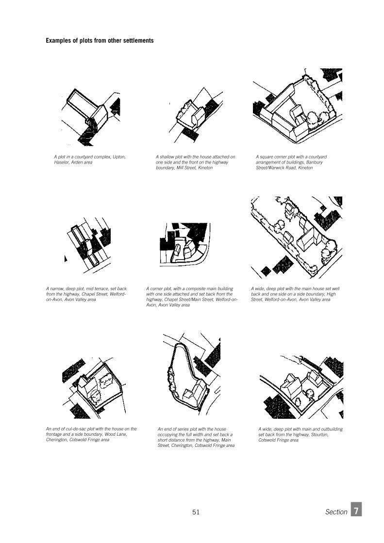
51 7Section
A shallow plot with the house attached onone side and the front on the highwayboundary, Mill Street, Kineton
A square corner plot with a courtyardarrangement of buildings, BanburyStreet/Warwick Road, Kineton
A wide, deep plot with the main house set wellback and one side on a side boundary, HighStreet, Welford-on-Avon, Avon Valley area
A narrow, deep plot, mid terrace, set backfrom the highway, Chapel Street, Welford-on-Avon, Avon Valley area
A corner plot, with a composite main buildingwith one side attached and set back from thehighway, Chapel Street/Main Street, Welford-on-Avon, Avon Valley area
An end of series plot with the houseoccupying the full width and set back ashort distance from the highway, MainStreet, Cherington, Cotswold Fringe area
An end of cul-de-sac plot with the house on thefrontage and a side boundary, Wood Lane,Cherington, Cotswold Fringe area
A wide, deep plot with main and outbuildingset back from the highway, Stourton,Cotswold Fringe area
A plot in a courtyard complex, Upton,Haselor, Arden area
Examples of plots from other settlements

527 Section
Density7.3.1 The density of residential development is
fundamentally related to the size of plots and theamount of building on each plot. Density is mostcommonly measured in houses per acre or hectare. Thisis not the most accurate measure of building densitybecause of the significant differences in size andoccupancy levels between different house types. Forexample, a development of 10 five bedroom houses onan acre is denser than 10 two bedroom house on thesame area.
7 . 3 . 2 It is essential that proposals for development shouldinclude a table or schedule stating the net developablearea, the total number of houses, the floor area andstorey number per house type, and the total floor area ofbuilding.
7.3.3 Central government advice on the question ofhousing density is tending to support the idea of raisingdensities at or immediately surrounding places withgood public transport facilities. The intention is toimprove the viability of local services and reduce theneed to travel for services. In the context of Stratford-on-Avon District, the issue of higher densities needs to beset against the issue of local character, particularly inthe smaller rural villages.
7 . 3 . 4 New development should balance considerations ofcharacter and density. Application of a uniform densityacross the District or even within a specific settlement isunlikely to be appropriate.
7 . 3 . 5 Working with existing settlement patterns, the mostappropriate basis for variation in density is a generalgradient along two main lines:
•the urban/rural distinction,•centre/periphery.
7 . 3 . 6 Within Stratford-on-Avon District, the urban/ruraldistinction is more one of larger rural town to small ruralvillage. Higher densities will thus be more appropriate inlarger towns as opposed to small villages or hamlets.
7 . 3 . 7 Densities within a particular settlement might varyfrom centre to periphery. It is important to note that'centre' in this context is an area of concentration ofbuildings and/or services.
7.3.8 In many cases, the centre is located near or radiatesout from a cross roads or along the central axis of themain route through the settlement. There are cases,however, in which the area of concentration is not atthe physical or geographical centre of the settlement.Equally, some settlements have two or more suchcentres.
7 . 3 . 9 Within a settlement, higher densities will be moreappropriate toward the centre. In certain instancesmultiple centres will be acceptable. Any sub-centre,however, must have ready access from a primary orsecondary route and/or public transport.
A one acre scheme with ten five bedroom,detached houses
A one acre scheme with ten two bedroomdetached houses
A one acre scheme with ten two bedroomterraced houses

53 7Section
Gardens and boundary features7.4.1 The position, shape and size of gardens is a function
of the position of the building within the plot .Depending on the plot type, there might be front, sideand back gardens. For guidance on the matter ofplanting, please refer to section 4.5.
Garden size7 . 4 . 2 As with front-to-front dimension, commonly accepted
standards may be used as a point of reference (11 metregardens to achieve a 70 feet/ 21 metre back-to-backdimension) but should not be taken as rigid rules. At thesame time, this should not be deemed as tacitacceptance of smaller dimensions applied uniformly ormindlessly.
Boundary features7.4.2 In cases where the main building on a plot is set back
from the boundary with the highway, the feature, ifany, that defines the boundary makes a significantcontribution to the character of the settlement. Typicaltreatments vary from one character area to the other andfrom one sub-area to the next. In many cases there is avariety of treatments within a settlement. Further, on agiven plot, treatments can vary between front, side andrear boundaries.
7.4.3 Plot boundary treatment should be appropriate to theposition of the boundary within the plot, the street,settlement and character area. The choice of proposedfeature (in terms of position, shape, size, details ofconstruction and materials) should be based on therange found in similar positions within the settlementwhere development is to occur.
7.4.4 There are five basic forms of boundary treatment commonly found in the district:
• stone walls,
• brick walls,
• timber fences,
• metal railings,
• hedges.
See page 70 for illustrations of examples.
7.4.5 The Character Map of the District gives indicationsof dominant wall materials as do Conservation Areadocuments. The materials used in stone and brick wallsshould ideally be of local provenance or matchingappropriate local materials in shape, size, colour andtexture. It should be noted that characteristic materialsfor boundary walls are in some cases not the same asthose for the walls of houses and other buildings. Forhedges, please refer to the section 4.5 and Appendix D.
7.4.6 Boundaries facing open countryside, public rights of wayor public open spaces should NOT be close board fence.Picket, pale, post and rail or hit and miss fencing ororchard railing is more likely to be appropriate in suchcases, generally in association with hedging. Walling maybe appropriate in some cases.
Close board or other solid fencing should generally berestricted to side and back boundaries shared with otherbuilt up plots.