town of manchester, ct geographic information system -...
TRANSCRIPT

Hill
stow
n R
oad
8
7
6
4
9
2
1
5
3
70
26
40
85
55
5439 69
8468
25
3824 53
6752 832311 37
6651 822210 36
6550 8121
80
35
4934 64
7963
20
3319 48
6247 7818
76
32
4530 60
75
9317 31 46 61 77
86
87
88
89
90
91
92
94
95
96
97
98
99
59
42
16
71
12
57
41 56 72
13 27
14 58
29
73
15
28 43
44
74
145
144
117
159
130116
129 157143
156
115
158114 142128
127 155141
140
113
154
153
126112
111 139125
124 152138
136
110
150
149
122108
107 135121
120 148134
133
106
147
146
119105
104 132118
103
102
101
100
151137123109
131
Town of Manchester, CT100' Scale Tile Index
84
84
384
384
South M
ain Street
West Center Street
Center Stree t
East Center S treet
Porter Street
Mai
n S
tree
t
North Ma in Street
Oak
land
Str
ee t
B ucklan d
Hills Drive
Ver
non
S
t ree
t
Gardener S
treet
Birch Mounta
in RoadTown of Manchester, CT
Geographic Information System
Policies and Rate Schedules
Adopted: January 21, 2003

Town of Manchester
Geographic Information System
Policies and Rate Schedules
Table of Contents
SECTION Page
Purpose .................................................................................................................................2
GIS Disclaimer.....................................................................................................................2
GIS Data Fee Waivers .........................................................................................................2
Electronic Submittals ...........................................................................................................3
APPENDIX
Ordering Instructions and Contact Information ...................................................................6
General Notes on GIS Data..................................................................................................7
Summary of Distributed GIS Data Layers ...........................................................................8
GIS Products and Rate Schedule ..................................................................................….13
Distribution Options.....................................................................................................13
Digital Data ..................................................................................................................13
Hardcopy Maps ............................................................................................................14
Electronic Submittal Requirements ...................................................................................15
FORMS
GIS Product Request Form ..........................................................................................18
GIS Product Receipt Form………………………………………………………...….20
Electronic Submittal Requirement Agreement Forms .................................................21
Planning Department……………………………………………………………...21
Building Department……………………………………………………………...22
GIS Data Fee Waiver Form .........................................................................................23
GIS Water Data Release Form .....................................................................................24

- 2 -
PURPOSE
This policy document has been prepared to provide, and make available to the public, general
information concerning the Town of Manchester’s Geographic Information System (GIS), to
establish a rate schedule for GIS map products and electronic data and to define the requirements
for electronic data submissions with specified land-use approvals.
GIS DATA DISCLAIMER
Please be advised that all information stored in electronic format is provided "as- is" without
warranty of any kind, either expressed or implied. It is the end user's responsibility to establish
that the results obtained from the use of this information are appropriate for the use intended.
Planimetric and topographic information represented in these map data was prepared through the
use of photogrammetric methods from photography dated April 1999. This information meets
National Map Accuracy Standards for 1” = 40’ scale data.
Real property is compiled from recorded deeds, subdivision plans, and other public records and
data. Users of these map data are hereby notified that the aforementioned public primary
information sources should be consulted for verification of the information contained in these
map data.
The Town of Manchester and the mapping companies who prepared these electronic data assume
no legal responsibility for the information contained in these data.
NOTE: The GIS parcel layer acreages are NOT used and should not be used for
property assessment purposes nor should any of the GIS data layers be used as
a surrogate to field survey data.
GIS DATA FEE WAIVERS
The Director of Public Works may, in his or her sole discretion, waive the GIS data fees required
by reason of activity performed by or on behalf of the Town whether by contract or otherwise
(see page 22 of the Appendix for the GIS Data Fee Waiver Form).

- 3 -
ELECTRONIC SUBMITTALS
NOTE: AS OF JUNE 15, 2009 THE TOWN OF MANCHESTER IS NO LONGER REQUESTING
ELECTRONIC SUBMITTALS (CADD FILES) AS A REQUIREMENT OF THE APPLICATION PROCESS.
THIS IS DUE TO REGULATIONS DESCRIBED IN AN OFFICIAL LETTER RECEIVED FROM THE
CONNECTICUT BOARD OF EXAMNINERS FOR PROFESSIONAL ENGINEERS AND LAND SURVEYORS
WHICH IS UNDER THE DEPARTMENT OF CONSUMER PROTECTION. THIS REGULATION STATES
THAT “…land surveyors are not permitted to release unsealed materials in violation of State statutes and
regulations.” THE AFOREMENTIONED STATUTES AND REGULATIONS REFER TO SECTION 20-300-10
OF THE REGULATIONS OF CONNECTICUT STATE AGENCIES - PROFESSIONAL ENGINEERS AND LAND
SURVEYORS DOCUMENT LOCATED AT:
http://www.ct.gov/dcp/lib/dcp/pdf/forms/penlsregs298.pdf
THE TOWN OF MANCHESTER WILL NOW CHARGE A $50 FEE FOR EACH SUBMITTED SHEET
CONTAINING PUBLIC IMPROVEMENTS.
Overview
The developer/owner of any project receiving land use approval within the Town of Manchester
shall submit a version of the final approved plans in electronic format for incorporation into the
Town’s GIS. Upon completion of the project, the developer shall also submit a version of the as-
built/record drawings in electronic form. These plans shall be in conformance with the Town of
Manchester Public Improvement Standards.
Structural lot features required for capture in electronic form include, but are not limited to:
1) primary single and multi family residential buildings
2) commercial, industrial, apartment and condominium buildings and
3) structural additions to commercial, industrial, apartment and condominium buildings.
Structural additions on existing commercial, industrial, apartment and condominium buildings
that are less than 10% of the building being added to, and NOT exceeding 500 square feet, are
exempt from the electronic submission requirements. Determination of electronic submission
exemptions is the responsibility of the Town’s GIS Coordinator.
Excluded from the electronic submission requirements are ancillary residential lot structures
such as decks, pools and sheds and additions to single and multi family residential buildings.
For a complete list of required features to be included with submissions, see the Electronic
Submittal Requirements in the Appendix (page 14).
Charges for Digital Conversion of Data
In the event that the developer/owner is unable to provide a digital submission to the Town at the
time of final permit approval or if the electronic submission fails to comply with these
requirements, a charge of $50 per each 24”x36” plan and $25 for each 18”x24” or smaller plan
will be applied to the submitter’s permit fees for conversion costs. An Electronic Submittal
Requirement Agreement Form must be completed, signed, and submitted with the permit
application before any permit application is accepted (see page 20 of the Appendix). This form
indicates the applicant’s intention of providing an electronic submission. Costs will be based on

- 4 -
the number of sheets in the final plan set. Proposed plans will be stamped only after the
electronic submission is approved by the GIS Unit or the appropriate conversion fee has been
paid by the applicant.
These conversion costs will also be applied if the as-built/record drawings are not provided in
electronic format and/or are NOT in conformance with the Electronic Submittal Requirements in
the Appendix (page 14).

- 5 -
APPENDIX

- 6 -
ORDERING INSTRUCTIONS
To place an order for GIS data products:
1. Review Summary of GIS Data Layers and General Notes on GIS Data sections in the
appendix to determine what data you require and if the data meets your requirements.
2. Complete the GIS Product Request & Receipt Form.
3. The GIS Products and Rate Schedule section will determine cost for GIS products.
4. Upon receipt of cash or a check made payable to the “Town of Manchester” by the GIS
Division, data will be provided to the person or organization listed on the GIS Product
Request & Receipt Form. Please allow three to five days for delivery of electronic GIS data.
CONTACT INFORMATION
Location: Mailing Address:
Lincoln Center-2nd
Floor Town of Manchester
Engineering Division Engineering Division
GIS/Maps & Records Unit GIS/Maps & Records Unit
494 Main Street 494 Main Street
Manchester, CT 06040 P.O. Box 191
Manchester, CT 06045-0191
Telephone #: (860) 647-3062 or
(860) 647-3066
Fax #: (860) 647-3140
Email: [email protected]

- 7 -
GENERAL NOTES ON GIS DATA
Planimetric and topographic data was prepared through the use of photogrammetric methods
from aerial photography dated April 24, 1999. This data complies with National Map Accuracy
Standards (NMAS) and the American Society of Photogrammetry and Remote Sensing (ASPRS)
Standards for 1” = 40’ scale mapping with a two foot contour interval.
Cadastral (Parcel) data was compiled from recorded deeds, subdivision plans, and other public
records and data following a hierarchy of source reliability. Coordinate geometry (COGO)
methods were used to automate the real property data then registered to fit the planimetric layers.
Users of these map data are hereby notified that the aforementioned public primary information
sources should be consulted for verification of the information contained in these map data. This
parcel layer was not used for property assessment purposes nor should this data be use as a
surrogate to field survey data.
Primary utility features were collected using conventional and GPS surveying techniques and
were located to a horizontal accuracy of one foot horizontal and 0.5 feet vertical. All field
procedures will follow Federal Geodetic Control Subcommittee (FGCC) guidelines. Secondary
utility features were captured by either photogrammetric methods from aerial photography dated
April 24, 1999 at a scale of 1”= 40’ or from digitizing 1” = 100’ scale utility record plans stored
and maintained by the Town of Manchester Public Works and Water Departments.
Color orthophotography is based on aerial photography dated April 24, 1999 and compiled to be
displayed at 1” = 100’ with a 1 foot minimum pixel resolution.
All Town of Manchester data has been projected to the Connecticut State Plane Coordinate
System, Zone 3526, Horizontal Datum NAD-83, and Vertical Datum NAVD-88 with US Survey
Feet as units.
Data Accuracy is based on National Mapping Accuracy Standards (NMAS) i.e. 90% of well-
defined visible features are within tolerance listed. It must be noted, however, that these
accuracy tolerances are only suggested and are based on the conversion processes. In no way
does this GIS data replace field survey data. The Town of Manchester legally responsible for any
features that fall outside these tolerances.
Planimetric: 1” = 40’ (+- 1.3’)
Topographic: +- 1’ (1/2 contour interval)
Cadastral: N/A (COGO)
Orthophotography: Compiled for display at 1"=100' with 1
foot pixel resolution
Utility:
Survey Capture +- 1.0’ horizontal
+- 0.5’ vertical
Photogrammetric Capture 1” = 40’ (+- 1.3’)
Digitized compiled from 1” = 100’ utility maps

- 8 -
SUMMARY OF DISTRIBUTED GIS DATA LAYERS
Data Group Data Layer Name Description Features
Address AddressPoints address
points
address points
AddressRanges Street
centerlines
with address
ranges
Street centerlines with address
ranges
StreetNames1000Scale street names
for 1”=100’
mapping
street names for 1”=100’
mapping
ZipCodes zip code
boundaries
zip code boundaries
Control ControlPoints surveyed
control
monuments
surveyed control monuments
Planimetrics
Aprons driveway
aprons
concrete or asphalt aprons
AthleticFields athletic
fields
athletic fields
BikePath bike path East Coast Greenway
Bridges bridges roadway and walking bridges
Buildings building
footprints
commercial, residential and
ancillary structures
Cemeteries cemeteries cemeteries
Driveways driveways driveways
Flagpoles flagpoles flagpoles
ParkingLots parking lots paved and unpaved parking
lots
Parks parks parks
Playgrounds playgrounds playgrounds
RadioTowers radio towers radio towers
Railroads railroads active and abandoned railroads
RetainingWalls retaining
walls
retaining walls
Roads road edge of
pavement
paved and unpaved roads
Sidewalks sidewalks sidewalks
StreetCenterLines street
centerlines
street centerlines
Streetlights streetlights streetlights
StreetNames40Scale street names street names used in 1”=40’
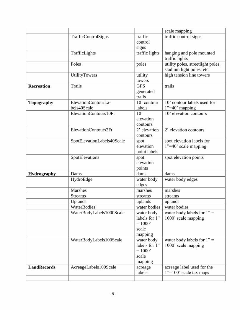
- 9 -
scale mapping
TrafficControlSigns traffic
control
signs
traffic control signs
TrafficLights traffic lights hanging and pole mounted
traffic lights
Poles poles utility poles, streetlight poles,
stadium light poles, etc.
UtilityTowers utility
towers
high tension line towers
Recreation Trails GPS
generated
trails
trails
Topography ElevationContourLa-
bels40Scale
10’ contour
labels
10’ contour labels used for
1”=40’ mapping
ElevationContours10Ft 10’
elevation
contours
10’ elevation contours
ElevationContours2Ft 2’ elevation
contours
2’ elevation contours
SpotElevationLabels40Scale spot
elevation
point labels
spot elevation labels for
1”=40’ scale mapping
SpotElevations spot
elevation
points
spot elevation points
Hydrography Dams dams dams
HydroEdge water body
edges
water body edges
Marshes marshes marshes
Streams streams streams
Uplands uplands uplands
WaterBodies water bodies water bodies
WaterBodyLabels1000Scale water body
labels for 1”
= 1000’
scale
mapping
water body labels for 1” =
1000’ scale mapping
WaterBodyLabels100Scale water body
labels for 1”
= 1000’
scale
mapping
water body labels for 1” =
1000’ scale mapping
LandRecords AcreageLabels100Scale acreage
labels
acreage label used for the
1”=100’ scale tax maps

- 10 -
LandRecords
(cont.)
AddressLabels100Scale parcel
address
labels
parcel address labels used for
1” = 100’ scale tax maps
DimesionLabels100Scale parcel
dimension
labels
dimension labels used for the
1”=100’ scale tax maps
EasementLabels100Scale easements
labels
easement labels used for the
1”=100’ scale tax maps
LotLabels100Scale developer
lot number
labels
developer lot labels used for
the 1”=100’ scale tax maps
Parcels parcels parcels
ParCondo parcels with
condos
parcels with condos used for
CAMA table linking
PrivateROWLines private
ROW lines
Private ROW lines
PropertyLines property
lines
property lines used to generate
parcels
PropertyPoints property
points
property points used to
generate parcels
RPKEYLabels100Scale RPKEY
(PID) labels
RPKEY labels used for the
1”=100’ scale tax maps
StreetNames100Scale street name street name labels used for the
1”=100’ scale tax maps
Subdivisions parcel based
subdivision
boundaries
subdivisions
Takings ROW
takings
ROW takings with deed date
and book/page
TownBoundary Town
boundary
Town boundary
TownBoundaryLabels100Scale Town
boundary
labels
Town boundary labels used
for the 1”=100’ scale tax maps
- 11 -
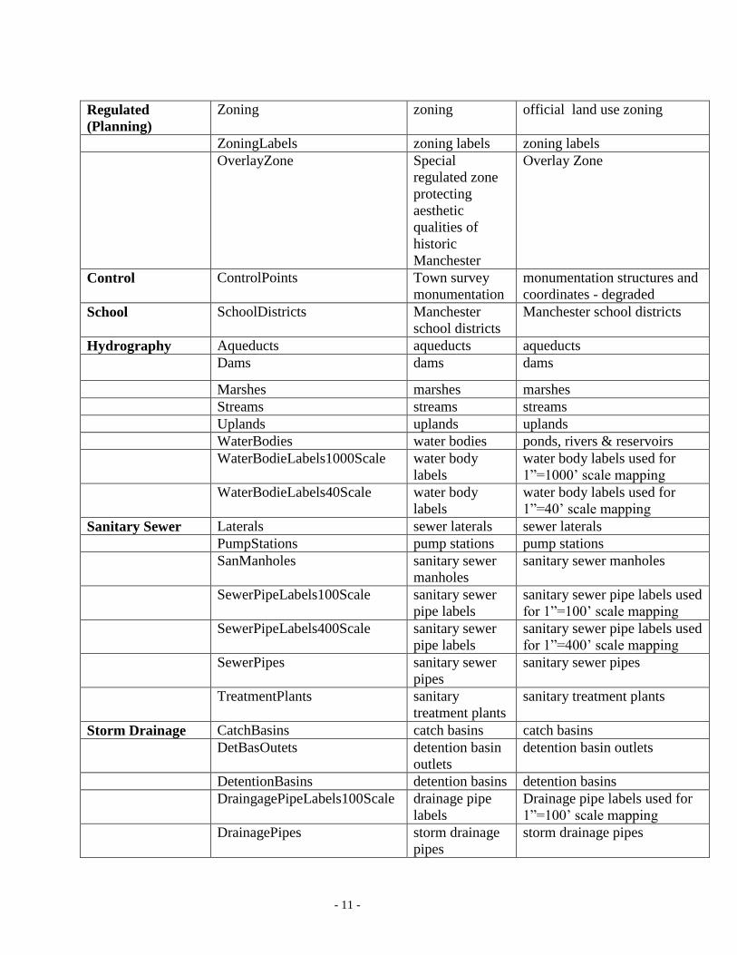
Regulated
(Planning)
Zoning zoning official land use zoning
ZoningLabels zoning labels zoning labels
OverlayZone Special
regulated zone
protecting
aesthetic
qualities of
historic
Manchester
Overlay Zone
Control ControlPoints Town survey
monumentation
monumentation structures and
coordinates - degraded
School SchoolDistricts Manchester
school districts
Manchester school districts
Hydrography Aqueducts aqueducts aqueducts
Dams dams dams
Marshes marshes marshes
Streams streams streams
Uplands uplands uplands
WaterBodies water bodies ponds, rivers & reservoirs
WaterBodieLabels1000Scale water body
labels
water body labels used for
1”=1000’ scale mapping
WaterBodieLabels40Scale water body
labels
water body labels used for
1”=40’ scale mapping
Sanitary Sewer Laterals sewer laterals sewer laterals
PumpStations pump stations pump stations
SanManholes sanitary sewer
manholes
sanitary sewer manholes
SewerPipeLabels100Scale sanitary sewer
pipe labels
sanitary sewer pipe labels used
for 1”=100’ scale mapping
SewerPipeLabels400Scale sanitary sewer
pipe labels
sanitary sewer pipe labels used
for 1”=400’ scale mapping
SewerPipes sanitary sewer
pipes
sanitary sewer pipes
TreatmentPlants sanitary
treatment plants
sanitary treatment plants
Storm Drainage CatchBasins catch basins catch basins
DetBasOutets detention basin
outlets
detention basin outlets
DetentionBasins detention basins detention basins
DraingagePipeLabels100Scale drainage pipe
labels
Drainage pipe labels used for
1”=100’ scale mapping
DrainagePipes storm drainage
pipes
storm drainage pipes
- 12 -
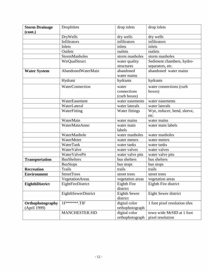
Storm Drainage
(cont.)
DropInlets drop inlets drop inlets
DryWells dry wells dry wells
Infiltrators infiltrators infiltrators
Inlets inlets inlets
Outlets outlets outlets
StormManholes storm manholes storm manholes
WtrQualStruct water quality
structures
Sediment chambers, hydro-
separators, etc.
Water System AbandonedWaterMain abandoned
water mains
abandoned water mains
Hydrant hydrants hydrants
WaterConnection water
connections
(curb boxes)
water connections (curb
boxes)
WaterEasement water easements water easements
WaterLateral water laterals water laterals
WaterFitting Water fittings Wye, reducer, bend, sleeve,
etc.
WaterMain water mains water mains
WaterMainAnno water main
labels
water main labels
WaterManhole water manholes water manholes
WaterMeter water meters water meters
WaterTank water tanks water tanks
WaterValve water valves water valves
WaterValvePit water valve pits water valve pits
Transportation BusShelters bus shelters bus shelters
BusStops bus stops bus stops
Recreation Trails trails trails
Environment StreetTrees street trees street trees
VegetationAreas vegetation areas vegetation areas
EighthDistrict EightFireDistrict Eighth Fire
district
Eighth Fire district
EighthSewerDistrict Eighth Sewer
district
Eight Sewer district
Orthophotography
(April 1999)
1F******.TIF digital color
orthophotograph
1 foot pixel resolution tiles
MANCHESTER.SID digital color
orthophotograph
town wide MrSID at 1 foot
pixel resolution

- 13 -
GIS PRODUCTS AND RATE SCHEDULE
Distribution Options
Digital distribution options for GIS products offered by the Town of Manchester include:
1) Digital town wide data sets for planimetric, topographic, cadastral (property), utility, zoning
and orthophotography and
2) Tile data sets comprised of planimetric, topographic, cadastral (property), utility, zoning and
orthophotography sets based on the Town’s 159 1”=100’ map tiles.
Various hardcopy (paper) stock maps are also provided by the Town’s GIS. Product types and
prices can be found in the Hardcopy (Paper) Maps section (see page 13).
Digital Data
The Town of Manchester currently stores all GIS layers in ESRI geodatabase format. Line, point
and polygon data can also be requested in ESRI shapefile format (does not include annotation) or
as DXF files including line, point and annotation data (does not include polygons). Orthophotos
are provided as a MrSID compressed town wide file or as geoTIFs based on the Town’s 1”=100’
tile map. A data dictionary will be provided with every purchase.
*Water system data is available but only on a tile-by-tile basis (no town-wide distribution) and a
release form must be filled out and approved by the Water & Sewer Administrator before the
water system data is released (see page 23 of the Appendix).
Town Wide Data
Item Description Cost
Planimetric all planimetric layers $300
Topographic 2’ contours & spot elevations $300
Cadastral (property) property & easements $300
Utility storm drainage & sanitary
sewers
$100
Zoning zoning $100
Orthophotograph (MrSID) 1 foot minimum pixel
resolution
$300
100 Scale Tiles
Item Description Cost
All available items planimetrics, cadastral,
topographic, zoning storm
drainage and sanitary sewer
networks
$50
1 Foot Res. Digital Orthophotography geoTIF file format $25 NOTE: Please contact the Town of Manchester GIS Division at (860) 647-3062 if you have any questions
concerning data formats and use.
- 14 -
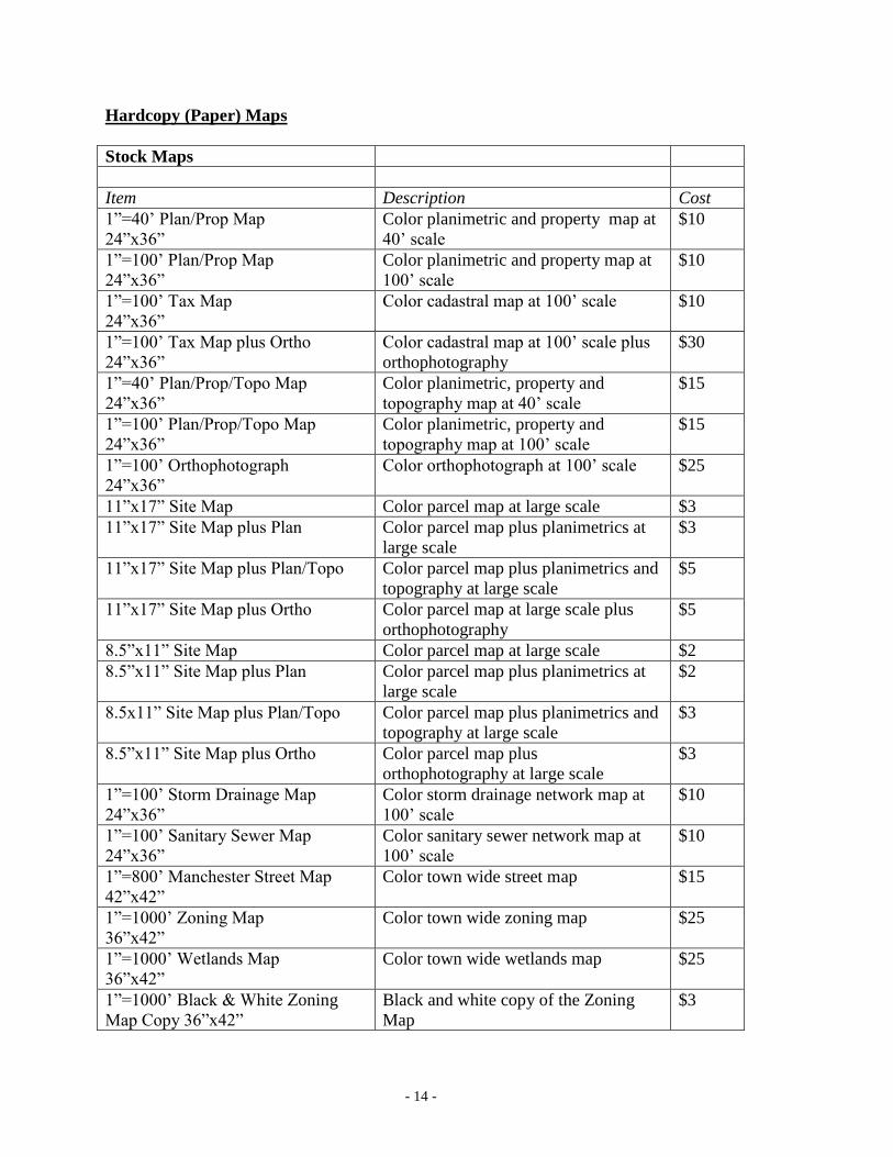
Hardcopy (Paper) Maps
Stock Maps
Item Description Cost
1”=40’ Plan/Prop Map
24”x36”
Color planimetric and property map at
40’ scale
$10
1”=100’ Plan/Prop Map
24”x36”
Color planimetric and property map at
100’ scale
$10
1”=100’ Tax Map
24”x36”
Color cadastral map at 100’ scale $10
1”=100’ Tax Map plus Ortho
24”x36”
Color cadastral map at 100’ scale plus
orthophotography
$30
1”=40’ Plan/Prop/Topo Map
24”x36”
Color planimetric, property and
topography map at 40’ scale
$15
1”=100’ Plan/Prop/Topo Map
24”x36”
Color planimetric, property and
topography map at 100’ scale
$15
1”=100’ Orthophotograph
24”x36”
Color orthophotograph at 100’ scale $25
11”x17” Site Map Color parcel map at large scale $3
11”x17” Site Map plus Plan Color parcel map plus planimetrics at
large scale
$3
11”x17” Site Map plus Plan/Topo Color parcel map plus planimetrics and
topography at large scale
$5
11”x17” Site Map plus Ortho Color parcel map at large scale plus
orthophotography
$5
8.5”x11” Site Map Color parcel map at large scale $2
8.5”x11” Site Map plus Plan Color parcel map plus planimetrics at
large scale
$2
8.5x11” Site Map plus Plan/Topo Color parcel map plus planimetrics and
topography at large scale
$3
8.5”x11” Site Map plus Ortho Color parcel map plus
orthophotography at large scale
$3
1”=100’ Storm Drainage Map
24”x36”
Color storm drainage network map at
100’ scale
$10
1”=100’ Sanitary Sewer Map
24”x36”
Color sanitary sewer network map at
100’ scale
$10
1”=800’ Manchester Street Map
42”x42”
Color town wide street map $15
1”=1000’ Zoning Map
36”x42”
Color town wide zoning map $25
1”=1000’ Wetlands Map
36”x42”
Color town wide wetlands map $25
1”=1000’ Black & White Zoning
Map Copy 36”x42”
Black and white copy of the Zoning
Map
$3

- 15 -
ELECTRONIC SUBMITTAL REQUIREMENTS NOTE: AS OF JUNE 15, 2009 THE TOWN OF MANCHESTER IS NO LONGER REQUESTING
ELECTRONIC SUBMITTALS (CADD FILES) AS A REQUIREMENT OF THE APPLICATION PROCESS.
THIS IS DUE TO REGULATIONS DESCRIBED IN AN OFFICIAL LETTER RECEIVED FROM THE
CONNECTICUT BOARD OF EXAMNINERS FOR PROFESSIONAL ENGINEERS AND LAND SURVEYORS
WHICH IS UNDER THE DEPARTMENT OF CONSUMER PROTECTION. THIS REGULATION STATES
THAT “…land surveyors are not permitted to release unsealed materials in violation of State statutes and
regulations.” THE AFOREMENTIONED STATUTES AND REGULATIONS REFER TO SECTION 20-300-10
OF THE REGULATIONS OF CONNECTICUT STATE AGENCIES - PROFESSIONAL ENGINEERS AND LAND
SURVEYORS DOCUMENT LOCATED AT:
http://www.ct.gov/dcp/lib/dcp/pdf/forms/penlsregs298.pdf
THE TOWN OF MANCHESTER WILL NOW CHARGE A $50 FEE FOR EACH SUBMITTED SHEET
CONTAINING PUBLIC IMPROVEMENTS.
The DXF files submitted to the Town shall contain separate and distinct layers designated as
DXF-LAYERS in the DXF file format for each of the Feature Groups or Layers designated by
the Town and listed below. Electronic submittals shall be submitted on compact disc media or e-
mailed to the Planning & Economic Development Department. Electronic submittals of as-
built/record plans to the Town shall conform to the Town of Manchester Public Improvement
Standards.
The coordinate information contained in the digital drawings or record plans shall be delivered in
the Connecticut State Plane coordinate system using the NAD83 horizontal datum and NAVD88
vertical datum using US Survey feet as units. These data shall be produced in real coordinate
space with an insertion point of (0,0). Horizontal and vertical accuracy of these data shall meet
the minimum standards for surveys and maps as stated in Section 20-300b and Section 4-168 of
the Connecticut General Statutes.
These feature groups or layers include:
FEATURE GROUP
Property Lines
Property Dimensions
Easements and Rights of Way
Easement Dimensions
Survey Monumentation
Road Edge of Pavement/Curb Lines
Bridge Lines
Parking Lots
Residential Principle & Commercial/Industrial/Apartment/Condominium
Buildings
Commercial/Industrial/Apartment/Condominium Building Additions
Utility & Street Light Poles
Retaining Walls
Fences
Guardrails
Paths

- 16 -
Traffic Control Signs
Traffic Control Signals
Railroads
Road Center Line
Street Names
Street Striping
Aprons
Sidewalks
Street Trees
Contours
Tree Lines
Wetlands
Water Courses
Storm Drainage Structures
Storm Drainage Pipes
Sanitary Sewer Structures
Sanitary Sewer Pipes
Water Distribution Structures
Water Services
Water Distribution Pipes
NOTE: Line work for these features shall be continuous and should
contain topological consistency with other lines i.e. lines shall
not be broken by label text or connected to other lines by marker
pins.

- 17 -
FORMS

- 18 -
Town of Manchester, CT
GIS Product Request Form
NOTE: Payment is due prior to compilation and delivery of data. Please make checks payable to
the “Town of Manchester”.
I. Digital Data
Data Format Media
o ESRI Geodatabase (*.mdb)
o ESRI Shape File (*.shp)
o AutoCAD DXF File (*.dxf)
o Compact Disc
o Deliver to FTP Site
o E-Mail
NOTE: ESRI personal geodatabase files can contain points, lines, polygons and annotation.
ESRI shape files can contain points, lines and polygons (NO annotation).
AutoCAD DXF files will contain only points, lines and annotation (NO polygons).
Please contact the GIS Unit if you have any questions regarding appropriate data formats.
Town Wide Layer(s) by Data Group Cost ($) # Copies Extended Cost ($)
Planimetrics $300
Topographic $300
Cadastral (Property) $300
Utilities (storm drainage & sanitary
sewer)
$100
Zoning $100
Orthophotography (MrSID) $300
100 Scale Tiles Cost ($) # Copies Extended Cost ($)
(tile number)
$50
$50
$50
$50
Digital Orthophotos Pixel Resolution Cost ($) # Copies Extended Cost ($)
(tile number)
1 2 4 8 $25
1 2 4 8 $25
1 2 4 8 $25
1 2 4 8 $25

- 19 -
Town of Manchester, CT
GIS Product Request Form (cont.)
II. HARDCOPY MAPS
Map Product Tile #(s) Cost (each) # Copies Total Cost($)
o 40’ Scale Plan/Prop Map (24”x36”) $10
o 100’ Scale Plan/Prop Map (24”x36”) $10
o 100’ Scale Tax Map (24”x36”) $10
o 100’ Scale Tax Map plus Ortho
(24”x36”)
$30
o 40’ Scale Plan/Prop/Topo Map
(24”x36”)
$15
o 100’ Scale Plan/Prop/Topo Map
(24”x36”)
$15
o 100’ Scale Ortho Map (24”x36”) $25
o 11”x17” Site Map N/A $3
o 11”x17 Site Map plus Plan N/A $3
o 11”x17” Site Map plus Plan/Topo N/A $5
o 11”x17” Site Map plus Ortho N/A $5
o 8.5”x11” Site Map NA $2
o 8.5”x11” Site Map plus Plan NA $2
o 8.5”x11” Site Map plus Plan/Topo NA $3
o 8.5”x11” Site Map plus Ortho NA
$3
o 100’ Scale Storm Drainage Map
(24”x36”)
N/A $10
o 100’ Scale Sanitary Sewer Map
(24”x36”)
N/A $10
o 800’ Scale Manchester Street Map
(42”x42”)
N/A $15
o 1000’ Scale Zoning Map (36”x42”) N/A $25
o 1000’ Scale Wetlands Map (36”x42”) N/A $25
o 1000’ Scale Black and White Zoning
Map (36”x42”)
N/A $3
TOTAL HARDCOPY MAPS
- 20 -
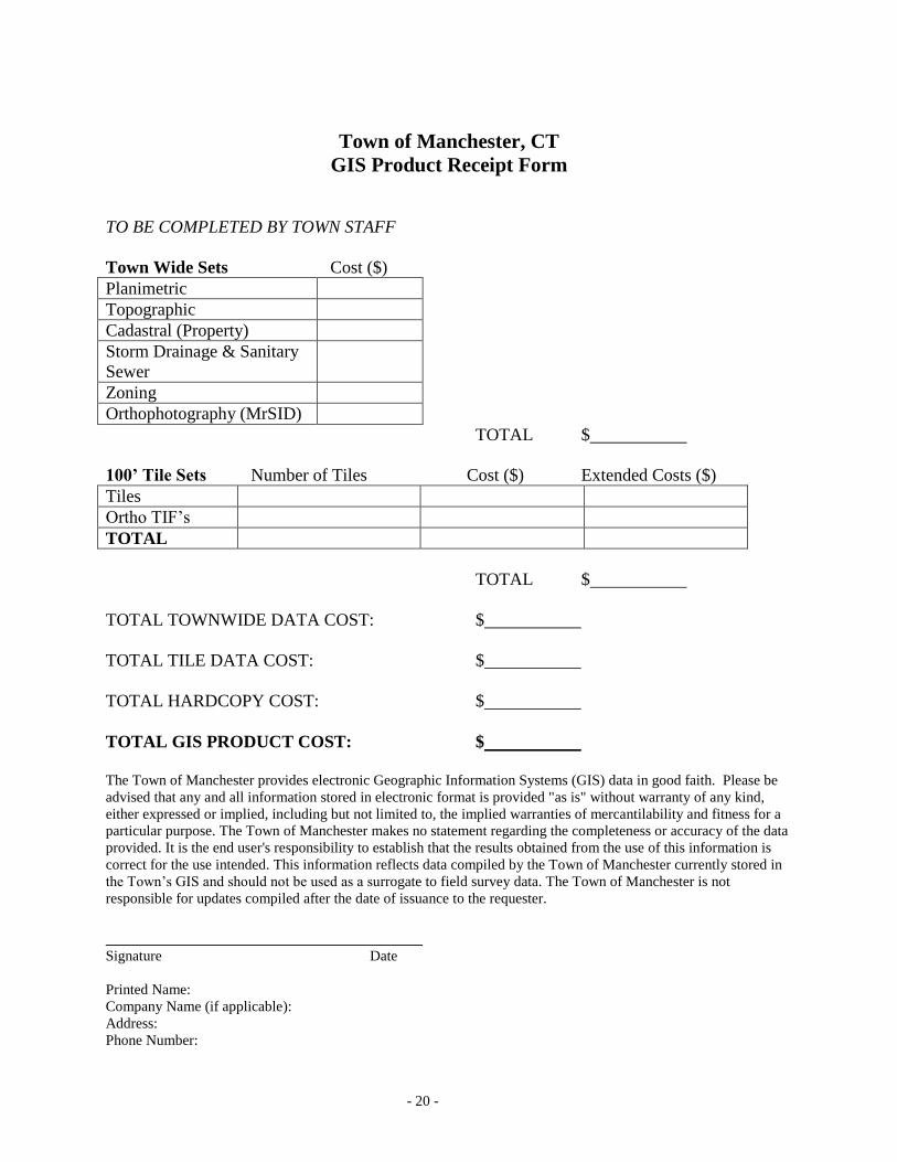
Town of Manchester, CT
GIS Product Receipt Form
TO BE COMPLETED BY TOWN STAFF
Town Wide Sets Cost ($)
Planimetric
Topographic
Cadastral (Property)
Storm Drainage & Sanitary
Sewer
Zoning
Orthophotography (MrSID)
TOTAL $
100’ Tile Sets Number of Tiles Cost ($) Extended Costs ($)
Tiles
Ortho TIF’s
TOTAL
TOTAL $
TOTAL TOWNWIDE DATA COST: $
TOTAL TILE DATA COST: $
TOTAL HARDCOPY COST: $
TOTAL GIS PRODUCT COST: $
The Town of Manchester provides electronic Geographic Information Systems (GIS) data in good faith. Please be
advised that any and all information stored in electronic format is provided "as is" without warranty of any kind,
either expressed or implied, including but not limited to, the implied warranties of mercantilability and fitness for a
particular purpose. The Town of Manchester makes no statement regarding the completeness or accuracy of the data
provided. It is the end user's responsibility to establish that the results obtained from the use of this information is
correct for the use intended. This information reflects data compiled by the Town of Manchester currently stored in
the Town’s GIS and should not be used as a surrogate to field survey data. The Town of Manchester is not
responsible for updates compiled after the date of issuance to the requester.
Signature Date
Printed Name:
Company Name (if applicable):
Address:
Phone Number:

- 21 -
ELECTRONIC SUBMITTAL REQUIREMENT AGREEMENT FORM
PLANNING DEPARTMENT
In accordance with Town of Manchester, CT
Geographic Information System Policies and Rate Schedules
CHECK APPROPRIATE BOX
Excluded Activity
_________________________________ ________________
Applicant Signature Date
Electronic Submittal to be provided after PZC/IWA or ZBA approval and with submission of plans for
stamping.*
_________________________________ ________________
Applicant Signature Date
Electronic submission of plans will not be provided with approved plans for stamping. Fee in lieu of
digital submission is herewith provided ___ sheets x $_____ = $_______.
_________________________________ ________________
Applicant Signature Date
Fee received by: ______________________________ Date__________________
* NOTE: if submittal is not in accordance with the town's electronic submittal requirements a charge will be
assessed in accordance with the Town of Manchester, CT Geographic Information System Policies and Rate
Schedules and must be provided to the Town of Manchester prior to stamping of approved plans.
FOR OFFICE USE ONLY
Staff Approval _____________________________________ Date __________________

- 22 -
PUBLIC WORKS DEPARTMENT
BUILDING DIVISION
ELECTRONIC SUBMITTAL REQUIREMENT AGREEMENT FORM
In accordance with Town of Manchester, CT
Geographic Information System Policies and Rate Schedules
CHECK APPROPRIATE BOX
Not required - excluded by GIS Policy (not required by ordinance or submitted previously to the Planning
Department
____________________________________ __________________
Staff Signature Date
Electronic Submittal to be provided when foundation AS-BUILT is submitted to the Building Department
_____________________________________ __________________
Applicant Signature Date
Electronic submission of plans will not be provided with approved plans for Building Permit. Fee in lieu of
digital submission is herewith provided___sheets x $______ = $_______.
Received by:
______________________________________ __________________
Staff Signature Date
*NOTE: if submittal is not in accordance with the Town’s electronic submittal requirements a charge will
be assessed in accordance with the Town of Manchester, CT Geographic Information System Polices and
Rate Schedules and must be provided to the Town of Manchester prior to issuance of Certificate of
Occupancy.

- 23 -
Town of Manchester, CT
GIS Data Fee Waiver Form
The Director of Public Works may, in his or her sole discretion, waive the GIS data fees required
by reason of activity performed by or on behalf of the Town whether by contract or otherwise.
Please provide the following information to expedite this request:
Date:
Name:
Company/Institution:
Address:
City/State:
Phone:
E-Mail:
o Town of Manchester Contract/Project Waiver
Town Department:
Contract/Project #
Town Contact Person:
Purpose:
Director of Public Works Date

- 24 -
Town of Manchester, CT
GIS Water Data Release Form
The Water & Sewer Administrator may, in his or her sole discretion, determine if electronic water network data
shall be released based on State of Connecticut exemption policies describe in PA 02-133: “An Act Concerning the
Disclosure of Security Information Under the Freedom of Information Act (FOIA)”. Please provide the following
information to expedite this request:
Date:
Name:
Company/Institution:
Address:
City/State:
Phone:
E-Mail:
Town Contact Person:
Town Contact Department:
GIS Tile(s):
Purpose:
Approved
Not Approved
Water & Sewer Department Administrator Date