town of new gloucestere9ffb5a1-d5a… · · 2017-08-02fax: (207) 926-4136 town of new gloucester...
TRANSCRIPT
Tel: (207) 926-4126 Fax: (207) 926-4136
Town of New Gloucester 385 Intervale Road
New Gloucester, ME 04260
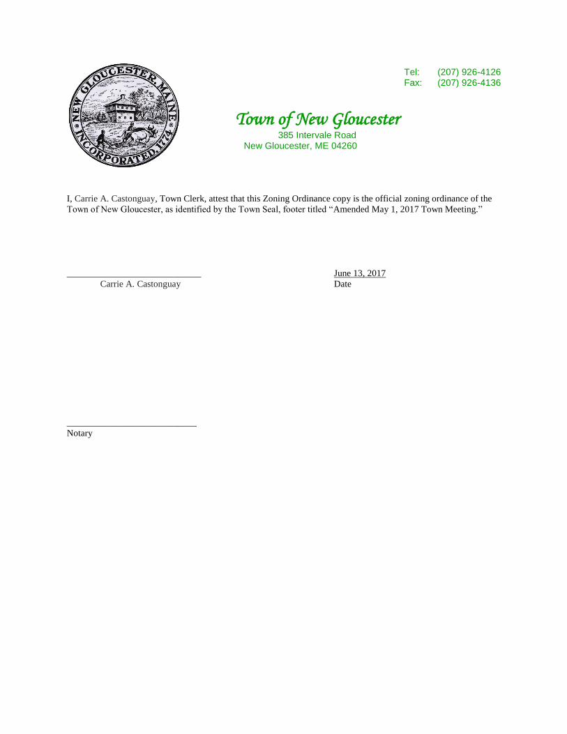
I, Carrie A. Castonguay, Town Clerk, attest that this Zoning Ordinance copy is the official zoning ordinance of the
Town of New Gloucester, as identified by the Town Seal, footer titled “Amended May 1, 2017 Town Meeting.”
_____________________________ June 13, 2017
Carrie A. Castonguay Date
____________________________
Notary

TOWN OF NEW GLOUCESTER
ZONING ORDINANCE
Revised March 1989
Revised March 1990
Revised May 1993
Revised April 1994
Revised May 1995
Revised May 1996
Revised June 1996
Revised May 1998
Revised May 1999
Revised May 2000
Revised May 2001
Revised June 2001
Revised May 2003
Revised January 2004
Revised Dec. 2004
Revised May 2006
Revised May 2010
Revised May 2011
Revised May 2012
Revised June 2013
Revised November 2015
Revised May 2017

4-i
New Gloucester Zoning Ordinance
TABLE OF CONTENTS
SECTION TITLE PAGE
1 PREAMBLE .......................................................................................................................... 1-1
2 DEFINITIONS ...................................................................................................................... 2-1
2.1 Word Usage ........................................................................................................................2-1
2.2 Definitions ..........................................................................................................................2-1
2.3 Shoreland Zoning Definitions ..........................................................................................2-21
3 GENERAL PROVISIONS .................................................................................................. 3-1
3.1 General Restrictions ...........................................................................................................3-1
3.2 Nonconformance ................................................................................................................3-2
3.2.1 General Provisions .............................................................................................................3-2
3.2.2 Non-conforming Uses ........................................................................................................3-2
3.2.3 Non-conforming Structures ................................................................................................3-4
3.2.4 Non-conforming Lots of Record ........................................................................................3-9
3.3 Changes and Amendments ...............................................................................................3-10
4 ZONING DISTRICTS ......................................................................................................... 4-1
4.1 Establishment of Districts ..................................................................................................4-1
4.2 Official Zoning Map ..........................................................................................................4-1
4.3 Zoning District Boundaries ................................................................................................4-2
4.4 District Standards ...............................................................................................................4-2
4.4.1 Residential C District (RC) ................................................................................................4-3
4.4.2 Village District (V) ............................................................................................................4-6
4.4.3 Rural Residential District (RR) ..........................................................................................4-9
4.4.4 Farm and Forest District (FF) ..........................................................................................4-11
4.4.5 Limited Residential Shoreland District (LRS) .................................................................4-13
4.4.6 Resource Protection District (RP) ....................................................................................4-16
4.4.7 Residential B District (RB) ..............................................................................................4-21
4.4.8 Groundwater Protection Overlay District (GPO) .............................................................4-24
4.4.9 Historic Resource Overlay District (HRO) ......................................................................4-30
4.4.10 Mobile Home Park Overlay District (MHPO) .................................................................4-35
4.4.11 Pineland Development District (PDD).............................................................................4-40
4.4.12 Transfer of Development Rights Sending District Overlay (TDR-S) ..............................4-48
4.4.13 Transfer of Development Rights Receiving District Overlay (TDR-R) ..........................4-49
4.4.14 Upper Village District (UV) ............................................................................................4-50

ii
5 PERFORMANCE STANDARDS ....................................................................................... 5-1
5.1 Townwide Standards ............................................................................................................ 5-1
5.1.1 Accessory Apartments .......................................................................................................5-1
5.1.2 Access to Lots ....................................................................................................................5-1
5.1.3 Affordable Housing Density Bonus ...................................................................................5-2
5.1.4 Agriculture .........................................................................................................................5-3
5.1.5 Buffers and Landscaped Areas...........................................................................................5-3
5.1.6 Campgrounds .....................................................................................................................5-4
5.1.7 Open Space Subdivisions ...................................................................................................5-5
5.1.8 Erosion and Sedimentation Control .................................................................................5-15
5.1.9 Flood Hazard Areas..........................................................................................................5-16
5.1.10 Home Occupations ...........................................................................................................5-16
5.1.11 Housing for the Elderly ....................................................................................................5-17
5.1.12 Junk Yards and Automobile Graveyards .........................................................................5-19
5.1.13 Lighting ............................................................................................................................5-19
5.1.14 Manufactured Housing .....................................................................................................5-19
5.1.14.1 Mobile Home Parks .........................................................................................................5-20
5.1.15 Multiplex Development ...................................................................................................5-25
5.1.16 Noise ................................................................................................................................5-26
5.1.17 Off-Road Loading ............................................................................................................5-26
5.1.18 Off-Road Parking Requirements ......................................................................................5-27
5.1.19 Signs .................................................................................................................................5-29
5.1.20 Sight Distance ..................................................................................................................5-35
5.1.21 Soils ..................................................................................................................................5-35
5.1.22 Stormwater Management .................................................................................................5-35
5.1.23 Temporary Structures .......................................................................................................5-36
5.1.24 Traffic Impacts .................................................................................................................5-36
5.1.25 Water Quality Protection..................................................................................................5-36
5.1.26 Wetlands ...........................................................................................................................5-36
5.1.27 Wildlife Wintering Areas .................................................................................................5-40
5.1.28 Timber Harvesting ...........................................................................................................5-41
5.1.29 Mineral Exploration, Excavation and Removal of Lands ................................................5-41
5.1.30 Aboveground Oil Storage ................................................................................................5-41
5.1.31 Telecommunications Towers ...........................................................................................5-41
5.1.32 Fire Protection ..................................................................................................................5-43
5.1.33 Residential Sprinklers ......................................................................................................5-44
5.1.34 Entrance and Driveway Standards ...................................................................................5-44
iii
5.2 Limited Residential Shoreland District and Resource Protection District Performance
Standards ............................................................................................................................. 5-46
5.2.1 Agriculture .......................................................................................................................5-46
5.2.2 Archeological Sites ..........................................................................................................5-47
5.2.3 Erosion and Sedimentation Control .................................................................................5-47
5.2.4 Essential Services .............................................................................................................5-48
5.2.5 Home Occupations ...........................................................................................................5-48
5.2.6 Individual Private Campsites ...........................................................................................5-48
5.2.7 Parking Areas ...................................................................................................................5-49
5.2.8 Piers, Docks, Wharves, Bridges and Other Structures and Uses Extending Over or Beyond
the Normal High-Water Line or Within a Wetland of Significance……… ....................5-49
5.2.9 Principle and Accessory Structures ..................................................................................5-50
5.2.10 Roads and Driveways .......................................................................................................5-52
5.2.11 Signs……………………………………………………………………….…………… 5-53
5.2.12 Septic Waste Disposal…………………………………………………………………. .5-54
5.2.13 Soils……………………………………………………………………………………. .5-54
5.2.14 Storm Water Runoff……………………………………………………………………. 5-55
5.2.15 Timber Harvesting………………………………………………………...………… ....5-55
5.2.16 Clearing or Removal of Vegetation for Activities Other That Timber Harvesting…… .5-63
6 ADMINISTRATION............................................................................................................................... 6-1
6.1 Administration of Permits .................................................................................................... 6-1
6.1.1 Building Permit ..................................................................................................................6-1
6.1.2 Application for Building Permit ........................................................................................6-2
6.1.3 Home Occupation Permits .................................................................................................6-3
6.1.4 Permits for Temporary Structures ......................................................................................6-3
6.1.5 Certificate of Occupancy....................................................................................................6-3
6.2 Enforcement .......................................................................................................................... 6-4
6.2.1 Code Enforcement Officer ................................................................................................. 6-4
6.2.2 Legal Action and Violation ................................................................................................ 6-4
6.2.3 Fines ...................................................................................................................................6-5
6.3 Board of Appeals ................................................................................................................... 6-5
6.3.1 Appointment and Composition ..........................................................................................6-5
6.3.2 Powers and Duties ..............................................................................................................6-5
6.3.3 Conditions Attached to Appeals ........................................................................................6-8
6.3.4 Meetings .............................................................................................................................6-8
6.3.5 Appeal Procedure ...............................................................................................................6-8
iv
7 SITE PLAN REVIEW .......................................................................................................... 7-1
7.1 Purpose ...............................................................................................................................7-1
7.2 Review of Development and Uses .....................................................................................7-1
7.3 Application Procedure ........................................................................................................7-1
7.4 Review Procedure ..............................................................................................................7-4
7.5 Approval Criteria ...............................................................................................................7-6
7.6 Outside Consulting Opinions and Fees ..............................................................................7-7
7.7 Performance Guarantees and Project Inspections ..............................................................7-8
8 ROAD AND ROAD STORM DRAINAGE DESIGN AND ........................................... 8-1
CONSTRUCTION STANDARDS
8.1 General Requirements ........................................................................................................8-1
8.2 Administration ...................................................................................................................8-2
8.3 Procedure............................................................................................................................8-2
8.4 Submission Requirements ..................................................................................................8-4
8.5 Road Design Standards ......................................................................................................8-5
8.6 Road Construction Standards .............................................................................................8-8
8.7 Road Storm Water Management Design Standards .........................................................8-11
8.8 Storm Drainage Construction Standards ..........................................................................8-12
8.9 Public Road Acceptance Procedure .................................................................................8-13
9 TRANSFER OF DEVELOPMENT RIGHTS .................................................................. 9-1
9.1 Purpose and Intent ..............................................................................................................9-1
9.2 Establishment of Sending and Receiving Districts ............................................................9-1
9.3 Sending District Regulations .............................................................................................9-1
9.4 Receiving District Regulations ..........................................................................................9-3
9.5 Procedure............................................................................................................................9-4
9.6 Submission Requirements ..................................................................................................9-5
9.7 Approved Criteria...............................................................................................................9-7
9.8 Administration ...................................................................................................................9-7

1-1
Except as hereinafter specifically provided, the provisions of the Land Zoning Ordinance for the
Municipality of New Gloucester, Maine, adopted February 1976, and as amended through September
1986, are further amended by being repealed and replaced by this Ordinance.
ARTICLE 1
PREAMBLE
1.1 Authority
This Ordinance has been prepared in accordance with the provisions of the Maine Revised Statutes
Annotated (M.R.S.A.), as amended.
1.2 Title
This Ordinance shall be known and may be cited as the “Zoning Ordinance of the Town of New
Gloucester, Maine”, and will be referred to herein as the “Ordinance”.
1.3 Purpose
The purpose of this ordinance is to implement the land use policies contained in the
Comprehensive Plan, entitled the “Town of New Gloucester Comprehensive Plan”, adopted by the
voters of New Gloucester in June 1991. The Plan seeks a balance between competing desires to
develop land and to preserve land. While the basic traditional right of the landowner to use
property as he or she sees fit remains respected, it is recognized that uncontrolled growth among
incompatible land uses will have negative results for the community as a whole. This ordinance
seeks to preserve the existing character of the Town, with its historic villages, clean ponds, safe
drinking water, rural nature, and feeling of openness. It is the intent of this ordinance to encourage
business development, economic well-being and job opportunities for all residents as well as to
encourage a safe, healthy and attractive residential environment where landowners will be
protected from unreasonable or detrimental, cumulative effects of growth and development.
1.4 Jurisdiction
The provisions of this Ordinance shall govern all land and all structures within the boundaries of
the Town of New Gloucester, Maine.
1.5 Conflict with other Ordinances
This ordinance shall not repeal, annul, or in any way impair or remove the necessity of compliance
with any other rule, regulation, permit or provision of law. Wherever the requirements of this
Ordinance are in conflict with the requirements of any other lawfully adopted rules, regulations,
ordinances, deed restrictions or covenants, the most restrictive shall govern.
1.6 Severability
Should any section or provision of this Ordinance be declared by the courts to be invalid, such
decision shall not invalidate any other article, section or provision of this Ordinance.
1-2
1.7 Effective Date
A. Effective Date of the Ordinance and Ordinance Amendments
The effective date of this Ordinance or any amendment thereto is the date of its adoption by the
legislative body.
B. Timber Harvesting Repeal
The following are repealed on the statutory date established under Title 38 M.R.S.A. section
438-B(5), at which time all regulation of timber harvesting within the shoreland zone shall be
the responsibility of the State Bureau of Forestry:
1. Section 5.2.15,
2. Section 4.4.5.C.1.g (forest management activities except for timber harvesting & land
management roads),
3. Section 4.4.5.C.1.n (timber harvesting),
4. Section 4.4.5.C.1.h (land management roads),
5. Section 4.4.6.C.1.c (forest management activities except for timber harvesting and land
management roads)
6. Section 4.4.6.C.2.h (timber harvesting)
7. Section 4.4.6.C.3.g (land management roads), and
8. Section 2.3 definitions for:
Cross-sectional Area,
DBH,
Disruption of Shoreline Integrity,
Forest Management Activities,
Forest Stand,
Harvest Area,
Land Management Road,
Licensed Forester,
Residual Basal Area,
Residual Stand,
Skid Road,
Slash,
Timber Harvesting, and
Windfirm.
1.8 Availability
A certified copy of this Ordinance shall be filed with the Town Clerk and shall be accessible to
any member of the public. Copies shall be made available to the public at reasonable cost at the
expense of the person making the request. Notice of availability of this Ordinance shall be posted
in the Town Hall.

2-1
ARTICLE 2
DEFINITIONS
2.1 Word Usage
In this Ordinance, certain terms or words shall be interpreted as follows: the singular may be taken for the
plural and the plural for the singular; “person” may include an association, a partnership, a corporation or
other entity; the present tense includes the future; the word “building” includes the word “structure”; the
word “lot” includes the word “plot”; the word “shall” is mandatory; the word “may” is permissive.
In case of any difference in meaning or implication between the text of this Ordinance and any map or
illustration, the text shall control. Terms not defined shall have their customary dictionary meaning.
2.2 Definitions
For the purpose of this Ordinance and the New Gloucester Subdivision Regulations, the terms and words
listed below shall apply outside of the Limited Residential Shoreland District and Resource
Protection District and be specifically interpreted or defined as follows:
Abutter - The owner of a property sharing a common boundary with or within 250 feet of a given piece
of property, whether or not these properties are separated by a public or private way. For the purposes of
this Ordinance, the owners of properties shall be considered to be those parties currently listed by the Tax
Assessor of New Gloucester as those against whom taxes are assessed. (adopted 4/2/94)
Accessory Apartment - A housing unit that is self-contained, but is incorporated within and is accessory
to an existing structure that was originally designed for a single family. The criterion for defining the
accessory unit shall be the existence of separate cooking facilities.
Accessory Use or Structure - A use or structure customarily incidental and subordinate to the principal
use or structure and located on the same lot. Where an accessory building is attached in a substantial
manner by a wall to a principal building or structure, it shall be considered a part of said principal
structure or building.
Activity - the specific use or uses to which premises are put.
Affordable Housing - A housing unit is affordable to a particular household if the monthly shelter costs
associated with the unit do not exceed a reasonable percentage of the household’s gross monthly income.
The following parameters shall be used to define housing affordability:
1. A renter-occupied housing unit is considered affordable to a household of a particular size and
income if the unit’s monthly estimated rent, insurance costs, and utility costs do not exceed 30%
of the gross monthly income of a household whose income equals 80% of the median income of
the Town of New Gloucester. [Amended 12/14/2004 Special Town Meeting]
2. An owner-occupied housing unit is considered affordable to a household of a particular size and
income if the unit's sales price or value does not exceed that for which the monthly estimated
mortgage payments (principal and interest), property tax and insurance costs (homeowner's and

2-2
private mortgage insurance), would equal 28% of the gross monthly income of a household whose
income equals 80% of the median income of the Town of New Gloucester. [Amended 12/14/2004
Special Town Meeting]
3. A household's gross monthly income in New Gloucester shall be estimated by dividing the median
household income by 12 months. Median household income shall be that figure provided annually
by the Department of Economic and Community Development.
Aggrieved Party - A person or group of persons who have suffered particularized injury as a result of
the granting or denial of such permit or variance.
Agriculture - The production of crops by the cultivation of the soil. Gardens of 1/2 acre or less in size
shall be excluded from this definition. Gardens used strictly for home use are excluded.
Alteration - Any change, addition, or modification in construction, or any change in the structural
members of a building, such as bearing walls, columns, beams or girders.
Animal Husbandry - the dairying, raising of livestock, breeding or keeping of animals, fowl or birds as a
business or gainful occupation.
Antenna – Any exterior apparatus designed for telephonic, radio, television or similar communications
through the sending and/or receiving of electromagnetic waves. (adopted May 4, 1998 town meeting)
Aquifer - A geologic unit composed of bedrock or sand and gravel, which contains sufficient saturated
permeable materials to conduct groundwater and also yield significant quantities of groundwater to wells
and springs.
Aquifer Recharge Area - The upland area surrounding a defined sand and gravel deposit identified as an
aquifer which as a result of slope and natural features drains into the aquifer.
Automobile Graveyard - An area used as a place of storage for three or more unserviceable, unlicensed,
and uninspected, discarded, worn-out or junked motor vehicles.
Automobile Repair Garage - A business establishment where motor vehicles and/or their related parts
are repaired, reconditioned, painted or rebuilt, but where no engine fuels are sold at retail. The following
services may be carried out: general repair, engine rebuilding, parts replacement, rebuilding or
reconditioning of motor vehicles, collision services such as body, frame or fender straightening and
repair, overall painting and undercoating and mechanized washing of automobiles.
Automobile Service Station - A place where gasoline, or any other vehicular engine fuel or lubricant, is
retailed directly to the public on the premises; including the sale of minor accessories and such work as
tune-ups and minor mechanical repairs, but not including the storage of unlicensed vehicles or the repair
of body, frame or fenders.
Average Daily Traffic (ADT) - The average number of vehicles per day that enter and exit the premises
or travel over a specific section of road. If the Planning Board or Code Enforcement Officer require a
traffic study, then ADT shall be determined by traffic study. If no traffic study is required, then ADT shall
be assumed to be ten (10) vehicles per day per dwelling unit.” [Adopted 5/2/2011 Town Meeting]
2-3
Barn - A structure designed for the housing of animals and/or storage of feed crops.
Base Flood - The flood having a one (1) percent chance of being equaled or exceeded in any given year,
alternatively referred to as the 100-year flood.
Bed and Breakfast Establishments - A dwelling in which is provided short-term overnight lodging to
paying guests in a maximum of seven (7) guestrooms located within the dwelling or permitted attached
structures. Breakfast shall be the only meal served and shall be limited to overnight guests. A bed and
breakfast with three (3) guest rooms or less shall be considered a home occupation accessory to principal
use of the dwelling and shall be allowed under the standards applicable to home occupations.
Boarding Care Facilities - a house or other residential structure having more than two residents which is
maintained wholly or partly for the purpose of boarding and caring for elderly residents, but which does
not provide a supportive services program.
Borrow Pit - An area of land from which soils, stone, or other mineral materials are extracted where
those materials are intended to be used for filling, landscaping, or other similar activities at other sites or
locations.
Brook - See “River, stream or brook”.
Buffers and Landscaped Areas - Areas of undisturbed natural vegetation, landscaping, fences, berms,
walls or combinations thereof, used to shield or block adverse impacts or nuisances on a site or between
adjacent sites.
Buildable Land - Land that in its natural state is suitable for development. For the purposes of this
Ordinance, land treated as 100 percent deductions for the net residential area calculation shall be
considered unbuildable land.
Building - Any structure designed or intended for the support, enclosure, shelter or protection of persons,
animals, or property. For the purposes of determining exterior measurements or footprints in order to
locate the setback line, buildings shall include all attached structures such as open or closed porches,
carports, garages, balconies, roof overhangs, stairways and other similar structures.
Business and Professional Office - A building in which there are located the offices of one or more
professional businesses including but not limited to banks, insurance offices, realtors, law and medical
offices.
Business Services - A commercial activity which renders an actual service (such as cleaning, repairing or
consulting) primarily where businesses are the end users, and which involves a low volume of accessory
retail sales upon the premises.
Campground - A parcel which is used as a recreational site for tents, trailers, or recreational vehicles or
other forms of temporary shelter and for which a use fee is charged.
Canopy Tree - A tree with branches that, individually or with other trees, hang to form an umbrella or
“canopy” effect.

2-4
Cemetery - A burial ground maintained by the town or other public or non-profit body or private
individual.
Central Collection System - A wastewater disposal system that receives wastewater from two or more
structures. The system may have a private sewer collection system flowing into a common septic tank, or
it may utilize individual septic tanks. The wastewater, after receiving primary treatment in the septic tank
or tanks, may be pumped or gravity-fed to a single subsurface disposal field or several fields on a
common land area.
Church - A building or structure, or groups of buildings and structures, which by design and construction
are primarily intended for the conducting of organized religious services.
Cluster Development - A form of residential development that allows a reduction in lot size and area
standards, with the remaining land to be used for recreation, open space, preservation of environmental
features, agriculture, or timber harvesting.
Code Enforcement Officer - A person appointed by the Board of Selectmen to administer and enforce
this Ordinance. Reference to the Code Enforcement Officer may be construed to include Building
Inspector, Plumbing Inspector, Electrical Inspector, and the like, where applicable.
Co-Location - The location of more than one telecommunications facility (use) on a tower. [adopted
5/4/1998 town meeting]
Commercial Sales and Service: Outdoor - Commercial sales and service which permits both indoor and
outdoor storage as principal uses.
Community Living Arrangement - Per MRSA Title 30-A, Section 4357-A, A housing facility of eight
(8) or fewer persons with disabilities that is approved, authorized, certified or licensed by the State. A
community living arrangement may include a group home, foster home or intermediate care facility.
Conforming Use - A use of buildings, structures, or land which complies with all applicable provisions
of this Ordinance.
Construction - Includes building, erecting and moving of structures, or any physical operations on the
premises which are required for construction. Excavation, fill, paving, drainage and the like shall be
considered part of construction.
Construction Services - The performance of work or the furnishing of supplies to members of the
building trades, such as but not limited to plumbing, painting, building, well drilling, carpentry, masonry,
or electrical installation, which requires the storage of materials and/or the location of commercial
vehicles at the site.
Convenience Store - A retail establishment that accommodates neighborhood needs for groceries and
sundries and that may sell, as an accessory use, prepared food for carry-out.
Convenience Store With Gas Pumps - A convenience store which sells, as an accessory use, gasoline at
pump or pumps.
2-5
Day Care Centers - Facilities providing, for compensation, day care for children under 16 years of age
who are not residents of the facility.
Day Care Center Facilities - A residence or other place where thirteen or more children are cared
for, either on a regular or non-recurring basis, and which fully complies with the rules and regulations
of the Maine Department of Human Services.
Family Day Care Home - A residence or other place where up to six children are cared for, which is
in compliance with the rules and regulations of the Maine Department of Human Services. Family
day care homes are classified as home occupations when located in the operator's residence.
Group Day Care Home - A residence or other place in which 7-12 children are cared for, which is in
compliance with the rules and regulations of the Maine Department of Human Services. Group day
care homes are classified as home occupations when located in the operator's residence.
Deck - An uncovered structure with a floor, elevated above ground level, or a patio at ground level if a
concrete slab or below-grade foundation is utilized. A deck is a structure for the purpose of this
Ordinance.
Designated Growth Area – Those areas, as defined by the Town of New Gloucester Comprehensive
Plan, most suitable for future growth and development.
Development - Any human-produced change to land, including but not limited to building, mining,
dredging, filling, grading, paving, excavating, or drilling.
Development Right - The right to develop one (1) residential unit based on the allowable density of the
underlying zoning district. [Adopted 12/14/2004 Special Town Meeting]
Disability –
A. A physical or mental impairment that: (1) Substantially limits one or more of a person's major life
activities; (2) Significantly impairs physical or mental health; or (3) Requires special education,
vocational rehabilitation or related services;
B. Without regard to severity unless otherwise indicated: absent, artificial or replacement limbs,
hands, feet or vital organs; alcoholism; amyotrophic lateral sclerosis; bipolar disorder; blindness or
abnormal vision loss; cancer; cerebral palsy; chronic obstructive pulmonary disease; Crohn's
disease; cystic fibrosis; deafness or abnormal hearing loss; diabetes; substantial disfigurement;
epilepsy; heart disease; HIV or AIDS; kidney or renal diseases; lupus; major depressive disorder;
mastectomy; mental retardation; multiple sclerosis; muscular dystrophy; paralysis; Parkinson's
disease; pervasive developmental disorders; rheumatoid arthritis; schizophrenia; and acquired
brain injury;
C. With respect to an individual, having a record of any of the conditions in paragraph A or B; or
D. With respect to an individual, being regarded as having or likely to develop any of the conditions
in paragraph A or B.
Distribution Facility - A facility specializing in the shipping and receiving of goods and articles, which
may include associated assembling, finishing and packaging.
2-6
District - A section or sections of the Town of New Gloucester for which regulations governing the use of
buildings and premises, the size of lots and setbacks and intensity of use are uniform.
Draining - lowering the water table below its natural level.
Dredging - removing materials from below the Wetland/Upland edge.
Drive-Through Facility - a commercial facility where the customer drives a motor vehicle onto the
premise and to a window through by which the customer is served without exiting the vehicle. Drive-
throughs associated with financial institutions are exempt from this definition. [Adopted 11/16/2015
Special Town Meeting]
Driveway - a vehicular access-way serving three (3) or fewer dwelling units.
Common Driveway: A vehicle access-way serving more than one (1) dwelling unit, but no more than
three (3) dwelling units. Common driveways must be named in accordance with section 5.1.34 of the
New Gloucester Zoning Ordinance [Adopted 5/2/2011 Town Meeting]
Private Driveway: A vehicle access way serving one (1) dwelling unit. [Adopted 5/2/2011 Town
Meeting]
Dwelling - A fixed structure containing one or more dwelling units.
Dwelling, Single-Family - A building, designed and/or used exclusively for residential purposes for
one (1) family and containing not more than one (1) dwelling unit. Manufactured housing shall be
considered a single-family dwelling if the length to width ratio does not exceed four (4) to one (1) and
the minimum horizontal dimension at its narrowest point is at least eighteen (18) feet. (adopted
4/2/94)
Dwelling, Two-Family - A building designed and/or used exclusively for residential purposes for two
(2) families living independently and containing not more than two (2) dwelling units. Manufactured
housing shall be considered a two-family dwelling unit if the length to width ratio does not exceed
four (4) to one (1) and the minimum horizontal dimension at its narrowest point is at least eighteen
(18) feet. (adopted 4/2/94)
Dwelling, Multi-Family - A dwelling or group of dwellings in one structure containing separate
dwelling units for three or four families.
Dwelling, Attached - A dwelling with two or more party walls, or one party wall in the case of a
dwelling at the end of a group of attached buildings.
Dwelling, Detached - A dwelling which is designed to be and is substantially separate from another
building or buildings except for accessory buildings.
Dwelling Unit - A room or group of rooms designed and equipped exclusively for use as living
quarters for only one (1) family, including provisions for living, sleeping, cooking and eating. This
term shall include manufactured housing units, but shall not include hotels, motels, bed and breakfast
establishments, inns, rooming houses, recreational vehicles or other temporary trailers.

2-7
Earth - Topsoil, sand, gravel, clay, peat, rock or other minerals.
Elderly Housing - See Housing for the Elderly.
Engineered Subsurface Waste Disposal System - A system or combination of individually or jointly
owned systems which serve a single building or group of associated buildings with a total design flow in
excess of 2,000 gallons per day.
Essential Services - The erection, construction, alteration or maintenance by public and private utilities or
municipal or other governmental agencies of gas, electrical or communication facilities, steam, fuel, water
transmission, distribution, collection, supply or sewage disposal systems. Such systems may include
poles, wires, mains, drains, sewers, pipes, conduits, cables, fire alarm and police call boxes, traffic
signals, hydrants, street signs, similar accessories for the promotion of the public health, safety, or general
welfare, and buildings necessary for the furnishing of such services or systems. Such systems shall not
include collection, storage or disposal of hazardous materials including but not limited to toxic metals,
chemicals, residues or contaminants.
Excavation - Any removal of earth or earth material from its original position.
Family - One or more persons occupying a premises and living as a single housekeeping unit, as
distinguished from a group occupying a rooming house or hotel. Such unit shall not exceed five persons
not related by blood or marriage, except that such unit may exceed five persons in any living quarters
constructed by and for the use of the United Society of Shakers.
Farm Stand - A structure that supports the seasonal sale of locally grown produce and is provided with
adequate off-road parking.
Filling - Placing of any material which raises, either temporarily or permanently, the elevation of an area.
Flood - A temporary rise in stream flow or water volume that results in water overtopping stream or lake
banks and inundating adjacent areas.
Flood Plain - The lands adjacent to a body of water which have been or may be covered by the base
flood.
Floor Area, Gross - The sum, in square feet, of the floor areas of all roofed portions of a building, as
measured from the interior faces of all exterior walls. In this Ordinance, total floor area for retail
establishments includes indoor sales and storage areas. This area shall include the basement or attic in
such cases when they are finished or are to be used as part of a business.
Forested wetland - a wetland of significance dominated by woody vegetation that is six (6) meters tall
(approximately twenty (20) feet) or taller.
Forestry - Use and management of forests for the production of silvicultural products, to provide passive
recreation, to maintain, restore, or enhance environmental conditions for wildlife, and for the protection
and production of water supplies.
2-8
Frontage, Road - The road frontage shall be on the lot line that lies between the two side lines and abuts a road.
For any lot bounded on more than one property line by a road, only one road may be used for the purpose of road
frontage. Frontage on a cul-de-sac may be measured at the building setback line. Except as otherwise provided
in this ordinance, an interior lot shall have its frontage determined by the horizontal distance, between side lot
lines, nearest to and roughly parallel to the closest road. [Adopted 5/2/2011 Town Meeting]
Frontage, Shore - The horizontal distance, measured as a straight line, between the intersection of the
side lot lines with the shoreline at the normal high water mark elevation.
Garden - A tract of land 1/2 acre or less used for the growing of plants.
Great Pond - any inland body of water which in a natural state has a surface area in excess of ten acres,
and any inland body of water artificially formed or increased which has a surface area in excess of thirty
(30) acres except for the purposes of this Ordinance, where the artificially formed or increased inland
body of water is completely surrounded by land held by a single owner.
Groundwater - All the water found beneath the surface of the ground. For the purposes of aquifer
protection, this term refers to the slowly moving subsurface water present in aquifers and recharge areas.
Hazardous Material - Material which may pose a present or potential hazard to human health or the
environment including without limitation hazardous wastes identified and listed in accordance with
Section 3001 of the Resource Recovery Act of 1976 and subsequent regulations promulgated in the
Federal Register process, or designated as hazardous by the Board of Environmental Protection under
Title 38, M.R.S.A., Section 1303.A.
Height - The vertical distance of a building measured from the average elevation of the finished grade
within twenty (20) feet of the building's contiguous perimeter, to the highest point of the roof. Height
limitation shall not apply to chimneys, steeples, towers (uninhabitable), water standpipes, detached barns
and silos used for agricultural purposes, spires or similar non-habitable structures. (adopted May 4, 1998
town meeting)
High Intensity Soil Survey - A map prepared by a certified soil scientist, identifying the soil types down
to 1/8 acre or less at a scale equivalent to that of the submitted plan. The soils shall be identified in
accordance with the National Cooperative Soil Survey. The map shall show the location of all test pits
used to identify the soils, and shall be accompanied by a log of each sample point identifying the textural
classification and the depth to seasonal high water table or bedrock at that point. Single soil test pits and
their evaluation for suitability for subsurface wastewater disposal systems shall not be considered to
constitute high intensity soil surveys.
Historic Setting - An area of outstanding historical and cultural significance including but not limited to
those designated as such by Federal, State or local authorities.
Home Occupation - An occupation or profession carried out for gain by a resident and conducted as an
accessory use in or about the resident's dwelling unit or accessory structures and subject to the
performance standards contained in Article 5 of this Ordinance.
Horizontal Distance - A line running between two points on the same plane.

2-9
Hospital - An institution providing but not limited to overnight health services, primarily for in-patients,
and medical or surgical care for the sick or injured, including as an integral part of the institution such
related facilities as laboratories, out-patient departments, training facilities, central services, and staff
offices.
Hotel - A facility which is not a Bed and Breakfast Establishment or inn as defined herein, in which
lodging is offered to transient guests for compensation with no cooking facilities in individual rooms or
suites. Hotels shall meet the minimum lot size for the district, plus 10,000 square feet for each lodging
unit. Hotels may include additional uses such as restaurants, public assembly and/or recreational facilities
in which case the requirements and standards for multi-use commercial buildings apply.
Housing for the Elderly - A facility providing living accommodations for the elderly, including boarding
care facilities, congregate housing, continuing care retirement communities, nursing homes, residential
care facilities, and retirement homes and communities for elderly persons of low and moderate income.
Congregate Housing - housing that is designed to provide housing solely for elderly households and
within which a supportive services program is available for functionally impaired residents who have
difficulty living independently without assistance, yet who do not require the level of service available
at a nursing home. For the purposes of the New Gloucester Zoning Ordinance, "congregate housing"
shall include only those facilities that have been certified by the State of Maine as meeting regulations
governing the administration of congregate housing services programs for the elderly according to the
provisions of Maine law.
Continuing Care Retirement Community - a residential care facility that provides a combination of
nursing home and congregate housing services as defined herein.
Nursing Home - a facility in which nursing care and medical services are prescribed by or performed
under the general direction of persons licensed to practice medicine or surgery in the State of Maine
and is designed to provide full-time convalescent or chronic care to individuals who, by reason of
advance age, chronic illness or infirmity, are unable to care for themselves. For the purposes of this
ordinance, “nursing home” shall include only those facilities that have been certified by the State of
Maine as meeting all licensing and operation regulations for skilled care or intermediate care facilities
as promulgated by the Department of Human Services pursuant to the provisions of Maine law.
Residential Care Facility - Residential housing consisting of private apartment or private room and
central dining facilities and within which a supportive services program is provided to residents who
are unable to live independently without assistance, yet do not require the constant supervision or
intensive health care available at nursing homes or hospitals.
Hydric soils - Soils defined in the U.S. Soil Conservation Service publication, “Hydric Soils of the State
of Maine 1988”. These soils shall include, but not be limited to, the following: (formerly used soil series
names are in parenthesis)
1. Very poorly drained organic soils, including Chocorua, Ossipee, Rifle, Sebago, Togus, Vassalboro
and Waskish;
2. Very poorly drained mineral soils, including Biddeford, Burnham, Gouldsboro, Halsey, Medomak
(Saco), Peacham (Whitman), Searsport (Scarboro), Washburn and Whately; and
3. Poorly drained mineral soils, including Atherton, Aurelie, Brayton (Ridgebury), Charles
(Limerick), Easton, Fredon, Lyme, Mainarda, Moosilauke (Walpole), Naskeag, Naumberg (Au
Gres), Roundabout, Rumney, Scantic and Swanton.
2-10
Impervious Surface - Structures and other man-made improvements to land, and materials covering the
land, which substantially reduce the infiltration of water. Impervious surfaces shall include but not be
limited to roofs, paved areas, and parking lots and driveways, regardless of surface materials.
Inn - A dwelling in which is provided short-term overnight lodging to paying guests in a maximum of
fifteen (15) guestrooms located within the dwelling or permitted attached structures. Restaurants shall be
allowed as an accessory use, which may serve meals to both overnight guests and the general public.
Junkyard - Any area, lot, land, parcel, building or structure or part thereof used for the temporary
storage, collection, processing, purchase, sale or abandonment of wastepaper, rags, scrap metal, or other
scrap or discarded goods, materials, machinery and their related recycling operations. Bottle redemption
facilities are not included in this definition. Junkyards must conform to minimum state standards and to
the performance standards contained in Article 5 of this Ordinance.
Kennel - Any place, building, tract of land, abode, enclosure, or vehicle where three (3) or more dogs or
six (6) or more cats, owned singly or jointly, are kept for any purpose, including but not limited to
breeding, hunting, show, field trials or exhibition, or where one or more dogs or other pets are kept for
their owners in return for a fee. This definition shall not apply to household pets or dogs or cats under the
age of six months.
Land Management Road - a route or track consisting of a bed of exposed mineral soil, gravel, or other
surfacing materials constructed for, or created by, the passage of motorized vehicles and used primarily
for agriculture, timber harvesting and related activities, including associated log yards, but not including
skid trails or skid roads. [Adopted 5/2/2011 Town Meeting]
Leachable Materials - Materials including but not limited to solid wastes, sludges, industrial wastes, and
agricultural wastes capable of releasing contaminants to the surrounding environment.
Light Industrial Use - A research laboratory, light assembly or light manufacturing facility that does not
endanger the health and safety of surrounding areas and which meets the following requirements:
1. The operation can be conducted primarily within enclosed buildings.
2. There shall be no exterior storage or assembly of materials or products, except the outdoor storage
of lumber and temporary display of goods.
3. There shall be no activity that is defined as a high hazard by Section 305.0 of the BOCA Basic
Building Code/1981.
4. Noise levels at the property boundary shall not exceed those identified in Article 5 of this
ordinance.
5. The use will not create any offensive vibration.
6. No offensive smoke, dust, odor or other unhealthy or offensive airborne discharge will be created.
7. The proposed use is not water intensive.
8. The use is designed so that the external appearance of any buildings is compatible with the area in
which it is located.
9. The proposed use shall not adversely affect the value of adjacent properties.
10. The proposed use shall not create unsafe traffic conditions or excessive traffic.
Lodging unit - A room or suite designed to accommodate transient guests.
2-11
Lot - A parcel of land having distinct and defined boundaries and described in a deed, plan or similar
legal document. Lands on opposite sides of a public way shall be considered separate lots.
Lot Area - The total horizontal area enclosed within the lot lines of a lot excluding any existing or
proposed road rights-of-way.
Lot Depth - The average horizontal distance from the road right-of-way of the lot to its opposite rear line.
Lot Lines - The lines bounding a lot.
Lot Line, Front - The line separating the lot from a road. On any lot bounded on more than one property
line by a road, the front lot line shall be that property line of the lot designated as “road frontage” in any
building permit application for such lot.
Lot Line, Rear - The lot line opposite the front lot line. On a lot pointed at the rear, the rear lot line shall
be a line between the side lot lines parallel to the front lot line, not less than ten (10) feet long, lying
farthest from the front lot line.
Lot Line, Side - Any lot line other than the front lot line or rear lot line.
Lot of Record - A parcel of land, a legal description of which or the dimensions of which are recorded on
a document or map on file with the County Registry of Deeds.
Lot Width - The average horizontal distance between the side lines of a lot measured at right angles to its
depth parallel to the front lot line at the minimum required front setback.
Manufacturing - The making of goods and articles by hand or machinery. Manufacturing shall include
assembling, fabricating, finishing, packaging or processing operations.
Manufactured Housing Unit - (1) A mobile home constructed after June 15, 1976, which the
manufacturer certifies is constructed in compliance with the United States Department of Housing and
Urban Development Standards, or (2) a Modular Home constructed after January 1, 1984, which the
manufacturer certifies is constructed in compliance with the State of Maine's Manufactured Housing Act.
Manufactured housing units must be designed for long-term, year-round occupancy and contain sleeping
accommodations, a toilet, a tub or shower bath, and kitchen facilities, including major appliances, with
plumbing and electrical connections provided for attachment to outside systems.
Manufactured Housing Units as defined must also meet the Manufactured Housing Performance
Standards contained in Article 5 of this Ordinance.
A mobile home that does not meet this definition but which was lawfully in use as a dwelling unit in the
Town of New Gloucester on the date of the adoption of this Ordinance shall be permitted to continue on
its respective site or lot and can be moved to another location within the Town that allows manufactured
housing as a permitted use.
Mill Site - a location where portable saw or chipping mill equipment is used to convert raw wood material
to saleable products.

2-12
Mineral Exploration - hand sampling, test boring, or other methods of determining the nature or extent
of mineral resources which create minimal disturbance to the land and which include reasonable measures
to restore the land to its original condition.
Mineral Extraction - Excavation for the purpose of removal of any earth product, including but not
limited to, sand, gravel, clay, topsoil, rock minerals and metals.
Mixed Uses Buildings - a building that contains at least one allowed nonresidential use and one allowed
residential use. [Adopted 11/16/2015 Special Town Meeting]
Mobile Home - A residential unit that is constructed in a manufacturing facility and then transported to a
site on a permanent chassis.
Mobile Home Park – A development containing manufactured housing and constructed in accordance
with the Mobile Home Park standards contained in Section 5.1.14.1 of this ordinance.
Modular Home or Modular Housing Unit - A residential unit designed for transportation, after
fabrication, to the site where it is to be occupied, as two or more component parts which must be
assembled into a livable dwelling unit on site. No component part of the Modular Housing Unit shall be
considered a complete dwelling unit.
Motel - A building or group of buildings containing a maximum of 30 rooms which are rented as sleeping
units for transient guests, each sleeping unit consisting of at least a bedroom and a bathroom, with no
cooking facilities in individual rooms or suites.
Multiplex - A multiplex is three (3) or more attached dwelling units, with all units having independent
outside access. No more than four (4) units may be attached in a group.
Municipal Facility - A facility owned by the municipality and operated under its direct supervision,
including but not limited to schools, libraries, offices, and garages.
Net Residential Acreage - The net acreage of a parcel or site that is generally suitable for development in
its natural state. Net residential acreage shall be determined by subtracting unsuitable and marginal areas
from the gross area of the parcel.
A. The following areas shall be considered unsuitable for development and 100% of the acreage of
these areas shall be deducted from the gross land area:
1. Land that is cut off from the main parcel by a road, or by existing land uses and where no
means of access can be provided, so that the land is isolated and unavailable for building
purposes or common uses.
2. Land situated below the normal high water mark of any waterbody.
3. Land within the 100-year floodplain as identified by Federal Flood Boundary and Floodway
Maps or Federal Flood Insurance Rate Maps.
4. Land within a Resource Protection District.
5. Land which has been created by filling or draining a great pond or wetland.
6. Land area consisting of unreclaimed gravel pits.
7. Very Poorly Drained Soils (see E. below).
2-13
8. Land that is covered under existing conservation easements or other similar restrictions.
[Amended 12/14/2004 Special Town Meeting]
B. The following areas shall be considered marginally suitable for development, and fifty (50)
percent of these areas shall be deducted from the balance of A.
1. Poorly Drained Soils and Somewhat Poorly Drained Soils (see E. below).
C. 15% of the total acreage of the site remaining after subtracting those areas listed in A and B above,
shall be deducted as an allowance for roads, whether or not the actual area devoted to roads is
greater or less than 15%. However, the 15% deduction shall not be subtracted when there are no
roads planned as part of a subdivision, or for TDR Density calculations on sending sites.
[Amended 12/14/2004 Special Town Meeting]
D. No building or structure shall be sited in areas subtracted as 100% deductions as listed in A above.
Siting of structures in areas subtracted as 50% deductions as listed in B above shall be discouraged
but shall be permitted where the applicant or developer demonstrates that measures will be taken
to minimize erosion, sedimentation, and seasonal wetness, that these areas are stable for the siting
of structures, and that proposed subsurface waste disposal systems will comply with the Maine
State Plumbing Code.
E. For determination of the very poorly, poorly and somewhat poorly drained soils, the following
guidelines shall apply:
1. Soil classifications shall preferably be developed using a high intensity soils map prepared by
a registered soils scientist, in accordance with the National Cooperative Soil Survey
Classification.
2. In cases where the requirement of a high-intensity soils map is waived, deductions for
unsuitable soils shall be determined in the following manner:
a. One hundred (100) percent of land areas with a water table within six (6) inches of the
surface for three (3) or more months a year shall be deducted. In making this
determination, the Planning Board shall consult medium-intensity soils maps, perform site
visits, consult experts and review other available information.
b. If the applicant wishes to contest the Planning Board's determination of unsuitable soils on
the site using the above method, the applicant may submit for the Board's consideration a
high-intensity map prepared by a Maine Certified Soils Scientist in accordance with the
National Cooperative Soil Survey Classification.
Net Residential Density - Net residential density shall mean the number of dwelling units per net
residential acre.
Non-conforming Lot of Record - A lot shown on a plan or deed recorded prior to the effective date of
this Ordinance or amendment, which does not conform to the standards of the District in which it is
located.

2-14
Non-conforming Structure - A structure that does not meet one or more of the dimensional requirements
of this Ordinance.
Non-conforming Use - Use of land, buildings, or structures lawfully existing at the effective date of
adoption or amendment of this Ordinance, which does not conform to the requirements of the district or
districts in which it is located.
Open Space Use - Any area of land or water set aside, dedicated, designated or reserved in a development
for public or private use or enjoyment, or for the use and enjoyment of owners and occupants of land
adjoining or neighboring such open space. Open space shall be used for recreation, protection of natural
resource areas, passive amenity, agriculture or timber harvesting; be accessible to all residents of the
development, except where used for agricultural or timber harvesting purposes; and be accessible to the
public, if accepted by a public agency. Open space shall not be occupied by nonrecreational buildings or
parking, and shall not include required lot areas of dwelling units.
Outdoor Storage - A land area where goods and materials are stored in specific outdoor locations.
Owner - Any person, firm, corporation or other legal entity which controls a parcel of land by a fee or
less than fee title, or holds a valid contract or option to purchase said title.
Party Wall - A wall, in conformance with fire codes, separating multiplex units.
Pedestrian Accessway - Any right-of-way designed primarily for pedestrian use. [Adopted 5/2/2011 Town
Meeting]
Permanently Preserved Land(s) - Lands that are protected from development via a deed restriction,
perpetual conservation easement, or other means for an infinite period of time.
Permitted Use - A use specifically allowed in a zoning district, which may require a permit.
Person - an individual, corporation, governmental agency, municipality, trust, estate, partnership,
association, two or more individuals having a joint or common interest, or other legal entity.
Planting Strip - The area between the travel surface of a road and the sidewalk, intended to provide a
buffer between pedestrians and vehicles. [Adopted 5/2/2011 Town Meeting]
Premises - One or more parcels of land which are in the same ownership and are contiguous.
Principal Structure - The structure in which the primary use is conducted on a lot.
Principal Use - The primary use to which the premises are devoted on a lot.
Private Assembly - A building which is owned and used as a meeting place for private or semi-private
social organizations and clubs such as grange halls, fraternal organizations and religious institutions, in
which the principal use is exclusively for members. Rental of the facilities to outside groups is clearly
incidental to the principal use and shall not significantly increase the intensity of the use of the site,
especially in regard to parking and traffic.

2-15
Prohibited Use - All uses not specifically allowed as Permitted Uses.
Public Assembly - A building which is available to the public on a nonprofit or for-profit basis.
Examples include auditoriums, meeting rooms and halls available for functions.
Receiving Site - A parcel of land located within a Receiving Zone to which development rights may be
transferred. [Adopted 12/14/2004 Special Town Meeting]
Receiving District - An overlay zoning district established by the Town as an area in which transferable
development rights can be applied. [Adopted 12/14/2004 Special Town Meeting]
Recreational Facilities –
Commercial Recreation: Indoor - Any recreational use in which the primary use is within a
structure, such as a bowling alley, roller or ice skating rink, swimming pools, tennis courts, movie
theaters or arcades, operated primarily for profit.
Commercial Recreation: Outdoor - Any outdoor recreational use such as, but not limited to, golf
courses, tennis courts, riding stables and arenas, swimming pools or ice skating rinks, operated
primarily for profit, but not including campgrounds, race tracks, amusement parks and mechanical or
motorized rides.
Public - An area or structure set aside for recreational use by the general public or all the townspeople
of New Gloucester, for which no user fee is charged.
Semi-public - An area or structure set aside for recreational use, not operated for profit, but for which
a user fee is charged or which is not open to the general public or all the townspeople of New
Gloucester. This term does not include recreational uses that are accessory to residential uses.
Recreational Vehicle - A vehicle or vehicle attachment designed for temporary sleeping or living
quarters for one or more persons, which is not a dwelling unit and which may include a pick-up camper,
travel trailer, tent trailer, camp trailer, and motor home. In order to be considered a vehicle and not a
structure, the unit must remain with its tires on the ground, must be road worthy and must possess a
current registration sticker from any state Division of Motor Vehicles. Recreational Vehicles shall be no
more than 400 square feet in size, including attachments.
Reliable Water Supply - a reliable water supply for fire-fighting purposes shall be considered a source
of water accessible and available year-round, that is sufficient in size and capacity to provide sufficient
water for rural fire-fighting purposes.[added May 1, 2006]
Restaurant - A commercial establishment where food and drink are prepared, served and consumed
primarily within the principal building. Outdoor seating is permitted. Drive-through facilities are not
included in this definition.
Retail Trade - Any business engaged primarily in the sale, rental or lease of goods and/or services
individually to the ultimate consumer for direct consumption and/or use, and not for resale. Retail trade
shall not include other commercial uses specifically defined.

2-16
River, Stream or Brook - River, stream or brook means a channel between defined banks including the
floodway and associated floodplain wetlands where the channel is created by the action of surface water
and characterized by the lack of upland vegetation or presence of aquatic vegetation and by the presence
of a bed devoid of top soil containing water borne deposits on exposed soil, parent material or bedrock.
Road - A route or track consisting of a bed of exposed mineral soil, gravel, asphalt, or other surfacing
material constructed for or created by the repeated passage of motorized vehicles, excluding a driveway as
defined. For the purpose of this Ordinance and for determining minimum road frontage requirements, a
road is considered to be: (a) any public road, excluding a limited access highway; (b) a private road (c) a
private road shown on a recordable plan, approved by the Planning Board; or (d) a private road in
existence and in use on the effective date of adoption of this ordinance that has a right of way width of at
least 25 feet. A road shall include the land between the right-of-way boundaries, whether improved or
unimproved. Land Management Roads, Skid Roads and Skid Trails shall be excepted from this definition.
[Amended 5/2/2011 Town Meeting]
Arterial Road - A road designated to carry traffic through the Town between major points with
limited access. [Amended 5/2/2011 Town Meeting]
Collector Road - A road designated to carry traffic between local roads and arterial roads, or from
local road to local road; designed to provide circulation between neighborhoods; and carrying a lower
volume of traffic than arterial roads. [Adopted 5/2/2011 Town Meeting]
Industrial/Commercial Road - A road designated to transport raw, processed or manufactured
resources, machinery, or personnel to and from an industrial or commercial facility. Does not include
Forest Service roads; a private road used by a resident for the person’s own purposes; a road used
exclusively for the construction and maintenance of electric power lines, telephone lines or pipe lines;
roads and yards within individually owned manufacturing plants, industrial facilities, commercial
facilities, storage yards, and construction sites. [Adopted 5/2/2011 Town Meeting]
Local Road - A road designated to carry traffic from local residences or businesses to a road of
higher standard; typically in a neighborhood setting; and carrying a lower volume of traffic than
collector roads. [Adopted 5/2/2011 Town Meeting]
Private Road - Any road designed for private use and maintained by a property owner or group of
property owners, and which is not an accepted town road. The authority for approving names of
private roads shall rest with the Board of Selectmen or their designated representative(s). [Adopted
5/2/2011 Town Meeting]
Public Road - Any road owned and maintained by the State, county or town, over which the general
public has a right to pass [Amended 5/2/2011 Town Meeting]
School - Includes nursery, elementary and secondary schools that are public, private or parochial; and
accessory uses; and shall exclude colleges, universities, and commercially operated schools of beauty
culture, business, driving, music, dance and similar establishments.
Sending District - An overlay zoning district established by the Town as an area from which
development rights can be sold. [Adopted 12/14/2004 Special Town Meeting]
Sending Site - A parcel of land located within a Sending Zone from which development rights may be
sold. [Adopted 12/14/2004 Special Town Meeting]

2-17
Setback - A line that is a required minimum distance from the road right-of-way line or any other lot line
that establishes the area within which principal and accessory buildings or structures must be erected or
placed. Antennae shall also meet setback requirements. Where road rights-of-way cannot be determined,
setbacks shall be measured from the centerline of the traveled way and shall equal the minimum setback
for the particular district, plus thirty-five (35) feet.
Setback, Front - Setback between the front lot line and front line of a building. The depth of the
front setback shall be measured from the front lot line to the front line of the building.
Setback, Side - Setback between the side lot line and side line of a building. The depth of the side
setback shall be measured from the side lot line to the side line of a building.
Setback, Rear - Setback between the rear lot line and rear line of a building. The depth of the rear
setback shall be measured from the rear lot line to the rear line of the building.
Shoreland Zone - The land area located within two hundred and fifty (250) feet, horizontal distance, of
the normal high-water line of any great pond or river; within 250 feet of the upland edge of a wetland of
significance; or within seventy-five (75) feet, horizontal distance, of the normal high-water line of a
stream of significance.
Sign – [Adopted 5/4/1998 Town Meeting]
Sign – Any devise, fixture, placard or structure that uses any color, form, graphic, illumination,
symbol or writing to advertise, announce the purpose of or identify the purpose of a person or entity,
or to communicate information of any kind to the public.
Banner – Any sign of lightweight fabric or similar material that is permanently mounted to a pole or a
building by a permanent frame at one or more edges. National flags, state or municipal flags, or the
official flag of any institution or business shall not be considered banners.
Flag – Any fabric, banner or bunting containing distinctive colors, patterns or symbols, used as
symbol of a government, political subdivision or other entity.
Freestanding sign – Any sign supported by structures or supports that are placed on, or anchored in,
the ground and that is independent from any building or other structure.
Pennant – Any lightweight plastic, fabric, or other material, whether or not containing a message of
any kind, suspended from a rope, wire or string usually in series, designed to move in the wind.
Projecting sign – Any sign affixed to a building or wall in such a manner that its leading edge
extends more than six inches beyond the surface of such building or wall.
Roof sign – Any sign erected and constructed wholly on and over the roof of a building, supported by
the roof structure, and extending vertically above the highest portion of the roof.
Temporary movable sign – Any sign not permanently attached to the ground, a building, or other
permanent structure by direct attachment to a rigid well, frame or structure, or a sign designed to be
transported, including, but not limited to, signs designed to be transported by means of wheels; signs
converted to A or T- frames; and balloons used as signs.
2-18
Wall signs – Any sign attached parallel to, but within six inches of, a wall, painted on the wall surface
of, or erected and confined within the limits of an outside wall of any building or structure, which is
supported by such wall or building, and which displays only one sign surface.
Window sign – Any sign, pictures, symbol, or combination thereof, designed to communicate
information about an activity, business, commodity, event, sale, or service, that is placed inside a
window or upon the window panes or glass and is visible from the exterior of the window.
Skid Road or Skid Trail - a route repeatedly used by forwarding machinery or animal to haul or drag
forest products from the stump to the yard or landing, the construction of which requires minimal
excavation. [Adopted 5/2/2011 Town Meeting]
Sludge - The semi-solid or liquid residual generated by a municipal, commercial, or industrial wastewater
treatment plant.
Solid Waste - Useless, unwanted, or discarded solid material without sufficient liquid content to be free
flowing. This includes, but is not limited to rubbish, garbage, scrap metals, junk and refuse, and
recyclable materials.
Stream - See “River, stream or brook”.
Stream of Significance - a free-flowing body of water from the outlet of a great pond or the confluence
of two (2) perennial streams as depicted on the most recent edition of a United States Geological Survey
7.5 minute series topographic map, or if not available, a 15-minute series topographic map, to the point
where the body of water becomes a river or flows to another water body or wetland within the shoreland
area.
Street - See “Road.”
Streetscape - that area that lies between the street curb and the facade of the adjacent buildings. [Adopted
11/16/2015 Special Town Meeting]
Structure - Anything built for the support, shelter or enclosure of persons, animals, goods or property of
any kind, exclusive of vegetation, boundary walls, fences, mailboxes, lamp posts, bird houses, antennae,
or similar construction. An outdoor swimming pool is a structure.
Supportive Services Program - a program of services for the elderly that provides, at a minimum: a
central dining facility and meals program; a central recreation/activities room and program; central
housekeeping services; available, qualified medical staff coverage, such as by a registered nurse or a
physician, for at least eight hours per day; regular transportation services; and the availability of personal
care assistance.
TDR Density - The number of transferable development rights per net residential acre. [Adopted
12/14/2004 Special Town Meeting]
2-19
Telecommunications Facility - Any structure, antenna, tower or other devise that provides
radio/television transmission, commercial mobile wireless services, unlicensed wireless services, cellular
phone services, specialized mobile radio communications, common carrier wireless exchange access
services, and personal communications services or pager services. (adopted May 4, 1998 town meeting)
Timber Harvesting - The felling, skidding and removal of trees from their growing site and the attendant
bucking and/or chipping operations, including the creation and use of skid trails and logging roads and
yards.
Tower - Any structure, whether freestanding or in association with a building or other permanent
structure, that is designed and constructed primarily for the purposes of supporting one or more antennas,
including self-supporting lattice towers, guy towers or monopole towers. The term includes radio and
television transmission towers, microwave towers, common-carrier towers, cellular towers, cellular
telephone towers and similar structures. (adopted May 4, 1998 town meeting)
Transferable Development Right - The number of development rights on a sending site that are
available for selling or transferring, based on the TDR Bonus Density in Section 9.5.2. [Adopted
12/14/2004 Special Town Meeting]
Transfer of Development Rights (TDR) - The practice of shifting development rights from one property
to another, or a program established to facilitate that practice. [Adopted 12/14/2004 Special Town
Meeting]
Transient Use/Guest - Occupancy of a lodging accommodation for not more than three (3) consecutive
weeks during any six (6)-month period.
Truck Facility - Any building, premises or land in or upon which a business, service or industry
involving the sale, maintenance, servicing, storage or repair of commercial vehicles, including heavy
machinery, is conducted or rendered as a principal use.
Upper Village Core Area - that area centered on and adjacent to land owned (or formerly owned) by the
Town of New Gloucester, where the public works facility is (was) located. [Adopted 11/16/2015 Special
Town Meeting]
Use - The purpose for which land or a structure is arranged, designed or intended, or for which land or a
structure is or may be occupied.
Variance - A departure from the requirements of this Zoning Ordinance as authorized by the Zoning
Board of Appeals only where strict application of the Ordinance would cause undue hardship. As used in
this Code, variances may be authorized only for minimum setbacks, maximum building coverage or
impervious surface, minimum frontage and reconstruction of destroyed non-conforming buildings.
Village-Orientation - a quality possessed by successful town centers that accrues from a variety of
factors including, but not limited to, a unified streetscape, sensitive building layout and design, mixed
uses, pedestrian amenities, traffic calming, and a focus on creating and maintaining a human scale rather
than an automobile-dominated landscape. [Adopted 11/16/2015 Special Town Meeting]
Warehouse Facility - An enclosed structure used primarily for the storage of goods or materials.
2-20
Wetland of Significance - Freshwater swamps, marshes, bogs and similar areas, other than forested
wetlands, which are:
1. Of ten or more contiguous acres; or of less than 10 contiguous acres and adjacent to a surface
water body, excluding any river, stream of significance or brook, such that in a natural state, the
combined surface area is in excess of 10 acres; and
2. Inundated or saturated by surface or ground water at a frequency and for a duration sufficient to
support, and which under normal circumstances do support, a prevalence of wetland vegetation
typically adapted for life in saturated soils.
Wetlands of significance may contain small stream channels or inclusions of land that do not conform to
the criteria of this definition.
Wetlands - land where saturation with water is the dominant factor determining the nature of soil
development and the types of plants and animal communities living in the soil and on its surface. For the
purpose of this ordinance, wetlands must have at least one of the following characteristics:
1. that, at least periodically, the land supports predominantly vegetation listed as “obligate”
vegetation in the U.S. Fish and Wildlife Service publication, National List of Plant Species that
Occur in Wetlands: 1988, Maine.”
2. that the substrate consists predominantly of hydric soils categorized as very poorly drained organic
or very poorly drained mineral soils. (see Hydric soils).
3. that the substrate consists predominantly of hydric soils categorized as poorly drained mineral
soils (see Hydric soils) and that, at least periodically, the land supports wetland vegetation listed as
“facultative” wetland vegetation in the U.S. Fish and Wildlife Service publication, “Wetland
Plants of Maine 1986”.
4. that the substrate is saturated with water to the surface or submerged for at least twenty (20)
consecutive days during the growing season each year.
Wetland Buffers - Designated areas bordering wetlands required to be left in their natural state in order
to protect wetlands from adjacent land uses.
Wetland/Upland Edge - The upland edge of a wetland is that boundary between:
1. land with predominantly wetland or aquatic vegetation and land with predominantly terrestrial
vegetation; or
2. soil that is predominantly hydric and soil that is predominantly non-hydric; or
3. in the case of wetlands without aquatic vegetation or hydric soils, land that is saturated with water
to the surface or covered with shallow water and land that is not saturated with water to the surface
or covered with shallow water.
Where there is both wetland vegetation and wetland soils, the highest boundary shall be used. In
places where the upland edge cannot be accurately determined, i.e. due to ledges or erosion, said
upland edge shall be estimated from the nearest locations where wetland vegetation or wetland soils
occurs.
2-21
Wetland Vegetation - Those species termed “Obligate” or “Facultative” wetland vegetation in the U.S.
Fish and Wildlife Service publication entitled “National List of Plant Species that Occur in Wetlands:
1988, Maine”.
Yard - An open space that lies between the required setback of the principal or accessory building(s) and
the nearest lot line.
Yard, Front - The area of land between the front lot line and the nearest part of the existing or
proposed principal or accessory building.
Yard, Side - The area of land between the side lot line and the nearest part of the existing or proposed
principal or accessory building.
Yard, Rear - The area of land between the rear lot line and the nearest part of the existing or
proposed principal or accessory building.
2.3 Shoreland Zoning Definitions
For the purpose of this Ordinance and the New Gloucester Subdivision Regulations, the terms and words
listed below shall apply only within the Limited Residential Shoreland District and Resource
Protection District and be specifically interpreted or defined as follows:
Accessory Structure or Use - a use or structure which is incidental and subordinate to the principal use
or structure. Accessory uses, when aggregated, shall not subordinate the principal use of the lot. A deck
or similar extension of the principal structure or a garage attached to the principal structure by a roof or a
common wall is considered part of the principal structure.
Aggrieved Party - an owner of land whose property is directly or indirectly affected by the granting or
denial of a permit or variance under this Ordinance; a person whose land abuts land for which a permit or
variance has been granted; or any other person or group of persons who have suffered particularized
injury as a result of the granting or denial of such permit or variance.
Agriculture - the production, keeping or maintenance for sale or lease, of plants and/or animals,
including but not limited to: forages and sod crops; grains and seed crops; dairy animals and dairy
products; poultry and poultry products; livestock; fruits and vegetables; and ornamental and green-house
products. Agriculture does not include forest management and timber harvesting activities.
Aquaculture - the growing or propagation of harvestable freshwater, estuarine, or marine plant or animal
species.
Average Daily Traffic (ADT) - The average number of vehicles per day that enter and exit the premises
or travel over a specific section of road. If the Planning Board or Code Enforcement Officer require a
traffic study, then ADT shall be determined by traffic study. If no traffic study is required, then ADT shall
be assumed to be ten (10) vehicles per day per dwelling unit.” [Adopted 5/2/2011 Town Meeting]
Basal Area - the area of cross-section of a tree stem at 4 1/2 feet above ground level and inclusive of
bark.
Basement - any portion of a structure with a floor-to-ceiling height of 6 feet or more and having more
than 50% of its volume below the existing ground level.
2-22
Boat Launching Facility - A facility designed primarily for the launching and landing of watercraft, and
which may include an access ramp, docking area, and parking spaces for vehicles and trailers.
Bureau - State of Maine Department of Conservation’s Bureau of Forestry
Canopy - the more or less continuous cover formed by tree crowns in a wooded area.
Commercial Use - the use of lands, buildings, or structures, other than a "home occupation," defined
below, the intent and result of which activity is the production of income from the buying and selling of
goods and/or services, exclusive of rental of residential buildings and/or dwelling units.
Cluster Development - A form of residential development that allows a reduction in lot size and area
standards, with the remaining land to be used for recreation, open space, preservation of environmental
features, agriculture, or timber harvesting.
Cross-sectional Area - the cross-sectional area of a stream or tributary stream channel is determined by
multiplying the stream or tributary stream channel width by the average stream or tributary stream
channel depth. The stream or tributary stream channel width is the straight line distance from the normal
high-water line on one side of the channel to the normal high-water line on the opposite side of the
channel. The average stream or tributary stream channel depth is the average of the vertical distances
from a straight line between the normal high-water lines of the stream or tributary stream channel to the
bottom of the channel.
DBH - the diameter of a standing tree measured 4.5 feet from ground level.
Designated Growth Area - Those areas, as defined by the Town of New Gloucester Comprehensive Plan,
most suitable for future growth and development.
Dimensional requirements - numerical standards relating to spatial relationships including but not
limited to setback, lot area, shore frontage and height.
Disability - any disability, infirmity, malformation, disfigurement, congenital defect or mental condition
caused by bodily injury, accident, disease, birth defect, environmental conditions or illness; and also
includes the physical or mental condition of a person which constitutes a substantial handicap as
determined by a physician or in the case of mental handicap, by a psychiatrist or psychologist, as well as
any other health or sensory impairment which requires special education, vocational rehabilitation or
related services.
Disruption of Shoreline Integrity - the alteration of the physical shape, properties, or condition of a
shoreline at any location by timber harvesting and related activities. A shoreline where shoreline integrity
has been disrupted is recognized by compacted, scarified and/or rutted soil, an abnormal channel or
shoreline cross-section, and in the case of flowing waters, a profile and character altered from natural
conditions.
Driveway - a vehicular access-way less than five hundred (500) feet in length serving two single-family
dwellings or one two-family dwelling, or less.
2-23
Educational, Scientific, or Nature Interpretation Facilities - Small nonresidential facilities intended to
share information about historical, natural or cultural resources, objects, sites and phenomena including,
but not limited to interpretation centers, kiosks, and interpretive signs.
Emergency Operations - operations conducted for the public health, safety or general welfare, such as
protection of resources from immediate destruction or loss, law enforcement, and operations to rescue
human beings, property and livestock from the threat of destruction or injury.
Essential Services - gas, electrical or communication facilities; steam, fuel, electric power or water
transmission or distribution lines, towers and related equipment; telephone cables or lines, poles and
related equipment; gas, oil, water, slurry or other similar pipelines; municipal sewage lines, collection or
supply systems; and associated storage tanks. Such systems may include towers, poles, wires, mains,
drains, pipes, conduits, cables, fire alarms and police call boxes, traffic signals, hydrants and similar
accessories, but shall not include service drops or buildings which are necessary for the furnishing of such
services.
Expansion of a Structure - an increase in the floor area or volume of a structure, including all extensions
such as, but not limited to: attached decks, garages, porches and greenhouses.
Expansion of Use - the addition of one or more months to a use's operating season; or the use of more
floor area or ground area devoted to a particular use.
Family - one or more persons occupying a premises and living as a single housekeeping unit.
Floodway - the channel of a river or other watercourse and adjacent land areas that must be reserved in
order to discharge the 100-year flood without cumulatively increasing the water surface elevation by more
than one foot in height.
Floor Area - the sum of the horizontal areas of the floor(s) of a structure enclosed by exterior walls, plus
the horizontal area of any unenclosed portions of a structure such as porches and decks.
Forest Management Activities - timber cruising and other forest resource evaluation activities, pesticide
or fertilizer application, management planning activities, timber stand improvement, pruning, regeneration
of forest stands, and other similar or associated activities, exclusive of timber harvesting and the
construction, creation or maintenance of roads.
Forested wetland - a wetland of significance dominated by woody vegetation that is six (6) meters tall
(approximately twenty (20) feet) or taller.
Forestry - Use and management of forests for the production of silvicultural products, to provide passive
recreation, to maintain, restore, or enhance environmental conditions for wildlife, and for the protection
and production of water supplies.
Forest Stand - a contiguous group of trees sufficiently uniform in age class distribution, composition, and
structure, and growing on a site of sufficiently uniform quality, to be a distinguishable unit.

2-24
Foundation - the supporting substructure of a building or other structure, excluding wooden sills and post
supports, but including basements, slabs, frostwalls, or other base consisting of concrete, block, brick or
similar material.
Frontage, Road - The road frontage shall be on the lot line that lies between the two side lines and abuts
a road. For any lot bounded on more than one property line by a road, only one road may be used for the
purpose of road frontage. Frontage on a cul-de-sac may be measured at the building setback line. Except
as otherwise provided in this ordinance, an interior lot shall have its frontage determined by the horizontal
distance, between side lot lines, nearest to and roughly parallel to the closest road. [Adopted 5/2/2011
Town Meeting]
Functionally Water-dependent Uses - those uses that require, for their primary purpose, location on
submerged lands or that require direct access to, or location in, coastal or inland waters and that can not
be located away from these waters. The uses include, but are not limited to commercial and recreational
fishing and boating facilities, excluding recreational boat storage buildings, finfish and shellfish
processing, fish storage and retail and wholesale fish marketing facilities, waterfront dock and port
facilities, shipyards and boat building facilities, marinas, navigation aids, basins and channels, retaining
walls, industrial uses dependent upon water-borne transportation or requiring large volumes of cooling or
processing water that can not reasonably be located or operated at an inland site, and uses that primarily
provide general public access to coastal or inland waters.
Great Pond - any inland body of water which in a natural state has a surface area in excess of ten acres,
and any inland body of water artificially formed or increased which has a surface area in excess of thirty
(30) acres except for the purposes of this Ordinance, where the artificially formed or increased inland
body of water is completely surrounded by land held by a single owner.
Great Pond Classified GPA - any great pond classified GPA, pursuant to 38 M.R.S.A. Article 4-A
Section 465-A. This classification includes some, but not all impoundments of rivers that are defined as
great ponds.
Ground Cover - small plants, fallen leaves, needles and twigs, and the partially decayed organic matter
of the forest floor.
Harvest Area - the area where timber harvesting and related activities, including the cutting of trees,
skidding, yarding, and associated road construction take place. The area affected by a harvest
encompasses the area within the outer boundaries of these activities, excepting unharvested areas greater
than 10 acres within the area affected by a harvest.
Height of a Structure - the vertical distance between the mean original (prior to construction) grade at
the downhill side of the structure and the highest point of the structure, excluding chimneys, steeples,
antennas, and similar appurtenances that have no floor area.
Home Occupation - an occupation or profession which is customarily conducted on or in a residential
structure or property and which is 1) clearly incidental to and compatible with the residential use of the
property and surrounding residential uses; and 2) which employs no more than two (2) persons other than
family members residing in the home.

2-25
Increase in Nonconformity of a Structure - any change in a structure or property which causes further
deviation from the dimensional standard(s) creating the nonconformity such as, but not limited to,
reduction in water body, tributary stream or wetland of significance setback distance, increase in lot
coverage, or increase in height of a structure. Property changes or structure expansions which either meet
the dimensional standard or which cause no further increase in the linear extent of nonconformance of the
existing structure shall not be considered to increase nonconformity. For example, there is no increase in
nonconformity with the setback requirement for water bodies, wetlands of significance, or tributary
streams if the expansion extends no further into the required setback area than does any portion of the
existing non-conforming structure. Hence, a structure may be expanded laterally provided that the
expansion extends no closer to the water body, tributary stream, or wetland than the closest portion of the
existing structure from that water body, tributary stream, or wetland. Included in this allowance are
expansions which in-fill irregularly shaped structures.
Individual Private Campsite - an area of land which is not associated with a campground, but which is
developed for repeated camping by only one group not to exceed ten (10) individuals and which involves
site improvements which may include but not be limited to a gravel pad, parking area, fire place, or tent
platform.
Industrial - The assembling, fabrication, finishing, manufacturing, packaging or processing of goods, or
the extraction of minerals.
Institutional - a non-profit or quasi-public use, or institution such as a church, library, public or private
school, hospital, or municipally owned or operated building, structure or land used for public purposes.
Land Management Road - a route or track consisting of a bed of exposed mineral soil, gravel, or other
surfacing materials constructed for, or created by, the passage of motorized vehicles and used primarily
for timber harvesting and related activities, including associated log yards, but not including skid trails or
skid roads.
Licensed Forester - a forester licensed under Title 32 M.R.S.A. Chapter 76.
Lot Area - The area of land enclosed within the boundary lines of a lot, minus land below the normal
high-water line of a water body or upland edge of a wetland of significance and areas beneath roads
serving more than two lots.
Lot Depth - The average horizontal distance from the road right-of-way of the lot to its opposite rear line.
[Adopted 5/2/2011 Town Meeting]
Market Value - the estimated price a property will bring in the open market and under prevailing market
conditions in a sale between a willing seller and a willing buyer, both conversant with the property and
with prevailing general price levels.
Maximum Cover - The total footprint area of all structures, parking lots and other non-vegetated
surfaces.
Mineral Exploration - hand sampling, test boring, or other methods of determining the nature or extent
of mineral resources which create minimal disturbance to the land and which include reasonable measures
to restore the land to its original condition.
2-26
Mineral Extraction - Excavation for the purpose of removal of any earth product, including but not
limited to, sand, gravel, clay, topsoil, rock minerals and metals.
Minimum Lot Width - the closest distance between the side lot lines of a lot. When only two lot lines
extend into the shoreland zone, both lot lines shall be considered to be side lot lines.
Mobile Home Park - A development containing manufactured housing and constructed in accordance
with the Mobile Home Park standards contained in Section 5.1.14.1 of this ordinance.
Multiplex - A multiplex is three (3) or more attached dwelling units, with all units having independent
outside access. No more than four (4) units may be attached in a group.
Native - indigenous to the local forests.
Non-conforming Condition - non-conforming lot, structure or use which is allowed solely because it was
in lawful existence at the time this Ordinance or subsequent amendment took effect.
Non-conforming Lot of Record - A lot shown on a plan or deed recorded prior to the effective date of
this Ordinance or amendment, which does not conform to the standards of the District in which it is
located.
Non-conforming Structure - A structure that does not meet one or more of the dimensional requirements
of this Ordinance.
Non-conforming Use - Use of land, buildings, or structures lawfully existing at the effective date of
adoption or amendment of this Ordinance, which does not conform to the requirements of the district or
districts in which it is located.
Normal High-water Line - that line which is apparent from visible markings, changes in the character of
soils due to prolonged action of the water or changes in vegetation, and which distinguishes between
predominantly aquatic and predominantly terrestrial land. Areas contiguous with rivers and great ponds
that support non-forested wetland vegetation and hydric soils and that are at the same or lower elevation
as the water level of the river or great pond during the period of normal high-water are considered part of
the river or great pond.
Parking Facility - Any surface area, regardless of surface material, designed for parking of motor
vehicles.
Pedestrian Accessway - Any right-of-way designed primarily for pedestrian use. [Adopted 5/2/2011
Town Meeting]
Permanently Preserved Land(s) – Lands that are protected from development via a deed restriction,
perpetual conservation easement, or other means for an infinite period of time.
Person - an individual, corporation, governmental agency, municipality, trust, estate, partnership,
association, two or more individuals having a joint or common interest, or other legal entity.
2-27
Piers, docks, wharves, bridges and other structures and uses extending over or beyond the normal
high-water line or within a wetland of significance-
Temporary - Structures which remain in or over the water for less than seven (7) months in any
period of twelve (12) consecutive months.
Permanent- Structures which remain in or over the water for seven (7) months or more in any period
of twelve (12) consecutive months.
Planting Strip - The area between the travel surface of a road and the sidewalk, intended to provide a
buffer between pedestrians and vehicles. [Adopted 5/2/2011 Town Meeting]
Principal Structure - a building other than one which is used for purposes wholly incidental or accessory
to the use of another building or use on the same premises.
Principal Use - a use other than one which is wholly incidental or accessory to another use on the same
premises.
Public Facility - any facility, including, but not limited to, buildings, property, recreation areas, and
roads, which are owned, leased, or otherwise operated, or funded by a governmental body or public entity.
Receiving District – An overlay zoning district established by the Town as an area in which transferable
development rights can be applied. [Adopted 12/14/2004 Special Town Meeting]
Recent Floodplain Soils - the following soil series as described and identified by the National
Cooperative Soil Survey:
Alluvial Charles Cornish
Fryeburg Hadley Limerick
Lovewell Medomak Ondawa
Podunk Rumney Saco
Suncook Sunday Winooski
Recreational Facility - a place designed and equipped for the conduct of sports, leisure time activities,
and other customary and usual recreational activities, excluding boat launching facilities.
Recreational Vehicle - a vehicle or an attachment to a vehicle designed to be towed, and designed for
temporary sleeping or living quarters for one or more persons, and which may include a pick-up camper,
travel trailer, tent trailer, camp trailer, and motor home. In order to be considered as a vehicle and not as a
structure, the unit must remain with its tires on the ground, and must be registered with the State Division
of Motor Vehicles.
Replacement System - a subsurface sewage disposal system intended to replace: 1.) an existing system
which is either malfunctioning or being upgraded with no significant change of design flow or use of the
structure, or 2.) any existing overboard wastewater discharge.
Residential Dwelling Unit - a room or group of rooms designed and equipped exclusively for use as
permanent, seasonal, or temporary living quarters for only one family at a time, and containing cooking,
sleeping and toilet facilities. The term shall include mobile homes and rental units that contain cooking,
sleeping, and toilet facilities regardless of the time-period rented. Recreational vehicles are not residential
dwelling units.

2-28
Residual Basal Area - the average of the basal area of trees remaining on a harvested site.
Riprap - rocks, irregularly shaped, and at least six (6) inches in diameter, used for erosion control and
soil stabilization, typically used on ground slopes of two (2) units horizontal to one (1) unit vertical or
less.
Residual Stand - a stand of trees remaining in the forest following timber harvesting and related
activities
River - a free-flowing body of water including its associated floodplain wetlands from that point at which
it provides drainage for a watershed of twenty five (25) square miles to its mouth.
Road - A route or track consisting of a bed of exposed mineral soil, gravel, asphalt, or other surfacing
material constructed for or created by the repeated passage of motorized vehicles, excluding a driveway as
defined. For the purpose of this Ordinance and for determining minimum road frontage requirements, a
road is considered to be: (a) any public road, excluding a limited access highway; (b) a private road (c) a
private road shown on a recordable plan, approved by the Planning Board; or (d) a private road in
existence and in use on the effective date of adoption of this ordinance that has a right of way width of at
least 25 feet. A road shall include the land between the right-of-way boundaries, whether improved or
unimproved. Land Management Roads, Skid Roads and Skid Trails shall be excepted from this definition.
[Amended 5/2/2011 Town Meeting]
Arterial Road - A road designated to carry traffic through the Town between major points with
limited access. [Amended 5/2/2011 Town Meeting]
Collector Road - A road designated to carry traffic between local roads and arterial roads, or from
local road to local road; designed to provide circulation between neighborhoods; and carrying a lower
volume of traffic than arterial roads. [Adopted 5/2/2011 Town Meeting]
Industrial/Commercial Road - A road designated to transport raw, processed or manufactured
resources, machinery, or personnel to and from an industrial or commercial facility. Does not include
Forest Service roads; a private road used by a resident for the person’s own purposes; a road used
exclusively for the construction and maintenance of electric power lines, telephone lines or pipe lines;
roads and yards within individually owned manufacturing plants, industrial facilities, commercial
facilities, storage yards, and construction sites. [Adopted 5/2/2011 Town Meeting]
Local Road - A road designated to carry traffic from local residences or businesses to a road of higher
standard; typically in a neighborhood setting; and carrying a lower volume of traffic than collector
roads. [Adopted 5/2/2011 Town Meeting]
Private Road - Any road designed for private use and maintained by a property owner or group of
property owners, and which is not an accepted town road. The authority for approving names of
private roads shall rest with the Board of Selectmen or their designated representative(s). [Adopted
5/2/2011 Town Meeting]
Public Road - Any road owned and maintained by the State, county or town, over which the general
public has a right to pass. [Amended 5/2/2011 Town Meeting]
2-29
Sending District - An overlay zoning district established by the Town as an area from which
development rights can be sold. [Adopted 12/14/2004 Special Town Meeting]
Sending Site - A parcel of land from which development rights may be originated. [Adopted 12/14/2004
Special Town Meeting]
Service Drop - Any utility line extension which does not cross or run beneath any portion of a water body
provided that:
1. In the case of electric service:
a. The placement of wires and/or the installation of utility poles is located entirely upon the
premises of the customer requesting service or upon a roadway right-of-way; and
b. The total length of the extension is less than one thousand (1,000) feet.
2. In the case of telephone service:
a. The extension, regardless of length, will be made by the installation of telephone wires to
existing utility poles, or
b. The extension requiring the installation of new utility poles or placement underground is
less than one thousand (1,000) feet in length.
Shore Frontage - the length of a lot bordering on a water body or wetland of significance measured in a
straight line between the intersections of the lot lines with the shoreline.
Shoreland Zone - the land area located within two hundred and fifty (250) feet, horizontal distance, of
the normal high-water line of any great pond or river; within 250 feet, horizontal distance, of the upland
edge of a wetland of significance; or within seventy-five (75) feet, horizontal distance, of the normal high-
water line of a stream of significance.
Shoreline - the normal high-water line, or upland edge of a freshwater or coastal wetland.
Shoreline Setback - the nearest horizontal distance from the normal high-water line of a water body or
tributary stream, or upland edge of a wetland of significance, to the nearest part of a structure, road,
parking space or other regulated object or area.
Skid Road or Skid Trail - a route repeatedly used by forwarding machinery or animal to haul or drag
forest products from the stump to the yard or landing, the construction of which requires minimal
excavation.
Slash - the residue, e.g., treetops and branches, left on the ground after a timber harvest.
Soil and Water Conservation Practices - Best management practices designed to protect and improve
water quality including, but not limited to, sediment barriers, buffer plantings and improvements, soil
stabilization, waterbars and diversion ditches.

2-30
Stream of Significance - a free-flowing body of water from the outlet of a great pond or the confluence
of two (2) perennial streams as depicted on the most recent edition of a United States Geological Survey
7.5 minute series topographic map, or if not available, a 15-minute series topographic map, to the point
where the body of water becomes a river or flows to another water body or wetland within the shoreland
area.
Structure - anything built for the support, shelter or enclosure of persons, animals, goods or property of
any kind, together with anything constructed or erected with a fixed location on or in the ground,
exclusive of fences, and poles, wiring and other aerial equipment normally associated with service drops
as well as guying and guy anchors. The term includes structures temporarily or permanently located, such
as decks, patios, and satellite dishes.
Subsurface Sewage Disposal System - any system designed to dispose of waste or waste water on or
beneath the surface of the earth; includes, but is not limited to: septic tanks; disposal fields; grandfathered
cesspools; holding tanks; pretreatment filter, piping, or any other fixture, mechanism, or apparatus used
for those purposes; does not include any discharge system licensed under 38 M.R.S.A. section 414, any
surface waste water disposal system, or any municipal or quasi-municipal sewer or waste water treatment
system..
Surveying and Resource Analysis - Includes property surveying and wetland and wildlife habitat area
delineations.
Sustained Slope - a change in elevation where the referenced percent grade is substantially maintained or
exceeded throughout the measured area.
Timber Harvesting - the cutting and removal of timber for the primary purpose of selling or processing
forest products. The cutting or removal of trees in the shoreland zone on a lot that has less than two (2)
acres within the shoreland zone shall not be considered timber harvesting. Such cutting or removal of
trees shall be regulated pursuant to Section 5.2.16, Clearing or Removal of Vegetation for Activities Other
Than Timber Harvesting.
Timber Harvesting and Related Activities - timber harvesting, the construction and maintenance of
roads used primarily for timber harvesting and other activities conducted to facilitate timber harvesting.
Tributary Stream - means a channel between defined banks created by the action of surface water,
which is characterized by the lack of terrestrial vegetation or by the presence of a bed, devoid of topsoil,
containing waterborne deposits or exposed soil, parent material or bedrock; and which is connected
hydrologically with other water bodies. “Tributary stream” does not include rills or gullies forming
because of accelerated erosion in disturbed soils where the natural vegetation cover has been removed by
human activity.
This definition does not include the term "stream of significance" as defined elsewhere in this Ordinance,
and only applies to that portion of the tributary stream located within the shoreland zone of the receiving
water body or wetland of significance.
Upland Edge of a Wetland - the boundary between upland and wetland. For the purposes of a wetland of
significance, the upland edge is formed where the soils are not saturated for a duration sufficient to
support wetland vegetation; or where the soils support the growth of wetland vegetation, but such
2-31
vegetation is dominated by woody stems that are six (6) meters (approximately twenty (20) foot) tall or
taller.
Vegetation - all live trees, shrubs, and other plants including without limitation, trees both over and under
4 inches in diameter, measured at 4 1/2 feet above ground level.
Velocity Zone - an area of special flood hazard extending from offshore to the inland limit of the primary
frontal dune along an open coast and any other area subject to high velocity wave action from storms or
seismic sources.
Volume of a Structure - the volume of all portions of a structure enclosed by roof and fixed exterior
walls as measured from the exterior faces of these walls and roof.
Water Body - any great pond, river or stream of significance.
Water Crossing - any project extending from one bank to the opposite bank of a river, stream of
significance, tributary stream, or wetland of significance whether under, through, or over the water or
wetland. Such projects include but may not be limited to roads, fords, bridges, culverts, water lines, sewer
lines, and cables as well as maintenance work on these crossings. This definition includes crossings for
timber harvesting equipment and related activities.
Wetland of Significance - freshwater swamps, marshes, bogs and similar areas, other than forested
wetlands, which are:
1. Of ten or more contiguous acres; or of less than 10 contiguous acres and adjacent to a surface
water body, excluding any river, stream or brook, such that in a natural state, the combined surface
area is in excess of 10 acres; and
2. Inundated or saturated by surface or ground water at a frequency and for a duration sufficient to
support, and which under normal circumstances do support, a prevalence of wetland vegetation
typically adapted for life in saturated soils.
Freshwater wetlands may contain small stream channels or inclusions of land that do not conform to
the criteria of this definition.
Wildlife Management Practices - Practices designed to enhance and maintain specific wildlife
populations including wildlife studies, species specific plantings, and installation of wildlife passageways.
Windfirm - the ability of a forest stand to withstand strong winds and resist windthrow, wind rocking,
and major breakage.
Woody Vegetation - live trees or woody, non-herbaceous shrubs

3-1
ARTICLE 3
GENERAL PROVISIONS
3.1 General Restrictions
3.1.1 Except as otherwise provided for in Section 3.2, no building shall hereafter be used or occupied
and no building or part thereof shall be erected, moved or structurally altered unless it is in
conformity with the standards of the district within which it is located and is in conformity with all
other provisions of this Ordinance.
3.1.2 The use of any building, structure or land shall comply with the performance standards and all
other applicable provisions of this Ordinance, except as provided for in Section 3.2. The Code
Enforcement Officer and the Planning Board, when reviewing applications for permits required by
law, shall determine if that use complies with all applicable performance standards and other
provisions.
3.1.3 Except in accordance with provisions for Cluster Housing, Housing for the Elderly, Transfer of
Development Rights and the Density Bonus for Affordable Housing, no lot shall be created or
changed in area after the enactment of this Ordinance so as to create a lot that does not comply
with the minimum lot size and other applicable dimensional requirements of this ordinance.
[Amended 12/14/2004 Special Town Meeting]
3.1.4 No more than one principal use or building and its accessory buildings as regulated by the
provisions of this Ordinance may be located on any one lot, unless all dimensional requirements
for the District in which the lot is located are met for each separate principal use or building and
its accessory buildings, except in the case of Cluster Housing, multiplex dwelling units, Housing
for the Elderly, multi-use commercial or multi-use industrial buildings that meet all other
applicable standards of this Ordinance.
3.1.5 No structure shall project into any minimum front, side, rear or shore setback, including structures
that are attached or unattached to principal structures, structures that are open or enclosed, as well
as porches, carports, balconies, decks or any platforms above normal grade level unless a variance
shall first have been granted.
3.1.6 No part of a yard or other open space around any building required by this Ordinance shall be
included as part of a yard or other open space similarly required for another building.
3.1.7 When a lot in the same ownership is transected by a zoning district boundary, the standards set
forth in this Ordinance for each district shall apply to the area of the lot in each district except that
the standards applicable to the less restricted portion of the lot may be extended not more than 50
feet into the more restricted portion of the lot, subject to site plan review. The extension of
standards described in this subsection shall not apply to lots in the Limited Residential Shoreland
and Resource Protection Districts.
3.1.8 Distances shall be measured horizontally, unless the Board determines that measurement of the
actual land contours is appropriate, due to the varied topography of the land in question.

3-2
3.1.9 Excavation or filling shall be permitted in any district only to the extent such activities are
necessary for and incidental to any permitted use.
3.1.10 Nothing in this Ordinance shall be construed to prevent the strengthening or restoring to safe
condition, any part of a building or structure declared unsafe by the Code Enforcement Officer.
3.1.11 Nothing in this Ordinance shall require any change in the plans, construction, or structure, or part
thereof, for which a Building Permit has been issued prior to the enactment of this Ordinance,
provided construction starts within sixty (60) days of enactment of the Ordinance.
3.2 Non-Conformance
3.2.1 General Provisions
A. Continuance
The lawful use of any building, structure or land that is made non-conforming by reason of the
enactment of this Ordinance, or which shall be made non-conforming by reason of a
subsequent amendment, may be continued, subject to the provisions of this Section 3.2. Except
as otherwise provided in this Ordinance, a non-conforming condition shall not be permitted to
become more non-conforming.
B. Transfer of Ownership
Ownership of lots, structures and uses that remain lawful but become non-conforming by the
adoption or amendment of this Ordinance may be transferred, and the new owner may
continue the non-conforming use or continue to use the non-conforming structure or lot,
subject to the provisions of this Ordinance.
C. Repair and Maintenance
This Ordinance allows, without a permit, the normal upkeep and maintenance of non-
conforming uses and structures including repairs or renovations that do not involve expansion
of the non-conforming use or structure, and such other changes in a non-conforming use or
structure as federal, state, or local building and safety codes may require.
3.2.2 Non-conforming Uses
A. Continuance
The lawful use of any building, structure, or land which is made non-conforming by reason of
the enactment of this Ordinance or subsequent amendment to this Ordinance may be continued
subject to the following provisions.
B. Repairs and Alteration
3-3
A building or structure devoted to a non-conforming use may be repaired, maintained or
improved, provided that the number of square feet of floor area devoted to the non-conforming
use is not increased except in accordance with the provisions of this section.
C. Discontinuance
A non-conforming use of a building, structure or land shall be considered discontinued if, in
the case of a building or structure, it remains vacant for a period of twelve (12) months, and in
the case of an activity, if it ceases for a period of twelve (12) months. During the following 36
month period, the building or structure may be reoccupied and the use reestablished with
approval by the Planning Board pursuant to Site Plan Review. Subsequent use shall conform
to the regulations specified in this Ordinance for the district or districts in which the building,
structure or land is located. If a non-conforming use is superseded by a permitted use, the non-
conforming use shall not thereafter be resumed. (revised 6/1995 town meeting)
D. Change of Use
A non-conforming use of a building, structure or land may be changed to another non-
conforming use only when the impact of the new use on adjacent properties and upon the
Town is less adverse than the impact of the former use, and a permit is issued for such change
by the Planning Board after site plan review in accordance with the procedures and criteria
described in Article 7. Once the use has been changed by permit from the Planning Board, the
former non-conforming use shall be considered abandoned.
E. Expansion of a Non-conforming Uses
1. Nonresidential Uses
The Planning Board may issue a permit for an expansion of a non-conforming,
nonresidential use outside of the shoreland zone up to a maximum of fifteen (15) percent
of the original floor area of the existing structure, or in the case of an outdoor use, fifteen
(15) percent of the original land area used for the activity, according to the criteria for site
plan review contained in Article 7 of this ordinance, provided that the expansion meets the
dimensional requirements and other provisions of this Ordinance. The expansion of a non-
conforming use shall not be for the purpose of changing that use to another non-
conforming use, except as provided in paragraph D above.
2. Residential Uses
Any non-conforming residential use of a building outside of the Limited Residential
Shoreland and Resource Protection Districts may be expanded upon approval from the
Planning Board under the criteria for site plan review contained in Article 7 of this
Ordinance, provided that said expansion is in compliance with the dimensional
requirements and other provisions of this Ordinance. Within the Limited Residential
Shoreland and Resource Protection Districts non-conforming residential uses may, after
obtaining a permit from the Planning Board, be expanded within existing residential
structures or within expansions of such structures as allowed in Section 3.2.3.C below.

3-4
F. Non-conforming Mobile Home Parks
Any Mobile Home Park in existence in the municipality prior to the adoption of the overlay
district of Section 4.4.10 below is deemed to be legally non-conforming and is not subject to
the provisions of said overlay district except those concerning health, safety and welfare of
occupants located within such park and any performance standards under the ordinance
relating to the same and all other applicable provisions of the Zoning Ordinances and
Subdivision Regulations.
3.2.3 Non-conforming Structures
A. Continuance
A non-conforming structure that is lawful at the effective date of the adoption or subsequent
amendment of this ordinance may continue to be occupied subject to the provisions of this
section. A structure that is made non-conforming by an action of eminent domain of a public
entity may continue to be occupied subject to the provisions of this section. [Amended
5/5/2003]
B. Expansion
A non-conforming structure may be repaired, maintained or improved, but shall not be
expanded, enlarged or increased unless such expansion or enlarged portion complies with the
other dimensional requirements of this Ordinance or unless a variance from such requirements
is granted by the Board of Appeals according to the criteria established in Section 6.3.
Expansions of non-conforming structures within a Limited Residential Shoreland District or
Resource Protection District must comply with 3.2.3. C. below.
C. Limited Residential Shoreland and Resource Protection Districts
Within any Limited Residential Shoreland or Resource Protection District, a non-conforming
structure may be added to or expanded after obtaining a permit from the same permitting
authority as that for a new structure, if such addition or expansion does not increase the non-
conformity of the structure and is in accordance with subparagraphs below.
1. Legally existing non-conforming principal and accessory structures that do not meet the
water body, tributary stream, or wetland of significance setback requirements may be
expanded or altered as follows, as long as all other applicable standards contained in this
Ordinance are met.
a. Expansion of any portion of a structure within 25 feet, horizontal distance, of the normal
high-water line of a water body, tributary stream, or upland edge of a wetland of
significance is prohibited, even if the expansion will not increase nonconformity with
the water body, tributary stream or wetland of significance setback requirement.
b. Expansion of an accessory structure that is located closer to the normal high-water line
of a water body, tributary stream, or upland edge of a wetland of significance than the
3-5
principal structure is prohibited, even if the expansion will not increase nonconformity
with the water body or wetland setback requirement.
c. For structures located less than 75 feet, horizontal distance, from the normal high-water
line of a water body, tributary stream, or upland edge of a wetland of significance, the
maximum combined total floor area for all portions of those structures within that 75-
foot distance is 1,000 square feet, and the maximum height of any portion of a structure
that is within 75 feet, horizontal distance, of a water body, tributary stream or upland
edge of a wetland of significance is 20 feet or the height of the existing structure,
whichever is greater.
d. For structures located less than 100 feet, horizontal distance, from the normal high-
water line of a great pond classified as GPA or a river flowing to a great pond classified
as GPA, the maximum combined total floor area for all portions of those structures
within that 100-foot distance is 1,500 square feet, and the maximum height of any
portion of a structure that is within 100 feet, horizontal distance, of a great pond is 25
feet or the height of the existing structure, whichever is greater, except that any portion
of those structures located less than 75 feet, horizontal distance from the normal high-
water line of a water body, tributary stream, or the upland edge of a wetland of
significance must meet the floor area and height limits of Section 3.2.3.C.1.c.
For the purposes of Section 3.2.3.C.1, a basement is not counted toward floor area.
2. Whenever a new, enlarged, or replacement foundation is constructed under a non-
conforming structure, the structure and new foundation must be placed such that the
setback requirement is met to the greatest practical extent as determined by the Planning
Board or its designee, basing its decision on the criteria specified in Section 3.2.3.C.6
Relocation, below. If the completed foundation does not extend beyond the exterior
dimensions of the structure and the foundation does not cause the structure to be elevated
by more than three (3) additional feet, as measured from the uphill side of the structure, it
shall not be considered to be an expansion of the structure.
3. Special expansion allowance
Existing principal and accessory structures that exceed the floor area or height limits set in
Section 3.2.3.C.1.c and Section 3.2.3.C.1.d above, may not be expanded, except that the
limits may be exceeded by not more than 500 square feet provided that all of the following
requirements are met.
a. The principal structure is set back at least 50 feet, horizontal distance, from the normal
high-water line of a water body, tributary stream or upland edge of a wetland of
significance.
b. A well-distributed stand of trees and other natural vegetation as defined in Section
5.2.16.B.2, extends at least 50 feet, horizontal distance, in depth as measured from the
normal high-water line or upland edge for the entire width of the property.
If a well-distributed stand of trees and other vegetation meeting the requirements of

3-6
Section 5.2.16.B.2 is not present, the 500 square foot special expansion allowance may
be permitted only in conjunction with a written plan, including a scaled site drawing, by
the property owner, and approved by the Planning Board or its designee, to reestablish a
buffer of trees, shrubs, and other ground cover within 50 feet, horizontal distance, of the
shoreline or tributary stream.
c. Adjacent to great ponds classified GPA and rivers flowing to great ponds classified
GPA, except for the allowable footpath, there exists complete natural ground cover,
consisting of forest duff, shrubs and other woody and herbaceous vegetation within 50
feet, horizontal distance, of the normal high-water line. Where natural ground cover is
lacking the area must be supplemented with leaf or bark mulch and plantings of native
shrubs, and other woody and herbaceous vegetation in quantities sufficient to retard
erosion and provide for effective infiltration of stormwater.
d. A written plan by the property owner, including a scaled site drawing, is approved by
the Planning Board and is developed, implemented, and maintained to address the
following mitigation measures for the property within the shoreland zone.
(1) Unstabilized areas resulting in soil erosion must be mulched, seeded, or otherwise
stabilized and maintained to prevent further erosion and sedimentation to water
bodies, tributary streams, and wetlands of significance.
(2) Roofs and associated drainage systems, driveways, parking areas, and other
nonvegetated surfaces must be designed or modified, as necessary, to prevent
concentrated flow of storm water runoff from reaching a water body, tributary
stream or wetland of significance, Where possible, runoff must be directed through
a vegetated area or infiltrated into the soil through the use of a dry well, stone apron,
or similar device.
4. Planting requirements
Any planting or revegetation required as a condition to the Special Expansion Allowance
must be in accordance with a written plan drafted by a qualified professional, be
implemented at the time of construction, and be designed to meet the rating scores
contained in Section 3.2.3.C.3.b and the ground cover requirements of Section 3.2.3.C.3.c
when the vegetation matures within the 50 foot strip. At a minimum, the plan must
provide for the establishment of a well-distributed planting of saplings spaced so that there
is at least one sapling per 80 square feet of newly established buffer. Planted saplings may
be no less than three (3) feet tall for coniferous species and no less than six feet tall for
deciduous species. The planting plan must include a mix of at least three native tree
species found growing in adjacent areas, with no one species making up more than 50% of
the number of saplings planted unless otherwise approved by the Planning Board or its
designee, based on adjacent stand comparison. All aspects of the implemented plan must
be maintained by the applicant and future owners.
5. Filing and reporting requirements

3-7
Written plans required pursuant to Section 3.2.3.C.3.d must be filed with the Cumberland
County Registry of Deeds. A copy of all permits issued pursuant to this section must be
forwarded by the municipality to the Department of Environmental Protection within 14
days of the issuance of the permit.
6. Relocation
A non-conforming structure may be relocated within the boundaries of the parcel on which
the structure is located provided that the site of relocation conforms to all setback
requirements to the greatest practical extent as determined by the Planning Board or its
designee, and provided that the applicant demonstrates that the present subsurface sewage
disposal system meets the requirements of State law and the State of Maine Subsurface
Wastewater Disposal Rules (Rules), or that a new system can be installed in compliance
with the law and said Rules. In no case shall a structure be relocated in a manner that
causes the structure to be more non-conforming.
In determining whether the building relocation meets the shoreline setback to the greatest
practical extent, the Planning Board or its designee shall consider the size of the lot, the
slope of the land, the potential for soil erosion, the location of other structures on the
property and on adjacent properties, the location of the septic system and other on-site soils
suitable for septic systems, and the type and amount of vegetation to be removed to
accomplish the relocation. When it is necessary to remove vegetation within the water or
wetland setback area in order to relocate a structure, the Planning Board shall require
replanting of native vegetation to compensate for the destroyed vegetation. In addition, the
area from which the relocated structure was removed must be replanted with vegetation.
Replanting shall be required as follows:
a. Trees removed in order to relocate a structure must be replanted with at least one
native tree, three (3) feet in height, for every tree removed. If more than five trees are
planted, no one species of tree shall make up more than 50% of the number of trees
planted. Replaced trees must be planted no further from the water or wetland than the
trees that were removed.
Other woody and herbaceous vegetation, and ground cover, that are removed or
destroyed in order to relocate a structure must be re-established. An area at least the
same size as the area where vegetation and/or ground cover was disturbed, damaged,
or removed must be reestablished within the setback area. The vegetation and/or
ground cover must consist of similar native vegetation and/or ground cover that was
disturbed, destroyed or removed.
b. Where feasible, when a structure is relocated on a parcel the original location of the
structure shall be replanted with vegetation which may consist of grasses, shrubs,
trees, or a combination thereof.
7. Reconstruction or Replacement

3-8
Any non-conforming structure which is located less than the required setback from a water
body, tributary stream, or wetland of significance and which is removed, or damaged or
destroyed, regardless of the cause, by more than 50% of the market value of the structure
before such damage, destruction or removal, may be reconstructed or replaced provided
that a permit is obtained within eighteen (18) months of the date of said damage,
destruction, or removal, and provided that such reconstruction or replacement is in
compliance with the water body, tributary stream or wetland of significance setback
requirement to the greatest practical extent as determined by the Planning Board or its
designee in accordance with the purposes of this Ordinance. In no case shall a structure be
reconstructed or replaced so as to increase its non-conformity. If the reconstructed or
replacement structure is less than the required shoreline setback it shall not be any larger
than the original structure, except as allowed pursuant to Section 3.2.3.C above, as
determined by the non-conforming floor area and volume of the reconstructed or replaced
structure at its new location. If the total amount of floor area and volume of the original
structure can be relocated or reconstructed beyond the required shoreline setback area, no
portion of the relocated or reconstructed structure shall be replaced or constructed at less
than the shoreline setback requirement for a new structure. When it is necessary to remove
vegetation in order to replace or reconstruct a structure, vegetation shall be replanted in
accordance with Section 3.2.3.C.6 above.
Any non-conforming structure which is located less than the required setback from a water
body, tributary stream, or wetland of significance and which is removed by 50% or less of
the market value, or damaged or destroyed by 50% or less of the market value of the
structure, excluding normal maintenance and repair, may be reconstructed in place if a
permit is obtained from the Code Enforcement Officer within one year of such damage,
destruction, or removal.
In determining whether the building reconstruction or replacement meets the shoreline
setback to the greatest practical extent the Planning Board or its designee shall consider, in
addition to the criteria in Section 3.2.3.C.6 above, the physical condition and type of
foundation present, if any.
8. Change of Use of a Non-conforming Structure
The use of a non-conforming structure may not be changed to another use unless the
Planning Board, after receiving a written application, determines that the new use will have
no greater adverse impact on the water body, tributary stream, or wetland of significance,
or on the subject or adjacent properties and resources than the existing use.
In determining that no greater adverse impact will occur, the Planning Board shall require
written documentation from the applicant, regarding the probable effects on public health
and safety, erosion and sedimentation, water quality, fish and wildlife habitat, vegetative
cover, visual and actual points of public access to waters, natural beauty, floodplain
management, archaeological and historic resources, and commercial fishing and maritime
activities, and other functionally water-dependent uses.
D. Destroyed or Demolished

3-9
A non-conforming building or structure that is destroyed or damaged by any means beyond the
control of the owner, may be rebuilt or restored within a period of twelve (12) consecutive
months, or it shall thereafter conform with the dimensional requirements and other provisions
of this Ordinance unless a variance from such requirements is granted by the Board of Appeals
as provided for other structures. If a non-conforming building is demolished or removed by or
for its owner, it may be rebuilt or restored, provided that: the restoration does not constitute an
expansion, the structure conforms as closely as possible with the provisions of this ordinance,
and provided that the restoration is completed within a period of twelve (12) consecutive
months. Otherwise, it shall thereafter conform with the dimensional requirements of this
Ordinance. Destroyed or demolished non-conforming structures within the Limited Residential
Shoreland or Resource Protection Districts shall be reconstructed or replaced in accordance
with the provisions of Section 3.2.3.C.7.
E. Use
A non-conforming structure may be occupied for any use allowable in the zoning district
where it is located, unless other provisions of this ordinance contain specific dimensional
requirements peculiar to the use which cannot be met in the existing structure or on the
existing lot.
F. Flood Hazard Areas
Improvements to non-conforming structures located within special flood hazard areas shall
conform to the requirements of the New Gloucester Floodplain Management Ordinance.
G. Non-conforming Mobile Homes
A mobile home that does not meet the definitions contained in Article 2 for Manufactured
Housing Unit or other definitions relating to Section 4.4.10 below which was lawfully used as
a dwelling unit in the Town of New Gloucester on the date of the adoption of the mobile home
park overlay district shall be permitted to continue on its respective site and lot and can be
moved to another location or mobile home park within the town. Such mobile home shall
meet the requirements of the zoning ordinance of New Gloucester regarding health, safety and
welfare for the occupants of said home, and shall not otherwise be expanded or altered except
in accordance with Section 3.2.3. B.
3.2.4 Non-conforming Lots of Record
A. Non-conforming Lots
A single non-conforming lot of record which, at the effective date of adoption or amendment
of this Ordinance, does not meet the minimum lot size and/or minimum shore frontage or road
frontage standard for the district in which it is located, may be built upon without a variance,
provided such lot is in separate ownership and not contiguous with any other lot in the same
ownership and provided further that all other provisions of this Ordinance are met. For such
lot, a reduction of the side setback requirement, on one side only, to fifteen (15) feet will be
allowed subject to Site Plan Review.
3-10
B. Except as provided in Section 3.2.4.C, if two or more contiguous lots or parcels are in single
ownership of record at the effective date of the adoption or subsequent amendment of this
Ordinance, or come into such ownership at any time thereafter, and if all or part of the lots do
not meet the dimensional requirements of this Ordinance, the lands involved shall be
considered to be a single parcel for the purposes of this Ordinance, and no portion of said
parcel shall be built upon or sold which does not meet the dimensional requirements of this
Ordinance; nor shall any division of the parcel be made that creates any dimension or area
below the requirements of this Ordinance. This subsection shall not apply to lots which have
already been improved with buildings or structures.
C. Any lot situated in a subdivision approved by the Planning Board after February 24, 1976, and
before the effective date of this Ordinance, which does not conform to the dimensional
requirements of the District in which it is located will be considered a non-conforming lot of
record as defined in Article 2 of this Ordinance. Two or more contiguous lots in the same
ownership shall be considered as separate lots in subdivisions approved after February 24,
1976.
D. Any lot made non-conforming by an action of eminent domain of a public entity will be
considered a non-conforming lot of record as defined in Article 2 of this Ordinance and may
be built upon in accordance with Section 3.2.4.(A). [Amended 5/5/2003]
3.3 Changes and Amendments
3.3.1 This Ordinance, and the official zoning map of the Town of New Gloucester may be amended and
its regulations, including subdivision regulations, boundaries, district classifications and standards
changed according to the following procedures:
A. Amendments or changes may be initiated by a majority vote of the Board of Selectmen, the
Planning Board, the Land Management Planning Committee, any local planning committee
established by the Board of Selectmen for purposes set forth in Chapter 187 concerning
planning and land use regulation under Title 30-A M.R.S.A. 4301 et. Seq., any economic
development committee established by the Board of Selectmen, or by written petition in
accordance with Title 30-A MRSA Section 2522. (passed 5/3/99 Town Meeting)
B. Individual request for amendments or changes, including a change of zone, shall be submitted
in writing to the Board of Selectmen. (passed 5/3/99 Town Meeting)
C. No request or initiation for amendments or changes shall be placed by the Selectmen on the
warrant for the annual or a Special Town Meeting without the following process having been
followed:
1. Such request or initiation for amendments or changes shall have been made in writing and
given to the Planning Board, the Land Management Planning Committee and such other
committees as the Selectmen shall determine for each committee’s review and
consideration. (passed 5/3/99 Town Meeting)
2. Joint meetings of the Board of Selectmen, the Planning Board, the Land Management
Planning Committee and such other reviewing committees as the Selectmen shall have

3-11
determined shall be held to consider and discuss the proposed amendment or change
including redrafts that may be suggested as appropriate. (passed 5/3/99 Town Meeting)
3. Thereafter, each of the committees reviewing the amendment of change shall have
provided the Selectmen and all other reviewing committees a memorandum outlining that
committee’s input, recommendation or position within 21 days subsequent to the joint
meeting. (passed 5/3/99 Town Meeting)
4. A public hearing or hearings shall then be held by the Planning Board at which the
Selectmen and/or the other joint committees may attend. Such hearing(s) shall be noticed
in compliance with Title 30-A M.R.S.A. 4352 (9) and such other applicable law, at least
14 days and again at least 7 days prior to such hearing in a newspaper of general
circulation in the Town of New Gloucester and to all abutters of the affected property if a
zoning change is being considered. After such public hearing(s), the Planning Board shall
by written recommendation and each of the committees reviewing the amendment or
change may provide the Selectmen and all other reviewing committees with a further
recommendation outlining that committee’s additional input, recommendation, or position
within 15 days subsequent to such public hearing(s). (passed 5/3/99 Town Meeting)
D. An amendment to this Ordinance may be adopted by a majority vote of the legislative body.
E. Certified copies of amendments made to the Limited Residential and Resource Protection
Districts, attested and signed by the Town Clerk, shall be forwarded to the Commissioner of
the Department of Environmental Protection following adoption by the municipal legislative
body and shall not be effective unless approved by the Commissioner. If the Commissioner
fails to act on any amendment within forty-five (45) days of his/her receipt of the amendment,
it shall be automatically approved. Any application for a permit submitted to the municipality
within the forty-five (45) day period shall be governed by the terms of the amendment, if such
amendment is approved by the Commissioner.
F. The Federal Insurance Administration and State Planning Office shall be notified before Flood
Plain Management Regulations are amended based on modified data reflecting natural or
man-made changes.
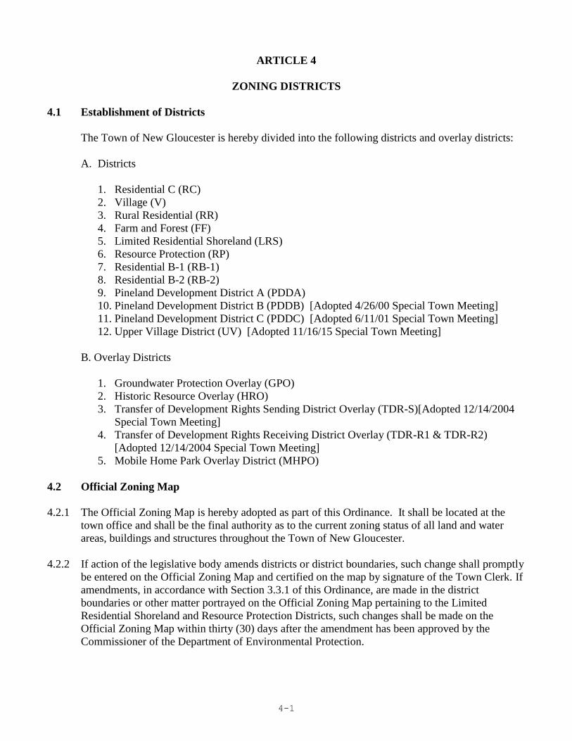
4-1
ARTICLE 4
ZONING DISTRICTS
4.1 Establishment of Districts
The Town of New Gloucester is hereby divided into the following districts and overlay districts:
A. Districts
1. Residential C (RC)
2. Village (V)
3. Rural Residential (RR)
4. Farm and Forest (FF)
5. Limited Residential Shoreland (LRS)
6. Resource Protection (RP)
7. Residential B-1 (RB-1)
8. Residential B-2 (RB-2)
9. Pineland Development District A (PDDA)
10. Pineland Development District B (PDDB) [Adopted 4/26/00 Special Town Meeting]
11. Pineland Development District C (PDDC) [Adopted 6/11/01 Special Town Meeting]
12. Upper Village District (UV) [Adopted 11/16/15 Special Town Meeting]
B. Overlay Districts
1. Groundwater Protection Overlay (GPO)
2. Historic Resource Overlay (HRO)
3. Transfer of Development Rights Sending District Overlay (TDR-S)[Adopted 12/14/2004
Special Town Meeting]
4. Transfer of Development Rights Receiving District Overlay (TDR-R1 & TDR-R2)
[Adopted 12/14/2004 Special Town Meeting]
5. Mobile Home Park Overlay District (MHPO)
4.2 Official Zoning Map
4.2.1 The Official Zoning Map is hereby adopted as part of this Ordinance. It shall be located at the
town office and shall be the final authority as to the current zoning status of all land and water
areas, buildings and structures throughout the Town of New Gloucester.
4.2.2 If action of the legislative body amends districts or district boundaries, such change shall promptly
be entered on the Official Zoning Map and certified on the map by signature of the Town Clerk. If
amendments, in accordance with Section 3.3.1 of this Ordinance, are made in the district
boundaries or other matter portrayed on the Official Zoning Map pertaining to the Limited
Residential Shoreland and Resource Protection Districts, such changes shall be made on the
Official Zoning Map within thirty (30) days after the amendment has been approved by the
Commissioner of the Department of Environmental Protection.
4-2
4.2.3 Scale of Map
The Official Zoning Map shall be drawn at a scale of not less than: 1 inch = 2000 feet. District
boundaries shall be clearly delineated and a legend indicating the symbols for each district shall be
placed on the map.
4.3 Zoning District Boundaries
Where uncertainty exists with respect to the boundary of any district as shown on the Official
Zoning Map, the following rules shall apply:
4.3.1 Where district boundaries are so indicated as to approximately follow lot lines, such lot lines shall
be construed to be such district boundaries;
4.3.2 Where district boundaries are indicated as approximately following the center lines of roads,
highways, streams, rivers or other rights-of-way, such center lines shall be construed to be such
boundaries;
4.3.3 Boundaries indicated as following shorelines shall be construed to follow such shorelines, and in
the event of change in the shoreline shall be construed as moving with the actual shoreline;
4.3.4 Where uncertainty exists in determining the precise location of any district boundary line, or
where physical or cultural features existing on the ground are at variance with those shown on the
Official Zoning Map, the Board of Appeals shall interpret the district and zone boundaries.
4.3.5 Overlay District requirements apply concurrently with the requirements for the underlying zoning
district. Where a conflict exists between the Overlay District requirement and the underlying
zoning district requirement, the more restrictive requirement shall apply.
4.4 District Standards
This section sets forth the purposes, allowable uses, dimensional requirements and other standards
for each of the zoning districts of this Ordinance. Except as otherwise provided in Section 3.2
(Nonconformance), any structure or land that hereafter is used or occupied, and any structure or
portion thereof that is erected, moved, constructed, reconstructed, extended, enlarged, or altered,
and any new lot created shall be in conformity with the standards and requirements herein
specified for the zoning district in which it is located, and the performance standards of this
Ordinance.
4-3
4.4.1 RESIDENTIAL C DISTRICT (RC)
A. Purpose
Retail uses that serve primarily community-wide shopping and service needs as opposed to
regional needs shall be permitted in this zone. However, non-retail businesses that draw from
the regional job force and those that serve regional markets shall be encouraged. The
residential C district generally contains uses that are desirable to separate from residential
uses; therefore, existing residential uses require protection and new residential uses require
planning. The type and mix of commercial development permitted in this District is intended
to be more intensive than that provided for in the Village District, while remaining sensitive to
maintenance of the rural characteristics of much of New Gloucester's road frontage. Because
business corridors are located in areas of high visibility within the Town, it is also the purpose
of this district to protect entranceways to the Town, to discourage highway strip development,
to restrict allowable uses based on traffic generation criteria, to limit traffic congestion by
limiting the number of access points for commercial uses on arterial roads and to encourage
attractive development along these identified major roadways.
B. Permitted Uses
1. home occupations, subject to the performance standards herein
2. signs, subject to the performance standards herein except if part of a development subject
to site plan review
3. accessory apartments, subject to the performance standards herein
4. accessory residential uses or structures and residential additions outside the Historic
Resource Overlay District [Amended 5/1/2017 Town Meeting]
5. expansions of up to 200 square feet to non-residential structures if such expansions
otherwise meet dimensional and other ordinance requirements and the structure is located
outside the Historic Resource Overlay District [Amended 5/1/2017 Town Meeting]
6. agriculture, subject to the performance standards herein
7. timber harvesting
8. gardens, other than as an accessory use
The following uses are permitted subject to site plan review
1. retail stores
2. food store
3. automobile service stations
4. convenience store with and without gas pumps
5. business services
6. business and professional offices
7. commercial schools
8. municipal uses and buildings
9. eating and/or drinking establishments, not including drive-through windows
10. banks
11. hotels and motels
12. bed and breakfast establishments which involve conversion or adaptation of existing
residential structures
13. commercial recreation: indoor
4-4
14. commercial recreation: outdoor (excluding amusements)
15. self-storage establishments
16. warehousing and wholesale distribution related thereto, exclusive of junk yards and
salvaging operations
17. light industrial facilities
18. private and public assembly
19. theaters
20. museums
21. commercial and veterinary kennels
22. essential services
23. commercial greenhouses and nurseries
24. hospitals and clinics
25. reserved
26. reserved
27. single-family dwellings
28. two-family dwellings
29. uses similar to permitted uses
30. inns, including restaurants as accessory uses
31. veterinary services and clinics
32. automobile sales provided that they are limited in size to one acre
33. outdoor sales and storage of equipment or materials for construction
34. day care centers
35. reserved
36. multiple use commercial buildings, so long as all uses are permitted in this district
37. signs, subject to the performance standards herein that are part of a development subject to
site plan review
38. automobile repair garages
39. reserved
40. uses or structures that are accessory to the above uses, except accessory residential uses
and additions as permitted above [Amended 5/1/2017 Town Meeting]
41. animal husbandry, subject to the performance standards herein
42. cluster development, subject to the performance standards herein
43. housing for the elderly subject to the performance standards herein
44. Single-Family and two-family manufactured housing
All other uses are prohibited.
C. Dimensional Requirements
1. Minimum lot size: 1 acre for each nonresidential use and 2 acres for each residential
dwelling unit or any other use where the standards for volume of effluent would equal or
exceed the most conservative standard for a 2 bedroom single family home as per the State
Plumbing Code.
For multi-use commercial buildings, the minimum lot size shall be one (1) acre, or the
acreage required to comply with all other applicable dimensional requirements, parking
regulations, buffering, and well/septic setbacks, whichever is greater. (amended 1/12/2004
Special Town Meeting)

4-5
2. Minimum road frontage:
150 feet for a lot less than 2 acres - 250 feet for a lot greater than or equal to 2 acres.
(amended 1/12/2004 Special Town Meeting)
3. Maximum impervious cover: 30%
4. Minimum setbacks:
Front: 75 ft., except that the minimum front setback for a dwelling is 50 ft.
Side: 25 ft.
Rear: 20 ft.
5. Maximum Building height: 35 ft.
D. Reserved (adopted 5/4/96 town meeting)
E. Performance Standards
In addition to the performance standards contained in Article 5, the following performance
standards shall be met for development within the Residential C District.
1. Driveway Cuts
a. Driveway cuts shall be limited to one per business onto Town roadways, unless the
characteristics of site topography, the nature of the business or the complexity of
internal circulation on the lot necessitates a second driveway location, in which case
two driveway cuts may be allowed at the discretion of, or required by, the Planning
Board. In the instance of state and state-aid highways the more restrictive of this
provision or those prescribed in the Maine Department of Transportation’s Highway
Driveway and Entrance Rules shall prevail. In cases where two curb cuts are permitted
for any one lot, distances between curb cuts shall be at least one hundred (100) ft.
2. No outdoor storage shall be allowed in the required front yard setback.
3. A twenty foot wide, maintained, vegetated buffer shall required within the front setback
area. Buffers shall meet the performance standards contained in Article 5.
4. For a multi-use commercial building:
a. maximum floor area for all uses shall not exceed 12,000 square feet
b. adequate water and sewage disposal facilities shall be provided for each use
5. RESERVED. (amended 1/12/2004 Special Town Meeting)
4-6
4.4.2 VILLAGE DISTRICT (V)
A. Purpose
It is the purpose of this district to preserve and continue existing mixed use development
patterns that are characteristic of New England town centers. Non-residential development in
this district shall meet local neighborhood needs for limited business services and may include
limited specialty retail uses. New development in this district shall be consistent with
historical land use patterns. A number of historically significant structures are located within
this district. Recognizing that economic and social conditions may warrant interior
renovations to these structures, and conversion to different uses, it shall be the primary intent
of this section to encourage preservation and enhancement of exterior architectural features. A
goal shall be to preserve the primarily residential nature of the existing Villages and to retain
open space.
B. Permitted Uses
The following uses are permitted:
1. agriculture, subject to the performance standards herein
2. timber harvesting
3. home occupations, subject to the performance standards herein
4. accessory residential uses or structures and residential additions outside the Historic
Resource Overlay District [Amended 5/1/2017 Town Meeting]
5. expansions of up to 200 square feet to non-residential structures if such expansions
otherwise meet dimensional and other ordinance requirements and the structure is located
outside the Historic Resource Overlay District [Amended 5/1/2017 Town Meeting]
6. signs not exceeding four square feet in area, not lighted or flashing, erected to advertise or
give information or warning about activities or conditions on the premises, or other
commerce
7. gardens other than as an accessory use
8. uses or structures that are accessory to the above uses
9. animal husbandry, subject to the performance standards herein
10. Accessory Apartments
The following uses are permitted subject to site plan review:
1. single-family dwelling
2. two-family dwelling
3. municipal uses
4. day care centers
5. bed and breakfast establishments
6. cemeteries
7. business and professional offices not exceeding 3000 square feet of gross floor area
8. retail uses such as a bakery, general store, bookstore, drugstore, hardware store, craft
shops, the sale of antiques, and specialty shops, provided that they are limited in size to
2000 square feet of first floor area.
9. barber shop, beauty salon, provided that no more than 2 chairs are proposed
10. elementary and secondary schools, both public and private

4-7
11. multiplex, limited to 4 units per building, subject to the performance standards herein
12. cluster development subject to the performance standards herein
13. churches, parish houses and rectories
14. housing for the elderly, subject to the performance standards herein
15. nursing homes and residential care facilities, subject to the performance standards for
housing for the elderly
16. inns, including restaurants as accessory uses
17. art and craft studios
18. museums
19. public and semi-public recreation facilities
20. funeral homes
21. private and public assembly
22. essential services
23. any sign other than those listed as permitted uses
24. uses or structures that are accessory to the above uses subject to site plan review, except
accessory residential uses and additions as permitted above [Amended 5/1/2017 Town
Meeting]
25. uses similar to permitted uses
All other uses are prohibited.
C. Dimensional requirements
1. Minimum lot size - 1 acre per principal use or dwelling unit.
2. Minimum land area per dwelling unit in multiplex and cluster housing - 1 unit/lot per acre
of net residential acreage.
3. Lot frontage - 150 ft.
4. Minimum Setbacks [Amended 5/2/2011 Town Meeting]
a. Front Setback – Thirty (30) feet
May be reduced by the Planning Board's during Site Plan review upon a determination
that:
i. Such a reduction in setback will enhance the architectural integrity of a
neighborhood or,
ii. The reduction in setback will be the same as the front setback of a building
located on an abutting parcel within two hundred fifty (250) feet.
b. Side and Rear Setbacks – Twenty (20) feet.
5. Lot Coverage - Impervious surfaces (including buildings, parking areas and walkways)
shall not exceed 30% of each lot.
6. Dimensional requirements for housing for the elderly are contained in Section 5.1.11.B.
7. Maximum Building height: 35 feet.
4-8
D. Performance Standards
1. In addition to the Performance Standards contained in Article 5, uses in the Village District
shall adhere to the following standards:
a. In the Village Districts known as the Upper and Lower Villages, a structure in
residential use or partial residential use must retain at least one dwelling unit when
a portion of the structure is converted to non-residential use.
b. For any use, the total square footage of the footprint of any addition or any
accessory building on a non-conforming lot shall not exceed 50% of that to the
original building. Municipal building are exempt from the 50% limitation on
additions. (Amended May 1, 2000 Town Meeting)
c. With the exception of up to 5 parking spaces, all parking shall be located to the side
and rear of structures, with vegetative screening, fences, berms and other methods
used to provide effective visual barriers. Buffers and landscaped areas shall
comply with the performance standards contained herein.

4-9
4.4.3 RURAL RESIDENTIAL DISTRICT (RR)
A. Purpose
The purpose of this district is to provide areas throughout the Town of New Gloucester
specifically for low density residential development. Such areas shall be located where
development will not place an undue burden of the ability of the Town to provide services and
utilities. The rural residential district shall provide a transitional area between the more
intensive Village development and the very low density Farm and Forest District. In order to
preserve the rural character of this district, to preserve agricultural land, forest land and open
space, clustering of residential development will be required to be considered for subdivision
and multiplex development.
B. Permitted Uses
The following uses are permitted:
1. agriculture, subject to the performance standards herein
2. timber harvesting
3. single-family dwellings
4. single-family or two-family manufactured housing units subject to the performance
standards herein.
5. two-family dwellings
6. home occupations, subject to the performance standards herein
7. day care centers
8. bed and breakfast establishments
9. expansions of up to 200 square feet to non-residential structures if such expansions
otherwise meet dimensional and other ordinance requirements and the structure is located
outside the Historic Resource Overlay District [Amended 5/1/2017 Town Meeting]
10. expansion of an existing gravel pit operation provided such expansion shall not exceed two
(2) acres of surface area per year and shall not cause the cumulative unreclaimed surface
area of such pit operation to exceed fifteen (15) acres
11. signs not exceeding four square feet in area, not lighted or flashing, erected to advertise or
give information or warning about activities or conditions on the premises, or other
commerce
12. farm stands
13. gardens other than as an accessory use
14. uses or structures that are accessory to the above uses
15. animal husbandry, subject to the performance standards herein
16. accessory apartments
17. mineral exploration
The following uses are permitted subject to site plan review:
1. excavation and mining activities other than those permitted above, subject to the
performance standards herein and any other applicable provisions of law.
2. commercial greenhouses
3. public buildings such as libraries, museums, and municipal buildings
4. elementary and secondary schools, both public and private
4-10
5. commercial schools limited to those involving instruction in horseback riding, cross-
county skiing, fishing, and other recreational activities permitted in this district.
6. churches, parish houses and rectories
7. campgrounds, subject to the performance standards herein
8. multiplex (limited to four units per building), subject to the performance standards herein
9. clustered residential development, subject to the performance standards herein
10. housing for the elderly, subject to the performance standards herein
11. nursing homes and residential care facilities, subject to the performance standards for
housing for the elderly
12. community living arrangement
13. essential services
14. inns, including those with restaurants as an accessory use
15. private assembly and public assembly
16. Commercial outdoor, public, and semi-public recreational facilities.
17. cemeteries
18. any sign other than those listed as permitted uses
19. accessory uses or structures to those uses above subject to site plan review
20. uses similar to permitted uses
All other uses are prohibited.
C. Dimensional requirements
1. Minimum lot size - 2 acres per principal use or dwelling unit
2. Minimum land area per dwelling unit in multiplex and cluster housing - 1 unit/lot per 2
acres of net residential acreage.
3. Minimum frontage -250 feet
4. Minimum setbacks
Minimum front setback - 50 ft.
Minimum side and rear setbacks - 30 ft.
5. Dimensional requirements for housing for the elderly are contained in Section 5.1.11.B.
6. Maximum building height - 35 feet.
D. Performance Standards
The performance standards of Article 5 shall apply to all uses as appropriate.
4-11
4.4.4 FARM AND FOREST DISTRICT (FF)
A. Purpose
Recognizing that the retention of existing farm and forest land, and open space is an important
part of maintaining rural character, it is the intent of the Farm and Forest District to encourage
and promote agricultural and forest management activities within the community, and to
provide land areas within the Town of New Gloucester where agriculture and forestry
activities can co-exist with limited residential development. Areas designated as farm and
forest are not suited to large scale development due to their status as working farms, forest
land, or open space, and/or due to their location away from Town service centers. In order to
preserve the rural character of this district, clustering of residential development will be
required to be considered for subdivision or multiplex development.
B. Permitted Uses
The following uses are permitted:
1. agriculture, subject to performance standards herein
2. animal husbandry
3. timber harvesting
4. single-family dwellings
5. single-family or two-family manufactured housing units that conform to performance
standards as contained in Article 5.
6. two-family dwellings
7. home occupations, subject to performance standards herein
8. day care centers
9. bed and breakfast establishments
10. expansions of up to 200 square feet to non-residential structures if such expansions
otherwise meet dimensional and other ordinance requirements and the structure is located
outside the Historic Resource Overlay District [Amended 5/1/2017 Town Meeting]
11. expansion of an existing gravel pit operation provided such expansion shall not exceed two
(2) acres of surface area per year and not cause the cumulative unreclaimed surface area of
such pit operation to exceed fifteen (15) acres
12. signs not exceeding four square feet in area, not lighted or flashing, erected to advertise or
give information or warning about activities or conditions on the premises, or other
commerce
13. farm stands
14. gardens other than as an accessory use
15. uses or structures that are accessory to the above uses
16. accessory apartments
17. mineral exploration
The following uses are permitted subject to site plan review:
1. excavation and other mining activities other than those permitted above, subject to the
performance standards herein,
2. junkyards and automobile graveyards, subject to the performance standards herein
4-12
3. elementary and secondary schools, both public and private
4. commercial schools limited to those involving instruction in horseback riding, cross-
country skiing, fishing, and other recreational activities permitted in this district.
5. campgrounds, subject to the performance standards herein
6. public buildings such as libraries, museums and municipal buildings
7. commercial kennels, including boarding kennels
8. commercial greenhouses and nurseries
9. clustered residential developments, subject to the performance standards herein
10. multiplex, limited to four (4) units per building, subject to the performance standards
herein
11. saw mills, provided that retail sales are limited to processed timber and related hardware
items
12. churches, parish houses and rectories
13. commercial outdoor, public, and semi-public recreational facilities
14. inns, including those with restaurants as an accessory use
15. private assembly and public assembly
16. essential services
17. cemeteries
18. any sign not exempted from site plan review above, subject to the performance standards
herein
19. uses or structures accessory to those uses above, subject to site plan review
20. uses similar to permitted uses
21. housing for the elderly subject to the performance standards herein
All other uses are prohibited.
C. Dimensional Requirements
1. Minimum lot size - 5 acres per principal use or dwelling unit
2. Minimum land area per dwelling unit in multiplex and cluster developments - 1 unit/lot per
5 acres of net residential acreage.
3. Minimum frontage - 300 ft.
4. Minimum setback
Minimum front setback - 50 ft.
Minimum side and rear setbacks - 30 ft.
5. Maximum Building height: 35 feet.
D. Performance Standards
The performance standards of Article 5 shall apply to all uses as appropriate.
4-13
4.4.5 LIMITED RESIDENTIAL SHORELAND DISTRICT (LRS)
A. Purpose
To allow residential development and other less intensive uses while protecting shoreline areas
that are vulnerable to physical, natural and scenic harm.
The Limited Residential Shoreland District includes all land areas, exclusive of those areas
that meet the criteria for the Resource Protection District listed in Section 4.4.6.A , within two
hundred and fifty (250) feet, horizontal distance, of the normal high-water line of any great
pond or river, or within two hundred and fifty (250) feet, horizontal distance, of the upland
edge of a wetland of significance.
In addition, the Limited Residential Shoreland District encompasses an area of land within five
hundred (500) feet, horizontal distance, of the normal high-water line on the westerly side of
Sabbathday Lake between the inlet of Wescott Brook and the intersection of the centerline of
Outlet Road to the east of the Royal River outlet; as well as the area between the normal high-
water line of Sabbathday Lake and the centerlines of Outlet Road, Snow Hill Road and
Sabbathday Road to the intersection of Wescott Brook, except including areas where two-
hundred and fifty (250) feet from the normal high-water line of Sabbathday Lake extends
beyond the road centerline.
B. Definitions Applicable to the Section
The definitions contained in Section 2.3 shall be applicable within the Limited Residential
Shoreland District.
C. Permitted Uses
1. The following uses are permitted:
a. Agriculture, subject to the performance standards herein
b. Clearing or removal of vegetation for activities other than timber harvesting,
subject to performance standards contained in Section 5.2.16
c. Emergency operations
d. Essential services, as outlined below:
i. Roadside distribution lines (34.5kV and lower)
e. Filling and earth moving of <10 cubic yards
f. Fire prevention activities
g. Forest management activities, except for timber harvesting and land management
roads
h. Land management road
i. Mineral Exploration
j. Recreational uses: Non-intensive recreational uses not requiring structures, such as
hunting, fishing and hiking.
k. Service drops, as defined, to permitted uses
l. Soil and water conservation practices
m. Surveying and resource analysis
n. Timber harvesting, subject to performance standards contained in Section 5.2.15
4-14
o. Travel: Motorized vehicular traffic on existing roads and trails
p. Water access: Areas for carry-in and carry-out of canoes and similar water craft and
access thereto and parking therefore.
q. Wildlife management practices
2. The following uses are permitted subject to a permit issued by the Code Enforcement
Officer:
a. Campsite: individual private campsite
b. Conversion of seasonal dwellings to year-round dwellings
c. Educational, scientific, or nature interpretation facilities
d. Essential services, as outlined below:
i. Non-roadside or cross-country distribution lines involving ten poles or less in the
shoreland zone
e. Filling and earth moving of > 10 cubic yards
f. Piers, docks, wharves, bridges and other structures and uses extending over or
beyond the normal high-water line or within a wetland of significance: Temporary
g. Residential dwellings, subject to a plan for the control of erosion and sedimentation
endorsed by the Cumberland County Soil and Water Conservation District:
i. Single family, including driveways
ii. Two family, including driveways
iii. Manufactured housing units for single family, subject to the performance
standards contained herein, including driveways
iv. Manufactured housing units for two family, subject to the performance
standards contained herein, including driveways
h. Signs
i. Structures accessory to permitted uses listed in Section 4.4.5.C.1 above
j. Subsurface sewage disposal system for permitted uses
k. Uses similar to permitted uses listed in Section 4.4.5.C.1 above
l. Uses similar to those permitted subject to permit issued by the Code Enforcement
Officer
3. The following uses are permitted subject to site plan review:
a. Aquaculture
b. Bed and Breakfast Establishments, outside of the shoreland zone
c. Cluster development, subject to performance standards herein
d. Essential services, as outlined below:
i. Non-roadside or cross-country distribution lines involving eleven or more poles
in the shoreland zone
ii. Other essential services
e. Home occupations, subject to performance standards herein
f. Institutional structures and uses
g. Mineral extraction
h. Multiplex, limited to four (4) units per building, subject to the performance
standards herein
i. Parking facility
j. Piers, docks, wharves, bridges and other structures and uses extending over or
beyond the normal high-water line or within a wetland of significance: Permanent
k. Public parks and outdoor recreation facilities
4-15
l. Recreational areas: public and private recreational areas involving minimal
structural development
m. Road construction
n. Structures accessory to those permitted subject to Site Plan review.
o. Uses similar to those permitted subject to Site Plan review
4. All other uses are prohibited.
D. Dimensional Standards
1. Minimum lot size - 2 acres per principal use or dwelling unit. Land below the normal
high-water line of a water body or upland edge of a wetland of significance and land
beneath roads serving more than two (2) lots shall not be included toward calculating
minimum lot size.
2. Minimum land area per dwelling unit in multiplex and cluster developments - 1 unit/lot per
2 acres of net residential area.
3. Minimum road frontage - 250 feet.
4. Minimum shore frontage
a. Residential uses - 250 feet.
b. Non-residential uses – 300 feet
5. Minimum Setbacks
a. Minimum front setback - 40 feet
b. Minimum side and rear setback - 30 feet.
c. Minimum shoreline setback – Subject to Section 5.2.9.A
6. Maximum height of a structure: 35 feet.
7. Maximum Cover: 20%.
8. The Code Enforcement Officer and the Planning Board retain the right to increase the
required setback of a proposed structure, as a condition to permit approval, if necessary to
accomplish the purposes of this ordinance. Instances where a greater setback may be
appropriate include, but are not limited to: areas of steep slope; shallow or erodible soils;
or where an adequate vegetative buffer does not exist.
E. Performance Standards
The performance standards of Sections 5.1 and 5.2 shall apply to all uses as appropriate.
4-16
4.4.6 RESOURCE PROTECTION DISTRICT (RP)
A. Purpose
The Resource Protection District includes areas in which development would adversely affect
water quality, productive habitats, biological ecosystems, or scenic and natural values. This
district shall include the following areas when they occur within the limits of the Limited
Residential Shoreland District or streams identified in subparagraphs 6 and 7 below:
1. Areas within 250 feet, horizontal distance, of the upland edge of wetlands of significance,
and wetlands associated with great ponds and rivers, which are rated "moderate" or "high"
value waterfowl and wading bird habitat, including nesting and feeding areas, by the
Maine Department of Inland Fisheries and Wildlife (MDIF&W) that are depicted on a
Geographic Information System (GIS) data layer maintained by either MDIF&W or the
Maine Department of Environmental Protection (MDEP) as of December 31, 2008. For the
purposes of this paragraph “wetlands associated with great ponds and rivers” shall mean
areas characterized by non-forested wetland vegetation and hydric soils that are contiguous
with a great pond or river, and have a surface elevation at or below the water level of the
great pond or river during the period of normal high water. “Wetlands associated with
great ponds or rivers” are considered to be part of that great pond or river.
2. Floodplains along rivers and floodplains along artificially formed great ponds along rivers,
defined by the 100-year floodplain as designated on the Federal Emergency Management
Agency's (FEMA) Flood Insurance Rate Maps or Flood Hazard Boundary Maps, or the
flood of record, or in the absence of these, by soil types identified as recent floodplain
soils.
3. Areas of two or more contiguous acres with sustained slopes of 20% or greater.
4. Areas of two (2) or more contiguous acres supporting wetland vegetation and hydric soils,
which are not part of a wetland of significance as defined, and which are not surficially
connected to a water body during the period of normal high water.
5. Land areas along rivers subject to severe bank erosion, undercutting, or river bed
movement.
6. The land areas within two-hundred and fifty feet (250) feet, horizontal distance, of the
normal high-water line of Wescott Brook and within seventy-five (75) feet, horizontal
distance, of the normal high-water line of a stream of significance, exclusive of those areas
within two-hundred and fifty (250) feet, horizontal distance, of the normal high-water line
of a great pond, or river, or within two hundred and fifty (250) feet, horizontal distance, of
the upland edge of a freshwater wetland of significance. Where a stream of significance
and its associated shoreland area are located within two-hundred and fifty (250) feet,
horizontal distance, of the above water bodies or wetlands, that land area shall be regulated
under the terms of the Limited Residential Shoreland District.
7. The Resource Protection District also includes the land areas within seventy-five (75) feet,
horizontal distance, of the normal high-water line of the following streams, exclusive of
those areas within two-hundred and fifty (250) feet, horizontal distance, of the normal

4-17
high-water line of a great pond, or river, or within two hundred and fifty (250) feet,
horizontal distance, of the upland edge of a freshwater wetland of significance:
a. Brandy Brook,
b. Foster Brook from its intersection with Royal River to the boundary of the
Residential B-2 District,
c. An unnamed stream that connects Royal River to Lily Pond,
d. An unnamed stream that flows through tax parcels Map 12 Lot 36-1, Map 12
Lot 35, and Map 12 Lot 34,
e. An unnamed stream that flows through tax parcels Map 12 Lot 42, Map 12 Lot
1-A, and Map 12 Lot 9, and
f. An unnamed stream that flows from tax parcel Map 8 Lot 21, crossing
Dougherty Road, to the intersection of a stream of significance on tax parcel
Map 4 Lot 58-A.
B. Definitions Applicable to the Section
The definitions contained in Section 2.3 shall be applicable within the Resource Protection
District
C. Permitted Uses
1. The following uses are permitted:
a. Emergency operations
b. Fire prevention activities
c. Forest management activities except for timber harvesting and land management roads
d. Recreational uses: Non-intensive recreational uses not requiring structures, such as
hunting, fishing, and hiking
e. Service drops, as defined, servicing permitted uses
f. Soil and water conservation practices
g. Surveying and resource analysis
h. Travel: Motorized vehicular traffic on existing roads and trails
i. Water access: Areas for carry-in and carry-out of canoes and similar water craft and
access thereto [Amended April 26, 2000, Special Town Meeting]
j. Wildlife management practices
2. The following uses are permitted subject to a permit issued by the Code Enforcement
Officer:
a. Campsite: individual private campsite
b. Clearing or removal of vegetation for activities other than timber harvesting, subject to
performance standards contained in Section 5.2.16
c. Conversion of seasonal dwellings to year-round dwellings
d. Essential Services as outlined below:
i. Roadside distribution lines (34.5kV and lower)
d. Filling and earth moving of < 10 cubic yards
e. Piers, docks, wharves, bridges and other structures and uses extending over or beyond
the normal high-water line or within a wetland of significance: Temporary
4-18
f. Signs
g. Subsurface sewage disposal system for permitted uses
h. Timber harvesting, subject to performance standards contained in Section 5.2.15
i. Uses similar to permitted uses
j. Uses similar to those requiring a CEO permit
3. The following uses are permitted subject to site plan review:
a. Agriculture, subject to the performance standards herein
b. Aquaculture
c. Educational, scientific or nature interpretation facilities
d. 5. Essential Services as outlined below:
i. Non-roadside or cross-country distribution lines involving ten poles or less in the
shoreland zone
ii. Non-roadside or cross-country distribution lines involving eleven or more poles in
the shoreland zone
iii. Other essential services
e. Filling and earth moving > 10 cubic yards
f. Home occupations, subject to performance standards herein
g. Land management road
h. Parking facility, when area is zoned for resource protection due to floodplain criteria
i. 4.Piers, docks, wharves, bridges and other structures and uses extending over or
beyond the normal high-water line or within a wetland of significance: Permanent
j. Recreational areas: Public and private recreational areas involving minimal structural
development
k. Residential dwellings: single family, including driveways, subject to the provision
found in Section 4.4.6.F, below
l. Roads construction, subject to performance standards contained in Section 5.2.10.D
m. Structures accessory to any of the above permitted uses, uses permitted with a CEO
permit, or uses subject to Site Plan Review.
n. Uses similar to uses requiring Site Plan review
4. All other uses are prohibited.
D. Dimensional Requirements
Where a principal building is in existence on the effective date of adoption or amendment of
this Ordinance, no lot or structure shall be created which does not meet the following
requirements:
1. Minimum lot area - 5 acres per principal use or dwelling unit. Land below the normal high-
water line of a water body or upland edge of a wetland of significance and land beneath
roads serving more than two (2) lots shall not be included toward calculating minimum lot
area.
2. Minimum land area per dwelling unit in multiplex - 1 unit per 5 acres of net residential
area
3. Minimum road and shore frontage - 250 feet.
4-19
4. Minimum Setbacks
a. Minimum front setback - 40 feet
b. Minimum side and rear setbacks - 30 feet.
c. Minimum shoreline setback - Subject to Section 5.2.9.A
5. Maximum cover: 20%
6. Maximum height of a structure: 35 feet.
7. The Code Enforcement Officer and the Planning Board retain the right to increase the
required setback of a proposed structure, as a condition to permit approval, if necessary to
accomplish the purposes of this ordinance. Instances where a greater setback may be
appropriate include, but are not limited to: areas of steep slope; shallow or erodible soils;
or where an adequate vegetative buffer does not exist.
E. Performance Standards
The performance standards of Article 5 of this ordinance shall apply to all uses as appropriate.
F. Special exceptions for single family residential dwellings
In addition to the criteria specified in Section 7.5 of this ordinance, excepting structure setback
requirements, the Planning Board may approve a permit for a single family residential
structure in a Resource Protection District provided that the applicant demonstrates that all of
the following conditions are met:
1. There is no location on the property, other than a location within the Resource Protection
District, where the structure can be built.
2. The lot on which the structure is proposed is undeveloped and was established and
recorded in the registry of deeds of the county in which the lot is located before the
adoption of the Resource Protection District.
3. All proposed buildings, sewage disposal systems and other improvements are:
a. Located on natural ground slopes of less than 20%; and
b. Located outside the floodway of the 100-year flood-plain along rivers and
artificially formed great ponds along rivers and outside the velocity zone in areas
subject to tides, based on detailed flood insurance studies and as delineated on the
Federal Emergency Management Agency's Flood Boundary and Floodway Maps
and Flood Insurance Rate Maps; all buildings, including basements, are elevated at
least one foot above the 100-year flood-plain elevation; and the development is
otherwise in compliance with any applicable municipal flood-plain ordinance.
If the floodway is not shown on the Federal Emergency Management Agency
Maps, it is deemed to be 1/2 the width of the 100-year flood-plain.

4-20
4. The total ground-floor area, including cantilevered or similar overhanging extensions, of
all principal and accessory structures is limited to a maximum of 1,500 square feet. This
limitation shall not be altered by variance.
5. All structures, except functionally water-dependent structures, are set back from the
normal high-water line of a water body, tributary stream or upland edge of a wetland of
significance to the greatest practical extent, but not less than 75 feet, horizontal distance. In
determining the greatest practical extent, the Planning Board shall consider the depth of the
lot, the slope of the land, the potential for soil erosion, the type and amount of vegetation
to be removed, the proposed building site's elevation in regard to the flood-plain, and its
proximity to moderate-value and high-value wetlands.
4-21
4.4.7 RESIDENTIAL B DISTRICT (RB)
A. Purpose
The purpose of this district is to provide land in the community for commercial and business
uses which can be developed in a manner compatible with existing low-density residential
uses. The overall goals of the Residential B District are to encourage commercial and business
development which:
is characterized by relatively low parking turnover;
requires larger land areas;
can be developed to provide greater buffering potential;
can be confined to buildings;
will utilize limited points of access onto public roads;
discourages traditional highway strip development; and
will not generate noise, odor or glare which is incompatible with nearby residential uses.
By utilizing large lots, limited highway access, long frontage and substantial setbacks,
negative impacts which might be associated with commercial or business development can be
internalized. The effective use of the provisions of the Residential B District will allow
reasonable growth of nonresidential development in the community without negatively
impacting the predominantly rural character of the area.
The Residential-Business District shall be further divided into the Residential B-1 (RB-1) and
Residential B-2 (RB-2) Districts for purposes of permitted uses and dimensional requirements.
B. Permitted Uses
The following uses are permitted:
1. agriculture, subject to the performance standard herein
2. timber harvesting
3. single-family dwellings
4. single-family or two-family manufactured housing units subject to the performance
standards herein
5. two-family dwellings
6. home occupations, subject to the performance standards herein
7. day-care centers
8. bed and breakfast establishments
9. expansions of up to 200 square feet to non-residential structures if such expansions
otherwise meet dimensional and other ordinance requirements and the structure is located
outside the Historic Resource Overlay District [Amended 5/1/2017 Town Meeting]
10. expansion of an existing gravel pit operation provided such expansion shall not exceed two
(2) acres of surface area per year and shall not cause the cumulative unreclaimed surface
area of such pit operation to exceed fifteen (15) acres
11. signs not exceeding four (4) square feet in area, not lighted or flashing, erected to advertise
or give information or warning about activities or conditions on the premises, or other
commerce
12. farm stands

4-22
13. gardens other than as an accessory use
14. uses or structures which are accessory to permitted uses
15. animal husbandry, subject to the performance standards herein
16. accessory apartments, subject to the performance standards herein
17. signs, subject to the performance standards herein, except if part of a development subject
to site plan review (passed 5/3/99 Town Meeting)
The following uses are permitted, subject to site plan review, in the RB-1 and RB-2 Districts:
1. business services conducted entirely indoors
2. business and professional offices
3. municipal uses and buildings
4. self-storage establishments
5. warehousing and wholesale distribution related thereto, exclusive of junkyards and
salvaging operations
6. veterinary services and clinics
7. signs, subject to the performance standards herein that are part of a development subject to
site plan review (passed 5/3/99 Town Meeting)
8. on-site sales that are accessory to permitted uses
9. multiple-use commercial buildings
10. farm and construction equipment sales and service
11. nursing homes and residential care facilities, subject to the performance standards for
housing for the elderly
12. commercial greenhouses and nurseries
13. Cluster housing, subject to Section 5.1.7 [Adopted 12.14/2004 Special Town Meeting]
The following uses are permitted, subject to site plan review, in the RB-1 District only:
1. commercial schools
2. light industrial facilities including light manufacturing or assembly using previously
prepared materials
3. wholesale storage and distribution of fuels and petroleum products
4. trucking terminals except that truck idling and service areas shall be at least two hundred
(200) feet from any residence
5. inns, including those with restaurants as an accessory use
C. Dimensional Requirements
1. Minimum Lot Size:
RB-1 District:
Uses not subject to site plan review - 2 acres per principal use or dwelling unit except
for cluster housing which requires 1 unit/lot per 2 acres of net residential area
Uses subject to site plan review - 5 acres per principal use except for the following
uses which require a minimum 2 acre lot size: business services if conducted entirely
indoors; business and professional offices; municipal uses and buildings; veterinary
services and clinics; and inns
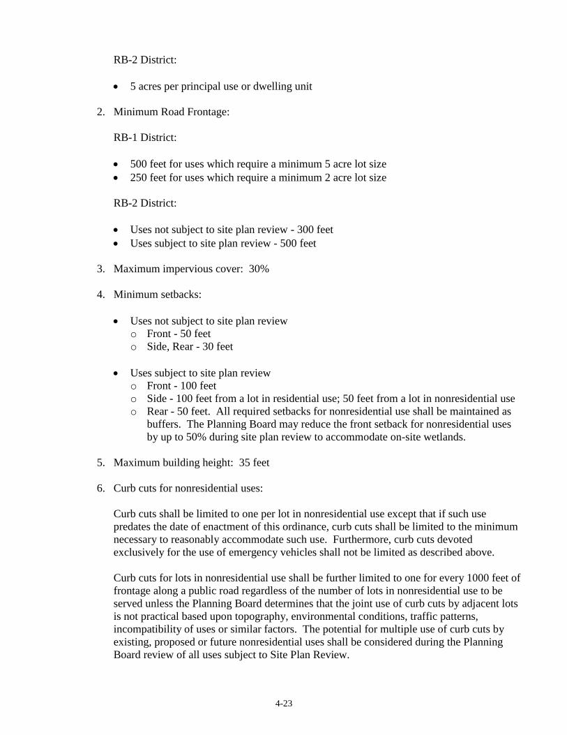
4-23
RB-2 District:
5 acres per principal use or dwelling unit
2. Minimum Road Frontage:
RB-1 District:
500 feet for uses which require a minimum 5 acre lot size
250 feet for uses which require a minimum 2 acre lot size
RB-2 District:
Uses not subject to site plan review - 300 feet
Uses subject to site plan review - 500 feet
3. Maximum impervious cover: 30%
4. Minimum setbacks:
Uses not subject to site plan review
o Front - 50 feet
o Side, Rear - 30 feet
Uses subject to site plan review
o Front - 100 feet
o Side - 100 feet from a lot in residential use; 50 feet from a lot in nonresidential use
o Rear - 50 feet. All required setbacks for nonresidential use shall be maintained as
buffers. The Planning Board may reduce the front setback for nonresidential uses
by up to 50% during site plan review to accommodate on-site wetlands.
5. Maximum building height: 35 feet
6. Curb cuts for nonresidential uses:
Curb cuts shall be limited to one per lot in nonresidential use except that if such use
predates the date of enactment of this ordinance, curb cuts shall be limited to the minimum
necessary to reasonably accommodate such use. Furthermore, curb cuts devoted
exclusively for the use of emergency vehicles shall not be limited as described above.
Curb cuts for lots in nonresidential use shall be further limited to one for every 1000 feet of
frontage along a public road regardless of the number of lots in nonresidential use to be
served unless the Planning Board determines that the joint use of curb cuts by adjacent lots
is not practical based upon topography, environmental conditions, traffic patterns,
incompatibility of uses or similar factors. The potential for multiple use of curb cuts by
existing, proposed or future nonresidential uses shall be considered during the Planning
Board review of all uses subject to Site Plan Review.

4-24
4.4.8 GROUNDWATER PROTECTION OVERLAY DISTRICT (GPO)
A. Purpose
It has been found that the protection of groundwater resources is critical in promoting the
health, safety and general welfare of the residents of New Gloucester, and residents of
surrounding towns who share common groundwater resources. To this end, the purpose of the
Groundwater Protection Overlay District is to protect the quality and quantity of present and
future groundwater resources by regulating activities and land use practices which can
reasonably be expected to reduce the availability or purity of water supplies. Furthermore, it is
the intent of this District to restrict or control uses involving hazardous or leachable materials,
which, if introduced into the ground or groundwater, cannot be rendered harmless by dilution
or the absorptive capacity of the soil, and to prohibit sources of viral and bacterial
contamination.
B. Administration
1. The provisions of the Groundwater Protection Overlay District shall be applied in addition
to those of the underlying zones. Where the provisions of this district conflict with the
provisions of the underlying zone, the more restrictive shall apply.
2. For uses within the Groundwater Protection Overlay District that do not require site plan
review by the Planning Board, the Code Enforcement Officer shall be responsible for
administering the provisions of this section. No building permit shall be issued unless the
CEO has made a positive finding that the proposed use or structure meets the requirements
and standards of this section. An applicant may appeal to Planning Board under the
provisions of Section 6 of this ordinance if the CEO denies a building permit based on
non-compliance with the groundwater protection standards contained in this section.
3. In reviewing subdivisions located all or in part within the Groundwater Protection District,
the Planning Board shall apply the requirements and standards of this section in addition to
those of the Subdivision Regulation.
4. The Planning Board may consult other local boards or groups such as the Conservation
Commission regarding uses or development in the Groundwater Protection Overlay
District. Where the Planning Board determines that adequate review of a proposed
development requires consultation of experts, it may hire such consultants at the applicant's
expense, according to the standards for retaining outside consultants contained in Article 7
of the Ordinances.
C. Identification of Aquifer Boundaries
For the purposes of this ordinance, and in order to carry out its provisions, the New Gloucester
Groundwater Protection Overlay District shall be delineated on the official zoning map of the
Town. Said map shall be available for inspection at the Town Office. Boundaries of the
aquifer and the aquifer recharge area have been identified in the Robert C. Gerber Inc. Study
completed for New Gloucester. Such boundaries shall be updated by vote of Town Meeting,
as new information or findings, provided by the Maine Geological Survey or by a Maine
Certified Geologist or Registered Professional Engineer with experience in hydrogeology,
warrant that they be changed.
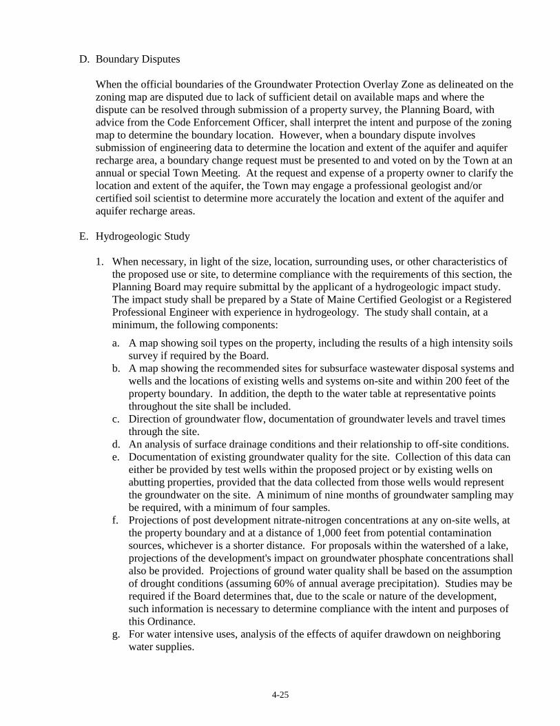
4-25
D. Boundary Disputes
When the official boundaries of the Groundwater Protection Overlay Zone as delineated on the
zoning map are disputed due to lack of sufficient detail on available maps and where the
dispute can be resolved through submission of a property survey, the Planning Board, with
advice from the Code Enforcement Officer, shall interpret the intent and purpose of the zoning
map to determine the boundary location. However, when a boundary dispute involves
submission of engineering data to determine the location and extent of the aquifer and aquifer
recharge area, a boundary change request must be presented to and voted on by the Town at an
annual or special Town Meeting. At the request and expense of a property owner to clarify the
location and extent of the aquifer, the Town may engage a professional geologist and/or
certified soil scientist to determine more accurately the location and extent of the aquifer and
aquifer recharge areas.
E. Hydrogeologic Study
1. When necessary, in light of the size, location, surrounding uses, or other characteristics of
the proposed use or site, to determine compliance with the requirements of this section, the
Planning Board may require submittal by the applicant of a hydrogeologic impact study.
The impact study shall be prepared by a State of Maine Certified Geologist or a Registered
Professional Engineer with experience in hydrogeology. The study shall contain, at a
minimum, the following components:
a. A map showing soil types on the property, including the results of a high intensity soils
survey if required by the Board.
b. A map showing the recommended sites for subsurface wastewater disposal systems and
wells and the locations of existing wells and systems on-site and within 200 feet of the
property boundary. In addition, the depth to the water table at representative points
throughout the site shall be included.
c. Direction of groundwater flow, documentation of groundwater levels and travel times
through the site.
d. An analysis of surface drainage conditions and their relationship to off-site conditions.
e. Documentation of existing groundwater quality for the site. Collection of this data can
either be provided by test wells within the proposed project or by existing wells on
abutting properties, provided that the data collected from those wells would represent
the groundwater on the site. A minimum of nine months of groundwater sampling may
be required, with a minimum of four samples.
f. Projections of post development nitrate-nitrogen concentrations at any on-site wells, at
the property boundary and at a distance of 1,000 feet from potential contamination
sources, whichever is a shorter distance. For proposals within the watershed of a lake,
projections of the development's impact on groundwater phosphate concentrations shall
also be provided. Projections of ground water quality shall be based on the assumption
of drought conditions (assuming 60% of annual average precipitation). Studies may be
required if the Board determines that, due to the scale or nature of the development,
such information is necessary to determine compliance with the intent and purposes of
this Ordinance.
g. For water intensive uses, analysis of the effects of aquifer drawdown on neighboring
water supplies.
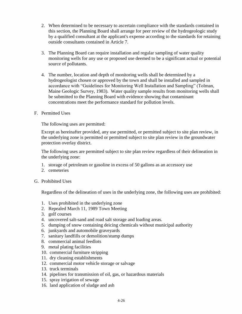
4-26
2. When determined to be necessary to ascertain compliance with the standards contained in
this section, the Planning Board shall arrange for peer review of the hydrogeologic study
by a qualified consultant at the applicant's expense according to the standards for retaining
outside consultants contained in Article 7.
3. The Planning Board can require installation and regular sampling of water quality
monitoring wells for any use or proposed use deemed to be a significant actual or potential
source of pollutants.
4. The number, location and depth of monitoring wells shall be determined by a
hydrogeologist chosen or approved by the town and shall be installed and sampled in
accordance with “Guidelines for Monitoring Well Installation and Sampling” (Tolman,
Maine Geologic Survey, 1983). Water quality sample results from monitoring wells shall
be submitted to the Planning Board with evidence showing that contaminant
concentrations meet the performance standard for pollution levels.
F. Permitted Uses
The following uses are permitted:
Except as hereinafter provided, any use permitted, or permitted subject to site plan review, in
the underlying zone is permitted or permitted subject to site plan review in the groundwater
protection overlay district.
The following uses are permitted subject to site plan review regardless of their delineation in
the underlying zone:
1. storage of petroleum or gasoline in excess of 50 gallons as an accessory use
2. cemeteries
G. Prohibited Uses
Regardless of the delineation of uses in the underlying zone, the following uses are prohibited:
1. Uses prohibited in the underlying zone
2. Repealed March 11, 1989 Town Meeting
3. golf courses
4. uncovered salt-sand and road salt storage and loading areas.
5. dumping of snow containing deicing chemicals without municipal authority
6. junkyards and automobile graveyards
7. sanitary landfills or demolition/stump dumps
8. commercial animal feedlots
9. metal plating facilities
10. commercial furniture stripping
11. dry cleaning establishments
12. commercial motor vehicle storage or salvage
13. truck terminals
14. pipelines for transmission of oil, gas, or hazardous materials
15. spray irrigation of sewage
16. land application of sludge and ash
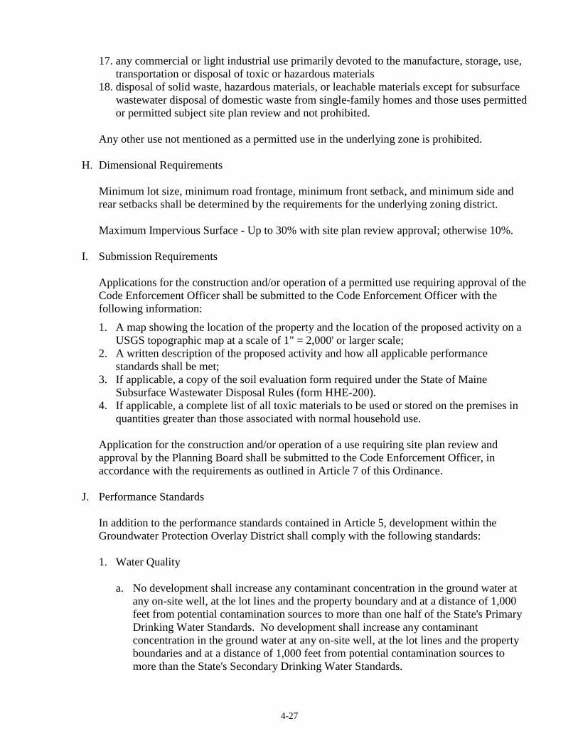
4-27
17. any commercial or light industrial use primarily devoted to the manufacture, storage, use,
transportation or disposal of toxic or hazardous materials
18. disposal of solid waste, hazardous materials, or leachable materials except for subsurface
wastewater disposal of domestic waste from single-family homes and those uses permitted
or permitted subject site plan review and not prohibited.
Any other use not mentioned as a permitted use in the underlying zone is prohibited.
H. Dimensional Requirements
Minimum lot size, minimum road frontage, minimum front setback, and minimum side and
rear setbacks shall be determined by the requirements for the underlying zoning district.
Maximum Impervious Surface - Up to 30% with site plan review approval; otherwise 10%.
I. Submission Requirements
Applications for the construction and/or operation of a permitted use requiring approval of the
Code Enforcement Officer shall be submitted to the Code Enforcement Officer with the
following information:
1. A map showing the location of the property and the location of the proposed activity on a
USGS topographic map at a scale of 1" = 2,000' or larger scale;
2. A written description of the proposed activity and how all applicable performance
standards shall be met;
3. If applicable, a copy of the soil evaluation form required under the State of Maine
Subsurface Wastewater Disposal Rules (form HHE-200).
4. If applicable, a complete list of all toxic materials to be used or stored on the premises in
quantities greater than those associated with normal household use.
Application for the construction and/or operation of a use requiring site plan review and
approval by the Planning Board shall be submitted to the Code Enforcement Officer, in
accordance with the requirements as outlined in Article 7 of this Ordinance.
J. Performance Standards
In addition to the performance standards contained in Article 5, development within the
Groundwater Protection Overlay District shall comply with the following standards:
1. Water Quality
a. No development shall increase any contaminant concentration in the ground water at
any on-site well, at the lot lines and the property boundary and at a distance of 1,000
feet from potential contamination sources to more than one half of the State's Primary
Drinking Water Standards. No development shall increase any contaminant
concentration in the ground water at any on-site well, at the lot lines and the property
boundaries and at a distance of 1,000 feet from potential contamination sources to
more than the State's Secondary Drinking Water Standards.
4-28
If ground water contains contaminants in excess of the secondary standards, the
development shall not cause the concentration of the parameters in question to exceed
150% of the ambient concentration.
Subsurface waste water disposal systems and drinking water wells shall be constructed
as shown on the map submitted with the assessment. If construction standards for
drinking water wells or subsurface disposal systems are recommended in the
assessment, those standards shall be included as a note on the Final Plan, and as
restrictions in the deeds to the affected lots.
b. There shall be no application of de-icing chemicals throughout the identified aquifer
and aquifer recharge area except sand with a salt content of no more than ten (10)
percent except by municipal authority. Any salt concentration shall be no greater than
that absolutely required under the prevailing conditions.
2. Expansion of Existing Gravel Pits
a. Extraction shall not be allowed below two and one-half (2 1/2) feet above the average
seasonal high ground water table. For the purposes of this section, the high water table
shall be measured through the observation of test borings during one full spring
recharge or high water season. No ditches, trenches, pumping or other methods shall
be used to lower the water table to permit more gravel extraction than could occur
under natural conditions.
b. Washing operations shall not be conducted in the pit without acceptable disposal of
waste water.
c. As the pit is concurrently closed, exhausted areas shall be loamed and seeded or
otherwise stabilized with native vegetation. Reclamation plans shall include provisions
for natural revegetation and replanting in mixed growth forest so as to maximize
recharge to the aquifer. Application of fertilizer, manure, or other soil amendments to
areas of bare soil where the topsoil has been removed is prohibited unless vegetative
cover has been established on the area first. In addition to the Town's requirements for
pit reclamation, plans for gravel pits in designated aquifer areas shall include
provisions for reclaiming slopes to 3:1 grade.
d. Storage of hazardous materials and petroleum products in the pit is prohibited.
e. Access roads into and around the pit shall not be oiled or treated with sodium chloride.
They may be paved only to the extent allowed under the performance standards of this
Ordinance.
f. The pit shall not be used for storage or dumping of any substances that could produce a
harmful leach, both during operation of the pit and following its permanent closure.
g. All trucking operations shall be responsible for taking all steps not prohibited by
section 4.4.8.j.2.e. to maximize dust control.
3. Subsurface Wastewater Disposal
Notwithstanding the requirements of the State of Maine Subsurface Wastewater Disposal
Rules, the following supplemental standards shall be required to be met for subsurface
wastewater disposal systems installed within the Groundwater Protection Overlay District
after the date of enactment of this District.
a. If less than 24 (twenty-four) inches of original undisturbed material is present between
the bottom of the subsurface disposal area and the most limiting soil factor (seasonal
4-29
high groundwater table, bedrock, or other restrictive layer), and the soil material is
classified as profiles 5, 6 or 11 (where this consists of sand or gravel) under the Maine
State Plumbing Code, the use of alternative systems comprised of the following shall
be required:
• disposal bed size shall be a medium/large size rating as a minimum;
• 12 (twelve) inches of sandy loam or loamy sand filtration liner materials shall be
required below the disposal bed, and
• the system shall be similar to that required by the Maine State Plumbing Code for
disposal systems in Coastal Sand Dune areas.
b. Individual wells and septic systems must be placed a minimum of 100 ft. apart,
including wells and septic systems of neighboring properties, except State plumbing
code setback requirements shall apply to replacement wells and septic systems.
4. Agriculture
All manure handling shall be carried out in conformance with a Conservation Plan
approved by the Cumberland County Soil and Water Conservation District.
5. Home Occupations
Home occupations involving the use or storage of hazardous or toxic materials in excess of
normal residential use are not permitted.
6. Petroleum Storage
All petroleum storage tanks shall meet the requirements established in DEP regulations
691, Section 6, and in addition, shall have a secondary containment system. Above
ground, outdoor tanks shall conform to State requirements.
7. Trucking Facilities
(All truck facilities within the GPOD will comply with the following):
1. No washing of tractors or trailers will be allowed on the premises except if part of an
approved washwater recycling system.
2. No floor drains shall be allowed in the truck maintenance areas.
3. A Best Management Practices Plan (BMP) shall be developed that describes the
storage, handling, use, and disposal of all materials stored or generated in the operation
of the truck facility that has the potential to pollute or otherwise harm groundwater or
surface waters. The BMP shall be presented to the Planning Board for approval.
4. All employees shall be familiar with the BMP. All employees shall read the BMP
annually and sign a BMP log book which documents that they have read and
understood the BMP. The employer shall be required to maintain the BMP log book
on-site.

4-30
4.4.9 HISTORIC RESOURCE OVERLAY DISTRICT (HRO)
Purpose
New Gloucester residents seek to promote the education, cultural, economic value and general
welfare of the community by protecting and enhancing existing Town character. The most easily
identifiable components of New Gloucester’s rural town character are those associated with its
historic structures and their setting. Once destroyed, historic architecture, areas and sites cannot
be replaced. The Town of New Gloucester shall protect and enhance the historic resources of
Town-wide concern, while accepting as appropriate new construction that is compatible. The
purpose of the Historic Resource Overlay Districts is to provide legal framework for the review of
lot design, siting of new structures, exterior reconstruction, and alterations to existing structures by
requiring compliance with design performance standards.
Uses
Permitted uses shall be those allowed in the underlying district, except that site plan review shall
be required for all uses except agriculture and home occupations. Minor additions up to 200
square feet shall be allowed without site plan approval upon review and approval by the Code
Enforcement Officer if the expansion is not visible from the road and such expansion otherwise
meets dimensional and other ordinance requirements. [Amended 5/1/2017 Town Meeting]
The purpose for this is to preserve historic sites, and structures, prevent inappropriate alterations to
structures of historic value, and assure new structures are designed and built in a manner
compatible with the Districts character in terms of scale and visual effect.
A. Dimensional requirements
Dimensional requirements shall comply with the standards of the underlying district. Except
that the thirty five (35) -foot height limitation may be exceeded if the Planning Board
determines the height of the proposed structure is compatible with the height of similar
existing structures characteristic of the Historic Resource Overlay District. Maximum
structure height shall be thirty five (35) feet or the average of the heights of similar existing
structures located within five hundred (500) feet and fronting on the same road, whichever is
greater.
B. Special Requirements for Structures and Sites on the National Register of Historic Places
and/or National Historic Landmarks.
The purpose of this section is to further the intentions of the Historic Resource Overlay
Districts, by preserving structures and sites that are important to the architectural, historical
and neighborhood significance of the Town of New Gloucester.
Neighborhood significance: the physical setting, which is composed of buildings, landscape
features, open space and other natural and architectural features.
Due to their architectural, cultural, and historic significance, many structures and sites located
in the Town of New Gloucester are listed on the National Register of Historic Places,
including structures and sites in the Lower Village, The Sabbathday Lake Shaker Village and
The Universalist Meeting House. A list of structures and sites, as amended from time to time,

4-31
shall be on file with the Town Clerk and Code Enforcement Officer, and copies shall be
provided to the New Gloucester Historical Society by the Town. Because these structures are
of local, regional, state, and national significance, the following additional requirements are
imposed.
1. Mandatory Notification of Demolition or Removal of Structures listed on the National
Register of Historic Places and/or National Landmarks.
The purpose of this notification is to give The Town of New Gloucester, The New
Gloucester Historical Society, and any individual or other organizations the opportunity to
acquire or to arrange for preservation of such structure and/or site. Such efforts may
include negotiation to relocate the structure or to induce interested third parties to purchase
the property for the purpose of preserving the structure and site.
Should a property owner want to demolish or remove a structure that is listed on the
National Register of Historic Places and/or National Landmarks, the property owner shall
file an application for a permit to demolish or remove the structure with the Code
Enforcement Office. The property owner shall post notice of the application.
Notices shall be published in a newspaper of general local circulation, shown on New
Gloucester Public Access Television, provided to the Selectmen, and the New Gloucester
Historical Society, and posted in the Town Hall.
The notice shall be posted at least three (3) times prior to demolition:
Within fifteen (15) days after filing the application
Not less then forty-five (45) days after filing the application
Not less then ninety (90) days after filing the application
The Code Enforcement Officer shall issue the demolition or removal permit 120 days after
the application is filed. In emergency cases or where Code Enforcement Officer
determines that demolition of the structure is necessary to protect the public health, safety,
and welfare, the demolition permit shall be issued without the notification requirements
specified in this section.
2. Providing a historic record
If a permit to demolish a historic structure is issued the owner shall provide so-called “line
drawings” that capture the essence of the structure as well as photographs of the structure
prior to demolition.
C. Performance Standards for all Lot Design, New Structures, Exterior Reconstruction, and
Alterations to Existing Structures in the Historic Overlay Districts.
In addition to the performance standards in Article 5 and the criteria established in Article 7 of
this Ordinance, where applicable, development in the Historic Resource Overlay Districts shall
meet the following performance standards.
1. The proposed development, including lot access shall be related harmoniously to the
terrain, use, scale, and architecture of existing historic structures that have functional or
visual relationships to the proposed structure. Access through the Historic Resource
4-32
Overlay District and development in an adjacent district shall be compatible and may also
require buffering.
2. To preserve and maintain the historic setting site disturbance shall be the minimum
necessary. No site disturbance, including stone walls, shall be done prior to Planning
Board approval. Structures shall be located to minimize site disturbance.
3. All site work shall be designed to maintain and preserve, insofar as practical, the historic
visual elements (such as stonewalls, old shade trees, etc.,) of the vicinity, and these
elements shall be considered in any buffering that may be required.
4. The dimensions, color and architectural design of new, altered, and re-constructed
structures shall be visually compatible with historic structures to which it is visually
related. The following visual compatibility standards shall apply to all Historic Resource
Overlay Districts.
a. Height – The height of proposed buildings shall be visually compatible with adjacent
buildings.
b. Proportion of Front Façade – The relationship of the width of the building to the
height of the front elevation shall be visually compatible with structures and open
spaces to which it is visually related.
c. Proportion of Windows and Doors – The relationship of the width of the windows to
height of windows and doors in a structure shall be visually compatible with those of
windows and doors of structures to which it is visually related. The proportion and
number of window divisions shall also be compatible with those of visually related
structures.
d. Rhythm of Spacing of Structures on Streets – The relationship of the structure to the
open space between it and adjoining structures shall be visually compatible to those
prevailing in the area to which it is visually related.
e. Rhythm of Entrance and/or Porch Projections – The relationship of entrance and porch
projections to sidewalks and roads of a structure shall be visually compatible with that
of structures to which it is visually related.
f. Relationship of Materials and Textures – The relationship of materials and textures of
the facade of a structure shall be visually compatible with that of the predominate
materials used in the structures to which it is visually related.
g. Roof Shapes – The roof shape of a structure shall be visually compatible with that of
structures to which it is visually related.
h. Directional Expression of Front Elevation – A structure shall be visually compatible
with buildings and landscape features to which it is visually related in its directional
character, whether this be vertical character, horizontal character or non-directional
character.
4-33
5. Exterior reconstruction and alterations to existing structures shall not destroy
distinguishing qualities or historic character of a structure or setting. Distinctive
architectural style such as molding, brackets, windows, doorways, porches, chimneys, etc.,
which characterize historic structures shall be preserved.
6. The proposed development shall, make every reasonable effort to provide a property use
compatible with visually related historic structures. There shall be minimal alterations to
the character defining features of the structure or site and its environment. The total setting
or character of the area including landscaping shall not obstruct significant historic
settings.
7. Additions or exterior reconstruction to an existing historic structure shall not destroy the
original distinguishing character. The new work may differentiate from the old but to
maintain the integrity and value of the historic property the new work shall be compatible
in size, scale, material and character with the existing property.
8. Signs: In addition to the Performance Standards in Article 5, Section 5.1.19 any new sign
or change in the appearance of an existing sign shall not detract from the historic character
of the site or structure.
The size, location, design, color, texture, lighting and material of all permanent signs and
outdoor advertising structures shall not detract from the use and enjoyment of proposed
structure and of the surrounding properties. Cumulative effects of multiple signs on a site
or along a roadway corridor shall be evaluated by the Planning Board when reviewing site
plans in Historic Resource Overlay Districts.
D. In Addition to the Submission Requirements of Article 7, Section 7.43.2.A the following items
will be provided for New Structures, Lot Design, Exterior Reconstruction and Alterations to
Existing Structures in the Historic Resource Overlay Districts.
1. A plot plan drawn to scale.
2. Documentation of the structure’s proposed scale and form as shown by sketches and
perspective drawings including specific height, width, roof shapes and trims.
3. Specifications of exterior materials (type of siding, roofing, windows, doors, chimney etc.).
These materials shall be visually compatible with the predominate materials used in the
structure and historic structures to which it is visually related.
4. Photographs of the existing site conditions prior to any site disturbance and of adjacent lots
shall be taken at representative points along the adjacent roadway.
5. A landscaping plan showing areas of vegetation to be removed and areas to be maintained,
including types and amounts of planting.
6. The Planning Board may require that a registered professional architect, engineer, or
landscape architect prepare the drawings and specifications.
4-34
7. If necessary to determine compliance with the standards contained in the Section, the
Planning Board may require submission of topographic information at 5-ft contour
intervals as prepared by a register engineer or licensed land surveyor.
8. The following submission requirement shall apply to all Historic Resource Overlay
Districts: Provide photographs of 2 -3 visually related structures, also located within the
same Historic Resource Overlay District which demonstrate the visual compatibility
standards found in section 4.4.9.C.4.
E. Ordinary Maintenance and Repair
1. Nothing in this Section shall be construed to prevent the ordinary maintenance or repair of
a structure’s exterior where such repair does not involve a change in design, or appearance.
(All maintenance and repair work in the Town of New Gloucester requires a permit from
the Code Enforcement Officer).
Siding and trim: original siding materials should be retained, repaired or replaced using the
same material when possible. The use of aluminum or vinyl may be an acceptable
alternative. The material shall be installed without irreversibly damaging or obscuring the
architectural features and trim of the historic structure.
Windows and doors: if replacement is necessary the new window and/or door shall match
the existing or historical size and sash arrangement.
2. Nothing in this Section shall prevent the construction, reconstruction, alteration, restoration
or demolition of any feature, which the Code Enforcement Office shall certify, is required
for public safety because of unsafe or dangerous conditions.
F. The Planning Board shall require notification of the New Gloucester Historical Society of
applications in the Historic Resource Overlay District.

4-35
4.4.10 MOBILE HOME PARK OVERLAY DISTRICT (MHO)
A. Purpose
It has been found that there is a need to provide areas for the development of mobile home
parks within the town consistent with state law, Title 30-A M.R.S.A. 4358. Zoning areas for
mobile home park development is part of the Town's overall efforts to provide areas for
reasonably priced housing. The anticipated densities in such areas will be substantially greater
than those permitted in all other zones allowing residential uses. Notwithstanding that vast
portions of the Town of New Gloucester consist of sand and gravel aquifers as well as bedrock
aquifers not suitable for intense development, it is intended that this district shall provide areas
suitable for such use without sacrifice of the protection of the quality and quantity of present
and future groundwater resources. Furthermore, in order to preserve agricultural land, forest
land and open space, historic and visual resources, clustering of such mobile home park
residential development may be required along with design and safety performance standards
to ensure the health, safety and general welfare of the park residents and the community at
large.
The following definitions shall be applicable within the Mobile Home Park Overlay district.
1. Manufactured Housing Unit: Structures, transportable in one of two sections, which were
constructed in a manufacturing facility and are transported to a building site and designed
to be used as dwellings when connected to the required utilities, including plumbing,
heating, air conditioning and electrical systems contained therein.
2. Mobile Home Park: A parcel of land under unified ownership designed and/or used to
accommodate three or more manufactured housing units.
3. Mobile Home Stand: That part of a mobile home park which has been improved for the
placement of one mobile home including all required appurtenant structures and having
provisions for utility connections.
B. Uses
Permitted uses shall be those allowed in the underlying district subject to the requirements in
the underlying district except that, subject to all of the administrative review criteria set forth
below, the development, construction, expansion and/or alteration of mobile home parks
within this district shall be allowed including the following:
1. Manufactured Housing Parks as defined in Article 2 of this Ordinance.
2. Open space in the park for recreational use of park residents only.
3. Specifically recognized accessory uses:
a. Park management office
b. Community or recreation building within the park for use by park residents only
c. Laundry building provided for use by park residents only
d. Service equipment building for storage of park maintenance equipment only
e. Storage facilities for use by park residents only
4-36
4. Utility services including water, sewer system, septic and regulations adopted by the Town
of New Gloucester and the State of Maine and which are in force at the time of park plan
approval.
C. Administration of Mobile Home Park review
1. The provisions of the Mobile Home Park Overlay District shall be applied in addition to all
of the requirements and performance standards of the underlying zone or other applicable
overlay zones. Where the provisions of this district conflict with the provisions of the
underlying zone or other applicable overlay zone, the more restrictive shall apply unless
Title 30-A M.R.S.A. Section 4358, as amended, shall supercede such provision. Except as
otherwise provided herein, new mobile home parks shall comply with all applicable
requirements and regulations of the State of Maine and the Town of New Gloucester.
2. Review of Mobile Home Park subdivisions shall be under this Ordinance including Site
Plan Review and under the Subdivision Regulations of the Town of New Gloucester.
3. When the official boundaries of the Mobile Home Park Overlay district are in dispute, the
Planning Board, with advice from the Code Enforcement Officer, shall interpret the
purpose and intent of the zoning map to determine the boundary location.
4. It shall be unlawful for any person to place, construct, expand, or operate any mobile home
park or do anything in furtherance of a plan for the same within the Town of New
Gloucester unless a plan for the park has been approved by the Planning Board.
D. Submission Requirements
In addition to those submissions required under site plan review and the subdivision
regulations, and in addition to the provisions of Section 7.6.1 below, an applicant shall also
submit the following before an application will be deemed complete:
For mobile home parks not served by a public sewer, the application shall include an
assessment of the impacts of park development on groundwater quality, drainage, stormwater
management, and erosion control. The person developing or expanding a mobile home park
has the burden of proving that the development will not pollute a public water supply,
waterway, groundwater, or aquifer. The assessment shall be prepared by a Certified Geologist
and Registered professional engineer as shall be required, and shall contain at least the
following information:
1. A map showing the basic soil types, including the results of a high intensity soils survey, if
required by the board, and a map showing the recommended sites for subsurface
wastewater disposal systems and wells in the park and showing also thereon wells and
septic systems on abutting properties within 500 ft. of the mobile home park boundaries.
2. The depth to water table at springtime levels at representative points throughout the mobile
home park, direction of groundwater flow, documentation of groundwater levels and travel
times throughout the park.

4-37
3. An analysis of drainage conditions throughout the mobile home park and their relationship
to off-site conditions.
4. Data of existing groundwater quality for the site. Collection of this data can either be
provided by test wells within the proposed mobile home park or by existing wells on
abutting properties provided that the data collected would represent the groundwater at the
mobile home park. A minimum of nine months of groundwater sampling may be required
by the Planning Board, with a minimum of four samples.
5. Projections of contaminant levels, including average nitrate nitrogen levels on the site after
development, including calculation of nitrate nitrogen levels at the downgradient mobile
home park lot lines for lots containing wells and at such wells and downgradient park
boundaries and at a distance of 1000 ft. from potential contamination sources. For mobile
home parks within the watershed of a lake, projections of the development's impact on
groundwater phosphate concentrations shall also be provided.
6. When determined to be necessary to ascertain compliance with the standards contained in
this section, the Planning Board shall arrange for peer review of the hydrogeologic study
by a qualified consultant at the applicant's expense according to the standards for retaining
outside consultants contained in Article 7.
7. The Planning Board can require installation and regular sampling of water quality
monitoring wells for any use or proposed use deemed to be a significant actual or potential
source of pollutants.
8. The number, location and depth of monitoring wells shall be determined by a
hydrogeologist chosen or approved by the town and shall be installed and sampled in
accordance with "Guidelines for Monitoring Well Installation and Sampling" (Tolman,
Maine Geologic Survey, 1983). Water quality sample results from monitoring wells shall
be submitted to the Planning Board with evidence showing that contaminant
concentrations meet the performance standard for pollution levels.
9. A storm drainage study and a proposed drainage system plan both certified by a registered
professional engineer, for surface and subsurface runoff, showing measures proposed to
prevent pollution of surface or ground water, soil erosion, increased runoff, changes in
ground water level and flooding. The storm drainage study shall document post vs. pre-
development runoff condition for two (2) and twenty-five (25) year, twenty-four (24) hour
storms. Drainage improvements shall be designated to control the rate of runoffs for the
twenty-four (24) hour storm such that the rate of post development runoff will not exceed
that of the pre-development condition.
10. Subsurface wastewater disposal systems and drinking water wells shall be constructed as
shown on the map submitted with the assessment required. If construction standards for
drinking water wells are recommended in the assessment, those standards shall be included
as a note on the Plan.
4-38
E. Dimensional Requirements
1. Lots served by public sewer
Minimum lot area - 6,500 sq. ft.
Minimum lot width - 55 ft.
2. Lots served by individual subsurface sewage disposal system:
Minimum lot area - 20,000 sq. ft.
Minimum lot width - 100 ft.
3. Lots served by a central subsurface wastewater disposal system:
Minimum lot area - 12,000 sq. ft. provided that overall density of park - no less than
20,000 sq. ft. per mobile home.
Minimum lot width - 75 ft.
4. Where lots front on a curved right of way or are served by a driveway, the lot width shall
be measured in a straight line perpendicular to the front of the mobile home.
5. Lots within a shoreland zoning district shall meet the lot area, lot width, setback, and shore
frontage requirements for that district.
6. The overall area of the mobile home park shall equal at least the sum of:
a. the combined area of all mobile home lots including the density requirements for lots
served by a central subsurface wastewater disposal system;
b. the area required for road right of ways;
c. the area for buffer strips;
d. for parks served by public sewer, an open space area for storage and recreation equal to
10% of the combined area of the individual lots, if required by the Planning Board; and
e. the area within the shoreland setback.
F. Lot Setbacks and Coverage
1. The following lot setbacks shall apply to all units and accessory buildings:
Front setback: 20 ft.
Side setback: 20 ft.
Rear setback: 10 ft.
If a lot is on a public road, the setback shall conform with the residential setback
requirements applicable to residential dwelling units in the underlying district.
4-39
2. So as to avoid monotony and sameness, the Planning Board may allow the front setback on
a private road within the park to be varied provided that no home or building may be closer
than 10 ft. from the right-of-way and the average distance is at least 20 ft. for all units and
buildings.
3. The Planning Board may reduce lot side yard setbacks to 5 ft. provided a distance of 25 ft.
is maintained between units.
4. A minimum 20 ft. separation shall be maintained between all units in all directions.
5. Buildings and mobile homes shall be set back at least 50 ft. from any abutting property.
6. Mobile home stands shall occupy no more than 20% of the lot area. The accumulated floor
area of the mobile home and its accessory structures shall not exceed 50% of the total area
of the lot.
G. Mobile Home Park Lots: Ownership, Use and Conversion
1. The mobile home park lots shall be shown on the site plan and the subdivision plan for the
mobile home park. All the land in the mobile home park shall be owned by the same
person or persons and the mobile home park lots may not be sold or leased individually
except as approved by the Planning Board pursuant to this section. No individual interests
in the mobile home park lots may be created or conveyed, except that individual mobile
lots or park lots may be created or conveyed, except that individual mobile home lots or
pads may be leased to the owners or occupants of the homes placed thereon. Mobile home
park lots are allowed only in mobile home parks approved by the planning board in
compliance with this Section 4.4.10, and shall not be considered lots for any other purpose
under this zoning ordinance. No mobile home lot may be sold, transferred or conveyed
without the prior approval of the Planning Board. Any such lot sold, transferred or
conveyed shall meet all the space standards and other regulations of the underlying district
and other applicable overlay districts in which it is located at the time of the sale, transfer
or conveyance.
2. The plan to be recorded at the registry of deeds shall include the following restrictions as
well as any other notes or conditions of approval:
a. the land within the park shall remain in a unified ownership and the fee to the lots or
portions of lots shall not be transferred.
b. no dwelling unit other than a manufactured housing unit shall be located within the park.
4-40
4.4.11 Pineland Development Districts
A. Purpose; Intent 1. It is the purpose of these districts to preserve the character and setting of Pineland Center
and its surrounding environs and encourage their orderly transition to new office, commercial, agricultural, recreational, and residential uses. Recognizing that some of the existing structures may need to be removed and that the remaining structures may require extensive renovations in order to be reused, an important purpose of this section is to encourage the overall enhancement and preservation of the campus atmosphere in the PDDA. Dimensional requirements and other provisions of this Section 4.4.11 reflect the historic development pattern of limited setbacks between buildings and roads, extensive areas of impervious surfaces, the pedestrian orientation of the campus in the PDDA, the existing layout of the campus in the PDDA, and the limited ability of interior roads and other infrastructure to meet modern design criteria. It is the intent of these districts to encourage the redevelopment and reuse of existing buildings located at Pineland Center in the PDDA and to further the agricultural, recreational and similar uses of the surrounding environs comprising the PDDB and PDDC while recognizing the practical impediments that would exist if such activities were subject to Site Plan Review in each and every instance. The provisions of this Section are, therefore, intended to expedite the development of these districts for the foregoing purposes by eliminating the requirement of Site Plan Review for certain uses in existing buildings and certain new buildings and by eliminating the requirement that such development meet certain performance standards that would be impracticable given the layout and configuration of buildings and improvements that currently exist in these districts.
B. Definitions applicable to this Section
The following definitions shall be applicable within the Pineland Development Districts: “Dormitory”: Rooms temporarily housing persons associated with educational activities conducted in the Pineland sub-districts. “Existing building(s)”: A building or buildings in existence prior to January 1, 1996, the total floor area of all such existing buildings being hereby deemed to be Five Hundred Thousand (500,000) square feet; “Existing road”: A paved or unpaved road in existence prior to January 1, 1996, or any road approved by the Planning Board pursuant to Site Plan Review or Subdivision Review; “Existing parking area”: A paved or unpaved parking area in existence prior to January 1, 1996, or any parking area approved by the Planning Board pursuant to Site Plan Review or Subdivision Review; “Existing essential service”: An essential service in existence prior to January 1, 1996, or any essential service approved by the Planning Board pursuant to Site Plan Review or Subdivision Review; and, "Essential Services" shall have the meaning set forth in Section 2.2, and specifically includes any such services erected, constructed, altered, or maintained by or for the benefit of a private property owner.
4-41
"Sheltered Group Home": A facility which provides food, shelter, and/or guidance or counseling services to a defined population. "Special Needs Independent Living Unit": A single family dwelling, multi-family dwelling (which may have more than four dwelling units), or other residential facility for habitation by persons with special social, physical, or mental needs and may include more than five (5) persons not related by blood or marriage. "Town Representatives": The Chair of the Planning Board or a nominee designated by the
Chair of the Planning Board from the Planning Board, the Town Planner, and the Code
Enforcement Officer. If the Chair of the Planning Board has a conflict of interest on any
permit application, the Planning Board is to elect a representative from the Planning Board for
all review related to that application.
C. Permitted Uses
The following uses are permitted in PDDA: 1. Governmental uses and buildings, including without limitation, municipal facilities 2. Essential services 3. Agriculture and timber harvesting 4. Churches 5. Retail trade 6. Business Services 7. Financial Services, including without limitation banks, banking operations and other
financial institutions 8. Business and professional offices 9. Restaurants and/or drinking establishments, not including drive-through windows 10. Indoor and outdoor recreation and related facilities, including, without limitation,
gymnasiums, swimming pools, cross-country skiing trails, and hiking trails (whether public, semi-public, private, commercial, non-profit or otherwise)
11. Equine and equestrian uses (whether public, semi-public, private, commercial, non-profit, or otherwise), including, without limitation, horseback riding, horse-drawn sleighs and wagons, indoor and outdoor riding arenas, and therapeutic riding centers
12. Indoor storage 13. Light industrial facilities 14. Theaters, museums and libraries 15. Greenhouses and nurseries (whether commercial, non-profit or otherwise) 16. Gardens 17. Hospitals, mental health facilities, and clinics 18. Landscaping operations 19. Communications, telemarketing and computer operations 20. Headquarters or branch offices of contracting and construction operations 21. Public and private schools and other educational facilities 22. Medical, research and testing laboratories and facilities 23. Day care centers and facilities, family and group day care homes 24. Multiple-use commercial buildings, as long as all uses therein are permitted in the district 25. Signs 26. Sheltered group homes, special independent living units, and similar residential facilities,
including housing for the elderly
4-42
27. Dormitories and other residential facilities housing students, family members or others in connection with services, schools or other uses permitted in the PDDA, which facilities may include more than four dwelling units in any one building
28. Farm stands 29. Animal husbandry and other livestock operations, including, without limitation, meat
cutting, but expressly excluding slaughtering of animals. 30. Warehouse facilities and wholesale sales and distribution facilities 31. Art, photo and similar studios 32. Uses similar to permitted uses in the PDDA 33. Uses or structures that are accessory to permitted uses in the PDDA 34. On-site disposal of construction and demolition waste materials resulting from
construction, remodeling, repair or demolition of existing buildings and accessory structures located within the Pineland Development Districts provided that such disposal is part of the capping and closure of existing land fills, dumps or other areas located within the PDDA and provided further that such disposal is approved by the Maine Department of Environmental Protection under the Maine Solid Waste Management Rules, to the extent such rules require approval (Adopted May 4, 1998 Town Meeting) ( Revised April 26, 2000 Special Town meeting )
The following uses are permitted in PDDB: 1. Agriculture and timber harvesting 2. Equine and equestrian uses (whether public, semi-public, private, commercial, non-profit,
or otherwise), including, without limitation, horseback riding, horse-drawn sleighs and wagons, indoor and outdoor riding arenas, and therapeutic riding centers
3. Greenhouses and nurseries (whether commercial, non-profit or otherwise) 4. Gardens 5. Landscaping operations 6. Outdoor recreation and related facilities, including, without limitation, cross-country skiing
trails and hiking trails (whether public, semi-public, private, commercial, non-profit or otherwise)
7. Residential facilities and dwellings housing proprietors, employees, managers, and agents and their family members or others in connection with services, businesses or other uses permitted in the PDDB (including by way of example and not limitation, residential facilities for the managers of agricultural operations and equestrian or equine operations), which facilities may include more than four dwelling units in any one building, provided, however, that such facilities and dwellings shall meet the following minimum gross density requirement: 10 acres per dwelling unit
8. Signs 9. Farm stands 10. Animal husbandry and other livestock operations, including, without limitation, meat
cutting, but expressly excluding slaughtering of animals. 11. Educational facilities associated with uses permitted in the PDDB (including, by way of
example and not limitation, nature centers) 12. Essential Services 13. Uses similar to permitted uses in the PDDB 14. Uses or structures that are accessory to permitted uses in the PDDB 15. On-site disposal of construction and demolition waste materials resulting from
construction, remodeling, repair or demolition of existing buildings and accessory structures located within the Pineland Development Districts provided that such disposal is part of the capping and closure of land fills or dumps located within the PDDB and provided further that such disposal is approved by the Maine Department of Environmental

4-43
Protection under the Maine Solid Waste Management Rules, to the extent such rules require approval
The following uses are permitted in PDDC
1. Agriculture, including gardens, farm stands, and accessory greenhouses and timber
harvesting
2. Equine and equestrian uses (whether public, semi-public, private, commercial, non-profit,
or otherwise), including, without limitation, horseback riding, horse-drawn sleighs and
wagons. 3. Outdoor recreation and related facilities, including, without limitation, all-season
pedestrian, bicycling, equestrian, cross-country skiing and hiking trails (whether public, semi-public, private, commercial, non-profit, or otherwise)
4. Signs 5. Animal husbandry and other livestock operations but expressly excluding meat cutting and
slaughtering of animals. 6. Essential Services
7. Uses or structures that are accessory to permitted uses in PDDC The following uses are subject to Site Plan Review in PDDA: 1. Hotels and motels 2. Bed and breakfast establishments 3. Inns 4. Private and public assembly and outdoor public assembly facilities (such as facilities for
outdoor musical performances and other entertainment) 5. Single family dwellings in existing buildings, except that this shall not be construed as
requiring site plan review for the uses described as permitted uses in the PDDA 6. Multi-family dwellings in existing buildings, except that this shall not be construed as
requiring site plan review for the uses described as permitted uses in the PDDA 7. New single family dwellings, subject to all requirements of the Rural Residential (RR)
District (other than road frontage) and applicable performance standards to said RR district and performance standard E 2. below, except that this shall not be construed as requiring site plan review for the uses described as permitted uses in the PDDA or as rendering the performance standards of the RR district applicable to such permitted uses
8. New multi-family dwellings, subject to all requirements of the Rural Residential (RR) District (other than road frontage) and applicable performance standards to said RR district and performance standard E 2. below, except that this shall not be construed as requiring site plan review for the uses described as permitted uses in the PDDA or as rendering the performance standards of the RR district applicable to such permitted uses
9. Salvaging operations located entirely within enclosed structures and which generate no appreciable noise detectable outside of such structures
10. Manufacturing other than light industrial uses 11. Cemeteries 12. On-site disposal, other than disposal allowed as a permitted use, of construction and
demolition waste materials resulting from construction, remodeling, repair or demolition of buildings and accessory structures located within the Pineland Development District if approved by the Maine Department of Environmental Protection under the Maine Solid Waste Management Rules
All other uses are prohibited.
4-44
The following uses are permitted subject to Site Plan Review in PDDB
1. Visitor Centers associated with uses permitted in PDDB and PDDC to provide services,
products and amenities to visitors of facilities in the Pineland Development Districts.
2. Veterinary facilities, including without limitation the practice of veterinary medicine,
training and education.
3. Agricultural product and food processing, including without limitation the processing of
dairy products.
4. Dormitories used in conjunction with the uses permitted in the PDDB and PDDC.
The following uses are permitted subject to Site Plan Review in PDDC
1. Hotels, including restaurants, public assembly and recreational facilities as accessory uses.
2. Passenger transportation facilities, including rail, vehicular and uses or structures that are
accessory to permitted uses in PDDC, excluding Airports.
3. Commercial schools limited to those involving instruction in horseback riding, cross-
country skiing, fishing, and other recreational activities permitted within the PDDB and
PDDC
4. Educational facilities associated with uses permitted in the PDDB or PDDC (including, by
way of example and not limitation, nature centers)
5. Uses similar to permitted uses in the PDDC
6. Residential facilities and dwellings housing proprietors, employees, managers, and agents
and their family members or others in connection with services, businesses or other uses
permitted in the PDDB or PDDC (including by way of example and not limitation,
residential facilities for the managers of agricultural operations and equestrian or equine
operations), which facilities may include more than four dwelling units in any one
building, provided, however, that such facilities and dwellings shall meet the following
minimum gross density requirement: 10 acres per dwelling unit excluding consideration of
net residential acreage.
7. Dormitories used in conjunction with the uses permitted in the PDDB and PDDC.
D. Dimensional Requirements
1. Minimum lot size: none, except as otherwise provided in this Section 4.4.11 with respect to
certain residential uses in the PDDB
2. Minimum frontage: none
3. Minimum setbacks: none. In PDDC no waiver allowed under 5.1.5.A.1
4. Maximum impervious cover: 50% of lot area in the PDDA and PDDB. PDDC shall not
exceed 30%
E. Performance and Review Standards
1. If any other provision of the Zoning Ordinance is inconsistent with the provisions of this
Section 4.4.11, the provisions of this Section shall control, and any ambiguity shall be resolved in favor of the application of the provisions of this Section. With respect to the application or interpretation of the Performance Standards of Article Five, the authority reviewing any application for a permit under this zoning ordinance shall give deference to the purpose and intent set forth in Section 4.4.11.A.1.
4-45
2. In the PDDA, single family dwellings and multifamily dwellings permitted shall be limited
to existing buildings and new buildings, the total combined floor area of which shall not exceed 20 percent of the total floor area of existing buildings, unless otherwise approved by the Planning Board.
3. Proposals to redevelop or reuse any existing buildings in the Pineland Development
Districts shall minimize adverse effects on the exterior architectural character and features of existing buildings to the extent practical, but this shall not be construed to preclude the construction of additions to existing buildings.
4. Existing roads, existing parking areas, and existing essential services may be erected,
constructed, used, repaired, maintained, altered, improved and replaced without Site Plan Review or application of Article 5 to serve buildings, additions to existing buildings and new buildings. New roads, new parking areas, and new essential services may be erected, constructed, used, repaired, maintained, altered, improved and replaced without Site Plan Review or application of Article 5 to serve existing buildings and to serve additions to existing buildings, new buildings and uses not otherwise requiring Site Plan Review. The construction of new roads, new parking areas and new essential services shall be subject to Site Plan Review and the provisions of Article 5 only if such roads, parking areas and essential services serve a use or building requiring Site Plan Review.
5. In the case of permitted uses in existing buildings, no review or other action by any official
or officials of the Town shall be required under this Zoning Ordinance, except as provided in Section 6.1.1, Section 6.1.2 and Section 6.1.5 with regard to building permits and certificates of occupancy and no portion of Article 7 or Section 5.1 shall apply except 5.1.17, Section 5.1.19, Section 5.1.25, Section 5.1.30. In the case of permitted uses in existing buildings for which the applicant is seeking a building permit, the applicant may only be required to submit the items or documents set forth in Table 1. Any activity requiring a building permit under Section 6.1.1 shall be reported by the Code Enforcement Officer to the Planning Board, but the applicant shall not be required to obtain Planning Board review or approval for permitted uses in existing buildings. The foregoing reporting requirement shall not be a prerequisite to the issuance or validity of any permit.
6. In the case of (i) permitted uses in new buildings and in additions to existing buildings,
provided that the total combined floor area of new buildings and additions then constructed to date does not exceed 30 percent of the total floor area of existing buildings; and (ii) accessory structures or structures related to essential services, regardless of the total combined floor area of new buildings then constructed to date, the Town Planner shall be consulted and provided with copies of plans and specifications for such new buildings, additions or structures, and Section 6.1.1, Section 6.1.2 and Section 6.1.5, and, except as otherwise set forth in this Section 4.4.11, Section 5.1 shall apply The Town Representatives, by majority decision, shall determine which of the items set forth in Section 7.4 must be submitted by the applicant and may, by majority decision for any matters waived by general regulation under Section 7.3.1.D, waive any such items. The Town Representatives, by majority decision, shall determine whether the proposed development satisfies the criteria set forth in Section 7.5 and if criteria are satisfied, shall direct the Code Enforcement Officer to issue a building permit. The Town Representatives or a designee selected by a majority of the Town Representatives, shall report on the status of such applications to the Planning Board, but the applicant shall not be required to obtain Planning Board review or approval and such reporting requirement shall not be a prerequisite to the issuance or validity of any permit.

4-46
7. In the case of permitted uses in new buildings and in additions to existing buildings, other
than accessory structures or structures related to essential services, after the total combined
floor area of new buildings and additions to existing buildings exceeds 30 percent of the
total floor area of existing buildings, and in the case of uses in any buildings that are
permitted with Site Plan Review, no building permit shall be issued until an application for
Site Plan Review under Article 7 has been approved, provided that such review shall be
limited to a review of the compliance of the new building or addition with the provisions
of this Zoning Ordinance, including Article 7 and, except as otherwise set forth in Section
4.4.11, Section 5.1, and the Planning Board shall have no authority to review or approve
the proposed use of such new buildings or additions so long as such use is permitted under
this Section 4.4.11. 8. Notwithstanding the foregoing, an applicant may elect to request Site Plan Review before
construction of any new building, addition to any building, road, parking area or essential service for which Site Plan Review is not required under the provisions of this Section.
9. For the purposes of determining, under subparagraphs 6 and 7 of this Subsection E,
whether at any time the total combined floor area of new buildings then constructed to date and additions to existing buildings then constructed to date exceeds 30 percent of the total floor area of existing buildings, floor areas of the following structures shall be excluded from the calculation: (i) barns, greenhouses, maintenance sheds and other structures in connection with any agricultural uses; and (ii) any buildings for which the applicant has obtained Site Plan Review under subparagraph 8 of this Subsection E.
10. Any application for a building permit not subject to Site Plan Review under Article 7 of
this Ordinance shall be subject to the provisions of Sections 7.6 and 7.7 regarding outside consulting and fees, and performance guarantees and project inspections. In such case, any reference in said sections to “board or Planning Board” shall be replaced by the following: "any one or more of the Town Representatives”.
11. In the PDDA, the noise regulations set forth in the Department of Environmental
Protection No Adverse Environmental Effect Standard of the Site Location Law, codified at CMR 375.10 shall apply in place of Section 5.1.
12. If any two of the Town Representatives deem any application described in Subsection E.6
to be of a significant nature, the Town Representatives shall have the right, in their discretion, to hold a project informational meeting at the Meeting House for the purpose of allowing public comment or questions in advance of the issuance of the permit. Town Staff members involved in the review of such application shall attend. The Code Enforcement Officer, at the expense of the applicant and after approval by the applicant of the wording to be used, shall place notice of the meeting in summary form in a newspaper of general circulation in the Town of New Gloucester at least seven (7) days prior to the meeting, the meeting to be held no later than ten (10) business days after the date of the application for the permit. The Code Enforcement Officer is responsible for notifying, at the applicant's expense, individual landowners within 250 feet of the improvement for which the permit is sought. No such meeting may be held if a delay in the grant of a permit may jeopardize use or development of the Pineland Development Districts or where the nature of the permit concerns construction of barns, greenhouses, maintenance sheds or other accessory structures or inconsequential or strictly technical matters for reuse or redevelopment provided that public health, safety, and welfare are protected. The sole purpose of this

4-47
provision is to provide notice and information to the public regarding the use or development the Pineland Development Districts in connection with the issuance of any building permit for which Site Plan Review is not required under Subsection E.6 and the requirements of this provision shall not bear upon or affect the grant of any permit.
13. If any provision of this Section is declared by a court of competent jurisdiction to be
invalid illegal or of no force or effect, such decision shall have no effect on the validity, legality, force or effect of any other provision of this Section.
14. Special Performance Standards for this Ordinance
A. The number of rooms in a dormitory in any Pineland sub-district shall be limited to one (1) bed for every three (3) acres of land within each Pineland sub-district, after deduction of the land area (footprint) occupied by buildings.
F. Additional Provisions
Article 8 of this Zoning Ordinance and Sections 3.1.4, 3.1.6, 3.2.2.D, E and F, and 5.1.2 are not applicable in the Pineland Development Districts. (Approved June 20, 1996 Special Town Meeting) (Revised April 26, 2000 Special Town Meeting)
Conveyance by the State of Maine. The amendments contained herein shall be null and void if the conveyance by the State of Maine pursuant to the Option Agreement dated January 10,2000 does not occur.
TABLE 1
Submittals for Building Permits/Certificate of Occupancy
Application form for building permit, identifying the proposed use.
Plan depicting the proposed improvements.
Identification of location of outdoor storage areas to be used in connection with the
portion of the premises for which the permit is sought
Demonstration of compliance with State Plumbing Code
Demonstration of compliance with NFPA Life Safety Code
Demonstration of adequate treatment of sanitary and solid waste
Demonstration of compliance with state or federal regulations or issuance of federal or state permits
(Adopted April 26, 2000 Special Town Meeting; Amended June 11, 2001 Special Town Meeting; Amended May 2, 2011 Town Meeting)
4-48
4.4.12 Transfer of Development Rights Sending District Overlay (TDR-S)
A. Purpose
It is the purpose of this overlay to permanently preserve agriculture, forestry, animal husbandry
and open space through the transfer of development right via sale or donation of those rights. The
Transfer of Development Rights program provides an incentive for land owners to partner with
developers and conservationists to achieve these purposes.
B. Administration
The Transfer of Development Rights program governing the overlay district is facilitated by the
Town of New Gloucester.
C. Permitted Uses
Any use permitted, or permitted subject to site plan review, in the underlying district is permitted
or permitted subject to site plan review in the Transfer of Development Rights Sending District
Overlay.
D. District Requirements
All land preserved through the transfer of development rights is subject to the Performance
Standards contained in Sections 5.1.7.D.1 and 5.1.7.D.3 subsections a through f of this ordinance.
E. Procedure and Submission Requirements
The procedure and submission requirements associated with the Transfer of Development Rights
program are outlined in Sections 9.5 and 9.6 of this ordinance.
4-49
4.4.13 Transfer of Development Rights Receiving District Overlay (TDR-R)
A. Purpose
It is the purpose of this overlay to direct growth into designated areas through the use of
transferable development rights. The Transfer of Development Rights program provides an
incentive for developers to partner with land owners and conservationists to achieve this purpose.
B. Administration
1. The Transfer of Development Rights program governing the overlay district is
facilitated by the Town of New Gloucester.
2. All development utilizing transferable development rights is subject to Planning Board
review.
C. Permitted Uses
Uses permitted, or permitted subject to site plan review, in the underlying district are permitted or
permitted subject to site plan review in the Transfer of Development Rights Receiving District
Overlay.
D. District Requirements
The overlay district is further divided into Receiving District 1 (TDR-R1) and Receiving District 2
(TDR-R2).
1. Receiving District 1
All development in Receiving District 1 is subject to the provisions for cluster subdivisions
found in Article 5 of this ordinance.
2. Receiving District 2
All development in Receiving District 2 is subject to the dimensional requirements
contained in the Village District except as altered by Section 9.4.2 of this ordinance.
E. Procedure and Submission Requirements The procedure and submission requirements associated with the Transfer of Development Rights program are outlined in Sections 9.5 and 9.6 of this ordinance.

4-50
4.4.14 UPPER VILLAGE DISTRICT (UV) [Adopted 11/16/2015 Special Town Meeting]
A. Purpose
The Upper Village is a significant area of town, both because of its historic role as one of New
Gloucester’s villages and because of its potential as a revitalized mixed-use center. The
extension of a public water supply to the area has created new opportunities for investment and
the higher densities typical of a village area. Recognizing the area’s importance, the town has
developed an Upper Village Master Plan, generated with considerable public input and
support. The purpose of this District is to promote the goals and principles of this plan by
promoting compact, mixed use, village-oriented development, providing flexible standards and
incentives for appropriate design, and balancing the area’s function as a transportation corridor
with its role as a viable “Main Street.”
B. Permitted Uses
The following uses are permitted:
1. agriculture, subject to the performance standards herein
2. timber harvesting
3. animal husbandry, subject to the performance standards herein
4. accessory apartments
5. home occupations, subject to the performance standards herein
6. accessory residential uses or structures and residential additions outside the Historic
Resource Overlay District [Amended 5/1/2017 Town Meeting]
7. expansions of up to 200 square feet to non-residential structures if such expansions
otherwise meet dimensional and other ordinance requirements and the structure is located
outside the Historic Resource Overlay District [Amended 5/1/2017 Town Meeting]
6. signs, subject to performance standards herein except if part of a development subject to
site plan review.
7. uses or structures that are accessory to the above uses
The following uses are permitted subject to site plan review:
1. single-family dwellings (with additional performance standards of Section G.)
2. two-family dwellings (with additional performance standards of Section G).
3. multiplex
4. cluster development
5. the following commercial uses, not to exceed 4,000 square feet of first floor area: retail
trade, business services, business and professional offices, restaurants, and multiple use
commercial buildings (as long as all uses within such buildings are otherwise permitted).
6. mixed use buildings
7. light industrial uses on lots fronting or accessed from Route 100 that are setback 100 feet
or more from public roads
8. bed and breakfast establishments and inns, including restaurants as accessory uses
9. housing for the elderly, subject to the performance standards herein
10. schools and daycare centers
11. churches, parish houses and rectories
12. municipal uses and buildings
13. public and semi-public recreation facilities
14. private and public assembly
15. cultural uses, including art and craft studios, theaters and museums

4-51
16. essential services
17. signs, subject to the performance standards herein that are part of a development requiring
site plan review.
18. uses or structures that are accessory to the above uses subject to site plan review, except
accessory residential uses and additions as permitted above [Amended 5/1/2017 Town
Meeting]
C. Prohibited Uses
1. Non-residential uses on lots fronting or accessed from Bald Hill Road that generate more
than 50 vehicle trips per day, as determined by the most recent edition of the Trip
Generation Manual, published by Institute of Traffic Engineers.
2. Drive-through facilities
3. Automobile service stations, convenience stores with gas pumps, automobile repair
garages and automobile outdoor sales, except for those uses existing as of the date of this
ordinance amendment.
4. Uses other than those listed in Section B.
5. Uses in existence at the date of amendment of this ordinance amendment that are classified
as prohibited or non-conforming shall be permitted to expand if all other dimensional
requirements of this ordinance are met, but in no case shall they exceed the size limitation
established for commercial uses under this district.
D. Dimensional Requirements
1. For projects which are not served by public water or do not meet the criteria for Upper
Village Design Certification Bonus:
a. Minimum lot size for single-family dwellings and single-use, non-residential uses – 1
acre
b. Minimum lot size for all other uses, including multiplex, cluster, multiple use non-
residential and mixed use buildings – 1 acre plus any additional required area,
calculated as net residential acreage, based on projected wastewater flows per the State
Minimum Lot Size Ordinance and the State Subsurface Waste Disposal Rules.
c. Minimum road frontage – 125 feet.
d. Minimum road setback – from Route 100: 30 feet; from other roads: 20 feet.
e. Minimum Side and Rear Setbacks – 15 feet
2. For projects served by public water which meet criteria for the Upper Village Design
Certification Bonus:
a. Minimum lot size for single-family and single-use non-residential uses – 1/2 acre
b. Minimum lot size for all other uses, including multiplex, cluster, multiple use non-
residential uses and mixed use buildings – 1/2 acre plus any additional required area,
calculated as net residential acreage, based on projected wastewater flows per the State
Minimum Lot Size Ordinance and the State Subsurface Waste Disposal Rules.
c. Minimum road frontage – 75 feet.
d. Minimum road setback – from Route 100: 20 feet; from other roads: 10 feet.
e. Minimum Side and Rear Setbacks –10 feet

4-52
The setbacks in 2. above may be further reduced by the Planning Board's during Site Plan
review upon a determination that:
i. Such a reduction in setback will enhance the architectural integrity of a neighborhood;
ii. Such reduction promotes the objectives of the Upper Village Master Plan;
iii. Such reductions do not adversely impact traffic or safety conditions; and
iv. Such reductions will not adversely impact neighboring properties.
3. Lot Coverage - Impervious surfaces (including buildings, parking areas and walkways)
shall not exceed 30% of each lot.
4. Dimensional requirements for housing for the elderly are contained in Section 5.1.11.B.
5. Maximum Building height: 35 feet.
E. Review Process for Upper Village Design Certification Bonus
Applicants seeking Upper Village Design Certification for their projects shall be reviewed
under the following process:
a. Applicant holds initial meeting with planning staff and other applicable town staff to
discuss design options and review of design guidelines.
b. Applicant submits an Upper Village Design Plan Certification application form, in addition
to relevant development review application.
c. Planning staff, in consultation with other staff, makes a preliminary determination as to
whether application meets or doesn’t meet design certification criteria.
d. Planning Board votes on whether to approve the application for design certification and
grant bonus.
e. Site plan and/or subdivision review shall occur concurrently with the design certification
process, unless the applicant requests a Planning Board vote on certification prior to
detailed development review. Upon receiving design certification, applicants may request
and the Planning Board may determine whether the applicant is eligible for expedited site
plan review.
F. Criteria for Design Certification Bonus
To be eligible for the Upper Village Design Certification bonus, projects shall not only meet
the minimum requirements of this ordinance, but also address the following criteria:
1. Pedestrian Orientation: Improve and promote walkability throughout the Upper Village,
and create attractive, safe, contiguous pedestrian connections between village land uses
and between the village and surrounding areas. Linkages to the Upper Village Core Area
should be promoted to the greatest extent possible.
2. Architectural Design: Employ architectural styles and design features commonly used in
historic New England village centers, or new designs that are visually compatible with
these styles. “Franchise architecture” that employs generic designs that are trademarked or
identified with a particular franchise chain or corporation shall be avoided. To be design-
certified, franchises or national chains shall meet this design standard, and otherwise meet
the standards of this section.
3. Streetscape Enhancement: Design, locate and size buildings in such a way in order to
create or reinforce a unified streetscape and otherwise help to promote a village

4-53
orientation. Buildings shall be of a scale and layout appropriate in a village setting. New
buildings shall be located at or near front setback lines, unless it is determined that such
locations create safety problems or are contrary fostering a village orientation.
4. Compact, Mixed Use Development: Promote a compact, mixed use development pattern
that creates and reinforces a village orientation, particular in areas within and adjacent to
the Core Area of the Upper Village. Businesses that provide essential needs to the local
populations are encouraged.
5. Parking Lots: Reduce the visual impact of parking lots through careful site design,
landscaping and use of shared parking. Parking lots shall be located to the rear or side of
buildings, designed to avoid large, unbroken expanses of pavement or gravel, and
landscaped, not only to provide visual screening, but to make them a positive visual
element. Parking areas for non-residential uses shall be paved.
6. Driveways and Circulation: Employ an approach to access management and on-site
circulation aimed at improving traffic safety, reducing turning conflicts and promoting
interconnections with neighboring land uses. Opportunities to limit new entrances and
consolidate existing entrances on Route 100 shall be strongly considered, and new
entrances shall create defined openings as opposed to open curbs.
7. Landscaping: Provide an approach to landscaping and signage that not only meets the
minimum requirements of the zoning ordinance, but enhances the visual quality of the site
and its surroundings.
8. Lighting and Utility areas: Ensure that loading areas, lighting, storage and other features
necessary for business operation and security are located and designed to minimize visual
impacts, particularly from key viewing areas. Lighting types that contribute to creating a
village atmosphere are strongly encouraged.
9. Signage: Signs shall be designed and located, not just to reduce visual impact, but to
improve the overall aesthetics of the site and promote a village orientation. To be eligible
for design certification, signs shall generally be constructed of natural materials and not be
internally illuminated.
10. Amenities: Where feasible, projects shall incorporate amenities that provide additional
public benefit or site enhancements, such as pedestrian gathering areas (i.e. plazas,
benches), and aesthetic features (i.e. public art, planters and additional landscaping
features).
In order to qualify for the design certification bonus, the applicant must address all of these
criteria or demonstrate that certain criteria are either not applicable to the project or that
meeting them would be contrary to the overall purpose of this District. When certain criteria
are not applicable or can only be partially met, consideration will be given to the extent to
which the applicant meets or exceeds the standards of other criteria.
For additional direction in meeting these criteria, applicants shall consult the Town’s
Voluntary Upper Village Design Guidelines. Applicants not pursuing design certification are
encouraged to consult these guidelines as well.
4-54
G. General Performance Standards for All Projects Within Upper Village District
1. To the greatest extent possible, parking areas for commercial and multi-family uses shall
be located behind or to the side of the proposed structures.
2. Any required landscaping or buffering required as part of project approval shall either be
completed prior to issuance of a certificate of occupancy, or the applicant shall post a
performance guarantee with the town in accordance with Section 7.7.
3. All proposed projects shall assess the potential for existing and future pedestrian access,
and incorporate a strategy that is reflected on the approved site plan. Where sidewalks are
feasible, they should meet the standards of Section 8.5.8. Where sidewalks are not
feasible, pathways and/or reservation of areas for future pedestrian access shall be
required.
3. Front setbacks should be minimized in cases where the location of structures closer to
roads will promote compatibility with existing streetscapes or contribute to a new
streetscape pattern that promotes a village orientation.
4. Entrances/exits onto state and public roads shall be limited and consolidated to the greatest
extent possible and clearly delineated. All non-residential parking areas shall be paved.
5. Additional standards for single-family and two-family dwellings in the Upper Village
District except lots fronting or accessed from Bald Hill Road:
a. These uses are not eligible for expedited site plan review.
b. In addition to meeting the site plan review standards of Section 7, these uses shall meet
the following additional standards:
To the greatest extent possible, they shall employ a layout and design that
contributes to a village orientation. Applicants are encouraged to review the
Town’s Voluntary Design Guidelines to obtain guidance.
To the greatest extent possible, they shall employ the smallest land area or linear
distance in excess of the minimum lot size, frontage or front setback requirements
necessary for the use.
6. Waiver of standards: The standard of Section G. may only be waived if meeting the
particular standard (1) creates significant practical difficulties or (2) results in actions that
are contrary to the purposes this District.
5-1
ARTICLE 5
PERFORMANCE STANDARDS
5.1 Townwide Standards
The following minimum standards of performance govern structures, uses and activities within the
Town of New Gloucester, including those areas defined as shoreland areas under M.R.S.A., Title
38, Sections 435-447, unless preempted by more restrictive standards in other provisions of this or
any other local, state or federal ordinance.
5.1.1 Accessory Apartments: Accessory apartments shall adhere to the following standards. It shall
be the responsibility of the property owner to demonstrate to the Planning Board or Code
Enforcement Officer, as applicable, that the standards have been met.
A. The owner of the principal structure must reside in either the principal structure or the
accessory unit.
B. One of the occupants of the accessory unit must be a member of the extended family of the
owner of the principal structure. Extended family shall include father, mother, son, daughter,
sister, brother, grandparent, aunt and uncle.
C. The number of occupants of the accessory unit is limited to two.
D. The accessory unit shall contain up to a maximum of 540 square feet of living space, and shall
be limited to no more than (2) two bedrooms.
E. The septic system on the property in question shall be functioning properly at the time of
application for site plan review. In addition, the applicant shall submit a new HHE-200 form
as documentation that another area of suitable soils exists on the property to be used for
replacement subsurface wastewater disposal system in the event of failure of the original
system. A copy of the HHE-200 form shall be recorded at the Cumberland County Registry of
Deeds.
F. The parking requirements of the performance standards contained herein or those of the
applicable zoning district apply.
G. Proper ingress and egress shall be provided to the accessory unit.
H. Upon approval of the addition of an accessory unit by the Planning Board, or the CEO as
applicable, a deed restriction shall be placed on the property in question, and recorded at the
Cumberland County Registry of Deeds. The deed restriction shall limit the approval of the
accessory unit as a non-market rental subject to the standards of Section 5.1.1.
I. Should the owners of the principal structure be found in non-compliance with the standards
contained in this section, the accessory unit shall be discontinued and the structure shall revert
to single-family use.
5.1.2 Access to Lots
A. All entrance and exit driveways shall be located to afford maximum safety to traffic, provide
for safe and convenient ingress and egress to and from the site and to minimize conflict with
the flow of traffic.
B. Where a lot has frontage on two or more roads, the access to the lot shall be provided to the lot
across the frontage and to the road where there is less potential for traffic congestion and for
hazards to traffic and pedestrians.
5-2
C. Where topographic and other conditions allow, provision shall be made for common
driveways and for interior connections between adjoining lots of similar existing or potential
use. The purpose of such connection is to allow the public to travel between two uses, without
the need to travel upon a road.
D. Driveway cuts
a. A lot in non-residential use shall be limited to two 2-way accesses or two 1-way accesses.
An additional access may be dedicated for residential use on the same lot. The provision
for the additional access shall not apply to home occupations. If site topography, the
nature of the non-residential use or the complexity of internal circulation necessitates
additional accesses for the non-residential use, additional accesses may be allowed at the
discretion of, or required by, the Planning Board pursuant to Site Plan Review. Within the
Site Plan Review process, the Planning Board has the authority to review, move and/or
close any existing accesses to the lot to maintain or improve public safety.
b. The minimum distance between two non-residential accesses shall be 100 feet. [Amended
May 4, 1996, Town Meeting]
c. In the instance of access to a state or state-aid highway the more restrictive of this
provision or those prescribed in the Maine Department of Transportation’s Highway
Driveway and Entrance Rules shall prevail.
5.1.3 Affordable Housing Density Bonus
There shall be a density bonus for any development of housing built for the purposes of housing
for low or moderate income families or elderly persons including units subsidized by the Federal
or State government, as follows: for each such affordable unit built within a subdivision or
project, an additional unit may be built, provided that: 1) the total number of units in such
development shall not exceed the maximum allowable density otherwise permitted by this
ordinance by more than ten percent (10%) and 2) adequate wastewater treatment can be provided
to the site without causing groundwater pollution according to the standards contained in Section
4.4.7 of this ordinance.
To obtain the density bonus described herein, the developer must show:
1. evidence that sales or rents will meet the criteria for affordability established in Article 2 of
this Ordinance; and
2. that future sales or rents will be maintained as affordable.
When a development is in the Receiving Zone and involves the transfer of development rights, the
TDR Density Bonus shall be applied first. The affordable housing density bonus shall then be
applied to the allowed density after the transfer of development rights. [Amended 12/14/2004
Special Town Meeting]
5-3
5.1.4 Agriculture
1. All spreading or disposal of manure shall be accomplished in conformance with the Soil
Testing Handbook for professional Agriculturalists; Second Edition 1989 or, when applicable,
the Nutrient Management Law (Title 7 M.R.S.A. sections 4201-4209).
5.1.5 Buffers and Landscaped Areas
A. No nonresidential building shall be erected or any nonresidential use permitted which abuts a
residential use unless the following side and rear yard requirements are satisfied:
1. All such side and rear yards abutting residential uses shall maintain the site boundary in its
natural state to provide a visual screen between the two types of uses of at least 50 feet
unless waived by the Planning Board.
2. Where no natural buffering exists, all such side and rear yards abutting residential uses
shall be landscaped to provide a visual screen between the two types of uses. Because of
varying site conditions, landscaping for the purposes of this section may include tree
plantings, hedges, fencing, walling and combinations thereof.
B. In addition to the requirements for buffers where non-residential uses meet residential uses,
buffers shall be required for the following areas and purposes:
1. along property lines, to shield incompatible uses from each other.
2. parking areas, garbage collection areas and loading and unloading areas.
3. around property boundaries of all parking areas, and at representative points throughout
large parking lots.
C. Guidelines for Buffers and Landscaped Areas
1. Natural buffers shall be preserved wherever possible to provide a buffer between the
proposed development and noncompatible abutting properties and public roadways. When
natural features, such as topography, gullies, stands of trees, shrubbing and/or rock
outcrops do not exist or are insufficient to screen structures and uses from the view of
noncompatible abutting properties and public roadways, other types of buffers shall be
provided to supplement the existing features.
2. Fencing and screening shall be durable and properly maintained at all times by the owner.
Fencing and screening shall be so located within the property line to allow access for
maintenance on both sides without intruding upon abutting properties.
3. All buffers that contain vegetation shall provide for a variety and mixture of landscaping.
The variety should consider susceptibility to disease, hardiness for specific site location,
colors, season, textures, shapes, sizes, blossoms and foliage.
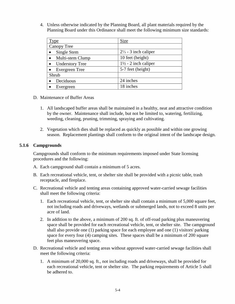
5-4
4. Unless otherwise indicated by the Planning Board, all plant materials required by the
Planning Board under this Ordinance shall meet the following minimum size standards:
Type Size
Canopy Tree
Single Stem 2⅓ - 3 inch caliper
Multi-stem Clump 10 feet (height)
Understory Tree 1½ - 2 inch caliper
Evergreen Tree 5-7 feet (height)
Shrub
Deciduous 24 inches
Evergreen 18 inches
D. Maintenance of Buffer Areas
1. All landscaped buffer areas shall be maintained in a healthy, neat and attractive condition
by the owner. Maintenance shall include, but not be limited to, watering, fertilizing,
weeding, cleaning, pruning, trimming, spraying and cultivating.
2. Vegetation which dies shall be replaced as quickly as possible and within one growing
season. Replacement plantings shall conform to the original intent of the landscape design.
5.1.6 Campgrounds
Campgrounds shall conform to the minimum requirements imposed under State licensing
procedures and the following:
A. Each campground shall contain a minimum of 5 acres.
B. Each recreational vehicle, tent, or shelter site shall be provided with a picnic table, trash
receptacle, and fireplace.
C. Recreational vehicle and tenting areas containing approved water-carried sewage facilities
shall meet the following criteria:
1. Each recreational vehicle, tent, or shelter site shall contain a minimum of 5,000 square feet,
not including roads and driveways, wetlands or submerged lands, not to exceed 8 units per
acre of land.
2. In addition to the above, a minimum of 200 sq. ft. of off-road parking plus maneuvering
space shall be provided for each recreational vehicle, tent, or shelter site. The campground
shall also provide one (1) parking space for each employee and one (1) visitors' parking
space for every four (4) camping sites. These spaces shall be a minimum of 200 square
feet plus maneuvering space.
D. Recreational vehicle and tenting areas without approved water-carried sewage facilities shall
meet the following criteria:
1. A minimum of 20,000 sq. ft., not including roads and driveways, shall be provided for
each recreational vehicle, tent or shelter site. The parking requirements of Article 5 shall
be adhered to.
5-5
E. Campgrounds shall be operated strictly on a seasonal basis. They shall not be open for
business, nor shall they be occupied other than for the use of the owner or the owner's relatives
before May 1 or after November 1.
F. The area intended for placement of the recreational vehicle, tent, or shelter and utility and
service buildings, shall be set back a minimum of 100 feet from the exterior lot lines of the
camping area and 100 feet, horizontal distance, from the normal high water elevation of any
water body.
G. All campgrounds shall be screened from adjacent land areas and from adjacent road frontage
by a continuous landscaped area not less than 100 feet in width containing evergreen shrubs,
trees, fences, walls or any combination which forms an effective visual barrier of not less than
six (6) feet in height.
5.1.7 Open Space Subdivisions
A. Open Space Subdivisions
1. Policy
It is the policy of the Town of New Gloucester to encourage the use of open space
subdivisions in order to preserve a sense of space, provide for sustainable agriculture and
forestry as well as recreational land, preserve other resources identified in the Town of
New Gloucester Comprehensive Plan, and harmonize new development with the
traditional open, wooded, agricultural, rural and village landscapes of the Town.
This performance standard is intended to implement that policy by providing incentives
that afford flexibility to landowners in road and lot layout and design and road frontage
requirements and by allowing the Planning Board to expedite procedure and to waive or
reduce certain otherwise applicable standards and provisions of this Zoning Ordinance and
the Subdivision Regulations if such landowners commit to the permanent preservation of
important open space resources. These incentives are designed to encourage greater
flexibility and more innovative approaches to housing and environmental design for the
development of single and multi-family residential areas that will promote the most
appropriate use of land and will preserve, as permanent open space, agricultural or forestry
land, important natural features, wildlife habitat, water resources, ecological systems, and
historic and scenic areas for the benefit of present and future residents.
2. Purposes
To qualify as an open space subdivision, a subdivision must achieve those of the following
purposes that are applicable to its specific circumstances:
a. Long term protection and conservation of existing natural and other resources and
landscapes identified in the Comprehensive Plan, the Subdivision Regulations, and the
Zoning Ordinance including but not limited to:
1) State-defined critical areas, and unique natural features located on the parcel to be
subdivided such as the black gum trees, the sink hole, and the red pines;
2) Historic land use patterns and historic structures;
5-6
3) Points of visual access to or from water bodies, scenic vistas, and points of access
to water bodies;
4) Contiguous stands of mature trees;
b. Maintenance or establishment of compatibility with surrounding land uses and the
overall rural character of the Town as defined by the Comprehensive Plan;
c. Provision of adequate buffers for adjoining properties where needed;
d. Contribution to Town-wide open space planning by creating a system of permanently
preserved open space, both within large parcels of land and among such parcels
throughout the Town, and by encouraging linkages between open space areas;
e. Conservation of land suitable or actively used for agriculture and forestry uses,
particularly where the open space subdivision borders active agricultural or forestry
land or land suitable for the same;
f. Conservation of traditional land uses;
g. Creation of choices in the type of environment (business or residential) and type of
housing available that will be a long-term asset to New Gloucester;
h. Construction of affordable housing;
i. Provision of recreation facilities, including active and passive recreational space, in the
most suitable locations for use consistent with the other purposes of this performance
standard; and
j. Attainment of planned variety and coordination in the location of structures,
architectural styles, and building forms and relationships.
3. Types of Open Space Subdivisions
There are two types of open space subdivisions, which may be used separately or in
combination:
a. Cluster Subdivisions.
A cluster subdivision achieves the purposes of this performance standard by reducing
the lot size and frontage and setback requirements in the Zoning Ordinance, modifying
the road design standards of Article 8 contained herein and clustering housing or
business structures and uses in those areas where they will have the least impact on
identified environmental and other open space resources. These resources are then
permanently preserved by the use of covenants and restrictions and/or conservation
easements that run with the land. The cluster principle can be applied to subdivisions
of any size.
1) For all cluster subdivisions the identified environmental and other open space
resources are then permanently preserved by the use of covenants and restrictions
and/or conservation easements that run with the land.
5-7
2) Cluster subdivisions utilizing transferable development rights are not required to
permanently preserve the identified environmental and other open space resources,
however no further subdivision of the lots contained in the subdivision will be
permitted at any time.
b. Conservation Density Subdivisions.
A conservation density subdivision achieves the purposes of this performance standard
through the creation of significantly lower lot densities than what would be allowed in
the applicable zoning district. In no event may the density of such a subdivision
average less than ten (10) acres, including the land placed in open space for the parcel
or portion of the parcel to be developed. This low density is maintained in perpetuity
through the use of permanent conservation easements or covenants and restrictions
running with the land. To encourage the establishment of these permanent low
densities, the Planning Board may expedite the review process, provided that certain
conditions are met.
4. Grouping Contiguous Parcels
In order to increase design flexibility, two or more contiguous parcels of land under the
same or different ownership, including parcels separated by a public or private road, may
be grouped together as one open space subdivision, if the Planning Board finds that such
grouping will benefit the Town and will help to achieve the purposes set forth in
subparagraph A.2.a-j.
B. Planning Board Review
An individual may apply for approval of an open-space subdivision either after pre-application
review of a conventional subdivision or by initially filing an application for an open space
subdivision. In either case, the Planning Board shall review the application in accordance with
the Subdivision Regulations as modified by the provisions of this performance standard.
1. Pre-application Procedure
a. Any applicant for an open space subdivision including a multiplex development is
encouraged but not required to submit at the pre-application stage, a complete build-out
plan for the entire parcel.
b. After review of the pre-application, if the Planning Board determines that an open
space subdivision may meet the purposes set forth in subparagraph A.2.a-j. that are
applicable to the proposed subdivision as well as other applicable provisions of this
performance standard, this Zoning Ordinance, the Subdivision Regulations, and the
Comprehensive Plan, the Board shall encourage or permit, as appropriate, the applicant
to proceed with an application for an open space subdivision.
c. If a complete build-out plan for the parcel has been submitted, the Planning Board shall
encourage, if appropriate, consideration of long-range planning to make the most
effective use of the design standards and timing mechanisms available to accomplish
the purposes set forth in subparagraph A.2.a-j. and to maximize the economic benefits
to the applicant and the Town over time.
5-8
d. In order to determine the maximum number of lots which would be allowed in a cluster
subdivision, the applicant shall submit a sketch plan showing the number and location
of lots realistically achievable with a standard subdivision given the parcel's
topographic and environmental characteristics. In the event the planning board feels
the sketch plan does not realistically portray on site conditions, a revised sketch based
upon the accurate location of on site wetland areas of soils suitable for septic systems,
topographical constraints, and other such conditions may be required.
2. Application Procedure
a. Required Plans
The submissions for an open space subdivision shall include, as appropriate unless any
of the same are waived, all plans and materials required for a conventional subdivision
under the Subdivision Regulations and for Site Plan Review under Article 7 of this
Zoning Ordinance.
b. Waiver of Submission and Review Requirements
The Planning Board may grant appropriate waivers of submission requirements for an
open space subdivision in order to expedite and make more efficient the review process
where the number of lots proposed for development in a parcel, is five or fewer within
any five-year period, or the proposed open space subdivision is a conservation density
subdivision.
C. General Requirements
In Planning Board review and approval of an open space subdivision, the following
requirements shall apply and shall supersede any inconsistent or more restrictive provisions of
this Zoning Ordinance or the Subdivision Regulations:
1. Use and District Requirements
All open space subdivisions shall meet the use standards of the Districts in which they are
located.
2. Allowable Density
a. Except as modified in section C.2.g below, in the case of a proposed development of
five or fewer lots within any five-year period on a parcel of land under one ownership
or a grouping of contiguous parcels as described in section A.4. above, the allowable
density shall be determined by the gross lot area of the portion of each parcel proposed
for development without reference to net residential acreage, divided by the minimum
lot size of the applicable district without reference to net residential acreage.
b. Nothing in this performance standard shall prevent this performance standard from
applying to a development consisting of a single lot where the purposes set forth in
subparagraph A.2.a-j. will be served and which may provide effective long range
5-9
planning for a larger parcel of land, than sought to be developed, when used in
conjunction with the flexible open space and substitution, timing, or phasing provisions
of this performance standard. In such cases, sufficient open space to accommodate the
single lot shall be permanently preserved as set forth in subparagraph 5.1.7.D. below.
c. Except as provided in subparagraph C.2.a. above, allowable density shall be based on
net residential density, and shall be calculated in the following manner: 1) Determine
the buildable area of the parcel according to the definition of "net residential area"
contained in Article 2; then 2) for single-family and multi-family cluster developments,
divide the net residential area by the minimum lot size required in the District to obtain
the net residential density allowable.
d. A lot for a dwelling unit created as part of an open space subdivision shall not be
further subdivided.
e. A lot for a dwelling unit created as part of an open space subdivision where such lot
shall have within its bounds designated open space shall not be further subdivided
unless the original approved plan shall have reserved future development of such lot,
but any such further subdivision shall only be made in accordance with this
performance standard.
f. The affordable housing density bonus provision contained in Paragraph 5.1.3 of the
performance standards shall also apply within clustered residential projects.
g. In a conservation density subdivision, where all other requirements of this performance
standard are met, the Planning Board may include up to 50% of land in Resource
Protection zones and wetland areas for purposes of calculating density.
h. The TDR Density Bonus contained in Article 9 shall also apply within clustered
residential subdivisions. [Amended 12/14/2004 Special Town Meeting]
3. Layout and Siting Standards
In planning the location and siting of residential or business structures in an open space
subdivision, lot dimension and frontage should not be the primary considerations. Priority
should be given to the preservation of the open space for its natural resource value, with
human habitation and business activity located and sited on the lower valued natural
resource portion of a parcel, taking into account the contours of the land and the
reasonableness of slopes.
The building lots on a parcel shall be laid out and the residences and business structures
shall be sited so as to maximize the following principles. The Board in its discretion shall
resolve conflicts between these principles as applied to a particular site.
a. In the least suitable agricultural soils and in a manner which maximizes the useable
area remaining for the designated open space use, where agricultural, forestry, or
recreational, existing or future uses, are particularly sought to be preserved.
b. In locations least likely to block or interrupt scenic, historic, and traditional land use
views, as seen from public roadways.
5-10
c. Within woodlands, or along the far edges of open agricultural fields adjacent to any
woodland to reduce encroachment upon agricultural soils, to provide shade in the
summer, and shelter as well as solar gain in the winter, and to enable new residential
development to be visually absorbed by natural landscape features;
d. In such manner that the boundaries between residential or business lots and active
agricultural or forestry land are well buffered by vegetation, topography, roads, or
other barriers to minimize potential conflict between residential or business and
agricultural or forestry uses;
e. In locations where buildings may be oriented with respect to scenic vistas, natural
landscape features, topography, and natural drainage areas, in accordance with an
overall plan for site development;
f. In locations that provide compatibility in terms of physical size, visual impact,
intensity of use, proximity to other structures, and density of development with other
permitted uses within the District;
g. In locations such that diversity and originality in lot layout and individual building,
road, parking layout is encouraged.
h. So that individual lots, buildings, road and parking areas shall be designed and situated
to minimize alterations of the natural site, to avoid the adverse effects of shadows,
noise and traffic on the residents of the site, to conserve energy and natural resources,
and to relate to surrounding properties, to improve the view from and of buildings.
4. Space Standards
a. Shore frontage and shore setback requirements shall not be reduced below the
minimum shore frontage or shore setback required in the zoning district.
b. Distances between residential structures in multi-family cluster or conservation density
developments shall be a minimum of the height of the tallest structure.
c. The required minimum lot size or minimum land area per dwelling unit for the building
envelope may be reduced in cluster or conservation density subdivision developments
to no less than one-half acre. If in either a single family or multi-family cluster
development the lot area is reduced, the total open space in the development shall equal
or exceed the sum of the areas by which the building lots are reduced below the
minimum lot area normally required in the zoning district as modified, if any, by
subparagraph C.2. above of this performance standard.
d. Minimum road frontage requirements of the Zoning Ordinance and Subdivision
Regulations may be waived or modified by the Planning Board provided that:
(1) Any applicable provisions regarding Roads in subparagraph C.6. below are
satisfied; and,
(2) Adequate access and turnaround to and from all parcels by fire trucks, ambulances,
5-11
police cars and other emergency vehicles can be ensured by private roads and /or
common driveways; and,
(3) No common driveway shall provide access to more than three (3) lots, except as
provided in C.6. below; and,
(4) For conservation density subdivisions, the maximum number of lots with frontage
or direct access on an existing public road shall be determined by dividing total
available public road frontage by the minimum frontage in the applicable district.
(5) For cluster subdivisions, not more than two lots with frontage or direct access on an
existing public road may be created, except for those lots fronting on a road
classified as a “local road”. [Amended 5/2/2011 Town Meeting]
(6) Any limitations on future development created by the use of the provisions of
paragraphs (4) or (5), above shall be so noted as a restriction on the deed of the
property from which such lots are derived and recorded in the Cumberland County
Registry of Deeds.
e. A reduction of required setback distances may be allowed at the discretion of the
Board, provided that the front, side and rear setbacks shall be no less than twenty-five
feet or that required for the applicable zoning district, whichever shall be less. For the
perimeter of a multi-family cluster development, site setback shall not be reduced
below the minimum front, side and rear setbacks required in the zoning district unless
the Planning Board determines a more effective design of the project can better
accomplish the purposes of this performance standard.
5. Utilities
At the discretion of the Planning Board, in order to achieve the most appropriate design
and layout of lots and open space, utilities including individual wells and septic systems
may be located on designated portions of the open space, if necessary, provided the same
shall not unreasonably interfere with the open space purposes to be achieved under this
performance standard and for the particular parcel(s) that is the subject of the application
for open space subdivision.
a. The Planning Board may waive or modify hydrogeological reviews or studies, if the
applicant demonstrates that due to the specific placement of wells and septic systems:
(1) adequate groundwater is available at all locations proposed for individual water
systems; and that
(2) there is no reasonable likelihood that the domestic water supply for any proposed
lot will exceed 5mg/l of nitrates.
This waiver shall not be available for cluster subdivisions that include the transfer of
development rights pursuant to Article 9. [Amended 12/14/2004 Special Town Meeting]
Notwithstanding other provisions of this Zoning Ordinance or the Subdivision

5-12
Regulations, the Planning Board may determine contaminant concentration in
groundwater at only the subdivision boundary line of an open space subdivision meeting
the other requirements of this performance standard, from a potential contaminant
source, without reference to interior lot lines or points 1000' from such source.
b. If a private collection septic system is proposed for a single family clustered
development or a multiplex cluster development, the applicant must show either that at
least one (1) designated site for each lot, in the open space or on the lot, has adequate
soils and land area suitable for subsurface waste disposal for each lot in accordance with
the minimum standards set forth in the Main State Plumbing Code, and that a second
designated site on the parcel has the size, location and soil characteristics, to
accommodate a system similar to the one originally proposed.
c. If a private central collection system is proposed, the system shall be maintained by an
homeowners association or under an agreement of the lot or unit owners in the same
fashion required for maintenance of the open space by an HOA or the lot or unit owners
in common and written evidence of said maintenance agreement shall be submitted to the
Planning Board.
6. Roads [Amended 5/2/2011 Town Meeting]
The Planning Board may grant a modification to otherwise applicable private road design
standards and specifications and approve private roads or rights of way and/or common
driveways to provide access to lots in open space subdivisions provided that:
a. The subdivision plan shall show the road clearly labeled "private road."
b. Whenever possible and as far as practicable the roads and common driveways shall:
(1) Follow natural contours in an effort to limit phosphorous export;
(2) Be limited in width, curvilinear in design, and without suburban or commercial
sprawl to keep within the rural character of the Town;
(3) Roads with access onto public roads shall curve away from the public road.
D. Open Space Requirements
In Planning Board review and approval of an open space subdivision, the following
requirements shall apply and shall supersede any inconsistent or more restrictive provisions of
this Zoning Ordinance or the Subdivision Regulations.
Open space set aside in a cluster subdivision or a conservation density subdivision shall be
permanently preserved as required by this performance standard, except as allowed under this
provision for flexible open space and the substitution for and/or the addition to the same, or
where open space is dedicated by a landowner under contract with the Town for a term of
years as set forth below. Land set aside as permanent open space may, but need not be, a
separate tax parcel. Such land may be included as a portion of one or more large parcels on
which dwellings are permitted, provided that a conservation easement or a declaration of
5-13
covenants and restrictions is placed on such land pursuant to subparagraph D.3. below and
provided that the Planning Board approves such configuration of the open space.
1. Open Space Uses
On all parcels, open space uses shall be appropriate to the site. Open space shall include
natural features located on the parcel(s) such as, but not limited to, stream beds, significant
stands of trees, individual trees of significant size, agricultural land, forested acreage,
wildlife habitat, rock outcroppings and historic features and sites. Open space shall be
preserved and maintained subject to the following, as applicable:
a. On parcels that contain significant portions of land suited to agricultural production,
open space shall be conserved for agriculture or other consistent open space uses such
as forestry, recreation (active or passive), and resource conservation.
b. When the principal purposes of conserving portions of the open space is the protection
of natural resources such as wetlands, aquifers, steep slopes, wildlife and plant habitats,
and stream corridors, open space uses in those portions may be limited to those which
are no more intensive than passive recreation.
c. Open space areas, shall be contiguous, where possible, to allow linking of open space
areas throughout the Town.
d. If the open space is to be devoted, at least in part to a productive land use, such as
agriculture or forestry, the developer shall submit to the Planning Board a plan of how
such use is to be fostered in the future. Such plan may include, for example, a long
term timber management plan.
e. The use of any open space may be limited by the Planning Board at the time of final
plan approval where the Board deems it necessary to protect adjacent properties or
uses, or to protect sensitive natural features or resources. A proposed change in use of
open space land, other than that specified at the time of plan approval, shall be
reviewed by the Planning Board as an amendment to the approved plan.
f. Further subdivision of open space or its use for other than agriculture, forestry,
recreation or conservation, except for easements for underground utilities, shall be
prohibited and shall be so stated by deed restrictions except as provided in
subparagraph D.3. below. Structures and buildings accessory to agriculture, recreation
or conservation uses may be erected on open space, subject to Planning Board approval
under the site plan review provisions of Article 7 of this Zoning Ordinance and this
performance standard.
2. Notations on Plan
Open space must be clearly labeled on the Final Plan as to its, use or uses with respect to
the portions of the open space that such use or uses apply, ownership, management,
method of preservation, and the rights, if any, of the owners in the subdivision to such land
or portions thereof. The Plan shall clearly show that the open space land is permanently
reserved for open space purposes, is subject to a reservation for future development,
5-14
including those provisions allowed under subparagraph D.5. and 6. below, and shall
contain a notation indicating the book and page of any conservation easements or deed
restrictions required to be recorded to implement such reservations or restrictions.
3. Preservation in Perpetuity
An owner of a parcel of land may designate all or a portion of the parcel for open space use
in perpetuity if the purposes set forth in subparagraph A.2.a-j. are achieved and all other
requirements of this performance standard are met subject to the following conditions:
a. A perpetual conservation easement, or declaration of covenants and restrictions,
restricting development of the open space land must be incorporated in the open space
plan.
b. The conservation easement may be granted to or the declarations may be for the benefit
of a private party, third party or other entity, the Town, with the approval of the Board
of Selectmen, or to a qualified not-for-profit conservation organization acceptable to
the Planning Board.
c. Such conservation easement or declaration of covenants and restrictions shall be
reviewed and approved by the Planning Board and be required as a condition of plan
approval hereunder.
d. The Planning Board may require that such conservation easement, or declaration of
covenants and restrictions, be enforceable by the Town of New Gloucester if the Town
is not the holder of the conservation easement or beneficiary of the declarations.
e. The conservation easement or declarations shall prohibit residential, industrial, or
commercial use of such open space land (except in connection with agriculture,
forestry, and recreation), and shall not be amendable to permit such use.
f. The conservation easement or declarations shall be recorded in the Cumberland County
Registry of Deeds prior to or simultaneously with the filing of the Open Space
Subdivision final plan in the Cumberland County Registry of Deeds.
g. Notwithstanding the foregoing, the conservation easement, or the declaration of
covenants and restrictions, may allow dwellings to be constructed on portions of
parcels that include protected open space land, provided that:
(1) The total number of dwellings permitted by the conservation easement, or
declaration of covenants and restrictions, in the entire subdivision does not exceed
the allowable density established in this performance standard above;
(2) The Planning Board grants approval for such lots; and,
(3) The applicant has reserved the right to apply for approval for such additional lots.
5-15
4. Ownership of Open Space Land
Open space land may be held in private ownership (which is to be preferred) including an
appropriate third party not the applicant; or owned in common by a homeowner's
association (HOA); dedicated to the Town, County or State governments or agencies;
transferred to a non-profit organization such as a conservation trust, or association,
acceptable to the Planning Board; or held in such other form of ownership as the Planning
Board finds adequate to achieve the purposes set forth in subparagraph A.2.a.-j. and under
the other requirements of this Zoning Ordinance and the Subdivision Regulations.
The appropriate form of ownership shall be determined based upon the purpose of the open
space reservation as stated pursuant to subparagraph D.1. above. Unless so determined, or
unless deeded to the Town of New Gloucester and accepted by the citizens of the Town at
Town Meeting, common open space shall be owned in common by the owners of the lots
or units in the development. Covenants for mandatory membership in the association
setting forth the owners' rights and interest and privileges in the association and the
common land, shall be approved by the Planning Board and included in the deed for each
lot.
5. Flexible Open Space and Substitution; Phasing
An applicant for an open space subdivision may at a future time designate other land to
serve as the open space for such subdivision if the Planning Board finds that the purposes
set forth in subparagraph A.2.a.-j. will better be served by promoting a more innovative
design and layout of lots created over time in relation to the area(s) designated as open
space if all other requirements under this performance standard may be met and such
substitution is specifically allowed in any documentation associated with the open space,
conservation easement, or homeowners association. Development that is phased over
time, including a schedule over time for either sale of lots or layout of further lots as part
of the open space subdivision plan, is encouraged so that more appropriate design of land
use and preservation of greater open space may be achieved.
6. Maintenance Standards
Maintenance standards for open space land, where appropriate, shall be in accordance with
other requirements of this Zoning Ordinance and Subdivision Regulations.
5.1.8 Erosion and Sedimentation Control
A. Filling, grading, lagooning, dredging, earth-moving activities, and other land use activities
shall be conducted in such manner as to prevent, to the maximum extent possible, erosion and
sedimentation of surface waters.
B. On slopes greater than twenty-five percent (25%), there shall be no grading or filling within
130 feet, horizontally measured, of the normal high water mark of any great pond, river,
stream, brook or wetland except where filling or grading is necessary to protect the shoreline
and prevent erosion.
C. Stripping of vegetation, regrading or other development shall be done in such a way as to
minimize erosion.
5-16
D. Development shall preserve salient natural features, keep cut-fill operations to a minimum and
ensure conformity with topography so as to create the least erosion potential and adequately
handle the volume and velocity of surface water runoff.
E. The disturbed area and the duration of exposure shall be kept to a practical minimum and
disturbed soils shall be stabilized as quickly as is practicable.
F. Temporary vegetation or mulching shall be used to protect exposed critical areas during
development.
G. The permanent (final) vegetation and mechanical erosion control measure shall be installed as
soon as practical on the site.
H. Until the disturbed area is stabilized, sediment in the runoff water shall be trapped by the use
of debris basins, sediment basins, silt traps or other acceptable methods.
I. Whenever sedimentation is caused by stripping vegetation, regrading or other development, it
shall be the responsibility of the developer causing such sedimentation to remove it from all
adjoining surfaces, drainage systems and watercourses and to repair any damage at his expense
as quickly as possible.
J. It is the responsibility of any person creating any disturbance, whether from development or
vehicular travel, on or across a communal stream, watercourse or scale or upon the floodway
or right-of-way thereof to maintain as nearly as possible in its present state the stream,
watercourse, scale, floodway or right-of-way during the duration of such activity and to return
it to its original or equal condition after such activity is completed.
K. Maintenance of drainage facilities or watercourses originating and completely on private
property is the responsibility of the owner to the point of open discharge at the property line or
at a communal watercourse within the property.
5.1.9 Flood Hazard Areas
In all flood hazard areas as identified by the Federal Emergency Management Agency Flood
Insurance Rate Maps, all development, including modifications to existing structures shall
conform to the requirements of the New Gloucester Floodplain Management Ordinance dated
June, 1987 as amended.
5.1.10 Home Occupations
Home occupations shall be accessory to a residential use and clearly incidental and secondary to
the residential use of the dwelling unit. A home occupation permit must be obtained from the
Code Enforcement Officer before such activity commences. Such permit shall be issued only
upon compliance with the following requirements:
A. No more than two (2) persons other than the residents occupying such dwelling shall be
employed.
B. The home occupation shall be incidental and subordinate to the property's use for residential
purposes, and shall occupy not more than 25% of the total floor area of the dwelling unit.
5-17
C. The occupation may use one accessory structure. The floor area utilized in the accessory
structure shall not exceed 33% of the total floor area of the dwelling unit in the Village District
and 50% in all other districts.
D. In no way shall the appearance of the structure be altered or the occupation be conducted in a
manner which would cause the premises to differ from its residential character either by the
use of colors, materials, construction, lighting, or the emission of sounds, noises, smoke, dust,
glare, odors, electrical interference, heat or vibrations.
E. Exterior storage of materials or goods, and any exterior display, with the exception of one
nonilluminated sign not exceeding four square feet is prohibited.
F. No traffic shall be generated by such home occupation that would be considered incompatible
in a residential neighborhood, and any need for parking generated by the conduct of such home
occupation shall be met off the road and other than in a required front yard.
G. Provisions must be made for adequate off road parking requirements based on the maximum
number of users that the home occupation may attract during peak operating hours, the
vehicles of any outside employees, and parking to meet the normal requirements of the
dwelling unit.
H. Evidence shall be provided that the subsurface disposal system on the site can accommodate
the wastewater generated by the home occupation.
I. Any automobile repair or automobile body repair business sought to be allowed as a home
occupation shall be subject to Site Plan Review, and the Best Management Practices Plan of
Section 4.4.8.J.3 and allowed only in the Rural Residential and Farm and Forest Districts.
5.1.11 Housing for the Elderly
A. Density
1. Nursing Home: the number of beds shall not exceed twenty (20) beds per net residential
acre. Net residential acreage shall be calculated in accordance with the formula contained
in the "net residential acreage" definition in Article 2.
2. All other forms of attached or detached elderly housing that fall within the definition of
"Housing for the Elderly" in Article 2 of the ordinance, shall not exceed 5 one bedroom
units per net residential acre. If units with more than one bedroom are proposed, density
shall be determined according to the formula contained in the minimum lot size law,
M.R.S.A. Title 12, Section 4807-A. 2. In any case, the maximum number of one- or two-
bedroom units in any development shall not exceed twenty (20) units and the maximum
number of beds shall not exceed forty (40).
3. Attached housing shall contain no more than twenty-five (25) units per building.
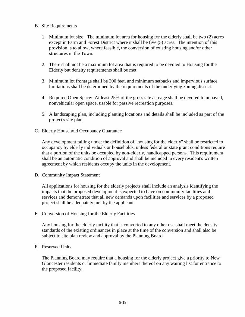
5-18
B. Site Requirements
1. Minimum lot size: The minimum lot area for housing for the elderly shall be two (2) acres
except in Farm and Forest District where it shall be five (5) acres. The intention of this
provision is to allow, where feasible, the conversion of existing housing and/or other
structures in the Town.
2. There shall not be a maximum lot area that is required to be devoted to Housing for the
Elderly but density requirements shall be met.
3. Minimum lot frontage shall be 300 feet, and minimum setbacks and impervious surface
limitations shall be determined by the requirements of the underlying zoning district.
4. Required Open Space: At least 25% of the gross site acreage shall be devoted to unpaved,
nonvehicular open space, usable for passive recreation purposes.
5. A landscaping plan, including planting locations and details shall be included as part of the
project's site plan.
C. Elderly Household Occupancy Guarantee
Any development falling under the definition of "housing for the elderly" shall be restricted to
occupancy by elderly individuals or households, unless federal or state grant conditions require
that a portion of the units be occupied by non-elderly, handicapped persons. This requirement
shall be an automatic condition of approval and shall be included in every resident's written
agreement by which residents occupy the units in the development.
D. Community Impact Statement
All applications for housing for the elderly projects shall include an analysis identifying the
impacts that the proposed development is expected to have on community facilities and
services and demonstrate that all new demands upon facilities and services by a proposed
project shall be adequately met by the applicant.
E. Conversion of Housing for the Elderly Facilities
Any housing for the elderly facility that is converted to any other use shall meet the density
standards of the existing ordinances in place at the time of the conversion and shall also be
subject to site plan review and approval by the Planning Board.
F. Reserved Units
The Planning Board may require that a housing for the elderly project give a priority to New
Gloucester residents or immediate family members thereof on any waiting list for entrance to
the proposed facility.

5-19
5.1.12 Junk Yards and Automobile Graveyards
Before granting approval for a junk yard or automobile graveyard, the Planning Board shall find
that the following conditions have been met:
A. The proposed use is shown to have no detrimental effect on adjacent land uses.
B. The proposed operation is not visible from a public road due to setbacks, fencing and
landscaping prescribed in C and D below.
C. Minimum front yard setbacks of 150 feet from any abutting public or private ways and 100
feet from any side and rear property lines have been established and maintained.
D. The proposed junkyard or automobile graveyard shall be entirely enclosed by a solid wall or
fence with access only through solid gates, and such fence or wall shall be kept in good repair
and neatly painted. Fencing may be supplemented by or replaced with landscaping provided
that the landscaped buffer is not less than 100 feet in width containing evergreen shrubs, trees,
fences, walls or any combination which forms an effective visual barrier of not less than six
(6) feet in height.
E. The contents of the proposed junkyard or automobile graveyard shall not be placed higher than
the fence, wall, or landscaped buffer herein required.
F. Automobile batteries shall be removed and all fluids such as oil, transmission fluid, and brake
fluid shall be drained from vehicles that are being stored. A system of containment shall be
utilized to collect such fluids, and fluids shall be properly disposed of or recycled. State law
prohibits the disposal of these substances into septic systems or leach fields.
G. The proposed junkyard or automobile graveyard is in conformance with this Ordinance and
any other ordinances of the Town of New Gloucester pertaining to the protection of the quality
of surface and ground water.
5.1.13 Lighting
Exterior lighting shall be used to serve security, safety and operational needs, but shall not directly
or indirectly produce deleterious effects on abutting properties and shall not impair the vision of a
vehicle operator on adjacent roadways. Lighting fixtures shall be shielded or hooded so that the
lighting elements are not exposed to normal view by motorists, pedestrians, or from adjacent
dwellings.
5.1.14 Manufactured Housing
The following standards, except where noted, shall apply to all manufactured housing.
A. All bulk and space standards of the appropriate zoning district shall be met.
B. Wheels on the undercarriage shall be removed and the Manufactured Home shall be placed on
a concrete pad (slab on grade) or on a permanent and continuous masonry foundation securely
fastened upon said foundation or pad. Foundations shall be either poured concrete or building

5-20
blocks bonded together on a sufficient footing and extend at least below the frost line. The
foundation shall be around the entire perimeter of the mobile home, may contain suitable
openings for ventilation not to exceed 32" X 16" in area, except that opening for windows or
doors in said foundation may be of larger size. (passed 1/2/90 special town meeting)
C. The manufactured home shall have at least one (1) egress window in each bedroom, except for
bedrooms that have an exterior door.
D. The manufactured home shall have at least two (2) exterior doors. Such doors shall be fully
operable.
E. At least one (1) smoke detector shall be installed on or near the ceiling areas within or giving
access to bedrooms. The make and model of the smoke detector must be one which has been
approved by the State Fire Marshall and is UL (Underwriters Laboratory) approved.
F. The manufactured home must be mechanically sound and structurally safe. There shall be no
weaknesses or defects in the manufactured home affecting the health and safety, or the
potential health and safety, of its occupants and their guests.
5.1.14.1 Mobile Home Parks [Adopted at Special Town Meeting, January 2, 1990]
The following standards, except where noted, shall apply to all mobile home parks:
A. Design Standards
1. The lots within any mobile home park shall not all be of the same size and shape if mobile
homes of different sizes are to be accommodated and if effective use is to be made of the
available space.
2. Placement of mobile homes within a park which appear to be perpendicular to a public
road outside of the park is prohibited.
3. The site, including mobile home stand, patio, structures, and all site improvements shall be
harmoniously and efficiently organized in relation to topography, the shape of the lot and
the shape, size and position of structures. Full attention shall be paid to use, appearance
and liveability. Special attention shall be given to new mobile home designs and to
common appurtenances that are available.
4. The site shall provide for a desirable residential environment which is an asset to the
community. Innovative and imaginative designs shall be encouraged.
B. Buffer Strips
1. If a park is proposed with a residential density at least twice the density of adjacent
development in existence, or at least twice the density permitted in the zoning district in
which the park is located if the neighboring land is undeveloped, the park shall be
designated with a continuous landscaped area not less than fifty feet in width which shall
contain no structures or roads. The first twenty-five feet of buffer strip, as measured from
the exterior boundaries of the park shall contain evergreen shrubs, trees, fences, walls,

5-21
berms or any combination which forms an effective visual barrier to be located on all
exterior lot lines of the park, except that driveways shall be kept open to provide visibility
for vehicles entering and leaving the park.
2. Further, no structures, roads or utilities shall be placed in the buffer strip except that
utilities may cross a buffer strip to provide services to the park.
3. The buffer strip shall comply with the standards of Article 5 as applicable.
C. Water Quality
1. No mobile home park development shall increase the nitrate nitrogen concentrations at the
property line of any mobile home park or any mobile home park lot with its own well to a
level in excess of 5 milligrams per liter of water.
2. There shall be no application of de-icing chemicals throughout park roads and ways except
sand with a salt content of no more than 5% except by municipal authority in the event
such roads are accepted by the Town. Any salt concentration shall be no greater than that
absolutely required under the prevailing conditions.
3. The planning may require chamber or peat septic systems to be used as well as reserve
sites to assure replacement in the event of septic system failure.
D. Road Design, Circulation, and Traffic Impacts.
1. Roads within mobile home parks which are to be offered for acceptance as a public road
shall meet the minimum road standards contained in Article 8 of this Ordinance.
2. Privately owned roads within the mobile home park shall be designed by a licensed
Professional Engineer, registered in the State of Maine, and shall be built according to the
requirements described below. Where the road standards duly promulgated by the State
Manufactured Housing Board conflict with the standards described below, the
Manufactured Housing Board's standards shall apply.
3. The road system of a mobile home park shall intersect with a public or private road able to
absorb the increase in traffic generated by the mobile home park, as determined by a
licensed professional engineer registered in the State of Maine, at the expense of the
developer. [Amended 5/2/2011 Town Meeting]
4. Mobile home park roads which intersect with a public road shall meet the intersection
requirements contained in Article 8 of this Ordinance.
5. Mobile home lots shall have vehicular access only to an interior road created for the
mobile home park.
6. Right-of-Way and Pavement Width
a. Privately owned roads within the park shall have a minimum right-of-way of 23 feet
and the Planning Board may require a minimum paved surface of up to 16 feet and
unpaved shoulders of up to 2 feet on each side.
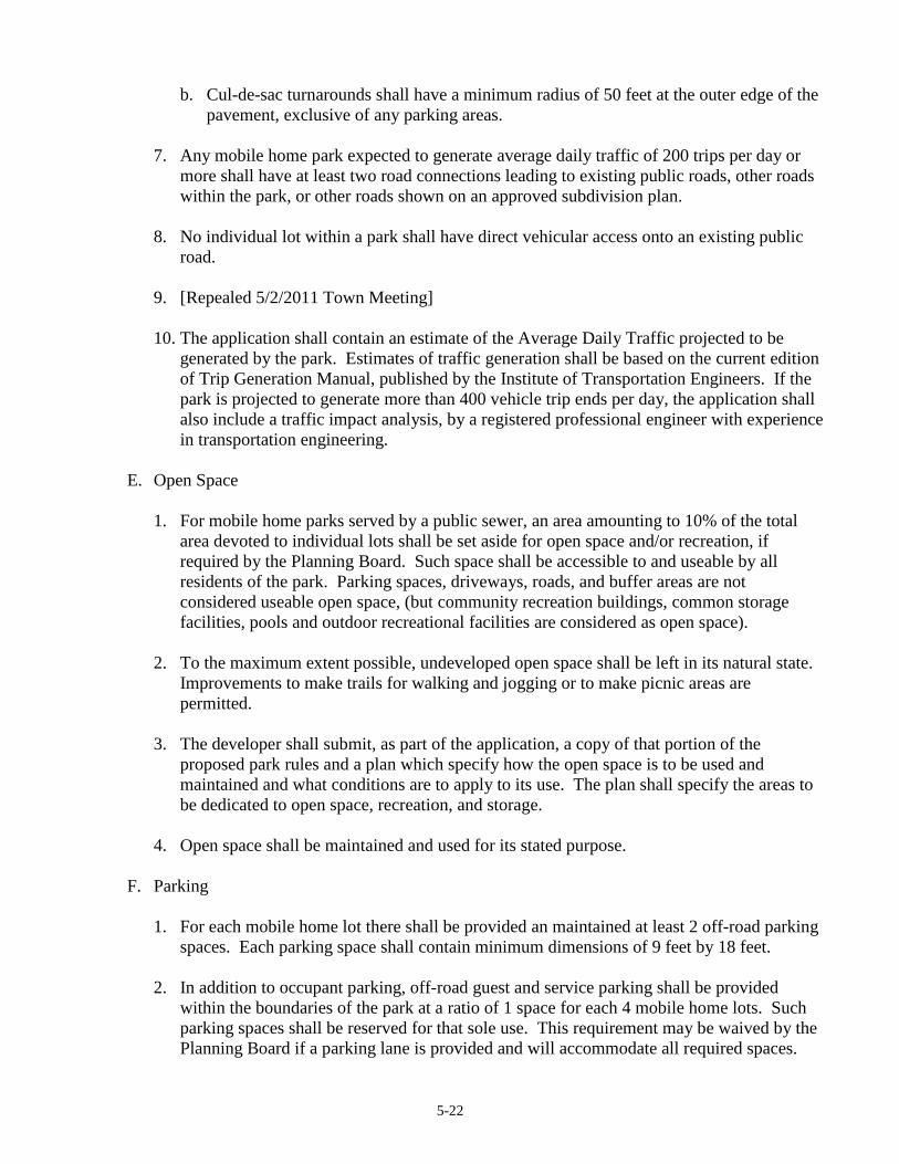
5-22
b. Cul-de-sac turnarounds shall have a minimum radius of 50 feet at the outer edge of the
pavement, exclusive of any parking areas.
7. Any mobile home park expected to generate average daily traffic of 200 trips per day or
more shall have at least two road connections leading to existing public roads, other roads
within the park, or other roads shown on an approved subdivision plan.
8. No individual lot within a park shall have direct vehicular access onto an existing public
road.
9. [Repealed 5/2/2011 Town Meeting]
10. The application shall contain an estimate of the Average Daily Traffic projected to be
generated by the park. Estimates of traffic generation shall be based on the current edition
of Trip Generation Manual, published by the Institute of Transportation Engineers. If the
park is projected to generate more than 400 vehicle trip ends per day, the application shall
also include a traffic impact analysis, by a registered professional engineer with experience
in transportation engineering.
E. Open Space
1. For mobile home parks served by a public sewer, an area amounting to 10% of the total
area devoted to individual lots shall be set aside for open space and/or recreation, if
required by the Planning Board. Such space shall be accessible to and useable by all
residents of the park. Parking spaces, driveways, roads, and buffer areas are not
considered useable open space, (but community recreation buildings, common storage
facilities, pools and outdoor recreational facilities are considered as open space).
2. To the maximum extent possible, undeveloped open space shall be left in its natural state.
Improvements to make trails for walking and jogging or to make picnic areas are
permitted.
3. The developer shall submit, as part of the application, a copy of that portion of the
proposed park rules and a plan which specify how the open space is to be used and
maintained and what conditions are to apply to its use. The plan shall specify the areas to
be dedicated to open space, recreation, and storage.
4. Open space shall be maintained and used for its stated purpose.
F. Parking
1. For each mobile home lot there shall be provided an maintained at least 2 off-road parking
spaces. Each parking space shall contain minimum dimensions of 9 feet by 18 feet.
2. In addition to occupant parking, off-road guest and service parking shall be provided
within the boundaries of the park at a ratio of 1 space for each 4 mobile home lots. Such
parking spaces shall be reserved for that sole use. This requirement may be waived by the
Planning Board if a parking lane is provided and will accommodate all required spaces.

5-23
G. Utility Requirements
All mobile home parks shall provide permanent electrical, water and sewage disposal
connections to each mobile home in accordance with applicable state and local rules,
regulations and codes.
Electrical utilities and telephone lines may be located above ground.
Septic systems shall be designed, constructed, and maintained in accordance with state and
local laws. Centralized septic systems shall be limited to a maximum of four dwelling units.
H. Sidewalks/walkways
The mobile home park shall contain pedestrian walkways between all units and all service and
recreational facilities. Such walkways shall be adequately surfaced and lit. A portion of the
road surface may be reserved for walkways provided the roadway width is widened
accordingly. Walkways shall be a minimum of 3 feet.
I. Lighting
Outdoor lighting shall be provided to adequately illuminate internal roads and pedestrian
walkways.
J. Signs
The following signs shall be permitted: One 12 square foot maximum identification sign at the
entrance road for each entrance, which sign may be indirectly lighted; backlit or flashing
illumination shall be prohibited.
K. Storage
At least 300 cubic feet of enclosed tenant storage facilities shall be conveniently provided near
or on each mobile home lot for the storage of materials and equipment.
L. Park Administration
The owner and operator of a mobile home park shall be responsible for ensuring the
maintenance of all structures and their sites including supervision of each mobile home's
placement on its mobile home stand. Park management shall conform to state laws.
Park management shall ensure that the park is kept free of litter, rubbish and other flammable
materials and shall provide for centralized locations for transfer of solid waste. Portable fire
extinguishers rated for Classes A, B, and C fires shall be kept in community facility buildings
and maintained in good operating condition. Their ratings shall not be less 1A10BC
(Underwriter's Laboratory Rating). Smoke alarms shall also be provided in said buildings and
shall have approval by the State Fire Marshall's office and shall be rated as UL approved
(Underwriter's laboratory).

5-24
Park management shall also provide for snow removal on park roads including emergency
areas, adequate water supply or reservoirs for fire protections, and school bus stations and
structures.
Compliance with this ordinance shall not exempt the park owner, developer, or manager from
complying with other applicable local, state and federal codes and regulations.
M. Responsibilities of Park Occupant
1. The park occupant shall comply with all applicable requirements of this ordinance and
shall maintain their mobile home lot, its facilities and equipment in good repair and in a
clean and sanitary condition.
2. The park occupant shall be responsible for proper placement of their mobile home and
accessory structures on its mobile home stand and proper installation of all utility
connections in accordance with the instructions of the park management and State and
Town regulations and codes.
N. Inspections of Mobile Home Parks and Permits
1. The Code Enforcement Officer or his agent is hereby authorized to make such inspections
as are necessary to determine satisfactory compliance with this Ordinance and shall have
the power to enter at a reasonable time upon any mobile home park property for the
purpose of inspecting and investigating conditions relating to the enforcement of this
Ordinance.
2. It shall be the duty of park management to give access to the park register and to all lots
during normal business hours to the Code Enforcement Officer or his agent for the purpose
of inspection.
3. Whenever the Code Enforcement Officer finds that an emergency exists which requires
immediate action to protect the public health, he may without notice or hearing issue an
order reciting the existence of such an emergency and requiring that certain action be taken
as he may deem necessary to meet the emergency. Notwithstanding any other provision of
this Ordinance, such order shall be effective immediately. Any per to whom such an order
is directed shall comply immediately, but shall be afforded an opportunity to appeal the
decision or action of the Code Enforcement Officer under the provisions for appeals
contained in Section 6.3.2 of this Ordinance. The provisions of this Ordinance shall be
applicable to such hearing and the order issued thereafter.
4. A building permit shall be required for each manufactured housing unit placed in a mobile
home park. The Code Enforcement Officer shall review permit applications and inspect
the premises to determine that the same complies ;with this ordinance and any other
applicable codes and ordinances relative to location, construction, arrangement, safety, and
sanitary facilities of the unit. (passed 1/2/90 special town meeting)

5-25
5.1.15 Multiplex Development [Amended 5/2/2011 Town Meeting]
The construction of any new multi-family dwelling or the conversion of an existing single-family
or two-family dwelling into a multi-family dwelling shall be done in accordance with the
following standards:
A. The number of dwelling units permitted on the site shall be determined by dividing the net
residential acreage by the minimum lot area required per dwelling unit.
B. Multi-family dwellings in developed areas shall retain and respect the character of the existing
neighborhood. This shall include the size and massing of structures, the relationship of
buildings to the road and the use and treatment of front yard areas.
C. For new construction, utilities shall either be placed underground or, if above the ground,
designed so as to be visually compatible with the overall development.
D. All required yard areas (front, side, rear) shall be retained as open, landscaped areas which are
not occupied by buildings, structures, parking lots, storage or similar uses. Access roads,
drives, sidewalks and paths may be located in required yard areas.
E. A buffer shall be established between the multi-family housing and any abutting single-family
or two-family dwellings. The buffering shall be sufficient to minimize any kind of potential
nuisance, such as but not limited to, headlights, noise, storage areas or waste collection and
disposal areas. The buffering shall meet the standards established in Section 5.1.5 of this
Article.
F. All private access roads shall be located within a 60 foot dedicated right-of-way. No off-road
parking shall be located within this right-of-way.
G. At a minimum, 250 square feet of private, outdoor space shall be provided for the individual
use of each dwelling unit.
H. At a minimum, 250 square feet of common, outdoor space for each dwelling unit shall be
provided by the developer with appropriate recreational facilities. When the multiplex
development is a condominium, the construction of recreational facilities may be left to the
discretion and expense of an established condominium owners association.
I. All roads associated with a multiplex development shall meet the minimum road standards
contained in Article 8 of this ordinance.
J. Parking areas shall be adequately screened according to the standards established in Sections
5.1.5 and 5.1.18 of this Article.
K. Exterior lighting shall meet the standard established in Section 5.1.13 of this Article.

5-26
5.1.16 Noise
A. The maximum permissible sound pressure level of any continuous, regular or frequent source
of sound produced by any activity shall be limited by the time period and land use district
listed below. Sound levels shall be measured at least four (4) feet above ground at the property
boundary. Where zoning district boundaries meet, the maximum permissible sound pressure
level shall be that of the less intensive zoning district.
Sound Pressure Level Limits by type of Zoning District
(Measured in dB (a) scale)
Residential
Time Period & Mixed Use Commercial Industrial
6 a.m. - 8 p.m. 55 --- ---
8 p.m. - 6 a.m. 45 --- ---
6 a.m. - 10 p.m. --- 60 60
10 p.m.- 6 a.m. --- 50 50
B. The levels specified above may be exceeded by 10 d.b.a. for a single fifteen (15) minute period
per day. Noise shall be measured by a meter set on the A-weighted response scale, slow
response. The meter shall meet the American National Standards Institute (ANSI S1.4-1961)
"American Standard Specification for General Purpose Sound Level Meters".
C. No person shall engage in construction activities, on a site abutting any residential use between
the hours of 8:00 p.m. and 6:00 a.m. which exceed those limits established for residential
districts. Otherwise, the following activities shall be exempt from these regulations:
(1) Sounds emanating from construction and maintenance activities conducted between 6 a.m.
and 8 p.m.
(2) Sounds emanating from safety signals, warning devices, emergency pressure relief valves
and other emergency activities.
(3) Sounds emanating from traffic on public transportation facilities.
5.1.17 Off-Road Loading
A. In any district where permitted or allowed, commercial or industrial uses shall provide, as
necessary, off-road loading facilities located entirely off public ways and entirely on the same lot
as the building or use to be served so that trucks, trailers and containers shall not be located for
loading or storage upon any public way.
B. Off-road loading areas shall be logically and conveniently located for bulk pick-ups and
deliveries, and accessible to expected vehicles when required off-road parking spaces are filled.
Off-road loading space shall not be included as off-road parking space in computation of
required off-road parking space.
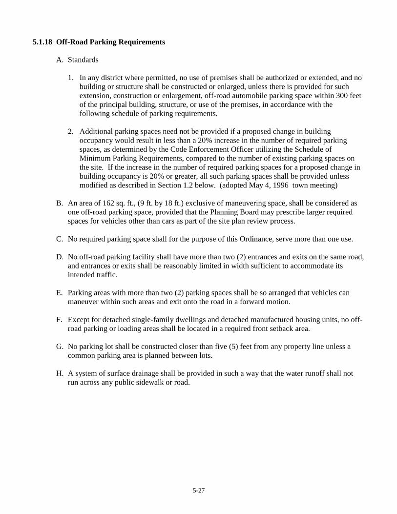
5-27
5.1.18 Off-Road Parking Requirements
A. Standards
1. In any district where permitted, no use of premises shall be authorized or extended, and no
building or structure shall be constructed or enlarged, unless there is provided for such
extension, construction or enlargement, off-road automobile parking space within 300 feet
of the principal building, structure, or use of the premises, in accordance with the
following schedule of parking requirements.
2. Additional parking spaces need not be provided if a proposed change in building
occupancy would result in less than a 20% increase in the number of required parking
spaces, as determined by the Code Enforcement Officer utilizing the Schedule of
Minimum Parking Requirements, compared to the number of existing parking spaces on
the site. If the increase in the number of required parking spaces for a proposed change in
building occupancy is 20% or greater, all such parking spaces shall be provided unless
modified as described in Section 1.2 below. (adopted May 4, 1996 town meeting)
B. An area of 162 sq. ft., (9 ft. by 18 ft.) exclusive of maneuvering space, shall be considered as
one off-road parking space, provided that the Planning Board may prescribe larger required
spaces for vehicles other than cars as part of the site plan review process.
C. No required parking space shall for the purpose of this Ordinance, serve more than one use.
D. No off-road parking facility shall have more than two (2) entrances and exits on the same road,
and entrances or exits shall be reasonably limited in width sufficient to accommodate its
intended traffic.
E. Parking areas with more than two (2) parking spaces shall be so arranged that vehicles can
maneuver within such areas and exit onto the road in a forward motion.
F. Except for detached single-family dwellings and detached manufactured housing units, no off-
road parking or loading areas shall be located in a required front setback area.
G. No parking lot shall be constructed closer than five (5) feet from any property line unless a
common parking area is planned between lots.
H. A system of surface drainage shall be provided in such a way that the water runoff shall not
run across any public sidewalk or road.
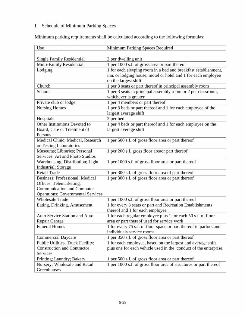
5-28
I. Schedule of Minimum Parking Spaces
Minimum parking requirements shall be calculated according to the following formulas:
Use Minimum Parking Spaces Required
Single Family Residential 2 per dwelling unit
Multi-Family Residential; 1 per 1000 s.f. of gross area or part thereof
Lodging 1 for each sleeping room in a bed and breakfast establishment,
inn, or lodging house, motel or hotel and 1 for each employee
on the largest shift
Church 1 per 3 seats or part thereof in principal assembly room
School 1 per 3 seats in principal assembly room or 2 per classroom,
whichever is greater
Private club or lodge 1 per 4 members or part thereof
Nursing Homes 1 per 3 beds or part thereof and 1 for each employee of the
largest average shift
Hospitals 2 per bed
Other Institutions Devoted to
Board, Care or Treatment of
Persons
1 per 4 beds or part thereof and 1 for each employee on the
largest average shift
Medical Clinic; Medical, Research
or Testing Laboratories
1 per 500 s.f. of gross floor area or part thereof
Museums; Libraries; Personal
Services; Art and Photo Studios
1 per 200 s.f. gross floor areaor part thereof
Warehousing; Distribution; Light
Industrial; Storage
1 per 1000 s.f. of gross floor area or part thereof
Retail Trade 1 per 300 s.f. of gross floor area of part thereof
Business; Professional; Medical
Offices; Telemarketing,
Communication and Computer
Operations; Governmental Services
1 per 300 s.f. of gross floor area or part thereof
Wholesale Trade 1 per 1000 s.f. of gross floor area or part thereof
Eating, Drinking, Amusement 1 for every 3 seats or part and Recreation Establishments
thereof and 1 for each employee
Auto Service Station and Auto
Repair Garage
1 for each regular employee plus 1 for each 50 s.f. of floor
area or part thereof used for service work
Funeral Homes 1 for every 75 s.f. of floor space or part thereof in parlors and
individuals service rooms
Commercial Daycare 1 per 350 s.f. of gross floor area or part thereof
Public Utilities, Truck Facility;
Construction and Contractor
Services
1 for each employee, based on the largest and average shift
plus one for each vehicle used in the conduct of the enterprise.
Printing; Laundry; Bakery 1 per 500 s.f. of gross floor area or part thereof
Nursery; Wholesale and Retail
Greenhouses
1 per 1000 s.f. of gross floor area of structures or part thereof
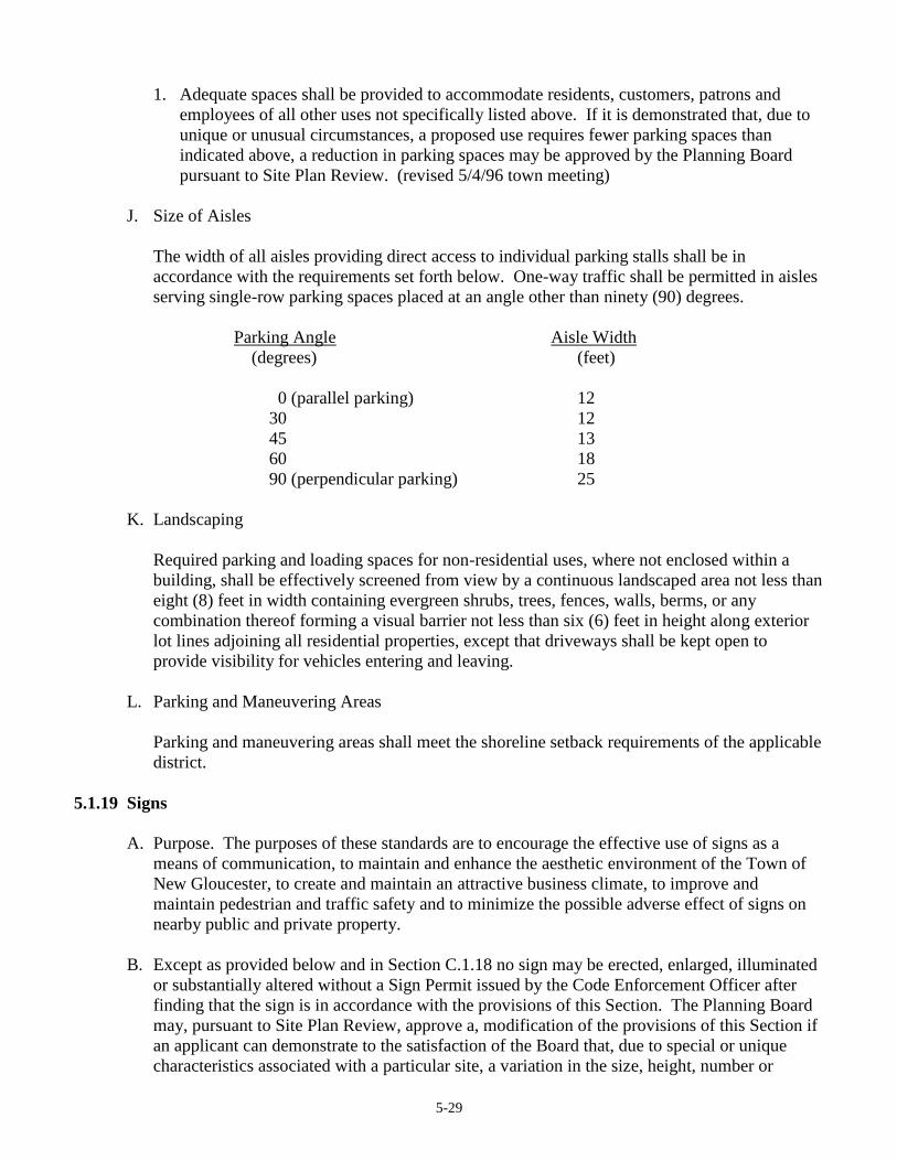
5-29
1. Adequate spaces shall be provided to accommodate residents, customers, patrons and
employees of all other uses not specifically listed above. If it is demonstrated that, due to
unique or unusual circumstances, a proposed use requires fewer parking spaces than
indicated above, a reduction in parking spaces may be approved by the Planning Board
pursuant to Site Plan Review. (revised 5/4/96 town meeting)
J. Size of Aisles
The width of all aisles providing direct access to individual parking stalls shall be in
accordance with the requirements set forth below. One-way traffic shall be permitted in aisles
serving single-row parking spaces placed at an angle other than ninety (90) degrees.
Parking Angle Aisle Width
(degrees) (feet)
0 (parallel parking) 12
30 12
45 13
60 18
90 (perpendicular parking) 25
K. Landscaping
Required parking and loading spaces for non-residential uses, where not enclosed within a
building, shall be effectively screened from view by a continuous landscaped area not less than
eight (8) feet in width containing evergreen shrubs, trees, fences, walls, berms, or any
combination thereof forming a visual barrier not less than six (6) feet in height along exterior
lot lines adjoining all residential properties, except that driveways shall be kept open to
provide visibility for vehicles entering and leaving.
L. Parking and Maneuvering Areas
Parking and maneuvering areas shall meet the shoreline setback requirements of the applicable
district.
5.1.19 Signs
A. Purpose. The purposes of these standards are to encourage the effective use of signs as a
means of communication, to maintain and enhance the aesthetic environment of the Town of
New Gloucester, to create and maintain an attractive business climate, to improve and
maintain pedestrian and traffic safety and to minimize the possible adverse effect of signs on
nearby public and private property.
B. Except as provided below and in Section C.1.18 no sign may be erected, enlarged, illuminated
or substantially altered without a Sign Permit issued by the Code Enforcement Officer after
finding that the sign is in accordance with the provisions of this Section. The Planning Board
may, pursuant to Site Plan Review, approve a, modification of the provisions of this Section if
an applicant can demonstrate to the satisfaction of the Board that, due to special or unique
characteristics associated with a particular site, a variation in the size, height, number or

5-30
location of signs is necessary and furthers the purposes of the application zoning district by
more than twenty-five percent (25%).
C. The following types of signs are permitted, except where otherwise prohibited by law, and
shall not require a Permit by the Code Enforcement Officer.
1. All permanent on-premise signs erected prior to the effective date of this Ordinance
(ordinary maintenance and upkeep shall be allowed).
2. Any sign approved by the Planning Board, as an element of Site Plan Review, prior to the
effective date of this Ordinance or as proposed in a pending application.
3. One sign not exceeding two (2) square feet used to display to road number and/or name of
the occupants of the premises.
4. One non-illuminated, non-internally lit sign not exceeding six (6) square feet used to
describe a home occupation.
5. One sign not exceeding thirty-two (32) square feet on the premises of public or semi-
public buildings, and charitable or religious institutions. These signs may incorporate a
bulletin board.
6. Temporary signs displayed for thirty (30) days or less to advertise school, non-profit, civic,
church and like events and garage sales, auctions and like events. If such signs are to be
displayed for more than thirty (30) days, approval by the Planning Board pursuant to Site
Plan Review is required.
7. One real estate sign not exceeding sixteen (16) square feet relating to the sale, rental or
lease of the premises. Such sign shall be removed within one (1) week after the property
transaction.
8. One sign each for a building contractor, architect or engineer, each sign shall not exceed
sixteen (16) square feet, relating to construction projects. Such sign shall be removed
within one (1) week after construction is complete.
9. One sign not exceeding thirty-two (32) square feet, identifying the name of a farm.
10. Sign(s) not exceeding thirty-two (32) square feet in total describing farm products for sale
on the premises.
11. Signs erected by growers of fresh fruit and vegetable crops advertising those fresh fruits
and vegetable crops when crops are offered for sale on premises where those crops are
grown. Signs may advertise only those fruits and vegetables that are available for
immediate purchase. A grower may not erect more than 4 such signs. A sign may not
exceed 8 square feet in size and must be located within 5 miles of the farm stand. The
signs must be erected within but at the edge of the rights-of-way of highways that receive
no federal aid.
12. Political signs, not exceeding thirty-two (32) square feet in total area and shall be placed in
accordance with Title 23 MRSA 1913-A.
13. Subdivisions may have one non-internally lit sign at each public entrance to the
development not to exceed thirty-two (32) square feet per sign.
14. Any sign(s) placed by the State or Federal Governments or the Town of New Gloucester
that comply with the Department of Transportation standards.
15. Outdoor signs identifying rest rooms, parking, entrance and similar information.
16. Four (4) or fewer flags or insignias per commercial lot ort business. Flags or insignias in
excess of four per commercial lot or use shall comply with the provisions of Section 6.
17. Memorial signs or tablets, names of buildings and date of construction, or historic markers
when cut into masonry, bronze or other permanent material affixed to the structure or
placed on the property.

5-31
18. Signs relating to trespassing and hunting shall be permitted without restriction as to
number provided that no such sign shall exceed tow (2) square feet in area.
19. Signs not exceeding eight (8) square feet per sign, which identify entrances and exits to
parking and service areas.
D. Prohibited Signs: The following signs are prohibited in all areas of the Town of New
Gloucester.
1. Signs, other than barber poles, time and weather devices that have visible moving parts or
blinking, moving or glaring illuminations.
2. No permanent sign except traffic and similar public safety signs, official business
directional signs shall be located in the public right-of-way of any road or highway except
as may be provided for in Section 5.1.19.3.
3. No sign shall protrude beyond the property line of the lot on which it is placed.
4. No sign shall be located so that it interferes with the view necessary for motorists to
proceed safely through intersections or to enter onto or exit public roads or private roads.
5. Signs painted on or attached to stationary vehicles except for signs relating to the sale of
the vehicle. For the purpose of this section, a stationary vehicle means any vehicle not
registered an inspected as required by Maine law.
6. Inflatable signs, tethered balloons and pennants except associated with special events or
sales for a duration not to exceed seven (7) days in any calendar year.
7. Signs relating to any business which have been out of business for more than 365 days.
The owner of the property or his agent shall be responsible for removing such signs.
8. Temporary movable signs are not permitted except for the following uses with the issuance
by the Code Enforcement Officer of a no fee temporary sign permit.
a. To call attention to and/or to advertise the name of a new business and the products
sold or activities to be carried on in connection with a new business. In such cases, no
sign shall remain at a premises for more than ninety (90) days in any twelve (12)
month period.
b. To advertise a special sale or sales. In such cases, such signage shall be allowed for a
period not to exceed ninety (90) days in any twelve (12) month period.
c. To promote community or civic activities. In such cases, no sign shall remain in place
for more than ninety (90) days in any twelve (12) month period.
The time limitations described in subsections 1, 2 and 3, above, apply to signs not exceeding
sixteen (16) square feet in sign area. For temporary movable signs exceeding sixteen (16)
square feet in sign area, the time limitations described in subsections 1, 2 and 3, above, shall
be reduced to no more than fourteen (14) days in any twelve (12) month period.
E. Non-conforming Signs. Non-conforming signs that were otherwise lawful on the effective
date of this Ordinance may continue except as provided below.
1. No non-conforming sign may be enlarged or altered in such a manner as to aggravate the
non-conforming condition.
2. No illumination may be added to any non-conforming sign except if such illumination
complies with the provisions of this section.
3. A non-conforming sign may not be moved except for maintenance, change in message or
repair or be replaced except to bring the sign into conformity with this section.
5-32
4. The message of a non-conforming sign may be changed so long as this does not create any
new non-conformities.
F. General Provisions
1. Signs must be kept clean, legible and free from all hazards such as, but not limited to,
faulty wiring, loose fastenings, or deterioration, and must be maintained at all times in such
condition so as not to be detrimental to the public health or safety, detract from the
physical appearance and the natural beauty of the community, or constitute a distraction or
obstruction that may impair traffic safety.
2. Except for banners, flags, temporary signs and window signs conforming in all respects
with the requirements of this Ordinance, all signs shall be constructed of permanent
materials, and shall be permanently attached to the ground or another structure by direct
attachment to a rigid wall, frame or structure.
3. All signs shall meet the following setback standards:
a. A minimum of twenty (20) feet from the outside edge of the paved portion of any
public way with more than two travel lanes and/or a total paved portion in excess of
twenty-four (24) feet in width.
b. A minimum of five (5) feet from the right-of-way of any public or private road.
c. All signs shall be set back a minimum of five (5) feet from side and rear lot lines.
4. Area and height of signs shall be computed as follows.
a. Computation of area of individual signs. The area of a sign face (which is also the sign
area of a wall sign or other sign with only one face) shall be computed by means of the
smallest square, circle, rectangle, triangle, or combination thereof that will encompass
the extreme limits of the writing, representation, emblem, or other display, together
with any material or color forming an integral part of the background of the display or
used to differentiate the sign from the backdrop or structure against which it is placed,
but not including any supporting framework, bracing or decorative fence or wall when
such fence or wall otherwise meets Zoning Ordinance regulations and is clearly
incidental to the display itself.
b. Computation of area of multi-faced signs. The sign area for a sign with more than one
face shall be computed by adding together the area of all signs faces visible from any
one point. When two identical sign faces are placed back to back, so that both are part
of the same sign structure, the sign area shall be computed by the measurement of one
of the faces.
c. Computation of height. The height of a sign shall be computed as the distance from the
base of the sign at normal grade to the top of the highest attached component of the
sign. Normal grade shall be constructed to be the lower of (i) existing grade prior to
construction or (ii) the newly established grade after construction, exclusive of any
filling, berming, mounding, or excavating solely for the purpose of locating the sign.
In cases in which the normal grade cannot reasonably be determined, sign height shall
be computed on the assumption that the elevation of the normal grade at the base of the
sign is equal to the elevation of the nearest point of the crown of a public road or the
grade of the land at the principal entrance to the principal structure on the same lot,
whichever is lower.
5-33
G. Specific Standards
1. Residential B, Residential C Districts and Upper Village Districts
a. In the case of a multi-tenant or condominium development, it shall be the responsibility
of the owner or property manager of such premises to allocate sign space upon the
premises, under the terms of this section.
b. On each premise, there shall be allowed one wall or roof sign affixed to the exterior of
the structure or for each occupancy under common ownership, operation or control
therein. Such signs shall not exceed thirty-two (32) square feet or occupy more than
twenty (20) percent of the wall to which it is attached or is above, whichever is larger.
For the purpose of this section, wall is defined as the façade of the building up to the
roofline excluding windows, doors and architectural features.
c. Window and door signs are allowed without regard to the percentage of the window or
door in which they are displayed.
d. Projecting Signs: One projecting sign is permitted per structure. Such sign shall extend
no lower than ten (10) feet above ground level, project from the wall at an angle of
ninety (90) degrees and be no nearer than fifteen (15) feet from any property line. No
projecting sign shall exceed thirty-two (32) square feet.
e. Free Standing Signs:
(1) One free standing sign per lot is permitted, except for each additional 250 feet of
road frontage per lot above the minimum frontage requirement for that district, an
additional free standing sign is permitted provided it complies with subsections b)
and c) below. No free standing sign shall exceed thirty-two (32) square feet in
area, the top edge shall not be higher than twenty (20) feet vertical measure above
average ground level from the base.
(2) Lots fronting on two or more public roads are allowed the permitted signage for
each road frontage, but signage cannot be accumulated and used on a single road in
excess of that allowed for lots with only one road frontage.
(3) Multi-tenant or multi-unit commercial development which lacks road frontage and
is served by a right-of-way may have one free standing sign not to exceed thirty-
two (32) square feet in area for the first commercial tenant and eighteen (18) square
feet in area for each additional commercial tenant.
f. Illumination: Signs shall be illuminated only by the following means:
(1) A steady, stationary light(s) of single color shielded and directed solely at the sign
and not casting light off the premises;
(2) Interior, non-exposed, white lights of reasonable intensity; and
(3) Neon tube illumination may be only used for window signs that do not exceed
twenty-five (25) percent of the window area in which they are located.
g. Awning and canopy signs: Awning and canopy signs are permitted. Canopies over
fuel islands shall only advertise fuel and fuel products.
5-34
h. Upper Village Certification. As part of design certification process, the Planning
Board in applying criteria 4.4.14.F.9 may impose more restrictive standards concerning
the size and other characteristics of signs in the Upper Village District. [Adopted
11/16/2015 Special Town Meeting]
2. Village District. The following standards apply to the Village District, except that for
those lots with frontage on Route 100 and whose primary sign is located adjacent to Route
100 and whose primary access is from Route 100, signs shall comply with the standards set
forth in Section 5.1.19.7.a, above.
a. In the case of a multi-tenant or condominium development, it shall be the responsibility
of the owner or property manager of such or property manager of such premises to
allocate sign space upon the premises, under the terms of this section.
b. On each premise, there shall be allowed one wall or roof sign affixed to the exterior of
the structure for each occupancy under common ownership, operation or control
therein. Such sign shall not occupy more than four (4) square feet. For the purpose of
this section, wall is defined as the façade of the building up to the roofline excluding
windows, doors and major architectural features.
c. Window and door signs are allowed without regard to the percentage of the window or
door in which they are displayed.
d. Projecting signs: One projecting sign is permitted per structure. Projecting signs shall
extend no lower than ten (10) feet above ground level, project from the wall at an angle
of ninety (90) degrees and be no nearer than eight (8) feet from any property line. No
projecting sign shall exceed four (4) square feet.
e. Free Standing Sign: One freestanding sign is permitted per lot. No freestanding sign
shall exceed twelve (12) square feet in area. The top edge shall not be higher than
twelve (12) feet vertical measure above average ground level from the base.
f. Awning and canopy signs: Awning and canopy signs are permitted. Canopies over
fuel islands shall only advertise fuel and fuel products.
g. Illumination: Signs shall be illuminated only by the following means:
1. A steady, stationary light(s) of single color shielded and directed solely at the sign
and not casting light off the premises.
2. Interior, non-exposed, white lights of reasonable intensity.
3. Neon to be illuminated may be only used for window signs that do not exceed
twenty-five (25) percent of the window area in which it is located.
3. Rural Residential and Farm and Forest Districts.
a. In the case of a multi-tenant or condominium development, it shall be the responsibility
of the owner or property manager of such premises to allocate sign space upon the
premises, under the terms of this section.
5-35
b. All signs shall be mounted flat on the wall or free standing.
c. Illumination: Signs shall be illuminated only by a steady stationary light(s) of single
color shielded and directed solely at the sign not casting light off the premises.
d. Total Signage: The permitted total signage shall not exceed twenty-four (24) square
feet.
4. Pineland Development Districts
One free standing sign identifying Pineland center or its successor, any residential
developments and all non-residential building occupants is permitted at the principal
entrance from Route 231 and the principal entrance from Morse Road. No such
freestanding sign shall exceed ninety-six (96) square feet in area. The top edge shall not be
higher than fifteen (15) feet vertical measure above average ground level from the base.
Such signs shall be located a minimum of fifty (50) feet from the edge of pavement of
Route 231 and Morse Road and 25 feet from the edge of pavement of all other roads.
[adopted May 4, 1998 town meeting; amended June 11, 2001 Special Town Meeting].
5.1.20 Sight Distance
A. Any driveway, entrance or any new public or private road shall be so designed in profile and
grading and so located as to provide safe minimum sight distance and conform to the Sight
Distance standards provided in Section 8.5.7.C of this ordinance. [Amended 5/2/2011 Town
Meeting]
B. [Repealed 5/2/2011 Town Meeting]
5.1.21 Soils
All land uses shall be located on soils that are suitable for such proposed uses from the point of
view of preventing adverse environmental impacts including erosion, mass soil movement, and
water pollution. In cases of proposed development or other similar intensive land uses, the
determination of soil conditions may be required by the Planning Board or Code Enforcement
Officer to be based on a soils report, identifying soil boundaries and names, prepared by a
State-certified soil scientist, geologist, licensed site evaluator or registered professional engineer
based on an on-site investigation. Suitability considerations shall be based primarily on suitability
as described by the National Cooperative Soil Survey as modified by on-site factors such as depth
to water table and depth to refusal.
5.1.22 Stormwater Management
A. All new construction and development, whether or not served by a storm water collection and
transportation system, shall be designed to manage stormwater runoff from the site in
accordance with best management practices and, where applicable, all structures and/or
methods shall be designed in accordance with the Maine Department of Environmental
Protection Chapter 500 Stormwater Management Rules.
B. Where possible, existing natural runoff control features, such as berms, swales, terraces and
5-36
wooded areas shall be retained in order to reduce runoff and encourage infiltration of
stormwaters.
C. Stormwater management systems shall be designed to facilitate aquifer recharge when it is
necessary to compensate for groundwater withdrawals or reductions in infiltration, but aquifer
recharge areas shall be avoided where effects to groundwater might be harmful.
D. Storm water runoff control systems shall be maintained as necessary to ensure proper
functioning.
E. All new or reconstructed roads shall also adhere to the Storm Water Management Design
Standards contained in Section 8.7 of this ordinance.
5.1.23 Temporary Structures
Temporary structures used in conjunction with construction work shall be permitted during the
period that the construction work is in progress. Permits for temporary structures shall be issued
for a six (6) month period and may be renewed by the Code Enforcement Officer for an additional
twelve (12) month period.
5.1.24 Traffic Impacts
Roads giving access to lots, and neighboring roads which can be expected to carry traffic to and
from any proposed development shall have available capacity and shall be suitably improved to
accommodate the additional level and types of traffic reasonably anticipated to be generated by a
proposed use. A traffic impact analysis performed by a registered traffic engineer shall be the
method used by the Planning Board to determine pre- and post-development roadway adequacy
regarding both capacity and safety and to identify necessary roadway improvements attributable to
the proposed development.
5.1.25 Water Quality Protection
No activity shall deposit into the ground or discharge to the waters of the State any pollutant that,
by itself or in combination with other activities or substances, will impair designated uses or the
water classification of the water body, tributary stream or wetland.
Individual wells and septic systems shall be placed a minimum of 100 feet apart, including wells
and septic systems of neighboring properties, except State plumbing code setback requirements
shall apply to replacement wells and septic systems.
5.1.26 Wetlands
A. Purpose
The purpose of this section is to ensure that wetlands are protected from detrimental impacts
and that wetland alteration activities do not threaten public safety or welfare, cause nuisances
or otherwise negatively alter natural wetland ecology. In establishing these requirements, it is
recognized that wetlands have value for wildlife habitat, pollution control, storage and passage
of flood waters, aquifer recharge, and control of sedimentation, and can be used for education
and scientific study, and for recreation and open space use.
5-37
B. Applicability
The standards contained herein are applicable to wetland areas and wetland buffers, as defined
in Section 2.2 of this Ordinance, subject to field verification. Wetland areas that meet said
definition and are currently zoned Resource Protection on the Town zoning map, shall also be
regulated under this section, provided that these lands shall comply with the standards of that
district, but shall not be exempt from procedures or standards contained in this section that are
more restrictive.
When a project undergoing subdivision review contains wetland areas and wetland buffers, the
Planning Board shall conduct a concurrent review of any wetland areas within the subdivision,
applying the procedures and standards of this section.
This performance standard shall not apply to a lot or roads in any subdivision approved by the
Planning Board after February 24, 1976 and prior to the effective date of this Ordinance. It
shall, however, apply to the scales of any such lot.
C. Permitted Uses
If wetland areas meet the criteria for wetlands and wetland buffer areas contained in Article 2
of this ordinance, the following Permitted Uses and uses requiring site plan review shall
supersede those listed in Article 4 for the zoning district where they are more restrictive.
Permitted Uses
1. Conservation of soil, water, vegetation, fish and wildlife
2. Wilderness areas, wildlife preserves and refuges
3. Education and scientific research and nature trails
4. Fishing and trapping
5. Outdoor recreational activities including but not limited to hunting where permitted,
birdwatching, duck blinds, hiking, horseback riding, and swimming, provided there is no
alteration of the wetland.
Uses Permitted Subject to Site Plan Review
1. Damming
2. Public Utilities*
3. Road Construction*
4. Timber harvesting or vegetative clearing
5. Agriculture, subject to the performance standards contained herein.
6. Catwalks and footbridges
7. Fences, wildlife management structures, observation decks and shelters
8. Filling**
9. Draining**
10. Dredging**
11. Grading**
12. Excavating**
13. Mining or drilling**
14. Piers**

5-38
* Provided that: (a) the proposed road or structure shall be sited within the designated
wetland buffer as far as possible from the established wetland/upland edge, or (b) if
siting within the actual wetland area is unavoidable and is permitted under applicable
state and federal regulations, as close to the wetland/upland edge as possible and (c) the
proposed road or structure is sited in such a way that the smallest amount of land area
is disturbed.
** Provided that: the affected wetland area is not greater than one-half an acre in size or
is not in a wetland designated as a freshwater wetland of ten (10) acres or more by the
Maine Department of Environmental Protection, or is not rated as a moderate or high
value wetland by the Maine Department of Inland Fisheries and Wildlife.
D. Submission Requirements
In addition to the submission requirements for site plan review contained in Article 7 of this
ordinance, the Code Enforcement Officer or the Planning Board may require the submission of
one or more of the following items of information for projects in wetland areas:
1. site plan features be mapped for all land area within 300 ft. of the mapped wetland;
2. topographic maps to show the location and slope for all grades existing and proposed upon
completion of the wetland alteration. Wetland area should be mapped at no greater than 1
foot contours, and non-wetland areas at no more than 2 foot contours;
3. a written description of the vegetative cover of the site including dominant species, and a
map indicating existing wetland vegetation as defined herein and the wetland/upland edge
as defined by wetland vegetation. The map and accompanying materials shall be prepared
by a botanist or wetland specialist;
4. a written description of the site's underlying soils and a high intensity soils map with all
mapping units being no larger than 1/4 acre, indicating the boundaries of soil types, the
location of hydric soils as defined herein and the wetland/upland edge as defined by hydric
soils. This map and accompanying map shall be prepared by a soils scientist certified by
the State of Maine.
5. in cases where there are no hydric soils or wetland vegetation, a map indicating the
wetland/upland edge based on site specific hydrology;
6. location of all standing water present for two or more months each year;
7. delineation of the lot area that is buildable and proposed footprints of buildings and
structures.
8. the exact sites and specifications for all proposed draining, filling, grading, dredging, and
vegetation removal including the amount and procedures to be used;
9. a written description of the purpose of the project and an explanation of why the proposed
activity cannot be located at other sites, including an explanation of how the proposed
activity is dependent on wetlands or water-related resources;
10. identification of any mitigation measures taken to offset wetland losses.
5-39
E. Review Criteria
In addition to the criteria for site plan approval established in Article 7 of this Ordinance, the
following criteria shall be used for evaluating developments involving wetlands alteration:
1. The Planning Board shall grant site plan approval for designated uses, structures and
activities within wetland areas and wetland buffers if it makes a positive finding based
upon the information presented that the proposed alteration:
a. will not materially obstruct the flow of surface or subsurface waters across or from the
alteration area;
b. will not impound surface waters or reduce the absorptive capacity of the alteration area
so as to cause or increase the flooding of adjacent properties;
c. will not increase the flow of surface waters across, or the discharge of surface waters
from, the alteration area so as to threaten injury to the alteration area or to upstream
and/or downstream lands by flooding, draining, erosion, sedimentation or otherwise;
d. will not result in damage to spawning grounds or habitat for aquatic life, birds or other
wildlife, including trees and shrubs;
e. will not pose problems related to the support of structures;
f. will not be detrimental to aquifer recharge or the quantity or quality of groundwater;
g. will maintain or improve ecological and aesthetic values
h. will maintain an adequate buffer area between the wetland and adjacent land uses; and
i. will be accomplished in conformance with the erosion prevention provisions of
"Environmental Quality Handbook Erosion and Sediment Control," published by the
Maine Soil and Water Conservation Commission dated March, 1986, or subsequent
revisions thereof.
2. In evaluating the proposed activity, the Planning Board may consult with expert persons or
agencies.
F. Wetland Buffers
1. Buffers of 100 ft. in width shall be located around all wetlands as measured from the
wetland/upland edge, provided that the Planning Board may reduce the required buffer
when:
a. critical wetlands are distinctly separated from adjacent areas by topography or other
natural features; and
b. when it is determined that the reduced buffer will offer the wetland adequate
protection.
5-40
2. Within the designated buffer, no development or vegetative manipulation other than those
uses listed in this Section as permitted uses or uses requiring site plan approval shall be
permitted.
G. Verification of Wetland Boundaries
1. The Code Enforcement Officer, upon request, shall make an initial determination of the
existence of wetland areas and the location of wetland and buffer boundaries based on
available maps, this Ordinance, documents referenced in this section, and site visits. If a
reasonable doubt exists regarding the existence or location of wetlands, the CEO shall refer
the request to the Planning Board for its determination. In all cases, the burden of proof
shall be on the applicant to show that the site in question is not within a wetland or a
required wetland buffer.
2. Applicants that dispute the placement of their proposed use, structure or activity within a
wetlands or wetland buffer shall submit the following information, unless otherwise
waived by the Planning Board:
a. a site plan map showing the proposed use, structure or activity including a map at a
scale on one inch equals fifty feet, including any boundaries of wetland areas as scaled
from available wetland maps, as well as the outer limits of wetland buffers, if
established;
b. a topographic map showing the location and slopes for all grades within the site, by not
greater than 2-foot contour intervals.
c. a high intensity soils map, which shows the wetland/upland edge for the site as defined
by wetland soils.
d. a description of the vegetative cover of the site, including dominant species and the
location of the wetland/upland edge for the site as defined by wetland vegetation.
e. a description, supported by necessary documentation, explaining why the site is not
within a wetland area or wetland buffer as defined herein, if relevant;
f. additional information as deemed necessary by the Planning Board to determine
identification of wetland boundaries.
3. The Planning Board shall exempt areas from the requirements of this section if, after a
field investigation and review of submitted materials, it determines that the site in question
does not meet the criteria for wetland areas or wetland buffers as defined herein.
5.1.27 Wildlife Wintering Areas
Where significant wildlife habitat areas exist according to the most current information available
from the Department of Inland Fisheries and Wildlife, the following standards shall apply to any
development:
A. A buffer strip of sufficient area shall be established to provide wildlife with travel lanes
5-41
between areas of available habitat. Adequate provisions shall be made to ensure maintenance
of these travel ways.
B. Proposed alterations and activities will not adversely affect wildlife and fisheries lifecycles.
C. There will be no unreasonable disturbance to: important deer wintering areas as rated by the
Department of Inland Fisheries and Wildlife and/or habitat of any species declared threatened
or endangered by the Maine Department of Inland Fisheries and Wildlife or the U.S. Fish and
Wildlife Service.
D. Development plans submitted within or adjacent to mapped wildlife areas shall include plans
for mitigation of adverse impacts through design consideration, pollution abatement practices,
and the timing of construction activities.
5.1.28 Timber Harvesting
Repealed, DATE, Special Town Meeting
5.1.29 Mineral Exploration, Excavation and Removal of Lands (repealed 3/89)
5.1.30 Aboveground Oil Storage
All facilities, businesses, and residences that have an aboveground oil storage tank with a capacity
in excess of 660 gallons, or one or more aboveground storage tanks with an aggregate storage
capacity in excess of 1,320 gallons will be required to comply with the following:
1. All applicable Federal and State regulations.
2. As required by 40 CFR 120 a Spill Prevention, Control, and Countermeasures (SPCC) Plan
will be required.
3. A copy of the SPCC Plan shall be provided to the Town of New Gloucester Fire Department.
5.1.31 Telecommunications Towers
A. Purpose
The Town of New Gloucester finds that telecommunication towers provide a valuable service
to the public. Due to their size, appearance and locational requirements, however, they have
the potential for creating visual impacts, environmental impacts, impacts to historically
significant areas, health and safety impacts and property value impacts. In order to balance the
interests of the residents of New Gloucester with those of telecommunications providers and
telecommunications customers and minimize the potential for adverse impacts, all
telecommunication towers that exceed one hundred (100) feet in height shall comply with the
following performance standard.
This performance standard has the following objectives:
1. To encourage co-location of carriers and minimize the total number of towers within the
community.
2. To permit the construction of new towers only where all other reasonable opportunities for

5-42
use of existing towers have been exhausted.
3. To encourage the users of towers to configure them in a way that minimizes the need for
additional towers in the future.
4. To establish minimum dimensional requirements for lots used for towers in order to protect
neighboring properties and structures from catastrophic failures.
5. To encourage the use of finishes and colors that minimize the disharmony between the
tower and the surrounding landscape.
6. To provide for the removal of towers and associated structures which are no longer being
used for telecommunications purposes.
B. Siting and Design Standards
1. Unless otherwise required by the Federal Aviation Administration, towers shall be
unlighted and have a galvanized steel-type finish or be painted a neutral color to reduce
visual obtrusiveness.
2. The lot upon which the tower is to be located shall be dimensioned and of sufficient size to
completely contain the tower, all guy-wires and other accessory structures in the event of a
catastrophic collapse. An analysis shall be prepared and submitted of potential structure
failure to insure that this requirement can be fully complied with. In no event shall the lot
be less than the minimum size required in the applicable zoning district.
3. With the exception of the access road, all required setbacks shall be maintained as
undisturbed vegetated buffers. The Planning Board may require additional plantings to
enhance the quantity of such plantings.
4. The design of buildings and related structures shall, to the extent possible, incorporate
materials, colors, textures, screening and landscaping that will blend the tower facilities
into the natural setting and built environment.
5. The access road to the site shall be the minimum width necessary for maintenance
purposes. It shall be laid out and constructed in a curvilinear fashion to visually screen
structures from the public way.
6. A security fence or wall, not less than eight (8) feet in height from finished grade, shall be
provided around the tower base. Access to the tower shall be through a locked gate.
C. Alternative Sites and Facilities and Co-Location
1. The applicant shall prepare a map at a suitable scale identifying alternative tower locations
investigated by the applicant and all existing and proposed towers located in and within
one (1) mile of New Gloucester.
2. The applicant shall submit information on current users, availability of antenna space, and
the feasibility of co-locating the applicant’s proposed service for each tower identified in
section C.1, above.
3. The applicant shall submit a report on the advantages and disadvantages of co-location and
of utilizing alternative tower sites and shall demonstrate to the satisfaction of the Board
that co-location or utilizing of alternative locations would not result in an adequate level of
service for the intended uses.
4. Any tower approved by the Planning Board must include capacity for the co-location of
future wireless service carriers using functionally equivalent equipment.

5-43
D. Removal of Abandoned and Unused Facilities
1. If a tower has not been used for its design or approved use for a period of twelve (12)
consecutive months, it shall be considered abandoned and the tower and all accessory
structures shall be removed by its owner. The Planning Board may extend this initial
period for an additional twenty-four (24) months if approved under the provisions for Site
Plan Review.
2. An applicant for Site Plan Review shall post a performance guarantee with the Town prior
to final approval that is equivalent to one hundred twenty five percent (125%) of the cost
of removing the tower and accessory structures. The performance guarantee shall be for a
minimum term of five (5) years and proof of renewal shall be submitted to the Town three
(3) months prior to its expiration. Failure to renew the performance guarantee shall be
considered evidence that the tower has been abandoned. The initial performance guarantee
shall include a mechanism, satisfactory to the Planning Board, that reevaluates the cost of
removal at the time of renewal of the performance guarantee and automatically adjusts the
amount of the performance guarantee so that it is maintained at one hundred twenty five
percent (125%) of the cost of removal. (Adopted May 4, 1998 Town Meeting)
5.1.32 Fire Protection [added May 1, 2006]
All reliable water supplies shall be constructed to the following standards.
A. Underground Cistern
1. Cistern installation shall be designed by a professional engineer.
2. All underground cisterns shall be constructed of pre-cast concrete or an equivalent material
approved by the Fire Department and shall include a statement of fire cistern warranty.
3. Minimum Water Capacity.
a. For minor subdivisions, a 15,000 gallon cistern shall be installed by the developer.
b. For major subdivisions between five (5) lots/units and 20 lots/units, a 30,000 gallon
cistern shall be installed by the developer. For major subdivisions over 20 lots/units,
an additional separate 15,000 gallon cistern shall be required for each 10 lots/units
above 20 lots/units.
4. Dry hydrants shall be installed per fire department specifications at the time of
construction, including any required signs.
5. A shoulder at least 10 feet wide and 60 feet long shall be constructed along the roadway to
support the fire trucks while pumping water from the hydrant.
6. Four bollards shall be placed around the hydrant to protect it from damage. Guardrails or
other similar forms of protection may be required
B. Fire Pond
1. All proposed fire ponds shall be built to the following standards:
a. Newly constructed fire ponds shall be designed by a Registered Professional Engineer
with experience in hydrology.
b. A minimum water capacity of 120,000 gallons shall be maintained at all times by either
a spring, well point, pumping facility or rain and snow runoff.
c. A minimum 2 foot thick layer of compacted clay or glacial till shall line the pond.
d. The pond shall be located adjacent to and have deeded access from a public road,
unless otherwise approved by the Fire Chief or his/her designee.
e. A shoulder at least 10 feet wide and 60 feet long shall be constructed along the
roadway to support fire trucks while pumping water from the hydrant.

5-44
f. The following dimensional requirements shall apply to all fire ponds:
1. Minimum depth of water: 8 feet with a 1,000 sq. ft. area at bottom
2. Maximum slope of bank: 2:1 (horizontal to vertical)
3. Maximum lift: 15 feet including all piping and fittings.
g. Four bollards shall be placed around the hydrant to protect it from damage. Guardrails
or other similar forms of protection may be required.
2. Dry hydrants shall be installed per fire department specifications at the time of
construction, including any required signs.
3. Fire Pond Discontinuance. If public water service becomes available to a subdivision or
area served by a fire pond, and the Fire Chief certifies that the pond is no longer needed for
fire protection, the owner(s) of the land on which the pond is located shall be notified by
the Fire Department of the discontinuance of the fire pond. If the pond is located within an
approved subdivision and the owner(s) want to close the pond, the owner(s) shall apply to
the Planning Board for approval to amend the subdivision plan to delete the pond.
C. Performance Guarantee
1. The developer shall provide the Town with a performance bond in an amount sufficient to
construct a replacement water supply either a pond or an underground cistern in the event
the underground cistern or pond fails to perform within the first 18 months from
completion of construction. The bond shall be held by the Town for the entire 18 months
after the constructed was approved by the Fire Chief.
5.1.33 Residential Sprinklers [added May 1, 2006]
1. Any residential sprinkler installations in one and two family homes shall conform to
National Fire Protection Association 13D and 13R, as amended, at the time of
construction.
2. Upon completion of system installation a certified test shall be conducted by a licensed
professional and submitted to the Fire Chief or his/her designee.
5.1.34 Entrance and Driveway Standards
All new driveways shall meet the provisions of this Section, and if necessary those of Section
5.2.10 of this ordinance.
A. Application
a. Prior to the relocation or construction of any private or common driveway an entrance and
driveway permit shall be obtained from the Code Enforcement Officer.
b. If applicable, an entrance permit approved by the Maine Department of Transportation
shall be submitted with an entrance and driveway permit application to the Town.
c. Entrance and driveway application shall be accompanied by the permit fee set by the Board
of Selectmen.
d. Grades of private and common driveways shall conform in general to the terrain and as
closely as possible to the original topography.
e. All private and common driveways shall have suitable drainage facilities to provide for
adequate removal of storm water to prevent flooding and erosion.
5-45
f. Common driveways, as defined is Sections 2.2 and 2.3 of the New Gloucester Zoning
Ordinance shall be named. Application for naming in accordance with 9-11 addressing
requirements shall be made with the Code Enforcement Officer.
g. Application approval is subject to applicant and permittee agreement to hold harmless, the
Town of New Gloucester, and its duly authorized agent and employees, against action for
personal injury or property damage sustained by reason of the exercise of an entrance and
driveway permit.
B. Construction Standards
1. Private Driveways Serving Individual Lots.
a. The maximum grade within thirty (30) feet of the driveway’s intersection with the
public or private way shall not exceed 3% to the maximum extent practicable.
b. The driveway surface and ditches shall be stabilized to prevent erosion of public and
private roads and ditches.
2. Common Driveways.
a. The following design and construction standards shall apply to common driveways:
1) Minimum angle of public or private way intersections seventy-five degrees (75°) to
the maximum extent practicable.
2) The maximum grade within thirty (30) feet of the driveway’s intersection with the
public or private way shall not exceed 3% to the maximum extent practicable.
b. Adequate provisions shall be undertaken to minimize erosion and sedimentation.
3. Public and Commercial.
The driveways, entrances and exits to any public gathering or commercial place shall be
considered special cases, and special studies and the issuance of permits will be made by
the Code Enforcement Officer after detailed plans and specifications have been submitted
for approval.
4. Drainage
a. Driveways shall be graded to ensure that surface drainage does not flow onto public or
private roads.
b. Construction of an entrance shall not alter or impede drainage in roadway side ditches.
The Code Enforcement Officer or his/her designee shall determine the length,
diameter, type and depth of cover of any culvert to be installed at the expense of the
applicant or permittee.
5. Sight Distance
a. The driveway shall be located to maximize sight distance in both directions, and
conform to the Sight Distance standards provided in Section 8.5.7.C of the New
Gloucester Zoning Ordinance to the maximum extent practicable.
6. Replacement of Sidewalk, Curb, or Gutter
If sidewalk, curbing, or gutter is to be removed during construction of an entrance, the
applicant or permittee shall replace, at his expense, the necessary sidewalk, curbing, or
gutter at the break points of entrance.
5-46
7. Other Improvements
Any excavating, grading, or change within the right-of-way of a public way to provide
utilities or drainage shall first be approved by the Code Enforcement Officer or his/her
designee after detailed plans and specifications have been submitted for approval. Also, the
road surface must be replaced, or repaired, equal to the existing natural or paved road
surface.
8. Maintenance
After permit or approval has been granted for a driveway entrance on a public road by the
Code Enforcement Officer, the Town agrees to maintain that portion of the entrance within
the right-of-way.
5.2 Limited Residential Shoreland District and Resource Protection District Performance
Standards
The following minimum standards of performance govern structures, uses and activities in the
Limited Residential Shoreland and Resource Protection Districts unless preempted by more
restrictive standards in other provisions of this or any other local, state or federal ordinance.
5.2.1 Agriculture
A. All spreading of manure shall be accomplished in conformance with the Manure Utilization
Guidelines published by the Maine Department of Agriculture on November 1, 2001, and the
Nutrient Management Law (Title 7 M.R.S.A. sections 4201-4209).
B. Manure shall not be stored or stockpiled within one hundred (100) feet, horizontal distance, of
a great pond classified GPA or a river flowing to a great pond classified GPA, or within
seventy-five (75) feet horizontal distance, of other water bodies, tributary streams, or wetlands
of significance. All manure storage areas within the shoreland zone must be constructed or
modified such that the facility produces no discharge of effluent or contaminated storm water.
C. Agricultural activities involving tillage of soil greater than forty thousand (40,000) square feet
in surface area, within the shoreland zone shall require a Conservation Plan to be filed with the
Planning Board. Non-conformance with the provisions of said plan shall be considered to be a
violation of this Ordinance.
D. There shall be no new tilling of soil within one-hundred (100) feet, horizontal distance, of the
normal high-water line of a great pond classified GPA; within seventy-five (75) feet,
horizontal distance, from other water bodies; nor within twenty-five (25) feet, horizontal
distance, of tributary streams and wetlands of significance. Operations in existence on the
effective date of this ordinance and not in conformance with this provision may be maintained.
E. Newly established livestock grazing areas shall not be permitted within one hundred (100)
feet, horizontal distance, of the normal high-water line of a great pond classified GPA; within
seventy-five (75) feet, horizontal distance, of other water bodies, nor; within twenty-five (25)
feet, horizontal distance, of tributary streams and wetlands of significance. Livestock grazing
associated with ongoing farm activities, and which are not in conformance with the above
5-47
setback provisions may continue, provided that such grazing is conducted in accordance with a
Conservation Plan.
5.2.2 Archaeological Sites
Any proposed land use activity involving structural development or soil disturbance on or adjacent
to sites listed on or eligible to be listed on the National Register of Historic Places, as determined
by the permitting authority, shall be submitted by the applicant to the Maine Historic Preservation
Commission for review and comment at least twenty (20) days prior to action being taken by a
permitting authority. The permitting authority shall consider comments received from the
Commission prior to rendering a decision on the application.
5.2.3 Erosion and Sedimentation Control
A. All activities which involve filling, grading, excavation or other similar activities which result
in unstabilized soil conditions and which require a permit shall also require a written soil
erosion and sedimentation control plan. The plan shall be submitted to the permitting authority
for approval and shall include, where applicable, provisions for:
1. Mulching and revegetation of disturbed soil.
2. Temporary runoff control features such as hay bales, silt fencing or diversion ditches.
3. Permanent stabilization structures such as retaining walls or rip-rap.
B. In order to create the least potential for erosion, development shall be designed to fit with the
topography and soils of the site. Areas of steep slopes where high cuts and fills may be
required shall be avoided wherever possible, and natural contours shall be followed as closely
as possible.
C. Erosion and sedimentation control measures shall apply to all aspects of the proposed project
involving land disturbance, and shall be in operation during all stages of the activity. The
amount of exposed soil at every phase of construction shall be minimized to reduce the
potential for erosion.
D. Any exposed ground area shall be temporarily or permanently stabilized within one (1) week
from the time it was last actively worked, by use of riprap, sod, seed, and mulch, or other
effective measures. In all cases permanent stabilization shall occur within nine (9) months of
the initial date of exposure. In addition:
1. Where mulch is used, it shall be applied at a rate of at least one (1) bale per five hundred
(500) square feet and shall be maintained until a catch of vegetation is established.
2. Anchoring the mulch with netting, peg and twine or other suitable method may be required
to maintain the mulch cover.
3. Additional measures shall be taken where necessary in order to avoid siltation into the
water. Such measures may include the use of staked hay bales and/or silt fences.
5-48
E. Natural and man-made drainage ways and drainage outlets shall be protected from erosion
from water flowing through them. Drainageways shall be designed and constructed in order to
carry water from a twenty five (25) year storm or greater, and shall be stabilized with
vegetation or lined with riprap.
5.2.4 Essential Services
A. Where feasible, the installation of essential services shall be limited to existing public ways
and existing service corridors.
B. The installation of essential services, other than road-side distribution lines, is not allowed in
the Resource Protection District, except to provide services to a permitted use within said
district, or except where the applicant demonstrates that no reasonable alternative exists.
Where allowed, such structures and facilities shall be located so as to minimize any adverse
impacts on surrounding uses and resources, including visual impacts.
C. Damaged or destroyed public utility transmission and distribution lines, towers and related
equipment may be replaced or reconstructed without Planning Board review.
5.2.5 Home Occupations
The following home occupations are prohibited within the Limited Shoreland Residential District:
A. Auto washing facilities
B. Auto or other vehicle service and/or repair operations, including body shops
C. Chemical and bacteriological laboratories
D. Storage of chemicals, including herbicides, pesticides or fertilizers, other than amounts
normally associated with individual households or farms
E. Commercial painting, wood preserving, and furniture stripping
F. Dry cleaning establishments
G. Electronic circuit assembly
H. Laundromats, unless connected to a sanitary sewer
I. Metal plating, finishing, or polishing
J. Petroleum or petroleum product storage and/or sale except storage on same property as use
occurs
K. Photographic processing
L. Printing
5.2.6 Individual Private Campsites
Individual private campsites not associated with campgrounds are allowed provided the following
conditions are met:
A. One campsite per lot existing on the effective date of this Ordinance, or thirty thousand (30,000)
square feet of lot area within the shoreland zone, whichever is less, may be permitted.
B. Campsite placement on any lot, including the area intended for a recreational vehicle or tent
platform, shall be set back one hundred (100) feet, horizontal distance, from the normal high-
water line of a great pond classified GPA or river flowing to a great pond classified GPA, and
5-49
seventy-five (75) feet, horizontal distance, from the normal high-water line of other water
bodies, tributary streams, or the upland edge of a wetland of significance.
C. Only one recreational vehicle shall be allowed on a campsite. The recreational vehicle shall not
be located on any type of permanent foundation except for a gravel pad, and no structure except
a canopy shall be attached to the recreational vehicle.
D. The clearing of vegetation for the siting of the recreational vehicle, tent or similar shelter in a
Resource Protection District shall be limited to one thousand (1000) square feet.
E. A written sewage disposal plan describing the proposed method and location of sewage disposal
shall be required for each campsite and shall be approved by the Code Enforcement Officer.
Where disposal is off-site, written authorization from the receiving facility or land owner is
required.
F. When a recreational vehicle, tent or similar shelter is placed on-site for more than one hundred
and twenty (120) days per year, all requirements for residential structures shall be met, including
the installation of a subsurface sewage disposal system in compliance with the State of Maine
Subsurface Wastewater Disposal Rules unless served by public sewage facilities.
5.2.7 Parking Areas
A. Parking areas shall meet the shoreline and tributary stream setback requirements for structures
for the district in which such areas are located. The setback requirement for parking areas
serving public boat launching facilities shall be no less than fifty (50) feet, horizontal distance,
from the shoreline or tributary stream if the Planning Board finds that no other reasonable
alternative exists further from the shoreline or tributary stream.
B. Parking areas shall be adequately sized for the proposed use and shall be designed to prevent
stormwater runoff from flowing directly into a water body, tributary stream or wetland of
significance and where feasible, to retain all runoff on-site.
5.2.8 Piers, Docks, Wharves, Bridges and Other Structures and Uses Extending Over or Below the
Normal High-Water Line of a Water Body or Within a Wetland of Significance
A. Access from shore shall be developed on soils appropriate for such use and constructed so as to
control erosion.
B. The location shall not interfere with existing developed or natural beach areas.
C. The facility shall be located so as to minimize adverse effects on fisheries.
D. The facility shall be no larger in dimension than necessary to carry on the activity and be
consistent with the surrounding character and uses of the area. A temporary pier, dock or wharf
in non-tidal waters shall not be wider than six (6) feet for non-commercial uses.
E. No new structure shall be built on, over or abutting a pier, wharf, dock or other structure
extending beyond the normal high-water line of a water body or within a wetland of

5-50
significance unless the structure requires direct access to the water body or wetland of
significance as an operational necessity.
F. New permanent piers and docks on non-tidal waters shall not be permitted unless it is clearly
demonstrated to the Planning Board that a temporary pier or dock is not feasible, and a permit
has been obtained from the Department of Environmental Protection, pursuant to the Natural
Resources Protection Act.
G. No existing structures built on, over or abutting a pier, dock, wharf or other structure extending
beyond the normal high-water line of a water body or within a wetland of significance shall be
converted to residential dwelling units in any district.
H. Structures built on, over or abutting a pier, wharf, dock or other structure extending beyond the
normal high-water line of a water body or within a wetland of significance shall not exceed
twenty (20) feet in height above the pier, wharf, dock or other structure.
5.2.9 Principle and Accessory Structures
A. All new principal and accessory structures specifically allowed in the district shall be set back at
least one hundred (100) feet, horizontal distance, from the normal high-water line of great ponds
classified GPA and rivers that flow to great ponds classified GPA, and seventy-five (75) feet,
horizontal distance, from the normal high-water line of other water bodies, tributary streams, or
the upland edge of a wetland of significance.
In addition:
1. The water body, tributary stream, or wetland of significance setback provision shall neither
apply to structures which require direct access to the water body or wetland as an operational
necessity, such as piers, docks and retaining walls, nor to other functionally water-dependent
uses.
B. Principal or accessory structures and expansions of existing structures which are permitted in the
Resource Protection and Limited Residential Shoreland Districts shall not exceed thirty-five (35)
feet in height. This provision shall not apply to structures such as transmission towers, antennas,
and similar structures having no floor area.
C. The lowest floor elevation or openings of all buildings and structures, including basements, shall
be elevated at least one foot above the elevation of the 100 year flood, the flood of record, or in
the absence of these, the flood as defined by soil types identified as recent flood-plain soils.
D. The total footprint area of all structures, parking lots and other non-vegetated surfaces, within
the shoreland zone shall not exceed twenty (20) percent of the lot or a portion thereof, located
within the shoreland zone, including land area previously developed.
E. Retaining walls that are not necessary for erosion control shall meet the structure setback
requirement, except for low retaining walls and associated fill provided all of the following
conditions are met:
1. The site has been previously altered and an effective vegetated buffer does not exist;

5-51
2. The wall(s) is(are) at least 25 feet, horizontal distance, from the normal high-water line of
a water body, tributary stream, or upland edge of a wetland of significance;
3. The site where the retaining wall will be constructed is legally existing lawn or is a site
eroding from lack of naturally occurring vegetation, and which cannot be stabilized with
vegetative plantings;
4. The total height of the wall(s), in the aggregate, are no more than 24 inches;
5. Retaining walls are located outside of the 100-year floodplain on rivers, streams, coastal
wetlands, and tributary streams, as designated on the Federal Emergency Management
Agency’s (FEMA) Flood Insurance Rate Maps or Flood Hazard Boundary Maps, or the
flood of record, or in the absence of these, by soil types identified as recent flood plain
soils.
6. The area behind the wall is revegetated with grass, shrubs, trees, or a combination thereof,
and no further structural development will occur within the setback area, including patios
and decks; and
7. A vegetated buffer area is established within 25 feet, horizontal distance, of the normal
high-water line of a water body, tributary stream, or upland edge of a wetland of
significance when a natural buffer area does not exist. The buffer area must meet the
following characteristics:
a. The buffer must include shrubs and other woody and herbaceous vegetation. Where
natural ground cover is lacking the area must be supplemented with leaf or bark mulch;
b. Vegetation plantings must be in quantities sufficient to retard erosion and provide for
effective infiltration of stormwater runoff;
c. Only native species may be used to establish the buffer area;
d. A minimum buffer width of 15 feet, horizontal distance, is required, measured
perpendicularly to the normal high-water line or upland edge of a wetland;
e. A footpath not to exceed the standards in Section 10.5.11.B.1, may traverse the buffer;
8. Any wall and associated soil disturbance occurring within seventy-five (75) feet, horizontal
distance, of a waterbody or tributary stream requires a permit pursuant to the Natural
Resource Protection Act from the Department of Environmental Protection.
F. Notwithstanding the requirements stated above, stairways or similar structures may be allowed
with a permit from the Code Enforcement Officer, to provide shoreline access in areas of steep
slopes or unstable soils provided: that the structure is limited to a maximum of four (4) feet in
width; that the structure does not extend below or over the normal high-water line of a water
body or upland edge of a wetland of significance, (unless permitted by the Department of
Environmental Protection pursuant to the Natural Resources Protection Act, Title 38 M.R.S.A.
section 480-C); and that the applicant demonstrates that no reasonable access alternative exists
on the property.
5-52
5.2.10 Roads and Driveways
The following standards shall apply to the construction of roads and/or driveways and drainage
systems, culverts and other related features.
A. Roads and driveways shall be set back at least one-hundred (100) feet, horizontal distance,
from the normal high-water line of a great pond classified GPA or a river that flows to a great
pond classified GPA, and seventy-five (75) feet, horizontal distance, from the normal high-
water line of other water bodies, tributary streams, or the upland edge of a wetland of
significance unless no reasonable alternative exists as determined by the Planning Board. If no
other reasonable alternative exists, the road and/or driveway setback requirement shall be no
less than fifty (50) feet, horizontal distance, upon clear showing by the applicant that
appropriate techniques will be used to prevent sedimentation of the water body, tributary
stream, or wetland of significance. Such techniques may include, but are not limited to the
installation of settling basins, and/or the effective use of additional ditch relief culverts and
turnouts placed so as to avoid sedimentation of the water body, tributary stream, or wetland.
On slopes of greater than twenty (20) percent the road and/or driveway setback shall be
increased by ten (10) feet, horizontal distance, for each five (5) percent increase in slope above
twenty (20) percent.
Section 5.2.10.A does not apply to approaches to water crossings nor to roads or driveways
that provide access to permitted structures and to facilities located nearer to the shoreline or
tributary stream due to an operational necessity, excluding temporary docks for recreational
uses. Roads and driveways providing access to permitted structures within the setback area
shall comply fully with the requirements of Section 5.2.10.A except for that portion of the road
or driveway necessary for direct access to the structure.
B. Existing public roads may be expanded within the legal road right-of-way regardless of its
setback from a water body, tributary stream or wetland of significance.
C. New roads and driveways are prohibited in a Resource Protection District except that the
Planning Board may grant a permit to construct a road or driveway to provide access to
permitted uses within the district. A road or driveway may also be approved by the Planning
Board in a Resource Protection District, upon a finding that no reasonable alternative route or
location is available outside the district. When a road or driveway is permitted in a Resource
Protection District the road and/or driveway shall be set back as far as practicable from the
normal high-water line of a water body, tributary stream, or upland edge of a wetland of
significance.
D. Road and driveway banks shall be no steeper than a slope of two (2) horizontal to one (1)
vertical, and shall be graded and stabilized in accordance with the provisions for erosion and
sedimentation control contained in Section 5.2.3.
E. Road and driveway grades shall be no greater than ten (10) percent except for segments of less
than two hundred (200) feet.
F. In order to prevent road and driveway surface drainage from directly entering water bodies,
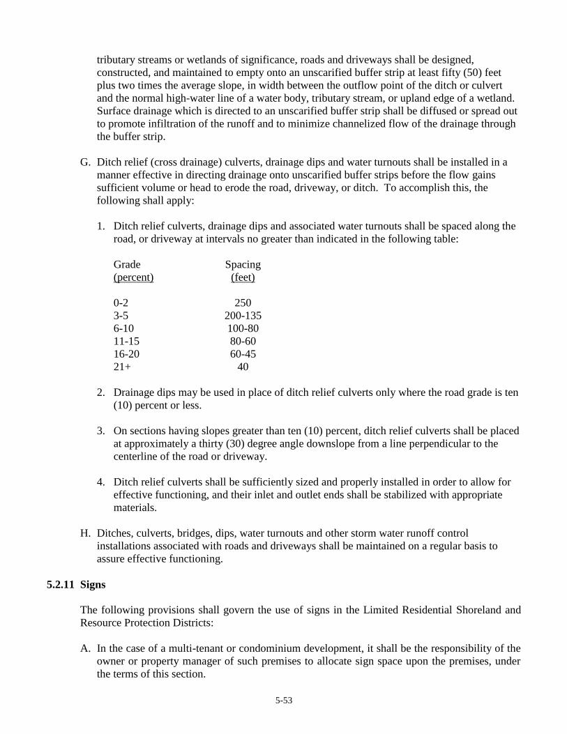
5-53
tributary streams or wetlands of significance, roads and driveways shall be designed,
constructed, and maintained to empty onto an unscarified buffer strip at least fifty (50) feet
plus two times the average slope, in width between the outflow point of the ditch or culvert
and the normal high-water line of a water body, tributary stream, or upland edge of a wetland.
Surface drainage which is directed to an unscarified buffer strip shall be diffused or spread out
to promote infiltration of the runoff and to minimize channelized flow of the drainage through
the buffer strip.
G. Ditch relief (cross drainage) culverts, drainage dips and water turnouts shall be installed in a
manner effective in directing drainage onto unscarified buffer strips before the flow gains
sufficient volume or head to erode the road, driveway, or ditch. To accomplish this, the
following shall apply:
1. Ditch relief culverts, drainage dips and associated water turnouts shall be spaced along the
road, or driveway at intervals no greater than indicated in the following table:
Grade Spacing
(percent) (feet)
0-2 250
3-5 200-135
6-10 100-80
11-15 80-60
16-20 60-45
21+ 40
2. Drainage dips may be used in place of ditch relief culverts only where the road grade is ten
(10) percent or less.
3. On sections having slopes greater than ten (10) percent, ditch relief culverts shall be placed
at approximately a thirty (30) degree angle downslope from a line perpendicular to the
centerline of the road or driveway.
4. Ditch relief culverts shall be sufficiently sized and properly installed in order to allow for
effective functioning, and their inlet and outlet ends shall be stabilized with appropriate
materials.
H. Ditches, culverts, bridges, dips, water turnouts and other storm water runoff control
installations associated with roads and driveways shall be maintained on a regular basis to
assure effective functioning.
5.2.11 Signs
The following provisions shall govern the use of signs in the Limited Residential Shoreland and
Resource Protection Districts:
A. In the case of a multi-tenant or condominium development, it shall be the responsibility of the
owner or property manager of such premises to allocate sign space upon the premises, under
the terms of this section.
5-54
B. Signs relating to goods and services sold on the premises shall be allowed, provided that such
signs shall not exceed six (6) square feet in area and shall not exceed two (2) signs per
premises. Signs relating to goods or services not sold or rendered on the premises shall be
prohibited.
C. Name signs are allowed, provided such signs shall not exceed two (2) signs per premises, and
shall not exceed twelve (12) square feet in the aggregate.
D. Residential users may display a single sign not over three (3) square feet in area relating to the
sale, rental, or lease of the premises.
E. Signs relating to trespassing and hunting shall be allowed without restriction as to number
provided that no sign shall exceed two (2) square feet in areas.
F. Residential users may display a single sign not over three (3) square feet in area relating to the
sale, rental, or lease of the premises.
G. Signs relating to public safety shall be allowed without restriction.
H. No sign shall extend higher than twenty (20) feet above the ground.
I. Signs may be illuminated only by shielded, non-flashing lights.
5.2.12 Septic Waste Disposal
All subsurface sewage disposal systems shall be installed in conformance with the State of Maine
Subsurface Wastewater Disposal Rules, and the following:
A. Clearing or removal of woody vegetation necessary to site a new system and any associated
fill extensions, shall not extend closer than seventy-five (75) feet, horizontal distance, from the
normal high-water line of a water body or the upland edge of a wetland of significance and;
B. A holding tank is not allowed for a first-time residential use in the shoreland zone.
5.2.13 Soils
All land uses shall be located on soils in or upon which the proposed uses or structures can be
established or maintained without causing adverse environmental impacts, including severe
erosion, mass soil movement, improper drainage, and water pollution, whether during or after
construction. Proposed uses requiring subsurface waste disposal, and commercial or industrial
development and other similar intensive land uses, shall require a soils report based on an on-site
investigation and be prepared by state-certified professionals. Certified persons may include
Maine Certified Soil Scientists, Maine Registered Professional Engineers, Maine State Certified
Geologists and other persons who have training and experience in the recognition and evaluation
of soil properties. The report shall be based upon the analysis of the characteristics of the soil and
surrounding land and water areas, maximum ground water elevation, presence of ledge, drainage
conditions, and other pertinent data which the evaluator deems appropriate. The soils report shall
include recommendations for a proposed use to counteract soil limitations where they exist.

5-55
5.2.14 Storm Water Runoff
A. All new construction and development shall be designed to minimize storm water runoff from
the site in excess of the natural predevelopment conditions. Where possible, existing natural
runoff control features, such as berms, swales, terraces and wooded areas, shall be retained in
order to reduce runoff and encourage infiltration of stormwaters.
B. Storm water runoff control systems shall be maintained as necessary to ensure proper
functioning.
5.2.15 Timber Harvesting
The following standards only apply within the shoreland zone and shall apply until repealed in
accordance with Section 1.7.B of this Ordinance.
A. Shoreline Integrity and Sedimentation
Persons conducting timber harvesting and timber harvesting related activities must take
reasonable measures to avoid the disruption of shoreline integrity, the occurrence of
sedimentation of water, and the disturbance of water body and tributary stream banks, water
body and tributary stream channels, shorelines, and soil lying within water bodies, tributary
streams and wetlands of significance. If, despite such precautions, the disruption of shoreline
integrity, sedimentation of water, or the disturbance of water body and tributary stream banks,
water body and tributary stream channels, shorelines, and soil lying within water bodies,
tributary streams and wetlands of significance occurs, such conditions must be corrected.
B. Slash Treatment
Timber harvesting and timber harvesting related activities shall be conducted such that slash or
debris is not left below the normal high-water line of any water body or tributary stream, or the
upland edge of a wetland of significance. Section 5.2.15 does not apply to minor, incidental
amounts of slash that result from timber harvesting and timber harvesting related activities
otherwise conducted in compliance with this section.
1. Slash actively used to protect soil from disturbance by equipment or to stabilize exposed
soil, may be left in place, provided that no part thereof extends more than 4 feet above the
ground.
2. Adjacent to great ponds, rivers and wetlands of significance:
a. No accumulation of slash shall be left within 50 feet, horizontal distance, of the normal
high-water line or upland edge of a wetland of significance; and
b. Between 50 feet and 250 feet, horizontal distance, of the normal high-water line or
upland edge of a wetland of significance, all slash larger than 3 inches in diameter must
be disposed of in such a manner that no part thereof extends more than 4 feet above the
ground.

5-56
C. Tree Cover
Timber harvesting and related activities must leave adequate tree cover and shall be conducted
so that a well-distributed stand of trees is retained. This requirement may be satisfied by
following one of the following two options:
1. Option 1 (40% volume removal), as follows:
a. Harvesting of no more than 40 percent of the total volume on each acre of trees 4.5
inches DBH or greater in any 10 year period is allowed. Volume may be considered to
be equivalent to basal area;
b. A well-distributed stand of trees which is windfirm, and other vegetation including
existing ground cover, must be maintained; and,
c. Within 75 feet, horizontal distance, of the normal high-water line of rivers, streams,
and great ponds, and within 75 feet, horizontal distance, of the upland edge of a
freshwater wetland of significance, there must be no cleared openings. At distances
greater than 75 feet, horizontal distance, of the normal high-water line of a river or
great pond or upland edge of a wetland of significance, timber harvesting and related
activities must not create single cleared openings greater than 14,000 square feet in the
forest canopy. Where such openings exceed 10,000 square feet, they must be at least
100 feet, horizontal distance, apart. Such cleared openings will be included in the
calculation of total volume removal. Volume may be considered equivalent to basal
area.
2. Option 2 (60 square foot basal area retention), as follows:
a. The residual stand must contain an average basal area of at least 60 square feet per acre
of woody vegetation greater than or equal to 1.0 inch DBH, of which 40 square feet per
acre must be greater than or equal to 4.5 inches DBH;
b. A well-distributed stand of trees which is windfirm, and other vegetation including
existing ground cover, must be maintained; and,
c. Within 75 feet, horizontal distance, of the normal high-water line of water bodies and
within 75 feet, horizontal distance, of the upland edge of wetlands of significance, there
must be no cleared openings. At distances greater than 75 feet, horizontal distance, of
the normal high-water line of a river or great pond, or upland edge of a wetland of
significance, timber harvesting and related activities must not create single cleared
openings greater than 14,000 square feet in the forest canopy. Where such openings
exceed 10,000 square feet, they must be at least 100 feet, horizontal distance, apart.
Such cleared openings will be included in the calculation of the average basal area.
Volume may be considered equivalent to basal area.
Landowners must designate on the Forest Operations Notification form required by Title 12
M.R.S.A. chapter 805, subchapter 5 which option they choose to use. Compliance will be
determined solely on the criteria for the option chosen.
5-57
The Code Enforcement Officer may verify that adequate tree cover and a well-distributed
stand of trees is retained through a field procedure that uses sample plots that are located
randomly or systematically to provide a fair representation of the harvest area.
D. Skid Roads, Yards and Equipment Operation
This requirement applies to the construction, maintenance, and use of skid trails and yards in
shoreland areas.
1. Equipment used in timber harvesting and related activities shall not use river, stream or
tributary stream channels as travel routes except when surface waters are frozen and snow
covered, and the activity will not result in any ground disturbance.
2. Skid trails and yards must be designed and constructed to prevent sediment and
concentrated water runoff from entering a water body, tributary stream, or wetland of
significance. Upon termination of their use, skid trails and yards must be stabilized.
3. Setbacks:
a. Equipment must be operated to avoid the exposure of mineral soil within 25 feet,
horizontal distance, of any water body, tributary stream, or wetland of significance. On
slopes of 10 percent or greater, the setback for equipment operation must be increased
by 20 feet, horizontal distance, plus an additional 10 feet, horizontal distance, for each
5 percent increase in slope above 10 percent. Where slopes fall away from the resource,
no increase in the 25-foot setback is required.
b. Where such setbacks are impracticable, appropriate techniques shall be used to avoid
sedimentation of the water body, tributary stream or wetland of significance. Such
techniques may include the installation of sump holes or settling basins, and/or the
effective use of additional ditch relief culverts and ditch water turnouts placed to avoid
sedimentation of the water body, tributary stream, or wetland of significance. If,
despite such precautions, sedimentation or the disruption of shoreline integrity occurs,
such conditions must be corrected.
E. Land Management Roads
Land management roads, including approaches to crossings of water bodies, tributary stream
channels, and wetlands of significance, ditches and other related structures, must be designed,
constructed, and maintained to prevent sediment and concentrated water runoff from directly
entering the water body, tributary stream or wetland of significance. Surface water on or
adjacent to water crossing approaches must be diverted through vegetative filter strips to avoid
sedimentation of the watercourse or wetland. Because roadside ditches may not extend to the
resource being crossed, vegetative filter strips must be established in accordance with the
setback requirements in Section 5.2.15.G of this ordinance.
5-58
1. Land management roads and associated ditches, excavation, and fill must be set back at
least:
a. 100 feet, horizontal distance, from the normal high-water line of a great pond, river or
freshwater wetland of significance;
b. 50 feet, horizontal distance, from the normal high-water line of streams of significance;
and
c. 25 feet, horizontal distance, from the normal high-water line of tributary streams
2. The minimum 100 foot setback specified in Section 5.2.15.E.1.a above may be reduced to
no less than 50 feet, horizontal distance, and the 50 foot setback specified in
Section 5.2.15.E.1.b above may be reduced to no less than 25 feet, horizontal distance, if,
prior to construction, the landowner or the landowner’s designated agent demonstrates to
the Planning Board’s satisfaction that no reasonable alternative exists and that appropriate
techniques will be used to prevent sedimentation of the water body, tributary stream, or
wetland of significance. Such techniques may include, but are not limited to, the
installation of settling basins, and/or the effective use of additional ditch relief culverts and
turnouts placed to avoid sedimentation of the water body, tributary stream or wetland of
significance. If, despite such precautions, sedimentation or the disruption of shoreline
integrity occurs, such conditions must be corrected.
3. On slopes of 10 percent or greater, the land management road setback must be increased by
at least 20 feet, horizontal distance, plus an additional 10 feet, horizontal distance, for each
5 percent increase in slope above 10 percent.
4. New land management roads are not allowed within the shoreland area in a Resource
Protection District, unless, prior to construction, the landowner or the landowner’s
designated agent makes a clear demonstration to the Planning Board’s satisfaction that no
reasonable alternative route exists outside the shoreland zone, and that the new road must
be set back as far as practicable from the normal high-water line and screened from the
river by existing vegetation.
5. Ditches, culverts, bridges, dips, water turnouts and other water control installations
associated with roads must be maintained on a regular basis to assure effective functioning.
Drainage structures shall deliver a dispersed flow of water into an unscarified filter strip no
less than the width indicated in the setback requirements in Section 5.2.15.G. Where such
a filter strip is impracticable, appropriate techniques shall be used to avoid sedimentation
of the water body, tributary stream, or wetland. Such techniques may include the
installation of sump holes or settling basins, and/or the effective use of additional ditch
relief culverts and ditch water turnouts placed to avoid sedimentation of the water body,
tributary stream, or wetland. If, despite such precautions, sedimentation or the disruption
of shoreline integrity occurs, such conditions must be corrected.
6. Road closeout and discontinuance. Maintenance of the water control installations required
in Section 5.2.15.E.5 must continue until use of the road is discontinued and the road is put
to bed by effective installation of water bars or other adequate road drainage structures at
5-59
appropriate intervals, constructed to avoid surface water flowing over or under the water
bar, and extending a sufficient distance beyond the traveled way so that water does not
reenter the road surface.
7. Upgrading existing roads. Extension or enlargement of presently existing roads must
conform to the provisions of Section 5.2.15. Any nonconforming existing road may
continue to exist and to be maintained, as long as the nonconforming conditions are not
made more nonconforming.
8. Exception. Extension or enlargement of presently existing roads need not conform to the
setback requirements of Section 5.2.15.E.1 if, prior to extension or enlargement, the
landowner or the landowner’s designated agent demonstrates to the Planning Board’s
satisfaction that no reasonable alternative exists and that appropriate techniques will be
used to prevent sedimentation of the water body, tributary stream, or wetland of
significance. Such techniques may include, but are not limited to, the installation of
settling basins, and/or the effective use of additional ditch relief culverts and turnouts
placed to avoid sedimentation of the water body, tributary stream, or wetland. If, despite
such precautions, sedimentation or the disruption of shoreline integrity occurs, such
conditions must be corrected.
9. Additional measures. In addition to the foregoing minimum requirements, persons
undertaking construction and maintenance of roads and river, stream and tributary stream
crossings must take reasonable measures to avoid sedimentation of surface waters.
F. Crossings of Waterbodies
Crossings of rivers, streams, and tributary streams must allow for fish passage at all times of
the year, must not impound water, and must allow for the maintenance of normal flows.
1. Determination of flow. Provided they are properly applied and used for the circumstances
for which they are designed, methods including but not limited to the following are
acceptable as a means of calculating the 10 year and 25 year frequency water flows and
thereby determining water crossing sizes as required in Section 5.2.15: The United States
Geological Survey (USGS) Methods; specifically: Hodgkins, G. 1999. Estimating the
Magnitude of Peak Flows for Streams in Maine for Selected Recurrence Intervals. U.S.
Geological Survey. Water Resources Investigations Report 99-4008. 45 pp.
2. Upgrading existing water crossings. Extension or enlargement of presently existing water
crossings must conform to the provisions of Section 5.2.15. Any nonconforming existing
water crossing may continue to exist and be maintained, as long as the nonconforming
conditions are not made more nonconforming; however, any maintenance or repair work
done below the normal high-water line must conform to the provisions of Section 5.2.15.
3. Other Agency Permits. Any timber harvesting and related activities involving the design,
construction, and maintenance of crossings on waterbodies other than a river, stream or
tributary stream may require a permit from the Department of Environmental Protection or
the US Army Corps of Engineers.
4. Any timber harvesting and related activities involving the design, construction, and
5-60
maintenance of crossings of wetlands of significance identified by the Department of
Inland Fisheries and Wildlife as essential wildlife habitat require prior consultation with
the Department of Inland Fisheries and Wildlife.
5. Notice to Bureau of Forestry. Written notice of all water crossing construction
maintenance, alteration and replacement activities in shoreland areas must be given to the
Bureau prior to the commencement of such activities. Such notice must contain all
information required by the Bureau, including:
a. a map showing the location of all proposed permanent crossings;
b. the GPS location of all proposed permanent crossings;
c. for any temporary or permanent crossing that requires a permit from state or federal
agencies, a copy of the approved permit or permits; and
d. a statement signed by the responsible party that all temporary and permanent crossings
will be constructed, maintained, and closed out in accordance with the requirements of
this Section.
6. Water crossing standards. All crossings of rivers require a bridge or culvert sized according
to the requirements of Section 5.2.15.F.7 below. Streams and tributary streams may be
crossed using temporary structures that are not bridges or culverts provided:
a. concentrated water runoff does not enter the stream or tributary stream;
b. sedimentation of surface waters is reasonably avoided;
c. there is no substantial disturbance of the bank, or stream or tributary stream channel;
d. fish passage is not impeded; and,
e. water flow is not unreasonably impeded.
Subject to Section 5.2.15.F.6.a-e above, skid road crossings of streams and tributary streams
when channels of such streams and tributary streams are frozen and snow-covered or are
composed of a hard surface which will not be eroded or otherwise damaged are not required to
use permanent or temporary structures.
7. Bridge and Culvert Sizing. For crossings of river, stream and tributary stream channels
with a bridge or culvert, the following requirements apply:
a. Bridges and culverts must be installed and maintained to provide an opening sufficient
in size and structure to accommodate 10 year frequency water flows or with a cross-
sectional area at least equal to 2 1/2 times the cross-sectional area of the river, stream,
or tributary stream channel.
5-61
b. Temporary bridge and culvert sizes may be smaller than provided in Section
5.2.15.F.7.a if techniques are effectively employed such that in the event of culvert or
bridge failure, the natural course of water flow is maintained and sedimentation of the
water body or tributary stream is avoided. Such crossing structures must be at least as
wide as the channel and placed above the normal high-water line. Techniques may
include, but are not limited to, the effective use of any, a combination of, or all of the
following:
i. use of temporary skidder bridges;
ii. removing culverts prior to the onset of frozen ground conditions;
iii. using water bars in conjunction with culverts;
iv. using road dips in conjunction with culverts.
c. Culverts utilized in river, stream and tributary stream crossings must:
i. be installed at or below river, stream or tributary stream bed elevation;
ii. be seated on firm ground;
iii. have soil compacted at least halfway up the side of the culvert;
iv. be covered by soil to a minimum depth of 1 foot or according to the culvert
manufacturer's specifications, whichever is greater; and
v. have a headwall at the inlet end which is adequately stabilized by riprap or other
suitable means to reasonably avoid erosion of material around the culvert.
d. River, stream and tributary stream crossings allowed under Section 5.2.15, but located
in flood hazard areas (i.e. A zones) as identified on Flood Insurance Rate Maps (FIRM)
or Flood Hazard Boundary Maps (FHBM), must be designed and constructed under the
stricter standards contained in the National Flood Insurance Program (NFIP). For
example, a water crossing may be required to pass a 100-year flood event.
e. Exception. Skid road crossings of tributary streams within shoreland areas and
wetlands adjacent to such streams may be undertaken in a manner not in conformity
with the requirements of the foregoing subsections provided persons conducting such
activities take reasonable measures to avoid the disruption of shoreline integrity, the
occurrence of sedimentation of water, and the disturbance of stream banks, stream
channels, shorelines, and soil lying within ponds and wetlands. If, despite such
precautions, the disruption of shoreline integrity, sedimentation of water, or the
disturbance of stream banks, stream channels, shorelines, and soil lying within ponds
and wetlands occurs, such conditions must be corrected.
8. Skid road closeout. Upon completion of timber harvesting and related activities, or upon
the expiration of a Forest Operations Notification, whichever is earlier, the following
requirements apply:

5-62
a. Bridges and culverts installed for river, stream and tributary stream crossings by skid
roads must either be removed and areas of exposed soil stabilized, or upgraded to
comply with the closeout standards for land management roads in Section 5.2.15.F.9
below.
b. Water crossing structures that are not bridges or culverts must either be removed
immediately following timber harvesting and related activities, or, if frozen into the
river, stream or tributary stream bed or bank, as soon as practical after snowmelt.
c. River, stream and tributary stream channels, banks and approaches to crossings of
water bodies and tributary streams must be immediately stabilized on completion of
harvest, or if the ground is frozen and/or snow-covered, as soon as practical after
snowmelt. If, despite such precautions, sedimentation or the disruption of shoreline
integrity occurs, such conditions must be corrected.
9. Land management road closeout. Maintenance of the water control features must continue
until use of the road is discontinued and the road is put to bed by taking the following
actions:
a. Effective installation of water bars or other adequate road drainage structures at
appropriate intervals, constructed to reasonably avoid surface water flowing over or
under the water bar, and extending sufficient distance beyond the traveled way so that
water does not reenter the road surface.
b. Water crossing structures must be appropriately sized or dismantled and removed in a
manner that reasonably avoids sedimentation of the water body or tributary stream.
c. Any bridge or water crossing culvert in roads to be discontinued shall satisfy one of the
following requirements:
i. it shall be designed to provide an opening sufficient in size and structure to
accommodate 25 year frequency water flows;
ii. it shall be designed to provide an opening with a cross-sectional area at least 3 1/2
times the cross-sectional area of the river, stream or tributary stream channel; or
iii. it shall be dismantled and removed in a fashion to reasonably avoid sedimentation
of the river, stream or tributary stream.
If, despite such precautions, sedimentation or the disruption of shoreline integrity occurs,
such conditions must be corrected.

5-63
G. Slope Table
Filter strips, skid trail setbacks, and land management road setbacks must be maintained as
specified in Section 5.2.15 but in no case shall be less than shown in the following table.
Average slope of land between exposed
mineral soil and the shoreline (percent)
Width of strip between exposed mineral soil and
shoreline (feet along surface of the ground) 0 25
10 45
20 65
30 85
40 105
50 125
60 145
70 165
5.2.16 Clearing or Removal of Vegetation for Activities Other Than Timber Harvesting
A. Within a Resource Protection District abutting a great pond there shall be no cutting of
vegetation within the strip of land extending 75 feet, horizontal distance, inland from the
normal high-water line, except to remove safety hazards.
Elsewhere, in any Resource Protection District the cutting or removal of vegetation shall be
limited to that which is necessary for uses expressly authorized in that district.
B. Except in areas as described in Section 5.2.16.A, above, and except to allow for the
development of permitted uses, within a strip of land extending one-hundred (100) feet,
horizontal distance, inland from the normal high-water line of a great pond classified GPA or a
river flowing to a great pond classified GPA, and seventy-five (75) feet, horizontal distance,
from any other water body, tributary stream, or the upland edge of a wetland of significance, a
buffer strip of vegetation shall be preserved as follows:
1. There shall be no cleared opening greater than 250 square feet in the forest canopy (or
other existing woody vegetation if a forested canopy is not present) as measured from
the outer limits of the tree or shrub crown. However, a footpath not to exceed six (6)
feet in width as measured between tree trunks and/or shrub stems is permitted provided
that a cleared line of sight to the water through the buffer strip is not created.
2. Selective cutting of trees within the buffer strip is permitted provided that a well
distributed stand of trees and other natural vegetation is maintained. For the purposes
of Section 5.2.16.B.2 a "well-distributed stand of trees" adjacent to a great pond
classified GPA or a river or stream flowing to a great pond classified GPA, shall be
defined as maintaining a rating score of 24 or more in each 25-foot by 50-foot
rectangular (1250 square feet) area as determined by the following rating system.
Diameter of Tree at 4 ½ ft.
Above Ground Level
Points
2 - <4 in. 1
4 - <8 in. 2
8 - <12 in. 4
12 in. or greater 8
5-64
Adjacent to other water bodies, tributary streams, and wetlands of significance, a "well-
distributed stand of trees is defined as maintaining a minimum rating score of 16 per
25-foot by 50-foot rectangular area.
The following shall govern in applying this point system:
a. The 25-foot by 50-foot rectangular plots must be established where the landowner
or lessee proposes clearing within the required buffer;
b. Each successive plot must be adjacent to, but not overlap a previous plot;
c. Any plot not containing the required points must have no vegetation removed
except as otherwise allowed by this Ordinance;
d. Any plot containing the required points may have vegetation removed down to the
minimum points required or as otherwise allowed by is Ordinance;
e. Where conditions permit, no more than 50% of the points on any 25-foot by 50-
foot rectangular area may consist of trees greater than 12 inches in diameter.
For the purposes of Section 5.2.16.B.2 “other natural vegetation” is defined as
retaining existing vegetation under three (3) feet in height and other ground cover and
retaining at least five (5) saplings less than two (2) inches in diameter at four and one
half (4 ½) feet above ground level for each 25-foot by 50-foot rectangle area. If five
saplings do not exist, no woody stems less than two (2) inches in diameter can be
removed until 5 saplings have been recruited into the plot.
Notwithstanding the above provisions, no more than 40% of the total volume of trees
four (4) inches or more in diameter, measured at 4 1/2 feet above ground level may be
removed in any ten (10) year period.
3. In order to protect water quality and wildlife habitat, existing vegetation under three (3)
feet in height and other ground cover, including leaf litter and the forest duff layer, shall
not be cut, covered or removed, except to provide for a footpath or other permitted uses as
described in Section 5.2.16.B and Section 5.2.16.B.1 above.
4. Pruning of tree branches, on the bottom 1/3 of the tree is permitted.
5. In order to maintain a buffer strip of vegetation, when the removal of storm-damaged,
diseased, unsafe, or dead trees results in the creation of cleared openings, these openings
shall be replanted with native tree species unless existing new tree growth is present.
The provisions contained in Section 5.2.16.B above shall not apply to those portions of
public recreational facilities adjacent to public swimming areas. Cleared areas, however,
shall be limited to the minimum area necessary.
C. At distances greater than one hundred (100) feet, horizontal distance, from a great pond
classified GPA of a river flowing to a great pond classified GPA, and seventy-five (75) feet,
horizontal distance, from the normal high-water line of any other water body, tributary stream,
or the upland edge of a wetland of significance, there shall be permitted on any lot, in any ten
(10) year period, selective cutting of not more than forty (40) percent of the volume of trees
four (4) inches or more in diameter, measured 4 ½ feet above ground level. Tree removal in
conjunction with the development of permitted uses shall be included in the forty (40) percent

5-65
calculation. For the purposes of these standards volume may be considered to be equivalent to
basal area.
In no event shall cleared openings for any purpose, including but not limited to, principal and
accessory structures, driveways, lawns and sewage disposal areas, exceed in the aggregate,
25% of the lot area within the shoreland zone or ten thousand (10,000) square feet, whichever
is greater, including land previously cleared.
D. Legally existing nonconforming cleared openings on the effective date of this Ordinance may
be maintained, but shall not be enlarged, except as permitted by this Ordinance.
E. Fields and other cleared openings which have reverted to primarily shrubs, trees, or other
woody vegetation shall be regulated under the provisions of Section 5.2.16.
Amended November 16, 2015 Special Town Meeting
6-1
ARTICLE 6
ADMINISTRATION
6.1 Administration of Permits
This Ordinance shall be administered by a Code Enforcement Officer appointed or reappointed
annually by July 1 by the Municipal Officers, except as otherwise provided.
Applications for site plan review shall be referred by the Code Enforcement Officer to the
Planning Board heretofore established by the Town of New Gloucester. The Planning Board shall
hear and decide upon such applications in accordance with the provisions of Article 7 of this
Ordinance.
Administrative and variance appeals from decisions of the Code Enforcement Officer shall be
heard and decided upon in accordance with the provisions of this Ordinance by the Board of
Appeals established by the Town of New Gloucester on March 11, 1972, to act under Maine
Revised Statutes, Title 30, Section 2411, now codified as Title 30-A M.R.S.A. Section 2691, or
except as otherwise provided.
6.1.1 Building Permit
A. 1. In areas outside the Limited Residential and Resource Protection Districts, no building or
other structure shall be erected, moved, added to, or structurally altered without a permit
therefore, issued by the Code Enforcement Officer.
2. In the Limited Residential Shoreland and Resource Protection Districts, after the effective
date of this ordinance, no person shall, without first obtaining a permit issued by the Code
Enforcement Officer, engage in any activity or use of land or structure requiring a permit in
the district in which such activity or use would occur; or expand, change, or replace an existing
use or structure; or renew a discontinued non-conforming use.
3. A permit for a building, structure, or use on any lot shall be issued to the owner of record
thereof, or his authorized agent. No building permit shall be issued except in conformity with
the provisions of this Ordinance, and all other applicable ordinances of the Town of New
Gloucester and any conditions imposed by the Planning Board, Board of Appeals, or other
authority pursuant to said ordinances. A person who is issued a permit pursuant to this
Ordinance shall have a copy of the permit on site while the work authorized by the permit is
performed.
B. Within fifteen (15) days of the date of receiving a written application the Code Enforcement
Officer shall notify the applicant in writing either that the application is a complete
application, or, if the application is incomplete, that specified additional material is needed to
make the application complete.
C. The Code Enforcement Officer shall approve, approve with conditions, or deny all permit
applications in writing within 15 days after receipt of the complete application, or within 48
hours after notification of the granting of an appeal by the Board of Appeals or of approval by
the Planning Board of a development or use which site plan review under Article 7 is required
by this Ordinance.

6-2
D. The decision of the Code Enforcement Officer shall be in writing on a form designed for the
purpose and shall be communicated directly to the applicant.
E. No building permit shall be issued for any structure or use involving the construction,
installation, or alteration of plumbing facilities unless a valid plumbing permit has been issued
to the applicant or his authorized agent by the local plumbing inspector in conformance with
all applicable performance standards contained in Articles 4 and 5 of this ordinance, and all
applicable provisions of state law.
F. The building permit shall be valid for one (1) year from the date of issue. If construction has
not been completed within the twelve month period, the permit may be renewed without
charge for a second twelve-month period. Thereafter, if construction has not been completed,
a new permit shall be applied for and the fee paid.
6.1.2 Application for Building Permit
A. All applications for building permits shall be submitted in writing and accompanied by plans
drawn to scale, showing:
1. the actual dimensions and shape of the lot to be built upon,
2. the exact sizes and locations on the lot of buildings already existing, if any,
3. the location and dimensions of the proposed buildings, and
4. the proposed sewage disposal system as required by the Maine State Plumbing Code.
B. The application shall include such other information as lawfully may be required by the Code
Enforcement Officer to determine conformance with and to provide for the enforcement of this
Ordinance.
C. All applications shall be signed by an owner or person who can show evidence of right, title or
interest in the property or by an agent, representative, tenant, or contractor of the owner with
authorization from the owner to apply for a permit hereunder, certifying that the information in
the application is complete and correct.
D. Applications shall be accompanied by a fee established in the Town Fee Schedule and revised
periodically by the Selectmen. Any person who shall commence work for which a building
permit is required by this Ordinance without first obtaining a building permit shall, if
subsequently permitted to obtain a permit, pay double the permit fee fixed by the Town
Selectmen in the Town Fee Schedule. This provision shall not apply to emergency work when
the applicant can prove to the satisfaction of the Code Enforcement Officer that such work is
urgently necessary and that obtaining a permit prior to commencing the work is not practical.
In all such cases, a permit must be obtained as soon as it is practical to do so. If there is an
unreasonable delay in obtaining such a permit, a double fee as herein provided shall be
charged. [Amended April 2, 1994, Town Meeting]
E. All applications shall be dated, and the Code Enforcement Officer or Planning Board, as
appropriate, shall note upon each application the date and time of its receipt.

6-3
F. If the property is not served by a public sewer, a valid plumbing permit or a completed
application for a plumbing permit, including the site evaluation approved by the Plumbing
Inspector, shall be submitted whenever the nature of the proposed structure or use would
require the installation of a subsurface sewage disposal system.
G. Applications for permits, along with their accompanying plans and permits issued, or other
decisions, shall be maintained as a permanent record by the Code Enforcement Officer.
H. The issuance of a building or use permit, as a result of Site Plan Review or otherwise, for one
or more dwelling units on a back lot, shall in no way be construed to imply acceptance of any
accessway for the purpose of maintenance, improvements or snow removal by the Town.
6.1.3 Home Occupation Permits
A home occupation permit must be obtained from the Code Enforcement Officer before such
activity commences. Such permits shall be granted upon determination by the Code Enforcement
Officer that the proposed home occupation meets the definition of such uses contained in Article 2
of this Ordinance, and complies with the performance standards contained herein.
6.1.4 Permits for Temporary Structures
Permits for temporary structures shall be issued for a six-month period by the Code Enforcement
Officer. The permit may be renewed by the Code Enforcement Officer for an additional twelve
(12) month period.
6.1.5 Certificate of Occupancy
A. It shall be unlawful to use or occupy or permit the use or occupancy of any building or
structure hereafter erected, changed, converted, wholly or partly altered, or enlarged in its use
or construction, until a Certificate of Occupancy shall have been issued by the Code
Enforcement Officer stating that the building or structure conforms with the requirements of
this Ordinance, the State Plumbing Code, the NFPA Life Safety Code, and is in compliance
with all provisions of this or any other applicable ordinance of the Town of New Gloucester
and with any conditions imposed on the project by the Planning Board or Board of Appeals.
The Certificate of Occupancy shall be issued in conformity with the provisions of this
Ordinance upon completion of the work. A Certificate shall not be issued until a copy of the
water analysis for the well serving the premises has been received by the CEO for his records.
B. A temporary Certificate of Occupancy may be issued by the Code Enforcement Officer for a
period of six (6) months during construction or alterations for partial occupancy of a building
pending its completion, provided that such safeguards as will protect the health, welfare, and
safety of the occupants and the public.
C. The Code Enforcement Officer shall maintain a public record of all Certificates of Occupancy.
D. Occupation or use of any building or structure without a certificate of occupancy required by
this Ordinance shall be a violation of this Ordinance.

6-4
E. No certificate of occupancy may be granted to a structure in an approved subdivision until any
required fire protection has been installed, in working order, and approved by the Fire Chief or
his/her designee. [added May 1, 2006]
6.1.6 Repealed DATE, Special Town Meeting
6.2 Enforcement
6.2.1 Code Enforcement Officer
A. Except as provided in paragraph C of this section, it shall be the duty of the Code Enforcement
Officer of the Town of New Gloucester to enforce the provisions of this Ordinance. If the
Code Enforcement Officer shall find that any of the provisions of this Ordinance are being
violated, he/she shall notify in writing the person responsible for such violation, indicating the
nature of the violation and ordering the action necessary to correct it. He/she shall order
discontinuance of illegal use of land, buildings or structures, or work being done; removal of
illegal buildings or structures or of additions, alterations, or structural changes thereto;
discontinuance of any illegal work being done and abatement of nuisance conditions; or shall
take any other action authorized by this Ordinance to insure compliance with or to prevent
violation of its provisions. A copy of such notices shall be submitted to the municipal officers
and be maintained as a permanent record.
B. It shall be the duty of the Code Enforcement Officer to enforce the provisions of the New
Gloucester Floodplain Management Ordinance.
C. Any local plumbing inspector authorized under State Law, and appointed by the Town to
administer and enforce the Maine State Plumbing Code in the Town of New Gloucester is
authorized to enforce those performance standards contained in Article 5 of this Ordinance
relating to soil suitability for wastewater disposal systems, provision of adequate wastewater
treatment systems, and water quality, and has all the powers and duties of the Code
Enforcement Officer hereunder for the purpose of enforcement of those sections.
D. The Code Enforcement Officer shall conduct on-site inspections to insure compliance with all
applicable laws and conditions attached to permit approvals. The Code Enforcement Officer
shall also investigate all complaints of alleged violations of this Ordinance.
E. The Code Enforcement Officer shall keep a complete record of all essential transactions of the
office, including applications submitted, permits granted or denied, variances granted or denied,
revocation actions, revocation of permits, appeals, court actions, violations investigated,
violations found, and fees collected.
F. On a biennial basis, a summary of the record pertaining to the Limited Residential Shoreland and
Resource Protection Districts shall be submitted to the Director of the Bureau of Land and Water
Quality within the Department of Environmental Protection.

6-5
6.2.2 Legal Action and Violation
When the above action does not result in correction or abatement of the violation or nuisance, the
Board of Selectmen, upon notice from the Code Enforcement Officer, are hereby directed, in
cases of violations in the shoreland zone, and in other cases, are authorized to institute any and all
actions and proceedings, either legal or equitable, including seeking injunctions of violations and
the imposition of fines, that may be appropriate or necessary to enforce the provisions of this
ordinance in the name of the Town. The municipal officers, or their authorized agent, are hereby
authorized to enter into administrative consent agreements for the purpose of eliminating
violations of this Ordinance and recovering fines without Court action. Such agreements, if
relating to violations within the shoreland zone, shall not allow an illegal structure or use to
continue unless there is clear and convincing evidence that the illegal structure or use was
constructed or conducted as a direct result of erroneous advice given by an authorized municipal
official and there is no evidence that the owner acted in bad faith, or unless the removal of the
structure or use will result in a threat or hazard to public health and safety or will result in
substantial environmental damage.
6.2.3 Fines
Any person, including but not limited to a land owner, a land owner’s agent, a contractor, firm or
corporation who violates any of the provisions of this Ordinance, or any condition imposed by the
Code Enforcement Officer, Planning Board or Board of Appeals pursuant to the provisions of this
Ordinance, shall be penalized in accordance with Title 30-A M.R.S.A. Section 452. Each day
such a violation is permitted to exist after notification thereof, shall constitute a separate offense.
All fines collected hereunder shall inure to the Town of New Gloucester.
6.3 Board of Appeals
6.3.1 Appointment and Composition
There shall be a Board of Appeals of five (5) members, all of whom shall be residents of the Town
of New Gloucester. The members of the Board shall be appointed by the Board of Selectmen.
Terms of members shall be for three (3) years except that initial appointment shall be such that the
terms of office of no more than two (2) members shall expire in a single year. The members of the
Board shall annually elect a Secretary and Chairman who shall provide for the keeping of the
minutes of the proceedings of the Board of Appeals, which shall show the vote of each member
upon each question. All minutes of the Board shall be public record. A quorum and a majority
shall consist of three (3) members.
6.3.2 Powers and Duties
Administrative and variance appeals from the decisions of the Code Enforcement Officer may be
appealed to the Board of Appeals and from the Board of Appeals to the Superior Court according
to law. The Board of Appeals shall have the following powers and duties.
A. Administrative Appeal
The Board of Appeals shall hear and decide administrative appeals where it is alleged by an
aggrieved party that there is an error in any order, requirement, decision, or determination

6-6
made by, or failure to act by the Code Enforcement Officer in his or her review of and action
on a permit application under this Ordinance.
Any order, requirement, decision or determination made, or failure to act, in the enforcement
of this ordinance is not appealable to the Board of Appeals.
A decision granting, granting with conditions, or denying a building permit or use permit
pursuant to the decision of the Planning Board on an application for site plan review is not
appealable to the Board of Appeals.
When the Board of Appeals reviews a decision of the Code Enforcement Officer, the Board of
Appeals shall hold a “de novo” hearing. At this time the Board may receive and consider new
evidence and testimony, be it oral or written. When acting in a “de novo” capacity the Board of
Appeals shall hear and decide the matter afresh, undertaking its own independent analysis of
evidence and the law, and reaching its own decision.
The action of the Code Enforcement Officer may be modified or reversed by the Board of
Appeals by concurring vote of at least three (3) members of the Board.
B. Variance Appeals
1. Except as provided in Sections 6.3.2.B.7 and 6.3.2.B.8, the Board of Appeals shall hear
and decide appeals of the Code Enforcement Officer's denial of a building permit when a
variance from the terms of this Ordinance is sought; where the use or structure would meet
all applicable performance standards, where variance from the terms of this Ordinance
would not be contrary to the public interest, and where a literal enforcement of the
provisions of this Ordinance would result in undue hardship. The words "undue hardship"
as used in this subsection mean:
a. That the land in question cannot yield a reasonable return unless a variance is granted;
b. That the need for a variance is due to the unique circumstances of the property and not
to the general conditions in the neighborhood;
c. That the granting of a variance will not alter the essential character of the locality; and
d. That the hardship is not the result of action taken by the applicant or a prior owner.
A financial hardship does not necessarily constitute grounds for granting a variance.
2. The petitioner shall submit specific information to substantiate undue hardship.
This information shall include statements in writing, which may be accompanied by
diagrams and/or photographs which shall become part of the record of such petition,
demonstrating the following:
a. The nature of the hardship to the property under appeal and the physical circumstances
that allegedly would occasion such unusual difficulty or special hardship.

6-7
b. That such physical circumstances are peculiar to the property under appeal, and are not
substantially duplicated on other property adjoining or nearby in the same
neighborhood or the same zoning district.
c. That the relief sought would not adversely affect property adjoining or nearby in the
same neighborhood or the same zoning district and would not endanger the public
health, safety or convenience and would not impair the integrity of the New Gloucester
Zoning Ordinance.
3. Except where specifically limited or prohibited, variances may be authorized only for
minimum setbacks, maximum building coverage or impervious surface, minimum
frontage, and reconstruction of destroyed non-conforming buildings. Only the minimum
variance that will alleviate the hardship shall be granted.
4. Variances shall not be granted for establishment of any uses otherwise prohibited by this
Ordinance.
5. In flood hazard areas, any variance issued shall be the minimum necessary, considering the
flood hazard, to afford relief. A variance shall not be granted that would result in increased
flood heights, additional threats to public safety, extraordinary public expense, or that
would create nuisances, cause fraud on or victimization of the public, or conflict with
existing local laws or ordinances.
6. If the applicant seeking a variance from the Board of Appeals also requires site plan review
approval from the Planning Board, the Board of Appeals and the Planning Board may hold
a joint public hearing within 30 days of the filing of the appeal, according to the procedure
for public hearings herein. A variance must be granted by the Board of Appeals prior to
Planning Board decision on the site plan review application.
7. Setback Variance for Single-Family Dwellings.
The Board of Appeals may grant a setback variance for a single-family dwelling only when
strict application of the zoning ordinance to the petitioner and the petitioner's property
would cause undue hardship. The term "undue hardship" as used in this subsection means:
a. The need for a variance is due to the unique circumstances of the property and not to
the general conditions in the neighborhood;
b. The granting of a variance will not alter the essential character of the locality;
c. The hardship is not the result of action taken by the applicant or a prior owner;
d. The granting of the variance will not substantially reduce or impair the use of
abutting property; and
e. There is no other feasible way to accomplish the goals sought by the petitioner.
The Board of Appeals is strictly limited to permitting a variance from a setback
requirement for a single-family dwelling that is the primary year-round residence of the
petitioner. A variance under this subsection may not exceed 20% of a setback requirement
and may not be granted if the variance would cause the area of the dwelling to exceed the
maximum permissible lot coverage.

6-8
8. The Board of Appeals may grant a variance to an owner of a residential dwelling for the
purpose of making that dwelling accessible to a person with a disability who resides in or
regularly uses the dwelling. The Board shall restrict any variance granted under this
subsection solely to the installation of equipment or the construction of structures
necessary for access to or egress from the dwelling by the person with the disability. The
Board may impose conditions on the variance, including limiting the variance to the
duration of the disability or to the time that the person with the disability lives in the
dwelling. The term “structures necessary for access to or egress from the dwelling" shall
include railing, wall or roof systems necessary for the safety or effectiveness of the
structure.
9. A copy of each variance request within the Limited Residential Shoreland and Resource
Protection Districts, including the application and all supporting information supplied by
the applicant, shall be forwarded by the municipal officials to the Commissioner of the
Department of Environmental Protection at least twenty (20) days prior to action by the
Board of Appeals. Any comments received from the Commissioner prior to the action by
the Board of Appeals shall be made part of the record and shall be taken into consideration
by the Board of Appeals.
6.3.3 Conditions Attached to Appeals
In granting an appeal, the Board of Appeals may attach such condition, in addition to those
required by other provisions of this Ordinance, as it finds necessary to insure compliance with all
standards and all other applicable requirements of this Ordinance. Violation of any of those
conditions shall be a violation of this Ordinance. Such conditions may include, but are not limited
to specifications for type of vegetation, increased setbacks and yards, specified sewage disposal
and water supply facilities, retention of natural features and topography, landscaping and planting
screens, hours of operation, operation controls, professional inspection and maintenance, sureties,
location of piers and docks, parking and signs, lighting and types of construction.
6.3.4 Meetings
The Board of Appeals shall schedule meetings once a month. The Board shall not be required to
hold a meeting if no appeals are pending at the scheduled date.
6.3.5 Appeal Procedure
A. In all cases where an appeal is permitted under this Ordinance, an aggrieved party shall
commence the appeal within 30 days after a decision is made by the Code Enforcement
Officer. The appeal shall be filed with the Board of Appeals on forms approved by the Board.
The application shall be accompanied by:
1. A filing fee which shall be established by the Selectmen,
2. A concise written statement indicating what relief is requested and why the appeal or
variance should be granted,
3. A copy of the building permit application,
6-9
4. Supporting information, and other information required by this section of the Ordinance.
The applicant may submit any additional information relevant to the appeal.
B. Upon receiving an application for an administrative appeal or a variance, the Code
Enforcement Officer shall transmit to the Board of Appeals all of the papers constituting the
record of the decision appealed from.
C. Hearing
1. Within thirty (30) days following the filing of an appeal, and before taking action on any
appeal or application, the Board of Appeals shall hold a public hearing. The Board of
Appeals shall notify the Code Enforcement Officer and the Planning Board at least ten (10)
days in advance of the time and place of the hearing, and shall post notice of the hearing in
the Town Office at least ten (10) days prior to the hearing. In addition, the applicant at his
or her expense and after approval by the Code Enforcement Officer of the wording to be
used, shall place notice of the public hearing in summary form in a newspaper of general
circulation in the Town of New Gloucester at least seven (7) days prior to the public
hearing. The applicant shall notify, at his or her expense, by first class mail, owners of
property within 250 feet of the property for which an appeal is made, of the nature of the
appeal and of the public hearing thereon. The Board shall be given proof of notification
either through certified mail or a certificate of mail.
2. For the purposes of this section, the owners of property shall be considered to be the
parties listed by the Assessor of Taxes for the Town of New Gloucester as those against
whom taxes are assessed. Failure of any property owner to receive a notice of public
hearing shall not necessitate another hearing or invalidate any action by the Board of
Appeals.
3. At any hearing a party may be represented by agent or attorney. Hearings shall not be
continued to other times except for good cause.
4. The Code Enforcement Officer or their designee shall attend all hearings and may present
to the Board of Appeals all plans, photographs or other material deemed appropriate for an
understanding of the appeal.
D. Decision By Board of Appeals
1. A majority of the full voting membership of the Board shall constitute a quorum for the
purpose of deciding an appeal.
2. Any question of whether a particular issue involves a conflict of interest sufficient to
disqualify a member from voting thereon shall be decided by a majority vote of the
members, excepting the member who is being challenged.
3. The person filing the appeal shall have the burden of proof.
4. The appellant's case shall be heard first. To maintain orderly procedure, each side shall
proceed without interruption. Questions may be asked through the Chair. All persons at
the hearing shall abide by the order of the Chair. The Board of Appeals may adopt
additional rules of procedure governing conduct of meetings.

6-10
5. Within thirty (30) days of the public hearing, the Board of Appeals shall reach a decision
on an appeal. The transcript of testimony, if any, and exhibits, together with all papers and
requests filed in the proceedings, together with the minutes, shall constitute the record. All
decisions shall become a part of the record and shall include a statement of findings and
conclusions, as well as the reasons or basis therefore, upon all material issues of fact, law
or discretion presented and the appropriate order, relief or denial thereof. Notice of any
decision shall be given in writing to the petitioner, his representative or agent, the Planning
Board, the Code Enforcement Officer and the Municipal Officers within seven (7) days of
the Board of Appeals decision.
6. For appeals within the Limited Residential Shoreland and Resource Protection Districts
written notice of the decision of the Zoning Board of Appeals shall be mailed or hand
delivered to the Department of Environmental Protection within seven (7) days of the
Boards decision.
E. Upon notification of the granting of an appeal by the Board of Appeals, the Code Enforcement
Officer shall, within 48 hours, issue a building permit in accordance with the conditions of the
approval, unless further review by the Planning Board is required.
F. A permit secured by vote of the Board of Appeals under the provisions of this Ordinance shall
expire if the work or change involved is not commenced within one year of the date on which
the appeal is granted, and if the work or change is not substantially completed within two years
of the date on which such appeal is granted.
G. If the Board of Appeals denies an application for a variance, a second application of a similar
nature for the same property may not be brought before the Board within one (1) year from the
date of the denial by the Board of the first application, unless in the opinion of a majority of
the Board, substantial new evidence shall be brought forward, or unless the Board finds, in its
sole and exclusive judgment, that an error of law or a misunderstanding of facts was made.
H. Except as provided by Title 30-A M.R.S.A. Section 2691(3)(F), any aggrieved party who
participated as a party during the proceedings before the Board of Appeals may take an appeal
to Superior Court in accordance with State laws, within forty-five (45) days from the date of
any decision of the Board.
I. Reconsideration
In accordance with Title 30-A M.R.S.A. section 2691(3)(F), the Board of Appeals may
reconsider any decision within forty-five (45) days of its prior decision. A request to the Board
to reconsider a decision must be filed within ten (10) days of the decision that is being
reconsidered. A vote to reconsider and the action taken on that reconsideration must occur and
be completed within forty-five (45) days of the date of the vote on the original decision.
Reconsideration of a decision shall require a positive vote of the majority of the Board members
originally voting on the decision, and proper notification to the landowner, petitioner, Planning
Board, Code Enforcement Officer, and other parties of interest, including abutters and those who
testified at the original hearing(s). The Board may conduct additional hearings and receive
additional evidence and testimony.
Appeal of a reconsidered decision to Superior Court must be made within fifteen (15) days after
the decision on reconsideration.
Amended November 16, 2015 Special Town Meeting
7-1
ARTICLE 7
SITE PLAN REVIEW
7.1 Purpose
The purpose of this Article is to provide site plan review of multi-family residential, commercial,
industrial, institutional and other projects and uses which by their nature, plan, size, or location
may affect the physical and visual environment, the provision of public services, and the value and
rights of adjoining properties, and thereby to protect the health, safety and welfare of the citizens
of New Gloucester.
7.2 Review of Development and Uses
7.2.1 The Planning Board is hereby authorized to review development for conformance with the criteria
stated herein and with the performance standards of Articles 4 and 5 of this ordinance, the
Floodplain Management Ordinance, and the Subdivision Regulations. A developer or his
authorized agent shall be required to obtain Planning Board approval prior to the issuance of a
building permit for all development and uses listed in Articles 3 and 4 of this ordinance as
requiring site plan review. The following uses shall be exempt from site plan review:
A. reserved (adopted 4/2/94)
B. subdivisions already subject to Planning Board review under the Town of New Gloucester
Subdivision Regulations.
7.2.2 No person subject to review under this Article shall commence work including site preparation, or
convey a development or portion thereof prior to Planning Board approval.
7.2.3 Preapplication Conference. Prior to formal application, the applicant or his authorized agent may
request a pre-application conference with the Planning Board or its designated staff to discuss the
plan and its compliance with Town standards. Comments made at such a meeting shall be
advisory in nature; no formal action shall be taken by the Planning Board and the pre-application
conference shall not be considered the initiation of the review process for the purposes of bringing
the plan under the protection of Title 1, M.R.S.A., §302. [Adopted 11/16/2015 Special Town
Meeting]
7.3 Application Procedure
7.3.1 Any person requiring and entitled to review under this article shall submit an application to the
Code Enforcement Officer during regular business hours. A complete application shall consist of
all of the following:
A. A fully executed and signed copy of the application for site plan review;
B. Ten (10) copies of required plans on sheets measuring no smaller than 11" x 17" and no larger
than 24" x 36", and ten (10) sets of attachments. Plans shall be drawn to a scale of no greater
than 1"=30' for developments under ten acres, and 1"=50' for all others, and
C. The application fee for site plan review as set by the Board of Selectmen.
7-2
7.3.2. Submission Requirements
A. The submission shall contain the following items, unless waived by specific vote of the
Planning Board under Section 7.4.1.C or general regulation under Section 7.4.1.D.
1. A title block in the lower right-hand corner, containing the name and address of the
applicant and property owner, the name and address of the preparer of the plan, with
professional seal, if applicable, location of the property according to municipal tax maps,
and the date of plan preparation or revision.
2. A standard boundary survey conducted by a surveyor licensed in the State of Maine, with
sufficient information to identify and locate interior and exterior boundaries, rights-of-way
and road alignments.
3. An arrow showing true north and the magnetic declination, a graphic scale, and a signature
block for members of the Board.
4. Location and description of all buildings existing or to be placed on the site, and floor
plans and front elevations of principal buildings.
5. Acreage of the total parcel, of rights-of-way, wetlands, and developed areas.
6. Zoning information for the site, including required setbacks, density and coverage
requirements, and zoning for abutting properties, if different.
7. Location of physical features such as ledge, wetlands, watercourses, sand and gravel
aquifers, agricultural areas and forested areas.
8. Location and design details of existing and proposed utilities, including power, water,
septic system, and drainage structures.
9. Location of any park, open space or conservation easement.
10. Location of any permanently installed machinery likely to cause appreciable noise at the
lot lines.
11. Existing and proposed topographic contour lines, drawn at 2 ft. intervals. Where necessary
to determine compliance with the performance standards in Section 7.1 and the approval
criteria herein, the Board may require finished grade plans for all or a portion of the site.
12. Proposed landscaping and buffering treatments.
13. Location and necessary design details of all parking and paved areas, sidewalks, curbing,
signs, fencing, and other site improvements.
14. A location map showing the property in relation to other properties and roads in the
general vicinity.

7-3
15. A written plan for the control of erosion and sedimentation endorsed by the Cumberland
County Soil and Water Conservation District.
16. A plan for the treatment of stormwaters designed in accordance with Section 5.1.22 and
endorsed by the Cumberland County Soil and Water Conservation District.
17. A copy of the medium intensity soil survey map of the area. Where the map shows soils
with severe restrictions for development, a high-intensity soil survey may be required by
the Planning Board.
18. Description of any raw, finished, or waste materials to be stored outside the buildings, and
any stored materials of a hazardous nature.
19. Documentation of the applicant's legal interest in the property.
20. Text of all encumbrances currently on the property and all encumbrances proposed to be
placed on the property.
21. A map and list containing names and mailing addresses of all owners of record of property
abutting the proposed development.
22. Description of the type and placement of sewage facilities:
a. Where disposal will be accomplished through subsurface waste disposal system, an
analysis of test pits prepared by a licensed site evaluator, with at least two passing test
pits located on the plan.
b. Where disposal will be by an engineered private system, prior approval by the
Department of Human Services.
23. Indication of water supply sufficient in quantity and quality for both normal use and fire
protection.
24. The location and necessary design details of all public and private roads. Private roads and
roads proposed to be accepted by the Town shall be designed and stamped by a
professional engineer, registered in the State of Maine.
B. In its consideration of an application, the Planning Board may require the applicant to submit
such additional materials, studies, analyses and proposals as it may deem necessary for a
complete understanding of the development. Such material may include, but is not limited to
the following categories:
1. Facilities Analysis: Examination of the impact of the development upon capital facilities
of the town, such as schools, water supply, public sewer, recreation facilities or highways.
2. Transportation: Existing and proposed traffic conditions, including capacity, daily and
peak hour levels of service, and the need for road or traffic control improvements.
7-4
3. Environmental: Relationship between the development and affected land and water
resources, which may include lake watersheds, aquifer protection or hazardous material
storage, or the cumulative impact of subsurface septic waste disposal.
7.3.3 Upon the submission of all necessary application materials, the application shall be placed on the
next available Planning Board agenda. A determination regarding completeness shall be made by
the Planning Board within thirty-five (35) days of presentation of the application. If the
application is determined not to be complete, the Board shall notify the applicant, in writing, of the
materials needed to make the application complete.
7.3.4 Required Notification: For proposed projects that involve a new commercial use or the
conversion of a residential use or non-commercial use to a commercial use requiring planning
board site plan review, the applicant shall notify all abutters within 250 feet of the subject property
that an application has been submitted to the Planning Board. The applicant shall provide proof of
notification by certified mail, return receipt required. Owners of abutting properties shall be those
listed in the most recent tax records of the Town of New Gloucester. [Amended 5/1/2017 Town
Meeting]
7.4 Review Procedure
7.4.1 A. The Board may prescribe and use a checklist to reflect the submission requirements in
Section 7.3.2.
B. The Board may make a physical inspection of the site for the purpose of determining whether
additional submissions will be required, in accordance with Section 7.3.2.B.
C. The Board may, by formal action, and upon written request of the applicant, waive submission
requirements which it may find to be unnecessary for proper review.
D. The Board may, by general regulation, waive specific submission requirements for particular
categories of uses.
E. Expedited Review
1. Adoption
These provisions for Expedited Review were adopted by the Planning Board pursuant to
Section 7.4.D of the New Gloucester Zoning Ordinance on February 9, 1994 and amended
on April 6, 1999.
2. Purpose
The purpose of these regulations is to expedite the approval process for activities that
require Site Plan Review by the Planning Board but which are not expected to generate any
significant adverse impacts on natural resources or adjacent properties.
3. Eligible Activities
a. Residential C, and Village Districts (Village and Upper Village)
i. Single family homes

7-5
ii. Additions and accessory structures equivalent to less than 25% of existing principal
structure ground floor area if they do not aggravate any existing nonconformity and
have no significant impact on: drainage, hours of operation, traffic, potential for
erosion, potential for conflict with adjacent uses, and groundwater resources.
iii. Pools
iv. Decks
v. Residential garages
b. Historic Resource Overlay District
i. Small addition, enclosure or deck (attached to rear of building), or accessory
structure, of 200 square feet or less
c. Residential C District
i. Accessory Apartment
4. Procedure
An application for Site Plan Review of an activity eligible for Expedited Review shall be
made to the Code Enforcement Officer. The application shall consist of a plot plan,
building permit application, tax map and letter describing the proposed activity. The plot
plan shall show the location of the proposed activity in relation to existing site
improvements and the applicant shall certify that all measurements shown on the plan,
including setbacks, are correct.
The Code Enforcement Officer and the Town Planner shall conduct a site visit to confirm
the eligibility of the activity for Expedited Review and determine if any additional
information is required. The Town Planner shall prepare a written report of the site visit
and the proposed activity and make a recommendation to the Planning Board whether
Expedited Review is appropriate and whether the activity should be approved.
The Planning Board may approve the application under the provisions for Expedited
Review upon granting of waivers of all other submission requirements and making written
findings of fact. If the Planning Board does not approve the application under the
provisions for Expedited Review, the applicant shall submit a full application as required
under the provisions of Chapter 7 of the New Gloucester Zoning Ordinance.
F. The applicant shall be notified by mail, once the application is determined by the Board to be
complete. The written notice shall include the timetable for review, and any additional
requirements or questions associated with the application.
G. At the time of determination that the application is complete, the Board may schedule a public
hearing for the next available time on the Board’s agenda. In addition, the applicant at his or
her expense and after approval by the Code Enforcement Officer of the wording to be used,
shall place notice of the public hearing in summary form in a newspaper of general circulation
in the Town of New Gloucester at least seven (7) days prior to the public hearing. The
applicant is responsible for notifying the CEO and all landowners within 250 feet of the
subject property at his or her expense. The Board shall be given proof of notification either
through certified mail or a certificate of mail.

7-6
H. The following rules shall apply to the public hearing:
1. The Board may receive oral or documentary evidence addressing the application, but may
exclude evidence which it considers irrelevant, immaterial or unduly repetitious.
2. The Chairman shall determine the order of presentation of parties to the hearing. Any
party may be represented by agent or attorney.
3. The CEO and such other town officers and staff as may have an interest in the application
may present evidence before or during the hearing.
4. The Board may continue the hearing to another time as it deems necessary.
I. The Board shall approve, approve with conditions, or deny approval of a development or use
for which site plan review is required within thirty-five (35) days of the closing of the hearing.
Written notice of the decision shall be mailed to the applicant within seven (7) days thereafter.
The Board may grant an applicant's request for an extension of the time period for the purpose
of introducing additional evidence.
J. Approval by the Board shall take the form of an agreement between the Town of New
Gloucester and the applicant, incorporating as elements of the agreement, the application, the
Board's findings of fact and conclusions, and such conditions as the Board may impose upon
approval. The Board shall acknowledge the agreement in writing by signing and dating the
final site plan that has been approved prior to the commencement of work. Only signed site
plans shall be considered official copies to be used for construction purposes.
K. Conditions of the Board's approval shall be intended to ensure conformance with approval
criteria. They may include, but are not limited to, increased setbacks and yard space,
specifications for type of sewage and water supply facilities, off-site improvements, vegetative
or structural buffers and screens, location of buildings, docks or parking, design, type or style
of construction, type, style and size of signage, operating requirements for handling of
hazardous wastes, deed restrictions, and period of maintenance sureties.
L. The Board shall send copies of the approval to the CEO and to the Town Manager. The CEO
shall issue no occupancy permit until all conditions of the approval have been carried out.
M. The approval of the Board shall expire if work on the development is not commenced within
six (6) months or substantially completed within one (1) year of the date of approval unless
approval shall allow a longer period. The Board may, by formal action, grant an extension of
the completion deadline for a period of no more than one (1) additional year.
N. Any party aggrieved by a decision of the Board under this Article may appeal the decision to
Superior Court as provided by law within thirty (30) days of the date of decision.
7.5 Approval Criteria
7.5.1 Action by the Planning Board in reviewing applications for site plan review shall be based upon
written findings of fact and conclusions which certify or waive compliance with those
performance standards listed in Article 4 and Article 5, and which certify that the development
meets the following criteria:
A. Maintenance of Traffic Level of Service "D" or above at all intersections receiving five
percent or greater increase in traffic from the proposed development and presence of reserve
capacity on other affected public roads as defined by the Institute of Transportation Engineers
Trip Generation Standards;

7-7
B. Sufficient parking and traffic circulation on the site of the development to avoid conflicts with
adjoining properties and roads;
C. Building locations or engineering measures to ensure that wetlands and surface water bodies
will not be adversely affected by erosion, sedimentation, runoff, or pollutants;
D. Treatment of all sanitary and solid wastes in a manner approved by qualified professionals,
together with written agreements showing the transportation, disposal and storage of
hazardous materials according to state and federal requirements;
E. Design measures to ensure the capability of the land and water systems to sustain the proposed
use without long-term degradation;
F. Protection of natural resources identified in the Comprehensive Plan or related studies,
including surface and subsurface water supplies, shoreland areas, spawning grounds, aquatic
life, bird and wildlife habitat, and access thereto;
G. Showing that public facilities will not exceed their respective capacities, including but not
limited to: schools, police and fire services, snowplowing and road maintenance capabilities;
H. Showing of sufficient financial backing and technical resources of the applicant to complete
the proposed development;
I. Compliance with other local, state or federal regulations as evidenced by Board of Appeals
approval (when necessary) and/or final approval of any required state or federal permits; and
J. Absence of any undue adverse effect on the scenic or natural beauty of a site, aesthetics,
historic sites, or rare and irreplaceable natural features or any public rights for physical or
visual access to the shoreline.
K. Will avoid problems associated with floodplain development and use.
7.6 Outside Consulting Opinions And Fees
7.6.1 The Planning Board may, at any time, determine that it requires legal or technical assistance in
addition to regular town staff for proper consideration of the application. The choice of personnel
to provide such expertise shall lie entirely with the Board, provided that such expertise shall be
recognized as competent. The costs of such assistance shall be borne by the applicant. No
building permit or certificate of occupancy may be issued, nor any subdivision plat released for
recording until all charges hereunder have been paid in full. The Board's use of outside expertise
at the applicant's expense shall be subject to the following limitations.
A. The proposed development or use must require review which is beyond the expertise of Town
Staff members;
B. The cost of such necessary services must be reasonable in amount based upon the time
involved and the complexity of the review;
C. The results shall be available for public review, but shall be deemed to have been made solely
for the benefit of the Town and shall remain its property;
7-8
D. Charges to the applicant shall be assessed for the privilege of review and so shall be payable
without regard to their results or the outcome of the application;
E. The Planning Board or its designated staff shall provide the applicant with an estimate of the
costs of any independent consulting review prior to making final arrangements for the analysis
to be undertaken, provided however, that such estimate shall not be binding;
F. Any dispute regarding the amount required to be paid either in advance or upon completion of
review may be referred in writing within ten (10) days to the Town Manager who may, after
due notice and investigation and for good cause shown, affirm, or reduce the amount assessed.
Until the Town Manager has resolved the dispute, no portion of the project review for which
the consulting fee is in dispute may go forward unless the applicant has paid or otherwise
made satisfactory provision therefore;
G. When the amount of such costs may exceed one thousand ($1,000), reasonable provision must
be made in advance to guarantee payment and the funds tendered by the applicant shall be
placed in a special account. If the balance in the special account shall be drawn down by 75%,
the Town shall notify the applicant and require that an additional amount be deposited to cover
the remaining work. No portion of the project review, for which the additional funds are
required, may go forward unless the applicant has paid or otherwise made satisfactory
provision therefore. The Town shall continue to notify the applicant and require that an
additional amount be deposited as necessary whenever the balance of the account is drawn
down by 75% of the original deposit. Any excess amount deposited in advance shall be
promptly refunded after final action on the application.
7.7 Performance Guarantees And Project Inspections
7.7.1 Performance Guarantees
A. If applicable, and not waived in whole or in part, the developer shall, prior to the issuance of a
building permit, file with the Town a performance guarantee in an amount set by the Planning
Board, (after consultation with appropriate staff), to cover the cost of required improvements.
Such performance guarantee may be in the form of a certified check payable to the Town of
New Gloucester, a performance bond running to the Town of New Gloucester, an irrevocable
letter of credit in the name of the Town of New Gloucester or some other form of surety that is
acceptable to the Town Manager. For the purposes of this section, "required improvements"
shall include but not be limited to improvements for common use of lessees or the general
public, all public and private ways, all drainage structures and ditches, all erosion control
measures, all utilities, all landscaping and all recreation facilities. Any such performance
guarantee shall be satisfactory to the Town Manager and the municipal attorney as to form,
sufficiency, manner of execution and surety.
B. At the discretion of the Planning Board, the applicant may be allowed to submit individual
performance guarantees for each phase of a project's development, provided that a phasing
plan for the site has been approved by the Planning Board.
C. A period of one (1) year shall be set forth in the performance guarantee document within
which required improvements must be completed. Prior to expiration of the performance
guarantee, such time period may be renewed at the discretion of the Town Manager, after
7-9
consultation with the Planning Board, provided that the developer has shown good cause for
such an extension, including, but not limited to severe weather conditions or unforeseen
construction problems.
D. The performance guarantee shall not expire until forty-five (45) days after the expiration of the
period for completion of required improvements.
E. Inspection of Required Improvements
1. At least fifteen (15) days prior to commencing construction of required improvements, the
applicant shall notify the Code Enforcement Officer in writing of the time when he
proposes to commence construction of such improvements so that inspection can be made
to assure that all municipal specifications and requirements shall be met during the
construction.
2. The Town Manager, upon consultation with the inspecting official, shall give the applicant
an estimated cost of the inspection fee, equal to the total estimated hourly costs of the
inspecting individual; except as per Section 8.3.3 of the New Gloucester Zoning
Ordinance, a road inspection deposit payment for the amount of 2% of the estimated costs
of construction, shall be made with the Town to pay for the costs of road inspections. At
least five (5) days prior to commencing construction of required improvements, the
applicant shall pay the estimated inspection fee and/or road inspection deposit, payable by
check to the Town of New Gloucester stating the purpose of the fee and/or road inspection
deposit. No building permits shall be issued on the project and no work begun until the
inspection fee and/or road inspection deposit has been paid.
3. If the inspecting official shall find, upon inspection of the required improvements
performed before the expiration date of the performance guarantee, that any of the required
improvements have not been constructed in accordance with plans and specifications filed
by the applicant, he shall so report to the Town Manager, the Road Commissioner and
Code Enforcement Officer. The Town Manager shall then notify the applicant and, if
necessary, the bonding company or bank, and take all necessary steps to preserve the
municipality's rights under the performance guarantee. Concurrently, the Code
Enforcement Officer may issue a stop work order.
4. If at any time before or during the construction of the required improvements it is
demonstrated to the satisfaction of the Code Enforcement Officer or his/her designee that
unforeseen conditions make it necessary or preferable to make a minor modification in the
location or design of any required improvement, the Code Enforcement Officer or his/her
designee is authorized to approve in writing minor modifications, provided these
modifications are within the spirit and intent of the Board's approval and do not amount to
the waiver or material alteration of the function of any improvements required by the
Board. The Code Enforcement Officer or his/her designee shall issue any authorization
under this section in writing and shall transmit a copy of such authorization immediately to
the Town Manager and to the Planning Board at their next meeting. Where the inspecting
official has authorized such minor modifications, the applicant, prior to the issuance of a
certificate of occupancy, shall submit as-built plans, showing all changes from the
approved site plan, to the Code Enforcement Officer.
7-10
5. Upon completion and final inspection of all required improvements, and submission of a
report by the inspecting official certifying satisfactory completion of the improvements,
any funds remaining in a project's inspection fee account, after all inspection fees have
been paid, shall be returned to the applicant. If the total inspections fees exceed the
original estimate provided, the applicant shall be billed for additional costs according to
the inspector's hourly rate. No certificates of occupancy shall be issued for the project
until the total inspections fees have been paid.
6. The applicant, or a successor approved as to form by the Planning Board, shall be required
to maintain all improvements and provide for snow removal on roads and sidewalks until
acceptance, if ever, of said improvements by the Town.
F. The performance guarantee shall not be released by the Town Manager until:
1. The inspecting official has completed his final inspection of the project and has submitted
a written report stating that all required improvements as defined above have been
completed in accordance with approved plans and specifications, and
2. The Town Manager and Code Enforcement Officer, or designees, have examined the site,
have reviewed the inspecting official’s report and concur with his findings.
G. Performance guarantees collected on phased work segments shall be released in the same
manner as outlined above, upon completion of each phase.

8-1
ARTICLE 8
ROAD AND ROAD STORM DRAINAGE DESIGN AND
CONSTRUCTION STANDARDS
8.1 General Requirements
All new roads in the Town shall meet the standards of this article. All reconstruction of existing
roads shall meet the standards of this article as closely as practicable. The reconstruction of Town
roads shall be subject to the Town Road Reconstruction Policy of the Board of Selectmen. Road
maintenance and improvement activities such as but not limited to paving, grading, ditching,
culvert installation, patching and safety improvements shall not be considered reconstruction. One
example of re-construction is projects that involve excavation and replacement of the road bed.
8.1.1 The Code Enforcement Officer and/or Planning Board shall not approve any development plan or
permit application that includes construction of a new road or reconstruction of an existing road
unless proposed new or reconstructed roads and storm water management systems are designed in
accordance with this article. Approval of a final plan by the Code Enforcement Officer and/or
Planning Board shall not be deemed to constitute or be evidence of acceptance by the municipality
of any road or easement.
8.1.2 Where a developer proposes reconstruction of an existing road, the proposed design and
construction details shall be approved in writing by the Code Enforcement Officer or the Maine
Department of Transportation, as appropriate.
A. Public Right-Of-Ways
If the existing right-of-way is less than the required right-of-way width, the improved right-of-
way shall be widened to the minimum required right-of-way width at the expense of the
developer. See Section 8.5.4 for required right-of-way width.
B. Private Right-Of-Ways
If the existing right-of-way is less than the required right-of-way width, it is recommended that
the improved right-of-way be widened to the minimum required right-of-way width to the
greatest extent practicable at the expense of the developer. See Section 8.5.4 for required
right-of-way width.
8.1.3 On road plans associated with a private road, the following words shall appear on the recorded
plan:
“All roads on this plan shall remain private roads to be maintained by the developer or the lot
owners and shall not be accepted or maintained by the Town.”
8-2
8.1.4 Road Maintenance Agreements
A. All private roads shall have a formal nonprofit corporation road association that shall act in
accordance with Maine State Law: Title 23, Part 3, Chapter 305, Subchapter 2, Sections 3101
– 3106; and Title 13-B. This requirement shall be included in the subdivision covenants,
together with reference to the Road Maintenance Agreement.
B. All new lots developed along a private road shall be required to join the existing nonprofit
corporation road association before any building permits may be issued for said lots.
8.2 Administration
The New Gloucester Zoning Ordinance shall be administered by the Code Enforcement Officer, as
detailed in Section 6.1 of the Zoning Ordinance.
For purposes of the administration of this Ordinance, all applications for the construction of public
and private roads and pedestrian accessways shall be submitted to the Code Enforcement Officer.
A. Exception :
For roads that are part of an application for a subdivision, the Planning Board shall provide
application review and approval in accordance with the New Gloucester Subdivision
Regulations and this Ordinance. The Code Enforcement Officer shall assist the Planning Board
in administering the following procedural requirements and the technical aspects of
construction.
8.3 Procedure
Application review for new road and reconstruction activities, as defined in Section 8.1, shall be
administered in conformance with Section 8.2 and conducted as follows. The provisions in Section
8.3.1 and Section 8.3.2 shall apply to applications submitted to the Code Enforcement Officer.
The provisions in Section 8.3.3 shall apply to applications submitted to both the Code
Enforcement Officer and the Planning Board.
8.3.1 Pre-Application Conference:
A. The applicant shall arrange with the Code Enforcement Officer to schedule a pre-application
conference with the Code Enforcement Officer and the Public Works Director. The
preapplication conference is intended to provide the applicant an opportunity to discuss their
road plan before committing funds to the project. An application shall not be considered to be
complete until a pre-application conference has been conducted with the Code Enforcement
Officer and the Public Works Director.
B. The applicant shall present to the Code Enforcement Officer and the Public Works Director a
simple sketch of the proposed road; existing and proposed lots, if applicable; existing
buildings; and other features in relation to existing conditions. The sketch plan may be a free
hand pencil sketch. It is recommended that the sketch plan be super imposed on, or
accompanied by, a copy of the Assessor’s Map(s) on which the proposed road is located.

8-3
C. Within thirty (30) days, the Code Enforcement Officer and Public Works Director shall
conduct an on-site inspection of the location of the proposed road. The applicant shall place
flagging at the centerline of the proposed road.
D. The submittal of the pre-application sketch plan shall not be considered the initiation of the
review process for the purposes of bringing the plan under the protection of Title1, Maine
Revised Statutes Annotated, Subsection 302.
8.3.2 Review
A. Complete Application
Within ten (10) working days from the date of receipt of an application, the Code Enforcement
Officer shall notify the applicant that either the application is complete or, if not complete, the
specific additional material needed to make it complete. A determination by the Code
Enforcement Officer that the application is complete in no way commits or binds the Town as
to the adequacy of the application to meet the requirements of this Article.
1. For all applications within the Limited Residential Shoreland and/or Resource Protection
Districts, or if the Code Enforcement Officers deems it necessary for applications within
any other Town district, within five (5) working days from the date of determining that an
application is complete, the Code Enforcement Officer shall at the applicant’s expense
forward the application to a licensed professional engineer selected by the Town to begin
consideration of whether to grant or deny approval of the application.
2. Also within five (5) working days from the date of determining an application is complete,
the Code Enforcement Officer shall also forward copies of the application to the Town
Planner, the Public Works Director, and the Fire Chief for their information. If any of
those individuals wish to offer unsolicited comments on the application, their comments
are to be delivered to the Code Enforcement Officer and the applicant within ten (10)
working days of their receipt of a copy of the application.
B. Application Approval
Within thirty (30) working days of a Public Hearing, or within forty-five (45) working days of
having received a complete application, or within such other time limit as may be mutually
agreed to, the Code Enforcement Officer shall deny approval, grant approval, or grant approval
with conditions as may be deemed necessary to satisfy this Ordinance. In all instances, the
burden of proof shall rest upon the applicant. In issuing the decision, the Code Enforcement
Officer shall make a written finding of fact establishing that the application does or does not
meet the provisions of this Ordinance. If the Code Enforcement Officer finds that the
application does not meet the provisions of this Ordinance, the Code Enforcement Officer
shall provide a written statement of the exact reasons for the negative finding.
8.3.3 Inspection of Construction.
A. At least fifteen (15) days prior to commencing each major phase of construction the applicant
or contractor shall notify the Code Enforcement Officer in writing of the time when he
proposes to commence construction so that an inspection can be made to assure that all
municipal specifications and requirements shall be met during the construction.
8-4
B. A deposit payment for the amount of 2% of the estimated costs of construction shall be made
with the Town to pay for the costs of road inspection. At least five (5) days prior to
commencing construction of required improvements, the applicant shall pay the road
inspection deposit, payable by check to the Town of New Gloucester and stating the purpose
of the deposit. Return and balance of deposit payments shall be administered per Section
7.7.1.E.5 of the New Gloucester Zoning Ordinance.
C. If the inspecting official finds upon inspection that any of the required improvements have not
been constructed in accordance with the plans and specifications filed by the applicant, he
shall so report in writing to the Town Manager, Road Commissioner, and Code Enforcement
Officer. The Town Manager shall then act in accordance with Section 7.7.1.E.3 of the New
Gloucester Zoning Ordinance.
D. If at any time before or during construction it appears to be necessary or desirable to modify
the approved plan, the Code Enforcement Officer or his/her designee is authorized to approve
in writing minor modifications due to unforeseen circumstances such as encountering hidden
outcrops of bedrock, natural springs, etc, provided these modifications are within the spirit and
intent of the Board’s or Code Enforcement Officer’s approval and do not amount to the waiver
or material alteration of the function of any improvements required by the Board or Code
Enforcement Officer. The Code Enforcement Officer or his/her designee shall issue any
approval under this section in writing and shall transmit a copy of such authorization
immediately to the Town Manager and to the Planning Board at their next meeting. Revised
plans shall be submitted to the Code Enforcement Officer for major modifications, such as
relocation of rights-of-way, property boundaries, significant changes of grade, etc. the
applicant shall re-submit an application for approval.
8.4 Submission Requirements
The applicant shall submit to the Code Enforcement Officer and/or Planning Board, as part of the
final plan, detailed construction drawings showing a plan view, and typical cross-section of the
proposed roads designed and stamped by a licensed professional engineer registered in the State of
Maine. The plans shall include the following information:
A. Date, scale and magnetic or true north arrow.
B. Intersections of proposed road with existing road(s).
C. Roadway and right-of-way limits including edge of pavement, edge of shoulder, sidewalks and
curbs.
D. Kind, size, location, material, profile and cross section of all existing and proposed
drainage structures and their location with respect to the existing natural waterways and
proposed drainage ways.
E. Complete curve data shall be indicated for all horizontal and vertical curves.
F. Turning radii at all intersections.
G. Centerline gradients.
H. Location of all existing and proposed overhead and underground utilities, to include but not
limited to water, sewer, electricity, telephone, lighting and cable television.
I. Profile of proposed roadway, including grades.
J. Soil erosion and sedimentation control plan meeting the standards laid out in Section 5.1.8 of
this ordinance to be implemented during construction.

8-5
8.5 Road Design Standards.
8.5.1 Where development borders an existing narrow road (not meeting the width requirements of the
standards for roads in these regulations), or when the Comprehensive Plan indicates plans for
realignment or widening of a road that would require use of some land in the development, the
plan shall indicate reserved areas for widening or realigning the road marked “Reserved for Road
Realignment (Widening) Purposes”. Land reserved for such purposes may not be included in
computing lot area or set back requirements of the Zoning Ordinance. When such widening or
realignment is indicated on any official map, the reserve area shall not be included in any lot, but
shall be reserved to be deeded to a road association, the Municipality or State.
8.5.2 Connectivity
A. When Abutting an Arterial Road
Property access to abutting arterials shall be minimized. Where such access is necessary, shared
driveways may be required in conformance with Section 5.1.34. If vehicle access off a secondary
road is possible then the Code Enforcement Officer and/or Planning Board may prohibit access to
the arterial.
8.5.3 Traffic Calming Features
The Code Enforcement Officer and/or Planning Board may require the installation of calming
features such as traffic circles, curb extensions, reduced road width (parking on one side), medians
with pedestrian crossing refuges, and/or special paving to slow traffic in neighborhoods or
commercial areas with high pedestrian traffic.
8.5.4 Road Standards Table
The following standards apply according to road classification. Road classification shall be
determined by the Code Enforcement Officer or Planning Board in accordance with the road’s
location and its present and contemplated usage. A road which is likely to be upgraded in
classification in the foreseeable future shall be laid out to the standards of the potential future
classification. Except where otherwise specified below roads are to be constructed to the design
standards as presented in the most recent edition of the Highway Design Guide produced by the
Maine Department of Transportation:

8-6
Description Arterial Collector
Local
Industrial/
Commercial
Standard Low Volume
< 200 ADT
Conservation
Density F
< 100 ADT
Minimum Right of way width 80’ 60’ 50’D 50’
D 50’
D 60’
Minimum travel lane width 12’ 11’ 9’ 8’ 7’ 12’
Minimum grade H
1% 1% 1% 1% 1% 1%
Maximum grade A
5% 9% 10% 10% 10% 5%
Roadway crown:
Paved roads: ¼”/ft. ¼”/ft. ¼”/ft. ¼”/ft. ¼”/ft. ¼”/ft.
Unpaved roads: ½”/ft ½”/ft ½”/ft ½”/ft ½”/ft ½”/ft
Minimum angle at road
intersection B 90
° 90
° 75
° 75
° 75
° 90
°
Maximum grade within 50’of
intersection 2% 2% NA NA NA 2%
Maximum grade within 25’ of
intersections N/A N/A 3% 3% 3% N/A
Minimum curb radii at
intersections 30’ 20’ 15’ 15’ 15’ 30’C
Minimum r.o.w radii at
intersections 20’ 10’ 10’ 10’ 10’ 20’
Minimum width of shoulders
(each side) 6’ 4’ 2’ 2’ 0’
G 6’
Notes:
A.Maximum grade may be exceeded for a length of 100’ or less
B. Road intersection angles shall be as close to 90° as feasible but no less than the listed angle
C. Should be based on turning radii of expected commercial vehicles, but not less than 30 feet
D. Existing right-of-ways prior to adoption of this ordinance shall be accepted as long as travel surface
meets standards
E. Road standards for Open Space Subdivisions may be modified with Planning Board approval in
accordance with Section 5.1.7.C.6
F. Conservation Density subdivisions are fully described in Sections 5.1.7. and 8.6.6.
G. In Conservation Density Subdivisions with paved roads, the Code Enforcement Officer may require
a suitable shoulder to support edge of roadway.
H. Minimum grade may be less than 1% for a distance of 100 feet or less.
8.5.5 The centerline of the travel lane shall be as close as practical to the centerline of the right-of-way.
8.5.6 Dead End Roads
In addition to the design standards above, dead-end roads shall be constructed to provide a turn-
around with the following dimensions:

8-7
X = 100 linear feet of surface material X = 40 linear feet of surface material
Y = 25 linear feet of surface material Y = 25 linear feet of surface material
Z = 40 linear feet of surface material
The location of driveways shall facilitate the efficient removal of snow.
The Board may require the reservation of a twenty-foot easement in line with the roads to provide
continuation of pedestrian traffic or utilities to the next road. The Board may also require the
reservation of a sixty-foot easement in line with the road to provide continuation of the road where
future subdivision is possible.
8.5.7 Grades, Intersections and Sight Distances
A. Grades of all roads shall conform in general to the terrain so that cut and fill are minimized
while maintaining the grade standards above.
B. All changes in grade shall be connected by vertical curves in order to provide the following
minimum stopping sight distances based on the road design speed.
Design Speed (mph) 20 25 30 35
Stopping Sight Distance (ft) 125 150 200 250
Stopping sight distance shall be calculated with the height of an eye at 3 ½ feet and the height
of object at ½ feet.
C. Where new road intersections or driveway curb cuts are proposed, sight distances, as measured
along the road onto which traffic will be turning, shall be based on the posted speed limit and
conform to the table below. Sight distances shall be measured to and from the point on the
centerline of the proposed access that is located ten feet from the edge of traveled way. The
height of the hypothetical person’s view to be 3 ½ feet above the travel surface and the height
of the object being viewed is considered to be 4 ½ feet above the travel surface. Required sight
distance may be adjusted by recommendation of the Public Works Director.
Posted Speed Limit (mph) 20 25 30 35 40 45 50 55 60
Sight Distance (ft) 155 200 250 305 360 425 495 570 645
When necessary, corner lots shall be cleared of all growth and sight obstructions, including
ground excavation, to achieve the required visibility.
X
Y
X
Y
Z
8-8
D. Road intersections shall either be directly opposed (four corner intersection) or a minimum
distance of two hundred (200) feet shall be maintained between centerlines of side roads.
8.5.8 Sidewalks and Pedestrian Accessways
The Code Enforcement Officer and/or Planning Board may reasonably require the installation of
sidewalks or pedestrian accessways which meet the following minimum requirements.
A. All sidewalks and pedestrian accessways shall be designed in accordance with the U.S.
Department of Transportation, Federal Highway Administration Designing Sidewalks and
Trails for Access and conform to applicable Americans with Disabilities Act requirements.
B. Minimum sidewalk widths are provided in the table below, however the Code Enforcement
Officer and/or Planning Board may require wider sidewalks to accommodate uses and
activities associated with sidewalks such as benches, bike racks, tree wells, transit shelters, and
outdoor dining tables. All sidewalks are to be located within the right-of-way of the road they
abut.
Min. Sidewalk Width Min. Planting Strip Width
All Roads 3 ft 2 ft
C. Sidewalks less than five (5) feet in width shall provide a five (5) foot wide passing space, at
least five (feet) in length, located at intervals of no more than 200 feet.
D. Pedestrian accessways shall be a minimum of ten (10) feet wide and located within a right-of-
way easement allowing public access and, as applicable, emergency vehicle access.
E. If planned roads are to be lighted, the Planning Board may require associated pedestrian
accessways to be lighted.
F. A lighted pedestrian accessway that is less than twenty (20) feet in length may be allowed on
steep slopes where the Code Enforcement Officer or Planning Board finds that stairs, ramps,
or switch-back paths are required.
G. The Code Enforcement Officer or Planning Board may require landscaping as part of the
required sidewalk or pedestrian accessway improvement to buffer pedestrians from adjacent
vehicles.
8.6 Road Construction Standards
8.6.1 Upgrading Driveways and Roads
In the case where one or more dwelling units is added to an existing driveway such that the
driveway serves more than 3 dwelling units, that portion of the driveway serving more than three
dwelling units must be updated to meet the road standards of this ordinance. For example, if
adding one additional dwelling unit triggers compliance with road standards, the portion of the
driveway serving the first dwelling unit must be updated to meet road standards.

8-9
8.6.2 Minimum Thickness of Material after Compaction.
Road Materials Minimum Requirements
Industrial/
Arterial Collector Local Commercial
All roads
Aggregates (compacted thickness):
Sub-base 18” 18” 15” 18”
Crushed Base Course 4” 3” 3” 4”
Paved roads
Hot Bituminous Pavement:
Total Thickness 3 ¼” 3” 3” 3 ¼”
Surface Course 1 ½” 1” 1” 1 ¼”
Base Course 1 ¾” 2” 2” 2”
8.6.3 Bases
All roads shall conform to the standards for bases contained in the Maine Department of
Transportation Standard Specifications Division 703.06. Sub-base types are limited to Type D or
E as defined in the Maine Department of Transportation Standard Specifications Division 703.06.
8.6.4. Pavements
Public roads shall conform to the standards for pavements contained in the Maine Department of
Transportation Standard Specifications Division 703.06. Base course pavement types are limited
to Types A, B or C as defined in the Maine Department of Transportation Standard Specifications
Division 703.06.
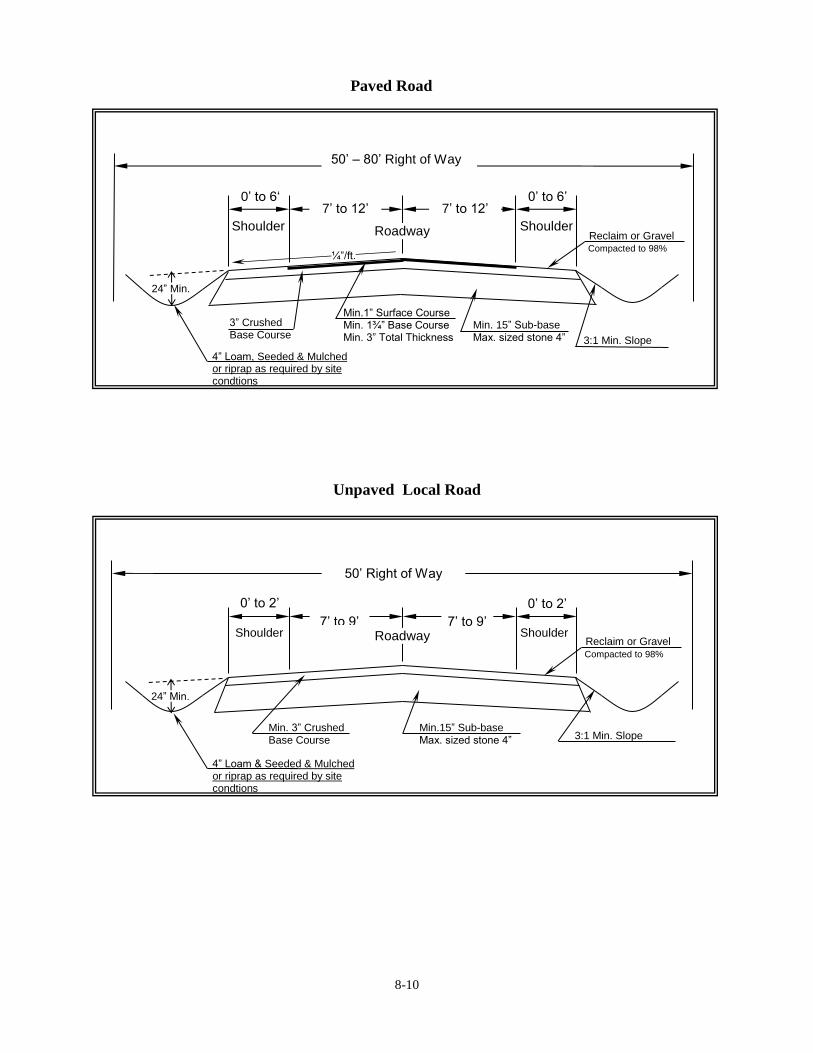
8-10
Paved Road
Unpaved Local Road
0’ to 6’ 0’ to 6‘ 7’ to 12’ 7’ to 12’
Min. 15” Sub-base Max. sized stone 4”
3” Crushed Base Course
Shoulder Shoulder Roadway
Min.1” Surface Course Min. 1¾” Base Course Min. 3” Total Thickness
4” Loam, Seeded & Mulched or riprap as required by site condtions
¼”/ft.
24” Min.
Reclaim or Gravel Compacted to 98%
3:1 Min. Slope
50’ – 80’ Right of Way
0’ to 2’
7’ to 9’ 7’ to 9’
Min.15” Sub-base Max. sized stone 4”
Min. 3” Crushed Base Course
Shoulder Shoulder Roadway
4” Loam & Seeded & Mulched or riprap as required by site condtions
3:1 Min. Slope
Reclaim or Gravel Compacted to 98%
24” Min.
50’ Right of Way
0’ to 2’

8-11
8.6.5 Road Drainage
A. Cross culverts shall have a minimum of two (2) feet of cover.
B. Sub-base shall be drained with ditches or underdrains.
C. The bottom of ditches shall be a minimum of two (2) feet below edge of shoulder.
8.6.6 Conservation Density Subdivision Traffic Pull-offs
For conservation density subdivisions using the 7’ travel lane standards from Section 8.5.4 Road
Standards Table, a determination will be made by the Code Enforcement Officer whether traffic
pull-offs are required based on site conditions. If pull-offs are deemed required, the Code
Enforcement Officer will determine pull-off locations based upon, road length, line of sight, and
other site constraints.
Conservation Density Subdivision Traffic Pull-off Plan View
8.7 Road Storm Water Management Design Standards
8.7.1 Adequate provision shall be made for the handling and treatment of all storm water generated
within the development, and any drained ground water, through a management system of swales,
culverts, underdrains, storm drains, and Best Management Practices. The storm water
management system shall be designed to conduct storm water flows to existing watercourses or
storm drains. The storm water management system shall be designed by a licensed professional
engineer.
A. Where a development is traversed by a stream, river, wetland, surface water drainageway, or
where the Code Enforcement Officer and/or the Planning Board determines that surface water
runoff to be created by the development should be controlled, there shall be provided
easements or drainage rights-of-way with swales, culverts, catch basins or other means of
8-12
channeling surface water within the development and over other properties.
B. Drainage easements for existing water courses or proposed drainage ways shall be provided at
least thirty feet wide, conforming substantially with the lines of existing natural drainage.
C. All components of the storm water management system shall be designed to limit peak
discharge to predevelopment levels for every storm between 2-year and 25-year, 24-hour
duration, frequencies, based on rainfall data for Gray, Maine. For example, rainfall data from
the website www.precip.net may be used.
D. The minimum pipe size for any storm drainage pipe shall be fifteen (15) inches. Maximum
trench width at the pipe crown shall be the outside diameter of the pipe plus two (2) feet. The
pipe shall be bedded in fine granular material, reaching a minimum of six inches below the
bottom of the pipe extending to six (6) inches above the top of the pipe.
8.7.2 The storm water management system shall be designed to accommodate upstream drainage, taking
into account existing conditions and approved or planned developments not yet built and shall
include a surplus design capacity factor of 25% for potential increases in upstream runoff.
8.7.3 Downstream drainage requirements shall be studied to determine the effect of the proposed
development. The storm drainage shall not overload existing or future planned storm drainage
systems downstream from the development. The developer shall be responsible for financing any
improvement to existing drainage systems required to handle the increased storm flows.
8.7.4 Catch basins shall be installed where necessary and located at the curb line.
8.7.5 Outlets shall be stabilized against soil erosion by stone riprap or other suitable materials to reduce
storm water velocity. Wherever the storm drainage system is not within the right-of-way of a
public road, perpetual easements shall be provided to the Town allowing maintenance and
improvements to the system.
8.7.6 Where soils require a subsurface system, the subsurface drainage system may be combined with
the storm water drainage system for temporary storage and treatment.
8.7.7 Where applicable, all structures and/or methods shall be designed in accordance with the Maine
Department of Environmental Protection Chapter 500 Stormwater Management Rules. The Code
Enforcement Officer and/or Planning Board may require review and endorsement of the
stormwater management plan by the Cumberland County Soil and Water Conservation District.
8.8 Storm Drainage Construction Standards
8.8.1 Materials
A. Reinforced Concrete Pipe. Reinforced Concrete Pipe shall meet the requirements of ASTM
Designation C-76 (AASHTO M 170). Pipe classes shall be required to meet the soil and
traffic loads with a safety factor of 1.2 on the .01 inch crack strength with a Class B bedding.
Joints shall be of the rubber gasket type meeting ASTM Designation C 443-70, or of an
approved preformed plastic jointing material such as “Ramnek”. Preformed Concrete Pipe
shall conform to the requirements of AASHTO M 175 for the appropriate diameters.

8-13
B. Corrugated Metal Pipe. Corrugated Metal Pipe shall be galvanized 14GA, M 196 for
aluminum alloy pipe for sectional dimensions and type of bituminous coating. Pipe gauge
shall be as required to meet the soil and traffic loads with a deflection of not more than 5%.
C. ABS Pipe. ABS (Acrylonitrile-Butadiene-Styrene) composite pipe and fittings shall conform
to the requirements of AASHTO M 264 and AASHTO M 265. Preformed pipe shall conform
to the requirements of AASHTO M 36, Type III.
D. Corrugated Plastic Pipe. Corrugated Plastic Pipe shall conform to the requirements of
AASHTO M-252.
E. Manholes. Manholes shall be of precast concrete truncated cone section construction meeting
the requirements of ASTM Designation C 478 or precast concrete manhole block construction
meeting the requirements of ASTM Designation C 139, radial type. Bases may be cast in
place 3,000 psi 28 day strength concrete or may be of precast concrete, placed on a compacted
foundation of uniform density. Metal frames and traps shall be set in a full mortar bed and
with tops that conform to the requirements of AASHTO M 103 for carbon steel casings,
AASHTO M 105, Class 30 for gray iron castings or AASHTO M 183 (ASTM A 283, Grade B
or better) for structural steel.
F. Catch Basins. Catch Basins shall be of precast concrete truncated cone section construction
meeting the requirements of ASTM Designation C 478 or precast concrete manhole block
construction meeting the requirements of ASTM Designation C 139, radial type. Castings
shall be square cast iron sized for the particular inlet condition with the gratings perpendicular
to the curb line. Bases may be cast in place 3,000 psi 28 day strength concrete or may be of
precast concrete, placed on a compacted foundation of uniform density. Metal frames and
traps shall be set in a full mortar bed and with tops shall conform to the requirements of
AASHTO M 103 for carbon steel castings, AASHTO M 105, Class 30 for gray iron castings
or AASHTO M 183 (ASTM A 283, Grade B or better) for structural steel.
8.9 Public Road Acceptance Procedure
The Town of New Gloucester provides no guarantee regarding the acceptance of any road.
A. Procedure:
1. Applicant must submit written request for acceptance of a road to be placed on a Town
Meeting warrant to the Town Manager to be placed on the next available Board of
Selectmen agenda.
2. Applicant appears before the Board of Selectmen to request acceptance of road be placed
on a Town Meeting warrant:
a. The Board of Selectmen agree to place the request on the up-coming Town Meeting
warrant; or
b. The Board of Selectmen deny placement of the request on the warrant.

8-14
3. If the Selectmen deny the request and the applicant completes the petition process in
accordance with Title 30-A MRSA 2522 then the request shall be placed on the Town
Meeting warrant.
B. Submission items for request:
1. “As built” plans depicting the roadway and all pertinent drainage systems.
2. Written certification signed by a licensed professional engineer registered in the State of
Maine at the expense of the applicant, certifying that the proposed road meets or exceeds
the design and construction requirements for public roads as approved by the Code
Enforcement Officer and/or the Planning Board and these regulations.
3. A draft deed of the right-of-way proposed to be adopted by the Town.
C. Acceptance Standards
1. Acceptance of roads shall be limited to the TDR Receiving Districts and/or shown on the
Town Road Plan.
2. Roads must be built and paved to Town standards and accommodate efficient maintenance
by existing Town vehicles.
3. The developer or contractor shall have conducted a thorough clean-up of stumps and other
debris from the entire road right-of-way.
9-1
ARTICLE 9
TRANSFER OF DEVELOPMENT RIGHTS
(Adopted December 14, 2004, Special Town Meeting / Effective February 12, 2005; Amended May 3,
2010, Town Meeting)
9.1 Purpose and Intent
9.1.1 Pursuant to Title 30-A, M.R.S.A. §4328, which allows local governments to establish Transfer of
Development Rights programs, this Article establishes a voluntary Transfer of Development
Rights program in the Town of New Gloucester. The purposes of this program are as follows:
A. To permanently preserve agriculture and forestry activities in the Town;
B. To permanently preserve large expanses of undeveloped land throughout the Town;
C. To direct growth and development into a designated growth area; and
D. To provide real incentives for landowners and developers to partner together to achieve these
purposes.
9.1.2 The Transfer of Development Rights program makes possible the following:
A. The development rights of an eligible sending site may be sold, donated, or otherwise
transferred to a property located in a designated “Receiving District”.
B. A “Sending District” may be designated in rural areas where there are agriculture and forestry
activities and large expanses of undeveloped land that could benefit from protection.
C. A “Receiving District” may be designated in growth areas where development is desirable,
feasible and marketable.
9.2 Establishment of Sending and Receiving Districts
The location of sending districts and receiving districts shall be shown on the official zoning map.
The sending and receiving districts shall act as overlay districts, such that all of the provisions of
the underlying zoning districts shall apply, unless altered by the provisions of the overlay district.
9.3 Sending District Regulations
9.3.1 Sending Site Eligibility, Within a Sending District: A property in a sending district shall meet the
following criteria in order to be eligible to sell transferable development rights:
A. Minimum acreage in common ownership:
1. Ten (10) acres; or
2. If the property is less than ten (10) acres, and the portion encumbered abuts an existing
parcel of permanently preserved land, then the minimum acreage shall be equivalent to that

9-2
required to create one transferable development right as calculated per Section 9.3.4 of this
ordinance.
B. Use of the land shall be one or a combination of the following:
1. Active agriculture or animal husbandry
2. Forestry
3. Undeveloped land suitable for development.
C. At least one (1) development right exists based on the net residential density for the property.
9.3.2 Sending Site Eligibility, Outside a Sending District: A property outside a sending district shall
meet the following criteria in order to be eligible to sell transferable development rights:
A. Minimum acreage in common ownership:
1. Ten (10) acres; or
2. If the property is less than ten (10) acres; and the portion encumbered abuts an existing
parcel of permanently preserved land, then the minimum acreage shall be equivalent to that
required to create one transferable development right as calculated per Section 9.3.4 of this
ordinance.
B. Principal use of the land shall be the following:
1. Active agriculture or animal husbandry, for a minimum of five (5) years immediately
preceding an application for transfer of development rights.
C. At least one (1) development right exists based on the net residential density for the property.
9.3.3 Development and Transfer Options. The landowner of an eligible sending site has the following
development and transfer options:
A. Option 1: A landowner may develop his or her property in compliance with all applicable
provisions of this Ordinance and other Federal, State or local regulations.
B. Option 2: A landowner may sell or transfer all or part of the transferable development rights
associated with the property to the landowner of a property located in a Receiving District, to a
developer, or to a third party.
1. If the landowner of the Sending Site intends to sell all the transferable development rights,
he or she shall retain the title to the property but shall be required to attach a deed
restriction or perpetual conservation easement to the title prohibiting future development,
including all residential, commercial, industrial, or public/institutional development.
2. If the landowner of the Sending Site intends to sell a portion of the transferable
development rights, he or she shall retain the title to the property but shall be required to
9-3
attach a deed restriction or perpetual conservation easement to the title prohibiting future
development, including all residential, commercial, industrial, or public/institutional
development, upon a portion of the parcel. The restricted portion shall be equivalent in
size to the land area that would have been necessary to accommodate the sold-off
transferable development rights. The remaining unrestricted portion of the parcel may still
be developed with the remaining development rights, or the remaining transferable
development rights may be sold in accordance with the provisions of this article.
9.3.4 Calculation of Transferable Development Rights
A. For all eligible sending sites, a net residential acreage calculation shall be required to
determine the acreage of developable area of the property. This acreage shall then be divided
by the applicable Transfer of Development Rights Density to determine the total number of
transferable development rights on the property. The Transfer of Development Rights Density
shall be determined as follows:
1. Where the underlying zoning density is 5 acres per residential unit, the Transfer of
Development Rights Density shall be 2 acres per transferable development right.
2. Where the underlying zoning density is 2 acres per residential unit, the Transfer of
Development Rights Density shall be 1 acre per transferable development right.
9.3.5 Deed Restriction or Conservation Easement Requirements
A. The deed restriction or perpetual conservation easement shall prohibit residential, industrial,
and commercial uses (except in connection with agriculture, forestry, and recreation) of the
portion of land from which development rights were severed, and shall not be amended to
permit such uses.
B. If a conservation easement is used the easement shall be granted to a qualifying government,
conservation or historic preservation organization, or other third party.
C. If the property is developed inconsistent with the provisions and restrictions of the deed
restriction or perpetual conservation easement it shall constitute a violation of this code and be
enforceable by the Town of New Gloucester.
9.4 Receiving District Regulations
9.4.1 Receiving Site Eligibility. A property in a receiving district shall meet the following criteria in
order to be eligible to receive transferable development rights:
A. Receiving District 1: Minimum acreage in common ownership: ten (10) acres.
B. Receiving District 2: No minimum acreage.
C. At least one (1) development right exists based on the net residential density for the property.
9.4.2 Development Options on Receiving Sites
The landowner or developer of a property located in a Receiving District shall have the following
development options:
9-4
A. Option 1: A landowner may develop his or her property in compliance with all applicable
provisions of this Ordinance and other Federal, State or local regulations.
B. Option 2: A person may purchase additional development rights from a Sending Site owner or
owner of transferable development rights and apply those transferable development rights to
the Receiving Site, through subdivision review pursuant to the New Gloucester Subdivision
Regulations.
1. For each additional transferable development right purchased, the Receiving Site person
shall be permitted to build one (1) additional housing unit.
2. However, in no case shall the resulting density of the property, after the addition of the
purchased transferable development rights, exceed twice the net residential density of the
property.
3. Development added to a property in a Receiving District through the purchase of
development rights shall be:
a. Consistent with the list of permitted uses in the underlying district; and
b. Compatible with the existing and/or proposed uses on the property.
4. Transfer of Development Rights shall not be used to increase the allowable density of any
existing or proposed mobile home parks.
5. The subdivision application shall indicate the Sending Site or individual from which
development rights were purchased or obtained.
9.5 Procedure
To facilitate the process the application for transfer of development rights may be initiated by the
seller, purchaser, or jointly by both parties.
A. A preapplication for transfer of development rights shall be submitted to the Code
Enforcement Officer and Planning Office (see Section 9.6.A of this ordinance for submission
requirements). During preapplication the Code Enforcement Officer and Town Planner may
ask questions, make specific suggestions, and schedule a site visit. The Code Enforcement
Officer may then provide an estimate of the provisional number of transferable development
rights.
B. Following preapplication, and in order to complete the sale of transferable development rights,
a complete application shall be submitted to the Code Enforcement Officer and Planning
Office (see Section 9.6.B of this ordinance for submission requirements).
C. Based on the submitted application the Code Enforcement Officer shall determine the number
of transferable development rights for the sending site, in accordance with Section 9.3.4 of this
ordinance.
D. After the Code Enforcement Officer, with consultation from the Town Attorney, if necessary,

9-5
has approved the application and the language of the deed restriction or perpetual conservation
easement, the sending site property owner shall file the deed restriction or conservation
easement along with the boundary survey depicting the acreage covered by the deed restriction
or perpetual easement in the Cumberland County Registry of Deeds.
E. After receipt of evidence of the filing of the deed restriction or perpetual conservation
easement in the Registry of Deeds, the Code Enforcement Officer shall issue a Transfer of
Development Rights Certificate in the name of the landowner or person for the number of
transferable development rights severed from the sending site. The landowner or person is
then able to sell, donate or otherwise transfer all or a portion of the transferable development
rights to a landowner in a Receiving Zone, to a developer, or to a third party. Upon evidence
of a sale of transferable development rights, the Code Enforcement Officer shall issue a new
TDR Certificate in the name of the purchaser for the number of transferable development
rights purchased.
F. An application for transfer of development rights may be submitted to the Code Enforcement
Officer and Planning Office in conjunction with an application for subdivision review.
G. All developments utilizing transferable development rights, regardless of the number of lots,
must submit for subdivision review and comply with the Town of New Gloucester Subdivision
Regulations.
H. Any development utilizing transferable development rights containing four lots or dwelling
units or less shall comply with the regulations for Minor Subdivision Review contained in the
New Gloucester Subdivision Regulations.
I. A developer may redeem the density bonus awarded through the application of transferable
development rights when a subdivision plan for an eligible receiving site has been approved by
the Planning Board with the added development from the transferable development rights
applied to the plan.
9.6 Submission Requirements
The following requirements apply to the sending site. Applicants shall submit the following items
to the Code Enforcement Officer and the Planning Office:
A. Preapplication Submission Requirements
1. An application for transfer of development rights.
2. Sketch of sending site and area proposed for transfer of development rights.
3. Documentation of the applicant’s legal interest in the property.
B. Application Submission Requirements
A complete application for review shall consist of the following items, and be accompanied by
a fee established by the Board of Selectmen. In addition, the Town may collect fees for
outside consulting opinions for legal or technical assistance needed for proper consideration of
9-6
the application. Such fees shall be administered according to provisions outlined in Section
7.6 of the New Gloucester Zoning Ordinance.
Plans shall be on sheets no smaller than 11” by 17” and no larger than 24” by 36”. Plans shall
be drawn to a scale no greater than 1” = 100’ for properties under one hundred (100) acres and
1” = 200’ for all others.
1. Each plan sheet in the application shall include a title block located in the lower right hand
corner containing:
a. the name and address of the property owner of the Sending Site;
b. the name and address of the preparer of the plan, with professional seal if
applicable;
c. location of the property according to municipal tax maps; and
d. the date of plan preparation or revision;
2. A boundary survey conducted by a surveyor licensed in the State of Maine, with sufficient
information delineating all features which determine net residential acreage, and the
location of the proposed deed restriction or conservation easement;
3. A plot plan drawn to scale indicating:
a. boundary lines and dimensions
b. acreage of:
1. the total parcel
2. the land subject to the transfer of development rights
3. existing developed areas
4. wetlands and other areas defined as unsuitable for development;
c. zoning district(s) and respective density;
d. agricultural areas, forested areas, waterbodies, and wetlands;
e. 100-year floodplains;
f. zoning district boundaries;
g. an arrow showing true north and the magnetic declination; and
h. a graphic scale;
4. Aerial photo(s) of the site;
5. A location map showing the property in relation to other properties and roads in the
general vicinity;
6. A net residential acreage calculation of the sending site, in accordance with the definition
of net residential acreage in Article 9.3.4 of this ordinance. The land features determining
net residential acreage shall be shown on the above mentioned plot plan;
7. Documentation of a title search on the property, to ensure clear title and marketability of
the property;
8. A draft deed restriction or perpetual conservation easement covering the portion of land
proportionate to the number of transferable development rights being severed from the land
and available for transfer;
9-7
9.7 Approval Criteria
A. No transfer of development rights shall be approved by the Code Enforcement Officer as long
as the sending property is in violation of the provisions of this ordinance or any other Town or
State land use statute, regulation, or permit.
B. Upon finding of fact and determination that all standards and this ordinance have been met,
and upon approving the transfer of development rights, the Code Enforcement Officer shall
issue a Transfer of Development Rights Certificate in the name of the landowner, his
successor, or assigns for the number of transferable development rights severed from the
sending site. The Code Enforcement Officer shall specify in writing her/his findings of facts
and any reasons for denial.
C. No changes, erasures, modifications, or revisions shall be made to any final transfer of
development rights plan after approval has been granted by the Code Enforcement Officer,
unless the revised final plan is first submitted and the Code Enforcement Officer approves any
modification.
D. The approval by the Code Enforcement Officer of a transfer of development right shall not be
deemed to constitute or be evidence of any acceptance by the municipality of any land shown
on such plan. When land has been shown on the plan to be dedicated to the municipality,
approval of the plan shall not constitute an acceptance by the municipality of such areas. The
Code Enforcement Officer shall require the plan to contain appropriate notes to this effect.
The Code Enforcement Officer may also require the filing of a written agreement between the
applicant and the Municipal Officers covering future deed and title, dedication, and provision
for the cost of maintenance of any such dedicated area. All land accepted by the municipality
must be done through a vote of the Town body at Town meeting.
9.8 Administration
A. All instruments implementing the transfer of development rights shall be recorded in the Town
Clerk's Office for both Sending Sites and Receiving Sites. The instrument evidencing such
transfers shall specify the map and lot numbers of the sites.