town of poncha springs - gigshowcase.com · town of poncha springs ... the land use code, ... or...
TRANSCRIPT

Town of Poncha SPringS
comPrehenSive Plan
Prepared By:
Western Slope Consulting LLCPh: [email protected]
Po
nc
ha S
Pr
ing
S, co
lor
ad
o
Adopted: November 7, 2011
Sopris Land Use [email protected]

Town of Poncha Springs
Acknowledgmentsa
ck
no
wle
dg
em
en
TS
Board of Trustees
Mark Thonhoff, MayorAaron Kroschel, Mayor Pro-Tem
Rick Roberts, TrusteeGalen Angelo, Trustee
Darrell Donahoo, TrusteeRon Slaughter, TrusteeBret Collyer, Trustee
Town AdministratorJerry L’Estrange
StaffDee Miller, Director of PlanningDiana Heeney, CMC/Treasurer
Greg Smith, Director of Public WorksWendel Stephen, Public Works CrewBrian Martinez, Public Works Crew
Brad Redmiles, Town Attorney
Planning & Zoning Commission
Ken MacNicolBen ScangaSteve Rust
Mark ThonhoffGalen AngeloBret Collyer
Becky Massey, Alternate
The Poncha Springs comprehensive plan update would not have been possible without the countless hours generously donated by members of the community, Poncha Springs’ Board of Trust-ees, Planning & Zoning Commission, Staff members and other participants. The following partici-pants are individually recognized for their participation in this planning process:
i
Neva BrekkeJody WestLarry West
Everet HawksKaryn HawksK.W. KirchnerCarol WilsonChuck Wilson
Kirk & Mary DonovanLillian BenderKate Kroschel
Mariah KroschelBob MacNicolEdna MacNicolDonna Angelo
Galen AngeloShelby RobertsCarol Novak
Wendell HutchisonTom Bell
Leonard VineyardCailey McDermott
Rich TylerJoe Stone
Nopavan KalivodaKelly LandauDave Ward
Michael IngramPat Raftery
Sara Cothren McCleary
Bob MishataJ.D. Longwell
Dana NachtriebKristi JeffersonFrank Holman
Jerry MillerRick Routh
Michael YermanJan Lindsay
Don ReimerGenie FarrowDale AntonSusan AntonTom Massey
Meeting Participants
Additional Contributors
James Wingert, Chaffee County Fire Dept.Laura Smith, Chaffee County EMS
Pete Palmer, Chaffee County Sheriff ’s Dept.Sandy Gardunio, Salida School District
Robert Vance, Salida’s Director of Public Works

ad
oP
Tio
n re
Solu
Tio
n
ii
Town of Poncha Springs
Adoption Resolution

Town of Poncha Springs
Adoption Resolution
iii
ad
oP
Tio
n re
Solu
Tio
n

Town of Poncha Springs
Ratification Resolution
iv
ra
Tific
aT
ion r
eSo
luT
ion

Town of Poncha Springs
Table of Contents
Acknowledgments........................................................................................
Adoption & Ratification Resolutions.........................................................
Introduction..................................................................................................
How to Use the Plan...................................................................................
Community Vision & Guiding Principles...................................................
Community Trends......................................................................................
Future Land Use Map.................................................................................Future Land Use Classifications
Goals & Policies............................................................................................Land Use & GrowthEconomic DevelopmentHousingEnvironmentCommunity Services & InfrastructureParks, Open Space & TrailsTransportationCommunity GatewaysIntergovernmental Coordination
Implementation Plan..................................................................................
Update & Amendment Process..................................................................
Community Snapshot..................................................................................Brief HistoryDemographicsEconomyHousingLand UseInfrastructureCommunity ServicesParks, Open Space & TrailsEnvironment
Public Involvement.......................................................................................
Appendix A..................................................................................................
i
ii
1
4
6
7
910
12121618192325283031
32
42
45454648495055626467
76
78v
Ta
ble o
f co
nT
en
TS

Town of Poncha Springs
Introduction
Purpose of the Plan
The Poncha Springs Comprehensive Plan establishes a framework for physical, social and economic development in Poncha Springs, over the next 20-30 years. The document is comprehensive in that it addresses; land use, economic development, housing, the environment, community services, infrastructure, parks, open space, trails, transportation, community gateways and intergovernmental agreements in a coordinated fashion. The Plan establishes the community’s shared vision for the future and provides a set of goals, policies and implementation actions that the Town will use to achieve that vision. If followed diligently, the Comprehensive Plan will have a long lasting and posi-tive impact on the Town and its community.
The Poncha Springs Comprehensive Plan is an official document that serves as the foundation for other actions and regulations in town such as; Zoning, the Land Use Code, Subdivision Codes as well as Capital Improvement Plans. An important facet of this Plan is the Future Land Use map. The Future Land Use map, used in conjunction with the accompanying guiding principles, goals and policies of this Plan, help to direct decision-making on land use proposals and future growth in and around Poncha Springs.
inT
ro
du
cT
ion
1
Comprehensive Plan
Zoning
LandUse Code
Capital Improvements Plan
3-Mile Plan(Annexation Plan)
Figure 1: This diagram depicts the various planning documents that are derived from a Compre-hensive Plan.
Why Update the Plan?
The Poncha Springs Comprehensive Plan is an update to the Town’s 1998 Compre-hensive Plan. While many of the goals and policies from the 1998 Plan still remain valid, changes in the community over the past 13 years require an update. The Poncha Springs Comprehensive Plan addresses properties within the current municipal limits as well as lands outside town but that are within the Municipal Planning Area. The Municipal Planning Area includes properties that may be developed and annexed into the Town in the future, or that will influence Poncha Springs as it grows. The Municipal Planning Area boundary was established with the adoption of the Town’s Three Mile Plan (Feb. 2011). The purpose of including properties both in and adjacent to Town is to establish a plan for future municipal growth and coordinated growth with Chaffee County.
Source: Town of Poncha Springs

Town of Poncha Springs
Introductionin
Tr
od
uc
Tio
n
2
Legislative Basis for the Plan
In Colorado, municipalities are given the authority to develop and adopt a Comprehensive Plan under Colorado Revised Statute (C.R.S.) §31-23-206. C.R.S. §31-23-206 states, “It is the duty of the [planning] commission to make and adopt a master plan for the physical development of the munici-pality, including any areas outside its boundaries, subject to the approval of the governmental body having jurisdiction thereof, which in the commission’s judgment bear relation to the planning of such municipality.”
C.R.S. §31-23-207 specifies that a Comprehensive Plan must, “…be made with the general purpose of guiding and accomplishing a coordinated, adjusted, and harmonious development of the munici-pality and its environs which will, in accordance with present and future needs, best promote health, safety, order, convenience, prosperity, and general welfare, as well as efficiency and economy in the process of development, including, among other things, adequate provision for traffic, the promotion of safety from fire, flood waters, and other dangers, adequate provision for light and air, distribu-tion of population, affordable housing, the promotion of good civic design and arrangement, efficient expenditure of public funds, the promotion of energy conservation, and the adequate provision of public utilities and other public requirements.”
Structure of the Plan
Introduction- offers a brief description of the Plan, explains why an update to the current com-prehensive plan is needed and provides information on the legislative basis for comprehensive plan-ning in Colorado.
How To Use the Plan- outlines how different members of the community (i.e. residents, business owners, developers/landowners, Town Staff, Planning Commission and the Board of Trustees) will make use of the Plan.
Community Vision & Guiding Principles- describes the ideal scenario for Poncha Springs 20-30 years in the future and presents core values of the community in the form of “Guiding Prin-ciples,” which serve as the foundation for the Goals and Policies of the Plan.
Community Trends- provides statistical information regarding historical and projected trends in the community.
Future Land Use Map- illustrates the desired land use patterns in the community over the next 20-30 years.
Goals & Policies- offer a path to achieve the community vision and to help guide future growth and land-use decisions.
Implementation Plan- lists specific actions to be used to accomplish the Goals and Policies of the Plan.

Town of Poncha Springs
Introductionin
Tr
od
uc
Tio
n
3
Structure of the Plan (continued)
Update and Amendment Process- describes the steps necessary in order to keep the Plan cur-rent and how to go about making any necessary changes to the Plan.
Community Snapshot- provides an inventory of the most current information about Poncha Springs and serves as background information that is important to the Plan.
Public Involvement- describes the process used to obtain community input for the Plan.
Appendix A- includes the Poncha Springs Community Survey final results.

Town of Poncha Springs
How to Use the Planh
ow
To u
Se Th
e Pla
n
4
How to Use the Plan
The Poncha Springs Comprehensive Plan is a compilation of existing community data and input, gathered from a variety of sources. The plan sets a path for community development in the form of a vision, guiding principles, goals, policies and implementation actions. The plan should serve as a guide for residents, business owners, developers/landowners, Town Staff, Planning Commission, the Board of Trustees and other government agencies for decisions related to land use, utilities, facilities, services and other initiatives in Poncha Springs.
Residents & Business Owners
Use the plan to understand how the Town will guide development, encourage economic growth, maintain adequate services and support a healthy environment.
• Refer to the Plan’s goals, policies and implementation actions to identify the strategies that the Town will employ to achieve the community’s desired future.
• The Future Land Use Map should be used to understand the desired land use patterns (e.g. general location of residential, commercial, mixed-use and light industrial) within the Town limits and the Municipal Planning Area.
Town Staff, Planning Commission & the Board of Trustees
The long-term implementation of the Poncha Springs Comprehensive Plan requires a commitment by the Town Staff, Planning Commission and the Board of Trustees to use it to guide community development decisions. The Planning Commission should review the Plan regularly (preferably on an annual basis) to gauge the community’s progress in achieving its vision. The Plan should also be used to:
• Encourage development that is consistent with the Future Land Use Map, the community’s vi-sion and the Plan’s Goals and Policies.
• Ensure that all development applications generally comply with the Comprehensive Plan.
• Provide a benchmark and allow the Town to gauge its progress and change over time.
• Coordinate with residents and businesses owners in joint community goal setting and action plans.
• Guide annual work programs and budgets and provide a basis for grant applications.
• Guide creation of new and revised codes and ordinances, in town.
• Help the Town plan for long-term initiatives and capital improvement projects.
• Provide a basis for intergovernmental agreements with Chaffee County, City of Salida and other governmental agencies.

Town of Poncha Springs
How to Use the Planh
ow
To u
Se Th
e Pla
n
5
Developers/Landowners
Utilize the Comprehensive Plan to demonstrate how development proposals conform to the com-munity’s vision and core values.
• Use the Future Land Use Map to locate property and determine if a proposed project com-plies with the future land use designation.
• Become familiar with the community vision, guiding principles, goals and policies.
• Applicants should meet with Town Staff to discuss how the development concept can best conform to the Comprehensive Plan and other relevant Town plans.
• Document, in an application submittal, how the project substantially complies with the Com-prehensive Plan.

Town of Poncha Springs
Community Vision & Guiding Principles
Guiding Principles
The major elements of the Poncha Springs Comprehensive Plan are expressed as Guiding Principles. The Guiding Principles are based on core community values that were derived from the public input process (e.g. community survey and public meetings). The following Guiding Principles serve to sup-port the Community Vision and provide a framework for the Goals & Policies of this plan.
Community
• Embrace small town character• Functional; Poncha Springs operates in an organized, orderly and efficient manner• Offer easy access to local government
Economy
• Facilitate locally owned/operated businesses and the creation of new jobs to achieve a vibrant economy
• Work to promote small business prosperity• Welcome and encourage new locally, sensitive businesses• Strive to achieve a balanced mix of land uses that support jobs, goods and services in a sustain-
able economic environment
Natural Environment
• Value and preserve a healthy environment and scenic vistas• Maintain clean water and air• Support local wildlife• Support a healthy river and river corridor
Land Use & Growth
• Maintain an open mind and flexibility with regard to new development/growth• Work to manage growth responsibly and to maintain adequate service levels• Respect private property rights• Support voluntary efforts to preserve the agricultural character surrounding town• Create community gateways to welcome visitors, present a positive first impression and convey
community identity• Promote a pedestrian/bicycle friendly town with good access to parks/open space• Encourage intergovernmental cooperation to ensure compatible, coordinated development
outside of town
Poncha Springs’ Community Vision
A small, safe, family and business friendly community;offering an ideal place for home, work and recreation.
co
mm
un
iTy v
iSion &
gu
idin
g Pr
inc
iPle
S
6

Town of Poncha Springs
Community Trendsc
om
mu
niT
y Tr
en
dS
7
0
5,000
10,000
15,000
20,000
25,000
30,000
35,000
2010
2012
2014
2016
2018
2020
2022
2024
2026
2028
2030
2032
2034
2036
2038
2040P
opul
atio
n E
stim
ates
Chaffee County Population Projections
Poncha Springs has had an average rate of change of 4.84% over the past decade (2000-2010). If this trend were to continue, the Town could expect a population of roughly 3,000 by 2040. It is unlikely that Poncha Springs will experience a steady rate of change over the next 30 years. There-fore, higher and lower (1.5%, 3% and 5%) rates of change have been provided to depict how differ-ent rates could influence the Town’s population by the year 2040.
The Colorado Department of Local Affairs projects Chaffee County to reach a population of roughly 30,000 by 2040. This would mean the addition of roughly 13,000 residents to the County. Population growth in Chaffee County should be taken in to account when planning for the Town’s future as growth in the County will certainly impact Poncha Springs.
0
500
1,000
1,500
2,000
2,500
3,000
3,500
200020022004200620082010201220142016201820202022202420262028203020322034203620382040
Pop
ulat
ion
Poncha Springs Population Projections
1.50%
3.00%
5.00%
Actual Pop.('00-'10)
Rate of Change
Source: Colorado Dept. of Local Affairs

Tax Revenue
Poncha Springs pays for infrastructure and community services from its general fund. Revenues for the general fund are derived primarily from sales and proper-ty tax, however some additional revenue is provided by other sources.
Sales Tax
The current sales tax in Poncha Springs is 2.0%, In 2000, sales tax revenues ac-counted for roughly 67% of the Town’s total revenue. In 2010, this percentage had increased to 70%.
Property Tax
The Town currently assesses property tax at 2.271 mils. In 2000, property tax accounted for 4% of the Town’s total revenue. In 2010, this amount had nearly doubled as property tax accounted for 8% of the Town’s total revenue.
*Tax revenues are shown on a per capita basis, to more accurately reflect changes in revenues, inde-pendent of population change.
Town of Poncha Springs
Community Trends
8
co
mm
un
iTy T
re
nd
S
$0.00
$100,000.00
$200,000.00
$300,000.00
$400,000.00
$500,000.00
$600,000.00
2000
2001
2002
2003
2004
2005
2006
2007
2008
2009
2010
Revenue vs. Expenditures
Total Revenue
Total OperatingExpenditures
$0.00
$10.00
$20.00
$30.00
$40.00
$50.00
$60.00
2000
2001
2002
2003
2004
2005
2006
2007
2008
2009
2010
Property Tax (per capita)
$0.00
$100.00
$200.00
$300.00
$400.00
$500.00
$600.00
2000
2001
2002
2003
2004
2005
2006
2007
2008
2009
2010Sales Tax (per capita)
By keeping expenditures below revenues, the Town has maintained a healthy financial condition over the past ten years.
Source: Town of Poncha Springs
Source: Town of Poncha Springs
Source: Town of Poncha Springs

Fu
tu
re L
an
d use M
ap
9
Town of Poncha Springs
Future Land Use Map

Town of Poncha Springs
Future Land Use Classificationsf
uT
ur
e la
nd u
Se cla
SSifica
Tio
nS
10
Land Use Type Density Description Location
Agricultural / Rural Residential
1 DU / 2 or more Acres
Agricultural purposes, including farming, dairying, pasturage, hor-ticulture, floriculture, viticulture, and animal and poultry husbandry and accessory uses, including farmstead or rural residence.
Working ranches/farms, ranch-ettes or single family dwellings on lots > 2 Acres. Should not receive municipal services.
Agricultural / Rural residential uses should generally be located outside of the town limits.
May provide a transition between more urbanized, denser develop-ment and rural, open and agricul-tural land uses. Can also serve as a buffer between municipalities.
Residential-Low Density
More than 1 DU / Acre and less than or equal to 5
DU / Acre
Intended primarily for single-fam-ily dwellings on large lots (up to 1 acre). May include limited num-bers of livestock, poultry, etc.
Cluster development should be considered in areas neighbor-ing or adjoining agricultural uses, conservation easements or open space.
Low density residential should generally be located on the pe-riphery of Town.
Low density uses may serve as a transition between rural areas and medium density neighborhoods.
Residential-Medium Density
More than 5 DU / Acre and less than
or equal to 12 DU /
Acre
Single family dwellings on smaller lots. Other dwelling types may include duplexes, triplexes, apart-ments and townhomes.
Generally located near the core of Town. Medium density residen-tial should not be located in the outer regions of Town.
Residential-High Density
More than 12 DU /
Acre
Provides for a mix of primarily multi-family dwellings as well as some small lot, single-family dwell-ings.
High density residential should be located in the core of Town. It may be appropriate to intermix high density uses with medium density uses.
Mixed Use
More than 5 DU / Acre and less than
or equal to 12 DU /
Acre
Mix of residential, light industrial, commercial, office or institutional uses.
Generally located on the pe-riphery of commercial or light industrial areas. May serve as a transition between commercial or light industrial areas and residen-tial areas. Or may serve as stand alone areas that include a variety of compatible uses.
DU = Dwelling UnitsSF = Square Feet1 Acre = 43,560 SF

Land Use Type Density Description Location
CommercialNA
Permits a wide range of com-mercial development (e.g., office, retail, service), with most opera-tions and storage being contained within the primary buildings.
Generally located adjacent to arterial roads and concentrated around intersections. Strip com-mercial along roadways should be discouraged.
Light IndustrialNA
Light manufacturing uses, office park, and limited retail/service uses that serve the industrial use.
Should include proper screening and buffering, and be compatible with adjoining uses.
Light industrial uses should gen-erally be located along County Rd. 120 corridor and within the Industrial Park.
Light industrial areas should have easy access to major arterials and highways capable of handling heavy truck traffic.
Open Space & Parks NA
Public or private land uses that encourage passive or active out-door recreation.
May also include sensitive envi-ronmental areas, river corridors, important wildlife habitat and similar locations.
Small parks should typically be bounded by local streets and within walking and bicycling dis-tance of most park users. Users should not have to cross a major arterial to access the park.
Larger parks should be easily accessed from major streets to serve several neighborhoods. Homes and businesses should surround and face parks to pro-vide casual surveillance.
Public NA
Public, quasi-public, and institu-tional uses that deliver local, state, or national governmental or non-profit services.
Generally public facilities (other than light industrial-type uses such as Town, County or CDOT service buildings) should be located in central locations and compatible with adjacent uses.
Utilities NA
Public or private land occupied by a substation, electric transmis-sion line, oil or gas pipeline, water tower, municipal well, pumping station, water treatment facility, communications tower, or similar use.
ViewshedProtection Area NA
Intended to identify locations that may be adversely impacted by large structures, substantial cut/fill, radio/cellular transmission facili-ties (antennas), water towers and other visually intrusive facilities.
*See Future Land Use Map
DU = Dwelling UnitsSF = Square Feet1 Acre = 43,560 SF
Town of Poncha Springs
Future Land Use Classificationsf
uT
ur
e la
nd u
Se cla
SSifica
Tio
nS
11

Town of Poncha Springs
Goals & Policies - Land Use & Growth
Guiding Principles
• Embrace small town character• Functional; Poncha Springs operates in an organized, orderly and efficient manner• Offer easy access to local government• Maintain an open mind and flexibility with regard to new development/growth• Work to manage growth responsibly and to maintain adequate service levels• Respect private property rights• Support voluntary efforts to preserve the agricultural character surrounding town• Promote a pedestrian/bicycle friendly town with good access to parks/open space• Encourage intergovernmental cooperation to ensure compatible, coordinated development
outside of town
Goal LU&G-1: Ensure that new development in Poncha Springs conforms to the guid-ing principles, goals and policies of the Town’s Comprehensive Plan.
Policy LU&G-1.1: Ensure substantial conformity with the Comprehensive Plan in all new devel-opment.
Policy LU&G-1.2: Support changes to non-compliant land use applications so they are modified to conform, substantially, to the Comprehensive Plan or recommend project denial.
Goal LU&G-2: Use the Future Land Use Map and Classifications in conjunction with the goals and policies, of this Plan, to uphold core community values and achieve a healthy balance of land-uses in Poncha Springs.
Policy LU&G-2.1: The Future Land Use Map establishes a land use pattern that accommodates future commercial, light industrial, mixed-use and residential growth. The Future Land Use Map provides flexibility for new development, considering market conditions; however the integrity of the Future Land Use classifications, on the map, shall be maintained to ensure a mix and sus-tainable balance of use types.
Policy LU&G-2.2: Use the Future Land Use Classifications to help determine if proposed land uses, which differ from the Future Land Use Map, are appropriate.
Policy LU&G-2.3: Protect the character of existing neighborhoods from incompatible land uses.
go
alS &
Po
licie
S - la
nd u
Se & g
ro
wT
h
12
Goals & Policies Goals: describe broad public purposes toward which policies and implementation actions are di-rected. Goals express the broad desired results of the plan.
Policies: more specific and are intended to carry out goals. Policies are intended to bring predictabil-ity to the decision-making process. Unless there are extenuating circumstances, policies should be looked to for guidance about how decisions will be made.

Town of Poncha Springs
Goals & Policies - Land Use & Growthg
oa
lS & P
olic
ieS - l
an
d uSe &
gr
ow
Th
13
Goal LU&G-3: Growth in Poncha Springs will remain within the established Municipal Planning Area (MPA).
Policy LU&G-3.1: The outer-edge of the MPA defines the long-term limits of municipal growth. In general, high intensity land uses shall be concentrated in the core of the Town and areas closer to the MPA will accommodate lower intensity uses.
Policy LU&G-3.2: Ensure that any new annexation is located within the MPA, is at least one-sixth contiguous to the municipal boundary and complies with the goals and policies of this plan.
Policy LU&G-3.3: Develop and maintain techniques (e.g. annexation analysis report) that enable the Town to properly evaluate new annexations. The Town will require that new annexations provide information regarding:
• Impacts on community services, infrastructure and land uses• Improvements to be made to mitigate any adverse impacts• Financial implications of the new annexation on the Town’s budget
Policy LU&G-3.4: Work with Chaffee County to ensure that the County Future Land Use map is consistent with the Poncha Springs’ Future Land Use map.
Goal LU&G-4: Work to preserve Poncha Springs’ small-town character by maintaining a physically, compact community.
Policy LU&G-4.1: Encourage and support the development of vacant land within the Town (infill), in order to promote a secure tax base and a compact community.
Policy LU&G-4.2: Urban development along US 50 and US 285, outside of the Municipal Planning Area is not to be encouraged.
Policy LU&G 4.2: Strive for roughly 75% infill of vacant properties, within the existing municipal limits, prior to new annexations.
Policy LU&G-4.3: Support the integration of commercial and light industrial development with residential development to facilitate a mix of uses, reduce the need for town expansion, provide economic stability and local job creation, as well as providing for improved pedestrian/bicycle access.
Policy LU&G-4.4: Preserve the rural entrances into town by limiting the expansion of strip com-mercial development along US 50 and US 285. Commercial development will be concentrated into areas identified on the Future Land Use map.
Policy LU&G-4.5: Encourage agricultural and rural land uses south of the South Arkansas River.
Policy LU&G-4.6: Encourage the voluntary preservation of agricultural and rural lands around the community to help maintain a distinct boundary between urban and non-urban areas. Preserva-tion efforts will also serve to maintain a sense of separation between Poncha Springs and Salida.

Town of Poncha Springs
Goals & Policies - Land Use & Growthg
oa
lS & P
olic
ieS - l
an
d uSe &
gr
ow
Th
14
Goal LU&G-5: Poncha Springs supports the 10 principles of Smart Growth. These principles provide a framework within which communities can make informed deci-sions about better ways to grow, create jobs, support economic development, enhance neighborhoods, provide housing, support transit options and achieve a variety of other long-term community benefits.
Policy LU&G-5.1: The following 10 principles of Smart Growth should be used to guide the pub-lic, developers and local decision-makers to evaluate new development with a goal of achieving most or all of the principles in a development proposal.
1. Compact Building Design2. Create Range of Housing Opportunities and Choices3. Create Walkable Neighborhoods4. Encourage Community and Stakeholder Collaboration5. Foster Distinctive, Attractive Communities with a Strong Sense of Place6. Make Development Decisions Predictable, Fair and Cost-Effective7. Mix Land Uses8. Preserve Open Space, Farmland, Natural Beauty and Critical Environmental Areas9. Provide a Variety of Transportation Choices10. Strengthen and Direct Development towards Existing Communities
Goal LU&G-6: Support opportunities for community input and respect the rights of private landowners through an open and inclusive public decision-making process.
Policy LU&G-6.1: Ensure that the community is made aware of the Town’s priorities, issues and actions.
Policy LU&G-6.2: Encourage citizen participation in civic activities, long range planning and volun-teer opportunities.
Policy LU&G-6.3: Encourage youth participation in civic affairs by:
• Supporting youth participation in identifying needs, opportunities and priorities for youth in Poncha Springs
• Encouraging youth engagement in boards, commissions and committees• Encouraging youth to participate in public service and volunteer work
Policy LU&G-6.4: Support local media coverage of all significant Town activities and decisions.
Policy LU&G-6.5: Encourage participation from a broad cross-section of the population in elect-ed and appointed boards, committees and commissions.
Policy LU&G-6.6: Ensure that the land use application process is clear, predictable and efficient.

Goal LU&G-7: Poncha Springs will work to manage growth responsibly and maintain adequate service levels by coordinating the location and intensity of growth with the Town’s capacity to provide adequate public services.
Policy LU&G-7.1: Ensure that new development occurs in areas where adequate public facilities are currently in place or in locations that will provide needed connections between existing facilities.
Policy LU&G-7.2: Discourage development that is not adjacent to existing public facilities (i.e. “leap-frog” development) unless the Town finds that there would be substantial public benefit from the development.
Policy LU&G-7.3: Provisions are to be made that ensure adequate public facilities are in place prior to the approval of new development so that existing levels of service will not be dimin-ished by new demand.
Policy LU&G-7.4: Annexation or approval of a pre-annexation agreement shall be required prior to the provision, extension and/or connection to public facilities.
Goal LU&G-8: The Town will encourage the preservation and renovation of historic structures.
Policy LU&G-8.1: Support opportunities to inventory buildings, districts and sites of historical, architectural, archaeological or cultural significance that should be protected.
Policy LU&G-8.2: Preservation and rehabilitation of such buildings, districts and sites by the pri-vate sector shall be encouraged by the Town.
Policy LU&G-8.3: Ensure adequate notification prior to the alteration or demolition of any his-torical building, district or site identified by the Town.
Town of Poncha Springs
Goals & Policies - Land Use & Growthg
oa
lS & P
olic
ieS - l
an
d uSe &
gr
ow
Th
15
Relevant Town Documents:
1. Poncha Springs Zoning Map2. Friend Ranch Zoning Map3. Poncha Springs 3 Mile Plan (adopted 2-14-11)

Town of Poncha Springs
Goals & Policies - Economic Developmentg
oa
lS & P
olic
ieS - e
co
no
mic d
ev
elo
Pm
en
T
16
Guiding Principles
• Facilitate locally owned/operated businesses and the creation of new jobs to achieve a vi-brant economy
• Work to promote small business prosperity• Welcome and encourage new locally, sensitive businesses• Strive to achieve a balanced mix of land uses that support jobs, goods and services in a sus-
tainable economic environment
Goal ED-1: Support the development and retention of a balanced mix of locally owned/operated commercial and light industrial enterprises in Poncha Springs.
Policy ED-1.1: Support a business-friendly community.
Policy ED-1.2: Make certain that the Town has a long-term plan for economic development.
Policy ED-1.3: Work to support local businesses. Policy ED-1.4: Ensure that commercial and light industrial development is compatible with the Town’s desired image.
Policy ED-1.5: Provide a predictable and transparent permitting process for commercial and light industrial development/redevelopment.
Policy Ed-1.6: The Future Land Use Map identifies locations appropriate for commercial and light industrial land uses. Encourage the coordinated development of business/industrial parks in these areas to promote attractive design, lower improvement costs and provide adequate public facilities.
Policy ED-1.7: Require that measures be taken to mitigate light industrial impacts on residential, mixed-use and commercial areas.
Policy ED-1.8: Land use policies and regulations will support home occupations for the purposes of promoting entrepreneurship, growth and employment.
Policy ED-1.9: Encourage the installation of high-speed telecommunications, fiber optics and other state-of-the-art communications technologies as part of new development.
Goal ED-2: Establish Poncha Springs as a tourist destination by promoting the Town’s unique retailers, history and recreational opportunities.
Policy ED-2.1: Support and encourage the development and promotion of cultural heritage tour-ism related to Poncha Springs’ historic buildings and sites (e.g. Jackson Hotel, Town Hall, Stage Coach Stop, etc.).

Policy ED-2.2: Support and encourage the devel-opment and promotion of recreationally-based tourism related to the Town’s unique recre-ational resources (e.g., Monarch Pass ski area, Monarch Crest bike trail, Collegiate Peaks, South Arkansas River, etc.).
Policy ED-2.3 Encourage the use of federal and state incentive programs or other tools to finance public improvement to benefit tourism and/or business development.
Policy ED-2.4: Work with the City of Salida and other agencies to explore development options for the Poncha Springs Hot Springs.
Policy ED-2.5: Support and encourage efforts to develop and promote Poncha Springs as a desti-nation for business conventions.
Policy ED-2.6: Utilize way-finding techniques incorporating information, thematic signage and other techniques to direct residents and visitor to key destinations and local businesses in Town.
Goal ED-3: Encourage and support community events in Poncha Springs.
Policy ED-3.1: Work with residents and the business community to develop community events that draw visitors, and enrich the community.
Policy ED-3.2: Encourage businesses, non-profit organizations and government agencies to locate special events in Town.
Policy ED-3.3: Seek out opportunities to advertise community events as a means of attracting visitors to town.
Town of Poncha Springs
Goals & Policies - Economic Developmentg
oa
lS & P
olic
ieS - e
co
no
mic d
ev
elo
Pm
en
T
17

Town of Poncha Springs
Goals & Policies - Housingg
oa
lS & P
olic
ieS - h
ou
Sing
18
Guiding Principles
• Maintain an open mind and flexibility with regard to new development/growth
Goal HO-1: Maintain a wide-variety of housing options in Poncha Springs.
Policy HO-1.1: New development and redevelopment should include a variety of dwelling unit types and densities.
Policy HO-1.2: Pursue development of accessory dwelling unit regulations.
Single Family Dwelling in the Rio Poco neighborhood
Multi-Family Units in the De Anza Vista neighborhood

Town of Poncha Springs
Goals & Policies - Environmentg
oa
lS & P
olic
ieS - e
nv
iro
nm
en
T
19
Guiding Principles
• Value and preserve a healthy environment and scenic vistas• Maintain clean water and air• Support local wildlife• Support a healthy river and river corridor
Goal ENVR-1: Maintain or improve Poncha Springs’ healthy environment by protect-ing the Town’s natural resources (floodplains, wildlife habitat, riparian areas, natural vegetation and drainage-ways) from adverse impacts.
Policy ENVR-1.1: Ensure that development activities comply with local, state and federal environ-mental laws.
Policy ENVR-1.2: Development in designated floodplain areas shall be avoided. Where develop-ment is unavoidable, all construction shall be designed to prevent damage due to flooding in ac-cordance with current FEMA requirements. In no event shall development in designated flood-plains be permitted to raise the flood elevation of downstream property.
Policy ENVR-1.3: Natural drainage-ways shall be maintained in a natural state, with culverts only permitted as necessary. Where projected runoff cannot be accommodated by natural drainage-ways, seek improvements that retain the natural characteristics of water courses and floodplain areas to the greatest extent possible.
Policy ENVR-1.4: Vegetation shall not be removed in flood plains, unless absolutely necessary for construction. Areas of vegetation removed for construction shall be reclaimed with new and compatible, native vegetation.
Policy ENVR-1.5: Development sites shall be re-vegetated with compatible native grasses and plants after completion of construction. Erosion control measures shall be implemented during construction and irrigated and maintained until re-vegetation is successfully established.
Policy ENVR-1.6: Riparian vegetation shall be preserved wherever possible through the use of development clustering or other effective techniques.
Policy ENVR-1.7: Natural vegetation shall be protected whenever possible, unless within an area with moderate to high wildfire risk. In particular, the mature cottonwoods along the river and throughout the town shall be preserved wherever possible. Development clustering or other effective techniques shall be used wherever possible to preserve existing stands of mature cot-tonwoods.
Policy ENVR-1.8: Effective vegetation management strategies shall be used to prevent the estab-lishment and spread of non-native, invasive plant species.

Town of Poncha Springs
Goals & Policies - Environmentg
oa
lS & P
olic
ieS - e
nv
iro
nm
en
T
20
Policy ENVR-1.9: Where possible, development shall not be located in critical wildlife habitat or migration corridors identified by the Colorado Division of Wildlife. Residential development near or within critical wildlife habitat shall be maintained at low densities.
Policy ENVR-1.10: Development in high water table and/or wet soil areas shall be avoided. Where development is unavoidable, all construction shall be designed to provide the least im-pact on wetland areas as practicable. Efforts to maintain the water storage capacity and water quality of wetlands is encouraged. Activities that result in a loss of wetlands, eutrophication of wetlands, or loss of wildlife dependent upon wetlands are not supported.
Policy ENVR-1.11: Location of water supplies, wastewater treatment systems, and other facilities shall be made in a manner that protects water quality. Facility location shall also recognize the protection of floodplains, geologic hazard areas, wildlife habitats, wetlands and agricultural land.
Goal ENVR-2: Minimize risks to the community from natural hazards such as wildfires.
Policy ENVR-2.1: Natural hazard areas including but not limited to rock fall, floodplains, debris flow and wildfire will be avoided by new development. Support options to set aside these areas as open space and preserve in their natural condition.
Policy ENVR-2.2: Developers shall complete site-specific analyses on hazard areas to determine the extent, type and characteristic of the hazards.
Policy ENVR-2.3: Development in areas identified on the Wildfire Hazard Map as severe shall be avoided.
Policy ENVR-2.4: Development in all other wildfire areas will ensure that safe and adequate ac-cess is provided prior to development approvals. Measures will be taken to increase defensible space and otherwise minimize the risks to life and property in these areas. Wildfire hazard mitigation measures shall be identified and implemented by the developer prior to sale of lots.
Policy ENVR-2.5: Work with the Chaffee County Fire Protection District and other agencies to identify and address fire hazard mitigation in town.
Goal ENVR-3: Protect the Town’s scenic vistas.
Policy ENVR-3.1: Continue to support mea-sures that retain the Town’s natural topogra-phy and mitigate the impact of development in areas with steep slopes.
Policy ENVR-3.2: Work with the neighboring government entities to preserve important ridgelines and view sheds in areas adjacent to the Town that, if developed, would ad-versely impact their aesthetic value.

Goal ENVR-4: Protect Poncha Spring’s water resources.
Policy ENVR-4.1: Work with Chaffee County and other agencies to identify current water quality characteristics in natural waterways and adopt policies and regulations aimed at improving or maintaining those qualities.
Policy ENVR-4.2: The surface and ground waters of the South Arkansas River shall be protected from land uses and manage-ment practices which could cause significant degradation of water quality or impair the natural protection and/or treatment pro-cesses provided by wetlands, floodplains and riparian areas.
Policy ENVR-4.3: The surface and ground waters of the South Arkansas River shall be protected from adverse impacts from pesticides, fertilizers, algaecides, road deicing and friction materials, and other chemicals which would temporarily or permanently cause a significant degradation of water quality or impair the current or classified uses of these waters.
Policy ENVR-4.4: Support efforts to protect the Town‘s drinking water supply.
Policy ENVR-4.5: Development that occurs upstream of irrigated ranchlands shall utilize best practices to prevent adverse impacts on water supply for downstream agricultural operations, including maintaining ditches, consolidating lateral ditches into one drainage and/or otherwise ensuring that irrigation flows continue on to downstream users.
Policy ENVR-4.6: Support options to maintain, expand and improve the municipal ditch system in order to reduce the demand on the municipal water system for non-potable watering needs.
Policy ENVR-4.7: Support and encourage water-wise landscaping, use of native plants and low-volume irrigation methods as a means of conserving the Town’s water resources.
Policy ENVR-4.8: Work with Chaffee County and the City of Salida to develop a long-range plan for the South Arkansas River corridor.
Goal ENVR-5: Maintain or improve the air quality in Poncha Springs.
Policy ENVR-5.1: Work with Chaffee County and other agencies to promote and support air quality studies and initiatives as appropriate.
Policy ENVR-5.2: Encourage the installation of alternatives to wood burning stoves and support regulations that require wood burning devices to meet or exceed emission standards for EPA Phase II Wood Burning Devices.
Policy ENVR-5.3: Continue to support dust control measures and the future paving of unpaved municipal streets to reduce dust emissions.
Town of Poncha Springs
Goals & Policies - Environmentg
oa
lS & P
olic
ieS - e
nv
iro
nm
en
T
21

Goal ENVR-6: Support local residents and businesses that are seeking to live/operate in an environmentally conscious manner.
Policy ENVR-6.1: Strive to operate in a more environmentally conscious manner.
Policy ENVR-6.2: Continue to support the Chaffee County EnergyNOW plan.
Policy ENVR-6.3: Support and encourage local recycling efforts. Policy ENVR-6.4: Support and encourage energy efficient building design.
Policy ENVR-6.5: Ensure that the zoning and land use code provide for the use of alternative energies (e.g. wind power and solar power) in appropriate locations.
Policy ENVR-6.6: Ensure that the zoning and land use code provide for local food production in appropriate locations.
Policy ENVR-6.7: Continue to support the Poncha Springs’ community garden.
Policy ENVR-6.8: Support and encourage Community Supported Agriculture (CSA) and/or the development of a local food Co-op.
Policy ENVR-6.9: Recognize and promote the efforts of local residents, businesses and organiza-tions who have undertaken measures to be more environmentally conscious.
Goal ENVR-7: Maintain the community’s ability to view the night sky.
Policy ENVR-7.1: Support lighting design standards (ex. “Dark-Sky”) that minimize lighting trespass, over-lighting and glare while meeting appropriate safety standards.
Policy ENVR-7.2: Support standards that minimize after-hours business lighting.
Town of Poncha Springs
Goals & Policies - Environmentg
oa
lS & P
olic
ieS - e
nv
iro
nm
en
T
22
Relevant Town Documents:
1. Town of Poncha Springs: Community Wildfire Protection Plan (2009)2. Three Year Community Forestry Program

Town of Poncha Springs
Goals & Policies - Community Services & Infrastructureg
oa
lS & P
olic
ieS - c
om
mu
niT
y Se
rvic
eS &
infr
aST
ru
cT
ur
e
23
Guiding Principles
• Functional; Poncha Springs operates in an organized, orderly and efficient manner• Work to manage growth responsibly and to maintain adequate service levels
Goal CS&I-1: Ensure that Poncha Springs has a long-term plan for water, sewer, public works, administration, police, fire and emergency services.
Policy CS&I-1.1: Ensure that the Town has a Capital Improvements Plan that addresses all munici-pal services. The Plan should:
• Inventory and describe maintenance requirements for existing facilities• Provide cost estimates for improvements to existing facilities• Identify and provide cost estimates for future facilities• Provide funding alternatives• Address emergency planning needs
Policy CS&I-1.2: Work to ensure that local entities are prepared for emergencies and natural disasters, coordinate services, and continue to provide timely responses.
Goal CS&I-2: Water, sewer and storm drainage systems will be adequate to supply the long-term needs of the community.
Policy CS&I-2.1: Manage growth so that the quantity, pace, and type of development does not exceed the capacity of public facilities, resulting in inadequacies in public services.
Policy CS&I-2.2: Support long-range planning that addresses replacement of aging infrastructure within the municipal water system. These planning efforts will take into account projections for areas of future development to anticipate the need to increase line sizes where necessary as replacement occurs.
Policy CS&I-2.3: Pursue long-term water supply, storage and treatment options which provide the flexibility to accommodate full development within the planning area, as well as the flexibility to adapt to problems associated with any single water source.
Policy CS&-2.4: New development shall be connected to both the municipal water system and the City of Salida’s sewer system. Prior to connection, the developer shall prepare and submit an impact report of the proposed development. This report will address the development’s impact on the existing water supply and existing sewer capacity.
Policy CS&I-2.5: New water facilities shall be constructed to conform to the Town’s water sys-tem design and construction standards.
Policy CS&I-2.6: New sewer infrastructure shall be constructed to conform to the current sewer design and construction standards.

Town of Poncha Springs
Goals & Policies - Community Services & Infrastructureg
oa
lS & P
olic
ieS - c
om
mu
niT
y Se
rvic
eS &
infr
aST
ru
cT
ur
e
24
Policy CS&I-2.7: Annexed property shall dedicate water rights to the Town that are sufficient in quantity and seniority to meet the needs of the project at build out.
Policy CS&I-2.8: Non-tributary groundwater water rights shall be deeded to the Town upon an-nexation or subdivision of property.
Policy CS&I-2.9: Develop and maintain digital maps of the municipal water system.
Policy CS&I-2.10: Discourage the construction of independent water or sewer systems or dis-tricts within urbanizing areas, except for the specified purpose of making improvements which will be transferred to the Town when the cost of improvements is paid.
Policy CS&I-2.11: New development shall provide a project specific comprehensive drainage study to assist the Town with decisions regarding the improvement of water quality, and future road projects.
Policy CS&I-2.12: Ensure that standards for drainage system design and construction are kept current. New development shall construct drainage systems that conform to these standards.
Policy CS&I-2.13: New development will preserve natural drainage courses. Where necessary, a drainage system designed by a professional engineer may be required.
Policy CS&I-2.14: Encourage use of natural runoff filtration such as bio-swales, pervious pavement, etc. for on-site retention.

Town of Poncha Springs
Goals & Policies - Parks, Open Space & Trailsg
oa
lS & P
olic
ieS - P
ar
kS, o
Pe
n SPa
ce &
Tr
ailS
25
Guiding Principles
• Promote a pedestrian/bicycle friendly town with good access to parks/open space• Value and preserve a healthy environment and scenic vistas• Work to manage growth responsibly and to maintain adequate service levels• Respect private property rights• Support voluntary efforts to preserve the agricultural character surrounding town• Embrace small town character• Functional; Poncha Springs operates in an organized, orderly and efficient manner• Encourage intergovernmental cooperation to ensure compatible development outside of
town
Goal POST-1: Make certain that Poncha Springs has a long-term plan for parks, open space, recreation and trails that provides adequate lands and facilities for the commu-nity.
Policy POST-1.1: Support the development of a Parks and Recreation Master Plan. The Plan should:
• Identify appropriate locations for future parks, open spaces, recreational facilities and trails• Address improvements or expansion of existing facilities.
Policy POST-1.2: Support broad public participation in the development of the Parks and Recre-ation Master Plan, as well as with any updates to the Plan. The youth of Poncha Springs should be encouraged to participate in these planning efforts.
Policy POST-1.3: Require new development to comply with the Parks and Recreation Master Plan.
Policy POST-1.4: Support and encourage future open space and trail development along drainage-ways, ridgelines and other natural features.
Policy POST-1.5: Support good standards for park and trail construction.
Goal POST-2: Develop and maintain a network of parks and open space that offers recreational opportunities and adequately serves the needs of the community.
Policy POST-2.1: Work cooperatively with Chaffee County to identify and prioritize parcels around Town for future acquisition as parks and/or open space.
Policy POST-2.2: Support and encourage efforts and opportunities to improve and expand exist-ing park spaces in Town.
Policy POST-2.3: Preserve areas of outstanding scenic and/or natural beauty and, when possible, include these areas in the Town’s permanent open space system.

Town of Poncha Springs
Goals & Policies - Parks, Open Space & Trailsg
oa
lS & P
olic
ieS - P
ar
kS, o
Pe
n SPa
ce &
Tr
ailS
26
Policy POST-2.4: Residential projects, specifically medium and high density, should have usable open space incorporated into the project or off-site open space that is reasonably linked to the project.
Policy POST-2.5: Discourage the conversion of public open space land to private development except where land exchanges enhance the environmental value of public open spaces.
Goal POST-3: Develop and maintain a trail system that provides recreational values and non-motorized access.
Policy POST-3.1: Trails should provide safe and efficient access between residential, commercial and open space areas, as well as to/from Town parks.
Policy POST-3.2: Locate and design trails that are sensitive to the privacy and safety of adjacent private properties.
Policy POST-3.3: Trails should not be subject to closure except as may be determined by the Town.
Policy POST-3.4: Ensure that trails are located, designed and managed to minimize impacts on na-tive ecosystems.
Policy POST-3.5: Work with Chaffee County, the City of Salida, local property owners, and Great Outdoors Colorado to pursue further development of the regional trail from Salida to Poncha Springs.
Policy POST-3.6: Support the development of a trail system that links the Town to the BLM and Forest Service lands south of Town. Work with the BLM and Forest Service to develop a trail system on those public lands.
Policy POST-3.7: Support development of a trail system along the South Arkansas River.
Policy POST-3.8: New development should provide appropriate trail linkages to adjacent neigh-borhoods, parks and/or open space.
Policy POST-3.9: Encourage collaboration with recreation groups and land management agencies to design and construct trailheads and other recreation amenities (i.e. parking, picnic areas and restrooms).
Goal POST-4: Recreational facilities in Town should be adequate to serve the needs of the community.
Policy POST-4.1: Support and encourage opportunities to develop ball fields in Town.
Policy POST-4.2: Continue to work with Chaffee County on maintaining, expanding and upgrading the Chaffee County Fairgrounds.

Goal POST-5: Maintain public spaces as strong visual amenities.
Policy POST-5.1: Preserve open spaces in their natural condition. Improvements made in open space areas will be designed and located to minimize their visual impacts from public areas. Policy POST-5.2: The design, construction and maintenance of parks and open spaces should maintain these areas as visual and recreational amenities. Parking areas, trails, structures and landscaping shall be designed and improved with an emphasis on aesthetics and sustainability.
Policy POSTT-5.3: Encourage art, from local artists, to be incorporated into trail projects, both through the overall design process and also with stand-alone works.
Goal POST-6: Maintain and develop fiscally responsible and sustainable funding pro-grams/opportunities for the Town’s parks, open space, recreation facilities and trails.
Policy POST-6.1: New parks, open spaces, recreation facilities and trails should be funded and designed so as to not create a financial burden for the Town.
Policy POST-6.2: Develop a Capital Improvements Plan for parks, open space, recreation and trails. The Plan should:
• Inventory and describe maintenance requirements for existing facilities• Provide cost estimates for improvements to existing facilities• Identify and provide cost estimates for future facilities• Provide funding options and alternatives
Policy POST-6.3: The Town shall utilize the capital improvements plan as the basis for annual bud-geting, for risk and investment analysis and to seek funding from outside sources (i.e. grants and/or low interest loans).
Policy POST-6.4: Actively pursue grant opportunities for funding future facilities in Town.
Town of Poncha Springs
Goals & Policies - Parks, Open Space & Trailsg
oa
lS & P
olic
ieS - P
ar
kS, o
Pe
n SPa
ce &
Tr
ailS
27
Relevant Town Documents:
1. Poncha Springs Trail Plan2. Poncha Springs Transportation Plan (adopted 2-7-11)

Town of Poncha Springs
Goals & Policies - Transportationg
oa
lS & P
olic
ieS - T
ra
nSP
orTa
Tio
n
28
Guiding Principles
• Functional; Poncha Springs operates in an organized, orderly and efficient manner• Work to manage growth responsibly and to maintain adequate service levels• Promote a pedestrian/bicycle friendly town with good access to parks/open space
Goal TRANS-1: Provide residents and visitors with a well-balanced transportation sys-tem that supports efficient and safe automobile, pedestrian and bicycle movement.
Policy TRANS-1.1: Continue working with Chaffee County and the Colorado Department of Transportation to maintain and update the Town’s Transportation Plan, which shall strive to pro-vide equal opportunities for all modes of transit (i.e. automobile, pedestrian and bicycle).
Policy TRANS-1.2: Work with the Colorado Department of Transportation to ensure safe pedes-trian and bicycle connections across US Hwy 285 and US Hwy 50.
Policy TRANS-1.3: Encourage and support opportunities to improve linkages between streets in town.
Policy TRANS-1.4: Support the development of a network of striped bike lanes to enhance the safety and convenience of bike riding in Poncha Springs.
Policy TRANS-1.5: Pursue the development of bike routes in Chaffee County that connect to the in-town network.
Policy TRANS-1.6: Construct sidewalks along well-traveled pedestrian corridors in Town.
Policy TRANS-1.7: Seperate bicycle and pedestrian trail facilities from high traffic roadways (e.g. highways, arterials, etc.) where space and funding allow.
Policy TRANS-1.8: Support efforts to develop a public transit system in Chaffee County.
Policy TRANS-1.9: Pursue options to reduce the demand for new transportation facilities through better integration of land uses that enable residents to work, play and shop in closer proximity to their homes.
Goal TRANS-2: Maintain, expand and improve the Town’s transportation network in a fiscally responsible and sustainable manner.
Policy TRANS-2.1: Utilize the Poncha Springs’ Transportation Plan to identify right-of-way needs where new development is proposed, as well as setting transportation priorities in the Capital Improvements Plan.

Policy TRANS-2.2: New development should contribute its proportionate share of the costs of transportation system capacity, including the costs of streets, bike lanes, trails and sidewalks.
Town of Poncha Springs
Goals & Policies - Transportationg
oa
lS & P
olic
ieS - T
ra
nSP
orTa
Tio
n
29
Relevant Town Documents:
1. Poncha Springs Transportation Plan (adopted 2-7-11)2. Highway Corridor Plan
Local roads in Poncha Springs
Unpaved roads in Poncha Springs’ Industrial Park

Town of Poncha Springs
Goals & Policies - Community Gatewaysg
oa
lS & P
olic
ieS - c
om
mu
niT
y ga
Te
wa
yS
30
Relevant Town Documents:
1. Highway Corridor Plan
Existing Community Gateway
Guiding Principles
• Create community gateways to welcome visitors, present a positive first impression and convey community identity
Goal CG-1: Develop and maintain community gateways that welcome residents/visi-tors and provide the Town with a unique identity.
Policy CG-1.1: Poncha Springs should develop site-specific plans for each of the four community gateways identified on the Future Land Use Map. These plans should define the entry portals and incorporate creative streetscape designs that give the Town a unique sense of place.
Policy CG-1.2: The Town should collaborate with community organizations, the business commu-nity and development community to support right-of-way clean up and beautification efforts in each gateway.

Town of Poncha Springs
Goals & Policies - Intergovernmental Coordinationg
oa
lS & P
olic
ieS - in
Te
rg
ov
er
nm
en
Tal c
oo
rd
ina
Tio
n
31
Guiding Principles
• Encourage intergovernmental cooperation to ensure compatible, coordinated development outside of town
Goal IC-1: Poncha Springs will continue to develop and maintain a strong working re-lationship with neighboring governmental entities.
Policy IC-1.1: Work with Chaffee County to coordinate the goals, policies and future land use map, within the Poncha Springs Comprehensive Plan, with the goals, policies and future land use map of the Chaffee County Comprehensive Plan.
Policy IC-1.2: Support Chaffee County and City of Salida planning efforts that preserve the open space separation between Poncha Springs and Salida.
Policy IC-1.3: Poncha Springs will work with Chaffee County and the City of Salida to develop an intergovernmental agreement on coordinated land use and development activities that ad-dresses integrated infrastructure, good access, compatible uses and effective implementation of the Poncha Springs Comprehensive Plan.

Town of Poncha Springs
Implementation Planim
Ple
me
nTa
Tio
n Pla
n
32
Implementation
Listed in the following tables are specific actions the Town should undertake in order to effectively achieve the community’ desired future. This list should be revisited on an annual basis, in order to:
• Identify what has been accomplished• Identify tasks that still need to be completed• Revise tasks to keep them current and relevant• Add new tasks, as necessary
*Policy References are provided to help Plan users find applicable sections of the document. Policy References should not be considered all inclusive, and users should review the complete document to obtain a full understanding.
Land Use & GrowthAction
Number Action Policy Reference Time Frame
1
Town staff will provide written information (ex. report) to the Planning Commission and the Board of Trustees evaluating development application compliance with the provisions in the Comprehen-sive Plan.
LU&G-1.1, 1.2 On-Going
2
Update Town Zoning to be consistent with the Future Land Use Map.
Simplify and reduce the number of zone dis-tricts.
Eliminate “Established” and “Developing” zon-ing districts. Develop a single zoning district for each land use category.
Consider developing compatibility standards that address such topics as development scale, noise, traffic and aesthetics.
LU&G-2.1, 2.3
ED-1.4, 1.7Short-Term
3
Require an analysis of new annexations that evaluates the proposed annexation. This report shall address:
• Impacts on the Town’s land uses, commu-nity services and infrastructure
• Techniques to mitigate any adverse impacts• Demonstrate that the annexation will not
result in a financial burden for the Town
LU&G-3.2, 3.3
CS&I-2.4On-Going

Land Use & Growth (continued)Action
NumberAction Policy Reference Time Frame
4
Utilize tools such as:• Conservation easements;• Acquisition of development rights;• Transferable Development Rights (TDR),
etc. to facilitate the voluntary preservation of agricul-tural and rural lands around the community.
LU&G-4.5, 4.6 Long-Term
5 Utilize the Town’s website and newsletter, local media and other media sources to provide infor-mation to the community.
LU&G-6.1, 6.2, 6.4, 6.5
On-Going
6 Review and update the land use application process to ensure that it is clear, predictable and efficient.
LU&G-5.1, 6.6
ED-1.5Short-Term
7
Develop and make available a fact sheet that outlines the land use application process and in-cludes review criteria to clarify the land use review process.
LU&G-6.6Short-Term & Update as Necessary
8 For municipal services, define minimum levels of service (LOS) in the Town’s Land Use Code. LU&G-7.3
Short-Term & Update as Necessary
9
Pursue grant funding to inventory buildings and/or sites of historical, architectural, archaeologi-cal or cultural significance that should be pro-tected.
LU&G-8.1 On-Going
Economic DevelopmentAction
Number Action Policy Reference Time Frame
1 Explore options to market Poncha Springs as a business-friendly community.
ED-1.1, 1.2, 1.3, 1.8 On-Going
2
The Town will work with local businesses and other members of the community to establish an Economic Development Committee, whose objec-tive will be to find ways to attract new business and retain existing business.
ED-1.1, 1.2, 1.3, 1.5
Short, Mid-Term
3
The Town will work with local business own-ers to develop a Business Improvement Master Plan that guides the redevelopment, attraction and retention of local businesses.
ED-1.2, 1.3Short-Term & Update as Necessary
Town of Poncha Springs
Implementation Planim
Ple
me
nTa
Tio
n Pla
n
33
Town of Poncha Springs
Implementation Planim
Ple
me
nTa
Tio
n Pla
n
34
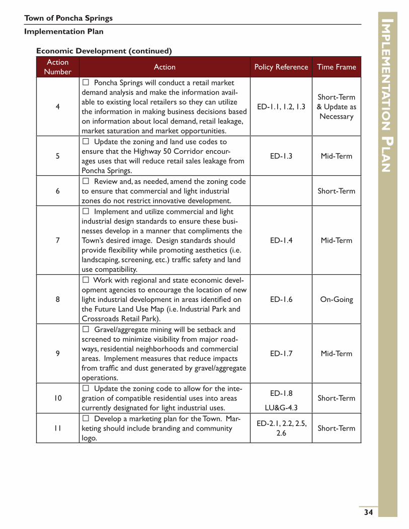
Economic Development (continued)Action
NumberAction Policy Reference Time Frame
4
Poncha Springs will conduct a retail market demand analysis and make the information avail-able to existing local retailers so they can utilize the information in making business decisions based on information about local demand, retail leakage, market saturation and market opportunities.
ED-1.1, 1.2, 1.3Short-Term & Update as Necessary
5
Update the zoning and land use codes to ensure that the Highway 50 Corridor encour-ages uses that will reduce retail sales leakage from Poncha Springs.
ED-1.3 Mid-Term
6 Review and, as needed, amend the zoning code to ensure that commercial and light industrial zones do not restrict innovative development.
Short-Term
7
Implement and utilize commercial and light industrial design standards to ensure these busi-nesses develop in a manner that compliments the Town’s desired image. Design standards should provide flexibility while promoting aesthetics (i.e. landscaping, screening, etc.) traffic safety and land use compatibility.
ED-1.4 Mid-Term
8
Work with regional and state economic devel-opment agencies to encourage the location of new light industrial development in areas identified on the Future Land Use Map (i.e. Industrial Park and Crossroads Retail Park).
ED-1.6 On-Going
9
Gravel/aggregate mining will be setback and screened to minimize visibility from major road-ways, residential neighborhoods and commercial areas. Implement measures that reduce impacts from traffic and dust generated by gravel/aggregate operations.
ED-1.7 Mid-Term
10 Update the zoning code to allow for the inte-gration of compatible residential uses into areas currently designated for light industrial uses.
ED-1.8
LU&G-4.3Short-Term
11 Develop a marketing plan for the Town. Mar-keting should include branding and community logo.
ED-2.1, 2.2, 2.5, 2.6 Short-Term

Economic Development (continued)Action
NumberAction Policy Reference Time Frame
12
Support regular farmers markets, outdoor art shows, stock shows or bicycle races/festivals and other public events as a means of attracting visi-tors to Town and enriching the community.
Evaluate the benefits of, and options for, priva-tizing the planning, integration and execution of events in the Town to reduce the workload on Town staff.
ED-3.1, 3.2 On-Going
HousingAction
Number Action Policy Reference Time Frame
1
Develop a mixed-use or live/work zoning district.
Planning staff will perform an in-depth review of neighborhood densities compared to those allowed in the zoning code. Use public process to determine ideal densities in existing neighbor-hoods. Encourage projects to use maximum density allowances.
HO-1.1
LU&G-4.3
ED-1.8
TRANS-1.9
Short-Term
2 Update the zoning code to allow for accessory dwelling units and permit accessory dwelling units to be used for rental housing.
HO-1.2 Short-Term
EnvironmentAction
NumberAction Policy Reference Time Frame
1 Establish a 50-foot building setback from the edge of the South Arkansas River.
ENVR-1.2, 1.4, 1.6, 1.10 On-Going
2
Consider land preservation tools such as: • Acquisition of specific parcels;• Acquisition of development rights, etc.
to be used as strategies for preservation of wildlife habitat.
ENVR-1.9 Mid, Long-Term
3
Implement and maintain development stan-dards for areas identified as critical wildlife habitat or migration corridors by the Colorado Division of Wildlife. Requirements for development clus-tering will be considered to preserve open space and mitigate development impacts on wildlife habitat.
ENVR-1.1, 1.9, 1.11
Mid-Term & On-Going
Town of Poncha Springs
Implementation Planim
Ple
me
nTa
Tio
n Pla
n
35

Town of Poncha Springs
Implementation Planim
Ple
me
nTa
Tio
n Pla
n
36
Environment (continued)Action
NumberAction Policy Reference Time Frame
4
The Town shall pursue the development of a Wellhead Protection Plan to reduce the likelihood of contamination of the town‘s drinking water sup-ply. The Wellhead Protection Plan will:
• Examine the hydrogeology of the area to delineate a wellhead protection area
• Inventory existing and potential contami-nants
• Create management guidelines• Develop contingency plans in case of con-
tamination• Recommend siting criteria for new wells in
case expansion is necessary• Promote public involvement and education
programs
ENVR-4.4 Mid-Term
5
Investigate opportunities to expand and im-prove the municipal ditch system to reduce the demand on the municipal water system for non-potable watering needs.
ENVR-4.6 Mid, Long-Term
6
Work with Chaffee County and the City of Salida to develop a South Arkansas Master Plan. The plan should balance how to:
• Make the river more visible and connected to key local and regional destinations and leverage development opportunities along the river
• Improve recreational opportunities• Maintain the health of the riparian corridor
and enhance wildlife habitat
ENVR-1.4, 1.6, 1.10, 4.1, 4.2, 4.3,
4.8
Mid, Long-Term
7 Continue to fund dust control measures and plan for future paving of unpaved streets to reduce dust emissions.
ENVR-5.3 On-Going
8 Investigate and pursue grants that would pro-vide opportunities for the Town to continue reduc-ing environmental impacts in all operations.
ENVR-6.1, 6.3 On-Going
9 Use the Chaffee County EnergyNOW plan as an advisory document for resource conservation and energy efficiency in Town.
ENVR-6.2, 6.4 On-Going

Environment (continued)Action
NumberAction Policy Reference Time Frame
10
Explore opportunities to develop a local recy-cling program. As part of the program, the Town should provide recycling bins in public spaces. In addition the Town should consider offering a regu-larly scheduled event that allows residents to drop off hard-to-recycle materials (for a fee).
ENVR-6.3 On-Going
11
Establish building energy efficiency standards and encourage energy efficient building design and construction. Investigate cost-effective ways to provide incentives for improving the energy effi-ciency of buildings in Town.
ENVR-6.4 Short-Term
12
Review the Town’s zoning and land use codes to ensure that they allow for the use of alternative energies (i.e. wind, solar and hydro) in appropriate locations within the municipal limits.
ENVR-6.5 On-Going
13
Review the land use code to ensure that it supports local food production in appropriate locations.
Investigate opportunities to increase yield and total area of the Poncha Springs community gar-den.
ENVR-6.6, 6.7 On-Going
14
Investigate opportunities for agricultural based businesses (i.e. Community Supported Agriculture (CSA), local food Co-op, Farmers market, etc.).Resource:Local Harvest (www.localharvest.org)
ENVR-6.6, 6.8 Mid-Term
15
Develop an inventory of businesses, residents and local organizations in or near Town that have undertaken measures to be more environmentally conscious. The inventory should include informa-tion on the measures taken, success stories and cost/performance reports where applicable. Inte-grate these local efforts into Town branding and marketing. Consider annual recognition for the top contributors to sustainability in Town.
ENVR-6.9 On-Going
16
Adopt and enforce outdoor lighting standards.Resource:International Dark Sky Association (www.darksky.org)
Implement standards that minimize after-hours business lighting.
ENVR-7.1, 7.2 Short-Term
Town of Poncha Springs
Implementation Planim
Ple
me
nTa
Tio
n Pla
n
37

Town of Poncha Springs
Implementation Planim
Ple
me
nTa
Tio
n Pla
n
38
Community Services & InfrastructureAction
NumberAction Policy Reference Time Frame
1
Update the Town’s Standard Design Criteria to address any changes in technology or construction techniques and ensure that infrastructure is de-signed and installed properly.
CS&I-2.5, 2.6, 2.12, 2.14
Short-Term & Update as Necessary
2 The Town shall continue to pursue completion of a water main loop between the electric substa-tion on US 50 and Halley’s Avenue at CR 128.
Short, Mid-Term
3
The Town shall adopt regulations that require annexed property to dedicate water rights to the Town in an amount equal to or greater than one and a half times the needs of the development at build out. In instances where water is not available an option for cash in lieu payment may be accept-ed at the sole discretion of the Town.
CS&I-2.3, 2.7, 2.8 Short-Term
4 Create and maintain digital maps of the mu-nicipal water system and provide staff training on maintaining the maps.
CS&I-2.9Short-Term & Update as Necessary
Parks, Open Space & TrailsAction
Number Action Policy Reference Time Frame
1
Develop a Parks and Recreation Master Plan that:
• Identifies appropriate locations for future parks, open spaces, recreation facilities and trails
• Addresses improvements or expansion of existing facilities
Development of the Parks and Recreation Master Plan, as well as any updates to the Master Plan, will provide for broad public participation.
POST-1.1, 1,2, 1.4
Short-Term & Update
regularly (5-7 years)
2 Ensure that the Town’s land use review process addresses compatibility of new development with the Parks and Recreation Master Plan.
POST-1.3, 2.4, 3.8 Short-Term
3
Implement and maintain standards for park and trail construction. The standards for parks should address park features such as playground equip-ment, benches, bathrooms, etc.
POST-1.5, 3.2, 3.4, 5.2
Short-Term & Update as Necessary
4 Improve signage for Poncha Springs’ parks, open space, recreation facilities and trails. Mid-Term

Parks, Open Space & Trails (continued)Action
NumberAction Policy Reference Time Frame
5
Work with adjacent property owners to pur-sue the expansion and additional improvement of Hoover Ranch Park. Improvements to the Park should provide for recreational facilities and activi-ties for local youth and families on the west side of town.
Investigate grant opportunities for the expan-sion and improvement of Little River Park and South Park.
POST-1.1, 2.2, 6.1, 6.4
On-Going
6
Explore opportunities and work with BLM to develop a trail system that allows residents to ac-cess and utilize the BLM lands south of Town.
Explore opportunities to develop a trail system along the South Arkansas River. This trail system should serve to improve public access to the river.
The Town should explore methods, with prop-erty owners, to secure trail easements and dedica-tions along the South Arkansas River.
POST-1.1, 1.4, 1.5, 3.6, 3.7, 6.1
Mid, Long-Term
7
Develop and maintain a map of trails and key destinations in Poncha Springs and the surround-ing area to include Poncha Springs’ parks, trails, and open lands into the Town’s marketing plan. This map can be web-based (as well as periodi-cally printed) so that it may be easily updated with advertising and information about local events.
Short-Term & Update as Necessary
8
Utilize the capital improvements plan as the basis for annual budgeting, for investment analy-sis and to seek funding from outside sources (i.e. grants and/or low interest loans).
Explore all available opportunities to team with private individuals and agencies such as GOCO, Arkansas Valley Land Trust, Nature Conservancy, the Trust for Public Lands, etc., to secure additional funds for open space preservation.
Work with stakeholders, citizens, community groups and regional, state and federal agencies to find creative ways to design, fund, improve and maintain parks.
POST-6.1, 6.2, 6.3, 6.4 On-Going
Town of Poncha Springs
Implementation Planim
Ple
me
nTa
Tio
n Pla
n
39

Town of Poncha Springs
Implementation Planim
Ple
me
nTa
Tio
n Pla
n
40
TransportationAction
NumberAction Policy Reference Time Frame
1
Update the Town’s street section, in the Land Use Code, to incorporate street designs that are cost-effective, efficient to maintain, provide a safe environment for pedestrians/bicyclists and al-low for efficient traffic movement. Traffic calming should be considered in street designs, but reliance on speed humps should be discouraged. Intersec-tion designs should evaluate the use of round-abouts and other creative designs to improve traffic flow and public safety.
TRANS-1.1Short, Mid-
Term
2
Develop and maintain of a network of striped bike lanes in Town, to enhance the safety and con-venience of bike riding in Town. Priority should be given to routes that connect activity centers such as areas of employment, restaurant/retail areas and/or parks with residential areas. Signage should be provided to inform motorists of the presence of bike lanes and routes.
TRANS-1.4, 1.5 Mid, Long-Term
3
Investigate grants or other funding opportu-nities to construct sidewalks along well-traveled pedestrian corridors in Town. Community input shall be included when identifying these corridors.
TRANS-1.6, 1.7 On-Going
4
Develop and maintain a Capital Improvements Plan that addresses the Town’s transportation net-work. The Plan will:
• Inventory and describe maintenance re-quirements for existing facilities
• Provide cost estimates for improvements to existing facilities
• Identify and provide cost estimates for future facilities
• Provide funding options and alternatives
Utilize the capital improvements plan as the basis for annual budgeting, for risk and investment analysis and to seek funding from outside sources (i.e. grants and/or low interest loans). Priority shall be given to maintenance, improvements to unpaved roads, safety issues, improved pedestrian/bicycle facilities and improved street connectivity.
TRANS-2.1 On-Going

Community GatewaysAction
NumberAction Policy Reference Time Frame
1
Develop site-specific plans for the four com-munity gateways identified on the Future Land Use Map. These plans shall define the entry portals and incorporate creative streetscape designs that give the Town a unique sense of place. Consideration shall be given to the integration of native materials and historic themes into the design of the commu-nity gateways.
Work with the Colorado Department of Trans-portation on approvals and on community gate-ways to ensure consistency of signage, landscaping design, lighting and other design features.
CG-1.1Mid, Long-
Term
2
Develop a master signage plan for the Town in order to limit the total number of signs, height and square footage. The sign plan will focus on aesthetic character through use of material and thematic designs.
ED-2.6 Short-Term
Intergovernmental CoordinationAction
Number Action Policy Reference Time Frame
1 The Town shall submit its Comprehensive Plan for acceptance by the Chaffee County Planning Commission.
IC-1.1
LU&G-3.4Short-Term
2
Work with Chaffee County and the City of Salida to develop an intergovernmental agreement on land use and coordinated implementation of the Poncha Springs Comprehensive Plan.
IC-1.1, 1.2, 1.3 Short, Mid-Term
Time-Frame
Short-Term Actions: 1-5 years
Mid-Term Actions: 5-10 years
Long-Term Actions: more than 10 years
Town of Poncha Springs
Implementation Planim
Ple
me
nTa
Tio
n Pla
n
41

Town of Poncha Springs
Update & Amendment Processu
Pd
aT
e & a
me
nd
me
nT P
ro
ce
SS
42
Updating the Plan
The Poncha Springs Comprehensive Plan is intended to be a dynamic document that will be flexible enough to incorporate change as the community evolves over time. The basic community values and vision, from which this plan is built, are not expected to change significantly. However, as the community moves into the future, technical details in the document are likely to need modification and updating. Minor errors may be found in the plan that should be corrected.
To keep the Poncha Springs Comprehensive Plan current, the Planning Commission, in conjunction with the Board of Trustees and Town Staff, should conduct an annual review and strive to update the plan every 5 years (may consider updating more or less frequently as needed to reflect changes in community goals and needs). Citizens should be engaged during any discussions to update or modify the plan. The practice of periodic updates gives the community, Planning Commission, the Board of Trustees and Town Staff an opportunity to review, evaluate and consider changes to the policies and strategies defined in the document. It also provides an opportunity to renew owner-ship in the Plan. It is ownership in the Plan that ensures the long-term effectiveness of the Plan.
The review process for the Poncha Springs Comprehensive Plan should involve the following:
• Evaluate the Town’s decisions and activities relative to implementing the Plan’s guiding prin-ciples, goals and policies.
• Review the plan’s usefulness in providing direction for the decisions that were made during previous years (i.e. if different topics or format would be helpful, then they are to be duly noted for inclusion in the next revision).
• Identify any major changes in conditions and new priority items affecting the community, and include these for implementation.
Highlight specific action items that were completed and report on their status to the community.
Amending the Plan
The comprehensive plan amendment process is not intended to change the plan in order to fit the needs of a non-compliant development proposal. Instead, the amendment process allows the Town and its residents to ensure that the core values remain consistent with Poncha Spring’s future. There are two measures available for amending the Poncha Springs Comprehensive Plan:
• Minor Amendment• Major Amendment

Minor Amendment
This is the simplest method available to amend the Comprehensive Plan. This amendment process is reserved for small changes and/or corrections of errors found as the document is used (e.g. pop-ulation numbers need to be updated as more current information becomes available; language needs revision to better clarify the intent of a particular section; etc.). Minor amendments are those that apply to a few sections of the document and DO NOT change the intent or underlying principles of any given section. These amendments are generally initiated by Town Staff, Planning Commission or the Board of Trustees on a yearly basis, or as needed.
Major Amendment
This amendment process is reserved for major changes to the Comprehensive Plan. These amend-ments are typically directed at policy changes, multiple sections of the document or are of a mag-nitude that warrants substantial review. Major amendments require noticed public hearings before the Planning Commission.
Both Minor and Major Amendments may be initiated by members of the community, as well as Town Staff, members of the Planning Commission or the Board of Trustees.
Amendment Criteria
Amendments (Minor or Major) to the Poncha Springs Comprehensive Plan shall be evaluated on the following criteria:
1. The plan section(s) subject to amendment are erroneous or have been found to be out of date.
2. The amendment does not bestow an individual benefit to a developer, landowner or re-questing party, but confers a benefit to the community as a whole.
3. The amendment is consistent with the community vision, the goals and policies of the Plan and serves the greater good of the community.
4. The amendment provides for future land uses that are compatible with neighboring areas of the community.
5. The amendment maintains an appropriate balance of land uses in Poncha Springs. An ap-propriate balance of land uses will maintain a healthy natural environment, the integrity of neighborhoods, address the economic needs of residents and business owners and respect the rights of private property owners.
6. The amendment is based upon a considerable change in the land use character of an area, which warrants modification.
7. The amendment does not conflict with or inhibit the Town’s capacity for logical, cost-effec-tive annexations.
Town of Poncha Springs
Update & Amendment Processu
Pd
aT
e & a
me
nd
me
nT P
ro
ce
SS
43

Town of Poncha Springs
Update & Amendment Processu
Pd
aT
e & a
me
nd
me
nT P
ro
ce
SS
44
8. The amendment does not conflict with or inhibit the Town’s capacity for logical, cost-effective annexations.
9. The amendment is consistent with the logical extension of services, utilities, roadways, parks/open space, trails and other essential municipal functions.
10. The proposed amendment will not adversely affect utility planning, transportation or delivery of adequate services, or other major functions of the Town.
11. The amendment does not adversely affect sensitive environmental areas, air or water quality or result in increased risks to public health, safety or welfare.
12. The amendment will not result in a financial burden or other type of hardship for the Town.
13. The amendment shall not alter the provisions of a section(s) in such a way that conflicts with the intent of the Plan or creates conditions that were not intended in the docu-ment.
The Town planning staff shall submit written recommendations to the Planning Commission evaluat-ing compliance of the proposed amendment with the above criteria. The Planning Commission is the final decision-making body on amendments. The Planning Commission shall make written find-ings on each of the above criteria, which shall be presented to the Board of Trustees no later than 45 days after a decision of the Planning Commission.

With abundant hot springs (99 nearby) and the influence of Spanish culture in the area, the community site became known as Poncho (meaning cape and warmth) Springs. In 1924, the town of-ficially became Poncha Springs.
The Ute Indians often camped in this area, spending summer high in the Rock-ies and winters in the lower mountain valleys where the average yearly tem-peratures are a pleasant 45 degrees Fahrenheit. In 1779, Juan Batista de Anza led a military expedition over Poncha Pass. Trappers soon followed the explorers. Kit Carson, a famous mountain man of the times, is credited by some with the discovery of the hot springs.
Prospectors began to arrive on the scene about 1860. Nat Rich and Bob Hendricks built the first cabin (still standing) in town. James Rich, son of Nat Rich, was the first white child born in Poncha Springs in 1867. Poncha Springs was designated as an election precinct that year.
John Burnett homesteaded in 1865. He was the first Indian Agent here and his wife, Menerva Max-well Burnett, was one of the first school teachers. In 1866, a log cabin was built on the Burnett Ranch for an Indian supply post.
The Hutchinson and McPherson families also homesteaded in the mid 1860’s. In 1868 John McPher-son purchased Nat Rich’s squatting rights from Joe Hutchinson and built a grocery store. Poncha started to boom in the mid 1870’s. Construction on the Jackson Hotel was begun in 1876 and completed in 1878. The town incorporated on December 8, 1880. The population was 350 at the time and the vote was 70 for and 1 against.
With the building of the railroad in 1880, the population grew to well over 2000. Poncha had the first library in Chaffee county. A major fire in 1887 destroyed almost all of the Town’s frame build-ings, including the 17 flourishing saloons in Town. Another early day structure, the Presbyterian Church, built in 1882 was lost to fire in 1932.
The school house, which was completed in 1883, is still standing. This long standing building has been converted to use as the Poncha Springs Town Hall. In 2011, with a population of 737 residents, Poncha Springs is a delightful community, proud of its heritage but eager for the future.
Town of Poncha Springs
Community Snapshot - Brief Historyc
om
mu
niT
y Sn
aP
Sho
T - br
ief h
iSTo
ry
45

Town of Poncha Springs
Community Snapshot - Demographicsc
om
mu
niT
y Sn
aP
Sho
T - de
mo
gr
aP
hic
S
46
Population
The 2000 US Census recorded that there were 466 people residing in Poncha Springs. The 2010 US Census showed that Poncha Springs’ population increased by 271 residents to 737.
Between 2000 and 2010, Poncha Springs had an average annual population growth rate of 4.66%. The table shows the rates of change for the individual years.
15,000
15,500
16,000
16,500
17,000
17,500
18,000
April 2000
July 2002
July 2004
July 2006
July 2008
April 2010
Pop
ulat
ion
Chaffee County
0
1,000
2,000
3,000
4,000
5,000
6,000
April 2000
July 2002
July 2004
July 2006
July 2008
April 2010
Pop
ulat
ion
Other Communities In Chaffee County
Salida
Buena Vista
0100200300400500600700800
April 2000
July 2002
July 2004
July 2006
July 2008
April 2010
Pop
ulat
ion
Poncha Springs
‘00-’01 ‘01-’02 ‘02-’03 ‘03-’04 ‘04-’05 ‘05-’06 ‘06-’07 ‘07-’08 ‘08-’09 ‘09-’10
Rate of Change 10.30% -0.39% 18.36% 3.47% 2.39% -0.31% 4.06% 9.31% 1.10% 0.14%
No other community in Chaffee County experienced the higher growth rates of Poncha Springs from 2000 to 2010.
Buena Vista grew at an average annual rate of 1.77%.
Salida lost residents with a negative population growth rate of -0.50%.
Chaffee County, between 2000 and 2010, had an average an-nual population growth rate of 0.93%.
Source: State Demography Office
Source: State Demography Office
Source: State Demography Office
Poncha Springs Annual Rate of Change (2000-2010)

Town of Poncha Springs
Community Snapshot - Deomgraphicsc
om
mu
niT
y Sn
aP
Sho
T - de
mo
gr
aP
hic
S
47
13%(95) 12%
(86)
14%(104)13%
(95)11%(84)
18%(135)
11%(79)
6%(45)
2%(14) Under 10
10 to 19
20 to 29
30 to 39
40 to 49
50 to 59
60 to 69
70 to 79
80 and Older
Age
From 2000 to 2010 the median age in Poncha Springs decreased by 1.8 years. Poncha Springs was the only community in Chaffee County that had a drop in median age during this 10-year period. This indicates that there was an increase in the number of younger residents in town.
Poncha Springs Salida Buena Vista Chaffee CountyMedian Age (2000) 40.5 42.1 42.2 41.8Median Age (2010) 38.7 46.2 45 47.4
Poncha Springs has a relatively even age distribution within its current population:
• 25% (181 residents) of the community is 19 years old or younger.
• 27% (199 residents) of the community is 20 to 39 years old.
• 29% (219 residents) of the community is 40 to 59 years old.
• 19% (138 residents) of the community is 60 years of age or older.
Median Age
Source: US Census Bureau
Source: US Census Bureau

Employment
The estimated total number of jobs in Chaffee County grew from 8,530 in 2001 to 9,076 in 2009, an increase of 12.70%. (Source: Colorado Dept. of Local Affairs)
In 2009, Services, Retail Trade, Accommodation and Food accounted for 44.11% of employment in Chaffee County. Government sector employment accounted for 19.53% and the Construction sec-tor accounted for 10.48% of jobs in the County.
Unemployment rates in Chaffee County have increased from 4% in 2001 to an estimated 7.4% as of May 2011. Source: U.S. Bureau of Labor Statistics
Industry # of Jobs % of TotalGovernment 1,756 19.35%Services 1,627 17.93%
Retail Trade 1,235 13.61%
Accommodation and Food 1,141 12.57%Construction 951 10.48%Financial, Insurance & Real Estate 662 7.29%Arts 534 5.88%Agriculture 209 2.30%Manufacturing 206 2.27%Wholesale Trade 192 2.12%Admin and Waste 187 2.06%Transportation/Utilities 154 1.70%Education 104 1.15%Management of Companies and Enterprise * -Mining * -Total 9,076
* Not shown to avoid disclosure of confidential information, but estimates for these sectors are included in total number of jobs.
Town of Poncha Springs
Community Snapshot - Economyc
om
mu
niT
y Sn
aP
Sho
T - ec
on
om
y
48
Source: Colorado Department of Local Affairs
Chaffee County Employment by Sector (2009)
0
5,000
10,000
15,000
20,000
25,000
30,000
35,000
1998 1999 2000 2001 2002 2003 2004 2005 2006 2007 2008 2009
Chaffee County Per Capita IncomeIncome
In 2009 the average per capita income in Chaffee County was $32,766; an increase of $12,713 from 1998. The graph shows a decline in per capita income after 2008 in conjunction with the current recession.
For 2010-2011, the average annual household income for Chaffee County was $56,400 Source: www.efanniemae.com
Source: US Bureau of Economic Analysis

02468
101214161820
# of
Bui
ldin
g P
erm
its
Poncha Springs Building Permits
2006
2007
2008
2009
2010
Town of Poncha Springs
Community Snapshot - Housingc
om
mu
niT
y Sn
aP
Sho
T - ho
uSin
g
49
Housing
In 2009, the estimated median house value was $157, 348, an increase of $30,648 from the 2000 estimated median house value of $126,700. Source: www.city-data.com
Total Housing Units Occupied Vacant Owner Occupied Renter Occupied
Poncha Springs 362 320(88.4%)
42(11.6%)
203(63.4%)
117(36.6%)
Salida 2,894 2,515(86.9%)
379(13.1%)
1,561(62.1%)
954(37.9%)
Buena Vista 1,378 1,194(86.6%)
184(13.4%)
826(69.2%)
368(30.8%)
Chaffee County 10,020 7,601(75.9%)
2,419(24.1%)
5,509(72.5%)
2,092(27.5%)
Housing
2.282.07
2.23 2.172.35
1.922.11 2.11
Poncha Springs Salida Buena Vista Chaffee County
Average Household Size
Owned Rented
The average household size in Poncha Springs, for both owned and rented properties, is slightly higher than the neighboring communities and Chaffee County overall.
43 (84.31%) of the permits is-sued were for new Single Family Dwellings (SFD).
Between 2006 and 2010, the Chaffee County Building Depart-ment issued 53 building permits for new residential development in Poncha Springs.
Source: Chaffee County Building Department
Source: US Census Bureau
Source: US Census Bureau

Existing Land Use*Refer to the Existing Land Use map for the general location of current land uses in Poncha Springs.
The following tables explain the existing land uses within the Poncha Springs municipal limits and within the Municipal Planning Area.
The acreages in the tables may be somewhat inaccurate, as they may include areas of constraint such as, floodplains, wetlands, and/or steep slopes. Areas of constraint typically have development restrictions or are simply unde-velopable.
Town of Poncha Springs
Community Snapshot - Land Usec
om
mu
niT
y Sn
aP
Sho
T - la
nd u
Se
50
Land Use Acres % of TotalPlanned Unit Development (PUD) 481.68 37.03%
Vacant Land 232.80 17.90%Agricultural/Rural Residential 230.42 17.71%
Open Space & Parks 121.50 9.34%Low Density Residential 81.26 6.25%Public/Institutional 59.34 4.56%Commercial 50.55 3.89%Light Industrial 22.43 1.72%Mixed Use 5.02 0.39%Utilities 4.65 0.36%Mobile Home Park 4.16 0.32%High Density Residential 3.57 0.27%
Medium Density Residential 3.38 0.26%
Total 1,300.76 100%
Land Use Acres % of TotalAgricultural/Rural Residential 2,865.14 78.14%
Vacant Land 612.26 16.70%Public/Institutional 128.58 3.51%Open Space 20.87 0.57%Low Density Residential 20.62 0.56%Utilities 16.21 0.44%Commercial 2.24 0.06%Mixed Use 0.73 0.02%Total 3,666.65 100%
Source: Chaffee County GIS Data
Source: Chaffee County GIS Data
Existing Land Use inside Town Limits Existing Land Use within Planning Area
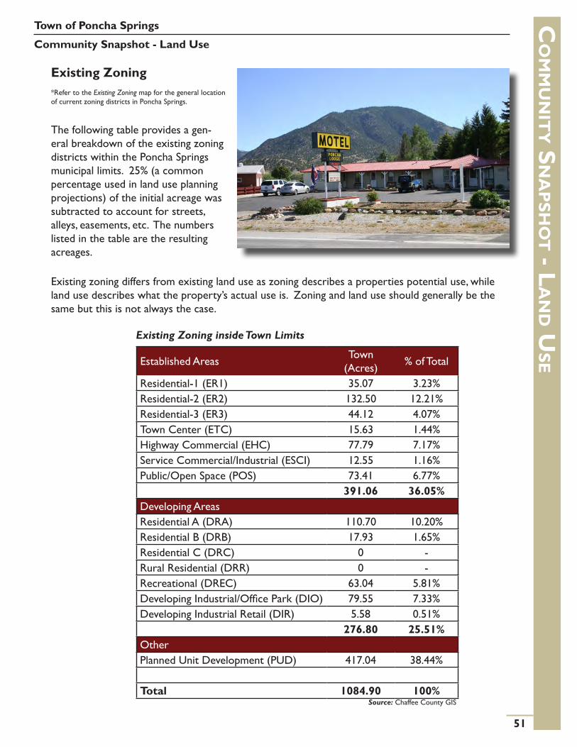
Existing Zoning*Refer to the Existing Zoning map for the general location of current zoning districts in Poncha Springs.
The following table provides a gen-eral breakdown of the existing zoning districts within the Poncha Springs municipal limits. 25% (a common percentage used in land use planning projections) of the initial acreage was subtracted to account for streets, alleys, easements, etc. The numbers listed in the table are the resulting acreages.
Existing zoning differs from existing land use as zoning describes a properties potential use, while land use describes what the property’s actual use is. Zoning and land use should generally be the same but this is not always the case.
Town of Poncha Springs
Community Snapshot - Land Usec
om
mu
niT
y Sn
aP
Sho
T - la
nd u
Se
51
Established Areas Town (Acres) % of Total
Residential-1 (ER1) 35.07 3.23%Residential-2 (ER2) 132.50 12.21%Residential-3 (ER3) 44.12 4.07%Town Center (ETC) 15.63 1.44%Highway Commercial (EHC) 77.79 7.17%Service Commercial/Industrial (ESCI) 12.55 1.16%Public/Open Space (POS) 73.41 6.77%
391.06 36.05%Developing AreasResidential A (DRA) 110.70 10.20%Residential B (DRB) 17.93 1.65%Residential C (DRC) 0 -Rural Residential (DRR) 0 -Recreational (DREC) 63.04 5.81%Developing Industrial/Office Park (DIO) 79.55 7.33%Developing Industrial Retail (DIR) 5.58 0.51%
276.80 25.51%OtherPlanned Unit Development (PUD) 417.04 38.44%
Total 1084.90 100%Source: Chaffee County GIS
Existing Zoning inside Town Limits

Town of Poncha Springs
Community Snapshot - Land Usec
om
mu
niT
y Sn
aP
Sho
T - la
nd u
Se
52
Zoning District (Established) Description
Residential-1 (ER1) A residential area primarily intended for single family development at densities no greater than one unit per 6,250 square feet.
Residential-2 (ER2) A residential area primarily intended for single family development at densities no greater than one unit per acre of land.
Residential-3 (ER3) A medium density residential area providing for a mix of residential types including single family and townhouse / garden type apartments.
Town Center (ETC)The commercial core of the town intended to serve a mix of local resident and visitor oriented retail, entertainment and civic uses with some accommo-dations.
Highway Commercial (EHC) Areas primarily along the North and East highway entrances to town. These areas are primarily intended to serve the needs of the traveling public.
Service Commercial/Industrial (ESCI)Areas intended to accommodate wholesale, service and light industrial uses which require larger area and separation or buffering from recreational and commercial uses.
Public/Open Space (POS)
This district is intended to serve the Town’s needs for passive open space, active parks, and residential areas and public buildings. Such areas may also include and are intended to conserve natural assets or hazard areas such as river / park frontage.
Zoning District (Developing)
Residential A (DRA) An area for residential expansion of primarily single family dwellings at a den-sity no greater than one unit per 10,000 square feet.
Residential B (DRB) An area for residential expansion for single family subdivisions at a density no greater than one unit per acre.
Residential C (DRC) An area for residential expansion for single family subdivisions at a density no greater than one unit per two acres.
Rural Residential (DRR)
This area is intended to accommodate expansion of agricultural and rural uses and certain other small –scale uses which are compatible with the prevailing character of the area. In areas so designated on the plan, rural residential ar-eas may be considered for upgrading under conditions to more dense residen-tial, light industrial, or recreational.
Recreational (DREC)
This area is intended for new recreational or resort related uses that will compliment, but not compete with commercial zones in the established area. These areas are for high quality tourist and recreation oriented uses that require a greater amount of land, comprehensive planning and development. Such areas should help implement ecologies.
Developing Industrial/Office Park (DIO)
This area is intended for new, light – industrial and office park uses to be developed under design guidelines intended to promote the attractiveness and function of a light industrial center.
Developing Industrial Retail (DIR)This area is intended for light industrial with retail uses. This area is comprised of development which is primarily non-offensive types of industry, processing, assemblage and light manufacturing.
Existing Zone District Descriptions

ex
istin
g La
nd u
se Ma
p
53
Town of Poncha Springs
Existing Land Use Map

ex
istin
g Zo
nin
g Ma
p
54
Town of Poncha Springs
Existing Zoning Map

Town of Poncha Springs
Community Snapshot - Infrastructurec
om
mu
niT
y Sn
aP
Sho
T - infr
aST
ru
cT
ur
e
55
Water System*Refer to the Water System map for the general loca-tion of existing water system infrastructure in Poncha Springs.
Poncha Springs owns, operates and maintains its own water system.
Poncha Springs Water System# of Water Tanks 2
Capacity of Water Tanks
160,000 gallons & 100,000 gallons
*Friend Ranch requires 350,000 gallons for Phase I (not yet constructed).
# of Wells4
*5th well for Friend Ranch (not yet online).
Capacity of Wells
Approximately 300 gpm allowed, but not necessarily avail-able to pump. Dependent on the well and the time of year.
*Friend Ranch well may be around 200+ gpm.Water Loss Average of 3-4% (2008-2010)
Peak Demand
Peak Summer Months: approximately 200 gpm or 300,000 gpd.
Average Peak Month: approximately 105 gpm or 150,000 gpd.
*Gallons per Minute (gpm)*Gallons per Day (gpd)
• Municipal water mains are primarily 6” with some 8” mains. There is a section of 10” trunk line from the storage tank to an area near the South Arkansas River.
• Poncha Springs’ 2006 water rights were adequate for approximately 490 single family taps.
• Approximately 295 (60%) of those taps were in use in 2006.
Source: Greg Smith, Director of Public Works
Source: Water & Sewer Systems Evaluation & Planning Study for the Town of Poncha Springs, CO (2006)

Town of Poncha Springs
Community Snapshot - Infrastructurec
om
mu
niT
y Sn
aP
Sho
T - infr
aST
ru
cT
ur
e
56
Sewer System*Refer to the Sewer System map for the general location of existing sewer infrastructure in Poncha Springs.
Poncha Springs does not have a wastewater plant. Sewer services are provided under contract with the City of Salida. Salida is responsible for treating Poncha Springs’ sewer and maintaining the Poncha Springs collec-tion system.
An agreement between Poncha Springs and Salida, in 2010, designated residents of Poncha Springs as direct customers of Salida.
Poncha Springs Sewer UsageCurrent Average Daily Demand 63,000 gallonsCurrent Average Peak Month Demand 3.67 million gallonsProjected Average Daily Demand(during peak month) 122,000 gallons
Current EQR Usage 507.13Allocated EQR’s(per agreement with the City of Salida) 1,130
Salida Sewer Treatment PlantExisting Capacity 1.2 million gallons per dayProposed Plant Capacity 2.7 million gallons per day
Source: Robert Vance, City of Salida Public Works Director

Roads*Refer to the AADT, Roadway Classification and Roadway Ownership & Surface Type maps for information regarding the existing transportation networks in and around Poncha Springs.
Poncha Springs owns and maintains 35.87 lane miles of both paved and unpaved roadways. 35.87 lane miles is a substantial amount of road-way for a Town, the size of Poncha Springs, to maintain.
In 2010, the Town spent, on average, $1,031.50 per lane mile.
Poncha Springs Road Network (2011)Paved Road 16.93 lane milesUnpaved Road 18.94 lane milesTotal 35.87 lane miles
Source: Greg Smith, Director of Public Works
Town of Poncha Springs
Community Snapshot - Infrastructurec
om
mu
niT
y Sn
aP
Sho
T - infr
aST
ru
cT
ur
e
57
Ditch System
Poncha Springs owns, operates and maintains the Acequia ditch system. The Acequia ditch system is approx-imately 2.5 miles in length.
Poncha Ditch System Water RightsAcequia Ditch *5.82 CFSAlloy Ditch 0.40 CFS
*Max allowed based on priority
Source: Greg Smith, Director of Public Works
Source: Greg Smith, Director of Public Works
Source: Greg Smith, Director of Public Works

Wa
te
r & s
eW
er s
yst
eM M
ap
s
58
Town of Poncha Springs
Water & Sewer System Maps

av
er
ag
e an
nu
aL d
aiLy t
rip
s Ma
p
59
Town of Poncha Springs
Average Annual Daily Trips Map
Average Annual Daily Trips (2010) - 3000
Projected Average Annual Daily Trips (2030) - 7000

ro
ad
Wa
y CLa
ssiFiCa
tio
n Ma
p
60
Town of Poncha Springs
Roadway Classification Map

ro
ad
Wa
y oW
ne
r & s
ur
FaC
e ty
pe M
ap
61
Town of Poncha Springs
Roadway Owner & Surface Type Map

Town of Poncha Springs
Community Snapshot - Community Servicesc
om
mu
niT
y Sn
aP
Sho
T - co
mm
un
iTy S
erv
ice
S
62
Local Schools
Poncha Springs does not currently have any school facilities in Town.
The Town is located within the Salida School District (R-32-J District) and school facilities for Poncha Springs resi-dents are located in the City of Salida.
The Salida School District provides two school buses to Poncha Springs residents. One bus provides service to the older portion of Town, while the other bus provides service to the area of the D’Anza Vista neighborhood.
Salida School District InformationLongfellow Elementary 81Salida Middle School 60Salida High School 41Total students, from Poncha Springs, enrolled in Salida’s schools 182
The following table provides information about the num-ber of students from Poncha Springs and which schools, in Salida, that they are enrolled in.
Fire Protection
Fire protection services are provided to Poncha Springs by the Chaffee County Fire Protection District.
The nearest Chaffee County Fire Protec-tion station is located next door to Poncha Springs Town Hall. This station services the Town with other resources responding from other areas in Chaffee County, as needed.
The volunteer staff at the fire station in Pon-cha Springs consists of:
• 1 Battalion Chief• 1 Station Captain• 1 Station Lieutenant• 1 Safety Captain• Approximately 20 other volunteer
firefighters
In addition, the Fire District staffs 1 to 2 paid firefighters at this station, 2 days a week.
Incident Report for Poncha Springs (2010)Fire Calls 7EMS Calls 4Hazardous Condition (No Fire) 3Vehicle Accidents 17Service Calls 3Good Intent Calls 5False Alarms 6Total Calls 45
*Avg. Response Time: 8 mins 52secs
Source: Sandy Gardunio, Salida School District
Source: Sandy Gardunio, Salida School District
Source: Jim Wingert, Chaffee County Fire Protection District Source: Jim Wingert, Chaffee County Fire Protection District

Town of Poncha Springs
Community Snapshot - Community Servicesc
om
mu
niT
y Sn
aP
Sho
T - co
mm
un
iTy S
erv
ice
S
63
Law Enforcement
Poncha Springs does not have a police de-partment. Law enforcement is provided by the Chaffee County Sheriff ’s Department.
In 2010, Chaffee County deputies responded to a total of 356 calls in Poncha Springs. Listed below are the five most frequent calls that deputies responded to:
Chaffee County Sheriff ’s Department (2009)Total Officers 22Total Civilians 31Total Law Enforcement Employees 53
Medical Services
Emergency medical services are provided to Poncha Springs by Chaffee County EMS. Listed below are some quick facts about Chaffee County EMS:
• The Poncha Springs station (10364 C.R. 120) has a crew of 2 employees, available 24 hours for 911 calls.
• In 2010, Chaffee County EMS responded to 38 medical and trauma calls
• 2 Ambulances, 1 Quick Response Vehicle with 4WD
• Average Response Time: 2.25 minutes
Chaffee County EMS employs:
• 12 Full-Time EMT’s• 9 Part-Time EMT’s
The Heart of the Rockies Medical Center is the closest hospital available to Poncha’s resi-dents. This facility is located roughly 6 miles away, in Salida.
Source: Federal Bureau of Investigation (FBI)
Source: Laura Smith, Chaffee County EMS
Call Description # of Calls (2010)Medical Assist 31Assist - Other 29Harassment 19VIN Inspection 19Accident 17
Source: Pete Palmer, Chaffee County Sheriff

Town of Poncha Springs
Community Snapshot - Parks, Open Space & Trailsc
om
mu
niT
y Sn
aP
Sho
T - Pa
rk
S, oP
en S
Pac
e & T
ra
ilS
64
Parks*Refer to the Parks, Open Space & Trails map for the general location of existing parks in Poncha Springs.
The Town of Poncha Springs owns, maintains and operates three, active park spaces. These parks are Chipeta Park, Hoover Ranch Park and South Park. The Town owns a fourth park site in the Little River Ranch subdivision. The park is approximately 2.46 acres in size, is located on the South Arkansas River and currently serves as an unimproved, passive, nature park.
Hoover Ranch ParkLocation Amenities Size
Located at the corner of Ev-
ans Avenue and Poplar Street
• Large playing field• Playground• Basketball court• Picnic area
Approx. 0.69
Acres
Chipeta ParkLocation Amenities Size
Located across Burnett Avenue from Town Hall
• Large playing field • Playground• Picnic area• Basketball court• Benches• Restrooms• Pavilion
Approx. 1.4
Acres
South ParkLocation Amenities Acreage
South of Town, along the east side of High-
way 285
• 18-hole disc golf course
• Trails for disc golf course
• Benches• Picnic area
Approx. 33.2
Acres

Town of Poncha Springs
Community Snapshot - Parks, Open Space & Trailsc
om
mu
niT
y Sn
aP
Sho
T - Pa
rk
S, oP
en S
Pac
e & T
ra
ilS
65
Open Space*Refer to the Parks, Open Space & Trails map for the general location of existing open space areas in Poncha Springs.
Open Space areas dedicated to the Town include, the abandoned railroad corridor, the triangle-shaped parcels at the intersection of Hwy 285 & 50 and lands in the Little River Ranch subdivision, as well as the Friend Ranch subdivision.
Trails*Refer to the Parks, Open Space & Trails map for the general location of existing and proposed trails in and around Poncha Springs.
The Town has designated trail routes along exist-ing roadways, in Town. Trail signs are posted along roadways to direct bicyclists to these designated routes and to advise motorists of the routes.
A regional trail system is being constructed along County Road 120. This trail will provide safe and convenient bicycle/pedestrian access between Poncha Springs and Salida. The trail is still under construction.
Recreation*Refer to the Parks, Open Space & Trails map for the general location of existing recreation facilities in Poncha Springs.
Chaffee County Fairgrounds
The Chaffee County Fairgrounds has held events such as the County Fair, Rodeos, Ski Swaps, Con-certs and High School Dances.
Disc Golf Course
20 acres of South Park have been developed into an 18-hole Frisbee course. This course has been very successful and is very popular with residents of Poncha Springs.
Monarch Crest Trail System & Monarch Ski Area
Poncha Springs serves as a basing area for mountain bikers riding the Monarch Crest bike trail. In addition, Poncha Springs is located roughly 15 miles east of the Monarch Ski Area.

Pa
rk
s, OP
en s
Pac
e & T
ra
ils Ma
P
66
Town of Poncha Springs
Parks, Open Space & Trails Map

Climate
Poncha Springs is known for its mild and breezy climate, with low humidity, low precipitation, abun-dant sunshine and mild temperatures. Average precipitation in Poncha Springs is around 5” per year and the growing season averages 112 days. Average daily high temperatures are in the 80’s during the summer months and in the 40’s during the winter. The frequent, prevailing winds are from the southwest. In fact, a local interpretation of the word “Poncha” is “where the wind rips the flesh off your bones.”
Geology*Refer to the Geology map for the general location of geologic features in and around Poncha Springs.
The geologic deposits underlying Poncha Springs consist primarily of gravel and alluvium from the Quaternary era, as well as siltstone and sandstone (sedimentary rocks) from the Tertiary era. Both mafic and felsic gneisses (metamorphic rocks) from the Early Proterozoic era can be found in the hills south of the Town, extending in southeasterly direction east of Poncha Creek.
The USGS GIS data indicates that there are several fault lines that run through the Municipal Limits, as well as the Planning Area. The size and type of these faults is unknown.
Vegetation
A broad range of plant types are found in Poncha Springs. Tree species in town include Cottonwoods, Willows, Cra-bapples, Scotch Pine, Pinion Pine, Spruce, Aspen and Cherry. Shrubs found in the residential areas include Viburnum, Dwarf Alberta Spruce, Lilac, Willow, Dogwood and Juniper.
With the warm, dry climate in Poncha Springs, xeric-land-scaping works well throughout Town, for water conservation. Xeric-landscaping may include a variety of drought-tolerant species that include flowering plants, grasses, shrubs and trees.
Pinyon, Juniper, Ponderosa Pine and Douglas Fir can be found in the upland terrain south of Poncha Springs. Aspen, Alpine Shrub, Spruce and Fir are found in the cooler environments at higher elevations. Wetland and riparian vegetation are found along the South Arkansas River.
Town of Poncha Springs
Community Snapshot - Environmentc
om
mu
niT
y Sn
aP
Sho
T - en
vir
on
me
nT
67

Wildlife*Refer to the Elk Habitat, Mule Deer Habitat & Black Bear Human Conflict maps for the general location of wildlife habitat in and around Poncha Springs.
Poncha Springs’ proximity to several mountain ranges and the South Ar-kansas River provides the Town with a variety of wildlife. Higher elevation species include the Western Boreal Toad (an endangered species), Abert’s Squirrel, Blue Grouse, Band-tailed Pigeon, Mountain Lion, Pronghorn and Snowshoe Hare. The Peregrine Falcon (a species of special concern), Prairie Falcons and Merriam’s Turkey may be found in the Planning Area. Black Bears are occasionally seen in the valley floor. During the winter months, Mule Deer and Elk feed in the open land surrounding Poncha Springs. In the winter, Mule Deer are prevalent throughout the river bottoms, especially in hay fields and rural residential areas south of the river. Golden and Bald Eagles (a species of special concern), Bob Cats, Red-tailed Hawks, Coopers Hawk, Canadian Geese, Beaver and Ducks also inhabit the riparian corridor.
Town of Poncha Springs
Community Snapshot - Environmentc
om
mu
niT
y Sn
aP
Sho
T - en
vir
on
me
nT
68

FLo
od
pLa
in Ma
p
69
Town of Poncha Springs
Floodplain Map

st
ee
p sLo
pe
s Ma
p
70
Town of Poncha Springs
Steep Slopes Map

WiLd
Fire H
aZ
ar
d Ma
p
71
Town of Poncha Springs
Wildfire Hazard Map

ge
oLo
gy M
ap
72
Town of Poncha Springs
Geology Map

eLk H
ab
itat M
ap
73
Town of Poncha Springs
Elk Habitat Map

Mu
Le de
er H
ab
itat M
ap
74
Town of Poncha Springs
Mule Deer Habitat Map

bLa
Ck b
ea
r - Hu
Ma
n Co
nFLiC
t Ma
p
75
Town of Poncha Springs
Black Bear - Human Conflict Map

Town of Poncha Springs
Public InvolvementP
ub
lic inv
olv
em
en
T
76
Public Involvement
The 2011 update of the Poncha Springs Comprehensive Plan was a commu-nity-driven effort. The Planning Team worked to include residents, Town Staff and elected and appointed officials, to ensure that a variety of community members had an opportunity to ex-press their opinions. The goal of the public involvement process was to make certain that community input
• A Comprehensive Plan Update webpage was added to the Town’s website to keep citizens informed about upcoming events, offer meeting results to those who were unable to attend and to provide citizens with draft sections of the comprehensive plan, as they were made available. The Town’s newsletter, the local newspaper and word-of-mouth were also utilized to provide keep the community informed about upcoming events and progress of the comprehensive plan update.
• A kick-off meeting and barbeque was held on June 22, 2011. This event introduced the Planning Team in an informal setting and offered an opportunity to present the outline for the comprehensive plan update process to the community. Roughly 30 residents from Poncha Springs attended this event. In addition to introducing the community to the com-prehensive plan process, this event was used to discuss and develop an initial list of “Oppor-tunities and Constraints” regarding a variety of issues facing the Town.
• A community survey was distributed door to door, by volunteers, to the residents of Poncha Springs in June 2011. Surveys were also mailed to county residents living within the Municipal Planning Area. Of the estimated 506 surveys distributed, 131 total surveys were returned. This represented a return rate of roughly 26%, a strong, statistically valid response. The survey results supplied important information on many topics including attitudes to-wards growth, development, community character and important issues that the Town should look to address. Refer to Appendix A for the results of the community survey.
• A community visioning meeting was held on July 11, 2011. This event served several purposes. The meeting began with a presentation of the initial community survey results. Following this presentation, the Planning Team worked with meeting attendees to develop a list of guiding principles for the comprehensive plan. Keypad polling was utilized to allow participants to vote anonymously on a list of potential guiding principles. The results of poll-ing determined which of the guiding principles were to be incorporated into the Plan. The final activity was a mapping exercise at which meeting attendees worked in groups to devel-op maps illustrating their preference for future land use locations. These maps were collated and served as the starting point for the Future Land Use Map.
would serve as the foundation for the Poncha Springs Comprehensive Plan. The public involvement process included:
June 22, 2011 - Kick-Off Meeting and BBQ

• The first community input meeting was held on August 3, 2011. The Planning Team worked with community members to create a vision statement for the Poncha Springs Comprehensive Plan. This event was also used to review the Goals and Policies from the 1998 Poncha Springs Comprehensive Plan. The meeting was an important step because it established which Goals and Policies to retain and which ones were no longer applicable. The meeting concluded with the presentation of the rough draft of the Community Snap-shot and the Future Land Use Map. Participants offered comments and suggestions and this input was used to revise these sections of the Plan.
• The second community input meeting was held on October 3, 2011. This event was used as an opportunity to review a rough draft of the Poncha Springs Comprehensive Plan in its entirety. Participants offered comments and suggestions and this input was used to further refine the Plan.
Town of Poncha Springs
Public InvolvementP
ub
lic inv
olv
em
en
T
77
July 11, 2011 - CommunityVisioning Meeting

Town of Poncha Springs
Appendix Aa
PP
en
dix a
78
TOWN OF PONCHA SPRINGS COMMUNITY SURVEY 2011
Final Results
August 2011
Prepared for:
Town of Poncha Springs
Prepared by:
RRC Associates 4940 Pearl East Circle, Suite 103
Boulder, Colorado 80301 303/449‐6558

1
Introduction
The Poncha Springs Community Survey was fielded and tabulated in June 2011. The survey was distributed door to door, one survey per household, with a request from the field worker to complete the survey immediately. Then, the interviewer returned to pick up surveys. A total of 131 completed surveys were obtained through the door‐to‐door process. An estimated 506 surveys were distributed; responses represent a return rate of approximately 26 percent, a strong response for this type of community survey.
The surveys have been compiled by the consultant team and selected results are summarized in this short report using graphs and some commentary. A primary purpose of the survey was to provide current information on opinions and priorities that would help to inform and shape the planning process that is currently underway in Poncha Springs. Many of the questions on the survey lend themselves to easy interpretation through graphs. For that reason, we have presented a number of graphs in this report; we believe many speak for themselves. Where appropriate we have rank ordered findings to permit patterns of responses to be easily identified.
Additional tables that segment the data, and open‐ended comments, have been provided under separate cover.
Demographics
The survey contained a series of questions that provide a profile of responding households. These questions are asked in order to create some measures of who responded to the survey, but they also provide a means of segmenting (or “crosstabulating”) results. For example, all of the survey responses are broken out by age, length of residency in the town, etc. in order to assess whether there are differences between the responding groups that can be helpful for planning purposes. The results showed:
93 percent full time residents, 6 percent part time; 91 percent report Poncha Springs is their primary residence.
In terms of household “tenure” 85 percent are owners, 12 percent renters and 3 percent report “other” living arrangements.
Most respondents are long‐time residents of the community, 32 percent have lived in Poncha Springs more than 15 years and 20 percent 11‐15 years. About 7 percent report they have been in town less than a year, and 28 percent have been there 1‐5 years.
Respondents report a wide variety of current employment. About 32 percent are employed full time, 30 percent are retired, 22 percent are self employed and 6 percent report part time work. Among those employed, 46 percent work in Poncha Springs, 39 percent in Salida and the remainder (16 percent) are employed throughout the area.

2
About 15 percent of respondents report they are under 40 years of age, 11 percent are 41 to 50, 38 percent 51 to 60 and 36 percent are over 60. Consistent with the large number of retirees, the community is home to a relatively older resident population.
Reasons to Live in the Town
Residents of Poncha Springs live in the town for a variety of reasons but three reasons are most identified: Small town character, Natural beauty/scenery and Climate, all receiving approximately 50 percent or more mentions. Affordability, recreational opportunities and retirement were also relatively frequently mentioned.
Why do you live in Poncha Springs?
Important Features of Small Town Character
Another series of questions on the survey provides further guidance on some of the dimensions of “small town character” that were given top priority in the question above. These results are summarized in the graph below which shows a “safe community” with an ability to walk/bike and locally owned businesses as the highest rated dimensions. The idea of a physically small and compact town is also a notable aspect of small town character as rated by Poncha Springs residents and this finding is consistent with a desire for in‐fill land development; this was measured on a later question which will be described below.
64%
62%
48%
32%
29%
27%
23%
23%
21%
14%
14%
11%
9%
3%
0% 10% 20% 30% 40% 50% 60% 70% 80%
Small town character
Natural beauty/scenery
Climate
More affordable than neighboring communities
For the recreational opportunities
Came here to retire
To be with family/spouse/friends
Location in Chaffee County
Proximity to Monarch Ski Area
Employment opportunities
Other
Proximity to Front Range
Easy access to retail establishments and services
I was born here
Percent Responding

3
Important Features of Small Town Character
Issues Prioritized
Various issues facing Poncha Springs were prioritized. The question was asked in three different ways to identify those issues that need to be addressed: now, in 10 years, or that do not need to be addressed. As shown in the following three graphs, the highest single priority that should be addressed now is preservation of small town character. As shown below, the rank ordering of responses provides an immediate set of priorities for consideration in the planning process.
The second graph below illustrates issues that need to be addressed either now or in over the next ten years. Again, small town character dominates.
Finally, a third graph illustrates those issues that are considered relatively low priority and “do not need to be addressed.” By this measure public transit is of relatively low importance, as is affordable housing, local food production, and law enforcement, all identified by over 25 percent of respondents.
1.2
1.5
1.6
1.6
1.8
1.8
1.8
2.0
2.2
2.3
2.3
2.3
2.4
1.0 1.5 2.0 2.5 3.0 3.5 4.0
Safe community
Ability to walk/bike around town
Locally owned and operated business
Easy access to parks and open spaces
Physically small/compact town
Familiarity with neighbors
Access to local government
Community events
Spaces for community interaction
Ability to work where you live
A well‐defined town center
Other
Absence of large retailers
( 1 = "Most Important", 4 = "Least Important" )

4
At what point do these issues need to be addressed?—Now
75%
69%
69%
67%
61%
60%
57%
56%
55%
50%
50%
49%
25%
14%
0% 10% 20% 30% 40% 50% 60% 70% 80% 90% 100%
Preservation of small town character
Irrigation water
Local job creation
Provision of adequate water services
Preservation of agricultural economy
Provision of adequate sewer services
Affordable housing
Use of renewable energies
Historic preservation
Sprawl/growth
Funding for streets and sidewalks
Local food production
Law enforcement
Public transit
Percent Responding
Need to be Addressed Now

5
At what point do these issues need to be addressed?—Now vs. 10 Years from Now

6
At what point do these issues need to be addressed?—Doesn’t need to be addressed
48%
26%
26%
26%
22%
18%
18%
15%
14%
13%
13%
12%
9%
7%
0% 10% 20% 30% 40% 50% 60%
Public transit
Affordable housing
Local food production
Law enforcement
Historic preservation
Preservation of agricultural economy
Funding for streets and sidewalks
Use of renewable energies
Sprawl/growth
Irrigation water
Local job creation
Provision of adequate sewer services
Provision of adequate water services
Preservation of small town character
Percent Responding
Doesn't need to be addressed

7
Growth Patterns and Preferred Types of Development
A question on growth patterns showed a clear preference for infill development before major annexations are undertaken. These results are illustrated below.
Preference for Community Growth Patterns
Concerning residential development, single family homes are the preferred pattern of development, followed by single family with some multi‐family. Live/work development received some support but it is clearly not the preferred type of development over traditional single family use.
Preference for New Residential Development
2.0
2.0
3.1
3.2
1.0 1.5 2.0 2.5 3.0 3.5 4.0
Development of 75% of vacant town lands before additional annexation
Infill development in conjunction with small annexations and minimal infrastructure
extensions
Annexation independent of infill
Infill development in conjunction with larger annexations that require major infrastructure
extensions
( 1 = "Most Preferred", 4 = "Least Preferred" )
1.5
2.3
2.7
2.8
3.0
3.2
1.0 1.5 2.0 2.5 3.0 3.5 4.0
Primarily single family
Mostly single family with some multi‐family
Equal mix single family, multi‐family and live/work
Primarily live/work
Other
Multi‐family and live/work
( 1 = "Most Preferred", 4 = "Least Preferred" )

8
Planning for Parks and Open Space
Survey results indicate a strong preference for joint Town and County efforts to acquire lands for parks and open space. There is also support for new development to contribute to acquiring land, and for the town to take a proactive role in acquiring land for parks and open space. The least preferred option for identifying and acquiring land for parks was a choice that would have a private organization taking primary responsibility.
How to Plan for New Parks and Open Space
Grants were the preferred method of funding parks, along with private fundraising efforts. The three categories of choices that involved taxes, either sales or property taxes, received relatively lower ratings.
1.9
2
2.2
2.6
2.8
3.5
1.0 1.5 2.0 2.5 3.0 3.5 4.0
Town and county should work together to identify and acquire land for future parks and open space
New development should contribute to parks and open space acquisition without regard to lands previously
identified by the Town
Town should identify and acquire land for parks and open space
New development should contribute to acquisition of lands previously identified by the Town for future parks
and open space
A parks and recreation district should be responsible for identifying and acquirong land for future parks and open
space.
A private organization should identify and acquire land for future parks and open space
( 1 = "Most Preferred", 4 = "Least Preferred" )

9
Funding for the Acquisition and Maintenance of Open Space and Park Lands
Environmental Quality
A question on environmental quality and potential actions provides additional information on community priorities. As illustrated below, recycling is the most preferred action, followed by a community garden and incentives to use renewable energies. Of relatively low interest are composting, reducing water consumption and reducing vehicle trips.
1.5
2.1
2.5
3.2
3.5
3.6
1.0 1.5 2.0 2.5 3.0 3.5 4.0
Pursue grants for parks and open space
Private fundraising efforts
Establish a parks and open space impact fee
Establish a dedicated sales tax
Establish a parks and open taxing district
Establish a dedicated property tax
( 1 = "Most Preferred", 4 = "Least Preferred" )
1.5
1.8
1.9
2.0
2.0
2.1
2.2
2.3
2.3
2.5
2.6
1.0 1.5 2.0 2.5 3.0 3.5 4.0
Recycling
Incentives for improving energy efficiency of buildings
Community garden
Incentive use of renewable energies
Expand municipal ditch system
Local food production
Community co‐op grocery
Reducing water consumption
Composting
Other
Reducing vehicle trips
( 1 = "Most Preferred", 4 = "Least Preferred" )

10
Economic Development Actions and Programs
Respondents were asked to evaluate a variety of economic development opportunities. The resulting priorities are summarized in the graph below. Attracting new business and “smart growth” were most identified. Strong support was also expressed for general tourism, recreational opportunities, recreation based tourism and the need for a small scale grocery store. At the low end of the list was historic architectural design standards on Main Street and actions to discourage strip commercial development along highways. Design standards are a particularly low priority receiving an average rating of 2.9 on the four point scale.
How should Poncha Springs focus its economic development efforts?
1.4
1.6
1.6
1.8
1.9
2.0
2.0
2.1
2.1
2.1
2.2
2.2
2.2
2.3
2.5
2.5
2.5
2.5
2.9
1.0 1.5 2.0 2.5 3.0 3.5 4.0
Attract new business
Smart growth
Other
General tourism
Recreational opportunities
Recreation based tourism
Small scale grocery store
Community events
More retail shops
Improve Town's sense of place along highways
Allow for home based businesses with retail …
Focus on renewable energy industries
Educational opportunities
Historic preservation
More restaurants and take‐out food …
Hotels/motels
Grocery store (safeway, city market)
Discourage strip commercial along highways
Historic architectural design standards on …
( 1 = "Most Important", 4 = "Least Important" )

11
What Would Cause you to Leave Poncha Springs?
Respondents indicated that an increase in crime, inadequate sewer /water services, or a loss of small town character would be the qualities that would most likely influence leaving the town. Note that a lack of dining and shopping options were of little importance to survey respondents. Apparently, they value Poncha Springs and its small town character, and weaknesses in shopping and dining are not a significant concern of most residents.
What would cause you to leave Poncha Springs?
68%
57%
49%
46%
39%
27%
25%
25%
22%
15%
7%
6%
6%
5%
0% 10% 20% 30% 40% 50% 60% 70% 80%
Increase in crime
Inadequate water/sewer services
Loss of small town character
Loss of environmental quality
Rapid growth
Loss of affordable housing options
Lack of full time employment …
Loss of agricultural/rural areas …
Lack of water for irrigation
Other
Lack of in town retail/shopping …
Not enough growth
Lack of in town dining options
Lack of community events
Percent Responding

12
Transportation Issues Ratings of transportation were obtained through the survey. As shown below, ease of walking, driving and parking are rated high. Street conditions, access to trails and public transit were rated relatively low.
Open‐Ended Comments The survey provided a number of opportunities for respondents to provide written comments “in their own words.” These comments offer additional insights and clarification into some of the statistical findings that were summarized in the previous graphs. Under “Additional Comments” a variety of opinions were expressed that illustrate the range of concerns that are present in the community. For example, there is strong support for smart growth and planning by some, but others felt that the emphasis should be on spending money on roads and town parks and not on planning “that is not tangible.” Similarly, several criticized various aspects of the survey while others praised it and expressed “thanks” for allowing comments. These differences are common in small towns and the richness and diversity of opinion is one of the purposes of a Community Survey. The written input, combined with specific suggestions (of which there were a number) helps to frame the public planning process and to reinforce the framework for decisions that will continue through public meetings and other forms of public input.
1.6
1.8
1.9
2.1
2.2
2.6
3.1
3.9
1.0 1.5 2.0 2.5 3.0 3.5 4.0
Ease of driving in town
Ease of walking
Parking availability
Traffic flow
Bicycle travel
Street conditions
Access to trails
Public transit
( 1 = "Very Good", 4 = "Very Poor" )
Transportation Issues

13
Additional Comments ADUs can be used as rental units: why not? Is it a water issue? Could ADU be turned into a small business ‐
would that be OK? Affordable housing = lazy people Affordable housing: don't be enablers Affordable housing: to whom? Be conservative; all will be well! Citizens of Poncha should NOT have to pay for annexation costs ‐ up to developer 100%. Quality of life
declined with local citizens being stuck with bills/legal fees from "big" business ‐ too much politics. Need to educate bicyclists to obey stop signs. We don't need Hwy 50 squeezed to 2 lanes going through Poncha ‐ we don't want to be stuck behind tourists trying to get home from work.
Community co‐op: if there is local food! Community events: holidays? Founders Day? What else would there be? Community garden: for senior citizens if they need it Community town‐owned bikes! Composting attracts bears which Fish and Game will NOT RUN OFF Composting: but you say bears would come in?!) Create incentives for energy‐efficiency improvements in buildings: what would that be? Create incentives for energy‐efficiency improvements in buildings: who pays the incentive Develop a mixed‐use zone: most people can't afford to rent/buy an office/retail space: size? Where is
cutoff? Develop a mixed‐use zone: only if you want productivity and local revenue generated Educational opportunities: in what? Expand municipal ditch system: if needed Funding for streets and sidewalks: from what source Funding for streets and sidewalks: slowly this can be done Growth in US 285 south of 50: NO WAY Growth is great. But you nor I should be able to tell land owner how to use their land. Historic preservation: define the degree of preservation Historic preservation: Ed Bomdecker's place was lost, stage coach stop in area Historic preservation: Jackson Hotel and Eddy Baundeckers Historic preservation: not much left but school house, everything else is private (illegible)! Hwy 50 needs improvement through the canyon south of here ‐ nothing along where the businesses are
now I am in college in Ft. Collins but spending the summer here after living here about 13 years If you overtax developers, they will not come here I'm so glad I moved to Poncha Springs. My neighbors and friends are the best ever! I don't want to see
Poncha become too big, like Salida with all its political infatuations, but I know we will grow here, so I am highly encouraged by town government's deep interest in sustainable growth. Focus and concentrate! Good luck! Thanks.
Improve town's sense of place: intersection 50/285 by post office ‐ get state to do "something" with this area
Incentive use of renewable energies: WIND!!! Allow residents to do Law enforcement: already have state and county Leave Hwy 50 alone ‐ spend money in the canyon at Rincon

14
Live/work in it's zone (sic); enough low income apartments Local community owned grocery: where is the food coming from? Trucked in? Not cost effective with gas
prices. Would support if truly local grown. Local food production: not much left but school Local food production: Run deer out of town ‐ each person could have a garden! Local food production: run deer out of town, have your own garden Local food production: to sell or use? Local job creation: not just tourism "stuff" Local job creation: you blew me off on this Need enforcement of ordinance concerning junk, weeds and general upkeep of residences. I see no effort
being made in this area. Affects everyones home values. New development should contribute to park and open space acquisition without regard to lands previously
identified by the Town: NO ‐ new development should not tell local gov't what to do! Organic local health food stores and restaurants Please do not approve sprawl, multi‐family, ADUs, or affordable housing projects. Instead, scrape and
encourage good quality development only and with a one‐mile extension for ultimate 50 year expansion. First, though, develop the town center and East Hwy 50 corridor. Don't be like Salida. Be quality single family homes and quality businesses.
Preservation of agricultural economy: don't lose it to tourism! Preservation of agricultural economy: too broad a question Preservation of agricultural economy: you blew me off on this Preservation of small town character: already has Preservation of small town character: hardly changed in 40 years Preservation of small town character: too broad a question Provision of adequate sewer and water services: with growth Public transit: 1 or 2 small buses Salida‐Poncha Pursue grants for parks and open space: maintenance cost? Quality of life has improved (community garden, more families in LLR). Safety and access across highways
are of paramount importance if the town is to be an attractive place to live and do business. Poncha could use more character!
Quality of life has not changed, sad to say, but that is not always a bad thing Recreational opportunities: enough out there already Reducing vehicle trips: how? Bus system? To where? Reducing vehicle trips: not feasible Reducing water consumption: symbolism over substance Remove junk cars and junk, encourage weed control Should be spending money on roads and town parks etc., not on comprehensive plans or planning that is
not tangible Small town character hardly changed in 40 years Smart growth: a real planned layout

15
Some rental properties in town are awful and substandard. You can't walk or bike in town without being barked at or chased by dogs. Cats ruin gardens and planters so why try. Parcels are packed with houses. Keep commercial areas well defined. Provide for LOCAL recreation (trails, fishing, camping, 4 wheeling, hiking, etc.). Establish town center and community events. Give businesses small and large a reason to be here (incentive). Apply for grants.
Someone did a good job compiling this survey. Town limits should expand via need Thank you for allowing us to comment! Thanks! The town needs to avoid putting our citizens in the position of paying for messes like the Friend Ranch.
Quality of life declined because too many people! The town should not participate in any more developments like Friend Ranch/Bent Tree. Development
should pay for itself and not at Poncha Springs residents expense. If they cannot provide their own water, they should not get it from town wells. Water supply in town is all ready. Poncha might have more new trees and lawns if residents had more water available instead of giving it to developers.
The traffic in the housing divisions (behind Grimos) needs to SLOW DOWN we have kids, and there are never any protroling officers, which we should have (sic)
Those hired to do survey didn't seem to have a mindset consistent with community (ie they were big city/liberal while Poncha is generally small town conservative). Poor choice of firm as it skewers the results. For example the young man introducing the survey asked if we want more schools, sidewalks, police, obviously hadn't done his homework. How can we want more when we don't have any? Why waste energy doing a comprehensive plan ‐ which has NO juristiction (sic) when we don't bother to even enforce laws which do? ie zoning, speed limits etc.
Town should identify and acquire open space/park lands: with real forthought (sic) (not just plop it here) Traffic on Ouray Ave. needs to SLOW DOWN. Church should have a time limit at night during vacation Bible
Schools and in winter trips from out of state. They are LOUD. Use of renewable energies: define these energies Use of renewable energies: hot springs in gone! (sic) Wind!!! Water for irrigation: to irrigate what? We feel very fortunate to operate our business in Poncha Springs. Town officials are always accessible. We
would like to expand in future. We love living in Poncha Springs! We need bike lanes or trails to hook us up with Salida ‐ also I am concerned about the area behind Hoover
Circle. At one time developers wanted high density housing and apartments. I would like to see single family housing and some condos/townhomes. Thanks.
Wind energy, hot springs/geothermal to town. Poncha Hot Springs location left dormant? A waste. Hotel by visitors' center. Why aren't county roads being graded? Fremont County is. Parking at post office dangerous in front. Traffic flow too fast at times.
With limited knowledge of town government and regulations, I feel somewhat inadequate and ill‐informed to respond to some of the issues mentioned in this survey. I feel, in many instances, we look to the town officials to gather the facts and, from that information, make wise decisions in the best interest of the town and its residents.
Would like to see irrigation ditch in Little River Ranch with access for E. Sabeta Ave. You ARE surrounded by National Forest! (no need for town to acquire open space land). And a private
organization ‐ absolutely NOT. You can't control where people want to develop

16
You need to expand gradually and not upon the mountains to put a house in the mountains NO matter what style takes away the natural beauty of what you have (sic)
Why do you live in Poncha Springs? (other) Chose to live in LLR because of paved streets, utilities (esp. high speed internet) Husband transfer Lived 16 years, just returned Moved from Salida politics, but Poncha Springs is getting as bad ‐ Chaffee County in general My grandparents and parents lived here Only available housing for sale at the time Proximity to outdoor recreation Proximity to Salida Raised here Raised our kids in Salida To do urban agriculture and educate selves and others in issues of sustainability We located the association here due to the property fits our needs Where should future growth occur? (other) IF Poncha Springs grows ‐ how can I say where and when Where the market drives it Old business that are no longer here, buildings look terrible ‐ need to come down or condemned (sic) New residential development in Poncha Springs should be: (other) All of the above ‐ owner's right Allow agricultural endeavors Apartment complexes Apartments Commercial Local municipalities must manage growth, not control it You can't control where people want to develop Live/work in it's zone (sic); enough low income apartments Which should be used to improve environmental quality in Poncha Springs? (other) Allow microfarming Bike path to Salida Bring back a Holman's grocery of sorts ‐ simple ‐ not complicated! Clean up junk cars, old campers, etc. No dogs within city limits! Public transit, bike trails Removal of unsightly junk, campers, old vehicles or require enclosures/storage of items, general property
cleanup Salida is 4 miles away for some of these This is up to individual, not the responsibility of government Wind production (perhaps up by fairgrounds?) Wind turbines

17
How should Poncha Springs focus economic development efforts over the next 10 years? (other) Develop image as a "sustainable" town, by focusing on sustainability Develop local hot springs into primitive type resort ‐ Valley View‐esk (sic) Fence off trailer park on Hwy 50, it is very unattractive Incentive for mobile home park owners to sell or put in retail rental space Make Poncha more aesthetically attractive, i.e., rural, quaint, less of a gas and go SHOW Poncha is a great place to live and have a business Support current residents concerns on growth over developers wants (sic) The town wants growth, but the town makes it hard for growth What would cause you to leave Poncha Springs? (other) Chicken and turkey etc. as of today ‐ smelly Getting a supermarket High taxes High taxes/cost of living Higher property taxes If the town begins to interfere too much Increase in taxes Increase property tax and business tax Lack of communication ‐ city Maybe unable to live a sustainable lifestyle! Most of the above; and most of all the town (fathers) telling me what to do with MY LAND Pricey utility fees. Crammed residents, noisy dogs. Salida and Poncha area turning into a Silverthorne or Crested Butte type Too much noise or car traffic in residential areas Most needed transportation improvements (other) 535 Ouray is dirt and rock ‐ 4 houses have to deal with this. Others have hard surface. Better signage, ex: frisbee golf Close off entrance to Western gas station off Kimberlin Lane for resident safety Either over or underpass for 285 and 50 Enforce stop sign laws No sidewalks No sidewalks! Remove most stop signs to promote flow and noise/wear of stop and go every block. It's a pain to get in
and out of residents'. (sic) Stop light Own or rent (other) On vacation Parsonage Live with parents