town planning
DESCRIPTION
historyTRANSCRIPT

Town Planning during Mughal PeriodLecture: 03 ARK 413: Town Planning

Town Planning during Mughal PeriodLecture: 03 ARK 413: Town Planning
The Indian History after the decline of Maurya and Gupta emperors from 6thcentury AD to the time of Mughals of 16thcentury AD was full of invasions from outside rulers and petty wars between small kingdoms.Cities and towns boomed under the Mughals; however, for the most part, they were military and political centers, not manufacturing or commerce centers. Only those guilds which produced goods for the those guilds which produced goods for the bureaucracy made goods in the towns; most industry was based in rural areas. The Mughals also built Maktabs in every province under their authority, where youth were taught the Quran and Islamic law such as the Fatawa-e-Alamgiri in their indigenous languages. During this period Urban planning was limited to the well fortified capital cities like Jaisalmer in Rajasthan and Golconda in Andhra Pradesh.The Mughal Kings were fond of luxurious life style. The palaces, forts, mosques, tombs, monumental buildings and beautiful gardens have a distinctive style of their own.

Town Planning during Mughal PeriodLecture: 03 ARK 413: Town Planning
Babur in India: 1526-1530Humayun: 1530-1556Akbar: 1556-1605 (Fatehpur Sikri: 1571-1585) Jahangir: 1605-1627 Shah Jahan and Aurangzeb: 1627-1707 (Shahjahanabad 1638-48), The Moghuls after Aurangzeb: 18th century

Town Planning during Mughal PeriodLecture: 03 ARK 413: Town Planning
The Jaipur in Rajesthan can be described as the sole example of a planned city during this period. The city was build Rajput king Maharaja Sawai Jai Singh in 1727. He brought prosperity to his kingdom by maintaining cordial relations with the Mughal Emperor Aurangzeb. Jai Singh’s interest in astronomy, arts and ancient scripts inspired the plan of jaipur. Vidyadhar Bhattacharya was his Architect.The site was located in the valley formed by hills to the north and east. The city was designed on a grid-iron pattern with octagonal clustering of square sectors. The major east-west road and three nprth-west roads divide the city into 8 district sectors known as ‘chowkris’. Different zones of the city were planned in conformity with the Vastushastra. Brahmins were alloted areas in the north, Kshatiyas in the east, Vaishyas in the South and Sudras in the west. Pinkish stones were used for the building façades on the major roads, which brought the name of ‘Pink City’ to Jaipur.

Modern Urban PlanningLecture: 03 ARK 413: Town Planning

Modern Urban PlanningLecture: 03 ARK 413: Town Planning
Industrial Revolution & It’s Impact:• Industrial revolution from late 18th century onwards may be taken as a cut-off line between ancient and modern urban planning. Industrialization was a boon to the growing population all over the world. • Inventions like elevators and automobiles have dramatically changed the shape and size of our cities. Industrialization changed the production and consumption pattern in the society.• Many departments and branches of various professionals were opened in the cities without caring the integration of their activities for proper city development. This is visible in the misuse of land in the shape of integration of their activities for proper city development. This is visible in the misuse of land in the shape of buildings and roads. • The profit motive and commercial outlook become part of the struggle for human existence. When compared to the rural society, urban society demanded more punctuality and precision to meet obligations. Money and brain, not spirit and heart, are the qualities needed for the urban resident for his survival. • The problems arose mainly because of the concentration of working class people in poorly built housing near the factories and mills. They were located near factories for proximity and lack of sufficient money for commuting long distances. People were put near together in poor accommodation near the place of work creating number of health and sanitary problems.

Modern Urban PlanningLecture: 03 ARK 413: Town Planning
Modern Urban Planning Initatives:• Industrial revolution from late 18th century onwards may be taken as a cut-off line between ancient and modern urban planning. Industrialization was a boon to the growing population all over the world. • Inventions like elevators and automobiles have dramatically changed the shape and size of our cities. Industrialization changed the production and consumption pattern in the society.• Many departments and branches of various professionals were opened in the cities without caring the integration of their activities for proper city development. This is visible in the misuse of land in the shape of integration of their activities for proper city development. This is visible in the misuse of land in the shape of buildings and roads. • The profit motive and commercial outlook become part of the struggle for human existence. When compared to the rural society, urban society demanded more punctuality and precision to meet obligations. Money and brain, not spirit and heart, are the qualities needed for the urban resident for his survival. • The problems arose mainly because of the concentration of working class people in poorly built housing near the factories and mills. They were located near factories for proximity and lack of sufficient money for commuting long distances. People were put near together in poor accommodation near the place of work creating number of health and sanitary problems.

EBENEZER HOWARD:•GARDEN CITY MOST POTENT PLANNING MODEL INWESTERN URBAN PLANNING.• CREATED BY EBENEZER HOWARD IN 1898 TO SOLVE URBAN AND RURAL PROBLEMS.• HOWARD READ WIDELY, INCLUDING EDWARD BELLAMY'S 1888 UTOPIAN NOVEL, LOOKING BACKWARD, AND HENRY GEORGE'S ECONOMIC TREATISE,PROGRESS AND POVERTY AND THOUGHT MUCH ABOUT SOCIAL ISSUES. HE DISLIKED THE WAY MODERN CITIES WERE BEING DEVELOPED AND THOUGHT PEOPLE SHOULD LIVE IN PLACES THAT SHOULD COMBINE THE BEST SHOULD LIVE IN PLACES THAT SHOULD COMBINE THE BEST ASPECTS OF BOTH CITIES AND TOWNS.• THE ONLY PUBLICATION HE WROTE IN HIS LIFE WAS TITLED AS GARDEN CITIES OF TOMORROW. THIS BOOK OFFERED A VISION OF TOWNS FREE OF SLUMS AND ENJOYING THE BENEFITS OF BOTH TOWN (SUCH ASOPPORTUNITY, AMUSEMENT AND GOOD WAGES) AND COUNTRY (SUCH AS BEAUTY, FRESH AIR AND LOW RENTS). HE ILLUSTRATED THE IDEA WITH HISFAMOUSTHREE MAGNETS.• SOURCE OF MANY KEY PLANNING IDEAS DURING 20TH CENTURY.


GARDEN CITY CONCEPT –• AN IMPRESSIVE DIAGRAM OF THE THREE MAGNETS NAMELY THE TOWN MAGNET, THE COUNTRY MAGNET WITH THEIR ADVANTAGES AND DISADVANTAGES AND THE THIRD MAGNET WITH ATTRACTIVE FEATURES OF BOTH TOWN AND COUNTRYLIFE.• NATURALLY PEOPLE PREFFERED THE THIRD ONE NAMELY GARDEN CITY

CORE GARDEN CITY PRINCIPLES:• STRONG COMMUNITY• ORDERED DEVELOPMENT• ENVIRONMENTAL QUALITYTHESE WERE TO BE ACHIEVED BY :• UNIFIED OWNERSHIP OF LAND TO PREVENT INDIVIDUAL LAND.• SPECULATION AND MAXIMIZE COMMUNTIY BENEFITS.COMMUNTIY BENEFITS.• CAREFUL PLANNING TO PROVIDE GENEROUS LIVING AND WORKING SPACE WHILE MAINTAINING NATURAL QUALITIES.• SOCIAL MIX AND GOOD COMMUNITY FACILITIES.• LIMIT TO GROWTH OF EACH GARDENCITY.• LOCAL PARTICIPATION IN DECISION ABOUT DEVELOPMENT

AFFORDABILITY:• HOWARD WANTED GARDEN CITY FORALL INCOMES.• IT IS AN IDEAL CITY INDUSTRY ISBALANCED WITH AGRICULTURE,HOUSING CAREFULLY DISTRIBUTED,AND TRANSPORT RATIONALISED.• HOWEVER, THE 32,000 INHABITANTSOF THIS GARDEN CITY ARE MOREMIXED, BY AGE, ARE MOREMIXED, BY AGE, OCCUPATION ANDABILITIES.• A LONG WITH BRICKFIELDS, FACTORIES AND MARKETS ARE CHILDREN’S COTTAGE HOMES, INDUSTRIAL SCHOOLS, ASYLUMS FOR THE BLIND AND DEAF. THIS IS A CITY FOR THE STRONG AND WEAK, AND WHERE THE WEAK GROWIN STRENGTH.

APPLICATIONLETCHWORTH, ENGLAND, UK• LETCHWORTH – 35 MILES FROM LONDON.• LAND OF 3822 ACRES.• RESERVED GREEN BELT – 1300 ACRES.• DESIGNED FOR MAXIMUM OF 35OOO POPULATION.• IN 30 YEARS – DEVELOPED WITH 15000 POPULATION AND 150 SHOPS,INDUSTRIES.• THE LAND USED WAS PURCHASED BY QUAKERS WHO HAD INTENDED TO FARM THE AREA AND BUILD A QUAKER COMMUNITY.• THE TOWN WAS LAID OUT BY RAYMOND UNWIN AS A DEMONSTRATION OF THE PRINCIPLES ESTABLISHED BY EBENEZER HOWARD WHO SOUGHT TO CREATE AN ALTERNATIVE TO THE INDUSTRIAL CITY BY COMBINING BE BEST OF TOWN AND COUNTRY LIVING.• IT IS ALSO HOME TO THE UNITED KINGDOM'S FIRST ROUNDABOUT, WHICH WAS BUILT IN 1909.

WELWYN, UK• WELWYN – 24 MILES FROM LONDON.• LAND OF 2378 ACRES.• DESIGNED FOR A MAXIMUM OF 40000 POPULATION.• IN 15 YEARS – DEVELOPED WITH10000 POPULATION AND 50 SHOPS,INDUSTRIES.WELWYN CITYIS A TOWN WITHIN TH EWELWYN HATFIELD BOROUGH OF HERTFORDSHIRE, ENGLAND.BOROUGH OF HERTFORDSHIRE, ENGLAND.• PLANNED BY LOUIS DESOISSONS 1921• WELWYN GARDEN CITY WAS THE SECOND GARDEN CITY IN ENGLAND (FOUNDED 1920) AND ONE OF THE FIRST NEW TOWNS (DESIGNATED1948).• IT IS UNIQUE IN BEING BOTH AGARDEN CITY AND A NEW TOWN AND EXEMPLIFIES THE PHYSICAL, SOCIAL AND CULTURAL PLANNING.

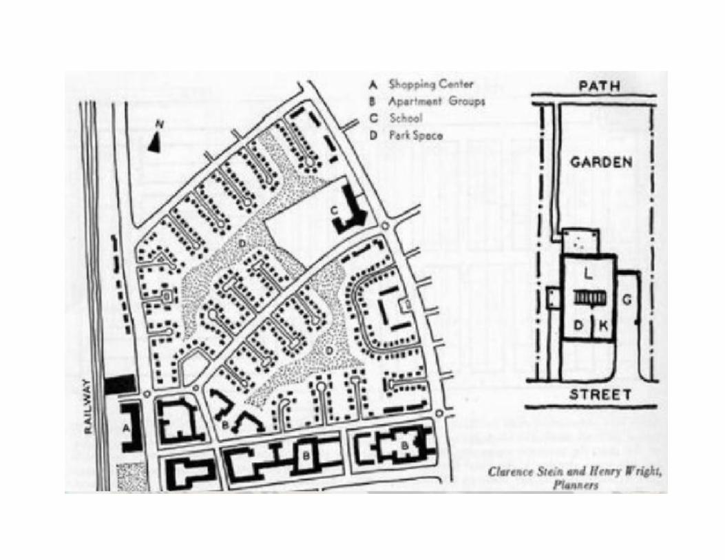
RADBURN LAYOUT IN USA:• Radburn layout was inspired by Garden city concept . This layout was planned by Henry Wright and Clarence Stejn. • There are approximately 3,100 people in 670 families residing in Radburn. They live in 469 single-family homes, 48 townhouses, 30 two-family houses and a 93-unit apartment complex.• Radburn's 149 acres (0.60 km2) include 23 acres (93,000 m2) of interior parks, four tennis courts, three hardball fields, two softball fields, two swimming pools and an archery plaza. Young children and their parents can make use of two toddler playgroup areas, two playgrounds and a toddler bathing pool.• There is also a community center which houses administrative offices, library, gymnasium, clubroom, pre-school and maintenance shops.• RADBURN’S PLANNING• RADBURN’S PLANNING1929 RADBURN CREATED 25000 PEOPLE 149 ACRES430 SINGLE HOUSES 90 ROW HOUSES 54 SEMI ATTACHED HOUSES93 APARTMENT UNIT
Map of north side section of the Redburn