traditional ecological knowledge and biological sampling
TRANSCRIPT

Technical Paper No. 362
Traditional Ecological Knowledge and Biological Sampling of Nonsalmon Fish Species in the Yukon Flats Region, Alaska
by
Michael Koskey, University of Alaska Fairbanks
and
Kristin Mull, Bureau of Land Management
May 2011
Alaska Department of Fish and Game Division of Subsistence

Symbols and Abbreviations
The following symbols and abbreviations, and others approved for the Système International d'Unités (SI), are used without definition in the reports by the Division of Subsistence. All others, including deviations from definitions listed below, are noted in the text at first mention, as well as in the titles or footnotes of tables, and in figure or figure captions.
Weights and measures (metric) centimeter cm deciliter dL gram g hectare ha kilogram kg kilometer km liter L meter m milliliter mL millimeter mm Weights and measures (English) cubic feet per second ft3/s foot ft gallon gal inch in mile mi nautical mile nmi ounce oz pound lb quart qt yard yd Time and temperature day d degrees Celsius °C degrees Fahrenheit °F degrees kelvin K hour h minute min second s Physics and chemistry all atomic symbols alternating current AC ampere A calorie cal direct current DC hertz Hz horsepower hp hydrogen ion activity (negative log of) pH parts per million ppm parts per thousand ppt, ‰ volts V watts W
General Alaska Administrative Code AAC all commonly-accepted abbreviations e.g., Mr., Mrs., AM, PM, etc. all commonly-accepted professional titles e.g., Dr., Ph.D., R.N., etc. at @ compass directions: east E north N south S west W copyright corporate suffixes: Company Co. Corporation Corp. Incorporated Inc. Limited Ltd. District of Columbia D.C. et alii (and others) et al. et cetera (and so forth) etc. exempli gratia (for example) e.g. Federal Information Code FIC id est (that is) i.e. latitude or longitude lat. or long. monetary symbols (U.S.) $, ¢ months (tables and figures) first three
letters (Jan,...,Dec) registered trademark trademark United States (adjective) U.S. United States of America (noun) USA U.S.C. United States Code U.S. state two-letter abbreviations (e.g., AK, WA) Measures (fisheries) fork length FL mideye-to-fork MEF mideye-to-tail-fork METF standard length SL total length TL
Mathematics, statistics all standard mathematical signs, symbols
and abbreviations alternate hypothesis HA base of natural logarithm e catch per unit effort CPUE coefficient of variation CV common test statistics (F, t, 2, etc.) confidence interval CI correlation coefficient (multiple) R correlation coefficient (simple) r covariance cov degree (angular ) ° degrees of freedom df expected value E greater than > greater than or equal to harvest per unit effort HPUE less than < less than or equal to logarithm (natural) ln logarithm (base 10) log logarithm (specify base) log2, etc. minute (angular) ' not significant NS null hypothesis HO percent % probability P probability of a type I error (rejection of the
null hypothesis when true) probability of a type II error (acceptance of
the null hypothesis when false) second (angular) " standard deviation SD standard error SE variance population Var sample var
TECHNICAL PAPER NO. 362
TRADITIONAL ECOLOGICAL KNOWLEDGE AND BIOLOGICAL SAMPLING OF NONSALMON FISH SPECIES IN THE YUKON FLATS
REGION, ALASKA
FINAL REPORT FOR STUDY 06-252
by
Michael Koskey, University of Alaska, Department of Alaska Native and Rural Development, Fairbanks
and
Kristin Mull,
U.S. Department of the Interior, Bureau of Land Management, Fairbanks District Office, Fairbanks
Development and publication of this manuscript were partially financed by the U.S. Fish and Wildlife Service, Office of Subsistence Management, Fisheries Resource Monitoring Program, under agreement number 701816C256.
Alaska Department of Fish and Game Division of Subsistence
1300 College Road, Fairbanks, Alaska, 99710-1599
May 2011

The Division of Subsistence Technical Paper series was established in 1979 and represents the most complete collection of information about customary and traditional uses of fish and wildlife resources in Alaska. The papers cover all regions of the state. Some papers were written in response to specific fish and game management issues. Others provide detailed, basic information on the subsistence uses of particular communities which pertain to a large number of scientific and policy questions.
Technical Paper series reports are available through the Alaska State Library and on the Internet: http://www.adfg.alaska.gov/sf/publications/.
This technical paper is essentially a reprint, to fulfill contract obligations, of a final report accepted by the U.S. Fish and Wildlife Service Office of Subsistence Management Fisheries Resource Division for project number 06-252. The assertions, results, and conclusions expressed in this report are the views of the authors and do not necessarily reflect the views of the State of Alaska, the Alaska Department of Fish and Game, or the Division of Subsistence. Product names do not constitute endorsement.
The following minor punctuation and layout changes, none of which have affected the content, meaning, or import of the report, have been applied by the Division of Subsistence: typographical errors have been corrected, capitalization and abbreviations have been made consistent, hyphens between data ranges have been changed to en dashes, unnecessary hyphens have been eliminated.
Michael Koskey, University of Alaska, Department of Alaska Native and Rural Development,
Fairbanks, AK, 99775-6500, USA
Kristin Mull, U. S. Department of the Interior, Bureau of Land Management, Fairbanks District Office
1150 University Ave., Fairbanks, AK, 99709, USA
This document should be cited as: Koskey, M. and K. Mull. 2010. Traditional ecological knowledge and biological sampling of nonsalmon fish
species in the Yukon Flats region, Alaska. Final report for study 06-252. Alaska Department of Fish and Game, Division of Subsistence Technical Paper No. 362, Fairbanks.
The Alaska Department of Fish and Game (ADF&G) administers all programs and activities free from discrimination based on race, color, national origin, age, sex, religion, marital status, pregnancy, parenthood, or
disability. The department administers all programs and activities in compliance with Title VI of the Civil Rights Act of 1964, Section 504 of the Rehabilitation Act of 1973, Title II of the Americans with Disabilities Act (ADA) of
1990, the Age Discrimination Act of 1975, and Title IX of the Education Amendments of 1972. If you believe you have been discriminated against in any program, activity, or facility please write:
ADF&G ADA Coordinator, P.O. Box 115526, Juneau, AK, 99811-5526 U.S. Fish and Wildlife Service, 4040 N. Fairfax Drive, MS 2042, Arlington, VA, 22203
Office of Equal Opportunity, U.S. Department of the Interior, 1849 C Street NW, MS 5230, Washington DC 20240 The department’s ADA Coordinator can be reached via phone at the following numbers:
(VOICE) 907-465-6077, (Statewide Telecommunication Device for the Deaf) 1-800-478-3648, (Juneau TDD) 907-465-3646, or (FAX) 907-465-6078
For information on alternative formats and questions on this publication, please contact: ADF&G Division of Subsistence at www.adfg.alaska.gov/index.cfm?adfg=contacts.anchorage.

i
TABLE OF CONTENTS Page
LIST OF TABLES ....................................................................................................................................................... iii
LIST OF FIGURES ..................................................................................................................................................... iii
LIST OF PLATES ....................................................................................................................................................... iii
LIST OF APPENDICES .............................................................................................................................................. iv
ABSTRACT .................................................................................................................................................................. 1
INTRODUCTION ......................................................................................................................................................... 1
OBJECTIVES ................................................................................................................................................................ 5
METHODS .................................................................................................................................................................... 6
Collection of Traditional Ecological Knowledge (TEK) ............................................................................................... 6 Harvest and Biological Assessments ............................................................................................................................. 8 Harvest Surveys ........................................................................................................................................................... 10
Sampling Goals ....................................................................................................................................................... 11
Pre-fieldwork Training ........................................................................................................................................... 11
Data Collection Phase ............................................................................................................................................. 12
Biological Assessment ................................................................................................................................................. 13 Northern Pike Length Index Sampling ................................................................................................................... 14
Capacity Building ........................................................................................................................................................ 15
RESULTS OF THE TEK COMPONENT ................................................................................................................... 16
Ethnohistoric Summary of the Denduu and Gwichyaa Gwich’in ................................................................................ 17 Beaver (Hughuntahoonee’onh Dinh) ...................................................................................................................... 20
Birch Creek (Tiheetsit’sai) ...................................................................................................................................... 22
Central .................................................................................................................................................................... 26
Circle (Dan Zhit Khaiinlaii) .................................................................................................................................... 28
Fort Yukon (Gwichyaa Zhee) ................................................................................................................................. 29
Traditional Knowledge of Nonsalmon Fishing in the Birch Creek Region ................................................................. 32 Whitefish (Coregonus and Prosopium cylindraceum) ............................................................................................ 33
Sheefish (Stenodus leucichthys) .............................................................................................................................. 34
Arctic Grayling (Thymallus arcticus) ..................................................................................................................... 34
Northern Pike (Esox lucius) .................................................................................................................................... 35
Burbot (Lota lota) ................................................................................................................................................... 36
Longnose Sucker (Catostomus catostomus) ........................................................................................................... 36
Seasonal Movements, Habitat, Spawning, and Diet of Nonsalmon Fish ................................................................ 37
Other Uses of Nonsalmon Fish ............................................................................................................................... 38

ii
Condition and Change in Nonsalmon Fish Populations .......................................................................................... 38
Change in Water and other Environmental Conditions .......................................................................................... 39
Historical and Contemporary Gear Types and Preservation Methods of the Birch Creek Region ......................... 41
Gwich’in Placenames ............................................................................................................................................. 47
RESULTS OF THE HARVEST ASSESSMENT COMPONENT .............................................................................. 49
RESULTS OF THE BIOLOGICAL ASSESSMENT COMPONENT ........................................................................ 61
Fisheries Resources ..................................................................................................................................................... 61 Mining History and Impacts ........................................................................................................................................ 62 Results of the Biological Sampling ............................................................................................................................. 63
DISCUSSION .............................................................................................................................................................. 66
CONCLUSIONS ......................................................................................................................................................... 71
RECOMMENDATIONS ............................................................................................................................................. 71
ACKNOWLEDGEMENTS ......................................................................................................................................... 73
LITERATURE CITED ................................................................................................................................................ 74
APPENDICES ............................................................................................................................................................. 79
iii
LIST OF TABLES Table Page
1. Key respondent interviews by community. ..................................................................................................... 8 2. Sampling statistics for Birch Creek nonsalmon harvest survey, 2006. .......................................................... 11 3. Known Gwich’in placenames in the southern Yukon Flats. ......................................................................... 48 4. Gwich’in fish names of nonsalmon fish in the southern Yukon Flats. .......................................................... 49 5. Estimated kilograms of nonsalmon fish harvested in the southern Yukon Flats, 2005. ................................ 51 6. Local community perspectives on changing harvest and use of nonsalmon fish. ......................................... 53 7. Estimated harvest and use of nonsalmon fish in Beaver, 2005. .................................................................... 56 8. Estimated harvest and use by month of nonsalmon fish in Beaver, 2005 (average by numbers). ................. 56 9. Estimated harvest and use of nonsalmon fish in Birch Creek, 2005. ............................................................ 57 10. Estimated harvest and use by month of nonsalmon fish in Birch Creek, 2005 (average by numbers). ......... 57 11. Estimated harvest and use of nonsalmon fish in Central, 2005. .................................................................... 58 12. Estimated harvest and use by month of nonsalmon fish in Central, 2005 (average by numbers). ................ 58 13. Estimated harvest and use of nonsalmon fish in Circle, 2005. ...................................................................... 59 14. Harvest by month of nonsalmon fish in Circle, 2005 (average by numbers). ............................................... 59 15. Estimated harvest and use of nonsalmon fish in Ft. Yukon, 2005. ................................................................ 60 16. Estimated harvest and use by month of nonsalmon fish in Ft. Yukon, 2005 (average by numbers). ............ 60
LIST OF FIGURES Figure Page
1. Location of the Birch Creek watershed (65.39 °N, 145.72 °W) in Alaska. ..................................................... 4 2. Location of the five ethnographic study communities of the Yukon Flats and surrounding areas. ................. 5 3. Location of the five ethnographic study communities and two northern pike sampling areas in the
Birch Creek watershed and surrounding area. ...................................................................................... 10 4. Nineteenth century Gwich’in territory with regional bands. ......................................................................... 18 5. Nonsalmon harvest in kilograms by community, 2005. ................................................................................ 50 6. Nonsalmon harvest in numbers of fish by community, 2005. ....................................................................... 51 7. Nonsalmon harvest in numbers of fish by species, 2005. .............................................................................. 52 8. Number of nonsalmon fish harvested by month, 2005. ................................................................................. 53 9. Average annual hydrograph for the USGS gauging station (Station #15392000) in upper Birch Creek
based on all available data between 2002 and 2007. ............................................................................ 64 10. Stream flow conditions recorded at the USGS gauging station (Station #15392000) in upper Birch
Creek during the period of northern pike sampling, June 3, 2007, through June 20, 2007. .................. 64 11. Length distributions of northern pike captured in Upper Birch Creek study sites. ....................................... 65 12. Length distributions of northern pike captured in Lower Birch Creek study sites. ....................................... 66
LIST OF PLATES Plate Page
1. The Yukon Flats in winter. .............................................................................................................................. 3 2. Birch Creek (lower mouth) downstream from Birch Creek Village. ............................................................. 13 3. Project participants Mike Koskey (UAF), Paul Williams, Sr. (Beaver), and Gene Balam (Birch Creek)
in the tribal offices of Birch Creek Village. .......................................................................................... 15 4. Wood bison Bison bison athabascae. ............................................................................................................ 20 5. Community of Beaver, Alaska. ..................................................................................................................... 21 6. Approach to Beaver from upriver. ................................................................................................................. 22 7. Community of Birch Creek Village with Birch Creek to the left. ................................................................. 23 8. Wetlands in the vicinity of Birch Creek Village, lower Birch Creek pike sampling area. ............................ 24 9. Birch Creek tribal offices. ............................................................................................................................. 25 10. Circle District Museum, Central, Alaska. ...................................................................................................... 27 11. Community of Circle, Alaska. ....................................................................................................................... 28

iv
12. Main Street in Circle in 1899, immediately after its heyday. ........................................................................ 29 13. Community of Fort Yukon, Alaska. .............................................................................................................. 30 14. Approach to Fort Yukon from downriver. ..................................................................................................... 31 15. Whitefish. ...................................................................................................................................................... 33 16. Sheefish. ........................................................................................................................................................ 34 17. Arctic Grayling. ............................................................................................................................................. 35 18. Northern pike................................................................................................................................................. 35 19. Burbot or lingcod or loche. ............................................................................................................................ 36 20. Longnose sucker. ........................................................................................................................................... 36 21. Fish camp on the Yukon between Beaver and the lower mouth of Birch Creek. .......................................... 42 22. Traditional Gwich’in fish basket trap (fyke net). .......................................................................................... 43 23. Traditional Gwich’in fish spear (leister). ...................................................................................................... 44 24. Traditional fish spear (leister), Yukon Territory, Canada. ............................................................................ 45 25. Traditional Gwich’in fish hook. .................................................................................................................... 46 26. Traditional Gwich’in fish drying and smoking (king salmon). ..................................................................... 47 27. Beaver Creek in the vicinity of Birch Creek. ................................................................................................ 67 28. Project partners Paul Williams, Sr. of Beaver (USFWS) and Mike Koskey (UAF) discuss changing
nonsalmon harvest and use trends on the Yukon River. ....................................................................... 69 29. Winston James, chief of Birch Creek. ........................................................................................................... 73
LIST OF APPENDICES Appendix Page
I. Survey instrument example. .......................................................................................................................... 80 II. Interview guide. ............................................................................................................................................. 81 III. Northern pike sampling data form and description of data fields. ................................................................. 84

1
ABSTRACT This project combines social scientific and biological methods to contribute to contemporary knowledge of nonsalmon fish species in the communities of Fort Yukon, Circle, Central, Beaver, and Birch Creek. Centered in the Birch Creek area, these communities have long relied on nonsalmon fish species for subsistence purposes. This project complements other projects funded by the Office of Subsistence Management to present a comprehensive picture of subsistence harvests of whitefish Coregonus and Prosopium cylindraceum, sheefish Stenodus leucichthys, northern pike Esox lucius, Arctic grayling Thymallus arcticus, longnose sucker Catostomus catostomus, burbot Lota lota, and Alaska blackfish Dallia pectoralis for a significant stretch of the Yukon, Koyukuk, and Tanana River drainages. Since the beginning of this study in April 2006, 20 key respondent interviews were completed with 21 individuals, and all five study communities were surveyed for their nonsalmon fish harvests.
This study revealed the highly variable use of whitefish and other nonsalmon fish in the southern Yukon Flats. The importance of these resources, both in the past and at present, and the change in relative importance of specific species is now better understood. Several themes emerged from the harvest surveys and key respondent interviews. For example, the use of specific nonsalmon fish is based on a variety of factors, including the presence and influence of elders, the perceived need for food by those who cannot obtain wild foods on their own, the need to prepare for cultural events such as potlatches, and the perceived relative condition (i.e., health, taste, appearance, size) of the fish as compared to another species. Although the use of geographic placenames is almost entirely in English, some elders recalled the Gwich’in names for certain land features that served to provide information about changing land and water conditions due to climate change.
Key Words: Interior Alaska, Yukon River, Fort Yukon, Beaver, Birch Creek, Circle, Central, Yukon Flats National Wildlife Refuge, nonsalmon fish, traditional ecological knowledge, harvest monitoring.
INTRODUCTION The goal of this project was to better understand nonsalmon harvests and to generate new information on the human use of nonsalmon species in the Yukon Flats, particularly among the indigenous Gwich’in Athabascans and other indigenous (Koyukon) and non-indigenous residents. We hypothesized that as salmon quality, size, and numbers decreased in the Yukon Flats, a shift would occur towards other wild food resources—specifically nonsalmon fish. As preferences change, or as environmental conditions force changing subsistence use patterns, fishing practices also change. This process occurs in all cultures to some degree, but it is especially important in food-gathering societies that are more susceptible to short term changes in resource access, whether human-caused or natural. Such a redefinition of food and other natural resources is largely made possible in food-gathering societies through the use of a deep and complex knowledge of the local environment, and is socially enhanced by traditions of spirituality tying the individual’s awareness and actions to the natural processes of the land. These behaviors, combined with the cash economy of the global economy, are not anachronistic but instead lend to human and natural diversity, and by extension, human survival.
A culture’s relationship to the land in part defines the behaviors of its members towards the land, thereby creating an ethic of conservation or exploitation, though usually falling somewhere in between. The Gwich’in of the southern Yukon Flats certainly perceive their relationship to the land to be deeply rooted in the experiences of their own ancestors, and the local environmental ethic is one of respect and reverence. This provides the social space necessary for the development of cultural behaviors that reflect this ethic, most importantly sharing. Even generations ago westerners noted this profound difference in perspective:
Conservation is getting nowhere because it is incompatible with our Abrahamic concept of land. We abuse land because we regard it as a commodity belonging to us. When we see land as a community to which we belong, we may begin to use it with love and respect…. That land is a community is the basic concept of ecology, but that land is to be loved and respected is an extension of ethics. That the land yields a cultural harvest is a fact long known, but latterly often forgotten. (Leopold 1949:viii–ix; Kassam:1)

2
Within these realizations, we examined the changing trends of nonsalmon harvests among the Gwich’in of the southern Yukon Flats from an interdisciplinary perspective. The local knowledge of elders and others heavily involved in subsistence fishing is included as part of this perspective. This kind of local knowledge (LK) is most often termed “traditional ecological knowledge” (TEK), although the term is not preferred among local Gwich’in community members (and many other indigenous peoples), since it isolates one aspect of a complex whole which includes ecology, geography, beliefs, and values. Therefore, the terms “local knowledge” or more commonly “indigenous knowledge” (IK) are preferred.
As was expressed in multiple interviews (A120706B, B011607B, E032807E, E032807F), the categorization of a body of traditional knowledge into “units” or “parts” is inherently flawed and fails to provide a holistic understanding of the integrated cultural traditions and associated knowledge. Traditional knowledge is, of course, not the cultural artifacts produced by it, but the sum of the understanding of the natural, social, and spiritual environments in which a group of people dwell. Local knowledge, as tradition, is not static, but instead is a gradual and dynamic reaction to the place of a human group’s residence over generations. Such adaptations generally favor sustainability and resilience, and tend to avoid behaviors that foster overexploitation or socioeconomic privilege. Although there are some differences in socioeconomic standings concerning community leaders, these are usually slight compared to the socioeconomic disparities seen in more ranked and hierarchical societies. In this holistic and interdependent way, the approach to ecological concerns is filled with social and spiritual concerns, and all aspects serve to inform the others.
An understanding of a body of traditional knowledge includes comprehension of the language in which it was expressed (Hunn 1988:14). For this reason, researchers hope that by understanding traditional knowledge as interpreted by those who practice it and speak the language in which it has been orally preserved and transmitted, an additional “tool” for understanding local social and ecological processes can be attained. This project accomplishes that as an approach to understanding changing use patterns of nonsalmon fish in the southern Yukon Flats.
This study collected traditional ecological knowledge and assessed the harvest of nonsalmon species used by residents of the Yukon Flats and Birch Creek area (Figure 1), from the community of Circle downriver to the community of Beaver, and including the communities of Birch Creek Village, Central, and Fort Yukon (Figure 2). A goal of this project was to combine social science and biological methods to contribute to contemporary knowledge of nonsalmon fish species in the area. During the first and second years of the study, nonsalmon household harvest surveys and key respondent interviews were conducted (heavily focused on TEK). Baseline biological data were collected in the second year of the project—in May 2007—under a separate cost share agreement submitted by the Bureau of Land Management (BLM), and augmented by the Alaska Department of Fish and Game (ADF&G). This information has been integrated throughout this report to achieve a more holistic assessment of changing use patterns and the effect of those use patterns on the physical quality of the resource. Additionally, this interdisciplinary approach demonstrates the usefulness—even the necessity—of evaluating ecological conditions from multiple perspectives.
3
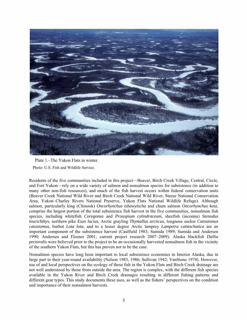
Plate 1.–The Yukon Flats in winter.
Photo: U.S. Fish and Wildlife Service.
Residents of the five communities included in this project—Beaver, Birch Creek Village, Central, Circle, and Fort Yukon—rely on a wide variety of salmon and nonsalmon species for subsistence (in addition to many other non-fish resources), and much of the fish harvest occurs within federal conservation units (Beaver Creek National Wild River and Birch Creek National Wild River, Steese National Conservation Area, Yukon–Charley Rivers National Preserve, Yukon Flats National Wildlife Refuge). Although salmon, particularly king (Chinook) Oncorhynchus tshawytscha and chum salmon Oncorhynchus keta, comprise the largest portion of the total subsistence fish harvest in the five communities, nonsalmon fish species, including whitefish Coregonus and Prosopium cylindraceum, sheefish (inconnu) Stenodus leucichthys, northern pike Esox lucius, Arctic grayling Thymallus arcticus, longnose sucker Catostomus catostomus, burbot Lota lota, and to a lesser degree Arctic lamprey Lampetra camtschatica are an important component of the subsistence harvest (Caulfield 1983; Sumida 1989; Sumida and Andersen 1990; Andersen and Fleener 2001; current project research 2007–2009). Alaska blackfish Dallia pectoralis were believed prior to the project to be an occasionally harvested nonsalmon fish in the vicinity of the southern Yukon Flats, but this has proven not to be the case.
Nonsalmon species have long been important to local subsistence economies in Interior Alaska, due in large part to their year-round availability (Nelson 1983, 1986; Sullivan 1942; VanStone 1974). However, use of and local perspectives on the ecology of these fish in the Yukon Flats and Birch Creek drainage are not well understood by those from outside the area. The region is complex, with the different fish species available in the Yukon River and Birch Creek drainages resulting in different fishing patterns and different gear types. This study documents these uses, as well as the fishers’ perspectives on the condition and importance of their nonsalmon harvests.

4
Figure 1.–Location of the Birch Creek watershed (65.39 °N, 145.72 °W) in Alaska.
Birch Creek flows approximately 340 miles from its headwaters to the Yukon River in the central region of the Yukon drainage.
This project has particular implications for federal and state subsistence management. Federal Subsistence Regional Advisory Councils representing Yukon River communities have identified a need for comprehensive data on nonsalmon fish populations, their life histories, and their range of uses as a subsistence resource. There also have been some regulatory issues in the area. The subsistence fishing closure for Birch Creek was removed by the Alaska Board of Fisheries (BOF) in January 2001 and a maximum mesh size restriction was instituted to protect spawning salmon and large, reproductively important resident species. The Federal Subsistence Board subsequently adopted a regulation to increase the allowable subsistence gillnet mesh size for Birch Creek, except between June 15 to September 15, when adult salmon are present. The BOF did not adopt a similar proposal at its January 2004 meeting, citing a lack of harvest information and unknown status of resident fish stocks. This research was designed in part to address these information gaps. Aside from concerns over management needs, local residents have also expressed concern about the impact of mining operations and resulting environmental contaminants on the resident species in Birch Creek, specifically northern pike (see also Caulfield 1983:213 and discussions below).

5
Figure 2.–Location of the five ethnographic study communities of the Yukon Flats and surrounding areas.
Map produced by the U.S. Fish and Wildlife Service, Yukon Flats National Wildlife Refuge.
OBJECTIVES This study had three primary goals with objectives to meet each goal:
A. Collection of traditional ecological knowledge:

6
Information was collected on the taxonomy and life history of nonsalmon fish within the study area. Additionally, and with greater focus due to the nature of this study, the traditional and contemporary harvest, use, and preservation methods were investigated alongside relative abundance and population considerations. This has largely been informed by the experiences and perceptions of long time fishers of nonsalmon fish and resident elders. Therefore, traditional knowledge of all types is described within the contexts from which it derives through narrative text.
B. Harvest and biological assessments:
Harvest and use information was collected for the calendar year 2005 by species and season of harvest for the communities of Beaver, Birch Creek, Central, Circle, and Fort Yukon. In addition to the harvest data, extensive information was collected on northern pike length index, providing a first level assessment of the stock status and relative population health of this species. See Appendix I for the survey instrument and Appendix III for the northern pike sampling data form.
C. Capacity building:
Capacity building occurred in all phases of this project (and ideally will be incorporated in future related projects). From the project’s initiation, including all the topics addressed, local concerns were considered and incorporated. This included participation and leadership roles in the fieldwork required for harvest and biological assessment, as well as involvement in the identification and selection of key respondents. Local project partners were present and participated in each interview.
These three objectives were addressed throughout the project and focused on culture change and the effects such change have had on local subsistence fisheries. Most important was consideration of the effects of changing nonsalmon fish quality and environmental change on the fishing practices of the peoples of the southern Yukon Flats. The objectives associated with each goal are described below.
METHODS COLLECTION OF TRADITIONAL ECOLOGICAL KNOWLEDGE (TEK)
Traditional ecological knowledge was documented though a variety of methods, including and primarily relying upon interviews with key respondents in the five study communities. In each community local tribal council leaders, Council of Athabascan Tribal Governments (CATG) staff, Subsistence Resource Specialists (SRSs) from the ADF&G Division of Subsistence, and BLM staff identified individuals knowledgeable about nonsalmon fish species with the assistance of other village residents. Collection of TEK was scheduled to occur in two phases: The first phase was conducted in December 2006, and a second phase followed in early 2007. A follow up round of interviews was scheduled between June and November 2007 to clarify the results of the household survey and the first round of interviews.
Because of the high quality of the original TEK interviews, it was unnecessary to conduct additional interviews. However, project investigators returned to the study communities in the summer of 2008 to review with local leaders and fishers analyses of information recorded in the TEK interviews and the harvest survey. Other clarifications and qualifications with key respondents occurred through early 2009 as needed. Researchers also took advantage of various key respondents’ travels into Fairbanks for unrelated activities to clarify information contained in the interviews, and to discuss placename meanings, and the harvest survey results.
Interviews generally were conducted during times of low subsistence activity in the southern Yukon Flats, although on occasion researcher participation in these activities served to further clarify practices and trends, including issues of culture change concerning the use of nonsalmon fish. Cumulatively, and often
7
opportunistically and at the researchers’ own expense, these participant activities totaled at least four weeks. Participating in the subsistence activities involving nonsalmon fish enhanced the researchers’ understanding of subsistence activity processes and motivations.
Interviews were conducted according to a semistructured format outlining general areas of discussion that were developed cooperatively in advance by ADF&G and CATG personnel. See Appendix II for the protocol used for these ethnographic/traditional knowledge interviews. Key respondents were provided honoraria for their time. Interviews were recorded and supplemented with note taking. Pictures and maps were provided as prompts during interviews, and relevant information (e.g., locations of spawning areas, rearing habitat, traditional harvesting areas, etc.) was recorded on U. S. Geological Survey (USGS) 1:250,000 scale maps. Some photographs were taken to document activities, but most participants asked that individuals not be photographed. Area photographs were permitted and appear throughout this report. Unless otherwise noted, photographs were taken by Koskey.
Recorded interviews included the following categories of information (as reported by local experts):
1. Taxonomy; that is, species used and local names for fish species;
2. Life history and biological information, including habitat preferences, spawning and rearing areas, and seasonal movements of fish;
3. Traditional and contemporary harvest methods, including timing of harvest, gear used, mapping of harvest areas, and collection of fish-related placenames;
4. Traditional and contemporary preparation and preservation methods;
5. Use of various fish and fish byproducts for human and dog consumption, trapping bait, etc.;
6. Relative abundance and population trends; and
7. Recording of Gwich’in placenames, where possible.
Twenty key respondent interviews were conducted (see Table 1 below) involving 21 individuals in five communities (Beaver, Birch Creek Village, Central, Circle, and Fort Yukon). Interviews were conducted in Fort Yukon by Michael Koskey (ADF&G/University of Alaska Fairbanks), Ingrid McSweeny (BLM), and Derek Rader (CATG) with the assistance of Bruce Thomas (CATG); by Koskey and U. S. Fish and Wildlife Service (USFWS) Refuge Information Technician (RIT) Paul Williams, Sr., in Beaver and Birch Creek Village with the assistance of Winston James (former chief, Birch Creek); by Rader and McSweeny in Central with the assistance of Laurel Tyrell (Circle District Museum); and by Koskey and Rader in Circle with the assistance of Margaret Henry John (former chief, Circle). The dataset resulting from these interviews comprises approximately 22 hours of audio recording, accompanying field notes, and maps depicting species-specific habitat, spawning areas, harvest locations, and some geographic placenames.
All but two of the key respondents preferred to remain anonymous, so only the number and location of interviews were recorded and all key respondent interviews are identified by code when used in this report. The preference for keeping one’s identity unknown stems from a perception that hunting and fishing (and trapping) regulatory agencies aggressively enforce fishing and hunting regulations. There also is a general perception among rural Alaskans that regulatory agencies have little cultural understanding of traditional wild resource extraction and management practices in rural and indigenous communities, and that “official” management practices are often ineffective.

8
Table 1.–Key respondent interviews by community.
The information collected from key respondents concerning nonsalmon fish represents an extensive body of knowledge handed down and accumulated through many generations of interaction with the natural world, as is typical of TEK. Also represented is a multigenerational perspective of the changes that have occurred affecting resident nonsalmon fish species and the practices surrounding their use. For each species, the information collected falls generally into the following categories: 1) Native terms and taxonomy; 2) life history, seasonal movements and spawning; 3) traditional and contemporary harvest methods; 4) use, preparation, and preservation methods; and 5) relative abundance. Information generated within each of these categories appears throughout this report.
Throughout the project the many (and often temporary) project partners utilized standard anthropological methods of participant-observation during fieldwork, involving participation in all local activities possible while in project communities. These included harvest and processing activities—primarily of nonsalmon fish but including king (Chinook) and chum salmon as well—in addition to other community activities. This involvement enabled researchers to learn more about the seasonal cycle of nonsalmon fish (as well as other subsistence resources) and the role of fish in the lives of local community members, including social organization and beliefs that surround their collection and processing practices. Significant involvement in fish cutting and the use of gillnets, hoop nets, hooks-and-line, and occasionally fish wheels helped researchers to understand the wide range of fishing methods employed in the region, including the use of fish byproducts as bait for trapping furbearers.
USGS 1:250,000 scale maps were used, when possible and appropriate, to record information such as spawning areas, rearing habitats, and traditional and new fishing locations. Where possible, local Gwich’in placenames were also recorded on these maps. These maps are presented and discussed later in this report. The list of placenames is incomplete due to the small number of respondents who continue to use Gwich’in placenames, and because not all community fishers could be interviewed.
HARVEST AND BIOLOGICAL ASSESSMENTS
The second goal of the study was twofold: to gather subsistence harvest assessment information on nonsalmon species, and to collect biological information, as part of a cost share agreement with the BLM, on northern pike Esox lucius. These goals were accomplished through face-to-face harvest survey interviews in the communities of Beaver, Birch Creek Village, Central, Circle, and Fort Yukon. The survey was conducted in 2006 for the calendar year 2005 nonsalmon harvest. The harvest assessment component includes a 12-month assessment of nonsalmon fish species harvest with a sampling of the overall subsistence harvest. Comprehensive household surveys that utilize standard ADF&G Division of Subsistence methods provide an in-depth view of community harvest estimates that tend to be more precise than postseason harvest surveys conducted by ADF&G’s Division of Commercial Fisheries. This is not because of a lack of rigor or research capacity on the part of the Division of Commercial Fisheries, but because these surveys often include small sample sizes that yield less precise community estimates. In addition, the data obtained through this harvest survey are comparable to other harvest studies performed by the Division of Subsistence throughout the state of Alaska.

9
The biological study portion of this project was directed by ADF&G Sport Fish Division researcher John Burr, who simultaneously conducted a parallel project focusing on the health of northern pike Esox lucius and water quality in upper Birch Creek between the communities of Central and Circle. Kristin Mull of the BLM was the project lead on the lower Birch Creek portion of the biological study—in the vicinity of Birch Creek Village— and she performed the subsequent assessment of data and their presentation in this report. In addition to being sampled for the purpose of assessing the degree of overlap between the pike population targeted by the subsistence and sport fisheries, the overall health of northern pike in Birch Creek was studied in response to the mining activities practiced in the vicinity of the community of Central. Local perceptions indicate that mining activities had deleterious effects on all fish species in the Birch Creek watershed prior to the implementation of changes in mining practices in the late 1980s and 1990s that led to an improvement of water quality, as was reported in multiple interviews (C011907A, C011807B, C011807C, D012407A, E032807F). These conditions are discussed in more detail later in this report.
In 2007, northern pike length index sampling was conducted to assess the proportion of large fish (>720 mm) inhabiting upper and lower Birch Creek. The length index provides a first level assessment of the stock status and relative population health. In addition, the effectiveness of the length index as applied to a presumably lightly fished northern pike stock was evaluated. Research objectives in the two study areas in 2007 were to:
1. Estimate the proportion of adult northern pike (450 mm FL at fork length—the point on a fish’s tail where it splits into two fins) that are >720 mm FL such that the estimated proportion will be within 5 percentage points of the true value 95% of the time.
2. Test the hypothesis that the proportion of adult northern pike (450 mm FL) that are >720 mm FL is ≥0.20 against the alternative hypothesis that the proportion of adult northern pike >720 mm FL is <0.20. The hypothesis was tested such that the null hypothesis was rejected if the true proportion is ≤0.15 with probabilities of Type I and Type II error being 0.05 and 0.20 respectively.
The map below (Figure 3) outlines the areas of the Birch Creek watershed that were sampled in the summer of 2007.
Birch Creek and its drainage are managed by an array of tribal, state, and federal agencies. Birch Creek flows approximately 340 miles from its headwaters near Eagle Summit to its confluence with the Yukon River in the Eastern Interior region of Alaska (Figure 3). The lands surrounding Birch Creek are managed by the BLM in upper Birch Creek, the State of Alaska and tribal governments and/or Native corporations cooperatively in parts of middle Birch Creek near Circle, and the USFWS in lower Birch Creek. In addition, many of the tributaries to Birch Creek are on private and state-managed lands.

10
Figure 3.–Location of the five ethnographic study communities and two northern pike sampling areas in the Birch Creek watershed and surrounding area.
The upper portion of Birch Creek (more accurately referred to as a “river” in its middle and lower reaches), which spans approximately 126 river miles, was established as a component of the National Wild and Scenic River System under the Alaska National Interest Lands Conservation Act (ANILCA) of 1980 and is managed by the BLM (Figure 3). The Birch Creek National Wild River begins approximately one mile upstream from the confluence of Twelvemile Creek and Birch Creek (BLM 1983). The land north and south of the wild river corridor was also converted to the Steese National Conservation Area. The lower portion of the river is within the Yukon Flats National Wildlife Refuge, which is managed by the USFWS and was also established with the passage of ANILCA.
HARVEST SURVEYS As noted above, harvest information was collected through systematic household surveys. In addition to harvest and use data, demographic information and information on sharing and use of fish species, timing of harvest, and numbers and species harvested was recorded. Based on retrospective recall, respondents were asked to provide specific information on numbers and species harvested, timing of harvest, and sharing and use of fish species. Surveys covered calendar year 2005 and were conducted in 2006. Some surveyed residents believed it was improper to discuss numbers of fish (or any other animal) harvested; however, most agreed to provide this information to the local survey technicians working on this project.
This situation concerning the counting of harvested animals arises from concepts of respect extending from the beliefs associated with subsistence lifeways derived from ancient animistic beliefs of the local Gwich’in Athabascan population. The belief that all of existence is backed by a spiritual reality includes a definition of nonhuman entities as “persons” in a spiritual sense, and thus how nonhuman persons are

11
treated is analogous to how a human is treated, with respect being the foundation of an honorable relationship. The counting of “harvested” animals, therefore, is considered presumptuous, insensitive, and disrespectful, and so is culturally dissuaded. Failure to treat the “harvested” animal with respect is believed to lead to bad luck in future hunts or other endeavors. To treat anything disrespectfully not only threatens one’s own luck, but also puts at risk the welfare of other family or community members. For these reasons are the terms “harvested” and “resources” also disliked and seldom used by many indigenous Alaskans, because they are seen as a dishonorable objectification of a spiritually aware portion of existence. These cosmological and spiritual concerns must be respected to effectively understand the subsistence behaviors of indigenous peoples in Alaska, and helps to explain why harvest reports are sometimes inconsistent or not completed.
Research was conducted consistent with ADF&G Division of Subsistence research ethics guidelines (ACUNS 2003) in accordance with tribal consultation policy. CATG identified local research assistants to administer the surveys with the assistance of tribal councils in each village. Research participants were provided a one-page information sheet that described the voluntary and confidential nature of their participation, and included contact information for both ADF&G and CATG in case they had further questions about the project after their surveys were completed. No household that was contacted declined to participate in the surveys.
Sampling Goals Two sampling designs were employed for this research. In communities with populations under 50 households (four of the five study communities) a census of all households was attempted. In Fort Yukon, with 205 households, a random sample was employed. All of the estimated 125 non-Fort Yukon households were invited to participate in the harvest survey. In Fort Yukon, the random sample was 50% of the estimated 205 households. All study communities were given the opportunity to review and comment on the preliminary study findings through the mail or when project staff made return trips. Final study results were provided to each community. Table 2 below displays the number of households contacted and surveyed in each community, as well as the percentage of the total households sampled, and the estimated 2006 population.
Table 2.–Sampling statistics for Birch Creek nonsalmon harvest survey, 2006.
Total Household Number of Percent of Sampled Estimated Number of Sample Surveyed Households Failed to Declined Household Community
Community Households Goal Households Sampled Contact Survey Population Population ALL 330 227 201 85.71% 477 794.7 Beaver 33 33 22 66.67% 11 0 51 76.5 Birch Creek 10 10 10 100.00% 0 0 21 21.0 Central 48 48 41 85.42% 7 0 83 97.2 Circle 34 34 26 76.47% 8 0 65 85.0 Fort Yukon 205 102 102 100.00% 103 0 257 515.8
Pre-fieldwork Training
Survey assistants were trained over an approximately one- to two-day period to conduct the harvest surveys. Project investigators performed this training in each community during the winter of 2005 before project partners began the TEK interviews. The training included the following:
1. A summary and discussion of previous related nonsalmon and traditional knowledge research in the study communities;
2. A review of project goals, objectives, and procedures and how to maintain anonymity in all survey endeavors;
3. A discussion of nonsalmon fish population trends and other local observations and issues; and

12
4. Training local researchers in survey performance, administration, and follow up concerns.
Local research assistants were supplied with packets that included an instructional guide to help them in survey administration and project record keeping, a set of color prints (drawings) and photographs of nonsalmon fish to be used as an identification guide, and the information sheets concerning the project and survey for each participating household, including investigator contact information.
Data Collection Phase Data collection occurred from May through August 2006. Either ADF&G, CATG, or USFWS staff were available to local research assistants in the field to answer questions or provide additional information and clarification on survey implementation. Local research assistants were compensated at a rate of $25 per completed survey form.
Upon completion of the household survey in each community, project investigators reviewed the survey forms for accuracy and potential problems or needs for clarification. The reviewed surveys were subsequently coded and sent to the Division of Subsistence’s Information Management staff for further review and analysis. Information was analyzed for the estimated number and pounds of nonsalmon fish species harvested in the five project communities. Further tables depicting the frequency of sharing—receiving and giving—of nonsalmon fish resources, as well as the percentage of households participating in fishing activities by month, were created by ADF&G data analysis staff. These tables include the estimated rates of fishing by month by household.
Household surveys are important for providing a relatively accurate depiction of harvest activities and often produce more accurate information than other data collection methods, such as harvest ticket reporting. Household surveys also tend to result in the reporting of higher numbers as well, since reporting is done under conditions of anonymity.1 This is not to say that anonymity or local-to-local resident interviews helps to skew harvest numbers upward (or in any potential direction), but that absent the fear of citation or prosecution, respondents are more likely to divulge accurate harvest information. Local community members who participate in household surveys have also reported in other Division of Subsistence surveys that they feel more comfortable and “safe” in providing subsistence harvest information to local surveyors, who provide a “buffer” between themselves and any potential enforcement backlash from state agencies. This has resulted from often insensitive and ineffectual intrusions into local communities’ traditional subsistence activities, some of which are effectively criminalized under existing regulations.
A TEK project such as this can help to avoid similar cross-cultural problems. By understanding the cultural behaviors that surround the harvest of wild resources, inconsistencies can be identified and evaluated as being present and legitimate as a product of cultural misunderstandings. Much of the misunderstanding that stems from differing conceptualizations of wild resources and their harvest can result in the creation of inaccurate presumptions or stereotypes. Such inaccuracies, when not exposed and qualified, can misinform resource management policymaking and result in potentially unsuccessful management efforts. Fundamentally, indigenous management systems reflect the collective concerns of the local community. Regardless of whether indigenous management systems are similar to those developed by management agencies, these systems often have the effect of conserving resources. Otherwise they would be self defeating, particularly among people whose primary sustenance needs are provided by fluctuating and living resources.
Through the anonymous surveys and the use of local surveyors, a more accurate harvest assessment can be obtained. By comparing the officially reported numbers (collected and tabularized through ADF&G’s
1 Koskey, M. 2007. Subsistence resource use among ten Tanana River valley communities: 2004–2005. Draft
technical paper. Alaska Department of Fish and Game Division of Subsistence, Fairbanks.

13
harvest database) with the results of household surveys, local hunters, fishers, and leaders report that the numbers generated from the household surveys are much more accurate than those generated through obligatory harvest reporting to ADF&G and others (see Footnote 1). Again, this is in part due to concerns about enforcement. Most local hunters and leaders call for locally and culturally based management that is appropriate to local seasonal conditions and cultural concerns of respect towards resources and local autonomy. This would require a suspension of the assumption that management techniques that are effective in one region are effective in all regions.
BIOLOGICAL ASSESSMENT A final component of this study included the biological assessment of northern pike in Birch Creek itself. As part of the larger project, but under separate funding—specifically, a Challenge Cost Share Agreement between the ADF&G Division of Sport Fish and the BLM—researchers also collected biological data on northern pike populations in upper and lower Birch Creek. This portion of the study in part served as a pilot project to determine the feasibility of further studies focusing on nonsalmon fish species in the Birch Creek drainage.
Birch Creek is located in eastern interior Alaska, approximately 75 air miles northeast of Fairbanks (see Figure 1 above). It is surrounded by rolling hills and low mountains in its upper reaches. In the lower reaches of Birch Creek in the Yukon Flats region, low gradient, slow water current, and a meandering channel characterize the river. The elevation in the Birch Creek watershed ranges from 360 feet at the lower mouth to 4,000 feet in the headwaters near Eagle Summit in the White Mountains.
The climate in the region is characterized by long cold winters and short, hot summers. Precipitation is usually in the range of 10 to 15 inches per year (Kostohrys and Sterin 1996), with two peak discharges during spring breakup in May and late summer rains in August. In upper Birch Creek, the steep slopes with thin soil cover and areas of permafrost have little capacity to retain runoff, creating flows that respond relatively quickly to storm events (Kennedy and Langley 2007). Rivers begin freezing by early October, and freezing to the stream bottom may occur in winter (Kostohrys and Sterin 1996).
Riparian vegetation in the Birch Creek watershed includes forests of black spruce Picea mariana, white spruce Picea glauca and birch Betula papyrifera; tundra; shrubs such as willow Salix spp., alder Alnus crispa, and dwarf birch Betula nana and Betula glandulosa; and herbaceous vegetation such as cotton grass Eriphorum spp. and sedges Carex spp. (Sterin et al. 1998).
Plate 2.–Birch Creek (lower mouth) downstream from Birch Creek Village.
Photo: Michael Koskey.

14
Northern Pike Length Index Sampling
Sampling of northern pike took place in two study reaches—one in lower Birch Creek and one in upper Birch Creek—and associated off-channel habitats (see Figure 3 above). Study reaches were chosen for their proximity to the subsistence and sport fisheries that take place in Birch Creek. According to the household interviews, both subsistence and sport fishing occur on the upper reaches of Birch Creek; subsistence fishing predominates on the lower reaches of Birch Creek (B011607B, C011807C, D012407B).
The length index provides information to managers regarding the relative status of the stock, and is not considered an unbiased estimate of population length composition. This is due to the random sampling methodology employed and its range, although it can reflect regional trends. Sampling protocols were designed by ADF&G’s Sport Fish Division researchers to ensure the validity of the assumptions of length sampling and include the following:
1. The population is closed—i.e., there is no significant change in the number or composition of northern pike in the study areas during the sampling event due to immigration, emigration, or growth;
2. Northern pike of all sizes larger than 450 mm fork length in the study areas are susceptible to the sampling gear; and
3. Fish are sampled without replacement.
Sampling occurred in June, when fish movement is at a minimum and fish are likely to be distributed more uniformly by sex and length than during spawning, which typically occurs in May. The majority of sampling took place during cooler morning and evening hours in order to prevent or minimize incidental mortality or other nonlethal stress to captured fish.
The sampling effort was distributed over the two pike study reaches to enhance capture probabilities of all adult sized fish present during the sampling period in early to mid-June. In addition, a variety of gear types were used to increase sampling efficiency, namely, variable mesh gillnets, fyke (hoop) nets, and hook and line.
All captured northern pike were measured for fork length to the nearest millimeter, marked with a Floy tag at the left base of the dorsal fin, and examined for existing tags or tag wounds to avoid repeat sampling. All fish were released immediately after data collection and tagging. Fish species, length, tag numbers, fish mortality, and other comments were recorded on data sheets, along with the date and time, gear type, set duration, latitude and longitude coordinates, and water temperature (see Appendix III). Tags were used as a part of another research project (whose partners sampled in the upper reaches of Birch Creek under the supervision of John Burr, Sport Fish Division, ADF&G). All data were edited for incomplete information and errors upon completion of fieldwork and were entered into a Microsoft Excel spreadsheet. Final copies of the data are archived in ADF&G’s Sport Fish Division Docushare repository.
The proportion of adult northern pike in the two size groups (fork length 450–720 mm, and fork length greater than 720 mm) captured in the two Birch Creek study areas are considered an estimate of the proportion of northern pike in either area at the time of sampling. A one-tailed proportion test was used to test the hypothesis that the proportion of adult northern pike (450 mm FL) that are >720 mm FL is ≥0.20 (Objective 2). Equations used to calculate the proportion and variance estimators and to perform the one-tailed proportion test are provided in a separate report.2
2 Burr, J.M. In prep. Evaluation of length index as a method for assessing northern pike in the Birch Creek drainage. Alaska
Department of Fish and Game, Fisheries Data Series, Anchorage.
15
CAPACITY BUILDING
A third goal of the study was to partner with local communities, tribal organizations, and nonprofit organizations to document harvest and biological information, thus building capacity within the local communities to practice and assist in subsistence harvest research. Local community involvement in conducting the harvest surveys, the TEK interviews, and the biological sampling all served to meet this goal. The participation of community members in each of these research components enabled a more complete understanding of the goals of the project and the methods used to accomplish these goals.
In cooperation with local residents in project communities and project partners, informal guidelines for working with rural Alaskan residents on TEK, harvest monitoring, and harvest assessment projects were developed, emphasizing mutual respect and patience in understanding and incorporating local perspectives, techniques, and preferences. This approach acknowledges that much can be learned through participation and observation, rather than through formal questioning or other more direct forms of inquiry. In part, this was augmented by demonstration and the training of selected community residents in techniques of interviewing for the purpose of collecting traditional knowledge and in biological sampling techniques.
Surveyor training required a different approach, since learning customs requires observation and participation as primary modes of instruction. By only explaining how a survey is to be conducted, much is presumed on the part of the investigator, and the surveyor might have difficulty in conceptualizing what is to occur, and why. Instruction through demonstration and participation proved to be most effective, with concurrently more successful results. Local residents were involved in every step of this project and preliminary reports were provided to communities to review for inaccuracies or other issues. Two University of Alaska Fairbanks students were closely involved in transcribing the TEK interviews and were encouraged to provide their perspectives throughout (see Acknowledgements at end of report).
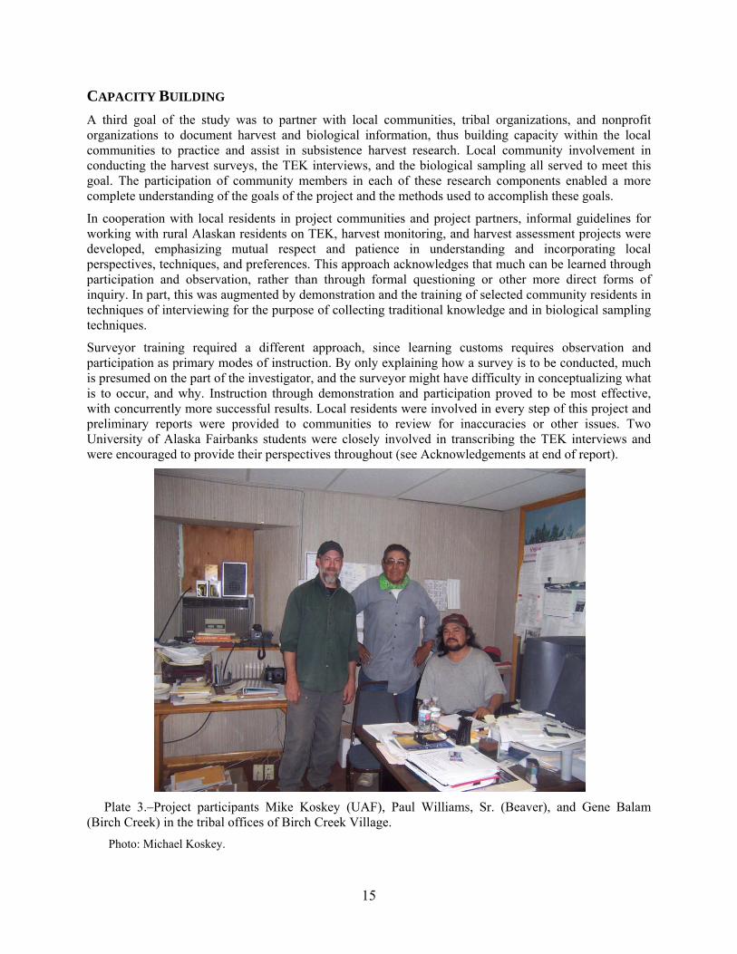
Plate 3.–Project participants Mike Koskey (UAF), Paul Williams, Sr. (Beaver), and Gene Balam (Birch Creek) in the tribal offices of Birch Creek Village.
Photo: Michael Koskey.

16
RESULTS OF THE TEK COMPONENT One of the most interesting aspects of the sociocultural research performed by anthropologists and other researchers through interviews and participant observation is the contextual information that is provided beyond the specific subject matter of the study or interview. This provides a holistic perspective that places the information sought within its larger and more complex context. Through these conditions, relations and contrasts can be observed that further inform the research concerning why and how a particular situation manifests. Interestingly, and relevant to cooperative research and co-management, this approach reflects the understanding of many indigenous cultures that such complexity in existence is best understood processually, by understanding the relations that can be perceived through experience and the subsequent consequence of action.
A substantial number of comments in key respondent interviews related nonsalmon fishing to salmon fishing, indicating concern about salmon declines. These declines seem to have affected only salmon, according to perceptions drawn from the 2006 and 2007 interviews, but overall, nonsalmon populations were described as “healthy.” Nevertheless, as witnesses to the rapid decline and gradual recovery of salmon, local residents voiced concerns over the future viability and resiliency of nonsalmon species.
Circle: So back when people fished for more whitefish here, was there more in the past or has it always been the same?
Lot of difference, especially with salmon, there’s a lot of difference. Well the main concern I got is the low number of fish. It’s not as good, not like long time ago. It is very poor, there is hardly any, long time ago back in the 1940s and ‘50s when you set a net there be about 500 to 600 a night. But now there is very little.
Do you see other kinds of whitefish here?
Oh yeah they got the big humpies, and the little ciscoes. They were about medium, they were bigger in the past. They fluctuate. Down on Medicine Lake there are still big ones. Oh man, they are like alligators down there. (E032807A)
Circle: Do you think the number of nonsalmon fish in the areas you fish are increasing or decreasing, or about the same as usual?
Depends on the year but it seems about the same as it was 5 years ago. The size are about the same size as they were long time ago. I think there are less of them, but otherwise they have been in pretty good shape, and the numbers are down. But I am not really sure; they screwed Birch Creek up here because years and years they had the mine. It used to be clear water but now it’s not like that. They messed it up, I suggest that they check that water once in a while and see what the fish are doing down there. (E032807F)
Fort Yukon: Do you think the number of nonsalmon fish in the areas you fish are increasing or decreasing, or about the same as usual?
Numbers are about the same. Pike numbers may be lower than the past, but grayling and burbot are pretty stable. The quality and number of fish changes from year to year, you know, like fifty years ago there was more whitefish. (A120706B)
Many respondents provided observations of widespread drying of lakes, sloughs, and streams, and much reduced or even absence of flooding on the Yukon River—in Beaver it was reported that until the massive flood of 2009, the Yukon has not flooded over its banks since 1993. The absence of these floods was directly identified as the cause for the decrease in the water levels and water quality in the vicinity of the formerly widespread annual floodplain of the Yukon. One important whitefish lake in particular—Twelvemile Lake—was renowned for its large population of whitefish, but now it was described by many respondents as having dried so much that its use was significantly diminished. This perception was

17
echoed in other communities as well, where once formerly productive habitats were described as now being marginal because of a decreasing water table or increased dryness.
Birch Creek: What about the waterways in which you fish—are they different than the past?
It’s too low, the water is too low, in the springtime then you could catch pike; that is when the water level is high in the Twin Lakes. On the high water in Twin Lake the beaver they bust their dams and the fish go out. Oh yeah it is getting worse with the water level going down, there is no more salmon. Yeah I know that the rivers are drying up, I see bars that I never seen before. The lakes every year are getting lower and lower and a lot of these lakes that go into the middle [melting permafrost under lakes leads to their draining]. (C011907A)
However, the quality and health of nonsalmon fish were generally reported as good, with only an occasional comment that sizes or numbers had declined compared to five or ten years ago. The exception is northern pike. Many respondents described that in the recent past, pike were more numerous and easier to find. In the more distant past—more than 10 or 20 years ago—pike were described by elders as being significantly larger in size than today and they were more numerous.
Beaver: There used to be a place back here when you just put a net across the creek and fish come out and we would catch pikes. But since there is low water there is hardly pikes in there. (B011607B)
Central: Though pike sizes seem to be the same as in the past twenty to thirty years, there seems to be noticeably fewer in Medicine Lake. The lake is gradually getting grassier, and the population of resident muskrat is increasing. (D012407A)
This should be qualified by the reported condition of a relative decline in the number of community residents who fish for pike, possibly accounting for the perception of reduced numbers, because of lighter harvests. Nevertheless, those who have fished for pike in the region over time report a decrease in numbers and sizes per fishing effort. This is the case despite the fact that fewer people throughout the region fish for northern pike today than during the previous 10 to 50 years.
ETHNOHISTORIC SUMMARY OF THE DENDUU AND GWICHYAA GWICH’IN
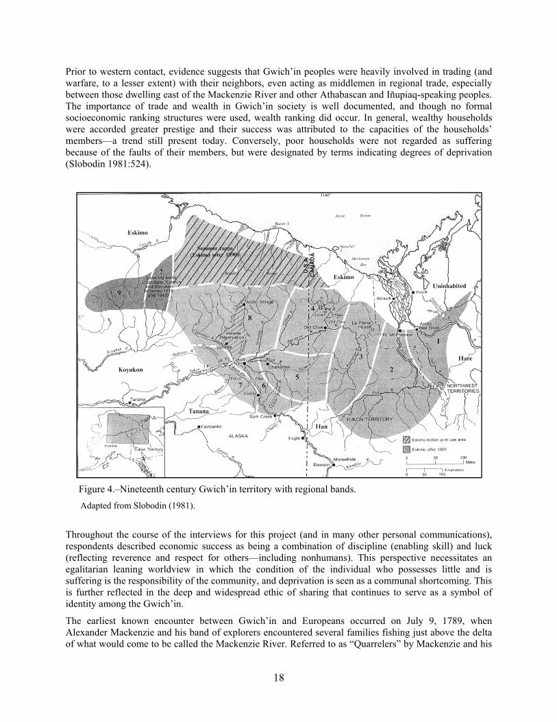
The Gwich’in Athabascan peoples of northeastern interior of Alaska and the northern and northwestern reaches of the Yukon and Northwest territories in Canada, respectively, were at the time of European contact (middle to late 19th century) divided into either nine or ten regional bands (Slobodin 1981:515; and Figure 4 below). Each of these bands continued to use their Gwich’in dialects through the time of their transition from seasonal nomadism to the establishment of permanent communities in the 20th century. This study focuses on the nonsalmon harvest and use practices of the Denduu and Gwichyaa Gwich’in (numbered 3 and 4, respectively, on the map in Figure 4).
Although the traditional subsistence economy was based on the hunting of large mammals—particularly caribou—the bulk of the diet apparently consisted of small mammals and, especially, fish. Both anadromous and freshwater fish were widely utilized in the Gwich’in region throughout the year. According to the harvest surveys and the interviews conducted for this study, this same pattern continues to the present. Of course, in the 21st century (and in preceding decades) a mixed subsistence–cash economy has arisen with the increase in trade and local demand for the products of trade. Many of these trade goods are acquired to facilitate subsistence activities, such as firearms, boats and motors, snowmobiles, and all-terrain vehicles, augmented by perishables such as manufactured food products, fuel, and ammunition. Nevertheless, the subsistence round continues to be followed within all five study communities with a focus on fishing for salmon, hunting moose and caribou, and furbearer trapping.
18
Prior to western contact, evidence suggests that Gwich’in peoples were heavily involved in trading (and warfare, to a lesser extent) with their neighbors, even acting as middlemen in regional trade, especially between those dwelling east of the Mackenzie River and other Athabascan and Iñupiaq-speaking peoples. The importance of trade and wealth in Gwich’in society is well documented, and though no formal socioeconomic ranking structures were used, wealth ranking did occur. In general, wealthy households were accorded greater prestige and their success was attributed to the capacities of the households’ members—a trend still present today. Conversely, poor households were not regarded as suffering because of the faults of their members, but were designated by terms indicating degrees of deprivation (Slobodin 1981:524).
Figure 4.–Nineteenth century Gwich’in territory with regional bands.
Adapted from Slobodin (1981).
Throughout the course of the interviews for this project (and in many other personal communications), respondents described economic success as being a combination of discipline (enabling skill) and luck (reflecting reverence and respect for others—including nonhumans). This perspective necessitates an egalitarian leaning worldview in which the condition of the individual who possesses little and is suffering is the responsibility of the community, and deprivation is seen as a communal shortcoming. This is further reflected in the deep and widespread ethic of sharing that continues to serve as a symbol of identity among the Gwich’in.
The earliest known encounter between Gwich’in and Europeans occurred on July 9, 1789, when Alexander Mackenzie and his band of explorers encountered several families fishing just above the delta of what would come to be called the Mackenzie River. Referred to as “Quarrelers” by Mackenzie and his

19
men, these Gwich’in are referred to as “Loucheux” (“squinters” or “cross-eyed”—possibly more accurately meaning “sharp-eyed”) by traders (Slobodin 1981:528, 531). Loucheux generally refers only to those Gwich’in who dwell in the vicinity of the lower Mackenzie River and its delta, although it has been used as a term for the Gwich’in of Canada in general. Later referred to as “Tukudh” by Anglican missionaries, the Gwich’in most commonly referred to themselves as Dinjii Zhuu—the “small [meaning humble] people.” The term “Gwich’in” is said to best translate as “one who dwells” or the “resident of the region.”
The ethnonyms of the primary residents of the five communities of this study—the Denduu and Gwichyaa Gwich’in—also vary. Among the people of the Yukon Flats the use of the term Denduu Gwich’in indicates “people on the other side [of the Yukon]” (i.e., the Birch Creek people), while another term—Ishenzhik Gwich’in—means “people of Birch Creek.” Slobodin (1981:532) indicates that the Birch Creek people refer to themselves as Tsatet’aich’in or some variation of this, meaning “dwellers on the converging streams” (i.e., Birch Creek, Beaver Creek, and their sloughs and tributaries). The indigenous people of Fort Yukon and Circle (and surrounding areas) tend to refer to themselves as Gwichyaa Gwich’in, variously said to mean “lowlanders,” “dwellers on the flats,” or “Fort Yukon dwellers.” On the upper Yukon (in Canada) this is said to translate as “giant people” (Slobodin 1981:532).
In the early 1800s the North West Company sought to establish trade with the Gwich’in by establishing Fort Good Hope, although from the time of its foundation, hostilities between the Gwich’in and Iñupiat were reported. Fort McPherson was subsequently established in 1840 on the nearby Peel River to help avoid this conflict. This was followed by the establishment of Fort Yukon in 1847 in what was officially Russian territory. The establishment of these trading posts was primarily motivated by the great economic potential of the northwest North American fur trade, soon to be augmented by the western Arctic whaling boom and the Klondike gold rush (Slobodin 1981:529).
With the rise of trade also came two elements that would forever alter the culture of the Gwich’in—epidemic diseases and Anglican and Roman Catholic missionaries. From the 1860s to almost 1930, diseases including scarlet fever and measles, among others, devastated the Gwich’in. Severely depopulated and traumatized, Gwich’in assimilation into Anglo–American lifeways accelerated. During this time the influence of the Dinjii Dazhan—the “magical people” or shamans—waned as their capacities for healing the unfamiliar diseases proved insufficient. Into this social space came the missionaries, many of who had access to western medicines developed to treat these diseases. As would be expected, diseases took the youngest and elderly in the greatest numbers; much traditional knowledge disappeared with the untimely death of a community’s elders. Such a loss of the accumulated knowledge of multiple generations inevitably contributed to rapid culture change.
In spite of these deprivations and rapid culture change, the Gwich’in remain a cohesive people who continue to mix ancient traditions with modern practices. This is clearly evident in the acquisition of nonsalmon fish resources, where knowledge of natural indicators, traditional fishing locations, and the use of modern equipment with traditional methods persist. So, too, continues the use of fish camps to ideally situate oneself to the seasonal movement of nonsalmon fish, although today most nonsalmon fishing is done in conjunction with, or even as a byproduct of, fishing for salmon—particularly kings (Chinooks) and chums.
Three issues dominate the contemporary sociopolitical situation of the Gwich’in of the southern Yukon Flats: ongoing mining in the White Mountains, the possible reintroduction of the wood bison Bison bison athabascae, and the development of natural gas resources. These three issues are intertwined to some degree, primarily because of the status of the wood bison as an endangered species. Due to provisions of the Endangered Species Act (ESA), the reintroduction of wood bison could affect the regulatory regime concerning gas and mining development.
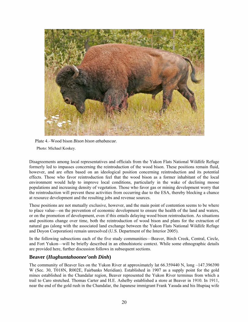
20
Plate 4.–Wood bison Bison bison athabascae.
Photo: Michael Koskey.
Disagreements among local representatives and officials from the Yukon Flats National Wildlife Refuge formerly led to impasses concerning the reintroduction of the wood bison. These positions remain fluid, however, and are often based on an ideological position concerning reintroduction and its potential effects. Those who favor reintroduction feel that the wood bison as a former inhabitant of the local environment would help to improve local conditions, particularly in the wake of declining moose populations and increasing density of vegetation. Those who favor gas or mining development worry that the reintroduction will prevent these activities from occurring due to the ESA, thereby blocking a chance at resource development and the resulting jobs and revenue sources.
These positions are not mutually exclusive, however, and the main point of contention seems to be where to place value—on the prevention of economic development to ensure the health of the land and waters, or on the promotion of development, even if this entails delaying wood bison reintroduction. As situations and positions change over time, both the reintroduction of wood bison and plans for the extraction of natural gas (along with the associated land exchange between the Yukon Flats National Wildlife Refuge and Doyon Corporation) remain unresolved (U.S. Department of the Interior 2005).
In the following subsections each of the five study communities—Beaver, Birch Creek, Central, Circle, and Fort Yukon—will be briefly described in an ethnohistoric context. While some ethnographic details are provided here, further discussion follows in subsequent sections.
Beaver (Hughuntahoonee’onh Dinh)
The community of Beaver lies on the Yukon River at approximately lat 66.359440 N, long –147.396390 W (Sec. 30, T018N, R002E, Fairbanks Meridian). Established in 1907 as a supply point for the gold mines established in the Chandalar region, Beaver represented the Yukon River terminus from which a trail to Caro stretched. Thomas Carter and H.E. Ashelby established a store at Beaver in 1910. In 1911, near the end of the gold rush in the Chandalar, the Japanese immigrant Frank Yasuda and his Iñupiaq wife
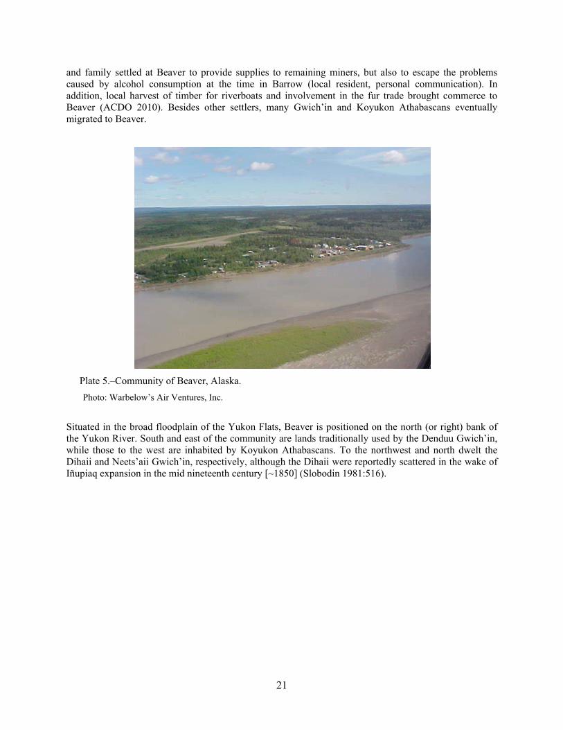
21
and family settled at Beaver to provide supplies to remaining miners, but also to escape the problems caused by alcohol consumption at the time in Barrow (local resident, personal communication). In addition, local harvest of timber for riverboats and involvement in the fur trade brought commerce to Beaver (ACDO 2010). Besides other settlers, many Gwich’in and Koyukon Athabascans eventually migrated to Beaver.
Plate 5.–Community of Beaver, Alaska.
Photo: Warbelow’s Air Ventures, Inc.
Situated in the broad floodplain of the Yukon Flats, Beaver is positioned on the north (or right) bank of the Yukon River. South and east of the community are lands traditionally used by the Denduu Gwich’in, while those to the west are inhabited by Koyukon Athabascans. To the northwest and north dwelt the Dihaii and Neets’aii Gwich’in, respectively, although the Dihaii were reportedly scattered in the wake of Iñupiaq expansion in the mid nineteenth century [~1850] (Slobodin 1981:516).

22
Plate 6.–Approach to Beaver from upriver.
Photo: Michael Koskey.
Contemporary Beaver (population 65 in 2008) is an unincorporated village governed by a traditional council, and the community (as are all study communities except Central) is one of the ten members of the Council of Tribal Athabascan Governments (CATG), an organization of villages that promotes cooperative economic development efforts, social and educational services, and land management. The adoption of the Alaska Native Claims Settlement Act (ANCSA) created the Beaver Kwitchin Corporation with 92,160 acres of land with an enrollment of 192 members (ANCSA; 85 Stat. 706) (Sumida 1989:10). The people of Beaver continue to be heavily involved in subsistence activities with a focus on trapping, hunting of moose and migratory birds, and fishing, especially for salmon. Fish wheels and mesh gillnets are the gear types most commonly used for fishing.
Birch Creek (Tiheetsit’sai)
The community of Birch Creek lies on the lower mouth of Birch Creek at approximately lat 66.256190 N, long –145.849670 W (Sec. 28, T017N, R009E, Fairbanks Meridian.) The Gwich’in name for Birch Creek means “place where the waters meet” and the community is located in a wetland along Birch Creek itself, situated in an extensive system of lakes, sloughs, and rivers, some connected by portages. This environment is rich with fish such as whitefish and northern pike, and its economy is heavily dependent on subsistence. In 2008 the population included 34 residents.

23
The Denduu Gwich’in have long lived in the region of the southern Yukon Flats and in the northern foothills of the White Mountains, utilizing the meandering Birch Creek and its many sloughs and lakes for subsistence purposes. Due to the wetlands surrounding Birch Creek, fish and migratory birds have long been important to local subsistence users, and particularly nonsalmon fish. Important portages—such as the one between Birch Creek (lower mouth) and Beaver Creek—enable access to nearby river systems and provide additional resource harvesting opportunities.
Plate 7.–Community of Birch Creek Village with Birch Creek to the left.
Photo: USFWS.
Archdeacon Robert McDonald from Fort Yukon visited a fishing camp established to supply fish for Hudson’s Bay Company (HBC) near the current location of Birch Creek Village in November 1862:
Reached Bikkuinechatti’s [a Denduu chief] camp at midday, and received a cordial welcome…there are here three tents of Indians, containing nine men, with women and children numbering in all about thirty. (McDonald, n.d.:10 November 1862 cited in Caulfield 1983:112)
The HBC camp is believed to have been established for the harvest of whitefish (the abundance of whitefish in the vicinity of Birch Creek village at the time of this study would support this) and McDonald reports that on one occasion 1,500 whitefish were harvested. These were dried in the summer. Some reports indicate that this Denduu Gwich’in group was annihilated by scarlet fever in the 1880s (Osgood 1936:14–15 in Caulfield 1983:112), but multiple accounts attest to the region’s continued use by Gwich’in speakers before and after this time. The son of the famous Gwich’in Chief Shahnyaati’—Birch Creek Jimmy (d. 1977)—confirmed the area’s continued use.

24
Plate 8.–Wetlands in the vicinity of Birch Creek Village, lower Birch Creek pike sampling area.
Photo: USFWS.
In 1898, either Birch Creek Jimmy or Old Thomas (another son of Shahnyaati’) built a cabin near the village site and established the current community. Birch Creek Jimmy was a high ranking and well respected chief at the time. Gradually his extended family settled nearby, and all moved to the current village site in 1916, three miles upstream from Birch Creek Jimmy’s original cabin (ACDO 2010). Schneider (1976:218, 338) indicates that Old Thomas and his son-in-law moved family members to the site, and incorporated his son-in-law’s Black River in-laws into the community. In addition to Birch Creek Jimmy’s people, his son—David James—recounted his father’s knowledge that the original Denduu were mountain folk, similar to the Neets’aii Gwich’in to the north of the Yukon Flats, and that another people—the Gwit’ee Gwich’in—formerly lived along Birch Creek itself. Gwit’ee Gwich’in means “people living under,” while Denduu is said to indicate “people of the other side,” and possibly it was the former who were annihilated by the scarlet fever. Furthermore, the presence of a caribou fence and accounts of sheep hunting in the mountains in the vicinity of upper Birch Creek and Beaver Creek indicate the presence of a highland-oriented people in the region (Schneider 1976:113).
Although the Denduu Gwich’in of Birch Creek remained seasonally nomadic, sedentarism increased in the 1950s with the establishment of a school (ACDO 2010), which itself became inevitably an institution of sociocultural change. In spite of the changes that have occurred since the 1950s, Birch Creek maintains many traditional elements including use of Gwich’in as a primary language, a deep involvement in subsistence activities, and a close-knit interdependent community that involves widespread sharing and cooperation. This cooperation includes efforts at resource acquisition, village maintenance, and celebrations. Additionally, trapping remains important, with some trappers utilizing large areas of 75 to 100 miles. For example, one resident (C011907A) described a trapline that extended south from Birch

25
Creek Village, past Twin Island Lakes (locally referred to as “Twin Lakes”) to the foothills of the White Mountains, then east to Preacher Creek in the vicinity of Geese Lakes, then north–northwest to the vicinity of Egil Island, then west back to Birch Creek. Along this route were cabins, some of which remain to the present. The trapline circuit extended nearly 100 miles through frozen foothills and wetlands and was reportedly traversed with dogsleds, pack dogs, and snowshoes.
Plate 9.–Birch Creek tribal offices.
Photo: Alaska Community Database Online.
The people of Birch CreekVillage were the most interested of the study communities in this project due to its focus on Birch Creek and its tributaries, and also because of the biological sampling that accompanied the traditional knowledge and ethnography aspects of the project. Concerned most about the health and continued recovery of Birch Creek from the mining operations practiced upstream before the 1980s, the people of Birch Creek village were pleased that the biological sampling revealed a relatively healthy resident northern pike population in the region. Compared to 20 or 30 years ago, the water quality in Birch Creek has improved considerably due to the adoption in the Central area of more ecologically sensitive mining techniques. However, due to longtime environmental damage caused by mining activities, suspicion lingers concerning the effects of mining in upper Birch Creek and Beaver Creek areas.
Birch Creek: That’s [dropping water levels in Birch Creek] been changing all over twenty years, or over the last 5 years?

26
About ten years. There used to be more water than this but the prospectors, they’re the ones that screwed up the water; the mining stuff. They’re the ones holding the water back. They’re using it for running that water different ways.
To flush out the mines?
When you use that [water-blasting mining equipment], you don’t leave that running.
That’s why your levels are dropping up here?
Yeah. It’s like a swivel bore coming down, just like waterfall. You see gravel bar, right across there, and you got all these channels. You only got channels but, not for a boat, almost. (C011807B)
Beaver: Have you noticed a change in the quality of nonsalmon fish, and since when?
After they start putting that gold mine over on Birch Creek you know, it used to be nice and clear [before then], you know, but you don’t see that anymore; that is what is killing the fish. I even notice that in Beaver River now. Yeah when the sun stop shining you see that cloudy water going down on Beaver River and Birch Creek. I think it because of the mines. It has been a long time, more than twenty years. I used to be on an advising committee some time ago and we fought back, we put a stop to that mining for a while. There is good money in mining, you ain’t kidding, that is when it was high [gold prices] you know. And how could we… we even went to the congressmen and nothing stopped it, and they are still doing it today. And after they put that road in to Beaver Creek and things got worse because more people would go out there, and we put a stop to that for about 20 years but you know people got money and they… you know. (B011107A)
Based on available evidence, mining does continue in the region but much has been done to limit the negative effects of mining activities. Most respondents conceded that water and fish quality was much improved when compared to the situation 20 years ago.
Central
The community of Central is situated in the upper reaches of Birch Creek at approximately lat 65.572500 N, long –144.803060 W (Sec. 27, T009N, R014E, Fairbanks Meridian.) Central was established as a response to the needs of the miners within the Circle Mining District after the discovery of gold in the 1890s. Originally known as Central House, the community was established with the building of a roadhouse around 1884 to serve the supply trail between the Yukon River at Circle and the mines at Mammoth, Mastodon, Preacher Creek, and Birch Creek. Situated at the crossing of Crooked Creek, miners and others settled around Central House to engage themselves in the supply of food, shelter, and equipment to nearby active miners.
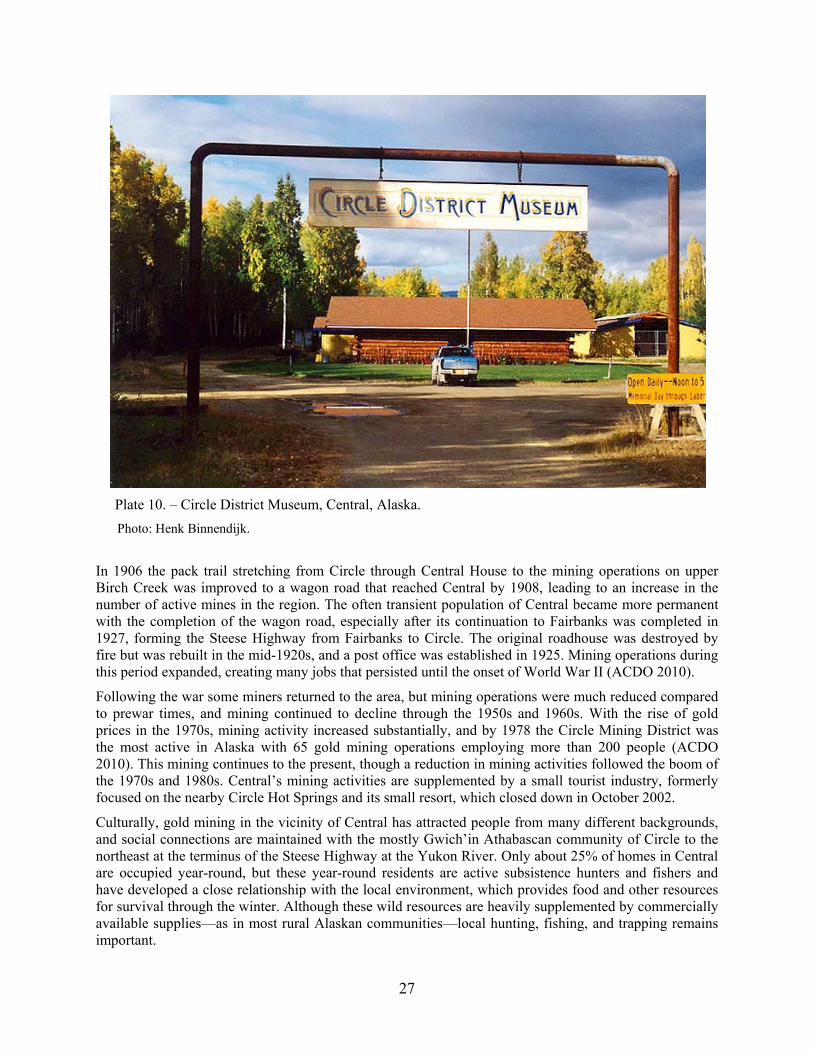
27
Plate 10. – Circle District Museum, Central, Alaska.
Photo: Henk Binnendijk.
In 1906 the pack trail stretching from Circle through Central House to the mining operations on upper Birch Creek was improved to a wagon road that reached Central by 1908, leading to an increase in the number of active mines in the region. The often transient population of Central became more permanent with the completion of the wagon road, especially after its continuation to Fairbanks was completed in 1927, forming the Steese Highway from Fairbanks to Circle. The original roadhouse was destroyed by fire but was rebuilt in the mid-1920s, and a post office was established in 1925. Mining operations during this period expanded, creating many jobs that persisted until the onset of World War II (ACDO 2010).
Following the war some miners returned to the area, but mining operations were much reduced compared to prewar times, and mining continued to decline through the 1950s and 1960s. With the rise of gold prices in the 1970s, mining activity increased substantially, and by 1978 the Circle Mining District was the most active in Alaska with 65 gold mining operations employing more than 200 people (ACDO 2010). This mining continues to the present, though a reduction in mining activities followed the boom of the 1970s and 1980s. Central’s mining activities are supplemented by a small tourist industry, formerly focused on the nearby Circle Hot Springs and its small resort, which closed down in October 2002.
Culturally, gold mining in the vicinity of Central has attracted people from many different backgrounds, and social connections are maintained with the mostly Gwich’in Athabascan community of Circle to the northeast at the terminus of the Steese Highway at the Yukon River. Only about 25% of homes in Central are occupied year-round, but these year-round residents are active subsistence hunters and fishers and have developed a close relationship with the local environment, which provides food and other resources for survival through the winter. Although these wild resources are heavily supplemented by commercially available supplies—as in most rural Alaskan communities—local hunting, fishing, and trapping remains important.

28
Local resident and community historian Laurel Tyrrell noted that there is, for each animal species, a “season of maximal activity and the lifestyle as a whole tied the participants [in subsistence activities] to a yearly cycle which filled their everyday lives with purposeful activities” (Tyrrell 2002:77). The year-round resident population, then, has developed a local awareness and sharing of experiences that has resulted in the development of a body of local knowledge, as is seen in indigenous communities elsewhere in Alaska. As Tyrrell notes, the insiders share a concept called the “code of the north,” which includes the values of “use of existing cabins, trapping and hunting ethics, and a system of hospitality involving helpfulness, treatment of others, and obligations of giving and sharing.” Outsiders do not know the rules and, according to Tyrrell, some stories the locals tell express their frustration over the breakers of these codes (Tyrrell 2002:57–59).
This notion of independence and subcultural difference is evident in Central, and in some cases is openly expressed, as on a sign on the wall of the community’s main store, where government agencies are singled out as a potential threat to local lifeways. One cultural difference brought to light through this study, interestingly, is the preference for different nonsalmon fish than those preferred in other study communities (see Results of the Harvest Assessment Component below). This is a result of preferences brought into the region from Central’s diverse population. Such subcultural differences make Central’s population both interesting and unique. According to the State of Alaska, Central had an estimated 95 residents in 2008 (ACDO 2010).
Circle (Dan Zhit Khaiinlaii)
Circle is situated on the Yukon River at approximately lat 65.825560 N, long –144.060560 W (Sec. 31, T012N, R018E, Fairbanks Meridian.) Located on the south (or left) bank of the Yukon River, Circle (also called Circle City) is located on the southern edge of the Yukon Flats at the terminus of the Steese Highway. Residents depend on nearby Birch Creek as well as the Yukon for fishing, and mining activities remain important in the region. The community’s approximately 94 residents are predominantly Gwichyaa Gwich’in, although other Gwich’in from the region, as well as non-Native families, also live in the community.
Plate 11.–Community of Circle, Alaska.
Photo: Larry Bredeman.

29
Circle was established in 1893 as a river landing for supplies shipped up the Yukon River, then distributed to gold mine camps and homesteads throughout the Circle Mining District. Before the Klondike gold rush, Circle was the largest mining community on the Yukon with a population of 700 (1896). The town was so large and active that besides an Alaska Commercial Company (ACC) store, Circle also had eight to ten dance halls, an opera house, a library, school, hospital, and an Episcopal church. Circle was also home to the Yukon Press, a local newspaper that still serves as one of the main sources for the region’s early history. Due to the size of the population and the importance of the mining industry, Circle also had a resident U. S. government commissioner, marshal, tax collector, customs inspector, and postmaster. The discovery of gold in the Klondike (Yukon Territory) led to the rapid depopulation of Circle, however, which was further exacerbated by the discovery of gold at Nome in 1899. Nevertheless, some miners and their families remained, working at nearby Mastodon Creek, Mammoth Creek, Deadwood Creek, and Circle Creek, and in the upper Birch Creek area in general (ACDO 2010).
Plate 12.–Main Street in Circle in 1899, immediately after its heyday.
Photo: Pillsbury and Cleveland.
Within Circle today most residents rely heavily on subsistence activities, and sharing of resources remains widespread. Besides the school and civic organizations, employment is rare and largely supplements the subsistence economy. This is further augmented by the creation of handicrafts and, especially, through trapping. Some families from throughout the region come to Circle in the spring and summer for waterfowl hunting and fishing, particularly for king (Chinook) salmon. Some tourism occurs in Circle and surrounding areas, generating some income, and Circle is considered the unofficial terminus of the Pan- American Highway.
Fort Yukon (Gwichyaa Zhee)
Fort Yukon, the largest community of the Yukon Flats, is situated near the confluence of the Porcupine River with the Yukon River at approximately lat 66.564720 N, long –145.273890 W (Sec. 18, T020N, R012E, Fairbanks Meridian.) Its Athabascan name, Gwichyaa Zhee, means “house in the flats,” and the community is situated near the confluence of the Yukon and Porcupine rivers in the center of the Yukon Flats. As such, the site has long been used as a Gwich’in gathering place, and since its establishment as a permanent settlement in 1847, Fort Yukon has served as a regional trading, supply, administrative, and transportation center. Fort Yukon is home to the Council of Athabascan Tribal Governments (CATG) and to the Yukon Flats’ only radio station, KZPA (900 AM), known as “Gwandak [Story] Radio.” The estimated population in 2008 was 587.

30
Surrounded by a vast, lake- and slough-covered lowland, the region has long supported intensive subsistence use and fostered complex and extensive land and resource use. Abundant numbers and species of fish, birds, and mammals dwell within the region, and many from surrounding communities utilize the region for subsistence harvest. The community has over time drawn settlers from many different backgrounds, though the predominant population is Gwichyaa Gwich’in, meaning “dwellers on the flats” (Slobodin 1981:532). The Gwichyaa Gwich’in originally used the entire region, including the lower Chandalar and Sheenjek rivers and upriver along the Yukon to the vicinity of Circle. Its longtime traditional use as a gathering place was attested to as far back as 1912:
Fort Yukon is the oldest spot on the river where English-speaking whites established themselves…but it had been long before that the native rendezvous for the inhabitants of this part of the Yukon, and of the many streams which are tributary to the Yukon hereabouts (Stuck 1914 in Caulfield 1983:146).
Plate 13.–Community of Fort Yukon, Alaska.
Photo: Michael Koskey.
Founded by Alexander Murray in 1847, Fort Yukon was established as a HBC trading post within Russian-claimed territory. Murray had been preceded by John Bell three years earlier, who had come into the country via the Porcupine River and observed that the local people had already established trade relations with the Russians (Stuck 1914 in Caulfield 1983:146). The year before Murray’s arrival, the HBC had initiated fur trading with the local Gwichyaa Gwich’in, and the company remained present at Fort Yukon until 1869, two years after the United States acquired Alaska and determined that the community was situated within the American boundaries (ACDO 2010).

31
As mentioned above, Anglican archdeacon Robert McDonald, who lived at Fort Yukon from 1862–1871, produced some of the earliest historical records of the region. McDonald described the cooperative behavioral patterns of the local inhabitants and noted especially an emphasis on sharing. McDonald also traveled with a group of local Gwichyaa Gwich’in to the confluence of the Yukon and Tanana rivers to trade 200 miles downriver at Nuchalawoyya, meaning “where the two rivers meet” (Caulfield 1983:146). Nuchalawoyya was a long established trading spot situated immediately upriver from the community of Tanana.
After the determination that Fort Yukon lay within the U.S., the ACC assigned Moses Mercier to assume operation of the former HBC trading post. Coupled with the always profitable fur trade, the whaling boom of 1889–1904, and the Klondike gold rush (1896), both opportunity and cultural change entered the region, and many local residents were employed in supporting these industries, including the massive harvesting of timber for use in wood-powered riverboats. Along with the influx of settlers and economic opportunity came disease, and from the 1860s to the 1920s epidemics plagued the region (ACDO 2010).
Plate 14.–Approach to Fort Yukon from downriver.
Photo: Michael Koskey.
Disease coupled with economic activity led to cultural changes among the Gwichyaa Gwich’in as more often families began to work alone in trapping and other labor-oriented activities. Though old customs of sharing food and other resources remained in practice, the communal nature of Gwichyaa Gwich’in society gave way somewhat to nuclear family-oriented social organization as families spent months in isolation from one another while working traplines. Consequently, land use patterns changed alongside social change. This was further exacerbated as customs enforcement at the U.S.–Canadian border

32
disrupted traditions of customary trade between Gwich’in on either side of the international boundary. Despite these changes and the disruption caused by the occasional catastrophic flood, subsistence activities remained important and continue to the present. Today Fort Yukon’s economy remains fully a blend of subsistence and cash, a pattern that has long persisted.
TRADITIONAL KNOWLEDGE OF NONSALMON FISHING IN THE BIRCH CREEK REGION
The most important and critical component of this project—the portion that qualifies and informs the bulk of the material of this report—is the traditional knowledge of nonsalmon fishing in the Birch Creek region. The tribal governments and resident specialists of Beaver, Birch Creek, Central, Circle, and Fort Yukon generously agreed to share their knowledge concerning nonsalmon fish and fishing in their region. Shared, too, was the deep local understanding of how the natural environment of which all are a part has changed in recent memory, and how this affects nonsalmon fish and the lives of those who in part depend on them for their physical, cultural, and spiritual health. This is confirmed by most of the region’s residents:
Beaver: What about the waterways in which you fish—are they different than in the past?
A lot of places that are away from the river that we have a lot of concern for Birch Creek is because of low water; nobody is taking care of the land like they used to. The river is getting more and more debris, you know, like cans and stuff like that. And it [debris—natural and manmade] kind of blocks it off, so we listen to Chief Winston James [of Birch Creek village] and listen to some of the concerns he got for this kind of situation. You know they used to go along these water streams and they used to cut and keep them open—the beaver dams—and allow the fish to come out. But people don’t do that anymore; they clean it out and that is why the water is so low. In the early days we used to catch a lot of fish even in winter and fall time, like in September the fish come out of there. And all of these sloughs are all connected but now it looks like it’s going out the other way. The water is cutting into different sloughs and are draining out in different areas. So it made a new slough so we are running backwards. In the springtime the tide [rising water from meltoff] comes in and that is when the fish comes in. But now it doesn’t happen anymore…Well it used to be flooded more often, and it hasn’t had a flood since 1993. That is over 13 years. And before that it would flood almost every year…Yeah. They could catch fish back in the slough, you know. After the water drain out just go back there and catch all the fish you need. But it’s not like that no more. (B011607B)
Although salmon, particularly king (Chinook), silver, and chum salmon, comprise the largest portion of the total subsistence fish harvest in the five study communities, nonsalmon fish species, including whitefish Coregonus and Prosopium cylindraceum, sheefish (inconnu) Stenodus leucichthys, northern pike Esox lucius, Arctic grayling Thymallus arcticus, longnose sucker Catostomus catostomus, and burbot Lota lota are important components of the subsistence harvest. In the past and/or in surrounding areas, Alaska blackfish Dallia pectoralis and Arctic lamprey Lampetra camtschatica reportedly were harvested. However, according to our respondents, blackfish are not harvested today. This is significant as well because when asked, many local respondents questioned whether Alaska blackfish Dallia pectoralis even could be found in the study region. In fact, very few recalled the use of Alaska blackfish Dallia pectoralis at all in the past or by their ancestors. This absence of Alaska blackfish in the study region generally corresponds to their range as described in recent documentation (Page and Burr 1991).
According to respondents who participated in the traditional knowledge interviews, whitefish as a grouping of subspecies is the most important nonsalmon fish relied upon in the Birch Creek region. In Fort Yukon, the consensus was that whitefish are the most the most preferred nonsalmon fish, followed
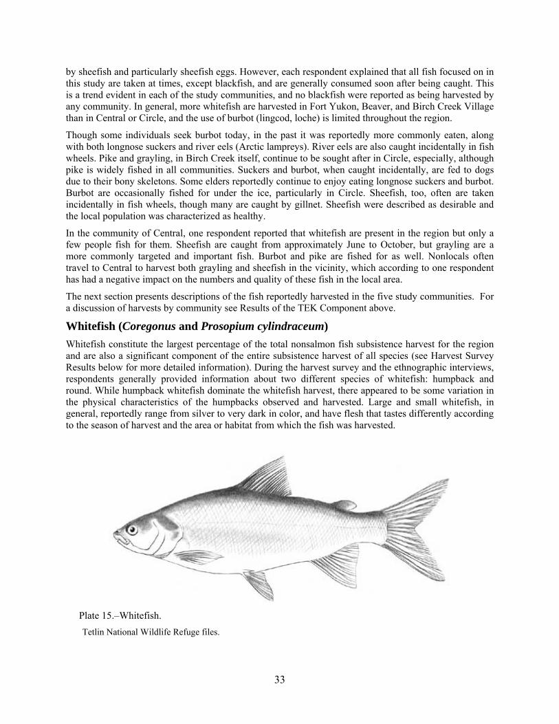
33
by sheefish and particularly sheefish eggs. However, each respondent explained that all fish focused on in this study are taken at times, except blackfish, and are generally consumed soon after being caught. This is a trend evident in each of the study communities, and no blackfish were reported as being harvested by any community. In general, more whitefish are harvested in Fort Yukon, Beaver, and Birch Creek Village than in Central or Circle, and the use of burbot (lingcod, loche) is limited throughout the region.
Though some individuals seek burbot today, in the past it was reportedly more commonly eaten, along with both longnose suckers and river eels (Arctic lampreys). River eels are also caught incidentally in fish wheels. Pike and grayling, in Birch Creek itself, continue to be sought after in Circle, especially, although pike is widely fished in all communities. Suckers and burbot, when caught incidentally, are fed to dogs due to their bony skeletons. Some elders reportedly continue to enjoy eating longnose suckers and burbot. Burbot are occasionally fished for under the ice, particularly in Circle. Sheefish, too, often are taken incidentally in fish wheels, though many are caught by gillnet. Sheefish were described as desirable and the local population was characterized as healthy.
In the community of Central, one respondent reported that whitefish are present in the region but only a few people fish for them. Sheefish are caught from approximately June to October, but grayling are a more commonly targeted and important fish. Burbot and pike are fished for as well. Nonlocals often travel to Central to harvest both grayling and sheefish in the vicinity, which according to one respondent has had a negative impact on the numbers and quality of these fish in the local area.
The next section presents descriptions of the fish reportedly harvested in the five study communities. For a discussion of harvests by community see Results of the TEK Component above.
Whitefish (Coregonus and Prosopium cylindraceum)
Whitefish constitute the largest percentage of the total nonsalmon fish subsistence harvest for the region and are also a significant component of the entire subsistence harvest of all species (see Harvest Survey Results below for more detailed information). During the harvest survey and the ethnographic interviews, respondents generally provided information about two different species of whitefish: humpback and round. While humpback whitefish dominate the whitefish harvest, there appeared to be some variation in the physical characteristics of the humpbacks observed and harvested. Large and small whitefish, in general, reportedly range from silver to very dark in color, and have flesh that tastes differently according to the season of harvest and the area or habitat from which the fish was harvested.
Plate 15.–Whitefish.
Tetlin National Wildlife Refuge files.

34
Whitefish are distributed throughout the Birch Creek region, with use areas concentrated around Beaver, Birch Creek Village, and Fort Yukon. As with other areas of interior Alaska, including the Tanana, Innoko, and Koyukuk river drainages, whitefish appear to seasonally occupy the wide variety of habitats in the Birch Creek region, including the main rivers and area lakes. The observations of local residents are best understood through a seasonal cycle characterized by marked migrations of whitefish from rivers to lakes and sloughs beginning in the spring, around breakup. Fishing continues throughout the summer in the lakes and a second migration from lakes and sloughs to rivers occurs in the fall and is targeted by residents for harvest just before and immediately after freezeup.
In general, knowing where and when people fish provides significant information about fish migration and seasonal locations. The major river systems of the Yukon Basin connect to a larger complex of lakes and wetlands that offer important habitat for humpback whitefish (Brown et al. 2002). As such, the main rivers and lakes provide important seasonal habitats for whitefish, while the sloughs and creeks that connect them are also significant habitats (frequently for spawning) and means of access to the lakes. According to local residents, whitefish move between the lakes and creeks with regularity all summer before moving back out to the rivers in the late fall/early winter.
Sheefish (Stenodus leucichthys)
Widely sought after and often caught incidentally in fish wheels, sheefish (inconnu) are large salmonids closely related to whitefish Coregonus. Possessing a large mouth and a protruding lower jaw, the sheefish is usually silver in color with a greenish, bluish, or brownish back. The sheefish can be further distinguished by its high and pointed dorsal fin.
Plate 16.–Sheefish.
Photo: N. Design Studio.
Sheefish usually live in brackish to freshwater lakes and rivers and have been known to travel more than 1,000 miles for spawning. Juvenile sheefish eat plankton for their first year, becoming predators of small fish thereafter. Sheefish are prized for their oily, flaky white meat and were characterized as desirable in all communities in the southern Yukon Flats. Weighing from approximately 20 to 50 pounds as adults, one sheefish can provide much food.
Arctic Grayling (Thymallus arcticus)
Arctic grayling are the only kind of grayling found in Alaska. On average measuring 30-35 centimeters [~1ft] in length, the Arctic grayling typically harvested ranges in weight from 450 to 700 grams [1to 1-1/2 pounds] (Morrow 1980:145). In appearance, the Arctic grayling is quite distinctive, especially its large dorsal fin—particularly in adult males—which usually contains more than 17 rays. Iridescent blue, blue-gray, or purple underneath, the Arctic grayling also has small blue-black spots on its sides that overlay its silver-gray to blue coloring, usually with a pink or lavender “wash” (Mecklenburg et al. 2002:191).
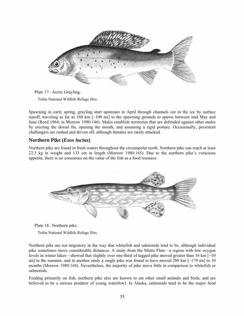
35
Plate 17.–Arctic Grayling.
Tetlin National Wildlife Refuge files.
Spawning in early spring, grayling start upstream in April through channels cut in the ice by surface runoff, traveling as far as 160 km [~100 mi] to the spawning grounds to spawn between mid May and June (Reed 1964, in Morrow 1980:146). Males establish territories that are defended against other males by erecting the dorsal fin, opening the mouth, and assuming a rigid posture. Occasionally, persistent challengers are rushed and driven off, although females are rarely attacked.
Northern Pike (Esox lucius)
Northern pike are found in fresh waters throughout the circumpolar north. Northern pike can reach at least 22.3 kg in weight and 133 cm in length (Morrow 1980:165). Due to the northern pike’s voracious appetite, there is no consensus on the value of the fish as a food resource.
Plate 18.–Northern pike.
Tetlin National Wildlife Refuge files.
Northern pike are not migratory in the way that whitefish and salmonids tend to be, although individual pike sometimes move considerable distances. A study from the Minto Flats—a region with low oxygen levels in winter lakes—showed that slightly over one-third of tagged pike moved greater than 16 km [~10 mi] in the summer, and in another study a single pike was found to have moved 288 km [~179 mi] in 10 months (Morrow 1980:168). Nevertheless, the majority of pike move little in comparison to whitefish or salmonids.
Feeding primarily on fish, northern pike also are known to eat other small animals and birds, and are believed to be a serious predator of young waterfowl. In Alaska, salmonids tend to be the major food

36
source of northern pike (Mecklenburg et al. 2002:143). However, they also eat birds and fish, frogs, mice, shrews, crayfish (not native to Alaska), and insects. In addition to salmon, northern pike will eat smaller pike, blackfish, burbot, and suckers (Morrow 1980:167–168).
Burbot (Lota lota)
The burbot, also known as “lingcod” or “loche” in the Yukon Flats region, is a freshwater fish related to cod. The genus and species name lota comes from “la lotte,” the old French word for “codfish.” Interestingly, burbot meat when cooked tastes very similar to the American lobster Homarus americanus. Hence, often times it is referred to as “poor man’s lobster.”
Plate 19.–Burbot or lingcod or loche.
Tetlin National Wildlife Refuge files.
As in other regions of Interior Alaska, residents of the Birch Creek region are familiar with the overwintering habits of burbot since the subsistence harvest is focused during this time. Burbot reportedly are most effectively found over submerged sandbars and muddy-bottomed spots in the river habitats, generally in eddies or otherwise slower water. And similar to residents of the lower middle Yukon River, the Koyukuk River, and the upper Tanana region, residents of the Birch Creek region identify the nighttime hours as being most productive for burbot harvest.
Longnose Sucker (Catostomus catostomus)
The longnose sucker ranges from New England and Labrador in the east, to the Great Lakes, and through the Mississippi–Missouri river drainages to the Columbia River on the west coast. This fish is also found in northern Canada and most of Alaska, and in eastern Siberia from the Yana to the Anadyr’ rivers (Morrow 1980:173–174). It is abundant in the Yukon River fisheries.
Plate 20.–Longnose sucker.
ADF&G files.

37
The longnose sucker is distinguished by its elongated cylinder-like body and its sucking mouth, located on the ventral side of the head, and by having thick lips covered with papillae. Its color is reddish-brown, dark brassy green or gray to black above, and paler on its lower sides with white ventral parts. The longnose sucker can reach a length of 64.3 centimeters [2.1 ft], but is generally smaller.
Seasonal Movements, Habitat, Spawning, and Diet of Nonsalmon Fish
Throughout the region, two large scale movements of whitefish occur annually: a movement from the deep creeks and Yukon River following breakup, to grassy lakes and sloughs in the spring, and a movement back to the Yukon and deep creeks in the fall. If these fish do not return to the Yukon or deep streams, they will freeze over winter. This is today a problematic issue. Reportedly the Yukon River had not flooded in Beaver, for example, since 1993. This period of very low or no flooding ended in spring 2009 when, due to a heavy snowfall the previous winter and a rapid meltdown, the Yukon flooded severely, devastating the nearby communities of Eagle Village and Stevens Village, and to a lesser extent Beaver and Fort Yukon. Though flooding and destruction were variable, few in these communities reported being prepared for the 2009 flood, due to the absence of flooding for the preceding 16 years. The Yukon and its tributaries in the past regularly flooded over their banks in spring, thereby providing fish passage to the lakes and sloughs from the river. As these floods receded, whitefish returned to the deeper waters of the Yukon and deep streams to overwinter. While this can still occur in many places in the Birch Creek region, fewer and smaller floods and overall lower water levels have limited accessible habitats in recent years.
Migrations of whitefish, pike, grayling, and burbot occur into and out of lakes for the summer. Fish spawn in the lakes and move back out into the streams and rivers in the fall. Traditionally at this time—the fall—is when small fish traps historically (now illegal due to commercial misuse of large scale fish traps in southern Alaska in the early 20th century)3 were used to catch the fish that had been maturing in the lakes all summer. Fall is also when sheefish migrate back to the river and are most often harvested. Round whitefish move up the river with king (Chinook) salmon, and the least and Bering ciscoes migrate afterwards, at the same time as chum salmon. Broad whitefish were reported to be present year-round, and longnose suckers were reported to migrate at the same time as whitefish.
Pike are observed to move much less frequently than other nonsalmon fish, and tend to prefer grassy sloughs and shores. Respondents indicated that pike also tend to remain in their home lake, moving very little. Grayling, however, were reported to move much more frequently when the water is high, and they tend to concentrate in deep pools, cutbanks, and creek mouths. Grayling have been observed moving upriver to spawn.
One issue that has caused some confusion is whether whitefish spawn in the spring and fall. While all respondents agreed that a spring spawning occurs, there was disagreement about the fall. Perhaps because there are spring and fall migrations, some respondents believe that each is accompanied by a spawning. Further investigation is needed to verify this perception. Many respondents also have observed that some whitefish remain in the lakes throughout the winter, although these lakes must be deep enough to not freeze to the bottom.
Whitefish, as was widely reported, prefer to eat insects, plants, and especially, small shellfish. Sheefish have been observed eating insects found in “foam-bunches” on the water’s surface. Grayling, too, are fond of insects, while burbot and longnose suckers are bottom feeders. Burbot were reported to eat small whitefish, pike, and sheefish. As noted earlier, northern pike are omnivorous and consume a wide variety
3 Editor’s note: State regulations for the Yukon-Northern Fisheries Area (5 AAC 01.220) currently authorize use of fyke nets to
harvest finfish other than salmon or halibut.

38
of fish and other animals, including juvenile pike, whitefish, and generally any fish or other animal small enough to eat.
Other Uses of Nonsalmon Fish
In addition to the obvious use of nonsalmon fish as food, respondents in each of the five study communities were asked about the use of nonsalmon fish for other purposes. Without exception, all respondents in all communities spoke of sharing all nonsalmon fish with others, especially with elders and those who cannot fully provide for themselves. The sharing of fish and other resources is a very old and widespread tradition, particularly in rural areas, that helps to bind individuals and families of the community together, and creates wide social bonds with other communities.
Although the selling of fish for cash—particularly local fish—was nowhere identified as a common practice, fish are sometimes exchanged for other goods (barter) that could otherwise be difficult to obtain. In Fort Yukon and Circle some respondents explained that a good fisher might exchange some fish for meat acquired by a good bird hunter, for example, or a person from another community might exchange caribou meat for a particular kind of fish not otherwise readily accessible to that community. Trading fish for gas, too, was reported in Fort Yukon. Such exchange is rarely done for money, however, and profiting from excess harvest was deemed unethical, although in Fort Yukon in the past whitefish reportedly were sold to nonlocal trappers and traders for ten cents apiece. The practice of sharing rather than selling represents a social leveling custom (a “mechanism” for lessening socioeconomic differences), but also and most importantly adheres to spiritual understandings of the relationship between the individual, the community, and the creature that is offering itself for the sustenance of the people of the community.
The use of nonsalmon fish for dogs was very common in the past, even though today it is not. This is due to the widespread replacement of dog teams by snowmachines that began in the 1970s. Still, burbot and longnose suckers that are incidentally caught, or those fish that seem unhealthy for human consumption, are fed to sled dogs and pet dogs today. Fish viscera and heads, particularly the portions that are not eaten, are also used to bait traps (for furbearer trapping) in each of the five project communities.
Condition and Change in Nonsalmon Fish Populations
Respondents expressed a wide variety of opinions concerning the condition of nonsalmon fish in the Birch Creek region. In Fort Yukon, Yukon River whitefish were reported to have a poor appearance due to the natural muddiness of the water. This muddiness was reported to be increasing over the last decade, however—locally believed to be caused by lower water levels and increased water turbulence. Nevertheless, the overall quality of whitefish was described as good. The present condition and numbers of whitefish were described as being comparable to the last 5-10 years, with regular patterns of seasonal change—in June the whitefish are fat and healthy in the Yukon River, while in the fall whitefish are fat in lakes but not in the Yukon River itself. Compared to 50 years ago, however, overall whitefish numbers are believed to have declined in the vicinity of Fort Yukon. Grayling and burbot populations are perceived as relatively stable and pike numbers have slightly declined. Respondents pointed out that warming water tends to cause softer meat, which is not desirable. In Beaver the same conditions were reported, and in the late fall whitefish seem to lose much of their fat and bulk—a normal process. According to many respondents, all fish populations fluctuate naturally from year to year and short term trends are not necessarily indicative of a long term sustained pattern. In both Beaver and Fort Yukon sheefish were described as being healthy.
Birch Creek Village respondents reported that burbot began disappearing from the area 10 to 15 years ago. In the past burbot were caught and eaten but today this is rarely the case because residents now prefer other fish types. Other nonsalmon fish species were described as healthy—particularly whitefish and sheefish. In comparison to Birch Creek Village, most respondents in Circle reported high numbers of pike and relatively low numbers of whitefish in their area, although the variety of subspecies caught seems greater than in the recent past (5-10 years). Compared to the more distant past—more than 50 years

39
ago—current whitefish numbers were described as being dismal in Circle. Nevertheless, the few whitefish that are harvested today in Circle were described as being similar in size to those taken in the recent and distant past. The decline in whitefish numbers was reported to be invariably linked to the presence of mines in the vicinity of upper Birch Creek.
In Central, most perceived decreases in fish numbers were attributed to the fouling of the waters of nearby creeks by wildfires and earthquakes. A fire in 2004 reportedly clouded the waters of Birch Creek, Albert Creek, and Crooked Creek for many months—even years—afterwards due to increased mud runoff. Additionally, a large earthquake (recalled to be) in 2005 (7.9 on the Richter scale) that occurred in the region shifted a significant amount of dirt along riverbanks and temporarily increased the siltiness of the water. In addition to these changes, Central respondents said that the frequency, size, and quality of sheefish have increased recently.
Although in Circle the overall average size of pike was described as being smaller than in the recent past, in Central overall size was perceived to be about the same. Numbers, however, are perceived as having declined. This was attributed to the drying of lakes, causing them to be shallower and grassier. This drying process consequently leads to muddier water, which causes pike and other resident fish to acquire a “muddy” taste when eaten, and so many people no longer fish in traditional areas, such as Medicine Lake near Central and Circle. Grayling, too, were described in Central and Circle as being smaller than in the recent past, and some fishers have ceased fishing for grayling entirely, particularly in Circle.
Overall, the size, quality of meat, and numbers of most nonsalmon fish were described as being good today, when compared to the recent past (5-10 years). However, especially before the early 1980s, size, quality, and numbers were almost always reported as being better than today. This change is primarily attributed to warming climate, lower water levels, and in the vicinity of Birch Creek, fires and mining activities. Fort Yukon residents described how Twelvemile Lake whitefish used to be consistently very large, but that due to drying, fewer and much smaller whitefish inhabit the lake today. While no apparent disease was detected in nonsalmon fish, the occasional presence of red spots, particularly on whitefish, causes these fish to be used for dog food only. By comparison, pike were consistently described as healthy—though again, when compared to the distant past (before the 1980s), they were described as smaller, particularly on Birch Creek and Beaver Creek.
Change in Water and other Environmental Conditions
Perhaps more than any other single set of factors, this project has revealed that local observations indicate that climate change and water levels together have caused the most profound changes in nonsalmon fish populations. This, coupled with mining activities near upper Birch Creek, has caused noticeable changes in overall quality, sizes, and numbers of nonsalmon fish. Particularly in Circle, the local whitefish population has changed drastically from the 1940s and 1950s, which is remembered as a time when whitefish were plentiful in the region. Generations of local observations of climate and topographic changes, including declines in water quality, reveal a pattern of change that seems to negatively affect whitefish and burbot more so than other nonsalmon species.
Changes affecting water quality (higher siltation, muddier water, lower water levels, and former water contamination) predictably tend to more adversely affect fish quality and numbers. As was explained in Fort Yukon, as water levels drop overall, water is muddier and more grass-filled, and provides less overwintering habitat for nonsalmon fish due to shallower depths in lakes, streams, sloughs, and rivers. In addition to melting permafrost, lower snowfalls are identified as partly to blame for overall lower water levels, although a few respondents attributed these lower water levels to the rapid increase in vegetation, especially bushes and trees, in the Yukon Flats, and the water requirements of these plants. A few elders reported that when they were young, there were few trees and large shrubs in the Yukon Flats. Most respondents felt that in the last five years, especially, weather has been rapidly changing, becoming warmer and dryer.

40
Another important factor in the changing character of waterways and water bodies in the Birch Creek region is a change in human practices. Respondents in Beaver and Birch Creek Village noted that in the past, people spent more time and effort “managing” local waters. Not only was debris and trash consistently removed from waterways, but beaver dams also were breached or removed if they were adversely affecting water conditions and quality. In fact, the presence of beaver dams and the perceived regulatory prohibition on their removal or alteration4 was consistently identified in each study community as significantly contributing to a decline in water quality, and therefore fish quality.
Fort Yukon: Beaver dams and low water is affecting whitefish in Sucker River. The Beaver dams block the flow and prevent whitefish from traveling up the river in the spring. (A120806D)
Beaver: They would have beaver dam. It [whitefish] gets collected behind this beaver dam, and you break it open, the fish would try to get out and that’s when you would catch the smaller fish. I think these are smaller fish than some whitefish, pike, and burbot. (B011607D)
Beaver: You know they used to go along these water streams and they used to cut and keep them open, the beaver dams, and allow the fish to come out. But people don’t do that anymore, they clean it out and that is why the water is so low. (B011607B)
Birch Creek: We don’t get no high water, they [lakes] just going to dry out. Back here, that lake where we go fishing, the water go down fast, beaver, beaver dam it up, too. No fish come out. (C011801B)
This coupled with the consistent decrease or lack of flooding is changing the character of the Birch Creek and Beaver Creek drainages, and of the nonsalmon fish dwelling there. As noted above, vegetation in these drainages and in the Yukon Flats in general is recognized as being much thicker than in the past, with willows and trees creeping north. Respondents in Beaver and Circle explained that in the past there was much less vegetation, particularly trees, than in the present. As willows move north, so, too, do animals such as beavers, moose, and rabbits (hares) that depend on willows.
During the 2007 fieldwork for the biological component of this study certain sampling sites in middle and lower Birch Creek were inaccessible due to drying and low water levels. Even when the water levels rose during the sampling period, some areas formerly used as fishing spots remained completely inaccessible by boat. Locally, as mentioned before, these lower water levels are attributed to beaver dams, increased vegetation, melting of permafrost, and mining activities in the vicinity of upper Birch Creek. Interestingly, overall sizes of pike sampled from upper and lower middle Birch Creek revealed consistently smaller pike in Birch Creek’s upper reaches. The practical consequence of this regional drying is that local residents must travel farther now than in the past to acquire nonsalmon fish for subsistence uses, and this at a time of skyrocketing fuel costs.
In Circle, by comparison, although water levels in streams and on the Yukon River were lower overall—before 2009 the last flooding was reported to have occurred in 1979—the surrounding lands were reported to be wetter and swampier than in the past. This is attributed to melting permafrost, however, and with the exception of the largest lakes, small lakes and ponds were gradually becoming swampy. Along with these changes in water levels is a consistent observation in all project communities, particularly in Birch Creek Village and Circle, that water temperatures have increased overall. Respondents from Central, however, noted little change in weather and water conditions and explained that after the
4 There is no regulatory prohibition on removing beaver dams by hand without the use of heavy equipment; however, there are
restrictions on disturbing beaver lodges or huts (5 AAC 92.095(a)(2)). If mechanical equipment is to be used to dismantle a beaver dam, then a Fish Habitat Permit is required from ADF&G Division of Habitat and if a beaver lodge will be affected a permit also is required from ADF&G Division of Wildlife Conservation (Jim Simon, ADF&G Division of Subsistence, personal communication, 2010).

41
initiation of the use of settling ponds associated with mining activities that began in the 1980s, formerly silty water has become clear again. On the other hand, communities downriver continue to report higher levels of muddier-seeming waters than in the past. In Birch Creek Village it was reported that Birch Creek waters can become orange, particularly in summer, but this occurs less now than in the past (1980s and 1990s). People said they do not fish when this coloration occurs.
Historical and Contemporary Gear Types and Preservation Methods of the Birch Creek Region
Subsistence fishing today in the Birch Creek region is considered as important as large land mammal hunting, with fish comprising a substantial portion of the diet and considered a basic staple. In the past, subsistence fishing for nonsalmon fish was even more important, especially because of the need to sustain dogs for dog sled transport—a custom no longer in widespread use in the region. Whitefish are active from evening until morning, and so they are caught during the night, and processed during the day. All ages of men and women take part in all stages of fishing—catching, drying, and storage.
In earlier times, prior to the widespread use of gillnets, the principal indigenous methods of fishing involved the use of conical-shaped fish traps (or fyke nets) and the construction of weirs across good spawning streams, the impounded fish being scooped out with willow dip nets. Whitefish were the principal fishery, although grayling, pike, longnose sucker, and burbot (loche, lingcod) were also caught. Fish were also trapped in conical fish traps; lanced with spears, leisters, or arrows; hooked with hand lines; and lassoed.
Anadromous fish—particularly salmon in the Yukon drainage and Arctic char in the Mackenzie drainage—were caught with post-and-withe weirs into which basket fish traps were set, and in the Yukon drainage dip nets made of spruce roots or babiche (sinew or rawhide) were used. In the late 19th century, fish wheels came into widespread use, particularly on the Yukon River. Whitefish and herring were also captured through the use of weirs and traps, especially in the Mackenzie drainage. Fully freshwater fish (potamodromous) were also widely used by the Gwich’in, including whitefish, lake trout (though rarely today), pike, and burbot (loche, lingcod). These species were traditionally taken with unbaited bone hooks, gillnets, and fish spears (leisters) throughout the year, though the use of weirs took place only in unfrozen water (Slobodin 1981:516).

42
Plate 21.–Fish camp on the Yukon between Beaver and the lower mouth of Birch Creek.
Photo: Michael Koskey.
In the Birch Creek region, whitefish were formerly caught with fish traps (Editor’s note: fyke nets), and fish spears. Gillnets are the predominant gear type used today but many people said they consider fish traps (fyke nets) superior because fish remain alive and do not start to rot once caught, as they do in gillnets. Additionally, fish traps (fyke nets) are usable in areas where it is not possible to put gillnets—e.g., in shallows or near beaver dams. Fish traps are today generally avoided due to the unclear understanding of gear use and gear use areas under state and federal fishing regulations.

43
Plate 22.–Traditional Gwich’in fish basket trap (fyke net).
Photo: Michael Koskey.
Commercially manufactured nylon setnets or gillnets appear to have come late onto the scene in the Birch Creek region, within the historical period, and are frequently used today throughout the study area. However, nets woven from willow or other materials were used previously. When fishing regulations prohibited the blocking of streams by weirs (e.g., 5 AAC 01.220(f)(4)), setnets set from the shore to midstream became the norm. These nets are checked daily, or more often during periods of peak runs; a boat is used to set these nets and retrieve fish.
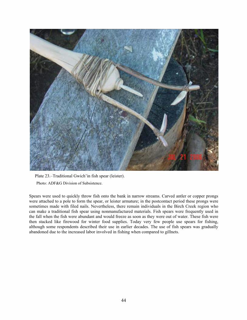
44
Plate 23.–Traditional Gwich’in fish spear (leister).
Photo: ADF&G Division of Subsistence.
Spears were used to quickly throw fish onto the bank in narrow streams. Carved antler or copper prongs were attached to a pole to form the spear, or leister armature; in the postcontact period these prongs were sometimes made with filed nails. Nevertheless, there remain individuals in the Birch Creek region who can make a traditional fish spear using nonmanufactured materials. Fish spears were frequently used in the fall when the fish were abundant and would freeze as soon as they were out of water. These fish were then stacked like firewood for winter food supplies. Today very few people use spears for fishing, although some respondents described their use in earlier decades. The use of fish spears was gradually abandoned due to the increased labor involved in fishing when compared to gillnets.
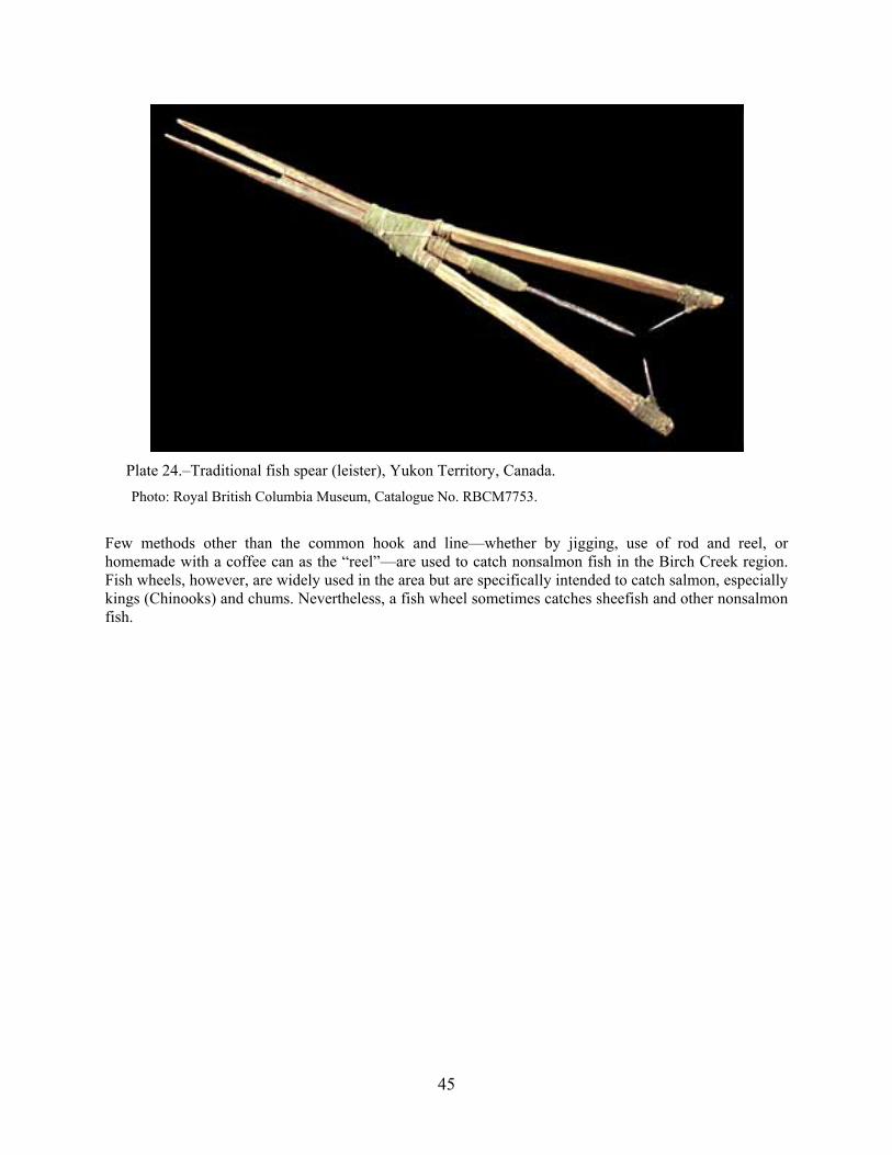
45
Plate 24.–Traditional fish spear (leister), Yukon Territory, Canada.
Photo: Royal British Columbia Museum, Catalogue No. RBCM7753.
Few methods other than the common hook and line—whether by jigging, use of rod and reel, or homemade with a coffee can as the “reel”—are used to catch nonsalmon fish in the Birch Creek region. Fish wheels, however, are widely used in the area but are specifically intended to catch salmon, especially kings (Chinooks) and chums. Nevertheless, a fish wheel sometimes catches sheefish and other nonsalmon fish.
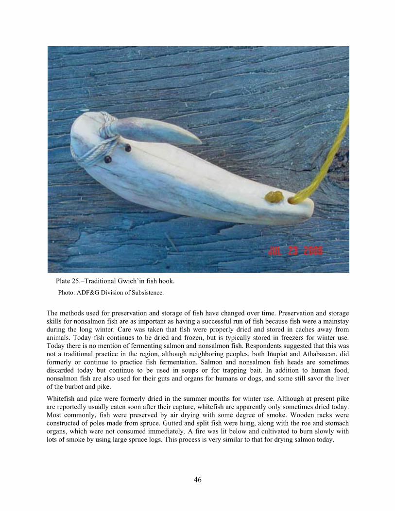
46
Plate 25.–Traditional Gwich’in fish hook.
Photo: ADF&G Division of Subsistence.
The methods used for preservation and storage of fish have changed over time. Preservation and storage skills for nonsalmon fish are as important as having a successful run of fish because fish were a mainstay during the long winter. Care was taken that fish were properly dried and stored in caches away from animals. Today fish continues to be dried and frozen, but is typically stored in freezers for winter use. Today there is no mention of fermenting salmon and nonsalmon fish. Respondents suggested that this was not a traditional practice in the region, although neighboring peoples, both Iñupiat and Athabascan, did formerly or continue to practice fish fermentation. Salmon and nonsalmon fish heads are sometimes discarded today but continue to be used in soups or for trapping bait. In addition to human food, nonsalmon fish are also used for their guts and organs for humans or dogs, and some still savor the liver of the burbot and pike.
Whitefish and pike were formerly dried in the summer months for winter use. Although at present pike are reportedly usually eaten soon after their capture, whitefish are apparently only sometimes dried today. Most commonly, fish were preserved by air drying with some degree of smoke. Wooden racks were constructed of poles made from spruce. Gutted and split fish were hung, along with the roe and stomach organs, which were not consumed immediately. A fire was lit below and cultivated to burn slowly with lots of smoke by using large spruce logs. This process is very similar to that for drying salmon today.

47
Plate 26.–Traditional Gwich’in fish drying and smoking (king salmon).
Photo: ADF&G Division of Subsistence.
The length of time the fish hangs varies with the humidity and degree to which people want the fish to dry. Today nearly all prefer dry fish that is “half smoked,” that is, fish whose surface flesh is dry and hard but retaining a soft interior. Fish fully smoked are quite hard, and need to be cooked by boiling in water for some time, the resulting broth being relished as much as the fish flesh itself. Fish caught late in September or October could be air frozen. Prior to the advent of electrical freezers, frozen fish (often stacked like wood) seems to have been the least favored method of preservation for human consumption.
Gwich’in Placenames
A secondary goal of this project was to collect, where possible, placenames in the study region in local Gwich’in dialects. The older residents of the region (generally 50 to 60 years and older with some exceptions) continue to speak and use Gwich’in on a regular basis, with the exception of Birch Creek Village, where respondents possessed limited memory of Gwich’in placenames and often used the English name even while speaking Gwich’in. Respondents expressed a desire to revive local placename usage as a part of language revival and spiritual connection with the land and sacred sites. Some respondents lamented that the old names were gradually slipping from use and memory. In the vicinity of the community of Beaver, Gwich’in placenames are mostly nonexistent. This is likely a result of the establishment of Beaver as a trading post by Koyukon, Gwich’in, Iñupiat, and non-Native English-speakers. Although local respondents assumed that Gwich’in or Koyukon placenames had previously existed for the natural and cultural features of the area, they have been largely forgotten. Many of the local English names nonetheless reflect the relationship of local people to the lands and waters.
Table 3 therefore contains placenames from within and beyond the study region that were provided by respondents who know local Gwich’in placenames. This short list is intended to supplement existing placename records that focused specifically on the collection of Gwich’in placenames (see especially

48
Caulfield et al. 1983, Kritsch and Andre 1997, and Ritter 1976 for earlier and in-depth work on Gwich’in placename research).
As is evident, many of the placenames collected for the Gwich’in area are descriptive of place and condition, reflecting important concepts of value and personal experience within Gwich’in culture. These placenames also indicate areas that continue to be of importance to the peoples using the associated resources; such importance likely facilitated continued usage of the Gwich’in placename. Furthermore, this continued usage indicates places of cultural importance and sites of sacred or historical importance. In addition to these placenames, fish names referred to in this study were recorded (see Table 4). Note that variation does occur in the pronunciation of these names and in their transliteration.
Table 3.–Known Gwich’in placenames in the southern Yukon Flats.
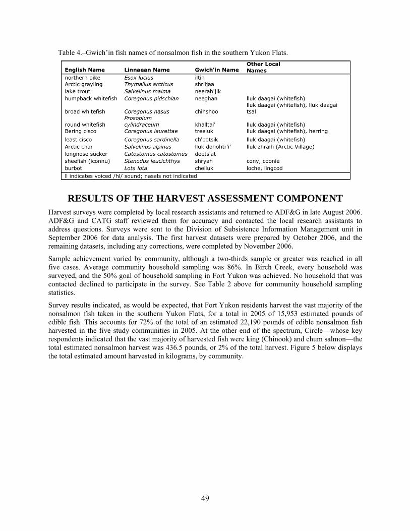
49
Table 4.–Gwich’in fish names of nonsalmon fish in the southern Yukon Flats.
RESULTS OF THE HARVEST ASSESSMENT COMPONENT Harvest surveys were completed by local research assistants and returned to ADF&G in late August 2006. ADF&G and CATG staff reviewed them for accuracy and contacted the local research assistants to address questions. Surveys were sent to the Division of Subsistence Information Management unit in September 2006 for data analysis. The first harvest datasets were prepared by October 2006, and the remaining datasets, including any corrections, were completed by November 2006.
Sample achievement varied by community, although a two-thirds sample or greater was reached in all five cases. Average community household sampling was 86%. In Birch Creek, every household was surveyed, and the 50% goal of household sampling in Fort Yukon was achieved. No household that was contacted declined to participate in the survey. See Table 2 above for community household sampling statistics.
Survey results indicated, as would be expected, that Fort Yukon residents harvest the vast majority of the nonsalmon fish taken in the southern Yukon Flats, for a total in 2005 of 15,953 estimated pounds of edible fish. This accounts for 72% of the total of an estimated 22,190 pounds of edible nonsalmon fish harvested in the five study communities in 2005. At the other end of the spectrum, Circle—whose key respondents indicated that the vast majority of harvested fish were king (Chinook) and chum salmon—the total estimated nonsalmon harvest was 436.5 pounds, or 2% of the total harvest. Figure 5 below displays the total estimated amount harvested in kilograms, by community.

50
Figure 5.–Nonsalmon harvest in kilograms by community, 2005.
The harvest in estimated pounds by community can be compared to the harvest in estimated numbers of individual fish (Figure 6 below). Again, with the exception of Circle, the fish harvest is proportional to the overall population of the community. In Circle, many respondents complained that the dropping water levels and muddier water conditions resulted in less tasty fish and led to fewer people harvesting nonsalmon fish than in the past. One respondent explicitly stated:
Nobody goes out and get whitefish like they did long time ago. Springtime they hook back there, but maybe not that often. (E032807A)
Circle residents clearly linked the decline in nonsalmon fishing to the rapidly changing environment. Another Circle resident commented:
It [whitefish] was never landlocked, it has always been around, but then they’re in another slough over here around Circle that we fish in every spring many years ago, but now that the water level in the lower Yukon has dropped considerably now hardly any water goes back up there when the ice goes. So few fish go back in there, but now we used to set a fish net there every spring for whitefish and suckers. And we used to go when my grandma and my mom were there, while the water was high, they would go and dry whitefish and put it away. But now we never done that for a number of years because the water level has dropped and there is not water in the slough and all you see is little jack pikes. (E032807F)
This account contrasts local observations in other study communities, where nonsalmon fish use is stable or increasing relative to the recent past. The low harvest in Circle is illustrated in Figure 6, which depicts community fish harvest levels.
1182
833
616
198
7236
Non‐salmon Harvest in Kilograms by Community
Beaver
Birch Creek
Central
Circle
Fort Yukon

51
Figure 6.–Nonsalmon harvest in numbers of fish by community, 2005.
Table 5 displays the estimated harvest by species in each study community. No community household surveys indicated the harvest or use of blackfish. This was reinforced in multiple traditional knowledge interviews, wherein only a few respondents even recalled their use in the past.
Table 5.–Estimated kilograms of nonsalmon fish harvested in the southern Yukon Flats, 2005.
As is shown in Table 5, pike, sheefish, broad whitefish, and humpback whitefish are the most preferred, primarily due to their larger size and local taste preferences. Although most respondents reported liking the taste of pike, many said that because of the numerous small bones, pike are today (as are suckers) usually fed to dogs. Sheefish, and to a lesser extent broad whitefish and humpback whitefish, are incidentally caught in fish wheels while fishing for salmon, but many are also captured with gillnets.
In Central, by comparison, only five whitefish of unknown species were harvested and a much greater emphasis is placed on catching grayling and sheefish. The harvest of pike in Central is comparable to that reported for other study communities. Nevertheless, some respondents in Central did say that if a whitefish was caught, it either was eaten or fed to dogs. The estimated pounds of fish harvested show
600
447
647
178
4588
Non‐salmon Harvest in Numbers of Fish by Community
Beaver
Birch Creek
Central
Circle
Fort Yukon

52
differing relative results by proportion of species when compared to numbers of individual fish harvested. This is simply due to differing units of measurement—“usable” fish weight as opposed to entire fish.
The following pie chart (Figure 7) displays regionwide the overall harvest by species, by number of individual fish harvested, relative to the entire estimated harvest in the study communities. Pike and broad whitefish account for a consistently high proportion of the harvest—whether measured in pounds or by numbers of individual fish—followed by grayling and least ciscoes. This is simply due to the smaller relative size of these individual fish, and the opposite condition is seen in the small proportion of humpback whitefish. The differences between numbers of fish and pounds of fish are standard ADF&G Division of Subsistence measuring units used in resource use surveys, provided for qualitative comparison.
Figure 7.–Nonsalmon harvest in numbers of fish by species, 2005.
For this reason, all numbers are converted into estimated pounds of edible fish, in order to provide a more accurate measure of a species’ relative importance within a household, community, and region. Therefore Figure 5 and Table 5 depict more reasonably the estimated harvest and the importance of individual species.
The harvest survey also tracked when fish were harvested, which is represented in the graph below (Figure 8). As expected, the primary harvest period for nonsalmon fish (and salmon as well) is from approximately May to September, and although some winter fishing does occur under the ice, it reportedly had declined significantly when compared to the recent past.
Burbot, 6%
Grayling, 11%
Pike, 22%
Sheefish, 7%Longnose Sucker, 2%
Broad Whitefish, 32%
Bering Cisco, 5%Least Cisco,
12%
Humpback Whitefish, 3%
Nonsalmon Harvest by Species
Burbot
Grayling
Pike
Sheefish
Longnose Sucker
Broad Whitefish
Bering Cisco
Least Cisco
Humpback Whitefish
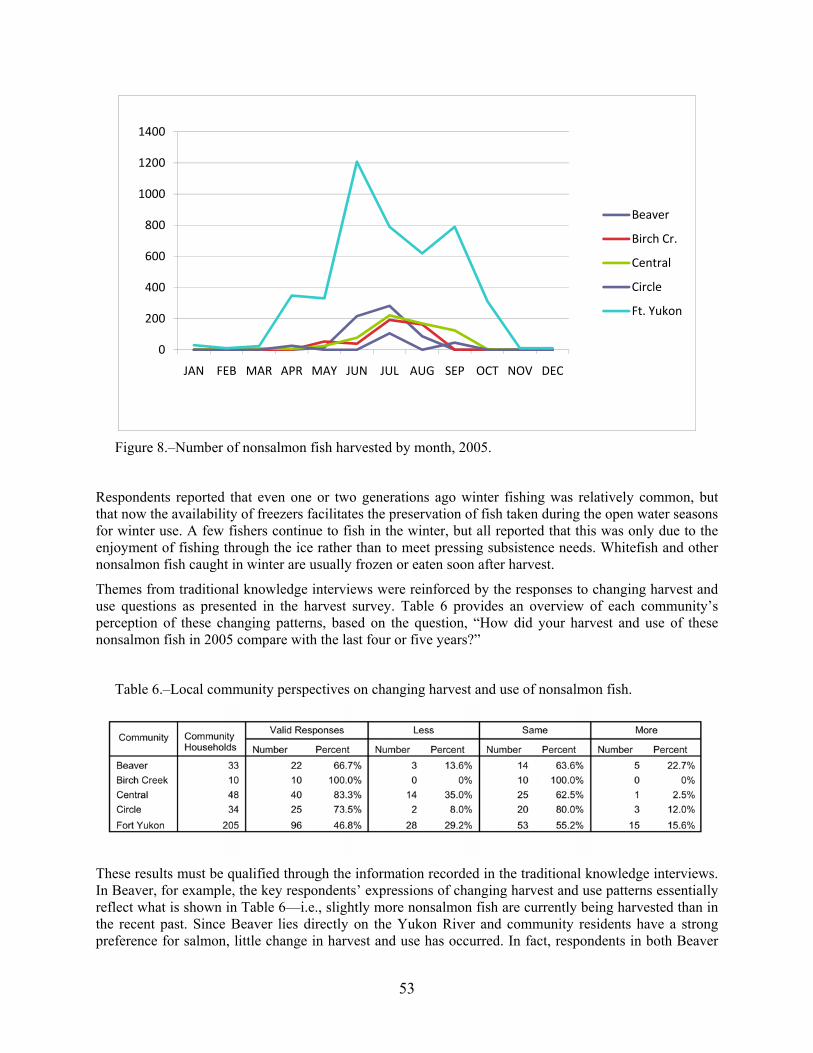
53
Figure 8.–Number of nonsalmon fish harvested by month, 2005.
Respondents reported that even one or two generations ago winter fishing was relatively common, but that now the availability of freezers facilitates the preservation of fish taken during the open water seasons for winter use. A few fishers continue to fish in the winter, but all reported that this was only due to the enjoyment of fishing through the ice rather than to meet pressing subsistence needs. Whitefish and other nonsalmon fish caught in winter are usually frozen or eaten soon after harvest.
Themes from traditional knowledge interviews were reinforced by the responses to changing harvest and use questions as presented in the harvest survey. Table 6 provides an overview of each community’s perception of these changing patterns, based on the question, “How did your harvest and use of these nonsalmon fish in 2005 compare with the last four or five years?”
Table 6.–Local community perspectives on changing harvest and use of nonsalmon fish.
These results must be qualified through the information recorded in the traditional knowledge interviews. In Beaver, for example, the key respondents’ expressions of changing harvest and use patterns essentially reflect what is shown in Table 6—i.e., slightly more nonsalmon fish are currently being harvested than in the recent past. Since Beaver lies directly on the Yukon River and community residents have a strong preference for salmon, little change in harvest and use has occurred. In fact, respondents in both Beaver
0
200
400
600
800
1000
1200
1400
JAN FEB MAR APR MAY JUN JUL AUG SEP OCT NOV DEC
Beaver
Birch Cr.
Central
Circle
Ft. Yukon

54
and Fort Yukon said that the whitefish populations fluctuate from year to year, but that the quality remains essentially the same.
In all communities, the use of whitefish available for harvest overall was said to have declined greatly compared to 30-40 years ago, but recently there has been a slight increase in whitefish harvests due to lower numbers of salmon. Some local residents believe that a resource is in part bountiful based on the people’s need for and use of a particular animal; since the widespread replacement of dog teams with snowmobiles has occurred, far fewer whitefish are harvested, so there are now fewer available. Therefore, this reflects the belief that if a particular species (resource) is not used, it will go away. By comparison, respondents said that the higher use (per capita) of whitefish and other nonsalmon fish in the vicinity of Birch Creek has resulted in more of these species being available. This is an extension of the same respect-oriented belief system described earlier—i.e., without a (spiritual) relationship maintained within expectations of prescribed behavior, the “resource” will vanish. Incidentally, this was also offered as a causal reason for the declining populations of muskrats, which used to be hunted and trapped in much higher numbers than at present.
In Birch Creek the current (2005) harvest and use of nonsalmon was universally perceived to be about the same as compared to the previous four or five years. During the traditional knowledge interviews people said that almost all locally caught fish are nonsalmon fish, and that most salmon are harvested on the Yukon, usually in the vicinity of Fort Yukon. Birch Creek residents shared their nonsalmon harvest very widely within the community and many exchanged nonsalmon fish for salmon with residents of Yukon River communities. Through the key respondent interviews it was explicitly evident that Birch Creek residents made much greater use of nonsalmon fish—particularly whitefish and pike—than do the other study communities (see Table 9 below).
The residents of Central, as in Fort Yukon, noted little change in the harvest of nonsalmon fish. Unlike Fort Yukon, Central does not have easy access to salmon, and so like Birch Creek, local resources determine in part the character of the harvest and locally more nonsalmon fish are harvested than salmon. Some in Central—about a third—did note that their use and harvest of nonsalmon fish had declined, but this was attributed to regulatory changes prior to 1979 that prohibit the use of gillnets in Birch Creek and Beaver Creek (D012407A, D012407B)5. Otherwise, little change was noted.
In Fort Yukon, as in Beaver and Circle, dependence on salmon is overwhelmingly greater than on nonsalmon fish. In Circle, respondents said the harvesting of nonsalmon fish has decreased markedly over the past five decades or so, although it has remained stable but small in recent years. In Fort Yukon, too, about 30 percent of all respondents reported using less nonsalmon fish than in the past, while about 16 percent reported using more. It became evident in the interviews that younger fishers are assuming whitefish harvest duties from elders, and so the amount harvested has changed little.
Tables 7 to 16 below summarize the harvest, by community, of nonsalmon fish during 2005. Definitions for abbreviations used in tables throughout this report are provided below:
Use: percentage of households using subsistence resources.
Att: percentage of households that attempted to harvest subsistence resources.
Harv: percentage of households that successfully harvested subsistence resources.
Rec: percentage of households that got subsistence resources from someone who shared.
Give: percentage of households that shared out subsistence resources.
Total: total edible kilograms of resources harvested.
5 Birch Creek and Beaver Creek were closed to subsistence fishing prior to 1979 until June 2001, when these closures were
repealed by the Board of Fisheries and instead gillnet mesh size was restricted to three inches (5 AAC 01.220(f)(6) & (7)).

55
Mean HH: edible kilograms of resources harvested per household.
Per Capita: edible kilograms of resources harvested per person.
Total: number of individuals of a single species harvested.
Mean HH: number of individuals of a single species per household.
Ind: individuals.
Again, note the absence of the harvest of both blackfish and Bering ciscoes in all of the five surveyed communities. However, key respondents did explain that in the past—one or two generations ago—blackfish either were harvested or obtained in trade. No one reported use of Bering ciscoes in the recent past; however, some of the whitefish of unknown species possibly could have been Bering ciscoes. Most burbot and least cisco were harvested in the study area by Fort Yukon fishers. In Central, a predominantly non-Native community, no suckers or humpback whitefish were harvested. In fact, the community of Central harvested very few whitefish of any kind, although broad whitefish and northern pike were heavily favored for harvest by all of the other study communities. Overall, longnose suckers and burbot were reported to have been harvested in large numbers a few generations ago, but changing preferences, bony skeletons, and the replacement of dog teams with snowmobiles has resulted in a marked decline in the harvest of these two fish species.
These tables detail by species, community, and month the nonsalmon fish subsistence harvest trends in 2005. The data in these tables also illustrate the exchange of specific species by community in terms of a household’s receiving fish or sharing fish. In general, whitefish and pike were shared or exchanged more often than other nonsalmon fish. However, we later learned in the interviews that many residents of Birch Creek Village distinguished between the exchange of nonsalmon fish within and outside of the community. There was an expectation that harvested fish would be distributed throughout the community but there was no implicit expectation that something would be given in return, particularly from elders. This behavior was evident in all study communities but appeared to be especially prevalent in Birch Creek Village.
The exchange of nonsalmon fish is most often done to acquire salmon, which was not a part of the household survey for this study. Sometimes other nonfood items were effectively exchanged for fish, but it would be inaccurate to call this “trade” or “barter” since the act of sharing is what is considered important, not the object shared. Often one individual shares something (gives something) to someone, and sooner or later the recipient shares (gives) something to the original “sharer.” This is most fundamentally an exchange of acknowledgement—a unilaterally initiated recognition that the “sharer” respects the recipient and the action is an acknowledgement of a relationship. The object shared is a symbol of the action and its motivating impetus—respect and honor.
The observed patterns of exchange indicate a widespread sharing of fish throughout the region, both within and between communities. Although key respondents all disavowed exchanging fish for profit or selling fish outright, most reported that others within a community do sell or exchange fish for profit. This behavior was universally noted as problematic, if not immoral. Exchange through sharing, however, is not only common but was expressed as a moral obligation. Most fishers reported that they regularly provide fish to elders, relatives, and especially to single mothers, and to any communal event. Such sharing was witnessed constantly while researchers were in the community. This sharing is recognized as serving as a socially binding behavior that increases community cohesion. Conversely, a few respondents noted that if they do not share with a particular person or family, it indicates a criticism or condemnation of that family’s behavior.

56
Table 7.–Estimated harvest and use of nonsalmon fish in Beaver, 2005.
Table 8.–Estimated harvest and use by month of nonsalmon fish in Beaver, 2005 (average by numbers).

57
Table 9.–Estimated harvest and use of nonsalmon fish in Birch Creek, 2005.
Table 10.–Estimated harvest and use by month of nonsalmon fish in Birch Creek, 2005 (average by numbers).

58
Table 11.–Estimated harvest and use of nonsalmon fish in Central, 2005.
Table 12.–Estimated harvest and use by month of nonsalmon fish in Central, 2005 (average by numbers).

59
Table 13.–Estimated harvest and use of nonsalmon fish in Circle, 2005.
Table 14.–Harvest by month of nonsalmon fish in Circle, 2005 (average by numbers).

60
Table 15.–Estimated harvest and use of nonsalmon fish in Ft. Yukon, 2005.
Table 16.–Estimated harvest and use by month of nonsalmon fish in Ft. Yukon, 2005 (average by numbers).
Most fishing for nonsalmon species in the study area occurs from May to August, with some fishing in April and September in Central, Circle and Fort Yukon. All nonsalmon harvests in Beaver and Birch Creek occurred from May to August. Pike were sometimes fished through the ice in Central (February to April), Circle (April), and Fort Yukon (March). In Central, fishing for some nonsalmon species occurred in all months except December and January, while in Fort Yukon harvest of nonsalmon fish occurred in every month of the year. Broad whitefish, especially, were harvested throughout the year in Fort Yukon, except in November. Humpback whitefish were heavily harvested relative to other species in all communities except Central.
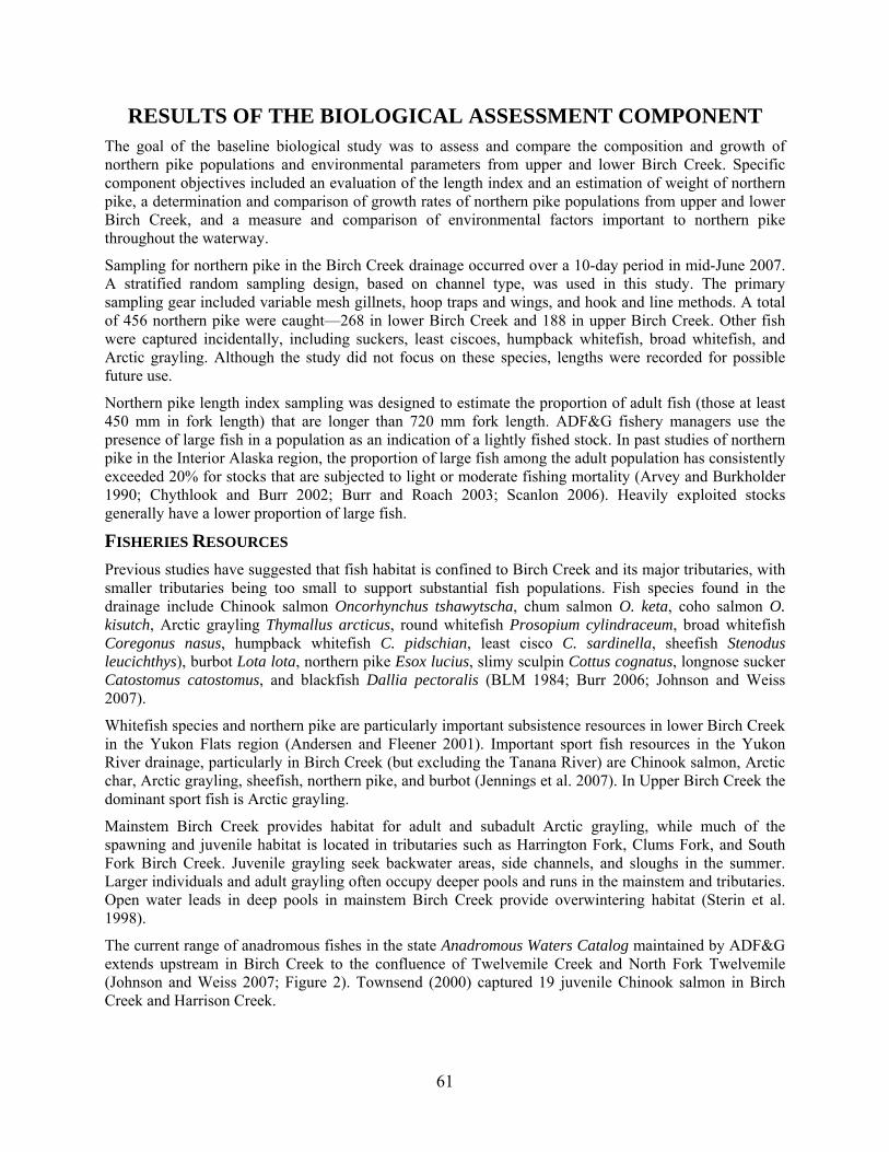
61
RESULTS OF THE BIOLOGICAL ASSESSMENT COMPONENT The goal of the baseline biological study was to assess and compare the composition and growth of northern pike populations and environmental parameters from upper and lower Birch Creek. Specific component objectives included an evaluation of the length index and an estimation of weight of northern pike, a determination and comparison of growth rates of northern pike populations from upper and lower Birch Creek, and a measure and comparison of environmental factors important to northern pike throughout the waterway.
Sampling for northern pike in the Birch Creek drainage occurred over a 10-day period in mid-June 2007. A stratified random sampling design, based on channel type, was used in this study. The primary sampling gear included variable mesh gillnets, hoop traps and wings, and hook and line methods. A total of 456 northern pike were caught—268 in lower Birch Creek and 188 in upper Birch Creek. Other fish were captured incidentally, including suckers, least ciscoes, humpback whitefish, broad whitefish, and Arctic grayling. Although the study did not focus on these species, lengths were recorded for possible future use.
Northern pike length index sampling was designed to estimate the proportion of adult fish (those at least 450 mm in fork length) that are longer than 720 mm fork length. ADF&G fishery managers use the presence of large fish in a population as an indication of a lightly fished stock. In past studies of northern pike in the Interior Alaska region, the proportion of large fish among the adult population has consistently exceeded 20% for stocks that are subjected to light or moderate fishing mortality (Arvey and Burkholder 1990; Chythlook and Burr 2002; Burr and Roach 2003; Scanlon 2006). Heavily exploited stocks generally have a lower proportion of large fish.
FISHERIES RESOURCES
Previous studies have suggested that fish habitat is confined to Birch Creek and its major tributaries, with smaller tributaries being too small to support substantial fish populations. Fish species found in the drainage include Chinook salmon Oncorhynchus tshawytscha, chum salmon O. keta, coho salmon O. kisutch, Arctic grayling Thymallus arcticus, round whitefish Prosopium cylindraceum, broad whitefish Coregonus nasus, humpback whitefish C. pidschian, least cisco C. sardinella, sheefish Stenodus leucichthys), burbot Lota lota, northern pike Esox lucius, slimy sculpin Cottus cognatus, longnose sucker Catostomus catostomus, and blackfish Dallia pectoralis (BLM 1984; Burr 2006; Johnson and Weiss 2007).
Whitefish species and northern pike are particularly important subsistence resources in lower Birch Creek in the Yukon Flats region (Andersen and Fleener 2001). Important sport fish resources in the Yukon River drainage, particularly in Birch Creek (but excluding the Tanana River) are Chinook salmon, Arctic char, Arctic grayling, sheefish, northern pike, and burbot (Jennings et al. 2007). In Upper Birch Creek the dominant sport fish is Arctic grayling.
Mainstem Birch Creek provides habitat for adult and subadult Arctic grayling, while much of the spawning and juvenile habitat is located in tributaries such as Harrington Fork, Clums Fork, and South Fork Birch Creek. Juvenile grayling seek backwater areas, side channels, and sloughs in the summer. Larger individuals and adult grayling often occupy deeper pools and runs in the mainstem and tributaries. Open water leads in deep pools in mainstem Birch Creek provide overwintering habitat (Sterin et al. 1998).
The current range of anadromous fishes in the state Anadromous Waters Catalog maintained by ADF&G extends upstream in Birch Creek to the confluence of Twelvemile Creek and North Fork Twelvemile (Johnson and Weiss 2007; Figure 2). Townsend (2000) captured 19 juvenile Chinook salmon in Birch Creek and Harrison Creek.

62
MINING HISTORY AND IMPACTS
Gold was first discovered in the Birch Creek area in 1893, and placer mining operations have been more or less active ever since (BLM 1983; Kennedy and Langley 2007). Placer mining typically involves rerouting streams into bypass channels and removing vegetation and topsoil to reach gold in the streambed gravels (Yeend et al. 1998). This disturbance to stream banks and streambeds may lead to increased erosion and high instream turbidity and suspended solids, especially during high flows. High suspended and total sediment can persist for many years because revegetation occurs very slowly due to the lack of organic material in tailings piles, and because unconsolidated tailings piles do not contain stream channels during high flows (Kennedy and Langley 2007). When the BLM developed the Birch Creek River Management Plan for upper Birch Creek in the early 1980s, poor water quality was reported due to active placer mining in the headwaters and tributaries to Birch Creek (BLM 1983), as observed locally and reported in the traditional knowledge interviews for this project.
Early studies investigated the effects of increased turbidity, suspended sediments, and deposited sediments on aquatic invertebrate and fish communities. Van Nieuwenhuyse and LaPerriere (1986) reported that increased sediment loads from placer mining reduced downstream primary production. Several studies reported decreased density and biomass of aquatic invertebrates in Birch Creek study sites as a result of increased sedimentation from mining (Wagener and LaPerriere 1985; Weber and Post 1985; Weber 1986; Maurer 1987; Reynolds et al. 1989). Weber (1986) found that these effects continued far downstream: invertebrate densities were 87% lower in a site 2 km downstream of mining effluent than in a clearwater site above mining. Milner and Piorkowski (2004) reported that macroinvertebrate abundance and biomass were lower in sites with a history of mining, even 12–50 years after mining activity ended.
Increased substrate embeddedness and turbidity levels in Birch Creek directly and indirectly impact fish populations. Reynolds et al. (1989) reported that the loss of interstitial space in the streambed due to siltation led to decreased survival of Arctic grayling fry and juveniles. In that study, Arctic grayling that were unable to escape streams with mining sediments either died or suffered gill damage, starvation, or slowed maturation. Indirect effects of mining, such as loss of summer feeding and reproduction habitat, may have more severe effects on Arctic grayling populations in Birch Creek than direct effects (Reynolds et al. 1989).
In another study of Arctic grayling in the upper Birch Creek drainage, Townsend (1991) found that population size increased between 1984 and 1990. This was attributed to improved water quality and decreased turbidity resulting from improved mining practices such as recycling mining water and reducing nonpoint source runoff from mines. Data collected for this study suggested that Arctic grayling avoid or abandon habitat when turbidity levels are greater than 400 NTU. Because Arctic grayling are visual predators that feed on invertebrates, turbidity impairment of stream waters leads to decreased use by Arctic grayling (Townsend 1996). Townsend (1996) found that the population of Arctic grayling in Birch Creek increased again between 1990 and 1995 and suggested that future increases would depend on the implementation of reclamation plans, such as improving streambank and overburden stability and capturing sediments in settling ponds.
As a result of the turbidity problems resulting from placer mining, Birch Creek and several tributaries have been listed in Section 303(d) of the Clean Water Act as impaired waters since 1992. The U.S. Environmental Protection Agency established a total maximum daily load (TMDL) for total suspended solids in Upper Birch Creek in 1996. Birch Creek was removed from the Section 303(d) list in 1998 after the establishment of the TMDL, but remains categorized as an impaired water body (Alaska Department of Environmental Conservation 2007).
A more recent study on sedimentation in Upper Birch Creek reported that median suspended sediment concentrations for two historically mined tributaries were less than the TMDL, and that there were no significant differences in water quality or sediment problems between upstream and downstream sites of mined tributaries. However, the same study reported that abandoned placer mines were likely to release

63
large quantities of fine sediments downstream during high flows (Kennedy and Langley 2007). Nevertheless, data collected in 2007 by the BLM suggests that water quality has improved so much that Upper Birch Creek may soon be removed from the Section 303(d) list (B.W. Kennedy, Bureau of Land Management, Fairbanks, Alaska, personal communication).
In addition to problems associated with turbidity and deposited sediments, placer mining activity has been shown to increase concentrations of heavy metals in stream water. LaPerriere et al. (1985) found that mined streams in the Birch Creek watershed had a significantly higher concentration of total arsenic, lead, zinc, and copper, but mercury levels did not vary between mined and unmined streams. Kennedy and Langley (2007) reported that mercury concentrations in water samples from the upper Birch Creek watershed met state and federal drinking water standards. They also found that concentrations of mercury, lead, and zinc in the streambed substrate were less than the probable effect concentrations for the protection of aquatic life. There are no known reports of high mercury concentrations in water, stream sediments, or fish tissue in the Birch Creek watershed (Kennedy and Langley 2007).
RESULTS OF THE BIOLOGICAL SAMPLING
Northern pike length index sampling was conducted to assess the proportion of large fish (>720 mm) inhabiting upper and lower Birch Creek, thereby providing a first level assessment of the stock status and relative population health. The effectiveness of the length index as applied to a presumably lightly fished northern pike stock was evaluated. Research objectives in the two study areas in included the estimation of the proportion of adult northern pike (450 mm FL) that are >720 mm FL such that the estimated proportion will be within five percentage points of the true value 95% of the time. Additionally, the hypothesis was tested that the proportion of adult northern pike (450 mm FL) that are >720 mm FL is ≥0.20 against the alternative hypothesis that the proportion adult northern pike >720 mm FL is <0.20. The hypothesis was tested such that the null hypothesis was rejected if the true proportion is ≤0.15 with probabilities of Type I and Type II error being 0.05 and 0.20 respectively.
A total of 188 northern pike were sampled in the upper Birch Creek study area between June 3–15, 2007, and 268 northern pike were sampled in the lower Birch Creek study area June 12–20, 2007. The desired sample size of 450 adult northern pike (FL 450 mm) was not achieved in either of the study areas due to low water that precluded access to off-channel habitat followed by high water that decreased capture rates. The average annual hydrograph and the hydrograph during 2007 sampling for the USGS gauging station in upper Birch Creek (Station #15392000) are given in figures 9 and 10, respectively.
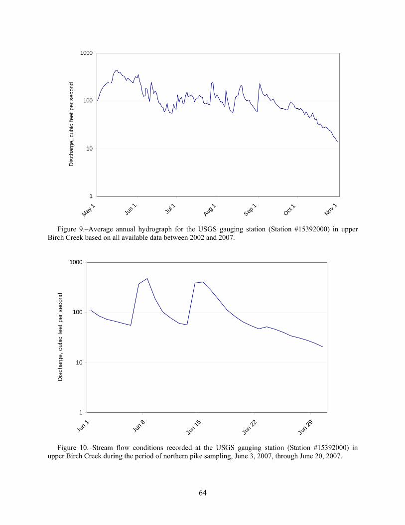
64
Figure 9.–Average annual hydrograph for the USGS gauging station (Station #15392000) in upper Birch Creek based on all available data between 2002 and 2007.
Figure 10.–Stream flow conditions recorded at the USGS gauging station (Station #15392000) in upper Birch Creek during the period of northern pike sampling, June 3, 2007, through June 20, 2007.
1
10
100
1000
May
1Ju
n 1
Jul 1
Aug 1
Sep 1
Oct 1
Nov 1
Dis
char
ge,
cubi
c fe
et p
er s
econ
d
1
10
100
1000
Jun
1Ju
n 8
Jun
15
Jun
22
Jun
29
Dis
char
ge,
cubi
c fe
et p
er s
econ
d
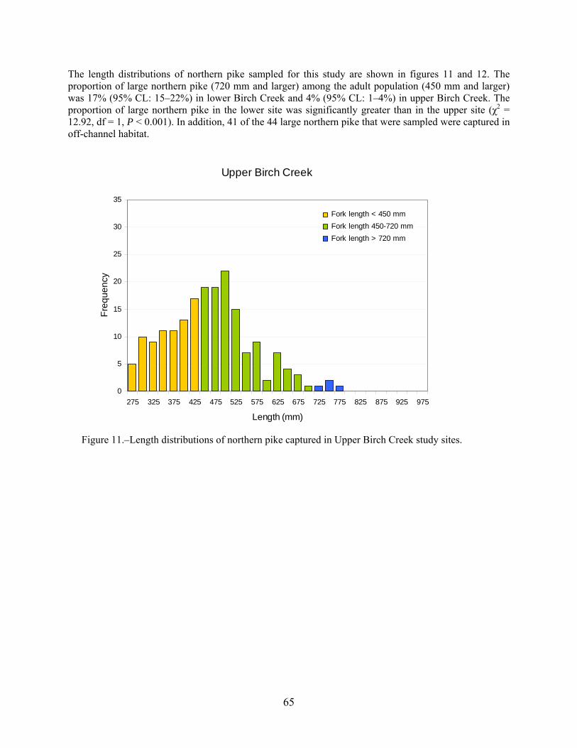
65
The length distributions of northern pike sampled for this study are shown in figures 11 and 12. The proportion of large northern pike (720 mm and larger) among the adult population (450 mm and larger) was 17% (95% CL: 15–22%) in lower Birch Creek and 4% (95% CL: 1–4%) in upper Birch Creek. The proportion of large northern pike in the lower site was significantly greater than in the upper site (χ2 = 12.92, df = 1, P < 0.001). In addition, 41 of the 44 large northern pike that were sampled were captured in off-channel habitat.
Figure 11.–Length distributions of northern pike captured in Upper Birch Creek study sites.
Upper Birch Creek
0
5
10
15
20
25
30
35
275 325 375 425 475 525 575 625 675 725 775 825 875 925 975
Length (mm)
Fre
qu
en
cy
275
700
775
Fork length < 450 mm
Fork length 450-720 mm
Fork length > 720 mm
66
Figure 12.–Length distributions of northern pike captured in Lower Birch Creek study sites.
DISCUSSION Analysis of data from the TEK interviews indicates some regional and local distinctions regarding nonsalmon fish harvests and use. The key informant interviews indicated that one or more species of nonsalmon fish were available for harvest or consumption (frozen or otherwise preserved) and used by residents of the region in almost every calendar month. This does not indicate that these fish were harvested in every month, but that these fish were used in every community throughout the year.
The Birch Creek and southern Yukon Flats region encompasses a large and diverse geographic area including a major river—the Yukon—and five important tributaries—Beaver Creek, Birch Creek, Discovery Creek, Jefferson Creek, and Preacher Creek. In addition to these six primary watercourses, key respondents mentioned countless sloughs and lakes that are used frequently during different parts of the year for harvesting nonsalmon fish. Information provided by key respondents offers a unique drainage wide perspective as to how these nonsalmon species move through and use the waterways of the region, and how they are used as a subsistence resource by the people who live there.
Lower Birch Creek
0
5
10
15
20
25
30
35
275 325 375 425 475 525 575 625 675 725 775 825 875 925 975
Length (mm)
Fre
qu
en
cy275
700
775
Fork length < 450 mm
Fork length 450-720 mm
Fork length > 720 mm

67
Plate 27.–Beaver Creek in the vicinity of Birch Creek.
Photo: USFWS.
In general, fishing areas have been used for generations with little change until drying trends within the last 20 years began to alter the landscape. Areas used in the past have been abandoned because they are no longer productive. Key respondents said that new fishing spots are occasionally tested, but for the most part traditionally known areas are used. Although the people who use them do not formally “own” these spots, it is considered unacceptable to use a place that another family has consistently used without first obtaining permission.
Overall, the key respondent interviews provided information regarding harvest practices for certain species, social practices surrounding harvest, and fish ecology. It seems that many nonsalmon fish are harvested incidentally while fishing for king (Chinook) and chum salmon—mostly using fish wheels. Nets for catching whitefish were placed not only incidentally based on natural indicators of whitefish presence and activity, but also according to traditional locations known to still be productive, yet lacking the otherwise sought for signs of potential whitefish activity. Reportedly, whitefish in the vicinity of the Yukon River in the Yukon Flats make two general runs per year, while fishers in the upper Tanana region of eastern interior region have reported three annual runs in that area (Koskey 2006).
Respondents reported a strong preference for fish wheels and fish traps [fyke nets] over gillnets due to the high mortality rate of fish caught in nets. The State of Alaska prohibits the use of fish traps in most cases (the use of fyke nets is allowed as long as the entire water flow is not blocked), but respondents believed them to be a superior fishing method, since the fish do not die as rapidly or frequently, and those that are not needed can be returned to the water alive. Returning live fish to the water is not usually an option with gillnets. Nevertheless, due to their efficiency and legality, mesh gillnets are widely used for nonsalmon fishing. Many respondents said the prohibition of fish traps constitutes a criminalization of their

68
traditional culture. While conducting the biological sampling portion of this project we informally noted that fish mortality rate—particularly among whitefish—was three to five times higher when using gillnets as opposed to hoop nets, which provide a “holding” area for captured fish. Respondents noted that fish caught in gillnets effectively “drown” in as few as fifteen minutes due to the disruption of their gills in the mesh, and then begin to deteriorate.
The harvest assessment data were also an important part of this project in providing a recent, single-year glimpse of nonsalmon harvests in a particular geographic area. This dataset complements traditional ecological knowledge in several ways. First, it provides a contemporary picture of harvest that is helpful in quantifying uses described in the interviews. Second, it identifies the full range of species used in the southern Yukon Flats, even when not identified in each interview, and the extent to which a species was used. Finally, the harvest and use survey offered clues as to how these species were distributed within a subsistence use network; the questions tracking use, harvest, receipt and giving away of nonsalmon fish suggest patterns in the social organization of subsistence throughout the region as a whole and in specific communities.
The results of northern pike sampling indicate geographic differences in the distribution of large northern pike within the Birch Creek watershed. The estimated proportion of large fish in the upper Birch Creek sampling area was below the 20% threshold level (possibly indicating a less-than-healthy population), but no comparable difference between the proportion of large fish and the threshold in lower Birch Creek was detected. Even with the limited sample sizes, the length index suggests that large northern pike in the lower sampling area are at or near the threshold, indicating a lightly fished stock, while large northern pike in the upper area are below the threshold. This may be a sign of differences in fishing effort and resulting size-selective fishing mortality between the two sample sites, or a health issue. Upper Birch Creek is accessible by road and supports a small sport and subsistence fishery, while lower Birch Creek is accessible only by air or boat and supports mainly very localized subsistence uses.
The northern pike sampling results demonstrate the importance of off-channel sloughs and lakes as summer feeding habitat for adult northern pike. Most of the large northern pike that we sampled were captured in off-channel habitats. This result is consistent with our expectations given the types of habitat encountered in the two study sites. Lower Birch Creek has more sloughs, lakes, and other off-channel habitats that make it more favorable for northern pike than upper Birch Creek. Our results are also consistent with ethnographic interviews that indicated that whitefish in the Yukon Flats region migrate twice a year: into lakes in the spring, and into main river channels in the fall.

69
Plate 28.–Project partners Paul Williams, Sr. of Beaver (USFWS) and Mike Koskey (UAF) discuss changing nonsalmon harvest and use trends on the Yukon River.
Photo: Michael Koskey.
The Birch Creek watershed remains impacted by mining activities. Abandoned placer mines may contribute large amounts of fine sediments to streams in the area, especially during periods of high stream flow (Kennedy and Langley 2007). In addition, active placer mining in tributaries in the upper part of the drainage likely affects water quality and may lead fish species to avoid certain areas. Arctic grayling and king (Chinook) salmon are sight feeders that feed on stream drift (Sterin et al. 1998), and it has been suggested that fish avoid or abandon habitat when turbidity levels are greater than 400 NTU (Townsend 1991; Townsend 1996). The BLM has undertaken a multiyear abandoned mine land reclamation project in Harrison Creek, in the upper Birch Creek watershed, to restore natural stream–floodplain connectivity in order to reduce erosion and large sediment inputs into Birch Creek. Reclamation of areas impacted by mining will continue to be important for the enhancement of aquatic habitats and the protection of aquatic species in Birch Creek.
Concerns were raised to the Eastern Interior Regional Advisory Council (EIRAC) in 2003 regarding the potential effects of placer mining activity in Birch Creek on northern pike populations, which are an important subsistence resource in the region. The EIRAC provides advice and recommendations to the Federal Subsistence Board about subsistence hunting, trapping, and fishing issues on federal public lands and waters in eastern interior Alaska. Local residents were concerned that northern pike in lower Birch Creek may have been impacted by heavy metal contaminants as a result of mining activity in the upper part of the watershed. They also believed that the northern pike population as a whole was declining due
70
to the combined impacts of these contaminants and high sediment loads in the river. Biological sampling of northern pike stocks in Birch Creek was combined with the ethnographic research in this project to address these concerns.
There are no previously existing data available on northern pike stocks in Birch Creek. However, the Alaska Department of Fish and Game has conducted extensive studies on northern pike in other Yukon River tributaries, and these results were used to develop research objectives and sampling methods and to provide context for the interpretation of results. In general, both whitefish and northern pike populations in the Birch Creek watershed were found to be healthier than in the past, especially at the peak of mining activity in the vicinity of Central. , However, prior to and in the 1960s, numbers, size, and quality of fish flesh were all reportedly superior.
Research in the western Yukon Flats and Minto Flats regions indicate that northern pike movement out of the study areas increases after the end of June; thus, the best period for representative sampling of northern pike in the Yukon Flats may be in June (Roach 1998; Chythlook and Burr 2002; Joy and Burr 2004). A study in the Nowitna River also showed that June sampling would yield a less biased estimation of northern pike length composition (Burr and Roach 2003). These studies have also led to the use of multiple gear types and sampling during cooler morning and evening hours to enable longer gear soak times. These were all considered and employed in the biological sampling component of this study.
Birch Creek supports a subsistence fishery for northern pike and other freshwater fish in the vicinity of Central, Circle, and Birch Creek Village. Gillnets are used to catch fish, and mesh size is restricted to three inches or less between June 15 and September 15 under federal subsistence regulations, and year-round under state regulations in order to reduce incidental take of migrating salmon. The number of fish that can be harvested in the subsistence fishery is not limited. As an example, household surveys from 2006 estimated that in 2005 Birch Creek Village residents harvested 336 northern pike.
A small sport fishery for northern pike and Arctic grayling also exists in sections of Birch Creek that are accessible from the Steese Highway. The total estimated annual harvest from the ADF&G Statewide Harvest Survey has averaged fewer than 30 northern pike (Burr 2006). The sport fish daily bag limit is 10 per day with no size limit, and the fishery is open year-round. The total annual harvest of northern pike by both subsistence and sport fisheries in Birch Creek is likely fewer than 1,000 fish.
The harvest of nonsalmon fish, then, is very light in most communities (except Fort Yukon) in absolute numbers, and relative to the harvest of salmon the amount is very small (except in Birch Creek and Central, where local access to salmon is limited or nonexistent). By combining ethnographic evidence derived from resident observations with data from the harvest survey and biological sampling of northern pike, an overall picture of the role and changes in nonsalmon fish and their use and harvest has been elucidated. While in some areas such as Circle the harvest of nonsalmon fish has decreased due to changing ecological conditions, in others such as Birch Creek harvest has reportedly increased due to improving water quality conditions.
In communities such as Beaver and Fort Yukon, an overall slight increase in the harvest of nonsalmon fish compensates for the decrease in the size and number of harvested salmon, which are seen as being more threatened by changing ecological conditions. In addition to mining activities in the upper Birch Creek area, environmental drying and the lack of consistent flooding were viewed as being the primary threats to nonsalmon fish—concerns that are further exacerbated by the presence of many more beaver dams than in the past. Although the practice is now highly restricted by the State of Alaska, indigenous peoples throughout Alaska periodically breached beaver dams to maintain healthy habitats for nonsalmon fish. Most fishers now believe that the balance between beaver dams and healthy nonsalmon fish habitat has been compromised by ineffectual and uninformed regulations.

71
CONCLUSIONS This interdisciplinary project has demonstrated that a multifaceted approach to addressing questions of the use of natural resources provides a better informed understanding of the processes involved. Local perspectives based on generations of accumulated knowledge about a local area and its flora and fauna, combined with western humanistic and scientific approaches, enabled a greater depth of understanding than otherwise would have been possible. This was particularly evident during the traditional knowledge interviews, where ideas or questions concerning the conditions and usage of nonsalmon fish could be asked by local experts, anthropologists, or fish biologists. Therefore, local traditional knowledge, ethnographic observation and evaluation, and fish biology all need to be addressed in order to achieve a more complete understanding of natural resource use in a particular geographic area.
In the course of this project, we learned that whitefish in the vicinity of the Yukon River in the Yukon Flats migrate twice per year (into lakes in spring and into rivers in the fall). Furthermore, one or more species of nonsalmon fish are available for use or consumption (from earlier preservation) and are utilized in every month of the year (made possible through techniques such as freezing, smoking, drying, and canning). Interest in harvesting various nonsalmon species differs between communities based on local ecological conditions, proximity to salmon fishing areas, and local and cultural preferences. Overall, salmon species were believed to be declining, according to perceptions drawn from 2006–2007 interviews, whereas nonsalmon populations were described as “healthy” though changing.
Concerns over the future viability and resiliency of nonsalmon species were nevertheless voiced, often related to widely observed conditions of climate change. Ecological awareness was expressed through observation of current conditions of widespread drying of lakes, streams, and sloughs, and a much reduced or absence of flooding on the Yukon River and its tributaries (excepting the tremendous and atypical flood of spring 2009). Lack of these floods was directly identified as the cause for the decrease in water levels and water quality near the formerly widespread annual floodplain of the Yukon River. Melting permafrost, too, has been widely observed, and this change seems to have resulted in a slight inundation of some areas with meltwater, forming swampy areas alongside drying and disappearing lakes and ponds. Further degradation of slough and lake water quality—and by extension nonsalmon fish quality—was attributed to the increasing number of beaver dams in the region, which hampers fish migrations. Finally, as the quality and quantity of salmon species decline, reliance on whitefish and other nonsalmon fish appears to be occurring in areas where salmon fishing is predominant.
This project provides a glimpse of the changing overall conditions affecting nonsalmon fish and cultural practices surrounding fishing for nonsalmon. Although our respondents recognized that such changes have always occurred, changes in recent times—particularly in the last five to fifteen years—have been more rapid and pronounced. The gradual changes in mining practices and the use of retention ponds in the vicinity of upper Birch Creek have improved water quality. However, the middle and lower courses of Birch Creek are affected by drying and dropping water levels overall. As the local conditions of the lands and waters of the Birch Creek region take on new characteristics, so too are the region’s people adapting to these inevitable changes. Local people recognized and identified these changes and have acknowledged them, adapting by increasing whitefish harvests in response to lower salmon availability. Most local residents recognize that new conditions must be met pragmatically and practically. This is a hallmark of the resiliency of Gwich’in Athabascan culture.
RECOMMENDATIONS The local and traditional knowledge of nonsalmon fish species of the southern Yukon Flats is highly localized. While this was not unexpected, it does limit the comparability of data between sites, particularly when the depth of research is limited due to funding constraints or to the spreading of resources across a wider geographic area. Nevertheless, through the use of ethnological and biological analysis, patterns were compared and interpretations standardized for the region as a whole. This could be

72
more effective if research was conducted for longer time periods in more localized contexts. We found that local perspectives and experience differed between study communities, and that with a more in- depth investigation into fish health and behavior, water quality, and the role of humans in the ecology of nonsalmon fish and their habitats, a more complete understanding of these interdependent processes could be attained.
An area of concern consistently articulated by project participants and key respondents was the limitations inherent in comprehending and considering only a portion of local and traditional knowledge. Most project participants and key respondents suggested that a complete understanding of the behaviors and habitat conditions of nonsalmon fish is not possible because of this limited focus. The general problem is that local knowledge is holistic and comprehensive, which western styles of categorizing environmental information fail to recognize. Nevertheless, by emphasizing local and traditional knowledge, cultural understandings can be highlighted and incorporated into systematic biological and ethnographic investigations.
In particular, the sampling of fish other than northern pike would provide a clearer picture of water quality and the interactions and interdependence of these species, and by extension with other species beyond nonsalmon fish. Additionally, the harvest surveys could be done in five-year intervals for an extended, decades-long time period to demonstrate not only changing harvest levels, but also to document which species are harvested (reflecting in part changing cultural ideas of what species are desired) and why. Finally, while the traditional knowledge interviews informed this project and report, more open-ended interviews, including group interviews, would likely elicit unexpected information on topics that could help to qualify what is learned from the harvest surveys and biological sampling.
Implicit in ecological research is the recognition that from a human perspective, empirical and cosmological concepts are inescapably unified; it is through the experiential conditions of life that an understanding of the human perspective arises. This is evident in the ideology behind ethnological research as well as in the understanding of traditional knowledge and, ideally, scientific inquiry. Knowledge of the ecological systems of a place requires the mutual respect of all who would delve into an investigation of any aspect of the whole, and through such respect knowledge is gained that transforms all willing participants. This requires genuine and sincere involvement in each other’s experience and perspectives on understanding why changes and conditions are what they seem.
As humans we may speak of the experiential in terms of allegory and metaphor, often for a lack of expressive skills caused by cultural peculiarities, but the knowledge obtained from experience is nevertheless present. While traditional (ecological) knowledge seemingly is often confusing or inconsistent to nonlocals, so too can be scientific inquiry and explanations to others not familiar with the particular discipline. As sharing is a method of securing resources through diversification and conceptual social binding among the Gwich’in (and others) of the Yukon Flats, so again can diversity as an operational value serve to inform those of different intellectual backgrounds of the highly complex processes of local and regional ecologies. To reach such a capacity for learning and understanding complex processes requires a genuine commitment of time and interest in any inquiry, and interdisciplinary approaches to resource management will prove to be most effective. This study represents one of a series of ongoing “first steps” in such an endeavor.
No matter the cultural background or intellectual rationale used to support effective management, all parties involved must fundamentally understand and support the concept of a healthy, resilient environment through sustainable behaviors. This is apparent in the statement from an elder respondent in Beaver:
I think it’s good that we take care of the land; we have to start taking care of it and start looking at it and start remembering what we the elders did a long time ago. Now modern day things are too easy, and we don’t look at these little things like cutting down brush to clear streams. We got away from our dances and songs and giving something back to the

73
land, like we did a long time ago. Maybe that worked that long ago. With the people, the land, and the animals, we always take care of one another. Because we know that bears are dangerous and so are wolves and we got to be prepared when we go out into the land, let the land know that you are there and what you are doing. If you’re going to cut down tree you tell the tree that you are going to cut it down. You’re going to use it for a certain purpose. I see picture about certain Indian and he got a deer, he said you are swift and we will honor you, and honor you that you are going to feed us because we are hungry. And just telling the deer that you thank them for providing meat, and a fast learning, that is respectful. Maybe that don’t count no more. I don’t know… (B011607B)
ACKNOWLEDGEMENTS The authors would like to extend their gratitude to the people of Beaver, Birch Creek, Central, Circle, and Fort Yukon for their time, knowledge, and patience in answering our questions and helping to shape this research. We have learned much from everyone involved.
We would like to give special and sincere thanks to Paul Williams, Sr. of Beaver and Winston James of Birch Creek, both of whom facilitated and made possible the successful completion of this project. The passing of Chief Winston James during the duration of this project was difficult for all who knew him.
Plate 29.–Winston James, chief of Birch Creek.
Photo: CATG.
74
Thanks, too, to Derek Rader (formerly of CATG) and Ingrid McSweeny (BLM) for their dedicated participation in the traditional knowledge interviews portion of this project, and thanks to Gloria Oseguera and Marjorie Tahbone for their transcription services. Finally, thanks to Beaver residents Richard Williams and Birdie Billie for their valuable assistance during the biological sampling portion of this project, and to Kathy Sikorski (UAF) who assisted in transliteration of the placenames collected.
We of course also thank the U.S. Fish and Wildlife Service, Office of Subsistence Management, for providing funding support for this project through the Fisheries Resource Monitoring Program, under agreement number 701816C256.
LITERATURE CITED ACUNS (Association of Canadian Universities for Northern Studies). 2003. Ethical principles for the conduct of
research in the north. http//www.acuns.ca/EthicsEnglishmarch2003.pdf, accessed March 2007.
Alaska Community Database Online (ACDO). 2010. Alaska Division of Community and Regional Affairs. Alaska Department of Commerce, Community, and Economic Development, State of Alaska, Juneau.
Alaska Department of Environmental Conservation. 2007. Alaska’s final 2006 integrated water quality monitoring and assessment report. December 28, 2006, modified September 20, 2007.
Andersen, D. B. and C. L. Fleener. 2001. Whitefish and beaver ecology of the Yukon Flats, Alaska. The Natural Resources Department of the Council of Athabascan Tribal Governments and the Alaska Department of Fish and Game Division of Subsistence, Technical Paper No. 265, Fort Yukon, Alaska, and Juneau, Alaska. http://www.subsistence.adfg.state.ak.us/TechPap/tp265.pdf
Arvey, W. D. and A. Burkholder. 1990. Stock assessment of northern pike in the vicinity of the Yukon River haul road crossing, 1988 and 1989. Alaska Department of Fish and Game Division of Sport Fish, Fishery Manuscript No. 90-1, Anchorage. http://www.sf.adfg.state.ak.us/FedAidPDFs/fms90-01.pdf
Brown, R. J., C. Lunderstadt, and B. Schulz. 2002. Movement patterns of radio-tagged adult humpback whitefish in the upper Tanana River drainage. United States Department of the Interior, Fish and Wildlife Service, Region 7 Fishery Resources, Alaska Fisheries Data Series Number 2002-1, Fairbanks, Alaska. http://www.arlis.org/docs/vol1/A/53795729.pdf
Bureau of Land Management. 1983. River management plan for the Birch Creek National Wild River. U. S. Department of the Interior, Bureau of Land Management, Fairbanks District, BLM-AK-PT-83-003-1610-REP-87-080, [Fairbanks, Alaska].
Bureau of Land Management. 1984. Proposed resource management plan/final environmental impact statement for the Steese National Conservation Area. U.S. Department of the Interior, Bureau of Land Management, Fairbanks District Office, [Fairbanks, Alaska].
Burr, J. 2006. Fishery management report for sport fisheries in the Arctic-Yukon Management Area, 2003–2005. Alaska Department of Fish and Game, Fishery Management Report No. 06-66, Anchorage. http://www.sf.adfg.state.ak.us/FedAidPDFs/fmr06-66.pdf
Burr, J. and S. Roach. 2003. Abundances, length and age compositions, and CPUE of northern pike within selected sloughs of the Nowitna River, 1997. Alaska Department of Fish and Game, Fishery Data Series No. 03-16, Anchorage. http://www.sf.adfg.state.ak.us/FedAidPDFs/fds03-16.pdf
Caulfield, R.A. 1983. Subsistence land use in Upper Yukon Porcupine communities, Alaska: Dinjii Nats’aa Nan Kak Adagwaandaii. Alaska Department of Fish and Game, Division of Subsistence Technical Paper No. 16, Fairbanks. http://www.subsistence.adfg.state.ak.us/techpap/tp016.pdf
Caulfield, R. A., W. J. Peter, and C. Alexander, editors. 1983. Gwich’in Athabascan place names of the Upper Yukon-Porcupine region, Alaska: a preliminary report. K. Peter, translator. Alaska Department of Fish and Game, Division of Subsistence Technical Paper No. 83, Fairbanks. http://www.subsistence/adfg.state.ak.us/TechPap/tp083.pdf
Chythlook, J. and J. M. Burr. 2002. Seasonal movements and length composition of northern pike in the Dall River, 1999–2001. Alaska Department of Fish and Game, Fishery Data Series No. 02-07, Anchorage.

75
Hunn, E. 1988. What is traditional ecological knowledge? Pages 13–15 in Williams, N. M. and G. Baines, editors. Traditional ecological knowledge: wisdom for sustainable development. Centre for Resource and Environmental Studies (CRES), Australian National University, Canberra, Australia.
Jennings, G. B., K. Sundet, and A. E. Bingham. 2007. Participation, catch, and harvest in Alaska sport fisheries during 2004. Alaska Department of Fish and Game, Fishery Data Series No. 07-40, Anchorage. http://www.sf.adfg.state.ak.us/FedAidPDFs/fds07-40.pdf
Johnson, J. and E. Weiss. 2007. Catalog of waters important for spawning, rearing, or migration of anadromous fishes—Interior Region, effective June 1, 2007. Alaska Department of Fish and Game, Special Publication No. 07-04, Anchorage. http://www.sf.adfg.state.ak.us/FedAidPDFs/Sp07-04.pdf
Joy, P. and J. M. Burr. 2004. Seasonal movements and length composition of northern pike in Old Lost Creek, 2001-2003. Alaska Department of Fish and Game, Fishery Data Series No. 04-17, Anchorage.
Kassam, K-A. S. 2009. Biocultural diversity and indigenous ways of knowing: human ecology in the Arctic. University of Calgary Press, Canada.
Kennedy, B.W. and D. E. Langley. 2007. Assessment of hydrology, water quality, and trace elements in selected placer-mined creeks in the Birch Creek watershed near Central, Alaska, 2001–05. U.S. Geological Survey Scientific Investigations Report 2007-5124, Reston, Virginia. http://purl.access.gpo.gov/GP/LPS85077
Koskey, M. 2006. Subsistence resource use in the upper Tanana 2004–2005. Report prepared for the Alaska Department of Natural Resources. Alaska Department of Fish and Game Division of Subsistence, Fairbanks.
Kostohrys, J. and B. B. G. Sterin. 1996. Water resources of Birch Creek National Wild River, Alaska: stream gauging data from 1989 to 1994. U. S. Department of the Interior, Bureau of Land Management, Anchorage.
Kritsch, I. and A. Andre. 1997. Gwich’in traditional knowledge and heritage studies in the Gwich’in settlement area. Pages 125–144 in G. P. Nicholas and T. D. Andrews, editors. At a crossroads: archaeology and First Peoples in Canada. Archaeology Press, Burnaby, British Columbia.
LaPerriere, J. D., S. M. Wagener, and D. M. Bjerklie. 1985. Gold-mining effects on heavy metals in streams, Circle Quadrangle, Alaska. Water Resources Bulletin 21: 245-252.
Leopold, A. 1949. A Sand County almanac; and, sketches here and there. Oxford University Press, New York.
Maurer, M. A. 1987. Compilation of stream macroinvertebrate data for the Birch Creek, Beaver Creek, Fortymile River, and Minto Flats drainages, Alaska. Alaska Department of Natural Resources, Division of Geological and Geophysical Surveys, Public Data File 87-30, Fairbanks. http://www.dggs.alaska.gov/webpubs/dggs/pdf/text/pdf1987_030.PDF
McDonald, R. n.d. Journals of the Archdeacon Robert McDonald. Fairbanks: University of Alaska Archives. Microfilm.
Mecklenburg, C.W., T.A. Mecklenburg, and L.K. Thorsteinson. 2002. Fishes of Alaska. American Fisheries Society. Bethesda, Maryland.
Milner, A. M. and R. J. Piorkowski. 2004. Macroinvertebrate assemblages in streams of interior Alaska following alluvial gold mining. River Research and Applications 20(6): 719–731.
Morrow, J. E. 1980. The freshwater fishes of Alaska. Alaska Northwest Publishing Company, Anchorage.
Nelson, R. K. 1983. Make prayers to the raven: a Koyukon view of the northern forest. University of Chicago Press.
Nelson, R. K. 1986. Raven’s people. In J. S. Aigner, R. D. Guthrie, M. L. Guthrie, W. S. Schneider, and R. M. Thorsen, editors. Interior Alaska: a journey through time. The Alaska Geographic Society, Anchorage.
Osgood, C. 1936. Contributions to the ethnography of the Kutchin. Yale University Publications in Anthropology, No.14. New Haven, CT.

76
Page, L. M. and B. M. Burr. 1991. A field guide to freshwater fishes: North America north of Mexico. Houghton Mifflin Company, Boston.
Reynolds, J. B., R. C. Simmons, and A. R. Burkholder. 1989. Effects of placer mining discharge on health and food of Arctic grayling. Water Resources Bulletin 25(3): 625–635.
Ritter, J. T. 1976. Kutchin place names: evidence of aboriginal land use. In Dene rights: supporting research and documents, Volume 3: 111–135. Indian Brotherhood of the Northwest Territories, Yellowknife, Canada.
Roach, S. M. 1998. Site fidelity, dispersal, and movements of radio-implanted northern pike in Minto Lakes, 1995–1997. Alaska Department of Fish and Game, Fishery Manuscript No. 98-1, Anchorage. http://www.sf.adfg.state.ak.us/FedAidPDFs/fms98-01.pdf
Scanlon, B. 2006. Abundance and composition of the northern pike population in Minto Lakes, 2003. Alaska Department of Fish and Game, Fishery Data Series No. 06-74, Anchorage. http://www.sf.adfg.state.ak.us/FedAidPDFs/fds06-74.pdf
Schneider, W. 1976. Beaver, Alaska: the story of a multi-ethnic community. Ph.D. dissertation. Anthropology Department, Bryn Mawr College, Pennsylvania.
Slobodin, R. 1981. Kutchin. Pages 514–532 in W. C. Sturtevant, editor. Handbook of the North American Indians, volume 6: Subarctic. Smithsonian Institution, Washington, D. C.
Sterin, B. B. G., D. Whittaker, and J. Kostohrys. 1998. Birch Creek National Wild River, Alaska: resource values and instream flow recommendations. U. S. Department of the Interior, Bureau of Land Management, Anchorage.
Stuck, H. 1914. Ten thousand miles with a dog sled. Charles Scribner’s Sons, New York.
Sullivan, R. J. 1942. The Ten'a food quest. Catholic University of America, Anthropological Series 11, Washington, D.C.
Sumida, V. A. 1989. Patterns of fish and wildlife harvest and use in Beaver, Alaska. Alaska Department of Fish and Game, Division of Subsistence Technical Paper No. 140, Fairbanks. http://www.subsistence.adfg.state.ak.us/techpap/tp140.pdf
Sumida, V. A. and D. B. Andersen. 1990. Patterns of fish and wildlife use for subsistence in Fort Yukon, Alaska. Alaska Department of Fish and Game, Division of Subsistence Technical Paper No. 179, Fairbanks. http://www.subsistence.adfg.state.ak.us/techpap/tp179.pdf
Townsend, A. H. 1991. Distribution of fishes in Alaska’s upper Birch Creek drainage during 1984 and 1990. Alaska Department of Fish and Game, Division of Habitat, Technical Report No. 91-2, Juneau. http://www.habitat.adfg.alaska.gov/tech_reports/91_02.pdf
Townsend, A. H. 1996. Distribution of fishes in Alaska’s upper Birch Creek drainage during 1984, 1990 and 1995. Alaska Department of Fish and Game, Habitat and Restoration Division, Technical Report No. 96-4, Juneau. http://www.habitat.adfg.alaska.gov/tech_reports/96_04.pdf
Townsend, A. H. 2000. Birch Creek juvenile and adult salmon surveys July–August, 2000. Yukon River Drainage Fisheries Association, Anchorage, Alaska.
Tyrrell, L. B. 2002. Living the frontier myth in the twenty-first century. M.A. thesis, University of Alaska, Fairbanks.
United States Department of the Interior, United States Fish and Wildlife Service. 2005. Evaluation and review of a proposed land exchange and acquisition of Native lands within the Yukon Flats National Wildlife Refuge, Alaska. Anchorage.
Van Nieuwenhuyse, E. E. and J. D. LaPerriere. 1986. Effects of placer gold mining on primary production in subarctic streams of Alaska. Water Resources Bulletin 22(1): 91–99.
VanStone, J. W. 1974. Athapaskan adaptations: hunters and fishermen of the subarctic forests. Chicago: Aldine.
Wagener, S. M. and J. D. LaPerriere. 1985. Effects of placer mining on the invertebrate communities of interior Alaska streams. Freshwater Invertebrate Biology 4(4): 208–214.

77
Weber, P. K. 1986. Downstream effects of placer mining in the Birch Creek basin, Alaska. Alaska Department of Fish and Game, Division of Habitat Technical Report No. 86-7, Juneau. http://www.habitat.adfg.alaska.gov/tech_reports/86_07.pdf
Weber, P. and R. Post. 1985. Aquatic habitat assessments in mined and unmined portions of the Birch Creek watershed. Alaska Department of Fish and Game, Division of Habitat, Technical Report No. 85-2, Juneau. http://www.habitat.adfg.alaska.gov/tech_reports/85_02.pdf
Yeend, W. E., P. H. Stauffer, and J. W. Hendley, II. 1998. Rivers of gold: placer mining in Alaska. U. S. Geological Survey Fact Sheet 058-98.

78

79
APPENDICES

80
Appendix I.–Survey instrument example.

81
Appendix II.–Interview guide.
Interview Guide Summary: (Summarize the following in your own words and/or allow the interviewee to read the statement themselves). “Thank you for sharing your knowledge and experience with us. We welcome your understanding of subsistence fishing in the northern Yukon Flats. This interview will be semi-structured to allow for you to say as much or as little as you would like about what you remember and what is important to you concerning fishing for nonsalmon fish. There is no time limit and feel free to speak in your native language if preferred, which will be translated by one of our project partners. The partners on this project will use your interview, or parts of it, for scientific and educational purposes. Your name may be used to identify your statements, but if you decide to remain anonymous, your wishes will be respected.” Seasonal Round: Begin by asking a respondent about his or her participation as children or now in a seasonal round of subsistence activities. Be sure to provide color pictures to aid in nonsalmon fish identification. Because some nonsalmon fish do move seasonally in the fall and winter, asking about spring, summer, and fall camp is useful. People will often discuss fishing for nonsalmon fish in relation to other subsistence practices, which can be especially interesting and relevant. Life History 1. What can you tell me about the seasonal movements of nonsalmon fish? a. Do they come and go? b. Are they in the area year-round? c. When do people catch them? 2. Do you know what each type of fish that you catch eat (ask individually by fish)? Follow up: Do you know what are the stomach contents at different times of the year? 3. Do you know when and where the nonsalmon fish you catch spawn? 4. What is the condition of the fish (such as its skin/scales at different times of the year)? 5. Where do they spend the winters? Where do they spend the summers? Do you know of any juvenile habitats? 6. On a more specific level, are fish movements affected by weather? a. Water levels? b. Time of day? c. Water temperature? 7. What kind of water do nonsalmon fish that you fish for like (slow, fast, deep, shallow, warm, cool)? Follow up: What makes a good habitat for the nonsalmon fish that you fish for?

82
Harvest and Use 1. Where do you go to catch fish? Follow up: Do you know the names in Gwich’in of the places you fish? Do you
know what these placenames mean in English? 2. What do you look for in selecting an area to fish for different types of nonsalmon fish? What kinds of nonsalmon fish did people harvest long ago, and have these changed? 3. What kinds of fishing gear was used in the past to catch different types of nonsalmon fish? a. Size of net (mesh, length)? b. Other methods? Were there differences in men’s and women’s roles in the past? Follow up: In the future? 4. What kinds of fishing gear is used today to catch different types of nonsalmon fish? a. Size of net (mesh, length)? b. Other methods? 5. How is your catch of nonsalmon fish usually preserved (freezing, drying, smoking, canning, or other)? a. What different ways do you cut nonsalmon fish for different purposes? b. Are there any ways of cutting or preserving nonsalmon fish that you know of that are no longer practiced? 6. Do you use nonsalmon fish for the purposes of baiting animals for traps or otherwise, or for feeding dogs? Was fish traded, bartered, or sold in the past? With whom? 7. Who participates in fishing for nonsalmon fish? a. Harvesting? b. Cutting? c. Making and repairing nets? 8. When at seasonal camps engaged in nonsalmon fishing, how many families are usually at each camp?
a. What are the relations between families sharing a camp? b. How long do families usually remain at each season’s camp?
9. How much nonsalmon fish (approximate pounds or numbers) did your family try to harvest? a. Do you consider your harvest to be adequate? b. Did you give away or receive nonsalmon fish?

83
10. How do you determine when to limit fishing—are there indicators that prompt you to begin and end your nonsalmon fishing efforts? Population and environmental trends 1. Do you think the number of nonsalmon fish in the areas you fish are increasing or decreasing, or about the same as usual? Have you noticed a change in the quality of nonsalmon fish? a. Size? Since when? b. Taste? Since when? c. Texture? Since when? 2. What about the waterways in which you fish—are they different than in the past? How? a. Water temperature? b. Water quality (increased siltation, levels, etc.)? c. Effects on the ecosystem? d. Environmental occurrences—fire, flood, earthquake, volcano, drought, warm
winter/cold winter, effects of snowfall, etc. Salmon Question 1. What is your impression of the King run on Birch Creek? How has it changed? 2. Have you noticed any white-fleshed king salmon in the region?
Resource Mapping and Place-name Identification Researchers will use USGS 1:250,000 maps as well as existing Gwich’in place-name maps with Mylar overlays to document: 1. fishing-related placenames 2. spawning areas 3. harvest areas 4. rearing habitat 5. other significant locations Respondents should also be asked to review topographical maps of the area including Gwich’in placenames and to: 1. mark current and historic fish-related areas 2. discuss these sites—including past and present use.

84
Appendix III.–Northern pike sampling data form and description of data fields.
Northern pike sampling data form and description of data fields
Date ________ Gear _______ Page 07 ____
Set Duration _____hr Location Lat 6_o___.___ Long 14_o___.___
H2O Temp _____ oC @ Time _______
# Species Length Tag # Fate Comments
1 2 3 4 5 6 7 8 9 10 11 12 13 14 15 16 17 18 19 20 21 22 23 24 25

85
Instructions for recording data fields:
Field Name Description of what will be recorded
Date ddMMMyy (e.g. 09JUN07)
Gear Gill, Hoop, Sport
Page Numbered sequentially 07001-07999
Duration Total time of gear soak in hours (e.g. 0.5 hrs)
Location GPS: Decimal Degrees (e.g. 65o 42.627’ N, 144o 20.185’ W)
H2O Temp oC measured at beginning of each set
@ Time Time of day for H2O Temp measurement
Species NP northern pike, SF sheefish, GR grayling, BB burbot, DV Dolly Varden, BWF broad whitefish, HWF humpback whitefish, LCI least cisco, BCI Bering cisco, RWF round whitefish, KS Chinook salmon, CS chum salmon
Length Nearest 1 mm Fork Length
Tag # Floy Tag color and number (e.g. BL 55451) BL blue, GY grey, GN, green, Y yellow, R red
Fate REL released, K killed
Comments Note anything particular about this fish. e.g. wounds, scars, tumors, etc Make additional notes on the back of the form as needed including:
Sex: As appropriate
Recap: Y only if marked in first event and recaptured in second event