trans-pennine tunnel study: interim report tunnel study interim report date: 24november 2015 version...
TRANSCRIPT

Trans-Pennine Tunnel Study Interim Report
Date: 24November 2015
Version 11_0 Page 1 of 58
This interim report has been superseded by the updated interim report at www.gov.uk/government/publications/trans-pennine-tunnel-strategic-study-updated-interim-report
1.1 Context ....................................................................................................................................... 4
1.2 Interim Report ............................................................................................................................ 4
1.3 Preliminary findings ................................................................................................................... 5
1.4 The strategic case ...................................................................................................................... 6
1.5 Economic case ........................................................................................................................... 7
1.6 Traffic considerations ................................................................................................................ 8
1.7 Construction considerations ...................................................................................................... 8
1.8 Operation and maintenance considerations ............................................................................. 9
1.9 Environmental considerations ................................................................................................. 10
1.10 Next steps ................................................................................................................................ 10
2.1 Background .............................................................................................................................. 11
2.2 Trans-Pennine strategic link study ........................................................................................... 11
2.3 Project team and reporting ..................................................................................................... 11
2.4 Study area ................................................................................................................................ 12
2.5 A tunnel solution ...................................................................................................................... 13
3.1 Introduction ............................................................................................................................. 14
3.2 Transportation case for change ............................................................................................... 14
3.3 Wider case for change ............................................................................................................. 16
3.4 Scheme objectives .................................................................................................................... 21
3.5 Policy drivers ............................................................................................................................ 21
3.6 Summary and next steps ......................................................................................................... 27
4.1 Introduction ............................................................................................................................. 28
4.2 Potential impacts of a strategic link across the Pennines ....................................................... 28
4.3 Direct benefits from faster journeys ........................................................................................ 30
4.4 The Potential for Wider Economic Benefits ............................................................................. 31
4.5 Improved Productivity from Firms Being Closer to Each Other – Some Alternative illustrative scenarios ............................................................................................................................................. 31
4.6 Productivity Benefits From Land Use Changes (Dynamic Agglomeration) .............................. 34

4.7 Summary .................................................................................................................................. 35
4.8 Next steps ................................................................................................................................ 35
5.1 Introduction ............................................................................................................................. 37
5.2 Road standards and status ...................................................................................................... 37
5.3 Tunnel capacity and cross section ........................................................................................... 38
5.4 Ground conditions ................................................................................................................... 38
5.5 Construction ............................................................................................................................. 40
5.6 Excavation ............................................................................................................................... 41
5.7 Constraints on construction ..................................................................................................... 42
5.8 Synergies with rail – operational issues ................................................................................... 43
5.9 Synergies with rail – construction issues ................................................................................. 43
5.10 Heavy rail ................................................................................................................................. 44
5.11 Light rail ................................................................................................................................... 44
5.12 Summary .................................................................................................................................. 44
5.13 Next steps ................................................................................................................................ 45
6.1 Introduction ............................................................................................................................. 46
6.2 Standards ................................................................................................................................. 46
6.3 Prohibited users ....................................................................................................................... 46
6.4 Incident management ............................................................................................................. 47
6.5 Routine and non-routine maintenance .................................................................................... 47
6.6 Safety ....................................................................................................................................... 48
6.7 Security .................................................................................................................................... 49
6.8 Driver behaviour ...................................................................................................................... 49
6.9 Technical innovation and tunnel operations ........................................................................... 50
6.10 Summary .................................................................................................................................. 51
6.11 Next steps ................................................................................................................................ 52
7.1 Introduction ............................................................................................................................. 53
7.2 Key environmental constraints ................................................................................................ 53
7.3 Potential environmental impacts and benefits........................................................................ 54
7.4 Summary of environmental opportunities and challenges ...................................................... 58
7.5 Next steps ................................................................................................................................ 58

• The strategic case for a scheme, involving an assessment of scheme objectives against national, regional and local policies and the wider case for change in the North of England.
• The economic case for a scheme, using the principles described in the Government’s Web-based Transport Analysis Guidance (WebTAG).
• The feasibility of designing and constructing a new strategic route between Manchester and Sheffield, recognising the particular issues associated with the construction of very long sections of tunnel.
• The feasibility of operating and maintaining this new strategic route, focusing on the particular challenges (including driver behaviour and incident management) associated with long lengths of tunnel.
• The potential synergies that could result from combining a road corridor with a heavy-rail or light-rail service following a similar route.
• The environmental impact of the scheme.
1.2.2 We have not had time yet to do any transport modelling of benefits and costs from a trans-Pennine tunnel. The analysis presented in this report is purely to determine whether there is a case to do more intensive work on investigating tunnel options. Based on the work carried out so far there is a good case for further work but more modelling will need to be done before we are in a position to reach a conclusion about the full case for investment in a tunnel.
1.3 Preliminary findings 1.3.1 In this preliminary stage we explored the feasibility of a new strategic highway route
connecting Manchester and Sheffield and found that:
a) Against the background of the Government’s ambition to establish the Northern Powerhouse economy there is a clear strategic case for the scheme, which is aligned with central and sub-national Government policy and which reflects the transportation, socio-economic and environmental objectives of the scheme;
b) the economic benefits of the scheme could include direct user benefits resulting from time savings and the improved resilience of the route compared to existing roads across the Pennines together with wider and more significant benefits in productivity, labour markets, land use and investment in the region;
c) the scale of the wider economic benefits has yet to be established but initial analysis shows that these could be significant and complementary to other elements of the developing Northern Powerhouse strategy. As we identify potential route options the scale of economic benefits will be quantified and compared with the costs which will also be very large;
d) the construction of a new strategic route between Manchester and Sheffield is technically feasible, recognising that the extensive tunnelling required through the National Park and the provision of suitable connections to the Strategic Road Network (SRN) presents some significant technical challenges ;
e) the operation and maintenance of this new road link – which includes extensive tunnel sections – would also be feasible; and
Version 11_0 Page 5 of 58

f) the development of a combined road and rail corridor through the tunnelled section could offer some additional benefits, although road and rail would need to occupy separate tunnel bores and we have not yet established the operational case for this type of solution.
1.4 The strategic case 1.4.1 The North continues to lag behind the South in terms of its economic performance.
Employment rates3 and productivity levels4 are both lower in the North than they are in the South, with the gap in productivity widening over time. The Northern Transport Strategy report (The Northern Powerhouse: One agenda, One economy, One north5) recognises that the North of England has a number of medium-sized cities that perform well individually, but lack the transport connectivity needed to drive improved output and employment. This is essential to creating a single and well-connected economy in the North, which is a key objective of the Northern Powerhouse.
1.4.2 The National Policy Statement for National Networks6 sets out a vision for national networks that is based on:
• creating the capacity, connectivity and resilience needed to support economic activity and to facilitate growth in employment;
• improving journey quality, reliability and safety;
• delivering strategic economic goals; and
• joining up communities
1.4.3 The DfT and TfN have both identified a new major road link under the Pennines between Manchester and Sheffield in their strategic plans7. The northern city regions’ One North8 report by the City Regions of Leeds, Liverpool, Manchester, Newcastle and Sheffield presents a strategic proposition for transport in the North that aims to transform connectivity for economic growth through agglomeration of markets, improving access to skilled labour and stimulating business investment.
1.4.4 The case for action set out in the highways plan of the One North report, recognises that the number, capacity and reliability of east-west road connections is a constraint on the economy and acknowledges that there are areas of severe congestion on the existing network, together with a high level of demand for freight from northern ports9.
1.4.5 In the One North report, Transport for the North cite the routes across the Pennines between Manchester and Sheffield as one of the main gaps in connectivity in the North of England. Existing roads have low average speeds and a poor record of collisions; they cross a National Park; and because of their altitude, they are affected by inclement weather throughout the year and other resilience pressures10.
3 ONS (2015) Nomis: Official Labour Market Statistics, https://www.nomisweb.co.uk/ 4 ONS (2015) Sub-regional Productivity Tables, August 2015 5 Transport for the North. The Northern Powerhouse: One Agenda, One Economy, One North, A report on the Northern Transport Strategy, HMSO, March 2015 6 DfT. National Policy Statement for National Networks, December 2014 7 DfT. Road Investment Strategy: Investment Plan, December 2014 and Transport for the North. The Northern Powerhouse: One Agenda, One Economy, One North, A report on the Northern Transport Strategy, HMSO, March 2015 8 Transport for the North. The Northern Powerhouse: One Agenda, One Economy, One North, A report on the Northern Transport Strategy, HMSO, March 2015 9 Transport for the North. The Northern Powerhouse: One Agenda, One Economy, One North, A report on the Northern Transport Strategy, HMSO, March 2015 10 DfT & Highways England. Trans-Pennine Routes Feasibility Study - Stage 1 Report, March 2015
Version 11_0 Page 6 of 58

1.4.6 The case for change is therefore based on the interrelated transportation and economic needs of the North. A new route is expected to improve connectivity, promote growth, improve capacity and safety, offer greater resilience, and reduce the impact of traffic on the high-quality environment of the National Park. Importantly, if the wider policy towards creating a Northern Powerhouse is successful, then the constraints on connectivity between Manchester and Sheffield, and their impact on the wider transport network in the North, will hold back growth across the region.
1.4.7 We have, therefore, defined the objectives of the trans-Pennine tunnel project as follows:
Objective 1 – To provide a safer, faster, and more resilient road connection between Manchester and Sheffield, creating more capacity and an additional east-west connection. Objective 2 – To fulfil the aims of the Northern Transport Strategy to deliver a scheme that will contribute to the transformation of the economy in the North. Objective 3 – To protect and improve the natural environment by reducing through-traffic in the Peak District National Park and by getting the right traffic onto the right roads. Objective 4 – To support wider socio-economic needs and leave a long-term legacy of improved road connectivity, better access to labour markets, wider employment opportunities, better land use, and more effective integration between transport modes.
1.5 Economic case 1.5.1 We are yet to carry out a WebTAG economic assessment that will form the core part
of the economic case. We are developing the appropriate transport models to undertake such an appraisal in later stages of the study.
1.5.2 Our assessment will consider the wider economic benefits that could occur when towns and cities are brought closer together in terms of travel times and costs, creating larger and more diverse labour and product markets, or greater 'economic mass', than individual towns and cities can achieve in isolation. Recent work in this area commissioned by the DfT notes that there are potentially significant links between improved transport connectivity and increases in economic output and employment11. The scale of the impacts are however context-specific and their estimation requires an understanding of how people and business are affected by, and respond to, transport investment.
1.5.3 We are at too early a stage in the design of the potential scheme to present robust analysis on any of the economic costs and benefits of a scheme. Instead we have only been able to outline the types of benefits and for some of these benefits, set out illustrative scenarios showing what could happen under different assumptions. However while there needs to be detailed transport and economic modelling, the indications are that there is the potential for significant benefits. These come from:
• Significant reductions in travel time of up to 30 minutes for both passenger and freight traffic between Manchester and Sheffield, with potential knock-on implications for travel times on other parts of the network as travel patterns change in response to changing network capacity and quality. In general, we would expect traffic congestion on other parts of the network to reduce as
11 DfT. Transport investment and Economic performance: Implications for Transport appraisal, December 2014
Version 11_0 Page 7 of 58
capacity increases but there may be increased pressure on local roads that provide access to the new road;
• There are likely to be significant reliability benefits to existing users of roads across the Pennines. These roads are frequently out of action during periods of poor weather;
• The reduced travel over the Pennines could itself have positive impacts on the environment;
• We have carried out a very high level illustrative scenario modelling of productivity effects on business from better links between Sheffield and Manchester. These scenarios show productivity benefits of between £171m and £421m per annum, with further potential gains to productivity arising from increased competition across markets. However these are just scenarios and benefits may be higher or lower when actual data has been analysed;
• There are also potential benefits from increasing the attractiveness of the North to inward investment arising from improved access to labour markets, suppliers, business accommodation, distribution centres and warehousing; and
• Importantly, the Northern Powerhouse is about putting together a whole programme of investments where complementary projects are packaged and where their interactions result in higher returns than individual projects alone. This is where the Northern Powerhouse concept comes into play, in that the range of cross-sector investments could result in projects having a larger impact than they would as stand-alone investments.
1.5.4 The means by which this new strategic route will be funded have not yet been considered. One option might be to introduce road-user tolls, but this would have an impact on the economic case for the scheme. The effects of tolling will be considered in later stages of the study, although a decision on whether or not to toll the road is outside the scope of the current study.
1.6 Traffic considerations 1.6.1 The Highways England Trip Information System (TIS) and the DfT’s Trafficmaster
system together provide up-to-date origin/destination information for traffic flows across the UK. We are currently using these datasets to undertake a coast-to-coast assessment of movements in the Northern Powerhouse region that will inform the analysis in later stages of the study.
1.6.2 Our initial analysis, which has looked at ‘coast to coast’ movements, shows that daily movements between Sheffield and Manchester are far lower than those between Manchester and Leeds or between Leeds and Sheffield; further analysis is required to determine how the Pennines is creating a barrier to movement between Manchester and Sheffield.
1.6.3 The journey between the urban centres of Manchester and Sheffield via the Pennine routes is approximately 45 miles and takes an average of 85 minutes (although this can increase greatly as a result of accidents and poor weather); the same journey is around 75 miles in length via the M62 motorway and takes 95 minutes. This is reflected in the fact that only around 10% of trips between the two cities are via the M62 and that, despite the lower average speeds, most travellers still choose to use the Pennine routes, which highlights the importance that travellers place on a direct route between the two cities.
1.7 Construction considerations 1.7.1 The construction of a new strategic road link between Manchester and Sheffield is
technically feasible, although it is likely to include a tunnel (or series of tunnels) that
Version 11_0 Page 8 of 58

could be longer than any road tunnel constructed in Europe to date. The geology of the Pennines is generally suitable for construction of bored tunnels, but the diameter of tunnel bores would be limited to around 15 metres using present-day tunnel boring machines (TBMs).
1.7.2 The road is likely to comprise a dual carriageway built to motorway or expressway standards. However, we are considering other, less conventional, solutions for the tunnel sections.
1.7.3 The new highway will not only need to serve motorists on the strategic network (by connecting to the M60 and M1 at the edge of the study area), but it may need to connect to the local road network within the study area. Additional junctions may therefore be required along the route to permit access to, and from, the new road, and it is anticipated that all junctions will be grade-separated.
1.7.4 In the next stage, a junction strategy will be developed so that junctions do not become too closely spaced and interfere with the smooth flow of traffic, creating a large amount of weaving, and reducing the overall safety of the route.
1.7.5 Driver behaviour in long sections of tunnel is an important consideration. Studies have been carried out to explore this issue and there are various examples around the world of long tunnels in which innovative forms of tunnel lighting and design have been used. However, with only a small number of very long road tunnels in the world, it is clear that further research will be needed to investigate this issue.
1.7.6 We are considering the implications of emerging technologies in vehicle automation, connectivity, propulsion methods and real-time navigation systems on tunnel design and operation. As the scheme will need to be designed for an operational life of 120 years, we must anticipate quite radical changes in technology and tunnel use.
1.7.7 Considerable investment is being made in rail in the North, but even when the current programme is completed, there will be a lack of capacity on routes into city centres and across the Pennines. Therefore, this study includes an assessment of potential synergies with rail-based solutions in a common transportation corridor. Our initial conclusion is that, in tunnel sections, additional bores would be required to accommodate rail alongside road. Light rail could, in principle, share road space with highway traffic, but low operating speeds and the fact that this mode is more suited to dense urban areas, may make it undesirable. We have not yet explored the rationale or logistics of combining road and rail in a single corridor outside tunnel sections, but this can be considered when route options are being developed.
1.8 Operation and maintenance considerations 1.8.1 The operation and maintenance of a new strategic road link between Manchester and
Sheffield, which involves long lengths of tunnel is technically feasible, although current standards and methods of operation will need to be reviewed if we are to develop a workable solution that meets the needs of road users, emergency services, tunnel maintenance workers and operators.
1.8.2 Safety and security in tunnel sections is an important consideration. Further consultation will be needed with tunnel operators, maintenance workers and emergency services to identify tunnel design requirements to fully address these issues.
1.8.3 Tunnel design will need to incorporate low-maintenance systems and products in order to minimise the frequency of operations and to eliminate unnecessary or hazardous activities. We will also consider robotic and automated maintenance solutions.
1.8.4 Intelligent transport systems will be required to monitor traffic conditions and manage traffic movement, to identify incidents and to provide road users with relevant
Version 11_0 Page 9 of 58

information. Again, we will consider the emerging technologies in these areas when evaluating possible solutions.
1.8.5 Whilst the design of systems and processes for tunnelled sections is likely to drive innovation, it is important that improvements in the operational and maintenance performance of the entire link are considered when we evaluate options.
1.9 Environmental considerations 1.9.1 The Peak District National Park is an area of protected status, the aim of which is to
conserve and enhance natural beauty, wildlife and cultural heritage. The surrounding countryside includes open areas that are designated as Green Belt and many villages are designated as Conservation Areas.
1.9.2 There are numerous Air Quality Management Areas on the fringes of the study area (mainly around Sheffield and Manchester) and there are recognised noise issues adjacent to existing roads and railways.
1.9.3 There are many potential environmental constraints, but also some important opportunities, and in the next stages of this study we will assess environmental impacts and benefits in more detail. For example, there may be the opportunity to re-designate existing roads at a lower grade as a large proportion of traffic through the National Park would be diverted onto the proposed new route. This would allow better provision for local people, tourists and non-motorised users.
1.10 Next steps 1.10.1 In the next stage in this project we will identify options for a strategic route and shortlist
these using the DfT’s Early Assessment and Sifting Tool (EAST). The work will be completed in early 2016, and we will summarise our findings in an update to this Interim Report.
1.10.2 We will consider solutions within a wide study area in the next stage of this project. The study area is defined by the M1 and M60 motorways to the east and west and by the towns of Holmfirth and Chapel-en-le-Frith to the north and south.
1.10.3 Assuming that there is a viable strategic and economic case for each of the shortlisted route options, and subject to the approval of the Project Steering Group and the Secretary of State, we will evaluate these shortlisted options and produce a final report by October 2016. This will consider the transport, socio-economic and environmental benefits of the scheme.
Version 11_0 Page 10 of 58
– –

constructing such a link in a safe and economic manner, considering that the solution is likely to involve a tunnel or tunnels beneath the Peak District National Park.
• Stage (ii) includes an assessment of construction issues associated with delivering this strategic road link, together with problems likely to arise from the operation and maintenance of the new infrastructure. This stage also considers issues associated with long tunnel sections (including driver behaviour, safety and security, vehicle recovery, and emergency access and evacuation) and the interconnectivity of the new strategic link with the surrounding network, the standard of road that should be provided, and potential synergies with rail or light-rail solutions.
• Stage (iii)a will involve work to develop a long-list of possible route options, which will be explored using the Early Assessment and Sifting Tool (EAST). This stage also draws this down into a shortlist. Work on the Northern Freight Study will be brought in at this stage.
• Stage (iii)b will assess each of the shortlisted options and consider the impacts and benefits of each one. This stage will provide a cost estimate for each option and consider the extent to which it offers synergy with rail and/or light-rail options.
2.4 Study area 2.4.1 We consider road-based solutions to improve connectivity east to west in the study
area shown in Figure 2-1. The study area is bounded to the west by the M60 Manchester orbital motorway and to the east by the M1 motorway. It is bounded to the north by the town of Holmfirth and extends south to Chapel-en-le-Frith. The rationale for choosing this study area for scheme options is that:
• the M60 and M1 motorways provide clearly defined borders and provide links to the strategic road network;
• the A635 is the most northerly direct road link between Manchester and Sheffield; and
• the A623 and A6 similarly provide the most southerly direct road link between Manchester and Sheffield
North and south of these two boundaries the potential routes would become much less direct and significantly less desirable and will not capture enough traffic from the existing routes.
2.4.2 A wider study area, which includes and extends beyond, the entire Northern Powerhouse area, has been used to consider the economic and traffic impacts of the scheme.
Version 11_0 Page 12 of 58
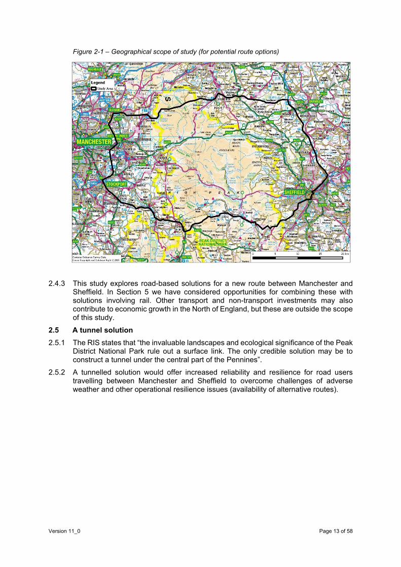
Figure 2-1 – Geographical scope of study (for potential route options)
2.4.3 This study explores road-based solutions for a new route between Manchester and Sheffield. In Section 5 we have considered opportunities for combining these with solutions involving rail. Other transport and non-transport investments may also contribute to economic growth in the North of England, but these are outside the scope of this study.
2.5 A tunnel solution 2.5.1 The RIS states that “the invaluable landscapes and ecological significance of the Peak
District National Park rule out a surface link. The only credible solution may be to construct a tunnel under the central part of the Pennines”.
2.5.2 A tunnelled solution would offer increased reliability and resilience for road users travelling between Manchester and Sheffield to overcome challenges of adverse weather and other operational resilience issues (availability of alternative routes).
Version 11_0 Page 13 of 58

is around 40 miles, but despite this, the journey between the two cities takes over an hour in uncongested conditions, representing an average journey speed below 35 mph.)
• road traffic collisions and safety, which have been identified for decades as a significant challenge for trans-Pennine routes, leading to problems of journey-time reliability and maintenance. The South Pennines Route Strategy highlights trans-Pennine trunk roads as routes where collision risks are particularly high22. This study also found that a higher than average number of accidents occur during adverse weather conditions, compared to the national average. The Trans-Pennine Routes Feasibility Study stated that, on average, the strategic route, incorporating the A57/A628/A616/A61, experiences a road closure every 11 days, with 36% of closures being longer than five hours.23 This means that on average, there is one road closed for five hours or more every month.
• capacity and capability constraints of the rail network, which limit potential for rail freight growth. Rail North’s Long Term Rail Strategy (2014)24 states, “Rail provides poor regional-centre-to-regional-centre connectivity for business-to- business trips, reducing the prospects for business agglomeration benefits.” Passenger surveys25 have highlighted quality, overcrowding and airport access as significant problems. These constraints are compounded by limitations to road freight, due to delays, poor reliability and network resilience.
• connectivity limitations of the strategic networks, which limit economic interactions and growth across the wider North. The majority of the best connected local authorities in England and Wales are found in the South East; there are only 4 (out of 50 nationally) in the North West and none east of the Pennines26.
• connectivity to Manchester Airport is a challenge for the Sheffield City Region, Derbyshire, Nottinghamshire and Hull, and the importance of these connections is likely to increase with the proposals for an Airport City and Enterprise Zone, where businesses will be offered incentives to locate in order to create jobs and stimulate economic growth locally, regionally and nationally. The Manchester Strategic Economic Plan (SEP) highlights the potential for the HS2 Airport station to deliver massive growth and regeneration benefits for the wider area.
• future residential and development proposals with anticipated impacts on the networks. These aspirations/targets are outlined later in Section 3.
3.2.6 Poor connections across the Pennines have wider consequences as traffic distributes itself across a limited number of alternative roads of varying standard. This results in increased congestion and capacity issues across the road network in the North, with particular problems on higher standard roads, such as the M62, which is the only major east-west road link in the North, and on the A628 further south. The Greater Manchester Transport Strategy 2040 27 specifically identifies the need for a new trans-Pennine route.
22 Highways England. South Pennines Route Strategy, April 2015 23 DfT & Highways England. Trans-Pennine routes feasibility study - Stage 1 Report, March 2015 24 Rail North. Long Term Rail Strategy – Final Version – with updates, August 2014 25 Passenger Focus Northern and TransPennine franchises – passenger research, 2012 26 ATOC. Accessibility Statistics, 2010 27 Transport for Greater Manchester (Greater Manchester Combined Authorities and Greater Manchester LEP). Greater Manchester Transport Strategy 2040, Our Vision, due to be published in 2016, draft available at: http://www.tfgm.com/2040/Documents/14-1882141882%20GM%20Transport%20Vision%202040.pdfpdf
Version 11_0 Page 15 of 58

3.2.7 The city regions on either side of the Pennines have significant plans for growth in terms of housing and employment over the coming decades and beyond. This is outlined later in Section 3. This will increase the demand for travel across the Pennines. Previous studies have demonstrated that sections of the existing road network, particularly some junctions, are already operating at, or beyond, capacity during peak periods. Combined with the existing poor network resilience, further growth will have significant journey-time and reliability impacts on the existing road networks.
3.2.8 There are important challenges to overcome, but there are also opportunities. The development of a new route presents opportunities in terms of:
• connectivity – through reduced journey times and improved journey reliability between the two city regions and the wider North and through contributing significantly to the aims of the Northern Transport Strategy;
• capacity – through reducing delays and queues that occur on the existing routes and network, particularly during the peak periods, and through creating a realistic additional route to the M62;
• safety – through reducing the number of collisions and their associated costs and impacts on lives, and also reducing their impacts on network performance;
• resilience – as a result of reducing the number of road closures, often resulting from inclement weather, there will be improved resilience of existing routes and the wider network; and
• environment – through building tunnels, there will be an opportunity to avoid unacceptable impacts on the Peak District National Park, and through active traffic management, there will be reduced traffic on completed routes.
3.2.9 Investment in road linkages between Manchester and Sheffield is, therefore, strongly aligned with national transport and economic policy.
3.3 Wider case for change 3.3.1 The northern economies have been emerging from a period of industrial decline28. Lost
jobs in manufacturing are being replaced by business and professional services, which pay higher wages and generate more employment. The changing nature of industrial structures has meant that growth in the North has concentrated in the major urban centres, similar to trends in the rest of the country. Over the past 10 years, while overall employment in the North actually fell, in four of the five main city regions (and specifically in their major urban centres) employment levels rose.
3.3.2 Indeed, major urban centres in the North, which are home to this new business activity, are playing an increasingly important role in generating jobs and growth. Research from the Centre for Cities29 showed that growth in employment in the financial sector and in knowledge-intensive business services (KIBS) has been concentrated in the main urban centres, such as Manchester and Leeds. Meanwhile, smaller urban centres in the North have seen a decline in these types of jobs.
3.3.3 The UK Commission for Employment and Skills states that the financial and knowledge-based sectors have grown most rapidly in recent years and are expected to drive growth in both economic output and employment in the UK over the coming
28 Centre for Cities. Cities Outlook 2015, 2015. http://www.centreforcities.org/wp-content/uploads/2015/01/Cities_Outlook_2015.pdf 29 Centre for Cities. Fast track to growth transport priorities for stronger cities, 2014. http://www.centreforcities.org/wp-content/uploads/2014/11/14-10-17-Fast-Track-To-Growth.pdf
Version 11_0 Page 16 of 58
decade30. The role of the main urban centres is, therefore, set to become even more important in driving the economy of the North and of the UK.
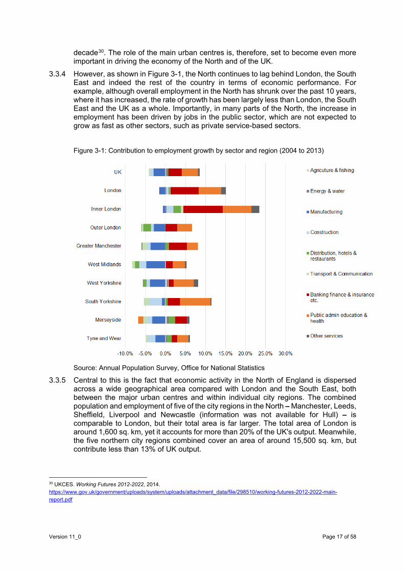
3.3.4 However, as shown in Figure 3-1, the North continues to lag behind London, the South East and indeed the rest of the country in terms of economic performance. For example, although overall employment in the North has shrunk over the past 10 years, where it has increased, the rate of growth has been largely less than London, the South East and the UK as a whole. Importantly, in many parts of the North, the increase in employment has been driven by jobs in the public sector, which are not expected to grow as fast as other sectors, such as private service-based sectors.
Figure 3-1: Contribution to employment growth by sector and region (2004 to 2013)
Source: Annual Population Survey, Office for National Statistics
3.3.5 Central to this is the fact that economic activity in the North of England is dispersed across a wide geographical area compared with London and the South East, both between the major urban centres and within individual city regions. The combined population and employment of five of the city regions in the North – Manchester, Leeds, Sheffield, Liverpool and Newcastle (information was not available for Hull) – is comparable to London, but their total area is far larger. The total area of London is around 1,600 sq. km, yet it accounts for more than 20% of the UK's output. Meanwhile, the five northern city regions combined cover an area of around 15,500 sq. km, but contribute less than 13% of UK output.
30 UKCES. Working Futures 2012-2022, 2014. https://www.gov.uk/government/uploads/system/uploads/attachment_data/file/298510/working-futures-2012-2022-main-report.pdf
Version 11_0 Page 17 of 58

3.3.6 Even in the city centres of the main northern conurbations, the magnitude of employment in the KIBS31 sectors pales in comparison with London. The total number of KIBS jobs in the city centres of the five major urban centres in the North is less than 150,000, compared with nearly 630,000 in the centre of London. Importantly, these types of jobs are more concentrated and closer to each other in London than they are in the North, which gives businesses a larger market to trade and compete with, and significantly more scope for knowledge transfer and sharing of resource (see Table 3-1). Table 3-1: KIBS jobs in London and northern UK cities
City City-centre wide private KIBS 2011 (jobs)
Density of KIBS jobs 2011 (jobs/hectares)
KIBS jobs as a share of all city-centre private sector jobs (%)
City-centre KIBS jobs as a share of all KIBS jobs in the city (%)
London 629,816 194 51 51
Manchester 51,710 99 53 34
Leeds 37,788 73 52 51
Liverpool 20,843 40 38 54
Newcastle 18,863 36 38 38
Sheffield 15,377 30 46 42
Hull 7,034 35 34 66
Source: Centre for Cities (2014). Fast track to growth
3.3.7 A key outcome of this dispersed activity is that productivity in the North, measured as GVA per worker, is less than the national average and well below that of London. Another concern is that productivity in the North has also been falling relative to the national average (see Table 3-2 and Table 3-3). The size and scale of the London market is central to its own success and to those cities in the South that are well connected to the capital, such as Reading, Cambridge and Oxford. Meanwhile, despite relatively short physical distances, the North lacks an economy with a similar scale.
Table 3-2: GVA per job relative to national average, 2002-2013
Geography Relative to England
2002 2013 Change
Greater Manchester 90% 90% 0%
Leeds 90% 89% -1%
Sheffield 83% 82% -1%
31 Swinney.P,Bidgood, E. Fast track to growth: transport priorities for stronger cities. 2014. Available from: http://www.centreforcities.org/wp-content/uploads/2014/11/14-10-17-Fast-Track-To-Growth.pdf [accessed October 2015]
Version 11_0 Page 18 of 58

Geography Relative to England
2002 2013 Change
Liverpool 90% 88% -2%
Northumberland and Tyne & Wear 86% 85% -1%
Inner London 144% 155% 11%
Outer London 106% 103% -4%
East Anglia (Cambridge) 93% 94% 1%
Berkshire, Buckinghamshire and Oxfordshire 123% 121% -2%
East Yorkshire and Northern Lincolnshire 87% 86% -1%
Table Notes:
*GVA per job estimates are representative on NUTS2 geographies except London.
Source: ONS Sub-regional Productivity Tables, August 2015
Table 3-3: GVA per job relative to national average, 2002-2013 (NUTS3)
Geography Relative to England
2002 2013 Change
Greater Manchester North 82% 80% -2%
Greater Manchester South 94% 95% 1%
Leeds 97% 95% -2%
Sheffield 87% 89% 1%
Liverpool 91% 90% -1%
Newcastle (Northumberland) 81% 74% -7%
Hull 80% 81% 1%
Cambridgeshire 100% 104% 4%
Reading (Berkshire) 139% 136% -3%
Oxfordshire 106% 103% -3%
Table Notes:
*GVA per job estimates are representative on NUTS3 geographies except London.
Source: ONS Sub-regional Productivity Tables, August 2015
Version 11_0 Page 19 of 58

3.3.8 A further outcome of this dispersion of activity is the fact that northern city regions are less specialised in specific economic sectors. Based on employment quotients, which measure the proportion of employment by economic sector relative to the national average, only West Yorkshire is highly specialised in finance and insurance. The remaining city regions have a high concentration of public sector and industrial employment relative to the national average.32 This is not to undermine the importance of industry and manufacturing to the national economy, where the North will continue to play a leading role, and where transport will be crucial; it is more about the likely drivers of future employment growth, which are expected to come from the labour-intensive, service-based sectors.
3.3.9 The consequence of these economic imbalances is rising pressures in London and the South East, potentially constraining growth, while the North is left with under-utilised capacity. This is manifested through congestion and pressures on housing affordability in London. For example, median house prices relative to the median income in London are twice that in the North.33 In addition, the gap in commercial rateable values between the different regions in the UK shows that the North has some of the lowest achievable rates in the country across most property types, specifically office space.34 This is all a reflection of lower demand.
3.3.10 The lower achievable rates in terms of residential and commercial property mean that investment is less attractive in the North than in other parts of the country. While achievable rates are significantly lower in the North, construction costs are only up to 10% lower in the North compared with the South.35 This in turn has an impact on regeneration in the North, holding back much needed private-sector investment into the region, which would provide capacity for growth in the form of residential and commercial development.
3.3.11 As recognised in The Northern Powerhouse36, the North has a number of medium-sized cities. While at a national level, these perform well individually, as part of a truly connected economic area, they would have the potential to compete with the best at an international level.
3.3.12 One of the constraints holding back growth in the North are some of the connections (road and rail links) between its major cities and within its city regions. Good transport connectivity is necessary for the type of economic activity that will drive output and employment growth in the North. To maximise the economic potential, it is essential to improve connectivity for businesses, provide access to skilled workers and to markets, and to attract investors and businesses.
3.3.13 A number of major reports over the past few years have set out the connectivity gaps in the North. In 2009, the Manchester Independent Economic Review 37identified poor transport infrastructure as being one of the main reasons why Manchester City Region
32 Office for National Statistics. Sub-regional Productivity Tables, August 2015 (and KPMG analysis) 33 Department for Communities and Local Government. Live tables on housing market and house prices, 2014 https://www.gov.uk/government/statistical-data-sets/live-tables-on-housing-market-and-house-prices 34 Department for Communities and Local Government. Live tables on commercial and industrial floor space and rateable value statistics, 2012 https://www.gov.uk/government/statistical-data-sets/live-tables-on-commercial-and-industrial-floorspace-and-rateable-value-statistics 35 Turner and Townsend. International construction market survey 2015, http://www.turnerandtownsend.com/ICMS-2015.html 36 Transport for the North. The Northern Powerhouse: One Agenda, One Economy, One North, A report on the Northern Transport Strategy, HMSO, March 2015 37 Manchester Independent Economic Review. Manchester Independent Economic Review, April 2009
Version 11_0 Page 20 of 58
was less productive than it should be38. In the same year, a report39 by the Spatial Economic Research Centre (SERC), commissioned by the Northern Way, found that commuting between Leeds and Manchester is 40% below what might be expected given the distance between them. The overall cost of travel (in time and fares) was identified as one of the main factors contributing to these trends.
3.4 Scheme objectives 3.4.1 The DfT has produced a Client Scheme Requirements document, which sets out
transport and other objectives for a new strategic transport link across the Pennines between Manchester and Sheffield.
3.4.2 We have reviewed and developed the following objectives, based on the case for change and taking into account comments received from the Stakeholder Reference Group:
Objective 1 – To provide a safer, faster, and more resilient road connection between Manchester and Sheffield, creating more capacity and an additional east-west connection.
Objective 2 – To fulfil the aims of the Northern Transport Strategy to deliver a scheme that will contribute to the transformation of the economy in the North.
Objective 3 – To protect and improve the natural environment by reducing through-traffic in the Peak District National Park and by getting the right traffic onto the right roads.
Objective 4 – To support wider socio-economic needs and leave a long-term legacy of improved road connectivity, better access to labour markets, wider employment opportunities, better land use, and more effective integration between transport
3.5 Policy drivers 3.5.1 The National Policy Statement for National Networks (2014)40 sets out a vision and
strategic objectives for networks that:
• have the capacity, connectivity and resilience to support national and local economic activity and to facilitate growth and create jobs;
• support and improve journey quality, reliability and safety;
• support the delivery of environmental goals and the move to a low-carbon economy; and
• join up communities and link them effectively to each other.
3.5.2 The Trans-Pennine Tunnel Study is being sponsored by the DfT and TfN. It is an important part of both organisations’ key strategies and regeneration plans, which are the central building blocks for the continued growth and development of the economies of Manchester, Sheffield and the wider region. The text below provides a summary of those policies and their strategic fit to this particular study.
3.5.3 The One North report41 presented a strategic proposition for transport in the North, with the aim of transforming connectivity and maximising economic growth. Findings
38 Manchester Independent Economic Review. Manchester Independent Economic Review, April 2009 39 Overman, H., Gibbons, S., D'Costa, S., Mion, G., Pelkonen, P., Resende, G. and Thomas, M. (2009)SERC. Strengthening economic linkages between Leeds and Manchester: feasibility and implications. The Northern Way, Newcastle upon Tyne, November 2009 40 DfT. National policy statement for national networks, December 2014 41 Leeds, Liverpool, Manchester, Newcastle and Sheffield city regions, One North: A Proposition for an Interconnected North, July 2014
Version 11_0 Page 21 of 58

indicated the necessity for a new trans-Pennine route, and highlighted how the lack of good strategic road and rail links between Manchester and Sheffield should be a matter of national concern.
3.5.4 The proposals in One North linked the need to transform connectivity in the North with the potential to deliver significant economic benefits by achieving agglomeration economies, stimulating business investment, enabling businesses to access a larger labour supply and strengthening existing comparative advantages.
3.5.5 One North states that better east-west connectivity would be an important growth multiplier for the North and nationally. Citing evidence from a study by SERC, published as part of the Northern Way in 2009, One North expects that improved east-west connectivity could deliver similar benefits to HS2.
3.5.6 One North also proposed that, in the longer term, a new rail route should be provided across the Pennines, which would become central to the northern transport system. This was defined as a new, high-reliability trans-Pennine route, connected to the HS2 lines and the existing rail network, tunnelled as needed, and linking the five city regions together with Manchester Airport and the ports. Amongst other benefits, this would help to deliver better journey times for commuters; a new integrated and resilient east-west rail freight capability, which linked the major ports; and direct access to the North's international gateway airport. In total, new trans-Pennine rail connections are expected to cost more than £5 billion and to be completed by 2030.
3.5.7 In August 2014, the Chancellor set out his vision for the Northern Powerhouse42, outlining growth targets that would realise the Government's ambition to rebalance the UK economy. There would be significant gains if a Northern Powerhouse grew in line with the rest of the UK over the next 18 years, that is by 4.6% (Office for Budget Responsibility (OBR) forecast43) – compared with historical performance, the Northern Powerhouse would be worth an additional £56 billion in nominal terms or £44 billion in real terms, which is equivalent to £1,600 per individual in the North. Enhanced connectivity between the different regions of the North will be a fundamental part of achieving these objectives.
42 HM Treasury and The Rt Hon George Osborne MP (2014). Northern Powerhouse, : Chancellor set out pathway, 2014 (at: https://www.gov.uk/government/news/northern-powerhouse-chancellor-sets-out-pathway) 43 Long term economic plan for the north-west set out by Prime Minister and Chancellor, January 2015. https://www.gov.uk/government/news/long-term-economic-plan-for-the-north-west-set-out-by-prime-minister-and-chancellor
Version 11_0 Page 22 of 58

Figure 3-2: GVA forecasts for the North
3.5.8 The DfT and TfN have outlined their vision for transforming connectivity in the North
through their One North, One Agenda report.44 The report was compiled by the northern city regions, HM Government and the national delivery agencies and sets out how enhancing transport linkages between northern cities are essential to boosting productivity, investment and employment, and delivering the Northern Powerhouse.
3.5.9 The case for action in the Northern Powerhouse highways plan45 puts forward two key arguments:
• the number, capacity and reliability of east-west road connections is a constraint on the northern economy; and
• there are areas of severe congestion on the road network, with high demand for freight from northern ports.
3.5.10 This plan also includes a shared roads vision for the future, which includes:
• improved east-west major road links to ensure better, more reliable journey times between the major cities in the North;
• a core free-flow network with mile-a-minute journeys becoming increasingly typical on expressways and motorways in the North of England;
• effective road connections to the country's major ports in the North of England;
• future-proofing the northern road network so that it can support the next generation of low-emission vehicles; and
• better planning of investment in road enhancements, maintenance and renewals between the different organisations.
3.5.11 Another key objective for TfN is to create a more environmentally sustainable transport network by ensuring that steps are taken to reduce the environmental impact of all
44 Leeds, Liverpool, Manchester, Newcastle and Sheffield city regions, One North: A Proposition for an Interconnected North, July 2014 45 Transport for the North. The Northern Powerhouse: One Agenda, One Economy, One North, A report on the Northern Transport Strategy, HMSO, March 2015
0
100
200
300
400
500
600
1994
1995
1996
1997
1998
1999
2000
2001
2002
2003
2004
2005
2006
2007
2008
2009
2010
2011
2012
2013
2014
2015
2016
2017
2018
2019
2020
2021
2022
2023
2024
2025
2026
2027
2028
2029
2030
£ bn
(cur
rent
pric
es)
GVA (North growth rate 1994-2012)
GVA (UK average growth rate 1994-2012)
Actual GVA North (1994-2012)
Version 11_0 Page 23 of 58

modes of transport. Currently, large volumes of HGV and other traffic flow through the Peak District National Park, damaging natural heritage. The potential removal of strategic through-traffic currently crossing the National Park on existing routes would offer significant local benefits.
3.5.12 The DfT also identifies linkages across the Pennines as one of the main gaps in connectivity in the North. Current road linkages between two of the main urban centres, Manchester and Sheffield, are among the worst in the country in terms of capacity, journey times, safety and reliability46. This is made worse by the fact that rail connections between the two cities are also considered to be too slow.
3.5.13 The DfT's strategy to enhance connectivity in the North (including links across the Pennines), is aligned with its overall strategy for transport investment in that these should provide capacity and connectivity between cities, while ensuring environmental objectives are also met. It is also aligned with wider Government policy and regional economic strategies, including:
• HM Treasury's Reducing the Deficit and Rebalancing the Economy47, which explores spatial patterns of investment and employment in the North and seeks improvements by plugging infrastructure gaps; and
• HM Treasury's Fixing the Foundations 48, which is specifically focused on boosting productivity in the UK through infrastructure investment, in particular road infrastructure
3.5.14 At a sub-national level the Sheffield City Region's Strategic Economic Plan49 sets out the region's ambitions for boosting economic growth, setting targets to narrow the economic gap over the next 10 years through the creation of 70,000 jobs, increasing GVA by 10% (or £3 billion) and creating 6,000 additional businesses beyond their baseline growth rates. It also includes aspirations for:
• reducing the amount of productive time lost on the strategic road network (SRN);
• improving the resilience and reliability of the SRN;
• improving surface transport linkages to international gateways; and
• promoting efficient and sustainable means of freight distribution.
3.5.15 Greater Manchester's Strategic Economic Plan50, which identifies priorities for growth and regeneration, also has transport sitting at the heart of its ambitions to boost economic growth, well-being and the environment. The Plan for Growth and Reform in Greater Manchester51, indicates the potential to create another 80,000 jobs during the period to 2020, while the Greater Manchester Strategic Economic Plan highlights the potential to deliver an additional 120,000 new jobs over the next 20 years and includes a target to deliver more than 60,000 new homes between 2013 and 2020. It also has similar aspirations with regard to the transport network, as outlined by the Sheffield City Region Local Enterprise Partnership (LEP).
46 Department for Transport (2015) DfT. Trans-Pennine Routes: Feasibility Study Summary, HMSO, March 2015 47 HM Treasury. Reducing the Deficit and Rebalancing the Economy, April 2015 48 HM Treasury. Fixing the foundations: creating a more prosperous nation, July 2015 49 Sheffield City Region Local Enterprise Partnership. Sheffield City Region’s Strategic Economic Plan, March 2014 50 Greater Manchester Local Enterprise Partnership and Greater Manchester Combined Authority. Stronger Together: Greater Manchester Strategy, 2013 51 Greater Manchester Combined Authority, Greater Manchester Local Enterprise Partnership & Association of Greater Manchester Authorities. A Plan for Growth and Reform in Greater Manchester, March 2014
Version 11_0 Page 24 of 58

3.5.16 Table 3-3 (below) provides a summary of the key Government and local government policies, strategies and studies; and how these relate to Trans-Pennine Tunnel Study and its objectives. Table 3-3: Summary of key plans, policies, strategies and studies
Policy/strategy/study Relevance to Trans-Pennine Tunnel Study
Project Objectives
Obj
ectiv
e 1
Obj
ectiv
e 2
Obj
ectiv
e 3
Obj
ectiv
e 4
Greater Manchester Transport Strategy 2040 Our Vision, July 2015, Transport for Greater Manchester (Greater Manchester LEP and Greater Manchester Combined Authority)
States need for improved trans-Pennine routes and identifies requirement of a new trans-Pennine route
Transport for the North, March 2015, Ed Cox and Luke Raikes, Institute for Public Policy Research
Transformations to an interconnected powerhouse and need for strategic investment
The northern powerhouse: one agenda, one economy, one north – a report on the northern transport strategy, March 2015, March 2015,DfT, HS2, Highways England, Transport for the North
Identifies TfN’s vision to address the gap in economic performance. Highlights the need to address east-west connection constraints
Trans-Pennine Routes – Feasibility Study (Stage 1 Report) February 2015, Highways England
Improvements to connectivity locally and between cities and regions are seen as fundamental to the future of the northern economies. Clearly identifies challenges and directs towards the need to consider longer-term solutions
National Infrastructure Plan, December 2014, HM Treasury
States the need to consider improvements to trans-Pennine connectivity as “an historic opportunity to link two of our great northern cities; this work will be taken forward with Transport for the North”. Highlights the significant positive effect new infrastructure can have on productivity, growth and the wider economy
National Policy Statement for National Networks, December 2014, DfT
Sets out the need for, and Government’s policies to deliver, nationally significant infrastructure projects. Strategic objectives are related to connectivity; resilience; facilitating growth; reliability; safety; low-carbon economy; joined-up communities
Version 11_0 Page 25 of 58

Policy/strategy/study Relevance to Trans-Pennine Tunnel Study
Project Objectives
Obj
ectiv
e 1
Obj
ectiv
e 2
Obj
ectiv
e 3
Obj
ectiv
e 4
Great North Plan, November 2014, IPPR North
“The north of England needs infrastructure projects capable of genuinely transforming the northern economy as it makes the journey from an industrial past to a dynamic, diverse, and sustainable economic future.”
One North: A Proposition for an Interconnected North, July 2014, City regions of Leeds, Liverpool, Manchester, Newcastle and Sheffield
Advocates better connectivity, journey-time reliability and travel quality to strengthen the economy. Identifies the need for transformational change
Transport – an engine for growth, August 13, DfT
Confirms the Government's intention to provide a broad and balanced investment package: striking a balance between maintaining the UK's existing transport assets and developing new schemes, and in geographical terms by supporting a wide range of benefits in all parts of the country
Investing in Britain’s Future June 2013, HM Treasury
Describes the road network as fundamental to the UK economy. Sets out the Government’s commitment to major investment in the road network, but also makes clear that improvements to the road network must be brought forward in a way that supports the nation’s overall quality of life and environment
National Planning Policy Framework (NPPF), March 2012, Department for Communities and Local Government
Highlights the Government’s commitment to ensuring that the planning system does everything it can to support sustainable economic growth
Peak District National Park Sustainable Transport Action Plan (2012 – 2017)
A strategic document that outlines the Peak District National Park Authority and its partners’ aspirations for transport in the Peak District
Peak District National Park –Local Development Framework, Peak District National Park, adopted in October 2011
Identifies cross-Park traffic as a continuing challenge. High-accident rates on routes lead to the pressure for new road infrastructure
Version 11_0 Page 26 of 58

Policy/strategy/study Relevance to Trans-Pennine Tunnel Study
Project Objectives
Obj
ectiv
e 1
Obj
ectiv
e 2
Obj
ectiv
e 3
Obj
ectiv
e 4
The Plan for Growth, March 2011, HM Treasury
Identifies the improvement of links that help to move people and goods around as an important factor in helping to build the balanced, dynamic, low-carbon economy that is essential for the UK's future prosperity
Creating Growth, Cutting Carbon – Making Sustainable Local Transport Happen, January 2011, Department for Transport
States the need for improved trans-Pennine routes and identifies requirement of a new trans-Pennine route
3.5.17 Many studies and options for improved connectivity between the Manchester and Sheffield city regions have been considered and these have recognised the constraints associated with improving existing routes. These constraints are restricting potential levels of growth and synergy between the cities, and even with limited growth, there will be severe problems in the future.
3.6 Summary and next steps 3.6.1 We have seen significant changes in the way the economies in the North are
structured, with growth in business and professional services offsetting the decline in manufacturing. This has had an impact on the distribution of economic activity across the region, with the main urban centres emerging as the engines of growth.
3.6.2 In light of these trends, the Government and the authorities in the North have unveiled their vision for unlocking growth in the region and creating a Northern Powerhouse. The programme of investment is focused on infrastructure, skills and innovation. The DfT and TfN have set out their vision for transport in the North though their The Northern Powerhouse: One Agenda, One Economy, One North.
3.6.3 One of the key constraints holding back growth in the North is poor connections between its major cities and within its city regions. Road and rail links across the region are among the worst performing in the country.
3.6.4 Investment in a strategic trans-Pennine link (with a long section of tunnel) is central to achieving the strategic objectives of Government and of the authorities of the North in terms of facilitating regeneration and unlocking growth in the Northern Powerhouse and delivering the One North vision – it is strongly aligned to national, sub-national and local policy objectives.
3.6.5 The case for change is clear in that many of the transport interventions required to deliver the Northern Powerhouse are about improving east-west connectivity on both the road and rail networks. The current transport routes across the Pennines between Manchester and Sheffield are among the poorest in the country, limiting opportunities for economic interactions between two of the major urban centres in the North and adding pressure on other parts of the transport network.
Version 11_0 Page 27 of 58


o improved productivity from firms being in closer proximity to each other (static agglomeration). Firms that are closer to each other experience a number of benefits, including; better co-operation and potential for technology spill-overs; economies of scale from access to larger markets; increases in productivity of the labour force through better matching of skills to employer needs; and specialisation of service industries that reflect increased trading opportunities from growing product markets; and
o productivity increases through dynamic agglomeration.52 For example, reductions in the cost of transport and production, together with access to bigger pools of skilled workers may attract new firms to the North.
4.2.3 The transformative nature of the investment into a strategic road link between Manchester and Sheffield means that the wider economic impacts of could be considerable. For example, there are a number of travel constraints between Sheffield and Manchester (delays on existing routes, lack of capacity for overall east/west movements, resilience during periods of inclement weather, impacts on the National Park, large number of collisions - which have been discussed in more detail within section 3; The Strategic Case) that stop economic centres becoming better connected and experiencing large productivity gains. Another example is how investment in the strategic road link could lead to significant changes in transport costs between Sheffield and Manchester, which in turn, could attract substantial new investment to the area, leading to a step change in employment, output and prosperity.
4.2.4 These benefits and the links between them are demonstrated in figure 4.1.
52 WebTAG allows the impact of these effects to be included in economic cases as a sensitivity test to the adjusted benefit cost ratio (BCR).
Version 11_0 Page 29 of 58

Figure 4-1: The mechanisms through which a strategic road link between Manchester and Sheffield could impact on the economy
4.3 Direct benefits from faster journeys 4.3.1 The starting point for the estimation of the economic impact of the changes arising
from the investment is in developing a clear view of the potential impact of the investment on the transport network.
4.3.2 As the study progresses, the economic analysis will be supported by a strategic traffic analysis that is currently being undertaken using a comprehensive set of traffic information. The primary datasets for this analysis are the Highways England Trip Information System (TIS) and the Department for Transport (DfT) Trafficmaster data. These provide complete datasets for March 2015 for national origin-destination movements and travel times.
4.3.3 The initial analysis from the Trafficmaster data shows that the average distance and travel time between Manchester and Leeds, and vice versa, is around 45 miles and 65 minutes, and the overwhelming majority of observed trips use the M62. The distance between Manchester and Sheffield via the M62 is around 75 miles and the average travel time, in both directions, is 95 minutes. This clearly highlights the relative accessibility of Leeds and Sheffield to Manchester.
4.3.4 The average distance and travel time between Manchester and Sheffield via other trans-Pennine routes is around 45 miles and 85 minutes, in both directions. The distribution of trips using the M62 compared to other routes reflects this. Only around 10% of total trips between the urban areas of Sheffield and Manchester use the M62.
4.3.5 The TIS data has been analysed to determine the current trip patterns between Greater Manchester, West Yorkshire and South Yorkshire. The volumes of observed movements are indicative of the economic interactions between these regions. The
Inputs
Outputs
Direct impacts
Immediate outcomes
Regional impacts
National impactsIncrease in economic output of the region
Displacement of economic activity from
other parts of the countryChange in national economic output
Investment in strategic road link between Manchester and Sheffield
Increased capacity Improved connectivity
Improved journey time reliability
Enhanced road safety
Travel time and cost savings Change in demand
Enabling housing development in Manchester, Sheffield and other regions
Enabling commercial development in Manchester, Sheffield and other regions
Increase in economic output of areas with the greatest transport gain
Displacement of economic output from
other parts of the region
Change in economic output of the region
Intermediate outcomes
More workers in high productive
jobs in cities
Agglomeration benefits through
increased density
Increase in inward investment
Enhancing economic
interactions between regions
Version 11_0 Page 30 of 58

interaction between Greater Manchester and West Yorkshire is around 50% of that between West Yorkshire and South Yorkshire. What is most noticeable is that the interactions between South Yorkshire and Greater Manchester are only 10% of those between South and West Yorkshire. The observed data further highlights the relatively low levels of interaction between the Manchester and Sheffield regions.
4.3.6 The TIS data will be analysed in more detail during the next stage of the project and will be supplemented with inputs from WebTAG and a suite of regional models, including PLANET. This will enable a set of option-specific traffic forecasts to be developed for Stage (iii) of the project.
4.3.7 The construction of a strategic road across the Pennines will create a high standard link that will complement the M62 between the M1 and the motorway system to the east of Manchester. The journey-time savings resulting from the new strategic link need to be quantified to support the transport economic case and the wider strategic and economic case. However, at this stage of the study we have not developed a route alignment and we have not fully developed traffic modelling tools. In the absence of these, we have undertaken a high-level analysis, based on a theoretical connection of 41km between the M1 at J35a and the A57 junction with the M67, which would satisfy the criteria of providing a trans-Pennine strategic link. The observed journey times on surface roads over this section of the Pennines are 50 minutes, implying an average speed of 30mph. These speeds are likely to deteriorate as future growth in the corridor leads to further congestion over time.
4.3.8 By contrast, a new strategic link will have an operating speed of at least 60mph. Based on the same distance as the surface roads, the journey time would be around 25 minutes. This implies a journey-time saving of around 30 minutes when we allow for growth and further increases in future years. The journey-time savings need to be verified at the next stage; however, a working assumption of a saving of 30 minutes across the National Park is appropriate for the scenario analysis undertaken at this stage.
4.3.9 Transport user benefits from journey time savings generally contribute a significant component to the economic benefits of a scheme. A transformational change of this order could generate significant social user benefits. In addition, a high quality strategic link could also generate significant reliability and safety benefits that will contribute to the economic case. The scheme could also have an impact on business users and transport providers and contribute positively to the economy. In particular, the freight industry could benefit from capitalising on cost reductions for long distance trips, rerouting and significant improvements in reliability.
4.4 The Potential for Wider Economic Benefits 4.4.1 There could be wider economic benefits for Manchester, Sheffield and the North from
the step-change in network capacity and connectivity between Manchester and Sheffield and the knock-on implications for the transport network as a whole.
4.4.2 In addition, the North is set to undergo a comprehensive economic transformation through various investments in infrastructure, skills and innovation, as well as major governance reforms that will be brought about with the ongoing devolution agenda. These changes will interact with the trans-Pennine Tunnel investment to produce further benefits.
4.5 Improved Productivity from Firms Being Closer to Each Other – Some Alternative illustrative scenarios
4.5.1 As noted earlier in this section, a key benefit that could arise is productivity effects from increased economic density. These can be substantial. Some illustrative scenarios are set out below to help understand the potential for benefits under alternative travel time
Version 11_0 Page 31 of 58

assumptions. It should be noted that actual estimates for the VfM appraisal will require transport modelling to be carried out to determine the impacts of a strategic road link on traffic flows between Manchester and Sheffield, or indeed the wider road network in the North. This will be further explored in Stage (iii) when a full WebTAG based analysis including wider economic benefits will be carried out. These figures are purely for illustrative purposes.
4.5.2 Our illustrative scenario-based exercise is based on the approach to measuring the impacts of enhanced connectivity on productivity described in Venables et al53 using:
• transport cost data derived from the road network in PLANET v4.3 (a version of the model developed for HS2);
• socio-economic data estimated previously for HS2 in 2013, which is based on WebTAG and adjusted for the geographic definition of zones in PLANET, which includes employment and GVA;
• impacts on transport costs of journeys from Manchester and Sheffield, and a number of other routes, described above; and
• a relationship between connectivity and productivity, based on work undertaken by SERC54.
4.5.3 As the study progresses, additional analysis to support the economic case for the scheme will be developed following the Department for Transport’s guidance on transport appraisal (WebTAG), which includes consideration of economic, social and environmental impacts.
4.5.4 Table 4-1 shows the analytical assumptions used with regard to the potential reduction in the generalised cost of travel on key routes, and the resulting changes in connectivity. As a sensitivity, we also considered a scenario in which the potential reduction in the generalised cost of travel on key routes is half that presented below. Table 4-1: Changes in the generalised cost of travel and business-to-business connectivity
Generalised cost change %
Changes in business-to-business connectivity High Scenario
Region 1
Changes in business-to-business connectivity High Scenario Region 2
Greater Manchester – South Yorkshire -35% 1.44% 3.67%
Greater Manchester – West Yorkshire -10% 0.48% 0.74%
Greater Manchester – Nottinghamshire -25% 0.52% 1.73%
Greater Manchester – Humberside -25% 0.37% 1.91%
53 Venables, A.J., Laird, J.J. and Overman, H.G. Transport investment and economic performance (TIEP) report, 2014. https://www.gov.uk/government/publications/transport-investment-and-economic-performance-tiep-report 54 Overman, H., Gibbons, S., D'Costa, S., Mion, G., Pelkonen, P., Resende, G. and Thomas, M. Strengthening economic linkages between Leeds and Manchester: feasibility and implications. The Northern Way, Newcastle upon Tyne, 2009
Version 11_0 Page 32 of 58
South Yorkshire – Merseyside -25% 0.56% 0.82%
Humberside – Merseyside -20% 0.41% 0.30%
Greater Manchester – Lincolnshire -20% 0.16% 1.10%
South Yorkshire – Staffordshire -20% 0.27% 0.63%
Source: Mouchel and KPMG
4.5.5 The core scenario on background economic growth is based on the economic data used in the analysis of HS2, which are based on WebTAG. As an additional scenario, we considered that the economy of the North (covering the North West, North East Yorkshire and the Humber) grows faster than the historic rate as per the Northern Powerhouse aspirations55.
4.5.6 The combination of generalised cost and background economic growth scenarios generates the following scenarios to be tested:
• low-low: Generalised costs fall by half of what is expected in Table 4-1, the North grows as per the baseline;
• low-high: Generalised costs fall by half of what is expected in Table 4-1, Northern Powerhouse growth is achieved;
• high-low: Generalised costs fall by what is expected in Table 4-1, the North grows as per the baseline; and
• high-high: Generalised costs fall by what is expected in Table 4-1, Northern Powerhouse growth is achieved.
4.5.7 The results from this illustrative scenario analysis are shown in Table 4-2. Under the assumptions we have adopted this shows that, the strategic road link between Manchester and Sheffield has the potential to result in a permanent annual economic uplift in the range of £171-421 million. These are significant, although it should be remembered that further analysis based on actual data may give lower impacts. Table 4-2: Preliminary high scenario results
Scenario Annual Uplift (£ millions) 60 Year Present
Value (£ billions)
Low transport impact, low background economic growth
171 3.9
Low transport impact, high background economic growth
190 4.4
High transport impact, low background economic growth
381 8.7
55Uk.Gov (2014). Northern Powerhouse: Chancellor sets out pathway [Online]. https://www.gov.uk/government/news/northern-powerhouse-chancellor-sets-out-pathway (accessed 27-10-2015)
Version 11_0 Page 33 of 58

High transport impact, high background economic growth
421 9.6
Source: KPMG
4.6 Productivity Benefits From Land Use Changes (Dynamic Agglomeration) 4.6.1 If the Northern Powerhouse growth objectives are achieved, the levels of economic
interactions between the different parts of the North will look very different from what they are today. In particular there is the potential for the investment – by improving links – to lead to housing and commercial developments being unlocked. The economic value of housing would be in the form of the effective labour market that is available for business, which is now widely acknowledged by Government as essential to unlocking growth. Transport investment allows more workers to access jobs in locations where they can be more productive. Land use will also change and the amount of labour able to access jobs will increase further. Since this is closely linked to patterns of investment, it will be addressed accordingly. Evidence for this is from business surveys and academic research56, which describes labour markets as a key factor in business location and investment decisions. The second is specifically concerned with the employment capacity that comes through commercial development in the way that transport makes locations more attractive for investment.
4.6.2 There is also the potential to increase the attractiveness of locations across the North for business investment into the North leading to higher levels of output and jobs. These impacts will be estimated at a later stage of this study, once a better understanding is reached on the specific developments that are likely to be unlocked by the investment and the wider transport network effects are taken into account.
4.6.3 It should be acknowledged that not all investment and employment that comes to the North as a result of investment in a trans-Pennine tunnel will be additional to the UK economy. Some investment and jobs will come at the expense of other regions. Even so this could be beneficial if other areas are overheating. For example, it is often argued that the UK economy is unbalanced, with shortages of labour in the South East leading to inflationary wage pressures and high prices for accommodation. In such a case, a shift of jobs to the North may well result in a better balanced economy, which is less subject to overheating. Again, the degree to which this might be the case is an empirical issue and will need to be investigated in later stages of the study.
4.6.4 It will therefore be important to understand in future analysis:
• the degree to which investment and jobs are additional to the UK;
• where that investment and jobs have come from; and
• to what extent the transfer of investment is a good or bad thing
4.6.5 The economic literature suggests that one of the main mechanisms by which national impacts could be additional is through attracting international investment. In this context, growth in Manchester and Sheffield generated through enhanced international competitiveness is less likely to result in offsetting reductions in employment or economic density elsewhere in the country.
4.6.6 Data collected annually from UK Trade and Investment suggests that foreign direct investment contributed to 25% of all jobs in the UK between 2004/5 and 2012/13 – both newly created and safeguarded jobs. This is directly linked to the investment that
56 Venables, A.J., Laird, J.J. and Overman, H.G. Transport investment and economic performance (TIEP) report, 2014. https://www.gov.uk/government/publications/transport-investment-and-economic-performance-tiep-report
Version 11_0 Page 34 of 58

will be unlocked by the land-use developments associated with the investment and so will be explored in more detail in Stage (iii) of this study.
4.7 Summary 4.7.1 We are at too early a stage in the design of the potential scheme to present robust
analysis on any of the economic costs and benefits of a scheme. Instead we have only be able to outline the types of benefits and for some of these benefits set out illustrative scenarios showing what could happen under different assumptions. However while there needs to be detailed transport and economic modelling, the indications are that there is the potential for significant benefits. These come from:
• Significant reductions in travel time of up to 30 minutes between Manchester and Sheffield. If this was to happen we would anticipate large reductions in journey costs to commuters, business users and other road users. One group that could be significantly impacted on is freight users. Such time savings are also likely to lead to reduced congestion on other routes;
• There could be significant reliability benefits to existing users of roads across the Pennines. These roads are frequently out of action during periods of poor weather;
• The reduced travel over the Pennines could itself have positive impacts on the environment;
• We have carried out very high level illustrative scenario modelling of productivity effects to business and the Northern Economy from better links between Sheffield and Manchester. Under alternative assumptions these illustrate benefits of between £171m and £421m per annum – although the exact level of benefits cannot be determined until more data have been collected and rigorous analysis carried out;
• There are also potential benefits from increasing the attractiveness of the North to new investors. This comes from improved access to labour markets and suppliers from better transport. Improved access to cheap business accommodation relative to other parts of the UK. Better access to distribution centres and warehousing and fundamentally a remake of the North’s image as a single linked centre of enterprise; and
• Importantly, the Northern Powerhouse is about putting together a whole programme of investments where complementary projects are packaged and where their interactions result in higher returns than individual projects alone. This is where the Northern Powerhouse concept comes into play, in that the range of cross-sector investments could result in projects having a larger impact than they would as stand-alone investments.
4.7.2 We are not yet in a position to say whether we should invest in a trans-Pennine Tunnel. That will require detailed modelling which will need to be carried out in stage (iii) of the analysis. Nor are we in a position to even present an estimate of the overall benefits. However we can say that the types of benefits that have been identified together with the scale and ambition of the investment merit further investigation through detailed modelling of costs and benefits.
4.8 Next steps 4.8.1 The key requirement for the next stage of the work is to determine in more detail the
transport impacts, including the impact on the wider transport network in the North. Alongside this, the other key next steps are as follows:
• Working with Government and authorities in the North to determine the future scenarios for the Northern Powerhouse – ‘do minimum’ scenario. As shown in
Version 11_0 Page 35 of 58

the initial economic analysis, the shape of the economy in the North, for example in Manchester and Sheffield, will be a key driver of the actual benefits of the scheme – this is especially the case if the scheme becomes focused on ensuring that growth is not held back by constraints in the transport network once the Northern Powerhouse proposals start to take shape. Essentially this is about setting the future baseline for the North and a number of scenarios around it.
• Working with authorities in the North to determine the specific land-use interventions that are likely to be impacted directly by the scheme. The second key dimension to the work is the degree to which the investment will impact on investment and employment, and hence the spatial distribution of activity in the North. We expect to include any relevant analysis in the next iteration of this Interim Report.
• Liaising with the other strategic studies, specifically the recently commenced Northern Freight Study (led by DfT and TfN), to start getting a sense of what the emerging conclusions are and how they can be integrated with this work. Coordination with other studies has already begun and we expect to include any relevant analysis in the next iteration of this Interim Report.
Version 11_0 Page 36 of 58


• prohibition of non-motorised users (similar to prohibitions in the tunnel section); and
• provision of variable mandatory speed limits (VMSL);
5.2.5 These standards are based on current vehicle technology and we recognise that future developments could change these.
5.2.6 We have made a high level assessment of theoretical locations where a route could connect to the existing motorway network to give an indication of tunnel lengths that will be required, depending on which part of the National Park the strategic link crosses.
5.2.7 We have assumed that the new strategic link will need to connect with the motorways at the edges of the study area (M60 and M1), and we have reviewed the capacity of the existing strategic links of the A616 and A628 between Flouch Roundabout and the M1.
5.2.8 We have explored possible connections with existing villages and roads. At either end of the tunnel, access to the local network will be needed to link into local communities. Additional junctions between the strategic link and the local network will be required along the route to permit access to, and from, the new road. Junctions will be grade-separated.
5.2.9 During the next phase of this study, stage (iii)a, we will assess a long-list of route options for the strategic link in more detail, and how these would connect to the Strategic Road Network (SRN). Joining either end of the link with the existing SRN will be one of the key challenges in stage (iii) of the study.
5.2.10 More detailed discussions will take place with local highway authorities to consider the potential impact and benefits on local roads. We will also develop a junction strategy in stage (iii)b so that junctions are spaced appropriately, but can serve local communities effectively. Junctions that are too closely spaced would interfere with the smooth flow of traffic, creating a large amount of weaving of vehicles and reducing overall safety.
5.3 Tunnel capacity and cross section 5.3.1 Our preliminary analysis suggests that the cross section through the tunnel will be dual
carriageway and we need to have a minimum of two lanes in each direction. This analysis is based on current traffic flows and operational and safety factors.
5.3.2 The capacity of the road through the tunnel will need to have a similar capacity, and be of a similar standard, to the links on either side. This will be required to avoid increasing flows on the existing SRN and creating a bottleneck when entering or leaving the tunnel.
5.3.3 However, in determining the tunnel cross section we must also consider future demand as it would be difficult to modify the geometry following construction.
5.3.4 The width of the tunnel not only depends on the volume of traffic, but we also need to take into account ventilation, lighting, and drainage. There are also safety requirements we must consider, such as those relating to smoke extraction and access for emergency vehicles.
5.4 Ground conditions 5.4.1 Figure 5-1 illustrates the bedrock geology of the study area and shows that the
Pennines largely comprise rocks of the Millstone Grit and Pennine Coal Measures groups. Millstone Grit is generally suitable for constructing large-diameter tunnels and there have been previous tunnels constructed through the Pennines in this area, for example the Woodhead railway tunnel. The high level of consistency in ground
Version 11_0 Page 38 of 58

conditions across the study area will makes it easier when choosing appropriate tunnelling methods.
5.4.2 When constructing tunnels a number of ground condition issues are typically anticipated. In the defined study area these include:
• unforeseen ground conditions;
• landslides;
• fault zones;
• weak clay strata;
• fractured rock mass;
• ground gases;
• historical coal and non-coal mine workings (abandoned mine shafts and galleries); and
• existing infrastructure.
5.4.3 Of these issues historical mining works and ground gases would appear to pose the greatest risk in the study area, but it should be possible to select a tunnel route where this risk is low or negligible. It is anticipated that all these potential hazards can be mitigated during the planning, design and construction phases of the project. Figure 5-1 - Bedrock geology of the study area
N
5 km
Modified after on-line BGS 1:625 000 geological map (http://mapapps.bgs.ac.uk/geologyofbritain/home.html)
Triassic Rocks (Undifferentiated) Permian Rocks (Undifferentiated) Cumbrian Coast Group and Appleby Group Pennine Upper Coal Measures Formation Pennine Middle Coal Measures Formation Pennine Lower Coal Measures Formation Millstone Grit Group Craven Group Peak Limestone Group
Version 11_0 Page 39 of 58

5.5 Construction 5.5.1 The new strategic road link between Manchester and Sheffield ranges from 40-50km
long and will be dependent on the route options taken forward in Stage (iii). It will involve the construction of a number of above-ground structures, bridges, retaining walls and earthworks, as well as the need to improve the existing highway infrastructure (including signage). The new link will include a tunnelled section, which could range from between 20-30km, making it one of the longest road tunnels ever built.
5.5.2 We will need to consider the following issues as we plan the construction of the new road link:
• interface with the existing road network;
• ground conditions, particularly in areas with a legacy of historical mine workings;
• constraints of working in the National Park;
• the need for new structures (bridges, culverts, earthworks);
• materials supply;
• re-use of materials generated during the construction works, with consideration given to the earthworks balance;
• industry capacity; and
• design standards
5.5.3 The construction of long tunnels has been made possible by advances in construction techniques and in particular the development of high-performance tunnel boring machines (TBMs). However, we believe that the ground conditions beneath the Pennines make it technically feasible to build the tunnel using either the conventional method of drilling and blasting to excavate material or using TBMs.
5.5.4 The typical method of constructing long tunnels is to divide the route into sections of less than 10-12km of relatively consistent ground conditions (where possible) and we would expect to adopt a similar approach here. Each section is separated by launch and arrival sites for tunnelling activities and, once the tunnelling is completed, these sites could then be used as shafts and adits for ventilation and emergency/maintenance access. These sites could also be excavated in the form of caverns, which could be used for TBMs during construction and later used as areas for breaking up journeys, which is an approach taken at the Laerdal Tunnel in Norway.
5.5.5 If TBMs are used, we would need additional areas for storage of materials and ancillary plant. Ideally, these would be sited close to the portals and to existing transport infrastructure to reduce transport costs, although there are likely to be environmental constraints associated with building intermediate accesses and working areas in a National Park.
Version 11_0 Page 40 of 58


will be undertaken to try to maximise use of the excavated materials (either for this scheme or stored for later use). The volume of the excavated materials will vary with the length of the tunnel for different options. Assuming twin road tunnels with excavation diameter of about 15m and an expansion factor of 1.25 to 1.3 for extracted materials, then the extracted material could be between 10 to 15 million cubic metres. A more detailed estimation will be undertaken during stage (iii)b.
5.7 Constraints on construction 5.7.1 Options for the above-ground sections of the strategic link must consider:
• large housing conurbations at both ends of the route, and the need to weave a route through any built-up areas. This may be more straightforward at the Manchester end, although it will be difficult to construct any new junction with the M60. At the eastern end, these considerations will depend on whether the route goes directly to Sheffield or to the M1;
• the impact on communities of the new strategic link; severance and local access is also an issue for non-motorised users, particularly in built-up areas at either end of the route;
• ground conditions;
• the local highway network;
• environmental constraints and impacts;
• drainage and hydro-geology; and
• road geometry and design speeds.
5.7.2 Options for the tunnel (specifically) must consider:
• tunnel alignment;
• horizontal and vertical alignments;
• drainage requirements, ease of construction and ventilation;
• highway design standards, and rail standards (which are typically more rigorous) if synergies are to exploited;
• cover (the distance between the tunnel lining and the surface). This will be greater than one half to one times the excavation diameter for mechanised methods and greater than one to two times the excavation diameter for conventional TBM methods;
• diameter of excavation – large diameters could lead to front stability issues, which must be mitigated. In general, the larger the excavation diameter, the higher the risk of face instability;
• environmental concerns – the National Park presents a significant environmental constraint and is likely to restrict the possibilities of constructing an intermediate access from the existing road network and the location of shafts;
• existence of historical coal mines – abandoned mine shafts and mine excavations within the Coal Measures present the main hazard to tunnel construction using a TBM and could lead to movement and water ingress. However, with careful planning and route selection, it may be possible to select a tunnel alignment that avoids areas affected by mining. If we cannot totally avoid these areas, we will carry out detailed ground investigation during different stages of design, which should provide the necessary data to enable
Version 11_0 Page 42 of 58

mitigation works to be carried out. Furthermore, the TBM will be equipped with tools for forward investigation of ground conditions as well as tools for soil treatment; and
• driver environment – The need to provide a design that helps to maintain concentration and provides interest. This is discussed in more detail within Section 6 of this report.
5.8 Synergies with rail – operational issues 5.8.1 There is significant investment currently taking place in rail in the Northern Hub
programme of works centred on Manchester and in the North West, and in the Midland Mainline and trans-Pennine electrification programmes. However, despite this investment, significant capacity constraints will remain both on the routes into city centres and also on the trans-Pennine routes.
5.8.2 The proposed HS2 scheme will link Manchester with the South. It will also link Leeds and Sheffield with the South through separate routes on either side of the Pennines. Without further intervention, this will not improve trans-Pennine links.
5.8.3 To address the shortfall in capacity on the existing network, the Northern Powerhouse report58 proposes a new trans-Pennine route linking the two legs of HS2 and providing improved east-west connectivity.
5.8.4 The new trans-Pennine rail route is being developed for DfT and TfN by HS2 and we anticipate that any route will need to be tunnelled.
5.8.5 In addition to the synergies with HS2, Network Rail has been commissioned by TfN and DfT to explore options to upgrade and transform (including where appropriate options for substantial by-passes and new lines) the existing corridors, to improve connectivity between Manchester and Sheffield city centres and also between Manchester and Leeds city centres, to help deliver the Northern Transport Strategy vision.
5.9 Synergies with rail – construction issues 5.9.1 There are some key issues that need to be considered in delivering a combined
corridor:
• construction of tunnels of this length require substantial compound areas both at the portals and at the intermediate shaft locations. By aligning road and rail routes, the impact on the local environment will be reduced if both are needed;
• construction access requirements for deliveries and removal of material from the excavated tunnels will be significant. We believe that, by combining the locations of portals and intermediate shafts to suit both road and rail routes, the overall traffic impact during construction will be reduced;
• adopting a common tunnel alignment to address ventilation, service and escape requirements would offer advantages; and
• operational and maintenance benefits.
5.9.2 The risks to the development of a combined corridor include the following:
• there may be differences in the strength of the business case for the two modes, which could lead to delays if one scheme is dependent on the other. This could be addressed if a combined business case is provided;
58 Transport for the North. The northern powerhouse: one agenda, one economy, one north – a report on the northern transport strategy, March 2015
Version 11_0 Page 43 of 58

• the different operational requirements of the two modes will require different vertical and horizontal alignments. This may mean that the benefits of a parallel tunnel alignment are not fully realised; and
• the different operational requirements of the two modes could result in the portals being located in different locations.
5.10 Heavy rail 5.10.1 Heavy rail and highway traffic would require segregation in a tunnel, either vertically or
horizontally. The resulting tunnel diameter required with vertical segregation would not be feasible with current TBMs. The width required for horizontal segregation is likely to result in a tunnel span that would be at the extreme end of what is feasible even for much slower drill-and-blast construction techniques.
5.10.2 We believe that with today’s technology it would be necessary to construct additional tunnel bores to accommodate a heavy rail route. The required cross section for a rail tunnel is dependent on a number of factors, including line speed, operational and safety requirements. The tunnel could be either a larger bi-directional single bore or a twin, smaller bore arrangement. The total number of tunnel bores for a combined road/rail corridor could affect the scale of the portal areas. However, as discussed above, the rail portal may not be located in the same position as the road portal.
5.11 Light rail 5.11.1 Manchester and Sheffield have well established light rail networks. Light rail offers
significant benefits for short journeys with closely spaced stops and is generally adopted for commuter routes into city centres. The journey time between Manchester and Sheffield would be substantial and we believe this would not make it attractive to passengers travelling directly between the two cities. The journey time through a trans-Pennine tunnel would present a substantial proportion of any journey time between communities in the east and west.
5.11.2 Light rail systems are typically prevalent in built up urban areas with frequent stops. They share road space with highway traffic in city centres and speeds are limited to less than 30mph for safety reasons – primarily to allow the light-rail vehicles to react to changes in traffic speed. It is usual to segregate light rail and road users when speeds are greater than 30mph, which would be applicable in a tunnel solution.
5.11.3 Allowing light-rail and highway traffic to share road space on a strategic link and within a tunnel would require the adoption of technological advances and development of a robust safety case. These could include adaptive cruise control and automatic braking systems. Managing the issues associated with road vehicles travelling on the rails would be more difficult to overcome. Allowing light rail and road to share space within the tunnel may increase the size of the tunnel bore in order to incorporate the overhead electrification system.
5.11.4 It is unlikely that light rail could provide a practical solution, although the tram/train trials (currently being considered between Sheffield and Rotherham) might be worthy of more detailed consideration.
5.12 Summary 5.12.1 The construction of a new strategic road link involving a substantial length of tunnel is
technically feasible. Modern tunnelling techniques can accommodate a dual carriageway tunnel and the geology of the Pennines is generally suitable for constructing large diameter bores. Various tunnelling methods are available, including the use of TBMs for diameters up to around 15m, drill-and-blast techniques and, potentially, cut-and-cover sections. We will consider the cost and environmental impacts of these tunnelling methods for each potential route option.
Version 11_0 Page 44 of 58

5.12.2 The construction of overland sections at either end of the tunnel and on the fringes of the National Park to connect the new route with the strategic road network presents a number of technical challenges but is technically feasible.
5.12.3 The tunnel is likely to be longer than most other road tunnels in Europe, and the psychological aspects of travelling through a tunnel of this length are broadly understood. However, it is appreciated that we will need to undertake further work to understand driver behaviour and to consider how advances in technology and appropriate tunnel design could help to mitigate this issue.
5.12.4 The integration of road and rail solutions within the same transport corridor would provide a number of operational benefits. Equally there are a number of risks to consider.
5.12.5 For heavy rail, the diameter required (vertically or horizontally) would be at the extreme end of what is feasible, based on current techniques. We therefore consider that it would be necessary to construct additional tunnel bores to accommodate a heavy rail route.
5.12.6 Light rail systems already share road space with highway traffic. However, this is in towns and cities so sharing road space on a strategic link and within a tunnel would require the adoption of technological advances and development of a robust safety case.
5.13 Next steps 5.13.1 The key requirement for the next stage of this study is to identify a long-list of possible
route options for the new strategic road, building on work done in this study and in previous studies, and identifying any additional options worthy of consideration.
5.13.2 To assist in generating suitable options, further work will include a focus on the following areas:
• more detailed analysis of geological conditions (mining legacy, water courses) will be developed using mapping software;
• more analysis of available traffic data to provide anticipated traffic flows, which again will assist in developing the type of road required;
• understanding the impacts of HS2 and opportunities for future technologies to influence options for rail synergies; and
• understanding the work currently being undertaken with regard to the movement of freight, for example TfN Freight and Logistics Strategy.59
5.13.3 The location, cost and environmental impact of potential options will be considered as part of a high-level assessment (using a recognised sifting tool) to identify a shortlist of options to be carried forward to further stages of the study.
5.13.4 Potential options will be discussed with stakeholders to understand the impacts on local roads (changes to standards and leaving a positive legacy, for example reducing severance and creating new cycle tracks or footpaths above the tunnel).
59 Transport for the North. Northern Freight and Logistics Strategy
Version 11_0 Page 45 of 58

classification of the road. However, appropriate signs and possible diversions would be necessary if non-motorway traffic was allowed on the strategic link road on either side of the tunnel.
6.4 Incident management 6.4.1 Key to the management of tunnel incidents is early detection and an appropriate
response by tunnel operators. Tunnel operators will undertake the management of tunnel incidents, including vehicle fires and spillages of toxic materials. Cameras will be an important tool to monitor the tunnel, and additional incident detection equipment will be installed to identify stopped vehicles and pedestrians. If an alarm is raised, the operator will need to respond according to incident procedures.
6.4.2 Appropriate intelligent transport systems will monitor traffic conditions across the whole link (including the tunnel) to manage traffic flow, identify incidents and provide information for customers. These will include (as a minimum) monitoring systems and variable message signs, but may also use floating vehicle detection (using real-time electronic fleet data to identify traffic flows) and wireless communications linked directly with the technology in motor vehicles.
6.4.3 The tunnel will have a service building at each portal. These will house the tunnel control centre and the tunnel maintenance facility, as well as providing an area for the emergency services to assemble when responding to incidents.
6.5 Routine and non-routine maintenance 6.5.1 Maintenance teams will require access into the tunnel for planned activities, including
structural and highway maintenance, mechanical/electrical principal inspections and wall washing. In shorter tunnels (2-4km), it is usual (where no alternative routes are available) to close one bore for maintenance and place the other bore in contraflow with suitable traffic management, signs/signals, lane control and central separation of traffic. However, in a longer tunnel section, these traditional methods may not be appropriate. Alternatives are explored in later in section 6.
6.5.2 The design process will consider and develop engineering and operational safety systems that reduce the need to access the tunnel for maintenance and statutory inspections. We will adopt a process of ‘design for low maintenance’. As far as is reasonably practicable, engineering systems, such as the communications network, will be located in the service tunnel. Other technologies, for example video surveillance, will be used remotely to monitor tunnel systems.
6.5.3 Constructing a central service tunnel will reduce the need to close the tunnel for maintenance. Engineering systems, sign controllers, cabling etc. will reside outside the operating bores and allow the maintenance teams to access tunnel equipment located in the service/escape bore with minimum disruption to traffic.
6.5.4 Responding to faults in tunnel equipment quickly and appropriately will also help to avoid disruption to traffic for access. Modern tunnels have varied and complex systems installed to provide appropriate safety levels for users. These systems must meet the designed operational standards and include:
• ventilation;
• lighting;
• communication and control;
• signs and signals; and
• mobile phone feeders.
Version 11_0 Page 47 of 58

6.5.5 Our challenge will be to develop new methods of planned and non-planned maintenance to reduce the impact on traffic through a co-ordinated asset management plan, for example:
• undertaking routine maintenance at night when traffic flows are lower;
• ensuring resilience and reliability of tunnel systems;
• selecting wall finishes to reduce the number of washes needed;
• minimising equipment installed within the tunnel;
• providing openings in the central wall to establish short sections of contraflow working;
• locating site equipment (where possible) in emergency refuge areas so that there is no maintenance in the live operating environment (as per the Smart motorway programme); and
• developing automatic traffic management systems that will reduce the time required to close sections of the tunnel for routine and non-planned maintenance.
6.6 Safety 6.6.1 The operational safety systems and associated engineering will provide the minimum
to ensure the trans-Pennine strategic link and tunnel can operate safely, to protect the travelling public during normal running and to provide an incident management response.
6.6.2 The tunnel/road network control room operator will supervise and observe traffic behaviour and flow rates. To assist in this role, operators will typically use the SCADA (Supervisory, Control and Data Acquisition) system, to monitor equipment condition/functionality, tunnel outstations (which monitor tunnel environmental conditions), incident systems and CCTV.
6.6.3 Appropriate design of any road and tunnel is vital to ensure that the link, and especially the tunnel, are operationally flexible and safe. It is also vital that the tunnel can be evacuated in an emergency.
6.6.4 Specific tunnel safety systems and considerations include:
• ventilation and the ability to manage smoke if a fire were to result from a traffic incident;
• lighting to ensure visibility in the tunnel during emergencies;
• communications network to ensure equipment and systems are available for plant, signs and signals control;
• incident detection;
• signs and signals to manage traffic and communicate with the road users;
• public address system for major incidents;
• firefighting capability, particularly with regard to response times, for example the Mont Blanc Tunnel in the Alps has its own fire station);
• hazardous loads (use of a thermal imaging scanner to detect hot spots in loads or engine/gearboxes that could potentially ignite); and
• operational procedures, including evacuation
6.6.5 Safety considerations on the strategic link include:
Version 11_0 Page 48 of 58

• prevention of accidents through design;
• procedures for undertaking emergency repairs; and
• safety of people working in road traffic control and management
6.7 Security 6.7.1 Any important piece of infrastructure on a primary transportation link is a potential
terrorist target, and the potential loss of life and damage to infrastructure from an explosion or release of hazardous substances within a confined space, such as a road tunnel, may be more severe than from a device detonated in an open space. Therefore, during the design process we will consider how to mitigate the harm caused by security risks, for example by reducing or eliminating combustible equipment such as gas or oil pipelines.
6.7.2 The most likely covert means of bringing an explosive into a tunnel is within a vehicle. Intelligent Transport Systems currently provide monitoring systems that could be used to identify suspect vehicles approaching a tunnel. We will need to examine appropriate methods of detection.
6.7.3 Consideration will need to be given to the design of the tunnel structure and equipment within the tunnel in terms of withstanding, absorbing and limiting the impacts of any explosion. It is understood that there are no existing national or international standards for the design of road tunnels specifically prescribing energy releases for such events.
6.7.4 Incident detection systems can identify stopped vehicles on the approaches to, and inside, the tunnel. Alarms can be raised in the tunnel operations centre and motorway control centres. Incident alarms will be used to automatically activate CCTV systems to monitor activities around a stopped vehicle, giving the tunnel operator time to close the tunnel to traffic if criminal action is suspected. Procedures will be developed to enable appropriate responses to a police-led incident.
6.7.5 Further consideration of security matters will be addressed in stage (iii) of the study, with more detailed input from security professionals.
6.8 Driver behaviour 6.8.1 Driver behaviour is a key factor influencing the use of a long road tunnel. Drivers will
need to be confident when approaching the tunnel that their journey will be stress free; that their time in the tunnel will be incident free; and that, if there is an incident or disruption to their journey, they will be kept safe from harm.
6.8.2 The practical and psychological difficulties of driving in a long tunnel environment should not be underestimated and include:
• reduced visibility due to poor lighting;
• difficulty in ascertaining position in relation to an exit (due to a monotonous visual environment);
• poor orientation;
• perception of an oppressive and smoky atmosphere, with a strong smell of exhaust fumes;
• being dazzled by the lights of oncoming vehicles;
• difficulties in maintaining a constant speed, especially where there are changes in vertical alignment within the tunnel;
• limited visibility due to curvature of the tunnels walls; and
• steering too wide and encroaching onto adjacent lanes if the walls are too close
Version 11_0 Page 49 of 58
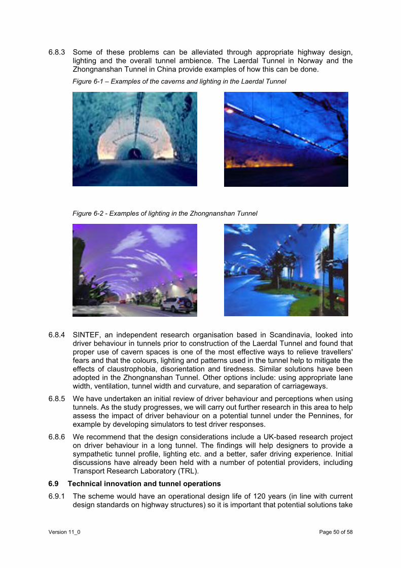
6.8.3 Some of these problems can be alleviated through appropriate highway design, lighting and the overall tunnel ambience. The Laerdal Tunnel in Norway and the Zhongnanshan Tunnel in China provide examples of how this can be done. Figure 6-1 – Examples of the caverns and lighting in the Laerdal Tunnel
Figure 6-2 - Examples of lighting in the Zhongnanshan Tunnel
6.8.4 SINTEF, an independent research organisation based in Scandinavia, looked into
driver behaviour in tunnels prior to construction of the Laerdal Tunnel and found that proper use of cavern spaces is one of the most effective ways to relieve travellers' fears and that the colours, lighting and patterns used in the tunnel help to mitigate the effects of claustrophobia, disorientation and tiredness. Similar solutions have been adopted in the Zhongnanshan Tunnel. Other options include: using appropriate lane width, ventilation, tunnel width and curvature, and separation of carriageways.
6.8.5 We have undertaken an initial review of driver behaviour and perceptions when using tunnels. As the study progresses, we will carry out further research in this area to help assess the impact of driver behaviour on a potential tunnel under the Pennines, for example by developing simulators to test driver responses.
6.8.6 We recommend that the design considerations include a UK-based research project on driver behaviour in a long tunnel. The findings will help designers to provide a sympathetic tunnel profile, lighting etc. and a better, safer driving experience. Initial discussions have already been held with a number of potential providers, including Transport Research Laboratory (TRL).
6.9 Technical innovation and tunnel operations 6.9.1 The scheme would have an operational design life of 120 years (in line with current
design standards on highway structures) so it is important that potential solutions take
Version 11_0 Page 50 of 58

into account emerging technologies in vehicle design, in highway design and operations, and in network information.
6.9.2 With the rapid change in highways technology and the development of connected and autonomous solutions, it is difficult to predict market-led change. However, given that these changes are potentially significant and are supported by a number of investment programmes so the ultimate design solution must take into account such technological solutions and their potential benefits, both in terms of design options and operational, safety and customer benefits.
6.9.3 We have identified five broad areas in which technological innovations might add value to the scheme. These will require further examination and scrutiny during the design/development of the solution and technologies will need to be clearly proven and have an identifiable route to mainstream market for them to justify a major design change. They include:
• Automation – the increasing ability of vehicles to undertake the more mundane and emergency aspects of driving, such as automatic braking systems and adaptive cruise control. These advances will reduce driver error and improve safety, allowing for narrower lanes.
• Connectivity – the sharing of data between drivers and infrastructure operators in order to give advance warning of disruption, congestion or maintenance. This will provide benefits to road users and operators.
• Robotics – the use of robotic equipment for routine inspections and maintenance tasks, such as tunnel cleaning and waste. Robotic traffic management will also eliminate the dangers inherent in current systems of traffic management for large-scale maintenance schemes.
• Propulsion – the shift from oil-derived combustion to electric, hydrogen and other fuel sources will reduce the need for ventilation shafts to remove exhaust fumes.
• Aggregation – the emergence of systems to aggregate and process data sources to provide real-time and predictive network operations, journey planning and other data will inform customers and help balance demand and capacity.
6.9.4 Other changes that are harder to quantify, but might have a bearing on road use and traffic and thereby influence operations, include:
• changing attitudes and behaviours of private and business users towards road travel;
• business, economic and social factors, which might modify the need for movement;
• demographic changes in Northern England; and
• the role and form of public transport provision.
6.10 Summary 6.10.1 The operation and maintenance of a new strategic road link involving a substantial
length of tunnel is technically feasible, although changes in technical standards and methods of working are likely to be needed to provide a safe and efficient solution. Considerations will include the way in which planned, routine and emergency maintenance is carried out; the way in which incidents are managed; and the way in which traffic is controlled and monitored. Fire safety, tunnel security and the health and welfare of the workforce are also important considerations as is the future role of robotics in tunnel maintenance.
Version 11_0 Page 51 of 58

6.11 Next steps 6.11.1 As part of the next stage of this study (identifying a long-list of possible route options
for the new strategic road) we will ensure that operational considerations are part of the thinking and assessment process. We will consider the most effective way that these priorities can be delivered throughout design, taking account of evidence and identifiable technological change during the mobilisation of the tunnel and as it operates as part of the wider strategic and local road network.
6.11.2 We will carry out further work to understand driver behaviour (talking to tunnel operators across the world and academics who have studied this topic in detail) and the new operational standards that will be required. We will also consider commissioning a UK-based research project on driver behaviour in long tunnels and have already had an initial dialogue with suitable research partners.
Version 11_0 Page 52 of 58


Pennine Trail; among hundreds of other public rights of way (PRoW) within and outside the National Park. There are also Country Parks within the study area.
7.2.2 There are seven Air Quality Management Areas (AQMAs) to the western and eastern extents of the study area on the existing road network. These are concentrated mainly around Sheffield and Manchester, plus smaller conurbations within their suburbs. Finding the right location for a tunnel portal and any new road infrastructure will be important to avoid exacerbating existing air quality problems and creating new ones.
7.2.3 There are nationally important heritage features, such as Scheduled Monuments, throughout the study area. These are located more towards the south-eastern extent of the study area than to the north and west, and they vary from relatively modern monuments, such as the World War Two training ground at Ladybower Reservoir, to Roman and medieval structures, including several castles. There are 88 Conservation Areas (CA) within settlements throughout the study area. These constraints suggest a rich and colourful history worthy of preservation.
7.2.4 Listed buildings are present throughout the study area and registered parks and gardens are present in urban areas on the west and east of the National Park.
7.2.5 The National Park is heavily constrained ecologically, with a Site of Special Scientific Interest (SSSI), Special Area of Conservation (SAC) and Special Protection Area (SPA) covering most of the Park within the study area. The Kinder Scout National Nature Reserve (NNR) is located to the south of the study area, and there are 32 local nature reserves (LNRs) and 22 SSSIs outside the National Park.
7.2.6 There are Noise Important Areas on existing roads within the study area. These are mainly within urban areas or associated with major routes, such as the M60, A627, M67, A628, A57 and A6018, although some are within the National Park.
7.2.7 There are settlements of all sizes within the study area, both rural and urban, which might experience severance as a result of new infrastructure associated with a new trans-Pennine link. However, there would also be reduced severance within smaller villages if some of the traffic in, and on the edges of, the National Park can be diverted.
7.2.8 The area under the Peak District National Park that may be tunnelled contains groundwater. There are also main rivers within the study area (Tame, Etherow, and Don), plus tributaries, that are known to flood at various points, although we have not considered flooding in detail at this stage. There are also several reservoirs – Woodhead, Ladybower and Howden – which are likely to form a significant constraint to shallow tunnelling at these locations.
7.2.9 Agricultural land classification mapping shows the highest grade within the study area to be Grade 3, with the majority of the Park either Grade 5 or 4 (towards the fringes).
7.2.10 We have not considered geology and soils, materials sourcing, reuse and waste disposal constraints from an environmental perspective at this stage.
7.3 Potential environmental impacts and benefits The potential environmental impacts and benefits of the project have been summarised in Table 7-1 below.
Version 11_0 Page 54 of 58

Table 7-1 – Potential environmental impacts and benefits of the project
DMRB topic Potential impacts Potential benefits and opportunities
Air quality Constructing additional road links may introduce air quality problems into entirely new locations.
Additional traffic generated as a result of the tunnel could create new, or exacerbate, air quality impacts on the existing road network.
Changes to traffic patterns on the existing road network could result in new air quality impacts. This may be a particular problem on existing roads entering Manchester and Sheffield where AQMAs exist.
Dispersal characteristics at tunnel portals are relatively unpredictable and would require specialist modelling, but good design could mitigate potential impacts to an acceptable level.
Impacts of ventilation may introduce new air quality issues, particularly in the National Park.
Consistent road speeds, reduced acceleration and shorter journey distances would reduce overall emissions per individual journey and help to avoid air quality impacts due to traffic growth.
There is also the opportunity to address air quality problems on the existing road network where new infrastructure is created. This may also take traffic away from residential areas and other sensitive locations.
Changes to traffic patterns on the existing road network could improve existing air quality impacts.
Encouraging a modal shift would also benefit air quality. New methods of ventilation may allow emissions to be treated before they are released into the atmosphere.
Separating HGVs and lighter traffic flows may allow targeted treatment to be more effective.
Cultural heritage
Infrastructure along new routes may result in loss of some heritage features or impact on their setting.
New sections of road network may reduce traffic through small villages and towns, particularly those containing Conservation Areas, potentially improving the setting of some heritage features.
Landscape Impacts of lighting around tunnel portals. Modelling of spill impacts would likely be required; however good design could mitigate to an acceptable level.
Impact on landscape of new sections of road in order to link the tunnel to the existing network. Some of these may be within the National Park to provide access to intermediate shafts/ventilation stacks for maintenance.
Impact of introducing new ventilation stacks into the National Park landscape.
A tunnel may reduce future traffic growth in the National Park and the Special Landscape Area, which might otherwise alter the character of these areas and reduce visual amenity.
There is an opportunity to create new landscape features (such as heritage style barns) within the landscape to screen ventilation stacks.
There is an opportunity to minimise light pollution in the National Park by reducing the visual impact of heavy traffic flows on existing roads through the National Park.
Version 11_0 Page 55 of 58

DMRB topic Potential impacts Potential benefits and opportunities
Adverse impacts related to construction, particularly where areas are required within the National Park and/or for extended periods of time.
Townscape Impact on townscape of increased traffic on parts of the existing road network, particularly on sensitive Conservation Areas.
Impact on townscape of new sections of road network through urban areas in order to link the tunnel to the existing road network.
New sections of road network may reduce traffic travelling through small villages and towns, particularly those with Conservation Areas.
The tunnel may reduce future growth in traffic that would pass through the National Park and its settlements. It may also avoid future road upgrades, which might alter the character of the area.
Biodiversity Potential for loss of biodiversity from any new infrastructure.
Potential for impacts on bats as a result of lighting around tunnel portals.
Potential indirect impacts on designated sites.
There is the opportunity to create new habitats within the National Park where ventilation stacks are required (for example heritage-style barns with suitable habitat for bat or bird species), as well as from spoil generation.
Geology & soils
Impacts on geological or geomorphological features.
Impacts on geological strata, indirectly altering the hydrogeology of an area, diverting underground stream flows, or preventing aquifer recharge.
Opportunities to develop contaminated land within urban areas.
Materials It is likely that there would be substantial waste material created through tunneling, for which a suitable disposal route would need careful consideration.
Availability of construction materials in the area may be limited and requires further consideration.
Opportunities for using the waste hierarchy (avoid, reduce, reuse, recycle, dispose) should be identified as early as possible.
Opportunities may be available for beneficial reuse within the scheme itself or other regional projects, providing that excavated material is suitable.
Opportunities for landscape enhancement/mitigation with generated spoil to be identified as early as possible.
Noise Constructing additional road links may introduce noise issues into new locations.
Opportunity to avoid future noise impacts within the National Park due to traffic growth, which may protect the tranquility of the area.
Version 11_0 Page 56 of 58

DMRB topic Potential impacts Potential benefits and opportunities
Additional traffic generated as a result of the tunnel could exacerbate, or create new, noise impacts on the existing road network.
Noise characteristics at tunnel portals are relatively unpredictable and would require specialist modelling, but good design could mitigate impacts to an acceptable level.
Construction-related noise issues may arise, especially within the National Park and portal areas. Construction traffic impacts associated with spoil removal may be significant.
Opportunity to address noise problems on the existing road network where new infrastructure is created. This may also take traffic away from residential areas.
Changes to traffic patterns on the existing road network could improve existing noise impacts.
Vehicle travellers
Views from the road, driver stress and journey amenity within the tunnel would need further consideration.
Potential impact on views from the road as a result of introduced ventilation stacks within the National Park.
Potential for poor or no views from the road where new roads are introduced in a cutting or in low lying areas.
The tunnel could increase fear of accidents and/or driver stress.
Opportunity to improve or maintain journey amenity along existing roads within the National Park by reducing traffic growth rate.
Opportunity to create lighting displays within the tunnel to create features along the tunnel route for journey amenity.
Pedestrians, cyclists and equestrians
Additional traffic on some areas of the road network, increasing severance and/or accidents.
Impact on PRoW, increasing journey length and/or amenity.
Opportunity to improve safety and journey amenity on the existing A57/A628 route, and possibly other routes, for cyclists.
Community and private assets
Loss of agricultural land, demolition of private property, loss of land used by communities and loss of future development land as a result of links to the existing road network.
Potential for severance from community services through increased traffic flows, road upgrades or new road links.
Opportunity to avoid future development of additional above-ground routes.
Version 11_0 Page 57 of 58

DMRB topic Potential impacts Potential benefits and opportunities
Water environment
Risk of flood or groundwater ingress to the construction and operation of the tunnel.
Impact on hydrology and water quality in areas where new sections of road may be introduced.
Impact on hydrogeology of the area as a result of the tunnel.
Potential for contamination of groundwater through leakage from the tunnel.
The tunnel element would have no impact on surface water run-off.
7.4 Summary of environmental opportunities and challenges 7.4.1 The exercise undertaken indicates the study area has environmental sensitivities
within the Peak District National Park, and also at the edges of the Park. Environmental mitigation is likely to be required, particularly where new elements of road or tunnel infrastructure are introduced.
7.4.2 Some stakeholders may welcome the opportunity to reduce the impact of traffic within the National Park and its protected sites, by avoiding the need for future road upgrades in this area in the medium term. Diverting traffic through the tunnel would also help to reduce noise levels in trunk-road related Noise Important Areas, some of which are within the National Park and to protect the functions of the National Park for conservation, recreation and tourism, ensuring that these remain for future generations.
7.4.3 However, there are many potential environmental constraints that we will need to take into account when developing options for tunnel portal locations, ventilation shaft functionality and locations, additional road infrastructure to link to the existing network, and construction methods and programmes to minimise construction-related impacts within the National Park. In addition, we will need to develop feasible options for excavated waste reuse or disposal as early as possible. There is the potential for environmental impacts to be realised across all DMRB environmental topics.
7.5 Next steps 7.5.1 The key task during the next stage of the study will be to assess the potential
environmental impact of the various options identified for the strategic road link and tunnel. This will use the forecast traffic flows, identified as part of the ongoing analysis of current sets of data.
7.5.2 These potential impacts, alongside the known potential environmental constraints identified and documented as part of this first stage of the study, will be used to assist the option generation and development process.
Version 11_0 Page 58 of 58

Glossary AADT – annual average daily traffic ATOC – Association of Train Operating Companies AQMA – Air Quality Management Area BCR – benefit cost ratio CA – Conservation Area DMRB – Design Manual for Roads and Bridges DfT – Department for Transport EAST – Early Assessment and Sifting Tool ERA – emergency refuge areas FDI – foreign direct investment GDP – gross domestic product GVA - gross value added HS2 – High Speed Two (a planned high-speed railway to link the city centres of: London, Birmingham, Leeds and Manchester) HGV – heavy goods vehicle KIBS – knowledge-intensive business services LEP – local enterprise partnership LGV – light goods vehicle NPPF – National Planning Policy Framework Northern Powerhouse – “The Northern Powerhouse is the bringing together of the northern cities, creating modern high speed transport links between those cities, making sure that they have strong civic leadership, bringing investment to them, and as a result creating a North of England that is greater than the individual parts.” Rt Hon George Osborne MP, Building a Northern Powerhouse, Chengdu, China, 24 September 2015 OBR – Office for Budget Responsibility ONS – Office for National Statistics OECD – Organisation for Economic Co-operation and Development PRoW – public right of way RSA – Royal Society for the Encouragement of Arts, Manufactures and Commerce
Version 11_0 Page 1 of 2

SCADA – Supervisory, Control and Data Acquisition SEP – Strategic Economic Plan SERC – Spatial Economic Research Centre SRN – strategic road network TAG – transport appraisal guidance TIEP – Transport Investment and Economic Performance (TIEP) report TIS – Trip Information System TBM – tunnel boring machines TfN – Transport for the North UKTI – UK Trade and Investment UKCES - UK Commission for Employment and Skills UVITI report – Understanding and Valuing the Impacts of Transport Investment report VMS – variable message signs WebTAG – Web-based Transport Analysis Guidance
Version 11_0 Page 2 of 2

Bibliography
Association of Train Operating Companies (ATOC). Accessibility Statistics, 2010
Centre for Cities. Cities Outlook 2015, 2015. http://www.centreforcities.org/wp-content/uploads/2015/01/Cities_Outlook_2015.pdf
Centre for Cities. Fast track to growth transport priorities for stronger cities, 2014. http://www.centreforcities.org/wp-content/uploads/2014/11/14-10-17-Fast-Track-To-Growth.pdf
Department for Communities and Local Government. Live tables on housing market and house prices, 2014. https://www.gov.uk/government/statistical-data-sets/live-tables-on-housing-market-and-house-prices
Department for Communities and Local Government. Live tables on commercial and industrial floor space and rateable value statistics, 2012. https://www.gov.uk/government/statistical-data-sets/live-tables-on-commercial-and-industrial-floorspace-and-rateable-value-statistics
Department for Communities and Local Government. National Planning Policy Framework (NPPF), March 2012
Department for Transport. Creating Growth, Cutting Carbon – Making Sustainable Local Transport Happen, January 2011
Department for Transport. Design Manual for Roads and Bridges, 2015
Department for Transport. Road investment strategy: investment plan and statement of funds available, December 2014
Department for Transport. Road investment strategy: overview, December 2014
Department for Transport. National policy statement for national networks, December 2014
Department for Transport. The Transport Business Cases, January 2013
Department for Transport. Transport analysis guidance: WebTAG, November 2014
Department for Transport. Transport appraisal and investment decisions: understanding and valuing the impacts of transport investment, December 2014.
Department for Transport. Transport Investment and Economic Performance: Implications for Transport Appraisal, December 2014
Department for Transport. Transport – an engine for growth, August 2013
Department for Transport. Trans-Pennine Routes: Feasibility Study Summary, March 2015
Department for Transport, High Speed Two (HS2) Ltd, Highways England, Transport for the North. The northern powerhouse: one agenda, one economy, one north – a report on the northern transport strategy, March 2015
Department for Transport and Highways England. Road investment strategy for the 2015/16-2019/20 Road Period, March 2015
Department for Transport and Highways England. Trans-Pennine Routes Feasibility Study: Exploration of Tunnel Options, October 2014
Version 11_0 Page 1 of 3
European Parliament and Council. Directive 2004/54/EC on minimum safety requirements for tunnels in the trans-European road network, April 2004
Greater Manchester Combined Authority, Greater Manchester Local Enterprise Partnership and Association of Greater Manchester Authorities. A Plan for Growth and Reform in Greater Manchester, March 2014
Greater Manchester Local Enterprise Partnership and Greater Manchester Combined Authority. Stronger Together: Greater Manchester Strategy, 2013
HM Treasury. Fixing the foundations: creating a more prosperous nation, July 2015
HM Treasury. The Green Book: appraisal and evaluation in Central Government, October 2015
HM Treasury. National Infrastructure Plan, December 2014
HM Treasury. Investing in Britain’s Future, June 2013
HM Treasury. Reducing the Deficit and Rebalancing the Economy, April 2015
HM Treasury. The Plan for Growth, March 2011
HM Treasury and The Rt Hon George Osborne MP. Northern Powerhouse: Chancellor set out pathway, 2014 (at: https://www.gov.uk/government/news/northern-powerhouse-chancellor-sets-out-pathway)
Highways England. South Pennines Route Strategy, April 2015
Institute for Public Policy Research (IPPR). Transport for the North, March 2015
Institute for Public Policy Research, Ed Cox and Luke Raikes. Transport for the North, March 2015
IPPR North. Great North Plan, November 2014
Leeds, Liverpool, Manchester, Newcastle and Sheffield city councils. One North: A Proposition for an Interconnected North, July 2014
Manchester Independent Economic Review. Manchester Independent Economic Review, April 2009
Northern and Trans-Pennine franchises – passenger research. Passenger Focus, 2012
OECD, Promoting Growth in All Regions: Lessons from across the OECD, March 2012
Office for National Statistics. Sub-regional Productivity Tables, August 2015
Office for National Statistics, Statistical Bulletin, Regional Gross Value Added (Income Approach), December 2014
Passenger Focus. Northern and Trans-Pennine franchises – passenger research, 2012
Peak District National Park. Sustainable Transport Action Plan (2012 -2017)
Peak District National Park. Local Development Framework, adopted in October 2011
Rail North. Long Term Rail Strategy – Final Version – with updates, August 2014
Royal Society for the Encouragement of Arts, Manufactures and Commerce (RSA), City Growth Commission, Unleashing Metro Growth, October 2014
Version 11_0 Page 2 of 3

SERC. Strengthening economic linkages between Leeds and Manchester: feasibility and implications. The Northern Way, Newcastle-upon-Tyne, November 2009
Sheffield City Region Local Enterprise Partnership. Strategic Economic Plan, March 2014 The Stationary Office. Road Tunnel Safety Regulations, 2007 (amended 2009)
Transport for Greater Manchester (Greater Manchester Combined Authorities and Greater Manchester LEP). Greater Manchester Transport Strategy 2040 Our Vision, due to be published in 2016, draft available at: http://www.tfgm.com/2040/Documents/141882%20GM%20Transport%20Vision%202040.pdf
Transport for the North. Freight and Logistics Strategy
Turner and Townsend. International construction market survey, 2015
UK Commission for Employment and Skills. Working Futures 2012-2022, 2014. https://www.gov.uk/government/uploads/system/uploads/attachment_data/file/298510/working-futures-2012-2022-main-report.pdf
Version 11_0 Page 3 of 3

Version 11_0 Page 1 of 1

Version 11_0 Page 1 of 1