transformer art installation, ida bay
TRANSCRIPT

Andrew North [email protected] Philip Barker [email protected]
163 Campbell Street Hobart TAS 7000 Telephone 03. 6231 9788 Facsimile 03. 6231 9877
Transformer – Art Installation, Ida Bay
Flora and Fauna Habitat Assessment,
Including Collision Risk
1st December 2020
For DarkLab, MONA

Transformer, Ida Bay
Flora and Fauna Habitat Assessment
North Barker Ecosystem Services
MON016: 2020_12_01
v. 2.0
i
SUMMARY
The proponent DarkLab, of the MONA (Museum of Old and New Art) group, are in the planning
phase for a proposed permanent art installation called Transformer at Ida Bay.
North Barker Ecosystem Services (NBES) have been engaged to undertake a flora and fauna
habitat assessment of the project area, including a collision risk assessment for the swift parrot.
Vegetation
Four native TASVEG vegetation units have been recorded within the project area, none of which
are threatened under the EPBCA or the NCA:
- DOB – Eucalyptus obliqua dry forest
- MBS – buttongrass moorland with emergent shrubs
- SHW – wet heathland
- SMR – Melaleuca squarrosa scrub
Threatened Flora
The footprint does not overlap with any known occurrences of threatened flora and it is not
expected to have any unanticipated impacts in relation to undocumented occurrences.
Weeds
The survey area was found to be relatively free of serious weeds. Only two declared weeds were
recorded in small amounts.
No symptomatic evidence of Phytophthora cinnamomi was observed within the site, but the
wet heath community is particularly susceptible to its impacts.
Threatened Fauna
The property and the broader Ida Bay contains potential foraging and nesting habitat for the
swift parrot, including habitat patches and elements (such as hollow-bearing trees) around the
proposed footprint.
Conclusions and Recommendations
In terms of natural values, potential direct impacts (e.g. habitat clearance) due to works from
the present proposal will be relatively minor on account of the footprint being relatively small
and having limited intersection with conservation significant values. The most significant value
associated with the site is potential foraging and nesting habitat for the swift parrot. Our
assessment has however shown that the proposal will require negligible levels of impact to
potential swift parrot habitat and poses only a low level of risk in relation to collision-induced
mortalities.
The following recommendations are made regarding general management of the proposal area
and to ensure minimal impacts to conservation significant values.
Native Vegetation
- Concentrate direct and irreversible clearance within areas of non-native vegetation
(modified land) as much as possible.
- Apply a micro-siting approach (with the aid of an ecologist) to areas of the final
footprint within native vegetation – the micro-siting should aim to make minor
adjustments to the footprint on the ground by selecting localised areas with relatively
less important values (e.g. lower condition areas), as well as maintaining variation within
a community across the project area and local areas containing important values.

Transformer, Ida Bay
Flora and Fauna Habitat Assessment
North Barker Ecosystem Services
MON016: 2020_12_01
v. 2.0
ii
- In cases of redesign or additions, maximise the proportion of the footprint within non-
native (modified) vegetation and avoid native vegetation (as well as habitat for
threatened species).
- Clearly demarcate the permitted impact area either in situ and/or clearly on
construction plans and specify on all contractor agreements that works, vehicles and
materials must be confined within the designated impact areas.
- Areas of native vegetation beyond the impact footprint should be designated as
exclusion zones and marked on the ground and in construction plans to the degree
necessary to ensure no inadvertent impacts occur.
- Incorporate a revegetation plan into the post-construction requirements, covering
areas where clearance of native vegetation is not required to be a permanent loss (e.g.
borrow pits [if required], temporary access routes and temporary construction
disturbance footprints). The plan should outline suitable species for revegetation
(sourced from the local environment), as well as revegetation specifics, such as seed
application rates, use of established plants, specific planting details, etc.
Introduced Plants and Pathogens
- Prior to and during construction:
o A Construction Environmental Management Plan (or similar instrument) should
include requirements for the contractor or proponent to undertake primary
control (eradication) of the blackberry and Spanish heath infestations
presented in Figure 4, as well as general hygiene principles (particularly the use
of clean and disinfected plant and equipment) that limit the potential for
introduction of weeds or pathogens.
- Post works:
o During the next spring/summer season at least three months after construction
is completed (not sooner), the proponent should arrange a weed and pathogen
inspection of the site, with scope for subsequent control actions if required.
- During operations:
o Users should be directed to stay on paths/tracks and other formed surfaces
with signage.
o The proponent may consider an educational sign within the visitor centre (or
elsewhere) that covers weeds and pathogens.
o The operators should install (prior to opening) and maintain a shoe wash
station at the start of the path consistent with those used in national parks and
reserves.
o At least one staff member should be trained in basic identification of weeds
(including blackberry and Spanish heath) and symptomatic evidence of PC,
supported by an action plan that outlines what to do if weeds or disease
symptoms are observed.
o The proponent should arrange biennial spring/summer weed and disease
inspections of the site, with scope for subsequent control actions if required.

Transformer, Ida Bay
Flora and Fauna Habitat Assessment
North Barker Ecosystem Services
MON016: 2020_12_01
v. 2.0
iii
Threatened Fauna
- Implement a monitoring program of both swift parrot use of the site and collision
incidences. The program should include:
o Annual pre-season checks on foraging trees and the likelihood of flowering
food plants within the vicinity of the development.
o Utilisation surveys within seasons where food plants on site are flowering
and/or the Southern Forests SPIBA is known to be host to significant numbers
of breeding pairs.
o Regular systematic patrols around the development buildings to document
bird collision mortalities.
o Mitigation strategies for if mortalities occur in relation to particular design
elements or habitat variables (e.g. flowering events) – mitigation options may
include alterations to the building designs or facades to the degree necessary.

Transformer, Ida Bay
Flora and Fauna Habitat Assessment
North Barker Ecosystem Services
MON016: 2020_12_01
v. 2.0
iv
File Control and Contributors
Project Transformer – art installation
Location PID: 5267994, title ref: 238040/1, 328 Lune River Road, Ida Bay, Tasmania –
part of the Ida Bay State Reserve
Proponent DarkLab, Museum of Old and New Art (MONA)
Proponent contact Tim Lathouris - [email protected]
NBES job code MON016
NBES project manager Grant Daniels – 0400 104 649
Field inspections and photos General flora and fauna: Grant Daniels
- 29/11/2020
Collision risk: Dave Sayers and Erin Harris
- 2/6/2020; 19/11/20
Reporting Grant Daniels*, Erin Harris**, Dave Sayers** and Phil Barker**
* general report; ** collision risk contributions only
Mapping Jacques Demange
External consultations Dejan Stojanovic, Australian National University – assessment of swift parrot
habitat on site to aid collision risk assessment.
Alister Hodgman, Element Tree Services – arborist assessment
Permit to take native flora DA 18246
Version Date Author / Comment
Draft 0.1 19/11/2020 Grant Daniels completed preliminary draft for Dark
Lab, incorporating collision risk assessment from EH,
DS and PB, derived in part from assessment of earlier
proposal
Draft 0.2 23/11/2020 GD and EH incorporated visitor centre collision risk
assessment
Version 1.0 24/11/2020 Grant Daniels delivered to DarkLab
Version 2.0 1/12/2020 Report updated for additional construction access

Transformer, Ida Bay
Flora and Fauna Habitat Assessment
North Barker Ecosystem Services
MON016: 2020_12_01
v. 2.0
v
North Barker Ecosystem Services Pty Ltd, 2020. This work is protected under
Australian Copyright law. The contents and format of this report cannot be used
by anyone for any purpose other than that expressed in the service contract for
this report without the written permission of North Barker- Ecosystem Services Pty Ltd.

Transformer, Ida Bay
Flora and Fauna Habitat Assessment
North Barker Ecosystem Services
MON016: 2020_12_01
v. 2.0
vi
Table of Contents and Figures
1 INTRODUCTION ........................................................................................................................................... 1
1.1 Background .................................................................................................................................................... 1
1.2 Project Area and Existing Environment .............................................................................................. 1
1.2.1 Project area and location characteristics ...................................................................................... 1
1.2.2 Survey/study area .................................................................................................................................. 1
1.2.3 Geology and Geoheritage .................................................................................................................. 2
1.2.4 Topography and altitude .................................................................................................................... 2
1.2.5 Climate characteristics ......................................................................................................................... 2
Figure 1: Site location and general layout ................................................................................................... 2
Figures 2a: Digital representation of proposed installation and reflections. ................................. 3
Figures 2b: Digital representation of proposed installation containing exterior heights of
the development components .............................................................................................. 3
Figures 2c: Aerial view of the floor plan of the proposed visitor centre showing its
attachment to the existing Ida Bay railway and café building. ................................. 4
Figures 2d: Side on view of the proposed visitor centre (in grey) and its attachment to the
existing Ida Bay railway and café building. ....................................................................... 4
2 FLORA SURVEY, FAUNA HABITAT AND COLLISION ASSESSMENT ......................................... 5
2.1 Background Research – Supporting Data .......................................................................................... 5
2.2 Survey Timing ............................................................................................................................................... 5
2.3 Flora Field Methods .................................................................................................................................... 5
2.3.1 Vegetation mapping ............................................................................................................................. 5
2.3.2 Floristic surveys, including threatened flora searches ............................................................. 6
2.4 Fauna Field Methods .................................................................................................................................. 6
2.4.1 Swift parrot habitat collision risk assessment ............................................................................. 6
2.5 Limitations ...................................................................................................................................................... 7
3 BIOLOGICAL VALUES ................................................................................................................................. 7
3.1 Vegetation ...................................................................................................................................................... 7
3.1.1 Dry forest and woodland .................................................................................................................... 8
3.1.2 Heathland, scrub and moorland ...................................................................................................... 9
3.2 Threatened and Conservation Significant Flora ........................................................................... 13
3.2.1 Threatened flora .................................................................................................................................. 13
3.3 Introduced Plants (Weeds) and Plant Pathogens ........................................................................ 14
3.3.1 Weeds ...................................................................................................................................................... 14
3.3.2 Plant pathogens .................................................................................................................................. 14
Figure 4: Distribution of declared weeds observed within the property.................................. 15

Transformer, Ida Bay
Flora and Fauna Habitat Assessment
North Barker Ecosystem Services
MON016: 2020_12_01
v. 2.0
vii
3.4 Fauna of Conservation Significance .................................................................................................. 16
3.4.1 General survey observations and habitat assessment ......................................................... 16
3.4.2 Swift parrot ............................................................................................................................................ 16
Figure 5: Distribution of potential threatened fauna habitat within the property ............... 18
Figure 6a: Potential flight path risks between habitat elements and Transformer .............. 19
Figure 6b: Potential flight path risks between habitat elements and visitor Centre ........... 20
4 POTENTIAL IMPACTS AND MITIGATION ........................................................................................ 25
4.1 Native Vegetation and Ecological Communities ......................................................................... 25
4.1.1 Extent of impact and conservation significance ..................................................................... 25
4.1.2 Potential for mitigation .................................................................................................................... 25
4.1.3 Summary of recommendations for native vegetation ......................................................... 25
4.2 Threatened and Conservation Significant Flora ........................................................................... 26
4.2.1 Potential impacts and context ....................................................................................................... 26
4.2.2 Potential for mitigation .................................................................................................................... 26
4.3 Introduced Plants and Pathogens...................................................................................................... 26
4.3.1 Potential impacts and context ....................................................................................................... 26
4.3.2 Potential for mitigation .................................................................................................................... 28
4.3.3 Summary of recommendations for weeds and pathogens ................................................ 28
4.4 Threatened Fauna..................................................................................................................................... 28
4.4.1 Swift parrot ............................................................................................................................................ 28
Figures 7a-c: Predicted flight paths between habitat elements across the installation site
– nodes for habitat elements represent canopy tops ................................................ 30
Figures 7d-e: Predicted flight paths between habitat elements across the installation site
– nodes for habitat elements represent canopy tops ................................................ 31
Figures 8a-f: Predicted flight paths between habitat elements across the visitor centre –
nodes for habitat elements represent canopy tops ................................................... 33
Figure 9: From Pfennigwerth (2008, artist Robyn McNicol), showing how a low or flat
position below canopies presents a lower threat than a higher position
relative to the canopy level .................................................................................................. 34
5 LEGISLATIVE IMPLICATIONS AND ASSESSMENT ........................................................................ 35
5.1 Environment Protection and Biodiversity Conservation Act 1999 (EPBCA)....................... 35
5.1.1 Threatened ecological communities ........................................................................................... 35
5.1.2 Threatened flora .................................................................................................................................. 35
5.1.3 Threatened fauna - swift parrot .................................................................................................... 36
5.2 Tasmanian Threatened Species Protection Act 1995 (TSPA) .................................................. 36
5.3 Tasmanian Nature Conservation Act 2002 (NCA) ....................................................................... 36
5.4 Tasmanian Weed Management Act 1999 ...................................................................................... 36

Transformer, Ida Bay
Flora and Fauna Habitat Assessment
North Barker Ecosystem Services
MON016: 2020_12_01
v. 2.0
viii
5.5 Tasmanian National Parks and Reserves Management Act 2002 ......................................... 37
5.6 Forest Practices Act 1985 ...................................................................................................................... 37
5.7 Land Use Planning and Approvals Act 1993 (LUPAA) ................................................................ 37
5.8 Huon Valley Interim Planning Scheme 2015 ................................................................................. 38
5.8.1 Rural Resource Zone 26.0 ................................................................................................................ 38
5.8.2 Biodiversity Code E10 ........................................................................................................................ 38
6 CONCLUSION AND RECOMMENDATIONS ................................................................................... 39
6.1 Native Vegetation .................................................................................................................................... 39
6.2 Introduced Plants and Pathogens...................................................................................................... 40
6.3 Threatened Fauna..................................................................................................................................... 40
REFERENCES ................................................................................................................................................................ 42
APPENDIX A – COARSE HABITAT MAPPING .................................................................................................. 44
APPENDIX B – VASCULAR PLANT SPECIES LIST ............................................................................................ 45

Transformer, Ida Bay
Flora and Fauna Habitat Assessment
North Barker Ecosystem Services
MON016: 2020_12_01
v. 2.0
ix
TABLE OF PLATES
Plate 1: Eucalyptus ovata canopy over cleared land (FAC), around the the visitor centre .......... 8
Plate 2: Dry Eucalyptus obliqua forest upslope from the proposed Transformer location .............. 9
Plate 3: SMR scrub along the tributary of Tea Tree Creek ................................................................ 10
Plate 4: Buttongrass moorland with emergent shrubs, near tributary of Tea Tree Creek .............. 10
Plate 5: Wet heathland vegetation (SHW) around the site of the Transformer development ..... 11
Plate 6: SHW around the Transformer, looking upslope towards a patch of DOB forest .............. 11
Plate 7: Small blackberry recorded around the railway line near Lune River Road buildings ...... 14
Plate 8: Stand of stringybark (E. obliqua) with nesting and foraging potential ............................. 17
Plate 9: Typical density and size distribution of E. ovata in wet heathland .................................... 21
Plate 10: Hollow-bearing E. ovata on the margin of a patch of DOB............................................. 21
Transformer, Ida Bay
Flora and Fauna Habitat Assessment
North Barker Ecosystem Services
MON016: 2020_12_01
v. 2.0
1
1 INTRODUCTION
1.1 Background
The proponent DarkLab, of the MONA (Museum of Old and New Art) group, are in the planning
phase for a proposed permanent art installation called “Transformer” at 328 Lune River Road, Ida
Bay (formerly used for the station of the Ida Bay Railway) (Figure 1).
The Transformer installation aims to capture the surrounding scenery through a kaleidoscopic lens
using precisely angled mirrored metal which opens to the landscape at three large tunnel
entrances (8 m wide by 4.8 m high) where the light enters. The entrances protrude out from within
the slope, so the body of the pavilion is effectively underground (Figure 2). The installation is
proposed at ground level within a slope with the aim to capture the reflection of the lower
landscape rather than the sky and other higher components of the landscape. To achieve this
reflection, the mirrors on the large side walls will be angled at 6.7 degrees from the central axis of
each tunnel, or 83.3 degrees from the plane of the end of the tunnel. The back wall of each tunnel
will face downwards at an angle of 13.6 degrees from vertical and the roof mirror is at 10.6 degrees
angle from horizontal, other than the central tunnel in which the back wall mirror is perpendicular
to the floor. With this arrangement, the mirrors will primarily reflect the external landscape to
observers standing inside the building (Figure 2a shows the modelled prediction of what will be
reflected to external observers) but will not show reflections of the landscape externally. The
installation is proposed to be linked by a gravel footpath to a visitor welcome centre (Figure 2c
and 2d) (with carpark at bus turning circle) around the location of the old railway office (Figure 1).
North Barker Ecosystem Services (NBES) have been engaged to undertake a flora and fauna habitat
assessment of the project area. Because the location is within a swift parrot important breeding
area (SPIBA), and reflective surfaces (as well as imperceptible structures) can present a collision
risk to the species, a collision risk assessment is included. The assessments can inform natural
values considerations within a development application and inform the proponent if the proposal
is compatible with the persistence of swift parrots in the area. Based on the assessments we make
recommendations to minimise impacts to threatened natural values, with specific reference to the
swift parrot.
1.2 Project Area and Existing Environment
1.2.1 Project area and location characteristics
The property (PID: 5267994, title ref: 238040/1, 328 Lune River Road, Ida Bay, Tasmania) comprises
part of the Ida Bay State Reserve, being the only part of the reserve on the west of Lune River
Road. The property is in the Tasmanian Southern Ranges bioregion and the jurisdiction of the
Huon Valley Council. The property covered by a Biodiversity Protection Area overlay under the
local planning scheme.
The property has been subject to some degree of clearance and development along the frontage
of the Lune River Road, where a collection of buildings are present, some of which were used in
the past as part of a train ride tourism operation along the Ida Bay railway line.
1.2.2 Survey/study area
The survey was concentrated on the development area for the installation, a visitor centre and a
proposed route for a walking path between the two (defined as the direct impact footprint by the
proponent) (Figure 1) – locations for the latter two were approximate at the time of the general
flora and fauna survey, having not been positioned definitively at that time. The collision risk and
swift parrot survey extended beyond the footprint to a greater degree, covering the entire property
and areas of adjacent properties with contiguous or associated habitat.

Transformer, Ida Bay
Flora and Fauna Habitat Assessment
North Barker Ecosystem Services
MON016: 2020_12_01
v. 2.0
2
1.2.3 Geology and Geoheritage
Soils throughout the property consist of undifferentiated Quaternary sediments.
The property falls within the mapped extent of two listed geoconservation values: Lune River Area
Jurassic Basalts and Gemfield Association, and Western Tasmania Blanket Bogs.
1.2.4 Topography and altitude
The property is relatively flat, with a slight northwest facing slope around an altitude of 30 m asl1.
1.2.5 Climate characteristics2
Mean rainfall for the area is around 870 mm per annum, with relatively low precipitation between
January and April limited seasonal variation in precipitation and a peak in August. Rainfall is
moderately inversely correlated with temperature in the area.
Figure 1: Site location and general layout
1 Above sea level 2 Using climatological data from the nearest weather station at Dover, 43.3330°S 146.9980°E 20m AMSL,
commencing in 1901

Transformer, Ida Bay
Flora and Fauna Habitat Assessment
North Barker Ecosystem Services
MON016: 2020_12_01
v. 2.0
3
Figures 2a: Digital representation of proposed installation and reflections
Figures 2b: Digital representation of proposed installation containing exterior
heights of the development components

Transformer, Ida Bay
Flora and Fauna Habitat Assessment
North Barker Ecosystem Services
MON016: 2020_12_01
v. 2.0
4
Figures 2c: Aerial view of the floor plan of the proposed visitor centre showing
its attachment to the existing Ida Bay railway and café building
Figures 2d: Side on view of the proposed visitor centre (in grey) and its
attachment to the existing Ida Bay railway and café building

Transformer, Ida Bay
Flora and Fauna Habitat Assessment
North Barker Ecosystem Services
MON016: 2020_12_01
v. 2.0
5
2 FLORA SURVEY, FAUNA HABITAT AND COLLISION RISK
ASSESSMENT
2.1 Background Research – Supporting Data
The following sources were used for biological records from the region to supplement field data
collected by NBES:
• Protected Matters database3 – all matters of national environmental significance that
may occur in the area or relate to the area in some way.
• Tasmanian Natural Values Atlas (NVA)4 – this Department of Primary Industries, Parks,
Water and the Environment, Tasmania (DPIPWE) database includes biological records.
• TASVEG 4.0 (and TASVEG Live) digital data – this layer has been field-truthed during
ground surveys.
• The LISTmap.
2.2 Survey Timing
Surveys by NBES ecologists were undertaken on the 26/5, 29/9, and 19/11, 2020.
2.3 Flora Field Methods
Flora field data were recorded using handheld non-differential GPS units with average location
accuracy < 10 m.
2.3.1 Vegetation mapping
In Tasmania, the primary source on the distribution of vegetation is the statewide TASVEG5
mapping database (with TASVEG 4.0 being the latest iteration, and current distribution data
available in the TASVEG Live database version). It is standard practice to truth TASVEG data using
recent imagery and ground sampling6.
The image interpretation process for the current proposal involved several satellite images
accessed via Google Earth Pro7. The images had a resolution of no more than 2.5 m, with a capture
date of 27/7/2017.
Ground sampling was undertaken during each field visit. When a patch was ground sampled, the
observer assessed the requisite traits of vegetation structure, floristics, geology and environment
to discriminate the patch from any other possible TASVEG units using the descriptions and
stepwise keys within the online versions of the current TASVEG companion manual8. Boundary
discrimination was based on image interpretation and aided by point data collected on a hand-
held GPS unit. All ground sampling was undertaken during the daytime, mostly in fine weather
due to the potential sampling constraints associated with reduced visibility from rain and/or low
light.
3 EPBC Act Protected Matters report, (Commonwealth of Australia) – PMST_ AU39TJ 4 NVA report_ nvr_1_09-Sep-2020 (DPIPWE) – with the database checked manually at later dates for new
records 5 DPIPWE (2013) 6 TVMMP (2013) 7 Google Earth Pro (2020), August 2020 – DigitalGlobe, TerraMetrics, CNES/ Airbus 8 Kitchener and Harris (2013)

Transformer, Ida Bay
Flora and Fauna Habitat Assessment
North Barker Ecosystem Services
MON016: 2020_12_01
v. 2.0
6
This combination of image interpretation followed by stratified ground sampling and interpolation
is consistent with the DPIPWE guidelines for natural values assessments (section 7, DPIPWE
2015a9).
Following ground sampling and the collation of data, TASVEG units observed on site were cross-
referenced against all vegetation communities listed as threatened under the Tasmanian Nature
Conservation Act 2002 (NCA) and/or the Commonwealth Environment Protection and Biodiversity
Conservation Act 1999 (EPBCA).
2.3.2 Floristic surveys, including threatened flora searches
To support the determination of TASVEG units (as per DPIPWE guidelines, 2015a) and provide
general floristic data, within each native community at least one full vascular plant species list was
taken in representative ¼ ha plots using a Timed Meander Search Procedure10; this method
requires the observer to continue survey effort until survey yields (new species observations)
diminish towards zero. Outside the ¼ ha plots, threatened species observations, and observations
of additional non-threatened plant species were noted as encountered while traversing the site
and while conducting all other observations – where nodes of additional plants were present,
additional plots were undertaken. Surveys for the current assessment included 8 floristic plots
distributed across the project area (but concentrated in potential impact areas). While outside
plots, flora survey effort was applied disproportionately within locations considered likely to
contain threatened species habitat (based on NBES knowledge and DPIPWE guidelines) or simply
contain species not noted earlier (based on observations of habitat variation at the sub-community
scale). Similar to the defined plots, meandering searches within potential threatened species
habitat or at previously reported locations, continued until a point in time when it was apparent
the likelihood of more observations was too low to warrant further effort.
Declared11 and environmental weeds, as well as symptomatic evidence of plant pathogens, were
searched for and recorded where evident within or close to (such as on an adjacent road) the
project area.
Botanical nomenclature follows the current census of Tasmanian plants12.
2.4 Fauna Field Methods
Observations of habitat suitability for fauna (particularly threatened fauna) were made
independently of the flora ground surveys across the project area other than in the general survey
on the 29/9, which combined survey effort for flora and fauna. Across the field surveys, particular
reference and/or targeted searching was undertaken in relation to:
• The suitability of habitat, and the way the distribution of habitat may influence collision
risk for the swift parrot.
2.4.1 Swift parrot habitat collision risk assessment
2.4.1.1 Coarse habitat assessment
The distribution of potential swift parrot habitat around the project area was provided at coarse
scale by ANU swift parrot researcher Dejan Stojanovic (Appendix A) and refined by NBES.
9 DPIPWE (2015a) 10 Goff et al. (1982) 11 Tasmanian Weed Management Act 1999 12 de Salas & Baker (2020)

Transformer, Ida Bay
Flora and Fauna Habitat Assessment
North Barker Ecosystem Services
MON016: 2020_12_01
v. 2.0
7
2.4.1.2 Habitat locations and heights, visibility, and flight paths
Particular habitat trees or patches were selected for the basis of the collision risk assessment,
representing potential departure and landing points (e.g. for plausible flight paths across the
proposed building locations based on the locations intersecting (or approximately so) a line
representing the shortest straight line distance between two habitat elements (Figure 3). The
selected habitat trees for this assessment were GPS located and the heights of the top and bottom
of the canopy visually estimated. The respective heights were adjusted for altitude for the purposes
of the risk assessment, to factor in the relative height differences associated with topography (e.g.
a 10 m tree located at 20 m asl would have a relative height of 30 m, giving it relative clearance of
10 m over an adjacent 10 m development located at 10 m asl – this is referred to as relative height).
For patches of trees, the height of the tallest trees and the lowest canopies were estimated (and
the constituent species noted) and were used as proxies for the patch.
Line of sight cross sections were graphed for the highest risk flight paths across the installation
and visitor centre, using relative heights of habitat elements and lateral separation between the
habitat elements and the points of interest calculated in GIS.
2.5 Limitations
Due to seasonal variations in detectability and accurate discrimination (i.e. identification of closely
related species), there may be some herb, orchid and/or graminoid species present in the survey
area that have been overlooked due to flowering at times of the year other than when the surveys
were undertaken, or being absent at the time of surveys due to seasonality and/or the absence of
requisite germination triggers.
The collision risk assessment is based on visual estimate of heights only, which could be refined
with precision instruments (e.g. an ultrasound hypsometer). The method assumes that within a
patch the tallest trees and those on the edge present the greatest risk of collision events associated
with sight lines (e.g. smaller and interior trees are screened). The method treats straight flight paths
as a proxy for other potential flight paths; while the selected potential flight paths are not likely to
represent the only flight paths utilised on site, they are intended to demonstrate the risk associated
with the highest risk scenarios.
3 BIOLOGICAL VALUES
3.1 Vegetation
Four native TASVEG vegetation units have been recorded within the project area, none of which
are threatened under the EPBCA or the NCA:
- DOB – Eucalyptus obliqua dry forest
- MBS – buttongrass moorland with emergent shrubs
- SHW – wet heathland
- SMR – Melaleuca squarrosa scrub
In addition, part of the modified land component (i.e. non-natural vegetation) near Lune River
Road contains a canopy of Eucalyptus ovata over cleared land Plate 1), which has subsequently
been mapped as FAC to denote that it retains a native canopy while being a non-natural
community.
Compared to earlier mapping presented in the TASVEG database, our field verification resulted in
verification of the absence of DOV (scattered E. ovata are emergent from areas of wet heath, but

Transformer, Ida Bay
Flora and Fauna Habitat Assessment
North Barker Ecosystem Services
MON016: 2020_12_01
v. 2.0
8
nothing meeting the woodland or forest definitions of DOV [or DOW] were observed13) and WOU
(no wet forest vegetation dominated by E. obliqua was observed), and refinement of the relatively
distributions of MBS and SHW as determined by the proportional coverage of key species,
including buttongrass Gymnoschoenus sphaerocephalus.
Native vegetation types are described below within groupings derived from similarities in floristics
and structure. Vascular plant species lists from sampling points are given in Appendix B. The
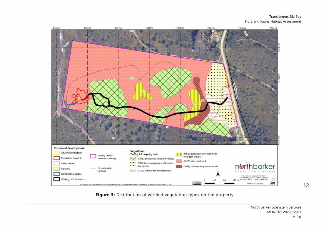
distribution of TASVEG units recorded within the study area is illustrated in Figure 3.
Plate 1: Eucalyptus ovata canopy over cleared land (FAC), around the proposed location of the visitor
centre
3.1.1 Dry forest and woodland
- DOB – Eucalyptus obliqua dry forest
Eucalyptus obliqua is the only native forest unit observed on the property14 and is present in five
disjunct patches within a matrix of non-forest heathland, scrub and moorland (Figure 3). The DOB
is dominated by > 25 m tall E. obliqua with occasional E. ovata and very occasional E. pulchella
(Plate 2). The subcanopy is relatively free of small trees but includes some Exocarpos
cupressiformis. A variably dense small shrub layer exists from ground level to around 2 m, including
thickets of Leptospermum scoparium and less dense occurrences of Lomatia tinctoria, Daviesia
ulicifolia, Pultenaea juniperina and Leptomeria drupacea. A typical mixture of graminoids, ferns
and low shrubs is present at ground level, with prominent Pteridium esculentum and variable
amounts of Epacris impressa, Acrotriche serrulata, Gleichenia dicarpa and Diplarrena moraea.
13 The EPBCA listed community Tasmanian Forests and Woodlands dominated by black gum or Brookers
gum (Eucalyptus ovata / E. brookeriana) is thus not considered to be present on site. 14 Although it is noted that DOV may have been presented in the past, based on the number of E. ovata
present in the cleared land near Lune River Road (FAC). However, it is also noted that E. ovata is highly
suited to colonising cleared land and, in some cases, the colonisation of a clearing by this species can
create the impression of past dominance that is not reality; this is potentially supported by the relatively
young age of many of the E. ovata in the area of FAC, suggesting that the young trees could simply be
recent colonists derived from a few remnant trees from clearance of whatever the earlier community was
(potentially DOB given that E. ovata are occasional within the patches of DOB on site).

Transformer, Ida Bay
Flora and Fauna Habitat Assessment
North Barker Ecosystem Services
MON016: 2020_12_01
v. 2.0
9
Plate 2: Dry Eucalyptus obliqua forest upslope from the proposed Transformer location
3.1.2 Heathland, scrub and moorland
- MBS – buttongrass moorland with emergent shrubs
- SHW – wet heathland
- SMR – Melaleuca squarrosa scrub
These communities occupy the lowest-lying parts of the site (and broader landscape), being
generally associated with poor drainage. The SMR occupies the wettest niche within this area,
being restricted to a narrow band around the tributary of Tea Tree Creek that bisects the eastern
end of the property in a north to south alignment. The SMR is relatively species poor with a
prominent tall shrub layer of Melaleuca squarrosa and Leptospermum lanigerum over sparse
sedges and rushes. The riparian SMR is bordered to the west by a patch of buttongrass moorland
with emergent shrubs, dominated by in excess of 70 % cover of Gymnoschoenus sphaerocephalus,
with emergent M. squarrosa and L. lanigerum. An additional patch of MBS was mapped near the
centre of the property between patches of forest. It is likely other patches of MBS could be
differentiated from the surrounding non-forest mosaic with finer scale targeted mapping (beyond
the scope or need of this assessment). However, it is noted that the large patch of MBU reported
on TASVEG prior to our assessment was redetermined in the field as SHW on the basis of the
relatively low cover of buttongrass (15-30 %) and floristics, including a moderately diverse
assemblage of small shrubs including Boronia pilosa subsp. pilosa, Epacris lanuginosa, Sprengelia
incarnata, Acacia myrtifolia, Aotus ericoides, Hibbertia appressa and Almaleea subumbellata, in
addition to various graminoids, such as Baumea tetragona, Diplarrena latifolia, Diplarrena moraea,
Gahnia grandis, Leptocarpus tenax and Schoenus lepidosperma subsp. lepidosperma. Small and
scattered Eucalyptus ovata are present throughout the SHW. The SHW is the most widespread and
extensive community on site.

Transformer, Ida Bay
Flora and Fauna Habitat Assessment
North Barker Ecosystem Services
MON016: 2020_12_01
v. 2.0
10
Plate 3: SMR scrub along the tributary of Tea Tree Creek
Plate 4: Buttongrass moorland with emergent shrubs, near tributary of Tea Tree Creek

Transformer, Ida Bay
Flora and Fauna Habitat Assessment
North Barker Ecosystem Services
MON016: 2020_12_01
v. 2.0
11
Plate 5: Wet heathland vegetation (SHW) around the proposed site of the Transformer development
Plate 6: Wet heathland vegetation (SHW) around the proposed site of the Transformer development,
looking upslope towards a patch of DOB forest
Transformer, Ida Bay
Flora and Fauna Habitat Assessment
North Barker Ecosystem Services
MON016: 2020_12_01
v. 2.0
12
Figure 3: Distribution of verified vegetation types on the property

Transformer, Ida Bay
Flora and Fauna Habitat Assessment
North Barker Ecosystem Services
MON016: 2020_12_01
v. 2.0
13
3.2 Threatened and Conservation Significant Flora
3.2.1 Threatened flora
The survey documented 96 vascular plant species (including 13 exotics) within the survey area
(Appendix B). No threatened flora were observed and none are likely to have been overlooked.
Indeed, no threatened flora have been reported from within 500 m of the site according to NVA
records, and only two species have been reported from within 5 km (Table 1) – neither of these
species is considered highly likely to be present on the property and even less likely to occur
within the footprint or the range of potential impacts (Table 1) – primarily this is simply due to
the small footprint in relation to widespread available habitat and sparsely distributed species.
Similarly, five species considered to have potential habitat in the area based on habitat mapping
in the EPBCA protected matters search tool 15 are not considered to have better than a very low
likelihood of occurring within the footprint for the same reasons in addition to less suitable
habitat (the species being Caladenia caudata, Euphrasia gibbsiae ssp. psilantherea,
Prasophyllum pulchellum, Thelymitra jonesii, and Xerochrysum palustre).
Table 1: Threatened flora species with observations (Tasmanian Natural Values Atlas) or
predicted habitat (EPBCA Protected Matters database) from within a 5 km radius of the site 16
Species Status17 TSPA /
EPBCA
Potential to
occur on site,
or relative
size of
population if
present
Observations and preferred habitat18
Previously reported from within 5 km radius
Corunastylis
morrisii
bearded midge-
orchid
endangered/ - Very low
Occurs in near-coastal lowland habitats in buttongrass
moorland and sedgy open eucalypt woodland on
moderately-drained sites, including raised clay pans in
poorly drained peaty sedgeland. Has potential habitat on
site within the SHW and MBS communities, but with only 4
records within 5 km (the last observation being 1993) it
would be very unlikely to occur within the project impact
area purely due to the small area and the rarity of the
species. It is noted that the survey was undertaken outside
of the viable survey period for the species, however the low
likelihood of it being present is not considered to warrant
a targeted summer/autumn survey.
Thelymitra
holmesii
bluestar sun-
orchid
rare/ - Very low
Occurs in wet heath habitats equivalent to those on site.
The survey was undertaken at the beginning of the
potential flowering period for the species, although most
flowering (and optimal survey timing) is from November to
December. Based on the survey results, in which no
15 EPBC Act Protected Matters report PMST_AU39TJ 16 Natural Values Report # 1_09-Sep-2020, DPIPWE, 2020 17 Tasmanian Threatened Species Protection Act 1995, Commonwealth Environment Protection and
Biodiversity Conservation Act 1999 18 Threatened Species Section (2020)

Transformer, Ida Bay
Flora and Fauna Habitat Assessment
North Barker Ecosystem Services
MON016: 2020_12_01
v. 2.0
14
Species Status17 TSPA /
EPBCA
Potential to
occur on site,
or relative
size of
population if
present
Observations and preferred habitat18
Thelymitra leaves were observed and relatively few orchids
were present overall, it was not considered to warrant a
follow-up survey. With only 1 record ever lodged from
within 5 km and such a small amount of potential habitat
within the proposed impact area, it would appear very
unlikely the species might occur within the footprint of the
development.
3.3 Introduced Plants (Weeds) and Plant Pathogens
3.3.1 Weeds
The survey area was found to be relatively free of serious weeds. Only two declared weeds were
recorded, with Spanish heath restricted to an adjacent part of Lune River Road (Figure 4), and
blackberry occurring as small, slashed plants and seedlings within the FAC community (Plate 7).
3.3.2 Plant pathogens
No symptomatic evidence of Phytophthora cinnamomi was observed within the site, but the
wet heath community is particularly susceptible to its impacts.
Plate 7: Small blackberry recorded around the railway line near Lune River Road buildings

Transformer, Ida Bay
Flora and Fauna Habitat Assessment
North Barker Ecosystem Services
MON016: 2020_12_01
v. 2.0
15
Figure 4: Distribution of declared weeds observed within the property

Transformer, Ida Bay
Flora and Fauna Habitat Assessment
North Barker Ecosystem Services
MON016: 2020_12_01
v. 2.0
16
3.4 Fauna of Conservation Significance
3.4.1 General survey observations and habitat assessment
The ground surveys established that the property contains typical faunal habitats associated
with the vegetation present on site and the location within southern Tasmania. For most
threatened species with potential habitat on site, including those with known observations
and/or core habitat mapped within 500 m (Table 2), the extent of potential habitat on site can
be seen as non-critical to the local persistence of species, due to large areas of equivalent
habitat present beyond the potential impact area and the absence of critical habitat elements
(such as ground dens or potential nest sites) within the footprint19. The exception warranting
further consideration is the swift parrot.
3.4.2 Swift parrot
The swift parrot is listed as endangered under the TSPA and Critically Endangered under the
EPBCA. Swift parrots are endemic breeders to Tasmania, migrating from south-eastern mainland
Australia where they spend the winter. The threatened status is a result of population decline
associated with the loss of foraging and nesting habitat, predation by sugar gliders (Petaurus
breviceps) and collisions with man-made objects20. Any infrastructure can create a potential
collision hazard to birds if it is not clearly visible and avoidable. In almost all scenarios, the risk
that buildings pose to bird collisions relates to the design and location of windows and any
other reflective surfaces. Threats posed by such surfaces can be classified into two main
categories: reflections and transparency. Reflection: A reflection can imitate continuous habitat.
When seen from the outside of a building, glass often has a reflective quality, mirroring the sky,
trees and other features. Transparency: Birds perceive a passageway between clear glass and
attempt to fly straight through. Glass lobbies, balconies, windows, glass walls that meet at a
corner, or aligned windows (windows installed parallel to each other, on opposite sides of the
building) may provide an unobstructed view of habitat and sky on the other side.
There are a number of dwellings in the Ida Bay area that have windows that may already pose
a risk to swift parrots, however no records of bird strike in the area are reported in Pfennigwerth
(2008) or on the Natural Values Atlas. This may be due to the low level of built infrastructure in
the area relative to available flight paths, facilitating avoidance through chance or adaptation
and also a lack reporting or discovery of dead birds
Swift parrots nest in tree hollows of mature eucalypts within range (generally less than 10 km)
of bulk food sources. Foraging habitat is primarily comprised of stands of blue gum (Eucalyptus
globulus) and black gum (Eucalyptus ovata). The flowers of these species are utilised before and
during the breeding season between August and February. Because patches of food plants
flower with varying intensity each year, the swift parrot population can breed in different areas
in different years.
The Ida Bay area around the project property supports numerous stands of black gums (in
conjunction with stands of blue gums around nearby Southport) and is consequently an
important swift parrot foraging area. The area also contains mature forest elements, particularly
those dominated by stringybark forest (Eucalyptus obliqua – TASVEG DOB) (Plate 8). The project
area itself, including components of the proposed footprint (or very close to it), contains stands
of DOB forest that are considered to be potentially viable foraging (scattered E. ovata) and
19 Noting that no raptor nests are known within 500 m or 1 km line of sight of the property, with the closest
known nest being a white-bellied sea eagle nest 3.5 km to the east (nest ID 1966) 20 Threatened Species Link – Swift Parrots (Lathamus discolor)

Transformer, Ida Bay
Flora and Fauna Habitat Assessment
North Barker Ecosystem Services
MON016: 2020_12_01
v. 2.0
17
nesting habitat (viable hollow-bearing trees), as well as areas of E. ovata (with relatively large
trees in the area of FAC [Figure 3] and varying densities of small to medium trees throughout
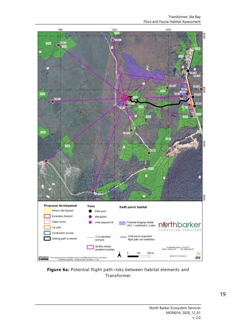
the wet heathland habitat) that are viable foraging habitat only (Figure 5, Plate 8). Trees in the
forest patches and the FAC are estimated to range in height from 18-35 m, with an average of
around 30 m, and an average canopy depth of around 10 m. The scattered heathland trees are
generally less than 10 m tall similarly reduced canopy depths. Five trees supporting hollows
potentially suitable for nesting of this species were observed within the survey area (Figure 5)
(Plates 2 and 9).
The footprint of the installation occurs in an area of wet heathland with limited direct habitat value to swift parrots, other than small, scattered E. ovata less than 10 m in height and with relatively low value as potential foraging trees and no potential nesting habitat value – the closest examples of the small trees are marked in Figure 5. A patch of tree with viable nesting elements occurs upslope of the installation and close to the proposed edge of the excavation area. Within this patch, two confirmed hollow-bearing trees occur close to the proposed alignment of the footpath (Figure 5). The visitor centre occurs within a patch of FAC with around 50 potential foraging trees of E. ovata.
The installation site is situated at a relatively lower (slightly) point in the landscape compared
to adjacent DOB forest patches (which tend to be situated on slight rises [better drainage] but
is at comparable relative height to the small scattered heathland trees. The visitor centre occurs
on the same relief as the surrounding FAC.
Eleven potential risk flight paths have been examined in relation to the locations of the
installation and the visitor centre intersecting with direct paths between viable habitat elements
(Figure 6a and b).
Plate 8: Stand of stringybark (E. obliqua) with nesting and foraging potential to the southwest of the
property

Transformer, Ida Bay
Flora and Fauna Habitat Assessment
North Barker Ecosystem Services
MON016: 2020_12_01
v. 2.0
Figure 5: Distribution of potential threatened fauna habitat within the property
Transformer, Ida Bay
Flora and Fauna Habitat Assessment
North Barker Ecosystem Services
MON016: 2020_12_01
v. 2.0
19
Figure 6a: Potential flight path risks between habitat elements and
Transformer

Transformer, Ida Bay
Flora and Fauna Habitat Assessment
North Barker Ecosystem Services
MON016: 2020_12_01
v. 2.0
20
Figure 6b: Potential flight path risks between habitat elements and visitor
centre

Transformer, Ida Bay
Flora and Fauna Habitat Assessment
North Barker Ecosystem Services
MON016: 2020_12_01
v. 2.0
21
Plate 9: Typical density and size distribution of E. ovata (potential foraging trees) scattered throughout
the wet heathland on and around the property
Plate 10: Hollow-bearing E. ovata on the margin of a patch of DOB near the proposed path

Transformer, Ida Bay
Flora and Fauna Habitat Assessment
North Barker Ecosystem Services
MON016: 2020_12_01
v. 2.0
22
Table 2: Fauna species of conservation significance known or with core habitat present within
a 500 m radius of the survey area 21
Species Status TSPA /
EPBCA
Potential to
occur Observations and preferred habitat22
Reported from within 500 m23
Accipiter
novaehollandiae
grey goshawk
Endangered / - Very low
The core habitat for this species is generally
below 600 m with high priority nesting habitat
occurring along watercourses in old growth
wet forests. This species inhabits large tracts of
wet and swamp forest, particularly patches
with closed canopies above an open
understorey and with dense stands of prey
habitat nearby. Mature blackwood (Acacia
melanoxylon) is the preferred nesting tree.
There are no sightings of this species within
500 m of the property and only one within 5
km. May be transient in the area. Although
core habitat is listed as occurring within 500 m,
none is present on the property. It is highly
unlikely the species would visit the potential
development area enough to suffer
measurable detrimental impacts.
Ceyz azureus ssp.
diemenensis
(Alcedo azurea subsp.
diemenensis)
azure kingfisher
Endangered /
ENDANGERED Very low
This species is found along rivers in the south,
west, north and northwest of Tasmania with
outlying and/or vagrant occurrences
elsewhere. This species occurs in the forested
margins of major river systems where it
perches on branches overhanging rivers
waiting for prey items such as small fish,
insects and freshwater crayfish to come down
the river. This species nests in holes along the
top of riverbanks and is therefore susceptible
to clearing and modification of river-side
vegetation. There is thought to be fewer than
250 mature individuals left in Tasmania with
the overall distribution of Tasmania’s azure
kingfisher reflecting the higher rainfalls in the
west and north-west regions of Tasmania.
The creek on site is not suitable for occupation
by this species in terms of being a regular
foraging habitat nor viable for breeding in any
way. The only likelihood of the species
occurring on site would be as a stop-over
21 NVA report_ nvr_1_09-Sep-2020, DPIPWE, 2020; EPBC Act Protected Matters Report, Commonwealth of
Australia, PMST_AU39TJ – note that the thylacine (Thylacinus cynocephalus) has been excluded from
Table 1 on the basis of being declared extinct, although it is noted an accepted observation of the
species is listed on the NVA from 1985 within 500 m of the property. 22 Threatened Species Section (2020) 23 Natural Values Report: nvr_1_09_Sep_2020

Transformer, Ida Bay
Flora and Fauna Habitat Assessment
North Barker Ecosystem Services
MON016: 2020_12_01
v. 2.0
23
Species Status TSPA /
EPBCA
Potential to
occur Observations and preferred habitat22
during dispersal between other habitats, or a
random dispersal from a bird living on the
Lune River. The single record from the edge of
the property (attributed to a “signpost in the
middle of the township of Lune River right
next to railway office” is likely to be derived
from one such event. It is unlikely to visit the
potential development area enough to suffer
measurable detrimental impacts.
Dasyurus viverrinus
eastern quoll - / ENDANGERED
Foraging:
low -
moderate
Denning:
very low
The eastern quoll is widespread in Tasmania
and was previously widespread in mainland
south-eastern Australia but has been
effectively extinct there since 1963 (some
reintroductions have occurred). Not currently
listed as threatened species within Tasmania
under the TSPA.
Records from the NVA indicate that the
eastern quoll occurs in most parts of Tasmania
but is recorded infrequently in the wetter
western third of the state. The species’
distribution is associated with areas of low
rainfall and cold winter minimum
temperatures. It is found in a range of
vegetation types including open grassland
(including farmland), tussock grassland, grassy
woodland, dry eucalypt forest, coastal scrub
and alpine heathland, but is typically absent
from large tracts of wet eucalypt forest and
rainforest.
Only one observation record is known within 5
km of the property, although the potential for
core habitat is listed within 500 m. The habitat
on site is moderately suitable within the
forested areas. Although denning on the
property is unlikely, it may be used as part of
a foraging range and/or for dispersal.
Lathamus discolor
swift parrot
Endangered /
CRITICALLY
ENDANGERED
High
Swift parrots are a migratory species,
undertaking annual flights from Tasmania to
the mainland of Australia. When in Tasmania
they are semi-nomadic, crossing much to the
state to coincide with the erratic and patchy
flowering patterns of their preferred food
plants, Eucalyptus globulus and Eucalyptus
ovata. Breeding occurs in hollow-bearing trees
within 10 km of flowering food stands.
The property occurs within the Southern
Forest SPIBA, which contains nesting and
other observations. Although the species has
not been reported to have been observed

Transformer, Ida Bay
Flora and Fauna Habitat Assessment
North Barker Ecosystem Services
MON016: 2020_12_01
v. 2.0
24
Species Status TSPA /
EPBCA
Potential to
occur Observations and preferred habitat22
within 500 m of the property according to data
on the NVA, with both potential foraging and
breeding habitat present, it can reasonably be
expected to be present in years when regional
conditions are suitable (e.g. flowering of key
food resources).
Sarcophilus harrisii
Tasmanian devil
Endangered /
ENDANGERED
Foraging:
moderate
Denning:
very low
The Tasmanian devil lives in a wide range of
habitats across Tasmania, especially in
landscapes with a mosaic of pasture and
woodland. Populations have declined
substantially since the first observations of the
infectious cancer Devil Facial Tumour Disease
(DFTD). DFTD has now spread across much of
Tasmania. The reduced population is also
likely to be more sensitive to additional threats
such as death by roadkill, competition with
cats and foxes, and loss or disturbance of areas
surrounding traditional dens where young are
raised. The protection of breeding
opportunities is particularly important for the
species due to the mortalities from
demographic pressures.
Records of Tasmanian devil are not
uncommon anywhere there are roads and
people in Tasmania. Within 500 m of the
property there are 2 observations records,
with the most recent from 2013. It is likely the
species is still present in the area and although
denning on the property is unlikely, it may be
used as part of a foraging range and/or for
dispersal.
Tyto novaehollandiae
masked owl
Endangered/
VULNERABLE
Low -
moderate
Masked owls are a nocturnal species that
favour the edges of dry forests, utilising
hollows >15 cm in diameter for nesting.
Therefore, significant habitat for this species is
limited to large eucalypts within dry eucalypt
forest in their core range. Their core foraging
habitat includes mature native forests and
woodlands typically below 600 m altitude as
well as mosaics of both native vegetation and
agricultural patches.
The forest areas of DOB on the property
constitute quality foraging habitat for the
species, but no potentially suitable nesting
hollows were observed nor are likely to have
been overlooked given their size. Although
nesting and roosting on the property is
unlikely, it may be used as part of a foraging
range and/or for dispersal.

Transformer, Ida Bay
Flora and Fauna Habitat Assessment
North Barker Ecosystem Services
MON016: 2020_12_01
v. 2.0
25
4 POTENTIAL IMPACTS AND MITIGATION
In terms of natural values, potential direct impacts (e.g. habitat clearance) due to works from
the present proposal will be relatively minor on account of the footprint being relatively small
and having limited intersection with conservation significant values. The most significant value
associated with the site is potential foraging and nesting habitat for the swift parrot –
subsequently, limiting impacts to this habitat, and minimising collision risks posed by new
infrastructure are the highest priorities.
4.1 Native Vegetation and Ecological Communities
4.1.1 Extent of impact and conservation significance
The current expected losses of native vegetation are considered to be negligible in relation to
the overall extent and conservation statuses of the communities to be impacted.
• Overall, the impact footprint is expected to impact four native vegetation units (Table 3),
none of which are listed as threatened under the EPBCA or NCA.
• The extent of impact on this native vegetation is 0.37 ha, which constitutes 2.24 % of the
property’s native vegetation.
• Proportional losses to vegetation are very low at scales beyond the property (Table 3).
4.1.2 Potential for mitigation
If any further additions are required to the footprint, it is recommended that direct and
irreversible clearance is concentrated within the areas of modified land (FUM and FAC) as much
as possible (although taking into account the threatened fauna habitat values in the FAC).
Where impacts to native vegetation is unavoidable, micro-siting at a local scale may be able to
direct impacts into localised areas with less contribution to the overall value (e.g. a rocky area
containing minimal vegetation, or a localised area with lower quality vegetation than the
surrounds). As well as representative examples of all communities, the project should aim to
protect localised variations within units and areas that contain other important values (e.g.
threatened species habitat).
To further minimise net losses, revegetation could be considered as a minor form of mitigation
in areas where clearance of native vegetation is not required to be a permanent loss (e.g. borrow
pits [if required], temporary access routes and temporary construction disturbance footprints).
Suitable species for revegetation should be sourced from the local environment (see species
lists in Appendix B). Revegetation specifics, such as seed application rates, use of established
plants, specific planting details, etc., are best outlined in a revegetation plan once specific
project details, timing, locations, etc., are finalised, and may be included as a requirement in a
post-construction management plan.
Prior to the commencement of works, the impact area should be marked (either in situ and/or
clearly on construction plans) and all contractor agreements should specify that works, vehicles
and materials must be confined within the designated impact areas. Areas of native vegetation
beyond the impact footprint should be designated as exclusion zones and marked on the
ground and/or in construction plans to ensure no inadvertent impacts occur.
4.1.3 Summary of recommendations for native vegetation
- Concentrate direct and irreversible clearance within areas of non-native vegetation
(modified land) as much as possible.

Transformer, Ida Bay
Flora and Fauna Habitat Assessment
North Barker Ecosystem Services
MON016: 2020_12_01
v. 2.0
26
- Apply micro-siting approach (with the aid of an ecologist) to areas of the final footprint
within native vegetation – the micro-siting should aim to make minor adjustments to
the footprint on the ground by selecting localised areas with relatively less important
values (e.g. lower condition areas), as well as maintaining variation within a community
across the project area and local areas containing important values.
- In cases of redesign or additions, maximise the proportion of the footprint within non-
native (modified) vegetation and avoid native vegetation (as well as habitat for
threatened species).
- Clearly demarcate the permitted impact area either in situ and/or clearly on
construction plans and specify on all contractor agreements that works, vehicles and
materials must be confined within the designated impact areas.
- Areas of native vegetation beyond the impact footprint should be designated as
exclusion zones and marked on the ground and/or in construction plans to the degree
necessary to ensure no inadvertent impacts occur.
- Incorporate a revegetation plan into the post-construction requirements, covering
areas where clearance of native vegetation is not required to be a permanent loss (e.g.
borrow pits [if required], temporary access routes and temporary construction
disturbance footprints). The plan should outline suitable species for revegetation
(sourced from the local environment), as well as revegetation specifics, such as seed
application rates, use of established plants, specific planting details, etc.
4.2 Threatened and Conservation Significant Flora
4.2.1 Potential impacts and context
The footprint does not overlap with any known occurrences of threatened flora and it is not
expected to have any unanticipated impacts in relation to undocumented occurrences.
4.2.2 Potential for mitigation
No specific mitigation or additional survey effort is warranted for the current footprint.
4.3 Introduced Plants and Pathogens
4.3.1 Potential impacts and context
Due to the very minor occurrences of weeds within the property and around the impact area,
the proposal presents a very low risk of spreading weeds beyond the site. It is possible however
that earthworks associated with clearance and infrastructure construction may result in the
proliferation of propagules already present on site or introduce new species. The latter can be
expected to be a continued threat during operations.
Although no symptomatic evidence of the root rot fungus Phytophthora cinnamomi (PC) has
been observed on site, it is known within 1.5 km (where it is common around the Southport
Lagoon track) and the SHW vegetation in particular is highly susceptible to infection. Civil works
plant and personnel pose a risk of introducing PC to the site and an ongoing risk will be posed
by pedestrian traffic during operations.

Transformer, Ida Bay
Flora and Fauna Habitat Assessment
North Barker Ecosystem Services
MON016: 2020_12_01
v. 2.0
27
Table 3: Proportional and quantitative vegetation losses from the impact footprint
Proposed losses from impact footprint Context24
Community/ unit
Extent in
project area
(ha)
Total (ha)
Total loss %
of extent in
council area
Total loss %
of extent in
bioregion
Total loss %
of extent in
State
(DOB) Eucalyptus obliqua dry forest 4.63 0.098 0.0004 0.0002 0.0001
(MBS) buttongrass moorland with
emergent shrubs 0.79 0.013 0.00006 0.0001 0.00001
(SHW) wet heathland 10.47 0.348 0.02 0.02 0.002
(SMR) Melaleuca squarrosa scrub 0.63 0.013 0.0003 0.0008 0.00008
24 DPIPWE (2014) – noting that the accuracy of the proportional calculations is subject to the mapping limitations of the base data in DPIPWE 2014

Transformer, Ida Bay
Flora and Fauna Habitat Assessment
North Barker Ecosystem Services
MON016: 2020_12_01
v. 2.0
28
4.3.2 Potential for mitigation
The risks of weed and pathogen spread or incursions into the site can be managed within
construction and operational phases of the proposal with hygiene protocols that comply with
the principles of DPIPWEs Weed and Disease Planning and Hygiene Guidelines25.
4.3.3 Summary of recommendations for weeds and pathogens
- Prior to and during construction:
o A Construction Environmental Management Plan (or similar instrument) should
include requirements for the contractor or proponent to undertake primary
control (eradication) of the blackberry and Spanish heath infestations
presented in Figure 4, as well as general hygiene principles (particularly the use
of clean and disinfected plant and equipment) that limit the potential for
introduction of weeds or pathogens.
- Post works:
o During the next spring/summer season at least three months after construction
is completed (not sooner), the proponent should arrange a weed and pathogen
inspection of the site, with scope for subsequent control actions if required.
- During operations:
o Users should be directed to stay on paths/tracks and other formed surfaces
with signage.
o The proponent may consider an educational sign within the visitor centre (or
elsewhere) that covers weeds and pathogens.
o The operators should install (prior to opening) and maintain a shoe wash
station at the start of the path consistent with those used in national parks and
reserves.
o At least one staff member should be trained in basic identification of weeds
(including blackberry and Spanish heath) and symptomatic evidence of PC,
supported by an action plan that outlines what to do if weeds or pathogen
symptoms are observed.
o The proponent should arrange biennial spring/summer weed and pathogen
inspections of the site, with scope for subsequent control actions if required.
4.4 Threatened Fauna
4.4.1 Swift parrot
4.4.1.1 Habitat clearance/impacts
None of the small E. ovata in the vicinity of the installation require direct removal and none are indicated as being at risk from root damage by the arboricultural assessment26. The arboricultural assessment raised a risk of decline in a E. obliqua from potential root impacts on the eastern end of the excavation footprint – the excavation area was subsequently shifted further from this tree in accordance with the arborist recommendations. This tree was not
25 DPIPWE (2015b) 26 Element Tree Services (2020)

Transformer, Ida Bay
Flora and Fauna Habitat Assessment
North Barker Ecosystem Services
MON016: 2020_12_01
v. 2.0
29
identified in our assessment as containing potential nesting hollows but is within a patch of trees with mature elements and other confirmed hollow-bearing trees.
The footpath construction and operation is not considered to pose a risk to tree health or require removal of limbs and thus is not expected to compromise the health of nearby potential nesting trees27.
The visitor centre and associated works will require the removal of one E. ovata potential foraging tree (identified as tree 4 in the arboricultural assessment28). An additional E. ovata (tree 6 in the arboricultural assessment) has also been identified as a likely mortality without permeable materials being used for surfacing.
The requirement for direct removal and/or risk of decline of potential swift parrot habitat elements is thus considered to be very low for this proposal, with a total of only one habitat tree requiring direct removal or considered to be at risk of decline.
4.4.1.2 Collision risk – Transformer installation and potential flight paths
Figures 7a-e show the potential relationship between the installation location and the
potential flight paths between habitat elements considered to present the greatest collision
risk, represented as cross sections showing relative heights and lateral separation. Due to the
combination of tree height (estimated range from 15-35 m high for highest risk elements, with
average of around 30 m, and altitude ranging from around 25-45 m) being greater than the
installation (around 4-5 m at around 32 m asl), no direct intersections are predicted by straight
line flight paths. The closest predicted paths (i.e. those with the least predicted separation)
are those involving the shorter statured potential foraging trees scattered within the
heathland. Due to the small canopies on these trees (and subsequent less scope for flowering),
they can be expected to be an infrequently utilised resource. As a result, they are not
considered to present a high collision risk. Habitat patches represented by patches of DOB
contain much taller trees, which result in much greater predicted separation of potential
direct flight paths, even when an average of 10 m is allowed for canopy depth. These patches
of habitat are thus considered to represent a very low risk of collisions from direct flight paths.
Flights departing from tree 10 may be a possible exception due to proximity to the installation
and the fact that a swift parrot may momentarily lose altitude as they depart from a canopy –
the installation however will appear as a solid obstruction from that angle (see section 4.4.1.4)
and combined with the fact that is has a relatively small lateral footprint (Figure 2), it is not
considered to pose a high collision risk in that context.
4.4.1.3 Collision risk – visitor centre and potential flight paths
Figures 8a-f show the potential relationship between the visitor centre location and the
potential flight paths between habitat elements considered to present the greatest collision
risk, represented as cross sections showing relative heights and lateral separation. Due to the
combination of tree height (estimated range from 10-30 m high for highest risk elements, with
average of around 20 m, and altitude ranging from around 20-35 m) being greater than the
visitor centre (around 3-4 m at around 20 m asl), no direct intersections are predicted by
straight line flight paths. The closest predicted paths (i.e. those with the least predicted
27 Element Tree Services (2020) 28 Element Tree Services (2020)

Transformer, Ida Bay
Flora and Fauna Habitat Assessment
North Barker Ecosystem Services
MON016: 2020_12_01
v. 2.0
30
separation) are those involving the shorter statured potential foraging trees scattered within
the heathland. Due to the small canopies on these trees (and subsequent less scope for
flowering), they can be expected to be an infrequently utilised resource. As a result, they are
not considered to present a high collision risk. Habitat patches represented by patches of DOB
contain much taller trees, which result in much greater predicted separation of potential
direct flight paths, even when an average of 10 m is allowed for canopy depth. These patches
of habitat are thus considered to represent a very low risk of collisions from direct flight paths.
Flights departing from several trees directly surrounding the visitor centre to tree 19 may be
a possible exception due to proximity to the visitor centre, the short stance of tree 19 and the
fact that a swift parrot may momentarily lose altitude as they depart from a canopy – the
visitor centre however will appear as a solid obstruction from that angle (see section 4.4.1.5)
and combined with the fact that is has a relatively small lateral footprint and is being
developed in a location that already consists of existing buildings (i.e. the Ida Bay railway and
café building is 7 m tall, 3 m higher than the proposed visitor centre) (Figure 2d), it is not
considered to pose a high collision risk in that context.
Figures 7a-b: Predicted flight paths between habitat elements across the
installation site – nodes for habitat elements represent canopy tops
36
0
10
20
30
40
50
60
70
80
-700 -600 -500 -400 -300 -200 -100 0 100 200 300 400
real
tive
hei
ght
(m)
distance (m)
Tree 12 to tree 14 via tree 9
36
0
10
20
30
40
50
60
70
80
-800 -600 -400 -200 0 200 400 600
rela
tive
hei
ght
(m)
distance (m)
Tree 13 to tree 7 via tree 10

Transformer, Ida Bay
Flora and Fauna Habitat Assessment
North Barker Ecosystem Services
MON016: 2020_12_01
v. 2.0
31
Figures 7c-e: Predicted flight paths between habitat elements across the
installation site – nodes for habitat elements represent canopy tops
36
0
10
20
30
40
50
60
70
80
-900 -800 -700 -600 -500 -400 -300 -200 -100 0 100 200
real
tive
hei
ght
(m)
distance (m)
Tree 11 to tree 10
36
0
10
20
30
40
50
60
-1000 -800 -600 -400 -200 0 200 400
real
tive
hei
ght
(m)
distance (m)
Tree 16 to scattered E. ovata in north
36
0
10
20
30
40
50
60
-1000 -800 -600 -400 -200 0 200 400
rela
tive
hei
ght
(m)
distance (m)
Tree 15 to scattered E. ovata in north

Transformer, Ida Bay
Flora and Fauna Habitat Assessment
North Barker Ecosystem Services
MON016: 2020_12_01
v. 2.0
32
Figures 8a-c: Predicted flight paths between habitat elements across the
visitor centre – nodes for habitat elements represent canopy tops
24
0
10
20
30
40
50
60
70
-800 -600 -400 -200 0 200 400 600
rela
tive
hei
ght
(m)
distance (m)
Tree 9 to tree 22 via tree 19
24
0
10
20
30
40
50
60
70
80
-700 -600 -500 -400 -300 -200 -100 0 100 200
rela
tive
hei
ght
(m)
distance (m)
Tree 14 to tree 20
24
0
10
20
30
40
50
60
70
-300 -250 -200 -150 -100 -50 0 50 100
rela
tive
hei
ght
(m)
distance (m)
Tree 18 to 5 via tree 1

Transformer, Ida Bay
Flora and Fauna Habitat Assessment
North Barker Ecosystem Services
MON016: 2020_12_01
v. 2.0
33
Figures 8d-f: Predicted flight paths between habitat elements across the
visitor centre – nodes for habitat elements represent canopy tops
24
0
10
20
30
40
50
60
-50 -40 -30 -20 -10 0 10 20 30 40 50 60
rela
tive
hei
ght
(m)
distance (m)
Tree 2 to tree 5
24
0
10
20
30
40
50
60
-100 0 100 200 300 400 500
rela
tive
hei
ght
(m)
distance (m)
Tree 2 to tree 24 via tree 4
24
0
10
20
30
40
50
60
70
-100 -50 0 50 100 150 200 250 300 350
rela
tive
hei
ght
(m)
distance (m)
Tree 7 to tree 23

Transformer, Ida Bay
Flora and Fauna Habitat Assessment
North Barker Ecosystem Services
MON016: 2020_12_01
v. 2.0
34
4.4.1.4 Collision risk – building design – Transformer installation
For swift parrots that fly over the installation, the fact the building is very low (in part due to
being embedded into the slope) gives it an inherently low risk of creating collisions with a
canopy bird such as the swift parrot (Figure 9), which when foraging generally fly within the
height range of the canopies29. Although swift parrots do sometimes land on the ground (for
food or water), we are not aware of records of this happening in the type of habitat that
immediately surrounds the installation, nor have we recorded any habitat elements at ground
level that we believe will induce this behaviour. In addition to being quite low (particularly
compared to the relative heights of surrounding habitat elements, as shown in section 4.4.1.2),
the installation is not expected to have any throughways (i.e. sight line transparencies where a
false impression of an unobstructed passageway is created by having two windows opposite
one another). Although the interior surfaces are covered with mirrors, the far mirror in the back
of the pavilion for two out of three tunnels and the mirrors on the walls of the entrances (i.e.
the mirrors potentially most visible when looking straight down one of the entrances) are angled
in such a fashion that the modelling (Figure 2a) predicts that reflections will be off the interior
floor or ceiling when viewed from outside – by reflecting the interior solid surfaces to external
observers, the installation will not create the impression of continuous habitat or sky, despite
the reflections shown to internal observers being comprised of these elements. No other
aspects of the building construction have the potential to be reflective of transparent in a way
that could create collision risk. The installation design is subsequently considered low risk for
collisions from swift parrots.
Figure 9: From Pfennigwerth (2008, artist Robyn McNicol), showing how a
low or flat position below canopies presents a lower threat than a higher
position relative to the canopy level
4.4.1.5 Collision risk – building design – visitor centre
For swift parrots that fly over the visitor centre, the fact the building is very low, < 4 m and
lower than the existing Ida Bay railway and café building which is 7 m at its peak and 4 m at the
gutters) gives it an inherently low risk of creating collisions with a canopy bird such as the swift
29 Smales (2005)

Transformer, Ida Bay
Flora and Fauna Habitat Assessment
North Barker Ecosystem Services
MON016: 2020_12_01
v. 2.0
35
parrot (Figure 9), which when foraging generally fly within the height range of the canopies30.
Although swift parrots do sometimes land on the ground (for food or water), we are not aware
of records of this happening in the type of habitat that immediately surrounds the installation,
nor have we recorded any habitat elements at ground level that we believe will induce this
behaviour. In addition to being quite low (particularly compared to the relative heights of the
surrounding buildings and habitat elements, as shown in section 4.4.1.3), the visitor centre will
be attached to the western side of the existing railway and café building (Figure 2c) and will not
have any throughways (i.e. sight line transparencies where a false impression of an unobstructed
passageway is created by having two windows opposite one another). The visitor centre design
is subsequently considered low risk for collisions from swift parrots.
4.4.1.6 Summary of further avoidance and mitigation recommendations for swift
parrots
It would appear that the proposed levels of habitat clearance and the collision risks proposed
by the development are relatively low should the development proceed as per the current
design and location. Nonetheless, it is prudent as a safeguard to design and implement a
monitoring program of both swift parrot use of the site and collision incidences. The program
should include:
- Annual pre-season checks on foraging trees and the likelihood of flowering food plants
within the vicinity of the development.
- Utilisation surveys within seasons where food plants on site are flowering and/or the
Southern Forests SPIBA is known to be host to significant numbers of breeding pairs.
- Regular systematic patrols around the development buildings to document bird
collision mortalities.
- Mitigation strategies for if mortalities occur in relation to particular design elements or
habitat variables (e.g. flowering events) – mitigation options may include alterations to
the building designs or facades to the degree necessary.
5 LEGISLATIVE IMPLICATIONS AND ASSESSMENT
5.1 Commonwealth Environment Protection and Biodiversity
Conservation Act 1999 (EPBCA)
The project is not considered to be a risk of resulting in significant impacts to Matters of
National Environmental Significance (MNES) under the definitions for assessment requirements
under this Act. Based on this it does not warrant referral to the federal Minister for consideration
as a controlled action.
5.1.1 Threatened ecological communities
The project area has not been found to support EPBCA listed threatened ecological
communities and as such there is no potential for significant impacts to MNES of this type.
5.1.2 Threatened flora
The project area has not been found to support EPBCA listed flora and as such there is no
potential for significant impacts to MNES of this type.
30 Smales (2005)

Transformer, Ida Bay
Flora and Fauna Habitat Assessment
North Barker Ecosystem Services
MON016: 2020_12_01
v. 2.0
36
5.1.3 Threatened fauna - swift parrot
The following criteria must be considered in relation to the swift parrot and the potential for
significant impacts in relation to this Act.
• Likelihood of breeding disturbance and therefore adverse impacts on habitat critical to
the survival of the species, potential to disrupt the breeding cycle of a population,
potential to lead to a long-term decrease in the size of a population and impacts to
habitat to the extent that the species is likely to decline.
• Possible fragmentation effects.
• Likelihood of introduction of disease or harmful invasive species.
• Potential for interference with the recovery of the species.
• A meaningful reduction in the area of occupancy of the species.
Taken these criteria into account and the general test of significance under the EPBCA31, the
proposal is not considered likely to result in a significant on the swift parrot.
5.2 Tasmanian Threatened Species Protection Act 1995 (TSPA)
Under the TSPA, a person cannot knowingly, without a permit, ‘take’ a listed species. With the
definition of ‘take’ encompassing actions that kill, injure, catch, damage, destroy and/or collect
threatened species or vegetation elements that support threatened species, e.g. nests and dens.
No permit is currently required for the project in relation to threatened species impacts.
5.3 Tasmanian Nature Conservation Act 2002 (NCA)
A permit to take products of wildlife may be required for this project if any hollow-bearing trees
are required to be impacted, but at this point none have been proposed for impacts.
5.4 Tasmanian Weed Management Act 1999
Two species of declared weeds have been observed around the proposal area. The relevant
statutory weed management plans define the respective municipalities as Zone B municipalities
for both Spanish heath and blackberry.
According to the provisions of the Weed Management Act 1999, Zone B municipalities are those
which host moderate or large infestations of the declared weed that are not deemed eradicable
because the feasibility of effective management is low at this time. Therefore, the objective is
containment of infestations. This includes preventing spread of the declared weed from the
municipality or into properties currently free of the weed or which have developed or are
implementing a locally integrated weed management plan for that species. As well there is a
requirement to prevent spread of the weeds to properties containing sites with significant flora,
fauna and vegetation communities.
31 The particular facts and circumstances of a proposed action need to be taken into account in
determining whether that action is likely to have a significant impact on a Matter of National
Environmental Significance (MNES). The general test for significance is whether an impact is ‘important,
notable or of consequence, having regard to its context or intensity’. This general test is informed by
the significant impact criteria but not necessarily entirely, as it provides scope for interpretation of
impacts beyond the generic and finely-worded significant impact criteria.

Transformer, Ida Bay
Flora and Fauna Habitat Assessment
North Barker Ecosystem Services
MON016: 2020_12_01
v. 2.0
37
5.5 Tasmanian National Parks and Reserves Management Act 2002
The Parks and Wildlife Service (PWS) Tasmania are responsible for maintaining the significant
values protected within lands reserved under this Act, including values of biological diversity,
geological diversity, water quality, sites/areas of cultural significance, and areas of high
wilderness quality. PWS are also charged with encouraging certain forms of use of reserves and
assessing proposed uses. The Reserve Activity Assessment (RAA) process is the Environmental
Impact Assessment system PWS uses to assess whether activities proposed on PWS managed
land are environmentally, socially and economically acceptable, and to ensure that proposals
are consistent with any approved management plan that applies to the land. Activities that
require an RAA are new or recurrent works/activities that over a period of time have the
potential for adverse environmental, social or economic impacts. Activities that do not require
an RAA are usually routine or general maintenance activities that are often done on a day-to-
day basis. They have low potential environmental, social or economic impacts even if they are
conducted over a long period of time. The RAA process applies to both PWS and external
proponents’ activities on PWS managed land. The RAA process complements other external
planning assessment processes covered under each of the Acts discussed in this section.
The current proposal will require an RAA due to the proposed use occurring within the Ida Bay
State Reserve and the proposal meeting the definition of a new or recurrent work/activity that
over a period of time has the potential for adverse environmental, social or economic impacts.
5.6 Forest Practices Act 1985
A Forest Practices Plan will be required under this Act for any forest practices that don’t fit the
definitions of works in which FPPs are not required, in accordance with the clauses of section 4
of the Forest Practices Regulations 2017. The current proposal meets the definitions of the
exemption clause 4 (j):
the harvesting of timber or the clearing of trees on any land, or the clearance and
conversion of a threatened native vegetation community on any land, for the
purpose of enabling –
(i) the construction of a building within the meaning of the Land Use Planning and
Approvals Act 1993 or of a group of such buildings; or
(ii) the carrying out of any associated development –
if the construction of the buildings or carrying out of the associated development is
authorised by a permit issued under that Act;
However, the proponent have been advised that they may require an FPP due to the
requirement for landowner consent from Sustainable Timbers Tasmania to use their fire trail
between South Lune Road and the installation site for construction access during works.
5.7 Land Use Planning and Approvals Act 1993 (LUPAA)
LUPAA states that ‘in determining an application for a permit, a planning authority must
(amongst other things) seek out the objectives set out in Schedule 132.
Schedule 1 includes ‘The objectives of the Resource Management and Planning System of
Tasmania’ which are (amongst other things):
32 Section 51(2)(b) – Part 4 Enforcement of Planning Control – Division 2 Development Control (LUPPA
1993)

Transformer, Ida Bay
Flora and Fauna Habitat Assessment
North Barker Ecosystem Services
MON016: 2020_12_01
v. 2.0
38
‘To promote sustainable development of natural and physical resources and the maintenance
of ecological processes and genetic diversity’.
Sustainable development includes ‘avoiding, remedying or mitigating any adverse effects of
activities on the environment’33.
The intent of LUPAA will be met through compliance with the above Acts and the Huon Valley
Interim Planning Scheme 2015 and this study suggests these provisions can be achieved.
5.8 Huon Valley Interim Planning Scheme 2015
5.8.1 Rural Resource Zone 26.0
The only applicable development standard (D26.4) that pertains to natural values relevant to
the scope of our assessment is D26.4.3. A1(c), which specifies that:
To ensure that the location and appearance of buildings and works minimises adverse impact on the rural landscape. The location of buildings and works must comply with any of the following:
(c) be located in and area not require the clearing of native vegetation and not on a skyline or ridgeline.
The installation relies on being embedded in the slope and facing a scenic vista, which does not
provide scope for relocation into already cleared land such as is being used by the visitor centre
proposal. There are unlikely to be other layout configurations that would enable the proposal
to remain functional and give the same likelihood of success while avoiding clearance of native
vegetation entirely. The proposal thus is seen to meet the following performance criteria:
(c) be located in and area requiring the clearing of native vegetation only if:
(i) there are no sites clear of native vegetation and clear of other significant site constraints such as access difficulties or excessive slope, or the location is necessary for the functional requirements of infrastructure;
(ii) the extent of clearing is the minimum necessary to provide for buildings, associated works and associated bushfire protection measures.
5.8.2 Biodiversity Code E10
Based on the values present, the proposal must been the requirements pertaining to Moderate
Priority Biodiversity Values under the definitions of E10.1 unless it is undertaken in accordance
with a certified Forest Practices Plan, which will make it exempt from E10 under clause E10.4.1.
(b).
To comply with E.10 the proposal must meet the conditions of E10.7.1, which have the objective
to ensure that development for buildings and works that involves clearance and conversion or
disturbance within a Biodiversity Protection Area does not result in unnecessary or unacceptable
loss of priority biodiversity values.
As the proposal does not meet any of the definitions of Acceptable Solutions under E10.7.1 A1,
it must meet the following Performance Criteria P1 (b) for moderate priority biodiversity values:
(i) development is designed and located to minimise impacts, having regard to constraints such as topography or land hazard and the particular requirements of the development;
33 page 56 – LUPPA 1993

Transformer, Ida Bay
Flora and Fauna Habitat Assessment
North Barker Ecosystem Services
MON016: 2020_12_01
v. 2.0
39
The installation relies on being embedded in the slope and facing a scenic vista, which does
not provide scope for relocation into already cleared land. The visitor centre is located in
modified land surrounded by existing buildings and next to the main road. There are unlikely
to be other layout configurations that would enable the proposal to remain functional and
give the same likelihood of success while further limiting impacts to moderate priority
biodiversity values. The proposal thus meets this criterion.
(ii) impacts resulting from bushfire hazard management measures are minimised as far as reasonably practicable through siting and fire-resistant design of habitable buildings;
We have not been informed the proposal will include hazard management.
(iii) remaining moderate priority biodiversity values on the site are retained and improved through implementation of current best practice mitigation strategies and ongoing management measures designed to protect the integrity of these values;
This will be achieved by implementing the recommendations of this report and the
arboricultural assessment.
(iv) residual adverse impacts on moderate priority biodiversity values not able to be avoided or satisfactorily mitigated are offset in accordance with the Guidelines for the Use of Biodiversity Offsets in the Local Planning Approval Process, Southern Tasmanian Councils Authority 2013 and any relevant Council policy.
Our assessment has shown that impacts on moderate priority biodiversity values have been avoided and or satisfactorily mitigated to a degree that offsets are not warranted at this time. Should monitoring as part of mitigation reveal unanticipated levels of impacts, there are various mechanisms available to achieve suitable offsets, such as habitat supplements, covenants, management agreements, and monetary contributions to research and conservation.
6 CONCLUSION AND RECOMMENDATIONS
In terms of natural values, potential direct impacts (e.g. habitat clearance) due to works from
the present proposal will be relatively minor on account of the footprint being relatively small
and having limited intersection with conservation significant values. The most significant value
associated with the site is potential foraging and nesting habitat for the swift parrot. Our
assessment has however shown that the proposal will require negligible levels of impact to
potential swift parrot habitat and poses only a low level of risk in relation to collision-induced
mortalities.
The following recommendations are made regarding general management of the proposal area
and to ensure minimal impacts to conservation significant values.
6.1 Native Vegetation
- Concentrate direct and irreversible clearance within areas of non-native vegetation
(modified land) as much as possible.
- Apply micro-siting approach (with the aid of an ecologist) to areas of the final footprint
within native vegetation – the micro-siting should aim to make minor adjustments to
the footprint on the ground by selecting localised areas with relatively less important
values (e.g. lower condition areas), as well as maintaining variation within a community
across the project area and local areas containing important values.
- In cases of redesign or additions, maximise the proportion of the footprint within non-
native (modified) vegetation and avoid native vegetation (as well as habitat for
threatened species).

Transformer, Ida Bay
Flora and Fauna Habitat Assessment
North Barker Ecosystem Services
MON016: 2020_12_01
v. 2.0
40
- Clearly demarcate the permitted impact area either in situ and/or clearly on
construction plans and specify on all contractor agreements that works, vehicles and
materials must be confined within the designated impact areas.
- Areas of native vegetation beyond the impact footprint should be designated as
exclusion zones and marked on the ground and/or in construction plans to the degree
necessary to ensure no inadvertent impacts occur.
- Incorporate a revegetation plan into the post-construction requirements, covering
areas where clearance of native vegetation is not required to be a permanent loss (e.g.
borrow pits [if required], temporary access routes and temporary construction
disturbance footprints). The plan should outline suitable species for revegetation
(sourced from the local environment), as well as revegetation specifics, such as seed
application rates, use of established plants, specific planting details, etc.
6.2 Introduced Plants and Pathogens
- Prior to and during construction:
o A Construction Environmental Management Plan (or similar instrument) should
include requirements for the contractor or proponent to undertake primary
control (eradication) of the blackberry and Spanish heath infestations
presented in Figure 4, as well as general hygiene principles (particularly the use
of clean and disinfected plant and equipment) that limit the potential for
introduction of weeds or pathogens.
- Post works:
o During the next spring/summer season at least three months after construction
is completed (not sooner), the proponent should arrange a weed and pathogen
inspection of the site, with scope for subsequent control actions if required.
- During operations:
o Users should be directed to stay on paths/tracks and other formed surfaces
with signage.
o The proponent may consider an educational sign within the visitor centre (or
elsewhere) that covers weeds and pathogens.
o The operators should install (prior to opening) and maintain a shoe wash
station at the start of the path consistent with those used in national parks and
reserves.
o At least one staff member should be trained in basic identification of weeds
(including blackberry and Spanish heath) and symptomatic evidence of PC,
supported by an action plan that outlines what to do if weeds or pathogen
symptoms are observed.
o The proponent should arrange biennial spring/summer weed and pathogen
inspections of the site, with scope for subsequent control actions if required.
6.3 Threatened Fauna
- Implement a monitoring program of both swift parrot use of the site and collision
incidences. The program should include:
o Annual pre-season checks on foraging trees and the likelihood of flowering
food plants within the vicinity of the development.

Transformer, Ida Bay
Flora and Fauna Habitat Assessment
North Barker Ecosystem Services
MON016: 2020_12_01
v. 2.0
41
o Utilisation surveys within seasons where food plants on site are flowering
and/or the Southern Forests SPIBA is known to be host to significant numbers
of breeding pairs.
o Regular systematic patrols around the development buildings to document
bird collision mortalities.
o Mitigation strategies for if mortalities occur in relation to particular design
elements or habitat variables (e.g. flowering events) – mitigation options may
include alterations to the building designs or facades to the degree necessary.

Transformer, Ida Bay
Flora and Fauna Habitat Assessment
North Barker Ecosystem Services
MON016: 2020_12_01
v. 2.0
42
REFERENCES
Commonwealth of Australia (2020). Protected Matters Search Tool, www.environment.gov.au.
Report – PMST_AU39TJ.
Commonwealth of Australia (1999). Environment Protection and Biodiversity Conservation Act
1999. No. 91, 1999.
Department of the Environment (2020). Species Profile and Threats Database, Department of
the Environment, Canberra. Available from: http://www.environment.gov.au/sprat.
de Salas M.F. and Baker M.J. (2020). A Census of the Vascular Plants of Tasmania. Tasmanian
Herbarium, Tasmanian Museum and Art Gallery.
DPIPWE (2020). Natural Values Report # 1_09-Sept-2020, DPIPWE, Natural Values Atlas,
Threatened Species Section, Department of Primary Industries, Parks, Water and
Environment, Hobart.
DPIPWE (2015a). Guidelines for Natural Values Surveys - Terrestrial Development Proposals.
Department of Primary Industries, Parks, Water and Environment (Natural and Cultural
Heritage Division).
DPIPWE (2015b). Weed and Disease Planning and Hygiene Guidelines - Preventing the spread
of weeds and diseases in Tasmania. (Eds.) Karen Stewart and Michael Askey-Doran.
Department of Primary Industries, Parks, Water and Environment, Hobart, Tasmania.
DPIPWE (2014). Department of Primary Industries, Parks, Water and Environment. TASVEG 3.0
area by VEGCODE. Tasmanian Vegetation Monitoring and Mapping Program, Resource
Management and Conservation Division.
DPIPWE (2013). Department of Primary Industries, Parks, Water and Environment. TASVEG 3.0,
Released November 2013. Tasmanian Vegetation Monitoring and Mapping Program,
Resource Management and Conservation Division.
Element Tree Services (2020). Development Impact Assessment, Ida Bay Railway, 2nd November
2020.
Goff, F.G, Dawson, G.A. and Rochow, J.J. (1982). Site examination for threatened and endangered
plant species. Environmental Management 6 (4) pp 307-316.
Google Earth Pro (2020). Various images referenced in text, by DigitalGlobe, TerraMetrics and
CNES/ Airbus. Accessed November 2020.
Harris, S. and Kitchener, A. (2005). From Forest to Fjaeldmark: Descriptions of Tasmania’s
Vegetation. Department of Primary Industries, Water and Environment, Printing
Authority of Tasmania, Hobart.
IBRA 7 (2012). Interim Biogeographic Regionalisation for Australia, Version 7. Map produced by
Environment Resources Information Network (ERIN), Australian Government
Department of the Environment and Energy, Canberra, Commonwealth of Australia.
Kirkpatrick, J.B. and Nunez, M. (1980). Vegetation-radiation relationships in mountainous
terrain: eucalypt-dominated vegetation in the Risdon Hills, Tasmania. Journal of
Biogeography v. 7, pp. 197-208.
Kitchener, A. and Harris, S. (2013). From Forest to Fjaeldmark: Descriptions of Tasmania's
Vegetation. Edition 2. Department of Primary Industries, Parks, Water and Environment,
Tasmania.
Kuchler, A.B. and Zonneveld, S. (2012). Vegetation Mapping. Kluwer Academic Publishers,
United States, pp. 648.

Transformer, Ida Bay
Flora and Fauna Habitat Assessment
North Barker Ecosystem Services
MON016: 2020_12_01
v. 2.0
43
Pfennigwerth, S. (2008). Minimising the swift parrot collision threat. Guidelines and
recommendations for parrot-safe building design. World Wildlife Fund – Australia.
Saunders, D.L. and Tzaros, C.L. (2011). National Recovery Plan for the Swift Parrot Lathamus
discolor, Birds Australia, Melbourne
Smales, I. (2005). Modelled cumulative impacts on the swift parrot of wind farms across the
species ranges in south-eastern Australia. Report for the Department of Environment
and Heritage. Biosis Research.
Tasmanian State Government (1993). Land Use Planning and Approvals Act 1993. No.70 of 1993.
Government Printer, Hobart, Tasmania
Tasmanian State Government (1995). Threatened Species Protection Act 1995. No.83 of 1995.
Government Printer, Hobart, Tasmania
Tasmanian State Government (1999). Weed Management Act 1999. No.105 of 1999.
Government Printer, Hobart, Tasmania.
Tasmanian State Government (2002). Nature Conservation Act 2002. No.63 of 2002.
Government Printer, Hobart, Tasmania.
Tasmanian State Government (2006). Nature Conservation Amendment (Threatened Native
Vegetation Communities) Act 2006. Government Printer, Hobart, Tasmania.
Tasmanian Vegetation Monitoring and Mapping Program/ TVMMP (2013). TASVEG 3.0
Metadata Statement. DPIPWE, Conservation Values Information Section, Hobart,
Tasmania.
The Nature Conservancy (1994). Field Methods for Vegetation Mapping – USGS/NPS Vegetation
Mapping Program. Report prepared for the United States Department of Interior,
United States Geology Survey and the United States National Parks Service.
Threatened Species Section (2020). Species Management Profiles from Tasmania's Threatened
Species Link. http://www.threatenedspecieslink.tas.gov.au. Department of Primary
Industries, Parks, Water and Environment, Tasmania.
Triggs, B. (1996). Tracks, Scats and Other Traces – A field guide to Australian Mammals. Oxford
Press, pp. 352.
Wapstra, M. (2018). Flowering Times of Tasmanian Orchids: A Practical Guide for Field
Botanists, 4th edition. Self-published by the author (July 2018 version).

Transformer, Ida Bay
Flora and Fauna Habitat Assessment
North Barker Ecosystem Services
M MON016: 2020_12_01
v. 2.0
44
APPENDIX A – COARSE HABITAT MAPPING (STOJANOVIC)

Transformer, Ida Bay
Flora and Fauna Habitat Assessment
North Barker Ecosystem Services
MON016: 2020_12_01
v. 2.0
45
APPENDIX B – VASCULAR PLANT SPECIES LIST
Status codes:
ORIGIN NATIONAL SCHEDULE STATE SCHEDULE
i - introduced EPBC Act 1999 TSP Act 1995
d - declared weed WM Act CR - critically endangered e - endangered
en - endemic to Tasmania EN - endangered v - vulnerable
t - within Australia, occurs only in Tas. VU - vulnerable r - rare
Sites: 1 SHW - E491596, N5189897 26/05/2020 Dave Sayers 2 FAC with emergent E. ovata - E492187, N5189983 26/05/2020 Dave Sayers 3 SHW with buttongrass component of 15-30% - E491552, N5189928 29/09/2020 Grant Daniels 4 DOB stand with scattered E. ovata particularly around edges - 29/09/2020 Grant Daniels E491667, N5189891 5 SHW indicative species between DOB patches - E491788, N5189855 29/09/2020 Grant Daniels 6 SMR creekline - E492080, N5189890 29/09/2020 Grant Daniels 7 MBS - button grass moorland with emergent paperbark and tea tree - 29/09/2020 Grant Daniels E492065, N5189905 8 FAC with emergent E. ovata and FUM - E492173, N5189957 29/09/2020 Grant Daniels
Site Name Common name Status
DICOTYLEDONAE ASTERACEAE 2 Cirsium vulgare spear thistle i 4 Coronidium scorpioides curling everlasting 4 Euchiton japonicus common cottonleaf 8 Hypochaeris glabra smooth catsear i 2 Olearia phlogopappa dusty daisy bush 2 Senecio linearifolius var. linearifolius common fireweed groundsel 8 Senecio minimus shrubby fireweed
CARYOPHYLLACEAE 2 Spergula arvensis corn spurrey i
CLUSIACEAE 8 Hypericum japonicum matted st johns-wort
CUNONIACEAE 1 3 7 Bauera rubioides wiry bauera
DILLENIACEAE 3 4 Hibbertia appressa southern guineaflower
DROSERACEAE 3 Drosera pygmaea dwarf sundew
ERICACEAE 4 Acrotriche serrulata ants delight 4 Epacris impressa common heath 1 3 5 Epacris lanuginosa swamp heath 2 Erica lusitanica spanish heath d 1 3 5 6 7 Sprengelia incarnata pink swampheath FABACEAE 3 4 Acacia myrtifolia redstem wattle 3 Acacia verticillata subsp. verticillata prickly moses 3 Almaleea subumbellata wiry bushpea 1 3 Aotus ericoides golden pea 4 Daviesia ulicifolia subsp. ulicifolia yellow spiky bitterpea 2 Lotus sp. trefoil i 4 Pultenaea juniperina prickly beauty

Transformer, Ida Bay
Flora and Fauna Habitat Assessment
North Barker Ecosystem Services
MON016: 2020_12_01
v. 2.0
46
GENTIANACEAE 2 Centaurium erythraea common centaury i
GERANIACEAE 8 Geranium potentilloides var. mountain cranesbill
HALORAGACEAE 3 Gonocarpus micranthus subsp. creeping raspwort 4 Gonocarpus tetragynus common raspwort
HEMEROCALLIDACEAE 8 Dianella revoluta var. revoluta spreading flax-lily
LAURACEAE 1 3 Cassytha pubescens downy dodderlaurel
LOGANIACEAE 3 Mitrasacme pilosa hairy mitrewort
MYRTACEAE 2 8 Eucalyptus amygdalina black peppermint en 3 8 Eucalyptus nitida western peppermint en 2 4 8 Eucalyptus obliqua stringybark 2 3 4 5 8 Eucalyptus ovata var. ovata black gum 2 4 8 Eucalyptus pulchella white peppermint en 1 6 7 Leptospermum lanigerum woolly teatree 3 4 7 8 Leptospermum scoparium common tea-tree 2 Leptospermum scoparium var. common teatree 1 3 5 6 7 Melaleuca squarrosa scented paperbark
PLANTAGINACEAE 2 Plantago lanceolata ribwort plantain i
POLYGALACEAE 4 Comesperma volubile blue lovecreeper
PROTEACEAE 1 Hakea epiglottis beaked hakea en 3 4 5 Hakea epiglottis subsp. milliganii western beaked needlebush 4 Lomatia tinctoria guitarplant en
ROSACEAE 2 8 Acaena novae-zelandiae common buzzy 8 Rubus anglocandicans blackberry d RUTACEAE 3 Boronia parviflora swamp boronia 3 4 Boronia pilosa subsp. pilosa hairy boronia
SANTALACEAE 4 Exocarpos cupressiformis common native-cherry 4 Leptomeria drupacea erect currantbush
SCROPHULARIACEAE 2 Verbascum thapsus great mullein i
STYLIDIACEAE 1 3 Stylidium graminifolium narrowleaf triggerplant
THYMELAEACEAE 4 Pimelea humilis dwarf riceflower 1 Pimelea linifolia slender riceflower
MONOCOTYLEDONAE ASPARAGACEAE 2 Lomandra longifolia sagg
CYPERACEAE 3 Baumea tetragona square twigsedge

Transformer, Ida Bay
Flora and Fauna Habitat Assessment
North Barker Ecosystem Services
MON016: 2020_12_01
v. 2.0
47
1 Gahnia filum chaffy sawsedge 1 2 3 4 5 Gahnia grandis cutting grass 1 3 4 5 6 Gymnoschoenus sphaerocephalus buttongrass 7
1 Isolepis sp. club rush 1 4 5 6 7 Lepidosperma filiforme common rapiersedge 8 Lepidosperma laterale variable swordsedge 1 8 Schoenus apogon common bogsedge 3 4 6 7 Schoenus lepidosperma subsp. slender bogsedge lepidosperma
IRIDACEAE 3 5 Diplarrena latifolia western flag-iris en 1 3 4 8 Diplarrena moraea white flag-iris 1 Patersonia occidentalis long purpleflag
JUNCACEAE 2 8 Juncus pallidus pale rush 2 Juncus subsecundus finger rush
ORCHIDACEAE 4 Acianthus caudatus mayfly orchid 4 Pterostylis melagramma blackstripe greenhood POACEAE 2 8 Agrostis capillaris brown top bent grass i 2 Aira caryophyllea silvery hairgrass i 2 Anthoxanthum odoratum sweet vernalgrass i 2 Austrostipa sp. speargrass 2 Deyeuxia sp. bent grass 2 Lolium perenne perennial ryegrass i 2 8 Microlaena stipoides weeping grass 1 5 8 Poa labillardierei silver tussockgrass 4 6 Poa sp. poa 2 Poa tenera scrambling tussockgrass 2 4 8 Rytidosperma sp. wallabygrass 3 Tetrarrhena distichophylla hairy ricegrass
RESTIONACEAE 1 4 5 6 7 Empodisma minus spreading roperush 7 Eurychorda complanata flat cordrush 1 2 Hypolaena fastigiata tassel roperush 3 4 5 6 7 Leptocarpus tenax slender twinerush 5 Sporadanthus tasmanicus branching scalerush
XYRIDACEAE 7 Xyris gracilis yelloweye 6 7 Xyris operculata tall yelloweye
PTERIDOPHYTA DENNSTAEDTIACEAE 2 4 8 Pteridium esculentum subsp. esculentum bracken
DICKSONIACEAE 8 Dicksonia antarctica soft treefern
GLEICHENIACEAE 1 2 4 5 6 Gleichenia dicarpa pouched coralfern
LINDSAEACEAE 3 Lindsaea linearis screw fern
LYCOPODIACEAE 1 Lycopodiella sp. clubmoss