transmission line from pinjar gas turbine to cataby · pdf filetransmission line from pinjar...
TRANSCRIPT
Transmission Line from Pinjar Gas Turbine to Cataby Substation
Western Power Corporation
Report and recommendations of the Environmental Protection Authority
Environmental Protection Authority Perth, Western Australia
Bulletin 1046 April 2002

ISBN. 0 7307 6677 2 ISSN. 1030 - 0120 Assessment No.1356
i
Summary and recommendations
Western Power Corporation (WPC) proposes to construct a transmission line with a maximum capacity of 330 kilovolt (kV) from its gas turbine generating station at Pinjar to a substation at Cataby. The line is proposed to ensure that the quality and reliability of the power supply in the North Country Region is adequately maintained beyond 2002. This report provides the Environmental Protection Authority’s (EPA’s) advice and recommendations to the Minister for the Environment and Heritage on the environmental factors relevant to the proposal.
Section 44 of the Environmental Protection Act 1986 requires the EPA to report to the Minister for the Environment on the environmental factors relevant to the proposal and on the conditions and procedures to which the proposal should be subject, if implemented. In addition, the EPA may make recommendations as it sees fit.
Relevant environmental factors
In the EPA’s opinion, the following are the environmental factors relevant to the proposal, which require detailed evaluation in the report:
(a) Vegetation communities – the effects of the construction and ongoing maintenance of the transmission line on local and regional vegetation both within conservation reserves and elsewhere along the transmission line corridor;
(b) Moore River crossing – the impact on riparian vegetation and the visual amenity in the vicinity of the crossing;
(c) Electromagnetic fields – compliance with safe exposure limits and the restriction of activities in proximity of the transmission line;
(d) Visual amenity – the visual impact of lattice towers generally along the proposed route, in the vicinity of the Moore River crossing and from the Wabling Hill lookout.
Conclusion
The EPA has considered the proposal by WPC to construct and maintain a transmission line from Pinjar to Cataby. The proposed route passes through areas of conservation estate, including State Forest 65 South, State Forest 65 North and the Gingin Stock Route Nature Reserve, as well as the boundary of Bush Forever Site 380. Construction of the transmission line will result in the permanent clearing of up to 2.9 hectares (ha) of vegetation and the temporary disturbance of up to 38.4 ha. The proposal is visible from the Wabling Hill lookout and the Moore River. Where it crosses the Moore River concerns were raised about the impacts on riparian vegetation.
Through its preliminary design of the proposal, the proponent has minimised the amount of vegetation clearing required by selecting a route which largely follows existing tracks. The amount of vegetation proposed to be cleared has also been reduced through the proponent’s management of construction activities.
In particular, maintaining a distinction between the level of temporary vegetation disturbance and the level of permanent vegetation clearing required. Undertaking construction of the transmission line in a manner that will allow these areas of temporary disturbance to
ii
rehabilitate in the longer term, will reduce the amount of vegetation to be cleared and ensure that the overall impacts of this proposal are kept to a minimum. The proponent’s intention not to construct a dedicated access track along the length of the line, which has historically been the practice, and instead to use existing tracks and cutting in spurs where necessary, contributes to the environmental acceptability of the proposal. Constructing the transmission line in this manner improves the proposal’s environmental manageability by not encouraging increased access along the transmission line, which has traditionally lead to further uncontrolled disturbance of vegetation over time and the introduction of weeds and pathogens.
The vegetation proposed to be cleared or disturbed by this proposal has been examined against the EPA’s Position Statement No.2 Environmental Protection of Native Vegetation in Western Australia which outlines the EPA’s expectations for proposals that involve a clearing component. It is the EPA’s view that the proposal meets the elements detailed in Section 4.2, “Clearing in the agricultural area where alternative mechanisms address biodiversity values” and Section 4.3, “Clearing in other areas of Western Australia”. The EPA considers the proponent has been able to meet the elements by demonstrating through its environmental investigations that, for the vegetation complexes that are proposed to be affected by this proposal, no vegetation types are to be reduced below the threshold level of 30% of their pre-clearing extent. In addition, the proponent has developed an offset package which has been endorsed by the Conservation Commission. This package provides for the Commission to acquire additional areas of remnant vegetation for inclusion in the conservation estate.
In response to concerns about the visual impacts and impacts on riparian vegetation at the original site selected to cross the Moore River, the proponent has developed an alternative alignment, selecting a site where vegetation is less dense requiring only minimal disturbance of riparian vegetation. WPC has also agreed to use poles instead of lattice towers in the vicinity of the crossing which reduces the visual impact. The Water and Rivers Commission (WRC) consider the revised proposal acceptable. Similarly for visual concerns raised by the Department of Conservation and Land Management (CALM) in the Wabling Hill lookout area, the proponent has agreed to install poles and CALM has advised that its concerns have been addressed.
Public concern was also raised regarding the level of electromagnetic fields (EMF) emitted by the proposed transmission line when operating. WPC has advised the EPA that electromagnetic fields will be in compliance with the safe exposure limits recommended by the World Health Organisation (WHO) and the National Health & Medical Research Council (NH&MRC) of Australia. There will be no restriction of activity in the vicinity of the line as a result of potential for impacts from EMF. Restriction of activity within the line corridor will only be to minimise the risk of electrocution.
The EPA considers that taking account of the relatively small areas of permanent (2.9 ha) and temporary clearing (38.4 ha) for a line which is 123 km long, the design changes to the proposal to reduce the visual impact in areas of environmental sensitivity, and the proposal meeting the safe exposure limits recommended by the WHO and the NH&MRC of Australia for EMF, the EPA has concluded that it is unlikely that the EPA’s objectives would be compromised provided there is satisfactory implementation by the proponent of the proponent’s commitments and the recommended conditions set out in Appendix 4 and summarised in Section 4.
iii
Recommendations
The EPA submits the following recommendations to the Minister for the Environment and Heritage:
1. That the Minister notes that the proposal being assessed is for a transmission line from Pinjar to Cataby, being proposed by Western Power Corporation.
2. That the Minister considers the report on the relevant environmental factors as set out in Section 3.
3. That the Minister notes that the EPA has concluded that it is unlikely that the EPA’s objectives would be compromised, provided there is satisfactory implementation by the proponent of the recommended conditions set out in Appendix 4, and summarised in Section 4, including the proponent’s commitments.
4. That the Minister imposes the conditions and procedures recommended in Appendix 4 of this report.
Conditions
Having considered the proponent’s commitments and information provided in this report, the EPA has developed a set of conditions that the EPA recommends be imposed if the proposal by WPC to construct and maintain a transmission line from Pinjar to Cataby is approved for implementation.
These conditions are presented in Appendix 4. Matters addressed in the conditions include the requirement that the proponent shall fulfil the commitments in the Consolidated Commitments statement set out as an attachment to the recommended conditions in Appendix 4.
Contents Page
Summary and recommendations ............................................................................................. i
1. Introduction and background......................................................................................... 1
2. The proposal ..................................................................................................................... 2
3. Relevant environmental factors ...................................................................................... 5
3.1. Vegetation communities............................................................................................. 5
3.1.1. Vegetation and conservation of biodiversity.......................................................... 5
3.1.2. Vegetation in conservation reserves....................................................................... 8
3.2. Moore River crossing ............................................................................................... 10
3.3. Electromagnetic fields (EMF) .................................................................................. 11
3.4. Visual amenity.......................................................................................................... 12
4. Conditions and Commitments....................................................................................... 14
4.1. Proponent’s commitments........................................................................................ 14
4.2. Recommended conditions ........................................................................................ 14
5. Conclusions ..................................................................................................................... 15
6. Recommendations .......................................................................................................... 16 Tables 1. Summary of key proposal characteristics Figures 1. Pinjar to Cataby Transmission Line Route Appendices 1. List of submitters 2. References 3. Identification of relevant environmental factors 4. Recommended Environmental Conditions and Proponent’s Consolidated Commitments 5. Summary of submissions and proponent’s response to submissions
1
1. Introduction and background
This report provides the advice and recommendations of the Environmental Protection Authority (EPA) to the Minister for the Environment and Heritage on the environmental factors relevant to the proposal by Western Power Corporation (WPC), to construct and operate a transmission line with a maximum capacity of 330 kilovolt (kV) from its Pinjar Gas Turbine Station to the Cataby Substation over a distance of 123 kilometres (km).
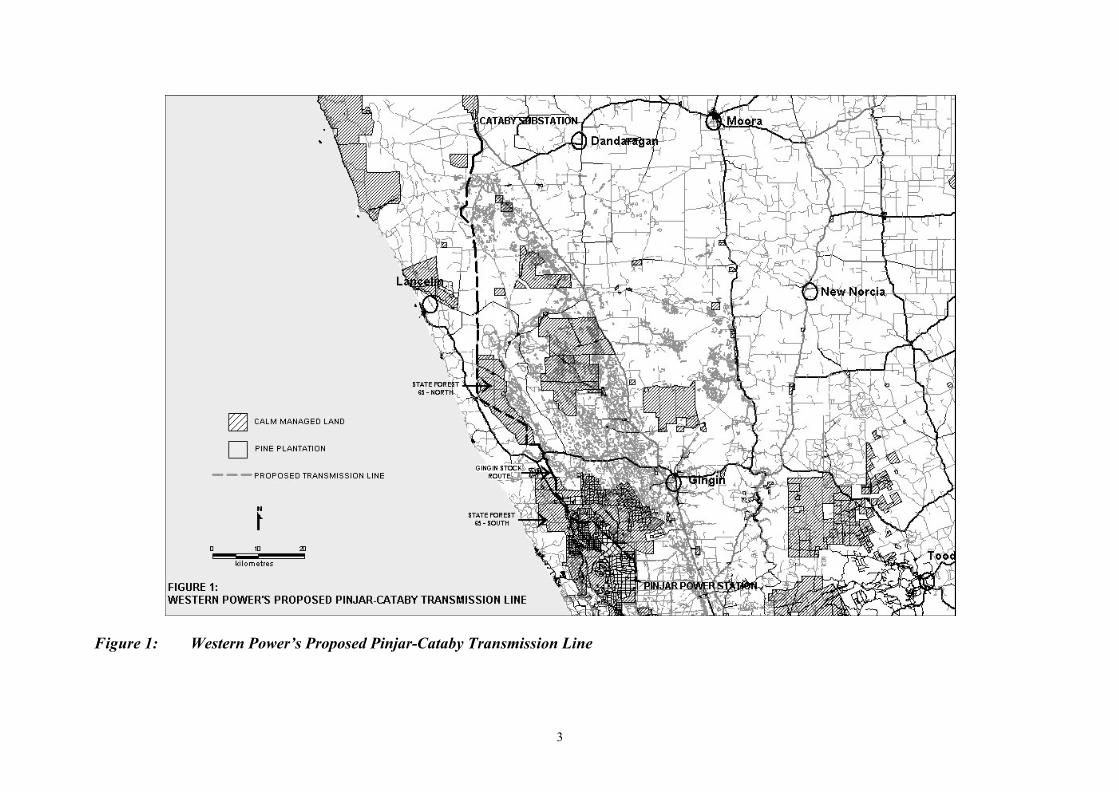
The transmission line is proposed to reinforce the existing power system and improve the quality and reliability of the power supply to regional customers located north of the Perth metropolitan area. The transmission line, which is primarily lattice tower construction up to 60 metres (m) high, traverses State Forest 65 South (Gnangara Park), Bush Forever Site 380, Gingin Stock Route Nature Reserve, State Forest 65 North and private property. The route of the transmission line is shown in figure 1.
It was considered that the potential environmental impacts from the development of this transmission line were significant with regard to the potential impacts of clearing of vegetation and the potential for impact on visual amenity as a result of the line construction. As such, a level of assessment of Public Environmental Review (PER) was set on the proposal on 25 September 2000.
The public submission period for the proposal commenced on 11 June 2001 for a period of four weeks, ending 9 July 2001. A total of 27 submissions were received on the proposal.
Further details of the proposal are presented in Section 2 of this report. Section 3 discusses the environmental factors relevant to the proposal. The conditions and commitments to which the proposal should be subject, if the Minister determines that it may be implemented, are set out in Section 4. Section 5 presents the EPA’s conclusions and Section 6, the EPA’s recommendations.
A summary of submissions and the proponent’s response to submissions is included as Appendix 5. Issues arising from this process and which the EPA has taken into account also appear in the body of the report.
2
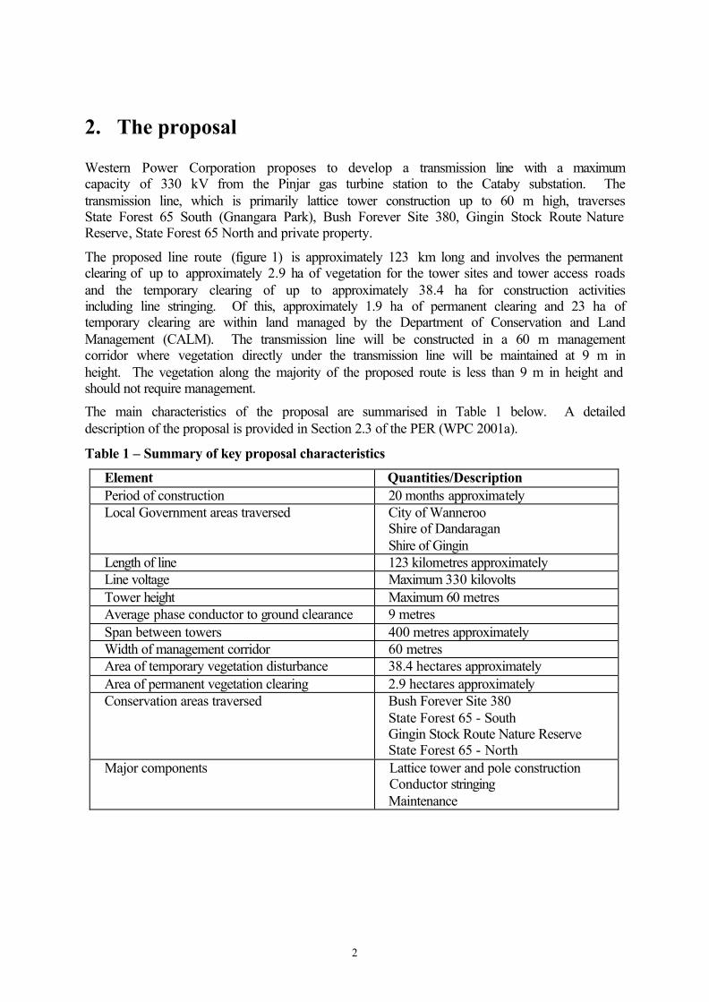
2. The proposal
Western Power Corporation proposes to develop a transmission line with a maximum capacity of 330 kV from the Pinjar gas turbine station to the Cataby substation. The transmission line, which is primarily lattice tower construction up to 60 m high, traverses State Forest 65 South (Gnangara Park), Bush Forever Site 380, Gingin Stock Route Nature Reserve, State Forest 65 North and private property.
The proposed line route (figure 1) is approximately 123 km long and involves the permanent clearing of up to approximately 2.9 ha of vegetation for the tower sites and tower access roads and the temporary clearing of up to approximately 38.4 ha for construction activities including line stringing. Of this, approximately 1.9 ha of permanent clearing and 23 ha of temporary clearing are within land managed by the Department of Conservation and Land Management (CALM). The transmission line will be constructed in a 60 m management corridor where vegetation directly under the transmission line will be maintained at 9 m in height. The vegetation along the majority of the proposed route is less than 9 m in height and should not require management.
The main characteristics of the proposal are summarised in Table 1 below. A detailed description of the proposal is provided in Section 2.3 of the PER (WPC 2001a).
Table 1 – Summary of key proposal characteristics
Element Quantities/Description Period of construction 20 months approximately Local Government areas traversed City of Wanneroo
Shire of Dandaragan Shire of Gingin
Length of line 123 kilometres approximately Line voltage Maximum 330 kilovolts Tower height Maximum 60 metres Average phase conductor to ground clearance 9 metres Span between towers 400 metres approximately Width of management corridor 60 metres Area of temporary vegetation disturbance 38.4 hectares approximately Area of permanent vegetation clearing 2.9 hectares approximately Conservation areas traversed Bush Forever Site 380
State Forest 65 - South Gingin Stock Route Nature Reserve State Forest 65 - North
Major components
Lattice tower and pole construction Conductor stringing Maintenance
3
Figure 1: Western Power’s Proposed Pinjar-Cataby Transmission Line
4
Since release of the PER, the proponent has made a number of modifications to the proposal. These include the:
• Moore River Crossing where an alternative alignment was selected to minimise any potential impacts on riparian vegetation and the visual impact of the lattice towers in the vicinity of the crossing to satisfy concerns raised by the Water and Rivers Commission (WRC).
• Gingin Stock Route Nature Reserve where an alternative alignment was selected as a result of a new dwelling being constructed 70m from the proposed alignment. The new owner of the property was not advised of the proximity of the proposed transmission line by the vendor, the vendor’s agent or the Local Government Authority at the time of purchase of the property. This realignment is proposed in order to move the transmission line further away from the dwelling. It will also reduce the impact on the Gingin Stock Route Nature Reserve.
• Sappers Road where an alternative alignment was selected to minimise the visual impacts of the transmission line from Sappers Road.
The EPA has assessed this proposal on the basis that a transmission line of a maximum capacity of 330 kV will be constructed. WPC has advised that the line may be constructed as a 132 kV transmission line. A decision to construct a 132 kV transmission line is likely to require lower, smaller towers, with a greater span between towers resulting in a reduced overall number of towers along the route. Although construction of the line as a 132 kV is likely to further reduce the footprint impacts of the proposal, the environmental issues raised by the proposal whether it is constructed as a 330 or 132 kV as examined by the EPA in Section 3 are essentially the same.
5
3. Relevant environmental factors
Section 44 of the Environmental Protection Act 1986 requires the EPA to report to the Minister for the Environment on the environmental factors relevant to the proposal and the conditions and procedures, if any, to which the proposal should be subject. In addition, the EPA may make recommendations as it sees fit.
The identification process for the relevant factors is summarised in Appendix 3. The reader is referred to Appendix 3 for evaluation of preliminary factors not discussed in detail in the main body of this report, including the reasons why these were not considered to be relevant factors.
It is the EPA’s opinion that the following are the environmental factors relevant to the proposal which require detailed evaluation in this report:
(a) Vegetation communities – the effects of the construction and ongoing maintenance of the transmission line on local and regional vegetation both within conservation reserves and elsewhere along the transmission line corridor;
(b) Moore River crossing – the impact on riparian vegetation and the visual amenity in the vicinity of the crossing;
(c) Electromagnetic fields – compliance with safe exposure limits and the restriction of activities in proximity of the transmission line; and
(d) Visual amenity – the visual impact of lattice towers generally along the proposed route, in the vicinity of the Moore River crossing, and from the Wabling Hill lookout.
The above relevant factors were identified from the EPA’s consideration and review of all environmental factors (preliminary factors) generated from the PER document and the submissions received, in conjunction with the proposal characteristics.
Details on the relevant environmental factors and their assessment are contained in Sections 3.1 - 3.4. The description of each factor shows why it is relevant to the proposal and how it will be affected by the proposal. The assessment of each factor is where the EPA decides whether or not a proposal meets the environmental objective set for that factor.
3.1. Vegetation communities
3.1.1. Vegetation and conservation of biodiversity
Description
WPC identified the clearing of vegetation as a major issue in the development of the proposal and have aligned the route to minimise the level of vegetation clearing. The eventual route of the proposed transmission line will require up to 2.9 ha of permanent vegetation clearing associated with the area around each of the towers and clearing for permanent access, and approximately 38.4 ha of temporary vegetation disturbance for construction of the towers and stringing of the conductors.
The proposal is within the area covered by the EPA Position Statement Number 2, Environmental Protection of Native Vegetation in Western Australia.
6
Submissions
Concerns expressed in the submissions mainly focused on:
• the potential for disturbance of a linear section through relatively undisturbed habitat, and resulting edge effects;
• the provision of documentation as to how areas of temporary disturbance will be restored to their previous level of ecological functionality, including details of contingencies in case of natural restoration not occurring at expected rates;
• the proposal causing an unacceptable level of disturbance to native vegetation; and
• concern that proposed clearing will lead to losses in biodiversity.
Assessment
The EPA’s environmental objectives for this factor are to:
• maintain the abundance, species diversity, geographic distribution and productivity of vegetation communities; and
• to ensure that the proposal meets the requirements of the EPA Position Statement Number 2: Environmental Protection of Native Vegetation in Western Australia.
In the design of the transmission line, WPC has proposed that there will be no new substantial track cleared along its length. Existing tracks will be used where possible and WPC propose to construct cut-in spurs between existing tracks and proposed tower base sites. This will minimise the requirement for vegetation clearing and also limit the likelihood of transfer of weeds and pathogens along the length of the line.
The proponent has committed to the development and implementation of a Vegetation Management Plan (Commitment 3) to detail the revegetation of areas of temporary disturbance. In particular, consideration will be given to the contingencies required in the case of natural revegetation of areas of temporary disturbance not being sufficient.
The proposal is within the area covered by the EPA Position Statement Number 2, Environmental Protection of Native Vegetation in Western Australia and it is the EPA’s expectation that it meet the elements detailed in Section 4.2, “Clearing in the agricultural area where alternative mechanisms address biodiversity values” and Section 4.3, “Clearing in other areas of Western Australia”. These elements are addressed below.
1. Area proposed for clearing is relatively small: The area proposed for clearing is relatively small, with approximately 2.9 ha of permanent clearing and 38.4 ha of temporary clearing, for the construction and operation of a line of approximately 123 km in length. All practical steps have been taken to minimise the area affected. The temporary clearing includes areas of the 60 m wide corridor that will be managed by WPC. Within this corridor, vegetation will be maintained at a maximum height of 9 m however this is not considered to have a significant environmental impact because vegetation within the corridor is generally below 9 m in height and substantial trimming of the vegetation will not be required.
7
2. Demonstrated elements in consideration of biological diversity: The methods proposed for the construction and maintenance of the line and access routes have been designed to minimise the level of vegetation clearing as well as the potential for the spread of weeds or disease through a linear section.
In the PER (WPC 2001a), the proponent prepared a table detailing the amount and percentage of Heddle vegetation complexes that are proposed to be cleared. This identified that no vegetation complexes are proposed to be reduced below the level of 30% of their pre-clearing extent.
A population of Declared Rare Flora has been located along the line route within the proposed management corridor. This population is not proposed to be disturbed by the proponent during construction or ongoing management of the transmission line. The proponent has committed to preparing a Vegetation Management Plan (Commitment 3) to detail the construction and ongoing maintenance activities that it will follow when undertaking activities in the vicinity of this population. The EPA is satisfied on the basis that providing this management plan is developed and implemented in consultation with CALM there is minimal risk to the population being impacted. While four Priority listed flora species were identified in the vegetation surveys, it is expected that potential impacts on these species can be managed on advice from CALM. It is not expected that any other threatened populations, communities or associations will be impacted by this alignment of the transmission line.
3. Land degradation will not be exacerbated: The proponent has designed the proposal such that it does not require a new cleared corridor to be constructed along the length of the line. Constructing the line in this manner will reduce the likelihood of the proposal increasing uncontrolled access to areas which would otherwise have an increased potential for the spread of dieback (Phytophthora sp) and weeds along the line. WPC has committed to preparing and implementing a Phytophthora Hygiene Management Plan (Commitment 7) to manage its own construction and maintenance activities to prevent the introduction and spread of dieback. This plan is to be developed in consultation with CALM.
The Office of the Commissioner of Soil and Land Conservation advised in its submission that the Commissioner believes that the proposed transmission line is unlikely to cause land degradation if implemented in accordance with the proponent’s strategies to manage impacts on terrestrial flora and land degradation.
4. Alternative mechanisms for protecting biodiversity: WPC has proposed environmental offsets in relation to the impact of the proposal on vegetation within the State’s conservation reserves and elsewhere along the route of the transmission line. Essentially, the offset will provide for land in excess of that disturbed by the proposal to be purchased for inclusion in the conservation estate and also provides for ongoing management of the area of conservation estate impacted by the proposal. CALM would administer a trust fund on behalf of the Conservation Commission with the Commission making decisions regarding the allocation of funding for purchases of remnant vegetation for inclusion in the conservation estate or management. The Conservation Commission has endorsed the proposed offset measures.
8
Summary
Having particular regard to the:
(a) relatively small area of vegetation clearing required;
(b) current extent of the vegetation complexes which will be affected by this proposal;
(c) proponent’s commitment to develop an Environmental Management Program (Commitment 1), incorporating a Vegetation Management Plan (Commitment 3), a Weed Management Plan (Commitment 5) and a Phytophthora Hygiene Management Plan (Commitment 7), all of which will be integrated into the proponent’s existing Environmental Management System; and
(d) the measures proposed to offset for the vegetation affected,
it is the EPA’s opinion that the proposal can be managed to meet the EPA’s environmental objective for this factor.
3.1.2. Vegetation in conservation reserves
Description
Of the 2.9 ha of permanent vegetation clearing and 38.4 ha of temporary vegetation disturbance proposed, approximately 1.9 ha of permanent clearing and 23 ha of temporary clearing is within land managed by CALM. The proposed line passes through State Forest 65 South, State Forest 65 North, the Gingin Stock Route Nature Reserve and Bush Forever Site 380.
Submissions
Concerns expressed in the submissions mainly focused on:
• the issue of offsets, particularly relating to CALM managed estate, where consideration should be given in the context of both direct (i.e. clearing of vegetation) and indirect impacts (i.e. third party access causing disturbance and spread of weeds). Environmental offsets need to reflect the loss of conservation values as well as the likely increase in management requirements for adjacent areas;
• the proponent establishing whether the proposal would require a change to fire management in the region as burning more frequently than the current 8 to 10 year burn would adversely impact on the conservation values of the area and would also impose additional management obligations on CALM; and
• the potential for impact on the Gingin Stock Route Nature Reserve, an important wildlife corridor and area of significant amenity and heritage value as the route is proposed to run adjacent to and within this reserve, with some clearing of vegetation proposed.
9
Assessment
The EPA’s environmental objectives for this factor are to:
• ensure that the conservation values and management of existing and proposed reserves are not compromised; and
• ensure that regionally significant flora and vegetation communities in these reserves are protected.
The EPA has examined, in section 3.1.1 above, the loss of vegetation against its Position Statement No. 2 and considers the proponent has demonstrated it can meet the elements of sections 4.2 and 4.3 of the Position Statement. As part of its proposal, WPC have committed to prepare a Vegetation Management Plan that details procedures to ensure that transmission line construction and maintenance activities are constrained to the level of disturbance within the conservation estate described by the proponent being 1.9 ha of permanent clearing and 23 ha of temporary clearing. As discussed above in section 3.1.1, an environmental offset package endorsed by the Conservation Commission is proposed to ensure that the proposal will result in no net loss of the conservation estate. This offset package also provides for increased management responsibilities caused by the proposal.
In negotiations following the release of the PER document, the line route has been altered in the vicinity of the Gingin Stock Route Nature Reserve. This change reduces the proposed amount of clearing within the Nature Reserve, with potentially only some of the tower bases impacting on the Nature Reserve. As for the original alignment, towers will be placed in predominantly cleared areas wherever possible. The change to the line route was primarily as a result of a house being built within 70 m of the proposed line during the assessment process however this change has also further reduced the area of the Gingin Stock Route Nature Reserve affected by the proposal.
The proposal would require in the order of 0.3 ha of permanent clearing of vegetation and 2.3 ha of temporary disturbance within Bush Forever Site 380, which has a total area of 8000 ha. The route of the transmission line has been aligned along the boundary of the Site and along existing access roads with clearing in the Bush Forever Site restricted to the tower base sites with no clearing for vehicle access required. The impact upon vegetation represents permanent clearing of only 0.004%, which is not considered significant.
The proponent has confirmed that the development of this transmission line would not require CALM to alter its fire management in the vicinity of the proposed transmission line. WPC has stated that burning at the current frequency would be adequate to maintain the security of the transmission line. A four-metre clear area will be maintained around each transmission tower to ensure that fire does not directly threaten the structures, insulators or live electrical conductors during controlled burns.
Summary
Having particular regard to the:
(a) proposed offset package to ensure that there will be no net loss of the conservation estate as a result of this proposal; and
(b) alteration to the line route at the Gingin Stock Route Reserve, which minimises impact within the Reserve,
it is the EPA’s opinion that the proposal can be managed to meet the EPA’s environmental objective for this factor.
10
3.2. Moore River crossing
Description
The transmission line crossing of the Moore River proposed in the PER is in an area where the Moore River turns to flow west to the coast. The crossing has the potential for impact on riparian vegetation and the visual amenity of the area. The Landscape study (John Cleary 2001) also noted this area as having significant visual aesthetic features.
Submissions
Concerns expressed in the submissions mainly focused on:
• the WRC considering that the crossing proposed in the PER document was unacceptable largely due to the impacts on riparian vegetation; and
• the high visual impact of the transmission line at the Moore River crossing.
Assessment
The EPA’s environmental objective for this factor is to maintain the integrity, functions and environmental values of the Moore River area, as impacted by the transmission line.
As a result of the comments received during the submissions period and following discussions with the WRC, the line route was altered from that originally proposed in the PER. The revised alignment crosses the Moore River at a narrower straighter section where the vegetation is lower and the trees are less dense, meaning that the need for clearing of riparian vegetation is minimised. The revised Moore River crossing satisfies the concerns of the WRC. Further to this, WPC has stated that they will continue to consult with WRC regarding the management of impacts of the transmission line on the Moore River. This will be incorporated into the Environmental Management Program for the transmission line (Commitment 1).
There is potential for birds striking the power lines in the vicinity of the Moore River crossing. WPC has committed to the development of a Management Plan for birds striking the power lines (Commitment 9). This Management Plan will also incorporate contingencies such as marking the conductor lines in prone areas where impacts are identified.
To minimise the potential level of impact on visual amenity of the area, WPC have committed to the use of shorter, narrower steel or concrete poles which would have a base diameter of one metre compared with base dimensions of approximately 12m by 12m for the towers and hence, are generally less visually obtrusive. Poles will be installed for a distance of 1.5 km north and 3 km south of the Moore River crossing (Commitment 11).
Summary
Having particular regard to the:
(a) realignment of the proposed Moore River crossing which has reduced the impacts on riparian vegetation satisfying the concerns of the WRC;
(b) incorporation of continued consultation with the WRC in regard to this factor into the Environmental Management Program referred to in Commitment 1;
11
(c) proponent’s commitment to develop a Management Plan for birds striking power lines (Commitment 9) and contingency measures that can be implemented in the event that bird strikes are observed; and
(d) proponent’s commitment to use poles in place of lattice towers in the vicinity of the Moore River crossing (Commitment 11) to address concerns about visual impacts,
it is the EPA’s opinion that the proposal can be managed to meet the EPA’s environmental objective for this factor.
3.3. Electromagnetic fields (EMF)
Description
The transmission line is proposed to carry a maximum of 330 kV from Pinjar to Cataby. The maximum EMF exposure level from the line (at a location immediately under the line) is approximately 22 milliGauss.
Submissions
Concerns expressed in the submissions mainly focused on:
• the need for exposure limits to comply with the National Health and Medical Research Council’s (NH&MRC) Interim guidelines on limits of exposure to 50/60 Hz electric and magnetic fields;
• the perceived risks relating to EMF and the associated impacts on general well-being. Concern was raised that it has never been proven that EMFs do not endanger the health and well-being of people who live near transmission lines; and
• restriction of activities, including working close to the line and undertaking rural pursuits such as cattle grazing or cropping.
Assessment
The EPA’s environmental objective for this factor is to protect the amenity and health of residents from potential impacts of electromagnetic fields, ensuring that levels meet statutory requirements and acceptable standards.
WPC provided information on the precautionary approach taken to the potential EMF levels from the transmission line including the sighting of the line no less than 200 m from residences, although the 200 m separation was primarily for the purposes of minimising visual impact. In one situation along the line route, the separation distance has been reduced to 140 m, due to land use activities within adjoining properties. In addition, the phasing of the two circuits on the double-circuit line will be configured such that the EMF from each circuit has some cancelling effect on each other, thereby reducing the EMF level from the line.
WPC has advised that it designs and operates all its powerlines in total compliance with the safe exposure limits recommended by the World Health Organisation (WHO) and adopted by the NH&MRC of Australia. The recommended limit in the NH&MRC guidelines for exposure to EMF for up to 24 hours per day is 1000 milliGauss (0.1 milliTesla). WPC reported that the maximum EMF exposure level from the line (at a location immediately under the line) is approximately 22 milliGauss, which is 2.2% of the level recommended by the NH&MRC for continuous exposure. As such, only activities that may contravene the safe
12
electrical clearances of the transmission line, relating to the potential for electrocution, will be restricted from being undertaken under the line and within the line easement.
Concerns were raised with regard to the potential impacts from ionisation or ionised particles, particularly in relation to hazards from working down wind from the source of ionised particles. However, WPC state that there is no cumulative effect from EMF or ionised particles as a result of living and working in close proximity to the line.
Research carried out to date on livestock that are penned within transmission line easements showed no evidence of adverse health effects on these animals. WPC state that there is no research to date that shows an effect on grazing animals regarding mating and reproduction performance, grazing and weight gain performance and general health.
Summary
Having particular regard to the:
(a) level of EMF directly under the line meeting the guidelines recommended by WHO and the NH&MRC for continuous exposure; and
(b) restriction of activities under the line only relating to those activities that may cause a risk of electrocution,
it is the EPA’s opinion that the proposal can be managed to meet the EPA’s environmental objective for this factor.
3.4. Visual amenity
Description
Following construction, there is potential for impact on the visual amenity of the area surrounding the transmission line. The views from the Wabling Hill lookout and in the vicinity of the Moore River crossing were two primary areas of concern.
Submissions
Concerns expressed in the submissions mainly focused on:
• the lack of visual screening along the proposed route;
• the potential impact on the visual amenity of Gnangara Park;
• the line route traversing people’s properties; and
• the landscape study (John Cleary Planning 2001) prepared on behalf of the proponent concluded that the proposal has a low to moderate compliance with objectives related to views and recommended modifications in the vicinity of the Moore River/ Gingin Brook junction and coastal ridges.
Assessment
The EPA’s environmental objective for this factor is to ensure that the visual amenity of the area is not significantly affected by the proposal.
As noted above in section 3.3, in the assessment of the factor of EMF, WPC aligned the transmission line with a 200 m separation from dwellings. This 200 m separation was
13
initiated primarily due to the minimisation of impact on visual amenity from the transmission line. In addition to the overall separation between residences and the transmission line, the proposed line route was modified in three locations following the submissions on the transmission line, primarily to minimise impact on visual amenity. The proponent modified the line route at the Moore River crossing, as described in section 3.2. This revised alignment includes a commitment by the proponent to use poles instead of lattice towers in the vicinity of the crossing. The alignment of the transmission line was also changed primarily to minimise visual amenity in the Sappers Road area and at the Gingin Stock Route Nature Reserve.
CALM raised concern in relation to the location of the line through the Wabling Hill area and requested that further consideration be given to the alternative alignment recommended in the landscape study (John Cleary Planning 2001). WPC stated that they have investigated the realignment recommended in the landscape study but have determined that this realignment is not feasible due to the potential to increase the level of background interference on highly sensitive gravitational wave sensing equipment at the Gingin Gravitational Observatory. Given the extreme sensitivity of this equipment, WPC sought to avoid causing interference to this international scientific monitoring program. Studies conducted by the Department of Electrical Engineering at the University of Western Australia indicated that an alternative alignment, proposed by WPC to lessen the visual impact on the Wabling Hill area could increase the level of interference to this highly sensitive equipment. Following further discussions with CALM, WPC has committed to install poles instead of the lattice towers for 6 km of the transmission line route in the vicinity of Wabling Hill to minimise the visual impact. CALM have advised that this is likely to result in an acceptable level of impact on visual amenity.
There is potential for impact on the development of the Gnangara Park. However, as the park is in the early stages of planning it is considered that planning processes can take account and minimise future visual impacts caused by the transmission line.
Summary
Having particular regard to the:
(a) changes that have occurred to the line route to minimise impact on visual amenity; and
(b) commitment to install poles instead of towers at Wabling Hill and the Moore River crossing (Commitment 11),
it is the EPA’s opinion that the proposal can be managed to meet the EPA’s environmental objective for this factor.
14
4. Conditions and Commitments
Section 44 of the Environmental Protection Act 1986 requires the EPA to report to the Minister for the Environment on the environmental factors relevant to the proposal and on the conditions and procedures to which the proposal should be subject, if implemented. In addition, the EPA may make recommendations as it sees fit.
In developing recommended conditions for each project, the EPA’s preferred course of action is to have the proponent provide an array of commitments to ameliorate the impacts of the proposal on the environment. The commitments are considered by the EPA as part of its assessment of the proposal and, following discussion with the proponent, the EPA may seek additional commitments.
The EPA recognises that not all of the commitments are written in a form which makes them readily enforceable, but they do provide a clear statement of the action to be taken as part of the proponent’s responsibility for, and commitment to, continuous improvement in environmental performance. The commitments, modified if necessary to ensure enforceability, then form part of the conditions to which the proposal should be subject, if it is to be implemented.
4.1. Proponent’s commitments
The proponent’s commitments as set in the PER and subsequently modified, as shown in Appendix 4, should be made enforceable.
4.2. Recommended conditions
Having considered the proponent’s commitments and information provided in this report, the EPA has developed a set of conditions that the EPA recommends be imposed if the proposal by Western Power Corporation to construct and maintain a transmission line from Pinjar to Cataby is approved for implementation.
These conditions are presented in Appendix 4. Matters addressed in the conditions include the requirement that the proponent shall fulfil the commitments in the Consolidated Commitments statement set out as an attachment to the recommended conditions in Appendix 4.
15
5. Conclusions
The EPA has considered the proposal by WPC to construct and maintain a transmission line from Pinjar to Cataby. The proposed route passes through areas of conservation estate, including State Forest 65 South, State Forest 65 North and the Gingin Stock Route Nature Reserve, as well as the boundary of Bush Forever Site 380. Construction of the transmission line will result in the permanent clearing of up to 2.9 hectares (ha) of vegetation and the temporary disturbance of up to 38.4 ha. The proposal is visible from the Wabling Hill lookout and the Moore River. Where it crosses the Moore River concerns were raised about the impacts on riparian vegetation.
Through its preliminary design of the proposal, the proponent has minimised the amount of vegetation clearing required by selecting a route which largely follows existing tracks. The amount of vegetation proposed to be cleared has also been reduced through the proponent’s management of construction activities.
In particular, maintaining a distinction between the level of temporary vegetation disturbance and the level of permanent vegetation clearing required. Undertaking construction of the transmission line in a manner that will allow these areas of temporary disturbance to rehabilitate in the longer term, will reduce the amount of vegetation to be cleared and ensure that the overall impacts of this proposal are kept to a minimum. The proponent’s intention not to construct a dedicated access track along the length of the line, which has historically been the practice, and instead to use existing tracks and cutting in spurs where necessary, contributes to the environmental acceptability of the proposal. Constructing the transmission line in this manner improves the proposal’s environmental manageability by not encouraging increased access along the transmission line, which has traditionally lead to further uncontrolled disturbance of vegetation over time and the introduction of weeds and pathogens.
The vegetation proposed to be cleared or disturbed by this proposal has been examined against the EPA’s Position Statement No. 2 Environmental Protection of Native Vegetation in Western Australia which outlines the EPA’s expectations for proposals that involve a clearing component. It is the EPA’s view that the proposal meets the elements detailed in Section 4.2, “Clearing in the agricultural area where alternative mechanisms address biodiversity values” and Section 4.3, “Clearing in other areas of Western Australia”. The EPA considers the proponent has been able to meet the elements by demonstrating through its environmental investigations that, for the vegetation complexes that are proposed to be affected by this proposal, no vegetation types are to be reduced below the threshold level of 30% of their pre-clearing extent. In addition, the proponent has developed an offset package which has been endorsed by the Conservation Commission. This package provides for the Commission to acquire additional areas of remnant vegetation for inclusion in the conservation estate.
In response to concerns about the visual impacts and impacts on riparian vegetation at the original site selected to cross the Moore River, the proponent has developed an alternative alignment, selecting a site where vegetation is less dense requiring only minimal disturbance of riparian vegetation. WPC has also agreed to use poles instead of lattice towers in the vicinity of the crossing which reduces the visual impact. The Water and Rivers Commission (WRC) consider the revised proposal acceptable. Similarly for visual concerns raised by the Department of Conservation and Land Management (CALM) in the Wabling Hill lookout
16
area, the proponent has agreed to install poles and CALM has advised that its concerns have been addressed.
Public concern was also raised regarding the level of electromagnetic fields (EMF) emitted by the proposed transmission line when operating. WPC has advised the EPA that electromagnetic fields will be in compliance with the safe exposure limits recommended by the World Health Organisation (WHO) and the National Health & Medical Research Council (NH&MRC) of Australia. There will be no restriction of activity in the vicinity of the line as a result of potential for impacts from EMF. Restriction of activity within the line corridor will only be to minimise the risk of electrocution.
The EPA considers that taking account of the relatively small areas of permanent (2.9 ha) and temporary clearing (38.4 ha) for a line which is 123 km long, the design changes to the proposal to reduce the visual impact in areas of environmental sensitivity, and the proposal meeting the safe exposure limits recommended by the WHO and the NH&MRC of Australia for EMF, the EPA has concluded that it is unlikely that the EPA’s objectives would be compromised provided there is satisfactory implementation by the proponent of the proponent’s commitments and the recommended conditions set out in Appendix 4 and summarised in Section 4.
6. Recommendations
The EPA submits the following recommendations to the Minister for the Environment and Heritage:
1. That the Minister notes that the proposal being assessed is for a transmission line from Pinjar to Cataby, being proposed by Western Power Corporation.
2. That the Minister considers the report on the relevant environmental factors as set out in Section 3.
3. That the Minister notes that the EPA has concluded that it is unlikely that the EPA’s objectives would be compromised, provided there is satisfactory implementation by the proponent of the recommended conditions set out in Appendix 4, and summarised in Section 4, including the proponent’s commitments.
4. That the Minister imposes the conditions and procedures recommended in Appendix 4 of this report.

Appendix 1
List of submitters
A total of 27 submissions were received: 3 from conservation/ community organisations 1 from a Member of Parliament 10 from Government Departments, namely
Australian Heritage Commission Conservation Commission of WA Department of Conservation and Land Management Department of Defence Department of Health Department of Mineral and Petroleum Resources Fire and Emergency Services Authority Heritage Council of WA The Office of the Commissioner of Soil and Land Conservation, Agriculture WA Water and Rivers Commission
13 private submissions

Appendix 2
References
EPA (2000) Environmental Protection of Native Vegetation in Western Australia: Clearing of native vegetation with particular reference to the agricultural area, Environmental Protection Authority Position Statement No. 2 John Cleary Planning (2001) Pinjar to Cataby, Proposed Transmission Line Landscape Study, Prepared for Western Power, May 2001. Western Power Corporation (2001a) Proposed Pinjar to Cataby Transmission Line, Public Environmental Review Volume 1 & 2, June 2001 Western Power Corporation (2001b) Proposed Pinjar to Cataby Transmission Line, Submission Responses to Public Environmental Review, November 2001. Western Power Corporation (2002) Pinjar-Cataby Transmission Line, Amendments to Public Environmental Review Submission Responses, January 2002.

Appendix 3
Summary of identification of relevant environmental factors
Preliminary Environmental Factors
Proposal Characteristics Government Agency and Public Comments Identification of Relevant Environmental Factors
BIOPHYSICAL
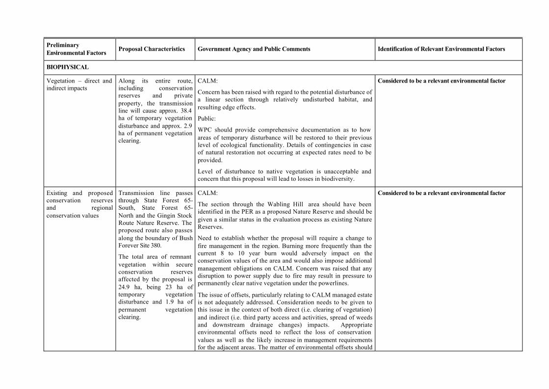
Vegetation – direct and indirect impacts
Along its entire route, including conservation reserves and private property, the transmission line will cause approx. 38.4 ha of temporary vegetation disturbance and approx. 2.9 ha of permanent vegetation clearing.
CALM:
Concern has been raised with regard to the potential disturbance of a linear section through relatively undisturbed habitat, and resulting edge effects.
Public:
WPC should provide comprehensive documentation as to how areas of temporary disturbance will be restored to their previous level of ecological functionality. Details of contingencies in case of natural restoration not occurring at expected rates need to be provided.
Level of disturbance to native vegetation is unacceptable and concern that this proposal will lead to losses in biodiversity.
Considered to be a relevant environmental factor
Existing and proposed conservation reserves and regional conservation values
Transmission line passes through State Forest 65-South, State Forest 65-North and the Gingin Stock Route Nature Reserve. The proposed route also passes along the boundary of Bush Forever Site 380.
The total area of remnant vegetation within secure conservation reserves affected by the proposal is 24.9 ha, being 23 ha of temporary vegetation disturbance and 1.9 ha of permanent vegetation clearing.
CALM:
The section through the Wabling Hill area should have been identified in the PER as a proposed Nature Reserve and should be given a similar status in the evaluation process as existing Nature Reserves.
Need to establish whether the proposal will require a change to fire management in the region. Burning more frequently than the current 8 to 10 year burn would adversely impact on the conservation values of the area and would also impose additional management obligations on CALM. Concern was raised that any disruption to power supply due to fire may result in pressure to permanently clear native vegetation under the powerlines.
The issue of offsets, particularly relating to CALM managed estate is not adequately addressed. Consideration needs to be given to this issue in the context of both direct (i.e. clearing of vegetation) and indirect (i.e. third party access and activities, spread of weeds and downstream drainage changes) impacts. Appropriate environmental offsets need to reflect the loss of conservation values as well as the likely increase in management requirements for the adjacent areas. The matter of environmental offsets should
Considered to be a relevant environmental factor
Preliminary Environmental Factors
Proposal Characteristics Government Agency and Public Comments Identification of Relevant Environmental Factors
be resolved before project approval.
Public:
Potential impact on the Gingin Stock Route Nature Reserve, an important wildlife corridor and area of significant amenity and heritage value. The route is proposed to run adjacent to and within this reserve, with some clearing of vegetation being proposed.
Weeds and disease, including Dieback (Phytophthora cinnamomi) and other pathogens from soil movement
Transport of weeds and disease along the transmission line corridor.
A single infestation of Phytophthora cinnamomi was found on the proposed route at the Moore River Crossing, the other areas along the route were found to be either uninfested or uninterpretable.
Transport of soil and soil borne disease along the transmission line corridor, with potential for impact on crops.
CALM:
In preparing a dieback management plan it is important that emphasis be placed on line maintenance as well as construction. This may include strategies such as restricted access gates and permanent clean down points.
The potential for weeds to invade areas of native vegetation is an ongoing issue for linear infrastructure that requires the same level of emphasis during maintenance as during construction. Commitment 5 needs to include a clear commitment for the maintenance phase. The EMP needs to deal not only with keeping weeds out of areas of native vegetation but also with what control mechanisms are in place if weeds become a problem.
Public:
Exposure of areas to vehicles from a wide area may spread dieback.
The timing of a dieback “zero-tolerance” policy must extend from the presently stated “pre-Construction” phase through to the “Construction” and “Post-Construction” and “On going maintenance” phases. The EMP should detail contingencies should any spread of dieback be observed in the proposal area.
Has spread of other pathogens been considered in the development of the line route?
WPC has committed to development of a Phytophthora Hygiene Management Plan that addresses post-construction activities, maintenance and management of access to the line route (Commitment 7).
WPC has committed to development of a Weed Management Plan that addresses post-construction audits, hygiene techniques to control weed spread and requirements relating to eradication of introduced weeds.
The proponent is committed to a no soil movement operation during construction and maintenance as well as a clean on entry policy for agricultural land.
As access to the towers will be through cut in spurs from existing access tracks, no corridor will be created along the length of the line. This will decrease the likelihood of weed invasion.
Both construction and maintenance phases of the proposal will be detailed in both the Weed Management Plan (Commitment 5) and the Phytophthora Hygiene Management Plan (Commitment 7). Monitoring and management of weeds and Phytophthora will be required to be detailed in the Management Plans.
Both of these management plans will be developed in consultation with CALM.
Factor does not require further EPA evaluation
Preliminary Environmental Factors
Proposal Characteristics Government Agency and Public Comments Identification of Relevant Environmental Factors
Declared Rare Flora, Priority Flora and other significant flora
CALM database indicated 3 areas of Priority flora within 400 m of the proposed line route. The centerline of the proposal passes through a population of Declared Rare Flora and a threatened plant community was identified as occurring within 400 m of the line
Public:
There is concern that the population of DRF within the line corridor will be impacted, particularly in light of other cases where land clearing occurred over the width of a powerline corridor. Whilst WPC states that the population will be protected, accidents could result in the loss of this population. Guarantees and contingency measures should be in place in case this population is impacted during construction or maintenance.
A number of vegetation communities are listed as being nationally threatened on the Swan Coastal Plain. It is not clear from the PER whether all threatened communities have been adequately addressed. An up-to-date assessment of all threatened communities and their occurrence in the vicinity of the proposal should be undertaken.
CALM:
Floristic community 26a is a currently listed (informal) Threatened Ecological Community (TEC) on CALM’s database, however, there are no records of it occurring in this location in State Forest 65 North (SF65N). Further information on the extent and location of this community would be beneficial.
Concern was raised with regard to the management of the population of Declared Rare Flora intersected by the line and while proposed management appears to address the issues sufficiently, design and construction techniques will need to be discussed with CALM.
Due to the proposed construction methods, the population of DRF will be spanned by the line (i.e. the line will pass above the population without any need to clear vegetation) and therefore will not be directly impacted. WPC have committed that the protection of Declared Rare and Priority species will be addressed in the Vegetation Management Plan (Commitment 3), to ensure that the construction activities will not impact this population.
WPC propose not to pass through the TEC on the Western edge of SF65N due to the requirement for a greater level of clearing, as there are fewer access tracks in that section of SF65N and the visual impact is likely to be higher. The full size of the TEC has not been determined, as the ‘final’ proposed route does not pass through this community.
WPC will consult with CALM when developing its Environmental Management Plan, particularly with regard to impact on DRF and TECs.
Factor does not require further EPA evaluation
Preliminary Environmental Factors
Proposal Characteristics Government Agency and Public Comments Identification of Relevant Environmental Factors
Terrestrial fauna, particularly Specially Protected (threatened) fauna
Potential for impact on species of national conservation significance including: 2 reptile species, 3 wetland bird species, 7 dryland bird species and 6 mammal species.
Public:
Concern was raised with regard to the impact of this proposal on the endangered Short-billed Black-Cockatoo. The removal of habitat is one of the critical factors for this species. Will the proposal impact on mature trees with hollows, known to be nesting sites? This should be addressed by establishing appropriate procedure in the EMP.
Will birds be likely to hit the wires? Are there any known impacts of EMF on birds and their behavioural patterns, particularly as they often sit or roost on lines?
WPC have advised that the proposed alignment will not impact on nesting sites of the endangered Short-Billed Black-Cockatoo as the line will not pass near any large trees with hollows that are known to be important habitat trees for this species.
The EMP will incorporate a monitoring program to address the issue of birds striking power lines (Commitment 9), incorporating management measures, such as bird diverters, in areas where strikes occur.
There is no known EMF effect on birds and their behavioural patterns nor on wildlife such as brush-tailed wallabies and other fauna.
Factor does not require further EPA evaluation
Wetlands The route will traverse a Conservation Category Wetland.
The route does not traverse any Environmental Protection Policy lakes.
Route passes through an area of unassessed wetlands at the northern end of the route.
WRC:
The information in the PER regarding the consideration of un assessed wetlands at the north of the route needs further clarification. The present extent of wetland evaluations on the Swan Coastal Plain only goes approximately as far north as the Moore River. Any potential impact of the proposed transmission line north of the Moore River should consider issues related to unassessed wetlands.
Public:
The removal of vegetation could adversely impact on the rising water table and salinity problem.
The Conservation Category Wetland would be able to be spanned, without impacting on the vegetation buffer around the lake and existing tracks can be used for access.
While an area of unassessed wetlands to the north of the route will be crossed, WPC have considered the wetlands as if they were Conservation Category Wetlands and have aligned the route to span both the wetlands and a 50 m vegetation buffer around them.
Of the 60km of vegetation traversed along the 123 km of the line length, approximately 2.9 ha will be permanently cleared. The removal of this quantity of vegetation along the length of the line route is not expected to adversely impact on the rising water table and salinity problem.
Factor does not require further EPA evaluation
Preliminary Environmental Factors
Proposal Characteristics Government Agency and Public Comments Identification of Relevant Environmental Factors
Watercourses The route will cross the Moore River.
WRC:
The crossing of the Moore River as proposed in the PER is not supported by the WRC.
Public:
Concern has been raised as to the high visual impact of the transmission line at the Moore River crossing.
The landscape study (John Cleary Planning 2001) notes that the Moore River Valley is a “key location” and an important transit corridor, and recommends an alternative route to that proposed for the transmission line.
The justification of small land holdings making adoption of the recommended modifications “problematic” has no technical basis and is without merit. The scale or nature of the problems associated with adopting the route as recommended in the Landscape Study should be addressed.
Considered to be a relevant environmental factor
Land degradation Potential for clearing associated with proposal to result in land degradation.
Pubic:
Concern over the potential for erosion around the towers, and that animals attracted to the structures may exacerbate the erosion.
Management includes low vegetation being retained where possible in drainage lines, no material to be pushed into drainage channels and drainage patterns not impacted.
While the likely level of impact from animals that may be attracted to the towers is minimal, WPC has advised that it will arrange for restoration activities if erosion does occur around towers. This matter can be addressed in the Environmental Management Program (Commitment 1)
Factor does not require further EPA evaluation
Preliminary Environmental Factors
Proposal Characteristics Government Agency and Public Comments Identification of Relevant Environmental Factors
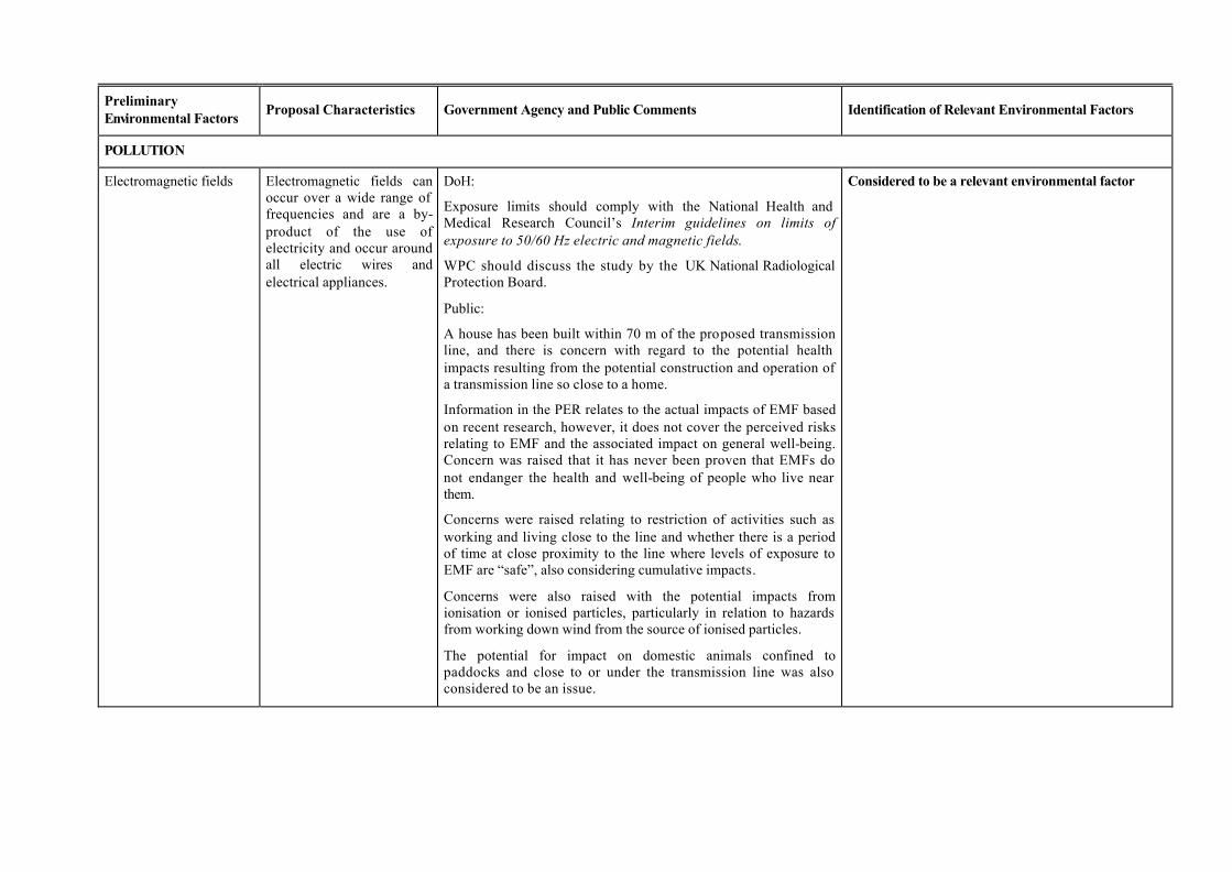
POLLUTION
Electromagnetic fields Electromagnetic fields can occur over a wide range of frequencies and are a by-product of the use of electricity and occur around all electric wires and electrical appliances.
DoH:
Exposure limits should comply with the National Health and Medical Research Council’s Interim guidelines on limits of exposure to 50/60 Hz electric and magnetic fields.
WPC should discuss the study by the UK National Radiological Protection Board.
Public:
A house has been built within 70 m of the proposed transmission line, and there is concern with regard to the potential health impacts resulting from the potential construction and operation of a transmission line so close to a home.
Information in the PER relates to the actual impacts of EMF based on recent research, however, it does not cover the perceived risks relating to EMF and the associated impact on general well-being. Concern was raised that it has never been proven that EMFs do not endanger the health and well-being of people who live near them.
Concerns were raised relating to restriction of activities such as working and living close to the line and whether there is a period of time at close proximity to the line where levels of exposure to EMF are “safe”, also considering cumulative impacts.
Concerns were also raised with the potential impacts from ionisation or ionised particles, particularly in relation to hazards from working down wind from the source of ionised particles.
The potential for impact on domestic animals confined to paddocks and close to or under the transmission line was also considered to be an issue.
Considered to be a relevant environmental factor
Preliminary Environmental Factors
Proposal Characteristics Government Agency and Public Comments Identification of Relevant Environmental Factors
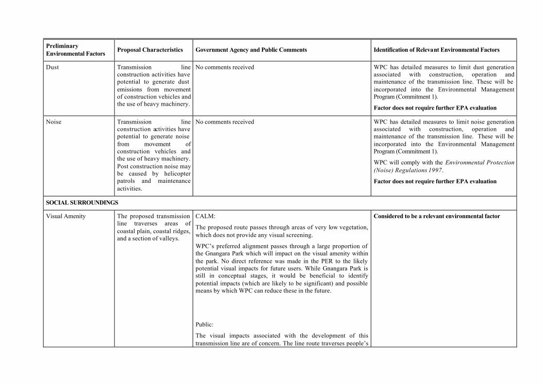
Dust Transmission line construction activities have potential to generate dust emissions from movement of construction vehicles and the use of heavy machinery.
No comments received WPC has detailed measures to limit dust generation associated with construction, operation and maintenance of the transmission line. These will be incorporated into the Environmental Management Program (Commitment 1).
Factor does not require further EPA evaluation
Noise Transmission line construction activities have potential to generate noise from movement of construction vehicles and the use of heavy machinery. Post construction noise may be caused by helicopter patrols and maintenance activities.
No comments received WPC has detailed measures to limit noise generation associated with construction, operation and maintenance of the transmission line. These will be incorporated into the Environmental Management Program (Commitment 1).
WPC will comply with the Environmental Protection (Noise) Regulations 1997.
Factor does not require further EPA evaluation
SOCIAL SURROUNDINGS
Visual Amenity The proposed transmission line traverses areas of coastal plain, coastal ridges, and a section of valleys.
CALM:
The proposed route passes through areas of very low vegetation, which does not provide any visual screening.
WPC’s preferred alignment passes through a large proportion of the Gnangara Park which will impact on the visual amenity within the park. No direct reference was made in the PER to the likely potential visual impacts for future users. While Gnangara Park is still in conceptual stages, it would be beneficial to identify potential impacts (which are likely to be significant) and possible means by which WPC can reduce these in the future.
Public:
The visual impacts associated with the development of this transmission line are of concern. The line route traverses people’s
Considered to be a relevant environmental factor
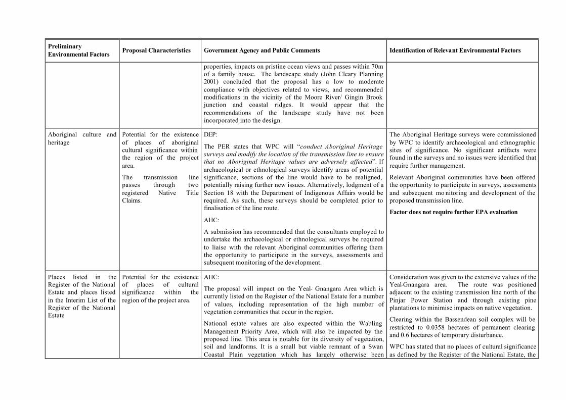
Preliminary Environmental Factors
Proposal Characteristics Government Agency and Public Comments Identification of Relevant Environmental Factors
properties, impacts on pristine ocean views and passes within 70m of a family house. The landscape study (John Cleary Planning 2001) concluded that the proposal has a low to moderate compliance with objectives related to views, and recommended modifications in the vicinity of the Moore River/ Gingin Brook junction and coastal ridges. It would appear that the recommendations of the landscape study have not been incorporated into the design.
Aboriginal culture and heritage
Potential for the existence of places of aboriginal cultural significance within the region of the project area.
The transmission line passes through two registered Native Title Claims.
DEP:
The PER states that WPC will “conduct Aboriginal Heritage surveys and modify the location of the transmission line to ensure that no Aboriginal Heritage values are adversely affected”. If archaeological or ethnological surveys identify areas of potential significance, sections of the line would have to be realigned, potentially raising further new issues. Alternatively, lodgment of a Section 18 with the Department of Indigenous Affairs would be required. As such, these surveys should be completed prior to finalisation of the line route.
AHC:
A submission has recommended that the consultants employed to undertake the archaeological or ethnological surveys be required to liaise with the relevant Aboriginal communities offering them the opportunity to participate in the surveys, assessments and subsequent monitoring of the development.
The Aboriginal Heritage surveys were commissioned by WPC to identify archaeological and ethnographic sites of significance. No significant artifacts were found in the surveys and no issues were identified that require further management.
Relevant Aboriginal communities have been offered the opportunity to participate in surveys, assessments and subsequent mo nitoring and development of the proposed transmission line.
Factor does not require further EPA evaluation
Places listed in the Register of the National Estate and places listed in the Interim List of the Register of the National Estate
Potential for the existence of places of cultural significance within the region of the project area.
AHC:
The proposal will impact on the Yeal- Gnangara Area which is currently listed on the Register of the National Estate for a number of values, including representation of the high number of vegetation communities that occur in the region.
National estate values are also expected within the Wabling Management Priority Area, which will also be impacted by the proposed line. This area is notable for its diversity of vegetation, soil and landforms. It is a small but viable remnant of a Swan Coastal Plain vegetation which has largely otherwise been
Consideration was given to the extensive values of the Yeal-Gnangara area. The route was positioned adjacent to the existing transmission line north of the Pinjar Power Station and through existing pine plantations to minimise impacts on native vegetation.
Clearing within the Bassendean soil complex will be restricted to 0.0358 hectares of permanent clearing and 0.6 hectares of temporary disturbance.
WPC has stated that no places of cultural significance as defined by the Register of the National Estate, the
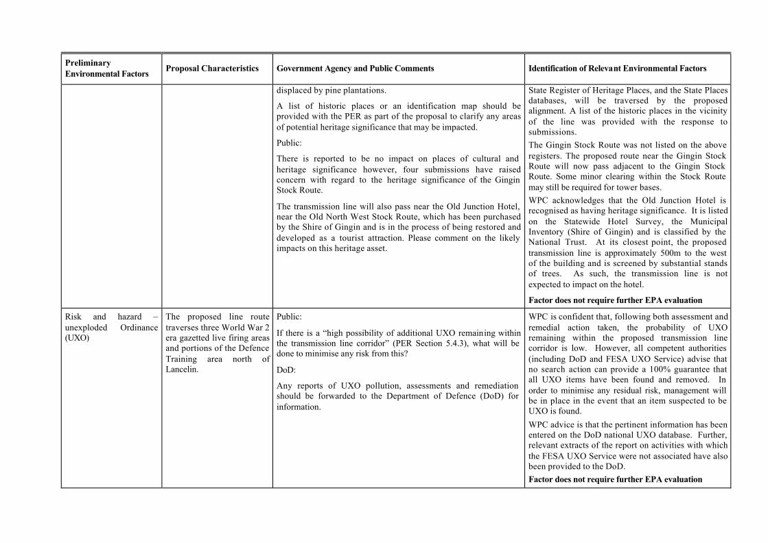
Preliminary Environmental Factors
Proposal Characteristics Government Agency and Public Comments Identification of Relevant Environmental Factors
displaced by pine plantations.
A list of historic places or an identification map should be provided with the PER as part of the proposal to clarify any areas of potential heritage significance that may be impacted.
Public:
There is reported to be no impact on places of cultural and heritage significance however, four submissions have raised concern with regard to the heritage significance of the Gingin Stock Route.
The transmission line will also pass near the Old Junction Hotel, near the Old North West Stock Route, which has been purchased by the Shire of Gingin and is in the process of being restored and developed as a tourist attraction. Please comment on the likely impacts on this heritage asset.
State Register of Heritage Places, and the State Places databases, will be traversed by the proposed alignment. A list of the historic places in the vicinity of the line was provided with the response to submissions. The Gingin Stock Route was not listed on the above registers. The proposed route near the Gingin Stock Route will now pass adjacent to the Gingin Stock Route. Some minor clearing within the Stock Route may still be required for tower bases. WPC acknowledges that the Old Junction Hotel is recognised as having heritage significance. It is listed on the Statewide Hotel Survey, the Municipal Inventory (Shire of Gingin) and is classified by the National Trust. At its closest point, the proposed transmission line is approximately 500m to the west of the building and is screened by substantial stands of trees. As such, the transmission line is not expected to impact on the hotel.
Factor does not require further EPA evaluation
Risk and hazard – unexploded Ordinance (UXO)
The proposed line route traverses three World War 2 era gazetted live firing areas and portions of the Defence Training area north of Lancelin.
Public:
If there is a “high possibility of additional UXO remaining within the transmission line corridor” (PER Section 5.4.3), what will be done to minimise any risk from this?
DoD:
Any reports of UXO pollution, assessments and remediation should be forwarded to the Department of Defence (DoD) for information.
WPC is confident that, following both assessment and remedial action taken, the probability of UXO remaining within the proposed transmission line corridor is low. However, all competent authorities (including DoD and FESA UXO Service) advise that no search action can provide a 100% guarantee that all UXO items have been found and removed. In order to minimise any residual risk, management will be in place in the event that an item suspected to be UXO is found.
WPC advice is that the pertinent information has been entered on the DoD national UXO database. Further, relevant extracts of the report on activities with which the FESA UXO Service were not associated have also been provided to the DoD. Factor does not require further EPA evaluation

Preliminary Environmental Factors
Proposal Characteristics Government Agency and Public Comments Identification of Relevant Environmental Factors
Effect on private land The proposed line route traverses 18 private properties.
Public:
Concern was raised with regard to the social impacts of the proposal, particularly the potential for loss of property value and loss of subdivision potential.
Compensation related to land matters is determined in accordance with the provisions of the Land Administration Act 1997. A valuer determines which items are applicable in the circumstances and calculates the level of compensation that should be applied. The valuation principles that are adopted for easement compensation are not created by WPC, nor does WPC influence these principles.
Factor does not require further EPA evaluation
Abbreviations: AHC: Australian Heritage Commission CALM: Department of Conservation and Land Management DEP: Department of Environmental Protection DoD: Department of Defence DoH: Department of Health DRF: Declared Rare Flora EMF: Electromagnetic field
EMP: Environmental Management Program FESA: Fire and Emergency Services Authority PER: Public Environmental Review TEC: Threatened Ecological Community WPC: Western Power Corporation WRC: Water and Rivers Commission UXO: Unexploded ordinance

Appendix 4
Recommended Environmental Conditions and
Proponent’s Consolidated Commitments
RECOMMENDED CONDITIONS AND PROCEDURES
STATEMENT THAT A PROPOSAL MAY BE IMPLEMENTED (PURSUANT TO THE PROVISIONS OF THE
ENVIRONMENTAL PROTECTION ACT 1986)
TRANSMISSION LINE
FROM PINJAR GAS TURBINE STATION TO CATABY SUBSTATION
Proposal: The construction and operation of a transmission line, with a maximum capacity of 330 kilovolts and approximately 123 kilometres in length from the Pinjar gas turbine generating station to the Cataby substation, as documented in schedule 1 of this statement.
Proponent: Western Power Corporation
Proponent Address: GPO Box L921, PERTH WA 6842
Assessment Number: 1356
Report of the Environmental Protection Authority: Bulletin 1046
The proposal referred to above may be implemented subject to the following conditions and procedures:
Procedural conditions
1 Implementation and Changes
1-1 The proponent shall implement the proposal as documented in schedule 1 of this statement subject to the conditions of this statement.
1-2 Where the proponent seeks to change any aspect of the proposal as documented in schedule 1 of this statement in any way that the Minister for the Environment and Heritage determines, on advice of the Environmental Protection Authority, is substantial, the proponent shall refer the matter to the Environmental Protection Authority.
1-3 Where the proponent seeks to change any aspect of the proposal as documented in schedule 1 of this statement in any way that the Minister for the Environment and Heritage determines, on advice of the Environmental Protection Authority, is not substantial, the proponent may implement those changes upon receipt of written advice.
2 Proponent Commitments
2-1 The proponent shall implement the environmental management commitments documented in schedule 2 of this statement.
2-2 The proponent shall implement subsequent environmental management commitments which the proponent makes as part of the fulfilment of the conditions in this statement.
3 Proponent Nomination and Contact Details
3-1 The proponent for the time being nominated by the Minister for the Environment and Heritage under section 38(6) or (7) of the Environmental Protection Act 1986 is responsible for the implementation of the proposal until such time as the Minister for the Environment and Heritage has exercised the Minister’s power under section 38(7) of the Act to revoke the nomination of that proponent and nominate another person as the proponent for the proposal.
3-2 If the proponent wishes to relinquish the nomination, the proponent shall apply for the transfer of proponent and provide a letter with a copy of this statement endorsed by the proposed replacement proponent that the proposal will be carried out in accordance with this statement. Contact details and appropriate documentation on the capability of the proposed replacement proponent to carry out the proposal shall also be provided.
3-3 The nominated proponent shall notify the Department of Environmental Protection of any change of contact name and address within 60 days of such change.
4 Commencement and Time Limit of Approval
4-1 The proponent shall provide evidence to the Minister for the Environment and Heritage within five years of the date of this statement that the proposal has been substantially commenced or the approval granted in this statement shall lapse and be void.
Note: The Minister for the Environment and Heritage will determine any dispute as to whether the proposal has been substantially commenced.
4-2 The proponent shall make application for any extension of approval for the substantial commencement of the proposal beyond five years from the date of this statement to the Minister for the Environment and Heritage, prior to the expiration of the five year period referred to in condition 4-1.
The application shall demonstrate that:
• environmental factors of the proposal have not changed significantly;
• new, significant, environmental issues have not arisen; and
• all relevant government authorities have been consulted.
Note: The Minister for the Environment and Heritage may consider the grant of an extension of the time limit of approval not exceeding five years for the substantial commencement of the proposal.

Environmental conditions
5 Compliance Audit
5-1 The proponent shall prepare an audit program in consultation with and submit compliance reports to the Department of Environmental Protection which address:
• the implementation of the proposal as defined in schedule 1 of this statement;
• evidence of compliance with the conditions and commitments; and
• the performance of the environmental management plans and programs.
Note: Under sections 48(1) and 47(2) of the Environmental Protection Act 1986, the Chief Executive Officer of the Department of Environmental Protection is empowered to audit the compliance of the proponent with the statement and should directly receive the compliance documentation, including environmental management plans, related to the conditions, procedures and commitments contained in this statement. Usually, the Department of Environmental Protection prepares an audit table which can be utilised by the proponent, if required, to prepare an audit program to ensure that the proposal is implemented as required. The Chief Executive Officer is responsible for the preparation of written advice to the proponent, which is signed off either by the Minister or, under an endorsed condition clearance process, a delegate within the Environmental Protection Authority or the Department of Environmental Protection that the requirements have been met.
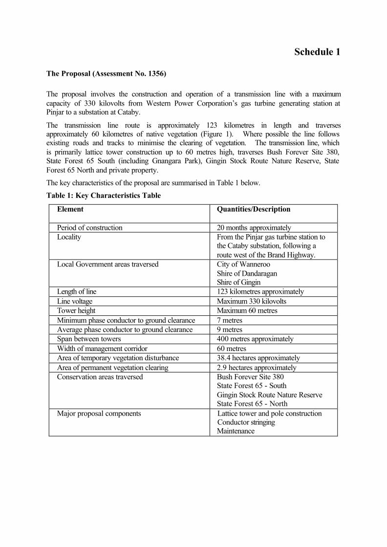
Schedule 1
The Proposal (Assessment No. 1356)
The proposal involves the construction and operation of a transmission line with a maximum capacity of 330 kilovolts from Western Power Corporation’s gas turbine generating station at Pinjar to a substation at Cataby.
The transmission line route is approximately 123 kilometres in length and traverses approximately 60 kilometres of native vegetation (Figure 1). Where possible the line follows existing roads and tracks to minimise the clearing of vegetation. The transmission line, which is primarily lattice tower construction up to 60 metres high, traverses Bush Forever Site 380, State Forest 65 South (including Gnangara Park), Gingin Stock Route Nature Reserve, State Forest 65 North and private property.
The key characteristics of the proposal are summarised in Table 1 below.
Table 1: Key Characteristics Table
Element
Quantities/Description
Period of construction 20 months approximately Locality From the Pinjar gas turbine station to
the Cataby substation, following a route west of the Brand Highway.
Local Government areas traversed City of Wanneroo Shire of Dandaragan Shire of Gingin
Length of line 123 kilometres approximately Line voltage Maximum 330 kilovolts Tower height Maximum 60 metres Minimum phase conductor to ground clearance 7 metres Average phase conductor to ground clearance 9 metres Span between towers 400 metres approximately Width of management corridor 60 metres Area of temporary vegetation disturbance 38.4 hectares approximately Area of permanent vegetation clearing 2.9 hectares approximately Conservation areas traversed Bush Forever Site 380
State Forest 65 - South Gingin Stock Route Nature Reserve State Forest 65 - North
Major proposal components
Lattice tower and pole construction Conductor stringing Maintenance
Schedule 2
Environmental Management Commitments
February 2002
TRANSMISSION LINE FROM PINJAR GAS TURBINE STATION TO CATABY SUBSTATION
(Assessment No. 1356)
Western Power Corporation
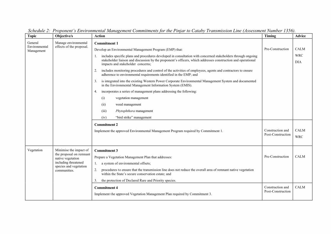
Schedule 2: Proponent’s Environmental Management Commitments for the Pinjar to Cataby Transmission Line (Assessment Number 1356). Topic Objective/s Action Timing Advice
General Environmental Management
Manage environmental effects of the proposal.
Commitment 1
Develop an Environmental Management Program (EMP) that:
1. includes specific plans and procedures developed in consultation with concerned stakeholders through ongoing stakeholder liaison and discussion by the proponent’s officers, which addresses construction and operational impacts and stakeholder concerns;
2. includes monitoring procedures and control of the activities of employees, agents and contractors to ensure adherence to environmental requirements identified in the EMP; and
3. is integrated into the existing Western Power Corporate Environmental Management System and documented in the Environmental Management Information System (EMIS).
4. incorporates a series of management plans addressing the following:
(i) vegetation management
(ii) weed management
(iii) Phytophthora management
(iv) “bird strike” management
Pre-Construction
CALM
WRC
DIA
Commitment 2 Implement the approved Environmental Management Program required by Commitment 1.
Construction and Post-Construction
CALM
WRC
Vegetation Minimise the impact of the proposal on remnant native vegetation including threatened species and vegetation communities.
Commitment 3 Prepare a Vegetation Management Plan that addresses:
1. a system of environmental offsets;
2. procedures to ensure that the transmission line does not reduce the overall area of remnant native vegetation within the State’s secure conservation estate; and
3. the protection of Declared Rare and Priority species.
Pre-Construction
CALM
Commitment 4 Implement the approved Vegetation Management Plan required by Commitment 3.
Construction and Post-Construction
CALM
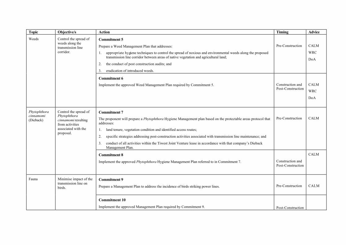
Topic Objective/s Action Timing Advice
Weeds Control the spread of weeds along the transmission line corridor.
Commitment 5
Prepare a Weed Management Plan that addresses:
1. appropriate hygiene techniques to control the spread of noxious and environmental weeds along the proposed transmission line corridor between areas of native vegetation and agricultural land;
2. the conduct of post construction audits; and
3. eradication of introduced weeds.
Pre-Construction
CALM
WRC
DoA
Commitment 6
Implement the approved Weed Management Plan required by Commitment 5.
Construction and Post-Construction
CALM
WRC
DoA
Phytophthora cinnamomi (Dieback)
Control the spread of Phytophthora cinnamomi resulting from activities associated with the proposal.
Commitment 7 The proponent will prepare a Phytophthora Hygiene Management plan based on the protectable areas protocol that addresses:
1. land tenure, vegetation condition and identified access routes;
2. specific strategies addressing post-construction activities associated with transmission line maintenance; and
3. conduct of all activities within the Tiwest Joint Venture lease in accordance with that company’s Dieback Management Plan.
Pre-Construction
CALM
Commitment 8
Implement the approved Phytophthora Hygiene Management Plan referred to in Commitment 7.
Construction and Post-Construction
CALM
Fauna Minimise impact of the transmission line on birds.
Commitment 9
Prepare a Management Plan to address the incidence of birds striking power lines.
Pre-Construction
CALM
Commitment 10 Implement the approved Management Plan required by Commitment 9.
Post-Construction
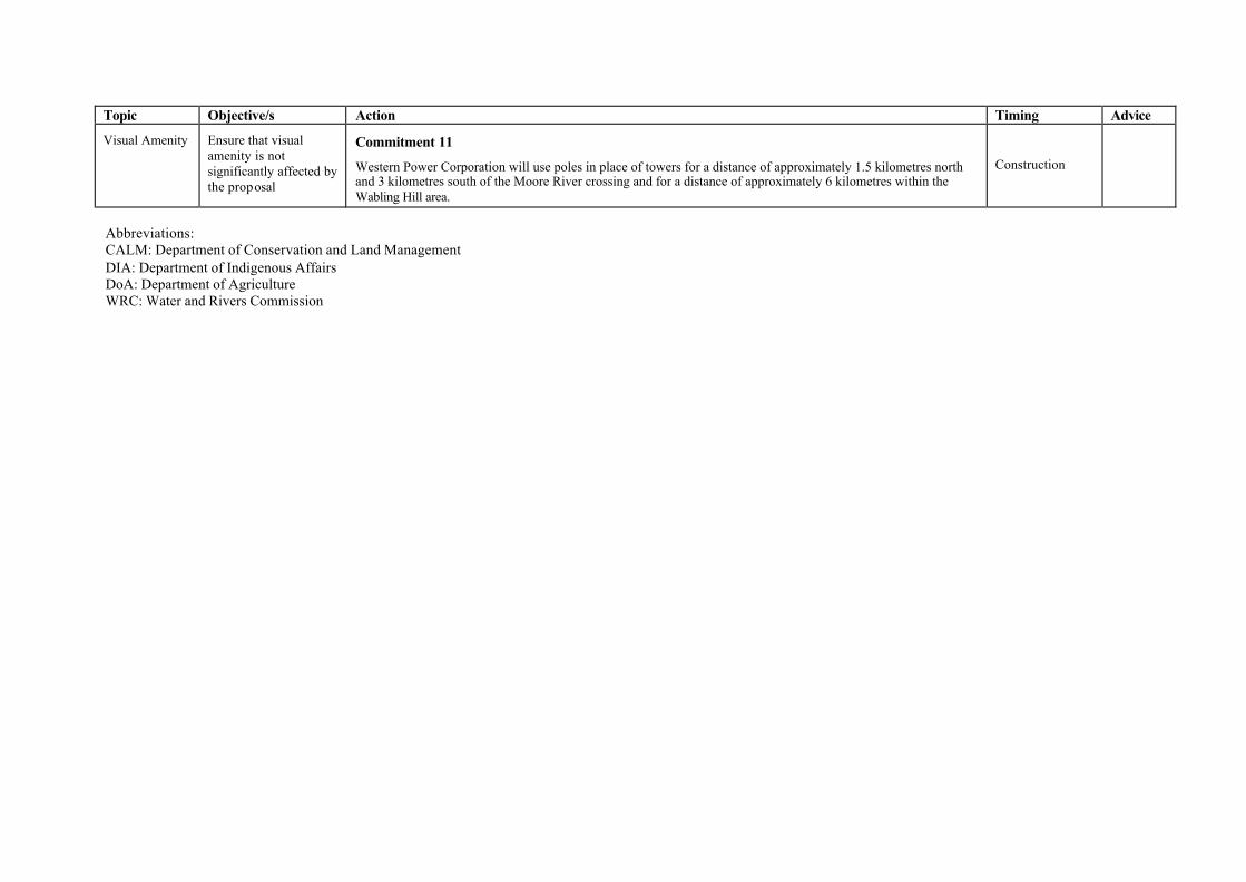
Topic Objective/s Action Timing Advice
Visual Amenity Ensure that visual amenity is not significantly affected by the proposal
Commitment 11
Western Power Corporation will use poles in place of towers for a distance of approximately 1.5 kilometres north and 3 kilometres south of the Moore River crossing and for a distance of approximately 6 kilometres within the Wabling Hill area.
Construction
Abbreviations: CALM: Department of Conservation and Land Management DIA: Department of Indigenous Affairs DoA: Department of Agriculture WRC: Water and Rivers Commission

Appendix 5
Summary of submissions and proponent’s response to submissions
WESTERN POWER Pinjar to Cataby Transmission Line Public Environmental Review Submission Responses
11/04/02 Table of Contents
Proponent’s response to Summary of Submissions
TABLE OF CONTENTS
2 GENERAL SUBMISSIONS...........................................................................................1
2.1 Submissions regarding the need for the proposal ..................................................... 1
2.2 Submissions regarding the level of consultation undertaken................................... 4
2.3 Submissions regarding the PER document (including discrepancies).................... 6
2.4 General Submissions on the Proposal ...................................................................... 13
2.5 Submissions raising planning issues ......................................................................... 17
2.6 Submissions raising issues regarding the alternative line options (Common Corridor and Eastern Option) .............................................................................................. 18
2.7 Submissions proposing alternatives.......................................................................... 22
2.8 Submissions relating to alternatives for the Moore River Crossing ...................... 28
2.9 Submissions regarding management (construction and operation) ...................... 30
3.0 SUBMISSIONS ON ENVIRONMENTAL FACTORS................................................34
3.1 Biophysical factors ..................................................................................................... 34 3.1.1 Terrestrial flora .................................................................................................. 34 3.1.2 Terrestrial fauna ................................................................................................ 38 3.1.3 Wetlands .............................................................................................................. 39 3.1.4 Weeds and Diseases, including Phytophthora Cinnamomi ............................ 40 3.1.5 Land ..................................................................................................................... 42 3.1.6 Impacts on reserved land, including CALM managed land .......................... 43
3.2 Pollution Management ............................................................................................... 46 3.2.1 Electro-magnetic fields (EMF) .......................................................................... 46
3.3 Social Surroundings ................................................................................................... 53 3.3.1 Visual Amenity ................................................................................................... 53 3.3.2 Aboriginal Heritage............................................................................................ 55 3.3.3 European Heritage ............................................................................................. 56 3.3.4 Risk – Unexploded Ordinances (UXOs)........................................................... 59 3.3.5 Economic Issues.................................................................................................. 61 3.3.6 Other Issues ........................................................................................................ 62
WESTERN POWER Pinjar to Cataby Transmission Line Public Environmental Review Submission Responses
20/11/01 1
2 General Submissions
2.1 Submissions regarding the need for the proposal 2.1.1 ‘The need for the transmission line has been questioned. Five submissions have raised that
power generation should occur where power is required, rather than transporting gas via the Northern regions to Pinjar to generate electricity to send back to the Northern Regions. Development of power where required would encourage regional employment and diversification and eliminate the need for large transmission lines. Long distance transmission from centralised fossil fuel power stations is not part of a sustainable future for the Gingin coast region. WPC’s distribution requirements do not necessarily correspond to long-term community needs and are inconsistent with Australia’s responsibility to reduce its greenhouse emissions. Submissions content that it is time to change the way of thinking and generate the power where it is needed. Please comment on these issues.’
Western Power draws its power supply from a pool of generators in the South West Interconnected System (SWIS). These generators use a variety of fuels, including gas. At any given time, power is drawn from a number of these generators to make use of the most economic fuel mix, according to load. The SWIS is not based on having local load supplied by local generation. If this were the case, the local generator would have to be larger than normally required. The alternative would be to have an isolated generator supplying local load only. However the size of the generator would need to match the maximum possible load in that area and would be much larger than necessary for most of the time. This would be both uneconomic and wasteful of fossil fuels. The Mid-West Transmission system, is part of the SWIS, and currently comprises of two transmission lines, linking Pinjar and Muchea to Geraldton. These lines are too limited to accommodate either additional generators or the supply required by customers throughout the Mid-West after 2003. Increasing the supply through the existing Mid-West transmission system would be akin to pushing a volume of water through too small a pipe, and would result in thermal overload and voltage instability. Thermal overload causes conductors (overhead wires) to overheat and sag excessively. Voltage instability results in low volts which can burn out electric motors and damage appliances and sensitive equipment, such as computers. While it may appear that overcoming line capacity problems could be done by adding local generation, this is not possible without causing instability between local generators and other generators in the SWIS. Stability relates to ensuring all power generators on the interconnected transmission system (of which the Perth-Geraldton lines are part) are synchronised; and have the capacity to transfer the additional power. The strength of the connection between these generators influences whether they continue to be synchronised. The existing transmission line to the MidWest and Central West is weak – it is long and operating at its capacity. Even if local generation were installed, the line must be upgraded. Western Power wants to build the new transmission line to raise the capacity of the system, to strengthen the system so that there is less risk of blackouts in these regions; and to cater for future growth in demand. Any loss of synchronisation between power generators will cause instability especially on the weakest link (Perth-Geraldton). This can affect the entire interconnected transmission system, not just the MidWest and Central West regions. The bigger the capacity of the transmission line, the less risk of the generators becoming unsynchronised and unstable.
WESTERN POWER Pinjar to Cataby Transmission Line Public Environmental Review Submission Responses
20/11/01 2
Capacity problems can be overcome by building additional transmission lines at either 132,000 volts (132kV) or 33,000 volts (33kV). This would overcome thermal and voltage limits and enable additional gas turbine generators to be connected, and to become part of the generator pool, without causing generator instability. Other options, such as upgrading existing transmission lines and adding specialised equipment such as capacitor banks and static var compensators could overcome thermal capacity and voltage instability limits, but not generator stability limits. For further information please see PER section 2.1. Attachment 1 indicates the present loading on the Mid-West System, projected future growth, the existing capacity limits, taking into account existing lines and generation, and the capacity with new transmission lines.
2.1.2 ‘Section 2.1: Generation Expansion states, “The installation of the transmission line will
accommodate the generation expansion in the Region”. What generation expansion? Who is asking for more generation? Are there any new projects, such as industry, being planned? Or, is the powerline infrastructure going in first in case industry is developed? What economic developments are planned for the Great Northern Region? Also comment on the idea that industry should be generating its own power in its own location rather than developing large transmission lines across the State.’
From time to time WPC is approached by private companies wishing to connect generators or large loads to the SWIS. Under the Government’s Open Access policy WPC is obliged to provide access to the network for large independent generators. However WPC is not aware of any firm proposals by independent power producers to connect generators to the SWIS in the Great Northern Region. Normally large industries do generate their own power locally, and any excess capacity is made available to other SWIS customers. However, to allow this, the existing network needs to be upgraded. See also submission response 2.1.1. The statement in the PER simply means it will be possible to connect generators once the transmission line is built. 2.1.3 ‘Section 2.1 of the PER states “sites near existing gas pipeline compressor stations may be
favoured”. It would then be logical for a new transmission line to follow the Brand Hwy in the proximity of the existing gas pipeline so that additional generating sites can be readily connected. Please comment on how this alternative has been considered.’
The Common Corridor Option, which follows the Brand Highway was one of many considered by Western Power. However, the advantage of proximity to gas supplies was outweighed by disadvantages, in particular issues with low flying aircraft, mineralised areas and conservation wetlands. (See PER 3.5.3.1) It is most likely that additional gas turbines would be located at points where proposed lines are in close proximity to the gas pipeline.
2.1.4 ‘Is the Western Option preferred because the true purpose of the line is to service a heavy industry development at Breton Bay? The Breton Bay proposal has already been rejected and shown to be unacceptable to the majority of local citizens. However, the proposed route shows a “dogs leg” to the Breton Bay area and while WPC has previously advised that there is no hidden agenda relating to the proposed deep water port, there is a considerable amount of

WESTERN POWER Pinjar to Cataby Transmission Line Public Environmental Review Submission Responses
20/11/01 3
scepticism in the community. Please advise as to whether the Breton Bay proposal was considered in the positioning of the Western Option.’
The proposed line route was not influenced by the Breton Bay proposal. The ‘dog leg’ was incorporated to minimise the effect of the transmission line on both private land and the Conservation Estate by running along the margin between these two types of land tenure. (See PER 3.5.3)
2.1.5 ‘A submission has raised that the major weakness of the proposal is the almost complete lack of justification for the transmission line, particularly for one constructed as a double-circuit 330kV transmission line. It is noted that a transmission line of some description between Pinjar and Cataby has been included in the WPC transmission plan in recent years, and it was expected that for the proposed purposes a single or double circuit 132kV transmission line (which can carry 80-100 MW each circuit) would be suitable.
No justification has been provided for the jump from a simple 132kV line to a double circuit 330kV (which could carry 1000-1500MW). It is considered that the lack of justification for this jump in voltage and associated design implications is a major flaw in the proposal. The submitter considers that loads north of Perth are relatively small (compared with those generally supplied by 330kV lines) and can be amply catered for by a 132kV system – uprated if necessary and interconnected to improve reliability. Why does WPC consider that the 330kV line is required? Was it considered that as Government had allocated a set amount of money for country transmission works, to improve the security and reliability of supply, if only one line is to be built – make it a big one? Please provide comment on the justification for a 330 kV line, with particular reference to the additional environmental impacts that result from the increased transmission capacity.’
Western Power has yet to decide on the voltage level for the proposed transmission line. The PER refers to the construction of a 330kV, rather than a 132kV transmission line because its physical environmental impacts are greater. It is anticipated that if approval is given for a 330kV line, then a 132kV line would not constitute a significant change to the proposal under the Environmental Protection Act (1986). (See also PER 1.3 and Submission Response Figure 1). With a 132kV transmission line, the towers are 47 metres rather than 56m high, and span lengths are 550 metres as opposed to 450m, resulting in fewer towers overall. Clearing required at each tower site would be 40 x 40 metres instead of 45 x 45 metres.
2.1.6 ‘Submissions raised that the previous Government advised that $480 million would be spent on country transmission works to improve the security and reliability of supply. It is understood that the current Labour Government has put all of these power programs except the Pinjar to Cataby transmission line on hold, pending the establishment of an Electricity Task Force to examine and recommend on the implementation of the Government’s Energy Policy. The submissions raise that this higher level of control would bring WPC back under the kind of regulatory and financial discipline necessary to ensure that proposals such as this transmission line are well thought out, justified against alternatives, and are really needed. Please comment on the development of this proposal considering sustainable development issues and how the Government’s Energy Policy has been considered in the development of this proposal.’
The $480 million capital works program announced by the previous government related to a number of projects, and included $60 million for the proposed Pinjar-Cataby and Cataby-Eneabba transmission lines. None of these projects has been put on hold by the current State Government. Decisions as to which projects proceed are made by Western Power management. The Electricity
WESTERN POWER Pinjar to Cataby Transmission Line Public Environmental Review Submission Responses
20/11/01 4
Reform Task Force is addressing the design of the electricity market in WA and is not involved in decisions relating to operational matters or sustainable development. However, the construction of this transmission line supports sustainable development. It will enable the implementation of significant wind generation projects in the mid-west region which are currently not viable because of the limitations of the existing transmission system. The proposal is consistent with sustainable development principles which are outlined in Western Power’s Environmental Policy and which will be implemented through the Corporation’s Environmental Management System.
2.1.7 ‘Apart from WPC, the other major beneficiary of this transmission line appears to be TiWest Ltd who, it was raised, will be selling excess co-generated power from their plant as and when it suits them. Will details of this agreement be revealed? Will the line be treated as part of TiWest’s head works and be paid for by them, with compensation to the affected landowners? Will the developers of the proposed southern extension of the Lancelin townish and Breton Bay and other beneficiaries of the line be paying for this development or providing compensation to affected landowners who will have the risk to health from the line, the loss in amenity and loss of property value all for no benefit to them, and apparently with the primary benefit going to large industrial companies and WPC?’
Tiwest will not be a major beneficiary of the proposed transmission line. Tiwest’s current load is approximately 7 per cent of the North Country load and Western Power is unaware of any plans to increase this load. The company’s highest possible load, under optimum conditions, would be less than 14 per cent of the North Country load. Tiwest has no plans to co-generate at their Cataby site as they have existing co-generation at their Kwinana site. The purpose of the transmission line is to maintain quality and reliability of supply to all regional customers - domestic, commercial and industrial. There is no particular benefit to any single customer or group of customers. As such Western Power will not be asking some customers to contribute directly to the capital cost of the line. The long term commercial benefit to Western Power of this transmission line would be modest. It would be funded by Western Power, which pays a dividend to the State Government for the benefit of the Western Australian community.
2.2 Submissions regarding the level of consultation undertaken 2.2.1 ‘A submission has raised concern with regard to the level of consultation with the local
authorities for the area through which the line passes. What level of consultation was undertaken with the three local authorities impacted by the Western Option? Does WPC consider this to be an appropriate level of consultation?’
The three shires affected by the transmission line are Wanneroo, Gingin and Dandaragan. No private properties within the Wanneroo Shire are affected by the transmission line. All impacts from the transmission line within the Shire of Wanneroo occur on Crown Land, managed by the Department of Conservation. The Shire of Wanneroo was provided with details about the proposed transmission line in the form of maps and brochures. Discussions were held with the Shire’s planning and environmental managers who were given the opportunity to raise any concerns they had about the proposal. To date no concerns have been raised. Extensive consultation was undertaken with representatives from the shires of Gingin and Dandaragan. Letters were written to the Chief Executive Officers of both shires providing details of the proposed transmission line including the nature of local impacts, proposed line routes and project timing. Public meetings were held with affected landowners in both shires, which were chaired by the CEO of each shire. Additional consultation with these shires included numerous phone conversations with shire representatives including CEOS, the Gingin Shire President, and the
WESTERN POWER Pinjar to Cataby Transmission Line Public Environmental Review Submission Responses
20/11/01 5
deputy CEO of the Shire of Dandaragan. Western Power officers addressed a full council meeting of the Shire of Gingin. During the exploration of the three transmission line options approximately 100 landowners were consulted within these two shires. Western Power considers the above level of consultation to be adequate and comprehensive but will continue to consult widely to ensure the best possible outcome for all affected stakeholders.
2.2.2 ‘If the general population of WA knew that their coastline was about to be defaced by massive structures, they would be outraged. The general public have not been informed of this proposal other than a few lines in the paper, in an area where people do not get the paper. What effort was made to inform the wider community of this proposal? Will there be further consultation?’
In addition to meetings with local journalists, Western Power sent written media statements regarding this project to a range of media outlets. However, the Corporation has no control over the extent to which these are published. Western Power advertised the proposal in the West Australian and all local print media in March 2001. Large display maps of proposed routes have been put up in shire offices and local Members of Parliament briefed. Details of the proposal are also available at the Department of Environment, Water and Catchment Protection library, the JS Battye Library, the Environment Centre, relevant Shire libraries and Western Power’s website. As stated, Western Power will continue to consult the community widely to ensure the best possible outcome for all affected stakeholders.
2.2.3 ‘Submissions have put forward that WPC did not conduct the community and stakeholder consultation in a responsible manner. As the impacts associated with the transmission line may include the closure of businesses with the consequent loss of jobs and livelihood this is not considered to be acceptable. It appears that WPC have only advised people about the line if it passes through their property. As such a house has been built within 70 m of the proposed Transmission Line. Please comment on the consultation process that allowed the transmission line to pass so close to a new dwelling, and allowed a dwelling to be built in this location without the owners being advised of its proximity to the proposed transmission line. Please comment on the appropriateness of the consultation undertaken by WPC and how the above impacts will be managed? It was also raised that if the project is of such importance to the community, can’t those who will benefit pay to make the line less damaging for others?’
Western Power consulted with all landowners and the shires directly affected by the proposed transmission line. At the time the Western Option Line Corridor was selected, all landowners, including the former owner of the property referred to in submission, were consulted. The new owner of this property was not advised by the vendor, the vendor’s agent or the shire at the time of purchase. The new owner was also not advised by the shire at the time of obtaining building permits. The transmission line was surveyed by Western Power without any knowledge of this proposed dwelling. However the centreline of the proposed line corridor was pegged and flagged with survey tape. After WPC became aware of the partially constructed dwelling, steps were immediately taken to realign the transmission line to ensure a separation approaching the desired separation of 200 metres between dwellings and the transmission line. Negotiations with another landowner affected as a result of this change are ongoing. Western Power is not aware of any cases where businesses will be forced to close down as a result of transmission lines being built.
2.2.4 ‘A submission has raised that the proposed route passes through two granted Mining Act tenements, three pending Mining Act tenements; two granted petroleum tenures and one pending petroleum tenure. Section 3.5.1 of the PER refers to mining tenements being an absolute constraint on the location of the transmission line and Table 3.3 of the PER does not include mineralisation as a potential land use for the Western Option. As such what level of
WESTERN POWER Pinjar to Cataby Transmission Line Public Environmental Review Submission Responses
20/11/01 6
consultation has permitted the proposed line to pass through these tenements? Also, have these potentially affected people or companies been contacted regarding the potential impact of the transmission line considering that the PER advises that all relevant landholders have been contacted?’
Section 3.5.1 of the PER stated that areas such as mining tenements presented an absolute constraint to transmission lines. This should have said that areas of mineralisation with prospective high commercial value would be an absolute constraint to transmission lines. Placing transmission lines through such areas would preclude mining and therefore potential revenue to the State. Areas of mineralisation with a high commercial value such as those contained within the Tiwest Mining Lease at Cooljarloo have been avoided. Western Power consulted extensively with Tiwest to define an alignment acceptable to them. In determining the proposed line route, Western Power consulted extensively with the Land Access Branch of the former Department of Minerals and Energy. They advised that the proposed alignment passed through areas where there were proposals for limestone extraction. However such resources have a lower commercial value, making compensation a viable option for Western Power. Western Power is aware of two mining leases and two exploration licence areas on the alignment. The Corporation will consult with all affected parties to ascertain whether the line will have an impact on their activities. If so, Western Power will either modify the line route or compensate for loss of productive capacity. In relation to petroleum tenures, the Land Access Branch of the Department of Minerals and Energy advised that there were no production areas affected by the proposed line route, although the proposed route may traverse some petroleum exploration areas. Advise from the Land Access Branch indicated that because there is scope to move the production bore locations, a bore could be located away from a line corridor 50-60m wide and the presence of a transmission line would not detrimentally affect petroleum production.
2.3 Submissions regarding the PER document (including discrepancies)
2.3.1 ‘Section ES2, “The Proposal” states that 2.15 km traversed in the Gingin Stock Route Nature Reserve. In Table 3.3 the distance traversed is stated as 2.5 km. Investigations reveal that the distance affecting the Stock Route is approximately 5 km. Please comment.’
The area of land within the Gingin Stock Route that will be traversed by the proposed transmission line is 2.15km. The statement made by a submitter that ‘[i]nvestigations reveal that the distance affecting the Stock Route is approximately 5km’ is incorrect. References to 2.5m in the PER are a typographical error.
2.3.2 ‘Section ES2, “The Proposal” states approximately 24 k m traversed on private properties, yet in ES5 the amount of private property traversed is stated as 35km. Such discrepancies in the PER bring its accuracy into doubt. Please comment.’
Section ES2, Section 2.2 pg 4 and Table 3.3 pg 19 of the PER each refer specifically to remnant vegetation on private property that will be traversed, i.e 24km of remnant vegetation on private properties will be traversed by the proposed transmission line. The figure of 35km given in Section ES5 of the PER should refer to the distance along private properties that will be traversed.
2.3.3 ‘Table ES2: Noise, Dust: Existing Environment and Table 5.2 Existing Environment, Noise states “The closest rural residence is at least 200m from the proposed transmission line”. This
WESTERN POWER Pinjar to Cataby Transmission Line Public Environmental Review Submission Responses
20/11/01 7
is incorrect. There is a house on Chitna Road within 70 m of the proposed transmission line. Please comment.’
The line corridor was designed with a 200 metre separation between dwellings and the transmission line. This has been achieved in all but one case. Negotiations are under way to address this. (See Submission Response 2.2.3)
2.3.4 ‘Section ES5, “Existing Environment” states “no sites of significant natural or cultural heritage value were identified for the area traversed by the proposed transmission line.” Table ES2: National Estate Management Strategies also reflects this statement. There is no mention here of the North West Stock Route (referred to in the PER as the Gingin Stock Route). This is a highly significant cultural heritage site in the Neergabby area and is designated in the State Trails Master Plan (Sports and Recreation WA) for development as a walk/ multi use trail. Please comment on why this Stock Route was not considered to be a heritage site.’
The Heritage Council of Western Australia conducted a search of the Register of the National Estate, the State Register of Heritage Places and the State Places database to identify if there were any areas within the project area that may have cultural heritage significance. The project area included the City of Wanneroo, the Shire of Gingin and the Shire of Dandaragan The Register of the National Estate is Australia’s national inventory of natural and cultural heritage places. The Register includes natural, historic and indigenous places in Australia that are worth keeping for the future. The State Register of Heritage Places is the statutory list of places given legal protection under the Heritage of Western Australian Act 1990, in recognition of their cultural heritage significance for the State. The State Places database is a comprehensive list of heritage places, whether or not given legal protection, including all places listed in local government heritage inventories, and in other non-statutory lists. The Gingin Stock Route (‘the North West Stock Route’) was not identified in any of the above-mentioned databases.
2.3.5 ‘Section 2.2: Location of the proposed transmission line states that “the proposed line route … traverses 23 private properties”. Table 3.3 indicates 18 private properties. Which is correct?’
The proposed transmission line traverses 23 private properties as stated in Section 2.2 page 4. The figure stated in Table 3.3 in the column titled “Private Landowners Affected” refers to 18 private landowners’ properties traversed.

WESTERN POWER Pinjar to Cataby Transmission Line Public Environmental Review Submission Responses
20/11/01 8
2.3.6 ‘Section 3.5.1: Significant Environmental and Social Issues listed a number of principles to guide the route selection process. A submission has raised concerns with the way in which these principles were applied. Please comment on the issues raised below:
§ Minimise visual impact; no provision has been made for the “no line” option.
§ Minimise effects on landowners; no provision has been made for the “no line” option.
§ Avoid restrictions on future land use; future land use in the form of intensive agriculture and tourism pursuits will be restricted by this proposal. It cannot be discounted that people working in this environment will not be affected by electro-magnetic fields (EMF), again restricting land use.
§ Minimise…number of angles and…line length; selection of the Common Corridor option would solve this problem or the “no line” option could be considered.’
Consequences of the ‘no line’ option would be loss of supply to significant numbers of customers in the Great Northern Region, after 2003. It would also severely constrain economic growth and development in the region. (See Submission Response 2.1.1). Western Power took care to avoid areas of intensive agriculture including large areas with pivot irrigation to the west of State Forest 65 North and to the west of the Gingin Stock Route Reserve. Western Power is not aware of evidence that tourism would be jeopardised by the presence of the transmission line. The existence of transmission lines has not adversely affected important tourist areas such the wine growing area of the Swan Valley, the Bibbulman Track, Hills areas such as Mundaring Weir, Kalamunda and Gooseberry Hill National Parks, Cohunu Wildlife Park and parts of the South West. Western Power has observed its policy of locating its transmission lines as far away as possible from dwellings wherever possible and, in almost all cases has achieved a 200 metre separation between dwellings and the proposed transmission line. In certain cases people may be required to work consistently at a distance of approximately 100 metres from the line. The magnetic fields at this distance is less than 0.1 milligauss, and the electric field less than 0.1kV per metre. These levels are lower than those found inside a typical residence. (see PER figures 5.5a and 5.5b). While the Common Corridor Option would have fewer angles than the Western Option, there are a number of disadvantages associated with it. For example, issues with low flying aircraft, mineralised areas and conservation wetlands. (See PER 3.5.3.1). § ‘Table 3.3 Business factors refers to “EPA Objectives” such as minimising overall length and
minimising the number of angles on the line. This is misleading as these are not EPA objectives but WPC objectives (and they were not provided in the EPA guidelines for the development of the PER document). Of more concern, to a submitter who reviewed earlier drafts, these were listed as “objectives” in the final draft of the PER but as “EPA objectives” in the final document. This leads to some concern as to any other matters that were changed between the final draft PER and the document that was released for public comment. Please comment.’
§ § It was not Western Power’s intention to mislead the reader by referring to ‘EPA objectives’ under
Business Factors in Table 3.3. Unfortunately the final formatting of the document resulted in the heading ‘EPA Objectives’ occurring instead of “WPC Objectives”. It should be noted that the EPA Guidelines for the project were provided in Appendix 1 of the PER, which states the EPA objectives for the project. Table ES2 page v, Table 5.2 page 68 and Sections 5.2.1.1 to 5.4.3 also state the EPA objectives for the project. Therefore the PER states quite clearly what the EPA objectives for the project are.
§
WESTERN POWER Pinjar to Cataby Transmission Line Public Environmental Review Submission Responses
20/11/01 9
Western Power does not believe that ‘any other matters’ were changed between the final draft PER and the publicly available PER document.
2.3.7 “Section 5.2 “Biophysical factors; remnant vegetation between SF65-North and Sappers Road” refers to the woodland along this section being unable to be described. A submission has raised that this is a complete fallacy. The submission refers to a 10 acre portion of native remnant vegetation on private property that has been protected by the owners as an example of the vegetation that existed before the area was cleared. The area has been surveyed by WPC on two occasions and is said to be the only area of protected remnant vegetation in the whole section, apart from the Garbanup Road reserve. This protected piece of vegetation has not been referred to in the PER, despite providing a habitat for (amongst other species) five species of orchid and two species of kangaroo paw.
Further, Table 5.9 refers to this area as having an understorey so disturbed that little or none of the original understorey is remaining. The submitter believes that this is completely untrue. Please comment on the consideration of this portion of land and provide further information on this vegetation that is proposed to be impacted upon. In this, particular consideration should be given to the percentage of community types to be lost to this proposal.”
The section of vegetation referred to in this submission was mapped as “Plant Community D3”. Community D3 is defined as “Banksia Woodland areas so disturbed by clearing, grazing or burning that little or none of the original understorey layer is remaining”. This mapping covered vegetation that will potentially be impacted by the proposed transmission line, which included only the western edge of the remnant referred to in this submission. The western portion of this remnant had been cleared to install fencing and a fire-break along a property boundary, and edge effects had resulted in the documented poor quality of the vegetation through this narrow strip. The remainder of the remnant did appear to be in good condition at the time of the survey, as stated in the submission, but was not mapped for this project as it will not be impacted by the current proposal. The remnant vegetation discussed in this submission is narrow at the point where the proposed transmission line will intersect it, approximately 100m. The proposed transmission line will have typical spans of approximately 400m between towers, and this remnant will not need to be disturbed for tower construction or ongoing access for maintenance. Therefore only minimal temporary disturbance to the vegetation present within this remnant is envisaged as a result of stringing of the conductors. No community types will be lost as a result of the proposed transmission line.
2.3.8 ‘In Appendix 4 Question 8, stating that “high numbers of residents in the Perth Metropolitan
Area live in close proximity to existing transmission lines” is not a justification for inflicting a new transmission line on other people. Please comment on what was meant by this statement.’
The statement ‘[h]igh numbers of residents in the Perth Metropolitan Area live in close proximity to existing transmission lines’ was not provided as a means for ‘justification for inflicting a new transmission line on other people’. Taken in the context that it was written, the statement is responding to the question “Will EMF be a problem”. The statement is offering assurance that even with the high number of residents living in close proximity to existing transmission lines that after more than 25 years of epidemiological and other studies no significant relationships between fields and human health effects have been established.
2.3.9 ‘ES1 proposes the target start date to be October 2001. This leaves 3 months after the close of submissions until the proposed start date. This does not give affected people time to prepare for the impact, nor does it provide time to fully address the concerns and other options raised during the public submission period. It also gives the impression that WPC consider that the
WESTERN POWER Pinjar to Cataby Transmission Line Public Environmental Review Submission Responses
20/11/01 10
proposal is “fait accompli” and are not planning to give the submissions the detailed consideration that they deserve. Please comment.’
At the time of writing the PER, Western Power set a target date of October 2001 for the start of this project. This target has been revised to April 2002, but may be delayed further. These dates should be considered targets only, rather than firm dates. The target of April 2002 should provide sufficient time for Western Power to complete the approval process and prepare environmental management plans prior the start of construction works.
2.3.10 ‘A number of submissions have raised concern over the level of misinformation in the PER (including information on new population growth and the use of out of date maps and aerial photographs). It is suggested that if the most up to date information, particularly the most recent aerial photography, was used, it is likely that the proposed line route would be quite different. The digital datasets used are significant in that it is what officers generally use in making decisions on the proposed alignment. Submissions raised that current photos would reveal recent developments and recent areas of clearing which would demonstrate that there is likely to be far more social and other destruction than is shown. Please comment on the aerial photographs used in the PER and the level of reliance on these photos in the proposing of alignments. Please comment on the expected accuracy of the PER document and the age of the datasets used in the development of the proposed alignment.’
At all times during the process of selecting line routes, Western Power used the most up-to-date information available. Generally this information was current to within six months, however datasets such as Department of Land Administration 25,000 series aerial photographs are updated annually or less frequently. However aerial photographs were used only as a secondary information source in the development of line route options. Primary information sources included planimetry, environmental datasets from the former Department of Conservation and Land Management and cadastral boundaries. (See PER 3.2). All digital data used in the selection process was cross-checked by extensive consultation with State Government agencies, local authorities, affected landowners and site visits.
2.3.11 ‘In Table 3.3 a potential land use of mineralisation is provided for both the Common Corridor and Eastern Option, however there is no potential land use provided for the Western Option. Submissions have raised concern that this is dishonest. The land in the Western Option is considered to be of immense value and is likely to be increasingly sought after for small rural holdings and horticulture. The submissions also suggest that the land impacted by the Western Option will be home to far more residents than areas further inland where the holdings will remain larger. Why was no potential land use provided for the Western Option in Table 3.3? Please comment on the decisions made for this factor.’
The issue of subdivision of land into small-holdings was not denoted in Table 3.3 of the PER as it was not considered an issue for comparison between the three options. All of them are subject to potential land use of this type.
2.3.12 ‘Table 3.4 allocates the same impact rating of number of angles, line length and number of structures for each of the three options despite clearly indicating that the number of each of these would be lowest for the Common Corridor Option and most for the Western Option. A submission has raised that this appears to either be an error or an attempt to mislead. Why was this done?’
WESTERN POWER Pinjar to Cataby Transmission Line Public Environmental Review Submission Responses
20/11/01 11
The impacts relating to the line length, number of angles and number of structures, refer to the effect they have on Western Power’s spending on the project. The differences in cost are too small to show up on a scale of 0-4. Naturally, the number of structures would have impacts other than economic impacts, however these are dealt with separately in Tables 3.2-3.4. For example, the Western Option has the highest number of angles, however the economic effect of these angles is approximately 5 per cent of the total transmission line cost, compared with approximately 1.5 per cent for the Common Corridor Option and 3 per cent for the Eastern Option. All these effects are considered minor in terms of the total project cost and were thus given a rating of one on a scale of 0-4.
2.3.13 ‘From Table 5.3b, the percentage remaining of each vegetation complex appears to be an over-estimate when compared with figures from the DEP. Of particular concern is the WPC estimate that 52% of Karrakatta Complex-North remains, when DEP figures indicate only 31% remains (the closeness of this figure to the EPA’s 30% threshold figure is to be noted). How were the WPC percentages determined?’
The remaining vegetated areas were determined through a Geographical Information System analysis of the Land Monitor Project data developed in 2000, from satellite imagery of vegetated areas of the Swan Coastal Plain. The percentage of remnant vegetation in each complex was then calculated from original complex areas, data obtained from Heddle et al 1980. The submitter will need to discuss the reasons for differences in ‘DEP figures’ with the DEP as Western Power has been advised by the DEP that the figure of 31% is unverified and for DEP internal use only.
2.3.14 ‘A submission has raised that while the PER has provided a considerable amount of information on the potential environmental impacts of this development, the social impacts are barely touched. How will the social impacts be addressed in the development of this proposal should it proceed?’
The Environmental Protection Authority guidelines provide for comment on the social impacts relating to aesthetics, culture and heritage, and health and safety factors. Western Power has addressed all of these as part of the PER. However, a dedicated field officer would maintain regular contact with all those affected by the line, before, during and after its construction to address any social issues which might arise.
2.3.15 ‘In table ES3, what does “a system of environmental offsets” involve? Please clarify this commitment.’
Section 5.2.1.1 of the PER includes the EPA objectives related to remnant native vegetation, i.e: § “maintain the abundance of species diversity, geographic distribution and productivity of
vegetation communities” and § “ensure that the conservation values and management of existing conservation reserves are not
compromised” The proposal will require temporary disturbance of 23 hectares of remnant vegetation and the permanent clearing of 1.9 hectares of remnant vegetation within secure conservation reserves. In order to meet the EPA objectives it will be necessary to offset this disturbance and clearing by adding an area of private land with significant conservation value to the conservation estate, or by
WESTERN POWER Pinjar to Cataby Transmission Line Public Environmental Review Submission Responses
20/11/01 12
contributing to the State’s nature conservation effort in some other way. This is what was meant by the term “a system of environmental offsets”.
2.3.16 ‘A submission has raised that issues related to unassessed wetlands should be addressed in Tables 3.2, 3.3 and 3.4 and Section 3.5.3.1 of the PER. Will this be done?’
Wherever possible the proposed transmission line has been aligned to avoid all wetlands, be they conservation, resource enhancement, multiple use or unassessed wetlands. Where this is not possible, the following management strategies, determined through consultation with the Water and Rivers Commission (WRC) and stated in Section 5.2.3.1 of the PER, will be employed: § Existing access tracks located near wetlands will be utilised for construction and maintenance
access; § All tower structures will be placed outside a 50 metre vegetation buffer surrounding the wetland
dependent vegetation § All construction and maintenance activities will occur in dry conditions. The WRC advised Western Power that it would not be necessary to assess the unassessed wetlands that will be traversed by the proposed transmission line as the management strategies proposed would not result in any impacts to these wetlands. Given this, it was not appropriate to address unassessed wetlands in the context of the information provided in Tables 3.2, 3.3 and 3.4 and Section 3.5.3.1. It should be noted that ‘unassessed wetlands’ and the management strategies proposed for them are discussed in Section 5.2.3.1 of the PER.
2.3.17 ‘The PER does not give a clear indication of the weight given to minimising clearing of important vegetation communities and habitats. For example, a route that avoids going through the middle of several tracts of vegetation and follows the edge of these areas was not examined in the PER. It is recognised that the cost of putting the route through freehold and leasehold land would be greater, however, the ecological cost of routing the line through such significant areas of vegetation should be weighed up in the final analysis and spelled out in the PER.’
The financial costs associated with access to freehold, leasehold, crown land or CALM managed land were not a factor in the selection of the transmission line route. The submitter is correct in stating that in most cases the financial cost to access freehold and leasehold land would be greater. However given that less than 3% of the overall financial costs of the project is attributable to access to leasehold and freehold, it would seem unreasonable to suggest that the financial cost of access was a factor considered in the line route selection process. Western Power considers the ecological costs associated with the project as an extremely important factor in the line selection process. Both in terms of aligning the line route to avoid significant vegetation and in terms of environmental offsets to ensure that there is no reduction in the overall area of remnant vegetation within the State’s secure conservation estate. See response to question 2.3.16 for clarification on environmental offsets. Western Power’s decision to align the transmission line in the middle of several tracts of vegetation rather than follow the edge of these areas was based on an understanding of the environmental and social issues associated with alternative alignments. For example, the proposed eastern alignment within State Forest 65-North was selected following detailed vegetation and flora surveys, and government agency and landowner consultations. It is Western Power’s belief that the proposed eastern alignment within State Forest 65 – North provides the least impact. That is, the transmission line has been aligned within or in close proximity to existing access tracks – McCormicks Rd and Pickpocket Rd, thereby utilising an existing road for access – thereby minimising clearing. The height
WESTERN POWER Pinjar to Cataby Transmission Line Public Environmental Review Submission Responses
20/11/01 13
of vegetation along this alignment is less than safety clearance requirement, thereby allowing vegetation of mostly Banksia woodlands to grow to maximum height. The western alignment within State Forest 65 - North would require more clearing of vegetation due to the nature of the vegetation growth and because no access exists. Sections 4.5.3 to 4.5.5 of the PER discuss the environmental significance of the flora and vegetation along the western alignment within State Forest 65 – North. Alignment of the transmission line around the perimeter of State Forest 65-North is not possible due to potential impacts on private property land use practices (see figure 4.13 of the PER).
2.4 General Submissions on the Proposal 2.4.1 ‘Why is it that the proposed transmission line was re-located 4.2km away from the
Gravitational Observatory at Wabling due to the potential for electrical interference while it is passing within 200m (and in one case approximately 70m) from people’s homes?’
The proposed transmission line has been located so that it does not increase the level of background interference on highly sensitive gravitational wave sensing equipment at the Gingin Gravitational Observatory. This equipment measures distances many orders of magnitude smaller than an atom and is more sensitive than any commercially available communication or electronic equipment. Given the extreme sensitivity of this equipment, Western Power wanted to avoid the possibility of causing interference to this international scientific monitoring program. Studies conducted by the Department of Electrical Engineering at the University of Western Australia indicated that an alternative alignment, proposed by Western Power to lessen the visual impact on the Wabling Hill area, could increase the level of interference to this highly sensitive equipment. As stated in 2.3.3, the line corridor was designed a 200 metre separation between dwellings and the transmission line. This has been achieved in all but one case. Negotiations are under way to address this. (See Submission Response 2.2.3)
2.4.2 ‘A submission has raised that it appears that the line zigzags around, avoiding numerous government owned properties, while passing through privately owned farm land which will greatly impact on the value of those properties. Please comment.’
The line route chosen does avoid certain Government properties which have high or significant environmental values. It is unlikely Western Power would have gained the environmental approval to construct the transmission line on such properties. Western Power has also avoided sensitive areas on private land, based on information provided by Government agencies and private landholders. Western Power attempts to minimise the overall impact of the transmission line and considers a range of issues, rather than whether the tenure of the land is public or private. (See also Submission Response 2.7.11).
2.4.3 ‘It was raised that WPC’s preference for the Western Option, against their other proposed options, does have merit, owing to several environmental factors including the lesser number of communities and species disturbed. However, the proposed alignment will cross large areas of remnant native vegetation and there still appears to be potential for reconsideration of the alignment to have less of an impact upon native vegetation. Is WPC considering further alterations to the line route to ensure that remnant vegetation is protected?’
Section 3 of the PER discusses the transmission line route selection process. This process involved extensive consultation with stakeholders and the investigation and evaluation of alternative alignments
WESTERN POWER Pinjar to Cataby Transmission Line Public Environmental Review Submission Responses
20/11/01 14
and options. It is Western Power’s belief that the transmisison line route selection process undertaken for this project identified and considered a wide and extensive range of issues. This process enabled the selection of a line route that minimises the environmental and social issues associated with the project. This included aligning wherever possible the transmission line alongside existing access tracks and placing tower structures in cleared areas to minimise the clearing of native remnant vegetation, avoiding conservation wetlands, protected lakes, threatened ecological communities and declared rare and priority listed flora. The selection process also included aligning the transmission line to avoid landuse activities such as intensive agriculture, mineralisation, low flight zones and small land holdings. Taking into consideration the above-mentioned issues associated with the proposed alignment, it is Western Power’s belief that the transmission line has been aligned to minimise or mitigate the impacts on a wide and extensive range of issues as much as possible. It should be noted that alterations to the alignment of the transmission line can affect other environmental and social issues along the line route, hence any further alterations would need to take into consideration these issues to determine the net environmental and social benefit.
2.4.4 “A portion of the southern section of the Western Option appears to be within or adjacent to a
Bush Forever Site. No mention is made of this in the PER. Does any part of the proposed transmission line corridor pass through a Bush Forever site? If so, have the Bush Forever Office of the Ministry for Planning been consulted and is any impact likely?”
The southern end of the proposed transmission line runs along the western edge of Bush Forever Site No 380 for approximately 4km. The proposed route then turns north-west and traverses pine plantation in State Forest 65 for a distance of 3.5km and then crosses Site 380 again for a distance of 600m. This 600m is along an existing road (Water Road). Approximately 1.9km further north along Water Road the proposed route again runs along the western edge of Site 380 for 1.6km. To date the office of Bush Forever has not been consulted regarding the proposed transmission line. However, the impacts to vegetation within the Bush Forever site are expected to be minimal as the route will be adjacent to existing access roads, thus no further clearing for vehicle access is required. Also Western Power is not proposing to clear under the line and towers will be located so as to minimise impacts to native vegetation.
2.4.5 ‘The electricity service to the Lancelin township and surrounding future growth areas should be improved as a priority outcome of this transmission line project. Confirmation is sought from WPC that increased reliability and capacity for electricity supply to the existing Lancelin township and support for future growth in the area will be a direct consequence of the project. Formal confirmation from WPC is also sought as to whether any further transmission or distribution lines or other related facilities are proposed or likely to be required to meet local servicing requirements, particularly on or across properties impacted by this transmission line.’
The reliability and quality of supply to the Lancelin Township and surrounding areas is constantly monitored by Western Power and the electricity transmission and distribution systems are enhanced and upgraded on an as needs basis as electrical load growth occurs. Western Power must meet statutory electricity supply standards for all electricity customers and must upgrade its networks to ensure such standards are maintained. Accordingly Western Power has recently commissioned a new substation, near Regans Ford, supplied from one of the existing transmission lines operating in the Mid West Region. New distribution feeders have been constructed from this substation to enhance the quality and reliability of electricity supply in surrounding areas including Lancelin.
WESTERN POWER Pinjar to Cataby Transmission Line Public Environmental Review Submission Responses
20/11/01 15
The new transmission line will facilitate significant growth in the region and additional new substations and distribution lines will also be connected to the electricity network at appropriate locations when needed to allow for new local projects such as new housing and tourism developments. The exact location of such future lines and substations would be determined at the time they are needed and approvals for such facilities would also be obtained at that time. If the proposed transmission line were not constructed commercial development of the type mentioned would be constrained.
2.4.6 ‘The properties of a number of the affected landholders have current and future uses in horticulture and related agricultural and rural lifestyle land-uses. Submissions have raised that the location of tower structures and operational requirements of the transmission line should not unreasonably constrain the opportunity to utilise the land for these purposes. As detailed planning proceeds, landholders enquire as to what opportunities will be provided to review the transmission route alignment and to meet on-site with Western Power to discuss any concerns which arise from this review and potential solutions. It is expected that WPC will also provide details of any planned or possible future transmission and/or distribution lines and substation proposals which may effect landholders on the Western Option. Please comment.’
Western Power will continue to consult the community widely to ensure the best possible outcome for all affected stakeholders, in relation to the proposed transmission line, distribution lines and substation proposals. In particular Western Power will liaise with affected landowners to ensure that towers are located to minimise impacts on present and intended land use. A dedicated Western Power field officer would maintain regular contact with all those affected by the line, before, during and after its construction to address any social issues which might arise. 2.4.7 ‘A submission has raised that WPC surveyors marking out the proposed line route have
damaged vegetation, particularly in a flora and fauna reserve near the Gingin Stock Route. Is this the case? If there has been damage from surveying of the route, how can the area be protected from construction?’
To enable a line of sight for the centreline surveying of the transmission line corridor it was necessary to trim one to two branches off of approximately five banksia bushes. No vegetation was removed and no seed stock was disturbed, as such Western Power does not consider this practice as damaging to the vegetation. The clearing of a large area of remnant vegetation on private property to the north of State Forest 65 – South and the east of Gingin Stock Route was not undertaken by or for Western Power.
2.4.8 ‘Pearse Airbase regularly uses the Chitna Road area for very low practice flying. Please comment on any potential conflict of use for the alignment.’
An analysis by Western Power of information provided by the Department of Defence indicates that there would be no conflict between the proposed transmission line located on the Western Option and low flying aircraft.
2.4.9 ‘Concern has been raised with regard to the potential disturbance of a linear section through relatively undisturbed habitat, increasing the edge effects, which effectively increases the overall area of vegetation impacted by this proposal. These effects include the increased likelihood of the transfer of dieback, weeds, feral animals and fire. The isolation of small areas of habitat from larger blocks of habitat and the proposal to traverse large areas of relatively undisturbed habitat, particularly in State Forest 65. How was this considered in the development of the line route and what management is proposed to minimise any impacts?’

WESTERN POWER Pinjar to Cataby Transmission Line Public Environmental Review Submission Responses
20/11/01 16
In all locations the line route runs parallel to existing tracks. No new clearing is required to provide linear access along the line route. In some locations, short vehicle access spurs of up to 200 metres will need to be constructed from existing tracks to tower sites. Such vehicle access spurs will not promote the transport of soil or plant material along the length of the transmission line. The existing Pinjar-Cataby 132kV line and the Cataby-Eneabba 132kV lines have existed for 25 years. During this time there has been no evidence of the introduction of dieback or the spread of dieback infestation along the corridor. The sole incidence of dieback along this line occurs at a water crossing, which has been identified as the likely source of the disease. There is also no evidence of the spread of weeds along the corridor, nor is there evidence of vegetation degradation on its margins, despite 25 years’ of line maintenance activities. As stated, the proposed transmission line does not create any new tracks and also does not divide any existing blocks of native vegetation in State Forest 65 or elsewhere. The management of the construction and maintenance activities for the proposed transmission line are discussed in detail in Submission Response 2.9.2 and 2.9.6.
2.4.10 “A submission has raised that considering the scale of this proposal, and the likely environmental impacts, particularly on listed threatened species and communities, WPC should consider whether they have any obligations under the Environmental Protection and Biodiversity Conservation Act 1999. Details can be obtained through the relevant website at www.environment.gov.au/epbc. In WPC’s view, does the proposal require referral to Environment Australia?”
Western Power has investigated the approval and permit requirements of the Environmental Protection and Biodiversity Conservation Act 1999, (the Act), in relation to the proposed PJR-CTB transmission line corridor, and has determined that a referral to Environment Australia is not required for the following reasons. Under the Environmental Protection and Biodiversity Conservation Act 1999, actions that are likely to have a significant impact on a matter of national environmental significance are subject to an environmental approval process under the direction of Environment Australia. The Act currently identifies six matters of national environmental significance:
1. World Heritage properties; 2. Ramsar wetlands of international significance; 3. listed migratory species; 4. Commonwealth marine area; and 5. nuclear actions (including uranium mining). 6. listed threatened species and ecological communities;
Matters 1 to 5 are not applicable to the proposed PJR-CTB transmission line corridor alignment. Whilst listed threatened species (matter 6.) are known to occur in the Region of the project area, the proposed transmission line corridor has been aligned to avoid all areas of significant habitat. Therefore Matter 6 is not applicable to the proposed alignment. The Act's assessment and approval provisions also apply to actions that are likely to have a significant impact on the environment of Commonwealth land (even if taken outside Commonwealth land). The proposed alignment will not have a significant impact on the environment within or outside Commonwealth land.
WESTERN POWER Pinjar to Cataby Transmission Line Public Environmental Review Submission Responses
20/11/01 17
2.4.11 ‘A submission has raised that approval for this alignment could establish a preferred corridor for additional utilities. A submitter understands that there is potential for additional lines from Pinjar north in the future. Such strategic issues have not been considered in the PER. Please comment on whether they have been considered by WPC in the development of this proposal.’
There are no plans to construct a second line at this stage. However, any other service providers, wishing to align with this corridor, would be subject to consultation and approval processes such as those undertaken in relation to this proposal. Strategic issues are addressed in Section 2.1 of the PER under the heading ‘Additional Transmission Lines and Long Term Strategy’.
2.4.12 ‘The actual likelihood of a fire starting from the transmission line is not quantified. More detail should be provided on the probability of a fire being caused by the transmission line, particularly with vegetation being maintained under the lines. Please comment.’
The only situation under which live electrical conductors could cause a fire is where there is insufficient clearance between the conductors and vegetation or other combustible materials. The Banksia woodland traversed by the majority of the Pinjar-Cataby Transmission Line is sufficiently low for safe clearances to be maintained without removing or pruning vegetation. There are some areas of Eucalypts, such as at the Moore River Crossing, where vegetation is taller, however the fire risk in these areas will be minimised through regular vegetation control.
2.5 Submissions raising planning issues 2.5.1 ‘Submissions have raised that the transmission line should not be allowed to proceed until the
status and outcome of the Gingin Coast Structure Plan is determined. Further, a submission has raised that a moratorium should be placed on all major development in the area until a plan, such as the Gingin Coast Structure Plan is in place. Please comment on how the Gingin Coast Structure Plan has been considered in the development of this proposal.’
Draft working papers of the Gingin Coast Structure Plan prepared for the Western Australian Planning Commission and the Ministry for Planning indicate that the proposed transmission line route would not conflict with likely development scenarios. Advice from representatives of the consultant conducting this study advised Western Power that the alignment for the Western Option is the best possible to minimise effects on future land use plans for the region. (See PER 5.5.1 Subdivision, and Appendix 4, Q6)
2.5.2 ‘A submission has put forward that the Gingin Coast is a unique, pristine ocean front area whose environment and natural heritage should be protected in perpetuity from hazardous developments, such as this proposal. It is hoped that Gingin coast infrastructure developments are planned in such a way that is sustainable and in harmony with the natural environment, such as promoting eco-tourism and protecting existing industries and lifestyles. Please comment on how these issues have been considered with regard to the development of this transmission line within the Gingin coast area.’
It is acknowledged that the construction of a transmission line in any location will alter the appearance of that location. However, in this instance, the proposed line route goes no closer to the coast than five kilometres, and remains on the eastern side of the Wanneroo Road. In selecting this route Western Power sought to avoid the coastal settlements to the west of Wanneroo and the proposed transmission line would be 6.3 kilometres from Ledge Point, 9.6 km from Lancelin, 8.3 km from Guilderton and 7.4 km from Seabird. The area through which the line would travel could not be described as pristine as extensive clearing has already occurred. (Re tourism potential, please see PER Submission Response 2.3.6. Re sustainable industry, see 2.1.6).
WESTERN POWER Pinjar to Cataby Transmission Line Public Environmental Review Submission Responses
20/11/01 18
2.5.3 ‘The PER refers to the Western Option alignment as being the “best possible” to be
considered within the Gingin Coast Structure Plan. However, it should be noted that the Community Advisory Group selected by the Minister for Planning for the Gingin Coast Structure Plan advised the consultants that in their unanimous opinion, the “Common Corridor” option was favoured. The reasons being that it was in the long term best interests of the Gingin Coast area, particularly considering its huge potential for tourism and recreation and residential development over the next 30 years and beyond (Gingin Coast Structure Plan Community Advisory Group Planning Issues Feb 2000). It would appear that the alternative of not having a line through the region at all was not provided as an option. Please comment.’
Taken in the context that it was written, the PER stated that Western Power was advised by representatives of the consultant conducting the study of the Gingin Coast Structure Plan that the proposed alignment along the Western Option was the best possible alignment for that Option. See PER Appendix 3 Q.6. The Common Corridor and Eastern Options, both of which are discussed in the PER, are not within the area that is covered by the Gingin Coast Structure Plan, hence logically would not affect the Plan. A ‘do nothing’ option would also have no impact but would jeopardise future power supplies in the region (see PER 2.1 paragraphs 3 & 4) and would constrain development such as subdivision proposals identified in the Gingin Coast Structure Plan. (See PER submission response 2.1.1)
2.5.4 ‘A submission raised that energy distribution- infrastructure was (not) considered in the Gingin Coast Structure Plan process but the transmission lines are inconsistent with the sustainable pattern of settlement proposed by the advisory committee. Please comment on how sustainable the continued development of transmission lines is, in the context of alternative energy and production of power where it is needed.’
The proposal is consistent with sustainable development principals. See PER Response 2.1.6. In relation to the production of power where it is needed, this is not possible without operating an isolated power supply network. As stated in PER response 2.1.1, Western Power draws supply from a pool of generators in the South West Interconnected System (SWIS). These generators use a variety of fuels, including gas. At any given time, energy is drawn from a number of these generators to make use of the most economic fuel mix, according to load. In an isolated network, the local generator would have to be larger than normally required. The size of the generator would need to match the maximum possible load in that area and would be much larger than necessary for most of the time. This would be both uneconomic and wasteful of fossil fuels.
2.6 Submissions raising issues regarding the alternative line options (Common Corridor and Eastern Option)
2.6.1 ‘Concern was raised with regard to the possibility of the route following the Eastern Option.
The Town of Badgingarra has recently received an “Environmental Banksia Award” and a number of farms have received awards from Greening Australia for collecting seed and planting trees. A submission has raised that it would be inappropriate for a transmission line to require clearing of some of these restored areas. Please comment.’
The proposed transmission line runs as far as Cataby, some 30 kilometres south of the town of Badgingarra. There is a separate proposal to build a line from Cataby to Eneabba, with a construction start date of April 2003. However the Eastern Option for the Cataby-Eneabba line via Badgingarra is
WESTERN POWER Pinjar to Cataby Transmission Line Public Environmental Review Submission Responses
20/11/01 19
not Western Power’s preferred route and is not currently being pursued. Landholders along this route have been advised of this.
2.6.2 ‘Lightening strikes are likely to be an issue, particularly for the Eastern Option. How is this proposed to be managed?’
The proposed Pinjar-Cataby line has an effective lightning protective system. The line has been designed with two earth wires which are directly above, and fully shield the conductors. The towers themselves are earthed at the base and would conduct any lighting striking the tower to ground without affecting the live electrical conductors.
2.6.3 ‘The development of the gas pipeline has impacted some landholders on the Eastern Option. Will these people be impacted again?’
Wherever possible Western Power has avoided properties where there is already a gas pipeline. The Eastern Option is not Western Power’s preferred option for the reasons stated in PER Section 3.5 and it is unlikely that a transmission line will ever be built on this alignment.
2.6.4 ‘The Eastern Option covers an area of concentrated cropping. There will be a loss of efficiency with the aerial spraying due to pilots having to fly above and around the power lines, resulting in spray drift and reduced farm production. Please comment on how this can be managed for both the Eastern and Western Options.’
Pilots who undertake crop spraying can and do fly underneath transmission and distribution lines. The presence of transmission lines can affect the planning of a spraying operation in some weather conditions. Western Power would consider compensation for any demonstrable loss of productivity because of crop spraying difficulties due to the presence of the proposed transmission line.
2.6.5 ‘The Eastern Option is considered to be a scenic tourist drive. The positioning of a power line along this alignment will impact visually on tourists and also local businesses. Please comment on how this can be managed.’
The visual impacts of the three corridor options were assessed as part of the Proposed Transmission Line Landscape Study (Cleary 2001). These are summarised on pages 8-10. An examination of relative advantages and disadvantages (page 10) indicates that there would be significant visual impacts associated with the Eastern Option. Visual impact was one of a number of issues considered in deciding the preferred option (see PER Section 3.0). As the Eastern Option is not the preferred option, Western Power has not developed strategies to manage the visual impact of locating the transmission line on this alignment. 2.6.6 ‘The Gingin Coast is likely to have much larger growth in population than the adjacent inland
areas. As a consequence, a greater percentage of people will be impacted on by this proposed transmission line, in particular by EMFs. If the line was to be constructed inland, where WPC already has a cleared route with existing easement, less people would be affected in the long term. People owning properties on the existing line have generally accepted the existing line or bought properties knowing that it is there. A number of submissions have therefore suggested that the Common Corridor should be the preferred option. It is shorter and has fewer angles than the Western Option. The lower
WESTERN POWER Pinjar to Cataby Transmission Line Public Environmental Review Submission Responses
20/11/01 20
number of angles is likely to mean less voltage loss with associated efficiencies and less generator pollution over the long term. The comparisons of line length and number of angles also clearly indicate that the Common Corridor would be the cheapest option and the Western Option the most expensive. The Common Corridor is also flatter than the Western Option. Please comment on these issues and how they were considered in the line selection process. In view of the above, why has the Common Corridor Option been discounted?
Discussions with landowners potentially affected by the Common Corridor option parallelling the existing transmission line indicated that people would not accept a new transmission line any more readily than other landowners. More landowners, approximately 30, would be affected if the line were located adjacent to the existing transmission line. While the Common Corridor Option would have fewer angles than the Western Option, there are a number of disadvantages associated with it. For example, issues with low flying aircraft, mineralised areas and conservation wetlands. These and other issues were considered in the selection process outlined in PER Section 3.0. In order to avoid encroaching on low flying areas controlled by the Department of Defence a significant deviation would be required. This would bring the line into a large area of conservation wetland (see PER 3.5.3.1). Even without this deviation the line would traverse significant areas of conservation wetlands including Environmental Protection Policy Lakes. The Water and Rivers Commission has advised that they would view the impact of towers constructed in conservation wetlands as environmentally unacceptable.
2.6.7 ‘One submission raised that earthworks to raise the foundations of the towers could alleviate any disturbance to wetlands caused by the construction of the Common Corridor Option. In that type of moist environment, vegetation will grow over rapidly and potentially reduce the environmental impacts to an acceptable level. Please comment.’
As indicated in Submission Response 2.6.6, the Department of Environment, Water & Catchment Protection would not support the construction of a transmission line through areas of conservation wetlands. Because of the extreme sensitivity of wetland fauna and vegetation, the use of heavy equipment such as cranes and pile drivers, would cause severe disturbance to such environments. There is also a much higher risk of the introduction of dieback and weeds in wetland environments. Rather than alleviating the disturbance caused by construction, using earthworks to raise tower foundations would increase disturbance.
2.6.8 ‘WPC have cited mineralisation as one of the constraints for the Common Corridor option, and that at some future time they may be required to move the line to make way for mining. Who is to say that these mineral sands will ever be in sufficient quantities to mine in the future? Has their potential been investigated? If so, who has done the investigations? Is the information reliable?’
Western Power has relied on information supplied by the former Department of Minerals and Energy, now the Department of Mines and Resource Development regarding the presence of prospective mineralised areas. This information is based on exploratory drilling and indicates areas that have a commercial grade and quantity of minerals with a potential for mining at some future time. A transmission line is incompatible with the dredging techniques used to mine mineral sands in this area and Western Power is not permitted to restrict or preclude access to the State’s mineral resources.
2.6.9 ‘Has a comprehensive study been undertaken into the prospect of upgrading the current power line? As timber poles presently support this line, the easement is totally cleared to protect the poles from fire. To upgrade this would not only avoid clearing required for the Western Option but would even allow for some regrowth under the taller towered line.’
WESTERN POWER Pinjar to Cataby Transmission Line Public Environmental Review Submission Responses
20/11/01 21
Western Power is obliged to provide a continuous power supply and for this reason is unable to de-energise the existing line for the period of time it would take to replace it with a new line. While it would be technically possible to construct a new steel tower line adjacent to the existing line, this option is unacceptable due to problems associated with aircraft low flight areas, conservation wetlands, and mineralised areas. This option is equivalent to the Common Corridor Option discussed in PER Section 3.5.
2.6.10 In 1989 Dames and Moore completed a study to determine the best alignment for a line from Hill River to Pinjar. It has been claimed that the Western Option is favoured as a result of the Dames and Moore study. It should be noted that the present Western Option and the Dames and Moore favoured option are very different. Please comment.’
Western Power has never used the Dames and Moore study to justify the Western Option. In 1989 the level of environmental information was considerably less than is currently available. As a result, the options selected in the study were at best preliminary options used by Western Power for initial investigations only.
2.6.11 ‘The Common Corridor Option, with minor realignment at the southern end of the line to avoid wetlands and flight paths, should be considered as an option. Please comment on the viability of this alternative and whether this was considered in the determination of line options.’
The realignment of the Common Corridor Option required to avoid aircraft low flight areas would not be minor. As indicated in Figure 3.1 of the PER, restrictions apply for a distance of approximately five kilometres from both the Gingin Airfield and the Remote ILS Site. (The Western Option has height restrictions at only a few proposed tower positions.) Altering the Common Corridor Option to avoid these sites would require a significant deviation whereby it would be impossible to return to the Common Corridor alignment. Such a deviation would create difficulties with issues such as additional line length, conservation and wetlands areas, and remnant vegetation on private property. A greater number of private landowners would also be affected.
2.6.12 ‘A submission raised that bias is inherent in the evaluation of the Eastern Option due to landholder interest being elevated over remnant vegetation values in determining the alignment and subsequently impacting on valuable remnant vegetation. However, the requirements of the Department of Defence appear to be a fatal flaw for the Common Corridor and Eastern Option and as such further comparison is academic. It may still be possible to refine the Western Option further to minimise vegetation clearing and other environmental impacts. Please comment on these issues.’
It is not correct that landholder issues have been rated higher than remnant vegetation values in determining the alignment. The risk rating assigned to vegetation in table 3.2 is 10, compared to 9 assigned to landholder issues. The Impact Severity Rating in table 3.4 was designated as 3 for the Eastern Option and 2 for the Western Option because of the number of landowners affected – 51 compared to 18. The impact on vegetation for the Eastern Option was considered more significant than for the Western Option because of the nature, diversity and scarcity of existing remnants on the Eastern Option. Vegetation on the Western Option is relatively uniform and abundant. (See PER table 3.3). Western Power has conducted an extensive consultation program and has modified the alignment of the Western Option to avoid remnant vegetation as much as possible. The Southern portion of the line route traverses predominantly pine forest. In the mid-range the route is aligned along the margins of conservation and agricultural land, except where existing State forest tracks can be used to minimise clearing. The northern portion of the proposed line route passes through areas
WESTERN POWER Pinjar to Cataby Transmission Line Public Environmental Review Submission Responses
20/11/01 22
where it is impossible to avoid remnant vegetation. However, Western Power would be prepared to investigate any recommendations that would reduce the amount of clearing, while considering all other implications.
2.7 Submissions proposing alternatives
2.7.1 ‘Submissions have proposed alternatives to the current proposal. Please comment on the acceptability of the following alternatives: a) a gas fired station in the Midwest region; b) an upgrade of the Geraldton power source; c) an upgrade of the existing Moora line; d) a privately sourced electricity supplier to provide for the power demand; e) the use of underground power lines; and f) the development of a power station at Cataby.’
Alternatives proposed in the submissions, such as a gas-fired station in the mid-west region, an upgrade of the Geraldton power source, a privately sourced electricity supplied to provide for the power demand or the development of a power station at Cataby, are not viable. Without significant increase in the mid-west transmission system capacity, stability problems would preclude the use additional local generation. This issue is dealt with in detail in 2.1.1. The alternative of upgrading the existing Moora transmission line is not considered viable. Upgrading it would actually require the construction of a new line adjacent to the existing transmission line, as the poles of the existing line are not capable of supporting the higher capacity conductor that would be required. The total length of these lines parallel to the existing Muchea-Moora and Moora-Three Springs transmission lines would be approximately 240km compared with 200km for proposed Pinjar-Cataby and Cataby-Eneabba transmission lines. This difference of 40km would translated to an additional $12m. The other alternative proposed in the submission, the use of underground power lines is also not viable. As indicated in PER Appendix 4, Question 4, the cost of undergrounding a double circuit 330kV transmission line over the entire length would cost $861m. If Western Power were to underground the sections of line through private land only the cost would be $525m. The indicative cost of an overhead construction is $60m. Western Power could not justify such spending and it is unlikely that the Western Australian community would support the cost of an underground line.
2.7.2 ‘An alternative has been suggested relating to Figure 5.4b of the PER. The transmission line could be located in vacant crown land (VCL) by following Sappers Rd in a north easterly direction for approximately 4 km, continuing in that direction for a further 3 km through Mimegarra South Reserve, across Mimegarra Rd to VCL and thence north approximately 17 km then northwest approximately 7 km back to original line – all the time traversing VCL. Travelling through VCL would minimise impacts on humans and domestic animals, provide a firebreak in bushland (reducing hazard for the local community), enable native animals to not be confined by fencing to the proximity of the line, reduce visual impact and reduce devaluation of private property from having transmission lines on the property. Please comment on the environmental acceptability of this alternative.’
The option outlined in this submission was not adopted because Western Power believed the Environmental Protection Authority would consider it environmentally unacceptable. Western Power endeavoured to minimise clearing as much as possible in line with EPA guidelines. Had this not been a consideration, Western Power would have selected the most direct route between Pinjar and Cataby, 90 per cent of which crosses remnant vegetation on Crown land.
WESTERN POWER Pinjar to Cataby Transmission Line Public Environmental Review Submission Responses
20/11/01 23
In selecting the line route options Western Power was mindful of the EPA’s position on clearing and endeavoured to minimise the impact of the transmission line on remnant vegetation, while taking into account the environmental and other impacts on private land.
2.7.3 ‘An alternative of a 132kV connection between Moora and Three Springs would substantially improve the diversity, reliability and electrical strength of the system between North Perth and Geraldton. Likewise, with such a connection, one or both of the existing lines between Pinjar/Muchea and Cataby/Moora could be rebuilt progressively (still at 132kV but at a higher rating). These are old lines and with relatively low ratings. This would be a lower cost and more environmentally-friendly solution to improve supply reliability. Please comment on the acceptability of this alternative.’
The alternative of a cross connection between Moora and Three Springs was one of the first options investigated by Western Power. Other cross connections between the existing 132kV transmission lines, such as Moora to Eneabba, were also investigated as these would have been relatively simple to implement. Unfortunately, such cross connections do not provide sufficient stability to meet the anticipated load demand of the Mid-West Region. (See Submission Response 2.1.1). The alternative of upgrading the existing Moora transmission line is not considered viable. Upgrading it would actually require the construction of a new line adjacent to the existing transmission line, as the poles of the existing line are not capable of supporting the higher capacity conductor that would be required. The total length of these lines parallel to the existing Muchea-Moora and Moora-Three Springs transmission lines would be approximately 240km compared with 200km for proposed Pinjar-Cataby and Cataby-Eneabba transmission lines. This difference of 40km would translated to an additional $12M. It is unlikely that construction of a new transmission line adjacent to the existing Pinjar-Cataby 132kV transmission line would be environmentally acceptable (see PER Section 3.5.3).
2.7.4 ‘The proposed route of the line effectively parallels two major gas pipelines. The Parmelia pipeline has substantial spare capacity. Generation from gas (or wind, if shown to be economic in the area) along the way, and connected to a 132kV system offers a clear alternative to such a high powered transmission line. Was this evaluated as an option? With the cost of gas and of gas transportation both falling in recent years, gas fired generation is the most economic expansion alternative for WPC. It appears logical to locate this type of generation along gas pipelines in order to minimise the need for new transmission lines and to support the existing system. WPC has such a gas-fired station at Mungarra and another near Eneabba. A Cataby-Moora connection would then substantially strengthen the system and provide extra reliability. Please comment on the acceptability of this alternative, and the issues raised in this submission.’
The reasons why additional gas generators could not be connected to the existing transmission system without substantially improving its capacity are given in response 2.7.1 and 2.1.1. If the proposed transmission line is built, gas generation could be connected at locations where the gas pipelines are in close proximity, at locations such as the Cataby and Eneabba Substations. As indicated in response 2.7.3 a Cataby-Moora connection would not substantially improve system stability. Thus the suggestion of gas-fired generation being supplemented by a Cataby-Moora connection is not a viable alternative.
2.7.5 ‘A submission strongly objects to the alternative alignment as shown on figure 2.2a in Volume 2 by a grey line at the crossing of Sappers Road, Lancelin. It is recommended that the
WESTERN POWER Pinjar to Cataby Transmission Line Public Environmental Review Submission Responses
20/11/01 24
proposed line route in that area indicated by a pink line as shown on Figure 2.2a be located further to the west. This would both minimise the visual impact, and avoid impact on the submitter’s property. Which is currently the preferred alignment for this section?’
The Landscape Study for the proposed transmission line (Cleary 2001) Section 8.3 page 62, proposed a modification in the vicinity of Sappers Road to the East of the alignment. This is indicated by a grey line in Figure 2.2a of Volume 2 of the PER, whereas the original route is indicated by a pink line. The disadvantage of the original route is that it traverses a ridge and steep slopes and is highly visible from a crest on Sappers Road, which is one of the best road views in the area and a key vantage point. The advantage of the proposed modification is that it keeps to lower ground to the east of existing buildings near Sappers Road and avoids ridges and steep slopes. This reduces the visual magnitude of the towers from the key vantage point. This submission recommends moving the transmission line even further west than the alignment indicated by the pink line. As can be seen from Map 1of the Landscape Study, this would place the transmission line on higher ground making it more visible from the vantage point on Sappers Road and increasing the visual impact in this area.
2.7.6 ‘Figure 5.2 of the PER indicates that the line is going between the Gingin Stock Route and land that has been placed under an Agreement to Reserve by a private landholder on Swan Location 1374. This public estate/private estate combined conservation effort should not have its conservation values diminished in this way. At least three pylons appear to be located in this area. It is noted that already cleared land is in the area, some 100 metres to the east of the proposed route. It would appear that the transmission line could be placed on paddock areas, so that no disturbance of bushland would be necessary between State Forest 65 South and Chitna Road. Please comment on the suitability of this alternative.’
The conservation values of the above-mentioned area of land will not be diminished. The proposed transmission line has been aligned alongside an existing firebreak/access track and the towers will be placed in cleared areas, thereby minimising the removal of remnant vegetation. This is not reflected in Figure 5.2 of the PER because of the scale of the figure. Alternative alignments were investigated and included aligning the transmission line on the eastern side of the Gingin Stock Route, however landuse activities would require alignment within the Stock Route which would result in the removal of more native remnant vegetation than the proposed alignment. Alignment to the west of the stock route enables tower placement and vehicle access in already cleared areas.
2.7.7 ‘From Figure 4.6 of the PER, it is not clear where pylons are located for the traversing of Sappers Road. It appears as though an alternative option to that proposed would have allowed for the transmission line to have remained over paddocks or areas of tagasaste (a better option). Please comment on the details of this area of the proposal and on the suitability of this alternative.’
Though Figure 4.6 of the PER indicates one possible path in the vicinity of Sappers Road, Figure 2.2a shows a modified alignment investigated for the Western Option. This is shown in grey and is to the east of the proposed line route, which is shown in pink. This modified alignment was introduced because of a recommendation from the Landscape Study (Cleary 2001) in order to reduce visual impact (see Submission Response 2.7.5). It also reduced the affect on remnant vegetation in the vicinity of Sappers Road. This modification has now been adopted as the preferred alignment.

WESTERN POWER Pinjar to Cataby Transmission Line Public Environmental Review Submission Responses
20/11/01 25
2.7.8 ‘From Figure 4.6 of the PER, an alternative to placing the transmission line between privately owned vegetation on Locations 7807 and 7808 should have been considered. Please comment on the suitability of this alternative.’
See Submission Responses 2.7.5 and 2.7.7.
2.7.9 ‘A submission has raised that whilst expensive, the health benefits and cost savings in lives and health care, would compensate for the initial outlay of either placing power lines underground, or using alternative energy such as wave and wind power. Please comment on why these alternatives have not been seriously considered. The submissions raise that WPC urges its customers to ‘…do your bit for the environment by using Natural power renewable energy’, but WPC cites costs when asked to do ‘their bit’. Given the abundance of sunlight, natural gas, wave energy and wind power with which this region is endowed, isn’t it time our major power provider seriously considers these alternatives. Currently, the area is subjected to very frequent power outages of from between a few minutes to many hours duration. A submission raised that in recent times, WPC has had to pay for helicopter time to clean the power pole conductors, a danger not only to the pilot and crew, but also to road users in the vicinity. Crews are regularly sent long distances at all hours to repair lines damaged through storms and even just fog (which occurs frequently). Power pole fires and broken lines increase damage to life, property and the environment. In many overseas countries subjected to weather extremes, power authorities have determined that the most economically viable method of installation is to place them underground. The initial cost whilst high, is preferable to the ongoing high cost of maintaining overhead lines. Please comment on the suitability of sustainable renewable energy alternatives and underground placement of lines.’
There is no evidence to suggest that overhead transmission lines have an adverse affect on health. Western Power designs its lines in accordance with guidelines for EMF exposure set by the World Health Organisation and National Health and Medical Research Council of Australia. Burying transmission lines does not reduce the level of EMF emissions. In fact the magnetic field immediately above an underground transmission line is higher than that of the same line of overhead construction. This submission also suggests it would be cost-effective to underground the power line, as maintenance costs would be reduced. The cost of maintaining the proposed overhead transmission line over a 50 year period would be approximately $1.53m, which is equivalent to the capital cost of placing one kilometre of the line underground. The proposed line is 123 kilometres. The suggested use of wind turbines would not solve existing capacity problems as wind turbines are only able to reduce the total amount of fuel (coal and gas) burned to produce electricity. During light wind conditions, local power supplies would need to be supplemented by power imported on the power system - that is, on transmission lines or from other local generation (which again would need a transmission line of greater capacity than the existing lines). The same applies to other natural energy sources, such as wave and solar energy. The construction of this transmission line would support the implementation of significant wind and other natural generation projects in the mid-west region which are currently not viable because of the limitations of the existing transmission system.
2.7.10 ‘A submission has raised concern with regard to the alignment proposed at Sappers Road which is likely to impact on the operations at Pt Loc 7808. The deviation that occurs from 352375E 6566575N to 352375E 6575775N should be realigned to be congruent. This would
WESTERN POWER Pinjar to Cataby Transmission Line Public Environmental Review Submission Responses
20/11/01 26
reduce the linear distance of the line by 200 metres and alleviate the requirement of four re-direction towers. The area of vegetation affected by the re-alignment would be 2900m of “Low Woodland of Banksia attenuata and Banksia menziesii over low shrubs dominated by Eremaea pauciflora, Stirlingia latifolia, Xanthorrhea preissii and Conospemum canaliculatum”. The balance of the alignment of 6350m is over land where there would not be any likelihood of high environmental impact. All of the alignment would be on freehold property. As there are restrictions on water allocation, the land that would be affected by this alternative is likely to be restricted to grazing. It seems that WPC have made considerable alternative arrangements for pivot irrigation schemes and intensive farming operations in other areas of the route. Due to considerations afforded the other alternatives and line route modifications, it is seems that WPC and the Cleary study were not aware of, or did not consider the intensive horticultural centre pivot operation adjacent, and north of Sappers Road. Was this issue considered at this site? Has WPC considered potential risks associated with pivot irrigation systems and transmission line clearances? Presently a minor power transmission line traverses the property on the eastern side and is proposed within the farm’s business plan to be relocated. The cost involved with this decision and the effort required will be nullified with the progression of the proposed route along and inside the farms western boundary. What consideration has been given to this? The submission has also raised concerns that the only reasoning for this alignment is to protect the remnant vegetation rather than the social values of the land. Is there any guarantee that the remnant vegetation that has been avoided will not be cleared at a later date? Please comment on the suitability of this alternative and the issues raised in this submission.’
The Department of Environmental Protection requested that, wherever possible, remnant vegetation be avoided by placing the transmission line on cleared land. A submission to the EPA on the level of assessment for this project suggested that a previous alignment located within the area of remnant vegetation Loc 7807, was inappropriate as this vegetation had significant conservation value. Furthermore a landscape architect advised Western Power that a realignment further to the east would have less impact on the view for travellers heading in an easterly direction along Sappers Road. By placing the transmission line on the boundary between cleared land of Pt Loc 7808 and the adjoining remnant vegetation, WPC accommodated both agricultural and conservation considerations. The existence of a transmission line would not inhibit the use of pivot irrigation on Loc 7808, even if the present area of pivot irrigation were extended. There are restrictions on the clearing of remnant vegetation, however Western Power has no control over future clearance policies.
2.7.11 ‘A submitter is of the view that when there is an option of putting this line on government land or private property it should always be put when ever possible onto Government land thereby all taxpayers are penalized not just the private land owners. Please comment.’
In constructing power lines, Western Power attempts to minimise the overall impact of the line. Line routes are chosen based upon a range of social and environmental issues rather than whether the tenure of the land is public or private. Western Power is also required to obtain environmental approval before constructing a new transmission line. In this the Corporation is guided by the Environment Protection Authority, particularly Bulletin 966, in relation to land clearing. Some public land comprises remnant vegetation
WESTERN POWER Pinjar to Cataby Transmission Line Public Environmental Review Submission Responses
20/11/01 27
which Western Power would not be given approval to clear. The EPA is charged with protecting public land for the benefit of the whole community. All issues relating to the line route are ranked according to geographic extent (local, regional, global), the existence of regulations and legislation, the duration of the impact (short or medium-term or permanent) (See PER table 3.2). The use of such ranking assists Western Power in determining a line route which has least overall impact.
2.7.12 ‘A submission has been received relating to the section of the line near the Gingin Stock Route. It was raised that WPC are proposing an alternative alignment to increase the separation distance between a newly built house and the transmission line. Concerns have been raised about the impact of this proposed alteration of the line on Part Lot 3 Gingin Brook Road (PT3). The alignment proposed in the PER does not concern the submitter, however alterations apparently proposed after release of the PER will impact on the submitter’s agricultural operations. An alternative proposal has been proposed by the submitter – see Attachment A. This alternative increases the separation distance between the transmission line and the dwelling on Lot 62 from 75 m to about 150 m. Extrapolating from Figures 5.5a and 5.5b the anticipated electric field level at that dwelling should be well below 0.1kV and an anticipated magnetic field well below 0.5mG. This alternative would provide existing track access to the eastern-most tower (the vegetation in PT3 has been cleared – this is not indicated by figure 5.1 of the PER). By following the boundary between the stock route reserve and PT3 and Lot 1 there will be less impact on both PT3 and Lot 1. This alternative does not increase the overall length of the route or the number of towers required. Please comment on the suitability of this alternative. Also, please confirm as to what process of consultation will be followed for any changes to the proposed route that have occurred after the release of the PER.
The submission has proposed that Western Power adopt a separation between the house on Lot 62 Chitna Road and the proposed transmission line of 150m. However as the towers will be 55m tall in this vicinity the tower height would be more than one third of the distance from the tower closest to the house, thus the visual impact on the property at Lot 62 Chitna Road would still be significant. Also because of the terrain the base of the tower site would be elevated above the land on which the house is located at Lot 62 Chitna Road. Western Power would normally aim to allow a separation between 330kV transmission lines and dwellings of at least 200m, in line with the Electricity Supply Association of Australia (ESAA) prudent avoidance policy. As the submission states, the EMF levels at a separation of 150m from the transmission line would be low. However, the prudent avoidance policy addresses public concerns and is more related to public perception than actual field levels. Given that no additional towers would be required on property Part Lot 3 Gingin Brook Road (PT3) under the new WPC proposal and that the minimum conductor ground clearance would be at least 15 m there should be no impediments to normal agricultural activities including the growth of olive trees. Under the provisions of the Environmental Protection Act (1986) Western Power is required to re-submit for environmental assessment any modifications to the transmission line that the EPA considers environmentally significant. Western Power anticipates that any changes subsequent to the proposal described to the PER will be minor. Such changes would be determined through a process of consultation and negotiation with affected stakeholders.

WESTERN POWER Pinjar to Cataby Transmission Line Public Environmental Review Submission Responses
20/11/01 28
2.8 Submissions relating to alternatives for the Moore River Crossing 2.8.1 ‘It would appear that WPC has changed the proposed Moore River Crossing after the release
of the PER. This is not considered to be appropriate, as it does not allow the “revised” alignment to be considered as part of the assessment. What level of public consultation was undertaken when considering the change of line route for the Moore River Crossing? What environmental advantages are gained by the newly proposed alignment? Have the Water and Rivers Commission advised of their support for this revised alignment?’
Western Power has been consulting with the Water and Rivers Commission (WRC) in relation to the alignment of the proposed transmission line crossing the Moore River. Confirmation from the WRC regarding the alignment across the Moore River was received during the printing stage of the PER. Unfortunately, as a consequence, the PER does not indicate the Western Power’s proposed alignment across the Moore River. The proposed alignment is preferred over the alignment presented in the PER and is based on advice from the WRC and on the principle of minimising the clearance of riparian vegetation; the removal of which can cause further erosion to the river channel, increase sedimentation and result in possible shift across the floodplain. The proposed alignment (see Attachment 2) is preferred over the alignment presented in the PER because the location of the crossing is a narrower and straighter section of the Moore River. The vegetation is also lower and the trees less dense. The surrounding land is also higher, which would give the transmission towers more clearance across the Moore River. All these factors require less clearing of riparian vegetation. Affected property owners, the WRC and the Department of Environmental Protection were all formally notified of the change to the alignment prior to the end of the submission period.
2.8.2 ‘An alternative line route for the Moore River crossing has been proposed - see Attachment B. This alternative route across the Moore River would follow Gingin Brook Road north east to the intersection of Telephone Road, at which point it would follow Telephone Road north to a theoretical intersection with the northern boundary of Lot 1 Location M1038. The line would then head due west to join the path of the proposed line. The submitter proposing this option has raised the need to minimise the impact of the transmission line corridor on a property with subdivision potential. Please comment on the suitability of this proposed option.’
The option referred to in 2.8.2 has been investigated and considered unsuitable for the following reasons:
§ It would run within 50 metres of two residences along Telephone Road.
§ It would impact significantly on the riparian zone of the Moore River. The option crosses the
Gingin Brook, the Moore River and one additional tributary of the Moore River. The transmission line would also be placed within the floodplain where it runs along the northern boundary of property Loc 1374. Transmission line construction and maintenance activities within this floodplain zone would potentially cause erosion and damage to the ecological and physical integrity of the river system
WESTERN POWER Pinjar to Cataby Transmission Line Public Environmental Review Submission Responses
20/11/01 29
§ It would run close to sites of historic significance, i.e. within 50m of the Old Junction Bridge and the Old Junction Inn, sites regarded by the Gingin Shire and local residents as having historic significance.
§ It would run close to a tourist rest and information area.
§ It would have higher visual impact than the preferred option detailed in the PER. The
transmission line would be highly visible to vehicles travelling along Gingin Brook Rd as it runs parallel to Gingin Brook Rd for approximately 1km. It would also be highly visible to vehicles travelling along Telephone Rd and to residences in the vicinity of Telephone Rd. The number of people affected by this option would be greater as the transmission line would be visible to vehicles travelling along Gingin Brook Rd for greater distances and would be observed on a daily basis by a number of additional residents living on or near Telephone Rd.
2.8.3 ‘A submission states that the Landscape study notes that the Moore River Valley is a “key
location” and an important transit corridor, and recommends an alternative route to that proposed for the transmission line. The report identifies that land as “A zone” management objective and states that this zone relates to a maximum retention of visual quality. Please comment on how this has been addressed. It was also considered that the justification of small land holdings making adoption of the recommended modifications “problematic” to have no technical basis and to be without merit. Please further address the decisions made in this regard and the scale or nature of the problems associated with adopting the route as recommended in the Landscape Report.’
It is correct that the Landscape Study commissioned by Western Power identifies the Moore River valley as a ‘key location’ and an important transit corridor. The Landscape Study recommends an alternative route to that proposed. Western Power has investigated this alternative route but is unable to re-align the route in this area for the reasons stated below. However, Western Power intends to investigate options to reduce the visual impact of the transmission structures along the section of the transmission line highly visible from the Gingin Road (2-3 kilometres). The Landscape study will be amended to include an investigation of alternative structure designs, such as steel or concrete poles in this area. The visual impact of such structures would be considerably less. They would be approximately 40 per cent shorter, significantly narrower, having a base diameter of one metre compared with base dimensions of 12m by 12m, and several design options would also be available. The exact design will be determined in conjunction with the Landscape Architect who produced the Landscape Study. Because of high cost, these alternative structures could not be used on other sections of the transmission line. Such an option would only be considered where all other options to mitigate the visual impact had been exhausted, and where the area has been identified by the Landscape Study as highly significant. The option referred to in 2.8.3, proposed in the Landscape Study was rejected following detailed investigations for the following reasons: § It would run close to existing buildings, one house and two outbuildings would be located
within the easement of the transmission line; § It would impact significantly on the riparian zone of the Moore River; § It would bisect existing land parcels; § It would run close to large sheds used for intensive poultry production. The effects on the Moore River and associated areas are identical to those outlined in PER submission response 2.8.2.

WESTERN POWER Pinjar to Cataby Transmission Line Public Environmental Review Submission Responses
20/11/01 30
The areal extent of the poultry sheds are too great to allow this proposed transmission line option to be deviated to the east. All other possible minor modifications to the option proposed by Western Power in the PER to the east of the Moore River have problems related to proximity to existing buildings and would bisect existing land parcels. More importantly all potential variations on the option proposed by Western Power in the PER located to the east of the Moore River would have detrimental effects on the Moore River and associated areas similar to PER submission response 2.8.2. 2.8.4 “A submission has raised that to compensate for the eventual decay of tree roots to be left
after the felling of selected trees higher than 9 m for bank stability, it is recommended that long term bank support be afforded by smaller tree species. It is suggested that Melaleuca pressiana is planted where Eucalyptus rudis is removed from higher level areas (i.e. drier areas) and M. rhaphiophylla is planted where E. rudis is removed from lower level areas (i.e. wetter areas). Has WPC given consideration to how this matter will be addressed in its management plans?”
Western Power has consulted with the WRC regarding the alignment and management practices of the proposed transmission line as it crosses the Moore River, with the amended proposed alignment having the least potential to impact on the Moore River (see Submission Response 2.8.1). Western Power will continue to consult with the WRC regarding management practices for the long-term stability of the bank of the river.
2.8.5 “If placing large woody debris, care should be taken to maintain the natural balance of the river system, as indicated by neighbouring areas.”
Western Power has consulted with the WRC regarding the management practices of the proposed transmission line as it crosses the Moore River (see Submission Response 2.8.1). The WRC have advised that it may be necessary to place large woody debris within the river to increase the roughness factor and hence reduce flow velocities. Western Power will continue to consult with the WRC regarding the necessity and management practices for the placement of large woody debris within the Moore River.
2.9 Submissions regarding management (construction and operation) 2.9.1 ‘The vegetation clearing work for the proposal is to be carried out by external contractors.
How will these external contractors be supervised and controlled? A recent television program reported on a transmission line on the outskirts of Canberra where vegetation was to be trimmed but was clear felled leaving an appalling scar and the soil open to erosion. What will be done to prevent this happening?’
It is correct that vegetation clearing work for the proposal will be carried out by an external contractor. This contractor will work to a specification prepared by Western Power, which will include a section on environmental requirements. An Environmental Management Program will be prepared for this project which will identify the aspects of clearing activities likely to cause environmental effects. Management strategies will be developed to minimise these effects and will specifically address:
§ Control of the extent of clearing § Control of soil movement to minimise the spread of dieback § The use of hygiene techniques to avoid the spread of environmental weeds § Prohibition of access to areas of significant vegetation or declared rare flora.
WESTERN POWER Pinjar to Cataby Transmission Line Public Environmental Review Submission Responses
20/11/01 31
A Western Power field officer will supervise and monitor the activities of contractors undertaking the clearing on a daily basis. The specification will contain a clause enabling Western Power to remove any contractor who commits a significant breach of the requirements.
Vegetation clearing will be selective. Most of the vegetation within the corridor will be retained. Where necessary, vegetation will be pushed over to enable construction of towers and access to tower sites. The topsoil will not be removed which will facilitate natural regeneration from soil seed stock.
2.9.2 ‘An Environmental Management Program (EMP) and Environmental Management System (EMS) are proposed for the construction and management of the project. How will the EMP and EMS be implemented? A detailed outline of ongoing management practices needs to be provided in the EMP. How will the program initiate and maintain control over these issues to be addressed in the EMP (eg proponent clearing controls, declared rare flora, weed, dieback and dust etc)? Will inspectors be on site daily to protect landowners and the environment from private contractors, especially in the matter of clearing of vegetation, fire control and spread of weeds (especially double gees) and disease? What reassurance can people have that their livelihoods and properties will not be further jeopardised? How will the activities of the employees, agents and contractors be controlled to ensure environmental compliance? How will this be monitored? How will the objectives and commitments be met?’
Western Power has prepared a specification for the Environmental Management Program for the transmission line, which forms part of the Western Power Environmental Management System (EMS) documented in the Western Power Environmental Management Information System (EMIS). The program addresses issues such as compliance, documentation of breaches, site inspections, auditing, reporting of environmental incidents and response to fire. During construction a Western Power field officer will be on-site, at all times, to monitor the performance of Western Power staff and contract employees to ensure compliance with stated environmental objectives and targets. Maintenance activities will also be controlled through EMS guidelines and regular EMS audits.
In addition, Western Power will be required to provide the Environmental Protection Authority with staged audit reports on the project from pre-construction through to post-construction.
2.9.3 ‘WPC has suggested that fire risk may result from the activities of the construction personnel. However, f ire management in general and site specific fire management plans do not appear to have been discussed in the PER. Traversing paddocks, and not areas of native vegetation would achieve the most effective fire management. What fire management practices are proposed to be undertaken? Will a fire management plan be produced? Will construction be undertaken in summer when fire risk is greatest? It is noted that construction specification requires certain responsibilities on behalf of the contractors, but who will police it? Who will put out any fires that occur? If a fire occurs, landholders and local volunteer fire fighters will be put at risk. Will WPC then compensate for time and equipment used?
The PER Section 5.5.2 discusses fire management and, in particular, a range of transmission line construction specification requirements. These include compliance with the Bush Fires Act Regulations (1981), contacting local authorities regarding suspension of work during fire bans, the prohibition of lighting fires, extinguishing fires and the notification of the Wanneroo office of the Department of Conservation in the event of fire. Post-construction fire risks and prevention strategies are also covered in PER Section 5.5.2. In addition, the Environmental Management Plan referred to in PER Response 2.9.2. will address emergency response procedures in the event of a fire due to construction or maintenance activities.
WESTERN POWER Pinjar to Cataby Transmission Line Public Environmental Review Submission Responses
20/11/01 32
Western Power will have a range of strategies to minimise the risk of fire, however should a fire occur the facts surrounding the incident will be examined by Western Power’s Corporate Risk Management Services and assessed accordingly. The line route selection was based on a number of factors (PER Section 3) other than the risk of fire. The risk of fire during transmission line construction is low and within the past 25 years there is only one recorded case of a Western Power transmission line causing a fire during operation. This was due to insufficient clearance between the live conductor and trees on agricultural property. This is unlikely to occur on the Pinjar-Cataby Transmission Line as the height of conductors has been adjusted to achieve safe clearances without the need for vegetation control over most of the line. Vegetation control will be required only over 10 kilometres out of the 100 kilometre length of the line.
2.9.4 ‘The PER acknowledges that “the proposal has the potential to impact on the existing social and biophysical environment” (ES6). This is taken to mean that it will adversely affect health and wellbeing and inflict loss of enjoyment. WPC propose that “by implementing appropriate management strategies, the impact can be effectively managed”. What management strategies could effectively manage health impacts from EMF or ionisation? What management strategies could effectively manage visual pollution, loss of employment, real estate losses, loss of tourism or business potential and associated job losses?’
Western Power commissioned an independent landscape study (Cleary 2001) to address the issue of visual impact and effects on wilderness quality. This study concluded that there was a range of important aesthetic values in the project area that needed to be protected. There would be a moderate impact on natural character in the vicinity of the transmission line, however these impacts were within acceptable limits, except where the transmission line is close to key travel routes. Wherever possible Western Power has changed the alignment in these key areas to reduce the impact. In the vicinity of the Moore River crossing it was not possible to change alignment because of conflicts with existing land use. However, Western Power will investigate the use of low profile structures in this area to minimise visual impact. (See PER Response 2.8.3). There is no evidence to suggest that the presence of a transmission line has a detrimental effect on employment, business potential or tourism (see PER Response 2.3.6). In fact the transmission line will allow for the expansion of commercial and industrial development in the Mid-West Region through improved capacity and quality of supplies. Any demonstrable detrimental effect of real estate values will be considered as part of the valuation conducted for easement compensation by the Office of the Valuer General.
2.9.5 ‘WPC has made a number of commitments in the PER including the preparation of an Environmental Management Program (EMP). The commitments as presented in the PER are not easy to locate and therefore it appears that potential exists for their not being implemented. The preparation of the EMP would presumably rectify this, however, it is not possible to comment on the suitability of this document and whether it would achieve the stated aims at this stage as it has not been prepared. Please comment on the implementation of WPC’s commitments and the preparation of the EMP.’
Table ES7 of the PER states the environmental management commitments of the project. These commitments are repeated in Table 5.14 titled ‘Proponent’s Environmental Management Commitments for the Pinjar to Cataby Transmission Line’. These management commitments are also repeated throughout Section 5 of the PER ‘Environmental Factors and Management Strategies’. One of the functions of the Environmental Management Program will be to summarise and re-format the commitments made in the PER and to link these commitments to management objectives,
WESTERN POWER Pinjar to Cataby Transmission Line Public Environmental Review Submission Responses
20/11/01 33
strategies and targets. As stated in Submission Response 2.9.2, Western Power has prepared a specification for the Environmental Management Plan which indicates how the Corporation’s commitments would be implemented. It is not possible to prepare an Environmental Management Plan until design of the transmission line has been completed, including the exact location of structures.
2.9.6 ‘A submission has raised that WPC’s reputation in the Gingin area is noted for its disregard for flora and fauna and impact minimisation when going about their duties. It is suggested that the easiest route is generally taken with no regard for damage caused. They do not clean up or rehabilitate. With this reputation at present, how can WPC assure the public that this project will be managed appropriately?’
A Western Power transmission line, the Pinjar-Cataby 132kV Transmission line, has existed in this area for 25 years. During this time there has been no evidence of the introduction of dieback or the spread of dieback infestation along the corridor. The sole incidence of dieback along the line occurs at a water crossing, which has been identified as the likely source of the disease. There is also no evidence of the spread of weeds along the corridor, nor is there evidence of vegetation degradation on its margins, despite 25 years’ of line maintenance activities. Western Power in unaware of the basis of this comment in relation to transmission line construction or maintenance activities.
2.9.7 “Why has no commitment been made with regard to fauna management? Are any management strategies proposed for fauna? Please detail these.”
Section 5.2.2, pages 88 to 90 of the PER details the strategies proposed to minimise impacts to fauna. As the PER states, the proposed transmission line has the potential to impact on fauna through the modification of habitat through processes such as clearing of native vegetation and the introduction of and spread of feral animals, weeds and diseases. Managing these issues results in the management of wildlife habitat. The PER states Western Power’s commitments and management strategies for the above-mentioned processes. Section 5.2.2 of the PER also states that there is the potential for birds striking transmission lines along some areas of the proposed transmission line. The PER states quite clearly that Western Power will monitor the occurrence of such events and will if necessary institute appropriate measures, such as bird diverters, to reduce the incidence of bird-strikes.
2.9.8 ‘Concern has been raised as to the long term integrity and control of follow up maintenance work proposed for areas set aside for temporary disturbance. How will WPC achieve third party access closure and rehabilitation in an area notorious for off-road vehicle activity? Of concern to submitters is whether the dimensions given for both permanent and temporary clearing is realistic and achievable in the field during construction and ongoing maintenance. Please comment.’
The proposed alignment will not create any new access tracks. Therefore third party access would not increase as a result of this project. The transmission line follows existing access tracks through State forest and other areas of Crown land. Temporary disturbance will create a wider path along such existing tracks to enable access for heavy vehicles during construction. Following construction, these widened areas will regrow. Line patrols will be performed by light 4WD vehicles and most maintenance work will be conducted by helicopter. In the unlikely event that a wider vehicle would need to be brought in to replace equipment, access would be chosen to minimise disturbance.
WESTERN POWER Pinjar to Cataby Transmission Line Public Environmental Review Submission Responses
20/11/01 34
During construction the area of disturbance around each tower site will be controlled through demarcation and regular monitoring by field officers. Helicopter patrols are preferred and vehicle access for maintenance purposes will be kept to a minimum.
2.9.9 ‘The EMP should consider options such as cutting trees down rather than pushing them over and subsequently disturbing the soil profile. The EMP should also consider the need to use vegetation debris to aid in the closure of access routes. Were these options considered and can such matters be included in the EMP?’
The predominant vegetation along the proposed corridor is Banksia Woodland which contains no tall trees. Pushing over vegetation of this nature will have minimal effect on the soil profile, and will allow regeneration as soil seed stock is preserved (see PER Response 2.9.1). The use of vegetation debris as a means of closing access routes will be considered as part of a wider access management plan to be negotiation with CALM. Such considerations will be included in the Environmental Management Plan for the project.
2.9.10 ‘A submission has raised that it is important that the environmental issues and management strategies that are raised in the PER document are appropriately implemented via the EMP. Strategies for project implementation should include provision for a Project Environmental Supervisor and inclusion of contract penalties for non compliance or poor performance in relation to the requirements of the EMP. It is also vital that there are appropriate checks and balances for the ongoing maintenance of the transmission line. The EMP should include: objectives, targets, monitoring, auditing, reporting and provision for remedial action and contingencies. All construction and maintenance activities need to be carried out to best practice standards. Please comment.’
Western Power acknowledges the importance of the implementation strategies outlined in Submission 2.9.10. These will be included in the Environmental Management Plan (EMP) for the project.
3.0 Submissions on environmental factors
3.1 Biophysical factors
3.1.1 Terrestrial flora 3.1.1.1 ‘Many of the native trees on properties in this area, such as tuarts, redgums and blackbutts,
have been lost over recent years. Often farmers wish to preserve areas of native vegetation on their property. Once lost, they are incredibly hard to replant successfully due to attacks from wingless grasshoppers in the summer. The environmental damage through loss of vegetation on private land that this transmission line will cause should not be underestimated. The trees will not just regrow once planted. Please comment on how WPC plans to manage this impact.’
Western Power acknowledges that trees are vitally important to the stability of the landscape and provide important hydrological functions and habitat for birds in pasture situations. Therefore Western Power will avoid felling remnant trees in pastures where possible for construction of the proposed transmission line. In addition, where pasture trees are to be removed, Western Power will consult with affected landholders and provide replacement trees in the form of seedlings. Western Power understands that re-establishment of trees in pasture situations can be extremely difficult due to competition from pasture species and predation by insects including wingless grasshoppers. To help tree survival and growth, Western Power will also provide suitable tree guards and other products
WESTERN POWER Pinjar to Cataby Transmission Line Public Environmental Review Submission Responses
20/11/01 35
designed to promote seedling establishment and growth under the conditions present in the project area on a case by case basis.
3.1.1.2 ‘A total of 38.4 hectares is identified for temporary disturbance. Please provide information on the nature of this temporary disturbance and the impacts of the disturbance on the various identified vegetation communities, i.e. differentiation between the impact being more serious for some communities and less for others.’
Section 2.4 of the PER discusses the vegetation clearing requirements of the project, which includes the reasons for and methods of temporary vegetation disturbance and permanent clearing of vegetation. Section 4.5.4 and 4.5.5 of the PER discuss the vegetation communities traversed by the proposed alignment and their regional significance and conservation status. Section 5.2.1.1 of the PER discusses individual areas of land along the proposed alignment, e.g. State Forest 65 South, Gingin Stock Route, remnant vegetation between point x and point y, and identifies the vegetation clearing scenarios required within each area of land. Section 5.2.1.1 also discusses the vegetation communities that occur within each area of land traversed and the regional significance and conservation status of each vegetation community that occurs within the area of land.
3.1.1.3 “WPC should provide comprehensive documentation as to how areas of temporary disturbance will be restored to their previous level of ecological functionality. It is noted that page 107 of the PER refers to regeneration, however, no details have been provided on the choice of method of regeneration.”
Section 2.4.1.2 of the PER discusses the vegetation rehabilitation proposed for the project. The areas of temporary disturbance will be allowed to regenerate naturally. As discussed in the PER, disturbance of these areas will involve minimal disturbance to the topsoil and its associated seed and rootstock resource. Previous clearing on the sandplain for other transmission lines has resulted in excellent recovery of the native vegetation.
3.1.1.4 “WPC should identify species that are likely to be difficult to regenerate so that a regeneration or ecological restoration plan can be designed to ensure that there is no risk of loss of these species.”
The ecological restoration program discussed in this submission will not be required. Placement of towers and other disturbance associated with this proposed transmission line will be sited in an environmentally sensitive manner to ensure that significant species are avoided. No loss of species will result from this development because all species within areas of disturbance are represented in vegetation adjacent to the transmission line.
3.1.1.5 “The level of disturbance to native vegetation is unacceptable to a number of submitters, particularly as we battle to prevent clearance in the region to within the limits that will not lead to further losses in biodiversity. Please comment on the level of impact on biodiversity expected, and how these impacts can be managed.”
WPC believe that the proposed transmission line will have no impact on biodiversity in the region for the following reasons:
WESTERN POWER Pinjar to Cataby Transmission Line Public Environmental Review Submission Responses
20/11/01 36
§ All significant flora and fauna species, and plant communities known from the region of the
proposal will be avoided, resulting in no nett loss of species or habitat. § Permanent clearing will be kept to a minimum to minimise fragmentation of habitats and
associated effects of construction. § Construction activities will be conducted under hygienic conditions to minimise the potential for
introduction or spread of weeds and plant diseases along the proposed transmission line route. § Future line maintenance activities will be kept to a minimum, and will be conducted in accordance
with strict hygiene procedures to promote regeneration of temporary disturbance areas and to reduce the risk of introducing weeds and plant diseases.
3.1.1.6 ‘The presence of Declared Rare Flora in the route of the transmission line is a cause of considerable concern. Recent events in the eastern states where complete land clearing occurred over the width of a powerline corridor have highlighted the potential difficulties that may be faced. Whilst WPC states that the population will be protected, this must be viewed with a considerable degree of caution given that accidents could result in the loss of this population. Are there any guarantees that can be made to protect this population? Is there a contingency plan in place in case this population is lost during construction of the transmission line? Will additional offsets be offered in the case of this population being impacted?’
One declared rare flora (DRF) population, Anigozanthos humilis subsp. chrysanthus, occurs on the centreline of the proposed transmission line. A botanist will be contracted by Western Power to delineate the area of this DRF. This area will be fenced prior to construction activities in the presence of the botanist. No clearing will be required in the vicinity of this population. The only construction activity that will be conducted close to this population is the stringing of conductors between tower supports. This will be achieved by passing a draw wire over the fenced area without impacting on the site, and will be done under the supervision of a Western Power environmental officer. (See PER Section 5.2.1.2). The control of construction activities to protect this DRF population will be covered in the Environmental Management Plan (as indicated in PER Submission Response 2.9.1).
3.1.1.7 ‘The PER notes that some areas of remnant native vegetation will be permanently cleared, whilst others will be temporarily cleared. It is unclear, however, what proportion of land will be temporarily cleared but subject to permanent maintenance to ensure a maximum height of 9m. Please clarify.’
There will be little requirement for vegetation control (‘permanent maintenance’) within the transmission line corridor as the minimum conductor height above ground in areas of native vegetation is 15m. This means that vegetation can grow to a maximum height of 9m enabling a 6m safety clearance between the vegetation and the conductor. Given that the majority of the native vegetation along the proposed transmission line is banksia woodlands which generally grows to a maximum height of 6m, there will be only a small number of areas along the route that will require vegetation control. These areas are the crossing of the Moore River, and a small area at the northern end of the proposed alignment.
3.1.1.8 ‘The proposed route runs through significant portions of remnant native vegetation and it may be expected that at some stage a need may be identified for spurs to be constructed off the main line. This may lead to further fragmentation and loss of remnant native vegetation. Please comment on the likelihood of construction of further spurs and further fragmentation of vegetation.’
Transmission lines are used as a means of transporting bulk power over long distances between terminal substations. Spur lines are run off distribution lines to supply power to local customers.
WESTERN POWER Pinjar to Cataby Transmission Line Public Environmental Review Submission Responses
20/11/01 37
Local customers are not supplied directly from transmission lines and therefore spur lines are not constructed off transmission lines. There is no likelihood of the fragmentation of vegetation from the construction of spur lines off the transmission line.
3.1.1.9 “A number of vegetation communities are listed as being nationally threatened on the Swan Coastal Plain. WPC state that a number of plant species taxonomic classifications have changed and that therefore it is not clear whether all threatened communities have been adequately addressed in the PER. It is recommended that WPC determine an up-to-date assessment of all threatened communities and document their occurrence in the vicinity of the proposal, particularly given the importance and rarity of many of these plant communities. Please comment on this recommendation, and any steps taken to follow it.”
The plant communities identified along the proposed transmission line route have been compared in detail with both the published list of threatened ecological communities and the list of plant communities that were recommended for inclusion in the published list at the time of the surveys. This was undertaken in consultation with staff of the Threatened Species and Communities Unit at the Department of Conservation and Land Management. WPC therefore believes that no further assessment of potentially threatened communities along this route is required. The taxonomic changes discussed in the PER refer solely to the Gibson et al. (1994) Swan Coastal Plain Study communities. All communities listed in that study as being threatened or significant were investigated to ensure that current taxonomic descriptions were compiled prior to comparison with the plant communities mapped for this proposal.
3.1.1.10‘Concern has been raised with regard to the potential disturbance of a linear section through relatively undisturbed habitat, increasing the edge effects, which effectively increases the overall area of vegetation impacted by this proposal. These effects include the increased likelihood of the transfer of dieback, weeds, feral animals and fire. The isolation of small areas of habitat from larger blocks of habitat and the proposal to traverse large areas of relatively undisturbed habitat, particularly in State Forest 65 has the potential to greatly increase the potential area of impact of this proposal. Please comment.’
The proposed line route will not create new access or isolate areas of existing habitat or remnant vegetation. Thus the impacts from the proposal will be largely confined to areas directly affected, such as tower sites and any new vehicle access spurs created (see Submission Response 2.4.9).
3.1.1.11“Although floristic community 26a is a currently listed (informal) Threatened Ecological community (TEC) on CALM’s database, there are currently no records of it occurring in this location in State Forest 65 North (SF65N). As such CALM has an interest in obtaining greater detail in regard to the extent and location of this community. Please provide this information. Another factor to consider is that the presence of the TEC may not necessarily preclude WPC from constructing the line along the western boundary of SF65N. Depending on the size of the community, other options are available such as stringing the line over the TEC without disturbing the site, or realigning the section of the line to avoid the TEC. Such options would be preferable. Please comment.”
The locations of this threatened community within the proposed transmission line corridor along the western route option within State Forest 65 North are shown on Figures 4.4 and 4.5 of the PER. The full size of these communities either side of the mapped corridor has not been determined. Spanning of the TEC would be possible in the two northern most locations as they occur on low rises. The southern location of the TEC could not be spanned as it is situated at the top of the highest ground
WESTERN POWER Pinjar to Cataby Transmission Line Public Environmental Review Submission Responses
20/11/01 38
in the area. A tower would need to be positioned on this peak in order to clear the local topography. Placement of a tower at this location would not only directly impact the TEC, it would provide a considerable impact to visual amenity in the area. In addition, the western route option within State Forest 65 North currently has minimal existing access along it. Construction of a transmission line along this route would require considerable clearing for access over and above that required for the eastern (preferred) option within the Forest. This additional clearing would pose increased risk of introduction of weeds and plant disease to the area and increase potential impacts to the TEC. Re-alignment of the western route option within State Forest 65 North further to the west is not possible as it would impact on an existing agricultural (pivot irrigation) operation and housing developments along the edge of the State Forest. Re-alignment of the route within the Forest to the east would require the construction of new access through an intact portion of the vegetated block. This would result in additional unnecessary fragmentation of the State Forest and increase the risk of degeneration of its natural values. The proposed alignment within State Forest 65 North follows wherever possible existing access tracks thereby minimising clearing of vegetation.
3.1.1.12‘The preferred alignment through SF65N intersects a population of Declared Rare Flora. While the proposed management mechanisms appear to address the issues sufficiently, the impact from fence construction may outweigh the benefits. Alternatively it may be necessary to fence the population permanently to prevent any future impacts on the population. Design and construction techniques will need to be discussed with the Department of Conservation and Land Management in the process of developing the EMP following a better understanding of site specific issues.’
Western Power’s recommended management strategy for the declared rare flora population for State Forest 65N is indicated in Submission Response 3.1.1.6. However in devising an appropriate Environmental Management Plan for this project Western Power will seek input from the Department of Conservation particularly in relation to the best method for protecting this DRF population and the location and permanency of the proposed fence.
3.1.2 Terrestrial fauna 3.1.2.1 ‘What is the likely impact of this proposal on the endangered black cockatoo? The removal of
habitat is one of the critical factors for this endangered species. Will the proposal impact on mature trees with hollows, known to be nesting sites? Can this be addressed by establishing appropriate procedure in the EMP?’
The proposed transmission line has been aligned to avoid all significant habitats. The proposed alignment will not impact on mature trees with hollows, known to be nesting sites of the endangered black cockatoo.
3.1.2.2 ‘The proposed Western Option passes through abundant trees and bush, with more abundant and varied birdlife compared with the cleared agricultural land further inland. How will WPC protect birds from hitting the wires? Are there any known impacts of EMF on birds and their behavioural patterns, particularly as they often sit or roost on lines?’
Section 5.2.2 of the PER states that there is the potential for birds striking transmission lines along some areas of the proposed transmission line. Western Power has been advised by Ecologist Mike Bamford that the Moore River crossing is a potential site where this may occur. Western Power will monitor the occurrence of such events and will if necessary institute appropriate measures, such as bird diverters, to reduce the incidence of bird-strikes.
WESTERN POWER Pinjar to Cataby Transmission Line Public Environmental Review Submission Responses
20/11/01 39
There is no known EMF effect on birds and their behavioural patterns.
3.1.2.3 ‘Wildlife, including brush-tailed wallabies and other fauna are likely to be impacted by this development. Is there any evidence of impact of EMF on wildlife?’
Section 5.2.2, pages 88 to 90 of the PER details the strategies proposed to minimise impacts to fauna. As the PER states, the proposed transmission line has the potential to impact on fauna through the modification of habitat through processes such as clearing of native vegetation and the introduction of and spread of feral animals, weeds and diseases. Managing these issues results in the management of wildlife habitat. The PER states Western Power’s commitments and management strategies for the above-mentioned processes. There is no known EMF effect on wildlife such as brush-tailed wallabies and other fauna.
3.1.2.4 ‘Invertebrate fauna have not been adequately addressed in Table ES2 or Table 5.2. A Schedule 1 and several Priority listed invertebrate species were identified in the fauna report (Bamford 2000), two of which occur near the preferred Western Corridor option and whose presence may require management. Please detail what management is proposed for listed invertebrate fauna.’
Western Power has been advised by Ecologist Mike Bamford that whilst there are Schedule 1 and several Priority listed invertebrate species that occur in the Region of the proposed transmission line, the proposed alignment will not impact on any of the habitats of these species.
3.1.3 Wetlands
3.1.3.1 “The removal of vegetation could adversely impact on the rising water table and salinity problem. How will this be managed”
The proposed transmission line route is approximately 123km in length and traverses approximately 60 km of native vegetation along the length of the line. Of that 60km of vegetation traversed, approximately 2.9Ha will be permanently cleared along the length of the line route. Western Power does not believe that the removal of this quantity of vegetation along the length of the line route could adversely impact on rising water table and salinity problems.
3.1.3.2 “The wetland sections of Tables ES2 and 5.2 do not adequately address the management strategy for the implementation of wetland buffers. Wetland buffers are measured from the outside extent of wetland dependent vegetation to the outside boundary of development. This definition should be incorporated into the glossary. What will be the management strategy for wetland buffers?”
Western Power consulted with the WRC regarding the alignment and management strategies of the proposed transmission line with respect to wetland areas. Western Power was advised by the WRC that the management strategies proposed in the PER, see Section 5.2.3.1 page 90, would result in no negative impacts to the wetlands traversed. Western Power will prepare a management plan that will incorporate these strategies.
3.1.3.3 “The present extent of wetland evaluations on the Swan Coastal Plain only goes approximately as far north as the Moore River. Any potential impact of the proposed transmission line north of the Moore River should consider issues related to unassessed wetlands – see Attachment C. Please highlight if it is WPC’s intention to avoid unassessed
WESTERN POWER Pinjar to Cataby Transmission Line Public Environmental Review Submission Responses
20/11/01 40
wetlands? This is of particular concern as Table 3.1 does not refer to unassessed wetlands being a consideration in selecting the preferred line route, despite the Water and Rivers Commission requesting that this be addressed.”
The purpose of Table 3.1 in the PER was to provide a list of the Government agencies and community groups consulted throughout the corridor selection process, and provides a brief summary of the issues discussed with each. The issues discussed with the WRC have been summarised in Table 3.1 as “management categories for wetlands”. This summarisation was intended to encompass a broad range of issues related to wetland management in relation to the project, which included non-assessed wetlands. As is stated in the PER, (see Section 5.2.3.1 and Figure 4.2), wherever possible the proposed line route has been aligned to avoid all wetlands, including non-assessed wetlands. Where this was not possible, management strategies were developed in consultation with WRC to ensure that if the non-assessed wetlands traversed were later categorised as conservation wetlands, they would not be impacted upon by the transmission line. See Section 5.2.3.1 page 90 of the PER for the management strategies.
3.1.4 Weeds and Diseases, including Phytophthora Cinnamomi
3.1.4.1 ‘Concern was raised with regard to the potential spread of dieback (Phytophthora cinnamomi), particularly due to exposure of areas to vehicles from a wide area. This species is likely to impact heavily on industries such as native flower production. Please comment on how spread of dieback is to be managed (during construction and ongoing maintenance) for both publicly and privately owned land.’
Western Power has commissioned a dieback survey, the results of which were summarised in the PER document (Section 4.7). The Environmental Management Plan for this project will incorporate a dieback hygiene plan which will designate hygiene clean down points and techniques to be employed during construction and maintenance activities. Strategies contained in this hygiene management plan will minimise risks to remnant vegetation on both private and government land. (See also PER Submission Response 2.9.6).
3.1.4.2 ‘Table 5.14 says that the spread of Phytophthora cinnamomi , resulting from activities associated with the proposal will be “controlled”. This is considered to be an inadequate commitment. There must be no spread of dieback resulting from the implementation of this proposal – a “zero-tolerance policy” should be implemented. The timing of a dieback “zero-tolerance” policy must extend from the presently stated “pre-Construction” phase through to the “Construction” and “Post-Construction” and “On going maintenance” phases. Should any dieback be observed in the proposal area Western Power must engage to treat the problem. Please comment on these suggestions.’
The objective to ‘control spread of Phytophthora cinnamomi (dieback) resulting from activities associated with the proposal’ was provided by the Environmental Protection Authority in its guidelines for the PER document. This objective is intended to mean that the proposal will not result in the transport of Phytophthora cinnamomi . Western Power’s commitment is demonstrated in PER Section 5 table 5.14, commitments 7 & 8, and in PER Submission Response 3.1.4.1).
3.1.4.3 “The mapping of Phytophthora cinnamomi (dieback) (sheet 4 of 5) has categorised a number
of areas to be “uninfested” or “uninterpretable”. Interpretation of these classifications appear to have been gained from a solitary sample location at latitude 6567225N; longitude 352700E. Is this the case for the classification of dieback presence for the full line route? With
WESTERN POWER Pinjar to Cataby Transmission Line Public Environmental Review Submission Responses
20/11/01 41
a combined length of approx 19 km of area unable to be classified as free from Phytophthora, the potential risk of construction, and maintenance vehicles transmitting this disease into an “uninfested” area is untenable. Please comment on the likelihood of movement of Phytophthora along the line.”
Mapping of the distribution of Phytophthora cinnamomi involves the interpretation of disease symptoms within native vegetation. Samples of soil and vegetation are collected to confirm the interpretation results or to aid in the placement of disease boundaries where disease expression is not clear or ambiguous due to either mild disturbance or other environmental factors such as drought, insect damage, vegetation or soil type etc. Areas of clearly uninfested native vegetation generally do not require sampling to confirm their uninfested status. Areas containing little or no remnant native vegetation, or containing insufficient known indicator or susceptible species to allow interpretation of disease boundaries are termed uninterpretable. Uninterpretable areas, where appropriate, will be managed as uninfested if they contain remnant native vegetation. All areas identified as uninfested will be managed under strict hygiene to prevent the introduction of P. cinnamomi. A hygiene plan for both construction and future maintenance of the proposed transmission line is being developed in consultation with the Department of Conservation and Land Management. The primary objective of the hygiene plan is to prevent the introduction of P. cinnamomi to uninfested and potentially uninfested vegetation along the transmission line. To achieve this end, the route will be divided into hygiene categories as indicated in Figures 4.8 to 4.12 in the PER. Hygiene measures will be implemented at the boundaries of all uninfested areas and areas of uninterpretable native vegetation that will ensure that all vehicles accessing these sections are free of dirt, soil slurry or vegetation that could contain P. cinnamomi (Clean on Entry). In addition, no movement of soil along the transmission line will be permitted. As discussed in the PER, the majority of the transmission line route traverses well-drained deep sands, or sands over limestone that are not conducive to the establishment and survival of P. cinnamomi. WPC believes that, with careful planning, implementation and supervision of the operations, the potential for introduction or spread of P. cinnamomi along the transmission line will be minimal.
3.1.4.4 “Has spread of other pathogens been considered in the development of the line route? Submissions have raised concern with regard to potential impacts from the following: Phytophthora (erythroseptica) is a major cause of “pink rot” in potatoes making them completely unmarketable.2 This soil borne disease appears to be spreading and is a serious problem where yield losses of 30% have been reported on some properties. Potato Early Dying (PED) has dramatic effects on yields obtained and has been rated as the second most important constraint to potato production in the USA. 1 A number of fungi, including Rhizoctonia (a soil borne pathogen) have been found to be associated with PED. The careful and prudent movement of ALL items capable of transmitting soil can largely control the build up and infestation of Rhizoctonia. Potato Cyst Nematode (PCN) Globodera rostochiensis3 is a major pest of potatoes in most overseas potato producing countries. It is a soil borne parasite with the capacity to remain viable for many years in the dormant encysted stage. Nematodes feed on plant roots and yield losses vary with cyst density, with high densities causing compete economic crop failure. Because the spread of the parasite is primarily (solely) due to the transmission of soil from infected properties, one submitter’s operation was relocated to the relatively isolated area north of Perth, which is proposed to be impacted by the transmission line. 1 Potato Early Dying: L Tesoriero Plant Pathologist S. Wade District Horticulturalist
R. Mc Leod Nematologist; all NSW Agriculture & R. Fox Crop Consultant I.K.Caldwell Pty Ltd

WESTERN POWER Pinjar to Cataby Transmission Line Public Environmental Review Submission Responses
20/11/01 42
2 T. Wicks Senior Plant Pathologist; R. Harding Technical Officer (Potato) South Australian Research & Development Institute.
3 R. Kirkham Plant Breeder Agriculture Victoria Toolangi; J Marshall Plant Pathologist Crop & Food Research Christchurch New Zealand.
What management measures have or will be put in place to minimise or prevent the spread of soil borne diseases and pest such as those listed above from the construction and maintenance of the proposed transmission line?”
Agricultural properties traversed by the proposed transmission line, and containing economic crop species susceptible to soil borne pathogens will be identified prior to commencement of construction. Construction equipment will be required to be free of soil material prior to entering these properties. Hygiene measures applied along the proposed route to control the spread of P. cinnamomi will be used to ensure that soil borne pathogens are not introduced to agricultural properties by WPC.
3.1.4.5 ‘In preparing a Phytophthora cinnamomi management plan it is important that emphasis be placed on maintenance as well as construction. This may include strategies such as restricted access gates and permanent cleandown points. Please comment on whether these issues can be considered within the EMP?’
Western Power will liaise with the Department of Conservation and landholders regarding a range of long-term strategies to minimise the spread of dieback in relation to maintenance activities. Access and permanent clean-down points will be part of the Environmental Management Plan.
3.1.4.6 ‘The potential for weeds to invade areas of native vegetation is an ongoing issue for linear infrastructure that required the same level of emphasis during maintenance as during construction. Commitment 5 needs to include a clear commitment for the maintenance phase. Also of importance is the issue of appropriate weed control if weeds do become a problem along the line. The EMP needs to deal not only with keeping weeds out of areas of native vegetation but also with what control mechanisms are in place if they become a problem.’
Western Power acknowledges that the Environmental Management Plan needs to include strategies to prevent the spread of weeds during maintenance as well as construction activities. The EMP will incorporate strategies for weed control should weeds become a problem along the line corridor.
3.1.5 Land
3.1.5.1 ‘What is the likely level of impact from animals, that may be attracted to the towers to rub and scratch, causing erosion around the towers?’
The likely level of impact from animals that may be attracted to the towers would be minimal. However, if necessary, Western Power will arrange for restoration activities if erosion does occur around towers.
3.1.5.2 ‘A submission has raised concern regarding the potential impacts from installation of the line causing a considerable amount of soil movement to property used for growing feed for cattle. Please comment on any likely impacts and potential risk from this soil movement.’
There are significant environmental risks associated with soil movement, including the spread of dieback and noxious weeds. Western Power is committed to a no-soil-movement operation during construction and maintenance. Western Power will also employ a clean-on-entry policy for
WESTERN POWER Pinjar to Cataby Transmission Line Public Environmental Review Submission Responses
20/11/01 43
agricultural land and will install appropriate signage and control methods to ensure ongoing compliance with this policy.
3.1.6 Impacts on reserved land, including CALM managed land 3.1.6.1 “It is considered that future plans for the Moore River State Forest 65 include the designation
of that area for a similar use to that of the Gnangara Park concept, with walk and equestrian trails, wildlife rehabilitation, eco-tourism and recreation. Transmission lines will impact severely on this concept and will bring environmental problems such as damage to bushland, loss of habitat, spread of dieback, visual pollution and increased fire risk. Please comment on how these impacts can be minimised and managed.”
There is no evidence to suggest that transmission lines impact severely on tourism or recreational potential (see Submission Response 2.3.6). The management of dieback and weeds during construction and maintenance is addressed in Submission Responses 3.1.4.5 and 3.1.4.6 respectively. The management of fire risk is addressed in 3.1.6.9 and the management of clearing to minimise its impacts in 2.9.1.
With regard to the management of fauna habitat, Western Power has avoided the clearing of habitat vegetation by § avoiding areas of habitat such as Tuart Forest along the western side of State Forest 65 North, and
the wetlands north east of Pinjar. § aligning the transmission line close to or alongside existing access tracks § aligning the transmission line wherever possible in pine plantation or cleared land § placing tower structures in areas where land has already been cleared or is degraded § using tall transmission towers, 50-60 metres in height which allow vegetation up to 15 metres to
grow under the live electric wires. This in effect means that in areas of Banksia woodlands, no clearing will be required other than the widening of existing access tracks and the clearing of tower sites (see PER Section 5.2.2.).
The Proposed Transmission Line Landscape Study (Cleary 2001) investigated the visual resources of the area to be traversed by the proposal and devises possible management strategies to reduce visual impact (see PER 5.4.1).
3.1.6.2 “5 submissions have raised concern with regard to the potential impact on the Gingin Stock Route Nature Reserve. This Reserve is an important wildlife corridor and area of significant amenity and heritage value. It should not be impacted upon by the development. Please comment.”
The proposed transmission line will be positioned on the western edge of the Gingin Stock Route Nature Reserve. The majority of this edge has already been completely or partially cleared. Towers will be positioned in these cleared areas or in adjacent cleared private property. Disturbance to vegetation within the Reserve will therefore be minimal (0.024 hectares permanent clearing) and WPC does not believe that the values of the reserve will be compromised in any way.
3.1.6.3 ‘A State Trails Master Plan has recently been released to determine which trails are regionally significant and to develop a planning framework for the implementation of a state-wide trails network. The Gingin Stock Route has cultural and heritage significance for the Gingin Coast and Shire of Gingin as a whole and the number of people using these walking trails is increasing. As trails are further developed to the north, it will bring social and economic benefits to regional areas such as the Gingin Coast. The transmission line is proposed to run along 5km of the Stock Route reserve. How will these potentially significant
WESTERN POWER Pinjar to Cataby Transmission Line Public Environmental Review Submission Responses
20/11/01 44
impacts on natural areas and tourist attractions be managed? How can a transmission line be proposed in an area where people go for the natural beauty of the area?’
Section 5 of the PER identifies the potential impacts of the proposed transmission line in relation to remnant native vegetation and discusses the proposed management strategies to mitigate these potential impacts. The management strategies will be addressed in the Environmental Management Program (EMP). See PER Submission Response 2.9.2 regarding the EMP for the project.
The Gingin Stock Route provides a link between local areas of natural and historic interest such as the Historic Junction Inn and Junction Bridge. The presence of the transmission line would not influence the historic value as the transmission line would be distant from the immediate surrounds of the Junction Inn and Junction Bridge as indicated in submission response 3.3.3.2. Though it may be argued that there could be some loss of enjoyment along walk trails due to the presence of transmission lines, there are many examples where recreation and transmission lines coexist. Transmission lines have not detered people from recreating in areas such the Swan Valley, the Bibbulman Track, Hills areas such as Mundaring Weir, Kalamunda and Gooseberry Hill National Parks.
On the basis of present low numbers using the Gingin Stock Route for recreation, the area has a low sensitivity as defined in the sensitivity level criteria given in Appendix 2 of the Landscape Study (Cleary 2001). Unless there is some evidence that local destinations are of such interest that numbers using this area are likely to increase in the future, the area would continue to have a low sensitivity and the impact on recreation due to the presence of the transmission line could not be considered significant. As indicated in submission response 2.8.3 Western Power is investigating the use of poles rather than lattice towers in areas close to the Moore River/Gingin Brook crossing, including the northern entrance to the Gingin Stock Route Reserve. This would lessen effects on enjoyment for walkers using the Gingin Stock Route Reserve.
3.1.6.4 “Page 74 of the PER says that vegetation in the Gingin Stock Route is Karrakatta Complex-North. However, Tables 5.3b and 5.5b indicate that there is also Cottesloe Complex North present. Please clarify what vegetation complexes are present within the Gingin Stock Route and to what extent they are to be impacted.”
The statement on Page 74 of the PER relates to the original Heddle report (see Heddle et al, 1987) and hard copy maps attached, not the survey work boundaries. It was quoted to provide background information on the major vegetation complexes present in the area. The data presented in Tables 5.3b and 5.5b were generated using digital data sets that were digitised from the original Heddle mapping. The discrepancy arose as a result of manual inspection of the hard copy maps versus a computer analysis of digital spatial data. The mapping indicated the presence of some Cottesloe Complex at the northern end of Gingin Stock Route (particularly Community S4 – ‘A dense shrubland of Hakea trifurcata over low shrubs and weeds on yellow sand with limestone outcropping. This area was in very poor condition, with a high weed cover and only 12 native species recorded’. See page 43 of PER). Of the 2.15km of the Gingin Stock Route that will be traversed by the proposed transmission line, the vegetation complexes traversed will be 100m of Cottesloe Complex and 2.05km of Karrakatta Complex-North. Section 5.2.1.1 page 74 of the PER discusses the vegetation clearing requirements in the Gingin Stock Route. Section 5.2.1 of the PER discusses that potential impacts associated with the project and the management strategies proposed to mitigate or minimise these impacts.
WESTERN POWER Pinjar to Cataby Transmission Line Public Environmental Review Submission Responses
20/11/01 45
3.1.6.5 ‘From Table 5.3a of the PER, it would have been useful to know the actual cause of the 250 square metres of clearing in the Gingin Stock Route. Is this the area of the three pylons that appear in figure 5.2? If not, what is the clearing attributed to? How wide are the footings of each pylon?’
Section 5.2.1.1 page 74 of the PER states the vegetation clearing requirements for Gingin Stock Route Nature Reserve. That is, given that existing access tracks running alongside the Reserve will be utilised for construction and post-construction phases of the project, and given that the vegetation within the Reserve is predominantely Banksia woodland, no clearing will be required other than for tower sites and tower construction. Figure 5.2 presented in the PER does not illustrate an accurate representation of the placement of the towers within the Gingin Stock Route due to the scale of the figure. The towers shown in Figure 5.2 are actually located on private property and are not within the Stock Route. Figure 5.1 of the PER provides a more accurate representation of tower placement within the Stock Route.
3.1.6.6 ‘The Gingin Stock Route Nature Reserve is a long thin strip of remnant native vegetation which renders it susceptible to disturbance edge effects. The powerline route is proposed to run adjacent to and within this reserve, with some clearing of vegetation being proposed. A more environmentally sensitive location would be to ensure that the route was of sufficient distance from the reserve to ensure that no clearing is necessary. Additionally, the placement of tower sites within degraded portions of the Reserve permanently removes the potential for these areas to be rehabilitated. Again a more environmentally sensitive location would be for the tower to be sited outside of the reserve. Please comment on the suitability of this alternative.’
The proposed transmission line in relation to the Gingin Stock Route has been aligned wherever possible within adjacent private property. However due to landuse activities adjacent to the Stock Route, i.e market garden with pivot irrigation system to the west and an orchard and wildflower farm to the east of the Stock Route, it will be necessary for the transmission line to traverse the Stock Route in some areas. Where this does occur, minimal disturbance will occur. See PER Submission Response 3.1.6.6 for further details.
3.1.6.7 ‘WPC’s preferred alignment passes through a large proportion of the Gnangara Park. The visual amenity within the park will be significantly affected. No direct reference was made in the PER to the likely potential visual impacts for future users. While Gnangara Park is still in conceptual stages, it would be beneficial to identify potential impacts (which are likely to be significant) and possible means by which WPC can reduce these in the future.’
The area designated for the Gnangara Park includes Wabling Hill and a look-out which will be a significant recreational site within the park. Most other areas of the park traversed by the proposed transmission line are currently pine plantations. No other significant tourist sites or centres are close to the proposed line route. Western Power has investigated the realignment recommended by Cleary to avoid Wabling Hill and has determined that this is not possible due to the presence of the Gravitational Observatory (see Submission Response 2.4.1). Western Power will seek further advice from Cleary in regard to possible alternatives for this area.
3.1.6.8 ‘The section through the Wabling Hill area should have been identified in the PER as a proposed Nature Reserve and should be given a similar status in the evaluation process as
WESTERN POWER Pinjar to Cataby Transmission Line Public Environmental Review Submission Responses
20/11/01 46
existing Nature Reserves. Please comment on the consideration given to this area in the determination of the proposed line route.’
The line route selection process identified and considered a wide and extensive range of environmental and social issues, including the Wabling Hill area. As a consequence, WPC has endevoured to align the transmission line to minimise any impacts on the Wabling Hill area. This includes wherever possible aligning the transmission line within pine plantation and along existing access tracks. See PER Section 5.2.1.1 for further details on management strategies for State Forest 65 South.
3.1.6.9 ‘A submission commended the approach to reduce clearing by having temporary clearing under the line. However, this also raised concern with regard to potential fire management issues. It is not clear from the PER whether there would be a need to alter fire management and what the likely risks of fire would be to the line operation. Burning more frequently than the current 8 to 10 year burn would adversely impact on the conservation values of the area and would also impose additional management obligations on the Department of Conservation and Land Management. Concern was raised that any disruption to power supply due to fire may result in pressure to permanently clear native vegetation under the powerlines. Please comment on these issues.’
There would be no Western Power requirement for the Department of Conservation to alter its fire management in the vicinity of the proposed transmission line. In Western Power’s experience, burning at the current frequency would be adequate to maintain the security of the transmission line. A four-metre clear area will be maintained around each transmission tower to ensure that fire does not threaten the structures, insulators or live electrical conductors during controlled burns.
3.1.6.10‘The issue of offsets, particularly relating to CALM managed estate is not adequately addressed. Consideration needs to be given to this issue in the context of both direct (i.e. clearing of vegetation) and secondary (i.e. third party access and activities, spread of weeds and downstream drainage changes) impacts. The compensation levels need to reflect the loss of conservation values as well as the likely increase in management requirements for the adjacent areas. Appropriate environmental offsets and cost recovery for CALM involvement in the project need to be put in place by WPC. Continuing liaison between WPC and CALM is required with regard to environmental offsets. It is proposed that the matter of environmental offsets should be resolved before project approval.
What provisions has WPC proposed to compensate for loss of the conservation estate and are there any provisions (or process to resolve) in relation to compensating CALM for financial burden or management responsibility placed on CALM from the construction and maintenance of the transmission line.’
As stated in PER Submission Response 2.3.16, Western Power is prepared to offer an environmental offset to compensate for the direct and indirect loss of conservation values due to the proposed transmission line. Negotiations on the exact contribution are currently being finalised between Western Power, the Department of Conservation and the Environmental Protection Authority.
3.2 Pollution Management
3.2.1 Electro-magnetic fields (EMF) 3.2.1.1 ‘A submission has been received from concerned residents who have built a home within 70 m
of the proposed transmission line on the Western Option. They are concerned about the
WESTERN POWER Pinjar to Cataby Transmission Line Public Environmental Review Submission Responses
20/11/01 47
potential health impacts resulting from the potential construction and operation of a transmission line so close to their home. Please comment on how potential impacts from EMF can be managed at such a distance.’
The maximum EMF exposure level from the transmission line will be well within those recommended by the World Health Organisation and the National Health & Medical Research Council of Australia and at 70m from the line it will be approximately 0.01% of the recommended level for continuous exposure. The impact at such a distance is therefore negligible when compared to the day-to-day exposure level a person would experience from typical electrical appliances at home or at the workplace. As a result of further review of the line route on the Western Option, the closest house to the line is now more than 200m away.
3.2.1.2 ‘While the information detailed in the PER relating to EMFs relates to the actual impacts of EMF based on recent research, it does not cover the perceived risks relating to EMF and the associated impact on general wellbeing. It has never been proven that EMFs do not endanger the health and wellbeing of people who live near them and there is a growing body of evidence that there is a link between EMF and deleterious health impacts. How will WPC address this issue of both the actual and perceived impacts of EMF?’
WPC is constantly placed in this position and it deals with it by meeting with the concerned party to explain and put the issue in its proper perspective.
EMFs are found wherever electricity is used and powerlines are only one source of EMFs. To put the issue in perspective, EMF measurements from powerlines and from typical electrical appliances are normally taken when WPC meets with the concerned parties. The readings would generally demonstrate that the exposure levels from powerlines are lower or comparable to those from typical household appliances.
In the light of existing evidence on EMFs, it is clear that the EMF health effects issue is and will remain dynamic and WPC does recognise that some members of the public still perceives that there is a link between EMF exposure and certain types of cancer. It is worthy to note however, that the findings of the most recent reviews carried out in the UK and the US both concluded that there is no evidence, either laboratory or epidemiological, that EMFs generally cause cancer. One of the conclusions of the US review (as reported by the Director of the US National Institute of Environmental Health Sciences) stated:
“that EMF exposure cannot be recognised at this time as entirely safe because of weak scientific evidence that exposure may pose a health hazard. In my opinion, the conclusion of this report is insufficient to warrant aggressive regulatory concerns. However, because everyone in the United States uses electricity and therefore is routinely exposed to EMF, passive regulatory action is warranted, such as a continued emphasis on educating both the public and the regulated community on means aimed at reducing exposure.” WPC will continue to communicate openly with all concerned parties and take advice from Australian health authorities on the issue. It will also continue to closely monitor overseas research and support such research here in Australia. WPC believes that the policies it has adopted have been responsive to both the community needs and commercial expectations. It is also committed to following the National Health & Medical Research Council of Australia’s recommended exposure limits for both workers and the public while any shred of doubt concerning the health effects exists.
WESTERN POWER Pinjar to Cataby Transmission Line Public Environmental Review Submission Responses
20/11/01 48
3.2.1.3 ‘A submission has proposed that without conclusive evidence on the impacts of EMF, it would appear irresponsible to build a powerline close to areas that are already zoned rural residential, particularly considering the housing development likely to occur on the coastline in the future.’
WPC already has a number of such powerlines located in or close to residential areas in the Perth metropolitan area and these lines have been in operation since the 1950s and 60s. WPC designs and operates all its powerlines in total compliance with the safe exposure limits recommended by the National Health & Medical Research Council of Australia.
3.2.1.4 ‘For properties where the operations involve labour intensive work in close proximity to the proposed transmission line, there is a duty of care consideration for the owner employing workers to that site. A submission raises that it would be hypocritical to expect staff to work in such an area if the owner would not – due to risk of impact from EMF. How can and will this be compensated for? The line should be kept away from areas of human activity.
Please comment on the type of activities that will be restricted from being undertaken under the line, within the line easement and within 200 m of the line? In considering this issue, the “safe” period of time at such proximity to the line and levels of exposure to EMF should also be demonstrated. What cumulative impacts are likely from living and working in close proximity to the line? At one property, 80% of a cropping area is within 200 m of the line and the type of cropping on the property involves labour intensive work. At another, workers will be in sheds and stockyards within 150 m of the line. What levels of EMF are likely within these proximities to the line and how safe are such cumulative levels of exposure over time? Guidelines for appropriate buffers from the line should also be provided.’
The EMF emissions from all the transmission lines designed, constructed and operated by Western Power are well within the exposure limits recommended in the guidelines published by the World Health Organisation and the National Health & Medical Research Council of Australia. The guidelines provide adequate protection against all known health effects. To minimise the EMF from the double -circuit transmission line in question further, the conductor phasings of the two circuits will be arranged such that the EMF from each circuit will have some cancelling effect on each other. According to calculations, the maximum EMF exposure level from the line (at a location immediately under the centre of the line) is approximately 22milliGauss, which is 0.22 % of the recommended limit for continuous exposure. This exposure level is effectively comparable to the level a person is normally exposed to in his or her normal daily activities. It is recommended that the matter be referred to the Health Department of WA or WorkSafe WA for arbitration if the employees are still concerned about the exposure levels.
The only type of activities that will be restricted from being undertaken under the line and within the easement area are those that may contravene the safe electrical clearances of the transmission line Such restrictions would not be influenced by the EMF exposure from the line given that the EMF emissions from the line will be well within the continuous exposure limit recommended by the World Health Organisation and the National Health & Medical Research Council of Australia.
The maximum EMF exposure level within the line easement area is expected to be approximately 0.22% of the recommended limit for continuous exposure by the WHO and the NH&MRC. Based on this criterion, the “safe” period of exposure is therefore not an issue.
There is no accumulative effect from living and working in close proximity to the line.
WESTERN POWER Pinjar to Cataby Transmission Line Public Environmental Review Submission Responses
20/11/01 49
The EMF exposure levels within the area in question are expected to be well within the continuous 24 hour exposure level as recommended by the WHO and the NH&MRC. No buffer from the line is therefore required.
3.2.1.5 ‘What impacts from ionisation or ionised particles are likely? What is the hazard potential when working down wind from the source of ionised particles? Considerable concern has been raised as to the impact of ionised particles which are released by the effect of extremely high voltage on air, which then blow on the wind and are inhaled. Scientists have recently issued warnings relating to these particles. What impact does WPC expect these particles to have on people with exposure to the line? Scientists consider that ionised air is likely to effect people up to 5 km away and are particularly dangerous within 400 m. How has this impact been considered with regard to the positioning of the line?’
In December 1999, Professor Dennis Henshaw from the University of Bristol, published his theory that high electric fields associated with high voltage powerlines (much of the research conducted to date has related to magnetic fie lds) might result in the charging of airborne pollutant particles such as from traffic. (Such air pollutant particles are known to be associated with the occurrence of childhood leukaemia). The charged particles or ions would then be more likely to transfer pollutants to people, compared with uncharged particles, causing increased rates of cancer in people living near and particularly downwind of powerlines.
Professor Henshaw’s work as reported in 1999 did not measure health or cancer effects near powerlines and as such could not test his theory as an explanation for the sometimes observed, weak relationship between EMF and health effects. The general theory of Professor Henshaw has yet to be peer reviewed and has failed to gain acceptance within the international scientific community and Government Authorities around world, including the Health Department of WA.
The work of Professor Henshaw was also considered in the much publicised Review in March 2001 by Sir Richard Doll’s committee for the UK national Radiological Protection Board (NRPB). It found for Henshaws work that, “The physical principle for enhanced aerosol deposition in large electric fields are well understood. However, it has not been demonstrated that any such enhanced deposition will increase human exposure in a way that will result in adverse health effects to the general public”. Dr Alan Preece, an epidemiologist from the University of Bristol also carried out a study of cancer cases near powerlines in South West England and found excess lung cancer rates for people living within 400m downwind of the powerlines. Dr Preece’s study is yet to be published and peer reviewed, and until full details of the research can be examined, it would not be possible to comment on the importance of the findings. As far as Western Power is concerned, studies attempting to demonstrate an excess of occurrences of cancer (or other health effects) downwind of powerlines will need to be scientifically controlled to take into account other confounding factors.
3.2.1.6 ‘Is there likely to be any impact from EMF on domestic animals confined to paddocks and unable to move away from the transmission line? What is likely to be the effect on grazing animals regarding mating and reproduction performance; grazing and weight gain performance and general health? Will stock have to be declared as having been exposed to EMFs? Will there be flow on impacts on consumers of products that have been exposed to EMF?’
Research carried out to date on livestock that are penned within transmission line easements showed no evidence of adverse health effects on these animals. There is no research to date that shows an effect on grazing animals regarding mating and reproduction performance; grazing and weight gain performance and general health?
WESTERN POWER Pinjar to Cataby Transmission Line Public Environmental Review Submission Responses
20/11/01 50
There is no requirement under existing guidelines or standards to have stock declared as having been exposed to EMFs. EMF as a source of energy has no residual properties, hence there shouldn’t be any flow-on impacts on products which are exposed to the fields.
3.2.1.7 ‘The published results of such world authorities as New Zealand’s Dr Cherry, Great Britain’s Professor Denis Henshaw and Dr Alan Preece, et al’s, ongoing research, on the dangers of electro- magnetic radiation, with respect to high voltage transmission lines, are cause for major concern. Any increase in risk - of childhood leukaemia, inhalation of charged corona ions, depression, suicide, non-melanoma skin cancer, reduction in efficacy of medication, - some apparent at low thresholds - whether large or small, is unacceptable. Please comment on the steps taken to reduce this risk for this line.’
The transmission line will be located as far away from residence and buildings to minimise the EMF exposure on the residents and members of the public. The phasing of the two circuits on the double-circuit line will be configured such that the EMF from each circuit has some cancelling effect on each other, thereby reducing the EMF level from the line.
3.2.1.8 ‘For exposure limits relating to health effects associated with power lines the 1989 National Health and Medical Research Council publication: Interim guidelines on limits of exposure to 50/60 Hz electric and magnetic fields has been used as a guide for the Department of Health. A submission has raised that the Australian Radiation Protection and Nuclear Safety Agency is currently reviewing these guidelines. Although the appropriate limits for the general public are provided on page 5 of this publication, the study by the NRPB (whose Chairman is Sir Richard Doll) should also be also discussed in the Public Environmental Review.’
At a press conference on 6 March 2001 in London, the U.K. National Radiological Protection Board (NRPB) epidemiologist Sir Richard Doll, chair of the Advisory Group on Non-Ionising Radiation (AGNIR), released a report on EMF and cancer which he said differs very little from the conclusions of a similar AGNIR report released in 1994.
Briefly, the April 1994 supplementary report by AGNIR, also chaired by Sir Richard, had concluded that "at present there is no persuasive biological evidence that extremely low frequency electromagnetic fields can influence any of the accepted stages in carcinogenesis. There is no clear basis from which to derive a meaningful assessment of risk, nor is there any indication of how any putative risk might vary with exposure."
According to the NRPB press release, Sir Richard told the board of the NRPB that AGNIR has concluded that the power frequency electric and magnetic fields found "in the vast majority of homes, are not a cause of cancer in general. However, some epidemiological studies do indicate a possible small risk of childhood leukaemia associated with exposure to unusually high levels of power frequency magnetic fields."
The AGNIR's report considered studies published since its first major review of the topic in 1992. Its main conclusion, as quoted by the NRPB, states that:
"Laboratory experiments have provided no good evidence that extremely low frequency electromagnetic fields are capable of producing cancer, nor do human epidemiological studies suggest that they cause cancer in general. There is, however, some epidemiological evidence that prolonged exposure to higher levels of power frequency magnetic fields is associated with a small risk of leukaemia in children. In practice, such levels of exposure are seldom encountered by the general public in the UK. In the absence of clear evidence of a carcinogenic effect in adults, or of a plausible explanation from experiments on animals or isolated cells, the epidemiological evidence is currently
WESTERN POWER Pinjar to Cataby Transmission Line Public Environmental Review Submission Responses
20/11/01 51
not strong enough to justify a firm conclusion that such fields cause leukaemia in children. Unless, however, further research indicates that the finding is due to chance or some currently unrecognised artefact, the possibility remains that intense and prolonged exposures to magnetic fields can increase the risk of leukaemia in children."
The AGNIR report also recommends certain further research efforts.
A two-page response to its advisory group's report was issued by the Board of NRPB. Among other points, this response welcomes AGNIR's conclusions and acknowledges "that the question of whether exposure to electromagnetic fields can influence the development of cancer cannot at present be completely resolved.... despite the results from extensive epidemiological studies carried out in recent years with greatly improved methodology."
The NRPB board agreed with the AGNIR report that there is "no additional scientific evidence to require a change in the current exposure guidelines."
At the press conference, Sir Richard also said that he personally is not convinced that there is an association between magnetic field exposure and risk of childhood leukemia. Also, where there is an association, it may well be due to the way the study was conducted. He reportedly quipped that if he had to bet money on it, he would attribute an observed association to methodology.
Asked by ABC Radio on 7 March if it was enough of a health hazard to justify public money being spent to bury all powerlines underground, Sir Richard said that it was something governments would have to decide. “It may be thought they could do more good for people in other ways”, he said. He also told the radio station that the recent media coverage has taken some of his findings out of context. While the research showed the possibility a risk exists, he said the review could not conclude that EMF – not just from powerlines – caused cancer. “There is some suggestion in the study of humans that there might be a very small risk from high exposure, but those studies are not conclusive and could be interpreted in various ways”, he said. “But the studies cannot be interpreted as indicating causation, because there are various other explanations of the way this type of association might be produced. All we can say is that the possibility of a risk exists, but it is not established.”
Western Power’s Position on the NRPB Review
Western Power has welcomed the British Government review of the issue of electric and magnetic fields and the risk of cancer. The review has again confirmed that adverse health effects have not been established and “provides no additional scientific evidence to require a change in exposure guidelines”.
The gist of the NRPB review is as follows:
• It does not conclude that there is a cause and effect relationship between any level of EMF exposure and any cancer
• It says many animal studies on EMF and cancer provide “no convincing evidence” that EMF can cause or contribute to cancer
• It finds that laboratory studies provide “no good evidence” that EMF can cause biological changes related to the development of cancer
• It concludes that, based on the many epidemiological studies of adults exposed to EMF at home or at work, there “is no reason to believe” that EMF exposure plays any role in adult leukaemia or brain cancer
WESTERN POWER Pinjar to Cataby Transmission Line Public Environmental Review Submission Responses
20/11/01 52
• It finds that scientific research has not demonstrated any increased risk of any kind of cancer in adults exposed to EMF at home or at work
• It states that there is “some evidence that prolonged exposure to higher levels of power frequency magnetic fields is associated with a small risk of leukaemia in children”, but goes on to say that the scientific evidence is inconclusive and is “not strong enough to justify any firm conclusion that such fields cause leukaemia in children”
• It identifies areas where additional research can be conducted to address remaining scientific issues, and
• It does not recommend any changes to existing EMF guidelines.
The suggestion that there may be a link between exposure to EMF and childhood cancer has been made for over 20 years and the subject has been extensively studied. The most recent evidence on which the UK study relies to a substantial extent for its conclusions is a pooled analysis of nine studies in a number of countries. Taken together, they suggest that prolonged exposure above a 4 milliGauss field is associated with a doubling of the risk of leukemia in children under 15 years of age. Given that only a few children in the UK are exposed to continuous field levels of more than 4 milliGauss, the analysis indicated that this means that only approximately 2 additional cases of childhood leukaemia might be expected in the UK per year as a result of exposure to power frequency EMF.
The UK report also points out the limitations of the pooled analysis that make the evidence not conclusive. In the majority of the studies grouped together in the analysis, direct measurements were made of the magnetic field exposures but there is some doubt about whether the control groups in these studies were representative of children from low socio-economic backgrounds.
To illustrate the complexity of the findings in the UK report, it is worthy to note that the single largest study included in the pooled analysis, the UK Childhood Cancer Study stated in its report in 1999 that it found no link whatsoever between overhead powerlines and childhood cancer.
The 4 milliGauss field level cited in the UK report is not an exposure limit or safe level. This number arises from the arbitrary selection of an exposure level to distinguish “exposed” and “unexposed” participants in epidemiological studies. For some reason the world scientific community has used this number to analyse data in all epidemiological studies that have been published to date. Hence, any association obtained in these studies means occurrence at more than 4 milliGauss, but it is never clear at what level more than 4 milliGauss. This is the reason why the world scientific community has reached the consensus view that more detailed studies on a “dose response” relationship is required before an exposure limit relevant to avoiding a cancer risk can be derived. The 1000 milliGauss limit is intended to protect against known health effects of EMF and therefore has no relevance to any cancer risk. There is therefore, no relationship between 4 milliGauss and 1000 milliGauss. It must be stressed that any cancer risk is yet to be demonstrated. It is worthy to note that the findings of the review are consistent with those of other major overseas reviews in recent times, and, in particular, the 1999 report of the US National Institute of Environmental Health Sciences (NIEHS).
3.2.1.9 ‘The unit Tesla is the recognised SI unit for magnetic field. It used in the exposure guidelines and is taught in high schools in Australia. This unit should be used in preference to the old unit of Gauss. Please comment.’
The scientific community involved in EMF research work traditionally reports their work in the Gauss unit and any reporting or review of the research by the media or authorities is subsequently done in the Gauss unit also. Its use has been adopted by the electricity industry almost universally, including the
WESTERN POWER Pinjar to Cataby Transmission Line Public Environmental Review Submission Responses
20/11/01 53
Electricity Supply Association of Australia, of which Western Power is a member. However, to help the situation, Western Power does use both units together, based upon the conversion of 1 microTesla = 10 milliGauss.
3.3 Social Surroundings
3.3.1 Visual Amenity
3.3.1.1 ‘The visual impacts associated with the development of this transmission line are unacceptable. It has been raised in a number of submissions that the EPA’s objective for visual amenity has not been met. The line route traverses people’s properties, impacts on pristine ocean views and passes within 70m of a family house. The PER states that the Landscape study concluded that the proposal has a low to moderate compliance with objectives related to views, and recommended modifications in the vicinity of the Moore River/ Gingin Brook junction and coastal ridges. It would appear that the recommendations of the Landscape study have been ignored. Please comment on how WPC considers that the EPA objective for visual amenity has been met. Also, has WPC minimised impact on visual amenity wherever possible and met the requirements of its own Landscape study?’
A visual impact analysis, using recognised methodology, has been completed as required by the EPA. This analysis proposed measures to manage visual impacts, also required by the EPA. It was commissioned by Western Power as an independent Landscape Study (Cleary 2001). (See Submission Responses 2.8.3 and 2.9.4). The Landscape Study provides detailed objectives that assist with the practical application of the EPA’s objective to not signficantly affect visual amenity. In particular, the study’s objectives define ‘significant effect’ for all the landscape classess in the study area.
Cleary concluded that there would be moderate impacts on natural character in the vicinity of the transmission line, except where it passes close to key travel routes, where the impact would be high.
Wherever possible Western Power has adopted recommendations by Cleary to change the alignment in such key areas. This was not possible in the vicinity of Moore River, however Western Power will investigate the use of low profile structures in this area to reduce the visual impact. See Submission Response 2.8.3.
The Landscape Study (Cleary 2001) considered visual impacts in the Coastal Ridges Unit (represented as Hinterland Ridge on Map 3 of Cleary (2001)), and alternative alignments were explored but rejected because they placed the line in either a higher sensitivity zone (with correspondingly higher visual standards) or areas with more visual aesthetic signficance.
In the vicinity of Wabling Hill, Western Power has investigated the realignment recommended by Cleary and has determined that this is not possible due to the presence of the Gravitational Observatory (see Submission Response 2.4.1). Western Power will seek further advice from Cleary in regard to possible alternatives for this area. Therefore Western Power considers that every effort has been made to ensure that visual amenity has not been affected and that it has complied with the EPA objective in all but one instance. In this case, Western Power will seek further advice.
3.3.1.2 ‘Submissions raised that one of the benefits of having a rural property is that the owners can enjoy the beauty of their own property. The Landscape study states that “it is also recognised that these values are a major component of recreation and tourism, and as such are an
WESTERN POWER Pinjar to Cataby Transmission Line Public Environmental Review Submission Responses
20/11/01 54
important contributor to the prosperity of the region”. How can these potential impacts be minimised and if not, what compensation will be offered?’
As indicated in the response to 3.3.1.1, visual impact will be minimised in key locations by modifying the transmission line alignment, or by using alternative structures. Compensation will not be offered for indirect impacts of the transmission line, such as visual impact. In fact Western Power is precluded from offering compensation for some components of injurious affection. Under the Energy Operators (Powers) Act (1979) claims for injurious affection related to any loss of enjoyment or amenity value, or by reason of any change in the aesthetic environment cannot be considered.
3.3.1.3 ‘If implemented, the proposed Lancelin to Cervantes coastal road is likely to become the major arterial road north of Perth which is likely to be taken by the majority of tourists. Was the visual impact of the transmission line from this proposed major road considered in the assessment of visual impact? Please comment.’
The Landscape Study report prepared by Cleary (2001) does not specifically address the visual impact of the proposed transmission line from the proposed Lancelin to Cervantes coastal road. The reason for this was that impacts were expected to be insignificant due to the distance and projecting landforms between the proposed road and the transmisssion line route. The impact of the transmission line from the Wanneroo – Lancelin Road and other existing major regional roads were significantly greater and were therefore the focus of the landscape assessment. It is recognised that the Lancelin Road is likely to carry higher volumes of traffic once the Lancelin to Cervantes coastal road is completed. This does not affect the outcomes of the study as the Lancelin Road has already been classified as the highest Sensitivity Level (ie. Sensitivity Level One).
3.3.1.4 ‘The Western Option passes through areas of very low vegetation which does not provide any visual screening. More planning will be required to mitigate visual impacts for existing and future activities at key view points along the Western Option.’
The Landscape Study provides detailed objectives that assist with defining appropriate visual management standards for all the landscape classes in the study area. The transmission line will be visible from a number of places. The objectives do not aim to make the line invisible but rather to define the acceptable level of impact according to the landscape class of each specific area. The objectives take into account existing and future activity areas through the application of ‘sensitivity levels’ and ‘sensitivity zones’. The reduction of impact is largely achieved through alignment and this has been designed to minimise impacts on these areas of high sensitivity (as well as other values). Where possible, the proposed alignment takes advantage of existing landform and vegetation screening. Introduced vegetation screening would bring with it a number of impacts such as the loss of expansive views or the loss of views to areas of visual aesthetic significance.
3.3.1.5 ‘The protection of the existing local landscape values is a critical issue. It is submitted that WPC should prepare a Landscape Management Plan for the transmission line. The plan should include details such as detailed description of conductor and tower treatments to minimise visibility, detailed route identification and projection of future visibility characteristics particularly from the coastal zone to the west of the alignment, and specific details of tower locations.’
The landscape study has addressed a specific alignment and has, as a primary effort to reduce impact on identified values, suggested modifications to that alignment. Alignment (or location) is considered to be the most effective means for reducing impacts on ALL values. Mapping of areas affected and

WESTERN POWER Pinjar to Cataby Transmission Line Public Environmental Review Submission Responses
20/11/01 55
seen area mapping was undertaken for the study and included areas extending to the coast in the west. Detailed descriptions of the likely appearance of the transmission line elements is provided in the report. The design treatment of transmission line elements has also been considered in the landscape study and detailed guidelines and recommendations have been provided. The study discusses design treatments and their effectiveness in reducing the visual contrast and magnitude of elements. The study recognises that this does not necessarily reduce the imapact on values (eg. changes in tower design will not reduce the impact on wilderness values). As such, the design treatments are used to support rather than replace the alignment design. Alternative designs, including low profile structures, are being investigated for the Moore River area and will aso be explored in further work on the Wabling Hill area (see 3.3.1.1).
3.3.1.6 ‘ES5 acknowledges “potentially high visibility” for the Western Option. This is considered to be a gross understatement considering that almost the entire route is across low wooded scrub and heath country and is fully visible. Particularly due to the many ridge crossings along the route. To what extent was visual impact considered for this option?’
A detailed assessment of the visual impact of the Western Option was conducted (Cleary 2001). This study was systematic and comprehensive in its coverage of the Option. This study assessed the existing landscape values, determined the likely visibility and appearance of the proposed transmission line, assessed the impact of the visibility and appearance on the values, and evaluated the impact against accepted landscape management objectives. Where the visual impact was considered to have a low to moderate compliance with these objectives, modifications were proposed. The proposed modifications have been implemented except where there was conflict with existing land uses or facilities. See Submission Responses 2.4.1 and 2.8.3.
3.3.1.7 ‘What justification was provided for the potential impacts on the gravitational observatory from the transmission line? The decision to place the transmission line away from the gravitational observatory appears to have caused a greater visual impact. Is it really necessary to adopt this route because of the gravitational observatory?’
The justification for not locating the proposed transmission line route closer to the Gravitational Observatory is given in Submission Response 2.4.1.
3.3.2 Aboriginal Heritage
3.3.2.1 ‘It is noted from Section 5.4.2.1 of the PER that WPC will “conduct Aboriginal Heritage surveys and modify the location of the transmission line to ensure that no Aboriginal Heritage values are adversely affected”. Has this survey been completed? If archaeological or ethnological surveys identify areas of potential significance, sections of the line would have to be realigned, potentially raising further new issues. Alternatively, lodgement of a Section 18 with the Aboriginal Affairs Department would be required. As such, these surveys should be completed prior to finalisation of the line route. Please comment on when this survey is proposed to be undertaken and how any potential sites will be managed.’
The Aboriginal Heritage surveys have been commissioned by Western Power and will be completed in the last quarter of 2001. These surveys will identify archaeological and ethnographic sites of significance and Western Power will modify the route to avoid them. It is Western Power’s experience that such sites are generally small in comparison to the space between support structures and therefore any deviations required to avoid them are minor.
WESTERN POWER Pinjar to Cataby Transmission Line Public Environmental Review Submission Responses
20/11/01 56
3.3.2.2 ‘A submission has recommended that the consultants employed to undertake the archaeological or ethnological surveys be required to liaise with the relevant Aboriginal communities offering them the opportunity to participate in the surveys, assessments and subsequent monitoring of the development. Please comment on whether this is proposed to be undertaken.’
Yes, relevant Aboriginal communities will be offered the opportunity to participate in surveys, assessments and subsequent monitoring and development of the proposed transmission line.
3.3.3 European Heritage
3.3.3.1 ‘There is reported to be no impact on places of cultural and heritage significance however, four submissions have raised concern with regard to the heritage significance of the Gingin Stock Route. The Old North West Stock Route is part of the cultural legacy left to the Shire of Gingin by our pioneers. Its history has been captured in “The Old North Road” (UWA Press 1986) and the area recognised as a walking/ multi-use trail. How will the heritage values of this area be protected by this development? Why has this area not been considered to be of heritage significance?’
The Heritage Council of Western Australia conducted a search of the Register of the National Estate, the State Register of Heritage Places, and the State Places database to identify if there were any areas within the project area that may have cultural heritage significance. The project area included the City of Wanneroo, the Shire of Gingin and the Shire of Dandaragan.
The Register of the National Estate, compiled by the Australian Heritage Commission, is Australia’s national inventory of natural and cultural heritage places that are worth keeping for the future. The Register includes natural, historic and indigenous places in Australia. They come from all parts of Australia and are owned variously by Commonwealth, State and local governments, by businesses, voluntary and other organisations and by private individuals. All places entered in the Register are strictly assessed against publicly available criteria outlining national estate values.
The State Register of Heritage Places is the statutory list of places given legal protection under the Heritage of Western Australia Act 1990, in recognition of their cultural heritage significance for the State.
The State Places database is a comprehensive list of heritage places, whether or not given legal protection, including all places listed in local government heritage inventories, and in other non-statutory lists. “Places” includes buildings and other structures, historic gardens, archaeological sites, or historic cemeteries.
The Gingin Stock Route Nature Reserve was not listed on any of the above-mentioned registries. Section 5.4 page 74 of the PER discusses the management strategies that will be employed to minimise impacts to the Stock Route, including locating the towers in already cleared areas or private property and utilising existing access tracks for construction and maintenance activities. It is Western Power’s view that impacts to the values of the Gingin Stock Route will be minimal due to the management strategies proposed.
3.3.3.2 ‘The transmission line will also pass near the Old Junction Hotel, near the Old North West Stock Route, which has been purchased by the Shire of Gingin and is in the process of being restored and developed as a tourist attraction. Please comment on the likely
WESTERN POWER Pinjar to Cataby Transmission Line Public Environmental Review Submission Responses
20/11/01 57
impacts on this heritage asset. Why has this area not been considered to be of heritage significance?’
WPC acknowledges that the Old Junction Hotel is recognised as having heritage significance. It is listed on the Statewide Hotel Survey, the Municipal Inventory (Shire of Gingin) and is classified by the National Trust. However at its closest point, the proposed transmission line is approximately 500m to the west of the building and is screened by substantial stands of trees. The line would not affect the fabric or local setting of the building and would be largely unseen from the area between the building and the Gingin Brook bridge. Therefore WPC does not believe that there will be any impact on the heritage significance of the Old Junction Hotel.
3.3.3.3 ‘The coastal area is well documented as one of the sites of Australia’s earliest European contacts. The Moore River and Gingin Brook were the only sources of freshwater in the region, and as such were linked to the coastal area. Relics of these earliest shipwreck days have been reported along the Moore River valley. As such the area in general has high heritage significance, and considerable tourist value.’
As indicated in PER Section 5.4.2, the Heritage Council of WA conducted a search of the Register of the National Estate, the State Register of Heritage Places and State Places database to identify if there were any areas within the project area that might have cultural heritage significance. Whilst the search of the database did identify places of cultural significance within the region, there were no places were the proposed transmission line would impact on these places or the values associated with them. Western Power is not aware of any evidence to suggest that transmission lines adversely affect tourism potential. See Submission Response 2.3.6.
3.3.3.4 ‘A submission has raised that the proposal will impact on the Yeal- Gnangara Area which is currently listed on the Register of the National Estate. The place is listed for a number of values, including representation of the high number of vegetation communities that occur in the region. The Yeal - Gnangara Area provides an excellent example of the range of soil and vegetation types associated with the Bassendean dune systems. The vegetation types found here are now increasingly uncommon on the Swan Coastal Plain. The area contains eight of the nine landform/soil/vegetation types found on the Bassendean dune systems and also contains a rich diversity of habitat for birds, reptiles and amphibians. Was this area considered in the development of the preferred route alignment? Are any management mechanisms proposed for this area?
In developing the western option, consideration was given to the extensive values of the Yeal-Gnangara area. The western option traverses the Bassendean Dune system for a short distance south of Two Rocks, and through this section it traverses predominantly pine plantation in an attempt to minimise impacts to the native vegetation. In addition, the route was positioned adjacent to the existing transmission line north of the Pinjar Power Station prior to entering the pine plantations and heading west towards the Wanneroo Road. This results in less clearing of vegetation for access. Clearing within the Bassendean soil complex will be restricted to 0.0358 hectares of permanent clearing and 0.6 hectares of temporary disturbance as a result of this proposal. Management mechanisms to be implemented through this section of the proposed transmission line include Phytophthora cinnamomi hygiene, weed hygiene, minimal clearing and management of fire risk from construction operations.
WESTERN POWER Pinjar to Cataby Transmission Line Public Environmental Review Submission Responses
20/11/01 58
3.3.3.5 ‘National estate values are also expected within the Wabling Management Priority Area (MPA), which will also be impacted by the Western Option. This area is notable for its diversity of vegetation, soil and landforms. It is a small but viable remnant of a Swan Coastal Plain vegetation which has largely otherwise been displaced by pine plantations. The Wabling MPA presents a largely undisturbed corridor between the Bassendean and Spearwood Dune Systems, and is potentially of scientific and educational value as an ecological benchmark. Please detail how the issues raised in this submission have or will be taken into account.’
Western Power is preparing a detailed Environmental Management Plan addressing all issues involved with construction of the Transmission Line. In addition, a Phytophthora cinnamomi Hygiene Plan is being prepared, to the satisfaction of the Department of Conservation and Land Management, to address hygiene during both construction and ongoing operation of the line. Western Power believe that construction activities and future maintenance operations associated with the Transmission Line can be managed so as to minimise the potential environmental impacts. The strict application of minimal clearing, plant disease and weed hygiene, fire control measures and ongoing protection of the vegetation through environmentally sensitive line maintenance programs will ensure that the values of the entire line, including the Wabling Management Priority Area, will be protected in the long term. In addition, the careful protection of significant species such as Declared Rare Flora and Threatened ecological communities during construction and future line maintenance will mean that there will be no nett loss of biodiversity in the region as a result of this proposed development.
3.3.3.6 ‘A list of historic places or an identification map should be provided with the PER as part of the proposal to clarify any areas of potential heritage significance that may be impacted.’
Section 5.4.2 of the PER states that there are no places of cultural significance as defined by the Register of the National Estate, the State Register of Heritage Places, and the State Places databases, that will be traversed by the proposed alignment. Attachment 3 provides a list of places of cultural significance, from the above-mentioned databases, that occur within the region of the project area. (Note: Contact Western Power ph: 9326 4598 for a printed copy of Attachment 3).
3.3.3.7 ‘Section 5.4.2.2 of the PER states that “National Estate places and the values associated with them could be adversely impacted by the physical presence of the transmission line”. Concern has been raised that these areas have not been clearly identified or that mitigation measures have not been given to protect these places from any adverse impacts either directly or indirectly from the transmission line. It is suggested that a heritage consultant is engaged to undertake a detailed heritage assessment of historic places and to provide measures for protection from the proposals. It is suggested that further advice is obtained from the Heritage Council of Western Australian.’
Attachment 3 provides a list of places of heritage and cultural significance that occur with the region of the project, as defined by the Register of the National Estate, the State Register of Heritage Places, and the State Places Register. This list covers the three Shires that will be traversed by the proposed transmission line, i.e. City of Wanneroo, Shire of Dandaragan and the Shire of Gingin. (Note: Contact Western Power ph: 9326 4598 for a printed copy of Attachment 3). WPC does not believe that there will be any impact on the heritage significance of any of the listed ‘places’. This is because the proposed transmission line does not affect the fabric or local setting of the building/places. The transmission line will not affect the integrity of appreciation of these places due
WESTERN POWER Pinjar to Cataby Transmission Line Public Environmental Review Submission Responses
20/11/01 59
to the low visual magnitude of the towers (given their distance from the building/place) and their location well away from normal sightlines to the building/place.
3.3.4 Risk – Unexploded Ordinances (UXOs)
3.3.4.1 ‘Was the assessment phase performed at the 10% rate for all areas of the line? Some concern has been raised as to the effectiveness of the assessment phase performed for the Western Option. The WPC should give consideration to contacting the Fire and Emergency Services Association to confirm the adequacy of the assessment.’
The UXO assessment was confined to those parts of the proposed transmission line alignment that WPC had identified as potentially UXO-affected. In respect to the Eastern option, assessment was discontinued when Department of Defence advised Western Power that construction could not proceed through a RAAF low flying area in the vicinity of Muchea. The assessed areas within the Western alignment option fell within the boundaries of former and current artillery and air weapons ranges. These ranges comprised:
• the former Gingin – Muchea air weapons range;
• the former Yanchep/Two rocks artillery range;
• the former (World War 2) Lancelin artillery range;
• the current Lancelin Defence Training Area; and
WPC sought advice from the Fire and Emergency Services Authority (FESA) UXO Services and from Department of Defence on the identification of potentially UXO-affected sectors of the proposed alignment. The areas subjected to assessment and, where necessary, to remediation were in accordance with that advice. Areas other than those advised by both authorities were not potentially UXO-affected and were consequently not subjected to assessment. The FESA UXO Service unsuccessfully tendered to WPC for the UXO assessment contract for potentially affected areas between Pinjar and the current Lancelin Defence Training Area. Consequently, it was considered inappropriate to seek advice from one potential contractor on the adequacy of another contractor’s work. Advice was, however, taken from Department of Defence on the most appropriate methodology. Notwithstanding this, WPC also discussed the proposed methodology and work-plan for the assessment with FESA UXO Service prior to assembly of the contract Specification. The measures proposed were concurred with by FESA prior to the tender call and were, in fact, precisely similar to those subsequently applied by FESA during the separate WPC contract awarded to it for assessment within the former Table Top Hill artillery range to the East of Jurien.
3.3.4.2 ‘Are there any plans to further survey the site for UXO pollution? This is particularly relevant where some evidence of UXOs was found during follow up surveys that were not identified in the assessment phase?’
Further UXO search of the alignment is not intended. A percentage-based assessment search is conducted on the following principles:
• Very rarely will one artillery weapon engage a target. Usually it will be fired on by between three and twelve guns, each of which will fire a number of rounds. High-explosive filled projectiles explosively burst prior to, on or after impact. The resulting metallic fragments are detectable by search equipment on and beneath the surface.
WESTERN POWER Pinjar to Cataby Transmission Line Public Environmental Review Submission Responses
20/11/01 60
• Between 2% and 5% of projectiles fail to function as designed when fired and typically remain within the target area. Because some of the inbuilt safety mechanisms may have become disengaged during the process of firing, UXO is inherently more hazardous than unfired projectiles. The target (or impact) area can be detected by employing a percentage based search designed to intersect at least twice the recognized diameter covered by fragmentation of projectiles known to have been fired (in this case 30 – 50 metres).
• The area within the boundaries of an impact area is then subjected to a second or remedial search of 100% of the affected area. Any complete or otherwise hazardous item is recovered and disposed of.
• The concentration of projectiles that fall near the boundaries of an impact area is less than that towards the middle of the area. Further, the incidence of fragmentation that falls near the radius of individual projectile impact is less than that found closer to the impact point. Consequently, it is not unusual for the precise limits of an impact area to be unclear during percentage assessment search. The actual limits are defined during total coverage remedial search, since all evidence of impact (to the ballistic penetration depth of the projectiles used) can be expected to be located. In this instance the failure to precisely define the impact area limits during assessment search was remedied by extending remedial search until those limits were defined. It should be noted that FESA UXO Service was the contractor selected to perform the remedial search.
WPC is consequently confident that all potentially UXO affected locations within the alignment have been identified and the appropriate remedial action taken.
3.3.4.3 ‘If there is a “high possibility of additional UXO remaining within the transmission line corridor” (PER Section 5.4.3) what will be done to minimise any risk from this?’
The assessment search contractor was of the opinion, from the evidence of high explosive ordnance impact found over a distance of approximately 1,700 metres within the former Lancelin field firing range that, pending further remedial search, there was such a possibility. This sector was subsequently subjected to remedial search at 100% coverage. No hazardous item was found. Consequently, WPC is confident that, following both assessment and remedial action taken, the probability of UXO remaining within the proposed transmission line corridor is low. Note, however, that all competent authorities (including Department of Defence and FESA UXO Service) advise that no search action can provide a 100% guarantee that all UXO items have been found and removed. In order to minimise any residual risk, the design and construction contractor will be advised that in the event that an item suspected to be UXO is found, it should not be moved or tampered with in any way. Its location and general appearance should be carefully noted and persons kept away from the area. The Police should be notified immediately, and will contact the appropriate military authorities who will remove or render the item safe.
3.3.4.4 ‘Any reports of UXO pollution, assessments and remediation should be forwarded to the Department of Defence for information.’
WPC has developed a close working relationship with Department of Defence in the exchange of UXO-related information. The UXO Project Manager selected by WPC is a UXO consultant to Department of Defence and relevant extracts of the reports on the UXO assessment and remediation activities associated with this matter have been provided to Department of Defence through him. WPC advice is that the pertinent information has been entered on the Department of Defence national UXO database. Further, relevant extracts of the report on activities with which the FESA UXO Service were not associated have also been provided to them.

WESTERN POWER Pinjar to Cataby Transmission Line Public Environmental Review Submission Responses
20/11/01 61
3.3.5 Economic Issues
3.3.5.1 ‘Ten submissions have raised concern with regard to the potential impact on property values as a result of transmission lines passing through or next to properties. Property values are likely to be reduced due to the visual impact of the structures and the possibility of health impacts from EMFs. Does WPC have in place any arrangements to address compensation?’
In Western Australia, compensation related to land matters is determined in accordance with the provisions of the Land Administration Act 1997 (LAA Act), which particularises the heads of claim that make up the items that a valuer can consider. It is then up to the valuer to determine which items are applicable in the circumstances and to calculate the quantum of compensation that should be applied to each of those items.
3.3.5.2 ‘How has the impact of the transmission line on subdivision potential been addressed by WPC? Will compensation relating for this issue be specifically addressed by WPC? In some cases people may feel a moral obligation not to sell property to others, this will lead to a sense of powerlessness and despair in the community. Please comment.’
When the matter concerns Western Power, the Land Administration Act 1997 (the LAA Act) is read in conjunction with the Energy Operators (Powers) Act 1979 (the Powers Act), and where these acts differ, the Powers Act prevails.
Valuation principles that are adopted for easement compensation are not created by Western Power, nor does Western Power influence these principles. They have been developed over many years throughout Australia, and are supported by the courts.
In the case of powerline easements, when calculating compensation, valuers will examine the restrictions that the easement conditions impose, the impact that is caused by the position of the line on the property and the area of land that is rendered unproductive by virtue of any structure and/or access track.
Issues that arise during the construction of the line, such as inconvenience, production loss and damage are dealt with separately, at that time, in direct consultation with the landowner. If and when necessary, the assistance of organisations such as Agriculture WA are sought to provide advice, and in some cases, to determine the value of any crop or production losses. There are many (probably hundreds) of examples of land being subdivided with transmission lines affecting that land, including cases where multiple lines affect the land parcel. Also see response to 3.3.5.1.
3.3.5.3 ‘Has WPC considered the potential impacts from EMF, both actual and perceived, in the determination of compensation for landowners for expected decline in property values and subdivision potential?’
Western Power notes that this is a difficult issue for valuers to deal with. However, if there is a calculated diminution in land value that a valuer believes is attributable to EMF then it could be factored into the compensation. Again, Western Power does not influence this calculation. Also see response to 3.3.5.1.
3.3.5.4 ‘There are people who have purchased land in the area traversed by the Western Option specifically to spend their retirement years there. What consideration will be given to
WESTERN POWER Pinjar to Cataby Transmission Line Public Environmental Review Submission Responses
20/11/01 62
compensation for the loss in value these people will experience due to the powerline when they need to sell and move on as they age?’
If a valuer believes that land has a special value for some reason, perhaps "lifestyle", then this will be reflected in the assessment. Loss of future value is difficult to quantify, but is calculable (and arguable). Though such a calculation may be attempted Western Power’s experience is that it is difficult for a valuer to provide an assessment of future value with an outcome that would satisfy an affected landholder. Also see response to 3.3.5.1.
3.3.5.5 ‘Will WPC compensate private landowners for loss of future profit from land use activities such as pine plantations for future timber use, and retention of areas of native bush for wellbeing?’
If the land has an existing plantation then the compensation will take into account the loss of profit, and any other item that a valuer believes to be a legitimate claim. If the land hasn't been planted but plantation timber is considered to be the "Highest and Best" use for the land then the valuer will calculate the compensation accordingly. This is not usually reflected in a higher per Hectare rate for but in the percentage of the easement allocated for compensation due to the effect of the transmission line. That is, because it is not possible to grow the preferred "crop" the percentage is increased to allow for this. Typically for normal farming land (grazing and stock) the percentage may be in the order of 25-50 per cent. Where plantation timber is considered the highest and best use then the percentage could increase to as much as 70-80 per cent. Western Power has no say in this. In regard to retention of areas of remnant vegetation for wellbeing see response to 3.3.5.4 and response to 3.3.5.1.
3.3.5.6 ‘Current provisions for compensation by WPC are inadequate to the point of being criminally unjust with the damage they are permitted to inflict on individuals. WPC have advised at least one submitter that no compensation is payable whatsoever, despite the line going through their property. A responsible reassessment of compensation provisions is overdue, particularly should WPC be considered for privatisation. Please comment on how WPC is going to address the issue of compensation for affected landowners. Will affected landowners be compensated?’
It is not correct that no compensation whatsoever is payable to private landowners directly affected by the transmission line. Compensation is payable to directly affected landowners based on the effect of the transmission line on their property. It is however correct that no compensation is payable to landowners that do not have the transmission line on their property. Thus adjoining landowners do not receive compensation.
In regard to how Western Power will address the issue of compensation for affected landowners, see responses to 3.3.5.1, 3.3.5.2, 3.3.5.3, 3.3.5.4 and 3.3.5.5. In relation to privatisation of Western Power, the Act Western Power operates under in dealings with land (and compensation) is no longer exclusively Western Power's Act. Specifically, the Energy Operators (Powers) Act 1979 refers to "Western Power and certain other operators". These may be private operators.
3.3.6 Other Issues
3.3.6.1 ‘The line route selection process avoided areas of residential development. However, how was the potential future residential development, particularly within the Gingin Coast area considered in the line selection process?’
WESTERN POWER Pinjar to Cataby Transmission Line Public Environmental Review Submission Responses
20/11/01 63
As stated in PER Section 5.5.1, in relation to subdivision, the proposed alignment was selected to avoid existing rural residential subdivisions and where possible, to avoid areas where subdivision plans and subdivision potential exists. Western Power consulted with all identifiable local and regional planning bodies, including local authorities, the Ministry for Planning and local landowners. Information was drawn from local authority planning schemes and the draft working papers of the Gingin Coast Structure Plan prepared for the Western Australian Planning Commission and the Ministry for Planning. This indicated that the proposed transmission line route would not conflict with likely development scenarios. Advice from representatives of the consultant conducting this study advised Western Power that the alignment for the Western Option is the best possible to minimise effects on future land use plans for the region. For further information refer to PER 5.5.1 under the heading of Subdivision.
3.3.6.2 ‘The development of a powerline in this area is likely to have a significant impact on the Neergabby Community itself as well as on the grounds of the Neergabby Community Association. Submissions have detailed the development of this area and the focus in the community of living on small rural holdings and enjoying the amenity of the area. The Western Option is proposed to run through the centre of the community, destroying the very amenity sought by these people and impacting an area seen as a meeting place for the community. How has WPC considered the impact on the community, the wellbeing of its people and the continuation of the community group? The financial burden of considerable lowering the value of the area will be borne by this community now and into future generations. Please comment on how the Neergabby area will still be able to function as a community and reach its full potential with the development of this transmission line.’
Western Power recognises the significance of the area in the vicinity of the Neergabby Community Association Hall and grounds, particularly the visual amenity of the surrounding Moore River Valley. The proposed transmission line does not run through the centre of the Neergabby Community Association grounds. Since the publication of the PER, the proposed line route has been moved 120 metres to the West at the Moore River Crossing. It now is more than 200 metres from the community hall, 430m from the historic Inn and 300m from the historic bridge. In addition Western Power is investigating the use of alternative structure designs, such as steel or concrete poles in this area. The visual impact of such structures would be considerably less. They would be approximately 40 per cent shorter, significantly narrower, having a base diameter of one metre compared with base dimensions of 12m by 12m, and several design options would also be available.
3.3.6.3 ‘The potential for tourism in the area with the coastline, shipwrecks, the Moore River valley and areas such as the Gingin Stock Route and the proposed Gnangara Park is likely to be immense - particularly as it is being promoted on programs such as “Postcards WA”. A transmission line through the middle of this area would not be helpful to the local tourist industry. Please comment on the likely impacts on tourism potential for the area, and the effectiveness of any proposed management.’
Western Power is not aware of evidence that tourism would be jeopardised by the presence of the transmission line. The existence of transmission lines has not adversely affected important tourist areas such the wine growing area of the Swan Valley, the Bibbulman Track, Hills areas such as Mundaring Weir, Kalamunda and Gooseberry Hill National Parks, Cohunu Wildlife Park and parts of the South West. However, should the suggested immense potential for tourism be realised, there would be a significant additional demand for electricity in the region. This would be severely constrained without the
WESTERN POWER Pinjar to Cataby Transmission Line Public Environmental Review Submission Responses
20/11/01 64
construction of the proposed transmission line. (See Submission Response 2.1.1, particularly last paragraph).
3.3.6.4 ‘Concern has been raised that there will be no opportunity for significant social concerns to be addressed in a fair, just and honest manner. How does WPC propose to address the social concerns relating to this proposal?’
The Environmental Protection Authority guidelines provide for comment on the social impacts relating to aesthetics, culture and heritage, and health and safety factors. Western Power has addressed all of these as part of the PER.
Western Power has conducted extensive consultation with affected stakeholders, including landholders and has made numerous adjustments to the line in order to accommodate their wishes. Western Power will continue to try and accommodate social concerns raised by stakeholders when designing the transmission line. During the construction phase, due care will be taken to avoid damage to properties, vegetation or areas of significance. Post-construction a field officer will continue to be available to address any social issues which might arise during maintenance and operation activities. Compensation will be available to directly affected landowners as indicated in 3.3.5.1 – 3.3.5.6. A dedicated Western Power officer will assist in the negotiation of compensation issues with landholders.
PINJAR-CATABY TRANSMISSION LINE ADDENDUM TO PUBLIC ENVIRONMENTAL REVIEW SUBMISSION RESPONSES
WESTERN POWER 1 JANUARY 2002
Further information following original response to submissions
1. Detail the Environmental offset for the Project
Through consultation with the Conservation Commission and the Department of Conservation and Land Management, Western Power proposes the following environmental offset for the Pinjar-Cataby transmission line and a proposed Cataby to Eneabba transmission line, comprising of two components.
• An allowance of $200,000 for the purchase of a suitable parcel of conservation land in the area traversed by the transmission line. (Note that this sum allows for the purchase of land more than double the area of disturbance);
• An allowance of $150,000 for all expenses related to the management of such a parcel of land.
The total amount of $350,000 would be deposited into a trust administered by CALM on behalf of the Conservation Commission. The Conservation Commission would determine how this amount would be spent. It could be spent on any conservation project including purchase of land or funding of conservation initiatives such as Western Shield.
It should be noted that the allowance for land is based purely on a judgement of what is deemed an amount necessary to acquire a property in the affected area that could usefully be added to the secure conservation estate. It is not directly related to the area of land affected, although it would purchase an area more than twice as large as the 71 Ha affected by the proposed Pinjar to Cataby to Eneabba transmission lines, i.e 38.4ha affected by the proposed Pinjar-Cataby transmission line, and the 32.6ha affected by a proposed Cataby - Eneabba transmission line. The allowance for land is also not directly related to any formula or per hectare calculation.
Western Power has chosen to go over and above its commitment to provide funds to offset land affected by the transmission line by providing an additional allowance of $150,000 for ongoing maintenance of this land.
Western Power will also purchase the private property north of the Jurien Road within the Coomallo Nature Reserve (Portion of Victoria Location 2833 being Lot 1 on Diagram 49370, adjacent to Reserve 41933). Western Power will then arrange for ownership of the land to be transferred the Commission.
This offer is additional to the offset offer of $350,000 to be deposited into a trust administered by the Conservation Commission.
The above mentioned environmental offset was endorsed by the Conservation Commission on November 16th, 2001. Comments regarding the offer were also sought from the Environmental Protection Authority; to date there has been no response.
2. Provide details of any transmission line route realignments.
The transmission line route alignment proposed in the Public Environmental Review (PER) document for the project has been slightly altered at three locations. Attachment 1 illustrates these realignments. These alterations have been investigated and are now proposed in place of the alignments detailed in the PER for the Pinjar to Cataby transmission line.
Each alteration has been selected following further consultation with affected landowners to identify an alignment to minimise any potential environmental impacts.
The three locations are at the following locations:
1) Moore River Crossing (see Figure 3.1 and as detailed in the letter dated 15 June 2001 addressed to Ms B. J. Poor and a copy forwarded to the DEP and the WRC regarding changes to the alignment at the Moore River).
PINJAR-CATABY TRANSMISSION LINE ADDENDUM TO PUBLIC ENVIRONMENTAL REVIEW SUBMISSION RESPONSES
WESTERN POWER 2 JANUARY 2002
2) Gingin Stock Route (see Figure 3.2).
3) Sappers Road (Figure 3.3).
The reasons for the alternative alignment investigated and proposed at the Moore River crossing are detailed in the above mentioned letter of which the DEP was sent a copy. Essentially the alternative alignment has been selected to minimise any potential impacts on the Moore River.
The alternative alignment investigated and proposed at Gingin Stock Route is a result of a new dwelling being built 70m from the proposed alignment. The PER submission response 2.2.3 details the reasons for the original alignment being within 70m of a dwelling. The realignment of the proposed transmission line in this area is proposed in order to move the transmission line further away from the newly constructed dwelling.
The alternative alignment investigated and proposed at Sappers Road is to minimise the visual impacts of the transmission line from Sappers Road.
3. Clarify the transmission line route alignment near the Wabling Hill area.
The University of Western Australia (UWA) have advised Western Power that an alternative alignment, proposed by Western Power to lessen the visual impact on the Wabling Hill area, would increase the level of interference on highly sensitive gravitational wave sensing equipment at the Gingin Gravitational Observatory. Specialists from the UWA Department of Electrical and Electronic Engineering have prepared a report for Western Power which confirms that the proposed re-alignment would increase the electrical noise incident on the Gravitational Observatory above existing noise levels. As such it was necessary to align the transmission line at least 4km away from the Observatory.
In selecting an alignment within the Wabling area that would enable the proposed transmission line to remain at least 4km away from the Observatory, Western Power identified and considered all relevant environmental and social issues that could be impacted upon. These issues included impacting on remnant vegetation, System 6 areas, threatened ecological communities, declared rare and priority listed flora, conservation wetlands and visual amenities.
It is Western Power’s belief that the proposed transmission line alignment stated in the PER within the Wabling area would have the least environmental and social impacts compared with any other achievable alignment within the area. Attachment 3 illustrates the environmental issues within the area that were considered in the line route selection process.
Western Power does not believe that there is an alternative alignment within the area that would be more environmentally acceptable than the alignment proposed in the PER.
4. Has a resolution with CALM on environmental concerns been met?
Western Power has consulted with CALM regarding environmental offsets and issues to be addressed in the Environmental Management Program (EMP) for the project.
The environmental offsets that Western Power proposes for the project are detailed in Question 1 of this document and were developed with and agreed upon by CALM.
Western Power has developed a draft job specification for the development of an EMP for the project, see Attachment 4. The EMP will address all the environmental commitments made in the PER by Western Power as well as the environmental concerns raised by CALM.
CALM will be consulted extensively in the development of the EMP and it is Western Power’s belief that it is through this process that resolution can be achieved regarding appropriate management of the environmental concerns raised by CALM.
PINJAR-CATABY TRANSMISSION LINE ADDENDUM TO PUBLIC ENVIRONMENTAL REVIEW SUBMISSION RESPONSES
WESTERN POWER 3 JANUARY 2002
5. Clarify how Black Cockatoo habitats have been avoided.
The proposed alignment will not impact on the endangered black cockatoo nesting sites as the transmission line has not been aligned near mature trees with hollows. There is no known nesting sites for the endangered black cockatoo along the proposed Pinjar to Cataby transmission line alignment.
6. Provide ethnographic and archaeological reports.
An archaeological and an ethnographic survey along the proposed Pinjar to Cataby transmission line alignment have been completed. No significant artefacts were found and no issues were identified that require management. A summary of the survey report has been provided to DEP.
7. Clarify what will occur under a ‘temporary clearing scenario’, i.e what process will occur to clear and which areas will require ‘selective clearing’ within a temporary clearing scenario.
Temporary clearing will involve the temporary disturbance of vegetation by rolling of vegetation. This will occur under the following situations:
• To enable heavy vehicle access during the construction phase along existing access tracks that are less than 4m in width. At the completion of construction, all access tracks that have been widened will be able to regenerate to their original width of approximately 2m.
• To enable tower construction activities to occur. Where vegetation exists within a proposed tower site, an area of 50m x 50m will be rolled to enable tower erection activities to occur. At the completion of construction, the vegetation that has been rolled will be able to regenerate.
• To string the conductor wires onto the towers. Vegetation will be rolled along a temporary 2m wide strip between each tower, this will enable the conductors to be run out, tensioned and clamped to the towers. This temporary 2m wide strip will not be used as an access track between each tower, existing access tracks and spurs will be used for access between each tower site.
The above clearing scenarios are detailed in Section 2.4 of the PER.
Of the areas of native vegetation traversed by the proposed transmission line route, the majority of the vegetation is low woodlands of banksia, see Section 4.5 of the PER. There will however be areas where the selective clearing of taller vegetation such as larger banksias and eucalypts will need to occur under the above mentioned temporary clearing scenarios, as rolling of such vegetation would be difficult.
Selective clearing would involve cutting the vegetation with a chainsaw rather than rolling it. This would occur in a small number of areas along the proposed line route, mainly to the north of State Forest 65 North towards the Tiwest mining operations where there is a number of eucalypts and larger banksias that will be traversed.
8. Inform Bush Forever Office regarding ‘bush forever’ areas that will be traversed include details on clearing requirements. Send copy of letter to DEP.
Letters sent
9. Clarify what monitoring will occur regarding bird strikes on the transmission line and include in the Environmental Management Program for the project.
The EMP for the project will include an appropriate ‘bird striking power lines’ monitoring program. See Bulletin for Proponent’s Environmental Commitments.

PINJAR-CATABY TRANSMISSION LINE ADDENDUM TO PUBLIC ENVIRONMENTAL REVIEW SUBMISSION RESPONSES
WESTERN POWER 4 JANUARY 2002
10. Clarify where smaller towers/poles will be used and make a commitment to this in Commitments.
Western Power will use poles in place of towers for a distance of 1.5km north and 3km south of the Moore River crossing. See Bulletin for Proponent’s Environmental Commitments.