triassic rift / lacustrine oil and gas in north carolina ... talks 2014... · 11 march 2014...
TRANSCRIPT

11 March 2014 – APPEX LondonJ.C. Reid – N.C. Geological Survey
919.707.9205 – [email protected]
Triassic paleogeography ~210mya, from Ron Blakey, NAU Geology.
North Carolina
Triassic rift / lacustrine oil and gas in North Carolina
and south-central Virginia:
An unexplored US East Coast fairway
Africa
USA

North Carolina (NC) - Overview
• NC is a highly technical and modern society right in the heart of the U.S. East Coast.
• NC is in the middle of a major unexplored rift / lacustrine oil and gas fairway stretching from Florida to NJ and until now, virtually no one has realized it.
• NC is right next to the NY market and can economically access the Marcellus generated oil field service industry in Appalachian basin.
• NC has spent a lot of time and effort getting the “social license” to drill and frack straightened out.
11 March 2014 – APPEX LondonJ.C. Reid – N.C. Geological Survey
919.707.9205 – [email protected]

11 March 2014 – APPEX LondonJ.C. Reid – N.C. Geological Survey
919.707.9205 – [email protected]
Coleman, 2009, in Lassetter, Jr., Proceedings of the 2009 Southeastern U.S. Mesozoic Basins Energy Resources Potential Workshop.
Primary focus Secondary focus
Federal jurisdictionState jurisdiction

East Africa rift size compared to Eastern U.S. Mesozoic basins
11 March 2014 – APPEX LondonJ.C. Reid – N.C. Geological Survey
919.707.9205 – [email protected]
Above: From African Oil Corp Jan. 2014 (Copenhagen) presentation. Right: From Milici and others, 2012. Figure scales about equal.
200km
200km

Estimated technically recoverable resources (ETRR): N.C. and VA results (Milici and others, 2012)
Deep River basin AU:
Dan River – Danville basin AU:
Cumberland-Marlboro AU: • Not assessed
• Aeromagnetic anomaly to be drilled by the NC Geological Survey
Note 1: M* = Mean
11 March 2014 – APPEX LondonJ.C. Reid – N.C. Geological Survey
919.707.9205 – [email protected]
Gas (BCFG) NGL (MMBNGL)
F95 F50 F5 M* F95 F50 F5 M*
779 1,527 2,990 1,660 35 75 158 83
Gas (BCFG) NGL (MMBNGL)
F95 F50 F5 M* F95 F50 F5 M*
17 42 106 49 0 0 1 0
Note 2: Mean of 3.86 TCF for all East Coast Mesozoic basins; Deep River basin ~ 40% of the ETRR.

East Coast USA Mesozoic basins: Common characteristics
11 March 2014 – APPEX LondonJ.C. Reid – N.C. Geological Survey
919.707.9205 – [email protected]
• Basin evolution:– Formed: along the continental margin from regional uplift, extension
(deep rifting), and crustal thinning from the early Atlantic opening.– Rifting: started about 227 mya – Middle Triassic – Carnian time.– Basin fill (fluvial to lacustrine environments): boulder beds, coarse-
grained fluvial to deltaic sandstones, red siltstone, mudstones, gray and black shales.
– Rifting ended: in Jurassic accompanied by regional volcanism and intrusion of diabase dikes and sills (CAMP).
• Hydrocarbon potential:– Source rocks: gray and black shales and coal beds.– Kerogen: derived from vascular plants and algae => gas and oil.– Thermal maturation: Wide range from immature to dry gas.– Potential reservoirs: Continuous accumulations in wide range of
lithologies (boulder conglomerates, very coarse sandstones to mudstone, shale and coal).
– Seals (potentially): shale beds interbedded with coarser strata.Adapted from Milici and others, 2012, and NCGS contributions

11 March 2014 – APPEX LondonJ.C. Reid – N.C. Geological Survey
919.707.9205 – [email protected]
Stratigraphy (both basins)Triassic stratigraphy and lacustrine strata (gray and green colors)

Cumnock Fm. - TOC / Potential source /reservoir rock
11 March 2014 – APPEX LondonJ.C. Reid – N.C. Geological Survey
919.707.9205 – [email protected]
Drill Hole : BMDH 2NCGS No.: CH-C-1-45Box No. : 118From : 1423 feet
to 1440 feet
Drill Hole :BMDH 2NCGS No.: CH-C-1-45Box No. : 119From : 1440 feet
to 1449 feet
** TOC Sanford sub-basin, Deep River basin = 1.96%, N = 353.
** TOC Cow Branch Mbr. = 3.55%, N = 122; Eden Mbr. = 1.38%, N=42 – Dan River-Danville basin.

11 March 2014 – APPEX LondonJ.C. Reid – N.C. Geological Survey
919.707.9205 – [email protected]
Shows= oil= gas

11 March 2014 – APPEX LondonJ.C. Reid – N.C. Geological Survey
919.707.9205 – [email protected]
From Olsen and others, 1991
Generalized lithologies and stratigraphy.
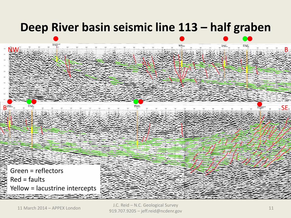
Deep River basin seismic line 113 – half graben
11 March 2014 – APPEX LondonJ.C. Reid – N.C. Geological Survey
919.707.9205 – [email protected]
NW B
B SE
Green = reflectorsRed = faultsYellow = lacustrine intercepts

11 March 2014 – APPEX LondonJ.C. Reid – N.C. Geological Survey
919.707.9205 – [email protected]
Organic source material –Mostly Type 3 and some Type 1 – Deep River basin

Kerogen type and maturity (Tmax) – multiple wells: Sanford sub-basin
11 March 2014 – APPEX LondonJ.C. Reid – N.C. Geological Survey
919.707.9205 – [email protected]
Simpson #1 – LE-OT-1-98
Dummitt Palmer #1 - LE-OT-82
Bobby Hall #1 – LE-OT-2-83
LE-C-4-45 – BDH-9
USBM2
**%Ro = 1.25%, N = 42 as of August 2012

11 March 2014 – APPEX LondonJ.C. Reid – N.C. Geological Survey
919.707.9205 – [email protected]
Wells / core holes
Maturation: Most data plots in the oil and condensate windows + dry gas
Oil – Butler #1Depth 3,000 ft
Oil-saturated sands above the source rock
Simpson #1 flare

11 March 2014 – APPEX LondonJ.C. Reid – N.C. Geological Survey
919.707.9205 – [email protected]
Clays are subequal chlorite + illite; very minor kaolinite + mixed I/S
Mostly quartz+feldspar
Some calcite veins observed

High pressure mercury porosity and permeability (MICP) results
11 March 2014 – APPEX LondonJ.C. Reid – N.C. Geological Survey
919.707.9205 – [email protected]

Porosity examples – reservoir characterization
11 March 2014 – APPEX LondonJ.C. Reid – N.C. Geological Survey
919.707.9205 – [email protected]
Top - V.R. Groce #1, depth 2,407 feet. Field of view shows intergranular pores associated with clay minerals and contacts with rigid grains.
Bottom - BMDH 2, depth 1,163 feet. Evidence of “organic porosity”. The sample has 2.3% TOC and 6.4% Hg porosity. Inter-granular porosity (green arrows) associated with Mg chlorite. Sample is chlorite/illite mud rock with prominent phosphate “complexes”. Organic porosity occurs both within and along the margins of organic matter (OM; blue arrows).
(Left) - Backscatter electron image; OM is black. Clays have typical platy appearance; chlorite is the lighter shade of gray.
(Right) - Secondary electron image; pores marked by arrows - these are of variable size (nanometer range is typical). Gray fleck in OM are occluded clay.
Geomechanical studies inprogress

North Carolina - Summary• Two continuous gas assessment units (AUs).• Age: Late Triassic (Carnian).• Source rocks: Freshwater lacustrine shales deposited near/at the
paleo-equator.• Continental rift basins formed from Permian to Early Jurassic
extension and breakup of Pangea.• Both North Carolina basins were assessed by U.S. Geological Survey
(Fact sheet 2012-3075) – URL http://pubs.usgs.gov/fs/2012/3075/. • Industry interest; some leasing – available open ground.• Horizontal drilling and fracking legalized in 2012; new state
permitting rules required by October 2014.• First permits anticipated to be issued in March 2015.• With new completion technology, these deposits may become
economically viable.
11 March 2014 – APPEX LondonJ.C. Reid – N.C. Geological Survey
919.707.9205 – [email protected]

For further information
11 March 2014 – APPEX LondonJ.C. Reid – N.C. Geological Survey
919.707.9205 – [email protected]
Geological research (list of all oil and gas publications) about the Triassic strata and reservoir characterization in North Carolina are on the Internet at URL: http://portal.ncdenr.org/web/lr/oilandgasresearch ,
Draft rules are available on the Internet at URL :http://portal.ncdenr.org/web/mining-and-energy-commission/home
Contact:Jeffrey C. Reid PhD, PG CPGEmail: [email protected]: 919.707.9205 (USA)
Drill site in Deep River basin: flat,relatively featureless, and lots of secondary roads. Typical terrain in these prospective basins – perfectfor exploration!
V.R. Groce #1 well pad - 1974