trimble inpho software
TRANSCRIPT

GeoSPAtiAlSolutioNS
TRIMbLE INPHO SOFTWARE
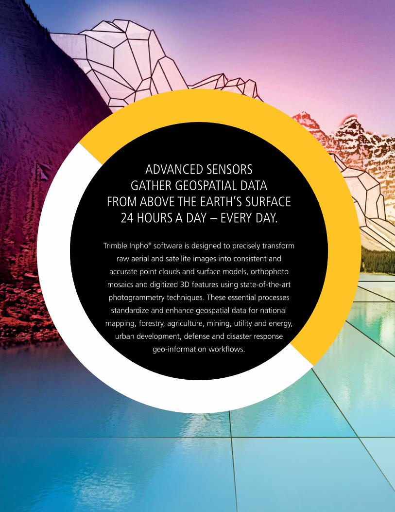
ADvANCED SENSORS GATHER GEOSPATIAL DATA
FROM AbOvE THE EARTH’S SURFACE 24 HOURS A DAY – EvERY DAY.
Trimble Inpho® software is designed to precisely transform
raw aerial and satellite images into consistent and
accurate point clouds and surface models, orthophoto
mosaics and digitized 3D features using state-of-the-art
photogrammetry techniques. These essential processes
standardize and enhance geospatial data for national
mapping, forestry, agriculture, mining, utility and energy,
urban development, defense and disaster response
geo-information workflows.

A modulAr ApproAch
With more than thirty years of development and thousands of global implementations, Inpho
software is well known for pioneering digital photogrammetry techniques that are today regarded
as the industry standard. This commitment to advancing the art and science of geo-precision lives
on within the latest generation of Inpho software which is engineered to the exacting standards of
digital photogrammetry and laser scanning data production. With Inpho, Trimble is committed to
protecting our customers’ investments by further developing cutting-edge technologies as well as
offering highly qualified technical support and consultancy services.
Geo-Referencing
• AerialTriangulation
• BundleBlockAdjustment
• CameraCalibration
Using a modular approach, Inpho software can be deployed as a complete, perfectly tuned system, or as individual components that integrate into geospatial information production work flows, including 3rd party work flows.
Geo-Capturing
• PointCloudsfrom
ImageBlocks
• Surface&TerrainExtraction
• StereoFeatureCollection
Geo-Modeling
• PointCloudFiltering,
Visualization&Editing
• DTMExtension
• LiDARprocessing
Geo-Imaging
• Ortho-rectification
• OrthophotoMosaicking
All software modules are delivered together with the ApplicationsMaster control center which includes basic sensordefinition,imagepreprocessingandDTMtools.
UAS Processing
• Completephotogrammetric
workflow in one tool
• Georeferencing,pointcloud
matching, ortho mosaicking
• Highlyeffectiveanalysisand
editing capabilities
INDUSTRY LEADING GEO-PRECISION SOFTWARE
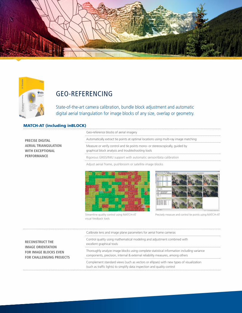
MATCH-AT (including inBLOCK)
PRECISE dIgITAl AERIAl TRIANgUlATION wITH ExCEPTIONAl PERFORMANCE
Geo-reference blocks of aerial imagery
Automatically extract tie points at optimal locations using multi-ray image matching
Measure or verify control and tie points mono- or stereoscopically, guided by graphical block analysis and troubleshooting tools
Rigorous GNSS/IMU support with automatic sensor/data calibration
Adjustaerialframe,pushbroomorsatelliteimageblocks
RECONSTRUCT THE IMAgE ORIENTATION FOR IMAgE blOCkS EvEN FOR CHAllENgINg PROjECTS
Calibrate lens and image plane parameters for aerial frame cameras
Controlqualityusingmathematicalmodelingandadjustmentcombinedwith excellent graphical tools
Thoroughly analyze image blocks using complete statistical information including variance components, precision, internal & external reliability measures, among others
Complement standard views (such as vectors or ellipses) with new types of visualization (suchastrafficlights)tosimplifydatainspectionandqualitycontrol
StreamlinequalitycontrolusingMATCH-AT visual feedback tools
PreciselymeasureandcontroltiepointsusingMATCH-AT
Geo-referencinG
State-of-the-artcameracalibration,bundleblockadjustmentandautomatic digital aerial triangulation for image blocks of any size, overlap or geometry.

MATCH-T DSM
AUTOMATICAlly CREATE dIgITAl TERRAIN ANd SURFACE MOdElS FROM AERIAl OR SATEllITE IMAgE blOCkS
Acquire accurate dense point clouds (1 pixel) and detailed high quality surface models directly from blocks of stereo scenes (aerial frames, satellites, pushbroom)
Use advanced “SGM-based” multi-image matching to create point clouds as a lower cost alternative to aerial laser scanning, particularly for applications such as city modeling and orthophoto generation
With automatic best-geometry selection, take into account all locally overlapping images in order to createrealRGBcoloredpointclouds
With at least 60/60 percent image overlaps, even narrow urban streets are detected
Automaticallyremovenon-groundobjectsoroutliersandachievebareearthdigitalterrainmodels(DTMs)usingrobustfiltermethods
Expandproductioncapabilitiesusingstate-of-the-artmulti-threadinganddistributedprocessingalongwithautomaticoptimizationofmatchingparametersandstrategiesandsensornoisefiltering
Rigorous weighted consideration of pre-measured morphological data such as break-lines, form-lines, spot-heights etc.
Direct output into tiled LAS structures for compatibility with 3rd party applications
SuMMiT EvOLuTiOn
COllECT 3d FEATURES dIRECTly INTO ARCgIS, AUTOCAd OR MICROSTATION
Digital photogrammetric stereo workstation
Roamseamlesslythroughprojectsofanysizeusingaproject-basedenvironmentfororientedimage blocks
Improve result quality with routines for data generalization, checking and automatic line editing
Ensurebestmappingperformanceusingautomaticbatchmapediting
Superimpose collected or imported vector data directly onto stereo models for effective and efficientinteractivemapping,changedetectionandGISupdates
Aerial frame and pushbroom imagery, close-range, satellite, IFSAR, LiDAR intensity and orthophoto imagery are all supported
CreatedensepointcloudsfromstereoimageryusingMATCH-TDSM
Geo-cApturinG
Create dense point clouds and surface models from aerial and satellite photo blocks. Use interactive stereo data capture to collect geospatial data directly into CAD or GIS.
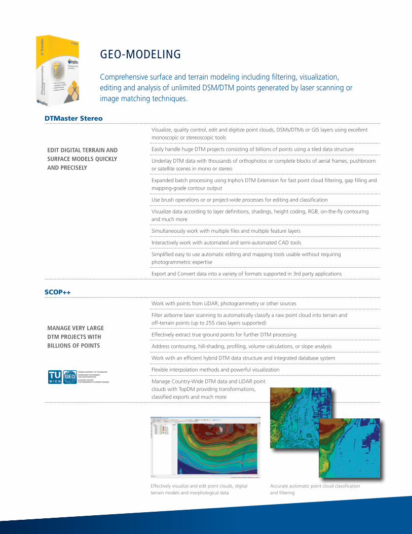
DTMaster Stereo
EdIT dIgITAl TERRAIN ANd SURFACE MOdElS qUICkly ANd PRECISEly
Visualize, quality control, edit and digitize point clouds, DSMs/DTMs or GIS layers using excellent monoscopic or stereoscopic tools
EasilyhandlehugeDTMprojectsconsistingofbillionsofpointsusingatileddatastructure
Underlay DTM data with thousands of orthophotos or complete blocks of aerial frames, pushbroom or satellite scenes in mono or stereo
ExpandedbatchprocessingusingInpho’sDTMExtensionforfastpointcloudfiltering,gapfillingandmapping-grade contour output
Usebrushoperationsororproject-wideprocessesforeditingandclassification
Visualizedataaccordingtolayerdefinitions,shadings,heightcoding,RGB,on-the-flycontouringand much more
Simultaneouslyworkwithmultiplefilesandmultiplefeaturelayers
Interactively work with automated and semi-automated CAD tools
Simplifiedeasytouseautomaticeditingandmappingtoolsusablewithoutrequiringphotogrammetric expertise
ExportandConvertdataintoavarietyofformatssupportedin3rdpartyapplications
SCOP++
MANAgE vERy lARgE dTM PROjECTS wITH bIllIONS OF POINTS
Work with points from LiDAR, photogrammetry or other sources
Filter airborne laser scanning to automatically classify a raw point cloud into terrain and off-terrain points (up to 255 class layers supported)
EffectivelyextracttruegroundpointsforfurtherDTMprocessing
Addresscontouring,hill-shading,profiling,volumecalculations,orslopeanalysis
WorkwithanefficienthybridDTMdatastructureandintegrateddatabasesystem
Flexible interpolation methods and powerful visualization
Manage Country-Wide DTM data and LiDAR point clouds with TopDM providing transformations, classifiedexportsandmuch more
Effectivelyvisualizeandeditpointclouds,digitalterrain models and morphological data
Geo-modelinG
Comprehensivesurfaceandterrainmodelingincludingfiltering,visualization, editing and analysis of unlimited DSM/DTM points generated by laser scanning or image matching techniques.
Accurateautomaticpointcloudclassification andfiltering

OrthoMaster
PROFESSIONAl SOFTwARE FOR HIgH-qUAlITy ORTHOPHOTO gENERATION
Ensurecompleteblocksofdigitalaerialframe,pushbroomormultichannelsatelliteimagerywithconstant scale using orientation and digital terrain models as source data
Batch-generatetrueorthophotosforbothsingleimagesandcompleteimageblocksusingadvancedcomputational algorithms in combination with OrthoVista
DerivetheheightreferenceforrectifiactiondirectlyfrompointcloudsandmorphologicalCADdatawith advanced modelling of bridges, buildings etc. for true ortho generation
Optimized for automated, high-performance orthophoto production with automated best geometry orthoareagenerationtocut-offdistortedimageedgesorfiducials
Expandproductioncapabilitiesusingstate-of-the-artmulti-threadinganddistributedprocessing
Orthovista
EFFICIENTly PROCESS THOUSANdS OF ORTHOPHOTOS INTO PERFECT ORTHOMOSAICS
Create seamless, color balanced and geometrically correct orthomosaics
Automate key ortho-mosaicking functions such as image intensity, color, and radiometric adjustmentsaswellasmulti-resolutionresamplingandmapsheettiling
Automatically correct visual effects such as hot spots, lens vignetting, brightness or color variations and sun reflections on water
Detectseamlinesfullyautomaticallywithfeaturedetectiontechnologyandmergeadjacentimageswith adaptive blending for perfectly hidden seams
Recognizeman-madeobjectswithoutmanualinterventiontogeneratehighqualityresults even in urban areas
Also includes a seam editor for interactive mosaic editing and interactive image enhancement tools
Step-by-step or one-stop processing and simultaneous generation of multi-channel variations of the finalmosaic(e.g.RGB+CIR+RGBI)
Create perfect orthophoto mosaics using OrthoVista
Geo-imAGinG
Master orthophoto creation and mosaicking of digital aerial or satellite imagery with automatic block-wide operation, rigorous true-ortho capabilities, unsurpassed color balancing and fully automatic seam detection. A variety of formats for deliverables guarantees easy integration into 3rd party workflows.

uASMaster
MOdERN COMPUTER-vISION AlgORITHMS COMbINEd wITH PROvEN STATE-OF-THE-ART PHOTOgRAMMETRIC TECHNIqUES
Accurateandreliableresultsinjustafewsecondsperimagewithahighdegreeofprocessautomation combined with intuitive guided workflow concept and thorough graphical QA/QC tools
Perfectly designed matching strategies lead to maximum ray connections for tie points and highest quality point clouds, contour lines or mosaics that integrate into any photogrammetric workflow as well as into eCognition automatic feature analysis
Minimizeduserinteractionforprojectset-upanddatapost-processingforanyfixed-wingorrotaryplatform UAS with up to 51Mpix
Ease-of-usecombinedwithphotogrammetricexperttoolsfromInphocoretechnology
Integrated extensive sensor calibration for camera and high-quality GNSS (for reduction of required ground control data)
Multi-flight and multi sensor capable
Simplifiedinteractiveeditingtoolswithahighdegreeofautomationformaximumgeoreferencingprecision,pointcloudediting,classificationandfiltering;aswellasstereoscopicCAD/GISmappingworkflows and orthomosaic editing
LPMaster
SEAMlESS lIdAR PROCESSINg SOlUTION PROvIdINg ACCURACy ANd PRECISION dATA
IntuitiveInterfacetoreduceproductionteamramp-uptimetoofferfastandefficient production workflows
Automaticdataassemblyandselectionforprojectsetup
Full-automaticLiDARstripadjustmentforhomogeneousquality,fastcoveragechecksand quality control
Seamless workflow integration into other Inpho modules such as DTMaster, OrthoMaster and OrthoVista for an end-to-end LiDAR workflow
USGS compliant reporting
uAS-proceSSinG
Photogrammetry-Grade Processing For Remotely-Piloted Aircraft Systems (RPAS) / Unmanned Aircraft Systems (UAS) bridging the gap between simple near-black-box workflows for non-photogrammetrists and photogrammetry expert workflows.
lidAr-proceSSinG
Powerful airborne LiDAR processing and quality assurance designed for use with Trimble AX Aerial Mapping System. With a focus on ease-of-use and productivity. LPMaster is fully integrated into the Inpho software line offering a true end-to-end LIDAR workflow.
Automated feature mapping in stereo or mono

Using a modular approach, the Inpho software suite can be deployed as a complete, perfectly tuned system, or as individual components that integrate into geospatial information production work flows.
Geo- reFereNciNG
Geo-cAPturiNG Geo-modeliNG Geo-imAGiNGuAS-
ProceSSiNGlidAr-
ProceSSiNG
MATCH-ATMATCH-T
DSMSuMMIT
EvoluTIoNDTMASTEr
STErEoSCoP++
orTHo MASTEr
orTHo vISTA
uASMASTEr lPMASTEr
Digital Photogrammetry
X X X X X X X X
Support Scanned Analogue Imagery
X X X X X X
Pushbroom oPTIoN X X X X X
Satellite X X X X X X
laser Scanning Data
X X X X X
Aerial Triangulation
X X
Camera Calibration X X
Surface / Terrain Extraction
X X X
Mapping /Mono/Stereo
X X X
DTM Processing and Management
X X X
Data for City Modeling
X X X
lite version oPTIoN oPTIoN oPTIoN oPTIoN oPTIoN oPTIoN
Extra research version
X X
rental option X X X X X X X X X
Network license X X X X X X X X X
iNPho buNdleS
orthoBox X X
DTMBox X X
liDAr Box X X
EDu/research X X X X X X

WORKLOAD MAnAGEMEnT
THE ClUSTER IS MANAgEd by dP MASTER, A wORkFlOw-bAlANCINg SySTEM wHICH IS INClUdEd wITH EvERy INPHO MOdUlE
Definesthecomputers/CPUs/Coresinvolvedforaprocess
Partitionstheprojectdataanddistributestothenodes
Controls the computation and creates status reports
increASed productiVitY BY diStriButed proceSSinG
Meet the challenge to process tens of thousands of images within hours using a cluster of computers in a network. Currently distributed processing is supported for MATCH-TDSMaswellasOrthoMaster.Inordertorunthesoftwareinadistributedprocess, one standard license of the module is required. Per computation node an additional lower-priced DPL license of the module must be acquired.
SerViceS
Training
Highly-skilledsupportengineersprovideknowledgeableoperatorsforasmoothandefficientproduction.Basicphotogrammetrytrainingsaswell as expert trainings are available. Trainings are available as trainer-led online classroom trainings, as well as online personal trainings. Or,letustrainyourstaffdirectlyinyouroffice,orhereatTrimble.Noproblem if you have a tight schedule, we also offer self-paced learning courses with regular, online Q&A sessions.
Software Maintenance
With the software update service we guarantee that your production environment stays up-to-date. Software maintenance agreements are freeforthefirst12monthsafteranewlicensehasbeenpurchased,after that, maintenance contracts can be renewed on an annual basis. Maintenance includes the update service, as well as access to our technical support.
Consulting
Let us help you optimize your photogrammetric production workflow. Our engineers are prepared to analyze current bottlenecks in order to improvequality,efficiencyandproductivityforyourprojects.

Lite Versions
Inpho modules are also available as restricted Lite versions.
module Number oF imAGeS
Sub-block hANdliNG
multi- threAdiNG
other reStrictioNS
mAtch-At lite (no restriction for the inblock adjustment routine!)
250 frames, no pushbroom, 12 satellite scenes
No No
mAtch-t dSm lite 250 frames, 12 line images No No only one output area
orthomaster lite 250 frames, 12 line images, 12 satellite images
No No No batch processing
orthoVista lite (includes the full unrestricted version of the Seameditor)
250 frames, 12 line images, 12 satellite images
No No
Summit evolution lite - Yes Yes Stereo viewer only, simple measurement and basic editing
uASmaster lite 800 frame images Yes Yes No point cloud editing, no stereo
Licensing
Inpho software is dongle protected. The dongle is network capable so any number of licenses within a company can be distributed on one dongle, alone or with, a multifold of dongles.
Educational/ResearchOffering
For educational institutes such as universities or similar, Inpho modules are offered in educational or research packages. A proof for the non-commercial use is required. The packages are available as time limited rentals as well, which might apply best for research licensing.
EducationalLicensesareavailableonanetworkdongleonly,thereforecannot be loaned to students for home-use. Research licenses also must be purchased through a university but may be loaned to students as well.
TheeducationalpackageincludesLiteversionsofMATCH-AT,MATCH-TDSM,DTMasterStereo,OrthoMasterandOrthoVista.One base package must be purchased, which can be expanded by any additional number of add-on seats. The educational version of UASMaster Lite is offered free of charge for universities or similar.
TheresearchpackageincludesunrestrictedfullversionsofMATCH-AT,MATCH-TDSM,DTMasterStereo,OrthoMaster,OrthoVistaandUASMaster. It is available seat-by-seat. Additional special pricing for researchlicensesofSummitEvolutionandUASMasterarealsooffered.
Time Limited Rentals
We also offer our modules as time-limited rentals. Minimum rental period is 3 months, which can be extended on a monthly basis.
LICENSING FLExIbILITY FOR MAxIMUM SCALAbILITY

© 2008–2015, Trimble Navigation Limited. All rights reserved. Trimble, the Globe & Triangle logo and Inpho are trademarks of Trimble Navigation Limited, registered in the United States and in other countries. Access, RTX, SurePoint, VISION, VRS, and xFill are trademarks of Trimble Navigation Limited. All other trademarks are the property of their respective owners. PN 022543-139C (08/15)
About trimble
Trimble’s solutions combine the latest in GPS/GNSS technologies with customized software and wireless communications enabling users to quickly and accurately capture the data needed to provide clients with actionable deliverables. Trimble’s solutions use integrated processes and workflows for complete life cycle management—from the planning and design to maintenance phases. The solutions can streamline operations to keep projects on time and costs on target.
For more information: www.trimble.com/inpho
NORTH AMERICATrimble Navigation Limited10368 Westmoor DriveWesminster CO 80021USA
EUROPETrimble Germany GmbH Rotebuehlstr. 81 70178 Stuttgart GERMANY Tel.: [email protected]
ASIA-PACIFICTrimble Navigation Singapore Pty Limited80 Marine Parade Road#22-06, Parkway ParadeSingapore 449269 SINGAPORE+65-6348-2212 Phone+65-6348-2232 Fax