trip-generation rates for urban infill land uses in california … · 2009-06-15 ·...
TRANSCRIPT

Economi c & Planni ng Sys te ms
Trip-Generation Rates for Urban Infill Land Uses in California
Phase 2: Data Collection
FINAL REPORT
Prepared For:
The California Department of Transportation (Caltrans) Headquarters Divisions of Transportation Planning
and Research & Innovation
Prepared By:
Kimley-Horn and Associates, Inc.
In Association With:
Economic & Planning Systems Gene Bregman & Associates
June 15, 2009

Final Report Trip-Generation Rates for Urban Infill Land Uses in California
Phase 2: Data Collection
June 15, 2009
Abstract This report presents the results of the second phase of a two phase research project undertaken by the California Department of Transportation (Caltrans) to study travel characteristics of infill development in California’s metropolitan areas. This research was guided by goals to establish a database of empirical trip generation studies for various types of infill development, to standardize a data collection and analysis methodology, and to coordinate this research with the Institute of Transportation Engineers (ITE) with an objective to integrate the findings into a future ITE publication. The specific objectives of the second phase of this research were to:
Develop trip generation rates for common infill land use categories in urban areas of California,
Use methodology established in Phase 1 and continue to build a California urban infill land use trip generation database, and
Supplement ITE trip generation data.
The first phase of this research project was considered a pilot study for the collection of trip generation data for urban infill land uses. The second phase is intended to collect and report additional trip generation data for an expanded set of urban infill land uses. The ultimate goal of this effort is to eventually gain acceptance and adoption of this data by the Institute of Transportation Engineers (ITE) in assessing the traffic impacts of various land use development projects located in urban infill areas as part of planning efforts, traffic impacts studies, traffic impact mitigation programs, and compliance with the California Environmental Quality Act (CEQA).
Data collection was indefinitely postponed in early 2009 because of concerns that the economic downturn affects the validity of the trip generation data. Furthermore, a limited amount of data was collected in the second phase of this project due to the inherent difficulty and relatively high cost associated with collecting data in complex urban settings. However, the study has been successful in developing and testing data collection methods, identifying challenges related to collecting data for urban infill sites and devising strategies to address these challenges, establishing the beginnings of an urban infill trip generation database, and deriving initial findings based on the limited data that was collected. The lessons learned through this undertaking have strengthened the knowledge and techniques for continuing data collection in future research efforts.
Kimley-Horn and Associates, Inc. Page i

Final Report Trip-Generation Rates for Urban Infill Land Uses in California
Phase 2: Data Collection
June 15, 2009
Acknowledgements
Project Management and Consultant Team
This project was initiated and funded by the California Department of Transportation (Caltrans) using State Planning and Research Program funds provided by the Headquarters Division of Research and Innovation. Ms. Terry Parker, a Senior Planner with the Office of Community Planning in Caltrans Headquarters Division of Transportation Planning, provided oversight of this effort.
The consultant team responsible for implementing this study included:
Kimley-Horn and Associates, Inc.
James M. Daisa, P.E., Project Manager Ali Mustafa, EIT, Project Analyst Marc Mizuta, P.E., PTOE, Project Engineer Luke Schwartz, EIT, Project Analyst Leo Espelet, P.E., Project Engineer Diana Turlik, EIT Project Analyst Daniel Carley, EIT, Project Analyst Jennifer Jackson, Project Analyst Cindy Dalen-Slade, Graphic Design Bruce Friedman, P.E., Technical Editor
Economic & Planning Systems, Inc.
Walter Keiser, Principal Edward A. Sullivan, III, Senior Technical Associate
Gene Bregman & Associates
Gene Bregman, President
The methodology and information summarized in this report has greatly
benefited from input and oversight provided by members of the Technical
Advisory Committee, who have generously donated their time and talents
since 2005.
Kimley-Horn and Associates, Inc. Page ii

Final Report Trip-Generation Rates for Urban Infill Land Uses in California
Phase 2: Data Collection
June 15, 2009
Members of the Phase 2 Technical Advisory Committee
AC Transit, Nathan Landau, Senior Planner Caltrans (Headquarters, Traffic Operations Division), Marc Birnbaum,
Supervising Senior Transportation Planner Caltrans (District 3), Nadarajah Suthahar, Transportation Engineer Caltrans (District 4), Beth Thomas, Senior Transportation Planner Bay Area Rapid Transit (BART), Kenya Wheeler, Senior Transportation
Planner San Francisco Municipal Transportation Agency, Peter Albert, Senior
Planning Manager Association of Bay Area Governments (ABAG), Christy Riviere, Senior
Planner Metropolitan Transportation Commission (MTC), Rupinder Singh,
Associate Transportation Planner San Diego Association of Governments (SANDAG), Alex Estrella, Trip
Generation Coordinator San Joaquin Council of Governments (SJCOG), Sam Kaur, Associate
Regional Planner City of San Diego, Shahriar Ammi, Associate Traffic Engineer San Francisco County Transportation Authority, Michael Schwartz,
Transportation Planner
Sources of funding for this study are the Federal Highway Administration (FHWA) State Research and Planning Program and the State of California, Department of Transportation, Division of Research and Innovation.
DISCLAIMER
The contents of this report reflect the views of the authors, who are responsible for the facts and the accuracy of data presented herein. The contents do not necessarily reflect the official views or policies of the State of California or the Federal Highway Administration. This report does not constitute a standard, specification, or regulation.
Kimley-Horn and Associates, Inc. Page iii

Final Report Trip-Generation Rates for Urban Infill Land Uses in California
Phase 2: Data Collection
June 15, 2009
TABLE OF CONTENTS
Abstract .......................................................................................................................... i
Acknowledgements ..................................................................................................... ii Project Management and Consultant Team ........................................................................ii Members of the Phase 2 Technical Advisory Committee ..................................................iii
1 Introduction ...........................................................................................................1 1.1 Problem Statement ............................................................................................................2 1.2 Purpose of the Study ..........................................................................................................3 1.3 Study Outcomes .................................................................................................................3
2 Overview of Phase 1 Study ...................................................................................4
3 Data Collection .....................................................................................................6 3.1 Identification and Selection of Study Sites.....................................................................6
3.1.1 Defining Urban Infill ....................................................................................................6 3.1.2 Selected Land Uses ....................................................................................................8 3.1.3 Site Selection Criteria ...............................................................................................14 3.1.4 Site Selection Approach .........................................................................................17
3.2 Overview of Selected Data Collection Methodology ..............................................17 3.3 Overview of Surveyed Sites .............................................................................................18 3.4 Site Overview by Land Use..............................................................................................18
3.4.1 Residential Land Use Categories...........................................................................19 3.4.2 Non-Residential Categories....................................................................................23
4 Preliminary Findings ............................................................................................31 4.1 Overview of Derived Trip Generation Rates by Land Use ........................................31 4.2 Comparison with ITE Trip Generation Rates .................................................................31
4.2.1 Residential Land Uses ..............................................................................................31 4.2.2 Non-Residential Land Uses ......................................................................................34 4.2.3 Non-Prioritized Land Uses ........................................................................................37 4.2.4 Urban University Town Trip Generation – UC Berkeley Sites ..............................38
4.3 Mode of Travel by Land Use ...........................................................................................41
5 Summary and Conclusion ..................................................................................45 5.1 Key Conclusions ................................................................................................................45 5.2 Recommendations ...........................................................................................................45
5.2.1 Recommendations for Improving Study Methodology ....................................45 5.2.2 Recommendations for Future Research Efforts ..................................................46
6 Bibliography.........................................................................................................48
7 Appendices .........................................................................................................49 A. Site Data Summaries ........................................................................................................ 50 B. Excerpt from Scope of Work for Phase 2 – Detailed Survey Methodology ...........70
Kimley-Horn and Associates, Inc. Page iv

Final Report Trip-Generation Rates for Urban Infill Land Uses in California
Phase 2: Data Collection
June 15, 2009 C. Intercept Survey Questionnaires .................................................................................... 75 D. Summary of Study Challenges ....................................................................................... 49 E. Summary of Study Costs .................................................................................................. 86 F. Summary of Comments Received from ITE Trip Generation Subcommittee
Review of Phase 1 Final Report...................................................................................... 94
LIST OF TABLES Table 1: List of Land Uses and Descriptions for California Urban Infill Trip Generation
Research ............................................................................................................................................. 11
Table 2: Comparison of Observed and ITE Trip Rates (For Residential Land Uses) ............... 32
Table 3: Comparison of Observed and ITE Trip Rates (For Non-Residential Land Uses) ...... 35
Table 4: Comparison of Observed and ITE Trip Rates (For Non-Prioritized Land Use
Categories) ......................................................................................................................................... 38
Table 5: Comparison of Observed and ITE Trip Rates (For Sites Near UC Berkeley) ............. 39
Table 6: Comparison of Mode of Travel by Land Use (For Residential Land Uses) ............... 41
Table 7: Comparison of Mode of Travel by Land Use (For Non-Residential Land Uses) ...... 43
Table 8: Comparison of Mode of Travel by Land Use (For Sites Near UC Berkeley) ............. 44
LIST OF FIGURES Figure 1: Location of Surveyed Sites in California ........................................................................ 27
Figure 2: Comparison Between Surveyed Trip Results and ITE Standard Trip Estimates For All
Residential Land Use Categories - AM Peak Hour ...................................................................... 33
Figure 3: Comparison Between Surveyed Trip Results and ITE Standard Trip Estimates For All
Residential Land Use Categories - PM Peak Hour ....................................................................... 33
Figure 4: Comparison Between Derived Trip Rates and ITE Trip Estimates - General Office
Use - AM Peak Hour ........................................................................................................................... 36
Figure 5: Comparison Between Derived Trip Rates and ITE Trip Estimates - General Office
Use - PM Peak Hour ........................................................................................................................... 36
Figure 6: Comparison Between Derived Trip Rates and ITE Trip Estimates – Berkeley
Residential Uses - AM Peak Hour .................................................................................................... 40
Figure 7: Comparison Between Derived Trip Rates and ITE Trip Estimates – Berkeley
Residential Uses - PM Peak Hour ..................................................................................................... 40
Kimley-Horn and Associates, Inc. Page v

Final Report Trip-Generation Rates for Urban Infill Land Uses in California
Phase 2: Data Collection
June 15, 2009
1 Introduction Infill development is defined as new development and redevelopment projects located on vacant or underutilized land within existing developed areas. Infill development is one strategy for revitalizing declining city and suburban cores and town centers. It promotes efficient and cost-effective use of existing infrastructure and services (such as streets, transit, and utilities), and expands opportunities for housing, recreation, and economic growth.
During local land use review and development permitting processes, public agencies commonly require estimates of vehicle travel impacts associated with proposed land use projects, assessments of their potential contribution to traffic congestion, and identification of appropriate mitigation strategies. These strategies often include mitigation fees, private developer contributions, special tax assessment districts, and specific infrastructure improvements.
Benefits of Infill In preparing traffic and transportation impact Development analyses, professionals often rely on the Institute of Transportation Engineers’ (ITE)
Provides housing published trip-generation rates for various opportunities closer to jobs types of land uses. However, ITE data
typically reflects isolated suburban Encourages community development usually lacking availability and revitalization proximity of transit service, and the ITE study
Reduces suburban sprawl sites are located such that they are difficult to access by walking or bicycling. As a result, Makes better use of
existing infrastructure the use of ITE trip-generation rates for proposed urban infill development projects Encourages walking and served by transit and having good the use of transit pedestrian access could significantly over-
Reduces need for predict vehicular traffic impacts. automobile ownership
The use of trip generation data goes beyond traffic impact analysis. It also has significant economic and environmental consequences. Trip generation rates are used in the development and application of traffic impact fees and are a major determinant in the approval of development projects and parking provisions. The use of auto-oriented suburban traffic generation data for assessing urban infill projects can produce an inherent inequity in the approval process resulting in a potential disincentive for developers to take on the increased challenges of infill development.
Kimley-Horn and Associates, Inc. Page 1

Final Report Trip-Generation Rates for Urban Infill Land Uses in California
Phase 2: Data Collection
June 15, 2009 All of these consequences can result in a slower pace of infill development, higher costs, and delay and/or even rejection of otherwise beneficial infill projects stalling economic development, housing provisions, and job growth within existing urban and suburban areas.
It is clear that further research is needed to better understand the trip generation characteristics of infill development. Recently there have been a number of research projects to determine the travel characteristics of infill, transit-oriented, and mixed-use development. The most significant conclusion that can be drawn from this body of information is that despite being a profession that studies the effect of land use on transportation, transportation professionals do not yet fully understand how much traffic and other forms of travel (such as walking, biking and transit) is generated by these types of developments in higher-density urban and suburban settings.
1.1 Problem Statement The Institute of Transportation Engineers (ITE) trip generation rates are the primary source for travel demand analysis of new development throughout the United States, and are relied upon for conducting California Environmental Quality Act (CEQA), National Environmental Policy Act (NEPA) and local agency development impact analyses. These rates were intentionally based on surveys of isolated suburban development with little or no pedestrian, bicycle, or transit accessibility for convenience of data collection. Despite the vast amount of data collected by ITE over the past decades, these trip generation rates may not be sufficient to guide the approval of proposed developments in urban infill areas because the sources of the rates do not reflect variations in density, diversity (land use mix), site design, and the multimodal transportation systems of our larger metropolitan areas, which are critical factors in travel demand.1 In metropolitan areas, vehicle trip generation is affected by multiple factors including:
Proximity to transit
Density of development
Mix of land use types
The pedestrian environment
Cost of parking and availability
Traveler demographics such as income and auto ownership
1 Land Use and Site Design - Traveler Response to Transportation System Changes. (Washington D.C., Transportation Research Board (TRB) Transit Cooperative Research Program (TCRP) Report 95: Chapter 15 (2003)
Kimley-Horn and Associates, Inc. Page 2

Final Report Trip-Generation Rates for Urban Infill Land Uses in California
Phase 2: Data Collection
June 15, 2009 Because the ITE trip generation rates do not account for the variations in these factors, a significant challenge has been created resulting in sometimes speculative adjustments to estimate urban and multimodal travel demand. The increased interest in land use typologies such as “mixed-use” and “transit-oriented” development has led to particular challenges and debate when it comes to travel demand analysis. Transportation and land use planners and engineers are seeking credible empirical trip generation and mode share data to more accurately assess the impacts and benefits of new development in our complex urban land use and transportation systems, and in order to provide adequate multi-modal infrastructure and services.
1.2 Purpose of the Study This research was undertaken by the California Department of Transportation (Caltrans) in 2004 to address the need for better and more accurate data regarding travel characteristics of infill development in California’s metropolitan areas. Specifically, the primary objectives of this study are to:
Develop trip generation rates for common infill land use categories in urban areas of California,
Establish a California urban infill land use trip generation database, and
Supplement ITE trip generation data.
1.3 Study Outcomes This research is intended to provide empirical trip generation data for use in transportation planning and traffic engineering studies for urban infill areas in California. This study also provides the foundation for subsequent research by others to further build a comprehensive urban infill trip generation database.
The most applicable outcome of this study is the production of an initial set of quantitative information on travel characteristics of urban infill land uses for traffic impact studies and environmental assessments in this state. This research is intended to establish a standardized data collection and analysis methodology, which will hopefully result in consistent information gathering in the future.
One of the goals of this study was to collaborate closely with ITE so that the resulting methodology and data, combined with the addition of national empirical data, eventually can potentially be integrated into a future addition of Trip Generation or other ITE publications, such as the Trip Generation Handbook.
Kimley-Horn and Associates, Inc. Page 3

Final Report Trip-Generation Rates for Urban Infill Land Uses in California
Phase 2: Data Collection
June 15, 2009 The methodology and data produced by this study can support transportation planning and assessment for the following types of land uses located in urban infill areas of California (and potentially elsewhere):
Commercial and office developments,
High density housing, and
Mixed-use and transit-oriented developments.
The initial goal for Phase 2 of this study was to add additional data in order to reach a target of 50 total survey sites (10 land uses; 5 sites each). However, a limited amount of data was collected in the second phase of the study, primarily due to the suspension of the project. The research was discontinued due to several challenges, such as the potential unreliability of collecting travel data during an economic downturn, as well as the inherent difficulty and relatively high cost associated with collecting trip generation data in urban settings.
The study has been successful in developing and testing data collection methods, identifying challenges related to collecting data for urban infill sites, and devising strategies to address these challenges. The lessons learned will strengthen the knowledge and techniques for continuing data collection in future research efforts.
2 Overview of Phase 1 Study In 2004, Caltrans undertook the first phase of this research project to address the need for better and more accurate data relating to travel characteristics of infill development in California’s urban areas. The two primary objectives of Phase 1 were to:
Develop a methodology for identifying and describing urban infill locations and for collecting trip generation rate data in urban infill areas of California, and
Establish a preliminary database of trip generation rates for common infill land use categories in urban areas of California.
The Phase 1 research resulted in the development of a detailed methodology for defining and identifying urban infill areas, selecting study sites, as well as a recommended approach for collecting trip generation data. The Phase 1 Technical Advisory Committee (TAC) selected the following ten land use types, which are consistent with ITE’s Trip Generation, 8th Edition land use definitions and represent common forms of urban infill development:
Kimley-Horn and Associates, Inc. Page 4

Final Report Trip-Generation Rates for Urban Infill Land Uses in California
Phase 2: Data Collection
June 15, 2009 Mid-rise apartment (223)
Mid-rise residential condominium/townhouse (230)
High-rise residential condominium/townhouse (232)
Multiplex movie theater (445)
Health/fitness club (492)
Daycare center (565)
General office building (710)
Shopping center (820)
Supermarket (850)
High-turnover sit-down restaurant (932)
Trip generation rates for the 19 sites surveyed in Phase 1 were derived by developing and utilizing a data collection methodology that uses the combination of intercept surveys and counts of people entering and existing individual buildings. The total vehicle trips generated by a site were determined by applying applicable mode shares (derived from intercept surveys) to the highest hour of pedestrian counts (entering and leaving buildings) for the morning (7:00 – 9:00 a.m.) or afternoon (4:00 – 6:00 p.m.) peak weekday periods.
An overall finding based on the data collected and evaluated from 13 sites in Phase 1 was that certain land use categories have lower trip generation characteristics for the morning and afternoon peaks in urban infill contexts compared to published ITE trip generation rates.
A detailed presentation of the methodologies and findings that were established in Phase 1 of the study are presented in Trip-Generation Rates for Urban Infill Land Uses in California, Phase 1: Data Collection Methodology and Pilot Application (Phase I Final Report), which is available via a Caltrans website2.
2 Association of Bay Area Governments, Kimley-Horn and Associates, and Economic & Planning Systems. Trip-Generation Rates for Urban Infill Land Uses in California, Phase 1: Data Collection Methodology and Pilot Application, Final Report.: California Department of Transportation, Headquarters Divisions of Transportation Planning and Research & Innovation, 2008. Website: http://www.dot.ca.gov/newtech/researchreports/reports/2008/ca_infill_trip_rates-phase_1_final_report_appendices_4-24-08.pdf
Kimley-Horn and Associates, Inc. Page 5

Final Report Trip-Generation Rates for Urban Infill Land Uses in California
Phase 2: Data Collection
June 15, 2009
3 Data Collection This chapter discusses the site identification, selection, and data collection methods adopted for the second phase of this study. It includes an explanation of the site selection criteria and provides a revised list of land use categories selected by the Phase 2 TAC for study. Finally, this chapter provides an overview of all of the infill study sites surveyed to date.
3.1 Identification and Selection of Study Sites As an initial step in the measurement of trip generation from urban infill development, it is necessary to define what constitutes “urban infill” and where such development presently exists. This section defines the term “urban infill” and provides an overview of a methodology for identifying Urban Infill Areas (UIAs). A more thorough discussion of the definition of urban infill and ,the site selection criteria used in this study is found in the Phase 1 Final Reports Appendix A (Working Paper #1 Selection of Urban infill Study Sites) (see footnote #2).
3.1.1 Defining Urban Infill The term infill is commonly used to describe the development of vacant or under-utilized land in areas surrounded by existing development. The collective term “urban infill” usually describes the redevelopment of areas within cities. Although transit proximity is not explicitly included in the common definitions, many practitioners believe that access to transit, transit-oriented development (TOD) and mixed-use development are typically associated with urban infill development.
Site selection criteria for Phases 1 and 2 of this study included transit proximity. In Phase 1, the transit proximity criteria specified that a study site must be within 1/3 mile of an existing or future rail transit station, a ferry terminal served by either a bus or rail transit service, an intersection of at least two major bus routes, or within 300 feet of a bus rapid transit corridor. The transit service shall have maximum scheduled headways of 15 minutes for at least five hours per day. It is acceptable to use the collective headways of multiple routes as long as the routes serve the same corridor for a considerable length of the corridor. This criterion pertains to corridors where people can use any route to reach any point within a significant length of the corridor. The transit proximity criterion is derived from California Government Code Section 65088.4, defining urban infill opportunity zones.
The Phase 1 transit proximity criterion was retained in Phase 2 with the exception of the distance criteria for a bus rapid transit corridor. This criterion was expanded from 300 feet to 1,200 feet. This change reflects the more extensive use of branded bus rapid transit systems with similarities to rail transit including high amenity stations, dedicated travel lanes, and very high frequency service. The
Kimley-Horn and Associates, Inc. Page 6

Final Report Trip-Generation Rates for Urban Infill Land Uses in California
Phase 2: Data Collection
June 15, 2009 rail-like characteristics of bus rapid transit systems influences the distance patrons will walk to the service. This change was further supported during the Phase 1 site selection process where infill sites meeting all of the criteria except distance to bus rapid transit were rejected. This change in criteria was approved by the TAC.
As introduced in Phase 1 of this study, Urban Infill Areas (UIAs) are defined through the use of area types, as defined in ITE’s Parking Generation, 3rd Edition3, and Context Zones, as described in the Proposed Recommended Practice for Context Sensitive Solutions in Designing Major Urban Thoroughfares for Walkable Communities4. The area types referenced in this study provide characteristics that are familiar and intuitive to experienced land use and transportation planners and are described as follows:
Central Business District (CBD) is the downtown area for a city. CBD characteristics include good transit service, parking garages, shared parking, an extensive pedestrian sidewalk network, multi-storied buildings, priced parking, and a wide range of land uses (including mixed-use sites).
Central City Not Downtown (CND) is the area outside the downtown area of a larger city. This area has greater land use density than suburban sites, but is substantially less dense than the CBD. The intent of this area designation is for the places around large central cities (for example, Seattle, San Francisco, Oakland, Atlanta, and Washington, DC) where travel characteristics are likely to be unlike suburban conditions.
Suburban Center (SBC) areas are those downtown areas of suburbs that have developed CBD characteristics, but are not the central city of a metropolitan region. These activity centers have characteristics that may include good transit service, a mix of surface and structured parking, connected streets, a connected pedestrian network, and a mix of land uses. Examples include the downtown areas of Bellevue, WA; Las Colinas, TX; and Walnut Creek, CA.
Context Zones are development intensity-based descriptions that range from the most rural or undeveloped area to the most urban or developed area. For purposes of this study, the following Context Zone types are used in parallel or as alternatives to the more traditional CBD, CND, and SBC Area types to characterize UIAs:
3 McCourt, Ransford S. Parking Generation, 3rd Edition. Washington, DC, USA: Institute of Transportation Engineers, 2004. 4 Daisa, James M., et. al. Context Sensitive Solutions in Designing Major Urban Thoroughfares for Walkable Communities: An ITE Proposed Recommended Practice. Washington, DC, USA: Institute of Transportation Engineers, 2005.
Kimley-Horn and Associates, Inc. Page 7

Final Report Trip-Generation Rates for Urban Infill Land Uses in California
Phase 2: Data Collection
June 15, 2009 General Urban (CZ-4): Denser and primarily residential urban fabric.
Mixed-use sites usually confined to corner locations. Characterized by a wide range of building types: single, side yard, and row houses. Setbacks and landscaping are variable. Streets typically define medium-sized blocks. Typical land uses: medium density residential and home occupations; limited commercial and lodging. Typical buildings: houses and outbuildings, side yard houses, townhouses, live/work units, corner stores, and inns.
Urban Center (CZ-5): “Main Street” land uses, characterized by building types that accommodate retail, offices, row houses, and apartments. Typically has a compact network of streets, with wide sidewalks, uniform street tree planting and buildings set close to the frontages. Typical land uses: medium intensity residential and commercial uses, (i.e., retail, offices, lodging, civic facilities). Typical buildings: townhouses, apartment houses, live-work units, shop-front buildings and office buildings, hotels, churches, and schools.
Urban Core (CZ-6): “Downtown” land uses, characterized by the tallest buildings, in the greatest variety, and unique civic buildings in particular. It is the least naturalistic zone type in which street trees are uniformly planted and sometimes absent. Typical land uses: high intensity residential and commercial: retail and offices, lodging, civic buildings. Typical buildings: high and medium-rise apartment and office buildings, hotels, townhouses, live-work units, shop fronts, churches, and civic buildings.
3.1.2 Selected Land Uses
Concurrent to the identification of the appropriate UIAs is the need to define appropriate land use types for selecting representative infill sites. This research was intended to produce trip generation data for at least ten infill land uses, including residential, office, shopping areas, restaurants, and other commercial land uses typical of urbanized areas. The land use selection criteria discussed and approved by the TAC members during Phase 1 includes:
1. Common urban land use types that are consistent with ITE categories (Trip Generation [7th ed.])5 and generally reflect a range of uses within residential, office, and retail categories.
2. Land use types where there is a demand for empirical trip generation data based on professional knowledge and frequent applications for development review.
5 ITE’s Trip Generation, 8th Edition has since been released. For this reason, the analysis summary in later sections of this report compares the collected trip generation data to Trip Generation, 8th Edition trip rates.
Kimley-Horn and Associates, Inc. Page 8

Final Report Trip-Generation Rates for Urban Infill Land Uses in California
Phase 2: Data Collection
June 15, 2009 3. Land use types where there is a reasonable propensity for shifting
drivers to another mode if the use is located in an urban area. For example, it may be likely that a significant number of patrons would shift significantly from autos to transit or walking if a restaurant was located in an urban infill area versus a suburban area.
4. Land use types that are considered beneficial to the revitalization of urban areas, and for which current trip generation data may act as a barrier to development approval. These may include types that are considered transit oriented, high-density residential, and urban retail uses.
Because parking availability and costs are often of crucial importance to the types and modes of trips generated by urban infill sites, consideration in choosing candidate uses was also given for those types already represented in ITE’s Parking Generation. Preferences were given in the initial selection to higher-density residential types, and to nonresidential land uses that are of recurring interest in infill development impact analyses
The following 10 land use types, arranged in order, by the ITE land use code in parentheses, were selected by the TAC for Phase 2 of this research:
High-rise apartment (222)
Mid-rise apartment (223)
Mid-rise residential condominium/townhouse (230)
High-rise residential condominium/townhouse (232)
Hotel (310)
General office building (710)
Shopping center (820) / Specialty Retail (814)
Pharmacy / Drugstore without drive-through window (880)
Quality (sit-down) restaurant (931)
Fast-food restaurant without drive-through window6 (933)
6 When the TAC selected the ten priority land uses, ITE Trip Generation, 7th Edition was the most recent edition available, and land use code 933 included sub categories for Coffee Shop, Bread and Bagel Shop. Since then, Trip Generation, 8th Edition has become available. In the 8th Edition, the Coffee Shop and Bread/Bagel subcategories have been removed from land use code 933; therefore, in this report, the trip generation for Coffee Shop and Bakery/Café sites will be compared to ITE land use code 936 (Coffee/Donut Shop w/o Drive-Through) and 939 (Bread/Donut/Bagel Shop w/o Drive-Through).
Kimley-Horn and Associates, Inc. Page 9

Final Report Trip-Generation Rates for Urban Infill Land Uses in California
Phase 2: Data Collection
June 15, 2009 The majority of these land uses are consistent with the list of preferred land use types selected for Phase 1 of the study; however, the following Phase 1 study land uses were removed by the TAC for Phase 2:
Multiplex movie theater (445)
Health/fitness club (492)
Daycare center (565)
Supermarket (850)
High-turnover sit-down restaurant (932)
Table 1 lists the Phase 2 land uses and provides their descriptions as published in ITE Trip Generation (8th Edition). In addition to the ITE description, Table 1 presents qualifications or recommendations specific to this urban infill trip generation study, if applicable. There are qualifiers/recommendations for three of the categories:
Residential condominium/townhouse (230) – This is a general category of residential use without a definition of the height of the building. The ITE data included low and high-rise buildings. For purposes of this study, this category is limited to buildings of between three and 10 stories.
High-rise residential condominium/townhouse (232) – This category represents buildings of three or more stories in height. For purposes of this study, this category is limited to high-rise buildings greater than 10 stories.
Specialty retail (814) / Shopping center (820) – Specialty Retail and Shopping Center represent common suburban and urban land uses. Specialty retail and shopping center categories are frequently used in Traffic Impact Studies for urban retail uses when there is a lack of definition of the exact land use (i.e. ground floor retail in a mixed-use building). For this reason, both retail uses are included as preferred study land use types.
In addition to the above qualifiers, most of the land uses include qualifiers that allow the site to be part of a mixed-use development, or integrated into a larger complex. This qualifier reflects the change in data collection methodology from traffic counts to intercept surveys. The data collection process is discussed in the Phase 1 Final Report (see footnote #2), and additional detail is provided in Appendix B of this Phase 2 report.
Kimley-Horn and Associates, Inc. Page 10

Final Report Trip-Generation Rates for Urban Infill Land Uses in California
Phase 2: Data Collection
June 15, 2009 Table 1: List of Land Uses and Descriptions for California Urban Infill Trip Generation Research
Land Use Group
ITE LU ITE Land Use Type ITE Description
Additional Qualifiers for Trip Generation Study Code
Residential 222 High-Rise Apartment High-rise apartments are apartments (rental dwelling units) in rental buildings that have more than 10 levels (floors).
No additional qualifiers
Residential 223 Mid-Rise Apartment Mid-rise apartments are apartments (rental dwelling
No additional qualifiers units) in rental buildings that have between three and 10 levels (floors).
Residential 230 Mid-Rise Residential Condominium/Townhouse
Residential condominiums/townhouses are defined as ownership units that have at least one other owned unit within the same building structure. Both condominiums and townhouses are included in this land use. The studies of this land use did not identify whether the condominiums/ townhouses were low-rise or high-rise.
The ITE description does not specify number of floors in this category. This category is limited to buildings of between three and 10 stories.
Residential 232 High-Rise Residential Condominium/Townhouse
High-rise residential condominiums/townhouses are To distinguish from the mid-rise category, the high-rise category is limited to buildings greater than 10 stories.
units located in buildings that have three or more levels (floors). Both condominiums and townhouses are included in this land use.
Services 310 Hotel
Hotels are places of lodging that provide sleeping accommodations and supporting facilities such as restaurants, cocktail lounges, meeting and banquet rooms or convention facilities, limited recreational facilities (pool, fitness room) and/or other retail and service shops.
No additional qualifiers
Office 710 General Office Building
A general office building houses multiple tenants. It is a
No additional qualifiers
location where affairs of businesses, commercial or industrial organizations, or professional persons or firms are conducted. An office building or buildings may contain a mixture of tenants including professional services; insurance companies; investment brokers; and tenant services, such as a bank or savings and loan institution, a restaurant or cafeteria, and service retail facilities.
Kimley-Horn and Associates, Inc. Page 11

Final Report Trip-Generation Rates for Urban Infill Land Uses in California
Phase 2: Data Collection
June 15, 2009
Land Use Group
ITE LU ITE Land Use Type ITE Description
Additional Qualifiers for Trip Generation Study Code
Retail 814 / 820 Specialty Retail /
Shopping Center [a]
Specialty retail is generally small strip shopping centers that contain a variety of retail shops and specialize in quality apparel; hard goods; and services such as real estate offices, dance studios, florists and small restaurants. [b]
A shopping center is an integrated group of commercial establishments that is planned, developed, owned, and managed as a unit. A shopping center's composition is related to its market area in terms of size, location, and type of store. A shopping center also provides on-site parking facilities sufficient to serve its own parking demands. [c]
Selection of shopping centers limited to "Neighborhood" and "Community" center classifications as defined by ITE (see definitions below). Additionally, retail land uses can range from small urban shopping centers (less than 190,000 square feet) to individual businesses within buildings.
Retail 880 Pharmacy / Drugstore (without drive-through window)
A Pharmacy/Drugstore are retail facilities that primarily
This land use may be part of a mixed-use building.
sell prescription and non-prescription drugs. These facilities may also sell cosmetics, toiletries, medications, stationery, personal care products, limited food products, and general merchandise.
Services 931 Quality (Sit-Down) Restaurant
This land use consists of sit-down, full-service eating establishments with turnover rates of approximately one hour or longer. Quality restaurants generally do not serve breakfast; some do not serve lunch; all serve dinner. This type of restaurant usually requires reservations and is generally not part of a chain.
This land use may be part of a mixed-use building.
Services 933 / 936 /
939 [d]
Fast-Food Restaurant (without drive-through window)
This land use is characterized by a large carryout
This land use may be part of a mixed-use building.
clientele; long hours of service (some are open for breakfast, all are open for lunch and dinner, some are open late at night or 24 hours); and high turnover rates for eat-in customers. These limited-service eating establishments do not provide table service and patrons generally order at a cash register and pay before they eat.
[a] In the 6th Edition of Trip Generation, ITE discontinued the distinction in trip generation rate by size of shopping center. A study published in the ITE Journal found that while the trip generation rate did vary by size of center, the regression equations published in the manual did not accurately reflect the variation in trip generation by size of center. See "Trip Generation Characteristics of Shopping Centers", ITE Journal, June 1996.
Kimley-Horn and Associates, Inc. Page 12

Final Report Trip-Generation Rates for Urban Infill Land Uses in California
Phase 2: Data Collection
June 15, 2009
Land Use ITE LU ITE Land Use Type ITE Description
Additional Qualifiers for Trip Generation Study Group Code
[b] Specialty Retail and Shopping Center represent common suburban and urban land uses. Specialty retail and shopping center categories are frequently used in Traffic Impact Studies for urban retail uses when there is a lack of definition of the exact land use (i.e. ground retail in a mixed-use building). For this reason, both retail uses are included as preferred study land uses.
[c] Additional description in ITE Trip Generation (7th Edition): Shopping Centers, including neighborhood centers, community centers, regional centers and super regional centers, were surveyed for this land use. Some of these centers contained non-merchandising facilities, such as office buildings, movie theaters, restaurants, post offices, banks, health clubs, and recreational facilities (e.g., ice skating rinks). The centers ranged in size from 1,700 to 2.2 million square feet of gross leasable area (GLA). Definitions:
Provides for the sale of convenience goods (foods, drugs and sundries) and personal services (such as laundry and Neighborhood Shopping dry cleaning, barbering, and shoe repairing) for day-to-day living needs of the immediate neighborhood. It is built Center around a supermarket as the principal tenant. In theory, the neighborhood center has a typical gross leasable area
of 50,000 square feet; in practice it may range in size from 30,000 to 100,000 square feet. Provides a wider range of facilities for the sale of soft lines (wearing apparel for men, women, and children) and hard lines (hardware and appliances), in addition to convenience goods and personal services. It is built around a junior
Community Center department store, variety store, or discount department store as the major tenant, in addition to a supermarket. In theory, its typical size is 150,000 square feet of gross leasable area, but in practice it may range in size from 100,000 to 450,000 square feet.
[d] When the TAC selected the ten priority land uses in Phase 2, ITE Trip Generation, 7th Edition was the most recent edition available, and land use code 933 included sub categories for Coffee Shop, Bread and Bagel Shop. Since then, Trip Generation, 8th Edition has become available. In the 8th
Edition, the Coffee Shop and Bread/Bagel subcategories have been removed from land use code 933; therefore, in this report, Coffee Shop and Bakery/Café sites will be compared to ITE land use code 936 (Coffee/Donut Shop w/o Drive-Through Window) and 939 (Bread/Donut/Bagel Shop w/o Drive-Through). The definitions for land use codes 936 and 939 are as follow:
Coffee/Donut Shop w/o Drive-Through Window (ITE 936): This land use includes single-tenant coffee and donut restaurants without drive-through windows. Freshly brewed coffee and a variety of coffee related accessories are the primary retail products sold at these sites. They may also sell other refreshment items such as donuts, bagels, muffins, cakes, sandwiches, wraps, salads, and other hot and cold beverages. The coffee and donut shops contained in this land use typically hold long store hours (over 15 hours) with an early morning opening. Table service is not provided.
Bread/Donut/Bagel Shop w/o Drive-Through Window (ITE 939): This land use includes single tenant bread, donut and bagel shops without drive-through windows. The sites surveyed specialize in producing and selling a variety of breads, donuts and bagels as the primary products sold. Some sites offer a breakfast menu. They may also sell other refreshment items such as coffee, tea, soda, or other hot or cold beverages. Limited indoor seating is generally available at the sites surveyed.
Kimley-Horn and Associates, Inc. Page 13

Final Report Trip-Generation Rates for Urban Infill Land Uses in California
Phase1: Data Collection Methodology and Pilot Application
June 15, 2009
3.1.3 Site Selection Criteria
Working with the TAC, the following specific criteria were established and utilized to select study sites within UIAs for Phase 1 and 2 of the study:
Urban Infill Area Criteria
1. A candidate site must be located either:
a. within a Central Business District (CBD), Central City, Not Downtown (CND), or Suburban Center (SBC) Area, as defined by the ITE; or
b. within a General Urban (CZ-4), Urban Center (CZ-5), or Urban Core (CZ-6) Context Zone, as defined in the Proposed Recommended Practice for Context Sensitive Solutions in Designing Major Urban Thoroughfares for Walkable Communities, and must also meet the other criteria defined below.
Transit Proximity Criteria
2. The site must be within 1/3 mile of a site with an existing or future rail transit station, a ferry terminal served by either a bus or rail transit service, an intersection of at least two major bus routes, or within 1,200 feet of a bus rapid transit corridor7. Transit service must have maximum scheduled headways of 15 minutes for at least five hours per day to qualify. It is acceptable to use the collective headways of multiple routes as long as the routes serve the same corridor for a considerable distance. This criteria was based on existing California statute8 defining “infill opportunity zones”.
Vacant Developable Land Criteria
3. The site must be within a UIA that contains no more than 10 percent Vacant Developable Land. Vacant Developable Land as defined excludes water bodies, public rights-of-way, land designated for conservation and public recreation, and any other land designated by local governments’ policies or
7 Note that for Phase 1 of this study, the site selection criteria relating to transit proximity required that a site be located within 300 feet of a bus rapid transit corridor. This distance was increased to 1,200 feet for Phase 2 based on direction from the TAC. 8 California Senate Bill (SB) 1636 (Figueroa) sponsored by the Surface Transportation Policy Project and signed in to law on September 12, 2002, and California Government Code Section 65088.1.
Kimley-Horn and Associates, Inc. Page 14

Final Report Trip-Generation Rates for Urban Infill Land Uses in California
Phase 2: Data Collection
June 15, 2009 comprehensive plans as unavailable for development. However, parking lots on land designated and/or zoned as developable under current policy qualify as Vacant Developable Land.
Population (Residential) and Employment Density Criteria
The site must be located within a UIA that meets one or more of the following density criteria:
4. Where residential land uses comprise at least 60 percent of developed land, average residential density shall be at least 10.0 dwelling units per gross acre9 of residentially developed land, or
5. Where nonresidential land uses comprise at least 60 percent of developed land, average nonresidential density shall be a floor area ratio (FAR) of at least 1.0 and/or an employment density of at least 35.0 jobs per gross acre of nonresidential developed land, or
6. Where neither residential nor nonresidential uses comprise more than 60 percent of developed land, both residential and nonresidential uses must meet the density and intensity criteria prescribed above.
Additional Criteria
Other qualitative criteria to be considered in the selection of sites include:
The maturity of the site. Newly constructed buildings are poor candidates for data collection, as they may not have developed stable travel characteristics or tenancy.
Destination retail. Large destination retail shopping centers attract traffic from a larger market area than typical infill development, and often attract tourist traffic. This type of land use is considered a special generator and is not the subject of this study.
Practicality of collecting data. The ability to cost-effectively collect travel data is critical. Very large and complex sites (such as multiple office towers and large mixed-use centers) with multiple entrances on multiple levels, skywalk connections to adjacent buildings, and large
9 Gross acres is the total area including land used for public or private street, alleys, easements, open space, and other such uses. In contrast, net acres is the amount of land remaining after necessary deductions have been made for streets, open space, utility easements, access corridors, or other necessary dedications.
Kimley-Horn and Associates, Inc. Page 15

Final Report Trip-Generation Rates for Urban Infill Land Uses in California
Phase 2: Data Collection
June 15, 2009 plazas, are difficult to survey and to verify that all trips have been captured.
Ability to gain permission. The property owner/manager must provide permission to conduct intercept surveys at the site. Not only is this a courtesy to the owner/manager, but is necessary to be able to obtain independent variable data such as building size, number of units, number of employees (if available) and level of occupancy.
Located within a walkable district. Although implied by the definition of an UIA and proximity to transit, the site must be located in a district that is walkable (see definition in Phase 1 Final Report). No quantitative measurable criteria are applied to walkability, therefore, it is qualitatively determined through observation.
Exclude below market rate housing. The selection of study sites excludes housing development projects that, in their entirety, are categorized as below market rate (BMR) or “affordable”. Studies show that BMR housing generally attracts households with lower incomes and lower auto ownership, two factors which influence trip generation. This type of development was excluded to avoid confounding the affect of housing in urban infill areas. However, housing projects with a portion of the units categorized as BMR could be included in the study.
To assist in the identification of candidate sites, the study team used a map-based or GIS approach using digital map layers and socioeconomic data that are available nationwide from Federal agencies and information centers. Population and employment density was mapped for the entire state identifying, at the 2000 Census Block Group level; those block groups which had residential development densities of at least 10 dwelling units per land acre, or, employment densities of at least 35 jobs per land acre. Additionally, digital map layers of California fixed-route bus services and fixed-rail transit routes were integrated into the mapping. Transit route headways are not included in the available map layers and therefore identification of the minimum service criterion was performed manually.
A digital map with layers showing areas of California with population densities of at least 10 dwelling units per land acre and/or employment densities of at least 35 jobs per land acre is available online via the following link: http://www.epsys.com/CA_Urban_Infillbeta.html
Kimley-Horn and Associates, Inc. Page 16

Final Report Trip-Generation Rates for Urban Infill Land Uses in California
Phase 2: Data Collection
June 15, 2009 3.1.3.1 Geographic Distribution of Sites
The collection of data is intended to represent infill development in any of California’s metropolitan regions. For the purposes of this study, the state was divided into the following four metropolitan areas:
San Francisco Bay Area (including Santa Cruz/Monterey Bay area)
Sacramento Area
Los Angeles Area
San Diego Area
In general, the data collection effort intended to survey 50% of the study sites in Northern California and 50% of the study sites in Southern California regions. These metropolitan regions contain concentrations of census block groups that meet the study’s minimum density for housing and employment. The Phase 1 report contains a more detailed description of the statewide distribution of the site selection process.
3.1.4 Site Selection Approach A number of methods were used to identify and select sites. The candidate study sites were identified by using any of the following approaches:
Identification using aerial photography or inspection
Identification by TAC members
Identification by contacting developers
Identification by contacting organizations and associations
Further details regarding the effectiveness and challenges of each approach are included In the Phase 1 Final Report.
3.2 Overview of Selected Data Collection Methodology For this study, data collection used a random sampling methodology, implemented as a combination of intercept surveys and pedestrian counts at study buildings. The surveys collected travel information from users of the selected sites, which was then used in conjunction with the pedestrian counts to derive automobile trip generation rates for the time periods under study. The intercept surveys were designed to collect the following travel data:
The primary means of travel to the surveyed site on the day of survey
Information on the primary destination of the site user to identify whether their trip is a primary trip, a pass-by trip, or a linked trip
Kimley-Horn and Associates, Inc. Page 17

Final Report Trip-Generation Rates for Urban Infill Land Uses in California
Phase 2: Data Collection
June 15, 2009 The number of visits to the site in a typical week, and whether the
respondents reside at, work at, or are visiting the site
The approximate time it took to reach the site
For mixed-use sites, whether the individual visited multiple uses on the site
In addition to travel data, the surveys asks optional questions to collect demographic data for future cross referencing such as zip code of residence, gender, age, number of vehicles owned, occupation, salary range, and number of people in the household. Example intercept survey questionnaires are included in the Appendix.
A detailed discussion of the data collection methodology and analysis, including data requirements, personnel requirements, time periods of data collection and sample intercept survey questionnaires, are included in the Phase 1 Final Report, and in the Appendix to this report.
3.3 Overview of Surveyed Sites This section provides an overview of the surveyed sites from the initial Phase 1 pilot study through Phase 2. Although the initial goal of the study was to provide at least five (5) data points for each of the 10 prioritized land uses, this goal was not achieved due to difficulties in obtaining permission to survey sites and the subsequent suspension of data collection efforts in Fall 2008 because of the economic recession. To date, a cumulative total of 27 sites have been surveyed. Five (5) of these study sites are located in the City of San Francisco, 12 are located in the City of Berkeley, two (2) are located in the City of Oakland, four (4) are located in the City of San Diego, three (3) are located in the City of Los Angeles, one (1) is located in the City of Santa Monica and one (1) is located in the City of Pasadena. This section provides a description of the sites and their surroundings.
3.4 Site Overview by Land Use The following section describes the surveyed land uses with the prioritized list established by the TAC for Phase 2. Subsequent sections summarize the surveys of the non-prioritized land uses. The study sites surveyed are divided into the residential and non-residential land use categories. Note that the study phase in which each site was surveyed is noted in parenthesis (i.e. Phase 1, Phase 2). The Appendix contains a detailed site description of each surveyed site.
Kimley-Horn and Associates, Inc. Page 18

Final Report Trip-Generation Rates for Urban Infill Land Uses in California
Phase 2: Data Collection
June 15, 2009 3.4.1 Residential Land Use Categories
The residential land use category included high-rise apartments, mid-rise apartments, mid-rise residential condominiums/townhouses and high-rise residential condominium/townhouses. A brief description of the residential sites surveyed to date is provided below.
High-Rise Apartments
One high-rise apartment site was surveyed. The site is located in the City of San Francisco. The site is a mixed-use building containing commercial businesses, offices and residential uses.
1. 1390 Market Street (Phase 2): This high-rise apartment building is located at 1390 Market Street, San Francisco, California. The building is 29 stories and has a total of 443 dwelling units—331 studio units, 96 1-bedroom units and 16 2-bedroom units. The first 12 floors contain office space with a ground floor portion containing a post office, office supply store and coffee shop; however, only the residential portion of the site was surveyed. At the time of the surveys, the building manager indicated that the residential occupancy was 95%. There are a total of 408 parking spaces at this site—120 parking spaces are reserved for the residential occupants and 288 spaces are provided for the office and retail users. The site location meets both the non-residential and residential density requirements. The Civic Center BART Station is located within 3 blocks (0.35 miles) of the study site, which is a little over the1/3 of a mile transit proximity criteria; however, San Francisco Municipal Transportation Agency (SFMTA, MUNI) Routes 9, F, 71, 76, 47, 49, 21 and 19 operate within 1,200 feet of the site providing 15 minute headways for five hours of the day. Several of these routes serve as a connection to the Civic Center BART Station.
Mid-Rise Apartments
Six mid-rise apartment study sites are located in the City of Berkeley, two sites in the Los Angeles area, one site in the City of Santa Monica, and one site in the City of Pasadena. It should be noted that all of the Berkeley sites were owned by the same development company. Because the six Berkeley sites were 50% occupied by residents with either student or staff affiliations with the University of California at Berkeley, only one of the sites was included in the overall analysis of mid-rise apartments. All six sites were separately evaluated as an example of university-related private housing.
1390 Market Street San Francisco, CA
Kimley-Horn and Associates, Inc. Page 19

Final Report Trip-Generation Rates for Urban Infill Land Uses in California
Phase 2: Data Collection
June 15, 2009
2111 University Avenue Berkeley, CA
All of the mid-rise apartment sites are rental apartments. Most of the sites are mixed-use buildings containing commercial businesses on the ground floor. Residential and commercial uses were surveyed separately.
2. 2111 University Avenue, Berkeley, CA (Phase 1): This building has a total of 44 dwelling units and 3,000 square feet of ground floor commercial use. The ground floor commercial is a copy/printing shop. At the time of the survey, the building manager indicated that the residential and the commercial occupancy was 100%. A total of 30 parking spaces are provided within the building. The site location meets both the non-residential and residential density requirements. The Downtown Berkeley BART Station is located within 2.5 blocks (0.17 miles) of the study site, within 1/3 of a mile thereby meeting the transit proximity criteria. AC Transit Routes 51 and 52L are within 300 feet of the site providing 15 minute headways for five hours of the day.
3. 2116 Allston Way, Berkeley, CA (Phase 1): This building has a total of 99 dwelling units and 12,000 square feet of ground floor commercial use. The ground floor commercial is a drinking establishment that provides live entertainment. At the time of the survey, the building manager indicated that the residential occupancy was 99% and the commercial occupancy was 100%. A total of 40 parking spaces are provided within the building. The site location meets the non-residential density requirement. The Downtown Berkeley BART Station is located within 1 block (300 feet) of the study site, meeting the transit proximity criteria. AC Transit Routes 1, 1R, 18, 51, and 52L are within 300 feet of the site providing 15-minute headways for five hours of the day.
4. 1370 University Avenue, Berkeley, CA (Phase 1): This building has a total of 71 dwelling units and 8,000 square feet of ground floor commercial use. The ground floor commercial is comprised of a sign shop, a piano school, a book store, and a bakery/café. None of these uses, except the café, are among the selected land use categories for this study. The cafe was surveyed. At the time of the survey, the building manager indicated that the residential and the commercial occupancy was 100%. A total of 62 parking spaces are provided within the building. The site
Kimley-Horn and Associates, Inc. Page 20

Final Report Trip-Generation Rates for Urban Infill Land Uses in California
Phase 2: Data Collection
June 15, 2009
2004 University Avenue, Berkeley, CA
location meets the residential density requirement. The Downtown Berkeley BART Station is located about 8 blocks (0.89 miles) away from the study site (more than the 1/3 mile criteria), but AC Transit Routes 51 and 52L are within 300 feet of the site providing 15 minute headways for five hours of the day, and connect to the BART Station.
5. 2004 University Avenue, Berkeley, CA (Phase 1): This building has a total of 35 dwelling units and 2,400 square feet of ground floor commercial use. The ground floor commercial is a retail flower shop. At the time of the survey, the building manager indicated that the residential occupancy was 97% and the commercial occupancy was 100%. A total of five parking spaces are provided within the building. The site location meets both the non-residential and residential density requirements. The Downtown Berkeley BART Station is located within 2 blocks (0.17 miles) of the study site, meeting the transit proximity criteria. AC Transit Routes 51 and 52 are within 300 feet of the site providing 15 minute headways for five hours of the day.
6. 1910 Oxford Street, Berkeley, CA (Phase 1): This building has a total of 56 dwelling units and 4,500 square feet of ground floor commercial use. The ground floor commercial use is a non-chain coffee shop. At the time of the survey, the building manager indicated that the residential and the commercial occupancy was 100%. A total of 36 parking spaces are provided within the building. The site location meets both the non-residential and residential density requirements. The Downtown Berkeley BART Station is located within 4 blocks (0.28 miles) of the study site, meeting the transit proximity criteria. AC Transit Route 52L is within 300 feet of the site providing 15 minute headways for five hours of the day.
7. 2110 Haste Street, Berkeley, CA (Phase 1): This building has a total of 100 dwelling units and 10,000 square feet of ground floor commercial use. This building has three ground floor commercial units, of which only one commercial unit was occupied. The occupied ground floor commercial use was an architectural design firm and was not surveyed. At the time of the survey, the building manager indicated that the residential occupancy was 100%. A total of 63 parking spaces are provided within the building. The site location meets both the non-residential and residential density requirements. The Downtown Berkeley BART Station is located within six blocks (0.36 miles) of the
Kimley-Horn and Associates, Inc. Page 21

Final Report Trip-Generation Rates for Urban Infill Land Uses in California
Phase 2: Data Collection
June 15, 2009 study site, a little over the 1/3 mile transit proximity criteria. However, AC Transit Route 18 is within 300 feet of the site providing 15 minute headways for five hours of the day, and connects to the BART Station. AC Transit Routes 1, 1R, and 51 are 600 feet from the study site and these routes also connect to the BART Station.
8. 2000 Main Street, Santa Monica, CA (Phase 2): This site has a total of 133 dwelling units and several suites of ground floor commercial use. The building has five ground floor commercial units, of which only two units were occupied. The occupied ground floor commercial included a hair/beauty salon and a deli/wine and cheese shop; however, these sites were not surveyed. At the time of the survey, the building manager indicated that the residential occupancy was approximately 93%. A total of 262 parking spaces are provided for residents (including 37 guest spaces) and 44 spaces are provided for retail users. The resident parking area in separated from the guest/retail parking by a security gate. The site meets the residential density requirement. The Los Angeles Metropolitan Transportation Authority (MTA) Metro Rapid Line 704 stops less than 1,200 feet from the site providing no-greater-than 15 minute headways for five hours of the day and connects to Downtown Los Angeles.
9. 25 South Oak Knoll, Pasadena, CA (Phase 2): This building has a total of 120 dwelling units and 1,800 square feet of ground floor commercial use. One of the commercial units is a bank and the other was unoccupied. Neither of the commercial units was surveyed. At the time of the survey, the residential occupancy at the site was 95%. A total of 220 residential parking spaces are provided at the site, along with 10 guest parking spaces and 50 retail parking spaces. The residential parking is separated by security gate from the retail/guest parking area. The site meets the employment density requirement. MTA Metro Rapid Line 780 stops less than 1,200 feet from the site providing no-greater-than 15 minute headways for five hours of the day. This route serves as a connection to Hollywood and the West Los Angeles Transit Center.
The following two mid-rise and high-rise condominium/townhouse sites are located in downtown San Diego. They include a mix of rental and owner occupied units.
Mid-Rise Residential Condominiums/Townhouses
10. 101 Market Street, San Diego, CA (Phase 1): This site is located at 101 Market Street in downtown San Diego, California. The building has 4 floors, a total of 149 dwelling units and 1,250 square feet of ground
25 South Oak Knoll Pasadena, CA
Kimley-Horn and Associates, Inc. Page 22

Final Report Trip-Generation Rates for Urban Infill Land Uses in California
Phase 2: Data Collection
June 15, 2009 floor commercial use. The ground commercial use is a national chain coffee shop. At the time of the survey, the building manager indicated that the residential and commercial occupancy was 100%. A total of 183 parking spaces are provided within the building. The site location meets the non-residential density requirement. The site is within 1/3 of a mile of the San Diego Trolley Gold Route and meets the transit proximity criteria. The site is also within 300 feet of San Diego Metropolitan Transit System (SDMTS) Route 11 which provides 15 minute headways for five hours of the day.
High-Rise Residential Condominiums/Townhouses
11. 505 Front Street, San Diego, CA (Phase 1): This site is located at 505 Front Street in downtown San Diego, California. This building has 25 floors, a total of 211 dwelling units. There is no ground floor commercial associated with this building. At the time of the survey, the building manager indicated that the residential occupancy was 100%. A total of 415 parking spaces are provided within the building. The site is within 1/3 of a mile from the San Diego Trolley Gold Route and meets the transit proximity criteria. The site is also within 300 feet of SDMTS Route 11 which provides 15 minute headways for 5 hours of the day.
3.4.2 Non-Residential Categories
The non-residential land use categories surveyed in the study include general office building, specialty retail/shopping center, fast-food restaurant (without drive-through window), quality restaurant, and drinking place. Brief descriptions of the sites surveyed under each of the different non-residential land use categories are provided below. Note that several of the non-residential sites were located at the ground level of the residential survey sites. For this reason, the descriptions for these sites are included in the Residential Categories section above.
General Office Building
12. 626 Wilshire Boulevard, Los Angeles, CA (Phase 1): This site is located at 626 Wilshire Boulevard in downtown Los Angeles, California. This building has a total of 138,542 gross leasable square feet of office use and 11,380 square feet of retail use on the ground floor. The retail use includes a credit union bank, a wine & spirit shop, and a cellular phone store. Surveys were not conducted for the retail uses. At the time of the survey, the building manager indicated that the commercial occupancy was approximately 98%. A total of 136 parking spaces are provided in two parking levels within the building. The site location meets the non-residential density requirement. The
Kimley-Horn and Associates, Inc. Page 23

Final Report Trip-Generation Rates for Urban Infill Land Uses in California
Phase 2: Data Collection
June 15, 2009 site is located within 1/3 mile of the existing Metro Rail Station at 7th
Street/Flower Street. It is also within 300 feet of multiple MTA Transit Routes and Metro Rapid Lines which provide 15 minute headways for 5 hours of the day.
13. 1388 Sutter Street, San Francisco, CA (Phase 1): This is a 120,000 square foot (gross leasable area) office building with a wide variety of tenants comprising primarily professional and service activities. The building was 100% occupied at the time of the survey. The building is located less than one block from Van Ness Avenue, a major transportation and transit corridor. The Civic Center BART Station is located within eight blocks of the office building, too distant to meet the transit proximity criteria. However, MUNI Routes 2 and 3 are within 300 feet of the site each providing 10 minute headways for four hours a day. The office building has an attached public parking garage, which charges market rates, about $21.00 per day. The location of the office building meets both the nonresidential and residential density requirements. The surrounding land uses include a mix of commercial, retail, and residential.
14. 10351 Santa Monica Boulevard, Los Angeles, CA (Phase 2): This is a 101,495 square foot (gross leasable area) office building with a wide variety of tenants comprising primarily professional and service activities, including law offices, architectural firms, a non-profit organization and entertainment-related businesses. A 9,500 square foot restaurant is located at the ground floor of the building with an entrance/exit separate from the office uses. The restaurant was not surveyed in this study. The building was 89% occupied at the time of the survey. A total of 283 parking spaces are provided for the building’s tenants and visitors. The project management indicated that of the 283 parking spaces, 250 spaces are provided in the site’s parking garage for monthly tenant parking, 21 spaces are provided in the garage for public parking and 12 spaces are provided offsite. The site location meets the non-residential and residential density requirements. The site is located along Santa Monica Boulevard, a major transportation and transit corridor. The site is located within 1,200 feet of MTA Transit Route 4 and Metro Rapid Line 704, which provide 15 minute headways for 5 hours of the day.
15. 12301 Wilshire Boulevard, Los Angeles, CA (Phase 2): This is a 105,977 square foot (gross leasable area) office building with a variety of tenants, including law offices, medical and insurance offices, entertainment-related businesses, education-related businesses and banking offices. A 6,405 square foot bank is located at the ground
Kimley-Horn and Associates, Inc. Page 24
Final Report Trip-Generation Rates for Urban Infill Land Uses in California
Phase 2: Data Collection
June 15, 2009 floor of the building; however, bank tenants, customers and visitors were excluded from the surveys. At the time of the surveys, the commercial occupancy of the building was 80%. A total of 180 monthly parking spaces are provided at the building’s parking garage. The site location meets the non-residential and residential density requirements. The site is located along Wilshire Boulevard, a major transportation and transit corridor. The site is located within 1,200 feet of Metro Rapid Lines 720 and 790, which provide 15 minute headways for 5 hours of the day.
Specialty Retail / Shopping Center
16. Chain Clothing Store (Phase 1): This site contains two clothing stores located in the Oakland City Center at 1333 Broadway. The two stores operate as a single retail store occupying 11,000 square feet. The surrounding area primarily consists of high-rise office buildings with ground floor retail and apartment/condominium buildings. This site is situated directly above the City Center/12th Street BART Station, and directly along AC Transit’s Routes 14 and 15, both with less than 15 minute headways for more than five hours a day. This location is within a UIA that meets the requirements for both the non-residential and residential density requirements.
Quality Restaurant
17. Italian Cuisine Restaurant: This locally owned, non-chain restaurant is located at 337 3rd Street, San Francisco, California. The site occupies approximately 3,000 square feet and serves gourmet pizza and Italian cuisine. The site is located adjacent to MUNI Bus Transit Routes 9X, 10, 30 and 45, which operate at less than 15 minute headways, thereby fulfilling the transit proximity criteria. The site is situated at the ground level of a mid-rise apartment building along with several other commercial uses. The surrounding area is mostly high to moderate rise, mixed-use, commercial office, and residential buildings meeting the residential and non-residential density criteria. There is a parking garage located nearby that serves the adjacent residential complex and provides additional monthly and hourly public parking. The parking garage does not contain any dedicated parking for the restaurant; however, there is on-street metered parking located directly in front of the site.
18. Asian Cuisine Restaurant: This locally owned non-chain restaurant is located at 311 3rd Street, San Francisco, California. The site occupies a 6,000 square-foot space and serves Asian cuisine in an upscale lounge setting. The site is located adjacent to MUNI Bus Transit Routes 9X, 10,
Kimley-Horn and Associates, Inc. Page 25

Final Report Trip-Generation Rates for Urban Infill Land Uses in California
Phase 2: Data Collection
June 15, 2009 30 and 45, which operate at less than 15-minute headways, thereby fulfilling the transit proximity criteria. The site is situated at the ground level of a mid-rise apartment building along with several other commercial uses. The surrounding area is mostly high to moderate rise, mixed-use, commercial office, and residential buildings meeting the residential and non-residential density criteria. There is a parking garage located nearby that serves the adjacent residential complex and provides additional monthly and hourly public parking. The parking garage does not contain any dedicated parking for the restaurant; however, there is on-street metered parking located directly in front of the site.
The locations of the surveyed sites are shown in Figure 1 (on the following pages). A detailed one-page summary for each of the studied sites can be found in the Appendix, which provide an overview of the site’s characteristics (floor area, number of units, number of parking spaces), a site description and photograph, an indicator of the site’s surrounding UIA, how the site surroundings meet the selection criteria, a qualitative measure of the surrounding pedestrian environment, and a summary of the site’s trip generation and mode share data.
Kimley-Horn and Associates, Inc. Page 26

Final Report Trip-Generation Rates for Urban Infill Land Uses in California
Phase1: Data Collection Methodology and Pilot Application
June 15, 2009
Figure 1: Location of Surveyed Sites in California San Francisco Sites
Kimley-Horn and Associates, Inc. Page 27
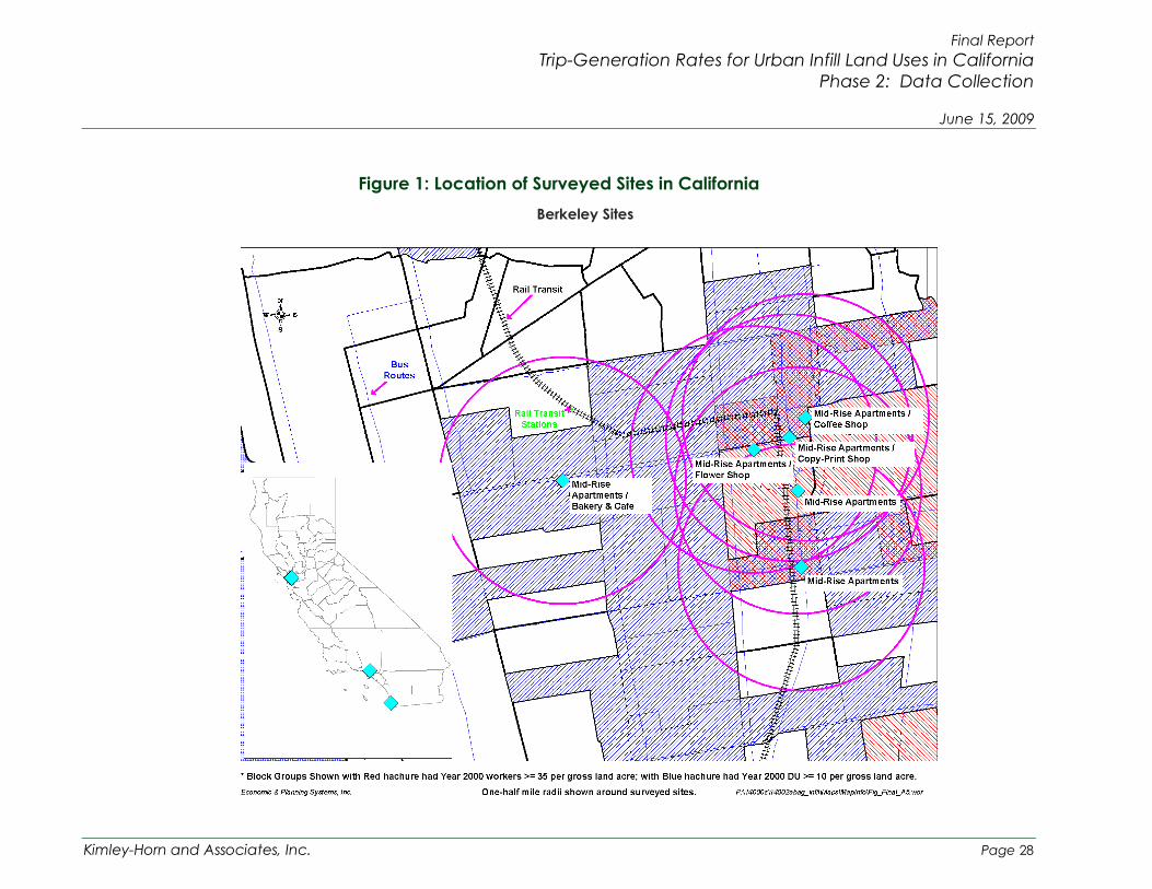
Final Report Trip-Generation Rates for Urban Infill Land Uses in California
Phase 2: Data Collection
June 15, 2009
Figure 1: Location of Surveyed Sites in California Berkeley Sites
Kimley-Horn and Associates, Inc. Page 28

Final Report Trip-Generation Rates for Urban Infill Land Uses in California
Phase 2: Data Collection
June 15, 2009
Figure 1: Location of Surveyed Sites in California Los Angeles Area Sites
Kimley-Horn and Associates, Inc. Page 29

Final Report Trip-Generation Rates for Urban Infill Land Uses in California
Phase 2: Data Collection
June 15, 2009
Figure 1: Location of Surveyed Sites in California San Diego Area Sites
Kimley-Horn and Associates, Inc. Page 30

Final Report Trip-Generation Rates for Urban Infill Land Uses in California
Phase1: Data Collection Methodology and Pilot Application
June 15, 2009
4 Preliminary Findings 4.1 Overview of Derived Trip Generation Rates by Land Use
The trip generation rates for the sites surveyed to date from both Phase 1 and Phase 2 (the observed rates) were derived by estimating the number of vehicle trips (from surveys and pedestrian counts) and dividing these trips by the gross leasable square footage of the building or number of dwelling units. Vehicle trips are the sum of all vehicle related trips (drove alone, passenger, and taxi), and are estimated by applying the applicable mode shares (derived from intercept surveys) to the highest hour of pedestrian counts in either the morning (7:00 – 9:00 a.m.), midday10 (11:00 a.m. – 3:00 p.m.) or afternoon (4:00 – 6:00 p.m.) peak weekday periods. It should be noted that data from alternate study periods, such as Saturday peak hours, would also be valuable for certain land use types such as retail. However, weekday peak hours were used in this study because they are the most commonly used analysis periods for traffic impact studies in California.
Although not enough data was collected to establish a statistically valid finding, a preliminary finding for the limited data collected to date is that the observed trip generation rates for the surveyed sites under different land use categories are generally lower during the morning and afternoon peak hours than ITE trip generation rates for comparable land uses. A few exceptions include the mid-rise apartment site in Pasadena, the mid-rise condominiums/townhouses site in San Diego, the Chain Clothing Store in San Francisco and the supermarket in San Diego, which had observed trip generation rates that were equal to or higher than ITE average rates for at least one peak study period. It should be noted that all of the sites that had observed trip rates that were slightly higher than ITE rates were within the ITE range of rates for their respective land use categories.
4.2 Comparison with ITE Trip Generation Rates
4.2.1 Residential Land Uses Table 2 compares the observed and ITE vehicle trip generation rates for residential land use categories. It is important to note that this comparison is based on a small number of sites and surveys (only one site for some categories) and is intended as the beginning of a more comprehensive database.
It is important to note that a large proportion of the residents surveyed at the Berkeley sites are affiliated with the University of California at Berkeley as either
10 For retail and restaurant uses, the midday survey covers a period from 10:00 a.m. to 3:00 p.m., depending on the hours of operation for the site.
Kimley-Horn and Associates, Inc. Page 31

Final Report Trip-Generation Rates for Urban Infill Land Uses in California
Phase 2: Data Collection
June 15, 2009 students or employees (about 50%). Due to the proximity of the sites to the University, the non-auto mode share may be higher than if the sites were not located near the University. This does not invalidate the data and, in fact, may be representative of typical university town urban infill development. However, in an effort to ensure diversity in the type and location of sites studied, only one of the Berkeley mid-rise apartment sites is included in the residential land use analysis summary and averages presented in Table 2. The findings from the remaining Berkeley mid-rise apartment sites are presented in a later section as a representation of urban university town residential trip generation.
Table 2: Comparison of Observed and ITE Trip Rates (For Residential Land Uses)
Land Use Location
AM Peak Hour PM Peak Hour
Observed Trip Rate
Avg. ITE Trip Rate (ITE Code)
% Diff.
Observed Trip Rate
Avg. ITE Trip Rate (ITE Code)
% Diff.
Residential Land Use Mid-Rise Apartments Berkeley 0.04
0.30 (223)
0.28
0.39 (223)
Mid-Rise Apartments
Santa Monica 0.25 0.25
Mid-Rise Apartments Pasadena 0.34 0.32
Weighted Average of Mid-Rise Apartment Sites 0.22 -27% 0.28 -28%
High-Rise Apartments
San Francisco 0.05 0.30
(222) -83% 0.07 0.35 (222) -0.80
Mid-Rise Residential Condominiums/ Townhouses
San Diego 0.46 0.44 (230) 5% 0.41 0.52
(230) -21%
High-Rise Condominiums/ Townhouses
San Diego 0.10 0.34 (232) -71% 0.17 0.38
(232) -55%
Weighted Average of All Residential Sites 0.17 0.32
Notes: Average ITE trip rates from Trip Generation, 8th Edition, 2008. ITE average trip rate for ‘Peak Hour of Adjacent Street Traffic’ was used for comparison, except where noted. Weighted average is computed by dividing the total number of auto trips from all sites by the total number of units in all sites.
Figure 2 and Figure 3 provide scatter plots comparing the observed residential trip rates to ITE trip rates for the AM and the PM peak hours. Further details on the mode of travel observed at these survey sites are presented in the following section.
Kimley-Horn and Associates, Inc. Page 32

Final Report Trip-Generation Rates for Urban Infill Land Uses in California
Phase 2: Data Collection
June 15, 2009 Figure 2: Comparison Between Surveyed Trip Results and ITE Standard Trip
Estimates For All Residential Land Use Categories - AM Peak Hour
150 Av
erag
e Ve
hicl
e Tr
ips
140
130
120
110
100
90
80
70
60
50
40
30
20
10
0
Surveyed AM Trips
ITE Standard AM Trips
0 25 50 75 100 125 150 175 200 225 250 275 300 325 350 375 400 425 450
Number of Dwelling Units
Figure 3: Comparison Between Surveyed Trip Results and ITE Standard Trip Estimates For All Residential Land Use Categories - PM Peak Hour
150
Aver
age
Vehi
cle
Trip
s
140
130
120
110
100
90
80
70
60
50
40
30
20
10
0
Surveyed PM Trips
ITE Standard PM Trips
0 25 50 75 100 125 150 175 200 225 250 275 300 325 350 375 400 425 450
Number of Dwelling Units
Kimley-Horn and Associates, Inc. Page 33

Final Report Trip-Generation Rates for Urban Infill Land Uses in California
Phase 2: Data Collection
June 15, 2009 For residential land use categories, the observed vehicle trip generation rates were lower than ITE trip rates at all locations surveyed during the AM and the PM peak hours, with the exception of the mid-rise apartment site in Pasadena and the mid-rise condominiums/townhomes site in San Diego, where the observed AM peak hour trip rates were slightly higher than the standard ITE trip rates. For the surveyed sites in San Francisco and Berkeley, the observed trip rates were significantly lower when compared to ITE trip rates. The observed trip generation rates for the mid-rise apartment site in Berkeley was 28 percent (PM peak) to 87 percent (AM peak) lower than ITE average rates, while the high-rise apartment site in San Francisco was 80 percent (PM peak) to 83 percent (AM peak) lower than ITE average rates. Additionally, the weighted average trip rate of the three mid-rise apartment sites was observed to be 27 percent to 28 percent lower than ITE average rates.
The observed trip rates for the San Diego sites may be representative of typical urban infill residential sites, but also representative of higher-end development with a mix of moderate to high-income owners and renters, and sites with relatively high parking ratios. Since the two San Diego residential sites are within different ITE land use categories, the weighted average trip rate was not calculated. However, the weighted average of all the residential sites is lower than the ITE average rates for any residential category.
4.2.2 Non-Residential Land Uses For the non-residential land use categories surveyed, the derived urban infill trip rates were lower than published ITE trip rates at all the locations surveyed during the AM and the PM peak hours, except for the Retail Clothing Store and the Asian Cuisine quality restaurant. For the Retail Clothing Store, the observed trip generation rate was slightly higher than the ITE rate during the PM peak hour. The retail site was not open during the AM peak hour. Therefore, it was surveyed during the midday peak; however, the observed midday trip rate could not be compared to an ITE average trip rate because ITE Trip Generation does not provide an average trip rate for the “weekday peak hour of the generator” for shopping centers. The observed trip generation rates for the Asian Cuisine quality restaurant were lower than the ITE average rate for the AM peak hour; however, the observed PM peak hour trip rate was higher than the equivalent ITE rate.
Table 3 compares the observed and ITE vehicle trip generation rates for non-residential sites. Figure 4 and Figure 5 provide scatter plots comparing the trip generation of the four office buildings surveyed during Phase 1 and Phase 2 using the observed and ITE average rates and ITE equations for the AM and PM peak hours.
Kimley-Horn and Associates, Inc. Page 34

Final Report Trip-Generation Rates for Urban Infill Land Uses in California
Phase 2: Data Collection
June 15, 2009 Table 3: Comparison of Observed and ITE Trip Rates
(For Non-Residential Land Uses)
Land Use Location AM Peak Hour PM Peak Hour
Observed Trip Rate
ITE Trip Rate % Diff. Observed
Trip Rate ITE Trip Rate % Diff.
Non-Residential Land Use General Office Building
San Francisco 1.21
1.55 (ITE 710)
0.92
1.49 (ITE 710)
General Office Building
Los Angeles 0.81 0.62
General Office Building
Los Angeles 0.28 0.50
General Office Building
Los Angeles 0.60 0.95
Weighted Average of Office Sites 0.78 -50% 0.74 -50%
Retail Clothing Store1,4 Oakland 12.03 N/A2 N/A 4.01 3.73
(ITE 820) 8%
Florist4 Berkeley 0.83 1.00 (ITE 820) -17% 2.92 3.73
(ITE 820) -22%
Bakery & Cafe5 Berkeley 5.21 70.22 (ITE 939) -93% 8.46 28.00
(ITE 939) -70%
Coffee Shop6 San Diego 50.80 117.23
(ITE 936) -57% 8.77 40.57 (ITE 936) -78%
Quality Restaurant
San Francisco 4.56
5.573
(ITE 931)
4.20
7.49 (ITE 931)
Quality Restaurant
San Francisco 1.75 8.29
Weighted Average of Quality Restaurant Sites 3.62 -35% 5.56 -26%
Notes: ITE trip rates from Trip Generation manual, 8th Edition, 2008. ITE average trip rate for ‘Peak Hour of Adjacent Street Traffic’ was used for comparison, except where noted.
1 The clothing store was not open during the AM peak hour. This rate is the midday rate representing the PM peak hour of the generator as defined by ITE. 2 ITE Trip Generation does not provide a weekday rate for “peak hour of the generator” for shopping centers. However, the trip generation manual provides rates for “apparel store” (Code 870). The ITE average PM peak hour rate for this land use is 3.83 trips per 1,000 SF, and 4.20 trips for the PM peak hour of the generator. Therefore, the observed rates for the clothing store, when compared to ITE’s apparel store category, provides a close match with the PM peak hour and a significantly higher rate when compared to ITE’s peak hour of the generator. 3 The quality restaurants were closed during the AM peak hour. Therefore, the restaurants were surveyed during the midday period (11:30AM-2:00PM). For comparative purposes, the ITE 931 rate for the AM peak hour of the generator is shown above. 4 ITE Trip Generation does not provide specific trip generation rates for each of the different types of retail land uses included in this study; therefore, the TAC chose to compare all forms of retail to ITE Trip Generation’s Shopping Center land use category (Code 820). 5 Compared to ITE’s bread/donut/bagel shop category under land use code 939 (Bread/Donut/Bagel Shop without Drive-Through Window). 6 Compared to ITE’s coffee/donut shop category under land use code 936 (Coffee/Donut Shop without Drive-Through Window).
Kimley-Horn and Associates, Inc. Page 35

Final Report Trip-Generation Rates for Urban Infill Land Uses in California
Phase 2: Data Collection
June 15, 2009 Figure 4: Comparison Between Derived Trip Rates and ITE Trip Estimates -
General Office Use - AM Peak Hour 250
Aver
age
Vehi
cle
Trip
s
225
200
175
150
125
100
75
50
25
0
Surveyed AM Trips
ITE Standard AM Trips
ITE Equation Rates
0 25 50 75 100 125 150 175 200
1,000 Sq. Feet Gross Floor Area
Figure 5: Comparison Between Derived Trip Rates and ITE Trip Estimates -General Office Use - PM Peak Hour
250
Aver
age
Vehi
cle
Trip
s
225
200
175
150
125
100
75
50
25
0
Surveyed PM Trips
ITE Standard PM Trips
ITE Equation Rates
0 25 50 75 100 125 150 175 200
1,000 Sq. Feet Gross Floor Area
Kimley-Horn and Associates, Inc. Page 36

Final Report Trip-Generation Rates for Urban Infill Land Uses in California
Phase 2: Data Collection
June 15, 2009 4.2.3 Non-Prioritized Land Uses
Several additional non-residential sites were surveyed, but were not included in the list of ten priority land uses selected by the TAC for Phase 2 of the research and, therefore, were not included in the analysis presented above. Several of these non-prioritized sites were located in the ground floor commercial portion the residential sites; therefore, these locations were surveyed along with the residential component of the site for future reference. Other sites, such as the Supermarket and Health/Fitness Club, were consistent with the ten priority land use categories for Phase 1 of the study, but were replaced by other preferred land uses types for Phase 2 by the TAC. In this section, the observed trip generation rates for these non-prioritized land use categories are compared to ITE average trip rates for similar land use categories.
Of the three non-prioritized sites that were surveyed, two of the three sites have observed trip generation rates that are lower than the ITE average rates. The only non-prioritized site that had higher observed trip rates than the equivalent ITE average rates was the supermarket, which had higher observed trip rates for the AM and PM peak hours. Table 4: summarizes the comparison of trips rates for non-prioritized land uses.
Kimley-Horn and Associates, Inc. Page 37

Final Report Trip-Generation Rates for Urban Infill Land Uses in California
Phase 2: Data Collection
June 15, 2009 Table 4: Comparison of Observed and ITE Trip Rates
(For Non-Prioritized Land Use Categories)
Commercial Land Use Location
AM Peak Hour PM Peak Hour
Derived Trip Rate
ITE Trip Rate (ITE
Code)
% Diff. Derived
Trip Rate
ITE Trip Rate (ITE Code) % Diff.
Non-Residential Land Use (not selected for this study)
Drinking Place1 Berkeley N/A 0.00
(ITE 925) N/A 0.14 11.34 (ITE 925) -98.8%
Supermarket San Diego 4.66 3.59
(ITE 850) 29.8% 10.82 10.50 (ITE 850) 3.1%
Health/Fitness Club Oakland 1.19 1.38
(ITE 492) -13.8% 1.21 3.53 (ITE 492) -65.7%
Notes: ITE average trip rates from Trip Generation, 8th Edition, 2008. ITE average trip rate for ‘Peak Hour of Adjacent Street Traffic’ was used for comparison. 1 The drinking place was closed for AM peak hour. Compared to ITE land use 925 (Drinking Place).
4.2.4 Urban University Town Trip Generation – UC Berkeley Sites As noted previously, a large proportion of the residents surveyed at the Berkeley residential sites are affiliated with the University of California at Berkeley as either students or employees (about 50%). Due to the proximity of the sites to the University, the non-auto mode share may be higher than if the sites were not located near the University. This does not invalidate the data and, in fact, may be representative of university town urban infill development. The findings from all of the surveyed Berkeley sites are provided in this section as a representation of the trip generation characteristics of residential and non-residential land uses in an urban university town setting.
Table 5 compares the observed and ITE vehicle trip generation rates for sites near the University of California at Berkeley. The observed trip generation rates were lower than the ITE average rates for all of the sites, except for the copy/printing shop, which had a slightly higher observed trip rate during the PM peak hour. The mid-rise apartment sites had significantly lower observed trip generation rates than the ITE average rates. The weighted average rate for the mid-rise apartment sites was 67% lower for the AM peak and 59% lower for the PM peak hour.
These findings are indicative of the travel characteristics of land uses in close proximity to the University, as well as the relatively low parking ratio provided at each of the six Berkeley sites (see Appendix for details).
Kimley-Horn and Associates, Inc. Page 38

Final Report Trip-Generation Rates for Urban Infill Land Uses in California
Phase 2: Data Collection
June 15, 2009 Table 5: Comparison of Observed and ITE Trip Rates
(For Sites Near UC Berkeley)
Land Use Location
AM Peak Hour PM Peak Hour
Observed Trip Rate
ITE Trip Rate (ITE
Code)
% Diff. Observed Trip Rate
ITE Trip Rate (ITE
Code)
% Diff.
Residential Land Use
Mid-Rise Apartments1 Berkeley 0.00
0.30 (ITE 223)
-100% 0.04
0.39 (ITE 223)
-89.7%
Mid-Rise Apartments Berkeley 0.04 -86.7% 0.28 -28.2%
Mid-Rise Apartments Berkeley 0.22 -26.7% 0.17 -56.4% Mid-Rise Apartments Berkeley 0.05 -83.3% 0.15 -61.5%
Mid-Rise Apartments Berkeley 0.07 -76.7% 0.09 -76.9%
Mid-Rise Apartments Berkeley 0.13 -56.7% 0.13 -66.7% Weighted Average of Berkeley Mid-Rise Apartment Sites 0.10 -66.7% 0.16 -59.0%
Non-Residential Land Use
Bakery & Cafe Berkeley 5.21 70.223
(ITE 939) -92.6% 8.46 28.003
(ITE 939) -69.8%
Coffee Shop Berkeley 17.89 117.234
(ITE 936) -84.7% 7.85 40.574
(ITE 936) -80.7%
Copy/Printing Shop2 Berkeley N/A 1.00 (ITE 820) N/A 4.00 3.73
(ITE 820) 7.2%
Flower Shop Berkeley 0.83 1.00 (ITE 820) -17.0% 2.92 3.73
(ITE 820) -21.7%
Notes: ITE trip rates from Trip Generation manual, 8th Edition, 2008. ITE average trip rate for ‘Peak Hour of Adjacent Street Traffic’ was used for comparison. 1 Intercept survey indicated no AM peak hour automobile trips. 2 The copy/printing shop is closed during the AM peak hour. 3 Compared to ITE’s bread/donut/bagel shop category under land use code 939 (Brea/Donut/Bagel Shop without Drive-Through Window). 4 Compared to ITE’s coffee/donut shop category under land use code 936 (Coffee/Donut Shop without Drive-Through Window). Weighted average is computed by dividing the total number of auto trips from all sites by the total number of units in all sites.
Figure 6 and Figure 7 provide scatter plots comparing the trip generation of the six mid-rise apartment sites in Berkeley surveyed during the study using the observed and ITE average rates for the AM and PM peak hours, respectively.
Kimley-Horn and Associates, Inc. Page 39

Final Report Trip-Generation Rates for Urban Infill Land Uses in California
Phase 2: Data Collection
June 15, 2009
Figure 6: Comparison Between Derived Trip Rates and ITE Trip Estimates – Berkeley Residential Uses - AM Peak Hour
50
Surveyed AM Trips
ITE Standard AM Trips
40
30
20
10
0 0 25 50 75 100 125 150 175 200
Number of Dwelling Units
Aver
age
Vehi
cle
Trip
s
Figure 7: Comparison Between Derived Trip Rates and ITE Trip Estimates – Berkeley Residential Uses - PM Peak Hour
50
Surveyed PM Trips
ITE Standard PM Trips
40
30
20Aver
age
Vehi
cle
Trip
s
10
0 0 25 50 75 100 125 150 175 200
Number of Dwelling Units
Kimley-Horn and Associates, Inc. Page 40

Final Report Trip-Generation Rates for Urban Infill Land Uses in California
Phase 2: Data Collection
June 15, 2009 4.3 Mode of Travel by Land Use
Table 6 summarizes the observed mode of travel by residential land use during the AM and the PM peak hour. The weighted average of percent auto trips for all of the residential sites is approximately 51% in the AM peak hour and 47% in the PM peak hour, which indicates a near-equal split between auto and transit/walk/bicycle mode share for the combined uses. Again, it should be noted that only one of the Berkeley mid-rise apartment sites is included in the residential land use mode split summary presented in Table 6. The findings from the remaining Berkeley mid-rise apartment sites are presented in a later section as a representation of urban university town residential mode split.
Table 6: Comparison of Mode of Travel by Land Use (For Residential Land Uses)
Land Use Location
AM Peak Hour PM Peak Hour %
Auto Trips
% Transit Trips
% Walk / Bicycle
Trips
% Auto Trips
% Transit Trips
% Walk / Bicycle
Trips
Residential Land Use
Mid-Rise Apartments Berkeley 20% 7% 73% 24% 5% 71%
Mid-Rise Apartments Santa Monica 84% 0% 16% 62% 3% 35%
Mid-Rise Apartments Pasadena 85% 9% 6% 85% 5% 10%
Weighted Average of Mid-Rise Apartment Sites 67% 5% 28% 60% 4% 36%
High-Rise Apartments San Francisco 14% 61% 25% 17% 49% 34%
High-Rise Residential Condominiums / Townhouses
San Diego 77% 3% 20% 73% 7% 20%
Mid-Rise Residential Condominiums / Townhouses
San Diego 85% 2% 13% 69% 0% 31%
Weighted Average of Residential Sites 51% 26% 23% 47% 21% 32%
For the residential land uses surveyed within the San Francisco Bay Area, the percentage of auto trips is relatively low compared to the percentage of non-auto trips. For example, the Berkeley mid-rise site in Table 6 has approximately 73 percent walk/bicycle trips in the AM peak hour and approximately 71 percent walk/bicycle trips in the PM peak hour. Also, the high-rise apartment site in the City of San Francisco has a combined transit and walk/bicycle mode share of approximately 86 percent for the AM peak hour and 83 percent for the PM peak hour. Note that for the transit mode share the San Francisco high-rise apartment
Kimley-Horn and Associates, Inc. Page 41

Final Report Trip-Generation Rates for Urban Infill Land Uses in California
Phase 2: Data Collection
June 15, 2009 site significantly skews the weighted average (49 percent to 67 percent transit) for all of the residential sites. The other sites surveyed have a transit mode share ranging from 2 percent to 9 percent.
In comparison, the two mid-rise apartment sites located in the Los Angeles region have significantly higher percent auto trips compared to transit and walk/bicycle modes. This may reflect a greater propensity for auto usage in the Los Angeles region, or it may indicate that residents of these areas commute to locations outside of their locality.
The two residential sites located in downtown San Diego have a higher percentage of auto trips than transit and walk/bicycle trips, indicating that these residents may commute to areas outside of downtown. However, both San Diego sites have a relatively high walk/bike mode of travel, indicating that the location of these sites is conducive to walking and biking for daily errands. Furthermore, the San Diego site residents are more affluent than other sites surveyed (based on the optional survey question on income) and the sites have a relatively high parking ratio. While more data is needed to draw any definitive conclusions, these sites may be examples of “self-selective” upscale urban housing where auto travel remains the predominant mode of travel.
Table 7 presents the observed mode of travel by non-residential land use during the AM and PM peak hours. For the non-residential land uses the following key observations can be made:
While the three office building sites in the Los Angeles region show that auto trips are the predominant mode of travel (92 percent to 95 percent in the AM and 77 percent to 94 percent in the PM peak hour), the observed trip generation rates are significantly lower than the ITE average rates. This would indicate that this building generates fewer person trips per 1,000 square feet of built space than a comparably sized building in a suburban environment. This may be due to a lower employee density and an indication that employee density should be identified at future office building sites. However, it should be noted that the transit mode share is very high in the PM peak hour (approximately 23 percent) for the first office building listed in downtown Los Angeles (626 Wilshire Boulevard). Of the 23 percent transit mode share, 16 percent is represented by train/trolley users, which is reasonable considering the proximity of the nearby Metro Rail Station at 7th Street/Flower Street. A few possible explanations for the relatively high transit mode share percent for the PM peak hour compared to the AM peak hour include:
o The random sampling did not pick up transit users equally in the morning and afternoon. Transit users generally have a set
Kimley-Horn and Associates, Inc. Page 42

Final Report Trip-Generation Rates for Urban Infill Land Uses in California
Phase 2: Data Collection
June 15, 2009 schedule based on bus and train arrival/departure times, while auto users are free to arrive or leave per their own schedule. Transit users arriving in the morning may have chosen not to participate in the survey because they were late for work.
o Transit users may arrive earlier or later than the morning peak period surveyed. If this is the case, this pattern would only be captured in a daily survey.
o Afternoon surveys captured a relatively large grouping of transit users, which could possibly be related to train schedules.
Table 7: Comparison of Mode of Travel by Land Use (For Non-Residential Land Uses)
Land Use Location
AM Peak Hour PM Peak Hour %
Auto Trips
% Transit Trips
% Walk / Bicycle
Trips
% Auto Trips
% Transit Trips
% Walk / Bicycle
Trips
Non-Residential Land Use
General Office Building
San Francisco 69% 16% 15% 56% 31% 13%
General Office Building Los Angeles 95% 4% 1% 77% 23% 0%
General Office Building Los Angeles 92% 5% 3% 94% 6% 0%
General Office Building Los Angeles 94% 4% 2% 93% 2% 5%
Weighted Average for Office Sites 86% 8% 6% 77% 18% 5%
Retail Clothing Store Oakland n/a1 n/a1 n/a1 36% 52% 12%
Flower Shop Berkeley 100% 0% 0% 100% 0% 0%
Bakery & Cafe Berkeley 33% 11% 56% 57% 10% 33%
Coffee Shop San Diego 50% 13% 37% 17% 0% 83%
Quality Restaurant2 San Francisco 34% 8% 58% 60% 0% 40%
Quality Restaurant2 San Francisco 50% 0% 50% 57% 22% 21%
Notes: 1 The clothing store was not open during the AM peak hour; therefore, data was collected during the midday period. For this reason, the mode split is provided for the PM peak hour only. 2 The quality restaurants were not open during the AM peak hour; therefore, data was collected during the midday period.
Kimley-Horn and Associates, Inc. Page 43

Final Report Trip-Generation Rates for Urban Infill Land Uses in California
Phase 2: Data Collection
June 15, 2009 The quality restaurants that were surveyed in San Francisco show a
walk/bicycle mode share of 50 percent or more for midday peak hour. This indicates that during lunch, people who live or work in the area tend to walk or ride bikes to their lunch destinations.
Table 8 presents the observed mode of travel by residential and non-residential land use for the sites surveyed near the University of California at Berkeley during the AM and PM peak hours. This is presented as a representation of the mode share distribution for an urban university town.
Table 8: Comparison of Mode of Travel by Land Use (For Sites Near UC Berkeley)
Name Location
AM Peak Hour PM Peak Hour %
Auto Trips
% Transit Trips
% Walk / Bicycle
Trips
% Auto Trips
% Transit Trips
% Walk / Bicycle
Trips Residential Land Use
Mid-Rise Apartments1 Berkeley 0% 11% 89% 7% 27% 66%
Mid-Rise Apartments Berkeley 20% 7% 73% 24% 5% 71%
Mid-Rise Apartments Berkeley 57% 29% 14% 35% 30% 35%
Mid-Rise Apartments Berkeley 25% 50% 25% 17% 9% 74%
Mid-Rise Apartments Berkeley 21% 17% 62% 20% 7% 73%
Mid-Rise Apartments Berkeley 44% 22% 34% 24% 14% 62%
Weighted Average of All Mid-Rise Apartment Sites 31% 20% 49% 23% 15% 62%
Non-Residential Land Use
Bakery & Cafe Berkeley 33% 11% 56% 57% 10% 33%
Coffee Shop Berkeley 64% 0% 36% 35% 8% 57%
Copy/Printing Shop Berkeley n/a2 n/a2 n/a2 38% 0% 62%
Flower Shop Berkeley 100% 0% 0% 100% 0% 0%
Weighted Average of All Non-Residential Sites 58% 5% 37% 53% 6% 41%
Notes: 1 Intercept survey indicated no AM peak hour automobile trips. 2 The Copy/Printing Shop was closed during the AM period. Weighted average is computed by dividing the total number of auto trips from all sites by the total number of units in all sites.
Kimley-Horn and Associates, Inc. Page 44

Final Report Trip-Generation Rates for Urban Infill Land Uses in California
Phase 2: Data Collection
June 15, 2009
5 Summary and Conclusion This chapter provides preliminary conclusions based on this research completed thus far. Despite the fact that the research project failed to meet its overall data collection goals, the data that was obtained provides some insight into the differences in travel patterns between urban infill and conventional suburban sites and establishes the beginning of an urban infill trip generation database. The study has been successful in identifying and testing data collection methods and determining ways to address challenges, such as promoting participation in the research. The lessons learned in this study have strengthened the knowledge and techniques for continuing data collection in future efforts. A detailed discussion of the challenges encountered in this study is presented in Appendix D.
5.1 Key Conclusions The preliminary data collected and evaluated to date from 27 sites indicate that the observed trip generation rates are generally lower (in some cases significantly) when compared to ITE trip generation rates, although some individual sites show trip rates equal to or higher than ITE rates. More data points are required for the full set of selected land uses to substantiate this preliminary conclusion and to establish statistical correlations between urban contexts and trip generation characteristics.
5.2 Recommendations
5.2.1 Recommendations for Improving Study Methodology The methodologies used in this study could be improved in the following ways:
In this study, the gross leasable area (GLA) was used to derive the observed trip generation rates for general office building sites. Because ITE trip rates are based on gross square-footage (GSF), the observed trip rates presented in this study are essentially conservative when compared to ITE rates. Gross leasable area was used for this study for the reason that it is typically easier for building property managers to provide compared to GSF; however, it is recommended that GSF be used for future efforts to increase the comparability of the analysis results11.
During the site surveys, the inbound and outbound trips were recorded separately for the pedestrian counts, but the intercept surveys did not differentiate between inbound and outbound trips during each peak
11 GLA – Total floor area available to tenants, GSF – Total floor area of a building.
Kimley-Horn and Associates, Inc. Page 45

Final Report Trip-Generation Rates for Urban Infill Land Uses in California
Phase 2: Data Collection
June 15, 2009 hour. In order to serve as a more valuable reference during data analysis, the intercept survey questionnaires should note the direction of each trip, as well as the precise time the interview was conducted.
For sites with multiple entrances (i.e. main lobby entrance, garage entrance), there may be distinctly different travel characteristics at each entrance. For example, an office building may have a particular entrance located near a transit station, or a garage entrance that is only accessible via automobile. For sites of this type, it is recommended that the mode split and trip generation be analyzed for each specific entrance, then used to develop a weighted average.
For several of the sites surveyed in Phase 2 of this study, the intercept survey questionnaires included a question regarding where the traveler parked (if traveling by automobile, did they park on-site, off-site, etc.). This information proved to be particularly useful when evaluating the survey data. It is recommended that future studies include a question of this type in the intercept survey questionnaire.
During the intercept surveys, surveyors were asked to note the time and location for each completed travel questionnaire; however, this information was often omitted during the survey process. For future studies, it is recommended that the survey supervisors ensure that the surveyors fill in as many of the questionnaire inputs as practicable.
5.2.2 Recommendations for Future Research Efforts Subsequent research should include the following:
Continue data collection with the goal of developing a larger database that includes at least five data points for up to ten land use categories. This will provide enough data to perform a reasonable statistical analysis and to correlate the data for those categories.
Conduct a pilot study to test a method of collecting average daily traffic data using intercept surveys. Optimally, the pilot study would locate a site with an isolated parking facility that would allow validation of the method using automatic machine counts. This same pilot study could be used to validate the observed peak hour trip generation rates.
Once a larger database has been established, select sites for validation of trip rates. While difficult to find in urban settings, an ideal validation site would have a parking garage exclusive to tenants and visitors where traffic can be counted automatically and compared to traffic estimates derived from the surveys.
Kimley-Horn and Associates, Inc. Page 46

Final Report Trip-Generation Rates for Urban Infill Land Uses in California
Phase 2: Data Collection
June 15, 2009 Use the optional demographic data to cross-reference trip generation
to income, auto ownership, and other socio-economic factors.
Develop additional indicators correlating trip generation rates to urban infill site characteristics, such as distance to the Central Business District, walking environment, residential densities, number of on-site parking spaces, and distance to transit.
Explore alternative incentives to explore which (if any) are most successful in motivating property managers/owners to provide permission to survey developments. A few incentives that could be offered include:
o Access to the site’s or study’s data and results
o Copy of the final report
o To “look at any traffic/parking problems” the developer may be having
o To collect a little extra data that may be of interest to the developer/manager
o Cash, prizes or other similar options
Kimley-Horn and Associates, Inc. Page 47

Final Report Trip-Generation Rates for Urban Infill Land Uses in California
Phase 2: Data Collection
June 15, 2009
6 Bibliography Land Use and Site Design - Traveler Response to Transportation System Changes. Washington D.C.: Transportation Research Board (TRB) Transit Cooperative Research Program (TCRP), Report 95.
Association of Bay Area Governments, Kimley-Horn and Associates, and Economic & Planning Systems. Trip-Generation Rates for Urban Infill Land Uses in California, Phase 1: Data Collection Methodology and Pilot Application, Final Report. California Department of Transportation, Headquarters Divisions of Transportation Planning and Research & Innovation, 2008 Sacramento, California, USA: . Website: http://www.dot.ca.gov/newtech/researchreports/reports/2008/ca_infill_trip_rates-phase_1_final_report_appendices_4-24-08.pdf
Census 2000 Urban and Rural Classification website: www.census.gov/geo/www/ua/1ua_2k.html.
Daisa, James M., Proposed Recommended Practice in Designing Major Urban Thoroughfares for Walkable Communities, Washington D.C., Institute of Transportation Engineers, 2006.
Institute of Transportation Engineers, Trip Generation Handbook, Second Edition, Washington D.C.: Institute of Transportation Engineers, 2004.
Institute of Transportation Engineers, Trip Generation, 8th Edition, Washington D.C.: Institute of Transportation Engineers, 2008.
Smith, Mary S. Shared Parking, Second Edition, Washington D.C.: ULI-The Urban Land Institute and the International Council of Shopping Centers, 2005.
Parking Generation, 3rd Edition. Washington D.C.: Institute of Transportation Engineers, 2004.
Terry Parker, G.B. Arrington, Topaz Faulkner, Janet Smith-Heimer, Ron Golem, Daniel Mayer, et. al. Statewide Transit-Oriented Development Study – Factors for Success in California, Sacramento: California Department of Transportation, 2002.
Guide for the Preparation of Traffic Impact Studies. Sacramento: California Department of Transportation, 2002.
California Senate Bill (SB) 1636 (Figueroa) sponsored by the Surface Transportation Policy Project and signed in to law on September 12, 2002, and California Government Code Section 65088.1.
Kimley-Horn and Associates, Inc. Page 48

Final Report Trip-Generation Rates for Urban Infill Land Uses in California
Phase 2: Data Collection
June 15, 2009
7 Appendices
A. Site Data Summaries
B. Excerpt from Scope of Work for Phase 2 – Detailed Survey Methodology
C. Intercept Survey Questionnaires
D. Summary of Study Challenges
E. Summary of Study Costs
F. Summary of Comments Received from ITE Trip Generation Subcommittee Review of Phase 1 Final Report
Kimley-Horn and Associates, Inc. Page 49

Appendix A
Site Data Summaries
50

Site Name: Chain Clothing Store
Site Location: 1333 Broadway, Oakland, CA
Land Use Type: Retail / Chain Clothing Store
Site Characteristics: Studios Units:
1 Bedroom Units: 2 Bedrooms Units:
3 + Bedrooms Units: Total
Ground Floor Commercial:
Residential Occupancy: Commercial Occupancy:
Number of parking spaces: Number of spaces per 1,000 square feet:
Density of Site:
Site Description:
Meets Residential Criteria: Meets Employment Criteria:
Meets Transit Proximity Criteria:
Quantity 0 D.U 0 D.U 0 D.U 0 D.U 0 D.U
11,000 Sq. Ft.
0% 100.00%
0 0.00 N/A units/acre
No Yes Yes
Transect / CArea Type: CBD
ontext Zone Type: Urban Core (T/CZ-6)
Predominant Land Use within 0.5 miles: Non-Residential Distance from CBD: Within CBD Connectivity Index (Measure of Walking Environment): High Residential Density (within 0.5mile): 13.17 units/gross land acre
% of blocks within 0.5 miles with sidewalks: 100% Employment Density (within 0.5 mile): 91.22 workers/ gross land acre
Survey Date: June 1, 2006. Survey Date: June 1,
ITE Land Use Codes: ITE 820 Shopping Center
Residential Trip Rate Comparison
ITE Trip Rate Directional Distribution
Surveyed Trip Rate Directional Distribution
Surveyed Mode Split
Commercial Trip Rate Comparison
ITE Trip Rate Directional Distribution
Surveyed Trip Rate Directional Distribution
Surveyed Mode Split
AM Peak Hour In Out
AM Peak - % Trips Auto
Transit Walk/Bicycle
AM Peak Hour In Out
0.63 0.37 63% 37%
5.92 6.17 49% 51%
AM Peak - % Trips Auto -
Transit -Walk/Bicycle -
Total
Total
1.00 100%
12.09 100%
PM Peak Hour In Out
PM Peak - % Trips Auto
Transit Walk/Bicycle
PM Peak Hour In Out
1.79 1.94 48% 52%
1.96 2.05 49% 51%
PM Peak - % Trips Auto 40%
Transit 48% Walk/Bicycle 12%
Total
Total
3.73 100%
4.01 100%
Note: Observed AM peak hour trip generation is the midday rate representing the PM peak hour of the generator. ITE Trip Generation does not provide a weekday rate for "peak hour of the generator" for shopping centers; therefore, no ITE comparison rate is provided for midday peak.
51

Site Name: 1388 Sutter Street
Site Location: 1388 Sutter Street, San Francisco, CA 94109
Land Use Type: Office Building
Site Characteristics: Quantity Studios Units: 0 D.U
1 Bedroom Units: 0 D.U 2 Bedrooms Units: 0 D.U
3 + Bedrooms Units: 0 D.U Total 0 D.U
Ground Floor Commercial: 120,000 Sq. Ft.
Residential Occupancy: 0% Commercial Occupancy: 100.00%
Number of parking spaces: N/A Number of spaces per 1,000 square feet: N/A
Density of Site: N/A
Site Description:
Meets Residential Criteria: Yes Meets Employment Criteria: Yes
Meets Transit Proximity Criteria: Yes
Predominant Land Use within 0.5 miles: Non-Residential Connectivity Index (Measure of Walking Environment): High
units/acre
Area Type: CBD Transect / Context Zone Type: Urban Core (T/CZ-6)
Distance from CBD: Within CBD Residential Density (within 0.5mile): 49.93 units/gross land acre
% of blocks within 0.5 miles with sidewalks: 100% Employment Density (within 0.5 mile): 46.09 workers/gross land acre
Survey Date: May 31, 2006.
ITE Land Use Codes: ITE 710 General Office Building
Residential Trip Rate Comparison
ITE Trip Rate Directional Distribution
Surveyed Trip Rate Directional Distribution
Surveyed Mode Split
Commercial Trip Rate Comparison
ITE Trip Rate Directional Distribution
Surveyed Trip Rate Directional Distribution
Surveyed Mode Split
AM Peak Hour In Out
AM Peak - % Trips Auto
Transit Walk/Bicycle
AM Peak Hour In Out
1.36 0.19 88% 12%
0.94 0.27 78% 22%
AM Peak - % Trips Auto 61%
Transit 16% Walk/Bicycle 23%
Total
Total
1.55 100%
1.21 100%
PM Peak Hour In Out Total
PM Peak - % Trips Auto
Transit Walk/Bicycle
PM Peak Hour In Out Total
0.25 1.24 1.49 17% 83% 100%
0.14 0.78 0.92 15% 85% 100%
PM Peak - % Trips Auto 53%
Transit 31% Walk/Bicycle 16%
52

Site Name: Bachenheimer Building.
Site Location: 2111 University Avenue, Berkeley, CA 94704
Land Use Type: Residential with ground floor commercial
Site Characteristics: Studios Units:
1 Bedroom Units: 2 Bedrooms Units:
3 + Bedrooms Units:
Quantity 0 D.U
12 D.U 32 D.U 0 D.U
Total 44 D.U
Ground Floor Commercial: 3,000 Sq. Ft.
Residential Occupancy: 100% Commercial Occupancy: 100%
Number of parking spaces: 30 Number of spaces per unit: 0.68
Density of Site: 155
Site Description:
Meets Residential Criteria: Yes Meets Employment Criteria: Yes
Meets Transit Proximity Criteria: Yes
Predominant Land Use within 0.5 miles: Non-Residential
units/acre
Area Type: CBD Transect / Context Zone Type: Urban Center (T/CZ-5)
Distance from CBD: Within CBD Connectivity Index (Measure of Walking Environment): High Residential Density (within 0.5mile): 11.63 units/gross land acre
% of blocks within 0.5 miles with sidewalks:% of blocks within 0.5 miles with sidewalks: 100%100% Employment Density (within 0.5 mile): 36.23 workers/gross land acre Employment Density (within 0.5 mile): 36.23 workers/gross land acre
Survey Date: 10th May, 2007
ITE Land Use Codes: ITE 223 Mid-Rise Apartments ITE 820 Shopping Center
Residential Trip Rate Comparison
ITE Trip Rate Directional Distribution
Surveyed Trip Rate Directional Distribution
Surveyed Mode Split
Commercial Trip Rate Comparison
ITE Trip Rate Directional Distribution
Surveyed Trip Rate Directional Distribution
Surveyed Mode Split
AM Peak Hour In Out
0.09 0.21 31% 69%
0.00 0.00
AM Peak - % Trips Auto 0%
Transit 11% Walk/Bicycle 89%
AM Peak Hour In Out
0.63 0.37 63% 37%
0.00 0.00
AM Peak - % Trips Auto 0%
Transit 0% Walk/Bicycle 0%
Total
0.30 100%
0.00
Total
1.00 100%
0.00
PM Peak Hour In Out
0.23 0.16 58% 42%
0.03 0.01 70% 30%
PM Peak - % Trips Auto 7%
Transit 27% Walk/Bicycle 66%
PM Peak Hour In Out
1.79 1.94 48% 52%
1.72 2.28 43% 57%
PM Peak - % Trips Auto 38%
Transit 0% Walk/Bicycle 62%
Note: The commercial shop was closed during the AM peak hourNote: The commercial shop was closed during the AM peak hour
Total
0.39 100%
0.04 100%
Total
3.73 100%
4.00 100%
53

Site Name: Gaia Building.
Site Location: 2116 Allston Way, Berkeley, CA 94704
Land Use Type: Residential with ground floor Jazz Island
Site Characteristics: Quantity Studios Units: 0 D.U
1 Bedroom Units: 26 D.U 2 Bedrooms Units: 73 D.U
3 + Bedrooms Units: 0 D.U Total 99 D.U
Ground Floor Commercial: 12,000 Sq. Ft.
Residential Occupancy: Commercial Occupancy:
99% 100%
Number of parking spaces: Number of spaces per unit:
Density of Site:
40 0.40 267 units/acre
Site Description:
Meets Residential Criteria: Meets Employment Criteria:
Meets Transit Proximity Criteria:
No Yes Yes
Area Type: CBD Transect / Context Zone Type: Urban Center (T/CZ-5)
Predominant Land Use within 0.5 miles: Commercial and Residential Distance from CBD: Within CBD Connectivity Index (Measure of Walking Environment): High Residential Density (within 0.5mile): 12.09 units/gross land acre
% of blocks within 0.5 miles with sidewalks:% of blocks within 0.5 miles with sidewalks: 100%100% Employment Density (within 0.5 mile): 36.32 workers/gross land acre Employment Density (within 0.5 mile): 36.32 workers/gross land acre
Survey Date: 10th May, 2007
ITE Land Use Codes: ITE 223 Mid-Rise Apartments ITE 925 Drinking Place
Residential Trip Rate Comparison
ITE Trip Rate Directional Distribution
Surveyed Trip Rate Directional Distribution
Surveyed Mode Split
Commercial Trip Rate Comparison
ITE Trip Rate Directional Distribution
Surveyed Trip Rate Directional Distribution
Surveyed Mode Split
AM Peak Hour In Out
0.09 0.21 31% 69%
0.01 0.03 22% 78%
AM Peak - % Trips Auto 20%
Transit 7% Walk/Bicycle 73%
AM Peak Hour In Out
0.00 0.00
0.00 0.00
AM Peak - % Trips Auto 0%
Transit 0% Walk/Bicycle 0%
Total
0.30 100%
0.04
Total
0.00
0.00
PM Peak Hour In Out
0.23 0.16 58% 42%
0.17 0.11 59% 41%
PM Peak - % Trips Auto 24%
Transit 5% Walk/Bicycle 71%
PM Peak Hour In Out
7.48 3.86 66% 34%
0.14 0.00 100% 0%
PM Peak - % Trips Auto 43%
Transit 29% Walk/Bicycle 28%
Note: The Jazz Island is closed during the AM peak hourNote: The Jazz Island is closed during the AM peak hour
Total
0.39 100%
0.28 100%
Total
11.34 100%
0.14 100%
54

Survey Date: May 8th, 2007
ITE Land Use Codes: ITE 223 Mid-Rise Apartments ITE 939 Bread/Donut/Bagel Shop w/o Drive-Through Window
Site Name: Acton Courtyard
Site Location: 1370 University Ave., Berkeley, CA 94704
Land Use Type: Residential with ground floor commercial
Site Characteristics: Quantity Studios Units: 4 D.U
1 Bedroom Units: 7 D.U 2 Bedrooms Units: 60 D.U
3 + Bedrooms Units: 0 D.U Total 71 D.U
Ground Floor Commercial: 5,000 Sq. Ft.
Residential Occupancy: 100% Commercial Occupancy: 100%
Number of parking spaces: 62 Number of spaces per unit: 0.87
Density of Site: 141 units/acre
Site Description:
Meets Residential Criteria: Yes Area Type: CND Meets Employment Criteria: No Transect / Context Zone Type: Urban Center (T/CZ-5)
Meets Transit Proximity Criteria: No
Predominant Land Use within 0.5 miles: Residential Distance from CBD: < 1 mile Connectivity Index (Measure of Walking Environment): High Residential Density (within 0.5mile): 10.75 units/gross land acre
% of blocks within 0.5 miles with sidewalks: % of blocks within 0.5 miles with sidewalks: 100%100% Employment Density (within 0.5 mile): 6.25 workers/gross land acre Employment Density (within 0.5 mile): 6.25 workers/gross land acre
Residential Trip Rate Comparison In AM Peak Hour
Out Total In PM Peak Hour
Out Total
ITE Trip Rate Directional Distribution
0.09 31%
0.21 69%
0.30 100%
0.23 58%
0.16 42%
0.39 100%
Surveyed Trip Rate Directional Distribution
0.04 19%
0.18 81%
0.22 100%
0.09 52%
0.08 48%
0.17 100%
Surveyed Mode Split AM Peak - % Trips
Auto 57% Transit 29%
Walk/Bicycle 14%
PM Peak - % Trips Auto 35%
Transit 30% Walk/Bicycle 35%
Commercial Trip Rate Comparison In AM Peak Hour
Out Total In PM Peak Hour
Out Total
ITE Trip Rate Directional Distribution
33.00 47%
37.22 53%
70.22 100%
14.00 50%
14.00 50%
28.00 100%
Surveyed Trip Rate Directional Distribution
2.13 56%
1.67 44%
3.80 100%
4.23 50%
4.23 50%
8.46 100%
AM Peak - % Trips PM Peak - % Trips Surveyed Mode Split Auto 33% Auto 57%
Transit 11% Transit 10% Walk/Bicycle 56% Walk/Bicycle 33%
55

Site Name: Touriel Building
Site Location: 2004 University Ave., Berkeley, CA 94704
Land Use Type: Residential with ground floor commercial (Flower Shop)
Site Characteristics: Quantity Studios Units: 0 D.U
1 Bedroom Units: 10 D.U 2 Bedrooms Units: 25 D.U
3 + Bedrooms Units: 0 D.U Total 35 D.U
Ground Floor Commercial: 2,400 Sq. Ft.
Residential Occupancy: 97% Commercial Occupancy: 100%
Number of parking spaces: 5 Number of spaces per unit: 0.14
Density of Site: 218 units/acre
Site Description:
Meets Residential Criteria: Yes Area Type: CBD Meets Employment Criteria: Yes Transect / Context Zone Type: Urban Center (T/CZ-5)
Meets Transit Proximity Criteria: Yes
Predominant Land Use within 0.5 miles: Commercial and Residential Distance from CBD: Within CBD Connectivity Index (Measure of Walking Environment): High Residential Density (within 0.5mile): 12.13 units/gross land acre
% of blocks within 0.5 miles with sidewalks: 100% Employment Density (within 0.5 mile): 32.77 workers/gross land acre
Surv Date: May 9th, 2007Survey Date: May 9th, 2007
ITE Land Use Codes: ITE 223 Mid-Rise Apartments ITE 820 Shopping Center
Residential Trip Rate Comparison In AM Peak Hour
Out Total In PM Peak Hour
Out Total
ITE Trip Rate 0.09 0.21 0.30 0.23 0.16 0.39 Directional Distribution 31% 69% 100% 58% 42% 100%
Surveyed Trip Rate 0.01 0.04 0.05 0.07 0.08 0.15 Directional Distribution 14% 86% 100% 46% 54% 100%
AM Peak - % Trips PM Peak - % Trips Surveyed Mode Split Auto 25% Auto 15%
Transit 50% Transit 9% Walk/Bicycle 25% Walk/Bicycle 74%
Commercial Trip Rate Comparison In AM Peak Hour
Out Total In PM Peak Hour
Out Total
ITE Trip Rate Directional Distribution
0.63 63%
0.37 37%
1.00 100%
1.79 48%
1.94 52%
3.73 100%
Surveyed Trip Rate Directional Distribution
0.44 100%
0.00 0%
0.44 100%
0.85 29%
2.07 71%
2.92 100%
Surveyed Mode Split AM Peak - % Trips
Auto 100% Transit 0%
Walk/Bicycle 0%
PM Peak - % Trips Auto 100%
Transit 0% Walk/Bicycle 0%
56

Site Name: Berkeleyan Apartments
Site Location: 1910 Oxford St., Berkeley, CA 94704
Land Use Type: Residential with ground floor commercial (Coffee Shop)
Site Characteristics: Quantity Studios Units: 0 D.U
1 Bedroom Units: 5 D.U 2 Bedrooms Units: 51 D.U
3 + Bedrooms Units: 0 D.U Total 56 D.U
Ground Floor Commercial: 4,500 Sq. Ft.
Residential Occupancy: 100% Commercial Occupancy: 100%
Number of parking spaces: 36 Number of spaces per unit: 0.64
Density of Site: 227 units/acre
Site Description:
Meets Residential Criteria: Yes Area Type: CBD Meets Employment Criteria: Yes Transect / Context Zone Type: Urban Center (T/CZ-5)
Meets Transit Proximity Criteria: Yes
Predominant Land Use within 0.5 miles: Non-Residential Distance from CBD: Within CBD Connectivity Index (Measure of Walking Environment): High Residential Density (within 0.5mile): 11.07 units/gross land acre
% of blocks within 0.5 miles with sidewalks: 100% Employment Density (within 0.5 mile): 35.72 workers/gross land acre
Survey Date: May 10th, 2007 Survey Date: May 10th, 2007
ITE Land Use Codes: ITE 223 Mid-Rise Apartments ITE 936 Coffee/Donut Shop w/o Drive-Through Window
Residential Trip Rate Comparison In AM Peak Hour
Out Total In PM Peak Hour
Out Total
ITE Trip Rate 0.09 0.21 0.30 0.23 0.16 0.39 Directional Distribution 31% 69% 100% 58% 42% 100%
Surveyed Trip Rate 0.02 0.05 0.07 0.07 0.02 0.09 Directional Distribution 28% 72% 100% 80% 20% 100%
AM Peak - % Trips PM Peak - % Trips Surveyed Mode Split Auto 21% Auto 20%
Transit 17% Transit 7% Walk/Bicycle 62% Walk/Bicycle 73%
Commercial Trip Rate Comparison In AM Peak Hour
Out Total In PM Peak Hour
Out Total
ITE Trip Rate Directional Distribution
59.79 51%
57.44 49%
117.23 100%
20.29 50%
20.29 50%
40.57 100%
Surveyed Trip Rate Directional Distribution
8.23 46%
9.66 54%
17.89 100%
3.22 41%
4.63 59%
7.85 100%
Surveyed Mode Split AM Peak - % Trips
Auto 64% Transit 0%
Walk/Bicycle 36%
PM Peak - % Trips Auto 35%
Transit 8% Walk/Bicycle 57%
57

Site Name: Fine Arts Building
Site Location: 2110 Haste St., Berkeley, CA 94704
Land Use Type: Residential
Site Characteristics: Quantity Studios Units: 4 D.U
1 Bedroom Units: 32 D.U 2 Bedrooms Units: 64 D.U
3 + Bedrooms Units: 0 D.U Total 100 D.U
Ground Floor Commercial: 0 Sq. Ft.
Residential Occupancy: 100% Commercial Occupancy: 0%
Number of parking spaces: 63 Number of spaces per unit: 0.63
Density of Site: 168 units/acre
Site Description:
Meets Residential Criteria: Yes Area Type: CBD Meets Employment Criteria: Yes Transect / Context Zone Type: Urban Center (T/CZ-5)
Meets Transit Proximity Criteria: Yes
Predominant Land Use within 0.5 miles: Residential Distance from CBD: Within CBD Connectivity Index (Measure of Walking Environment): High Residential Density (within 0.5mile): 12.91 units/gross land acre
% of blocks within 0.5 miles with sidewalks: 100% Employment Density (within 0.5 mile): 26.45 workers/gross land acre
Surv Date: May 9th, 2007Survey Date: May 9th, 2007
ITE Land Use Codes: ITE 223 Mid-Rise Apartments
Residential Trip Rate Comparison In AM Peak Hour
Out Total In PM Peak Hour
Out Total
ITE Trip Rate 0.09 0.21 0.30 0.23 0.16 0.39 Directional Distribution 31% 69% 100% 58% 42% 100%
Surveyed Trip Rate 0.01 0.12 0.13 0.08 0.05 0.13 Directional Distribution 7% 93% 100% 61% 39% 100%
AM Peak - % Trips PM Peak - % Trips Surveyed Mode Split Auto 44% Auto 24%
Transit 22% Transit 14% Walk/Bicycle 34% Walk/Bicycle 62%
AM Peak Hour PM Peak Hour Commercial Trip Rate Comparison In Out Total In Out Total
ITE Trip Rate Directional Distribution
Surveyed Trip Rate Directional Distribution
AM Peak - % Trips PM Peak - % Trips Surveyed Mode Split Auto
Transit Auto
Transit Walk/Bicycle Walk/Bicycle
58

Site Name: Central City Association of Los Angeles
Site Location: 626 Wilshire Boulevard, Los Angeles, CA 90017
Land Use Type: Office Building
Site Characteristics: Quantity Studios Units: 0 D.U
1 Bedroom Units: 0 D.U 2 Bedrooms Units: 0 D.U
3 + Bedrooms Units: 0 D.U Total 0 D.U
Ground Floor Commercial: 138,542 Sq. Ft.
Residential Occupancy: 0% Commercial Occupancy: 97.66%
Number of parking spaces: 136 Number of spaces per 1,000 square feet: 0.98
Density of Site: N/A units/acre
Site Description:
Meets Residential Criteria: No Area Type: CBD Meets Employment Criteria: Yes Transect / Context Zone Type: Urban Core (T/CZ-6)
Meets Transit Proximity Criteria: Yes
Predominant Land Use within 0.5 miles: Non-Residential Distance from CBD: Within CBD Connectivity Index (Measure of Walking Environment): High Residential Density (within 0.5mile): 9.55 units/gross land acre
% of blocks within 0.5 miles with sidewalks: 100% Employment Density (within 0.5 mile): 197.78 workers/gross land acre
Survey Date: October 10th, 2007 Survey Date: ober 10th,
ITE Land Use Codes: ITE 710 General Office Building
AM Peak Hour PM Peak Hour Residential Trip Rate Comparison In Out Total In Out Total
ITE Trip Rate Directional Distribution
Surveyed Trip Rate Directional Distribution
Surveyed Mode Split AM Peak - % Trips
Auto Transit
Walk/Bicycle
PM Peak - % Trips Auto
Transit Walk/Bicycle
Commercial Trip Rate Comparison In AM Peak Hour
Out Total In PM Peak Hour Out Total
ITE Trip Rate Directional Distribution
1.36 88%
0.19 12%
1.55 100%
0.25 17%
1.24 83%
1.49 100%
Surveyed Trip Rate Directional Distribution
0.67 83%
0.14 17%
0.81 100%
0.12 19%
0.50 81%
0.62 100%
Surveyed Mode Split AM Peak - % Trips
Auto 95% Transit 4%
Walk/Bicycle 1%
PM Peak - % Trips Auto 77%
Transit 23% Walk/Bicycle 0%
59

Site Name: Ralphs
Site Location: 101 G Street, San Diego, CA 92101
Land Use Type: Supermarket
Site Characteristics: Quantity Studios Units: 0 D.U
1 Bedroom Units: 0 D.U 2 Bedrooms Units: 0 D.U
3 + Bedrooms Units: 0 D.U Total 0 D.U
Ground Floor Commercial: 43,318 Sq. Ft.
Residential Occupancy: 0% Commercial Occupancy: 100.00%
Number of parking spaces: 156 Number of spaces per 1,000 square feet: 3.60
Density of Site: N/A units/acre
Site Description:
Meets Residential Criteria: Yes Area Type: CBD Meets Employment Criteria: No Transect / Context Zone Type: Urban Core (T/CZ-6)
Meets Transit Proximity Criteria: Yes
Predominant Land Use within 0.5 miles: Non-Residential Distance from CBD: Within CBD Connectivity Index (Measure of Walking Environment): High Residential Density (within 0.5mile): 8.79 units/gross land acre
% of blocks within 0.5 miles with sidewalks: 100% Employment Density (within 0.5 mile): 88.26 workers/gross land acre
Survey Date: February 7th, 2007 Survey Date: February 7th,
ITE Land Use Codes: ITE 850 Supermarket
AM Peak Hour PM Peak Hour Residential Trip Rate Comparison In Out Total In Out Total
ITE Trip Rate Directional Distribution
Surveyed Trip Rate Directional Distribution
Surveyed Mode Split AM Peak - % Trips
Auto Transit
Walk/Bicycle
PM Peak - % Trips Auto
Transit Walk/Bicycle
Commercial Trip Rate Comparison In AM Peak Hour
Out Total In PM Peak Hour Out Total
ITE Trip Rate Directional Distribution
1.98 61%
1.27 39%
3.25 100%
5.33 51%
5.12 49%
10.45 100%
Surveyed Trip Rate Directional Distribution
2.28 49%
2.38 51%
4.66 100%
5.19 48%
5.63 52%
10.82 100%
AM Peak - % Trips PM Peak - % Trips Surveyed Mode Split Auto 50% Auto 49%
Transit 10% Transit 12% Walk/Bicycle 40% Walk/Bicycle 38%
60

Site Name: Horizon
Site Location: 505 Front Street, San Diego, CA 92101
Land Use Type: Residential
Site Characteristics: Quantity Studios Units: 0 D.U
1 Bedroom Units: 0 D.U 2 Bedrooms Units: 0 D.U
3 + Bedrooms Units: 0 D.U Total 211 D.U
Ground Floor Commercial: 0 Sq. Ft.
Residential Occupancy: 100% Commercial Occupancy: 0%
Number of parking spaces: 415 (includes 22 motorcycle parking stalls) Number of spaces per unit: 1.97
Density of Site: 109 units/acre
Site Description:
Meets Residential Criteria: No Area Type: CBD Meets Employment Criteria: Yes Transect / Context Zone Type: Urban Core (T/CZ-6)
Meets Transit Proximity Criteria: Yes
Predominant Land Use within 0.5 miles: Non-Residential Distance from CBD: Within CBD Connectivity Index (Measure of Walking Environment): High Residential Density (within 0.5mile): 8.86 units/gross land acre
% of blocks within 0.5 miles with sidewalks: 100% Employment Density (within 0.5 mile): 83.96 workers/gross land acre
Surv Date: May 31st, 2007Survey Date: May 31st, 2007
ITE Land Use Codes: ITE 232 High-Rise Residential Condominiums / Townhouses
Residential Trip Rate Comparison In AM Peak Hour
Out Total In PM Peak Hour
Out Total
ITE Trip Rate Directional Distribution
0.06 19%
0.28 81%
0.34 100%
0.24 62%
0.14 38%
0.38 100%
Surveyed Trip Rate Directional Distribution
0.02 21%
0.08 79%
0.10 100%
0.11 67%
0.06 33%
0.17 100%
Surveyed Mode Split AM Peak - % Trips
Auto 77% Transit 3%
Walk/Bicycle 20%
PM Peak - % Trips Auto 73%
Transit 7% Walk/Bicycle 20%
Commercial Trip Rate Comparison In AM Peak Hour
Out Total In PM Peak Hour
Out Total
ITE Trip Rate Directional Distribution
Surveyed Trip Rate Directional Distribution
AM Peak - % Trips PM Peak - % Trips Surveyed Mode Split Auto
Transit Auto
Transit Walk/Bicycle Walk/Bicycle
61

Site Name: Atria
Site Location: 101 Market Street, San Diego, CA 92101
Land Use Type: Residential with ground floor commercial (Coffee Shop)
Site Characteristics: Quantity Studios / lofts Units: 60 D.U
1 Bedroom Units: 58 D.U 2 Bedrooms Units: 31 D.U
3 + Bedrooms Units: 0 D.U Total 149 D.U
Ground Floor Commercial: 1,250 Sq. Ft.
Residential Occupancy: 100% Commercial Occupancy: 100%
Number of parking spaces: 183 Number of spaces per unit: 1.23
Density of Site: 83 units/acre
Site Description:
Meets Residential Criteria: No Area Type: CBD Meets Employment Criteria: Yes Transect / Context Zone Type: Urban Center (T/CZ-5)
Meets Transit Proximity Criteria: Yes
Predominant Land Use within 0.5 miles: Non-Residential Distance from CBD: Within CBD Connectivity Index (Measure of Walking Environment): High Residential Density (within 0.5mile): 8.64 units/gross land acre
% of blocks within 0.5 miles with sidewalks: 100% Employment Density (within 0.5 mile): 81.20 workers/gross land acre
Surv Date: March 20th, 2007Survey Date: March 20th, 2007
ITE Land Use Codes: ITE 230 Residential Condominiums / Townhouses ITE 936 Coffee/Donut Shop w/o Drive-Through Window
Residential Trip Rate Comparison In AM Peak Hour
Out Total In PM Peak Hour
Out Total
ITE Trip Rate Directional Distribution
0.07 17%
0.37 83%
0.44 100%
0.35 67%
0.17 33%
0.52 100%
Surveyed Trip Rate Directional Distribution
0.14 30%
0.32 70%
0.46 100%
0.21 51%
0.20 49%
0.41 100%
Surveyed Mode Split AM Peak - % Trips
Auto 85% Transit 2%
Walk/Bicycle 13%
PM Peak - % Trips Auto 69%
Transit 0% Walk/Bicycle 31%
Commercial Trip Rate Comparison In AM Peak Hour
Out Total In PM Peak Hour
Out Total
ITE Trip Rate Directional Distribution
59.79 51%
57.44 49%
117.23 100%
20.29 50%
20.29 50%
40.57 100%
Surveyed Trip Rate Directional Distribution
23.88 47%
26.92 53%
50.80 100%
4.47 51%
4.30 49%
8.77 100%
AM Peak - % Trips PM Peak - % Trips Surveyed Mode Split Auto 50% Auto 17%
Transit 13% Transit 0% Walk/Bicycle 37% Walk/Bicycle 83%
62

Land Use Type: Office, General Office Building
Site Characteristics: Studios Units: 0 D.U
1 Bedroom Units: 0 D.U 2 Bedrooms Units: 0 D.U
3 + Bedrooms Units: 0 D.U Total 0 D.U
Ground Floor Commercial: 101,495 Sq. Ft.
Residential Occupancy: 0% Commercial Occupancy: 88.97%
Number of parking spaces: 283 Number of spaces per 1,000 square feet: 2.79
Density of Site: NA units/acre
Site Description:
Meets Residential Criteria: Yes Area Type: CBD Meets Employment Criteria: Yes Transect / Context Zone Type: Urban Center (T/CZ-5)
Meets Transit Proximity Criteria: Yes
Predominant Land Use within 0.5 miles: Non-Residential Distance from CBD: Within CBD Connectivity Index (Measure of Walking Environment): High Residential Density (within 0.5mile):
% of blocks within 0.5 miles with sidewalks: 100% Employment Density (within 0.5 mile):
Survey Date: 29th May, 2008
48.31 workers/land acre
Site Name: 10351 Santa Monica Boulevard
Site Location: 10351 Santa Monica Boulevard, Los Angeles, California
Quantity
8.08 units/gross land acre
ITE Land Use Codes: ITE 710 General Office Building
In Out Total In Out Total
ITE Trip Rate Directional Distribution
Surveyed Trip Rate Directional Distribution
Surveyed Mode Split Auto Auto Transit Transit
Walk/Bicycle Walk/Bicycle
In Out Total In Out Total
ITE Trip Rate 1.36 0.19 1.55 0.25 1.24 1.49 Directional Distribution 88% 12% 100% 17% 83% 100%
Surveyed Trip Rate 0.17 0.11 0.28 0.28 0.22 0.50 Directional Distribution 60% 40% 100% 56% 44% 100%
Surveyed Mode Split Auto 92% Auto 94% Transit 5% Transit 6%
Walk/Bicycle 3% Walk/Bicycle 0%
Note: A 9,500 s.f. restaurant with an entrance separate from the main office building is loacted at this site. Restaurant patrons/custormers were not included in the surveys.
AM Peak - % Trips PM Peak - % Trips
Residential Trip Rate Comparison AM Peak Hour PM Peak Hour
Commercial Trip Rate Comparison AM Peak Hour PM Peak Hour
AM Peak - % Trips PM Peak - % Trips
63

Land Use Type: Office, General Office Building
Site Characteristics: Studios Units: 0 D.U
1 Bedroom Units: 0 D.U 2 Bedrooms Units: 0 D.U
3 + Bedrooms Units: 0 D.U Total 0 D.U
Ground Floor Commercial: 105,977 Sq. Ft.
Residential Occupancy: 0% Commercial Occupancy: 79.79%
Number of parking spaces: 180 Number of spaces per 1,000 square feet: 1.70
Density of Site: NA units/acre
Site Description:
Meets Residential Criteria: Yes Area Type: CBD Meets Employment Criteria: Yes Transect / Context Zone Type: Urban Center (T/CZ-5)
Meets Transit Proximity Criteria: Yes
Predominant Land Use within 0.5 miles: Commercial and Residential Distance from CBD: Within CBD Connectivity Index (Measure of Walking Environment): High Residential Density (within 0.5mile):
% of blocks within 0.5 miles with sidewalks: 100% Employment Density (within 0.5 mile):
Survey Date: 28th May, 2008
20.14 workers/gross land acre
Site Name: Wilshire Pacific Plaza
Site Location: 12301 Wilshire Boulevard, Los Angeles, California
Quantity
14.60 units/gross land acre
ITE Land Use Codes: ITE 710 General Office Building
In Out Total In Out Total
ITE Trip Rate Directional Distribution
Surveyed Trip Rate Directional Distribution
Surveyed Mode Split Auto Auto Transit Transit
Walk/Bicycle Walk/Bicycle
In Out Total In Out Total
ITE Trip Rate 1.36 0.19 1.55 0.25 1.24 1.49 Directional Distribution 88% 12% 100% 17% 83% 100%
Surveyed Trip Rate 0.44 0.15 0.59 0.32 0.61 0.93 Directional Distribution 75% 25% 100% 34% 66% 100%
Surveyed Mode Split Auto 94% Auto 93% Transit 4% Transit 2%
Walk/Bicycle 2% Walk/Bicycle 5%
Note:
Residential Trip Rate Comparison AM Peak Hour PM Peak Hour
The 6,405 s.f. bank located within the building was not included in the study. Bank employee/patron trips were not applied towards the office building trip generation and questionnaires from bank employees/patrons were not counted.
AM Peak - % Trips PM Peak - % Trips
Commercial Trip Rate Comparison AM Peak Hour PM Peak Hour
AM Peak - % Trips PM Peak - % Trips
64

Site Name: Archstone Santa Monica on Main
Site Location: 2000 Main Street, Santa Monica, California
Land Use Type: Residential, Mid-Rise Apartment
Site Characteristics: Quantity Studios Units: 0 D.U
1 Bedroom Units: 64 D.U 2 Bedrooms Units: 62 D.U
3 + Bedrooms Units: 7 D.U Total 133 D.U
Ground Floor Commercial: Sq. Ft.
Residential Occupancy: Commercial Occupancy:
93.23% 100%
Number of parking spaces: Number of spaces per unit:
Density of Site:
262 1.97 NA units/acre
Site Description:
Meets Residential Criteria: Meets Employment Criteria:
Meets Transit Proximity Criteria:
Yes No Yes
Transect / CArea Type: CND
ontext Zone Type: Urban Center (T/CZ-5)
Predominant Land Use within 0.5 miles: Commercial and Residential Distance from CBD: N/A Connectivity Index (Measure of Walking Environment): High Residential Density (within 0.5mile): 10.24 units/gross land acre
% of blocks within 0.5 miles with sidewalks: 100% Employment Density (within 0.5 mile): 16.72 workers/gross land acre
Surv Date: 20th November, 2008 Survey Date: 20th November, 2008
ITE Land Use Codes: ITE 223 Mid-Rise Apartments
Residential Trip Rate Comparison
ITE Trip Rate Directional Distribution
Surveyed Trip Rate Directional Distribution
Surveyed Mode Split
Commercial Trip Rate Comparison
ITE Trip Rate Directional Distribution
Surveyed Trip Rate Directional Distribution
Surveyed Mode Split
Note:
AM Peak Hour In Out
0.09 0.21 31% 69%
0.08 0.17 33% 67%
AM Peak - % Trips Auto 84%
Transit 0% Walk/Bicycle 16%
AM Peak Hour In Out
AM Peak - % Trips Auto
Transit Walk/Bicycle
Total
0.30 100%
0.25 100%
Total
PM Peak Hour In Out
0.23 0.16 58% 42%
0.14 0.11 57% 43%
PM Peak - % Trips Auto 62%
Transit 3% Walk/Bicycle 35%
PM Peak Hour In Out
PM Peak - % Trips Auto
Transit Walk/Bicycle
Total
0.39 100%
0.25 100%
Total
This site contains groundfloor commercial; however these components were not included in the study. There are 44 additional parking spaces at the property for the commercial uses (262 + 44 = 306 spaces total)
65

Land Use Type: Residential, Mid-Rise Apartment
Site Characteristics: Studios Units: 16 D.U
1 Bedroom Units: 54 D.U 2 Bedrooms Units: 50 D.U
3 + Bedrooms Units: 0 D.U Total 120 D.U
Ground Floor Commercial: 1,800 Sq. Ft.
Residential Occupancy: 95.00% Commercial Occupancy: 50%
Number of parking spaces: 220 Number of spaces per unit: 1.83
Density of Site: NA units/acre
Site Description:
Meets Residential Criteria: No Area Type: CBD Meets Employment Criteria: Yes Transect / Context Zone Type: Urban Center (T/CZ-5)
Meets Transit Proximity Criteria: Yes
Predominant Land Use within 0.5 miles: Commercial and Residential Distance from CBD: Within CBD Connectivity Index (Measure of Walking Environment): High Residential Density (within 0.5mile):
% of blocks within 0.5 miles with sidewalks: 100% Employment Density (within 0.5 mile):
Survey Date: 18th November, 2008
Site Name: Archstone Pasadena
Site Location: 25 South Oak Knoll Avenue, Pasadena, CA
Quantity
10.13 units/gross land acre 40.27 workers/gross land acre
ITE Land Use Codes: ITE 223 Mid-Rise Apartments
In Out Total In Out Total
ITE Trip Rate 0.09 0.21 0.30 0.23 0.16 0.39 Directional Distribution 31% 69% 100% 58% 42% 100%
Surveyed Trip Rate 0.04 0.30 0.34 0.21 0.11 0.32 Directional Distribution 13% 87% 100% 67% 33% 100%
Surveyed Mode Split Auto 85% Auto 85% Transit 9% Transit 5%
Walk/Bicycle 6% Walk/Bicycle 10%
In Out Total In Out Total
ITE Trip Rate Directional Distribution
Surveyed Trip Rate Directional Distribution
Surveyed Mode Split Auto Auto Transit Transit
Walk/Bicycle Walk/Bicycle
Note:
There is a Bank and one other unoccupied retail space at the groundfloor of the development. The bank customers/patrons were not included in the surveys. There are 50 retail parking spaces at the site in addition to the 220 resident/guest parking spaces (270 total).
AM Peak - % Trips PM Peak - % Trips
Residential Trip Rate Comparison AM Peak Hour PM Peak Hour
AM Peak - % Trips PM Peak - % Trips
Commercial Trip Rate Comparison AM Peak Hour PM Peak Hour
66

Site Name: Archstone Fox Plaza
Site Location: 1390 Market St., San Francisco, CA 94102
Land Use Type: Residential and Commmercial
Site Characteristics: Quantity Studios Units: 331 D.U
1 Bedroom Units: 96 D.U 2 Bedrooms Units: 16 D.U
3 + Bedrooms Units: 0 D.U Total 443 D.U
Ground Floor Commercial: Unknown Sq. Ft.
Residential Occupancy: Commercial Occupancy:
95% NA
Number of parking spaces: Number of spaces per unit:
Density of Site:
120 0.27 NA units/acre
Site Description:
Meets Residential Criteria: Meets Employment Criteria:
Meets Transit Proximity Criteria:
Yes Yes Yes
Area Type: CBD Transect / Context Zone Type: Urban Core (T/CZ-6)
Predominant Land Use within 0.5 miles: Commercial and Residential Distance from CBD: Within CBD Connectivity Index (Measure of Walking Environment): High Residential Density (within 0.5mile): 24.35 units/gross land acre
% of blocks within 0.5 miles with sidewalks: 100% Employment Density (within 0.5 mile): 88.54 workers/gross land acre
Survey Date: 6th November, 2008
ITE Land Use Codes: ITE 222 High-Rise Apartments
Residential Trip Rate Comparison
ITE Trip Rate Directional Distribution
Surveyed Trip Rate Directional Distribution
Surveyed Mode Split
Commercial Trip Rate Comparison
ITE Trip Rate Directional Distribution
Surveyed Trip Rate Directional Distribution
Surveyed Mode Split
Note:
AM Peak Hour In Out
0.08 0.23 25% 75%
0.01 0.04 15% 85%
AM Peak - % Trips Auto 14%
Transit 61% Walk/Bicycle 25%
AM Peak Hour In Out
AM Peak - % Trips Auto
Transit Walk/Bicycle
Total
0.30 100%
0.05 100%
PM Peak Hour In Out
0.21 0.14 61% 39%
0.04 0.03 64% 36%
PM Peak - % Trips Auto 17%
Transit 49% Walk/Bicycle 34%
PM Peak Hour Total In Out
PM Peak - % Trips Auto
Transit Walk/Bicycle
Total
0.35 100%
0.07 100%
Total
The Fox Plaza Building includes other office and commercial units; however, these were not included in the surveys. There are 120 parking spaces reserved for residents and 288 additional parking spaces open to other building users and the public (408 total).
67

Land Use Type: Services, Quality (sit-down) Restaurant
Site Characteristics: Studios Units: 0 D.U
1 Bedroom Units: 0 D.U 2 Bedrooms Units: 0 D.U
3 + Bedrooms Units: 0 D.U Total 0 D.U
Ground Floor Commercial: 3,000 Sq. Ft.
Residential Occupancy: 0% Commercial Occupancy: 100%
Number of parking spaces: 0 Number of spaces per 1,000 square feet: NA
Density of Site: NA units/acre
Site Description:
Meets Residential Criteria: Yes Area Type: CBD Meets Employment Criteria: Yes Transect / Context Zone Type: Urban Core (T/CZ-6)
Meets Transit Proximity Criteria: Yes
Predominant Land Use within 0.5 miles: Commercial and Residential Distance from CBD: Within CBD Connectivity Index (Measure of Walking Environment): High Residential Density (within 0.5mile):
% of blocks within 0.5 miles with sidewalks: 100% Employment Density (within 0.5 mile):
Survey Date: 12th November, 2008
ITE Land Use Codes: ITE 931 Quality (sit-down) Restaurant
174.68 workers/gross land acre
Site Name: Pazzia Caffe and Trattoria
Site Location: 337 3rd Street, San Francisco, California
Quantity
9.85 units/gross land acre
In Out Total In Out Total
ITE Trip Rate Directional Distribution
Surveyed Trip Rate Directional Distribution
Surveyed Mode Split Auto Auto Transit Transit
Walk/Bicycle Walk/Bicycle
In Out Total In Out Total
ITE Trip Rate 4.57 1.00 5.57 5.02 2.47 7.49 Directional Distribution 82% 18% 100% 67% 33% 100%
Surveyed Trip Rate 2.23 2.33 4.56 2.60 1.60 4.20 Directional Distribution 49% 51% 100% 62% 38% 100%
Surveyed Mode Split Auto 33% Auto 60% Transit 8% Transit 0%
Walk/Bicycle 58% Walk/Bicycle 40%
Note:
Residential Trip Rate Comparison AM Peak Hour PM Peak Hour
Restaurant square footage based on restaurant management/staff estimates.
Restaurant staff mentioned that business was slower than usual for Lunch and Dinner. The restaurant was not open for the AM peak period of adjacent street traffic (7:00am-9:00am), therefore data was collected during midday lunch hours (11:30am-2:00pm). Because data was not collected durring the peak hour of adjacent street traffic, the ITE trip rate for the AM peak hour of the generator is shown for comparitive purposes.
No parking is provided specifically for restaurant patrons/staff, therefore the restaurant users rely on nearby public parking.
AM Peak - % Trips PM Peak - % Trips
Commercial Trip Rate Comparison AM Peak Hour PM Peak Hour
AM Peak - % Trips PM Peak - % Trips
68

Land Use Type: Services, Quality (sit-down) Restaurant
Site Characteristics: Studios Units: 0 D.U
1 Bedroom Units: 0 D.U 2 Bedrooms Units: 0 D.U
3 + Bedrooms Units: 0 D.U Total 0 D.U
Ground Floor Commercial: 6,000 Sq. Ft.
Residential Occupancy: 0% Commercial Occupancy: 100%
Number of parking spaces: 0 Number of spaces per unit: NA
Density of Site: NA units/acre
Site Description:
Meets Residential Criteria: Yes Area Type: CBD Meets Employment Criteria: Yes Transect / Context Zone Type: Urban Core (T/CZ-6)
Meets Transit Proximity Criteria: Yes
Predominant Land Use within 0.5 miles: Commercial and Residential Distance from CBD: Within CBD Connectivity Index (Measure of Walking Environment): High Residential Density (within 0.5mile):
% of blocks within 0.5 miles with sidewalks: 100% Employment Density (within 0.5 mile):
Survey Date: 12th November, 2008
ITE Land Use Codes: ITE 931 Quality (sit-down) Restaurant
189.01 workers/gross land acre
Site Name: Bong Su
Site Location: 311 3rd Street, San Francisco, California
Quantity
9.90 units/gross land acre
In Out Total In Out Total
ITE Trip Rate Directional Distribution
Surveyed Trip Rate Directional Distribution
Surveyed Mode Split Auto Auto Transit Transit
Walk/Bicycle Walk/Bicycle
In Out Total In Out Total
ITE Trip Rate 4.57 1.00 5.57 5.02 2.47 7.49 Directional Distribution 82% 18% 100% 67% 33% 100%
Surveyed Trip Rate 0.91 0.84 1.75 5.89 2.40 8.29 Directional Distribution 52% 48% 100% 71% 29% 100%
Surveyed Mode Split Auto 50% Auto 57% Transit 0% Transit 22%
Walk/Bicycle 50% Walk/Bicycle 21%
Note:
Residential Trip Rate Comparison AM Peak Hour PM Peak Hour
Restaurant square footage based on restaurant management/staff estimates.
Restaurant staff mentioned that business was slower than usual for Lunch, but Dinner was typical. The restaurant was not open for the AM peak period of adjacent street traffic (7:00am-9:00am), therefore data was collected during midday lunch hours (11:30am-2:00pm). Because data was not collected durring the peak hour of adjacent street traffic, the ITE trip rate for the AM peak hour of the generator is shown for comparitive purposes. Durring Lunch perdiod, many customers walked or drove from their nearby place of work, therefore transit usage was low.
No parking is provided specifically for restaurant patrons/staff, therefore the restaurant users rely on nearby public parking.
AM Peak - % Trips PM Peak - % Trips
Commercial Trip Rate Comparison AM Peak Hour PM Peak Hour
AM Peak - % Trips PM Peak - % Trips
69

Appendix B
Excerpt from Scope of Work for Phase 2 – Detailed Survey Methodology
70

Excerpt from detailed Workplan for:
“Development of Trip Generation Rates for Infill Land Uses in California – Phase 2”
Regarding detailed data collection procedures
February 28, 2008
Prepared For:
California Department of Transportation Division of Transportation Planning
Prepared By:
In Association With:
Economic & Planning Systems Gene Bregman & Associates
71

The following description of the data collection methodology that was developed and used in the California Infill Trip Generation Rates study is provided to assist with other infill trip generation rates efforts. (It was excerpted from Kimley-Horn and Associates’ Workplan for Phase 2 - ”Development of Trip Generation Rates for Infill Land Uses in California.”)
1. Criteria for Selecting Infill Sites Criteria for identifying and selecting urban infill sites for data collection are described in Working Papers #1 and #2, which can be found in the Final Report “Trip-Generation Rates for Urban Infill Land Uses in California - Phase 1: Data Collection Methodology and Pilot Application” (2008): http://www.dot.ca.gov/newtech/researchreports/reports/2008/ca_infill_trip_rates-phase_1_final_report_appendices_4-24-08.pdf
2. Site Selection Procedures for selecting specific sites for data collection were developed during Phase 1 of the California Infill Trip Generation Rates effort, and are described in the 2008 Phase 1 Final Report (cited above). Site selection should be geographically distributed for each land use category (in places that adhere to the locational criteria described in Working Papers #1 and #2):
Before initiating data collection efforts, practitioners should first verify that the sites proposed for data collection meet the density, transit proximity, context, and all other requirements established and described in the Phase 1 Final Report (cited above).
3. Pre-Data Collection Work The pre-data collection work identified during Phase 1 (described in the Phase 1 Final Report, cited above) includes all of the following steps:
• Identification of individual study sites. • Mapping sites (using GIS) to verify that they meet the housing and employment density, the
transit proximity criteria, and all other criteria. (Note: GIS mapping of population and employment densities in California are described in Working Paper #1 in the Phase 1 Final Report (cited above).)
• Obtaining permission from property owners/managers necessary to survey employees, shoppers, tenants, and other users.
• Conducting pre-survey tasks, which may include preparing fliers for distribution to employees and/or tenants of sites, obtaining necessary insurance, and visiting and discussing the surveys with managers and/or security personnel.
• Gathering and organizing the land use information obtained, including (as appropriate): number of dwelling units, commercial square footage, percent occupancy, number of access points, and other information as necessary to define the independent variables and to describe the site.
• Describing the context in which the site is located. • Subcontracting and/or training of site surveyors (note: the use of experienced professional
surveyors is highly recommended).
4. Detailed Data Collection Methodology Use a random intercept survey technique to collect travel information from an adequate sample of users of urban infill land uses to derive trip generation rates for automobile and other modes of travel for the peak hours of adjacent street traffic. (note: intercept surveys collect data from a sample of the user
72

“population,” and this sampling procedure assures that each element in the population has an equal chance of being selected. The random intercept survey technique was used as part of the Phase 1 infill trip generation rates effort primarily due to the limitations of implementing automated traffic-counting tubes in infill locations - which often do not have separate parking areas, or have shared-use parking areas that are not restricted to individual land uses.)
Intercept surveying should be conducted on Tuesday, Wednesday, and Thursday of the week during the morning (7:00 AM to 9:00 AM) and evening (4:00 PM to 6:00 PM) peak hours, unless the land use category requires conducting surveys on other days of the week and/or at different time periods (i.e. retail uses may peak in the mid-day, theaters peak in the evening on weekends, etc.). Intercept survey forms for various urban land use categories are included in Appendix A (which may be slightly revised to meet the specific needs of sites). Note that intercept surveying should only be conducted during non-holiday periods when schools are typically in session.
5. Data Analysis and Validation Analyze the empirical data collected, derive trip generation rates, and compare the results with the ITE Trip Generation Handbook, most recent Edition. Summarize and report the results, observations, and key findings of the empirical analysis. Identify all study site locations using street addresses and geographic coordinates.
Detailed methodology: Trip generation rates are derived for each site and averaged over all of the sites for each land use category. Derived rates are compared to ITE trip generation rates using the following statistical analyses:
• Predictive accuracy. This will determine how well the variation of the estimation methodology’s independent variable(s) explain the variation of the dependent variable (e.g., trips generated). Measures typically used include coefficient of determination (R2) for regression equations and standard deviation and standard error for mean trip generation rates. Others may be used as applicable to the estimation methodologies selected.
• Differences between trip generation rates. This test can detect the significance of differences between trip generation rates for baseline (e.g., suburban ITE rates) and infill development. Given the likely number of samples (data collection sites for each land use), the T-test would be used for this purpose. It would compare the rates for the two sets of data and indicate if the difference in rates is significant given the sample size and variability within each sample.
• Sample size to determine significant difference (in rates). Given the likely small sample sizes that may be available for each infill land use category, the retrospective power analysis test can be used to determine if, for a given sample size, the sample can detect a true difference in generation rates. This test is applicable for small sample sizes.
Validation of the rates is important to show whether the average derived rates can reasonably estimate traffic from an urban infill development site. Validate the rates in the following manner:
1) Data for each land use are used to validate the derived trip generation rates utilizing the “leave one out” cross-validation statistical method. For each land use, average rates are derived using all but one site, then the last site is used to test validation – e.g., the rate’s accuracy. For each land use, this is repeated leaving a different site out until that has been repeated for all sites. Then the average error is calculated.
2) If the average error of estimation meets established criteria, then the rates (and the methodology used to derive the rate) can be considered valid. If the estimates are within 10 percent of the observed
73

value, that is considered excellent based on ITE data variability. If the estimate is within one standard deviation (for data used to calibrate estimation models), the results can be considered acceptable.
Attachment A Intercept Survey Forms
Sample intercept survey forms used in the California Infill Trip Generation Rates effort are provided in Appendix C.
74

Appendix C
Intercept Survey Questionnaires
75
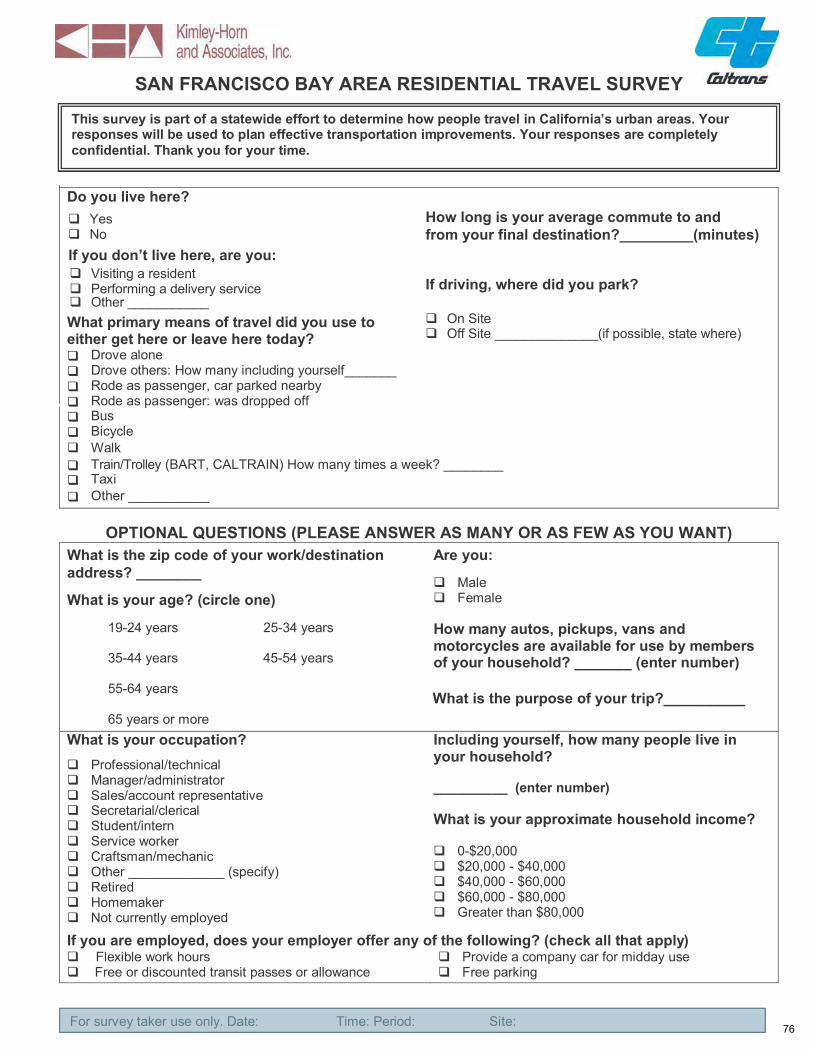
SAN FRANCISCO BAY AREA RESIDENTIAL TRAVEL SURVEY
This survey is part of a statewide effort to determine how people travel in California’s urban areas. Your responses will be used to plan effective transportation improvements. Your responses are completely confidential. Thank you for your time.
Do you live here? Yes No
If you don’t live here, are you: Visiting a resident Performing a delivery serviceOther ___________
What primary means of travel did you use to either get here or leave here today?
Drove alone Drove others: How many including yourself_______ Rode as passenger, car parked nearby Rode as passenger: was dropped off
Bus Bicycle Walk
How long is your average commute to and from your final destination?_________(minutes)
If driving, where did you park?
On Site Off Site ______________(if possible, state where)
Train/Trolley (BART, CALTRAIN) How many times a week? ________ Taxi Other ___________
OPTIONAL QUESTIONS (PLEASE ANSWER AS MANY OR AS FEW AS YOU WANT) What is the zip code of your work/destination Are you:address? ________
MaleWhat is your age? (circle one) Female
19-24 years 25-34 years How many autos, pickups, vans and motorcycles are available for use by members
35-44 years 45-54 years of your household? _______ (enter number) 55-64 years What is the purpose of your trip?__________ 65 years or more
What is your occupation? Including yourself, how many people live in your household? Professional/technical
Manager/administrator __________ (enter number) Sales/account representative Secretarial/clerical What is your approximate household income? Student/intern Service worker
0-$20,000 Craftsman/mechanic $20,000 - $40,000 Other _____________ (specify) $40,000 - $60,000 Retired $60,000 - $80,000 Homemaker Greater than $80,000 Not currently employed
If you are employed, does your employer offer any of the following? (check all that apply) Flexible work hours Provide a company car for midday use
Free or discounted transit passes or allowance Free parking
For survey taker use only. Date: Time: Period: Site: 76For survey taker use only. Date: Time: Period: Site:

BERKELEY AREA RESIDENTIAL TRAVEL SURVEY
This survey is part of a statewide effort to determine how people travel in California’s urban areas. Your responses will be used to plan effective transportation improvements. Your responses are completely confidential. Thank you for your time.
Do you live here? How long is your average commute to and from Yes your final destination?_____________(minutes) No
What primary means of travel did you use to Are you a student /employee/staff of either get here or leave here today? U.C Berkeley?______
Drive alone Drive others: How many including yourself_______ Ride as passenger/Carpool Bus Bicycle Walk Taxi Train/trolley Other ___________
OPTIONAL QUESTIONS (PLEASE ANSWER AS MANY OR AS FEW AS YOU WANT) What is the zip code of your home address? Are you: _______
Male What is your age? (circle one) Female
19-24 years 25-34 years How many autos, pickups, vans and motorcycles are available for use by members
35-44 years 45-54 years of your household?________ (enter number)
55-64 years What is the purpose of your trip? ______
65 years or more What is your occupation? Including yourself, how many people live in
your household? Professional/technical Manager/administrator __________ (enter number) Sales/account representative Secretarial/clerical What is your approximate household income? Student/intern Service worker 0-$20,000 Craftsman/mechanic $20,000 - $40,000 Other _____________ (specify) $40,000 - $60,000 Retired $60,000 - $80,000 Homemaker Greater than $80,000 Not currently employed If you are employed, does your employer offer any of the following? (check all that apply) Flexible work hours Provide a company car for midday use Free or discounted transit passes or allowance Free parking
For survey taker use only. Date: Time: Period: Site: 77

SAN DIEGO AREA RESIDENTIAL TRAVEL SURVEY
This survey is part of a statewide effort to determine how people travel in California’s urban areas. Your responses will be used to plan effective transportation improvements. Your responses are completely confidential. Thank you for your time.
Do you live here? How long is your average commute to and from Yes your final destination?_____________(minutes) No
What primary means of travel do you use to get to and from work everyday?
Drive alone Drive others: How many including yourself_______ Ride as passenger/Carpool Take a bus Ride a bicycle Walk to work Take a taxi Take a train/trolley Other ___________
OPTIONAL QUESTIONS (PLEASE ANSWER AS MANY OR AS FEW AS YOU WANT) What is the zip code of your home address? Are you: _______
Male What is your age? (circle one) Female
19-24 years 25-34 years How many autos, pickups, vans and motorcycles are available for use by members
35-44 years 45-54 years of your household?
55-64 years ______________ (enter number)
65 years or more What is your occupation? Including yourself, how many people live in
your household? Professional/technical Manager/administrator __________ (enter number) Sales/account representative Secretarial/clerical What is your approximate household income? Student/intern Service worker 0-$20,000 Craftsman/mechanic $20,000 - $40,000 Other _____________ (specify) $40,000 - $60,000 Retired $60,000 - $80,000 Homemaker Greater than $80,000 Not currently employed If you are employed, does your employer offer any of the following? (check all that apply) Flexible work hours Provide a company car for midday use Free or discounted transit passes or allowance Free parking
For survey taker use only. Date: Time: Period: Site: 78

LOS ANGELES AREA RESIDENTIAL TRAVEL SURVEY
This survey is part of a statewide effort to determine how people travel in California’s urban areas. Your responses will be used to plan effective transportation improvements. Your responses are completely confidential. Thank you for your time.
Do you live here? Yes No
If you don’t live here, are you: Visiting a resident Performing a delivery serviceOther ___________
What primary means of travel did you use to either get here or leave here today?
Drove alone Drove others: How many including yourself_______ Rode as passenger, car parked nearby Rode as passenger: was dropped off
Bus Bicycle Walk
How long is your average commute to and from your final destination?_________(minutes)
If driving, where did you park? On Site
Off Site ______________(if possible, state where)
Train/Trolley (Metro Gold Line, etc.) How many times a week? __________ Taxi Other ___________
OPTIONAL QUESTIONS (PLEASE ANSWER AS MANY OR AS FEW AS YOU WANT) What is the zip code of your work/destination Are you:address? ________
MaleWhat is your age? (circle one) Female
19-24 years 25-34 years How many autos, pickups, vans and motorcycles are available for use by members
35-44 years 45-54 years of your household? _______ (enter number) 55-64 years What is the purpose of your trip?__________ 65 years or more
What is your occupation? Including yourself, how many people live in Professional/technical your household? Manager/administrator __________ (enter number) Sales/account representative Secretarial/clerical What is your approximate household income? Student/intern Service worker
0-$20,000 Craftsman/mechanic $20,000 - $40,000 Other _____________ (specify) $40,000 - $60,000 Retired $60,000 - $80,000 Homemaker Greater than $80,000 Not currently employed
If you are employed, does your employer offer any of the following? (check all that apply) Flexible work hours Provide a company car for midday use
Free or discounted transit passes or allowance Free parking
For survey taker use only. Date: Time: Period: Site: 79For survey taker use only. Date: Time: Period: Site:

SAN FRANCISCO BAY AREA RESTAURANT TRAVEL SURVEY
This survey is part of a statewide effort to determine how people travel in California’s urban areas. Your responses will be used to plan effective transportation improvements. Your responses are completely confidential. Thank you for your time.
Are you: (check one of the following) Customer Employee Other ________
What primary means of travel did you use to either get here or leave here today?
Drove alone Drove others: How many including yourself_______ Rode as passenger, car parked nearby Rode as passenger: was dropped off
Bus Bicycle Walk Train/Trolley (BART, CALTRAIN) Taxi Other ___________
Is this location your primary destination or did you stop here on the way to another destination?
Primary Destination Stopped here on the way to another destination
How often do you visit this location in a typical month? __________
Where did you park today? On Site (the garage located at this building) Off Site ______________(if possible, state where)
If you are arriving, how long did it take you to get here today? __________ (minutes)
OPTIONAL QUESTIONS (PLEASE ANSWER AS MANY OR AS FEW AS YOU WANT) What is the zip code of your home/work address? Are you:___________ (home) ____________ (work)
Male Female What is your age? (circle one)
19-24 years 25-34 years How many autos, pickups, vans and motorcycles are available for use by members 35-44 years 45-54 years of your household? _______ (enter number)
55-64 years
65 years or more
What is your occupation? Including yourself, how many people live in your household? Professional/technical
Manager/administrator __________ (enter number) Sales/account representative Secretarial/clerical What is your approximate household income? Student/intern Service worker
0-$20,000 Craftsman/mechanic $20,000 - $40,000 Other _____________ (specify) $40,000 - $60,000 Retired $60,000 - $80,000 Homemaker Greater than $80,000 Not currently employed
If you are employed, does your employer offer any of the following? (check all that apply) Flexible work hours Provide a company car for midday use
Free or discounted transit passes or allowance Free parking
For survey taker use only. Date: Time: Period: Site: 80For survey taker use only. Date: Time: Period: Site:

LOS ANGELES AREA OFFICE TRAVEL SURVEY
This survey is part of a statewide effort to determine how people travel in California’s urban areas. Your responses will be used to plan effective transportation improvements. Your responses are completely confidential. Thank you for your time.
Do you work here in the Office Building?
Yes No
What primary means of travel did you use to either get here or leave here today?
Drove alone Drove others: How many including yourself_______ Rode as passenger, car parked nearby Rode as passenger: was dropped off Bus Bicycle Walk Train/Trolley Taxi Other ___________
Is this location your primary destination or did you stop here on the way to another destination?
Primary destination Stopped here on the way to another destination
How often do you visit this location in a typical week? ______
If you are arriving, approximately how long did it take you to get here today? _______ (minutes)
OPTIONAL QUESTIONS (PLEASE ANSWER AS MANY OR AS FEW AS YOU WANT) What is the zip code of your home address? Are you:_______
MaleWhat is your age? (circle one) Female
19-24 years 25-34 years How many autos, pickups, vans and motorcycles are available for use by members
35-44 years 45-54 years of your household?
55-64 years ______________ (enter number)
65 years or more What is your occupation? Including yourself, how many people live in
your household? Professional/technical Manager/administrator __________ (enter number) Sales/account representative Secretarial/clerical What is your approximate household income? Student/intern Service worker 0-$20,000 Craftsman/mechanic $20,000 - $40,000 Other _____________ (specify) $40,000 - $60,000 Retired $60,000 - $80,000 Homemaker Greater than $80,000
Not currently employed If you are employed, does your employer offer any of the following? (check all that apply)
Flexible work hours Provide a company car for midday useFree or discounted transit passes or allowance Free parking
For survey taker use only. Date: Time: Period: Site: 81

Appendix D
Summary of Study Challenges
82

Challenges / Lessons Learned
This study encountered a number of challenges in the implementation and, ultimately, the cost of collecting urban infill trip generation rates data. Unfortunately, the study's goal of providing at least five data points for each of the ten prioritized land use categories was not achieved before the data collection efforts were suspended in Fall 2008. However, the study has been successful in identifying the challenges associated with collecting trip generation data in complex urban environments. There were lessons learned in terms of site selection, data collection and data analysis.
This section highlights the challenges that were encountered throughout the study and discusses the lessons learned in confronting these challenges.
Site Selection
The selection of individual sites for surveying is one of the most difficult tasks in this research project. While selecting an urban infill area and verifying that an individual site meets the requisite density and transit criteria is relatively straightforward, getting permission to survey the site is often very difficult and time consuming. Most property owners and managers deal with many day-to-day issues and have little time to coordinate with a research project. And, unlike land use developers, they do not experience the challenges and complexities of typical local development approval and mitigation processes. Once a candidate site has been identified, getting permission to survey the site often requires many phone calls, follow-up phone calls, and face-to-face meetings with property owners or managers. Often times, the site is corporate owned, requiring permission from a remote location. Even with a thorough explanation of the purpose of the survey, property owners/ managers remain reluctant to give permission citing tenant and patron privacy and inconvenience, or internal policies against soliciting of any type. Key lessons learned from site selection include the following:
A prior relationship with the property owner/management results in a more receptive introduction to the survey and its importance. The strategies that were found to be the most effective with obtaining permission to survey sites included (1) providing a brief, concise and easy to understand "fact sheet" that describes the research, its objectives, and how it is conducted, and (2) partnering with individuals or organizations who understand the benefits of the research study and were willing to promote it to their constituents, associates, and peers, such as professional or industry organizations, downtown or business associations, local or regional politicians, and high level corporate officers, and (3) hiring subcontractors within the property management industry who have a thorough knowledge of the real estate
83

and commercial leasing market and have developed relationships with property management organizations, developers, and real estate professionals.
Approaching owners/managers of past clients or contacts, or through organizations such as Transportation Management Associations, Downtown Business Associations or public agencies resulted in a greater success with obtaining permission to survey sites. For example, in Phase I, a single developer/property manager in Berkeley was identified who was able to provide the research team with global permission to survey six of their residential properties. Five of these sites featured retail or restaurant components that we were also able to survey. From this single contact, we were able to obtain permission for several sites. In addition, this contact was able to help identify additional sites that had not originally been considered. Similar success was had, although to a lesser extent, in Phase 2 of the study with another contact at a nationwide residential developer. This contact was able to provide permission for several of the sites that were surveyed in Phase 2.
Conducting the Surveys
While obtaining permission to survey sites was the most significant challenge encountered in the study, there are several complexities involved with the data collection process. The following lessons were learned through data collection:
While conducting the surveys, complete knowledge of all access points of the site is critical to ensure that the surveys capture an accurate pedestrian count. It is critical to count all pedestrians entering and exiting the building or the statistical application of the survey results will be invalid. A pre-survey site visit is therefore crucial to plan the survey. There were several instances in the study where a site visit resulted in the conclusion that a site was too difficult or expensive to survey. Although time and effort were spent to identify the site, obtain permission and verify that it met the required density and transit criteria, no data was ultimately collected.
It is also important to supervise the surveyors to ensure the necessary time periods are manned and that they approach individuals in a polite and professional manner. There is some flexibility in the precise timing of the intercept surveys, but the pedestrian counts must be started and ended on time.
Use of trained surveyors to conduct the intercept surveys is highly desirable. Surveyors who do not fully understand the purpose of the survey had difficulty explaining it to the people being surveyed. Therefore, it is important to provide adequate information to the surveyors so that they are received as being knowledgeable and trustworthy. Pre-survey meetings should be held to explain the purpose and hear the surveyor’s “pitch” to make sure they sound professional, knowledgeable, and friendly. This is particularly important when
84

surveying sites that are located outside of the area that the research team is primarily based in.
It was observed that many people entering/exiting sites, particularly places of employment, are in a hurry and do not want to take time to participate in the survey. This appeared to be especially true for retail and restaurant sites. Surveyors should be directed to politely ask for participation, indicate the questions will only take about 15 seconds, but not to persist. Tenant complaints to management are cited by property owners/managers as one of the reasons they reject participation in such surveys.
The study found that it worked well when the surveyors filled out the surveys for respondents waiting for an elevator, making it more convenient for the respondents.
It is important to confirm with the site owner/manager that the appropriate independent variable data and other relevant information is available (e.g., building square footage, number of units, and occupancy) before conducting the survey. It is also important to explain that anecdotal information is unacceptable, that the survey requires more precise information. This information can be difficult to acquire from busy property owners/managers, so it is important that they are informed of the importance of these details prior to collecting data.
The study found that it was difficult to obtain a minimum of 100 completed surveys. Based on the number of completed surveys collected from some of the study sites, it would take multiple days to obtain 100 surveys, which would have a significant effect on the cost of the study. This is especially true for retail and restaurant sites, where property owners/managers often requested that patrons only be approached when exiting the business.
Analyzing the Data
No significant issues related to data analysis were encountered. However, the one key finding regarding the data analysis was potential double counting of automobile trips.
There is the potential to double count automobile trips when a group of visitors fill out multiple surveys. For example, when the driver and a passenger both fill out a survey, the single automobile trip can be counted as two trips. If the driver and passenger of the same vehicle were surveyed, their one trip has been double counted. One solution for this is to give the surveyors instructions to indicate on the survey if multiple surveys are from groups, if possible. If this is not feasible the trip generation estimates may be somewhat conservative.
85

Appendix E
Summary of Study Costs
86

Summary of Effort and Cost of Data Collection for “Development of Trip Generation Rates for Infill Land Uses in California” Phase 1 and 2
The following summarizes the level of effort and actual cost involved for Phase 1 and Phase 2 of the research study, “Development of Trip Generation Rates for Infill Land Uses in California.” This summary is intended to identify the real costs associated with identifying sites, gaining permission to survey sites, conducting pre-survey site reconnaissance, and collecting data in order to inform future data collection efforts.
PHASE 1 EXPENDITURE SUMMARY
The first phase of this project, which began in July of 2006 and was completed in February of 2008, was considered a pilot study for the collection of trip generation data for urban infill land uses. The specific objectives of Phase 1 were to:
Develop a methodology for identifying and describing urban infill locations suitable for collecting infill trip rate data,
Define and test a methodology for collecting trip generation rate data in urban infill areas,
Develop trip generation rates for common infill land use categories in urban areas of California,
Establish a California urban infill land use trip generation database, and
Supplement ITE trip generation data.
Data was collected and evaluated for a total of 19 sites in Phase 1, including prioritized land uses, non-prioritized land uses and three initial pilot study sites. Table 1 and Table 2 provide a basic summary of the effort and budget expended by Kimley-Horn and Associates (KHA) to complete Phase 1 of the project.
The effort and budget expenditures shown in Table 1 and Table 2 are divided into three categories in order to show the relative cost associated with each project task. The tasks are presented as follows:
1. Coordination / Project Management
Duties Include: - Development of study methodology - Review and preparation of invoices and progress reports. - Documentation of survey results for TAC/progress meetings. - Meeting attendance.
87

- ITE/NCHRP coordination and other misc. project management duties. - Final Report documentation.
2. Site Identification / Field Visit
Duties Include: - Locating potential sites though general research, industry contacts, field visits,
etc. - Checking new sites against density and transit criteria. - Performing site visits to verify feasibility of performing surveys. - Continued correspondence with property owners, management and staff to obtain permission and coordinate survey details.
3. Data Collection / Analysis
Duties Include: - KHA staff and outside staff performing site surveys. - Coordination with outside survey staff regarding survey logistics. - Organization, review and analysis of survey data.
As shown in the Phase 1 tables, the majority of the project effort and budget (60%) was spent on the Site Identification / Field Visit and Data Collection tasks. With a total budget for KHA was approximately $176,800, of which approximately $105,300 was used for Site Identification / Field Visit and Data Collection (including expenses for professional surveyors). Based on the fact that data was collected and evaluated for a total of 19 study sites in Phase 1, the average cost to identify and select a site, collect survey data and evaluate the data was approximately $5,500 per site ($105,300 / 19 = $5,542).
PHASE 2 EXPENDITURE SUMMARY
While the first phase of this research project was considered a pilot study for the collection of trip generation data for urban infill land uses, the second phase was intended to utilize the methodologies that were developed in Phase 1 to develop and report additional trip generation data for an expanded set of urban infill land uses. The target for Phase 2 was to provide at least five data points for each of the ten prioritized land uses. Despite strategies to resolve the challenges experienced in Phase 1, gaining permission to survey sites in Phase 2 remained challenging and time consuming. Data was collected and evaluated for seven (7) additional sites for Phase 2.
Table 3 and Table 4 provide a detailed summary of the effort and budget expended to date for Phase 2. Figure 1 presents a graph of the cumulative Phase 2 costs for each month of the project.
88

As with Phase 1, the Phase 2 summary tables show that the majority of the project effort and budget (77%) went towards the Site Identification / Field Visit and Data Collection tasks. Site Identification tended to be the most difficult and time consuming aspect of the project, especially when it came to obtaining permission to survey sites. Approximately $102,500 of the Phase 2 budget was used prior to suspension of the project and data was collected and evaluated for seven (7) additional study sites. Of the $102,500 used in Phase 2, $78,973 of the cost was used towards the Site Identification / Site Visit and Data Collection tasks. Based on this information, the average Phase 2 cost to identify and select a site, collect data and evaluate survey data was roughly $11,300 per site ($78,973 / 7 = $11,282).
The primary reason for the higher cost-per-site for Phase 2 of the study was that acquiring permission to survey sites remained a significant challenge. Obtaining permission often required numerous phone calls, follow-up phone calls and face-to-face meetings with property owners/management. Even with a thorough explanation of the purpose of the survey, property owners/managers often remain reluctant to give permission citing tenant and patron privacy and inconvenience, or internal policies against soliciting of any type. Even when permission has been obtained, there was no guarantee that a site would be feasible to study until a proper field visit has been performed. There were several instances in the study where a comprehensive site visit concluded that the site was too complex (and therefore too expensive) to survey. In these cases (about five sites), although time and effort were spent to identify the site, obtain permission, coordinate logistics with property management and verify that it met the required density and transit criteria, no data was ultimately collected.
One factor that helped reduce costs in Phase 1 of the study was the fortunate enthusiasm of a particular property owner/manager to aid the project. A developer in Berkeley, California was very supportive of the study. Once the project background and details were provided, the developer was willing to provide assistance and permission to survey multiple residential sites. In addition, several of the residential sites included commercial uses in the ground floor, which provided additional survey sites for the study.
In conclusion, collecting accurate trip generation data in urban environments is inherently challenging and relatively costly. This study has been successful in identifying the challenges associated with collecting this data and will serve as a valuable reference for future data collection efforts.
89

Attachments:
Table 1: Summary of Effort Expenditure – Phase 1 Table 2: Summary of Budget Expenditure – Phase 1 Table 3: Summary of Effort Expenditure – Phase 2 Table 4: Summary of Budget Expenditure – Phase 2 Figure 1: Budget Expenditure Summary from Project Inception – Phase 2
90
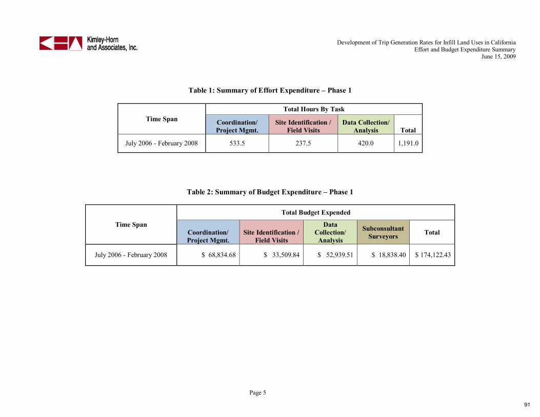
Development of Trip Generation Rates for Infill Land Uses in California Effort and Budget Expenditure Summary
June 15, 2009
Table 1: Summary of Effort Expenditure – Phase 1
Time Span Total Hours By Task
Coordination/ Project Mgmt.
Site Identification / Field Visits
Data Collection/ Analysis Total
July 2006 - February 2008 533.5 237.5 420.0 1,191.0
Table 2: Summary of Budget Expenditure – Phase 1
Time Span
Total Budget Expended
Coordination/ Project Mgmt.
Site Identification / Field Visits
Data Collection/
Analysis
Subconsultant Surveyors Total
July 2006 - February 2008 $ 68,834.68 $ 33,509.84 $ 52,939.51 $ 18,838.40 $ 174,122.43
Page 5
91

Development of Trip Generation Rates for Infill Land Uses in California Effort and Budget Expenditure Summary
June 15, 2009
Table 3: Summary of Effort Expenditure – Phase 2
Month
Hours By Task
Coordination/ Project Mgmt.
Site Identification / Field Visits
Data Collection/ Analysis
Total (monthly)
Apr-08 49.0 12.5 1.0 62.5 May-08 37.5 35.5 32.0 105.0 Jun-08 30.5 13.0 23.0 66.5 Jul-08 17.0 31.0 12.5 60.5
Aug-08 4.5 3.5 0.0 8.0 Sep-08 4.5 64.0 0.0 68.5 Oct-08 26.5 107.0 0.0 133.5 Nov-08 14.0 55.5 120.0 189.5 Dec-08 6.0 0.0 27.0 33.0
Totals 189.5 322.0 215.5 727.0
Table 4: Summary of Budget Expenditure – Phase 2
Month
Budget Expended
Coordination/ Project Mgmt.
Site Identification / Field Visits
Data Collection/ Analysis
Subconsultant GBA
Subconsultant EPS
Total (monthly)
Total (cumulative)
Apr-08 $ 5,843.51 $ 1,621.00 $ 129.68 $ - $ - $ 7,594.19 $ 7,594.19 May-08 $ 4,314.29 $ 4,017.12 $ 3,507.38 $ - $ - $ 11,838.79 $ 19,432.98 Jun-08 $ 4,175.62 $ 1,933.20 $ 2,410.08 $ - $ - $ 8,518.90 $ 27,951.88 Jul-08 $ 3,286.87 $ 4,165.65 $ 1,271.88 $ - $ - $ 8,724.40 $ 36,676.28 Aug-08 $ 513.73 $ 441.40 $ - $ - $ - $ 955.13 $ 37,631.41 Sep-08 $ 442.89 $ 6,947.90 $ - $ - $ - $ 7,390.79 $ 45,022.20 Oct-08 $ 3,435.50 $ 12,333.61 $ - $ - $ 5,860.00 $ 21,629.11 $ 66,651.31 Nov-08 $ 2,195.54 $ 5,940.40 $ 12,405.53 $ - $ 3,330.60 $ 23,872.07 $ 90,523.38 Dec-08 $ (674.31) $ 162.09 $ 2,747.26 $ 8,836.27 $ 911.95 $ 11,983.26 $ 102,506.64 Totals $ 23,533.64 $ 37,562.37 $ 22,471.81 $ 8,836.27 $ 10,102.55 $ 102,506.64 $ 102,506.64
Page 6
92

Development of Trip Generation Rates for Infill Land Uses in California Effort and Budget Expenditure Summary
June 15, 2009
Figure 1: Budget Expenditure Summary from Project Inception – Phase 2
Page 7
93

Appendix F
Summary of Comments Received from ITE Trip Generation SubcommitteeReview of Phase 1 Final Report
94

Summary of Comments Received from ITE Trip Generation Subcommittee Review of Phase 1 Final Report
The following summarizes the comments from representatives of the ITE Trip Generation Subcommittee who volunteered to review the methodology and findings that were developed in the final report for Phase 1, “Development of Trip Generation Rates for Infill Land Uses in California.” The majority of the reviewers’ comments are general observations or minor editorial revisions; however, several comments warranted individual responses. These comments are either addressed below or in the Phase 2 final report.
On the following page, Table 1 summarizes the comments/observations from the ITE review panel. In order to ensure that this summary is concise and to-the-point, some of the comments have been edited to remove any extraneous side notes or remarks that are not directly related to the study approach, methodology, findings or documentation. An unedited compilation of all the ITE Subcommittee’s is included as an attachment to this memorandum.
95

Table 1: ITE Trip Generation Subcommittee Review Comments
# Comment Response Reviewer A
1.1
I have performed my review of the Report. It appears well done. I think that it is a good first start but it needs more samples, including some outside of California, before rates can be established. With these types of developments, there are so many variables and different scenario combinations that it is very hard to establish actual rates. ITE should adopt certain criteria of what would qualify as an Urban Infill. The report does try to establish criteria and these seem reasonable.
No response needed.
1.2 The Berkeley sites may not be valid due to the influence of the college students and how they impact the trip generation with non-standard times and patterns.
In order to maintain diversity in the location and type of study sites, all but two of the Berkeley sites were removed from the final Phase 2 summary of residential trip generation results. The results from all of the Berkeley sites are included as a subsection in the final Phase 2 documentation as a representation of Urban UniversityTown trip generation.
1.3 Depending upon the location and type/mix of infill, Saturday trip rates may need to be reviewed also.
Valid point; however, this was not included in the scope of work for this study, as weekday peak hours are the most commonly used study periods for TIAs in California. Other data collection periods would provide useful information for certain land uses. For example, Saturday midday peak data would be particularly useful for retail sites. This is noted in the Phase 2 final report.
96

# Comment Response
1.4 The report should discuss further why some of the trip rates are higher than ITE.
The observed trip rates for most of the sites were lower than ITE rates; although, there were a few sites where the observed rates were higher. All of the sites that had higher trip rates than ITE were still within the ITE range of rates for their respective land use categories. This may be indicative of the travel characteristics specific to a particular site, or even the mode split characteristics for the specific geographic location of the site. In at least two cases where auto trip generation was observed to be higher than ITE rates, the sites also generated substantial walk and transit trips. This indicates that these sites are generating more “person trips” per unit of independent variable than a typical isolated suburban site would generate, based on ITE data. To make a definitive conclusion regarding this issue, additional observation of the individual sites, or a larger pool of study sites for developing an average are needed.
1.5
The travel mode percentage for the CCLA Building is questionable. If 95% take the car in the morning, then more that 77% would take their car home as opposed to using transit. There are only 136 parking spaces at the site so how the percentages were determined should be looked at more closely.
This is addressed in the Phase 2 Final Report in the results section for Non-Residential land uses, as well as in the Future Recommendations section.
1.6 When finalized, a Summary Report should be prepared because most people will not go through the entire study.
This is a valid recommendation; however, there are no plans to prepare a brief summary report at this time.
Reviewer B
2.1 The common sense test is that it is reasonable to anticipate that study results will produce lower trip generation rates. No response needed.
2.2
Agree with the tone of the introduction: conducting such a study is a good idea, ITE rates do not reflect urban infill characteristics, and the details of the approach to study and calculate these rates are worthy of consideration for establishing a credible data base in this new category.
No response needed.
2.3
While okay as is, I’m thinking the study could have let up a little bit on being so strict, with so many conditions on which study sites were selected. After all, the resulting number of sites meeting the criteria were very low. The stricter the criteria is, the greater chance that this data may not apply to many proposed future projects. But again, I think it may be acceptable as is.
No response needed.
97

# Comment Response
2.4 In many instances throughout the report, the author uses the term Trip Generation “Manual” when referencing ITE’s Trip Generation report. I suggest we request the author to remove all references to this document being called a “Manual”.
Noted. This error will be corrected in the Phase 2 report.
2.5
Agree with the level of difficulties in seeking permission to do these data collection studies at selected sites. Bottom line is, this is a very expensive, time-consuming, and challenging data collection exercise. I commend the author for acknowledging this, and recognizing that this requires special attention and supervisory control.
This is described in more detail in the main text and in the appendix of the Phase 2 Final Report.
2.6 Agree with preferred methodology of intercept surveys, and with selected independent variables used. No response needed.
2.7
Page 17, last sentence in first full paragraph, which starts with “However,…”: Not sure if this sentence is worded correctly/appropriately by stating that the resulting data cannot be standardized until they are included in a future ITE publication. I think deleting this sentence from the report is a simple fix.
Noted; however, there are no plans to revise the Phase 1 report at this time.
2.8 Maybe I didn’t remember reading this to its full understanding, but is it clearly explained enough as to how exactly they translated (or adjusted) the face-to-face person interviews (i.e. person trips) into automobile trips (i.e. vehicle trip ends)?
This process is discussed in the Phase 1 Final Report.
2.9 The overall report is thorough and complete; very well written. No response needed.
2.10 Lessons learned are similar to those I have experienced. For me, this lends additional credibility to this study. No response needed.
2.11 Having a college university nearby, does that affect the data/results in a way that we feel comfortable with? See response for Comment #1.2
Reviewer C
3.1
The Report is comprehensive and thorough in its approach, findings and issues/concerns associated with the methodologies used and findings developed. Given that, it is difficult to be specific in providing a Peer Review of the document with the time constraints and the unfamiliarity [at least to me], relative to the Study Area and validity of the Intercept Survey used in the study versus the other methodologies, and then the sample size.
No response needed.
3.2 Clearly, the extent and availability of public transportation, availability and culture of the use of private vehicles and availability of affordable parking have distinct influences in the results.
No response needed.
98

# Comment Response
3.3
One comment relates to Table 3. The last columns calculate the percent difference between the Observed Trip Rates versus the ITE Trip Rates using the Observed Trip Rates as the base. I would suggest using the ITE Trip Rates as the base. Therefore, the difference of Office in Category 710 would be that the 67% [the Observed Trip Rate is 67% of the ITE trip Rate].
Noted. The method of calculating the percent difference has been changed in the Phase 2 final reprt; however, there are no plans to revise the Phase 1 final report at this time.
3.4
Again, the methodology is extensive and perhaps can be duplicated by municipalities and MPO's. The next discussion, however, is how this report is used by Planning & Zoning Commissions and State DOT's relative to Transportation Impact Requirements to Land Developer for any type of in-fill development Applications.
Good comment; however it has not yet been determined as to how this study will be utilized (i.e. incorporated into future ITE publications, used independently by DOTs, and Planners). Our intent was to have the methodology and data integrated into a future ITE publication, which then would lend more credibility for governmental agencies to use the methodology.
Reviewer D
4.1
Thanks for the opportunity to participate in the review of the subject material. I found it to be a very comprehensive approach to an important topic. Unfortunately, even given the long review time you provided, I was only able to conduct a cursory review of the material. I did concentrate on Chapters 3 and 4, the most important chapters noted by Jim Daisa. I believe the work to date has uncovered most of the challenges – particularly in gaining approval of study sites from building/complex owners, and in collecting the data – that are characteristic of these sites. Our firm is undertaking a statewide survey of California Superior Courts and has encountered similar issues and difficulties in our studies. In my review of the data, I see no red flags, other than the inherent difficulty of developing usable information.
No response needed.
99

# Comment Response
4.2
Another question of interest is to what use will the results be put? Traffic generation information in its usual suburban setting is used to predict impacts and craft mitigations for the impacts. In the urban infill setting, the actual vehicular traffic generation may be “diffused” over a several block area due to a potential broad field of parking facilities. Certainly, the results may be useful for the purposes of establishing traffic impact fees, but less useful in determining mitigation measures that can be focused on a specific development.
The commenter suggests a legitimate issue related to urban infill trip generation. Should urban infill trip generation only be measured for trips that access the actual site, or that are diffused into the surrounding urban fabric? The intent of this study was to determine the actual trip generation, both trips that accessed the site and trips diffused into the surrounding area. Regardless of the diffusion effect, the trip generation remains valid for TIA’s as it 1) accurately estimates total trip generation, and 2) can be the basis for determining impacts although they may be distant from the site (but probably not more distant than a person would walk).
Reviewer E
100

# Comment Response
5.1a
(In reference to Pages 29-31 in Phase 1 Final Report) Transit proximity criteria – I realize that transit proximity may be included in California’s legal definition of infill development, but looking at it from an ITE perspective, there is a lot of infill development that has no rail station or frequent transit service. This almost makes the infill under this definition be transit-oriented development (TOD) or transit adjacent development (TAD). Vehicle trip generation rates will be found to be lower with nearby high quality transit than at those infill sites that have no such transit service. As a result, if these data are included in Trip Generation, they should be defined as TOD or TAD infill (consultant can assign appropriate designation).
For NCHRP 8-66 surveys, I suggest that the panel address this characteristic directly and decide on applicability. At the very least, there could be two categories: with high quality transit, and without.
Dwelling unit density – The infill areas have been defined. Is there a need for this density threshold of 10DU/acre? It seems unnecessary.
Site maturity – The report does not recommend a threshold for maturity. Generally a building should have been sold out or leased out the first time and have something like 80%+ occupancy if office or industrial and 85-90%+ occupancy for other uses. The study authors can adjust these numbers as needed to reflect what they used or recommend.
For the purposes of this study, transit proximity was included in the definition of urban infill. Further discussion on this is included in the Phase 2 Final Report (Section 3.1.1). The authors agree that our data reflects urban TOD or TAD, and therefore represents a particular subcategory of urban infill development.
The residential density was used to identify the infill areas, so the density remains an important criteria.
Site maturity is discussed as an additional qualitative criteria for site selection. (See Phase 1 Final Report, pg. 31). Generally, we sought mature sites meaning at least one year old, and preferably, older.
101

# Comment Response
5.1b
(In reference to Pages 29-31 in Phase 1 Final Report) Omitted: Economic viability – in addition to maturity, the development should be “successful.” If retail or restaurant, that means busy at least to an average level. For retail, office, residential, that also means with few vacancies and well occupied parking lots (if not a TOD). This may involve professional judgment, but needs to be considered so unnaturally low rates are not reported for a development that is subpar economically.
Omitted: parking availability – For developments that are not TOD or TAD, there should be adequate parking available. This can be on or off site; it can be free or have a fee. Developments with insufficient parking will constrain vehicle trip generation and therefore not provide unconstrained generation rates.
Located within a walkable district – similar to the transit proximity criterion, this criterion should not be required for ITE infill sites. Many infill developments are not in walkable areas. However, that is not to say that Caltrans was improper using it.
Economic Viability – For restaurant/retail uses, the property management and staff were questioned to ensure that the business had been consistent over the past few months and not uncharacteristically busy or slow. In more general terms, it is difficult to measure economic viability. The same question could be asked of the sites surveyed for ITE’s Trip Generation. However, it is an important point, and perhaps could be addressed from simple observation of the activity of individual businesses being surveyed.
Parking Availability – For sites that have parking on-site, the total supply is listed in the report appendix. The exact off-site parking supply is often difficult to determine for sites where multiple off-street lots/garages and on-street parking is available. For several of the site surveys, the intercept surveys included a question regarding where the traveler parking (if traveling by automobile). This information can be particularly useful. The Phase 2 Final Report includes a recommendation to ensure that this information is collected in future surveys. General observation of the relative availability of off-site parking should be included in future data collection efforts.
5.2
(In reference to Pages 35 in Phase 1 Final Report) Developers and property managers may be motivated to cooperate by offering:
• Access to the site’s or study’s data • Copy of the final report • To “look at any traffic problems” the developer may be having • To collect a little extra data that the developer/manager could use
To alter the survey in a manner that is preferred by the developer/manager but produces the same basic data
Noted. The Phase 2 Final Report includes additional recommendations such as these. The third recommendation may be difficult given the current cost per site of collecting data. It would depend on the issue but this form of motivation could easily double or triple the cost of collecting data at the particular site.
102

# Comment Response
5.3
(In reference to Page 43 in Phase 1 Final Report) The interview forms were not provided with the report so I may or may not be interpreting these statements correctly:
• “Number of visits to the site in a typical week” – This requires guessing or recollection over time. Neither is accurate and will tend to underestimate due to incomplete recollection. The only potential accurate data will come from questions about the current trip being made, perhaps the one immediately before, and those from a properly completed trip log (i.e., filled out as trips are being completed). If this is a real question, the resulting data should be considered speculative.
• “Whether individual visited multiple sites” – this is only of quantitative value if the number of on-site visits is known. Since the question is asked before the respondent leaves the site, some of the internal stops may not have been made or even thought about. Just as above, this question and the resulting data should be considered speculative.
Fortunately, neither question is critical for the peak hour surveys that were conducted.
The number of visits is not critical data but intended to establish whether the trip was a regular trip or a one-time only or infrequent trip. It would only matter if a significant portion of say an office building’s visitors were infrequent (i.e., attending a seminar or conference). The multiple site questions was again of general interest in determining if people tended to visit multiple sites. It could be cross-referenced with mode share and parking to determine if a particular mode is more conducive to trip-linking or a park once strategy. Sample interview forms are included in the Appendix of the Phase 1 Final Report. Additional intercept survey questionnaires are included in the Phase 2 Final Report Appendix.
5.4
(In reference to Page 43 in Phase 1 Final Report) Is there a need to collect data on gender, age, occupation, salary range, household income? Are both salary range and household income needed? ITE does not need it. Are these independent variables that Caltrans uses in its modeling? If this becomes an ITE procedure, these variables are not critical.
The demographic information was collected as an optional portion of the survey questionnaire. This data was not required to analyze the trip generation data, but was collected as an additional reference for potential future cross-referencing.
5.5
(In reference to Pages 47 in Phase 1 Final Report) Office space is usually in gross square feet (GSF) of building floor area in ITE data. Real estate information may also be in net rentable area. GLA is used with retail space, but ITE reports do not use this measure.
Noted, this is a valid comment. For many of the office study sites, the property management was only able to provide the office space information in Gross Leasable Area. The Phase 2 Final Report includes the recommendation to collect GLA and GSF from property owners/managers. The result for the Caltrans study is that our trip estimates are conservatively high.
5.6 (In reference to Page 51 in Phase 1 Final Report) Last 2 columns of Table 3. This measure should be observed /ITE. See response to Comment #3.3
103

# Comment Response
5.7
(In reference to Page 52 in Phase 1 Final Report) Site selection IS one of the most CRITICAL tasks of such projects. This study started from GIS resources. An easier way might have been to start in the field looking for good examples in known urban infill areas. We usually find this more productive. One criterion is that there be an on-site property manager. They are usually easier to work with on a mature property than a developer who has moved on to the next project.
For Phase 1 and Phase 2, field visits were used to identify additional study sites and request permission to survey. A major difficulty in this is that on-site management often lacked the authority to provide permission to survey. Many times this led to several phone calls and attempts to get in contact with store owners and corporate authorities. In general, we found that using a “top down” approach by contacting development organizations and corporate development directors resulted in more success with obtaining permission.
5.8
(In reference to Pages 67+ in Phase 1 Final Report) The data provided in the tables is bottom line summary information which is what is needed for comparisons, but which does not permit other analyses and comparisons.
It would be desirable to be able to compare person trips from infill sites to vehicle trips for ITE sites (with a vehicle occupancy factor). This would permit a comparison of person trips. Theoretically, two similar surveyed buildings would have similar amounts/rates for person trip generation. Such a comparison would support the contention that infill sites generate a smaller number of vehicle trips.
Noted, this would be an interesting detail to include in future research efforts.
104

# Comment Response (In reference to Appendix in Phase 1 Final Report) The report does not include the final/recommended questionnaire, so the following suggestions are based on the draft questionnaire contained in the Appendix, Working Paper #2, p. 13-14 (pages 92-93 of appendices file). • Question 1 – additional responses that could be valuable include:
o Drove; parked on site o Drove; parked off-site (____ blocks away) o Road as passenger; parked on-site o Road as passenger; parked off-site ( ___ blocks away)
• Question 5 – How is this information used? It requires long term recollection and averaging, so will not be accurate.
• Question 6 – Might you want to replace or supplement this by asking for
The draft questionnaire is a very good representative of the final questionnaires that were used for the surveys; however, each questionnaire was adjusted to account for characteristics specific to each study site. For example, for office sites, people were asked to provide the zip code of their origin and destination.
5.9 location/zip code of trip origin?
• Additional question – ask for trip purpose? • Optional question 4 – Instead of these occupations, you might use a more standard
and comprehensive list, for example: management, professional, service, sales, administrative, farming, construction, installation/repair, production, transportation, military (from http://www.bls.gov/oco/home.htm )
• Last optional question – add vanpool or carpool program or others that may apply in survey area?
All of the intercept surveys were conducted for inbound and outbound trips, with the exception of one of the restaurant sites surveyed in Phase 2, where the management asked that we only survey customers on their way out. For this site, we asked the customers about their inbound and outbound trips as they were leaving the site. The Phase 2 Final Report includes a recommendation to always record the inbound and
The questionnaire and the procedures are both silent about whether the interviews are conducted inbound, outbound, or both. It is desirable to do both, especially for peak period surveys since characteristics may well be directionally different. If permission can only be obtained to interview in one direction (often outbound for a consumer type business), what should be done (e.g., survey another site; ask information for both the current outbound and the previous inbound trip in the same interview; other)?
outbound direction in the intercept surveys.
105

# Comment Response
5.10
There is no mention of how to factor the sample represented by interviews to represent the universe of people entering and exiting the site. This may vary based in how many access points there are and what modes are available at each, but usually expansion factors would be done by entrance or type of entrance if the survey is of a single building. You might address this as part of the procedures, either in general or more specifically. What you do not want happening for a multi-entrance building (especially where one may be a transit connection and another one may be a garage entrance) is taking the total interviews and the total person counts and using that ration to expand interview results.
For this study, the mode split results from the intercept surveys were applied to the total population. Type-of entrance and other factors such as this may be useful details to consider in future study efforts. (this is noted in the Phase 2 Final Report). We are recommending for future data collection to separate the data from entrances that are “mode-specific” (i.e., an entrance from a parking garage. The data can then be analyzed separately and a weighted average derived.
5.11 Many references are made to the ITE “Trip Generation Manual.” The document referenced, while commonly referred to as “the manual” is actually properly referenced as the “Trip Generation” report, or simply “Trip Generation.”
Same as response for Comment #2.4
106