troccibras and its partner projects hibiscus and troccinox ... · radar observations, integration...
TRANSCRIPT

ÓPTICA PURA Y APLICADA. www.sedoptica.es
Opt. Pura Apl. 41 (2) 207-216 (2008) - 207 - © Sociedad Española de Óptica
TroCCiBras and its partner projects HIBISCUS and TROCCINOX: The 2004 field campaign in the State of São Paulo
TroCCiBras y sus proyectos hermanos HIBISCUS y TROCCINOX: La campaña
de campo en el Estado de San Pablo
Gerhard Held(1,*), Jean-Pierre Pommereau(2) and Ulrich Schumann(3)
1. Instituto de Pesquisas Meteorológicas, Universidade Estadual Paulista, Bauru, S.P., Brazil 2. Service d’Aéronomie, Centre National de la Recherche Scientifique, Verrières le Buisson, France
3. Institut für Physik der Atmosphäre, Deutsches Zentrum für Luft- und Raumfahrt, Oberpfaffenhofen, Germany
* Email: [email protected] Recibido / Received: 9 – Nov – 2007. Versión revisada / Revised version: 17 – Abr – 2008. Aceptado / Accepted: 18 – Abr – 2008.
REFERENCES AND LINKS [1] http://www.ipmet.unesp.br/troccibras [2] G. Held, R. V. Calheiros, J.-P. Pommereau, A. M. Gomes, “A preview of preliminary results from the
TroCCiBras, TROCCINOX and HIBISCUS campaign 2004”. Proceedings, XIII Congresso Brasileiro de Meteorologia, (CD ROM), Fortaleza, 29 August – 3 September 2004, SBMET, pp. 15 (2004).
[3] http://www.aero.jussieu.fr/projet/HIBISCUS/ [4] J.-P. Pommereau, A. Garnier, G. Held, A.-M. Gomes, F. Goutail, G. Durry, F. Borchi, A. Hauchecorne, N.
Montoux, P. Cocquerez, G. Letrenne, F. Vial, A. Hertzog, B. Legras, I. Pisso, J. A. Pyle, N. R. P. Harris, R. L. Jones, A. Robinson, G. Hansford, L. Eden, T. Gardiner, N. Swann, B. Knudsen, N. Larsen, J. Nielsen, T. Christensen, F. Cairo, M. Pirre, V. Marécal, N. Huret, E. Rivière, H. Coe, D. Grosvenor, K. Edvarsen, G. Di Donfrancesco, P. Ricaud, J.-J. Berthelier, M. Godefroy, E. Seran, K. Longo, S. Freitas, “An overview of the HIBISCUS campaign”, Atmos. Chem. Phys. Discuss. 7, 2389-2475 (2007).
[5] http://www.atmos-chem-phys-discuss.net/special_issue27.html
ABSTRACT: This overview paper summarizes the objectives of the Tropical Convection and Cirrus Brasil project, as well as those of the European Commission sponsored HIBISCUS and TROCCINOX projects, which conducted a joint field campaign in the State of São Paulo from January to March 2004. Emphasis is given on the description of different types of lidars and their deployment for obtaining meteorological data during the joint field campaign in 2004.
Keywords: TroCCiBras, HIBISCUS, TROCCINOX, Radar Observations, Elastic Backscatter Lidar, Balloon-borne Micro-Lidar, Airborne H2O DIAL, State of São Paulo, Brazil.
RESUMEN: Este trabajo general resume los objetivos del proyecto Convección Tropical y Cirrus Brasil, así también como aquellos proyectos patrocinados de la Comisión Europea HIBISCUS y TROCCINOX, los cuales condujeron una campaña conjunta en el Estado de San Pablo desde enero hasta marzo de 2004. El énfasis está puesto en la descripción de los diferentes tipos de lidares y su despliegue para la obtención de datos meteorológicos durante la campaña conjunta en 2004.
Palabras Clave: TroCCiBras, HIBISCUS, TROCCINOX, Observaciones Radar, Lidar de Backscattering Elástico, Micro-Lidar embarcado en globo, DIAL de H2O embarcado en avión, Estado de San Pablo, Brasil.
ÓPTICA PURA Y APLICADA. www.sedoptica.es.
Opt. Pura Apl. 41 (2) 207-216 (2008) - 208 - © Sociedad Española de Óptica
[6] H. Huntrieser, H. Schlager, A. Roiger, M. Lichtenstern, U. Schumann, C. Kurz, D. Brunner, C. Schwierz, A. Richter, A. Stohl, “Lightning-produced NOx over Brazil during TROCCINOX: Airborne measurements in tropical and subtropical thunderstorms and the importance of mesoscale convective systems, Atmos. Chem. Phys. 7, 2987-3013 (2007).
[7] U. Schumann, H. Huntrieser, “The global lightning induced nitrogen oxides source”, Atmos. Chem. Phys., 7, 3823-3907 (2007).
[8] U. Schumann, H. Höller, Edts., TROCCINOX (Tropical Convection, Cirrus and Nitrogen Oxides Experiment), Annual Report No.2 (1 June 2003 - 31 May 2004), EU Contract No. EVK2-CT-2001-00122, DLR, 79 pp, Oberpfaffenhofen (2004).
[9] U. Schumann, H. Höller. Edts., TROCCINOX (Tropical Convection, Cirrus and Nitrogen Oxides Experiment), Final Report, EU Contract No. EVK2-CT-2001-00122, DLR, 154 pp, Oberpfaffenhofen (2006).
[10] http://www.pa.op.dlr.de/troccinox/ [11] http://www.atmos-chem-phys-discuss.net/special_issue31.html [12] CPTEC, Climanálise: Boletim de Monitoramento e Análise Climática. INPE/CPTEC, 19, No.01 (Janeiro),
No.02 (Fevereiro), No.03 (Março), Cachoeira Paulista (2004). [13] V. E. Kousky, “Pentad outgoing longwave radiation climatology for the South American sector”, Rev. Bras.
Meteo. 3, 217-231 (1988). [14] E. Landulfo, A. Z. Freitas, A. Papayannis, et al., “Lidar measurements with IPEN´s aerosol lidar during the
TroCCiBras 2004 Campaign”, Proceedings, HIBISCUS / TroCCiBras / TROCINOX Workshop, Bauru, SP, 16-19 November 2004, p28 (2004). Website: http://www.ipmet.unesp.br/troccibras
[15] G. Di Donfrancesco, F. Cairo, M. Viterbini, R. Morbidini,C. Buontempo, F. Fierli, F. Cardillo,M. Snels, G.L. Liberti, F. Di Paola, “Cloud and aerosol detection by balloonborne lidars and backscatter-sondes in the UTLS during the HIBISCUS campaign: optical and dynamical Properties”, Geophys. Res. Abstracts 7, 03355 (2005).
[16] G. Di Donfrancesco, F. Cairo, G. Held, F. Fierli, “Contemporary measurements of a ground-based weather radar and balloon-borne lidar at Bauru during the HIBISCUS Campaigns: A powerful synergy in cloud physics studies” (Paper P6R.10). Preprints, 32nd Conference on Radar Meteorology, CD, AMS, Albuquerque, USA, 24-29 October 2005, 4pp (2005).
[17] H. Flentje, A. Dörnbrack, A. Fix, G. Ehret, E. Hólm, “Evaluation of ECMWF water vapour analyses by airborne differential absorption lidar measurements: a case study between Brasil and Europe”, Atmos. Chem. Phys. 7, 5033-5042 (2007).
[18] G. Ehret, K.P. Hoinka, J. Stein, A. Fix, C. Kiemle, G. Poberaj, “Low-stratospheric water vapour measured by an airborne DIAL”, J. Geophys. Res. 104 (D24), 31351–31359 (1999).
[19] G. Held, A.M. Gomes, K.P. Naccarato, O. Pinto Jr., E. Nascimento, “The structure of three tornado-generating storms based on Doppler radar and lightning observations in the State of São Paulo, Brazil”, Proceedings, 8th International Conference on Southern Hemisphere Meteorology and Oceanography, Foz do Iguaçu, 24-28 April 2006, 1787-1797 (2006).
1. Introduction In February 2003, an International Workshop was realized at IPMet in Bauru, in collaboration with the European Project Coordinators, to ascertain the interest of Brazilian research groups in participating in a joint multi-disciplinary research project, which would exploit unique data provided by the TROCCINOX (Tropical Convection, Cirrus and Nitrogen Oxides) and HIBISCUS (“Impact of tropical convection on the upper troposphere and lower stratosphere”) projects. The general objective of the TroCCiBras project (Tropical Convection and Cirrus Brasil) was thus to obtain a set of special measurements throughout the troposphere and the
lower stratosphere, to meet specific research needs of Brazilian research institutions, through the realization of the TROCCINOX and HIBISCUS projects in Brazil. The detailed TroCCiBras project is available at [1]. Besides IPMet, six other Brazilian research institutions, as well as the German Max Planck Institute for Chemistry (MPIC) and the Lightning Research Group of Osaka University (LRGOU) from Japan, participated actively in the TroCCiBras field campaign [2]. Table I shows the ten different research sub-projects, which were grouped into three main topics, viz., “Meteorology, Atmospheric Physics and Forecasting” (radar, radiosonde and lightning observations, as well as numerical modelling), “Atmospheric Chemistry”
ÓPTICA PURA Y APLICADA. www.sedoptica.es
Opt. Pura Apl. 41 (2) 207-216 (2008) - 209 - © Sociedad Española de Óptica
(lidar and airborne pollutant measurements) and “Validation of Satellite-borne and Ground-based Remote Sensors”, constituting a comprehensive ensemble, which will contribute significantly to the overall knowledge of the atmosphere over the State of São Paulo and thus facilitate the achievement of the two primary goals of TroCCiBras, viz., the validation of satellite-derived measurements (especially those of the “Humidity Sounder for Brazil”, HSB) and the improvement of Nowcasting methods, besides providing extremely valuable data for graduate student projects. In this paper, special emphasis will be given to measurements of the ground-based lidar in Bauru, as well as examples of specialized balloon-borne (HIBISCUS) and airborne (TROCCINOX) lidar sensors.
The general objective of the HIBISCUS project, which is an RTD Program of the European Community, is to investigate the impact of deep convection on the Tropical Tropopause Layer (TTL) and the Lower Stratosphere (LS). Its specific objective was to provide a set of new observational data on meteorology, tracers of horizontal and vertical transport, water vapour, clouds, radiation, micro-physics and atmospheric chemistry in the
tropical UT/LS from balloon observations at local scale over a land convective area, as well as at global scale, using circumnavigating long-duration balloons. Details about the HIBISCUS project can be found at [3], and in [4], while main results are available from the special HIBISCUS issue in Atmospheric Chemistry and Physics (ACP) and its Discussion version (ACPD), see [5].
The main objectives of TROCCINOX, which is also an RTD Program of the European Community, can be summarized as follows:
• To improve the knowledge about lightning-produced NOx (LNOx) in tropical thunderstorms by quantifying the produced amounts, by comparing it to other major sources of NOx and by assessing its global impact [6,7] and,
• to improve the current knowledge on the occurrence of other trace gases (including water vapour and halogens) and particles (ice crystals and aerosols) in the upper troposphere and lower stratosphere in connection with tropical deep convection, as well as large-scale upwelling motions.
TABLE I
TroCCiBras “umbrella projects” with the specific sub-projects (Topics shown in italics could not be realized due to a limitation of funds)
AREA OF SUB-PROJECT TITLE OF SUB-PROJECT RESPONSIBLE INSTITUTION
Radar Observations, Integration of Lightning Observations, Numerical Models & Nowcasting IPMet / UNESP
Validation of Atmospheric and Chemistry Numerical Models CPTEC / INPE
The Coupling Between the Boundary Layer and the Onset and Vigor of Moist Convection
CTA and CPTEC/INPE
Cloud Physics Studies UECE
Lightning and Sprites Studies ELAT / INPE
Meteorology, Atmospheric Physics and Forecasting
Air Pollution, Cloud and Climate Interactions IAG / USP
Atmospheric Chemistry Vertical Distribution of Aerosols and Trace Gases between the Ground and the Mid-Troposphere
IF / USP and MPIC
Matching Measurements from Different Sensors IPMet / UNESP
Assessing Clear Air Detection and Cloud Boundaries IPMet / UNESP Validation of Satellite-Borne and Ground-Based Remote Sensors Rainfall Quantification by Satellite Microwave
Channels IPMet / UNESP
ÓPTICA PURA Y APLICADA. www.sedoptica.es
Opt. Pura Apl. 41 (2) 207-216 (2008) - 210 - © Sociedad Española de Óptica
Thus, the project TROCCINOX performed first measurements of the combined properties of convection, aerosol and cirrus particles and chemical air composition (nitrogen oxides in particular) in the tropics over oceanic and continental regions (State of São Paulo and adjoining areas) in the upper troposphere and lower stratosphere, including troposphere-stratosphere exchange. Bauru was identified as the ideal base point, due to its proximity to observed high lightning frequencies over the South American continent. In 2004, TROCCINOX performed airborne measurements using the Falcon aircraft of the Deutsches Zentrum für Luft- und Raumfahrt (DLR), as reported in [8]. The Falcon was equipped with instruments to measure meteorology (wind, temperature, humidity, pressure), a large variety of trace gases and several aerosol properties and cloud parameters in the size range from 4 nm to 100 μm. A modelling component aims in providing improved descriptions of processes relevant to global climate problems. Due to the Russian Geophysica M55 high-altitude aircraft (maximum altitude 20 km) not being available in 2004, a second TROCCINOX Campaign was organized in February 2005 [9]. Details about the TROCCINOX project can be found at [10]. A still growing number of papers with results from TROCCINOX is becoming available from the special TROCCINOX issue in Atmospheric Chemistry and Physics (ACP) and its Discussion version (ACPD), see [11].
2. Method and data base Besides its scientific objectives, TroCCiBras, under IPMet´s coordination, was also responsible for the logistics and infrastructure needed for the execution of the HIBISCUS and TROCCINOX projects, which included specialized operational weather forecasts and regular radiosoundings. While each of the two European projects mounted their own data base, all data collected by IPMet and its Brazilian partners was assembled in a unique data base, covering the period 21 January to 11 March 2004, which is of outstanding value for scientists in the State of São Paulo and Brazil. It includes IPMet’s radar observations (7.5 min volume scans) from Bauru and Presidente Prudente, up to 5 daily radiosoundings from IPMet, aerosol profiles ≤36 km altitude from IPEN’s (Instituto de Pesquisas Energéticas e Nucleares) lidar at IPMet, trace gas and particulate measurements obtained in the lower troposphere by aircraft (Bandeirante, instrumented by MPIC and Instituto de Física / Universidade de São Paulo, IF/USP), data from the Brazilian Lightning Detection Network (RINDAT) and 2- and
3-dimensional lightning observations from the LRGOU VHF broadband interferometer network (2 stations near Bauru), Automatic Weather Station data from 23 stations, radiosoundings from INMET and the output of the Meso-Eta model, which was specifically run by CPTEC (Centro de Previsão do Tempo e Estudos Climáticos) centred on Bauru. Details of the Data Base structure and contents are provided in2. The TroCCiBras data base is administered by IPMet and resides on a password-protected FTP site. Access for all participating scientists is subject to signing the TroCCiBras Data Protocol, but they are also entitled to access all TROCCINOX Falcon aircraft data (mid-troposphere) and the HIBISCUS stratospheric balloon measurements, through signing the relevant international Data Protocols. Following international convention, the data bases remain protected until one year after termination of the projects, viz. January 2008 in the case of TroCCiBras, after which application for access can be made by submitting a project proposal to the coordinator.
3. Specific instruments deployed and their relevant observations
The synoptic situations during the experimental period (21 January to 11 March 2004) were characteristic for summer in the central State of São Paulo. The beginning was dominated by a strong episode of the South Atlantic Convergence Zone (SACZ) from 25-29 January, but no frontal activity was observed over the central State of São Paulo [12]. A SACZ can be identified from satellite images as a cloud band with orientation from north-west to south-east, which commonly extends from the southern region of Amazônia into the central region of the South Atlantic [13], with a typical persistence of ≥ 4 days. It is characterized by low-level humidity convergence zones, a strong gradient of the equivalent potential temperature in the middle troposphere and an anticyclonic circulation at high levels (200 hPa). Being located at the edge of humid tropical air masses, it results in the generation of strong and extensive convective instability. The occurrences of SACZ play an important role in the transfer of latent heat, momentum and humidity from the tropics to the mid-latitudes and are responsible for the most humid periods and heavy summer rainfalls in the State of São Paulo. During February 2004, the frontal systems rapidly advanced across Southern Brazil and on some occasions became stationary over Southeast Brazil, establishing two episodes of SACZ, viz. 07-11 and 20-24 February [12]. No significant large-scale synoptic events occurred over Southeast Brazil
ÓPTICA PURA Y APLICADA. www.sedoptica.es
Opt. Pura Apl. 41 (2) 207-216 (2008) - 211 - © Sociedad Española de Óptica
during the first third of March [12], resulting in typical airmass-type convection being observed within the range of IPMet’s radars.
3.1. Radar Observations
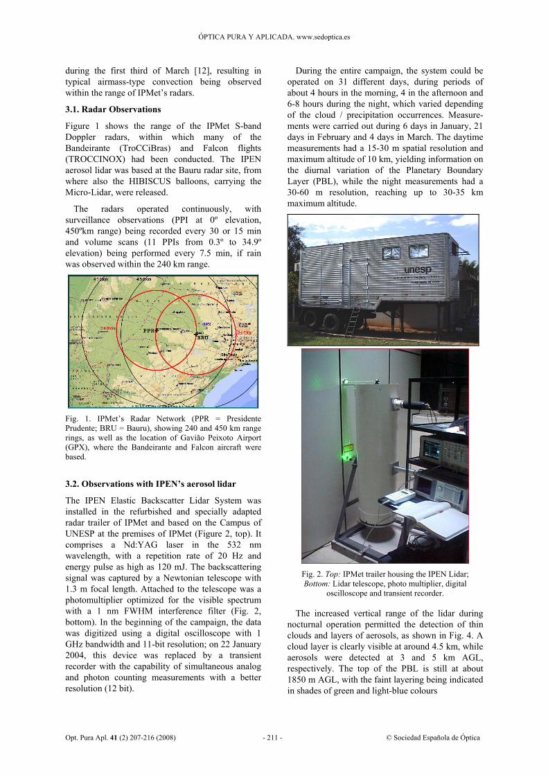
Figure 1 shows the range of the IPMet S-band Doppler radars, within which many of the Bandeirante (TroCCiBras) and Falcon flights (TROCCINOX) had been conducted. The IPEN aerosol lidar was based at the Bauru radar site, from where also the HIBISCUS balloons, carrying the Micro-Lidar, were released.
The radars operated continuously, with surveillance observations (PPI at 0º elevation, 450ºkm range) being recorded every 30 or 15 min and volume scans (11 PPIs from 0.3º to 34.9º elevation) being performed every 7.5 min, if rain was observed within the 240 km range.
Fig. 1. IPMet’s Radar Network (PPR = Presidente Prudente; BRU = Bauru), showing 240 and 450 km range rings, as well as the location of Gavião Peixoto Airport (GPX), where the Bandeirante and Falcon aircraft were based.
3.2. Observations with IPEN’s aerosol lidar
The IPEN Elastic Backscatter Lidar System was installed in the refurbished and specially adapted radar trailer of IPMet and based on the Campus of UNESP at the premises of IPMet (Figure 2, top). It comprises a Nd:YAG laser in the 532 nm wavelength, with a repetition rate of 20 Hz and energy pulse as high as 120 mJ. The backscattering signal was captured by a Newtonian telescope with 1.3 m focal length. Attached to the telescope was a photomultiplier optimized for the visible spectrum with a 1 nm FWHM interference filter (Fig. 2, bottom). In the beginning of the campaign, the data was digitized using a digital oscilloscope with 1 GHz bandwidth and 11-bit resolution; on 22 January 2004, this device was replaced by a transient recorder with the capability of simultaneous analog and photon counting measurements with a better resolution (12 bit).
During the entire campaign, the system could be operated on 31 different days, during periods of about 4 hours in the morning, 4 in the afternoon and 6-8 hours during the night, which varied depending of the cloud / precipitation occurrences. Measure-ments were carried out during 6 days in January, 21 days in February and 4 days in March. The daytime measurements had a 15-30 m spatial resolution and maximum altitude of 10 km, yielding information on the diurnal variation of the Planetary Boundary Layer (PBL), while the night measurements had a 30-60 m resolution, reaching up to 30-35 km maximum altitude.
Fig. 2. Top: IPMet trailer housing the IPEN Lidar; Bottom: Lidar telescope, photo multiplier, digital
oscilloscope and transient recorder.
The increased vertical range of the lidar during nocturnal operation permitted the detection of thin clouds and layers of aerosols, as shown in Fig. 4. A cloud layer is clearly visible at around 4.5 km, while aerosols were detected at 3 and 5 km AGL, respectively. The top of the PBL is still at about 1850 m AGL, with the faint layering being indicated in shades of green and light-blue colours

ÓPTICA PURA Y APLICADA. www.sedoptica.es
Opt. Pura Apl. 41 (2) 207-216 (2008) - 212 - © Sociedad Española de Óptica
0
500
1000
1500
2000
2500
3000
3500
10:0
010
:19
10:3
010
:36
10:5
211
:05
18:0
518
:08
18:1
418
:20
18:2
918
:36
18:4
318
:49
19:1
819
:29
19:3
519
:46
19:5
3
00:3
300
:43
01:0
301
:59
Local Time (hh:mm LT)
PBL
Hei
ght A
GL
(m)
Fig. 3. Height of the PBL over Bauru on 01/02 March 2004 for four different periods (10:19-11:08; 18:05-18:55; 19:13-1954; 00:27-02:02 LT), with a vertical resolution of 30 m (after [14]).
Fig. 4. Nocturnal lidar observation above Bauru on 04 March 2004. Vertical range from 855 m to 21.5 km AGL with a resolution of 30 m (after [14]).
3.3. Balloon-borne Micro-lidar (HIBISCUS)
A miniaturized optical radar (LIDAR), was developed specifically as payload for the HIBISCUS Project to take continuous measure-ments of clouds below the stratospheric floating platform [15]. The low-power lidar comprises a miniaturized Nd-YAG pulsed laser firing at 532 nm (Fig. 5). It is capable of performing aerosol and cloud backscattering and depolarization measurements during night time, with more than 30 km of range and a vertical resolution of 30 m. Its light weight, compact size and reduced power consumption make it suitable for flying on stratospheric balloons, sounding downward.
Although the Bauru S-band radar was not specifically set up to accompany the Micro-Lidar flights (e.g., scanning in RHI mode along the flight path), as it simultaneously had to serve many different purposes during the field campaign, an attempt was nevertheless made to compare its observations with those obtained during several flights of the balloon-borne Micro-Lidar [16]. The sensitivity of the radar is nominally –32 dBZ at the radar, but decreases rapidly with distance, viz.–18 dBZ can be seen up to about 15 km radius, while –
15 to –12 dBZ can be detected up to 20 to 25 km. Another limitation is caused by the highest elevation being 34.9º, thus cutting nearby echoes at a height of about 10-12.5 km.
Flight SF4 on 24 February 2004 is presented here to illustrate the findings. The 3000 m3 balloon was launched from Bauru at 17:03 LT and reached an altitude of 20.2 km, shortly before sunset, followed by a 3½ hour float and slow descent, initially westwards, then veering to southeast, down to 10.7 km, when it was cut down. The total flight time was 4 hours 52 minutes. Due to the strong background light during the balloon ascent, the lidar started to profile only one hour and half after the launch, when at sunset the balloon began the descent. Before this time only the close range signal (100 meters below the platform) is emerging above the noise, and was used to assess the presence of clouds in the ascent path. During the descent, the lidar detected two cirrus layers, at 13 km and 11 km, respectively, clearly discernable in the scattering and depolarisation ratio images (Fig. 6).
Using a radar reflectivity threshold of –18 dBZ at different times during the flight to investigate its capability to detect the cirrus bottom in coincidence with the balloon-borne micro-Lidar, it was found, that it could only detect the cirrus layer at 11 km, while the higher layer was beyond the sensitivity range. The limit for the radar detection of cirrus clouds is 15 km. In fact, looking at the lidar close-range signals acquired during the fast ascent above Bauru (Fig. 7), it can be seen that up to a range of 15 km, the radar sensitivity is able to detect all the cloud layers encountered by the lidar, including a cirrus at 12 km of altitude.
Fig. 5. Micro-lidar used for short-duration balloon flights during the HIBISCUS field campaigns in 2003 and 2004 (after [16]).

ÓPTICA PURA Y APLICADA. www.sedoptica.es
Opt. Pura Apl. 41 (2) 207-216 (2008) - 213 - © Sociedad Española de Óptica
Fig. 6. Lidar data acquired during the linear slow descent and parachute descent of SF4 on 24 February 2004. Top: scattering ratio vs height and time-of-flight; Bottom: depolarisation ratio (after [16]).
Fig. 7. Plot of lidar signal vs. time, superimposed with four vertical cross-sections from the Bauru radar, each one at the time of the lidar detection of clouds during the balloon ascent on 24 February 2004 (after [16]).
A back-trajectory study revealed, that air of completely different origins was responsible for the two cirrus layers, which were intersected by the balloon track [16]. The higher one being generated by aged outflow from a distant storm and the lower one by a more recent strong convective air mass up-lift. 3.4.-Airborne H2O-DIAL lidar (TROCCINOX) The H2O-DIAL is one of many instruments, with which the DLR’s Falcon Research Aircraft is equipped. It is a differential absorption lidar (DIAL) system, comprising a Mopa Laser (Rofin Sinar), operating at 532 nm and 1064 nm. The transmitter is based on a Nd:YAG pumped, injection seeded KTP-OPO (Optical Parametric Oscillator) and was operated during TROCCINOX at 925 nm achieving a pulse energy of 18 mJ [17]. The system aboard the Falcon can be positioned to look either downward or upward, providing simultaneous vertical profiles of water vapour concentration and aerosols [18]. Figure
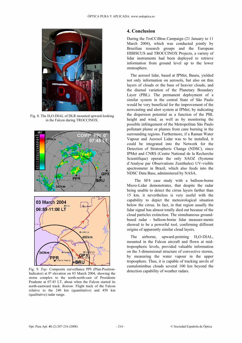
8 shows the H2O-DIAL installed in the Falcon during the TROCCINOX campaign in Brazil, with an example of upward-scanning observations being demonstrated in Fig. 10.
The DIAL was operated successfully onboard the Falcon during the TROCCINOX campaign over Brazil from 31 January – 15 March 2004, including the transfers. The lidar measured the distributions of water vapour and aerosol/cloud backscatter ratio along the flight path during 14 missions in Brazil. Depending on the cruising altitude, the vertical range reached up to 15-17 km [8]. Mostly convective or convectively influenced, but also clear-sky conditions were probed in different synoptic situations.
Over Brazil, the observations show considerable inhomogeneity in the horizontal and vertical distribution of water vapour, depending on the origin of the probed air-masses. As an example, elevated upper tropospheric H2O mixing ratios above 100 μmol.mol-1 were observed in 14.5 km in an aged air mass flowing out from the convective Amazon region, while on other days values were about one order of magnitude smaller at this altitude [8].
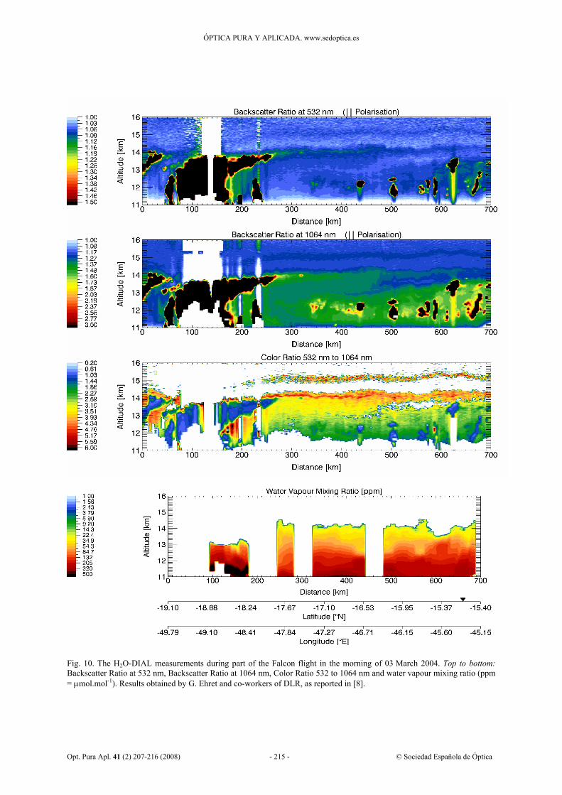
The H2O-DIAL is well suited to track and quantify cumulonimbus anvils, as demonstrated with Figs. 9 and 10. Figure 9 (top) shows a large multicellular storm complex, which was moving from south-west towards north-east (from Mato Grosso do Sul, across the westernmost part of the State of São Paulo and into Minas Gerais) during the early hours of the morning. The complex propagated at a speed of 50-70 km.h-1, typical for severe storms in this region [19], by generating new cells on its northern and eastern flank. Individual cell tops penetrated through the tropopause, reaching up to 17-19 km amsl (above mean sea level). Unfortunately, at the time the Falcon aircraft reached the storm complex, its major part was already beyond the quantitative radar range, which is 240 km. Figure 9 (bottom) shows the Falcon’s flight track from GPX to about 270 km north of the PPR radar, from where it headed north-eastwards within the outflow of the storm complex. The lidar measurements shown in Figure 10 were made below the anvil downwind from the storm complex. The radar indicated an anvil of about 100 km (10 dBZ), while the lidar could see the outflow at around 14.5 km amsl up to about 500 km downwind from the storm complex. However, the top of this outflow could only be determined by a special aircraft (e.g., the Geophysica M55 or ER2) or a balloon-borne sensor flying simultaneously in the lower stratosphere (> 20 km above mean sea level). Further DIAL measurements were performed in Brazil during TROCCINOX 2005 [9].
ÓPTICA PURA Y APLICADA. www.sedoptica.es
Opt. Pura Apl. 41 (2) 207-216 (2008) - 214 - © Sociedad Española de Óptica
Fig. 8. The H2O-DIAL of DLR mounted upward-looking
in the Falcon during TROCCINOX.
Fig. 9. Top: Composite surveillance PPI (Plan-Position-Indicator) at 0º elevation on 03 March 2004, showing the storm complex to the north-north-east of Presidente Prudente at 07:45 LT, about when the Falcon started its north-eastward track. Bottom: Flight track of the Falcon relative to the 240 km (quantitative) and 450 km (qualitative) radar range.
4. Conclusion During the TroCCiBras Campaign (21 January to 11 March 2004), which was conducted jointly by Brazilian research groups and the European HIBISCUS and TROCCINOX Projects, a variety of lidar instruments had been deployed to retrieve information from ground level up to the lower stratosphere.
The aerosol lidar, based at IPMet, Bauru, yielded not only information on aerosols, but also on thin layers of clouds or the base of heavier clouds, and the diurnal variation of the Planetary Boundary Layer (PBL). The permanent deployment of a similar system in the central State of São Paulo would be very beneficial for the improvement of the nowcasting and alert system at IPMet, by indicating the dispersion potential as a function of the PBL height and wind, as well as by monitoring the possible infringement of the Metropolitan São Paulo pollutant plume or plumes from cane burning in the surrounding regions. Furthermore, if a Raman Water Vapour and Aerosol Lidar was to be installed, it could be integrated into the Network for the Detection of Stratospheric Change (NDSC), since IPMet and CNRS (Centre National de la Recherche Scientifique) operate the only SAOZ (Systeme d’Analyse par Observations Zenithales) UV-visible spectrometer in Brazil, which also feeds into the NDSC Data Base, administered by NASA.
The SF4 case study with a balloon-borne Micro-Lidar demonstrates, that despite the radar being unable to detect the cirrus layers farther than 15 km, it nevertheless is very useful with the capability to depict the meteorological situation below the cirrus. In fact, in that region usually the lidar signal has almost totally died out because of the cloud particles extinction. The simultaneous ground-based radar - balloon-borne lidar measure-ments showed to be a powerful tool, confirming different origins of apparently similar cloud layers.
The airborne, upward-pointing H2O-DIAL, mounted in the Falcon aircraft and flown at mid-tropospheric levels, provided valuable information on the 3-dimensional structure of convective storms, by measuring the water vapour in the upper troposphere. Thus, it is capable of tracking anvils of cumulonimbus clouds several 100 km beyond the detection capability of weather radars.
ÓPTICA PURA Y APLICADA. www.sedoptica.es
Opt. Pura Apl. 41 (2) 207-216 (2008) - 215 - © Sociedad Española de Óptica
Fig. 10. The H2O-DIAL measurements during part of the Falcon flight in the morning of 03 March 2004. Top to bottom: Backscatter Ratio at 532 nm, Backscatter Ratio at 1064 nm, Color Ratio 532 to 1064 nm and water vapour mixing ratio (ppm = μmol.mol-1). Results obtained by G. Ehret and co-workers of DLR, as reported in [8].

ÓPTICA PURA Y APLICADA. www.sedoptica.es
Opt. Pura Apl. 41 (2) 207-216 (2008) - 216 - © Sociedad Española de Óptica
Acknowledgements
UNESP and FUNDUNESP are thanked for their generous financial support to enable at least the most important subprojects and activities of the TroCCiBras project to be executed jointly with TROCCINOX and HIBISCUS during the experimental campaign, as initially proposed. The Centro Técnico Aeroespacial (CTA) provided invaluable logistic support for obtaining the necessary permissions from central Government in connection with the temporary importation of foreign aircraft, while CNPq (Conselho Nacional de Desenvolvimento Científico e Tecnológico) of the Ministério de Ciência e Tecnologia contributed significantly towards the realization of TroCCiBras in terms of a “Scientific Expedition”. Embraer is
gratefully acknowledged for opening their facilities at Gavião Peixoto, to be used as a base for the TroCCiBras and TROCCINOX aircraft, at no cost. HIBISCUS was partially funded by the Commission of the European Community under the contract EVK2-2001-00111, while some of the HIBISCUS partners also provided additional funds. TROCCINOX was partially funded by the Commission of the European Community under the contract EVK2-CT-2001-00122. Further funding was provided by the DLR and the other TROCCINOX partners. Finally, the Project Coordinators wish to thank the scientists of the various groups for allowing some of their results to be included in this overview.