tropical update - granicus · tropical update this update is ... local national weather service...
TRANSCRIPT

Tropical Update
This update is intended for government and emergency response officials, and is provided for informational and situational awareness purposes only. Forecast conditions are subject to change based on a variety of environmental factors. For additional information, or for any life safety concerns with an active weather event please contact your County Emergency Management or Public Safety Office, local National Weather Service forecast office or visit the National Hurricane Center website at www.nhc.noaa.gov.
10 AM EDT Tuesday, October 18, 2016
Invest 99L (70%)

Atlantic Basin Satellite Image

Note: Shaded areas show where a tropical cyclone is likely to develop within the given
time frame. It DOES NOT show what the likely forecast track
of a tropical cyclone will be once it forms!
70%
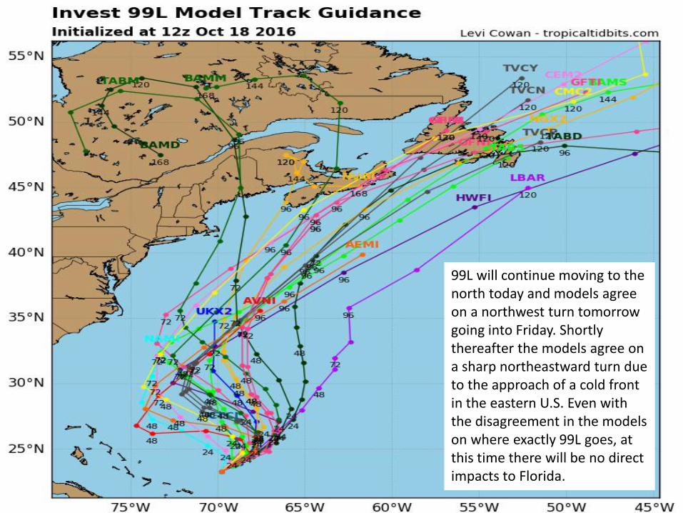
99L will continue moving to the north today and models agree on a northwest turn tomorrow going into Friday. Shortly thereafter the models agree on a sharp northeastward turn due to the approach of a cold front in the eastern U.S. Even with the disagreement in the models on where exactly 99L goes, at this time there will be no direct impacts to Florida.

Steering Currents
99L is currently situated east of the Bahamas and is in an area with weak steering currents, which is why the system is moving slowly northward. This motion is expected to continue for the today, and a turn towards the north-northwest or northwest is expected on Thursday. This path will bring the system closer to the U.S., however we do not believe the storm will impact any land areas because a cold front will come through Florida on Friday will sweep the system out to sea.

Models continue to be in disagreement on 99L’s intensity, which is common with disorganized and weak tropical systems. Strong intensification is not likely due to the presence of strong wind shear that is currently impacting 99L.

Current Wind Shear (shaded) and Shear Tendency (contours)
The tropical disturbance over the Bahamas is currently in an environment of strong wind shear. This will likely prohibit any significant development over the next day or so. However, conditions are starting to improve today as wind shear begins to decrease.
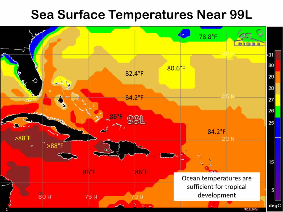
Sea Surface Temperatures Near 99L
80.6°F
84.2°F
86°F
>88°F
86°F
82.4°F
78.8°F
88°F
Ocean temperatures are sufficient for tropical
development
>88°F
86°F
84.2°F

Forecast Wave Heights

Tropical Summary: • At 8am EDT, shower activity associated with Invest 99L, a well-defined, non-tropical low pressure system
located just to the northeast of the Turks and Caicos has changed little during the past several hours. • The low is expected to slowly intensify as upper-level winds become more conducive, and a subtropical or
tropical cyclone could form during the next couple of days while the low moves northward on Wednesday and turns north-northwestward or northwestward on Thursday.
• The system has a 40% (medium) chance of development over the next 48 hours, and a 70% (high) chance of development through the next five days.
• Forecast models are in agreement that 99L will move to the north today, and then take a turn towards the northwest by Thursday. After that, the models disagree greatly on the exact track for 99L, but ALL the models agree that a cold front will pick up 99L and carry the system out to sea on Friday.
• Models are also in disagreement on the future intensity of 99L, but the general consensus is that 99L has a good chance of becoming a subtropical or tropical storm within the next day or two.
• The next name on the Atlantic storm list is Otto. Florida Outlook: • Overall, we do not expect any direct impacts to Florida from Invest 99L. • Most of the effects will be felt in the marine environment along the Atlantic coast, and 99L is very likely to
exuberate the coastal impacts we have been seeing over the past five days. • Wave heights are forecast to be at 6-7 feet, which will cause additional beach erosion and coastal flooding. • Dangerous rip currents will also continue to occur. • We may see some breezy conditions for the next two or three days, along with a slight increase in shower and
thunderstorm activity on Thursday and Friday. Another briefing packet will be issued on Wednesday morning. For more information, please visit the NHC website at www.nhc.noaa.gov.
