‘tropical yorkshire’ fieldtrip to the corallian group ... · 2 tropical yorkshire – fieldtrip...
TRANSCRIPT

J.D. Witts 20/11/14
‘TROPICAL YORKSHIRE’
Fieldtrip to the Corallian Group (UpperJurassic) of the North Yorkshire Moors
Part of the 58th Annual Meeting of the PalaeontologicalAssociation, held at the University of Leeds
19th December 2014

2
TROPICAL YORKSHIRE – FIELDTRIP TO THE CORALLIAN GROUP
(UPPER JURASSIC) OF THE NORTH YORKSHIRE MOORS
INTRODUCTION
Welcome to this one-day fieldtrip, run as part of the 58th Annual Meeting of the
Palaeontological Association at the University of Leeds.
Today we will visit three inactive quarries in the southern part of the North
York Moors, to the East of Leeds, to look at various facies of the Oxfordian (Upper
Jurassic) Corallian sediments in the area.
We will start at Betton Farm Quarry, an SSSI site that has recently been
cleared. Here there are metre-scale reef structures formed by the coral
genera Isastraea and Thamnasteria, together with very fossiliferous inter-reef facies
containing molluscs, echinoids and other fauna. Also in the quarry are examples of
the surrounding oolitic facies of the Malton Oolite Member (Coralline Oolite
Formation).
After lunch at the quarry we will move to Ravenswick Quarry to look at tall
quarry faces displaying weathered surfaces of the Malton Oolite, some beds of which
are packed with large gastropods, and the overlying Coral Rag Member, which
contains in-situ Rhabdophyllia phillipsi corals and the characteristic echinoid spines
of Paracidaris florigemma.
We will then drive a short way to Spaunton Quarry to look again at the Coral
Rag, which here contains patch reefs and various inter-reef facies, and is overlain by
the sandy sediments of the Newbridge and Spaunton Sandstone Members of the
Upper Calcareous Grit Formation, from which ammonites can sometimes be
collected. We will then return to Leeds.
A more formal timetable for the day is included overleaf. A copy of the Risk
Assessment can be found at the back of this guide. By signing onto the coach at
the start of the day, you will have agreed to read and abide by this legally
binding document.
Please dress warmly as we will be exposed to the elements during the day.
Stout footwear will be useful, although there will not be a lot of walking on the day.
Hard hats will be provided.

3
TIMETABLE
08:00am – Depart University of Leeds (Parkinson steps)
10:00am – Arrive Betton Farm (1)
12:00pm – Lunch at Betton Farm, South Quarry
12:45pm – Leave Betton Farm, drive to Ravenswick Quarry
13:05pm – Arrive Ravenswick Quarry (2)
14:05pm – Depart Ravenswick Quarry, drive to Spaunton Quarry
14:15pm – Arrive Spaunton Quarry (3)
16:00pm – Depart Spaunton Quarry
18:00pm – Arrive Leeds (Railway station and then University of Leeds)
Numbers in parentheses refer to numbers on location map overleaf.
Due to the short day and the requirement to be back in Leeds by 18:00pm to
enable some participants to catch trains, we will be attempting to adhere to this
timetable as closely as possible.
Please assist us in doing this by promptly following the guidance of the
field trip leaders and helpers when in the field!

4
LOCATION MAP
23
1
Lee
ds
(~1
00
km)

5
GEOLOGICAL BACKGROUND
The Cleveland Basin – general context
The rocks we will be examining today were deposited in the Cleveland Basin
during the Upper Jurassic (Oxfordian Stage) (Fig. 1). During the Jurassic, the
Cleveland Basin formed part of a system of shallow epeiric seas and extensional
tectonic basins, linked to the south-east via the Sole Pit Basin (a half-graben) to the
North Sea Basin. The Cleveland Basin itself was relatively small, and bounded to the
north and west by tectonic highs. To the south lay the East Midlands Shelf, the
northern part of which comprised the Market Weighton High (MWH), a stable
unfolded block characterised by reduced rates of sedimentation throughout the
Jurassic.
Figure 1: Geological map of the Jurassic strata of the Cleveland Basin(modified from Powell, 2010). Field trip locations marked by black stars.
6
The MWH is an asymmetrical structure over which subsidence and
sedimentation rates were reduced; it separated rapid subsidence and higher
sedimentation rates to the north in the Cleveland Basin, from more gradual
subsidence to the south in the Lincolnshire area of the East Midlands Shelf. The high
is essentially a hinge between the shelf and the basin, the main line of inflection
being the Howardian-Flamborough Fault Belt. (See Rawson and Wright (2000) and
Powell (2010) for more detailed overviews of Jurassic sedimentation in the
Cleveland Basin.)
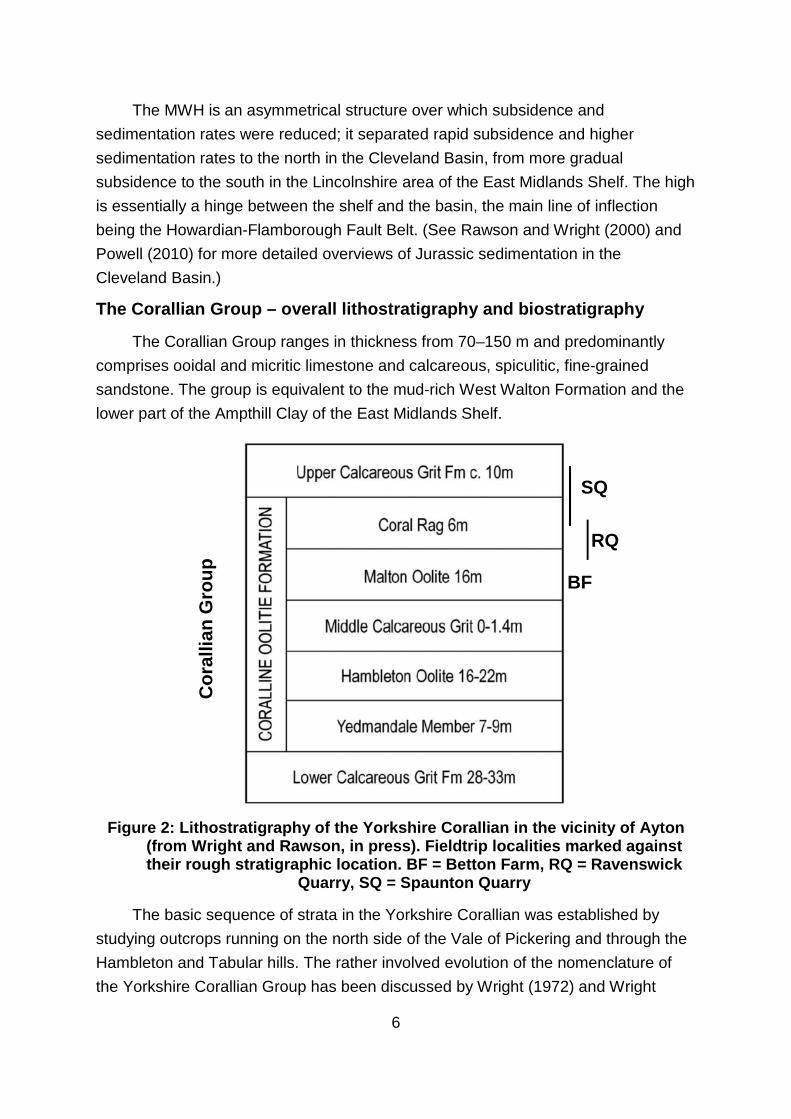
The Corallian Group – overall lithostratigraphy and biostratigraphy
The Corallian Group ranges in thickness from 70–150 m and predominantly
comprises ooidal and micritic limestone and calcareous, spiculitic, fine-grained
sandstone. The group is equivalent to the mud-rich West Walton Formation and the
lower part of the Ampthill Clay of the East Midlands Shelf.
Figure 2: Lithostratigraphy of the Yorkshire Corallian in the vicinity of Ayton(from Wright and Rawson, in press). Fieldtrip localities marked againsttheir rough stratigraphic location. BF = Betton Farm, RQ = Ravenswick
Quarry, SQ = Spaunton Quarry
The basic sequence of strata in the Yorkshire Corallian was established by
studying outcrops running on the north side of the Vale of Pickering and through the
Hambleton and Tabular hills. The rather involved evolution of the nomenclature of
the Yorkshire Corallian Group has been discussed by Wright (1972) and Wright
BF
RQ
SQ
Co
rallia
nG
rou
p

7
(2009). The succession outlined in Fig. 2 with three distinct formations has become
the established nomenclature. Disconformities are also present within the formations
over parts of the basin and lateral lithofacies changes have enabled the recognition
of numerous impersistent members (Figs. 2 and 4).
Ammonites have traditionally provided the biostratigraphical and
chronostratigraphical framework for the Jurassic of the Cleveland Basin. Ammonites
typical of the Boreal (northern) and Tethyan (southern) realms are present as a
result of periodic connection between these two palaeobiogeographical provinces.
Tethyan forms appear to have been dominant during the Early Jurassic (Sinemurian-
Aalenian), but during the later Jurassic Boreal faunas were dominant – especially
during the Callovian transgression and the Oxfordian.
Figure 3: Position of the Oxfordian age in the Jurassic period (from theInternational Stratigraphic Chart 2012) and the chronostratigraphy and
ammonite biostratigraphy of the Oxfordian (taken from Martin-Garin et al.,2012)
In the lower Oxfordian, one uniform zonal and subzonal scheme is used right
across northern and central Europe. However, in the Middle and Upper Oxfordian,
ammonite families become more provincial, and separate schemes for the Boreal,
Sub-Boreal and Sub-Mediterranean faunal provinces have been introduced (Fig. 3).
Strata in Britain are allocated to either the Boreal or the Sub-Boreal schemes,
depending on the predominance of cardioceratid (Boreal) or perisphinctid (Sub-
Boreal) ammonites. Zones identified in the Corallian successions of the Cleveland
Basin are outlined alongside the stratigraphy in Fig. 4. This scheme indicates the
group spans the upper Lower, Middle, and lower Upper Oxfordian stages.

8
Figure 4: Stratigraphical cross-section of the Yorkshire Corallian (fromWright and Cox, 2001)

9
Detailed lithostratigraphy and biostratigraphy
A broad, shallow carbonate platform was established across the Cleveland
Basin area during mid Oxfordian times, contrasting with more rapid subsidence and
deeper water sedimentation across the East Midlands Shelf. The spicule-rich
calcareous sandstones and micritic, bioclastic, reefal and ooidal limestones that
comprise the Corallian Group (70–150 m) were deposited in a warm, shallow sea
during a relative sea-level low stand.
At the base of the Corallian Group, the Lower Calcareous Grit (LCG) ranges
from 22–48 m thick in the Hambleton and Howardian Hills, and reaches 50 m on the
Yorkshire coast. It consists predominantly of yellow, buff, fine- to medium-grained,
calcareous sandstone, with subsidiary beds and concretions of blue-grey, micritic
limestone; both lithologies are variably ooidal and peloidal. Siliceous spicules of the
sponge Rhaxella perforata form much of the clastic component, and diagenesis of
these has produced secondary thin beds of chert, particularly in the lower part of the
formation. Thalassinoides burrows are very common on bedding planes at some
horizons; the backfilled burrows have a higher spicule content and are more resistant
to weathering, giving an irregular, nodular appearance to weathered faces. Despite
the general absence of primary current structures, the lithological and faunal
characteristics indicate deposition in shallow to moderate depths (c. 10–30 m) in the
offshore zone.
The Coralline Oolite Formation comprises the following five members, in
upward sequence: Hambleton Oolite, Birdsall Calcareous Grit, Middle
Calcareous Grit, Malton Oolite and Coral Rag. The estimated thickness of the
formation ranges from 60–70 m. The Coralline Oolite Formation consists of a varied
sequence of grey, predominately ooidal and peloidal limestone (ooidal wackestone
to ooidal grainstone texture) intercalated with wedges of buff-yellow, sparsely ooidal,
calcareous fine-grained sandstone. Subsidiary lithologies include micritic limestone
and reefal boundstone rich in corals and algae. Over most of the Cleveland Basin,
from Scarborough in the east to Northallerton in the west, the stratigraphical
relationship of the members assumes a ‘layer-cake’ sequence. As the formation is
traced from the NW of the district to the SE and beyond to the Howardian Hills,
however, lateral changes in lithofacies are prevalent, particularly in the lower three
members. The top of the formation is defined by the base of the Upper Calcareous
Grit which rests disconformably on the Coral Rag Member.
The Hambleton Oolite Member (up to 34 m thick) caps the escarpment of the
Hambleton Hills and forms extensive dip slopes north of Pickering on the North

10
Yorks Moors. It consists of pale grey to white ooidal limestone (packstone to
grainstone texture), with a variable proportion of quartz sand,peloids and fragmented
shells; chert nodules are common in places. Thin beds of calcareous sandstone with
scattered ooids are present in the southern part of the outcrop. Cross-bedding and
shallow scours are locally common in the ooidal limestone and the beds are
frequently penetrated by circular, vertical burrows, up to 1 cm in diameter. The oolite
member splits into an upper and lower leaf in parts of the Hambleton Hills and in the
Howardian Hills. Ammonites indicate an age ranging from the Cordatum Subzone to
the Vertebrale Subzone, spanning parts of the Cordatum and Densiplicatum zones.
The Birdsall Calcareous Grit Member (Cordatum Subzone) is a yellow-buff,
calcareous, fine-grained spiculitic sandstone with scattered ooids and lenses of grey
chert, which was deposited coevally with the Hambleton Oolite. It is up to 12 m thick
in the Hambleton Hills, but reaches 30 m in the Howardian Hills to the south,
suggesting a provenance from that direction. Nodular texture is common and is due
to abundant silica-rich Thalassinoides burrow-fill; Chondrites burrows are locally
present in thin-bedded siltstones. The Birdsall Calcareous Grit has yielded the
subzonal ammonite Cardioceras cordatum as well as bivalves, including Chlamys
fibrosa.
The Middle Calcareous Grit Member crops out in the south-east of the
Hambleton Hills, on Byland Moor where it is about 12 m thick. It is similar in lithology
to the Birdsall Calcareous Grit, and the rock is often decalcified at outcrop, so that
only relict ooids can be seen. The unit probably belongs to the upper part of the
Vertebrale Subzone and the lower part of the Maltonese Subzone.
The Malton Oolite Member (up to 20 m thick), formerly known as the
Osmington Oolite, separates the Middle Calcareous Grit from the stratigraphically
higher Coral Rag Member, and comprises variably shelly, ooidal limestone. Quarries
in the Malton area show large scale cross-bedding, indicating deposition as laterally
migrating ooidal shoals, similar to parts of the present-day Bahama Banks. Sparse
ammonites indicate the Antecedens Subzone.
The uppermost unit, the Coral Rag Member (up to 9 m thick), belongs to the
Parandieri Subzone, and comprises coral–algal patch reefs, coral–shell inter-reef
debris and micritic limestone; both fore-reef and off-reef bioclastic (ooidal–coral–
shell) debris with the echinoid Hemicidaris and the oyster Lopha are common.
Isolated patch reefs had a relief of up to 3.5 m high above the surrounding substrate.
The distribution of lithologies, fauna and facies suggest that the Coralline Oolite
Formation was deposited in a warm shallow sea that covered an extensive

11
carbonate platform, across which ooid shoals prograded offshore (south-eastwards)
from the nearshore zone situated to the north of the district. Micritic carbonates
developed in sheltered lagoons that were protected, in part, by coral–algal patch
reefs during deposition of the Coral Rag Member. Intercalation of ooidal carbonates
and calcareous sandstones in the lower part of the formation, and lateral passage to
increasingly siliciclastic-dominated lithofacies to the SW, suggest a southeasterly
transition from nearshore to offshore zones.
The lithological characteristics of the ooid lithofacies, taken together with the
low-dipping, multidirectional cross-bedding and shallow scours, suggest periodic
migration of oolitic shoals on a shallow-water carbonate platform, influenced by
waves and oscillating tidal currents. Sparse vertical burrows indicate temporary
stability of the substrate that allowed colonization by infauna.
The pattern of fluctuating sea-level is repeated with deposition of the Middle
Calcareous Grit Member, Malton Oolite Member and Coral Rag Member which
together form the second upwards shallowing cycle in the Corallian Group. Shell
beds composed of Myophorella hudlestoni in the Middle Calcareous Grit, together
with Rhizocorallium burrows and cross-bedding, suggest a highenergy, shallow-
marine environment of deposition. The shoaling cycle is capped by the Malton Oolite
and Coral Rag members. Large-scale foresets and a paucity of benthic faunas in the
Malton Oolite indicate large mobile laterally migrating ooidal shoals, similar to parts
of the present-day Bahama Banks, formed during strong flood and ebb storm surges
and preserved as mega-dune foresets. The Coral Rag comprises locally developed
coralalgal patch reefs, coral–shell inter-reef debris, and micritic limestone deposited
in back-reef lagoons.
As the name suggests, the Upper Calcareous Grit Formation marks a return
to spiculitic sand sedimentation. It is between 12–15 m thick and consists of very
fine- to fine-grained, calcareous, spiculitic sandstone and siltstone, with abundant
beds of clayey, micritic limestone in the middle of the unit.
In the Kirkdale to Pickering outcrop, the formation was divided into three
members by Wright (1972), spanning the Nunningtonense Subzone to early
Serratum Zone. In upward sequence, these are the Newbridge Member, Spaunton
Sandstone and Snape Sandstone. The Newbridge Member consists of buff, thin-
bedded siltstone, marl and fine-grained sandstone. The Spaunton Sandstone is a
buff, thin-bedded, bioturbated, calcareous sandstone with abundant sponge spicules
and siliceous nodules. The fauna includes belemnites and sparse bivalves.
Ammonites collected from the Spaunton Sandstone indicate the Glosense Zone. The

12
Snape Sandstone Member is about 8 m thick, and consists of buff, flaggy, cross-
laminated siltstone and finegrained sandstone with abundant ammonite fragments
and, locally, bioclastic limestone. Ammonites collected from the Snape Sandstone
indicate the Serratum Zone of the Upper Oxfordian. The junction between the Upper
Calcareous Grit and the overlying Upper Jurassic clays (Ampthill Clay and
Kimmeridge Clay formations) is a burrowed, gradational boundary.
As sea-level rose towards the end of Corallian Group deposition, the Upper
Calcareous Grit Formation was deposited in slightly deeper water across the Market
Weighton High and northwards into the Cleveland Basin. Very fine- to fine-grained,
highly calcareous, spiculitic sand and silt, with abundant beds of clayey lime-mud in
the middle of the unit, was deposited in moderate depths on the shelf in nearshore to
offshore environments. Increased rates of subsidence and global sea-level rise
around Serratum Zone time resulted in ‘drowning’ of the shallow siliciclastic and
carbonate platform, with the deposition of mud (Ampthill Clay and Kimmeridge Clay)
in deeper water environments.

13
LOCALITY 1: Betton Farm
OS Grid Reference: TA00208565 and TA00158555
The Betton Farm site comprises two adjacent disused quarries situated either
side of the A170, approximately 1 km north-east of East Ayton. The exposures occur
at the southeastern extremity of the Tabular Hills, and were first described by Blake
and Hudleston (1877) and Hudleston (1878).
Today we will be concentrating on the exposures in the South Quarry (Fig.
5). Here, the Betton Farm Coral Bed contains a large framework reef of the
compound coral Thamnasteria growing upon a hard-ground surface that formed
early on during sedimentation of the Malton Oolite Member. This framework
protected a shallow platform area in which coral-shell sand accumulated, with the
development of patch reefs and at least one small ribbon-reef. The ribbon-reef itself
protected a small lagoon in which fine carbonate sediment accumulated with a
prolific gastropod fauna. Also in this more protected area grew branching corals
(Thecosmilia and Rhabdophyllia), fragments of which when broken off during storms
are found in the coral-shell sand enveloping the reef corals.
Figure 5: Location map of Betton Farm sections (from Wright and Rawson, inpress).

14
In the South Quarry massive Thamnasteria corals form a small ribbon-reef
framework that runs through the quarry on a north–south line. To the west, the reef
coral abuts against an apron of shelly carbonate sand containing abundant shell
debris, coral debris and occasional ooidal bands (Fig. 6). Competition between the
growth of the Thamnasteria framework and the accumulation of the apron of fringing
sediment saw periods when the Thamnasteria expanded over the fringing sediment
and periods when encroaching sediment cut back the area of coral growth
considerably (Fig. 7). The coral shell sand facies consists of a bioclastic micrite with
fragments of Nanogyra nana and other bivalves, small gastropods, cidarid echinoid
spines and Rhabdophyllia phillipsi, and very abraded fragments of corals
Thecosmilia and Thamnasteria concinna. One bed approaches a sparry, shelly rock
containing a small percentage of ooids. This deposit thus consists of bioclastic debris
dispersed through the area by storms, with subsequent bioturbation introducing lime
mud derived from the reef.
Figure 6: View of the western face of the South Quarry, showing level beddedcoral-shell sand facies abutting against reef limestone to the right. 30 cm
hammer for scale (from Wright and Rawson, in press).

15
Other patches of ribbon-reef may have formed immediately to the west of the
present one and now have been quarried away, leaving just the softer associated
sediments which were of no use to the quarrymen. The Thamnasteria ribbon reef
that is still preserved protected a small lagoonal area (Fig. 8). In this protected area,
close to the ribbon-reef, coral-shell sand washed in, and organisms that lived in
close proximity to coral thrived. This variant of the protected facies consists of
coarsely shelly micrite with unbroken Chlamys nattheimensis, Lopha gregaria and
Nanogyra nana, spines of Nenoticidaris smith, Rhabdophyllia phillipsi, and numerous
small, abraded fragments of Thamnasteria and Thecosmilia.
Figure 7: Growth of the ribbon-reef in the South Quarry (right), showingperiods of encroachment of coral-shell sand (left) over massive
Thamnasteria (middle of hammer shaft), and subsequent growth of thecoral over coral-shell sand (above hammer). Hammer, 30 cm.
These shelly carbonates then pass laterally into argillaceous micritic marly
limestone. Thus, in this more protected lagoonal area, lime-mud accumulated, and a
substantial population of the gastropod Bourgetia saemanni became established.
The sediment consists of a fine micrite with very few corals or coral fragments,

16
scattered thin-shelled bivalves (Modiolus sp.), the gastropods, and echinoids such as
Pseudodiadema sp. and Hemicidaris cf. intermedia.
In other protected areas of the platform, where there was slightly more nutrient
input, there was growth of the more delicate Rhabdophyllia and Thecosmilia.
Fragments of these branching corals are commonly found in the coral-shell sand.
They were more suited to the lower light and food input of these slightly deeper
areas, but they were also easily prone to damage during storms, and rolled
fragments such as those seen at Betton Farm were incorporated into nearby shallow
ooidal sandbanks (See Fig. 9 for suggested distribution of facies types during
deposition of the Betton Coral Bed).
Figure 8: Reconstructed cross-section of the South Quarry, showing therelationships of the various facies. From left to right: coralshell sand;
ribbon reef; coralshell sand rich in bivalves and echinoids; fine carbonatemud with gastropods; patch reef.
There has been some debate in the literature as to the precise stratigraphic
position of the Betton Farm Coral Bed within the Coralline Oolite Formation. Early
workers suggested these sections represented part of the Coral Rag Member, but
recent work suggests these Thamnesteria patch reefs represent an earlier phase of
reef growth in the lower portion of the underlying Malton Oolite Member (Fig. 4)
(Wright and Cox, 2001; Wright and Rawson, in press).

17
Figure 9: Close-up view of colony of Thamnesteria concinna in the field (fromWright and Rawson, in press).
Figure 10: Suggested distribution of facies during accumulation of BettonFarm Coral Bed (from Wright and Rawson, in press).

18
LOCALITY 2: Ravenswick Quarry
OS Landranger Sheet: 94
Map Ref: SE712873
Ravenswick Quarry displays tall weathered surfaces of the Malton Oolite,
some beds of which are packed with large gastropod species Pseudomelania
heddingtonensis (Sowerby), and the overlying Coral Rag Member, which contains in-
situ Rhabdophyllia phillipsi corals and the characteristic echinoid spines
of Paracidaris florigemma.
Figure 11: Typical outcrops of upper Malton Oolite Member and overlyingCoral Rag Member at Ravenswick Quarry (photo by J. Witts)

19
Figure 12: Specimens of in-situ Rhabdophyllia phillipsi corals in the Coral Ragmember, Ravenswick Quarry (photo by J. Witts).
Figure 13: Spine of Paracidaris florigemma – indicative of the Coral RagMember, Ravenswick Quarry (photo by J. Witts).

20
LOCALITY 3: Spaunton Quarry
OS Grid Reference: SE800860
At Spaunton Quarry we will look again at the Coral Rag, which here contains
patch reefs and various fossil-poor inter-reef facies, and is overlain by the sandy
sediments of the Newbridge and Spaunton Sandstone Members of the Upper
Calcareous Grit Formation, from which ammonites can sometimes be collected.
Figure 12: Stratigraphy of the upper portion of the Coralline Oolite Formation,and Upper Calcareous Grit Formation at Newbridge Quarry, Pickering. Avery similar stratigraphy is seen at Spaunton Quarry. (From Wright and
Cox, 2001.)

21
The Coral Rag here is 7.5 metres thick and contains well developed patch coral
reefs, similar to those seen at Betton Farm, as well as inter-reef facies. The lowest
6.5 metres consist of well to massively-bedded, sparsely-oolitic limestone with many
spines of Paracidaris florigemma, also Ctenostreon proboscideum, Nerinea,
Pseudomelania, etc. At the top, a one-metre bed of similar limestone contains
abundant Rhabdophyllia phillipsii.
The Newbridge Member shows a succession consisting of silty shale overlain
by of poorly-sorted, clayey, flaggy sandstone. The two facies vary in importance. At
Spaunton, one metre of blue-grey marl is overlain by one metre of flaggy sandstone.
The Spaunton Sandstone Member comprises 5 metres of massive, spongy-
weathering, fine-grained sandstone, full of Thalassinoides burrows; blue-hearted and
calcareous when unweathered, with sporadic ammonites (Perisphinctes spp. and
Amoeboceras sp.). Overlying this is 0.25 metres of oolitic sandy limestone containing
occasional ammonites.
The uppermost layers in the quarry are assigned to the Snape Sandstone
Member, and consist of 1.5 metres of silty, flaggy, decalcified sandstone with a
profusion of fossil casts of Belemnites sp., Chlamys sp., and Microbiplices.
22
REFERENCES AND FURTHER READING
Blake, J.F., Hudleston, W.H. 1877. On the Corallian rocks of England. Quarterly
Journal of the Geological Society of London, 33, 260-405
Hudleston, W.H. 1878. The Yorkshire Oolites. Part 2, Section 2, The Coralline
Oolites, Coral Rag and Supra-coralline Beds. Proceedings of the Geologists’
Association 5, 407-494
Martin-Garin, B., Lathuiliere, B., Geister, J. 2012. The shifting biogeography of reef
corals during the Oxfordian (Late Jurassic). A climatic control? Palaeogeography,
Palaeoclimatology, Palaeoecology 365-366, 136-153
Powell, J.H. 2010. Jurassic sedimentation in the Cleveland Basin: a review.
Proceedings of the Yorkshire Geological Society 58, 21-72
Rawson, P.F., Wright, J.K. 2000. The Yorkshire Coast. Geologists’ Association
Guide 34, 3rd Edition. 130p.
Wright, J.K. 1972. The Stratigraphy of the Yorkshire Corallian. Proceedings of the
Yorkshire Geological Society 39 (2), 225-263
Wright, J.K. 2001a. Betton Farm. In: Wright, J.K. & Cox, B.M. British Upper Jurassic
Stratigraphy (Oxfordian to Kimmeridgian). Geological Conservation Review Series
No. 21, Joint Nature Conservation Committee, Peterborough, 94-96
Wright J.K. 2001b. Newbridge Quarry. In: Wright, J.K. & Cox, B.M. British Upper
Jurassic Stratigraphy (Oxfordian to Kimmeridgian). Geological Conservation Review
Series No. 21, Joint Nature Conservation Committee, Peterborough, 157-161
Wright, J.K., Rawson, P.F. In press. The development of the Betton Farm Coral Bed
within the Malton Oolite Member (Upper Jurassic, Middle Oxfordian Stage) of the
Scarborough District, North Yorkshire, UK. Proceedings of the Yorkshire Geological
Society

23
RISK ASSESSMENT
Location Palaeontological Association Annual Meeting – post-conference
fieldtrip to North Yorkshire Moors
Description of
activity and
purpose
One day fieldtrip for the purpose of geological and
palaeontological observation, from a range of geological outcrops
in x 3 inactive quarries in the North Yorkshire Moors.
Itinerary December 19th 2014. Travel by 51 seat coach (Geldard’s
Coaches) from Leeds to East Ayton. A portion of the day will be
spent at Betton Farm, Racecourse Road, East Ayton (nr
Scarborough), North Yorkshire, Y013 9HT. Tel: 01723 863143.
The remainder will be spent at two quarries in the vicinity of
Kirkbymoorside and Keldholme, North Yorkshire.
Organiser
details
Trip will be overseen by three organisers (x2 members of
academic staff, x1 PhD student from the University of Leeds).
Principal
organiser
Dr. Crispin Little, School of Earth & Environment, University of
Leeds. Email: [email protected] Mobile: 07847651883
Participant
details
51 persons. Contact details for all participants will be provided to
field trip organisers on separate list and copies will be carried in
the field.
Hazard(s)
identified
Control measures
Nature of
site(s)
Visiting geological outcrops in x3 inactive quarries. All three sites
visited are easily accessible via well used paths and/or roads.
The field party will drive between the three sites. Moderate risk
from slippery rocks and moderate terrain (walking boots or similar
to be worn by all members), and falling rocks (hard hats to be
worn by all participants and no one to venture directly beneath
cliff faces with overhanging rocks). One site involves a road
crossing over a busy minor road to gain access to a footpath. Trip
organisers in high-visibility clothing will be on hand to direct
participants and warn of oncoming traffic. Spaunton Quarry is
owned by a private company (CEMEX), and entry has been
agreed with the quarry manager (David Leckenby – 01751
472257). This is conditional on the field party following the

24
instructions outlined below:
a) Ensure that each member of your party will comply with
any directions (including a direction that the visit be
curtailed or that your parties activities should be confined
to a specified area of the site, or that they should wear any
protective clothing which we ask them to bring or which we
make available) issued by any of our servants or agents or
by the servants or agents of any other CEMEX company
on the site.
b) Your undertaking to ensure that neither yourself nor any
member of your party will approach any plant or any
equipment on the site unless with the express permission,
and in the company, of a member of the company
management.
c) Your accepting full responsibility for any loss, any death or
injury caused by you or any member of your party during
the Visit. And your indemnifying us and any other CEMEX
company present on the site and our respective servants,
agents, tenants, invitees, licensees and other visitors
present on the site against all costs, proceedings, claims,
demands and expenses resulting from any such injury
arising out of the visit (however caused): and your waiving
any claim against any such person arising out of the visit:
except that you will not be required to indemnify such a
person or to waive any such claim in respect of any
negligent act or default attributable to such a person.
d) Your confirming that no member of your party will be a
minor at the time of visit or that a parent or guardian of any
minor who will be present has, or will have, consented to
that minor making the visit.
Process Direct observation of rock faces to enable participants to examine
geological and palaeontological structures therein. One site is a
SSSI so no hammering of outcrops will be undertaken.
Transport Transport to and from Leeds via 51 seat coach.
Equipment No equipment required. Manual handling of small rock/fossil
25
specimens by participants. Hard hats to be worn in vicinity of cliff
faces. Hi-visibility jackets to be worn by trip organisers. All
organisers to carry first aid kits.
Supervision Participants are mostly field geologists and palaeontologists with
extensive field experience. Field trip organisers have experience
of leading large groups on geological field courses for
educational purposes.
Other control
measures
All field activities will take place in daylight hours (10:00am start,
return to Leeds 16:00). All localities have been visited previously
by field trip organisers. Two of the sites are regularly visited by
members of the general public, and the third is overseen by a
quarry company (CEMEX).
Additional
information
All participants are at low risk. Special care will be taken if
individuals identify themselves as subject to increased risk (e.g.
injury, medical condition).
The Palaeontological Association has public liability insurance
which covers this trip.
Agreement By signing a register on the coach at the start of the trip,
participants will have agreed to read and abide by this document.
Assessment
carried out by
Dr Crispin Little
Mr James Witts
Miss Joanna Hall