troublesome construction: the rationale and risks of iirsa · ments in an iirsa related plan of...
TRANSCRIPT

101
European Review of Latin American and Caribbean Studies 85, October 2008 | 101-120
Published by CEDLA – Centre for Latin American Research and Documentation | Centro de Estudios y Documentación Latinoamericanos, Amsterdam; ISSN 0924-0608; www.cedla.uva.nl
Troublesome Construction: The Rationale and Risks of IIRSA
Pitou van Dijck
Roads play a key role in economic development, yet are among the major driving forces behind the destruction of ecosystems. Among the most ambitious infrastruc-ture programmes initiated in recent times is the continental wide Iniciativa para la Integración de la Infraestructura Regional Suramericana / Initiative for Regional Infrastructure Integration in South America (IIRSA), launched by the governments of South America in 2000. In Central America and Mexico, Plan Puebla Panamá (PPP) envisages similar objectives. IIRSA is concentrated on ten so-called development hubs, ejes de desarrollo or ejes de integración y desarrollo, presented in Map 1. Most of the IIRSA hubs in-volve road infrastructure programmes linking the countries in the region with each other as well as world markets, but some hubs involve the improvement of the navigability of waterways, the construction of international telecommunication systems and energy links. All together, over three quarters of the overall amount of investments as budgeted in the IIRSA Consensus Agenda 2005-2010 are related to road infrastructure. In view of the sheer size of the Initiative, IIRSA’s potential impact on the re-gion’s economic geography may be significant through its stimulus to investment, production and trade. The Initiative may even induce the rise of new centres of economic gravity in the region. As the impact of such long-distance hubs may ex-tend over large territories, the ecological effects of IIRSA may be profound as well, contributing to large-scale land-use conversion, the fragmentation of forests and the ultimate destruction of ecosystems and the public goods they deliver to the local, regional and global community, including their function as a habitat for in-digenous peoples, animals, and plant species. The concept of development hubs is critical to the understanding of the objec-tive and the potential impact of IIRSA road infrastructure. As put by the Inter-American Development Bank (IDB),
[t]he concept of the hub is novel in that it attempts to fully address the eco-nomic, social and environmental dimensions of physical integration and their interplay in the project development process…IIRSA’s comprehensive ap-proach to projects places a priority on environmental protection and is respon-sive to a growing awareness of its importance by the people of the region. Or-ganized society and elected governments are increasingly attuned to this reality. The IIRSA approach of applying the concept of hubs helps address environ-mental issues in a structured way and offers planners and other stakeholders a vision of development opportunities, alternatives and needs to ensure effective and balanced regional integration (IDB October 2006, 17).

102
102 | Revista Europea de Estudios Latinoamericanos y del Caribe 85, octubre de 2008
Map 1. IIRSA’s ten development hubs
Source: www.iirsa.org, 2007 To stimulate the potential welfare-enhancing effects of IIRSA and reduce its nega-tive side effects on the environment and human welfare, appropriate frameworks are required to assess ex ante the impact of infrastructure on adjacent regions and territories and to integrate in an effective and efficient manner economic instru-ments in an IIRSA related Plan of Action. So far only a few ‘strategic assessment studies’ (SEA) have been made related to corridors in the IIRSA agenda, and only little systemic knowledge and know-how has been developed related to the appro-priate methodology for studies of such large-scale corridors. This article focuses on the aims and methodology of SEA or IIRSA-related road infrastructure projects. It should be clear, however, that every IIRSA hub brings about its own specific potentials and risks and requires a specific approach to assess its potential impact. As traditional costs-benefit analyses are not appropri-ate to assess potential long-term conversion in a wide area, tools such as the envi-ronmental impact assessment (EIA) and subsequently SEAs have been developed in recent years to include environmental and social dimension of impact in combi-nation with the assessment of economic change induced by infrastructure projects. Moreover, SEAs are a compulsory tool in case of co-financing of IIRSA road in-frastructure by the IDB, which plays a key role in the Initiative. Financing by the Andean Devel opment Corporation (CAF) as well requires an investigation of some sort of the potential environmental impact.
IIRSA: the plan
IIRSA is unique in its size and concept as a region-wide plan for integrated infra-structure in Latin America (IIRSA, 2004 and 2005). The initiative was taken on
103
European Review of Latin American and Caribbean Studies 85, October 2008 | 103
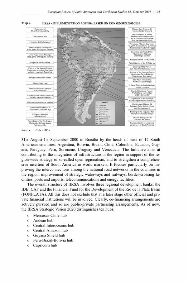
Map 2.
Source: IIRSA 2005a 31st August-1st September 2000 in Brasilia by the heads of state of 12 South American countries: Argentina, Bolivia, Brazil, Chile, Colombia, Ecuador, Guy-ana, Paraguay, Peru, Suriname, Uruguay and Venezuela. The Initiative aims at contributing to the integration of infrastructure in the region in support of the re-gion-wide strategy of so-called open regionalism, and to strengthen a comprehen-sive insertion of South America in world markets. It focuses particularly on im-proving the interconnections among the national road networks in the countries in the region, improvement of strategic waterways and railways, border-crossing fa-cilities, ports and airports, telecommunications and energy facilities. The overall structure of IIRSA involves three regional development banks: the IDB, CAF and the Financial Fund for the Development of the Rio de la Plata Basin (FONPLATA). All this does not exclude that at a later stage other official and pri-vate financial institutions will be involved. Clearly, co-financing arrangements are actively pursued and so are public-private partnership arrangements. As of now, the IIRSA Strategic Vision 2020 distinguishes ten hubs:
o Mercosur-Chile hub o Andean hub o Central Interoceanic hub o Central Amazon hub o Guyana Shield hub o Peru-Brazil-Bolivia hub o Capricorn hub
104
104 | Revista Europea de Estudios Latinoamericanos y del Caribe 85, octubre de 2008
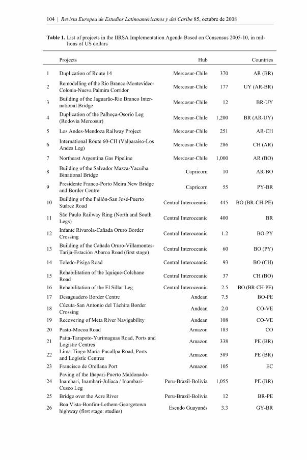
Table 1. List of projects in the IIRSA Implementation Agenda Based on Consensus 2005-10, in mil-lions of US dollars
Projects Hub Countries
1 Duplication of Route 14 Mercosur-Chile 370 AR (BR)
2 Remodelling of the Rio Branco-Montevideo-Colonia-Nueva Palmira Corridor Mercosur-Chile 177 UY (AR-BR)
3 Building of the Jaguarão-Rio Branco Inter-national Bridge Mercosur-Chile 12 BR-UY
4 Duplication of the Palhoça-Osorio Leg (Rodovia Mercosur) Mercosur-Chile 1,200 BR (AR-UY)
5 Los Andes-Mendoza Railway Project Mercosur-Chile 251 AR-CH
6 International Route 60-CH (Valparaíso-Los Andes Leg) Mercosur-Chile 286 CH (AR)
7 Northeast Argentina Gas Pipeline Mercosur-Chile 1,000 AR (BO)
8 Building of the Salvador Mazza-Yacuiba Binational Bridge Capricorn 10 AR-BO
9 Presidente Franco-Porto Meira New Bridge and Border Centre Capricorn 55 PY-BR
10 Building of the Pailón-San José-Puerto Suárez Road Central Interoceanic 445 BO (BR-CH-PE)
11 São Paulo Railway Ring (North and South Legs) Central Interoceanic 400 BR
12 Infante Rivarola-Cañada Oruro Border Crossing Central Interoceanic 1.2 BO-PY
13 Building of the Cañada Oruro-Villamontes-Tarija-Estación Abaroa Road (first stage) Central Interoceanic 60 BO (PY)
14 Toledo-Pisiga Road Central Interoceanic 93 BO (CH)
15 Rehabilitation of the Iquique-Colchane Road Central Interoceanic 37 CH (BO)
16 Rehabilitation of the El Sillar Leg Central Interoceanic 2.5 BO (BR-CH-PE)
17 Desaguadero Border Centre Andean 7.5 BO-PE
18 Cúcuta-San Antonio del Táchira Border Crossing Andean 2.0 CO-VE
19 Recovering of Meta River Navigability Andean 108 CO-VE
20 Pasto-Mocoa Road Amazon 183 CO
21 Paita-Tarapoto-Yurimaguas Road, Ports and Logistic Centres Amazon 338 PE (BR)
22 Lima-Tingo María-Pucallpa Road, Ports and Logistic Centres Amazon 589 PE (BR)
23 Francisco de Orellana Port Amazon 105 EC
24 Paving of the Iñapari-Puerto Maldonado-Inambari, Inambari-Juliaca / Inambari-Cusco Leg
Peru-Brazil-Bolivia 1,055 PE (BR)
25 Bridge over the Acre River Peru-Brazil-Bolivia 12 BR-PE
26 Boa Vista-Bonfim-Lethem-Georgetown highway (first stage: studies) Escudo Guayanés 3.3 GY-BR

105
European Review of Latin American and Caribbean Studies 85, October 2008 | 105
Projects Hub Countries
27 Bridge over the Takutu River Escudo Guayanés 10 GY-BR
28 Venezuela (Ciudad Guayana)-Guyana (Georgetown)-Suriname (Paramaribo) Road (first stage)
Guayanese Shield 0.8 VE-GY-SU
29 Improvements in Nieuw Nickerie-Paramaribo-Albina Leg and International Bridge over the Marowijne River
Guayanese Shield 105 SU-GY
30 Exports through Postal Services for SMEs ITCs 2.5 All countries
31 Implementation of a Roaming Agreement in South America ITCs 0.4 All countries
Total 6,921
Source: IIRSA 2005a and www.iirsa.org.
o Southern hub o Paraguay-Paraná waterway hub o Southern Andean hub
In the period 2003-04 an indicative planning process started in which all countries listed projects. By October 2006 the IIRSA portfolio included 348 projects, among which 31 priority projects (IDB 2006, 5). Map 2 shows the 31 priority projects included in the Consensus Agenda of IIRSA, and Table 1 lists these projects. Table 2 shows a list of approved projects with estimated investment as laid down in the consensus agenda for the period 2005-2010. The list is permanently adjusted and updated. (For updates see www.irsa.org.) The actual state of the trajectories as well as their envisaged future functioning differs widely among the hubs. The same holds for their impact on adjacent territo-ries. Many parts of the trajectories already exist as unpaved or paved roads, but need improvement, reconstruction, or additional infrastructural works, such as bridges, border crossings, and international connections. Although the envisaged hubs link existing infrastructure, the precise trajectories are in most cases not yet determined but are being investigated or negotiated among interested parties. In many cases, IIRSA’s contribution is particularly in making or improving the cross-border linkages between already existing national road systems. Hence, significant efficiency gains may be realized with relatively small investment. Apart from IIRSA, other transnational road projects are under construction that may or may not link up with IIRSA trajectories. Cases in point are the Brazilian plans for infrastructure development: Avança Brasil, the Programa de Aceleração do Crescimento (PAC) 2007-2010 and the so-called Arco Norte project. More re-cently the Brazilian government introduced the Plano Amazônia Sustentável (PAS), which includes projects as well as financial mechanisms to develop trans-port infrastructure. These recent infrastructural plans build upon initiatives taken in earlier decades, many of which were implemented only partially for fiscal reasons. In Central America and Mexico, the PPP was launched in 2001 as a programmatic regional framework for the promotion of regional sustainable development to

106
106 | Revista Europea de Estudios Latinoamericanos y del Caribe 85, octubre de 2008
Table 2. Approved projects with estimated investment as laid down in the consensus agenda for the period 2005-2010
Hubs No. of groups No. of projects % Estimated
investment (millions of US$)
%
Amazonas 7 58 11.4 3,975 5.8
Andino 10 65 12.8 6,097 8.8
Capricornio 5 63 12.4 5,953 8.6
Del Sur 2 26 5.1 2,530 3.7
Escudo Guyanés 4 32 6.3 5,847 8.5
Hidrovía Paraguay - Paraná 5 97 19.1 2,829 4.1
Interoceánico Central 5 49 9.7 4,651 6.7
Mercosur - Chile 6 92 18.1 19,467 28.2
Peru - Brazil - Bolivia 3 23 4.5 17,559 25.5
PSI 0 2 0.4 2,9 0.0
Total 47 507 68,908
improve regional road infrastructure, water management and energy distribution. IIRSA and PPP could physically be connected if a road were to be constructed be-tween Panamá and Colombia through the Darién.
The rationale of IIRSA
Infrastructure, defined broadly, plays a key role in stimulating economic growth by facilitating production and trade, thus generating income and employment. Without efficient transportation and communication infrastructure, economic agents face high transaction costs that hamper production, trade, and consumption, and conse-quently reduce welfare. Particularly, countries that pursue export-orientated devel-opment policies may suffer greatly from a lack of efficient (transport) infrastruc-ture (Rozas and Sánchez 2004, Sánchez and Echeverría 2003). Transportation costs may be expressed in terms of their import tariff equivalents, and their impact on welfare may be considered in similar ways. IIRSA is part of a comprehensive set of policy initiatives to strengthen the posi-tion of South America in the global economy. The new insertion of the region in world markets was initiated by a process of unilaterally implemented trade liberali-zation, strengthened by group-wise initiatives to improve market access, and locked in at the multilateral level. Stabilization and restructuring policies, aiming at the liberalization of trade and capital movement, privatization, and regional inte-gration, have made the region’s prospects to improve the standard of living more dependent on the capability of domestic producers to compete in domestic and for-eign markets and to supply worldwide the required quantities and qualities in time. To support domestic producers to meet this challenge, a broad array of measures is required to facilitate trade and enhance trade-related capacity. The renewed insertion of the South American countries in world markets coin-

107
European Review of Latin American and Caribbean Studies 85, October 2008 | 107
cides and is partly induced by the emergence of new centres of gravity in the world economy, offering new trade opportunities and challenges. This holds especially for the growing significance of East Asia, and particularly for China as an importer of South American commodities. The rise of Asia, however, not only contributes to Latin America’s export potential but may also jeopardize its aspirations of becom-ing a platform for manufacturing production and assembly for the international market. Indeed, IIRSA and PPP plans for the construction of several transcontinen-tal roads, linking the Atlantic side of the region with the Pacific, the so-called bi-oceánicas, not only facilitate Latin America’s export drive but may also contribute to competition in the regional market by Asia’s industry. In support of an enhanced insertion in international markets, measures are re-quired that complement the traditional agenda of shallow liberalization, focusing on the abolishment of barriers to trade and integration at the borders (Lawrence 1996). In contrast with shallow integration, deeper integration may be conceived of as a form of integration that moves beyond the removal of trade obstacles in the following ways: improvement of customs procedures and other forms of trade fa-cilitation; regulations pertaining to trade-related technical, sanitary and phytosani-tary standards; and trade-related physical infrastructure. Such measures may en-hance the capability of countries to exploit trade opportunities in regional or global markets. With declining rates of import tariffs, the role of transportation costs – ex-pressed in terms of their tariff equivalent – in international competition has in-creased. Tedious customs clearance, high port charges and freight costs, and slow handling add costs to traders and consequently impede trade. Transportation costs worldwide account on an average for 5.3 per cent of the value of merchandise im-ports, but are 8.3 per cent in Latin America, excluding Mexico. In several countries in the region, the tariff equivalent of transportation costs exceeds the level of im-port tariff rates (IDB 2006, 30). International comparisons show port clearance in Latin America to require more time than in any other region in the world except for Africa. At the same time clearance times differ widely among ports in Latin Amer-ica, with harbours in Chile, Mexico and Panama among the most efficient, and harbours in Venezuela and Brazil among the least efficient (IDB 2002, 134, Fig-ures 6.3 and 6.4). Trade Facilitation, including the improvement of trade-related infrastructure in support of deeper integration of countries in the regional or world economy, has been added to the agenda of the World Trade Organization (WTO) as one of four so-called Singapore Issues during the WTO Ministerial of Singapore in 1997. The issue of Trade Facilitation includes a wide array of mechanisms and instruments to reduce trade-related transaction costs. Worldwide, the issue of trade-related infra-structural improvement is becoming a priority (Van Dijck and Faber 2006).
The spatial impact of roads
The impact of the construction of a new road or the improvement of an existing road on adjacent territories, the área de influencia del corredor, may involve eco-nomic, social and environmental dimensions. The spatial extent of the impact de-pends on a large number of factors that differ among hubs and specific locations
108
108 | Revista Europea de Estudios Latinoamericanos y del Caribe 85, octubre de 2008
along these hubs. Hence, meaningful generalizations on the impact of roads on their environment – defined broadly and including economic, social, physical, eco-logical and institutional dimensions – are not warranted. Put differently, general-ized claims regarding the potentials of infrastructure in support of sustainable de-velopment will be hard to substantiate, and the same holds for allegations pertain-ing to the negative effects of these infrastructure programmes. Notwithstanding the wide variety in impact that roads may have on adjacent territories, some regulari-ties and patterns may be inferred from statistical studies on land use conversion and deforestation effects of road building and improvement as summarized below. Statistical studies show a high concentration of deforestation in Amazonia along the expanding road network. In the period 1991-95, 33 per cent of deforesta-tion was concentrated in an area within 50 kilometres of the eastern road network, 24 per cent within 50 kilometres of the central road network, and 17 per cent within 50 kilometres of the western road network. All together, 74 per cent of de-forestation was concentrated within 50 kilometres of the main roads, creating long corridors through the forest. Most new clearing takes place in areas adjacent to areas already cleared, on a moving agricultural frontier, often according to a so-called fish-bone pattern (Alves 2002; Andersen et al. 2002, 55; Pfaff et al. 2007). On the basis of a composite map, Nepstad et al. (2000, 2001, 2002)) found that 28 to 58 per cent of the forest had been cleared in the 20 years following road pav-ing within a zone of 50 kilometres on either side of the road. Studies along the BR 010, PA 150 and BR 364 show that the impact varies widely with distance, with higher rates of deforestation nearby roads. On the basis of analyses regarding the impact of paved roads during the past 15 to 25 years, Laurance et al. (2001) find a forest loss of 30 per cent in the 0-10 kilometre zone, 20 per cent forest loss in the 11-25 kilometre zone, and 15 per cent loss in the 26-50 kilometre zone. Regression analyses by Kaimowitz et al. (2002, 43-45) indicate that deforesta-tion is supported by better access to markets (availability of a paved road and in-verse of distance); the size of a market in terms of purchasing power; ecological conditions favouring agricultural production including cattle (soil quality, precipi-tation, probable slope and distance to rivers as well); the inverse of input prices (labour, land and intermediate inputs); output prices of agricultural products; the use of policy instruments such as subsidy; inverse of distance to already deforested areas; inverse of degree of protection of land areas. Such studies allow for an esti-mation of the impact of policy variables on different stretches of roads. The effects of new roads on adjacent territories cannot simply be considered as negative externalities to be avoided or compensated by the application of policy instruments. In this context it should be noted that the concept of development hubs, as considered by the IDB, refers to the mechanism of so-called crowding-in effects of roads: government investment in such public goods induce private in-vestment that benefit from improved market access and communication options. Hence, land use conversion related to roads is among the very objectives of the IIRSA programme. To what extend the objective of land use conversion is realized ultimately depends on aggregate decisions and interventions by individual persons, households and firms. The general hypothesis about their behaviour is that the de-cision to deforest or convert land use is the outcome of the net present value from non-forest land use, for example, agricultural land and pasture; the net present

109
European Review of Latin American and Caribbean Studies 85, October 2008 | 109
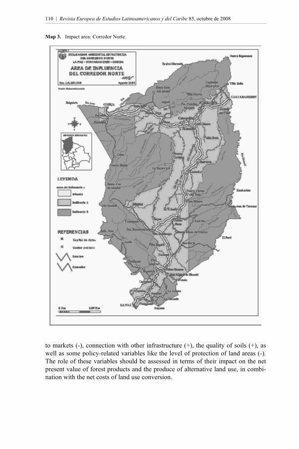
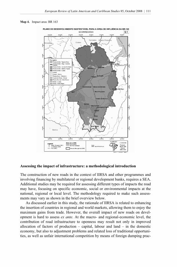
value of the use of forested land; and the costs of land use conversion net of obtain-ing timber value (Stavins and Jaffe 1990, Pfaff et al. 2007). Not unusually, private investment decisions concerning land use are analysed in the context of so-called livelihood strategies of individuals or households that un-dertake economic activities along a road trajectory. At the same time similar deci-sions are made by private firms behaving according to a standard profit maximali-zation function. The two categories of economic actors, small farmers and private firms, differ in economic behaviour for several reasons related to the access to land and capital and the costs thereof; their different capabilities to reduce risks; differ-ences in the costs of using inputs like pesticides and fertilizers; and options to mar-ket their output. Nutrient mining, conceived of as the unsustainable extraction of nutrients from the forest soil through cropping, ranching and logging, is both an incentive and market response to road building, and among the main causes of deforestation (Schneider 1995, 15). The rain forest in central and northern Amazonia may in-creasingly come under pressure for the following reasons related to the expansion of nutrient mining activities. First, with the depletion of worldwide stocks of tim-ber, higher prices will stimulate exploitation. To different degrees, this may also hold for some other natural resources, be it that the impact of pit mining activity on the integrity of the forest may be more locally confined than large-scale timber exploitation is. Second, increased worldwide demand and higher prices for specific agricultural products and biofuels such as soya and sugar stimulates production and contributes to the expansion of productively used land area in forested areas and savannahs. Third, infrastructural investment embedded in new governmental pro-jects to develop Amazonia, particularly in new roads, will enhance the likelihood of deeper penetration into the forest (Gascon et al. 2001, 25). Moving the frontier by building new roads, particularly in pristine forests, may have a lowering impact on land prices by making new land available, hence stimu-lates colonization and land-extensive forms of production, while, on the contrary, improvement of existing roads may increase land prices by stimulating intensifica-tion of land use along the paved road. There is evidence to suggest that investment in network expansion may result in more deforestation than investment in network improvement (Andersen et al. 2002, 145-147). Studies on the potential or expected impact of newly paved roads on adjacent territories suggest that the spatial impact may be substantial. The comprehensive investigation into the possible impact of the Corredor Norte in northern Bolivia by DHV (2006) indicates directly and indirectly that the projected road of 1,386 kilo-metres between La Paz, Guayaramerín and Cobija may affect 25 per cent of the Bolivian landmass, as illustrated in Map 3. According to the Brazilian Ministry of the Environment (2005) the impact area of the BR 163 highway of 1,756 kilome-tres linking Cuiabá with Santarém may equal 15 per cent of the Brazilian landmass, as illustrated in Map 4. The available evidence suggests that the potential direct and indirect impact area of corridors may be substantial in spatial terms and that a number of variables, in combination with road construction or improvement, has a statistically signifi-cant positive (+) or negative (-) impact on land use conversion, including distance
110
110 | Revista Europea de Estudios Latinoamericanos y del Caribe 85, octubre de 2008
Map 3. Impact area: Corredor Norte
to markets (-), connection with other infrastructure (+), the quality of soils (+), as well as some policy-related variables like the level of protection of land areas (-). The role of these variables should be assessed in terms of their impact on the net present value of forest products and the produce of alternative land use, in combi-nation with the net costs of land use conversion.
111
European Review of Latin American and Caribbean Studies 85, October 2008 | 111
Map 4. Impact area: BR 163
Assessing the impact of infrastructure: a methodological introduction
The construction of new roads in the context of IIRSA and other programmes and involving financing by multilateral or regional development banks, requires a SEA. Additional studies may be required for assessing different types of impacts the road may have, focusing on specific economic, social or environmental impacts at the national, regional or local level. The methodology required to make such assess-ments may vary as shown in the brief overview below. As discussed earlier in this study, the rationale of IIRSA is related to enhancing the insertion of countries in regional and world markets, allowing them to enjoy the maximum gains from trade. However, the overall impact of new roads on devel-opment is hard to assess ex ante. At the macro- and regional-economic level, the contribution of road infrastructure to openness may result not only in improved allocation of factors of production – capital, labour and land – in the domestic economy, but also to adjustment problems and related loss of traditional opportuni-ties, as well as unfair international competition by means of foreign dumping prac-
112
112 | Revista Europea de Estudios Latinoamericanos y del Caribe 85, octubre de 2008
tices. Although openness and increased competition may generally contribute to welfare through increased consumer surplus and improved allocation of available factors of production, the impact of openness on longer-term growth is more diffi-cult to establish by means of trade models and regression analyses and has been contested in the literature. The impact of opening up the economy is traditionally studied in computable general equilibrium (CGE) models. For example, CGE models generated in the Global Trade Analysis Project (GTAP) are applied to as-sess the sectoral and nation-wide economic effects of concessions to liberalize economies in the context of negotiations in the WTO (Van Dijck and Faber 2006). However, for a number of reasons it will be difficult to model the impact of trade-related capacity building through infrastructural development on the economy. First, to include infrastructure improvement in the model, the so-called tariff equivalent of transport costs (reduction) needs to be incorporated into the model at the sectoral level. Second, the model only allows for assessing the impact of trans-port costs reduction on export and import flows and related income flows, and not for assessing the economic costs and benefits of the investment in infrastructure, let alone the inclusion of environmental costs of such investment. Third, notwith-standing ambitions and claims, GTAP models essentially are static by nature and do not provide insight into longer-term effects and crowding in effects of invest-ment in trade-related road infrastructure. Clearly, investment in infrastructure is a long-term programme with trade and income effects to be generated only in the longer term. Fourth, the models cannot cope adequately with the economic adjust-ment problems during the transitional stage in which liberalization measures or trade-related investment programmes are being implemented. These economic ad-justment problems may contribute to economic and social disruption at the regional and local level, to be addressed in plans of action, that are among the most critical components of the required SEA studies. These adjustment problems may involve relatively large sections of communities in the case of labour-intensive (agricul-tural) sectors employing relatively low-skilled and low-income workers. Intensifi-cation of trade-related traffic and improved access to relatively inaccessible regions may create additional social disruption. We may conclude at this stage that the types of CGE models referred to above may be useful to assess the direction of trade and income effects of increased open-ness at the macro-economic level, be it that the models tend to generate once-and-for-all effects rather than the effects of intensified economic liberalization over the course of time. However, the models are not capable of assessing the impact of trade-related infrastructural programmes in adjacent territories. SEAs are being designed and applied to assess ex ante several types of impacts in areas directly or indirectly affected by roads and other types of (trade-related) infrastructure. The concept of SEA is relatively new and follows upon earlier methodologies to assess infrastructure impacts such as costs-benefit analysis (CBA) and environmental impact assessment (EIA). The methodology and content requirements of SEAs are not yet standardized, at least not in the context of IIRSA, and the methodologies applied so far may be considered experimental, are con-tested and are in the process of being redesigned. The comprehensive DHV study on the Corredor Norte in Bolivia, commissioned by the IDB, is a case in point as discussed below. A SEA is conceived by The World Bank as ‘an umbrella term for

113
European Review of Latin American and Caribbean Studies 85, October 2008 | 113
the integration of environmental and social concerns in the process of developing policies, plans or programs […]. SEA has great potential in meeting real and grow-ing needs in many developing countries and can assist in clarifying economic, so-cial and environmental tradeoffs at aggregate levels of policy and planning, and in developing balanced responses. The key shortcoming of SEA at this stage is its lack of methodological definition and robustness’. SEA needs to support decision makers ‘with a holistic understanding of the environmental and social implications of policy proposals' (The World Bank 2002, 2, 3, 7). The SEA provides informa-tion about the characteristics of a specific infrastructure project. It helps to deter-mine who will benefit from, a new road, for example, and who will be negatively affected. It provides information about the (regional) distributional effects of new infrastructure facilities, about the effects on the economy as a whole and about the effects on the environment (SATCRA 1999, 40-65; Venables and Gasiorek 1998). This helps to determine whether a specific road should be considered a public or a private good. In case a certain road can be classified as a private good, a user charge can be applied. The entirely public provision of such a road would not be reasonable from a welfare-economic point of view. Ultimately, the aim of a SEA is not to approve or disapprove of a certain infra-structure product, but to inform policy-makers and the general public about all ef-fects of infrastructure investments. As such, a SEA contributes to higher quality public management and policies, since it provides politicians and policy-makers with first-rate information about the possible consequences of their decisions, and adds to the transparency of public governance (Netherlands Ministry of Transport, Public Works and Water Management 2000, Part I, 1-50). In addition to the envi-ronmental impact analysis of the EIA, a SEA consists of a ‘systematic and com-prehensive evaluation of the environmental and social effects of policies, plans or programmes and their alternatives, resulting in a report that facilitates publicly ac-countable decision-making’ (Ahmed et al. 2005, 1-4). By using the SEA, a more comprehensive and inclusive approach to large infra-structure and regional development projects is possible. This is particularly impor-tant in the case of border-crossing projects and public-private-partnership construc-tions, since the design of the project and its payment system should be related to the distribution of positive and negative welfare effects generated by the project.
Towards a comprehensive SEA
In view of the sheer size and scope of the road projects, an assessment of its prob-able economic and non-economic impacts exceeds by far the traditional framework for project assessments and evaluations, as provided by a CBA. There are at least three good reasons why a SEA for IIRSA road infrastructure must be comprehen-sive by nature. First, the impact of newly paved roads on the environment in adja-cent territories may be widely dispersed. Second, the impact may be long-term and even irreversible. Third, the change is multidimensional involving economic, envi-ronmental, social and political dimensions. A truly comprehensive and robust SEA needs to address some critical methodo-logical problems that are briefly referred to below. Ideally, a comprehensive ex-ante assessment would include a regional CGE model allowing for simulation runs.

114
114 | Revista Europea de Estudios Latinoamericanos y del Caribe 85, octubre de 2008
However, the capability to simulate the real-world dynamics of such a major in-vestment programme in selected regions is limited. Moreover, the time span of such essentially economic models does not allow for inclusion of long-term envi-ronmental effects and their (second round) economic repercussions. Next, a comprehensive assessment of the welfare effects of a road requires that all costs and benefits are fully included. To assess the true value of a region and the consequences of intervention by means of infrastructure, a comprehensive inven-tory of the many different functions of the forest need to be made including the array of direct and indirect use values as well as optional and existence values of the forest. The forest is truly multifunctional in the sense that it provides simulta-neously direct and indirect use values, the latter of which become available as pub-lic goods. Exploitation of some or more of the direct use value capabilities of the forest may result in ecological degradation and limit the capability of the forest to provide some of its indirect use values. Moreover, an economic assessment of the consequences of changes in land use requires an economic valuation of environmental services. Such valuations are hampered by imperfect functioning of many of the markets involved and by the absence of markets for several eco services provided by the forest at the local, re-gional and global level. This holds particularly for the economic valuation of bio-diversity and carbon sequestration. Moreover, longer-term forecasting of variations in direct and indirect use values, resulting from future patterns of demand and sup-ply of natural resources and ecological services, are hard to make (Trindade de Almeida and Uhl 1999, Van Beukering and van Heeren 2003). These complica-tions must be tackled in order to make a comprehensive valuation of the forest to enable comparison of alternative options for its exploitation. So far, experience with the application of the new methodology by multilateral financial institutions in developing countries is limited (The World Bank 2002). In Latin America, Brazil is probably the country with the earliest and most extensive experience with impact assessment studies related to the development of road in-frastructure. As shown elsewhere, the ex ante assessment studies undertaken in preparation of the pavement of the 1,756 kilometres long BR 163, linking Cuiabá with Santarém, show important methodological shortcomings and the decision-making process based upon the studies show serious flaws (Van Dijck and Den Haak 2006).
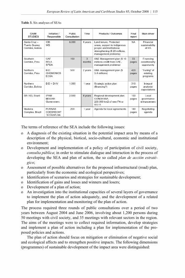
Pedro Bara Neto (2007) gives an overview of six case studies related to road corridors presented in Table 3. These studies were not commissioned per se in the context of IIRSA but were made fairly recently and relate to substantial road infra-structure projects. The studies have in common: land use planning, improvement of basic public services, support of productive activities, and institutional strengthening. They do not have in common: public consultation, and implementation strategies. The DHV (2006) Corredor Norte study, commissioned by the IDB, was excep-tionally comprehensive and detailed, and was undertaken in the period 2004-2006. The study involved an impact area of 234,000 square kilometres along the 1,386 kilometres-long trajectory, the equivalent of 25 per cent of Bolivia’s landmass. Three sub regions were distinguished in the assessment: (1) Yungas and Subandino (cordillera); (2) Piedemonte and Llanuras (lowlands and wetlands); (3) Norte Amazónico (tropical Amazon forest region in the very north of Bolivia).
115
European Review of Latin American and Caribbean Studies 85, October 2008 | 115
Table 3. Six analyses of SEAs
The terms of reference of the SEA include the following issues: o A diagnosis of the existing situation in the potential impact area by means of a
description of the physical, biotical, socio-cultural, economic and institutional environment;
o Development and implementation of a policy of participation of civil society, consulta pública; in order to stimulate dialogue and interaction in the process of developing the SEA and plan of action, the so called plan de acción estraté-gico;
o Assessment of possible alternatives for the proposed infrastructural (road) plan, particularly from the economic and ecological perspectives;
o Identification of scenarios and strategies for sustainable development; o Identification of gains and losses and winners and losers; o Development of a plan of action; o An investigation into the institutional capacities of several layers of governance
to implement the plan of action adequately, and the development of a related plan for implementation and monitoring of the plan of action.
The process required three rounds of public consultations over a period of two years between August 2004 and June 2006, involving about 1,200 persons during 50 meetings with civil society, and 35 meetings with relevant sectors in the region. The aims of the meetings were to collect required information, develop strategies and implement a plan of action including a plan for implementation of the pro-posed policies and actions. The plan of action should focus on mitigation or elimination of negative social and ecological affects and to strengthen positive impacts. The following dimensions (programmes) of sustainable development of the impact area were distinguished:
116
116 | Revista Europea de Estudios Latinoamericanos y del Caribe 85, octubre de 2008
o Transport and territorial integration o Economic development o Indigenous peoples o Basic services o Land tenure o Natural resources and environment o Development planning o Institutional strengthening
Concluding observations
There is a real risk that SEA studies to be commissioned in the future will not be that comprehensive, as pressure is building up from the side of governments and financial institutions to limit time and resources to be spent on SEAs. It has been proposed to limit the time available to undertake a SEA to six months and to limit the available budget to US$ 300,000 (approximately € 200,000). One may question the rationale of this recent approach for at least three reasons. First, earlier experi-ence with road construction in Amazonia shows that unexpected spatially wide-spread negative environmental and economic developments with an irreversible character have occurred in cases characterized by inadequate ex ante assessment. The developments related to the Polonoroeste (BR 364) in Rondônia that ulti-mately contributed to the withdrawal of multilateral financial institutions such as IDB and The World Bank from financing large-scale road infrastructure pro-grammes in South America for a long period of time, are a case in point. Moreover, there is no need to postpone investment in the proposed hub entirely during the period in which a comprehensive SEA is being executed as specific projects along the trajectory can be started that do not depend on the outcomes of the overall as-sessment and on final decisions concerning the development of the integrated hub. Finally, in view of the overall budgeted expenses of the IIRSA hubs as shown in Table 2, the expenses on a comprehensive SEA are modest. Assume now that cuts in spending on resources and time are required. As we indicated earlier the concept of SEA is relatively new and no standardized method or model exists from which a reduced form can be developed to match the new budget constraints. Figure 1 illustrates the problem in general terms. It is assumed that the total marginal costs of acquiring and processing information is upward sloping with marginal costs of acquiring information increasing relatively strongly as compared to costs of processing. Marginal benefits of information show a nega-tive slope, with costs and benefits balancing at Ō, which would require a budget covering total costs at this point. If the budget does not allow for such expenses, it is pertinent to cut expenses by means of efficiency measures or, alternatively, by reducing areas of information acquisition. Important variables affecting spending on information acquisition are in all likelihood the size of the impact area, and the number of variables expressing eco-nomic activity and environmental diversity. The DHV study is illustrative of the point: three subregions within the impact area have been distinguished with a large number of specific environmental and economic characteristics or dimensions.

117
European Review of Latin American and Caribbean Studies 85, October 2008 | 117
Figure 1. Costs and benefits of information
Source: G. K. Shaw, Rational Expectations – An Elementary Exposition, St Martin’s Press, New York, 1984, p. 48 The first problem to be faced here is that it is hard to generate information required to delineate the impact area ex ante. We came across this phenomenon earlier in our brief discussion of the limitations of CGE models. Figure 2 illustrates the inter-action of some crucial variables in a land use conversion model. On the horizontal axis, F depicts the maximum-forested area. The upward sloping NN or N´N´ curve reflects the marginal net value of non-forest products such as cattle, agricultural produce including ethanol and soya that are produced after deforestation. This can be considered the opportunity costs of forest conservation. The higher international prices for agricultural products and revenues from land use conversion, the higher opportunity costs of keeping the area forested once the forested area is connected with international markets by means of a road. The DLDL curve reflects the mar-ginal value of conserved forest area to the country itself, and the DWDW curve re-flects the value of forests and forests services to the world as a whole. Clearly, the less forest still available, the higher its marginal value will be. With high prices for agricultural produce and low rewards for environmental services provided by for-ests, we move rapidly towards the origin of the figure. Put differently: the impact area expands as measured by registered land use conversion. The point here is that none of these critical variables is known over the longer term, and that hardly any of these variables can be influenced by the country concerned. Consequently, the impact area is hard to determine ex ante, and the same holds for the type of eco-nomic activity that induces land use conversion. Hence, the plan of action cannot be formulated as one package from the start of the implementation period of the infrastructure programme, but needs permanent adjustment. The second problem concerning the acquisition of information relates to the public consultation. As indicated earlier, the public consultation is a critical

118
118 | Revista Europea de Estudios Latinoamericanos y del Caribe 85, octubre de 2008
Figure 2. Costs and benefits of deforestation: the long-run unknowns
Source: Ramón López (ed.) ‘Mecanismos de financiación e instrumentos de política para el uso sostenible de los bosques’, in K. Keipi, Políticas forestales en América Latina, IDB, Washington, D.C., 2000, p. 48). component of SEA-type investigations and generates information required as an input for the plan of action. Two points may be distinguished here that create bi-ases in the outcomes and limit their robustness. First, the interviews reflect priori-ties of insiders only, not of persons not yet located in the area. Second, the prefer-ences and expectations concerning the road as expressed by the interviewed per-sons are based on partial information and on a type of extrapolation of the actual situation with respect to variables that are involved other than the road itself. Hence, these expectations cannot be considered so-called rational expectations. From the above it follows that the acquisition of information on future devel-opments in the impact area is hampered by poor capabilities to forecast markets, and by biases in the results of the public consultation. Faced with these methodo-logical problems, and excluding the options of efficiency improvement or budget expansion to acquire information, three steps may be considered. First, make inter-temporal adjustments in the plan of action, with the plan focusing on a sequence of shorter periods. Second, in case of a lack of reliable information, apply the precau-tionary principle, particularly when faced with irreversible potential impacts. Three, improve governability to enhance law enforcement and the use of (existing) economic instruments such as taxes and subsidies, and of non-economic instru-ments such as protected areas and reserves. SEAs are a vital mechanism to stimulate the potential welfare enhancing impact of road infrastructure and mitigate potential negative effects on human welfare, animal and plant life and the environment. Cutting time and budgets available for making SEAs in the context of large infrastructure programmes like IIRSA with potentially large and irreversible effects is probably unsound from the perspective of rational decision-making and human welfare. Moreover, it may undermine po-litical and popular support for the infrastructure programme itself, at the local, na-tional and international level.
119
European Review of Latin American and Caribbean Studies 85, October 2008 | 119
* * *
Pitou van Dijck is Associate Professor of Economics at the Centre for Latin American Research and Documentation (CEDLA) in Amsterdam. His field of spe-cialization is international trade and trade policy, more specifically, regional inte-gration policies in Latin America and the functioning of the WTO from the per-spective of developing countries. In recent years he has focused on IIRSA as an initiative to deepen regional integration in Latin America and facilitate interna-tional trade. In 2006 he published Troublesome Construction: IIRSA and Public-Private Partnerships in Road Infrastructure (also available in Spanish). <[email protected]>
Acknowledgements
My thanks go to Marinella Wallis at CEDLA for her diligent research assistance.
References
Ahmed, K., et al., (2005) ‘Strategic Environmental Assessment: Concept and Practice’, Environmental Strategy Notes, Number 14, The World Bank, Washington, D.C., June.
Alves, D., (2002) ‘An Analysis of the Geographical Pattern of Deforestation in Brazilian Amazonia in the 1991-1996 Period’. In: C. Wood and P. Porro (eds) Land Use and Deforestation in the Amazon, University Press of Florida, Gainesville,.
Andersen, L., et al. (2002) The Dynamics of Deforestation and Economic Growth in the Brazilian Ama-zon. Cambridge University Press, Cambridge.
Anderson, K. et al. (2006) ‘Global Trade Reform and the Doha Development Agenda’. In: P. van Dijck and G. Faber (eds) Developing Countries and the Doha Development Agenda of the WTO, Routledge, London and New York.
Bara Neto, P. (2007) Mitigating Induced Impacts from Infrastructure Projects: A Comparative Analysis, presentation at CEDLA Expert Meeting ‘Strategic Environmental Assessment Studies for IIRSA Road Infrastructure’, Amsterdam, 23 April.
Beukering, P. van; and A. van Heeren, (2003) Economic Valuation of the Iwokrama Forest, Guyana - A Stakeholder Perspective. IVM, VU University Amsterdam, internal report, March.
Boadway, R. (1974) ‘The Welfare Foundations of Cost-Benefit Analysis’, Economic Journal, Volume 84.
DHV (2006) Evaluación ambiental estratégica del Corredor Norte de Bolivia, La Paz-Guayaramerin-Cobija, La Paz.
Dijck, P. van; and G. Faber (2006) ‘Towards a Development Round’. In: P. van Dijck and G. Faber (eds) Developing Countries and the Doha Development Agenda of the WTO. London and New York: Routledge.
Dijck, P. van; and S. den Haak (2006) Troublesome Construction – IIRSA and Public-Private Partner-ships in Road Infrastructure. Cuaderno del CEDLA No. 20, Amsterdam.
Gascon, C. et al. (2001) ‘Deforestation and Forest Fragmentation in the Amazon’. In: R. Bierregaard Jr. et al. (eds) Lessons from Amazonia, The Ecology and Conservation of a Fragmented Forest. New Haven and London: Yale University Press.
Grimsey, D., and M. K. Lewis (2004) ‘The Governance of Contractual Relationships in Public-Private Partnerships’, Journal of Corporate Citizenship, Number 15, Autumn.
––– (2002) ‘Evaluating the Risks of Public Private Partnerships for Infrastructure Projects’, Interna-tional Journal of Project Management, Volume 20.
Heertje, A. (1998) ‘Meer Welvaart met Behulp van Pareto’, Economisch Statistische Berichten, Volume 83, Number 4156 , 11 June.
IDB, (2002) Beyond Borders, The New Regionalism in Latin America, Economic and Social Progress in

120
120 | Revista Europea de Estudios Latinoamericanos y del Caribe 85, octubre de 2008
Latin America, 2002 report, Washington, D.C. ––– (2006) Building a New Continent. A Regional Approach to Strengthening South American Infra-
structure. Washington D.C., October. IIRSA (2004) Initiative for Regional Infrastructure Integration in South America. Overview and Strate-
gic Guidelines, Buenos Aires, October. ––– (2005a) Implementation Agenda Based on Consensus 2005-2010, 31 Strategic Projects of Integra-
tion in South America, First Semi-Annual Report, IDB-CAF-FONPLATA, Buenos Aires, July. ––– (2005b) Planificación Territorial Indicativa. Cartera de Proyectos IIRSA 2004, Iniciativa para la
Integración de la Infraestructura Regional Suramericana, Buenos Aires,. Kaimowitz, D.; P. Mendez, A. Puntodewo, and J. Vanclay (2002) ‘Spatial Regression Analysis of De-
forestation in Santa Cruz, Bolivia’. In: C. Wood and R. Porro (eds) Deforestation and land use in the Amazon, Gainesville: University Press of Florida.
Kjörven, O.; and H. Lindhjem (2002) ‘Strategic Environmental Assessment in World Bank Operations: Experience to Date – Future Potential’, World Bank Environment Strategy Papers, Number 4. Washington, D.C The World Bank. See also below as: The World Bank.
Lawrence, R. (1996) Regionalism, Multilateralism, and Deeper Integration. Washington, D.C.: The Brookings Institution.
López, R. (2000) ‘Mecanismos de Financiación e Instrumentos de Política para el Uso Sostenible de los Bosques’. In: K. Keipi (ed.) Políticas Forestales en América Latina. Washington, D.C.: IDB.
Nepstad, D. et al. (2000) Avança Brasil: Os Custos Ambientais para a Amazônia. Belém: Gráfica e Editora Alves.
Nepstad, D., et al. (2002) ‘Road Paving, Fire Regime Feedbacks, and the Future of the Amazon For-ests’, Forest Ecology and Management, Volume 154.
––– (2002) ‘Frontier Governance in Amazônia’, Science, Volume 295, January. Netherlands Ministry of Transport, Public Works and Water Management (2000) Leidraad OEI, The
Hague. Pfaff, A. et al. (2007) ‘Road Investments, Spatial Spillovers, and Deforestation in the Brazilian Ama-
zon’, Journal of Regional Science, Volume 47, Number 1. Rozas, P., and R. Sánchez, (2004) ‘Desarrollo de Infraestructura y Crecimiento Económico: Revisión
Conceptual’, Serie Recursos Naturales e Infraestructura, Number 75, Santiago de Chile: CEPAL. SACTRA, Transport and the Economy (1999) Standing Advisory Committee on Trunk Road Assess-
ment, UK Department of Transport, London. Sánchez, R., and M. Echeverría, (2003) ‘Comercio entre los Países de América del Sur y los Países de
la Comunidad del Caribe: el Papel que Desempeñan los Servicios de Transporte’, Serie Recursos Naturales e Infraestructura, Number 68, Santiago de Chile: CEPAL.
Schneider, R. (1995) Government and the Economy on the Amazon Frontier, World Bank Environment Paper No. 11, Washington, D.C.:The World Bank.
Shaw, G. K. (1984) Rational Expectations – An Elementary Exposition. New York: St. Martin’s Press. Stavins, R. N., and A. Jaffe (1990) ‘Unintended impacts of Public Investments on Private Decisions: the
Depletion of Forested Wetlands,’ American Economic Review, Volume 80. Trinidade de Almeida, O., and C. Uhl (1999) ‘Developing a Quantitative Framework for Sustainable
Resource-Use Planning in the Brazilian Amazon’. In: P. May (ed.) Natural Resource Valuation and Policy in Brazil, Methods and Cases in Conservation Science. New York: Columbia University Press.
Venables, A .J., and M. Gasiorek (1998) The Welfare Implications of Transport Improvements in the Presence of Market Failure, Report to SACTRA. London: UK Department of Transport.
World Bank, The (1994) Infrastructure and Development. World Development Report, Washington, D.C.
––– (1997) Roads and the Environment. A Handbook. Washington, D.C. ––– (2002) Strategic Environmental Assessment in World Bank Operations, Experience to Date – Fu-
ture Potential. Environment Strategy Papers Number 4, Environment Department, Washington, D.C., May.