ts08f hasan azhari et al ppt 4742 - fig · 4 jalal johari consultants leica 1 5 geometra surveys...
TRANSCRIPT
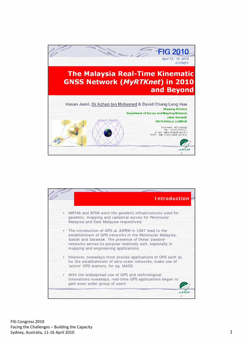
FIG Congress 2010 Facing the Challenges – Building the Capacity Sydney, Australia, 11‐16 April 2010 1
2
• MRT48 and BT68 were the geodetic infrastructures used for geodetic, mapping and cadastral survey for Peninsular Malaysia and East Malaysia respectively
• The introduction of GPS at JUPEM in 1987 lead to the establishment of GPS networks in the Peninsular Malaysia, Sabah and Sarawak. The presence of these ‘passive’ networks serves its purpose relatively well, especially in mapping and engineering applications.
• However, nowadays most precise applications of GPS such as for the establishment of zero-order networks, make use of ‘active’ GPS stations, for eg. MASS
• With the widespread use of GPS and technological innovations nowadays, real-time GPS applications began to gain even wider group of users
Introduction

FIG Congress 2010 Facing the Challenges – Building the Capacity Sydney, Australia, 11‐16 April 2010 2
1. Malayan Revised Triangulation 1948 (MRT48)
• basic mapping in Peninsular
Malaysia since 1948 • evolved from the Old
Triangulations and the Primary (Repsold) Triangulation
• consists of 77 geodetic, 240 primary and ~ 900 (2nd/3rd) points
• Modified Everest Ellipsoid, Kertau Datum and Rectified Skew Orthomorphic (RSO) projection
Conventional Networks
G020
Repsold Triangulation
2. Borneo Triangulation 1968
(BT68) • for mapping in East Malaysia
since 1968 • resulting from early
readjustment of Borneo in 1948 and 1961
• consists of 145 stations • Modified Everest Ellipsoid,
Timbalai Datum and Rectified Skew Orthomorphic (RSO) projection
INDONESIA
SABAH
SARAWAK
SOUTH CHINA SEA
Conventional Networks CONTD
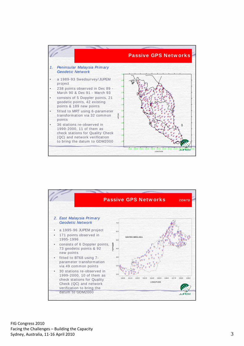
FIG Congress 2010 Facing the Challenges – Building the Capacity Sydney, Australia, 11‐16 April 2010 3
1. Peninsular Malaysia Primary Geodetic Network
• a 1989-93 Swedsurvey/JUPEM project
• 238 points observed in Dec 89 - March 90 & Dec 91 - March 93
• consists of 5 Doppler points, 21 geodetic points, 42 existing points & 189 new points
• fitted to MRT using 6-parameter transformation via 32 common points
• 36 stations re-observed in 1999-2000, 11 of them as check stations for Quality Check (QC) and network verification to bring the datum to GDM2000
DOP1
DOP2
DOP3
DOP4
DOP5
GP02
G003 GP04
GP05 GP06
GP07
GP08
GP09 GP10
GP11 GP12 GP13
GP14
GP15 GP16
GP17
GP18
GP19 GP20
GP21
GP22
GP23
GP24 GP25
GP26 GP27 GP28
GP29 GP30 GP31 GP32
GP33
GP34
GP35
GP36 GP37
GP38
GP39 GP40
GP41 GP42
GP43
GP44
GP45
GP47
GP48
GP49
GP50
GP51
GP52
GP53
GP54
GP55
GP56 GP57
GP58
GP59
GP60
GP61
GP79
GP80
GP81
GP82
P083
GP84 GP85
GP86
GP87 GP88
GP89
GP90 GP91
GP94
GP95
GP98
GP99
G100
J416
TD01
TG01
TG03
TG04
TG05
TG06
TG07
TG09
TG10
TG11
TG13
TG14
TG15
TG18
TG19
TG20
TG24 TG25
TG26
TG27 TG28
TG31
TG33
TG35
TG36
TG38
TG42
TG56
TG57 TG58
TG59
TG61
T190
T200
T283
13DJ
149B
251.00
P101
P102
P105
P106
P107
P201
P202
P203
P204
P205
P207
P209
P210 P211
P212
P213
P214
P215
P216 P217
P218
P219
P220
P221
P222
P223
P224
P225
P226
P227
P228
P229
P230
P231
P232
P233
P234 P235
P236 P237
P238
P239
P240
P241
P242
P243
P244 P245
P246
P247
P248
P249 P250
P251
P252
P253
P254
P255 P256
P257
P258
P259 P260
P261
P263
P264
P265
P267
P268
P269
P270
P271 P272
P273 P274
P275
P276
P277
P278
P279
P280 P281
P282
P283 P285 P286
P287
P288
P289 P290
P291
P292
P293
P295
P296
P297
P298
P299
P304
P305
P306 P307
P308 P309
P310
P311
P313
P314
P351
P352
P500
P808 P809
S136
S290
K350
M331
99.50 100.00 100.50 101.00 101.50 102.00 102.50 103.00 103.50 104.00 104.50 105.00
LONGITUDE
1.50
2.00
2.50
3.00
3.50
4.00
4.50
5.00
5.50
6.00
6.50
7.00
L A T I T
U D E
Passive GPS Networks
2. East Malaysia Primary Geodetic Network
• a 1995-96 JUPEM project • 171 points observed in
1995-1996 • consists of 6 Doppler points,
73 geodetic points & 92 new points
• fitted to BT68 using 7-parameter transformation via 49 common points
• 30 stations re-observed in 1999-2000, 10 of them as check stations for Quality Check (QC) and network verification to bring the datum to GDM2000
M501 T004
M502
T101
T102
M503
M505
M504
T103
M507
M506 M508
M402 M403
M404
M405 M509
M401
M407
M408
T114
M406
D004
M413
M412
M414 M415
T108
M409
T106 M410
M411
T107
T109
M416
M316
M417
M317
M315
M314
M418
T128
M313
M306 T127
M419 M422
M421
M420
M305
M307 M312
M311 M310
T125
M304
M303
M302
M105
T124
M424
M423
T113 T116
M104
M202
M301
M201
M203
T122 A102
T123
T121 D006
M204
T120
D005
T118
T119
T117
M102
T110
T112
M103
A101
T115 M101
T111 T100
T104
110.0 111.0 112.0 113.0 114.0 115.0 116.0 117.0 118.0 119.0
LONGITUDE
1.0
2.0
3.0
4.0
5.0
6.0
7.0
L A T I T U D E
T002
M510
T006
T004
T003
M511
M502
D001
T007
T008
T005
4122
5101
T001
D002
4242 8045
8047
4044
T010
T009
8048 T012
8028
T013
3074
3032
3046
T014 T016
T015
3021
T020 T019
3010
T021
6008
4127
4114
4118
2200
2011
T022
2038 T029
9900
T030
T031
T026
R027
T025 2005
T018
T017
6047
T045
7085 7086 6052
J01
7084 7082
7083
D003
T038
T037
7080
T039
4119 T043
4120 T042
T041
T040 7079
2015
T032
1009
T034
T036
T035
1019
SOUTH CHINA SEA
Passive GPS Networks CONTD
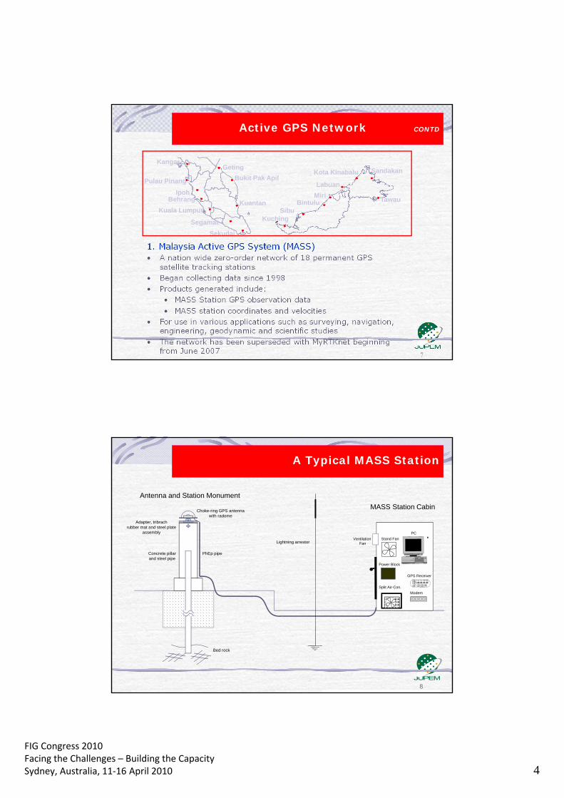
FIG Congress 2010 Facing the Challenges – Building the Capacity Sydney, Australia, 11‐16 April 2010 4
Geting
Pulau Pinang
Kangar
Bukit Pak Apil
Kuantan
Ipoh Labuan
Miri Bintulu
Kuching
Kota Kinabalu
Kuala Lumpur
Tawau
Sandakan
Sekudai
Behrang
Segamat
Sibu
Active GPS Network CONTD
8
PhEp pipe
Choke-ring GPS antenna with radome
Concrete pillar and steel pipe
MASS Station Cabin
Antenna and Station Monument
Lightning arrestor
Bed rock
Adapter, tribrach rubber mat and steel plate
assembly
Modem
GPS Receiver
Split Air-Con.
PC
Stand Fan Ventilation Fan
Power Block
A Typical MASS Station
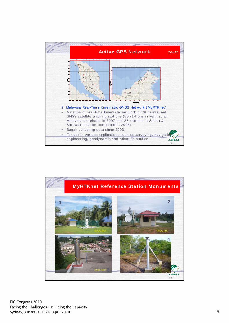
FIG Congress 2010 Facing the Challenges – Building the Capacity Sydney, Australia, 11‐16 April 2010 5
9
Active GPS Network CONTD
2. Malaysia Real-Time Kinematic GNSS Network (MyRTKnet) • A nation of real-time kinematic network of 78 permanent
GNSS satellite tracking stations (50 stations in Peninsular Malaysia completed in 2007 and 28 stations in Sabah & Sarawak shall be completed in 2008)
• Began collecting data since 2003 • For use in various applications such as surveying, navigation,
engineering, geodynamic and scientific studies
10
MyRTKnet Reference Station Monuments
1 2
3
4

FIG Congress 2010 Facing the Challenges – Building the Capacity Sydney, Australia, 11‐16 April 2010 6
Reference station data streams into the GITN IP cloud via 64K leased lines.
From the GITN cloud, all reference station data is immediately sent to Seksyen Geodesi KL over a 1M leased line.
Remote users connect by getting onto the internet using GPRS or GSM to ISP and selecting the IP address of the GITN Internet Gateway 202.75.44.154 port 8080.
The GITN Internet Gatway forwards requests on port 8080 to the GPStream computer on which the NTRIP server is running.
Upon receipt of the NMEA GGA string from the particular user, the system will begin to stream network RTK corrections to the user.
Other users can also access the wenserver at 202.75.44.154 for access to customizable Rinex files for post processing and other services.
Courtesy of John Serink of Trimble
MyRTKnet Data Flow
12
MyRTKnet Services VRS Correction a) Within the limits of our MyRTKnet Dense Network,
MyRTKnet provides VRS GPS corrections with an accuracy of 1 to 3 cm horizontally and 3 to 6 cm vertically.
b) Distance dependent errors are considerably minimized with utilization of the MyRTknet network, thereby achieving increased accuracy and reliability.
c) RTK Surveying works at its optimum with a base station network to achieve the pinnacle of RTK Technology production potential.

FIG Congress 2010 Facing the Challenges – Building the Capacity Sydney, Australia, 11‐16 April 2010 7
13
Single Base Correction a) Within the limits of our MyRTKnet Reference Stations,
MyRTKnet provides RTK GPS corrections with an accuracy of 1 to 3 cm horizontally and 3 to 6 cm vertically.
b) Base Station coordinates errors are eliminated with utilization of the MyRTKnet Single Base service, thereby achieving increased accuracy and reliability.
c) RTK Surveying works at its optimum with a base station which is not limited by range of radio transmission.
MyRTKnet Services
14
Network DGPS Correction
a) This application is a sub-meter Mapping and Navigation Technology.
b) The service provided by MyRTKnet Solutions includes data for post-processed positioning and Real Time Correction.
c) Distance dependant errors are eliminated for users’ observations due to MyRTKnet Solutions’ array of base station locations.
MyRTKnet Services
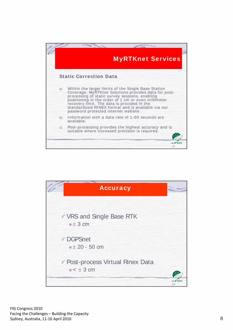
FIG Congress 2010 Facing the Challenges – Building the Capacity Sydney, Australia, 11‐16 April 2010 8
15
Static Correction Data a) Within the larger limits of the Single Base Station
Coverage, MyRTKnet Solutions provides data for post-processing of static survey sessions, enabling positioning in the order of 1 cm or even millimeter recovery limit. The data is provided in the standardized RINEX format and is available via our password protected internet website.
b) Information with a data rate of 1-60 seconds are available.
c) Post-processing provides the highest accuracy and is suitable where increased precision is required.
MyRTKnet Services
VRS and Single Base RTK 3 cm
DGPSnet
20 - 50 cm Post-process Virtual Rinex Data
< 3 cm
Accuracy

FIG Congress 2010 Facing the Challenges – Building the Capacity Sydney, Australia, 11‐16 April 2010 9
17
Survey / Mapping - Single receiver positioning, GIS systems Integration, CCS, Map
Completion, e-CADASTRE
MyRTKnet Applications
Transportation / Recreation / Navigation - Real Time Positioning - Recreation eg: Fishing, boating, bike touring, hiking etc. - Dynamic surveying - Vehicle tracking/reporting - Intelligent transport system
International Collaboration - Support for SEAMERGES and APRGP GPS Campaigns
Environment - Tide gauge monitoring - Auto tide/current measures - Oil spill containment Geodynamics
- Monitoring earth deformations, rotation and variation
- Atmospheric monitoring - Geodynamic applications
18
MyRTKnet Users THE LIST OF REGISTERED USER IN JUPEM
NO AGENCY EQUIPMENT BRAND NUMBER OF USER NAME
1 JUPEM (GEODESI) TRIMBLE 25
2
JUPEM (KADASTER) TRIMBLE 144 3
SEKSYEN FOTOUDARA (JUPEM) TRIMBLE 4 4
JUPEM SARAWAK TRIMBLE 2 5
SEKSYEN PEMETAAN UTILITI TOPCON & TRIMBLE 6 6
SEKSYEN TOPOGRAFI SABAH TRIMBLE 5 7
SEKSYEN TOPOGRAFI SEMENANJUNG TRIMBLE 2
TOTAL 188
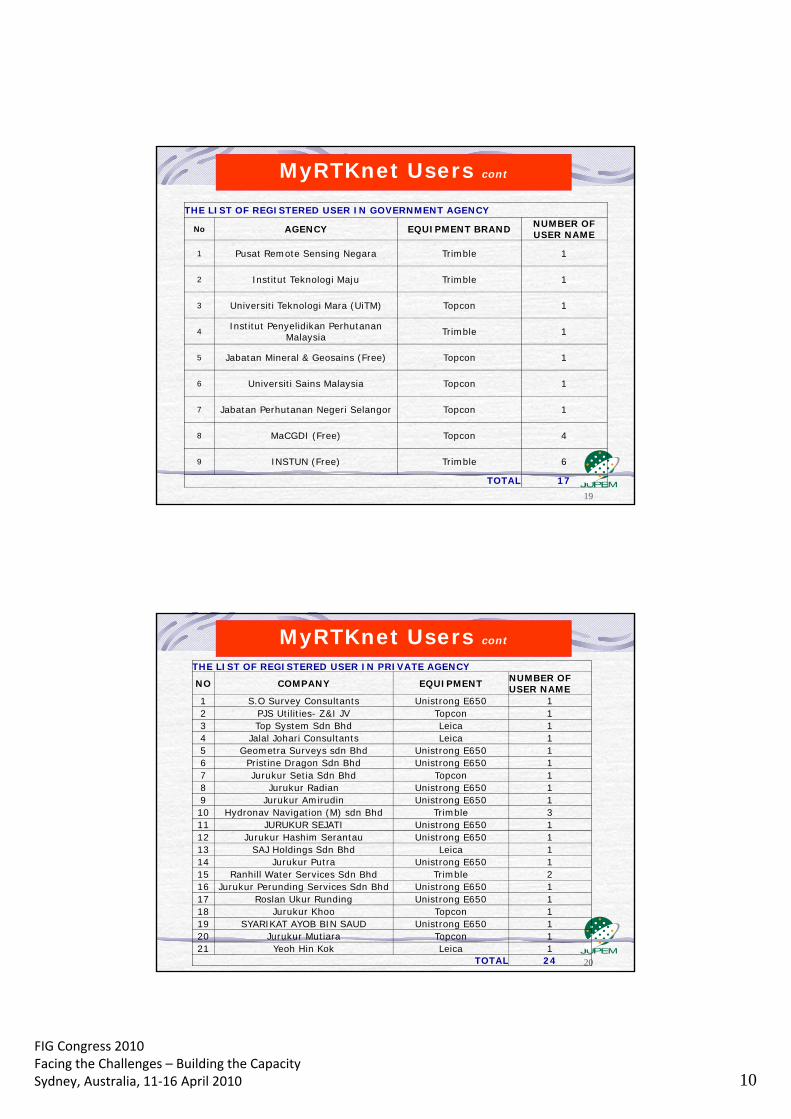
FIG Congress 2010 Facing the Challenges – Building the Capacity Sydney, Australia, 11‐16 April 2010 10
19
MyRTKnet Users cont
THE LIST OF REGISTERED USER IN GOVERNMENT AGENCY
No AGENCY EQUIPMENT BRAND NUMBER OF USER NAME
1 Pusat Remote Sensing Negara Trimble 1
2 Institut Teknologi Maju Trimble 1
3 Universiti Teknologi Mara (UiTM) Topcon 1
4 Institut Penyelidikan Perhutanan
Malaysia Trimble 1
5 Jabatan Mineral & Geosains (Free) Topcon 1
6 Universiti Sains Malaysia Topcon 1
7 Jabatan Perhutanan Negeri Selangor Topcon 1
8 MaCGDI (Free) Topcon 4
9 INSTUN (Free) Trimble 6
TOTAL 17
20
MyRTKnet Users cont
THE LIST OF REGISTERED USER IN PRIVATE AGENCY
NO COMPANY EQUIPMENT NUMBER OF USER NAME
1 S.O Survey Consultants Unistrong E650 1 2 PJS Utilities- Z&I JV Topcon 1 3 Top System Sdn Bhd Leica 1 4 Jalal Johari Consultants Leica 1 5 Geometra Surveys sdn Bhd Unistrong E650 1 6 Pristine Dragon Sdn Bhd Unistrong E650 1 7 Jurukur Setia Sdn Bhd Topcon 1 8 Jurukur Radian Unistrong E650 1 9 Jurukur Amirudin Unistrong E650 1 10 Hydronav Navigation (M) sdn Bhd Trimble 3 11 JURUKUR SEJATI Unistrong E650 1 12 Jurukur Hashim Serantau Unistrong E650 1 13 SAJ Holdings Sdn Bhd Leica 1 14 Jurukur Putra Unistrong E650 1 15 Ranhill Water Services Sdn Bhd Trimble 2 16 Jurukur Perunding Services Sdn Bhd Unistrong E650 1 17 Roslan Ukur Runding Unistrong E650 1 18 Jurukur Khoo Topcon 1 19 SYARIKAT AYOB BIN SAUD Unistrong E650 1 20 Jurukur Mutiara Topcon 1 21 Yeoh Hin Kok Leica 1
TOTAL 24
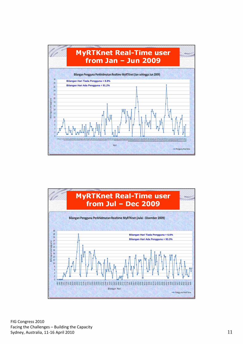
FIG Congress 2010 Facing the Challenges – Building the Capacity Sydney, Australia, 11‐16 April 2010 11
Bilangan Hari Tiada Pengguna = 8.8%
Bilangan Hari Ada Pengguna = 91.2%
Bilangan Hari Tiada Pengguna = 6.6%
Bilangan Hari Ada Pengguna = 93.3%
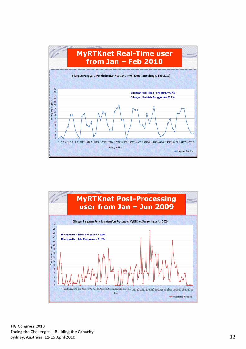
FIG Congress 2010 Facing the Challenges – Building the Capacity Sydney, Australia, 11‐16 April 2010 12
Bilangan Hari Tiada Pengguna = 6.7%
Bilangan Hari Ada Pengguna = 93.2%
Bilangan Hari Tiada Pengguna = 8.8%
Bilangan Hari Ada Pengguna = 91.2%

FIG Congress 2010 Facing the Challenges – Building the Capacity Sydney, Australia, 11‐16 April 2010 13
Bilangan Hari Tiada Pengguna = 13.2%
Bilangan Hari Ada Pengguna = 86.8%
Bilangan Hari Tiada Pengguna = 18.6%
Bilangan Hari Ada Pengguna = 81.4%
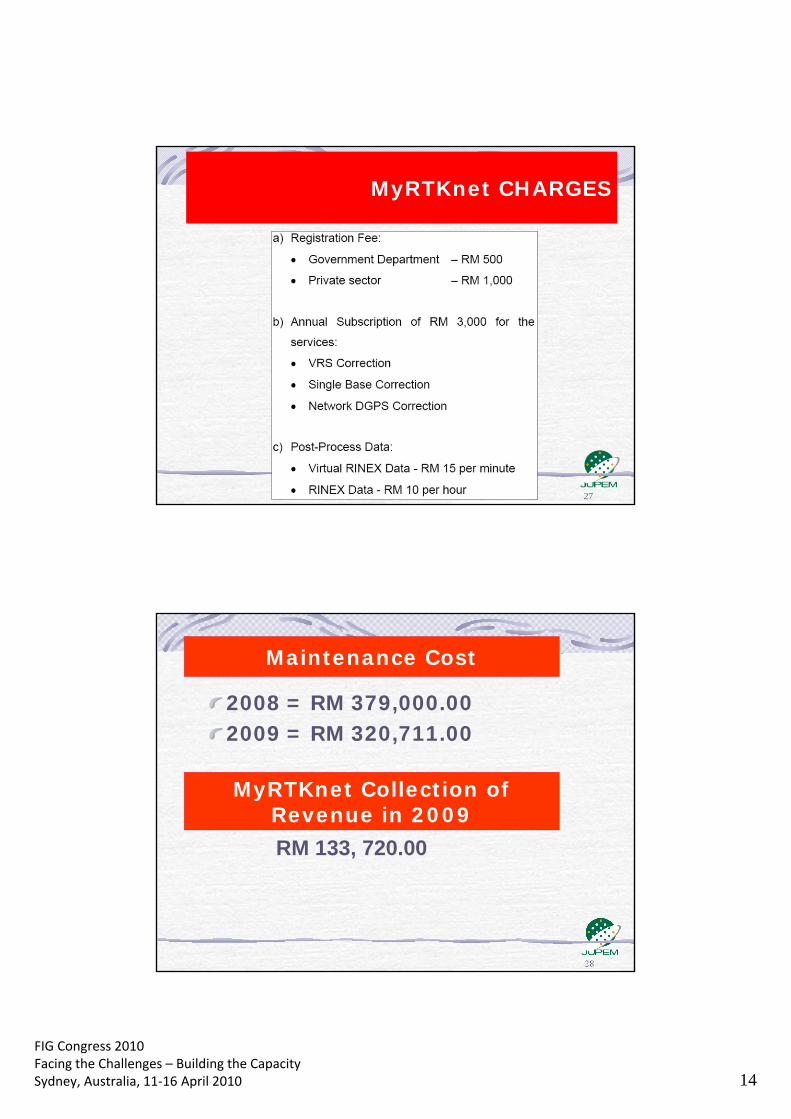
FIG Congress 2010 Facing the Challenges – Building the Capacity Sydney, Australia, 11‐16 April 2010 14
27
MyRTKnet – The Bigger Picture MyRTKnet CHARGES
2008 = RM 379,000.00 2009 = RM 320,711.00
Maintenance Cost
MyRTKnet Collection of Revenue in 2009 RM 133, 720.00
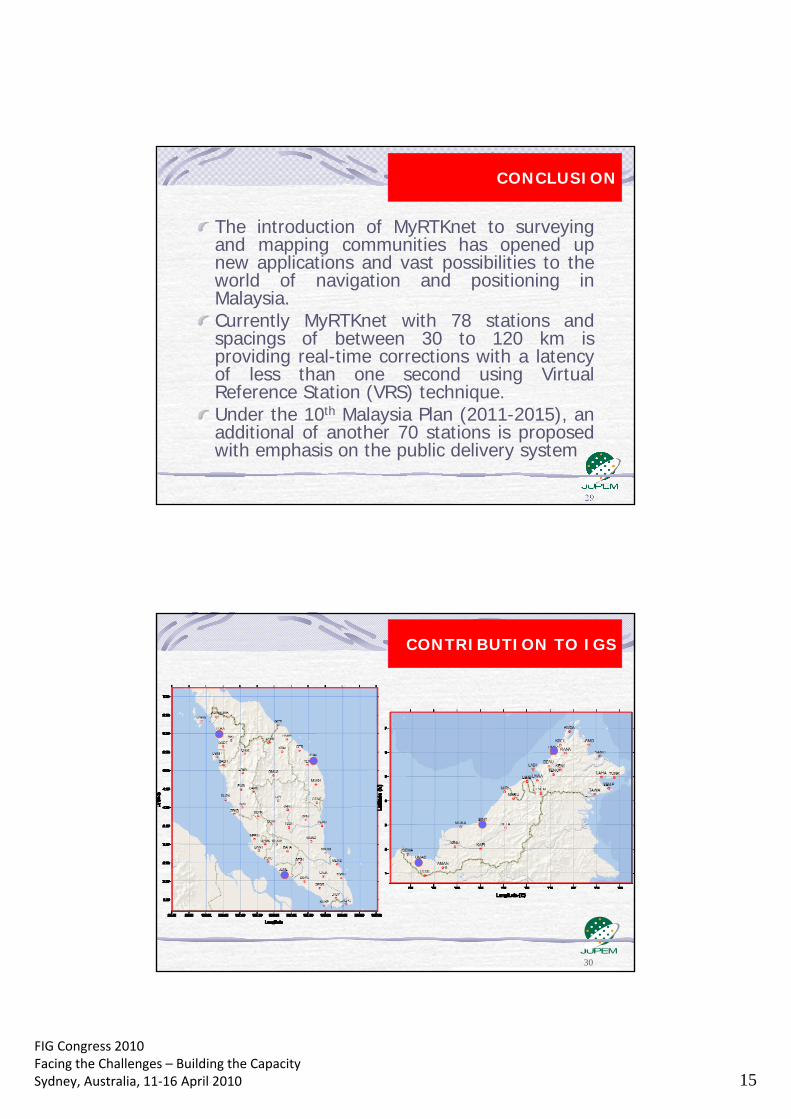
FIG Congress 2010 Facing the Challenges – Building the Capacity Sydney, Australia, 11‐16 April 2010 15
The introduction of MyRTKnet to surveying and mapping communities has opened up new applications and vast possibilities to the world of navigation and positioning in Malaysia. Currently MyRTKnet with 78 stations and spacings of between 30 to 120 km is providing real-time corrections with a latency of less than one second using Virtual Reference Station (VRS) technique. Under the 10th Malaysia Plan (2011-2015), an additional of another 70 stations is proposed with emphasis on the public delivery system
CONCLUSION
30
CONTRIBUTION TO IGS

FIG Congress 2010 Facing the Challenges – Building the Capacity Sydney, Australia, 11‐16 April 2010 16
31
IGS TRACKING NETWORK
32
Recipient of the GIS Development Geospatial Excellence Award in Surveying Category
(RTK Application) MAP ASIA 2009

FIG Congress 2010 Facing the Challenges – Building the Capacity Sydney, Australia, 11‐16 April 2010 17
33
Tq 4 yr knd attn
Kuala Lumpur awaits on 9-16 May, 2014