tsunami of amorgos, 1956
DESCRIPTION
Facts of Amorgos Tsunami, 1956TRANSCRIPT

Name of Student: Chrysoula Sfynia
Name of Supervisor: Dr. Liora Malki-Epshtein
|The Tsunami in Amorgos, 1956, Greece| |
FINAL REPORT
LONDON, MAY 2013
CIVIL, ENVIRONMENTAL AND GEOMATIC ENGINEERING
MSC ENVIRONMENTAL SYSTEMS ENGINEERING
CEGEG101/ CEGEM030: NATURAL AND ENVIRONMENTAL DISASTERS

2
Table of Contents 1. Introduction ....................................................................................................................... 3
2. Background Information ................................................................................................... 5
2.1 Location of the Natural Disaster ................................................................................ 5
2.2 Geology of the Area ................................................................................................... 6
2.3 Seismicity of the Area ................................................................................................ 6
2.4 Historical Tsunami Data ............................................................................................. 6
3. Physical Mechanism .......................................................................................................... 8
3.1 The Earthquake of 9th July, 1956 .............................................................................. 8
3.2 The Tsunami of 9th July, 1956 ................................................................................... 9
4. Monitoring of the Amorgos Tsunami .............................................................................. 12
4.1 Field Surveys ............................................................................................................ 12
4.2 Hydrodynamic Simulation ....................................................................................... 14
5. Impacts of the Amorgos Tsunami .................................................................................... 16
6. Future aims to address Tsunamis in the Mediterranean ................................................ 18
7. Conclusion ....................................................................................................................... 20
References ............................................................................................................................... 21

3
1. Introduction
It was July 9, 1956. At 3:11, a strong earthquake with a magnitude of 7.8 R struck the
island of Amorgos, in the south-central Aegean Sea (Fig. 2.1) and was the largest one to
strike the Mediterranean over the last 100 years (Solov’ev et al. 2000), as computed by
B. Gutenberg at Pasadena and reported by the International Seismological Summary
(ISS). The earthquake caused major damage to the surrounding islands Astypalea, Anafi,
Kalymnos, Leros, Patmos and Santorini. Nevertheless, the earthquake was accompanied
by a marine gravity wave (tsunami), due to a submarine landslide that affected the
coastal areas of both the Cyclades and Crete. Specifically, the run-up values that have
been reported where 30, 20 and 10 meters on the southern shores of Amorgos,
Astypalaia and Folegandros, respectively. It resulted in 53 deaths and more than 100
injuries. Also, the big waves that hit the ports of many other islands caused considerable
damage to homes and crops.
The earthquake and resulting tsunami are remembered as one of the worst natural
disasters in the history of Greece, together with the Parnitha’s earthquake (1999) and
the Peloponnesus flooding (2009-2010).
This coursework aims to present in detail, as a case study, the natural disaster of the
tsunami in the southern Aegean in 1956, the physical mechanisms that caused it and
physical impacts it had.
a) b)
4
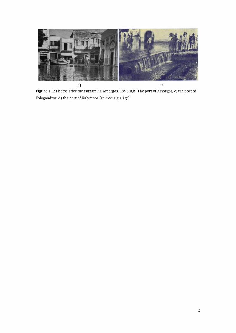
Figure 1.1: Photos after the tsunami in Amorgos, 1956, a,b) The port of Amorgos, c) the port of
Folegandros, d) the port of Kalymnos (source: aigiali.gr)
c) d)

5
2. Background Information
2.1 Location of the Natural Disaster
The island of Amorgos (Fig.2.1-2.2) belongs to the Prefecture of the Cyclades in the
South Aegean region (Dafne, 2008). It is the easternmost island of the region, between
the Small Cyclades and Astypalaia and has a total area of 121 km2 (the 7th largest island
in the Cyclades), with a coastline of 112 kilometers and a population of 1866 inhabitants
(NSO, 2001). Its shape is highly elongated, with a length of about 32 km and orientation
NE - SW.
Figure 2.1: Situation map of Greece during the tsunami in Amorgos, 1956. (source: Okal et al.,
2009)

6
Figure 2.2: Close-up of Fig. 2 showing the islands that have been affected by the tsunami. (source:
Okal et al., 2009)
2.2 Geology of the Area
According to the "Hydrological Survey of Cyclades II- Amorgos" of I. G. M. E. (1983) the
geological structure of Amorgos includes sediments and volcanic sediments of low
transformation.
2.3 Seismicity of the Area
The seismicity of the island is as much and the seismicity of the broader Aegean region,
since it belongs to the Dodecanese – Cyclades arc which is located near the boundary
between the Eurasian and African lithospheric plate (Konstantinou, 2010). Moreover
the seismisity is greater than that of other Mediterranean countries. From the
distribution map of the epicenters of the surface and intermediate-depth earthquakes, it
seems that in the Aegean region intermediate-depth earthquakes occur more than
surface ones (h> 60 km) (IGME, 1983).
2.4 Historical Tsunami Data
The seas of the Aegean and Ionian Sea as well as the neighboring smaller seas and bays
have a great story to tsunamis since antiquity. Tsunamis have been recorded by many
scientists (Galanopoulos, [1960], Ambraseys, [1960], Antonopoulos, [1980]).

7
From the above studies we can observe that over time the incidence of tsunamis is
increasing while the largest tsunami of last century that took place in Greece is that of
Amorgos in July 9, 1956. Below Figure 2.3 demonstrates the areas of Greece and close
countries where tsunamis have been observed from 1773 to 1995.
Figure 2.3: Sources of strong earthquakes in Greece and surrounding areas caused tsunami. The
sizes of the stars show the maximum intensity of the tsunami that occurred in the region. The red
star indicates the source of the tsunami of 1956. (source: Ambraseys, 1960)
As shown in the above map, areas in Greece that have suffered more from tsounamis are
mainly the western shores of the Corinthian Gulf, the Maliatikos bay, the islands of the
Cyclades, Crete, the Dodecanese Islands and the western coast of Greece.
8
3. Physical Mechanism
This chapter is an attempt to study the physical mechanisms that caused the initial
earthquake as well as the displacements and the physical processes that took place,
causing the deadly tsunami of Amorgos in 1956. This natural disaster begun from a land
movement disaster which generated a water disaster (Malki-Epshtein, 2013).
3.1 The Earthquake of 9th July, 1956
The earthquake of Amorgos was the largest and most destructive earthquake that had
occurred in the Aegean region during the past 75 years (Konstantinou, 2010). This
earthquake was one of the most important in the modern history of our country for two
reasons: (a) is the only earthquake of last century that triggered such a tsunami, and (b)
it is one of the most damaging earthquakes in the modern history if we consider the
human and the infrastructure losses.
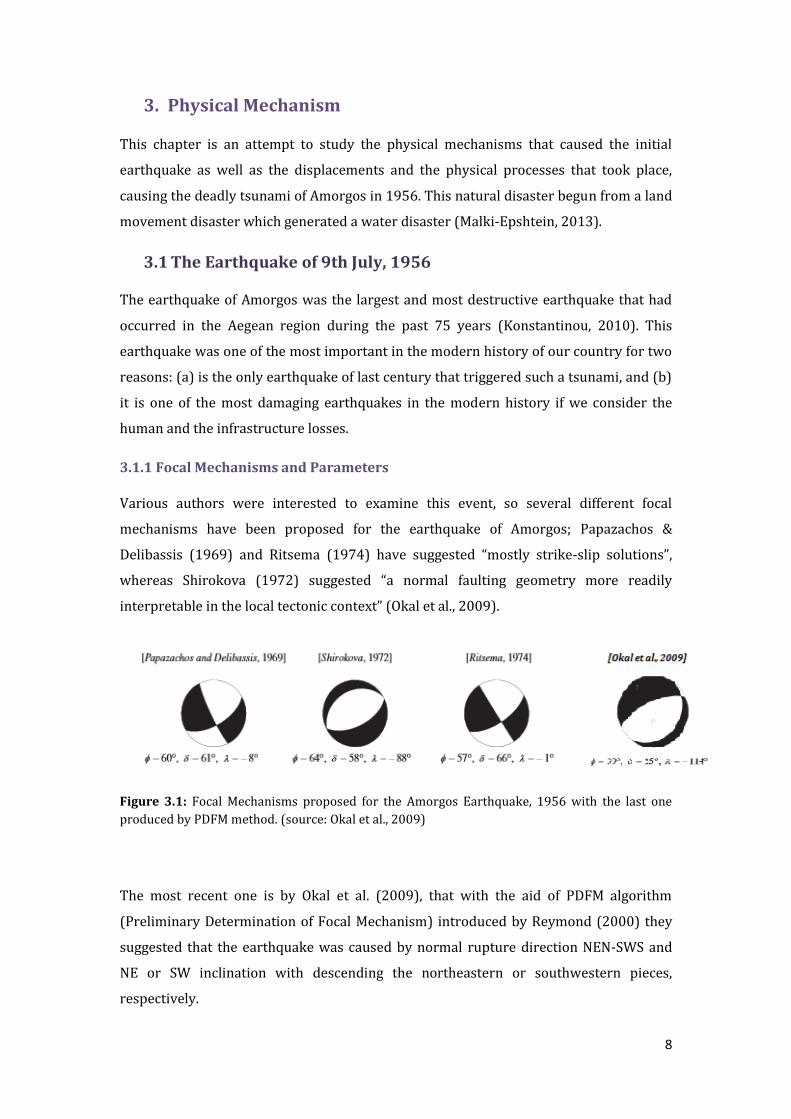
3.1.1 Focal Mechanisms and Parameters
Various authors were interested to examine this event, so several different focal
mechanisms have been proposed for the earthquake of Amorgos; Papazachos &
Delibassis (1969) and Ritsema (1974) have suggested “mostly strike-slip solutions”,
whereas Shirokova (1972) suggested “a normal faulting geometry more readily
interpretable in the local tectonic context” (Okal et al., 2009).
Figure 3.1: Focal Mechanisms proposed for the Amorgos Earthquake, 1956 with the last one
produced by PDFM method. (source: Okal et al., 2009)
The most recent one is by Okal et al. (2009), that with the aid of PDFM algorithm
(Preliminary Determination of Focal Mechanism) introduced by Reymond (2000) they
suggested that the earthquake was caused by normal rupture direction ΝΕΝ-SWS and
NE or SW inclination with descending the northeastern or southwestern pieces,
respectively.

9
Figure 3.2: Map of the area with the epicenter of the earthquake, the epicenters of the
aftershocks and the focal mechanisms. (source: Konstantinou, 2010)
The earthquake of 1956 had a magnitude of Ms = 7.8 (Mo = 3.91027 dyn-cm) and struck
05:11:43.7 local time. The determined focal point of the main earthquake by
Makropoulos et al. (1989) has coordinates 36.64 °N/25.91 °E (20 km North of Amorgos)
and depth n = 15 (± 10 km). 20 aftershocks small and large (MS ≥ 4.1) followed the main
earthquake.
3.2 The Tsunami of 9th July, 1956
Apart from the massive earthquake that took place on July 9th there are a series of
underwater landslides that helped in the creation of the tsunami, as first suggested by
the academician, Ambraseys (1960).
3.2.1 Morphology of the basin
The basin of Amorgos is directed NE-SW and is one of the many large valleys located in
the Northwest Aegean. The maximum depth is over 700 m and is bounded from both
sides by steep normal faults directed NE-SW. The two major boundary faults deviate
towards NE. Smaller and older normal faults produce the complex morphology of the
bottom in the northern part of the basin.
3.2.2 Underwater Landslides
A detailed examination of the seismic profile in the northwestern part of the basin of
Amorgos showed that a large sedimentary slump between the islands of Santorini and
Anafi took place (Okal et al., 2009). There is no evidence that the old sedimentary
10
deposits along the sides of the basin have moved but it seems that in the center of the
basin the arrangement of sediment layers became chaotic. The landslide material
consists of an incoherent sedimentary layer of 50 m thickness. The sliding stretches
along the basin in an area of 6 km wide and 24 km long in the sea at a depth of 350 m to
600 m. The lateral of the sliding has a slope of 3o and the total sedimentary volume is
estimated around 3.6 ∙106 m3 (Perissoratis & Papadopoulos, 1999).
3.2.3 The Tsunami Event
Although the tsunami in Amorgos was studied soon after the event, initially the studies
are based on data described by the local authorities and eyewitnesses and not on
detailed field surveys, which was not developed at that time. However, specialized
scientists have conducted nowadays extensive field surveys in the islands, local
interviews and have implemented their findings in models in order to simulate and
understand the tsunami event in Amorgos (Okal et al., 2009).
So, it seems that soon after the main earthquake, a great marine wave (tsunami) was
created by a series of underwater landslides along the steep slopes of the trench of
Amorgos (Katsimixa, 2012). The tsunami had maximum run-up of 30 m above sea level
in the south - eastern coast of Amorgos (Galanopoulos, 1957; Ambraseys, 1960), while
the corresponding run up values in the surrounding islands were based on the local
bathymetry and coastal morphology, with the waves reaching the island of Crete. Also,
according to eyewitnesses, the sea remained rumpled for many days after the incident
(Katsimixa, 2012).
Although, there is an expected inaccuracy in memory of several witnesses after 49 years,
most of them saw a retreat of the sea water followed by two large waves and many of
decreasing intensity until the returning of the sea level to its original condition. The first
wave, as described by the witnesses, was a smooth wave of standard size, whereas the
second was impetuous and destructive, far higher than the first (Katsimixa, 2012).
Below, Fig. 3.3, shows the maximum amplitudes of the tsunami (in the sea) and run up
(on the land) on the island of Amorgos as simulated by Okal (2009).

11
Figure 3.3: Maximum wave amplitude (sea) and run up (land) of the tsunami in Amorgos (a) and
the run up in the southern shores of Amorgos in the same scale (b). (source: Okal, 2009)

12
4. Monitoring of the Amorgos Tsunami
The unique size of the earthquake and the exceptional amplitude of the tsunami in
Amorgos seemed an interesting field of research for geologists and engineers, who tried
to examine the physical mechanisms and implement models. As already written above, it
was the most destructive earthquake in Greece and the tsunami wave had the highest
run up values ever registered across the Mediterranean basin during the last century
(Solov’ev et al. 2000).
Okal and his colleagues in 2009 studied the effect of the tsunami in Amorgos, by
applying modern techniques of seismology and hydrodynamics, because until then the
older studies were based more on witnesses than on technological advances. So, they
performed:
A recalculation of the main earthquake and the aftershocks,
they resolved the characteristics of the focal point,
they collected 68 run up data from human testimonies and systematic research
in the field and
They published the results obtained from the numerical hydrodynamic
simulation of the tsunami.
From the above mentioned, great interest pose the field surveys run up data and the
hydrodynamic simulations.
4.1 Field Surveys
During the field surveys, the researchers organized visits to various islands in the
Aegean in order to collect oral testimonies and visual elements in the field. From the
field surveys they managed to determine the data for the inundation and run-up of the
tsunami; the maximum horizontal penetration of the wave in the shore and the wave
elevation above the mean sea level (Synolakis & Okal, 2005). Some of the data collected
are shown in the figures below.
13
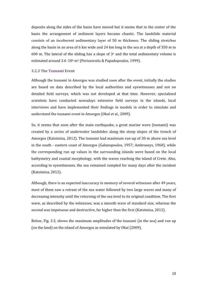
Figure 4.1: Up: The valuation of the tsunami in Amorgos coast, in bold the run up values, Bottom:
The coast Mouros in the southeast of Amorgos. The arrow indicates the maximum run up value
observed. (source: Katsimixa, 2012)

14
Figure 4.2: Up: The valuation of the tsunami in Folegandros coast, in bold the run up values,
Bottom: The coast Aggali in the west of Folegandros. The red arrow indicates the inundation: 290
m and the blue arrow the flow depth : 6.3 m of the wave. (source: Katsimixa, 2012)
4.2 Hydrodynamic Simulation
For the modeling of the tsunami in Amorgos Okal et al. (2009) applied the numerical
code MOST (Titov & Synolakis, 1998), which solves the nonlinear hydrodynamic
equations for shallow water using an algorithm of finite differences and the method of
fractional steps (Synolakis, 2003). The Code of MOST is used to calibrate and guide other

15
numerical models applied by NOAA (National Oceanic and Atmospheric Administration)
for the design of inundation maps.
The code was initially applied to a large grid covering the entire Aegean Sea. The
necessary bathymetry was obtained by inserting the database SRTM 30 with critical
points around several islands that have been digitized from nautical charts (Okal et al.,
2009). So, they generated the model and produced several maps (Figure 3.3, 4.3, 4.4).
Figure 4.3: Simulation of the initial deformation of the sea surface. (source: Okal, 2009)
Figure 4.4: Close –up of maximum wave amplitude and run up of the tsunami in Amorgos. (source: Okal, 2009)

16
5. Impacts of the Amorgos Tsunami
The devastating effects of the earthquake and the tsunami of 1956, as briefly recorded
by Galanopoulos et al. (1982), were as follows; 53 deaths, 100 injuries, 529 buildings
collapsed completely and 1482 buildings were partially damaged. More than 50% of the
destruction and damage took place in Santorini.
Figure 5.1: File photos from the ruins in Santorini and the rescue teams after the disater of 1956
(source: santorini.gr).
According to telegrams of local correspondents, the tide caused damage to coastal
installations, crushed small boats, swept away houses and destroyed livestock and
croplands in many surrounding islands; Amorgos, Folegandros, Kalymnos, Astipalaia,
Leros, Rhodes, Anafi, and Crete (Katsimixa, 2012).
Figure 5.2: Rare photos from the island of Astipalaia (port & hora) after the tsunami of 1956
(source: fotogonia.gr).
From photographic and historical records (National History Museum, National
Statistical Service of Greece (NSSG), Library of Parliament), we can understand that
most of the affected islands didn’t have proper ports and lacked of any kind of coastal
protection. Thus, we can justify the large penetration (inundations) of the tsunami wave
in several locations. The economic situation in Greece, the political and historical
circumstances of the time (the Dodecanese Islands were annexed to Greece in 1948) did

17
not ease the construction of ports, particularly in non-developed areas as it was then the
Cyclades and Dodecanese.
18
6. Future aims to address Tsunamis in the Mediterranean
The biggest challenge that scientists face, in the research to mitigate the effects of a
tsunami, is to change the perception that tsunamis are rare events, even in the
Mediterranean Sea. Recent data show that each year, a destructive tsunami causes death
and desertification somewhere, anywhere in the world (Bernard et al., 2006). However,
scientists are required to work on four different targets.
1. Regarding the actual observations, scientists:
should be able to combine all the possible tsunami generation
mechanisms,
they can develop a network of DART systems (Deep-ocean Assessment
and Reporting of Tsunamis) in the Mediterranean monitored by the
GEOSS (Global Earth Observing System of Systems),
to control existing flood models by incorporating more parameters
to design durable constructions
2. Regarding the calibrations (standards)
Scientists should make the appropriate changes concerning the coastal topography, the
bathymetry and the scenery in general, since the modern development of coastal
settlements in the Mediterranean, can make old models inaccurate.
3. Regarding the vulnerability
They should make vulnerability assessments, both human and economic, that involve
the risk of a tsunami in the Mediterranean.
4. Regarding the education
It is necessary to create educational programs that will be addressed to a wide range of
different communities, from small villages in the Cyclades to large metropolitan centers
of the Mediterranean that will familiarize them with the danger of tsunamis with the
appropriate educational tools (e.g. signs)
(Bernard et al., 2006; Geodifhs, 2012)
Moreover , the precise estimation of the effects of the tsunami on structures can help in
designing robust settlements (Eisner, 2005), the modeling of human behavior against
the threat of a tsunami can save lives and the use of satellites to monitor tsunamis in

19
real time can contribute in the rescue, rehabilitation and assessment of losses (Bernard
et al. , 2006).
Figure 6.1: DART system monitored by satellites, in order to inform about a Tsunami (source:
NOAA.gov)

20
7. Conclusion
It's been 57 years since the tsunami in Amorgos. If this incident happened today where
the islands are full of travelers and leisure activities are taking place, especially during
the summer months, then the consequences would have been much more dramatic. The
Mediterranean and especially the Aegean is one of the most dangerous maritime regions
for tsunami events, as they have faced many since antiquity. However, there is not yet
enough information and training programs in order to alert the local people. For these
reasons, special satellite systems or other alert mechanisms should be installed in
several areas in the Mediterranean. Concerning public safety, after a large earthquake it
is advised to stay away from coastal areas and seek shelter in a high place.

21
References
Ambraseys, N.N.: 1960, “The seismic sea wave of July 9th 1956, in the Greek
Archipelago”, Journal of Geophysical Research 84, 1561-1568.
Antonopoulos, J.A.: 1980, Data from investigation on seismic Sea-waves events in
the Eastern Mediterranean from the Birth of Christ to 1980 AD (six parts). Ann.
Geof., 33, 141-248.
Bernard, E.N., Mofjeld, H.O., Titov, V., Synolakis, C.E. and González, F.I, 2006,
“Tsunami: scientific frontiers, mitigation, forecasting and policy implications”,
Philosophical Transactions of the Royal Society A 364, 1989 -2007.
Dafne, 2008, “Network of Sustainable Islands”, Ministry of Tourism, Greece
Galanopoulos, A.G.: 1960, Tsunamis Observed on the Coasts of Greece from
Antiquity to Present Time, Annali di Geofisica, 13, 369-386.
IGME -Institute of Geology and Mineral Exploration, 1983, “Hydrological Survey
of Cyclades II- Amorgos", Athens, Greece
Katsimixa D., 2012, “The earthquake of Amorgos 1956 – Interviews”, MSc Thesis,
Technical University of Crete, Greece
Konstantinou K.I., 2010, “Crustal rheology of the Santorini–Amorgos zone:
Implications for the nucleation depth and rupture extent of the 9 July 1956
Amorgos earthquake, southern Aegean”, Journal of Geodynamics 50 (2010), pp.
400–409
Makropoulos, K.C. Drakopoulos, J.K. Latousakis, J.B.:1989, “A revised and
extended earthquake catalogue for Greece since 1900”. Geophys. J.Int., 98, 391-
394
Malki-Epshtein Liora, 2013, “Natural and Environmental Disasters”, Lectures 1-
Course CEGEG101, UCL, London
NSO- National Statistical Organization, 2001, “Census of population brochure”,
Athens, Greece
Okal Emile A., Costas E. Synolakis, Burak Uslu, Nikos Kalligeris, Evangelos
Voukouvalas, 2009, “The 1956 earthquake and tsunami in Amorgos, Greece”,
Geophys. Journal. International, 178, pp. 1533–1554
Papazachos, B.C. & Delibassis, N.D., 1969. “Tectonic stress field and seismic
faulting in the area of Greece”, Tectonophysics 7, pp. 231–255.
Perissoratis C., G. Papadopoulos, 1999, “Sediment instability and slumping in the
southern Aegean Sea and the case history of the 1956 tsunami”, Marine Geology,
161, 287-305.

22
Reymond, D. & Okal, E.A., 2000. “Preliminary determination of focal mechanisms
from the inversion of spectral amplitudes of mantle waves”, Phys. Earth planet.
Inter., 121, pp. 249–271
Ritsema, A.R., 1974. “Earthquake mechanisms of the Balkan region”, Kon. Ned.
Meteor. Inst. Repts., 74 (4), 36 pp
Shirokova, E.I., 1972. “Napryazheniya i razryvy v ochagakh zemletryasenii
Sredizemnomorskovo-Aziatskovo seismicheskovo poyasa, in Polye up- rugikh
napryazhenii zemli i mekhanizm ochagov zemletryasenii”, pp. 112– 148
Solov’ev, S.L., Solov’eva, O.N., Go, Ch.N., Kim, Kh.S. & Shchetnikov, N.A., 2000.
“Tsunamis in the Mediterranean Sea, 2000 B.C. – 2000 A.D.”, Kluwer, Dordrecht,
237 pp
Synolakis, C.E. & Okal, E.A., 2005, “1992–2002: perspective on a decade of post-
tsunami surveys”, In: Satake, K. (ed.), Tsunamis: Case Studies and Recent
Developments,Vol. 23:Adv. Natur. Technol. Hazards, pp. 1–30, Springer,
Dordrecht.
Synolakis, C.E., 2003, “Tsunami and seiche”, Earthquake Engineering Handbook,
pp. 91–99, CRC Press, Boca Raton.
Titov, V.V. & Synolakis, C.E., 1998. “Numerical modeling of tidal wave run up”,
Journal of Waterway , Port, Coastal, and Ocean Engineering Vol . 124, No.4,
pp.157–171.