tuolumne utilities district - home | tud · tuolumne utilities district ditch sustainability...
TRANSCRIPT
TUOLUMNE UTILITIES DISTRICT DITCH SUSTAINABILITY PROJECT
HISTORIC RESOURCE EVALUATION REPORT
ALGERINE DITCH
COLUMBIA DITCH
EUREKA DITCH
KINCAID DITCH
DEADMAN/MATELOT DITCH
MONTEZUMA DITCH
PHOENIX DITCH
ROACH’S CAMP DITCH
SAN DIEGO DITCH
SECTION 4 DITCH
SHAWS FLAT DITCH
SOULSBYVILLE DITCH
TABLE MOUNTAIN DITCH
PREPARED FOR: STANTEC CONSULTING SERVICES INC.
ROCKLIN, CALIFORNIA PREPARED BY: FOOTHILL RESOURCES, LTD. MURPHYS, CALIFORNIA
FRANCIS HERITAGE, LLC SONORA, CALIFORNIA
JANUARY 2012


TUOLUMNE UTILITIES DISTRICT DITCH SUSTAINABILITY PROJECT
HISTORIC RESOURCE EVALUATION REPORT
Algerine Ditch Columbia Ditch
Eureka Ditch Kincaid Ditch
Deadman/Matelot Ditch Montezuma Ditch
Phoenix Ditch Roach’s Camp Ditch
San Diego Ditch Section 4 Ditch
Shaws Flat Ditch Soulsbyville Ditch
Table Mountain Ditch Prepared for: Stantec Consulting Services Inc. 3875 Atherton Road Rocklin, California 95765 Prepared by: Foothill Resources, Ltd. Murphys, California Francis Heritage, LLC Sonora, California
January 2012

Foothill Resources, Ltd. ii TUD Ditch Sustainability Project Francis Heritage, LLC Historic Resource Evaluation Report
TABLE OF CONTENTS
1. PROJECT OVERVIEW AND EXECUTIVE SUMMARY ....................................1.1 Natural and Cultural Setting.....................................................................................1.3 Prehistoric Archaeological Background.............................................................1.5 Historic Archaeological Background .................................................................1.7 Current Project..........................................................................................................1.8 Evaluation.................................................................................................................1.8 2. RESEARCH METHODS.........................................................................................2.1 Documentary Research.............................................................................................2.1 Previous Surveys ......................................................................................................2.2 Present Survey Field Methods..................................................................................2.3 3. HISTORICAL OVERVIEW....................................................................................3.1 Tuolumne County Water Company..........................................................................3.2 Columbia and Stanislaus River Water Company .............................................3.13 Tuolumne Hydraulic Mining Company, Phoenix Water Company.......................3.16 Street’s Ditch, Sullivan Creek Water Company, Shaw’s Flat Ditch................3.20 Sonora and Jamestown System ..............................................................................3.23 Other Water Companies .........................................................................................3.23 Soulsbyville, Eureka, and Roach’s Camp Ditches .................................................3.24 Soulsbyville Ditch ............................................................................................3.24 Eureka Ditch.....................................................................................................3.27 Roach’s Camp Ditch.........................................................................................3.28 End of the Boom.....................................................................................................3.28 Hard-Rock Mining Boom.......................................................................................3.29 Hydroelectricity......................................................................................................3.29 Expansion ...............................................................................................................3.30 4. DESCRIPTION AND EVALUATION OF HISTORICAL RESOURCES ............4.1 Water Conveyance Systems .....................................................................................4.1 Evaluation of the TUD System and Its Elements ...............................................4.3 Tuolumne County Water Company System.............................................................4.4 National Register of Historic Places Evaluation ......................................................4.5 Algerine Ditch (P-55-001011; CA-TUO 3953H)...............................................4.6 Columbia Ditch (P-55-00385; CA-TUO-2861H) ............................................4.11 Eureka Ditch (P-55-006362) ............................................................................4.20 Kincaid Ditch (P-55-008208; CA-TUO-5239H)..............................................4.23 Matelot (Deadman) Ditch (P-55-006539; CA-TUO-4507H)...........................4.26 Montezuma Ditch (P-55-008221; CA-TUO-5252H) .......................................4.27 Phoenix Ditch (P-55-003751; CA-TUO-2765H) .............................................4.30 Roach’s Camp Ditch (P-55-006364; CA-TUO-2879H)...................................4.36 San Diego Ditch (P-55-006538; CA-TUO-4506H) .........................................4.38
Foothill Resources, Ltd. iii TUD Ditch Sustainability Project Francis Heritage, LLC Historic Resource Evaluation Report

Section 4 Ditch (P-55-003161; CA-TUO-2187H) ...........................................4.39 Shaw’s Flat/Street’s/Sullivan Creek and Tuolumne River Water Company Ditch (P-55-000980; CA-TUO-3305H) ................................4.40
Soulsbyville Ditch (P-55-005959)....................................................................4.44 Table Mountain Ditch (P-55-003505; CA-TUO-2538H).................................4.47 Other Sites and Features...................................................................................4.49 5. References Cited and Consulted...............................................................................5.1 6. Historic Properties Management Plan (under separate cover) APPENDICES A. Cultural Resources Record Forms (DPR 523) B. Tuolumne County Water Companies C. Results of Records Search TABLE 1. Other Sites and Features Recorded In the TUD Study Corridor ............................4.50 FIGURES 1. Project vicinity..........................................................................................................1.2 2. Project location.........................................................................................................1.3 3. Tuolumne Utilities District System..........................................................................1.4 4. Theodolite.................................................................................................................3.3 5. Reservoir of the Tuolumne County Water Company at Strawberry
Flat, from Hutchings California Magazine, 1858 ....................................................3.4 6. Tuolumne County Water Company’s flume near Donnell’s Flat ............................3.6 7. Entrance of the tunnel at Spring Gap .......................................................................3.8 8. The High Flume........................................................................................................3.9 9. Montezuma Flats, ca. 1859, from Hutchings California Magazine .......................3.10 10. Portion of the John Wallace’s TCWC System Map, 1853.....................................3.11 11. Shaw’s Flats, ca. 1852 ............................................................................................3.21 12. Portion of John Wallace’s TCWC System Map, 1862...........................................3.25 13. The Rawhide Mine near Jamestown, ca. 1900 .......................................................3.30 14. Gauge box on A.J. Sylva’s dairy ranch, flume on C. Belli’s ranch on
Curtis Creek Ditch, and triangular weir on the Black Oak Ditch near Soulsbyville, 1909 ..................................................................................................3.32
15. Scenic view of a portion of Tuolumne County Water Company’s storage reservoirs and ditch system, 1909..............................................................3.33
16. Portion of the 1909 map of the Tuolumne Water Power Company depicting the current project area ...........................................................................3.34
17. Northwest portion of 1871 General Land Office Plat for T1N, R15E .....................4.9 18. Portion of the Map of the Principal Quartz and Gravel Mines of
Tuolumne County (Dart 1879) showing the Algerine Ditch south of Curtis Creek flowing northeast to southwest through T1N, RXVE, and ending at the Shawmut and Eagle Quartz Mines at the lower left...................4.10
Foothill Resources, Ltd. iv TUD Ditch Sustainability Project Francis Heritage, LLC Historic Resource Evaluation Report

19. Western portion of John Wallace’s Plan of the Saw Mill Flat Flume, March 1861.............................................................................................................4.13
20. Western portion of John Wallace’s Sectional Profile of ground and proposed pipe across Yankee Hill Road for the Tuolumne County Water Company......................................................................................................4.14
21. John Wallace’s undated drawing of a Dam for Reservoir in Hardscrabble Gulch ................................................................................................4.15
22. John Wallace’s undated drawings of sectional profiles of (top to bottom) flume to Negro Gulch, second pipe across Experimental Gulch, and first pipe across Summit Pass ..............................................................4.16
23. Wallace’s undated construction plans for the Union Flume ..................................4.17 24. Placer mining on the road between Sonora and Columbia, ca. 1870 .....................4.18 25. Placer mining and flume in Brown’s Flat, ca. 1870 ...............................................4.18 26. General Land Office Plat of T2N, R16E, surveyed in 1875 ..................................4.22 27. The Eagle-Shawmut Mine and Mill site in 1914....................................................4.33 28. Portion of Tuolumne County Water Company Reservoir and Main
Ditch System to Summit Pass, prepared by C. E. Grunsky, Civil Engineer, 1896........................................................................................................4.34
29. Topographical Map of Lower Phoenix Reservoir prepared by George H. Senger, ca. 1890s ...............................................................................................4.35
Foothill Resources, Ltd. v TUD Ditch Sustainability Project Francis Heritage, LLC Historic Resource Evaluation Report

Foothill Resources, Ltd. vi TUD Ditch Sustainability Project Francis Heritage, LLC Historic Resource Evaluation Report

1. PROJECT OVERVIEW AND EXECUTIVE SUMMARY The Tuolumne Utilities District (TUD) Ditch Sustainability Project encompasses thirteen historical ditches and flumes, segments of earthen, gunited (i.e., coated with concrete that is pneumatically applied or sprayed in place using air pressure) and piped canals, siphons, flumes, culverts, drops, and their associated reservoirs and water control features. They are located within Township 1 North, Ranges 14, 15, and 16 East; and Township 2 North, Ranges 14, 15, and 16 East, MDBM (Figures 1, 2). The TUD system is the portion of the historic Tuolumne County Water Company system of dams, canals, ditches, and flumes west of Middle Camp (Figure 3). The eastern portion of the system, from Lyons Reservoir to the Phoenix Penstock, is the property of Pacific Gas and Electric Company (PG&E) and was not recorded for this project, nor were the penstock, powerhouse, and natural creek below that to the diversion point on Powerhouse Creek. In August 2011 Foothill Resources, Ltd, Murphys and Mokelumne Hill, California, was contracted by Stantec Consulting Services Inc. to conduct cultural resources investigations and National Register of Historic Places (NRHP) evaluations of thirteen ditches within the TUD system and to prepare a Historic Resource Evaluation Report (HRER) and Historic Properties Management Plan (HPMP). Francis Heritage, LLC, Sonora, and Far Western Anthropological Services, Inc., Davis, California were subcontracted to Foothill Resources to conduct the archaeological survey and recordation of the ditch systems. Francis Heritage also coauthored the HRER. The investigation included the following tasks:
A preliminary investigation into previously published materials relating to the history of the project area and the ditch systems, including previously conducted surveys and reports for the TUD, and a records search at the Central California Information Center, California State University, Stanislaus. None of the ditches in their entirety were formally recorded on DPR 523 forms, so available 523s on file at the Central California Information Center were gathered. These 523s document shorter segments of the ditches.
A field survey of the Area of Potential Effects (APE) to record any sites/features
over 45 years of age. Complete 523s prepared include the Primary (523A), Building, Structure, Object (523B), Linear Feature (523E), Continuation (523L), and Location (523J) records. An overarching District Record (523D) is included. The results of the survey are included in this HRER. The features recorded included rock retaining walls, various water control features, tunnels, historic flumes, and other important sites and features.
Research in the offices of the Tuolumne Utilities District; Tuolumne County
Recorder, Surveyor, and Assessor; Carlo M. De Ferrari Tuolumne County Archive; Tuolumne County Historical Society and Tuolumne County Museum, Sonora; and PG&E, San Francisco.
Foothill Resources, Ltd. 1.1 TUD Ditch Sustainability Project Francis Heritage, LLC Historic Resource Evaluation Report

Figure 1. Project vicinity.
Consultation with informants with pertinent information regarding the project area, ditch systems, and their histories. This included consultation with the Army Corps of Engineers, Bureau of Land Management, the Tuolumne Band of Me-Wuk, and the Tuolumne County Historical Society.
Preparation of a Historic Resources Evaluation Report comprising NRHP
evaluations of the system, as well as the thirteen individual ditches, including historical background, research on the properties, and an evaluation of their eligibility for inclusion in the National Register of Historic Places (NRHP), the California Register of Historical Resources (CRHR), and the Tuolumne County Register of Cultural Resources. The State Historic Preservation Officer will be consulted upon finalization of the HRER to obtain an eligibility determination.
Foothill Resources, Ltd. 1.2 TUD Ditch Sustainability Project Francis Heritage, LLC Historic Resource Evaluation Report

Figure 2. Project location. A comprehensive Historic Properties Management Plan (HPMP) has also been prepared and will be submitted separately. This document identifies system maintenance that will be exempt from further review (requiring no further cultural resource work) and specifies project types where additional cultural resource review is needed. NATURAL AND CULTURAL SETTING The ditches, canals, and flumes of the TUD Ditch Sustainability Project are distributed throughout the north central portion of Tuolumne County, and lie at elevations ranging from approximately 1400 to 4000 feet above mean sea level (amsl). This location is within the Foothill Belt environmental zone, also referred to as the Sonoran life zone; and the Yellow Pine Belt or Transition Zone (Storer and Usinger 1963:27). The systems flow southwesterly from the Tuolumne Ditch (or Main Canal) originating on the South Fork Stanislaus River, and historically took water from various creeks along their routes: Turnback, Blanket, Rough and Ready, Curtis, Sullivan, Woods, and Peppermint creeks, as well as numerous drainages and gulches. The landscape consists of steep hillsides, knolls, and gently sloping meadows. Stands of chaparral are found on the hillsides, interspersed with stands of oak and pine, with grasslands in the meadows and open slopes.
Foothill Resources, Ltd. 1.3 TUD Ditch Sustainability Project Francis Heritage, LLC Historic Resource Evaluation Report

Fig
ure
3. T
uolu
mne
Uti
liti
es D
istr
ict S
yste
m.
Foothill Resources, Ltd. 1.4 TUD Ditch Sustainability Project Francis Heritage, LLC Historic Resource Evaluation Report

Geologically, the area begins east of the Mother Lode belt of the central Sierra Nevada foothills, and continues through its East Belt and Mother Lode Belt. It lies within the Columbia, Confidence, Jamestown, Jacksonville, Sonora, and Soulsbyville gold mining districts, producing both placer and lode gold, but the lode mines have been more productive (Clark 1970:15). The ditches and their systems were originally constructed to provide water for mining the rich Tertiary gravels and the limestone belt, primarily around Columbia, but were soon extended to other placer mining camps and areas, to the hard rock mines during the Second Gold Rush of the late 1880s-1900s, and eventually were altered, expanded, and enlarged to serve agricultural and community needs. The surface of the region as a whole is rugged and broken. In the higher elevations and timbered areas traversed by the system, the surface soil is more free from rock than in the lower regions, though slate, shale, and granite are encountered in some localities. The upper ditches are heavily wooded, largely with sugar pine, ponderosa pine, incense cedar, and Douglas-fir, requiring extensive clearing of large timber, but little or no brush. The Columbia System below the Main Columbia ditch crosses the limestone belt that extends through the county and the cost of ditch construction there was high, as much of the excavation had to be blasted out of solid rock. Below Columbia the system traverses the district about Table Mountain, a long, low, lava-capped ridge. The Table Mountain and Peppermint Creek ditches were cut for almost their entire length in its formation of cemented gravel (PG&E 1947:3). Prehistoric Archaeological Background
Early human use of the Sierra Nevada has not been well-documented. Some early points (generally thought to be 9,000-11,000 years old) have been found regionally, including two Clovis points, found in the Twain Harte area, as well as at other locations north and south (Moratto et al. 2011).
As Marvin and Davis-King (2008) so succinctly summarized prehistoric occupation of the project vicinity:
♦ The first, and ultimately largest, villages were situated near the rivers and their main tributaries at low elevations (usually below [4100 feet]). The intensive occupation of the Sierra after circa 1500-1000 B.C. is seen archaeologically in the . . . Late Martis, Sierra, Crane Flat, [and] Chowchilla . . . phases. [It might also be noted that the “intensive” occupation is a result of surveys conducted on recent landforms, and that subsurface surveys may change this assessment].
♦ The highest population densities were found near the ecotones. . . . Few sites above the snow line were inhabited year-round, and only warm-season camps and activity stations were to be found in the high Sierra. [Paleoclimatological studies indicate that the snow line has been ever-changing, altering also the settlement pattern of the high Sierra].
♦ Cultural innovation and social change between circa 1000 B.C. and A.D. 500 included expansion of trade, increased use of acorns, and as populations grew, the establishment of major villages in the Upper Sonoran and Transition zones.
♦ Between A.D. 500 and 1400 many lower foothill villages were occupied only
Foothill Resources, Ltd. 1.5 TUD Ditch Sustainability Project Francis Heritage, LLC Historic Resource Evaluation Report

sparsely or intermittently; new settlements were located higher in the mountains. Trade with peoples to the west was disrupted; the bow and arrow were introduced; exotic artifacts . . . were buried with the dead; and violence was commonplace... . Archaeologically, this disquieting episode is recorded as the Early Kings Beach, Redbud, Tamarack [and other] phases.
♦ New levels of population growth and social integration were achieved after . . . 1400-1500. This resulted in part from movements into the Sierra of new populations, notably the Miwok . . . and Mono...
♦ ... as a result of Ibero-American incursions and pressures, Indians from western California sought refuge in the Sierra... after A. D. 1770. ... The epidemic of 1833 devastated foothill Indians and left many of their villages deserted forever... . The Gold Rush of circa 1848-1860 severely disrupted settlements in the Mother Lode country and often triggered the relocation of entire villages... . Finally, the establishment of ... reservations ... further coalesced Indian groups, reduced their numbers, and accelerated cultural and social changes. All of this has resulted in an archaeological record of singular complexity in the Sierra Nevada [Moratto 1984:337-338].
Culture Chronology. Chronological sequences for the central Sierra Nevada have utilized the cultural chronologies developed during the New Melones Archaeological Project (Moratto et al. 1988) and from the Yosemite studies such as Bennyhoff (1956) and Hull et al. (1998). While these two culture chronologies do not agree with each other in every detail, there is more or less agreement on the timing of each temporal phase. The project area is closest to the Stanislaus River where the New Melones sequence was developed. From ca. 9600 B.P. to 6800 B.P., the Clarks Flat Phase was identified at CA-CAL-S342, which included bipointed, foliate, and stemmed points, scrapers, notched tools and beaked gravers. Later in the phase, milling slabs, manos, many types of scrapers, and Western Stemmed Series points were added to the artifact inventory. The Stanislaus Phase from 8000 - 5500 B.P., Pinto and Humboldt series projectile points occur along with the later Clarks Flat artifact types and Stanislaus Broad Stemmed points. The increasing diversity of artifact types is thought to reflect increasing levels of occupation and economic pursuits compared to the limited and temporary use of sites in the Clarks Flat Phase interpreted as hunting camps. From 5500 - 4500 B.P., the Texas Charley Phase’s large lanceolate bifaces and distinctive scrapers were followed by the Calaveras Phase spanning from 4000 - 3000 B.P. This time period seemed to indicate an abandonment of the area with few remains of Pinto and Humboldt series points and milling stones found. The following time period signaled a re-occupation of the area from 3000 - 1500 B.P. with the introduction of the bowl mortar, cylindrical pestle, points including Elko series, Sierra Concave Base and Sierra Side-Notch, large populations, houses, middens, cemeteries, trade, Olivella F and G beads, economic diversity, and acorn use. This was followed by another sparse usage time period, the Redbud Phase from 1500 - 650 B.P., characterized by Rosegate series points, and Olivella D, K, and M beads. At approximately 500 A.D., there is a general agreement of a rather major change in subsistence technology in the central Sierra. Projectile points changed from larger, heavier points presumably used with atlatls and darts, to smaller points probably indicating a change to the use of the bow and arrow. Processing of vegetable foods changed from milling with a mano and metate (millingstone) to mortar and pestle. It is thought that this technological change also indicates a food preference change from seeds to acorns, although there is now evidence that mortars and pestles were used for
Foothill Resources, Ltd. 1.6 TUD Ditch Sustainability Project Francis Heritage, LLC Historic Resource Evaluation Report
preparing and processing other items in addition to acorns and at a much earlier point in time. The Horseshoe Bend Phase (650 - 100 B.P.) signaled a return to intensive occupation, including year-round settlements and large populations, with characteristic artifacts including Cottonwood Triangular, Gunther-barb, and Desert Side-Notch points, and Olivella E, K, and M beads.
Archaeological work in the central Sierra Nevada began in the 1940s and continues to the present time. Central Sierra archaeology has been influenced by the archaeology of the Sacramento-San Joaquin delta, Great Basin, and the areas to the north and south in the foothills and mountains. Regional syntheses have appeared in a number of publications including Moratto (1984) Waugh and Rondeau (1990), Stewart (2001), and Stewart et al. (2002). Summaries are also included in the county-wide contextual history (Davis-King and Marvin 1994) and in an overview prepared for the U.S. Forest Service on the north-central Sierra Nevada area (Jackson et al. 1994).
Archaeological findings from the 13-year investigations (1968-1981) at New Melones Reservoir are of considerable importance. By the completion of investigations, 737 historic and prehistoric sites had been identified. The 295 Native American sites included open middens, bedrock mortars, petroglyphs, lithic quarries and workshops, and mortuary caves; 68 Native American archaeological sites were excavated (Moratto et al. 1988:iv). Two of the most intensively investigated sites, Redbud (CA-Cal-S347) and Texas Charley (CA-Cal-S286), were examined to address specific research questions regarding past environmental conditions and changes and associated cultural adaptations. This study provided, up to that point, the most exhaustive synthesis of regional paleoclimatic data, along with specific local data and correlations of paleoclimatic change and cultural ecology (Moratto et al. 1988:44-61, 535-540).
Findings from the more recent East Sonora Bypass project are also of significant research interest, but are yet to be fully reported other than tantalizingly brief glimpses (Stewart et al. 2002). Studies in the Sonora area at a lower elevation indicated the likelihood that buried sites with some antiquity will be found in certain geomorphological settings, such as gentle slopes on concave landforms (Meyers and Dalldorf 2004). Early and middle Archaic-era buried deposits were located during construction of the East Sonora Bypass in Tuolumne County suggesting that investigations for early human occupations in the region have to be approached carefully and thoughtfully due to the complexity of the archaeological record. Studies for the East Sonora Bypass projects hold much promise to add chronological and cultural depth to this time period, as geomorphological studies have indicated (Meyer and Dalldorf 2004)
Historic Archaeological Background
Few accounts of non-Indian excursions into the project area prior to 1848 have survived. Historic settlement and activity began soon after the discovery of gold, an event that forever changed the landscape in the central Sierra Nevada.
Historical archaeological investigations conducted for the New Melones project have confirmed and expanded what was known about regional and vicinal history. The first major identifiable, non-Indian archaeological components date to the time of the 1840s-
Foothill Resources, Ltd. 1.7 TUD Ditch Sustainability Project Francis Heritage, LLC Historic Resource Evaluation Report

1850s Gold Rush. As many as 10,000 miners came to the Stanislaus River area by 1849 (Hall 1978), and importantly, the ethnic composition was diverse, leaving archaeological sites with distinctive remains. Remnants from this mining era include stacked rock features such as walls, alignments, waste rock piles, stone ovens, buildings, and road embankments. Landscape alterations, largely the result of placer mining operations, occasional platforms (the foundations for tents or shacks), artifact scatters, quarries, and mills are also found from this era.
Gold was mined in places remote from the supply centers of the time; vast amounts of food, tools, and basic supplies had to be transported to the gold country, virtually overnight. Such a need led to the development of towns and extensive road systems, both of which left developed archaeological remains. Subsequent economic and social developments generated cultural remnants such as logging camps, homesteads, hard-rock mines, ranches, and other indications of historic activities. All these activities, especially the mines and the camps, required a dependable year-round supply of water in what was otherwise a summer-drought location. CURRENT PROJECT At the request of Tom Scesa, TUD District Engineer, Foothill Resources, Ltd., Francis Heritage, LLC, and Far Western Anthropological Research Group, Inc., conducted a survey and evaluation of the thirteen identified resources in August, September and October of 2011. The work, authorized under TUD’s 2008 Strategic Plan (BHI 2008:18-20), was carried out under the direction of Judith Marvin, project manager, historian, architectural historian and principal author (Registered Professional Historian No. 525). Charla Francis, Archaeologist and co-author (Registered Professional Archaeologist No. 10518), prepared the archaeological site records (Appendix A) and contributed to the reports. Archaeological technicians Linda Thorpe, Foothill Resources; Meagan O’Deegan, Stantec Consulting Services Inc.; and Rebecca Kellawan and Adelina Asan, Far Western, conducted the archaeological survey and field recordation, while Terry Brejla of Foothill Resources conducted archival research and edited the document. EVALUATION Overall, the Tuolumne Utilities District canal and ditch system appears eligible for listing on the National Register of Historic Places (NRHP). Their canals, ditches, flumes, laterals, races, pipelines, and reservoirs—all were the life blood of economic (and consequently political) development of Tuolumne County. As a major contributor to the theme of water development in Tuolumne County, containing the principal surviving examples of the Tuolumne County Water Company, the Tuolumne Hydraulic Association, Tuolumne Hydraulic Mining Company, the Street’s/Shaw’s Flat Ditch, and many others, and as the “mother” of the distribution system, which contains technological information, reservoirs, diversion dams, headworks, canals, ditches, flumes, siphons, and water control and diversion features, the TUD system appears eligible for listing on the NRHP under Criteria A and C at the statewide level of significance. The system does not appear eligible under Criterion B although some important financiers were associated with various ditches and engineers with others (C.E. Grunsky), it was only peripherally,
Foothill Resources, Ltd. 1.8 TUD Ditch Sustainability Project Francis Heritage, LLC Historic Resource Evaluation Report

and there are other resources in California that are more closely associated with them. Some components of the system may also be evaluated as eligible under Criterion D; it appears likely that many of the archaeological ditches may provide information important in the engineering techniques of the mid-19th century.
Foothill Resources, Ltd. 1.9 TUD Ditch Sustainability Project Francis Heritage, LLC Historic Resource Evaluation Report

Foothill Resources, Ltd. 1.10 TUD Ditch Sustainability Project Francis Heritage, LLC Historic Resource Evaluation Report

2. RESEARCH METHODS Research methods included visits to local archives, county offices, museums, and the historical society; interviews with knowledgeable local informants and checking the earlier site records at the Central California Information Center (CCIC) of the California Historical Resources Information System (CCIC File #8033/O). DOCUMENTARY RESEARCH Archival and oral-history research for the project overview and specific site history was conducted by Judith Marvin, historian and architectural historian, assisted by Terry Brejla. As part of the research phase of the project, research was conducted at a number of repositories to identify known historic land uses and the locations of research materials pertinent to the project area. Research focused on examining historical maps, written histories, mining publications, federal census records, and the official records of Tuolumne County in an attempt to determine ownership and dates of construction for the project area ditches, as well as histories of identified features. These included the published and unpublished documents housed at the Carlo M. De Ferrari Archive, Tuolumne County Surveyor’s Office, Tuolumne County Recorder’s Office, Tuolumne Utilities District, and the Tuolumne County Historical Society and Tuolumne County Museum, Sonora; Columbia State Historic Park Archives, Columbia; the files of Foothill Resources, Ltd., Murphys and Sonora; the files of Francis Heritage, LLC, Sonora; and the mining publications archived at the Calaveras County Historical Society. Other major sources of information consulted included:
1. Review of listings in the National Register of Historic Places and current updates [Archaeological Determinations of Eligibility, California Office of Historic Preservation, 8-15-2011; and Directory of Properties in the Historic Property Data File (Office of Historic Preservation 8-09-2011)]; 2. Miscellaneous local inventories and histories of historic resources (see References Cited and Consulted).
In addition, persons with information regarding the history of the ditch systems were contacted (several of them many years previously):
Carlo M. De Ferrari, Tuolumne County Historian Patricia Rhodes, local historian Tom Scesa, TUD District Engineer Greg Day, Ditchtender Ty Day, Ditchtender Russell Burns, Ditchtender Jerry Whitehead, Jr., retired TUD Watermaster
Foothill Resources, Ltd. 2.1 TUD Ditch Sustainability Project Francis Heritage, LLC Historic Resource Evaluation Report

Of particular assistance in determining the location of specific ditches were the maps of the Tuolumne County Water Company system produced by John Wallace, TCWC surveyor, in 1853 and 1862; the General Land Office Plats (1869-1909); A.B. Beauvais’s Official Map of Tuolumne County (1882); Robert Thom’s Official Map of Tuolumne County (1907); Tuolumne Water Power Company (1909); and the current maps of the TUD system. Other maps that proved helpful included the maps and drawings produced by John Wallace of the TCWC of various ditches, flumes, and pipelines, archived at Columbia State Historic Park. The official records of Tuolumne County, particularly the Deed Books, Pre-emption Claim Books, Water Right Books, and other materials, proved invaluable in tracing the history of the various ditch systems. General Land Office Plats (GLO) and the Surveyor’s Field Notes provided site specific locations of ditches, as did early maps of Columbia and the Mother Lode Region (Barton 1896; Dart 1879; USGS 1900). Published histories and newspaper accounts were helpful in providing a background of information on the changes of land and ditch use in the area, as well as the histories of the various ditches. Barbara Eastman’s notes on the history of the TCWC, archived at Columbia State Historic Park, provided an in-depth history of its early years. Of great assistance were the previous studies of the TUD systems (Davis-King 2003; Rhodin 1916; PG&E 1947), and various reports completed by Foothill Resources and Francis Heritage. Tom Scesa, District Engineer of the TUD, graciously provided information and a tour of the current systems and facilities, while Russell Burns, Ty Day and Greg Day, provided invaluable information on the historical ditch systems and their relation to current operations and features. PREVIOUS SURVEYS Archaeological and historical studies and field surveys of various segments of the TUD system have been conducted over a period of many years beginning in the late 1980s. The portion of the system operated by Tuolumne County was surveyed in 1987, resulting in recording of a select few ditch features. The survey was prompted by a proposed piping of the ditches and found that the system was not eligible to the National Register of Historic Places (Peak & Associates 1987). A second study, the Ditch Optimization Study, was conducted in 2002 over a period of a few weeks. The survey itself was wide-ranging, covering a corridor varying in width along each ditch. Documentation included field notes itemized by feature number, site number, and, in some cases, PG&E work order numbers (Davis-King 2003). (There is no documentation for the Section 4 or Phoenix ditches, and some segments of a few others were not surveyed.) These numbers were plotted on TUD Ditch Data maps dated 2002. Unfortunately, a full report was not prepared nor was any formal recordation done.
Foothill Resources, Ltd. 2.2 TUD Ditch Sustainability Project Francis Heritage, LLC Historic Resource Evaluation Report

Various segments of most of the thirteen ditches are previously recorded as revealed by the formal records search. Many were documented by Foothill Resources and Francis Heritage in the course of environmental study on various local projects. PRESENT SURVEY FIELD METHODS The 2011 survey commenced on August 29 and continued through September 2 when the bulk of the survey work was done by two crews of 2-3 people. Additional survey occurred on September 6-7 and 12 by a 2-person crew, and one person finished the survey on two additional days in mid-September. Field surveyors consisted of Linda Thorpe and Judith Marvin, Foothill Resources, Ltd.; Rebecca Kellawan and Adelina Asan, Far Western Anthropological Research Group, Inc., Meagan O’Deegan, Stantec Consulting Services Inc., and Charla Francis, Francis Heritage, LLC. Survey of each ditch system included a thorough inspection of the 25-foot-wide survey corridor and the re-location of previously known sites and features noted by Davis-King & Associates in 2002. Each crew carried a Trimble global positioning system unit (GPS), a digital camera, Davis-King feature descriptions, and a set of field maps that included the ditch, feature and site data compiled and maintained by TUD. Previously noted historic-era features were re-located, photographed and the GPS data was updated only when it appeared it was mapped in the wrong location. Supplementary data was recorded in the event the descriptions were incorrect or incomplete. New, previously unnoted historic-era features were photographed, described, and the GPS location was recorded. Detailed photograph and GPS logs were kept to organize data collection. Given time constraints, GPS recordings were limited to five satellite readings per point, instead of the optimal fifteen readings. With regards to gunite-lined segments, the field crews also documented obvious discrepancies between mapped data and the actual current condition of the ditch. In many instances, areas of the ditch that were mapped to be natural had recently been gunite-lined by TUD. Long piped sections and steep, unwalkable randoms were not surveyed, along with areas of the ditch system that were dangerous to access. Since the ditch system is located on private lands, unleashed dogs were not infrequent and avoided, not surveyed, and noted on the field maps. The field teams were accompanied by TUD ditchtenders and the water master at various times, especially during the first week. They aided the logistical effort and provided valuable information about ditch history, landowners, features, etc.
Foothill Resources, Ltd. 2.3 TUD Ditch Sustainability Project Francis Heritage, LLC Historic Resource Evaluation Report

Foothill Resources, Ltd. 2.4 TUD Ditch Sustainability Project Francis Heritage, LLC Historic Resource Evaluation Report

3. HISTORICAL OVERVIEW
As were most of the original ditch systems in the Mother Lode, the ditches and flumes of the present Tuolumne Utilities District (TUD) were constructed to provide water for the miners working the rich gravels in the California gold diggings. The majority of the early system was constructed in the 1850s to supply water to the placer mines, especially to the Columbia basin district. With the general exodus from the county after the placers were exhausted, many of the ditches were abandoned, but the hard-rock milling lodes later revived the industry and new laterals were dug to supply the quartz mines. The present ditch system has united into one organization the separate properties of a number of historically separate and independent companies (Rhodin 1916). Gold was discovered in the streams and drainages of the Stanislaus and Tuolumne rivers and their tributaries as early as 1848. Except during the rainy season and spring, the diggings were often dry, with too little water available to wash gold from the gravels. A few springs provided enough water for eating and bathing purposes, and when dammed, a small pond for panning the gold, but by 1850 the horde of miners who had poured into the area began to look for additional sources to provide a year-round supply of water. Plausible sources were the creeks and rivers higher in the foothills, principally the watersheds of the South and Middle forks of the Stanislaus River and the North Fork Tuolumne River and their tributaries. Most other major drainages had ditches or small dams as well, and were often dammed later in the 19th century for hydropower generation. The first water ditches to be noted in the literature were described in the Daily Alta of October 5, 1852:
Two races only at the beginning of the past winter: “One of these was the Seco Company’s race, fetching water from Wood’s Creek into Seco; the other, the Jackson Flat Race, from Mormon Creek to Jackson’s Flat.” Sometime in February the Sonora Water Company went into operation, fetching water from Sullivan’s Creek to Sonora. The next completed was the Sullivan’s Creek Race, in March, bringing water from that creek to Shaw’s Flat. Next comes the Tuolumne County Water Company, which for a month or so fetched in a small stream; and yet, for a time, in June and July, it was the only support and maintenance of quite a brisk business in Columbia.
By 1853, within five years of the gold “discovery,” most easily retrievable gold had been recovered. Thus, decreasing quantities of placer gold and the need for vast quantities of water to mine in new ways and areas spurred the development of large-scale water storage and conveyance systems. In a few short years, hundreds of miles of flumes and canals were built in Tuolumne County, principally to bring water to the miners but having the added benefit of irrigating fields and gardens.
Foothill Resources, Ltd. 3.1 TUD Ditch Sustainability Project Francis Heritage, LLC Historic Resource Evaluation Report

In 1855 the need for more water for mining, especially for hydraulicking the hillsides now that the stream placer gold had been depleted, was noted in a description of the work of fluming the waters to distant points:
These three Companies (TCWC, C&SRWC, and Street’s Ditch) will erect some very large and heavy fluming the coming season, so as to be able to conduct water to the high points of land where rich diggings have been discovered, and cannot be successfully worked without water [which] can be had at a sufficient height to use the Hydraulic force (Heckendorn and Wilson 1856:8).
The 1859 California State Register asserted “There is no class of enterprise which is more essential to the development of the resources of California, than the construction of such works as will secure to the mining population …an adequate supply of water” (Langley and Morison 1859:275). The Register listed more than 6700 miles of California canals which had been constructed in the previous ten years to assist the mining industry at an estimated cost of $13,575,000. Ten years following, J. Ross Browne, in his summary of Pacific Coast resources, noted that:
Ditches occupy an important place in California mining. Indeed, it may be said that without them the mines of the state would be relatively insignificant. At least four-fifths of the gold is obtained with the assistance, direct or indirect, of ditch water (Browne 1869:179).
According to Langley and Morison, in 1858 Tuolumne County was assessed for ten ditches with an aggregate length of 181 miles, although many more ditches had been built by this time (Langley and Morison 1859). Impetus for the construction of the first major ditch, flume, and reservoir system in Tuolumne County was the need to bring water for mining to the area around Columbia, including Yankee Hill, Martinez, Sawmill Flat, Springfield, Shaw’s Flat, and other surrounding camps. Gold was discovered in Columbia at least as early as 1849 when a group of Mexicans from San Diego Camp were mining at the foot of Kennebec Hill. In March of the following year, Dr. Thaddeus Hildreth and his company discovered gold in the Main Gulch at Columbia, while discoveries at Knapp’s Ranch, Gold Hill, Spring Gulch, and other locations soon followed. In order to obtain water for their claims, a group of forward thinking miners determined to find a way to construct a ditch and flume system from the Stanislaus River to the Columbia Basin. TUOLUMNE COUNTY WATER COMPANY From its organization in 1851 to its purchase by PG&E in 1927, the Tuolumne County Water Company constructed dams, reservoirs, ditches, flumes, and watercourses, purchasing virtually every other ditch and flume company that tried to operate within its sphere of operations. From small ditches built to serve only Columbia, Tuolumne
Foothill Resources, Ltd. 3.2 TUD Ditch Sustainability Project Francis Heritage, LLC Historic Resource Evaluation Report

County Water Company’s system was expanded, lengthened, and improved to provide water to the entire area between the Tuolumne and Stanislaus rivers. Over the ensuing years, the use of water controlled by the company was to shift from placer mining to hard-rock mining, on to agriculture, and, finally, to domestic use, thus reflecting the changing economic pattern of not only Tuolumne County, but the entire foothill region. It is difficult to ascertain the exact chronicle of the TCWC, as over the succeeding years the company purchased many other water companies, some with interlocking ownerships or directorships, trustees, and operators, so that it is difficult to separate one from another, or to know when one ended and the other began. This was common with water and mining companies in those years, as names and ownerships changed hands often in order to avoid paying taxes, make and redeem mortgages, hide investments, and otherwise obfuscate their transactions. As was also common with other water companies in the gold country, many of the investors, owners, attorneys, boards of trustees, and places of business were located in San Francisco. Some of the more important men involved in the TCWC included Jonas Gilman Clark, a San Francisco furniture store owner and founder of Clark University in Worcester, Massachusetts; and financier Francois Pioche of the banking firm of Pioche and Bayerque, who was responsible for the development of Hayes Valley and the Market Street Railroad in San Francisco, as well as financing and developing mining and irrigation districts throughout California and the West. The Tuolumne County Water Company was organized on June 24, 1851, in Columbia, as an employee owned and controlled entity, incorporated under the Fifth Chapter of an act concerning Corporations, passed by the Legislature of the State of California, for the purpose of developing and conserving the water of the Stanislaus River and conveying it to the various miners in Tuolumne County. The first officers of the company were: Nathaniel Bernard, chief engineer; John Wallace, assistant engineer; Judge William H. Carlton, president; Dan Patterson, secretary; George Graham, treasurer; and 160 stockholders (San Joaquin Republican, August 7, 1852). English engineer John Wallace was hired to survey the South Fork Stanislaus River to find a line for the canal. Using only a theodolite (a kind of transit; Figure 4, at right), because his other surveyor’s equipment had been stolen in San Francisco, he laid out a line for the ditch and flume. Digging began in early July 1851 and by the autumn of 1852, the company was $75,000 in debt, but had nearly completed a canal and flume system between Lyons Ranch and Columbia. The system extended from the headwaters of the South and Middle Fork Stanislaus and North Fork Tuolumne rivers, with hundreds of miles of main or branch ditches serving mining, agricultural, and residential users. Beginning at Big Dam or Upper Dam on the South Fork of the Stanislaus River about 10 miles above Strawberry Station on the Mono Road (State Route 108), where a dam was built in 1856 and 1857 (Figure 5), the system followed the
Figure 4. Theodolite.
Foothill Resources, Ltd. 3.3 TUD Ditch Sustainability Project Francis Heritage, LLC Historic Resource Evaluation Report

Figure 5. Reservoir of the Tuolumne County Water Company, at Strawberry Flat [now Pinecrest Reservoir], from Hutchings California Magazine, 1858.
channel of the river to Bulk Head below Lyons Flat Dam and by ditch and flume to Columbia,Springfield, Shaws Flat, and Montezuma. Construction began in 1851 and was completed the following year (Rhodin 1916). Work commenced at Summit Pass about noon on July 1. The flume was to be 15 miles long, 4 feet wide, 2 feet deep, and made of boards 2 inches thick, with 5 miles in ditch. The company purchased a saw mill and steam boat, from which they removed the engine and boilers, in San Francisco, erected it at the Pass, and soon began work cutting timber for the flumes (John Wallace Letters, in Eastman 1969:297-299). As early as October, the rapid progress and magnitude of the work was commented upon:
The Tuolumne Water Company, got up for the purpose of supplying Columbia, Yankee Hill, Shaw’s Flat, Senorita and the environs of Sonora with water from the South Fork of the Stanislaus has been busy at work since the commencement of July. The canal will be twenty-two miles in length and calculated to supply ten cubic feet of water. It is already graded and ditched and taking into consideration the surface of the country through which it passes, it may be looked upon as a work of wonderful
Foothill Resources, Ltd. 3.4 TUD Ditch Sustainability Project Francis Heritage, LLC Historic Resource Evaluation Report

magnitude. The cost will be about $400,000 and one hundred and sixty men have been at work upon the canal for about three months. The completion of this work will throw open four thousand acres of land, to the miners shovel and pick. Virgin soil, teeming with the precious metal, as yet untouched by the blind votaries of the blind son of Ceres! (Letter dated October 24, 1851, published in the San Joaquin Republican, October 25, 1851).
Water was first brought through Five Mile Creek, using its bed as a ditch, but when it was found that there was not sufficient water to run the proposed water-powered saw mill, the company borrowed from $6000 to $8000 from Mills & Co., of Sacramento, to purchase a steam engine and boilers in San Francisco, also purchasing a small steam boat in order to get them to the mill site. While these were being brought to Columbia and a road built to the mill location, the members of the company appointed a committee to lay out the town streets and lots of Columbia (Eastman Notes:n.d.). Wallace recognized the importance of the system to the area, noting that,
A large town has been built, entirely upon the strength of our company, bringing the water into a large tract of country, abounding in gold, but which is of no value without the water (Wallace, November 23, 1851, in Eastman 1969:299).
Writing in March of 1852 from Sawmill Camp, engineer Wallace described the work as having cost $15,000 up to that time, with two-thirds of the system dug and the rest flumed and trestled (three miles, two over ravines and one over grading and timbering; Figure 6). Water was taken from the South Fork Stanislaus River near Lyons Ranch, flumed and ditched to Five Mile Creek, taken down the bed of the creek to the company flume, where another sawmill was erected. In addition to ditching and fluming, the company also dug a tunnel about 6½ miles below Lyons Dam. By May the system had reached Summit Pass, a distance of 25 miles, the company was getting $500 a day from water sales, and Wallace was elected president. Many more side ditches were required, however, in order to distribute the water regularly to the different mining regions. The articles of incorporation for the Tuolumne County Water Company specified that 200 shares of stock be issued, with individual shareholders having one vote. Miners working on the ditch were to be paid one share of stock as well as $5 a day in scrip for water. In order to keep the company locally owned, other shareholders had to pay $5 a day, hire someone to work on the ditch, or forfeit their share. When originally issued, the shares of the water company stock were valued at $25; within two years the price had increased to $275 and continued to rise, so that many miners who had invested in the company were forced to trade their shares for food and supplies when they were unable to find gold. Offices of the company were located in the rear of the D.O. Mills Bank
Foothill Resources, Ltd. 3.5 TUD Ditch Sustainability Project Francis Heritage, LLC Historic Resource Evaluation Report

Figure 6. Tuolumne County Water Company’s flume near Donnell’s Flat. (Kuchel & Dresel lithograph, drawn by F. Holtzmann, courtesy of Columbia State Historic Park Archive.)
building on Main Street in Columbia, and remained there until the water company was sold in the early 1900s (Friends of Columbia State Historic Park 2005:26-27). The system was completed in early August, with a debt of $75,000, but carried scarcely any water because of evaporation; the miners would have to wait for the rains to commence mining. The company was incorporated that month, but Wallace, a native of England, was prevented by law from being president, so was given the title Assistant Engineer and Surveyor. He described the company members as:
…lawyers, doctors, ministers, mechanics, sailors, & laborers, all working to-gether with Frenchmen, Spaniards, Germans, Norwegians, English, Scotch, & Irish, & of course, Americans, yet we are all on an equality, & have to work alike (Wallace 1852, in Eastman 1970a:308).
The work of the company was described in exuberant fashion by William Perkins:
These works, taking into consideration that they are carried out by miners without the aid of engineers, or engineering skill, are stupendous, and are a wonderful commentary on what the search after gold enables men to perform. The work alluded to, when completed will make the fortune of
Foothill Resources, Ltd. 3.6 TUD Ditch Sustainability Project Francis Heritage, LLC Historic Resource Evaluation Report

all concerned in the undertaking, for the miners and owners of claims will pay any amount of money for a constant supply of water, without which their claims are valueless (Perkins 1964:305).
Along the route of the canal, ditch tenders and work crews lived in log cabins, where food and supplies were brought to them, with sawmills established along the water company’s route supplying lumber to build the flumes. Work on the tunnel at Spring Gap, over 3000 feet long with a flume six feet high and seven feet wide to carry the water, began only a year after formation of the company (Figure 7). Work in the canyons was just as difficult, as the high flume was 1200 feet long and 200 feet high, requiring incredible amounts of lumber for the flume boxes and bents (Figure 8). During construction, money was continually being borrowed to fund these activities, many of which were later purchased by an investor who turned out to be a friend of the Tuolumne County Water Company’s D.O. Mills (Friends of Columbia State Historic Park 2005:26-27). In letters home to his mother, engineer Wallace discussed the technology and engineering of the ditch construction and provided valuable information abut the early years in Tuolumne County. He described the cutting of timber for the flumes:
We had at first proposed putting up a water power Saw Mill for the purpose of cutting the immense quantity of boards which we will require, but we have now purchased a Steam Engine, & are about erecting a saw mill on top of the mountains, where there is plenty of timber growing, and there to saw a great quantity of the boards required, and then shift the mill to another place further on as we progress with the work… When this work is completed we shall have a large stream of water running into the richest mining district in this part of the country… The water will also be a great use and value for agricultural and mill purposes… (Eastman 1969:298).
By the end of 1852 the company’s water system was complete, consisting of about 18 miles of flume, 30 miles of earthen ditch, and four small reservoirs (Eastman 1970:310), as well as a diversion dam at Lyon’s Flat. Ditches were dug by hand or with scrapers drawn by horse or mule, while wooden flumes, which used thousands of board feet of lumber, were required to carry the water around the steep cliffs and over the canyons. This system engineered by John Wallace is the early Gold Rush years is still in use today, although Lyons Reservoir has been enlarged and Five Mile Creek is not used. Once in operation, by December of 1852 the water system proved profitable, averaging more than $9,000 a week in income, with investments totaling $350,000. The ditch carried a stream three and a half feet in width by two in depth, furnishing an abundant supply. In addition to routine maintenance, expensive repairs were frequently needed due to breachings, flooding, landslides, and trees and animals falling into the canal, so that the company felt justified in charging high prices for water.
Foothill Resources, Ltd. 3.7 TUD Ditch Sustainability Project Francis Heritage, LLC Historic Resource Evaluation Report

Figure 7. Entrance of the tunnel at Spring Gap. (Kuchel & Dresel lithograph, drawn by F. Holtzmann, courtesy of Columbia State Historic Park Archive.) An account in 1852 noted that the ditch of the TCWC sent down a 150 tom stream into Columbia, giving a tremendous impetus to operations in the whole section of the country round Columbia, Springfield and Shaw’s Flat. It was estimated that probably not less than three thousand miners were actively engaged within a circle of one mile (Lang 1882:127). Quite a portion of the water was also carried to Montezuma Flats by that December. Montezuma Flats, which commenced at the palisaded rocks of Table Mountain and was bounded by it on the north and west, was one of the richest early gold camps (Figure 9). There the company constructed a large reservoir for use in the dry season, filled by a ditch carrying a stream three and a half feet in width by two in depth (Lang 1882:115-116).
Foothill Resources, Ltd. 3.8 TUD Ditch Sustainability Project Francis Heritage, LLC Historic Resource Evaluation Report

Figure 8. The High Flume. (Kuchel & Dresel lithograph, drawn by F. Holtzmann, courtesy of Columbia State Historic Park Archive.) In order to store water for the dry seasons, several storage reservoirs were built in the high country: the Upper or Big Dam Reservoir, built in 1856; the log filled Upper and Lower Strawberry Reservoirs built in 1856 and 1857 (replaced by the drop-filled granite dam of the Sierra and San Francisco Power Company in 1916), Herring Creek Reservoir, and Lyons Flat Reservoir, erected by the TCWC in 1857 and rebuilt in 1897-1898 on land purchased from Gardner Grey in 1881. Lyons Flat Reservoir was designed by civil engineer C. E. Grunsky and later reconstructed by PG&E (PG&E 1947:2). Other reservoirs were constructed in the lower elevations, most also to store water for local distribution during the dry months. They are discussed individually in Chapter 4 in the histories of the individual ditch systems.
Foothill Resources, Ltd. 3.9 TUD Ditch Sustainability Project Francis Heritage, LLC Historic Resource Evaluation Report

Figure 9. Montezuma Flats, ca. 1859, from Hutchings California Magazine.
In October of 1853, Wallace noted that the company was now out of debt, and that he was making a map of the canal from accurate surveys of over 20 miles of ground (Figure 10). The company now included 275 shares, of which he had two. Wallace continued designing flumes, ditches, dams, reservoirs, and pipelines connecting the system to virtually all the mining regions around Columbia. Its first decade saw the company embroiled in numerous lawsuits over the breakages of dams and ditches. The Rawhide Ranch ditch broke in October of 1856; the New Reservoir near San Diego in April of 1857; the new embankment of the Deadman’s Gulch Reservoir broke in August of 1857; Lyon’s Reservoir burst in July 1857, as did a reservoir in the Pine Log vicinity near Summit Pass; Montezuma Reservoir in June of 1858; Spring Gulch Ditch in May of 1859; and several others (Excerpts of TCWC Board of Directors Meetings Minutes). After paying damages, evidently the company repaired the reservoirs, as not much more information was forthcoming in the company minutes.
Foothill Resources, Ltd. 3.10 TUD Ditch Sustainability Project Francis Heritage, LLC Historic Resource Evaluation Report

Figure 10. Portion of the John Wallace’s TCWC System Map, 1853. (Courtesy of the Columbia State Historic Park Archives.)
Foothill Resources, Ltd. 3.11 TUD Ditch Sustainability Project Francis Heritage, LLC Historic Resource Evaluation Report

Foothill Resources, Ltd. 3.12 TUD Ditch Sustainability Project Francis Heritage, LLC Historic Resource Evaluation Report

For more than half a century the Tuolumne County Water Company was the dominant player in the building of dams, reservoirs, and ditches and the delivery of water to the northern portion of the county. During this period the company absorbed, by merger or purchase, more than 40 other companies incorporated between 1851 and 1907, about 20 of which were integrated into later systems (PG&E 1947:1-3). The systems were constructed, reused, connected, enlarged and improved, altered, and abandoned, first by the TCWC in 1851-1898, the Columbia and Stanislaus River Water Company (1855-1860), the Tuolumne Hydraulic Association and its successors (1852-1876), and the Sullivan Creek/Street’s/Shaw’s Flat system (1855-1876), and others. Many of these ditches were purchased and consolidated by the Tuolumne Hydraulic Mining Company (THMC) in 1872 and sold to the TCWC in 1876 (separate histories are discussed below). Thereafter, the ditch systems were bundled and transferred to the Tuolumne Water and Electric Power Company in 1898, the Tuolumne Water Power Company in 1907, reformed as the Sierra and San Francisco Power Company in 1909, Pacific Gas & Electric Company in 1927, County of Tuolumne in the 1980s, and the Tuolumne Utilities District, formed in 1992. Columbia and Stanislaus River Water Company (Miner’s Ditch, New Ditch) As early as January of 1853, the miners began to complain about the “enormous price” that they had to pay for water from the TCWC, as they were making only enough to pay for water and board. The Columbia miners were charged more for their water than those in Shaw’s Flat, and a newspaper correspondent noted that it was probably because they were in competition with the Sullivan Creek Water Company in that location (Columbia Gazette, January 22, 1853). After requesting that the price of water be reduced to $4.00 per day for a full sluice stream, which was denied, a group of 3000 miners met in March of 1855. They voted to strike against the TCWC and on March 19th started work on a separate system to bring water from the Middle Fork Stanislaus River at a point near Donnell’s Flat. Company founders were Andrew Fletcher, Joseph Spier, Albert Windeler, and John Jolly; James A. Jackson, Albert F. Windeler, Dr. George Manning, N.A. Tolman, Charles Johnson, James W. Coffroth, John Jolly were trustees; George L. Trask was engineer (Articles of Incorporation No. 29). The company passed several resolutions, stating that they would never pay the TCWC more than $4.00 per day for a full sluice of water; recommended that miners and others friendly to the cause withdraw all monies that they had in the TCWC and invest it in the new water company; that the officers of the new water company be requested to commence their canal at the earliest possible day, so as to give employment to the miners thrown out of work by the strike; that any miner using the TCWC water before the price was reduced be reported as a delinquent and his name published in the newspapers; that a notice be placed upon their claims in large figures, “ ‘$4.00 for water and no more’– as a tombstone, denoting that our claim is buried for a season.” The vote was unanimous and all pledged to hold out until their demand was acceded to (Columbia Clipper, published in the Daily Alta California, March 17, 1855).
Foothill Resources, Ltd. 3.13 TUD Ditch Sustainability Project Francis Heritage, LLC Historic Resource Evaluation Report

Visiting Camp Coffroth, named for James T. Coffroth, a trustee of the Columbia and Stanislaus River Water Company (C&SRWC) who would later be elected a state senator representing Tuolumne County (Lang 1887:400), a newspaper correspondent noted that the engineers were hard at work and the boys were building cabins in a beautiful flat with abundant water. Contracts for construction were let in half-mile segments to seven contractors, each consisting of four to six men, who were described as “noble a set of fellows as ever lived, and we have Dutch, English, Irish, and all kinds” (M. Lang, March 20, 1855, in Eastman notes, n.d.). Writing about the same time, another correspondent noted that the work had commenced and would be speedily completed, with from 400 to 600 workmen on the line in less than six days. Most of the men were paid $4 a day for labor, payable in stock, although over 25 men offered their services to the company free for one week. The company furnished the tools, picks, shovels, provisions, and blankets. It was anticipated in less than eight weeks, “water will be flowing in our gulches, and ravines” (The Columbia Clipper, March 22, 1855). That same year it was noted that the C&SRWC were constructing some of the highest, longest, and most substantial flumes of any yet put up on this portion of the state:
Among those under contract, and nearly completed , is the Summit Pass flume, which is 34 feet high and about 7000 feet long, built of Timbers 10 x 12 inches, well framed and secured by iron stirrups and bolts. The Yankee Hill flume is between Columbia and Yankee Hill and is 2000 feet long, and the highest point is 79 feet, made of heavy timber and well ironed. The Gold Hill flume, which conducts water to these rich and extensive diggings, is about 700 feet long, and 34 feet high...The Philadelphia House flume, between Columbia and Sonora, built by the same Company, will when completed be a fine piece of workmanship (Heckendorn and Wilson 1856:8).
In October of 1855 the Columbia Clipper noted that Tuolumne County possessed greater facilities for mining than perhaps any other county in the state. Three hundred miles of ditch and flume had been constructed. The C&SRWC was to have their upper line completed by the time water was to fall the next year, with an anticipated amount of water for 10,000 miners. The TCWC was building immense dams on the river, which would enable them to furnish water for the entire year and also supply thousands. The article went on to note that Mr. Kimball had his artesian apparatus at work, with hope of getting both gold and water, and would commence boring into Table Mountain, where some of the richest leads in the state were located (San Francisco Daily Herald, October 21, 1855). The C&SRWC ditch was completed and a grand celebration held in Columbia on Monday, November 19th, 1858, “The day when the laborers, one and all, on the Columbia and Stanislaus River Water Company’s canals, threw down their tools and threw up their hats, shouting from one end of the vast aqueduct to the other, ‘The work is done!’” (Lang
Foothill Resources, Ltd. 3.14 TUD Ditch Sustainability Project Francis Heritage, LLC Historic Resource Evaluation Report

1882:172). The day’s festivities were concluded with a community dinner, fireworks, and a ball. The celebration was brief, however, as several factors led to the rapid demise of the company: even when the new ditch was completed, seven out of eight miners continued to purchase their water from the TCWC; the decline of the placers in the foothills, with assessed property values in Tuolumne County dropping 12% between 1858 and 1859; the Fraser River gold rush, when many abandoned the California gold fields; and the heavy mortgage debt of the company. One of its major creditors was the firm of Donnell and Parsons, who operated a store in Columbia and built the Donnell Flat sawmill at their own expense to be paid half in stock and half in scrip at 2% interest per month; they also loaned the company $5750.50, with a note and mortgage on the company as security. A disastrous fire in Columbia in August 1857 destroyed the Donnell and Parsons business; needing money to rebuild, they requested the money due them from the C&SRWC, who then borrowed money from San Francisco capitalist Erwin Davis to repay the firm (Johnson 1988:31). After several machinations by creditors Donnell and Parsons, Col. William S. Smart of Jacksonville, Mr. Caldwell, Erwin Davis, and other creditors, the company was foreclosed upon and sold early in May of 1859, with liabilities approaching one million dollars. On May 9, Davis purchased the ditch for $78,650 in an attempt to protect his investment and assuage the angry miners. He agreed on terms that would allow him to control the ditch, with half of the proceeds to go the trustees to divide among the other creditors. Several attempts were then made in order to redeem the ditch, but Davis remained in control. In one effort the Columbia Water Company was organized and tried to raise money by selling stock. Without raising enough money, another company was formed, the Tuolumne Redemption Company, which finally raised the full sum and paid $94, 950.22 to Davis in gold. The Redemption Company also purchased mortgages from J.J. Poor and Smart. Davis, however, quietly redeemed the ditch for $98,711.83, claiming it as the assignee of two other judgments rendered in July 1859. The Redemption Company then sued Sheriff John Sedgwick for the company deed, but he refused to comply. They then went to the courts, losing in the Fifth District Court, and then to the State Supreme Court, who decided against them and gave Davis title to the ditch. By April of 1860, salaries were trimmed and the number of employees reduced. In June a committee was appointed to confer with Davis to arrange a settlement of their difficulties. On July 1 the committee was discharged and an agreement was signed between the Redemption Company, Davis, and the TCWC on June 12, 1860, Under the terms of the agreement, the Redemption Company stockholders were repaid, and Davis received his share (Deed Book 9:322). On July 12 the ditch was turned over to the TCWC for $149,307.18, described as follows:
Foothill Resources, Ltd. 3.15 TUD Ditch Sustainability Project Francis Heritage, LLC Historic Resource Evaluation Report

All that certain Water Ditch or Canal known as the Columbia & Stanislaus River Water Company’s Ditch, with all its branches, water rights, rights of way, dams, reservoirs, flumes, branches, side ditches and appurtenances thereunto belonging or in any wise appertaining, commencing at a point on the Main Fork of the Stanislaus River above the place known as Donnell’s Flat and extending to the City of Columbia and vicinity also to Table Mountain, Shaw’s Flat and Sonora (Deed Book 9:322).
The fight was not over, however, for believing that Davis had been a conspirator with the TCWC, violence broke out in the mountains where the dissident workers organized themselves into a new company, the Nil Desperandum Water Company, formed September 13, 1860, claiming the rights of the old C&SRWC. Acts of vandalism escalated, including arson at the TCWC sawmill and lumberyard at Lyons Ranch and attempts to destroy the flume at Middle Camp. Both ditches were cut above the Stanislaus River, and over 20 acts of vandalism against the old and new ditch lines were conducted. On June 11, 1861, the fight ended: the TCWC purchased the Nil Desperandum Water Company for $5000, which provided a mere $312 for each individual owner; that same day $500 was paid to Sam Haggerty for the land and mill at Donnell Flat (Johnson 1988:various). Ironically, the new ditch proved to be of little value to the TCWC, as snow avalanches during the winter damaged the flumes so severely that it was too expensive to repair them. Because of reduced mining operations, the demand for water was down, the TCWC had little need for the Miners’ Ditch, and it was soon abandoned (Johnson 1988:48). TUOLUMNE HYDRAULIC ASSOCIATION/PHOENIX WATER COMPANY Meanwhile, to the southwest of the TCWC system, the Tuolumne Hydraulic Association (THA) was busy constructing their own ditch and flume system from the North Fork Tuolumne River. The company was incorporated March 22, 1852, with A.H. Tuttle, Charles M. Radcliff, E.H. McGowen, and J.P. Yaney as officers and George Ketchum, W.W. Taylor, Henry Burke, Thomas C. Brunton, and William H. Ford as trustees. Capital stock was $50,000 with 200 shares at $150 each. It was formed to bring water from the North Fork Tuolumne River to the mines around Sonora, Jamestown, Quartz, Chinese Camp, and others (Articles of Incorporation No.2). The first segment of the THA ditch system took water from the North Fork Tuolumne River to the head of the north branch of Sullivan Creek, thence to Sonora and vicinity. It was constructed during the latter part of 1852 by Engineer George Ketchum for a cost of $120,000 (Carlo M. De Ferrari Archive No. 3183:2). In December of that year, the THA signed another contract with Ketchum to build a canal from Sullivan Creek to Campo Seco, York Town, Poverty Hill, and Montezuma Flats, to be completed in 60 working days from the 15th of December. The Company was to pay $6,000 in cash and furnish
Foothill Resources, Ltd. 3.16 TUD Ditch Sustainability Project Francis Heritage, LLC Historic Resource Evaluation Report

the plank lumber necessary, considered a further cash payment (Carlo M. De Ferrari Archive No. 3183:2). An account of a trip to the company’s works during construction was recounted in the Sonora Herald by correspondent Murray, who described an inspection undertaken by himself and others. About 25 miles from Sonora they left the main road, known as the Ice Trail, and descended to the store of Captain Puckett, located at the bottom of the ravine formed by Sugar Pine Creek. There they found some 20 or 30 men at work upon the THA race, which was intended to cross Sugar Pine Creek by a 40 or 50-foot high flume at that location. They found the race on either side of the creek to be “of large size, and well and securely constructed.” Ketchum, the contractor and engineer, was encountered about one-quarter of a mile up the creek, near his ranch in a small valley (Lang 1882:118). From there they ascended a gradual declivity and arrived at the headquarters of the working party, a few rods below the dam, where he described the system:
The dam at the head of the race is, at the highest calculation, abut thirty miles from Sonora. It is built of strong, stout logs, set into the bed of the river in a slanting position, the upper ends resting upon a structure composed of logs, laid horizontally, one upon another, after the fashion of a log house. Other logs are planted so as to support the dam, being firmly braced upon the solid rock. The superincumbent water thus lies upon the dam, pressing it down and keeping it in its place. The winter freshets will pass over, leaving it undamaged. The race commences on the left bank of the river, consisting, for several hundred feet, of a strong flume, constructed of six-inch timbers. This connects with a ditch dug in the side-hill, which conveys the water for several hundred yards further, when the side of the river becomes more precipitous and rocky, requiring to be flumed. Here commences the main fluming, and great care has been taken to construct a firm and solid grade upon which to support it. Much skill has been displayed by the engineer, in this department. Huge trees have been felled, and firmly propped in their places to support the sleepers; rocks have been partially blasted so as to convert them from obstructions into firm supports for the fluming. Gulches have been bridged, thirty or forty feet in hight [sic], in order to avoid the curve which would be occasioned by following the side-hill round to cross them. We were gratified to see that upon this part of the race, extending for several miles, the principal part of the work has been done… (Lang 1882:120-121).
Murray went on to note that a corps of 40 or 50 men were in full activity, and the whole of the route was under contract to practical men, who would immediately proceed to the construction of the ditching, by far the longest, but easiest part of the work. There were then about 80 men employed on the race, and the whole of the work was to be completed
Foothill Resources, Ltd. 3.17 TUD Ditch Sustainability Project Francis Heritage, LLC Historic Resource Evaluation Report

in three months. The dimensions of the race were three feet in width at bottom; three feet in depth, with a slope at the sides of one foot to each foot in depth. The fluming was eight feet wide and two and one-half foot in depth (Lang 1882:122, 123). As early as April 2, 1853, it was noted that the large canal would be speedily opened, with water let in from a dam on Sullivan’s Creek and soon to be let in higher at or from Sugar Pine, providing great benefits to the miners (Sonora Herald, April 2, 1853). The biggest problem, however, and the one that ultimately proved insurmountable, was the low volume of water to be found in the North Fork Tuolumne, which was insufficient to supply the ditch all year round. An expedition had set out, however, to survey the ground and inquire into the practicality of turning the water of the Middle Fork into the North Fork, so as to increase the supply. Nonetheless, there was believed to be enough water from the North Fork to supply the ditch for nine months of the year. The correspondent noted, however, that “the race was often sneered at as being altogether too large for the purposes aimed at” (Lang 1882:122-123). By 1853 it was noted that with an abundant supply of water from the ditches of the THA, the first extended use of sluice boxes forming a continuous flume, often several hundred feet in length, of the Campo Seco Ditch Company and Messrs. Johnson & Cary came into vogue. The work proved comparatively easy and the diggings were more extensively worked than ever before. The growth of Algerine Camp was particularly indebted to the THA ditch which opened in May of 1853, abandoning the camp at Curtisville when water ran out (Lang 1882:127-128). By the following year all was not well, as the THA sold their system of flumes, ditches, and reservoirs to the Tuolumne River Water Company and ceased to exist. Their name, however, remained on the ditch system, suggesting that the water was still being used for hydraulicking, and that, perhaps, was operated by some members of the original company. The Republican Water Company (RWC), which took water from Curtis Creek, and the THA and their stockholders sold their ditches in 1854 to the Tuolumne River Water Company (TRWC) (Deed Book 2:807, 808, 809, 810, 811, 812, 813), incorporated April 14, 1853. The TRWC was incorporated for the purposes of carrying, conducting, and conveying water to different places in Tuolumne for mining, mechanical, manufacturing, and agricultural purposes by means of canals, flumes, and aqueducts and other structures. Conducting business in Sonora, its officers were Henry W. Williams, Henry Charles, and Calvin Park (Articles of Incorporation No. 20; Claims Book 1-7:68). On March 5, 1857, the TRWC system, along with the Algerine Ditch, Kincaid Flat Ditch, Union Water Ditch, Montezuma Ditch, and other properties owned by the TRWC, was deeded by Sheriff James M. Smart to San Francisco financier Jonas Gilman Clark, as a result of a judgment against the company in the Third Judicial Court and the San Francisco Court. The properties of the TRWC were first sold at auction on September 3, 1856, to Charles E.P. Wood (a San Francisco attorney), who assigned it to Clark on
Foothill Resources, Ltd. 3.18 TUD Ditch Sustainability Project Francis Heritage, LLC Historic Resource Evaluation Report

October 31, 1856. At that time water was taken from the North Fork Tuolumne River, about five miles above the Sugar Pine Mill, to Sugar Pine Creek, thence to the divide leading into Curtis Creek, thence to the Dam, and a little below the Slater Rancho, to Algerine Camp, Curtisville, Pacific Flat, and Jacksonville, including all waters, rights and privileges. It also included the canal known as the Union Water Ditch (Deed Book 6:70, 73). On October 21, Clark had assigned his power of attorney to the above to Edwin B. Mastick, a San Francisco attorney (Deed Book 7:20). Seven days later, on October 28, 1857, Clark deeded the system to Thomas C. Brunton, George Gleason, and James Parsons, but excluded the Slater Ranch on Curtis Creek and Alderman Meadow on the Tuolumne River. The deed was signed and executed by his attorney, Edwin Mastick (Deed Book 7:40). In February of the following year, James M. Craig deeded his Craig’s Ditch, extending from the north bank of Sullivan Creek to Campbells Flat, to Brunton and others for $1800. In addition to the ditch, the deed included reservoirs, aqueducts, dams, etc. (Deed Book 7:315). In March of 1858, Willis and Ildegritta Stone deeded a 15-foot-wide strip of land on which Brunton and his partners had constructed a ditch, beginning on the road to Sonora and Jacksonville, for $390 (Deed Book 7:362). In 1859, a group of men, most of whom were associated with the San Francisco banking firm of Pioche and Bayerque, formed themselves into the Phoenix Water Company, with Sonoran Caleb Dorsey as their attorney. The men had acquired the Street’s/Shaw’s Flat Ditch in the foreclosure of a Mechanics Lien that April, and turned the property to the Phoenix Water Company for $1 (Deed Book 8:374). That same day Caleb Dorsey sold the Shaw’s Flat and Tuolumne River Water Company to the Phoenix Water Company, noting that he had purchased it at the tax sale for $1575 (Deed Book 8:370). It was with this purchase that the THA/TRWC system entered into the then-modern era, with a low-elevation reservoir to channel water into the various conduits to serve the distant mines and communities through a common distribution system. The most important reservoir in the lower system, the (lower) Phoenix Reservoir, built ca. 1853 by the THA, took water from Sullivan Creek and was purchased by the Phoenix Water Company, incorporated May 12, 1859 (Articles of Incorporation No. 141), that same year. In order to augment their water supply, on August 27, 1859, the Phoenix Water Company purchased a mining claim and ditch on Dragoon Gulch, noting that the ditch took water out of a gulch where the road from Sonora to the Race Track crossed, as well as a flume and tail race connected with the mining claim (Deed Book 8:552). On August 27, 1861, William Clark, Caleb Dorsey, and George Gleason deeded the rights to build a reservoir on Clark’s Ranch to the Phoenix Water Company. The deed noted that the 400-acre ranch was bounded south by the ranch and reservoir of the Phoenix Water Company, and was for a reservoir about to be constructed. Clark was to build a good wagon road around the ranch, as the Mono Road would have to be rerouted, and to have the rights to his fencing, fruit trees, and vines; while the company was to
Foothill Resources, Ltd. 3.19 TUD Ditch Sustainability Project Francis Heritage, LLC Historic Resource Evaluation Report

have the right to improve or enlarge the reservoir in any way they thought proper (this was evidently for construction of the Upper Phoenix Reservoir) (Deed Book 13:364). The two reservoirs were depicted on John Wallace’s map in 1862, but not the ditches. On May 1, 1872, the Phoenix Water Company deeded all their real estate, water ditches, reservoirs, flumes, and personal property to James T. Maclean of Sonora, and George W. Clark (a San Francisco merchant) for $10,000. The property included the extensive system of distribution ditches below Phoenix Reservoir: Street’s or Shaw’s Flat Ditch, the Hydraulic Ditch, Algerine Ditch, and others (Deed Book 16:638). On August 29th of that same year, Maclean and Clark deeded the same properties to their Tuolumne Hydraulic Mining Company (THMC) for $1, as well as mining ground in Peoria Flat and Mountain Pass (Deed Book 16:518). ). Following the collapse of the dam due to heavy rains in November 1875, the THMC in turn deeded the properties to the TCWC on February 24, 1876 (Deed Book 18:248; Lang 1882:295). Originally supplied with water from the natural course of Sullivan Creek, about 1898 a penstock was installed from the Main Ditch to the Phoenix Power Station, and thereafter the Phoenix Reservoir was supplied with water from the tailrace (conveyed by a natural watercourse), as well as from Sullivan Creek and local streams and stored it until such time as needed by the distributing ditches below. In 1909 the reservoir was described as storing the tail waters of the generating station with the waters of Sullivan Creek behind a dam 1150 feet long and 40 feet high. It was the main source of supply to the Curtis Creek (Algerine), Sonora, and Shaw’s Flat ditches, which furnished water to the Shawmut, App, and other mines, as well as Sonora and Jamestown (Union Democrat 1909:12-14). Street’s Ditch, Sullivan Creek Water Company, Shaw’s Flat Ditch The third most important early ditch system in Tuolumne County had its origins as the Sullivan’s Creek race, which brought water to Shaw’s Flat in 1852. About equal in size to the Sonora ditch, it carried water for a few weeks only. Miners, however, flocked in by the hundred to the vicinity of the water and for a short time “infused life and activity into a section of the country which was afterwards nearly deserted. The company then extended its ditch to the Tuolumne, and by that means was enabled to hold out much longer in the ensuing year” (Lang 1882:126; Figure 11). The Shaw’s Flat Ditch had its origin in the Sullivan Creek Water Ditch, which was first noted in the archival record on October 25, 1851, when the company was created at a meeting of a number of citizens in the Arkansas Hotel in Sonora, where they voted to form a company for the purpose of cutting said contemplated ditch. On August 24, 1852, the name was changed to the Sullivan Creek and Tuolumne River Water Company. The company was formed as a joint stock company with shares, a constitution, and bylaws naming a president, secretary, treasurer, and chief engineer. It was to be the duty of each stockholder to work nine hours a fair working day, forfeiting his stock six days after maturity if he did not work. The Constitution was amended August 24, 1852, when the
Foothill Resources, Ltd. 3.20 TUD Ditch Sustainability Project Francis Heritage, LLC Historic Resource Evaluation Report

Figure 11. Shaw’s Flats, as drawn by J. D. Borthwick ca. 1852.
five-member Board of Directors met at Shaw’s Flat and stated that they “were embarrassed and unable to continue [the company’s] operations successfully.” The Board voted to sell the joint stock property, consisting of the Sullivan Creek and Tuolumne River Water Company ditch or canal, and its one-half interest in the Wood’s Diggings Water Company Ditch, to James Street for $39,000 (Claims Book 1-7:131, recorded October 25, 1854). That same day, James Street filed a Water Privilege, noting that his survey commenced at the head of the Sullivan Creek and the Tuolumne River Canal on Sullivan Creek, running southeast to a certain point upon one of the branches of Curtis Creek, at which he intended building a dam, thence ascending said branch some two miles to a point on the ridge between Curtis and Blanket creeks, again commencing the canal to follow the slope around by Cherokee Camp across Blanket and Turnback creeks, a distance of some six miles, to a low place in the river ridge, thence along the slope of the river ridge some seven or eight miles to the North Fork of the Tuolumne River. At that point the company claimed all the water in the river for mining and mechanical purposes, as well as all the surplus water in Turnback and Blanket creeks, “and in each and every branch that may cross the line of the canal.” The company also claimed all the timber from the unclaimed lands along the south side of the canal that might be required in its construction and forbade anyone to infringe on the right of the survey. The canal was intended to be constructed “with all practical speed” (Claims Book 1-7:134).
Foothill Resources, Ltd. 3.21 TUD Ditch Sustainability Project Francis Heritage, LLC Historic Resource Evaluation Report
In the 1855 directory, James Street was noted as a native of New York and the proprietor of the Tuolumne Ditch, which was to be completed the following spring at a cost of $200,000 (Heckendorn and Wilson 1856:60). On July 6, 1855, Street filed a second Water Privilege for the Middle Fork Tuolumne River, claimed all the water in the creeks and gulches, and forbade anyone trespassing on the right of the ditch, for the purpose of “leading the water to Sonora and vicinity for mining purposes” (Claims Book 1-7:194). On February 1, 1856, S.S. Turner deeded his land, located on both sides of Sullivan Creek, to James Street for $4000 (Deed Book 4:403), evidently protecting Street’s water right to Sullivan Creek. The Street Ditch Company was incorporated July 1, 1856 (Articles of Incorporation No. 62). Street’s other operation, the Shaw’s Flat & Tuolumne Canal Company, was incorporated August 9, 1856, with James Street, Charles B. Young, and George Bower as directors (Articles of Incorporation No. 67). This was evidently to incorporate Street’s water and canal rights into a joint stock company, which issued 4000 shares at $100 each. This early system was improved over the years and known at various times as Street’s Ditch, Sullivan Creek and Tuolumne River Water Company Ditch, Shaw’s Flat Ditch, and Phoenix Ditch. Its routes have been realigned, shortened, lengthened, and otherwise altered over the ensuing years since its construction in 1855-1856. Impetus for its construction was the March 1855 Miners’ Strike held in Columbia over the high costs of water imposed by the TCWC. By March 19th, work had commenced on both the Columbia and Stanislaus River Water Company works and Street’s Ditch, in anticipation of providing less expensive water to the mines around Columbia and Shaw’s Flat (Heckendorn and Wilson 1856:8). Three years later, on April 27, 1859, Street lost his ditch as a result of a suit and foreclosure of a Mechanics Lien against James Street & Co., alias New Tuolumne River Water Company, also known as Shaw’s Flat and Tuolumne Canal Company. The ditch was noted as taking water from the Tuolumne River two miles below the mouth of Sugar Pine Creek to Shaw’s Flat, and included the Wood’s Creek Diggings’ Ditch from Peppermint Creek to Coopers Flat, Montezuma, and vicinity (Deed Book 8:372). On May 11, 1859, the purchasers of Street’s holdings, with their attorney Caleb Dorsey, formed themselves into the Phoenix Water Company and turned the Street Ditch property over to the company for $1. All but one of the men were associated with the San Francisco banking firm of Pioche and Bayerque (Deed Book 8:374). That same day Sonoran Caleb Dorsey sold the Shaw’s Flat and Tuolumne River Water Company to the Phoenix Water Company, after acquiring it at a tax sale (Deed Book 8:370). In July of 1859, James and Sarah Street sold their home in Shaw’s Flat to George and Ameritta Pierce and moved to San Jose (Deed Book 8:454). Though it is unclear how they came to acquire it, on August 29, 1872, James T. Maclean and George Clark deeded the ditch “formerly known as the Street or Shaw’s Flat Ditch” to their Tuolumne Hydraulic Mining Company (THMC) for $1. The deed noted that the ditch conveyed water from the North Fork Tuolumne River by way of Sullivan and
Foothill Resources, Ltd. 3.22 TUD Ditch Sustainability Project Francis Heritage, LLC Historic Resource Evaluation Report

Wood’s creeks to Shaw’s Flat and vicinity. The deed also included the Phoenix Water Company ditch, three-fifth’s of the Montezuma Ditch, Algerine Ditch, and other properties (Deed Book 16:518, 18:248). Four years later, on February 24, 1876, the THMC deeded the same properties to the TCWC (Deed Book 18:248). Following its purchased by the TCWC, the Shaw’s Flat Ditch was diverted northwesterly from the northwest side of the Phoenix Water Company Lower Reservoir to Shaw’s Flat and points west (Senger n.d.). SONORA AND JAMESTOWN SYSTEM Not part of this project, but once one of the most important divisions of the THA system, several ditches took water from Sullivan Creek, through the Phoenix Reservoir, to Sonora, Jamestown, Stent, Quartz, Poverty Hill, Campo Seco, and other locations along their routes (GLO 1869, 1870; Thom 1907; TCWC 1909). After it purchased the THA/Street’s/Shaw’s Flat system in 1876, the TCWC constructed a system of ditches and distributing reservoirs to the towns of Sonora and Jamestown. As described in 1916, the water flowing over the spillway at Phoenix Reservoir fell into Sullivan Creek, from which it was diverted to Sonora about one mile below. Other features of this system included Wolfling Reservoir, constructed by the TCWC in 1878 and rebuilt by PG&E in 1930 (PG&E 1947). It was the distributing reservoir for the THA ditch and the Golden Gate Ditch; at that time it consisted of two low earth fill dams and wooden outlet gates. From Wolfling Reservoir, the Golden Gate Ditch was conveyed through Sonora by means of an inverted pipe siphon and thence to the head of the Golden Gate Mine pipeline. The ditch formerly extended to Jamestown, but was then (1916) obstructed with aquatic growth. From Wolfling Reservoir, another ditch began at the end of the inverted pipe siphon and terminated at Divoll Reservoir, the principal distributing reservoir for the City of Sonora. The earth fill dam and wood outlet gates, as well as the reservoir, were in good condition (Rhodin 1916). Another ditch originally built by the THA in 1852 carried water 5.37 miles from the later Wolfling Reservoir to the head of the pressure pipeline of the App Mining Company on Quartz Mountain. It also supplied the Jamestown Ditch, supplying the Jamestown Reservoir and the Sierra Railroad through a diversion directly from the THA ditch. This connecting ditch was built by the Sierra and San Francisco Power Company in 1915 (Rhodin 1916). OTHER WATER COMPANIES Over the years, the Tuolumne County Water Company purchased the systems of numerous other companies, expanding their own with the others’ facilities. In addition to the Columbia and Stanislaus River Water Company (Miners Ditch), the Sullivan Creek Water Company, James Street properties (Street’s Ditch), and the Shaw’s Flat and Tuolumne Hydraulic Association, close to 20 companies were acquired (see Appendix C for a more complete listing). When Wallace prepared a map of the system in 1862, many major ditch systems had been acquired, making it useful in determining the location and
Foothill Resources, Ltd. 3.23 TUD Ditch Sustainability Project Francis Heritage, LLC Historic Resource Evaluation Report

nature of its early ditches (Figure 12). According to the State Register (Langley and Morison 1859) the company had the most valuable water system in the county, and only three in the state were more valuable. SOULSBYVILLE, EUREKA, AND ROACH’S CAMP DITCHES During the late 1880s and early 1900s, the TCWC also purchased the old Soulsby, Eureka, and Roach’s Camp ditches, connecting them to their Main Ditch at Middle Camp. While these ditches had separate histories and identities in the early years, they were thereafter associated with the TCWC and its successors. Soulsbyville Ditch The Soulsbyville Ditch, as did most of the ditches in Tuolumne County, was built to supply water for mining, this time in present Soulsbyville. Gold was first discovered in Soulsbyville in the summer of 1857 by Benjamin Platt; a quartz outcropping was discovered by 17-year-old Ben Soulsby that fall, and Ben’s father Thomas posted a claim. The Soulsby mine came into official existence on October 9, 1857. A 20-stamp quartz mill was erected on the bank of Curtis Creek and operated under the title of the Soulsby Quartz Company (De Ferrari in Marvin and De Ferrari 1992:19-20). Soon after the Soulsby Mine was opened, the ditch was constructed from the head of Curtis Creek along the western slope of the Soulsbyville Ridge about two miles to the mine site. In addition to the creek, water was also probably obtained from the Tuolumne Hydraulic Ditch which passed near the Duffield Ridge to the west of the creek. In 1872 it was decided to convert the mill and shaft hoist to water power with steam providing an alternate means of operation, with the nearest source of water at the TCWC Main Ditch at Middle Camp. A ditch was constructed from Middle Camp to the northern end of today’s Twain Harte meadow. From there the water flowed down through the meadow by way of a natural creek bed to a point about a quarter of a mile above Bald Rock, where it was diverted into a second ditch that carried it around the intervening ridge to Duffield Canyon and then along the old ditch to the Soulsby mill. Due to flooding issues in the meadow, in mid-1878 the ditch was reconstructed by the Soulsby Mine so that it ran north of the meadow, along a higher level than its predecessor, and then down the east side of Duffield Canyon. Calvin J. Williams and his son-in-law Ben Soulsby filed a claim to the superseded line of ditch (Claims Book 8:64). In May of 1888, several landowners and the Sonora Gold Mining Company, which had purchased the Soulsby Quartz Mine, deeded rights of way and land ownership to the TCWC, evidently for the purpose of giving the TCWC an absolute title to the ditch so that it could be extended to serve the Arastraville area and beyond, as a right-of-way for a ditch capable of carrying 500 inches of water was also acquired for $100 from Ezekiel Westinghouse, through whose ranch such a ditch would have to pass (Deed Book 23:676). Soon thereafter, the Soulsby mine was sold by the Sonora Gold Mining Co., Ltd. to William Sharwood, and he promptly conveyed to the water company the
Foothill Resources, Ltd. 3.24 TUD Ditch Sustainability Project Francis Heritage, LLC Historic Resource Evaluation Report

Foothill Resources, Ltd. 3.25 TUD Ditch Sustainability Project Francis Heritage, LLC Historic Resource Evaluation Report
Fig
ure
12.
Por
tion
of
John
Wal
lace
’s T
CW
C S
yste
m M
ap, 1
862.
(C
ourt
esy
of th
e C
arlo
M. D
e F
erra
ri A
rchi
ve.)

Foothill Resources, Ltd. 3.26 TUD Ditch Sustainability Project Francis Heritage, LLC Historic Resource Evaluation Report

remaining portion of the Soulsby Ditch, extending from the head of Curtis Creek to the mine, for $250. This era coincided with the sale of the Soulsby group of quartz mines to a group of East Coast investors in July of 1896 for $50,000 and capitalized as the Soulsby Consolidated Gold Mining Company at $875,000. New hoisting works were erected, the quartz mill renovated and increased to 20 stamps, and more shafts were sunk and drifts run (De Ferrari in Marvin and De Ferrari 1992:33). Other hard-rock mines in the Soulsbyville area were also improved and developed, increasing the demand for water for milling purposes. Eureka Ditch The first Eureka Ditch was constructed ca. 1860, bringing water from the THA North Fork Tuolumne River ditch southerly to the Eureka Quartz Mine and the areas around Summersville, Carter’s, and Tuolumne. The plat of the Eureka Quartz Mine Claim, patented in 1877, depicted both the Eureka Ditch and the Cox Ditch on the northeast side of the claim. The 1875 GLO Plat of T2N, R16E depicted Street’s Ditch in approximately the same location in Section 33, while it was depicted as the Hydraulic Ditch in Sections 4, 9, and 16. The history of the ditch follows that of the THA, which was purchased by the TRWC in 1854, sold to satisfy debts in 1856 to Jonas G. Clark, then to Brunton et al. in 1857, and to the Phoenix Water Company in 1860. In 1872 the Phoenix Water Company conveyed the system to James T. MacLean and George Clark, who transferred it to the Tuolumne Hydraulic Mining Company. The THMC sold the system to the TCWC in 1876 (Deed Book 16:638), and its history follows that of the TCWC thereafter. While the mines were associated with the town of Summersville, the biggest economic boom in the area occurred in the late 1890s and early 1900s with the development of the headquarters of the West Side Flume and Lumber Company, incorporated in 1899, at present Tuolumne, adjacent to the south. The company built a massive sawmill, with associated drying sheds, sawdust burner, railroad lines, locomotive shops, storage yards, a box factory, and other facilities, and dammed Turnback Creek for a log storage pond. The townsite of Carter was platted for their employees, and the company built a large two story office building, a railroad depot, the Turnback Inn, a business district, schools, and churches (Thornton et al. 2001:22-26). The name of the town was changed to Tuolumne when the Sierra Railway was extended into Carter and the station was named “Tuolumne,” with the two towns now known collectively as Tuolumne. When laying out the town, the company constructed a reservoir on the west slope of the ridge running on the east side of Carter, with water supplied from the Eureka Ditch (Thornton et al. 2001:36). At this time water for the Eureka Ditch and the community of Tuolumne was provided through the Section 4 Ditch, to the Carter’s and Tuolumne Reservoirs (rebuilt in 1931), for distribution to the Roach’s Camp Ditch and the community of Tuolumne.
Foothill Resources, Ltd. 3.27 TUD Ditch Sustainability Project Francis Heritage, LLC Historic Resource Evaluation Report

Roach’s Camp Ditch The Roach’s Camp Ditch was constructed to take water from Turnback Creek to Roach’s Camp south of Tuolumne on Ward’s Ferry Road, located near the top of the grade above the Tuolumne River (Gudde 1975:293). The ditch was evidently built sometime after 1855, as when the camp was visited that year it was described as one of several small but promising camps located southeast of Sonora, and that as soon as they could get a good supply of water for the entire season they would be able to get a good amount of gold (Heckendorn and Wilson 1856:89). There is little mention of Roach’s Camp in the literature, but brief accounts of people still residing there were noted in the 1860s and 1870s (Lang 1882:236, 296). Sometime in the late 1880s or early 1890s, it was connected to the TCWC Main Ditch via the Section 4 and Eureka ditches at the Tuolumne Reservoir and extended southerly to the Roach’s Camp Reservoir where it branched two ways to the Ajax and Free Lance hard rock mines. The ditch was described as having been constructed about 1890 to supply the mining region about Roach’s Camp and Poison Oak Gulch, so it appears likely that the original 1850s-1860s Roach’s Camp Ditch was rebuilt by the TCWC at that time to supply the hard rock mines that had recently opened (Rhodin 1916). The Tuolumne Utilities District now refers to it as the Camp Roach Ditch. END OF THE BOOM Though essential to the development of mineral resources, related attendant industries such as steam- or water-powered sawmills, and the commercial establishments and towns that grew up in the county, the prosperity of the water system was ending by the late 1860s due to the general decline in mining. In 1866 the TCWC, however, was still making a profit, paying $35,750 in dividends to stockholders (Browne 1869:194). That year was also an auspicious one for the future of the TCWC, as on July 26, 1866, the right of ingress to and egress from the ditch, as well as the right to clean, maintain and repair it, was granted by the United States Congress under an act entitled “An Act Granting the Right-of-Way to Ditch and Canal Owners over the Public Lands and for Other Purposes” (Faulstich 1985). With the Act guaranteeing its continued operations, water continued to be delivered to agricultural users, especially the truck gardens and apple orchards, as well as some mining ventures. Writing in the 1880s, Herbert O. Lang described the decline:
…by the end of the sixties but few placer claims were worked with good results; the enterprising gold-seekers had sought more productive fields. With the departure of the miners came dull times for the camps…The store and saloons, no longer crowded with customers, put up their shutters and retired from a business no longer profitable… Ditches and flumes were suffered to go to ruin…By the close of the next decade the resounding crash of the stamp mill had well nigh ceased, and now, in
Foothill Resources, Ltd. 3.28 TUD Ditch Sustainability Project Francis Heritage, LLC Historic Resource Evaluation Report

1882…one can not say that mining is entirely done…yet gold extraction is comparatively at a painfully low ebb (Lang 1882:234).
The change from boom to bust was fairly gradual, but the census figures for Tuolumne County show a decline in population of nearly 50 percent (16,229 to 8150) between 1860 and 1870; by 1890 only 6082 people were counted. During this period, the Tuolumne County Water Company absorbed and purchased a larger number of smaller companies, the biggest of which, built by the Tuolumne Hydraulic Association, was acquired in February 1876, providing the TCWC with the Phoenix Reservoir (Union Democrat 1909:11). The purchase of the Phoenix Reservoir allowed the company to transfer water to Sonora and Jamestown, necessary to survive the hard times. The company, originally intended to serve only Columbia, was now devoted to serving the entire county north of the Tuolumne River. The company barely survived during this era, incapable of repairing breakages and leaks, or conducting routine maintenance. The dam at Lyons failed in 1882, and county water was apparently diverted directly from the South Fork Stanislaus River into the distribution canal. HARD-ROCK MINING BOOM
Fortunately, just when the company was about to declare bankruptcy, the hard-rock mining boom of the late 1880s-1910s spurred a resurgence in the need for water. This boom was occasioned by the improvements in mining and milling technology (air drills, explosives, pumps, and the introduction of electric power), enabling many more lode deposits to be profitably worked, especially large but low-grade accumulations. Chief among these mines developed during the “Second Gold Rush” were the App and Rawhide mines at Jamestown (Figure 13), owned by Captain William Nevills, who provided capital to the water company to improve their water conveyance and storage facilities so that they in turn could provide his mines with electricity in repayment. HYDROELECTRICITY The development of hydroelectric power from the Stanislaus River was made possible by the extensive water conveyance and storage facilities originally constructed to deliver water to mining operations. During the 1890s, the Tuolumne County Water Company rebuilt the ditches and flumes, built a new dam at Lyons, and constructed the first Phoenix Powerhouse. Although the largest in the county at the time, it was not the first or only. As early as October 1, 1892, the Sonora Electric Light Company had a small hydroelectric plant located on Wood’s Creek at Brown’s Flat, and furnished enough power for 600 homes and businesses to light one light bulb in each. At the Marble Quarry in Columbia, a 60-horsepower Dodd waterwheel and a Westinghouse generator were equipment noted in a plant sold to W.D. Bannister in October 1896, which apparently furnished power to Nevills’ Rawhide Mine as early as October 1, 1896.
Foothill Resources, Ltd. 3.29 TUD Ditch Sustainability Project Francis Heritage, LLC Historic Resource Evaluation Report

Figure 13. The Rawhide Mine near Jamestown, ca. 1900. The mill operated with 40 stamps, with gold production reported to have been $6 million. (Courtesy California State Library.) Other early plants were erected at the Jumper Mine on Sullivan’s Creek, which began operation in mid-February 1896, powered by a 200-horsepower Pelton Wheel. John App also had a small hydroelectric plant on Woods Creek below Woods Crossing about this time as well. By the middle of 1897, electricity was provided to Quartz Mountain from power generated at Woods Creek by the Central Electric Light Company. The plant was soon converted to steam and later sold to the Tuolumne County Water and Electric Power Company (the major producer of power at the time), which purchased the 46-year-old Tuolumne County Water Company in 1898 in order to expand its activities to include the business of generating electricity by water power. The Phoenix Powerhouse was put into operation that same year and modified a year later. EXPANSION During this period, beginning in the late 1880s and continuing through the 1890s, the TCWC rebuilt, enlarged, expanded, and extended its system to serve the needs of the hard-rock mines and the hydroelectric industry. By 1909 the system, then owned by the TWPC, was described as consisting of 85 miles of ditches, with the main diverting dam a short distance below the Lyons Dam and following the left or south bank of the South
Foothill Resources, Ltd. 3.30 TUD Ditch Sustainability Project Francis Heritage, LLC Historic Resource Evaluation Report

Fork, generally in earthwork channels, occasionally in short flumes, coursing westward along the northern slope of the ridge separating the South Fork of the Stanislaus River from the North Fork of the Tuolumne River. When it reached the summit of the ridge at Middle Camp, the Eureka branch was sent southward into the vicinity of Tuolumne and Soulsbyville. The Main Ditch then followed first the southern, then the northern slope of the ridge between the tributaries of the South Fork Stanislaus and Sullivan Creek, again approaching the ridge summit at Whitman’s Pass. The Main Ditch continued west along the principal ridge separating Five Mile Creek and the South Fork on the north, until it reached the westerly end of the Big Hill district (Figures 14, 15). From there, the ditch known as the Columbia Ditch made a sudden descent of about 600 feet to the lower level of the lesser ridges and extended further to the west (Figure 16). The pipeline or penstock leading to the Phoenix Powerhouse headed at Penstock Camp, from where the tail waters, together with the waters of Sullivan Creek, were stored at Phoenix Reservoir. The reservoir was the source of supply to the Curtis Creek (now Phoenix), Sonora, and Shaw’s Flat Ditches, which furnished water to the Shawmut, App, and other mines, and supplied the towns of Sonora and Jamestown. The Phoenix Powerhouse was described as operating under a static head of about 1000 feet; the four generators of 2500 h.p. capacity were driven by four direct-connected Pelton water wheels and the power was transmitted by about 30 miles of transmission lines to the principal towns and mines operated by electrical energy (The Union Democrat 1909:12-14). Interestingly, the company president was Beach Thompson, also the president of the Union Construction Company, another example of interlocking directorships. Ownership was transferred to the Tuolumne Water Power Company in 1907. The company was reformed as the Sierra and San Francisco Power Company in May 1909, which supplied electric power to the streetcar system in San Francisco. Although the system would be owned by the Sierra and San Francisco for 20 years, it was clear that the emerging “Pacific Service” of the Pacific Gas and Electric Company was operating the plant. Pacific Service formalized their lease on January 1, 1920, and purchased the system outright in 1927 (PG&E 1947). As a result, the reservoirs and ditches built originally to serve the mines and camps of the Gold Rush era became a part of the PG&E system, which by the 1940s served nearly all of central and northern California. PG&E continued to purchase and modify most, if not all, of the water and power companies in the county (and throughout the central and northern Sierra Nevada) during the next few decades. Modifications to their system, many components of which date to the Gold Rush era, include replacement of flumes, spraying of gunite on earthen berms, facing stone dams, and consistent maintenance, generally preserving these systems rather than damaging them. In the 1980s, PG&E sold much of its local system to Tuolumne County, which began a program to pipe and abandon many of the ditches which had been built almost 160 years ago. The Tuolumne Utilities District was organized July 1, 1992, in response to a voter initiative requiring the consolidation of two local public water systems, the Tuolumne Regional Water District (previously known as Tuolumne County Water District No. 2),
Foothill Resources, Ltd. 3.31 TUD Ditch Sustainability Project Francis Heritage, LLC Historic Resource Evaluation Report

Fig
ures
14
(abo
ve),
15
(bel
ow).
The
se v
igne
ttes
of
vari
ous
com
pone
nts
of th
e T
uolu
mne
Cou
nty
Wat
er C
ompa
ny’s
dit
ch s
yste
m
appe
ared
in th
e 19
09 p
rom
otio
nal b
ookl
et p
repa
red
“und
er th
e au
spic
es a
nd d
irec
tion
of
the
Sup
ervi
sors
of
Tuo
lum
ne C
ount
y,”
Tuo
lum
ne C
ount
y, C
alif
orni
a.
Foothill Resources, Ltd. 3.32 TUD Ditch Sustainability Project Francis Heritage, LLC Historic Resource Evaluation Report

Foothill Resources, Ltd. 3.33 TUD Ditch Sustainability Project Francis Heritage, LLC Historic Resource Evaluation Report

Figure 16. Portion of the 1909 map of the Tuolumne Water Power Company depicting the current project area. and the Tuolumne Water System. The TUD today is a water and wastewater utility serving nearly 44,000 residents in Tuolumne County. It provides drinking water for homes, schools, and businesses, as well as recycled water from its wastewater treatment plant to irrigate prime agricultural lands near Jamestown. As the successor to the many smaller water companies that comprise its history, it has changed from a utility serving mainly mining operations to one that serves the residential, commercial, and industrial sectors of Tuolumne County.
Foothill Resources, Ltd. 3.34 TUD Ditch Sustainability Project Francis Heritage, LLC Historic Resource Evaluation Report

Foothill Resources, Ltd. 4.1 TUD Ditch Sustainability Project Francis Heritage, LLC Historic Resource Evaluation Report
4. DESCRIPTION AND EVALUATION OF HISTORICAL RESOURCES
WATER CONVEYANCE SYSTEMS Like roads and trails, water systems, as linear sites, are researched in their entirety to provide a historic context for evaluation. Also, like roads, they are often encountered in segments and are therefore incrementally assessed for integrity. Significance assessments relate water systems with the larger historic context of water development in the western United States, one of the most important influences on this region’s economic development, politics, and settlement patterns. Caltrans’ publication, Water Conveyance Systems in California: Historic Context Development and Evaluation Procedures (JRP Historical Consulting Services [JRP] and Caltrans 2000), offers a cohesive method for evaluating these resources. Major themes and examples of sub themes are:
Irrigation: Native American, Spanish and Mexican Period, American Period Mining: Gold Rush, hydraulic, quartz, dredge, recent small-scale placer mining Hydroelectric: Pioneering developments to 1910, watershed development 1905-
present, public development Community Reclamation, Major Multi-Purpose: Central Valley Project, State
Water Project A survey of 22 California water systems determined eligible for the National Register revealed that most are important under Criterion A, and secondly under Criterion C: their association with important events and engineering values, respectively (JRP and Caltrans 2000:92). While association with important persons (Criterion B) and information potential (Criterion D) are also represented, they were rare. Evaluation and interpretation of ditches must include not only their physical identification on the ground (where extant), but the source, route, destination, and use of the water. The historic development of the water system, political motives, financing arrangements, and eventual abandonment all contribute toward understanding the importance of the facility. Under Criterion A, as stated by JRP and Caltrans:
water conveyance systems are inherently important to the communities they serve, providing infrastructure essential for community development…. For a water conveyance system to be eligible under Criterion A, it must be found to be associated with specific important events or important patterns of events…. The system’s association with the important event must also be an important association, not mere coexistence (JRP and Caltrans 2000:93).
Foothill Resources, Ltd. 4.2 TUD Ditch Sustainability Project Francis Heritage, LLC Historic Resource Evaluation Report
For Criterion C, according to JRP and Caltrans:
Water conveyance systems have been found eligible for the NRHP under Criterion C for their engineering or design values. Examples of different types, periods, or methods of construction; … and properties which together constitute a historic district may be eligible under Criterion C … or be the best or good examples of a type of property. The earliest, best preserved, largest, or sole surviving examples of particular types of water conveyance systems or a property that introduced a design innovation may be eligible as examples of evolutionary trends in engineering (JRP and Caltrans 2000:93-94).
The evaluation procedures go on to state:
Water conveyance systems that appear to meet the National Register criteria must also retain integrity, which is the ability of a property to convey its significance…. To address integrity, the appearance of the water system and its design during its period of significance must be known and the following questions should be asked: Does the system follow the alignment of its period of significance? Have the significant elements of design, materials, and workmanship been retained? Does the setting still evoke the important qualities of the water system? And does the property retain the feeling and associations needed to convey its significance?... As with other types of historic properties, the fundamental test of the integrity of a water conveyance system consists of the relationship between its current appearance and its appearance during the period of its significance. Integrity will not be lost as the result of modifications that were undertaken during the system’s period of significance, and modifications made within that time may actually contribute to the importance of the property. Subsequent repairs or modifications may have greater effects on the system’s integrity than abandonment and deterioration of the system… (JRP and Caltrans 2000:95).
In California, eligible ditches range from small stream diversions for ranches and farms, to abandoned mining enterprises, to enormous governmental undertakings. The complex of ditches, canals, tunnels, and weirs that organize the Santa Ana River waters near Redlands were determined eligible for National Register listing as part of two district nominations. One included more than 15 irrigation canals and another added power-generation systems to an existing nomination for the powerhouses (Hornbeck and Botts 1988). In 1992, Caltrans recorded the 340-mile long Los Angeles Aqueduct as sites CA-INY-459H, CA-MNO-2753H, and CA-LAN-2105H (trinomials change with county) (Costello and Marvin 1992).

Foothill Resources, Ltd. 4.3 TUD Ditch Sustainability Project Francis Heritage, LLC Historic Resource Evaluation Report
Water conveyance features are ubiquitous in the California gold country, but perhaps none are more intact than those constructed for mining purposes in Tuolumne and adjacent Calaveras County. These features of earth-bermed ditches, take outs, flumes, drainage crossovers, spill gates, cross gates, sandtraps, reservoirs, holding ponds and more are remarkable dendritic remnants of the early development of these foothill counties. In engineering terms, canals were the primary conduits of water, carrying water to laterals and ditches, but in some instances laterals would carry water to ditches and in other instances canals carried water directly to ditches. Historically, however, this is a definition of canals, laterals, and ditches that would be difficult to determine from the names of water conduits in Tuolumne County. Therefore, the historic names of the systems have been utilized in this report. Since the initial study for Tuolumne County (Peak & Associates 1987), intensive studies conducted for the Caltrans East Sonora Bypass Project, private and public development projects, and this study have uncovered additional information, requiring that the names and histories of the ditches and their components be revised. Also, the ditches had different names at different periods in time, or for different uses or destinations, further confusing the issue. A Ditch Optimization Study was conducted in 2002 over a period of a few weeks. This survey was wide-ranging, covering a corridor varying in width along each ditch (Davis-King 2003). (There is no documentation for the Section 4 or Phoenix ditches from this work, and some segments of a few others were not surveyed.) Evaluations of the TUD System and Its Elements
When a water conveyance system is evaluated as an eligible district or as an individually eligible property with multiple components, contributing and noncontributing elements must be identified. Contributing structures, buildings, objects, and sites are those elements associated with the property’s period and area of significance which also possess an adequate level of integrity. Noncontributing elements were either not present during the historic period, or they were not part of the property’s documented significance, or they have lost integrity and no longer reflect historic character. When considered as a historic district, a water conveyance system must contain a high proportion of contributors to noncontributors (JRP and Caltrans 2000:96).
As stated by noted Swiss architect Jacques Herzog (2011):
There is no particular point in history. History is a process. We believe every time and every contribution has its importance, versus something that freezes one moment in time.
Therefore, the following descriptions, histories, and evaluations have been compiled from the available archival resources and surveys of thirteen individual ditches. The systems and their features are described and evaluated for the National Register of Historic Places (NRHP) below.

Foothill Resources, Ltd. 4.4 TUD Ditch Sustainability Project Francis Heritage, LLC Historic Resource Evaluation Report
TUOLUMNE COUNTY WATER COMPANY SYSTEM The Tuolumne Utilities District (TUD) system today consists of thirteen ditches that were constructed beginning in the 1850s placer mining era, through the hydraulic mining era of the 1860s and 1870s, to the hard-rock mining and hydroelectric boom of the late 1880s-1910s (when the connecting Section 4 Ditch was constructed), and its evolution into a system that now serves community and agricultural interests. From individual mining and ditch companies that constructed systems from the South Fork Stanislaus River and the North Fork Tuolumne River, the water companies constructed hundreds of miles of ditches and flumes, and numerous dams and reservoirs, to bring water to the mines, mills, industries, and settlements in Tuolumne County. The system today is comprised of two major systems that were incorporated in 1852: the Tuolumne County Water Company (TCWC) which brought water from the South Fork Stanislaus River to the Columbia Basin, Springfield, Shaw’s Flat, and the Table Mountain systems, and the Tuolumne Hydraulic Association (THA), which brought water from the North Fork Tuolumne River to the original Phoenix, Algerine, Kincaid, Soulsbyville, Eureka, and Roach’s Camp systems. After their purchase by the TCWC in 1876, the source of the THA water system was changed from the North Fork Tuolumne River takeout to the TCWC Main Ditch from the South Fork Stanislaus River. This change was necessitated because water from the Stanislaus River was more reliable, the North Fork Tuolumne often going dry in the summer months, as well as the cost of maintaining two systems. During their ownership, most of the ditches were improved, reengineered, augmented, extended, truncated, or otherwise altered by the TCWC during the late 1880s and 1890s hard-rock mining and hydroelectric boom. The third most important system was the Street’s or Shaw’s Flat Ditch, which originally brought water from the North Fork Tuolumne River to Shaw’s Flat and other locations but was altered by the TCWC after 1876 to take water from the Phoenix system to Shaw’s Flat and on to the Table Mountain district. In addition to these systems, throughout its development the TCWC purchased, absorbed, and otherwise acquired more than 40 separate ditch companies, many of which were later abandoned. Those systems that were retained tended to serve more important mining areas, changes in mining technologies (i.e., from river placering, to hydraulicking, to quartz mining), or communities, towns, and agricultural areas. Often they were realigned, piped, constructed along parallel courses, or piped within existing ditches. Thus, it is difficult to determine exactly which ditches were constructed at specific time periods, or when those alterations occurred over the ensuing years. A more complete listing of the ditch companies and their dates of incorporation will be found in Appendix C. In more recent years, since the advent of PG&E and the TUD, many sections have been gunited (i.e., coated with concrete that is pneumatically applied or sprayed in place using air pressure), piped, or otherwise altered to serve current needs, but these alterations were not critical in the evaluation, as much of that work was completed more than 45 years ago
Foothill Resources, Ltd. 4.5 TUD Ditch Sustainability Project Francis Heritage, LLC Historic Resource Evaluation Report
and is historic in its own right, or affects but small segments of the whole. In other cases pipelines have been laid in the historic ditch beds, not adversely impacting the archaeological ditch. In addition, it appears that the presence of the dual systems—the archaeological ditches and the active canals—may increase the overall significance of the systems, as they may answer questions important in the history of ditch engineering. As noted in an earlier survey:
Based upon initial inspection….while it is commonly held that the ditch system is over 150 years of age, it appears that the majority of the ditches are late 19th or early 20th century re-engineered conveyances, and that few areas actually date to the 1850s. This is very evident along portions of the Columbia, Shaw’s Flat, Phoenix, Algerine, and San Diego systems where long-abandoned earth bermed ditches parallel the existing ditches. Archival records that survive are scarce, but suggest that when Pacific Gas and Electric Company (and Sierra and San Francisco Power) reworked the ditches they abandoned some of the earlier segments for newer, better engineered canals (Davis-King 2003).
This survey also identified parallel ditches along the Eureka, Roach’s Camp, Matelot, and Montezuma ditches. While many were no doubt altered or realigned in the 20th century, it appears likely that others were altered in the 1860s and 1870s by the Tuolumne Hydraulic Mining Company (THMC), taking water to their various claims, and the TCWC during the late 1880s-1890s hard-rock mining boom. Their evaluation under Criterion A, therefore, assumes that their eligibility dates to the earliest period of their operation, as changes over time are important in their own right. Historically, the ditch system was directly associated with Sierra Nevada mining and hydroelectric power industries, land settlement, community development, and logging, and played a substantial part in the economic and corporate development of the region. The landscape is strongly evocative of the accomplishment of the early ditch and flume builders and the challenges they faced, particularly in the unchanged higher elevations and in cutting through the limestone belt in the lower, as they meander around hillsides, drop down steep slopes, or course across the landscape. NATIONAL REGISTER OF HISTORIC PLACES EVALUATION Under the NRHP a resource is considered to be “historically significant” if it meets the following criteria for listing on the NRHP:
The quality of significance in American history, architecture, archeology, and culture is present in districts, sites, buildings, structures, and objects of State and local importance that possess integrity, and: A. That are associated with events that have made a significant contribution to the broad patterns of our history; or

Foothill Resources, Ltd. 4.6 TUD Ditch Sustainability Project Francis Heritage, LLC Historic Resource Evaluation Report
B. That are associated with the lives of persons significant in our past; or C. That embody the distinctive character of a type, period, or method of construction, or that represent the work of a master, or that possess high artistic values, or that represent a significant and distinguishable entity whose components may lack individual distinction; or D. That have yielded, or may be likely to yield, information important in prehistory or history (Code of Federal Regulations, Title 36, Part 60).
The seven elements of integrity include location, design, setting, materials, workmanship, feeling, and association. According to Little et al. (2000:35), “The importance of each of these aspects of integrity depends upon the nature of the property and the Criterion or Criteria under which it is nominated.” For example, a property nominated under Criterion A (events) would most likely convey its significance primarily through an integrity of location, setting, and association. A property evaluated solely under Criterion C (architecture) would rely primarily upon integrity of design, materials, and workmanship. Overall, the Tuolumne Utilities District canal and ditch system appears eligible for listing on the National Register of Historic Places (NRHP). Its canals, ditches, flumes, laterals, races, pipelines, and reservoirs—all were the life blood of economic (and consequently political) development of Tuolumne County. As a major contributor to the theme of water development in Tuolumne County, containing the principal surviving examples of the Tuolumne County Water Company, the Tuolumne Hydraulic Association, Tuolumne Hydraulic Mining Company, the Street’s/Shaw’s Flat Ditch, and many others (described below), and as the “mother” of the distribution system, which contains technological information, reservoirs, diversion dams, headworks, canals, ditches, flumes, siphons, and water control and diversion features, the TUD system appears eligible for listing on the NRHP under Criteria A and C at the statewide level of significance. The system does not appear eligible under Criterion B, as although some important financiers (the San Francisco firm of Pioche and Bayerque) were associated with various ditches, and engineers with others (C.E. Grunsky), the associations were mainly peripheral, and/or there are other resources in California that are more closely associated with them. Under Criterion D, it appears likely that many of the archaeological ditches may provide information important in the engineering techniques of the mid-19th century. Algerine Ditch (P-55-001011; CA-TUO-3953H) Description. This resource is a water conveyance system consisting of an earthen berm ditch, siphons (pipe), a small dam, and a reservoir. The total length of the ditch is 52,376 linear feet that conveys water managed by the Tuolumne Utilities District from Curtis Creek below Lambert Lake at a point known as Slum Dam, where there is a small impoundment that is about 970 feet (295 m) upstream (northeast) from Old Wards Ferry Road. The one-acre Blue Gulch Reservoir, with an earthen dam, is at the other end of the

Foothill Resources, Ltd. 4.7 TUD Ditch Sustainability Project Francis Heritage, LLC Historic Resource Evaluation Report
Algerine Ditch. In between are several siphons along its alignment, numerous concrete spillgates, and rock reinforcing walls. There are 5,803 feet of pipe and 45,810 feet of open ditch in between (included in the total length is 1,841 feet of Curtis Creek between the Lambert Lake spillway and the slum dam). Eleven percent (11%; 4,908 ft.) of the open ditch is lined with gunite. Elevation ranges from about 2,100 feet at the headworks to 1,600 feet at Blue Gulch Reservoir. Thirty-nine features were recorded. The operating ditch and a lengthy segment of abandoned ditch, replaced historically by a much shorter siphon in the Twist Road area, were previously recorded.
This system is distinctly rural, winding its way for almost ten miles through large parcels and cattle ranches as it flows generally southwest through low grassy hills, around small open valleys, and along country roads. The USGS mapped ditch is inaccurate in many locations.
The slum dam is gunite-covered; the headgate opening is filled with concrete, and part of berm is gone at Gianelli vineyard, but the ditch retains its historic feel and setting in most locations. The slum dam is one of two within TUD’s area of responsibility and the Algerine is one of the longest ditches in TUD’s system.
History. Taking water originally to Curtisville and Algerine, where gold had been discovered by Mexicans in 1850 and 1853 respectively, the Algerine Ditch, also known as the Hydraulic Ditch, was built by the Tuolumne Hydraulic Association (THA), incorporated March 22, 1852 (Articles of Incorporation No. 2), later incorporating the Tuolumne River Water Company (TRWC) and the Republican Water Company (RWC). The ditch supplied the mines around Curtis Creek, Algerine, Blue Gulch, Jacksonville, Montezuma, and Chinese Camp, but its course has been changed many times over the years, especially after the placers were exhausted in the mid-1860s and again when acquired by the TCWC in 1876. The RWC was organized July 10, 1852, to take water from Curtis Creek to the dry diggings near Curtisville, a distance of about five miles; a water right to Curtis Creek was filed at the same time (Claims Book 7:192). On April 14, 1853, the TRWC formed a corporation in Sonora “for purposes of carrying and conducting and conveying water to different places in Tuolumne for mining, mechanical, manufacturing, and agricultural purposes by canals, flumes, and aqueducts and other structures” (Claims Book 1-7:68), filing papers April 21, 1854 (Articles of Incorporation No. 20). That same year the shareholders of the Republican Ditch and the THA deeded their interests to the TRWC for various amounts of money based upon shares of stock (Deed Book 2:803, 807, 808, 809, 810, 811, 812, 813). At some point before March 1857 the ditch was extended to Algerine and other points, as that year the Algerine Ditch, along with the Kincaid Flat Ditch, Union Water Ditch, Montezuma Ditch, and other properties owned by the TRWC, was deeded by Sheriff James M. Smart to San Francisco financier Jonas Gilman Clark, as a result of a judgment against the company in the Third Judicial Court and the San Francisco Court. The properties of the TRWC were sold at auction on September 3, 1856, to Charles E.P. Wood (a San Francisco attorney), who assigned it to Clark on October 31, 1856. At that

Foothill Resources, Ltd. 4.8 TUD Ditch Sustainability Project Francis Heritage, LLC Historic Resource Evaluation Report
time water was taken from the North Fork Tuolumne River, about five miles above the Sugar Pine Mill, to Sugar Pine Creek, thence to the divide leading into Curtis Creek, thence to the Dam, and a little below the Slater Rancho, to Algerine Camp, Curtisville, Pacific Flat, and Jacksonville, including all waters, rights and privileges. The transfer also included the canal known as the Union Water Ditch (Deed Book 6:70, 73). On October 21, Clark had assigned his power of attorney to the above to Edwin B. Mastick, a San Francisco attorney (Deed Book 7:20). Seven days later, on October 28, 1857, Clark deeded the system to Thomas C. Brunton, George Gleason, and James Parsons, but excluded the Slater Ranch on Curtis Creek and Alderman Meadow on the Tuolumne River. The deed was signed and executed by his attorney, Edwin Mastick (Deed Book 7:40). In February of the following year, James M. Craig deeded his Craig’s Ditch, extending from the north bank of Sullivan Creek to Campbells Flat, to Brunton, Gleason, and Parsons for $1800. In addition to the ditch, the deed included reservoirs, aqueducts, dams, etc. (Deed Book 7:315). In March of 1858, Willis and Ildegritta Stone deeded a 15-foot-wide strip of land on which Brunton and his partners had constructed a ditch, beginning on the road to Sonora and Jacksonville, for $390 (Deed Book 7:362). The following year, a group of men, most of whom were associated with the San Francisco firm of Pioche and Bayerque, formed themselves into the Phoenix Water Company. The men had acquired the Street’s/Shaw’s Flat Ditch in a foreclosure of a Mechanics Lien that April, and turned the property to the Phoenix company for $1 (Deed Book 8:374). The Algerine ditch and the THA system were acquired by the Phoenix Water Company in 1860, and by July of 1869 two water-powered stamp mills were operating at the site of the later Eagle-Shawmut Mine, undoubtedly served by the ditch, depicted on the 1870 GLO Plat for T1N, R15E as the Hydraulic Ditch (Figure 17). On May 1, 1872 the Algerine Ditch, along with several others, was deeded by the Phoenix Water Company to James T. Maclean and George W. Clark for $10,000 (Deed Book 16:638), and by Maclean and Clark to the Tuolumne Hydraulic Mining Company (THMC) for $1 (this appears to be a mortgage by the company, or a conveyance from the company to its major stockholders). At that time the ditch was described as taking water down by way of Curtis Creek and Latimer’s Ranch to Algerine Camp, Windy Flat, Blue Gulch, Jacksonville, and vicinity (Deed Book 16:518). Finally, on February 24, 1876, the Algerine Ditch and others were sold by the THMC to the TCWC (Deed Book 18:248) and its history follows that of the TCWC thereafter. In 1879 the Algerine Ditch was depicted on a map of the mines in Tuolumne County as taking water from Curtis Creek and conveying it to the Blue Gulch Reservoir and the Shawmut (Eagle-Shawmut) Mine (Figure 18; Dart 1879). About 1897, a connecting ditch was constructed from Curtis Creek below Kincaid Reservoir to the Algerine Ditch (Rhodin 1916). It appears likely that the 1850s ditch is the one that parallels the present system, while the present ditch was probably constructed by the TCWC during the hard-

Foothill Resources, Ltd. 4.9 TUD Ditch Sustainability Project Francis Heritage, LLC Historic Resource Evaluation Report
Figure 17. Northwest portion of 1871 General Land Office Plat for T1N, R15E. Hydraulic Ditch can be seen in the northwest portion of Section 10. rock mining boom when it was extended to the Eagle-Shawmut Mine and others in the Jacksonville vicinity. The course of the ditch was depicted in approximately the same location on 1890s and 1900s maps (Barton 1896; Thom 1907; Union Democrat 1909; Figure 16). In 1901, the Algerine Ditch, along with all other properties of the TCWC, was deeded to the Tuolumne Water and Electric Power Company (TW&EPC) for $5 and 2200 shares. The description noted that it took water from Sullivan’s Creek down by way of Curtis Creek (below Kincaid Reservoir) and Latimer’s Ranch to Algerine and Blue Gulch Reservoir and to the vicinity of Jacksonville (by this time water to the ditch had been connected to Sullivan Creek and the Phoenix Reservoir, after its purchase by the TCWC) (Deed Book 46:417, 520). On February 20, 1906 the entire TW&EPC was purchased by the Union Construction Company (Union Democrat 1909:11), who in turn sold the entire property to the TWPC on February 5, 1908 (Union Democrat 1909:12-14). By the mid-1910s, the extension to Jacksonville was no longer in use and partially obliterated, while the main ditch supplied the Eagle-Shawmut Mine through a two-mile-long 10-inch pressure pipeline from the earth-filled Blue Gulch Reservoir, almost silted up. The main ditch, flumes and pipe were in good condition, however (Rhodin 1916).

Foothill Resources, Ltd. 4.10 TUD Ditch Sustainability Project Francis Heritage, LLC Historic Resource Evaluation Report
Figure 18. Portion of the Map of the Principal Quartz and Gravel Mines of Tuolumne County (Dart 1879) showing the Algerine Ditch south of Curtis Creek flowing northeast to southwest through T1N, RXVE, and ending at the Shawmut and Eagle Quartz Mines at the lower left.
Foothill Resources, Ltd. 4.11 TUD Ditch Sustainability Project Francis Heritage, LLC Historic Resource Evaluation Report
Evaluation. The Algerine Ditch appears to be eligible for listing on the NRHP under Criteria A and C, as a contributing property to a potential Tuolumne Utilities District National Register District. The Algerine Ditch has been associated with placer and hydraulic mining in Tuolumne County since the early 1850s and the TCWC system since the 1870s. Under Criterion A, the ditch is associated with Gold Rush-era placer mining activities around Curtis Creek, Algerine, Blue Gulch, and Jacksonville, and with the Eagle-Shawmut and other important hard rock mines near Jacksonville. It was associated with the early 1870s THMC, and, since 1876, with the TCWC and its successors, one of the largest and most important entities in Tuolumne County from 1852 to the present. Under Criterion C, although dry in places, the ditch retains its integrity along at least 80% of its length and embodies the distinctive characteristics of its type, period, and method of construction. Along its route, it conveys its integrity of location, design, setting, materials, workmanship, feeling, and association to a remarkable degree, and conveys water over much of its route in the same manner it did when designed. Columbia Ditch (P-55-003845; CA-TUO-2861H) Description. This resource is a water conveyance system consisting of earthen berm ditch, siphons (pipe), and randoms. The total length of ditch is 38,281 linear feet that conveys water managed by the Tuolumne Utilities District from the Phoenix Penstock intake at Old Oak Ranch Road on Big Hill to Matelot Reservoir in the Columbia area. It drops 1,335 vertical feet between the start and end, aided in part by the use of seven randoms of various lengths and grades. There are 3,445 feet of pipe, 3,102 feet of random, 156 feet of flume and 31,520 feet of open ditch. Thirty percent (30%; 9,459 ft.) of the open ditch is lined with gunite. It has a relatively low percentage of gunite lining and contains several riveted pipes (pre-1920). This is the largest ditch in TUD’s system. Parallel ditch alignments were noted at various locations. Segments of the operating ditch were previously recorded. This system is distinctly rural, winding its way for almost 7 miles along Big Hill that has a forested ambience and down through brushland with widely scattered residences, to isolated Matelot Reservoir. It crosses numerous small roads and creeks. Twenty-six features were recorded. They consist of seven randoms, two shoot flumes, one modern metal flume, five spillgates with crossgates, an abandoned spill, a drainage crossover, three sections of rock reinforced ditch, two rock culverts with pipes, possibly historic road crossings, a wire-rail formed concrete wingwall and culvert support, and an iron pipe. History. The Columbia System, embracing the district in and around Columbia, was the most important factor in the TCWC system in the early days, with long lines of branch ditches constructed to reach the area’s placer mines. The Columbia Ditch carried water from the Main Ditch at Big Hill Camp to the junction of the Deadman (present Matelot) and San Diego ditches at Matelot Reservoir.

Foothill Resources, Ltd. 4.12 TUD Ditch Sustainability Project Francis Heritage, LLC Historic Resource Evaluation Report
Placer gold was discovered in the limestone belt around Columbia as early as 1849, but water was needed to work the placers during the dry seasons. In order to work their claims, the miners in Columbia formed a company to bring water to the area, and on July 1st of 1851 the TCWC began digging a ditch from the South Fork Stanislaus River to the district to supply the mines and communities in the area. System water first reached Columbia through Five Mile Creek in May of 1852, and by August the entire ditch and flume system was completed and has been in continuous use since. In addition to Columbia, the ditch supplied Shaw’s Flat, where placering had begun as early as 1848; Springfield, at the head of Mormon Creek; Matelot Gulch, named for the French sailors who mined there in the 1850s; Martinez, for Doña Martinez, where gold was discovered in the 1850s; Knapp’s Ranch on San Diego Hill; Knickerbocker Flat; Sawmill Flat at the forks of Wood’s Creek, where Mexicans, Chilenos, and Peruvians mined; Yankee Hill at the head of Wood’s Creek; Squabbletown; Douglasville; Gold Springs; Union Hill; and numerous other camps whose names have been lost to history. Depicted on the map drafted by John Wallace in 1853, a veritable spider web of ditches and flumes radiated around Columbia, bringing water to each and every mine, claim, and gulch throughout the district (Figure 10). Numerous other unmapped ditches carried water through privately owned ditches from the company system to individual claims and reservoirs. TCWC reservoirs depicted at that time included Matelot, San Diego, Gold Hill, Byrd’s, Copeland’s, Deadman’s, Summit Pass, and others (Wallace 1853, 1861, 1863). By the time Wallace completed his next map of the district nine years later, over 12 reservoirs were depicted surrounding Columbia, and in the ensuing years he designed the Saw Mill Flat Flume; a pipeline across Yankee Hill Road; a reservoir in Hardscrabble Gulch; flumes across Experimental Gulch and Summit Pass; a flume from the End of Pipe to the Head of Negro Gulch; the Union Flume; and probably many others for which no plans are extant (Figures 12, 19, 20, 21, 22, 23; Wallace 1862; Wallace Plans n.d., various). The 1870 GLO Plats for T2N, R14E and 15E, depict the Columbia Ditch in approximately the same location as the present alignment, as do the Dart (1879), Beauvais (1882), and Barton (1896) maps. The 1907 Thom Map and 1909 Tuolumne Water Power Company Map reflect the same alignment, and depict Matelot, San Diego, Gold Hill, Copeland, Byrd, Deadman, and Race Track reservoirs. Ditches no longer in operation that were connected to the Columbia Ditch at the top of Big Hill include the Bald Mountain Branch (1.42 miles long), which connected to Sawmill Flat and vicinity and to the reservoirs of the Electric Light and Old Miner’s Reservoirs, providing water to a power generating station in Sonora (Deed Book 46:417, 520; Grunsky 1896; Rhodin 1916). Other branch ditches carried water to the Old Smooth Bore and Hardscrabble mines (Barton 1896; Dart 1879), and as far south as the Radovich and Belmont mines in Section 24, T2N, R14E, near Brown’s Flat (Figures 24, 25; Barton 1896). The Dondero Ditch carried water from about one mile below Big Hill Camp and

Foothill Resources, Ltd. 4.13 TUD Ditch Sustainability Project Francis Heritage, LLC Historic Resource Evaluation Report
Fig
ure
19.
Wes
tern
por
tion
of
John
Wal
lace
’s P
lan
of th
e S
aw M
ill F
lat F
lum
e, M
arch
186
1. (
Cou
rtes
y of
the
Col
umbi
a S
tate
H
isto
ric
Par
k A
rchi
ves.
)

Foothill Resources, Ltd. 4.14 TUD Ditch Sustainability Project Francis Heritage, LLC Historic Resource Evaluation Report
Fig
ure
20.
Wes
tern
por
tion
of
John
Wal
lace
’s S
ecti
onal
Pro
file
of
grou
nd a
nd p
ropo
sed
pipe
acr
oss
Yan
kee
Hil
l Roa
d fo
r th
e T
uolu
mne
Cou
nty
Wat
er C
ompa
ny.
(Cou
rtes
y of
the
Col
umbi
a S
tate
His
tori
c P
ark
Arc
hive
s.)

Foothill Resources, Ltd. 4.15 TUD Ditch Sustainability Project Francis Heritage, LLC Historic Resource Evaluation Report
Fig
ure
21.
John
Wal
lace
’s u
ndat
ed d
raw
ing
of a
Dam
for
Res
ervo
ir in
Har
dscr
abbl
e G
ulch
. (C
ourt
esy
of th
e C
olum
bia
Sta
te
His
tori
c P
ark
Arc
hive
s.)

Foothill Resources, Ltd. 4.16 TUD Ditch Sustainability Project Francis Heritage, LLC Historic Resource Evaluation Report
Fig
ure
22.
John
Wal
lace
’s u
ndat
ed d
raw
ings
of
sect
iona
l pro
file
s of
(to
p to
bot
tom
) fl
ume
to N
egro
Gul
ch, s
econ
d pi
pe
acro
ss E
xper
imen
tal G
ulch
, and
fir
st p
ipe
acro
ss S
umm
it P
ass.
(C
ourt
esy
of th
e C
olum
bia
Sta
te H
isto
ric
Par
k A
rchi
ves.
)

Foothill Resources, Ltd. 4.17 TUD Ditch Sustainability Project Francis Heritage, LLC Historic Resource Evaluation Report
Figure 23. Wallace’s undated construction plans for the Union Flume. (Courtesy of the Columbia State Historic Park Archives.) transported it down a gulch to the Dondero Mine, a distance of 2.02 miles (Rhodin 1916). Southerly, the Sawmill Flat Flume and Ditch, from Yankee Hill to below Sawmill Flat, was still in use in 1901 (Deed Book 46:417, 520). By 1916 the Main Columbia Ditch was described as taking water directly from the Main Ditch at Big Hill Camp and carrying it to Columbia and vicinity; it was 4.04 miles long, with an average bottom width of 4½ feet, and in very good condition. At the junction point above Columbia the supply was distributed into a number of small ditches that completely encircled the town; all of which, with the exception of the south section between San Diego Reservoir and Byrd’s Reservoir and Dead Man Ditch, were in operation either continuously or intermittently. Matelot Reservoir was the most important in the district and had been in continuous use since 1853. From there water was carried to Gold Hill Reservoir, from which privately owned mains distributed it to the town of Columbia. There were six reservoirs in the vicinity, but most of them were seldom used, owing to the small demand; no mines were operating in the area and with a small population, water was then needed only in small quantities for irrigation and domestic supply (Rhodin 1916).

Foothill Resources, Ltd. 4.18 TUD Ditch Sustainability Project Francis Heritage, LLC Historic Resource Evaluation Report
Figure 24. Placer mining on the road between Sonora and Columbia, ca. 1870. Note the flume in the background. (Courtesy of the Society of California Pioneers.)
Figure 25. Placer mining and flume in Brown’s Flat, ca. 1870. (Courtesy of the Society of California Pioneers.)

Foothill Resources, Ltd. 4.19 TUD Ditch Sustainability Project Francis Heritage, LLC Historic Resource Evaluation Report
No longer in operation, but originally one of the more important segments of the system was the Main or Columbia Gulch flume, race, and waterway from Columbia via Springfield to the Slum Dam on Mormon Creek, as well as a branch to Shaw’s Flat. Both were depicted on Wallace’s 1853 and 1862 maps of the TCWC system. The Columbia Gulch Fluming Company was incorporated December 18, 1854, for the purpose of constructing a flume from San Diego Gulch through Columbia Gulch to Tim’s Springs Gulch (Articles of Incorporation No. 17½), and increased its capital stock the following year (Articles of Incorporation No. 18). Evidently intending to acquire all the water rights in the area, on November 21, 1857 the Columbia Gulch Fluming Company (incorporated in 1854 and 1855) purchased the 120-rod long flume of the Mormon Creek Fluming Company, located in a gulch near the Columbia Gulch Fluming Company’s flume, for $2000 (Deed Book 7:84). In debt to the TCWC in the amount of $9,000, on August 29, 1864, the Columbia Gulch Fluming Company deeded their flume, described as extending from Columbia Gulch to a short distance east of Columbia to a point in the gulch a short distance southwesterly of Springfield, satisfying the debt plus $100 in court costs; the flume was valued at $15,000 (Deed Book 13:436). On January 9, 1867, the Columbia Gulch Flume was conveyed by Sheriff John L. Bourland to George Wight, and by Wight to the TCWC for $7,159.72 on January 31. It was again described as being on Columbia Gulch and coursing through Springfield to 400 yards below (Deed Book 14:725). In 1870, it was identified as the Columbia Gulch Tailrace Flume and depicted on the GLO Plat for T2N, R14E, in approximately the same location. The Slum Dam on Mormon Creek was apparently constructed ca. 1853, as on May 30 of that year Loretta Arrows deeded a right-of-way for a ditch or flume on Mormon Creek one-half mile below Springfield to the TCWC for their use and benefit for the “construction, excavation, or repair of said ditch” (Deed Book 7:184). The Slum Dam was built to “slum out” the tailings carried down from the Columbia placers and was rebuilt in stone in 1900 (Rhodin 1916). It has been used as a diversion dam for the Table Mountain Ditch since that time. The other important system was the Table Mountain system that took water from the Columbia Ditch through a series of reservoirs and the Union, or High Flume, and the Springfield Weir to the mining regions on and near Table Mountain, including the Rawhide Ranch, Peppermint Creek, Montezuma, Chinese Camp, Peoria Flat, and French Flat. Those systems are described below in the histories of the Montezuma and Table Mountain ditches. As noted in the 1910s, however, at times, water was turned through the “Main Gulch Flume” to the Springfield Weir (the weir was apparently located near the present Springfield Trout Farm at the headwaters of Mormon Creek) of the Table Mountain system. This means was not preferable, as it had to flow across the Columbia Basin where seepage was great, and the water supplying the Table Mountain system through the

Foothill Resources, Ltd. 4.20 TUD Ditch Sustainability Project Francis Heritage, LLC Historic Resource Evaluation Report
Shaw’s Flat Ditch was used for generating power through the Phoenix Power Station, which was robbed by the Columbia System if taken through their ditches (Rhodin 1916). Evaluation. The Columbia Ditch appears to be eligible for listing on the NRHP under Criteria A and C, as a contributing property to a potential Tuolumne Utilities District National Register District. Under Criterion A, the Columbia Ditch was one of the first segments of the TCWC to be completed when it brought water to Columbia in August of 1852. Long lines of branch ditches soon connected to virtually every mining ground, flat, and claim within the Columbia Basin, while other branches extended to the Shaw’s Flat, Springfield, and Table Mountain districts, all Gold Rush-era mining areas important in the history of Tuolumne County and California. Incorporated in 1852, 1853, and again in 1876, the company was the major distributor of water in Tuolumne County for over 50 years and, through its successors, to this day. Under Criterion C, the ditch retains its integrity along about 90% of its length, and embodies the distinctive characteristics of its type, period, and method of construction to its period of significance (1852-1967). It is still in use, conveys water in the same manner as when it was first constructed, and retains its integrity of location, design, setting, feeling, and association. Eureka Ditch (P-55-006362) Description. This resource is a water conveyance system consisting of earthen berm ditch, pipeline, siphons, and flumes with a total length of 41,804 linear feet. It conveys water managed by the Tuolumne Utilities District from a dual junction box (also the start of the Soulsbyville Ditch) directly to a siphon that flows into the alignment which varies from earthen berm to pipe to flume generally south along the hillside above Turnback Creek ending in the Tuolumne community at the Tuolumne Water Treatment Plant. There are two randoms (2,822 ft. long), 5,161 feet in pipes, 384 feet of wooden flume, and 33,401 feet of open ditch. Seventy-two percent (72%) of the open ditch is lined with gunite. Portions of this ditch have been previously recorded. This resource begins with a 645-foot-long angled siphon at the start from a modern junction box on the west side of Turnback Creek, into earthen berm ditch on the creek’s east side, goes through three flumes in the Sherwood Forest area, 36 pipes total of varying lengths at various locations along its entire length (the longest being the siphon at the start that was not surveyed), and two randoms (the longest is about 2,500 ft. and drops about 600 ft. in elevation). The top width varies from 5 to 7 feet, bottom width averages about 3 feet, and depth varies from 2 to 3 feet. From north to south, the ditch winds its way through coniferous forest on moderate to steep slopes around the upper reach of Turnback Creek, then near the top of a long trending ridge to the south, to the random that drops off the ridge continuing its last mile along the side of a mountain valley where the Tuolumne community is located. A number of flumes and pipes have replaced washed-out ditch along unstable slopes, especially between Turnback Creek and Arastraville (Ponderosa Hills). An older parallel ditch alignment about 1200 linear feet long is recorded (P-55-007710) and may be the

Foothill Resources, Ltd. 4.21 TUD Ditch Sustainability Project Francis Heritage, LLC Historic Resource Evaluation Report
original location, replaced in 1888-89 by the current location, as suggested by PG&E archival information. Other segments of parallel ditch are known but not recorded. Prior to the Sugar Pine Railroad alteration of the Section 4 Ditch, the Eureka apparently began at a different location, probably at a point farther up Turnback Creek. Thirty-two features were recorded. These include the three flumes (which are constantly maintained; the piers may be the only historic component remaining); twelve spillgates, most with crossgates (including one with visible stacked rock); two abandoned spills; two randoms; four sets of stacked rock piers and/or embankment pipe supports; concrete components of the old Confidence WTP with other structural remains outside the study corridor; numerous pipes of which at least two are historic; a possible service ditch; a rock retaining wall on the outside berm; and an abandoned service reservoir with mud-mortar stacked rock retaining wall used to reinforce the earth berm. History. The first Eureka Ditch was constructed ca. 1860, bringing water from the THA North Fork Tuolumne River ditch southerly to the Eureka Quartz Mine and the areas around Summersville, and later Carter’s/Tuolumne. The Eureka Quartz Mine was established in 1858 with the discovery of gold by brothers Joseph G. and James Blakely. It was noted for its rich production during the winter of 1859-1860, and in 1860 was assessed for a 20-stamp quartz mill and water wheels. The plat of the Eureka Quartz Mine Claim, patented in 1877, depicted both the Eureka Ditch and the Cox Ditch on the northeast side of the claim. The 1875 GLO Plat of T2N, R16E depicted “Street’s Ditch” in approximately the same location in Section 33, while it was depicted as the “Hydraulic Ditch” in Sections 4, 9, and 16, though it had long belonged to the TRWC (Figure 26). The THA was purchased by the TRWC in 1854, sold after a court judgment in 1856 to Jonas G. Clark, sold to Brunton, Gleason, and Parsons in 1857, and to the Phoenix Water Company in 1860. In 1872 the Phoenix Water Company conveyed the system to James T. Maclean and George Clark, who transferred it that same year to the THMC; in 1876 they deeded it to the TCWC (Deed Book 16:638), and its history follows that of the TCWC thereafter. Mining and production continued at the Eureka through the 1870s and 1880s. By the late 1880s and during the 1890s, mining technology and techniques improved to the point that a hard-rock mining boom was sweeping Tuolumne County. The Eureka Mine was incorporated and numerous other hard-rock mines opened in the present Tuolumne area (Thornton et al. 2001:15-17). A map of the Main Ditch system, drafted in 1896, depicted the Eureka Branch coursing directly south from Middle Camp (Grunsky 1896). Another account states that it was the Section 4 Ditch that was constructed in 1887-1888 by the TCWC from Middle Camp to connect with the Eureka Ditch at Eureka Camp Station, with the Eureka Ditch extended in 1888-1889 to Carter’s and vicinity (Rhodin 1916). It appears that this second period of construction was simply an improvement on the original Eureka Ditch, coursing parallel with the earlier ditch in places. In both the 1907 Thom Map and 1909 Tuolumne Water Power Company Map (Figure 16), the ditch was depicted in approximately the same

Foothill Resources, Ltd. 4.22 TUD Ditch Sustainability Project Francis Heritage, LLC Historic Resource Evaluation Report
Figure 26. General Land Office Plat of T2N, R16E, surveyed in 1875. location as at present, but the “Section 4 Ditch” name was not used on either map, suggesting that it was originally known only by the sobriquet Eureka. A boom period of construction in the area occurred in the late 1890s and early 1900s with the development of the headquarters of the West Side Flume and Lumber Company, incorporated in 1899, at present Tuolumne. The company built a massive sawmill with associated drying sheds, sawdust burner, railroad lines, locomotive shops, storage yards, a box factory, and other facilities, and dammed Turnback Creek for a log storage pond. They laid out the townsite of Carter for their employees, and built a large two-story office building, a railroad depot, the Turnback Inn, a business district, schools, and churches (Thornton et al. 2001:22-26). The name of the town was changed to Tuolumne when the Sierra Railway was extended into Carter and the station was named “Tuolumne,’ with the two towns now known collectively as Tuolumne.

Foothill Resources, Ltd. 4.23 TUD Ditch Sustainability Project Francis Heritage, LLC Historic Resource Evaluation Report
When laying out the town, the West Side company constructed a reservoir on the west slope of the ridge running on the east side of Carter, with water supplied from the Eureka Ditch (Thornton et al. 2001:36). At this time water for the Eureka Ditch and the community of Tuolumne was provided through the Section 4 Ditch, to the Carter’s and Tuolumne reservoirs, for distribution to the Roach’s Camp Ditch and the community of Tuolumne. In 1916 the ditch was described as 8.07 miles long, with an average bottom width of three feet, and in very good condition. Through two small reservoirs (Carter’s and Tuolumne, rebuilt in 1931), it supplied the town of Tuolumne, the bulk being delivered to the West Side Lumber Company. The reservoirs were described as having earth fill dams and wooden control and outlet gates (Rhodin 1916). Evaluation. The Eureka Ditch appears to be eligible for listing on the NRHP under Criteria A and C, as a contributing property to a potential Tuolumne Utilities District National Register District. Under Criterion A, the Eureka Ditch was one of the earliest ditches in Tuolumne County to be constructed to bring water to a hard-rock mine, and continued to serve the Eureka Mine and others, as well as the community of Tuolumne and the West Side Lumber Company, one of the most important entities in Tuolumne County, for over 60 years. From the late 1880s, it was also associated with the TCWC and its successors, one of the largest and most important entities in Tuolumne County from 1852 to the present. Under Criterion C, although altered from the earlier ca. 1860 ditch in places, the Eureka Ditch retains its integrity to its period of significance (1888-1967) along about 80% of its length, and embodies the distinctive characteristics of its type, period, and method of construction. Along its route, it conveys its integrity of location, design, setting, feeling, and association, and conveys water in the same manner as when it was first constructed. Kincaid Ditch (P-55-008208; CA-TUO-5239H) Description. This resource is a water conveyance system consisting of earthen berm ditch and pipeline, a reservoir, and dam. The ditch has a total length of 2,986 linear feet that conveys water managed by the Tuolumne Utilities District from a concrete structure with drop-boards. There are 212 feet of pipe and 2,738 feet of open ditch. Forty percent (40%) of the open ditch is lined with gunite. Seven features were recorded. The section from Cascade Mobile Home Park’s garbage bins to Lambert Lake was not surveyed due to impassable blackberries. This operating segment has not been previously recorded.
From east to west, the ditch begins at a point on Curtis Creek, contours the sideslope on the south side of the creek to a pipe crossing the creek, and then runs in an earthen berm structure through a mobilehome park to Lambert Lake (formerly Kincaid Reservoir), exiting at the spillway into Curtis Creek. There are seven features consisting of the dam and reservoir, concrete box with drop-boards, a wingwall and grizzly, a headgate with wheel and grizzly, a riveted metal pipeline supported with stacked rock footings, a rock retaining wall, and an abandoned spillgate.

Foothill Resources, Ltd. 4.24 TUD Ditch Sustainability Project Francis Heritage, LLC Historic Resource Evaluation Report
History. The present Kincaid Ditch system is but a small remnant of the original Kincaid system, which took water from Sullivan and Curtis Creeks to the mining claims on Kincaid Flat, located in Tuolumne County’s limestone belt and mined from the early 1850s through the 1870s. Kincaid Flat was first named in the archival record on December 13, 1853, when A. Kincaid filed a Possessory Claim to the land (Claims Book 7:496). The Kincaid Ditch appears to be the one mentioned in a deed dated March 6, 1856, when William P. Griswold and F.J. Woodman deeded their water system to the TRWC for $5,000, where it was noted as the old and new Union Water Company Ditch or canal putting out of Sullivan’s Creek about two miles above the Falls, thence southwesterly 2½ or 3 miles to Kincaid’s Flat, with all laterals (Deed Book 4:503, 563; 7:46). The Kincaid Ditch and other properties then owned by the TRWC were deeded by Sheriff James M. Smart to San Francisco financier Jonas G. Clark as a result of a judgment against the company, which was first sold at auction on September 3, 1856, to San Francisco attorney Charles E.P. Wood, who assigned it to Clark on October 31, 1856 (Deed Book 6:60). The sale also included the Sullivan Creek branch of the old Tuolumne Hydraulic Association system that went to Sonora and beyond (Deeds 6:70, 73). The Kincaid Flat Mining and “Flooming” Company was incorporated by Fridrich Morris, S. G. Burger and M. York in January 1857 (Articles of Incorporation No. 78), and the ditch was noted as “a canal or water race from Sullivan and Curtis Creeks to Kincaid Flat.” This company, however, seems to have been short-lived. On October 28, 1857 Jonas Clark deeded the Kincaid portion of the system, which included several other ditches originally belonging to the THA, to Thomas Brunton, George Gleason, and James Parsons, but excluded the Slater Ranch on Curtis Creek and Alderman Meadow on the Tuolumne River. The deed was signed and executed by his attorney, Edwin Mastick, later (in 1860) identified as living in Tuolumne County on the United States Ranch (Deed Book 7:40, 9:605). In February of the following year, James M. Craig deeded his Craig’s Ditch, extending from the north bank of Sullivan Creek to Campbells Flat, to Brunton, Gleason, and Parsons for $1800. In addition to the ditch, the deed included reservoirs, aqueducts, dams, etc. (Deed Book 7:315). In March of 1858, Willis and Ildegritta Stone deeded the 15-foot-wide strip of land across their ranch, on which Brunton, Gleason, and Parsons had constructed a ditch to the partners, beginning on the road to Sonora and Jacksonville, for $390 (Deed Book 7:362). Sonora attorney Caleb Dorsey deeded the Kincaid ditches to James Parsons on April 7, 1860, noting that they were previously deeded to James Parsons by George Gleason by virtue of a tax sale of the Hydraulic, Yorktown, and Sonora ditches on or about December 20, 1859, purchased by Leander Quint and transferred to Dorsey (Deed Book 9:214). Thereafter, the Kincaid Ditch was separated from the other original THA ditches and retained by mining companies that operated on Kincaid Flat until purchased by the TCWC in 1896.

Foothill Resources, Ltd. 4.25 TUD Ditch Sustainability Project Francis Heritage, LLC Historic Resource Evaluation Report
By the early 1860s the ditch was the property of the Kincaid Flat Mining Company, directly associated with James P. Lunt and James Parsons. On October 25, 1860, P.N. and Anna Lambert deeded a parcel of land within their United States Ranch on Curtis Creek to Harriet M. Lunt and Icelia Parsons, wives of the two gentlemen. The deed noted that the land was located on the northeast side of the creek and “comprising so much of the land or flat as can be overflowed by an embankment thirty feet high, built or to be built at or near two pine trees standing close together on the west side of the outlet of the waters of said flat and marked on the east side by large rocks standing out above the ground…” It also included the right-of-way over “a strip of land from the dam into Curtis Creek wide enough to construct a ditch five or six feet wide at the bottom, with room for the dirt taken from such construction and the water to fill the reservoir to the depth of thirty feet” (Deed Book 9:605). The point of diversion was about one-half mile below the Republican Water Company Ditch take-out. In November of 1867, James T. Maclean (connected with the THMC) and many others deeded 54,000 square feet at Kincaid Flat comprising 54 claims and all ores, rights, tenements, and appurtenances to the Kincaid Flat Mining Company (Deed Book 15:161). The Kincaid Flat Mining and Fluming Company patented their mine, the ditches, and Kincaid Reservoir in 1872 (Deed Book 17:41). It was reincorporated in June of 1876 (Articles of Incorporation No. 251), this time spelled properly, by Ferdinand Vassault, Samuel Osgood Putnam, and Lucius Thompson. It continued to operate through the 1890s, by which time it was owned by the W.I. Morgan Estate (Davis-King 1998; Davis-King and Francis 2000). In the 1870s the original ditch was depicted as taking water from the Hydraulic Ditch to the Kincaid Flat Gold Mine (Dart 1879; GLO 1870). The ditch was purchased by the TCWC in November of 1896, and in 1897 the ditch extending from below Kincaid Reservoir to the Algerine Ditch was constructed (Rhodin 1916); thereafter its history was associated with the TCWC. In 1901 the Kincaid Ditch was deeded by the TCWC to the TW&EPC, noting that it took water from Curtis Creek to Kincaid Reservoir, located on Curtis Creek near Lambert’s Ranch (Deed Book 46:417, 520). The Kincaid Ditch is depicted on the 1909 Tuolumne Water Power Company map (Figure 16). In 1916 the present Kincaid Ditch was described as the Upper Kincaid Ditch, which was one-half mile long and carried water to Kincaid Reservoir, but the water was said to be brackish due to overflow from the Black Oak Mine and the Standard City Mill. Kincaid Reservoir was situated at the end of the Upper Kincaid Ditch, and flooded 10.29 acres, partially silted up and supported by an earth filled dam with overflow type concrete and rubble spillway and discharge pipes. Water was then directed through control gates back into Curtis Creek, where a mile downstream a small rubble masonry diversion dam formed the common headworks of the Algerine Ditch and the Lower Kincaid Ditch to Kincaid Flat. This alteration was evidently intended to provide more water from the Phoenix Reservoir to the Eagle-Shawmut and other hard-rock Jacksonville mines through the Algerine Ditch. By 1916, the Lower Kincaid Ditch supplied a few farmers for irrigation, with its Algerine Ditch extension terminating near the deserted town of Algerine (Rhodin 1916).

Foothill Resources, Ltd. 4.26 TUD Ditch Sustainability Project Francis Heritage, LLC Historic Resource Evaluation Report
Evaluation. The Kincaid Ditch appears to be eligible for listing on the NRHP under Criteria A and C, as a contributing property to a potential Tuolumne Utilities District National Register District. Under Criterion A, although only remnants of a larger system that took water to the mining claims on Kincaid Flat, the ditch and reservoir are nonetheless important elements of that system, and appear to have been changed but little since about the late 1890s, after they were purchased by the TCWC and the reservoir was connected via Curtis Creek to the Algerine Ditch. Therefore, they are important elements in the history of both placer and hard rock mining in Tuolumne County and California. Under Criterion C, the Kincaid Ditch retains its integrity to its period of significance (1860-1967) along at least 90% of its length, and embodies the distinctive characteristics of its type, period, and method of construction. Along its route, it conveys its integrity of location, design, setting, materials, workmanship, feeling, and association, and conveys water in the same manner as when it was first constructed. Matelot (Deadman) Ditch (P-55-006539; CA-TUO-004507H) Description. This resource is an operating ditch system consisting of a reservoir with spill gates, earthen berm ditch, pipelines, and a random with a total length of approximately 6,320 linear feet. It stores and conveys water managed by the Tuolumne Utilities District from Matelot Reservoir and a bypass pipeline from the Columbia Ditch to an earthen-berm ditch, a random (100 ft. long), and a pipeline (680 ft. long). Matelot Reservoir covers 2 acres and the dam is 230 feet long. The open ditch is 5,499 feet long, of which 5% (251 ft.) is gunite-lined. Starting elevation at Matelot Reservoir is about 2,454 feet above mean sea level while the end elevation is about 2,243 feet at a point where the private pipeline starts on the north side of Parrott’s Ferry Road.
Generally, the ditch flows from north to south on contour along easterly facing slopes above Matelot Gulch and the town of Columbia. From north to south, the ditch begins at the Matelot Reservoir bypass pipe that joins the ditch at the base of the dam, flows down the west side of Matelot Creek on contour, to a short random then a longer 12-inch diameter pipe section, and around a low hill heading westerly then southerly to a spill at service F-46 at the start of a private pipeline. The portion that was field-inspected passes through large wooded parcels with occasional grassy openings in the tree and brush cover (the pipelines were not field-inspected). A few residences are nearby. The ambience is rural.
Seven features were recorded including the Matelot Reservoir, an intake gate, an outlet box with wheel, two spill gates, a historic road crossing, and discontinuous dry-laid retaining walls on the upslope side of the ditch.
History. Originally known as the Deadman Ditch and Reservoir, the name of the system was changed to the Matelot Ditch when it was altered in recent years. The Deadman Ditch was one of the first distribution ditches constructed by the TCWC. It took water from the Matelot Reservoir and carried it down Matelot Gulch and around Gold Hill to Deadman Reservoir, located in a flat above Deadman’s Bar on the Stanislaus River. In
Foothill Resources, Ltd. 4.27 TUD Ditch Sustainability Project Francis Heritage, LLC Historic Resource Evaluation Report
addition, water was conveyed to the mining areas south and west of Columbia, surrounded Gold Hill, and fed the Gold Hill Reservoir and the town of Columbia. It was apparently constructed in 1852, as it was depicted on Wallace’s 1853 and 1862 maps. The reservoir was enlarged in 1857, when Hezekiah Goff sold land to the TCWC, noting that it adjoined the western edge of Deadman’s Reservoir, and was bounded on the west “by the dam being constructed by the company for enlarging the reservoir” (Deed Book 6:276). It was probably at that time that the ditch was extended from Deadman Reservoir to Springfield (Wallace 1862). The ditch and reservoir continued to be depicted on maps of the area as late as 1909, with the reservoir located in Section 10, T2N, R14E (GLO 1870; Thom 1907; TW&PC 1909). By 1916, the ditch had been truncated and was noted as only 1.52 miles long and carried water for irrigation purposes to Section 14, T2N, R14E (Rhodin 1916). Evaluation. The Deadman/Matelot Ditch appears to be eligible for listing on the NRHP under Criteria A and C, as a contributing property to a potential Tuolumne Utilities District National Register District. Under Criterion A, the Deadman Ditch was one of the first segments of the TCWC to be completed after it brought water to Columbia in August of 1852. It provided water not only to Gold Hill Reservoir, an integral part of the community of Columbia and its development, but to the mining areas west and south of Columbia, which contained some of the most important placer mines in the Gold Rush era, important in the history of Tuolumne County and California. Under Criterion C, the open ditch retains its integrity along the original upper 5,499 feet of its length (where it enters a pipeline to its destination), and embodies the distinctive characteristics of its type, period, and method of construction to its period of significance (1852-1967). It is still in use, conveys water in the same manner as when it was first constructed, and retains its integrity of location, design, setting, feeling, and association. Montezuma Ditch (P-55-008221; CA-TUO-5252H) Description. This resource is an operating ditch system consisting of a reservoir, earthen berm ditch, and pipeline with a total length of 29,555 linear feet. It stores and conveys water managed by the Tuolumne Utilities District from O’Neil Reservoir directly into the alignment which varies from earthen berm then pipe generally south along the hillsides west of Jamestown, ending at a point where TUD responsibility ends and a privately owned ditch begins on the Rosasco Ranch. O’Neil Reservoir is about 2 acres in size and the dam is about 400 feet long. Other than one pipe under Rawhide Road, the remainder of the earthen berm segment is 8,213 feet long. Of that, 86% (7,090 ft.) is gunite-lined. Typical top width is 66 inches, bottom width 48 inches; height is 18 inches, water depth 4 inches. Starting elevation at O’Neil Reservoir is 1,634 feet above mean sea level while the end elevation where the ductile iron pipeline under TUD’s responsibility ends is 1,450 feet. The pipeline is 21,256 feet long; it was only briefly field-inspected for this study. The pipeline supplants an earthen ditch of which one lengthy segment is abandoned and bypassed by plastic pipeline through the former Sonora Mining Company property. A second lengthy segment that starts where the plastic pipeline meets the

Foothill Resources, Ltd. 4.28 TUD Ditch Sustainability Project Francis Heritage, LLC Historic Resource Evaluation Report
ductile iron pipeline is laid in the ditch alignment. This ditch has not been previously recorded.
Generally, the ditch flows from north to south along easterly facing slopes above Jamestown. The portion that was field-inspected passes through scattered residences for approximately the first half, with the remainder having a rangeland ambience.
Ten features were recorded that include O’Neil Reservoir; the outlet gate at O’Neil to an underground pipe; a dry-laid stacked rock reinforcement on the inside berm; a spill with cross-gate; a parallel archaeological ditch segment; two dry-laid stacked rock embankments at drainages; two abandoned spillgates, one with a flume and one with a crossgate; stacked volcanic boulders along the ditch that are part of a large pen; a lengthy uphill rock wall and built-up ramp and rock retaining wall downhill; and the ductile iron pipeline.
History. The original Montezuma Ditch was constructed by the TCWC from the Main and Columbia Ditch system by way of the Union, or High, Flume, to the Peppermint Ditch, located above Peppermint Creek, and coursed along the east side of Table Mountain to the mining areas around Montezuma and Chinese Camp (Wallace 1853; Figure 10). Prospecting had commenced in both areas as early as 1849, with a significant Chinese population locating in Chinese Camp that same year. According to one account, the first Chinese settlement was at Camp Salvado, and when forced out, the Chinese went west over the hill to the American Camp Washington, which grew and became known as Chinese Diggings or Camp. The diggings at Montezuma proved equally rich in the beginning, with serious mining starting in 1852; by 1867, however, the placers had petered out (Gudde 1975:71-72, 222). By 1852 the TCWC had completed their ditch along the southeast side of Table Mountain to the mining claims near Mountain Pass, through the ditch from Peppermint Creek, to connect with the Montezuma Ditch and Montezuma Reservoir. From that point another branch carried water through a High Trestle to a distributing reservoir and a series of ditches, the main canal of which branched again into the Montezuma and Chinese branches southeasterly of Montezuma (Wallace 1853 and 1862). About the same time, the TCWC constructed a ditch from the Springfield Weir along the northwest side of Table Mountain as far as the Rawhide Ranch (present Table Mountain Ditch) (Wallace 1853). About 1856 a tunnel was driven through Table Mountain connecting the Rawhide Ranch Ditch (Table Mountain Ditch) with the Montezuma Ditch at a reservoir on the mountain’s east side (present O’Neil Reservoir), purchased from Allen Oliver in February 1856 (Rhodin 1916; USGS 1900; Wallace 1862). By 1869 the Montezuma Ditch terminated at the Montezuma Reservoir in Section 30, T1N, R14E, about one mile northwest of Montezuma; the lower Montezuma and the Chinese Camp ditches (3.05 miles long) had been abandoned, undoubtedly due to the placers having been exhausted (GLO 1869). Over the ensuing years the ditches were altered, with the Rawhide Ranch Ditch on the west side of Table Mountain becoming known as the Table Mountain Ditch. The
Foothill Resources, Ltd. 4.29 TUD Ditch Sustainability Project Francis Heritage, LLC Historic Resource Evaluation Report
Peppermint Ditch, on the east side, which formerly diverted water to the Montezuma Ditch by means of a small timber crib dam in Peppermint Creek, was mostly abandoned after a tunnel was driven through Table Mountain in 1856 to connect with the Rawhide Ranch Ditch. It skirted the rim rock of Table Mountain, with most of its route blasted out of the perpendicular lava cliffs. It was last used from the diversion dam at O’Neil Reservoir in 1911; and in 1908 from O’Neil Reservoir to the Alabama Mine (about a mile southerly of the reservoir). Another abandoned reservoir, the Woodside Reservoir, a small elliptical earth fill dam on the summit of a low hill near the Montezuma Reservoir, was at one time supplied by an inverted pipe siphon from the Peppermint Creek Ditch to furnish water to the Woodside Mine (Rhodin 1916). On Dart’s 1879 map, the Montezuma ditch was depicted as forking about one mile north of Montezuma, with one branch coursing southeasterly towards Montezuma and the other southwesterly around Table Mountain to the Tuolumne Hydraulic Gold Mine and the Maclean and Clark gold mines near Mountain Pass and Peoria Flat. In the 1910s the Montezuma Ditch was described as 7.14 miles long, commencing at O’Neil Reservoir (named for the O’Neil family who owned the surrounding land), which received its water from the Table Mountain Ditch. The reservoir, in continuous use since 1856, was then used as a distributing reservoir for the Montezuma Ditch, which terminated at the Montezuma Reservoir. The earth-fill O’Neil dam and three wooden sluice gates were in fair condition, supplying water primarily to the Harvard Mine through the Gem Ditch, as well as the Crystalline Mine (Rhodin 1916). Evaluation. The Montezuma Ditch appears to be eligible for listing on the NRHP under Criteria A and C, as a contributing property to a potential Tuolumne Utilities District National Register District. Under Criterion A, the Montezuma Ditch was completed in 1852 as part of the Tuolumne County Water Company system, taking water from the South Fork Stanislaus River, through the Columbia System, and by way of the Peppermint Ditch to the Montezuma Ditch, to access the rich diggings around Montezuma and Chinese Camp, important early Gold Rush-era mining camps. As such, it was associated with the Tuolumne County Water Company and its successors, one of the largest and most important entities in Tuolumne County from 1852 to the present. Under Criterion C, although paralleling the earlier 1850s ditch in places, the Montezuma Ditch retains its integrity to its period of significance (1852-1967) along at least one-third of its length, and embodies the distinctive characteristics of its type, period, and method of construction. Along its route, it conveys its integrity of location, design, setting, materials, workmanship, feeling, and association to a remarkable degree, especially in the tunneled sections, and conveys water in the same manner as when it was first constructed. Although the lower two-thirds of the ditch have been piped, the pipe in the last one-third of it was installed in the ditch bed, which has not been altered significantly by its placement and retains its integrity.

Foothill Resources, Ltd. 4.30 TUD Ditch Sustainability Project Francis Heritage, LLC Historic Resource Evaluation Report
Phoenix Ditch (P-55-003751; CA-TUO-002765H) Description. This resource is a water conveyance system consisting of earthen berm ditch, creek (random), pipeline, and flume with a total length of 44,985 linear feet. It conveys water managed by the Tuolumne Utilities District from a diversion dam on Powerhouse Creek along Summers Lane downstream of PG&E’s Phoenix Powerhouse, ending at Curtis Creek between Camage Avenue and Tuolumne Road. There are 18,649 feet of pipe, 153 feet of flume, 8,692 feet of creek, and 14,679 feet of open ditch. Sixty-three percent (63%) of the open ditch is lined with gunite. This operating water conveyance has been previously recorded, in part. The portion within Caltrans right-of-way was determined not eligible in 1991. This ditch has several geographically distinct segments, beginning with the upper segment from Powerhouse Creek to the Phoenix Bypass where the water is piped around the west side of Phoenix Lake, across the dam, and south along Meadowbrook Drive to a point where the Shaw’s Flat siphon starts. From that junction, water again flows in open ditch and a short flume to the Caltrans r/w on State Route 108. Then it is piped, with a short segment of open ditch, piped again, another short segment of open ditch, another pipe, and then open ditch to just north of the Sierra Pacific Industries (SPI) weigh station, where it is piped south through the log pond, then flows in an unnamed creek to its junction with Curtis Creek. Generally, the ditch flows from north to south along easterly facing slopes, switching to a westerly aspect south of Phoenix Lake. The Upper Phoenix has a rural ambience, as does the Lower Phoenix section north of State Route 108. From there south, the setting is urban or industrial. This ditch has two lengthy sections that are in good condition, but has diminished integrity due to recent piping and highway construction resulting in abandoned and obliterated segments. Fourteen features were noted, including the diversion dam on Powerhouse Creek; nine sections of dry-laid rock reinforcement; an isolated length of riveted, corrugated steel pipe; a length of riveted metal pipe reused as a culvert; a small crossing or bridge created by a rusted steel double culvert (side-by-side) in the ditch; and a riveted pipe. This latter artifact appears historically to convey water from a parallel ditch alignment uphill of the Phoenix. The parallel alignment is noticeable about 1,000 feet north from the southern ditch access point at the highway (possibly Street’s Ditch or Shawmut Ditch) and extends north to the Meadowbrook area, a distance of about one mile. History. The first segment of the Tuolumne Hydraulic Association (THA) ditch system took water from the North Fork Tuolumne River to the head of the north branch of Sullivan Creek, thence to Sonora and vicinity. A contract for construction was made during the latter part of 1852 with Engineer George Ketchum for a cost of $120,000 (Carlo M. De Ferrari Archive No. 3183:2). In December of that year, the THA signed another contract with Ketchum to build a canal from Sullivan Creek to Campo Seco, York Town, Poverty Hill, and Montezuma Flats, to be completed in 60 working days from the 15th of December. The Company was to pay $6,000 in cash and furnish the plank lumber necessary, considered a further cash payment

Foothill Resources, Ltd. 4.31 TUD Ditch Sustainability Project Francis Heritage, LLC Historic Resource Evaluation Report
(Carlo M. De Ferrari Archive No. 3183:2). The Lower Phoenix Reservoir, taking water from Sullivan Creek, was built ca. 1853 by the THA. The Republican Water Company (RWC), which took water from Curtis Creek, and the THA and their stockholders sold their ditches in 1854 to the Tuolumne River Water Company (TRWC) (Deed Book 2:807, 808, 809, 810, 811, 812, 813), incorporated April 14, 1853. The TRWC was incorporated for the purposes of carrying and conducting and conveying water to different places in Tuolumne for mining, mechanical, manufacturing, and agricultural purposes by means of canals, flumes, and aqueducts and other structures. Conducting business in Sonora, its officers were Henry W. Williams, Henry Charles, and Calvin Park (Articles of Incorporation No. 20; Claims Book 1-7:68). However, the TRWC soon ran into financial troubles, and the properties of the TRWC were sold at auction on September 3, 1856, to Charles E.P. Wood (a San Francisco attorney), who assigned them to San Francisco financier Jonas Gilman Clark on October 31, 1856. At that time water was taken from the North Fork Tuolumne River, about five miles above the Sugar Pine Mill, to Sugar Pine Creek, thence to the divide leading into Sullivan and Curtis creeks, where one branch lead “in to Sullivan’s Creek, thence down to the Dam in said Creek where the Canal takes the waters to Sonora, Jamestown, Montezuma City, Chinese Camp, Campbell’s Flat, Campo Seco, and Poverty Hill,” including all waters, rights and privileges; it also included the canal known as the Union Water Ditch. The other branch led via Curtis Creek to that vicinity, ending at Jacksonville (Deed Book 6:70). On October 21, Clark had assigned his power of attorney to San Francisco attorney Edwin B. Mastick (Deed Book 7:20). Six months later, on March 5, 1857, the transaction transferring the TRWC system, including the Sullivan Creek branch, Algerine Ditch, Kincaid Flat Ditch, Union Water Ditch, and Montezuma Ditch, was finalized by deed by Sheriff James M. Smart to Jonas Gilman Clark, as a result of a judgment against the company in the Third Judicial Court and the San Francisco Court (Deed Book 6:73). In May of 1859, a group of men, most of whom were associated with the San Francisco banking firm of Pioche and Bayerque, formed themselves into the Phoenix Water Company, with Caleb Dorsey as their attorney (Articles of Incorporation No. 141). The men had acquired the Street’s/Shaw’s Flat Ditch in a foreclosure of a Mechanics Lien that April, and turned the property to the Phoenix Water Company for $1 (Deed Book 8:374). That same day Caleb Dorsey also sold the Shaw’s Flat and Tuolumne River Water Company to the Phoenix Water Company, noting that he had purchased it at the tax sale for $1575 (Deed Book 8:370). The Phoenix Reservoir was also purchased by the Phoenix Water Company about this time. In order to augment their water supply, on August 27, 1859, the Phoenix Water Company purchased a mining claim and ditch on Dragoon Gulch, noting that the ditch took water from the gulch where the road from Sonora to the Race Track crossed, as well as a flume and tail race connected with the mining claim (Deed Book 8:552).

Foothill Resources, Ltd. 4.32 TUD Ditch Sustainability Project Francis Heritage, LLC Historic Resource Evaluation Report
On August 27, 1861, William Clark, Caleb Dorsey, and George Gleason deeded the rights to build a reservoir on Clark’s Ranch to the Phoenix Water Company. The deed noted that the 400-acre ranch was bounded south by the ranch and reservoir of the Phoenix Water Company, and was for a reservoir about to be constructed. Clark was to build a good wagon road around the ranch, as the Mono Road would have to be rerouted, and to have the rights to his fencing, fruit trees, and vines; while the company was to have the right to improve or enlarge the reservoir in any way they thought proper (this was apparently for construction of the Upper Phoenix Reservoir) (Deed Book 13:364). The two reservoirs were depicted on John Wallace’s map in 1862, but not the ditches. In May 1872, the Phoenix Water Company deeded all their real estate, water ditches, reservoirs, flumes, and personal property to James T. Maclean of Sonora and George W. Clark (a San Francisco merchant) for $10,000. Included were the Street’s or Shaw’s Flat Ditch, the Hydraulic Ditch, Algerine Ditch, and others (Deed Book 16:638). On August 29th of that same year, Maclean and Clark deeded the same properties to the Tuolumne Hydraulic Mining Company (THMC) for $1, as well as mining ground in Peoria Flat and Mountain Pass (Deed Book 16:518). Following the collapse of the dam due to heavy rains in 1875, on February 24, 1876, the THMC in turn deeded the properties to the TCWC (Deed Book 18:248; Lang 1882:295). Originally supplied with water from the natural course of Sullivan Creek, about 1898 a penstock was installed from TCWC’s Main Ditch to the Phoenix Power Station, and thereafter the Phoenix Reservoir was supplied with water from the tailrace (conveyed by a natural watercourse), as well as from Sullivan Creek and local streams, and stored it until such time as needed by the distributing ditches below. In 1909 the reservoir was described as storing the tail waters of the generating station with the waters of Sullivan Creek behind a dam 1150 feet long and 40 feet high. It was the main source of supply to the Curtis Creek (Algerine), Sonora, and Shaw’s Flat ditches, which furnished water to the Shawmut, App, and other mines, as well as Sonora and Jamestown (Union Democrat 1909:12-14). C. J. Rhodin described the reservoir in 1916 as being impounded by an earth fill dam with a total crest length of 910 feet and an average height of 23 feet, a concrete retaining wall and rubble masonry and concrete spillway, overall type, with flash boards; the submerged area was 105 acres. The outlet consisted of two parallel discharge pipes through the levees, set in concrete. The reservoir was partially silted up by the dam, but the spillway and discharge pipes were in excellent condition, supplying the Phoenix-Algerine, Sonora-Jamestown, and the Shaw’s Flat-Table Mountain systems (Rhodin 1916). The Lower Phoenix Ditch was evidently originally built by James Street, as it is identified as such on the 1870 GLO plats of T1N and T2N, R15E, and appears to be the one that took water from the North Fork Tuolumne River, through Cherokee, and on to the Phoenix Reservoir area. The ditch was not depicted on the 1879 Dart Map or the 1896 Barton Map but was depicted on the 1907 Thom Map and 1909 TWPC Map (Figure
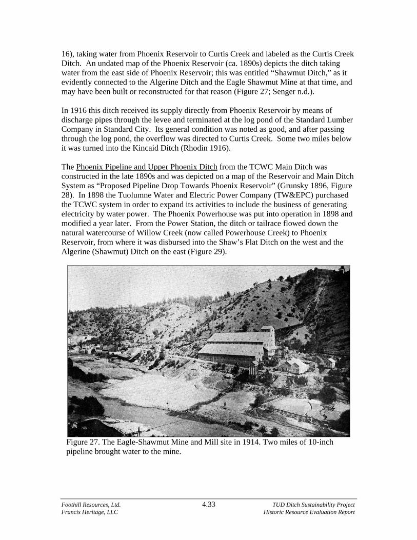
Foothill Resources, Ltd. 4.33 TUD Ditch Sustainability Project Francis Heritage, LLC Historic Resource Evaluation Report
16), taking water from Phoenix Reservoir to Curtis Creek and labeled as the Curtis Creek Ditch. An undated map of the Phoenix Reservoir (ca. 1890s) depicts the ditch taking water from the east side of Phoenix Reservoir; this was entitled “Shawmut Ditch,” as it evidently connected to the Algerine Ditch and the Eagle Shawmut Mine at that time, and may have been built or reconstructed for that reason (Figure 27; Senger n.d.). In 1916 this ditch received its supply directly from Phoenix Reservoir by means of discharge pipes through the levee and terminated at the log pond of the Standard Lumber Company in Standard City. Its general condition was noted as good, and after passing through the log pond, the overflow was directed to Curtis Creek. Some two miles below it was turned into the Kincaid Ditch (Rhodin 1916). The Phoenix Pipeline and Upper Phoenix Ditch from the TCWC Main Ditch was constructed in the late 1890s and was depicted on a map of the Reservoir and Main Ditch System as “Proposed Pipeline Drop Towards Phoenix Reservoir” (Grunsky 1896, Figure 28). In 1898 the Tuolumne Water and Electric Power Company (TW&EPC) purchased the TCWC system in order to expand its activities to include the business of generating electricity by water power. The Phoenix Powerhouse was put into operation in 1898 and modified a year later. From the Power Station, the ditch or tailrace flowed down the natural watercourse of Willow Creek (now called Powerhouse Creek) to Phoenix Reservoir, from where it was disbursed into the Shaw’s Flat Ditch on the west and the Algerine (Shawmut) Ditch on the east (Figure 29).
Figure 27. The Eagle-Shawmut Mine and Mill site in 1914. Two miles of 10-inch pipeline brought water to the mine.

Foothill Resources, Ltd. 4.34 TUD Ditch Sustainability Project Francis Heritage, LLC Historic Resource Evaluation Report
C
Fig
ure
28.
Por
tion
of
Tuo
lum
ne C
ount
y W
ater
Com
pany
Res
ervo
ir a
nd M
ain
Dit
ch S
yste
m to
Sum
mit
Pas
s,
prep
ared
by
C. E
. Gru
nsky
, Civ
il E
ngin
eer,
189
6. (
Cou
rtes
y of
the
Col
umbi
a S
tate
His
tori
c P
ark
Arc
hive
s.)
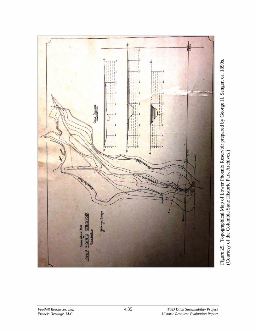
Foothill Resources, Ltd. 4.35 TUD Ditch Sustainability Project Francis Heritage, LLC Historic Resource Evaluation Report
Fig
ure
29.
Top
ogra
phic
al M
ap o
f L
ower
Pho
enix
Res
ervo
ir p
repa
red
by G
eorg
e H
. Sen
ger,
ca.
189
0s.
(Cou
rtes
y of
the
Col
umbi
a S
tate
His
tori
c P
ark
Arc
hive
s.)

Foothill Resources, Ltd. 4.36 TUD Ditch Sustainability Project Francis Heritage, LLC Historic Resource Evaluation Report
Ownership of the TW&EPC system was transferred to the Tuolumne Water Power Company in 1907 and reformed as the Sierra and San Francisco Power Company in May 1909, to supply electric power to the streetcar system in San Francisco. The pipeline and ditch were depicted on the 1907 Thom Map and 1909 TWPC map in the approximate location as today. Although the system would be owned by the Sierra and San Francisco for 20 years, it was clear that the emerging “Pacific Service” of the Pacific Gas and Electric Company was operating the plant. Pacific Service formalized their lease in 1919, and purchased the system outright in 1927 (PG&E Archives). Evaluation. The Phoenix Ditch appears to be eligible for listing on the NRHP under Criteria A and C, as a contributing property to a potential Tuolumne Utilities District National Register District. Under Criterion A, the Phoenix Ditch was completed in 1898 as part of the Tuolumne County Water Company system, taking water from the Phoenix Power Station Penstock, down Willow Creek to Phoenix Reservoir, then picked up again on the reservoir’s south end and taken to the Standard Lumber Company mill. The Standard Lumber Company, incorporated in 1899, and its successors the Pickering Lumber Company, Louisiana Pacific, Fibreboard, and Sierra Pacific Industries, was one of the largest and most important entities in Tuolumne County for over 100 years. In addition, the ditch was directly associated with the Phoenix Powerhouse, the largest in the county at that time, and with its successors, important entities in the business of generating hydroelectric power in California. Under Criterion C, although piped in places, the Phoenix Ditch retains its integrity to its period of significance (1898-1967) along more than half of its length, and embodies the distinctive characteristics of its type, period, and method of construction. Along its route, it conveys its integrity of location, design, setting, feeling, and association, and conveys water in the same manner as when it was first constructed. Roach’s Camp Ditch (P-55-006364; CA-TUO-002879H) Description. The Roach's Camp Ditch is a water conveyance consisting of earthen berm ditch, a siphon, a random, and pipeline with a total length of 11,975 linear feet that conveys water managed by the Tuolumne Utilities District from the Tuolumne WTP directly to a siphon that flows into the alignment, which varies from earthen berm to pipe generally south along the hillsides above Tuolumne and other small valleys, ending at the Wiber-Armstrong reservoir intake in the Apple Colony area. The southern half contains numerous fences. Overall, it has a rural ambience. There are ten pipes (total 1,698 ft. long) and 10,625 ft. of open ditch. Seventy-seven percent (77%) of the open ditch is lined with gunite. Portions of this ditch have been previously recorded. This ditch is primarily an earthen berm structure that is mostly gunite-lined. A riveted pipe siphon at Rosasco Ranch forms a possible bypass for the earthen ditch that continues on contour. Another, modern, pipe passes through a residential section of Tuolumne where the ditch was formerly open.

Foothill Resources, Ltd. 4.37 TUD Ditch Sustainability Project Francis Heritage, LLC Historic Resource Evaluation Report
An older parallel alignment was noted in several locations, but the current alignment appears mostly original to its date of construction. The siphon at Rosasco Ranch appears old with pipe being riveted although it is possibly a slightly later change. The headgate at the Tuolumne WTP appears modified with the height of the box increased. Gunite-lining is also an addition to the original earthen berms. History. The Roach’s Camp Ditch was constructed to take water from Turnback Creek to Roach’s Camp on Ward’s Ferry Road, located near the top of the grade above the Tuolumne River, which, according to Pacquette, was “actually named for Frédéric de Rouche, a Frenchman who found his golden niche in the Blanket Creek area… as early as 1849,” (Gudde 1975:293; Pacquette 1996:129). The ditch was evidently built sometime after 1855, as when the camp was visited that year it was described as one of several small but promising camps located southeast of Sonora, and that as soon as they could get a good supply of water for the entire season they would be able to get a good amount of gold (Heckendorn and Wilson 1856:89). There is little mention of Roach’s Camp in the literature, but brief accounts of people still residing there were noted in the 1860s and 1870s (Lang 1882:236, 296). The Roach’s Camp flume and ditch were depicted on the 1870 T1N, R15E GLO as taking water from Turnback Creek as far south as Section 35, but were not depicted on the 1879 Dart or 1896 Barton maps. Sometime in the late 1880s or early 1890s, it was connected to the TCWC Main Ditch via the Section 4 and Eureka ditches at the Tuolumne Reservoir and extended southerly to the Roach’s Camp Reservoir, where it branched two ways to the Ajax and Free Lance hard rock mines. In 1901 it was described as a water ditch extending from a point above Carter’s (Tuolumne), by way of Long Gulch and Turnback Creek to Blanket Creek and Roach’s Camp and vicinity (Deed Book 46:417, 520). On the 1907 Thom Map the system was depicted as extending through Sections 35 and 36 to the Township line and was apparently the same as depicted on the TWPC map of 1909. In 1916 the three-foot-wide ditch was described as 7.03 miles long, but it had been truncated and entirely consumed for irrigation at a point two miles below Tuolumne. From there to the end (5.30 miles) the ditch was dry, in good condition but somewhat brushy, and the flumes destroyed. It was described as having been constructed about 1890 to supply the mining region about Roach’s Camp and Poison Oak Gulch, so it appears likely that the original 1850s-1860s Roach’s Camp Ditch was rebuilt by the TCWC at that time to supply the hard-rock mines that had recently opened (Rhodin 1916). The Tuolumne Utilities District now calls it the Camp Roach Ditch. Evaluation. The Roach’s Camp Ditch appears to be eligible for listing on the NRHP under Criteria A and C, as a contributing property to a potential Tuolumne Utilities District National Register District. Under Criterion A, the Roach’s Camp Ditch was built in the Gold Rush era to provide water for the placer mines at Roach’s Camp and along Turnback Creek, and was altered and extended in the 1890s hard-rock mining era to the Ajax and Free Lance mines, thus evolving with mining technologies. By that time the

Foothill Resources, Ltd. 4.38 TUD Ditch Sustainability Project Francis Heritage, LLC Historic Resource Evaluation Report
ditch had been absorbed into the TCWC system; it was thereafter associated with the TCWC and its successors, one of the largest and most important entities in Tuolumne County from 1852 to the present. Under Criterion C, although paralleling the earlier 1850s ditch in places, the Roach’s Camp Ditch retains its integrity to its period of significance (ca. 1850s-1967) along about 80% of its length, and embodies the distinctive characteristics of its type, period, and method of construction. Although the active ditch was truncated after about one and one-half miles, instead of continuing southerly to Roach’s Camp and the Tuolumne River, the extant operating segment conveys its integrity of location, design, setting, feeling, and association, and conveys water in the same manner as when it was first constructed. The lower section, although no longer in operation and outside of the project boundaries, also appears to be a contributor as an archaeological property. San Diego Ditch (P-55-006538) Description. This resource is a water conveyance system consisting of earthen berm ditch, siphons (pipe), and two tunnels. From a dual junction box along the Columbia Ditch, the San Diego contours along a side hill north of Italian Bar Road to a siphon that crosses Yankee Hill Road, continuing in earthen berms on contour to San Diego Reservoir, about 3.5 acres in size. The ditch continues, flowing around Kennebec Hill first in a pipe and pipe-in-tunnel to its terminus near the end of Damin Road at Hippie Pond. This system is somewhat rural, set in a mixed conifer-oak woodland along hillsides that were heavily mined during the Gold Rush. The total length of the ditch is 19,369 linear feet that conveys water managed by the Tuolumne Utilities District from the Columbia Ditch to the end of Damin Road. There is 5,355 feet of pipe, 289 feet of tunnel, and 13,892 feet of open ditch. Forty-one percent (41%; 5,710 ft.) of the open ditch is lined with gunite. Segments of the operating ditch were previously recorded, including those abandoned when the Kennebec tunnel was constructed. The USGS-mapped ditch is inaccurate in many locations. Thirteen features were recorded. Only one spillgate with crossgate; four small archaeological branch ditches/flume channels leading off from the San Diego; a random replaced by an inverted siphon; a tunnel now with pipe laid in it; a dry-laid rock reinforcement feature; a lengthy discontinuous segment of similar rock reinforcement; a formerly flumed segment of ditch through blasted rock; a dry-laid limestone rock embankment that retains the bank below the ditch; San Diego Reservoir, about 3.5 acres in size; and a junction structure known as the Tower. History. The San Diego Ditch was one of the first distribution ditches to be completed by the TCWC in 1852 and is depicted on Wallace’s 1853 and 1862 maps of the system (Figures 10, 12). It carried water southerly from Matelot Reservoir to San Diego Reservoir, from where water was distributed to Copeland’s and Byrd’s reservoirs, westerly around Kennebec Hill, down Columbia Gulch, through Red Gulch to Saw Mill Flat, and to numerous placering and hydraulicking claims along its route.

Foothill Resources, Ltd. 4.39 TUD Ditch Sustainability Project Francis Heritage, LLC Historic Resource Evaluation Report
The route of the San Diego Ditch is depicted in approximately in the same location on several later historic maps (Beauvais 1882; Barton 1896; Dart 1879; GLO 1870; Thom 1907; TWPC 1909). Evaluation. The San Diego Ditch appears to be eligible for listing on the NRHP under Criteria A and C, as a contributing property to a potential Tuolumne Utilities District National Register District. Under Criterion A, the San Diego Ditch was one of the first segments of the TCWC to be completed after it brought water to Columbia in August of 1852. It provided water to the San Diego Reservoir for distribution to the Copeland’s and Byrd’s reservoirs, to Columbia Gulch (the most important mining area in the Columbia Basin), Martinez, Saw Mill Flat, Red Gulch, and other mining camps, important in the history of Tuolumne County and California. Under Criterion C, the ditch retains its integrity along about 75% of its length, and embodies the distinctive characteristics of its type, period, and method of construction to its period of significance (1852-1967). Although truncated from its original length, the ditch is still in use, and conveys water as far as Kennebec Hill in the same manner as when it was first constructed, retaining its integrity of location, design, setting, feeling, and association. Section 4 Ditch (P-55-003161) Description. This resource is a water conveyance system consisting of earthen berm ditch, three flumes, and pipeline with a total length of 14,293 linear feet. It conveys water managed by the Tuolumne Utilities District at a headgate on the south side of the PG&E Main Canal (Tuolumne Ditch) directly into the alignment which varies from earthen berm to pipe generally south along the hillsides above Twain Harte, ending at a junction box on the south side of State Route 108. Much of it passes through residential areas, but it retains a rural ambience due to the coniferous forest setting. There are ten pipes including two siphons (total 3,293 ft. long), 3 flumes (188 ft.), and 10,810 feet of open ditch. Seventy-six percent (76%) of the open ditch is gunite-lined. Top width is 8 feet, bottom width is 4 feet, and height is 3 feet. Starting elevation near South Fork Road is 3,971 feet above mean sea level, ending at 3,847 feet. A portion of this ditch is previously recorded. This is primarily an earthen berm ditch constructed across flats, drainages, and on slopes. There are three short modern wood flumes varying from 55 feet to 76 feet long, and ten pipelines varying in length from culverts under driveways to the final segment that is about 2,130 feet long at the southern end of the ditch where it traverses the historic Sugar Pine Railroad grade, Twain Harte Drive, and State Route 108. There are 15 features that include one wood drop-down, one board-formed concrete drop down or weir, two rock retaining wall locations, a mortared & stacked fieldstone culvert, a dry-laid fieldstone culvert under the Sugar Pine Railroad grade, one metal pipe overdrain and a welded metal pipe with board supports crossing ditch, an inverted siphon crossing under Middle

Foothill Resources, Ltd. 4.40 TUD Ditch Sustainability Project Francis Heritage, LLC Historic Resource Evaluation Report
Camp Road, various concrete and/or wood drop-downs and gates, often with associated cross-gates or distribution gates and spillways, an above-ground concrete clean-out and pipe-access box, a concrete driveway bridge, two board-formed concrete supports for the Sullivan Creek pipeline, and two board-formed concrete chutes with grizzly. There are various historic ditch service tags. History. The Section 4 Ditch, named for its origin in Section 4, T2N, R16E, was reportedly constructed in 1887-1888 by the TCWC (Rhodin 1916). It received its supply from the Main Ditch at Middle Camp, and carried it to Eureka Camp, from where it was distributed into the Eureka Ditch, and, beyond Tuolumne, to the Roach’s Camp Ditch. Another branch carried water through the Soulsbyville Ditch to Soulsbyville. The ditch was constructed by the TCWC during the hard-rock mining era, when the company was reconstructing the old mining ditches of the 1850s-1870s to bring water to the booming quartz mines and their communities. It connected the Soulsbyville Ditch and the Eureka Ditch with the Main Ditch at Middle Camp, replacing the two original separate ditches with the headworks to connect both ditches that coursed southerly from their original takeouts. In 1916 the ditch was described as being 2.73 miles long, with an average bottom width of four feet, in excellent condition, with flumes in fair condition. Its terminus was at Eureka Camp Station (ditch-tender’s dwelling with outbuildings), which was in a good state of repair. At Eureka Camp Station water was diverted into the Soulsbyville Ditch and the Eureka Ditch (Rhodin 1916). Evaluation. One of the younger ditches in the TUD system, the Section 4 Ditch appears to be eligible for listing on the NRHP under Criteria A and C, as a contributing property to a potential Tuolumne Utilities District National Register District. Under Criterion A, the Section 4 Ditch was constructed by the TCWC during its era of expansion in the late 1880s-1890s. At that time, it was built to convey water from the Main Ditch to the Eureka and Soulsbyville ditches, a refinement and improvement of their earlier routes. It was during this booming era that the company was expanding and altering its conduits to bring water to the hard-rock mines and the West Side Lumber Company town of Carter’s/Tuolumne, an era important in the history of Tuolumne County and California. Under Criterion C, the ditch retains its integrity along about 65% of its length, and embodies the distinctive characteristics of its type, period, and method of construction to its period of significance (ca. 1888-1967). The ditch is still in use, and conveys water in the same manner as when it was first constructed. Shaw’s Flat/Street’s/Sullivan Creek and Tuolumne River Water Company Ditch (P-55-000980; CA-TUO-003305H) Description. This resource is a water conveyance system consisting of earthen berm ditch, random, siphons, and pipelines with a total length of 55,784 linear feet (this total excludes Shaws Flat pipeline from Chaparral Drive to the Sonora WTP that is 6,398 ft.

Foothill Resources, Ltd. 4.41 TUD Ditch Sustainability Project Francis Heritage, LLC Historic Resource Evaluation Report
long). It conveys water managed by the Tuolumne Utilities District from the Phoenix Ditch directly into a lengthy pipeline that runs westerly to a point where the open ditch resumes. Other pipes total 15,042 feet, flumes are 316 feet, randoms total 6,413 feet. Of the open ditch, 66% (22,408 ft.) is gunite-lined. Top width varies from 5 to 8 feet, bottom width 2½ to 3 feet, and depth is 1½-2½ feet. The two lengthy pipelines have been installed in the last 20 years. This operating ditch begins at its junction with the Phoenix Ditch on the west side of Meadowbrook Drive and runs in pipeline to Chaparral Drive. From that point, the open ditch begins. It ends at the Table Mountain slum dam on the north side of State Route 49 near its intersection with Mt. Brow Road. From Chaparral Drive, the pipeline also continues to the Sonora WTP along a different route following roads for the most part. The elevation ranges from 2,350 feet at start to 1,924 feet at the end at the slum dam. The Shaws Flat Ditch traverses a foothill setting, contouring sideslopes and crossing creeks. Generally, the ditch flows from the Sullivan Creek area below Phoenix Lake on the east along southerly and westerly facing slopes and through Shaws Flat, crossing several creeks and roads to the west. Most of this ditch has a rural ambience. Original earth berm ditch is supplanted from west of Sullivan Creek to Chaparral Drive by pipeline installed in the last 20 years; the abandoned segment is depicted on the USGS topographic quadrangle while the pipeline is not. Another pipeline from that point to the Sonora WTP bypasses the Cabezut portion of the earthen ditch although a smaller amount of water still flows in it. At one location southeast of the Union Hill Inn, the alignment changed after 1948 from contouring around a low hill to a throughcut. A downhill parallel alignment was observed from F60 to near the Union Hill Inn. An uphill parallel alignment was observed from the end of the Union Hill siphon and near the start of the random downstream on the Verkuyl Ranch. A short portion south of Cabezut was not inspected due to aggressive dogs, nor were siphons and randoms. The pipeline from Phoenix Lake dam to the siphon was not surveyed nor is it recorded as part of any system as it is a relatively recent feature. Thirty-five features were recorded including several previously recorded. Several segments have been previously recorded as well. Included are 19 spillgates, some with crossgates; a crossgate with service boxes; a Sylva gate; five rock reinforcement features; four drainage crossovers, one that has rock supports for modern plastic pipe; three siphons; four flumes; two sections of riveted pipe across washouts; and a modern pipe with metal supports across Sonora Creek. History. Known at various times as Street’s Ditch, Sullivan Creek and Tuolumne River Water Company Ditch, Shaw’s Flat Ditch, and Phoenix Water Company Ditch, this ditch’s routes have been realigned, shortened, lengthened, and otherwise altered over the ensuing years since its original construction in 1855-1856. Impetus for its construction was the March 16, 1855, Miners’ Strike held in Columbia over the high costs of water imposed by the TCWC. By March 19th, it was noted that work had commenced on both the Columbia and Stanislaus River Water Company (C&SRWC) works and Street’s
Foothill Resources, Ltd. 4.42 TUD Ditch Sustainability Project Francis Heritage, LLC Historic Resource Evaluation Report
Ditch, in anticipation of providing less expensive water to the mines around Columbia and Shaw’s Flat (Heckendorn and Wilson 1856:8). The Shaw’s Flat Ditch had its origin in the Sullivan Creek Water Ditch, which was first noted in the archival record on October 25, 1851, when the company was created at a meeting of a number of citizens in the Arkansas Hotel in Sonora, where they voted to form a company for the purpose of cutting said contemplated ditch. On August 24, 1852, the name was changed to the Sullivan Creek and Tuolumne River Water Company. The company was formed as a joint stock company with shares, a constitution, and bylaws naming a president, secretary, treasurer, and chief engineer. It was to be the duty of each stockholder to work nine hours a fair working day, forfeiting his stock six days after maturity if he did not work. The constitution was amended August 24, 1852, when the five-member Board of Directors met at Shaw’s Flat and stated that they “were embarrassed and unable to continue [the company’s] operations successfully.” The Board voted to sell the joint stock property, consisting of the Sullivan Creek and Tuolumne River Water Company ditch or canal, and its one-half interest in the Wood’s Diggings Water Company Ditch, to James Street for $39,000 (Claims Book 1-7:131, recorded October 25, 1854). That same day, James Street filed a Water Privilege, noting that his survey commenced at the head of the Sullivan Creek and the Tuolumne River Canal on Sullivan Creek, running southeast to a certain point upon one of the branches of Curtis Creek, at which he intended building a dam, thence ascending said branch some two miles to a point on the ridge between Curtis and Blanket creeks, again commencing the canal to follow the slope around by Cherokee Camp across Blanket and Turnback creeks, a distance of some six miles, to a low place in the river ridge, thence along the slope of the river ridge some seven or eight miles to the North Fork of the Tuolumne River. At that point the company claimed all the water in the river for mining and mechanical purposes, as well as all the surplus water in Turnback and Blanket creeks, “and in each and every branch that may cross the line of the canal.” The company also claimed all the timber from the unclaimed lands along the south side of the canal that might be required in its construction and forbade anyone to infringe on the right of the survey. That canal was intended to be constructed “with all practical speed” (Claims Book 1-7:134). In the 1855 directory, James Street was noted as a native of New York and the proprietor of the Tuolumne Ditch, which was to be completed the following spring at a cost of $200,000 (Heckendorn and Wilson 1856:60). On July 6, 1855, Street filed a second Water Privilege for survey or exploration to the Middle Fork Tuolumne River, and claimed all the water in the creeks and gulches and forbade anyone trespassing on the right of the ditch. The purpose was for “leading the water to Sonora and vicinity for mining purposes” (Claims Book 1-7:194). On February 1, 1856, S. S. Turner deeded his land, located on both sides of Sullivan Creek, to James Street for $4000 (Deed Book 4:403), evidently protecting Street’s water right to Sullivan Creek. The Street Ditch Company was incorporated July 1, 1856 (Articles of Incorporation No. 62). Street’s other operation, the Shaw’s Flat & Tuolumne

Foothill Resources, Ltd. 4.43 TUD Ditch Sustainability Project Francis Heritage, LLC Historic Resource Evaluation Report
Canal Company, was incorporated August 9, 1856, with James Street, Charles B. Young, and George Bower as directors (Articles of Incorporation No. 67). This was evidently to incorporate Street’s water and canal rights into a joint stock company, which issued 4000 shares at $100 each. Three years later, on April 27, 1859, Street lost his ditches as a result of a suit and foreclosure of a Mechanics Lien against James Street & Co., alias New Tuolumne River Water Company, also known as Shaw’s Flat and Tuolumne Canal Company. Deeded from Sheriff John Sedgewick to A. Patterson, J.P. Denoon, William Condon, J. Armstrong, R.P. Denoon, R. McKenzie, Abner Reed, John Kryster, and Henry P. Barber, the ditch was noted as taking water from the Tuolumne River two miles below the mouth of Sugar Pine Creek to Shaw’s Flat, and included the Wood’s Creek Diggings’ Ditch from Peppermint Creek to Coopers Flat, Montezuma, and vicinity (Deed Book 8:372). On May 11, 1859, the above-mentioned gentlemen, with their attorney Caleb Dorsey, formed themselves into the Phoenix Water Company and turned the Street Ditch property over to the company for $1. All of the men, except McKenzie, were associated with the San Francisco banking firm of Pioche and Bayerque (Deed Book 8:374). That same day Caleb Dorsey sold the Shaw’s Flat and Tuolumne River Water Company to the Phoenix Water Company, noting that he had purchased it at the tax sale for $1575 (Deed Book 8:370). In July of 1859, James and Sarah Street sold their home in Shaw’s Flat to George and Ameritta Pierce and moved to San Jose (Deed Book 8:454). Though it is not yet known how they acquired it, on August 29, 1872, James T. Maclean and George Clark deeded the ditch “formerly known as the Street or Shaw’s Flat Ditch” to their Tuolumne Hydraulic Mining Company (THMC) for $1. The deed noted that the ditch conveyed water from the North Fork Tuolumne River by way of Sullivan and Wood’s creeks to Shaw’s Flat and vicinity. The deed included the Phoenix Water Company ditch, three-fifths interest in the Montezuma Ditch, the Algerine Ditch, and other properties (Deed Book 16:518, 18:248). Four years later, on February 24, 1876, the THMC deeded the same properties to the TCWC (Deed Book 18:248). After the Phoenix Water Company Reservoir was purchased by the TCWC from the THMC in 1876, the Shaw’s Flat Ditch was diverted northwesterly from the northwest side of the reservoir to Shaw’s Flat and points west (Senger n.d., Figure 29). Street’s Ditch was depicted on the 1870 General Land Office Plat in Sections 24 and 25, T2N, R14E, in approximately the same location as it remains today. In Sections 28, 30, and 32, T2N, R15E, the ditch flowed into the northeasterly side of Lower Phoenix Reservoir in Section 28. In 1879 the ditch, now noted as the TCWC Ditch, was depicted as flowing from the Reservoir of the Tuolumne County Water Company (Phoenix Reservoirs), northwesterly through Brown’s Flat to Shaw’s Flat, connecting with the Table Mountain system (Dart 1879), the same as depicted on the 1907 Thom Map. After its acquisition by the TCWC, the major connection to the Table Mountain and Montezuma ditches was made from the Shaw’s Flat ditch, supplanting the original

Foothill Resources, Ltd. 4.44 TUD Ditch Sustainability Project Francis Heritage, LLC Historic Resource Evaluation Report
Columbia Ditch system connection through the Springfield Weir, which was used only occasionally after that time (Rhodin 1916). Another ditch associated with the Maclean et al. enterprise was Craig’s Ditch and mining claim in Sullivan’s Dry Arroyo (S ½ of Section 6, T1N, R15E) near Ralph’s Ranch, deeded by the THMC to its officers Maclean, George W. Clark (president), Isaac T. Milliken (secretary), and George F. Geisse. The claim included all the ditches, reservoirs, water rights, privileges, tools, improvements, and appurtenances, to work as the [Tuolumne] Hydraulic Mining Company (Deed Books 17:205, 298, 366, 771), and was depicted on the 1870 GLO Plat as the Hydraulic Ditch. Evaluation. The Shaw’s Flat Ditch appears to be eligible for listing on the NRHP under Criteria A and C, as a contributing property to a potential Tuolumne Utilities District National Register District. Under Criterion A, in its earlier permutations, the Shaw’s Flat Ditch was one of the earlier large systems to be constructed in Tuolumne County, with its origins in the 1855 Miners’ Strike in Columbia against the TCWC, when James Street and others formed companies to construct ditch systems to compete against the TCWC with lower rates. Completed ca. 1856, the ditch conveyed water to Shaw’s Flat, Brown’s Flat, Union Hill, and the areas south and west of Columbia. After its purchase by the TCWC in 1876, it was connected to its system through the former Phoenix Water Company Reservoir, and extended to the Table Mountain and Montezuma ditches, all important in the history of mining and settlement in Tuolumne County and California. Under Criterion C, the Shaw’s Flat ditch retains its integrity along at least two-thirds of its length, and embodies the distinctive characteristics of its type, period, and method of construction to its period of significance (1856-1967). Although altered several times over its long history, including the construction of parallel systems, the Shaw’s Flat Ditch nonetheless retains its engineering integrity as it winds along the hillsides and flats, conveying water in the same manner as when it was first constructed. Soulsbyville Ditch (P-55-005959) Description. This resource is a water conveyance system consisting of earthen berm ditch, siphons (pipe), and a lengthy random. The total length of the resource is 30,155 linear feet that conveys water managed by the Tuolumne Utilities District from the end of the Section 4 Ditch to the Monte Grande WTP near Soulsbyville. There are one random 4,737 feet long, 1,374 feet of pipe and 23,952 feet of open ditch. Seventy-three percent (73%; 17,519 ft.) of the open ditch is lined with gunite. Elevation ranges from the start at about 3,846 feet at the junction box below a driveway off of North Tuolumne Road and west of Turnback Creek, descending to 3,234 feet at end of ditch just past the Monte Grande WTP. As with all the ditches, the Soulsbyville Ditch size is variable: measurements along the Lower Soulsbyville where it is gunite-lined were 56 inches top width x 10-12 inches deep, while on the Upper Soulsbyville where there is no lining it is considerably larger (12 ft. top width x 55 in. deep x 4 ft. bottom width). The ditch has been affected by modern highway construction at two locations (east and west ends of Twain Harte ca. 1965), as well as the Sugar Pine Railroad grade location built ca. 1905.

Foothill Resources, Ltd. 4.45 TUD Ditch Sustainability Project Francis Heritage, LLC Historic Resource Evaluation Report
Twenty-two features were recorded. Some sections of the operating ditch are previously recorded under designations P-55-000724 and P-55-005959. This resource is an earthen berm ditch from its beginning at the junction box at the end of the siphon under State Route 108 on the Section 4 Ditch; and includes two siphons along its alignment; a long random that follows a natural watercourse; numerous wood and concrete spillgates and crossgates; services; and rock reinforcement including retaining walls. This ditch begins on coniferous forest slopes above Turnback Creek, crosses over to the Curtis Creek drainage, and descends through woodland and volcanic tablelands. Twenty-five features were recorded. These include: a parallel ditch alignment; seven rock reinforcement segments of various lengths; two gauging stations; five spills (including one recent); a retaining wall of stacked wood beams; several crossgate locations no longer in use; a recent flume with older concrete connectors; the ca. 1965 tunnel under State Route 108 for pipe; and a short rock and pipe culvert under the Sugar Pine grade. History. The Soulsbyville Ditch, as did most of the ditches in Tuolumne County, had its beginnings in supplying water for mining, this time in present Soulsbyville. Gold was first discovered in Soulsbyville in late July or early August, 1857, by Benjamin Platt, but for the future, and naming of the town, the discovery of a quartz outcropping by 17-year old Ben Soulsby that fall was to be the defining moment for the district. Ben’s father, Thomas Soulsby, posted a claim and the mine came into official existence on October 9, 1857. A 20-stamp quartz mill was erected on the bank of Curtis Creek and operated under the title of the Soulsby Quartz Company, with Thomas as superintendent (De Ferrari in Marvin and De Ferrari 1992:19-20). The following history of the Soulsby Ditch was taken from De Ferrari in Marvin and De Ferrari (1992:39-42). Soon after the Soulsby Mine was opened, a ditch was constructed from the head of Curtis Creek along the western slope of the Soulsbyville Ridge to the mine site, somewhat over two miles. In addition to the creek, water was also probably obtained from the Tuolumne Hydraulic Ditch, which passed near the Duffield Ridge to the west of the creek. In 1872 it was decided to convert the mill and shaft hoist to water power with steam providing an alternate means of operation, with the nearest source of water at the TCWC Main Ditch at Middle Camp. In the summer of that year a ditch was constructed from Middle Camp to the upper, or northern, end of today’s Twain Harte meadow, owned by Calvin J. Williams. From there the water flowed down through the meadow by way of a natural creek bed to a point about a quarter of a mile above Bald Rock (present Twain Harte dam site), where it was diverted into a second ditch that carried it around the intervening ridge to Duffield Canyon and then along the old ditch to the Soulsby mill. Due to flooding issues in the meadow, in mid-1878 the ditch was reconstructed by the Soulsby Mine so that it ran north of Williams’ meadow. After the water was diverted to the new ditch, which was constructed along a higher level than its predecessor down the east side of Duffield Canyon, Williams and his son-in-law Ben Soulsby filed a claim to the superseded line of ditch (Claims Book 8:64). Holding ponds and a pipe down the side of the Soulsbyville

Foothill Resources, Ltd. 4.46 TUD Ditch Sustainability Project Francis Heritage, LLC Historic Resource Evaluation Report
Ridge to the Soulsby mill were constructed at the terminus of the ditch, which made it possible to operate high pressure water wheels at the mine. On May 4, 1888, C.J. Williams quitclaimed the portions of the old Soulsby ditch running through his ranch to the TCWC for $150 (Deed Book 23:675). On May 17 of the same year, C.F. Haslam deeded a right-of-way through his land in Section 5, T2N, R16E to the same company for $50. The right-of-way was for a ditch 50 feet more or less above the line of the old Soulsby Ditch (Deed Book 23:677). On May 19, 1888, the Sonora Gold Mining Co., Ltd., then owner of the Soulsby Mine, deeded to the TCWC that portion of the old Soulsby ditch extending from Middle Camp to the head of Duffield Canyon for $250 (Deed Book 23:675). The deeds were evidently for the purpose of giving the TCWC an absolute title to the ditch so that it could be extended to serve the Arastraville area and beyond, as a right-of-way for a ditch capable of carrying 500 inches of water was also acquired for $100 from Ezekiel Westinghouse, through whose ranch such a ditch would have to pass, noting that it was located above “the present Rising Sun Ditch” (Deed Book 23:676). Soon thereafter, the Soulsby mine was sold by the Sonora Gold Mining Co., Ltd. to William Sharwood, and he promptly conveyed to the water company the remaining portion of the Soulsby Ditch, extending from the head of Curtis Creek to the mine, for $250. Although dated November 20, 1888, the deed was not recorded until April 10, 1896 (Deed Book 30:529), suggesting that it was improved by the TCWC before or about that time, connecting with the Section 4 Ditch, rather than extending from near the present Twain Harte meadow directly from Middle Camp. This era coincided with the sale of the Soulsby group of quartz mines to a group of East Coast investors in July of 1896 for $50,000 and capitalized at $875,000 as the Soulsby Consolidated Gold Mining Company. New hoisting works were erected, the quartz mill was renovated and increased to 20 stamps, and more shafts were sunk and drifts run (De Ferrari in Marvin and De Ferrari 1992:33). Other hard-rock mines in the Soulsbyville area were also improved and developed, increasing the demand for water for milling purposes. The ditch was depicted on the 1875 GLO Plat for T2N, R16E as the Soulsby & Co. Ditch. Four years later it was depicted as carrying water directly from the Main Ditch to the Soulsby Mine and others in Soulsbyville (Dart 1879), and in 1896 as the TCWC Ditch (Barton 1896). In 1901 the ditch was noted as crossing Mono Road and thence to Soulsbyville and Cherokee (Deed Book 46:417, 520). Thom’s 1907 map places it in approximately the same location as today, as did TCWP in 1909. The ditch was described in 1916 as beginning below Eureka Camp Station, taking water directly from the Section 4 Ditch, and terminating at the head of the Black Oak Mining Company’s pressure pipeline, which also supplied the town of Soulsbyville. Its total length was 5.67 miles, with an average bottom width of four feet, and it was in very good condition. The Black Oak Ditch was built before 1854 and rebuilt in 1894 by the TCWC to pick up water after having been used by the Black Oak Mine and carried around to

Foothill Resources, Ltd. 4.47 TUD Ditch Sustainability Project Francis Heritage, LLC Historic Resource Evaluation Report
Lower Phoenix Reservoir. At that time it was used for about one mile to supply a few consumers near the Draper Mine; it was dry from that point to where it connected with the Phoenix ditch (Rhodin 1916). That segment, from below the Black Oak Mine on Curtis Creek to the Lower Phoenix Reservoir, was still in use as late as 1901 (Deed Book 46, 417, 520). Evaluation. The Soulsbyville Ditch appears to be eligible for listing on the NRHP under Criteria A and C, as a contributing property to a potential Tuolumne Utilities District National Register District. Under Criterion A, the original Soulsby Ditch was one of the earliest ditches in Tuolumne County to be constructed to carry water to a hard-rock mine and continued to serve the Soulsby Mine and others, as well as the community of Soulsbyville, until it was purchased and improved by the TCWC in the late 1880s. After that time it was associated with the TCWC and its successors, one of the largest and most important entities in Tuolumne County from 1852 to the present. Under Criterion C, although the upper end of the ditch no longer connects to the THA ditch from its original 1850s takeout, over 90% of the lower section from the Section 4 Ditch is located in approximately the same alignment as the 1880s ditch, and apparently has been altered but little since it was reconstructed during the hard-rock mining boom. It retains integrity to its period of significance (ca. 1858-1967), embodies the distinctive characteristics of its type, period, and method of construction, conveys water in the same manner as when it was constructed, and retains its integrity of location, setting, feeling, and association. Table Mountain Ditch (P-55-003505) Description. This operating ditch begins at a spill gate at the slum dam on the north side of State Route 49 near its intersection with Mt. Brow Road to a pipe then an earthen berm ditch that flows southwest around the west side of Table Mountain, through a tunnel in the mountain to its end at O’Neil Reservoir. This resource is a water conveyance system consisting of earthen berm ditch and small amounts of random, pipeline, and tunnel, with a total length of 24,332 linear feet, that conveys water managed by the Tuolumne Utilities District from the Shaw’s Flat Ditch at the slum dam directly into the alignment generally southwesterly along the side of Table Mountain. The slum dam is 10 feet high, of lime-mortared native stone with a spillgate, pipe, a retaining wall, and other artifacts. Two tunnels, rare in the TUD system, are 713 feet long, two randoms total 329 feet long, 825 feet is piped, while the remainder (22,413 ft.) is earthen ditch, of which 73% is gunite-lined. Thirty features were recorded. Four features (P-55-143, 144, 145, 3007) and a short segment of ditch have been previously recorded. The starting elevation at the slum dam is 1,924 feet above mean sea level descending to 1,644 feet at the end above O’Neil Reservoir. Much of this ditch has a rural ambience with the exception of the Rim Rock and Bostwick Road area where there is more residential development.

Foothill Resources, Ltd. 4.48 TUD Ditch Sustainability Project Francis Heritage, LLC Historic Resource Evaluation Report
There are eighteen features including the slum dam (one of two remaining in the system); two rare tunnels (one has pickaxe marks in the bedrock said to be of Chinese origin); a slide gate and a spill gate at the start of the first tunnel; ten stacked rock embankments, alignments, and retaining walls; a weathered wood retaining structure; a stone-lined culvert; Caltrans concrete right-of-way marker; and rock pipe supports. History. The Table Mountain Ditch, also known as the Rawhide Ranch Ditch, was constructed by the TCWC in 1852 to take water to the diggings on the west side of the Table Mountain district. At that time it primarily served the Rawhide Mine, with its two periods of prosperity: from the 1850s to 1867 and from 1891 to 1905 (Gudde 1975:285). The ditch brought water from the Columbia system through the Deadman Ditch to the Springfield Weir, then down along Mormon Creek to the Slum Dam Reservoir, constructed in 1853 by the TCWC to slum out the tailings carried down from the Columbia placers. The dam was rebuilt in stone in 1900 and in 1916 was described as a small rubble masonry structure, built directly on the bedrock of the creek. From there the Table Mountain Ditch was diverted through a flume and carried along the base of Table Mountain to Rawhide Flat (Rhodin 1916). About 1856 a tunnel was driven through Table Mountain connecting the Rawhide Ditch (Table Mountain Ditch) with the Montezuma Ditch at a reservoir on the mountain’s west side (present O’Neil Reservoir), purchased from Allen Oliver in February 1856 (Rhodin 1916; USGS 1900; Wallace 1862). The 1870 GLO Plat of T2N, R14E depicts the ditch connecting with the Columbia Gulch Tailrace Flume at Springfield, on the northwest side of Table Mountain. The Peoria Ditch, an important component of the Table Mountain system in the 1870s, has been long abandoned. It was constructed sometime prior to 1872, connected to the Table Mountain Ditch at the Rawhide Ranch, and extended southeasterly to the Lone Star Mining District on Table Mountain. In March of 1872, John Thaller; Joseph Francis, Joseph Moigg, Jr., Jacob Bayer, William Bruskey, and Gotthelf Haug conveyed their placer and tunneling claim in Table Mountain to James T. Maclean for $20,000. The deed noted that it included three-fifths of a water ditch commencing at the ditch of the TCWC near Rawhide Ranch and extending on the westerly side of Table Mountain to the claim, as well as the tools, flumes, and tailraces located in a gulch “now used as a tailrace from said claim to public road” (Deed Book 16:479) near Peoria Flat. The following month Maclean purchased the dwelling and boarding house associated with the claim (Deed Book 16:518). For several years thereafter the Peoria Ditch continued to serve the hydraulic mining claims of James T. Maclean, George W. Clark, and Isaac T. Milliken, officers of the Tuolumne Hydraulic Gold Mining Company (THMC), and its claims, located on Table Mountain between Mountain Pass and Peoria Flat (Dart 1879). In 1876 the THMC deeded to the TCWC its ditch from the High Flume around Peoria Mountain, known as the “Old High Flume Ditch,” and the “water ditch from the Table Mountain Company claims by Whiskey Hill and along Table Mountain” to their mining claims in Mountain Pass and Peoria Flat for $4500, along with the Phoenix Water Company properties and

Foothill Resources, Ltd. 4.49 TUD Ditch Sustainability Project Francis Heritage, LLC Historic Resource Evaluation Report
the Table Mountain Company claims (Deed Book 18:252). The Peoria Ditch was still depicted as late as 1907 (Thom 1907; USGS 1900); however, in 1916 it was described as 7.14 miles long, but not in use for the previous 20 years except intermittently for the first three miles. Several flumes were rotten and the ditch was in poor condition (Rhodin 1916). Along its route from the Slum Dam, the Table Mountain Ditch branched westerly 2.18 miles to French Flat, supplying only a few farmers by the 1910s (Rhodin 1916). Another branch forked westerly to Tuttletown and Jackass Hill (USGS 1900), and was depicted a few years later as ending at Tuttletown (Thom 1907). Although the ditch was not depicted on the earlier maps of the area, it had undoubtedly been constructed by the 1850s, as numerous arrastras, stamp mills, and other mining facilities were operating in those years; it may have been the ditch noted in 1855 as the Reynold’s, Goodwin & Co. Ditch, carrying water from Mormon Creek near Twist’s Ranch to Tuttletown (Claims Book 1-7:194), and later known as Gale’s Ditch (GLO 1870; Dart 1879). Gold was first discovered at Mormon Gulch on Mormon Creek by a group of Mormons in 1848, but the place was renamed for Judge Anson A.H. Tuttle after he settled there (Gudde 1975:354). In 1916, the Table Mountain Ditch was noted as supplying the Rawhide Mine, the French Flat Ditch, and formerly the Peoria Ditch. It was in excellent condition, with a total length of 5.5 miles (Rhodin 1916). Evaluation. The Table Mountain Ditch appears to be eligible for listing on the NRHP under Criteria A and C, as a contributing property to a potential Tuolumne Utilities District National Register District. Under Criterion A, the Table Mountain Ditch was completed in 1852 as part of the TCWC system, taking water from the South Fork Stanislaus River, through the Columbia system, and by way of the High Flume to access the rich diggings on Table Mountain and the Rawhide Ranch, important early Gold Rush-era mining districts. As such, it was associated with the TCWC and its successors, one of the largest and most important entities in Tuolumne County from 1852 to the present. Under Criterion C, the Table Mountain Ditch retains its integrity to its period of significance (1852-1967) along more than 95% of its length and embodies the distinctive characteristics of its type, period, and method of construction. Along its route, it conveys its integrity of location, design, setting, materials, workmanship, feeling, and association to a remarkable degree, especially in the sections on Table Mountain and through the tunnels, and conveys water in the same manner as when it was first constructed. Other Sites and Features In the course of the ditch survey, 28 previously unnoted, historic-era, non-ditch sites were found in addition to ditch features. These resources were photographed, described, and the GPS location was recorded (Table 1). Detailed photograph and GPS logs were kept to organize data collection. Given time constraints, GPS recordings were limited to five satellite readings per point, instead of the optimal fifteen readings. California Department of Parks and Recreation forms (523A, J) were prepared for these features; the records are included in Appendix A.

Foothill Resources, Ltd. 4.50 TUD Ditch Sustainability Project Francis Heritage, LLC Historic Resource Evaluation Report
Table 1: Other Sites and Features Recorded In the TUD Study Corridor
Primary Number Temporary Designation Site Type Comments
Algerine S6 Ranching
Columbia LT11 Marble retaining wall
Columbia S27 Mining Adit and waste rock
Columbia S32 Mining Prospect
Eureka S5 Ditch Parallel ditch intersects Eureka
Eureka S8 Mining Shaft
Eureka S10 Mining Waste rock on both sides
P-55-001630 Montezuma S06 Railroad grade Angels Branch, Sierra RR
Montezuma S08 Mining Collapsed adits, prospects, shaft
Montezuma S11 Mining Shore Mine, coyote tunnels, adit under ditch.
San Diego S02 Placer mining Hydraulicked
San Diego S15 Cabin On ditch berm
Shaws Flat Mining Zone A Mining Adit, 2 shafts, prospects, placering
Shaws Flat Ditch Portuguese Zone Mining Adits, placering, prospects
Shaws Flat Ditch S17 Mining Prospects and waste dirt
Shaws Flat Ditch S18 Mining Adits, shaft, prospects, waste rock
Shaws Flat Ditch S19 Mining Pocket mines, collapsed areas, waste rock
Shaws Flat Ditch S20 Mining Adits, very large waste dump, rock retaining wall, terrace
Shaws Flat Ditch S29 Habitation Building pad above ditch, corrugated sheet metal, Vinca
Shaws Flat Ditch Tennessee Gulch Zone Mining ¼ mi. of prospects, waste rock, adits, ramps
Shaws Flat Ditch Woods Creek Zone Mining
½ mi. of excavations including under ditch, waste rock, stacked rock retaining walls, etc. P-55-3008 & -146
Soulsbyville S04 Rock walls Stacked rock walls & alignments
P-55-000148 Soulsbyville S05 Dam Stacked rock dam and pipe outlet
Table Mountain North Mining Zone Mining ½ mile, 3 loci minor placering, 3 loci of adits,
shaft, waste rock, stacked rock
Table Mountain S16 Mining Adit
Table Mountain S17 Mining Placering both sides
P-55-000144 Table Mountain S19 Mining Buckeye Mine
Table Mountain South Zone Mining ¼ mi. rock work, placering, shaft, drift mine shaft

5. REFERENCES CITED AND CONSULTED
Anderson, R. S. 1987 Late-Quaternary Environments of the Sierra Nevada, California. Ph.D.
dissertation, University of Arizona, Tucson. Beck, Warren A., and Ynez D. Haase 1974 Historical Atlas of California. University of Nebraska Press, Norman and
London. BHI Management Consulting 2008 Strategic Plan 2008. Prepared by Brent H. Ives and Jim Raymond, BHI
Management Consulting, for the Tuolumne Utilities District, Sonora. Bloomfield, Anne, with Benjamin F.H. Ananian and Philip P. Choy 1994 History of Chinese Camp, Cultural Resources Inventory, Tuolumne County,
California. Prepared for the County of Tuolumne, Sonora, California. Borthwick, J.D. 1948 3 Years in California. Index and Foreword by Joseph A. Sullivan. Biobooks,
Oakland, California. Buckbee, Edna Bryan 1935 The Saga of Old Tuolumne. Press of the Pioneers, New York. California, State of n.d. California Environmental Quality Act (CEQA) and Historical Resources.
California Office of Historic Preservation Technical Assistance Series One. California Office of Historic Preservation, Sacramento.
1976 California Inventory of Historic Resources. Department of Parks and Recreation, Sacramento.
1988 Five Views: An Ethnic Historic Site Survey for California. Department of Parks and Recreation, Sacramento.
1990 California Historical Landmarks. Department of Parks and Recreation, Sacramento.
1992 California Points of Historical Interest. Department of Parks and Recreation, Sacramento.
1995 Instructions for Recording Historical Resources. Office of Historic Preservation, Sacramento.
1998 The California Register of Historical Resources, Public Resources Code, Chapter 11.5, implemented January 1, 1998.
California Department of Transportation (Caltrans) 2008 A Historical Context and Archaeological Research Design for Mining Properties
in California. Prepared by the California Department of Transportation, Sacramento, California.
Foothill Resources, Ltd. 5.1 TUD Ditch Sustainability Project Francis Heritage, LLC Historic Resource Evaluation Report

California Department of Transportation and JRP Historical Consulting Services 2000 Water Conveyance Systems in California. Historic Context Development and
Evaluation Procedures. Prepared jointly with JRP Carson, James H., Edited by Peter Browning
1991 Bright Gem of the Western Seas, California 1846-1852. Great West Books, Lafayette, California.
Clark, William B. 1970 Gold Districts of California. Bulletin 193. California Division of Mines and
Geology, San Francisco. Columbia State Historic Park var. Tuolumne County Water Company files. On file, Columbia State Historic Park,
Columbia. Costello, Julia G., and Judith Marvin 1992 Supplemental Archaeological Survey Report and Historic Study Report for the
Highway 395, Alabama Gates Four Lane Project, Inyo County, California. Prepared for Caltrans District 9, Bishop, California. 09-INY-395, PM 58.8/66.5. Contract No. 09H078. Foothill Resources, Ltd., Mokelumne Hill, California.
Davis-King, Shelly 1998 Historic Resources Survey (Positive) for the Proposed Whispering Woods
Subdivision, Tuolumne County, California. Prepared with Carlo M. De Ferrari Report no. TO-3356, on file, Central California Information Center, Turlock.
2002 Cultural Resource Information 2002 Ditch Survey. Tuolumne Utilities District, Sonora, California.
2003 Ditch Data Maps with Cultural Sites, Features, and Work Orders. Tuolumne Utilities District, Sonora, California.
Davis-King, S., and C. Francis with contributions by C.M. De Ferrari, J. Marvin, and T. Van Bueren 2000 Historical Resources Survey Report for the Mountain Springs Community EIR,
Tuolumne County, California. Submitted to EDAW, San Francisco, and the County of Tuolumne, Sonora, California. Draft.
Davis-King, Shelly, and Judith Marvin 1994 Contextual History of Tuolumne County. Prepared for the County of Tuolumne,
Sonora, California. With contributions by Dorothea J Theodoratus, Carlo De Ferrari, and Mark V. Thornton. Submitted to Tuolumne County Planning Department, Sonora.
Deane, Dorothy Newell 1960 Sierra Railway. Howell-North. Berkeley, California.
Foothill Resources, Ltd. 5.2 TUD Ditch Sustainability Project Francis Heritage, LLC Historic Resource Evaluation Report

Delano, Alonzo 1854 Life on the Plains and at the Diggings. Miller, Orton & Mulligan, Auburn and
Buffalo. Reprinted 1981 by Time-Life Books, Alexandria, Virginia. Eastman, Barbara 1969 “John Wallace and the Tuolumne Water Company, with Excerpts from John
Wallace’s Letters to His Family in England, Selected by His Son, the late John H. Wallace.” Chispa, The Quarterly of the Tuolumne County Historical Society, Vol. 9, No. 2, Oct.-Dec., 1969.
1970a “John Wallace and the Tuolumne Water Company, with Excerpts from John Wallace’s Letters to His Family in England, Selected by His Son, the late John H. Wallace.” Chispa, The Quarterly of the Tuolumne County Historical Society, Vol. 9, No. 3, Jan.-Apr., 1970.
1970b “John Wallace and the Tuolumne Water Company, with Excerpts from John Wallace’s Letters to His Family in England, Selected by His Son, the late John H. Wallace.” Chispa, The Quarterly of the Tuolumne County Historical Society, Vol. 10, No. 1, July-Sept., 1970.
Faulstich, Leo J., Deputy County Counsel, Tuolumne County 1985 Access for Maintenance of Water System Canals. Memorandum dated April 25,
1985, to Memorandum to Billy H. Marr, Water Supervisor, Tuolumne County. Foothill Resources, Ltd., and Far Western Anthropological Research Group, Inc. 2004 Historic Study Report and Constraints Analysis for the Tuolumne North/South
Connector Project, Sonora, California. Prepared for Mark Thomas & Co, Inc., Sacramento, California, for submittal to Tuolumne County Department of Public Works, Sonora, California.
Francis, Charla 2003a Cultural Resource Assessment, A Portion of the Townsite of Confidence,
Tuolumne County, California. Report on file, Central California Information Center, Turlock. Assessor Parcel Numbers 047-100-14 & -15.
2003b DPR 523, Tuolumne Hydraulic Association Ditch. Record on file, Central California Information Center, Turlock.
Frye, Melinda Young, Editor 1979 Natives & Settlers. Indian and Yankee Culture in Early California. The
Collections of Charles P. Wilcomb. The Oakland Museum, Oakland, California.
Frye, Thomas 1979 Introduction. In Natives & Settlers. Indian and Yankee Culture in Early
California. The Collections of Charles P. Wilcomb, edited by Melinda Young Frye, pp 7-9. The Oakland Museum, Oakland, California.
Foothill Resources, Ltd. 5.3 TUD Ditch Sustainability Project Francis Heritage, LLC Historic Resource Evaluation Report

Goldberg, Susan K., Alice L. Hall, Michael J. Moratto, Laurence H. Shoup, Dorothea J Theodoratus, and Thad Van Bueren with Terry Brejla 1982 Cultural Background: Regional Archeology, Ethnography, and History. Final
Report of the New Melones Archeological Project 2. Submitted to the National Park Service, Washington, D.C.
Gudde, Erwin G. 1969 California Place Names. The Origin and Etymology of Current Geographic
Names. University of California Press, Berkeley. Gudde, Erwin G., edited by Elisabeth K. Gudde 1975 California Gold Camps. University of California Press, Berkeley.
Hall, Alice Louise 1978 Ethnohistorical Studies of the Central Sierra Miwok: 1800-1900. Master's Thesis,
Department of Anthropology, San Francisco State University, San Francisco. Hamilton, Fletcher 1915 Mines and Mineral Resources of Amador County, Calaveras County, Tuolumne
County. California State Mining Bureau, San Francisco. Heckendorn, John, and W.A. Wilson 1856 Miners & Business Men’s Directory. Heckendorn & Wilson, Columbia.
Reprinted 1976 by the Donald I. Segerstrom Memorial Fund, Publication No. 2. Tuolumne County Historical Society, Sonora.
Heizer, Robert F., and Albert B. Elsasser 1953 Some Archeological Sites and Cultures of the Central Sierra Nevada. University
of California Archaeological Survey Reports 12:42. Berkeley. Heizer, Robert F., and Franklin Fenenga 1948 Survey of Building Structures of the Sierran Gold Belt—1848-70. In Bulletin 141,
Geologic Guidebook Along Highway 49—Sierran Gold Belt, The Mother Lode Country (Centennial Edition), prepared under the direction of Olaf P. Jenkins. California Division of Mines, San Francisco.
Herzog, Jacques 2011 “Fixer-Upper with Unique Challenge,” New York Times, October 5.
Hill, Mary 1975 Geology of the Sierra Nevada. University of California Press, Berkeley.
Foothill Resources, Ltd. 5.4 TUD Ditch Sustainability Project Francis Heritage, LLC Historic Resource Evaluation Report

Hoover, M.B., H.E. Rensch, E.G. Rensch, and W.N. Abeloe 1990 Historic Spots in California, 4th ed., revised by D.E. Kyle. Stanford University
Press, Stanford, California. Hungry Wolf, Adolf 1964 Rails in the Mother Lode. Darwin Publications, Burbank, California. Isaacs, P. and R. Isaacs 1982 Archaeological Site Record, Harvard Mine and features at Whiskey Hill; Bear
Gulch and three small mining operations; Alabama Hill and features of the Crystalline and Alabama Mines and the Old Schafer residence; the area of Mexican Flat: and the area of the Punch Bowl (CA-TUO-2397H). Prepared for the California Gold Project.
Jackson, Joseph Henry, Editor in Chief 1949 Gold Rush Album. Bonanza Books, New York. Johnson, David H. 1988 The History of the Columbia and Stanislaus River Water Company. Manuscript
in possession of Mark Stoltenberg, Twain Harte, California. Lang, H.O. 1882 History of Tuolumne County, California. B. F. Alley & Co., San Francisco.
Republished 1973 by the Tuolumne County Historical Society, Sonora. Langley, Henry G., and Samuel A. Morison 1859 The State Register and Year Book of Facts: For the Year 1859. Henry G. Langley
and Samuel A. Morison, San Francisco. Lewis Publishing Company 1892 History of Central California. Lewis Publishing Company, Chicago. Lindgren, Waldomar 1911 The Tertiary Gravels of the Sierra Nevada of California. United States
Geological Survey, Washington. Little, B.E., Martin Seibert, J. Townsend, J.H. Sprinkle, Jr., and J. Knoerl 2000 Guidelines for Evaluating and Registering Archaeological Properties. National
Register Bulletin. U.S. Department of the Interior, National Park Service, Cultural Resources, National Register, History and Education.
Marvin, Judith, with Historical Overview by Carlo M. De Ferrari 1992 Soulsbyville Cultural Resources Inventory, Tuolumne County, California.
Prepared for County of Tuolumne, Sonora, California.
Foothill Resources, Ltd. 5.5 TUD Ditch Sustainability Project Francis Heritage, LLC Historic Resource Evaluation Report

Marvin, Judith, and Terry Brejla 2004 Sonora Historic Resources Inventory, City of Sonora, Tuolumne County,
California. Prepared for the City of Sonora. Prepared by Foothill Resources, Ltd., Murphys, California.
2011 Historical Cultural Resources Study for the Tuolumne County Law and Justice Center, Sonora, Tuolumne County, California. Prepared for Francis Heritage LLC, Sonora, California, for submittal to Tuolumne County Community Development Department.
Marvin, Judith, and Shelly Davis-King 2008 Historic Properties Management Plan for the Utica Project, FERC 2019,
Calaveras County, California. Prepared for Utica Power Authority, Angels Camp, California.
Meyer, Jack and Graham Dalldorf 2004 Geoarchaeological Investigations for Stage 2 of the East Sonora Bypass Project,
State Route 108, Tuolumne County, California. Submitted to California Department of Transportation, Stockton.
Milliken, Randall, William Bloomer, Susan Stratton, Jim Nelson, Denise Furlong, D. Craig Young, Jr., Eric Wohlgemuth, Julia Costello, Pat Mikkelsen, Tim Carpenter, and Deborah Jones 1997 The Taylor's Bar Site (CA-CAL-1180/H): Archaeological and Ethnohistorical
Investigations in Calaveras County, California. Submitted to Calaveras County Water District, San Andreas, California.
Moratto, Michael J., Editor 1984 California Archaeology. Academic Press, San Francisco and London. Moratto, Michael J., and O. K. Davis 1988 Paleoenvironment. In Culture Change in the Central Sierra Nevada, 8000 B.C.-
A.D. 1950, by Michael J. Moratto, Lawrence H. Shoup, and Judy D. Tordoff, pp 39-72. Final Report of the New Melones Archeological Project 9. Submitted to the National Park Service, Washington, D.C.
Moratto, Michael J., Thomas F. King, and Wallace B. Woolfenden 1978 Archaeology and California’s Climate. Journal of California Anthropology 5:147-
161. Moratto, Michael J., Judy D. Tordoff, and Lawrence H. Shoup 1988 Culture Change in the Central Sierra Nevada, 8000 B.C.-A.D. 1950. Final Report
of the New Melones Archeological Project 9. Submitted to the National Park Service, Washington, D.C. To be published by Coyote Press, Salinas, California.
Moratto, M.J., S. Davis-King, J. Rosenthal, and L. Sylwester 2011 A Second Fluted Point from Twain Harte, Central Sierra Nevada, California.
California Archaeology, 3(2):307-311.
Foothill Resources, Ltd. 5.6 TUD Ditch Sustainability Project Francis Heritage, LLC Historic Resource Evaluation Report

Muñoz, Pedro 1806 Diario de la Expedicíon hecha por Don Gabriel Moraga, Alferez de la Compañia
de San Francisco, a los Nuevos Descubrimientos del Tular, 1806. Transcript, Bancroft Library, University of California, Berkeley.
National Register of Historic Places 1990 Directory of Determinations of Eligibility, Vols. I and II. Updated to August 9,
2011. Office of Historic Preservation, Sacramento. 2011 Directory of Properties in the Historic Property Data File. Office of Historic
Preservation, August 9. Navarro, Ramόn Gil, Edited and Translated by Maria Del Carmen Ferreyra and Davis S. Reher 2000 The Gold Rush Diary of Ramόn Gil Navarro. University of Nebraska Press.
Lincoln. Nordhoff, Charles 1973 California: for Health, Pleasure, and Residence. A Book for Travellers and
Settlers. Ten Speed Press, Berkeley. Noyes, Leonard Withington 1858 Journal and Letters, 1853-1858. Unpublished Manuscript on file, Essex Institute,
Salem, Massachusetts. Pacific Gas & Electric Company 1947 The Historical Background of Pacific Gas and Electric Company’s Ditch System
in Tuolumne County. Prepared for the Tuolumne County Historical Society. On file, Tuolumne Utilities District, Sonora.
Pacquette, Mary Grace 1996 Then Came the French: The History of the French in Tuolumne County,
California. Tuolumne County Historical Society, Sonora. Peak & Associates 1987 Cultural Resource Assessment of the Tuolumne Water System Ditch
Improvement Project, California. Report no. 1297 on file, Central California Information Center, Turlock.
Perkins, William, introduction and annotations by Dale L. Morgan and James R. Scobie 1964 William Perkins’ Journal of Life at Sonora, 1849-1852. University of California
Press, Berkeley.
Foothill Resources, Ltd. 5.7 TUD Ditch Sustainability Project Francis Heritage, LLC Historic Resource Evaluation Report

Progressive Association 1901 Tuolumne County, California. Compiled and Issued by the Progressive
Association, Sonora, Tuolumne County, Cal. O.F. Greeley, Secretary. Reprinted 1999 by the Tuolumne County Historical Society, Sonora.
Rhodin, C.J. 1916 Geographical and Historical Features of the Tuolumne Water System. Report
Prepared for the Pacific Gas and Electric Company. On file at PG&E Record Center, San Francisco, File No. 483-40. Copy on file, Tuolumne Utility District Headquarters, Sonora, California.
Scott, Charles L., edited by Kathy McCoy 1997 Adventures of Charles L. Scott, Esq. Monroe County Heritage Museums,
Monroeville, Alabama. Stoddart, Thomas Robertson, edited and annotated by Carlo M. De Ferrari 1963 Annals of Tuolumne County. Tuolumne County Historical Society. Reprinted
1997, Sonora. Storer, Tracy I., and Robert L. Usinger 1963 Sierra Nevada Natural History. University of California Press, Berkeley. Taylor, Bayard, Foreword by Joseph A. Sullivan 1859 New Pictures from California. Reprinted 1951, Biobooks, Oakland. Taylor, Bayard, Introduction by Robert Glass Cleland. 1849 ELDORADO, or Adventures in the Path of Empire. Reprinted 1988, University
of Nebraska Press, Lincoln. Thornton, Mark V., Charla Meacham Francis, Anne Bloomfield, Benjamin Ananian, Shelly Davis-King, Carlo M. De Ferrari, and Architectural Resources Group 2001 Tuolumne Community Cultural Resources Survey, Tuolumne County, California.
Terry Brejla, editor, with oversight by the Historic Preservation Review Commission. Prepared for the County of Tuolumne, Sonora, California.
Tuolumne, County of var. Assessment Rolls. On file, Assessor’s Office and Carlo M. De Ferrari Archive,
Sonora. var. Articles of Incorporation. On file, Carlo M. De Ferrari Archive, Sonora. var. Deed Books. On file, Recorder’s Office, Sonora. var. Land Claim Books. On file, Recorder’s Office, Sonora. Union Democrat, edited by J.A. Van Harlingen & Co., Sonora 1909 Tuolumne County, California. Issued by the Union Democrat, Sonora, California.
Republished 1995 by the Tuolumne County Historical Society, Sonora.
Foothill Resources, Ltd. 5.8 TUD Ditch Sustainability Project Francis Heritage, LLC Historic Resource Evaluation Report

Weston, Otheto 1948 Mother Lode Album. Stanford University Press, Stanford. Maps
Barton, E.H. 1896 Map of the Mother Lode and Principal Quartz Mines in the Counties of Tuolumne
and Calaveras. Eugene H. Barton, Sonora, California. Beauvais, A.B. 1871 Map of a survey of the Town of Jamestown, Tuolumne County, California. On
file, Tuolumne County Recorder, Sonora. 1882 Map of the County of Tuolumne. Compiled from United States Surveys and the
Maps and Records of the County Surveyor and County Assessor. Copy on file, Tuolumne County Recorder's Office, Sonora, California.
Dart, J.P. 1879 Map of the Principal Quartz and Gravel Mines in Tuolumne County, California.
A. L. Bancroft & Co., San Francisco. General Land Office 1870 Cadastral Survey Plat Map of Township 1 North, Range 14 East, MDBM. 1870 Cadastral Survey Plat Map of Township 2 North, Range 14 East, MDBM. 1870 Cadastral Survey Plat Map of Township 1 North, Range 15 East, MDBM. 1870 Cadastral Survey Plat Map of Township 2 North, Range 15 East, MDBM. 1875 Cadastral Survey Plat Map of Township 2 North, Range 16 East, MDBM. 1876 Cadastral Survey Plat Map of Township 1 North, Range 14 East, MDBM. 1899 Cadastral Survey Plat Map of Township 2 North, Range 16 East, MDBM. Grunsky, C.E., Civil Engineer 1896 Sheet 2. Reservoir and Main Ditch System to Summit Pass, Tuolumne County
Water Company. On file, Columbia State Park Archives, Columbia. Metsker ca. 1939 Metsker's Map of Tuolumne County. On file, Stanislaus National Forest,
Sonora. Senger, George H. n.d. Topographical Map of Lower Phoenix Reservoir. Scale 200 ft = 1 in. On file,
Columbia State Park Archives, Columbia. Skidmore, C.E. var. Land patent maps. On file, Tuolumne County Recorder’s Office, Sonora. Thom, Robert, M.E. 1907 Official Map of Tuolumne County, California. Sonora Abstract and Title
Company, Sonora, California.
Foothill Resources, Ltd. 5.9 TUD Ditch Sustainability Project Francis Heritage, LLC Historic Resource Evaluation Report

Foothill Resources, Ltd. 5.10 TUD Ditch Sustainability Project Francis Heritage, LLC Historic Resource Evaluation Report
Thom, Robert, M.E. (continued) 1915 Map of Jamestown and Additions, Tuolumne County, California. Robert Thom,
County Surveyor. On file, Tuolumne County Historical Society, Sonora. Tuolumne Water Power Company 1909 Map showing Reservoirs, Ditches and Transmission Lines of the Tuolumne
County Water Company, Tuolumne County, California. Published in Tuolumne County, published by the Union Democrat, 1909.
United States Geological Survey 1897 Sonora Quadrangle, Scale: 1:125,000. Surveyed in 1891. 1900 Mother Lode District Folio, Scale 1:63380. Surveyed in 1898. 1901 Big Trees Quadrangle, Scale: 1:125,000. Surveyed in 1890-91. 1948 Sonora Quadrangle. 7.5-minute series (topographic). Photorevised 1987. Wallace, John 1853 Map of the Tuolumne County Water Company. On file, Columbia State Park
Archives, Columbia. 1861 Plan of the Saw Mill Flat Flume. On file, Columbia State Park Archives,
Columbia. 1862 Map of the Tuolumne County Water Company. On file, Carlo M. De Ferrari
Archive, Sonora. 1863 Sectional Profile of ground and proposed pipe across Yankee Hill Road for the
Tuolumne County Water Company. Pipe 20 inches diameter to convey 150-12 inch streams. Scale 40 Feet to One Inch. On file, Columbia State Park Archives, Columbia.
n.d. Grade of Surface of By-wash on West side of Wood’s Creek at Saw Mill Flat. On file, Columbia State Park Archives, Columbia.
n.d. Longitudinal and Cross Section of proposed Dam for Reservoir on Hardscrabble Gulch for the Tuolumne County Water Company. On file, Columbia State Park Archives, Columbia.
n.d Sectional Profile of Flume from end of second Pipe to Head of Negro Gulch. Sectional Profile of Second Pipe across Experimental Gulch. Sectional Profile of First Pipe across Summit Pass. On file, Columbia State Park Archives, Columbia.