twelfth report by the uk airprox board
TRANSCRIPT


Twelfth Report by the UK Airprox Board:
‘Analysis of Airprox in UK Airspace’
(January 2004 to June 2004)
produced jointly for
The Chairman,Civil Aviation Authority
and the
Chief of the Air Staff,Royal Air Force

2
FOREWORD
If you are a new reader of these books – welcome! If you are a regular reader – welcome back! I hopethat you will find this publication of value as part of your overall flight safety awareness.
Although the twelfth in the series, the purpose of this book remains unchanged – to promote air safetyawareness and understanding of Airprox by sharing widely the unfortunate experiences of the few forthe benefit of the many. For that benefit to be realised, it is essential that this book be made freelyavailable, in particular to pilots and air traffic controllers. Please would you help the process along byensuring that your crew room, club house or work place has available a copy of this book for people toread.
“Book 12” covers the first six months of 2004 and contains findings on the 109 Airprox which occurredwithin UK airspace in that period. The count of 109 incidents during the six-month period exceeds thetotals recorded in each of the same periods in the previous four years. Note however that the increaseis virtually all in Airprox assessed as Risk Categories C - ‘no collision risk’ - and D - ‘insufficient informationavailable’ - respectively.
A summary of ‘risk’ results for the first six months of 2004 is shown in the following table, set againstcomparable results from year 2000 onwards.
January to JuneRisk Category 2000 2001 2002 2003 2004
A 14 16 7 6 8 Collision Risk B 20 23 27 29 30 Safety not assured C 61 57 56 49 66 No collision risk D 0 5 2 1 5 Insufficient information availableTotals: 95 101 92 85 109
Risk Bearing% 36 39 37 41 35 Average 37%
As can be seen from data in the table, in respect of risk-bearing results (Risk A + Risk B) the outturn forthe first six months of 2004 was below average: 35% vs 37%. The significant drop in Risk Category AAirprox after 2000-2001 is being maintained and once again there were no Risk A Airprox involving anyCommercial Air Transport aircraft. The reader is invited to note from the ‘causal factors’ tables the dropin the number of Airprox with ‘inadvertent penetration of controlled airspace’ as a cause. This developmentis to be welcomed reflecting, it is hoped, the value of the ‘On Track’ initiative.
There are many valuable lessons to be learned by reading about the unhappy situations in which othershave found themselves, starting on page 19. Tribute is paid to those who reported their experienceshonestly and openly so that colleagues might benefit.
Peter Hunt
Director, UKAB

3
CONTENTS
Introduction Page
UKAB Composition 4UKAB’s Role 4Status of UKAB Reports 4Risk Categories 4
Statistics
The UKAB Data Set 5Map showing location of Jan-Jun 2004 Airprox 6Half-year Comparisons 7Who Met with Whom During Jan-Jun 2004 8
Airspace in which conflicts took place 8
Commercial Air Transport Section 9
CAT Risk Results
CAT Causal Factors
General Aviation Section 10
GA Risk Results
GA Causal Factors
Military Aviation Section 12
Military Risk Results
Military Causal Factors
UKAB Safety Recommendations 13
Glossary of Abbreviations 17
AIRPROX Reports: 19

4
INTRODUCTION
UK AIRPROX BOARD (UKAB) COMPOSITION
The UKAB is an independent organisation sponsored jointly by the CAA and the MOD to deal with allAirprox reported within UK airspace. There are 8 civilian and 6 military Members on the Board which ischaired by the Director UKAB who reports directly to the Chairman CAA and Chief of the Air Staff, RoyalAir Force. Board Members together form a team of hands-on practitioners with first-hand civil and military‘know how’ on:
· Air Traffic Terminal Control, Area Control and Airfield Control, military and civil;· Commercial Air Transport (CAT) flying;· General Aviation (GA) flying, both fixed and rotary wing; and· Military flying, both fixed and rotary wing, by the RN, Army and the RAF.
UKAB’s ROLE
The UKAB undertakes the following tasks in promoting improved safety standards in the air:
· Act as the start point for an investigation process into each incident, generally carried out bythe Safety Regulation Group (SRG) of the CAA and/or Military HQs;
· Determine what happened plus analyses of the main causal factors;· Assess the risk levels involved;· Make Safety Recommendations where appropriate to reduce the risk of incident recurrence;
and· Publish and distribute full reports so that lessons can be learned.
STATUS OF UKAB REPORTS
The sole objective of the UK Airprox Board is to assess reported Airprox in the interests of enhancingflight safety. It is not the purpose of the Board to apportion blame or liability. To encourage an open andhonest reporting environment, names of companies and individuals are not published in UKAB’s reports.
RISK CATEGORIES
Risk level assessments are made on the basis of what actually took place and not on what may or maynot have happened. There are four agreed categories as follows:
A Risk of collision An actual risk of collision existed
B Safety not assured The safety of the aircraft was compromised
C No risk of collision No risk of collision existed
D Risk not determined Insufficient information was available to determine the riskinvolved, or inconclusive or conflicting evidence precluded suchdetermination

5
A pictorial representation of the main Airprox risk bands is shown below:
Collision There was an actual risk of a collision
Safety was not assured
Safety of ac was compromised
There was no risk of a collision
Normal safety standards
(the ‘Airprox’ band)
A B CSafety
An AIRPROX is described as: “A situation in which, in the opinion of a pilot or a
controller, the distance between ac as well as their relative positions and speed was such that the safety of the ac involved was or may have been compromised.
THE UKAB DATA SET
The UKAB Airprox database comprises a set of records which relate to a specific Airprox. As aninvestigation proceeds, from first report until the conclusion of the Board’s deliberations, fields withinthe appropriate record are completed by the UKAB Secretariat. Analysis of a set of records is thenpossible to produce information.
On pages 7 to 12, this report follows established practice, giving a broad overview on general trendsand then examining in more detail some specific results for each of the three principal airspace usergroups Commercial Air Transport (CAT); General Aviation (GA) and Military.
To begin this review, a map (overleaf) of the UK showing the location of those Airprox that were reportedin the period January–June 2004 and which were subsequently opened for full investigation is included.(Please note that some events reported as Airprox are subsequently withdrawn and are thus not subjectto full investigation. Note also that only the reporter can withdraw an Airprox).

6
Map 1: location of Airprox reported in the period January–June 2004 which weresubsequently opened for full investigation.
Airprox location

7
AIRPROX NUMBERS INVOLVING CIVIL AND MILITARY AIRCRAFT
HALF-YEAR COMPARISONS 2003 AND 2004
A total of 109 Airprox were reported and opened for full investigation in the period 01 January to 30 June2004. As shown in Figures 1 and 2, the proportion of Civ~Mil encounters has remained constant whilstthe balances of Civ~Civ and of Mil~Mil have moved by 4-5%. The figures underpinning the two pie-charts are given in Tables 1 and 2 below.
Civ~Civ48%
Mil~Mil11%
Civ~Mil36%
Other5%
Civil/Military Mix: January – June 2003
Civ~Civ44%
Mil~Mil16%
Civ~Mil36%
Other4%
Civil/Military Mix: January – June 2004
Figure 1 Figure 2
Table 1 Table 2
Exploring the changes in more detail, the data in Tables 1 and 2 can be expressed as in Tables 3 and4 below.
CAT~CAT 6 CAT~CAT 10CAT~GA 13 CAT~GA 16GA~GA 18 GA~GA 27CAT~Mil 12 CAT~Mil 16GA~Mil 19 GA~Mil 23Mil~Mil 14 Mil~Mil 12
CAT~unknown 1 CAT~unknown 1GA~unknown 1 GA~unknown 1Mil~unknown 1 Mil~unknown 3
85 109
Mix details for 2003 (Jan - Jun): Mix details for 2004 (Jan - Jun):
Table 3 Table 4
As can be seen, the increase of 24 Airprox in the period is, with two exceptions, spread evenly acrossthe categories. The exceptions are for Mil~Mil (decrease of two) and GA~GA, an increase of nine(which will be referred to later).
2003 Jan Feb Mar Apr May Jun TotalsMil~Mil 2 1 1 1 4 5 14Civ~Mil 2 2 7 4 7 9 31Civ~Civ 3 6 2 6 6 14 37Other 1 1 1 3Totals 7 10 11 12 17 28 85
2004 Jan Feb Mar Apr May Jun TotalsMil~Mil 2 1 2 2 3 2 12Civ~Mil 3 5 12 5 9 5 39Civ~Civ 2 3 8 14 16 10 53Other 1 3 1 5Totals 7 9 22 22 31 18 109

8
WHO MET WITH WHOM?
Jan to Jun 2004 CA
T H
elic
opte
r
CAT
Pas
seng
er
GA
(Hire
& R
ewar
d)
GA
Com
pany
Ac
GA
Glid
er
GA
Hel
icop
ter
GA
Priv
ate
or C
lub
GA
Tra
inin
g
Unt
race
d G
A A
c
Mili
tary
Fix
ed W
ing
Mod
el a
ircra
ft
Mili
tary
Glid
er
Wea
ther
Bal
loon
Unk
now
n
Oth
er C
ivil
Ac
Unt
race
d ai
rcra
ft
Tot
als
CAT Cargo 1 1 CAT Passenger 10 2 1 6 3 1 12 1 36 GA (Hire & Reward) 1 1 4 6 GA Company Ac 1 1 2 GA Glider 1 2 3 GA Helicopter 3 1 1 5 GA Private or Club 2 1 1 9 1 6 20 GA Training 3 1 1 1 6 Military Fixed Wing 1 2 1 4 1 10 1 1 1 1 23 Military Glider 1 1 Military helicopter 1 1 2 2 6 Totals 1 15 4 3 2 1 29 9 2 36 2 0 0 2 1 2 109
Table 5 (above) provides a breakdown showing ‘who met with whom?’ in Airprox in the first six months of2004. As last year, the highest number of encounters (49) were experienced by pilots of military fixedwing aircraft, CAT (with 43) being next in the list and GA pilots flying Private or Club aircraft coming thirdwith 40 incidents.
AIRSPACE IN WHICH CONFLICTS TOOK PLACE – JANUARY TO JUNE 2004
0 5 10 15 20 25 30 35 40
LFS AVOIDANCE AREAS
ADVISORY ROUTES BELOW FL 245
DANGER AREA
UIR FL245 -
UPPER ATS ROUTE
MILITARY AIR TRAFFIC ZONES
CONTROL ZONES (RULE 21)
LOW FLYING AREA
CONTROL ZONES & AREAS
AIRWAYS
AERODROME TRAFFIC ZONES
FIR FL80 - FL244
FIR 3001 FT - FL79
TERMINAL CONTROL AREAS
FIR 0 - 3000 FT
Figure 3

9
Figure 3 (above) shows the various classes of airspace in which Airprox events occurred in the first sixmonths of 2004. The most notable feature is the increase, comparing Jan-Jun 2004 with the sameperiod in 2003, of incidents in Class G airspace, the ‘Open FIR’, in the altitude band from ground level to3,000ft. The increase is from 25 to 40 Airprox, equating to an increase in percentage terms from 29 to37% of all Airprox in the period.
This increase reflects through into the result for Airprox in the first six months of 2004 occurring in ClassG airspace: almost 75% compared with 60% for the same period in 2003.
Increases are also noted for Airprox inside Terminal Control Areas – from 10 to 17 – and the number ofAirprox occurring in Airways is down by almost 50%, from seven events to four (note that ‘Airways’ and‘Terminal Control Areas’ are both Class A airspace). It is pleasing to note that the number of eventsoccurring in Low Flying Areas is also down, from nine to four. The number of Airprox in the ‘Open FIR’ inthe altitude/level band from 3,001ft to FL79 is up from three to 13.
Figure 4 Figure 5
Risk results for CAT aircraft are plotted in Figures 4 and 5 above using data from the two tablesbelow.
2003 Jan Feb Mar Apr May Jun Totals 2004 Jan Feb Mar Apr May Jun TotalsRisk A 0 0 0 0 0 0 0 Risk A 0 0 0 0 0 0 0Risk B 0 0 1 1 0 2 4 Risk B 0 1 0 4 1 0 6Risk C 3 2 3 5 5 10 28 Risk C 0 3 14 6 8 4 35Risk D 0 0 0 0 0 0 0 Risk D 0 0 0 0 2 0 2Totals 3 2 4 6 5 12 32 Totals 0 4 14 10 11 4 43
Table 6 Table 7
Jan Feb Mar Apr May Jun Jan Feb Mar Apr May Jun
CAT Risk D
CAT Risk B
CAT Tot alsA ll A irprox
2003 2004
CAT Involvement in A irprox: January - June in 2003 and 2004
CAT Risk D CAT Risk A CAT Risk B CAT Risk C CAT Totals A ll A irprox

10
As the tables show, there were again no Risk Category A incidents. The number of Risk Category Bincidents increased by two and the combined number of Risk levels C and D increased by nine.
In terms of Causal Factors for CAT Airprox, Table 8 below shows the different reasons behind the 43encounters involving CAT aircraft in the first six months of 2004. To be strictly accurate, the Tableshows all bar the ‘one off’ examples of cause such as ‘Misunderstood RT/Apparent LanguageDifficulty’.
Ser. Cause Totals Attributed to1 DID NOT SEPARATE/POOR JUDGEMENT 18 CONTROLLER2 CONFUSION/ POOR COORDINATION 5 CONTROLLER3 DID NOT SEE CONFLICTING TRAFFIC 4 PILOT4 FIR CONFLICT 4 OTHER 5 ‘BANDBOXING’/HIGH WORKLOAD 4 CONTROLLER6 UNDETECTED READBACK ERROR 4 CONTROLLER7 PENETRATION OF CAS/ATZ WITHOUT CLEARANCE 3 PILOT8 SIGHTING REPORT 3 OTHER9 LATE SIGHTING OF CONFLICTING TRAFFIC 3 PILOT 10 DID NOT ADHERE TO PRESCRIBED PROCEDURES 3 PILOT11 DISTRACTION / FAILURE TO MONITOR 3 CONTROLLER12 INADEQUATE AVOIDING ACTION/LACK OF POSITIVE CONTROL 2 CONTROLLER13 CLIMBED/DESCENDED THROUGH ASSIGNED LEVEL 2 PILOT14 DID NOT ADHERE TO PRESC'D PROCED'S/OPERAT INSTR'S 2 CONTROLLER15 NOT OBEYING INSTRUCTIONS/ FOLLOWING ADVICE FROM ATC 2 PILOT
Table 8
There were 76 different causes assigned to the 43 Airprox involving CAT aircraft. Because oneAirprox can have more than one causal factor so there is no ‘one to one’ relationship between numberof Airprox and causal factors.
In the period January-June 2003, ‘Did Not Separate/Poor Judgement’ was also at the top of the list.All of the 2003 incidents where this was causal factor were assessed as Risk Category C: in the sameperiod in 2004 all bar one were assessed as Risk Category C, the exception being one assessed asRisk Category B.
Again comparing the same two periods, it is noteworthy that ‘Penetration of CAS/ATZ WithoutClearance’, second on the list of causes in 2003 with nine events, has now dropped to seventh on thelist with three such incidents.
As has been mentioned, any analysis of the data must be undertaken with care because in generalthe numbers are small.
GENERAL AVIATION (GA) SECTION
GA: Risk Results
Figures 6 and 7 (overleaf) plot the data in Tables 9 and 10 (also overleaf) to show the GA Risk resultsfrom the two January – June periods in 2003 and 2004. When figures are expressed in percentageterms, the proportion of Risk A events is slightly higher; that for Risk B slightly lower and theproportion of Risk Bearing (Risk A+B) Airprox is unchanged at 43% of the total.

11
Jan
Feb
Mar
Apr
May Ju
n
Jan
Feb
Mar
Apr
May Ju
n
GA Risk D
GA Risk CAll Airprox
2003 2004
GA Involvement in Airprox: January - June in 2003 and 2004
GA Risk D GA Risk A GA Risk B GA Risk C GA Totals All Airprox
Figure 6 Figure 7
2003 Jan Feb Mar Apr May Jun TotalsRisk A 0 0 0 0 2 2 4Risk B 1 3 2 3 3 6 18Risk C 1 4 4 6 7 7 29Risk D 0 0 0 0 0 0 0Totals 2 7 6 9 12 15 51
2004 Jan Feb Mar Apr May Jun TotalsRisk A 0 0 0 0 5 2 7Risk B 3 1 1 9 2 6 22Risk C 2 3 6 7 14 4 36Risk D 0 1 0 0 1 0 2Totals 5 5 7 16 22 12 67
Table 9 Table 10
GA: Causal Factors
Table 11 shows the principal causal factors assigned to the 67 GA Airprox which occurred in January– June 2004. As in the same period in the previous year, ‘see and avoid’ underpins the first twoentries in the Table. It is pleasing to note that the number of penetrations of CAS/ATZ withoutclearance has dropped from 10 to six.
Ser. Cause Totals:1 DID NOT SEE CONFLICTING TRAFFIC 192 LATE SIGHTING OF CONFLICTING TRAFFIC 143 PENETRATION OF CAS/SRZ/ATZ WITHOUT CLEARANCE 64 INADEQUATE AVOIDING ACTION / FLEW TOO CLOSE 35 FAILURE TO ADHERE TO PRESCRIBED PROCEDURES 36 FLYING CLOSE TO/OVER GLIDER OR PARADROP SITE 37 NOT OBEYING ORDERS/ FOLLOWING ADVICE/ FROM ATC 3
Table 11

12
MILITARY SECTION
Military: Risk Results
Jan Feb Mar Apr May Jun Jan Feb Mar Apr May JunMil Risk D
Mil Risk C
2003 2004
Military Involvem ent in Airprox: January - June in 2003 and 2004
Mil Risk D Mil Risk A Mil Risk B Mil Risk C Mil Totals All Airprox
Figure 8 Figure 9
2003 Jan Feb Mar Apr May Jun TotalsRisk A 1 0 0 0 1 2 4Risk B 0 2 2 2 6 5 17Risk C 3 1 6 3 4 7 24Risk D 0 1 0 0 0 0 1Totals 4 4 8 5 11 14 46
2004 Jan Feb Mar Apr May Jun TotalsRisk A 0 0 0 1 1 0 2Risk B 1 2 2 4 2 4 15Risk C 4 3 12 2 8 4 33Risk D 0 1 0 1 2 0 4Totals 5 6 14 8 13 8 54
Table 12 Table 13
Figures 8 and 9 plot the data in Tables 12 and 13 to show the distribution by month of Airprox with amilitary aircraft involvement. Table 14 lists the principal causal factors and it is pleasing to note thatnotwithstanding an increase in the number of incidents, the figure for penetrations of CAS/ATZwithout clearance has dropped from five to two. As in the past, it is the ‘see and be seen’ issue thatpredominates in the list, with actual numbers much as in 2003.
Ser. Cause Totals:1 LATE SIGHTING OF CONFLICTING TRAFFIC 102 DID NOT SEE CONFLICTING TRAFFIC 103 DID NOT ADHERE TO PRESCRIBED PROCEDURES 64 DID NOT PASS OR LATE PASSING OF TRAFFIC INFO 55 CONFUSION OR POOR COORDINATION INCLUDING AT HANDOVER 46 LACK OF CO-ORDINATION BETWEEN CONTROLLERS 47 PENETRATION OF CAS/SRZ/ATZ WITHOUT CLEARANCE 2
Table 14

13
UKAB SAFETY RECOMMENDATIONS
UKAB Safety Recommendations are made when, following its consideration of any given Airprox, theBoard believes that action needs to be taken to address a particular safety matter. It is for theorganisation(s) concerned to decide how to respond to a UKAB Safety Recommendation. The informationbelow updates actions being taken in response to those Safety Recommendations published inReport Number 11. Also listed are Safety Recommendations made more recently together with Responseswhere available. Updates will continue to be published until action is complete, indicated by ‘CLOSED’in the ‘STATUS’ sections below.
Airprox 47/02: 22 Apr 02: involving a DHC8 and a SHAR Risk C
RECOMMENDATIONS: The MOD considers a review of the rules for Visual identification by military airdefence ac in UK airspace.
ACTION: The MOD accepts this Recommendation. HQ 1Gp issued written guidance on 15 May 03 toall Air Defence aircraft crews on Targets of Opportunity (TOO) that states ‘if the target cannot be identifiedby 5nms, crews are to ensure that a minimum of 3000ft vertical separation is maintained. Whereverpossible, crews conducting TOO intercepts are to be in receipt of a radar service and are to avoid trafficthat is not in Class G airspace’.
An updated version of Training Instruction 4 of 1984 (TI4/84) will be released during 2005, containingthe guidance.
STATUS - ACCEPTED - OPEN
Airprox 225/02: 28 Oct 02: involving an SF34, a Ka13 Glider and a ASW19 Glider Risk C
RECOMMENDATION: That the City of Derry and the Ulster Flying Club review jointly their operatingprocedures.
ACTION: Agreement regarding the co-ordination of instrument approach traffic and gliding traffic in thevicinity of the ILS approach area has been reached with the Ulster Gliding Club. A Letter of Agreementdetailing this co-ordination has been signed by City of Derry Airport/ Ulster Gliding Club.
STATUS – ACCEPTED - CLOSED
Airprox 74/03: 9 Jun 03: involving a B757 and a Learjet 35 Risk C
RECOMMENDATIONS: That the CAA considers:
1. Providing an update on the review into terminology used by civil controllers when effecting avoidingaction.
2. Advising if there are other factors, which may inhibit civil controllers from using the terminology‘avoiding action’.

14
CAA ACTION:
1. The CAA accepts this Recommendation. A hazard analysis has been completed by an expert workinggroup conducting an in-depth review on the effectiveness of three avoiding action phraseologies. Theworking group used a systematic safety assessment methodology to analyse the current UK avoidingaction phraseology, introduced in 2001, and two options for change; the previous UK phraseology andthat published by ICAO. Due to the complexity of the assessment, the final report of the hazard analysiswas presented to the ATS Standards Department of the CAA Safety Regulation Group in June 2004.
Of the three examples, the report concludes that the avoiding action phraseology, used in the UK priorto 2001, is the most effective and recommends that it be reintroduced. Air Traffic Services InformationNotice (ATSON) No. 49, issued on 11 August 2004, instructs ATS Units to implement the revised avoidingaction phraseology on receipt of the ATSIN and the necessary amendments to the Manual of Air TrafficServices Part 1 will be incorporated in Amendment 63 in October 2004.
2. The CAA accepts this Recommendation. The CAA understands that there are manyfactors that may inhibit certain controllers from using the terminology ‘avoiding action’. The CAA has, fora number of years, actively campaigned to overcome any reluctance and, from the evidence available,this has been successful. However, the phrase ‘avoiding action’ does continue to be omitted on occasions.Often, this is simply a case of forgetting in the heat of the moment but there are numerous other reasons.The use of the words ‘avoiding action’ does not dictate whether, or not, an MOR must be filed. Thisdepends on the circumstances surrounding an incident and the cases when an MOR must be filed aredescribed in CAP382. ‘The Mandatory Occurrence Reporting Scheme’, which also emphasises that theoverall objective of occurrence reporting”…is to use the reported information to improve the level offlight safety and not to attribute blame”.
STATUS – 1. ACCEPTED – CLOSEDSTATUS – 2 ACCEPTED - CLOSED
Airprox 156/03: 29 Aug 03 involving an A320 and a SHAR Risk B
RECOMMENDATION: That the CAA and the MOD reviews jointly the safety issues associated with acthat climb or descend in controlled airspace at such high rates that their Mode C indication cannot beinterpreted by TCAS or ground based ATC equipment, thereby inhibiting any warning to pilots and/orcontrollers.
ACTION: The CAA and the MOD accept this Recommendation. A review team, comprising membersfrom DAP and SRG, has examined the relevant issues concerning this incident and initiated a study intothe effect of high rates of climb/descent on surveillance infrastructure and safety nets, such as TCASand STCA. This work, conducted in cooperation with the MOD, will aim to quantify the problem andallow policy guidance to be issued to adequately manage the issue. This work is expected to be completedby Summer 2005.
STATUS – ACCEPTED – OPEN
Airprox 191/03: 26 Nov 03 involving an ATR 42 300 and a SHAR Risk C
RECOMMENDATION: MOD reviews regulations with a view to ensuring that all parties concernedacknowledge safety instructions. The MOD accepts this Recommendation. The Defence Aviation Safety

15
Centre (DASC) has reviewed the regulations and states that the extant policy for the acknowledgementof safety instructions is satisfactory. The DASC Feedback bulletin issue 14-04 dated 02 September2004 contained a summary of the subject Airprox, highlighting the importance of acknowledginginstructions.
STATUS – ACCEPTED – CLOSED
Airprox 04/04: 21 Jan 04 involving a PA31 and a PA28 Risk C
RECOMMENDATION: That the MOD, MOD (DPA), and CAA should jointly review the applicable BoscombeDown, Thruxton and Middle Wallop aerodrome/approach procedures to ensure that these conform tothe requirements of Rule 39 of the Rules of the Air so as to ensure the safe integration of air traffic atthese closely located aerodromes.
ACTION: The CAA accepts this Recommendation. The CAA is currently setting up a joint review of theBoscombe Down, Thruxton and Middle Wallop ADC/APC procedures with respect to compliance withRule 39 of the Rules of the Air. The review will involve CAA (SRG, DAP), MOD and MOD (DPA) and willbe completed by end of March 2005.
STATUS – ACCEPTED – OPEN
Airprox 18/04: 4 Mar 04 involving a Gulfstream 41 and an F16 Risk C
RECOMMENDATION: The MOD should review the safety arrangements in respect of major air exerciseswith a view to establishing an Air Safety Cell for each such exercise in order to minimise the risk ofparticipating aircraft infringing Controlled Airspace.
ACTION: The Defence Aviation Safety Centre (DASC) is to conduct a Safety Review on the potentialrequirement for air safety cells for major exercises. It is presently believed that there have been nineAirprox and 18 Mandatory Occurrence Reports in the five-year period 2000-2005 that either have ormay have involved exercise aircraft. These figures are to be checked as part of the work of the Review.
STATUS – ACCEPTED - OPEN
Airprox 39/04: 22 Mar 04 involving a B747 and a Hawk Risk C
RECOMMENDATION: The MOD review the applicable instructions and procedures for military ATC andASACS controllers, when effecting co-ordination, to establish whether a requirement to give/obtain a‘read back’ is warranted at the conclusion of such agreements with the aim of ensuring compatibility withpromulgated civilian procedures and a unified joint procedure for use by all controllers who interact withone another in UK airspace.
ACTION: The MOD accepts this Recommendation. Having consulted with the other military air trafficservice providers - namely, the Royal Navy and the Defence Procurement Agency - Headquarters No 3Group, Strike Command is providing a consolidated response to this Recommendation. Extant militaryATC coordination procedures are considered to be extremely robust and are very strictly adhered to by

16
all controllers. A set format is used that identifies traffic involved and coordination is only complete whena course of action has been agreed. Such a requirement is clearly indicated with the words “requestcoordination”. Coordination is often lengthy and complex and when carried out correctly, the course ofaction is clear and unambiguous. Any additional requirement to readback agreements would put anunacceptable burden on busy controllers. A change of military ATC procedures to incorporate a readbackis not therefore warranted. However, the MOD has agreed to work with SRG with the intention ofimproving the comprehension associated with an act of coordination.
STATUS – ACCEPTED – CLOSED
Airprox 59/04: 28 Apr 04 involving an Embraer 145 and a Tornado F3 Risk B
RECOMMENDATION: The MOD and CAA should jointly the terminology used by Air Defence and AirTraffic controllers when effecting co-ordination with other military and/or civilian ATSUs, the aim beingusage of a standardised form of phraseology which minimises the potential for any misunderstanding.
ACTION: The MOD accepts this Recommendation. As a result, an agreement has been reached thatthe CAA and MOD will form a Working Group to jointly review the coordination process and terminologyused by military Air Traffic or Air Defence controllers and civilian controllers when providing trafficinformation or effecting coordination with other military and/or civilian ATSUs. Where consideredappropriate, terminology will then be amended accordingly.
STATUS – ACCEPTED – OPEN
Airprox 97/04: 25 May 04 involving an MD80 and a CRJ Risk C
RECOMMENDATION: The CAA revise the UK AIP clearly to promulgate the requirement for flight crewsto report inter alia their cleared level and, if appropriate, passing level, on initial contact with a controllersubsequent to an RT frequency change.
STATUS – OPEN

17
GLOSSARY OF ABBREVIATIONSAAI Angle of Approach Indicator aal Above aerodrome level ac Aircraft ACAS Airborne Collision Avoidance System ACC Area Control Centre ACN Airspace Co-ordination Notice ACR Aerodrome Control Radar A/D Aerodrome ADC Aerodrome Control(ler) ADF Automatic Direction Finding Equipment ADR Advisory Route AEF Air Experience Flight AEW Airborne Early Warning AFIS(O) Aerodrome Flight Information Service
(Officer) agl Above Ground Level AIAA Area of Intense Aerial Activity AIC Aeronautical Information Circular AIP Aeronautical Information Publication AIS Aeronautical Information Services ALT Altitude amsl Above mean sea level AOB Angle of Bank A/P Autopilot APP Approach Control(ler) APR Approach Radar Control(ler) ARP Aerodrome Reference Point ASACS SSU Air Surveillance and Control System
Standards and Safety Unit ASR Airfield Surveillance Radar ATC Air Traffic Control ATCC Air Traffic Control Centre ATCO Air Traffic Control Officer ATCRU Air Traffic Control Radar Unit ATIS Automatic Terminal Information Service ATM Aerodrome Traffic Monitor ATS (U) Air Traffic Service (Unit) ATSA Air Traffic Service Assistant ATSOCAS ATSs Outside Controlled Airspace ATSI Air Traffic Services Investigations ATZ Aerodrome Traffic Zone AWACS Airborne Warning and Control System AWR Air Weapons Range AWY Airway BGA British Gliding Association BHAB British Helicopter Advisory Board BHPA British Hang Gliding and Paragliding
Association BINA ERS British Isles/N Atlantic En Route
Supplement BMAA British Microlight Aircraft Association c circa CAA Civil Aviation Authority CALF Chart Amendment - Low Flying CANP Civil Air Notification Procedure CAS Controlled Airspace CAT Clear Air Turbulence CAVOK Visibility, cloud and present weather better
than prescribed values or conditions CFI Chief Flying Instructor CinC Fleet Commander in Chief Fleet, Royal Navy CLAC Clear Above Cloud CLAH Clear Above Haze CLBC Clear Below Cloud CLBL Clear Between Layers CLOC Clear of Cloud CMATZ Combined MATZ CPA Closest Point of Approach C/S Callsign CTA Control Area CTR/CTZ Control Zone
CWS Collision Warning System DA Decision Altitude DAAvn Director Army Aviation D & D Distress & Diversion Cell DF Direction Finding (Finder) DFTI Distance from Touchdown Indicator DH Decision Height DME Distance Measuring Equipment DUA Dedicated User Area E East EAT Expected Approach Time ERS En Route Supplement est estimated FAT Final Approach Track FIC Flight Information Centre FIR Flight Information Region FIS Flight Information Service FISO Flight Information Service Officer FMS Flight Management System FO First Officer fpm Feet Per Minute FPS Flight Progress Strip GAT General Air Traffic GCA Ground Controlled Approach GCI Ground Controlled Interception GMC Ground Movement Controller GP Glide Path H Horizontal HISL High Intensity Strobe Light HLS Helicopter Landing Site HMR Helicopter Main Route HPZ Helicopter Protected Zone HTZ Helicopter Traffic Zone HUD Head Up Display iaw In accordance with ICF Initial Contact Frequency IFF Identification Friend or Foe IFR Instrument Flight Rules ILS Instrument Landing System IMC Instrument Meteorological Conditions JOI Joint Operating Instruction JSP Joint Services Publication KHz Kilohertz kt Knots km Kilometres L Left LACC London Area Control Centre (Swanwick) LARS Lower Airspace Radar Service LATCC(Mil) London Air Traffic Control Centre (Military) (West Drayton) LFA Low Flying Area LFC Low Flying Chart LLZ Localizer LJAO London Joint Area Organisation (Swanwick
(Mil)) LOA Letter of Agreement LTMA London TMA MACC Manchester Area Control Centre MATS Manual of Air Traffic Services MATZ Military Aerodrome Traffic Zone mb Millibars MHz Megahertz MOD Ministry of Defence MRSA Mandatory Radar Service Area MSD Minimum Separation Distance MTRA Military Temporary Reserved Airspace N North NNATS National Air Traffic Services NDB Non-Directional Beacon nm Nautical Miles NK Not Known

18
NOTAM Notice to Airmen NR Not Recorded NVG Night Vision Goggles OAC Oceanic Area Control OACC Oceanic Area Control Centre OAT Operational Air Traffic OJTI On-the-Job Training Instructor OLDI On-Line Data Interchange PAR Precision Approach Radar PFL Practice Forced Landing PF Pilot Flying PI Practice Interception PINS Pipeline Inspection Notification System PNF Pilot Non-flying PTC Personnel & Training Command QDM Magnetic heading (zero wind) QFE Atmospheric pressure at aerodrome airport
elevation (or at runway threshold) QFI Qualified Flying Instructor QHI Qualified Helicopter Instructor QNH Altimeter sub-scale setting to obtain
elevation when on the ground R Right RA Resolution Advisory (TCAS) RAS Radar Advisory Service RCO Range Control Officer RIS Radar Information Service ROC Rate of Climb ROD Rate of Descent RPS Regional Pressure Setting RT Radio Telephony RTB Return to base RVSM Reduced Vertical Separation Minimum R/W Runway RVR Runway Visual Range S South SAP Simulated Attack Profile SAS Standard Altimeter Setting SC Sector Controller ScATCC(Mil) Scottish Air Traffic Control Centre (Military)
(Prestwick) ScOACC Scottish and Oceanic Area Control Centre SID Standard Instrument Departure SMF Separation Monitoring Function SOP Standard Operating Procedures SRA Surveillance Radar Approach SRA Special Rules Area SRE Surveillance Radar Element of precision
approach radar system SSR Secondary Surveillance Radar STAR Standard Instrument Arrival Route STC Strike Command STCA Short Term Conflict Alert SVFR Special VFR TA Traffic Advisory (TCAS) TBC Tactical Booking Cell TC Terminal Control TCAS Traffic Alert & Collision Avoidance System TDA/TRA Temporary Danger or Restricted Area TFR Terrain Following Radar TI Traffic Information TMA Terminal Control Area TRUCE Training in Unusual Circumstances and
Emergencies UAR Upper Air Route UDF Ultra High Frequency Direction Finder UHF Ultra High Frequency UIR Upper Flight Information Region UKDLFS United Kingdom Day Low Flying System UKNLFS United Kingdom Night Low Flying System UNL Unlimited
USAF(E) United States Air Force (Europe) UT Under Training UTA Upper Control Area UTC Co-ordinated Universal Time V Vertical VCR Visual Control Room VDF Very High Frequency Direction Finder VFR Visual Flight Rules VHF Very High Frequency VMC Visual Meteorological Conditions VOR Very High Frequency Omni Range VRP Visual Reporting Point W West

AIRPROX REPORT No 001/04
19
AIRPROX REPORT NO 001/04
PART A: SUMMARY OF INFORMATION REPORTED TO UKAB
THE TORNADO PILOT reports flying a Grey GR4 ac on a singleton sortie from Marham with HISLsselected on. While heading 103° at 512kt having transited eastbound through the Lichfield radarcorridor at FL110 under RC from London Military, the service was downgraded to a RIS and they weregiven TI on traffic left 11 o’clock, 8nm at FL80 manoeuvring but at this stage the traffic was not sighted.At 11.43:10 they were given a squawk change while they updated the ac navigation computer(11.43:30). Six seconds later they were passed further TI on manoeuvring traffic in their 12 o’clock at1nm and the pilot became visual with the traffic ½nm away and took evasive action. The pilot assessedthe range between the ac was within 0.3nm but that a collision was unlikely.
THE HARRIER PILOT reports flying a singleton GR7 in Arctic Camouflage with HISLs selected oncarrying out GH and aerobatics to the E of Cottesmore. He was squawking with mode C and in receiptof a RIS from Cottesmore. He was heading 240° at 165kt and pulled up to carry out a half Cubanmanoeuvre and at 70° nose-up he rolled inverted and saw a Tornado co-altitude at approximately0.5nm, on a reciprocal heading. He delayed the pull down and rolled and pulled away from Tornado andat the same time it broke away. No information on the Tornado was passed to him. He reported theincident to Cottesmore ATC.
THE TORNADO STATION COMMENTS The FSO discussed the incident with the crew, viewed theHUD video and listened to the voice recording, a copy of which was provided. On departing the Lichfieldcorridor for recovery to Marham, the sequence of events was as stated in the pilot’s report. The Harrierappears in the HUD below and in the 12 o’clock of the Tornado. The Tornado pilot rightly took avoidingaction to ensure a safer separation; the Harrier appeared inverted in a high nose up attitude. Of note,the Harrier was in Arctic camouflage and although both ac were operating in VMC, there was a cloudlayer below, which made visual conspicuity of the Harrier poor. The incident occurred in Class Gairspace while both ac were operating under a RIS from different agencies; the see and avoid principleworked in this case, however the lack of TI to the Harrier is of some concern. Both pilots agree thatthere was little risk of collision.
THE HARRIER STATION COMMENTS that even under a limited RIS, the Harrier pilot could reasonablyhave expected a conflicting traffic call. However, the controller was very busy and did not make the callthat would in all probability have prevented this incident. The pilot was in Class G airspace and did not
Date/Time: 7 Jan 1143Position: 5250N 00004W
(27nm WNW Marham)Airspace: London FIR (Class: G)
Reporting Ac Reported AcType: Tornado GR4 Harrier GR7Operator: HQ STC HQ STCAlt/FL: FL110 11300ft
(QNH 1013 mb)Weather VMC CLAC VMC CLACVisibility: >10km >10kmReported Separation:
0.3nm H low 200yd H 200ft VReported Separation:
0.3nm H 100ft V
Radar Derived all ac levels
Mode C (1013 mb)
HARRIER
TORNADO
CPA .3nm H 100FT V
6nm0
43:23F110
1143:08F110
MARHAM090/18
43:15F110
43:30F110
43:38F110
43:46 F110/NMC
43:15NMC
1143:08F83
43:23F73
43:30NMC
43:38F109
HARRIERHARRIER
TORNADOTORNADO
6nm00
MARHAM090/18
43:15NMC
1143:08F83
43:23F73
43:30NMC
43:38F109

AIRPROX REPORT No 001/04
20
need to be under any form of ATC service but sensibly elected for the RIS. In the aerobatic manoeuvrehe saw and avoided the other ac that he noted was also taking evasive action. This incident shows thatalthough aviators rely on a ground service they still need to maintain a constant look out – as wouldappear was the case in this incident from both cockpits
MIL ATC OPS reports that a Tornado GR4 departed the Lichfield Radar Video Corridor (RVC) at FL110and was handed over to LATCC(Mil) Controller 3 (CON 3) at 1141:45 and CON 3 identified the ac andcleared the pilot on own navigation. CON 3 then called 2 separate conflicting contacts and at 1142:57he called “C/S, further traffic, left, eleven o’clock, range eight miles, manoeuvring indicating flight leveleight zero”, which the pilot acknowledged. CON 3 then instructed the pilot to change squawk from 6031to 3656 for Marham and passed updated TI: “C/S, manoeuvring traffic, now twelve o’clock, one mile,turn(ing) south, indicating seven five” to which pilot responded “now visual with that traffic, it was a closecall”. CON 3 questioned the pilot on the proximity of the conflicting traffic, the response was “C/S, it wasa late spot, we saw it coming from below, we’ll think about it”.
At 1136:20, a Harrier called RAF Cottesmore Approach (APP) (band-boxed as APP/DIR) “…fifteenmiles to the east (of Cottesmore) at flight level one hundred…requesting a RIS for general handling forapproximately ten minutes”. APP instructed the Harrier to squawk 4610 and transmitted “C/S trafficbelieved to be you has traffic, north west, five miles, crossing left right, indicating four hundred feetabove”. He then identified the Harrier under a RIS, called more traffic and established that the Harrierpilot wanted to manoeuvre between FL80 and FL240 and a minute later transmitted “All stations, limitedtraffic information from all around due to poor radar performance”. At 1139:30 the radar recovery acrequested an upgrade to a RAS whilst APP was also distracted on a landline conversation; APPprovided the RAS ac with avoiding action and simultaneously received an unprenoted handover on aRIS formation from LATCC(Mil) for a radar recovery. APP handed over one ac to Talkdown at 1142:06and proceeded to sequence the formation for recovery, continuously transmitting on RT with bothadministrative and control instructions to the formation. At 1143:59, the Harrier interrupted “APP, C/S2”, and APP asked the Harrier to pass the message. The Harrier pilot advised “just passed, errh, veryclose to a Tornado just over Spalding at eleven forty four, just wondered if you can see anything on radar,he’s gone out to the east, towards Marham?” APP answered “C/S, affirm, we have his squawk nowindicating slightly below”. The Harrier pilot inquired if that meant that the conflicting Tornado (GR4) wasinstrument traffic or just VFR? APP stated “believe he’s working Marham now” and the Harrier pilotreiterated “just doing general handling and he just passed extremely close to me…if you’ll be able tospeak to Marham and get his details, I’ll call him when I’m on the ground”.
Analysis of the Claxby Radar video recording at 1142:47 shows the GR4 transiting 12nm NE ofCottesmore, tracking E at FL110 on a 6031 squawk. At the same time the Harrier is 23nm NE ofCottesmore, indicating FL88 on a 4610 squawk. As the GR4 maintains track and FL110, the Harrierturns onto a Westerly track then converges on a Southerly track as the Mode C disappears. The GR4changes squawk at 1143:26 to a 3656 squawk and the Harrier is 3nm to the E indicating FL73. Againthe Mode C of the Harrier disappears although it flashes with FL110 just as it comes into contact withthe 3656 contact, also at FL110. At 1143:41, the 2 contacts merge, 20nm ENE of Cottesmore. The GR4continues to head E and is observed at FL116; as the tracks diverge, the Harrier continues a right handturn and indicates FL117.
The GR4 routed from the Lichfield RVC under control of CON 3 in receipt of a RIS. Pertinent TI waspassed to the pilot and CON 3 acted in accordance with the rules of a RIS and additionally he updatedthe details of the conflicting traffic as it continued to constitute a hazard. Further CON 3 did not releasethe GR4 on a silent handover to Marham iaw the LoA until it was clear of the conflicting traffic. After thetraffic had been recalled (at that specific point there was more than 3000ft between the 2 ac), the GR4reported visual with the Harrier although he stated that the separation was very close. Under the rulesof a RIS, CON 3 provided a timely and accurate service. Moreover, his diligence and foresight inanticipating the Harrier to manoeuvre rapidly in the vertical plane led him to call the traffic, this updatecould have enable the GR4 to gain visual acuity and hence prevented the situation from being worse.

AIRPROX REPORT No 001/04
21
The Harrier was also under a RIS, manoeuvring between FL80 and FL240 in between Cottesmore andthe Wash Danger Areas under control of APP. At the time the Harrier first called for a service at 1136:20,APP’s workload was not particularly high despite being band-boxed with DIR and operating 2frequencies in poor weather conditions. Within the following 5min the scene changed markedly andAPP became extremely busy very quickly. Simultaneously he dealt with a freecall for a random radarrecovery, a protracted landline discussion, and an unprenoted handover all interspersed with standardDIR administration and controlling instructions. Although the unit’s workload had been low, thecontroller’s workload was high; additionally in response to a request he upgraded a RIS ac to a RASwhen he could have continued to provide a RIS, in accordance with the rules of a RIS “subject to thecontroller’s workload”. As APP upgraded the service to a RAS, his priorities were appropriatelydisplaced from the manoeuvring Harrier on the RIS to the RAS ac, now in the DIR pattern. Meanwhilethe GR4 was on a steady converging heading at FL110 but at no time was it called to the Harrier, despitethe 2 contacts merging with only a few hundred feet vertical separation. In this regard APP did notsatisfy all the requirements of a RIS despite the adage “ the pilot is wholly responsible for maintainingseparation from other ac whether or not the controller has passed traffic information”. It is understoodfrom the Unit report that APP did request help from the Supervisor but both controllers wereconcentrating on the higher priority RAS traffic in the DIR radar pattern and neither spotted theconflicting GR4. When he started to get busy, APP could have offered the Harrier to LATCC(Mil) for hismanoeuvring (in exchange for the unprenoted formation inbound) or limit the RIS ac until capacityallowed or until a DIR was manned. Supervisors are often faced with making the decisions to allowappropriate levels of rest amongst controllers. The Supervisor stated that he was constrained bymanning options, which left him no choice but to bandbox the APP and DIR tasks on one controller andit is accepted that this was a contributory factor to the incident.
HQ STC comments that this Airprox illustrates once again the need to communicate one’s intentions.While there was no formal requirement to do so, the APP/DIR controller could have transmitted to theHarrier that his service would be de-graded which, in turn, may have made the pilot re-prioritise hislookout scan.
Fortunately, see and avoid prevailed, albeit very late. The Arctic camouflage of the Harrier was acontributory factor to the Airprox, and all aircrew should be aware of their ac's conspicuity (or lack of it)in differing environmental conditions.
PART B: SUMMARY OF THE BOARD'S DISCUSSIONS
Information available included reports from the pilots of both ac, transcripts of the relevant RTfrequencies, radar photographs/video recordings, reports from the air traffic controllers involved andreports from the appropriate ATC and operating authorities.
Members considered in turn the parts played by the 4 parties involved in this incident.
LATCC (Mil) Controller 3 provided accurate and timely information to the Tornado crew under the RISenabling them to acquire the rapidly manoeuvring Harrier at ½nm and to take avoiding action, albeit laterthan they would have liked. The late sighting was most probably because of the lack of conspicuity ofthe Harrier’s Arctic camouflage scheme against the background of cloud and its approach from wellbelow. The Harrier however, also under a RIS but from Cottesmore, was not afforded the same high-calibre information; on the contrary he was given almost none and Members believed this hadcontributed to the eventual outcome. While accepting that the RIS was degraded by the poor radarperformance due to the weather clutter, specialist ATC members considered that the controller shouldhave seen the Tornado approaching on an undeviating flight path and warned the Harrier pilot about it.Had he done so it was thought likely that the Harrier would have noted the risk and modified his GHprofile according, thus preventing the incident.

AIRPROX REPORT No 001/04
22
Undermanning in ATC agencies is always of concern to the Board, particularly if it leads to degradationin service. In this case the Supervisor would appear to have had no option but to bandbox the APP andDIR functions and accept that this necessarily meant a lower standard of service to customer ac.Allowing that this was the case, that no reinforcements were available and that the very high workloadsituation developed quickly, specialist Members thought that a prudent course of action would havebeen to load-shed lower priority ac by requesting London Mil to accept the Harrier concerned or, in theunlikely event of that not being possible, terminate service and allow staff to concentrate on the higherpriority RAS ac approaching the airfield in poor weather from the radar pattern. Although notcontributing directly to the incident Members considered that the controller should have amplified thelimitation on the RIS since the term ‘Limited RIS’ in isolation is not very helpful to aircrew.
Notwithstanding these factors, the pilots both saw the opposing ac in this conflict and in sufficient timeto change their flightpaths enough to prevent there being any risk of the ac colliding.
PART C: ASSESSMENT OF CAUSE AND RISK
Cause: A conflict in the FIR resolved by both pilots.
Degree of Risk: C.
Contributory Factors: The lack of TI from Cottesmore APR/DIR to the Harrier pilot.

AIRPROX REPORT No 002/04
23
AIRPROX REPORT NO 002/04
PART A: SUMMARY OF INFORMATION REPORTED TO UKAB
THE JETSTREAM 31 PILOT reports that his ac has a blue/white colour scheme and the landing lampsand HISL were all on whilst inbound to Northolt at 210kt in intermittent IMC conditions, for a ‘CHARLIE’arrival via BARKWAY (BKY). He was in receipt of a RAS, he thought, from ESSEX RADAR on120·62MHz and squawking the assigned code of A0201 with Mode C; TCAS is not fitted.
The flight was instructed to route ‘own navigation’ to BROOKMANS PARK (BPK) at 2400ft London QNH(1015mb), but shortly afterwards whilst heading 190° RADAR reported a contact at 11 o’clock - 4nmcrossing from L - R at 1500ft. Essex then reported the contact at 11 o’clock - 1nm at 2100ft unverified.The other ac - which he thought was a helicopter - was first spotted in his ac’s 1030 position about ½nmaway slightly below in a climbing hard R turn. To avoid the other ac he turned hard R himself as it passed½nm away to port and he believed 100ft below his Jetstream. He assessed the risk of a collision as“high”. Upon landing at Northolt he telephoned the Supervisor to thank the controller and initially statedthat he would not be filing an Airprox. However, on reflection “in the cold light of day” he thought itappropriate to complete a report to highlight that lack of TCAS fitted to his ac. He added that becauseof the very high workload of the Essex RADAR controller he was never able to establish that it was aRAS being provided.
THE PA44 PILOT, a flying instructor, reports that his ac has a predominantly white colour scheme andthe HISL was on whilst conducting an instructional sortie including an ILS approach & go-around atCambridge before returning to Cranfield. On leaving Cambridge the ac was climbed on a westerlyheading to 3500ft for a homing to the ‘CIT’ (Cranfield) and they switched from Cambridge to CranfieldAPPROACH when 10nm NW of BARKWAY [just after the Airprox]. Shortly afterwards, heading 270° at12nm NW of BKY at 110kt – still displaying a Cambridge squawk with Mode C – another ac was sightedat 2 o’clock - 1nm away at the same altitude displaying HISLs and landing lamps crossing from R - L ona near collision course. To avoid it he initiated a climbing R turn and the other ac passed about 0·2nmahead and he believed 400ft below his ac with a “high” risk of a collision. He emphasised thatCambridge ATC had instructed him to call Cranfield about 1–2mins beforehand but whether theopposing ac was working Cambridge he did not know; he recalled thinking that if the other pilot was andif he had still been on that frequency, he might have gained earlier warning of this traffic.
Date/Time: 20 Jan 1716 NightPosition: 5206N 0004W (5½nm N of ASKEY)Airspace: London FIR (Class: G)
Reporting Ac Reported AcType: JS31 PA44Operator: CinC FLEET Civ TrngAlt/FL: 2400ft ↑3500ft
(QNH 1015mb) (ALT)Weather IMC NR VMC NKVisibility: NR 5nmReported Separation:
½nm H/100ft V 0·2nmRecorded Separation:
0·2nm H
CPA 0·2nm @ 1716:40
ASKEY
1715:10
Radar Derived all ac levels Mode C
(1013 mb)
PA44
JS31
15
25
LTMA BASE
4500ft ALT
0 5 NM
24
24
2419
22
1715:21
17
24
24
24
25
LTMA BASE
5500ft ALT
CPA 0·2nm @ 1716:40CPA 0·2nm @ 1716:40CPA 0·2nm @ 1716:40
ASKEY
1715:10
Radar Derived all ac levels Mode C
(1013 mb)
PA44PA44
JS31JS31
15
25
LTMA BASE
4500ft ALT
0 5 NM0 5 NM
24
24
2419
22
1715:21
17
24
24
24
25
LTMA BASE
5500ft ALT

AIRPROX REPORT No 002/04
24
THE ESSEX RADAR CONTROLLER an OJTI, reports that he was mentor to a trainee whilst workingthe Essex RADAR position at LTCC. The Jetstream 31 crew was under a limited RIS - due to controllerworkload. Traffic information on the unknown ac squawking 4656 – the PA44 - was given when at 11o’clock - 4nm as the PA44’s Mode C showed 2100ft ALT. Further traffic information was given when theac had closed to 1nm still showing 2100ft. After the aircrafts’ tracks had crossed the PA44’s Mode Cwas indicating 2400ft. Subsequently, a telephone call was received from the JS31 pilot thanking themfor the timely traffic information provided.
LTCC ATCI reports that the Jetstream 31 was inbound to Northolt and established contact with EssexRADAR at 1713:00. The crew reported they were maintaining 3000ft QNH and was instructed by Essexto “…route towards BARKWAY…descend to 2400ft…Stansted QNH 1015mb limited radar informationservice BARKWAY CHARLIE arrival for Northolt”. Although the JS31 crew read back the altitude androuteing the pilot did not read back the type of ATS. The Essex controller subsequently recognised thata slow moving unknown ac with a Mode C indicating 1500ft, was in potential conflict with the JS31 andat 1714:10, passed traffic information on this to the crew. At this point the unknown traffic – the PA44 -squawking A4656 - an unvalidated and unverified SSR code allocated to Cambridge APPROACH forconspicuity purposes - was in the JS31’s 12 o’clock - 7·6nm and tracking in a generally southwesterlydirection. Shortly afterwards at 1714:30, the JS31 crew was instructed to route direct towards the BPK.However, the unknown PA44 had climbed slowly through 2000ft Mode C, had continued on itssouthwesterly course and so traffic information on this ac was updated to the JS31 crew at 1715:20,“..that traffic 11 o’clock 4 miles”. By 1716:18, the Essex RADAR controller had recognised that theunknown traffic had turned onto a westerly track and appeared to be in potential conflict with the JS31and advised the crew, “…that traffic now turning cross you left to right…11 o’clock 1 mile 2100 feetunverified.” Whereupon the Jetstream crew immediately reported visual contact. No furthertransmissions were made between Essex and the JS31 crew relating to the occurrence, but the radarrecording shows that as the tracks of the two ac crossed, the unknown PA44 was in a climb. At 1716:35,separation reduced to 0·2nm at the same altitude as the JS31 crossed ahead of the PA44.
ATSI reports that the PA44 was in receipt of a FIS from Cambridge and squawking an unverifiedconspicuity SSR code. The PA44 completed some instrument training at Cambridge and, at 1709:40,reported going around to depart IFR back to Cranfield. The crew’s intention was to route back toCranfield remaining outside CAS. The PA44 climbed initially to 2000ft before turning R, on course tothe ‘CIT’, then climbing further toward 4500ft. At 1715:10, the PA44 pilot reported passing 2000ft andwas instructed by Cambridge to squawk A7010 (a Cranfield IFR Conspicuity code) and to contactCranfield APPROACH. The JS31 was inbound to Northolt from Leeming and contacted Essex RADARat 1713. The pilot reported he was flying at 3100ft and was cleared to route BARKWAY descending to2400ft as well as being placed under a Limited RIS. At 1714:10, the Essex RADAR controller passedtraffic information to the JS31 crew regarding unknown traffic - the PA44. At that point, the PA44 was12 o’clock – 7nm crossing from L - R. Shortly afterwards, the JS31 was cleared to route direct toBROOKMANS PARK. Traffic information on the PA44 was updated at 1715:20 and again at 1716:20,whereupon the JS31 crew reported visual with the PA44. The PA44 established contact with CranfieldAPPROACH, (who are not equipped with radar), shortly after 1717:30 – after the Airprox had occurred.The pilot made no comment about the JS31, which by now, had passed.
Minimum separation occurred at about 1716:40, at a position about 8nm NW of BKY when the PA44climbed through the level of the JS31 with a lateral separation of only 0·2nm. This took place after thePA44 crew had been instructed to change frequency by Cambridge, but before they called on theCranfield APPROACH frequency. There are no apparent civil ATC contributory factors.
THE JETSTREAM31 PILOT’S STATION comments that this appears to be a conflict in Class Gairspace where, following traffic information from the Essex RADAR Controller, the Jetstream crewvisually sighted the conflicting traffic, and were able to take late avoiding action. Flying in intermittentIMC, the Jetstream crew were rightly concerned and felt the safety of their ac had been compromised(especially given the perceived miss distance), despite the best efforts of the controller who nonetheless

AIRPROX REPORT No 002/04
25
passed essential traffic information. It is considered that if the Jetstream had been fitted with TCAS, thecrew would have been able to improve their situational awareness regarding the conflicting traffic andmay have been able to take earlier avoiding action.
CinC FLEET comments that this Airprox appears to have been a conflict in Class G airspace betweentwo ac, that it was resolved was largely due to the timely action of a very busy controller who was notobliged under the limited service being provided to call the conflicting traffic to the Jetstream but whom,by doing so, afforded the crew to focus their attention on the required area. Nevertheless this wasobviously an uncomfortably close call for both crews. Notwithstanding the constant and correctexhortations for crews to maintain a good lookout there are occasions when lookout alone may not beenough; had TCAS been fitted to the Jetstream it would have allowed a much earlier identification andresolution of this conflict.
PART B: SUMMARY OF THE BOARD'S DISCUSSIONS
Information available included reports from the pilots of both ac, transcripts of the relevant RTfrequencies, radar video recordings, reports from the air traffic controllers involved and reports from theappropriate ATC and operating authorities.
It was evident from the respective reports that the Jetstream crew was not in receipt of a RAS as thereporting pilot thought. The tape transcript clearly revealed that ESSEX had placed the flight under alimited RIS at the outset, but the controller had not stated the nature of the limitation to the service, whichin this instance was workload. Pilots should always acknowledge the type of ATS and if appropriateshould request an upgrade. In this instance some controller members wondered if the JS31 pilot hadfiled because he was expecting avoiding action and to be separated from other observed traffic in thevicinity, whereas he was correctly given only traffic information under the limited RIS with no avoidingaction proffered. Descending IMC in this area at night, without a RAS was considered by some unwiseespecially without the benefit of TCAS. This was apparently in the mind of the JS31 pilot when he filedthe Airprox, but he would have been better advised to lobby the operating authority rather than misusethe Airprox system to highlight deficiencies in the operator’s equipment funding arrangements. In theBoard’s view, the worth of TCAS has undoubtedly been proven, but the CinC Fleet members explainedthat unfortunately, it was not intended to fit such equipment to the Jetstream fleet.
On another tack, the JS31 pilot’s chosen routeing was considered by some members to be less thanideal; an IMC transit at night in the busy and confined Class G airspace beneath the LTMA courted riskas demonstrated. Although less direct and without the benefit of CAS for a portion of the routeemanating from Leeming, the HQ STC member thought it far better to route via the airways structureinto Northolt, which would have afforded a greater degree of ‘protection’ to the flight. Nonetheless, theJS31 pilot had seen the confliction with the PA44 – albeit at a late stage – and managed to turn R toavoid it, achieving he thought ½nm and 100ft separation. Neither Cambridge nor Cranfield couldprovide a warning about the presence of the JS31 to the PA44 crew as neither ATSU can provide a radarservice to traffic in transit and it was most unlikely that the JS31 crew would have called either for aservice whilst inbound to Northolt. As a result, the PA44 instructor would never have gained any ‘earlywarning’ of the flight, but he did see the JS31 first at a range of 1nm and was already in the process oftaking avoiding action by turning R behind the twin turboprop (by what he thought was 0.2nm at theclosest point) when the Jetstream pilot acquired his smaller ac. As it turned out this was exactly rightaccording to the radar recording and the Board thought the PA44 instructor could not have done moreto avert the conflict other than obtain a radar service from ESSEX RADAR. The Board concluded,therefore, that this Airprox had resulted from a conflict in Class G airspace resolved by the PA44 pilot,and that no actual risk of a collision had existed in the circumstances reported.

AIRPROX REPORT No 002/04
26
PART C: ASSESSMENT OF CAUSE AND RISK
Cause: Conflict resolved by the PA44 pilot.
Degree of Risk: C.

AIRPROX REPORT No 003/04
27
AIRPROX REPORT NO 003/04
PART A: SUMMARY OF INFORMATION REPORTED TO UKAB
THE AUSTER J5F PILOT reports flying a red and white ac with no lights in receipt of an FIS from Oxford(he thought). While heading 230° at 70kt and 750ft QNH (220ft agl) after take off from, Shotteswell, anactive private airfield in Oxfordshire, he was overtaken from his 0730 position by a Tornado(subsequently traced to be a Harrier) slightly above his height in a left turn. He first saw the ac after ithad passed him 30ft away and he therefore took no avoiding action but experienced severe turbulenceand assessed the risk of collision as being high. The airfield suffers from, continued overflying of militaryjets, particularly on Wednesdays, so the residents avoid local flying on that day. This incident howeveroccurred on a Friday afternoon so no military activity was expected. Since the airfield at Shotteswell ismarked on the CAA VFR maps no traffic below 500ft should be expected except for the purpose of take-off and landing.
[UKAB Note (1): Considerable difficulty was encountered in establishing the time of this incident sinceat the reported time the ac was recorded as being on the ground at Oxford between 2 flights. Further,at that time there was no military traffic in the UK LFS. The pilot was contacted and was certain that thetiming was correct. In an attempt to resolve the anomaly however the radar recordings for 1 hour earlierwere examined. At that time the Auster was recorded as being airborne on an Airtest from Oxford andtraffic, later traced as a formation of Harriers, was observed in the Shotteswell area].
THE HARRIER GR7 PILOT reports that the incident occurred on a transit from Wittering to a tacticalformation sortie in Wales. The pilot was the wingman of a 2 ac formation about 2nm abeam his leaderto the right squawking with mode C with no CWS fitted. While heading 250° at 420kt and 400ft he brieflynoted a white object low in his 10 o’clock which passed rapidly beneath his ac then re-sighted movinga way in the 4 o’clock position. Owing to the short time between his sighting the ac and its passingunderneath, he was unable to estimate vertical separation, initiate avoiding action or assess risk ofcollision.
The precise location, altitude and heading of his ac at the time of the incident were unknown, as hiscockpit video did not run. Post incident, owing to the proximity of Banbury airstrip and the low altitudeof civilian traffic, he concluded that the ac was operating from there and attempted to contact theoperators of Banbury airstrip (Shotteswell), however no reply was received.
Date/Time: 16 Jan 1635Position: 5206 N 00123 W
(Shotteswell Airfield)Airspace: UKDLFS LFA4 (Class: G)
Reporting Ac Reported AcType: Auster J5F Harrier GR7Operator: Civ Pte HQ STCAlt/FL: 750ft 400ft
(QNH 1024mb) (Rad Alt)Weather VMC CLBC VMC CAVOKVisibility: 10km 20kmReported Separation:
30ft V 30ft H below V 0 HRecorded Separation:
About ¼ nm H NR V
HARRIER 2
AUSTER
DTY 8nm
Shotteswell
Auster pops up 1 sweep
A41 (B4100)
Gt Bourton
Cropredy
Mollington
BANBURYHarrier Tracks Radar
Derived all ac levels Mode C (1013 mb)
Grass Strip
HARRIER 2
AUSTERAUSTER
DTY 8nmDTY 8nm
Shotteswell
Auster pops up 1 sweep
A41 (B4100)
Gt Bourton
Cropredy
Mollington
BANBURYHarrier Tracks Radar
Derived all ac levels Mode C (1013 mb)
Grass Strip
HARRIER 2
AUSTERAUSTER
DTY 8nmDTY 8nm
Shotteswell
Auster pops up 1 sweep
A41 (B4100)
Gt Bourton
Cropredy
Mollington
BANBURYHarrier Tracks Radar
Derived all ac levels Mode C (1013 mb)
Grass Strip
HARRIER 2
AUSTERAUSTER
DTY 8nmDTY 8nm
Shotteswell
Auster pops up 1 sweep
A41 (B4100)
Gt Bourton
Cropredy
Mollington
BANBURYHarrier Tracks Radar
Derived all ac levels Mode C (1013 mb)
Grass Strip

AIRPROX REPORT No 003/04
28
THE HARRIER STATION comments that this appears to be a classic case of see and be seen thatfortunately ended in a safe outcome. It was noted that both Harrier pilots saw the ac too late to takeavoiding action and the light ac flew under the formation who were operating slightly above their normallow level height.
[UKAB Note (2): Examination of the radar recording showed the pair of Harriers flying in Battle formationjust under 2nm apart heading to the SW just to the N of Banbury. Both ac could be seen weaving slightly,presumably to avoid overflying the numerous small villages in the area. The Northerly ac, the wingmanand the ac involved in the Airprox, overflew the airfield at 1528:45 on a heading of about 230° andovertook the Auster from its 7 o’clock departing in its 1 o’clock. The Auster pops up on radar for onesweep only and displayed no Mode C so the relative heights of the ac could not be determined positively.The elevation of the airfield is 530ft and the Harrier reported flying at 400ft Rad Alt which equates to930ft amsl, but he was unable to assess the vertical separation as the Auster passed below him. TheAuster pilot reported flying at a height of 220ft agl equating to an alt of 750ft amsl and he received severeturbulence, therefore it is reasonable to assume that the alts reported by both pilots are reasonablyaccurate; this gives a vertical separation of 180ft between the ac. The horizontal distance between theac measured on the sweep immediately (2-3sec) before the CPA is of the order of ¼ nm and does notreduce substantially. Since the Harrier departed rapidly (6nm/min overtake) in the Auster’s 1 o’clock,slightly above it, it may have appeared to the pilot to have been about the same height and similarly,since the CPA was abeam him, it would have been very difficult to estimate the lateral separation withany degree of accuracy.
The best estimate therefore, of the miss-distance is ¼ nm and about 180ft].
HQ STC comments that Shotteswell airfield was obliterated by data printed on the Harrier MissionPlanning Aid (HAMPA) generated pilot's map. Thus the Harrier pilot was potentially unaware of theairstrip until after the event. All crews should note that the use of computer-generated maps can causethis problem and route markings should be studied carefully during pre-flight preparation for suchoccurrences and, if necessary, the symbols should be moved.
Since the incident occurred in Class G airspace and neither pilot was in a position to be aided by a radarservice total reliance was placed on 'see and avoid' which, in this instance, failed due to a number offactors: a low contrast coloured ac, that has recently taken off and was therefore below the horizon, thelack of high intensity lights on the reporting ac, poor planning by the reported ac, the lack of any warningfrom electronic sensors of the presence of another ac. Without all of these being addressed it is quitepossible that such an occurrence could happen again. Had both ac been CWS equipped it is probablethat this incident would not have occurred, however, in this instance the Auster was not transponder orCWS equipped and the integration of TCAS/CWS is difficult, expensive and still a way off for Harrier.We understand however that lightweight, inexpensive Traffic Proximity Alert Systems (TPAS) are nowbecoming available and these will detect transponding ac out to range of 5-10nm and will alert the userthat a transponding ac is present (all military fast jets are required to squawk 7001/C whilst in theUKLFS). Such a system would have warned the Auster of the Harrier's presence.
PART B: SUMMARY OF THE BOARD'S DISCUSSIONS
Information available included reports from the pilots of both ac, transcripts of the relevant RTfrequencies, radar photographs/video recordings, reports from the air traffic controllers involved andreports from the appropriate ATC and operating authorities.
Shotteswell is clearly annotated on both civil and military charts and listed in respective AIPs as anairfield. The Harrier pilot should therefore have been aware of its presence and avoided it by a safemargin. The point is well made by HQ STC that regardless of its obscuration on the map generated bythe mission-planning computer, pilots have an obligation to check against a fully updated map for such

AIRPROX REPORT No 003/04
29
inadequacies and, if necessary, move data blocks to reveal the symbology below. Not being aware ofthe airfield, the pilot would not have increased his lookout for other ac in its vicinity.
Old ac, such as the Auster involved, do not have the benefit of modern technology, lighting or thegenerator performance to power it and can be very difficult to see, particularly almost into a setting sun.TPAS as mentioned in the STC comment is however, relatively inexpensive, internally powered, handheld and will disclose the presence of all military ac in the vicinity which are required to squawk whenflying VFR.
Members questioned the wisdom of flying in a wide Battle formation through very congested airspace,particularly when not necessary for tactical reasons. More compact manoeuvrable formations canafford leaders much more flexibility and reduce the time wingmen spend station keeping therebyallowing them to allocate more time to routine lookout.
The estimated lateral miss-distance was questioned by members, who thought that it must have beencloser than ¼nm for the Auster to experience severe turbulence from the Harrier after it overtook himfrom behind. Further, the Harrier pilot, probably concentrating on maintaining formation on his leader,reported first seeing the Auster low in his 10 o’clock (between him and the leader) very late, affordinghim no time to take avoiding action. It follows therefore, that although the ac were not on a collisioncourse they were uncomfortably close and that their safety was not assured since neither pilot saw theother ac in sufficient time to avoid it.
PART C: ASSESSMENT OF CAUSE AND RISK
Cause: An effective non-sighting by the Harrier pilot.
Degree of Risk: B.

AIRPROX REPORT No 004/04
30
AIRPROX REPORT NO 004/04
PART A: SUMMARY OF INFORMATION REPORTED TO UKAB
THE PA31 PILOT, a QFI, reports his ac has a red white & blue colour-scheme and the HISL was on.He was conducting a day/night check from the right hand seat of the Chieftain monitoring the LHS PF,whilst descending on an SRA to RW23 at Boscombe Down in receipt of a talkdown from BoscombeDown TALKDOWN (T/D) on 336·15MHz. A squawk of A2603 was selected with Mode C; TCAS is notfitted.
Approaching 5nm from touchdown, heading 225° at 130kt the controller warned them of another ac intheir 11 o’clock - possibly Thruxton aerodrome Cct traffic - but not displaying any Mode C heightinformation. Nothing was seen at that point but as the controller called “5 miles - height should be1500ft” [QFE (1006mb)], he spotted a light ac less than 500yd away - white in colour – that flew “veryclose” down their port side on a reciprocal heading at almost the same height. The incident was oververy quickly, which made it difficult to accurately assess separation but he believed the LA passed about50ft below his PA31 with a “high” risk of a collision. He added that although the visibility was good thewhite ac was approaching them head-on against a white background of thin white cloud and consideredthey were “lucky to be closing from the right of the centre line and 100ft” above the nominal glide path.
THE PA28 PILOT reports his ac is white and the HISL was on whilst departing from Thruxton at 80ktoutbound for Fairoaks VFR. He was in communication with Thruxton RADIO A/G Station on 130·45MHzand squawking A7000; Mode C is not fitted. After take-off from RW25 he turned R crosswind onto aheading of 340° to depart the aerodrome when he noticed another ac approaching from NE about 1 nmaway and about 1000ft higher than his ac. He thought initially it might have been an inbound ac goingaround, but then realised that it was transit traffic – he thought it was a Jetstream - which would notconflict as he turned downwind onto 070° to depart the ATZ to the NE. His maximum altitude was 1500ftThruxton QNH (1020mb) during the encounter [Thruxton elevation 319ft amsl]. No avoiding action wastaken as the other ac passed 700-1000yd away “slightly higher” as it descended on a steady coursethrough his level to the W. He assessed the risk as “none” and opined that neither he nor the other pilothad to take evasive action. Furthermore, his GPS trace showed that he was in the Thruxton ATZ at thetime - horizontally and vertically – but he did not hear the PA31 crew contact Thruxton RADIO at all.
Date/Time: 21 Jan 1628Position: 5113N 0138W (5nm finals RW23
Boscombe Down elev: 407ft)Airspace: CMATZ/ATZ (Class: G)
Reporting Ac Reported AcType: PA31 PA28Operator: DPA Civ PteAlt/FL: 1600ft 1500ft
(QFE 1006 mb) (QNH 1020 mb)Weather VMC CLBC VMC CLBCVisibility: 20km 25nmReported Separation:
H-"Not sure"/50ft V700-1000yd HRecorded Separation:
NR - about 0·33nm H
1628:03
Radar Derived PA31 levels Mode C (1013mb)
Boscombe Down ATZ Elev: 407ft
24 @ 1627:25
0 5 NM
Middle Wallop ATZ Elev: 297ft
Thruxton ATZ Elev: 319ft
Boscombe DownCMATZ
sfc to 3000ft aal
Boscombe Down CMATZ Stub
1000 to 3000ft aal
18 @ 1628:27
NOT to scale
PA28
PA31
NOT to scale
PA28
PA31
PA28PA28
PA31PA31
1628:2724
21@1628:0319 @ 1628:22
1628:03
Radar Derived PA31 levels Mode C (1013mb)
Boscombe Down ATZ Elev: 407ft
24 @ 1627:25
0 5 NM0 5 NM
Middle Wallop ATZ Elev: 297ft
Thruxton ATZ Elev: 319ft
Boscombe DownCMATZ
sfc to 3000ft aal
Boscombe Down CMATZ Stub
1000 to 3000ft aal
18 @ 1628:27
NOT to scale
PA28
PA31
PA28PA28
PA31PA31
NOT to scale
PA28PA28
PA31PA31
PA28PA28
PA31PA31
1628:2724
21@1628:0319 @ 1628:22

AIRPROX REPORT No 004/04
31
[UKAB Note (1): In a later telephone conversation with UKAB staff the PA28 pilot stressed that althoughhe did not consider the encounter warranted an Airprox report, the other ac had flown through theThruxton Cct area without calling Thruxton RADIO. He added that the UK AIP Thruxton entry“recommends” that departing ac should free call Boscombe Down and it is not obligatory.]
[UKAB Note (2): In view of the PA28 pilot’s remarks advice was sought from the Aerodrome operator,who reaffirmed that all pilots visiting Thruxton should comply with the established and promulgatedprocedures for everyone’s benefit.]
[UKAB Note (3): Sunset was at about 1639 UTC, 10 mins after the Airprox had occurred.]
[UKAB Note (4): The UK AIP at AD2-EGHO-1-2 notifies the Thruxton ATZ as a radius of 2nm centredon RW07/25, extending from the surface to 2000ft above the aerodrome elevation of 319ft amsl.]
[UKAB Note (5): The Pease Pottage Radar recording shows the PA31 Chieftain established inboundfor Boscombe RW23 at 1626:45, squawking A2603, indicating 2400ft Mode C (1013mb) – equating toabout 2190ft Boscombe Down QFE (1006mb) – 210ft difference. At 1627:49, the PA31’s Mode Cindicated the start of the ac’s descent and at 1628:03, indicated 2100ft Mode C - 1890ft QFE. At thispoint the PA28 is displayed for one sweep, 1·66nm W of Thruxton, inside the Thruxton ATZ andBoscombe Down Combined MATZ stub, squawking A7000 – no Mode C fitted. At the PA28 pilotsreported maximum altitude of 1500ft Thruxton QNH 1020mb (a height of about 1181ft above Thruxton’selevation of 319ft amsl and about 1093ft above Boscombe Down’s elevation of 407ft amsl), his ac wouldbe above the base of the Boscombe down CMATZ stub, which is 1407ft amsl. The PA28’s contact fadesimmediately and does not then reappear for another 3 sweeps until 1628:27, after passing ‘port – port’abeam the PA31’s at a track displacement of about 0·33nm as the latter indicated 1900ft Mode C(1013mb) – a height of 1690ft Boscombe QFE and in general accord with the PA31 pilot’s report.However, the minimum horizontal separation cannot be determined with certainty, as both ac returns arenot shown at the same time. Thereafter the tracks of both ac continue to diverge on reciprocal headingsand at 1628:53 the Chieftain indicates 1700ft Mode C - 1490ft QFE before its return fades.]
MIL ATC OPS reports that the PA31 (Chieftain), was carrying out an SRA approach to Boscombe DownRW23 under a RIS from Boscombe Down TALKDOWN controller (T/D). At 1627:41, T/D transmitted “Turnleft 5 degrees heading 230, well right of centreline. Begin descent now for a 3 degree glidepath. 6 ½ miles.”T/D then observed an ac return 2nm WSW of Thruxton and at 1628:01, called the traffic to the PA31, “6miles 1800 feet pop-up traffic 12o’clock, 2miles, manoeuvring, no height, believed to be in the Thruxtoncircuit”, which the PA31 crew acknowledged. T/D reported that the conflicting radar return was thenobserved to diverge from the PA31’s track and at 1628:38 T/D advised “5miles, 1500feet.” At 1628:55, thePA31 reported “…we just got visual with that traffic that went down our left hand side…about 1/3 mile co-altitude, he would have been right down the extended centre-line of the runway.” Following further routinetransmissions between T/D and the PA31, T/D responded “…height of that would have been 1550feet.”
A Letter of Agreement (LOA) exists between MOD Boscombe Down and the Thruxton AerodromeOperator. The PA28 was making a north-easterly departure from Thruxton Aerodrome and should havedeparted in accordance with this LOA and the Thruxton Aerodrome Local Traffic Regulations –Warnings which state at Appendix A:-
“Leave the ATZ at an altitude of 1220ft, or 900ft AAL (Thruxton QFE). If this is not possible due toweather conditions, leave the ATZ and at an altitude not exceeding 1220ft/900ft AAL, remaining in VMC.Contact Boscombe Down on 126.700MHz, or continue to climb when clear of CMATZ lateral limits.”
However, the UK AIP Thruxton entry at AD 2-EGHO-1-3 Para 2.22 (b) states:-
“Outbound departing aircraft should free call Boscombe Down before climbing through

AIRPROX REPORT No 004/04
32
800ft Thruxton QFE or 1100ft ALT, or climb when clear from the CMATZ.”
The PA28 was not in contact with Boscombe ZONE and, since no approval had been issued byBoscombe ZONE for further climb, in accordance with the LOA the PA28 pilot should not have flownabove 1220ft Thruxton QNH (1020mb) - 800ft Boscombe QFE (1006mb). When T/D observed thePA28’s return, the controller correctly called the traffic to the PA31 crew in accordance with the rules fora RIS at JSP 552 235.115 but, since the return appeared late and appeared to be diverging from thePA31’s return, she might not have been able to provide effective avoiding action even if the pilot of theChieftain had requested it. T/D had not received any information about any Thruxton outbounds thatwere not flying in compliance with the LOA. Consequently, the controller could not have done any more.
ATSI reports that the Thruxton RADIO A/G Station frequency of 130·45MHz is not recorded. Where theThruxton flight procedures quote in the UK AIP at AD 2-EGHO-1-3 that “..outbound departing aircraftshould free call Boscombe Down...” no interpretation of the word “should” can be found in the AIP.ICAO describe their specifications using the words “shall/should” as:
“Standards employ the operative verb "shall", while Recommended Practices employ the operativeverb "should". Interpretation of “should” is also made in the MATS Part 1, at Page xxiv: “Should meansthat it is strongly recommended that an action is carried out…”.
On this occasion, the pilot of the PA28 complied with Rule 39, for flight within the ATZ. But as civilrecognition of a MATZ is not obligatory (UK AIP ENR 2-2-3-1), he did not contravene any rules whenentering the Boscombe Down CMATZ, albeit it would have been sensible to comply with the'recommended' local procedures. The A/G operator on duty at the time commented that he did notobserve the incident as he was engaged in a telephone call with Boscombe about another inbound ac.
MOD (DPA) comments that this Airprox highlights, yet again, the risks associated with operations in theintermediate and final stages of flight for ac operating outside CAS. It is particularly disappointing, thatsuch an Airprox should occur when there are very robust procedures to de-conflict exactly this type ofactivity.
Of note is the observation, made by the PA28 pilot, that the conflicting ac was a Jetstream (considerablylarger than a Piper Chieftain) thus, perhaps, giving the mistaken impression that the ac was further awaythan it actually was. His GPS trace may well indicate that the PA28 was within the Thruxton ATZ froma ‘plan perspective’ but does not address the issue of being ‘not above 800ft’ until two-waycommunication is established with Boscombe Down.
Heretofore the very successful working relationship between Thruxton and Boscombe, conducted in anentirely co-operative manner has undoubtedly resulted in a very low incidence of such occurrences inthis area. Clearly, such procedures can only be effective when pilots/controllers comply with them. Inthis case, the pilot of the PA28 does not appear to have complied with the extant LOA and publishedprocedures.
PART B: SUMMARY OF THE BOARD'S DISCUSSIONS
Information available included reports from the pilots of both ac, transcripts of the relevant BoscombeRT frequencies only, radar video recordings, reports from the air traffic controllers involved and reportsfrom the appropriate ATC and operating authorities.
The Board was acutely aware that this Airprox had been filed by a PA31 Chieftain commander, a QFI,flying into his home base of Boscombe Down on an IFR procedure flown in conformity with therequirements of military flying regulations whilst sighting a PA28 flown by a pilot departing Thruxton,operating his ac under VFR and the provisions of the ANO. The integration of IFR and VFR traffic

AIRPROX REPORT No 004/04
33
always poses difficulties outwith CAS: this has been highlighted by DPA. However, these closelylocated aerodromes had over many years evolved mutually agreed procedures to ensure thesatisfactory integration of departing and landing traffic, not forgetting also the compounding factor of thetraffic procedures at Middle Wallop, which formed - with Boscombe - part of the CMATZ. The Boardrecognised that these aerodromes handled widely differing traffic scenarios: airships, light ac,helicopters, fast jets and heavy transport types, indeed every form of aircraft could potentially beencountered in the traffic patterns of these three aerodromes. This, coupled with the overarchingcomplication of military and civilian procedures all combined to produce a complexity of traffic scenarioswhich was difficult to duplicate at any other location. Nonetheless, procedures had been agreedbetween Boscombe Down and Thruxton within a formal LOA, promulgated to military crews within theUnit Flying Order Book (FOB) and to civilian pilots within the AIP, which had clearly worked satisfactorilyfor many years.
Noting that the PA31 crew was conducting an IFR approach but in receipt of a RIS from TALKDOWN,some members thought that this ran counter with best practice. A RIS is in essence a VFR servicewhereby traffic information is provided to enable one crew to sight another ac and thereby effect theirown visual separation from it, this being at odds with an SRA in instrument conditions. However, thiswas a practise IFR approach conducted here in VMC and with a safety pilot looking out. The PA31 crewwas evidently familiar with local procedures in the FOB and had every expectation that the agreementsbetween Boscombe Down and Thruxton within the LOA would be complied with thereby allowing thePA31 to complete this approach through the Thruxton ATZ, this posing a conundrum in itself. However,from the traffic information provided by the controller, the QFI safety pilot had spotted the PA28 about500yd away and in the Board’s view would have been able to initiate avoiding action if need be, as thePA28 passed down the port side, from the PA31 pilot’s perspective some 50ft below his ac and as hereported on RT “…about 1/3 mile” away.
For his part the PA28 pilot had seen the PA31 about 1nm away whilst flying between the crosswind anddownwind legs, opining that he had not needed to take any avoiding action as he continued outboundpassing he thought about 700 - 1000yd away from the Chieftain and slightly below it as the latterdescended. From his perspective there was no Airprox and no risk of a collision. In this instance thePA28 pilot reported that he had not climbed above 1500ft ALT, but he had neither switched to BoscombeZONE and communicated nor waited until clear of the CMATZ before he had climbed through 1100ftALT - as recommended in the AIP. It was not feasible to determine the vertical separation that existedaccurately as the PA28 was not fitted with Mode C. Nevertheless, both pilots’ estimates were broadlyin accord. In the Board’s view the PA28 pilot’s climb above the altitude recommended in the AIP had,in the absence of an R/T call to Boscombe, potentially brought his ac into conflict with the PA31 on finalsto RW23 at Boscombe. However, the radar did reveal that the horizontal separation was about 0·33nmsupporting both estimates. Moreover, the Board agreed that the promulgated procedures were notmandatory and relied on willing compliance to ensure the safe integration of ac departing from Thruxtonand instrument traffic inbound to Boscombe. A civilian pilot member postulated that as the UK AIP wasfor the purposes of the ANO the notifying document, the PA28 pilot appeared to been flying contrary toANO Article 43 insofar as, he did not apparently "...take into account the latest information available asto the .... aerodrome to be used". But it was not clear where the responsibility lay to ensure that visitingpilots complied with the promulgated procedures and members urged that the issue of the wording“should” be resolved. Nevertheless, good airmanship dictated compliance with the recommendedprocedures, for if the PA28 pilot had done so it could have averted this Airprox. The Board concludedunanimously that this encounter within the Thruxton ATZ/Boscombe Down CMATZ had resultedbecause the PA28 pilot did not follow the advice contained in the UK AIP and climbed into conflict withthe PA31. Given the horizontal separation that pertained with each aware of each other’s ac, no risk ofa collision had existed in the circumstances reported.
The assessment of this Airprox had revealed to the members an anomaly. In conformity with the ANOand Rule 39 of the ‘Rules of the Air’, the PA28 pilot was required to maintain a continuous listening watchwith Thruxton RADIO whilst within the Thruxton ATZ and communicate his position and height on

AIRPROX REPORT No 004/04
34
leaving it: this was not possible if he had free-called Boscombe ZONE in accordance with the LOA,although he could have flown at 1110ft ALT or below and still complied with the AIP advice. Whilst it wasclearly a very technical argument, there was an overwhelming view amongst the civilian members thatthe procedures in place here to allow ac on the FAT to Boscombe Down RW23 to fly through theThruxton ATZ without communicating with Thruxton was contrary to Rule 39. The promulgatedThruxton procedure had been signed off by the aerodrome operators in an LOA but it appeared tocivilian pilot members that this LOA could not take any precedence over a Statutory Instrument – theANO - nor Rule 39 of the ‘Rules of the Air’ Regulations, which does not appear to allow for any‘easement’ in the case of ac under the control of another ATSU. The pilot of the PA31, and arguablyany other ac conducting an instrument approach to RW23 under the control of Boscombe was, from acivilian regulatory standpoint clearly in contravention of Rule 39(2) and Rule 39(3). However acomplicating factor was that military pilots of military ac are exempt from the majority of the regulationsin the ANO. Whereas JSP 550 – Military Aviation Policy, Regulations and Directives - states that it isMOD policy that military regulations in relation to the ‘Rules of the Air’ should conform to the civilianrules, clearly it not feasible for military pilots to communicate with Thruxton RADIO whilst receiving atalkdown on an IFR approach to RW23 at Boscombe. Moreover, the provisions of Rule 39 are notincluded within the applicable military regulations for the avoidance of aerial collisions contained inJSP550. Military and civilian members alike believed that this issue needed to be resolved and the MilATC Ops advisor explained that the respective units involved were already conducting a proceduresreview. Nevertheless, the Board agreed unanimously that the disparity revealed by the investigation ofthis Airprox between the ‘Rules’ and procedures agreed under the LOA and currently in use, should bereviewed and any anomalies corrected. Consequently the Board was moved to recommend that theMOD, MOD (DPA), and CAA should jointly review the applicable Boscombe Down, Thruxton and MiddleWallop aerodrome/approach procedures to ensure that these conform to the requirements of Rule 39 ofthe ‘Rules of the Air’ so as to ensure the safe integration of air traffic at these closely locatedaerodromes.
PART C: ASSESSMENT OF CAUSE AND RISK
Cause: The PA28 pilot did not follow the advice contained in the UK AIP and climbed into conflict withthe PA31.
Degree of Risk: C.
Recommendation: That the MOD, MOD (DPA), and CAA should jointly review the applicableBoscombe Down, Thruxton and Middle Wallop aerodrome/approach procedures to ensure that theseconform to the requirements of Rule 39 of the Rules of the Air so as to ensure the safe integration of airtraffic at these closely located aerodromes.

AIRPROX REPORT No 005/04
35
AIRPROX REPORT NO 005/04
PART A: SUMMARY OF INFORMATION REPORTED TO UKAB
THE KC-135R PILOT reports flying a grey ac under Radar Control, he thought, from LATCC (Mil),squawking as directed with HISLs selected on. While heading 235° at 430kt and FL240, en-route fromBZN to VLN in the Swindon corridor, he thought, he was given TI “ eleven o’clock, 10 miles 1000ftbelow”. While visually searching for the traffic, they received a TCAS TA in the direction of the ATC TI.The traffic had climbed to co-altitude and changed direction to head straight toward their ac. He thenreceived a TCAS RA at the same time as they visually acquired the ac. They complied with the RA,when the Hawk was approximately in their 9 o’clock, inside 2nm, co-altitude, by climbing to FL250 andwatched the Hawk move into their 6o’clock position. The pilot called ATC stating that he was holdingwaiting for a climb. At the closest point the Hawk was seen inside 1nm, co-altitude, moving L to R behindthem.
THE HAWK T1 PILOT reports flying a Hawk T1 ac with HISLs and Nav Lights selected on, on a sortiefrom Culdrose to Yeovilton. He was orbiting left at 400kt, level at FL240, overhead Yeovilton, under aRIS from Yeovil Approach in Class G airspace. During his 4th orbit awaiting clearance/handover toLondon (Mil) for further climb to FL300, he was informed of traffic in his 10 o’clock at approximately 5nm.Visual contact was made with a KC135 and there was no confliction. He continued to orbit leftmaintaining visual contact with the KC135 and received a handover to London (Mil). When on frequencyhe heard the KC135 pilot talking to London (Mil), and on completion of that conversation, he checked inand requested clearance to climb under Radar Control. At that time the KC135 pilot requested hiscallsign and seemed to be under the false impression that they were engaging the tanker. The KC135pilot stated that they were filing an Airprox, even though the incident had been in Class G airspace witha CPA that was visually assessed as approximately 2nm passed on the RT to the tanker crew.
YEOVILTON APPROACH Controller reports that he was screening a trainee in the Approach position.At approximately 1130 a Hawk free called requesting the block FL170-FL300 with RIS for ‘spins’. At thispoint he had 4/5 ac on frequency conducting various sorties under various services, including 2 undera RAS. On calling LATCC requesting an un-prenoted handover LATCC told him to keep the ac ‘notabove FL240’ and that they would open a console and call back for handover. The Hawk meanwhilewas given free to manoeuvre in the block FL170-FL240 in the Yeovilton overhead. LATCC trafficsquawking 3317 was seen tracking SW 30nm to the NE of Yeovilton and he called it to the Hawk pilot.LATCC called back for the handover and this was conducted in a slightly protracted manner due to the
Date/Time: 16 Jan 1135Position: 5102N 00237W
(Yeovilton Overhead)Airspace: London FIR (Class: G)
Reporting Ac Reported Ac Type: KC135R Hawk T1Operator: Foreign Mil COMNAAlt/FL: FL240 FL240Weather VMC VMC AboveVisibility: NR NRReported Separation:
1nm H 0 V 2nm HRecorded Separation:
1nm H 900ft V YEOVILTON
Radar Derived all ac levels
Mode C (1013 mb)
1134:42NMC
HAWK
KC135R
CPA @ 1135:06~1nm 900ft
1 2 NM0
34:50F240
1132:42F239
35:06F240
34:58F241
35:14F241
34:50NMC
34:58NMC
35:06F249
35:14F249
YEOVILTON
Radar Derived all ac levels
Mode C (1013 mb)
1134:42NMC
HAWKHAWK
KC135RKC135R
CPA @ 1135:06~1nm 900ft
1 2 NM0 1 2 NM0
34:50F240
1132:42F239
35:06F240
34:58F241
35:14F241
34:50NMC
34:58NMC
35:06F249
35:14F249

AIRPROX REPORT No 005/04
36
trainee’s ability. LATCC accepted the ac and gave him their frequency and immediately on closing thelandline the Hawk was transferred to LATCC control. At the point of transfer he believed that the KC135was approx 10nm NE of Yeovilton tracking SW at FL240, and the Hawk was approximately 10nm ESEtracking E at FL240.
THE HAWK STATION COMMENTS that this appears to be a TCAS perceived conflict in Glass Gairspace. The Hawk pilot was conducting a lazy slow left hand orbit at FL240 whilst awaiting handoverto LATCC (Mil). Unfortunately the Hawk’s hold was in the VLN overhead and as a result the Approachcontrollers would have had difficulty assessing the ac’s heading. The controller and mentor were busywith several other ac on frequency (2 x RAS and other RIS traffic) however, the mentor does rememberseeing the potentially conflicting KC135 at FL240 but at the same time did not consider it a risk to theHawk (the Hawk’s apparent track at the time was Eastward). The Hawk pilot believed he had receivedTI on the conflicting traffic although this might have been misinterpreted from a call to another ac.Nonetheless, the Hawk pilot visually acquired the KC135 at about 5nm, he thought, and since no risk ofcollision existed he continued his lazy left hand hold passing well astern the KC135 and to starboard.The CPA was considered to be 1·5-2 miles.
MIL ATC OPS comments that the Yeovilton RT timings were found to be 2min 30sec behind the time ofthe radar replay. The times indicated have been adjusted to UTC.
A KC135 was routeing through the Swindon RVC to join GAT at Berry Head whilst maintaining FL240en route. The Hawk had got airborne for general handling just to the north of Yeovilton between FL70and FL300.
A Hawk was identified by Yeovilton Approach (APP) at 1129:25 and placed under a RIS, operating inthe block FL70 - FL300. The Hawk was subsequently restricted to "…not above FL240" at 1129:37whereon the ac requested a handover to London (Mil) to facilitate the use of the airspace up to FL300and APP attempted to initiate an unprenoted handover to LATCC (Mil) at 1131:01. Simultaneously, theKC135 was identified and placed under a RIS by LATCC(Mil) Controller 31 (CON 31) at 1132:33, routingfrom the Swindon RVC to join GAT at Berry Head, maintaining FL240. Ten sec later CON 31 passed TIon traffic "…left ten o'clock fifteen miles crossing left to right, medium speed indicating FL210 slow climb"This is believed to be traffic squawking 2626, which had no bearing on the incident. At 1132:02 CON31 rang APP to enquire whether they had an ac to hand over and there followed a protracted and non-standard handover, seemingly caused by APP having lost radar contact with the Hawk. The handoverwas, eventually completed at 1134:18 and almost immediately, the KC135 reported traffic "six, five milesco-altitude" to which CON 31 responded "…that traffic is now approaching onto my frequency, it's aHawk not above FL240 and left eleven o'clock five miles manoeuvring now left eleven o'clock four milestracking towards same level". The KC135 initiated a TCAS climb and called "…passing two five zero inthe climb" at 1134:37. The KC135 reported visual with the Hawk at 1134:50 and descended back toFL240 to continue his transit. The Hawk established two-way communication with CON 31 at 1134:58and called "tally with the traffic" which was subsequently verified as the KC135.
The Burrington radar recording showed the KC135 exiting the Swindon RVC at 1132, tracking 220ºindicating 3317 Mode A and FL240. At the same time, the Hawk was manoeuvring N of Yeovilton outto a range of 7nm with its Mode C indicating FL240, +/- 200ft, from 1132:44 until after the Airprox hadoccurred. The KC135 continued to converge with the Hawk at a similar level until the former initiated aclimb at 1134:34 when its Mode C disappeared for 2 sweeps and reappeared indicating FL249. TheKC135 makes no track adjustment and the Mode C indication descended back to FL240 after theincident had occurred.
APP correctly restricted the Hawk to not above FL240 and requested an unprenoted handover withLATCC(Mil). A console at LATCC(Mil) was not immediately available and the handover was notcommenced with CON 31 until one minute later. The handover was very protracted and non-standardleading to ambiguity between the controllers. The handover was further lengthened by the Hawk

AIRPROX REPORT No 005/04
37
disappearing in the Yeovilton radar overhead resulting in APP being unable to provide an accurateposition report or heading. CON 31 identified the Hawk by use of SSR information only and restrictedthe Hawk's level to not above FL240 until he had identified it. CON 31 did not call the Hawk to the KC135or ask APP if they had called the KC135 to the Hawk. At the beginning of the handover the two ac wereapproximately 17nm apart converging and at the end of the handover this was reduced to 10nm. At theend of the handover, however, the Hawk was tracking E and had it continued to do so would not haveposed a confliction to the KC135. However, the Hawk initiated a left turn back into the path of the KC135and triggered a TCAS RA; afterwards the crew became visual with the Hawk and descended back toFL240. It is believed from the tape transcript that the Hawk was visual with the KC135 throughout theincident and that no risk of collision existed. However, it is noted that no TI was passed by either CON31 or APP to their respective ac, although under the responsibilities of RIS the pilot is wholly responsiblefor separation whether TI has been passed or not. In this instance it would have been beneficial for theKC135 to have received TI on the Hawk and possibly averted the KC135 crew from having to react tothe TCAS RA.
UKAB Note (1): The issue of inaccurate timings on Military RT recordings was addressed by a UKABrecommendation following Airprox 29/03 (30 Mar 03). A response from HQ STC (Reference:3GP.212002.1.ATC dated 05 Feb 04) advised that such inaccuracies had been overcome. However,major inaccuracies in timings on Military RT recordings are still apparent and further corrective action atunits is needed on a widespread basis.
HQ3AF comments that when the peripheral elements to thisAirprox are eleiminated, such as thewisdom of the Yeovilton Approach Controller apparently providing a RIS in his overhead the KC135 pilotthinking he was in receipt of RC, the lengthy handover from Yeovilton to CON31, which agency did ordid not warn who and when, and lastly, is there any point to RIS, a familiar situation remains. This Airproxis another example where the perception of a comfortable CPA for a pilot os asmall manoeuvrable acdiffered from that of the pilot of a big jet who, incidentally, was also receiving a TCAS RA. The KC135pilot compiled with the TCAS RA when the Hawk came into his 9 c’clock at less than 2nms at a similarlevel, The Hawk then continued on an apparent interception course as he climbed. Without any ATCinternention the Hawk pilot was clearly happy in his orbit and had the KC135 in sight from about 5nmsat the same level. It was regrettable that he first aimed at the KC135 and then passed uncomfortablyclose - for the tanker pilot - behind it.
CINCFLEET comments that this incident is a very pertinent example of the need for all involved inaviation to adhere to SOP's in even relatively straightforward serials. From the original incorrectclearance for the Hawk to operate in the upper air through to the attempted handover in the radaroverhead this was poorly handled by the ATCOs involved. Incomplete TI may have then compoundedearlier errors. Notwithstanding the responsibilities of the pilots, who were operating under RIS in ClassG airspace, it is considered that the controlling staff fell some way short of the standards that should beexpected. Lessons have been recognised and appropriate unit action taken.
PART B: SUMMARY OF THE BOARD'S DISCUSSIONS
Information available included reports from the pilots of both ac, transcripts of the relevant RTfrequencies, radar photographs/video recordings, reports from the air traffic controllers involved andreports from the appropriate ATC and operating authorities.
When the many side issues clouding the picture were removed, the Board viewed this occurrence asone of several recently where the pilot of a small manoeuvrable ac saw and avoided a much largerTCAS equipped ac by what he considered a safe margin, unlike the other pilot. Very many large ac arenow TCAS equipped yet there remains a lack of understanding on system functionality by many non-users, e.g. the type of manoeuvres that will trigger a warning, which must then be reacted to by pilots.

AIRPROX REPORT No 005/04
38
Board members considered it good practise to avoid large ac by a wide margin and not to point the noseof small agile ac at them, thereby reducing nuisance TCAS warnings.
At first sight, the lead up to this incident appeared not to be well handled by Yeovil APR, however, thismust be seen in context. There was a trainee controller at the helm who made mistakes, but on mostoccasions these were picked up and corrected by the mentor as soon as practicable. It is a matter offine judgement as to how much rope to allow inexperienced trainees. In any case, though the servicewas less than perfect it did enable the Hawk pilot to see the KC135 at 5nm and avoid it by what hevisually estimated as a minimum of 2nm. TCAS, however, operates on closure time, not distance. Thefact that an RA was triggered by the Hawk confirms that, at one stage, its closing vector was indicatingunder 25 secs or so to penetrating the TCAS’ ‘safety zone’ or ‘bubble’. This was the lesson. The KC135pilot believed that he was still under an RCS and would have been surprised to see another ac in closeproximity, apparently intercepting him. However, as verified by the radar recording, his range estimationwas more accurate. The full reports reveal that the Hawk pilot was not conducting an intercept butsimply adjusting his holding orbit, which coincidentally was being flown at the same FL as the tanker,and taking lateral avoiding action on it.
Both pilots saw each other 5nm in advance of the occurrence; the Hawk pilot took avoiding actionhowever, not enough to prevent a TCAS RA. The KC135 pilot, in the belief that he was still under RadarControl for the Swindon RVC, had left the corridor, transferred to LATCC (Mil), been identified andplaced on a RIS (from the transcript). Although the Hawk was not called to him initially he saw it visuallyand discussed it with CON 31, however, he took no action until the RA was triggered when he reactedto it generating a vertical separation of 900ft.
Weighing all the information available to them, members considered that, although some aspects of thecontrol by Yeovilton were rather untidy, both pilots were on a RIS and saw one another just under aminute prior to the incident. Both avoided each other and the eventual MSD was 1nm and 900ft in ClassG airspace so there had been no compromise to safety or risk of them colliding.
Members noted that the accuracy of timing information from Yeovilton RT recordings remained welloutside acceptable limits. This whole topic had been addressed previously by UKAB Recommendation29/03 to the MOD and assurances that corrective measures would be introduced had been made at thetime. It was agreed that Director UKAB was to re-open the matter with MOD, as Yeovilton had noknowledge of such measures.
PART C: ASSESSMENT OF CAUSE AND RISK
Cause: Sighting report (TCAS).
Degree of Risk: C.

AIRPROX REPORT No 006/04
39
AIRPROX REPORT NO 006/04
PART A: SUMMARY OF INFORMATION REPORTED TO UKAB
THE LS4 GLIDER PILOT reports soaring at 45kt at 2000ft amsl about 3nm SW of Nympsfield and incommunication with other gliders on 130·125MHz. The weather was VMC 1500ft below cloud and theglider was coloured white with an orange nose; no transponder or lights were carried. Whilst turning Rthrough heading 250° the Hunter was first seen over her L shoulder in her 7-8 o’clock position about200m away, converging. Her R turn was continued, as it was taking her away, but there had been notime to take any avoiding action and the Hunter passed about 100m to her L and 50ft above by the timeher glider was turning through a parallel heading. The Hunter was dark coloured overall flying in a levelattitude heading approx 280°. She assessed the risk of collision as high. At the time of the incidentthere had been about 15 other gliders ridge soaring at similar heights within 1nm of her ac, two otherglider pilots had observed the encounter.
THE HUNTER PILOT reports heading 270° at 250kt and about 2000ft RPS on a dual local sortie fromKemble. The visibility was 10km 500ft below cloud in VMC and the ac was painted in desert camouflagescheme, he thought. He had not seen the reporting glider during his transit of the area towards the RiverSevern. At the time, he was changing frequency from Kemble to Bristol to obtain an ATS and changinghis transponder settings from 7000 to a Bristol assigned code.
ATSI comments this Airprox took place on a Saturday when Filton Radar is not available and BristolInternational takes on the LARS responsibility in the Filton area and to the N of it. The Hunter pilot calledthe Bristol LARS controller at 1438 advising that he was 5 miles W of Kemble at 2500ft on the RPS,heading NW towards the Estuary. The controller confirmed that the ac type was a Hunter and the pilotrequested a RIS. The controller responded by advising that there were a lot of primary contacts in thearea and allocated a squawk of 0410. Shortly afterwards, the controller informed the pilot that he hadpassed the observed traffic and that nothing further was showing, on radar, ahead. He placed theaircraft under a RIS, limited owing to its altitude. The time between the Hunter pilot making his first call,and being placed under a service was 45 seconds. The pilot made no mention of any other ac seen orthat he had been involved in an Airprox. No ATC errors were disclosed in this incident.
UKAB Note (1): Met Office archive data shows the Cotswold RPS 1400-1500UTC as 1013mb and theactual QNH in the Nympsfield area as 1017mb.
Date/Time: 24 Jan 1439 (Saturday)Position: 5142N 0219W (2nm SW Nympsfield
G/S - elev 700ft)Airspace: FIR (Class: G)
Reporting Ac Reported AcType: LS4 Glider HunterOperator: Civ Pte Civ PteAlt/FL: 2000ft↑ c2000ft
(amsl) (RPS)Weather VMC CLBC VMC CLBCVisibility: 10kmReported Separation:
50ft V 100m H not seenRecorded Separation:
not recorded
R105/2.0
KembleElev: 436ft
R155/2.0
G
NympsfieldElev: 700ft
HUNTER
1437:12NMC
38:3202438:48
022PossibleAirprox position38:56HUNT 023LS4 not seen
025
LS4
LS4 glider’sposition NOTradar derived
Radar derived levelsshow Mode C 1013mb
0 1
NM
R105/2.0
KembleElev: 436ft
R155/2.0
G
NympsfieldElev: 700ft
HUNTERHUNTER
1437:12NMC
38:3202438:48
022PossibleAirprox position38:56HUNT 023LS4 not seen
025
LS4LS4
LS4 glider’sposition NOTradar derived
Radar derived levelsshow Mode C 1013mb
0 1
NM

AIRPROX REPORT No 006/04
40
UKAB Note (2): The UK AIP at ENR 5-5-1-4 promulgates Nympsfield as a Glider Launching Sitecentred 514251N 0021707W for winch and aerotow launches where cables may be encountered to3000ft agl, during daylight hours; site elevation 700ft amsl.
UKAB Note (3): Analysis of the Clee Hill radar recording proved inconclusive as only the Hunter is seenbut the LS4 glider pilot did provide a GPS and barograph log for the flight. The Hunter begins paintingon radar at 1437:12 2·4nm W of Kemble tracking 280° squawking 7000 with NMC. By 1438:32 theHunter is flying 1·9nm S of Nympsfield tracking 290° and showing Mode C for the first time at FL024(2520ft QNH 1017mb). After fading for one radar sweep, 16secs later the Hunter reappears 1·5nm SSWof Nympsfield squawking 0410 indicating FL022 (2320ft QNH) climbing. The Airprox is believed to occurabout the time of the next radar sweep (1438:56), the Hunter is climbing through FL023 (2420ft QNH)and the LS4 pilot’s data log places the glider in the same area 2nm SW of Nympsfield at about 2000ftamsl.
PART B: SUMMARY OF THE BOARD'S DISCUSSIONS
Information available included reports from the pilots of both ac, radar video recordings and reports fromthe appropriate ATC and operating authorities.
The gliding advisor to the UKAB said that a local agreement was in place between the Hunter operatorat Kemble, Aston Down and Nympsfield. ‘Fast jet’ traffic should route after departure towards MichaelWood service station on the M5 (almost on the extended C/L of the Kemble RW) at about 1000ft beforeturning R and climbing over the Severn Estuary. This procedure was worked out to provide separationagainst the two gliding airfields and other users of the Cotswold edge. Members noted that as theHunter’s track had taken it 1·5nm SSW of Nympsfield Site, it would be very likely to encounter glidingactivity. As gliders are usually predominantly white and notoriously hard to see, particularly against abackground of white cloud, any procedure, which provides segregation, should be followed – ‘bestpractice’ being the order of the day. However, this conflict occurred in Class G airspace, where ‘see andavoid’ pertained and from the reports received, it was clear that the Hunter pilot had not seen thereporting LS4 glider. This had caused the Airprox.
Fortunately the LS4 pilot had seen the Hunter approaching from the rear L quarter on a converging trackand, after quickly assessing that her R turn was taking her away from it, she continued the turn whilstwatching the ‘fast jet’ pass 100m away abeam on her LHS and 50ft above. At the time, she had reportedflying at 2000ft amsl, which is confirmed on the data log, and the radar recording shows the Huntercrossing the area at 2300-2400ft QNH. With the glider unsighted from the Hunter cockpit, any collisionavoidance was left to the LS4 glider pilot. This was accomplished by her continuing to turn R but theBoard agreed that the subject ac had passed unnecessarily close, to the extent that safety was notassured during the encounter.
PART C: ASSESSMENT OF CAUSE AND RISK
Cause: Non-sighting by the Hunter pilot.
Degree of Risk: B.

AIRPROX REPORT No 007/04
41
AIRPROX REPORT NO 007/04
PART A: SUMMARY OF INFORMATION REPORTED TO UKAB
THE S313 ALOUETTE PILOT reports flying a local sortie from Wycombe Air Park with 4 passengersrouteing to Cookham to join the H10 London Heli-Route and was establishing communications withHeathrow on 125·62MHz squawking 7000 with Mode C, he thought. The visibility was 20nm 1000ftbelow cloud in VMC, the helicopter was coloured white with red/blue stripes with a strobe light switchedon. About 1nm W of Flackwell Heath whilst heading 180° at 75kt cruising at 1700ft QNH 1024mb, henoticed a model ac in his 11 o’clock lower quarter <100m away about 200ft below in a vertical climb ona collision course. He immediately banked L keeping the model ac in sight, which passed verticallythrough his level in his 4 o’clock position 50ft away. It was a low wing aerobatic type with a 5-6ftwingspan, painted in a red/white scheme identical to that of an Extra Display team’s colours/markings.The model was then seen to fly a lot higher before carrying out a loop. This high-risk incident occurredduring his initial call to Heathrow and he had then reported it as an Airprox to the controller. He wasaware of a radio controlled model ac club which operates in the area, close to Flackwell Heath, but hehad never seen any such ac before when flying on this route. He expressed concern that the radiocontrol operator should have seen his helicopter, as well as hearing its distinctive turbine engine noise,so should have avoided such an incident.
AIS (MIL) reports that the High Wycombe and District Model Aircraft Club (HWDAC), who operate froma site 1nm W of Flackwell Heath, the Airprox position, were contacted and given the incident detailsreported by the Alouette pilot and were requested to ascertain if any club members were operating atthe time.
THE MODEL FLYING CLUB SECRETARY reports the helicopter, flying at 1700ft amsl, would havepassed over the site at about 1200ft agl, as the land is 500ft amsl. The Club Secretary stated that 2 clubmembers have an Extra model of 5-6ft wingspan but neither were flying at the site on the day inquestion. Although models of this type have the capability to fly at 1200ft, it would be extremely unusualfor club members to fly above 400-500ft and even more unusual for the ac to be flying in a vertical climbat 1200ft. Almost without exception, most club members who choose to fly any of the smaller or largerExtra model ac would be Grade B certificate holders and therefore extremely aware of air proximitysafety considerations. The Grade B rating is awarded to highly competent flyers with considerableaerobatic experience who are licensed to fly in front of fee-paying public. Normal practice is for anobserver to call ‘low aircraft approaching’, when one is sighted, to allow the operators to steer the model
Date/Time: 4 Jan 1305 (Sunday)Position: 5136N 0044W
(2·25nm E Wycombe Air Park)Airspace: FIR (Class: G)
Reporting Ac Reported AcType: S313 Alouette Untraced Model acOperator: Civ PteAlt/FL: 1700ft
(QNH 1024mb)Weather VMC CLBCVisibility: 20nmReported Separation:
nil V 50ft HRecorded Separation:
0·18nm H
LONDON CTRSFC-2500ft
LTMA 2500ft+1304:35NMC
05:35NMC
One primaryonly return at1305:35 possible modelaircraft
0 1
NMWycombe Air Park
Elev 520ft
ATZ
ALOUETTE
LONDON CTRSFC-2500ftLONDON CTRSFC-2500ft
LTMA 2500ft+1304:35NMC
05:35NMC
One primaryonly return at1305:35 possible modelaircraft
0 1
NMWycombe Air Park
Elev 520ft
ATZ
ALOUETTEALOUETTE

AIRPROX REPORT No 007/04
42
ac airborne out of danger. After investigations within the HWDAC, which is the only club to use the site,he did not believe that one of their members was involved. Following discussion of this incident at acommittee meeting, it was agreed to remind members, through the club newsletter, about responsibleflying at Flackwell Heath.
ATSI reports that the Alouette pilot commented on the Heathrow frequency, at 1306, about a minuteafter his first call and before he was identified, that he had just had an 'Airmiss' with a radio controlledmodel. Subsequently, he reported that the model was operating just to the north of Cookham at 1500ft.Further comments were made later that it had been carrying out aerobatics and was about 5ft in lengthand describing it as one of the aerobatic models used in competitions.
UKAB Note: Analysis of the Heathrow radar recording shortly after 1300 shows the Alouette departingWycombe Air Park to the NE before turning R and steadying on a track of 160° at 1304:35 squawking7000 with NMC. One minute later, as the Alouette passes 2·25nm E of Wycombe Air Park (1nm W ofFlackwell Heath), its squawk changes to 7030 NMC and a single pop-up primary only return is seen justR of its 12 o’clock range 0·18nm which could possibly be the model ac. No other radar contacts areseen to conflict with the Alouette, which continues towards the London CTR.
PART B: SUMMARY OF THE BOARD'S DISCUSSIONS
Information available included reports from the Alouette pilot, tape of the relevant RT frequencies, radarvideo recordings and reports from the appropriate ATC and operating authorities.
Although the Model Flying Club Secretary believed that no club members had been involved, theincident had occurred at, or very adjacent to, the established site. One theory put forward was thatanother flyer, not a club member, could have been using the site at the time. For that matter any memberof the public could purchase a model ac and fly it unsupervised although a 5-6ft model ac would requirea high level of flying skill (Grade B). From the limited information, members were constrained toconclude that this had been a conflict with an untraced model ac. Fortunately, the Alouette pilot hadseen the model ac approaching from his 11 o’clock position range <100m away from below. He hadmanaged to execute an avoiding action L turn to avoid the model whilst maintaining visual contact withit climbing through his level 50ft away. While his quick actions had removed the actual collision risk, thesubject ac had passed uncomfortably close which led the Board to conclude that safety had beencompromised significantly during the encounter.
PART C: ASSESSMENT OF CAUSE AND RISK
Cause: Conflict with an untraced model ac.
Degree of Risk: B.

AIRPROX REPORT No 008/04
43
AIRPROX REPORT NO 008/04
BOTH PILOTS FILED
PART A: SUMMARY OF INFORMATION REPORTED TO UKAB
THE TORNADO F3 PILOT reports his ac has an air defence grey camouflage scheme but the HISL wason whilst operating beneath MDA Central ‘C’ [EGD613C] under an Air Defence Information Service fromCRC Neatishead – effectively a FIS below 5000ft. TCAS is not fitted but the ac’s AI radar wasserviceable and they were squawking with Mode C selected on. The surface wind was westerly at about35kt, with the 2000ft wind registering at 50kt; the weather was slightly hazy at low level with an in-flightvisibility of about 8km and no cloud to affect the flight.
Tasked as the target ac, he was required to simulate an ac flying a 20nm square search pattern between250-1000ft asl. EG D609 was active up to 5000ft amsl with naval activity so he established a searchpattern in the E of the selected area with the initial leg of the pattern on SE. He descended initially to2000ft before turning onto NW, but because of the HMR elected to descend still further beneath it to1000ft RATTRAY RPS (999mb). About 119nm SE of Aberdeen at 5630N 00103E, after turning onto theheading of 305° at 320kt whilst flying in ‘25° wing’ he suddenly spotted a blue/white & red helicopter atextremely close range in the 12:30 position about ¼nm away and co-altitude. To avoid the AS332 heimmediately pulled up, rolled left, then reversed the roll right to re-acquire the helicopter. During thismanoeuvre he exceeded the ‘never exceed’ angle of attack limits of the Tornado, but full power was notapplied to prevent any downwash affecting the AS332. He assessed that he probably passed about100ft above, slightly to port, of the other ac at the closest point, but added as soon as he had started topull, he knew he had done enough to miss the helicopter.
An Airprox was reported to Neatishead and the ac was recovered to Leuchars immediately thereafter.The helicopter crew did not appear to take avoiding action as none was observed.
THE AS332L PILOT provided a very comprehensive account reporting that his helicopter has a blue/white & red livery and the HISL was on whilst flying a routine commercial air transport helicopter flight.They were returning to Aberdeen in VMC along the 117° Helicopter Main Route (HMR) from AUK aftercalling at various platforms beforehand with an in-flight visibility of 6nm and no low cloud. Aberdeen wasproviding a FIS on 135·175MHz and they were squawking the assigned code with Mode C; neitherTCAS nor any other form of CWS is fitted.
Date/Time: 5 Feb 0941Position: 5630N 0103E
(117°R ADN 119nm DME)Airspace: Scottish FIR (Class: G)
Reporting Ac Reporting Ac Type: Tornado F3 AS332LOperator: HQ STC CATAlt/FL: 1000ft 1000ft
(RPS 999mb) (RPS 999mb)Weather VMC CLOC VMC CLOCVisibility: 8km 6nmReported Separation:
100ft V 50ft H/nil VRecorded Separation:
Not recorded
AUK
NOT Radar Derived
EGD613C
10000-55000ft110
100n
m D
ME
ADN
57°N
001°E
EGD613B
10000-55000ft
117
114
111
108
130
F3
AS332EGD609
1000ft AUK
NOT Radar Derived
EGD613C
10000-55000ft110
100n
m D
ME
ADN
57°N
001°E
EGD613B
10000-55000ft
117
114
111
108
130
F3
AS332
F3F3
AS332AS332EGD609
1000ft
EGD609
1000ft

AIRPROX REPORT No 008/04
44
After departing the AUK ‘A’ platform at 0907 they climbed to 1000ft McCabe RPS (999mb) and joinedthe 117° radial at 140DME from ADN - the usual transit altitude for this route is 2000ft or the appropriateflight level, but they selected a lower altitude because of strong (55kt) adverse winds. As they wereapproaching 119nm range from the ADN VOR, in level cruise heading 285° at 125kt with autopilotengaged, they suddenly became aware of a “roaring” noise coupled, “milliseconds later” by the suddenonset of harsh and severe turbulence which started with a roll and yaw to the right. The P1 grabbed thecontrols and looked left, across the cockpit toward the ac’s 10-10:30 position and saw the P2’swindscreen and quarter light filled with what they thought was the underneath of the rear section of aTornado in a steeply banked turn away from the helicopter at a range of about 50ft. The Tornado thenreversed the turn and passed ahead before climbing away toward the NW. No avoiding action wastaken as the other ac had passed; he assessed the risk as “high” and added that the jet had closedunseen from their 8 o’clock. The Airprox was reported to Aberdeen ATC immediately after level flightwas regained.
UKAB Note (1): A review of the Aberdeen RT transcript reveals that the AS332 crew called Aberdeenand reported at 0941:10, “…we’ve just had an Airmiss [sic] with a Tornado he came extremelyclose…the turbulence was such it kicked the autopilot out”. The controller advised that he had noreports of military traffic in the area whereupon at 0941:30, the AS332 pilot added, “…we lost about 500ftin the event and he’s now climbed to about 3000 feet I guess”. When asked for the ac’s position theAS332 crew responded “117 and 118 miles”.
UKAB Note (2): This Airprox occurred outwith the coverage of recorded radar.
THE TORNADO F3 PILOT’S STATION comments that the station is confident that home based aircreware fully aware of the confliction potential that exists when operating under the MDAs in the region ofthe HMRs. This incident further highlights that potential and is a reminder to crews of the need forthorough pre-flight preparation and due consideration of the risk throughout the sortie. Nonetheless,this was a very close call and has prompted the need for greater awareness of all parties using thisairspace. Accordingly, a number of initiatives have already been forwarded by HQ STC Flight Safety(FS) staffs to increase awareness. These are being assessed for their practicality and feasibility. Theyinclude means for greater coordination between ASACS and Aberdeen ATC and the possible use ofspecific Mode 3 squawks.
ASACS SSU comments that the formation of 3 F3s was conducting a routine sortie within andunderneath the confines of MDA 613C. All of the ac were in receipt of a RIS above 5000ft and a FISbelow that level and the MDA had been booked for their use. At the time of the incident the subject F3was operating underneath the MDA, below 5000ft and therefore operating under a FIS. The aircrewwere thus responsible for their own safe separation from other ac.
It is clear from the Neatishead report and our own investigation that neither the AS332 nor the F3 werewithin cover of the available NATS or ASACS radar sources. Consequently, neither the weaponscontroller (WC) nor fighter allocator (FA) detected the conflict and were not aware that an incident hadoccurred until the F3 crew climbed out from low-level, informed the WC of the incident with the helicopterand immediately recovered to base.
The AS332 crew’s choice of a transit altitude of 1000ft given the strong winds, made the likelihood of anencounter with military traffic even greater given the status afforded HMRs and the advice that “Militaryoperations near HMRs should normally be conducted at or below 1000ft amsl or above FL85 and withdue regard for civilian helicopter operations when crossing HMRs”.
ATSI reports that there are no apparent ATC causal factors. At the time of the Airprox the AberdeenREBROS Controller was providing the AS332 with a FIS. The Airprox occurred below radar cover andthe presence/intentions of the F3 were unknown to the controller. The Aberdeen MATS Part 2, Section4, Page 29, states that an ATS is provided to aircraft operating between 1500ft and FL85 beyond 80nm

AIRPROX REPORT No 008/04
45
E of Aberdeen to the Median Line. The Offshore area below 1500ft is divided into nine Traffic Areaseach with a specific VHF Traffic Frequency. On this occasion the AS332 crew elected to fly beneath theHMR at 1000ft whilst enroute back to Aberdeen and it is considered appropriate for the AS332 crew tobe in contact with Aberdeen ATC. The vertical operational limits of an HMR in the Northern North Sea(55N to 62N) are from 1500ft amsl to FL85. The UK AIP at ENR 1-15-5, states that: "However, shouldhelicopter icing conditions or other flight safety considerations dictate, helicopters may be requested tooperate below 1500ft amsl and where possible pilots shall endeavour to follow the HMR and advise theappropriate ATS Unit of the new altitude giving reasons for operating below 1500ft amsl". No mentionwas made on the RTF about the reason for the flight operating below 1500ft.
UKAB Note (3): In the interests of improving flight safety a meeting was held between HQ STC FS andthe AS332 crew’s company that resulted in some useful changes to SOPs. Helicopter crews operatingon the HMRs, but not in receipt of a radar service, will now select A0040 on their transponders. Tornadocrews will set their interrogators to that code when operating in the vicinity of the HMRs in an effort toimprove ‘electronic’ conspicuity and detection. Furthermore, helicopter crews were stronglyencouraged to operate ‘on’ the HMR at the published levels.
HQ STC comments that this Airprox occurred in class G airspace, beyond radar cover, and below thepublished route structures. Both aircraft had accepted and were flying in accordance with the ‘see andavoid principle’. Unfortunately the conflict was only sighted very late, leading to an uncomfortably closeencounter. Significantly both ac were in radio contact with control units, but neither of these units (northe aircrew) were aware of the other’s traffic.
In order to improve safety in this oversea area, a meeting (as suggested by HQSTC FS and UKAB) on02 Jun 04, attended by representatives from the F3 station, DAS & DAP and 9 civilian representatives(including the civilian ATS provider and the 3 helicopter companies). Although agreements reached atthat forum would only initially be applied to sqns based at Leuchars, initiatives that proved successfulcould be applied to more operators. Key decisions were that a Letter of Agreement (LoA) would beraised between Aberdeen and Leuchars. Initiatives to be covered by the LoA should include:
a. CRC Buchan call NATS Aberdeen to co-ordinate the squawks, types, levels (highlighting 5000ftQNH base level when appropriate) and duration of sortie as the ac get airborne for MDA 613 A, Bor C, and/or the areas beneath them.
b. NATS Aberdeen pass relevant traffic information on helicopters to assist CRC Buchan e.g. timeperiod under the MDAs, the squawks, height position, level and direction, including those outsideradar cover that Buchan can’t see i.e. traffic still beyond 80nm East/South East of the ADN VOR.
c. A designated crew will make an ‘awareness call’, critical if they are autonomous, on theAberdeen Frequency 134·1MHz and then switch. The F3 crews would call direct to NATSAberdeen on 134·1 or 135·175MHz as they approached the MDAs. (It was suggested that it wasduplicating what Buchan would be coordinating, however, the advantages are that it confirmedthe sortie details with NATS Aberdeen directly and provided the opportunity to brief the F3s onthe position of any conflicting traffic. It also told any helicopters listening on frequency what wasabout to happen.)
d. NATS Aberdeen continue to pass traffic information to the helicopters.
e. RAF Buchan pass a ‘close down’ call to NATS Aberdeen when a sortie is complete and theyhave vacated the MDAs and/or the area beneath them.

AIRPROX REPORT No 008/04
46
Additionally:
NATS Aberdeen could assist in relays etc to low level Mil ac using the Tx/Rxs on the Fulmar, Forties andBrae platforms (135·175MHz) when outside the range of Buchan Txs. RAF crews will take avoidanceaction if informed of helicopter traffic. Why do the F3s operate so far north? This was due to pressurefrom the South where RAF Leeming operate and this pressure will increase with the introduction of theTyphoon. The RAF agreed to use the ADN VOR/DME as a common reference point for trafficinformation.
It was agreed that IFF interrogators could not be relied on for traffic avoidance: - an F3 could fly a sortiewithout a serviceable IFF interrogator, and could lead the crews into relying on their interrogators/radarsinstead of looking out. Conversely they could lead the helicopter pilots into a false sense of securitybecause they thought they would always be seen.
Planned introduction of the Multilateration system in the REBROS area (the non radar area East ofAberdeen outside 80nm where all the rigs are), will present the controller with a pseudo radar picture,based on auto triangulation measurements using the Mode A and C transponder responses fromhelicopters and anything else squawking in the area. It is intended to place a number of Rx on certainplatforms and will hopefully provide coverage over certain areas (clusters) down to deck level and in theorder of 500–1000ft amsl for the remainder of the REBROS area so that all traffic should be the seen.However, the introduction may be still 18 months away. The CAA was apparently considering to makeit mandatory for any helicopter associated with the oil and gas industry to be:
a. In 2 way contact with an ATS agency at all times. This has provided the necessary impetus forthe introduction of the extra 8 Tx/Rx required to fill the known gaps in RTF coverage in the NorthSea.
b. To be monitored on Flight following equipment, hence the need for multilateration. Multilaterationwould ‘see’ Mode S and also Autonomous Dependant Surveillance (ADS).
Military crews needed to be aware of the ‘low level inter rigging transit convention’ i.e. southbound at500’ and northbound at 1000’. Thus helicopters may be flying down to 500’ between platforms.
It is intended that a follow up meeting will be organised for September 2004.
THE AS332L PILOT’S COMPANY declined to add anything further.
PART B: SUMMARY OF THE BOARD'S DISCUSSIONS
Information available included reports from the pilots of both ac, transcripts of the relevant RTfrequencies and reports from the appropriate ATC and operating authorities.
It was apparent from the respective reports that the AS332 crew had elected to transit at an altitude of1000ft because of strong 55kt head-winds along their desired track to Aberdeen above that altitude. Ina helicopter pilot member’s opinion, this head-wind would not have induced any particular handlingdifficulties and so the decision was not for any flight safety advantage but more one of conveniencewhere the lower altitude should improve their speed made good. However, this had the unwelcomeconsequence of taking the helicopter into the very altitude band where the F3 was operating -unbeknownst to the AS332 crew at the time. Whilst it was evident that the helicopter crew had alegitimate reason for flying at this altitude and the Board recognised they were perfectly entitled to doso in Class G airspace, it meant flying below the promulgated HMR structure, which extended upwardsfrom 1500ft amsl. Notwithstanding the caveat in the AIP and reproduced in RAF Flight InformationPublications provided to military crews about helicopters flying below this altitude owing to icing, the F3

AIRPROX REPORT No 008/04
47
crew’s decision to operate at 1000ft was based purely on the knowledge that commercial helicopterswould normally operate at 1500ft and above, on the HMR. Thus the F3 pilot had specifically chosen hisoperating altitude to reduce the potential of encountering a helicopter on the HMR and was therebyattempting to afford in general terms 500ft separation beneath the route to avoid disrupting civilianoperations. Pilot members understood the significance of compliance with established procedures andthe significance of military ac staying clear of the HMRs. Unfortunately, and unbeknown to the F3 crew,the AS332 crew had breached one of the fundamental safety nets in the off shore operating environmentby descending below this published route altitude. Civilian helicopter pilot members believed that thiswas unwise as use of the established route structure is fundamental to flight safety throughout the‘offshore tapestry’, which the Board as a whole strongly endorsed. The HMR structure had beenestablished solely for use by helicopters servicing the offshore oil installations in this airspace that wasdevoid of radar coverage; any decision to fly off-route must be balanced against the associated risk ofencountering military or other operations (fishery protection flights etc) that had been planned aroundthem. Therefore, in the Board’s opinion, the decision by the AS332 crew to leave the protection of theHMR structure had been a significant contributory factor to the Airprox.
The ASACS SSU report had explained that both the helicopter and F3 were beyond the coverage ofradar detection and the AD service provided by CRC Neatishead could not have prevented thisoccurrence. Nor could the FIS from Aberdeen unless the two agencies had exchanged specificinformation about their ac’s operations and that the AS332 was at 1000ft RPS. The discussion thenmoved to the provision of improved ATSs to off shore operations and improved co-ordination betweenthe CRC and ATC at Aberdeen where some actions had already been taken. The NATS Ltd advisoralso explained that whereas significant development work had been done on the provision of theMultilateration system in the REBROS area, which might indeed be achievable, it could only be madeoperational if funding was made available from those that would utilise the service. Unfortunately, itwould seem that the offshore companies/operators were reticent to commit funds for what would be asignificant investment. TCAS was also conspicuous by its absence here and the Board was surprisedthat CAT helicopters had not been fitted with this invaluable piece of equipment which had undoubtedlyproved its worth and could potentially have given the AS332 crew a vital early warning of the presenceof the jet and any other traffic around. This equipment argument applied equally to the Tornado but herethe Board was briefed that progress had been made and while funding had been allocated muchdevelopment work was still needed to create a ‘military CWS’. On a positive note, it was evident thatthis Airprox had engendered a comprehensive dialogue between the various operators/agencies/companies, which was very encouraging. The Board noted that significant proposals for improvedprocedures for use by both military and civilian crews were being staffed and the considerable amountof good work that had been done recently; the Chairman requested that the HQ STC member keep theBoard appraised of developments in this area.
Returning to the encounter itself, it was evident that without TCAS, the helicopter crew would have beenunable to detect the jet approaching in their rear hemisphere any earlier than they did, before it movedinto their field of view forward of the helicopter’s beam. Although the F3’s AI radar was serviceable theAS332 was not detected beforehand, which was of considerable concern. But with no other means ofCWS to alert them, it remained solely up to the F3 crew to sight the AS332 in time to ‘give way’ as theywere required to do under the ‘Rules of the Air’. Again members reiterated that this was anotherexample of why the jet crews should be provided with a TCAS/CWS. As it was, the Tornado crew shouldhave been able to see the helicopter in the reported visibility of 8km earlier than they did (at about ¼ nmaway) whereupon the F3 pilot executed his robust avoidance manoeuvres. A civilian helicopter pilotmember extolled the advantages of high conspicuity colour schemes in the often-murky conditions ofthe N Sea and wondered whether the poor conspicuity of the company livery was a factor here. This,coupled with the tail-on aspect of the small helicopter as the jet approached with 200kt overtake fromastern, with little crossing motion to draw attention to it, all conspired to mask the AS332’s presence fromthe F3 pilot until the last moment. After assiduously weighing all these factors, the Board concluded thatthis Airprox had resulted, nonetheless, because of the very late sighting by the Tornado F3 pilot.

AIRPROX REPORT No 008/04
48
Once the helicopter was seen the F3 pilot’s actions were extremely robust and it was evident he hadendeavoured to take due account of the affect of his ac’s wake on the helicopter. Nonetheless, from theAS332 pilot’s account it would appear that the affects were still quite dramatic as he reported on RTmoments later that “..it kicked the autopilot out”, and “we lost about 500ft in the event”. Thesedisturbances to the helicopter’s flight path could not have occurred until the jet was passing the AS332– not before. Some helicopter pilot members acknowledged that the action of grabbing the helicopter’scontrols after being startled at the onset might also have tripped-out the autopilot, but there was no wayof confirming this suggestion. What was clear was that this had been a very close encounter that thehelicopter crew was totally unprepared for; in the Board’s view there was little else that the crewmembers could have done to prevent the encounter once they had levelled at 1000ft. The F3 pilot’sintuitive avoiding action when he pulled up, rolled L, then reversed the roll R to re-acquire the helicopter,enabled him to achieve about 100ft above the helicopter he said. But during this manoeuvre he wouldhave been ‘belly up’ and blind to the helicopter for a few moments until he over-banked to the R. Thismight explain the anomaly of how the P1 in the AS332 saw the jet cross-cockpit through the P2’swindscreen and quarter light. However, it was also feasible that the helicopter was banked slightly tothe R as the jet passed by on the port beam. Without a radar recording it was not feasible to determinethe minimum separation that existed during this encounter but the AS332 pilot’s estimate of 50fthorizontally – just about one rotor diameter – convinced many members that there had been an actualrisk of collision. From the F3 pilots perspective he had exceeded the ‘never exceed’ angle of attacklimits of the Tornado while manoeuvring his jet up and away from the helicopter. However, he was in25° wing – the best wing sweep for manoeuvrability and he had reported that “as soon as he had startedto pull, he knew he had done enough to miss the helicopter”. Whilst some members agreed that he haddone just enough to avert a collision, safety had certainly been compromised in this situation, which bya narrow majority after a vote was the decision of the Board.
It was clear that both the Company and Command flight safety staffs involved had taken a verypragmatic approach in seeking to resolve some of the very difficult safety issues that were exposed bythis Airprox. Such positive attitudes were very refreshing and augured well for the interchange of ideasby all concerned with the common aim of improving flight safety for those involved in air operations inthe unforgiving environment of the northern North Sea. The Board commended the significant stridesthat had already been taken toward this goal, nevertheless, members charged the Chairman withbringing the important issues raised by this Airprox: - high-conspicuity helicopter colour-schemes -following promulgated HMRs and the fitment of TCAS to CAT helicopters - to the attention of thehelicopter operators through the good offices of the BHAB.
PART C: ASSESSMENT OF CAUSE AND RISK
Cause: Very late sighting by the Tornado F3 pilot.
Degree of Risk: B.
Contributory Factors: The AS332 crew elected to fly at an altitude below the promulgated base altitudeof the HMR.

AIRPROX REPORT No 009/04
49
AIRPROX REPORT NO 009/04
PART A: SUMMARY OF INFORMATION REPORTED TO UKAB
THE RV6 PILOT reports flying a white red and yellow ac with wing tip strobes switched on a local sortiefrom a strip near Selkirk. While heading 030° at 145kt and 3100ft amsl a Tornado approached from his8 o’clock (he thought), and level with him and upon seeing him turned away at a range of 100m. He didnot see the Tornado until it had passed him and was already turning away. As the ac passed he circledleft in an attempt to see if there was another ac and a second Tornado passed astern of him at a rangeof 900m and well clear. Both ac then continued on track of approximately 090°. He believed that if hehad turned away from the first ac he would have turned into the second. He assessed the risk as beingMedium to High if the other ac had not seen him.
THE TORNADO F3 PILOT reports that he was not contacted until 3 months after the event and had norecollection of the sortie other than that he flew as No3 in a routine air defence training 4-ship sortieagainst a pair of GR4 ac in the Borders area. He does not recall seeing the other ac.
UKAB Note (1). Due to an error in the allocated squawks from Neatishead the other ac involved in thisincident was initially misidentified. It was not until the first pilot submitted a report that it became clear,due to the significant difference in reported altitudes, that further research was required. A second in-depth analysis of the radar recording was then carried out with reference to the sortie map provided bythe GR4 crew. This confirmed that his ac was not involved in the incident and it was one of a formationof 4xF3s opposing them. Unfortunately by the time the pilot of the F3 ac involved was traced andcontacted he had no recollection of the sortie details.
UKAB Note (2). The radar recording shows up to 6xF3 and GR4 ac operating in the SE of Scotland onan Evasion training sortie. None of the contacts paint continuously. At the position, time and alt of theAirprox (as reported by the RV6 pilot) 2xF3 ac in fairly close proximity displaying Neatishead Squawkscan be seen on a Southerly Track before turning to the E. The other 2xF3s were well displaced and the2xGR4s did not paint but were last seen at low level several miles to the S as they disappeared headingW, presumably below the radar horizon. At 1045.49 a pop-up contact is seen approximately 4nm S ofthe reported position heading N but it disappears 50sec later just to the S of the reported position. Atthe time the primary contact disappears the 2xF3s involved are seen to execute a left turn on to anEasterly track roughly in the reported position. From this and the squawks it was deduced that the acinvolved was the No3 ac of the F3 formation. The actual Airprox however, was not recorded on radar
Date/Time: 9 Feb 1045Position: 5534N 00225W
(1½ miles S of Kelso)Airspace: Scottish FIR (Class: G)
Reporting Ac Reported AcType: RV6 Tornado F3Operator: Civ Pte HQ STCAlt/FL: 3100ft NR
(QNH 1031 mb)Weather VMC CLBC VMCVisibility: >10km NRReported Separation:
100m H 0 V NRRecorded Separation:
NRNOT fully Radar
Derived
F3s
KELSO
RV6
3 & 4
1nm
NOT fully Radar Derived
F3s
KELSO
RV6
3 & 4
1nm
NOT fully Radar Derived
F3sF3s
KELSO
RV6 RV6
3 & 4
1nm

AIRPROX REPORT No 009/04
50
and there is no other information available to support or contradict that in the report provided by the RV6pilot. The approximate geometry of the incident shown on the radar recording however, is not dissimilarto that reported by the RV6 pilot. While not entirely satisfactory, the lack of any supporting orcontradictory information means that the RV6 pilot’s estimation of the miss-distance must be acceptedas ‘best available’.
HQ STC comments that the geometry reported by the RV6 pilot (sighting left 8 o’clock then turning) doesnot quite match the picture of the F3s closing from the RV6s 11/12 o’clock then turning. The lack ofrecollection of the incident by the F3 crews does not give confidence that any accurate assessment canbe made. The F3s may have seen and avoided the RV6 and been unconcerned or they may not haveseen it at all and passed close by. Due to the lateness of the tracing action and reply, HQ STC areunable to make any comment that would be other than speculation.
PART B: SUMMARY OF THE BOARD'S DISCUSSIONS
Information available included reports from the pilots of both ac, radar photographs/video recordings,reports from the appropriate operating authority.
The radar recording showed the F3s throughout the encounter but the RV6 only briefly before theAirprox occurred so the actual geometry at the time of the incident was impossible to determine.
Unfortunately due to the difficulty and time taken in tracing the Tornado involved, the pilot was unableto recall any detail of the mission or seeing any other particular ac. It is probable that had he come closeto another ac he would have recalled it. This left two possibilities either he saw the RV6 and did notconsider it a threat or he did not see it. Since there was no other amplifying information, the Board didnot offer an opinion on which was more likely.
The F3 crews would have been in high workload situations, committing an attack on the GR4s to the Sbut nonetheless all 4 crew should have been in a position to see the RV6, albeit presenting a very smalltarget initially virtually head-on. During an engagement such as this the F3 pilots would be maintainingan intense lookout for their prey, albeit biased to looking down rather than straight ahead.
Although the RV6 pilot was in a position to see the F3s, they had been closing at a very high rate, head-on, below cloud in low light conditions and just on the horizon all combining to make early visualacquisition very difficult. As it was, the F3s moved unseen by the RV6 pilot from his front hemisphereinto his rear quarter before being acquired. Understandably, a mistaken conclusion on the F3s flightpath had been reached by the RV6 pilot.
Since no other information was available the Board assumed that the miss-distance reported by the RV6pilot (100m, co-altitude) was the best estimate. Owing to the lack of any picture of precisely what tookplace at the point of the confliction (the radar picture did not verify the RV6 pilot’s report) the Board wasunable to determine the degree of risk. Further, although a possible cause was offered, as stated below,the level of confidence in this assessment was lower than members would have liked.
PART C: ASSESSMENT OF CAUSE AND RISK
Cause: Possible non-sighting by F3 crews and an effective non-sighting by the RV6 pilot.
Degree of Risk: D.

AIRPROX REPORT No 010/04
51
AIRPROX REPORT NO 010/04
PART A: SUMMARY OF INFORMATION REPORTED TO UKAB
THE C172 PILOT reports heading 095° at 95kt cruising at 2300ft QNH 1035mb and listening out withElstree on 122·4MHz squawking 7000 with Mode C. The visibility was >30km in clear sky VMC, the acwas coloured white with red/blue stripes and the strobe lights were switched on. Passing over the LeaValley lakes, his passenger spotted a PA38 Tomahawk ac, coloured white with a thin stripe, in their 5o’clock position range 100m at the same level heading directly towards them. He immediately executeda descending L turn to avoid it and believed that had neither ac deviated at all, the risk of collision wouldhave been high. After regaining his track towards LAM VOR, the Tomahawk was now in front and hewatched it diverge away to the NE, apparently not having altered course or altitude.
THE PA38 PILOT reports heading 090° at 90kt cruising at 2400ft QNH and listening out with EssexRADAR on 120·62MHz squawking 7000 with Mode C. The visibility was >30km in clear sky VMC, theac was coloured white with red stripes and the strobe lights were switched on. When W of the Lea Valleyhe saw a high wing white/light coloured Cessna overtaking him on his LHS, he had been watching it forabout 5-10min as it slowly caught him up from behind. In accordance with the Rules of the Air, he waitedfor the Cessna pilot to see him and to take appropriate action. He kept watching it in case he wasunsighted, particularly as vision from the Cessna’s cockpit, owing to the high wing, was not good in hisdirection and because their tracks were converging. He deduced that the other pilot did see him as theCessna reached his 10 o’clock position range 300m and altered course by turning steeply to the L anddescending before turning R to pass behind. He maintained his course whilst watching the Cessnacontinue diverging to the SE. He believed that there had been no risk of collision.
UKAB Note (1): The Rules of the Air Regulations 1996 Rule 17 Rules for avoiding aerial collisions para(2) Converging (b) (i) states “...when two aircraft are converging in the air at approximately the samealtitude, the aircraft which has the other on its right shall give way”. Para (4) Overtaking (a) states “...anaircraft which is being overtaken in the air shall have the right-of-way and the overtaking aircraft, whetherclimbing, descending or in horizontal flight, shall keep out of the way of the other aircraft by alteringcourse to the right, and shall not cease to keep out of the way of the other aircraft until that other aircrafthas been passed and is clear, notwithstanding any change in the relative positions of the two aircraft”.
UKAB Note (2): The London QNH was 1036mb.
Date/Time: 9 Feb 1135Position: 5140N 0003W (8nm W LAM)Airspace: FIR (Class: G)
Reporting Ac Reported AcType: C172 PA38Operator: Civ Pte Civ PteAlt/FL: 2300ft 2400ft
(QNH 1035mb) (QNH)Weather VMC CLNC VMC CLNCVisibility: >30km >30kmReported Separation:
nil V 100m H nil V 300m HRecorded Separation:
0·1nm H
LAM
1131:40A23
1131:40A24
34:44A24
34:44A24
34:48A23
34:48A24
C172
PA38
BPK
LTMA2500ft+
0 1
NM
Lea ValleyLakes
LAMLAM
1131:40A23
1131:40A24
34:44A24
34:44A24
34:48A23
34:48A24
C172C172
PA38PA38
BPK
LTMA2500ft+LTMA2500ft+
0 1
NM
Lea ValleyLakes

AIRPROX REPORT No 010/04
52
UKAB Note (3): Analysis of the Heathrow radar recording clearly shows the incident as described bythe PA38 pilot. At 1131:40 the C172 is seen 13·5nm W of LAM tracking 100° squawking 7000 indicating2300ft QNH 1036mb with the PA38 to the SSW of it range 1·5nm tracking 090° squawking 7000indicating 2400ft QNH. Both ac continue on steady converging tracks, the C172 very slowly overhaulingthe Tomahawk until the CPA occurs at 1134:44, both ac indicating 2400ft QNH, with the C172 in thePA38’s 10 o’clock range 0·1nm. The next sweep 4sec later show the subject ac 0·2nm apart with C172diverging on a 070° track at 2300ft QNH, 100ft below the PA38’s level. The ac continue to diverge untildisplaced by 0·4nm before the C172 turns towards the SE to pass behind the PA38.
PART B: SUMMARY OF THE BOARD'S DISCUSSIONS
Information available included reports from the pilots of both ac and radar video recordings.
It was clear that Rule 17 pertained during this ‘see and avoid’ encounter in Class G airspace.Unbeknown to the C172 pilot, he had slowly overtaken the PA38 for several minutes whilst both ac hadbeen on a converging course. However, the C172 pilot had only seen the PA38, which had ‘right of way’,after he had pulled ahead of it and once his passenger pointed it out to him. Being startled by the PA38’sposition and proximity at this first sighting, the C172 pilot had believed the Tomahawk was in conflict andhad executed a descending L turn away. Members agreed that what had taken place amounted to anon-sighting by the C172 pilot and that this had caused the Airprox. The PA38 pilot had watched theovertaking/converging C172 for several minutes, and had been mindful that its pilot may not have seenhim. However, some members thought that the situation had warranted some sort of action also. Whilstthe Tomahawk pilot had always been in a position to manoeuvre if required, it may have been prudentto do so until he was certain that the Cessna pilot had seen him, notwithstanding any ‘right of way’priorities. As it transpired, despite this view, safety had remained intact.
PART C: ASSESSMENT OF CAUSE AND RISK
Cause: A non-sighting by the C172 pilot when overtaking the PA38 on a converging course.
Degree of Risk: C.

AIRPROX REPORT No 011/04
53
AIRPROX REPORT NO 011/04
PART A: SUMMARY OF INFORMATION REPORTED TO UKAB
THE GROB TUTOR PILOT, a QFI instructing a student, reports that his aeroplane has a predominantlywhite colour scheme and the landing lamp and HISL were on, shortly after take off from RW09 into theaerodrome Cct at Wyton. He was in communication with Wyton TOWER on 245·375MHz andsquawking A7000 with Mode C.
Whilst turning L through 070° at 80kt, as he was approaching 500ft QFE (1026mb) in the climb, hespotted a single engine light aircraft (LA) approaching from the starboard side about 500m away,heading NW and slightly above his ac. The downwind turn was continued as it was the best avoidingaction and the LA passed 50m ahead from R - L and 50ft above his Tutor, whereupon he was able toidentify the ac’s registration letters. The pilot of the LA took no avoiding action and continued on asteady course out of the Wyton Cct area. No transmissions were heard from the LA pilot to either WytonAPPROACH or Wyton TOWER who were unaware of the ac before the incident occurred. Given theintensity of Cct traffic, in his opinion, this was a highly dangerous infringement of the ATZ and heassessed the risk as “high”.
THE CESSNA C172 PILOT reports his ac had a white colour-scheme and the anti-collision beacon wason whilst in transit from Duxford to private strip N of Leeming under VFR at 100kt. He had been inreceipt of a FIS from Cambridge on 123·6MHz and was flying clear below cloud with an in-flight visibilityof 15km+. A squawk of A7000 was selected, but Mode C is not fitted.
His intended track was east of the Wyton ATZ, but on this return leg he had to fly lower than his preferredcruise altitude to remain VMC. Heading 340° in level cruise at 1100ft QNH (1027mb) just as he wasabout to establish communications with Cottesmore, he spotted another low-wing single engine acabout 1000yd away off the port wing and 500ft below his ac. He also saw a runway beyond and realisedthat he had drifted to the west of his intended track. There was no point in altering course at that pointbecause the other ac would have passed well behind him and the separation was increasing, but it thenturned onto the same course he was flying and continued climbing, following his ac below and to port.He watched the other ac for some time as it gradually caught him up until eventually it peeled off at arange of about 75yd. He assessed the risk as “none”. On landing he telephoned Wyton ATC to explainthat he may have inadvertently entered their ATZ.
Date/Time: 11 Feb 1436Position: 5221N 0006W
(Wyton A/D Cct - elev 135ft)Airspace: Wyton ATZ (Class: G)
Reporting Ac Reported AcType: Grob Tutor C172Operator: HQ PTC Civ PteAlt/FL: 700ft↑ 1100ft
(QFE 1026mb) (QNH 1027mb)Weather VMC HAZE VMC CLOCVisibility: 4000m 15km+Reported Separation:
50m H/50ft V 75yd HRecorded Separation:
Contacts merged0 1 2 NM
Contacts merge @ 1436:26
WYTON ATZ B’dry (2½nm rad)
1436:01
C172GROB
WYTON elev: 135ft
0103
03
03
Contacts merge again @ 1436:50
0303
04
04
1437:53
Radar Derived all ac levels Mode C
(1013 mb)
0 1 2 NM
Contacts merge @ 1436:26
WYTON ATZ B’dry (2½nm rad)
1436:01
C172GROB
WYTON elev: 135ft
0103
03
03
Contacts merge again @ 1436:50
0303
04
04
1437:53
Radar Derived all ac levels Mode C
(1013 mb)

AIRPROX REPORT No 011/04
54
HQ No1 EFTS comments that this Airprox occurred as a result of a civilian light ac infringing the WytonATZ. Conditions were fit for Cct work but the visibility, at 4000m, was relatively poor. Earlier sighting ofthe Cessna was further prevented by the climbing attitude of the Tutor, which would have obscured theintruding ac under the right hand side of the Tutor’s nose. Fortunately, the Tutor pilot was keeping agood lookout and he saw the Cessna in good time to take avoiding action, albeit that the miss distancewas minimal. It seems that the Cessna pilot, already unaware of his proximity to a busy airfield, did notsee the Tutor or if he did then did not take any avoiding action; this is disturbing.
The key points are the importance of being fully aware of ATZs and the need to keep a good lookout atall times. It is easy when in the Cct to just look inside the Cct pattern to locate known traffic but thisAirprox emphasizes the value of looking outside the Cct pattern and to be vigilant for the unexpected.
THE WYTON AERODROME CONTROLLER (ADC) reports that shortly after the Grob Tutor took-offfrom RW09, whilst turning cross-wind, the pilot reported sighting a light single engine ac in the ATZ. Hethen spotted the white C172 himself at a height of about of 800ft very close to the Grob. Later, duringthe down-wind leg the Grob pilot reported the C172’s registration. The C172 pilot was not in contact onany Wyton frequencies and maintained a non-deviating track of about 290°(M) before departing theWyton Zone, seemingly unaware that he was crossing a busy ATZ. LATCC (Mil) was informed fortracing action. No traffic information was passed, as he had not spotted the C172 before the Grob pilotreported it; he assessed the minimum separation as 50m at the same height
[UKAB Note (1): The 1450 Wyton weather (14min after the Airprox) was reported as: sfc wind: 360/9kt;>10km nil Wx; SCT-1400ft; OVC-1800ft; QFE: 1026mb; QNH: 1031mb; CC GREEN.]
[UKAB Note (2): The UK AIP at ENR 2-2-2-4 notifies the Wyton ATZ as a radius of 2½nm centred onRW09/27, extending from the surface to 2000ft above the aerodrome elevation of 135ft amsl. TheWyton LA Cct height is 800ft.]
UKAB Note (3): The Debden radar recording shows the Grob Tutor departing from Wyton (after astream departure of similar ac) as it climbs into radar cover at 1436:01, squawking A7000 indicating100ft unverified Mode C (1013mb). Meanwhile the C172 is shown [no Mode C fitted] approaching fromthe SE after penetrating the ATZ boundary. The Grob levels at 300ft (1013mb) – which equates to aheight of about 690ft Wyton QFE (1026mb) that is maintained thereafter as the C172 turns west for ashort while. The contacts merge at 1436:26 at 0·83nm in the climbout to RW09. Thereafter the C172is shown just ahead of the Grob Tutor before the latter closes and the contacts appear to merge oncemore at 1436:50, 1nm NE of the aerodrome though it may be that radar contact on the C172 is lost atthat point. Afterwards, the Grob turns downwind in conformity with the Cct pattern and the C172maintains a NW track to clear the ATZ.
ATSI had nothing to add to the ADC’s report.
HQ PTC comments that in the absence of any Mode C data from the Cessna, there can be no certaintyas to the proximity of the 2 ac. However, we are satisfied that the Tutor pilot saw the Cessna sufficientlyearly that he had only to continue his circuit to keep safely clear of the Cessna and (coincidentally) toidentify it. We concur with 1 EFTS’ remarks – an ATZ boundary is no fireproof barrier against incursions.
PART B: SUMMARY OF THE BOARD'S DISCUSSIONS
Information available included reports from the pilots of both ac, radar video recordings, reports from theair traffic controllers involved and reports from the appropriate operating authority.
It was reported that the C172 pilot had taken care to plan his homeward bound route clear of the WytonATZ. However, the radar recording clearly illustrated that the Cessna had entered the ATZ and flown

AIRPROX REPORT No 011/04
55
across the climb-out from RW09 as the Grob took-off into the Cct. Members recognised that the C172pilot had not navigated accurately enough to ensure that he stayed out of the Zone, as he was requiredto do in the absence of any communication with the controlling ATSU who had not issued anypermission to enter beforehand. The Wyton TOWER controller confirmed the C172 pilot had not calledon any of the Wyton frequencies but had instead called Cottesmore. Some members wondered why hehad done so when passing so close to Wyton, a busy training aerodrome. While Cottesmore was themost suitable ATSU from which to acquire a radar service, it could have been quite helpful if the C172pilot had called Wyton APPROACH on 134·05MHz to advise ATC that he was passing by, as intended,outside the ATZ. Unknown to the Cessna pilot, a wave of about 6 similar training ac had departed fromRW09 out to the NE immediately before this incident occurred, so it was indeed fortunate that the C172pilot had only encountered the Grob flown by the reporting pilot. Unfortunately, when the Cessna pilotrealised that he had drifted into the ATZ without the permission of Wyton TOWER he made no attempteither to exit the Zone expeditiously, or, more importantly, to call ATC on RT to report his presence. AnATZ is a controlled environment and all traffic within it should be known to ATC. Civilian pilot membershighlighted an important flight safety lesson to pilots here – if you realise you are in the wrong place andhave inadvertently strayed into an ATZ tell ATC as soon as practicable. Here, the ADC had not acquiredthe C172 before the Airprox occurred and since there may have been other ac in the vicinity it wouldhave been wise if the Cessna pilot had asked ATC for traffic information.
The Grob Tutor pilot said that he spotted the C172 some 500m away. By that stage the C172 pilot hadseen the Grob some 1000yds away to port and some 500ft below, climbing; in broader terms this wasa distance of ½nm and members noted that both pilots having seen each other at these ranges closedfurther. The Grob pilot had turned, crosswind toward the downwind leg at first sighting to avoid theC172, while the latter’s pilot had flown on without taking any action, perhaps thinking that the Grob wasgoing to pass behind. This led the Board to agree, unanimously, that the Airprox had occurred becausethe C172 pilot had penetrated the Wyton ATZ without permission and had flown into conflict with theGrob Tutor in the aerodrome Cct.
It was not clear why the Cessna pilot apparently turned his ac west toward the aerodrome just beforethe merge at 1436:26, as shown on the radar recording. But the head-on aspect of the meeting betweenthese two white ac would have made the C172 more difficult to spot from the Grob pilot’s perspective,a difficulty that was shared also by the ADC in the Control Tower. Nevertheless, both pilots had acquiredeach other’s ac before the CPA and each pilot had been in a position to afford greater separation if needbe. Although the radar recording showed that the contacts had merged, which accorded with theminimum range reported of 50–70m, it was not feasible to determine independently the minimumvertical separation because the C172 was not fitted with Mode C. However, after carefully weighing allthese factors, the Board concluded unanimously that no risk of a collision had existed in thecircumstances reported here.
PART C: ASSESSMENT OF CAUSE AND RISK
Cause: The C172 penetrated the Wyton ATZ without permission and flew into conflict with the GrobTutor.
Degree of Risk: C.

AIRPROX REPORT No 012/04
56
AIRPROX REPORT NO 012/04
PART A: SUMMARY OF INFORMATION REPORTED TO UKAB
THE JETSTREAM 41 PILOT reports that his ac has a white, red and blue livery and the HISLs were onwhilst flying under IFR in “good” VMC between Humberside and Aberdeen at 280kt. He was in receiptof a RIS from SCOTTISH CONTROL on 124·5MHz and squawking the assigned code with Mode C;TCAS is not fitted.
Whilst heading N, about 85nm S of Aberdeen at FL145, the controller passed traffic information aboutan ac at 10 o’clock - 10nm away at the same level as his ac. At this point he asked for descent, butwhen he stopped transmitting heard on the RT the end of another message from the controller“??..4nm”, whereupon he sighted two conflicting Tornado jets at the 0930 position about 2nm away. Bythis stage the jets had already commenced a descent and to avoid them he also turned R about 40º asthe two Tornados passed about 150ft beneath his ac.
He did not assess the risk involved but added that all the ac’s lighting was on, along with ‘mapping mode’on the ac’s radar, which he had been led to believe improved their chances of being detected by afighter’s onboard sensors.
THE TORNADO F3 PILOT provided a very comprehensive account reporting that he was leading a pairof F3s in transit to D613C at 15-16,500ft RPS (1029mb) under an ADIS from CRC Buchan on282·2MHz. The pair has an air defence grey camouflage scheme but the HISLs were on whilst flyingsome 10000ft clear above cloud, but into sun. The assigned squawk was selected with Mode C, butneither TCAS nor any other form of CWS is fitted.
Heading 090° toward D613C at 400kt, they had been instructed not to climb above 16500ft [1029mb]because of a “stranger” to the NE heading S, which Buchan had co-ordinated above them.Subsequently, a further “stranger” to the SE heading N was called [the JS41] but with no level andapparently no co-ordination applied. His wingman acquired the second ac [the JS41] on AI radar fromabout 10nm and maintained this contact throughout. However, his own ac’s AI radar had not detectedthe other ac and this contact was not passed to him by his No2 because of intensive RT on thefrequency. The CRC controller called the second ac – the JS41 - to them again using a tactical bearingat a range of 4nm and his wingman gained a ‘tally’ [visual contact] immediately just out of the sun. His
Date/Time: 19 Feb 0856Position: 5604N 0200W
(12nm NE of SAB VOR)Airspace: Scottish FIR (Class: G)
Reporting Ac Reported AcType: Jetstream 41 Tornado F3 prOperator: CAT HQ STCAlt/FL: FL145 15000ft
RPS (1029mb)Weather: VMC CLOC VMC CLACVisibility: 10km+ NRReported Separation:
150ft V/200m H 1nm H/2000ft VRecorded Separation:
JS41 v Lead F3: 0·32nm HJS41 v No2 F3: 1·1nm H/2100ft V
NMC
Radar Derived all ac levels Mode C
(1013 mb)
F3 Ldr
JS41145 @ 0854:41
142
0 5 NM
146
F3 No2
0854:41
148 148
146
145 @ 0855:12
147
146
145
148
146
145
0855:41
0855:12
147
145
138
146
129 @0856:07 125
128
146
NMC @0856:07
Another Ac
NMC
131
145175
175
NMC
Radar Derived all ac levels Mode C
(1013 mb)
F3 LdrF3 Ldr
JS41JS41145 @ 0854:41
142
0 5 NM0 5 NM
146
F3 No2
0854:41
148 148
146
145 @ 0855:12
147
146
145
148
146
145
0855:41
0855:12
147
145
138
146
129 @0856:07 125
128
146
NMC @0856:07
Another AcAnother Ac
NMC
131
145175
175

AIRPROX REPORT No 012/04
57
No2 called him to descend so an immediate descent was initiated; he acquired the Jetstream at a rangeof 3nm and his formation passed by the Jetstream about 1nm away and in excess of 2000ft, he thought,below the airliner. He added that it would have been easier to go above the JS41, but with their co-ordinated top altitude of 16500ft they were not guaranteed to be clear of the other traffic. He assessedthe risk as “nil”.
THE TORNADO F3 PILOT’S STATION comments that safe separation was achieved during thisoccurrence albeit at the last moment. However the position of the southerly Jetstream relative to thefighter formation was held by both the CRC controller and the F3 wingman. Notwithstanding theintensity of RT communications at the time, it was the responsibility of the No2 F3 crew to pass to hisleader the Jetstream’s position thereby ensuring safe and controlled separation. The incidentunderscores the importance of good RT discipline.
ScACC ATCI reports that the Jetstream 41 crew was inbound to Aberdeen via SAB VOR, under a RISfrom the ScACC TAY SC on 124·5MHz. The flight was operating IFR in VMC conditions by day, at thecorrect quadrantal flight level of FL145. TAY Sector was manned with both a PLANNER and TACTICALcontrollers with good radar cover from both Lowther Hill and Great Dun Fell Radar heads.
At 0854:50, STCA activated. TAY TACTICAL first passed traffic information to the Jetstream crew towarn them of the presence of Tornado pair squawking A1524 and A1523 with Mode C at 0855:20, when10nm W of the airliner - tracking E, saying “…two military aircraft in your ten o’clock at ten miles goingto cross your left to right, unverified Mode C indicates similar height to you”. To which the JS41 crewresponded “..looking”. [UKAB Note (1): These codes are assigned to CRC Buchan within the UK SSRCode Assignment Plan notified in the UK AIP at ENR 1.6.2, but they are not annotated as eitherunvalidated or unverified.] The pilot replied “…looking”. The SC updated the information shortlyafterwards at 0855:40, “…coming into your 11 o’clock now, about 4 miles”, but the pilot queried “sayagain” so the controller responded “they’re in your eleven o’clock now, about 3 miles” whereupon theJS41 crew reported immediately “traffic in sight”.
SMF was not activated but the radar recording shows that as the lead Tornado crossed the Jetstream’snose, vertical separation was estimated to be approximately 1400ft Mode C. The JS41 and the lead F3were 2¼nm apart (converging) when at the same level. The No2 F3 initiated a descent to clear the JS41at a range of about 3nm.
At 0856:03 the JS41 pilot transmitted “…they’ve gone just right underneath us…”. Later at 0856:35 thepilot commented, “I appreciate we’re in the open FIR here but that was a wee bit too close for comfortfor these Tornados, but thanks for telling us about them”. The controller replied: ”There’s nothing I cando about them, I’m afraid”, to which the pilot said “I appreciate that, I’ll say something when I get backto base”.
[UKAB Note (2): The ScACC Lowther Hill Radar recording shows the F3 pair tracking eastwardstowards D613C squawking A1524 and A1523 [respectively the No2 and the Lead F3] – in a 1-2nm widebattle formation - the latter being the more southerly and hence closer to the northbound Jetstream. Thepair pass beneath and astern of the other co-ordinated southbound ac at FL175 as reported by the F3lead. At 0855:41, the lead F3 indicated FL146 Mode C at a range of 4nm from the subject Jetstreamand the No2 indicated FL148. The Lead F3 is shown descending through FL142 at 0855:54, some 300ftbelow the Jetstream at a range of 2nm from the latter, having descended through its level of FL145 whilstthe No2 is shown still 200ft above the airliner. No Mode C can be seen for 2 successive radar returnsof the lead jet as it passes about 0·32nm ahead of the JS41 from L-R at 0856:07, with the No2 shownpassing FL138 and FL129 respectively. The lead Tornado is next observed at FL128 Mode C at0856:10, some 1800ft below the JS41, which had climbed momentarily to FL146 as the No2, crossedabout 1·1nm ahead of the JS41 indicating FL125 Mode C – some 2100ft below the latter. Thereafterthe lead F3 climbed back through FL138 at a range of 2·3nm, to FL148 at 3·7nm and the No2 at FL141respectively, as the JS41 continued northbound at FL145.]

AIRPROX REPORT No 012/04
58
It is recommended that steps taken by NATS over past months to establish a combined NATS/Militaryforum to examine recent civil/military encounters are progressed with vigour by the MOD.
ASACS SSU comments that the F3 Pair were outbound to their operating area in D613C and in receiptof an ADIS 5000ft from the Buchan Weapons Controller (WC). The WC had previously co-ordinatedsouthbound traffic at FL175 and limited the F3 pair to not above 16500ft. However, neither the BuchanWC nor the ScATCC TAY SC initiated co-ordination for the subject JS41, which was also operatingunder the terms of a RIS. The WC initially called the JS41 to the F3 pair at approximately 13nm but thecall was not acknowledged by F3 leader, probably because the call was made immediately after passingsortie admin calls to another F3 pair also on the frequency. The WC passed a further ‘stranger’ warningto the subject F3 pair at 0855:28, “[C/S] previously called traffic [bearing] 100, 7 miles heading northindicating 145, any joy?” However, the next transmission was partly stepped on but apparently the twoseparate F3 pairs were unsure which of them the ‘stranger’ call was applicable to. The WC made afurther ‘stranger’ call at 0855:40, “…that call for [the subject F3 pair’s C/S] traffic right 1 o’clock indicating145 heading north range now 4 miles”. Whereupon at 0855:49, the subject F3 pairs leader called “[C/S] visual and [the subject F3 pair’s C/S] descend’ with a further call “Traffic’s right 2 o’clock just underthe sun now”.
Although a late sighting of the JS41, the subject F3 pair descended steeply and passed some 1800ftand 2100ft respectively clear below the Jetstream. Understandably, the JS41 pilot was concernedhaving also sighted the F3s late, but having obtained visual contact and ascertained they had alreadyinitiated a descent, the prudence of turning belly-up and unsighting himself is perplexing. The BuchanWC did fulfil his obligations under the terms of the RIS, but it would appear that both of the F3 crews’,and possibly also the JS41 crew, did not realise the significance of the first stranger warning passed tothem by the respective controllers thereby potentially delaying early resolution of the conflict. Thisregrettable incident occurred in Class G airspace with both flights receiving a RIS; the aircrew were thusresponsible for their own safe separation from other ac. The late sighting by the JS41 crew and theirsubsequent R turn away from the F3’s may have contributed to the mistaken impression by theJetstream crew of the separation that actually existed. CRC Buchan correctly identified the lack ofacknowledgement by the F3 crew of the stranger warning as a contributory factor and has disseminatedthe lessons learnt to their control team.
ATSI had nothing to add.
HQ STC comments that the F3 formation would have been working a split search-responsibility betweentheir 2 AI radars - splitting the search areas of responsibility (AORs) high and low. This was why onlyone Tornado detected the JS41 that was slowly approaching 90° from their flight path. However, thelesson to be learned by the wingman navigator, in contact with the JS41 on the radar, was to call thetraffic both in cockpit and on the RT to all concerned. This lapse of CRM, coupled with the JS41'sposition relative to the sun, caused the formation to have low awareness of the airliner and a subsequentlate reaction.
See and avoid prevailed in this occurrence, and given the large recorded separation, we feel that theformation avoided the JS41 by a reasonable margin in Class 'G' airspace (well outside that offered whenflying UK quadrantal cruising-levels which gives a minimum vertical separation of 500ft under IFR).However, it is probably the tardiness of the avoidance that alarmed the JS41 crew rather than the missdistance. Their subsequent choice of a R turn towards the F3's direction of travel remains a mystery,with hindsight it would have been better for the JS41 to remain predictable having seen the F3smanoeuvring to avoid.

AIRPROX REPORT No 012/04
59
PART B: SUMMARY OF THE BOARD'S DISCUSSIONS
Information available included reports from the pilots of both ac, transcripts of the relevant RTfrequencies, radar photographs/video recordings, reports from the air traffic controllers involved andreports from the appropriate ATC and operating authorities.
The report provided by ScACC made it plain that the TAY SC had detected the presence of the F3 pairin excess of 10nm away, just after STCA was triggered and in time to provide the JS41 with a suitablewarning as the jets closed on the airliner at 400kt. This was conscientiously updated on two furtheroccasions at ranges of 4 and 3nm whereupon the JS41 crew reported sighting the F3s. It was clear tothe members that within the terms of the RIS provided, the controller had ‘painted a comprehensivepicture’ for the JS41 crew as the jets approached: this was essential in Class G airspace where ‘see andavoid’ prevailed. Some members were surprised that the Jetstream crew had chosen not to take morepositive action at an earlier stage. Although they had reported flying under IFR at the correct quadrantal,a RIS is in essence a VFR service whereby traffic information is provided to enable the crew to sight theother ac and thereby effect their own visual separation from it. The Board was reminded of thedifficulties encountered by ScACC controllers in years gone by when endeavouring to provide a RAS inthe Open FIR, which had led to the unfortunate decision by the Unit to withdraw the provision of thisservice to ‘off-route’ GAT in the Scottish FIR. It was accepted that the provision of an ATS to traffic inthe Open FIR outwith CAS comes fairly low on the controller’s list of priorities at ScACC. Nevertheless,it was unfortunate that in the subject case neither the TAY SC nor the Buchan WC had attempted toinitiate co-ordinate with one another. The ScACC member opined that some difficulties had beenencountered previously when trying to co-ordinate with the CRC, who insisted on using the RPS as analtitude reference when operating above the transition altitude. The STC member explained that it wasstandard practise with AD crews to use the RPS – as here - because their exercises usually generatedso many climbs and descents through the transition level that the use of an altitude reference reducedthe potential for terrain clearance errors. Controller members recognised the potential for confusionhere, but the ASACs advisor assured the Board that CRC controllers do take into account the pressuredifferential when concluding co-ordination agreements. The ScACC member stressed that theinformation available to controllers about verified/unverified codes had been corrected. Nevertheless,the delays encountered in actually trying to reach the CRC controller concerned promptly on the landlinewere such as to dissuade ScACC controllers generally from attempting co-ordination with the CRC inthe first instance, a point worthy of consideration by the ASACS SSU.
Pilot members considered that when operating outside the protection afforded by CAS there is little pointin obtaining traffic information unless it is used to assist avoidance of other ac in the FIR. Whilstrecognising that the JS41 had ‘Right of Way’ under the ‘Rules of the Air’, the crew had evidently not seenthe jets until they were about 3nm away and then promptly turned R. Some members had contendedthat this was a late stage to be taking avoiding action but up until this point the F3’s were still closingrapidly on the JS41 at the same level with no apparent action on the part of the leader to avoid theairliner, as they were required so to do. The JS41 pilot’s contention that they were more conspicuousto military AI radar’s in ‘mapping mode’ was correct. However, the STC fast-jet member said that whilstit did indeed advertise the presence of the radar to F3 crews, it would be just one more of the myriad ofradars detected that was operating at that bandwidth – including maritime radars. Whilst some mightcontend that the Jetstream crew should not have been placed in this uncomfortable situation, the ‘Rules’can only work if the other pilot has spotted your ac and there was clearly no indication to the JS41 crewthat their ac had been seen up until the time that they had initiated their R turn. Furthermore, it was notsurprising to some CAT pilot members that the JS41 crew had reported the vertical separation as 150ftand the horizontal 200m, somewhat closer than the radar recording indicated. The crew wereapparently unsighted on the jets at the closest point but probably saw the F3s just before the latterdescended and then picked them up again when the jets regained their transit altitude, unaware -without TCAS - of the vertical separation as they passed underneath the airliner.

AIRPROX REPORT No 012/04
60
The ASACS report had made it clear that the F3 pilots had been warned about the JS41 by the WC ata range of 13nm but the lead crew had not acknowledged this transmission. This was a salutary lessonto all controllers alike - worth repeating here - to ensure that critical information has been received bythose that need to know about it. If the WC had repeated this call and the leader had picked up thepresence of the JS41 at that point, the situation would probably have changed significantly. HQ STChad explained the AI radar search rationale, so as it was, only the No2 F3 crew held the airliner on hisscope at this stage and did not pass this information on. Both the F3 station and HQ STC hadcommented on this lapse and it was clear to members that the No2 crew should have prompted theirleader earlier. The next update call by the WC at 7nm was prudent but the apparent uncertainty amongstthe two pairs of F3s, to whom the transmission was addressed, evidently delayed any action still further.It was not until the lead F3 had closed to about 2nm that its crew had realised there was a confliction,reported descending below the airliner at 0855:49, with the descent apparent on the radar recordingmoments later. Although this was certainly less than ideal and possibly just after the JS41 spotted thejets, members agreed that the lead F3 crew had spotted the JS41 in time to manoeuvre the more nimblejets around it, giving an appropriately wide berth below the airliner. The F3 leader had explained in hisreport why he had opted to descend, not climb, to avoid the JS41 because of the extant co-ordinationand it was unfortunate that the WC had not promptly lifted the level restriction when the pair had passedthe other southbound ac: such action might have given the pilots a little more flexibility. Evidently fromthe radar recording, the lead F3 had passed about 0·32nm clear ahead of the JS41 – not a lot but inaddition it would appear to have been a significant amount underneath the J41, the ScACC reportsuggesting 1400ft although the lead F3’s Mode C was not shown for three sweeps [possibly due to therapid descent] - whereas the No2 passed over 1nm ahead and 2100ft below the airliner. After weighingall these factors carefully the Board concluded, unanimously, that this Airprox had resulted from aconflict in Class G airspace resolved by the F3 pair’s descent which had removed any risk of a collision.
The Board noted the concerns expressed by ScACC and the request for a joint forum to review suchoccurrences as these in this locality. The STC member briefed the Board that a team had indeed beenconstituted: he explained that following an AAIB Safety Recommendation suggesting a joint review ofairspace in the NE of the UK by the CAA and MOD, ADAP2 at the Directorate of Airspace Policy hadbeen appointed as the Chairman of this joint review team, which consists of both civil and militaryexperts with significant experience between them. The Team formally accepted their TORs at their firstmeeting in August 2004 and plan to meet once a month whilst progressing their review. Several actionshave been placed on the Team by the Director of Airspace Policy with the objective that they should bereporting their recommendations to the Airspace Policy and Safety Regulation Group PolicyCommittees within 6 months.
PART C: ASSESSMENT OF CAUSE AND RISK
Cause: Conflict in Class G airspace resolved by the F3 pair.
Degree of Risk: C.

AIRPROX REPORT No 013/04
61
AIRPROX REPORT NO 013/04
PART A: SUMMARY OF INFORMATION REPORTED TO UKAB
THE DHC8 PILOT reports heading 305° at 120kt flying a straight in approach following vectoring todelay behind 2 Falcon ac approaching ahead. They were cleared for the approach and were fullyestablished in the landing configuration speaking to Newquay TALKDOWN on 125·55MHz. Whilstdescending through 600ft agl, a DHC6 Twin Otter, of which they had no prior notification, cut in at 90°from the L and turned in to land ahead of them. ATC told them to carry out a ‘go-around’ to avoid it andduring this manoeuvre they climbed over the top of the DHC6; minimum separation distances had been200ft vertically and <1nm horizontally. The weather conditions were good so the collision risk was low.He opined that if both ac had been coordinated sooner, he could have slowed down on final approachto allow space for the other ac to get in. As it was, their flight had a strong tailwind whilst the Twin Otterhad turned into a strong headwind on base leg.
THE DHC6 PILOT reports flying inbound to St Mawgan from the Isles of Scilly and in receipt of an ATSfrom St Mawgan TOWER on 123·4MHz. Earlier when approaching the aerodrome, the Approachcontroller had instructed them to join downwind LH for RW31 as there was departing traffic and severalinbound ac, one of which was making an instrument approach. ATC then told them to change to theTower frequency, which they did, and they entered the cct as cleared. The Capt, PNF, called ‘downwind’and at this time, and for all of the cct, the flight was in good VMC. The crew had the departing traffic insight and were searching for the inbounds. They easily spotted the first 2 ac, a pair of Falcons flying inclose formation and remaining N of RW31 as they tracked NW to position around to join downwind LHbehind their ac. Also, they soon saw a third Falcon Jet following the pair and joining in a similar fashion.The Tower controller responded to his call with information on further instrument traffic joining for RW31.By the end of the downwind leg, they had the DHC8 (instrument traffic) in sight, it was still some wayout (about 7nm distant), but nevertheless he asked the controller to confirm his position in the trafficsequence before he turned onto base leg, also confirming that they were visual with the DHC8. TheTower controller told them that they were No 1 so being conscious that the Falcons were joining behindthem, faster and also now unsighted, they turned onto base leg to give best traffic separation. TheDHC8 was in sight until they turned onto final approach in front of it onto heading 310° at 80kt, at whichtime they received landing clearance, estimating that he was 500ft below and 2nm ahead. He offeredto ‘land long’ to facilitate the DHC8 which the Tower controller agreed and this was accomplished shortlythereafter, touching down half way along the RW. They taxied and exited at the NW’ly (far) end of RW31
Date/Time: 19 Feb 1039Position: 5025N 0457W
(2nm SE St Mawgan - elev 390ft)Airspace: ATZ (Class: G)
Reporting Ac Reported AcType: DHC8 DHC6Operator: CAT CATAlt/FL: 600ft↓ <300ft↓
(agl) (QFE 1013mb)Weather VMC CLBC VMC CLBCVisibility: 17km 17kmReported Separation:
200ft V <1nm H 500ft V 2nm HRecorded Separation:
NR
St MawganElev 390ft
1035:51009
36:47009
1035:51025
36:47024
36:55023
36:55009
38:2301038:48
006
39:03004 39:11
005
0 1
NM
Radar derived levelsshow Mode C 1013mb
Approx. scale
DHC6
DHC8
St MawganElev 390ft
1035:51009
36:47009
1035:51025
36:47024
36:55023
36:55009
38:2301038:48
006
39:03004 39:11
005
0 1
NM
Radar derived levelsshow Mode C 1013mb
Approx. scale
DHC6
DHC8

AIRPROX REPORT No 013/04
62
as expeditiously as possible and only after vacating did they notice that the DHC8 had initiated a go–around.
THE ST MAWGAN TOWER MENTOR reports on duty in the VCR supervising a trainee. He had beennotified of 6 ac inbound to the aerodrome for landing on RW31 which included a DHC6 making a visualapproach from the W and a DHC8 making an ILS approach. He assessed his personal workload asMod/High increasing to High in the instructional role. The DHC6 crew called on frequency and thetrainee cleared the flight to join downwind LH with instrument traffic, a Grob Tutor, overshooting from aPAR within the cct area. He saw the DHC6 entering the downwind leg as 2 DA20 Falcon ac called tojoin via initials. Also, he observed a radar contact on the Hi-Brite display at a range of 8nm anddiscussed with his trainee a landing order and a safety option if the intended sequencing did not workas planned; this included the possibility of breaking off the DHC8 and, if necessary, instructing it to flythrough and then to rejoin the visual cct. A call was then received from a Jetstream flight for a visualjoin from the N onto R base but, after receiving the traffic situation, its pilot elected to join overhead; theJetstream was sighted approaching from the E. The 2 DA20s overflew the RW and broke into the cctbehind the DHC6, who was at this stage late downwind, and the Jetstream positioned downwind as No4.The trainee allocated an order of landing in which the DHC6 was No1 with the DA20 formation instructedto extend downwind behind the DHC8. The DHC6 crew said that they would “keep it tight” and wasgiven landing clearance shortly thereafter. He first became aware of a possible problem with theintegration plan when the DHC6 turned into wind on L base (the surface wind was NE’ly) and the ac’sgroundspeed reduced. Aware that the option to ‘break-off’ the DHC8 was viable, he chose to allow it tocontinue its ILS approach to 2nm, confident that his trainee would be able to give the flight landingclearance in due course. As the DHC8 approached 2nm, the DHC6 was still on short finals ahead sothe student issued an instruction to the radar controller to ‘break-off’ the DHC8, which was seen toinitiate an overshoot, climbing to 1000ft. The DHC8 crew called on frequency and were instructed tojoin the visual cct which was completed without incident. Later the DHC8 crew reported that they wouldbe filing an Airprox.
UKAB Note (1): Met Office archive data shows the St Mawgan METAR EGDG 1050Z 05015KT 9999FEW022 BKN250 06/M00 1027 BLU NOSIG=
MIL ATC OPS reports that all timings in this report are UTC and the RT timings have been adjusted by -25 sec to synchronise with the radar recording. SATCO St Mawgan has confirmed that the RT recordingclocks at his unit have been reset and a procedure is now in place to ensure that they are kept accurate.
At 1035:11 the DHC6 crew called St Mawgan Tower (TWR) to report joining “downwind…left for 31” andthe pilot confirmed that he was visual with a departing Grob. At 1036:00 the DHC8 crew called StMawgan Approach (RAD) reporting “…on the localiser with 1013 (mb)”, which was acknowledged witha request to “ report descending on the glidepath”. At 1036:50, the DHC6 crew reported to TWR“Downwind left err DHC6 c/s visual with the pair on the err northside” and TWR acknowledged the calland gave the surface wind. RAD did not make a 7nm liaison call to TWR in accordance with local orders.However, TWR had already observed a radar return which he believed to be the DHC8 on the Hi-Brite(Radar display used to judge distance from touchdown) and broadcast “…Dash 8, 7 and a half miles…”on the TWR frequency at 1037:12. Following this broadcast the DHC6 crew reported “…visual with theDash 8” and shortly afterwards requested “…which number are we please?” TWR transmitted “…you’renumber 1, radar traffic at 5 miles” and the crew confirmed that they were “…turning to keep it tight now”.At 1038:44 TWR received a 3 mile call from RAD requesting a clearance for the DHC8 to land; TWRgave an instruction to delay the clearance until 2nm by stating “…call by two”.
[UKAB Note (2): RAD then told the DHC8 crew at 1038:49 “DHC8 c/s final clearance delayed continuethe approach” which was acknowledged.]
TWR then broadcast “Dash 8, 3 miles continuing” before he asked the DHC6 “…confirm you’re finals?” TheDHC6 crew replied “Just above to turn finals now sir” and at 1039:01 TWR informed the DHC6 crew that

AIRPROX REPORT No 013/04
63
they were “…clear to land wind 060 15”. The DHC6 crew read back the clearance adding “...we are happyto and well up if that helps”. Almost simultaneously at 1039:09 RAD used the radar clearance line again tocall TWR and requested a 2¼ mile clearance for the DHC8 to land. TWR instructed RAD to break off theDHC8’s approach stating “…break off the approach with 3 in acknowledge”. At 1039:15 this break-offinstruction was passed to the DHC8 crew who reported “…going around”. RAD then instructed the DHC8to “continue on runway track to 1000 feet initially” and the DHC8 crew read back this instruction. The DHC8was given TWR’s frequency, two-way contact was established with TWR at 1040:37 and the DHC8 wastold “…join RW31, QFE 1013 err 3 in”.
[UKAB Note (3): The Airprox is not shown on the Burrington recorded radar and ranges describedhereafter are all approximate owing to lack of accurate range scaling information. At 1035:51 the DHC8is seen approx 11nm SE of St Mawgan heading NW squawking 0463 maintaining FL025 (2500ft QFE1013mb) with the DHC6 2nm W of St Mawgan, heading SE on the downwind leg for RW31 squawking0466 at FL009 (900ft QFE). The DHC6 is last seen on radar at 1036:55 just under 2nm SSW of theaerodrome before fading. Meanwhile the DHC8 has commenced descent on the ILS at 1036:47 andcontinues its approach until 1039:03 when about 2nm final for RW31 Mode C indicates 400ft QFEfollowed 8sec later 500ft QFE as the ac commences a climb].
The TWR position was staffed by a U/T and a mentor, both of whom were experienced controllers. Thetraffic levels were reported as very light but by the time of the incident they had increased rapidly withina relatively short space of time with an ac carrying out an overhead join and a pair carrying out a visualjoin. Although RAD did not give TWR the appropriate liaison call at 7nm, TWR had pre-empted this andmade an appropriate broadcast on the TWR frequency. The U/T Controller and the Mentor discusseddifferent options for sequencing the visual and instrument traffic and decided that it was highly likely thatthe DHC6 would be sequenced first with the DHC8 behind. They also agreed that if their plan did notwork they would first be able to delay the clearance of the DHC8 and ultimately could break the DHC8off. Both controllers agreed that, so long as a clearance or break-off instruction was passed to the pilotof the DHC8 by 2nm their plan would remain safe, though it could prove not to be the most expeditiouscourse of action. As the DHC6 turned finals it was apparent to TWR that the sequencing distance wastight, but they still believed that the DHC6 could land ahead of the DHC8. TWR opted to issue a landingclearance to the DHC6 and delay the DHC8’s clearance until 2nm. As the DHC6 turned into wind theeffect on the ac’s groundspeed was far more dramatic than TWR had anticipated. They chose to instructthe DHC8 to break off the approach and the instruction was passed via RAD to the pilot by 2nm. StMawgan routinely operates a mixture of civilian and military ac and civilian flights are “…subject tomilitary flying regulations for civil aircraft…” Consequently, it is normal for TWR to sequence the mixtureof visual circuit and instrument traffic in accordance with JSP552. SATCO St Mawgan reported thatfollowing the incident he had spoken to the pilot of the DHC8 who had acknowledged that he was notfamiliar with the military system for sequencing visual and instrument traffic. In this instance the DHC6had reported visual with the DHC8 whose crew were given an instruction to break off before 2nm,followed by visual cct joining instructions. With the benefit of hindsight, TWR may have made a betterappreciation of the effect that headwind could have on the DHC6 and could have chosen to sequencethe ac behind the DHC8. This may have been more expeditious but would have had a knock on effecton the other circuit traffic. In addition, if TWR had passed the reason for breaking off the DHC8 with thebreak off instruction e.g. “Break off the approach with one landing ahead,” then the pilot may have beenbetter able to anticipate the appearance of the DHC6 ahead of him.
UKAB Note (4): The Mil AIP promulgates St Mawgan ATZ as a circle 2·5nm radius centred on 502626N004943W from the surface to 2000ft agl active 0650-2359A Mon-Thu and 0650-2200A Fri-Sun.

AIRPROX REPORT No 013/04
64
PART B: SUMMARY OF THE BOARD'S DISCUSSIONS
Information available included reports from the pilots of both ac, transcripts of the relevant RTfrequencies, radar video recordings, reports from the air traffic controllers involved and reports from theappropriate ATC authorities.
From the outset, it was clear to the Board that there were differing perceptions and understandings bythe subject acs’ crews and ATC about the procedures in use at St Mawgan. Civil pilot members agreedthat the DHC8 crew would have expected priority on the instrument approach against visual cct traffic.Also, the DHC6 Twin Otter crew had, unbeknown to the DHC8 crew, asked for and had been given theirposition as No1 in traffic i.e. to turn in front of the DHC8 on long final. Civil ATCOs informed membersthat at civil aerodromes the DHC8 crew would have been given TI on the traffic turning in ahead andalmost certainly would have been afforded sufficient spacing from the Twin Otter, to allow it to executeits approach and landing. Military ATCOs opined that even though the DHC6 crew had been givenclearance to turn in ahead of the DHC8 as No1 in the traffic sequence, they would have had better aappreciation of the wind effect on their ac during the approach. Members agreed however that thesituation was always going to be ‘tight’ irrespective of the wind effect.
The St Mawgan TWR controller was cognisant of the faster traffic that had joined the cct behind the TwinOtter and had decided on a traffic sequence order. If he had given the DHC6 crew No2 to the DHC8, itwould have caused problems with the DA20 formation and Jetstream trying to follow the much slowerTwin Otter on its extended cct. Although the “break-off” option was an SOP at military aerodromes,military ATCO members agreed that to continue an approach beyond 3nm to 2nm was normally onlyused if there was assurance that the landing clearance would be forthcoming. It was felt that perhapsthe TWR controller should have made that ‘break-off’ decision earlier when it became apparent that theTwin Otter’s groundspeed had slowed during the base leg/final approach phase of its flight. Pilotmembers understood the concern of the DHC8 crew when, without prior notification, the Twin Otter hadturned in front of them to land and they had been broken off at, as they saw it, the last minute with aninstruction to execute a visual go-around climbing to 1000ft QFE. At civil aerodromes, traffic on aninstrument approach (ILS) is transferred to the TWR frequency once fully established which allows thecrew better situational awareness of other aerodrome cct traffic. Civil operators using MOD aerodromescan obtain aeronautical information from the military Aeronautical Information Documents Unit (Civil UKAIP AD1-1-3 refers) although members expressed doubt whether the basic ATC procedures used byMilitary ATCOs as SOP in this incident would be explained in the MIL AIP in sufficient detail, given thatit is already fully covered in JSP552. (The JSP is not, however, available in the public domain.) Duringthis incident the investigation had revealed that the subject acs’ crews and ATC had complied with theprocedures/regulations in force. The unexpected late go-around instruction to the DHC8 crew hadundoubtedly caused them concern: with hindsight, earlier TI on the DHC6 or increased spacing mayhave alleviated the situation. In the end, the Board agreed that this had been a conflict on final approachto St Mawgan and the go-around issued by ATC and executed by the DHC8 crew had been effective inremoving any risk of collision.
Members were mindful of an ongoing review within the MOD, following previous Airprox, concerning theintegration of VFR and IFR traffic and elected not to put forward a further safety recommendation.
PART C: ASSESSMENT OF CAUSE AND RISK
Cause: Conflict on final approach to St Mawgan.
Degree of Risk: C.

AIRPROX REPORT No 015/04
65
AIRPROX REPORT NO 015/04
PART A: SUMMARY OF INFORMATION REPORTED TO UKAB
THE HAWK T MK1 PILOT reports flying a red, white and blue Hawk ac on a Test Pilot instructional sortiewith anti collision and nav lights switched on, squawking with Mode C and in receipt of a RIS fromBoscombe Down. While heading 170° at 430kt following the completion of aerobatic manoeuvres, andin a shallow descent passing FL53, a Jaguar was spotted coming from behind the canopy arch in the1.30 position less than 1km away. It was at close range and on a constant bearing with a 90º aspect soavoiding action in the form of a high G pull was initiated to negate the potential collision and, as a result,the non-flying pilot in the rear cockpit suffered minor neck strain. After the avoiding action, the frontcockpit G meter indicated 9·7G, and the rear cockpit 10·2G. The ac was recovered to Boscombe via astraight in approach having first completed a low speed handling check. Throughout the generalhandling phase of the sortie, RIS was being provided by Boscombe Radar.
THE JAGUAR T MK2A PILOT reports flying a red white and blue Jaguar T2A on a Test Pilotinstructional sortie with nav and anti collision lights switched on, squawking with Mode C and in receiptof a RIS from Boscombe Down. While straight and level at FL51, heading 090° at 300kt on recovery toBoscombe Down simulating asymmetric, TI was received on a Hawk in their 10 o’clock at 10,000ft.Approximately 30sec later the rear crewmember spotted the ac to their left. They estimated the Hawkto be 1000m away and approximately 100ft above so a small bunt was initiated to increase the verticalseparation, however on initial sighting they assessed there to be enough separation to avoid a collisionand the Hawk was obviously pitching up, therefore only a small bunt (0G) was performed to increasethe separation.
SATCO reports that the incident was not reported on the RT, but was phoned through to the ATCSupervisor after the ac had landed. Unfortunately, this prevented accurate assessment of workload andthe radar picture at the time. However, it was a typical day for Boscombe ATC, with fairly standard trafficloading for the time of year and a typical background picture with numerous ac from several sitesoperating in the area. A trainee controller manned the Radar position with an experienced mentor sittingbehind him. Initially they had 3 ac on frequency all conducting GH under RIS to the W of the airfieldwhen the Hawk was handed over from Lyneham Zone and although this raised the workload it was stillconsidered to be within their capacity. Shortly thereafter, the ac requested recovery in quick succession.While the 3rd ac, the Jaguar, was being positioned for recovery the Hawk descended into closeproximity. Avoiding action was instigated by both ac.
Date/Time: 20 Feb 1548Position: 5110N 00238W
(30nm W of Boscombe)Airspace: London FIR (Class: G)
Reporting Ac Reported AcType: Hawk T MK1 Jaguar T MK2AOperator: DPA DPAAlt/FL: FL53 FL51Weather VMC Above VMC AboveVisibility: >10km >10kmReported Separation:
0ft H 150ft V 0ft H 200ft VRecorded Separation:
>100m H
Radar Derived all ac levels
Mode C (1013 mb)
JAGUAR
HAWK CPA BETWEENSWEEPS >100M H NR V
5nm0
48:08F56
1548:00F56
BOSCOMBE DOWN090/30
48:40NMC
48:16F55
48:24F55
48:32F54
48:40F53
1548:00NMC
48:08NMC
48:16NMC
48:24NMC
48:32NO CONTACT
48:48F52
48:48NMC
AEROS
Radar Derived all ac levels
Mode C (1013 mb)
JAGUARJAGUAR
HAWKHAWK CPA BETWEENSWEEPS >100M H NR V
5nm0
48:08F56
1548:00F56
BOSCOMBE DOWN090/30 BOSCOMBE DOWN090/30
48:40NMC
48:16F55
48:24F55
48:32F54
48:40F53
1548:00NMC
48:08NMC
48:16NMC
48:24NMC
48:32NO CONTACT
48:48F52
48:48NMC
AEROSAEROS

AIRPROX REPORT No 015/04
66
Prior to the incident regular TI was being passed to the various ac on each other and on other unknowntracks. This undoubtedly created a difficult and complex air picture for the aircrew to assimilatehowever, this is not unusual for this airspace. The situation was made more complex by Boscombeoperating on RW 05, which reduces the time and airspace available for positioning and sequencing.Given that the Jaguar was already established on its recovery, it is feasible that the Hawk pilot believedthe Jaguar to be further E than it actually was. The controller had passed TI on the Hawk to the Jaguarpilot as he called for recovery but did not reciprocate to the Hawk pilot at the time. The mentor controllerremembered seeing the Mode C of the Hawk indicate FL85 while the trainee was passing the weatherto the Jaguar, which still gave 3000ft vertical separation, but then the Mode C disappeared until after theincident is believed to have occurred. Furthermore, the Jaguar pilot requested a repeat of the weatherbecause the Airprox occurred while it was being passed first time. Subsequently, the Hawk called forrecovery and informed the controller that he was visual with the Jaguar and was positioned for recoverybehind and above it.
With the exact science of hindsight it is possible that the passing of TI on the Jaguar to the Hawk pilotbefore commencing the recovery of the former might have produced a different outcome to this incident.However, the mentor is confident that everything was being done appropriate to the circumstances atthe time and that given the added pressure of positioning for RW 05, the indications that the Hawk waswell above the Jaguar and the passing of TI to the Jaguar pilot, the trainee controller’s actions werereasonable.
THE STATION comments that this incident highlights the traffic density found in the Class G airspace tothe W of Boscombe Down, particularly when both Boscombe and Yeovilton have a busy flyingprogramme. Even under VMC, the radar service provided to traffic in this relatively restricted area isfundamental to safe operations and the tape transcript provides ample proof of the complex and rapidlychanging picture. Although none of the individuals involved was at fault in this instance, a review isneeded on how the allocation of available airspace is co-ordinated. Boscombe Down will now reviewthe sequencing of the station flying programme in an attempt to rationalise individual Squadronrequirements and reduce periods of congestion. In a parallel activity, the controlling authority for thedanger areas above Lyme Bay will be consulted with a view to utilising this airspace to reduce trafficdensity in their current operating areas.
MIL ATC OPS endorsed the SATCO’s report and had nothing further to add.
DPA comments that this Airprox occurred in Class G airspace which has a very high density of fastmoving traffic undertaking a vast array of tasks and roles. That said, a suggestion to the Hawk to remainabove a suitable base level until the Jaguar which was being vectored for a recovery, was sighted mighthave been prudent. This, of course, assumes sufficient time, and as eloquently put by SATCO, ‘with theexact science of hindsight…’ all things are possible! The reality is that this was a very late sighting bythe crews of both ac; the lesson remains the same, if you are flying VFR then you must maintain a goodlookout. In the Boscombe Down area in particular a very, very good lookout as there is a tremendousamount of activity there.
PART B: SUMMARY OF THE BOARD'S DISCUSSIONS
Information available included reports from the pilots of both ac, transcripts of the relevant RTfrequencies, radar photographs/video recordings, reports from the air traffic controllers involved andreports from the appropriate ATC and operating authorities.
At the time of the incident both ac were in receipt of a RIS from the same unit in good weather conditions,in a busy section of airspace, and expecting warning of other ac; one was on recovery and the otherabout to commence one. The Jaguar pilot was passed TI on the Hawk enabling him to see it, albeit late,as it descended into conflict. The Hawk pilot, however was not given reciprocal information and

AIRPROX REPORT No 015/04
67
continued his descent until he saw the Jaguar at a range of 1000m slightly below, on a constant bearingand reacted with a high G pull. While accepting that the pilots were responsible for collision avoidance,specialist members considered that Boscombe Down APR should have given the Hawk pilot TI on theJaguar. Had this happened in a timely manner, it was thought probable that the Hawk pilot would havemodified his flightpath to avoid the other ac, thereby preventing the encounter. While accepting that thetrainee controller was busy, the mentor should have advised him to reprioritise his actions and toconcentrate on passing TI to the Hawk rather than the weather to the Jaguar, which was of much lessurgency. In addition, despite both ac being in receipt of a RIS, specialists considered that the controllersshould have considered giving the Hawk a height limitation until it was visual with, or clear of, the Jaguar.
Members were unable to determine why the Hawk pilot considered that such a violent avoidingmanoeuvre was required when he sighted the opposing ac 1000m away in the 1:30 position; however,he obviously thought that it was required to prevent a collision and it had undoubtedly removed any suchrisk in good time. As a consequence, the Jaguar pilot meanwhile had been relatively unconcerneddeeming only a small bunt to be needed since the other ac was seen to be already avoiding him. In thisinstance both pilots did see the other ac. They were able to avoid each other although not by as muchas they would have liked, but there had not been a risk of their colliding. The absence of TI to the Hawkpilot had undoubtedly contributed to his late sighting of the Jaguar and the ensuing overstress of the ac.
PART C: ASSESSMENT OF CAUSE AND RISK
Cause: Late sightings by both crews resolved by the Hawk pilot.
Degree of Risk: C.
Contributory Factors: Inadequate TI from Boscombe Down APR.

AIRPROX REPORT No 016/04
68
AIRPROX REPORT NO 016/04
PART A: SUMMARY OF INFORMATION REPORTED TO UKAB
THE GUERNSEY APR reports that both ac were being vectored for an ILS to RW09, the TB20 wasmaintaining 2000ft heading 280° downwind being positioned No2 to the FK27 which was cleared to3000ft on a heading of 235° routeing overhead the TB20 then positioning onto base leg. The FK27 wasseen to descend through 3000ft and as it reached 2700ft she asked the crew if they were levelling off at3000ft. The FK27 crew replied that they were climbing in response to TCAS so she immediately passedTI to the TB20 pilot, as the FK27 was about to pass over the top of it climbing through 2500ft. The FK27crew then called ‘visual’ with the TB20 and both ac subsequently continued with vectors to the ILS.
UKAB Note (1): The Guernsey METAR was EGJB 1050Z 04024G34KT 9999 FEW022 SCT030 06/00Q1024=
THE FK27 PILOT reports flying inbound to Guernsey heading 210°, he thought, at 210kt and in receiptof an ATS from Guernsey APPROACH squawking an assigned code with Mode C. ATC had clearedhim to descend to 2000ft, which resulted in a TCAS RA warning on traffic crossing L to R at 2000ft.Fortunately the crew had visually acquired the traffic prior to the TCAS warning. It was a dark colouredsingle engine light ac, which was seen crossing their nose from L to R, eventually passing >500m totheir R and 400ft below and he considered the risk of collision as low. Initially the APR had commentedthat their cleared level had been 3000ft but during a subsequent telephone conversation after landing,the controller confirmed that he had been incorrectly cleared to 2000ft.
THE TB20 PILOT reports flying inbound to Guernsey on a training flight heading 300°, he thought, at140kt and in receipt of an ATS from Guernsey APPROACH on 128·65MHz squawking an assigned codewith Mode C. He was being vectored on a downwind LH pattern for RW09 at 2000ft QNH when a FK27reported a TCAS warning. ATC gave him TI and he saw the FK27 in his aft R window crossing behindat about 3000ft altitude.
ATSI reports that both flights were inbound to Guernsey Airport under IFR, the FK27 was from Hurnwhile the TB20 Trinidad was from Lelystad Holland. The incident occurred approximately 6nm NW ofthe Airport, while the two flights were being positioned by the Guernsey APR for an ILS approach toRW09. Traffic loading and workload at the time of the incident were assessed as ‘low’.
Date/Time: 19 Feb 1045Position: 4931N 0242W
(6nm NW Guernsey - elev 336ft)Airspace: CTR (Class: A/D)Reporter: Guernsey APR
First Ac Second AcType: FK27 TB20Operator: CAT Civ TrgAlt/FL: 2400ft↓ 2000ft
(QNH 1024mb) (QNH)Weather VMC CLOC VMC Visibility: 10kmReported Separation:
400ft V >500m H NRRecorded Separation:
700ft V 0·25nm H
GuernseyElev 336ft
1043:58
017
44:34
024
017
44:52017
44:52020
GUERNSEY CTRSFC-2000ft
CHANNEL ISLANDSCTA SFC-FL195
033
TB20
FK27
CPA45:04
FK27 FL024TB20 FL017
Radar derived levelsshow Mode C 1013mb
0 1
NM GuernseyElev 336ft
1043:58
017
44:34
024
017
44:52017
44:52020
GUERNSEY CTRSFC-2000ft
CHANNEL ISLANDSCTA SFC-FL195
033
TB20
FK27
CPA45:04
FK27 FL024TB20 FL017
Radar derived levelsshow Mode C 1013mb
0 1
NM

AIRPROX REPORT No 016/04
69
Approaching Guernsey from the E, the TB20 pilot made his first call to Guernsey Approach at 1031:45.He reported routeing direct to the ‘GUR’ VOR, descending to FL50, his release level from Jersey ATC,and in receipt of the appropriate arrival information. The APR responded by instructing the flight tocontinue its descent to 3000ft on the QNH 1024mb. Offered a choice of a visual approach or vectoringto an ILS, the pilot elected the latter and, at 1034, was placed on a radar heading of 280º to position itN of the island, LH downwind for RW09.
At 1035:33, the FK27 crew established communications with Guernsey, descending through FL100 forFL50 and tracking SW direct to the island. The flight was instructed to maintain FL50 on reaching. Thiscrew also elected to receive vectors to an ILS approach, as glare from the sun was precluding a visualapproach. Although some distance apart at this stage, the two flights were, nevertheless, on trackswhich were converging. The APR stated that as both flights had requested an ILS approach and theFK27’s aircraft type was faster, she decided that this flight would be number one in the sequence. Sheexplained that to achieve this, her plan was to maintain vertical separation between the two flights, withthe TB20 at 2000ft and the FK27 at 3000ft, until their respective tracks had crossed and the requisitehorizontal separation had been established. Thereafter, vertical separation could be dispensed with andeach flight would be vectored towards the ILS centreline in the desired landing order.
At 1036:35, the TB20 pilot was instructed to continue its descent to 2000ft. Two minutes later the APRplaced the FK27 on a radar heading of 225º for positioning towards a base leg. The APR then intendedto issue the FK27 with a descent clearance to 3000ft, in accordance with her plan. However, theclearance she issued to the flight, at 1040:36, was “ FK27 c/s descend to altitude two thousand feetQNH 1024”. The pilot clearly read back the clearance issued to him, but the difference between this andthe clearance intended was not detected by the APR and, consequently, not challenged. This wasunfortunate as it was the only clue that the error had been made, the fps having been marked by her toindicate a clearance to 3000ft, the intended level, had been issued. The APR was convinced at the timethat she had issued the FK27 with a descent clearance to 3000ft and could not account for her error.Various scenarios were explored in an attempt to seek a possible explanation but the error would appearto have been simply a result of a human ‘slip’ (ie: action not as planned) and not a procedure or systemshortcoming.
The erroneous clearance, which the APR had unwittingly issued, now placed the two flights intopotential conflict. The radar recording shows that at this point they were about 10nm apart, still onconverging tracks, with the TB20 at 2000ft (FL017), while the FK27 is indicating FL67 in the descent.Over the next few minutes both flights were issued minor heading changes, each 10° R. Then during aroutine scan of the radar the APR noticed that the FK27’s height readout was indicating a descent below3000ft, it now showing 2700ft (FL024), with the TB20 at 2000ft (FL017) in its 11 o’clock position at arange of 1.5nm. Convinced that she had earlier cleared the flight to only 3000ft, her immediate thoughtwas that it had just made a brief excursion below the cleared level, consequently she transmitted at1044:40 to the FK27 pilot “FK27 c/s confirm you’re maintaining altitude 3000 feet”. The response madeno reference to level, the pilot stating only “We’ve just got TCAS warning we still await traffic”. The APRrecalled hearing the reference to TCAS and had interpreted this to mean the pilot was now readjustingto 3000ft while reacting to a TCAS instruction. She therefore turned her attention to the TB20transmitting “TB20 c/s traffic information for you in your right er one o’clock at a range of less than onemile is an F27” to which the pilot responded “searching……maintaining two thousand”.
While the FK27 pilot’s message contained no actual reference to an RA its content was neverthelessambiguous and the APR’s interpretation and reaction was perhaps understandable. However, in viewof the other ac’s close proximity, it may have been more prudent, in the first instance, for the APR tohave issued the FK27 with an immediate climb instruction back to 3000ft and provided it with accurateTI. (Note: the ATC Unit involved intend to place greater emphasis on the handling of TCAS events andincident resolution in future TRUCE exercises). Although never announced by the pilot on the RT, ittranspires that the flight did receive and react to a TCAS RA climb, but not before it had descendedfurther (see radar analysis below). In his written account, the pilot reports that he had already seen the

AIRPROX REPORT No 016/04
70
‘light aircraft’ before the TCAS RA, however, this information was not shared with the controller. Thenecessity for clarity of communications during TCAS events cannot be over emphasised. The MATSPart 1 guidance in Supplementary Instruction, 3/01, para 6, describes the recommended TCASphraseology as “……clear, simple, concise and to the maximum extent devoid of ambiguity andpotential to cause operational confusion. It provides:
The means to ensure that the pilot and controller have, whenever possible, a clear mutualunderstanding of the progression of a TCAS RA manoeuvre.
The means to delineate the point at which the responsibility for the separation of aircraft directly affectedby the manoeuvre is transferred from the controller to the pilot, and, at the completion of the manoeuvre,from the pilot back to the controller.” Examples of pilot announcements are given, including, “TCASCLIMB (or DESCENT)” or in the case of being unable to comply with an ATC clearance due to an RA“UNABLE TO COMPLY, TCAS RA”.
Analysis of the radar recording shows that while the TB20 pilot was being provided with TI, the FK27continued its descent, reaching 2300ft (FL020) just as the TB20 was about to pass through its 12 o’clockposition at a range of 0·5nm at 2000ft (FL017). The FK27 then commenced a climb (under a TCAS RA),reaching 2700ft (FL024) as it passed 0·25 astern of the TB20, still indicating at 2000ft (FL017).Thereafter, the tracks started to diverge and the pilot of the FK27 sought confirmation from the controllerthat he had been cleared to 2000ft. The APR advised, wrongly, that the cleared level had been 3000ft,but that the flight could now descend to 2000ft. No further discussions took place on the RT, each flightsubsequently completing a safe landing in the order planned.
PART B: SUMMARY OF THE BOARD'S DISCUSSIONS
Information available included reports from the pilots of both ac, transcripts of the relevant RTfrequencies, radar video recordings, reports from the air traffic controllers involved and reports from theappropriate ATC authorities.
Members could not uncover any hidden factors and agreed with the ATSI findings that a simple, buthonest, error had been made. The Guernsey APR had intended to issue the FK27 pilot with a descentclearance to 3000ft but had unwittingly instructed the flight to descend to 2000ft. This placed the flightinto conflict with the TB20 which had caused the Airprox. The FK27 pilot’s accurate read back to theunintended instruction went undetected by the Guernsey APR which then allowed the chain of eventsto unfold and which had contributed to the incident.
The fpss had been marked according to her intended plan, which re-inforced her belief that all was well,and therefore they did not reveal the correct ‘picture’. The APR first noticed the potential confliction asthe FK27 descended through 3000ft but the pilot’s response to her ‘challenge’, which mentioned TCAS,had been ambiguous, causing her to believe that the FK27 crew were reacting to a TCAS command.She had then passed TI to the TB20 pilot who saw the FK27 in his R rear quarter crossing behind about1000ft above. The FK27 crew had received an RA ‘climb’ warning, which was followed, but after havingvisually acquired the TB20 crossing ahead from L to R; they watched it pass >500m to their R 400ftbelow. The recorded radar had shown the FK27 ‘bottoming out’ at 2300ft just before the TB20 crossed0·5nm ahead with the FK27 climbing rapidly thereafter and crossing 0·25nm behind and 700ft above atthe CPA. This visual sighting by the FK27 crew when combined with their robust avoiding action wasenough to persuade the Board that any risk of collision had been quickly and effectively removed.
PART C: ASSESSMENT OF CAUSE AND RISK
Cause: The Guernsey APR unwittingly descended the FK27 into conflict with the TB20.

AIRPROX REPORT No 016/04
71
Degree of Risk: C.
Contributory Factors: The APR missed the correct read back to her unintended instruction.

AIRPROX REPORT No 017/04
72
AIRPROX REPORT NO 017/04
PART A: SUMMARY OF INFORMATION REPORTED TO UKAB
THE MICROLIGHT PILOT reports flying a yellow and purple fixed-wing microlight from a farm strip andnot in communication with any agency. He had flown a standard overhead join and descended deadside for a left hand circuit and landing. He was crossing the upwind end at 800ft on QFE1037, heading160° at 60kt and was about to turn onto the downwind leg when he saw a Hawk ac about 150ft away.The other ac had taken avoiding action and he noted that his starboard wing was down and he couldsee the underside of his port wing.
At that point he looked away since he knew that it had missed and he started looking for any partner acas he thought it likely there were 2ac together; therefore he could not recall which direction it came fromor departed to. He assessed the risk as being very high as there was no time to take any avoiding action.
THE HAWK PILOT reported that he was flying a black Hawk on student solo Hi Lo tactical sortie inWales and SW UK. After transiting up the Severn and avoiding Newport at 1000ft he descended to500ft. While heading 036° at 420kt, just to the W of Chepstow he saw a high wing green, yellow andpurple microlight at a distance of 500yd in his 12 o’clock. The microlight was a very late spot as itappeared camouflaged against the forest background and did not seem to have any movement relativeto the ground. He initiated an immediate break to the right but he only had a glimpse of the other ac. Hecontinued the sortie and reported the incident to his duty authoriser on landing and noted the details ofthe incident. The risk of collision was high until he manoeuvred to avoid the ac when it reduced to low.
[UKAB Note (1): At the time of the incident Upfield Farm was not notified in the UKMilAIP 1-2-7-9 as aMicrolight site although it has subsequently been added.
THE HAWK STATION comments that this Airprox occurred in fine weather as the student pilot wasdescending his ac back into low level after a transit at 1000ft. The student estimated the minimum rangeto have been 500yds with the Hawk at the same altitude as the microlight. On spotting the microlighthe took immediate avoiding action, breaking to the right and up, and considered the risk of collision tohave been low. At the end of the sortie the student pilot correctly raised the issue with his supervisorand the decision was made to record the incident on the relevant maps and in the authorisation sheets.
Date/Time: 1 Mar 1530Position: 5137N 00250W (Upfield Farm
Landing Strip nr Newport)Airspace: London FIR (Class: G)
Reporting Ac Reported AcType: RANS S6 HawkOperator: Civ Pte HQ PTCAlt/FL: 800ft 500ft
(QFE 1037 mb) (RPS)Weather VMC Haze VMCVisibility: 8km NRReported Separation:
150ft H 4/500yds H 0 VRecorded Separation:
NR
UPFIELD FARM AIRSTRIP
HAWK
MICROLIGHT
Not radar derivedNot to Scale
UPFIELD FARM AIRSTRIP
HAWKHAWK
MICROLIGHTMICROLIGHT
Not radar derivedNot to Scale

AIRPROX REPORT No 017/04
73
The incident serves as a timely reminder of how difficult it is to see small, slow moving objects with noconspicuity markings or lights against dark backgrounds. Staff and students have been briefed aboutthe incident and reminded of the need for constant vigilance and thorough lookout.
HQ PTC comments that this seems to be an increasingly common encounter on weekdays in airspace,which both military fast-jets and (slow) sport aviation find themselves sharing. It was resolved by arelatively inexperienced Hawk pilot and despite the poor background contrast afforded by the microlight.This sort of encounter is likely to remain without a solution – even the mandated fitment of TCAS isunlikely ever to reach microlights. But lightweight transponders would be a considerable safetyenhancement.
PART B: SUMMARY OF THE BOARD'S DISCUSSIONS
Information available included reports from the pilots of both ac, a radar video recording, and reportsfrom the Hawk operating authority.
At the time of the incident the student Hawk pilot was flying a solo sortie without a Rad Alt and was in amoderate to high work-load situation descending slowly back to low level through a congested area,dispensing with a FIS from Cardiff and changing to the LFS frequency. The Microlight was almost head-on to him and had minimal relative movement to either the background or his ac and it was climbing upfrom below. Further, there was a slight haze and although the light level was good, the colour of theMicrolight (yellow and purple) was such that it blended in with the forest background.
The Microlight pilot too was busy, concentrating on his circuit but, since the Hawk was positioned almostin his 12 o’clock, its headlight would have been visible to him for at least 30 sec. Several Airproxincidents have occurred recently when ac were very vulnerable in the circuit at small airfields, oftenunprotected by ATZs (as here), and specialist Board members reminded GA pilots that good lookout inthe circuit is an essential survival tool which comes at no cost.
It had not been possible to determine accurately the miss-distance due to both pilots sighting theopposing ac only fleetingly. The Hawk pilot’s estimation was made while he was breaking away fromthe Microlight, whose pilot had understandably then looked away to see if there was another Hawk.Although the Microlight pilot did not have time to take any avoiding action, the Hawk pilot’s effective, butlast minute, break had prevented there being an actual risk that the ac would collide. Owing to thelateness of the manoeuvre however and the resulting proximity of the ac, members considered thatsafety had not been assured.
PART C: ASSESSMENT OF CAUSE AND RISK
Cause: A late sighting by the Hawk pilot and a very late sighting by the Microlight pilot.
Degree of Risk: B.

AIRPROX REPORT No 018/04
74
AIRPROX REPORT NO 018/04
PART A: SUMMARY OF INFORMATION REPORTED TO UKAB
THE GULFSTREAM G5 PILOT reports flying a commercial sortie from Luton to Amsterdam. He wason a radar heading of 070° at 300kt on Airway M183 at FL230 when he was instructed by LondonControl to climb to FL240. As they entered the climb on autopilot, ATC instructed them to expedite theclimb due to unidentified traffic ahead. At the same time, they had a TCAS RA to descend which theyfollowed and advised ATC of their actions. They disconnected the autopilot during the manoeuvre;when clear of the conflict it was re-engaged and the ac re-established at FL230. As the incidenthappened very quickly, he did not note the level of the other traffic, but he thought that the TCAS hadshown it to be 200ft above them as they passed. He assessed the risk of collision as being high.
THE F16 PILOT reports flying a NATO Tactical Leadership Programme (TLP) sortie as part of a packagefrom Florennes in Belgium into the UK FIR. He was heading 170° at 380kt flying at FL200 in thedesignated TLP exercise area (he thought) and reacted to a call given by the AWACS “turn to 270°” andturned as instructed. While in the turn he saw a contact on his AI radar and requested a ‘hostiledeclaration’. After a ‘positive declaration’ by AWACS he commenced a stern conversion on the target.He considered that there were no flight safety issues because he positively identified that the other acwas an airliner “with a tail aspect” and broke AI lock. When he realised that the AWACS was unawareof the situation and area, he began a turn to leave CAS at once and proceeded with the rest of the flight.On landing the sequence of events was discussed with TLP Staff and recorded.
THE AWACS Base comments that due to a shortage of personnel the TLP staff was advised by theAWACS Sqn that only 2 controllers would be available for the TLP mission on which the occurrence tookplace. It was therefore decided to support only the ‘Blue’ packages and to give a ‘broadcast controlservice’ to ‘Red’ air [including the subject F16] if time permitted. Only one radio was therefore selectedto give admin information to Red air. The Fighter Allocator (FA) who passed the RPS information and abroadcast control service made the initial contact. The first Red player on this frequency was C/S X andthe second, C/S Y [the ac involved in the Airprox], reported on station 25 min later. At that time the firstBlue package was returning to Florennes with ATC and the second was outbound to the simulated targetarea. When the incident occurred C/S Y formation split into 2 elements, one ac was fighting against thesecond Blue package, the second one flew close to the S border of his assigned area and it looked tothe controller that he was manoeuvring to re-enter the fight. As depicted on the AWACS radar picturehe entered CAS by not more than 1nm. The controller recommended to the F16 pilot that he worked
Date/Time: 4 Mar 1309Position: 5203N 00107E (6nm NW TEDSA)Airspace: Airway M 183 (Class: A)
Reporting Ac Reported AcType: Gulfstream G5 F16Operator: Civ Comm Foreign MilAlt/FL: FL230 FL200Weather IMC VMC HAZEVisibility: NR NRReported Separation:
200ft (TCAS) 2000ft H Low V Recorded Separation:
3.1nm H 300ft
Radar Derived
all ac levels Mode C (1013 mb)
CPA (H) 3.1nm300ft V @ 11:32
0 1 2 3 4 5 6 NM
M 183 Base F135
F16
Transit
10:30
F219
1309:51
Level F188
1309:03
TEDSA
CLACTON L 620 Base F55
F235
F218 F229
F198
B737
G5
10:30 F230
F229
11:28 F224F226
Radar Derived
all ac levels Mode C (1013 mb)
CPA (H) 3.1nm300ft V @ 11:32
0 1 2 3 4 5 6 NM
M 183 Base F135
F16
Transit
10:30
F219
1309:51
Level F188
1309:03
TEDSA
CLACTON L 620 Base F55
F235
F218 F229
F198
B737
G5
10:30 F230
F229
11:28 F224F226
Radar Derived
all ac levels Mode C (1013 mb)
CPA (H) 3.1nm300ft V @ 11:32
0 1 2 3 4 5 6 NM
M 183 Base F135
F16
Transit
10:30
F219
1309:51
Level F188
1309:03
TEDSA
CLACTON L 620 Base F55
F235
F218 F229
F198
B737
G5
10:30 F230
F229
11:28 F224F226
Radar Derived
all ac levels Mode C (1013 mb)
CPA (H) 3.1nm300ft V @ 11:32
0 1 2 3 4 5 6 NM
M 183 Base F135
F16
Transit
10:30
F219
1309:51
Level F188
1309:03
TEDSA
CLACTON L 620 Base F55
F235
F218 F229
F198
B737
G5
10:30 F230
F229
11:28 F224F226

AIRPROX REPORT No 018/04
75
further N of his present position and even gave an update on the Blue package which was as well to theN. At the same time C/S X formation reported off station and RTB as they free-called ATC.
No transmissions on UHF guard to C/S Y flight were heard by any of the mission crew members.
After a further 10min C/S Y also returned to Florennes with ATC.
UKAB Note (1): Broadcast Control is defined as follows: ‘A form of ac mission control used in theabsence of full capability or if the tactical situation precludes close or loose control, in which tactical/target information is passed to enable the ac to accomplish the assigned task. The controlling unit, whenpossible, provides adequate warnings of hazards, but the ac commander (s) is (are) responsible for acnavigation and collision avoidance. Two-way communications are not pre-requisite for this type ofcontrol’.
UKAB Note (2): Although they were not made available directly to the Board, the graphical output of theE3A mission tapes was reviewed by HQ STC on their behalf. HQ STC offered the following comment:
E-3A’s do not have a voice recording facility so no transcript of the incident is available.
The mission crew of the E-3A AWACS were providing ‘Broadcast Control’ to the F16. It is evident fromthe Radar Graphic that the E-3A radar returns on the F16 were sporadic at best with only 4 disparatereturns within the CAS. Additionally, the Weapon Controller (WC) responsible for the Broadcast to RedAir would have been focused on the COMAO to ensure an accurate tactical picture was available to theopposing fighters. Given this focus and the poor radar detection of the F16 by the AWACS sensors theWC is unlikely to have been able to warn the F16 of the proximity of the CAS. Furthermore, the pilot ofthe F16 was entirely responsible for ensuring he remained clear of CAS. This requirement was part ofthe mission briefing given to TLP students at the mass briefing prior to launch for the mission. TLP staffstate that unfortunately in this instance the F16 pilot lost his situational awareness and infringed the CASto the south of the operational area.
This regrettable incident occurred because the F16 pilot entered CAS without authorisation whilstresponsible for his own navigation.
UKAB Note (3): The procedures for AWACS ac within the UK FIRs/UIRs in peacetime are containedwithin HQSTC ‘Interface Document No 8’.
THE LACC CONTROLLERS reported that London Sector 12, 13 and 14 (Clacton) Planner and Tacticalwere combined. At the time of the incident Swanwick Military (LJAO) were controlling TLP sorties andthe controller was expecting ac on a south-westerly heading through SONDO at FL190 inbound toKOKSY (in Belgian Airspace).
The Tactical Controller climbed an unrelated B737 from FL170 to FL330 as there was no TLP acobserved and the G5 was maintaining FL230 heading 070º. At approximately 1305 she noticed a 4717squawk [the F16] showing FL217-220 to the N of the B737 heading S inside CA so she stopped theclimb of the B737 at FL120 and then a short while after cleared it to FL200 as she saw the Mode Creadout of the unknown ac fluctuating. After consultation with the London (MIL) Controller it transpiredthe ac wasn’t under anybody’s control. At this point it became clear the unknown ac would pass behindthe B737 just as the G5 pilot called on frequency, heading 070º climbing to FL230. The unknown acthen executed a L hand orbit rolling out on a NW track and climbed to FL230 bringing it into conflict withthe G5 which had levelled at FL230; STCA activated at this time. The Planner then contacted TC towarn them to beware.
The Tactical Controller then instructed the G5 to climb to FL240 and gave the pilot TI, unfortunately inher anxiety giving the wrong position of the ac; the pilot however, advised her of a TCAS descent, which

AIRPROX REPORT No 018/04
76
was acknowledged and she gave further TI. The unknown ac then turned L and passed behind the G5and left CAS.
She estimated the minimum separation was about 2nm and 300ft.
Immediately after the incident another ac, squawking 4716 and indicating FL230 was observed to enterCAS and she again telephoned TC to advise them and put a “SHOW CROSSER” on the TDB to assistwith avoidance. This ac [the F16] then turned and left CAS without incident.
THE NATS UNIT REPORT was endorsed by ATSI and stated that the G5 was en route from Luton toAmsterdam and the ac squawking 4717 was the F-16 apparently under the control of a NATO AWACS.
A TLP exercise had been taking place in the airspace to the N of Sector (S) 12 and a Cleared Flight Pathof FL190 had been agreed for ac leaving the exercise and routeing through S12-14 airspace. Previouscrossing traffic had been under the control of LJAO and had displayed converted TLP SSR C/Ss.
The 4717 squawk was an unconverted background track and, as a result, did not appear as a roguesector entry. The brightness setting for background tracks was not considered an issue in this incident.
S12-14 Tactical reported that she was expecting TLP ac on a SW heading through SONDO at FL190when she noted a 4717 squawk showing FL220 heading S, to the N of a B737. Enquiries indicated thatthe ac wasn’t under the control of any known unit so she stopped the climb of the B737 at FL210 andthen, a short while later, at FL200 as she observed the mode C of the unknown ac fluctuating. Thecontroller noted that several military ac had been operating in the airspace to the N of S12 for some timeand, as a result, only became aware of the threat posed by the unknown ac as it came within 5nm of thesector boundary.
Analysis of the radar recording shows the unknown ac [the F16] approaching CAS heading S and, sinceLJAO advised that it was not under their control, the track was hooked to make it more visible: at thetime its mode C indicated FL218.
S12-14 Tactical then started looking for potential conflictions between the unknown which was headingS and a westbound ac since the immediate threat of a collision between the unknown and the B737 wasover. Analysis of the radar recording showed that the unknown made a L turn in behind the B737 androlled out heading N and climbed to FL230 placing it into conflict with the G5.
S12-14 Tactical reported that the G5 pilot had checked on frequency climbing to FL230. The unknownthen executed a L hand orbit rolling out on a NW heading and climbed to FL230. The G5 had levelledat FL230 and was in conflict with the unknown ac so she instructed the G5 pilot to climb to FL240 andgave TI but he reported he had the traffic on TCAS and was performing a TCAS descent. The STCAactivated at 1310:54, simultaneously with the initial instruction to the G5 pilot and at this point theunknown F16 was 9.1nm away at the same level and on a converging heading.
At 1311:20, S12-14 Tactical amended the TI. The G5 had descended to FL226 in response to his TCASRA, and the unknown indicated FL231.
Analysis of the Debden radar shows that minimum separation of 3.1nm and 300ft occurred between theac at 13:11:32 as they passed abeam one another.
The phrase ‘avoiding action’ was not used. S12-14 Tactical reported that she had not expected the Rturn made by the unknown, and in the heat of the moment neglected to say them. She opined that shehad initially given traffic information to the G5 in the incorrect direction for the same reason. She haddecided to climb the G5 as the unknown had previously been occupying lower levels, and thought it

AIRPROX REPORT No 018/04
77
safer to climb the G5 in case the unknown descended again. As a result of the TCAS RA, the G5descended to FL224 before climbing again to FL230.
THE COMMANDANT OF TLP comments that the pilot concerned was removed from the course andhe, along with the other F16 pilot in the ac, were sent back to their home base. The pilot concerned lostsituational awareness while receiving information from of an AWACS and believed the ac he interceptedwas being declared hostile. There was some confusion in his mind as he had become separated fromhis wingman.
HQ STC comments that the chances of recurrence of this Airprox has been reduced by the subsequentactions by the TLP staff. It illustrates the potential for conflict when running an exercise with foreigncrews in unfamiliar airspace that is very close to CAS; a fact that TLP staff are all too aware of and amplybrief to those concerned. Unfortunately, you cannot allow for a random failure of situational awareness(SA) that occurs in conditions that are designed to replicate the fog of war.
PART B: SUMMARY OF THE BOARD'S DISCUSSIONS
Information available included reports from the pilots of both ac, transcripts of the relevant RTfrequencies, radar photographs/video recordings, reports from the controllers involved and reports fromthe appropriate ATC and operating authorities.
Despite that there was never any risk that the 2 ac involved in this Airprox would collide, the Boardviewed this to be a most serious violation of a very busy section of Class A CAS. Members welcomedthe uncompromising follow up taken by TLP staff and endorsed by HQ STC. Similar CAS violations,also leading to Airprox, have happened on several occasions on previous multi-national exercises in UKairspace and this incursion was by no means unique or isolated. Members were not reassured by theHQ STC comment that this was a ‘random failure of Situational Awareness’ and were unanimous in theirview that the MOD should put in place measures to prevent such potentially very dangerous incursionsin the future. Members considered that there was a comprehensive Air Defence Radar network in theUK and that it ought to be possible to provide a radar based Air Safety Cell to monitor all players andensure that potential violations are spotted early enough to be prevented. If such a system is notconsidered possible, or the safety of ac in CAS cannot be guaranteed by some other means, then theBoard considered that large exercises should only take place in areas well removed from CAS.Although it is most unusual for the Board to comment on potential rather than actual risk, members wereunanimous in their view that this was a most serious breach of flying discipline which had the potentialat best to disrupt the orderly flow of traffic in the London area and at worst to result in a mid-air-collision.
Members recognised that the LACC Controller had not handled the incident in a perfect manner butsympathised with her predicament in a very rapidly changing situation with a totally unpredictable rogueac in her very congested sector. With this in mind, members agreed that she had not contributed in anyway to the incident and had done her best to resolve the situation in difficult circumstances. They alsonoted the thorough and frank unit report.
Following the ramble through CAS, this Airprox, as reported by the G5 on the F16 which was about toleave CAS, was reduced almost to a non-event by the appropriate avoiding action taken by the G5 pilotfollowing the TCAS RA. Fortunately, there was no traffic below and in any case he too was about toleave CAS to the N of TEDSA (the CAS boundary changed and moved to the N shortly after theincident). Members were not able to determine if the F16 pilot had seen the G5 descending in his 1o’clock below since it is not mentioned in his report. Nonetheless, bearing in mind the separation thatwas actually achieved and that the 2 ac had passed as the CPA was reached, members concluded thatsafety had not been compromised.

AIRPROX REPORT No 018/04
78
PART C: ASSESSMENT OF CAUSE AND RISK
Cause: The F16 pilot penetrated CAS without permission and flew into conflict with the G5.
Degree of Risk: C.
Recommendation: The MOD should review the safety arrangements in respect of major air exerciseswith a view to establishing an Air Safety Cell for each such exercise in order to minimise the risk ofparticipating aircraft infringing Controlled Airspace.

AIRPROX REPORT No 020/04
79
AIRPROX REPORT NO 020/04
PART A: SUMMARY OF INFORMATION REPORTED TO UKAB
THE CHINOOK PILOT reports that he was flying a day into night, crewman currency training sortie witha Limited Combat-Ready co-pilot and 6 crewmen in a dark green ac with red strobes and both landinglamps on. They were a singleton sortie conducting air to ground gunnery on Target (Tgt) 8 at HolbeachRange, squawking 7002 and in contact with Range Control. During twilight they were instructed by theRange Control Officer (RCO) to hold to the N of Tgt 8 while 2 Jaguars conducted an FRA (First RunAttack) on Tgt 2 from the E. They stopped firing, made their weapons safe and held in orbit at 200ftamsl (Rad Alt) at 80kt. They elected to hold NE of Tgt 8 to afford more clearance on the Jaguars andchose a right-hand orbit to allow the handling pilot and the No2 crewman maximum visibility of the otherac. When established in the hold they informed the RCO and heard him warn the Jaguar leader of thepresence of the Chinook which was acknowledged. They watched the first Jaguar’s run and his bombbeing dropped and shortly after the second ac dropping his; just after the release however, they turnedto the E and lost sight of the [second] ac. The RCO then cleared them to re-engage Tgt 8 and theycontinued their turn on to the gunnery heading of SW. As they passed through an Easterly heading the2nd Jaguar passed across their nose, at the same level, slightly right wing down. The captain then calledto the RCO that they had just had an ac pass in front of them at 100m range and the Jaguar pilot repliedthat he had them visual. As he responded that it was very close they flew through the Jaguar’s waketurbulence. He had no time to take any avoiding action and assessed the risk of collision as high.
THE JAGUAR PILOT reports that he was No2 of a pair flying at twilight on NVGs, entering Holbeachrange for a pre-booked FRA. His leader called ‘joining from Hunstanton for an FRA Tgt 2 and departingto the North’ and the RCO replied that a Chinook was holding just N of Tgt 8 until the FRA was complete.He was concerned that the RCO had not given the Chinook a minimum height for the duration of theFRA, particularly as Tgt 8 lies to the N of Tgt 2. Due to the high light levels on the 330° LOA [line ofattack], (looking just North of the setting sun) his leader stated on the formation discrete frequency thatthe attack height would be raised to 450ft agl from the normal EO (Electro-Optical) attack height of 250ft.The formation was in 30sec trail and climbed to 450ft then completed the attack. After passing the Tgthe commenced a gentle right hand turn and began searching for the Chinook and his leader. He couldjust make out what he perceived to be his leader’s formation lights and began to take ‘lead’ on the lightsto reduce trail separation to 20sec for the next attack at Donna Nook Range. Moments later the rotatingblades of the Chinook, which was in a right hand turn at approximately 3-400ft, were seen emanatingfrom the formation lights and the pilot realised that he was rapidly closing on the Helicopter. He
Date/Time: 9 Mar 1822Position: 5253N 00012E (Holbeach Range)Airspace: EGD 207 Class G
Reporting Ac Reported AcType: Chinook JaguarOperator: JHC STCAlt/FL: 200ft 450ft
(Rad Alt) (Rad Alt)Weather VMC CLBC NRVisibility: 25km NRReported Separation:
50/100m H 0 V 100/200m H 50/100ft V
Recorded Separation:NR
Not Radar Derived
CHINOOK
HOLBEACH RANGE
CONINGSBY
320/18 nm
D207 (Surface)
°8
°2
JAGUARS
LOA 3300T
LEAD No 2
0 1 2km
Not Radar Derived
CHINOOKCHINOOK
HOLBEACH RANGE
CONINGSBY
320/18 nm
CONINGSBY
320/18 nm
D207 (Surface)
WASH
°8
°2
JAGUARSJAGUARS
LOA 3300T
LEAD No 2
0 1 2km0 1 2km
Not Radar Derived
CHINOOKCHINOOK
HOLBEACH RANGE
CONINGSBY
320/18 nm
CONINGSBY
320/18 nm
D207 (Surface)
°8
°2
JAGUARSJAGUARS
LOA 3300T
LEAD No 2
0 1 2km0 1 2km
Not Radar Derived
CHINOOKCHINOOK
HOLBEACH RANGE
CONINGSBY
320/18 nm
CONINGSBY
320/18 nm
D207 (Surface)
WASH
°8
°2
JAGUARSJAGUARS
LOA 3300T
LEAD No 2
0 1 2km0 1 2km

AIRPROX REPORT No 020/04
80
increased the rate of the turn for a moment to ensure a clear flight path and then rolled off some bankto maintain visual contact as he passed down the right hand side of the Chinook. He thought that hehad passed no closer than 1-200m to the right of the Chinook and 50-100ft above it.
UKAB Note (1): The document governing the use of Holbeach Range is HQ STC Air Weapon RangeOrders (STCAWROs). It permits the limited conduct of FRAs in other user’s slots, affording them priority(after the booking is accepted) and requiring the slot owner to hold clear as follows:
“Control of FRAs. The RCO is to deconflict range traffic from a FRA and released weapons eitherlaterally and/or by a minimum of 1000ft vertically. If necessary, range traffic may be instructed to clearthe range”. et seq.
UKAB Note (2): The range departure procedure being used by the Jaguars is published in STCAWROsas follows:
“VFR Low Level. When approved, ac are to climb to 1000ft before going ‘Feet Dry’ and maintain thislevel until clear of PMR 225”.
Although it is not specifically covered in STCAWROs, if there are no conflicting departures fromWainfleet Range (which is adjacent) or other conflicting traffic low-level departures to point Alpha(approx 040° 20nm from the range) are normally authorised by the RCO.
UKAB Note (3): A written report from Holbeach Range was not available. However, when contacted,the RCO on duty at the time of the Airprox was most helpful and provided considerable detail of themission. His recollection of the incident largely verified the detail in both pilots’ reports and that it wasalmost dark at the time. He verified the Chinook Captain’s report in its entirety and that both the Chinookand the Jaguars were on the same frequency (Range Secondary). He recalled passing details of theChinook’s position and intentions to the Jaguar leader. Further, because of the potential for confliction,he instructed the Jaguar formation to extend off Tgt 2, remaining to the S and W of Tgt 8 until clear ofthe Chinook; this was acknowledged by the leader and is recorded on the RT tapes. Although it wasbecoming difficult to see, as it was almost dark, he thought that the No 2 Jaguar had cut the corner inan attempt to close the distance between him and his leader.
THE CHINOOK STATION comments that the Chinook pilot ac would appear to have complied with theinstructions issued by the RCO and made every effort to keep clear of the Jaguar formation’s anticipatedtrack. The Chinook aircrew had visual contact with both the Jaguars in turn but lost sight of the secondone as their ac manoeuvred in the holding pattern. Having been cleared to re-engage its target, theChinook was continuing its clockwise turn when the second Jaguar flew directly in front of it. It seemsthat the second Jaguar did not follow the same path as its formation leader off Tgt 2. While it wouldappear from his reported transmission that the pilot of the second Jaguar could see the Chinook, therewas no doubt in the minds of the Chinook aircrew, who were unsighted until the last moment, that theseparation afforded them by the Jaguar pilot was inadequate. Although pilots flying under VFR mustsee and avoid other ac, co-ordinating authorities responsible for airspace in which ac may come intoclose proximity should ensure as far as possible that their procedures reduce to a minimum the risk ofcollision.
THE JAGUAR STATION comments that the Airprox appears to be the result both of poor co-ordinationand a reluctance to confirm or question that co-ordination by any of the parties involved: the tacitassumption by all was that deconfliction would occur. A low level FRA using NVGs in difficult lightconditions creates a very high workload and both Jaguar pilots would have correctly expected theChinook to be deconflicted from their planned path for the duration of the FRA. Their uneasyassumption that this was the case proved incorrect: despite the high workload, the No2 Jaguar pilotshould have confirmed the vertical separation from the Chinook. That said, the Chinook crew shouldhave confirmed the FRA profile and positioned to deconflict themselves from the Jaguars. Furthermore,

AIRPROX REPORT No 020/04
81
the Chinook pilots exacerbated the situation by not maintaining visual contact with both Jaguars duringthe critical period when the ac were likely to be closest together. A number of options could haveprevented this Airprox. The simplest and safest would have been to ensure vertical separation, whichcould have been achieved by the RSO giving the Chinook a holding height above that of the plannedmaximum height of the Jaguars during the FRA. Even if neither ac type had gained visual contact withthe other, safety would have been assured. Secondly, the Jaguar pilots could, and should, haveascertained the height the Chinook was holding at and then modified their profile to give verticalseparation during the off-target manoeuvre. Additionally, the Chinook pilots could have maintainedvisual contact with both Jaguars during the period when the ac were expected to be closest together.Any of these options would have decreased the probability of the Airprox and improved safety duringthe FRA.
HQ JHC comments that it would appear from the above statements that the Chinook crew followed thecorrect procedures and instructions of the RCO. As the Jaguar formation were aware of the presenceand position of the Chinook, and were visual at the time of the Airprox, it would appear that there wasno risk of collision. However, good airmanship dictates that the No2 Jaguar should have followed hisleader and given a wider berth to the Chinook. Further, the pilot should have been more aware of theeffect that wake turbulence can have on rotary ac: it was fortunate that in this case the ac had sufficientpower to counter the effects.
HQ STC comments that poor co-ordination and communication led to this Airprox. The height and theposition the Chinook held at was inappropriate for a fast jet FRA on NVGs and this was laterdemonstrated by the crew loosing sight of the Jaguars while operating at a similar height. With thebenefit of hindsight, the RCO should have positioned the Chinook further to the E and deconflicted it byheight from the Jaguars. Further, the Jaguar pilots should have realised that the Chinook would conflictwith their intended flight paths and offered it lateral separation on their egress. Finally, if they believedthat safety could be compromised, the RCO or Chinook Captain, who had the range slot booking, couldhave declined the FRA request as permitted by STCAWROs.
What is disturbing is that everyone involved in the incident was ‘happy to go with the flow’; any one ofthem however, could have broken the sequence of events that led to this very close encounter.
Finally, HQ 1Gp are re-writing their STCAWROs to place emphasis that RCOs should, where possible,increase lateral, and use vertical, separation when 2 or more elements are working within an AWR.
PART B: SUMMARY OF THE BOARD'S DISCUSSIONS
Information available included reports from the pilots of both ac, radar photographs/video recordings,reports from the Range Control Officer involved and reports from the appropriate operating authorities.
The Board noted that the Chinook is not a regular AWR user and the pilots may not have been familiarwith, or have previously experienced, fast jet ac conducting First Run Attacks in their allocated rangeslots. This would have been known to the RCO and members considered that he should therefore havebeen extra vigilant in deconflicting the ac, perhaps by directing a minimum holding altitude for theChinook. He did, however, direct the Jaguar formation to extend off the target and informed them of theposition of the Chinook. The Jaguar leader stated in his report that he was concerned about the altitudeof the Chinook but did not pass on his concern to the RCO. Although it appears that the Jaguar leaderfollowed the instruction to extend off the target, the No2 did not. He then initially misidentified theChinook for his leader and attempted to rejoin on it before realising too late to avoid the Chinook by asafe margin bearing in mind the light levels and visibility, both visually and on NVGs. The no 2 pilot tookso much ‘lead’ on the ac that he actually passed ahead of it by 100m or so rather than opting for thesafer path behind or climbing above it indicating that he realised his mistake at a very late (close) stage.

AIRPROX REPORT No 020/04
82
Although the Chinook captain elected to hold NE of Tgt 8 rather than N, thereby slightly increasing thesafety margin, members felt that he too could have been more proactive in ensuring that there wasadequate separation.
Members considered that there had been a slight degree of complacency by all involved, any one ofwhom could have taken positive action to ensure the safety of the situation. The Jaguar pilot saw theChinook well in advance even though the Chinook crew did not see the Jaguar until it was too late toinitiate avoiding action. Even before it became apparent that the lights were that of the Chinook not hisleader, the intention of the no2 pilot would have been to formate (loosely) on the ac: therefore there wasno real risk of the ac colliding. The situation was not however fully controlled and the Board agreed thatthe safety of both ac had been compromised.
PART C: ASSESSMENT OF CAUSE AND RISK
Cause: The pilot of the No2 Jaguar did not follow the instructions of the RCO and flew into conflict withthe Chinook.
Degree of Risk: B.

AIRPROX REPORT No 021/04
83
AIRPROX REPORT NO 021/04
PART A: SUMMARY OF INFORMATION REPORTED TO UKAB
THE EC135 T1 HELICOPTER PILOT provided a very comprehensive account reporting that his ac hasa blue/yellow colour scheme and the port/starboard fuselage and tail fin strobes plus the 2 landing lampswere all on whilst conducting a VFR observer navigational training exercise. In addition to himself, thecrew comprised 1 qualified observer and two student observers and they were in communication withRHYLL RADIO A/G station on 123·475MHz and squawking A0032 with Mode C; TCAS is fitted.
Flying at about 1200ft QNH (1032mb) heading 320° towards Rhos-on-Sea at 100kt, TCAS showedanother ac as a proximate traffic advisory [within 4nm range & within +/- 1200ft of his ac’s altitude]initially at the 11 o’clock position 3-4nm away and 100ft below his helicopter. All the crew looked out,but nothing was seen in the prevailing haze. The TCAS indication on this traffic then ‘jumped’ to the 9-10 o’clock at about 2nm away at the same altitude and quickly changed to a traffic advisory,accompanied by an audio warning “TRAFFIC TRAFFIC”. The qualified observer then spottedconflicting traffic at 9-10 o’clock about ¼ - ½ nm away, and called “conflicting”. Simultaneously, to avoidthe other ac and so that he could acquire it he put his helicopter into a steeply descending L turn and 1-3sec later spotted what he thought was a Tornado GR4 in the 11 o’clock position passing about 50mahead from L – R and 250–300ft above his EC135. He opined that if avoiding action had not been takenthere was a very high risk of a collision, or the helicopter being seriously affected by wake turbulence.
THE JAGUAR PILOT reports that his ac has a grey camouflage scheme. He was flying as the bounceac for a Jaguar pair, thus he was not in receipt of an ATS, but squawking A7001 with Mode C; neitherTCAS nor any other form of CWS is fitted. Following an engagement over the sea he was positioningfor the next engagement in the vicinity of CONWY in LFA7 at 480kt. The weather at 1200ft Rad Altdeteriorated so to remain VMC he descended and continued along his route at 760ft Rad Alt, but noother ac was seen.
UKAB Note (1): This Airprox is not shown on recorded radar. The Great Dun Fell radar shows theEC135T helicopter S of the reported Airprox location turning from SW onto a northerly heading at1449:04, indicating 1100ft unverified Mode C (1013mb) but the ac contact then fades. Meanwhile theJaguar is shown coasting in and approaching the area from the NW, southeast bound at 1449:45,indicating 1200ft unverified Mode C (1013mb). The jet is shown at the same level two sweeps later at1450:00; at this point only the helicopter’s Mode A code is displayed - with no supporting position symbol
Date/Time: 10 Mar 1450Position: 5316 N 0344 W
(3NM ESE of CONWY)Airspace: London FIR/LFS (Class: G)
Reporting Ac Reported AcType: EC135 T1 JaguarOperator: Civ Comm HQ STCAlt/FL: 1200ft 760-1200ft
(QNH 1032 mb) (Rad Alt)Weather VMC HAZE VMC CLBCVisibility: 4-5km NRReported Separation:
50m H/250-300ft V Not SeenRecorded Separation:
Not recorded
0 1 2 NM
1450:24
Radar Derived all ac levels Mode C
(1013 mb)EC135T
12 @ 1449:45
NMC
11
11 @ 1449:04
JAGUAR
12
13
7
9
1450:00
9 @ 1450:48
12
0 1 2 NM0 1 2 NM
1450:24
Radar Derived all ac levels Mode C
(1013 mb)EC135TEC135T
12 @ 1449:45
NMC
11
11 @ 1449:04
JAGUARJAGUAR
12
13
7
9
1450:00
9 @ 1450:48
12

AIRPROX REPORT No 021/04
84
at all - thereby only giving an approximate location for the EC135T. The Jaguar climbs to 1300ft on thenext contact at 1450:08, which is probably about the point that the Airprox occurred. After descendingfrom 1200ft the Jaguar is shown down at 700ft Mode C at 1450:24, when the helicopter is next shownnorthbound to the N of the Jaguar’s track at 900ft Mode C and after the Airprox has occurred.
It is not feasible to determine the minimum vertical separation with certainty, however, the Jaguar isshown at 1300ft (1013mb) before the projected tracks crossed – equating to an altitude of about 1870ft(1032mb) some 670ft above the EC135T pilots reported transit altitude of 1200ft (1032mb). However,the helicopter is shown at 1100ft (1013mb) before the encounter suggesting that if this level wasmaintained vertical separation in the order of 200ft might have existed before the tracks crossed andbefore the avoiding action descent effected by the EC135T pilot, which is broadly in line with his report.
THE JAGUAR PILOT’S STATION could offer no useful additional comment because the Jaguar pilotdid not observe the incident.
HQ STC comments that the EC135 crew made a good tally on the Jaguar (with the assistance of TCAS)and took sensible avoiding action. It is likely that the Jaguar was always slightly higher than thehelicopter, thus making it difficult for him to acquire the EC135T.
PART B: SUMMARY OF THE BOARD'S DISCUSSIONS
Information available included reports from the pilots of both ac, radar video recordings and a reportfrom the appropriate operating authority.
The EC135T crew exhibited good teamwork throughout this encounter and in the Board’s opinion thehelicopter pilot exercised sound airmanship by descending once he had been alerted to the presenceof the jet by the combination of the TCAS TA and his Observer’s warning. Once again TCAS had provedits worth with a valuable ‘heads-up’ alert, but the ‘jump’ of subsequent indications was a reminder of itslimitations in azimuth, in the low-level environment, at close range with rapidly crossing traffic. Althoughthe EC135 pilot’s L turn did take the helicopter closer toward the jet the pilot was wise to try and acquirethe Jaguar visually, because ultimately he succeeded in sighting the jet, which then enabled him toresolve this conflict.
This was an unfortunate encounter in the upper reaches of the military LFS [2000ft agl and below] wherethe Jaguar pilot was descending to remain VMC along his route. A helicopter pilot member opined thatcivilian pilots are encouraged to operate in height bands above that regularly used by military fast-jetpilots (500ft agl and below) for some flying operations e.g. Pipeline Inspections and thought it unwisefor the Jaguar pilot to press on in the weather conditions reported here. Nevertheless, jets mustdescend through these levels to achieve their low-level operating band, indeed pilots will operate at thehighest level consistent with their sortie requirements and civilian pilots should be in no doubt that jetscould theoretically be encountered at any height above 250ft agl; so it was evident that the Jaguar pilotwas legitimately operating where he was. However some military pilot members questioned the wisdomof flying at 480kt in what was apparently marginal weather conditions and thought a reduced transitspeed would have been more appropriate as the Jaguar pilot was not conducting an IP to target run, noran engagement of other members of the formation, at the time he flew through the area. Although theJaguar pilot had not reported his flight visibility at the location, probably because he was unaware of theAirprox and the subject helicopter at the time, the latter’s pilot had reported a visibility of 4-5km whichwas below the minima required by FW jet pilots [though the vertical separation from cloud need only be500ft to maintain VMC in the LFS]. From the Jaguar pilot’s report he had not detected the presence ofthe helicopter at all in the prevailing haze, and the Board concluded this non-sighting was thefundamental cause of the Airprox.

AIRPROX REPORT No 021/04
85
Turning to risk, the HQ STC member opined that it was not always feasible to judge visibility accuratelyin marginal weather conditions and so curtail military low-level flying, although a civilian pilot membervoiced his concern at this. The helicopter’s livery was designed to assist aerial conspicuity from aboveagainst the background terrain but here it was evidently ineffective. The jet pilot – without the advantageof a CWS to provide a warning of the helicopter - had not seen the EC135T at all, potentially heighteningthe risk. However, the helicopter pilot with the advantage of a TA coupled with his alert observer’ssighting, had turned L and acquired the jet himself. In the end he said he achieved 250-300ft of verticalseparation as the jet crossed ahead; it was unfortunate that the radar recording did not show both ac atthe critical moment, but it suggested that he was not far out at all. The EC135T pilot – the sole pilot whowitnessed the event - had opined that the risk was “very high” if avoiding action had not been taken.However, the same basis was not used by the Board to assess risk - only what had actually occurred.Whilst not doubting the seriousness of the situation from the helicopter pilot’s perspective, his promptand effective action convinced the Board that he had done enough to avert a collision.
PART C: ASSESSMENT OF CAUSE AND RISK
Cause: Non-sighting by the Jaguar pilot in marginal weather conditions of a conflict, which wasresolved by the EC135 pilot.
Degree of Risk: C.

AIRPROX REPORT No 022/04
86
AIRPROX REPORT NO 022/04
PART A: SUMMARY OF INFORMATION REPORTED TO UKAB
THE GROB TUTOR PILOT, a QFI instructing a student, reports he had just departed from Wyton andwas in communication with Wyton TOWER when he initiated a Practise Forced Landing (PFL) for thebenefit of his student. The simulated engine failure exercise resulted in a PFL being flown to thenorthwesterly RW at the disused aerodrome at Alconbury [elevation about 157ft]. At the termination ofthe PFL his aeroplane was climbed away heading 300° over the RW surface after having descended nolower than 500ft Wyton QFE (1018mb) along the centreline, he thought. Passing about 800ft QFE inthe climb at 80kt about 1/3 of the way along the RW, a large static bird scaring kite was seen about 150ftabove and 150m away in the 12 to 1o’clock position. To avoid the kite an emergency break to the southwas executed (the wind was from the North), as he passed the kite about 100m away to starboard andsome 150ft above his Grob. The height of the kite was later established to be between 900 - 950ft WytonQFE [Wyton a/d elevation: 135 ft]. He opined that the risk of colliding with the kite was “high” and withthe unseen tethering rope “very high”.
UKAB Note (1): Alconbury was last listed as a non-active aerodrome - “closed – out of use. Maybe inuse however for other purposes…”
UKAB Note (2): The static bird scaring kite operator in a telephone conversation with UKAB staffadvised that until the date of the Airprox he regularly flew a kite at the disused aerodrome at Alconburyto train falcons and also for the purpose of scaring nesting birds. He could not recall if it was himself orhis assistant that was flying the kite on the day of the occurrence, which was not observed. Two sizesof triangular shaped kite are utilised – 3ft or 6ft across – coloured yellow & red and flown using a nylonline. Normally, the belaying point for the kite was about 1/3 of the way along the disused main NW/SERW to the N of the hard RW surface. Depending on the prevailing wind the kite might achieve anestimated height of 600ft agl, the maximum length of the tethering line is 750ft. The kite was flown forperiods of 30-60mins, some 3-4 times per day during daylight hours and raised or lowered by means ofa winch. Heretofore, the kite would be lowered if any ac was seen to be approaching the vicinity. Beforethis occurrence he was not aware that to fly a kite above a height of 60m agl was contrary to theprovisions of the Air Navigation Order 2000 Article 86 (2) (b) (v), which states that:
“a kite shall not be flown at a height of more than 60 metres above ground level” [outside an AerodromeTraffic Zone]…without the permission in writing of the CAA….”
Date/Time: 23 Feb 0956Position: 5222N 0013W
(Alconbury disused aerodrome)Airspace: London FIR (Class: G)
Reported Ac Reporting AcType: Grob Tutor Static KiteOperator: HQ PTC Civ CommAlt/FL: 800ft Wyton QFE <750ft
(1018mb) aglWeather VMC CLOC NRVisibility: 25km+ NRReported Separation:
100m H/150ft V Not observedRecorded Separation:
NR
Alconbury disused aerodrome
Not to scaleKite
4
10
GROB
7 @ 0955:115
43
2 @ 0956:00
5
6 @ 0956:18
7
89
10Radar Derived Grob levels Mode C (1013 mb)
Alconbury disused aerodrome
Not to scaleKiteKite
4
10
GROBGROB
7 @ 0955:115
43
2 @ 0956:00
5
6 @ 0956:18
7
89
10Radar Derived Grob levels Mode C (1013 mb)

AIRPROX REPORT No 022/04
87
Subsequent to this occurrence he received a complaint from Wyton and has not flown the kite since helearned of the restriction cited above. He has now applied to the CAA for permission to use the kite forthe forthcoming season and is now aware of the need to NOTAM the activity in advance.
UKAB Note (3): This Airprox is not shown on the Debden Radar recording as, understandably, the kiteis not evident at all. However, the track of the Grob can be followed during the PFL to the disused RWfrom its SSR return. The Grob is shown passing 700ft unverified Mode C (1013mb) at 0955:11,descending to a minimum level of 200ft Mode C at 0956:00, that equates to a height of about 350ftWyton QFE (1018mb) (+150ft) and in the order of 330ft above Alconbury disused aerodrome.Thereafter the Grob is shown climbing away before commencing a R turn passing 500ft Mode C andthen immediately reversing into a L turn through 600ft Mode C – about 730ft above Alconbury andprobably when the Airprox occurred. The aeroplane continued to climb to 1000ft Mode C – about 1150ftWyton QFE after turning about through E.
HQ PTC comments that now the kite operators have had their responsibilities pointed out to themregarding NOTAMs, Wyton operators need to consider whether they really have a pressing need to useAlconbury for PFLs, outside the NOTAM’d kite hours. If they do, then we would counsel that somediplomatic face-to-face education by one of their QFIs might disabuse the owners of any perception ofdanger to their property from PFLs.
PART B: SUMMARY OF THE BOARD'S DISCUSSIONS
Information available included a report from the Grob pilot and comments from the static kite operator,radar video recordings and a report from the appropriate operating authority.
Although some might wonder why the Board was considering this encounter with a tethered object forassessment, members were advised that it had been decided to accept this report as there were somesignificant lessons for operators contained herein, worthy of wider dissemination.
The Board was reassured to learn of the static bird scaring kite operator’s very responsible attitude oncethe facts had been pointed out to him and that he had temporarily stopped flying his kite. Clearly,lessons had been learned here and whilst noting that the operator was awaiting permission from theCAA to resume this activity, the Authority in their consideration of the issuance of any ‘permission’ wouldin all probability require a NOTAM to cover any kite flying at these heights in the future. Membersstressed that any NOTAMs issued as a warning to pilots about this hazard should provide precise andtimely information. ‘Blanket warnings’ over broad periods with little detail are not helpful; membersencouraged such operators to provide the most comprehensive and accurate information possibleregarding location and heights to be flown, together with an accurate indication of the period and timeswhen the activity will occur so that it can be taken into account during pre-flight planning by otherairspace users. In addition a quick phone call to Wyton ATC to highlight the presence of the kite whenairborne might be worthwhile.
Turning to the Airprox itself, the radar recording had shown the Grob’s track as the ac descended andthen climbed away from the PFL. Clearly, if the kite had been restricted to a maximum height of 60m –about 200ft – then the instructor pilot would, potentially, have completed his exercise well above it asfrom his account he had not descended below 500ft Wyton QFE. However, the recorded Mode C datasuggested that the PFL had been flown a little lower that the Grob QFI had recalled - down to a minimumheight of about 330ft above Alconbury’s disused runway – though it was stressed this was an unverifiedMode C indication. Moreover, if a NOTAM had been issued and the QFI had been aware that the kitewas being flown above 60m, then in the Board’s view he would not have conducted the PFL here at alland, in all probability, stayed well away from the vicinity. The Board concluded, therefore, that thisAirprox had resulted because the static kite operator had allowed his kite to be flown above 60m agl, incontravention of the provisions of the Air Navigation Order 2000 Article 86 (2) (b) (v).

AIRPROX REPORT No 022/04
88
Turning to risk, the members noted that the Grob QFI had reported sighting the static kite just tostarboard of the nose from about 150m away – some 150ft above his aeroplane – whereupon heexecuted an emergency break to the S, probably more concerned at the time of the proximity of theinvisible tethering line. The Board thought the pilot had done well to spot this small kite some 3-6ftacross from this range but it was apparent that he had managed to take control of the situation in timeto fly some 100m clear of the kite. Whilst this was enough to avert a collision with the static kite, it wasfortunate that the QFI had the presence of mind to turn L away from it as he did in this northerly wind:some members thought the unseen tethering line might potentially have posed a greater danger to hisaeroplane. Though it was reported subsequently to be a nylon line (of unknown breaking strain) theBoard was keenly aware of the damage that might ensue from contact with wires. The Board agreedunanimously that although the QFI’s avoiding action turn had proved effective in preventing an actualcollision, safety had not been assured by any means.
PART C: ASSESSMENT OF CAUSE AND RISK
Cause: The Kite operator allowed his kite to be flown above 60m agl, in contravention of the provisionsof the Air Navigation Order 2000 Article 86 (2) (b) (v).
Degree of Risk: B.

AIRPROX REPORT No 023/04
89
AIRPROX REPORT NO 023/04
PART A: SUMMARY OF INFORMATION REPORTED TO UKAB
THE GLOUCESTERSHIRE COMBINED APPROACH/APPROACH RADAR CONTROLLER (APP)reports that he was providing an advisory/procedural approach control service to the C441 crew thatwas inbound to GLOUCESTERSHIRE Airport. At about 1110 UTC a fast moving radar contact wasobserved about 10nm NW tracking towards the overhead so a traffic broadcast was made on thefrequency of 128·55MHz warning all ac of possible jet activity. Shortly afterwards, the pilot of the C441reported that a Tornado jet had passed 200ft below his ac passing from the 3 to 6 o’clock position in adescent. The contact faded from radar about 3–4nm from the overhead but a Tornado was then visuallyobserved descending rapidly in a steep turn tracking away from the airfield. The C441 pilot advised thathe was not inclined to file a report but was informed that ATC would be filing an Airprox.
The 1050UTC Gloucestershire METAR: SW: 210/10kt VIS: 9999 CLOUD: FEW006 SCT016 BKN090,QNH: 1017mb.
THE CESSNA 441 PILOT reports that his ac has a white & blue colour-scheme and the wingtip and tailstrobes were all on whilst inbound to Gloucestershire Airport IFR. He was in receipt of a “advisoryapproach control service” from GLOSTER APPROACH on 128·55MHz; Mode A1431 and C wasselected and the ac is fitted with a ‘SKYWATCH’ traffic alert system. Flying at FL40, he was VMC 1000ftclear of cloud between layers with an in-flight visibility of greater than 10km. Whilst outbound in the GSThold heading 265° at 160kt the SKYWATCH alerted him to another ac indicated at 3 o’clock some 2nmaway and 200ft below his ac. He then observed a Tornado jet passing below crossing in a L bank behindhis C441 from starboard 200ft below and apparently descending as it passed through the 4:30 to 6o’clock position. No avoiding action was taken as the incident was over too quickly. GLOSTERAPPROACH was advised of the incident immediately on RT and he assessed that there had been “apossible risk of a collision”.
THE TORNADO GR4 PILOT reports his ac has a dark grey camouflage scheme and the HISL was onwhilst flying as a ‘singleton’ on a NOTAM’d close air support exercise. They were operating VFR belowa cloud base of around 5-6 oktas of broken cloud with a base 3–4000ft, in “good” visibility but flying into
Date/Time: 18 Mar 1109Position: 5155N 0215W (3½nm NW of
Gloucestershire Airport elev: 101ft amsl.)
Airspace: London FIR (Class: G)Reporter: Gloucestershire ATC
First Ac Second AcType: Cessna 441 Tornado GR4Operator: Civ Pte HQ STCAlt/FL: FL40 250-3000ft
(Rad Alt)Weather VMC CLBL VMC CLBCVisibility: 10km+ >10kmReported Separation:
200ft V Not SeenRecorded Separation:
1000ft V @ 1·5nm H
Gloucestershire Airport
1108:56
Radar Derived all ac levels Mode C (1013 mb)
CHELT
C441
38 @ 1108:56
NMC
35
41
0 5 NM
Tornado
38
211109:44
31 NMC
41 thereafter
40
GST
NOTAM’d Close Air Support area
sfc – 15000ft
HCheltenham
Heliport
Gloucestershire Airport
1108:56
Radar Derived all ac levels Mode C (1013 mb)
CHELT
C441C441
38 @ 1108:56
NMC
35
41
0 5 NM0 5 NM
Tornado Tornado
38
211109:44
31 NMC
41 thereafter
40
GST
NOTAM’d Close Air Support area
sfc – 15000ft
HCheltenham
Heliport

AIRPROX REPORT No 023/04
90
the sun. A squawk of A7001 was selected with Mode C and he was monitoring the LFS frequency of300·8MHz.
The exercise was entirely within Class G airspace and they were flying between 250-3000ft Rad Altbelow cloud in the vicinity of Ledbury (N5205 W00220) at the time of the reported Airprox he perceivedhe was southbound at 400kt, conducting training with Forward Air Controllers (FACs) on the ground.This is a high workload exercise and involves the pilot looking out whilst the navigator is “heads in”noting the FAC’s report from a 9-line brief and plotting the target position within the ac’s navigation/attacksystem, or positioning to attack whilst being talked onto a target by the ground party. Whilst they wereaware of other ac during the sortie, none required any avoiding action. However, they did not see theC441.
UKAB Note (1): The UK AIP at AD2-EGBJ-1-6 notifies the Gloucestershire ATZ as a radius of 2nmcentred on RW09/27, extending from the surface to 2000ft above the aerodrome elevation of 101ft amsl.
UKAB Note (2): The close air support exercise was promulgated by NOTAM H1376 on 021003z MARfor the day of the Airprox: 0930 – 2359, “multiple fast jets will conduct a close air support exercise within5nm radius of 52°02’N 002°22’ W (Eastnor). Ac will conduct high-energy manoeuvres and may beunable to comply with the rules of the air. Surface to 15000ft amsl.” A contact telephone number wasincluded. An extensive NOTAM was also issued for aviation activity at the Cheltenham Gold CupMeeting relating to helicopter operations from the licensed Heliport established there.
UKAB Note (3): The Clee Hill Radar recording illustrates this Airprox broadly as described by the C441pilot, whose ac is shown outbound from the GST, level at 4100ft Mode C (1013mb) whilst the Tornadoapproaches from the NNW indicating 3800ft Mode C (1013mb). The Tornado jet maintains its levelsome 300ft below the C441 before commencing a descent at a range of 2·22nm from the Cessna.Minimum horizontal separation of 1·5nm is shown at 1109:44, as the GR4 descends through 3100ft andturns about to the N – some 1000ft below the C441, which maintained 4100ft.
GLOUCESTERSHIRE AIRPORT ATC reports that in order to regulate the flow of GAT during theCheltenham National Hunt Festival, the Airport had initiated a PPR ‘slot’ scheme for fixed wing IFRarrivals. Poor weather conditions during the morning had resulted in delays to some arrivals and alsoaffected helicopter traffic to the racecourse, some of which were requesting instrument approaches atGloucestershire for a ‘cloud break’. Consequently GLOSTER APPROACH was experiencing a veryhigh workload. The position was manned by one APC/APR but due to the high traffic volume, theSATCO was acting in a supporting role, effecting co-ordination with adjacent units and aerodromecontrol. The weather had improved slightly and low-level military jet traffic had been visually observedoperating to the N of the airport.
Gloucestershire Airport predominately operates a procedural approach control service but frequentlyuses a 3cm primary SRE to provide SRA’s and sequencing within 20nm up to FL80. However, ac in the‘GST’ holding pattern cannot normally be seen on radar, due to the proximity to the radar ‘overhead’.Military operations continued at various times throughout the day, between 3–10nm from the airport atvarious levels. The unknown and unpredictable nature of these flights increased the workload ofGloucestershire Airport’s ATCOs. During the 3 days of the Cheltenham Festival, there were over 800flights to/from Gloucestershire Airport, 150 transits and over 60 helicopters/day operated to/fromCheltenham Racecourse ATZ, which was notified as active. The wisdom of conducting militaryoperations in close proximity to high intensity civil operations in Class G airspace is questionable.
ATSI comments that the controller was providing the C441 with a procedural approach control serviceat the time of the Airprox. The primary radar was operational and being used to enhance the serviceprovided where possible, however, traffic in the holding pattern, based on the ‘GST’ NDB which issituated on the airfield, tends to be in the radar overhead. The RTF recording confirms that thecontroller’s workload and traffic loading was very high so the spot of the Tornado and provision of traffic

AIRPROX REPORT No 023/04
91
information, albeit late as far as the C441 pilot was concerned, is commendable. The controller initiallysuspected that the Tornado was at low level, so the traffic information was primarily directed at thehelicopter traffic operating in and out of the Heliport at the racecourse. The unit was not aware of theNOTAM describing the exercise in which the Tornado was involved but does not believe that they wouldor could have operated significantly differently even if they had been. In future, given the traffic that theCheltenham National Hunt Festival generates, re-scheduling or re-locating such exercises may beworth considering where possible.
THE TORNADO GR4 PILOT’S STATION comments that the sortie was planned, briefed, authorisedand executed in a correct and professional manner. There is little more to add to the pilot’s report andthe crew correctly conformed to the ‘Rules of the Air’, but although they were aware of other ac duringthe sortie they did not see the C441. The crew admitted that FAC Close Air Support missions are workintensive and they train to ensure at least one pair of eyes is “out of the cockpit” at all times but it ispossible that the crew were involved in taking information from the FAC during the time span of thisoccurrence.
HQ STC comments that it is unfortunate that two high intensity air activities were planned for the sametime period in adjacent areas. These activities often involve extensive co-ordination and forwardplanning. Possibly by providing greater advance notification of intended activities, potential conflictscould be identified early and activities adjusted accordingly. Notwithstanding the extra air activity, the 2ac in this incident were never on a collision course, and both pilots successfully cleared their flightpathswith their visual scans.
PART B: SUMMARY OF THE BOARD'S DISCUSSIONS
Information available included reports from the pilots of both ac, transcripts of the relevant RTfrequencies, radar video recordings, reports from the air traffic controllers involved and reports from theappropriate ATC and operating authority.
It was evident to the Board that the planned activities of the GR4 crew were not known in advance tothe Gloucestershire ATCOs, as it was reported that the ATSU was unaware of the NOTAM promulgatedfor the CAS exercise. This was surprising to some but may explain in part why ATC was caughtunawares. Although busy because of the increased traffic generated by the Cheltenham race meeting,all involved here were legitimately proceeding about their own purposes, apparently unaware of eachother’s activities as can very often occur in Class G airspace, where ‘see and avoid’ prevails.Furthermore, the jet’s crew had ‘Right of Way’ under the ‘Rules of the Air. Nevertheless, it might havebeen helpful if the GR4 crew had contacted APP beforehand, to advise what they were doing that closeto the aerodrome patterns and possibly maintained a listening watch with APP on VHF.
The Board recognised that the limited radar coverage of the Gloucestershire SRE denied the APPcontroller a complete picture of what was going on. Whilst the C441 pilot’s report of an ac observed onTCAS passing 200ft below the twin may have concerned the reporting controller who did not haveaccess to Mode C data, it was clear from the Clee Hill Radar recording that the Tornado GR4 was alwaysheading to pass astern of the C441, some 300ft below it. In the event, at the CPA the jet passed 1000ftbelow the C441 at a minimum range of 1·5nm. Although the GR4 crew said they had not seen the C441at the time, some pilot members suggested that as the jet was always on a vector to pass behind thetwin, it might not have been in the GR4 crew’s field of view as they cleared their flight path into the portturn away from the C441. Things may have been different if the turn had been to starboard, but it hadnot.
As it was the APP controller had conscientiously reported a situation, which he considered with thelimited information available to him, had been more serious, than it actually was in the Board’s opinion.The C441 pilot had been aware of the jet from his TCAS, moreover as it turned out, the GR4 descended

AIRPROX REPORT No 023/04
92
1000ft clear below the Cessna, convincing the Board that this Airprox was the result of a controllerperceived confliction, where no risk of a collision had actually existed.
PART C: ASSESSMENT OF CAUSE AND RISK
Cause: Controller perceived confliction.
Degree of Risk: C.

AIRPROX REPORT No 024/04
93
AIRPROX REPORT NO 024/04
PART A: SUMMARY OF INFORMATION REPORTED TO UKAB
THE NIMROD MR2 PILOT reports flying a Hemp coloured ac with HISLs and Taxi lights on, on a crew-training sortie in receipt of a FIS from RAF Leuchars and squawking with Mode C. While passingheading 225° in a gentle left hand turn at 220kt and 400ft Rad Alt with the crew conducting photographicruns on surface ships, the RH seat pilot saw a fast jet in the 12 o’clock, at half a mile at the same height.The pilot carried out a tight left-hand turn and observed the Jaguar carrying out the same manoeuvre (aturn onto East) and 3 crewmembers on the starboard side assessed the Jaguar to pass down the sideat a distance of approx 200m. The Jaguar then appeared to clear to the S. Leuchars Radar reportedno traffic in the area, or radar contact from the Nimrod. The Jaguar did not paint on the Nimrod’s radar,either as a primary or secondary contact. He assessed the risk of collision as moderate.
THE JAGUAR PILOT reports leading a formation of 2 grey Jaguar T4 ac on a low level tactical sortie,with HISLs switched on squawking 7001 and not in receipt of an ATC service. Instructor and studentpilots occupied both ac. While heading 010° at 450kt and coasting out at 1000ft Rad Alt both the studentand he spotted a Nimrod at low level in their 12 o’clock at 5.7nm slightly low moving from left to right.The student initiated a gentle climb to pass over the other ac about 500ft above with a lateraldisplacement of 1500ft to the W. The formation then completed a pre-planned turn on to E and the No2 passed ¼nm across the Nimrod’s nose, 300ft above, and wing waggling to acknowledge the sighting.He assessed there was no risk of collision due to the early sighting.
THE NIMROD STATION comments that the practice of low level photography over the sea is a busytime for Nimrod crews with obvious dangers from birdstrikes. This is compounded by the risk of collisionfrom other low flying ac and helicopters. The need for lookout is constantly reinforced to Nimrod crewsand in this instance it proved worthy in that the Jaguar ac was seen in time and avoiding action taken.It is not surprising that the Jaguar was not detected on the Nimrod radar as the system would have beenset up for a surface search and not for collision avoidance. The need to maintain a good visual lookoutparticularly when conducting low level operations will continue to be reinforced to Nimrod crews.
THE JAGUAR STATION comments that this possible conflict in the open FIR was resolved by theJaguar formation at a very early stage but still caused concern to the Nimrod crew. Both elements wererelying on the ‘see and avoid’ principle and it appears that the Jaguar formation were visual with theNimrod in plenty of time to avoid it successfully. The Nimrod crew, however, appear to have been
Date/Time: 18 Mar 1148Position: 5600N 00158W
(10nm NE St Abbs Hd)Airspace: LFA 16 (Class: G)
Reporting Ac Reported AcType: Nimrod MR2 Jaguar Operator: HQ STC HQ STCAlt/FL: 400ft 1000ft
(Rad Alt) (Rad Alt)Weather VMC CAVOK VMC CAVOKVisibility: 20km 15kmReported Separation:
~200m H 0 V 1500ft H 500ft VRecorded Separation:
NR
St ABBS HEAD 10nm
JAGUAR
NIMROD
Not radar derivedNot to Scale
400FT Rad Alt1000FT Rad Alt
No1No2
St ABBS HEAD 10nmSt ABBS HEAD 10nm
JAGUAR JAGUAR
NIMROD NIMROD
Not radar derivedNot to Scale
400FT Rad Alt1000FT Rad Alt
No1No2

AIRPROX REPORT No 024/04
94
surprised by the sudden appearance of the Jaguars, even though they were initially flying towards theJaguar formation and it was skylined above them throughout the encounter. Yet again, this reinforcesthe requirement for all crews operating in the open FIR to ensure they maintain the best possiblelookout.
HQ STC comments that the Jaguars saw the Nimrod in sufficient time to adjust their flight paths andcomfortably avoid the Nimrod. However the late sighting by the Nimrod appears to have caused thecrew concern. All pilots should attempt to give wide avoidance margins to avoid startling other crews.
PART B: SUMMARY OF THE BOARD'S DISCUSSIONS
Information available consisted only of reports from the pilots of both ac and a report from theappropriate operating authority.
All pilots in the Jaguar formation saw the Nimrod early at about 5nm and afforded it what both handlingpilots considered to be safe separation and the rear seat instructors verified this. The Nimrod pilot wasin a position to see the Jaguar formation that was high relatively, in his 12 o’clock and, although into sun,would have been skylined; however, he saw only one of the ac, late at a distance of ½nm and wasalarmed by it as it passed from his view in the turn.
Unconcerned by the separation, the Jaguar formation had then executed their pre-planned R turn on toE and this may have confused the Nimrod pilot’s mental air picture thinking that there was only one ac.The Nimrod’s tight L turn with a corresponding relatively high bank angle, may have given a falseimpression to rear crew lookouts that little or no vertical separation existed. However, since all of the acinvolved were maintaining height with reference to Rad Alt, their reported heights could be regarded asbeing very accurate giving a bigger vertical separation than reported by the Nimrod and nearer to the500ft reported by the Jaguar pilot. Further, if the Nimrod’s rear crew saw a Jaguar through the sidewindow as reported, there must also have been lateral separation.
On considering all the information members considered that there had not been any risk of the accolliding during this encounter that had been resolved by the sensible actions of the pilots concerned.
PART C: ASSESSMENT OF CAUSE AND RISK
Cause: A conflict in the LFS resolved by both pilots.
Degree of Risk: C.

AIRPROX REPORT No 025/04
95
AIRPROX REPORT NO 025/04
PART A: SUMMARY OF INFORMATION REPORTED TO UKAB
THE A321 PILOT reports flying inbound to Heathrow at 250kt in IMC and cleared to descend to FL110by London on 120·52MHz. Descending through FL125, opposite direction traffic appeared very quicklyon the Navigation Display (ND). It was 500ft below his level but climbing towards him, he thought; TCASgave a TA alert. Immediately it appeared that he was heading towards a collision. The A/P wasdisconnected in anticipation of an RA warning, the Flight Directors were switched off and the ROD wasreduced – separation became 700ft with the opposite direction traffic still climbing as they crossed.Although in IMC, he caught a glimpse of the other ac at this point, possibly a B747, which he identifiedfrom its tail shape. It had been obvious from the initial contact with ATC that they were very busy at thetime and both he and his FO were reflecting on this just before the incident happened.
THE B767 PILOT reports heading 095° at 290kt outbound from Heathrow maintaining FL120. Oppositedirection traffic in his 12 o’clock at 5nm range caused a TCAS TA alert whilst it was 1500ft above anddescending. The ac passed overhead within 1000ft still descending and was 500ft above his level whenit disappeared from the TCAS display; no RA warning was received. He heard the other ac’s pilot reportto ATC his intention to file an Airprox.
ATSI reports that at the time of the Airprox, both ac were in communication with the TC Biggin SectorController who described both the workload and traffic loading as ‘busy’. He was operating the Bigginand TIMBA sectors in a bandboxed mode, and advised that sufficient staff were available to split thiscombination if required. However, this was not, in his opinion, necessary.
In the bandboxed configuration, basically the Biggin SC’s task was to climb outbound ac to the agreedlevels and to descend inbounds so that they are at, or descending to, the agreed release levels at theBIG stack.
The B767 pilot established communications with the TC Biggin SC at 1740:40, and reported airbornefrom Heathrow following a Dover 4G SID. This requires ac to route via EPM and then DET, climbing to6000ft, before turning R at DET for DVR. The Biggin SC instructed the crew to leave EPM heading 125°,which was correctly acknowledged. At 1743:25, the crew were instructed to climb to FL100 and shortlyafterwards, at 1744:40, they were instructed to climb to FL120. At that time, the A321, although not yeton frequency, was in the 1 o’clock position at a range of 35nm from the B767. The A321 pilot reportedon frequency at 1744:50, descending to the agreed level of FL150. The SC instructed the flight to route
Date/Time: 18 Mar 1747Position: 5107N 0019E (9nm NE MAY)Airspace: TMA (Class: A)
Reporting Ac Reported AcType: A321 B767-300Operator: CAT CATAlt/FL: FL125↓ FL120
Weather IMC IICL NK NRVisibility:Reported Separation:
500ft V 500ft VRecorded Separation:
900ft V 0·15nm
TIGER
1746:40120
1746:40140
47:00139
47:00120
A321
B767
47:28120
47:28130
47:32128
47:32120
136
120
133
120
LTMA 3500ft+LTMA 2500ft+
MAY
0 1
NM
125
BIG
TIGER
1746:40120
1746:40140
47:00139
47:00120
A321
B767B767
47:28120
47:28130
47:32128
47:32120
136
120
133
120
LTMA 3500ft+LTMA 2500ft+
MAY
0 1
NM
125
BIG

AIRPROX REPORT No 025/04
96
direct to BIG and to descend to FL140. At 1746:40, the A321 crew was instructed to descend to FL110.At that time, the two ac were head on at a range of 10·3nm. At 1747:30, the crew of the A321 reportedthat they “..had a very close cross……with the traffic opposite direction” and then advised that theywould be filing an Airprox.
The SC reported that his usual method of operating the sector was to devise a ‘procedural plan’ andthen, by reference to the radar, decide on a trade off between levels of the outbound and inbound ac.Traffic following the DVR SID track routes out towards EPM and under the OCK stack before it turns leftand routes towards DET. If it follows that track, it will also route under the Biggin hold. The SC’s usualplan was to instruct traffic to leave EPM on a heading of between 110° and 145°. This then permittedan opportunity to climb an outbound, subject to traffic established in the BIG hold and traffic routeingtowards it. On this occasion, the SC assigned a heading from EPM and instructed the crew of the B767to climb to FL120, which was underneath an inbound to Gatwick at FL130.
The SC instructed the A321 to descend to FL140, which would be on top of both the B767 and thepreviously mentioned Gatwick inbound. Once he judged that the projected track of the A321 was clearof the Gatwick inbound, he instructed it to descend to FL110. At that time, the A321 was head on to theB767, climbing to FL120, which the SC had momentarily overlooked, at a range of 10·3nm. The SC hada DET strip for the B767 and a BIG strip for the A321. These were located in different, but adjacent stripbays and were clearly and accurately marked with the clearances issued to both ac.
The SC explained that removing the strips on outbounds and placing them in the adjacent ‘BIG’ stripbay would assist in highlighting conflictions between such ac and inbounds to the BIG hold, but wouldthen be of reduced value in detecting conflictions between outbounds and other traffic. Furthermore,space within the fps displays is always at a premium. Accordingly, it was his usual practice not to moveindividual strips between bays but to rely more on the radar for showing such conflictions. He advisedthat the strips were used more as ‘a reminder as to which ac were still on frequency’, rather than asystem for identifying potential conflictions.
The SC advised that he had simply forgotten the presence of the B767 when he issued descentclearance to the A321. He recalled that he had concentrated on monitoring the radar and ensuring thatthe track of the A321 was clear of the traffic inbound to Gatwick. His first knowledge of a problem waswhen the pilot of the A321 reported that they had been involved in a loss of separation with the B767.
STCA did not activate during the occurrence and, as the SC was unaware of the Airprox until after it hadtaken place, neither TI nor avoiding action were passed.
UKAB Note: The CPA occurs between two radar sweeps. At 1747:28 the A321 crosses 0·6nm aheadof the B767 from R to L on a converging heading 1000ft above whilst 4sec later the ac have passed, theA321 indicating FL128 0·2nm N of the B767. The CPA is estimated to occur just before this last sweep,the A321 passing 0·15nm NE of the B767 900ft above.
PART B: SUMMARY OF THE BOARD'S DISCUSSIONS
Information available included reports from the pilots of both ac, transcripts of the relevant RTfrequencies, radar video recordings, reports from the air traffic controllers involved and reports from theappropriate ATC authorities.
ATCO members explained that the ‘modus operandii’ at LTCC for fps data display is formulated withinthe TC MATS Part 2 to ensure uniformity in the standard operating procedures. The subject ac’s fpsswere correctly annotated and displayed and these would have shown the potential confliction. The BIGSC had been concentrating on separating the B767 from a Gatwick inbound but had not taken the B767

AIRPROX REPORT No 025/04
97
into account when he descended the A321 into conflict. This had been an honest mistake whichmembers agreed had caused the Airprox.
Members understood the A321 pilot’s concern, whilst descending in IMC, when TCAS gave a TA alerton the B767 which appeared to be in potential confliction. The recommended action on receipt of a TAis to assimilate the information provided, commence a visual search for the potential threat and prepareto respond to an RA warning. As it was the A321 crew had reduced their ROD, in anticipation of an RAalert, which had, in all probability, negated its onset. However, manoeuvring during the TA phase is notrecommended unless visual acquisition has occurred although, in this case, the crew had not departedfrom the ATC clearance.
The SC had been unaware of the incident until the A321 pilot had reported it on frequency - STCA andSMF had not activated. Meanwhile the B767 crew had received a TA alert on the approaching A321which was ‘seen’ on TCAS to pass about 1000ft above, descending. Actions by the A321’s crew hadby that stage turned the whole incident into a benign event, which led the Board to conclude that anyrisk of collision had been very effectively removed.
PART C: ASSESSMENT OF CAUSE AND RISK
Cause: The TC BIG SC did not take the B767 into account when he descended the A321 into conflict.
Degree of Risk: C.

AIRPROX REPORT No 026/04
98
AIRPROX REPORT NO 026/04
PART A: SUMMARY OF INFORMATION REPORTED TO UKAB
THE JODEL1050 PILOT reports flying solo on a local sortie from Bidford Gliding Site, not incommunication with any agency and squawking standby. The visibility was >10km below cloud in VMCand the ac was coloured red/white with nav lights switched on. Whilst descending through 1500ft QFE997mb on the downwind leg heading 060° at 70kt, he was looking L (9-10 o’clock) towards the RW24threshold prior to turning onto L base, he looked R and saw a large black/silver helicopter on a relativebearing of 45° to his track at about 400-600yd range heading towards him slightly below him. Heimmediately turned hard R 270° and watched the helicopter pass 200yd to his L just below his level andcontinue to track overhead Bidford airfield in level cruise. He believed that there had been a definite riskof collision if he had not taken avoiding action.
THE A109 PILOT declined to submit a report.
UKAB Note (1): The UK AIP at ENR 5-5-1-1 promulgates Bidford as a Glider Launching Site centredon 520803N 0015103W where aerotow launches may be encountered during daylight hours, siteelevation 135ft.
UKAB Note (2): The Rules of the Air Regulations 1996 Rule 17 Rules for avoiding aerial collisions para(5) Flight within the vicinity of an aerodrome states “Without prejudice to the provisions of rule 39, a flyingmachine, glider or airship while flying in the vicinity of what the commander knows or ought reasonablyto know to be an aerodrome or moving on an aerodrome, shall unless, in the case of an aerodromehaving an air traffic control unit otherwise authorises: (a) conform to the pattern of traffic formed by otheraircraft intending to land at that aerodrome, or keep clear of the airspace in which the pattern is formed;and (b) make all turns to the left unless ground signals otherwise indicate.
UKAB Note (3): Analysis of the Clee Hill radar recording proved inconclusive as the Airprox is not seen.The A109 is identified from its Brize Radar 3706 squawk showing NMC which changes to a 7000 codeat 1256:37 11nm SE of Bidford near Moreton-in-Marsh tracking 330°. The A109 pilot had reported toBrize to be cruising at 1500ft altitude whilst en route to Chester when under an ATS. The Jodel is notseen at all but the A109 continues on a steady track passing overhead Bidford Glider Site at 1302:12.
Date/Time: 21 Mar 1302 (Sunday)Position: 5208N 0151W
(1nm SE Bidford G/S - elev 135ft)Airspace: FIR (Class: G)
Reporting Ac Reported AcType: Jodel1050 A109Operator: Civ Pte Civ PteAlt/FL: 1500ft↓
(QFE 997mb)Weather VMC CLBCVisibility: >10kmReported Separation:
just below V 200yd HRecorded Separation:
NR
Bidford G/SElev: 135ft
0 1
NM
Bidford G/SElev: 135ft
R204/2.2 A109
02:12NMC
0 1
NM
Jodel position is not radar derivedand is shown for graphical purposesonly
1300:08NMC
Moreton–in-Marsh
Bidford G/SElev: 135ft
0 1
NM
Bidford G/SElev: 135ft
R204/2.2 A109A109
02:12NMC
0 1
NM
Jodel position is not radar derivedand is shown for graphical purposesonly
1300:08NMC
Moreton–in-Marsh

AIRPROX REPORT No 026/04
99
PART B: SUMMARY OF THE BOARD'S DISCUSSIONS
Information available included a report from the Jodel pilot and radar video recordings. Members weredismayed that the A109 pilot had declined to complete an Airprox form.
Bidford Glider Site is shown clearly on topographical charts so due regard should have been taken ofaircraft/glider operations during the A109 pilot’s flight planning stage. The recorded radar shows theA109’s track passing through the Bidford overhead, which, on this occasion, had caused it to conflictwith a Jodel in the cct, and this had caused the Airprox.
Without the benefit of the A109 pilot’s viewpoint, the Board could only assess the incident on the limitedinformation available. Fortunately, the Jodel pilot had visually acquired the helicopter, whilst descendingdownwind, in his 01.30 position about 400-600yd away, slightly below his ac and on a converging track.Quickly realising the potential confliction, the Jodel pilot had executed timely avoiding action by turninghard R through 270° whilst maintaining visual contact with the helicopter, watching it pass 200yd to hisL just below. These actions taken by the Jodel pilot led the Board to conclude that any risk of collisionhad been effectively removed.
PART C: ASSESSMENT OF CAUSE AND RISK
Cause: The A109 pilot flew into conflict with the Jodel in the Bidford cct.
Degree of Risk: C.

AIRPROX REPORT No 27/04
100
AIRPROX REPORT NO 27/04
PART A: SUMMARY OF INFORMATION REPORTED TO UKAB
THE HS125-700 PILOT reports his ac had a red/white & blue livery and the HISL was on whilstoutbound through the LTMA, IFR under a RCS from LTCC on 134·125MHz. The allocated squawk wasselected with Mode C and TCAS is fitted.
Approaching a position about 30nm N of SAM, southbound, climbing through FL115 for their clearedlevel of FL120, LONDON CONTROL instructed them to stop their climb at FL110. He acknowledgedthe instruction and replied that they would descend to FL110, which the controller asked them toexpedite. The descent was initiated – having ascended to a maximum of FL117 – whereupon TCASenunciated a TA with “TRAFFIC, TRAFFIC”. An A321 was spotted about 1nm away 400ft above his acand the avoiding action descent appeared to resolve the conflict, he also heard the controller passingan avoiding action turn to the Airbus crew onto a heading of 170°. He reported level at FL110 and visualcontact with the airliner, but an RA was not enunciated. At the closest point the A321 passed about 300ftabove and about 1nm away through their 2 o’clock as it crossed ahead from R - L.
He reaffirmed that he had been alerted to the conflict by both the controller and TCAS. Although heassessed the risk as “high”, once avoiding action had been initiated “the danger of a collision wasavoided”.
THE HS125-700 PILOT’S STATION comments that the crew responded speedily and correctly, suchthat a potential accident was avoided. There were no pertinent flight safety or human factor issuesregarding the HS125 crew.
THE A321 PILOT reports that the ac’s HISLs were on whilst inbound to London Heathrow heading 100°,some 35nm W of OCKHAM and in receipt of a RCS from London CONTROL on 134·125MHz. Asquawk of A1414 was selected with Mode C and TCAS is fitted.
Date/Time: 24 Mar 0829
Position: 5127N 0123W (9NM SW of Compton)
Airspace: London TMA (Class: A)Reporting Ac Reporting Ac
Type: HS125-700 A321Operator: HQ STC CATAlt/FL: ↑FL120 ↓FL120
Weather VMC VMC Visibility: >10km >12kmReported Separation:
1nm H/300ft V 3nm H/300ft VRecorded Separation:
400ft V - 6·04nm @ 0829:041000ft V @2·5nm0·33nm H - 1200ft @ 0830:13
BOTH PILOTS FILED
COMPTON
Radar Derived all ac levels Mode C
(1013 mb)
A321
HS125
88 @ 0827:03
150
156
0 5 NM
PEPIS
168@ 0827:03
94
141127
102 @ 0827:59
110 @ 0828:29
113
1250829:04
117
121
120
115
110
120
120
110
121109
109121
A320
155 @ 0827:59
174 @ 0829:00
0827:590830:13
0828:29
COMPTON
Radar Derived all ac levels Mode C
(1013 mb)
A321A321
HS125HS125
88 @ 0827:03
150
156
0 5 NM0 5 NM
PEPIS
168@ 0827:03
94
141127
102 @ 0827:59
110 @ 0828:29
113
1250829:04
117
121
120
115
110
120
120
110
121109
109121
A320A320
155 @ 0827:59
174 @ 0829:00
0827:590830:13
0828:29

AIRPROX REPORT No 27/04
101
Flying at 300kt, level at FL120, he spotted a contact on TCAS at 11 o’clock less than 1000ft below andclosing from 6nm away. As he keyed the transmitter to check with ATC, the controller issued an avoidingaction R turn onto a heading of 170°, so he immediately disconnected the autopilot and complied. OnTCAS the other ac’s contact turned amber, and he thought an RA was imminent, but it was neveractually enunciated. The HS125 passed 300ft below his ac and 3nm to port with a “high” risk of acollision. The flight then continued normally into Heathrow.
THE OCKHAM SECTOR CONTROLLER (SC) reports that a northbound SF34 was transiting the sectorat FL130, with a southbound A320 climbing to FL120 initially outbound from Luton. The HS125 was ona COMPTON [CPT] departure from Northolt. Both the southbound A320 and the HS125 crew called atthe same time heading 230°. He climbed the A320 to FL150 underneath traffic cruising at FL160 andthen climbed the HS125 to FL120, before clearing the southbound A320 to FL210 as co-ordinated. Inorder to expedite the level change between the eastbound subject A321 and the southbound A320 heinstructed the A321 crew to descend to FL120, forgetting that he had already climbed the HS125 toFL120. He noticed the HS125 passing FL112 at a range of 10nm from the A321. Realising his mistake,he immediately instructed the HS125 crew to stop climb at FL110, accepting that the ac would go higher,but considered that there was enough room to maintain separation. Seconds later as the HS125’s ModeC indicated FL117, he perceived that this may not be the case and issued an avoiding action 70° R turnto the A321 crew. This transmission was stepped on so he repeated this instruction, but in the meantimethe HS125 crew had started to descend and had reported the A321 in sight. No further action wasnecessary after the incident was resolved so he turned the A321 direct to OCK. The A321 pilot thenasked what the other ac involved was and advised he was going to file an Airmiss [sic].
ATSI reports that at the time of the Airprox, both ac were under the control of the LTCC OCKHAM SC,who described his workload as being medium to high with a moderate traffic loading. The controlleradvised that he had had a disturbed night’s sleep prior to his duty but, at the time of the Airprox, he wasnot aware of feeling unduly fatigued. He went on to say that during the months of January, Februaryand March, he had been rostered on OCKHAM Sector for only two effective duties per month. In hisopinion, operating on that Sector at weekends with reduced traffic loading, does not assist in maintaininga high standard of competency. His impression was that this shortfall of duties was due to staffshortages that had been caused by training requirements.
The A321 was inbound to Heathrow and the HS125 outbound from Northolt. The tracks of the two acwould cross in the vicinity of CPT. The HS125 was flying below and on a similar track to anothersouthbound A320 and so his COORDINATOR agreed to accept the southbound A320 climbing toFL120, underneath a northbound SF34 at FL130, with the HS125 climbing to the standard FL70, as theyentered the Ockham SC’s airspace. This information was written on the Ockham SC’s FPSs and theco-ordination was pointed out to him.
At 0825:00, the HS125 crew established communications with the Ockham SC and reported climbingto FL70 heading 230°, in a position about 12nm NNE of CPT passing FL61. The southbound A320 was5nm NW of the HS125 and passing FL106. The Ockham SC instructed the HS125 crew to climb toFL100, which was correctly acknowledged. Soon afterwards, at 0826:10, the Ockham SC instructedthe HS125 crew to climb to FL120. At 0826:55, the A321 crew reported on frequency descending to theagreed level of FL140 on a radar heading of 100º. At that time, the HS125 was passing FL86, about4nm N of CPT with the A321 at 1 o’clock - 24nm.
The SC explained that his initial plan was to keep the southbound A320 climbing above the subjectA321, whilst the HS125 was climbed to a level beneath the A321. However, at 0827, the SC transmitted“[C/S] continue the heading descend flight level 120 high rate through 130”. The SC explained that hehad a WOODLEY (WOD) FPS on the A321 and a NORRY FPS on both the A320 and the HS125. Theywould have been in the same flight strip bay and he normally kept them in level order. At 0826:15, theHS125 crew was instructed to resume their own navigation to SAM. At that time, the A321 wasdescending through FL163 whilst the HS125 was in its 10 o’clock - 21nm passing FL91. His next

AIRPROX REPORT No 27/04
102
transmission was to the A320, giving it clearance for further climb, as it was now no longer a conflictionwith his traffic.
At 0828:30, having seen the confliction developing between the subject ac, the SC transmitted to theA321 crew, “[C/S] stop descent flight level 120”, which they subsequently did. This transmission wasmade when the A321 was passing FL127 with the HS125 in its 10 o’clock – 10·7nm, passing FL110.The SC then instructed the HS125 crew at 0828:40, to stop their climb at FL110; at this point the HS125indicated FL113 Mode C and continued to ascend to a maximum of FL117 before descending. As it waspassing FL115 still climbing, the SC transmitted to the HS125 crew “…I’m sorry and just down fairlyquickly please”. [UKAB Note (1): Minimum vertical separation of 400ft occurred when the HS125ascended to FL117 beneath the A321 at FL121 Mode C; the HS125 indicated FL117 for three sweepsof the Heathrow 10cm from 0828:56 till 0829:04, when the 2 ac were 6·04nm apart and converging.]The SC realised his plan was not working and so, at 0829:00, he instructed the A321 crew to “…turnavoiding action turn right heading one seven zero degrees”. He transmitted this twice as he laterexplained that he thought his first transmission had crossed with that from another flight. A few secondslater, STCA activated. [UKAB Note (2): The Mode C readout from the HS125 indicated it wasdescending through FL116 at 0829:08]. At 0829:20, the crew of the HS125 crew reported visual contactwith the A321, which was in their 2 o’clock - 4·3nm – some 600ft above them. Horizontal separationcontinued to reduce as the two ac converged but vertical separation was slowly increasing. [UKAB Note(3): When the HS125 is first shown level at FL110 and the A321 had levelled at FL120 at 0829:37, withstandard vertical separation of 1000ft assured, the Heathrow 10cm radar recording reveals horizontalseparation was 2·5nm. The two ac continued to converge and the A321 crossed about 0·44nm aheadof the HS125 from R – L; minimum horizontal separation of about 0·33nm occurred at 0830:13, as theA321 opened to the E indicating some 1200ft Mode C above the HS125. Shortly afterwards the crewof the A321 advised they would be filing an Airprox report; after landing the HS125 pilot also indicatedhis intention to file.]
The SC advised that his normal procedure was to check both the strips and radar before issuing climbor descent clearances. He believed that on this occasion he might not have moved the FPS on theHS125 to the appropriate position, below that of the A321, when he instructed the crew of the HS125 toclimb to FL120. This might account for the fact that he descended the A321 crew to the same level. Hewas also conscious of the status of the HS125’s flight and, accordingly, he did not want to issue anyinstructions which would require severe manoeuvring. This is also why he did not pass any avoidingaction to the HS125 crew, although he had anticipated that the crew would arrest their climb anddescend more promptly to FL110, thereby preventing a loss of separation. When he issued avoidingaction instructions to the A321 crew he used ‘the old phraseology’ as he was of the opinion that the newphrase is ineffective due to the long preamble before the executive instructions are passed. Heconsidered there was little point in passing traffic information to the crew of the A321 as they wereturning away from the other ac and probably would not see it.
The instruction to the A321 crew to stop descent at FL120 only confirmed their existing clearance, asthis was the original cleared level for the flight. Instead, and with the benefit of hindsight, had the crewof the HS125 been instructed, at that time, to stop their climb at FL110, or been instructed to turn left, itis probable that the requisite vertical separation would have been provided sooner than it was.However, it is recognised that the requisite separation of either 3nm laterally or 1000 feet vertically wasmaintained throughout the incident.
HQ STC comments that the Ockham SC, HS125 crew and A321 pilots all recognised the potentialconfliction at a considerable distance. Whilst the extremities of the 3nm/1000ft separation bubble mayhave been 'tickled' during the resolution of the conflict, the likelihood of collision was always very low. Itwould also appear that both TCAS and STCA worked ‘as advertised’ proving that had the controller notspotted the earlier level clearance error then these systems would have enunciated an adequatewarning.

AIRPROX REPORT No 27/04
103
THE A321 OPERATOR had nothing further to add to the report.
PART B: SUMMARY OF THE BOARD'S DISCUSSIONS
Information available included reports from the pilots of both ac, transcripts of the relevant RTfrequencies, radar video recordings, a report from the air traffic controller involved and reports from theappropriate ATC and operating authorities.
Controller members noted that the OCKHAM SC had realised his mistake in descending the A321 toFL120 moments before STCA was triggered. However, the ATSI report had highlighted that thecontroller’s initial reaction to the situation was to instruct the A321 crew to level at FL120, which merelyrestated the level that the flight had been erroneously assigned in the first instance and had no effect onresolving the situation. It was unfortunate that the SC choose to do this as his first immediate actionbecause by the time he told the HS125 crew to stop their climb at FL110, the HS125 had already climbedthrough FL113 Mode C and it continued to ascend to a maximum of FL117. The Board was concernedthat the SC made no attempt to prefix this transmission with the term ‘avoiding action’. It might be thatthe SC thought that he could still maintain separation at this stage without these words as he later usedthem when turning the A321. Some also thought that the HS125 crew might have been somewhat slowin responding to this instruction possibly adding to the SC’s problem, who might have thought that thecrew would arrest their climb and descend more promptly to FL110. However, it was evident from theradar recording that the HS125 crew’s response was not tardy and given the timing of the transmissionand the lag of the indicated Mode C due to the radar data update rate, there was no indication to CATpilot members of any hesitancy by the crew. Indeed, the HS125’s ROC passing through COMPTONwas in the order of 1500ft/min and as they passed FL113/114 the crew would have been preparing tolevel at their assigned level so a violent 'push-over' was not warranted without some other indication tothem of the urgency required. The Board agreed that the SC’s reluctance to issue “avoiding action”instructions to the HS125 crew, whilst perhaps understandable, possibly exacerbated the situation here.The prevailing view was that without the ‘avoiding action’ prowords to galvanise the HS125 crew intoimmediate action, there was nothing at that stage to indicate to them that anything was awry as theHS125 pilot reported that the TCAS TA occurred after the descent instruction had been issued.Notwithstanding any suggestion by the SC that he did not want to issue any avoiding action instructionsto the HS125 crew that would require severe manoeuvring, controller members opined there was a fineline to be drawn between routine control instructions, or where the safety of flight might be in questionand avoiding action warranted. Members were aware that the avoiding action phraseology had recentlybeen reviewed, albeit after this particular incident; now, use of the ‘revised’ phraseology had beenabandoned in favour of the former version – thereby vindicating the SC’s views about the usefulness ofthat form of words. Nevertheless, in the Board’s view, controllers must be prepared to act promptly andissue robust avoiding action manoeuvres using the words “avoiding action” if need be. From thecomprehensive reports provided and taking all the respective views into account, it was evident that theOCKHAM SC had descended the A321 into conflict with the HS125 after clearing the Airbus to descendto the same level to which the HS125 had been cleared to climb without ensuring that the requisitehorizontal separation would be afforded. Whilst it had been shown that the SC had a “medium – high”workload to deal with under this “moderate” traffic loading, it was not clear why he had made this error.The ATSI advisor had reported that the appropriate flight progress strips had been correctly marked butit is possible that they had not been placed in the optimum position to highlight the conflict. The Boardconcluded unanimously, therefore, that this Airprox had resulted because the OCKHAM SC descendedthe A321 into conflict with the HS125. With regard to the SC’s concerns over Sector currency, a TCmember advised that controllers are normally rostered for a minimum of 4 duties/month and individualscan always ask for more if they feel in need.
From the A321 pilot’s perspective, he had already levelled at FL120 when he detected the HS125approaching from below on TCAS. Thus he was prepared for the SC’s avoiding action instructions andreacted quickly by de-selecting the autopilot and promptly turning R. In the other cockpit the HS125

AIRPROX REPORT No 27/04
104
crew also had a TA, had descended as instructed and also reported sighting the A321. During all of thisa TCAS RA was not generated in either cockpit and standard separation was barely eroded if at all.Some members questioned how ATSI could assert that the requisite horizontal separation of 3nm or1000ft vertically was maintained throughout the incident. The ATSI advisor commented further that theapplicable rules at MATS Part 1, Section 1, Chapter 5 page 10 para 9.3.1 a) state that “An aircraft maybe considered to be at an assigned level provided the Mode C readout indicates 200 feet or less fromthe level”. Furthermore, the same section of MATS Part 1 at para d) states: “An aircraft may beconsidered to have reached an assigned level when three successive Mode C readouts indicate 200feet or less from that level”. Given the applicable tolerances of Mode C [+/-200ft of the indicated level]and the 'lag' between the radar picture and the 'real life situation' due to the slow radar data update rate,in the advisor’s opinion it was not possible to state here categorically whether separation was lost or notfrom the radar that the controller was actually using. In such circumstances, the ATSI view is that thebenefit of any doubt should be given to the controller and therefore separation was considered to havebeen maintained. However, technicalities aside, it was stressed that the Board was concerned here withthe separation insofar as it applied to the risk, not merely consideration of a technical erosion ofseparation minima. Nevertheless, it was clear that the controller’s error had been identified earlyenough, corrective action taken and both ac crews’ were aware of each other’s ac. Thus with aminimum of 400ft between these ac at just over 6nm range and some 1200ft when they had closed to0·33nm, with TCAS ‘primed’ to act if need be, the Board agreed unanimously that this, coupled with theaction taken, had assured the safety of the ac involved.
[Post UKAB Meeting Note: It was acknowledged during discussions between ATSI and UKAB staffsthat the precise separation figures shown by the various recorded radar sources available from NATSLtd do vary from radar to radar. However, technical appreciations aside, the precise separation thatpertained here did not effect the Board’s determination of Cause and Risk. The Debden Radarrecording showed that the HS125 was descending through FL112 at a range of 3·5nm from the A321,before leveling on the third successive sweep at FL110 at a range of 2·4nm. Whereas, the Heathrow23cm radar, with a data update rate similar to the Heathrow 10cm, shows the HS125 at FL112 withlateral separation of 3·4nm, FL111 at 3·1nm before levelling at FL110 at a range of 2·7nm. Thusunfortunately neither of the foregoing recordings illustrate that there were 3 radar sweeps that showedthe HS125 was within 200ft of its assigned level before the horizontal separation minima of 3nm wasbreached. As it was, the Heathrow 10cm that gave a shorter interval between updates had shown thatthe ac had closed to a range of 2·5nm before vertical separation had been assured and 1000ft verticalseparation was shown to exist from the indicated Mode C data. Following these discussions, ATSIrequested a further technical analysis from NATS in an effort to resolve this technical issue. From thesimulation of the incident provided by NATS it was shown that: at a range of 3nm - 903ft existed; at2·6nm - 985ft pertained and at 2·3nm - 1061ft was evident between the subject ac.]
PART C: ASSESSMENT OF CAUSE AND RISK
Cause: The LTCC OCKHAM SC descended the A321 into conflict with the HS125.
Degree of Risk: C.

AIRPROX REPORT No 028/04
105
AIRPROX REPORT NO 028/04
PART A: SUMMARY OF INFORMATION REPORTED TO UKAB
THE BE76 PILOT reports established on the ILS for RW26 at Bournemouth and in receipt of an ATSfrom Bournemouth TOWER on 125·6MHz, having just been transferred from APPROACH on119·47MHZ, squawking an assigned code with Mode C. Descending through 1200ft QNH 1016mb andheading 265° at 105kt, both he, the Capt seated on the RHS, and an observing student seated behindsaw a PA28 dead ahead range about 600m at the same altitude apparently heading directly towardsthem. The other ac made no sign of taking avoiding action so he took control from the other trainee pilotin the LH seat and carried out an emergency avoiding action sharp LH break which took his ac into clearair and clear of the other traffic, which passed 500m away to his R at the same level. He assessed therisk of collision as ‘significant’. At no time had the APR nor the ADC advised him of the traffic. Whenhe advised the ADC of the PA28, she had sounded surprised and apologised and he was subsequentlyinstructed to re-contact APP. Later he was informed that the PA28 was being flown by a student on asolo navigation flight who had appeared to have become lost inside CAS and had drifted onto the ILScourse. He opined that a larger, faster ac with a higher nose attitude on approach would probably nothave seen the ‘rogue’ ac given its relative position.
THE PA28 PILOT was contacted within one week of the incident occurring and had agreed to completea CA1094 report form. Numerous reminders by telephone and e-mail were acknowledged during thefollowing months with promises received to submit a report. A completed report is still awaited.
THE BOURNEMOUTH ADC reports that a solo student pilot in the subject PA28 was inbound from theNW VFR and was asked to report ready to turn R base. Owing to a BE76 [not the Reporting ac] on anILS approach, she changed her plan and asked the PA28 pilot to report final No2 to the ILS traffic.However, a BE24 then joined on L base so the PA28 pilot was asked to position behind it, No3 in thesequence. The subject BE76 was then inbound at 6·5nm on the ILS so she told the PA28 pilot to turnin behind the BE24 coming off L base but that a go-around was possible owing to the BE76 on the ILSbehind him: she was unable to orbit the PA28 owing to further PA28 traffic inbound on R base. At 1238the BE76 pilot reported breaking L off the approach as he had sighted a PA28 flying towards him in closeproximity.
Date/Time: 23 Mar 1238Position: 5047N 0146W
(3nm E Bournemouth - elev 38ft)Airspace: Bournemouth CTR (Class: D)
Reporting Ac Reported AcType: BE76 PA28Operator: Civ Trg Civ TrgAlt/FL: 1200ft↓ NR
(QNH 1016mb)Weather VMC CLBC NRVisibility: NRReported Separation:
nil V 500m H NRRecorded Separation:
not recorded
BE76
PA28
BournemouthAirport ~3nm
Not radar derivednor to scale
BE24
BE76BE76
PA28PA28
BournemouthAirport ~3nmBournemouthAirport ~3nm
Not radar derivednor to scale
BE24BE24

AIRPROX REPORT No 028/04
106
ATSI reports that at the time of the Airprox, the subject ac were under the control of the BournemouthADC. However, until a short time before, the BE76 had been under the control of the BournemouthAPR. The primary radar was reported to have been unserviceable since early morning. Furthermore,there were ATC staff shortages on the day in question.
There was depletion in the number of qualified controllers at the unit and several of the ATSAs werereleased to attend a training course towards their Restricted Meteorological Observer’s Certificate, asthe traffic levels appeared manageable with the staff available. Owing to the shortage of controllers itwas not possible to open both the Ground and Air positions so the ADC was performing both tasks onthe one frequency.
The weather was also a factor in this Airprox as both a northerly wind and thunderstorm activity wereaffecting operations. This resulted in increased workload for the APR as ac deviated for weatheravoidance. The Bournemouth METAR for 1150 was 02009KT 9999 VCSH SCT028CB BKN060 10/08Q1016= and that for 1220 36016KT 9999 VCSH SCT028CB BKN060 08/07 Q1016=.
The PA28 was returning to Bournemouth, having made a local VFR flight to the NW, and was beingflown by a student pilot. The ac had been transferred to the ADC frequency, by the APR, andestablished communications at 1234:00. The ADC’s task was to integrate the PA28 with the instrumenttraining traffic which was approaching RW26. The traffic situation became complicated and the ADChad to revise her plan. Instead of staying with the original plan, which directed the PA28 pilot to turn Rbase and position behind a BE24 on L base, ahead of the subject BE76 on a 5·5nm final, the pilot of thePA28 was instructed to continue downwind. It was shortly after this instruction that the pilot of the BE76reported that a PA28 had just flown opposite direction to his ac and that avoiding action had been taken.Later, the pilot of the BE76 reported that he was filing an Airprox.
The primary radar had been released to Tels earlier that morning so that they could investigate aproblem relating to MTI breakthrough. This resulted in a SSR only operation, which is permitted in theunit’s MATS Part 2. However, the MATS Part 2, page 6:20 para 6.5.6 describes the use of the ATM insuch circumstances and contains the following entry: ‘Controllers may use the system with SSRinformation only, however they must ensure that all aircraft equipped with transponders, have themswitched on with either 7000, or a suitable verified (sic – validated) Mode A squawk displayed. It shouldbe noted that certain locally based operators do not have transponder equipped aircraft. Theinformation gleaned from the ATM must be used with caution’.
At 1229, the pilot of the PA28 contacted the APR and requested to rejoin from the W. The controllerapproved this and, at 1231:15, advised the ADC on the intercom that the ac was rejoining from thedirection of Tarrant Rushton (a VRP to the NW of the aerodrome). The ADC acknowledged this andmarked her fps accordingly, as well as moving it into the active part of her display. The strip clearlyshowed that a student pilot was flying the ac. Shortly afterwards, the pilot reported the airfield in sightand was instructed to contact Bournemouth Tower. Analysis of the Pease Pottage radar shows no SSRlabel for the PA28 and there is no evidence from the RT transcript that the pilot was instructed to squawk.Enquiries have established that the PA28 was equipped with a serviceable transponder.
When the PA28 pilot called on the Tower frequency, at 1234:00, the ADC instructed him to report readyfor R base; there was no acknowledgement to this transmission. Another BE76, not the one involvedin the Airprox, was on final approach and had been cleared to land. The pilot requested a ‘go around’and this was approved. At 1234:30, the ADC transmitted “PA28 c/s report final number two number onea Duchess at two and a half miles”. The pilot correctly acknowledged this. A BE24 pilot then reportedon frequency joining from the SE and was instructed to join on L base for RW26. The ADC changed herplan and instructed the PA28 pilot to report before turning base as the ac was now likely to be number3 in the sequence. Again, the pilot correctly acknowledged this.

AIRPROX REPORT No 028/04
107
At 1235:45, the BE76 pilot on final reported going around and then entered a LH cct. Some 10sec later,the BE24 pilot reported established on L base and was told that he was number one and to report final.The ADC transmitted: “PA28 c/s extend slightly you’re now number two following a Beech twenty fourcoming off a two mile left base”. The pilot acknowledged this. The ADC was asked what she meant bythe expression ‘a two mile L base’ and she explained that the ac was on L base two miles SE of theaerodrome. She went on to state that, with hindsight, she could see that such a term might beinterpreted in different ways and perhaps a student pilot may not have understood. It was around thistime that the ADC could see an ac displayed on the ATM, which proved to be the subject BE76 that wasinvolved in the Airprox. It was on long final but she had not received any notification from the APR. TheAPR explained that the usual co-ordination arrangements between tower and approach for inboundtraffic are as follows: VFR inbounds are normally pre-noted when they request joining clearance andtransferred when they report aerodrome in sight. IFR traffic is notified at 8nm. He could not recall whythe subject BE76 was not coordinated with the tower. He suggested that perhaps it was owing, in part,to his workload and the fact that for most of the time he was operating without an assistant.
At 1236:40, the ADC transmitted “…PA28 c/s turn in now and there’s a Duchess on a five and a half milefinal I may have to send you around”. The pilot replied “Er PA28 c/s er turn in now please confirm”. TheADC replied “PA28 c/s er confirm turn in now and follow the Beech twenty four which is turning in on aone mile final do you have contact”. The PA28 pilot advised that he did not have contact with the BE24and so the ADC instructed him to continue downwind. The ADC reported that she was using acombination of looking out of the VCR and also using the ATM to monitor the positions of ac in the cct.She went on to say that, as she was aware of other VFR traffic joining from the N she wanted ‘to keepthe traffic flowing’ as best she could. At 1237:05, the subject BE76 pilot contacted the ADC and reportedestablished on the ILS for RW26 and was told to continue. The BE24 was then cleared for a touch andgo on RW26 and immediately after this, at 1237:30, the other BE76 which had gone around into the cct,reported downwind. The ADC admitted that it was about that time she had started to lose the overalltraffic picture. Shortly afterwards, the VFR traffic joining from the N, towards a R base for RW26,reported on her frequency and was instructed to make one RH orbit. At 1238:00, the ADC transmitted“BE76 c/s you’re following a Cherokee he’s in the circuit if necessary I’ll send him around”. TheCherokee referred to was the subject PA28 and, clearly, the ADC controller had forgotten that the pilothad earlier been instructed to continue downwind. The pilot of the BE76 responded by transmitting“BE76 c/s negative er it’s avoiding action one ac a quarter mile same heading towards us”.
As neither the Bournemouth radar nor ATM is recorded the only source available to ATSI was the PeasePottage radar, and owing to the level of the ac involved and the fact that only one of the subject ac wastransponding, the exact geometry of the Airprox has not been conclusively established. It is possiblethat the PA28 pilot, in compliance with ATC instructions to “...turn in now”, had turned R from downwindonto base leg. Given that the wind was northerly, the ground speed of the PA28 would have increased.When the ADC changed her plan and instructed the PA28 pilot to “…continue downwind” the pilot’s turnback onto a downwind heading might have permitted the ac to continue closing towards the FAT trackfor RW26. Whatever the case, the result was that it came into conflict with the BE76 established on theILS.
Even though there was a shortage of controllers and the assistants were not available, no steps weretaken to restrict traffic. MATS Part 2, 1:28 states ‘Supervisors are responsible for ensuring that overflowpositions are manned to meet predicted traffic demands. In the event that insufficient staff are availableto open GMC or the Approach support position then measures to control the flow of traffic must be taken.These include:
i) Restricting circuit traffic.
ii) Reducing the number of training flights.
iii) Organising breaks to meet anticipated needs’.

AIRPROX REPORT No 028/04
108
On the morning of the Airprox the APR was the Supervisor, who confirmed that no traffic restrictions hadbeen applied. It was, apparently, common practice to restrict cct training ac but not usually IFR trainingac. The fact that GMC was not open certainly increased the workload of the ADC. Analysis of the RTrecording shows that in the period 1233 – 1239, a total of 60 transmissions took place on the frequencyand 32 of those took place between 1236:30 and 1239 (the Airprox being reported at 1238). The ADCreported that although feeling fit and rested at the commencement of her duty that day, she had begunto feel somewhat fatigued as the duty progressed. Furthermore, she questioned the suitability of theweather conditions for solo flight by students when so many ac were avoiding the CBs close to theaerodrome.
Owing to the layout of the aerodrome, a large number of RW crossings by vehicles take place. The fuelinstallation is on the S side whilst many operators are on the N side. There is no perimeter road and,according to the ADC, many of the refuelling vehicles are unable to use public roads. Such vehiclescontact ATC on a UHF frequency, and the controller responds on the same frequency. Normally, suchcalls are not of concern to the APR but, as he explained, when there is no GMC position open you areunable to monitor such transmissions from the radar position and so you do not get a complete idea ofhow busy the ADC is. He went on to say that, owing in part to the ATM only displaying transponding ac,he was not assisting ADC with additional information, such as the relative positions of ac in the cct, aswould have been done if the primary radar had been serviceable. Furthermore, as the ADC was veryexperienced he believed that she could handle the traffic situation without any difficulty. Had assistancebeen required he expected her to have requested it.
UKAB Note: The Airprox occurs below recorded radar coverage. The Pease Pottage radar at 1235:43shows the subject BE76 established on the ILS LLZ for RW26 range 8nm indicating FL019 (2000ft QNH1016mb). The BE76 at 1236:43 is seen descending through FL018 (1900ft QNH) approx 5·5nm fromtouchdown before fading from radar, its last radar return showing at 1237:49 about 3·5nm fromtouchdown indicating FL011 (1200ft QNH). The BE76 reappears on radar at 1239:01 4nm SE ofBournemouth airport tracking 180° indicating FL014 (1500ft QNH) climbing. The subject PA28 is notsee at all during this period.
PART B: SUMMARY OF THE BOARD'S DISCUSSIONS
Information available included reports from the BE76 pilot, transcripts of the relevant RT frequencies,radar video recordings, reports from the air traffic controllers involved and reports from the appropriateATC authorities.
ATCO members agreed that at the time of the Airprox the ADC’s workload had been high when she wasoperating the Air and GMC positions combined. However, no steps had been taken earlier by the ATCSupervisor, who was also the APR at the time, owing to staff shortages, to restrict either cct or trainingtraffic. This was assessed as contributing to the Airprox. The difficulties of exercising sound judgementin the course of carrying out supervisory duties when working an operational position were well knownto members. The Supervisor had not been able to assess the ADC’s true workload, in part because theUHF frequency used by the GMC for vehicle control could not be monitored from the APR position. TheAPR had also, during a period of primary radar outage, not ensured that the PA28 was squawking eitheran assigned code or the conspicuity code of 7000 so that the ac would be displayed on the ATM duringthe period of SSR-only operation. This had also contributed to the incident. It was also noted that theAPR had not given an 8nm range check, on the BE76, to the ADC although its presence had beendetected by the ADC during a scan of the ATM.
After changing her original traffic sequence plan twice, the ADC had given an executive “...turn in now”instruction to the PA28 pilot to position it ahead of the BE76. When this was queried by the PA28 pilot,the ADC repeated the instruction, this time amended to follow the BE24 before she asked the PA28 pilotif the Beech was in sight. ATCO members agreed that it would have been better had the ADC asked

AIRPROX REPORT No 028/04
109
firstly if the traffic was in sight before issuing a turn instruction, thereby confirming that the PA28 pilotwould be able to separate his ac from the other traffic. However, in this case, when the student repliedthat he could not see the traffic, the ADC forgot that she had then told the PA28 pilot to extend furtherdownwind. This led members to agree that ADC did not ensure that the PA28 was integrated safely intothe traffic pattern. This had caused the Airprox. In the absence of a report, it was unknown what actionshad been taken/completed by the PA28 pilot in response to ATC’s instructions. Ultimately, these hadplaced the student pilot in an unenviable position and pilot members sympathised. Having alreadyextended downwind, he would have had few visual references to keep himself ‘downwind’ and clear ofthe FAT.
Turning to risk, the ADC had passed TI, albeit erroneous, to the BE76 pilot that he was following thePA28 in the cct, having forgotten that she had told its pilot to extend downwind. Fortunately, the BE76Captain had seen the PA28, 600m ahead, and taken timely and robust avoiding action, watching it pass500m clear to his R. These actions were enough to persuade the Board that any risk of collision hadbeen quickly and effectively removed.
PART C: ASSESSMENT OF CAUSE AND RISK
Cause: The Bournemouth ADC did not ensure that the PA28 was integrated safely into the trafficpattern.
Degree of Risk: C.
Contributory Factors: The ATC Supervisor/APR did not:
1. Restrict traffic in accordance with MATS Part 2.2. Ensure that the PA28 was squawking an SSR code.

AIRPROX REPORT No 029/04
110
AIRPROX REPORT NO 029/04
PART A: SUMMARY OF INFORMATION REPORTED TO UKAB
THE SF34 PILOT reports departing Stansted RW05 on a CPT2S SID and in receipt of a RCS fromStansted Director on 126·95MHz. After being turned at 2nm onto heading 310° and levelling at 5000ftQNH 1025mb at 180kt, TCAS gave a TA alert. He was given a turn onto 325° and he disconnected theA/P ready for an RA warning which did not happen. The other ac was not visually acquired but observedon the TCAS display passing 1·7-2nm down the LH side at the same altitude. ATC stated that 3nm wasthe required minima and that separation pertained at the time contrary to TCAS indications.
THE B737 PILOT reports inbound to Stansted and he had just been transferred from Essex Radar toStansted Director using the standard phrase “B737 c/s contact 126·95MHz callsign only”; the previousATC instruction from Essex was radar heading 110° and 6000ft altitude. After contacting Director hewas cleared for descent to 3000ft and shortly afterwards given a radar heading 230°. Meanwhile, TCAShad given a TA alert but without altitude information, 2 or 3 aural warnings were received but heunderstood that some light ac pass through the airport area with NMC on the transponder. TCASdisplayed an orange circle behind his track (B737’s); the circle seemed to be flying in the oppositedirection, and the aural warning stopped in a few seconds as the orange symbol turned to white. Theflight continued without any problems and ATC did not inform him of any possible near miss.
LTCC INVESTIGATIONS reports that this event occurred 4nm to the N of Stansted during a period whentraffic loading, sector workload and complexity were all reported as low.
The SF34 departed from RW05 at Stansted and its crew established contact with the Stansted FinalDirector (SS FIN) at 1859, reporting climbing to 5000ft in accordance with the CPT2S SID and passing3000ft. This was acknowledged by SS FIN who, shortly after 1859:30, instructed the flight to fly a radarheading of 310°.
The B737 was inbound to land on RW05 at Stansted and its crew established contact with SS FIN at1859:46. It had been placed on a radar heading of 110° by Essex radar and cleared to descend to6000ft. SS FIN advised the B737 crew that the flight was 22nm from touchdown RW05, and at 1859.57instructed the ac to descend to 3000ft, to be level in 9 miles.
Date/Time: 24 Mar 1901 NIGHTPosition: 5157N 0013E
(4nm N Stansted - elev 348ft)Airspace: TMA (Class: A)
Reporting Ac Reported AcType: SF34 B737-800Operator: CAT CATAlt/FL: 5000ft ↓3000ft
(QNH 1025mb) (QNH)Weather IMC KLWD NK NRVisibility:Reported Separation:
nil V 1·7nm H NRRecorded Separation:
300ft V 2·5nm H
1859:0027
1859:0062
59:2060
59:2032
59:4435
59:4460 1900:00
60
1900:0038
STCA W00:2257
STCA W00:2243CPA
00:46
52
49
StanstedElev 348ft
BKY
B737
SF34STANSTED CTRSFC-3500ft LTMA 3500ft+
STANSTED CTA2500-3500ft LTMA 3500ft+
0 1
NM
1859:0027
1859:0062
59:2060
59:2032
59:4435
59:4460 1900:00
60
1900:0038
STCA W00:2257
STCA W00:2243CPA
00:46
52
49
StanstedElev 348ft
BKY
B737B737
SF34SF34STANSTED CTRSFC-3500ft LTMA 3500ft+
STANSTED CTA2500-3500ft LTMA 3500ft+
0 1
NM

AIRPROX REPORT No 029/04
111
(SRG ATS Investigations Note: The standard technique when dealing with inbound and outbound trafficis to descend the inbound to 6000ft whilst the outbound ac is climbed to 5000ft. Further descent for theinbound is issued when clear of any outbounds)
It was unclear why SS FIN chose to issue the descent clearance to the B737 before it had been turnedon to a downwind heading and away from the SF34. The controller had been made aware that the B737would be transferred on a heading of 110° for him to complete the turn on to the downwind heading.Also he believed that seeing the ac in a R turn may have triggered the perception that the ac was in factturning on to a south westerly / downwind heading and thus it was safe to issue the descent clearance.
The SS FIN reported that his attention was drawn to the potential conflict by the Essex controller whohad heard the descent clearance being issued without an associated change to the heading of the B737.This prompted the SS FIN to instruct the B737 crew to turn R on to 225° (at time 1900.04), followed, justafter 1900:10, by an instruction to the SF34 crew to turn R on to a heading of 325°. The term ‘avoidingaction’ was not used, as the SS FIN was confident that separation would be maintained through theheading changes.
The radar replay shows no discernible change to the track of the B737 for a period of about 15sec andthe ac was indicating a ground speed of 235kt. The B737 crew had contacted Essex radar advising‘high speed’ and reducing to 280kt and had subsequently been instructed, shortly after 1858:00, toreduce speed to 220kt before being transferred to the SS FIN. It is evident that the ac was still in theprocess of reducing speed as it called the SS FIN and in the circumstances it would appear to have beenbetter practice had Essex radar issued the B737 with a turn on to a downwind heading.
STCA activated with a low severity alert ‘white’ at 1900:22 when the subject ac were 4·3nm apart.About 15sec later the SF34 crew contacted the SS FIN stating “SF34 c/s he’s descending on top of ushere”. The SS FIN asked the station calling to say again and this time the SF34 crew transmitted “I’vegot an ac at two miles at the same level”. The controller replied “SF34 c/s roger, I don’t make it as littleas that”. During this exchange separation reached its minimum (1900:46) as the SF34 climbed through4,900ft with the B737 diverging in its 10 o’clock at a range of 2·5nm, 300ft above and descending.Standard lateral separation was achieved almost immediately afterwards. Separation MonitoringFunction (SMF) was not triggered during this event.
Subsequently the SF34 crew discussed the matter with the controller which ended with the Captaindeclaring that he would be filing an Airprox.
ATSI endorsed the LTCC report.
UKAB Note: Met Office archive data shows the Stansted METAR as EGSS 1850Z 36009KT 9999 VCSHFEW014 SCT050 04/02 Q1024=
PART B: SUMMARY OF THE BOARD'S DISCUSSIONS
Information available included reports from the pilots of both ac, transcripts of the relevant RTfrequencies, radar video recordings, reports from the air traffic controllers involved and reports from theappropriate ATC authorities.
Members were aware of the airspace constraints in the Stansted area with limited space available forvectoring, particularly onto RW05. Consequently, speed control is necessary in the vectoring phase inorder to position and separate ac accurately. Some members thought that the Essex controller couldhave given the B737 a R turn downwind prior to transfer, as the flight was still in the process of slowingdown. However, the Stansted FIN was cognisant that the B737 had been transferred on a heading of110° at 6000ft and had for reasons that remained undetermined immediately descended the flight to

AIRPROX REPORT No 029/04
112
3000ft, into potential confliction with the outbound SF34 climbing to 5000ft. In doing so, it was clear thatthe Stansted FIN had dispensed with vertical separation without ensuring lateral separation existedwhich had caused the Airprox.
The Essex controller had immediately alerted the FIN to the developing situation, who had then giventhe B737 crew a R turn onto 220° and the SF34 a 15° R turn, apparently comfortable with the separation,although the turn executed by the B737 may have been wider/slower than he expected. STCA hadactivated after the turns had been issued. The B737 crew had received a TA alert, but only briefly, asthe SF34 passed clear to their L and behind. Meanwhile, the SF34 crew had also received a TA alert.After being given a heading change onto 325°, they had disconnected the A/P in anticipation of an RA,which did not happen, and had watched the B737 on TCAS pass an estimated 1·7-2nm clear down theirLHS. Inspection of the radar recording, timed shortly after 1900:22, showed the subject acs’ turns beginto take effect, resulting in a slight loss of separation at the CPA. These combined elements were enoughto persuade the Board that any collision risk had been effectively removed.
PART C: ASSESSMENT OF CAUSE AND RISK
Cause: The Stansted FIN dispensed with vertical separation without ensuring lateral separation.
Degree of Risk: C.

AIRPROX REPORT No 030/04
113
AIRPROX REPORT NO 030/04
PART A: SUMMARY OF INFORMATION REPORTED TO UKAB
THE B737(A) PILOT reports heading 360° at 420kt en route to Dublin and in receipt of an ATS fromLondon. When descending through FL325, having been cleared to FL260 to be level at BANBA, aTCAS TA alert was received on traffic in his 12 o’clock position range 10nm 2000ft below but climbing,he thought. Simultaneously, ATC issued a 90° L turn to him and to the other flight and the ‘intruder’ ac’slights were sighted in his 1 o’clock range 7-8nm. The other ac was seen to pass about 5nm abeam tohis R at the same level, FL310.
THE B737(B) PILOT provided a brief report in which he said that ATC gave him an unusually largeheading change of about 90° but he was not aware of any loss of separation with another ac; TCAS hadgiven a TA alert.
THE S8/5/23/6/9 TACTICAL CONTROLLER reports that he cleared B737(A), which was routeing LND-BANBA-DUB, to descend to FL260 to be level at BANBA. This was issued early owing to him beingbusy elsewhere in the Sector. Subsequently B737(B), an ‘Irish Gap Flight’, was offered to S8 byShannon routeing DUB-BANBA-LND, the fps for which initially appears with a blank level box. Later,the level was coordinated with the Planner at FL310 who advised him accordingly. By now the Sectorwas busy and he thought he had resolved the confliction by giving an early descent to B737(A), believingthat it would descend below B737(B). Whilst carrying out a radar scan, he noticed the subject ac werein confliction, with B737(A) descending through FL320, so he gave its crew ‘avoiding action’ and TI. Thisinstruction was repeated and then STCA activated. He then gave ‘avoiding action’ and TI to B737(B)crew who told him that the other ac was in sight, he thought. Separation was estimated to be 4-4·5nmas the ac passed.
THE S8/5/23/6/9 PLANNER CONTROLLER reports the bandboxed Sector was quite busy owing toseveral pilots reporting turbulence near to BCN. He accepted a southbound flight, B737(B), fromShannon at FL310 having previously received a fps on this ‘Irish Gap’ flight, which was initially blankand later was offered electronically at FL330. He wrote FL330 in Box C on the fps and then amendedit to FL310, after coordination with Shannon, and informed the Tactical controller. This situationappeared reasonable as the northbound B737(A) had to be level at FL260 at BANBA and he believedthe Tactical controller had issued descent clearance early to its crew to ensure separation againstB737(B). Later he became aware of a problem when the Tactical controller gave an ‘avoiding action’turn to the B737(A) crew when it was descending through FL318 with B737(B) 10nm ahead flying in the
Date/Time: 25 Mar 2118 NIGHTPosition: 5150N 0608W (8nm S BANBA)Airspace: UAR UP620 (Class: B)
Reporting Ac Reported AcType: B737(A) B737(B)Operator: CAT CATAlt/FL: FL310↓ FL310
Weather VMC CLAC VMC NRVisibility: >10km NRReported Separation:
nil V 5nm H NRRecorded Separation:
300ft V 3·9nm H
BANBA
SHANNON UIR
LONDON UIR
2116:42310
2116:42326
17:10320
17:10310
17:38312
17:38310
17:54311
CPA18:02
C/LUP620
C/LUP620
17:54310
312
309
0 1
NM
310
311
B737(A)
B737(B)Radar derived levelsshow Mode C 1013mb
BANBA
SHANNON UIR
LONDON UIR
2116:42310
2116:42326
17:10320
17:10310
17:38312
17:38310
17:54311
CPA18:02
C/LUP620
C/LUP620
17:54310
312
309
0 1
NM
310
311
B737(A)B737(A)
B737(B)B737(B)Radar derived levelsshow Mode C 1013mb

AIRPROX REPORT No 030/04
114
opposite direction. He advised the Tactical to turn B737(B) onto East, which he did immediately as wellas passing TI to both crews, estimating that separation at the CPA was approximately 4nm.
ATSI reports that at the time of the Airprox, both ac were in communication with the S9 Tactical controllerand the workload and traffic loading were described as ‘moderate’. Both the Tactical and Plannerexplained that operating at that time of day with so many sectors (8/5/23/6/9) bandboxed onto oneposition was quite normal.
The B737(A) crew established communications with the Tactical controller at 2050:50, maintainingFL340 and routeing northbound to Lands End. The Tactical controller cleared the flight to route directto BANBA, on the FIR/UIR boundary, and then Dublin. Some 30sec later an electronic offer wasreceived by the Planner on B737(B) from Shannon. This generates a paper fps which is placed, usuallyby the ATSA, on the Tactical controller’s flight progress board.
At 2105:00, the Tactical controller instructed B737(A) crew to “…descend when ready flight level two sixzero level by BANBA”. At that time, B737(A) was approximately 82nm S of BANBA. Very shortlyafterwards, at 2106:15, an ACT message was received in respect of B737(B) reporting the level asFL330. The Planner marked this on the Tactical controller’s strips. As part of the same message, a timerevision amending the BANBA estimate from 2101 to 2118 was also received. The ATSA marked thison the strips but the Tactical controller had no recollections of this being pointed out to him at the time.At 2109:40, Shannon revised the level to FL310 when B737(B) was just S of Dublin and whilst B737(A),still maintaining FL340, was still some 50nm S of BANBA.
The B737(B) crew established communications with the Tactical controller at 2114:40, and were clearedto route direct to PATEL, a reporting point located on the Brest/Madrid UIR boundary, SW of Bordeaux.The two ac were now on reciprocal tracks, 50nm apart, B737(B) maintaining FL310 and B737(A) levelat FL340 having been cleared to descend to FL260. Analysis of the radar recording shows B737(A)commencing descent from FL340 at 21:15:40, when the ac were 33nm apart. At 21:17:10, the Tacticalcontroller transmitted “B737(A) c/s stop descent immediately flight level three two zero turn left headingtwo seven zero degrees traffic twelve o’clock range ten miles opposite direction three one zero”. TheMode C of B737(A), when the controller started transmitting, indicated FL320, with the ac 14·5nm apart.As no reply was received the controller transmitted “B737(A) c/s left heading two seven zero traffic inyour one o’clock range about eight miles opposite three one zero” and the crew requested the headingto be repeated. This was done and then an avoiding action turn was passed to B737(B). The STCAactivated at 2117:40 as the two ac, both responding to their turn instructions, were 6·9nm apart.
[UKAB Note (1): Separation reduced to a minimum at 2118:02 as B737(B), indicating FL311, passeddown the starboard side of B737(A) at FL309, 300ft above and laterally displaced by 3·9nm.]
Sufficient staff was available to split the sector combination if necessary. The Tactical controller reportedthat he had had a number of conflictions to resolve in the RADNO area and so that was where he wasmainly concentrating. However, he was scanning the rest of the total sector airspace and monitoringthe traffic. He had his strips arranged in time order and, when the strips for B737(B) were produced, heasked the Planner if he could see the ac on his display. The Planner could not and after checking hisown radar, which displayed as far as Dublin to the N, the Tactical controller inserted the strip.
The Tactical controller commented that, in his opinion, strips on these flights were produced too early.Such flights, which depart from within the London FIR/Scottish FIR, transit Irish airspace and then re-enter the London FIR/Scottish FIR are termed ‘Irish Gap’ flights. [UKAB Note (2): B737(B) departedBelfast routeing to Spain.] A strip is produced, based on the departure time but does not have any activelevel information. In his view, it would be better if the strip was not available until the ACT message hadbeen received and so Tactical controllers would have more complete data to work with. When the ACTmessage was received, the Planner wrote ‘330’ in the level box and recalled drawing the Tacticalcontroller’s attention to this, however, when asked, the Tactical controller had no recollection of this.

AIRPROX REPORT No 030/04
115
When the level revision to FL310 was received, the Planner amended the strip and the Tactical controllerrecalled having had this pointed out to him.
The Tactical controller, having checked that B737(B) was still outside his displayed radar range passeddescent instructions to B737(A); however, the crew were not requested to report commencing theirdescent nor did they report doing so. Shortly afterwards, B737(B) appeared at the edge of his display.He rechecked the situation to ensure it was safe and assessed that the ac would cross N of the UIR/FIRboundary, by which time B737(A) would be FL260 or even lower whilst B737(B) would be maintainingFL310. The Planner was also aware of the traffic situation and, as part of his normal duties, wasmonitoring the radar as well as the strips. Both controllers believed that the subject ac, which were thesame type, would be of similar speed. However, later analysis has shown that the reported wind atFL300 was 040/110kt. This resulted in the groundspeed of the southbound B737(B) being some 150ktfaster than the northbound B737(A).
When B737(B) reported on frequency, it was instructed to route direct to PATEL, which would result init tracking slightly E of the Upper Air Route. Again, the Tactical controller remained of the opinion thatthere was not a problem between these two ac and so turned his attention to other parts of his sectorairspace. By now it was apparent that the cross would take just to the S of the boundary, as B737(B)was 20nm N and B737(A) 28nm S of it.
Both controllers saw the problem at around the same time and the Tactical controller issued turninstructions. He was convinced that he had used the words “avoiding action” but analysis of the RTrecordings shows that this was not the case.
PART B: SUMMARY OF THE BOARD'S DISCUSSIONS
Information available included reports from the pilots of both ac, transcripts of the relevant RTfrequencies, radar video recordings, reports from the air traffic controllers involved and reports from theappropriate ATC authorities.
ATCO members empathised with the Tactical controller’s ‘mindset’ during this encounter. He had giventhe B737(A) crew descent clearance, to be level at FL260 by BAMBA, in the conviction that it would be‘separated’ from the southbound B737(B) level at FL310. This was reinforced when he had recheckedthe situation as B737(B) appeared on his radar display. However, the strong prevailing wind had causedthe expected ac ‘crossing point’ to migrate further to the S than initially thought. Having dispensed withvertical separation without ensuring lateral separation would be assured, the onus was then on theTactical controller to monitor the situation, with both ac being visible to him for several minutes beforethe CPA. Members agreed that the cause of the Airprox had been the S8/5/23/6/9 Tactical controllerdescending B737(A) into conflict with B737(B).
During a routine scan of his display the Tactical controller noticed the confliction, prior to STCAactivating, and told the B737(A) crew to stop descent at FL320 and make a L turn onto 270°. As thisinstruction went unanswered, he had then repeated the L turn instruction and added TI which wasacknowledged but with a request to repeat the heading. The crew had seen the B737(B)’s lights in their1 o’clock range 7-8nm and watched it pass about 5nm clear on the R. The controller then gave an‘immediate’ L turn instruction to the B737(B) crew and TI which was acknowledged. It appeared thatB737(A) crew may have been slow to ‘cotton on’ to the situation but had reported that a TCAS TA alerthad been received simultaneously with the ATC instruction so this may have led to the delayed reply.The geometry of the encounter shows that the route flown by B737(B) direct to PATEL had taken theflight to the E of the UAR C/L and put the subject ac on nearly parallel opposite direction tracks. All ofthese elements when combined led to the subject ac passing 3·9nm apart diverging and was enough topersuade the Board that safety had been assured during the encounter.

AIRPROX REPORT No 030/04
116
PART C: ASSESSMENT OF CAUSE AND RISK
Cause: The S8/5/23/6/9 Tactical controller descended B737(A) into conflict with B737(B).
Degree of Risk: C.

AIRPROX REPORT No 031/04
117
AIRPROX REPORT NO 031/04
PART A: SUMMARY OF INFORMATION REPORTED TO UKAB
THE DO328 PILOT reports outbound from London City level at 3000ft QNH 1021mb and in receipt of aRCS from London on 118·82Mhz squawking 5056 with Mode C. The visibility was >10km clear of cloudand the anti-collision, nav and strobe lights were all switched on. About 10nm S of BPK heading 333°at 250kt an unknown ac was observed on the TCAS display in his 12 o’clock range 4nm headingtowards him climbing slowly indicating -300ft. When the height separation indicated -200ft with therange showing 3nm and decreasing rapidly, a climb was initiated, initially to 4000ft. He informed ATCand at that time an amber TA caption illuminated and a “traffic” warning sounded. ATC gave an avoidingaction turn onto 280° and climb to 5000ft and the other ac was seen on the display to pass down hisRHS by about 0·5-1nm away and 1000-1200ft below their new height.
THE PA23 PILOT provided a comprehensive report but the Airprox was not observed during the courseof the flight. Outbound from Elstree to France at 2400ft QNH 1021mb squawking 7000 with Mode C, hehad been heading 100° at 170kt during his transit of the area. The visibility was >10km in sky clear VMCand the ac was coloured white/blue with anti-collision light switched on. He was carrying 3 passengers,of which 2 were pilots, and a CPL holder was occupying the front RH seat. No one onboard saw anotherac other than those on VFR flights following TI being passed by Stapleford RADIO. He had changedfrequency from Elstree to Stapleford when approaching the Lea Valley lakes about 7nm W of LAM andthe QNH given was 1021mb, the same as that at Elstree. Both altimeters were set to 1021mb and bothindicated the same altitude. He was aware of the base level of the LTMA, as his ac was based atElstree, and he flew regularly to France. On this occasion he had climbed when abeam of Headcorn tocross the Channel and had changed frequency to London for a FIS after working Stapleford.
UKAB Note (1): After completing the CA1094 form, the PA23 pilot contacted the UKAB with furtherinformation. On the flight he had noted a smell in the cockpit after turning on the heater and had amaintenance organisation to investigate. Subsequently he was informed that both voltage regulatorshad burnt out and the smell had been the batteries boiling dry owing to overcharging. This had resultedin 1 generator circuit breaker ‘popping and the insulation of the other generator melting. Items like theheater, cigarette power supply and landing light were affected. He was unaware whether theseelectrical problems would have affected the encoding altimeter but his 44yr old ac had not given anyindications within the cockpit of the aforementioned problems.
Date/Time: 26 Mar 1637Position: 5138N 00001E (5nm W LAM)Airspace: LTMA (Class: A)
Reporting Ac Reported AcType: DO328 PA23Operator: CAT Civ PteAlt/FL: 3000ft 2400ft
(QNH 1021mb) (QNH 1021mb)Weather VMC CLOC VMC CLNCVisibility: >10km >10kmReported Separation:
1000-1200ft V 0·5-1nm H not seenRecorded Separation:
300ft V 2·5nm H or 1000ft V 1·5nm H
1636:02A27
1636:02A30
36:42A30
36:42A27
London/CityElev: 19ft
BPK
LAM
37:06A28
37:06A31
CPA37:26
A27
A37
DO328
PA23LTMA2500ft+
LONDON/CITYCTR SFC-2500ftLTMA 2500+
STANSTED CTA1500-2500ftLTMA 2500ft+
0 1
NMA27
A33
1636:02A27
1636:02A30
36:42A30
36:42A27
London/CityElev: 19ft
BPK
LAM
37:06A28
37:06A31
CPA37:26
A27
A37
DO328
PA23LTMA2500ft+
LONDON/CITYCTR SFC-2500ftLTMA 2500+
STANSTED CTA1500-2500ftLTMA 2500ft+
0 1
NMA27
A33

AIRPROX REPORT No 031/04
118
ATSI reports that there are no apparent ATC causal factors in this Airprox. Following departure fromLondon City, the pilot of the DO328 established communication with the TC NE SC at 1635:20 reportingclimbing to 3000ft, following the BPK 3U SID. At 1637:00, the pilot reported “… climbing for traffic”. TheSC obtained confirmation that the crew had the conflicting traffic on TCAS, instructed it to continue climbto 5000ft and, a few seconds later, to turn L onto heading 280°. He advised that the traffic was “… goingdown your right hand side …”. The radar recording indicates that STCA activated with a low severityalert while the pilot was reporting the climb due traffic. At that point, timed at 1637:06, the unknowntraffic, tracking E, had passed through the DO328’s 12 o’clock into its 1 o’clock position at a range of2·5nm, with its Mode C indicating 2800ft. (The base of the TMA in this area is 2500ft). The DO328leaves 3000ft and, by 1637:27, with the unknown ac in its 2 o’clock position at 1·5nm, vertical separation,according to Mode C, was 1000ft and increasing.
The unknown ac had been squawking SSR code 7000 and the SC had not seen its apparent climb intothe Class 'A’ airspace of the TMA, prior to the conflict, because he had 7000 squawks filtered out, as isalmost standard operating practice on the TMA sectors. While this clearly is not ideal in suchcircumstances, it is accepted that the alternative of having all 7000 squawks displayed might well clutterthe radar screen to the detriment of the primary responsibility of providing a radar control service to acin CAS. Even when SSR codes are filtered out, they will be ‘forced through’, as on this occasion, whenthe STCA detects a conflict.
The unknown ac was subsequently identified as a PA23 that had departed from Elstree, at 1632, enroute for Le Touquet. The pilot established communication on the London FIS (East) frequency at1641:50, after the Airprox had occurred. He requested a FIS and reported routeing via Stapleford andLydd, maintaining “… two thousand five hundred feet one zero two one …”. Whilst attempting to identifythe second ac involved in the Airprox, TC had contacted the FISO and the PA23 was later positivelyidentified when it was assigned a discrete squawk. When advised that his ac had earlier been involvedin an Airprox the pilot reported “… we were two thousand four hundred feet all the way.” At 1659:50,the pilot requested his Mode C readout. The FISO contacted one of the radar sectors and, at 1702:10,asked the pilot to advise his present altitude. He reported at 3200ft and the FISO replied “I cannotactually give you a … transponder check … we’re not able to do that but I suggest that isn’t too far fromwhat you’re actually showing on radar …”. The radar recording shows the ac’s Mode C readout as3300ft at that time.
The TC unit report indicates that the PA23 pilot telephoned the unit later on the day of the Airprox andincludes the following “… the pilot telephoned LTCC advising that he was in the vicinity of the allegedAirprox at the time, but at all times he had operated below the TMA at 2400ft. Four persons on board,three being pilots had agreed the altimeter had showed 2400ft. Additionally, the pilot explained that ona recent flight he had been asked to switch off its Mode C as it was giving a false reading. The pilotfurther explained that he was a regular user of the route and was well aware of the airspace restrictions.”When the pilot reported at 2500ft, in his initial call, the Mode C readout had been 2700ft.
UKAB Note (2): Prior to the Airprox from 1634:12 onwards, the PA23’s Mode C readout had indicatedsteady at 2700ft on the London QNH 1022mb.
THE DO328’s FLIGHT SAFETY DEPARTMENT comments the Capt has received further training in thesimulator as he had departed from his ATC cleared level during the receipt of a TCAS TA, contrary tocompany policy.
PART B: SUMMARY OF THE BOARD'S DISCUSSIONS
Information available included reports from the pilots of both ac, transcripts of the relevant RTfrequencies, radar video recordings, reports from the air traffic controllers involved and reports from theappropriate ATC and operating authorities.

AIRPROX REPORT No 031/04
119
Members were fully aware of the restrictions placed on GA traffic when flying below the LTMA. Ac flyingjust below 2500ft in the area of the Airprox are deemed separated from IFR traffic flying at 3000ft, 500ftabove the LTMA’s base level. The PA23 pilot was familiar with the airspace constraints and had reportedflying at 2400ft QNH at the time, although the ac’s unverified height readout had shown 2700-2800ftduring its transit towards BPK. It was unlikely that the pilot would have inadvertently climbed into CASand one explanation offered was that if the PA23 pilot had climbed to 2400ft on the Elstree QFE then hewould have been at 2732ft altitude. The Board agreed that this was a possibility but on balanceaccepted the pilot’s report. Another suggestion was that there was a malfunction in the PA23’stransponder system which resulted in false indications to both ATC and the Dornier crew. The DO328crew had not visually acquired the PA23 so there had been no confirmation of the ac’s actual altitude atthe time. Without any other information available to members as to whether the encounter had beenreal or perceived, it was agreed that the most likely cause of the Airprox was the PA23’s unverified ModeC readout indicating that the ac had entered CAS bringing it into confliction with the DO328.
The DO328 crew had seen the potential confliction on TCAS and had manoeuvred their ac clear of thePA23 by commencing a climb and informing ATC. Members were surprised that the Dornier crew haddeparted from their ATC clearance without either visually acquiring the ‘threat ac’ and prior to any TCASalerts. The crew should have asked ATC for assistance to supplement the information received fromTCAS to help them decide whether a change of flight path should be made. A TA alert had beenreceived, as the climb was commenced, by which time the PA23 was in the Dornier’s 1 o’clock range2·5nm and diverging on an easterly track: TCAS had indicated the PA23 passed 0·5-1nm to their R and1000-1200ft below. Also, STCA had activated at about the same time and the controller had issuedfurther climb clearance and a L turn away from the PA23. These elements, when combined with thegeometry of the encounter shown on recorded radar, led the Board to conclude that any risk of collision,whether real or perceived, had been effectively removed.
PART C: ASSESSMENT OF CAUSE AND RISK
Cause: The PA23’s unverified Mode C readout indicated that the ac had entered CAS and was inconfliction with the DO328.
Degree of Risk: C.

AIRPROX REPORT No 32/04
120
AIRPROX REPORT NO 32/04
PART A: SUMMARY OF INFORMATION REPORTED TO UKAB
THE JETSTREAM 41 PILOT reports his ac has a white colour scheme with blue & red stripes and thatthe HISL was on. TCAS is not, as yet, fitted. He was flying on a scheduled CAT flight from Teesside toHumberside under IFR, in level cruise at FL55. Whilst in receipt of a RAS from Linton RADAR, “knowingthe area and the fact that there is a lot of military traffic”, he suggested to the controller that they mightbe routed “…at the coast down to Humberside as the fighter jets keep off the coast”. However, thecontroller said that there was no traffic to affect their flight. Approaching the Humber Bridge at 250kt,they were given an avoiding action turn onto a heading of 200° against an ac approaching from their 9o’clock position, which maintained heading and altitude as they closed on each other. The other ac – ablack or dark grey Hawk – was spotted about 5nm away and he was “expecting standard avoidingaction” from the other aircraft’s pilot but nothing happened. To avoid the jet he turned hard left himselfas the Hawk crossed 100m ahead of his ac from L – R some 500ft below his Jetstream, adding that hecould see the Hawk pilot under the canopy. He tried to query Linton as to what had happened but thecontroller then instructed them to ‘free-call’ Humberside Radar on 119·12MHz, as Linton said they couldnot get a reply from Humberside ATC. He assessed the risk as “very high” and added that they weregetting ready for the Approach phase into Humberside, to whom he reported the Airprox on RT.
THE HAWK PILOT, a qualified pilot navigator instructor (QPNI) reports he was flying with a student,holding to the S of the Vale of York Training Area in an area clear of cloud with an in-flight visibility of30km+. He was operating under an ADIS [RIS] from CRC Neatishead and squawking A2471 with ModeC, but neither TCAS nor any other form of CWS is fitted. The ac has a black colour-scheme and theHISL was on. Flying in the vicinity of the Humber Bridge heading 270° at 250kt, he had just completeda gentle 180° right turn through S, when he saw what he thought was a light civil ac [the Jetstream]southbound, in his 2-3 o’clock about 2nm away and slightly high. To avoid the other ac a gentle descentwas initiated to increase the vertical separation and it passed 1 - 2nm astern and some 500ft above hisjet with a “small” risk of a collision. He added that no traffic information had been passed by the CRCcontroller about the other ac.
THE HUMBERSIDE APPROACH RADAR CONTROLLER (APR) reports that the JS41 crew freecalledwhilst inbound to Humberside some 10nm N of the Airport, squawking A7000 at FL55. The pilotreported visual with the airport and then advised that he had just taken avoiding action against an acmanoeuvring in his vicinity, which he later reported as a black Hawk jet. Following this report the flight
Date/Time: 29 Mar 0900Position: 5343N 00030W
(9½nm NW of Humberside)Airspace: London FIR (Class: G)
Reporting Ac Reported AcType: Jetstream 41 HawkOperator: CAT HQ STCAlt/FL: FL55 8000ft
(alt)Weather VMC NR VMC CLOCVisibility: NR 30km+Reported Separation:
100m H/500ft V 2nm H/500ft VRecorded Separation:
800ft V/0·5 nm H
Hawk
JS41
47
55
47
51
0 5 NM
55
55
0859:53
4747
CPA 800ftV/0·5nmH@ 0900:54
47
Radar Derived all ac levels Mode C (1013 mb)
JS41 maintains FL55 throughout
0900:15
0900:38
Humberside
HawkHawk
JS41JS41
47
55
47
51
0 5 NM0 5 NM
55
55
0859:53
4747
CPA 800ftV/0·5nmH@ 0900:54
47
Radar Derived all ac levels Mode C (1013 mb)
JS41 maintains FL55 throughout
0900:15
0900:38
Humberside

AIRPROX REPORT No 32/04
121
was vectored for a visual approach and landing to RW21. He added that all Air Traffic OperationalTelephone Network (ATOTN) lines and Aeronautical Fixed Teleprinter network (AFTN) lines were out ofservice; consequently the proper procedure for tracing action could not be effected.
The 0852UTC Humberside weather was given as: s/w 280/02kt; vis 7000m; cloud SCT 4000ft; +9/+7;QNH 1023mb.
THE HAWK PILOT’S STATION comments that despite the fact that the pilot was receiving a RIS fromCRC Neatishead, this contact – the Jetstream - was not called. This is not unusual in the Vale of YorkAIAA, [this Airprox occurred just to the S of the southern boundary of the AIAA] where there arefrequently ‘pop-up contacts’ from military ac performing aerobatic manoeuvres, ‘possible contacts’ fromgliding activity and also ‘weather breakthrough’ or other ‘clutter’. Although it is Class G airspace,because of the density of air traffic it is an area in which they would not choose to operate without a radarservice - ADIS. In this case, however, that service has not provided a warning, and it is down to thegood airmanship and lookout of a very experienced pilot that this civilian ac was seen and clearlyavoided. This serves as a timely reminder that even when receiving a radar service, crews mustmaintain a good lookout at all times.
MIL ATC OPS reports that the JS41, was routeing from Teesside to Humberside under a LARS and hadbeen handed to Linton ZONE from Teesside ATC under a RAS at FL55. Simultaneously, 2 fast movingtracks were operating in the Vale of York carrying out high energy manoeuvres, between the E Coast,S of Bridlington, and about 10-15nm inland at various levels [the Hawk pair]. The JS41 crew was giventhe first of 3 instances of avoiding action against the Hawk at 0850:18, " …avoiding action, turn rightheading 200, traffic was SE 7 nm NW bound indicating 1000ft below descending, fast mover". The JS41crew acknowledged and took the turn at 0850:30. Later, at 0851:10, the JS41 pilot inquired if "it wouldbe better for us to route over the coast?" ZONE responded that "it looks like there's…2 fast jets workingthe air defence unit operating between 3000ft and FL45…I can co-ordinate all the traffic in your 12o'clock and south of you but this traffic…now NE 5 miles NW bound at FL45 is the only conflictor". At0851:39 ZONE informed the JS41 crew that they were clear of traffic and released them under their ownnavigation, reporting at 0852:29, steady on heading 170º. ZONE then requested some administrativedetails for the recovery at Humberside and then instigated avoiding action again at 0855:53, "avoidingaction turn right heading 200, traffic was left 10 o'clock, 7 miles crossing left right indicating 2000ft below- it’s a fast moving aircraft looks like he's on an intercept course with an aircraft 6nm to the north of you".The JS41 pilot reported being in IMC and that he was taking the turn. At 0858:53, ZONE advised thatthe conflicting traffic had now turned away and once again, the JS41 was released own navigation. At0859:43, the JS41 crew reported steady heading 109º. The final avoiding action call was passed to theJS41 crew by ZONE at 0900:12, "…avoiding action turn right heading 200º, traffic was left 6 milesmanoeuvring indicating FL50 descending and I am unable to arrange a handover to Humberside….areyou happy to freecall?" At 0900:30, the JS41 declared "Affirm we are happy to freecall and we are visualwith traffic in our 12 o'clock slightly lower". Whereupon the JS41 was given his position and at 0900:34,instructed to freecall Humberside.
[UKAB Note: Analysis of the Claxby Radar recording shows the JS41 6·5nm WNW of Leconsfieldtracking 200º, indicating FL55 Mode C (1013mb) throughout. The Hawk is shown descending throughFL51 at 0859:53, and passing through the JS41 crew’s 12 o’clock some 5nm away, when the Hawk pilotcommenced a R turn onto W, back onto a conflicting track with the JS41. Just before 0900:15, the JS41crew’s reponse to ZONE’s last avoiding action R turn is apparent and at 0900:38, the Hawk passesthrough the airliner’s 12 o’clock westbound once again. At 0900:47, the Hawk passed 0·8nm directlyahead of the Jetstream from L - R indicating FL47 – some 800ft below the JS41, which maintains FL55.Minimum horizontal separation occurred at 0900:54, as the Jetstream passed 0·5nm directly astern ofthe Hawk with 800ft vertical separation indicated on Mode C between them, heading towardHumberside Airport.]

AIRPROX REPORT No 32/04
122
When the JS41 transferred to Humberside, at 0900:30, the horizontal separation between the 2 ac is2·2nm, with 800ft indicated on Mode C.
The weather in the Vale of York at the time of the Airprox was generally good, with a mixture of IFR andVFR flights in the local area. Following a handover from Teesside, the JS41 was given a RAS withZONE at FL55. Also operating in the Vale of York were 2 fast moving contacts squawking 2471/72 –the Hawk pair - carrying out high energy manoeuvres. Shortly after handover the JS41 was given thefirst of 3 avoiding action turns against the Hawks. Incorrectly, ZONE believed these ac squawkingA2471/72 were operating with Boulmer and attempted to co-ordinate these tracks against the JS41. Hewas subsequently informed that the Hawks were under the control of CRC Neatishead and during alengthy process valiantly endeavoured to contact the appropriate controller but with no success. Afterthe first avoiding action turn, the pilot of the JS41 suggested a routeing via the East Coast would bebetter given the traffic situation. ZONE’s own assessment based on the previous track history of theHawks was that a re-routing would not relieve the problem. Prior to the 3rd avoiding action turn, ZONEattempted to contact Humberside Radar but was unable to do so due to technical problems. During theprocess of passing the 3rd avoiding action turn the pilot of the JS41 was advised by ZONE that he wasunable to arrange a handover and asked if a freecall was acceptable. The pilot reported that she wasvisual with the previously reported traffic and agreed to freecall. When the JS41 left ZONE's frequency,the separation between the 2 ac was 900ft Mode C and 2·2nm. Although relatively inexperienced,ZONE demonstrated sound awareness, division of attention and scan, in an attempt to adhere to theconditions of RAS against conflicting tracks which were performing high energy, unpredictablemanoeuvres. His decision not to reroute the JS41 was well founded and with the ac fast approachingits destination airfield, with which no landline communication was available, the freecall in this situationwas reasonable.
ATSI reports that there are no apparent contributory civil ATC implications. The Hawk remains on aNeatishead squawk - A2471 - before, during and after the encounter while the Jetstream is on a Lintonsquawk - A4531 - until just before the Airprox. The latter displays a Mode C readout of FL55 throughout.Just after the Jetstream crosses the south bank of the River Humber, with the Hawk 4nm distant andheading away to the W, the Jetstream changes to a Humberside squawk A4271.
ASACS SSU comments that unfortunately the initial Airprox signal was not addressed to the ASACSSSU at Bentley Priory: initial notification was thus some 6 weeks after the incident and the data tapesat Neatishead were not available. The WC and FA involved reviewed the radar replay but did notrecollect the incident. The Hawk was one of a pair programmed to work with Neatishead to carryout 1v1practice intercepts in the Vale of York AIAA under an ADIS. Without the RT tape transcript fromNeatishead it is difficult to ascertain the reason why the Hawk did not receive traffic information on theJS41 whilst under an ADIS. However, the Hawk pilot reports he saw the JS41 in time to effect what heconsidered appropriate safe separation, for which he was responsible, whilst in Class G airspace.
HQ STC comments that there was little risk of collision with this conflict in the open FIR where both pilotssaw each other. The recorded seperation was in excess of what could have been achieved if flying IFRquadrantals (just 500ft on the headings flown).
However, there are several issues to consider in that the Hawk’s ADIS would have defaulted to a FISbelow 5000ft, and at best would be a Limited RIS between 5-7000ft. Therefore, the Hawk pilot placedtoo much emphasis on what the ADIS would provide him at the altitude he was flying at. Secondly, theHawk should have realised that the chosen marshalling position and altitude could generate conflictingtraffic; being some 9nm from Humberside’s overhead where most instrument traffic joins at 2700ft fortheir respective procedures. However, the Hawk crew did spot the JS41 and avoided it by a sufficientmargin.
It is suggested that the JS41’s acceptance for the request to freecall Humberside, once he was visualwith the Hawk some 4 miles to the W, suggests that he was happy to use ‘see and avoid’. It would

AIRPROX REPORT No 32/04
123
appear that in doing so the JS41 crew had taken responsibility to monitor and avoid the Hawk, whichthey could have done by routeing behind it and then heading towards Humberside. The fact that theHawk had not taken “standard avoiding action” would indicate that the Hawk had not seen the JS41 atthat point, and therefore, it would be reasonable to expect the JS41 to avoid the Hawk under the Rulesof the Air. Later on, when the Hawk sights the JS41, he correctly identifies the JS41’s right of way andalters his height to avoid the civil aircraft in accordance with the Rules of the Air.
PART B: SUMMARY OF THE BOARD'S DISCUSSIONS
Information available included reports from the pilots of both ac, transcripts of the relevant RTfrequencies, radar video recordings, reports from the air traffic controllers involved and reports from theappropriate ATC, AD and ac operating authorities.
It was evident from the MIL ATC Ops report that the Linton ZONE controller had been working hard tosteer the JS41 around the Hawk pair as the airliner headed toward its destination through the southernportion of the Vale of York AIAA. It was clear to the Board that the controller had conscientiously donehis best to provide the JS41 with an effective RAS through this busy airspace and it was unfortunate thatZONE had mistaken the identity of the unit providing the Air Defence Service (ADS) to the Hawk. IfZONE had been able to contact the controller at CRC Neatishead earlier, then co-ordination might havebeen feasible. However, the ASACS advisor explained to the Board that the ATOTN malfunction thathad apparently prevented the Linton ZONE controller from contacting Humberside ATC had alsoimpacted on Neatishead, so it would also have hindered ZONE from contacting the CRC controller.Thus ZONE could only provide vectors around the conflicting traffic that he had detected and whereasthe JS41 pilot might have supposed that a routeing off the coast would have been beneficial, here thatwould not appear to have been the case. The Humberside APR controller’s report had laid bare thecommunication problems that had affected his unit. Therefore, without landline contact that effectivelyprevented a radar hand-over with the Humberside APR there was nothing else that the Linton ZONEcontroller could do other than instruct the JS41 crew to free-call their destination airport. This instructionoccurred just after the critical third transmission of avoiding action, whereupon the JS41 pilot reports hesighted the Hawk at a range of 5nm. Clearly ZONE was endeavouring to achieve standard separationof 5nm against the ‘unknown’ ac and had managed to achieve this successfully up until the point thatthe Hawk unexpectedly turned R toward the JS41. However, by then the airliner crew had spotted theHawk themselves. In this situation best practise would suggest that a controller should confirm that apilot has visual contact with the other ac before instructing them to switch off his frequency and free-callthe next ATSU, but the Board understood why ZONE was anxious for the JS41 crew to contact theHumberside ATC with only some 10nm to run to their destination.
The JS41 pilot had spotted the small black jet some 5nm away and seemed somewhat surprised thatits pilot was not taking “standard avoiding action” against his airliner. The Board took this to mean inaccordance with the ‘Rules of the Air’, but these ‘Rules’ can only be complied with if the other pilot hasseen your ac and clearly there was a duty on both crews to ‘see and avoid’ each others’ ac in the OpenFIR environment of Class G airspace. Here the JS41 pilot was wise to turn L when he did and thisAirprox illustrates well the adage that pilots should ‘never assume’ that their ac has been spotted by thepilots of conflicting ac. As it was the airliner had been seen but not until a little later than the JS41 crew,so better to take a small turn yourself at range to ensure separation, rather than ‘stand-on’ in the hopethat you have been spotted and have to take aggressive avoiding action yourself at close quarters.Nevertheless, there was a duty on the part of the Hawk crew to remain clear of the JS41 when theyturned towards it, but without the benefit of any traffic information from the CRC controller they did notdo so until the Hawk instructor saw it himself in his 2-3 o’clock some 2nm away. This accords generallyboth with the radar recording, which shows that the Hawk descended about 400ft after the westerly turn,and in line with the pilot’s report where he states he initiated a gentle descent to increase the verticalseparation. As it was he achieved some 800ft vertical separation, but crossed a lot closer than heassessed, at 0·8nm ahead of the JS41 with the latter then passing 0·5nm behind the Hawk. (Not 1 -

AIRPROX REPORT No 32/04
124
2nm as the Hawk QPNI thought and greater than the JS41 pilots perceived minimum separation of100m ahead of his ac and some 500ft below it). In the Board’s view the RAS provided here had beeneffective until this final encounter and the JS41 pilot had been wise to heed the advice in the AIP andavail himself of this radar service. Whilst in transit ZONE had managed to afford appropriate separationagainst the Hawk until it unexpectedly turned toward the JS41, whereupon the slightly abbreviated trafficinformation had allowed them to sight the jet. As it was, both pilots had then taken positive andappropriate action, leading the Board to conclude unanimously that this Airprox was a sighting report oftraffic in Class G airspace proceeding about its legitimate occasions, where ultimately no risk of acollision had existed.
PART C: ASSESSMENT OF CAUSE AND RISK
Cause: A sighting report.
Degree of Risk: C.

AIRPROX REPORT No 033/04
125
AIRPROX REPORT NO 033/04
PART A: SUMMARY OF INFORMATION REPORTED TO UKAB
THE DORNIER Do328 PILOT reports flying a scheduled passenger flight from London City to Dundeesquawking as directed with mode C and receiving a Radar Control service (he thought) from EdinburghRadar. While turning L through 350° at 250kt and FL70 they saw a contact on TCAS at 8nm display as“Other” then “Proximate” so he asked Edinburgh for information on the traffic. The contact then changedto a TA then an RA; he became visual and identified it as a Grob Tutor co-incident with RA activation.They made an immediate avoiding action descent and the traffic then went into an aerobatic manoeuvre(a L roll through 90°) at this point it went out of visual contact in the overhead. He assessed the risk asbeing high.
THE GROB TUTOR PILOT reports flying an instructional sortie in a white ac with HISLs selected onwith a student on a local sortie from RAF Leuchars and in receipt of a FIS from them. They wereconducting a spinning exercise and on reaching the end of a pre spin lookout turn the ac was rolledwings level and a Dornier was seen approx 2nm to the SSW. At the same time Leuchars radar passedhim TI on the ac. A further turn was commenced to maintain visual contact and it passed 500-1000ftbelow on a northerly track.
THE GROB STATION COMMENTS reports that this incident serves to highlight the essential nature ofgood lookout checks prior to aerobatic or spinning manoeuvres. In this case visual acquisition of theDornier meant that the risk of collision was low.
THE EDINBURGH CONTROLLER reports the Dornier was Northbound flying into confliction withunknown traffic over Fife and it was placed on a Radar heading of 015° in order to transit E of Edinburghand Northbound for Dundee. The pilot was asked for a report approaching FL70 in the descent.Following a fairly complex traffic situation he relaxed and became distracted during the following lull intraffic. His attention was then returned to the situation when the pilot requested ‘own navigation’ toDundee. At this point he realised that he was outside CAS with unknown traffic some 5 miles ahead ofhim indicating a similar level with an apparent Easterly track. He turned the Dornier L onto a headingof 270° and immediately called Leuchars ATC on the landline in an attempt to co-ordinate the traffic.The unknown traffic was then observed to make a right turn back towards the Dornier at which stage heimmediately descended it to 5000ft on the QNH. The pilot reported a TCAS TA and then that he hadthe traffic in sight. Further co-ordination with Leuchars was fruitless and he suggested the Dorniertransfer direct to Dundee ATC.
Date/Time: 30 Mar 1305Position: 5616N 00248W
(8nm S Leuchars)Airspace: Scottish FIR (Class: G)
Reporting Ac Reported AcType: Dornier Do328 Grob TutorOperator: CAT HQ PTCAlt/FL: FL70 FL70Weather VMC HAZE VMC CAVOKVisibility: 10km <10kmReported Separation:
300ft H 200ft V 0.5nm H 500ft VRecorded Separation:
< ¼nm H 900ft V
Radar Derived all ac levels Mode C (1013 mb)
CPA >1/4nm 900ft @ 13 07:01
GROB
DORNIER 328
0 1nm
06:37 F69
EDINBURGH 20nm
13 06:29 FL70
06:54 F63
07:02 NMC
06:45 F66
07:10 F58
13 06:29 FL71
06:45 F70
07:02 NMC
07:10 F70
06:54 F70
Radar Derived all ac levels Mode C (1013 mb)
CPA >1/4nm 900ft @ 13 07:01
GROB
DORNIER 328
0 1nm
06:37 F69
EDINBURGH 20nm
13 06:29 FL70
06:54 F63
07:02 NMC
06:45 F66
07:10 F58
13 06:29 FL71
06:45 F70
07:02 NMC
07:10 F70
06:54 F70
Radar Derived all ac levels Mode C (1013 mb)
CPA >1/4nm 900ft @ 13 07:01
GROB GROB
DORNIER 328DORNIER 328
0 1nm
06:37 F69
EDINBURGH 20nmEDINBURGH 20nm
13 06:29 FL70
06:54 F63
07:02 NMC
06:45 F66
07:10 F58
13 06:29 FL71
06:45 F70
07:02 NMC
07:10 F70
06:54 F70
Radar Derived all ac levels Mode C (1013 mb)
CPA >1/4nm 900ft @ 13 07:01
GROB GROB
DORNIER 328DORNIER 328
0 1nm
06:37 F69
EDINBURGH 20nmEDINBURGH 20nm
13 06:29 FL70
06:54 F63
07:02 NMC
06:45 F66
07:10 F58
13 06:29 FL71
06:45 F70
07:02 NMC
07:10 F70
06:54 F70
Radar Derived all ac levels Mode C (1013 mb)
CPA >1/4nm 900ft @ 13 07:01
GROB GROB
DORNIER 328DORNIER 328
0 1nm
06:37 F69
EDINBURGH 20nmEDINBURGH 20nm
13 06:29 FL70
06:54 F63
07:02 NMC
06:45 F66
07:10 F58
13 06:29 FL71
06:45 F70
07:02 NMC
07:10 F70
06:54 F70

AIRPROX REPORT No 033/04
126
ATSI reports that the incident occurred just after the controller’s workload had decreased from moderateto light and he had been at position for approximately 20min. In that time he had been busy vectoringfive Edinburgh inbounds and working two VFR ac. Another controller was available if it was necessaryto split the Approach position.
Prior to the Dornier pilot establishing communication with Edinburgh Approach (APR), the controller hadrequested that the Aerodrome Controller check all N and S departures. The request was in respect ofthe expected arrival of the Dornier from the S, which might conflict. When the ac made its initial call thepilot reported heading 005° and descending to FL70. In accordance with the APR Controller’s plan, toroute the flight to the E of Edinburgh, clear of the outbound tracks, he instructed the flight to turn Rheading 025° and to “report approaching flight level seven zero in descent”. The pilot read back theheading instruction correctly and also the request for the level information, although no such call wasever received (the ac reached FL70 at 1303:51). At 1300, the Dornier pilot was instructed to turn Lheading 015°, a tactical adjustment towards Dundee.
The next call received from the Dornier pilot was timed at 1305:45, about 5min after it was instructed toturn L heading 015°. The pilot requested a routeing direct to the Dundee NDB (DND). The APRController admitted that, in the meantime, he had not been monitoring the progress of the flight as hehad intended, this despite cancelling the appropriate departure check with the ADC Controller some3min minutes earlier. When the pilot requested its direct routeing to the DND, the radar recordingreveals that it was outside CAS by approximately 8nm. MATS Part 1, Section 1, Chapter 5, Page 2,states that: “Pilots must be advised if a radar service commences, terminates or changes when: a) theyare operating outside controlled airspace; or b) they cross the boundary of controlled airspace.” Thecontroller said that his intention had been to provide the pilot with a RAS, once it had left CAS. He statedthat as soon as the pilot made the request to route to DND, he noticed that there was an ac, displayinga Leuchars allocated squawk, also at FL70, in his 12 o’clock about 6nm away, tracking E. He instructedthe Dornier pilot to turn L heading 270°, judging that this would route him away from the other traffic. Hetelephoned Leuchars to inform them of his traffic and was advised the ac was operating under a FISfrom that unit. Realising that a horizontal solution would not resolve the confliction, as the other trafficwas now manoeuvring and no longer tracking E, he instructed the Dornier pilot to descend to an altitudeof 5000ft to which he responded that he was descending and visual with the traffic. Radar recordingsshow that, at 1306:27, the subject ac were 3.4nm apart, with the Dornier having started its L turn. Theac commenced a descent and was passing FL66 at 1306:45. Subsequently, the radar returns of the acmerge, at which point the Dornier was passing FL63, with the Grob still at FL70. The controller agreedthat, with hindsight, he should have used the term ‘avoiding action’ when issuing avoidance instructionsto the Dornier. In the first instance he believed that the situation would be resolved without the need forthe term as the Grob was tracking E and the Dornier pilot was given a turn onto W. It was only whenthe Grob manoeuvred that he realised that the turn would not be sufficient to resolve the confliction.Further telephone calls were made to Leuchars, whereupon it was reported that their ac was on a GHhandling flight and subsequently, it was agreed that, as the flights were no longer in confliction, theDornier would be transferred direct to Dundee ATC.
The Edinburgh APR Controller explained that he had allowed himself to be distracted following a periodof moderate workload. As the position had become quieter he had entered into conversation withcolleagues seated alongside him, to the detriment of monitoring the progress of the Dornier. He couldnot explain why he had allowed himself to be distracted in this way, or why, on cancelling the departurecheck with the ADC Controller, he had not been reminded of the Dornier’s presence and the necessityto monitor its progress and to pass details of the flight to Leuchars. The Edinburgh MATS Part 2, Page4-26, states the procedures for co-ordination with Leuchars. For Dundee arrivals via TALLA (theDornier), “APC will co-ordinate a clearance limit and level including present SSR code. A radarhandover will be given when outside CAS and clear of Edinburgh traffic, change SSR code if requested”.The APR Controller commented that, rather than making one telephone call to Leuchars to pass thedetails of a Dundee inbound and another to arrange a radar handover, he usually combined them. Hereasoned that not only would that reduce workload for both units but also the flight details would be more

AIRPROX REPORT No 033/04
127
up to date as radar derived information would be used rather than estimates. He added that, had hemade the initial call on this occasion, it is possible that it would have alerted him to the need to monitorthe Dornier’s progress to comply with any level allocated by Leuchars. Since this incident, he nowmakes two separate telephone calls.
The Edinburgh APR Controller allowed himself to be distracted from the task of monitoring the flight pathof the Dornier that was en route to Dundee. Consequently, no co-ordination took place with Leuchars,as required in MATS Part 2, and the ac left CAS without being informed. Notwithstanding that theincident took place in Class G airspace, given it was the intention to provide a RAS, it is considered thatit was incumbent on the APR Controller to monitor the flight’s progress and to take early action to resolvethe confliction between the subject ac.
UKAB Note (1): The recording of the Great Dun Fell Radar shows the incident. The CPA occursbetween radar sweeps with the tracks crossing at right angles about 8nm to the S of Leuchars. Thehorizontal separation between the ac cannot be determined accurately but extrapolation of the trackswould indicate that it is probably just under ¼nm. On the sweep before (~5sec) the CPA the ac wereseparated by 700ft vertically and this was increasing at about 200ft per sweep (8sec). However theMode C drops out for both ac on the sweep after the CPA so, although again it cannot be determinedaccurately, a simple calculation would indicate that it is likely that it was of the order of 900ft.
HQ PTC comments that it seems that the Tutor pilots’ pre-spin clearing turn did exactly what it wasintended to achieve and that they we able to see the Dornier in sufficient time to deem that no avoidingaction was necessary.
PART B: SUMMARY OF THE BOARD'S DISCUSSIONS
Information available included reports from the pilots of both ac, transcripts of the relevant RTfrequencies, radar photographs/video recordings, reports from the air traffic controllers involved andreports from the appropriate ATC and operating authorities.
Specialist ATC members considered that this had been a serious lapse of attention by the APRcontroller. It had been his intention to provide a RAS when the Dornier left CAS and he should havegiven avoiding action allowing it to pass clear of the Grob. It was not possible from the informationavailable to ascertain why the controller allowed himself to be come distracted to the extent that heoverlooked the Dornier for a period of several minutes during a period of light workload. Fortunately theother safety nets were sufficient to prevent this from being a more serious incident.
Members considered this to be an excellent example of why a meticulous clearing turn is essential priorto any ac engaging in rapid and or unpredictable manoeuvring. During this turn the Grob pilot saw theapproaching Dornier and afforded it reasonable separation considering that both ac were operating ‘seeand avoid’ in Class G airspace.
The Dornier’s TCAS also performed as intended, the pilot following the command and informing thecontroller of his avoiding action in accordance with published guidance. In addition, he was visual withthe Grob soon after the TA activated. The Board considered that in many respects, despite the lack ofpositive control by Edinburgh APR, these other safeguards ensured good separation between the ac,well over the minimum that is prescribed even for ac flying in IFR/IMC in the open FIR.
PART C: ASSESSMENT OF CAUSE AND RISK
Cause: The Edinburgh APR Controller allowed the Dornier to leave CAS on an assigned heading,which took it into conflict with the Grob.

AIRPROX REPORT No 033/04
128
Degree of Risk: C.

AIRPROX REPORT No 034/04
129
AIRPROX REPORT NO 034/04
PART A: SUMMARY OF INFORMATION REPORTED TO UKAB
THE B757 PILOT reports inbound to Luton at 250kt and 5000ft QNH 1008mb heading 330° followingradar vectors from Essex RADAR; the FO was the PF. After ATC told him to turn on to heading 030°(away from Luton), TCAS gave a TA alert on crossing traffic (R to L), which appeared in front (he wasunsure of the range) indicating 600ft above but descending. ATC then told him to “turn right 070°avoiding action” which co-incided with TCAS giving an RA ‘descend’ and the FO briefly seeing the otherac. The Capt took control, disengaged the A/P and followed the RA guidance, descending to 4200ft;ATC were informed of the TCAS manoeuvre, who later advised that they would be filing a report. At notime had the crew heard the other ac on the frequency.
THE B737 PILOT reports inbound to Stansted at 220kt heading 210° descending from 6000ft to 3000ftfollowing radar vectors to RW05 from London on 126·95MHz. On descending through 3700ft, hethought, TCAS gave a TA alert on traffic showing in his 10 o’clock position. Very quickly TCAS gave anRA ‘climb’ simultaneously as ATC told him to “turn right heading 270°” followed by an urgent instructionto “turn hard right to avoid”, eventually being given heading 310°. The TCAS guidance was followeduntil ’clear of conflict’ was received and ATC were informed of the TCAS manoeuvre. The other ac wasnot seen visually but TCAS indicated that it passed 1·5nm clear to his L 700ft below.
THE STANSTED FINAL DIRECTOR (FIN DIR) reports that the Intermediate Director (INT DIR) advisedhim that the B757 was routeing to BKY from the S at 6000ft. He told the INT DIR that “6000ft is not agood place to be” so the INT DIR said that he would try and organise something else instead. The B737crew called him at 6000ft LH downwind for RW05 by which time the B757 was at 5000ft heading 330°just to the S of airway R123. He instructed the TOWER controller to check before releasing westbounddepartures owing to the B757’s altitude. After overhearing coordination between the INT DIR and Lutonconcerning the B757 RH downwind for Luton RW08, he descended the B737 to 3000ft and turned it Lheading 210°, planning to route it behind the B757 on the assumption that it was turning further L.However, he quickly realised that standard separation would not be achieved so he alerted the INT DIRand gave avoiding action instructions to the B737 crew.
UKAB Note (1): The Stansted METAR shows EGSS 0620Z 08008KT 2800 BR FEW230 05/04 Q1008=
Date/Time: 31 Mar 0631Position: 5153N 0005E
(6nm W Stansted - elev 348ft)Airspace: LTMA (Class: A)
Reporting Ac Reported AcType: B757 B737-300Operator: CAT CATAlt/FL: 5000ft ↓3000ft
(QNH 1008mb) (QNH)Weather VMC CLNC VMC CLOCVisibility: 20nm NRReported Separation:
NR 700ft V 1·5nm HRecorded Separation:
600ft V 2·25nm H
BPKLAM
0628:3060
0628:3060
StanstedElev 348ft
Luton
29:2057
29:2060
30:2052
30:2060
30:4050
30:4060
30:5257
30:5250
STCA31:0454
STCA31:04
50
31:1250
31:1253
CPA31:24
57
43
STANSTED CTRSFC-3500ftLTMA 3500ft+
LTMA2500ft+
STANSTED CTA1500-2500ftLTMA 2500ft+
STANSTED CTA2500-3500ftLTMA 3500ft+
LUTON CTA2500-3500ftLTMA 3500ft+
BKY
LOREL
ABBOT
29:5055
29:5060
B757
B737
31:1648
31:1654 0 1
NM
BPKLAM
0628:3060
0628:3060
StanstedElev 348ft
Luton
29:2057
29:2060
30:2052
30:2060
30:4050
30:4060
30:5257
30:5250
STCA31:0454
STCA31:04
50
31:1250
31:1253
CPA31:24
57
43
STANSTED CTRSFC-3500ftLTMA 3500ft+
LTMA2500ft+
STANSTED CTA1500-2500ftLTMA 2500ft+
STANSTED CTA2500-3500ftLTMA 3500ft+
LUTON CTA2500-3500ftLTMA 3500ft+
BKY
LOREL
ABBOT
29:5055
29:5060
B757
B737
31:1648
31:1654
BPKLAM
0628:3060
0628:3060
StanstedElev 348ft
LutonLuton
29:2057
29:2060
30:2052
30:2060
30:4050
30:4060
30:5257
30:5250
STCA31:0454
STCA31:04
50
31:1250
31:1253
CPA31:24
57
43
STANSTED CTRSFC-3500ftLTMA 3500ft+
STANSTED CTRSFC-3500ftLTMA 3500ft+
LTMA2500ft+
STANSTED CTA1500-2500ftLTMA 2500ft+
STANSTED CTA2500-3500ftLTMA 3500ft+
LUTON CTA2500-3500ftLTMA 3500ft+
BKY
LOREL
ABBOT
29:5055
29:5060
B757B757
B737B737
31:1648
31:1654 0 1
NM

AIRPROX REPORT No 034/04
130
ATSI reports that at the time of the incident, the B757 was under the control of the Essex RadarController and the B737 was working the Stansted FIN DIR. The Essex Radar Controller described hisworkload level as medium-high, with the associated traffic loading as low-medium. The FIN DIRreported his workload/traffic loading as low-medium. The latter also commented that, in his opinion, acontributory factor to this Airprox was his lack of recent time performing Stansted duties. He stated thathe had been rostered for Luton Approach increasingly often and, consequently, had not performed theStansted task as much and felt he was ‘losing the edge’.
The Essex Radar Controller received a telephone call from the TC NE position, at 0626, offering aninbound release on the B757, which was on a positioning flight from Gatwick to Luton. The ac wasidentified to Essex Radar, S of LAM, together with information that it was: “Cruising at six thousand feetwe’re gonna give to you on a heading towards LOREL at six thousand feet and you can do what youwant with him”. The Essex Radar Controller commented that he had never experienced such flights onthat routeing at 6000ft. The LTCC MATS Part 2, Page NEA-10, states, relative to Stansted, Cambridgeand Luton positioning flights from Gatwick, that: ‘This traffic will follow the ABBOT 1E arrival, routeing:DET – ABBOT’. (The position of ABBOT is approximately 16nm NE of Stansted i.e. almost due N ofDetling.) He said that he realised straight away that 6000ft was not an acceptable altitude at LOREL.He explained that, as Stansted’s RW in use was 05, this would have created an immediate conflictionwith Stansted inbounds descending to 6000ft in that area, on a LH downwind track for that RW. TheEssex Radar Controller said that he reluctantly accepted the B757 routeing to LOREL at 5000ft as this,at least initially, provided vertical separation from the Stansted inbounds. He immediately passedinformation on the release to the Stansted FIN DIR, who, in turn, requested the ADC to check beforereleasing any westbound departures.
The B757 established communication with Essex Radar, at 0629:20, reporting passing 5700ftdescending to 5000ft on a radar heading of 360°. The flight was instructed to turn L heading 330°.Shortly afterwards, the B737, which was inbound to Stansted from the W, under the control of EssexRadar, was transferred to the Stansted FIN DIR, in accordance with the relevant procedures for acinbound RW05 i.e. by silent handover, descending to 6000ft, to the N of the airport. The Essex RadarController explained that his plan was, following co-ordination with Luton Approach, to position the B757downwind RH for RW08 at 5000ft. He reasoned that this would ensure separation from Stanstedinbounds, which would be expected to be level at 3000ft to the W of Stansted, i.e. clear of the plannedtrack of the B757. Accordingly, he turned to the Luton APR, who was situated to his right, to co-ordinatethis plan. However, the Luton APR was unable to accept this routeing due to a departure, just airborne,urning R on a Compton SID climbing to 5000ft.
The Stansted FIN DIR said that he had overheard his colleague initiate the co-ordination with Luton,adding that he would probably have taken the same course of action had he been in a similar position.Admitting that he was never informed that co-ordination had been agreed, he made the erroneousassumption that it had been carried out successfully. Accordingly, at 0630:20, he instructed the B737to turn L heading 210°, planning to route behind the B757, and to descend to 3000ft. Meanwhile, theEssex Radar Controller, realising that he was running out of options, devised another plan, which wasto route the B757 behind the B737. He instructed the B757 to turn R heading 030°, at 0630:40, but atthe time did not realise that the FIN DIR had just turned and descended the B737. Before he couldcommunicate the new plan to his colleague, it became apparent to both controllers that the subject acwere turning towards each other. Virtually simultaneously, both controllers issued avoiding action totheir respective flights, although not using the ‘correct phraseology’. The B757 was instructed to turn Rheading 070° and information was passed on traffic to the N, descending to 5000ft. The pilotacknowledged the turn but because the controller believed that the transmission had been interruptedby the pilot, the TI was repeated. The pilot reported visual with the traffic and descending in reaction toa TCAS alert. The B737 was instructed to turn R heading 270°, without use of the term avoiding action.The controller believed that if the pilot reacted straight away the term was not necessary. However, oncethe pilot responded with an incorrect heading i.e. 230°, the term was added to the instruction to turn

AIRPROX REPORT No 034/04
131
“hard right”. This was updated with a further instruction to turn R heading 310°, whereupon the pilotreported a TCAS climb.
[UKAB Note (2): The radar recording shows that, at the time that the avoiding action turns were issuedjust after 0630:50, the B757 at 5000ft was 5·3nm S of the B737, which was descending through 5700ft].
It is not apparent that the B757 has commenced its turn from heading 330° onto 030°. STCA activatedat 0631:04, showing a high severity alert. Minimum vertical separation was recorded as 2·7nmhorizontal and 300ft vertical, at 0631:12. Thereafter, the turns issued to the two ac, together with theirrespective TCAS resolutions, begin to take effect.
[UKAB Note (3): By 0631:16, the B757 is seen descending through 4800ft 2·25nm S of the B737climbing through 5400ft. By the time the ac reached the CPA of 1·8nm, at 0631:24, vertical separationhad increased to 1400ft].
The Essex Radar Controller mentioned that just prior to the incident, he was in the process of handingthe position over to a trainee and mentor. He could not recollect when the oncoming controllers pluggedin but he did remember being concerned as to how he would be able to hand over a rather complextraffic situation. It is not certain whether this affected the handling of the incident but it was certainly anextra complication at a busy time.
PART B: SUMMARY OF THE BOARD'S DISCUSSIONS
Information available included reports from the pilots of both ac, transcripts of the relevant RTfrequencies, radar video recordings, reports from the air traffic controllers involved and reports from theappropriate ATC authorities.
ATCO members informed their colleagues on the Board that although this appeared to be a complexsituation, non-standard arrivals, such as the B757 on a positioning flight, was not unusual. This tacticalrouteing was used to expedite the traffic flow and when the B757 was offered by TC NE to the Essexcontroller, there would have been an expectancy by all parties that the flight into Luton would bepositioned successfully, particularly at that time of day. The Essex controller had reluctantly acceptedthe B757 at 5000ft and had then told the Stansted FIN DIR of its presence before transferring the B737to him at 6000ft. Crucially, the ensuing coordination between the Essex controller and the Luton APR,to position the B757 downwind RH for RW08 at Luton, was unsuccessful, owing to a conflicting Lutondeparture. The Stansted FIN DIR, after overhearing this ‘third party’ discussion, had erroneouslyassumed that coordination had been agreed and descended the B737 into conflict which had causedthe Airprox. A salutary lesson for all to be learnt from this incident is the old adage ’never assume,check’.
The Essex controller had then revised his plan by turning the B757 R onto 030°. Shortly thereafter, boththe Essex and FIN DIR controllers realised the deteriorating situation and gave avoiding action turns totheir respective flights, prior to STCA activating. Meanwhile, after being instructed to turn onto 030°, theB757 crew had received a TA alert on the crossing B737 which was followed simultaneously with afurther ‘avoiding action’ ATC turn onto 070° and an RA ‘descend’ command. The B757 FO had brieflyseen the B737 whilst the Capt flew the ac, following the TCAS guidance. Similarly, the B737 crew hadbeen given the ‘heads-up’ by a TA alert which quickly became an RA ‘climb’ at the same time as the FINDIR gave an avoiding action R turn onto 270°. Although singularly untidy, each of these ‘recovery’elements when combined had very quickly taken the ‘sting’ out of the confliction, with the radar recordingrevealing a rapid positive resolution. This outcome was enough to persuade the Board that any risk ofcollision had been quickly and effectively removed.

AIRPROX REPORT No 034/04
132
PART C: ASSESSMENT OF CAUSE AND RISK
Cause: The Stansted FIN DIR erroneously assumed that the B757 would be positioned RH downwindfor Luton and descended the B737 into conflict.
Degree of Risk: C.

AIRPROX REPORT No 035/04
133
AIRPROX REPORT NO 035/04
PART A: SUMMARY OF INFORMATION REPORTED TO UKAB
THE LONDON HEATHROW TOWER RW27R ARRIVALS CONTROLLER reports that theSUPERVISOR informed him of a helicopter that had deviated from his route. Looking back to theAerodrome Traffic Monitor (ATM) he observed an A7037 Squawk – the Puma helicopter and passedtraffic information to the A319, which was on the approach. At this point the Puma was about 2nm N ofthe A319: no avoiding action was given. He had not received a telephone call from the HeathrowSPECIAL VFR (SVFR) CONTROLLER about this helicopter, but when SVFR was called, he was toldthat the PUMA crew had misrouted, but it was now back on the London Helicopter route H10.
THE LTCC THAMES RADAR CONTROLLER reports that the Puma was inbound to Northolt viaHelicopter Route H10, but the helicopter appeared to deviate ‘off route’ after passing KEW BRIDGEReporting Point (RP). As soon as he saw this he instructed the crew to make an immediate R turn torejoin the route at BRENTFORD RP. Heathrow were landing on RW27R, so separation was lost as soonas the Puma left the route astern of the B757 that was landing at Heathrow.
[UKAB Note (1): The B757 Fleet manager mentioned that the B757-200 crew had seen “some trafficon TCAS” but without any height indication. The same company’s Airbus A319 crew could not recallany detail of the occurrence to assist with the investigation of this Airprox. Neither crew reportedsighting the helicopter visually, consequently neither the B757 crew, nor the A319 crew filed reports.]
THE PUMA HC1 crew reports that the helicopter has a green camouflage scheme, but the HISL was onwhilst inbound to Northolt [Special VFR] at 90kt, in receipt of a RCS from Thames RADAR on 132·7MHz.The assigned squawk was selected with Mode C, but neither TCAS nor any other form of CWS is fitted.
Flying at 1200ft ALT, he thought, London QNH (1003mb), he was in a level R turn through 315° at theBRENTFORD RP when the Airprox was reported to have occurred. However, the other ac were notseen, consequently, he was unable to assess the minimum separation that pertained or the risk.
Date/Time: 21 Mar 1506 (Sunday)Position: 5128N 00017W (6½nm Final App
Heathrow RW27R - TDZE 78ft)Airspace: Heathrow
CTR(Class: A)
Reporter: London Heathrow TOWERFirst Ac Second Ac Third Ac
Type: B757-200 A319 PumaOperator: CAT CAT HQ JHCAlt/FL: NR NR 1200ft
(NR) (NR) (1003mb)Weather NR NR VMC NRVisibility: NR NR NR
Reported Separation:Not seen Not seen Not seen
Recorded Separation:B757: 1·4nm H/300ft V at 1506:02A319: 2·1nm H/900ft V at 1506:51
Heathrow
Radar Derived all altitudes Mode C
(1003 mb)
Ac silhouettes omitted for clarity
B757
9
0 5 NM
7
1506:22
1507:20
1503:30
29
7
27
Northolt
15
8
1506:51
1504:33
721 25
7
1506:511507:20
LONDON CTR sfc – 2500ft ALT
KEW BRIDGE RP
UXBRIDGE COMMON RP
BRENTFORD RP
Puma
A319
HELO ROUTE H10
15 1822
9
111506:02
8
PERIVALE RP
RW27R Centre-line
Heathrow
Radar Derived all altitudes Mode C
(1003 mb)
Ac silhouettes omitted for clarity
B757B757
9
0 5 NM0 5 NM
7
1506:22
1507:20
1503:30
29
7
27
Northolt
15
8
1506:51
1504:33
721 25
7
1506:511507:20
LONDON CTR sfc – 2500ft ALT
KEW BRIDGE RP
UXBRIDGE COMMON RP
BRENTFORD RP
PumaPuma
A319A319
HELO ROUTE H10
15 1822
9
111506:02
8
PERIVALE RP
RW27R Centre-line

AIRPROX REPORT No 035/04
134
ATSI reports that the Puma crew had been cleared to follow Helicopter Routes H4 and H10 westboundtoward their destination of Northolt, flying at Standard Operating Altitudes. The route appears to havebeen accurately flown until the Puma crew reached KEW BRIDGE RP, where, instead of following H10northwards towards BRENTFORD RP, the helicopter left the route, taking up a westerly track. Trafficfollowing H10 and complying with Standard Operating Altitudes is separated from Heathrow traffic, butthe deviation resulted in the Puma paralleling the final approach track (FAT) to Heathrow’s RW27R,about 0·7nm to the N of the FAT, resulting in a loss of separation with 2 flights - firstly the B757 - thenthe A319 - both inbound in turn on the ILS to RW27R. However, there was never any actual risk ofcollision and, within a minute of the Puma deviating from H10, the controller became aware of it andinstructed the flight to turn R, immediately, back to Brentford to regain the route.
The B757 had passed overhead the Puma, vertically separated by 1400ft, as the latter passed throughthe RW27R centreline, approaching KEW BRIDGE at 1504:33. The B757 quickly pulled ahead of thehelicopter but, as it descended on the ILS, vertical separation was eroded. Minimum separation againstthe B757 of 1·4nm and 300ft, occurred at 1506:02, just before the Puma crew turned sharp R indicating800ft ALT (1003mb) in response to the controller’s instruction. However, by that stage, the helicopterwas in the B757’s 4:30 position, with the latter indicating 1100ft ALT.
Meanwhile, the A319 was descending on the ILS, approximately 4nm behind the B757. As the Pumacrew regained H10, just N of BRENTFORD, and took up a northerly track: the A319 passed asternthrough the helicopter’s 6 o’clock at a range of 2·1nm with 900ft separation at 1506:51. (At that point,the A319’s Mode C indicated 1800ft and the Puma’s 900ft. Helicopters flying along H10 are required tofly at 750ft between KEW BRIDGE and PERIVALE GOLF COURSE in order to ensure adequate terrainclearance and separation from traffic approaching RW27R at Heathrow, in accordance with the UK AIPat AD 2-EGLL-1-25, para. 15 b iii.
In the Heathrow VCR, the SUPERVISOR noted the traffic deviating from H10 and alerted the ARRIVALScontroller to the situation. By that stage, the B757 had already passed the Puma and was pulling ahead,so there was little that could be done in respect of that loss of separation, however, traffic informationwas issued to the crew of the A319, “… a helicopter in your two o’clock approximately two miles at ninehundred feet”. The A319 pilot acknowledged the traffic information but did not sound unduly concernedand no further reference was made to the incident on RT.
There are no ATC causal factors readily apparent within this Airprox.
THE PUMA HC1 PILOT’S STATION comments that the crew report was submitted by the Station FlightSafety Officer based on the Puma navigator’s verbal account as the pilot involved in this Airprox wasdeployed on Operations. At no stage did the Puma crew see another ac in the vicinity of theBRENTFORD RP.
HQ JHC comments that this Airprox occurred in an area of intense traffic density, where there are strictrules regarding helicopter operations. Pilots are required to comply with these rules meticulously. ThisAirprox appears to have been caused by the Puma crew’s temporary deviation from the required track,although the Puma crew did not see the other ac, which, at the closest, came within 1.4nm of the Puma.Following this incident, all JHC aircrew were reminded of the importance of strictly adhering to theproscribed London Helicopter Routes.
PART B: SUMMARY OF THE BOARD'S DISCUSSIONS
Information available included a report only from the Puma crew, transcripts of the relevant RTfrequencies, radar video recordings, reports from the air traffic controllers involved and reports from theappropriate ATC and operating authorities.

AIRPROX REPORT No 035/04
135
The HQ JHC member explained that military helicopters used these routes regularly and deviations fromthe prescribed routeing were clearly unacceptable. It was plain that here a navigational error hadresulted in this erosion of separation against the two airliners, which had not been seen by the helicoptercrew. The Board was briefed that the Command had used this Airprox to highlight to their crews thedifficulties associated with flight on these routes, which require exacting navigation, a flight safety posterhad been produced and circulated widely that emphasised the necessity of strict adherence to thepromulgated routeings. A civilian ATCO member also emphasised the importance of accuratenavigation here as separation from traffic inbound to Heathrow can only be maintained by crews’ strictobservance with the promulgated routes and stipulated altitudes. Whereas navigation may be relativelystraightforward when following the line of the River Thames or a motorway, it is all to easy to go astrayif significant turning points are missed by the unwary against the dense urban backdrop. A civilianhelicopter pilot member familiar with these routes endorsed this view and others emphasised thedifficulty of establishing the exact route just where the Puma crew had apparently gone astray at KEWBRIDGE and had set off westbound in error. Fortunately, it was evident from the radar recording thatthe deviation was short and did not encroach significantly S toward the RW27R centreline, as thehelicopter remained to the N of the FAT. Nevertheless, it was fortunate that both the B757 and the A319were flying the approach very accurately. Whilst the Puma crew’s recollection was clearly wrong whenreporting that they had been flying at 1200ft ALT at the time, it was apparent that they had flown about150ft above the route altitude of 750ft in places and ATCO members emphasised the dangers ofexceeding specified altitudes, adding that wake vortices from passing inbound traffic on the FAT abovethe route brings another invisible danger. The closest the helicopter approached to the first of the twoother ac – the B757 – was some 1·4nm NE of the airliner and 300ft below it after it had passed and wascontinuing its westerly approach. By that stage the helicopter crew had apparently realised their mistakeas they were already turning R back toward their route. Similarly the second jet – the A319 - was wellastern as it passed 2·1nm to the S and 900ft above the Puma some 50sec later. The membersunderstood why both airliners’ crews would not have paid much attention to the helicopter during theapproach – even if they had spotted it which was unlikely - and clearly the helicopter crew would havebeen unlikely to spot either of the jets when they were well astern. Moreover, neither of the airlinerswere unlikely to have strayed off the FAT at anywhere near the Puma’s maximum altitude of 900ft.Whilst not intending to diminish in any way the seriousness of this occurrence, in the event membersagreed this was not a risk bearing, close quarters situation. The Board concluded unanimously that thefundamental cause of this Airprox was a loss of separation resulting from the Puma crew deviating fromHelicopter Route H10, but in these circumstances no risk of a collision had existed.
PART C: ASSESSMENT OF CAUSE AND RISK
Cause: Loss of separation resulting from the Puma crew deviating from Helicopter Route H10.
Degree of Risk: C.

AIRPROX REPORT No 036/04
136
AIRPROX REPORT NO 036/04
PART A: SUMMARY OF INFORMATION REPORTED TO UKAB
THE TB21 PILOT reports heading about 250° at 170kt and FL40, inbound to Filton, IFR on a dualtraining flight and squawking an assigned code with Mode C. During handover from Lyneham to Filtonfor an ILS approach under a RIS, he was both advised by Lyneham ATC and alerted by TCAS of trafficahead ‘height unknown’ which, although intermittently IMC between cumulus clouds, he spotted below(not the reported ac), through a break in the clouds, and which was no problem. After handover anddescending through 3500ft QNH, he thought, he momentarily popped out from the side of a cloud to seea Flexwing Microlight, possibly a Pegasus Quantum type, with a yellow coloured pod and yellow/whitewing, in his 1130 position 0·5nm ahead crossing R to L about 100ft above and in level flight: owing tohis speed, it appeared to remain stationary. With the shock of seeing it after exiting cloud, his avoidingaction taken - shutting the throttle and pitching down - was made too late to make any real difference,apart from slightly increasing his ROD. Seconds later he re-entered cloud as he passed 400yd behindand still about 100ft below the M/light. When he exited cloud once more, he looked over his L shoulderand caught a further glimpse of the Flexwing which by now was way behind and at least 1000ft higherowing to his continued descent. He told the Filton APR who advised him that nothing was showing onradar and he assessed the risk of collision as ‘real’. He opined that pilots should be made aware of theconsequences of not talking to the appropriate ATSU when crossing a promulgated approach path.
THE PEGASUS QUANTUM FLEXWING M/LIGHT PILOT reports that he was unaware of any Airproxinvolvement until being contacted by AIS (Mil) following tracing action over 5 weeks post incident.During the flight he did not recall seeing any other ac. The M/light’s ‘pod’ was coloured yellow and thewing was white/yellow with a blue leading edge. He had departed Kemble at 1024 for a private site 8nmSE Filton and had initially been in receipt of a FIS from Kemble INFORMATION on 118·9MHz. Afterleaving the ATZ he had changed frequency and had either listened out with Lyneham or on the BMAAdiscrete frequency. Conditions at the time were slightly thermic so he had climbed through well brokenfair weather cumulus into smooth air at 4000ft on the Cotswold RPS, he thought, where the visibility was>10nm, 500ft above cloud. After tracking SW over the Badminton estate at 50kt he had turned S justW of Junction 18 on the M4 towards his destination. Owing to his unfamiliarity with the destinationlanding strip, he had been concentrating on spotting it at this point which was where he had been toldthe Airprox occurred ie crossing the extended FAT of Filton RW27. With his high wing configuration, hewas aware of this ac’s blind spots above the wing but thought he should have seen another ac if he hadgot as close as reported by the other pilot. He had been told the other ac had a low wing configuration
Date/Time: 2 Apr 1050Position: 5132N 00217W (9nm E of Filton)Airspace: FIR (Class: G)
Reporting Ac Reported AcType: TB21 Pegasus Quantum
Flexwing M/LightOperator: Civ Trg Civ PteAlt/FL: 3500ft↓ 4000ft
(QNH) (RPS)Weather IMC IICL VMC CLACVisibility: >10nmReported Separation:
100ft V 400yd H not seenRecorded Separation:
NR
J18
M4
BadmintonElev 495ft
KembleElev 433ft
1046:40040
47:30040
48:28040
Filton
FAT RW27 49:08040
49:58040
46:4050:49039
51:22037
FLEXWING
TB21
LYNEHAM CTA3500ft-FL65
LYNEHAM CTRSFC-3500ft
43:28
1028:28
34:40
37:05
40:55
0 1
NM
Radar derived levelsshow Mode C 1013mb
Private SiteDestination
ATZJ18
M4
BadmintonElev 495ft
KembleElev 433ft
1046:40040
47:30040
48:28040
Filton
FAT RW27 49:08040
49:58040
46:4050:49039
51:22037
FLEXWING
TB21
LYNEHAM CTA3500ft-FL65
LYNEHAM CTRSFC-3500ft
43:28
1028:28
34:40
37:05
40:55
0 1
NM
Radar derived levelsshow Mode C 1013mb
Private SiteDestination
ATZ

AIRPROX REPORT No 036/04
137
and it had been descending which could have meant each ac had been in each other’s blind spots.Retrospectively, he thought he should have spoken to Filton as he was within 10nm of the aerodrome.In summary, he had learnt a) to keep a good lookout and not concentrate too much on ground featuresand b) to use the radio more especially when flying towards aerodrome final approaches.
UKAB Note (1): The Airprox was reported by the TB21 pilot to the UKAB within 1hr of the incidentoccurring but the completed CA1094 was not received however until over 4 months later. Mil ATC Opswere only informed of Lyneham ATC involvement after AIS (Mil) tracing action 6 weeks post incident.
UKAB Note (2): Met Office archive data shows the Cotswold RPS 1000-1100Z as 1001mb and theFilton METAR as EGTG 1120Z 17015KT 9999 SCT025 13/04 Q1005=
UKAB Note (3): Analysis of the Clee Hill radar recording proved inconclusive, as the Airprox is not seen.An intermittent primary only response, believed to be the Pegasus Quantum M/light, is seen leaving theKemble area at 1028 on a nominal track of 225° before fading completely from radar 1nm S ofBadminton at 1046:40. Fifty seconds later (1047:30), the TB21 leaves the Lyneham CTA 6nm WNW ofLyneham tracking 275° squawking 4522 (Lyneham code) at FL40. At 1048:28 the TB21 turns onto atrack of 270° followed 40sec later with the squawk code changing to 4251 (Filton code) indicating FL40.On this track the TB21 passes 2nm S of Badminton on the extended FAT to Filton RW27 beforecommencing descent 1nm N of J18 on the M4. The TB21 descends through 3500ft QNH 1005mb,approx FL37, the level reported by its pilot when the Airprox occurred, at 1052:23 7·5nm E of Filton.
PART B: SUMMARY OF THE BOARD'S DISCUSSIONS
Information available included reports from the pilots of both ac and radar video recordings.
Members discussed the ‘crossing’ of the Filton FAT by the Flexwing pilot, which had been about 9nm tothe E of Filton. Some thought that flying at 4000ft, the M/light had been well above the instrumentapproach profile and clear of the procedural approach pattern; the TB21 had effectively joined from along straight-in approach. Although advisable and good airmanship, there is no requirement for pilotsto call the appropriate ATSU when crossing a promulgated approach path, such paths being affordedno protection in Class G airspace. Although the Flexwing was not showing on radar at the time, an RTcall from its pilot would have alerted the APR to his presence. Ultimately this had been an encounter inthe FIR where ‘see and avoid’ pertained with an equal onus on both pilots. The Flexwing pilot had notseen the TB21, although the opportunity had been there, but it was made more difficult as it hadapproached from his rear L quarter and passed behind and below. However, this non-sighting elementhad been a part cause of the Airprox. The TB21 pilot had seen the M/light at the earliest possibleopportunity, albeit late, after he had exited cloud. This had been the second part cause of the Airprox.
With only the TB21 pilot observing the incident, the Board could only assess the risk on this limitedinformation. Undoubtedly the TB21 pilot had been surprised to see the subject M/light, as he exitedcloud, in his 1130 position range 0·5nm crossing R to L 100ft above, their flight paths having alreadycrossed with the M/light slowly diverging away to the L. He had instinctively tried to increase theseparation distance but thought that his actions had had little effect, passing 400yd behind and still about100ft below it, just before he re-entered cloud. This led the Board to agree that there had been no actualrisk of collision but the safety of both ac had been compromised during the encounter.
PART C: ASSESSMENT OF CAUSE AND RISK
Cause: Non-sighting by the Flexwing pilot and a late sighting by the TB21 pilot.
Degree of Risk: B.
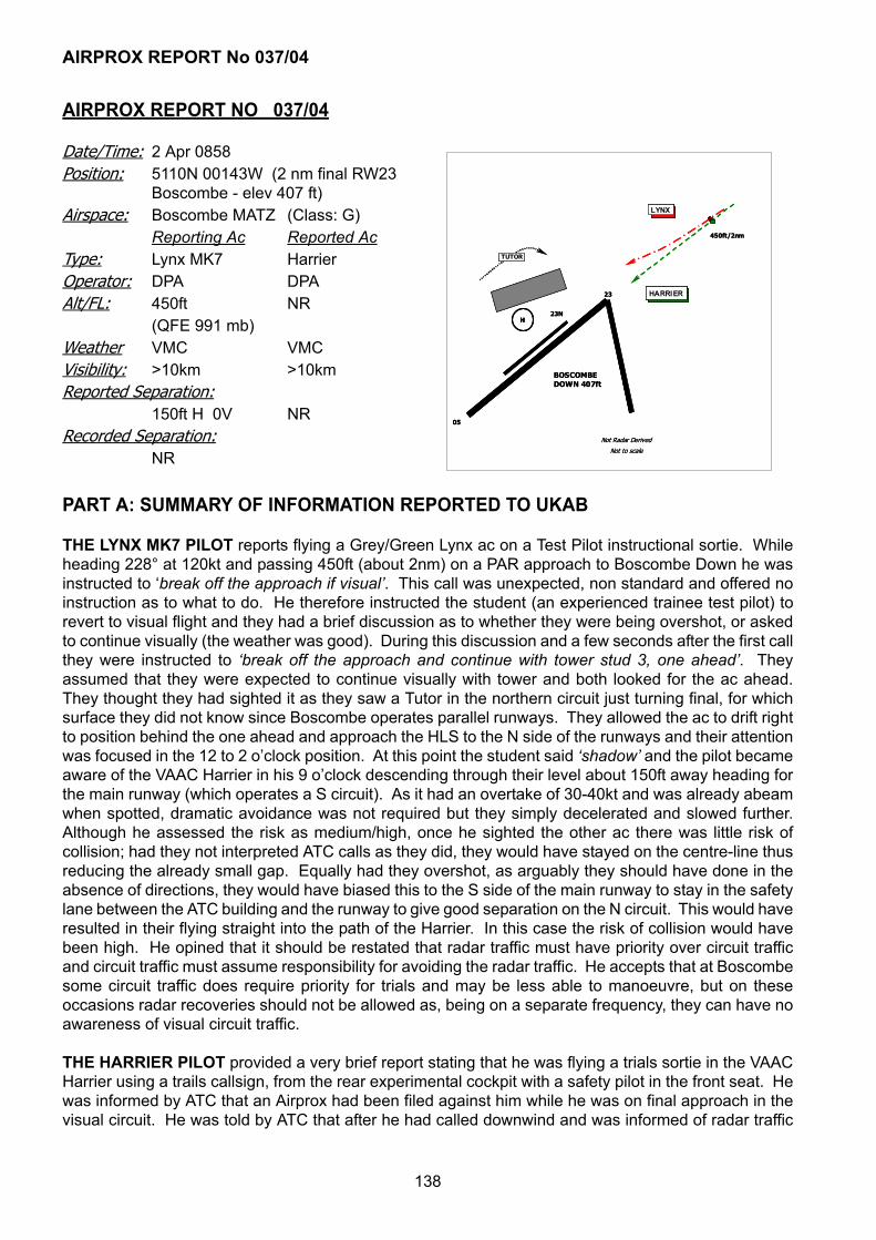
AIRPROX REPORT No 037/04
138
AIRPROX REPORT NO 037/04
PART A: SUMMARY OF INFORMATION REPORTED TO UKAB
THE LYNX MK7 PILOT reports flying a Grey/Green Lynx ac on a Test Pilot instructional sortie. Whileheading 228° at 120kt and passing 450ft (about 2nm) on a PAR approach to Boscombe Down he wasinstructed to ‘break off the approach if visual’. This call was unexpected, non standard and offered noinstruction as to what to do. He therefore instructed the student (an experienced trainee test pilot) torevert to visual flight and they had a brief discussion as to whether they were being overshot, or askedto continue visually (the weather was good). During this discussion and a few seconds after the first callthey were instructed to ‘break off the approach and continue with tower stud 3, one ahead’. Theyassumed that they were expected to continue visually with tower and both looked for the ac ahead.They thought they had sighted it as they saw a Tutor in the northern circuit just turning final, for whichsurface they did not know since Boscombe operates parallel runways. They allowed the ac to drift rightto position behind the one ahead and approach the HLS to the N side of the runways and their attentionwas focused in the 12 to 2 o’clock position. At this point the student said ‘shadow’ and the pilot becameaware of the VAAC Harrier in his 9 o’clock descending through their level about 150ft away heading forthe main runway (which operates a S circuit). As it had an overtake of 30-40kt and was already abeamwhen spotted, dramatic avoidance was not required but they simply decelerated and slowed further.Although he assessed the risk as medium/high, once he sighted the other ac there was little risk ofcollision; had they not interpreted ATC calls as they did, they would have stayed on the centre-line thusreducing the already small gap. Equally had they overshot, as arguably they should have done in theabsence of directions, they would have biased this to the S side of the main runway to stay in the safetylane between the ATC building and the runway to give good separation on the N circuit. This would haveresulted in their flying straight into the path of the Harrier. In this case the risk of collision would havebeen high. He opined that it should be restated that radar traffic must have priority over circuit trafficand circuit traffic must assume responsibility for avoiding the radar traffic. He accepts that at Boscombesome circuit traffic does require priority for trials and may be less able to manoeuvre, but on theseoccasions radar recoveries should not be allowed as, being on a separate frequency, they can have noawareness of visual circuit traffic.
THE HARRIER PILOT provided a very brief report stating that he was flying a trials sortie in the VAACHarrier using a trails callsign, from the rear experimental cockpit with a safety pilot in the front seat. Hewas informed by ATC that an Airprox had been filed against him while he was on final approach in thevisual circuit. He was told by ATC that after he had called downwind and was informed of radar traffic
Date/Time: 2 Apr 0858Position: 5110N 00143W (2 nm final RW23
Boscombe - elev 407 ft)Airspace: Boscombe MATZ (Class: G)
Reporting Ac Reported AcType: Lynx MK7 HarrierOperator: DPA DPAAlt/FL: 450ft NR
(QFE 991 mb)Weather VMC VMCVisibility: >10km >10kmReported Separation:
150ft H 0V NRRecorded Separation:
NRNot Radar Derived
Not to scale
05
23
LYNX
BOSCOMBE DOWN 407ft
HARRIER
23NH
450ft/2nm
TUTOR
Not Radar Derived
Not to scale
05
23
LYNX LYNX
BOSCOMBE DOWN 407ft
HARRIERHARRIER
23NHH
450ft/2nm
TUTOR

AIRPROX REPORT No 037/04
139
at 4nm and that he had priority and was cleared to fly through at 500ft. Neither pilot saw any other acduring the event.
[UKAB Note (1): The incident is not recorded on radar].
SATCO reports that after landing, the pilot of a Lynx helicopter contacted the ATC Supervisor to reportthat while he was on a PAR approach, an incident had occurred with another ac in the visual circuit. TheADC mentor, ADC trainee, Talkdown controller and the Supervisor, who arrived in the VCR as theincident was occurring, all provided reports. Tape transcripts of the Tower position and frequency, andthe Talkdown position and frequency covering the period of the incident were also provided as wereextracts from the Boscombe Down Flying Order Book and the ATC Order Book referring to theclearances available for use by the ADC.
The VAAC Harrier is a unique ac that operates from Boscombe Down on trials sorties. The trainee ADCwas told by Sqn Ldr Ops that VAAC sorties for the day would have priority over normal radar and circuittraffic. It is not uncommon for ac and sortie priorities to alter on a daily basis dependant on trialsrequirements. Although the trainee ADC passed this information to the mentor controller, he did notpass it to the morning Supervisor. A fax was received by ATC detailing the VAAC’s sortie times, but thisdid not state that any priority was required. This notification system has since been revised to ensurethat priorities are clearly detailed. The first few VAAC circuits were uneventful with the ac conductingstandard circuit profiles to fly through at 500ft. Unbeknown to the ADC trainee or screen, the circuit onwhich the incident occurred required an early deceleration from a slightly wider circuit profile, whichmeant the ac would be on the approach for a longer period.
The Lynx helicopter, was warned in at 7nm by Director and a brief conversation about VAAC priorityensued and subsequently a standard broadcast was made on the Tower frequency (stud 3), although adifferent range was passed, believed to be derived from the DFTI. The VAAC called downwind for a flythrough just before the Lynx reached the 4nm clearance point. The ADC trainee issued a delayedclearance to the Lynx, put out a broadcast on stud 3 and then informed the VAAC that he was ‘numberone’, as in his opinion, (reinforced by previous circuits) there was sufficient lateral separation to get theVAAC through and then issue a clearance to the Lynx at 2¼nm. Furthermore, armed with the BoscombeDown specific ‘if visual’ clearance, both he and his screen were confident there was no need to breakoff the Lynx. However, this was the first time that the trainee would have made use of the clearance.The VAAC called finals and was cleared for his fly through without a check to confirm that he was visualwith the Lynx. At that point the Supervisor arrived in the VCR. At 2¼nm the ‘if visual’ clearance wasused but in the wrong format and before it could be rectified it was passed to the pilot, again using anincorrect format. The incident is believed to have occurred around this time, as the Supervisor wasdrawing attention to the close proximity of the tracks on the DFTI. The Lynx was transferred to the Towerfrequency and was cleared to position for a landing at North Point. After questioning the intentions ofthe VAAC, the Lynx was cleared to land at North Point from where he contacted Ground for taxi back todispersal. On returning to the Sqn the Lynx pilot contacted the Supervisor to discuss the incident andinform him that an Airprox was being filed. The Supervisor carried out the necessary actions includinginforming the VAAC pilot of the incident, who was unaware of a problem until that point.
Guidance has been issued to controllers following this incident to clarify the priority that is to be affordedto the VAAC when operating engaged.
STATION COMMENTS that this was a totally unnecessary incident, and a worrying one, given thatneither ac was aware of the location of the other. The VAAC Harrier pilot was working hard and did notexpect any confliction, given the information passed to him however, it would be expected that he wouldhave recalled a Lynx within 150ft of his ac (assuming the distance reported by the Lynx pilot wasaccurate). There was a weakness of information flow within the ops/ATC network regarding the priorityof the VAAC over other traffic, compounded by the exceptionally positive and proactive approach takenby Boscombe ATC, resulting from an honest desire to deliver as much value as possible to all

AIRPROX REPORT No 037/04
140
‘customers’. As a result, the Lynx was not held clear until sequencing with circuit traffic could becontrolled, and assumptions were made regarding the circuit profile being flown by the Harrier whichwere based on invalid historical data, and took no account of varying speeds during multipleapproaches. Concern was expressed at the lack of information passed to the Harrier despite ATCpersonnel being aware that the 2 ac were close to each other and the potential for a conflict existed.Flexibility can only be based on robust processes overlaid with sufficient information; these processesexist and Boscombe is well used to trials constraints occasionally mandating non-standard procedures.However, on this occasion, communications were inadequate to ensure that all parties were aware ofeach other and that caution was needed. Ops and trials aircrew have been rebrieffed on the need toensure that priorities are clearly expressed and understood during sortie planning and arecommunicated to all airfield users. The Stn Cdr regarded this as a wake-up call to all involved thatoperator communication must be appropriate and that ATC flexibility must be tempered by positivecontrol and adequate information provision, both internally and externally.
MIL ATC OPS concurred SATCO’s report and had nothing to add.
DPA comments that this Airprox raised a number of questions about the processes and proceduresactive at the time of the incident. There was a lack of, effective TI, compounded by a lack of control,being exercised by the Boscombe visual controller and mentor. While many factors contributed to thetraffic situation, trials priority and circuit priority to highlight but two; however the fundamental fact is thatit is the function of ATC to resolve conflictions regardless of how they are caused. That said, the factthat neither pilot in the VAAC Harrier saw a Lynx that was being overtaken on final approach was ofconcern.
As a result of this, and other recent similar incidents, a review has been undertaken to look at the issuesemerging from this incident. This review addressed the process for allocating trials and circuit priorities,the potential need for a supervisor within the visual control room, the recent increase in the numbers ofinexperienced controllers at Boscombe and the implementation of circuit restrictions for trials activity.
PART B: SUMMARY OF THE BOARD'S DISCUSSIONS
Information available included reports from the pilots of both ac, transcripts of the relevant RTfrequencies, reports from the air traffic controllers involved and reports from the appropriate ATC andoperating authorities.
The Board expressed concern that the revised ATC arrangements at Boscombe Down may have led toa reduction in experience levels of the controllers at this unique airfield with its own peculiar flying controlrequirements. The integration of ac testing, Test Pilot instruction and a diverse variety of other flyingactivity are not new challenges they but are nonetheless very demanding.
Although sympathising with the situation that the ADCs faced, with inadequate information on therequirements of the VAAC Harrier, specialist members endorsed the comment made by DPA “thefundamental fact is that it is the function of ATC to resolve conflictions regardless of how they arecaused”: for whatever reason, they did not accomplish this. In mitigation, they accepted that the actualconfliction took place some distance away from the Tower and that the controllers’ view may have beenrestricted: however members thought that it should have been apparent, at the time the Harrier calleddownwind with the Lynx at 4nm that there was potential for a confliction. Although the trainee may havelacked experience, both a mentor and the supervisor were present during the evolution, both of whomwere in a position to initiate action to take control and resolve the rapidly deteriorating situation. Thisincident provides another example of why it is most important for controllers to use standardphraseology and to understand thoroughly the less frequently used, but nonetheless, standardoperating procedures. Often time does not permit lengthy discussion or instruction when ac areconverging.

AIRPROX REPORT No 037/04
141
Members considered why the ADCs were unaware of the intentions and priority required by the trialsac. The Harrier pilots believed correctly that their trial status afforded them priority over other traffic;since this is one of the prime functions of Boscombe Down it is surprising that robust procedures werenot in place to ensure that this information was made equally available to others who would be affectedas a consequence. Further, good airmanship would dictate that all pilots keep ATC informed of theirintentions, particularly when they differ from the norm or are changed. In this situation the Harrier crewhad not informed ATC that their downwind leg would be extended.
The Board also considered the part played by the pilots involved. The actions of the Lynx crew wereconsidered reasonable. Although they were aware of the presence of the VAAC Harrier theyunderstandably thought that it would be behind them, that normal priorities would apply, and that it(visual traffic) would avoid them (instrument traffic). Further, they had not been in a position to see theHarrier nor take avoidance. When faced with an unexpected and non-standard instruction from ATC,they adopted an understandable course of action and therefore had not contributed to the cause of theincident. The Harrier pilots also believed that they had priority and that ATC were aware of that. Thismay have led them to be less punctilious in their lookout when both of them would have been in a veryhigh workload situation, perhaps locked into a testing mode of flying. Nonetheless, one of the primeresponsibilities of the safety pilot was lookout whenever the handling pilot was so busy that this functionbecame degraded. Members, including a test pilot, were therefore surprised that the, albeit small, tail-on aspect and camouflaged Lynx, was not seen by either Harrier pilot and avoided.
Since the Harrier pilots did not see the Lynx and the Lynx pilots were not in a position to see the Harrieruntil after it had passed them, this was judged to be a most serious incident. Only good fortune hadseparated the ac; members therefore considered that there had been an actual risk of collision.
PART C: ASSESSMENT OF CAUSE AND RISK
Cause:
1. A lack of positive control by Boscombe Down Tower.2. A non-sighting by the Harrier pilots of the Lynx which they overtook on the final approach.
Degree of Risk: A.

AIRPROX REPORT No 038/04
142
AIRPROX REPORT NO 038/04
PART A: SUMMARY OF INFORMATION REPORTED TO UKAB
THE B737(A) PILOT reports inbound to Stansted at 220kt and in receipt of a RCS from Essex RADARon 120·62MHz squawking an assigned code with Mode C. Turning L from heading 235°, he thought,onto L base leg RW05 and descending through 4000ft QNH in IMC, ATC gave an avoiding action 50° Rturn onto heading 270°. TCAS gave a TA alert on traffic in his 1 o’clock range 4nm crossing R to L atthe same level which was seen on the TCAS display to pass 2·5nm to his L during the turn. He assessedthe risk of collision as high.
THE B737(B) PILOT reports flying a Clacton departure from Luton on a training flight. The crewcomplement was two training Capts and a trainee FO on the jump seat. The crew considered itnoteworthy that they were late being handed-over to London, to the point where they were about toquery this with ATC, as they were at an unusually low altitude. As the crew were discussing this on theflight deck, a TCAS TA alert was received which looked as if it might become an RA, but in the end didnot. Another ac was ‘seen’ on the display to pass in the opposite direction down their LHS at the samealtitude and about 3nm away. Shortly after this, ATC called asking if he was still on frequency and hewas then handed over with nothing more being said. Initially he did not file an ASR as he consideredthat a TA alert is not particularly unusual in the LTMA although on reflection a same level TA is – theyare normally climbing or descending encounters. This report was completed from memory about 1month post incident, after being asked to complete a form by the UKAB.
ATSI reports that at the time of the Airprox, the B737(B) crew were in communication with the Luton INTDirector whilst the B737(A) crew were in contact with the Stansted INT/FIN Director. The controllersdescribed both the workload and traffic loading as ‘moderate’, although the Luton Director added thatthe situation was complex. The Stansted Director’s position was being operated by a Trainee undersupervision who had received approximately 150hr training. A typical trainee would require some 300hrto reach an acceptable level of competency. The position was being operated in a bandboxed mode,carrying out the duties of both FIN and INT.
The B737(A) crew established communications with the Stansted Director at 1310:25, and reporteddescending to FL100 routeing direct to Barkway, the ac being 10nm W of Stansted and passing FL113.The Director instructed the crew to continue on their present (northerly) heading and reduce speed to
Date/Time: 26 Mar 1319Position: 5146N 0001E
(4nm ENE BPK)Airspace: LTMA (Class: A)
Reporting Ac Reported AcType: B737(A) B737(B)Operator: CAT CATAlt/FL: 4000ft↓ NR
(QNH) (QNH)Weather IMC KLWD IMC KLWDVisibility:Reported Separation:
nil V 2·5nm H nil V 3nm HRecorded Separation:
nil V 1·85nm H
LUT
BPK
BKY
StanstedElev:348ft1315:20
A40
1315:20074
16:15A40
16:15063
16:40A40
16:40A62
18:10A40
18:10A42
18:24A40
18:24A40
A40
LUTON CTRSFC-3500ftLTMA 3500ft+
LUTON CTA2500-3500ftLTMA 3500ft+
LTMA 2500ft+
STANSTED CTA2500-3500ftLTMA 3500ft+
17:30A50
17:30A40
B737(A)
B737(B)
0 1
NM
CPA18:48
A40
STANSTED CTRSFC-3500ftLTMA 3500ft+
STANSTED CTA1500-2500ftLTMA 2500ft+
STANSTED RMA3000ft and below
LUT
BPK
BKY
StanstedElev:348ft1315:20
A40
1315:20074
16:15A40
16:15063
16:40A40
16:40A62
18:10A40
18:10A42
18:24A40
18:24A40
A40
LUTON CTRSFC-3500ftLTMA 3500ft+
LUTON CTA2500-3500ftLTMA 3500ft+
LTMA 2500ft+
STANSTED CTA2500-3500ftLTMA 3500ft+
17:30A50
17:30A40
B737(A)B737(A)
B737(B)B737(B)
0 1
NM
CPA18:48
A40
STANSTED CTRSFC-3500ftLTMA 3500ft+
STANSTED CTRSFC-3500ftLTMA 3500ft+
STANSTED CTA1500-2500ftLTMA 2500ft+
STANSTED CTA1500-2500ftLTMA 2500ft+
STANSTED CTA1500-2500ftLTMA 2500ft+
STANSTED RMA3000ft and below

AIRPROX REPORT No 038/04
143
220kt. The landing RW at Stansted was 05 and so ac were being vectored to a position NW of the airportand then turned R to position downwind LH. When the B737(A) crew called, there were 2 other acahead of it being positioned as described. Clearance to descend to FL90 and then FL80 was given and,at 1313:20, when the B737 was approximately 10nm NW of the airport, the crew was instructed to turnR heading 235º.
During the execution of this turn, B737(B) departed from RW08 at Luton, and the crew contacted theLuton INT Director at 1314:50 and were cleared on a CLN6C SID. This requires flights to climb straightahead to the LUT NDB, turn R to BPK, a track of 157°M, before turning L and tracking 085° direct toCLN. The initial level for such departures is 4000ft and, having passed BPK, cross 7 DME from BPK at5000ft. Due to a slow climbing departure ahead, the Luton INT Director had restricted B737(B) to 3000ftaltitude. On initial contact, the controller instructed the crew to squawk Ident and continue climb to4000ft. Meanwhile, B737(A) was completing the R turn and the Stansted Director issued descentclearance to 6000ft. Shortly afterwards, a track adjustment turn onto 220°, together with further descentto 3000ft, was issued. At that time (1315:20), B737(B) was just levelling at 4000ft and about to turn Ras it crossed the LUT NDB with B737(A) in its 11 o’clock position at 15nm and passing FL74.
At 1316:15, the Luton INT Director received a telephone call from TC North advising that a C550, whichhad departed Luton for Amsterdam, had declared a ‘PAN’ due to vibration and required a return to Luton.The C550 was 10nm E of Stansted descending to FL100. The Luton controller advised that the acshould be positioned downwind RH for RW08 and descended to 5000ft. He then advised Luton Towerto check all departures with him. During this telephone coordination, the Stansted Director hadinstructed B737(A) to turn further L onto 200° as it was positioned downwind LH. At that time (1316:40),it was passing 6200ft for 3000ft and B737(B) was maintaining 4000ft virtually half way between the LUTNDB and BPK. B737(A) was in its 9 o’clock position at a range of 10nm.
At 1318:10, the Stansted Director instructed B737(A) to turn L heading 130° for a base leg onto RW05at Stansted. The ac was passing 4200ft whilst B737(B) had reached BPK and turned L for CLN, stillmaintaining 4000ft with B737(A) in its 10 o’clock at 4·5nm. Ten seconds later the Stansted Directortransmitted “B737(A) c/s avoiding action turn right I say again a right turn heading two seven zerodegrees”, which the crew acknowledged. TI was passed as “….traffic was in your 12 o’clock same levelright to left”. The instruction was complied with but slow to become effective because the flight hadalready been in the L turn onto 130°. B737(B) was steady on an easterly track towards CLN as B737(A)was closing from its 9 o’clock position. Separation reduced to a minimum, at 1318:48, when B737(A)was turning R in the 8 o’clock position of B737(B) at a range of 1·85 miles with both ac at 4000ft. STCAactivated on ‘high severity’ at 1318:50, ceasing 10sec later as the R turn onto 270° being executed byB737(A) took effect. Very shortly afterwards standard lateral separation was restored.
The Luton Director reported that he had become preoccupied with the returning C550 as the conflictwas developing. It was unusual, in his experience, to work BPK departures from Luton, although it doeshappen on occasions such as this when a slow ac departs ahead. His plan had been to climb B737(B)to 4000ft and then transfer it to the TC NE Deps controller. (Note: As referred to earlier, the verticalprofile of this SID is as follows: Cross BPK D5 3000 feet or above, BPK D3 at 4000 feet, BPK VOR at4000 feet and CLN D40 (BPK D7) at 5000 feet). He added that it was extremely rare for Luton to stillbe working such departures when they had reached BPK as, under normal circumstances, they wouldhave been transferred, and climbed further by TC, much earlier. He recalled that he had inadvertentlycrossed through the strip on B737(B) and, probably had moved it to the ‘dead bay’ on his strip display.Thus, to all intents and purposes, his strip display indicated that B737(B) was no longer on his frequencyand accordingly, he was no longer specifically monitoring the flight. It was only when he received atelephone call from TC North asking whether he still had the flight that he called B737(B) and discoveredit was still on the Luton frequency.
The Stansted Mentor explained that the standard procedure for handling such situations when RW05was in use was to descend inbound traffic to 6000ft initially, thus permitting departures to the NW to get

AIRPROX REPORT No 038/04
144
airborne climbing to 5000ft. It is generally considered that this technique is the best compromise giventhe restrictions on airspace in the area. (To the NW of Stansted, the base of the London TMA is 4500ftand so 5000ft is the minimum level that can be allocated). Inbound traffic is taken to the NW andtypically turned onto 230°. Once it has crossed the outbound track, further descent is given to 3000ft.The Mentor had noted that his trainee was turning traffic slightly early, which resulted in it being higherthan the ideal as it tracked downwind LH for RW05.
The Stansted Intermediate and Final Procedures, as described in the MATS Part 2, require ac enteringthe Radar Manoeuvring Area (RMA) to the SW of Stansted, to be 3000ft or below. If this is not achievedthen coordination is required with TC. This assists, but does not ensure, separation from Luton andLondon City departures routeing on SIDs via BPK. MATS Part 2 STN 5.2 requires that StanstedDirectors ensure ac under their control remain separated from ac on the SID track between Luton andBPK by radar monitoring and vectoring if necessary. Furthermore, TC Stansted will ensure that ac inthe SW segment of the Stansted RMA are separated from London City departures via BPK or LAM. Anexamination of radar recordings showed that in the period 1313 – 1325 on the day of the Airprox, noneof the four ac that were inbound to Stansted complied with the requirement to be 3000ft or below onentering the RMA. The Stansted INT/DIR Mentor explained that he had conducted a small survey andfound that 58% of traffic did not comply with this restriction. B737(A) was passing 4500ft as it crossedthe boundary of the RMA, 1500ft above the approved level. Accordingly, the followingrecommendations have been made:
ATSI RECOMMENDATIONS:
1) Given the evident frequency of ac failing to meet the level requirement on entering the SW segmentof the RMA, NATS should review the procedure in order to establish whether it is feasible to achieve iton a reasonably consistent basis, and, if not, modify it as necessary.
2) Given the increasing traffic levels in the NE portion of the London TMA, NATS should review theprocedures in place for ensuring separation between traffic being positioned for RW05 at Stansted andtraffic outbound on SIDs, from Luton and London City which route via BPK, to assess whether they aresufficiently robust.
The Mentor explained that he had seen the C550, which had declared the PAN, to the E of Stansted.The Group Supervisor had come over and provided him with some details. The Mentor then startedtalking directly with the Luton Director, as he was sat alongside him, to establish the intentions of the acas well as the Luton controller’s plan. It was at that time the trainee had directed B737(A) to turn L onto130°, however, this heading was not written on the strip. When the Mentor looked back at the radar, hesaw B737(B) having made its turn onto an easterly track, just east of BPK, and in direct conflict withB737(A). He then directed the trainee to pass an avoiding action turn onto 270°, but without theknowledge that the ac was already in a L turn from 200° to 130°. When this avoiding action was passed,the radar did not clearly indicate that B737(A) had already commenced its L turn onto 130°. Althoughthere was a delay in changing from the L to a R turn, the avoiding action was effective as B737(A)manoeuvred N of the steady easterly track that B737(B) followed.
PART B: SUMMARY OF THE BOARD'S DISCUSSIONS
Information available included reports from the pilots of both ac, transcripts of the relevant RTfrequencies, radar video recordings, reports from the air traffic controllers involved and reports from theappropriate ATC authorities.
The ATSI advisor confirmed that the 2 recommendations had been sent to NATS and that they werebeing addressed. ATCO members were familiar with the ‘tight airspace’ available at Stansted duringRW05 operations and the limited options open to controllers. It was clear from the ATSI investigation

AIRPROX REPORT No 038/04
145
and report that the Stansted mentor had allowed his trainee to descend B737(A) to 3000ft but its flightpath had not complied with the requirements for entering the Stansted RMA. This had been a part causeof the Airprox. RMA level requirements are catered for on the published STAR charts but crews underradar vectoring would be used to Continuous Descent Approach (CDA) profiles so would need to be toldto adjust their flight paths to conform. Furthermore, during vectoring to RW05, the onus was on theStansted mentor/trainee to monitor the flight path and avoid Luton SID traffic - B737(B) - as detailed inMATS Pt 2. This was not done and had been a second part cause of the Airprox. Unfortunately, theLuton Director had become preoccupied with returning ‘PAN’ traffic and had forgotten that he had step-climbed B737(B) and restricted it to 4000ft. Although it had been in accordance with the SID until BPK,it should have climbed to be level at 5000ft by D7 but subject to ATC approval. Also, he had thenforgotten to transfer B737(B) to the TC N SC who would normally climb Luton outbound traffic muchearlier than the published procedure. This had been a contributory factor to the incident.
During coordination with the Luton controller, the Stansted mentor had missed the turn issued by histrainee to B737(A) crew onto L base leg. Having then noticed B737(B) at BPK in confliction, he had toldhis trainee to give an avoiding action R turn to B737(A) unaware that it had started a L turn. However,the turn reversal soon took effect as B737(B) passed quickly through B737(A)’s 12 o’clock with the CPAoccurring as B737(A) passed behind. After ATC had given avoiding action, B737(A) crew had receiveda TCAS TA alert which indicated B737(B) in their 1 o’clock range 4nm crossing R to L before it eventuallypassed 2·5nm to their L as the turn took effect. B737(B) crew had noticed the potential for conflict onTCAS but after the TA alert saw the traffic on the display pass to their L about 3nm away. The promptactions taken by the Stansted mentor/trainee and reactions of B737(A) crew had quickly resolved thedeteriorating situation and led the Board to conclude that any collision risk had been effectivelyremoved.
PART C: ASSESSMENT OF CAUSE AND RISK
Cause: The Stansted mentor did not ensure that his trainee complied with the requirements for enteringthe Stansted RMA and did not monitor and avoid Luton SID traffic as required in MATS Pt 2.
Degree of Risk: C.
Contributory Factors: The Luton Director did not transfer B737(B) to LTCC.

AIRPROX REPORT No 039/04
146
AIRPROX REPORT NO 039/04
PART A: SUMMARY OF INFORMATION REPORTED TO UKAB
THE B747-400 PILOT reports that he was outbound from London Heathrow to Toronto in receipt of anATC service from LONDON CONTROL [LACC] on 129·37MHz, the allocated squawk of A7601 wasselected with Mode C.
Outbound on UPPER LIMA 9 approaching the vicinity of AMMAN, heading 295° at 310kt LONDONcleared them to climb from FL260 to FL340. When passing FL286 in the climb, the controller instructedthem to stop climb at FL280, before asking them to expedite descent down to FL280 because ofuncoordinated military traffic in their 12 o’clock that had “entered controlled airspace”. After initiating anexpeditious descent to FL280 with autopilot selected, TCAS “picked up” a contact at 12 o’clock, but oncethey had levelled at FL280 TCAS lost the return. Neither an RA nor TA was enunciated, but ATC thenadvised that the pilot of the other ac had been advised to remain clear of them - he assumed,erroneously, visually. The ATC instructions issued did not include the phrase “avoiding action”. Heassessed the risk was “medium” and reported the minimum separation as 400ft vertically and 8nmhorizontally.
UKAB Note (1): The B747-400 pilot did not state whether the Hawk was sighted.
THE HAWK T1 PILOT, a QFI, reports his ac has a black colour-scheme and the HISLs were on whilstin transit southbound at high-level into sun some 15000ft clear above cloud with an inflight visibility of30km. He was in receipt of a RCS from LATCC (Mil) and squawking the assigned codes with Mode C;neither TCAS nor any other form of CWS is fitted.
Flying south toward AMMAN in level cruise at FL280, the controller instructed him to expedite a climbto FL290 to deconflict with civil traffic. Whilst flying straight and level at FL290, in accordance with airtraffic instructions, he was given traffic information about the civil ac – a B747-400 – which was spotted10nm away. “The other ac was not a threat” and passed 5nm away about 600ft below his jet at whatappeared to be standard ATC separation [although his report did not recount the avoiding action issuedby MIL32]. He assessed the risk as “none”.
LATCC MIL CONTROLLER 32 (MIL32) reports that the Hawk needed to cross UL9 7nm W of AMMANand so he spoke to S8 to coordinate the B747, which was climbing through FL240 slightly E of BRECON.S8 informed him that the B747 was climbing to FL280. At this point the Hawk was N of AMMAN by 15nm
Date/Time: 22 Mar 1235Position: 5150N 0400W (AMMAN)Airspace: UAR - UL9 (Class: B)
Reporting Ac Reported AcType: B747-400 Hawk T1Operator: CAT HQ PTCAlt/FL: FL286↑ FL290
Weather VMC VMC NRVisibility: 10km 30km+Reported Separation:
400ft V/8nm H 600ft VRecorded Separation:
3·65nm H/700ft V
1234:05
Radar Derived all ac levels Mode C
(1013 mb)HAWK
B747
AMMAN
270 @ 1232:37
289
285
279 @ 1232:370 5 NM
290 @ 1233:09
283 @ 1232:52
272 @ 1232:52
275 @ 1233:09
290 @ 1233:31
278 @ 1233:31
282
290
286
1234:22
287
290
280
1234:47
290
280
1235:361234:05
Radar Derived all ac levels Mode C
(1013 mb)HAWKHAWK
B747B747
AMMAN
270 @ 1232:37
289
285
279 @ 1232:370 5 NM0 5 NM
290 @ 1233:09
283 @ 1232:52
272 @ 1232:52
275 @ 1233:09
290 @ 1233:31
278 @ 1233:31
282
290
286
1234:22
287
290
280
1234:47
290
280
1235:36

AIRPROX REPORT No 039/04
147
at FL280 so he said that the Hawk would avoid the B747 until it was “not below FL290”. He theninstructed the Hawk crew to expedite a climb to FL290, which they complied with and reported levelwhen the ac were still approximately 12nm apart. However, the B747 continued the climb throughFL280; when it indicated FL282 Mode C, under instruction from his SUPERVISOR he initiated avoidingaction of a R turn onto a heading of 250°. He estimated this achieved a separation between the ac of2nm and 600ft. S8 then called back to tell him that the B747 was actually climbing to FL300.
LATCC MIL TACTICAL SUPERVISOR WEST (MIL SUP) became aware that MIL32 had conflictingtraffic westbound on UL9. Upon hearing that co-ordination was being effected, he waited for the landlinecall to finish before asking controller 32 the details of the co-ordination. MIL32 confirmed that the GATwas climbing to FL280 and that controller 32 would avoid the GAT until the Hawk was “not below FL290”.He continued to monitor the situation and watched the Hawk level at FL290, whereupon he saw theB747 climb through FL281 so he approached Console 32. On the next radar sweep, the B747 indicatedFL283 Mode C and MIL32 was instructed to provide an avoiding action turn of 30° to prevent returnsfrom merging. An avoiding action R turn onto a heading of 250° was given by MIL32. Simultaneously,the S5 line rang; MIL32 picked up the call and it became apparent that MIL32 and the LACC S5PLANNER disagreed over the exact details of the co-ordination agreement.
THE LACC SECTOR 5/8 PLANNER CONTROLLER reports that LONDON MIL called when the trafficloading was relatively high. The controller wanted to cross the Hawk at AMMAN against the B747 - slowclimbing out of the LTMA to FL280 – and MIL32 said they were climbing to FL290 but would miss theB747. Subsequently, the Hawk did not avoid the B747 as he believed MIL32 was going to do. Standardseparation was not lost, he thought, but the B747 pilot elected to file an Airprox.
THE LACC SECTOR 5/8 TACTICAL CONTROLLER (TAC) reports that the PLANNER pointed out theHawk and said that MIL32 would avoid the B747 and cross the UAR at FL290. Traffic levels were busyand she was training a UT controller, but then the PLANNER pointed out the Hawk was not avoiding ourtraffic so we stopped the B747 from climbing and descended the ac to FL280 – expediting the descent.Traffic information was given to the B747 crew and the two ac passed abeam by about 5nm.
THE HAWK T1 PILOT’S STATION comments that the ac Captain, an experienced QFI, was occupyingthe rear seat with a trainee pilot in the front seat. The Hawk ac commander was informed that an Airproxhad been filed approximately 3 weeks after the event [after it had been confirmed that the B747 pilotwas filing an Airprox.]
MIL ATC OPS reports that MIL32 was providing an ATS to the Hawk crew, in transit from Valley to enterthe UKDLFS at Hartland Point, crossing UL9 in the vicinity of AMMAN and thereby in potential conflictwith the westbound B747. At 1232:18, MIL32 called PLANNER and said “…request co-ordinationplease, your traffic [B747 C/S]”. PLANNER responded that the B747 was climbing at the moment up toFL280. MIL32 then indicated the Hawk, “…can you see my traffic north of AMMAN, fifteen miles, [C/S]?” which PLANNER could, therefore, MIL32 stated “I’ll avoid you until not below FL290.” PLANNERresponded “okay, ta.” The military controller then closed the landline conversation at 1232:35, byreiterating his control position. Immediately afterwards at 1232:38, MIL32 instructed the Hawk crew to“…expedite climb FL290 for crossing controlled airspace” and at 1233:06, the Hawk pilot reported“…level FL290.” At 1233:14, MIL32 informed the Hawk crew, “…leaving the MTA [North Wales MilitaryTraining Area] Radar Control” whereupon the crew acknowledged the change of radar service. At1233:31, MIL32 passed traffic information to the Hawk crew “… traffic left, 10 o’clock, 12 miles, crossingleft right, co-ordinated not above FL280” which was acknowledged. However, at 1234:16, MIL32instructed the Hawk crew “…avoiding action, turn right heading 250, traffic was left 11 o’clock, 5 miles,crossing left right, indicating FL285 climbing” whereupon the Hawk crew immediately replied “…comingright 250.”
Examination of the Clee Hill Radar recording at 1231:11 shows the Hawk 17nm N of UL9 heading Sindicating FL280 Mode C. At the same time the B747 is shown 6·5nm NE of BRECON heading W and

AIRPROX REPORT No 039/04
148
climbing through FL260. At 1233:08, the Hawk is shown level at FL290 whilst the B747 is passingFL275 climbing. At 1234:11, when the Hawk and the B747 are 9·3nm apart, the B747 is passing FL282and at 1234:28, the ac are 8·2nm apart and the B747 indicates FL286. At 1234:35, the ac are 6·3nmapart and the B747 has reversed its climb and is indicating FL285 descending. At 1234:43, the Hawk’strack indicates the commencement of a R turn and at 1234:47, when the ac are 4·3nm apart the B747indicates FL280 and the Hawk indicates FL287 for one sweep before indicating FL289 again. At1235:06, the HAWK is in the R turn indicating FL290, the B747 indicates FL282 and the ac are 4nmapart. Thereafter both ac continue to diverge and the Hawk has passed through the B747’s 12 o’clockposition.
When MIL32 recognised that there would be a confliction between the two ac he called S8 PLANNERin order to arrange co-ordination in accordance with JSP 552 230.105. MIL32 correctly requested co-ordination in line with the regulation at JSP 552 230.115.2a and identified both ac appropriately asrequired by JSP 552 230.115.2b, before offering a workable course of action based upon theinformation available to him and obtaining agreement from PLANNER as per JSP 552 230.115.2c.Shortly afterwards the MIL SUP spoke to MIL32 and confirmed that appropriate co-ordination was inplace. When the MIL SUP saw the B747 indicating passing through FL280 he instructed MIL32 to issueappropriate avoiding action to the Hawk crew, which MIL32 then did.
MIL32 acted in accordance with the extant regulations for co-ordination. Furthermore, MIL SUPbehaved in a pro-active manner when he checked that co-ordination had taken place and subsequentlyinstructed MIL32 to give avoiding action.
ATSI reports that at the time of the incident, the LACC BRECON (Sector 5) and STRUMBLE (Sector 8)sectors were bandboxed together and both the PLANNER and TAC described their respective workloadas moderate to high. TAC was also monitoring a relatively inexperienced trainee but she had discussed,with her PLANNER and the LACC LOCAL AREA SUPERVISOR, whether to split the Sector. However,it was assessed that the traffic had peaked and it would be good experience for the trainee SC tocontinue operating in a bandboxed configuration, so she agreed to continue without splitting the Sector.However, she said that, with hindsight, it might have been appropriate to split the Sector, as this wouldhave allowed her more time to monitor the developing situation between the subject ac.
The B747 crew established communication with the bandboxed Sector 5/8 at 1226. In accordance withthe standing agreement between S23 and S8, the flight had been transferred climbing to FL260,positioned on the N side of LIMA 9 heading 285°. At 1231, the trainee SC cleared the B747 crew toclimb to FL280, underneath other crossing traffic, which was passing FL290.
At 1232:20, the S5/8 PLANNER received a telephone call from MIL32 requesting co-ordination againstthe B747. PLANNER replied that it “is climbing at the moment up to Flight Level 280”. The conversationcontinued with MIL32 saying: “…roger can you see my traffic north of AMMAN…15 miles [Hawk C/S asdisplayed by CCDS]”. When the PLANNER replied, “yes” MIL32 responded, “I’ll avoid you until notbelow flight level two nine zero.” “Okay Ta” was the reply, whereupon MIL32 ended the call saying“Thanks London Mil Controller Thirty Two.” As a result of this telephone call, the PLANNER’sunderstanding was that MIL32 would provide horizontal separation between the B747 and the Hawk byensuring 5nm radar separation. This belief was based on MIL32 saying “I’ll avoid you”. PLANNERadmitted that, having heard this phrase, he had not registered the rest of the sentence but could notreadily explain why he had missed hearing the whole message. He reasoned that, possibly, he waslistening to an RTF exchange, as he had been monitoring the frequency, or maybe he was talking to anATSA, who, he recollected, had approached him about that time. He thought that, if the MilitaryController had just requested to cross at FL290, any ambiguity would have been resolved.
Following the conversation with MIL32, the Planner pointed out the Hawk to the TACTICAL mentor,saying that the Military would avoid their traffic – the B747. The radar recording, timed at 1232:20,shows the B747 passing FL267, 30.6nm SE of the Hawk - the latter 17nm N of AMMAN tracking S,

AIRPROX REPORT No 039/04
149
maintaining FL280 with a ground speed of 390kt. Shortly after the end of the co-ordination telephonecall, the B747 crew was cleared to climb to FL340. The Planner confirmed that he heard this instructionbut, as he believed, erroneously, that the Military Controller was going to provide horizontal separationfrom the B747 he did not consider that this would create a problem.
The TAC mentor said that having been told that separation was being provided by MIL32 she hadallowed the trainee to instruct the B747 crew to climb to FL340 at 1232:50. Both then turned theirattention to the traffic situation elsewhere in the Sector. TAC mentor first became aware of thedeveloping confliction, between the subject ac, when the PLANNER pointed out that the Hawk was notavoiding the B747. She commented that, had the Sector been split notwithstanding that she understoodthat MIL32 was responsible for maintaining separation against the B747, she would probably have beenmonitoring the Hawk’s progress relative to the airliner. Acting on the PLANNER’s warning, the traineeSC at 1234:08, instructed the B747 crew to “…descend now Flight Level 280”, which the B747 crewreadback immediately. The radar recording shows that the B747 was passing FL282, at the time, 700ftbeneath the Hawk at 1 o’clock – 10·8nm indicating FL289. Because of the trainee’s lack of experience,the mentor took over the RTF and passed traffic information to the B747 crew at 1234:20, “[C/S]traffic…military traffic hasn’t been given a clearance its at…290 crossing you now…in your 12 o’clockwill you expedite down”. TAC agreed subsequently that it would have been appropriate to use the term‘avoiding action’ at the time. As the pilot was not visual, further traffic information was issued 10 seclater, “he’s just coming into your twelve o’clock now and got about four or five miles”. The radarrecordings of the event show that the B747 crew ascended to a maximum of FL286 Mode C beforedescending back to FL280 at 1234:47. By this time, the Hawk, in a R turn onto a south-westerly track,had descended to FL287 Mode C – the point of minimum vertical separation of 700ft - as it passedthrough the B747’s 12 o’clock at 4·9nm. Thereafter, the Hawk climbed back to FL290, whereas the B747crew climbed to FL282.
Minimum horizontal separation was of 3·65nm at 1235:36, but by this time the respective tracks hadbeen diverging for nearly 1min.
The LACC MATS Part 2, GEN Section, states that: “Military or civil aircraft operating as OAT which havea requirement to cross controlled airspace or UAR’s will proceed after coordination with the Planner ofthe appropriate sector on a cleared flight path. The procedure for granting a crossing clearance willnormally be as follows: On receipt of a crossing request, the Tactical and Planners will agree a courseof action and the Planner will issue the crossing clearance to the appropriate authority requesting theclearance; the Planner must ensure that the PFS (Paper Flight Strip) is displayed on the PFSB and thatany clearance conditions are annotated on the strip; the Tactical will acknowledge the crossingclearance by ticking the level in Box B of the PFS; an electronic blocking strip may be raised ifconsidered necessary by the Planner”. On this occasion, because of the relatively late request for co-ordination, the Planner said that there was no time to prepare a PFS. However, this omission is notconsidered to be a contributory factor because both controllers were aware of the Hawk ’s presence andthe PFS would only have reflected the perceived co-ordination.
The MATS Part 1, Appendix E, states that: “Controllers shall read back any operationally significantinformation contained in telephone (and intercom) co-ordination messages”. Additionally, “controllersmust ensure they obtain a readback of any operationally significant information contained in telephoneand intercom co-ordination messages”. It is believed that a similar requirement is not stipulated in theequivalent military publication (JSP552). The Planner admitted that, on this occasion, if he had readback what he believed was the agreed co-ordination, although he was never challenged to do so, theerror would have been realised and the incident prevented. He thought that the use of the phrase “I’llavoid you” at the beginning of a sentence was inappropriate, directly leading him to believe that thesituation was resolved, meaning he could turn his attention to other matters. Arguably, had the termCleared Flight Path, together with a request for a specific crossing level i.e. FL290, been used, it wouldhave removed any ambiguity.

AIRPROX REPORT No 039/04
150
Here a breakdown in the co-ordination process occurred between the S5/8 PLANNER and MIL32. ThePlanner should not have allowed himself to be distracted before the co-ordination procedure had beencompleted, thereby missing a vital part of the message. Additionally, in accordance with therequirements stated in MATS Part 1, he should have read back the co-ordination. Nevertheless, if bothcontrollers had ensured that a readback of the agreed co-ordination was done, the misunderstandingwould have been apparent. In the event, the Planner did well to monitor the situation and provide earlywarning to the Tactical Controller, allowing remedial action to be taken.
HQ PTC had nothing further to add.
PART B: SUMMARY OF THE BOARD'S DISCUSSIONS
Information available included reports from the pilots of both ac, transcripts of the relevant RTfrequencies, radar video recordings, reports from the air traffic controllers involved and reports from theappropriate ATC and operating authorities.
The comprehensive analysis provided by both Mil ATC Ops and ATSI had made it plain that the crux ofthis Airprox was one of communication and the differing perceptions of the co-ordination agreementinitiated by MIL32 with the LACC S5/8 PLANNER. Members agreed that the key here was theinterpretation of the MIL32 controller’s response to the PLANNER’s comment that the B747 “..is climbingat the moment up to flight level 280”, thereby inducing a belief that the airliner would level at FL280.Hence, with MIL32 saying that he would “…avoid you…” (the B747), PLANNER believed that MIL32 hadaccepted responsibility for ensuring standard separation, by altering the flight path of the Hawk shouldthat be required. But having heard this phrase, the PLANNER had not registered the rest of thesentence “..until not below flight level 290”, thereby erroneously grasping the impression that MIL32would maintain horizontal radar separation against the B747 when, as PLANNER intended, the airlinerwas further cleared to continue its climb through the Hawk’s level. This intention was not communicatedby PLANNER to MIL32 at the time of the co-ordination discussion. A controller member opined that themilitary controller should have expected the B747 to fly above the stipulated FL280: whilst PLANNERhad certainly not stated it would climb further, conceivably there was an inference that it might do so inthe words “….at the moment…”, but others thought it was stretching the point outwith the bounds ofreason. Whilst the Board agreed that the controllers involved here were not communicating effectivelybetween themselves, civilian ATCO members opined that the form of words used by MIL32 was, in theirview, confusing. The Mil ATC Ops advisor and other members disputed this opinion and contended thatthis expression was commonly used when effecting co-ordination agreements. Moreover, the co-ordination was carried out according to the applicable military regulations. Mention had been made ofa “Cleared Flight Path”, which a military controller pointed out was only stipulated for use when conflictswere apparent with multiple GAT tracks. Nonetheless, after a lengthy discussion the balance of opinionwas that it was not plain enough and had evidently induced confusion here as the PLANNER had notfully absorbed MIL32’s intent. As to whether a readback of the agreement would have highlighted themisunderstanding by PLANNER also engendered considerable debate. The act of co-ordinationbetween military and civilian controllers within which an agreement was reached regarding who wouldbe responsible for effecting separation between ac was clearly operationally significant information andwarranted a readback, which the ATSI advisor stressed was required by existing procedures in MATSPt 1, but evidently not given by the PLANNER here. After weighing all the aspects carefully the Boardconcluded unanimously that this Airprox had resulted because the LACC S5/8 PLANNER hadmisunderstood the co-ordination he had agreed but not read back to MIL32.
Continuing the discussion further some members were surprised that the requirement for a readbackstipulated for civilian controllers was not replicated in military regulations. Military controllers - be theyair traffic controllers or air defence controllers - were effecting co-ordination agreements with theircivilian counterparts as an operational necessity on a routine basis. Logically, a common system andpattern had evolved for this purpose between civilian and military controllers, but it would appear that

AIRPROX REPORT No 039/04
151
the applicable procedures were not entirely the same for both as MIL32 was not charged with giving orobtaining a readback in these circumstances. Similarly, if the S5/8 PLANNER had expected a readbackof the agreement or asked for one there was no apparent necessity for MIL32 to give one. This seemedto some members to be counter to best practice: it was reasoned that there should be a unified jointprocedure for use by all controllers - either air traffic or air defence, civilian or military alike - whosoeverthe service provider. Some thought lengthy discussions on the landline very unwieldy and impracticalin busy traffic scenarios, but arguably the more complex the situation the greater potential for confusionand hence the necessity for a readback to eradicate any misconceptions about the intent in the mind ofeither controller. Some members thought that this was being too prescriptive, whereas others argued itwould be sensible if all controllers were following the same rules and it was the latter view that prevailedby a narrow majority. Therefore, it was with the essentially joint and integrated nature of military/civilATC services in mind that the Board recommended that the MOD review the applicable instructions andprocedures for military ATC and ASACS controllers, when effecting co-ordination, to establish whethera requirement to give/obtain a ‘readback’ is warranted at the conclusion of such agreements, with theaim of ensuring compatibility with promulgated civilian procedures and a unified joint procedure for useby all controllers who interact with one another in UK airspace.
Turning to risk: from the Hawk QFI’s perspective there was little of significance to the event. He followedthe ATC instructions issued to climb to FL290 under the RCS, which was adeptly applied. Even withoutthe benefit of TCAS the B747 had been spotted from 10nm away, so the Hawk pilot was always in aposition to react accordingly in his nimble jet if the situation altered further. The avoiding action orderedby the MIL SUP and assiduously applied by MIL32 ensured a swift reaction from the Hawk pilot whocomplied promptly. The Board noted that the alert PLANNER had pointed out himself that the Hawkwas not turning away from the B747 which resulted in the S5/8 mentor taking over the RT from herstudent after the latter had passed the initial descent instruction. However, a CAT pilot member opinedit was disappointing to see that yet again a bandboxed sector figured in an Airprox. One memberstressed the importance of using appropriate “avoiding action” phraseology, which had also beencommented on by the B747 pilot. The addition of this significant phrase should galvanise pilots into animmediate reaction. However, it was also clear that the B747 crew had reacted swiftly to the descentinstruction from the S5/8 student anyway - although the continued use of autopilot in this situation wasquestioned. This descent instruction was transmitted as the airliner was passing about FL282 Mode C,so the B747 crew did well to arrest the climb by FL286 some 300ft clear below the Hawk, which wasmomentarily indicating FL289 at that point more than 6nm away. The B747 crew achieved FL280 some4·3nm away from the Hawk as the latter crossed ahead some 700ft above the airliner – and it was notedthat TCAS was not called upon to act. The action taken by the controllers and the swift reaction of thepilots concerned ensured that standard separation was only marginally eroded, convincing the Boardthat any risk of a collision had been removed entirely in these circumstances.
PART C: ASSESSMENT OF CAUSE AND RISK
Cause: The LACC S5/8 PLANNER misunderstood the co-ordination he had agreed but not read backto MIL 32.
Degree of Risk: C.
Recommendation: The MOD review the applicable instructions and procedures for military ATC andASACS controllers, when effecting co-ordination, to establish whether a requirement to give/obtain a‘readback’ is warranted at the conclusion of such agreements with the aim of ensuring compatibility withpromulgated civilian procedures and a unified joint procedure for use by all controllers who interact withone another in UK airspace.

AIRPROX REPORT No 040/04
152
AIRPROX REPORT NO 040/04
PART A: SUMMARY OF INFORMATION REPORTED TO UKAB
THE B737 PILOT reports that in the climb out from Luton RW26 on a CPT 3B SID with London Control,he was cleared to climb to 5000ft and to assume a hdg of 255° after passing alt 4000ft. When he waspassing 3700ft in the climb, ATC passed avoiding action “Stop climb at 4000ft, turn left hdg 180°”. Ashe started to turn, TCAS gave a “TA” warning but the other ac was not seen visually. He banked to 35°for 2sec to help the turn. The other ac was also given avoiding action and indicated the same alt and3nm on TCAS. He assessed the risk of collision as medium.
THE HS125-700 PILOT reports that he was in the climb out from Northolt on a BUZAD SID with LondonControl. He was given a radar heading of 345°and was at 250kt passing 4000ft when he was given anavoiding action L turn onto a heading that he was unable to recall. TCAS was fitted to his ac and a TAwarning with respect to the other ac was displayed and monitored. At the time his workload was high,flying the cleared SID. He assessed that the collision risk was low.
THE LTCC CONTROLLER reported that having taken over a comparatively busy NW DeparturesSector, he did not take into account the conflicting SID routes when he was asked by the co-ordinatorfor departure release on the ac. He that he gave avoiding action to both ac; “stop climb left heading180°” to the B737 and “climb 5000ft, L hdg 295°” to the HS125. He passed TI to both as soon as hewas able. In his opinion, standard separation was maintained throughout and the B737 pilot reportedvisual with other traffic.
ATSI reports that the controller, who had been in position for about 10min, reported that he wasoperating the TC NW DEPS/BNN Sectors in bandboxed mode at the time of the incident. He describedhis workload as moderate and confirmed that another controller was available if it had been considerednecessary to split the sector.
While he had been in position, Northolt and Luton, in accordance with agreed procedures, requestedreleases on their respective departing ac. Northolt telephoned the North Co-ordinator (trainee), at 0816,to request a release on the HS125, outbound on a BUZAD 1Y SID. The SC remembered agreeing torelease the ac, following a request from the trainee co-ordinator. The appropriate fps was placed in theright-hand fps display bay under the HEMEL designator. Approximately 2min later, Luton telephonedthe co-ordinator to request a release on the B737 on a COMPTON (CPT) 3B SID. This flight was also
Date/Time: 29 Mar 0824Position: 5144N 00038W (3nm W of BNN)Airspace: London TMA (Class:A)
Reporting Ac Reporting AcType: B737 HS125-700Operator: CAT HQ STCAlt/FL: 3700ft 4000ft
(QNH 1032) (QNH)Weather VMC CLBL IMCVisibility: 5km 5kmReported Separation:
3nm TCAS H 0 V 1000ft H - 1000ft V
Recorded Separation:2.6nm H 800ft V
Northolt 10nmRadar Derived all ac levels Mode C
(1013 mb)
0 1 2 3 4 5 6nm
LONDON TMA Base A2500ft
MSD 2.6nm 800ft @ 0823:39
HS125
B737
0823:20 F42
Luton 8nm
23:36 F46
23:28 F44
23:44 F47
23:52 F49
0823:20 F4023:28 F40
23:36 F3923:44 F39
23:52 F40
Northolt 10nmNortholt 10nmRadar Derived all ac levels Mode C
(1013 mb)
0 1 2 3 4 5 6nm 0 1 2 3 4 3 4 5 6nm
LONDON TMA Base A2500ft
MSD 2.6nm 800ft @ 0823:39
HS125HS125
B737B737
0823:20 F42
Luton 8nm
23:36 F46
23:28 F44
23:44 F47
23:52 F49
0823:20 F4023:28 F40
23:36 F3923:44 F39
23:52 F40

AIRPROX REPORT No 040/04
153
released but, subsequently, the SC said that he could not recollect receiving, or agreeing to, this releaserequest from the trainee co-ordinator. It was only after listening to a recording of the telephoneconversation between the co-ordinator and Luton, where the former could be heard, off-telephone,asking him for the 737’s release, that he realised that he had indeed approved it. Additionally, he hadalso been informed that the 737’s fps confirmed that the SC had agreed the co-ordination (annotated inblue ink). The SC explained that the BUZAD 1Y and CPT 3B SID profiles conflict. The BUZAD 1Y SIDroutes via BNN, climbing initially to 3000ft, with further climb, on passing BNN D6, to 6000ft. The CPT3BSID routes to HENTON, passing N of BNN, climbing to 5000ft. The SC added that, having released theHS125, he should not have released the B737 until separation could be established.
The HS125 pilot established communication with the NW DEPS/BNN sector, at 0820, reporting levellingat 3000ft on a BUZAD 1Y SID. The SC removed the speed restriction but left the ac following the SID.The B737 pilot made his initial call on the frequency some 2min later, reporting passing 2000ft climbingto 5000ft on a CPT 3B SID. Once again, the SC removed the speed restriction and left the ac followingthe SID. Shortly afterwards, the B737 pilot was instructed, once it had passed 4000ft i.e. after noiseabatement, to turn R heading 255°. The SC explained that this heading was to ensure lateral separationfrom a slower ac on a parallel track, thereby allowing the B737 to be climbed to the same level (FL70).In accordance with the Standing Agreement with TC OCK, the B737 had to be at Minimum Stack Level(FL70) by 11nm NE CPT. The SC commented that he was still not aware of the potential conflictionbetween the subject ac. He added that the HS125 had not been clearly visible on his radar display asits label was overlapping with those of other ac holding at BNN. The fps display would have providedinformation to show the confliction, although the fps would not have been positioned in the same bay.The B737’s fps would have been in position in the left-hand of the three-bay fps display i.e. farthest fromthe HS125’s.
The SC said that he first became aware of the confliction shortly after he issued the turn instruction tothe B737. Whilst scanning the radar display, he noticed the HS125’s SSR label which appeared justclearing the BNN traffic. He reacted immediately by issuing the B737 pilot with an ‘avoiding action’ Lturn heading 180° together with an instruction to maintain 4000ft. After receiving a correct read back,the HS125 pilot was given an ‘avoiding action’ turn heading 295° and instructed to climb to 5000ft. TIwas then passed to the B737 pilot: “traffic twelve o’clock range three miles indicating four thousand fourhundred feet verified”. The pilot reported that the traffic was showing on TCAS and, additionally, he wasvisual with it. The pilot of the HS125 reported later that he had sighted the B737 and had also receiveda TCAS TA. Radar recordings of the incident show that when the avoiding action instruction was passedto the B737 pilot, at 0823:00, the ac was passing 3400ft. The SSR label of the HS125 was justappearing clear of BNN holding traffic, at 3900ft. This corresponds with the SC’s recollection of theevent. The 2 ac were now on conflicting tracks, 6.5nm apart. When STCA activated at 0823:19, theB737 had levelled at 4000ft and the HS125 was passing 4200ft, 4.5nm away. Minimum separationoccurred at 0823:39 when the ac were passing 2.6nm apart, separated vertically by 800ft.
The Airprox occurred because the NW DEPS/BNN SC released the B737 into confliction with theHS125. It has not been possible to determine why, having already released the HS125, the SC agreedthe release for the B737 on a conflicting SID nor why he could not recollect having carried out this task.However, as soon as he spotted the confliction, the SC took timely and positive action to rectify thesituation and almost achieved standard separation.
RAF NORTHOLT comments that in order to deconflict with other routes, significantly those servingLuton airport, the published BUZAD 1Y departure mandates a stepped-climb profile. This requires theac to be level at 3000ft QNH 6 DME before BNN VOR, after which it is required to climb in order toachieve 5000ft 3 DME from BNN and 6000ft 6 DME from BNN. The clearance under which the HS125was operating appeared to conform to this profile, as did the ac itself, and from the report submittedthere appears to have been no procedural failure by the crew that might have contributed to the incident.Therefore, notwithstanding that this is busy airspace, there should be no reason why a conflict aroseunless a failure occurred in the co-ordination with other routes or the other crew made a mistake.

AIRPROX REPORT No 040/04
154
Although there seems to have been no real risk of collision in this case, it serves to emphasise thedensity of traffic in the London area, the significant safety benefits of TCAS and the continuing wisdomof maintaining an effective lookout even in Class A airspace.
HQ STC comments that the controller appears to have made an initial error and then taken positiveaction to correct this. Following this action there was little chance of a collision as verified by the largemiss distance.
PART B: SUMMARY OF THE BOARD'S DISCUSSIONS
Information available included reports from the pilots of both ac, transcripts of the relevant RTfrequencies, radar photographs/video recordings, reports from the air traffic controllers involved andreports from the appropriate ATC and operating authorities.
Members concurred the findings of the thorough ATSI investigation and their determination that theprimary cause of this Airprox was a straightforward mistake by the SC. Some ATC experts additionallyconsidered that the ATC teamwork had been lacking: they thought that the Co-ordinator, albeit a trainee,who had been involved actively in accepting the respective ac releases, should also have seen theconfliction and informed the SC, allowing him to take earlier avoiding action. After the ac were airborneand the confliction was spotted, however, the action taken by the SC was correct, as timely as it couldhave been and resulted in only a small erosion of standard separation.
Pilot members considered that the early release from speed control by ATC, if enacted by crews,resulted in reduced time being available for the implementation of any ATC instructions. This wasparticularly pertinent in busy terminal airspace.
PART C: ASSESSMENT OF CAUSE AND RISK
Cause: The LTCC NW DEPS/BNN Sector Controller released the B737 into conflict with the HS125.
Degree of Risk: C.

AIRPROX REPORT No 041/04
155
AIRPROX REPORT NO 041/04
PART A: SUMMARY OF INFORMATION REPORTED TO UKAB
THE B757-200 PILOT reports that his ac has a blue & white livery and the HISL was on whilst inboundto Birmingham, IFR, in receipt of a RCS from LTCC on 130·92MHz and squawking the allocated codewith Mode C.
Heading 310° (M) direct to the HON VOR at 250kt, the controller instructed them to descend to FL90through the level of the Daventry Radar Corridor (RC) [FL100]. Descending about 2000ft above cloudwith a flight visibility of 50nm, apparently there was a military ac in transit through the corridor, but notraffic information warning nor avoiding action advice was issued before they spotted the other ac – aKC-135 – about 4nm away and closing from the R. TCAS indicated a TA but an RA was not enunciated.To avoid the KC-135 and increase separation he increased the rate of descent by selecting thespeedbrake and they passed 700ft below and 2½nm away from the other ac. The Airprox occurredduring the frequency change from London CONTROL to Birmingham APPROACH on 118·06MHz; theBirmingham controller queried whether they had sighted the KC-135 and the separation with the firstcall. He added that the risk was “slight” but cited controller workload as a possible relevant factor.
THE KC-135R PILOT reports he was inbound to Fairford IFR and in receipt of a Radar InformationService [sic – it was actually a RCS] from London Military heading 268° at 300kt. He was squawkingthe assigned code with Mode C; TCAS is fitted. Flying in level cruise at FL100, in VMC some 4000ftabove cloud with unlimited visibility he was not aware of any other ac that had flown “within an unsafeproximity” to his ac. He had not sighted the B757 and added that the risk was “none”.
THE LTCC MIDLANDS SECTOR CONTROLLER (TC MID) reports that he was controlling the TCMIDLANDS Sector with COWLY & WELIN bandboxed together, hence he was “reasonably busy” butwas in the process of trying to get the Sector split at the time of the Airprox.
The B757 was inbound to Birmingham and he had co-ordinated the crossing traffic through the DaventryRC himself at FL100. The B757 had initially been descended to FL170 and upon reaching this level thecrew “was pushing him” for further descent, so he descended the flight to FL130; once they had levelledthe crew “pushed him” for further descent again. At this point he issued a descent instruction to FL80,[it was initially FL90 then to FL80 about 1min later], thereby descending the B757 through the level ofthe crossing traffic at FL100 in the RC. The first he knew about the incident was when the direct accesstelephone line from LJAO started ringing; when he looked up he saw the two ac’s SSR returns flashing
Date/Time: 29 Mar 1604Position: 5211N 0102W (3nm E of DAV)Airspace: DAVENTRY CTA (Class: A)
Reporting Ac Reported AcType: B757-200 KC-135ROperator: CAT Foreign MilAlt/FL: ↓FL90 FL100
Weather VMC CLBL VMC CLACVisibility: 50nm UnlimitedReported Separation:
700ft V/2·5nm H Not seenRecorded Separation:
4·3nm H - 500ft V
DAVENTRY
1604:13
STCA low severity at 1604:31 for 10sec
Radar Derived all ac levels Mode C
(1013 mb) KC-135R
WELIN
103
B757
100
100
0 5 NM
100
98
9592
88
105 105
100
8583
RC S B’dry
RC N B’dry
100
DAVENTRY
1604:13
STCA low severity at 1604:31 for 10sec
Radar Derived all ac levels Mode C
(1013 mb) KC-135RKC-135R
WELIN
103
B757B757
100
100
0 5 NM0 5 NM
100
98
9592
88
105 105
100
8583
RC S B’dry
RC N B’dry
100

AIRPROX REPORT No 041/04
156
– the B757 at FL95 and the RC traffic at FL100 about 3·5 miles apart. He did not pass avoiding actionnor traffic information to the B757 crew, but the Swanwick (Mil) LJAO CENTRAL controller climbed theKC-135 about 500ft. Both ac continued on their respective flight paths without the B757 pilot mentioninganything about the incident on RT.
THE SWANWICK (Mil) LJAO CENTRAL CONTROLLER (CEN) reports that he was controlling the KC-135, under a RCS through the Daventry RC at FL100, which had been booked with TC MID. When theKC-135 was in the corridor he observed the B757 in his ac’s L 10 o’clock at about 20nm descendinginbound to Birmingham and he passed traffic information on the airliner to the KC-135 crew as“descending, co-ordinated above”. The KC-135 pilot reported visual contact with the B757, which hethen saw had descended through FL110 Mode C, but he thought the TC controller must be expeditingthe B757’s descent to pass beneath the KC-135, so re-called the traffic to the KC-135 crew as“descending now co-ordinated beneath”. Whilst following the B757’s Mode C indications he realised theac was not descending fast enough and separation would be eroded. So to avoid the B757 he initiatedan avoiding action climb instruction to the KC-135 crew to climb to FL110, which they acknowledged.He assessed that the minimum separation between the ac was 3nm horizontally and 1000ft vertically.Subsequently, TC MID informed him that the B757 pilot was reporting an Airprox, as he had to increasehis ac’s rate of descent to avoid a TCAS RA going off.
MIL ATC OPS reports that LJAO CEN had obtained a Cleared Flight Path (CFP) for the KC-135 to transitthe RC at FL100, as per HQ 3 Gp ATC SOPs - 0309 & LTCC MATS Pt 2 - 4.3, from TC MID who wascontrolling the B757, descending into Birmingham from the S. At 1603:00, the KC-135 crew wasestablished under their own navigation through the DTY RC, level at FL100 under a RCS. At 1603:42, CENcalled the B757 traffic to the KC-135 as "..traffic left 10 o'clock 12 miles crossing left to right in the descent,co-ordinated 1000ft above." The KC-135 crew reported "..traffic in sight" at 1603:47, but CEN continued tomonitor the B757, which had maintained its descent and the controller presumed that the TC MID controllerwas now descending the B757 below the KC-135. Therefore, CEN recalled the traffic inferring that theB757 was now co-ordinated below at 1604:06. However, as the situation developed it became apparent toCEN that separation between the 2 ac was going to be eroded, therefore at 1604:35, CEN passed avoidingaction to the KC-135, "…avoiding action, climb FL110, that traffic left 10 o'clock, 5 miles crossing left right,descending slowly". This instruction was acknowledged by the KC-135 crew at 1604:41. Simultaneously,CEN contacted TC MID to confirm their intentions with the B757. CEN advised that he was climbing theKC-135 to FL110 but after TC Midlands stated "..I think he's through you now" CEN declared "…Okay I'lllevel off". As the B757 descended through FL90 Mode C, CEN instructed the KC-135 crew to "..maintainFL100 now , the traffic left 10 o'clock, 3 miles left to right, 1000ft beneath", which was acknowledged at1604:57.
[UKAB Note: The Clee Hill Radar recording shows the KC-135 routeing through the RC indicating levelat FL100 Mode C. At 1604:13, the B757 is shown just before it crosses the southern boundary of theDAVENTRY RC tracking 310º and descending through the level of the KC-135 indicating FL100. STCAactivated at 1604:31, when the horizontal separation reduced to 4·3nm and Mode C indicated aseparation of 500ft as the B757 descended through FL95. Standard minima of 1000ft was restoredquickly at 1604:55, by a combination of the B757’s descent and the KC-135 climbing through FL103 inresponse to the avoiding action issued, ascending to a maximum of FL105. This level was maintaineduntil after the B757 had crossed ahead, still descending with vertical separation steadily increasing.]
Prior to the Airprox, the transit of the KC-135 through the DTY RC had been routine. When the controllerspotted the potential confliction at 1603:42, CEN passed prompt and accurate traffic information to theKC-135 about the B757. As GAT had to be separated from the KC-135 - which was on a CFP - CEN'sassumption that the conflicting traffic would stop above his traffic was understandable given the B757'srate of descent, which CEN had been monitoring. As the B757 passed through FL110 in the descent,CEN assumed that TC MID was now descending their traffic below the KC-135. However, as thehorizontal separation between the 2 ac approached separation minima, CEN assessed that the B757'srate of descent was not sufficient to achieve vertical separation minima and CEN initiated an avoiding

AIRPROX REPORT No 041/04
157
action climb to FL110. CEN immediately contacted TC Midlands to ascertain the intentions of the B757and a somewhat confused conversation ensued as to what had just occurred and further actions. Bythe end of this conversation the B757 had descended below FL90 and it was agreed that the KC-135could maintain FL100 for the remainder of the crossing of the DTY CTA.
CEN acted in accordance with SOPs and Swanwick (Mil) has taken appropriate action to highlight to theircontrollers the need for vigilance against this form of incident.
ATSI reports that the Airprox took place in Class A CAS approximately 3nm E of the DTY VOR at 1604UTC, as the KC-135R crossed westbound through the Daventry RC. The corridor, which is 8nm widewith a centreline aligned on DTY VOR 246°/066° radials enables co-ordinated OAT to cross the airwayssystem at specific levels [normally FL100] in the vicinity of the DTY VOR. The B757-200, was inboundto Birmingham from Las Palmas. It was receiving an Area Control Service from the TC MID SC whowas operating both COWLY and WELIN Sectors bandboxed together, as well as performing the TCMIDLAND CO-ORDINATOR role. The controller reported that he had been comfortable with thisconfiguration, which he had inherited from his predecessor some 50min earlier. It was only in the periodimmediately preceding the Airprox, during which both workload and traffic loading reached a level of‘medium to high’, that he considered the position should be split and was taking steps to achieve thiswhen the incident occurred.
At 1557:20, the B757 crew made their first call on the TC MID frequency, reporting passing FL240descending to FL220 and tracking N towards BUZAD for the commencement of the relevant STAR intoBirmingham. TC MID acknowledged the report and then immediately answered a telephone call fromthe LACC LJAO controller who requested co-ordination for the KC-135 to cross westbound through theRC at FL100. TC MID advised that he could see the track and issued a RC crossing clearance at FL100.At this stage the subject flights were some distance apart, the KC-135 being about 20nm to the N of thecorridor’s eastern extremity while the B757 had about 40nm to run to the southern edge of the corridor.Requests to TC MID for corridor transits are relatively common occurrences, three in one hour on someoccasions the SC opined. In accordance with the applicable procedures TC MID then prepared 3 ‘pink’crossing fpss, each with the KC-135’s flight details. One was provided for TC NW while the other twowere placed on the SC’s fps display board, one on the ‘west’ side and one on the ‘east’. Their purposeis to act as a reminder of the presence of the crossing traffic as it transits through the corridor and thusthe airway complex.
Approaching FL220, about a minute after his first call, the B757 pilot requested further descent “[C/S]standing by for further descent”. At the time, the SC was on the telephone to another TC sector andmissed the call. After other exchanges had taken place the pilot’s request was repeated at 1558:50, “[C/S] requesting further descent”, whereupon the SC issued a descent clearance to FL170. A similarscenario occurred as the flight reported “…approaching flight level 170”. However, on this occasion therequest was quickly identified, the flight cleared to FL160 and instructed to turn L onto a radar headingof 310°. Some 30 sec later, after instructions were issued to other flights, further descent clearance toFL130 was transmitted. At this stage, the two ac were about 20nm apart with the B757 in the L turn ontothe assigned heading and the KC-135 about to enter the eastern end of the corridor westbound. At1602:45, as the B757 was passing FL135, the pilot asked once more “[C/S] requesting further descent”.The SC immediately responded at 1602:50, with a clearance to descend to FL90, through the level ofthe KC-135 at FL100 that was at 2 o’clock - 16nm on a converging track. The controller acknowledgedthat when he issued this clearance he had not taken into account the presence of the crossing KC-135despite having done so earlier when issuing climb and descent instructions to other traffic. Though hecould not recall specifically, he had little doubt that the relevant pink crossing fps had been correctlypositioned in his fps display to provide the necessary reminder. It would appear that on this occasionhe had acceded to the pilot’s request (the fourth by this crew in less than 5min) a little too hastily andbefore he had first made the appropriate checks to ascertain a safe level. In the controller’s writtenreport he refers twice to the flight “..pushing me for further descent”, which he considered placedunnecessary demands upon him when the flight’s descent profile was not unreasonable for a normal

AIRPROX REPORT No 041/04
158
arrival into Birmingham. After dealing with two telephone calls from other sectors, TC MID then issuedthe B757 crew with further descent clearance to FL80 at 1603:40, again overlooking the presence of thecrossing KC-135, though at this point the radar recording shows that the KC-135’s label is obscured bythe label of other traffic. The two ac were then 9nm apart - with the B757 descending through FL112and from Mode C data maintaining a rate of descent of at least 2000ft/min. Forty five seconds later theSC instructed the B757 crew to route direct to HONILEY [requiring about a 10° L turn] and to contactBirmingham APPROACH. At this point the B757 was descending through FL98 with the KC-135 in its2:30 position at a range of 6nm. Almost immediately STCA activated and then, co-incident with thepilot’s read back of the frequency change, TC MID received a telephoned call from the LJAO controller.Now recognising his error, TC MID spoke first and apologised. LJAO CEN sought confirmation that theB757 was descending and then advised that the crossing KC-135 was now climbing to FL110 to avoidthe airliner. Fortuitously, separation was eroded only briefly and reached a minimum when the B757was descending through FL95 with the KC-135 in its 2:30 position at a range of 4·3nm some 500ft aboveit. When the B757 was crossing through the KC-135’s 12 o’clock at a range of 2·2nm, the ac’s levelswere FL83 and FL105 respectively. On first communication with Birmingham, no comment about theincident was volunteered by the pilot of the B757. It was only when the Birmingham APR enquired if hewas aware they had been close to military traffic that the pilot stated “…negative nothing was said to uswe got him on TCAS nearest about 700 feet above just increased our rate of descent”.
Reflecting on the development of the incident, the controller considered that a contributory factor wascertainly the increasing workload of the CO-ORDINATOR function on the suite. Unlike the flow of trafficwhich is usually measurable, CO-ORDINATOR workload is much more difficult to predict and canquickly balloon, irrespective of the anticipated traffic load. The controller felt that his inexperience wasalso a factor (he had only recently qualified on the TC MIDLANDS suite) and in hindsight shouldprobably have taken steps to ‘split-off’ the CO-ORDINATOR role earlier. A Unit review of this incidentresulted in the publication of an ’Information Notice’, highlighting the need to ‘split’ sectors in sufficienttime. In addition, Watch Managers have been reminded that due cognisance of controller’s experienceshould be given when combining sectors. Considering the controller did not subsequently recognise thedeteriorating situation until after he had transferred the flight, it was fortunate that both the pilot of theB757 and the military controller had initiated action; otherwise a more serious incident could haveresulted. In the end, standard separation was only briefly eroded. The increasing workload was asignificant contributory factor, particularly the co-ordinating element of the bandboxed MIDLANDS suitethat the SC was operating at the time. This was evinced by the fact that the pilot of the B757 had tokeep requesting further descent. As can be seen, this resulted in additional RTF transmissions, whichcould have been avoided and placed greater pressure on the SC. The prompt follow-up action takenby Unit management to remind staff of the need to split sectors in good time is acknowledged and to bewelcomed.
HQ 3AF had nothing further to add.
PART B: SUMMARY OF THE BOARD'S DISCUSSIONS
Information available included reports from the pilots of both ac, transcripts of the relevant RTfrequencies, radar photographs/video recordings, reports from the air traffic controllers involved andreports from the appropriate ATC and operating authorities.
It was evident that the LJAO CEN controller had correctly co-ordinated the transit of the KC-135 throughthe Daventry RC with TC MID and it was CEN who had astutely detected that the B757 was descendingthrough the level of the RC. The Board commended the LJAO controller for the steady flow of trafficinformation to the KC-135 crew and his perceptive appreciation of the situation. Although the avoidingaction given to the tanker crew was wisely applied, by that stage the situation was already beingresolved as the radar recording shows that the avoiding action transmitted to the KC-135 crew wasissued after the B757 was in fact already below the level of the KC-135 with vertical separation steadily

AIRPROX REPORT No 041/04
159
increasing between the two ac. Nonetheless, CEN was evidently keeping a close watch on events, tookcharge of the situation and passed comprehensive traffic information, which had enabled the KC-135crew to sight the B757 promptly as it descended ahead – as evinced by the RT transcript and contraryto the KC-135 pilot’s recollection. That neither crew received an RA was indicative of the broadgeometry of the situation and evidently TCAS did not consider that either ac’s safety margins would bebreached.
From the reporting B757 pilot’s perspective it was fortunate that they had spotted the KC-135 when itwas about 4nm away - probably just as they descended through the level of the RC - and reinforced bythe TCAS TA. Thus alerted to the presence of the KC-135, the crew had sensibly elected to increasethe ac’s RoD and hence the separation from the Tanker, preventing the situation from deteriorating. TheBoard noted the comments by the reporting B757 pilot, citing controller workload as a possible relevantfactor to this Airprox. Indeed this did appear to be the case and it was evident that the SC was workinghard on this ‘bandboxed’ sector. Controller members thought it very significant that the SC had missedthe first transmission from the B757 when the crew initially contacted the Sector. This could have beenthe trigger which induced the B757 crew to persist in their requests for further descent as theyapproached their destination of Birmingham – which ATSI had highlighted in their report. Nevertheless,the view of several CAT pilot members was that the descent profile was not abnormally high for the flightand there was no apparent need for the B757 crew to continually ask for further descent from the SC.TC MID would have been perfectly aware of the appropriate levels required in order to comply with theB757’s arrival routeing. To continually ask for further decent was not only unwarranted, but in theBoard’s view probably compounded TC MID’s workload and a pilot member observed that generaladvice on this topic had recently been released.
The ATSI report had reflected that the SC himself had been content to work the ‘bandboxed’ sector aftertaking over from his colleague some 50min before the Airprox occurred. Controller members observed,however, that this somewhat inexperienced controller was possibly not best placed to judge when theworkload was building to the point that a sector split was warranted. The Board endorsed the ATSI viewthat the high workload resulting from ‘bandboxing’ all the MID Sector control and co-ordinator tasks ontoone operating position manned by a recently qualified controller was highly significant but rather thanjust contributory, in the member’s view it figured as part of the cause of this Airprox. Some CAT pilotmembers were concerned at the number of Airprox that had been presented where ‘bandboxed’ sectorworking featured: controller’s were quick to point out that supervisors must play an active role inensuring that workload is kept within the limits of their controllers capabilities. Whilst members agreedwith the TC MID that the workload in the co–ordinator role can vary considerably and notwithstandingthat action to split the sector was already in hand, controller members experienced in the supervisoryrole at ACCs suggested that it should evidently have been split earlier. Whilst the decision to split isclearly a matter of judgement, it is far better to split before the traffic/workload builds above acceptablelevels. The Board welcomed the advice provided by the service provider to watch managers on thistopic, seeing this as a positive step. Evidently, the TC MID controller had effected the correct co-ordination for the RC crossing and had the relevant fps to block the RC level. Controller membersthought the cause, therefore was straightforward in that the TC MID SC had not recognised theconfliction when he descended the B757. The Board agreed unanimously and concluded that thisAirprox had resulted during a period of relatively high workload, because the TC MID SC descended theB757 through the RC without taking the KC-135 into account.
With regard to risk, it was unfortunate that the STCA triggered just as the B757 crew was reading backthe frequency change instruction and switching from the TC MID Sector frequency. Thus the TC MIDSC was not alerted to the situation before the B757 crew switched to Birmingham. Consequently, theTC MID SC was unable to effect the outcome when he was alerted to the situation by the LJAO CENcontroller’s landline call. Fortunately, the B757 crew had seen the KC-135 and had taken action toincrease separation against it. Moreover, LJAO CEN had alerted the latter’s crew who had also seenthe airliner and been instructed to climb above it. This, coupled with a minimum of 4·3nm/500ft betweenthe ac in the Board’s view had removed entirely any risk of a collision.

AIRPROX REPORT No 041/04
160
PART C: ASSESSMENT OF CAUSE AND RISK
Cause: During a period of relatively high workload, the TC MID SC descended the B757 through theRC without taking the KC135 into account.
Degree of Risk: C.

AIRPROX REPORT No 042/04
161
AIRPROX REPORT NO 042/04
PART A: SUMMARY OF INFORMATION REPORTED TO UKAB
THE FK70 PILOT reports flying a scheduled service from Amsterdam to Teesside, IFR in receipt of aRAS from London Military. He was inbound the TD NDB in the descent and was cleared to FL170 nearOTR. London Mil advised them of traffic at 15nm and advised a left turn onto 270° to avoid it. Shortlythereafter the controller advised a hard turn on to 210° so they disconnected the autopilot andimmediately received, and responded to, a TCAS RA with a ‘Climb, Climb’ instruction. This wasfollowed by ‘Adjust V/S’ and then ‘Clear of traffic’. They saw one of two black fighters passing 400ftbelow and at 1.5nm away in their 12 o’clock crossing from right to left. RA occurred at approx FL180and they climbed to FL185 before continuing the descent direct to TD. They felt that their ac had beenendangered by the proximity of the other ac.
UKAB Note (1): The FK70 pilot’s report bore the date of the Airprox but was not received until 21 daysafter the event. This delayed tracing action, in the event making it impossible to gather complete dataabout the incident.
THE HAWK PILOT reports that at the time and date of the incident he was leading a pair of Hawk ac onan air combat training (ACT) mission conducting practise intercepts in the Vale of York AAIA in receiptof an ADIS from Neatishead. He was not made aware of the incident until one month after the eventand neither pilot in the ac had any recollection of a confliction. Either the other ac was not seen or, morelikely he thought, that it was seen but not considered to be a confliction. At the time the weather wasclear above 8000ft with very good conditions and no cloud above.
THE HAWK STATION did not comment.
MIL ATC OPS reports that a FK70 was routeing inbound to Teesside from Amsterdam while a pair ofHawks was carrying out an Air Defence sortie in the Vale of York under the control of Neatishead. Theleader was the ac involved in the incident. The FK70 had been prenoted to LATCC (Mil) Controller 12(CON 12) to depart UARs in the OTR area at FL260. The FK70 pilot called CON 12 at 0940, wasidentified and placed under a RCS and was instructed to "..maintain heading" at 0940:07. At 0940:55CON 12 instructed him to descend to FL170 and changed the type of radar service to a RAS as the acleft CAS. At 0943:06 CON 12 called “traffic 12 o'clock, 15 miles, reciprocal, indicating FL 185, if notsighted turn left heading 270º". The pilot acknowledged the TI and initiated a turn. At 0944:11, further
Date/Time: 25 Mar 0945Position: 5412N 00032E
(Descent to Teesside)Airspace: Vale of York AIAA (Class:G)
Reporting Ac Reported AcType: FK70 HawkOperator: CAT HQ STCAlt/FL: FL170 N/R
(N/K)Weather VMC CLAC VMC CLACVisibility: >10km >10kmReported Separation:
1.5nm H 400ft V NRRecorded Separation:
1.00nm H 700ft V
TEESSIDE 40nm
Radar Derived all ac levels
Mode C (1013 mb)
0 1 2 3 4 5 6 NM
Hawk (1)
FK 70
0944:07 F192
CPA 1.0nm 700ft@ 0944:47
44:15 F189
44:23 F186
44:31 F184
44:39 F18444:47 F187
44:55 F1880944:07 F179
44:15 F179
44:23 F179
44:31 F179
44:39 F180
44:47 F180
44:55 F182
TEESSIDE 40nm
Radar Derived all ac levels
Mode C (1013 mb)
0 1 2 3 4 5 6 NM0 1 2 0 1 2 3 4 3 4 5 6 NM5 6 NM
Hawk (1)Hawk (1)
FK 70FK 70
0944:07 F192
CPA 1.0nm 700ft@ 0944:47CPA 1.0nm 700ft@ 0944:47
44:15 F189
44:23 F186
44:31 F184
44:39 F18444:47 F187
44:55 F1880944:07 F179
44:15 F179
44:23 F179
44:31 F179
44:39 F180
44:47 F180
44:55 F182
TEESSIDE 40nm
Radar Derived all ac levels
Mode C (1013 mb)
0 1 2 0 1 2 3 4 3 4 5 6 NM5 6 NM0 1 2 0 1 2 3 4 3 4 5 6 NM5 6 NM
Hawk (1)Hawk (1)
FK 70FK 70
0944:07 F192
CPA 1.0nm 700ft@ 0944:47CPA 1.0nm 700ft@ 0944:47
44:15 F189
44:23 F186
44:31 F184
44:39 F18444:47 F187
44:55 F1880944:07 F179
44:15 F179
44:23 F179
44:31 F179
44:39 F180
44:47 F180
44:55 F182

AIRPROX REPORT No 042/04
162
avoiding action was passed when CON 12 instructed "C/S 1 further avoiding action turn hard leftheading 210, previously reported traffic north west 5 miles southbound indicating FL175". The FK70pilot responded that "we have got him on TCAS, he's 12 o'clock now turning hard left heading 210"followed immediately by "TCAS is right through the climbing C/S 1" and at 0944:34 "we've got visualwith the traffic 12 o'clock now sir. We're climbing leaving FL185". The pilot called clear of the conflictionat 0944:50.
Analysis of the Claxby Radar recording shows the FK70 in the OTR area at FL260 tracking 330º. Itcommences a descent at 0941:28 and leaves the upper air 50 sec later. A further 40sec later the Hawkis observed in the FK70’s 11 o'clock at 22.5nm indicating FL183 tracking 160º showing a Neatisheadsquawk. At 0943:39 the FK70 initiates a L turn onto 270º and its Mode C indicates FL198 descendingwhen the two contacts are 12.5nm apart still converging. The Hawk is seen initiating a R turn to track170º at 0943:53 while indicating FL180 which brings the 2 contacts back onto conflicting tracks. TheFK70 continues to descend and at 0944:17 the Hawk is in its 1 o'clock at 6nm, Mode C showingseparation of 1000 ft. The FK70 continues to descend to FL184 and this is maintained for 2 sweepsbefore a climb is initiated against the Hawk which maintained FL180 throughout. At 0944:50 the Hawkpassed through the FK70’s 12 o'clock and the separation then increases.
CON 12 reported his workload at the time as being high, with 3 ac on frequency and simultaneouslybeing involved in 2 protracted handovers. The FK70 was carrying out the standard routeing for acinbound to Teesside leaving the UAR structure at OTR at FL260 and routeing to the Teesside NDB. TheUK AIP states that "aircraft inbound to Teesside from the southeast are recommended to route viaFAMBO to TD NDB…" to take ac clear of the Vale of York AIAA. However, when the FK70 pilot calledCON 12 he was placed under a RCS and instructed to maintain heading which negated any option hehad to route via FAMBO, as recommended in the AIP. CON 12 passed TI to the FK70 pilot on the Hawkwhen the ac were 20nm apart (although he passed the range as 15nm) on a reciprocal heading. At thetime, CON 12 gave a sound heading which would have ensured standard separation against the Hawkprovided it maintained its heading. Thirty sec later however, the Hawk initiated a R turn to track 170ºwhich brought the ac back onto conflicting tracks. CON 12 was then engaged in a protracted handover(not evident on the tape transcript but heard on the tape held at LATCC(Mil)) with another agency for anac 75nm away from the location of the incident. This geographical split may have been a factor in thereduction in CON 12's attention that resulted in the late update to the TI on the Hawk (he did not updatethe TI nor pass any avoiding advice until 0944:11 when the ac were 6.5nm apart still converging). Atthis stage CON 12 passed avoiding action for the FK70 to turn further left heading 210º with "trafficnorthwest, 5 miles, southbound, indicating FL175". This was immediately followed by the FK70 pilotsaying that he had the traffic on TCAS and was making a hard left turn which culminated in him makinga TCAS RA climb to FL185.
CON 12 was late in updating the TI to the FK70 due to a number of factors. He had placed it on aheading, which he thought to be safe, and would achieve standard separation from the conflicting trafficwhile at the same time he initiated a protracted handover, which took his attention to a differentgeographical location. When CON 12 updated the avoiding action and TI the hard left turn given to theFK70 exacerbated the problem by reducing further the lateral separation. If he had taken the decisionto reverse the turn - to R - at this stage, the FK70 would have routed further from the Hawk. However,he assessed that the FK70 was already in a left turn so to continue in the same direction would be themost effective option: unfortunately, this was not the case.
HQ 3 Gp ACC SM comments that due to the late notification of the Airprox, data tapes were re-used atNeatishead. An AIS (Mil) video replay of the incident was obtained and forwarded to Neatishead butwhen the WC and FA involved reviewed the replay they did not recollect the incident. Analysis of thereplay showed the Hawk formation outbound from Leeming on a heading of 150° squawking 0415; thesquawk then changed to a Neatishead allocated squawk of 2441/2442. The Hawks were placed on anADIS while the FK70 was 23nm to the SSE. The Neatishead WC then split the Hawks, the No2 heading040° and the Leader, the subject ac, on 170°. The FK70 in the meantime had turned left 20° from its

AIRPROX REPORT No 042/04
163
previous track at a range of 13.25nm, this heading lagged the Hawk and at 8.5nm separation it was1500ft above. At 5.5nm separation the FK70 turned a further 30° left, giving some lead albeit with aspeed disadvantage, and it descended a further 600ft. Hawk leader maintained heading 170° andFL179/180 throughout the incident. At 4.5nm the FK70 had descended to FL186 heading approximately270° with the lead on the Hawk eroding quickly.
By 2.75nm the FK70 had descended to FL184 with the Hawk indicating FL179 and by this stage theFK70 was lagging the Hawk. Closure continued with the FK70 turning left towards the Hawk at FL184,to the E of leader’s position by 1.5nm. The CPA occurred shortly afterwards, with the FK70 passingbehind the leader and displaced by 0.75nm, indicating FL187 and heading 260° [See UKAB Note 2].Thereafter, the separation increased with Hawk leader continuing S and the FK70 heading W havingclimbed to FL188. The Hawks were under the terms of service of an ADIS so without the supportingevidence it is assumed that the FK70 was called in to the Hawk formation. On the other hand the FK70was under a RAS. The analysis shows that the FK70 was turned into confliction with the Hawk. Theinitial turn L to clear the projected track at 22nm did not resolve the potential conflict as the Hawks splitand did not maintain an E track.
UKAB Note (2): The recording of the Claxby Radar shows the CPA as occurring at 0944:47, as the FK70passes behind the Hawk and separated at the closest point by 1.00nm and 700ft above and climbing200ft per radar sweep (8sec).
HQ STC comments that it is surprising to see that the controller was willing to give a service in suchbusy airspace (AIAA) during one of the busiest periods of the day for the Vale of York air stations. Indoing this he had potentially absolved the FK70 from ‘see and avoid’ in Class G. The avoiding actiongiven may have been appropriate at the time but with the vagaries of other ac manoeuvre, it should havebeen be monitored closely until the confliction had passed.
TCAS worked ‘as advertised’, providing the FK70 crew with a suitable action to avoid the conflict. Also,the Hawk pilot had fulfilled his mandate of ‘see and avoid’ in Class G airspace – which has primacy overall other avoidance means. The avoidance margin given by the Hawk would seem reasonable for anencounter in Class G. However, given the nature of the FK70’s duties, a jink to fly behind or furtherbelow it by the Hawk pilot would have been preferable. The fact that the Hawk pilot had no recollectionof the FK70 some one month after is hardly surprising as this encounter would be unlikely to havealarmed him.
PART B: SUMMARY OF THE BOARD'S DISCUSSIONS
Information available included reports from the pilots of both ac, transcripts of the relevant RTfrequencies, radar photographs/video recordings, reports from the air traffic controllers involved andreports from the appropriate ATC and operating authorities.
Members were concerned that the late notification of the incident had hampered the investigation. Theyreminded pilots that the UK AIP ENR 1-14 3.2 et seq stipulates that ‘An initial report of an Airprox shouldbe made immediately to the ATS Unit with which the pilot is in communication’. Further ‘If the Airproxcannot be reported on the radio at the time, an initial report should be made by the pilot immediatelyafter landing by telephone or other means to any UK ATS Unit but preferably to an ACC’. The AIP alsostates that ‘Initial reports MUST be confirmed within 7 days …’.
Members were concerned that incidents involving ac not utilising the recommended routeing viaFAMBO to Teesside (and Newcastle) from the S were becoming frequent. This routeing was specificallydesigned to try to reduce the amount of traffic transiting the Vale of York AIAA and thereby preventincidents such as this one.

AIRPROX REPORT No 042/04
164
Following some concern, Members were assured that this incident had been properly reported andinvestigated by the Military authorities.
Members considered why the loss of separation had occurred. The Hawk was under an ADIS fromNeatishead, but due to the late reporting and follow-up Neatishead could not provide any information toassist with the investigation. It was accepted however, that the Hawk Leader was probably informedabout the FK70 by the Fighter Controller, placing the onus on the Hawk pilot to avoid it. That he did notrecall seeing the FK70 was puzzling as it was initially coming from his 11 o’clock high and should havebeen easily visible if the canopy arch did not conceal it. In the event however, due in part to its TCASfunctioning and being reacted to correctly by the FK70 pilot, his ac crossed well above and behind theHawk (800ft and over 1nm when the tracks crossed).
The FK70 was under a RAS in Class G Airspace and was given, but reacted slowly to (1min until a turnis discernable on the radar) a turn left onto 270º to avoid the Hawks. This instruction was not prefacedby ‘avoiding action’: had it been the FK70 pilot would probably have reacted to it more promptly.Members however thought that, when the Hawk leader turned towards the FK70, giving the FK70 afurther left turn rather than reversing it to the right had been unwise and had exacerbated the situation.In addition, the Hawk had levelled at FL180 and had been at that height for about 1min, so it may havealso been appropriate to stop the FK70’s descent (passing FL195 at the time) above the Hawk.
Members considered that this lapse by Con 12 had been the cause of the loss of separation. In thisinstance however, although there had been a serious erosion of the separation prescribed whenapplying a RAS, this had not resulted in any risk of collision since the FK70 pilot reacted correctly andpromptly to the TCAS RA warning and, such that the ac were separated laterally by over a mile.
PART C: ASSESSMENT OF CAUSE AND RISK
Cause: Following a turn by the Hawk leader, London (Mil) Con 12 did not achieve the desiredseparation required by a RAS.
Degree of Risk: C.

AIRPROX REPORT No 043/04
165
AIRPROX REPORT NO 043/04
PART A: SUMMARY OF INFORMATION REPORTED TO UKAB
THE R22 PILOT reports heading 090-100° at 70kt after departing Thruxton on a local G/H training flightand in receipt of an A/G service from Thruxton RADIO 130·45MHz squawking 7000 with NMC. Thevisibility was >10km in clear sky VMC and the helicopter was coloured white with anti-collision lightswitched on. When S abeam Andover cruising at 2100ft QNH 1014mb, a blue/white low wing singleengine ac was seen to pass about 100ft below and 50ft horizontally to his R in level flight at about 2000ftaltitude and 95-110kt on an easterly track. He had no time to take avoiding action as the other ac hadappeared from behind and it was seen to continue on a steady slowing diverging track to his R. The achad passed too close and fast for him to record its registration and he believed that his small tail-onprofile, lack of relative movement and with both ac flying into sun probably had meant that he had goneunsighted to the other pilot. He assessed the risk of collision as very high.
AIS MIL reports that tracing action on the reported ac had been unsuccessful. Burrington and PeasePottage radars were out of service and the incident occurred below Heathrow radar coverage.Extensive procedural tracing action covering all adjacent ATSUs and airfields did not reveal the identityof the reported ac.
PART B: SUMMARY OF THE BOARD'S DISCUSSIONS
Information available was the report from the R22 pilot.
It was unfortunate that this incident occurred outside of recorded radar coverage and that the proceduraltracing action had not revealed the other ac’s identity. Therefore, assessment of the incident was limitedto the reporting pilot’s information. The R22 pilot had only seen the conflicting untraced light ac as itovertook him, passing 100ft below and 50ft to his R, having approached from behind with no opportunityto take avoiding action. Whether the R22 had gone unsighted to the untraced light ac’s pilot wasunknown, but members agreed that all of the reporter’s observations were pertinent factors to theencounter and could add no further elements. On the limited information available, members could onlyconclude that the untraced light ac had flown into conflict with the R22.
Turning to risk, although corroboration of the reporting pilot’s viewpoint had not been forthcoming, theBoard considered that, from R22 pilot’s graphic description of the encounter, the untraced ac pilot had,for whatever reason, flown unnecessarily close during the overtaking situation. This had left little margin
Date/Time: 4 Apr 0919 (Sunday)Position: 5111N 0128W (S Abm Andover)Airspace: FIR (Class: G)
Reporting Ac Reported AcType: R22 Untraced light acOperator: Civ Trg NKAlt/FL: 2100ft
(QNH 1014mb)Weather VMC CLNC NKVisibility: >10kmReported Separation:
100ft V 50ft HRecorded Separation:
NR
R22
Untraced ac
Not radar derivednor to scale
R22
Untraced ac
R22R22
Untraced acUntraced ac
Not radar derivednor to scale

AIRPROX REPORT No 043/04
166
for error or unforeseen manoeuvring to the extent that safety had not been assured during theencounter.
PART C: ASSESSMENT OF CAUSE AND RISK
Cause: Untraced light ac flew into conflict with the R22.
Degree of Risk: B.

AIRPROX REPORT No 044/04
167
AIRPROX REPORT NO 044/04
PART A: SUMMARY OF INFORMATION REPORTED TO UKAB
THE ROBIN2112 PILOT reports flying a dual training sortie (PPL annual check) from Chichester/Goodwood and in receipt of an AFIS from Goodwood INFORMATION on 122·45MHz. The visibility was15km 4000ft below cloud in VMC and the ac was coloured white/red with the fuselage strobe lightswitched on. On climbout from RW32 passing 150ft QFE 1020mb heading 325° at 70kt, he was alertedby the duty AFISO to a PA28 on final approach to RW14. He saw the conflicting ac head-on, 500mahead as the RT call was heard, took control and turned immediately R to avoid, estimating the PA28passed 300m clear to his L at the same level. He assessed that a head-on collision would have occurredif avoiding action had not been taken. He had previously heard the PA28 pilot position incorrectly fordownwind and being warned to reposition correctly for a RH cct for RW32. Later he spoke to the PA28pilot who had been very upset and shaken by his actions, somehow confusing RW direction and live/dead-sides at Goodwood, ending up 180° out of ‘sync’ with the duty RW. The instructor opined thatseveral factors should have alerted the PA28 pilot to his error on final to RW14, rather than RW32.These included compass/DI heading indications, RW numbers, position of the sun and other cct traffic,including his ac which had just tracked along the RW carrying out a touch and go. The instructorbelieved the Goodwood AFISO reacted superbly in issuing a traffic warning and it had been fortuitousthat he had been carrying out a lookout scan at the time and spotted the traffic whilst his student hadbeen at the controls.
THE PA28 PILOT reports flying solo inbound to Chichester/Goodwood and in communication withGoodwood INFORMATION on 122·45MHz. The visibility was clear below cloud in VMC and the ac wascoloured brown/white; anti-collision light switched on. When he called on frequency approaching theairfield, he was told RW32 was in use with a RH cct and, after referring to his loose-leaf flight guide, heenvisaged his approach by reference to the airfield plan. He decided to fly to the W of the airfield andthen approach from the W, which he did, he thought. The Goodwood airfield plan was lying sidewayson the passenger’s seat and, for some unexplained reason, he misread the diagram and thought he wasapproaching the cct in the direction of RW32. Consequently, he made what was an otherwise correctcct and approach but unfortunately from the wrong direction. He called ‘overhead’ and what he believedto be ‘downwind’. In the process of turning ‘finals’, he noticed an ac on the RW facing in his directionabout 1300m ahead and 1000ft below but was unable to see whether it was moving or not. He thenrealised that he was, erroneously, approaching RW14 instead of RW32 and aborted the landing byexecuting a R turn and climbing: seconds later the AFISO directed a similar course of action.
Date/Time: 11 Apr 1017 (Sunday)Position: 5052N 00045W
(O/H Goodwood - elev 110ft)Airspace: ATZ (Class: G)
Reporting Ac Reported AcType: Robin2112 PA28Operator: Civ Trg Civ ClubAlt/FL: 150ft↑ 1000-1200ft↓
(QFE 1020mb) (QFE)Weather VMC CLBC VMC CLBCVisibility: 15km 'clear'Reported Separation:
nil V 300m H 1000ft V 1300m HRecorded Separation:
NR32
GoodwoodElev 110ft
Not radar derivednor to scale
PA28
14 R2112
32
GoodwoodElev 110ft
Not radar derivednor to scale
PA28PA28
14 R2112R2112

AIRPROX REPORT No 044/04
168
UKAB Note (1): During a subsequent telephone conversation with the PA28 pilot, he confirmed to theUKAB Secretariat that he had been turning onto final approach about 1·5nm from touchdown, havingdescended on base leg from the cct height of 1200ft, when he noticed the ac on the RW. During the goaround, turning R and climbing, he had lost sight of the other ac.
THE GOODWOOD FISO reports the PA28 pilot was given joining information for RW32 but joined forRW14. The pilot was instructed to turn R from final to avoid a Robin2112 which was lifting off fromRW32.
UKAB Note (2): The Chichester/Goodwood RT transcript reveals that shortly before 1015, after thePA28 pilot reports “...crosswind”, the AFISO transmits “PA28 c/s roger report downwind there’s onedownwind there’s also one crosswind er probably out to your left”. The PA28 pilot replies “copy trafficer report downwind”. Shortly thereafter the AFISO transmits “er PA28 c/s confirm your position” to whichthe pilot replies “er turning downwind PA28 c/s”. The AFISO responds at 1015:30 “PA28 c/s roger Ibelieve you’re actually deadside at the moment report crosswind. This transmission was notacknowledged and 30sec later when further departing traffic requests a L turn out, the AFISO informedthe pilot of “...caution there’s traffic deadside er to turn crosswind some distance out keep a goodlookout”. At 1016:30 the Robin2112 pilot reports “...finals touch and go” and the AFISO replies“Robin2112 c/s roger touch and go is your discretion surface wind er zero three zero one zero”. Lessthan 30sec later the AFISO transmits “...PA28 c/s your present position” to which the pilot replies “erfinals turning finals PA28 c/s”. The AFISO then transmits “PA28 c/s roger immediate right turn pleaseimmediate right turn you’re on finals for the wrong runway the traffic on the runway is doing a touch andgo”. The PA28 pilot transmits “immediate right turn” and the AFISO then transmits “Robin2112 c/scaution traffic making an approach head on to you at the moment”. Thereafter simultaneoustransmissions were recorded followed by an open transmitter for 37sec.
UKAB Note (3): The Airprox occurs below recorded radar coverage. An intermittent primary only returnis seen, believed to be the PA28, tracking towards the Goodwood overhead from the N before fadingwith 4nm to run. It is seen again at 1015:10 1nm W of Goodwood tracking NW in a RH downwindposition for RW14 whilst a 7000 squawk NMC, believed to the Robin2112 is seen 2nm SE of Goodwoodtracking SW on R base RW32. The PA28 fades 40sec later 2nm NW of Goodwood in a R turn passingN, turning onto R base RW14, as the Robin2112 also fades 1nm final for RW32.
PART B: SUMMARY OF THE BOARD'S DISCUSSIONS
Information available included reports from the pilots of both ac, transcripts of the relevant RTfrequencies, radar video recordings and reports from the aerodrome flight information service officerinvolved.
Members could add little further comment to the Airprox. The PA28 pilot had been convinced that hisjoining plan for RW32 was correct and, in following this, had ended up flying a RH visual cct to RW14onto final approach, head on to the Robin2112 . In doing so, the PA28 pilot did not integrate safely intothe Goodwood cct pattern which caused the Airprox.
Members commended the actions taken by the Goodwood AFISO. He had noticed the PA28 pilot’sincorrect positioning, when the pilot thought he was downwind but was in fact dead-side, but histransmission was not acknowledged and unfortunately this pertinent information had gone unheeded.The PA28 pilot had noticed his error as he turned onto final approach and commenced a go-aroundseconds before the ‘break-off’ instruction had been issued by the AFISO. The AFISO then passed TIto the Robin2112 pilot who saw the PA28 500m ahead and immediately took avoiding action by turningR. All of these factors were enough to persuade the Board that any risk of collision had been quicklyand effectively removed.

AIRPROX REPORT No 044/04
169
PART C: ASSESSMENT OF CAUSE AND RISK
Cause: The PA28 pilot did not integrate safely into the Goodwood cct pattern.
Degree of Risk: C.

AIRPROX REPORT No 045/04
170
AIRPROX REPORT NO 045/04
PART A: SUMMARY OF INFORMATION REPORTED TO UKAB
THE HEATHROW FIN DIR reports that she was vectoring traffic for Heathrow RW09L. She noticedunknown traffic just S of White Waltham squawking 0436 at 3000ft tracking SSE towards the RW09Lextended C/L whilst the CRJ2 was on a closing heading of 055° from the R to establish on the LLZ at3000ft. She gave avoiding action to the CRJ2 crew - a R turn onto 180° - and TI followed by climbclearance to 4000ft and a further R turn onto 240°.
THE FARNBOROUGH LARS CONTROLLER reports that the C172 pilot called on frequency at 1230routeing from Barton to Fairoaks. A squawk code 0436 was issued and the Farnborough QNH of1020mb was passed and the flight was given a FIS in an area of high traffic density. The frequency wasvery busy [Easter Bank Holiday Friday]. At 1234 a telephone call was received from Heathrow Radarthat the 0436 squawk had infringed CAS. The C172 pilot was asked to report his altitude and replied3200ft QNH 1020mb. Immediately the pilot was instructed to descend to 2400ft and leave CAS andinformed that Heathrow had taken avoiding action on his ac. One minute later the C172 pilot reportedlevel at 2400ft as was told to turn onto a southerly heading as the ac was tracking towards the HeathrowCTR.
THE CRJ2 PILOT reports inbound to Heathrow established on the ILS LLZ RW09L at 3000ft and inreceipt of an ATS from Heathrow TOWER, he thought, squawking an assigned code with Mode C. Thevisibility was 30nm 1000ft above cloud in VMC and the ac was coloured white with strobe lights switchedon. The controller gave him avoiding action, an immediate R turn heading 150°, he thought, owing to alight ac. The turn was commenced and the ac was automatically levelled off at 3000ft. A few secondslater the controller said, still without raising her voice, “that’s not enough turn further right heading 180°and climb to 4000ft”. After then being told that they were clear of the unknown VFR traffic, a further Rturn was given to allow them to re-establish on the ILS and the approach was completed without furtherincident. The other ac was not seen visually and no TCAS alerts/warnings were received.
THE C172 PILOT reports that the Airprox really happened on his kitchen table when he had plannedhis flight. On his planned trip between Barton and Fairoaks he knew that he had to be below 4500ft inthe sector immediately to the N of the Airprox area but he had simply not noticed the requirement to bebelow 2500ft abeam White Waltham. The figures on the 1:500,000 chart were to the N and E of theassociated sector. He could offer no reason, having spent 2hr planning, what was for him, an
Date/Time: 9 Apr 1234Position: 5129N 00049W (3nm NE WOD)Airspace: LTMA (Class: A)Reporter: HEATHROW FIN DIR
First Ac Second AcType: CRJ2 C172Operator: CAT Civ PteAlt/FL: 3000ft↓ 3200ft
(QNH) (QNH 1020mb)Weather VMC CLAC VMC CLNCVisibility: 30nm >10nmReported Separation:
not seen nil V 1nm HRecorded Separation:
nil V 1·4nm H
EXTENDED C/L RW09L
Heathrow
WOD
WycombeAir Park
ATZ
WhiteWaltham
ATZ
1229:3040
1229:3028
30:3828
30:3840
31:3630
31:3640
LONDON CTRSFC-2500ftLTMA 2500ft+LTMA
2500ft+
LTMA4500ft+
LTMA3500ft+
LTMA3500ft+
STCA33:34
35
31
CRJ2
C172
33:5431
31
0 1
NM
VRPBAGSHOT
EXTENDED C/L RW09L
Heathrow
WOD
WycombeAir Park
ATZ
WhiteWaltham
ATZ
1229:3040
1229:3028
30:3828
30:3840
31:3630
31:3640
LONDON CTRSFC-2500ftLTMA 2500ft+LTMA
2500ft+
LTMA4500ft+
LTMA3500ft+
LTMA3500ft+
STCA33:34
35
31
CRJ2
C172
33:5431
31
0 1
NM
VRPBAGSHOT

AIRPROX REPORT No 045/04
171
adventurous trip. Heading 185° at 120kt and 3200ft QNH at the time, he was in receipt of a FIS fromFarnborough on 125·25MHz squawking 0436 with Mode C. The visibility was >10km in VMC and theac was coloured white/green with anti-collision light switched on. About 2nm W of White Waltham hesaw a white coloured airliner, possibly a Jumbo jet, in his 2.30 position range 2-2·5nm converging fromR to L but in a R turn. It passed about 1nm away on his RHS as it turned through an easterly headingonto a southerly track, slightly above his level. He wondered if there was a problem and it was then thatFarnborough asked him for his height and then to descend immediately to 2400ft. In his report, the C172pilot offered sincere apologies for any problems that he had caused.
ATSI reports that the pilot of the C172 established communication with the Farnborough LARS controllerat 1229:30. He reported at 3000ft on QNH 1020mb, 2 miles abeam Wycombe, en route from Barton toFairoaks. A “… Flight Information Service to Bagshot Mast …” was requested. The LARS controllerconfirmed the QNH and instructed the flight to squawk the discrete code 0436. No furthercommunication took place until the Airprox occurred.
The CRJ2 was being radar vectored for an ILS approach to Heathrow’s RW09L by the TC Heathrow FINDirector. When on a closing heading and descending to 3000ft, STCA activated (1233:34) in respect ofunknown traffic in its 11o’clock position at a range of 2·2nm with Mode C indicating 3100ft. At that pointthe CRJ2’s Mode C indicated 3500ft. The Heathrow controller issued the CRJ2 an ‘avoiding action’instruction to turn R onto heading 180°, passed TI and then instructed the flight to climb to 4000ft,emphasising that that this was also part of the avoiding action due to traffic “… to the north of you at arange of one and a half miles at the same level.” Half a minute later, the CRJ2 was advised that thetraffic was now to the NE, at a range of 3nm descending, and was subsequently repositioned for anuneventful ILS approach.
Analysis of the relevant RT and radar recordings provided the following additional information. At thetime of the C172 pilot’s initial call, the ac was approximately 3·8nm to the W of Wycombe Air Park(Booker) with its Mode C indicating 2800ft. In that position, the base of the LTMA is 4500ft, however,on its track the flight would enter an area where the base is 2500ft in approximately 2nm. When the0436 squawk was issued, the flight was still indicating 2800ft Mode C with just over 1nm to run to theboundary of the area with a base of 2500ft. With approximately 0·5nm to run to the boundary (1230:38),the C172’s 7000 squawk disappears and when the 0436 squawk appears (1231:36), the flight isindicating 3000ft Mode C, 1·4nm inside the portion of the LTMA with base 2500ft, i.e. apparently insideCAS. No further communication took place between Farnborough and the C172 until 1234:09, whenthe flight had travelled a further 5nm and into conflict with the CRJ2. In a telephone call, commencedat 1233:56, TC alerted Farnborough to the conflict developing between the subject ac. TheFarnborough controller asked the pilot of the C172 to report his altitude, to which he replied 3200ft. Thecontroller instructed the pilot to descend immediately to 2400ft and informed him that he was insideCAS. A few seconds later he informed the pilot that “… Heathrow have taken avoiding action on youthis time” but no TI was passed. By that stage, the CRJ2 was 1·4nm to the S of the C172 at a similaraltitude, 3100ft Mode C, turning away to the S. This was the point of minimum separation. The requisitevertical separation was quickly re-established as the ac followed their respective climb and descentinstructions and, at 1235:09, the pilot of the C172 reported at 2400ft. A few seconds later it wasnecessary for the Farnborough controller to instruct the C172 to take up a more southerly heading inorder to avoid infringing the London CTR.
From their written reports, both the pilot of the C172 and the Farnborough controller were under theimpression that the ac was in receipt of a FIS at the time of the Airprox. However, although the pilot hadrequested a FIS, no service was ever specified. MATS Pt. 1, Section 1, Chapter 5, para. 4.4.1 states: “A controller assigning any Mode A code must validate the code by checking as soon as possible, eitherby direct reference to his display or with the assistance of another controlling agency, that the datadisplayed corresponds with the code which has been assigned.” In addition, para. 4.3.1 states: “Unlessotherwise directed by an air traffic control unit, Mode C will be selected in conjunction with Mode A.Controllers must, therefore, verify the accuracy of the Mode C readout when assigning codes to aircraft.”

AIRPROX REPORT No 045/04
172
As soon as controllers have identified ac flying outside controlled airspace, they are required to informpilots that they are identified and to pass them their position. From this it follows that a pilot, who shouldbe flying outside CAS but is identified inside CAS, should be informed without delay. (Section 1, Chapter5, Paras. 7 and 8 refer). It is disappointing that the Farnborough controller was unable to prevent theAirprox situation developing. If he had paid stricter attention to the MATS Pt. 1 instructions for validatingand verifying SSR data, even though he may not have been able to prevent the infringement, he maywell have been able to detect it at an early stage and, thereby, to have prevented the subsequentAirprox. The unit was asked whether the pilot’s initial reported position and altitude (2nm abeamWycombe at 3000ft) and intention to route via the Bagshot Mast should have raised questions in thecontroller’s mind. The response was that calls of this nature are commonplace and would not, inisolation, cause undue concern. Under such circumstances, flights not wishing to descend will normallytrack slightly further west, to remain in the area where the base of CAS is 3500ft, and those wishing toremain on the track followed by the C172 will descend below 2500ft.
There were other ac in receipt of a service on the Farnborough controller’s frequency but the RTrecording does not indicate that the workload was excessive, particularly around the time that the actualinfringement took place. After the pilot of the C172 had acknowledged the assigned squawk, there wereno further transmissions on the frequency for over a minute and from 1229:52, the time that the pilot ofthe C172 made his initial call, until 1231:40, 3sec after the 0436 squawk first appeared within CAS, noRT transmissions to or from any other ac were made and there is no record of the controller making orreceiving any telephone calls. That said, the latter transmission, at 1231:40, was to pass TI to an ac inthe Hook/Odiham area so it is likely that the controller’s attention was focussed in that area at the timeand, from that point until the Airprox occurred, the controller dealt with 5 other ac.
PART B: SUMMARY OF THE BOARD'S DISCUSSIONS
Information available included reports from the pilots of both ac, transcripts of the relevant RTfrequencies, radar video recordings, reports from the air traffic controllers involved and reports from theappropriate ATC authorities.
It was clear that the cause of this Airprox was the unauthorised penetration of the LTMA, Class Aairspace, by the C172 pilot. During the planning stage of the flight, the Cessna pilot had missed theLTMA’s base level change, down to 2500ft, to the N and W of White Waltham. However, the change inlevel is shown on the 1:500 000 topographical chart as a line, with qualifying altitude figures displacedto the NE of High Wycombe, so the pilot should have assimilated the information during the planningprocess. Controller members agreed that the Farnborough LARS controller should have validated andverified the C172’s discrete code as soon as possible but a number felt that the ATSI criticism was harsh.The discrete code appeared seconds before the controller passed TI to another flight and then dealt with5 other flights during the intervening period before the Airprox occurred.
Members noted that the Heathrow FIN DIR had not noticed the potential conflict until STCA activated.ATCOs members said the FIN DIR’s attention would be focussed on the primary task of vectoring ac inthe Heathrow traffic sequence and, although the discrete Farnborough code would have beendisplayed, a conscious check would have to be made to ‘assimilate’ the associated height readout. Itwas not uncommon for there to be several other squawks showing on radar in this area, owing to trafficrouteing around the London CTR and under the LTMA. The STCA ‘safety net’ warned the FIN DIR ofthe potential conflict and she issued an avoiding action R turn, TI and then climb. The CRJ2 had notvisually acquired the Cessna nor received any alerts/warnings on TCAS. The C172 pilot had seen theCRJ2 in his 2.30 position about 2-2·5nm away in a R turn and watched it pass about 1nm clear to his R.After being warned by TC of the CAS infringement, the Farnborough controller told the C172 pilot todescend which had quickly removed the Cessna from CAS. The radar recording had revealed the achad passed 1·4nm apart at the CPA with the CRJ already diverging in a turn and pulling away from theCessna. The Board agreed that the prompt and robust avoiding action taken by the FIN DIR had taken

AIRPROX REPORT No 045/04
173
any ‘sting’ out of the deteriorating situation, making the potential conflict benign, to the extent that anyrisk of collision had been effectively removed.
PART C: ASSESSMENT OF CAUSE AND RISK
Cause: Unauthorised penetration of Class A airspace by the C172 pilot.
Degree of Risk: C.

AIRPROX REPORT No 046/04
174
AIRPROX REPORT NO 046/04
PART A: SUMMARY OF INFORMATION REPORTED TO UKAB
THE PA 28 (A) PILOT reports flying a white and yellow ac with the strobes and nav lights selected onsquawking 7000C on a local instructional sortie, and in receipt of FIS, from Elstree. Heading 270° at97kt and 2300ft (QNH) (which equates to about 2000ft agl) he was in a high workload situationmonitoring the student who was adjusting the VOR radial. Unlike the student however, his view to his1130 was obscured by the windscreen pillar and magnetic compass. He saw another ac 2sec before itpassed through his nose from the 1130 to the 430 just below his height and he initiated an immediateavoiding action steep turn to port to ensure they did not cross the other pilot’s flight path. At time ofincident the pilot of the other ac was transmitting to Elstree Info and he subsequently reported an Airproxto them. Although he could recall being slightly to the starboard side of the other ac; he thought that itwas so close to being a ‘head on’ that blame could not be attributed to either pilot. The other pilot andhis own student were understandably quite shaken by the incident and he assessed the risk as beingvery high. There seemed to be more ac than usual in the Elstree Local Flying Area (WNW of airfield).He compiled his report using notes made immediately after the event.
THE PA28 (B) PILOT reports flying a white burgundy and grey ac solo on a local flight to the E ofWycombe squawking 7000C. While heading 090° at 130kt and 2350ft just to the N of the M25 at Radletthe looked in to check the map in anticipation of a radio call to Elstree and on starting the transmissionand looking out again he saw a low wing ac with yellow markings, registration G-XXXX, virtually on areciprocal heading but approaching from slightly L of his 12 o’clock. The ac was making a climbing Lturn to avoid him and was clearly a step ahead of him on the see and avoid principle and passed safelyto his R about 50ft above and displaced laterally by 100ft. Details were exchanged on the radio onElstree’s frequency direct with the other pilot, as Elstree radio did not want to log an Airprox, as theywere not receiving a service from them. He thought that they would have missed each other without theother pilot’s avoiding action due to the slight difference in height but it would have been very close. Hetook no action, as it would have been after the event. As this was his second near miss in this vicinitywithin 5 years he believed it was time that the base of CAS should be raised to at least 3000ft or othermeasures taken to allow more space for E/W transiting ac.
UKAB Note (1): The base of CAS above the area of the incident is 2500ft amsl. The height of the terrainis up to 300ft and, although it varies, is slightly higher to the W.
Date/Time: 11 Apr 1045 (Sunday)Position: 5141N 00030W
(1.5nm West of M1/M25 Junction)Airspace: London FIR (Class: G)
Reporting Ac Reporting AcType: PA 28 (A) PA28 (B)Operator: Civ Trg Civ PteAlt/FL: 2300ft 2350ft
(QNH 1022 mb) (N/K)Weather VMC VMCVisibility: 12km 10kmnReported Separation:
20-50ft V <50m H50ft V 100ft HReported Separation:
Contacts Merge at 2300ftBOTH PILOTS FILED
Pictorial representation of Radar Derived Information
Not to scale
Levels Mode C (1013 mb)
ELSTREE AIRFIELD 5nm
PA 28 B
1044:43 FL 023
PA 28 A
Pictorial representation of Radar Derived Information
Not to scale
Levels Mode C (1013 mb)
ELSTREE AIRFIELD 5nmELSTREE AIRFIELD 5nm
PA 28 BPA 28 B
1044:43 FL 023
PA 28 APA 28 A

AIRPROX REPORT No 046/04
175
UKAB Note (2): The vertical separation reported by both pilots was of the order of 50ft. Further,although there was also some, albeit minimal, horizontal separation reported by both pilots, the precisetracks of the ac relative to one another at the moment of the incident is less clear since both pilots showthe other ac as passing in front on their diagrams. In their written description of the sequence of eventshowever, both pilots agree that the L turn by the pilot of PA28 (A) achieved or increased lateralseparation. The latter is probably more accurate.
PART B: SUMMARY OF THE BOARD'S DISCUSSIONS
Information available consisted of reports from the pilots of both ac and radar photographs/videorecordings.
The Board noted that in this incident, although the visibility was relatively good and the light conditionsand sun were not a factor, the ac had been effectively head-on to one another with minimal relativemovement and therefore were difficult to see. At the time leading up to the occurrence, both pilots hadbeen engaged on other activities, one busily instructing a student and the other, who was solo, changingradio frequency and also concentrating on map reading.
Members noted that there had been a sizeable number of Airprox and recently a mid-air collision in thiscongested area where CAS above, to the S and to the N squeezes all GA movements, which arepredominantly E/W, into a small ‘letterbox’.
The Chairman noted the pilot of PA28 (A)’s comment regarding blame-worthiness but reminded all thatthe UKAB never apportions blame but rather determines the circumstances of incidents to draw lessonsfrom them.
The Board was disappointed that Elstree Radio would not accept the Airprox on the RT. In the light ofthis and another incident yet to be investigated, ATSI undertook to clarify the situation.
PART C: ASSESSMENT OF CAUSE AND RISK
Cause: Very late sightings by both pilots.
Degree of Risk: B.

AIRPROX REPORT No 047/04
176
AIRPROX REPORT NO 047/04
PART A: SUMMARY OF INFORMATION REPORTED TO UKAB
THE HAWK (1) PILOT reports flying solo on a local student training sortie as leader of a pair in the ValleyATA W. The ac is coloured black and he had HISLs selected on, was squawking a Valley code but wasnot in receipt of an ATC service. The formation was heading 070° at 200kt with leader at 13000ft amsl45° nose-down with 60° angle of bank and his No2 on the R at 15000ft, 40° nose-up and also turningwith 60° angle of bank. They were in a high workload situation practising air combat manoeuvres(ACM), when another Hawk ac from the same base appeared 700ft away in plan form to and below theleader, crossing from L to R. He had no time to take any avoiding action and he assessed the risk ashigh.
THE HAWK (2) PILOT reports that he was the rear seat captain of a black Hawk ac flying with a studenton a hi-low navigation training sortie with HISLs on and squawking with mode C. The sortie was plannedto climb to High Level before descending to enter low level in Cornwall. After take off, heading 190° at350kt, the weather was good but there was a cloud layer between 2-4000ft so it was decided to obtaina RAS from Valley for the cloud penetration; once above the cloud layer the weather was good and theservice was downgraded to a RIS for the climb through the ATA. At about FL170, with the student flyingthe ac, Valley Radar handed them over to Lon (Mil) and they did not recall any TI being passed prior tothe handover. On the initial call to Lon (Mil), radar contact was confirmed followed immediately by TI ontraffic in their 1-2 o’clock at 2nm. The traffic was sighted immediately by both crew members andconsisted of two Hawks engaged in a rolling scissors manoeuvre. Avoiding action was initiated after aslight pause to analyse the flight paths of the ac and which one presented the greatest collision threat.The captain took control of the ac and pulled hard, low and L away from the other ac. After a 90° turnaway he rolled wings level and caught a flash of an ac going below theirs at an estimated distance of 5-800ft. He did not consider that at any time during the manoeuvre there was a collision risk however, ifhe had not taken avoiding action, the potential for a collision would have been high.
THE HAWK STATION comments that they have reviewed a number of procedures in light of the Airprox.Valley ATC did not inform the pilot of Hawk 2 that VATA West was active; however on this occasion heshould have been aware of the VATA activity from his ‘out brief’. With immediate effect however, alldeparting ac will be informed of the status of the VATA by ATC.
Date/Time: 14 Apr 1505Position: 5258N 00435W (130º/14nm VAL)Airspace: London FIR (Class: G)
(VATA)Reporting Ac Reported Ac
Type: Hawk T1 Hawk T1Operator: HQ PTC HQ PTCAlt/FL: 13000ft FL130
(RPS 1008 mb)Weather VMC CLAC VMC CLACVisibility: >10km >10km Reported Separation:
700ft H 200ft V 5-800ft H 5-800ft VRecorded Separation:
<0.5nm H N/R V
Valley14nm
Radar Derived all ac levels Mode C (1013 mb)
0 1 2 3 4 5 6 NM
L 18 Base F165
Hawk (1)
Hawk (2)
01:23 NMC
01:40 F157
1500:59 NMC01:07 F166
01:48 NMC
1500:59 F103
01:07 F111
01:15 F120
01:32 F132
01:40 F132
01:48 F135
CPA (H) <.5 nm V N/R@ 1501:32
Valley14nm
Radar Derived all ac levels Mode C (1013 mb)
0 1 2 3 4 5 6 NM
L 18 Base F165
Hawk (1)
Hawk (2)
01:23 NMC
01:40 F157
1500:59 NMC01:07 F166
01:48 NMC
1500:59 F103
01:07 F111
01:15 F120
01:32 F132
01:40 F132
01:48 F135
CPA (H) <.5 nm V N/R@ 1501:32
Valley14nm
Radar Derived all ac levels Mode C (1013 mb)
0 1 2 3 4 5 6 NM
Radar Derived all ac levels Mode C (1013 mb)
0 1 2 3 4 5 6 NM0 1 2 0 1 2 3 4 3 4 5 6 NM5 6 NM
L 18 Base F165
Hawk (1)Hawk (1)
Hawk (2)Hawk (2)
01:23 NMC
01:40 F157
1500:59 NMC01:07 F166
01:48 NMC
1500:59 F103
01:07 F111
01:15 F120
01:32 F132
01:40 F132
01:48 F135
CPA (H) <.5 nm V N/R@ 1501:32 CPA (H) <.5 nm V N/R@ 1501:32

AIRPROX REPORT No 047/04
177
MIL ATC OPS reports that 2 RAF Valley based Hawks Callsign 1 A&B, were working autonomously inthe Valley Aerial Tactics Area (VATA), operating on the nominated air-to-air frequency. At the time of theAirprox the ac were conducting a ‘rolling scissors’ manoeuvre in the block 13-17000ft on the HolyheadRPS, on an axis of 120º with 2000ft vertical displacement between them. Simultaneously a single Hawkac, C/S 2, was getting airborne from Valley for a high level transit with Lon (Mil). C/S 2 climbed out at1459:50 calling Valley RAD calling "C/S 2 passing 2000ft request Radar Advisory Service." At 1500:27C/S 2's service was down graded by RAD to a RIS due to a change in his flight conditions. A handoverto LATCC(Mil) (CON 31) was initiated at 1500:46 and C/S 2 was transferred at 1501:10 and 2sec laterhe contacted CON 31 and was immediately placed on a RIS and informed of "…that traffic right oneo'clock, three miles manoeuvring indicating FL 165". C/S 2 reported "tally right C/S 2". C/S 1 contactedRAD at 1502:14 calling "C/S 1…we had a Hawk just fly in between our 2 ac during a combat, can youfigure out who it is?" and subsequently returned to the air-to-air frequency.
Analysis of the Clee Hill Radar shows C/S 1 formation manoeuvring within the VATA squawking 3767(Valley ATA) with an unverified Mode C. Meanwhile C/S 2 is seen climbing out into radar cover at1500:11 indicating FL056 Mode C, tracking 190º. At this time the C/S 1 formation and C/S 2 are 15nmapart converging. They continue to converge and at 1501:10 C/S 1 formation's Mode C indicated FL166and C/S 2's indicated FL111 climbing with a lateral separation of 5nm between the contacts. C/S 2continued to track 190º and C/S 1 formation turned to track 160º and the separation reduced to 3nmwith the C/S 2 indicating FL120 while the C/S 1 Mode C had disappeared, not returning until after theAirprox had occurred. The CPA occurred at about 1501:32 but the contact of Hawk 2 dropped out onthe sweep when it occurred; however by using a predicted position on that sweep it can be deduced thatthe lateral displacement was under 0.5nm but due to the lack of mode C information from C/S 1 it hasnot been possible to predict the vertical separation. Following the event the contacts diverged.
The VATA is described in the UK Mil AIP as:
"…an area of intense military air activity, including air combat training manoeuvres” with:
“Military flying is at its peak 0800-1800 Mon to Thu and 0800-1700 Fri” and goes on to state that:
“Pilots are strongly recommended to avoid the Area. If this is not possible they should request a servicefrom RAF Valley ATC or London Radar, via London Flight Information if necessary, at least 15 nm rangefrom the edge of the airway."
In addition, The Valley FOB states:
"Radar Service. Ac are normally to operate VFR within the VATA. Unless conducting AD training withASACS GCI, formations are encouraged to obtain a RIS from either Valley ATC or London Mil who willassist with deconfliction of formations within the VATA and warn of the proximity to the boundaries of theVATA”.
On this occasion, C/S 1 leader had not requested a service from Valley ATC as encouraged by the ValleyFOB. Had C/S 1 formation been under a RIS it would have provided the pilots with TI on the conflictingtraffic.
C/S 1 formation had been carrying out air combat manoeuvres in the W part of the VATA which wasactive from 6000ft to FL245. At the time of the Airprox, the formation was operating in the block 13-17000ft. On his departure C/S 2 pilot was cleared to climb to Fl 350 and took up a track of 190º. Thistrack immediately took them into a converging flight path with C/S 1 formation although at this time, C/S 2 was indicating well below them. RAD deemed C/S 2 to be far enough below the formation to notwarrant passing TI. At the time when RAD initiated a handover to CON 31 the vertical separationbetween the 2 contacts was indicating 10000ft. However, during the handover procedure the C/S 1Mode C disappeared and reappeared briefly at the end of the handover when 5000ft separation

AIRPROX REPORT No 047/04
178
between the 2 contacts was shown. RAD did not pass TI to C/S 2 at any time and further during thehandover CON 31 did not question RAD as to whether the conflicting traffic had been called, therebyaccepting responsibility for the passing of TI to C/S 2. The separation between the 2 contacts oncompletion of the handover was 5nm and 5000ft which was decreasing as C/S 2 continued its climb.CON 31 did pass TI to C/S 2 when the ac called on his frequency passing it as "C/S 2, identified radarinformation, that traffic right one o'clock 3 miles manoeuvring indicating FL165". C/S 2 replied "tallyright..C/S 2" but continued to track 190º. Although TI was passed to C/S 2 it was very late giving the pilotlittle opportunity to avoid the conflicting traffic. Both RAD and CON 31 had ample opportunity to call themanoeuvring formation to C/S 2. Although there was 10000ft vertical separation at the start of thehandover this had reduced to 5000ft by completion as C/S 2 continued its climb to FL350. Any TI wouldhave been particularly relevant when no Mode C information was available on C/S 1 formation and mayhave afforded the opportunity for pilot of C/S 2 to become acquire visual contact with the formationsooner and to take earlier avoiding action.
HQ PTC comments that they were disappointed that neither the handing-over Valley controller nor thereceiving Lon (Mil) controller mentioned what was a self-evident “dead-ringer” of a confliction duringtheir handover. When ac are engaged in ACM they are best given a very wide berth; such manoeuvrescan eat up apparently respectable separation in a couple of radar sweeps. Whilst the late TI fromLondon may have been helpful, the singleton was so close to the pair that he had to choose which oneto avoid most.
PART B: SUMMARY OF THE BOARD'S DISCUSSIONS
Information available included reports from the pilots of both ac, transcripts of the relevant RTfrequencies, radar photographs/video recordings, reports from the air traffic controllers involved andreports from the appropriate ATC and operating authorities.
Members noted that this was the latest of a number of Airprox where controllers have not passed TI untila very late stage of a confliction. Notwithstanding that pilots are responsible for collision avoidancewhen in receipt of a RIS, the reason that they ask for ATC assistance is to help them to be able to fulfilthis obligation. If TI is not passed until it is too late to prevent the ac coming, into conflict the system hasfailed them.
Members considered in turn the part played in this incident by the 4 parties involved. Valley ATC wereaware that the VATA was active with the Hawks 1 operating between 13-17000ft yet they released Hawk2 to climb to FL350 through the area. A restriction of say FL120 until clear of the VATA to the S or visualwith the formation would have prevented the Airprox. Further, even without such a restriction had theypassed timely TI when it was obvious that the ac climbing out was tracking directly towards themanoeuvring pair it is probable that the pilot of Hawk 2 would have taken action to avoid them on hisown initiative. Accepting that no one actually contravened the rules or procedures, specialist Membersconsidered that this was an unpolished performance that did not inspire confidence in the ATC team,particularly since they were not busy at the time.
The handover to London (Mil), although accomplished in a prompt fashion, was not started until theformation was in Hawk 2’s 12 o’clock, under 30 sec away and 5000ft above. At that point Hawk 2 wasat FL111, climbing at over 3000ft/min, while the pair were manoeuvring through the whole of their 13-17000ft block. In sum the confliction should have been apparent at the start of the handover but theValley controller did not make any mention of TI in the handover and the London (Mil) controller did notchallenge this. He did however see the confliction very shortly after and passed TI but by this time itwas too late to allow the pilots of Hawk 2 to avoid the other ac by a safe margin.
The pilot of Hawk 2 downgraded his service from a RAS to a RIS after he had cleared the cloud layerand by doing so accepted responsibility for collision avoidance. Neither student nor instructor saw the

AIRPROX REPORT No 047/04
179
pair until prompted by the late TI and by then were not able to manoeuvre clear of the formation by asufficient margin to ensure the safety of all involved instead passing through it, albeit with both acsighted.
The Board also thought the pilots of Hawk 1 formation had been remiss in not requesting a RIS asadvised by the Valley Flying Order Book. By not requesting such assistance they accepted totalresponsibility for collision avoidance while engaged in high energy manoeuvring in a high workloadsituation. Although it would not have been easy for them to see the climbing Hawk it would haveemerged from the cloud in their 9 o’clock low on an undeviating flightpath over a minute before theencounter and it should have been visible to both pilots.
Although sympathising with the pilots of Hawk 2 who the Board thought were entitled to expect a betterservice from ATC, all aircrew involved were ultimately responsible for collision avoidance in this instanceand none saw the opposing ac until too late to take effective avoiding action.
PART C: ASSESSMENT OF CAUSE AND RISK
Cause: Very late sightings by the crews of all ac compounded by the lack of TI to the pilot of Hawk 2.
Degree of Risk: B.
Contributory Factors: The pilots of Hawk 1 formation did not adhere to the guidance in the Valley FOBregarding the utilisation of a radar service when operating in the VATA.

AIRPROX REPORT No 048/04
180
AIRPROX REPORT NO 048/04
PART A: SUMMARY OF INFORMATION REPORTED TO UKAB
THE PA28 PILOT reports flying a dual local training sortie (visual ccts) from Panshanger and incommunication with Panshanger RADIO on 120·25MHz squawking 7000 with Mode C. The visibilitywas >10km in VMC, the ac was coloured white/mauve/pink with the anti-collision and wing-tip strobelights all switched on. When flying downwind LH for RW11, heading 280° at 105kt and 800ft QFE1001mb, the instructor saw an ac 1·25nm ahead. She called on the radio but there was no responsebut then quickly realised that it was a helicopter on a reciprocal heading at the same level. She tookcontrol from the student, cut power to descend and turn L as the helicopter was seen to do the opposite.The helicopter, a dark coloured R44, passed over her starboard wing about 100ft above and sheassessed the risk of collision as high. She contacted the A/G operator who telephoned Luton ATC: thehelicopter’s registration was provided and information that it was under a FIS. Later she spoke to theR44 pilot who had said that he had been aware of the Panshanger ATZ and believed that he had passed150-200ft above her ac with sufficient separation.
THE R44 PILOT reports flying en route from Swindon to a private site near to Stansted and in receipt ofa FIS from Luton on 129·55MHz squawking 7000 with Mode C. The visibility was >10km below a 4000ftcloud base in VMC, the ac was coloured magenta/gold with nav and strobe lights switched on. Theincident occurred owing to his transit very close to the northern boundary of the Panshanger ATZ,causing a conflict with cct traffic which was flying a wide downwind leg. Heading 060° at 110kt and1300ft Luton QNH, he saw the white/blue low wing single-engined ac in his 1·30-2 o’clock position about300m ahead and below in level flight. He maintained his level as he judged that the other ac would passclear, which it did by 300ft away to his R and below.
ATSI reports that there are no apparent ATC causal factors. The R44 pilot was in communication withLTCC Luton INT DIR at the time and the flight was being provided with a FIS and was not identified.
UKAB Note (1): The Luton QNH was 1009mb.
UKAB Note (2): The UK AIP promulgates Panshanger ATZ as a circle radius 2nm centred on thelongest notified RW11/29 514809N 0000929W up to 2000ft agl, elevation 250ft amsl. The aerodromeis active winter 0900-SS, summer 0800-SS with A/G available during the notified hours.
Date/Time: 16 Apr 1401Position: 5150N 00010W
(1·5nm N Panshanger - elev 250ft)Airspace: ATZ (Class: G)
Reporting Ac Reported AcType: PA28 R44Operator: Civ Trg Civ PteAlt/FL: 800ft 1300ft
(QFE 1001mb) (QNH)Weather VMC CLOC VMC CLBCVisibility: >10km >10kmReported Separation:
50-100ft V 300ft V&HRecorded Separation:
Contacts merge 200ft V
BPK
1359:08A12 1359:08
A11
PanshangerElev: 250ft
ATZ
00:12
00:40A09
00:40A11
CPA01:12
PA28 A09R44 A11
A10A11
LUTON CTRSFC-3500ft
R44
PA28
0 1
NMBPK
1359:08A12 1359:08
A11
PanshangerElev: 250ft
ATZ
00:12
00:40A09
00:40A11
CPA01:12
PA28 A09R44 A11
A10A11
LUTON CTRSFC-3500ft
R44
PA28
0 1
NM

AIRPROX REPORT No 048/04
181
UKAB Note (3): The Rules of the Air Regulations 1996 Rule 39 Flight within aerodrome traffic zonespara (2) states “An aircraft shall not fly, take off or land within the aerodrome traffic zone of an aerodrometo which this paragraph applies unless the commander of the aircraft .......where there is no air trafficcontrol unit nor aerodrome flight information service unit, has obtained information from the air/groundradio station at that aerodrome to enable the flight to be conducted with safety.
UKAB Note (4): Analysis of the Stansted radar recording at 1359:08 shows a 7000 squawk, believed tobe the R44, 3·4nm W of Panshanger tracking 065° indicating unverified 1200ft altitude QNH 1009mb.At the same time, another 7000 squawk, believed to the reporting PA28, is seen 1nm SE of Panshangertracking 105° level at 1100ft altitude, unverified, before it turns L shortly afterwards onto the crosswindleg for RW11. At 1400:12, the R44 is seen to enter the Panshanger ATZ 2nm WNW at 1100ft altitudeby which time the PA28 is turning L onto the downwind leg at 1000ft altitude. Twenty-eight seconds laterthe PA28 is 1·4nm NNE of Panshanger downwind maintaining 900ft altitude with the R44 in its 11 o’clockrange 1·5nm on a converging/crossing track 200ft above. The subject ac continue on steady tracks untilthe CPA occurs at 1401:12 when contacts merge 1·5nm N of Panshanger with the R44 still indicating1100ft and the PA28 900ft.
PART B: SUMMARY OF THE BOARD'S DISCUSSIONS
Information available included reports from the pilots of both ac, transcripts of the relevant RTfrequencies, radar video recordings, reports from the air traffic controllers involved and reports from theappropriate ATC authorities.
Given the proximity of the Luton CTR to the Panshanger ATZ, the R44 pilot’s plan to route between bothhad been ill-conceived. Moreover, without ATC clearance from Luton to route through the Class D Zone,penetration of the ATZ was inevitable. The recorded radar shows the R44 entering it to the WNW of theairfield, which had caused the Airprox. At the time, the R44 pilot was in receipt of a FIS from Luton,contrary to the requirements of Rule 39 where the R44 pilot should have contacted Panshanger, priorto entering the ATZ, to obtain information to enable the flight to be conducted with safety. Following this,the helicopter had then flown into conflict with the PA28 in the visual cct flying in the downwind leg.
Looking at the risk element, the PA28 pilot had seen the R44 1·25nm ahead but had not immediatelyassimilated it as head-on conflicting traffic. After then realising the geometry, the PA28’s instructor hadtaken positive action by taking control, turning L and descending whilst she watched the helicopter passjust to her R about 100ft above. It appeared that the R44 pilot had seen the PA28 later, in his 1.30-2o’clock range 300m, below in level flight and had maintained his level, judging that it would pass clear.He estimated that the PA28 passed 300ft away to his R and below. The recorded radar had shown thesubject ac on converging tracks, vertically separated by 200ft, which is maintained during the incidentas the ac’s returns merge. The PA28 pilot had undoubtedly been surprised at seeing the unknown trafficflying in the opposite direction of the visual cct. However, the visual sightings by both pilots combinedwith the PA28 pilot’s timely actions were enough to persuade the Board that any collision risk had beeneffectively removed.
PART C: ASSESSMENT OF CAUSE AND RISK
Cause: The R44 pilot entered the Panshanger ATZ contrary to the requirements of the Rules of theAir Regulations 1996 Rule 39 and flew into conflict with the PA28.
Degree of Risk: C.

AIRPROX REPORT No 049/04
182
AIRPROX REPORT NO 049/04
PART A: SUMMARY OF INFORMATION REPORTED TO UKAB
THE VIKING GLIDER PILOT reports flying from Kenley, instructing a student pilot on his first sortie ina Day-Glo and white glider. The instructor was at the controls and had just released the cable at the topof the launch and was about to explain the normal gliding attitude. At the time the ac was over the Sperimeter of the airfield, heading 210° at 55kt and 1300ft on the QFE [1866ft amsl] when he saw ahelicopter 200ft away in his 2 o’clock level, converging with him on a course approx 90° to the gliderlaunch line of 210°. He estimated that the helicopter passed with 200ft horizontal clearance, very slightlyabove. The instructor lowered the nose of the glider and banked hard, turning L through 270°. He sawno apparent avoiding action by the helicopter and assessed the risk of collision as being high had henot taken avoiding action. He reported the incident to Kenley Radio during avoiding turn.
THE EC120 HELICOPTER PILOT reports flying a black ac from Nether Warton, Oxfordshire, to EastGrinstead routeing via OCK VOR, tracking S of Sevenoaks VRP, then following M25, staying N to avoidGatwick Zone, but remaining S of Kenley and Biggin Hill ATZs. At Sevenoaks he turned S to enter theGatwick Zone under Gatwick’s control. He understood that an Airprox was reported S of Kenley:however, he was unaware of any potential collision. Assuming the Airprox took place at a position S ofKenley he was receiving a FIS from Biggin Hill and neither he nor his passenger saw a glider close tothem. He thinks that at the time he was at 1500-2000ft, but was descending to 1500ft for entry toGatwick Zone after passing S of Sevenoaks. He was certain that he passed between Kenley and M25/M23 Intersection.
UKAB Note (1): Kenley is promulgated in the UK AIP ENR 5-5-1-3 as a Glider Launching Site up to1700ft agl (2266ft amsl) daily from sunrise to sunset. It has no ATZ.
UKAB Note (2): Both ac paint on the Gatwick radar recording. The EC120 can be seen as it approachesfrom the W at a constant altitude of FL22 while a primary-only contact of the glider is seen shortly afterit gets airborne. The contacts continue to merge and the glider can be seen apparently commencing ahard L turn. Shortly after, it disappears, reappears 20 sec later a few hundred yards to the WSW of thefield whilst the EC120 continues to track to the E.
Date/Time: 17 Apr 1227 (Saturday)Position: 5118N 00005W (S perimeter Kenley
Airfield - elev 566ft)Airspace: London FIR (Class: G)
Reporting Ac Reported AcType: Viking Glider EC120 Operator: HQ PTC Civ PteAlt/FL: 1300ft 2000ft amsl
(QFE 984 mb) (N/K)Weather VMC CLBC VMC N/RVisibility: >10km N/RReported Separation:
200ft H 50/100ft V N/RRecorded Separation:
Approx 400yd H N/R V0 1 2 NM
KENLEY AIRFIELD
Both tracks Radar Derived all ac levels Mode C (1013 mb)
M25
EC 120
VIKING
OCK 10NM
M23
CATERHAM
1226:08
26:24
26:4026:56
CPA (H) 1227:12 ~.400yd
F22 throughout
0 1 2 NM0 1 2 NM
KENLEY AIRFIELD
Both tracks Radar Derived all ac levels Mode C (1013 mb)
M25
EC 120EC 120
VIKING VIKING VIKING
OCK 10NM
M23
CATERHAM
1226:08
26:24
26:4026:56
CPA (H) 1227:12 ~.400yd
F22 throughout

AIRPROX REPORT No 049/04
183
UKAB Note (3): The Biggin Hill QNH at 1220 from Met Office data was 1001mb; it can be calculatedtherefore that EC120 was flying at an actual altitude of 1840ft amsl while the reported altitude of theglider was 1866ft amsl.
UKAB Note (4): The base of the London TCA in this area is altitude 2500ft.
HQ PTC comments that this is just the latest of a continuing number of Airprox between gliders at Kenleyand GA traffic. More disturbingly, it is not the first where the GA pilot has not even been aware of theglider. Previous informal approaches to avoid such occurrences seem to have brought no improvementin the local airspace management. HQ PTC is aware that 2 further local initiatives, both by the VGS andthe civilian club, are in progress. If these bear no substantial fruit, more formal avenues will be explored.
PART B: SUMMARY OF THE BOARD'S DISCUSSIONS
Information available included reports from the pilots of both ac, radar photographs/video recordingsand a report from the glider operating authority.
The BGA provided the Board with written comments. In summary they believed that this incident couldhave been prevented if the helicopter pilot had not routed so close to Kenley or had flown at a lowerheight. Further, at the speed he was flying the helicopter pilot should have been able to see both theairfield and the glider. Members also thought that the Viking instructor not only saw the situation andacted promptly, but also was able simultaneously to warn others on the frequency. Finally, theycommended the local initiatives, mentioned by HQ PTC, to try to resolve the continuing worrying numberof GA/glider conflictions in the vicinity of Kenley.
Members agreed with the BGA view that the prime cause of this incident had been the EC120 flyingclose to the promulgated glider site at Kenley. Although he did not overfly the site or contravene anyregulations or procedures, Members considered that it was unwise to fly so close to busy glider sitesparticularly at a weekend. A Member with considerable experience in this field informed the Board thathe believed that, given the height and speed of the helicopter, it should have been spotted by the gliderlaunch party and they should have delayed the launch.
Members agreed with the BGA comment that the helicopter pilot had been in a position to see the gliderbut had not done so, possibly due to it being obscured by window or door supports. Although theyaccepted that there had been airmanship deficiencies by the helicopter pilot the good lookout andcorrect follow-up action by the glider instructor had prevented this from becoming a more seriousoccurrence. Members therefore concluded that there had not been any risk of the ac colliding.
PART C: ASSESSMENT OF CAUSE AND RISK
Cause: Conflict in Class G airspace in the close vicinity of a promulgated glider site, resolved by theglider pilot.
Degree of Risk: B.

AIRPROX REPORT No 050/04
184
AIRPROX REPORT NO 050/04
PART A: SUMMARY OF INFORMATION REPORTED TO UKAB
THE B737 PILOT reports heading 090° at 250kt level at FL110 inbound to Stansted and in receipt of anATS from Essex RADAR on 120·62MHz squawking 5055 with Mode C. TCAS demanded a descent andthe conflicting traffic was sighted in their 1.30 position above them. The A/P and autothrottle (A/T) wereboth disconnected and the ac was descended following the TCAS guidance; ATC were informed. ATCissued a R turn of approx. 40° onto 130°, minimum separation estimated as 600ft and 2nm. Once clearof the traffic, the ac was climbed back to FL110 and ATC were informed. He assessed the risk ofcollision as medium.
THE FALCON2000 (F2TH) PILOT reports heading 030° at 210kt descending to FL90 inbound to Lutonand in receipt of a RCS squawking 3017 with Mode C. ATC were very busy at the time when a TCAS‘climb’ warning was triggered on traffic in their 10 o’clock range 2-3nm indicating –400ft; the other acwas seen as a B737. The RA guidance was followed and ATC were informed although the frequencywas very congested. It appeared that a supervisor then took over the control position. He assessed therisk of collision as high.
THE ESSEX RADAR CONTROLLER reports the Falcon2000 crew called her inbound to BKY releasedat FL120. She descended the ac to FL90 and turned it onto heading 050° whilst the B737 wasapproaching BKY at FL110. STCA alerted her to the conflict and, on realising her error, she gave theFalcon2000 an avoiding action turn onto 130° but this was not acknowledged. The B737 crew checkedin on the frequency, advising of a TCAS descent to FL100. She reiterated the turn to the Falcon2000flight but the B737 crew took the call and then turned.
ATSI reports that the controller described her workload at the time of the Airprox as medium. Shecommented that she had been operating the Essex Radar and Stansted FIN positions in bandboxedmode but another controller had been available if it had been considered necessary to split the sector.In any case, with the offering traffic predominantly favouring Luton arrivals, a split would not have beenadvantageous, as these ac would be transferred to the TC Luton Controller for final vectoring.
Date/Time: 17 Apr 1047 (Saturday)Position: 5159N 00002E (2nm W BKY)Airspace: LTMA (Class: A)
Reporting Ac Reporting AcType: B737-300 Falcon2000Operator: CAT Civ CommAlt/FL: FL110 ↓FL90
Weather VMC NR VMC CLACVisibility: NR 8kmReported Separation:
600ft V 2nm H 400ft 2-3nm HReported Separation:
500ft V 1·7nm H or 900ft V 1·2nm H
BOTH PILOTS FILED
1045:34
112
128Luton
46:04STCALOW
46:41
110
122
114
109
B737
BKY
Stansted
LTMA4500ft+
LTMA3500ft+
115
108
Radar derived levelsshow Mode C 1013mb
0 1
NM
CPA46:49B737 FL107F2TH FL116110
117
F2TH
1045:34
112
128Luton
46:04STCALOW
46:41
110
122
114
109
B737B737
BKY
Stansted
LTMA4500ft+
LTMA3500ft+LTMA3500ft+
115
108
Radar derived levelsshow Mode C 1013mb
0 1
NM
0 1
NM
CPA46:49B737 FL107F2TH FL116110
117
F2THF2TH

AIRPROX REPORT No 050/04
185
The Falcon2000 established communication with Essex Radar at 1045:34, reporting descending toFL120, with a speed of 210kt. The Essex Radar Controller instructed the flight to turn R heading 050°and descend to FL90. This clearance, however, did not take the B737 into account. This flight, not yetin contact with Essex Radar, was approaching BKY from the W, with a release level of FL110. Thecontroller could offer no definitive reason for overlooking the B737. She thought that possibly she mighthave misread the fps display. She recollected that the Falcon2000’s fps was positioned in the LORELbay, above 2 or 3 other flights, organised in level order. The fps immediately underneath was for a flight(AC3) with the same company c/s prefix as the B737. She thought that she may have looked at thedisplay but erroneously believed this fps related to AC3, a Luton inbound, which was about 10nm aheadof the Falcon2000 and passing FL90, rather than to the subject B737 at FL110. Additionally, the factthat the B737’s SSR label was overlapping with other traffic at the time, thereby making it difficult to seeon the radar display, may also have been a contributory factor to her overlooking its presence. The radarrecording, timed at 1045:34, when the Falcon2000 made its initial call, shows the ac tracking NNEtowards BKY, passing FL129. The B737 was 7·4nm to the NW, passing FL112, in an area where otherSSR labels were displayed.
The Essex Radar Controller said that she became aware of the resultant confliction, between the subjectac, when STCA activated. She then instructed the Falcon2000 to “turn right heading one three zerodegrees this is avoiding action turn right now heading one three zero degrees”. The radar recordingreveals that the two ac were 2·7nm apart at the time, with the Falcon2000, passing FL117, SE of theB737. However, before any reply was received, the B737 made its first call on the frequency, reportinga TCAS descent and passing FL110. The controller did not respond to this transmission but reiteratedthe R turn instruction to the Falcon2000. This time, the pilot of the B737 replied to the instruction andread back the heading, believing it related to his flight. Immediately afterwards the pilot of theFalcon2000 reported a “TCAS climb”. The controller acknowledged the call and instructed theFalcon2000 to maintain FL110. She agreed that this was not in accordance with the procedures statedin MATS Part 1, Supplementary Instruction 3/01. “On being informed that an ac is manoeuvring inaccordance with a TCAS Resolution Advisory (RA), a controller must not issue control instructions tothat ac which are contrary to the RA communicated by the flight crew.” When a pilot notifies a controllerof a TCAS climb or descent, the controller “should acknowledge the report”. She explained that whenshe issued this instruction she believed that the incident had been resolved. Radar recordings of theevent show that the minimum separation occurred at 1046:41. The Falcon2000 had arrested its descentat FL114 when it was 1·7nm distance from the B737. The latter had just commenced descent fromFL110 and was passing FL109 at the time. STCA changed from a low to a high severity alert at thesame time. Thereafter, the Falcon2000 climbed to FL116 and the B737 descended to FL105 in reactionto their respective TCAS RAs. The Falcon2000 maintained a constant northeasterly track throughout,whilst the B737 is seen to turn onto the 130° heading, after the ac had passed.
[UKAB Note (1): The CPA occurs at 1046:49, the B737 is seen descending through FL107 as theFalcon2000 passes through its 12 o’clock range 1·2nm indicating FL116, 900ft above.]
Copies of the fpss of both ac show that the Falcon2000 was estimating LOREL at 1047, released atFL120. This was 8min ahead of the B737, its release having been changed from FL120 to FL110. TheEssex Radar Controller confirmed that the time discrepancy was not, in her opinion, a contributoryfactor. She commented that, once fpss are placed in the display in level order, she concentrates onlevels rather than times. It was unfortunate that the two ac called in reverse order to their level allocationbut they were being controlled previously by different agencies i.e. the Falcon2000 by TC Capital andthe B737 by TC NW. Had the B737 made its initial call before the Falcon2000, the Airprox wouldprobably not have occurred.
The Essex Radar Controller agreed that she did not use the ‘revised’ phraseology when issuing theavoiding action instruction. She said that she reverted to the phraseology she was more used to in the“heat of the moment”. However, the avoiding action turn was passed clearly and stressed the need forurgent action. It is not known why the Falcon2000 did not reply to this transmission nor why the B737

AIRPROX REPORT No 050/04
186
responded to the instruction clearly addressed to another flight. After the ac had passed and about 1minafter the Falcon2000 had been instructed to maintain FL110, the transcript reveals that the controllerasked the B737’s pilot if he was on frequency. She said that it was probable that she had not registeredthe B737’s previous transmissions and was unaware it was on the frequency. This could explain whyshe had not challenged its pilot when he read back the turn instruction addressed to the Falcon2000.
PART B: SUMMARY OF THE BOARD'S DISCUSSIONS
Information available included reports from the pilots of both ac, transcripts of the relevant RTfrequencies, radar video recordings, reports from the air traffic controllers involved and reports from theappropriate ATC authorities.
Members could add little to the ATSI report. The Essex Radar controller had, for whatever reason,descended the Falcon2000 into conflict with the B737 which had caused the Airprox. Although thesubject acs’ crews had called her in reverse order to their level allocation, the fps display would haveshown the correct information even if the radar display had been suffering from label overlap/clutter.The controller had been alerted to the confliction by STCA although her attempts to resolve thedeteriorating situation had been unsuccessful. The B737 crew had been given the ‘heads-up’ by TCASand had followed the TCAS RA descent guidance, having seen the Falcon in their 1.30 position abovethem. During this manoeuvre, the crew contacted the Essex Radar controller reporting a TCAS descentand would, understandably, be expecting an RT call from the controller, giving TI and/or avoiding action.Members could understand the B737 crews mindset who, on hearing an avoiding action turn instructionbeing given, ‘in the heat of the moment’ had taken the call, as the R turn appeared to ‘fit the picture’ fromtheir cockpit viewpoint, although the call had been clearly addressed to the other subject ac. Pilotsreminded all members that TCAS was designed to resolve encounters by manoeuvres in the verticalplane and that normally resolution would be actioned ideally ‘wings-level’ and not whilst turning. TheFalcon2000 crew had not answered the RT avoiding action instructions that were passed twice, norchallenged the B737 crew’s acknowledgement of the transmission addressed to their flight. Membersopined that the Falcon crew were probably busy assimilating and then reacting to their TCAS RA climbwarning, having visually acquired the B737 2-3nm away 400ft below, before informing the controller oftheir manoeuvring. Members were concerned that the controller had issued instructions that werecontrary to the reported TCAS manoeuvre reported but the radar recording shows that the Falcon crewhad ignored this and continued following the TCAS guidance. Despite these shortcomings, the robustTCAS RA manoeuvres flown by both crews, combined with their mutual visual sightings, persuaded theBoard the any risk of collision had been quickly and effectively removed.
PART C: ASSESSMENT OF CAUSE AND RISK
Cause: The Essex Radar controller descended the Falcon2000 into conflict with the B737.
Degree of Risk: C.

AIRPROX REPORT No 051/04
187
AIRPROX REPORT NO 051/04
PART A: SUMMARY OF INFORMATION REPORTED TO UKAB
THE B737 PILOT reports inbound to Luton IFR and in receipt of ATS from Luton on 129·55MHz. Onbase leg about 14nm from Luton heading 180°, he thought, at 250kt and 5000ft a TCAS TA alert wasreceived on traffic in his 1230 position range 5nm. The ac was sighted visually, just below their leveltracking to pass down their RHS. ATC gave a further ‘avoiding’ turn onto 170° and as the ac passedthrough their 2 o’clock position range 1·5-2nm it was seen to pull up into the vertical plane and climbthrough their level, passing out of view above them. The FO identified the ac as a red coloured Extratype. ATC were informed, who, he thought told the crew that the turn onto 170° had been for separationfrom the traffic.
THE E300L EXTRA PILOT reports flying a dual aerobatic training sortie from Panshanger and in receiptof an A/G service from Panshanger RADIO on 120·25MHz squawking 7000; no mention was made ofMode C being fitted. The visibility was 40km 1000ft below cloud in VMC and the ac was coloured white/red. This was the 4th flight of the day operating in the area between Baldock and Steeple Morden. Thevisibility was excellent making objects probably appear closer than they really were. A Boeing jet wasseen 5-8km away and was seen to pass 1000m away and 600ft above. Many airliners were seeninbound to Luton with constant efforts being needed to ensure separation and to remain outside CAS.The inbound jets were usually turning which would also have presented their crews with problems indetermining the height of VFR traffic below. He was uncertain in retrospect which airliner had reportedthe conflict. At no time was he flying above 4400ft amsl (London QNH set) and several manoeuvreswere terminated at this altitude to remain outside the LTMA. There was no risk of collision at any timewith any airliner traffic.
ATSI reports that the B737 was being vectored for an ILS approach to RW26 at Luton. The crewestablished contact with the Luton INT controller (1624:30) and reported that they were descending to5000ft. Shortly afterwards (1626:10), the crew were instructed to turn L onto a heading of 185º. To theSW of the B737, at a range of 6·7nm, was a 7000 squawk with NMC displayed. The base of CAS inthat area is 4500ft, and so the controller was complying with the MATS Part 1 requirement to keep traffic500ft above the base of CAS.
[UKAB Note (1): The RT transcript at 1627:20 reveals the B737 pilot transmitting “and Luton er B737 c/s” to which the controller replies “B737 c/s turn further left heading one seven zero degrees and furtherdescent shortly”.]
Date/Time: 19 Apr 1627Position: 5201N 00008W (12nm NE Luton)Airspace: LTMA (Class: A)
Reporting Ac Reported AcType: B737 E300L ExtraOperator: CAT Civ TrgAlt/FL: 5000ft <4400ft
(QNH 993mb) (QNH)Weather VMC CLOC VMC CLBCVisibility: >10km 40kmReported Separation:
0ft V 1·5-2nm H 600ft 1000m HRecorded Separation:
0·6nm H
BKY
LOREL
LutonAirport
1626:11A50
1626:11NMC
27:27A50
27:27NMC
Baldock
SteepleMorden
LUTON CTA2500-3500ftLTMA 3500ft+
LTMA4500ft+
STANSTED CTA2500-3500ftLTMA 3500ft+
LTMA5500ft+
27:15A50
27:15NMC
0 1
NM
B737
EXTRA
BKY
LOREL
LutonAirport
1626:11A50
1626:11NMC
27:27A50
27:27NMC
Baldock
SteepleMorden
LUTON CTA2500-3500ftLTMA 3500ft+
LTMA4500ft+LTMA4500ft+
STANSTED CTA2500-3500ftLTMA 3500ft+
LTMA5500ft+
27:15A50
27:15NMC
0 1
NM
B737B737
EXTRAEXTRA

AIRPROX REPORT No 051/04
188
The crew then reported traffic in their 3 o’clock that was carrying out aerobatics and had passed throughtheir level when lateral separation reduced to 0·6nm at 1627:27. The controller advised that such trafficshould not be above 4500ft and then issued descent clearance to the B737. The crew read back theclearance and added that the aerobatic ac was above them and they were just leaving 5000ft. Noapparent civil ATC errors disclosed.
UKAB Note (2): The London QNH was 993mb.
PART B: SUMMARY OF THE BOARD'S DISCUSSIONS
Information available included reports from the pilots of both ac, transcripts of the relevant RTfrequencies, radar video recordings, reports from the air traffic controllers involved and reports from theappropriate ATC authorities.
Members wondered whether this had been a suitable area in which to carry out aerobatics. It appearedthat the area chosen was a short distance from Panshanger and one that facilitated airspace formanoeuvring in the vertical plane above 2500ft. Noteworthy was the fact that the E300L pilot had notselected the aerobatic conspicuity code of 7004. This code, together with Mode C if fitted, should beselected on 5min prior to commencing aerobatics until ceasing manoeuvring and normal operationsresume. Pilots are also encouraged to contact an ATCU to advise them of the vertical, lateral andtemporal limits within which they will be operating. This ‘squawk’ would have alerted controllers at SSR-equipped ATSUs to the E300L pilot’s intentions. It had not been possible to establish whether the E300Lcarried Mode C.
Members were unable to resolve the discrepancy between the disparate reports of the incident as towhether the Airprox occurred inside or outside the LTMA. The E300L pilot had reported carrying outaerobatic training manoeuvres not above 4400ft altitude at all times, having to terminate severalmanoeuvres at this altitude to remain outside CAS. Some members thought that perhaps it would havebeen prudent for the E300L pilot to build in a vertical ‘buffer’ zone, to cater for any unforeseen deviationsthat may occur during the flying of any planned manoeuvre/sequence. The B737 crew had beenfollowing radar vectors at 5000ft and had been steady on a southerly track until immediately prior to theAirprox. The 2 crew members on the flight deck had visually acquired the E300L 5nm ahead just belowtheir level, after receiving a TCAS TA, tracking to pass down their RHS. Then, when instructed toexecute a 15° L turn, as the E300L reached their 2 o’clock position, it was seen to pull up to the verticalplane and climb through their level, passing an estimated 1·5-2nm clear to their R. The E300L pilot hadreported seeing a Boeing jet pass 1000m away 600ft above. Recorded radar had revealed the CPA as0·6nm. The Board concluded that at the end of the day, only the pilots involved know exactly whathappened. The radar recording shows the geometry of the incident but without Mode C altitudereporting on the E300L, only its horizontal track can be seen. From the information available, the Boardcould only state that this encounter had occurred because the E300L Extra pilot had flown aerobaticsclose to the base of the LTMA. With both crews seeing each other’s ac and monitoring their respectiveflight paths, even with the understandable ‘surprise’ element in the B737 cockpit, the Board had nodoubt that safety had been assured during the encounter.
PART C: ASSESSMENT OF CAUSE AND RISK
Cause: The E300L Extra pilot flew aerobatics close to the base of the LTMA.
Degree of Risk: C.

AIRPROX REPORT No 052/04
189
AIRPROX REPORT NO 052/04
PART A: SUMMARY OF INFORMATION REPORTED TO UKAB
THE CESSNA 152 PILOT reports his ac has a white colour-scheme with a red stripe on the fuselage;the anti-collision beacon was on. Whilst in transit from Andrewsfield to Kemble he was in receipt of aFIS from LONDON INFORMATION on 124·6MHz, squawking A7000 with Mode C selected on [thoughnot shown at all on the radar recording]. In a level cruise at 2000ft London QNH (1007mb), he was flyingsome 500-1000ft below cloud with an in-flight visibility of >10km.
Approaching a position about 1nm S of BOVINGDON [BNN] VOR heading 270° at a TAS of 95kt [GS72kt] another ac came into view very quickly in the upper left hand corner of his screen about 500ft awaydescending through cloud. To avoid the other ac – a twin rear-engine low-wing executive jet - heimmediately entered a steep dive and within 5-6 seconds it passed within 100ft directly overhead with a“high” risk of a collision. As he looked out of the right hand rear facing window he saw the jet was belowhis altitude tracking about 050°-060° and it appeared that its crew had not seen his Cessna nor, hethought, taken any avoiding action.
He added that as the ac passed overhead he could actually hear it; he was also very concerned aboutany possible turbulence but did not encounter any, possibly due to his dive. If he had passed directlyoverhead the BNN then both ac would have been at the same altitude.
THE FALCON 2000 (FA20) PILOT reports 4½ months after the event, that his ac has a white/red andgrey livery and the HISL was on whilst in transit on an IFR FPL from Farnborough to Luton, but flying inVMC some 600ft below cloud. He was in receipt of a RAS from THAMES RADAR, he thought andsquawking the assigned code with Mode C; TCAS is fitted.
On course to the BNN VOR, at 210kt in a level cruise at an altitude of 2400ft, there appeared to be a lotof traffic holding at BNN. An ‘intruder’ was identified on TCAS flying in the opposite direction at about2000ft (+/- 300ft), whereupon an RA was enunciated to “CLIMB” at 1500ft/min, which was followed. Asecond RA was then triggered by conflicting traffic above giving “MAINTAIN VERTICAL SPEED”,followed by “CLEAR OF CONFLICT”. Assessing the risk as “high” he believed that the first ac passedwithin 3nm about 100ft below his jet, with the second 500ft above some 5nm away.
LTCC ATCI reports with RT transcript that the FA20 was the subject of a radar handover fromFarnborough ATC to the TC Luton INTERMEDIATE DIRECTOR (INT DIR). The FA20 crew contacted
Date/Time: 5 Apr 1023Position: 5142N 00031W (1½nm SE of BNN)Airspace: London FIR (Class: G)
Reporting Ac Reported AcType: Cessna 152 Falcon 2000Operator: Civ Pte Civ CommAlt/FL: 2000ft 2400ft
(QNH 1007mb) (alt)Weather VMC CLBC VMC CLBCVisibility: >10km 10kmReported Separation:
Nil H/100ft V <3nm H/100ft VRecorded Separation:
Contacts merged in azimuth
BNN
LTMA 2500ft ALT
1025:21
Radar Derived ac altitudes Mode C
(1013mb)
C152
LONDON CTR
28
24
25
22
0 5 NM
FA20
2624
26
UNK ac2
UNK ac1
22
1025:49
1026:13
1026:0023
21
BNN
LTMA 2500ft ALT
1025:21
Radar Derived ac altitudes Mode C
(1013mb)
C152C152
LONDON CTR
28
24
25
22
0 5 NM0 5 NM
FA20FA20
2624
26
UNK ac2UNK ac2
UNK ac1UNK ac1
22
1025:49
1026:13
1026:0023
21

AIRPROX REPORT No 052/04
190
the INT DIR 1min later at 1022:00, squawking A4666, in the vicinity of the WOD NDB heading 010°towards the BNN VOR and was instructed to fly at 2400ft Luton QNH (1011mb), identified and the crewadvised that it was RIS. At 1023, overhead Booker, the FA20 crew was instructed to turn R on to aheading of 040° for positioning for RW26 at Luton and a little later the crew was instructed to turn furtherR on to a heading of 060°.
At 1024:22, as the FA20 approached the vicinity of BNN, the radar service was amended by thecontroller to a Limited RIS due to traffic holding at BNN obscuring other traffic which may be operatingbelow the ‘stack’. Approximately 20sec later the FA20 crew was given traffic information on two contactsin the ac’s 1 o’clock at a range of 4nm; one was indicating an altitude of 2300ft Mode C, with the otherat 2100ft Mode C, both unverified. The FA20 crew acknowledged this information advising that they hadTCAS contact and the controller continued to update the crew on the tracks, together with informationat 1025:00, on a further contact which had appeared “…1 o’clock position range 4 miles this one isopposite direction no altitude information”- the C152. The crew again acknowledged this, reporting that“..we have also traffic..same altitude opposite direction and one unknown altitude opposite direction”.INT DIR updated the FA20 crew with traffic information again on the 2300ft traffic, which at 1025:20 wasnow making a R turn towards the FA20 at a range of 2nm. The crew replied at 1025:30, that they hada “..traffic advisory”, but this response was quickly followed by another crew member announcing at1025:40, that they were responding to a “TCAS climb”. INT DIR added at 1026:00, “…the secondcontact nearly 12 o’clock now range one mile no altitude information but it should be altitude twothousand four hundred or lower”. The FA20 crew responded immediately at 1026:10,“..visual it’s aCessna 152 regaining altitude now 2400ft 1011” as the FA20 descended.
Simultaneously, the controller co-ordinated the climb of the FA20 into the LTMA with the TC TMA/NESC, to afford the ‘protection’ of the Class A CAS, the crew was then instructed to climb to 3000ft at1026:30, and thereafter continued their approach to RW26 with no further comment about theencounter.
Analysis of the FPL filed by the FA20 crew reveals that the crew had filed an IFR FPL at FL50.Farnborough ATC have analysed the relevant RT recordings and report that the crew elected tocontinue under VFR, but no reason was given for this and it was not enforced on the crew to avoid anATC delay.
UKAB Note: Analysis of the Heathrow 10cm radar recording shows the C152 squawking A7000 but withno Mode C apparent at all throughout the encounter. The FA20 is shown approaching the Airproxlocation from the SW in level cruise indicating 2400ft on the actual London QNH of 1013mb at the time.Unknown tracks faithfully reported by the INT DIR are also shown as the FA20 closes on the C152 andpasses Unknown ac 2 (Unk ac2) on the starboard beam indicating 2200ft ALT at 1025:49. The FA20sMode C shows a climb at this point through 2600ft (1013mb) indicative of the reported “CLIMB”, but inall probability triggered by the presence of Unk ac 2. Ascending to a maximum of 2800ft (1013mb) –some 300ft inside the LTMA, the contact of the FA20 merges with that of the C152 at 1026:13, some 1½nm SE of the BNN - passing from the light ac’s 11 o’clock – 5 o’clock whilst indicating 2600ft Mode C(1013mb) – about 2540ft QNH (1011mb) and equating to some 420ft above the C152 pilots reportedaltitude of 2000ft (1007mb). The FA20’s Mode C indicates a rapid descent through 2500ft (1013mb) onthe very next radar sweep 4 sec later at 1026:17, evincing the jet’s descent whilst overflying the C152as reported. However, without a Mode C indication from the C152, neither the minimum verticalseparation nor the reported avoiding action dive can be confirmed with certainty.
ATSI commented that the FA20 was receiving a limited RIS, because of traffic in the BNN hold areaobscuring other ac returns, from the TC Luton INT DIR. Nevertheless, traffic information was passedon a number of contacts in the vicinity of the FA20. This included information about an ac squawkingA7000 but not displaying Mode C, which the pilot subsequently reported as a C152. Shortly after theencounter with the subject C152, the INT DIR cleared the FA20 to climb to 3000ft to position it withinCAS (base 2500ft).

AIRPROX REPORT No 052/04
191
As a result of a previous incident in similar circumstances a TC Supplementary Instruction (SI 116/04)was issued. This included the following procedure: "To avoid the workload and conflictions inherent inthe provision of ATSOCAS (Air Traffic Services Outside Controlled Airspace), IFR aircraft which havefiled a flight plan to join CAS, inbound Stansted, Luton, London City, Gatwick or Heathrow, should beafforded the protection of CAS as soon as practicable".
It is considered that the Luton INT DIR fulfilled his responsibilities with respect to the provision of alimited RIS. The procedure stated in the SI, should assist in reducing the possibilities of similar incidentsoccurring in future.
PART B: SUMMARY OF THE BOARD'S DISCUSSIONS
Information available included reports from the pilots of both ac, transcripts of the relevant RTfrequencies, radar video recordings, reports from the air traffic controllers involved and reports from theappropriate ATC and operating authorities.
From the reporting C152 pilot’s perspective, he was operating under VFR some 500ft below the baseof the LTMA in the ‘see and avoid’ environment of Class G airspace - he reported at an altitude of 2000ftLondon QNH, which he perceived was 1007mb, though at the time of the Airprox it was actually a valueof 1013mb – placing him in the order of 180ft closer to CAS than he thought. For his part, without thebenefit of any radar service to supplement his lookout, the C152 pilot had spotted the FA20 some 5-6sec before it flew directly over his aeroplane barely 100ft above his Cessna. It appeared that the C152pilot had probably spotted the FA20 as early as he could in the prevailing conditions clear below cloud,but his account equated nevertheless to very late spot indeed and he may not have expected to seeanother ac closing from above. Fortuitously, the C152 pilot had just sufficient time to effect an avoidingaction dive, but alas the absence of Mode C data from the C152 did not enable this to be confirmedindependently from the radar recording, which had not shown any altitude data at all from this aeroplane.Some members wondered if the identity of the C152 was correct: it was explained that AIS (Mil) haddouble-checked the recorded data so the radar identity of the C152 flown by the reporting pilot’s ac hadbeen positively attested as correct. Others questioned if the C152 pilot had not switched his Mode Con, or whether the altitude reporting was just inoperative: this aspect was not clear, but controllermembers stressed how important Mode C was to them, as it enabled the fullest ‘picture’ to be paintedfor aircrew when transmitting traffic information about the other ac or trying to avoid it whilst providing aRAS.
Unbeknown to the Cessna pilot, the FA20 crew had been provided with copious traffic information bythe TC INT DIR, under the RIS, about traffic observed in the FIR beneath the LTMA, one of which hadtriggered an RA in the Falcon’s TCAS. Without Mode C data it was not feasible for TCAS to generatean RA and the Board concurred that the FA20 pilot’s RA had not been triggered by the reporting C152pilot’s aeroplane. It was after their excursion into the TMA when the FA20 crew were regaining theirassigned altitude by descending back down to 2400ft Luton QNH (1011mb) that the Airprox occurredand it was clear that TC INT DIR had done his best to forewarn the FA20 crew about the contact. TheTC RT transcript had reflected the accurate traffic information and helpful advice provided about thesubject C152 transmitted at 1026:00, “…nearly 12 o’clock now range one mile no altitude informationbut it should be altitude two thousand four hundred or lower”. This also evinced the FA20 crew’s sightingimmediately thereafter, “..visual it’s a Cessna 152 regaining altitude now 2400ft 1011”, only momentsbefore the contacts merged. It was the FA20 crew’s responsibility under the ‘Rules of the Air’ to ensurethat they ‘gave way’ to the other ac – and ultimately to avoid it – the latter aspect in concert with theC152 pilot. From the FA20 pilot’s account provided some 4½ months after the event, he had reportedthe closest ac being 3nm away, which was evidently not the case. Whether this was based on visualacquisition, from the TCAS horizontal separation displayed by TCAS at the time - perhaps from amemory faded by the passage of time and many sectors later - was not clear. Indeed members weredismayed that it had taken so long for the FA20 pilot to render his report and urged reporters to submit

AIRPROX REPORT No 052/04
192
their accounts promptly to ensure optimum accuracy. In the Board’s view, the TC INT DIR had provideda very effective service to the FA20 crew under the RIS, conscientiously passing traffic information onthe contacts observed in the vicinity of the Falcon. This coupled with the information gained from TCASshould have been enough to ‘paint a good picture’ for the crew about the conflicting traffic ahead of theFA20. Taking all these factors into account, the Board concluded that this Airprox had resulted from alate sighting by both pilots close to the base of the LTMA.
In one GA member’s view, when crews elect as a matter of expedience, to cancel an IFR flight plan andoperate under a RIS - essentially a VFR service where pilots are passed traffic information but whereno avoiding action or provision of separation is implied or proffered – then it is essential that theyunderstand their responsibilities for conflict detection and resolution in Class G airspace without relyingentirely on ATC and TCAS to keep them out of trouble. As a rule TCAS is generally less accurate inproviding azimuth information: moreover, here it is feasible that the FA20's TCAS never detected theC152 at all. If this was the case, then one member opined that the whole incident was much morehazardous. Members reviewed the controller’s decision to climb the FA20 into the relative sanctuary ofthe LTMA and wondered if this could have been done sooner. A controller intimately familiar with thetraffic in this vicinity observed that this congested Class G airspace below the LTMA affords controllerslittle room to manoeuvre when controlling ac in the Open FIR. Effectively the only radar vectoringaltitudes available here to the controller in Class G airspace are 2300ft and 2400ft ALT – which thenreduces to only 2400ft further to the east. The member stressed that with most outbounds in the LTMArouteing through BOVINGDON, negotiating an entry through the base of the Class A LTMA isproblematic, as it is only after passing BNN that a climb into CAS can usually be co-ordinated, asoccurred here so the Board welcomed the additional advice given to controllers on this topic.Nevertheless, the controller had demonstrated good judgement and flexibility. On this topic a controlleradvised that flights routeing IFR through the TMA into Luton from airfields in the S normally had to routevia LOREL, hence the VFR option was seen by some (but not necessarily by the FA20 crew here) as aquicker option. The HQ STC member cautioned that with so much traffic operating outside CAS notfitted with a transponder, thereby rendering TCAS ‘blind’ to a large number of unseen ac of all kinds, itwas essential for pilots to keep their eyes ‘out of the cockpit’. Here both pilots were able to spot eachother’s ac, but it was not clear if the FA20 crew had managed to take effective avoiding action on thesubject C152 in the very short time after they had spotted it and in limited airspace available to thembearing in mind the other traffic in the vicinity. Whilst the contacts of the C152 and FA20 had mergedand the recorded data confirmed broadly the geometry of the encounter, the C152 pilot had reported thevertical separation was 100ft. But it was not entirely clear that the FA20 pilot’s same assessment duringthe fleeting encounter was against the subject C152. Whereas the separation had been minimal by allaccounts, a collision had been narrowly averted, but the Board agreed unanimously, that the safety ofthe ac involved here had not been assured by any means.
PART C: ASSESSMENT OF CAUSE AND RISK
Cause:Late sighting by both pilots close to the base of the LTMA.
Degree of Risk: B.

AIRPROX REPORT No 053/04
193
AIRPROX REPORT NO 053/04
PART A: SUMMARY OF INFORMATION REPORTED TO UKAB
THE SQUIRREL PILOT, a QHI instructing a student, reports his helicopter has a black/yellow colour-scheme and the HISL was on whilst conducting an instrument-training sortie in VMC. He was in receiptof a RIS from Shawbury on a ‘quiet’ frequency and squawking the assigned code of A0230 with ModeC; neither TCAS nor any other form of CWS is fitted.
He was just commencing an instrument training recovery from ‘IF (Instrument Flying) Box A’, positioningfor an SRA into Shawbury and heading S at 70kt climbing to 3000ft BARNSLEY RPS (996mb) inaccordance with local procedures. Whilst climbing through 2700-2800ft a twin engined ac was spottedin his 12 o’clock heading towards his helicopter. The other ac - a white low-wing twin - was first sightedby the Squirrel crew apparently leaving cloud some 1000-1500m away and slightly high but descendingtowards his helicopter on a reciprocal heading. To avoid the other ac – the BE200 - he pulled up as theother ac descended (from being slightly above at first sighting) and he also commenced a R turn fromhis original 70kt climb; the other ac passed 100ft directly below with a “very high” risk of a collision andno discernible avoiding action by its pilot, he thought. He reported the Airprox on RT to Shawbury on315.4MHz and asked if they had the twin on radar. The controller confirmed they now had the ac incontact and the BE200 appeared as though it had descended from slightly above his helicopter. No priornotification about the traffic had been received from Shawbury RADAR under the RIS.
UKAB Note (1): The Shawbury AIAA is promulgated within the UK AIP at ENR 5-2-3, as permanentlyactive from 0700 to 0130 UTC Mon - Thur in winter from the surface to FL70. Civilian “pilots are stronglyrecommended to avoid this area; if this is not possible a LARS is available from Shawbury ATC on120·775MHz”. Remarks: “Intense instrument flying and general handling training by large numbers ofhelicopters (including initial helicopter pilot training)…..”.
THE BEECH BE200 PILOT reports that his ac has a white colour-scheme and the HISL was on whilstin transit from Denham to Hawarden. He was in receipt of a RIS from Shawbury ZONE on 120·77MHzand squawking the assigned code with Mode C; TCAS is not fitted.
Whilst descending below cloud passing about 3500ft Shawbury QFE (992mb) in the vicinity of theShawbury overhead, heading about 350° (M) at 250kt, he first sighted the helicopter about 200m awaypassing through his level in a climb. To avoid the Squirrel he pushed the nose down and turned to the
Date/Time: 20 Apr 1049Position: 5255N 0250W (9½nm NW of
Shawbury - elev 249ft)Airspace: Shawbury AIAA (Class: G)
Reporting Ac Reported AcType: Squirrel Beech 200Operator: HQ PTC Civ ExecAlt/FL: 2800ft↑ 3500ft↓
(RPS 996mb) (QFE 992mb)Weather VMC CLOC VMC below cloudVisibility: 10km+ 10km+Reported Separation:
Nil H/100ft V 100m H/100ft VRecorded Separation:
Not recordedShawbury
NOT Radar Derived nor to scale
350°R
SQUIRREL
300°R
‘IF Box A’
2500ft RPS – FL70
BE200
Shawbury
NOT Radar Derived nor to scale
350°R
SQUIRRELSQUIRREL
300°R
‘IF Box A’
2500ft RPS – FL70
BE200BE200

AIRPROX REPORT No 053/04
194
R as the helicopter passed 100m away to port and 100ft above his ac with a “high” risk of a collision.When ZONE passed traffic information about the Squirrel, the controller gave no indication that thehelicopter was climbing towards his ac and omitted the Squirrel’s vertical profile in relation to his. Thesituation was made worse because he was transitioning from IMC to VMC at the time, resulting in thelate sighting.
UKAB Note (2): In a later telephone call with UKAB staff, the BE200 pilot explained that he had beenIMC whilst descending through cloud just before the Airprox occurred. He cited the omission by ZONEof the vertical element of traffic information as a relevant factor. He believed that when passed trafficinformation at "…12 o'clock, 2 miles, now manoeuvring indicated 2000ft below…", with no indication tohim that the helicopter was climbing, it was sufficient separation to enable him to continue his descent.He also mentioned that in future he would endeavour to avoid the Shawbury overhead.
THE SQUIRREL PILOT’S STATION comments that the Squirrel QHI was conducting instrument flyingtraining in IF Box A to the west of Shawbury. Box A is a designated area of airspace extending from2500ft amsl to FL70 in which ac from Shawbury conduct IF training and 1 of 4 such areas in the‘Shawbury local flying area’. The Squirrel crew had just completed a recovery from an unusual attitudemanoeuvre and were re-establishing the climb when the Airprox occurred. No traffic information wasgiven to the Squirrel crew by Shawbury Radar under the RIS at all. The BE200 was under the controlof Shawbury ZONE on a different VHF frequency and also in receipt of a RIS. The Beech pilot hadreceived a warning and had confirmed visual contact with the Squirrel at ½nm range. On studying thetranscripts it is apparent that there had been a risk of collision and the fact that the fixed wing was invisual contact with the helicopter did not mitigate this, due to the closure rate and late acquisition by theBE200 pilot of the helicopter. There is no doubt that under a RIS the Squirrel pilot should have beenwarned that there was traffic that could conflict with his flight path. It has long been recognised that theairspace used for helicopter training in the Shawbury area is congested and this incident highlights theneed for the highest level of awareness by controllers and aircrew alike. To mitigate the risk of futureoccurrences, it was recommended that a trial be conducted to improve the conspicuity of the Squirreland to fit a TCAS system to the training ac at Shawbury to ascertain if this would be of benefit.
UKAB Note (3): This Airprox is not shown on recorded radar as neither the Clee Hill nor the Great DunFell sources were operational during the period of this incident.
MIL ATC OPS reports that the Shawbury based Squirrel was receiving a RIS from ShawburyAPPROACH (APP) whilst conducting a general handling sortie in IF Box A, situated 8-14 nm NW ofShawbury, operating from 2500ft BARNSLEY RPS (996mb) to FL70. The Squirrel crew had previouslyreceived 4 calls from APP regarding conflicting traffic since entering IF Box A at 1042. Simultaneously,the BE200 was receiving a RIS from the Shawbury LARS/ZONE controller and had been identified atFL165 and placed under a RIS at 1040, ready for descent into Hawarden. The ac's projected routeingtook it directly through the Shawbury Radar overhead and it was subsequently given a proceduralservice in the descent to 4000ft on the Shawbury QFE (992mb) at 1046:12. The BE200 was re-identified leaving the overhead at 1048:10, whereupon conflicting traffic was immediately called in theac’s "…12 o'clock, 6 miles, manoeuvring indicated 3, correction 1500ft below…". The BE200 wassubsequently instructed to descend to 2500ft QFE and the conflicting Squirrel recalled at "…12 o'clock,2 miles, now manoeuvring indicated 2000ft below…". The Squirrel was called again at 1049:30, "…12o'clock half a mile tracking south indicating 400ft below", whereupon the BE200 pilot responded with"…just got him". At 1049:40, The Squirrel declared to APP "…we've just had an Airmiss with a twin, he'sheading north...2500ft". APP responded "[C/S]…roger, [C/S], [C/S]… er roger, the aircraft is, er, justgot a squawk on him but I've got no primary at all” a conversation then ensued between APP and theSquirrel pilot about the details pertaining to the Airprox. The BE200 pilot switched from the ZONEfrequency at 1050.
Instrument Flying Box A, within which the Squirrel was operating, is an area bounded by the following:

AIRPROX REPORT No 053/04
195
"Shawbury VOR 315º radial - Shawbury VOR 005º radial; Shawbury DME 8nm arc - Shawbury DME 14nm arc; Base 2500ft (Barnsley RPS) Top F 070."
It is one of 4 IF Boxes that are used by Shawbury helicopters. The Squirrel had been identified andplaced under a RIS, by APP, and flew into Box A at 2500ft QFE. The Shawbury Flying Order Book(FOB) states that:
"Areas of Poor Radar Performance. Radar services to Shawbury aircraft are deemed to be limited inthe following areas due to poor performance or ground masking:
300 - 350 radial, 7 - 15 nm up to 3000ft.
140 - 170 radial, 10 - 20 nm up to 2500ft.
The Shawbury radar overhead within 5nm of RAF Shawbury."
At the time of the Airprox, taking into account both the pilots' position reports, the Squirrel was deemedto be under a limited RIS from APP due to the ac’s position and altitude.
Whilst transiting from SE to NW with its projected track taking it through the Shawbury Radar overhead,the BE200 pilot had initiated a descent from FL165 ultimately to 2500ft Shawbury QFE. ZONE placedthe BE200 under a procedural service when radar contact was lost as it flew into the radar overhead.ZONE regained radar contact and identified the BE 200 at 1048:10, although the type of service wasnot reiterated. Traffic, which was believed to be the Squirrel, was called in his "…12 o'clock, 6 milesmanoeuvring, indicated 3, correction 1500ft below". This traffic was called on 2 further occasions, 53seclater and a further 27sec later, at ranges of 2nm and ½nm respectively; level information was passedwith both transmissions, contrary to the BE200 pilot's report. The BE200 pilot reported visual with theconflicting traffic after the third transmission.
Although the BE200 had been painting on the radar display, for at least 1½min before the Airproxoccurred, APP had not passed traffic information about it to the Squirrel crew. APP's workload wasdescribed as "light" with 3 Shawbury based ac in separate IF boxes to the N, E and S of Shawbury. Butimmediately prior to the Airprox, APP's concentration was focused on the IF area to the S and thecontroller says that he did not see the BE200 depart from the radar overhead and first became awareof the other ac’s presence when the Squirrel reported the Airprox. ZONE's workload was described as"medium to high" and the controller should be commended for continuing to update the trafficinformation, including the height information to the BE 200 until he became visual. Appropriate actionhas been taken by the Unit.
HQ PTC comments that although there is no radar corroboration of the proximity of the 2 ac, the 2 pilots’reports chime well enough together to indicate that, without their respective actions, a collision wouldhave been very close. We are disappointed to conclude that the Airprox could have been avoided bythe exercise of a bit more common-sense by the controllers involved. Given that the BE200 had recentlypassed through the radar overhead and was heading into an area of poor cover, it might have been moreprudent procedurally to restrict its descent until such time as he was seen to be clear of the Squirrel.Both pilots were under a RIS and it can be argued that ZONE fully fulfilled the requirement to pass trafficinformation to the BE200 and there was no regulatory requirement for co-ordination with APP. Equally,had the BE200 pilot elected for a more appropriate type of service (RAS) for an IMC descent then the2 controllers might have handled the matter differently. But, in the round, RIS does not seem to beserving us too well as a means of preventing such incidents.

AIRPROX REPORT No 053/04
196
PART B: SUMMARY OF THE BOARD'S DISCUSSIONS
Information available included reports from the pilots of both ac, transcripts of the relevant RTfrequencies and reports from the appropriate ATC and operating authority.
Many pilot members echoed the sage words of the Command’s view and were concerned at theapplication of the RIS provided by APP to the Squirrel pilot and the overall ATS from these twocontrollers working alongside one another in the same Approach Room. Notwithstanding the caveatwithin the regulations for a RIS that each pilot was “…wholly responsible for maintaining separation fromother ac whether or not the controller has passed traffic information”, it was evident that ZONE hadconscientiously passed traffic information to the BE200 pilot, and had continued to do so when it wasapparent that the helicopter continued to pose a hazard. But in trying to paint the picture the controllerhad omitted the important factor that the Squirrel was climbing up toward the Beech in the critical stagesof the encounter. The BE200 pilot had commented about this and other pilot members agreed that theinclusion of the climb ‘sense’ was crucial in this situation to painting the ‘whole picture’. Although it wasnot feasible to determine the level of the BE200 or Squirrel when given traffic information, the first twotransmissions from ZONE gave the impression that the traffic was receding “…12 o'clock 6miles…1500ft below…"; the next "…12 o'clock 2 miles now manoeuvring indicated 2000ft below…";whereas the last must have been an unpleasant surprise "…12 o'clock half a mile tracking southindicating 400ft below", suggesting that vertical separation had rapidly reduced by 1600ft in the spaceof about 1½nm. Thus members had sympathy with the BE200 pilot who had been constructing hismental air picture of what lay ahead, based solely on what information ZONE was giving at the time. Itmust have appeared that the separation between the two ac had increased before dramatically reducingto the reported 400ft. In attempting to provide a good picture, ZONE had added the “manoeuvring”caveat, but, “climbing” would have been a more descriptive and useful addition at close quarters. Thisis highlighted to controllers at JSP552 Article 235.140:
“In all cases…the information passed to the pilot should be relevant to his situation and circumstancesat the time; the transmission should also contain sufficient information to accurately paint the trafficpicture, as available to the controller.”
The Mil ATC Ops report made it plain that APP was operating under a light traffic loading at the time andthough his attention was focused to the S and it was technically a ‘limited’ service, controller memberswere concerned that he had not called the BE200. Furthermore, there was no indication within the MilATC Ops report that any traffic information had been passed between the two controllers; it wasaccepted that theoretically neither was compelled to co-ordinate at all under the terms of the RISprovided. Nevertheless, each controller had information about his respective ac but had not apparentlypassed it on to his colleague, which in the Board’s view, was indicative of a lapse in teamwork within theApproach Control Room at the time. Although no recorded radar data was available the BE200 hadreportedly flown through the radar overhead and the tape transcript had reflected that the ac had beenconscientiously re-identified by ZONE when it cleared the overhead to the NW and its pilot immediatelygiven traffic information about the helicopter. Therefore, both ac were painting on the Shawbury SREbefore the Airprox had occurred. ‘Best Practice’ suggested that there might have been scope for ZONEeither to pass traffic information to APP about the twin at some stage before the Airprox occurred or evenjust point it out. This would have alerted his colleague working the helicopter to the presence of theBeech passing through the overhead ‘dark area’ in case he did not spot it in time – as subsequently wasthe case. In the Board’s opinion the omission of traffic information by APP to the reporting Squirrel pilotabout the BE200 was undoubtedly a significant contributory factor to the outcome of this Airprox.
Here the BE200 pilot had complied with the advice contained in the AIP and conscientiously calledShawbury for a radar service. Some members thought it was unfortunate that ZONE had not gone thatone step further and de-conflicted the two ac by momentarily stopping off the twin above the helicopter’soperating block thereby assisting the latter’s pilot with his instructional task - as the terms of a RIS permit

AIRPROX REPORT No 053/04
197
and thereby delaying the BE200’s descent very little. Nevertheless, the Mil ATC Ops advisor noted thatthere was a requirement to get the twin down to levels which would ensure clearance below CAS as itflew on toward Hawarden. Civilian controller members emphasised that if pilots wanted ATC to affordseparation they must ask for a suitable ATS themselves - e.g. RAS. However, pilot members agreedwith the HQ PTC input and were also critical of the BE200 pilot’s airmanship for not informing ZONE thathe was IMC. It was not clear if he had been in cloud for a significant portion of his descent or whetherit was just before the Airprox had occurred, but nonetheless, if he had informed the controller of thissignificant information ZONE might well have acted differently. In any event there was little meritcontinuing with a RIS when IMC – pilots could not acquire traffic having been given traffic informationby ATC.
Inescapably, both pilots ultimately remained responsible for separation against other ac under the RIS.The Squirrel pilot did well to sight the twin (½-¾nm away) as it broke cloud and take avoiding action bypulling up into a R turn. With the benefit of traffic information, the BE200 pilot sighted the helicopter, butonly 200m away and probably after the latter’s pilot had seen his ac. His own avoiding action, howeverhelped by turning R and pushing down. Both pilots agreed that their combined actions had achieved amere 100ft of vertical separation while the Beech pilot was able to see from below that some lateralseparation also existed as their tracks crossed. Thus the Board concluded that this conflict in theShawbury AIAA was resolved by both pilots. In doing so, it was also clear that while safety had not beenassured by any means, they had done just enough to remove the actual risk of a collision.
PART C: ASSESSMENT OF CAUSE AND RISK
Cause: Conflict resolved by both pilots.
Degree of Risk: B.
Contributory Factors: Lack of traffic information from Shawbury APP to the Squirrel crew about theBE200.

AIRPROX REPORT No 055/04
198
AIRPROX REPORT NO 055/04
PART A: SUMMARY OF INFORMATION REPORTED TO UKAB
THE B737 PILOT reports flying inbound to Stansted IFR and in receipt of a RCS from StanstedDIRECTOR on 126·95MHz squawking an assigned code with Mode C. Whilst descending to 2000ftQNH in a R turn onto heading 190° to intercept the ILS LLZ for RW23 at 180kt in VMC, a light ac wasspotted about 3nm ahead moving L to R tracking S, initially at the same level, 3500ft. The traffic passed300ft above them and 1nm clear to their R, he thought, and was identified as a PA28 coloured white witha dark blue stripe. The ac was not squawking so no TCAS alerts/warnings were received. No avoidingaction was taken but the other traffic’s presence was reported to the Stansted Director. He assessedthe risk of collision as medium.
THE PA28 PILOT reports flying with a passenger from Fowlmere, intending to land at Andrewsfield andflying at 3200ft QNH 1027mb and 100kt. The transponder was set to 7000 but had been inadvertentlyleft on standby. The visibility was >10km clear of cloud in VMC and the ac was coloured white/burgundywith strobe lights switched on. He had previously flown around the NE side of the Stansted CTR on anumber of occasions and had landed at Andrewsfield 5 times in the previous 4·5yr. On those previousoccasions, he had approached from the SW from overhead the LAM VOR: this time he had aimed tointercept the QDR 045° from LAM and then descend to below 2000ft before turning R for Andrewsfield.On course from Great Shelford railway junction tracking 113° to pass over Haverhill (S side), he changedfrequency from Duxford to Andrewsfield but did not establish contact with them. Whilst attempting toobtain a reliable VOR indication, he saw a large low wing twin engined ac 1000-1200ft below, overtakinghim on a similar south-easterly track, and then saw that it was turning R. He assumed the ac hadapproached him from behind and below. Disconcerted that his involvement with the VOR may have ledhim to drift into CAS at his altitude, he turned L to head NE to make the quickest exit followed by a quickdescent to below 1500ft, just in case he had mistaken Haverhill. On second sighting he felt sure of hisposition and at 1300ft, after cross checking his DI and compass and finding it needed resetting, heresumed his previous track, heading 113° whilst looking for the 045° VOR radial on which to turn.Having started the flight later than originally planned and conscious of his passenger’s laterengagement, he abandoned the idea of continuing to Andrewsfield and turned L onto 310° towardsCambridge, later climbing to 2600ft to avoid the ATZ. He routed to N side of the city back to Fowlmere,contacting Duxford en route. If he had drifted just into CAS, he regretted any such inadvertent incursionand any concern caused to the other crew.
Date/Time: 23 Apr 1511Position: 5203N 00024 E
(11nm NE Stansted - elev 348 ft)Airspace: LTMA/CTA (Class: A/D)
Reporting Ac Reported AcType: B737-300 PA28Operator: CAT Civ PteAlt/FL: 3500ft↓ 3200ft
(QNH 1025mb) (QNH 1027mb)Weather VMC CLNC VMC CLOCVisibility: 10km >10kmReported Separation:
300ft V 1nm H 1000-1200ft VRecorded Separation:
0·25nm H
StanstedElev 348ft
Gt Shelford
VRPHAVERHILL
LAM Q
DR 045°
STANSTED CTA1500-3500ftLTMA 3500ft+
STANSTED CTRSFC-3500ftLTMA 3500ft+
STANSTED CTA2500-3500ftLTMA 3500ft+
LTMA4500ft+
LTMA3500ft+
LTMA 5500ft+
LTMA3500ft+
LTMA 5500ft+
LTMAFL75-175
EXTENDED C
/L RW
23
B737
PA28
1508:4163
1508:41
09:5746
09:57
10:4735
10:47
10:59
10:5932
0 1
NM
34
AndrewsfieldElev 286ft
ATZ
STANSTED CTA1500-3500ftLTMA 3500ft+
StanstedElev 348ft
Gt Shelford
VRPHAVERHILL
LAM Q
DR 045°
STANSTED CTA1500-3500ftLTMA 3500ft+
STANSTED CTRSFC-3500ftLTMA 3500ft+
STANSTED CTA2500-3500ftLTMA 3500ft+
LTMA4500ft+
LTMA3500ft+
LTMA 5500ft+LTMA 5500ft+
LTMA3500ft+LTMA3500ft+
LTMA 5500ft+LTMA 5500ft+
LTMAFL75-175LTMAFL75-175
EXTENDED C
/L RW
23
B737B737
PA28PA28
1508:4163
1508:41
09:5746
09:57
10:4735
10:47
10:59
10:5932
0 1
NM
34
AndrewsfieldElev 286ft
ATZ
STANSTED CTA1500-3500ftLTMA 3500ft+
STANSTED CTA1500-3500ftLTMA 3500ft+

AIRPROX REPORT No 055/04
199
ATSI comments that the Airprox occurred within CAS where the base is 1500ft. The Stansted FinalDirector (FIN DIR) would have no reason to suspect that the primary only contact (the PA28) hadentered CAS. The B737 was flying about 2000ft above the base level at the time. No apparent ATCcausal factors.
UKAB Note (1): The London and Stansted QNH was 1025mb.
UKAB Note (2): Analysis of the Stansted and Debden radar recordings at 1508:41 shows the B737 9nmNNW of Stansted tracking 065° descending through 6300ft QNH 1025mb with a primary only return,believed to be the subject PA28, 3nm W of Haverhill VRP in its 12 o’clock range 7·7nm tracking 120°.Just over 1min later at 1509:46 the B737 is steady tracking 090° descending through 4600ft QNHfollowing vectors from the Stansted FIN DIR whilst the PA28 has commenced a R turn 1nm SW ofHaverhill VRP on the boundary of the Stansted CTA, rolling out onto a track of 180° 18sec later. TheB737 commences a R turn at 1510:47 descending through 3500ft QNH with the PA28 0·6nm to its ESEstill tracking 180°. The next radar sweep shows the B737 indicating 3400ft QNH 0·33nm NW of thePA28. The CPA occurs on the next sweep at 1510:59 with the B737 turning R through 120° at 3200ftQNH 0·25nm NE of the PA28. The radius of turn executed by the B737 means that the subject acdiverge for the next 18sec before the B737 crosses ahead of the PA28 which is seen to commence a Lturn away from the Stansted FAT.
PART B: SUMMARY OF THE BOARD'S DISCUSSIONS
Information available included reports from the pilots of both ac, transcripts of the relevant RTfrequencies, radar video recordings, reports from the air traffic controllers involved and reports from theappropriate ATC authorities.
The NATS Advisor informed members that an internal operations group within NATS had recentlyformed to study airspace infringements. During the initial meeting it had been agreed that as CAAalready had an ongoing confidential infringement project, ‘On Track’, NATS would proactively supportthis initiative and produce internal publicity to encourage constructive reporting of incidents.
Members agreed that the PA28 pilot had been unwise to plan to fly so close to the Stansted CTA (S sideof Haverhill VRP) leaving himself no room for error: normal good practice is to plan a track remaining2nm clear of CAS. It was clear that the cause of the Airprox had been an unauthorised penetration ofCAS by the PA28 pilot who flew into conflict with the B737. Although the PA28 pilot had inadvertentlynot switched on his transponder, it was not known whether Mode C was carried which would haverevealed the ac’s level to ATC. The Stansted FIN DIR had been oblivious to the PA28’s entry into CASas the ac had been a primary-only return in an area where the CTA base level is 1500ft. The PA28 pilothad only seen the B737 as it passed underneath, he thought by at least 1000ft, on a similar track andhaving approached from behind. Fortunately the B737 crew had visually acquired the PA28 about 3nmahead on a crossing track L to R at the same level and had continued their R turn and descent whilstthey monitored its course and watched it pass 300ft above and 1nm clear to their R. The recorded radarshows the B737 passing 0·25nm NE of the PA28 at the CPA during the overtake situation.Nevertheless, the B737 crew were always in the position to manoeuvre their ac further to avoid thePA28, had the situation deteriorated, which led the Board to conclude that safety had been assuredduring the encounter.
PART C: SSESSMENT OF CAUSE AND RISK
Cause: Unauthorised penetration of CAS by the PA28 pilot who flew into conflict with the B737.
Degree of Risk: C.

AIRPROX REPORT No 056/04
200
AIRPROX REPORT NO 056/04
Date/Time: 25 Apr 1041 (Sunday)Position: 5349N 00304W (3nm NW Blackpool - elev 34ft)Airspace: FIR (Class: G)
Reporting Ac Reported Ac1 Reported Ac2Type: DHC8 TB20 PA28Operator: CAT Civ Pte Civ TrgAlt/FL: 2000ft 1700ft↑ NR
(QNH 1027mb) (QNH 1027mb) NRWeather VMC CLBC VMC CAVOK VMCVisibility: 15km 15km NRReported Separation:
TB20 300ft V 0·5nm H 500ft V 1000m H not seenPA28 200ft V NR H
Recorded Separation:TB20 300ft V 0·45nm H PA28 NR
ATZ
BlackpoolElev 34ft
1039:50007
1039:50018
0 1
NM
40:54
40:06016
40:46
014
014
40:06009
Blackpool Tower
Radar derived levelsshow Mode C 1013mb
DHC8
TB20
PA28
PA28 position is notradar derived and is shown for graphicalpurposes only
016017
ATZ
BlackpoolElev 34ft
1039:50007
1039:50018
0 1
NM
40:54
40:06016
40:46
014
014
40:06009
Blackpool Tower
Radar derived levelsshow Mode C 1013mb
DHC8DHC8
TB20TB20
PA28PA28
PA28 position is notradar derived and is shown for graphicalpurposes only
016017

AIRPROX REPORT No 056/04
201
PART A: SUMMARY OF INFORMATION REPORTED TO UKAB
THE DHC8 PILOT reports inbound to Blackpool IFR and in receipt of an ATS from Blackpool Approachsquawking 1231 with Mode C. About 3nm NW of Blackpool during vectors to a RH downwind for RW28heading ENE descending to 2000ft and 190kt, they saw an ac about 0·75nm away to their R heading N.ATC told them of this traffic, a TB10 he thought, whilst simultaneously TCAS annunciated “monitorvertical speed” with a ‘do not descend’ red arc. This was quickly followed by a “climb” RA. As this wasbeing actioned, the FO, PNF, looked forward and up to see a white/blue PA28 about 0·5nm ahead and200ft above, also heading N - he could read the ac’s registration. The PA28 was not showing on TCAS.The RA was ignored and the ac was manoeuvred visually to avoid both ac, the TB10 passing 0·5nm totheir R and the PA28 200ft above - the TCAS RA would have directed them towards a midair collision.He thought that both ac had just departed Blackpool and were in the process of checking in with theApproach/Departure controller.
THE TB20 PILOT reports outbound from Blackpool VFR heading N at 90kt squawking 7000 with ModeC. The visibility was 15km in CAVOK and the ac was coloured white/blue with strobe lights switched on.He had been cleared for take-off and had been advised of various parachuting sites being active in thelocal area. On clearing the cct to the N - 1·5nm NW - he requested a frequency change to Approach on119·65MHz. He reported clearing to the N and passing 1700ft for FL50 and was immediately told to“climb not above 1700ft” and was made aware of inbound IFR traffic. He levelled his ac and becamevisual with a DHC8 in his 10 o’clock range 1nm crossing L to R 500ft above: he turned L to ensure thathe would pass behind and reported “visual”. The DHC8 passed about 1000m ahead and 500ft above.During his departure phase, he was aware of another ac, a PA28, which at this time was in his 2 o’clockrange 1000m just overhead the Blackpool Tower onshore, above him and climbing, but he had not beengiven any information on its height or track from ATC. He heard the DHC8 crew report a TCAS RA butdid not recall hearing the PA28 pilot on the frequency. He estimated the PA28 passed 2-300ft above theDHC8.
THE PA28 PILOT reports flying on a solo student cross country flight from Blackpool VFR and incommunication with TOWER on 118·4MHz then APPROACH on 119·95MHz; no transponder was fitted.He had climbed out, setting course for Carnforth, High Benthan and Skipton and had not seen thereporting ac nor had he been passed any special instructions by ATC.
THE BLACKPOOL APROACH RADAR CONTROLLER reports acting as mentor to an experiencedAPP rated trainee who had only recently gained an APR rating. The DHC8 was inbound to Blackpoolleaving the airway system via WAL and ESTRY. The weather was good and the unit had been busy forthe previous hour or so with VFR traffic. Unknown traffic operating to the S of the aerodrome precludedvectors to a downwind LH pattern for RW28 ILS so the DHC8 was vectored to the W of the aerodrometo position RH for the ILS or a visual approach. VFR traffic inbound from the N that requested to joinwas either held off or instructed to route inbound not above 1000ft. He expected the DHC8 crew torequest a visual approach so he descended the flight to 2000ft whilst W of the aerodrome. He told histrainee to inform the ADC that the intention was to vector the flight to about a 5nm final but the messagebecame slightly altered which led the ADC to understand that the DHC8 would join visually downwind.The ADC could not accept this owing to workload and asked for the flight to do a full procedure. As theADC was obviously busy, he did not ring him back to explain his intentions and continued vectoring forthe ILS, the DHC8 now being level at 2000ft. Normally he descended ac to 3000ft or above when usinga RH pattern - to stay above the climb out area - but he could not explain why he did not impose a levelrestriction on departing northbound traffic. The ADC continued to allow VFR departures to the N whichresulted in 2 ac, a PA28 and a TB20, coming into close proximity to the DHC8 as it crossed the coast3nm N of the aerodrome.
UKAB Note (1): The Blackpool METAR shows EGNH 1020Z 29005KT 9999 FEW030 14/09 Q1027=and 1050Z 28004 9999 FEW030 15/09 Q1027=

AIRPROX REPORT No 056/04
202
ATSI reports that at the time of the Airprox, the DHC8 and TB20 were under the control of BlackpoolAPR whilst the PA28 was in the process of changing frequency from the Blackpool ADC’s frequency tothat of the APR. During the course of the investigation, it was revealed that the RT recording was 65secahead of UTC so all timings in the report have been adjusted accordingly.
The ADC was operating with an assistant whilst a mentor and trainee manned approach/approachradar. There is no assistant provided in the approach room. The mentor reported that the trainee wasa qualified and experienced approach controller but had only recently completed his approach radarcourse. He had undergone some 25hr of training and was, therefore, being monitored closely. Thenormal time taken to attain competence level at the unit is typically 200hr.
The mentor explained that the combination of approach and approach radar is normal. However, whenradar is not available due to lack of qualified staff or equipment problems, the normal technique is tooperate with separate aerodrome and approach positions occupied. It was this latter combination thatshould have been in place at the time of the Airprox. The mentor had however noted that the DHC8was pending and, as it was the only scheduled IFR inbound for some 3hr, he decided that it would beof benefit for the trainee to handle the flight as a radar training exercise.
The DHC8 crew established communications with the APR at 1034:15, and reported descending toFL50 direct to ESTRY (a position approximately 9nm SW of Blackpool aerodrome). The crew wereinformed that they would be placed under a RAS on leaving CAS and that they could expect to receivevectors for a RH cct to the RW28 ILS at Blackpool. Subsequent descent to 3000ft was given at 1036:20,and the crew were instructed to leave ESTRY heading 010º. Some 90sec later the flight was instructedto descend to 2000ft and then turned right onto 070º. The controller advised the crew, at 1038:55, thatthey were 6·6nm to the W of Blackpool being positioned RH for a 7nm final.
Blackpool airport is situated in Class G airspace. The mentor explained that traffic leaving airways isfrequently routed WAL to Blackpool via ESTRY. This ensures that such flights are kept clear of theWoodvale aerodrome overhead, as well as local traffic from Blackpool operating S of the airfield. Theplan was to vector the DHC8 on this routeing and position it wide downwind RH for, hopefully, a visualapproach onto RW28. This would ensure it remained clear of any cct traffic operating within andadjacent to the ATZ.
Meanwhile, two VFR departures to the N had taken off from RW28 and, having reported clear of the cct,requested a frequency change to 119.95MHz (Blackpool Approach). The ADC responded, in bothcases “(c/s) to radar bye bye”. Just before 1040:30, the TB20 pilot established communications with theAPR and reported passing 1700ft for FL50 and requested a RIS. The other departure, the PA28, wasin the process of changing frequency to contact the APR but was not yet in two-way communication.The APR immediately instructed the TB20 pilot to stop his climb at 1700ft and passed TI on the DHC8and the pilot reported “...visual”. The APR then passed TI to the DHC8 crew which was met with a“….standby…” and then the crew transmitted “And tower (sic) from DHC8 c/s we had a TCAS RA andan Airprox there we were in between two but we visually manoeuvred”. At 1042:15, the other VFRdeparture, the PA28, established two-way communications with the APR.
[UKAB Note (2): The Blackpool RT transcript at 1041:25 reveals that shortly after receiving a headingchange from the APR after his previous ‘TCAS’ transmission, the DHC8 crew transmitted “er Blackpoolwe had the traffic off to our right it was like a Piper Warrior or something just above us about I think hewas about two thousand one hundred two thousand two hundred feet”. After acknowledgement by theAPR, the DHC8 crew continued “yeah we had a TCAS RA climb but we couldn’t climb because he wasin the way”.]
Prior to the Airprox, the ADC was instructing inbound VFR traffic to join overhead the aerodrome at2000ft, for traffic reasons, and had coordinated this with the APR. A strip was displayed on the APR’sflight progress board to serve as a reminder that 2000ft was in use by ADC. The ADC cleared the PA28
AIRPROX REPORT No 056/04
203
pilot for take off at 1037:25, at which time the DHC8 was approaching ESTRY. Shortly after this, at1038:05, the APR instructed the DHC8 crew to descend to 2000ft which was approximately the sametime as the ADC cleared the TB20 pilot to take off. The MATS Part 2, page 4/4, states: ‘After APR havegiven a 20nm range check on inbound traffic, ADC will restrict conflicting VFR traffic to not above 1000feet QNH and transfer it to APR for further climb’. Both the PA28 and TB20 had been cleared for takeoff prior to APR notifying ADC about the inbound DHC8. Therefore, in the ADC’s mind, there was noreason to restrict these VFR flights.
The Blackpool MATS Part 2, on page 1/3, states: ‘VFR flights should depart and arrive on tracks to orfrom the VRPs’. VRPs are established to the S, SE, E, ENE, NE and N of the aerodrome. The Mentoradvised that it is common practice to route inbounds via such VRPs but this does not apply to outboundflights. If they are routeing to the N, from RW28, then it will simply be a R turn after departure. When apilot books out for a VFR flight, two strips are produced. One is retained in the tower whilst the other ispassed down to the approach room. Such strips do not contain any detail relating to the direction offlight nor the requested level. As mentioned previously, there is no assistant in the approach room andso all communication is with the APP or APR. Accordingly, airborne times on such flights are not passedfrom tower to approach, and so the ac simply call on frequency once instructed by ADC to contact APR.
At 1038:25 the APR trainee, having been prompted by his Mentor, called the ADC and advised “OKDHC8 c/s is on his way he is just to the south west of the field going right hand for about a five mile visualif that’s OK”. The ADC responded: “Ahh could you take him for the full procedure please” and the APRreplied: “Full ILS yeah?” which the ADC confirmed. The Mentor advised that he was a little taken backby this response, as the trainee had not fully conveyed the message intended. It was clear that the ADCwas busy and so rather than calling him back the Mentor decided to stay with the coordination agreed.He went on to say that he was convinced he had requested that all departures be restricted to ‘not above1500ft’, however, analysis of the RT recordings shows this not to have been the case. There is noprocedure at the unit for placing a ‘reminder strip’ on the APR’s strip display when such a restriction isapplied. The ADC later advised that he was under the impression that radar was not available at thetime and so, to facilitate traffic, he had requested that the DHC8 carry out the full procedural ILSprocedure. (Note: The commencement altitude for this approach is 3000 feet). This would ensure thatthe DHC8 was above and clear of the ADC’s traffic that was joining overhead at 2000ft. Once again,this reinforced his view that traffic routeing from the SW to the overhead at 3000ft or above would notbe a potential conflict with traffic departing RW28 making a R turn towards the N. Given that ADCbelieved that a non-radar service was being provided, it has not been possible to establish why bothdepartures were told “.…to radar…” when changing frequency.
At 1038:45, the APR instructed the DHC8 to turn R onto 070º and advised the crew “DHC8 c/s you’recurrently six and a half miles to the west of Blackpool be taking you right hand for about a seven milefinal for the ILS”. At 1040:15, the TB20 pilot requested to change frequency and this was approved, and15sec later the PA28 pilot was instructed likewise. The ADC later advised that he could not account forwhy they had been transferred in ‘reverse order’ i.e. second to depart transferred first, however, hebelieved that perhaps he had moved the strips into top RH section of his strip display and they might nothave been in the correct time order. Additionally, it was the pilot of the second ac to depart (the TB20)who made the first request to change frequency. As soon as the TB20 pilot established communicationswith him, the APR recognised the possibility of a confliction and instructed the flight to maintain itspresent level. The Mentor advised that the conflict would not have been apparent on radar earlier sincesuch departures are not visible on the display until they are completely clear of the cct. Due to thepresence of the local Pleasure Beach, traffic frequently flies rather wide ccts to encompass this andBlackpool Tower (338° at a range of 2·6nm). By the time the TB20 pilot had called, the Airprox wasalready taking place. The TB20 was transponder equipped but the PA28 was not, so the crew of theDHC8 were only alerted to the presence of the former by TCAS. Fortuitously, the crew of the DHC8acquired both ac visually and were able to manoeuvre accordingly.

AIRPROX REPORT No 056/04
204
The mentor advised that it was the responsibility of ADC to identify potential conflictions between IFRarrivals and VFR departures, although common practice was for the APR to request that ADC apply arestriction to conflicting departures. However, on this occasion ADC was unaware of the inbound trafficuntil after both VFR departures had taken off. ADC also believed that the DHC8 would be carrying outa procedural ILS approach, which would mean that it would route to the overhead at 3000ft beforeheading out to the E as part of the notified procedure. Therefore, in the ADC’s mind, there was nopotential confliction between the DHC8 and the two VFR departures. It is clear that the present MATSPart 2 procedures are insufficiently robust in respect of such flights, however. The unit advised that areview and a rewrite of the present procedures were being undertaken as a direct result of this Airprox.
The decision to descend the DHC8 was taken by the trainee. However, the mentor commented that withIFR traffic, common practice was that if it was probable crews would be able to effect a visual approach,descent to 2000ft was normal, otherwise the minimum would have been 3000ft. As this Airprox occurredin Class G airspace between an IFR flight and two operating under VFR, the responsibility of ATC wasto pass TI and instructions to flights in order to prevent collisions and maintain a safe, orderly andexpeditious flow of traffic. Given that the APR had been advised that 2000ft was being used by the ADC,the use of the same level close to the aerodrome by the APR for IFR traffic was not a prudent one.
UKAB Note (3): Analysis of the Great Dun Fell radar recording at 1039:50 shows the DHC8 4·75nmWNW of Blackpool Airport tracking 065° squawking 1231 indicating FL018 (2220ft QNH 1027mb)descending. Simultaneously, a 7000 squawk is seen, believed to be the TB20, 1·75nm NW of Blackpooltracking 360° indicating FL007 (1120ft QNH) climbing in its 1.30 position range 3·2nm. Sixteen secondslater as the DHC8 is seen to level at FL016 (2020ft QNH) the TB20 is climbing through FL009 (1320ftQNH). The DHC8 and TB20 continue to converge, the TB20 is seen to stop climb at 1040:46 at FL014(1820ft QNH) with the DHC8 in its 1030 position range 0·6nm 200ft above. The CPA occurs just afterthe next radar sweep 8sec later, the DHC8 crossing through the TB20’s 12 o’clock range 0·45nmindicating FL017, 300ft above it. The non-squawking PA28 is not seen at all and its position on thediagram above is taken from the diagram and narrative reported by the TB20 pilot.
PART B: SUMMARY OF THE BOARD'S DISCUSSIONS
Information available included reports from the pilots of all 3 ac, transcripts of the relevant RTfrequencies, radar video recordings, reports from the air traffic controllers involved and reports from theappropriate ATC authorities.
The ATSI Advisor informed members that Blackpool ATC had completed its review of procedures. Itwas clear that both the ADC and the APR had different understandings of the traffic situation followingcoordination ‘agreed’. The APR had called the Tower informing the ADC that the inbound DHC8 was “just south west of the field going right hand...”, whether this call satisfied the 20nm range checkrequirements of the MATS Part 2, extant at the time, was open to debate. The ADC had appeared tobe somewhat surprised by this call but had asked for the DHC8 to carry out ‘the full procedure’, believingthe flight would route via the overhead not below 3000ft for a procedural ILS and therefore not inconfliction with the departing PA28 and TB20. These 2 VFR flights had been released without any levelrestriction. The ADC had been unaware whether the DHC8 was operating under a radar or non-radarservice, the APP/APR function being carried out from the APP room, out of sight from the ADC. TheAPR mentor had erroneously thought that he had told the ADC to restrict all northbound departures tonot above 1500ft and had allowed his trainee to descend the DHC8 to 2000ft to the W and NW ofBlackpool. He had no idea of the PA28 and TB20 departing VFR unrestricted to the N, so that any levelchosen for the DHC8 positioning RH downwind would have been unsafe. Members agreed that thiscoordination had been ineffective and inaccurate, following which the Blackpool APR had vectored theDHC8 into conflict with the 2 departing ac which had caused the Airprox.

AIRPROX REPORT No 056/04
205
The APR quickly became aware of a potential confliction when the TB20 pilot called on frequency: hewas told to level-off immediately at 1700ft. However, the controller was unaware of the PA28 whosepilot was in the process of changing frequency. The TB20 pilot had reacted swiftly to the instruction and,following TI, had visually acquired the DHC8 in his 10 o’clock range 1 nm and turned L to ensure thathe passed behind it as it crossed 1000m ahead and 500ft above. The DHC8 crew had visually acquiredthe northbound TB20 to their R, received TI and then TCAS gave an RA warning of “monitor verticalspeed” followed by a “climb” command. Whilst actioning the TCAS guidance against the TB20, theDHC8’s FO had, fortuitously, caught sight of the northbound PA28, 0·5nm ahead 200ft above crossingR to L. The PA28 was non-squawking and therefore was undetected by TCAS, its pilot being unawareof the TB20 and DHC8’s proximity. The TCAS guidance was ignored and visual separation was takenon both light ac. Although the DHC8 crew’s actions had been effective in removing the actual risk ofcollision, the Board agreed that the subject ac had passed in such close proximity to the extent thatsafety had not been assured during the encounter.
PART C: ASSESSMENT OF CAUSE AND RISK
Cause: Following ineffective and inaccurate coordination, the Blackpool APR vectored the DHC8 intoconflict with the 2 departing ac.
Degree of Risk: B.

AIRPROX REPORT No 057/04
206
AIRPROX REPORT NO 057/04
PART A: SUMMARY OF INFORMATION REPORTED TO UKAB
THE B737 PILOT reports inbound to Gatwick on the ILS to RW08R at 135kt and in receipt of an ATSfrom Gatwick TOWER. Descending through 2000ft, ATC advised “unidentified traffic at 10 o’clock”. Atapprox 1500ft he became visual with traffic in his 10 o’clock <1nm tracking S bound at 1500-1800ftwhich then turned sharply away onto a westerly heading passing 0·5nm clear to his L. It was a single-engine light ac, possibly a Mooney, coloured white with blue markings. During the encounter, TCAS hadgiven a TA alert and he assessed the risk of collision as medium.
THE PA38 PILOT reports flying at 90kt on his student solo qualifying cross-country flight on the leg fromFairoaks to Lydd via Haslemere, Littlehampton and Bexhill and in receipt of a FIS from Farnborough on125·25MHz. The weather was VMC and the ac was coloured white with blue stripes and the strobelights were switched on. After departing Fairoaks and reaching OCK at 1400ft, he turned on headingfor Haslemere and climbed to 2300ft, he thought. Five minutes later he contacted Farnborough for aFIS, no squawk code was issued. As he progressed along his route, he became concerned about thepoor visibility: it was becoming very hazy, to the point were he considered turning back to OCK andreturning to Biggin Hill, his original aerodrome of departure. At the allotted time according to his Pilot’sLog (PLOG) he saw what he thought was Haslemere, called Farnborough and gave his height andposition. He did not observe any other ac at this time. Approaching the coast, the visibility improved sohe carried on towards Lydd with flight conditions remaining fair for the remainder of the flight.
THE TC GATWICK INTERMEDIATE DIRECTOR (INT DIR) reports that having just coordinated a taskwith Gatwick Tower, he noticed a 7000 squawk 4nm NW of Gatwick. As the subject B737 had just beentransferred to Tower frequency 124·22MHz, he immediately telephoned the Tower controller, stating theunknown ac’s position and potential route southbound through the ILS. The B737 continued itsapproach and the conflicting traffic was seen to turn away about 0·25nm N of it and route to the W. Thefollowing inbound ac, another B737, was positioned onto the ILS and TI was passed. The conflicting acturned S so further TI was given and it was seen to pass ahead of the second B737 which continued itsapproach.
THE GATWICK ADC reports that he was alerted by the TC INT DIR to unknown traffic approaching theFAT. He passed TI immediately to the subject B737 crew, who were already on his frequency, and, afterupdating the TI once more, the crew reported the traffic in sight. The unknown ac, sighted as a low wing
Date/Time: 25 Apr 1152 (Sunday)Position: 5108N 00020W
(5nm W Gatwick - elev 196ft)Airspace: CTR (Class: D)
Reporting Ac Reported AcType: B737-500 PA38Operator: CAT Civ TrgAlt/FL: 1500ft↓ 2300ft
(QNH 1026mb) (QNH)Weather VMC CLBC VMC HAZEVisibility: >10km NRReported Separation:
nil V 0·5nm H not seenRecorded Separation:
0·6nm H
Haslemere
Haslemere
52:00
52:00A23
1148:00
1148:00A54
49:26A44
49:26
51:00
51:00A33
52:38
52:38A18
Horsham
VRPDORKING
OCK
LTMA2500ft+
GATWICK CTRSFC-2500ftLTMA 2500ft+
GATWICK CTA1500-2500ftLTMA 2500ft+
LTMA2500ft+
GatwickElev 196ft
B737
PA38
0 1
NM
52:30A18
52:30
MID
Haslemere
Haslemere
52:00
52:00A23
1148:00
1148:00A54
49:26A44
49:26
51:00
51:00A33
52:38
52:38A18
Horsham
VRPDORKING
OCK
LTMA2500ft+LTMA2500ft+
GATWICK CTRSFC-2500ftLTMA 2500ft+
GATWICK CTA1500-2500ftLTMA 2500ft+
LTMA2500ft+LTMA2500ft+
GatwickElev 196ft
B737B737
PA38PA38
0 1
NM
52:30A18
52:30
MID

AIRPROX REPORT No 057/04
207
single engine type, turned away from the B737 to the W, then S, passing behind the first B737 and infront of the next ac on final approach.
UKAB Note: Met Office archive data shows the Gatwick METAR as EGKK 1150Z VRB02KT 9999SCT040 19/08 Q1026=
ATSI reports that the pilot of the PA38 established contact with the Farnborough LARS controller shortlyafter 1145:30. The pilot reported overhead Ockham, routeing from Fairoaks to Littlehampton viaHaslemere at 2300ft and requested a FIS. This was provided and the controller requested that the pilotreport passing Haslemere. However, there is no evidence that this report was made and no furthertransmissions from the PA38 pilot are evident on the RT recording.
Shortly before 1152, after the B737 inbound to RW08R at Gatwick had been transferred from theGatwick INT DIR’s frequency to that of the Gatwick ADC, the DIR saw a 7000 squawk, with NMC, approx4nm NW of Gatwick. He immediately contacted the Aerodrome controller and advised him of theunknown ac. MATS Part 1, Section 1, Chapter 5, Page 13, states that within Class D airspace, if anunknown ac is observed, a controller will: ‘Pass traffic information unless the primary function ofsequencing and separating IFR flights is likely to be compromised. If a pilot requests avoiding action itshall be provided to the extent determined by the radar controller. Give avoiding action if radar derivedor other information indicates that an aircraft is lost, has experienced a radio failure, or has made anunauthorised penetration of the airspace’. As the ac was clearly within the lateral confines of the CTR,this latter requirement applied.
The radar recording shows that a 7000 squawk entered the Gatwick CTR at 1149:26, on a south-westerly track. At approximately 1151, the ac turned L onto a southerly track, which took it towards theFAT.
At 1152:00, the ADC passed TI to the crew of the first B737 who, at 1152:30, reported the ac in sightand that it was turning away. However, this was fortuitous and it is assessed that the INT DIR, via theADC, should have taken positive action at an earlier stage to prevent the ac getting into such closeproximity.
Minimum separation occurred after the light ac had turned R to pass through the 9 o’clock position ofthe B737, at a range of 0·6nm. The ac then turned sharp L behind the first B737, passing 2·2nm aheadof the next inbound ac on the ILS. The light ac then continued to track S and away from the Gatwickfinal approach before finally leaving CAS.
PART B: SUMMARY OF THE BOARD'S DISCUSSIONS
Information available included reports from the pilots of both ac, transcripts of the relevant RTfrequencies, radar video recordings, reports from the air traffic controllers involved and reports from theappropriate ATC authorities.
Although the PA38 student pilot had been flying solo ‘in command’, members agreed that overallresponsibility for the flight had initially rested with the instructor who had authorised the qualifying cross-country sortie. The onus had been on the instructor to ensure that the student could complete the flightsafely after assessing his ability and that the weather conditions were – and would continue to be -suitable over the whole of the intended route. For whatever reason, the PA38 pilot had not flown theplanned route correctly which led to an unauthorised penetration of Class D airspace and a subsequentflight path conflict with the B737. This had caused the Airprox. ATCOs were concerned that the GatwickFIN DIR had only noticed the ‘intruder’ ac after he had transferred the B737 and although he hadtelephoned the ADC asking him to relay TI to the B737 crew, the FIN DIR had not given avoiding actioninstructions. It was considered that this had contributed to the incident. The B737 crew saw the

AIRPROX REPORT No 057/04
208
conflicting PA38 after receiving TI again in his 10 o’clock <1nm away at about the same level which thenwas seen to turn to the W passing 0·5nm clear on their LHS. Members could not reconcile the PA38pilot’s unexplained hard R turn, immediately prior to the CPA as the student pilot had reported not seeingany conflicting ac on this leg of his flight. This raised doubts, as this turn may have been purelycoincidental with the airliner truly going unsighted to the PA38 pilot. This led the Board to conclude thatsafety had not been assured during the encounter.
PART C: ASSESSMENT OF CAUSE AND RISK
Cause: Unauthorised penetration of Class D airspace by the PA38 pilot who flew into conflict with theB737.
Degree of Risk: B.
Contributory Factor: The Gatwick INT DIR did not issue avoiding action to the B737 crew.

AIRPROX REPORT No 058/04
209
AIRPROX REPORT NO 058/04
PART A: SUMMARY OF INFORMATION REPORTED TO UKAB
THE JODEL D150 PILOT reports flying a white ac with a blue/black stripe on a local sortie from Perth,squawking 7000 but with no Mode C fitted and not in communication with any unit since Perth A/Gservice had closed approx 20min before. The weather was good with scattered cloud several thousandfeet above and the visibility was generally 20-30km although there were some rain showers 10km to theW. While heading 210° at 100kt and at 2200ft (on QNH 1013), returning to the field, he blind-called atabout 10nm to the NNE. His call was answered by a flying instructor who had just landed who passedthe QFE and R/W in use (27). He continued towards the overhead, keeping a good lookout, andadjusted the altimeter to the QFE (1000mb).
The Jodel pilot looked to the R and saw nothing so then looked to the L and within 2sec heard the roarof a jet engine pass very quickly somewhere behind his head. He looked back to the R and saw nothingthen back to the L and saw in his 8 o’clock position the rear end view of a Tornado about 200-400 metresaway, banked to the R at an angle of approx 120° and climbing rapidly. The Tornado pilot continued arolling manoeuvre with the apogee approx 5-700ft above the Jodel’s level and approx 1000m to the Eof him. The Tornado pilot also rocked his wings during this manoeuvre. How great the separation washe does not know but it must have been close for him to hear it above the noise of his engine whilstwearing a good set of headphones.
He thought that the Tornado had come from the direction of the showers which was also into sun.
He noted his position, height, heading, time etc and then changed to Leuchars frequency and enquiredif they had any ac in his area that had reported an Airprox but the controller stated that he had noTornados on frequency at that time. He returned to the Perth frequency and completed the usual circuitcalls and landed at 1630Z. He then called Leuchars ATC and enquired about the Tornado but they saidthat they only had 2 ac flying at the time and both were over the North Sea.
The pilot attached a map of the area of the incident. He understood that he was in class G airspace,that both ac had an equal right to be there and that ‘see and avoid’ was the sole means of separation.He felt however, that it was grossly irresponsible for the Tornado crew to plan and fly a route that passedso close to a busy airfield, 3nm at the closest point, at a height typically used by light ac when not in
Date/Time: 22 Apr 1625Position: 5629N 00318W (Perth 030/3.8nm
elev 397ft)Airspace: Scottish FIR/LFA14 (Class: G )
Reporting Ac Reported AcType: Jodel D150 Tornado F3Operator: Civ Club HQ STCAlt/FL: 2200ft 1500ft
(QNH1013mb) (Rad Alt)Weather VMC CLBC VMC CLBCVisibility: >10km >10kmReported Separation:
NR 2000ft H 1000ft VRecorded Separation:
NR
Not Radar Derived all ac levels as
reported by pilots
TORNADO F3
1500ft Rad Alt~2000ft amsl
2200ft amsl
JODEL
2nml
CPA - F3 pilot’s estimate 1000ftV 2000ft H
FAST JET NOT INVOLVED
Not Radar Derived all ac levels as
reported by pilots
TORNADO F3
1500ft Rad Alt~2000ft amsl
2200ft amsl
JODEL
2nml
CPA - F3 pilot’s estimate 1000ftV 2000ft H
FAST JET NOT INVOLVED

AIRPROX REPORT No 058/04
210
receipt of an ATC service. At the range that the Airprox took place ac, inbound to Perth would be on theA/G frequency and would not have the benefit of radar to warn of any conflict.
He did not assess the degree of risk.
UKAB Note (1): A very detailed map was provided by the Jodel pilot which was drawn on the day of theevent. It showed the incident as occurring about 4nm NNE of Perth. Both the written report and thediagrams of the event indicate that he did not see the Tornado until 200m after their tracks had crossed.
THE TORNADO PILOT provided a brief report stating that he was flying a singleton sortie in a grey acsquawking Mode C but with no CWS fitted. While heading 100° at 420kt and at 1500ft Rad Alt andclimbing out from low level, he saw a white light ac at a range of 2nm in his 11 o’clock slightly below hisflight path. He did not file an Airprox since he saw it early enough to avoid it by a good margin, sufficientto ensure that there was no risk of collision. After crossing he rolled R to maintain visual contact with itbut noted no reaction from the light ac. He spoke to the pilot later who said that he did not see theTornado until after they had passed. At the time he was also visual with and avoiding another militaryfast-jet ac 5nm further E, heading N.
THE TORNADO STATION comments that their report has been raised in response to an Airproxsubmitted by the pilot of the light ac who appeared neither to have seen nor reacted to the Tornado. TheTornado pilot did not consider that there was a risk of collision as he saw and avoided the ac in plentyof time and therefore did not consider raising a report. In this case the pilot had, as required, maintaineda good lookout and in addition to seeing the potential for a military-on-military confliction, cleared hisimmediate flight path ahead and saw, and avoided, the light ac. The lesson remains the same –maintain a constant lookout; in this case the maxim is particularly true in light of the proximity to thecivilian aerodrome at Dundee.
UKAB Note (2): The Tornado pilot was traced and contacted 2 weeks after the event. He provided areport with a map but it showed the incident as taking place at 5632N 00258W which is 5nm NNE ofDundee and about 10nm ENE of the position reported by the Jodel pilot. It also showed his track(extended behind) as passing 5.5nm to the N of Perth on a heading of 100°.
UKAB Note (3): The incident was not recorded on radar so the position and geometry could not beverified.
HQ STC comments that ‘see and avoid’ prevailed in this case and it appears that there was never anyrisk of collision once the Tornado F3 pilot had spotted the Jodel whilst flying in the busy area near Perth.Both ac's lack of conspicuity relative to their background probably played a role in this encounter: thegrey Tornado coming from the direction of grey shower-clouds, out of sun, would have been difficult toacquire and similarly the white Jodel against a scattered cloud background. All pilots should note thatac often appear unexpectedly from the side that is difficult to look at: their lookout scan should beadjusted accordingly, a lesson learned by some RAF fighter pilots during the Battle of Britain by notlooking into sun. In this instance, it would appear that the Tornado pilot acted in accordance with Rule17 of the Rules of the Air which states that 'the commander of an aircraft [shall] take all possiblemeasures to ensure that his aircraft does not collide with any other aircraft'. The Jodel pilot was howevernot able to implement the other part of Rule 17 'the aircraft which has the other on its right shall giveway' since he did not see the Tornado approaching.
It is not surprising that the Tornado pilot's recollection of the exact location of the incident differed slightlyfrom the Jodel pilot’s, since the former’s report was completed a fortnight after the occurrence. It maybe indicative that the encounter was reasonably close for the pilot to have recalled the event at all.Although this is confirmed by the Jodel pilot hearing the Tornado from inside his wood and fabric ac, it

AIRPROX REPORT No 058/04
211
would be also consistent with a miss-distance of 1-2000ft (as reported by the Tornado pilot) or evenmore. However, since no buffet was reported and the fact that the Tornado surprised the Jodel pilot, webelieve that the Tornado pilot’s estimate of the miss-distance was accurate.
PART B: SUMMARY OF THE BOARD'S DISCUSSIONS
Information available included reports from the pilots of both ac, radar photographs/video recordings,and a report from the Tornado operating authority.
The Board was informed that since the Tornado was not Leuchars-based, the station would not havehad any record of its presence or intentions.
The Board thought that the solo Jodel pilot must have been very alarmed by the Tornado, having heardit before he saw it. There was discussion regarding the margin by which the Tornado had avoided theJodel, but the Board accepted that it could have been some distance away and still be heard over theengine noise of the Jodel even with its pilot wearing headphones. The Tornado pilot had seen the Jodelat a distance commensurate with its size, the ac colour and the background, at about 2nm (about 15 secto CPA) and he avoided it both vertically and horizontally by a margin he considered to be safe. He wasnot unduly concerned and had time to waggle his wings as the ac passed. Since the Jodel pilot did notsee the Tornado until after the event he was unable to report a miss-distance. In the absence of anyradar or other information the Board considered the miss-distance reported by the Tornado pilot to bethe best estimate.
The Board was not persuaded by the Jodel pilot’s argument that the Tornado was too close to Perthairfield. He had avoided the ATZ by about 2nm and had not flown through the approach to the runway;also since it was late in the day and the A/G station was therefore closed and there was only one otherac on frequency (that ac having just landed), it would have been unlikely that the airfield was busy.There was also discussion regarding the differing positions of the Airprox as reported by the respectivepilots. The Board concluded that since the Jodel pilot completed his report shortly after the event it wasprobably the more accurate. However, since he did not see the Tornado until after it had passed, therecould have been a slight delay in his noting the position and the distance to the North of Perth would begreater than reported and nearer to the track marked on the Tornado pilot’s map which showed that hehad planned to avoid the airfield by about 4nm. Since the Jodel pilot was familiar with the area, wasinbound to Perth and the Tornado pilot did not note the position until 2 weeks after the event, the actualposition was thought more likely to be NNE of Perth rather than the Tornado pilot’s estimate of 10nmfurther to the E. Notwithstanding the uncertainty over the position, the Board considered that the Tor
The Board noted and concurred HQ STC comments regarding the relative conspicuity of both ac.
Members determined that the incident had taken place in Class G Airspace and the exact position waslargely irrelevant. The Tornado pilot had, to as large an extent as practicable, fulfilled his obligation tosee and avoid and, for whatever reason, the Jodel pilot had not seen the Tornado and was therefore notable to take any avoiding action. Fortunately in the circumstances, this had not mattered since theTornado pilot’s avoiding action had assured that there had been no risk of collision.
PART C: ASSESSMENT OF CAUSE AND RISK
Cause: Conflict in Class G airspace resolved by the Tornado pilot.
Degree of Risk: C.

AIRPROX REPORT No 59/04
212
AIRPROX REPORT NO 59/04
PART A: SUMMARY OF INFORMATION REPORTED TO UKAB
THE EMB145 PILOT reports he was outbound from Aberdeen for Esbjerg routeing ADR P600D heading065° en-route to FORTY at 230kt. They had been cleared by Scottish CONTROL to climb to FL370 andadvised of military traffic that was already displayed on TCAS. The other ac – he believed correctly itwas a grey Tornado - was sighted by the co-pilot - the PF - before he saw it himself, so he then turnedon their landing lights when the jet was about 10nm away to assist their own visual conspicuity. Scottishinstructed them to “maintain a good rate of climb” so they maintained 3000ft/min. The military jet wasthen seen turning and, he thought, diving towards his ac. They prepared for a “TCAS alert” and a TAwas enunciated “TRAFFIC TRAFFIC” followed by an RA “MAINTAIN VERTICAL SPEED”, with whichhis co-pilot complied. He watched the Tornado descend towards them from ahead, passing under thewing as it flew about 400m down the port side. TCAS then enunciated “CLEAR OF TRAFFIC”.
It was emphasised that he was visual with the Tornado throughout, because ATC had identified the jetto them and had asked them to maintain a good ROC. He stressed that if the Tornado pilot had pulledup, there would have been a definite risk of collision, which is why he had filed the Airprox.
THE TORNADO F3 PILOT reports his ac has a grey air defence camouflage scheme, but the HISL wason whilst flying in VMC with an in-flight visibility of >10nm. He was operating under an ADIS from CRCNeatishead [NEAT FC] conducting practice intercepts (PI) at 23000ft, whilst flying at Mach 0·62 [about375kt]. A squawk of A2411 was selected with Mode C, but neither TCAS nor any other form of CWS isfitted.
Whilst outbound heading 020° to set up for the next PI, Neatishead reported traffic to the NW, headingNE at 18000ft and climbing. He had been “cleared in the full height block” [but did not explain what itwas] so turned L inbound at about 072° ADN 50nm onto a heading of 215° for the intercept. Neatisheadthen advised of stranger traffic 5nm away, followed by the controller requesting confirmation that he wasvisual with the reported ac, which he was not.
THE ScACC MORAY SECTOR TACTICAL & PLANNER CONTROLLER (MORAY SC) reports thatCRC Neatishead called to ask the flight profile of the EMB145 so he advised the ac was climbing highlevel toward FORTY. The controller advised that the F3 would be clear by 1000ft below on Mode C andhe would call the traffic. He advised the EMB145 crew about the military ac who confirmed that they
Date/Time: 28 Apr 0937Position: 5740N 00050W (50nm NE ADN)Airspace: ADR P600D (Class: F)
Reporting Ac Reported AcType: EMB145 Tornado F3Operator: CAT HQ STCAlt/FL: FL230↑ 23297ft
Orkney RPS (1014mb)
Weather NR VMC NRVisibility: NR GoodReported Separation:
<600ft V/400m H Not seenRecorded Separation:
Contacts merged
0935:41
NMC
Radar Derived all ac levels Mode C (1013 mb)
F3 Ldr
193
237
0 5 NM
207
236 @ 0936:28
221
235
234
230
233
233
232
239
253
233
242
P600D Centre-line
EMB145
ADR B’dry
ADR B’dry
Contacts merge at 0937:00
236
NMC
238 @ 0936:02
NMC @ 0936:36
224 @ 0936:36
227
0935:41
NMC
Radar Derived all ac levels Mode C (1013 mb)
F3 LdrF3 Ldr
193
237
0 5 NM0 5 NM
207
236 @ 0936:28
221
235
234
230
233
233
232
239
253
233
242
P600D Centre-line
EMB145EMB145
ADR B’dry
ADR B’dry
Contacts merge at 0937:00
236
NMC
Contacts merge at 0937:00
236
NMC
238 @ 0936:02
NMC @ 0936:36
224 @ 0936:36
227

AIRPROX REPORT No 59/04
213
had detected the F3 on TCAS, so he told him to keep the ac in sight. As the situation continued todevelop, the military jet appeared not to be complying with the co-ordination [as he apparentlyunderstood it]. He phoned Neatishead and asked for the controller of the F3. The assistant replied andhe asked for the controller NOW! When the NEAT FC answered he asked what the F3 was doing andwas told he was turning S. When he asked if the F3 crew was visual with the EMB145 he was told theywere not. The EMB145 crew then advised that the F3 was clear of them.
THE CRC NEATISHEAD FIGHTER CONTROLLER’S MENTOR was supervising the U/T controller[NEAT FC] conducting 1v1 intercepts to the E of Aberdeen between 8000ft ALT and FL350. At about0925, he observed an Aberdeen departure climbing out on a A6233 squawk – the EMB145 - trackingabout 070°. At 0928 his student saw the same traffic and immediately called ScACC for co-ordination/information: this call was initially connected to the wrong ScACC Sector and the MORAY controller wasrequested, who picked up the line very shortly afterwards. The trainee identified the traffic he wasrequesting information on – the EMB145 - and was told it was in the climb to FL330. His student thenidentified his traffic, the F3 squawking A2411, and stated that whilst the fighter traffic was below FL245the FC will call the EMB145 in under the ADIS, but when the F3 was above FL245 would maintain 1000ftbelow the EMB145’s climbing Mode C indication, unless clear in plan. Before NEAT FC could state hisactions above FL290 the MORAY SC interjected that he was happy with this course of action. Becausehe knew that the lead F3 would not be above FL290 whilst the EMB145 was in the vicinity, he felt noneed to re-contact the MORAY SC to confirm their actions above FL290. At about 0931, the U/Tcontroller imposed the restriction “not above FL245” to the lead F3 and then called in the climbingEMB145, giving bearing, range and height from the F3. In the call the U/T controller stated that theairliner was climbing through about 17000ft - continuing to FL330. At 0933, the F3 crew advised theywere ready for the PI and the lead F3 as target turned himself inbound through W onto a southerlyheading. During the turn the EMB145 was called in a second time and with about 5nm separation theMORAY SC tried to re-establish landline communications with the U/T controller. This call was initiallypicked up by the NEAT FC’s U/T assistant as the U/T controller was transmitting to his ac at the time.When the U/T controller picked up the line both ac were already merging in plan with the lead F3 turningto clear to the SW. At the request of the MORAY SC they asked again if the lead F3 crew was visualthe traffic; the response was negative. The EMB145 continued towards FORTY and the lead F3continued to clear SW. At no time during the incident did the lead F3 climb above FL238.
ScACC ATCI reports that at 0930:10, the EMB145 crew first called on the MORAY Sector frequencyclimbing through FL90. The flight was identified by the controller who was operating the Sector withboth TACTICAL & PLANNER combined on one operating position. Although the EMB145 crew hadflight-planned a cruising level of FL370, the ac was climbed initially to FL250 by the SC. The pilot asked“are the military active, do you know?” adding “…if we could route direct VAXIT [in the Copenhagen UIR].…we’d be happy with radar information if er military would let us”. However, the controller instructedthe EMB145 crew to route towards FORTY as the Danger Area complex S of P600D - EGD613 - wasactive. Just after 0931:10, the EMB145 crew was cleared for a further climb to FL290, which wasacknowledged. At 0933:00, the SC instructed the crew after FORTY to route direct to VAXIT.
Just before 0933:20, MORAY responded to a call from Neatishead for co-ordination. CRC NeatisheadController 1 (NEAT FC) requested traffic information on MORAY’s A6233 squawk - the EMB145 –whereupon MORAY advised that the EMB145 was “…continuing on that route to FORTY in the climb”then turning SE, before adding that the airliner was climbing to “[FL] 330 at the moment”. NEAT FC thengave details of his military ac squawking A2411 – the lead F3 - which the MORAY SC confirmed he couldsee on radar some 30nm SE of the EMB145. NEAT FC co-ordinated this traffic, saying from just before0934:10, “..I’m on an information service below 245 and I’ll call you in when you’re in the er whenI’m in the upper air I’ll maintain a thousand below your climbing charlie”. To which MORAY SCreplied, “okay no problem”. Thus co-ordination was agreed between the two controllers.
The EMB145 crew was cleared to climb to FL370 and at 0935:17, the MORAY SC requested the pilotto “give me a good rate of climb through FL320 please”. MORAY immediately followed this up with traffic

AIRPROX REPORT No 59/04
214
information on the F3 at about 0935:30, saying “I’ve got military traffic in your 2 o’clock at a range of 10miles showing 230 descending you got him in sight?” The EMB145 crew replied “Got it on TCAS erlooking”. MORAY added moments later at 0935:40, “he said he was gonna take 5 miles from you butat the moment he is converging with you 235 unverified”. [UKAB Note (1): These codes are assignedto CRC Neatishead within the UK SSR Code Assignment Plan notified in the UK AIP at ENR 1.6.2.4,and extant at the time of the Airprox, but they are not annotated as unverified. The information availableto ScACC controllers about verified/unverified codes has now been corrected.] As the EMB145 wasclimbing through FL197, after a few seconds the crew confirmed “got him visual”, to which MORAY SCresponded “OK, keep your eye on him please” to which the crew replied “wilco”. The radar recordingreflects a range of 7nm between the ac at this point, on slow convergence.
Moments later at 0936:04, when the EMB145 was passing FL207 and the F3 was indicating FL238 just6½nm away and still converging [within Class F airspace], MORAY initiated contact with NEAT FC onthe landline. The call was answered by the CRC FIGHTER MARSHAL’s ASSISTANT, whereuponMORAY SC asked for the controller working the A2411 squawk. The call was then picked up by theNEAT FC’s assistant before the NEAT FC himself came on the line. This internal transfer within the CRCmeant that it took a total of 32sec before controller-to-controller communication was established. Whilewaiting for the response, the NEAT FC can be heard in the background giving traffic information to theF3 crew. Just after 0936:40, MORAY SC queried “your 2411 [the lead F3] what’s he doing?” As hespoke the recording shows the F3 turned sharply L, passing FL235 in descent towards the airliner at arange of 3·2nm and closing head-on against the EMB145, which was climbing through FL230. TheNeatishead trainee controller then replied erroneously “he’s maintaining not below FL245”. A voice washeard in the background at the CRC correcting the NEAT FC [probably the FC’s mentor], who then said“..he’s in a left hand turn on to south he’s not above 245”. Whereupon, the MORAY SC asked the FC“can’t you see my traffic” NEAT FC is then heard asking the F3 crew, “are you visual with the strangernorthwest of you?” The two ac are shown on the Scottish radar recording approaching head on, theEMB145 climbing through FL233 Mode C, and the F3 at FL234 descending at a range of 2nm. TheNeatishead controller then replied to MORAY that the F3 crew was “…not visual, he’s maintainingsouthwest”, though on radar the Tornado can be seen having turned NW and descended before turningSW bound. The MORAY SC commented “Well, I’m not impressed, I’ll speak to you later” and ended thecall.
[UKAB Note (2): Meanwhile, the next transmission to or from the EMB145 was at 0937:10, when thecrew reported the “..military traffic now passed behind”, the MORAY SC did not respond until a furthercall from the EMB145 crew just after 0937:30, the SC saying “do you see that traffic”. The EMB145 crewadvised, “yeah we did TCAS RA on that so we’ll..have to be putting in..an..RA..report on that but..we’revisual throughout”. Some time later when the EMB145 crew queried the location of the F3’s base andwhether there was any RT contact with the jet from ScACC, the SC added that “no he was workingNeatishead Radar the defence radar and I did co-ordinate it and they assure me he would maintain 1thousand feet and 5 miles when I tried to speak to him the controller (NEAT FC) then said they did nothave you in sight”.]
The EMB145 was climbing on Advisory Route P600D under a RAS although this was not explicitlystated by the MORAY SC. However, in requesting a routeing direct to VAXIT and saying that he wouldaccept a RIS on that track, the pilot exhibited a knowledge of the conditions for provision of off-ADRservice and it is judged that he was aware that he was receiving a RAS whilst on P600D.
Under a RAS, the ScACC MATS Part 2, Section 5, para 1.4.1 states that the controller:
“shall….pass to the pilot the bearing, distance and, if known, level of conflicting non-participating traffic[the F3], together with advice on action necessary to resolve the confliction.”
Controllers shall pass avoiding action instructions to resolve a confliction with non-participating trafficand, wherever possible, shall seek to achieve separation which is not less than 5 nm or 3000 feet,

AIRPROX REPORT No 59/04
215
except when specified otherwise by the CAA. However, it is recognised that in the event of the suddenappearance of unknown traffic, and when unknown aircraft make unpredictable changes in flight path,it is not always possible to achieve these minima.
Controllers shall continue to provide information on conflicting traffic until the confliction is resolved.”
In handling this incident the civil controller correctly provided the EMB145 crew with traffic informationon the converging F3. MORAY SC established that the EMB145 crew had spotted the other ac on TCASand visually, instructing the pilot to keep it in sight. On its original steady course the F3 was seen to begoing to pass a bare 5nm ahead of the EMB145 on a crossing track, and it was only when the MORAYSC was on the phone to Neatishead (to confirm that the original co-ordination was being acted upon)that the F3 was seen to turn suddenly L towards the EMB145. At that point it was too late for the SC togive any effective avoiding action. Minimum separation as recorded by SMF shows 130ft V at a rangeof 1·4nm, before it increased to 400ft V at 0·23nm H.
It was noted that at 0936:04, with the civil and military ac converging, it took 32sec for the MORAY SCto establish contact with the FC controlling the F3, because the call was passed through two assistantsbefore reaching the specific controller concerned. Since civil controllers will normally only initiatecontact with CRC Neatishead to resolve a potential conflict, such a delay gives some concern. It isrecommended that this concern be raised with MoD with a view to establishing if the connection time tothe right controller can be reduced in the interests of safety. During the telephone co-ordination betweenunits, the [trainee] NEAT FC’s phraseology was less than fluid and in the landline recording he appearsunder some pressure. He made an error regarding the Tornado’s level and was heard being correctedby another controller. It is noted that a controller check was in progress and it would be helpful to knowat what point during such a check the Mentor is required to step in.
ASACS SSU comments with RT audio recordings & landline transcript that the subject Tornado was theleader of a pair of F3s that was conducting an AD training sortie to the E of Aberdeen operating in analtitude block from 8000ft up to FL350 under an ADIS [in the lower & middle airspace] which had beenlimited due to equipment unserviceabilities and a RCS in the upper airspace. The School of FighterControl (SFC) U/T controller at Neatishead (NEAT FC) observed the EMB145 climbing out of Aberdeen,squawking A6233 and initiated a call to the ScACC MORAY SC at 0932:55, which was answered initiallyby another Sector Controller. NEAT FC asked for “Moray Sector please”. The answering SC responded“MORAY was that standby sorry they’re on the other side of the room we’re just going to shout to them”.Some 21secs after the call was initiated Moray SC came on the line at 0933:16. After the NEAT SC hadelicited traffic information about the EMB145, the F3 was identified to the MORAY controller thus:“regarding my 2411 [the F3] south-east of your traffic [the EMB145] by 30, heading northeast.”Whereupon the trainee NEAT FC proposed co-ordination, “I’m on an information service below 245 andI’ll call you in when you’re in the er when I’m in the upper air I’ll maintain a thousand below your climbingCharlie.” To which the MORAY SC replied “OK no problem.” Although the co-ordination did not includethe requirements above FL290 and the phraseology was less than ideal, the agreement was apparentlyunderstood. The instructor screening the FC and the supervising FA, who checked, also understoodthe terms of the agreement.
At 0934:55, the FC limited the F3 to not above FL245, which was acknowledged by the crew. Shortlyafterwards the FC issued the first ‘stranger’ warning to the F3 crew [under the ADIS]. “[C/S] strangerbra [compass bearing to the other ac & range in nm] 300/15 heading north east climbing through 18thousand to flight level 330. You will have the full block on the inbound run”. At 0936:02, the lead F3crew called ready for the inbound run as the target ac; the NEAT FC passed target information to theNo2 at 0936:13, “NEAT picture 2 Groups. First group hostile group Bull 320/47 24000” coupled with afurther stranger warning at 0936:26, “Second group, stranger, bull 315/52 22 thousand headingnortheast” – referring to the EMB145. This was not specific to the lead F3 crew, but should havesupplemented the first actual warning about the EMB145. At 0936:33, a further ‘stranger’ warning waspassed directly to the lead F3 crew, “[C/S] previous called stranger is bra 250/5 heading northwest,

AIRPROX REPORT No 59/04
216
FL225 climbing”. Between the target information and coupled stranger warning the FC’s assistant canbe heard picking up the call from the NEAT FIGHTER MARSHALLER subsequent to the MORAY SC’sreturn call to the NEAT FC to ascertain what the lead F3’s intentions were. The reason that the NEATFC did not pick up the call immediately is clear from the RT recording in that he was speaking to the acon RT and passing traffic information to the lead F3 crew about the EMB145. The trainee FC repliederroneously “he’s maintaining not below FL245, in the left hand turn onto south”. This statement wasincorrect, as the F3 crew had been limited to not above FL245. The ScACC controller was obviouslyconcerned and asked if the F3 crew was visual with his traffic. It was subsequently established that theF3 crew did not have visual contact with the EMB145.
The crew of the EMB145 was visual with the lead F3, in addition the information was supplemented byTCAS so the reported separation of 600ft vertical and 400m horizontal might well be accurate. Thetrainee NEAT FC co-ordinated the lead F3 with the MORAY SC, which, whilst not textbook, wasapparently understood by both parties and traffic information on the EMB145 called to the lead F3 crewunder the terms of the Limited ADIS and the co-ordination agreed. It was unfortunate that the crew ofthe F3 turned into confliction with the EMB145 despite traffic information being passed on three separateoccasions by the WC. However, another factor in ASACS view was that the MORAY SC did not applythe RAS correctly to the EMB145 crew.
ATSI comments that it would appear that the MORAY SC either did not fully hear, or understand theimplications of, the co-ordination with the NEAT FC, insofar as the military controller would only beproviding a RIS to the Tornado below FL245, the airspace in which the Airprox occurred. In accordancewith MATS Part 1, the civil controller should have provided a readback to the military controller of theco-ordination agreed. Had he done so it would have allowed any misunderstanding to be addressed.
HQ STC comments that there are a number of Human Factors apparent in this Airprox affecting allinvolved. Following analysis of the actual voice recordings between the Tornado crew, the NEAT FCand the MORAY SC the situation has been clarified. It has also highlighted the risks of misinterpretationif relying on the transcripted evidence. From the voice recordings it would appear that the MORAY SCwas busy and his initial conversation regarding the co-ordination plan would appear strained. Thetrainee NEAT FC stumbled slightly with his co-ordination agreement, but believed he got most of theinformation across. The quick, and apparently terse, reply of “OK, no problem, many thanks…” from theMORAY SC would seem to imply that the SC was busy. The trainee NEAT FC now started to build ‘thepicture’ for both Tornados and described the now known civil traffic routeing in the ADR as a ‘stranger’.He reported the EMB145’s position with reference to ‘bullseye’ [a tactical reference point] and also usingthe BRA [bearing & range] format. This was an error of judgment and the trainee NEAT FC would havebeen better placed in describing the Embraer as ‘Civil Traffic’ and its position and routeing with referenceto the ADR. This would have alerted the lead Tornado crew of the Embraer’s presence and intendedrouteing, who were planning to make an, albeit misguided, decision to do a high-energy manoeuvringturn in the ADR.
The difficulty that the MORAY SC experienced in contacting the NEAT FC almost certainly played a partin the next error of judgment. The MORAY SC began to realise in good time that a potential conflictionwas developing. His call to NEAT FC was delayed by having to go through the FIGHTERMARSHALLER, then UT NEAT FC’s Assistant and then finally to the trainee NEAT FC. During thisperiod, MORAY SC had time to apply avoiding action under his obligations when providing a RAS to theEMB145 crew. At this point, action - rather than a request for information - would have been preferable.Furthermore, he would appear to have been distracted by the amount of time that it has taken to talk tothe trainee NEAT FC; who at the moment-critique has been delivering updated traffic information to thelead F3 crew. Within this information call a critical single error is made by reporting the Embraer’sheading as “northwest” rather than the northeast’ly heading that it was flying. This error of detail wasmade as the trainee NEAT FC realised that the MORAY SC was waiting to speak to him on the landline.But the lead F3 crew was unlikely to regard the EMB145 as a potential confliction on a NW heading, asthis might have suggested it was flying away from them at a range of 5nm so they continued their L turn.

AIRPROX REPORT No 59/04
217
The trainee NEAT FC realised the problem and took action at this point. The lead F3 crew weremisguided in deciding to execute their turn in through the ADR. Whilst this was perfectly legitimate inClass F airspace it was ill advised, even in good VMC. Although they did complete a ‘belly check’ afterthe first 90° of their 180° about turn, analysis of the radar recording suggests that the EMB145 probablylay behind the canopy rail as they rolled out after the first 90° and then remained under the rail for theremainder of the turn. From the picture that the lead F3 crew had received from the trainee NEAT FC,it is unlikely that their situational awareness was high enough to know that P600D had an airlinerclimbing within it.
It was recommended that ASACS management should review the impact that their lengthycommunication chain has on outside ATSUs trying to coordinate with them; review the supervision givenand whether trainee Controllers and Assistants should work on console together; review the need forhuman factors training and investigate their transcription production validation and checkingprocedures. Moreover, ASACS should take steps to ensure that the safety of all ac under their controlis achieved whilst exercising a controller’s best judgement of not only where it is safe to operate, butalso by paying due regard to the needs of other airspace users.
It is surprising that the EMB145 crew saw the Tornado 10nm away and then elected to continue flyingto the CPA that they reported themselves as <600ft and 400m. However, the EMB145 crew was notaware of what coordination had been actually been agreed between the MORAY SC and the NEAT FC,only what the MORAY SC erroneously thought had been agreed. From the civil perspective, it is hopedthat the human factors lessons learned here are incorporated into future ATC training packages.
Finally, the voice inflexion and inference revealed only by the audio recordings has been key to thisinvestigation. Therefore, the UKAB may want to consider the utility of transcripted evidence vice theuse of audio clips containing the actual voice conversations.
PART B: SUMMARY OF THE BOARD'S DISCUSSIONS
Information available included reports from the pilots of both ac, transcripts of the relevant RTfrequencies, radar video recordings, reports from the air traffic controllers involved and reports from theappropriate ATC, AD, and ac operating authorities.
The assessment of this Airprox had been somewhat protracted insofar as the incident was initiallyassessed and a cause and risk duly determined. Furthermore, the Board was also minded to make aSafety Recommendation. However, further investigation of an anomaly within the Neatishead RTtranscript brought to light an error in the transcripted NEAT FC's RT dialogue with the F3 crews, whichregrettably had not been apparent before the Board's original determination. Consequently, as hasbecome the Boards practise when an error of fact is revealed, this Airprox was re-examined by theBoard who also considered a revised comment from HQ STC. A civilian controller Member wasopposed to this approach and opined that the Command's comments had now benefited from the viewsof other Members and Advisors as expressed at the first discussion. However, an overwhelmingmajority view prevailed which accepted that these new facts were entirely relevant and to ignore themwould be most unwise: the incorrect CRC RT transcript had unwittingly materially affected the Board'sassessment of the cause. Audio recordings of the landline co-ordination and the Neatishead RTdialogue were, therefore, played to the Board Members. Audio recordings from ScACC were also madeavailable. A civilian controller Member was also concerned that no field investigation had beenconducted by ATSI. However, ScACC had provided the unit account that had been judged to beappropriate at the time. This summary is, therefore, a distillation of the various views expressed overtwo Board meetings about this very complex occurrence.
The ASACS Advisor’s view was that this was a less than ideal performance from the CRC Mentor andhis trainee the NEAT FC. Under the ADIS that applied in the ‘contract’ between the NEAT FC and the

AIRPROX REPORT No 59/04
218
F3 crews, strictly there was no compunction to separate these fighters from other ac within the Class F/G Middle Airspace (MAS). More experienced controllers might not have allowed the F3 to extend theopening PI ‘set-up’ into Class F airspace toward the EMB145. A southerly turn-about short of the ADR,turning the F3 inbound a little earlier for the PI, or instructing the F3 crew to turn R away from theEMB145 could have forestalled the whole situation. A willingness to exercise more positive control overand above the basic requirements of the radar service, which had been alluded to by HQ STC in theircomments, had formed the basis of the STC recommendations to ASACS. Reinforcing that the otherac was civilian ADR traffic on a steady climb through the F3’s level would have given added insight tothe F3 crew and might have given added impetus to turn about earlier, whether or not they could seethe EMB145.
The Board was briefed that this was a validation sortie for the trainee FC, where he would have beenexpected to stay closely within the extant rules and procedures to achieve qualification. There was afine line to be drawn over how far a qualified Mentor can allow a trainee to go without having to interject,which is purely a matter of individual judgement in the circumstances at the time. Nevertheless, in theBoard’s view the Mentor should not have permitted the PI set-up to penetrate an ADR in this manner.The lesson was clear that in seeking to prevent a recurrence of this close quarters situation, ASACScontrollers should abide by the spirit of Class F airspace and either effect positive separation from trafficon the ADR or not conduct PI setups within it. A Member who was uniquely qualified as a civilian ATCOand also a reservist fighter controller endorsed this view, stressing that due regard must be given to theneeds of other airspace users so that all may operate together with safety.
It was apparent that the catalyst to this Airprox was the co-ordination initiated by the NEAT FC with theMORAY SC. ATSI had highlighted that the MORAY SC either did not fully hear or understand theimplications of what the NEAT FC had told him in the first instance and that the civilian controller’sunderstanding of the NEAT FC’s intent was wrong. NEAT FC had said from just before 0934:10, (justunder 3min before the Airprox occurred) “..I’m on an information service below 245 and I’ll call youin…when I’m in the upper air I’ll maintain a thousand below your climbing Charlie”. To some controllerMembers it was clear that whilst the FC was providing an ADIS (equating to a RIS) in the MAS – whichis where the Airprox occurred - his intent was entirely in accord with his responsibilities under the radarservice he was providing. These responsibilities were to pass traffic information to the F3 crews whenoperating in the MAS below FL245, initiating positive action to effect separation only when a ‘Control’service applied in the UAS (FL245 and above). Thus there was never any intention on the part of theNEAT FC - under supervision from his Mentor - to enforce separation in the MAS between the F3 andthe EMB145. Some Members asked if the MORAY SC should have agreed to this co-ordination as itmade it difficult for him to comply with his responsibilities under the RAS. Here was another of theintricacies of this Airprox, insofar as the MORAY SC had not actually offered or specified that he wasproviding a RAS to the EMB145 crew, nor had the latter asked for or queried the ATS provided. A civiliancontroller Member opined that the service actually provided was commensurate with a civil ‘AdvisoryService’ rather than a RAS. The ScACC report had covered this point and it was deemed that the SCwas providing a RAS: indeed, the ATSI Advisor stressed that the MORAY SC had himself reported thatthis was the service being provided, which was accepted by the Members. A civilian ATCO Memberopined that not specifying the ATS provided was a common omission amongst controllers; the ATS mustbe emphasised more, so that each was aware of exactly what was expected, as it was tantamount to a‘contract’ between the pilot and controller. Such emphasis would thereby remove any area of doubt andreduce the potential for any recurrence of what happened here.
Turning to the NEAT FC, civilian controller Members were of the opinion that the meaning conveyed tothe MORAY SC during the initial co-ordination was not clear-cut. They questioned the FC’s use of thephrase “…and I’ll call you in…” which to them and other CAT pilot Members was not self-evident.Military controller Members took a contrary view and reminded the Board of a recent Airproxassessment (Airprox 39/04) that also involved difficulties over a co-ordination agreement. Thisprompted a wide-ranging discussion where civilian controller Members opined that the phraseologyused by military controllers when effecting co-ordination was at times confusing and too verbose; a

AIRPROX REPORT No 59/04
219
civilian area controller Member implored military controllers to keep any co-ordination dialogue shortand simple. There was in some Member’s view an incumbency on the MORAY SC to provide a morepositive ‘read-back’ to the co-ordination to which he had agreed - as highlighted by ATSI and not merely“okay no problem” – for if he had done so his misunderstanding might have been made plain earlier andforestalled the subsequent close quarters situation. The STC Member thought this reply ratherdismissive of the NEAT FC, the audio recording having clearly evinced a somewhat underconfident tonefrom the trainee FC (perhaps understandably whilst under close scrutiny). The STC Member thoughtthat this was a good example of ‘Human Factors’ in play. He also thought that this was an opportunitymissed by the Mentor to reinforce what his trainee had undertaken to do, but it would appear that theMentor was content that his trainee had ‘got his message across’ to the SC. It was suggested that itmight be beneficial if both CRC Neatishead and ScACC revisit the Team Resource Management (TRM)[Human Factors] aspects during training sessions. The NATS Advisor thought it was not particularlyhelpful or relevant to try to examine Human Factors issues so long after the event. The STC Membernevertheless contended that advice was sought when investigating ac accidents from human factorsexperts sometimes many months after an incident. Whilst a human factors analysis had not beenconducted at ScACC for this Airprox, the Board was briefed that NATS was about to roll out a veryextensive TRM [Human Factors] training package across the whole company, which was encouraging.
Returning to the read-back issue, another controller Member thought this requirement too unwieldyeven though it was standard practise as stipulated in the MATS Pt 1. Another controller Membersummed up a possible reason for the misunderstanding, insofar as the MORAY SC was not apparentlyconcentrating on what he was being told in the beginning – referring to the actions in the MAS – butheard the last part of the co-ordination agreement when in the UAS and perceived that the NEAT FCwould effect separation regardless, otherwise why would he have said ‘thank you’. However, this wasnot entirely convincing. The ScACC ATCI report had said that the SC was seeking to achieve separationof not less than 5nm or 3000ft Mode C against the non-participating F3. From the traffic informationtransmitted by the MORAY SC at 0935:40, he clearly believed before the Airprox that the NEAT FC “…was gonna take 5 miles from..” the EMB145, which was reinforced after the event by saying to theEMB145 crew that the NEAT FC “…would maintain 1 thousand feet and 5 miles” from the airliner withthe lead F3. This was clearly not the intent of the NEAT FC who had no implicit responsibility to effectseparation against the EMB145 in the MAS and had moreover conveyed this within the co-ordinationmessage. To some Members the MORAY SC’s misunderstanding of the co-ordination was fundamentalto the cause of the Airprox, others disagreed and by a narrow majority it was deemed only to be acontributory factor. The Board’s recent Safety Recommendation to the MOD on a very similar topic wasstill fresh in the minds of Members subsequent to their assessment of Airprox 039/04. (This SafetyRecommendation proposed a review of the applicable instructions and procedures for military ATC andASACS controllers, when effecting co-ordination, to establish whether a requirement to give/obtain a‘readback’ is warranted at the conclusion of such agreements with the aim of ensuring compatibility withpromulgated civilian procedures and a unified joint procedure for use by all controllers who interact withone another in UK airspace). A majority view during this assessment also prompted a further SafetyRecommendation, over and above that for 39/04: to review the terminology used by Air Defence and AirTraffic controllers when effecting co-ordination with other military and/or civilian ATSUs, the aim beingusage of a standardised form of phraseology which minimises the potential for any misunderstanding.Moreover, as civilian and military ATCOs were directly involved as potentially the other half of any co-ordination agreement, a civilian controller’s input was considered essential during this review, so it wasdecided that this Safety Recommendation should be directed jointly to both the MOD and the CAA.
It was apparent to the Board that standard horizontal separation was just barely achieved up until thepoint that the lead F3 turned L, NW to cross ahead of the EMB145 from R – L. In the mistaken beliefthat the NEAT FC would direct the lead F3 away from the airliner, such that standard separation wouldbe maintained without the SC having to deviate the EMB145 from its course or climb toward VAXIT, theSC had not taken any pre-emptive action. A civilian controller Member pointed out that the EMB145would not have been able to outrun the F3 nor would the SC have been able to effect any turn to remainclear of the F3. Indeed, in his view any avoiding action might have confused the situation. It was argued

AIRPROX REPORT No 59/04
220
that with the Danger Area complex to the S of the ADR the EMB145 could not be turned R astern of theF3 albeit that the EMB145 was well N of the ADR axis. A L turn would not have helped either and mightindeed have unsighted the airliner crew. The EMB145 pilot had reported that he was climbing his ac ata ‘good rate’ of 3000ft/min, in response to the SC’s instruction, probably with the intention of climbingthe airliner into the relative sanctuary of the UAS as quickly as possible. Indeed the subsequent TCASRA probably required the crew to actually “MONITOR VERTICAL SPEED”, not MAINTAIN as reported.Other Members contended that there was an opportunity to stop the EMB145’s climb below the F3 andtake positive action in that way whilst still at the same time calling the CRC to check what was going on,although clearly the time taken to contact the FC was less than satisfactory. The radar recordingindicated that the F3 had broadly maintained FL235 +/- 300ft in the latter stages of the encounter,whereas the reporting EMB145 pilot had said that the F3 had descended down towards them fromahead. This erroneous impression might have been derived from his interpretation of the TCAS display,but it was clear that the airliner had in fact climbed up steadily toward the F3 at a closing speed in theorder of 600kt during the latter stages. So a temporary stop-off below the fighter, whilst not necessarilyachieving separation of 3000ft, might have afforded in the order of 1000ft and a bit more room formanoeuvre, considering also that the EMB145 crew was visual with the fighter throughout and also hadthe benefit of TCAS. However, it was emphasised that although the F3 had AI radar, it was not fittedwith TCAS so any RA was very much an un-coordinated event. Consequently, the EMB145 crewcontinued their climb at a good rate up toward the other ac having been given misleading trafficinformation about the F3 at a range of 10nm and then been told at 0935:40, just under 1½min beforethe CPA that “…he was gonna take 5 miles from you but at the moment he is converging with you 235”,when the airliner was climbing through FL193, over 4000ft below the F3. So whilst the EMB145 crewwas aware of the F3’s proximity, could see it and had the jet displayed to them on TCAS, they had beenmisled into believing that the fighter would steer away from them, unaware that the F3 crew wereapparently oblivious to their ac. The F3 turned L close across the EMB145’s nose and it was at this point,a CAT pilot Member contended, that the EMB145 crew would have become concerned as the fighterturned onto a conflicting closing track. The TCAS RA was then enunciated at close quarters, whichcommanded them to carrying on climbing at a good rate, to pass above the other ac as they closedhorizontally.
From the NEAT FC’s perspective he had transmitted traffic information to the lead F3 crew twice andgiven a broadcast call to the fighter pair, which in the Board’s view should have been sufficient to alertthem to the conflict, but Members were concerned that this traffic information had not painted the correctpicture of where the EMB145 was in relation to the fighter’s level on the last occasion. Members agreedwith the Command’s uneasiness about this slightly misleading transmission when the FC said within thelast iteration of traffic information at 0936:33. It was originally believed that the traffic informationtransmitted had included an incorrect level and also that it had been transmitted before the lead F3 crewturned L onto NW part way through their turn-about inbound for the PI. This was subsequently provedto be wrong and the NEAT FC had faithfully reported the airliner’s correct level passing (about 1000ftbelow the fighter) just as the F3 was turning according to the radar recording. This was correctlyreflected in the audio recording that the EMB145 was “250/5 heading northwest, FL225 climbing”.Evidently the EMB145 was not heading NW but once the lead F3 crew had been advised that the airlinerwas heading NW the F3 crew might have discounted the EMB145 as a confliction, no longer of anyrelevance to them and were thus content to turn in for the PI. The STC Member suggested that thetrainee NEAT FC simply made a mistake with the transmission whilst under some considerablepressure, knowing that the MORAY SC was waiting to speak to him further. It was not clear if thiselement of the traffic information transmitted led the F3 crew to believe, erroneously, that the EMB145was clear of them. But it seemed to some civilian pilot Members almost inconceivable that another accould pass this close without being spotted in the prevailing conditions. The Command had postulatedhow this might have occurred. Nevertheless, the F3 crew had not seen the EMB145 at all as itapproached from the W and remained oblivious to its close proximity as they turned across its nose,then SW, not seeing the EMB145 as it passed by on their port side climbing through their level. It wasunfortunate that the fighter’s Mode C could not be determined at the CPA from the radar recording:nevertheless, the contacts had merged, evincing the closeness of the encounter. After a vote the Board

AIRPROX REPORT No 59/04
221
concluded, therefore, that this Airprox had resulted because, the F3 crew had turned into conflict withthe EMB145, which they did not see. At these close quarters in a climb-through situation and with onlyone crew sighted and responding as best they could to the TCAS RA, the Board concluded that safetyof the ac involved had not been assured during this entirely avoidable Airprox.
[Post Meeting Note: HQ STC Flight Safety has produced a poster reminding crews of the likelihood ofencountering CAT ac in Class F airspace, and advising against manoeuvring in ADRs. These have nowbeen sent to fast jet squadrons, ATC, and ASACS units. The final Airprox report will be highlighted toall fast jet squadrons. Furthermore, work is under way regarding a potential policy revision wherebymilitary crews would fly by reference to the SAS of 1013mb (rather than the RPS) when operating abovea base height of 5000ft, which will assist with co-ordination with other ATSUs. The Chairman requestedthat the Board be kept appraised of the outcome of these reviews.]
PART C: ASSESSMENT OF CAUSE AND RISK
Cause: The F3 crew turned into conflict with the EMB145, which they did not see.
Degree of Risk: B.
Contributory Factors: The MORAY SC’s misunderstanding of the co-ordination that he had agreed.
Recommendation: The MOD and CAA should jointly review the terminology used by Air Defence andAir Traffic controllers when effecting co-ordination with other military and/or civilian ATSUs, the aimbeing usage of a standardised form of phraseology which minimises the potential for anymisunderstanding.
Post Meeting Note: Subsequent to the Board’s final assessment of this Airprox, representations weremade by a civilian controller Member of the Board who was concerned that this report did not fully reflecthis views expressed at the various discussions. He argued that another RT transmission from anunrelated flight was made at the time the landline co-ordination discussion was taking place. TheMember contended that this might have distracted the MORAY SC and been the cause of hismisunderstanding of the co-ordination agreement because he was assimilating the information and thenreplying to the co-ordination while the other unrelated flight was transmitting a message reportingcrossing the FIR boundary. The Director and UKAB secretariat discussed with him and considered theMember’s concerns at great length. His assertions were referred directly to the Head of ATSI, SRG, andanother complete RT transcript of the Sector frequency was produced by SRG Transcription Unit of theappropriate period overlapping the landline co-ordination discussion. Head of ATSI reports that theextra transcript, together with the specific seconds timings produced by the Transcription Unit, allow adefinitive answer as to when the RT call, made by the unrelated flight was received during the telephonecall with the NEAT FC. This other flight started its transmission at 0934:12. At this time the coordinationmessage had virtually been passed in its entirety, only the last word “charlie” would have beensimultaneous with the other flight’s RT call. Consequently, in Head of ATSI’s opinion it is not consideredthat this RT call should have presented sufficient distraction to have prevented the MORAY SC fromhearing the proposed coordination. Whilst it is understandable that concern has been expressed thatan RT call might contribute to a misunderstanding of co-ordination, this problem would be overcome byensuring that a readback of the perceived co-ordination was given/obtained.

AIRPROX REPORT No 060/04
222
AIRPROX REPORT NO 060/04
PART A: SUMMARY OF INFORMATION REPORTED TO UKAB
THE K8 GLIDER PILOT reports flying an orange and white glider on a local soaring sortie from Kenley.He had been soaring for about an hour and for the last 15min he had been flying back and forth betweenCaterham and Sanderstead Church. While ½nm N of the airfield heading N/NW at 45kt at about 1900ftagl he saw the twin-engine jet coming towards him on what he considered to be a collision course. Hehad been constantly looking out because of the proximity of Biggin Hill Aerodrome and the amount ofair traffic it creates and at the time of the incident he had just visually swept the area towards Biggin Hilland just started to look towards Purley when he saw the ac. He immediately took evasive action in theform of a sharp dive and heard the jet go past; when he had a chance to look back it seemed to be flyingon its original course. Although he could not say positively whether or not the pilot saw him or how faraway it was, he thought that if he had not seen it and taken avoiding action there would have been acollision.
THE BAE125 PILOT reports flying a white ac with strobes and landing lights selected on, on a VFRapproach to Biggin Hill from Epsom. He was on an E heading at 180kt and at 2100ft on the QNH andplanning to join Biggin Hill on a R base for R/W21 and passed just to the N of Kenley, as the duty R/Wat Biggin was changed to 03. They then turned for downwind 03 while maintaining a good lookout forcircuit traffic. No other ac were seen.
UKAB Note (1): Although the BAE125 paints on the Heathrow radar throughout at FL021, the glider isnot seen until after the event, when it pops up behind it at 1653:53; the actual Airprox therefore was notrecorded on radar. The track of the BAE125 however could be verified from the radar recording and itpassed of the order of 1.5nm to the N of the Kenley Airfield datum at approx 1652:43 before turning Rto intercept the RW03 centreline for Biggin Hill. Consequently, at the time of the Airprox the glider wouldhave been almost head on to the BAE125. The BAE125 was showing a mode C of FL021 throughoutthe transit to the N of Kenley. The Biggin Hill QNH at the time of the incident was 1025mb; therefore theBAE125 was at an alt of 2460ft amsl, 40ft below the base of the London TCA. The K8 pilot reported thathe was at 1900ft agl which equates to 2466ft amsl and also just below the base of the TCA but hisdiagram shows the BAE125 as passing above him. Assuming both figures to be reasonably accurate,and since the glider pilot avoided the BAE125 by making a steep dive, it is probable that the last minutediving manoeuvre by the glider pilot provided some, albeit minimal, vertical separation.
Date/Time: 23 Apr 1650Position: 5119N 00005W (1½nm N of Kenley
Airfield - elev 566ft)Airspace: London FIR (Class: G)
Reporting Ac Reported AcType: K8 Glider BAE125Operator: Civ Club Civ CommAlt/FL: 1900ft 2100ft
(QFE) (QNH)Weather VMC CLOC VMC CAVOKVisibility: 50km NRReported Separation:
50ft V 0 H NRRecorded Separation:
NR
0 1 2 NM
K8 Track
KENLEY AIRFIELD
BAE 125 Track Radar Derived
CATERHAM
SANDERSTEAD CHURCH
BAE 125
BIGGIN HILL
0 1 2 NM0 1 2 NM
K8 Track
KENLEY AIRFIELD
BAE 125 Track Radar Derived
CATERHAMCATERHAM
SANDERSTEAD CHURCH
BAE 125BAE 125
BIGGIN HILL

AIRPROX REPORT No 060/04
223
UKAB Note (2): The recording of the Biggin Hill RT shows at 1652:50:
Biggin “Callsign XXX rog continue a left base runway 03”
BAE125 “Yeah we’re just going round the back of Kenley now coming round for a left Base 03”
UKAB Note (3): Kenley is promulgated in the UK AIP ENR 5-5-1-3 as a Glider Launching Site up to1700ft agl (2266ft amsl) daily from sunrise to sunset.
PART B: SUMMARY OF THE BOARD'S DISCUSSIONS
Information available included reports from the pilots of both ac, transcripts of the relevant RTfrequencies and radar photographs/video recordings.
This incident took place in very congested airspace confined laterally and vertically by CAS and byKenley itself; both pilots were aware of this and adjusted their lookout accordingly. The pilot of theBAE125 was aware of his position relative to Kenley and ensured that he avoided the airfield by as largea margin as he could. Although the R/W change at Biggin Hill would have added to the workload of theBAE125 crew, thereby possibly degrading their lookout, it had not contributed to the incident in any otherway since the ac ground track leading up to the incident was as planned. Members questioned thespeed of the BAE125 but were reassured that it was reasonable with the radar recording showing it asbeing 180kt initially, reducing to 160kt.
The BGA representative provided the Board with a most helpful written comment stating the K8 pilot didwell to spot the BAE125, aided by its landing lights, and took correct avoiding action. He opined thatthere may have been a degree of luck involved and that the K8 pilot was probably experienced and hadmore time than the average K8 ab-initio pilot to assess and manage the situation.
The BAE125 pilot had not seen the glider; the K8 pilot on the other hand did see the BAE125 and tookavoiding action which in all probability had been sufficient to prevent a collision between the ac. TheBoard were unanimous in their opinion however, that due to the small margin reported by the glider pilot,safety had not been assured.
PART C: ASSESSMENT OF CAUSE AND RISK
Cause: A non-sighting by the BAE125 pilot and a late sighting by the glider pilot.
Degree of Risk: B.

AIRPROX REPORT No 62/04
224
AIRPROX REPORT NO 62/04
PART A: SUMMARY OF INFORMATION REPORTED TO UKAB
THE TUCANO PILOT, a Qualified Pilot Navigator Instructor (QPNI), reports his ac has a black colourscheme, the HISL and all other ac lighting was on whilst conducting an instructional low-level sortie. Hewas in receipt of a FIS from Waddington and squawking A7000 with Mode C, but neither TCAS nor anyother form of CWS is fitted.
Heading S through the flowed gap between Waddington/Cranwell & Coningsby at 250ft agl at 210kt, hespotted an ac in his 11 o’clock and slightly high at an indeterminate range but far enough away hethought not to cause an immediate concern. However, the range closed very rapidly. As he broke Raway from what he considered to be a very high risk of collision he recognised the object as a modelaeroplane, which passed at the same height at an estimated horizontal separation of 50m. As hereversed the turn he saw a group of model aeroplanes on the ground at a disused aerodrome[Metheringham]. He added that the model flying activity had not been the subject of a NOTAM.Furthermore, the site is at a busy low–flying choke point.
AIS (MIL) reports that a model-flying group operates from a site at Methringham disused aerodrome inthe immediate vicinity of the location reported by the Tucano pilot. The group was approached regardingthe Airprox and although unable to confirm whether one of their members was actually flying the re
A MODEL AEROPLANE ENTHUSIAST comments that the group of model aeroplane fliers thatoperates at Metheringham is not constituted as a club but just a group of like-minded individuals. Thegroup have been established at the site at Metheringham for about 12 years, with a membershiprestricted to 35 of which there is a core of keen enthusiasts who number about 8. Unless it is raining orthe wind is in excess of 20mph model flying will invariably be taking place at the site which is availableto them from dawn to dusk, 365 days a year, without restriction. The flying site is about 90yd squareand is closely mown grass and the models flown there vary in wingspan from 4-8ft and from 3-12lb inweight. Most are single engined, but there are one or two multi-engined examples. The models areflown within a radius of about 200 yards from the launch point up to a maximum height of about 150ft.Potential applicants to the group must demonstrate that they are safe and responsible model flyers overa considerable period before they accepted into the group and all are very much aware of the dangersto low flying full sized ac and for this reason everyone keeps a sharp lookout. Tucano ac alwaysapproach from the N and fly directly over their site. They normally have their landing lights on which
Date/Time: 23 Apr 1215Position: 5308N 0021W
(Metheringham - elev about 50ft)Airspace: UKDLFS-LFA11 (Class: G)
Reporting Ac Reported AcType: Tucano T Mk1 Model acOperator: HQ PTC NKAlt/FL: 250ft NR
(agl)Weather VMC NR NKVisibility: 10km+ into sun NRReported Separation:
50m H/nil V NRRecorded Separation:
NR
Radar Derived all ac levels Mode C
(1013 mb)
Coningsby MATZ
00@1214:44
0 5 NM
00 @1215:00
00@1215:08
Waddington MATZ
Cranwell MATZ
Metheringham
TUCANO
Topographic features are approximate
Specified LFS Flow
Radar Derived all ac levels Mode C
(1013 mb)
Coningsby MATZ
00@1214:44
0 5 NM0 5 NM
00 @1215:00
00@1215:08
Waddington MATZ
Cranwell MATZ
Metheringham
TUCANOTUCANO
Topographic features are approximate
Specified LFS Flow

AIRPROX REPORT No 62/04
225
makes them somewhat easier to spot, but the perimeter of the disused aerodrome to the N is boundedby trees 60ft high and about 1mile away. He thought that a Tucano from first sighting to overflight cancover this distance in about 15sec [about 17sec at 210kt] and the group members response is to shoutto the active fliers to warn them, whereupon they will descend their model aeroplanes immediately andwithout question to a height of about 30ft until the overflying ac has passed. Members are so used tothe Tucanos flying over the site on an almost daily basis that they do not regard one day as beingdifferent from any other.
A daily record of attendance is not maintained; he has questioned all the individuals who would mostlikely have been there at the time of the reported Airprox, but none of them can remember anything outof the ordinary or hazardous.
THE TUCANO PILOT’S STATION comments that a good lookout followed by prompt and correctiveaction by the pilot prevented this incident from becoming a very serious one. Had the Tucano collidedwith the model ac, serious damage to the airframe or engine may have resulted, endangering the livesof not only the crew but personnel on the ground as well. A salutary lesson to all of us, even though theNOTAMS were thoroughly checked before flight, there are many hazards at low level not necessarilynotified. The lesson is clear; a good lookout is essential during low-level operations.
MIL ATC OPS reports that the Tucano pilot called Waddington APPROACH and advised, “…just abouta mile north of my current position, there’s a disused airfield got model aircraft at the minute…they areup to 3 or 400 feet”. APPROACH acknowledged the call and passed the information to subsequent acoperating in the vicinity.
MILITARY LOW FLYING OPS confirmed that no Y series NOTAM had been issed for this activity atMetheringham but commented that notification of model ac flying to the Low Flying Booking Cell isavailable to model flyers in accordance with AIC 55/2001 (Yellow 52). A warning status Y SeriesNOTAM will be distributed to military aircrew for activity occurring below 1000ft by 5 or more ac. Thereare currently no permanent model ac flying sites listed in the Military AIP although this situation iscurrently under review. In the meantime, model ac operators are being encouraged to make use of theFreephone and Freefax facility.
UKAB Note (1): ‘The Air Navigation Order 2000’, at article 87 (2), specifies that “the person in chargeof a small ac which weighs more than 7kg [without fuel] …shall not fly such ac:…
(d) at a height exceeding 400ft above the surface…;
Article 129 (1), specifies that:
'Small aircraft' means any unmanned aircraft, other than a balloon or a kite, weighing not more than 20kgwithout its fuel but including any articles or equipment installed in or attached to the aircraft at thecommencement of its flight;
UKAB Note (2): The UK MIL AIP at Vol III Pt 1-2-11-2 - 3b. (3), specifies that when flying in conformitywith low-level flying regulations through the Cranwell/Coningsby gap, military crews are only to fly in asoutherly direction.
UKAB Note (3): From Meteorological Office archive data the 1150UTC Waddington weather was 230/9kt; CAVOK; QNH: 1025mb; CC: BLUE; NOSIG. The Barnsley RPS 12-1300 UTC was 1020mb.
UKAB Note (4): This Airprox is not shown on recorded radar. However the Tucano is shownsouthbound in accordance with the specified UKDLFS unidirectional flow approaching Metheringham at1214:44, indicating 0ft Mode C (1013mb). The Tucano tracks just marginally to the E of the disusedaerodrome and is shown making a sharp R turn at 1215:00, (about 5min prior to the reported Airprox

AIRPROX REPORT No 62/04
226
time but at the stated location), still indicating 0ft Mode C (1013mb), which may be indicative of theavoiding action break reported by the pilot. The ac then continues S. Given the Waddington actual QNHof 1025mb, 0ft Mode C (1013mb) equates to 360ft amsl. The elevation of Metheringham is about 50ft,suggesting that the Tucano passed at a height of about 310ft agl.
HQ PTC comments that there are too many uncertainties surrounding this encounter to be sure whatreally happened and what might need to be done to prevent a recurrence. Was the Tucano pilot’sperception tricked by the model ac’s small dimension into believing that it was higher/closer than itactually was? How do model fliers know what height their models are flying at? Certainly, an activitylike this within a busy choke point should not go uninvestigated, to discover the reality of the matter. Ifit proves significant, then NOTAM action might be appropriate. But that could spawn a whole rash moreof NOTAMs.
PART B: SUMMARY OF THE BOARD'S DISCUSSIONS
Information available included reports from the pilot of the Tucano and the model flying group,transcripts of the relevant RT frequencies, radar video recordings and reports from the appropriate ATCand operating authorities.
It was explained to the Board that in this very congested area a considerable amount of military low-flying activity takes place. It was evident to pilot members that the Tucano pilot was flying in conformitywith the established LFS flow regulations as he overflew Metheringham - at about 310ft agl accordingto the recorded radar data. This was significantly higher than the maximum height that the model acflyers operated - as suggested by one of their number here. However, there is apparently no accuratemethod for the average model flyer either to establish the height of a model or ensure that it does notfly above the legislated maximum of 400ft. Whilst this was still well above the lowest height of 250ftmsd/agl permitted by military crews through this vicinity, it would seem that if the untraced operator’smodel ac was between 300-400ft as the Tucano pilot reported on RT, the model ac operator was indeedoperating legitimately and the Board recognised that he had every right to fly his model at this height.Nevertheless, in flight safety terms the members questioned whether it was either necessary or wise todo so, conscious that emergencies and radio failures can occur with model ac as with their full sizecounterparts and that the potential for loss of control must inevitably be ever present. Since it had notbeen possible to trace the model ac operator, neither the size nor weight of the actual model involvedcould be determined. The Board did not question the veracity of the Tucano pilot’s report, but hisCommand had raised a valid point and members recognised it was impossible either to verify theTucano pilot’s perception of the separation that actually pertained or his assessment of the risk. Clearlyhe had seen the model in time and taken appropriate avoiding action, but without more information itwas impossible to be more definitive. The Board could only conclude, therefore, that this Airprox hadresulted from a conflict with an untraced model ac, which had been resolved by the Tucano pilot, butthat insufficient information was available to determine the risk involved.
Any information that might help to advertise the aerial activity at any location can only be in the interestsof flight safety and the Mil Low-Flying Ops advisor explained that if the Metheringham group contactedthe Low Flying Booking Cell then a NOTAM could be issued warning of their activity at this location. Thisfacility is available to model flyers through the LATCC (Mil) Low Flying Booking Cell on Freefone 0800515544. Any activity so notified would be afforded a ‘warning’ status to all military pilots – not amandatory avoidance. Generally, a minimum of 4 hours notice is helpful and would enable theinformation to reach the crews in time to be useful. Furthermore, as crews engaged in ‘low-flying’through the LFS are required to call Waddington when in transit through this area, it was also suggestedthat the model flyers might call Waddington ATC switchboard by telephone (01522 727451) to advisethem when they were actually flying at Metheringham, thereby enabling a precise warning to be givento military crews on RT. [Post Meeting Note: SATCO Waddington suggested that a call at thecommencement of model flying and on completion would be helpful]. On a different tack, the LF Ops

AIRPROX REPORT No 62/04
227
advisor believed it was somewhat impractical to mark all the model flying sites (many of which like theMetheringham group here are not used by officially constituted clubs) on the military low-flying charts asthis might obscure more important information. Nonetheless, in view of this particular model flyingactivity at Metheringham that occurs precisely at this flowed location, which could potentially affectmilitary low-flying ac, he undertook to liaise with the Metheringham model ac group with a view to placingan entry within the LFA11 brief in the Mil AIP warning crews of the model flying. A GA member withcontacts in the model ac flying world also undertook to see what could be done through specialist hobbymagazines to disseminate the lessons learned further.
PART C: ASSESSMENT OF CAUSE AND RISK
Cause: Conflict with an untraced model ac resolved by the Tucano pilot.
Degree of Risk: D.

AIRPROX REPORT No 063/04
228
AIRPROX REPORT NO 063/04
PART A: SUMMARY OF INFORMATION REPORTED TO UKAB
THE VIGILANT MOTOR GLIDER (MG) PILOT reports he had departed from Kinloss and wasconducting an instructional sortie in VMC whilst flying under a FIS from Kinloss on 122·1MHz. A squawkof A7000 was selected with Mode C and the HISL on. Flying in level cruise at an altitude of 3900ft QNH(1010mb), a haze obscured the horizon, but the visibility was about 18km.
Passing overhead Culbin Forest - about 8nm W of Kinloss - heading 240° at 60kt slightly inshore of thecoast he spotted a dark blue twin engine airliner at 10 o’clock crossing obliquely from L to R [he did notspecify the range] at a slightly higher altitude some 200ft above his motor-glider (MG), but descending.To avoid the airliner he commenced an immediate hard R turn through 180° as the other ac passedastern and apparently descended through his altitude below his ac as it was next seen low to the L ofthe Vigilant. He estimated the minimum horizontal separation to be about “two football pitches” [about200m] after he had completed his R turn and added that the crew of the airliner did not appear to takeany avoiding action, but subsequently turned L apparently onto the approach for RW24 at Inverness.He perceived a “serious risk of collision” and reported the Airprox to the duty instructor at Glider controlafter landing.
THE AIRBUS A319 PILOT reports he was unaware of any Airprox situation until his company’soperations department advised him later that day of the Airprox reported by the MG pilot. His ac has ablue & white livery and all the ac’s lighting was on whilst inbound to Inverness for a VOR/DMEprocedural approach to RW24 at 220kt. He reported the type of ATS to be “radio/information” fromInverness APPROACH (APP) on 122·6MHz and was squawking A7000 with Mode C.
They had been cleared by APP for the VOR/DME procedural approach from DAVOT via the 10nm DMEArc to RW24 and flew the entire procedure observing all altitudes/tracks. The DME arc was flown withlanding lights on at 220kt reducing to 140kt at 7nm DME on finals. Scattered cloud and haze madevisibility difficult, but the instrument approach was converted into a visual approach at 5nm fromtouchdown. Although TCAS is fitted, neither a TA nor RA was enunciated. At no time did either he orhis co-pilot see, or were they aware of, any other ac.
UKAB Note (1): This Airprox occurred outwith the coverage of recorded radar.
Date/Time: 1 May 1209 (Saturday)Position: 5737N 00348W
(8nm W of Kinloss - elev 22ft)Airspace: Kinloss AIAA (Class: G)
Reporting Ac Reported AcType: Vigilant M/Glider Airbus A319Operator: HQ PTC CATAlt/FL: 3900ft ↓ on TAP
(QNH 1010mb) (QNH 1011mb)Weather VMC HAZE IMC NKVisibility: 18km NKReported Separation:
200m H Not seenRecorded Separation:
NR
INS R
061
NOT Radar Derived nor to scale. Based solely on the MG Pilot’s
report
A319
2000
231°
10nm DME Arc Descend to 2000
VIGILANT MG
Inverness
INS R
061
NOT Radar Derived nor to scale. Based solely on the MG Pilot’s
report
A319A319
2000
231°
10nm DME Arc Descend to 2000
VIGILANT MGVIGILANT MG
Inverness

AIRPROX REPORT No 063/04
229
UKAB Note (2): The Inverness Direct Arrivals VOR/DME TAP requires pilots to “…establish on the INSDME 10 arc anticlockwise. When established, descend along the arc not below 2000ft (QNH), from thelead VOR INS R061 turn left onto extended FAT.”
UKAB Note (3): A review of the Inverness RT transcript, revealed that the A319 crew reported crossingthe 130 radial at 1206:40, after being instructed to descend with the arc procedure to RW24. The crewadvised APP at 1209:00, that they would be turning finals in one min.
UKAB Note (4): The MIL AIP at ENR 5-2-3, 3.2, states that the Kinloss/Lossiemouth AIAA (sfc – FL150)is “permanently active”, which is not replicated in the equivalent civilian UK AIP at 5-2-2. However, bothdocuments relate that peak periods of activity occur 0800-2359 Mon – Thur 0800-1800 Fri.
MIL ATC OPS had nothing to add.
ATSI had nothing to add.
THE VIGILANT MOTOR GLIDER PILOT’S STATION comments that both ac were operating in ClassG airspace where “see and avoid” prevailed. The Vigilant was receiving a FIS from Kinloss TOWER onVHF although this might only provide information on traffic known to TOWER. At weekends – theAirprox occurred on a Saturday - Lossiemouth ATC is not contractually obliged to provide an ATS to CATac inbound or outbound from Inverness. Here the Airbus was operating under a proceduralAPPROACH service with Inverness on a published VOR/DME procedure for RW24, and the Vigilantwas carrying out a GH with Kinloss TOWER. Neither of these ATSUs have any requirement to routinelyco-ordinate with each other. Following discussions with OC of the VGS, a new procedure will beadopted; if Vigilant MGs plan to operate within 15nm of Inverness airport and are not receiving an ATSfrom Lossiemouth, the pilot of the Vigilant will contact Inverness direct on VHF for traffic advice.Additionally, OC VGS will ensure that all Vigilant pilots are regularly briefed on the published approachprocedures for Inverness to help maintain situational awareness of the airspace they are operating in.
HQ PTC comments that as the A319 crew did not see the Vigilant, we are solely reliant on the latterpilot’s judgement of the separation distance. However, as the A319 reports no kind of TCAS alert at allwe must conclude that they were probably not close enough to cause any real concern. We haveconsulted the ACO and agree with them that this could easily be avoided by a bit more liaison betweenInverness and Kinloss ATC. Perhaps the LOA between them and Lossiemouth needs to be revised tocover the peripheral operating hours better.
PART B: SUMMARY OF THE BOARD'S DISCUSSIONS
Information available included reports from the pilots of both ac, a transcript of the relevant RT frequencyand reports from the appropriate ATC and operating authorities.
At face value this Airprox appeared to the Board to be a conflict between VFR traffic and GAT executingan IFR approach in the ‘see and avoid’ environment of Class G airspace. Impractical as it may havebeen, the onus was on the A319 crew airliner to ‘give way’ to the Vigilant under the ‘Rules of the Air’,but impossible to apply if the other ac had not been spotted. Whilst engaged in their IFR VOR/DMEprocedure, the Airbus pilot had reported that neither he nor his co-pilot had detected the presence of theVigilant as they flew around the 10nm DME arc. Some CAT pilot members thought this understandableas the view out from the Airbus’s flight deck (or any other airliner for that matter), was not necessarilyconducive to a good all round visual scan. However, as the MG was reportedly transponding it wassurprising that TCAS had not detected and displayed the Vigilant to the A319 crew, although this wasentirely dependant on what the crew had selected. From the Vigilant pilot’s report it would appear thatthe Airprox occurred just before the A319 crew picked up the VOR INS lead radial and turned L onto theextended FAT when the airliner was descending some 200ft above his MG. Members noted an anomaly

AIRPROX REPORT No 063/04
230
here between the altitude that the MG pilot reported flying at - 3900ft QNH (1010mb) – and that of theAirbus, which was following the DME arc procedure that required descent to no lower than 2000ft QNH(1011mb). The Board was unable to reconcile this aspect though the HQ PTC member stressed thatthe MG pilot was somewhat inexperienced. Whilst not impossible by any means, it seemed improbableto CAT pilot members that the A319 would be descending through an altitude of about 4100ft this closeto the Airport and well in excess of the ideal profile. But without the benefit of a radar recording thatwould have shown not only the airliner’s vertical profile but also the actual vertical separation thatpertained this could not be independently resolved. Clearly the Vigilant pilot – the only pilot to actuallywitness this occurrence - had perceived the airliner was very close as it descended toward his MG andhe had elected to turn away from it achieving he assessed in the order of 200m separation. The Boardconcluded, therefore, that this Airprox had resulted from a conflict in Class G airspace resolved by theVigilant pilot. However, with only the MG pilot’s account of the event and without any independentcorroboration, the Board concluded that there was insufficient information available upon which todetermine an assessment of the risk involved here.
PART C: ASSESSMENT OF CAUSE AND RISK
Cause: Conflict in Class G airspace resolved by the Vigilant motor glider pilot.
Degree of Risk: D.

AIRPROX REPORT No 064/04
231
AIRPROX REPORT NO 064/04
PART A: SUMMARY OF INFORMATION REPORTED TO UKAB
THE LACC SECTOR19-21 TACTICAL CONTROLLER (S19-21T) reports acting as a Mentor on thebandboxed sector and taking over the RT from the trainee as a late call to hold traffic en route toHeathrow had been received from TC OCK via the S19-21 Planner (S19-21P). This immediatelyincreased workload owing to the amount of traffic on airway R8. The outbound subject A321 was turnedL early and climbed to FL270 but this was later amended to FL220 owing to the subject B767 at FL240:the B767 was subsequently descended to FL220. He noticed the A321 climb through FL220 which hequeried with the crew who replied that they were cleared to FL260. Immediately he gave the B767 anavoiding action L turn and passed TI to the A321 crew as the B767 was already passing behind: duringthis second transmission STCA activated.
THE LACC SECTOR19-21 PLANNER CONTROLLER (S19-21P) reports that workload was highbecause of EATs at Heathrow and en route holding being initiated by TC. At the time of the incident, hewas busy coordinating with TC the ‘bringing off’ of traffic from the BEWLI hold which had just beencleared to hold. The ac concerned, AC3, was being vectored towards BEWLI causing confusion andhigh workload for himself and the Tactical controller. In the meantime, the subject ac came intoconfliction, the S19-21T gave avoiding action and STCA then activated late. Approximately 5minpreviously he had requested the sector to be split but this did not help the situation because all of thetraffic was on S20 where the sector teams were in place.
THE A321 PILOT reports not being informed at the time of the Airprox and completing the report formwhen contacted by the UKAB some 3 weeks post incident. He apologised for the vagueness of hisinformation. The flight had been outbound from Gatwick to Spain and in the vicinity of BEGTO, thereported position of the Airprox, he had been climbing through FL225 and had seen a low wing twinengined ac to his R. He was not able to assess a distance and reports that the other ac was on acrossing track, R to L, at about the same level. No instructions were issued by ATC and no TCAS alertswere received.
THE B767 PILOT reports completing his report from memory 3 weeks after the event. Inbound toGatwick from the USA, there was a loss of normal separation. The other ac was visually acquired andseen on TCAS which generated a TA alert. No RA was received but ATC gave a heading change whichwas flown immediately. As the ac was above FL100, the AOB selector was set to 25° from 15° (SOP
Date/Time: 21 Apr 0754Position: 5041N 00125W (16nm S SAM)Airspace: AWY R8/N866 (Class: A)Reporter: LACC S19-21T
First Ac Second AcType: A321 B767-300Operator: CAT CATAlt/FL: FL225↑ FL230↓
Weather VMC CLOC VMC CLOCVisibility: 50nm goodReported Separation:
NR NRRecorded Separation:
100ft V 3·4nm H
BEWLIBEGTO
ELDER
0752:51240
0752:51210
53:46223
53:46234
54:17 227
228
B767
A321
Radar derived levelsshow Mode C 1013mb
N866 FL55+
H51 FL155+
R84/L980FL105+
R8 FL95+
SAM
54:05226
54:05231
0 1
NM
BEWLIBEGTO
ELDER
0752:51240
0752:51210
53:46223
53:46234
54:17 227
228
B767
A321
Radar derived levelsshow Mode C 1013mb
N866 FL55+
H51 FL155+H51 FL155+
R84/L980FL105+
R8 FL95+R8 FL95+
SAM
54:05226
54:05231
0 1
NM

AIRPROX REPORT No 064/04
232
setting), this not necessarily being user-friendly for traffic avoidance. The turn had been given in goodtime and an ASR was not considered necessary.
ATSI reports that the controller was operating as the S19-21 (Hurn) Tactical Controller in band-boxedconfiguration. He had been in position for about 20min prior to the incident. Initially, workload had beenlight but increased to high because of the complexity of the situation when enroute holding wasinstigated. When holding had become necessary, the S19-21 Planner had requested that the sectorsbe split: this had not taken place when the Airprox occurred. In any case, due to the distribution of thetraffic, with all ac being the responsibility of S20, a split would not have assisted the situation. TheTactical Controller was monitoring a relatively inexperienced trainee although he had taken over the RTat the time of the incident. Pease Pottage radar was out of service but, according to the controller, thiswas not considered to be a contributory factor to the occurrence.
The crew of the B767, eastbound on UR8, established communication with the S19-21T at 0747,reporting heading 085°. The trainee instructed the flight to descend to FL230. At the time, the B767was tracking S of, and parallel to, AC3, an inbound to Heathrow, which was also descending to FL230.Approximately 1min later, the A321 crew made its initial call on the frequency, climbing to FL150 on aradar heading of 255°. The flight was cleared, again by the trainee, to climb to FL190 and instructed toturn L heading 225°.
At 0949, the S19-21P was requested by TC, due to delays at Heathrow, to hold AC3 enroute. As soonas the Planner informed the Tactical Controller of the need to hold, the latter decided to take over theRT from his trainee. He commented that he decided to take this course of action because his traineehad not experienced enroute holding before. Consequently, he would have had to talk through anyactions with the trainee, thereby increasing the workload considerably. He allowed his trainee to remainin position, annotating the Paper Flight Strips (PFSs), whilst he made the requisite RT transmissions.
The first action the mentor took was to instruct the B767 to stop its descent at FL250. This was to ensureseparation from AC3, which was to hold at BEWLI at FL230. He commented that, as AC3 was onlyabout 20nm from BEWLI and as, in his experience, this flight was not a regular user of this route, hedecided to vector the ac into the hold. He then instructed the B767 crew to turn R heading 105°, atactical adjustment to increase the lateral distance from AC3, allowing subsequent descent to take placeearlier.
At 0750:57, when the subject ac were 36·3nm apart, the Tactical Controller instructed the A321 crew toclimb to FL270 and to turn L heading 205°. The B767 crew were then cleared to descend to FL240.The Tactical Controller said that his plan had been to position the A321 on the eastern side of AirwayN866. He estimated that this would ensure that the ac passed well in front of the B767, to allow the levelchange to take place. The B767 was restricted to FL240 to ensure that vertical separation still existedfrom AC3. In the event, shortly afterwards, as a precaution because separation might be lost betweenthe A321 and AC3, he decided to stop the former’s climb at FL220. However, the pilot reported,subsequently, that he had read back the instruction as “stop climb flight level two six zero”. Thiserroneous read back went unchallenged by the controller. He said that he had been sure that, at thetime, the pilot had read back the clearance correctly. The RT recording was checked and certainly, atfirst listening, the pilot appears to respond FL220.
For the next minute, the Tactical Controller was busy dealing with another ac having to hold at BEWLI,as well as vectoring AC3. Just as the latter was being turned onto a westerly heading, TC cancelled therequirement to hold, resulting in the assignment of a new heading of 085°. As the B767 was nowlaterally separated from AC3, it was instructed to descend (0752:50) to FL220 i.e. the same level towhich the A321 had been cleared to (although it is now known that the flight was climbing to FL260).The Tactical controller explained that, because his trainee was still seated annotating the PFSs, fromhis position standing behind her, looking over her R shoulder, he was unable to see the bottom 4 PFSs.These included those relating to the subject ac. As a result, he was controlling these ac partly from

AIRPROX REPORT No 064/04
233
memory and partly from observing the radar display. When he cleared the B767 crew to descend toFL220, he had noticed that the A321’s Mode C readout was showing FL210. Based on the fact that hisusual operating technique, for ac on such routeings, was to clear those flights to FL210, to await thecross with traffic on Airway R8 descending to FL220, he made the erroneous assumption that FL210was the A321’s cleared level. Believing that the subject ac would be vertically separated, he turned hisattention to other traffic.
Following a scan of the radar display, he noticed that the A321 was passing FL223. For the first timehe looked at its PFS and, on realising that its cleared level was annotated as FL220, he immediatelychecked with the pilot to establish whether he was maintaining FL220. The pilot replied that he had readback clearance to FL260. By this time (0753:46), the radar recording shows that the A321, at FL223,was passing through the 12 o’clock of the B767, at FL234, at a range of 6·4nm. He issued the B767crew with an ‘avoiding action’ L turn heading 060° and passed information to the A321 crew, about trafficpassing 2nm behind. He said that he was restricted in being able to turn the A321 L because of othertraffic approaching from the S. STCA activated at 0754:05, when the subject ac were 3·9nm apart, bywhich time their tracks were diverging. As their tracks continued to diverge, minimum separation(3·4nm/100ft) occurred, at 0754:17.
The controller commented that, with hindsight, he must have misjudged the effect of the strong SW windwhen he adopted his initial plan of separating the subject ac horizontally during the level change.Thereafter, his inability to observe the PFS Board, greatly contributed to the incident. He added that,since this Airprox, in order to prevent such a situation occurring in future, he now ensures that the traineedoes not remain in position once he has taken control of the RT. He mentioned that the trainee had beenannotating the PFS correctly throughout but had not been able to assimilate the traffic situation and,consequently, could not warn him of the confliction.
PART B: SUMMARY OF THE BOARD'S DISCUSSIONS
Information available included reports from the pilots of both ac, transcripts of the relevant RTfrequencies, radar video recordings, reports from the air traffic controllers involved and reports from theappropriate ATC authorities.
The S19-21T’s workload had undoubtedly increased when enroute holding was instigated. Howeverwhen the S19-21T mentor took over the RT, leaving the trainee seated annotating the PFSs, he hadmade it difficult for himself to cross refer to the PFSs of the subject ac, instead relying on radar and hismemory. He had then vectored AC3 towards BEWLI and built-in vertical separation between it and theB767 by stopping the descending B767 at FL240. Then, when the enroute hold for AC3 was cancelled,he had turned the B767 and descended it to FL220, forgetting that the A321 had been cleared to thesame level. His normal ‘modus operandii’ was to stop traffic on this routeing (in this case the A321) atFL210 but he had not referred to the PFS, only the Mode C indicated on his radar display. Membersagreed that during the busy traffic situation the S19-21T had vectored the B767 and A321 into conflictand this had caused the Airprox.
It was noted that the A321 crew had been told to stop their climb at FL220 but had read back the wronglevel, FL260. Pilots commented that CRM procedures on the flight deck should have captured thisthrough cross-checking between PF and PNF. The subsequent erroneous read back by the A321 crewhad gone undetected by the S19-21T although this was understandable in light of the analysis of RTrecording. Although this ‘safety net’ had broken down, ultimately it had not contributed to the incident.The S19-21T had noticed the A321 climbing through FL223 and, after then correlating this with the PFS,he asked the crew if they were maintaining FL220, as indicated on the PFS, their cleared level. It wasthen revealed that the A321 crew had earlier read back FL260 but, by this time, the A321 was crossing6·4nm ahead of the B767 which was descending through FL234, 1100ft above. The controller gave theB767 crew an avoiding action L turn onto 060°, to increase separation, and then passed TI to the A321

AIRPROX REPORT No 064/04
234
crew. STCA then activated but by now the subject acs’ tracks were already rapidly diverging with CPAoccurring 12sec later. During this period both crews had seen each other’s ac and the B767 crew hadreceived a TCAS TA alert. The radar recording shows that even if the A321 had maintained FL220,separation would still have been lost, although to a lesser extent. These elements were enough topersuade the Board that the encounter had been benign, resulting in a loss of separation after thepotential for collision had passed, which led the Board to conclude that safety had been ensured duringthe encounter.
PART C: ASSESSMENT OF CAUSE AND RISK
Cause: In a busy traffic situation, the S19-21T vectored the B767 and A321 into conflict.
Degree of Risk: C.

AIRPROX REPORT No 066/04
235
AIRPROX REPORT NO 066/04
PART A: SUMMARY OF INFORMATION REPORTED TO UKAB
THE SF340 PILOT reports that he was inbound to Wick from Edinburgh at 180kt and routeing ADR W4Dat 3000ft QNH (1019mb) and in receipt of an ATS from Wick APPROACH (APP) who cleared him to jointhe WIK hold at 3000ft. A squawk of A7000 was selected with Mode C; TCAS is fitted. At the time, aNimrod jet was conducting VOR/DME procedure training at Wick and had executed a missed approachprocedure (MAP) from RW31 where the standard MAP altitude is 2000ft ALT. At some stage the Nimrodcrew had requested a climb to 4000ft ALT for another approach and once outbound on the procedurethe Nimrod crew commenced a descent to 1600ft ALT through his altitude (of 3000ft). About 4nm SEof Wick aerodrome he observed a TCAS contact (a blue diamond) in their 1o’clock some 400ft abovethem and descending. This became a Traffic Advisory [probably proximate traffic] that remained as theNimrod passed on their starboard beam descending through their level, whereupon the TCAS contactchanged to a yellow diamond and “TRAFFIC” was enunciated. No avoiding action was taken, no RAenunciated and the Nimrod was not seen, but TCAS displayed the jet half way between their SF340 acsymbol and the 2nm radius circle on the display. Therefore, he estimated that the Nimrod passed, atmost, 1·5nm away at the same altitude. He did not assess the inherent risk.
THE NIMROD MR2 PILOT reports that he was conducting a PR crew-training sortie in a Kinloss MRairframe, which involved an IFR VOR/DME procedure at Wick in IMC, whilst in receipt of a ProceduralApproach Service from Wick APP. A squawk of A3702 was selected with Mode C but neither TCAS norany other form of CWS is fitted.
After homing to Wick at 4000ft altitude and one turn in the WIK hold, he thought, at 4000ft QNH, theycompleted a VOR/DME procedure to RW31 followed by a pre-briefed go around. [UKAB Note (1): TheWick RT transcript reveals that the first hold was flown at 2000ft QNH] After climbing out, a return to thehold was commenced and they climbed to 4000ft QNH, as cleared by ATC for one turn in the hold, thistime for the second pilot’s training benefit, in accordance with their stated further intentions to ATC afterthe go-round. Although aware of the SF340 from the RT transmissions, as they were flying in IMC theyhad no visual corroboration of the other ac’s position. Once they were cleared for the RW31 VOR/DMEprocedure a descent was established from the beacon on the published track, which took them awayfrom W3D, inbound on the ADR. After leaving 4000ft, heading 152° at 200kt and passing 3000ft at a
Date/Time: 27 Apr 1100Position: 5823N 00300W
(5nm SSE of Wick - elev 126ft)Airspace: Scottish FIR (Class: G)
Reporting Ac Reported AcType: SF340 Nimrod MR2Operator: CAT HQ STCAlt/FL: 3000ft ↓2000ft
(QNH 1019mb) (QNH 1019mb)Weather NR IMC HAZEVisibility: 10km 10kmReported Separation:
Nil V/1·5nm H [TCAS]
<2nm H
Recorded Separation:Nil V/1·2nm H
Wick
1100:571059:31
Radar Derived all ac levels Mode C
(1013 mb)
SF340
WIK38
36
28
0 5 NM
W3D
35
3230
28
25
W3D
W4D
2828
2828
28
28
22 @ 1101:30
28
Nimrod
Class F ADR base FL35
Wick
1100:571059:31
Radar Derived all ac levels Mode C
(1013 mb)
SF340SF340
WIK38
36
28
0 5 NM0 5 NM
W3D
35
3230
28
25
W3D
W4D
2828
2828
28
28
22 @ 1101:30
28
NimrodNimrod
Class F ADR base FL35

AIRPROX REPORT No 066/04
236
range of 5nm from the ‘beacon’, the SF340 pilot joining, he thought, from the advisory route W3Dreported the conflict.
He thought, erroneously, that since the SF340 crew had been cleared to join the WIK hold via W3D at3000ft (though the inbound ETA was unknown to him) they were on a divergent course so once theywere on top of the beacon there was no apparent conflict. No avoiding action was taken as they hadbeen IMC, unaware of the SF340’s proximity below them.
When they were cleared for the procedure, since their altitude, intentions and position were known toWick APPROACH, he assumed no conflict existed. Although the Saab was not seen at all he estimatedthe minimum horizontal separation would have been <2nm but assessed the risk as “unknown”. Headded that if TCAS had been fitted “we would have known otherwise”.
THE WICK COMBINED AERODROME/APPROACH CONTROLLER (APP) reports that the Nimrodcrew was carrying out a VOR/DME approach to RW31 under a procedural APPROACH control serviceand was cleared initially for a “low approach go around”. He then received a telephone call on theexternal direct telephone line, which he answered. During the telephone conversation the Nimrod crew‘went around’ and reported doing so, which he heard on the loud speaker. As the Nimrod crew madethis report he told the person on the telephone to stand by and replaced his headset to acknowledge the‘go around’, passing the Wick QNH (1019mb) in the erroneous belief that the standard missed approachwas being carried out (a climb to 2000ft Wick QNH).
The SF340 crew then called inbound to Wick from the SE. At 25nm DME inbound, the SF340 crew wasinstructed initially to descend to 4000ft QNH (1019mb) and then subsequently to 3000ft QNH at 15nmDME. The Nimrod crew then reported joining the WIK hold and ready for a second VOR/DME approachto RW31 so he cleared the Nimrod for the approach and asked the crew to report “beacon outbound”.The SF340 crew was asked to report joining the WIK hold and advised of a short delay before they couldcommence their approach. Following a telephone call to the ScACC MORAY Sector regarding trafficthat would affect the Nimrod’s departure back to Kinloss on completion of the go around, the SF340 crewadvised him of a TCAS ‘warning’ on traffic 3 miles E of the SF340 at the same altitude. The SF340 pilotwas advised that the only traffic [known] was the Nimrod at 2000ft and to put the SF340 pilot at his easehe asked the Nimrod crew to confirm their altitude, to which the pilot replied passing 2300ft in descentfrom 4000ft. He asked the Nimrod crew why he was at 4000ft and the pilot replied it was the altitudethat he had requested on his initial go around, but the Nimrod pilot’s request was neither heard norapproved by him and he stressed he had not passed a clearance to climb to 4000ft QNH. He assessedthat the prescribed separation was eroded, at a minimum to 3nm at the same altitude
UKAB Note (1): The Wick METAR at 1050UTC: sfc wind of 020°/04kt; Vis. 9km in drizzle; BKN @ 120
ATSI reports that the Airprox occurred within Class G airspace, above the Wick ATZ (sfc - 2000ft aalelev: 126ft) and below the FL35 base of the Class F ADR - W4D. The WICK APP Controller said hisworkload and traffic loading were light at the time of the Airprox. In the period leading up to the incidentthere was only one other flight on frequency in addition to the subject ac so in accordance with normaloperating procedures the controller was carrying out the combined duties of ADC and APP: there is noprovision for an ATS Assistant at Wick Tower and surveillance radar is not installed.
The Nimrod crew established communication with Wick APP at 1029, reporting level at 4000ft, inboundfor a VOR/DME approach. APP established that the flight was at a range of 25nm on the WIK 200°radial and cleared the flight to descend to 2000ft Wick QNH (1019mb). The pilot requested to join thehold at WIK for one holding pattern, followed by an ‘overshoot’ from RW31 for a second approach,before recovering to Kinloss. At 1036:30, the pilot reported joining the WIK hold and was subsequentlycleared for the VOR/DME approach, reporting ‘BASE TURN’ complete at 1048:47. APP immediatelycleared the Nimrod for a low approach and go around RW31, which was acknowledged. About 2minafter clearing the Nimrod crew for the go around, the controller answered a telephone call, requesting

AIRPROX REPORT No 066/04
237
approval for a practice diversion (PD) later that afternoon. This telephone call was received via ahandset situated to the L of the APP Controller’s operating position i.e. not through the operationalcontrol panel. This necessitated the controller removing his headset to conduct the telephone call. Itwas whilst he was so engaged that the pilot of the Nimrod crew crucially reported at 1051:40, “[C/S] onthe go around climbing 4000 feet to return to the Whiskey India Kilo”. The controller said that heheard this call through the loudspeaker, replaced his headset and acknowledged the transmission with“[C/S] roger QNH 1019”, before resuming the telephone conversation about the PD. He said that it hadnot registered in his mind that the Nimrod pilot had reported climbing to 4000ft after the go around.Although he had not cleared the flight for a standard MAP he believed, nevertheless, that the pilot wouldbe carrying it out:
“climb straight ahead WIK VOR R306 to 2000 (1886) then turn right to VOR WIK enter the hold at 2000or as directed”.
As a result of this Airprox, the controller says that he now clears flights for a standard MAP to avoid anyambiguity. After the telephone call had finished the controller asked for confirmation from the Nimrodpilot that he intended carrying out one hold before commencing the next approach. This was confirmed.The controller explained that he was aware that the SF340 was inbound and estimating the WIK VORat 1101. He added that if the Nimrod crew had intended to hold for longer than one pattern he wouldhave afforded the SF340 priority over the training flight. The SF340 made its initial call at 1054:00, aftertransfer from ScACC. The pilot reported passing FL88, descending to FL65, 30nm from WIK. APPinstructed the SF340 crew after passing 25nm DME to descend to 4000ft QNH (1019mb), above anunrelated helicopter, which was routeing between WIK and Aberdeen at 3000ft. The controller did notrealise that the SF340 and Nimrod were now on potentially conflicting flight profiles.
At 1054:50, the Nimrod crew reported “WICK “[C/S] beacon joining 4000 feet”. APP acknowledgedthe call with “[C/S] roger”, whereupon the pilot requested to return to Kinloss, after the procedure,climbing to FL60. The controller’s view was that, again, he had not registered that the Nimrod crew hadreported an altitude of 4000ft. He could not explain why he had again missed the level report on thisoccasion. Whereas, previously he had been engaged with the telephone call, as far as he couldrecollect there had been no distractions at the time, which could have explained the lapse. He opinedthat as he had no reason to believe that the Nimrod crew was not at the standard MAP altitude of 2000ftQNH, he did not note the significance of the altitude report.
At 1055:40, the SF340 reported at 25nm from WIK and descending to 4000ft. Subsequently, on passing15nm, the SAAB crew was cleared to descend to 3000ft and to expect a short hold at the WIK. TheNimrod crew was cleared for the procedural approach and, at 1059:00, reported “[C/S] is beaconoutbound”. Exactly 2mins later, the pilot of the SF340 transmitted at 1101, “..just to advise you..we verynearly got a…TCAS climb on that Nimrod who’s quite close to us about three miles to our right”. APPreplied that he had still believed that the Nimrod was at 2000ft but, to reassure the pilot of the SF340,he requested the jet’s altitude. APP was surprised when the Nimrod pilot replied at 1101:30, “[C/S] we’redescending through 2300ft we were overhead the beacon at 4000 [ft]”. When APP asked why he wasat 4000ft, the Nimrod pilot replied “[C/S]..that was the height [sic] requested and the height [sic] we werethat we climbed to..apologise [sic] if there was a mistake”. The RT transcript confirms that although nosuch request was made, the pilot clearly reported climbing to 4000ft on the RT at the time. The radarphotograph timed at 1100:57, shows the two ac just passing each other starboard – starboard, 1·2nmapart on reciprocal tracks, both indicating FL028 (1013mb), which equates to 2960ft QNH (1019mb).
During the incident the controller was undoubtedly distracted by the telephone call about the PD. Thiswas exacerbated by having to use a separate telephone handset, rather than being able to receive thecall through his headset, which could explain why he missed the call, broadcast via the loudspeaker,after the go around, when the pilot of the Nimrod crew reported climbing to an altitude of 4000ft. Thisis one of two similar telephone lines within the Visual Control Room (VCR) at Wick, which terminate inseparate telephone handsets. The one used on this occasion normally receives calls from certain

AIRPROX REPORT No 066/04
238
operational units, e.g. ScACC, when there is a problem with the direct line, but is more often used bymilitary units. But the other line is usually for less urgent, general requests for information and is oftentransferred to the VCR from the administration office following a call to Wick on the publishedAerodrome Operator’s telephone number. It is considered that this telephone arrangement increasesthe potential for RTF calls to be missed and, accordingly it was recommended that the aerodromeoperator reviewed the telephone arrangements in the Wick VCR, with the aim of allowing all calls to bereceived by the controller through the headset.
During the course of the investigation, it also became apparent that an altitude - 4000ft - which is inexcess of the published Transition Altitude of 3000ft, is regularly used at Wick. This is contrary tostandard altimetry conventions as stated in the UK AIP and so this topic has been raised with theRegional Inspector of ATC.
THE NIMROD MR2 PILOT’S UNIT comments that the Nimrod crew did not see the Saab at all duringthis Airprox as they were flying in IMC and the ac is not fitted with TCAS.
The Nimrod Captain believed that he had been cleared by Wick ATC to climb to 4000ft (rather than thestandard 2000ft MAP altitude) and then cleared to commence the procedure, which required a descentthrough 3000ft – the altitude of the SF340. The Nimrod pilot had not detected from the RT transmissionsthat a conflict might exist with the inbound Saab: it was presumed that deconfliction would be effectedby Wick ATC. While this event demonstrated the dangers inherent in any modification to a standardprocedure the Nimrod crew flew their ac as cleared by ATC and with regard to what they knew of theother traffic around them. The incident also clearly demonstrates the value of TCAS.
HQ STC comments that a significant chain of events had led to this Airprox: Firstly, the Nimrod crew’sdecision to ‘step away from the norm’ and fly the missed approach at an altitude higher than thepublished 2000ft, albeit tacitly approved by ATC, they thought. Secondly, the delay in the Nimrod MRA4program, which is toted to be equipped with TCAS, had meant that Nimrod MR2 had remained un-funded and not fitted with TCAS. Thirdly, the controller did not register that the Nimrod was climbing to4000ft, which was key. Finally, the mixing of flight levels and altitudes within this portion of proceduralIFR airspace above the transition altitude was a recipe for disaster; either with or, in this case, withouta suitable ATC radar picture.
PART B: SUMMARY OF THE BOARD'S DISCUSSIONS
Information available included reports from the pilots of both ac, transcripts of the relevant RTfrequencies, radar video recordings, reports from the air traffic controllers involved and reports from theappropriate ATC and operating authorities.
The comprehensive analysis from ATSI had laid bare the facts of this Airprox. From the RT transcript itwas evident that the Nimrod pilot had clearly told APP that he was “…on the go around climbing 4000feet”, not to the standard MAP altitude of 2000ft and therefore climbing to an altitude above that of theSF340. CAT pilot Members were quick to point out that this was phrased more as a statement ratherthan the request that it should have been. Nevertheless, the pilot’s report was unfortunately not pickedup by the APP controller at the time and the ATSI report had suggested that he might have beendistracted by the telephone call. Controller Members could understand why a controller might havemisheard what a pilot said on one occasion but it was clear that the pilot had also reported joining theWIK beacon at 4000 ft – the second opportunity that presented itself for the controller to correct theNimrod pilot’s error, but this time there was no apparent distraction. It was not obvious why the Nimrodcrew had climbed to 4000ft for the MAP: they had not been instructed to do so and their initial hold hadbeen flown at 2000ft. As it was, neither of these transmissions from the Nimrod pilot apparentlyregistered in the controller’s mind. Consequently, when APP cleared the Nimrod pilot for the VOR/DMEprocedure he did so not realising that the Nimrod was above the SF340 and that by continuing on the

AIRPROX REPORT No 066/04
239
procedure the Nimrod would descend through the altitude of the SF340 and thereby into conflict withthe airliner. APP was unaware of this until it was brought to his attention by the SF340 pilot’s report.The alert SF340 crew detected the Nimrod descending through their altitude as a result of the TCAS TA.Once again this equipment had proved its worth, for without it the unsighted SF340 crew would havebeen oblivious to the whole event. Similarly, the Nimrod crew were following the azimuthal part of theprocedure, descending in IMC and unaware of the airliner below them just off to starboard. From theirreport it seemed as though the Nimrod pilots might have believed that the SF340 was flying on W3D,which was clearly not the case. So with both opportunities missed to check the Nimrod pilots’ non-standard climb, the Board concluded that this Airprox had resulted because the Nimrod pilots climbedabove the standard altitude during the go-around, which was not detected by the APP controller whoallowed the Nimrod to descend into conflict with the SF340.
With regard to risk, one controller Member suggested that as both crews were unsighted in the poorprevailing weather when the Nimrod descended through the altitude of the SF340 in this non-radarenvironment, then this was a risk-bearing encounter. However, this was a solitary view and anoverwhelming majority disagreed. CAT pilot Members placed greater trust in the TCAS fitted in theSF340: although the Nimrod did not carry this equipment no RA was triggered onboard the SAAB. Ifthe encounter had been that close then pilot Members were in no doubt whatsoever that TCAS wouldhave enunciated an RA thereby commanding the SF340 crew to fly out of danger. As it was TCAS wasnot required to act and only a TA was given which, coupled with the minimum horizontal separation of1·2nm – albeit slightly less than the SF340 pilot’s estimate - convinced the Board that no actual risk ofa collision had existed in the circumstances reported here.
Subsequent to ATSI’s recommendation to the Wick Aerodrome operator about the telephonearrangements in the Wick VCR, the ATSI advisor briefed the Board that this review appears to havebeen carried out thoroughly. The Operator concluded that the current telephone arrangements arebetter than the alternative options considered. Additionally, a Supplementary Instruction (SI) was issuedreminding controllers of their responsibility not to become distracted from their primary functions in theprovision of an ATC service. As a small ATSU, the learning points from this Airprox have, no doubt,already been discussed between the operational staff. ATSI accepted the aerodrome operator’sconclusions but, in conjunction with ATSSD, will continue to monitor the situation.
PART C: ASSESSMENT OF CAUSE AND RISK
Cause: The Nimrod pilots climbed above the standard altitude during the go-around, which was notdetected by the APP controller who allowed the Nimrod to descend into conflict with the SF340.
Degree of Risk: C.

AIRPROX REPORT No 067/04
240
AIRPROX REPORT NO 067/04
PART A: SUMMARY OF INFORMATION REPORTED TO UKAB
THE B737 PILOT (A) reports on CPT3R departure from Stansted to Jerez squawking Mode C and incommunication with Stansted Director (SS FIN DIR). Having just completed a L turn over the 262°R/5nm point, climbing as cleared by ATC at 1000ft/min and passing FL70 for FL80 at 250kts, he receiveda TCAS TA. B737 (B) was seen ahead, slightly R and above. The rate of climb was reduced to 300ft/min at FL72 as a RA ‘Monitor Vertical Speed’ was given so the ac was flown level manually until theconflict ended. The other ac was identified as B737 (B) and was estimated to be 2nm ahead and 600ftabove at the closest point. ATC were informed of the TCAS descent but no R/T was heard from theother ac. He assessed the risk as low.
THE B737 PILOT (B) reports holding at BKY at FL80 and 210kt inbound Stansted from Newcastle incommunication with Essex Radar when a TCAS RA was briefly triggered followed by the instruction to‘Monitor Vertical Speed’. The other ac was sighted passing behind them. ATC were not informed asthe warning was momentary, there was no risk of collision, and at the time they were extremely busywith ac avoiding severe thunderstorms over Stansted. He assessed the risk as low.
THE ESSEX RADAR CONTROLLER reported that he was controlling B737 (B) inbound to Stanstedand since there was a thunderstorm overhead the pilot elected to delay his approach. There were anumber of other ac inbound including one approaching LOREL hold where the minimum holding levelwas FL90. To assist him with his traffic Stansted Final Director (SS FIN DIR) invited him to use FL80 tohold the B737, which he did. The ac was not using the LOREL HOLD but he was vectoring him aroundas he avoided weather and at one point he was about 10nms from LOREL. He then brought the B737(B) back to LOREL to commence an approach. As he turned over LOREL towards BKY he saw B737(A) in close proximity at FL73. By the time he saw the Red STCA indicated the incident was over andthe ac had passed. The pilot then said he had had an RA which he acknowledged.
THE STANSTED FINAL DIRECTOR reported that there was a lot of poor weather over the airfield andthat most of the inbounds had initially refused to make an approach. She offered the Essex RC FL80for B737 (B) to help him out as a Luton inbound ac had called at the same level. Initially she heard B737(B) refuse to make an approach and the Essex RC told him to take up a L hand orbit to the West, hethought, of the X-Y line. The inbounds started to make approaches, all non-standard to avoid weather,wanting to turn base at about 6nm and requesting headings. Departing ac had also been avoidingweather. About 10 minutes had elapsed before B737 (A), departing to CPT, got airborne. She climbed
Date/Time: 5 May 1635Position: 5159N 00003W(BKY 262/5nm)Airspace: London TMA (Class: A)
Reporting Ac Reported AcType: B737 (A) B737 (B)Operator: CAT CATAlt/FL: FL72 FL80
Weather VMC CLOC VMCVisibility: 10km NRReported Separation:
<2nm H 600ft V 3nm H 700ft VRecorded Separation:
0.7nm H 600ft V
BKY
Radar Derived all ac levels
Mode C (1013 mb)
1634:32F80
B 737 B
B 737 A
CPA @ 1435:00.7nm 600ft
1 2 NM0
34:36 F80
34:36 A63
1634:32 A62
LOREL
34:40 F80
34:40 F7334:44 F80 34:44 F7334:48 F80
34:52F80
34:52F74
34:56F80
34:56F74
35:00F80
35:04F80
35:00F7435:04F80
34:48F74
XY LINE
BKY
Radar Derived all ac levels
Mode C (1013 mb)
1634:32F80
B 737 BB 737 B
B 737 AB 737 A
CPA @ 1435:00.7nm 600ft
1 2 NM0 1 2 NM0
34:36 F80
34:36 A63
1634:32 A62
LOREL
34:40 F80
34:40 F7334:44 F80 34:44 F7334:48 F80
34:52F80
34:52F74
34:56F80
34:56F74
35:00F80
35:04F80
35:00F7435:04F80
34:48F74
XY LINE

AIRPROX REPORT No 067/04
241
it to FL80 unaware that the Essex RC had put B737 (B) to cross the X-Y line West then to turn backdownwind: it was not until STCA triggered that it came to her attention. When B737 (B) declared an 'RAtraffic at the same level' both she and the Essex RC realised what had happened: this was after theevent. The traffic had built up dramatically in the time between co-ordination and the incident.
ATSI reported that they endorsed the NATS unit investigation that stated that this incident occurred atBKY at 1635 and the controllers involved were the Essex RC and the Stansted Final Director (SS FINDIR). Traffic loading was medium to high but as ac were holding awaiting weather improvement andrequired vectoring around weather the controllers’ workload and traffic complexity was high. There wassignificant bad weather in the area and all sectors had been experiencing problems. Essex had sufferedweather avoidance at 1430 and at 1550 Heathrow had lightning strikes. This weather drifted NE andstarted to affect Stansted at 1620 when an ac had a go-around due to turbulence on short final.
At about 1610 the Essex RC had accepted a release for B737 (B) into LOREL at FL90. He had alsoaccepted an uninvolved ac at FL90 into LOREL inbound Luton on the assumption that B737 (B) wouldbe coming straight out of the holding pattern (this is common practice). B737 (B) first called as itapproached BKY and the Essex RC instructed it to head 080° intending to vector it downwind for theILS. The B737 (B) pilot replied that they were concerned about a large CB showing on radar overheadStansted. As B737 (B) went through the X-Y line at 1615, the pilot reported that that he did not wish tomake an approach until he had further information.
At 1616, when 737 (B) was 3nm E of the X-Y line, the Essex RC instructed the pilot to make a L-handorbit.
[UKAB Note (1): The X-Y line: a line from Stansted through BKY to the edge of CAS to mark a divisionbetween the levels available to Essex Radar and SS FIN DIR. W of the line the minimum stack level atBKY is reserved for the use of SS FIN DIR: Essex Radar may not descend ac below minimum stacklevel plus one until E of the line.]
Soon after this the uninvolved ac called over BPK heading for LOREL descending to FL90. The SS FINDIR, overhearing some of the Essex RC's R/T, realised that he had a problem with the 2 ac at FL90 sooffered him the use of FL80 for the uninvolved ac. The initial MOR submitted by SS FIN DIR specificallystates that "I offered INT [Essex RC] FL80 for C/S (B)" and it was in a subsequent report that this waschanged to "I offered INT FL80 for the Luton inbound (the uninvolved ac)". The Essex RC reported thatthe only part of the conversation he heard was the offer of FL80. He decided to drop B737 (B) becauseto the E of the X-Y line minimum stack level (FL80 at the time) and below was his and to the W of theline it was allocated to SS FIN DIR for Stansted departures.
At 1617 an ac making an approach to Stansted abandoned the approach due to weather andsucceeding Stansted inbound ac decided to hold to await an improvement in the weather. At 1620 B737(B) pilot asked if they should hold somewhere and the response from the Essex RC was “I’m happy ifyou just stay in the orbit, it’ll save you going back to LOREL and getting in the way of the departures”which indicates that he was aware that at FL80 B737 (B) would compromise departures if it went backto LOREL.
At 1625 all other ac inbound to Stansted were holding awaiting the result of the ac making a secondapproach to land. The workload was beginning to build on Essex RC and a support controller, althoughjustified, had not been called for. At 1626 when the ac was 4nm on final approach, other ac decidedthat it was safe to continue but, because there was a line of weather on the final approach and to the Wof it, initially only one ac at LORREL elected to make an approach. The Essex RC thus became involvedin setting up a sequence of traffic from ABBOT which is 20nm E of LOREL.
The second ac made a normal ILS approach. However, the next ac advised that due to bad weather onthe approach, they would like to parallel the approach down to 6nm and then join the ILS. At about this

AIRPROX REPORT No 067/04
242
time B737 (B) pilot advised that they were ready to try an approach so they were turned onto a headingof 230° to position in a normal pattern for the sequence. The Essex RC then returned his attention toABBOT to organise the sequence there. During this period there had been 2 Stansted departures viaBKY that SS FIN DIR had climbed to FL80, knowing that B737 (B) was orbiting well NE of LOREL. Thuswhen B737 (A) departed from Stansted it was also climbed to FL80 and SS FIN DIR then returned herattention to the approach because the next ac in the sequence had also asked to follow the “offsetapproach” and she had to ensure that the descent and headings were exact for it to be able to completean approach.
At 1634, when B737 (B) about 3nm NE of LOREL, just crossing the X-Y line Westbound, the Essex RCgave it a L turn onto 090° and then returned his attention to the sequence from ABBOT. At this timeB737 (A) was climbing through 5800ft heading for BKY. The SS FIN DIR, unaware of a potentialproblem with B737 (A), was concentrating on the complicated approaches to Stansted.
When B737 (B) started the L turn just before LOREL, B737 (A) was 2nm S of BKY turning L towardsBUZAD at FL74 climbing following the SID. Neither controller noticed the confliction but at about thistime both ac received a TCAS RA and B737 (A) pilot levelled at FL74. At 1634:50 on the next radarsweep STCA activated white when the ac were 1.4nm and 600ft apart. On the subsequent sweep STCAwent red with the ac 1nm and 600ft apart. Minimum separation of 0.7nm 600ft occurred on the nextsweep at 1635:00 as the ac passed abeam each other with the labels overlapping. Neither controllerwas aware of the conflict until it was over and neither avoiding action nor TI was given. Only the pilotof B737 (A) reported to their controller that they had received a TCAS RA.
The origins of the incident lie in the original co-ordination about the use of FL80. It seems as though theEssex RC assumed that it was to allow him to descend B737 (B); whereas the SS FIN DIR is quite clearthat it was to allow an early descent for the uninvolved ac. It would have made no sense for her to offerFL80 for B737 (B), as it was already E of the X-Y line and outside of her area of jurisdiction. Had hewished to do so, the Essex RC could have descended B737 (B) to FL80 without reference to SS FINDIR. Having descended B737 (B) to FL80 the controller clearly at one stage recognised that it could notgo back to LOREL without getting in the way of the outbounds. However, when B737 (B) pilot reportedthat he was ready to make an approach, he was put on a heading of 230° towards LOREL to start normalsequencing. The Essex RC thought that it is possible that he was confused about the Min Stack Leveland he thought that at FL80 he was at min stack plus one. While this is possible it is more likely that hewas focussed on working in the ABBOT area and allowed 737 (B) to penetrate W of the X-Y line withoutco-ordinating with SS FIN DIR.
It would have helped if a support controller had been put in place earlier. However, the traffic level builtup very rapidly because of the refusal of ac to land at Stansted and the Group Supervisor was distractednegotiating a strategy for flow control with the Traffic Manager.
PART B: SUMMARY OF THE BOARD'S DISCUSSIONS
Information available included reports from the pilots of both ac, transcripts of the relevant RTfrequencies, radar photographs/video recordings, reports from the air traffic controllers involved andreports from the appropriate ATC authorities.
A Member familiar with operations in the Stansted/Luton area explained that the Stansted Final Directoroften handled outbound traffic in order to equalise the workload between the position and that of theEssex Radar, both being located adjacent to one another at LTCC.
The Board noted that the adverse weather had caused a very difficult air traffic situation, at a very busyperiod, causing the system and the controllers to be working to near capacity. This had also caused thesupervisors to be concentrating on devising a flow control plan rather than directly observing the co

AIRPROX REPORT No 067/04
243
Although there had been previous co-ordination with Stansted Fin Dir regarding 737(B), it had takenplace over 20min before the incident and was, in the opinion of expert members, no longer valid and re
Members determined that, for whatever reason, the Essex Radar directed B737(B) to cross the X-Y linewithout co-ordinating this action with the Stansted Fin Dir. On trying to determine why this hadhappened, specialists thought it likely that the controller may have been concentrating on setting up asequence of ac inbound from ABBOT and had allowed his attention to be diverted away from thesituation of B737(B).
Members were concerned that neither controller involved was aware of the incident until after it hadoccurred. Although STCA did illuminate, it did not do so in time to give either controller time to issueavoiding action to their respective ac. Fortunately however, both pilots had received and reactedcorrectly to TCAS RAs in respect of the opposing ac, generating a vertical separation of 600ft. Thehorizontal separation of 0.7nm was purely a matter of happenstance. In the event however, TCAS andthe inherent lateral separation had ensured that there was no risk that the ac would have collided.
The Board was informed that following this incident Stansted procedures have been reviewed by NATS.
PART C: ASSESSMENT OF CAUSE AND RISK
Cause: During a very complex and non-standard traffic situation caused by a bad weather, the EssexRadar Controller turned B737(B) into conflict with B737(A) without co-ordination.
Degree of Risk: C.

AIRPROX REPORT No 068/04
244
AIRPROX REPORT NO 068/04
PART A: SUMMARY OF INFORMATION REPORTED TO UKAB
THE KC-135R PILOT reports his ac has a light grey camouflage scheme but the HISLs were on whilstoutbound for the Daventry RC IFR, but flying in VMC some 5000ft above cloud and >10km visibility.Flying in level cruise at 400kt, he reports he was in receipt of either “a RIS or a RAS” from LATCC (Mil)and squawking the assigned code with Mode C; TCAS is fitted.
Whilst heading 185° toward the eastern end of the Daventry RC at FL100 LONDON MILITARY calledtraffic information on an ac at 11 o’clock -10nm manoeuvring at the same level - FL100. TCAS thenenunciated an RA - “CLIMB CLIMB”. A crewmember located one ac at 11 o’clock slightly low then sawa second ac slightly high – both were fighter-sized jets, which he thought might have been Skyhawks[they were actually GR7s]. His ac was approximately 500ft from each at the time, so he disengaged theautopilot and manoeuvred rapidly to the R with initially 45° of bank, and then 60° to avoid them anddeviating from his assigned level by “minus 300ft to plus 600ft”. His co-pilot reported “visual” with thetwo jets to ATC; one ac was “going vertical” as the second jet followed. They climbed approximately600ft during the RA manoeuvre before TCAS issued a clear of contact, whereupon he returned to FL100and informed London Mil of the Airprox. He assessed the risk of collision as “high”, adding that thisencounter “had all five sets of eyes working on it!”
THE HARRIER GR7 PILOT reports he was leading a 2-ac formation of grey camouflaged GR7sconducting air combat training (ACT) overhead Wittering. They were operating in VMC some 9000ftabove cloud and >10km visibility whilst in receipt of a RIS from Cottesmore on 376·575MHz. A squawkof A7000 was selected with Mode C, but neither TCAS nor any other form of CWS is fitted.
Whilst engaged in dynamic manoeuvres Cottesmore ATC informed his formation of a contact closingfrom the N at 4nm but the controller did not specify the level. About 10sec later he spotted a “707”reversing he thought from a left turn into a right turn, flying towards him at the same level 1-1½nm away.He ceased dynamic manoeuvring in order to resolve any potential confliction on a heading of 280°, at
Date/Time: 12 May 1555Position: 5239N 00028W
(2½nm NNE Wittering)Airspace: London FIR (Class: G)
Reporting Ac Reporting AcType: KC-135R Harrier GR7Operator: Foreign Mil HQ STCAlt/FL: FL100 FL130
Weather VMC CLAC VMC CLACVisibility: >10km >10kmReported Separation:
Not reported ½nm H/3000ft VRecorded Separation:
0·16nm H astern/V 1800ft (closest GR7)
BOTH PILOTS FILED
Radar Derived all ac levels Mode C
(1013 mb)
GR7 Pr
0 1 NM
KC-135
100
99
99
102
118
119
117
115
NMC
106NMC
82
NMC NMC
NMC
1555:41
1555:36
Radar Derived all ac levels Mode C
(1013 mb)
GR7 PrGR7 Pr
0 1 NM0 1 NM0 1 NM
KC-135KC-135
100
99
99
102
118
119
117
115
NMC
106NMC
82
NMC NMC
NMC
1555:41
1555:36

AIRPROX REPORT No 068/04
245
130kt. He immediately called a “knock it off” [an end to the ACM] and a “heavy between the twoformation ac”. To avoid the other ac he bunted to 1000ft below the KC-135 in a controlled manner.During this manoeuvre he estimated that the KC-135 passed about 600m/½nm away at the closestpoint. He opined that the flight paths were however diverging with level separation, which ensured therewas no actual risk of a collision.
MIL ATC OPS reports that the timings of the LATCC (Mil) tape transcripts correlate accurately with theradar video recording. Unfortunately, Cottesmore ATC's involvement in this Airprox was not identifiedby this HQ until some time after the event: thus no RT transcripts were available, nor could the controllerinvolved recollect many details pertaining to the incident.
The pair of Wittering based Harrier GR7s was carrying out an ACT sortie in the Wittering area under anATS from Cottesmore RADAR. Cottesmore were operating without SSR [provided from the CranwellSSR head] hence the GR7 pair was squawking A7000 with Mode C under a RIS. The KC-135 crew wasunder a RIS from LONDON MILITARY Console 14 (CON 14) maintaining FL100 routeing toward theDaventry Radar Corridor (RC) for a crossing of CAS. The KC-135's service was immediately limiteddue to high traffic density. However, traffic information was passed to the KC-135 crew at 1553:50,"…traffic 12 o'clock 10 miles manoeuvring indicating FL100", whereupon the KC-135 pilot reported"..searching". The height information on the conflicting traffic was updated at 1554:12, "…now indicatingFL200". The KC-135 pilot asked for clarification about the traffic information passed from CON 14 whoadvised, "..previously reported traffic now 12 o'clock, five miles indicating FL90." The KC-135 crew thenreported "traffic in sight" and added "…the traffic in sight fast manoeuvrable aircraft in a vertical climb,two of them actually". After a brief break in the transmission CON 14 added "[C/S]…one indicating 130now". At 1555:27, the KC-135 pilot reported "…in a right turn to avoid traffic" and subsequently calledreporting an Airprox at 1556.
Analysis of the Claxby Radar recording shows the GR7 formation at 1554:11, manoeuvring 6nm NW ofWittering squawking A7000 with no Mode C with the KC-135 on the Wittering 010º radial 14nm - tracking190º - indicating FL100; the relative distance between them is 10nm. The GR7s and the KC-135continue to converge and at 1554:19, a Mode C indication of FL106 is evident from one of the Harriers.At 1554:37, both Harriers Mode C is displayed - one at FL90 and the other at FL119. The GR7s ModeC data then disappears for 4 sweeps and reappears at 1555:02, with one of the pair indicating FL134.When the KC-135 and the Harriers are 2nm apart, converging, the Mode C on the Harriers is indicatingFL102 and FL117 respectively. When horizontal separation reduced to 1nm the Harriers indicatedFL118 and FL100.
[UKAB Note (1): The KC-135 is shown in a R turn to SW at 1555:36, as the Harrier pair set coursewestbound indicating FL119 & FL118 respectively; it is not possible to determine which of the two A7000squawks is the lead ac. No Mode C is evident on the next sweep, but at 1555:41, the closer of the twoGR7s indicated FL117 as it passed 0·16nm astern of the Tanker and some 1800ft above it, whilst theKC135 reverses the turn back toward a southerly heading at FL99 Mode C. One of the GR7s thendescends through the level of the tanker as the pair clears to the W. The KC135 then climbs – probablyin response to the reported RA - but after the close quarters situation to FL104, before descending oncemore to regain its cruising level of FL100.]
The KC-135 was operating under a RIS, which had been ‘limited’ due to high traffic density. CON 14 hadpassed timely and relevant traffic information on the Harriers, at a range of 10nm, which included levelinformation. However, no mention was made that the conflicting tracks were carrying out high-energymanoeuvres or that 2 contacts were shown. The conflicting ac were called again at 5nm, but the pilot ofthe KC-135 asked for the information to be repeated. After this the KC-135 pilot reported visual with theHarriers and stated that they were "…fast manoeuvrable traffic in a vertical climb…2 of them...". It isunfortunate that neither a tape transcript nor ATC report is available from Cottesmore, however, it wouldappear from the lead Harrier pilot's report that traffic information about the KC-135 was passed to theHarrier pilots at about 4nm.

AIRPROX REPORT No 068/04
246
HQ 3AF comments that this Airprox might have been avoided had either the GR7s been workingLondon MILITARY or if Cottesmore ATC, notwithstanding the temporary failure of their SSR, hadallocated them a discrete SSR code; indeed, the UK AIP stipulates that the conspicuity code should notbe used above FL100 if under a radar service. In retrospect, the attempt by Cottesmore ATC to providea service to ac carrying out ACT close to CAS and without the benefit of SSR would seem unwise. The10nm warning to the KC-135 on the GR7s was reasonable but the 4nm warning given to the GR7s ofthe approach of the KC-135 was not. Subsequently, the avoiding action taken by the KC-135, in partprompted by TCAS, was made more challenging by the high energy manoeuvring of the GR7s and theuncertainly as to whether either or both had the KC-135 in sight.
HQ STC comments that although no ATC transcript from Cottesmore (COT) was available, Strike FlightSafety managed to secure the Head Up Display (HUD) tape from the lead GR7. This wascomprehensively reviewed and offered a new slant on this occurrence:
At 1551:40 the GR7s turn away from each other to generate a 2 mile neutral split for ACT. Immediately,COT ATC call "[C/S]..traffic NW 5 miles". The GR7 formation leader asked "Was that for C/S?" and COTATC retorts at 1551:42, "[C/S]..traffic NW 5 miles no height slow mover". The GR7 pilots probablylooked in this direction, saw nothing and elected to continue (it might have been a light ac below thecloud but without SSR no height can be ascertained). The rapid manoeuvring begins very shortly afteras the 2 GR7s merge within 1000ft of each other. At 1553:55, COT ATC called "[C/S]..traffic east 4 milesno height". To which the GR7 leader replied "roger" and continued (again this is either high level or lowlevel traffic of no interest to the GR7s). At 1555:13, COT reported "[C/S]..traffic north 4 miles no height"- the KC135 - which was not acknowledged by the GR7 pilots so COT repeated "[C/S]..traffic north 2miles no height". There is an immediate "[C/S]..knock it off" from the GR7 leader, the 2 pilots exchangerapid RT transmissions and avoided the KC-135.
From the Command viewpoint there seems to be 3 issues of note from this Airprox. Firstly, is thewillingness of the KC-135 to route towards the high-energy manoeuvring traffic that was being called onthe nose at 10 miles; with hindsight, it is suggested that it would have been prudent to route around thisunknown traffic at range. Secondly, it would appear that the GR7 crews had become desensitised toATCs traffic information calls - working without the use of SSR Mode C levels - during the previous20min of ACT. The area around Wittering is busy with many GA ac that generated most of the previoustraffic calls by COT ATC. With hindsight, the GR7s would have been better to transpond an autonomousWittering Mode A squawk thus enabling the CON 14 to identify where this traffic was from and who wasworking it. This would have enabled LATCC (Mil) to co-ordinate with COT ATC to identify what the GR7swere doing.
Finally, this Airprox illustrates that the current TCAS procedures are potentially inappropriate for VFRflying in Class 'G'. From the KC-135 pilot's report it would appear that the RA "CLIMB CLIMB" was notfollowed until after some manoeuvre in azimuth had taken place. However, given that the GR7s werebracketing the KC-135 in height the RA advice would appear to be inappropriate by climbing the KC-135 into confliction with the second GR7 some 1700ft above it. Whilst TCAS was excellent in detectingthe potential confliction, it would appear that it was struggling with the rapid manoeuvres of the GR7s -where climb rates can be in excess of 20,000ft/min.
PART B: SUMMARY OF THE BOARD'S DISCUSSIONS
Information available included reports from the pilots of both ac, transcripts of the relevant RTfrequencies, radar video recordings, reports from the air traffic controllers involved and reports from theappropriate ATC and operating authorities.
The KC-135 pilot had reported that he was flying IFR, but it had been established that he was in receiptof a RIS from London MILITARY whilst in transit through Class G airspace to the eastern end of the

AIRPROX REPORT No 068/04
247
Daventry RC. Some members questioned the wisdom of the provision of a RIS to a flight operatingunder IFR and wondered if the KC-135 pilot had actually intended to include this in his report as heappeared to be unsure of the form of ATS he was receiving. Under a RIS the KC-135 crew was entirelyresponsible for sighting and affording separation from reported traffic and some members wondered ifthis was fully appreciated by the pilots. It was worth repeating here that a RIS is essentially a VFRservice whereby pilots are given traffic information on observed radar contacts to enable pilots to acquirethe other ac visually and maintain their own separation as appropriate. No form of separation oravoiding action is proffered, unlike a RAS, where controllers will provide advisory avoiding actioninstructions necessary to achieve specified radar separation minima against observed traffic. The HQ3AF advisor reaffirmed that UK-based USAFE crews were intimately familiar with the unique radarservices provided in UK airspace, but he was unable to clarify this point further with those involved hereas the pilots had returned to the USA. The Tanker crew was first informed about the Harriers at a rangeof 10nm and the STC member wondered if it would have been more appropriate for them to turn awayat that stage to give the GR7s a wider berth. Whereas CON14 had conscientiously provided a goodflow of traffic information to the KC-135 crew, some members thought the calls given might not havepainted the complete picture to the tanker pilots. The Board agreed with the Mil ATC Ops advisor thatas there were two jets shown this was significant, and as they were conducting high energy manoeuvresthis was also very relevant. However, the Board was briefed that analysis of the radar recording hadshown that the complex ACT manoeuvres flown by the Harrier pair were difficult to follow - especiallytheir vertical profile – because of the rapidly changing Mode C. On this topic, the Board noted thatCottesmore ATC was unable to provide any level information at all as they were operating without SSR.Consequently, under the RIS provided to the Harrier pilots the traffic information was of limited value.The review of the HUD recording by HQ STC Flight Safety had provided some very useful informationhere. The STC fast-jet member contended that the Harrier pilots may have become overloaded with toomuch information from the Cottesmore controller who would not have been able to gauge the relevanceof some of the observed traffic that might have been operating well above or below the jets. WithoutMode C to indicate the other ac’s level, the controller would not know which conflicting tracks were ofspecific interest to the formation leader so all the controller could do was faithfully call all of the ac thathe could see in the vicinity, which in dense traffic conditions might be counter productive. Controllermembers opined that the Harrier pair might have been better served in this instance if they had obtainedtheir RIS from London Military who, unlike most RAF terminal ATSUs, are not restricted to a singlesource of SSR. Given Cottesmore’s lack of SSR, when operating in the middle airspace LATCC (MIL)might have been able to provide the GR7 pilots with a more comprehensive RIS (within the limits of theunit capacity and the relative priorities of service). Furthermore, a LATCC (Mil) controller might alsohave been more aware of the KC-135 crew’s intentions from the flight data available within theoperations room. Potentially, the frequency might also have been a little quieter allowing the pilots toconcentrate on their manoeuvres. As it was, Cottesmore had apparently called the tanker at a range of4nm to the GR7 formation pilots under the limited RIS, but without any height information. The GR7leader reports that he saw the KC-135 and suspended the ACT whilst avoiding action was taken toresolve any potential confliction. This would have been just as the KC-135 pilot was energeticallyreversing from the R turn into a L turn – as shown on the radar recording. Thus both the controllersinvolved had transmitted traffic information – at least twice - about the other ac and each crew hadspotted the other in time to take avoiding action and afford what separation they could in accord withtheir responsibilities and the nature of the ATS provided. Some thought that the GR7 leader might havespotted the tanker somewhat late but he had certainly acquired it in time to call the “knock it off” andthereby end the ACM to turn to pass astern of the heavy KC-135 in his nimble jet, affording some 1800ftof vertical separation as he did so against the closest of the formation ac. Although the KC-135 pilothad reported receiving an RA, it was clearly apparent from the radar recording that the tanker crew hadnot initiated any climb until after the pair of GR7s was crossing astern of and above the tanker, but themembers were unable to reconcile a TCAS CLIMB RA with the GR7s flying above the tanker. From thiswide-ranging discussion the Board concluded unanimously that this Airprox had resulted from a conflictin the FIR, resolved by both the KC-135 pilot and GR7 formation leader, where any risk of a collisionhad been removed.

AIRPROX REPORT No 068/04
248
PART C: ASSESSMENT OF CAUSE AND RISK
Cause: Conflict in the FIR resolved by the KC-135 pilot and GR7 formation leader.
Degree of Risk: C.

AIRPROX REPORT No 069/04
249
AIRPROX REPORT NO 069/04
PART A: SUMMARY OF INFORMATION REPORTED TO UKAB
THE MAINAIR BLADE WEIGHTSHIFT MICROLIGHT PILOT reports he was instructing a student pilotin this 2-seat microlight, which is coloured white overwing, with red & gold underwing and a red fuselage.No radio is fitted.
Flying at 500ft agl overhead Arclid microlight site, heading S at 48kt on the downwind leg of a Cct, hesighted a large single rotor helicopter about 1/3nm away tracking from W – E, flying at 100kt+ on aconverging track at about the same height. To avoid the dark green & blue helicopter he turned sharpR as it passed about 100-150m away in straight and level flight no more than 50ft above his microlightwith a “medium” risk of collision but, he added, a “high risk of wake turbulence”. The helicopter pilot didnot appear to take any action to avoid his ac.
AIS MIL reports that on this day the Clee Hill primary radar was out of service and thus only the SSRwas available. Therefore, neither the microlight nor the Airprox are shown on the radar recording. TheClaxby Radar was used to track the helicopter after it faded from Clee Hill SSR coverage, and wastracked from the Oulton Park area where it had first appeared to Duffield where it descended and fadedfrom radar. However, despite exhaustive enquiries the identity of the reported helicopter remainsunknown.
UKAB Note: The unidentified helicopter is shown transiting overhead Arclid at 1102:38, maintaining500ft Mode C (1013mb), which, given the Manchester actual QNH of 1023mb would equate to a heightof about 538ft above the site elevation of 262ft amsl.
PART B: SUMMARY OF THE BOARD'S DISCUSSIONS
Information available included a report solely from the microlight pilot; radar video recordings, and areport from the appropriate ATC tracing authority.
It was unfortunate that despite their laudable efforts, AIS (Mil) had been unable to trace the pilot of thereported helicopter. Thus the only information available to the members was from the reportingmicrolight pilot himself, together with the data from the Clee Hill SSR. Whilst not an ideal situation,members nevertheless agreed that the inclusion of the radar recording gave sufficient data to enable
Date/Time: 13 May 1102Position: 5307N 00218W
(O/H Arclid microlight site elev 262ft)Airspace: London FIR (Class: G)
Reporting Ac Reported AcType: Microlight Untraced HeloOperator: Civ Trg NKAlt/FL: 500ft NR
aglWeather VMC CLBC NRVisibility: 10km NRReported Separation:
50ft V/100-150m HReported Separation:
NR
1102:38
Radar Derived all ac levels Mode C
(1013 mb)
Arclid
0 5 NM
S
M6 Motorway
Untraced Helo
MAN CTA 2500-3500’
Inset not to scale
500’1102:38
Radar Derived all ac levels Mode C
(1013 mb)
Arclid
0 5 NM0 5 NM
SS
M6 Motorway
Untraced HeloUntraced Helo
MAN CTA 2500-3500’
Inset not to scale
500’

AIRPROX REPORT No 069/04
250
them to make an assessment in this instance. The Board was briefed that the position of Arclidmicrolight site is clearly marked on CAA VFR charts and its location should, therefore, have been readilyapparent to the helicopter pilot. Whereas this site was situated in the Open FIR and the helicopter pilotwas legitimately entitled to fly there, the radar recording showed that the helicopter had flown directlyover Arclid. The microlight would have presented a very small cross-section indeed and when viewed‘across the cockpit’ from the helicopter pilot’s perspective at the same level, with little crossing motionto draw attention to the machine if it was on a collision course and therefore on a constant relativebearing, it would indeed have been difficult to spot. Nevertheless, in the Board’s opinion, the helicopterpilot should have been able to see it and may have done so, but good airmanship would suggest thatthe notified site should have been given a somewhat wider berth.
For his part, the locally based microlight pilot who should have been very familiar with the local areareported sighting this helicopter 1/3nm away. The helicopter’s reported speed of 100kt+ would haveallowed the microlight instructor & student at most 10sec to effect an avoiding action manoeuvre againstthe other ac, as they were required to do under the ‘Rules of the Air’. The Board concluded thereforethat this Airprox had resulted from a conflict in Class G airspace with an untraced helicopter, which hadbeen resolved by the microlight pilot. The avoiding action turn had clearly been effective and enabledthem to achieve some 100-150m horizontal separation as the helicopter passed by - some 50ft abovethem, the microlight pilot reported. This estimate was broadly supported by the radar recording which,notwithstanding the tolerances applicable to Mode C data, showed that the helicopter had overflownArclid at a height of about 538ft – some 38ft above the microlight flying in the Cct at 500ft. Whilst theavoiding action R turn had forestalled any actual risk of a collision, it was fortunate that the microlightpilot had spotted the helicopter when he did and in the Board’s view, safety had not been assured byany means.
PART C: ASSESSMENT OF CAUSE AND RISK
Cause: Conflict in Class G airspace with an untraced helicopter, resolved by the microlight pilot.
Degree of Risk: B.

AIRPROX REPORT No 070/04
251
AIRPROX REPORT NO 070/04
PART A: SUMMARY OF INFORMATION REPORTED TO UKAB
THE FA20 PILOT reports flying a blue ac with strobes and nav lights on, recovering to Teesside fromBelgium, in receipt of a RAS from Teesside Radar and squawking with Mode C. He was heading 330°at 230kt passing 3900ft cleared to 3500ft on the Teesside QNH about 14nm SW of the airfield when hereceived a TCAS TA contact indicating 10nm on the nose at 3700ft which he reported to Radar who inturn gave an avoiding action R turn. They became visual with the traffic, turned hard L and followed RAclimb. Two dark grey Tornado GR4 ac on an opposing heading went down the R side at about 1nm and300ft below. He assessed that if he had not followed the TCAS RA the risk would have been very high.
THE TORNADO PILOT reports leading a pair of grey Tornado GR4 ac in ‘fighting wing’ formationclimbing out from Low Level in receipt of a RIS from Leeming heading 140° at 300kt when he wasinstructed to stop his climb at FL40. Leeming then passed TI on traffic in their 11 o’clock at 5nm L to Rat FL45. They saw traffic a short while later in their 1 o’clock going away and identified it as a Teessidebased ac. Leeming then cleared them to climb to FL135. He considered the avoidance as routine andthat there was no threat of collision as traffic was called, they became visual and were not conflictingwith it.
THE TORNADO STATION comments that the sortie was planned and briefed as a 4-ship, to include a[weapons] Range detail, Low Level, Air-Air Refuelling, Electronic Warfare Training and Affiliation trainingwith an external agency. Prior to the incident 2 formation members dropped out due to unservicabilities.The sortie was correctly authorised and constituted. The SFSO discussed the incident with the leadpilot and navigator and confirmed that at the time of the Airprox they were under a RIS from Leeming.He reviewed the audio tape for that time and noted that at 1204:30, Leeming informed the Tornadoleader that the Falcon was at 11 o’clock, 5nm passing L to R at FL45. At this time the Tornado washeading 145°, 300kt at FL40. At 1204:54 the crew saw the Falcon in their 1 o’clock, going away. Theywere able to identify the ac. No avoiding action was taken, as none was deemed necessary. TheTornado was flying a speed of 300kt: the 24 sec elapsed from the first call from Leeming to the firstsighting would give a miss- distance in excess of 2.5nm, with a height difference of 500ft. The crew wereaware of the position of the Falcon and obtained visual contact. In the crew’s view, concurred by theSFSO having reviewed the HUD tapes, there was no risk of collision and this would appear to be anotherTCAS derived Airprox. A copy of the route map and a tape containing the audio covering the time ofthe incident were provided: the Falcon was not visible on the HUD Video.
Date/Time: 7 May 1205Position: 5422N 00130W
(10nm SW Teesside - elev 120ft)Airspace: London FIR (Class: G)
Reporting Ac Reported AcType: FA20 Tornado GR4Operator: Civ Comm HQ STCAlt/FL: 3900ft 3500ft
(QNH 1004mb) (Rad Alt)Weather VMC HAZE VMC CLOCVisibility: 5km 10kmReported Separation:
1nm H 300ft V NRRecorded Separation:
~1.3nm H 500ft V
Radar Derived all ac levels
Mode C (1013 mb)
TORNADOS
FALCON 20
CPA 1205:001.3nm 500ft
1 2 NM0
1204:28F039
04:52 F039
TEESSIDE 5NM
1204:28 F046
04:44 F039
04:36 F039
05;00 F039
05:08 F039
04:36 F044
04:44 F04404:52 F043
05:00 F044
05:08 F045
0-6000
1200 -6000
1500 -6000
Radar Derived all ac levels
Mode C (1013 mb)
TORNADOSTORNADOS
FALCON 20
CPA 1205:001.3nm 500ft
1 2 NM0 1 2 NM0
1204:28F039
04:52 F039
TEESSIDE 5NM
1204:28 F046
04:44 F039
04:36 F039
05;00 F039
05:08 F039
04:36 F044
04:44 F04404:52 F043
05:00 F044
05:08 F045
0-6000
1200 -6000
1500 -6000
Radar Derived all ac levels
Mode C (1013 mb)
TORNADOSTORNADOS
FALCON 20
CPA 1205:001.3nm 500ft
1 2 NM0 1 2 NM0
1204:28F039
04:52 F039
TEESSIDE 5NM
1204:28 F046
04:44 F039
04:36 F039
05;00 F039
05:08 F039
04:36 F044
04:44 F04404:52 F043
05:00 F044
05:08 F045
0-6000
1200 -6000
1500 -6000
Radar Derived all ac levels
Mode C (1013 mb)
TORNADOSTORNADOS
FALCON 20
CPA 1205:001.3nm 500ft
1 2 NM0 1 2 NM0
1204:28F039
04:52 F039
TEESSIDE 5NM
1204:28 F046
04:44 F039
04:36 F039
05;00 F039
05:08 F039
04:36 F044
04:44 F04404:52 F043
05:00 F044
05:08 F045
0-6000
1200 -6000
1500 -6000

AIRPROX REPORT No 070/04
252
TEESSIDE SUPERVISOR (RAD MENTOR) reports that he was supervising a student on APR,vectoring a Falcon 20 right hand for RWY05. About 20nm S, they informed Leeming as per the Letterof Agreement and they replied that we could “have down to 3000ft – the MATZ”. Two 7001 squawkswere then seen about 20nm WNW of Teesside showing 1100ft and 1300ft. He pointed these out to thestudent as a possible confliction and saw the squawks change to 0403 and 7403 [UKAB Note (1): Code0403 is assigned to Leeming; code 7403 is listed as ‘UK domestic’ and it is possible that there wasinterference since the ac were in formation]. The Falcon was descended to 3500ft and the assistantwas requested to contact Leeming and ascertain the intentions of the contacts. As the Falcon waspassing about 5500ft QNH the 0403/7403 squawks commenced a climb and when they passed 10nmW of Teesside, the mentor took control of the RTF and turned the Falcon for avoiding action. The Falconpilot reported a TCAS RA, he thought, and turned L for avoiding action and descended. The 2 contactsworking Leeming turned out to be Tornado GR4’s climbing out from low level. Leeming ATC did notinform Teesside of the intentions of the GR4’s as per the Letter of Agreement.
ATSI reports that the timings on the RTF transcript were approximately 1 min 6sec slow. The staff atTeesside has addressed the problem, and has amended procedures to check that the digital visualdisplay time remains true and accurate to the spoken time as required by CAP 670 (+/- 15sec).
Turning to the Airprox it would seem, from the MATS Part 2, that the Tornados were not in the generalarea covered by the LOA (i.e. the Leeming/Teesside Control Area) but just to the W of it [see UKAB Note(2)]. Nevertheless, the Teesside ATSA, at 1159, notified Leeming of the FA20's arrival and identified it10nm SE Topcliffe and Leeming agreed a descent to 3000ft. This telephone call followed the FA20,inbound on an IFR flight, contacting Teesside Approach (mentor and trainee) and it being identified25nm SSE of Teesside. No type of ATC service was mentioned/agreed (contrary to MATS Part 1),although it would appear from their respective reports that both parties believed that a RAS was beingprovided. Subsequently, the FA20 was instructed to descend to 3500ft, whilst vectoring for an ILSapproach to RW 05.
The APR Controller said that he had observed the Tornados 20nm WNW of Teesside at 1100/1300ft.The radar recording of the Claxby radar only shows the Tornados as they pass W of the airport at1203:49. It was about this time that the ATSA telephoned Leeming to ask about the traffic. At 1204:19,APR asked the Leeming Zone Controller which way the Tornados were going and was told that they hadbeen stopped off at FL40, having just pulled out of low level. The Leeming Zone Controller offered totake the traffic L into the CTR but no agreement was reached as Teesside APR said that the FA20 hada TCAS TA and he would call back.
Meanwhile, the FA20 pilot had reported traffic 'on the nose' at 3700ft and the mentor took over the RTFand issued an 'avoiding action' R turn. Although this turn was taking the ac towards the 'safety' of CAS,a L turn would probably have been more appropriate; as it was the pilot became visual with the trafficand elected to go L to avoid it and then received a TCAS RA.
UKAB Note (2): The LOA between Leeming and Teesside covers specifically operations in theLeeming-Teesside Control Area (LTCA). There is however an agreement at Para 20 (applicable to bothunits):
“All other traffic will be co-ordinated case by case by the controllers at both aerodromes in accordancewith the priorities detailed in Para 23 below” (MATS Pt 1 priorities).
Further at Para 27a(2), (Leeming/Teesside ‘Gap’ Traffic):
“ ‘Gap’ traffic above 500ft agl is to be notified to Teesside Radar by traffic information message”.
Although this Airprox occurred outside the area covered by the LOA, it also states at Para 14 and 15:

AIRPROX REPORT No 070/04
253
“The ATSU at Teesside is to notify the ATSU at Leeming of any arriving, departing or transit traffic whichdue to routeing and traffic information already received, is likely to affect operations at Leeming”.
15 “In addition to ‘Gap’ traffic procedures set out in paragraph 27, the ATSU at Leeming is to notify theATSU at Teesside of any arriving, departing or transit traffic which, due to routeing and traffic informationalready received, may affect operations at Teesside”.
UKAB Note (3): Although the Teesside (Mentor) Controller saw the Tornado contacts at Low Level 20nmWNW of Teesside some time earlier, they did not paint on the Claxby radar recording until 1203:49squawking 0403 NMC (one contact only) while the Falcon was tracking 305° and passing FL52 in thedescent about 12nm 190° from Teesside (2nm 010° Leeming). On the next sweep the Tornados showedFL32 and climbed to FL39 before levelling there until after the ac had passed.
UKAB Note (4) The transcript of the Teesside Radar Frequency, corrected to UTC, shows the following:
1200:36 Teesside xxx descend altitude three thousand five hundred feet QNH one zero zero four
Falcon ???? thousand five hundred feet one zero zero four xxx
1201:06 Teesside xxx continue present heading report your heading
Falcon Heading three zero five xxx
1203.36 Teesside xxx turn right heading three zero zero degrees
Falcon were heading three zero five
Teesside Three three xxx [C/S was an alpha numeric] three three zero degrees
Falcon right three three zero xxx
1204:06 Falcon xxx we’ve got a contact on the nose at three thousand seven hundred feet
Teesside xxx right heading zero two zero avoiding action
1204:36 Falcon Zero two zero avoiding action xxx …tally a pair
Falcon We’re going left to avoid
Teesside Understand you’re going left
Teesside xxx that was military traffic just aborting out of low level er they were talking to Leemingthey’re going down your starboard side now
Falcon Tally a pair of GR fours there now.
1205:06 Teesside xxx just gone down your starboard side turn right heading er zero three zeroclose from the right report established.
A transcript of Teesside landlines was not available.
MIL ATC OPS reports that due to the late notification of the Airprox, there were no voice recordingtranscripts available and the Controller's Reports were vague due to the time elapsed between incidentand writing the report.

AIRPROX REPORT No 070/04
254
Leeming Zone (Zone) reports that before 1200:00 he was passed TI by the Teesside ATSA on a Falcon20 (FA20) inbound to Teesside from SE of Leeming. After consulting with Leeming APP, Zone theninformed the ATSA that Leeming had no outbound traffic and that the FA20 could descend to 3000ft inthe Leeming MATZ. Zone then reported that a pair of Tornado GR4s, called on his frequency requestinga low-level climb-out and then a transit of the Leeming-Teesside gap. Zone passed a 0403 squawk andapplied a FIS since the Tornados were below radar cover. Information derived from the Head up Display(HUD) recording from the GR4s shows that Zone placed them under a limited RIS while they wereoperating at the base of radar cover and asked them to "expedite climb to FL70 " at 1203:50 but some10sec later Zone stopped their climb at FL40 with no reason passed over the RT. Zone then passed TIto the Tornados at 1204:30 stating "traffic left 11 o'clock, 5nm, indicating FL45 believed to be inbound toTeesside"; the leader reported visual with the FA20 at 1204:55.
Examination of the Claxby radar recording at 1159:58 showed the FA20 17nm SE of Leeming, trackingNW, indicating FL101 and descending. At 1203:58 the Tornado formation was seen indicating FL3213nm NNW of Leeming tracking SE and, at the same time, the FA20 was 2nm N of Leeming trackingNW. At 1204:21 the returns were 5.5nm apart on reciprocal tracks with the FA20 indicating FL47 andthe Tornado Leader indicating FL40. The Tornado Leader then continued to show FL40 while at 1204:21the FA20 indicated FL43 and the returns were 1.7nm apart still converging. At 1205:00 the Tornadoleader indicated FL39 and the FA20 was 1.25nm away in his R 1 o’clock; the FA20 then started a L turn,climbing slightly to indicate FL45 and then, at 1205:22 when the returns had passed each other,recommenced a descent followed immediately by the Tornado formation recommencing a climb.
The area where the Tornados free called Zone is often used for low-level climb outs. Zone grantedTeesside approval to transit the Leeming MATZ at 3000ft (unspecified pressure) with the FA20 inbound.However, this approval did not constitute co-ordination and any conflicting traffic would still have to beindividually co-ordinated. When the Tornado Leader free called Zone the FA20 was in the Leemingradar overhead and was not showing on radar. Once the exact location of the Tornados formation wasdetermined, Zone placed them under a service and climbed them to FL70, a level that was above theone cleared by Teesside for the descending FA20. However, after a period of time, Zone assessed thatthe formation's rate of climb was not good enough to get above the FA20 and stopped the Tornadoformation's climb at FL40 which was below the indicated level of the FA20 which at the time was FL50descending. Zone called the FA20 to the GR4s when they were separated by 5nm although he passedthe TI as "left eleven o'clock" when the FA20 was actually in their R 1 o'clock. However, the GR4s calledvisual with the FA20 in their "right 2 o'clock" at 1204:55 when the tracks were separated by 2nm and theFA20 had initiated a hard L turn to track W. The GR4s then continued heading S and recommencedtheir climb. It is unfortunate that no landline transcripts, between Teesside and Zone, were available toascertain any passing of TI or co-ordination that may have taken place between the agencies inaccordance with the Letter of Agreement between RAF Leeming and Teesside (see UKAB Note (2)).Although it would appear from Zone's report that no TI on the Tornados was passed to Teesside; thismay have been due to the Controller attempting to deconflict them from the FA 20 before attempting topass TI.
HQ STC comments that the GR4s in all probability saw the FA20 as it began its avoiding turn. From thereports this can be estimated to have been in excess of 2nm and that the FA20 reported visual with theGR4s at a range in excess of 3nm. The recorded minimum separation distance of 500ft and 1.3nmcould have been increased by the GR4. The conflict was in Class ‘G’ airspace, where see and avoidhas primacy and has appeared to have worked in this case. Furthermore, it would appear that theissues already raised by ATSI and Mil ATC Ops may have compounded the conflict.

AIRPROX REPORT No 070/04
255
PART B: SUMMARY OF THE BOARD'S DISCUSSIONS
Information available included reports from the pilots of both ac, transcripts of the relevant RTfrequencies, radar photographs/video recordings, reports from the air traffic controllers involved andreports from the appropriate ATC and operating authorities.
Integration of IFR and VFR traffic in Class G airspace is often difficult where see and avoid is the primemeans of collision avoidance. In this case both pilots requested a radar service to assist them in thisobligation. Members were therefore disappointed that this had not prevented the Airprox due to smalldeficiencies in the respective services being provided. Nevertheless, the Tornado leader saw theFalcon early enough to take what he considered to be sufficient avoiding action, generating over a milehorizontally and 500ft vertically. The Falcon safety net, namely TCAS, also provided its pilot with acourse of action to prevent a collision: the pilot acted on it and again avoided the opposing ac. Despitethe factors outlined below, this incident was in essence a conflict between 2 ac operating legitimately inthe FIR and there was never any risk that they would have collided.
The Board accepted that, although the Letter of Agreement did not strictly cover the area in which thisincident occurred, due to the close proximity of the airfields best practice would require a close liaisonbetween controllers. It is frequently difficult to integrate RIS and RAS traffic: in this case the LeemingController made an attempt but he underestimated the rate of climb of the Tornados. Realising this, hechose an inappropriate FL to level them, albeit without full information on the intentions of the Falcon.The Teesside Controller had, on the other hand, been aware of the presence of the Tornados for sometime, albeit not their intention to climb out from low level. It should however have been evident that theywould probably become a confliction well before the first avoiding action was passed at 4½ nm with theac head on. Although the ATSA passed TI on the Falcon to Leeming, co-ordination was theresponsibility of the controller and was not effected. Specialists were unable to determine why theTeesside Controller had attempted to turn the Falcon R towards the Tornados’ track rather that L awayfrom it. The Board was aware that the entire sequence of events had taken place in a very short timeinterval which may had led to the breakdown of normal communication between the two units.
On scrutinising the RT transcript, Members noted that the Falcon pilot had not complied withrecommended RT procedures for TCAS alerts but had used the phrase “we’ve got a contact on the noseat …..”. Also that he did not inform the Teesside Controller that he was in receipt of a TCAS RA andwas climbing. However he did tell them that he was avoiding the Tornados by turning L rather than Ras had been advised by the Teesside Controller. This omission had not contributed to the incident.
PART C: ASSESSMENT OF CAUSE AND RISK
Cause: Conflict between IFR and VFR traffic in Class G Airspace.
Degree of Risk: C.
Contributory Factors:
1. Teesside Radar did not apply the RAS correctly.2. The Leeming Controller levelled the Tornados at an inappropriate level.

AIRPROX REPORT No 071/04
256
AIRPROX REPORT NO 071/04
PART A: SUMMARY OF INFORMATION REPORTED TO UKAB
THE R22 PILOT reports flying a dual local training sortie from Denham and listening out withPanshanger RADIO on 120·25MHz; no transponder was fitted. The visibility was >30km below cloud inVMC and the helicopter was coloured maroon/silver with tail strobe light switched on. The Airproxoccurred when 0·3nm WSW of BPK following a planned track between BNN and BPK heading 075° at75kt and 1800ft QNH 1023mb. The student was about to turn onto 045° to track to BKY when he, theinstructor seated on the LHS, looked L to clear the turn and saw a PA28 in his 7.30 position 700-800ftaway on a converging course at the same level. He told his student to continue on course whilst thePA28 overtook, still converging. As the PA28 reached his 10 o’clock position, the instructor made aslight speed reduction, estimating the minimum separation as 200ft horizontally. The PA28 wascoloured light/dark and he read the registration letters before changing frequency to London Informationto report the Airprox. He expressed concern that had his student been flying solo, the overtaking PA28would have been in his blind spot. The PA28 had passed so close that its pilot must have seen hishelicopter but the pilot appeared to have disregarded the Rules of the Air during the encounter. Later,on his return to Denham, he had positioned his helicopter relative to a parked PA28 to confirm hisestimated separation distance. He assessed the risk of collision as high.
THE PA28 PILOT reports flying enroute from Coventry to Ostend VFR and in communication withStapleford INFORMATION on 122·8MHz squawking 7000 with Mode C switched off. The visibility was>25nm in clear sky VMC and the ac was coloured red/white. About 0·5nm W of BPK, after tracking fromBNN at 2000ft QNH 1026mb heading 085° at 95kt, he first saw a R22 helicopter approx 200ft off thestarboard wing and 200ft below at 1800ft. He immediately turned to port and climbed, levelling at 2300ft.He could then not see the helicopter so he turned R back onto his intended heading of 120° to tracktowards LAM. He assessed the risk of collision as high on the first sighting of the helicopter.
UKAB Note (1): The London QNH was 1023mb.
UKAB Note (2): The Rules of the Air Regulations 1996 Rule 17 Rules for avoiding aerial collisions para(2) (b) (i) states “...when two aircraft are converging in the air at approximately the same altitude, theaircraft which has the other on its right shall give way”. Para (4) Overtaking (a) states “...an aircraft whichis being overtaken in the air shall have the right-of-way and the overtaking aircraft, whether climbing,descending or in horizontal flight, shall keep out of the way of the other aircraft by altering course to the
Date/Time: 13 May 1131Position: 5145N 00008W (1nm WSW BPK)Airspace: FIR (Class: G)
Reporting Ac Reporting AcType: R22 PA28Operator: Civ Trg Civ ClubAlt/FL: 1800ft 2000ft
(QNH 1023mb) (QNH 1026mb)Weather VMC CLBC VMC CLNCVisibility: >30km >25nmReported Separation:
nil V 200ft H 200ft V 200ft HRecorded Separation:
NR
BPK
STANSTED CTA1500-2500ftLTMA 2500ft+
LTMA2500ft+
PanshangerElev 250ft
ATZ
PA28
R22
1128:00NMC
1128:00
30:28NMC
30:28
31:16NMC
0 1
NM
BPK
STANSTED CTA1500-2500ftLTMA 2500ft+
LTMA2500ft+LTMA2500ft+
PanshangerElev 250ft
ATZ
PA28PA28
R22R22
1128:00NMC
1128:00
30:28NMC
30:28
31:16NMC
0 1
NM

AIRPROX REPORT No 071/04
257
right, and shall not cease to keep out of the way of the other aircraft until that other aircraft had beenpassed and is clear, notwithstanding any change in the relative positions of the two aircraft”.
UKAB Note (3): Analysis of the Stansted radar recording at 1128:00 shows a 7000 NMC squawk,believed to be the PA28 5·3nm WSW of BPK tracking 085° with a primary only return, believed to be theR22, in its 1 o’clock range 1·5nm tracking 075°. The subject continue on converging tracks until the R22fades from radar at 1130:28 1·25nm WSW of BPK with the PA28 in its 7.30 position range 0·33nm.Thirty seconds later the PA28 is seen to commence a R turn, steadying on a track of 125° at 1131:16 atwhich time the R22 reappears on radar 0·5nm SW of BPK tracking 080°, 0·4nm NNW of the PA28. TheAirprox is believed to occur during this the ‘radar fade’ period.
PART B: SUMMARY OF THE BOARD'S DISCUSSIONS
Information available included reports from the pilots of both ac and radar video recordings.
It was clear that Rule 17 pertained during this ‘see and avoid’ encounter in Class G airspace.Noteworthy was the fact that both pilots had been VOR tracking towards BPK on converging courseswhilst flying VFR. Using radio NAV aids is well known to increase the likelihood of encountering othertraffic also using the same beacon: the ‘honey pot’ effect. The PA28 pilot had every opportunity to seethe R22 ahead, as he approached it from behind on a slowly converging/overtaking course, but he hadonly visually acquired the R22 as he passed abeam it. Members agreed that this had been a very latesighting by the PA28 pilot which had caused the Airprox. However, members were conscious that theR22 is a notoriously difficult helicopter to see, particularly when it is showing a tail-on aspect as in thiscase. Also, it was noted that the PA28 pilot had selected Mode C off. The AIP recommends that ModeC is selected on, subject to certain provisos, to provide level information to adjacent SSR equippedATSUs and full data to TCAS equipped ac.
The PA28 pilot had responsibility to ‘give way’ to the R22 which he did, albeit late, after seeing the R22200ft to his R and 200ft below. He had turned L and climbed, before turning back on course. Althoughthe R22 instructor had seen the approaching PA28 in his 7.30 position range 700-800ft away, he had letit get close: 200ft on his LHS. Some members thought that it may have been prudent for the R22instructor to have taken more positive action until he was certain that the PA28 pilot had seen him,notwithstanding any ‘right of way’ priorities. However, at the end of the day, the R22 instructor hadalways been in a position to manoeuvre, if required, had the situation deteriorated further, which led theBoard to conclude that safety had been assured during the encounter.
PART C: ASSESSMENT OF CAUSE AND RISK
Cause: A very late sighting by the PA28 pilot when overtaking the R22 on a converging course.
Degree of Risk: C.

AIRPROX REPORT No 072/04
258
AIRPROX REPORT NO 072/04
PART A: SUMMARY OF INFORMATION REPORTED TO UKAB
THE DR 400/500 PILOT reports flying a blue and white ac with strobes selected on, squawking 7000with Mode C, on a flight from Bembridge to Jersey having flown in from Jersey earlier, landing at 0845Z.The flight conditions inbound had been hazy but with reasonable forward visibility as the sun was fromslightly behind, his track from 50N being 034°. On leaving 50N inbound to Bembridge, Jersey Zone hadsuggested that he called Bournemouth Radar since Plymouth Military are closed on Sundays. On thereturn, he also called Bournemouth as soon as there was a pause in transmissions about 3nm off theSE corner of the Isle of Wight (the controller was very busy) and he requested a FIS. With about 20nmto run to 50N, tracking 214° at 135kt and 3000ft on the Portland QNH, he saw another ac at very closerange, at the same height, on almost exactly a reciprocal track. He had been keeping a good lookout,although he believed that he would be showing on radar, but the combination of haze and sunshinemade the forward visibility very poor. There was no time to take any avoiding action and although theexact passing distance was hard to estimate, he thought it to be about 20m. Quite severe turbulenceresulted and his port wing dropped. At the first pause in transmissions about 1min later he calledBournemouth to report the Airprox passing the position from the GPS.
He was aware that he had been in uncontrolled airspace and made between 50 and 100 Channelcrossings a year. He thought he was receiving a FIS with a radar back up: he had not called LondonInformation but in future he will before transferring to Plymouth or Bournemouth. He thought that theother pilot must have been talking to London. He considered that the occupants of both ac had beenlucky to survive the incident and assessed the risk as being very high.
THE CESSNA 182 PILOT reports flying a red and white ac with strobes selected off, the beacon on,squawking 7000 with Mode C, he thought, from Caen to Old Sarum with one passenger. On leaving theDeauville CTR on a Deauville squawk heading 005° at 135kt at 2000ft QNH, he was instructed to climbto 3000ft by MP NDB [Cherbourg] to avoid conflicting traffic. He tried to get clearance through D036from Deauville and Brest with no success. He called Plymouth Mil, also getting no response, so he thencalled London FIS. They cleared him through D036 since it was not notified as active and asked himfor his estimate for SAM which he passed. Shortly after he saw another ac very close in his 12.30 atthe same height but since it passed very quickly and he was on autopilot, he had no time to take anyavoiding action. He thought that all ac using that recommended route should work Bournemouth radarand then Deauville at weekends and Plymouth Mil/Deauville during weekdays. He opined that the
Date/Time: 16 May 0926 (Sunday)Position: N5008 N W00126 W
(22nm S Isle of Wight)Airspace: London FIR (Class: G)
Reporting Ac Reported AcType: DR 400/500 Cessna 182Operator: Civ Pte Civ PteAlt/FL: 3000ft 3000ft
(QNH 1027 mb) (QNH)Weather NK HAZE VMC HAZEVisibility: 1.5km 5nmReported Separation:
0 V 20m H 0 V 50m HRecorded Separation:
Contacts overlap
ISLE OF WIGHT 22NM
Radar Derived all ac levels
Mode C (1013 mb)
0925:48NMC
C 182
DR 4/500
CONTACTS OVERLAP 0926:18
1 2 NM0
0925:48F026
25:54NMC
26:00F026
25:54F026
26:06F026
26:12F02626:18F026
26:24F026
26:00NMC
26:06NMC
26:12NMC
26:18NMC
26:24NMC
ISLE OF WIGHT 22NM
Radar Derived all ac levels
Mode C (1013 mb)
0925:48NMC
C 182
DR 4/500
CONTACTS OVERLAP 0926:18
1 2 NM0
0925:48F026
25:54NMC
26:00F026
25:54F026
26:06F026
26:12F02626:18F026
26:24F026
26:00NMC
26:06NMC
26:12NMC
26:18NMC
26:24NMC

AIRPROX REPORT No 072/04
259
problem was that both ac had been at 3000ft, which was correct according to rules, but working differentfrequencies.
UKAB Note (1): Both ac can be seen on the recording of the Jersey radar although the C182 has noMode C displayed. The CPA cannot be determined as it occurs between 2 sweeps. On the sweep 2 or3 sec after the event, the contacts are still overlapping.
UKAB Note (2): The UK AIP at AD2 –Jersey-1-12 states:
‘c. A bi-directional Recommended VFR Route between the Channel Islands CTR and the Solent CTAis aligned in the UK Airspace on a track between the MP NDB on the Cherbourg Peninsula andSouthampton VOR (SAM). South of the Isle of Wight the Route may be used up to FL100 and all trafficflying above 3000ft amsl (irrespective of the flight rules being observed) is advised to maintain analtitude appropriate to the magnetic track in order that opposite direction conflictions may be minimised.The Route penetrates Royal Navy Danger Area EGD036 (see AD 2-EGJJ-3-1). The route may not beavailable during EGD036 scheduled hours or at other times promulgated by NOTAM. Flights wishing touse the route during EGD036 scheduled hours can request a Danger Area Crossing Service fromPlymouth Military on VHF frequency 124.150MHz. Pilots are advised to call Plymouth Military in transit,as early and as high as practicable (but south of 511000N), to establish satisfactory two-waycommunications and to facilitate availability of the route for their use. Subject to unit workload, a radarservice may be offered to flights in the sea area west of EGD036 if Danger Area activities preclude flightalong the VFR Recommended Route itself. Pilots wishing to obtain pre-flight information may alsocontact the Plymouth Military Air Operations Tel: 01752 557751, during Plymouth’s published operatinghours. Nevertheless, pilots should consult NOTAMs to check on any EGD036 notified activity outsidescheduled hours. The activity status may also be confirmed through Southampton or Jersey ATSU’s orLondon Information.’
‘f. The base of Airway N866 between the Solent CTA and the Channel Islands is FL35. In order thatthe Class G airspace beneath the Airway is not constricted during periods of low pressure, the actualbase of the Airway will always remain above 3000ft amsl, thus guaranteeing up to this altitude forGeneral Air Traffic.’
UKAB Note (3): This incident occurred in Class G airspace about 8nm inside the London FIR andoutside the Channel Islands CTR (the Jersey Transition Alt is 3000ft). The boundary of N866 is 13nmto the W.
PART B: SUMMARY OF THE BOARD'S DISCUSSIONS
Information available included reports from the pilots of both ac and a radar video recording.
The Board determined that this incident had occurred simply because both pilots had not seen theopposing ac. They had both been flying at the same height in the belief that they should be at a suitableheight to maintain communication and possibly paint on radar. The ac had been on almost a collisioncourse and would have had no relative movement in each other’s windscreen, the visibility was verypoor and they were closing at about 1nm every 15sec. Assuming that the reported visibilities werecorrect (into and out of sun) the Cessna would have become visible to the Robin pilot 15sec before theycrossed and the Robin to the Cessna pilot just over 1min before. It may be however that the Robin inhis one o’clock was obscured to the Cessna pilot by the windscreen pillar.
The Board noted that this was one of a number of recent incidents when a GA pilot was apparently underthe mistaken belief that he was in receipt of a radar assisted service while on a FIS. Experts advisedthat if pilots require a radar service they should contact the LARS provider for the area and request eithera RIS or a RAS.

AIRPROX REPORT No 072/04
260
Notwithstanding the comments above, both pilots had been operating under the see and avoid principlein busy Class G airspace and neither saw the other ac until it was too late to initiate any effectiveavoiding action. The Board was unanimous in their view that only good fortune had prevented acollision.
The Board discussed the possibility of implementing more robust VFR Channel crossing procedures butdecided that a formal recommendation was not justified.
PART C: ASSESSMENT OF CAUSE AND RISK
Cause: Effective non-sightings by both pilots.
Degree of Risk: A.

AIRPROX REPORT No 073/04
261
AIRPROX REPORT NO 073/04
PART A: SUMMARY OF INFORMATION REPORTED TO UKAB
THE PA28RT(A) PILOT reports tracking 015° towards CPT at 120kt and 2000ft RPS 1028mb enroutefrom Compton Abbas to Wycombe Air Park and in receipt of an AFIS from Wycombe TOWER on126·55MHz squawking 7000 with Mode C. The weather was CAVOK and the ac was coloured beige/brown with wing-tip strobe lights switched on. Although flying as P1 in the LH seat, a second qualifiedpilot (P2) was occupying the RH seat carrying out nav and radio duties with a further qualified pilot (P3)seated in the rear. P3 was reading out the approach instructions for Wycombe Air Park whilst P2 waschecking their position and ETA. P3 then drew their attention to restricted area R101 in their 3 o’clockand they all turned to look. A few seconds later P2 shouted “look out” and P1 then saw the approachingunderside of an ac in about their 1 o’clock position which immediately filled the windscreen. The otherac was in a climbing and turning attitude (R wing down 15-20°), its nose was out of view above thescreen and slightly to his L, heading about 210-220° with the underside of its tail, at the leading edge ofthe elevators, being directly in line with his propeller. He could not see the whole underside of the otherac as it was so near but recalled it being white or light brown/beige, single engined with retractable gearpossibly a Mooney, Bonanza or Arrow. Its wheels could be seen in their entirety in the wheel wells (notfitted with spats) and he estimated the distance to impact as 7-8m. Presumably as a reflex action hepushed the control column forward and collision was averted. However, he recalled the incident as if ithad occurred in slow motion – he remembered processing the information, the unusually heavyresistance on the control column and on pushing forward being convinced he had pushed forward toolate. The CPA was estimated as 2-3m vertically, the whole episode lasted about 4sec. Of concern wasthe fact that none of the 3 pilots on board had seen the other ac before the incident and he wonderedwhether its pilot had been climbing, turning or pulling sharply to avoid them or if they had been sightedat all. He assessed the risk as ‘the highest possible’.
THE PA28RT(B) PILOT reports flying a dual training sortie from Blackbushe and in receipt of a ‘radar’service from Farnborough on 125·25MHz squawking an assigned code, he thought. The visibility was>10km in SKC VMC and the ac was coloured beige/brown/red; no lighting was specified. During thisnavigation exercise, operating up to 4000ft, neither he nor his student had seen any ac conflicting withtheir flight path and he did not consider that his ac had been involved in the Airprox.
AIS MIL reports that the reported ac was tracked on recorded radar until it landed at Blackbushe at1646Z with Blackbushe ATC confirming the identity of the ac as PA28RT(B).
Date/Time: 16 May 1605 (Sunday)Position: 5121N 00116W
(2nm S Greenham Common)Airspace: FIR (Class: G)
Reporting Ac Reported AcType: PA28RT(A) PA28RT(B)Operator: Civ Pte Civ TrgAlt/FL: 2000ft 4000ft
(RPS 1028mb) (QNH 1025mb)Weather VMC CAVOK VMC CLNCVisibility: >10kmReported Separation:
2-3m V not seenRecorded Separation:
nil V returns merge
GreenhamCommon
R101
1603:00A19
1603:00A32
04:00A19
04:00A25
04:36A28
04:36A20
A19
A22
PA28RT(A)
PA28RT(B)
04:56A18
04:56A19
CPA05:04
PA28RT(A) 20PA28RT(B) 20
0 1
NM
CPT
GreenhamCommon
R101
1603:00A19
1603:00A32
04:00A19
04:00A25
04:36A28
04:36A20
A19
A22
PA28RT(A)PA28RT(A)
PA28RT(B)PA28RT(B)
04:56A18
04:56A19
CPA05:04
PA28RT(A) 20PA28RT(B) 20
0 1
NM
0 1
NM
CPT

AIRPROX REPORT No 073/04
262
ATSI reports that at 1555Z all ac on 125·25MHz were told to squawk 7000 as LARS was closing for90min. Subsequently all pilots calling were advised by other pilots on frequency to broadcast theirposition and intentions and to treat the frequency as a ‘traffic’ frequency. No calls were heard fromPA28RT(B) pilot. Further checks were made 1hr earlier in case of UTC/BST error but the frequency wasagain closed with no calls heard from the reported ac’s pilot. The Farnborough APP frequency of134·35MHz was checked between 1555-1615Z and no calls were heard from the PA28RT (B) pilot.
UKAB Note (1): Met Office archive data shows the Portland RPS 1500-1600Z & 1600-1700Z as1025mb and the QNH for the Greenham Common area was 1028mb.
UKAB Note (2): Analysis of the Heathrow radar recording at 1603:00 shows a 7000 squawk believedto PA28RT(A) 5·7nm S of Greenham Common tracking 015° indicating 1900ft (London QNH 1028mb).At the same time another 7000 squawk is seen, believed to be PA28RT(B), 1·5nm NW of GreenhamCommon tracking 160° indicating 3200ft QNH 1028mb. PA28RT(A) continues on a steady track untilthe Airprox occurs with its Mode C varying between 1900-2000ft. PA28RT(B) however is seen tomanoeuvre abeam Greenham Common, turning to the ESE and descending to 2500ft before climbingto level at 2800ft at 1604:36. Thereafter PA28RT(B) turns sharply R onto a conflicting south-westerlytrack and commences a rapid descent to 1800ft 20sec later (ROD 3000fpm) before immediatelyclimbing again. The CPA occurs 8sec later at 1605:04 when radar returns merge, both ac indicating2000ft.
PART B: SUMMARY OF THE BOARD'S DISCUSSIONS
Information available included reports from the pilots of both ac, radar video recordings and reports fromthe appropriate ATC authorities.
Members shared the reporting pilot’s concern that PA28RT(B) had gone unsighted to all 3 pilots onboard until the Airprox occurred. The radar recording shows PA28RT(B) manoeuvring ahead ofPA28RT(A), initially crossing ahead L to R above their level before it turns into conflict. Thereafter it isseen to converge almost head-on, descend through their cruising level before pulling up and turning tothe W. Conversely, PA28RT(B) pilot had the opportunity to see PA28RT(A) and should have seen itwhen he cleared the area into which he was turning. That said, on this occasion, for whatever reason,‘see and avoid’ in Class G airspace had not worked. The graphic description of the incident fromPA28RT(A) pilot, combined with the radar recording, left members in no doubt the sighting of PA28RT(B)had occurred too late for any avoiding action taken to have been effective, the subject ac passing bychance. This led members unanimously to agree that the Airprox had been caused by a non-sightingby PA28RT(B) pilot and an effective non-sighting by PA28RT(A) pilot and that a definite risk collision hadexisted.
PART C: ASSESSMENT OF CAUSE AND RISK
Cause: Non-sighting by PA28RT(B) pilot and an effective non-sighting by PA28RT(A) pilot.
Degree of Risk: A.

AIRPROX REPORT No 074/04
263
AIRPROX REPORT NO 074/04
PART A: SUMMARY OF INFORMATION REPORTED TO UKAB
THE HAWK PILOT reports flying solo leading a formation of 2 black Hawk ac 20nm NW of Leeming en-route to a FAC training exercise with HISLs and Nav lights selected on squawking 7001 with Mode C.The weather was good and he was heading out of sun with a little haze. He was heading 335° at 360ktat 2000ft on the RPS and had just called Newcastle APR to inform them of his sortie details. Havingcalled them he went head-up, after a short period head-in to retune a VHF frequency, and a white andblue light ac was seen out of the corner of his eye, 100yd away and 30ft below crossing from L to R ona heading of about 070°. He instinctively pulled and rolled but had passed the light ac before his acactually changed its flightpath. He believed that had there not been a height difference between the acthey would have collided. He also thought that his low arousal state during the transit just prior to a veryhigh workload period, the obscuration of the conflicting ac by his windscreen pillar and head down workhad combined to produce a close miss. He assessed the risk of collision as being very high. As a resultof this incident he has re-examined his personal priorities and lookout technique.
THE PA38 PILOT reports flying a local flight from Teesside, solo in a club ac with strobes and nav lightsselected on, squawking a Teesside squawk but Mode C was not fitted. He was in receipt of a FIS fromTeesside and flew a triangular route to the NW of the airfield. Since the flight was made 3½ weeksbefore he compiled the Airprox report and the flight log had been destroyed, all he had was his logbookand memory to recall the details. The flight was VFR throughout, usually at 2000ft or below cloud andwas flown at 90kt. From the recorded timings he had been in the area of the reported incident but didnot recall seeing any other ac and the flight had been routine.
In his experience Teesside Radar always gave a first class service in keeping pilots advised ofconflicting traffic but if no avoiding action is needed details are hard to recall.
UKAB Note (1): The Teesside QNH at the time of the incident was 1023mb. If the PA 38 was at 2000fton that QNH, as the pilot reported, and the Hawk was at 2000ft but on the RPS of 1018, as its pilotreported, the PA38 would have been 150ft lower than the Hawk.
THE HAWK STATION comments that there is very little that can be added to this comprehensive Airproxreport: the pilot has already identified the need for constant lookout at low level and the need to bevigilant at all stages of flight.
Date/Time: 17 May 1308Position: 5437N 00150W (14 NW Teesside)Airspace: London FIR (Class: G)
Reporting Ac Reported AcType: Hawk PA 38Operator: HQ STC Civ ClubAlt/FL: 2000ft 2000ft
(RPS 1018 mb) (Teesside QNH)Weather VMC CLOC VMC CLBCVisibility: 8km 10kmReported Separation:
30ft V 0 H NRRecorded Separation:
Contacts Merge0 1 2 NM
PA 38
TEESSIDE 14nm
Tracks Radar Derived levels Mode C (1013 mb)
Hawk 1
1308:08 F019
1308:08 NMC
1308:16 F018
1308:16 NMC
1308:24 F018
1308:24 NMC 1308:32 F018
1308:32 NMC
1308:40 F019
1308:40 NMC
0 1 2 NM
PA 38
TEESSIDE 14nm
Tracks Radar Derived levels Mode C (1013 mb)
Hawk 1
1308:08 F019
1308:08 NMC
1308:16 F018
1308:16 NMC
1308:24 F018
1308:24 NMC 1308:32 F018
1308:32 NMC
1308:40 F019
1308:40 NMC

AIRPROX REPORT No 074/04
264
HQ STC comments that the Hawk pilot should have been more aware of the likelihood of encounteringa light ac at 2000ft. For many years we have encouraged the GA community to fly at or above 2000ftto avoid fast jet traffic at low level; this guidance is also contained within the CAA's GA Safety Senseleaflet No 18A. All fast jet aviators should take note of this fact and be pro-active in increasing their'heads out' time when operating in this height band or operate under a suitable LARS.
PART B: SUMMARY OF THE BOARD'S DISCUSSIONS
Information available included reports from the pilots of both ac, a radar video recording, and a reportfrom the Hawk operating authority.
This incident took place in Class G airspace with both ac planning to operate at the same altitude of2000ft and both having an obligation to see and avoid one another. Although the Hawk was at 2000ftto comply with the regulation in the Mil AIP that ac should not transit in the LFS unless essential, perhaps2000ft, a height regularly used by light ac, was an unwise choice. Fortunately, the 2 pilots wereoperating on QNHs, both appropriate to the area, which unusually differed by 7mb generating a smallvertical separation. The Hawk ac being the higher, its pilot was able to pull up and roll at the last second.It was however, most unlikely that the Hawk flightpath had changed in the 100m (½ sec) between itspilot seeing the other ac and their tracks crossing. The Hawk would have been in the PA38's 3-4 o'clockwith very little relative movement and not in the pilot's direct line of view. Nevertheless, Board expertsreminded pilots that ac often appear coming from the areas where lookout is less easy and that most ofthe images seen and registered by the human eye are in a 10° cone round the line of vision: thereforea deliberate scan by moving the head laterally and vertically must be undertaken.
The Board again noted that this was another recent incident when a GA pilot was apparently under themistaken belief that he was in receipt of a radar assisted service while on a FIS. Experts advised thatif pilots require a radar service they should contact the LARS provider for the area and request either aRIS or a RAS.
PART C: ASSESSMENT OF CAUSE AND RISK
Cause: Non-sighting by the PA38 pilot and very late sighting by the Hawk pilot.
Degree of Risk: A.

AIRPROX REPORT No 075/04
265
AIRPROX REPORT NO 075/04
PART A: SUMMARY OF INFORMATION REPORTED TO UKAB
THE SWANSEA ADC/APP reports that the BE23 departed Swansea at 1204UTC on a VFR flight toKerry routeing direct to Waterford. The ATR43 was inbound on a scheduled IFR flight from Dublin andhad left STU VOR routeing via Point November to avoid D117 and D118 intending to carry out a DME/ARC approach to RW22. LACC had passed a STU estimate earlier and had been requested to allocateFL55 towards Point November. The BE23 pilot reported passing Carmarthen at 6000ft, he thought, incloud, the two subject ac were on roughly opposite direction tracks. When the ATR43 pilot called onfrequency descending to FL55 he told the pilot to stop his descent at FL70 and TI on the BE23 waspassed. The BE23 pilot was given TI on the ATR and when asked to report his level he replied 6000ft‘in cloud’ adding shortly thereafter that he was VFR and that his intended level was FL65. He was againasked if he was VFR, which he confirmed, and that his flight conditions were ‘in and out of cloud’. Hewas instructed not to continue his climb to FL65 but to return as soon as possible to VMC conditions,VFR flight rules and to report his intentions. The BE23 pilot reported that he would descend and thathe was already passing 4400ft, subsequently levelling at 4000ft. The ATR was then cleared to FL50and advised that he should now expect to carry out the full SWN NDB/DME procedure for RW22. Forexpedition he was re-offered the ARC/DME approach at FL50 but this was declined.
THE ATR43 PILOT reports tracking from STU to Point November, initially cleared down to FL70, at180kt and in receipt of an ATS from Swansea. He requested to fly the DME/ARC procedure for RW22and was cleared to fly the full procedure. Later he was cleared to descend to FL50 and given a revisedclearance to fly the DME/ARC procedure to RW22. He had heard GA traffic talking to ATC whose pilotwas apparently unsure of his position, height, altimeter settings and was climbing through cloud. Duringthis time whilst flying in Class G airspace, he had been either in IMC, in cloud, or in VMC above cloudand had not seen any other traffic.
THE BE23 PILOT reports outbound from Swansea to Kerry VFR via Carmarthen and listening out withSwansea ATC on 119·7MHz squawking 7000 with NMC, he thought. The visibility was 17km in VMCand the ac was coloured white with strobe lighting switched on. He was negotiating a scattered cloudlayer, base 4000ft to 6500ft, climbing through large gaps whilst maintaining visual contact with theground and blue sky above. He was turning just to the S of Carmarthen onto heading 290° at about5000ft climbing at 82kt and this was where he normally changed frequency to Haverfordwest. When he
Date/Time: 14 May 1220Position: 5150N 00430W
(7nm WSW Carmarthen)Airspace: LFIR (Class: G)Reporter: Swansea ADC/APP
First Ac Second AcType: ATR43 BE23Operator: CAT Civ PteAlt/FL: ↓FL55 ↑FL65
Weather IMC KLWD VMC CLOCVisibility: VMC CLAC 17kmReported Separation:
Not seen Not seenRecorded Separation:
3·75nm H
STU
Point N
Carmarthen
SwanseaAirport
HaverfordwestAerodrome
1216:28118
1216:28
17:00105
17:00
17:24097
17:24
18:28081
18:52075
18:28
18:52
19:56
19:56070
L9 FL105+
BE23
ATR43
D118
D117
0 1
NM
Radar derived levelsshow Mode C 1013mb
STUSTU
Point N
Carmarthen
SwanseaAirport
HaverfordwestAerodrome
1216:28118
1216:28
17:00105
17:00
17:24097
17:24
18:28081
18:52075
18:28
18:52
19:56
19:56070
L9 FL105+
BE23BE23
ATR43ATR43
D118
D117
0 1
NM
Radar derived levelsshow Mode C 1013mb

AIRPROX REPORT No 075/04
266
overheard ATC talking to an airliner based at Swansea and to another pilot he decided to maintain alistening watch with Swansea. He commenced descent immediately becoming aware of the airlinerinbound to Swansea to increase his lateral visibility and opined that had he been told earlier of theinbound flight, he would have remained at a lower altitude until passing STU. He had not seen any otherac and was not informed at the time that any Airprox had occurred, only being informed about theincident after tracing action.
ATSI reports that the incident took place in Class G airspace, 22nm NW of Swansea Airport atapproximately 1220UTC. The two flights involved were an ATR43, inbound to Swansea from Dublin,operating on an IFR flight plan and a BE23, which had recently departed from Swansea on a VFR flightto
At the time of the incident both flights were in receipt of an Approach Control Service provided by theSwansea controller who was operating the normal combined ADC and APC configuration. SwanseaAirport is located in Class G airspace and is not radar equipped.
The unofficial weather observation for Swansea was EGFH 1150Z 21005 160V240 9999 FEW030SCT045 15/10 Q1026= RW22 was in use at the time of the incident.
The pilot of the BE23 had indicated on his VFR flight plan a routeing direct to Waterford and then directto Kerry, which is broadly a WNW’ly track from Swansea and he had filed an intended cruising level ofFL65. At 1204, the BE23 was cleared for take-off on RW22 at Swansea and instructed to make a R turnafter departure.
Some 14min earlier, at 1150, the LACC Sector 8 assistant had telephoned the Swansea controlleradvising him that an inbound flight, the ATR43, was estimating STRUMBLE VOR (STU) at 1213. It wasagreed that Swansea would accept the flight routeing from STU to ‘Point November’ descending toFL55. Point November is a position 12·5nm NW of Swansea Airport and is utilised to ensure flightsremain clear of Danger Areas D117 and D118 that lie to the W of the Airport. The base of Airway L9 onthis track is FL105: consequently below this level the ATR43 would thereafter be in Class G airspaceen-route to Swansea.
At 1215:30, the ATR43 crew made an early call to Swansea, while still under the control of LACC. Thepilot reported estimating the ‘SWN’ (NDB at Swansea Airport) at time 1223 and requested the weather;the 1150UTC weather was provided. The crew then made a request to carry out the relevant ‘ARC’ (orDirect Arrivals) Approach Procedure for RW22. Subject to other traffic, the controller advised that hedid not envisage a problem in accommodating this request.
At 1216:30, the Swansea controller warned the BE23 that Danger Area D118 was still active andrequested the flight to report passing abeam Carmarthen (approximately 16·5nm NW of SwanseaAirport). The pilot replied “…er passing abeam Carmarthen climbing through four thousand two hundred(feet)”. Unsure whether this meant the flight was currently passing Carmarthen or not, the controllersought confirmation and the pilot responded with “I am passing Carmarthen I’m in cloud at themoment….”. This response prompted the controller to ask “You’re VFR confirm”, to which the pilotanswered “VFR passing through the cloud VFR… (Note: MATS 1, Sect 1, Chtp 2, Page 3, para 4“Visual Flight Rules” states that “The pilot of an aircraft is responsible for determining whether or notthe meteorological conditions permit flight in accordance with visual flight rules”. On this occasion thecriteria for determining VMC were 1500m horizontal and 1000ft vertical distance from cloud and a flightvisibility of 5km). Although the pilot stated twice that he was “VFR”, the controller could not reconcilethis with the report that the aircraft was in cloud and consequently unable to maintain VMC. As a result,at 1217:20, the controller transmitted to the BE23 “…essential traffic information for you is an ATRStrumble the estimate…was time one three so in theory it should have passed that at the moment it’srouteing north of the ranges in the descent to flight level five five IFR out towards the field”. The pilotacknowledged the message with c/s only. Irrespective of the VMC/VFR issue, the BE23 pilot had now

AIRPROX REPORT No 075/04
267
been provided with the ATR43’s details and intentions, which would enable the pilot to make an informedjudgement of the situation. The radar recording at time 1217 shows the ATR43 about 10nm E of STUon a SE’ly track, descending through FL105, Mode C. The BE23 cannot be positively identified on theradar but a slow moving primary-only radar target can be seen just to the N of D118 on a W’ly track andcommensurate with the known details of this flight. At this point the two ac are approximately 18nmapart and although on opposing tracks which are slowly converging, they appear unlikely to cross untilthe ATR43 has passed astern of the BE23.
Under current regulations, IFR and VFR traffic in Class G airspace are not required to be separated andthere are no minimum services to be provided by an ATC Unit in such circumstances. Nevertheless,on this occasion, in view of the relative tracks involved, the controller had sensibly planned to provideeach flight with traffic information. (MATS 1, Sect 1, Chpt 1, Page 1 states that one of the functions ofan ATC service is “preventing collisions between aircraft in the air”. Also in MATS 1, Sect 3, Chpt1,Page 2, para 2.1.1 under “Traffic Information and Avoidance”, it states “Traffic information shall bepassed and traffic avoidance advice given to aircraft on any occasion that a controller considers itnecessary in the interests of safety.”). At 1217:30 the controller asked the BE23 pilot to what level hewas climbing; the pilot replying FL65. After this RT exchange, the ATR43 crew establishedcommunications with Swansea, following transfer from LACC. Still not convinced that the BE23 was inVMC, the controller elected to intervene and immediately instructed the ATR43 crew to stop theirdescent at FL70. Once acknowledged, he then instructed the BE23 pilot to stop his climb at FL60, whichthe pilot read back correctly.
At this point the incumbent controller was relieved for a SRATCOH break. The oncoming controller, whohad been monitoring events, then explained to the ATR43 crew (1218:30) that he had VFR traffic en-route Swansea to Kerry, which had reported passing Carmarthen. He added that the pilot had reported“…VFR climbing through cloud in the last three minutes so whether he’s IMC or VMC I’m afraid I can’ttell you but he is VFR stop your descent at Flight Level 70 and …expect further descent later er beprepared to fly to the SWN for a full ADF approach or a visual approach on reaching the beacon…”. Thepilot acknowledged the information, reported that he would keep a good lookout and that the flight hadnow reached FL70. The radar recording for this time shows the two ac in each other’s 2 o’clock position,7nm apart and the ATR43 indicating FL75, Mode C.
Over the next minute or so, from 1219:30, the Swansea controller engaged in a series of exchangeswith the pilot of the BE23, essentially to establish whether the flight was currently meeting the criteriafor VFR operation. Although the pilot reported he was currently ‘VFR’, the controller appeared not toaccept this stating that “you can’t be VFR and climb through cloud…”. The tone of questioning wasstrong and at one point there was an inappropriate use of the RT by the controller. The BE23 pilotreported that he was returning to “…full VFR conditions er descending…” and at 1220:45 reportedmaintaining his cruising level “…full VFR at 4000 feet on 1013mb” (FL40). The radar recording showsthat, at 1219:55, while these exchanges were taking place, the two ac pass each other starboard tostarboard, 3·75nm apart with the ATR43 indicating at FL70. The BE23 still appears as a primary-onlytarget, hence there is no Mode C level information. However, based on earlier level reports it isestimated that the BE23 was probably close to FL50 at this time. No sighting reports were made by thecrew of either flight. Subsequently, the ATR43 was issued a descent clearance to FL50 and once moreoffered the opportunity to carry out a ‘Direct Arrivals’ (ARC) approach for RW22 at Swansea. Later, therelieving controller elected to file an Airprox on the basis that the BE23 on a VFR flight plan had climbedinto cloud and conflicted with the ATR43.
PART B: SUMMARY OF THE BOARD'S DISCUSSIONS
Information available included reports from the pilots of both ac, transcripts of the relevant RTfrequencies, radar video recordings, reports from the air traffic controllers involved and reports from theappropriate ATC authorities.

AIRPROX REPORT No 075/04
268
Members agreed that the Swansea controller had done more than was required during this encounterbetween VFR and IFR traffic in Class G airspace. The BE23 pilot had been climbing through gaps inthe cloud and had been responsible for determining whether the meteorological conditions were suitableboth for VFR flight and to separate his ac from other traffic. However, when asked by the controller, thepilot had reported firstly “...I’m in cloud at the moment” and then “VFR passing through cloud VFR...”.The Swansea ATCO could not reconcile this information with the pilot’s ability to maintain VMC and hadpassed TI to the BE23 on the ATR. Immediately thereafter, the controller had ascertained the BE23pilot’s intended cruising level as FL65 and he had elected to stop the ATR’s descent at FL70 followedby telling the BE23 pilot to stop his climb at FL60. The (oncoming) controller had then told the ATR crewabout the BE23 “climbing through cloud...” and reiterated the stop-off level at FL70. Although not arequirement under current rules, the controller had taken measures to ‘separate’ the subject ac as hehad perceived a potential confliction of flight paths. This had led to the Airprox report being filed.
At the end of day, with the benefit of radar data to supplement the pilots’ reports, it was clear to the Boardthat the flight paths flown by the subject ac combined with the actions taken by the Swansea controllerresulted in the subject ac passing with no risk of collision.
PART C: ASSESSMENT OF CAUSE AND RISK
Cause: Controller perceived confliction.
Degree of Risk: C.

AIRPROX REPORT No 076/04
269
AIRPROX REPORT NO 076/04
PART A: SUMMARY OF INFORMATION REPORTED TO UKAB
THE FK70 PILOT reports outbound from Humberside IFR routeing to OTBED at 250kt and in receipt ofan ATS from Humberside APPROACH on 119·12MHz squawking 6021 with Mode C. Prior to departure,Tower had instructed the crew to maintain 2000ft QNH after take-off. Once airborne they turned L ontrack and then Approach gave them clearance to climb to FL230. When climbing through 2300ft QNHin CAVOK VMC, they saw an Ultralight ac on their RHS about 1000m away in an apparent descendingLH turn away from them at the same level. An avoiding climbing LH turn was commenced and theyassessed the risk as high. No target had been seen on TCAS nor had TI been passed by ATC.
AIS (MIL) reports that although a primary only response is seen to appear about 6nm SSE ofHumberside and fly NE’ly, it fades just SW of Cleethorpes. Despite the locality of numerous microlightsites, procedural tracing action did not reveal the identity of the subject Ultralight.
THE HUMBERSIDE APR reports that the RADAR2 (R2) position was also manned whose function wasto control IFR inbounds and IFR training traffic as well as acting as an overload position for the APR.He was busy with 5 or 6 VFR transit and training ac in the local area whilst the R2 had only 1 ac. Hewas aware that when the FK70 pilot had called the Tower controller for pushback, the ADC was told bythe R2 that he would take the ac as the APR was busy. At 1343 he saw an ac depart, what he believedto be the FK70, which climbed and turned to the SE. He was surprised to receive a call from the FK70pilot saying she was “maintaining 2000ft towards OTBED”. Knowing the ac was on the wrong frequency,he was about to instruct the crew to change to the R2 frequency (123·15MHz) when the R2 attractedhis attention and told him to climb the flight to FL230. This was carried out and he obtained a correctread back before instructing the crew to change to the correct frequency. The crew read back thefrequency but then reported that they had nearly hit an Ultralight ac. The APR had seen nothing aheadof what he thought was the FK70’s radar return nor had he formally identified the ac nor placed it underany radar service. He told the crew that nothing was showing on radar and the flight changed to123·15Mhz and filed an Airprox. Within a few seconds of the initial report, he saw an almost stationaryradar return in the fading track of the FK70 which was monitored until fading completely 1min later.Tracing action was requested from AIS (Mil) whilst the APR requested information from the localMicrolight site at Wickenby but to no avail. The Airprox had occurred near to the disused Cuxwold Farmairstrip which had been out of use for several years.
Date/Time: 18 May 1346Position: 5329N 00016W (6nm SE
Humberside - elev 121ft)Airspace: FIR (Class: G)
Reporting Ac Reported AcType: FK70 Untraced UltralightOperator: CATAlt/FL: 2300ft↑
(QNH 1024mb)Weather VMC CAVOKVisibility: 10kmReported Separation:
Nil V 1000m HRecorded Separation:
0·2nm H
HumbersideElev: 121ft
VRPCAISTOR
Binbrook
Cuxwold
VRPLACEBY
CROSSROADS
ATZ
OTBED
1344:08006
1344:08
44:56018
44:56
45:36
018
45:52
021
025
0 1
NM
Radar derived levelsshow Mode C 1013mb
Ultralight
FK70
HumbersideElev: 121ft
VRPCAISTOR
Binbrook
Cuxwold
VRPLACEBY
CROSSROADS
ATZ
OTBED
1344:08006
1344:08
44:56018
44:56
45:36
018
45:52
021
025
0 1
NM
Radar derived levelsshow Mode C 1013mb
UltralightUltralight
FK70FK70

AIRPROX REPORT No 076/04
270
THE HUMBERSIDE APR (R2) reports that he released the FK70 on track to OTBED but to stop its climbat 2000ft owing to traffic in the KIM NDB hold at 3000ft QNH. He identified the FK70 on departure andwhen it was 3-4nm SE of Humberside he attempted to make contact with the flight crew but this wasunsuccessful. He rang the ADC who advised him that the flight had been transferred to the APRfrequency. At this point he heard his colleague making contact with the FK70 crew so he indicated tothe APR to climb to flight to FL230 and to transfer it to his frequency. Seconds after the FK70 crew calleda very weak radar return appeared in the vicinity of the disused aerodrome at Binbrook which quicklydisappeared making tracing action impossible.
ATSI had no comment to make.
UKAB Note (1): The Humberside APR RT transcript at 1347:30 reveals the FK70 pilot reporting “...withthe previous controller er there was an ultralight aircraft er it was on the right hand side of us er a fewhundred feet probably above and we almost hit it he made a left turn...”. This transmission wasacknowledged. Later, when asked for further details of the geometry by the controller, the pilot responds“...he was around er one nautical mile on the right hand side of us and we were just in the climb to erfrom two thousand feet and we were passing around two thousand three hundred feet and the aircraftwas probably in a descending turn er we think he saw us as well”.
UKAB Note (2): Analysis of the Claxby radar recording at 1344:08 shows the FK70 squawking 6021shortly after departure from RW21 at Humberside climbing through FL006 (930ft QNH 1024mb). At thesame time, a slow moving primary only response is seen, believed to be the Ultralight, 6nm SSE ofHumberside tracking 070°. The FK70 turns L 16sec later and steadies on a track of 135°, levelling atFL018 (2130ft QNH) at 1344:56. The subject ac continue to converge, until 1344:56 when the Ultralightis in the FK70’s 1230 position range 0·5nm. The Ultralight fades on the next sweep 8sec later at theCPA, the FK70 having commenced a climb indicating FL021 (2430ft QNH). The next radar sweepshows the FK70 climbing through FL025 (2830ft QNH) 0·4nm ESE of the Ultralight which appears tohave reversed its course, appearing 0·1nm to the S of its previous radar paint. Taking into account theUltralight’s speed both prior to and post incident, the CPA is estimated to be in the region of about 0·2nm.
PART B: SUMMARY OF THE BOARD'S DISCUSSIONS
Information available included a report from the pilot of the FK70, transcripts of the relevant RTfrequencies, radar video recordings, reports from the air traffic controllers involved and reports from theappropriate ATC authorities.
It was clear that the incident had occurred in the open FIR, Class G airspace, where ‘see and avoid’pertained. Members were disappointed that the Ultralight had not been identified, despite detailedtracing action. The FK70 crew were receiving an ATS at the time and were climbing en route when theyhad encountered an Ultralight on a crossing track. This had led to a conflict of flight paths between thesubject ac which Members agreed had caused the Airprox.
ATC had been unable to give the FK70 crew any ‘heads-up’ warning of the conflicting traffic tosupplement their visual scan as the Ultralight had not been showing on radar at the time. Fortunately,the FK70 crew had seen the Ultralight to their R, after commencing climb, and had turned L, reportingthat the Ultralight pilot apparently had also seen their ac as it was seen to turn L and descend. The radarvideo recording had revealed a track change by the Ultralight ac as the FK70 passes an estimated0·2nm ahead of its projected track. These elements when combined were enough to persuade theBoard that any risk of collision had been effectively removed.

AIRPROX REPORT No 076/04
271
PART C: ASSESSMENT OF CAUSE AND RISK
Cause: Conflict with an untraced Ultralight in Class G airspace.
Degree of Risk: C.

AIRPROX REPORT No 077/04
272
AIRPROX REPORT NO 077/04
PART A: SUMMARY OF INFORMATION REPORTED TO UKAB
THE SWANSEA ADC/APP reports that the AA5 was enroute from Perranporth to Blackpool and thepilot requested to transit via the SWN NDB at 6000ft. It was determined that his flight conditions wereIMC but his flight rules were not stated and that his initial call was only 3min before reaching theSwansea overhead. The ATR43 was inbound IFR from Dublin and the flight had been cleared for theARC/DME procedure for RW22 at FL50. Earlier descent before establishing on the ARC was notpossible owing to further traffic below and the ATR crew did not advise that the procedure could not befollowed as cleared. The AA5 pilot reported overhead the SWN NDB, now at FL60. Shortly afterwardswhen he estimated that the ATR should be establishing on the ARC, he requested from the crew a rangefrom the SWZ DME. The reply from the ATR crew did not answer his question but informed thecontroller that the flight was climbing to a higher level and wished to enter the hold. This climb wasexecuted, for whatever reason, without clearance from a safe separated level to the level alreadyoccupied by the AA5. He thought that the ATR may have had a problem that was not being revealedso essential TI was passed immediately on the AA5 and, as soon as the opportunity arose, he told thecrew to descend immediately to FL40. Essential TI was passed to the AA5 pilot on the ATR, the AA5pilot reporting VMC on top and keeping a good look out. Subsequently the ATR was given furtherdescent to the minimum safe sector altitude, cleared for a full NDB/DME procedure for RW22 which wascompleted without further incident.
THE AA5 PILOT reports heading 360° at 95kt en route from Perranporth to Blackpool and in receipt ofan ATS from Swansea on 119·7MHz squawking 7000, he thought; with NMC. The visibility was >10km,500ft clear above cloud in IMC and the ac was coloured white/red/blue with anti-collision light switchedon. During his transit of the Swansea area he had not seen the ATR which, he understood, had beenin confliction with his flight path.
UKAB Note (1): During a subsequent telephone conversation with the UKAB Secretariat, the AA5 pilotadvised that the transponder had been serviceable when working St Mawgan, prior to calling Swansea.However, later when calling Manchester no squawk was seen by ATC. The transponder failed a groundtest during subsequent fault checking and was removed for repair.
Date/Time: 14 May 1226Position: 5140N 00408W (4nm NW Swansea
Airport - elev 295ft)Airspace: LFIR (Class: G)Reporter: Swansea ADC/APP
First Ac Second AcType: AA5 ATR42-300Operator: Civ Pte CATAlt/FL: FL60 FL61↑
Weather IMC CLAC IMC KLWDVisibility: >10km NRReported Separation:
Not seen Not seenRecorded Separation:
7nm H
Point N
8 DME ARC
SwanseaElev 295ft
ATZ
D107
1221:30
1221:30070 22:02
062
22:02
22:58050
22:58
0 1
NM
24:34
24:34050
24:58
24:58050
25:30
25:30051
047
26:26062
26:26
Radar derived levelsshow Mode C 1013mb
24:02050
24:02
ATR43
AA5
25:54059
061
26:58060
26:58
27:30054
27:30
25:54
Point N
8 DME ARC
SwanseaElev 295ft
ATZ
D107
1221:30
1221:30070 22:02
062
22:02
22:58050
22:58
0 1
NM
24:34
24:34050
24:58
24:58050
25:30
25:30051
047
26:26062
26:26
Radar derived levelsshow Mode C 1013mb
24:02050
24:02
ATR43ATR43
AA5AA5
25:54059
061
26:58060
26:58
27:30054
27:30
25:54

AIRPROX REPORT No 077/04
273
THE ATR43 PILOT reports inbound to Swansea from Dublin IFR via ‘Point November’ with clearancefrom ATC to descend to FL50 and carry out the DME/ARC procedure for RW22 at 185kt. With the DMEreading 7·3nm and not being established on the ARC, he, the Capt and PF, turned onto a SSW’ly trackaway from high ground and commenced a climb to clear cloud and establish good VMC for safety/trafficconsiderations. After then requesting to return to the SWN for a full procedure, ATC cleared the flightto descend to FL40 and the request was approved; he turned onto 040° towards the SWN. Thesubsequent approach and landing were uneventful.
ATSI reports that the incident occurred within 10nm of Swansea Airport in Class G airspace atapproximately 1225UTC. The AA5’s flight rules were not declared at the time: however, immediatelyprio
At the time of the incident both flights were receiving an Approach Control Service from the Swanseacontroller who was operating ADC and APC in the normal combined configuration. Swansea Airport liesin Class G airspace and has no radar service.
The Swansea unofficial weather observation at 1250Z 22006KT 170V260 9999 FEW030 SCT045 17/10 Q1026= RW22 was in use at the time of the incident.
Approaching Swansea from the NW, the ATR43 had left CAS by descent on a direct track from STU(STRUMBLE VOR) towards a position ‘Point November’, 12·5nm NW of Swansea Airport, which is usedto ensure flights remain clear to the N of Danger Areas D117 and D118. The flight had already been onfrequency for about 3min when, at 1221, the controller requested its “...distance to run”. The pilotreported he was “...19 track miles from the field via er Point November”. The flight had been stopped atFL70 due to an earlier traffic situation but was now instructed to descend to FL50. At 1221:30, the pilotreported leaving FL70. This was acknowledged by the controller who then requested a report at “10DME”, adding that the flight could expect to carry out an ‘ARC’ (Direct Arrivals) approach for RW22. Thiswas acknowledged by the pilot. The DME referred to is the “I-SWZ” located on the airport. Ten DMENW of Swansea Airport is the Initial Approach Fix (IAF) for the Direct Arrivals approach. The relevantApproach chart shows that from the IAF the flight would make a L turn to establish and follow the I-SWZDME 8 arc clockwise, descending initially to not below 2300ft altitude.
At 1222, the AA5 pilot established communications with Swansea ATC reporting that he was just to theS of the Swansea overhead at 6000ft and requested a FIS. The controller then established that the flightwished to route through the overhead via the SWN NDB (located at the Airport). He then requested itslevel and flight rules. The pilot did not declare his flight rules but responded with “…at the moment itser India Mike (IMC) and I’m at 6000 feet” (Note: while the controller could expect the ac to be flying onthe standard pressure setting of 1013·2mb in these circumstances, he nevertheless did confirm with thepilot a short time later that this was the case). Aware that the ATR43 had been descending, thecontroller immediately checked with the flight and established that it had now reached FL50. The flightwas also asked to report taking up the ‘ARC’ at FL50 and approval was given for descent in accordancewith the procedure. The radar recording at this time, (1222:58), shows the ATR43 just arriving at PointNovember, indicating FL50 Mode C and a primary only target, believed to be the AA5, 2nm SW ofSwansea on a NE’ly track.
At 1224:30, the AA5 pilot was asked to report passing the SWN at FL60 and to provide an estimate ofthe time at the beacon. No estimate was provided but 30sec later, at 1225, the pilot reported overheadthe SWN. The controller responded by instructing the flight to maintain FL60. The radar recording atthis time reveals that the AA5 has already passed the overhead and is now 2nm NNE of the Airport.
[UKAB Note (2): The CPA occurs at this time, the ATR (indicating FL50) and the AA5 passing abeamone another with 7nm separation.]

AIRPROX REPORT No 077/04
274
Meanwhile, the ATR43, instead of being to the N of the Airport establishing on the ARC for RW22 asexpected, is now about 7·5nm NW of the Airport on a SW’ly track. The crew made no announcementof this apparent change of plan.
To obtain a routine update, the controller, at 1225:30, requested the ATR43’s DME range from the I-SWZ. The question was not answered, the pilot responding with “…we’re just gonna climb back up tosix eight and reposition back to the er beacon to enter the hold please”.
[UKAB Note (2): ATC replies “There is no need to enter the hold the traffic is all clear do you wish toenter the hold for your own pur for your own purposes”. The ATR crew then responds “affirm we wishto enter the hold er please er just approaching flight level six zero now”.]
The controller then stated that no climb instruction had been issued and provided TI on the AA5, statingthat it was “…just north of the beacon at flight level six zero IFR an AA5 aircraft please advise me yourintentions”. Reporting at FL61 (1226:30), the pilot declared he was ready to accept a level at the hold.Confirming first that the pilot has copied the “essential traffic information”, the controller immediatelyissued a descent instruction to FL40, which was acknowledged. Turning then to the AA5, the controllertransmitted “…essential traffic in the vicinity an ATR43 at FL60 is descending immediately to FL40 ifable keep a good lookout”. The TI was acknowledged, the pilot reporting that he would keep a goodlookout now that he was above cloud. One minute later the pilot of the ATR43 reported passing FL53for FL40 and subsequently carried out a full NDB procedure to RW22 with no further incident.
UKAB Note (3): The UK AIP at AD 2-EGFH-8-3 (Swansea) shows the MSA 25nm NW 2700ft, NE 3900ftand 10nm NW 2600ft, NE 2600ft.
THE CAA FLIGHT OPERATIONS INSPECTORATE (FOI) reports that the operator conducted athorough investigation into this incident, finding shortcomings in the crew’s situational awareness andCRM. The Capt did not follow the published IAP and then initiated a climb without ATC clearance. TheFO was unable to prevent the train of events unfolding, notwithstanding his attempt to alert the Capt tothe developing situation. Appropriate action has been taken with the crew concerned.
PART B: SUMMARY OF THE BOARD'S DISCUSSIONS
Information available included reports from the pilots of both ac, transcripts of the relevant RTfrequencies, radar video recordings, reports from the air traffic controllers involved and reports from theappropriate ATC and operating authorities.
Members were concerned that on 3 occasions during the incident, the controller’s questions were notanswered correctly. The AA5 pilot had been asked his flight rules but had replied with his flightconditions (IMC); the controller tried to obtain an ETA from the AA5 pilot but this request was onlyanswered, 30sec later, with a report as being overhead; and having not received any indication from theATR43 crew that they were established on the ARC, the controller had then asked for their DME range,the crew replying that they were going to climb and position towards the NDB.
Noting that the AA5 pilot said he was IMC, the controller took it that VFR flight was not possible leadinghim to deduce that IFR were pertaining at the time. After ensuring the ATR43 had levelled at FL50 andgiving the crew clearance to fly the ARC and descend with the procedure, in the absence of an ETA fromthe AA5 pilot, the ADC/APP then applied procedural separation between the subject ac, the AA5 tomaintain FL60, being known traffic to the ATR. The ATR43 crew’s statement that they were going toclimb and position towards the NDB was queried by the ADC/APP but the crew reported “...approachingflight level six zero now”. This climb had been executed, contrary to the ATC clearance, which led to aloss of procedural separation and caused the Airprox.

AIRPROX REPORT No 077/04
275
Unbeknown to the controller, the ATR43 crew was not to the N of the aerodrome having followed theARC procedure but to the NW tracking SSW. By the time the ATR crew had informed ATC of their climb,the subject ac had already passed the CPA, laterally separated by 7nm on diverging tracks and verticallyseparated by 1000ft before the ATR descended slightly to FL47 before climbing above FL50. The ADC/APP immediately passed essential TI to the ATR43 crew on the AA5 and descent clearance to FL40.He then passed essential TI to the AA5 pilot on the ATR; neither crew visually acquiring one another.The radar recording revealed that the flight path flown by the ATR crew, fortuitously, had led to thesubject ac passing without any risk of collision.
PART C: ASSESSMENT OF CAUSE AND RISK
Cause: The ATR43 crew did not follow their ATC clearance which led to a loss of procedural separation.
Degree of Risk: C.

AIRPROX REPORT No 78/04
276
AIRPROX REPORT NO 78/04
PART A: SUMMARY OF INFORMATION REPORTED TO UKAB
THE B737-700 PILOT reports he was outbound from Luton IFR and in receipt of an ATC Service fromLONDON CONTROL. Whilst climbing through FL50 for their cleared level of he thought FL70, andturning onto a heading of 270° (M) at 280kt, they sighted a large cylindrical object 200m away. Noavoiding action was taken as the Balloon was already passing about 200m to starboard when spotted[he reported “…about ¼nm…” on RT]. He assessed the risk as “medium” and although he first thoughtit was a para sail, he realised the object was actually a long cylindrical balloon bent into an arc, whichhe estimated to be about 15ft in length. He reported the occurrence to ATC on RT.
AIS MILITARY reports that their efforts to trace and identify the agency that released the reportedballoon in this incident have proved fruitless. Moreover no inadvertent releases were notified to themfor NOTAM action. Regrettably, therefore, the operator of the balloon remains untraced.
ATSI reports that the B737 departed from RW08 at Luton en route for Palma. The flight was transferredto the LTCC NW Sector and established communication with the SC at 1241:40. The ac was trackingW, towards Henton, at 5000ft when at 1241:50, the SC instructed the crew to turn R 10° and climb toFL90. At 1242:20, when the ac was passing HENTON, the crew reported that they had “…just passedwhat looks like…a large para sail…went down the righthand side about ¼nm at about FL52 - there’snobody on it looks like maybe a sails just escaped but it looks quite large”. Which the SC acknowledged.The crew later stated at 1244, that “….it probably was a balloon it was above the cloudbase…”. Nothingwas observed on the radar recordings and no reports of any captive balloons that had broken free werereceived at LTCC.
UKAB Note (2): This Airprox is not shown on radar recordings.
PART B: SUMMARY OF THE BOARD'S DISCUSSIONS
Information available included a report from the B737 pilot, a transcript of the relevant RT frequency,radar video recordings and reports from the appropriate tracing & ATC authority.
Here the lack of any positive information relating to the origin of the balloon had clearly frustrated furtherinvestigation. It was explained to the members that the Board has tried in the past to address theproblem of balloon releases, but with no success and aircrew will need to remain ever vigilant to these
Date/Time: 16 May 1242 (Sunday)Position: 5145N 0045W (HENTON)Airspace: LTMA (Class: A)
Reporting Ac Reported AcType: B737-700 BalloonOperator: CAT N/KAlt/FL: FL52↑ ----
(SAS)Weather VMC NR ----Visibility: 30km ----Reported Separation:
200m H/nil V ----Recorded Separation:
NRNOT Radar Derived
Untraced Balloon
B737
NOT Radar Derived
Untraced BalloonUntraced Balloon
B737B737

AIRPROX REPORT No 78/04
277
random hazards. The Board was briefed that no information was readily available relating to the effects,or indeed the feasibility, of a jet airliner actually striking a balloon. It was not known if the airflow would,or would not, displace the balloon and deflect it away preventing it from striking the airframe. Militarypilot members related the challenges of actually engaging the probe with a refuelling basket whenengaged in Air to Air refuelling with a tanker ac. Furthermore, the Board was not aware of any effectthat might result if the balloon burst and was ingested in the engines. The Board could only conclude,rather unsatisfactorily, that this Airprox had resulted from a conflict with an untraced balloon and thatinsufficient information was available to determine the risk involved.
PART C: ASSESSMENT OF CAUSE AND RISK
Cause: Conflict with an untraced balloon.
Degree of Risk: D.

AIRPROX REPORT No 080/04
278
AIRPROX REPORT NO 080/04
PART A: SUMMARY OF INFORMATION REPORTED TO UKAB
LACC SECTOR 23 PLANNER CONTROLLER (S23PLAN) reports that LATCC (Mil) Controller 31(CON31) rang to request a Cleared Flight Path (CFP) at BCN from SW to NE at FL230 for a foreignmilitary ac. After discussion with the Sector 23 TACTICAL Controller (S23TAC) the CFP was approvedfor a climb to FL230 on the foreign ac’s current heading. Shortly afterwards an electronic request fromLJAO was received for a Tornado F3 to cross the Swindon Radar Corridor (RC) NE bound at FL230.The RC crossing was accepted and she called Sector 5 PLANNER to request that the HS125’s descentinbound to Luton be started and the flight transferred early. She then rang CON31 and retrospectivelyamended the CFP clearance to a lower level of “climbing to FL210”. CON31 then informed her that hewould be turning his foreign military ac 20° L to clear CAS more quickly. S23TAC then started todescend the HS125 to FL220 so that it would be below the Swindon RC level of FL230. LJAO rang toinform them that the F3 would be W of the notified track through the RC and tried to obtain clearanceon that track through the CTA. But this was not possible so she said ‘no’: LJAO’s F3 must remain in theRC to avoid the HS125 which was already descending to avoid the corridor. LJAO therefore agreed toturn the F3 to the E. Shortly after that, another controller rang to inform her that LJAO’s F3 was an AirDefence Priority Flight (ADPF) and would be remaining on track. Assessing the situation, she and herTACTICAL controller realised that the HS125 would be behind the F3. London Mil CON31 then rangagain to request a further climb for the foreign military ac to FL230, which was agreed. At this point,S23TAC saw an unknown ac [the subject Harrier] ‘go intruder’ and asked CON31 if he knew anythingabout it: an electronic ‘offer’ [clearance request] was then received from LJAO for the subject HarrierGR7A to transit the Swindon RC at FL230. The GR7A was squawking Mode A but no Mode C (NMC)was shown and it was about 6nm S of the southern boundary of the CTA. Before she was able to assesswhether or not she could approve the RC crossing at FL230, LJAO rang to verbally request the RC. Bythat time the HS125 was indicating FL230 in descent. LJAO informed her that the Harrier was beingturned onto a heading of 040° so she agreed that provided it remained inside the Swindon RC it couldcross. The HS125 then appeared to slow its rate of descent, levelling at FL220 about 1nm W of the RC,she thought, with the Harrier positioned 1nm inside its western lateral boundary.
LACC SECTOR 23 TACTICAL CONTROLLER (S23TAC) reports that at the time of the Airprox, trafficlevels were low and it was not busy. When the HS125 was in the vicinity of NUMPO [7nm S of BCN]under control of LACC S5, co-ordination had been agreed with LATCC (Mil) [CON31] on a foreignmilitary ac climbing to FL230. He had planned to drop the HS125 to a level above this foreign crosser
Date/Time: 19 May 1459Position: 5127N 00206W
(5nm SW of Lyneham)Airspace: Cotswold CTA (Y3) (Class: A)Reporter: LACC Sector 23
First Ac Second AcType: HS125 Harrier GR7AOperator: Civ Exec DPAAlt/FL: FL230 FL230Weather VMC CAVOK VMC CLACVisibility: >10km >50kmReported Separation:
300-400m H nil V/2nm HRecorded Separation:
1·7nm H
Lyneham
Radar Derived HS125 levels Mode C (1013 mb)
GR7A primary only
241
0 5 NM
Swindon RC W Bdry
Cotswold CTA base FL105
HS125
1458:01
235
230
225
220223
222
215
210
1459:00
1·7nm H @ 1459:08
GR7A
1458:41
Lyneham
Radar Derived HS125 levels Mode C (1013 mb)
GR7A primary only
241
0 5 NM0 5 NM
Swindon RC W Bdry
Cotswold CTA base FL105
HS125HS125
1458:01
235
230
225
220223
222
215
210
1459:00
1·7nm H @ 1459:08
GR7AGR7A
1458:41

AIRPROX REPORT No 080/04
279
but it became evident that it was going to pass well clear. The HS125 crew had been instructed throughS5 to start their inbound descent early as LJAO had asked for the Swindon RC at FL230 for a TornadoF3. The HS125 crew checked in on his frequency descending through FL270 so he instructed them todescend to FL220 to clear underneath the RC. At this point the F3 was SW of the RC [northeast bound]and co-ordination was effected enabling the F3 to cross the CTA outside the confines of the RC: thiswas agreed as the HS125 was going to pass well behind. It subsequently transpired that the F3 was anADPF of which they were unaware. Just after this he spotted an ac - the subject Harrier - to the W ofthe Salisbury Plain Danger Area complex northbound, with about 6-7nm to run before entering CAS: itwas moving fast and the jet’s level was unknown as NMC was shown. He was unsure if was going toturn away or continue on its present track but he realised that if it continued it was going to come fairlyclose to the HS125. As the Harrier approached the southern edge of the CTA he become consciousthat it would be continuing through because he could hear the S23PLAN talking to LJAO and advisingthat they had traffic in confliction. He was unsure if the GR7A was going to avoid the HS125 so heinstructed the HS125 pilot to descend to be level at FL180 15nm before NIGIT to achieve the standingagreement into the LTCC CAPITAL Sector. It then became apparent that the Harrier was at FL230 withNMC displayed about 5nm away from his HS125 and now on conflicting tracks. LJAO TLC was notavoiding his HS125 so he continued to monitor the HS125’s descent profile closely. It had beendescending at a reasonable rate since the ‘top of descent’ and he believed that it was going to fly clearbelow the Harrier. However, the HS125’s ROD appeared to decrease after FL230 so separation waseroded between these two ac down to a minimum of 1½nm horizontally and 600ft vertically. No avoidingaction or traffic information was given nor was STCA triggered.
THE HS125 PILOT reports that he was flying IFR in VMC, from St Johns to Luton under the Control ofLACC Swanwick and cleared to he thought FL200 in an en-route descent clear of cloud, with an in-flightvisibility of 10nm+. Eastbound at 350kt he spotted a “fighter” ac in his 12 o’clock at about the same levelbut he did not specify the range at which he first saw it. The jet crossed his nose from R to L about 300-400m away and then climbed and turned, he thought, but he could not identify the ac type or colour.The ac was not displayed on his TCAS nor was he given any warnings about it. He assessed the riskas “minimum”.
THE HARRIER GR7A PILOT reports he was flying as a singleton on a local sortie from BoscombeDown, initially under IFR at 440kt in VMC clear of cloud and 50km+ visibility out of the sun. Theassigned squawk was selected but he reported his Mode C as unserviceable inside CAS. [UKAB Note1: The Mode A was also unserviceable and the ac was only displayed as a primary return on theHeathrow radar recording.] Whilst in receipt of a RCS from LJAO SWANWICK MIL, heading 040° levelat FL230, traffic was called by the controller in his 10 o’clock at a range of 5nm. This was followed byan avoiding action 50° R turn instruction onto 090°, with which he complied. The traffic was then calledat 3nm, whereupon he sighted the other ac which appeared to be approximately level with his jet. Heassessed that “there was no risk of collision at any time”.
THE HARRIER GR7A PILOT’S STATION comments that the pilot responded correctly to ATCdirections and was visual with the conflicting traffic at all times.
MIL ATC OPS reports that the Harrier GR7A was routeing from Boscombe Down to East Anglia via theSwindon RC at FL230 whilst the HS125 was descending eastbound along YANKEE 3 inbound to Luton.At the time of the Airprox the LJAO CENTRAL Sector (CEN) was fully manned. The TACTICAL LEFTController position (TLC) was manned by a controller under training (UT) and a very experiencedMentor. At 1445:14, the LJAO CENTRAL PLANNER received a military pre-note on the Harrier whichhe allocated to the TLC. At 1451, TLC rang Boscombe Down to restrict the climb of the Harrier to FL220so that it would be deconflicted with another ac in the vicinity of the RC at FL230. The TLC acceptedthe handover of the Harrier at 1454:15, subsequently identified the flight outside CAS and placed itunder a RIS at FL220. At 1455:59, TLC instructed the GR7A pilot to turn R and head N, to route behindanother ac already in the RC. The GR7A pilot responded that he was level at FL220. At this stage noCFP request had been submitted to S23 for the Harrier to route via the RC in accordance with SOPs

AIRPROX REPORT No 080/04
280
and at 1456:05, a further R turn onto 010º was issued. After 1456:51, the Harrier’s Mode C disappearedfrom the displayed radar picture: consequently at 1457:20, TLC asked the GR7A pilot to "confirm levelFL230" to which the response was " negative level 220". [UKAB Note 2: The Heathrow recording showsno GR7A SSR from 1456:30, and only one sweep thereafter, at 1456:50, with the Harrier indicatingFL219]. TLC therefore instructed the pilot to climb to FL230 which he acknowledged at 1457:27. Whenthe Harrier was 7nm S of the southern boundary of the RC at 1457:30, an ‘electronic’ CFP request wassent to the S23PLAN and 9sec later the GR7A pilot was instructed to "turn right heading 040º to positionfor the Swindon Corridor". TLC then rang S23PLAN who inquired about the intentions of the Harrier.TLC's response was that it was "going up to twenty three [FL230] through the corridor if you’re happywith that?" to which the S23PLAN replied, " if he's inside the corridor yes…". TLC confirmed that the acwas turning R onto 040º and the S23PLAN responded just before1458:00, "OK right I'll accept it in thecorridor then at 230", which TLC acknowledged “roger…”.
At this point the HS125 was descending through FL243, about 10nm W of the western boundary of theRC. At 1458:03, the Harrier pilot confirmed that he was heading 040º and was told by TLC that he couldnow route "own navigation Brize", which was acknowledged. About 10sec later there was still NMCdisplayed on the Harrier's SSR track data block (TDB) and the pilot was requested to recycle his ModeC. However, at 1458:17 as the GR7A entered CAS, the ac's Mode C was not displayed. TLC passedtraffic information to the Harrier pilot about the HS125 at 1458:28, "[C/S] traffic left 10 o'clock, 4miles…left to right co-ordinated below", whereupon the pilot replied 7sec later that he was visual withthe other ac. At 1458:38, as the HS125’s Mode C indicated it was descending through FL233, TLCpassed an avoiding action turn to the Harrier pilot -"avoiding action turn right heading 090° traffic left 10o'clock 3miles 4miles, crossing left to right indicating similar level". This instruction did not elicit aresponse from the GR7A pilot and when the 2 contacts were 3nm apart at 1458:54, the TLC Mentor‘stepped-in’ on the RT saying, "[C/S] avoiding action turn right heading 090". The GR7A pilot thenacknowledged this call and the ac was seen on radar to commence a R turn. An update on the trafficinformation was provided by TLC at 1459:06, and the pilot was asked to recheck his Mode C. At1459:27, with the HS125 now indicating FL218 descending, the Harrier pilot was told to resume trackfor Brize: the Harrier’s Mode C did not reappear until some time later.
At the time the LJAO TLC position received the pre-note on the Harrier, the HS125 was W of BRECONand its designator indicated that it was inbound to Luton and would be descending. The LACC MATSPt 2 states that LJAO CENTRAL Controllers are to provide a minimum of 5min notification to S23 toactivate the Swindon RC. However, given the proximity of the Harrier pilot’s base - Boscombe Down -to the S edge of the Swindon RC, a fast jet’s flying time to the CAS boundary is well within this 5min‘window’. Experience has shown that civil controllers like to be able to identify a crossing military ac ontheir radar display before they issue a CFP: therefore, TLC decided to wait until the ac was airbornebefore submitting their CFP request. However, TLC became distracted by other tasks so the requestwas not actually submitted until the Harrier was 1min from the edge of CAS – about 8nm. As the CFPrequest was within the 5min required, TLC also contacted the S23PLAN by landline to reinforce the CFPrequest but the time remaining for the S23PLAN to consider the request was very short. The Harrierwas flying towards CAS and the situation was further complicated by the absence of any SSR Mode Cindication from the jet. Nevertheless, S23PLAN clearly stated that provided the GR7A was inside theRC at FL230 then it would be cleared to cross as requested. No mention was made by the S23PLANof the HS125's intentions but equally TLC did not enquire about it, presumably on the assumption thatthe HS125 would be below the level of the RC by the time it crossed the W edge of the RC. TLCtherefore ensured that the Harrier was vectored on a heading of 040° towards the RC. The decision torelease the Harrier pilot to fly under his own navigation direct to Brize, at 1458:03, resulted in a slight Lturn which reduced the distance between it and the HS125 but nevertheless it was still within theconfines of the RC, albeit close to the western boundary. As the Harrier approached CAS the ac wasstill not displaying Mode C and analysis of the radar indicates that its SSR transponder had failed. Thishad not been picked up by either the TLC trainee or Mentor as the flight had been "paired" by the code/callsign distribution system [CCDS] with its assigned SSR code and an associated Track Data Block,displayed from when the SSR was working. Whether the Harrier had Mode C displayed or not is

AIRPROX REPORT No 080/04
281
irrelevant insofar as TLC did not confirm the ac’s level prior to its entry of CAS nor did the trainee changethe type of service applied to a RCS. However, TLC did provide traffic information to the GR7A pilotwho reported visual contact with the HS125.
As it became apparent that separation would be eroded, TLC issued an avoiding action turn. This wasnot acknowledged by the pilot so the Mentor had to step in to repeat the call, causing a delay. Therefore,by the time the avoiding action turn had taken effect, separation had reduced to 2nm horizontally andabout 300ft vertically. It was evident from discussions after the incident that the S23PLAN wasconcerned about the late-notice request to use the RC. Nevertheless, she had agreed to the crossing,albeit at the last minute. TLC's plan to turn the Harrier R to track parallel with the airway centre-line if aCFP had not been forthcoming was sound and given the dynamics of the situation and the lateness ofthe request for a CFP, it might have been better to enact this prior to receiving the RC crossing clearancefrom S23PLAN. There was plenty of time to request the CFP and the TLC Mentor should not haveallowed the situation to deteriorate to the point where a close quarters situation was inevitable:appropriate unit action has been taken.
LACC ATCI reports that the Swindon RC is established to allow LJAO controllers co-located atSwanwick (Mil) to cross the Cotswold CTA without the need for individual co-ordination. The RC is 8nmwide overall with its centre-line aligned between the Brize Norton and Yeovilton TACANs. Swindon RCis depicted on the radar video map and it is available at 2 levels: FL230 & FL240. The LACC MATS Pt2 differentiates between procedures to be followed depending on its activation status. If the Corridor isactivated as “Activation TFN” civil traffic must remain clear of its lateral and vertical limits and MATS Pt2 BCN 3.2.2.2. states that:
“as a guide, eastbound aircraft descending into the London TMA should be at or below FL220 when 40DME BCN or 70nm before OCK”.
In this case, however, the Swindon RC was activated by “Tactical Activation”, which requires a minimumof 5min notice to be given in order for the S23 team to review the traffic situation and ensure that therequisite separation is provided in a timely fashion. Here, the RC had previously been requested for aTornado F3 at FL230 in accordance with established MATS Pt2 procedures. Consequently, theS23PLAN requested that the HS125 be transferred early from S5 so that descent could be initiated toget the ac below the RC. The HS125 pilot called at 1553:30 and was instructed to descend to FL220[thereby effecting 1000ft separation below the level of the RC] but was not instructed to be level 70nmbefore OCK: S23TAC was relying on his ability to monitor the relative positions of the HS125 and theTornado. The S23PLAN, however, assumed that S23TAC had stipulated this level requirement to theHS125 pilot and based her planning and actions on that assumption. Neither the S23 PLANNER northe TACTICAL controllers were working with their ‘own’ watches: the S23 PLANNER was on a day shiftand the S23TAC was from another watch entirely. In discussion with the controllers involved it becameclear that their ‘parent’ watches applied a different ‘working practice’. The TACTICAL controller reportsthat the 70nm before OCKHAM restriction was not used much on his watch whereas the PLANNERreports that its use is taught as ‘standard practice’ on her watch. However, the PLANNER did not cross-check her plan with TACTICAL which would have revealed the false assumptions made by bothcontrollers.
At 1554:33, the LJAO TACTICAL RIGHT controller (TRC) contacted the S23PLAN to advise that theTornado was an ADPF and needed to maintain its heading, W of the RC. S23PLAN was not happy withthis late notification and advised the LJAO TRC that “we are descending our traffic to be level 70 milesbefore OCKHAM”. S23TAC concluded, correctly, that the Tornado was sufficiently ahead of the HS125that no action was required. Just under 2min later at 1456:26, the HS125 was cleared for descent toFL180 – to be level 15nm before NIGIT [the first RP situated on Y3 after the route enters the LTMA] - inaccordance with the standing agreement with LTCC. Shortly afterwards S23TAC observed a‘background’ track symbol change to a hollow diamond - the standard symbol for a ‘Rogue Sector Entry’and asked S23PLAN if she knew anything about it. This was the Harrier, indicating a climb with the

AIRPROX REPORT No 080/04
282
Cleared Flight Level (CFL) at FL230. Instead of calling LJAO, the S23PLAN answered a phone call fromLondon Mil CON31 and became involved in different co-ordination. During this period the transponderof the Harrier failed.
LJAO is required to identify to the S23 Planner any non-SSR ac prior to entry to the RC. However, it isclear that all of the controllers involved had not noticed the change to the displayed track symbol andbelieved that only the Mode C had failed. The designed functionality of the data processing systemretains the displayed callsign of tracked ac even if there is no longer any supporting secondary radarreturn. The representation of the track changes from a single slash to a cross. The Mode C indicationis removed but the CFL indication remains: clearly, this does not guarantee that the ac has actuallylevelled at the CFL. It is considered that the display of the CFL for an ac that has NMC may result in acontroller believing, erroneously, that the actual ac’s level was being displayed.
The electronic CFP ‘offer’ was received for the Harrier at FL230, 1min before its entry into the RC. Thisaction changed the radar plot of the Harrier to a ‘foreground’ track with a ‘filled’ diamond symbol. TheLACCMATS Pt 2 BCN 3.2.1.states:
“A minimum of 5 minutes notice is required [from LJAO] when activating the Swindon Radar Corridor”.
LJAO did not comply with this requirement and thereby placed the S23PLAN in a difficult situation thatrequired a rapid decision. When at 1457:39, LJAO TLC contacted S23PLAN to verbally requestcrossing clearance, the Harrier was only 2½nm from CAS. At the time that this co-ordination took place,the HS125 was passing FL246 in descent for FL180 with 11nm to run to the edge of the RC. TheHS125’s Mode C was momentarily unclear due to an overlap with the TDB of an ac at a lower level.
Although the S23PLAN reported after the event that the HS125 was passing FL230 at this time, this wasnot the case and she did not positively confirm the level of the HS125 before accepting the Harrier intothe RC. The S23PLAN later said that she felt ‘backed into a corner’ to make a quick decision. Whilstshe could have refused the offer or requested that the ac carry out an orbit, she felt however that shehad just given the ‘Military’ a “hard time” about the ADPF flight and now wanted to be helpful. Mistakenly,she thought that she had specified the HS125 to LJAO as she had done previously about the TornadoF3 ADPF and she also thought that she had previously spoken with this particular LJAO controller andhad mentioned the HS125 in the previous exchange. This was partially due to the omission by the LJAOtrainee controller to identify himself at the beginning of his telephone call. S23PLAN also thought theHarrier might be another ADPF and inadvertently put more pressure on herself to accept the ac.
The LACC MATS Pt2 GEN 4.4.2.1.states that:
“On receipt of an offered CFP, the PLANNER will assess the request and inform the TACTICAL. In theevent of conflicting traffic, the TACTICAL and PLANNER will then agree a course of action and thePLANNER will notify the appropriate military controller accordingly.
The PLANNER must ensure that a PFS [paper flight strip] is displayed on the PFSB [paper flight stripboard] and that any clearance conditions are annotated on the strip. The TACTICAL will acknowledgethe crossing clearance by ticking the level in Box B of the PFS.
Furthermore BCN 3.2.2.1.states that:
“On receipt of an electronic CFP if the proposal is acceptable the S23 PLANNER places the printed PFSon the PFSB, informs the TACTICAL and electronically accepts the offer”.
These two references do not entirely correspond. Consequently, several controllers validated on thisSector were approached and there was no consensus of opinion as to how such a conflict should behandled between PLANNER and TACTICAL nor whether the PFS should be ticked for RC traffic or not.

AIRPROX REPORT No 080/04
283
S23PLAN reported that she believed she had told LJAO about the HS125, indicating that she was awareof the possible conflict. The S23TAC was however not consulted and no agreement on a course ofaction was made. The PFS was not placed in front of the TACTICAL controller and he did not see it untilafter the incident. S23TAC, whose workload was light, had however been monitoring the progress ofthe Harrier and was aware that the PLANNER was co-ordinating something with LJAO. At 1458:03,S23PLAN initiated a phone call to the LJAO Planner. Whilst it is ringing a section of off-line conversationbetween the PLANNER and TACTICAL controllers can be heard when S23PLAN said, “Actually he didsay 230 but I’ll just check, he said he’s turning right onto 040…”. The whole conversation is not recordedso it is not possible to confirm exactly what information and or concern was expressed. At the beginningof this conversation the HS125 was passing FL240 at 8nm range from the RC boundary. S23TACrecalls questioning the level of the Harrier: S23PLAN recalls that she was fairly sure of the level but thisconversation sowed a seed of doubt in her mind: the Harrier entered CAS at 1458:17 and she continuedto ring LJAO for a further 4sec but then chose to answer an incoming phone call from LATCC (Mil)CON31. From that point onwards, S23PLAN was engaged in a co-ordination about a separate ac andwas ‘out of the loop’.
The Harrier entered the Swindon RC at 1458:17, less than 1nm from the western boundary. The HS125had passed FL230 at a range of 2·5nm from the RC boundary. Although S23TAC’s perception that theHS125’s ROD reduced, analysis shows this was not the case as from ‘top of descent’ a constant rate ofabout 1500ft/min was maintained. S23TAC did not take any action and minimum separation occurredat about 1459:08, as the Harrier (subsequently confirmed as maintaining FL230) crossed 1·7nm aheadof the HS125 when the latter was passing FL223. Shortly after the CPA, the Harrier was seen to turn Ronto a roughly parallel track with the HS125 [the Heathrow radar shows it gradually diverging] beforethen turning L and resuming a northbound heading through the RC. When S23TAC was asked why hetook no action, having been aware of the conflict for some time and under a light workload, he said thathe had incorrectly assumed the co-ordination must have included an agreement that the GR7A wouldavoid the HS125. He did not check this assumption by asking S23PLAN and added that he was notsure what co-ordination had been agreed between LJAO and his PLANNER so he was never entirelysure what level the Harrier was at. Nevertheless, his report suggested that his plan had been based onvertical separation being achieved. He advised he could see that the two ac were not going to collideand so he did not feel avoiding action was required. However, he did agree that he should have passedtraffic information. When asked if he considered either turning the HS125 or expediting its descent, hesaid that he had considered both but was unsure what LJAO or the Harrier pilot might be doing. Askedwhy he did not contact LJAO himself to ascertain the answers, he responded that his PLANNER wastalking to LJAO, there was only one phone so there was nothing more he could do. S23PLAN had infact stopped attempting to contact LJAO some 45sec before the CPA. However, the PLANNER wasengaged in co-ordination with a different Military controller on a different line. Whilst the functionality ofthe Direct Access telephone system did not enable the TACTICAL controller to see, from his operatingposition, who the PLANNER was talking to, S23TAC would still have been able to use his telephone‘stacked’ display to call the LJAO TLC. It would appear that S23TAC had difficulty in recognising therisk inherent in the developing situation. It was only when the two ac were in close proximity thatS23TAC sought assurance from his PLANNER (which he never actually received). S23TAC said hewas confused about the seriousness of the situation because STCA had not triggered and the HS125pilot had not reported responding to a TCAS alert. This lulled him into the mistaken belief that therecould not be a serious incident happening.
Civil and Military procedures are adequate if acted upon correctly by the appropriate staff. There arehowever some details that are not completely aligned in different sections of MATS Pt2. Therequirement to provide the required 5min notice for the activation of the Swindon RC with regard todepartures from adjacent aerodromes is not conducive to the most efficient operations of either LJAOor Sector 23. “Standard practice” on the watches differs which leads to opportunities for an error chain.Whereas the LACC systems functioned as designed, the displayed indication of an ac following SSRfailure was thus only a primary return was not noticed by any of the staff involved. Consequently, theindication of a Cleared Flight Level for an ac with no displayed Mode C may lead to a false assumption

AIRPROX REPORT No 080/04
284
of the ac’s actual level. As regards the specific incident, neither S23TAC nor S23PLAN actively soughtinformation to confirm or refute any uncertainties. PLANNER allowed herself to be pressured into arushed decision, in consequence there was very little time to brief TACTICAL who, in turn, did not insistupon acquiring a full understanding of the situation.
ATSI had nothing to add to the LACC report.
DPA had nothing further to add.
PART B: SUMMARY OF THE BOARD'S DISCUSSIONS
Information available included reports from the pilots of both ac, transcripts of the relevant RTfrequencies, radar photographs/video recordings, reports from the air traffic controllers involved andreports from the appropriate ATC and operating authorities.
The NATS advisor briefed the Board that the unit investigation into this Airprox had determined thatthere were a number of areas where lessons could be learned and recommendations for improvementmade. The investigation had resulted in a series of safety recommendations covering aspects such asa joint review by LACC and LJAO of the applicable Swindon RC procedures and specifically therequirement for 5min advance notification for use of the corridor. The LACC unit management teamaccepted all of the report recommendations and 60% are now complete and closed. Those 4recommendations remaining ‘open’ are being progressed and will be completed. Furthermore, anumber of lessons have been learned from this incident, some of which have been published in abulletin for the benefit of controllers and the NATS investigation report will be used as an example forTeam Resource Management (TRM) training. Given that LJAO was already participating in the reviewof procedures it seemed superfluous to generate another recommendation on this topic from the Board;the Chairman requested therefore that the NATS and Mil ATC Ops advisors keep the Board appraisedof the outcome of this work.
A military controller member opined that the catalyst to this Airprox was that the LJAO TLC controllershad not complied with the requirement to provide a minimum of 5min notice for activation of the SwindonRC. Whilst acknowledging that Boscombe was in close proximity to the RC entry point, the jet still hadto be climbed to the appropriate level for the RC outside CAS and here it appeared there was no reasonfor not initiating the co-ordination earlier – as had been highlighted in the Mil ATC Ops report. TheMember opined that the implementation of a call from Boscombe ATC to LJAO when the ac was rollingfor take-off on the RW – ‘a rolling call’ – could provide the necessary ‘trigger’ to achieve the requirednotice regardless of any difficulties associated with identifying the ac to S23. The controller Memberadded that it should be quite feasible to provide the requisite notice in this manner if that is what LACCS23 requires and to leave it so late as occurred here – virtually at the last minute - was inexcusable.The Board agreed with the Mil ATC Ops view that given the extreme lateness of the request to S23, itwould have been more sensible to have turned the GR7A away or flown it parallel outside CAS untilseparation was assured against the HS125. Whether the Mentor was trying to make a teaching pointhere was unclear, if it was he had left it far too late – so the salutary lesson was that training must notovertly impact on the standard of the ATS provided. Another topic worthy of mention here was that theMil ATC Ops report had pointed out that the Harrier pilot was not placed under a RCS before he enteredCAS. This is a common omission amongst controllers – civilian and military alike - that had figured in anumber of Airprox assessments recently and caused the Board some concern. Pilots should beprepared to question ATCOs if this is not volunteered before the CAS boundary. The lesson worthrepeating here was that ATS changes must be specified on RT and a pilot should not be left in any doubtas to the nature of the ATS being provided to him. It was also clear from the very comprehensive MilATC Ops and LACC reports that S23PLAN had agreed to the crossing of the GR7A through the corridorwhen she responded to TLC’s request just before 1458:00, "OK right I'll accept it in the corridor then at230". This extremely late request from LJAO had clearly placed S23PLAN in a difficult position and the

AIRPROX REPORT No 080/04
285
LACC report had explained the background to this: nonetheless, controller Members agreed it hadunfortunately resulted in a rushed decision to accept the crossing. The Board recognised that thisagreement to the tactical activation of the RC gave the Harrier a CFP at FL230 and placed the onus onS23TAC then to avoid the GR7A whilst within the limits of the RC – which it was. The NATS advisorexplained the significant operating difference between the way that the RC was ‘booked’ either ‘TFN’ or‘tactically’: in the first instance the S23TAC would have to ensure that separation was established withthe RC and a permanent ‘blocking strip’ was positioned to remind TAC. However, here it wastheoretically a tactical booking, where there was a tacit agreement that S23 would avoid the crossing acidentified to them, so a PFS should have been placed on the PFS board, but TAC apparently did not seeit until after the incident. S23PLAN could not confirm from the radar display that the HS125 was at thecorrect level – FL230 - before accepting the corridor crossing traffic and the LACC report had detailedsubsequent attempts by S23PLAN to clarify that for TAC. Some Members believed the lack of Mode Cwas a significant contributory factor here and there was also tacit acceptance by TLC that the Harrierwas at FL230 as this had neither been confirmed by the controller nor the Harrier pilot after he had beeninstructed to climb from FL220 to FL230, which Members were in no doubt should have been done –another principal omission by TLC. A Member contended that it should have been recognised muchearlier that the Harrier’s Mode C had failed. It appeared that the CFL might have been misinterpretedas the actual Mode C, but the CFL faithfully reflected LJAO’s instructions. Nevertheless, in his reportthe GR7A pilot had reaffirmed that he was flying level at FL230, which there was no reason to doubt.The lack of SSR had also rendered the HS125 crew’s TCAS blind to the presence of the Harrier.Moreover, for his part, the HS125 pilot had not been forewarned about the GR7A at all, but had onlyspotted it as it crossed ahead where the radar recording showed it was somewhat further than the 3-400m he reported. However, the HS125 pilot was evidently not overly concerned to report the encounterhimself until asked to respond to the LACC controller’s submission.
It would also appear that S23PLAN did not ensure that TAC was aware of what she had agreed and theabsence of any positive discussion and agreement between the two Sector 23 controllers did not ensurethat there was a comprehensive plan to separate these two ac. It seemed to the Board that S23PLANand TAC were operating in isolation on different assumptions that were not checked nor satisfactorilyclarified. The salutary reminders for controllers here were never to operate on assumptions and if youare not given enough time to resolve a crossing clearance properly then say NO and turn the trafficaway. Clearly, S23PLAN was acting with the best of intentions, but in the Board’s view, if crossingclearance had been refused at this late stage it might have averted this conflict and kept it safe. TheLACC report had made it plain that S23PLAN had assumed that S23TAC had instructed the HS125 crewto be level 70nm before OCK. This was not the case but S23PLAN had based her planning and actionson that assumption - possibly because the RC had been activated previously for the Tornado - thereforebelieving that the HS125 would be level at FL220 before it got near the GR7A. But S23PLAN movedon to co-ordinate other traffic and did not continue to monitor the conflict. Controller Members agreedthat if S23TAC had specified that the HS125 must be level 70nm before OCK, this would have lead toa different outcome. Unfortunately, the HS125 was still descending and had not levelled when theGR7A crossed 1·7nm ahead of it at the closest point. S23PLAN believed that she had identified theHS125 to the LJAO TLC, but this was not the case either as she had earlier given an 'ident' to the LJAOTRC and the TLC trainee had omitted to identify himself to S23PLAN. S23TAC had reported that hehad unwisely based the separation on the HS125’s observed RoD as it descended to FL220. Althoughhe was aware of the possible conflict he evidently took no resolute action to ensure separation in thetime available to him, possibly because he could see from the ac’s trajectory that the HS125 would passastern of the GR7A. The Board agreed that positive action should have been taken earlier to warn theHS125 crew, so traffic information should certainly have been passed and steps taken to ensureseparation. There were significant TRM lessons here worthy of further promulgation, so the Board wasencouraged to hear of the considerable work done already by NATS to bring this event and in particularthe learning points to the attention of other NATS controllers and their military colleagues. In theirdetermination of the cause the Members recognised that there were many factors to consider and whilstweighing all these for relevance some thought the LJAO TLC’s late notification was an intrinsic part ofthe cause. Other Members recognised, however, that the CFP through the RC had been accepted by

AIRPROX REPORT No 080/04
286
S23PLAN and given to TLC who had reaffirmed that the GR7A was at FL230. A majority view prevailedthat the late notification by TLC was but a contributory factor and the Board agreed, unanimously, thatthe cause of this Airprox was that the S23 controllers did not ensure separation between the HS125 andthe Harrier GR7A.
With regard to risk, although S23 PLAN did not specifically identify it to them, TLC was evidently awareof the descending HS125. Consequently, traffic information had been passed to the GR7A pilot at 4nmrange in the first instance [not 5nm] who reports he spotted the HS125 3nm away. He was thus awareof the other ac from this point and could manoeuvre away if the HS125 got too close, thereby givingsubstance to his assessment that “there was no risk of collision at any time”. Although TLCsubsequently issued avoiding action to the GR7A pilot, this turn was aimed at preserving what horizontalseparation there was, but it was largely ineffective at these close quarters because the Harrier pilot didnot react to it immediately. It was suggested that this delayed reaction on the part of the GR7A pilotmight possibly have been the result of him trying to get his SSR working, but this was conjecture. Evenso two transmissions were required before the Mentor finally got the message home – here was a lessonfor pilots – when issued avoiding action react without delay. With TCAS and STCA rendered inoperablebecause of the lack of SSR and no action taken by S23TAC to pass traffic information or ensureseparation, all the safety nets in place to protect his IFR traffic in CAS had been breached. Thissuggested to some that safety had not been assured. Fortunately, the HS125 crew had also seen theHarrier but probably later than the latter’s pilot as it crossed ahead. On a day when IMC prevailed thisAirprox might have been assessed differently but the degree of risk is always assessed on what hadactually happened in these circumstances, not what might have occurred. Here, TLC had wisely passedtraffic information that had enabled the Harrier pilot to spot the HS125 in a clear sky: thus he was in aposition to afford greater separation in his nimble jet if needs be. Therefore, the Board concluded,unanimously, that no risk of a collision had existed in the circumstances reported here. This assessmentshould not be seen to detract from the seriousness of the incident in any way. It was clear that this reporthad been extremely valuable; the conscientious in-depth investigations conducted had revealed manylessons and the recommendations already made, some of which had been promptly absorbed andpromulgated shortly after the occurrence, have the potential to enhance the safety of these specificaspects significantly.
PART C: ASSESSMENT OF CAUSE AND RISK
Cause: LACC S23 did not ensure separation between the HS125 and the Harrier GR7A.
Degree of Risk: C.
Contributory Factor: Late notification of the CFP request from LJAO TLC.

AIRPROX REPORT No 081/04
287
AIRPROX REPORT NO 081/04
PART A: SUMMARY OF INFORMATION REPORTED TO UKAB
THE F15E PILOT reports he was leading a flight of two F15Es on a low-level sortie through LFA17. Theac have a dark grey camouflage scheme but no HISLs are fitted. He was listening out on the LFScommon frequency of 300·8MHz and the appropriate SSR code was selected with Mode C, but neitherTCAS nor any other form of CWS is fitted.
The flight entered the uni-directional ‘flowed’ valley N of Lake Windermere, flying at 450kt [groundspeed] from S to N at 500ft Rad Alt. Approaching a position 1nm S of Keswick, they transitioned into aL turn to follow the valley to the S of Keswick. As his formation rolled out of the turn onto a heading of330°, a pair of Tucanos was spotted entering the ‘flowed’ valley “from 90° out” at 500ft agl. No avoidingaction was taken as the Tucano pair passed 50ft below with an “extremely high” risk of a collision at1254:26.
He opined that the correct procedure for entering a flowed valley from 90° out - at points other than thestart - is to enter 250ft above the highest point on either side of the valley. The Tucanos entered at 500ftagl, well below the required 3058ft altitude over spot height 2808ft. After the encounter he attempted tocall the Tucano leader on the LFS common frequency, but no response was received.
THE TUCANO TMk1 PILOT, a QFI, provided a frank account reporting that he was leading a pair ofTucanos on a low-level training sortie. Both ac were crewed by students instructed by a QFI with thestudents occupying the front seats. His No2 was flying in ‘fighting wing’ – the wingman swept back 45°off his port quarter. Both ac colour-schemes are black and the HISLs were on. A squawk of A7001 wasselected with Mode C, but neither TCAS nor any other form of CWS is fitted. They were not is receiptof an ATS, nor listening out on the LFS frequency of 300·8MHz.
Flying clear of cloud with a flight visibility of 40km, they approached Keswick at low level heading 270°at 240kt, when a pair of F15s was spotted 500m away to his left, flying down the valley in a left handturn towards them. With the No2 student pilot formatting off the port quarter and looking at his leadingTucano the options were somewhat limited; they could not go down as they were at 250ft agl, nor couldthey fly right over Keswick, neither could they turn left into the path of the F15’s or climb up into them asthe jets descended. No avoiding action was taken as the lead F15 flew between the two Tucanos -astern of his ac but in front of his No2 - from left to right with a “low” risk of a collision. Minimum
Date/Time: 19 May 1254Position: 5435N 0308W (1nm S of Keswick)Airspace: UKDLFS - LFA17 (Class: G)
Reported Ac Reporting AcType: F15E x2 Tucano x2Operator: Foreign Mil HQ PTCAlt/FL: 500ft 250ft
Rad Alt msdWeather VMC CLOC VMC CLOCVisibility: >7nm 40kmReported Separation:
50ft V 100ft H/60ft VRecorded Separation:
NR
Keswick
3055
A591
Not radar derived nor to scale
Tucano Ldr
F15E Ldr F15E Pr
Tucano Pr
2808
3116
F15E No2
Tucano No2
BassenthwaiteLake
Thirlmere
Derwent Water
Keswick
3055
A591
Not radar derived nor to scale
Tucano Ldr
F15E Ldr F15E PrF15E Pr
Tucano PrTucano Pr
2808
3116
F15E No2
Tucano No2
BassenthwaiteLake
Thirlmere
Derwent Water

AIRPROX REPORT No 081/04
288
horizontal separation was about 100ft against the lead F15 that was about 60ft above his ac, but thesecond jet stayed up high throughout and was apparently visual with the Tucano pair.
He added that he incorrectly assumed that the student flying the No2 Tucano had seen the F15s andthat the pilots of the jets were visual with them too. He stressed that he was reluctant to go right, as theywould have flown over Keswick.
UKAB Note (1): This Airprox is not shown on the Great Dun Fell Radar recording. The Tucano pair areshown approaching the Airprox location from the E indicating 500ft Mode C (1013mb) for one sweep at1254:12. Some 20 sec later a 7001 squawk is shown momentarily at 800ft Mode C followed later bytwo random returns, which could be from any of the 4 ac involved. From the Low Flying Chart (LFC)fragment provided by the Tucano pilot, their route followed the line of the valley westward toward theAirprox location about 1nm S of Keswick
UKAB Note (2): The UK Mil AIP at Vol III Part 1-2-17-1, specifies that the:
“Cumbrian Directional Flow Control System. In order to de-conflict opposing traffic in specific steepsided valleys, a system of mandatory flow control in a northerly direction is established in the centralvalley of the Lake District, along the M6 motorway pass located to the North east of Kendal and alongthe Ullswater valley. Ac are to enter the flowed valleys only at the initial co-ordinates but may exitat any point. Flowed valleys may be overflown a minimum of 250ft above the ridge line. Details….asfollows:
From Grasmere N54 27·18 W003 01·45…..along valley defined by Thirlmere – A591 – BassenthwaiteLake to Ouse Bridge N54 40·65 W003 14·45… Crews are to avoid Keswick.
All valleys are to be flown in a northerly direction.
UKAB Note (3): The UK Mil AIP at Vol III Part 1-1-4, specifies that “For flight safety reasons…300·8MHzhas been allocated for use in the UKLFS. Whenever possible aircrew are to monitor this frequency aswell as Guard…..”.
THE TUCANO PILOT’S STATION comments that although the risk of collision was low on this occasion,this Airprox nevertheless highlights the essential need to lookout at all times when flying at low-level.Some lessons can be drawn from this incident, such as never assume your wingman has seen the otherac; if in doubt call it on the RT and secondly take extra care, particularly with lookout, when approachingjunctions of valleys.
MILITARY LOW-FLYING OPS comments that flowed valleys have been established to enhance flightsafety by reducing the risk of head-on collisions. In certain flow systems - the Cumbrian Directional FlowControl System is one such example - additional restrictions have been imposed on flight in the flowedvalley to further enhance flight safety. On this occasion it would appear that the Tucano pair waserroneously attempting the join the flow system beyond the initial coordinates at less than 250ft abovethe ridge line – the height of the ridge line being the higher of the 2 ridge lines adjacent to the valley (UKMil APD Vol III Part 1-1-4 para 15). Whilst this height is not explicitly defined for each flow system, andneither is there any intention to be so prescriptive, it would have been in excess of 3000ft AMSL in thevicinity of the Airprox.
It is noted that the Tucanos were not monitoring 300·8MHz, the UKLFS RT Frequency. It is notmandatory to monitor this frequency when in the UKLFS, but it should be the exception rather than thenorm. That said, as confirmed at the recent Joint Low Flying Management Group Meeting in June 2004,there is no requirement to make specific positional flight safety calls on the UKLFS frequency – apossible option for the F-15 formation to have alerted the Tucanos of their presence and vice-versa.Indeed, it was thought that such RT calls would degrade safety by cluttering a generally quiet frequency

AIRPROX REPORT No 081/04
289
with a high volume of chatter providing potentially confusing information. This does not mean thefrequency should not be used if there is a genuine specific flight safety concern, although Guard shouldalso be considered in these circumstances. Other measures are used to minimise the risk of collisionsin the UKLFS, including capping for LFA 17. In the future, the Military Flying Management InformationSystem – scheduled to be introduced in 2006 - will provide increased conflict awareness.
HQ 3AF comments that the F-15Es were going about their legitimate business in the correct directionat an appropriate altitude. The intentions of the Tucano pair were not clear; if they were planning to jointhe Cumbrian Directional Flow Control System then, given their position approaching Keswick, theywere in contravention of the regulation quoted at UKAB Note (2). If, on the other hand, they wereintending to simply cross the flowed valley their height would appear to have been incorrect. They seemto have been following the valley to the E of Keswick which joins the flowed N-S valley at roughly 90degrees, between the spot heights of 2808 and 3055 shown on the diagram. The Mil AIP dictates thatthe flowed valley should be overflown at least 250ft above the ridge line. In this case, the Tucanos,appear to have been flying along the adjoining valley at around 250ft agl; good airmanship wouldindicate that, on approaching the junction with the flowed valley, they should have climbed to clear thenotional ridge line, i.e., the line joining the spot heights, by 250ft; moreover, had they continued to trackW they would have needed to climb to achieve the prescribed clearance of the ridge line on the westernside of the flowed valley. In the event, the Tucanos did not climb and an Airprox occurred apparently ina manner, which the regulations at UKAB Note (2) were intended to prevent.
HQ PTC comments that without any radar trace there can be no impartial arbiter in this case. Neitherwere we able to get any further elucidation from the Tucano leader. We are therefore forced to the viewthat the rules are such that they should not have been joining the flow part-way along its length. Thisput them in the position, when the F15s appeared, of being squeezed against the terrain with noavoidance options. If there is a well-established rule, it has generally been evolved out of hardexperience.
PART B: SUMMARY OF THE BOARD'S DISCUSSIONS
Information available included reports from the leaders of both formations and reports from theappropriate ATC and operating authorities.
The Board was briefed on the nature of the terrain in the vicinity of this Airprox. Although comprehensiverecorded radar data was not available, it was evident to the members from the leading QFI’s chart thatthe Tucano pair had followed the valley of the A66 from Troutbeck westbound toward Keswick. TheBoard noted the comments from Military Low-Flying Ops and echoed the sage advice from theCommand, which made it clear that the Tucanos should not have flown through this vicinity following theroute that they did. Evidently the Tucano QFI leader had allowed his formation to join the flowed valleyhere at 250ft, which was not allowed according to the applicable regulations within the Mil AIP[reproduced here at Note 2], thereby bringing his formation into conflict with the F15 pair that werefollowing the established flow. The Board agreed unanimously that this was the fundamental cause ofthis Airprox. Members postulated why the Tucano leader might have done this, as it was inconceivablethat he deliberately flouted the regulations. Seen in isolation the shape of one of the flow arrows shownon the LFC might have led him to think he could join here, but the Board was briefed that the regulationswithin the MIL AIP made it quite plain what to do, so this was not seen by the members as contributoryto the cause. It was explained to the members that a small mandatory avoidance area (1nm radius) hadbeen established some distance to the south for some helicopter load lifting sites, which might havecaused the Tucano leader to re-route his formation further to the east initially, before rejoining his originalroute near Keswick. The PTC member suggested that if that was the case and the revised route wasconstructed in haste without reference to the MIL AIP, it might have led to such an error. The lessonhere was clear - if changes are necessitated to a planned route at the last minute double check verycarefully that all is in order.

AIRPROX REPORT No 081/04
290
For their part the F15 pair were flying in conformity with the established flow, but when confronted withthe Tucano formation crossing their path the F15 formation leader was placed in a difficult situation. Hisreport had not reflected the range at which he first saw the Tucanos and whether or not any of the F15s’much vaunted sensors had alerted him beforehand was not clear. However, it was evident from hisreport that the leader did not take any action to avoid the Tucano pair. Although, the F15 leader mighthave been able to climb his formation up higher, he did not do so - perhaps not knowing what the otherpilots would do - but also suggesting to some that an avoiding action manoeuvre might not have beencrucial, even though he reported the risk was extremely high. The reports from both pilots’ gave theminimum vertical separation as between 50-100ft, when the Tucanos flew under the lead jet, and theBoard agreed with the Tucano pilot that in this confined terrain few avoidance options were available.Although the Tucano leader had spotted the jets 500m away, the members also noted his reluctance toover fly Keswick - as specified in the area brief. Board members agreed that, whilst not wishing tooverstate the obvious, if it was essential to penetrate an avoidance area to avert a collision pilots shouldnot hesitate to do so if that was the only remaining option. However, fast-jet members were mindful thathad the Tucanos turned away to the N that would have placed them ‘belly-up’ in the turn and thus unableto keep sight of the jets. The Tucano leader had not felt compelled to take any avoiding action eitherand his report suggested that the No2 jet had stayed up high unlike the leading F15 which had flownbetween him and his No2. Weighing all these factors carefully, the Board concluded that as it was, theseparation that existed had been just enough to prevent the two formations from colliding but,nonetheless, the safety of the ac involved here had definitely been compromised.
PART C: ASSESSMENT OF CAUSE AND RISK
Cause: The lead Tucano QFI had allowed his formation to fly in contravention of the applicableUKDLFS flow regulations within the Mil AIP, thereby bringing his formation into conflict with the F15s.
Degree of Risk: B.

AIRPROX REPORT No 082/04
291
AIRPROX REPORT NO 082/04
PART A: SUMMARY OF INFORMATION REPORTED TO UKAB
THE LS4 GLIDER PILOT reports flying a white glider on a local soaring sortie from Nympsfield andlistening out on their frequency. He was at 2600ft QFE heading 090° at 60kt when he heard enginenoise and very shortly afterwards a light ac passed directly over him 100ft above. The ac came from his9 o’clock and departed to his 3 o’clock and he was able to identify it by type and registration number.Since he saw the other ac so late, he was unable to take any avoiding action and assessed the risk ofcollision as being high.
THE PA28R PILOT reports flying a blue and white ac from Gloucestershire to Dinard [see UKAB Note(2)] with strobes and the beacon selected on, in receipt of a RIS from Bristol [International] Radar. Atthe reported time of the incident he was heading 185° at 135kt and FL30. Until he was contacted, hewas not aware of an Airprox occurring. However, he doubted the proximity as reported by the glider pilotand assessed the risk as none.
UKAB Note (1): The PA28R can be seen on the Clee Hill radar recording squawking 7000 climbing toand maintaining FL35 Mode C on a SW heading. One min before the incident the squawk changed to0414, a Bristol code, and descended to FL31. It is seen directly over the reported position at 1157:49in a hard R turn. Immediately after, the squawk changes back to 7000 and the ac departed the area ona Northerly heading.
UKAB Note (2): The PA28R took off form Gloucestershire at 1150UTC outbound for Dinard andencountered a problem in the vicinity of Stroud (the Airprox position). The ac turned round andrecovered to Gloucestershire where the problem was rectified before taking off again at 1220UTC forDinard. In a subsequent telephone conversation the pilot confirmed that his report was for the first sortieand that he had not seen any gliders (this was not clear from the written version).
PART B: SUMMARY OF THE BOARD'S DISCUSSIONS
Information available included reports from the pilots of both ac, a radar video recording and, reportsfrom the air traffic controllers involved.
Date/Time: 15 May 1157 (Saturday)Position: 5144N 00215W
(2nm ENE Nympsfield)Airspace: London FIR (Class: G)
Reporting Ac Reported AcType: LS4 Glider PA28ROperator: Civ Club Civ ClubAlt/FL: 2600ft FL30
(QFE )Weather VMC CLBC VMC CLBCVisibility: >5nm 15kmReported Separation:
100ft V 0 H NRRecorded Separation:
NR
0 1 2 NM
PA28
PA 28 Radar Derived
Glider no contact
57:40 NMC
GLOUCESTERSHIRE8nm
NYMPSFIELD
1156:03 F35
Position reported by glider
0 1 2 NM
PA28
PA 28 Radar Derived
Glider no contact
57:40 NMC
GLOUCESTERSHIRE8nm
NYMPSFIELD
1156:03 F35
Position reported by glider
0 1 2 NM0 1 2 NM
PA28PA28
PA 28 Radar Derived
Glider no contact
57:40 NMC
GLOUCESTERSHIRE8nm
GLOUCESTERSHIRE8nm
NYMPSFIELDNYMPSFIELD
1156:03 F35
Position reported by glider

AIRPROX REPORT No 082/04
292
The BGA provided written comments, which were concurred by the Board and are summarised in thefollowing. This was a worrying incident in that it took place on a weekend soaring day. Nympsfield andadjacent Aston Down both have more than 50 gliders based there and it is likely that more than 10 wouldhave been flying in the area on such a day. Furthermore, had the PA28R turned back to Staverton alittle later, he would have almost certainly have passed over the Nympsfield launching wire. Nympsfieldalso launches by aero tow in this area. No mention was made [by the PA28R pilot] of seeing any othertraffic which may have meant that he was concentrating on navigation, autopilot and transponderactivities rather than looking out. Some form of advisory routing advice could provide a way forward sothat en-route light ac and helicopters avoid the busiest spots: in this case routeing just a little to the Wwould have minimised the risk. Gliders travelling in straight lines are almost impossible to see, but anac operating below 150kts should see a circling glider much more easily. You can hear ac approachingquite often in gliders but it is often very difficult to establish their direction and reactionary manoeuvringwithout visual contact can exacerbate the problem. Most LS4 pilots will be experienced and the gliderpilot having sufficient capacity to note the type and registration does indicate the encounter must havebeen relatively close.
Notwithstanding the BGA comments, both pilots had a responsibility to see and avoid each other. Thatneither did in time to take effective avoiding action was of concern to, and the reasons analysed by, theBoard. Members agreed that the PA28R pilot had probably become distracted by his ac problem,deciding whether to return to Staverton, plotting a new course and changing frequency and squawk. Acombination of these factors had probably led to a lapse in his lookout. If the glider pilot was circling,his picture of the surroundings would have been changing continuously. However if the PA28R camefrom his 9 and departed to his 3 o’clock, as he reported, then he was probably a little farther NE thanthe position reported. This would have meant that he had been in a position to see the PA28R for sometime, albeit presenting a small target to acquire, not moving across his canopy and coming straighttowards him. Members surmised that a combination of these factors had led to the glider pilot not seeingthe other ac until it was too late to take avoiding action.
Since neither pilot was able to take any action to avoid the opposing ac, it had been only good fortunethat prevented them from colliding: the Board judged that there had therefore been an actual risk ofcollision, grading the Airprox ‘A’ accordingly.
PART C: ASSESSMENT OF CAUSE AND RISK
Cause: Non-sighting by the PA28R pilot and effectively non-sighting by the LS4 glider pilot.
Degree of Risk: A.

AIRPROX REPORT No 083/04
293
AIRPROX REPORT NO 083/04
PART A: SUMMARY OF INFORMATION REPORTED TO UKAB
THE JS41 JETSTREAM PILOT reports he was inbound to Norwich from Manchester on an IFR FPL,but flying in CAVOK VMC at FL150 and in receipt of a RIS from London MILITARY, squawking theassigned code with Mode C. The ac has a red, white & blue livery, but TCAS is not, as yet, fitted.
Approaching FENLAND NDB heading 110°(M) at 285kt, the London MILITARY controller (who was verybusy) passed traffic information about a flight of three F15 jets and included the callsign of one of them.Information on another F15 (again the C/S was given) was not passed and neither was the pilot heardon VHF. A single conflicting grey jet was first spotted as it crossed through the level of his Jetstream ina descending L turn some 30m ahead from L – R [he said south to north on RT], with a “high” risk of acollision. There was no time to take avoiding action, but he added that it would not have been possibleto see the jet any earlier from the cockpit of his JS41, as it had been in a dive from above. He opinedthat TCAS would probably have given an avoiding action RA if fitted. An Airprox was reported to LondonMILITARY on RT just after it occurred.
THE PILOT OF F15-d one of the 4 camouflaged grey F15 jets involved provided a very helpful reportbut it was the wingman - F15-c - that was the jet reported by the pilot of the JS41. All four F15 jets werein receipt of a RIS from London MILITARY and squawking their assigned codes with Mode C. Hisoriginal wingman had aborted the sortie, so at the time of the Airprox he was joining with a replacementwingman – F15-c the ac reported by the JS41 pilot - as they had been sent E to set up for a 2v2 againsta pair of F15s [F15-a & F15-b] beneath the East Anglia Military Training Area [EAMTRA FL245 – FL550].They had received a point-out [traffic information] from London MILITARY about eastbound civiliantraffic – the JS41, which he had sighted at a range of about 5nm. At that point his ac was SE of theeastbound JS41 and below it. His wingman – the reported F15-c - was above the Jetstream to the Nheading southbound. To the best of his recollection, his wingman confirmed he was visual with civiliantraffic, but not that he was visual with his own jet - F15-d - whereas he was visual contact with all of theac. He directed his wingman – F15-c - to turn to the N to effect a flight rejoin. During this rejoin he issued“directive communication” to his wingman who confirmed that he was visual with the JS41 to avoid anypotential for an unsafe situation. After the rollout, he reconfirmed that his No2 had been visual with theairliner and received an affirmative reply so no further action was taken. He added that the incident
Date/Time: 19 May 0754Position: 5245N 00001W
(vicinity of Fenland NDB)Airspace: London FIR (Class: G)
Reporting Ac Reported AcType: JS41 Jetstream F15COperator: CAT Foreign MilAlt/FL: FL150 NR
Weather VMC CAVOK VMC NRVisibility: Unlimited NRReported Separation:
30m H/nil V. F15-d: 2nmH/2000ftF15-c: 1nm H/1000ft
Recorded Separation:JS41 v F15-c: ¼nm H/400ft↓ @ 0754:18
JS41 maintains FL150 throughout
0754:18
NMC
Radar Derived all ac levels Mode C
(1013 mb)
JS41
150
172
174
150
156
154
134
131
123
122
121117
112
0753:27
0753:27
1710754:18
NMC
F15-c
F15-d
F15-a
F15-b
136
NMCNMC
NMC
178
173
0754:55
JS41 maintains FL150 throughout
0754:18
NMC
Radar Derived all ac levels Mode C
(1013 mb)
JS41JS41
150
172
174
150
156
154
134
131
123
122
121117
112
0753:27
0753:27
1710754:18
NMC
F15-cF15-c
F15-dF15-d
F15-aF15-a
F15-bF15-b
136
NMCNMC
NMC
178
173
0754:55

AIRPROX REPORT No 083/04
294
seemed routine at the time and so it was not mentioned at the flight debrief or to the Ops supervisorpost-flight.
MIL ATC OPS reports that London MILITARY Controller 12 (CON 12) was initially providing a RIS to thepilots of a three-ship formation of F15s [F15-a, F15-b & F15-c] on a UHF frequency, whilst also providinga RIS to the JS41 crew routeing TRENT to Norwich at FL150 on a VHF frequency. CON 12 had boththe selected VHF & UHF frequencies on Tx/Rx throughout and ‘cross-coupled’ together, therebyenabling transmissions from the selected frequencies to be re-broadcast on the other selectedfrequency. At 0751:26, CON 12 transmitted to the JS41 crew on VHF “…traffic left 11 o’clock, 5 miles[but actually 11nm away] manoeuvring, three ship of F-15s in the height block between FL50 and 240”and the JS41 crew responded “OK looking for traffic…”. At 0751:39, CON 12 passed traffic informationto the three-ship F15 formation about the JS41 “ …traffic south-west, 10 miles tracking east at FL150,inbound to Norwich”, which the formation leader [F15-a] acknowledged. At 0751:52, another F15 pilot– the pilot of F15-d - contacted CON 12 on the same UHF frequency that the three-ship F15 formationwas on. F15-d was provided with a RIS and told “you are cleared to manoeuvre initially between FL50and FL240.” The pilot of F15-d then informed CON 12 that he would like to “re-join and fight” with thethree-ship F15 formation [F15-a/F15-b & F15-c]. Shortly afterwards, at 0752:21, the JS41 crewbroadcast “…copied the flagship of 3.” At 0752:30, in response to his request CON 12 then transmittedto the pilot of F15-d on UHF “…you are clear in the block between FL50 and FL240”, which the pilotacknowledged at 0752:48. At 0753:27, CON 12 passed traffic information to the pilot of F15-d aboutthe JS41, “..traffic north, 10 miles, tracking east at FL150 inbound to Norwich” that was acknowledged.The JS41 crew requested descent at 0753:39, however CON 12 did not respond immediately buttransmitted to all four F-15 pilots on UHF “…you are cleared in the full height block in the East AngliaMTRA in the eastern portion up to FL550, in the western portion only up to FL280.” Returning to theJS41 crew at 0754:14, CON 12 transmitted on VHF only “…traffic north 5 miles manoeuvring no height,further traffic south 3 miles, tracking north indicating FL120.” Whereupon the JS41 crew acknowledgedthe traffic information and at 0754:21 reported, “…we’ve just had an Airprox with an F-15 right acrossour bows backing away.” The JS41 crew then asked for and was given descent, initially to FL60. TheJS41 pilot reaffirmed that he wished to file an Airprox and described the flight path of the conflicting jet,erroneously, as “…south to north…about a quarter of a mile descending…”. At 0755:49, CON 12passed traffic information to F15-d about the JS41 and a non attributable transmission was made onUHF, probably by F15-d calling “…tally.” At 0756:02 traffic information was again passed to the JS41crew about F15-d, to which the crew reported “…looking for the traffic…”.
[UKAB Note (1): The Claxby Radar recording shows that when CON 12 transmitted traffic informationto the JS41 crew at 0751:26, the JS41 was 11nm ENE of Cottesmore tracking SE in a level cruise atFL150 Mode C, which is maintained throughout the encounter. At the same time F15-a, F15-b & F15-c are seen manoeuvring to the ENE of the JS41: F15-a & F15-b indicating FL127 and FL115respectively and the nearest of the three F-15s is 11nm from the Jetstream. Simultaneously, F15-d isshown 33nm SE of the JS41 tracking NW. When the three-ship formation (including at that stage thewingman F15-c) was passed traffic information about the JS41 at 0751:39, (but acknowledged by theleading F15–a at the time) the airliner is 10nm from the nearest jet. At 0753:27, (when the diagramcommences) the JS41 is 9nm NW of F15-d. Later, the wingman – F15-c - is shown NE of the JS41indicating FL156 descending and F15-d is shown SE of the JS41 indicating FL123 descending.Meanwhile, F15-a & F15-b turn right to track clear astern of the JS41 over 2000ft above it. At 0754:18,F15-c is shown descending through FL154, passing from L – R through the JS41’s 12 o’clock at a rangeof ¼nm as F15-d is shown at FL122 Mode C, in the JS41 crew’s 3 o’clock – 1½nm. The Mode C of F15-c & F15-d becomes somewhat intermittent displaying no Mode C on the next sweep as meanwhile F15-c has crossed from L – R above F15-d - indicating FL121, some ¾nm S of the JS41 at FL150. Thewingman maintains a descent and turns about to effect the join on F15-d as reported, whilst the latterturns NE indicating FL117 about 3300ft below the JS41 before passing ¼nm astern of the airliner. F15-c crosses through the nose of the JS41 but no Mode C is shown; as the previous and successiveindication shows the jet below the airliner F15-c was probably in excess of 1500ft below the JS41 at thisstage. At 0754:55, F15-c & F15-d are shown again at FL112 and FL131 respectively. After the ‘join-up’

AIRPROX REPORT No 083/04
295
the pair continue to track NE and at 0755:19, the JS41’s Mode C indicates that the ac has starteddescent. Shortly afterwards, the pair turn southbound and pass the JS41 again 1·2nm astern indicatingFL128, with the jets some 800ft below it indicating FL120.]
Throughout this incident all the ac involved were being provided with a RIS by the same controller and,consequently CON12 was not required to pass any avoiding action to any ac. However, CON 12 wasobliged to pass “…the bearing, distance and, if known, the level of the conflicting traffic.” This he didsatisfactorily for the most part, however, when calling the three ship of F15s - F15-a/b/c - to the JS41crew, he gave the range as “5nm” when it was actually 11nm distant. In addition CON 12 passed TI as“between FL50 and 240”; although this was useful information the Claxby Radar Mode C data wasavailable on 2 of the F-15s showing FL127 and FL115 - all other TI was accurate. In accordance withthe conditions for a RIS at JSP 552 235.115.1, the controller was not responsible for separating ac andwas only obliged to update the traffic information if he considered under the caveat at JSP 552235.115.1, that the conflicting traffic continued to “constitute a definite hazard.” At 0753:46, when F15-c was 4·9nm NE of the JS41 southbound and descending from 1800ft above it, F15-d was northbound6·2nm SE of the JS41, CON 12 chose to transmit a clearance to the F15s to operate in the East AnglianMTRA in the UAS. The pilot of F15-d reports that he and the pilot of F15-c were visual with the Jetstreamat this point, but the RT transcript does not reflect any calls from any of the pilots’ involved reportingvisual contact to CON 12 at this stage. Although what constitutes a “definite hazard” is a matter ofindividual judgement, CON 12 could have updated the traffic information to the Jetstream crew and thejet pilots at this point instead of passing the clearance to permit GH in the MTRA. The controller clearlyconsidered it was warranted as he passed traffic information straight after this clearance. However,none of the pilots involved had requested an update of the traffic information given or made anytransmission to CON 12 indicating that they had visual contact until 0756:00. Whilst recognising thatCON 12’s workload was increased by the use of dual frequencies and the pilot of F15-d having tochange frequencies, CON 12 should have provided more comprehensive and timely traffic informationthan he did. However, neither the Jetstream crew nor the pilots of F15-c/d appear to have taken anyaction to separate their flight-paths, request updated traffic information or report visual contact to CON12.
HQ 3AF comments that there is little to add to the Mil ATC Ops analysis. CON 12 provided early warningof the potential confliction to the JS41 and the F-15 formation yet subsequently, none of the 3 majorplayers: - CON12 - the pilots of the JS41 and F15-c, initiated or took sufficient further action to eliminatethe risk of an avoidable Airprox.
PART B: SUMMARY OF THE BOARD'S DISCUSSIONS
Information available included reports from the pilots of both ac, transcripts of the relevant RTfrequencies, radar photographs/video recordings, reports from the air traffic controllers involved andreports from the appropriate ATC and operating authorities.
The Board was concerned that despite traffic information being provided by CON 12 to the pilots of theac involved here, all being under the RIS, an Airprox had resulted. This essential traffic informationshould have been sufficient to warn the pilots of each other’s ac, but none had apparently taken anypositive action to forestall this avoidable encounter in the time available to them. From the JS41 crew’sperspective, they were legitimately proceeding inbound to Norwich and approaching their ‘top ofdescent’ when the Airprox occurred. CON 12 evidently passed an incorrect range when he said thethree-ship formation was 5nm away when in fact they were 11nm, but notwithstanding the less agilenature of the JS41 airliner compared to the more nimble F15 jets, Members recognised that the JS41crew was content to accept a RIS where separation from the jets was entirely the crew’s responsibilityin the ‘see and avoid’ environment of Class G airspace. Clearly if the JS41 crew wanted the controllerto effect radar separation against other traffic in the FIR then they should have requested a RAS. TheBoard did not agree that the JS41 crew would not have been able to see the jets any earlier as they

AIRPROX REPORT No 083/04
296
approached. Whilst they might not have been seen in time to take any avoiding action, and F15-d wasbelow them, CAT pilot members contended that F15-c was not that far above the airliner, whose crewshould have been able to spot it earlier in the reported CAVOK conditions. This lead the Board toconclude that the very late sighting by the JS41 crew was part of the cause, notwithstanding that inaccordance with the ‘Rules of the Air’, the JS41 crew had right-of-way over F15-c.
The Mil ATC Ops report had clearly shown that CON 12 had also transmitted traffic information to thepilots’ of F15a, b & c, at 10nm, but whilst it should have been heard and had indeed been acknowledgedby the formation leader flying F15-a, there was no guarantee that the pilot of F15-c had received it.Unfortunately, CON 12 had chosen the wrong moment to tell the F15 pilots of their clearance into theMTRA. The Board agreed entirely with the Mil ATC Ops view that traffic information about the JS41 wasfar more important at that stage. There were clearly grounds for the controller to surmise that F15-c &d posed a “definite hazard” and the additional update call to the pilots of F15-c & d should have beenmade earlier. That said, the Board recognised that none of the pilots involved had requested an updateabout the traffic, which it would have been sensible to request at the time. Whilst CON 12 was notobliged to take pre-emptive action under the RIS, the LATCC (Mil) member agreed that the controller’spriorities were not ideally chosen here and he stressed the importance of accurate and, mostimportantly, timely traffic information. After the investigation of this Airprox, controllers at the unit havebeen reminded of these important lessons.
Whilst most illuminating, the comprehensive account provided by the jet pilot here was not actuallypenned by the pilot of F15-c - the ac spotted by the JS41 crew – but his section leader’s account hadbeen most helpful. It was explained that the initial account by the JS41 pilot on RT had suggested thatthe encounter had been with the F15 flying from south to north: consequently a report was obtain fromthe pilot of that ac – F15-d. However, when the JS41 pilot’s written submission was received andcompared with the radar recording it was clear that F15-c had been the closer of the two and the subjectof the reporting pilot’s report. Nevertheless, the pilot of F15-d was the section leader responsible at thetime. The HQ 3AF advisor explained to the Board that notwithstanding the section leader’s account, inthe Command’s opinion it seemed highly unlikely that the pilot of F15-c had indeed seen the JS41 beforehe set course to join on F15-d as the wingman of the reporting jet pilot. It seemed more likely that if thepilot of F15-c had spotted the airliner at all, it was at a far later juncture when it was all too late, just ashe flew past it, when he was probably unable to materially affect the horizontal separation. This seemedto the Board the most likely reason for passing a mere ¼nm away from the airliner (somewhat more thanthe 30m reported) as the jet descended down across the nose of the JS41 to join with his new sectionleader. The counter argument was that if the pilot of F15-c had seen it beforehand then he hadintentionally flown that close. Despite the section leader’s assertion that his wingman had seen theJS41, Members were sceptical and discounted the latter view. It seemed inconceivable that a pilotwould knowingly be so ‘cavalier’: Members were therefore swayed by the Command’s contention thatalthough the pilot of F15-d had believed that his wingman had spotted the airliner as they joined, thiswas probably not the case. Whilst his “directive communication” to his wingman – orders in any otherparlance – might have directed F15-c onto his own jet, this might have focused his attention too muchand distracted him from acquiring the airliner sooner. The Board accepted this view and determinedunanimously that this Airprox had resulted despite traffic information from LATCC (Mil) CON12, from avery late sighting by the JS41 crew and a probable non-sighting by the pilot of F15-c. At these ranges,the JS41 crew was unable to manoeuvre out of the way of the fast F15s, whose intentions would havebeen far from clear to the former as they joined in formation and turned about. Moreover, the JS41 pilotwas apparently oblivious to the proximity of F15-d below him. Consequently, the Board agreedunanimously that the safety of the ac involved here had been compromised.
PART C: ASSESSMENT OF CAUSE AND RISK
Cause: Despite traffic information from LATCC (Mil) CON12, a very late sighting by the JS41 crew anda probable non-sighting by the F15-c pilot.

AIRPROX REPORT No 083/04
297
Degree of Risk: B.

AIRPROX REPORT No 84/04
298
AIRPROX REPORT NO 84/04
PART A: SUMMARY OF INFORMATION REPORTED TO UKAB
THE APACHE AH MK1 HELICOPTER PILOT reports that he was executing a practise PAR approachto overshoot at Benson, whilst in receipt of a RIS from Benson APPROACH. The PF was flying IFR oninstruments, but they were flying ‘into sun’ in VMC some 3-400ft below & 1000m clear of cloud with“good” in flight visibility. After initiating the overshoot they set course and climbed out on a heading of160°(T) in accordance with ATC instructions at 100kt. Approaching the level off at 3000ft ALT, a low-wing single engine light ac (LA) was spotted at 11o’clock, some 3-400m away at a similar altitude. Toavoid the LA he turned slightly L, which took them 400m behind the LA at the same altitude with a“moderate-high” risk of a collision.
THE PIPER PA28R ARROW PILOT reports his ac has a white colour scheme with yellow stripes andthe wing-tip strobes were on whilst in transit from Elstree to Swansea with a glider pilot as his passenger.He was not under any ATS at all, nor in communication with any agency. A squawk of A7000 wasselected but no Mode C is fitted. Flying at 3200-3300ft amsl in VMC, in the vicinity of Bensonaerodrome, heading 275-280°(M) at 140kt, the military Apache helicopter was first spotted about ½nmaway to starboard. As soon as they saw the helicopter they could see that it was on a divergent trackand he felt the best course of action was to maintain his course straight and level. A climb would haveslowed them down and reduced the distance by which the ac would have passed behind them,moreover he wanted to avoid passing too close to the cloud some 400ft above them. Both he and hispassenger felt that there was very little or no risk of collision.
MIL ATC OPS reports that the AH 1 crew had just completed a Precision Approach (PAR) at Bensonwith the intention of overshooting and departing to Odiham climbing to FL35. The AH 1 crew completedtheir PAR at 1425:34, and reported to Benson APPROACH (APP) overshooting, whereupon the flightwas identified, placed under a RIS and the pilot requested to “report level at FL35”. At 1426:18, APPinstructed the AH 1 crew "…on passing 1800ft [the minimum from Radar Vector Chart] take up ownnavigation for Odiham". After the completion of some administrative calls, APP advised the Apachecrew that the traffic information was ‘limited’ from all around due to the proximity of the helicopter toBenson's radar overhead, but added traffic information on “traffic east 3 nm tracking west, no height”.The AH 1 crew reported visual with the traffic at 1426:45, so APP tried to ascertain the height of theconflicting traffic but with no success. Traffic information was passed, again, on the unknown track at1428:34, as "previous traffic now 12 o'clock, ½nm, tracking west, no height information”, whereupon the
Date/Time: 20 May 1427Position: 5135N 00108W
(1½nm SW of Benson - elev 226ft)Airspace: MATZ/Oxford AIAA (Class: G)
Reporting Ac Reported AcType: Apache AH Mk1 PA28ROperator: HQ DAAvn Civ PteAlt/FL: 3000ft 32-3300ft amsl
(QNH) (QNH 1016mb)Weather VMC CLOC VMC NRVisibility: Good >30nmReported Separation:
Nil V/400m H ¼nm HRecorded Separation:
0·2nm H
Radar Derived all AH-64 helicopter
levels Mode C (1013 mb)
PA28R
AH-64
Benson
25
1428:00
1428:23
27
29
30
31
1428:401428:47
0 1 NM
Radar Derived all AH-64 helicopter
levels Mode C (1013 mb)
PA28RPA28R
AH-64AH-64
Benson
25
1428:00
1428:23
27
29
30
31
1428:401428:47
0 1 NM0 1 NM

AIRPROX REPORT No 84/04
299
helicopter crew reported “visual”. At 1428:45, the AH 1 pilot reported he would be filing an Airproxagainst the other ac – the PA28R - routeing "¼nm across our nose, same height". APP handed overthe AH 1 to Odiham at 1434.
[UKAB Note: (1): The Heathrow Radar recording first shows the AH 1 helicopter climbing out fromBenson, tracking N, indicating 2000ft Mode C (1013mb), with the PA28R 2nm SE of the helicopter (1½nm ESE of Benson), tracking 250°, squawking A7000 [no Mode C fitted]. The AH 1 is shown initiatinga L turn at 1427:28, indicating 2100ft Mode C, whilst the PA28R turns R onto a track of 290º at 1427:44.The AH 1 steadies on a southerly heading at 1428:23, with the PA28R at L 10 o'clock – 1¼nm tracking290º. Without either ac showing any deviation from their respective tracks, the contacts continue toconverge as the LA crosses 0·3nm ahead of the helicopter from L-R at 1428:40. The AH 1 closes to0·2nm in the PA28R’s 4 o’clock at 1428:47, the helicopter indicating 3000ft Mode C at the CPA, beforepassing directly astern of the LA that maintains a westbound course as the helicopter climbs to 3100ftMode C.]
On completion of the PAR, the AH 1 had been climbed by APP to FL35 and released own navigation forOdiham, which required a southbound heading. The traffic information passed to the AH 1 crew whilstthe helicopter was ¼nm SW of Benson, climbing through 1700ft Mode C, on traffic "…east, 3nm trackingwest, no height", correlated exactly with the position of the PA28R. However, the second transmissionof traffic information passed stated “previous traffic now 12 o'clock, ½ nm, tracking west, no height”. TheHeathrow Radar recording shows no other traffic in this position, but it might nevertheless have beendetected and displayed to APP on the Benson SRE. It is feasible that the traffic APP called in the firstinstance may not necessarily have been the PA28R but another track in the same vicinity. At that stagethe PA28R was 1¼nm SE of the AH 1. The fact that the helicopter pilot called visual with traffic afterboth transmissions of traffic information suggests that the information given was reasonably accurateand that an ac was operating in the specified location.
HQ DAAvn comments that with 2min available to the Apache crew to alter their flight path this encounterwas perhaps closer than necessary but was certainly not dangerous nor lax given their situationalawareness and ac’s manoeuvrability. It is likely that the Apache crew was lulled into expecting greaterairspace protection having just followed such a specific and directed activity as a PAR, however, APPprovided appropriate and timely information under the RIS requested. The situation was undoubtedlycompounded however by the disappointing airmanship displayed by the PA28 pilot who did not deem itwise to seek an ATS in such a busy locality, as communication with Benson ATC would have been ofconsiderable benefit. Both ac’s crews chose a course of action that avoided confrontation but whichsubsequently proved to be a little less comfortable than anticipated.
PART B: SUMMARY OF THE BOARD'S DISCUSSIONS
Information available included reports from the pilots of both ac, transcripts of the relevant RTfrequencies, radar video recordings, and reports from the appropriate ATC and operating authorities.
A Member expressed his concern at, in his view, the disappointing airmanship displayed by the PA28Rpilot. The Mil ATC Ops report had confirmed the LA pilot’s report that he had not called Benson ATC,despite crossing close to this busy aerodrome just at, or slightly above, the upper limit of the BensonMATZ of some 3000ft aal – 3226ft being the upper altitude here – and within the confines of the OxfordAIAA. Whilst cognisant of the PA28R pilot’s legitimate right to fly either through the MATZ [but not theATZ] or in close proximity to it, without calling Benson ATC, the Board agreed with the GA pilot Member’sopinion that this was most unwise. If the PA28R pilot had indeed called Benson on VHF, even just fora FIS, then the PA28R could potentially have been identified and thus become ‘known traffic’ to ATC.This might have additionally resulted in traffic information being given to the PA28R pilot about thehelicopter, thereby alerting him at an earlier stage to the presence of the AH1. Or, potentially, if thePA28R pilot had asked for a MATZ penetration service (the UK AIP at ENR 2-2-3-1 refers) in addition to

AIRPROX REPORT No 84/04
300
traffic information being provided then positive separation could have been effected by ATC betweenthese two ac as the helicopter climbed out. As it was the PA28R pilot did not do this and was thusrequired under the ‘Rules of the Air’ to give way in this crossing situation. The PA28R pilot elected tomaintain his course and speed so that, as he reported, the separation that did exist would not have beeneroded still further. It is axiomatic that the ‘Rules of the Air’ can only be applied when pilots have spottedthe other ac in sufficient time to take the action required of them. Here the PA28R pilot says that he hadnot spotted the helicopter until it had closed to a range of about ½nm – a late sighting. At this junctureit was left to the Apache crew to take action. The Mil ATC Ops report reveals that according to the RTrecording the helicopter pilot spotted the other ac from 3nm away (not the 3-400m the pilot had includedin his written submission) following the traffic information provided by APP under the RIS. This seemedsomewhat surprising as this call was given when the helicopter was northbound, climbing out after thePAR, and the PA28 was SE of the aerodrome. The later update was however transmitted after thehelicopter had ‘rolled-out’ on its southbound heading when the pilot had again called visual with thePA28 and at about the same point that the latter’s pilot apparently saw the helicopter. The RIS providedis essentially a ‘VFR service’ that requires the crew to maintain their own separation visually, in the ‘seeand avoid’ environment of Class G airspace. The HQ DAAvn Member postulated that the helicoptercrew might also have mistakenly thought that ATC was going to effect appropriate separation – a notuncommon misconception in this sort of scenario – but which was neither mandated nor asked for bythe AH1 crew here. APP had provided traffic information, although in the Mil ATC Ops advisor’s opinionthe later transmission at ½nm was a little too late, albeit that no update had been requested by thehelicopter crew. Some Members viewed the helicopter crew’s decision to close to this range, havingseen the LA earlier, somewhat perplexing and in the HQ DAAvn Member’s opinion the helicopter pilotcould have given the PA28 a wider berth if needs be. It was however pointed out that the helicopter wasundertaking an intensive training exercise at the time. Nevertheless, the AH1 crew only elected to turnL slightly, which resulted in minimum horizontal separation of 0·2nm, almost exactly the range reported- 400m. This led the Board to conclude, unanimously, that this Airprox had resulted from a conflict inthe Oxford AIAA resolved by the Apache AH1 pilot. Moreover, the helicopter crew were aware of thePA28 at range from APP’s traffic information: the latter’s pilot had seen the helicopter and both couldhave afforded greater separation had they chosen to do so. The Board concluded, therefore, that theApache pilot’s avoiding action turn had effectively removed any risk of a collision in the circumstancesreported here.
PART C: ASSESSMENT OF CAUSE AND RISK
Cause: Conflict in the Oxford AIAA resolved by the Apache AH1 pilot.
Degree of Risk: C.

AIRPROX REPORT No 85/04
301
AIRPROX REPORT NO 85/04
PART A: SUMMARY OF INFORMATION REPORTED TO UKAB
THE ScACC MONTROSE COMBINED PLANNER & EXECUTIVE CONTROLLER (MON SC) reportsthat the KC-135 was handed over from London MILITARY (EAST) after a request for a UAR joiningclearance at NEWCASTLE VOR (NEW). An AWACS ac was operating in UK AEW Orbit Area 4 atFL310, so he had requested that the KC-135 be handed over early, as there was also other GAT atFL320 that had to be descended to FL260 by NEW, but which was not in confliction with the KC-135.The KC-135 was level at FL280 when identified and then climbed to FL300, before a landline call wasreceived from LJAO NW, who rang to co-ordinate traffic squawking A6441 15nm N of the KC-135tracking S [the VC10]: its Mode C showed FL303 and climbing. LJAO NW said the VC10 was notclimbing above FL300, but he advised that his KC-135 was also at FL300. The LJAO controller thenamended the co-ordination to “not above FL310” so he mentioned the AWACS at FL310. The A6441squawk had by then descended to FL302 and the distance had closed to about 9 miles, so he told LJAONW to standby whilst he gave his KC-135 an avoiding action turn of about 50°-60° onto 270° and passedtraffic information to the crew. However, the KC-135 pilot did not reply so he had to repeat the avoidingaction instruction. Reporting the VC10 in sight, the KC135 pilot turned L onto 270°, whereas the A6441climbed: he estimated the ac passed about 3½ nm and 500ft apart. The KC-135 pilot was informed thathe would be taking reporting action. Initially, he believed that the A6441 squawk indicating FL303 ModeC and displaying a climb arrow, would be above his traffic before horizontal separation was breached.When he realised that this would not happen he initiated avoiding action.
THE KC-135E PILOT provided a short account, reporting his ac has a dark grey camouflage schemeand both upper and lower HISLs were on. TCAS is fitted. Returning to their home base at Bangor MNUSA from Waddington, northbound in an en-route climb at 360kt, reportedly in IMC, a TCAS TA wasenunciated. He levelled off and started to take a turn away from an unknown ac, which passed as hebelieved “200ft” away horizontally and above his ac. No RA was triggered because he had reactedbeforehand, but “if no action had been taken” he assessed the risk of a collision would have been “high”.
THE VC10C Mk1K PILOT reports his ac has a light grey camouflage scheme, but the HISLs were onwhilst flying VMC ‘out of the sun’, clear of cloud with an in flight visibility of >10km. Although the crewincluded a training captain, student captain, co-pilot and 2 navigators, at the time of the Airprox the pilot
Date/Time: 21 May 1026Position: 5539N 00128W
(160° NEW VOR 25nm)Airspace: UTA/MRSA (Class: B)Reporter: ScACC MONTROSE SC
First Ac Second AcType: KC-135E VC10Operator: Foreign Mil HQ STCAlt/FL: FL300 ↑FL320
Weather IMC VMC CLOCVisibility: -- >10kmReported Separation:MON SC: 3½nmH/500ft V
200ft H 2nm HRecorded Separation:
3·7nm H/400ft V
1024 :47
R a da r De r iv e d a ll a c le v e ls Mode C
(1013 mb)
V C 1 0
K C -1 3 5
295
0 5 NM
UL602
NEW VO R 340 /25nm
295
303 @ 1025 :1 1
299 @ 1025:11
302 @ 1025 :28
300 @ 1025 :28
303@ 1025 :43
300 @ 1 025 :43
305300
308
300
310
300
304 @ 1025 :50
300 @ 1025 :50
A E W
C PA H 3 ·7nm @ 1026 :06
310 @ 1025 :11
5nm Pa ra lle l
1 024 :47
R a da r De r iv e d a ll a c le v e ls Mode C
(1013 mb)
V C 1 0V C 1 0
K C -1 3 5K C -1 3 5
295
0 5 NM0 5 NM
UL602
NEW VO R 340 /25nm
295
303 @ 1025 :1 1
299 @ 1025:11
302 @ 1025 :28
300 @ 1025 :28
303@ 1025 :43
300 @ 1 025 :43
305300
308
300
310
300
304 @ 1025 :50
300 @ 1025 :50
A E WA E W
C PA H 3 ·7nm @ 1026 :06
310 @ 1025 :11
5nm Pa ra lle l

AIRPROX REPORT No 85/04
302
reports his workload was "medium to high", flying ‘single pilot’, with the co-pilot not on the flight deck.He was flying IFR in receipt of a RCS from London MILITARY, but neither TCAS nor any other form ofCWS is fitted.
They had just completed air-air refuelling in the vicinity of Air-Air Refuelling Area (AARA) 5 and hadinitiated their recovery to Brize Norton on completion of the sortie at 470kt. The flight had been cleareddirect to POLE HILL (POL) VOR and ATC ordered 2 level changes - he could not remember exactlywhich - but possibly included a “stop climb” at FL300 and/or FL310, before eventually being instructedto climb to FL320. The controller passed an avoiding action L turn instruction onto 140°, requesting thatthe turn be initiated immediately. A KC-135 was sighted during the L turn about 2nm away possibly ata similar level. He assessed the risk of a collision as “low”.
ScACC reports that at 1018:30, a London Military (EAST) Assistant phoned MON SC , requesting aUAR join of UL602 at NEW VOR for the KC-135 climbing to FL290, outbound to the USA as GeneralAir Traffic (GAT). This was agreed at FL280, the correct westbound level. The KC-135 crew contactedthe MON SC at 1022:46, with some 48nm to run to NEW VOR. After identification the crew wasinstructed to route NEW-TALLA thence for their OCA entry at 57°N 010°W under a RCS in the upperairspace. At 1023:38, MON SC asked the KC-135 crew what level they required for the crossing, towhich the pilot responded FL310 for the OCA entry. Because an AEW ac was operating in the vicinityat FL310, the MON SC cleared the KC-135 crew to climb initially to FL300. At 1024:47, the LJAONORTH WEST controller (LJAO NW) [situated at Swanwick (Mil)] contacted MON SC to co-ordinatethe VC10, some 19nm N by E of the KC-135 passing FL295 in the climb. The KC-135 was also passingFL295 at this time; LJAO NW controller stated that her traffic was “…climbing flight level 32[0]” thenbroke off to correct herself, saying “..not above flight level 300”. At this point however, the VC10 wasalready indicating FL302 in the climb. MON SC replied that the KC-135 was “…climbing to maintain [FL]300” to which LJAO NW responded, at 1025:10, “roger, I’ll climb [FL] 310”. MON SC then advised ofthe AEW ac operating at FL310 20nm to the S of the VC10, upon which LJAO NW reported radarcontact. ScACC STCA activated at 1025:11, when the range was 12nm between the ac. At just before1025:20, the MONTROSE Sector transcript reveals that LJAO NW instructed the VC10 crew to “..climbflight level 310”, albeit with no mention of any need to expedite the climb. Moments later at 1025:28,the MON SC initiated avoiding action and transmitted to the KC-135 crew, “…avoiding action, turn leftheading 270°, traffic in your 1 o’clock range 8miles, Mode C 302”. There was no acknowledgement fromthe KC-135 crew, so at 1025:40 he repeated the instruction saying, “avoiding action, turn leftimmediately heading 270”. Whereupon the KC-135 pilot responded at 1025:50, “[C/S] turning left 270have the traffic in sight”. A different voice from the LJAO NW controller initiating co-ordination [probablythe LJAO mentor] then reported that “we’ve gone left 140° as well MONTROSE”. The KC-135 began aL turn at 1025:59, when the VC10 was 4·2nm distant and passing FL304 in the climb. MON SC said tothe London Mil controller “We’re going to have to file on that” to which LJAO NW replied “OK, noproblem”. SMF was not triggered.
MONTROSE Sector was single-manned, with one controller – MON SC – operating both PLANNER andTACTICAL positions; traffic levels were light and single manning was considered appropriate. Beforethe incident, the KC-135 was flying ‘off-route’ at FL280 within Class B airspace under the control ofLondon Military (EAST) [as OAT], requesting a UAR join at NEW [the KC-135 thus becoming ‘on-route’GAT] to proceed towards its OCA entry point at GOMUP under a RCS from ScACC. LATCC (Mil) co-ordinated a handover to MON SC and the KC-135 crew made their first call to MON SC at 1022:46,reporting level at FL280. After establishing that the KC-135 pilot required a higher level [FL310] for hisOCA entry point, the flight was climbed initially to FL300 because of the AEW ac operating in the vicinityat FL310. LJAO NW [situated at Swanwick] initiated co-ordination with the MON SC against the KC-135 with their VC10 heading SSW, climbing through FL295 for FL300 at 1024:47. At this point thedistance between the ac was 19nm and although this was perhaps a little late, there should just abouthave been adequate time to agree and achieve requisite separation of 1000ft vertically or 5nmhorizontally between ac.

AIRPROX REPORT No 85/04
303
The ScACC MATS Pt 2 General 5.4.11.1, states that: On-route GAT has priority over Operational AirTraffic (OAT) and Defence Air Traffic (DAT), except when OAT or DAT has been granted Non-DeviatingStatus or Air Defence Priority Flight (ADPF) status. Additionally, certain special flights which are subjectto procedures agreed by NATS HQ have priority of passage over GAT.
Furthermore MATS Pt 2 General 5.4.14, Responsibility for Initiating Coordination, states that:
On-Route GAT: Military controllers are to initiate coordination when OAT/DAT may conflict with GATwhich is on-route or holding in the Upper Airspace.
Off-Route GAT: Civil controllers are to initiate coordination when off-route GAT conflicts with OAT/DATin the Upper Airspace; however, at certain times and subject to agreed procedures, off-route GAT maybe afforded on-route status.
On this occasion the landline interchange was rather protracted. LJAO NW stated in the call that theVC10 was climbing to FL320 but then corrected the level to “not above FL300”. However, at that pointthe VC10 could be seen on radar already climbing through FL302 Mode C. When MON SC stated thatthe KC-135 was maintaining FL300, LJAO NW said she would climb the VC10 to FL310. MON SCwarned her about the AEW ac in the Newcastle area also at FL310, which necessarily lengthened thetelephone dialogue. LJAO NW interjected at 1025:19, to climb the VC10 to FL310 when the ac wereconverging about 12nm apart with the VC10 climbing through FL303. However, on the next Scottishradar sweep, the VC10 indicated having descended again to FL302. The MON SC reports that becauseit was agreed that the VC10 would be climbed to FL310 to ensure 1000ft vertical separation against theKC-135, and that the VC10 could be seen on radar already at FL303 and climbing, he judged that therequisite separation would be achieved. However on a subsequent radar sweep some seconds later,the VC10 is shown at FL302 and it was clear to him that he would have to take immediate, decisiveaction to resolve the situation by giving the KC-135 an 80° L turn. When giving avoiding action to theKC-135 crew, the MON SC controller was not certain if the pilot had heard the instruction, as it was notacknowledged: thus he repeated the transmission. However, a review of the radar recording suggeststhat the crew did begin to respond to the first instruction before the repeat instruction was completed.LJAO NW recognised the requirement to co-ordinate and attempted to do so, but separation was erodedbefore co-ordination was agreed. Despite being reported as an Airprox, minimum separation betweenthe ac was not less than 3·7nm/400ft. Moreover, the SC was aware of the developing situation and tookmeasures to resolve it.
Following their analysis of this Airprox ScACC ATCI observed that, controller-to-controller co-ordinationbetween ScACC and LJAO is normally problem-free, although there have been difficulties in the pastwith other military units. Therefore it was recommended that ScACC senior management reviews thelessons learned from all telephone co-ordination between ScACC and external military agencies andconsiders if action is required to de-risk procedures. The ATCI recommendation was accepted andcontroller-to-controller telephone co-ordination will be considered as a suitable subject for a safetysurvey.
MIL ATC OPS reports that the VC10 was routeing from the North Sea inbound to Brize Norton under aRCS from LJAO NW climbing to FL320. The KC-135 was outbound under the control of ScACCclimbing to FL300 as off-route GAT. At the time of the incident LJAO NW was manned by a mentor,instructing a trainee controller.
The VC10 was identified, placed under a RCS by LJAO NW, and instructed to climb to FL320 at1023:02. The VC10's climb was restricted to FL300 by LJAO NW at 1025:00, for "co-ordinationpurposes", before at 1025:14 the crew reported level and was given a further instruction to climb toFL310. This was followed 14sec later at about 1025:28, by an avoiding action instruction when LJAONW transmitted "…avoiding action turn left heading 140° traffic was 12 o'clock eight miles left - right

AIRPROX REPORT No 85/04
304
FL300". The VC10 crew subsequently called visual with the conflicting traffic – the KC-135 - andlevelled at FL 310 at 1026:38.
The Claxby Radar recording shows the VC10 at 1024:29, 14nm SE of Newcastle, tracking 210º climbingthrough FL270 Mode C. The KC135 is shown 4nm S of Teesside, tracking NW indicating FL287 ModeC climbing. The KC135 levels at FL300 at 1025:19, whilst the VC10 climbs to and maintains FL303 for2 sweeps, before descending again to FL302 for a further 3 sweeps and then initiates a climb to FL310at 1025:47. The KC135 is seen initiating a L turn at 1025:50, when vertical separation is 400ft. Minimumhorizontal separation of 3·7nm occurs at 1026:06, as the 2 ac are in their respective turns.
LATCC (Mil) (EAST) had originally taken a prenote for the VC10 from CRC BUCHAN, but with the aimof saving the pilot a squawk and frequency change LATCC (Mil) asked LJAO NW if they would be happyto take the handover direct from BUCHAN and provide an ATC service in LATCC (Mil)'s airspace. Giventhe light traffic loading at the time, LJAO NW - acting with the best intentions - readily agreed. The VC10crew first called LJAO NW at 1022:46, when the KC-135 was 60nm SW of the VC10 indicating FL280Mode C. At that point the KC-135 was 10nm W of the western edge of UAR UL602 and therefore "off-route" as per the ScACC MATS Pt 2 Gen 5.4.10.1. At face value, it would seem that the sole onus forinitiating co-ordination lay with ScACC MON SC. However, given the predicted tracks of the 2 ac, it waslikely that the point of confliction between them would be on or close to UL602 so arguably LJAO NWshared a joint responsibility for initiating co-ordination. Indeed, LJAO NW had interrogated theelectronic FPL details of the KC-135 at 1018 when the KC-135 was still under the control of LATCC (Mil)(EAST) and this data remained on their screen until 1021:58. The FPL data showed that the flight wouldbe climbing to FL280 and proceeding as GAT via UL602 from NEW. However, whilst this was useful asa planning tool it could not be relied upon for co-ordination purposes. In this instance LJAO NW placedundue reliance on this FPL information and believed that the VC10 would reach its assigned level ofFL320 before it came within 5nm of the KC-135, which LJAO NW supposed would maintain FL280.LJAO NW realised the point of confliction would be when the KC-135 was ‘on-route’ and the 2 ac wouldhave to be co-ordinated, as even the perceived vertical separation would be only 4000ft. Between thetime of the first RT contact with the VC10 and the Airprox, LJAO NW took a prenote from another ATSUas well as an electronic allocation, which in accordance with SOPs required LJAO NW to request aPLANNER to man the Sector. It is likely that all these actions happening simultaneously distractedLJAO NW from the developing situation. When LJAO NW's attention returned to the subject ac, the KC-135 was still maintaining FL280. However, at 1024:29, the KC-135 started to climb. Recognising thisand notwithstanding that the KC-135 was still ‘off-route’, LJAO NW contacted MON SC to request co-ordination. LJAO NW's initial reaction was to stop the VC10's climb at FL300, but NW had to readjusttheir plan when the MON SC advised that he was climbing the KC-135 to FL300. With the ac now 20nmapart and closing rapidly, LJAO NW stated that he would continue the climb of the VC10 to FL310.However, insufficient airspace was available to allow the VC10 to reach this level (thereby establishingvertical separation) before horizontal separation was eroded: avoiding action was therefore issued byboth LJAO NW and MON SC against the opposing track.
It might be suggested that contrary to the ScACC MATS Pt 2, MON SC did not initiate co-ordination ofthe KC-135 whilst operating off-route in the UAS. However, given the anticipated flight profile of the KC-135 and the likely point of confliction, LJAO NW must share equal responsibility for the lack of early co-ordination or avoiding action. LJAO NW's over reliance on the flight plan data of the KC-135 wasanother factor, as well as their well intended decision to work the VC10 which was well outwith LJAO'sarea of responsibility.
HQ STC comments that there is a salient lesson for all in that early action could have prevented thisAirprox. The controllers appear to have effectively allowed a situation to develop where all flight levelmanoeuvre options were used up whilst either distracted or relying on the other to do something aboutit. A simple 20-30° turn at range would have resolved any confliction had the situation been recognisedearly enough.

AIRPROX REPORT No 85/04
305
HQ 3AF had nothing further to add.
PART B: SUMMARY OF THE BOARD'S DISCUSSIONS
Information available included reports from the pilots of both ac, transcripts of the relevant RTfrequencies, radar video recordings, reports from the air traffic controllers involved and reports from theappropriate ATC and operating authorities.
The crux of this encounter revolved around the controlling aspects of scan and co-ordination. TheScACC MATS Pt 2 makes it plain that there was an inherent responsibility on the part of the MON SCto initiate co-ordination against ‘OAT’ – the VC10 - whilst the KC-135 was technically ‘off-route’ havingnot yet joined the UAR structure at NEW. Nevertheless, if MON SC had tried to call LATCC (Mil) toinitiate co-ordination, in whose Mandatory Radar Service Area (MRSA) this Airprox occurred, the callwould have been fruitless as he would have called the wrong unit! Given the sound working relationshipthat exists between the units here, the issue of who was required to initiate co-ordination was to somerather academic and it was clear that each controller involved had an inherent responsibility for their ownac, which they were discharging as best they could. The Board recognised that whilst it was wellintended, the decision by the LJAO NW Mentor and trainee to provide the crew of the VC10 with a RCSoutwith their area of responsibility (at the suggestion of LATCC (Mil)) and thereby save the VC10 crewthe additional disturbance of a frequency change had subsequently been fraught with difficulty. The veryfull ScACC account, coupled with the comprehensive Mil ATC Ops report, had laid bare the essentialdetails of this encounter in the Class B UAS, where some useful and pertinent reminders had beendrawn for all controllers from this unfortunate encounter: not to base plans too closely on FPL data fromthe military perspective; and to scan well ahead for potential conflictions and take decisive and robustaction at an early stage.
The LJAO NW trainee’s initial attempts at co-ordination reflected in the transcript evinced a confusedscenario, which was indicative of late detection of a confliction that should have been readily apparentand the attempted co-ordination was plainly not successful. It appeared to some Board members thatLJAO NW had tried to ‘co-ordinate to confliction’. The LJAO mentor should have instructed his traineeto effect an early avoiding action turn away which could potentially have resolved the situation when itbecame plain that co-ordination might not be accomplished successfully. Nevertheless, when it wasobvious that avoiding action was necessary (at the same time that MON SC instructed the KC-135 crewto turn L), the instruction issued was effective and coupled with the traffic information provided allowedthe VC10 pilot to sight the KC-135. However, best practise would suggest that it was unwise to expectU/T controllers to operate efficiently outwith their own Unit’s MRSA and the trainee mightunderstandably have been a little flustered at working in ‘foreign territory’. Whilst flexibility is one ofLJAO's great strengths there was a salutary lesson here for mentors insofar as trainees should not beinstructed to operate outwith a unit’s area of responsibility.
For his part the ATSI advisor opined that it was unfortunate that the MON SC did not apparently detectthe confliction until the LJAO NW trainee called to initiate co-ordination and it was pointed out. Thecontroller had apparently not been unduly concerned until it became evident that the VC10 was notclimbing at a sufficient rate to ensure that standard separation would be maintained. The MON SC’sdecision to dispense with co-ordination by that stage and effect an avoiding action L turn was wellfounded and the ScACC report had shown that the KC-135 crew had indeed responded to this firsttransmission, it having the desired effect. In the Board’s view, neither the LJAO NW mentor and traineenor the MON SC had spotted the confliction early enough to be able to resolve it and maintain standardseparation within the time and airspace available to them. Consequently, the Board agreed that thiserosion of separation had resulted from a lack of effective and timely co-ordination by the controllersconcerned.

AIRPROX REPORT No 85/04
306
Why this KC-135 pilot perceived that the VC10 flew within 200ft horizontally was not plain at all from hisshort account: from the radar data he was evidently mistaken. The combined effect of the controllers’complementary turn instructions and the crews’ prompt reaction had ensured that both ac flew no closerthan 3·7nm apart. The Board noted that as this minimum range was greater than the range at which theVC10 pilot states that he saw the KC-135 [2nm] so he must have actually seen it a lot earlier than he stated.Furthermore, the VC10’s climb had added 500ft vertical separation by that stage, which convinced themembers that these combined actions had effectively removed any risk of a collision here.
PART C: ASSESSMENT OF CAUSE AND RISK
Cause: Lack of effective and timely co-ordination.
Degree of Risk: C.

AIRPROX REPORT No 086/04
307
AIRPROX REPORT NO 086/04
PART A: SUMMARY OF INFORMATION REPORTED TO UKAB
THE B767 PILOT reports being stationary at Holding Point G1 for RW09 at East Midlands and in receiptof an ATS from East Midlands TOWER on 124·0MHz. The B767 was heading N and a conditionalclearance had been received to line up and wait after training traffic at 2nm on a go-around. Theapproaching traffic, a white coloured PA34 with landing light on, was seen visually as it was a very clearday, although it was slightly S of the RW extended C/L in a slightly nose down attitude on a 3° glide slopeand appearing to be slightly low; he assumed the PA34 would commence a go-around at 200ft aglsomewhere near to Donington Park situated about two-thirds of a mile from the RW threshold. He wasused to seeing test ac at East Midlands, however when the subject PA34 reached about 200ft, it wasseen to veer further S of the C/L and continue its descent towards them. He would have called out “go-around” himself but the PA34 was on another frequency. He spooled up his engines in anticipation oftaking avoiding action but there was no time left. It went through his mind that the PA34 had suffered alive engine failure and that its instructor was making a forced landing but the ac did go-around at the lastminute, its engines being heard and felt, both on the flight deck and the cabin. Both he and the FOestimated that the Seneca had sunk to about 40-50ft agl directly in front of the airliner and initiated thego-around 40-50m before reaching them. They only saw the PA34 arresting its ROD because it passedover them at that stage. Considering the Boeing 767’s fin height is 50ft, he thought this an extremelyhigh risk to both ac.
THE PA34 PILOT reports flying as an examiner on an initial instrument rating test (IRT) flight fromOxford to Cranfield via East Midlands and in receipt of a RCS from East Midlands APPROACH on134·17MHz. The visibility was 20km 2000ft below cloud in VMC and the ac was coloured white/bluewith wing-tip strobe lights switched on. The examinee was seated in the LH seat with screens obscuringhis external view whilst the examiner’s screens were angled to allow adequate view from the R. At 4nmon the ILS for East Midlands he could see an ac lining up plus 2 others holding at the holding point S ofthe RW. The approach flown had been reasonably stable heading 090° at 100kt until 2nm when theexaminee allowed the ac to drift to ½ scale deflection above the G/P which he corrected smoothly.Throughout the last 2nm, the examinee drifted S so that approaching decision altitude (DA) he had a ½scale fly L indication. At about 600ft QNH the ac again drifted high however this time the examineepitched the ac’s nose down by approximately 10°, rapidly moving the ac to >½ scale deflection belowthe G/P. He immediately took control and went around just before DA 530ft QNH and eased the ac L to
Date/Time: 21 May 1407Position: 5250N 00121W (RW09 Holding
Point East Midlands - elev 306ft)Airspace: ATZ (Class: D)
Reporting Ac Reported AcType: B767-200 PA34Operator: CAT Civ TrgAlt/FL: surface 600ft↓
(agl) (QNH 1025mb)Weather VMC CLBC VMC CLBCVisibility: 20km 20kmReported Separation:
40ft V >300ft VRecorded Separation:
NR
Holding Point G1
09PA34
B767
ATC
Displacedthreshold
Not radar derivednor to scale
East MidlandsElev 306ft
Holding Point G1
09PA34PA34
B767B767
ATC
Displacedthreshold
Not radar derivednor to scale
East MidlandsElev 306ft

AIRPROX REPORT No 086/04
308
avoid overflying the B767 at the holding point. He estimated that he climbed over the front of the B767above 300ft agl (600ft QNH), assessing the risk as low.
THE EAST MIDLANDS ADC reports that the incident was not seen because at the time he had beendealing with an ac that had just departed. The pilot of the subject B767, which was at holding point G1,advised him that an MOR would be filed regarding the subject PA34 which was executing a lowapproach and go-around.
THE EAST MIDLANDS GMC reports that she saw the PA34 on short final for RW09 pitch down andturn slightly towards the B767 which was at holding point G1 S of the RW09 threshold. This was quicklyfollowed by the PA34 pitching up and turning L away from the B767.
ATSI reports that there are no apparent ATC causal factors. Although the ADC did not see the PA34approaching the B767, the incident was observed by the GMC. As the incident occurred so quickly andwas resolved by the PA34 pilot, any remedial ATC intervention was not practical.
UKAB Note (1): The incident occurred below recorded radar coverage.
PART B: SUMMARY OF THE BOARD'S DISCUSSIONS
Information available included reports from the pilots of both ac, transcripts of the relevant RTfrequencies, a CCTV video recording, reports from the air traffic controllers involved and reports fromthe appropriate ATC authorities.
Members could not reconcile the disparate differences in the separation distances reported by bothcrews. During the later stages of the PA34’s approach, the examinee had allowed the ac to drift S ofthe FAT and descend below the nominal G/P, heading towards the B767 S of the RW. However, thePA34 examiner had taken control, just before DA, and executed a go-around, turning L to avoid the B767and passing >300ft above and in front. The B767 crew had been concerned at the PA34’s flight pathand estimated that it passed 40ft above them. The ADC had not seen the incident but the GMC hadseen the incident unfold broadly in line with the PA34’s report. Fortunately, East Midlands ATC hadprovided the UKAB with a CCTV recording from a camera situated adjacent to the ATC building, facingWNW. This shows, using a time lapse recording technique, the RW09 threshold area, holding point andpart of the taxiway together with the last part of the FAT, as shown in the diagram. The recording initiallyshows an approaching airliner which carries out a landing followed by another airliner lining up anddeparting, with the subject B767 moving to the hold after the previous departing ac had moved onto theRW. Shortly after this, the PA34 is seen on final approach describing a similar path on the screen to theprevious arriving airliner before it executes a missed approach on short finals and turns L away from,and climbs well above, the B767 at the Holding Point. The recording on the CCTV does not support thedistances estimated by the B767 crew. This left the Board in no doubt that the PA34’s flight path flownhad not compromised safety and the incident had been little more than a sighting report.
PART C: ASSESSMENT OF CAUSE AND RISK
Cause: Sighting report.
Degree of Risk: C.

AIRPROX REPORT No 087/04
309
AIRPROX REPORT NO 087/04
PART A: SUMMARY OF INFORMATION REPORTED TO UKAB
THE LYNX PILOT reports flying a grey/green camouflaged ac with HISL and nav lights selected on enroute from Prestwick to pick up two passengers from a field site near Aberfeldy. He was flying VFR, inreceipt of a FIS from Scottish Military and squawking 7000 with Mode C selected off. While on the finalleg heading 050° at 130kt and 2800ft on the regional QNH of 1030mb and while checking navigationfeatures and looking out, he saw a dark blue fixed wing ac 400m away in his 3 o’clock, at the same level,making an avoiding action climbing right turn. He warned his crew and carried out a descending left turnaway from the hazard. Once it was confirmed that he was clear of the other ac he re-established theoriginal height and heading. The fixed wing ac departed to the N towards Loch Annalairige (a valleyrunning N/S to the left of his track). He informed Scottish Information by radio and sent a follow-uptelephone report to them landing at Aberfeldy. The pilot assessed the risk of collision as being high.
THE ISLANDER PILOT reports flying a blue and white ac, single pilot, from Thornhill to Invernesssquawking with Mode C selected and in receipt of a FIS from Scottish. While heading N at 130kt andat FL30, he first noticed a Lynx coming into view in his windscreen in his 11 o’clock, about 500yd away,at the same altitude and moving swiftly to dead ahead. He executed a sharp right turn but kept the Lynxin sight. Initially it kept constant altitude and direction but then broke away in a descending turn to theleft. He turned left behind the Lynx and resumed his original track.
THE LYNX STATION comments that from the description and debrief obtained from the crew thisAirprox seems to have occurred due to late sightings by both crews involved. The fixed wing ac appearsto have been approaching from the 4 to 5 o’clock position. This would have made it very difficult to beseen by the Lynx crew due to the construction of the ac. The likelihood of a collision taking place wouldat first glance appear to have been high, but was reduced by the avoiding action taken by the fixed wingpilot. The equally late sighting by the Lynx crew and their subsequent avoiding action further reducedthe risk. This incident took place in open FIR airspace on a weekend in good weather conditions andserves to amplify the need for good lookout at all times. This point will once again be widely circulatedaround the unit.
ATSI reports that the civil ac was receiving a FIS from ScACC but the AFISO was not informed of theencounter until after it had occurred and then by ScATCC (Mil) who had been informed on the RT by theLynx pilot. The Islander pilot made no mention of it directly until subsequently challenged by ScACC
Date/Time: 22 May 1347 (Saturday)Position: 5630N 00415W (N Bank Loch Tay )Airspace: Scottish FIR (Class: G)
Reporting Ac Reported AcType: Lynx IslanderOperator: DAAvn Civ PteAlt/FL: 2800ft FL030
(QNH 1030 mb)Weather VMC CAVOK VMC CLBCVisibility: >50nm 20kmReported Separation:
300m H 0 V 1-200yd H 0 VRecorded Separation:
NR
Not Radar Derived
0 5 NM
PERTH 28nm
LYNX
POSITION OF AIRPROX AT ~2800FT amsl AT1343:00
ISLANDER
BEN LAWERS3984ft
LOCH TAY3421ft
2300ft
Not Radar Derived
0 5 NM
PERTH 28nm
LYNX
POSITION OF AIRPROX AT ~2800FT amsl AT1343:00
ISLANDER
BEN LAWERS3984ft
LOCH TAY
Not Radar Derived
0 5 NM0 5 NM
PERTH 28nm PERTH 28nm
LYNXLYNX
POSITION OF AIRPROX AT ~2800FT amsl AT1343:00
ISLANDERISLANDER
BEN LAWERS3984ft
LOCH TAY3421ft
2300ft
Not Radar Derived
0 5 NM
PERTH 28nm
LYNX
POSITION OF AIRPROX AT ~2800FT amsl AT1343:00
ISLANDER
BEN LAWERS3984ft
LOCH TAY
Not Radar Derived
0 5 NM0 5 NM
PERTH 28nm PERTH 28nm
LYNXLYNX
POSITION OF AIRPROX AT ~2800FT amsl AT1343:00
ISLANDERISLANDER
BEN LAWERS3984ft
LOCH TAY3421ft
2300ft
Not Radar Derived
0 5 NM0 5 NM
PERTH 28nm PERTH 28nm
LYNXLYNX
POSITION OF AIRPROX AT ~2800FT amsl AT1343:00
ISLANDERISLANDER
BEN LAWERS3984ft
LOCH TAY
Not Radar Derived
0 5 NM0 5 NM
PERTH 28nm PERTH 28nm
LYNXLYNX
POSITION OF AIRPROX AT ~2800FT amsl AT1343:00
ISLANDERISLANDER
BEN LAWERS3984ft
LOCH TAY3421ft
2300ft

AIRPROX REPORT No 087/04
310
and the pilot said on RT that he would not be filing. The event took place at 2800ft which is below thebase of radar cover and neither ac can be seen at the time and position of the Airprox.
HQ DAAvn comments that this incident appears to have been caused by late sightings by both pilotswho subsequently took correct action to resolve the situation.
PART B: SUMMARY OF THE BOARD'S DISCUSSIONS
Information available included reports from the pilots of both ac and a report from the Lynx operatingauthority.
Specialists informed the Board that when valley flying, other ac crossing the valley are often impossibleto see until very late when they appear over the surrounding ridges: the converse also applies to accrossing valleys. In this case therefore, the respective pilots would not have had the opportunity to seeeach other much earlier.
This incident took place on a Saturday when Military Helicopters are limited to 500ft MSD and the Lynxwas well above that. (The valley floor height is ~ 400ft amsl and the height of the terrain in the area ofAirprox is ~ 800ft amsl).
In this incident both pilots had seen and reacted to the other ac as early as could reasonably beexpected. Having seen the other ac, the respective pilots had avoided each other by as wide a marginas practicable in the circumstances: consequently there had been no risk of collision.
PART C: ASSESSMENT OF CAUSE AND RISK
Cause: Conflict in Class G Airspace resolved by both pilots.
Degree of Risk: C.

AIRPROX REPORT No 088/04
311
AIRPROX REPORT NO 088/04
PART A: SUMMARY OF INFORMATION REPORTED TO UKAB
THE B757 PILOT reports outbound from Stansted IFR on a positioning flight heading 270° at 240kt andin receipt of an ATS from London squawking 2251 with Mode C. Near to BKY climbing to FL70, he sawopposite direction descending traffic on TCAS showing +2300ft but with a high vertical closure rate.About 30sec later when climbing through FL65 TCAS gave a TA followed quickly with an RA “adjustvertical speed”. This gave the crew very little time to respond to the TCAS command which continueduntil the other ac had passed behind. The PF decreased the v/s and then turned L as instructed by ATC,TCAS indicated the other traffic passed 400ft above and very close. Although the visibility was 60km,the traffic was not seen visually, owing to a thin layer of stratus cloud at precisely the crossing level. Heassessed the risk as high.
THE GLF4 PILOT reports heading 045° at 250kt inbound to Luton IFR following vectors for the ILS onRW08. Initially ATC cleared the flight to FL80 then FL70 but, when descending through FL76, thenasked if they were at FL80. He answered that they descending, as assigned, to FL70. Traffic was seenon TCAS which was assumed to be climbing to 6000ft as both flights were on conflicting paths. Thecontroller quickly determined there was a confliction and gave immediate orders to the other ac’s crewto ‘stop climb’, he thought, to avoid further conflict. Neither crew members saw the CPA but TCASdistances of <0·5nm horizontally and 1000ft vertically were noted. No avoidance was taken owing tothe controller’s actions, TCAS had annunciated ‘traffic traffic’ and ‘monitor vertical speed’ during thisencounter and he assessed the risk as ‘moderate to low’.
THE ESSEX RADAR CONTROLLER reports working the Stansted INT and FIN positions bandboxedwith the frequencies cross-coupled during a short period of steady traffic. The B757 outbound on a CPTSID was placed on a radar heading of 270° and climbed to 5000ft to parallel Luton Gate traffic whilst theGLF4 was given heading 045° to position No2 to a preceding Luton inbound. When the B757 wasparallel to the Luton Gate traffic she climbed it to FL70 as the GLF4 fps was marked FL80 only. Latershe observed the GLF4 at FL76 and asked the crew if they were maintaining FL80. The pilot replied noand that he was cleared to FL70; she could not remember whether she did or did not give descentclearance to the GLF4 to FL70 and thought this may have been a possible ‘level bust’. She immediatelygave the B757 crew an avoiding action turn onto heading 220° but omitted TI. A voice was then heardon frequency reporting a TCAS RA manoeuvre which she thought had been the B757 crew.
Date/Time: 20 May 0719Position: 5158N 00010E
(5nm NNW Stansted)Airspace: LTMA (Class: A)
Reporting Ac Reported AcType: B757-200 GLF4Operator: CAT Civ ExecAlt/FL: FL65↑ FL76↓
Weather VMC CLBC VMC NRVisibility: 60km >10kmReported Separation:
400ft V v.close H 1000ft V 0·5nm HRecorded Separation:
900ft V 0·4nm H
LUTON CTA2500-3500ftLTMA 3500ft+
STANSTED CTA2500-3500ftLTMA 3500ft+
STANSTED CTA1500-2500ftLTMA 2500ft+
STANSTED CTRSFC-3500ftLTMA 3500ft+
0716:20115
0716:20A05
17:32102
17:32A36
BKY
BPK
18:20A49
18:20090
19:24B757 A60GLF4 074
CPA19:32B757 063GLF4 072STCA
19:3719:40B757 066GLF4 070
B757
GLF4
0 1
NM

AIRPROX REPORT No 088/04
312
ATSI reports that the controller described her workload at the time of the Airprox as moderate. Shecommented that she had been operating the Essex Radar and Stansted FIN positions in bandboxedmode but another controller was available, in the operations room, if it had been considered necessaryto split the sector. She mentioned that she had felt tired due to lack of sleep during the two precedingnights but, at the time, considered herself fit to work. She wondered whether, with hindsight, this mayhave been a factor.
The GLF4 crew established communication with Essex Radar, at 0716, reporting descending throughFL115 to FL80. The controller instructed the flight, which was approaching BKY from the S, to descendto FL70, on radar heading of 045°. However, she did not annotate the fps to show that descent to FL70had been issued. She then turned her attention to vectoring Stansted inbound traffic.
The B757 crew made their initial call on the frequency, at 0717:30, reporting climbing to 5000ft on aCompton 2S SID. This departure involves a L turn, after departure from RW05 at Stansted, routeing toBKY. The Essex Radar Controller instructed the flight to fly a heading of 270°. She explained that thisheading was to parallel that of a Luton inbound to the N, which was maintaining 6000ft, preparatory toissuing further climb to the B757. Accordingly, at 0718:22, with lateral separation established from theLuton inbound, she cleared the B757 to climb to FL70, the agreed level for transfer to TC NW DEPS.This clearance did not take into account the GLF4, which she had cleared to descend to FL70. Thecontroller said that, prior to issuing climb clearance to the B757, she had looked at the GLF4’s fps.Because she had omitted to annotate its fps with its cleared level of FL70, it still indicated that the acwas descending to FL80. Consequently, she believed, after reference to the fps display, that verticalseparation would exist between the subject ac. The radar, timed at 0718:22, shows the B757 passing4900ft, turning onto a conflicting track with the GLF4. The latter ac is 8·5nm SW, passing FL90. Fromthis point, the Essex Radar Controller’s plan, carried out in the belief that vertical separation would beprovided, was to wait for the tracks of the two ac to cross, before issuing further descent to the GLF4.In order to position the GLF4 behind other Luton traffic, she, subsequently, issued it with a tactical L turnheading 010°, resulting in it tracking further away from the B757.
The controller said that, following a routine scan of the radar display, she noticed that the GLF4’s ModeC was showing FL76. She immediately sought confirmation from the pilot that he was maintaining FL80.As soon as the pilot replied that “we were given er flight level seven zero” she instructed the B757 tomake an avoiding action L turn heading 220°. As there was little time to pass TI, the controller chose toissue just the avoiding action instruction as a priority. The radar, timed at 0719:24, when the avoidingaction turn was issued, shows the two ac were 0·9nm apart, the GLF4 was passing FL74 and the B757an altitude of 6000ft (equivalent to FL57). By the time the pilot of the B757 had replied to the avoidingaction turn instruction the ac had passed and were now 0·4nm apart with vertical separation of 900ft.Thereafter, vertical separation continued to decrease as their tracks diverged. STCA activated, with alow severity alert, at 0719:37, i.e. after the ac had passed, minimum separation (1·5nm/400ft) occurring3sec later.
The controller could not explain, having instructed the GLF4 to descend to FL70, either why she had notannotated its fps with the correct level, or had not recollected issuing the clearance. She explained thatthe usual method of operation, when dealing with this type of scenario, is either to maintain FL80 withthe inbound, whilst issuing climb to the outbound to FL70, or to descend the inbound to FL70 or 6000fti.e. separated from the outbound climbing on the SID to an initial altitude of 5000ft. In either case, toawait the crossover before initiating the level change. In this instance, she thought she may have,initially, gone for the second option, descending to FL70 above the level of a Luton inbound routeingnorth of Stansted at 6000ft. For whatever reason, she did not recollect this action and based her planon her inaccurate fps annotation. She added that, if the Stansted FIN DIR position had been manned,at the time, the incident would probably not have occurred. She explained that, any descent to MinimumStack Level (FL70 on this occasion) or below before a line drawn from Stansted through BKY to the NW,has to be co-ordinated with Stansted FIN. This co-ordination would probably have removed the

AIRPROX REPORT No 088/04
313
possibility of a confliction between the subject ac, as each controller would, by necessity, have beenmore aware of the ac’s cleared level.
PART B: SUMMARY OF THE BOARD'S DISCUSSIONS
Information available included reports from the pilots of both ac, transcripts of the relevant RTfrequencies, radar video recordings, reports from the air traffic controllers involved and reports from theappropriate ATC authorities.
Members could add little to the ATSI report. The Essex Radar controller had given the GLF4’s crewdescent to FL70 on initial contact but, for whatever reason, had not annotated the appropriate fps. About2min later, when the B757 was clear of a Luton inbound ac and after she had checked the GLF4’s fpsdata, she had climbed the B757 into confliction which had caused the Airprox.
In the belief that vertical separation would be established, the Essex Radar controller had given theGLF4 crew a tactical L turn onto 010° for positioning. Shortly thereafter she noticed that the GLF4 wasindicating FL76, which she thought indicated a possible ‘level bust’, and had challenged the GLF4’screw: they had replied that clearance had been given to FL70. Immediately, she gave the B757 crewan ‘avoiding action’ L turn but by which time the CPA had occurred, the ac passing 0·4nm horizontallyand 900ft vertically apart; STCA activated 5sec later. Although vertical separation had continued toreduce to 400ft at range 1·5nm 8sec later, the subject ac were rapidly diverging on almost oppositedirection tracks. The B757 crew were aware of the potential conflict, noting the GLF4’s presence(+2300ft) on TCAS and, after receiving a TA alert then an RA command, had followed the guidance, theTCAS display indicating the GLF4 400ft above and very close in azimuth. The GLF4 crew saw the B757on TCAS, had received a TA alert and then an RA ‘monitor vertical speed’ warning, which was followed,the TCAS display indicating that the B757 passed within 0·5nm and 1000ft below. Taking into accountall of these elements/actions and, mindful that the recorded radar shows the GLF4 crossing through theB757’s 12 o’clock range 0·9nm and 1700ft above descending, the Board were able to conclude thatthere had been no risk of collision during the encounter.
The NATS advisor informed members that a review of ATC procedures in the Luton/Stansted airspacehad taken place. Following the review, recommendations for improvement were made which includedsector splitting procedures. These recommendations are under consideration within NATS.
PART C: ASSESSMENT OF CAUSE AND RISK
Cause: The Essex Radar controller did not annotate the GLF4’s descent on the fps which led her tosubsequently climb the B757 into conflict.
Degree of Risk: C.

AIRPROX REPORT No 089/04
314
AIRPROX REPORT NO 089/04
PART A: SUMMARY OF INFORMATION REPORTED TO UKAB
THE KA8 GLIDER PILOT reports flying solo from Kenley at 1800ft agl thermalling in a RH orbit over theNW aerodrome boundary of Kenley. The visibility was 50km in SKC VMC and the ac was coloured red/white; no radio was fitted. Turning through E an ac was sighted about 1000m away approaching himfrom behind tracking E and after turning about, the other ac was seen still to be approaching. Thegeometry remained unchanged after completing 1 further orbit so he tightened his RH turn to avoid theconflicting ac, a white/blue coloured low wing T tail single engined type. Simultaneously it was seen toexecute a RH wing-over to avoid him, passing 50ft below and 100m clear to his L, before it then turnedback onto track towards Biggin Hill. He believed that there had been a risk of collision.
THE DA40D PILOT reports flying a dual training sortie en route from Southampton to Stapleford at2000ft, he thought, and he was in receipt of a FIS from Biggin Hill on 129·4MHz squawking 7000 withMode C. The visibility was >10km 1000ft below cloud in VMC and the ac was coloured white with strobelights switched on. Approx 1nm S of Kenley, he thought, whilst heading 070° at 120kt, he saw a gliderin a RH orbit about 1000m ahead and above his level. He turned 20-30° R to avoid, the glider continuedto orbit without taking any avoiding action, and it was seen to pass 800m to his L and 300ft above. Heopined that the glider pilot probably saw his ac a lot later than he acquired the glider and he did notconsider there to have been any risk at all. Also, he went on to say that if he had thought that there hadbeen a risk, he would have altered his heading by a lot more than he did.
UKAB Note (1): The London QNH was 1023mb.
UKAB Note (2): The UK AIP at ENR 5-5-1-3 promulgates Kenley as a Glider Launching Site centredon 511820N 0000537W for winch launches where cables may be encountered to 1700ft agl duringdaylight hours; site elevation 566ft amsl.
UKAB Note (3): Analysis of the Heathrow and Gatwick recorded radars at 1312:04 shows the DA40D2·85nm W of Kenley Glider Site tracking 070° indicating 2400ft altitude QNH1023mb; this level ismaintained throughout. Just over 1min later an intermittent primary only return is seen on 2 consecutivesweeps at 1313:12 and 1313:16 before fading, believed to be the KA8 Glider, tracking 090° 0·9nm NNWof Kenley, just to the L of the DA40D’s 12 o’clock range 0·9nm. The DA40D is seen to commence a Rturn immediately thereafter, steadying on a track of 120° for 3 radar sweeps before turning L and
Date/Time: 19 May 1313Position: 5119N 00006W
(0·75nm NNW Kenley - elev 566ft)Airspace: FIR (Class: G)
Reporting Ac Reported AcType: KA8 Glider DA40DOperator: Civ Club Civ TrgAlt/FL: 1800ft 2000ft
(agl) (QNH)Weather VMC CLNC VMC CLBCVisibility: 50km >10kmReported Separation:
50ft V 100m H 300ft V 800m HRecorded Separation:
NR
BIG
G
GATWICK CTRSFC-2500ftLTMA 2500ft +
LONDON CTRSFC-2500ftLTMA 2500ft+
1312:04A24
13:12A24
13:16
13:16
13:54
DA40D
13:12
Primary only Glider returns
13:54A24
0 1
NM
GatwickAirport
KenleyElev 566ft
LTMA2500ft+
BIG
G
GATWICK CTRSFC-2500ftLTMA 2500ft +
LONDON CTRSFC-2500ftLTMA 2500ft+
1312:04A24
13:12A24
13:16
13:16
13:54
DA40DDA40D
13:12
Primary only Glider returns
13:54A24
0 1
NM
GatwickAirport
KenleyElev 566ft
LTMA2500ft+

AIRPROX REPORT No 089/04
315
regaining its original track 0·8nm NE of Kenley. The Airprox is not seen, the KA8 Glider only re-appearing on radar at 1313:54 0·7nm N of Kenley 0·66nm W of (behind) the DA40D. The KA8 pilot hadreported flying at 1800ft agl during the encounter which equates to about 2300-2400ft amsl.
PART B: SUMMARY OF THE BOARD'S DISCUSSIONS
Information available included reports from the pilots of both ac and radar video recordings.
Members were aware that airspace near to Kenley is ‘tight’ owing to adjacent CTRs and the LTMA, baselevel 2500ft, above. Gliding activities are predominantly training flights which are normally concentratedwithin the immediate vicinity of the glider site and usually within the upper levels of the available height.Although the DA40D’s track towards BIG would not have overflown the site, some Members thought thatthe pilot should have planned to give Kenley a wider berth. As it was, the KA8 pilot had been thermallingto the NW of the site and the DA40D pilot’s chosen route had brought the subject ac into conflict whichhad caused the Airprox.
Members could not resolve the disparate separation distances reported by the pilots. The KA8 pilot hadreported flying at 1800ft agl (2366ft QNH) and had seen the approaching DA40D, monitoring itsprogress; his options to avoid were limited owing to his speed. After completing 1 further orbit, he hadtightened his R turn to increase separation, estimating the DA40D passed 50ft below and 100m clear.The DA40D pilot had reported cruising at 2000ft and had seen the glider 1000m ahead and above hislevel. He had turned 20-30° to the R to avoid it by 800m laterally and 300ft vertically below it. Therecorded radar shows the DA40D indicating 2400ft QNH during its transit of the Kenley area. Puttingthe distances issue aside, the Board agreed that both pilots had discharged their duties to ‘see andavoid’ and their combined actions had been effective in removing any risk of collision.
PART C: ASSESSMENT OF CAUSE AND RISK
Cause: Conflict in the vicinity of a notified gliding site resolved by both crews.
Degree of Risk: C.

AIRPROX REPORT No 090/04
316
AIRPROX REPORT NO 090/04
PART A: SUMMARY OF INFORMATION REPORTED TO UKAB
THE CHINOOK MK2 PILOT reports that his helicopter has a green camouflage scheme, but the landinglights and HISL were on whilst outbound from Odiham after a SID 2 departure. He was in receipt of aRIS from Odiham APPROACH (APP) on UHF and squawking A4562 with Mode C, but neither TCASnor any other form of CWS is fitted. Flying in level cruise at 3000ft London QNH (1025mb), the visibilitywas >10km in haze ‘down sun’, but reduced ‘into sun’ whilst operating some 1000ft below scattered/broken Cu with a base of about 4000ft.
Approaching the COMPTON VOR heading 330° at 120kt, Odiham ATC reported a radar contact at 12o’clock 1½nm away, he thought; a glider was spotted 1nm away at the same altitude heading away fromhis ac. However, the glider turned L so he turned his Chinook R to avoid it. But the glider pilot continuedhis L turn through 180° and ended up pointing almost directly at his helicopter. The white glider (with ared nose cone) passed about 80m away down the port side of his helicopter at the same altitude with a“high” risk of a collision.
THE CHINOOK MK2 PILOT’S STATION comments that this Airprox occurred in an area of poorcoverage for Odiham’s radar. A radar handover to Brize Norton was in progress and the contact, 1 of2, was reported by the Brize controller “½ mile in 2 o’clock” to the Odiham controller, who then relayedit to the Chinook crew. As gliders are difficult to identify on radar and have no transponder, it cannot bepositively determined that the Airprox was with the reported traffic.
This incident occurred in one of the worst hotspots for high VFR traffic density: the Compton VOR. Inthe conditions on this day, a glider would have been very difficult to spot until quite close. Similarproblems occur in the western instrument approach lane, which is just N of Lasham Gliding Centre.Whilst this Airprox will remind aircrew of the importance of good lookout when under a RIS in a high-density area, could more be done by the glider pilots to look out for and keep clear of military ac?Additionally, more could be done to assist controllers in identifying glider returns; glider pilots haveapparently resisted pressure to incorporate SSR equipment in their sailplanes on the grounds of costand weight. But would the extra margin of safety that would be afforded, justify a call for gliders andother light ac in the busy skies over southeastern England to be fitted with SSR equipment as amandatory requirement.
Date/Time: 18 May 1250Position: 5128N 00112W
(1½nm SSE COMPTON VOR)Airspace: London FIR (Class: G)
Reporting Ac Reported AcType: Chinook Mk2 Untraced GliderOperator: HQ JHC N/KAlt/FL: 3000ft N/K
(QNH 1025mb)Weather VMC Haze -Visibility: 10km -Reported Separation:
80m H, nil V NRRecorded Separation:
Not recorded0 1 2 NM
CPT
1250:36
Radar Derived Chinook levels Mode C (1013 mb)
Untraced Glider
CHINOOK
30
3030 @ 1250:52
29
29
0 1 2 NM0 1 2 NM
CPT
1250:36
Radar Derived Chinook levels Mode C (1013 mb)
Untraced GliderUntraced Glider
CHINOOKCHINOOK
30
3030 @ 1250:52
29
29

AIRPROX REPORT No 090/04
317
AIS (MIL) reports that only intermittent primary contacts are shown on the Heathrow 10cm radarrecording, which may, or may not be, the reported glider possibly in an orbit some 1½nm NNW of thereported Airprox position. The Airprox seemed to occur moments after 1250:52, when the contact wasvery intermittent; the glider seemed to track SW passing over Greenham Common where it faded fromradar. However, despite exhaustive enquiries and a detailed systematic search for the glider, tracingaction has proved unsuccessful. Consequently, AIS (Mil) have been unable to identify the reportedglider.
MIL ATC OPS reports that Odiham RT tape transcript timings were found to be inaccurate by 1hr 2min;action has been taken to rectify this situation and all timings in this report have been corrected to UTC.The Chinook crew was in transit from Odiham to Boulmer, via Cottesmore and Leeming. The helicopterwas identified on radar by APP at 1242:31, instructed to climb to 3000ft QNH (1025mb) and placedunder a RIS whilst approval was given to carry out a "SID 2". APP commenced a prenote of the flightto Brize Norton ATC Assistant (FOA) at 1243:16, which took nearly 1 minute to complete. The Chinookcrew reported "…reaching 3000ft" at 1244:40. Traffic information was passed to the Chinook crew at1245:55, "[C/S] traffic right 1 o'clock, 6 miles manoeuvring, no height." At 1248:42, APP passed theChinook crew the Brize Norton squawk in preparation for handover with Brize Norton LARS (BZN),which commenced at 1249:40. During the handover BZN reiterated the type of service – RIS - andpointed out conflicting traffic at "right one o'clock, crossing right left, no height; further traffic 12 o'clock3 miles …manoeuvring no height", which was relayed to the crew by APP. The Chinook crew reported"visual with the traffic in our 12 o'clock" to APP, before switching frequency to BZN at 1250:28. Detailsof the Airprox were later passed by the Chinook crew to Brize Norton SUPERVISOR at 1307.
The Heathrow Radar recording shows the Chinook, 9nm SE of CPT, tracking 330º, squawking A4562indicating FL30 Mode C. A contact that may or may not be the reported glider is displayed at 1247:42,in the Chinook crew's 12 o’clock 6·5nm with no Mode C. The contact disappears from radar at 1248:27,and reappears at 1249:05. The Chinook changes squawk to A3715 at 1248:57, indicating FL29 withthe glider in the Chinook's 12 o'clock - 4nm. At 1249:48, just after the handover commenced, thehelicopter's Mode C indicates FL30 with a horizontal separation against the ‘pop-up’ primary contact of3nm. The glider disappears from radar at 1250:09, before reappearing at 1250:36 for one sweep whenthe 2 ac contacts are ¾nm apart as the helicopter closes from the S.
The Chinook had departed Odiham under a RIS at 3000ft (QNH). At the time of handover, APP did notobserve any conflicting tracks in the vicinity of the Chinook and the traffic information given about theglider was pointed out by BZN during the handover. No limitation of service was applied to the Chinookby APP, which would imply that the conflicting glider should have been painting satisfactorily on radar.
HQ JHC comments that this Airprox occurred during a period of high workload for the crew of theChinook. Although the radar service provided to them had not been limited, they had been warned ofat least 2 contacts in their area and a potential accident was avoided by their good lookout andsubsequent actions. This area to the W and NW of Odiham is renowned for gliders and due to theirstreamline design and colour they are extremely difficult to spot visually. This Command stronglysupports the call for mandatory IFF in all ac, which is viewed as a step forward to improving flight safetyin busy airspace. It is of concern that the glider pilot appears not to have seen the Chinook. This Airproxserves as another reminder to all airspace users of the need for thorough lookout at all times.
PART B: SUMMARY OF THE BOARD'S DISCUSSIONS
Information available included a report from the Chinook pilot, transcripts of the relevant RT frequencies,radar video recordings, and reports from the appropriate ATC and operating authorities.
The STC member was surprised that the Chinook crew had chosen to retain a radar service fromOdiham; he thought Benson might have been able to provide a better service in this vicinity. However,

AIRPROX REPORT No 090/04
318
it was pointed out that Benson is not a LARS unit and would probably only work the transit if the flightwould either directly effect their traffic or route through their MATZ. Nevertheless, Brize had detectedthe contact and traffic information was relayed by Odiham APP at a range of 3nm, which had enabledthe Chinook crew to sight the circling glider. Despite the helicopter pilot’s avoiding action turn, it wouldappear he achieved only 80m separation against the glider – less than ideal – and he was evidentlyconcerned that the glider pilot had carried on turning toward his helicopter rather than taking moreappropriate action to stay clear. Whereas the helicopter pilot was clearly required to avoid the glider andhad been thwarted when he had tried to do so - it seemed inconceivable to some members that theglider pilot would not have been aware of the presence of the Chinook by way of its size and the soundof its engines. Notwithstanding that ‘flying machines’ are required to give way to gliders in the ‘see andavoid’ environment of the Open FIR, both pilots were ultimately responsible for affording appropriateseparation against each other’s ac. However, some members opined that the glider pilot might wellhave been turning for this very reason - to keep the helicopter in sight - and the turn might haveappeared more threatening to the Chinook crew than might have been the case. It may have been thatthe glider pilot felt the separation was adequate and he had thought he had the situation under control,for in general terms glider pilots are quite happy operating relatively close to other gliders and tugs – butthis was mere speculation. However if the separation was indeed as reported by the Chinook pilot, andthe Board had no reason to doubt the veracity of his account, the glider pilot should have turned a littleless to open the separation. Either way it was not advisable to get too close to any helicopter, especiallysuch a large machine and the glider pilot would have been well advised to stay well away from a twin-rotor Chinook in his lightweight unpowered ac.
The glider pilot correspondent undertook to ensure that the BGA instructors committee was aware ofthis Airprox. Nonetheless, without the glider pilot’s report it was impossible to know if he did, or did not,see the Chinook and without a continuous radar recording that illustrated the event it was not possibleto ascertain independently the minimum separation that pertained here. The Board was advised that itshould have been very easy to read the competition number or identification letters on the tail of theglider, but there was no mention of either in the Chinook pilot’s report. Furthermore, it is not that easyto ‘run away’ from military traffic in a glider and it is often much better to try and make the ac moreconspicuous by banking quickly one way and the other to get the mainplane to flash in the sun andprovide a better plan view for the crew of the other ac. The highest concentration of gliders on thermaldays will generally be from the cloudbase down to about 2000ft agl. Therefore, operating helicopterswhere feasible below this height can reduce the risk. On the topic of SSR transponders, it would appearthat glider pilots are not averse to transponders on the grounds of cost and weight; the overriding issuewould appear to be one of battery power. Developments are under way to produce lightweight and lowpower versions that will be suitable for all unpowered flight, but they have as yet to come into production.
The Board’s assessment of this encounter was severely hampered without a report from the glider pilotand his view will forever remain a mystery. With that in mind the Board could only conclude, ratherunsatisfactorily, that this Airprox had resulted from a conflict in Class G airspace with an untraced glider,but that insufficient information was available to the Board upon which to make a determination of theinherent risk.
PART C: ASSESSMENT OF CAUSE AND RISK
Cause: Conflict in Class G airspace with an untraced glider.
Degree of Risk: D.

AIRPROX REPORT No 091/04
319
AIRPROX REPORT NO 091/04
PART A: SUMMARY OF INFORMATION REPORTED TO UKAB
THE ALPHA JET PILOT reports recovering to Boscombe Down from a local training sortie flying acamouflage ac squawking as directed and in receipt of a SSR-only RIS from Boscombe APR. Whileheading 120° at 300kts and at FL50, a stranger was called in their 12 o’clock. They turned to 090° andstarted searching for the stranger, descending to FL40 to maintain clear of cloud. Subsequently a white2-seat glider was seen in his 12 o’clock ¾nm away below the cloud and a slight turn away to avoid itwas initiated. They thought that the glider was not the original stranger reported by APR and the turnonto 090° precipitated by the stranger call had turned them directly at the glider. He assessed the riskof collision as being high.
Despite extensive enquiries the glider was not traced.
THE ALPHA JET STATION reported that this incident occurred when the Boscombe radar wasundergoing maintenance and only transponding traffic was visible to ATC. An education programme isunderway to inform all their aircrew that about 25% of the traffic in the Boscombe area is not transponderequipped. This is not the first time, nor will it be the last, that gliders have been encountered near thecloud base, and is another good lesson in why summertime transits near the cloud base should beavoided whenever possible. In order to try to optimise ATC coverage of the busy airspace aroundBoscombe, action is in hand to install radar links to Yeovilton and Portland to cater for Boscombeprimary radar outages. Despite the above, good lookout by the Alpha Jet crew enabled them to see andavoid the glider.
MIL ATC OPS concurred the Boscombe Down report, which stated that during a relatively quiet period,in blue weather conditions, an Alpha Jet, 10nm NNE of Yeovilton and tracking ESE towards BoscombeDown under his own navigation, free-called Boscombe APR for a visual recovery. APR placed him ona limited RIS using SSR only. Soon after identification he passed TI on a contact. Neither the APRcontroller nor the Military Supervisor were aware at the time that an Airprox had occurred as the pilotreported it to operations on landing rather than to ATC.
HQ DPA comments that as observed in the Station Comments work is apace to remove the practise ofSSR only operations at Boscombe Down which, as this Airprox as demonstrates, are not ideal.Undoubtedly, the good lookout and correct avoiding action by the Alpha Jet crew prevented thisoccurrence from being potentially far more serious.
Date/Time: 24 May 1521Position: 5109N 00232W (10nm NNE VLN)Airspace: London FIR (Class: G)
Reporting Ac Reported AcType: Alpha Jet Untraced GliderOperator: DPA NKAlt/FL: FL40 NKWeather VMC
Haze BC NKVisibility: 5km NKReported Separation:
50ft H 100ft V NKRecorded Separation:
Contacts Merge
YEOVILTON 10NM
Radar Derived all ac levels
Mode C (1013 mb)
ALPHA JET
CONTACTDISAPPEARS 1521:53
1521:11FL49
21:27FL45
21:19FL47
21:35FL42 21:43
FL4121:51FL40
1 2 NM0
YEOVILTON 10NM
Radar Derived all ac levels
Mode C (1013 mb)
ALPHA JET
CONTACTDISAPPEARS 1521:53
1521:11FL49
21:27FL45
21:19FL47
21:35FL42 21:43
FL4121:51FL40
1 2 NM0
YEOVILTON 10NM
Radar Derived all ac levels
Mode C (1013 mb)
ALPHA JETALPHA JET
CONTACTDISAPPEARS 1521:53
1521:11FL49
21:27FL45
21:19FL47
21:35FL42 21:43
FL4121:51FL40
1 2 NM0 1 2 NM0

AIRPROX REPORT No 091/04
320
UKAB Note (1): The recording of the Burrington Radar shows a primary contact appearing at 1515:07to the SW of the Airprox position with very little movement. Five minutes later the Alpha Jet can be seenjust over 11nm WNW of the Airprox position heading SE at FL50. The Airprox appears to occur at1521:44 as the Alpha Jet passes just to the N of last position of the primary contact as it disappears fromradar. The primary contact reappears in the same position a short time after the event probablyindicating that it was thermalling.
THE BGA provided written comments which comments are summarised as follows:
In thermal conditions, gliders will more often be found under clouds and at a higher concentration justbelow cloudbase; when below 2000ft on a good day, with a cloudbase similar to this, the risk is reduced.
Boscombe APR did well in signalling traffic so the Alpha Jet crew who were already looking for ofanother ac or glider. However, if only some of the returns are displayed, then it can cause additional riskif avoiding action ends up causing a confliction with those that are not displayed. On soaring days suchas this, there will be high concentration of gliders soaring or carrying out cross-countries together, so asingle return may actually indicate the presence of several.
The glider pilots would have had little chance of seeing an Alpha Jet in poorish visibility at 300kts andwithout the benefit of any warning. Unfortunately it is unlikely that this situation can be improved untilbattery powered transponders become available but in the meantime it is worth reminding pilots to tryand adjust their recoveries in thermal conditions to minimise the risk.
PART B: SUMMARY OF THE BOARD'S DISCUSSIONS
Information available included reports from the pilots of the Alpha Jet, a radar video recording, a reportfrom the air traffic controllers involved and a report from the Alpha Jet operating authority.
Members concurred the BGA comments. Gliders operate just below the base of the cloud, are oftenwhite in colour and are difficult to see against fair-weather cumulus. Pilots should anticipate this andadjust their flying and lookout accordingly. In this instance good lookout by the Alpha Jet crew followedby a small avoiding action turn prevented there being a risk of collision.
PART C: ASSESSMENT OF CAUSE AND RISK
Cause: Presumed non-sighting by the glider pilot and late sighting by the Alpha Jet pilots.
Degree of Risk: C.

AIRPROX REPORT No 092/04
321
AIRPROX REPORT NO 092/04
PART A: SUMMARY OF INFORMATION REPORTED TO UKAB
THE BEAGLE B121 PUP PILOT reports flying a blue and white ac with no strobes or SSR fitted on alocal flight from Leicester and in receipt of an A/G service from them. He took off from RW28 andclimbed out to 700ft at 85kt and then turned onto a heading of 190°, continuing his climb to 1000ft. Hemade a radio call to A/G “climbing to overhead” and continued his climb. When he was in a positionflying N back to the centre of the R/W he saw an ac at 3nm ahead of him on the dead-side of RW28performing aerobatics. As he continued inbound the ac (an Extra) descended towards him and wentout of his vision. While he still had RW28 in sight ahead of him the Extra came upwards in front of himappearing as big as his own ac. He then entered turbulence and his ac rocked considerably. He lostsight of the Extra as it climbed above him and he was concerned that it may be doing a second loop sohe turned immediately to the W towards the city as he thought this would be the safest place to go. TheExtra was doing an aerobatic display revalidation that was being observed from the ground. Heassessed the risk as being high.
THE EXTRA 260 PILOT reports flying a red, grey and white ac with no strobes or SSR fitted on a fulldisplay sequence over Leicester airfield. The aerobatic sequence was flown for Display Authorisation(DA) renewal and had been arranged in advance with the CFI at Leicester and the DA Evaluator (DAE).He had a comprehensive briefing with the DAE the previous day and arranged for the tower at Leicesterto be manned for the flight. He planned to fly the sequence in the overhead before midday in order toreduce noise and traffic disruption. He also arranged for any visiting ac to be advised that the overheadwould be active for approximately 6min. After getting airborne, he called Leicester Radio to inform themthat he was about to commence the sequence and was running in from the E: the message wasacknowledged by the tower. At some point during the sequence he heard a call on the radio “Visual withthe aerobatic traffic”. He assumed that this pilot knew what was happening and would take action tostay clear or adjust his circuit. The sequence lasted 5min 48 sec after which he landed. Only after hewas back on the ground did he realise that the pilot who had been “visual” was upset. He spokeimmediately to the DAE, who was also surprised that the Pup pilot had seen the aerobatic ac but hadcontinued to close with it, further exacerbating the situation. He thought that the pilot had decided toclimb to the overhead come what may and was not going to change his mind. He spoke to the CFI whoagreed to meet the pilot, who was an ATPL with over 8000 hrs and training captain, on his return. Asan unlimited display/competition pilot he feels that he made an appropriate risk assessment, prior to
Date/Time: 22 May 0942 (Saturday)Position: 5236N 00101W (Overhead RW28
Leicester - elev 469 ft)Airspace: Leicester ATZ (Class: G)
Reporting Ac Reported AcType: Beagle B121 Pup Extra 260Operator: Civ Pte Civ PteAlt/FL: 2000ft 500-2500ft
(QNH 1030mb) (QFE)Weather VMC CAVOK VMC CAVOKVisibility: <10km 40kmReported Separation:
0 V <100ft H NRRecorded Separation:
NRNot Radar Derived
LEICESTER469ft
EXTRA
10
28PUP
Not Radar Derived
LEICESTER469ft
EXTRA
10
28PUP
Not Radar Derived
LEICESTER469ft
EXTRAEXTRA
10
28PUPPUP

AIRPROX REPORT No 092/04
322
flight and was surprised at the other pilot’s poor airmanship and situational awareness. He did not seethe other ac at any time.
UKAB Note (1): The UK AIP AD 2 –EGBG-1-1 (Leicester) states:
AD hours: Summer 0800-1600 and by arrangement.
ATS: Summer A/G (ATZ) 0800-1600. A/G also available by arrangement.
The AIP also promulgates Leicester ATZ as being a circle of 2nm centred on the longest R/W. andfurther states:
Noise Abatement Procedures: All ac to climb straight ahead maintaining R/W centreline to 1000ft beforeturning.
UKAB Note (2): The incident was not recorded on either the Claxby or Debden Radar.
PART B: SUMMARY OF THE BOARD'S DISCUSSIONS
Information available included reports from the pilots of both ac and radar photographs/videorecordings.
Members addressed in turn the part played in this incident by the 3 parties involved.
From the information available it would seem that the only person who had a complete picture of eventswas the AG operator. Although he had no formal obligation to do so, Members thought that he couldhave done more to inform the pilots of each other’s intentions and activities.
The Extra 260 pilot, it would seem, did as much as possible to mitigate the risk of his activities.Notwithstanding his meticulous pre-flight preparation, he still had a responsibility to ensure that he sawand avoided other ac operating in his vicinity and expert opinion was that he should have seen theBeagle Pup approaching.
The Board unanimously considered however, that the prime responsibility for the incident lay with theBeagle Pup pilot. Members found it almost incomprehensible that, having seen the Extra performing itsaerobatic sequence from some distance, he continued to fly towards it. By continuing to fly into conflicthe displayed poor airmanship and bad judgement, putting both pilots and observers on the ground atsome risk. At the precise moment that the 2 ac were at their closest, neither pilot was in sight of theother ac and it was therefore only by good fortune that they had not collided.
Members were again unanimous that safety had not been assured.
PART C: ASSESSMENT OF CAUSE AND RISK
Cause: Having seen aerobatics in progress, the Beagle Pup pilot flew into conflict with the Extra 260.
Degree of Risk: A.

AIRPROX REPORT No 093/04
323
AIRPROX REPORT NO 093/04
PART A: SUMMARY OF INFORMATION REPORTED TO UKAB
THE R44 PILOT reports flying a white and blue ac from Milton Keynes to a private site near Mildenhallin receipt of a FIS from Cambridge and squawking 7000 with Mode C. He was heading 065° towardsCambridge Airport at 95kt and 1500ft on the QFE and asked Cambridge APP if he would like him to goover or around the airfield. Initially APP asked them to go to the N but shortly after changed this andcleared them through the Zone, overhead the threshold of RW23 at 1500ft (it may have been 1400 butwhatever APP told him was the exact height that he flew – the report was written a week later). He sawa light coloured twin engined ac about 500m ahead climbing towards him from his 11o’clock. He turnedto the left as soon as he saw it and was able to read the last two letters of the ac registration. The otherac had apparently been cleared for a “low approach go around”. He reported the Airprox to CambridgeAPP.
He assessed the risk of collision as being high and thought that if he had seen the other ac 2sec laterthey would have collided.
THE PA23 PILOT reports flying a blue and white ac on a local IR renewal flight from Cambridge withstrobes selected on in receipt of a “procedural IFR” service from Cambridge Tower and squawking asdirected with Mode C. The Candidate was wearing an IFR hood. They were heading 230° at 120kt afterthey had conducted a go-around from an ILS at approximately 450ft (QNH) and were climbing straightahead to 2000ft procedurally IFR. He saw a R44 about 500m ahead and passing down his right sideslightly below. He heard the R44 captain talking to ATC and saying that he had got very close to a PA23(them). They were unaware that he had been cleared through the airfield ahead at 1500ft which was intheir flightpath. During the go around they were busy as they were simulating an engine failure aftertake off and the candidate was dealing with it. The AZTEC had a good rate of climb as verified by theirbeing at 1800ft before reaching the upwind end of the RW.
He did not take any avoiding action and assessed the risk of collision as being low.
CAMBRIDGE APPROACH CONTROLLER reports that at about 1250 an R44 reported on frequencyfrom a private site near Milton Keynes to a private site near Mildenhall requesting overflight at 1500’.Initially the R44 was N of the RW23 centreline and to the WSW of Cambridge. He asked the pilot toavoid the climbout and pass N abeam as he would have traffic going around from an instrument
Date/Time: 19 May 1352Position: 5212 N 00010W (Overhead
Cambridge Airport - elev 50ft)Airspace: Cambridge ATZ (Class: G)
Reporting Ac Reported AcType: R44 PA23Operator: Civ Pte Civ TrgAlt/FL: 1500ft 1800ft
(QFE) (QNH)Weather VMC CAVOK VMC CAVOKVisibility: >10km >10kmReported Separation:
0 V 200m H 300ft V 500m HRecorded Separation:
0V ~100m H
AC TRACKS RADAR DERIVED ALTS BASED ON 1013
23
05
R44
CAMBRIDGE 50ft
CPA 1254:13AC CO-ALT FL016
PA 23
CONTROLTOWER
0 200m 600m400m
1965M
AIRFIELD BOUNDARY
AC TRACKS RADAR DERIVED ALTS BASED ON 1013
23
05
R44R44
CAMBRIDGE 50ft
CPA 1254:13AC CO-ALT FL016
PA 23
CONTROLTOWER
0 200m 600m400m0 200m 600m400m
1965M
AIRFIELD BOUNDARY

AIRPROX REPORT No 093/04
324
approach. He was given a FIS when the instrument traffic had completed its base turn and was visualfrom the VCR he then advised the R44 pilot that he could now route overhead the RW 23 threshold at1500ft. He thought that it would now be approaching from a W or NW direction, and sufficient vertical/track separation would exist, therefore no further TI was given. The R44 pilot advised APP that he wasapproaching the overhead and asked if they could see him but the controller replied that he could not.At that time the PA23 was on short final and shortly afterwards went around. A short time later the R44pilot reported seeing the PA23 pass in front of him and the PA23 pilot replied that he could see the R44throughout. The PA23 was climbing straight ahead (RWY 23) to the SW to altitude 2000ft. On leavingthe ATZ to the NE the R44 pilot free-called Lakenheath. Apart from the initial report/comment on the RTthere had been no further conversation or contact between himself and the R44 pilot and he was notaware that an Airprox had been filed until 10 days later.
ATSI reports that the Approach Controller (APP) was conducting the duty from the Cambridge VCR,seated adjacent to the Aerodrome Controller but, due to a shortage of qualified staff, the ApproachRadar (APR) position was not manned. The Approach Controller described his workload as low at thetime of the Airprox.
Cambridge airfield is situated within Class G airspace. It has an ATZ, a circle radius 2.5nm centred onRW 05/23, extending from the surface to 2000ft aal.
The PA23 was carrying out IFR training at Cambridge. At 1243, the ac was cleared for a proceduralNDB approach to RW23 and 3min later reported Beacon Outbound. The pilot was instructed to reportBase Turn Complete and stated his intention of carrying out a low approach and go around, beforedeparting to the N VFR.
The R44 established communication with Cambridge APP at 1248, reporting at a range of 8-9nm,routeing VFR from Milton Keynes to a private site south of Mildenhall. The pilot requested to routethrough the Cambridge overhead at 1300ft. He was instructed to report the airfield in sight, cleared tooverfly and informed that a FIS was being provided. The pilot reported that he was already visual andAPP then added “…if you could avoid erm the final approach correction the climb out to runway twothree I’ll shortly have traffic climbing away from an NDB Approach, which is a P A Twenty Seven androute to pass just north abeam the airfield”. The pilot read back the routeing instruction correctly. Thestandard missed approach for an NDB procedure, on RW23, is, initially, to climb straight ahead to 2000ft
The PA23 pilot reported Base Turn Complete, at 1251, and was cleared for a low approach and goaround. The radar recording of the event shows that the R44 was approximately 5nm WSW at the time,tracking directly towards the airfield. Just over one minute later, at 1253:00, APP transmitted to the R44“can you er overfly the airfield er north of the final approach to runway two three one thousand fivehundred feet. There’ll be circuit traffic at one thousand feet”. Following an acknowledgement by thepilot, the controller changed the routeing instruction to “if you route overhead two three threshold at onethousand five hundred feet that will suffice”. The pilot read back the routeing adding “you can probablysee me just erm at the boundary now”. APP responded “no I can’t see you but we have a very big roofarea”. The radar recording, timed at 1253:18, when the controller passed the revised routeing to passoverhead, shows the R44 1.9nm WSW of the airfield at an altitude of 1700ft. The PA23, on a reciprocaltrack, was slightly right of the final approach track, at 600ft, 3.1nm from the R44.
The controller commented that he had been visual with the PA23 throughout its approach, however, hecould not see the R44. He believed that the R44, having been instructed to route to the N of the finalapproach path, would be approaching the airfield on a more Easterly track rather than from the WSW,as it actually had. The airfield is equipped with D/F and this could have shown the R44’s bearing fromthe airfield. Consequently, when he rerouted the helicopter over the 23 threshold at 1500ft, he assumedthat, firstly it was closer to the airfield than it actually was and secondly, having observed the PA23 goingaround at about 300ft, he estimated that vertical separation of at least 1000ft would exist as the acpassed. The controller thought that he probably misinterpreted the ‘boundary’ call by the pilot of the R44

AIRPROX REPORT No 093/04
325
as meaning the airfield boundary, whereas radar evidence shows that the helicopter was nearer to theATZ boundary at the time. The controller admitted that, in view of its range and altitude, he should havebeen able to see the R44 from the VCR, when its pilot queried whether he had him visual, as it wouldhave been outside the area obscured by the roof area.
The MATS Part 1, Section 1, Chapter 2, Page 4 states that, irrespective of the class of airspace:“Controllers are to provide an air traffic control service to ac within an aerodrome traffic zone and to acunder their jurisdiction in the vicinity of the aerodrome”. The primary purpose of an air traffic controlservice, as described in the same publication, is to prevent collisions between ac in the air. Additionally,the Cambridge MATS Part 2, Page 4-1, states that Approach Control has the specific responsibility of“Issuing pertinent traffic information on known Visual Flight Rules (VFR) flights to IFR flights”. Becausethe controller believed that the subject ac would be adequately separated, he did not pass TI to the pilotof the PA23 and did not update the information already provided to the pilot of the R44. The radarrecording of the event shows that the ac passed within 0.1nm of each other, at the same altitude. Bothpilots reported sighting the other traffic at a distance of 500m.
The Airprox occurred because the Cambridge Approach Controller allowed the R44 to route over theRW23 threshold, while the PA23 was carrying out a go around following an NDB approach. Thisresulted from a lack of situational awareness, by the controller, of the R44’s position, although it shouldhave been visible from the VCR and D/F would have indicated its position. In accordance with MATSPart 1/2 procedures, to fulfil his responsibilities, the controller should have passed TI to both flights. Thepilot of the PA23 was not warned about the helicopter crossing at the threshold. The pilot of the R44was informed, some 5min before the incident, of traffic ‘shortly’ climbing away from an NDB approachbut this information was never updated as the helicopter approached the overhead. Consequently,notwithstanding that this Airprox occurred within Class G airspace, because the controller did notprovide information that would have assisted the ac to avoid each other, it is assessed that theCambridge Approach Controller must bear a significant degree of responsibility for the incident.
UKAB NOTE (1): The tape of the Stansted radar shows both ac clearly. A 2nm scale blow-up of thearea of the incident was available and showed the horizontal miss distance as being 105m; however,the accuracy of horizontal measurement on such high-scale recordings is limited, hence a figure ofapproximately 100m is considered reasonable. Both ac were at FL016.
PART B: SUMMARY OF THE BOARD'S DISCUSSIONS
Information available included reports from the pilots of both ac, transcripts of the relevant RTfrequencies, radar photographs/video recordings and reports from the air traffic controllers involved.
Members familiar with the area were surprised at the planned routing of the R44 and suggested that itwould have been wiser for a single engined helicopter to avoid the town, the hospital and the airfield bya substantial margin. Accepting the routeing however, the pilot’s actions had been proper and he hadreacted appropriately to the instructions passed to him by APP. He therefore, had not contributed to thecause of incident.
It was not clear to Members whether the PA23 was on an NDB or an ILS approach as there wasconflicting information from its pilot and from the controller. However, apart from affecting the DA/MDAand therefore the distance out at the commencement of the go-around and resultant height over theairfield, this was of little consequence. The PA23 pilot had been flying in accordance with the publishedprocedures for a normal (but practise single-engined) go-around from an instrument approach and hisflightpath should have been predictable to APP.
ATC specialist members were of the opinion that the path of the R44 should also have anticipated byAPP since the pilot flew exactly as he had been directed (by APP). Members were unable to determine

AIRPROX REPORT No 093/04
326
why the situational awareness of the controller had become degraded to the extent that he did notanticipate and prevent the confliction.
Both pilots had seen the other ac, in the case of the R44 pilot just in time to take effective avoiding action.The PA23 pilot saw the R44 during a period of high workload but judged that avoiding action wasunnecessary as it was going to pass down the right (the R44 pilot had apparently already made a turnto the left). Members considered that although the turn made by the R44 pilot had prevented there beingan actual risk of collision, safety had not been assured due to the lateness of his reaction and the splitattention of the PA23 instructor, both of whom understandably assumed that they had been deconflictedby ATC.
PART C: ASSESSMENT OF CAUSE AND RISK
Cause: Cambridge APP directed the R44 into conflict with the PA23.
Degree of Risk: B.

AIRPROX REPORT No 94/04
327
AIRPROX REPORT NO 94/04
PART A: SUMMARY OF INFORMATION REPORTED TO UKAB
THE ATR42 PILOT reports departing from Swansea on track to CDF NDB (120°) at 220kt and climbingto 4000ft QNH 1022mb. The Capt, PNF, had relayed information between Swansea ATC and a rescuehelicopter inbound low-level to a hospital which had delayed their handover to Cardiff Radar whenlevelling-off at 4000ft. During his initial call to Cardiff, a TCAS TA alert was received on traffic in his 12o’clock indicating –200ft which was followed almost immediately by a TCAS RA ‘climb’. He interruptedhis transmission to ATC, calling ‘TCAS climb’, and followed the TCAS guidance. During this manoeuvrethe conflicting traffic was not acquired visually. Climbing through 4700ft, ‘clear of traffic’ wasannunciated and he informed ATC that he was “...descending to 4000ft”. The controller told him to“maintain altitude, do not descend, further traffic”. He maintained 5000ft, he thought, and was formallyradar identified and subsequently carried out an uneventful landing on RW12 at Cardiff.
THE PA28 PILOT reports heading 306° at 120kt en route from Cardiff to Kilkenny VFR at 3000ft RPS,he thought, and in receipt of a FIS from Swansea on 119·7MHz squawking 7000 with Mode C. Neitherhe nor his passenger, a pilot, could recall seeing a conflicting ac whilst approaching Swansea.
UKAB Note (1): During a subsequent telephone conversation with the UKAB Secretariat followingreceipt of the Swansea RT transcript, the PA28 pilot agreed that he had been flying at 4000ft and,following TI passed by Swansea ATC after his initial RT call on the ATR, he had seen the reporting acbut only as it passed overhead flying in the opposite direction. He was unable to assess the separationdistance or risk.
UKAB Note (2): Met Office archive data shows the Cardiff METAR EGFF 1250Z 09009KT 9999 SCT03019/09 Q1022=
ATSI reports that the incident took place in Class G uncontrolled airspace 10nm ESE of Swansea Airportat 1244 UTC. The ATR42 was en-route from Swansea to Cardiff on an IFR flight plan. The identity ofthe other flight involved was initially unknown but later revealed to be a PA28 which had departed fromCardiff on a VFR flight-plan to Kilkenny in Ireland. The Airprox occurred as the subject ac wereestablishing communications with, respectively, Cardiff and Swansea ATCUs.
Date/Time: 27 May 1244Position: 5134N 00350W
(10nm ESE Swansea)Airspace: LFIR (Class: G)
Reporting Ac Reported AcType: ATR42-300 PA28Operator: CAT Civ PteAlt/FL: 4000ft 4000ft
(QNH 1022mb) (QNH)Weather VMC CLOC VMC NRVisibility: 8km >10kmReported Separation:
NR Nil HRecorded Separation:
Returns merge 500-1000ft V
SwanseaElev 295ft
ATZ
Port Talbot
1241:22018
1241:22037
42:02037
42:02028
42:58036
42:58038
43:38039 43:38
035041
036
CPA44:02returnscoincidentSSR datacorrupt
44:10036 44:10
046
0 1
NM
ATR42
PA28
Radar derived levelsshow Mode C 1013mb
CARDIFF CTA2000ft - FL55
SwanseaElev 295ft
ATZ
Port Talbot
1241:22018
1241:22037
42:02037
42:02028
42:58036
42:58038
43:38039 43:38
035041
036
CPA44:02returnscoincidentSSR datacorrupt
44:10036 44:10
046
0 1
NM
ATR42ATR42
PA28PA28
Radar derived levelsshow Mode C 1013mb
CARDIFF CTA2000ft - FL55CARDIFF CTA2000ft - FL55

AIRPROX REPORT No 94/04
328
Following departure from Cardiff, the PA28 pilot, operating VFR, established communications with theCardiff Radar 2 (R2) controller at 1232:22, reporting climbing to 1500ft. The controller responded byadvising that a FIS would be provided after leaving the ‘Zone’ and requested to what level he wished toclimb. The pilot replied “...er four thousand when clear of you thanks I understand a FIS....”. Wearinga discrete Cardiff SSR code, the PA28 pilot was instructed to follow a published VFR route and exit theCardiff CTA at its NW boundary. A short while later, the pilot of another PA28 (AC3), a second VFRdeparture en-route to Kilkenny, called on the R2 frequency. Again wearing a discrete code, he wassimilarly notified that a FIS would be provided after leaving Cardiff’s CAS. The pilot of this flight declaredthe intention to cruise at 4500ft. At 1234:34, with the two ac about 3nm apart, each was issuedclearance to climb to 2500ft.
A little over 3min later, at 1238, R2 approved the subject PA28’s climb to its requested altitude of 4000ft.While this was taking place, the Cardiff Radar 1 controller (R1) was responding to a telephone call fromthe Swansea ADC/APC. The latter provided a ‘departure warning’ on the ATR42, a pending IFR flightto Cardiff from Swansea, and requested a joining clearance for it to enter Cardiff’s CAS. In accordancewith a Letter of Agreement (LOA) between the two Units for such flights, the Cardiff R1 issued Swanseaa discrete SSR code and a clearance for the ATR42 to enter the Cardiff CTA at 4000ft on a direct trackto the Cardiff NDB ‘CDF’. It is not routine practice for R1 to be advised by R2 of VFR traffic leaving thearea, however, on this occasion had R1 known about the subject PA28 there would have been anopportunity to alert Swansea to the presence of this flight during the telephone conversation. Swanseaairport, which is not radar equipped, lies outside CAS approximately 30nm to the NW of Cardiff and thegreater portion of the ATR42’s flight would be conducted in Class G airspace. (Note: 4000ft is stipulatedin the LOA as it conforms to the relevant Cardiff MSA of 3900ft amsl). Under the terms of the LOA,Swansea is not required to notify Cardiff of an airborne time for such flights, it being understood thisevent will take place within a few minutes of the departure warning being provided. To enable Cardiff toprovide the flight with a radar service at the earliest opportunity, the Swansea MATS Part 2, 4.17.2,states “After departure the ac should be transferred to Cardiff radar as soon as it is clear of known trafficunder Swansea control”. At 1238:30, after being instructed to enter and backtrack RW04 at Swansea,the ATR42 was passed the following clearance by the Swansea controller “After departure right turndirect Cardiff maintain altitude 4000 feet on Cardiff QNH 1022 squawk 3601 expect runway 12 (atCardiff)”.
By 1240, the PA28 had exited the Cardiff CTA on a NW’ly track. The Cardiff R2 controller decided toterminate the service, suggesting the flight made a call to Swansea “...on your way past they areactive...” and provided the frequency. The pilot did not respond and the message was repeated“...there’s nothing else… (1-2 unintelligible words)… known to affect now squawk 7000 on stand-byfreecall Swansea 119.7”. The message was acknowledged and the flight finally left the frequency at1241:22. The Cardiff R2 controller reports that when he took this action he was aware a joiningclearance for the ATR42 had been issued. However, at the time the Swansea departure was not yetvisible on the radar and, therefore, he considered that the PA28 would be better served by speaking toSwansea who could provide up to date TI on the ATR42 and other relevant traffic in the area. MATSPart 1, Section 1, Chapter 1, Page 2, para 5 - ‘Flight Information Service’, states that controllers will,subject to workload “...provide pilots with information concerning collision hazards to ac operating inclass C, D E, F or G airspace when self evident information from any source indicates that a risk ofcollision may exist. It is accepted that this information may be incomplete and the controller cannotassume responsibility for its issuance at all times or for its accuracy”. As the ATR42 was known trafficto the Cardiff R2 controller, it is felt that the pilot of the PA28 could reasonably have expected to be madeaware of ATR42’s intentions, especially in view of the PA28’s decision to cruise at the same altitude.There were opportunities for this to have been done before the PA28 left Cardiff’s frequency andreflecting on the situation the controller concurred.
The ATR42 was airborne from Swansea’s RW04 at 1241. However, the flight’s transfer to the CardiffR1 frequency was delayed for about 2min as the Swansea controller enlisted the pilot’s help to act as arelay to a local rescue helicopter that appeared not to be receiving Swansea’s calls. At 1242.01, during

AIRPROX REPORT No 94/04
329
this process, the subject PA28’s pilot made an opening transmission to Swansea, using c/s only, but wasinstructed to stand-by. A minute later, at 1243:03, the Swansea controller transferred the ATR42 to theCardiff R1 frequency. The radar recording at 1242:58 shows the ATR42 about 6nm ESE of Swansea atFL038 (4070ft QNH 1022mb), tracking SE with traffic opposite direction wearing conspicuity code 7000at a range of 5·5nm and indicating 200ft lower on Mode C (subsequently established as the PA28).
Twenty five seconds later, at 1243:30, the Swansea controller invited the PA28 pilot to pass his details.The pilot reported that he was “...currently four thousand feet...coasting out abeam Port Talbot like tocross your field... at four thousand feet”. The Swansea controller immediately responded “Er rogerPA28 c/s traffic information there’s an ATR42 airborne from us at four one now level at 4000 feeteastbound into Cardiff”. The pilot replied “Got him in sight he’s just crossing overhead now”. No furthercomment about the sighting was made by the pilot on the RT.
Meanwhile, the Cardiff R1 controller had observed on radar the traffic to affect the ATR42 and, as thelatter had not yet arrived on frequency, addressed a ‘blind’ call to the flight. The pilot of the ATR42responded immediately “Affirm sir we’re just with you and we’re four thousand feet and tracking directto Charlie Delta Fox ATR42 c/s TCAS climb”. The controller replied “ATR42 c/s roger unknown traffic12 o/clock one mile indicating 3800 feet”. In reply the pilot said “Yeah roger we got that now we’ve justgot an RA actually...(unintelligible words)...maintaining 4000 feet we are now four eight and clear ofconflict and resuming altitude 4000 feet”. The flight was instructed to “squawk ident” but maintain itscurrent altitude because “...there’s further traffic twelve o/clock two miles opposite direction indicating3500 feet that is known traffic at 3500 feet”. This was acknowledged by the ATR42 pilot who reportedmaintaining 4700ft. This further traffic was AC3 that R2 had retained on frequency to provide TI on theATR42, having observed the latter airborne. Following the encounter, the ATR42 was formally placedunder a RAS and positioned for a straight-in approach to RW12 at Cardiff without further incident.
The radar recording shows that in the minute or so leading up to the encounter, the ATR42 and thesubject PA28 were on directly opposing tracks. From a range of 4nm until they are a little over 2·5nmapart, there is 300ft of vertical separation between them. By the time they are 0·75nm apart (1243:54),the vertical displacement is 500ft with the ATR42 indicating at FL041 Mode C (4370ft altitude) and thePA28 at FL36 (3870ft altitude). Unfortunately, when the two ac cross, the Mode C indications becomecorrupt and are therefore unreliable. However, it is estimated at CPA the vertical separation wasbetween 500ft and 1000ft.
UKAB Note (3): The radar sweep 8sec after CPA at 1244:10 does show the ATR42 indicating FL46 andthe PA28 at FL36.
PART B: SUMMARY OF THE BOARD'S DISCUSSIONS
Information available included reports from the pilots of both ac, transcripts of the relevant RTfrequencies, radar video recordings, reports from the air traffic controllers involved and reports from theappropriate ATC authorities.
It was clear that during this conflict in Class G airspace, between an IFR ATR42 and VFR PA28, bothcrews were responsible for maintaining their own separation from other traffic. Both flights had been inreceipt of an ATS from 2 adjacent units but had met ‘in confliction’ during the ‘transfer of control’ period,with neither crew being aware of each other’s presence until immediately before the encounter. CardiffATC was the only party in possession of information on the subject ac’s flight details. The Cardiff R2was aware of the impending ATR departure from Swansea but he had not passed TI to PA28 pilotalthough both flights were in potential confliction. The PA28 had reached the boundary of the CardiffCTA and had been transferred to Swansea. This had occurred about 2min after the R1 had given ajoining clearance to the Swansea ADC/APP on the ATR but the R1 had not been aware of the PA28.However, there had been an opportunity for the R2 to inform the Swansea ADC/APP of the PA28

AIRPROX REPORT No 94/04
330
tracking towards them, but as the R2 had not seen the ATR on radar he had thought that the flight wouldbe better placed talking to Swansea. Members agreed that these omissions in passing TI to SwanseaATC and the PA28 pilot had contributed to the Airprox. Unbeknown to Cardiff ATC, the ATR crew haddelayed contacting them because they were relaying RT messages between Swansea ATC and ahelicopter. The PA28 pilot had called Swansea and been told to ‘standby’ and 1min later the ATR wastransferred to the Cardiff frequency. A further 30sec later the PA28 pilot was invited to pass his flightdetails. The ADC/APP then reacted quickly, issuing TI on the ATR although by now it was alreadypassing overhead the PA28 when its pilot saw it. Meanwhile the Cardiff R1 had seen the conflict andmade a blind call to the ATR crew who had not called on his frequency. The ATR crew had meanwhilereceived a TCAS TA alert followed by an RA climb command, which was followed whilst informing ATCof their actions during their initial call. Although the crew had not visually acquired the PA28, the TCASmanoeuvre had fortuitously resulted in the ATR passing the PA28 with at least 500ft of verticalseparation. The prompt actions taken by the ATR crew were enough to persuade the Board that anyrisk of collision had been quickly and effectively removed.
Members could not understand the Cardiff R2’s ‘rationale’ in instructing the PA28 to squawk 7000 ‘onstandby’ when he transferred the flight to Swansea. Thankfully the PA28 pilot ignored the instructionand switched his transponder on with 7000 and Mode C selected. The recommended guidance is tosquawk 7000 with Mode C unless receiving an ATS from a unit, which requires a different setting, orwhen circumstances require the use of a Special Purposes Code or other specific conspicuity code.
PART C: ASSESSMENT OF CAUSE AND RISK
Cause: Conflict in Class G resolved by the ATR42 crew.
Degree of Risk: C.
Contributory Factors: Lack of TI from Cardiff R2 to:
1. The Swansea ADC/APP on the PA282. The PA28 pilot on the ATR42.

AIRPROX REPORT No 095/04
331
AIRPROX REPORT NO 095/04
PART A: SUMMARY OF INFORMATION REPORTED TO UKAB
THE BA 125-800 PILOT reports flying a white and silver ac with strobes and taxi lights selected on, ona positioning flight from Farnborough to Northolt, radar to radar, initially at 2400ft and 230kt on theLondon QNH. Headings were given by ATC to avoid the LONDON CTR. They were handed to Northoltradar at WOD and told to maintain 2400ft and a heading of 030°. At 2400ft they were IMC in cumuluscloud. Northolt [Director] reported a contact at 11 o’clock at a ‘similar’ altitude. Northolt Dir theninstructed them to turn right onto 080° and descend to 2000ft QNH. At 2000ft they had good forwardvisibility and almost immediately saw a Kingair pass through their 12 o’clock, level or slightlydescending, at a distance which they initially reported as ‘a quarter of a mile’ but which, on reflectionwas considerably less, perhaps 250yd and both ac were at exactly the same altitude. They reported toNortholt that they would be filing an Airprox. He was not able to take any avoiding action and assessedthe risk of collision as being high.
UKAB Note (1): The transcript of the Northolt Director position shows that the HS125 was in receipt ofa RIS from Farnborough LARS. It was identified and handed over to Northolt Director at 0907:53, 2min15sec before the incident. The Farnborough LARS Controller stated in the handover brief to Northolt:”I’ve called that traffic to him, the one manoeuvring at Woodley yep”.
THE BE76 PILOT reports flying a blue and white ac with strobes selected on squawking 7000 on a localtraining flight and in receipt of a FIS from Booker. While heading SW at 120-140kt flying in good VMCbelow CAS he saw a white low-wing twin-jet ¼ a mile away, in a turn, to their rear right. It had descendedfrom the cloud layer above; hence he saw the ac late as it passed to their rear. No avoiding action wastaken as they were heading away from other ac.
MIL ATC OPS reports that Northolt Director (Dir) was working an HS125 on a RIS flying at 2400ft on theLondon QNH of 1025mb. Simultaneously a BE76 was departing Wycombe Air Park VFR on a FIS fromBooker and squawking 7000. At 0908:28 Dir instructed the pilot of the HS125 to turn on to a headingof 030º; Dir and the Northolt Supervisor (Sup) report that this heading was to keep the HS125 clear ofthe Booker ATZ. There then followed a short interchange between the HS125 pilot and Dir in which he
Date/Time: 2 Jun 0910Position: 5134N 00053W
(3nm NE of Henley-on-Thames)Airspace: London FIR (Class: G)
Reporting Ac Reported AcType: BA125-800 BE76Operator: Civ Exec Civ TrgAlt/FL: 2000ft 2000ft
(QNH 1025 mb) (QNH )Weather IMC/VMC VMC
CLBC CLBC
Visibility: 20km 25km
Reported Separation:0 V 250m H 0/200ft V 500m H
Recorded Separation:100ft V 120yd H
Radar Derived Information
Levels Mode C (1013 mb)
HS 125
BE 76
BOOKER
WHITE WALTHAM
LHR CTR0 - 2500ft
TMA BASE 2500ft
TMA BASE 4500ft
TMA BASE 3500ft
NORTHOLT 11nm
TMA BASE3500ft
0910:13
F20
F20
F19
F20
F19
Radar Derived Information
Levels Mode C (1013 mb)
HS 125HS 125HS 125
BE 76 BE 76 BE 76
BOOKER
WHITE WALTHAM
LHR CTR0 - 2500ft
TMA BASE 2500ft
TMA BASE 4500ft
TMA BASE 3500ft
NORTHOLT 11nm
TMA BASE3500ft
0910:13
F20
F20
F19
F20
F190910:13
F20
F20
F19
F20
F19
Radar Derived Information
Levels Mode C (1013 mb)
HS 125HS 125HS 125
BE 76 BE 76 BE 76
BOOKER
WHITE WALTHAM
LHR CTR0 - 2500ft
TMA BASE 2500ft
TMA BASE 4500ft
TMA BASE 3500ft
NORTHOLT 11nm
TMA BASE3500ft
0910:13
F20
F20
F19
F20
F190910:13
F20
F20
F19
F20
F19
Radar Derived Information
Levels Mode C (1013 mb)
HS 125HS 125HS 125HS 125
BE 76 BE 76 BE 76 BE 76
BOOKER
WHITE WALTHAM
LHR CTR0 - 2500ft
TMA BASE 2500ft
TMA BASE 4500ft
TMA BASE 3500ft
NORTHOLT 11nm
TMA BASE3500ft
0910:13
F20
F20
F19
F20
F190910:13
F20
F20
F19
F20
F19

AIRPROX REPORT No 095/04
332
requested radar vectors for a downwind join for RW25 at Northolt and at 0909:12 Dir called the BE76 tohim “traffic left, 11 o’clock, 5 miles, crossing slowly left right, similar altitude, 2400ft.” The pilot reported“intermittent India Mike” so Dir instructed him to descend to 2000ft. At 0909:40 Dir called the traffic again“10 o’clock, 3 miles…similar altitude.” Eight sec later the HS125 pilot reported: “looking…victor mikebeneath.” Dir responded by calling further traffic and turning the ac on to 080º to position it for recovery.The HS125 pilot then reported that he had seen the BE76 pass “…about a quarter of a mile in front, lessthan that, same altitude” and that he intended to file an Airprox.
Analysis of the Heathrow radar 0908:59 shows the HS125, indicating a Mode C of FL24, tracking 030º,7nm W of White Waltham. At the same time the BE76 is seen 7.8nm NW of White Waltham, trackingS, indicating FL24. At 0909:12, when Dir passes TI to the HS125 pilot, the ac are 5.5nm apart and bothMode C’s still indicate FL24. At 0909:16 the BE76 indicates FL23 as the ac starts its descent and shortlyafter this the HS125 also indicates a descent. By 0909:40 the ac are 2.7nm apart and both indicate FL22and at 0910:09 the returns merge [see UKAB Note (2)]. At this point the HS125 indicates FL19 and theBE76 indicates FL20.
When Dir first called the BE76 to the HS125, he did so in accordance with the terms and phraseologyof RIS (at JSP552 235.115.1) unaware that the HS125 was flying in intermittent IMC. The pilot did notrequest an upgrade to a RAS but he did report the change to his met conditions; Dir took this as a cueto offer immediate avoiding action. Unfortunately, in the location of the Airprox, there are several areasof CAS. Dir could not turn the HS125 left since it would probably have entered the Booker ATZ (2520ft QNH) or the Benson MATZ (3226ft QNH) and the ac was already on a heading of 030º to stay clearof Booker. At 2400ft the HS125 may have been able to turn right and remain above the White WalthamATZ but it is highly likely that the radius of turn would have resulted in the ac entering the London CTR.Furthermore it could not climb without entering the London TMA. Dir was left with only one realisticoption and that was to instruct his ac to descend, and this he did promptly and to the minimum altitudeallowed by the Northolt Radar Vector Chart. Although Dir did not use the phraseology ‘avoiding action’,the pilot of the HS125 appears to have reacted straight away; it is therefore unlikely that this omissionhad any effect on the outcome. Unfortunately the BE76 also commenced a descent but Dir could notoffer further avoiding action, so he called the BE76 to the HS125 Pilot again. Dir not only complied withthe regulations for RIS, he also fulfilled his implied duty of care by offering the best avoiding action hecould when it was apparent that the HS125 pilot was not in a position to employ the see and avoidprinciple.
UKAB Note (2): A 1nm scale recording of the Heathrow radar shows the contacts crossing, but notoverlapping. Although distance calculations at such high scales can be inaccurate, the separation wascalculated at about 100m.
CAA General Aviation Department comments that they believe that the HS125 pilot made an errorwhen choosing to accept a RIS while flying in and out of IMC conditions outside of Controlled Airspace(CAS). The HS125 pilot should have requested a Radar Advisory Service or chosen a level to maintainVMC or requested a Radar Control Service within CAS.
PART B: SUMMARY OF THE BOARD'S DISCUSSIONS
Information available included reports from the pilots of both ac, transcripts of the relevant RTfrequencies, a radar video recording, reports from the air traffic controllers involved and reports from theappropriate ATC authorities.
Members familiar with operating in the area informed the Board that the Farnborough to Northolt routewas awkward, particularly in poor weather. A full IFR routing would be very convoluted due to thecomplexity of the CAS around Heathrow. They were unsure of the level of service that the HS125 pilotexpected from ATC as the terminology he used in his report, namely ‘Radar to Radar’, did not

AIRPROX REPORT No 095/04
333
adequately describe any type of ATC service (RIS or RAS being possible interpretations). Further, hedid not report whether he was operating under VFR or IFR. Both controllers however were clear thatthey had been providing the HS125 pilot with a RIS and therefore probably assumed that he was VFR(at least until he told them otherwise). Following TI from Farnborough and a correct handover, theNortholt Dir had more than fulfilled his responsibilities under the RIS by passing accurate TI to theHS125 pilot as soon as he could and 1min before the incident. However this was of little practical useto the pilot since he was IMC and thus unable to see and avoid the other ac until it was too late to takeavoiding action.
One member opined that this was a common route through very busy airspace below the base of theLondon TMA used both by fixed wing ac and helicopters and as a result Airprox were frequent.Accepting that major revisions to the airspace structure are most unlikely, it was not possible to suggestan alternative routing which remained CAS which offers greater protection. It was agreed however, thatto plan to fly this route in poor weather was most unwise.
Although the BE76 pilot was relatively unconcerned (and did not assess the risk) by the proximity of theHS125, he did not see it until after it had passed him and was going away behind when no avoidingaction was appropriate. Despite the previous TI the HS125 pilot, on the other hand, saw the BE76earlier but only when his ac emerged below the cloud and the other ac was 350m away, directly aheadof him, closing and crossing his nose. He unsurprisingly considered the risk as being high since he sawthe BE76 before their flight paths had started to diverge. It appeared however, too late for the HS125pilot to take any avoiding action.
Members therefore, considered that although, due to the geometry and good fortune, there was noactual risk that the ac would have collided, there had been a clear erosion of the safety of both.
PART C: ASSESSMENT OF CAUSE AND RISK
Cause: Effective non-sighting by the BE76 pilot and a very late sighting the HS125 pilot.
Degree of Risk: B.

AIRPROX REPORT No 097/04
334
AIRPROX REPORT NO 097/04
PART A: SUMMARY OF INFORMATION REPORTED TO UKAB
THE MD80 PILOT reports he was holding at LAMBOURNE (LAM) in IMC descending to FL80 whilstinbound to Heathrow. ATC instructed them to turn L to LAM, then after passing LAM fly heading 275°at 220kt, whereupon TCAS gave them an “advisory” at the 2 o’clock position in the inner circle of theVSI, shown at 600ft in descent. The controller gave an instruction first to the CRJ, telling the crew tostop descent immediately and to turn. Thereafter ATC told him to descend rapidly to FL70 and turn leftonto 260°. Speedbrakes and the vertical speed were set to 2000ft/min and the instructions compliedwith. He assessed the minimum vertical separation as 300ft at 1-3nm, but did not give an assessmentof the risk.
THE CRJ PILOT provided only barest of details of his flight, which were received by the UKAB some 12weeks after the event. He reports that he was inbound to London Heathrow and that the Airproxoccurred heading 280°, E of LAM at 250kt. Whilst IMC in between cloud layers descending throughFL96 a TCAS TA was enunciated and a heading change onto 340° was made. The risk was assessedas “Medium – Low”.
[UKAB Note (1): The CRJ pilot’s account did not reveal why he descended his ac below the flight’sassigned level.
THE LTCC LAMBOURNE SECTOR CONTROLLER (LAM SC) reports that the CRJ was transferred toHeathrow INT DIR in descent, to be level at FL100 before LAM. The MD80 had been observeddescending below FL96 before the descent clearance to FL100 was issued to the CRJ crew. The CRJwas then seen to descend below FL100, potentially into conflict with the MD80: STCA was triggered andavoiding action given by the Heathrow INT DIR. He was advised of the avoiding action and informedTC NE DEPARTURES who potentially had traffic to the CRJ.
THE LTCC HEATHROW INTERMEDIATE DIR (INT DIR) reports that the MD80 was completing a lefthand orbit to leave LAM on a heading of 275° at 220kt, descending to FL80. The CRJ crew checked-inon his frequency and was cleared to leave LAM also on a heading of 275°, at 220kt. A short time later,he observed that the CRJ was descending through FL98 and so he instructed the crew to stop descent,as they should have been maintaining FL100. He then issued avoiding action and traffic information to
Date/Time: 25 May 1551Position: 5138N 00012E (2nm ESE of
LAMBOURNE)Airspace: LTMA (Class: A)
Reporting Ac Reported AcType: MD80 CRJOperator: CAT CATAlt/FL: ↓FL80 FL96
Weather IMC IMC IBCLVisibility: NR NRReported Separation:
1-3nm H/300ft V NRRecorded Separation:
2·6nm H/400ft V
0 1 2 NM
LAMBOURNE
Radar Derived all ac levels Mode C
(1013 mb)
CRJ
MD80
92 @ 1550:44
106 @ 1550:44
89 @ 1551:08
96 @ 1551:08
90 @ 1550:52
103 @ 1550:5287 @ 1551:19
92 @ 1551:1987
918690CPA 2·6nm H/400ft
V @ 1551:34
83 91
78 @ 1552:0192 @ 1552:01
0 1 2 NM0 1 2 NM
LAMBOURNE
Radar Derived all ac levels Mode C
(1013 mb)
CRJCRJ
MD80MD80
92 @ 1550:44
106 @ 1550:44
89 @ 1551:08
96 @ 1551:08
90 @ 1550:52
103 @ 1550:5287 @ 1551:19
92 @ 1551:1987
918690CPA 2·6nm H/400ft
V @ 1551:34
83 91
78 @ 1552:0192 @ 1552:01

AIRPROX REPORT No 097/04
335
both acs’ crews to resolve the conflict. At some point during the “level bust” the CRJ crew mentionederroneously that their assigned level was FL60.
THE CRJ PILOT’S company reports that their flight safety department addressed this incident to all theirflight crews. Standard RT procedures were stressed and in particular for crews to report the levelcleared to and their level passing to ATC.
LTCC ATCI reports that this incident occurred in the vicinity of the LAM VOR at 1551. Both ac wereinbound to Heathrow via the LAM VOR, where traffic was holding up to FL90 under the control of theTC LAM SC.
Just at 1550:00, the CRJ crew was instructed by LAM SC to “descend flight level 100 be level beforeLAMBOURNE”. The CRJ had a little under 10nm to run to the VOR at this point and the crew clearlyand accurately acknowledged this descent clearance moments later, “descending flight level 100 to bethere before LAMBOURNE [C/S]”. Following this transmission the flight was instructed to contactHeathrow INT DIR.
The CRJ crew established contact with the TC Heathrow INT DIR just after 1550:40, reporting “arrivalgood afternoon [C/S] information Alpha ????? ????? [2-3 unintelligible words] inbound toLAMBOURNE”. No report of the level to which the aircraft was descending was [apparently] made inthis transmission.
INT DIR was keen to integrate the ac into the sequence that he had established off LAM and respondedto the call by instructing the CRJ crew at 1550:50, “[C/S] good afternoon leave LAMBOURNEheading…275 degrees speed 220 knots”. There was no challenge made to clarify the level to which theflight was descending before the CRJ crew acknowledged “speed 2 20 leaving LAMBOURNE heading275 [C/S]”. Later discussion on the incident with the INT DIR determined that he had observed that theHeathrow APPROACH Controller [sitting alongside the INT DIR and operating ‘procedurally’ on thesame frequency] had ringed FL100 in the level box of the FPS. From this FPS marking the INT DIR wascontent that the crew had reported their level to the previous controller – the LAM SC. The Sector wasmoderately busy and INT DIR believed that the omission that had been noted was the unclear ac typereport made by the CRJ crew, who were later instructed to confirm their ac type.
STCA activated against the MD80 below the CRJ at 1550:53. By 1551:08, the MD80 was descendingthrough FL89 for FL80 and in a L turn back towards the LAM VOR in accordance with ATC instructions,with the CRJ having passed FL100 and descending through FL96. INT DIR observed the Mode C ofthe CRJ and instructed the crew to stop their descent, whereupon the controller requested confirmationof the flight’s cleared flight level insofar as the crew understood it. The CRJ crew replied “[C/S] flightlevel 60”. INT DIR repeated the instruction to the CRJ at 1551:20, “negative stop descent now turn rightheading 340” for avoiding action. The crew acknowledged, “heading 340 stopping descent now [C/S]”.Whereupon the INT DIR added traffic information on the MD80 below and ahead at 1551:30, “that’savoiding action there’s traffic in your 12 o’clock range 2 miles turning left west ahead of you”. Whencethe CRJ crew reported level at “90 for [C/S]” just after 1551:30. The crew of CRJ have subsequentlyreported that they were IMC.
Separation between the two ac reduced to a minimum of 2·6nm horizontally and 400ft vertically at1551:34. The INT DIR then turned his attention to the MD80, instructing the crew at 1551:40, to“descend immediately FL70 its avoiding action turn left heading of 260”. The MD80 crew acknowledgedstraight away, “we’re descending immediately and turning left [C/S]”. Standard vertical separation wasrestored within 20secs.
Separation did not fall below the parameters that would have triggered the Separation MonitoringFunction (SMF) equipment, thus it was originally thought that standard separation minima had been

AIRPROX REPORT No 097/04
336
maintained. From subsequent analysis of the radar recording it was determined that separation wasmarginally eroded.
Following a number of previous ‘level busts’ which had resulted in a loss of separation during inter-sector transfer of traffic within TC, the instructions to controllers within the LTCC MATS Part 2 werespecifically amended in an effort to reduce such instances. Consequently, MATS Part 2 GEN 2.8.1 isquite specific about checking levels and states that:
“All TC controllers are to confirm the cleared level of an aircraft coming under their control on first RTFcontact. If this is not volunteered by the pilot it is to be requested and verified by the receiving controllerbefore giving any executive instruction”.
Whereas the avoiding action issued by INT DIR was timely and very effective, this loss of separationmight have been prevented from developing if the INT DIR had challenged the CRJ crew when they didnot report their cleared level.
ATSI reports that the LAM SC cleared the crew to descend to FL100, to be level before LAMBOURNE.Having obtained a clear and correct readback, the LAM SC instructed the crew to change frequency tothe TC HEATHROW INT DIR.
The crew contacted the HEATHROW INT DIR, and reported that they were inbound to LAM. Thecontroller instructed the crew to leave LAM heading 275º and maintain a speed of 220 knots, which wascorrectly readback, but the TC HEATHROW INT DIR did not comply with the requirements of LTCCMATS Part 2 GEN 2.8.1 and check their level assigned. A short time later, the INT DIR observed theMode C of the CRJ indicating FL98 and so he instructed the crew to stop their descent and passedavoiding action. STCA activated between the CRJ and the MD80, which was descending through FL89for FL80. Separation between the CRJ and the MD80 reduced below [the standard minima of 3nm/1000ft] to a minimum of 2·6nm and 400ft as the flights converged on the Lambourne VOR. Uponchallenging the CRJ crew as to their cleared level after the event they replied “flight level six zero”.
It has not been possible to establish why the crew of the CRJ thought that their cleared level was FL60.With a transition altitude of 6000ft, FL60 would not normally be allocated within the London TMA.Furthermore, although there are clear instructions contained in MATS Part 2 for controllers to establishthe cleared level of an ac on first contact, it would appear that there is no similar directive to pilotsinstructing them, in these circumstances, to report this information.
PART B: SUMMARY OF THE BOARD'S DISCUSSIONS
Information available included reports from the pilots of both ac, transcripts of the relevant RTfrequencies, radar video recordings, reports from the air traffic controllers involved and reports from theappropriate ATC authorities.
For his part the reporting MD80 pilot could only react to the avoiding action issued by the Heathrow INTDIR and the reported TCAS “advisory”, which appeared to be a Traffic Alert and not an RA. The Boardwas dismayed that it had not been possible to determine from the CRJ pilot’s incomplete and somewhatbelated report why he and his co-pilot had supposed that they had been cleared to descend to FL60.Whereas the analysis provided by ATSI had made it plain that such a level would not normally beallocated within the London TMA, the inadequate report from the CRJ crew was not helpful and did notpermit a full understanding from their perspective. Moreover, LTCC ATCI’s comprehensive report hadshown that the LAM SC had clearly instructed the CRJ crew to descend to FL100 and to be level beforeLAMBOURNE. That the CRJ crew continued descent below their assigned level of FL100, the Boardagreed unanimously, was the cause of this Airprox.

AIRPROX REPORT No 097/04
337
In one pilot member’s view, the RT transcript did not show ‘beyond any shadow of doubt’ that the CRJcrew had not reported their cleared level or their passing level when they first contacted the HeathrowINT DIR and had said “…good afternoon [C/S] information Alpha ????? ????? [2-3 unintelligible words]inbound to LAMBOURNE”. The INT DIR apparently believed that the crew had reported their level tothe LAM SC as annotated by his supporting APPROACH controller. To some pilot members theunintelligible words noted might feasibly have been a level report but to other members this seemedextremely unlikely. If the CRJ crew had said anything about their cleared level it would have beenimmediately obvious that they were descending erroneously to the spurious level of FL60: correctiveaction could have been taken at that point. But it seemed to the majority of members that no report ofthe level to which the CRJ was descending had apparently been made in this initial transmission. CATpilot members were quite emphatic that the level passing and cleared level should have been reported;indeed the CRJ operator had stressed this very point to their crews. To pilot members these wereessential elements of any initial RT report especially in the terminal environment. Indeed the board wasbriefed that examples of RT phraseology in the Radiotelephony Manual - CAP413 – included passingand cleared level information, so the Board was surprised to learn from the ATSI report that the UK AIPdid not require pilots of arriving traffic to report their cleared, and passing level where necessary, as wasthe case for departing ac. Consequently, the Board was moved to recommend that the CAA revise theUK AIP clearly to promulgate the requirement for arriving flight crews to report inter alia their clearedlevel and, if appropriate, passing level on initial contact with a controller subsequent to an RT frequencychange. Notwithstanding the foregoing, if a level report had not been made then the controllers shouldhave challenged this (the LTCC MATS Pt 2 requirements had been written a result of occurrences suchas this). Controller members agreed that the instruction to the controllers was quite specific in thisrespect and this Airprox could have been prevented from developing if the Heathrow INT DIR or thesupporting APPROACH controller had challenged the crew of the CRJ when they did not report theircleared level. With this in mind the Board agreed that the controllers’ omission had been a contributoryfactor.
Fortunately, the alert Heathrow INT DIR observed the CRJ’s descent below their cleared level veryquickly, the controller spotting it when the ac’s Mode C indicated FL98 (virtually as soon as it wasfeasible to detect the CRJ crew’s error on radar). Having spotted the problem, the INT DIR decided hispriorities correctly and issued immediate instructions that both arrested the descent of the CRJ at FL90and turned the two ac away from each other. Both acs’ crews immediate compliance with this effectiveavoiding action achieved some 400ft vertical separation at the closest point and only a marginal erosionof horizontal separation below the standard of 3nm. In the Boards view, these actions probablyforestalled an RA and certainly removed any risk of a collision.
PART C: ASSESSMENT OF CAUSE AND RISK
Cause: The CRJ crew descended below their assigned level into conflict with the MD80.
Degree of Risk: C.
Contributory Factors: Neither the Heathrow INT DIR nor APPROACH verified the CRJ crew’s clearedlevel on initial contact in accordance with the LTCC MATS Pt 2.
Recommendation: That the CAA revise the UK AIP clearly to promulgate the requirement for flightcrews to report inter alia their cleared level and, if appropriate, passing level, on initial contact with acontroller subsequent to an RT frequency change.

AIRPROX REPORT No 100/04
338
AIRPROX REPORT NO 100/04
PART A: SUMMARY OF INFORMATION REPORTED TO UKAB
THE B737 PILOT reports flying a scheduled passenger service from Newcastle to Amsterdam in receiptof an ATS from Newcastle and squawking as directed with Mode C. He was passing FL140 in the climbto FL200 heading 150° at 310kt when he received a sudden TA and, seconds later, an RA with an“Adjust V/S” followed by “descend”. Two fighters were observed rapidly descending from FL200 throughtheir level. He estimated the vertical separation as being nil and the horizontal separation as beingapprox ¼nm in their 2 o’clock position. The pilot informed ATC who had no contact with the fighters.
THE HAWK PILOT reports leading a pair of black Hawk ac with No 2 high on his left, operating VFR inthe Vale of York AIAA, in receipt of a RIS from Scottish Mil and squawking as directed with Mode C. Asthey started a descent overhead Teesside, heading 180° at 300kt, they had received one call from ATCregarding another ac ‘right one o’clock at FL105’ but he did not see it until after it had passed. They didnot see the airliner until it was 3-4nm behind them at same level. On contact with Leeming he askedhow close it had been and was told ‘4 miles going away’. His No 2 saw nothing of the incident.
THE HAWK STATION COMMENTS that Leeming-based ac are familiar with operating in this busyairspace, as it is their standard arrival/departure lane. Accordingly, it is the norm for them to operateunder a radar/GCI service prior to handover to Leeming ATC who then co-ordinate their recovery toLeeming with Teesside. It is disconcerting, therefore, to find that there was a potential confliction withan airliner operating in Class G airspace apparently without a radar service – otherwise he would surelyhave been aware that he was operating in the vicinity of ac recovering to Leeming. They are convincedthat their co-ordination with both Teesside and Newcastle is robust and is vital to continued safeoperations.
MIL ATC OPS reports that ScATCC (Mil) Controller 2 (CON2), a mentor and UT team, was working apair of Hawks under a RIS inbound to Leeming. Newcastle Radar (New Rad) was working a B737 underRAS, climbing outbound from Newcastle. At 0937:45 the leader of a pair of Hawks contacted CON2and reported “…levelling FL225” requesting a direct track to Leeming and CON2 identified the ac andoffered a RIS. Initially the 2 Hawks requested separate squawks as they were about 3nm apart, but by0939:45 the ac were in close formation. After he received the weather, the Hawk leader requested“…handover, radar to vis” and at 0946:30 CON2 told him to report ready for descent to which heresponded “ready.” At 0946:45 CON2 called the B737 to the Hawks stating “…traffic right 2 o’clock, 10
Date/Time: 4 Jun 0948Position: 5441N 00104W (New 150/30nm)Airspace: Vale of York AIAA (Class: G)
Reporting Ac Reported AcType: B737-300 HawkOperator: CAT HQ STCAlt/FL: FL140 10,000ft
(QFE)Weather VMC VMC CLACVisibility: NR 43kmReported Separation:
0 V .25nm H NR V 3nm HRecorded Separation:
400ft V 1nm H (ac diverging)1200ft V1nm H (as ac cross)
0 1 2 NM
HAWK1NEWCASTLE 30nm
Tracks Radar Derived levels Mode C (1013 mb)
0948:00 FL202
B737
48:08 FL196
48:40 FL163
48:32 NMC
48:24 FL180
48:16 FL188
48:48 FL155
0948:00 FL139
48:08 FL143
48:16 FL147
48:24 FL150
48:32 FL151
48:40 FL151
48:48 FL151
0 1 2 NM
HAWK1NEWCASTLE 30nm
Tracks Radar Derived levels Mode C (1013 mb)
0948:00 FL202
B737
48:08 FL196
48:40 FL163
48:32 NMC
48:24 FL180
48:16 FL188
48:48 FL155
0948:00 FL139
48:08 FL143
48:16 FL147
48:24 FL150
48:32 FL151
48:40 FL151
48:48 FL151
0 1 2 NM0 1 2 NM
HAWK1HAWK1NEWCASTLE 30nmNEWCASTLE 30nm
Tracks Radar Derived levels Mode C (1013 mb)
0948:00 FL202
B737 B737
48:08 FL196
48:40 FL163
48:32 NMC
48:24 FL180
48:16 FL188
48:48 FL155
0948:00 FL139
48:08 FL143
48:16 FL147
48:24 FL150
48:32 FL151
48:40 FL151
48:48 FL151

AIRPROX REPORT No 100/04
339
miles, crossing right to left, indicating FL105 climbing.” and the leader replied “…looking and ready fordescent” and CON2 instructed him to report level at FL100. At 0948:00 CON2 instructed the Hawkleader to “…squawk 0411, contact Leeming base stud 3.” No transcript of CON2’s landlines wasavailable but the controller said that on completion of the handover to Leeming, he called New Rad andpassed them TI, stating that the Hawks were in the descent to FL100 under a RIS and that he hadpassed them TI on the B737.
Analysis of the Claxby Radar shows the pair of Hawks, 35nm NE of Teesside at 0945:43 indicatingFL224 and the B737, 25.5nm NW of Teesside indicating FL067. At 0946:30 the ac are 17.4nm apartand the Hawks still indicate FL224 while the B737 shows FL94. By 0946:45 the ac are 15nm apart; theHawks continue to indicate FL224 and the B737 FL103. At 0947:00, shortly before the Hawkscommence their descent, they are 12.5nm from the B737 which indicates FL111. When the Hawks areinstructed to change frequency at 0948:00, the formation is 5.2nm from the B737, separated verticallyby 6300ft, and 40sec later they pass through the B737’s 12 o’clock, a mile ahead, 1200ft above.Thereafter the ac diverge.
CON2 correctly passed TI to the Hawks about the B737 using the correct phraseology. The pilots of theHawks were clearly content that they could see and avoid other traffic under a RIS since they requesteddescent immediately following the TI. At the point when CON2 handed the Hawks to Leeming, they stillhad 6300ft between themselves and the B737 and since the Leeming Controller accepted the handover,he must have been content that adequate TI had been passed. As CON2 did not require co-ordinationagainst the B737, the onus was not on him to initiate any co-ordination but rested with Newcastle.Nonetheless, despite being busy, CON2 contacted New Rad to pass TI about the Hawks as a courtesy.
ATSI reports that at the time of the Airprox, the B737 was in receipt of a RAS from the Newcastle Radar1 Controller whilst the Hawks had just changed frequency from Scottish Military to Leeming Zone. TheRadar 1 controller described both the workload and traffic loading as ‘very high’ whilst the Radar 2controller described his workload as ‘high’ but the traffic loading was ‘light/medium’. At Newcastle, thenormal division of duties between Radar 1 and Radar 2 is that Radar 1 takes responsibility for all transitflights, outbounds and inbound traffic which is not routeing via airway P18 while Radar 2 deals with acinbound from airway P18 and sequencing for final approach.
Following departure from RW25, the B737 pilot established communications with the Newcastle Radar1 at 0943:40, reporting passing 3,900ft. The controller advised that he would be providing a RAS oncethe ac left CAS and instructed the pilot to turn left heading 120º and climb to FL120 which he read back.The controller then turned his attention to other traffic.
Several minutes after leaving CAS, at 0946:30, the B737 pilot reported approaching FL120 andrequested further climb. The controller had seen traffic (the Hawks) operating to the E of Newcastle,SW bound, displaying a Scottish Military squawk with a Mode C readout of what he thought was FL230.He instructed the B737 pilot to resume own navigation for OTR and climb to FL200, in the belief that theac would be adequately separated from the military traffic. He then returned to resolving a confliction tothe W of the CTR. At 0949:05, the B737 pilot reported that 2 fighter jets had descended through hislevel, triggering a TCAS RA, and shortly afterwards that he would be filing an Airprox.
The Radar 1 controller reported that he had been busy handling a number of ac. One of these, aTucano, had declared a practice ‘PAN’ when 20nm N of Newcastle. Although the crew simply wishedto route visually to the overhead before departing again to the N, this did occupy his attention for sometime. Meanwhile, Radar 2 was vectoring traffic onto the ILS for RW25. Radar 1 stated that he hadreceived approximately 3min notice that the B737 was to depart. His plan was to climb it initially to6000ft on a heading of 210º and this was relayed to the Tower. The B737 pilot reported on frequencyat 0943:40 and was instructed to turn L onto 120º and climb to FL120. He advised that this turn wasdesigned to take it away from his other traffic and that FL120 was the maximum level that he could

AIRPROX REPORT No 100/04
340
allocate ensuring that it did not enter Manchester’s airspace. Meanwhile, the Hawks wereapproximately 33nm E of Newcastle tracking SW indicating FL225.
At 0944:00, a formation of Harriers southbound to the N of Newcastle called Radar 1, reportingdescending to FL50. The controller advised that it was a common occurrence for such traffic to callNewcastle as it descended to low level and routed W of the Control Zone via the ‘Hexham Gap’. At0945:35, the Harrier formation reported levelling at FL80. The controller acknowledged this and wasthen occupied in passing TI on a pending departure to the Tucano, referred to earlier. At 0945:45, thedeparture, a JS32 for Inverness, called on frequency reporting climbing as cleared, straight ahead to6000ft, and the controller instructed them to continue on heading and climb to FL100. At that time, theHarrier formation was 14.5nm N of Newcastle tracking S. Meanwhile, the B737 was 8nm S of theairport, passing FL63 with the Hawks in its 10 o’clock at a range of 26nm still indicating FL225.
The Radar 1 controller had seen the Hawk’s squawk and taken it into account when, at 0946:33, hecleared the B737 to FL200, thus, he had thought, providing 3000ft separation. (Note; the controller wasconvinced that the Hawk’s Mode C had been indicating FL230: however, analysis of the radarrecordings shows that it was actually FL225). The controller then became occupied in dealing with thecomplex confliction developing between the Harriers, maintaining FL80, and the JS32 climbing slowlyto FL100. While this was taking place, the Mode C of the Hawks indicated that they had commenced adescent.
The controller said that it is unusual for ac displaying a Scottish Military squawk to be so far S, unlessthey are about to turn onto a reciprocal track and route to the N. There were other similar squawks Nof 55º N and the controller was expecting the Hawks to turn and rejoin those ac. If traffic is inbound toLeeming, and requiring a descent, it normally displays a Leeming squawk before it is 15nm from thecoast. In this case, when he first had indications that the Hawks were descending, they were less than10nm from the coast and had not changed to a Leeming squawk until they were almost crossing thecoast.
Meanwhile, the Radar 2 controller was monitoring the overall situation as well as dealing with his owntraffic. On his radar display he was using the facility that allows a ‘window’, with a radar picture in it, andhe had placed this in the SE corner of his display. Within the ‘window’, he had selected the area to theS of Newcastle so that he had warning of inbound traffic from P18. Unfortunately, however thepositioning of this window meant that the developing conflict between the B737 and the Hawks was notvisible to him and therefore he was unable to alert Radar 1.
At 0948:35, Radar 2 answered the direct line from Scottish Military. The caller said “Hello Newcastle,traffic information for you the aircraft just descending towards your three seven three one…………he’sradar information the traffic’s been called he’s having to continue the descent inbound to Leeming”. Atfirst, Radar 2 was unsure which ac the caller was referring to. Having ascertained that he was referringto the Hawks, he could see, by looking at Radar 1’s display, that they were crossing from L to R in frontof the B737 at a range of less than 1nm but it was now too late to resolve the confliction. At 0949:05,the pilot of the B737 transmitted “We had two fighter jets descending through our level we had a TCASResolution Advisory”. Minimum separation occurred at 0948:49, when the Hawks were in the B737’s 2o’clock position at a range of 1nm, 400ft above descending.
The Radar 1 controller was asked whether he had considered limiting the RAS, or providing a RIS, buthe explained that it was common practice on the unit to provide the best possible service and thereforein this case it would have been a RAS. With non-UK based crews, his experience was that to limit theservice often caused more problems than were solved as frequently they did not appreciate what wasmeant and this resulted in a protracted dialogue on the RT. The call from Scottish Military wassomewhat unusual; both controllers commented that normally such calls are very precise and in plentyof time, whereas this one came too late to be of any practical use.

AIRPROX REPORT No 100/04
341
The controllers both advised that, following an Airprox and subsequent accident in 1999, many militaryac that are transiting the Newcastle area, call on their frequency. This does result in a high workloadand RTF loading at times. In the 10min leading up to the Airprox, Radar 1 had been in communicationwith 12 ac, 5 of which were military, and nearly all of which required TI and/or a FIS.
This was a conflict of flight paths in the FIR but the Airprox could have been avoided if the B737 hadbeen provided with TI and/or avoiding action on the Hawks as is required under the terms of a RAS.Accordingly, the Newcastle Radar 1 controller must accept a degree of responsibility for this Airprox.That said, being a conflict in the FIR, with all the ac involved being in receipt of an ATC service, it isassessed that responsibility for providing adequate separation did not rest solely with the Newcastlecontroller.
The Radar 1 controller was distracted by the developing confliction taking place to the W of his CTRbetween the outbound JS32 and the formation of Harriers. Although the Harriers were remainingoutside CAS, it was fairly evident that the two flights might get adjacent to each other and this occupiedthe larger part of the controller’s attention at the time. While accepting that the Harriers did not descendas the Radar 1 controller expected, and the formation initially stated, positive steps from the outset toensure that a conflict would not arise would have resulted in extra time to concentrate on other tasks,such as monitoring the B737. Radar 2 could not see the developing confliction due to the positioning ofthe radar window on his display. The call from Scottish Military came too late to be of use as the two achad virtually passed each other before the conversation was complete.
HQ STC comments that the RT calls made by the military traffic to Newcastle ATC have been mandatedfollowing the recommendations of several joint civil/military working groups trying to ease the problemsgenerated in the past. It is suggested that if this is now overburdening the controllers concerned thenthe usefulness of these calls should be reconsidered.
It is surprising to see that a scheduled flight between Newcastle and Amsterdam has chosen to flythrough a busy AIAA, a recognised approach path to several military airfields, and at a time when militaryactivity is most prevalent. Whilst the CAT has every right to transit through this Class G airspace, it isincreasing the risk to its passengers by doing so, especially when a Class A structure exists for theirintended route. Furthermore, they were not receiving the attention that warranted such a transit fromtheir ATC service due to a high workload.
The most alarming fact is that the Hawk did not see the airliner until it had passed. The Hawk pilotobviously did not clear his flightpath beneath his ac during the descent and placed an over-reliance onthe RIS that he was receiving. The fact that he did not see the airliner is hardly surprising as it hadapproached from the side, and below, and would have been potentially obscured by his wingtip duringthe last 16 seconds of the encounter. All crews should remind themselves that looking for conflictionahead of the ac is not good enough: during descent you must look below and to the side of yourflightpath. It would appear that the unexpected ‘beam and below’ entry has caught out this individual inthis particular case.
PART B: SUMMARY OF THE BOARD'S DISCUSSIONS
Information available included reports from the pilots of both ac, transcripts of the relevant RTfrequencies, radar photographs/video recordings, reports from the air traffic controllers involved andreports from the appropriate ATC and operating authorities.
Members noted that the B737 was not following the outbound routeing from Newcastle recommendedin the UK AIP ENR AD2-EGNT –1-11 para2 via FAMBO or P18 – M150 – L26. Had the B737 followedeither of the 2 recommended routes, both of which avoid the Vale of York AIAA, the incident would havebeen prevented.

AIRPROX REPORT No 100/04
342
Members considered in turn the part played by each of the parties involved in this incident. The B737pilot had been in receipt of a RAS in Class G airspace. The report submitted by the pilot stated that hehad seen the fighters at FL200. They left this altitude 48sec before the CPA so Members assumed thathe had seen and tracked them for that period but had taken no action until he received a TCAS warningbut with no associated avoiding action from the controller. However, when the warning was received hereacted correctly and by doing so increased the separation between his ac and the Hawks.
Despite early and accurate TI from Scottish Mil, the Hawk pilots did not see the B737 which at the timewas 10,000ft below them and climbing on a crossing track. Members concurred the HQ STC commentthat it is important to clear one’s flightpath below before and during rapid descents. Although theScottish Mil controller had technically fulfilled his responsibility when providing a RIS, Membersconsidered that handing the Hawks over as they approached the confliction was unwise. At the leasthe should have updated the TI to the Hawk leader; stopping or asking them to reduce their rate ofdescent would have prevented the incident. Further, his call to Newcastle notifying them of the traffic,although not strictly required, had been far too late to allow time to give any effective avoiding action.
Members considered that the majority of the responsibility for this incident lay with the Newcastle Rad1 Controller. They accepted that he was very busy and, for understandable reasons, received little helpfrom his colleague on Rad 2. He did not however, take any action to alleviate the situation and reducehis workload to a more manageable level. Members noted the comments regarding military trafficpassing information calls to Newcastle when in their vicinity. They considered this to be good practicebased on extensive previous experience. These calls were intended as ‘information calls’ to assistNewcastle controllers with their air picture and only in a very few cases did the military traffic require anyservice at all. The Harriers, by passing slightly inaccurate information, had been a factor in the controllerspending much of his time in resolving the Jetstream/Harrier confliction to the W and not noticing theevolving, and more serious, B737/Hawk confliction to the S. Notwithstanding these factors, the B737was in receipt of a RAS and the pilot should have been given avoiding action on the Hawk which wasnot done.
In the event however, although there was an erosion of the separation stipulated when providing a RAS,a TCAS RA had been generated, and reacted to, preventing any risk that the ac would have collided.Further, even if no warning had been generated, the Hawks would have passed 1nm ahead of the B737at a separation calculated as being 500ft (which is the same as that provided when flying IFR onquadrantals) and although there had been an erosion of required separation there had been nosignificant erosion of safety margins.
PART C: ASSESSMENT OF CAUSE AND RISK
Cause: Newcastle Radar 1 did not apply the conditions of a RAS.
Degree of Risk: C.
Contributory Factors:
1. The ScATCC (Mil) Controller handed over the Hawks at an inappropriate time and did not update the TI.
2. The Hawk crews did not see the B737 until after they had passed it.

AIRPROX REPORT No 101/04
343
AIRPROX REPORT NO 101/04
PART A: SUMMARY OF INFORMATION REPORTED TO UKAB
THE KA8 GLIDER PILOT reports flying solo on a local sortie from Weston on the Green (WOTG) andin communication with Launch Control on the Glider Common frequency 130·1MHz. The glider fuselagewas coloured red with white wings and red tips. He had planned his cct to land in between 2 stationarygliders, 1 parked at the launch point and the other about 150m away on the NE section of the airfield;the landing direction was NW’ly. The incident occurred when he was about 400m SE of the airfieldboundary, about to carry out his final turn from base leg heading 045° at 55kt and 350-400ft agl. He sawa helicopter in his 11 o’clock position range 600ft, slightly below, heading in a southerly directionbetween him and the airfield. He aborted his final turn and continued on base leg until clear of therecently landed, stationary glider to give himself enough clear airfield to land in. The helicopter passedabout 300-400ft horizontally clear to his L at about 300ft agl, 100ft below. He assessed the risk as highif he had not aborted his final turn but this encounter had increased his workload owing to him having toreassess his options on the landing area.
THE ENSTROM EH28 PILOT reports flying inbound to Oxford from Silverstone and in communicationwith Oxford APPROACH 125·32MHz squawking 7000 with Mode C. The visibility was >10km in VMCand the helicopter was coloured white with tail strobe lights switched on. When N of Bicester he calledOxford Approach and obtained PPR for fuel and later, when passing Bicester, ATC advised him toapproach Oxford at low level and transit to the eastern edge of the aerodrome for the heli-pads. By nowhe was S of Bicester heading 180° at 70kt and 800ft QNH and this was when he spotted a white gliderin his 10 o’clock range 2nm flying in the opposite direction about 500ft above him. As he turned R toavoid the glider, the glider was seen to turn L towards him so he lowered the helicopter’s nose,descended to 500ft and accelerated away to 110kt. The glider was seen to pass 300ft above and 1nmclear to his L. With hindsight he presumed the glider had been on a wide downwind leg and had beenturning L for base leg or final approach. It appeared that the glider pilot had not seen his helicopter buthis early visual acquisition and avoiding action had kept him well away from a collision path. However,this had forced him cross the WOTG boundary at low level. He assessed the risk as low.
UKAB Note (1): During a subsequent telephone conversation with the Enstrom pilot by the Secretariat,he said that during his previous flight into Silverstone he had been in communication with Brize NortonATC who had told him that D129 was not active with parachuting. Brize Norton ATC confirmed thatD129 was not active with parachuting on the day of the incident.
Date/Time: 9 May 1533 (Sunday)Position: 5152N 00112W (0·75nm SE
Weston-on-the-Green - elev 282ft)Airspace: Oxford AIAA (Class: G)
Reporting Ac Reported AcType: KA8 Glider Enstrom EH28Operator: Civ Club Civ PteAlt/FL: 350ft↓ 800ft↓
(QFE) (QNH)Weather VMC NR VMC CLOCVisibility: NR >10kmReported Separation:
100ft V 300ft H 300ft V 1nm HRecorded Separation:
NR
Weston onthe Green
Bicester
KA8
EH28
Not radar derivednor to scale
Weston onthe Green
Bicester
KA8KA8
EH28EH28
Not radar derivednor to scale

AIRPROX REPORT No 101/04
344
UKAB Note (2): The UK AIP at ENR 5-5-3-4 promulgates Weston on the Green as a Free Fall DropZone 2nm radius centred on 515246N 0011320W from FL85, active normally during daylight hours.Activity notified on the day to Brize Norton ATC with an alternative contact frequency of 133·65MHz.Drops may be made from up to FL150 with LTCC permission and night parachuting frequently occurswhich is normally notified by NOTAM. Also at 5-1-3-8 it is promulgated as a Danger Area EG D129,with the same coordinates and dimensions, where parachute dropping activities take place H24 fromFL120 with a DAAIS available from Brize Radar on 124·27MHz.
UKAB Note (3): The UK AIP at ENR 5-5-1-6 promulgates Weston on the Green as a Glider LaunchingSite centred on 515249N 0011311W for winch launches where cables may be encountered to 3000ft aglduring daylight hours; site elevation 282ft amsl.
UKAB Note (4): The Rules of the Air Regulations 1996 Rule 17 Rules for avoiding aerial collisions Para(5) Flight in the vicinity of an aerodrome states Without prejudice to the provisions of rule 39, a flyingmachine, glider or airship while flying in the vicinity of what the commander of the aircraft knows or oughtreasonably to know to be an aerodrome or moving on a aerodrome, shall unless, in the case of anaerodrome having an air traffic control unit that unit otherwise authorises:
conform to the pattern of traffic formed by other ac intending to land at that aerodrome, or keep clear ofthe airspace in which the pattern is formed; and
make all turns to the left unless ground signals otherwise indicate.
UKAB Note (5): The incident occurred below recorded radar coverage.
PART B: SUMMARY OF THE BOARD'S DISCUSSIONS
Information available included reports from the pilots of both ac.
Members wondered whether the EH28 pilot, after being informed by Brize Norton ATC that D129 wasnot active (parachuting), had not assimilated that there was an active gliding site co-located. WOTG isclearly shown on topographical charts by a large crosshatched circle depicting the D129 Danger Areawith the smaller parachuting and glider symbols displayed in the centre. The KA8 pilot had reportedestablished on L base within the WOTG cct when he had encountered the EH28 flying in a S’ly directionbetween him and the airfield. This led Members to agree that the EH28 pilot had flown through a notifiedglider site and into conflict with the KA8 and this had caused the Airprox. A pilot Member felt that WOTGshould be referred to as a ‘notified parachuting/gliding site’. Whilst recognising the accuracy of the point,the majority view was that as parachuting did not play any part in this Airprox, the cause should referonly to gliding. The STC military Member informed the Board that he would take an action to ensurethat when there was no parachuting taking place at WOTG but gliding was in progress, both BrizeNorton and Oxford ATCUs would be informed.
Members could not resolve the disparate separation distances reported by both pilots. One pilotMember believed that safety had not been ensured during the encounter owing to the KA8 pilot’s lackof options to avoid the EH28 whilst being committed to land. The majority of the Board did not sharethis view. It was clear that both pilots had seen each other and their respective actions, when combined,had ensured that any risk of collision had been removed.
PART C: ASSESSMENT OF CAUSE AND RISK
Cause: The EH28 pilot flew through a notified gliding site and into conflict with the KA8 glider.
Degree of Risk: C.

AIRPROX REPORT No 102/04
345
AIRPROX REPORT NO 102/04
PART A: SUMMARY OF INFORMATION REPORTED TO UKAB
THE JET RANGER B-206 PILOT reports his helicopter has a black/silver livery and the HISL & ‘pulse-lights’ were on whilst in transit from Droitwich Heliport to Norwich. Flying in level cruise at 2000ft RPS(1017mb), he was about 500ft below cloud with an in-flight visibility of >10nm. The helicopter is fittedwith a Skywatch ACAS I.
Whilst in receipt of an AFIS from Northampton/Sywell on 122·70MHz he was approaching a positionabout 5nm N of Grafham Water, heading 085° at 110kt when a TCAS TA prompted him to increase hislookout. Scanning both the TCAS display and the sky another ac appeared crossing ahead. To avoidthe other ac – a white & blue single engine light ac (LA) - he carried out a breaking turn to the R as theLA crossed from R - L about 50ft away at the same altitude with a “high” risk of collision. An Airproxreport was filed on RT with Sywell. Although his workload was “low”, his vision was partly obscured tothe R by the helicopter’s door pillar. He added that the pilot of the LA appeared not to see his JetRangereven as he executed his avoiding action R break.
THE PA28-161 PILOT provided a comprehensive account of his flight, reporting that his ac is colouredwhite with blue & gold markings; the fin and wingtip strobes were on whilst flying a local sortie fromNorthampton/Sywell and in communication with SYWELL INFORMATION on 122·70MHz. A squawk ofA7000 was selected with Mode C.
After departure from Sywell RW21 at about 1105, he climbed to 2000ft Sywell QNH (1017mb) andheaded E, passing N of Wellingborough before turning onto 120° (M) to intercept the DAVENTRY VOR080° radial. Maintaining 2000ft ALT for most of the flight, he turned overhead Grafham Water to head300°(M) initially, before picking up the A14 and following the road towards Kettering. His route then tookhim S to rejoin RW21 at Sywell, landing at about 1153. The visibility was “very good” with 3/8 cloudcover at an estimated cloudbase of 2500ft amsl and there was some slight turbulence, but he did notsee the JetRanger helicopter nor any other ac. From the Airprox position reported by the B206 pilot tothe N of Grafham Water, this would correspond to the portion of his flight after he had turned hisaeroplane over the reservoir, whilst he was either heading 300°(M) or tracking the A14. He did recallhearing part of a transmission talking about another ac, but if this did refer to this Airprox he did notappreciate its significance at the time.
Date/Time: 10 Jun 1131Position: 5221N 00023W
(4nm NW of Grafham Water)Airspace: London FIR (Class: G)
Reporting Ac Reported AcType: JetRanger B-206 PA28-161Operator: Civ Comm Civ PteAlt/FL: 2000ft 2000ft
(RPS 1017mb) (QNH 1017mb)Weather VMC CLBC VMC CLBCVisibility: >10nm 20kmReported Separation:
Nil V/<50ft H Not seenRecorded Separation:
185m H/nil V
0 1 nm
1131:31
Radar Derived all ac levels Mode C (1013 mb)
PA28
B206
18
20
1818
19 1919
2020
19
1919
1131:50
0 1 nm0 1 nm
1131:31
Radar Derived all ac levels Mode C (1013 mb)
PA28PA28
B206B206
18
20
1818
19 1919
2020
19
1919
1131:50

AIRPROX REPORT No 102/04
346
UKAB Note: This Airprox is illustrated clearly on the Debden Radar recording. The B206 JetRanger isshown tracking ENE maintaining 1800ft (1013mb) – equating to 1920ft QNH (1017mb). The PA28 isshown tracking NW from Grafham Water at 2000ft (1013mb). The ac converge at a position 4nm NWof Grafham Water as both ac cross the A14, indicating 1900ft Mode C. The PA28 crosses at most 0·1nm– 185m - ahead of the B206 from R – L moments after 1131:50, when the JetRanger pilot’s reportedavoiding action R break is just discernable.
ATSI had nothing to add.
PART B: SUMMARY OF THE BOARD'S DISCUSSIONS
Information available included reports from the pilots of both ac and radar video recordings.
The crux of this Airprox was clearly visual conspicuity and acquisition in the ‘see and avoid’ environmentof the Open FIR. Members were concerned that despite the excellent conditions and the additional highintensity ‘pulse-lights’ fitted to aid the conspicuity of the B206, the PA28 pilot had still not seen thehelicopter at all, which was clearly part of the cause. The Board was keenly aware that even in goodconditions, ac closing at the same level on conflicting headings - and hence on a constant relativebearing with little relative movement to draw attention - were very difficult to spot. Add in the obscuringeffect of the ac structure (various door pillars and struts etc) against a relatively small white ac and itwas immediately evident just how easy it was for another ac to approach unseen: this Airprox was agood example of just how that can happen. The radar recording had confirmed that the Airprox hadoccurred just as the PA28 crossed the A14 road and some Members suggested that the execution ofthis turn in conformity with his planned track at this navigational feature might have distracted the PA28pilot at the critical moment as the B206 pilot took avoiding action and passed astern – a salutary lessonfor all and worth repeating here.
Turning to the view from the reporting pilot’s cockpit, it was also regrettable that in a reported visibility inexcess of 10km and with the assistance of Skywatch, the B206 pilot had not detected the PA28 anyearlier than he did. The JetRanger pilot was very close to not fulfilling his responsibility to see and avoidthe PA28, as he was required to do here under the ‘Rules of the Air’. A helicopter pilot Member endorsedthe B206 pilot’s comments about the difficulties of seeing around the Jetranger’s door pillar.Nevertheless, if it was a known hazard then that had to be taken into account in a pilot’s all-round scan,moving the ac if necessary in order to see around it. The helicopter pilot had not reported the range atwhich he sighted the aeroplane, but if it was only seen in time so that he was able to achieve a mere50ft horizontal separation – 1½ rotor diameters - then it was an incredibly late spot indeed. However,the Debden radar recording had evinced a slightly larger distance of about 0·1nm. Even so, by anyreckoning this was still a very late sighting by the B206 pilot that the Board concluded unanimously wasthe other part of the cause of this Airprox.
Whereas the radar recording had shown a slightly larger horizontal separation than that reported, itnevertheless confirmed the helicopter pilot’s assertion that the PA28 was at the same altitude, with nomeasurable vertical separation reflected by the recorded Mode C indications of either ac. Thoughprompted by Skywatch, with only the B206 pilot aware of the presence of the other ac at these closequarters and able to take action at a very late stage with the PA28 pilot oblivious to the danger that lurkedunseen to port, the Board agreed unanimously that the safety of these two ac had indeed beencompromised.
PART C: ASSESSMENT OF CAUSE AND RISK
Cause: Very late sighting by the B206 pilot and non-sighting by the PA28 pilot.
Degree of Risk: B.

AIRPROX REPORT No 103/04
347
AIRPROX REPORT NO 103/04
PART A: SUMMARY OF INFORMATION REPORTED TO UKAB
THE HR200 PILOT reports flying solo on a local sortie from Bodmin and in communication with BodminRADIO on 122·7MHz squawking 7000 with Mode C. The visibility was >20km in clear sky VMC and theac was coloured blue/white with strobe and landing lights switched on. He had entered the LH cct forRW31 via the 'deadside', making position reports on the Bodmin frequency. He started to turn L fromdownwind heading 130° onto base leg at 90kt and 800ft QFE when suddenly a white coloured C172appeared from under his starboard wing in his 2.30 position <100yd away and about 75ft lowerdescending; it was entering the cct straight onto base leg on a crossing track R to L. He immediatelyapplied power and initiated a climbing turn to avoid the Cessna and transmitted an appropriate warningon the radio. He vacated the cct to compose himself before returning to land. The Cessna passed about70yd away tracking about 060°, he could see the last 3 letters of the Cessna’s registration. After landinghe spoke to the Airfield Manager who gave him the C172’s full registration. He assessed the risk ofcollision as high.
THE C172 PILOT provided a very comprehensive report. The incident occurred during a ferry flight fromPerranporth to Bodmin (maintenance facility) owing to a battery-charging problem which caused a totalelectrical failure after about 10min operation. Prior to departure, he had twice telephoned Bodmin toobtain PPR for the non-radio flight but this had been unsuccessful; there had been no answer. Also hetelephoned St Mawgan ATC to inform them of his impending flight, without radio and squawk, and thathe would be transiting the area above their MATZ (3000ft or above). As he prepared the ac, thePerranporth A/G operator continued trying to contact Bodmin and, on the second attempt, managed toinform them that the C172 would be inbound non-radio and PPR was obtained. The visibility wasexcellent, >15km, and he elected to join on base leg at 500ft (300ft below cct height) as he assessedthat this would keep his time in the cct minimal. He set the QFE (Perranporth QFE minus 10mb) anddescended to 500ft whilst reducing speed to 75kt. Heading 040°, he saw another ac early downwindabout 4nm away and thought that his ac would be seen by its pilot as it would appear within the latter’sforward visual arc (between 10.30-1.30 relative bearing) and that it would also pass behind and abovehis Cessna. He continued his approach, last seeing the other ac, a Robin, as it passed his 8.30 positionrange about 1500-2000yd away, above his ac. He believed that after he lost sight of the Robin, it musthave turned L and descended towards his ac. He then set up the ac for a flapless approach (C172 haselectric flaps) onto the short RW31 (630m) in calm wind conditions. Apparently there had not been anyradio broadcasts informing cct traffic of an ac inbound non-radio. Also, the Airfield Manager stated that
Date/Time: 2 Jun 1533Position: 5028N 00441W
(1·5nm S Bodmin - elev 650ft)Airspace: ATZ (Class: G)
Reporting Ac Reported AcType: Robin HR200 C172Operator: Civ Pte Civ PteAlt/FL: 800ft 500ft↓
(QFE) (QFE)Weather VMC CLNC VMC Visibility: >20km >15kmReported Separation:
75ft V/70yd H 1500-2000yd HRecorded Separation:
NR V 0·3nm H
BodminElev 650ft
ATZPerranporthElev 330ft∼14nm
1528:42
1528:42020
29:28019
31:10011
31:10
29:28
32:06011
32:06
32:38013
HR200
C17232:38
32:46
32:46013
32:54
32:54014
Radar derived levelsshow Mode C 1013mb
0 1
NM
32:22
32:22012
BodminElev 650ft
ATZPerranporthElev 330ft∼14nm
1528:42
1528:42020
29:28019
31:10011
31:10
29:28
32:06011
32:06
32:38013
HR200HR200
C172C17232:38
32:46
32:46013
32:54
32:54014
Radar derived levelsshow Mode C 1013mb
0 1
NM
32:22
32:22012

AIRPROX REPORT No 103/04
348
the reason that the telephone had gone unanswered was because he had been putting ac away. Hesurmised that this might also be the reason that the A/G station may not have been manned and that nobroadcast had been made about his non-radio arrival - this had been his intention when PPR wasrequested.
UKAB Note (1): The Rules of the Air Regulations 1996 Rule 17 Rules for avoiding aerial collisions Para(5) Flight in the vicinity of an aerodrome states Without prejudice to the provisions of rule 39, a flyingmachine, glider or airship while flying in the vicinity of what the commander of the aircraft knows or oughtreasonably to know to be an aerodrome or moving on a aerodrome, shall unless, in the case of anaerodrome having an air traffic control unit that unit otherwise authorises:
conform to the pattern of traffic formed by other ac intending to land at that aerodrome, or keep clear ofthe airspace in which the pattern is formed; and
make all turns to the left unless ground signals otherwise indicate.
UKAB Note (2): The UK AIP at AD3-EGLA-1-1 to 1-3 promulgates the Bodmin ATZ as a circle radius2nm centred on the longest notified RW13/31 502959N 0043957W from surface to 2000ft agl activeWinter 0830-1700 or SS, Summer 0830-1930 and by arrangement; the A/D is PPR. Flight proceduresstates cct height 800ft aal with cct directions RW03/31-LH, RW13/21-RH.
UKAB Note (3): Met Office archive data gives the QNH in the Bodmin area as 1029mb. The Bodminaerodrome elevation is 650ft amsl (22mb) giving a calculated QFE of 1007mb.
UKAB Note (4): Analysis of the Burrington radar recording at 1528:42 shows a 7000 squawk, believedto be the HR200, 3·75nm N of Bodmin tracking 130° indicating FL020 (1820ft QFE 1007mb) whilst aprimary only return, believed to be the C172, is seen 7·5nm SW of Bodmin tracking 075°. The HR200is seen to commence descent at 1529:28 followed just under 30sec later by a R turn onto a track of 230°,levelling at FL011 (920ft QFE) (1531:10) as it passes 0·35nm NW of the aerodrome at the start of thecrosswind leg. The HR200 then turns L and steadies on a track of 140° at 1532:06 (downwind leg) withthe C172 in its 2 o’clock range 1·5nm on a converging/crossing track. A slight L turn by the C172 onto060° is observed 16sec later in the HR200’s 1.30 position range 1nm, which is now indicating FL012(1020ft QFE). Two radar sweeps later (1532:38) the HR200 is indicating FL013 (1120ft QFE) climbing,having commenced a L turn, 0·4nm N of the C172. The CPA is achieved on the next sweep 8sec later(1532:46), the HR200 turning through approximately 060° 0·3nm N of, and parallel to, the C172. Thesubject ac are seen to diverge on the next sweep as the HR200 turns through N, indicating FL014(1220ft QFE), 0·4nm NNW of the C172 which appears to have turned slightly R before fading from radarshortly thereafter.
UKAB Note (5): During a subsequent telephone conversation between the Secretariat and the C172pilot to discuss the incident, the pilot expressed surprise that the Burrington primary radar could becapable of discriminating between two ac when they were flying so far from the radar head (37nm).Some track jitter is evident on the primary only return of the C172 leading up to the Airprox. TheEuropean Surveillance Standard for radar positional accuracy lists values for systematic and randomerrors. Broadly, slant range value of <70m is stated and azimuth, using <0·08 degree at 37nm, is justover 300ft i.e. the real target could be ±300ft different from where the target is displayed.
PART B: SUMMARY OF THE BOARD'S DISCUSSIONS
Information available included reports from the pilots of both ac and radar video recordings.
As the C172 pilot had made reference to the apparent non-manning of the A/G station, the ATSI advisorreminded Members of the requirements stated in CAP452 Aeronautical Radio Station Operator’s Guide,

AIRPROX REPORT No 103/04
349
Chapter 3, Page 1, Aerodrome A/G Communications Service that “The service, which includes analerting, emergency and rescue services, is to be made available during the notified hours.” The serviceis provided inter alia to allow pilots to comply with the requirement to obtain information, from the A/Goperator, to enable a flight to be conducted safely. However, in this incident the C172 pilot was flyingnon-radio when he joined the Bodmin cct. Whilst Members acknowledged that the routeing flown wouldhave reduced the C172’s time in the cct, they believed its pilot had displayed poor airmanship in electingto join directly on L base leg, below cct height, which brought his ac into conflict with the HR200. By notcarrying out a standard overhead join, the C172 pilot did not integrate safely into the cct pattern and thishad caused the Airprox.
The C172 pilot had seen the HR200 downwind, as he joined on L base, crossing ahead of it from R toL, estimating it passed 1500-2000yd away, behind and above, as he lost sight of it. The HR200 pilothad only seen the C172 when it appeared in his 2.30 position, he thought about 100yd away and 75ftlower, descending. He immediately executed an avoiding action climbing turn, estimating the Cessnapassed 70yd away. The radar recording had shown the subject ac at CPA about 0·3nm aparthorizontally. Although the HR200 pilot’s sighting of the C172 had been late, he was undoubtedlysurprised to meet another ac joining the cct, unannounced, in that cct position. However, the HR200pilot had seen the C172 in enough time to take action to prevent an actual collision, the Board agreedthat the subject ac had passed in such close proximity that safety had not been assured during theencounter.
PART C: ASSESSMENT OF CAUSE AND RISK
Cause: The C172 pilot did not integrate safely into the cct pattern.
Degree of Risk: B.

AIRPROX REPORT No 104/04
350
AIRPROX REPORT NO 104/04
PART A: SUMMARY OF INFORMATION REPORTED TO UKAB
THE HAWK T1 PILOT reports he was the rear seat QFI captain of a black Hawk ac on a low level StaffContinuing Training (SCT) sortie. Shortly after entering the Machynlleth Loop from the N entrance herolled out heading 200° at 250ft agl and 450kt IAS. As he passed through the tight valley and as theterrain opened slightly, he saw the landing lights of a Tucano at approximately 1½ -2nm, heading NEagainst the SW flow. The Tucano was also at about 250ft agl but appeared beneath him because thevalley floor descends. He pulled up sharply and passed 300ft overhead and then went into a climbingleft hand turn to get out of the LFS and to remain tally. The Tucano continued on heading 020°approximately and then turned left toward Dolgellau.
He then descended back into the LFS and passed along the right side of the Tucano at 360kt and 200ftabove. The Tucano then orbited around Dolgellau and re-entered the Machynlleth Loop this timeheading 200° in the correct direction. He continued to extend away from the Tucano and completed hisSCT uneventfully. After landing he spoke to his authorising officer and following a short discussion itwas decided to file an Airprox. He considers the actual risk of collision as low as he was visualthroughout.
THE TUCANO TMK1 PILOT reports flying a black ac with HISLs and landing lights selected on, with astudent in the front seat on a low level instructional sortie in Wales at 240kt and 250ft agl. He wasunfamiliar with the terrain in that part of LFA7, having not flown the Machynlleth Loop for some 12 years.He was heading N, flying against the flow arrow in the Machynlleth Loop towards Dolgellau in the beliefthat he was established in the correct valley. He had made a navigational error SE of Dolgellau thatresulted in him flying further to the W than he had intended. As a consequence of this error he turnedN at Machynlleth instead of continuing 4½nm to the E to follow the flow up the Eastern valleys.
Just to the S of Dolgellau, as he approached the indicated point of the Airprox, he became visual withthe nose light of a Hawk on a reciprocal heading at an estimated range of 1km. He took avoiding actionby descending slightly and turning to the left, rolling out on a heading of 250°. Approximately 30sec toone minute later, after exiting the loop at Dolgellau heading 250° at 250ft agl, the Hawk then approachedhis ac from the stern on the right hand side 30-50ft above and at an overtake of 60-80kt. He assessedthe risk of collision as being medium.
THE HAWK STATION comments that this was an unexpected encounter in the Machynlleth Loop in LFA7. The Hawk pilot first spotted the Tucano at a distance of approximately 1½--2nm and the Tucano
Date/Time: 10 Jun 1430Position: 5242N 00351W (Dolgellau)Airspace: UKDLFS LFA 7 (Class: G)
Reporting Ac Reported AcType: Hawk T1 Tucano T1Operator: HQ PTC HQ PTCAlt/FL: 250 agl 250 aglWeather VMC CAVOK VMC CAVOKVisibility: >10km >10kmReported Separation:
0 H -300ft V 150ft H +150ft VRecorded Separation:
NR
HAWK
TUCANO
HAWK
TUCANO

AIRPROX REPORT No 104/04
351
landing light greatly assisted the pilot in identifying the potential confliction. The Hawk pilot wasconvinced that the Tucano was flying against the flow arrow in the Machynlleth Loop. Due to an Airproxincident that occurred between 2 Hawk ac last year, they have mandated in No 4 FTS that a serviceablelanding light is required before any sortie involving low flying. Ac landing lights are checked before eachdeparture. The Tucano landing light was a factor in this Airprox, enabling the Hawk pilot to take avoidingaction in time.
THE TUCANO STATION comments that the pilot – an inexperienced QFI – has been open and honestabout his own error, that lead to this Airprox, and he has been reminded of his responsibilities whenoperating in the UKLFS. The simple fact of the matter is that he did not maintain sufficient situationalawareness, whilst supervising his student pilot, which resulted in them flying against the flow and intoconflict with the Hawk.
UKAB Note (1): The incident was not seen on the recordings of the Clee Hill or the Burrington radars.
HQ PTC comments that they were pleased that the Tucano Unit has unequivocally admitted to thehuman error and gratified that both parties were able to recognise it and take appropriate actionpromptly. The part played both ac’s forward facing lights is a significant lesson that should not be lostin selecting future training ac. However, we do not approve of ad hoc visidents [visual identificationprocedures]: they could be a potentially dangerous distraction from looking out for other traffic in the LFS– and there can, in any case, have been no doubt as to the Tucano’s Unit. The re-alignment of thewesterly of the Machynlleth Loop flow arrows might clarify things for infrequent users.
PART B: SUMMARY OF THE BOARD'S DISCUSSIONS
Information available included reports from the pilots of both ac, radar video recordings and reports fromthe ac operating authority.
The Board noted and endorsed the PTC comment, particularly regarding landing lights as an aid tovisual acquisition. Members welcomed the frankness of the Tucano Instructor’s report and agreed thatthe sole cause of the incident had been his navigational error. However, due to the early acquisition andavoidance of the other ac by the respective pilots, assisted in both cases by the landing lights, there hadnot been any risk of collision.
There was a brief discussion by the Board regarding the depiction of the one-way system on the LFC.It was agreed by OC MFAC Sqn that this aspect would be reviewed.
UKAB Note (2): OC MFAC Sqn has reviewed the positioning of the ‘Flow Arrows’ on the LFC. Thesewill be moved to improve clarity on the next reprint.
PART C: ASSESSMENT OF CAUSE AND RISK
Cause: A navigation error by the Tucano instructor caused him to fly against the Machynlleth flowsystem into conflict with the Hawk.
Degree of Risk: C.

AIRPROX REPORT No 105/04
352
AIRPROX REPORT NO 105/04
PART A: SUMMARY OF INFORMATION REPORTED TO UKAB
THE BN2B ISLANDER PILOT reports flying a police air operations flight that involved a thermal imagesearch of an area, with HISL, the tail beacon and the nav lights selected on and in receipt of a FIS fromTeesside Radar while squawking as directed with Mode C. While passing heading 090° in an orbit at80kt and at 2000ft amsl on the Teesside QNH, they were advised of a contact 5nm N of them trackingN to S at 200ft below their height. One minute later they were advised that the contact had not deviatedand was then 1nm N of their position on a direct track towards them. [see transcript below] He initiatedan immediate climb and rolled out onto an E’ly heading and after levelling his wings he looked left andsaw a C130 with his lights out pass through their port rear quarter about 500m away flying straight andlevel but slightly below them.
He assessed the risk of collision as being high and reported the incident the following day by telephone.
UKAB Note (1): The following is an excerpt from the transcript of the Teesside APR RT frequency:
Teesside You may see traffic seven miles northwest of you southbound slightly below you apparentlyit’s a Charlie one thirty that’s gone en route I’ll give you a shout if it gets any closer
Islander Roger Police XXX thanks.
Teesside Police XXX Teesside.
Islander Police XXX.
Teesside That Charlie one thirty from you bearing two eight zero degrees four miles three hundredfeet below you tracking towards you now.
Islander That’s understood er I’m unhappy with that what I’m going to do I’m going to move south acouple of miles XXX.
Date/Time: 28 May 2150 (Friday Night)Position: 5438N 00148W(17nm WNW
Teesside - elev ~500 ft)Airspace: London FIR/UKNLFS
Region 4AS (Class: G)Reporting Ac Reported Ac
Type: BN2B Islander C130 HerculesOperator: Civ Comm HQ STCAlt/FL: 2000ft 250ft agl
(QNH 1029mb) (RPS 1025mb)Weather VMC CLOC VMC CLOCVisibility: >10km >5.5kmReported Separation:
200ft V/500m H NKRecorded Separation:
400ft V/4.1nm H
C130 ISLANDER ORBIT
RADAR VERIFIED
0 1 2 3 4NM
TEESSIDE
C130 ISLANDER ORBIT
RADAR VERIFIED
0 1 2 3 4NM0 1 2 3 4NM0 1 2 3 4NM
TEESSIDE
C130 ISLANDER ORBIT
RADAR VERIFIED
0 1 2 3 4NM0 1 2 3 4NM0 1 2 3 4NM
TEESSIDE
C130 ISLANDER ORBIT
RADAR VERIFIED
0 1 2 3 4NM0 1 2 3 4NM0 1 2 3 4NM0 1 2 3 4NM
TEESSIDE

AIRPROX REPORT No 105/04
353
Teesside Er Police XXX Roger I’ll keep you advised he has been tracking north to south er generallyhe went round to the west of Newcastle I think he is aiming for the gap between er Teesside andLeeming.
Islander I’ll go east.
Teesside Good idea.
TeessidePolice XXX he’s turned right onto a southerly heading he’s three miles due west of you if youwant to turn er left onto a westerly heading you’ll probably see him disappearing off to the south.
Teesside Roger XXX.
Islander ????? I don’t think he’s showing any lights XXX.
Teesside Er XXX Roger er from you bearing two four zero degrees at three miles now he’s southbounda thousand feet below you.
Islander Roger Police XXX thanks.
Teesside And Police XXX you’re clear.
Islander Thanks XXX
THE C-130 HERCULES PILOT reports flying at 210kt and 250ft agl on an initial NVG qualification checksortie for the captain and a Cat renewal for the co-pilot. The sortie was correctly booked into Night FlyingRegion 4AS. They were squawking 7001 with Mode C, the weather was good but completely dark andthe anti-collision and formation lights were selected on, the Nav lights to dim and flash and the HISLsselected off since they interfered with the NVGs.
He did not see any other ac in the reported position.
UKAB Note (1): Due to the discrepancy in the C130 lighting regime reported between the Islander andHercules pilots the station was contacted by the UKAB and asked to confirm the lighting status. Theyconfirmed the Captain’s report and stated that this was in accordance with their SOPs.
TEESSIDE ATC reports that the Islander departed SVFR to N before turning NW and establishing in anorbit about 10nm NW of Teesside. He saw a low-level 7001 SSR code, which had earlier been on aNewcastle squawk when it skirted the W edge of Newcastle’s zone so he called Newcastle ATC whoadvised him that the ac was a C130 that had gone en-route. He passed TI to the Islander pilot whenthe ac was at a range of 7nm and again at 3nm. The Islander pilot said that he couldn’t see the ac andwould therefore turn away to the S. He suggested that he go N as the 7001 ac would almost certainlybe heading for the Leeming-Teesside ‘gap’. The Islander turned L onto N and climbed to approx 2000ftamsl. The C130 passed approx 3nm SW of the Islander, tracking SE’ly and passing between Leemingand Teesside. The Islander operator called Teesside ATC the following morning to advise that anAirprox was being filed.
THE C130 STATION commented that the ac was lit in accordance with the SOPs laid down in their guideto tactical operations. The C130 was operating correctly within the UKNLFS and the pilot did not seethe Islander.
ATSI reports that the Islander was operating approximately 14nm NW of Teesside Airport, squawking7015 and displaying a Mode C readout of FL17 (approximately 2180ft amsl). The Teesside Controllerpassed TI to the Islander pilot on what proved to be the C130, keeping this updated. At approximately

AIRPROX REPORT No 105/04
354
2156:15, the radar showed that the C130 had turned L, from its previous S’ly track, onto a SE onetowards the Islander, which was orbiting 7nm to the E. Further TI was passed and the Islander pilotadvised that he was “…going to move south a couple of miles…”. At that time, the C130 was squawking7001 and displayed a Mode C readout of FL12 (approximately 1380ft amsl). The Islander was thentracking E with the C130 approximately 4nm to the W tracking SE. The Mode C of the C130 indicateda descent and separation reduced to 4.1nm and 400ft at 2157:40. This was the minimum separationbetween the two ac. The Islander then turned L, from an E’ly heading, back onto a S one as the C130turned slightly R onto a more S’ly heading, away from the Islander, with a Mode C readout of FL05 (980ftamsl). The Islander pilot did not state that he was visual with the C130 and added that the ac did notappear to be showing any lights. No mention was made at the time of an Airprox but one was filed thefollowing day.
Although no level of air traffic service was requested by the Islander pilot, nor specified by the controller,the controller effectively provided a RIS in Class G airspace and fulfilled the requirements of that service.
UKAB Note (2): An independent analysis of the Gt Dun Fell radar recording confirms the ATSI analysisabove.
UKAB Note (3): The military regulations for operating without lights or with no Navigation or Anti-Collision lights are at JSP 550 Regulation 323 which refers to the UK Mil AIP Vol3 for Low leveloperations. This states:
‘Exercises with navigation lights only are to be cleared through MFAC Sqn, SO2 LF who will publishappropriate NOTAM navigation warnings only’.
The RAF Lyneham Flying Order Book Order C12 (Aircraft Lighting) states:
a. Navigation Lights Only (Bright Flash). If the Captain plans to use navigation lights only (eg TALOLeader), he is to include this fact in the route UKLB NOTAM request.
b. No Lights et seq’.
Although the regulations for lights out activity are clear, we have been unable to find any MOD wideregulation or dispensation regarding reduced lighting operations. No NOTAM was requested byLyneham for this flight.
HQ STC comments that the RAF Hercules force have, until this Airprox, been using a standardoperating procedure (SOP) of flying with their Nav lights set to "DIM" when night low-flying on NVGs.This SOP was in accordance with the RAF Lyneham Flying Order Book. However, there was anassumption amongst the force that the MOD had an exemption to operate with reduced lighting;discussions with DAS(LA) revealed that there was no such exemption. HQ 2 Group, the owners of theac in this incident, have taken action to amend Hercules C130 night SOPs to ensure that nav-lights areset to "ON" (full brightness) with immediate effect. They will only utilise the "DIM" setting at night on thelead ac of a pair of formating Hercules - otherwise the brighter lights will dazzle the formating Hercules.The trail, or formating, Hercules will have their nav lights at full brightness. All other air-work withunusual lighting at night will be subject to NOTAM action.
Further work on this matter is being staffed and procedures for using "DIM" lighting will be discussed atforthcoming meeting on low flying issues. This Airprox and No 143/04 will be raised at this meeting.
With reference to the Airprox, it is hardly surprising that the C130 crew have no recollection of an acorbiting some 400ft above them, 4.1nm distant and, bearing in mind the relative distance, that theIslander pilot did not see the C130 at Low Level. It is suspected that the C130's use of ‘DIM’ lighting,coupled with the inability of the Islander to see these lights at range, had disconcerted the Islander crew

AIRPROX REPORT No 105/04
355
sufficiently to file an Airprox. It is probable also that, at that range, and low angle above the horizon, theIslander was lost amongst the background of cultural lighting in the Teesside area.
PART B: SUMMARY OF THE BOARD'S DISCUSSIONS
Information available included reports from the pilots of both ac, transcripts of the relevant RTfrequencies, a radar video recording, reports from the air traffic controllers involved and reports from theappropriate ATC and operating authorities.
The Board was satisfied that both ac had been operating legitimately, VFR at night in good weather butin almost complete darkness, in Class G airspace; the C130 at 250ft agl and the Islander slightly higherat just over 1000ft agl (initially).
Members noted that the Islander pilot had wisely opted to use an ATS from Teesside and that APR hadprovided him with a very good service, giving substantially more useful information than the minimumrequired for a FIS.
There was discussion by Members as to whether or not the Islander pilot had actually seen the C130 (ifhe did, he did not say so in his RT discussion with Teesside at the time) or whether he had been soconcerned by the situation that he believed that he had seen it. There were discrepancies between theTI range of the C130 he reported and those actually passed by APR, as taken from the transcript of theTeesside RTF. The latter agree to within 1nm with the separation distances and positions noted at thesame times, from recording of the Great Dun Fell radar. This recording confirms that the minimumseparation horizontally between the ac did not reduce below 4·1nm and that the C130 was 400ft belowthe height of Islander. This being the case, expert advice to the Board was that, if the C130 had noexternal lights illuminated (as the Islander pilot reported) then it would have been extremely unlikely thathe would have been able to see it with the naked eye while it was flying at 250ft agl, 4.1nm away inrolling terrain with little cultural lighting, in the natural light conditions (including no moonlight) whichprevailed at the time.
Members did not dispute that the Islander pilot believed that his ac had been in considerable dangerdue to the proximity of the C130. With the benefit of hindsight and recordings however, the availablefacts showed the 2 ac to have been separated by a substantial distance, both laterally and vertically.Based primarily on the radar recording and that there was no doubt that the contacts shown were thoseof the 2 ac involved, the Board concluded that there had been no risk that the ac would have collided.Further, although it may be of concern as a general principle, in this particular incident the reducedlighting configuration of the C130 had not been a significant factor. Notwithstanding, in the context ofthis Airprox and 143/04, discussion followed regarding night low-level operations with reduced lighting.
While accepting that military ac are exempt from the external lighting requirements of the Air NavigationOrder (ANO) and that the regulations for operations with no lights are clear and unambiguous, Membersnoted the apparently confused regulatory situation regarding the operation at night of military ac withreduced lighting. Although the Board fully accepted that low-level training at night was an essentialmilitary skill, Members considered that the MOD had a duty to ensure that military ac conducting suchflights (including operations with external lighting below that specified in the ANO for their civiliancounterparts) should be the subject of NOTAM action. For such NOTAMs to be of use to non-militarypilots it is imperative that current distribution procedures be revised. HQ STC advised, on behalf of theMOD, that work is ongoing to resolve these current difficulties. The Board welcomed the pre-emptiveaction taken by HQ STC to improve flight safety as a result of this and another similar incident [seeAirprox 105/04]. The US 3 AF advisor to the Board undertook to ensure that US forces operating in theUKNLFS were informed of these procedures. Members also noted the open approach to thepromulgation of information concerning night low-level training taken by the MOD through the MOD/ESH (Emergency Services Helicopter) Working Group.

AIRPROX REPORT No 105/04
356
PART C: ASSESSMENT OF CAUSE AND RISK
Cause: A mistaken impression of the separation by the Islander pilot.
Degree of Risk: C.

AIRPROX REPORT No 106/04
357
AIRPROX REPORT NO 106/04
PART A: SUMMARY OF INFORMATION REPORTED TO UKAB
THE ASW15 GLIDER PILOT reports his glider is coloured white overall. He was conducting generalhandling at an altitude of 2500ft just to the S of the Aston Down glider site boundary, and there wereseveral other gliders from Aston Down and Nympsfield operating in the local area, soaring at all altitudesup to the cloud base of about 3500ft amsl. At the time of the Airprox he was flying straight and levelheading 350° at 40kt just after straightening out from a circling L turn, with another glider 3-400ft abovehim and some 1000ft below cloud with an in-flight visibility of 20nm. Whereupon a greyish VC10 wasspotted at 2 o’clock, some 500yd away, approaching obliquely from R – L. The jet passed about 200ftdirectly below his glider with a “considerable” risk of a collision, but no avoiding action was taken as heopined there was no point. He added that the VC10 flew close to both glider sites at some 15-1700ftagl.
THE VC10K4 PILOT reports his ac has a grey camouflage scheme but the HISLs were on. Whilstoutbound from Brize Norton he was in receipt of a RIS from Brize Norton APPROACH (APP) andsquawking the assigned code with Mode C; TCAS is fitted but neither an RA nor TA was enunciatedduring the period of the Airprox.
Flying at 2000ft Brize QFE (1013mb), [Brize Norton elev-288ft] heading W reportedly into sun, at 250kt,some 1000ft below cloud and “good” in-flight visibility, APP called traffic to him at a range of about 4nm.An ac - a white low-wing glider - was acquired visually at the reported range and was flying either atabout the same altitude or slightly above his ac. As his current heading would have kept his jet clear ofthe glider he maintained his course, but the glider then manoeuvred towards his ac. Therefore, heinitiated a descent to increase the clearance below the glider and descended overall about 180ft. Headded that it was difficult to assess the minimum separation, but estimated it was about 400ft verticallyand 1½ - 2nm horizontally and assessed the risk as “low – medium”.
MIL ATC OPS reports that the VC10 departed Brize Norton for Air-to-Air Refuelling Area (AARA) 10.The outbound VC10 crew contacted Brize Norton APP at 1219:34, APP identified the ac within the ClassD Brize CTR and stated "once passing 1500ft you're cleared left or right turn own navigation", which wasacknowledged. At 1219:52 APP informed the VC10 crew that "…it is very, very busy around theNympsfield Glider Site, multiple contacts there". APP advised the VC10 crew when they exited theClass D CTR and placed the flight under a RIS at 1221:54. Traffic information was passed to the VC10
Date/Time: 15 Jun 1224Position: 5141N 00238W (1½nm S of Aston
Down Glider Site - elev 600 ft)Airspace: London FIR (Class: G)
Reporting Ac Reported AcType: ASW15 Glider VC10K4Operator: N/K HQ STCAlt/FL: 2500ft 2000ft
QNH QFE (1013mb)Weather VMC CLOC VMC CLOCVisibility: 20nm GoodReported Separation:
200ft V/nil H 400ft V/1½-2nm HRecorded Separation:
Not recorded
1222:32
Radar Derived Mode C ac heights Brize QFE
(1013 mb)
Kemble elev 433ft
20
R105 sfc – 2000ft
0 5 NM
G
Aston Down elev 600ft
Brize Norton CTR
2020
1·5nmrad
19
VC10
1223:22
20
1224:10
1918
1224:35
Nympsfield 5½nm
1222:32
Radar Derived Mode C ac heights Brize QFE
(1013 mb)
Kemble elev 433ft
20
R105 sfc – 2000ft
0 5 NM0 5 NM
G
Aston Down elev 600ft
Brize Norton CTR
2020
1·5nmrad
19
VC10VC10
1223:22
20
1224:10
1918
1224:35
Nympsfield 5½nm

AIRPROX REPORT No 106/04
358
crew at 1221:56, "…traffic right 1o'clock, 6miles, looks to be south east bound, indicating 800ft above".Just under 1min later at 1222:53, an update on the previously reported traffic was given within trafficinformation passed by APP at 1223:05, "…further traffic 12 o'clock, 5 miles, southbound, no height,possible Kemble visual circuit". The VC10 crew reported having the conflicting traffic on TCAS, 800ftbelow. At 1223:38, further information was passed to the VC10 as "traffic right 2o'clock, 5miles,manoeuvring 3 contacts, no height possible glider". The VC10 reported visual at 1223:45. APP limitedthe RIS from all around at 1223:59, due to "high traffic density and also altitude from below." Prior totransfer to the next ATSU, APP passed updated information as "traffic left 11o'clock, 2miles,manoeuvring no height, 3 contacts" and again at 1224:31 as "…multiple contacts, right 2o'clock throughto 11o'clock various, ….(transmission broken). There's about 12 contacts there, no height information,all gliders". The VC10 reported "visual with several and taking avoiding action". More traffic informationwas passed at 1225:50, as "further contact left 11o'clock, 2miles, manoeuvring. Your current trackshould take you clear." The VC10 was transferred to Filton at 1226:00.
[UKAB Note (1): The Heathrow, Debden and Pease Pottage radar recordings’ were reviewed butunfortunately did not show the Airprox. The Clee Hill SSR [primary out of service] clearly shows theVC10 after departure from Brize Norton, however, the glider was not shown as no transponder is fitted.Analysis of the Clee Hill SSR shows the VC10 climbing out of Brize Norton at 1219:54, squawkingA3733 at 1600ft Mode C (1013mb, that is also the value of the QFE), tracking 260º. The VC10 levelsat 2000ft Mode C at 1220:45. The VC10 starts a L turn SW’ly at 1222:32, and at 1223:04 the ac is shownmaking a R turn back onto a W’ly track. The VC10 crosses the Kemble ATZ boundary at 1223:22, levelat 2000ft Brize QFE to pass 1½nm N of Kemble. At 1224:10, when the ac is NNW of Kemble, the VC10is shown in a L turn SW’ly again and the Mode C descends to 1900ft for 1 sweep before returning to2000ft. The VC10 is shown passing 1½nm S abeam Aston Down at 2000ft QFE then at 1224:27; theMode C indicates 1900ft momentarily before descending further to 1800ft for one sweep at 1224:35,which is when the Airprox might have occurred, before climbing back to 1900ft and maintaining thatheight westbound. The VC10 then commences a R turn back onto a W’ly heading and changes squawkto A4274.]
The VC10 had departed Brize Norton on a SW’ly heading, climbing to 2000ft QFE (1013mb), routeingtowards AARA10. Upon vacating Brize Norton Class D airspace the VC10 was placed under a RIS andreleased own navigation. The crew was initially informed of numerous contacts operating in theNympsfield area, which was well to the W of their position at the time. However, APP appears to havepassed detailed and relevant traffic information to the VC10 crew about the position of gliders operatingin the Aston Down area. It is impossible to ascertain whether the information was accurate as the glidersdo not show on the recording, but the crew of the VC10 was visual with the gliders at 4nm after whichthe VC10 crew advised "taking avoiding action"; the pilot reports taking a 200ft descent after the glidermanoeuvred towards the VC10. This coincides with the fluctuation of the VC10's Mode C indication at1224:27. Brize Norton do not have Aston Down Gliding Site marked on their radar map and weretherefore unable to provide accurate information as to the VC10's position in relation to the glider site.
[UKAB Note (2): The UK AIP at ENR 5-5-1-1, promulgates that Aston Down Glider launching site isactive during daylight hours for winch and aerotow launches which may attain a height of 3000ft agl,above the site elevation of 600ft amsl.
UKAB Note (3): The extant UK Mil AIP at Vol 3 UKDLFS Pt 1-2-2-5 stipulated that Aston Down GliderSite - GS10 - was to be avoided by 1·5nm [below 2000ft msd] and noted that gliders operate up to 3000ftagl.
It was also noted that the Mil AIP states that Kemble – CA11 - is to be avoided by “2nm Weekends andPH…0800-1700 Summer” which might imply to some pilots that the ATZ is only active at weekends andon Public Holidays, which is not the case. This Airprox occurred on a Tuesday.

AIRPROX REPORT No 106/04
359
The civilian UK AIP at ENR AD2-EGBP-1-3 notifies the Kemble ATZ as a radius of 2nm centred onRW08/26 extending from the surface to 2000ft above the aerodrome elevation of 433ft amsl. Active inSummer 0800-1700].
HQ STC comments that the VC10’s crew’s selected route and altitude was misguided due to thelikelihood of confliction with GA and glider traffic. Furthermore, the busy nature of this airspace shouldbe of no surprise to Brize-based aircrew. From the report it is probable that the VC10 was avoidinganother glider rather than the one that reported the Airprox.
It is disappointing that the RAF has installed TCAS on the VC10, at great expense, only to conflict withanother airspace user operating without a transponder; thus restricting the utility of the TCAS fitment.Moreover, with known poor visual and radar conspicuity on gliders, the options to ‘see and avoid’ areusually limited to a very short range (if at all) and useful potential confliction information from ATC isunlikely.
PART B: SUMMARY OF THE BOARD'S DISCUSSIONS
Information available included reports from the pilots of both ac, transcripts of the relevant RTfrequencies, radar video recordings, reports from the air traffic controllers involved and reports from theappropriate ATC and operating authorities.
This incident occurred on a good summer soaring day when there were many gliders operating fromAston Down and Nympsfield and almost certainly gliders from sites many miles away, flying cross-country flights using waypoints in that area at which to turn. It was mentioned that 60 gliders are basedat each of the two sites and up to 30 additional gliders might visit the sites on a busy day. With this inmind, the Board was somewhat puzzled as to why the VC10 crew had elected to transit to AARA10 inthe SW, within the low-level environment, and route so close to these busy sport-flying locations. TheSTC member said there was no readily apparent reason for flying in this large, relatively unwieldy ac atthese heights so close to Kemble and the two glider sites. He added that the execution of this departurefrom Brize was perhaps somewhat unwise. It was evident that the VC10 crew had been warned by APPabout the presence of aerodrome cct traffic at Kemble and the large number of gliders operating aroundNympsfield so it might have been more appropriate to give these locations a wider berth. It wassuggested that a fairly rapid climb with radar assistance to a level that is above cloud tops would reducethe potential for encounters such as described here. It was explained that in thermal conditions, gliderswill more often be found under clouds (with a higher concentration just below cloudbase) but once abovethe cloudbase and atop thermic cloud the risk of encountering these unpowered ac is reduced. Similarconditions prevailed here. The gliding advisor undertook to liaise with HQ STC with a view to providinga general briefing about gliding for the benefit of military crews operating from Brize Norton andLyneham as soon as possible. Moreover, in his view the explanatory wording in both the UK AIP andthe UK Mil AIP was somewhat misleading as some aircrew might get the impression from the warningabout the respective activities that it is quite safe to overfly sites at heights of more than 3000ft.Whereas both sites have winching capability on the wire to a height of 3000ft aal, aerotows to any heightbelow cloud (but normally 4000ft) are executed and soaring gliders will be found at any height up tocloudbase, and occasionally above during wave conditions. However, despite these site-specificwarnings it was stressed that gliders could legitimately be encountered anywhere in Class G airspace.The Boards advisor on military low-flying had previously undertaken to review the UK Mil AIP Vol III entryregarding the Kemble ATZ at UKAB Note (3) and had asked No1 AIDU to revise the wording to make itclearer and reflect the information published in the RAF FLIP En-Route Supplement. Furthermore, theMil ATC Ops Advisor elected to investigate the feasibility of marking Aston Down on the Brize NortonSRE video map.
Members were all too well aware of the poor visual and radar conspicuity of white gliders made ofcomposite materials. The Board was advised that not much could be done about STC's observation

AIRPROX REPORT No 106/04
360
about SSR transponders for gliders until the technology actually becomes available commercially. TheGA member commented that much has been made over the years of the potential for a lightweighttransponder, but it was explained that they have not as yet been developed to the point that they can beplaced into production. Nevertheless, the Mil ATC Ops report had made it plain that the controller hadconscientiously called the traffic that he could see displayed to him in the vicinity of Aston Down.
From the reporting glider pilot’s perspective, he was conducting his general handling sortie from his localsite when he saw the VC10 500yd away (¼nm). At a closing speed in the order of 250kt this distancewould have been covered in about 4sec. So although he opined there was no point in taking anyavoiding action as the jet passed 200ft directly beneath his ac, the Board recognised he would probablyhave been unable to alter his glider’s flightpath significantly in the time available. A gliding advisorexplained that the BGA Safety Committee is currently in the process of providing advice to glider pilotson avoidance techniques when faced with conflicting traffic, but it is extremely difficult to clear away fromac with a speed differential of more than 100kt. Without recorded radar data it was impossible to resolvethe anomalies in the horizontal separation reported by both pilots. The Clee Hill SSR had shown thatthe VC10 had passed 1½nm S of Aston Down, in the immediate vicinity of where the glider pilot reportedhe was operating at the time of the Airprox. Whereas the VC10 pilot’s account had stated that 1½-2nmhorizontal separation had existed at a minimum as he descended below a white glider, if that was thecase then either the glider pilot had been mistaken, which was unlikely as there were no other VC10sin the vicinity, or the jet pilot had based his assessment on another glider which he had been avoidingwhilst passing directly beneath the reporting pilot’s ac that had not actually been spotted at all. In thisdense traffic scenario with many gliders about this was entirely feasible and in the STC member’sopinion the VC10 crew had probably not seen the subject glider: the Board was unable to reconcile thisanomaly beyond doubt. The Board could only conclude, therefore, that this Airprox had resulted froma conflict on the boundary of the Aston Down Glider Avoidance Area. Given the separation reportedand the probability that the VC10 crew had not seen the subject glider the Board agreed that, on theinformation available, the safety of the ac involved had not been assured.
PART C: ASSESSMENT OF CAUSE AND RISK
Cause: Conflict on the boundary of the Aston Down Glider Avoidance Area.
Degree of Risk: B.

AIRPROX REPORT No 107/04
361
AIRPROX REPORT NO 107/04
PART A: SUMMARY OF INFORMATION REPORTED TO UKAB
THE A321 PILOT, the PF, reports that he was inbound to London Heathrow and in receipt of an ATCservice from LACC Swanwick whilst descending to FL240 at 300kt, when ATC called and instructedthem to take immediate avoiding action. The controller advised them to turn L from their radar headingof 105° onto 060°. At the same time TCAS enunciated a TA “TRAFFIC TRAFFIC” and an ac appearedon TCAS, whereupon traffic information was given by ATC about a Harrier jet closing from the 2 o’clockposition. When steady 060° the Harrier still appeared to be closing toward them “quickly” at a similarlevel, so although no RA was enunciated he elected to disconnect the autopilot and initiated a gentledescent down to FL236 to give separation as TCAS showed the airspace ahead and below was clear.The other ac was not acquired visually at all, but he assessed from TCAS that the Harrier had passedabout 3nm away some 200ft above his ac. He reported that he would be filing an Airprox to ATC on RTand confirmed this by telephone later with the LACC SUPERVISOR.
THE HARRIER GR7 PILOT reports his ac has a green camouflage scheme, but the HISL was on whilstin transit to Wittering at 420kt in VMC, under a RCS from LATCC (Mil) and squawking the assigned codewith Mode C selected on. Neither TCAS nor any other form of CWS is fitted. The other ac in the vicinityof ALVIN was not seen and no avoiding action was taken as he was under a RCS. The risk was“unknown”`.
THE LACC SECTOR 23 PLANNER CONTROLLER (S23 PLAN) comments that his colleague theS23TACTICAL controller (S23 TAC) asked him what the Harrier [he quoted the ac’s Code/CallsignDistribution System displayed callsign] was doing. But he advised that he had no information on thisflight and so S23 TAC asked him to check with the ‘Military’ for the flight’s intentions. He confirmed bylooking at the ‘strips’ that the A321 was descending to FL240 and the Harrier was at this time SSE ofALVIN at FL230. The LATCC (Mil) WEST telephone line then rang and he overheard the LATCC (Mil)controller clear the Harrier pilot to climb to FL250, whereupon the London (Mil) controller then requesteda Cleared Flight Path (CFP) crossing of the Sector climbing to FL250. He asked the LATCC (Mil)controller if he could see the A321 some 12nm NW of the Harrier, but no reply was received and heinstructed the Military Controller to turn the jet away. By this stage S23 TAC was issuing avoiding actionto the A321 crew and he then overheard on the landline avoiding action being given to the Harrier pilot,whereupon the military controller rang off. The Harrier levelled at FL250, he thought, in a sweeping Rturn.
Date/Time: 3 Jun 1605Position: 5128N 00245W (5nm SW of Filton)Airspace: Cotswold CTA (Class: A)
Reporting Ac Reported AcType: A321 Harrier GR7Operator: CAT HQ STCAlt/FL: ↓FL240 ↑FL230
Weather VMC IBCL VMC NRVisibility: 10km NRReported Separation:
200ft V/3nm H Not seenRecorded Separation:Standard Separation was not eroded300ft V @ 8½nm H: 6000ft V @ 5·2nm H
Bristol Lulsgate
Radar Derived all ac levels Mode C
(1013 mb)
GR7
226
240
NMC
263
0 5 NM1604:03
271
250245
240236
234233
230
230
231228
222
234
243
252
276
265293
310
310
Cotswold CTA B’dry
7·0nm8·5nm @ 1605:10
1604:03
1604:44
A321
258
234 @1605:10
1606:08
Filton
248Another ac
Bristol Lulsgate
Radar Derived all ac levels Mode C
(1013 mb)
GR7GR7
226
240
NMC
263
0 5 NM0 5 NM1604:03
271
250245
240236
234233
230
230
231228
222
234
243
252
276
265293
310
310
Cotswold CTA B’dry
7·0nm8·5nm @ 1605:10
1604:03
1604:44
A321A321
258
234 @1605:10
1606:08
Filton
248Another acAnother ac

AIRPROX REPORT No 107/04
362
THE LACC SECTOR 23 TACTICAL CONTROLLER (S23 TAC) comments that S23 PLAN informed himthat the Swindon Radar Corridor (RC) was active at FL230 until further notice. Therefore he descendedthe A321 to FL240, whereupon he noticed non-corridor traffic approaching CAS, South of Alvin headingNE at FL230. He pointed this out to the S23 PLAN, but shortly afterwards he noticed the other traffic –the Harrier - had begun to climb. An avoiding action L turn onto 060° was immediately given to the A321crew and traffic information passed at a range of 8nm. When horizontal separation had reached 5nm,he thought erroneously, that the other ac was indicating FL250. The A321 pilot informed him that hewould be filing a “report”.
ATSI reports that the A321 crew established communications with the LACC S23 TAC controller at1603:00, and reported descending to FL270 heading 100º. The controller instructed the crew todescend to FL240, to effect separation against other unrelated military traffic using the activatedSwindon RC at FL230. Shortly afterwards, S23 TAC became aware of traffic just S of Bristol Airporttracking N towards the southern edge of the Cotswold CTA, indicating FL228. S23 TAC ‘hooked’ thisac at 1604:10, when it was 15nm from the boundary of CAS. At 1604:40, the S23 PLAN received atelephone call from LATCC (Mil) Controller 33 (Con 33), [after having previously called the LACC Sector5 PLANNER in error], requesting a CFP for the Harrier climbing from FL250 to FL310 into the UAS androuteing S - N across the UARs at ALVIN. This was the same ac that the S23 TAC had hooked 30secearlier. At the time of the request, the Harrier was only 7nm from the edge of CAS, at FL230, in the A321crew’s 2 o’clock at 12nm. S23 PLAN asked Con 33 whether he could see the A321 and then requestedthe LATCC (Mil) controller to turn the Harrier away. At 1605:10, S23 TAC passed avoiding action to theA321 crew instructing them to turn L onto 060º and advising of the Harrier in their 2 o’clock. Meanwhile,the A321 descended to an indicated FL236 Mode C, however, the pilot did not report to S23 TACreceiving any RA [UKAB Note (1): from the A321 pilot’s report he only received a TCAS TA]. Standardseparation was never compromised and shortly afterwards at 1605:40, the A321 pilot was instructed todescend to FL140. The A321 pilot subsequently advised that he would be filing a report and the Harriersubsequently crossed the UARs at FL310.
Given the very short notice that S23 PLAN received from Con 33 for a CFP crossing clearance, thePLANNER’S actions were understandable and safe. Had he been advised of the ac type and realisedthe GR7’s performance capabilities, the response may have been different. It is noted that the unitMATS Part 2 does not specify a minimum period of notice for such crossing requests.
No civil ATC causal factors were apparent during the investigation of this Airprox.
MIL ATC OPS reports that LATCC (Mil) Con 33 was providing a RIS to the Harrier GR7, at FL220 to theS of Bristol Lulsgate, but the pilot wanted to climb to FL350 and a direct routeing to Wittering. LACCS23 were working the A321, descending inbound to Heathrow on UL9/L9, through the DAVENTRY CTA.Shortly after 1603:00, Con 33 identified the Harrier and turned the ac on to 030º to pass behind a thirdac, which was routeing W - E and also descending. The Harrier pilot was then instructed by Con 33 toclimb to FL310, but immediately afterwards the cleared level was changed to FL230; the pilot compliedwith the second instruction. At about 1604:00, Con 33 then called LACC Sector 5 PLANNER (S5 PLAN)and requested a “…clear flight path, south to north, FL230, to cross at ALVIN.” Having queried the level,S5 PLAN then stated “…that’s Sector 23 zone.” Shortly after 1604:00 Con 33 instructed the GR7 pilotto turn R 30° and then climb to FL310 adding an instruction to “…expedite climb.” Con 33 then calledS23 PLAN and requested “…clear flight path south to north, ALVIN, FL250 climbing, my traffic overheadBristol tracking north”. There was a short interchange while S23 PLAN confirmed the intended level ofthe GR7 and shortly after 1605:00, S23 PLAN indicated the A321 “…northwest of him [the GR7] by 12miles”. Con 33 reported “contact” whereupon S23 PLAN instructed Con 33 to “turn away please” andat 1605:15, Con 33 transmitted to the Harrier pilot “…avoiding action, turn right heading 060, expediteclimb through FL290.” Once the GR7 has climbed sufficiently to be no longer a confliction with the A321,Con 33 turned the ac back on to a heading of 010º.

AIRPROX REPORT No 107/04
363
Analysis of the Burrington radar recording at 1603:28, shows the Harrier 10nm SW of Bristol Lulsgate,with 15½nm to run to CAS and indicating FL220. At 1603:55, the Airbus is shown 18½nm NW ofLulsgate, descending through FL267 Mode C, about 23nm from the point of confliction. At 1604:17 theHarrier is 9nm from CAS indicating level at FL230, whilst the Airbus is continuing its descent throughFL257. When the GR7 turns left to track north at 1604:54 it is 11.75nm from the Airbus, which isindicating passing FL243. At 1605:03 the Harrier’s Mode C indicates FL231 for one sweep beforeindicating NMC for 2 sweeps and then the Mode C returns to indicate FL256 at 1605:23. In the sametime period the A321 is seen continuing its descent and at 1605:23 indicates FL240 when the ac are6.5nm apart. At 1605:30 the Harrier commences a right turn while the Airbus makes a left turn and theac then parallel each other, 5.5nm apart, while the Harrier continues its climb and the A320 continuesits descent. By 1606:20 the GR7 is indicating FL309, the Airbus is indicating FL224 and the ac are seenturning back on track.
It is apparent from Con 33’s initial vectoring of the GR7 slightly towards the A321, in order to avoidanother ac, that he had not seen the potential confliction between the Harrier and the Airbus. Thisomission was compounded by calling the wrong LACC sector for co-ordination, although the confusionprobably arose because the GR7 wanted to climb into S5’s airspace (FL270 and above) and the ac hethought he was in confliction with was descending from S5’s airspace. In reality the GR7 was withinS23’s airspace (FL265 and below) and, since the Airbus was descending into S23, it had already beenhanded over to that sector. Fortunately, the S23 controllers’ spotted the confliction and both S23TACand Con 33 passed effective avoiding action thereby resolving the confliction. Appropriate action hastaken by LATCC (Mil).
HQ STC comments that confusion during coordination had caused the potential for confliction.However, both controllers had recognized this potential and, through their subsequent avoiding action,the risk of collision was removed.
PART B: SUMMARY OF THE BOARD'S DISCUSSIONS
Information available included reports from the pilots of both ac, transcripts of the relevant RTfrequencies, radar video recordings, reports from the air traffic controllers involved and reports from theappropriate ATC and operating authorities.
It was apparent from the Mil ATC Ops analysis that Con 33 had not seen the confliction that developedbetween the Harrier and the Airbus initially: his attention appeared to have been diverted by thepresence of another ac and also by erroneously calling LACC Sector 5 to request a CFP. The GR7 waswithin S23’s airspace who should have been called in the first instance for the CFP as the Airbus wasdescending into this Sector’s airspace and had already been transferred to S23 TAC’s control. OnceCon 33 realised his mistake he still endeavoured to achieve co-ordination with S23 PLAN, but it waseffectively too late. The only sensible recourse was to take avoiding action that was wisely affirmed byS23 PLAN. Although calling the wrong Sector did potentially mask the conflict and delayed its resolutionsomewhat, once contact was established with S23 it did allow controller-controller co-ordinatedresolution by ensuring that S23 was aware of Con 33’s plan for the GR7 Con 33’s avoiding action turnand expedited climb instruction to the GR7 pilot was evidently effective and ensured that standardseparation was not eroded. Furthermore, it prevented either a TCAS RA or STCA from being triggered.
The A321 pilot had reported that he had reacted to a TCAS TA by commencing a descent below hiscleared level. The UK AIP makes it quite clear that pilots must not manoeuvre their ac solely in responseto a TA. CAT pilot members stressed that, in general, TCAS is seeking to provide separation in thevertical plane so it was unwise to descend below the level assigned by ATC based on a visualsurveillance of the airspace ahead and interpretation of the position of other traffic displayed on TCASin azimuth. ATCO members also pointed out that traffic without SSR might have been crossing CASlegitimately on a crossing clearance, or another ac’s transponder might have failed, rendering such

AIRPROX REPORT No 107/04
364
traffic effectively invisible to TCAS, but potentially unknown to other crews. Though both are fortunatelyrare occurrences, Members highlighted the need for strict compliance with promulgated procedures.
The Harrier pilot was evidently not overtly concerned by the event, but from the reporting pilot’sperspective he thought that the Harrier had closed to a minimum separation of 200ft vertically and 3nmhorizontally, which was the basis for his report. The Board was somewhat perplexed by this, but it wasclear that the A321 pilot’s assessment was a significant underestimate of the separation that wasactually evinced by the radar recording. Whilst it was clear that the Harrier had actually climbed throughthe A321’s level, this was evidently in response to the instructions from Con 33 and occurred at a rangein excess of 8·5nm. Given the prompt avoiding action and traffic information passed by S23 TAC andthe adept application of a turn and climb by Con 33, standard separation was never compromised.Moreover, the Harrier pilot’s swift reaction to the R turn and climb ensured that 6000ft of verticalseparation was effected before horizontal separation dropped below 5nm. Therefore, the Boardconcluded unanimously that this was a sighting report of traffic displayed on TCAS to the A321 pilotwhere no risk of a collision had existed.
PART C: ASSESSMENT OF CAUSE AND RISK
Cause: Sighting report (TCAS).
Degree of Risk: C.

AIRPROX REPORT No 108/04
365
AIRPROX REPORT NO 108/04
PART A: SUMMARY OF INFORMATION REPORTED TO UKAB
THE MD902 PILOT reports heading 310° stationary in a hover at 1300ft QNH 1016mb 3nm SSE ofLeeds/Bradford and in receipt of a FIS from Leeds/Bradford APPROACH on 123·75MHz squawking adiscrete code with Mode C. The visibility was 30km 2700ft below cloud in VMC and helicopter wascoloured white/blue with nav, anti-collision and strobe lights all switched on. ATC told him of helicoptertraffic transiting to them from the S which was duly noted on TCAS. His focus of attention was out ofthe cockpit down to the starboard side. After an unknown length of time TCAS gave an alert and, uponlooking in, the display indicated the other ac close to his port side. Upon looking L across the cockpithe saw a helicopter flying straight and level emerge from behind and slightly above (50ft) the front L doorcrossing L to R about 100m away. He did not manoeuvre but transmitted “too close, too close” on theapproach frequency. The rear R observer saw a shadow passing the rear L door and looked up to seethe helicopter continuing over the head of the front L observer who noted the type and colour (AS355coloured blue/white). He assessed the risk as high.
THE AS355 PILOT reports inbound to Coney Park, 1nm N of Leeds/Bradford, heading 360° at 110kt at2000ft QNH and in receipt of a RIS from Leeds/Bradford on 123·75MHz squawking an assigned codewith Mode C. The visibility was >10km in VMC and the helicopter was coloured blue/white with anti-collision light switched on. The radar controller told him of other traffic and he visually acquired it, ablack/white coloured MD902, 3-4km ahead about 700ft below. He heard ATC inform the MD902 pilot ofhis presence and he maintained visual contact with the helicopter for the next 2-3min until it passed 300-400m to his R about 700ft below. He believed that there was absolutely no risk.
THE LEEDS/BRADFORD APR reports that the MD902 was operating over Leeds City centre with theAS355 inbound from the S VFR to Coney Park. TI was passed to pilots of both ac, the AS355 pilotreporting visual with the Explorer. Shortly after the AS355 was transferred to Tower, he heard theMD902 pilot transmit “too close, too close” over the RT.
ATSI reports that the Airprox occurred within the Leeds CTR (Class D airspace). Both helicopters werereceiving an Approach Control Service from the Leeds Approach/Approach Radar Controller. TheMATS Part 1, Section 3, Chapter 1, Page 2, states that "Controllers at aerodromes located in Class C,D and E airspace are to pass traffic information.......to VFR flights on other VFR flights". On thisoccasion, the AS355 was informed (1413:10) of "helicopter traffic right one o'clock range of er three and
Date/Time: 9 Jun 1415Position: 5349N 00138W (3nm SSE Leeds/
Bradford - elev 681ft)Airspace: CTR (Class: D)
Reporting Ac Reported AcType: MD902 Explorer AS355Operator: Civ Comm Civ CommAlt/FL: 1300ft 2000ft
(QNH 1016mb) (QNH)Weather VMC CLBC VMC NRVisibility: 30km >10kmReported Separation:
50ft V 100m H 700ft V 300-400m HRecorded Separation:
100-200ft V 0·15nm H
Leeds/BradfordElev 681ft
LEEDS CTA2500ft-FL85
LEEDS BRADFORDCTA 3000ft-FL85
LEEDS BRADFORDCTR SFC-FL85
LEEDS CTA2500ft-FL85
AS355
MD902
13:40015
1412:44016
1412:44016
13:40016
15:06 + 15:14015 014
15:06016
15:14016
0 1
NM
Radar derived levelsshow Mode C 1013mb
Leeds/BradfordElev 681ft
LEEDS CTA2500ft-FL85
LEEDS BRADFORDCTA 3000ft-FL85
LEEDS BRADFORDCTR SFC-FL85
LEEDS CTA2500ft-FL85
AS355
MD902
13:40015
1412:44016
1412:44016
13:40016
15:06 + 15:14015 014
15:06016
15:14016
0 1
NM
Radar derived levelsshow Mode C 1013mb

AIRPROX REPORT No 108/04
366
a half miles not above altitude two thousand feet". In turn, the Explorer pilot was given TI (1414:30) on"helicopter traffic south of you routeing northbound to the southern boundary". The AS355 pilot reportedvisual with the traffic before being transferred to the Tower frequency. The controller complied with theprocedure stated in MATS Part 1.
UKAB Note (1): The Leeds/Bradford QNH was 1016mb.
UKAB Note (2): Analysis of the Claxby radar recording at 1412:44 shows the AS355 entering the Leeds/Bradford CTR 8nm SSE of the airport tracking 340° squawking 2675 indicating FL016 (1690ft QNH1016mb) which is maintained throughout. At the same time the MD902 is just R of its 12 o’clock range5nm in a slow R turn passing heading 220° squawking 7376 indicating FL016. Just under 1min later theMD902 steadies on a NW’ly track and enters a hover at FL015 (1590ft QNH) 3nm ahead of, and 100ftbelow, the converging AS355. The AS355 is seen at 1415:06 0·2nm SW of, and 100ft above, thestationary MD902 and 8sec later 0·2nm NW of, and now 200ft above the MD902 which is now indicatingFL014 (1490ft QNH). The CPA occurs between these 2 radar sweeps, the estimated horizontalseparation is 0·15nm.
PART B: SUMMARY OF THE BOARD'S DISCUSSIONS
Information available included reports from the pilots of both ac, transcripts of the relevant RTfrequencies, radar video recordings, reports from the air traffic controllers involved and reports from theappropriate ATC authorities.
With the benefit of recorded radar data, it was evident the AS355 pilot’s estimation of vertical separation,700ft, had been overly optimistic. After the controller had passed TI to both crews, the AS355 pilot hadvisually acquired the MD902 and had chosen to continue, selecting the separation distance whilstmaintaining visual contact. It was clear from the geometry of the encounter that it would have beendifficult for the MD902 pilot to see the approaching AS355 from his rear L quarter. After TCAS had givenan alert, the MD902 pilot had been concerned when he sighted the AS355 as it passed 50ft above andto his L. This had caused the Airprox.
Members thought that the AS355 pilot should have afforded the MD902 a larger margin of separationdistance when giving way, either vertically or by turning R to pass well behind it, as the MD902 pilot’sintentions were unknown. The MD902 was established in a hover from which the pilot would haveeventually transitioned ahead into forward flight. However, at the end of the day, the AS355 pilot hadalways been in a position to manoeuvre to avoid a collision which led the Board to conclude that safetyhad been assured during the encounter.
PART C: ASSESSMENT OF CAUSE AND RISK
Cause: The AS355 pilot flew close enough to the MD902 to cause concern its pilot.
Degree of Risk: C.

AIRPROX REPORT No 109/04
367
AIRPROX REPORT NO 109/04
PART A: SUMMARY OF INFORMATION REPORTED TO UKAB
THE C17 PILOT reports that he was leader of a formation of 11 ac, operating as 5 elements with 2nmspacing, heading 300° at 280kt at 2000ft on a route leading to a timed formation flypast at RAFWaddington. Four gliders, he thought, were operating from Old Buckenham airfield, were spotted onthe nose at a distance of 1nm and due to the size of the formation, they were unable to take avoidingaction. The gliders flew right through all the elements of the formation.
UKAB Note (1): The gliders were traced to Tibenham airfield.
UKAB Note (2): The flight was the subject of NOTAM action. This gave the composition, route, heightand timings for the formation. It also stated that the formation would not be able to comply with the rulesof the air.
THE GLIDER PILOT provided a brief report that he was flying a red and white glider thermalling overTibenham airfield at 1850ft and 45kt. He first saw a large formation of large military ac at 2-300yd atabout the same height and 200yd horizontally displaced. He turned away from it, dived and accelerated.
THE DCFI OF THE GLIDING CLUB sent a comprehensive report including an input from the pilot whowas identified as being the closest to the formation.
On the day of the incident, the Wednesday flying group prepared for the day as normal. One of themembers attempted to download the NOTAMs for the day using the club computer, but unfortunately hecould not access the information as it refused him access to the Internet. As the day was not forecastto be a good soaring day and no cross-country flights were planned, the decision was made only tooperate locally from RW 26.
The DCFI was not at airfield that morning but returned and, at approximately 1330, took a phone callfrom Marham ATC requesting the telephone number of Priory Farm. He asked why they wanted it andthe caller said that they wished to inform them of some jet activity. He enquired what jet activity as theywere only just over a mile away and was told that there was a practice formation of jets later that day.The DCFI told Marham ATC that they had about 5 gliders airborne at that time and asked what time theac were expected. He was told ‘in about 5 minutes time’ but this reply was drowned by the sound of the
Date/Time: 9 Jun 1345Position: 5230N 00110E (10nm SW Norwich)Airspace: London FIR (Class: G)
Reporting Ac Reported AcType: C17 GliderOperator: HQ STC Civ ClubAlt/FL: 2000ft 1850ft
(RPS) (amsl)Weather VMC CLBC VMC CLBCVisibility: >10km >10km
Reported Separation:1-200ft V/½nm H 0 V/<200yd H
Recorded Separation:Not recorded

AIRPROX REPORT No 109/04
368
formation passing overhead. He looked out the window and reported to Marham that the formation hadmissed all of their ac. He immediately went to the field and asked the duty instructor if he had beenaware of any activity. The instructor reported the problem obtaining the NOTAMs and that he hadtherefore not been aware of any activity. The DCFI then returned and downloaded the NOTAMs on hispersonal laptop and then plotted the route on the map and found the formation should have passed 1nmto the N of them. He then called Marham ATC and asked why they had not been informed that such alarge formation was going to pass so close to them and within their published winch launch height andwas told that that it had all been planned properly and that an ACN was sent to the club for the attentionof their CFI. He was also told that there was a Hawk 8nm in front of the formation clearing the route.No one at Tibenham reported seeing the Hawk ac so he thought it possible that it flew the planned routeand did not report any gliders.
No ACN was received from the Airspace Utilisation Section but subsequently they found that it had beenwrongly addressed and had actually been sent to Priory Farm (also wrongly addressed). He passed thecorrect addresses to the UKAB who forwarded them to AUS. Further investigation also revealed thatthere were deficiencies with the Club computer system.
MIL ATC OPS reports that the Marham Watchman radar was unserviceable and Marham Zone wasproviding a service from the SSR at Honington. The formation lead ac was identified and placed undera FIS by Marham Zone controller at 1340:06. TI was immediately passed as "C/S 1, traffic left 11 o'clockrange 7 miles passing down your left hand side, indicating 1000ft ". Further traffic was called by anunknown callsign, believed to be an F3, at 1342:15 as "C/S XXX you’ve got traffic on the nose, low, noconfliction 12 o’clock". Further TI was passed, again by the unknown callsign, at 1342:35 "C/S XXXyou’ve got traffic left 11 o’clock, glider, right to left, high". At 1342:45 traffic was called by an unknowncallsign was passed on " C/S XXX you’ve got traffic my left, 4 o’clock, level and one my left 9 o’clockover, behind me ". The C17 pilot acknowledged the call and no further relevant TI calls are made.
Analysis of the Debden Radar shows the C17 at 1340:11, [2½ min before the lead ac passes Tibenham]SW of Bungay heading 290°; there are 2 contacts painting near Tibenham with one fading almostimmediately and one 7000 squawk indicating FL020. This latter contact is believed to be the subjectglider heading NW before turning right to the SE. [This contact could be the Tug.]
At 1340.43 the contact is heading 120° at FL019, 11.1nm from the lead C17 of the formation. The C17formation and glider contact converge and at 7.5nm, time 1341.24, the contact is observed at FL011having slowly descended on heading. At 1341.33 the contact turns right through south at FL010 and6.6nm, the descent is observed to continue to FL009 at 6.1nm; the contact then fades at 1341.45 andno further contact is observed in the Tibenham area during the formation transit to the NW.
The Marham Zone Controller declared his workload at the time of the Airprox to be low; in addition, theController was working SSR only under the terms of a FIS. A NOTAM was issued for the practiceformation flypast, so the glider club should have been aware of the activity.
HQ STC comments that the ACN and NOTAMs were written for the protection of all air users; ignoranceof them is no excuse. There were several other means of obtaining NOTAMs available to the GlidingClub including FAX and telephone. Any ac flying in the UK FIR without first checking the NOTAMs wouldbe in contravention of Article 43 of the ANO - Pre-flight action by the commander of ac. Under the articleac commanders are to satisfy themselves "that the flight can safely be made, taking into account thelatest information available as to the route and aerodrome to be used, the weather reports andforecasts available and any alternative course of action which can be adopted in case flights cannot becompleted as planned".
The plan for these formations took into account both the size of the formation, including its inability tomake tight turns, and current airspace restrictions. However, consideration would also be given tominimise the disruption to other air users. The Hawk was utilised to watch out for other ac and also to

AIRPROX REPORT No 109/04
369
act as a 'whip', which is positioning the formating ac into a symmetrical formation with even spacing.Therefore, it may not have seen the gliders at the time, especially given the known problem of gliderconspicuity and their lack of SSR equipment. There would have been an assumption by all the crewsinvolved in the flypast that other air users would keep clear of this large and unwieldy formation. Thefact that this long and wide formation was 1nm S of the planned track is hardly surprising and all air userswould be well advised to avoid similarly notified formations by a large margin in the future.
PART B: SUMMARY OF THE BOARD'S DISCUSSIONS
Information available included reports from the pilots of both ac, transcripts of the relevant RTfrequencies, a radar video recording, reports from the air traffic controllers involved and reports from theappropriate ATC and operating authorities.
Members considered that permitting flying to take place – and indeed flying - without first checkingwarnings and NOTAMs was inexcusable. The checking and if appropriate onward dissemination ofNOTAMs is a clear and prime responsibility of all pilots and supervisors of flying, the Duty FlyingInstructor in this case. Although adherence to NOTAMs is not mandatory, the Board had no reason tobelieve that a significant gliding club such as this would not have paid them due regard. The Boardreminded pilots that there are several means of receiving NOTAMs, as outlined in the HQ STC report,other than the Internet. However, Members accepted that proper prioritisation of large numbers ofsometimes irrelevant NOTAMs can be very time-consuming.
Members were unclear regarding the responsibilities of AUS and the status of ACNs. The UKABSecretariat was tasked by the Board to clarify the situation and append the findings to this report. Thestatus of the gliding site was also unclear to Members.
It was explained that Tibenham is a notified glider site in the UK AIP (Civil) (HJ, up to 3000ft agl) and forcivil ac there is no promulgated avoidance for glider sites, only a warning of their activity. Theinformation is mirrored in the UK Mil AIP (Vol3 – The UKLFS) but, although Vol3 promulgates theTibenham glider site as being active up to 3000ft, and as such attracts a 2nm avoidance (mandatory formilitary ac), the maximum extent of the UKLFS and therefore the top height of the avoidance area is2000ft agl. Since the formation was deliberately planned not to utilise the UKLFS neither the pilots northe planners would have had any reason to consult the UK Mil AIP Vol3. As with other glider sitesoperating above 2000ft, Tibenham is not promulgated in any other section of the UK Mil AIP. Havingsaid that, since the lead crew would most probably have been planning on, and visually navigatingusing, a Low Flying Chart (LFC), they would have been aware of the existence of Tibenham, albeit notthat it operated up to 3000ft. In any case, the prime purpose of glider avoidance areas is to giveprotection to gliders when they are launching and are relatively vulnerable; in this case the gliders werenot launching but soaring when the formation passed. When soaring the sole means of avoiding otherac is good lookout.
The ACN notified the formation route as being 2½ nm either side of the published centre lines and from1-4000ft; this could have penetrated the Tibenham (military) avoidance area. Although there is noregulatory requirement for pilots to avoid the formation’s published route, it would be most unwise notto do so. Members had no reason to believe that, had the Gliding Club received the ACN, they wouldnot have paid it due regard. Members were astonished that there had been no prior consultationbetween AUS and Tibenham which is a major glider-operating airfield. Had this been the case it wouldalso have provided the Club some warning of the formation with or without the NOTAM or the ACN. TheUKAB Secretariat was tasked to ascertain whose responsibility it is to ensure that the AUS distributionlist is accurate and also to establish the consultation process prior to the issuing of an ACN.
Members were surprised that the glider pilot was not aware of the C17 and following formation until itwas 2-300yd away since its engines would probably have been audible by then. Although the formation

AIRPROX REPORT No 109/04
370
leader saw the glider earlier than the glider pilot, there was virtually nothing he could have done toalleviate the situation in the circumstances. The accompanying Hawk would have found it very difficultto see any gliders, paragliders or even slow ac, given the height and speed differences. Further, themain task of the Hawk at that stage of the formation’s flight would have been to direct the individualelements into precisely the correct formation positions rather than to look for non-participating ac ahead.Members therefore agreed unanimously that it is not sensible for non-participants to fly anywhere in thevicinity of this type of unwieldy formation.
ATC members considered that using Marham’s SSR-only capability to provide a service to the formationwas unwise, as it would not reveal any non-squawking ac. Given that the Marham primary radar hadbecome unserviceable at short notice, other suitable agencies were available locally.
The Gliding Advisor undertook to forward this incident to the BGA Directorate and Safety Committee sothat the lessons can be distributed widely through the gliding community. Further, he informed the Boardthat new methods of downloading, sorting and prioritising NOTAMs were being explored by the BGA.
Both pilots saw the opposing ac. However, due to the relative lateness of both sightings and the lack ofmanoeuvre capability open to the lead C17 pilot, the Board determined that, although there had beenno actual risk that the ac would have collided (any of them), clearly there had been a compromise to thesafety of both ac actually involved and potentially to other formation members and gliders.
UKAB Post-meeting Note: AUS were contacted as directed and the following is a synopsis of theirresponse:
There is no 'acknowledgement of receipt' system for ACNs sent out as hard copy. E-mail and fax copiesare instantaneous and 'receipt' can be seen. All in the AUS database of addressees are encouraged toprovide fax numbers and/or e-mail addresses.
AUS do not consider that a workable 'receipt acknowledgement' system could be developed or wouldbe useful since many hundreds of ACNs are processed per year. The aim is to send out ACNs 28 daysin advance of an activity but many are revised or amended and are sent at much shorter notice. In allsuch cases it would be likely that the activity would have taken place before any 'receiptacknowledgement' was received. Further, AUS emphasize that it is a NOTAM that providesnotification of the event to airspace users and not an ACN, the latter being only a record of the airspaceco-ordination arrangements.
In any Unusual Aerial Activity (UAA) taking place within, or passing through, airspace for which aparticular agency is responsible then that agency will be included in the negotiations prior to an ACNbeing agreed and issued. [Tibenham has no such airspace]. ACNs are developed normally only forthose UAA which either require some form of co-ordination regarding activity in managed airspace oractivity that requires ATS provision or separation from other traffic in receipt of an ATS. Minor airfieldsin the vicinity of a UAA are not normally included in any prior co-ordination discussion unless theairspace for which the airfield is responsible is to be utilised by the UAA. Nevertheless, airfields areincluded in the information distribution list of the ACN if considered relevant - as was the case withTibenham.
The AUS address database can only be as accurate as the information passed by their customers orthat available from Flight Information Publications. If there is any change to the person to contact or toany other details for an airfield then it is their responsibility to inform the CAA/AUS. AUS review theirdatabase regularly each year as a matter of course but would not have the capacity to check eachaddress in the database with postal address lists. From a Flight Safety Management perspective, AUShas an existing process to ensure that when a NOTAM is raised it is made available to all through AIS.

AIRPROX REPORT No 109/04
371
PART C: ASSESSMENT OF CAUSE AND RISK
Cause: A conflict in the vicinity of a notified gliding site which was on the route notified for a very largeformation.
Degree of Risk: B.
Contributory Factors:
Gliding activity was taking place without the NOTAMs having been checked.
The Gliding Club did not receive the ACN.

AIRPROX REPORT No 110/04
372
AIRPROX REPORT NO 110/04
PART A: SUMMARY OF INFORMATION REPORTED TO UKAB
THE JS31 PILOT reports outbound from Cambridge IFR climbing to 4000ft QNH 1016mb at 160kt andin receipt of a RIS from Stansted DIRECTOR on 126·95MHZ squawking 5030 with Mode C. Duringinitial climb out on Cambridge RW heading 233° at 7nm, he was advised of pop-up traffic ahead at0·5nm which was seen as low wing monoplane, possibly a YAK51, coloured white/red. On initial contactit was climbing and manoeuvring but then levelled at the same altitude and carried out aerobatic flickmanoeuvres whilst it moved to their R, passing <0·5nm away flying in the opposite direction; it appearedthat the other pilot was unaware of their presence. Next it was seen to manoeuvre to their R, back totheir 4 o’clock position, apparently taking a look before peeling backwards and descending. He had notcarried out avoiding action, keeping course whilst evaluating in which direction the other ac wouldmanoeuvre next. He had been concerned that if they had manoeuvred it may have resulted in furtherconflict if he had become unsighted. Luckily the final manoeuvre taken by its pilot had taken it awayfrom their flight path, which is when he thought that their ac had been sighted. He assessed the risk asvery high.
THE E300 EXTRA PILOT reports flying a local aerobatic sortie from Little Gransden operating between500ft and 4000ft not in communication with any agency squawking 7004 with Mode C. The visibility wasgood in VMC and the ac was coloured red/silver with strobe lights switched on. During the aerobaticsequence the only traffic that he saw was a twin-engined ac flying about 0·5nm away on a 300° track.
ATSI reports that the incident took place at 1744 UTC in Class G airspace, approximately 9nm SW ofCambridge Airport. The JS31 had recently departed Cambridge for Warton on an IFR flight-plan and atthe time of the incident was in receipt of a RIS from the LTCC Stansted Final Director. The other ac wasinitially considered as ‘unknown’ but later identified as an Extra 300 that was airborne from LittleGransden, a local general aviation airfield. The Cambridge 1720 UTC weather was reported as26015KT 9999 SCT040 22/14 Q1016=
The JS31 was airborne from RW23 at 1740 on an IFR flight-plan to join CAS to the NW of BKY en-routeto Warton. It had been agreed that LTCC would provide the flight with a radar service prior to entry intoCAS and at 1741:40 it established communications with the Stansted Final Director (FIN). The pilotreported climbing to 3000ft on the RW heading and the controller responded by instructing the flight to‘squawk ident’ and climb to altitude 4000ft. One minute later the flight was informed that it was identifiedand was now being provided with a RIS, which the pilot read back. A RIS is a radar service available
Date/Time: 10 Jun 1744Position: 5206N 00003W (7nm NW BKY)Airspace: LFIR (Class: G)
Reporting Ac Reported AcType: JS31 E300 ExtraOperator: Civ Comm Civ TrgAlt/FL: ↑4000ft 500-4000ft
(QNH 1016mb) (QNH)Weather VMC CLBC VMC CLOCVisibility: >10km 'Good'Reported Separation:
Nil V <0·5nm H Not seenRecorded Separation:
0·45nm H
Cambridge
1743:44A41
Duxford
LittleGransden
1743:44 43:54A41
43:54
44:16A41
44:16
LTMA5500ft+
LTMA4500ft+
0 1
NM
JS31
44:24A41
44:24
E300Primary onlyradar returns
Cambridge
1743:44A41
Duxford
LittleGransden
1743:44 43:54A41
43:54
44:16A41
44:16
LTMA5500ft+
LTMA4500ft+LTMA4500ft+
0 1
NM
JS31JS31
44:24A41
44:24
E300Primary onlyradar returns

AIRPROX REPORT No 110/04
373
to flights outside controlled airspace and is described in MATS Part1, Section 1, Chapter 5, Page 3, Para1.5, as “…an air traffic radar service in which the controller shall inform the pilot of the bearing, distanceand if known, the level of the conflicting traffic. No avoiding action shall be offered. The pilot is whollyresponsible for maintaining separation from other aircraft whether or not the controller has passed trafficinformation.”
At 1743:53, the JS31, now level at 4000ft, was instructed to turn R onto a heading of 260°, to facilitatethe flight’s entry into CAS. After receiving the pilot’s read back the FIN then attended to traffic in CASthat he had been vectoring for an approach to Stansted. Immediately after these exchanges, whichprobably lasted about 15sec, his attention was drawn to unknown traffic, not squawking, ahead of theJS31’s flight path. At 1744:15, he transmitted “…JS31 c/s pop up half past twelve half a mile possiblya glider”, the pilot responding immediately “…JS31 c/s is visual with that aerobatic”. This isacknowledged by the controller who then says “…subject that one on your right climb to altitude 5000feet”.
An analysis of the radar recording was undertaken using the same radar source as that employed bythe FIN at the time (‘Stansted 10cm’). It shows the ‘unknown’ ac (later identified as the subject Extra300) first appearing as a credible primary return in the JS31’s 1 o’clock position, range 3nm, at 1743:44,31 seconds before TI was issued by the FIN. (Note: A return on the ‘unknown’ is just detectable earlier,after scrutiny, but the ‘trail dots’ of another flight largely obscures its presence.) The turn onto a headingof 260° issued to the JS31 crew, occurring 9sec later (1743:53), did not appear to take into account thepresence of the ‘unknown’, now at 2·7nm in the same relative position (1 o’clock). A further 22secpasses and then at 1744:15, the FIN transmits the warning to the JS31 crew. At this point the ‘unknown’is at a range of 1nm in a tight L turn. It was fortunate that the pilot of the JS31 immediately acquired thetraffic visually as a turn onto the assigned heading, if fully completed, would have brought the flightdirectly towards the ‘unknown’. The unknown traffic continues turning L, ultimately completing an orbitin a position a little less than 0·5nm to the N of the JS31, which, by now, is establishing on its assignedheading. A short while later, the unknown traffic can be seen displaying the ‘Special Purpose’transponder code 7004, but with NMC height readout. The UK AIP ENR 1-6-2-1, para 2.4 - AerobaticManoeuvres states: “The use of Special Purpose Code 7004 shall be for solo or formation aerobatics,whilst displaying, practising or training for a display or for aerobatics training or general aerobaticpractice. Any civil or military pilot may use this code whilst conducting aerobatic manoeuvres. Unlessa discrete code has already been assigned, pilots of transponder equipped aircraft should select code7004, together with mode C, five minutes before commencement of their aerobatic manoeuvres untilthey cease and resume normal operations. Pilots are encouraged to contact ATCUs and advise themof the vertical, lateral and temporal limits within which they will be operating and using the SSR code7004”.
UKAB Note (1): The radar recording shows the E300 manoeuvring overhead Bassingbourn disusedairfield. An ac, later traced as a PA34, is seen to transit over Bassingbourn at 1742:45 indicating 3000ftaltitude on a track of 290°. The Airprox CPA occurs at 1744:24, the subject ac separated by 0·45nmwhich is maintained for the next two radar sweeps as the E300 turns to parallel the JS31. Later at1748:55, Mode C is seen on the E300’s 7004 squawk.
PART B: SUMMARY OF THE BOARD'S DISCUSSIONS
Information available included reports from the pilots of both ac, transcripts of the relevant RTfrequencies, radar video recordings, reports from the air traffic controllers involved and reports from theappropriate ATC authorities.
Members agreed that this had been a conflict in Class G airspace, with both crews responsible for ‘seeand avoid’. After levelling at 4000ft and following TI from the Stansted FIN, the JS31 crew had seen theE300 about 0·5nm ahead climbing from below. This had been a late sighting which had been a part

AIRPROX REPORT No 110/04
374
cause of the Airprox. Pilot members wondered whether the E300 pilot had seen the reporting ac, as theradar revealed a PA34 twin-engined ac had transited the area on a 290° track at 3000ft 1min 45secbefore the Airprox. Although the E300 pilot would have been concentrating on the aerobatic task, therewas an equal onus on him to avoid other ac whilst manoeuvring. From the information available and onthe balance of probability, Members agreed that the E300 had probably not seen the JS31 which was asecond part cause of the Airprox. It was evident that the primary only return of the E300 had not beennoticed by the Stansted FIN until late in the day: its pilot had reported squawking 7004 code but this hadonly appeared on the controller’s display, for whatever reason, after the Airprox. The aerobatic SpecialPurpose Code would undoubtedly have made the E300 more conspicuous to the FIN at an earlier stage,as well as to other pilots on TCAS, and the non-display of the SSR code was cited as a contributoryfactor. Also, the E300 pilot had not contacted an adjacent ATCU, as recommended by the AIP. BothCambridge ATC and Stansted were aware of the JS31’s flight path and should have been able to provideTI on the flight to the E300 pilot. This was also deemed to be a contributory factor.
Moving onto risk, the FIN’s TI had allowed the JS31 crew to visually acquire the E300. Owing to thelatter’s profile, the JS31 crew had not manoeuvred, being concerned that further conflict may haveensued if they had lost sight of it. The E300 was seen to pass <0·5nm away to their R, whilst performingaerobatics, before turning out of conflict. The recorded radar had revealed 0·45nm separation at CPA,although this distance was purely fortuitous as the JS31 was apparently not seen by the E300 pilot.Whilst the JS31 crew were always in a position to manoeuvre to avoid an actual collision, the Boardagreed that safety had not been assured during this encounter.
PART C: ASSESSMENT OF CAUSE AND RISK
Cause: Late sighting by the JS31 crew and probable non-sighting by the E300 pilot.
Degree of Risk: B.
Contributory Factors:
1. The E300’s transponder code 7004 was not displayed.2. The E300 pilot did not contact an adjacent ATCU.

AIRPROX REPORT No 111/04
375
AIRPROX REPORT NO 111/04
PART A: SUMMARY OF INFORMATION REPORTED TO UKAB
THE C17 GLOBEMASTER PILOT reports that he was flying inbound to Brize Norton some 2000ft clearbelow cloud in VMC for a single ac recovery after participating in a formation flypast over London. Hewas in receipt of a RIS from Brize Norton on 133·75MHz and squawking A7040 with Mode C; TCAS isfitted but neither an RA nor TA was enunciated during the period of the Airprox. The ac has a greycamouflage scheme, but the HISLs were on.
Whilst heading 280° toward Brize flying at 2200ft Brize QFE (1023mb) in a shallow descent at 300ktprior to recovery, a white low wing Glider was spotted very late about ½nm away as it appeared fromunder the nose. He immediately pulled up to avoid the glider as it crossed ½nm ahead from R-L. Theminimum vertical separation was 50-100ft and he added if avoiding action had not been taken the riskof a collision would have been “high”.
AIS (MIL) reports that on this day the Clee Hill primary radar source was out of service and although theHeathrow and Debden recordings were checked neither the subject glider nor the Airprox are shown onthe recordings. Despite exhaustive enquiries and extensive procedural tracing action they have beenunable to identify the reported glider.
UKAB Note (1): UK NOTAM H3440/04 promulgated the routeing of the multi-ac formation from theforming up point through the London CTR to Northwood, where the formation was detailed for “dispersalen-route – 1230”. No further detail was included in the NOTAM regarding the routeing of the dispersedelements after the formation break.
MIL ATC OPS reports that the C17 had been the lead ac in a mixed formation of military ac that wasrecovering to Brize Norton independently after a flypast overhead London. The C17 was identified andplaced under a RIS by BRIZE APPROACH (APP) at 1206:47. Traffic information was immediatelypassed as "[C/S] traffic 12o'clock 3nm 2 contacts no height information". The same traffic was calledagain at 1207:00, as "previously reported traffic, 2 contacts still to the west of you by 1mile nowmanoeuvring". Further traffic information was passed by APP at 1207:30, on traffic "north 2miles,manoeuvring 2 contacts no height". The C17 reported visual with this contact. At 1208:38 trafficinformation was passed on "traffic 12o'clock 4miles manoeuvring, no height information", to which thecrew replied “…looking”. But moments later at 1208:57, the C17 crew reported “…descending to 2000ft1023 [mb] to remain clear of that traffic". [UKAB Note (2): This was not apparently the subject glider.
Date/Time: 12 Jun 1210 (Saturday)Position: 5144N 00114W (Oxford)Airspace: Oxford AIAA (Class: G)
Reporting Ac Reported AcType: C17 Untraced GliderOperator: HQ STC NKAlt/FL: 2200ft NK
(QFE 1023mb)Weather VMC CLBC NKVisibility: NR NKReported Separation:
50-100ft V/½nm H NRRecorded Separation:
Not recorded
24 @ 1209:59
Radar Derived all ac levels Mode C (1013 mb)
Qxford/Kidlington
20
0 5 NM
NOT Radar Derived
Untraced Glider
23 @ 1208:52
21 @ 1209:24
Brize Norton CTR Sfc – 3500ft ALT
C17
23
21 @ 1209:51
24
24
24 @ 1209:59
Radar Derived all ac levels Mode C (1013 mb)
Qxford/Kidlington
20
0 5 NM0 5 NM
NOT Radar Derived
Untraced Glider
NOT Radar Derived
Untraced GliderUntraced Glider
23 @ 1208:52
21 @ 1209:24
Brize Norton CTR Sfc – 3500ft ALT
C17C17
23
21 @ 1209:51
24
24

AIRPROX REPORT No 111/04
376
No comment was made on RT about an avoiding action pull-up which was shown later at 1209:51]. Afterproviding a general warning to other formation elements about sighting traffic over Oxford, the C17 crewswitched to Brize TOWER at 1210:46.
[UKAB Note (3): The Heathrow Radar recording shows the C17 at 1206:30, 6nm NNE of Wycombe AirPark, squawking A7040 and indicating 2400ft Mode C, tracking 290º, the C17's Mode C fluctuatesbetween 24-2500ft for the next minute. After a right turn onto a track of 280°, the C17's Mode Cdescends to 2400ft at 1207:45 and maintains this level and track for over 1min until 1208:52, just afterthis the crew report “descending…to remain clear of that traffic", whereupon the C17 is first shown in aslow descent through 2300ft Mode C (1013mb), down to 2100ft at 1209:24. After this the ac maintains2000ft (1013mb), before at 1209:51 a sharp climb is evident through 2100ft. The C17’s Mode C risesto a maximum of 2400ft at 1209:59, evincing the C17 pilot’s reported avoiding action ‘pull-up’. This levelis maintained until the C17 enters the Brize Norton CTR. No radar contacts that might be the reportedglider are evident at all on the radar recording. The C17 crew commence their descent into Brize Nortonat 1210:35 when well clear of the vicinity of the Airprox.]
APP declared his workload at the time of the Airprox as medium to high. The C17 was returning froma flypast overhead London via Princes Risborough and Aylesbury and the crew contacted APP 6nmNNE of Wycombe Air Park, which was hosting a gliding competition that was generating a high level ofbackground tracks on APP's Radar. These background tracks are not displayed on the Heathrow Radarrecording. Accurate and relevant traffic information was passed by APP to the C17 on multiple tracksas the C17 transited through the area. The ac upon which traffic information was passed to the crew at1208:38, is not displayed on the Heathrow Radar recording. However, the C17 crew reported visualwith the ac almost immediately after APP had passed the location of the conflicting traffic at “12 o'clock,4nm”. Nevertheless, a primary contact is displayed for 1 sweep in the C17's 4 o'clock at ½nm at1208:45. This contact was not called by APP as when the conflicting contact appears on the radar theC17 is west of the contact, diverging. No further conflicting traffic is evident on radar and no further trafficinformation is passed to the C17.
It is questionable that with the high level of background tracks around the vicinity of the Airprox locationa limitation in service would have warranted, especially when coupled with the controller's workload.However, APP has provided accurate, relevant and timely traffic information to the C17 as it transitedthrough the area. As the glider remains untraced and is not evident on the radar recording, it isimpossible to ascertain the exact location of the Airprox.
HQ STC comments that this Airprox once again illustrates the poor visual and radar conspicuity ofgliders. The C-17 pilot did not see the glider until very late and without a transponder in the glider theC-17’s TCAS was rendered redundant. Furthermore, it is proposed that the glider would have been wiseto talk to Brize ZONE (if fitted with a radio) whilst flying across the main approach into Brize Norton at2000ft.
PART B: SUMMARY OF THE BOARD'S DISCUSSIONS
Information available included a report solely from the pilot of the C17, transcripts of the relevant RTfrequencies, radar video recordings, reports from the air traffic controllers involved and reports from theappropriate ATC and operating authorities.
Some considered that HQ STC’s suggestion that glider pilots might call on the RT when intending tocross the approach was a sound idea. An advisor commented that in this vicinity on a Saturdayafternoon in summer with good thermal conditions and a weekend competition in progress at Booker,this area could potentially be the haunt of a considerable number of gliders at any one time. (Indeed,the particular glider might be based 100nm away). The advisor further noted that during competitiontimes this could result in 20-30 gliders streaming across the approach path with implications for ATC if

AIRPROX REPORT No 111/04
377
an RTF call became a requirement. Under the auspices of the BGA, he would encourage more gliderpilots to call the major ATSUs (where gliders are so fitted) in an effort to enhance safety for all. TheBoard was advised that not much could be done about STC's observation about SSR transponders forgliders until the technology actually becomes available commercially. Much has been made over theyears of the potential for a lightweight transponder. It was explained that the research phase isunderstood to be substantially complete and that DTI have made funding support available to industry.One aspect that might prove helpful though was that the advisor had raised with the BGA SafetyCommittee the issue of a glider pilots’ understanding of the nature of the airspace. His view was thatglider pilots generally tend to think of airspace as straightforward blocks of airspace. If they thought moreabout the runways/approaches and certain types of letdown procedures used by powered ac, it mightenable them to sensibly route clear of inbound traffic more easily.
For the C17 pilot’s part he was returning VFR to base and the NOTAM and ACN had promulgated theunusual aerial activity, which was the reason for his sortie. The flypast route, perhaps understandably,was not promulgated to other airspace users nor was the detail about the formation ac returningindependently into Brize Norton. Nevertheless, the routeing via Princes Risborough was in accord withthe established agreements with Northolt and it is common for traffic exiting the CTR, VFR into the FIR,to route this way. It was emphasised that the NOTAM warning was not relevant to this single ac recoveryand afforded no ‘protection’ whatsoever here. With hindsight, some Members thought it might havebeen better had the NOTAM given more information about how the formation planned to break-up andwhere the ac intended to route thereafter. Others thought that a long descent at these altitudes at 300kton a weekend increased the potential for a conflict with GA traffic and gliders. Flying this large, relativelyunwieldy ac slower (wherever feasible) might give a better chance of visual acquisition and avoidancein the ‘see and avoid’ environment of Class G airspace. Civilian pilot Members, whilst aware that militarypilots were exempt from the general speed restriction, said that the more usual maximum of 250kt forcivilian ac below 10,000ft might give more opportunity to see other ac. The conscientious BrizeAPPROACH controller was evidently providing copious traffic information, which had undoubtedlyhelped in this dense traffic scenario, but it was unclear if it had facilitated visual acquisition of the subjectglider. Fortunately, the alert C17 crew spotted the glider and just managed to climb above it, which itwould appear had prevented a collision. Unfortunately, despite the considerable work by AIS (Mil) it hadnot been possible to trace the pilot of this particular glider. With only the C17 pilot’s perspective on whichto base their assessment, the Board could only conclude rather unsatisfactorily that this Airprox hadresulted from a conflict with an untraced glider that had been resolved by the C17 crew. Given thereported very late sighting at a range of only ½nm, the C17 pilot did well to climb above the glider in hisvery large ac, so the Board agreed that the safety of the ac had not been assured.
PART C: ASSESSMENT OF CAUSE AND RISK
Cause: Conflict with an untraced glider, resolved by the C17 crew.
Degree of Risk: B.

AIRPROX REPORT No 113/04
378
AIRPROX REPORT NO 113/04
PART A: SUMMARY OF INFORMATION REPORTED TO UKAB
THE PA28 PILOT reports flying a white ac with red and blue stripes with nav lights, beacon and landinglights selected on, on an IFR flight from Teesside to Cranfield. He was intermittently IMC in rain showersand was squawking 7017 [at the time Cranfield Conspicuity] with Mode C and was in receipt of anApproach Control Service from Cranfield APP. While heading 035° at 130kt and having just levelled at2500ft 1min 30sec outbound on the ILS procedure for RW22, [the pilot reported his position ascommencing the base turn on the RT] he saw a white C152 with blue stripes crossing from R to L, justabove him at a slant range of approximately 30ft and on a track of 260°. [He was able to read the acregistration]. The ac transited the published IAP, he thought, which is clearly marked on ½mil GA chartswith a chevron, without contacting the controlling ATSU. He immediately dived his ac and applied rightbank and assessed the risk of collision as being imminent/high.
THE C152 PILOT reports flying a blue and white ac with HISLs on on a local training flight from Bournsquawking 7000 with no Mode C and listening out with Cranfield APP [on the same frequency as thePA28]. At the time of the reported Airprox he was heading 265° at 85kt and was tracking from Bourn toSalcey Forest, about 2nm N of the planned track. Just before St Neots he changed frequency from LittleStaughton but heard no reply to their call: shortly afterwards he changed frequency to Cranfield APP.Their ground speed was ~70kts (wind ~270°/15) and when they were abeam Podington [10nm N ofCranfield] they had been listening out for between 9 and 10 minutes but heard no calls. When about 1to 2nm SW of Podington [the APP Controller reported that he said 4nm S in the telephone call to them]they heard the pilot of another ac calling Cranfield, stating that he wished to file an Airprox with a blueand white Cessna 152 reg G XXXX. He was surprised and asked his student if he had seen anything.The student commented that he believed he had seen a ‘white flash’ passing from left to rightimmediately below that could have been another ac. They continued their flight towards Salcey Forestand then turned to the N tracking towards Oundle (track 025°) and thence back to Bourn landing at 1705local. He then rang Cranfield ATC to establish if he had indeed been involved in an AIRPROX, giving acontact telephone number.
SATCO Cranfield reports that he was informed that the PA28 pilot had reported an Airprox with anotherac while on the approach to Cranfield. The other ac was believed to be a C152 reg G XXXX and thepilot of which, on hearing the Airprox being reported, realised that he may have been involved. The pilot
Date/Time: 20 Jun 1520 (Sunday)Position: 5241N 00028W
(9m NNE Cranfield - elev 358 ft)Airspace: London FIR (Class: G)
Reporting Ac Reported AcType: PA28 C152Operator: Civ Pte Civ TrgAlt/FL: 2500ft 2500ft
(QNH 1004 mb) (QNH 1005 mb)Weather Inter IMC RAIN VMC CLBCVisibility: ~8km 20-30kmReported Separation:
0V 30ft H Not seenRecorded Separation:
Not recordedPA28 Track
Radar Derived
C152 PLANNED TRACKPODINGTON
PROBABLE POSITION OF AIRPROX@ 1516:50 2500FT
PA28 ACTUAL TRACK
0 10NM
CIT
LITTLE STAUGHTON
CRANFIELD
10NM
PA28 Track Radar Derived
C152 PLANNED TRACKC152 PLANNED TRACKPODINGTON
PROBABLE POSITION OF AIRPROX@ 1516:50 2500FT
PA28 ACTUAL TRACKPA28 ACTUAL TRACK
0 10NM0 10NM
CIT
LITTLE STAUGHTONLITTLE STAUGHTON
CRANFIELD
10NM

AIRPROX REPORT No 113/04
379
contacted ATC after landing: his details were recorded. The SATCO contacted both pilots, as he wasunsure as to whether an AIRPROX was to be filed.
The PA28 pilot described the incident [as in his report above]. It was established that the other pilotbelieved to be involved had been in the vicinity, on an instructional flight with a student pilot operatingout of Bourn. They had not seen the reporting ac and confirmed that he had been listening out onCranfield APP but did not call Cranfield, as it was ‘quiet’. He informed the SATCO that he was awareof the Cranfield instrument approach, as he had been an instructor there some ten years previously. Hebelieved that the reporting ac had not been anywhere near the ILS pattern. The SATCO asked thatnotwithstanding this incident, he would appreciate a call on APP if he was listening out in order to informother ac of his presence.
ATSI reports that there were no apparent ATC causal factors in this incident. The PA28 was receivingan Approach Control service from Cranfield which is not radar equipped. The C152 was not known toAPP as it was only listening out on the frequency.
UKAB Note (1): The PA28 can be seen on the recording of the Debden Radar throughout the Instrumentpattern. The ac flies the pattern as described by its pilot but drifts to the E by about 1nm and extendsto 13nm (9½ nm from the Cranfield LCTR) before turning in. Although this is 4nm further outbound thanthe promulgated pattern, from the timings on the RT transcript the PA28 pilot reported the Airprox to APPwhen he was in a position 028° 9½nm from the airfield and still tracking outbound. The C152 does notpaint on primary or secondary at any time. However an unidentified primary return shows veryintermittently just to the W of the reported position (tracking slowly to the W) just after the time that thePA28 pilot reported the incident to Cranfield APP. If this were the C152 then back-plotting the ac trackwould verify the diagram of the incident provided by the PA28 pilot. Although there is a slightdiscrepancy in the positions reported, this can probably be explained by the time lag of the 2 pilots’verbal reports to APP.
PART B: SUMMARY OF THE BOARD'S DISCUSSIONS
Information available included reports from the pilots of both ac, transcripts of the relevant RTfrequencies, a radar video recording, reports from the air traffic controllers involved and reports from theappropriate ATC and operating authorities.
Although unable to resolve positively the differences in the reported positions, the Board had little doubtthat the C152 had been the other ac involved, stemming mainly from its registration and colour scheme.
The Board determined that both ac had been operating legitimately in Class G airspace and, in theabsence of any radar assistance, ‘see and avoid’ was the sole means of collision avoidance. Althoughaccepting that no radar assistance would have been available at the height that the respective ac wereoperating, this does not absolve the respective pilots from their obligation to avoid other ac even if theyare flying on a published IFR approach.
Despite his distance from Cranfield, the Board considered that the C512 instructor might have beenunwise in not calling them and informing them of his position and intentions. Had he done so this couldhave been relayed to the PA28 pilot allowing him to make an informed decision as to whether or not itwas safe to proceed with his approach in IMC conditions. Members accepted however that such callsto non radar-equipped airfields can be of limited value to the pilot making them. Additionally the LARSprovider for the area is Brize Norton and at 2500ft the C152 would have been below their radarcoverage. In such circumstances, it can therefore be difficult to decide which airfield to call. In thisinstance the C152 was equidistant between Sywell and Cranfield: Cranfield can be exceptionally busyand at these times information calls can serve to distract APP from their primary function. Nevertheless

AIRPROX REPORT No 113/04
380
in this instance an information call by the C152 instructor could have prevented this incident evenallowing for the fact that the PA28 was outside the pictorial representation of the published approach.
The closeness of this occurrence and the fact that neither pilot saw the opposing ac in time to takeeffective avoiding action was of major concern and the Board determined that only good fortune hadprevented the ac from actually colliding and even then by the smallest of margins.
PART C: ASSESSMENT OF CAUSE AND RISK
Cause: Non-sighting by the C152 pilot and very late sighting by the PA28 pilot.
Degree of Risk: A.

AIRPROX REPORT No 114/04
381
AIRPROX REPORT NO 114/04
PART A: SUMMARY OF INFORMATION REPORTED TO UKAB
THE Do328 PILOT reports established on the ILS at London/City descending from 3000ft QNH 1016mbheading 270° at 160kt and in receipt of an ATS from City TOWER on 118·07MHz squawking 5110 withMode C. Approaching 2000ft a TCAS contact was observed in his 11 o’clock range 2nm. No warningswere received at this stage and the other ac, a white coloured PA34, was visually acquired at about1500ft in level flight and in a R turn towards him on a reciprocal heading which he assessed to be on acollision course: he immediately initiated a go-around. By now, his altitude was 1750ft and separationhad reduced to 1nm and TCAS indicated –200ft, during which an amber TA alert illuminated followedimmediately by a red RA with aural “monitor vertical speed”. Shortly afterwards a “climb” command wasannunciated and the PA34 passed immediately underneath his ac, still in a R turn, with a very high riskof collision. He commented the TCAS RA had occurred very late, after his ‘avoiding action’ go-aroundhad been taken.
THE PA34 PILOT reports flying a local sortie VFR from Stapleford at 1500ft QNH 1016mb at 120kt andin receipt of a RCS from City TOWER on 118·07MHz squawking 7055 with Mode C. The controller toldhim to fly from Vauxhall Bridge eastbound S of the River Thames. When about 1·5nm E of City airportand S of the river heading E, ATC asked if he was visual with an ac on final, which he confirmed, andthen instructed him to fly to the City overhead and on to the Lee Valley Lakes. Maintaining visual contactwith the traffic he started his L turn towards City airport but when passing through N he found that hewas getting close to the extended C/L, owing to a strong SW’ly wind, and in front of another ac (theDo328) on a 3nm final about 1000ft above. He immediately initiated a R turn to avoid passing in frontof and to get to the S of the Do328’s flight path. However, shortly thereafter the Do328 was seen toinitiate a go-around, estimating it passed 500ft above and 1nm clear to his L. He did not assess the riskbut said that had he continued his L turn, he would have been in front of the Do328.
KAB Note (1): The London/City METAR shows EGLC 1450Z 22013KT 190V250 9999 SCT045 22/10Q1016=
ATSI reports that the Airprox occurred within the London City CTR (Class D airspace). The Do328 wasinbound IFR on the ILS for RW28 and the PA34 was transiting VFR, both ac being under the control ofthe London City ADC. The controller fulfilled his basic responsibilities, stated in MATS Part 1, withrespect to the minimum ATC services to be provided in Class D airspace i.e. “pass traffic information to
Date/Time: 27 Jun 1513 (Sunday)Position: 5130N 00008E
(5nm E London/City - elev 19ft)Airspace: London City CTR (Class: D)
Reporting Ac Reported AcType: Do328 PA34Operator: CAT Civ CommAlt/FL: 1750ft↓ 1500ft
(QNH 1016mb) (QNH 1016mb)Weather VMC CLBC VMC CLBCVisibility: >10km 10kmReported Separation:
200ft V nil H 500ft V 1nm HRecorded Separation:
300ft V 0·65nm or 800ft V 0·25nm H
1511:32A15
1511:32A30
London/CityElev 19ft
LTMA2500ft+LONDON CITY CTR
SFC-2500ftLTMA 2500ft+
11:48A14
11:48A29
12:30A14
12:30A21
12:46A18
12:46A15
A20
A14CPA
12:54DO328 A21PA34 A13
0 1
NM
DO328
PA34
12:16A24
12:08A26
12:08A14
12:16A15
Stapleford
1511:32A15
1511:32A30
London/CityElev 19ft
LTMA2500ft+LONDON CITY CTR
SFC-2500ftLTMA 2500ft+
LONDON CITY CTRSFC-2500ftLTMA 2500ft+
11:48A14
11:48A29
12:30A14
12:30A21
12:46A18
12:46A15
A20
A14CPA
12:54DO328 A21PA34 A13
0 1
NM
DO328DO328
PA34PA34
12:16A24
12:08A26
12:08A14
12:16A15
Stapleford

AIRPROX REPORT No 114/04
382
IFR flights on VFR flights and give traffic avoidance advice if requested, pass traffic information to VFRflights on IFR flights and other VFR flights”. The PA34 pilot was given TI about the Do328 and reportedvisual; the Do328 pilot was warned about the PA34 crossing ahead, when the two ac were 3nm apart.
The PA34 pilot, who was heading E, S of the airport, was instructed (1511:45) to cross through theoverhead, in front of the Do328. The radar recording indicates that this was a sound plan at that stage(the PA34 was 2·4nm SSE of the airport with the Do328 at about 5nm, groundspeeds were similar)provided the PA34 turned straight away. However, the PA34 was approximately 2·6nm SE of the airportbefore he commenced his L turn. TI was passed to the pilot of the Do328, at 1512:08, as the PA34 wasin the L turn 3nm away. At this stage, the radar recording shows that there was now some doubt as towhether the PA34 would be able to pass safely ahead of the Do328. Furthermore, instead of routeingtowards the overhead, the PA34 tracked N, into confliction with the Do328. At 1512:16, when the acwere 2·4nm apart, the PA34 was tracking N, 2·5nm SE of the airport, at 1500ft, the Do328 was on theILS at 4·3nm descending through 2400ft. The ADC asked the pilot of the PA34 if he was visual with theDo328. The pilot replied that he was and, then (1512:30), that he would hold on the S side ‘just in case’.
[UKAB Note (2): The London/City RT transcript reveals that just over 1min prior to the instruction givento the PA34 pilot to cross through the overhead, the pilot had requested routeing direct to Stapleford. Atthis time another ac, AC3, not the subject Do328 was on final approach to RW28 for a go-around. Thecontroller transmitted, just before 1510:40 “yeah that would make life easier then er once you see theone in the go around then you can er continue northbound direct to Stapleford” which was correctly readback, having previously been passed TI on AC3 and reported visual with it. At this stage the PA34 is2·4nm SSW of London/City with AC3 positioned just over 1nm final on RW28. The Do328 pilot thenmakes his initial call (1510:50) reporting “...localiser established seven point one d”. Thirty seconds later(1511:30) the PA34 pilot transmits “and PA34 c/s can I cross to the north now” which was notacknowledged, the radar shows the ‘go-around traffic 0·5nm W of London/City tracking W climbingthrough 1200ft QNH. The PA34 pilot then calls “...tower PA34 c/s” to which the controller replies(1511:45) “PA34 c/s if you cross er now directly through the overhead erm I’ve traffic on the five milefinal for runway two eight to land”. The pilot replies “cross to the north side PA34 c/s”.]
Having passed appropriate information/instructions to the PA34 pilot, the ADC had no reason to believethat the situation was not resolved. However, realising that the pilot was not complying with the ATCrouteing, it would have been prudent for the ADC to have issued revised instructions to deconflict thetwo ac. This may, at least, have prevented the Do328 having to carry out a go around. Having said this,there is no provision in the City MATS Part 2, to allow the ADC use of the ATM to “monitor the progressof overflying aircraft identified by approach radar control to ensure that they do not conflict with the tracksof arriving or departing aircraft”. MATS Part 1, Section 2, Chapter 1, Page 12, applies. The onlyauthorised use of the ATM, relevant to this incident (City MATS Part 2) is to “Provide information toaircraft on the position of other aircraft carrying out an instrument approach”.
UKAB Note (3): The Heathrow radar recording shortly after 1512:30 shows the PA34 squawking 7055turning R from a N’ly track at altitude 1400ft with the Do328 1·5nm to its NE tracking W descendingthrough altitude 2100ft. Minimum vertical separation is seen at 1512:46, the PA34 turning through E at1500ft in the Do328’s 1130 position range 0·65nm and 300ft below. The next radar sweep shows theDo328 climbing through 2000ft altitude with the PA34 indicating 1400ft, with the CPA occurring 4seclater, 800ft/0·25nm, the PA34 turning through heading 130° and diverging from the Do328 climbingthrough 2100ft altitude.

AIRPROX REPORT No 114/04
383
PART B: SUMMARY OF THE BOARD'S DISCUSSIONS
Information available included reports from the pilots of both ac, transcripts of the relevant RTfrequencies, radar video recordings, reports from the air traffic controllers involved and reports from theappropriate ATC authorities.
The Board were mindful that this incident occurred in Class D airspace where ATC had fulfilled the basicresponsibilities required with respect to the IFR Do328 and VFR PA34. One ATCO Member initiallybelieved that the ATC plan, to turn the PA34 towards the overhead, had been poor. However, afterfurther discussion and correlating the RT transcript with the radar recording, the Member agreed thatthe ATC plan should have worked. That it did not was owing to poor execution by the PA34 pilot. Earlier,he had been given a ‘provisional’ clearance to cross the FAT behind AC3 on a ‘go-around’, which wasahead of the Do328. However, a short while after the Do328 crew made their initial call, the PA34 pilotthen asked for clarification of the crossing clearance. A 15sec delay occurred before the ADC theninstructed the PA34 pilot to route via the overhead but this was not readback correctly. Members agreedthat the pilot’s read back of “cross to the north side...” should have been challenged by the ADC to re-inforce the required routeing needed to ensure that the PA34 would not conflict with the Do328. Thiswas considered to have contributed to the Airprox. However, Members disagreed with the ATSIstatement that the PA34 was slow to turn as the recorded radar shows the ac turning L almostimmediately after the ADC instructs the flight to route to the overhead. However, the PA34 pilot did notcomply with the instruction, rolling out on a N’ly track and placing the subject ac in confliction which hadcaused the Airprox.
The PA34 pilot saw the approaching Do328 and elected not to turn in front of it but to stay to the S ofthe FAT. After informing ATC and whilst maintaining visual contact with the Do328, the PA34 pilot turnedsharply R to avoid it and during his manoeuvring, he saw the Do328 execute a go-around, eventuallypassing 500ft above and 1nm clear of his ac. The Do328 crew had been given TI on the PA34 whichwas seen on TCAS, and then visually acquired, in their 11 o’clock range 2nm at 1500ft on a reciprocalheading. Assessing that it was on a collision course, the Do328 crew immediately executed a go-aroundduring which TCAS gave a TA alert followed by an RA ‘climb’ warning, the PA34 passing underneaththeir ac. The radar recording reveals that during the resolution of the conflict, the PA34 pilot had alsodescended 200ft, the subject ac passing at the CPA with 800ft vertical and 0·25nm horizontalseparation. The action taken by both crews, when combined, was, in the end, enough to persuade theBoard that any risk of collision had been quickly and effectively removed.
PART C: ASSESSMENT OF CAUSE AND RISK
Cause: The PA34 pilot did not comply with the ATC instruction and flew into conflict with the Do328.
Degree of Risk: C.
Contributory Factors: The London/City ADC did not challenge an incorrect readback.

AIRPROX REPORT No 115/04
384
AIRPROX REPORT NO 115/04
PART A: SUMMARY OF INFORMATION REPORTED TO UKAB
THE PILOT OF HAWK (A) reports his ac has a black colour scheme and the HISLs were on whilstoutbound from Yeovilton for a sortie in the Plymouth Exercise Areas (EXAS). Neither TCAS nor anyother form of CWS is fitted. His intended departure details had been passed to ATC on GROUND andencompassed a L turn after take-off onto a heading of 240° and climb to FL180, prior to a radar handoverto PLYMOUTH MIL to commence his exercise. After take-off from RW27 at 0805, as planned, hedeparted under a RIS from Yeovilton APPROACH (APP) and levelled at FL180 in VMC some 10000ftclear of cloud and in unlimited visibility. Approximately 2nm NE of the boundary of N864, still SW bound,he was instructed to “contact” PLYMOUTH MILITARY. To stay outside of controlled airspace heimmediately entered a right hand orbit at 350kt, maintaining FL180, before he contacted PLYMOUTHMIL and informed them of his intentions. Whilst turning R through S, another Hawk was spotted briefly½nm away at the apex of a bunt as the pilot of the other ac - Hawk (B) - took avoiding action. Becauseof the “late spot” he was unable to take any avoiding action himself. The other Hawk passed ¼nm awaysome 400ft below his ac with an “actual” risk of a collision. He added that the late handover toPLYMOUTH MIL from APP without any clearance to cross CAS were all contributory factors.
THE PILOT OF HAWK (B) reports his departure for a sortie in the Plymouth Exercise Areas (EXAs) waspre-noted to Yeovilton GROUND for a L turn heading 240° and climb to FL240 with a handover toPLYMOUTH MIL. After a timed take off 5min after Hawk (A), he thought, he set course outboundheading 250° at 350kt under a RIS from APP, but no traffic information regarding Hawk (A) was received.Whilst in the climb through FL160 he believed he had been handed over to PLYMOUTH MIL by APP.But on initial contact with PLYMOUTH MIL, the controller instructed him to level at FL170 and trafficinformation about Hawk (A) was passed. Simultaneously, he became visual and with no relativemovement of the other ac in relation to his jet and a rapid decrease in range he assessed there was anactual risk of collision so he bunted to avoid the other Hawk, topping out at about FL176 beforedescending down to FL170 as cleared by PLYMOUTH MIL.
THE HAWK PILOTS’ STATION comments that this was an unfortunate incident in Class G airspacewhere both ac, flown by experienced pilots, came into confliction following a decision by a traineecontroller to effectively ‘freecall’ the ac across to the next ATSU in relatively close proximity to CAS. Thetrainee controller’s Mentor, an experienced ATCO, had become distracted with an unfamiliar foreign acdeparture and subsequent airways joining clearance, which was complex. The Mentor missed the
Date/Time: 24 Jun 0811Position: 5044N 00309W (10nm E of Exeter)Airspace: London FIR (Class: G)
Reporting Ac Reported AcType: Hawk (A) Hawk (B)Operator: CinC Fleet CinC FleetAlt/FL: FL180 FL170↓
Weather VMC CLOC VMC CLOCVisibility: Unlimited UnlimitedReported Separation: 400ft V below/
¼nm H 400ft V /¼nm H
Recorded Separation:500ft V/0·4nm H
0809:52
ROMEO 8FL195
Radar Derived all ac levels Mode C
(1013 mb)
157
179
0 5 NMHawk (A)
0810:39
180
0809:52
122
155 @ 0810:39
164
173
180
175180
181 171
182171
NOVEMBER 864FL65
183170
0811:14
Hawk (B)0811:26
Exeter 0809:52
ROMEO 8FL195
Radar Derived all ac levels Mode C
(1013 mb)
157
179
0 5 NM0 5 NMHawk (A)Hawk (A)
0810:39
180
0809:52
122
155 @ 0810:39
164
173
180
175180
181 171
182171
NOVEMBER 864FL65
183170
0811:14
Hawk (B)Hawk (B)0811:26
Exeter

AIRPROX REPORT No 115/04
385
significance of a critical call from the pilot of Hawk (A) “turning right for the airway” and as such did notappreciate that the ac was now turning and would eventually conflict with the second outbound jet -Hawk (B). In addition, the Mentor believed PLYMOUTH MIL would take both Hawks through the airway.Moreover, as he had checked the airway for conflicting traffic and saw none, he assumed the latetransfer would not cause a problem. The SUPERVISOR (SUP) assumed the APP Mentor had thesituation under control, both with the foreign ac and the Hawks although arguably, he could have beenmore proactive in assisting APP. The Hawk pilots both thought they had been handed over toPLYMOUTH MIL when in fact no handover had taken place. The pilot of Hawk (B), although aware ofthe other Hawk (A) had launched shortly afterwards and was climbing through his level, and assumedHawk (B) would be kept clear of him as he conducted his turn. Hawk pilot (B), although climbing throughthe level of Hawk (A), did not expect (A) to turn towards him and like the APP Mentor, did not assimilatethe call from the pilot of Hawk (A), “turning right for the airway”. This could have been misinterpreted asa positioning turn to cross the airways and therefore was reasonably discounted. Several lessons havebeen learnt and all those involved fully re-briefed. This Airprox highlights the need for Mentors to ensurethey monitor ALL the actions of trainees in their charge and for Supervisors to ensure they maintainawareness over developing situations. It also highlights the need for aircrew to remain vigilant andmaintain good look out especially when receiving the lowest form of radar service - a RIS.
MIL ATC OPS reports that the Yeovilton RT recordings were 58min 25sec ahead of the Burrington Radartimebase, therefore timings in this report have been adjusted accordingly to match the Burrington timings.The ATSU will, henceforth, ensure that the ATC voice recorder timings are monitored and corrected daily.
Yeovilton APPROACH (APP) was manned by a trainee and an experienced mentor who had been inposition for less than 15min. They were expecting to work an Antonov, flown by a foreign crew unfamiliarwith UK airspace, for an airways join at SAM, in addition to two Hawks: (Hawk (A) and Hawk (B), whowere departing Yeovilton independently and would both need to cross airway N864. At 0807:18, whilstAPP was still trying to establish two-way RT with the Antonov crew, Hawk (A) called on departure, wasidentified placed under a RIS and instructed to climb to FL180. Eventually at 0807:56, after prolongedexchanges, APP managed to identify the Antonov and placed it under a RAS. Shortly afterwards, at0808:17, APP identified Hawk (B) and again placed the flight under a RIS, in the climb to FL240. Therewas no traffic to affect either Hawk and for the next 2min APP was experiencing a busy and frustratingtime as they arranged the CAS joining clearance for the Antonov crew and then found that the pilot hadchanged his desired joining level from FL190 to FL90. But FL90 was not high enough for a join at SAM,resulting in the clearance being cancelled so APP found themselves trying to explain this situation to theforeign crew. In the meantime, the APP trainee had [erroneously] instructed the APP Assistant (APPAsst) to pre-note both Hawks to Exeter RADAR for an airways crossing. Exeter advised the APP Asstthat the Hawks would not be passing through airspace within their responsibility and that the Hawk pilotsshould call PLYMOUTH MIL. The APP Asst then pre-noted PLYMOUTH MIL, was issued squawks forthe Hawks and instructed to “…call back for handover.” At 0808:40, APP had established that theAntonov pilot intended to level at FL90 and instructed the pilot to “remain clear of controlled airspace.”Immediately afterwards Hawk (A) was instructed to select the pre-notified PLYMOUTH MIL squawk and“…continue with ,er, Plymouth 124x15.” The pilot acknowledged this and reported “coming right for theairway.” At 0811:00, APP instructed Hawk (B) to change squawk and also continue with PLYMOUTHMIL; APP then continued to try and achieve an agreement and airways joining clearance for theAntonov. Consequently, APP would have been expecting PLYMOUTH MIL to put Hawk (A) back ontrack. When PLYMOUTH MIL established 2-way RT with both Hawk pilots they attempted to stop Hawk(B) at FL170 and to pass traffic information, but by this time the Airprox was imminent.
[UKAB Note (1): Analysis of the Burrington and Jersey Radar recording at 0805:05, shows the Antonov3¼nm W of Yeovilton and tracking SW. Shortly afterwards the ac makes a L turn towards SAM andcontinues climbing. At 0806:59, Hawk (A) is shown 4½nm W of Yeovilton, heading SW and climbingthrough 1800ft Mode C (1013mb). Shortly afterwards, at 0808:08 Hawk (B) appears 4nm SW ofYeovilton, following Hawk (A)’s track and indicating a climb through 2300ft Mode C (1013mb). Both jetsmaintain their respective courses and at 0809:53, Hawk (A) indicating FL156 Mode C changes squawk

AIRPROX REPORT No 115/04
386
to A1670 [for Plymouth (Mil)]. At this point Hawk (A) is 3·75nm E of the boundary of Airway N864 and4½nm N of the boundary of R8. Shortly afterwards, when Hawk (A) is 1·75nm from CAS climbingthrough FL165, it commences a right hand orbit. At the same time Hawk (B) is 10·75nm behind Hawk(A) indicating FL138. At 0810:24, Hawk (B) changes squawk, to A1666 indicating FL144 Mode C. At0810:53, Hawk (A) levels at FL180 still in its right hand orbit, whilst Hawk (B) is passing FL164, trackingSW and some 4·3nm ESE of Hawk (A). Shortly afterwards at 0811:02, the ac are 2·2nm apart with Hawk(A) indicating FL180 and Hawk (B) indicating FL173 climbing. Thereafter both ac continue to close andthe point of minimum vertical separation occurs at 0811:14, as Hawk (B) ascends to a maximum ofFL175, at the apex of the reported avoiding action bunt, 500ft beneath Hawk (A), which maintains FL180at a range of 1nm. Hawk (A) draws ½ nm ahead of Hawk (B) crossing from R – L as the latter turns L.The point of minimum horizontal separation occurs on the next sweep with Hawk (B) turning L, 0·4nmoff Hawk (A)’s port quarter with 1100ft of vertical separation evident as Hawk (A) climbs slightly throughFL182 and Hawk (B) descends through FL171, whereupon both ac continue to diverge.]
Throughout this incident, APP was struggling to divide their attention between all their ac as a result ofthe complex and difficult problems that the Antonov was presenting in busy airspace close to CAS. TheAPP Mentor and the SUP became overly involved in establishing what it was that the Antonov crewwished to do. This resulted in no traffic information being passed to either Hawk pilot on the position ofthe other jet. Due to the very late prenote of both Hawks to PLYMOUTH MIL, APP opted to instruct thepilots to freecall PLYMOUTH MIL although they did not actually use the term “freecall” in thetransmissions as required by JSP552 915 Serial 15 (2). APP did not give the pilot of Hawk (A) anyinformation on his position in relation to Hawk (B) or CAS. Accordingly, the pilot elected to initiate a Rturn himself, to avoid the airway and it was this orbit that brought him in to confliction with the secondHawk. APP should have effected the handover to PLYMOUTH MIL much earlier, or alternatively, shouldhave freecalled the ac earlier in order to give PLYMOUTH MIL sufficient time to take positive control ofthe situation. In addition, when the pilot of Hawk (A) reported turning R, APP could have passed trafficinformation about Hawk (B), though it was not initially apparent that Hawk (A)’s pilot was intending tomake a full orbit. A combination of factors resulted in this Airprox: APP did not maintain an adequatedivision of attention during a period of labour intensive controlling. The Mentor and trainee weredistracted by the difficulties encountered attempting to apply basic control instructions to the Antonovcrew that was further complicated by the difficulties associated with the airways joining clearance for thisforeign-crewed ac.
CinC FLEET comments that traffic information from Yeovilton and/or an earlier handover to PLYMOUTHMIL would have helped resolve this confliction. Alternatively, as the airway was clear the Yeovilton APPcontroller had the option of taking the Hawks through N864 under RC. None of these options were takendue to the distraction provided by the Antonov. The level of Radar Room Supervision must bequestioned (RNASs employ a Radar Supervisor permanently in the Radar room) as the Supervisor isemployed to assist and guide the APP controller in order to prevent such occurrences, especially duringbusy and complex control periods. Had a handover to Plymouth Mil been completed in good time or thecrossing of N864 been completed by the Yeovilton APP controller then the pilot of Hawk (A) would nothave instigated the turn away from CAS (good airmanship by the pilot) and the Airprox would have beenavoided. Despite the lack of availability of the Portland Radar the PLYMOUTH MIL controller was ableto provide a normal airways crossing service. Above FL60 the Hawks were in radar coverage of theCambridge Radar head (located at Wembury on the S Devon coast) which was available to thePLYMOUTH MIL controller. Additionally, had a timely handover occurred, the option to obtain aprocedural crossing could have been taken. The positive side of this Airprox is that all parties havelearned valuable lessons.
PART B: SUMMARY OF THE BOARD'S DISCUSSIONS
Information available included reports from the pilots of both ac, transcripts of the relevant RTfrequencies, radar video recordings and reports from the appropriate ATC and operating authorities.

AIRPROX REPORT No 115/04
387
During the investigation of this Airprox it had been reported, incorrectly, that that the operating capabilityof PLYMOUTH MIL had been adversely affected by the unserviceability of the Portland remote radarhead. This is but one of the radar sources used by this ATSU in the provision of airways crossings. TheCinC Fleet Member reaffirmed that the subject Hawks were both within the solid coverage of the radarhead situated at HMS Cambridge and a full RCS could have been provided if a hand-over had beeneffected in the appropriate timescale. Therefore, the unit's airways crossing capability was not de-graded and so this aspect did warrant inclusion in a NOTAM that had been issued about the LARSprovided by PLYMOUTH MIL.
It was apparent to the Board that the catalyst to the difficulties encountered here by the Hawk pilotsstemmed from ATC’s evident concentration on the Antonov joining CAS out to the E to the detriment ofthe ATS provided to their westbound home based traffic. The Mil ATC Ops analysis had made it plainthat APP should have afforded a greater division of attention to the situation of both Hawks; either anearlier free-call to PLYMOUTH MIL, well clear of CAS, or a radar crossing of N864 could have forestalledthis close quarters situation. Alternatively, a stop-off of Hawk (B)’s climb coupled with a pre-warning byAPP of the other ac out to starboard would have helped the pilot of (B) gain greater situationalawareness. A controller Member suggested that the APP Mentor did not have the situation ‘undercontrol’ and should have been given better direction by the Supervisor. The Board agreed with theMember from CinC Fleet who opined that the supervisory aspects of this occurrence had a significantbearing on the Airprox. There were lessons here for all ATC Supervisors who should ensure that theircontrollers were given suitable guidance and every assistance necessary. It was all too easy forcontrollers to become engrossed in the task at hand to the detriment of the ‘big picture’. Very oftensupervisors can ‘take a step backwards’ and achieve a clearer overview of the whole scenario that hasthe potential to recognise pitfalls and forestall avoidable situations at the critical moment. Whilst it isimpossible to foresee every eventuality, the Board agreed that timely intervention here might well haveproduced an entirely different outcome. The ability to afford good ‘supervision’ over an ATC Watch is avery important skill that cannot be acquired in short order and should not be underestimated –experience is key, which also holds true for those charged with training others in professional air trafficcontrol skills. The Board was well aware from other incidents that even the most experienced of mentorscan allow themselves to be drawn into difficult situations as a result of their trainee’s actions which canoften quickly trap the unwary. Mentors should be in no doubt that they can only allow their trainees togo so far and be prepared to take over the instant it starts to go wrong. That point is a very individualjudgement based on a myriad of factors but can be no further than the mentor is capable of retrievingthemselves – a dynamic and extremely difficult aspect to judge accurately and probably the most difficulttask set before any controller given the responsibility of schooling trainee controllers in the ‘live’environment. Training must not be allowed to have a detrimental impact on the ATS provided overall.Here was a salutary lesson of what can go awry when distracted by the unusual.
Nevertheless, it had been shown that in the period leading up to the Airprox the pilots of both Hawkswere in receipt of a RIS, essentially a VFR service where having been given traffic information pilotsmust maintain their own visual separation. Having been placed in the situation of rapidly approachingCAS, with no crossing clearance, no hand-over effected to PLYMOUTH MIL and no clue offered by APPof whether he could safely penetrate, the pilot of Hawk (A) wisely elected to turn away from the airway.No confliction with Hawk (B) existed up until this point and the pilot of (A) was patently unaware of itsclose proximity as it caught him up whilst approaching rapidly from the NE and below his ac. Thus Hawk(A)’s pilot found himself in a very difficult situation when he suddenly spotted (B) apparently during thelatter pilot’s avoiding action ‘bunt’. Fortunately, (B) had switched in time to allow the PLYMOUTH MILcontroller to pass traffic information to him about (A), which he spotted simultaneously. Moreover, thecontroller had recognised the predicament and instructed (B) to level below (A), but only just in timebecause the bunt still resulted in the ac ascending to FL175 – just 500ft below the other jet. The CinCFleet Member said that (B)’s pilot felt it was too close to do anything else and he was concerned in casehe lost sight of the other jet. Thus in originating a turn away from CAS the pilot of Hawk (A) hadunwittingly turned about into confliction with (B), about which he had not been pre-warned at the timebecause APP had not appreciated that he would turn away from CAS. This turn placed (A) directly in

AIRPROX REPORT No 115/04
388
the path of (B) whose pilot saw the other jet only just in time to take avoiding action. In the weatherconditions that prevailed it seemed to the Board that each ac might have been spotted by the other pilotsomewhat earlier, but this was not the case. Weighing all these factors carefully the Board agreed,unanimously, that this Airprox had resulted from a conflict in the FIR, resolved by the pilot of Hawk (B)’savoiding action. Nonetheless, contributory factors were the APP mentor’s preoccupation with theAntonov to the E, which distracted him from the situation developing in the W between these two jetsand which could well have been forestalled by the intervention of the ATC Supervisor.
Turning to risk, the Members were aware of the high closure rate of these two ac, both flying at 350kt.This coupled with the rate of climb of (B), as (A) flew into its path, left little time for the PLYMOUTH MILcontroller to forewarn the pilots and for (B) to react. The pilot of (A) saw (B) too late to do anything ashe reported (B) was already taking action when spotted. It was fortunate that the pilot of (B) was ableto bunt 500ft below the level of (A) at a range of 1nm, according to the radar recordings. Following (B)’ssighting and avoiding action L turn horizontal separation had reduced to a minimum of 0·4nm. This hadeffectively removed the actual risk of a collision at close quarters, but it was all very late so the Boardconcluded that safety was not assured.
PART C: ASSESSMENT OF CAUSE AND RISK
Cause: Conflict in the FIR resolved by the pilot of Hawk (B).
Degree of Risk: B.
Contributory Factors:
1. The APP Mentor became distracted by the Antonov’s CAS join.2. Apparent lack of intervention by the ATC Supervisor.

AIRPROX REPORT No 116/04
389
AIRPROX REPORT NO 116/04
PART A: SUMMARY OF INFORMATION REPORTED TO UKAB
THE C150 PILOT reports en route to Norwich heading 060° at 100kt and in receipt of a FIS fromLakenheath APPROACH on 128·9MHz squawking 0451 NMC. The visibility was 25km, 500-700ftbelow cloud in VMC and the ac was coloured red/white and blue. He had free-called Lakenheathpassing Newmarket and was assigned a transponder code and given clearance to transit the MATZ,remaining clear of the Mildenhall and Lakenheath ATZs. Cruising at 2500ft QNH 1024mb the controllerwas very good and gave information on traffic in the area despite only requesting a FIS. About 3nm Sof Thetford he spotted a glider 100m away just to his L, flying in the opposite direction and slightly abovehis level but descending, appearing as if it had descended from cloud or from behind a cloud. It waspossible that he had not seen it earlier owing to its small profile and colour allowing it to blend into thecloud background. He pointed this glider out to his colleague, another instructor, as he turned R to avoidit, passing close enough to see that it was dumping water ballast. As the glider disappeared from viewjust above his LH wing, both he and his colleague became aware of multiple gliders head-on to them atvarious altitudes, just above and below. Over the next 15sec, he had to turn either way and at first climbthen descend to remain clear of individual gliders, 2 of which passed within 50ft of them, 1 slightly L andbelow and the other slightly R and above, both once again dumping ballast. They were again difficultto spot because of their small frontal area and he believed he would have seen them earlier if he hadnot concentrated so much on the first glider. Despite the fact that they must have seen his ac, not oneglider made any attempt at evasive manoeuvring, that he could detect, with all remaining on a steadyreciprocal headings. It appeared that they were racing and were relying on him to avoid them. Oncethe gliders had cleared away, he reported their presence to Lakenheath.
The controller said that the gliders were not showing on his radar and he was mindful that he was onlyin receipt of a FIS. Shortly after this he spotted another group of 5 gliders in his 12 o’clock and thenanother group of 6 in his 10 o’clock; both groups were circling in thermals, the second group were doingso on the final approach to Lakenheath’s RW. ATC then offered, and he accepted, radar vectors to theE towards Diss and then towards Norwich. He assessed the risk of collision as high owing to a numberof reasons. Firstly, his late sighting of the first glider; secondly because of possible missed sightings ofany glider that went undetected when he manoeuvred to avoid others; thirdly the apparent inability/unwillingness of any of the gliders to take avoiding action and fourthly the non-communication by any ofthe gliders with Lakenheath Approach.
Date/Time: 29 Jun 1139Position: 5223N 00045E (2nm S of Thetford)Airspace: LFIR (Class: G)
Reporting Ac Reported AcType: C150 7x GlidersOperator: Civ Pte Civ PteAlt/FL: 2500ft NR
(QNH 1024mb)Weather VMC CLBC NKVisibility: 25kmReported Separation:
50ft V & H NRRecorded Separation:
NR
D208/2.5OCNL/7.5
LakenheathMildenhallCMATZ
1137:08NMC
39:28NMC
Thetford40:58NMC
40:02Pop-upprimary onlyreturn
40:02NMC
G
Tibenham
Mildenhall
Lakenheath
ATZ
ATZ
Honington
0 1
NM
Norwich
Cambridge
C150
ATZ not shown for clarity
D208/2.5OCNL/7.5
LakenheathMildenhallCMATZ
1137:08NMC
39:28NMC
Thetford40:58NMC
40:02Pop-upprimary onlyreturn
40:02NMC
G
Tibenham
Mildenhall
Lakenheath
ATZ
ATZ
Honington
0 1
NM
0 1
NM
Norwich
Cambridge
C150C150
ATZ not shown for clarity

AIRPROX REPORT No 116/04
390
UKAB Note (1): During a subsequent telephone conversation with the UKAB Secretariat, the C150 pilotconfirmed that he had been aware of an ACN and NOTAM issued for a gliding competition fromTibenham and he had planed to route well clear of the Tibenham area. Prior to a flight earlier that dayfrom Norwich to Cambridge, he had telephoned the published number to obtain further information onnominated cross-country routes, timings and activities but there had been no answer.
AIS MIL reports that the CFI of the Gliding Club at Tibenham was contacted and he was attempting toestablish the identity of the reported gliders; a copy of a CA1094 Report Form was e-mailed. However,no reports have been received and enquiries through the gliding advisor to UKAB have not shed anylight as yet on the identity. Information is still awaited.
MIL ATC OPS reports that the C150 was transiting from Cambridge to Norwich at 2500ft. The C150 pilotcalled Lakenheath Approach (APP) at 1127:51; APP issued a Mode A0451 and requested "ident". At1128:24, APP informed the C150 pilot "radar contact 2 miles SW of Newmarket, say your altitudemaintaining and your destination". The C150 pilot responds that he was passing "2300 for 2500 inboundfrom Norwich, to Norwich from Cambridge". After a request from APP the C150 pilot declared he requireda "FIS and his own transit." At 1128:56 APP placed the C150 under a FIS and approved a MATZpenetration whilst remaining clear of the Lakenheath and Mildenhall ATZs. At 1131:08, APP reported thatthe C150's transponder was intermittent. TI was passed to the C150 pilot at 1133:57 as "traffic for you sir,9 o'clock and 10 miles turning southeast bound, that is a HR 200, 2500ft". This TI was updated at 1134:34by reaffirming that the conflicting traffic was "maintaining 2900". At 1140:03 the C150 pilot reports that hehad "just had multiple air misses with six to seven gliders just south of Thetford, heading west at about2600ft". APP replied that he was "picking up some faint targets now, uh looks like one in your 12 o'clock at3 miles". The C150 pilot responded that they were "now visual with another 3 orbiting in a thermal 2500 uhwe're now got another four-five in my left 10 o'clock, another six or seven now in my 6 o'clock heading west,south of your field and south of Thetford." APP offered a suggested heading of 150° to "remain south ofthat" and an offer to vector the aircraft just S of Tibenham. The C150 pilot reported turning R at 1140:58and APP immediately suggested a heading of 090º on course. The pilot reported taking the vector and at1142:44 that he would be filing an Airprox.
[UKAB Note (2): Analysis of the Debden Radar recording at 1137:08 shows the C150 5nm SE ofLakenheath tracking NE squawking 0451 with NMC with several contacts visible in the Tibenham area,16-23nm ahead. The C150 continues to track in a NE direction until 1139:28 when a R turn is observedonto a track of 085°. A primary only contact pops-up for 1 radar sweep at 1140:02 in the C150's 1 o'clockrange 0·6nm which coincides with a L turn by the C150 onto a heading of 070°. However, this pop upreturn appears at the time when the C150 pilot reports having already had multiple air misses (sic) andis therefore not believed to be one of the reported 7 gliders. Later at 1140:58, the C150 is seen makinga hard R turn onto 150° as suggested by the Lakenheath controller but no primary contacts are observedin the vicinity at this time.]
The C150's intended track would route him close to Tibenham Airfield, which is an active glider site upto 3000ft agl. An ACN and a NOTAM had been issued regarding a gliding competition to be held atTibenham involving up to 50 gliders, from dawn to dusk at all levels. APP had been providing the C150with a FIS with the stipulation that the ac should remain clear of the Lakenheath and Mildenhall ATZs.APP was aware of the gliding activity at Tibenham but the Airprox took place some 16nm fromTibenham, which would suggest that the gliders were carrying out cross-country routes. The GliderCompetition Director had not contacted Lakenheath Air Traffic to inform them that the gliders would beoperating away from Tibenham or which cross country routes they would be taking. This situation hasbeen resolved for next year. The gliders were not painting on radar giving APP no opportunity to warnthe C150 of the confliction. The Unit has taken the appropriate action against the likelihood of thisscenario reoccurring.
UKAB Note (3): The ACN Activity No 04-06-0183 and NOTAM H4387/04 promulgate a major BritishGliding Association gliding competition between 26th June 0930 and 4th July 1900 including cross-

AIRPROX REPORT No 116/04
391
country routes within 5nm radius 5227N 00109E (Tibenham AD, Norfolk) up to 50 gliders and 8 tug ac.Gliders will normally operate below the inversion level or between the tops of any cumulus clouds and500ft agl. After launching most participants may be concentrated in the airspace around and justdownwind of the launch site or on the first leg of the cross-country route. Information on routes for theday and likely take-off times was available from Glider Contest Control on a dedicated telephonenumber.
PART B: SUMMARY OF THE BOARD'S DISCUSSIONS
Information available included reports from the pilots of both ac, transcripts of the relevant RTfrequencies, radar video recordings, reports from the air traffic controllers involved and reports from theappropriate ATC authorities.
The gliding advisor informed Members that with the good weather conditions on the day, there wasalways a high possibility of glider activity which was compounded by the NOTAM’d competition involvinglarge numbers of gliders following a similar route. Members noted that the wording used in the ACNand NOTAM “...including cross-country routes within 5nm radius...” was inaccurate, which was felt to bemisleading to pilots and inadequate to ensure safety. This was considered to be a contributory factor tothis incident. A second contributory factor was that the C150 pilot had telephoned the promulgatedGlider Contest Control number, to obtain further information on cross-country routes, but, for whateverreason, there had been no answer. The C150 pilot was cognisant that the area around Tibenham wouldbe very active but, without up to date knowledge of the cross-country routes, he was taken by surprisewhen he came into conflict with multiple gliders close to Thetford, well SW of the glider site. This hadcaused the Airprox.
The Board was advised that the ATSU at Lakenheath was also unaware of the glider cross-country routenor were the gliders showing on radar. The controller was thus unable to provide the C150 pilot withaccurate and timely TI. Members noted that steps had been taken to ensure that better coordinationtakes place between the Lakenheath ATSU and the Gliding Competition Director in the future. With noreports from the glider pilots, it was not known which if any of them saw the C150 nor whether the gliderswere in fact manoeuvred to avoid it. The Board was advised that competition gliders of this class arefaster than C150 ac and can accelerate very quickly. The C150 pilot had noticed the first glider about100m away, turned R to avoid it whilst he watched it pass to his L, slightly above but descending.Members concurred with the C150 pilot’s comments with respect to target aspect/profile presented bya glider head-on and their colour/contrast against the cloud background which makes early visualacquisition very difficult.
The C150 pilot then, over a very short period, manoeuvred his ac to avoid multiple gliders flying in theopposite direction, none of which appeared to him to be attempting to avoid his ac. Two Membersthought that the C150 pilot’s actions had been effective in removing the actual collision risk but that theac’s safety had not been assured: this would correspond to a risk rating of ‘B’. This view was not sharedby the majority. Although the C150 pilot had undoubtedly threaded his way through the stream ofgliders, the very late sightings had left him with few options. Despite the avoiding action taken, he hadpassed in very close proximity to the gliders that he had seen. The Board agreed with the C150 pilot’scomments that in manoeuvring to miss the gliders as they were spotted, almost head on, other glidersmay have passed undetected, and that during this encounter an actual risk of collision had existed.

AIRPROX REPORT No 116/04
392
PART C: ASSESSMENT OF CAUSE AND RISK
Cause: Conflict in the FIR with multiple gliders.
Degree of Risk: A.
Contributory Factors:
1. The ACN and NOTAM wording was not adequate to ensure safety.2. The Gliding Contest Control contact telephone was not manned.

AIRPROX REPORT No 117/04
393
AIRPROX REPORT NO 117/04
PART A: SUMMARY OF INFORMATION REPORTED TO UKAB
THE B206 PILOT reports flying a black and silver ac with HISLs and nav lights selected on squawking7000 with Mode C in receipt of an FIS from Shobdon, on a pipeline inspection in an area notified underthe PINS system. He was heading 275° at 100kt and 500ft agl in reduced visibility (estimated 5km) ina rain shower when he received several non-audio TCAS indications from the area of Shobdon followedan audio TCAS warning. He then saw a Tornado in his 5 o’clock position at the same altitude in a levelleft turn towards his ac. He initiated a rapid descent to his left and the Tornado passed overhead andslightly to his starboard side. He assessed the risk of collision as being high.
THE TORNADO GR4 PILOT reports flying as the ‘bounce’ to a formation of 2 other Tornados in LFA7with HISLs and nav lights selected on squawking 7001 with Mode C listening out on the LFS commonfrequency. He was at about 7-800 ft on the regional QNH heading SW at 420kt and was approximately4min ahead of the other pair with his initial track line taking them to the N of Ludlow. However theweather N of Leominster was unfit for low flying so he routed to the SW of Leominster in the area wherehe understood that the Airprox was believed to have taken place, but he did not see any other ac. Thewhole of Wales was area notified as active under the PINS system for the day of the occurrence:however, only individual PINS [pipelines] 8, 9 and 11 were NOTAMed. Pin 10 was not specificallyNOTAMed active (NOTAM ref 30 Jun 04 Y1695) but that was where the alleged Airprox took place.
THE TORNADO STATION comments that the crew of the Tornado crew were conducting a correctlyplanned, briefed and authorised sortie. The SFSO subsequently spoke with the Navigator (the pilot wason leave) who reported that they were ahead of the main formation and were re-routeing because theweather was unfit for low flying on their planned route. They were flying at approximately 7-800ft, whichis above their normal operating altitude and makes sighting of other ac at low level more difficult.Although this was the top of the recommended height band for helicopters, PIN 10 was not individuallyNOTAMed. Neither crewmember saw another ac and unfortunately the Head-Up Display camera wasinoperative. The crew provided the pertinent segment of map printed from the Mission PlanningSystem, with the track deviation marked. The Station declined to comment on the PINs issue apart frompointing out that notifying an area the size of Wales as being subject to pipeline inspection with theexpectation that this will aid deconfliction is totally ill-advised. The ac was in Class G airspace, with thecrew maintaining a good look out and working hard to enable the formation to achieve their trainingobjectives.
Date/Time: 30 Jun 1050Position: 5213N 00247W (nr Leominster )Airspace: UKDLFS LFA7 (Class: G)
Reporting Ac Reported AcType: B206 Tornado GR4Operator: Civ Com HQ STCAlt/FL: 500ft 7-800ft
(QNH 1002) (RPS )Weather VMC RAIN VMC RAINVisibility: 8km 10kmReported Separation:
300ft V 100ft H NRRecorded Separation:
600ft V 650m H
TORNADO
50:21 F013
H
0 1 2nmRADAR
DERIVED All ac levels Mode C
1013mb
B206
LEOMINSTER
50:29 F013
50:37 F013
50:45 F01350:54 F011
51:02 NMC
51:10 F011
50:17 F011
1050:21 F01150:37 F013
50:54 F01251:10 005
PIPELINE 10
TORNADOTORNADO
50:21 F013
H
0 1 2nmRADAR
DERIVED All ac levels Mode C
1013mb
B206
LEOMINSTER
50:29 F013
50:37 F013
50:45 F01350:54 F011
51:02 NMC
51:10 F011
50:17 F011
1050:21 F01150:37 F013
50:54 F01251:10 005
PIPELINE 10
H
0 1 2nm0 1 2nmRADAR
DERIVED All ac levels Mode C
1013mb
B206B206
LEOMINSTERLEOMINSTER
50:29 F013
50:37 F013
50:45 F01350:54 F011
51:02 NMC
51:10 F011
50:17 F011
1050:21 F01150:37 F013
50:54 F01251:10 005
PIPELINE 10

AIRPROX REPORT No 117/04
394
UKAB Note (1): At the time of the incident the following PINS were active for the S of England:
Areas D1, E1, 2, 3, 8, 9, 10 and 11; F1, 2, 3 and 4; G1, 2 and 3 and J2, 3 and 4 (a triangle fromBarnstaple, Scunthorpe, Llandudno, Barnstaple) and Pipelines 8, 9 and 11 (all well to the E of the Area).The Airprox occurred in Area F3.
UKAB Note (2): Both ac can be seen on the Clee Hill radar recording throughout the incident whichoccurs 1½ nm S of Leominster. On the sweep 8sec prior to the CPA, the B206 can be seen commencinga hard avoiding turn to the left away from the Tornado and descending from FL012 to FL005. The acwere separated by ~650m and 600ft as they passed.
HQ STC comments that this Airprox demonstrates once again the limitations of PINS. However, it ishoped that an improved system will be instigated following the work of the PINS Working Group.
Of more worry is why the Tornado crew did not see the Jet Ranger. It is believed that several factorsconspired against the Tornado crew in detecting the helicopter:
a. The small size of the Jet Ranger.
b. The colour of the Jet Ranger (Silver Grey with a Black underside) against a grey background.
c. The poor weather (rain showers) that the Jet Ranger admitted to flying in (albeit within the legalweather minima for helicopters).
d. The absence of a CWS fitted to the Tornado GR4.
Furthermore, the Tornado crew’s decision to route around the reported bad weather was a good one buthad unwittingly reduced his chance of detecting the helicopter from ‘popping’ out of poor weather closeto their flight path. It is pleasing to see that the Jet Ranger’s CWS had provided a warning for them tolook and to take appropriate action to avoid a collision.
PART B: SUMMARY OF THE BOARD'S DISCUSSIONS
Information available included reports from the pilots of both ac, radar photographs/video recordings,reports from the Tornado operating authority.
Director UKAB gave the Board a brief overview of the recent meeting of the PINS Working Group. Onbehalf of the helicopter expert Member who was unable to attend this Board meeting, the Director alsomade a short verbal report on this specific Airprox, in particular querying why the Tornado was flyingabove the height normally associated with fast jet activity.
The Board considered this incident to be an excellent example of how an ACAS warning, followed byappropriate avoiding action, can prevent ac operating independently in the FIR/LFS coming into closeproximity with one another. Members also considered it a good example of the ineffectiveness of thecurrent PIN system. The company conducting the pipeline inspection(s) had correctly advised theiractivity which was notified (under PINS), promulgated, received and briefed by the Tornado crew.However, the area notified on that occasion, being about half of England, did not realistically provide theTornado crew with useful information as to the whereabouts of any helicopter(s).
Having said that, both pilots had a responsibility to see and avoid each other; the B206 pilot did (greatlyassisted by ACAS) and the Tornado pilot did not, suggesting that there may have been a conspicuityissue. The Tornado crew would not have been helped by the lack of contrast between the apparentlygrey ac in the grey weather and dark background of the showery conditions. The tail on aspect of a Jet

AIRPROX REPORT No 117/04
395
Ranger is not much more than 1sq m and it is possible that the tail boom may have obscured its HISL.Further, the helicopter was below them and descending. Members thought that a combination of thesefactors may have prevented the Tornado crew from detecting the Jet Ranger and also taking avoidingaction.
Since the recorded miss-distance as the ac passed, following the B206 pilot’s early detection andeffective avoiding manoeuvre, was 600ft vertically and 650m horizontally, the Board concluded thatthere had been no risk of the ac colliding.
PART C: ASSESSMENT OF CAUSE AND RISK
Cause: Conflict in the FIR resolved by the B206 pilot following an ACAS warning.
Degree of Risk: C.

AIRPROX REPORT No 118/04
396
AIRPROX REPORT NO 118/04
PART A: SUMMARY OF INFORMATION REPORTED TO UKAB
THE B737(A) PILOT reports turning from the outbound onto the inbound leg of the LAM hold at 210kt.Approaching FL94 in a descent in cloud, TCAS gave a TA alert followed by an RA ‘climb’, which wasfollowed, levelling at FL98 as traffic was seen on TCAS to pass 1·5nm away. He did not assess the risk.
THE B737(B) PILOT reports outbound from Stansted in cloud and in receipt of an ATS from London.Climbing through FL81, he was told to stop his climb as TCAS gave a TA alert followed by an RA‘descend’. He followed the instructions, only seeing the other ac on his TCAS display. He was unableto recall the exact geometry and distances involved.
THE TC NE DEPS CONTROLLER reports having just taken over the sector and decided to try andobtain a higher level for a Luton departure routeing to Dover, AC3. He rang LACC Dover Sector andcoordinated climb to FL210 and then climbed AC3 to FL110, prior to further coordination with TC LAM.He then noticed B737(B) just to the E of LAM VOR at FL81. As he told B737(B) crew to maintain FL80,he realised that he had confused the c/ss of both flights. He instructed B737(B) crew to maintain FL80and that this was ‘avoiding action’ and then he looked to see where FL90 LAM holding traffic was. Itwas seen as B737(A) to the S of B737(B) by 5nm turning L so he told the crew to turn L onto 120° andconsidered that it was not necessary to give further ‘avoiding action’ phraseology. He was unsure whenhe confused the c/ss.
ATSI reports that the controller, who had only taken over the TC NE DEPS sector some 5min earlier,described his workload as light at the time of the Airprox. The TC NE Sector was split into NE DEPSand LAM.
When he took over the sector, B737(B), which was following a Dover 7R SID from RW23 at Stansted,had been cleared to climb to FL80. This clearance was in accordance with agreed procedures wherebyac route beneath the LAM hold at the minimum stack level (MSL). Also on frequency was another ac,AC3, which had departed from Luton and had also been cleared to climb to FL80 on a SID routeing viaDover. On taking over the sector, the first transmission the oncoming SC made (0822:00) was to instructAC3 to fly a heading of 090°. His plan was to route the flight N of the LAM holding area and to co-ordinate a climb to a level above the stack (holding up to FL150 at the time). Accordingly, he telephonedthe LACC Sector 15 (Dover) to request a higher level for AC3 and was given FL210. This co-ordinatedlevel was then written, in error, on B737(B)’s fps by the SC.
Date/Time: 23 Jun 0824Position: 5138N 00020E (8nm ESE LAM)Airspace: LTMA (Class: A)
Reporting Ac Reported AcType: B737-500(A) B737-500(B)Operator: CAT CATAlt/FL: FL94↓ FL81↑
Weather IMC KLWD IMC KLWDVisibility: NR NRReported Separation:
1·5nm H NRRecorded Separation:
700ft V 2·8nm H or 1000ft V 2·2nm H
LAM
B737(A)
B737(B)
0822:03100
Radar derived levelsshow Mode C 1013m b
22:57099
0822:03078 080
100
22:57080
23:17081
23:17096
STCA095
STCA083
23:37086
23:37093
23:41B737A 094B737B 084
096082
0 1
NMLAM
B737(A)B737(A)
B737(B)B737(B)
0822:03100
Radar derived levelsshow Mode C 1013m b
22:57099
0822:03078 080
100
22:57080
23:17081
23:17096
STCA095
STCA083
23:37086
23:37093
23:41B737A 094B737B 084
096082
0 1
NM

AIRPROX REPORT No 118/04
397
With the intention of instructing AC3 to climb, initially to FL110 to remain below TC Capital’s airspace,the SC started to transmit to the pilot. However, as he started to transmit he noticed that the co-ordinated climb was annotated on B737(B)’s fps and, consequently, he readdressed the instruction tothat ac: “AC3 c/s prefix sorry B737(B) c/s climb flight level one one zero”. The radar timed at 0822:53,as the above climb clearance was being issued, shows B737(B) at FL80 heading SE, 6·4nm ENE ofLAM, in potential confliction with holding traffic. AC3, at FL79, is approximately 22nm WNW of the sameVOR, well clear of the stack. The SC confirmed that he did not look at the radar display when issuingthe climb clearance.
Meanwhile, B737(A) was holding at LAM, under the control of Heathrow Approach North. At 0822, itwas cleared to descend from FL100 to FL90. The Support Controller reported that he was alerted tothe potential confliction between the subject ac when STCA activated. He instructed B737(A) to tightenits turn, at which time the pilot reported a TCAS climb. Co-incidentally, the NE DEPS SC, noticing thatB737(B) was at FL81, had routinely instructed the pilot to maintain FL80, not realising that the ac wasin the process of climbing through that level. He said that it was only as he issued this instruction thathe noticed that the ac was still climbing. Consequently, in the same transmission, he added “it’s avoidingaction descend to maintain flight level eight zero”. He explained that, whilst issuing the avoiding actionhe was looking for conflicting traffic at FL90 in the LAM hold. Initially, B737(A)’s SSR label wasoverlapping those of other traffic, precluding him passing an avoiding action turn or appropriate TI.Shortly afterwards, spotting B737(A)’s position, he instructed B737(B) to turn left heading 120°,whereupon the pilot reported a “TCAS notification”. STCA did activate but only after the SC hadcommenced taking action to control the situation. The minimum separation was recorded (0823:37) as2·8nm horizontal and 700ft vertical, as the subject ac passed, starboard to starboard, with B737(A) in itsL turn back to LAM. Thereafter, although horizontal separation continued to reduce to 2·2nm, verticalquickly increased to 1000ft, as B737(B) descended through FL84 and B737(A) climbed through FL94.Realising that he had instructed the wrong ac to climb, the SC then addressed the climb clearance toFL110 to the correct ac, AC3.
PART B: SUMMARY OF THE BOARD'S DISCUSSIONS
Information available included reports from the pilots of both ac, transcripts of the relevant RTfrequencies, radar video recordings, reports from the air traffic controllers involved and reports from theappropriate ATC authorities.
Members could add little to the ATSI report. The NE DEPS had planned a course of action to climb AC3but had erroneously written the agreed coordination on the fps of B737(B). He started transmitting toAC3 to execute his plan but then readdressed the call to B737(B) crew when he noticed the apparentcoordinated climb on the latter’s fps. ATCO Members agreed with ATSI in that he should have backedup his plan with cross-reference to his radar display which would have revealed the potential confliction.It was clear that the Airprox was caused when the TC NE DEPS SC climbed B737(B) into conflict withB737(A).
Although the SC had been unaware of his error, he had very quickly noticed B737(B) climbing throughFL81. However, after instructing the flight to maintain its level, the SC then noticed it was still climbingand gave an avoiding action descent to FL80. The Heathrow Support controller was alerted to theconfliction by STCA and told B737(A) crew to tighten their turn. The B737(A) crew had received a TAalert then RA ‘climb’ command which was followed, TCAS indicating that the other ac passed 1·5nmclear to their R. Similarly, B737(B) crew had been told to stop their climb as well as getting firstly a TCASTA and then an RA ‘descend’ warning. The crew complied with the instructions. All of these elements,when combined, led the Board to conclude that any risk of collision had been quickly and effectivelyremoved.

AIRPROX REPORT No 118/04
398
PART C: ASSESSMENT OF CAUSE AND RISK
Cause: The TC NE DEPS SC climbed B737(B) into conflict with B737(A).
Degree of Risk: C.

AIRPROX REPORT No 119/04
399
AIRPROX REPORT NO 119/04
PART A: SUMMARY OF INFORMATION REPORTED TO UKAB
THE DISCUS B GLIDER PILOT reports he was thermalling at a speed of 48kt in the vicinity of HoughtonRegis, about 2½nm N of Dunstable Down Glider Site after launching in his single-seat glider fromDunstable Down for a general handling flight. He was flying at 2500ft above the site elevation of 500ftamsl [equating to an altitude of about 3000ft] some 1000ft clear below cloud with an in-flight visibility of20nm and in communication with the club on 119·9MHz. The glider has an all-white finish; notransponder is carried.
Whilst in a banked R turn he saw an executive twin-jet with rear mounted engines literally as it waspassing directly overhead some 2-300ft above his circling glider, on an E’ly track. The jet hadapproached unseen, because of the amount of R bank applied, so no avoiding action could be taken.No other ac had been seen in the vicinity before he entered the thermalling R turn and he added that henever expected to see a commercial jet (presumably going into Luton Airport) below 3000ft (QFE) sonear to the Gliding Club. If he had not been thermalling he might have had more time to spot anapproaching ac, but with a head-on aspect this might have been difficult. Furthermore, the closingspeed left little time for avoidance. He did not assess the risk.
THE FALCON 2000 PILOT reports his ac has a white & red colour-scheme and the HISLs were onwhilst inbound to Luton from Brize Norton at 230kt and in receipt of a “Radar Approach” service fromLTCC. The assigned squawk was selected with Mode C and TCAS is fitted but neither a TA nor RA wasenunciated during the period of the Airprox.
Whilst eastbound about 15nm W of Luton Airport, flying at an altitude of about 2500ft, he thought,[actually 3000ft ALT] in level cruise some 3000ft below cloud, he spotted the white glider “well in time”some 3-4000m away flying in the same direction in level flight. However, he then realised it wasclimbing, and faster than he had expected. To avoid the glider he had to initiate a climb at a “moderate”rate, because if he had not he realised that they would be too close. The minimum vertical separationwas about 500ft as they overflew the white glider and he assessed the risk as “moderate”, because theglider was in sight “well before”.
THE LTCC LUTON INTERMEDIATE DIRECTOR [DIR] could not recall anything of significance aboutthe Airprox.
Date/Time: 18 Jun 1447Position: 5155N 00032W
(6nm WNW of Luton - elev 526ft)Airspace: London FIR (Class: G)
Reporting Ac Reported AcType: Discus B Glider Falcon 2000Operator: Civ Pte Civ CommAlt/FL: 2500ft 2500ft
(QFE) (QNH)Weather VMC CLBC VMC CLBCVisibility: 20nm >10kmReported Separation:
200-300ft V/nil H 500ft V/nil HReported Separation:
Not recorded
0 1 NM
Luton Class D CTR sfc - 3500’ ALTBut airspace delegated to Dunstable Downs under LoA
Radar Derived all ac altitudes Mode C (QNH 1007mb)
3000’
Luton Class D CTA 3500’ – 5500’ ALTLondon FIR sfc –3499’ ALT
Falcon 2000
3000’
3000’
3100’ @ 1447:53
3100’
3000’3100’
Luton 6nm
1447:33
Discus B
1447:45
Dunstable Down Glider Site 2½nm
0 1 NM0 1 NM
Luton Class D CTR sfc - 3500’ ALTBut airspace delegated to Dunstable Downs under LoA
Radar Derived all ac altitudes Mode C (QNH 1007mb)
3000’
Luton Class D CTA 3500’ – 5500’ ALTLondon FIR sfc –3499’ ALT
Falcon 2000Falcon 2000
3000’
3000’
3100’ @ 1447:53
3100’
3000’3100’
Luton 6nm
1447:33
Discus BDiscus B
1447:45
Dunstable Down Glider Site 2½nm

AIRPROX REPORT No 119/04
400
LTCC ATCI reports that the Falcon had been transferred to the LTCC Luton DIR on 129·55 MHz at 1442,after a handover from BRIZE RADAR. While under the control of Brize Radar the Falcon had beenclimbed to 5000ft ALT in accordance with its FPL, above an area of intense activity in the vicinity ofOxford. DIR specified that the Falcon be routed via WESTCOTT and descended to an altitude of 3000ft.The crew established contact with DIR descending through 3500ft, the flight was identified, placed undera RIS, the crew advised they were clear to enter CAS and instructed to leave WESTCOTT on a headingof 080°. This heading would position the ac right hand downwind for RW26 at Luton, but on a track thatwould take it just to the N of the Dunstable Downs Area of Intense Gliding activity.
The radar replay was reviewed using the ‘Slave Mode’, this replicating the radar settings and picturethat were in use at the controller’s radar console at the time and which on this occasion showed anumber of radar contacts in the Dunstable area ahead of the projected track of the Falcon. These radarcontacts had the profile of gliders but no advance warning of this activity was passed to the Falcon crew.Following identification of the Falcon, the DIR continued with other tasks which included vectoringanother ac to the ILS for RW26. A police helicopter inbound to the field VFR was also in communicationwith DIR and there was a period of difficulty when the observed SSR code displayed by the helicopterdid not match that reported by its crew. It was at the point when the helicopter crew reported crossingthe M1 with the field in sight, at time 1444:31, that the radar in use by DIR was switched from theStansted 10cm radar to the Debden 23cm radar. The helicopter’s squawk problem was quickly resolvedbut the Debden Radar source remained selected. LTCC MATS Part 2 GEN 2.3. states that the defaultradar source to be used by Luton FINAL DIRECTOR and Luton INTERMEDIATE DIRECTOR is theStansted 10cm (S10), with the Debden 23cm as the standby. It would appear that the Debden wasselected to cover a short fall in low-level SSR cover of the S10 in the lee of the Chilterns. Upon switchingto the Debden the radar returns previously showing in the Dunstable area on the S10 diminishedsignificantly. Further tasks undertaken by the DIR during this period included a FIS to 2 other ac andacceptance of a release on inbound traffic. The ‘Slave’ radar replay showed that the controller changedthe radar selection back to the S10 at 1447:34. This coincided with traffic information being passed tothe Falcon crew, “[C/S] I believe there is a glider contact 12 o’clock left half a mile”. The crew replied,“…yes we have him, he’s passing below us”. It would appear unlikely that the DIR would have hadsufficient time to provide avoiding action if it had been requested by the Falcon crew. The flight thencontinued to an uneventful landing with nothing more being said on the RT about the Airprox.
It would appear likely that selection of the Debden radar, in lieu of the S10, deprived the Luton DIR ofupdated information on the glider activity, thus delaying the passing of traffic information to the Falconcrew. If the Falcon had remained at 5000ft ALT it would have entered the Class D CAS of the LutonCTA more quickly and remained above the gliding activity. However, the controller believed that 3000ftwas preferable as at the higher altitude of 5000ft traffic is likely to conflict with ac through the ‘gate’. Theuse of 4000ft was also suggested, as the base of the CTA is at 3500ft amsl. The controller consideredthis would create a potential confliction with OLNEY 1B SIDs which initially turn L onto the BNN R035,climbing to 5000ft ALT, followed by a R turn onto the BNN R347. The SID stipulates that OLNEY 1Bdepartures are to be at 5000ft by BNN DME 9. This is about 2nm S of the track taken by the Falcon. Inreality traffic can be expected either to be level at 5000ft or climbing to a higher level as it crosses Nthrough the extended centreline of Luton’s RW08. There is no doubt that if the Falcon had transited ata higher level it would have gained the protection of Class D CAS at an earlier stage and thus avoidedthe conflict with the gliding activity.
UKAB Note (1): The Heathrow 10cm radar recording shows the Falcon 2000 maintaining 3000ft QNH(1007mb) approaching the start of the downwind leg. Simultaneously, a primary contact which may ormay not be the glider flown by the reporting pilot, is shown closing on a steady SE’ly track and does notappear to enter a turn until after the Airprox has occurred. The glider is shown at a range of about 0·9nmat 1447:33, moments before traffic information was passed by the DIR. The glider crosses into theFalcon pilot’s 12 o’clock - ¼nm at 1447:46, but the glider’s radar contact is lost on the next return andis not shown again until the Falcon is well to the E. The Falcon’s Mode C shows a momentary increasefor three radar sweeps to 3100ft (1007mb) after the tracks have crossed. Notwithstanding the applicable

AIRPROX REPORT No 119/04
401
tolerances of Mode C, this may be indicative of the Falcon pilot’s avoiding action climb, but only by 100ft.No deviation in the jet’s course is apparent thereafter as the Falcon continues on the downwind leg forthe ILS approach to RW26 at Luton.
UKAB Note (2): The UK AIP at ENR 5-5-1-1, promulgates that Dunstable Down Glider launching siteis active during daylight hours for winch and aerotow launches which may attain a height of 2000ft agl,above the site elevation of 500ft amsl.
ATSI added that traffic information was passed by DIR to the Falcon crew about the glider - assumingit was the subject Discus ‘B’ - albeit somewhat late. As a result of this incident a TC SupplementaryInstruction (SI 116/04) was issued, which included the following procedure.
“To avoid the workload and conflictions inherent in the provision of ATSOCAS (Air Traffic ServicesOutside Controlled Airspace), IFR aircraft which have filed a flight plan to join CAS, inbound Stansted,Luton, London City, Gatwick or Heathrow, should be afforded the protection of CAS as soon aspracticable”.
PART B: SUMMARY OF THE BOARD'S DISCUSSIONS
Information available included reports from the pilots of both ac, transcripts of the relevant RTfrequencies, radar video recordings, a report from the air traffic controller involved and a report from theATSU together with comment from the ATC authority.
This Airprox occurred some 2½nm from Dunstable Down Glider site in Class G airspace close to thenorthern boundary of the Class D CTR. It seemed somewhat ironic to some Members that glidersoperated in a portion of this CAS under a LOA with Luton when the Falcon was being vectored to the Nof the CTR in the Open FIR. The BGA gliding advisor had provided written comment on this encounterand stressed that this whole area is highly active when the conditions are suitable, not just with glidingbut with every type of aerial pursuit. This Airprox could just as easily have taken place anywhere alongthe Falcon crew’s route and the promulgated parameters for winch heights around the glider site werebut an indicator of gliding activity at that location. The Board understood this entirely and recognisedthat gliders could be encountered anywhere in Class G airspace not just in the vicinity of notified glidersites.
The Board was briefed that it was a little unclear if the contact shown on the radar recording was thesubject Discus B glider. The Members were well aware of the difficulties associated with acquiring agood radar contact on this type of ac: the composite structure, size and small reflective area at someaspects are not conducive to efficient radar detection. Furthermore, the reporting Discus pilot says hewas in a banked R turn which did not align with the contact shown on the radar recording. It may havebeen that this part of the track was just before he commenced his thermalling turns as it was explainedthat this contact, although fading from radar at the critical moment, did subsequently conduct a seriesof tight turns, which he might have just started. Radar conspicuity was clearly a relevant topic here asthe LTCC report had highlighted that gliders had been showing ahead of the Falcon and had beendisplayed to the controller. It was unfortunate that no warning of this activity had been given at that stageto the Falcon’s crew. Of the two radar sources in use by the LTCC DIR, it was the 10cm wavelengthStansted S10 that had displayed the contact subsequently reported to the Falcon crew, albeit at theclose range of ½nm – but apparently it was not shown by the longer-range 23cm Debden source. Acivilian ATCO Member pointed our that although the LTCC MATS Part 2 might specify that the S10 wasthe “Default Radar Service” this did not imply that a controller must use that radar head all the time.Indeed the controller Member explained that the LTCC MATS Part 2, at GEN 2.3 states that “The radarservice(s) selected for use should normally be the most appropriate geographically sited, subject tosatisfactory performance. Nevertheless, with the exception of Surveillance Radar Approaches, allTerminal Control functions may be provided by alternative Terminal Control radar services within

AIRPROX REPORT No 119/04
402
coverage and separation limits”. Thus the key point here was that the radar head selected should bethe most suitable for the task at hand and the Member contended that this was what the DIR had donewhilst working the helicopter. It was just an unfortunate coincidence that the Debden had been selectedabout 3min before the Airprox and had not displayed the glider. However, other Members noted that assoon as DIR switched back to the 10cm source, at about 1147:34, traffic information was given, some10sec before the Falcon overflew the glider. This was apparently after the Falcon crew had already seenthe glider, from a range of about 3-4000m. It was this sighting that crucially enabled the crew to climbabove the Discus B. Although the Falcon pilot had reported a separation of 500ft, the radar recordingonly showed a 100ft climb for a short period, albeit less than the glider pilot had reported himself, butgiven the applicable tolerances of Mode C data this was not surprising. Comment had been made aboutentering the Falcon into CAS earlier, possibly by routeing the jet at higher altitudes. However, a civiliancontroller Member intimately familiar with this airspace opined that any traffic entering CAS below 5000ftwould conflict with SID profiles. In general the lower the inbound altitude, the more quickly departingtraffic will clear through it and he explained that jet crews will be requesting the lowest practicable levelsin order to make a gradual descent onto the ILS procedure.
From the glider pilot’s perspective there was nothing he could do as he only saw the jet directly abovehis ac as the Falcon overflew his circling glider – which the GA Member viewed as a very late sightingindeed. The jet was there to be seen and should have been readily apparent from some way off, butthe gliding advisor had opined that although the Falcon was operating below 250kt it was still too fast inan area of high-density gliding. Other Members contended that it was not unreasonable and suchspeeds such as the Falcon’s 230kt here are the norm for jets when marshalling in instrument patterns.Even so, the alert Falcon crew had seen the glider – possibly a glint from the wing as the glider hadturned might have helped here – and avoided it in reasonable time. This led the Board to conclude,unanimously, that this Airprox had resulted from a conflict in Class G airspace resolved by the Falconcrew, whose prompt sighting and avoiding action climb had removed the risk of a collision in thecircumstances reported here.
PART C: ASSESSMENT OF CAUSE AND RISK
Cause: Conflict in the FIR resolved by the Falcon 2000 crew.
Degree of Risk: C.