types of streams - georgia southwestern state …itc.gsw.edu/faculty/bcarter/physgeol/river/types of...
TRANSCRIPT

TYPES OF STREAMS
(The Causes of Each Type)
Unless otherwise noted the artwork and photographs in this slide show are original and © by Burt Carter. Permission is granted to use them for non-commercial, non-profit educational purposes provided that credit is given for their origin. Permission is not granted for any commercial or for-profit use, including use at for-profit educational facilities. Other copyrighted material is used under the fair use clause of the copyright law of the United States.

As we will discuss next semester in Geology II, the first geologist that consistently thought in a scientific way was James Hutton of Scotland. Hutton was a terrible writer, but
fortunately his great friend John Playfair, a mathematician, loved to accompany him into the field and understood his ideas. Playfair was an excellent writer and it is through his
explanations that we chiefly know what Hutton thought about the world.
However, Playfair wasn’t simply a parrot for Hutton. He understood Hutton’s thinking well enough to use it himself and make some very interesting personal contributions to
geology. What we now call “Playfair’s Law” states that streams create and maintain their own valleys to balance the energy of their movement to the sediment they must move.
Playfair’s Law describes the behavior of almost every stream very well, but there are
some streams that are confined to valleys that predate them. They busily modify those valleys in the direction Playfair’s Law predicts, but they have not yet reached the point of
full responsibility for the valley’s shape.
Most of these streams are in mountainous areas and drain through abandoned glacial valleys, but, for example, the Suwannee River in north Florida flows through an ancient
cave system for the lower two-thirds of its length and cannot modify its course as needed to conform to Playfair’s Law.
We will be interested in those streams that do control their own valley forms.

Providence Canyon State Park, Stewart Co., GA Image from Google Maps.
Here are a couple of streams that are actively creating their own valleys by
headward erosion. They have already made the downstream parts of the valleys in that way and now are establishing where the
upstream parts will eventually be.
Badlands National Park, Pennington Co., SD
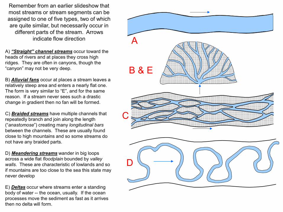
Remember from an earlier slideshow that most streams or stream segments can be assigned to one of five types, two of which are quite similar, but necessarily occur in
different parts of the stream. Arrows indicate flow direction
A) “Straight” channel streams occur toward the heads of rivers and at places they cross high ridges. They are often in canyons, though the “canyon” may not be very deep. B) Alluvial fans occur at places a stream leaves a relatively steep area and enters a nearly flat one. The form is very similar to “E”, and for the same reason. If a stream never sees such a drastic change in gradient then no fan will be formed. C) Braided streams have multiple channels that repeatedly branch and join along the length (“anastomose”) creating many longitudinal bars between the channels. These are usually found close to high mountains and so some streams do not have any braided parts. D) Meandering streams wander in big loops across a wide flat floodplain bounded by valley walls. These are characteristic of lowlands and so if mountains are too close to the sea this state may never develop E) Deltas occur where streams enter a standing body of water -- the ocean, usually. If the ocean processes move the sediment as fast as it arrives then no delta will form.
A
B & E
C
D

1. Straight-Valley Streams

Some streams are what we might call “straight” streams. The valleys are not literally straight for their entire length, but do not bend in any consistent, repetitive way like some of the ones we will discuss later. Straight streams have a couple of other interesting characteristics. They are confined to a single channel (mostly) and their valley walls and banks are the same thing. In other words they are in steep-walled canyons or gorges, like the Gunnison or the Colorado in the Grand Canyon of Arizona.
Gunnison River, CO
Grand Canyon of the Colorado River, AZ

6000’ at the river
8000’ on the plateau
Topographic map of the Black Canyon of the Gunnison in southwestern Colorado.
Very steep 2000’ valley walls.
Original map from USGS. This image from Delorme mapping software.
No Flood Plain

The canyons or gorges of straight streams do not need to be thousands of feet deep. The critical feature is that the valley walls slope steeply downward right to the edge of the water. In other
words, there is no flood plain. The banks and the valley walls are the same thing.
This description fits the upstream ends of all streams, even those that begin and end entirely in lowland areas. The Muckalee meanders and has a nice wide floodplain at Americus (right-hand
map), but at its head in Marion County (the next county northwest of Americus) it is in a small “gorge” a few feet deep, and has no floodplain at all (left-hand map).
Only in regions of high elevation can the straight channel form continue far downstream and create
huge canyons, but it is present on a small scale in every valley.
Images from USGS Tazewell South, GA (left) and Americus, GA (right) 7.5’ topographic maps

Streams of this type are purely erosional. The available energy far exceeds what is required to move the sediment supplied to
the stream (E>L), except for the exceptionally large boulders in the beds.
The stream responds by active
downcutting erosion that creates and deepens the canyon until it reaches grade.
The sediment created by this erosion is moved farther downstream by the highly
energetic flowing water.

2 – Alluvial Fans

The second type of stream pattern we will consider can actually appear in two different settings along a stream, but may not appear in either one. That is, not all streams have
this type of channel (unlike a straight-channel pattern).
Ordinarily we think of streams gathering smaller streams into themselves as they flow along their courses. The smaller streams that join the main stream (and add to its flow)
are called its tributaries.
But under certain conditions this pattern can be reversed, the stream will split into multiple smaller channels flowing away from each other. These smaller channels are
called distributaries because they are the opposite of tributaries and because they distribute the flow over a wider area.
Typically in upstream settings the distributaries eventually find their way back together to
re-form the stream in a single valley, flowing in one specific direction, but for at least a small stretch the stream’s flow will “fan out” over a broad area, and we call the result an alluvial fan. “Alluvial” is an adjective meaning, “associated with rivers”. “Alluvium” is a
noun meaning, “river sediment”.
When the distributary pattern occurs at the mouth of a stream, of course, the stream cannot re-form farther along because it does not exist farther along. The distributaries
are part of the river’s delta. We will consider deltas separately, later in this presentation.

From USGS Badwater, CA 7.5’ topo map.
A fan form where a stream leaves a straight valley in a region of high relief and flows onto a relatively flat surface. Here a small intermittent stream flows westward out of the Black Mountains in southeastern California and onto a flat valley floor. This is desert terrain, so there is rarely much flow. Notice that even when it does flow the stream often does not make it all the way across the fan (unless it has received a lot of rainfall upstream). As will be obvious in the next couple of slides, this is because the fan is made of very poorly sorted sand and gravel and the water soaks into it very easily. It is a losing stream in other words.

View in next slide
Imag
e fro
m G
oogl
e M
aps.
This is the same fan on a satellite image. The multiple distributary channels are very obvious in this image, radiating away from the mouth of the canyon upstream.

The coarse, very poorly sorted nature of the fan deposits are very clear in this photograph. If you look carefully you can also see some of the small distributary channels.
Image from Google Maps street view.

If we zoom out from the previous view and look at more of the valley that the fan is building into we see
many fans on both sides of the valley.
The continuous apron of sediment
along the foot of the mountains, created by coalescence of alluvial
fans, is called a bajada.
The bright white regions west of Badwater and in the northern part
of the valley are evaporite deposits in lakes that accumulate what little water comes off (and through) the fans and there evaporates in the desert climate. These are called playa lakes and they are common in the closed depressions in this
part of the world. Image from Google Maps.

Photo by Eirick Jansson Haverstad, from Google Maps Photo Sphere
This is a close-up view of the salts in the playa with a side view of the Badwater Alluvial Fan in the background. The odd offset near the toe of the fan is a stitching error in the panorama. The Fan doesn’t
really have a vertical offset on it like that.

Alluvial fans are depositional features that form in exactly one setting: where a stream leaves a canyon and flows out onto a relatively flat lowland. In this case the sediment generated by erosion in the canyon gives the stream a huge load when it arrives at the reduced gradient on the flatland. The lower gradient causes the water to slow and lose energy (L>E). Consequently it drops the coarsest part of the load to bring the balance back between energy and load (E=L). The fan modifies the gradient by aggradation, making the flatland a little steeper just at the mouth of the canyon, and helping to create the equilibrium profile.
FLAT BASIN FLOOR WITH EVAPORITES
(spaced contours)
STEEP MOUNTAINS WITH CANYONS
(Packed contours that V sharply in valleys)
FAN PRODUCES AN INTERMEDIATE GRADIENT
(the base of this one is eroded steeper than is usual)

3 – Braided Streams

A third type of stream is called braided because there are multiple channels that branch and rejoin like hair tresses braided together. Another word for this pattern is “anastomosing”. These are not the same as fans because the channels do not diverge into the fan-like shape of distributaries. They rejoin very quickly and the flow is constrained to a narrow valley with no obvious floodplain. The small stream in the bottom of Providence Canyon (near Lumpkin, GA) is a great example. In the photograph, the stream flows toward the viewer and the multiple branchings and junctions are very obvious.
Providence Canyon, GA

Longitudinal Bar
Longitudinal Bar Longitudinal Bar
Providence Canyon, GA

Braided streams have no true floodplain as we’ll see in the next type of stream, but when a flood comes the entire channel system fills to create only one channel. Most sediment movement occurs at this time. As the water level recedes new braided channels form. As it recedes further these are abandoned and yet more form, and so on …
A closer look at one of the longitudinal bars from the previous slide clearly reveals the earlier channels, above the present water level, on the surface of that bar. These presently carry no water. Providence Canyon, GA
Providence Canyon, GA

South Platte River near Ovid, CO. Image from Google Earth.
Braided streams are not common in the eastern United States, but the large rivers that cross the Great Plains from the Rocky Mountains are mostly braided. It was said by the first settlers to see the South Platte that it was “a mile wide and a foot deep”, and also “too thin to plow and too thick to drink”. We will return to this issue of sediment in braided streams (and the other types of streams) later.

Here is what part of the South Platte looks like from a bridge west of Ovid. The arrows indicate “large” channels of the river.
Image from Google Earth Street View
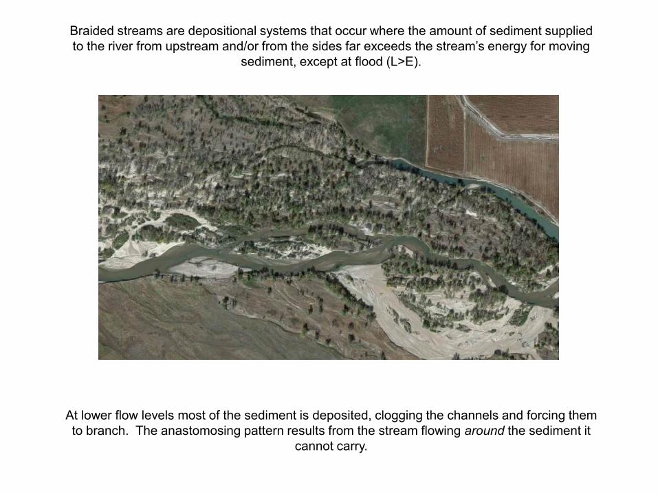
Braided streams are depositional systems that occur where the amount of sediment supplied to the river from upstream and/or from the sides far exceeds the stream’s energy for moving
sediment, except at flood (L>E).
At lower flow levels most of the sediment is deposited, clogging the channels and forcing them to branch. The anastomosing pattern results from the stream flowing around the sediment it
cannot carry.

4 – Meandering Streams

The house my great-great grandfather built
The Alapaha River (which flows past my father’s family’s farm in Echols County, GA) is a typical meandering stream. Notice that there is a single channel (blue dashed line) that winds and loops back and forth across a broad floodplain (approximate limits shown by red lines).
Image from USGS Terraserver

The Meander (Maeandros (Greek) Menderes (Turkish)) River in Turkey is the source of the name of this type of stream, and, incidentally, the source of the word we use for “following a
winding or indirect path”. It is shown here just below its outfall from Lake Isikli in west-central Turkey. The cultivated land of its floodplain stands in obvious contrast to the uncultivated
upland to the southeast.
Floodplain
Floodplain Upland
Image from Google Earth

Original map from USGS. This image from Delorme mapping software.
The Flint River near Americus, GA. The main channel (black dashed line) is the Sumter/Dooly County line. Ignore the arrows and sloughs for now – we will get back to them.

Meandering streams are the most interesting energetically because they clearly both erode sediment (on their cutbanks) and deposit it (on their pointbars). Are they erosional? Depositional?
Actually, on balance they are erosional (E>L). They occur in lowlands where there is either a small sediment supply to begin with, or where a longer river system has dropped much of its sediment
load farther upstream, either in fans or in braided streams, or in both.
At low elevations like this, streams do not have the option of downcutting and so the erosion they accomplish is mostly lateral – eroding their own banks and occasionally eroding the valley walls as
well.
Thus the stream uses a little of its excess energy eroding and transporting the same sediment over and over – pick it up on this cutbank and drop it off on the next pointbar, to be picked up again by
another meander in the distant future.
Meandering has another effect on the energy load balance. If a straight stream drops 10’ in one mile it has a 10ft/mi gradient. But meanders make the stream longer so rather than dropping 10’ in
one mile it drops the same 10’ in 1.5 or two miles, giving it a lower gradient. The lower gradient slows it down and reduces its energy! Both of these processes – erosion/transport and channel
lengthening – allow the stream to bring E=L.
The next slideshow specifically treats meandering streams and their behavior, but we need to understand them here and now a little in the context of their overall form.

5 – Deltas

Nile Delta
Nile
Egypt
Saudi Arabia
Israel
Persian Gulf Red Sea
Mediterranean Sea
Rosetta Mouth
Damietta Mouth
As with “meander” the word “delta” comes to us from Greek, and signifies the general shape of the
Nile Delta – triangular like the Greek letter.
Like alluvial fans, deltas
are characterized by distributary channels
spreading from a single channel. Before much of
the Nile’s water was extracted and used for
irrigation there were many more active distributaries. Now even the Damietta sees little flow, and most goes through the Rosetta
mouth.
Image courtesy of NASA

Deltas form any time a stream reaches a standing body of water. It does not have to be the ocean. The Chattahoochee River has created a classic delta where it enters Lake Seminole. The delta will eventually fill the lake entirely with delta sediment. Man-made reservoirs like this have a life expectancy when they are built.

At its mouth, a stream loses all of its energy. If it joins another stream then the energy of that larger stream will, of course, continue to move the sediment. If the stream ends at the Ocean (like the Nile) or in another standing body of water (like the Flint) then all the stream energy is quickly damped and goes to zero. The stream has no gradient, no velocity, and therefore no energy. If there is any sediment load at all at this point then it will be more than the stream can handle and will be deposited as a delta, unless marine processes take over and move the sediment away from the river’s mouth. (In which case it is no longer river sediment.)

SUMMARY
Some streams or stream segments result from net erosion because E>L. In fact, any time E>L is threatened, the stream must erode. • If the erosion is primarily downcutting or headward erosion then the stream will be a more or less straight channel and will be in a “canyon”, even if that “canyon” is not very deep. • If the erosion is lateral, at the banks or valley wall, then the stream will be a meandering stream. Other streams or stream segments result from net deposition because L>E. In fact, any time L>E is threatened the stream will drop part of its load. • This happens when a stream reaches a relatively flat place, making an alluvial fan. • It also happens when a stream leaves a region of high sediment production and its gradient declines, as downstream of an alluvial fan, for example. This type of stream is a braided stream. •If a stream ends at a standing body of water – a lake or the ocean – any remaining load will be deposited as a delta.