ulocate: a ubiquitous location tracking system for … · ulocate: a ubiquitous location tracking...
TRANSCRIPT
uLocate: A Ubiquitous Location Tracking System for People Aging with Disabilities
Ke-Yu Chen1, Mark Harniss2, Justin Haowei Lim1, Youngjun Han1, Kurt L. Johnson2, Shwetak N. Patel1
1Electrical Engineering University of Washington
Seattle, WA {kychen, limju22, hyj5320, shwetak}@uw.edu
2Rehabilitation Medicine University of Washington
Seattle, WA {mharniss, kjohnson}@uw.edu
ABSTRACT Researchers have developed different kinds of location technologies for observing daily activities. However, to date, there are very few systems that are able to ubiquitously monitor an individual’s location, especially for people aging with disabilities. In this study, we developed a location tracking system, uLocate, capable of both indoor and outdoor tracking. The system was evaluated in real homes and tested by 11 participants aging with different types of disabilities. Based on our evaluations, we believe uLocate and the findings of this case study will benefit designers and rehabilitation researchers who require location-based tracking technologies for health-related studies.
Keywords Location; tracking; indoor; outdoor; disability; wearable
1. INTRODUCTION Location technologies have been a central focus of ubiquitous computing. Location tracking systems can be a means of collecting data used to infer additional pieces of context, such as people’s behaviors and activities. For rehabilitation researchers, such a system can potentially replace the “diary” system, which requires intensive overhead for both the participants and researchers to process.
Different location technologies generally trade off accuracy for coverage and cost. The accuracy could range from 1 mm used in human body sensing (Ascension Technology [1]) to tens of kilometers using ambient FM radio signals [9][10][12][14]. Other systems that exploited Bluetooth [11] and Ultrasonic [7], and commercial products [4][5][13] are successful and useful under different circumstances. One needs to choose the appropriate system that fulfills the accuracy requirement of the particular location-aware application of interest. Therefore, it would be difficult to track a subject’s indoor and outdoor activities using one single system due to their different natural characteristics.
Tracking a subject both indoors and outdoors using a single device can be crucial in some situation. For example, people with limited mobility may want to know the territory of their daily life and extend it for social purposes or health improvement. Gathering this information usually requires relatively high accuracy for indoor tracking so as to know their in-home activities, such as how long the subjects stay in
the same place for some health issues (e.g., trying to avoid watching TV for hours). Furthermore, these individuals may not be able to manage multiple sensors due to their limited physical function. Therefore, a single, compact and easy-to-carry location sensing device is significant for them. This single device needs to provide indoor location tracking with room-level accuracy and relatively lower accuracy outdoor location tracking abilities with wider coverage.
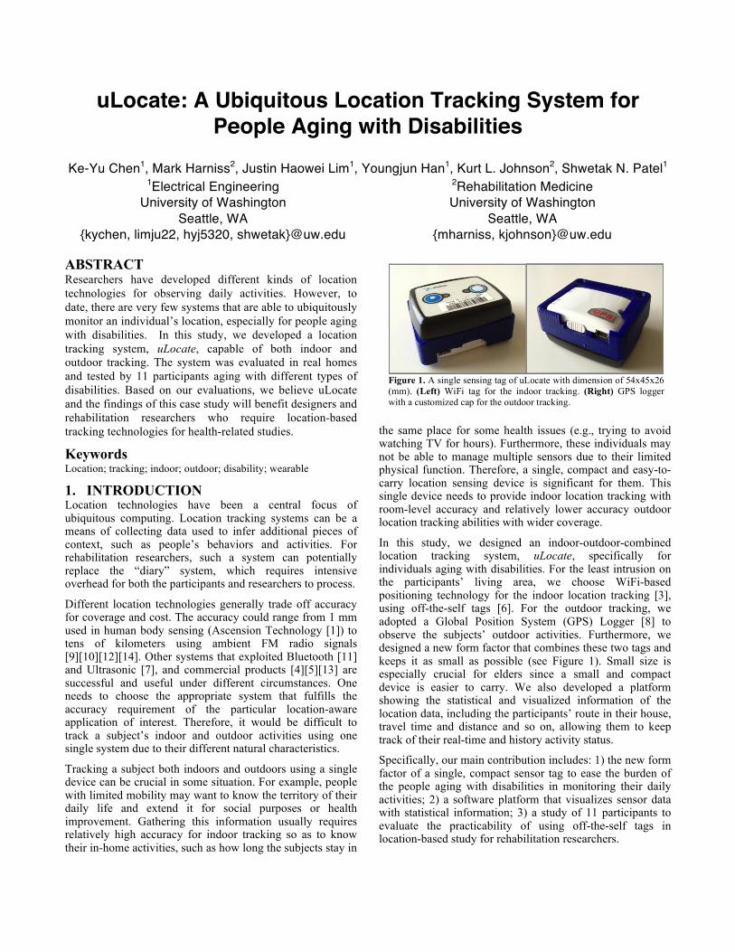
In this study, we designed an indoor-outdoor-combined location tracking system, uLocate, specifically for individuals aging with disabilities. For the least intrusion on the participants’ living area, we choose WiFi-based positioning technology for the indoor location tracking [3], using off-the-self tags [6]. For the outdoor tracking, we adopted a Global Position System (GPS) Logger [8] to observe the subjects’ outdoor activities. Furthermore, we designed a new form factor that combines these two tags and keeps it as small as possible (see Figure 1). Small size is especially crucial for elders since a small and compact device is easier to carry. We also developed a platform showing the statistical and visualized information of the location data, including the participants’ route in their house, travel time and distance and so on, allowing them to keep track of their real-time and history activity status.
Specifically, our main contribution includes: 1) the new form factor of a single, compact sensor tag to ease the burden of the people aging with disabilities in monitoring their daily activities; 2) a software platform that visualizes sensor data with statistical information; 3) a study of 11 participants to evaluate the practicability of using off-the-self tags in location-based study for rehabilitation researchers.
Figure 1. A single sensing tag of uLocate with dimension of 54x45x26 (mm). (Left) WiFi tag for the indoor tracking. (Right) GPS logger with a customized cap for the outdoor tracking.

Figure 2. System Architecture of uLocate. The indoor subsystem exploited existing WiFi network for location tracking. When the subject moves outdoors, the system adapts to keep track of the subject by GPS.
Dimension(mm) 45 x 55 x 19 Weight 48 g with batteries Communication 802.11b/g/n Security WEP Encryption 40/104 Bit
WPA2-PSK Transmit Power +11.5 dBm@2Mbps Receiver Sensitivity -82 dBm@11Mbps Frequency Ranges 2.400 - 2.4835 GHz (USA, Europe)
Table 1. Ekahau T301A Specification
Figure 3. uLocate Software Platform. (Left): Indoor location tracking, showing the route and profile of the subject. (Right): Outdoor tracking, including an interactive map, the trip route, time and distance.
2. SYSTEM DESIGN In this section, we describe the system architecture, hardware/software design and how this prototype can support rehabilitation researchers.
2.1 System Overview Figure 2 shows the system architecture of uLocate. For the indoor positioning, we adopted the location system manufactured by Ekahau [5]. We deployed wireless routers in the participant’s’ houses for location tracking. The tag searched nearby routers and sent the collected RSSI to the location server for locating and reasoning the position. The server was disconnected from the Internet to protect the privacy of the participants. For outdoor location tracking, we used a GPS logger due to its low cost and wide coverage.
2.2 Tag Design The sensing tag includes two parts, a WiFi tag (Ekahau T310) [6] for indoor tracking and the GPS logger (i-Blue 860E) [8] for outdoor tracking. Table 1 and 2 listed the specifications of these two tags. In order to ease the burden of our participants, we removed part of the T301A tag and designed a new cap to integrate it with the GPS logger (see Figure 1). The integrated tag is small, compact and easy-to-use for individuals aging with disabilities.
2.3 uLocate Software Platform In addition to the hardware design, we developed a platform for rehabilitation researchers and our participants to review the visualized and statistical information of the location data. Figure 3 (left) shows the visualized information of the indoor tracking data. The system extracted the raw data (i.e., location positions) from the server database through Ekahau APIs and presented them as meaningful information. Specifically, the users can specify the period of interest and explore the route of the indoor activities and total time spent in different rooms during this period. For the outdoor activities, as show in Figure 3 (right), the platform showed
the routes, distance of each route and total travel time. We embedded Google Earth into our platform and provided an interactive map view for users to easily view the route from different angles or check their position at any given time. The reason for using Google Earth instead of Google Maps is that most of our participants did not have an Internet connection from home, which is necessary for Google Maps, while Google Earth can run offline.
We believed providing visualized information could aid not only the rehabilitation researchers but also the participants to better understand their daily activities and even find out potential environmental barriers in a public space or at home. For example, if a wheelchair user tends to choose a specific but farther path toward the market, it may imply insufficient public facilities for people with disabilities at some spots. The demo of uLocate software platform can be accessed at: http://www.youtube.com/watch?v=I9g7B_LEUPc&hd=1.
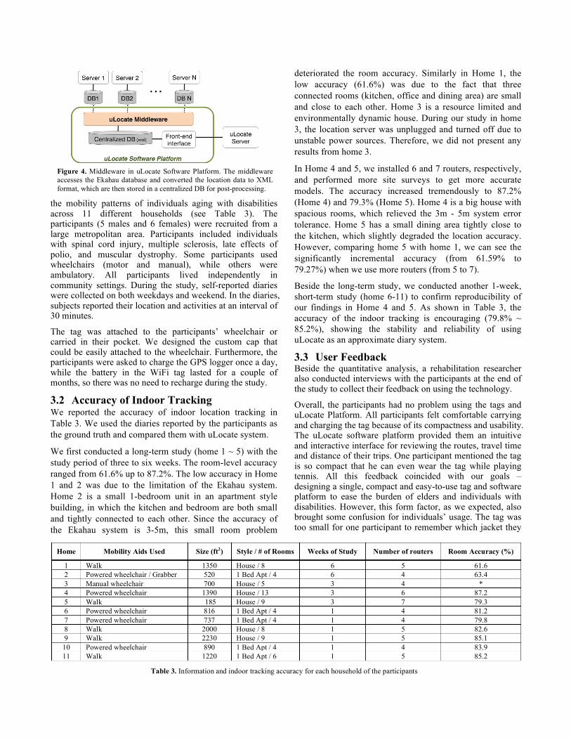
2.4 Middleware As we described, the uLocate software platform utilized Ekahau APIs to provide a handy channel for participants to review their daily activities. However, Ekahau APIs do not support simultaneous access to multiple location servers. It is a significant feature for rehabilitation researchers to post-process or compare the data among multiple subjects. In order to overcome this limitation, we developed a middleware in uLocate software platform (see Figure 4). The middleware accessed the Ekahau database and converted the location data into customized XML format. All converted data were collected by the researchers and stored in a centralized DB for post-processing.
3. STUDY DETAILS AND RESULTS In this section, we describe the user study, evaluation and results.
3.1 Participants The evaluation involved rehabilitation researchers studying
Dimension(mm) 32 x 46 x 14.7 Weight 22g Channel 66 for tracking Start time Cold start: 35 sec, hot start: 1.5 sec Storage 4MB (up to 125,000 way points) Protocols NMEA-0183, GGA, GSA, GSV Battery Charging time: 1.5 hours
Operation time: 11 hours Table 2. iBlue 860E Specification
Home Mobility Aids Used Size (ft2) Style / # of Rooms Weeks of Study Number of routers Room Accuracy (%)
1 Walk 1350 House / 8 6 5 61.6 2 Powered wheelchair / Grabber 520 1 Bed Apt / 4 6 4 63.4 3 Manual wheelchair 700 House / 5 3 4 * 4 Powered wheelchair 1390 House / 13 3 6 87.2 5 Walk 185 House / 9 3 7 79.3 6 Powered wheelchair 816 1 Bed Apt / 4 1 4 81.2 7 Powered wheelchair 737 1 Bed Apt / 4 1 4 79.8 8 Walk 2000 House / 8 1 5 82.6 9 Walk 2230 House / 9 1 5 85.1 10 Powered wheelchair 890 1 Bed Apt / 4 1 4 83.9 11 Walk 1220 1 Bed Apt / 6 1 5 85.2
Table 3. Information and indoor tracking accuracy for each household of the participants
Figure 4. Middleware in uLocate Software Platform. The middleware accesses the Ekahau database and converted the location data to XML format, which are then stored in a centralized DB for post-processing.
the mobility patterns of individuals aging with disabilities across 11 different households (see Table 3). The participants (5 males and 6 females) were recruited from a large metropolitan area. Participants included individuals with spinal cord injury, multiple sclerosis, late effects of polio, and muscular dystrophy. Some participants used wheelchairs (motor and manual), while others were ambulatory. All participants lived independently in community settings. During the study, self-reported diaries were collected on both weekdays and weekend. In the diaries, subjects reported their location and activities at an interval of 30 minutes.
The tag was attached to the participants’ wheelchair or carried in their pocket. We designed the custom cap that could be easily attached to the wheelchair. Furthermore, the participants were asked to charge the GPS logger once a day, while the battery in the WiFi tag lasted for a couple of months, so there was no need to recharge during the study.
3.2 Accuracy of Indoor Tracking We reported the accuracy of indoor location tracking in Table 3. We used the diaries reported by the participants as the ground truth and compared them with uLocate system.
We first conducted a long-term study (home 1 ~ 5) with the study period of three to six weeks. The room-level accuracy ranged from 61.6% up to 87.2%. The low accuracy in Home 1 and 2 was due to the limitation of the Ekahau system. Home 2 is a small 1-bedroom unit in an apartment style building, in which the kitchen and bedroom are both small and tightly connected to each other. Since the accuracy of the Ekahau system is 3-5m, this small room problem
deteriorated the room accuracy. Similarly in Home 1, the low accuracy (61.6%) was due to the fact that three connected rooms (kitchen, office and dining area) are small and close to each other. Home 3 is a resource limited and environmentally dynamic house. During our study in home 3, the location server was unplugged and turned off due to unstable power sources. Therefore, we did not present any results from home 3.
In Home 4 and 5, we installed 6 and 7 routers, respectively, and performed more site surveys to get more accurate models. The accuracy increased tremendously to 87.2% (Home 4) and 79.3% (Home 5). Home 4 is a big house with spacious rooms, which relieved the 3m - 5m system error tolerance. Home 5 has a small dining area tightly close to the kitchen, which slightly degraded the location accuracy. However, comparing home 5 with home 1, we can see the significantly incremental accuracy (from 61.59% to 79.27%) when we use more routers (from 5 to 7).
Beside the long-term study, we conducted another 1-week, short-term study (home 6-11) to confirm reproducibility of our findings in Home 4 and 5. As shown in Table 3, the accuracy of the indoor tracking is encouraging (79.8% ~ 85.2%), showing the stability and reliability of using uLocate as an approximate diary system.
3.3 User Feedback Beside the quantitative analysis, a rehabilitation researcher also conducted interviews with the participants at the end of the study to collect their feedback on using the technology.
Overall, the participants had no problem using the tags and uLocate Platform. All participants felt comfortable carrying and charging the tag because of its compactness and usability. The uLocate software platform provided them an intuitive and interactive interface for reviewing the routes, travel time and distance of their trips. One participant mentioned the tag is so compact that he can even wear the tag while playing tennis. All this feedback coincided with our goals – designing a single, compact and easy-to-use tag and software platform to ease the burden of elders and individuals with disabilities. However, this form factor, as we expected, also brought some confusion for individuals’ usage. The tag was too small for one participant to remember which jacket they

put it in. Furthermore, sometimes the visualization map was not clear for the participants. This is because Google Earth can only display low-resolution maps when running off line. This could be overcome when the Internet is accessible in a future study.
Traditionally in rehabilitation studies, participants are required to keep logs of their daily activities manually (called “diary”), which are collected by the researchers for post processing. uLocate acts as an automatic logging system, avoiding the tedious diary-collecting process. Furthermore, this system also enables researchers to access information that cannot be observed directly from the paper-based diaries such as time-line movement on the map and statistical data like total travel time and distance.
4. DISCUSSION AND FUTURE WORK To further improve the location accuracy, we used one more tag, Actigraph GT3M [1], in home 6 ~ 11. Our assumption was based upon the fact that participants would perform different activities at different locations. By observing the accelerometer data, the system could approximately identify the subject’s activity level and therefore localize the tag. For the data analysis, we applied some signal processing and machine learning techniques. Specifically, we choose both time- and frequency-domain data (i.e., FFT size 4096, sampled at 100K) as features and trained a SVM (Support Vector Machine) classifier in WEKA Toolkit. The results, however, were not encouraging; we could not observe any significant relations between the Actigraph data and the participant’s locations.
The low classification rate was caused by the hardware limitations and low resolution of the ground truth. First, the tag contains a flash of 4MB, which can only store up to 17 min of raw data at its highest sampling rate (i.e., 30 Hz). Therefore, to accommodate the accelerometer data for a one-week study, the tag can operate at a sampling rate of 1 Hz. At this low resolution, the data became less useful in identify the relationship between participants movement and their location. Furthermore, the ground truth (i.e., the self-reported diaries) was logged at an interval of 30 minutes. During each 30-min period, the user might move between various rooms with different activities, which may not be reported in the diaries. Since the Actigraph logged finer-grained accelerometer data, it therefore requires ground truth with higher resolution (e.g., every 1 minute).
In the future, we plan to apply more ubiquitous technologies to this system and improve the location accuracy, such as adding an automatic turn-on-and-off mechanism for the GPS logger to avoid the daily charging and showing more meaning context and behavioral analysis related to the location data.
5. CONCLUSION In this paper, we demonstrated the usability of an indoor-outdoor-combined location tracking system, uLocate, in the
context of being used by our participants and rehabilitation researchers to study the mobility patterns of individuals aging with disabilities. Based on the evaluation of this system, we have confirmed that the tag is compact and easy-to-carry, which is significant to ease the burden for the elder or individuals aging with disabilities. The uLocate software platform provides a friendly interface and useful visualized information for both the participants and researchers. Such a system can potentially be used as an automatic logging system to avoid traditional, tedious diaries in rehabilitation research.
6. ACKNOWLEDGE Research and development described in this article was conducted with support from the National Institute on Disability and Rehabilitation Research (NIDRR grant number H133B080024).
7. REFERENCE [1] Actigraph: http://www.actigraphcorp.com/ [2] Ascension Technology: http://www.ascension-tech.com/ [3] P. Castro, P. Chiu, T. Kremenek, and R.R. Muntz, “A
Probabilistic Room Location Service for Wireless Networked Environments,” In: G.D. Abowd, B. Brumit, and S. Shafer, UbiComp2001. LNCS, vol. 2201, pp. 18-34. Springer, Heidelberg (2001)
[4] Cricket Series Mote. Crossbow Technologies, Inc. (2011), http://www.xbow.com
[5] Ekahau (2013), http://www.ekahau.com [6] Ekahau T301A tag: http://www.ekahau.com/products/wi-fi-
tags.html [7] M. Hazas and A. Ward, “A Novel Broadband Ultrasonic
Location System,” In: G. Borriello, L.E. Holmquist, UbiComp 2002. LNCS, vol. 2498, pp. 264–280. Springer, Heidelberg (2002)
[8] i-Blue 860E: http://www.semsons.com/i86kegpsdare.html [9] J. Krumm, G. Cermak, E. Horvitz, “RightSPOT: A Novel
Sense of Location for a Smart Personal Object,” In: A.K. Dey, A. Schmidt, and J.F. McCarthy, UbiComp 2003. LNCS, vol. 2864, pp. 36–43. Springer, Heidelberg (2003)
[10] LaMarca, A., Chawathe, Y., Consolvo, S., Hightower, J., Smith, I., Scott, I., Sohn, T., Howard, J., Hughes, J., Potter, F., Tabert, J., Powledge, R., Borriello, G., Schilit, B., “Place Lab: Device Positioning Using Radio Beacons in the Wild.” In: Gellersen, H.-W., Want, R., Schmidt, A., PERVASIVE 2005. LNCS, vol. 3468, pp. 116–133. Springer, Heidelberg (2005)
[11] A. Madhavapeddy and T. Tse, “Study of Bluetooth Propagation Using Accurate Indoor Location Mapping,” In: M. Beigl, S.S. Intille, J. Rekimoto, and H. Tokuda, UbiComp 2005. LNCS, vol. 3660, pp. 105–122. Springer, Heidelberg (2005)
[12] V. Otsason, A. Varshavsky, A. LaMarca, and E. de Lara, “Accurate GSM Indoor Localization,” In: M. Beigl, S.S. Intille, J. Rekimoto, and H. Tokuda (eds.) UbiComp 2005. LNCS, vol. 3660, pp. 141–158. Springer, Heidelberg (2005)
[13] Vicon (2013), http://www.vicon.com/products/system.html [14] A. Youssef, J. Krumm, E. Miller, G. Cermak, and E. Horvitz,
“ Computing location from ambient FM radio signals,” Wireless Communications and Networking Conference, 2005 IEEE, pp. 824 - 829 Vol. 2