unified stream methodology - virginia deq · unified stream methodology final draft for...
TRANSCRIPT

UNIFIED STREAM METHODOLOGY for use in Virginia
U.S. Army Corps of Engineers, Norfolk District Virginia Department of Environmental Quality
January 2007
Table of Contents Acronyms, Equations, Examples, Figures, Forms, Tables.……………….………i
Introduction 1
Organization of USM 2 1.0 Stream Impact Site Assessment 4 1.1 Channel Condition Parameter 4
1.1.1 Channel Condition Categories 4 1.1.2 Channel Condition Photographs 8 1.2 Riparian Buffer Parameter 8 1.2.1 Riparian Buffer Categories 10 1.2.2 Riparian Buffer Photographs 10 1.3 In-Stream Habitat Parameter 10 1.3.1 In-Stream Habitat Categories 12 1.3.2 In-Stream Habitat Photographs 12 1.4 Channel Alteration Parameter 12 1.4.1 Channel Alteration Categories 13 1.4.2 Channel Alteration Photographs 13
1.5 Reach Condition Index (RCI) 14
2.0 Stream Impact Factor Assessment 14 2.1 Impact Factor Photographs 16 3.0 Determining Stream Compensation Requirements 16 4.0 Precompensation Evaluation and Stream Conceptual Mitigation Plan 16 4.1 Conceptual Compensatory Mitigation Plan 17 5.0 Determining Compensation Crediting 18 5.1 Restoration 20
5.1.1 Restoration Photographs 21 5.2 Enhancement 21 5.2.1 Enhancement Photographs 23 5.3 Riparian Areas 23 5.3.1 Riparian Areas Photographs 26 5.4 Adjustment Factors 26
6.0 Evaluating Compensation Credit 27 Appendix A Stream Assessment Forms Form 1 Stream Assessment Form Form 2 Stream Assessment Summary Form Appendix B Compensation Crediting Forms Form 3 Compensation Crediting Form Form 4 Compensation Summary Form Appendix C Definitions I Appendix D Useful Internet Links/References
i
Acronyms AF Adjustment Factor CC Compensation Credit CI Condition Index COE United States Army Corps of Engineers CR Compensation Requirement DEQ Virginia Department of Environmental Quality IF Impact Factor LB Left Bank LI Length of Impact Reach RB Right Bank RCI Reach Condition Index SAR Stream Assessment Reach USM Unified Stream Methodology
Equations Equation 1 Riparian Condition Index 8 Equation 2 Reach Condition Index 14 Equation 3 Compensation Requirement 16 Equation 4 Enhancement Credit 23 Equation 5 Total Compensation Credit 27
Examples Example 1 Riparian Assessment Example 9 Example 2 Riparian Crediting Example 25
Figures Figure 1 Channel Evolution relationship with USM Channel Condition……………..5
Forms Form 1 Stream Assessment Form Appendix A Form 2 Stream Assessment Summary Form Appendix A Form 3 Compensation Crediting Form Appendix B Form 4 Compensation Summary Form Appendix B
Tables Table 1 Impact Factor Table 15
Unified Stream Methodology Final Draft for Implementation Page 1 of 27
Introduction The Unified Stream Methodology (USM) is a collaborative effort between the U.S. Army Corps of Engineers, Norfolk District (COE) and the Virginia Department of Environmental Quality (DEQ). The purpose of this Manual is to describe a method to rapidly assess what the stream compensation requirements would be for permitted stream impacts and the amount of “credits” obtainable through implementation of various stream compensation practices. The Manual describes a process to: 1) assign a Reach Condition Index (RCI) to the stream to be impacted; 2) assess the type or severity of impact; 3) determine the compensation requirement; and, 4) determine what types of and the amount of the various compensation practices that will satisfy the compensation requirement. This manual may be used for projects requiring stream compensation under the COE regulatory program and the DEQ’s Virginia Water Protection Permit Program (VWPP). This Manual and USM forms can be found on the COE and DEQ webpages US Army Corps of Engineers - Norfolk District and Virginia DEQ - Wetlands.
This method is not intended to take the place of project specific review and discussion, which may result in adjustments to the compensation requirements or credits obtained through application of this process. This method can be applied to stream compensation projects performed on-site, off-site, for a stream mitigation bank, or for an in-lieu fee fund project, thereby, ensuring a standard application for evaluating and crediting all stream compensation projects. This Manual is to be used in wadeable intermittent or perennial streams statewide. The following circumstances require special consideration:
Concrete, Gabion-lined or Riprap Channels
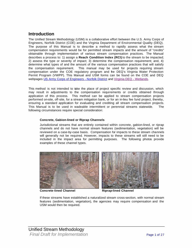
Jurisdictional streams that are entirely contained within concrete, gabion-lined, or riprap channels and do not have normal stream features (sedimentation, vegetation) will be reviewed on a case-by-case basis. Compensation for impacts to these stream channels will generally not be required. However, impacts to these streams will still need to be included in the impact area for permitting purposes. The following photos provide examples of these channel types.
Concrete-lined Channel Riprap-lined Channel
If these streams have established a naturalized stream cross-section, with normal stream features (sedimentation, vegetation), the agencies may require compensation and the USM would then be required.
Unified Stream Methodology Final Draft for Implementation Page 2 of 27
Relocated Stream Channels
Streams that will be relocated using the principles of natural channel design may be considered self-mitigating in most cases, eliminating the need to apply the USM. The relocated stream must be designed and constructed to mimic the functions and values of the impacted stream, at a minimum. All relocated streams must be stable. However, if the relocated stream results in a reduced stream length or function, compensation may be required for the difference between pre- and post-construction stream length/function. Jurisdictional Ephemeral Streams
“Ephemeral Streams” are defined as streams that have flowing water only during and for a short duration after, precipitation events in a typical year. Ephemeral streambeds are located above the groundwater table year-round. Groundwater is not a source of water for the stream. Rainfall runoff is the primary water source for these streams. Jurisdictional ephemeral streams have the presence of an ordinary high watermark.
Ephemeral streams will be reviewed on a case-by-case basis. In the event that compensation is required for impacts to ephemeral streams, the RCI is determined by evaluating only the Riparian Buffer Parameter (Section 1.2 and Form 1). The Condition Index (CI) calculated from this evaluation is then divided by two (2) to obtain the RCI. Proceed to Section 2.0 of this Manual
Organization of USM This Manual is divided into six sections, summarized below. The sections represent the basic types of analyses that are performed, including assessing existing conditions, characterizing proposed impacts, determining compensation requirements, evaluating precompensation conditions, determining compensation credit, and evaluating total compensation credit. Section 1 - Stream Impact Site Assessment describes a method to rapidly assess and assign a Reach Condition Index (RCI) to a stream reach proposed for impact. Section 2 - Stream Impact Factor Assessment presents a procedure for characterizing proposed impacts to a stream. Section 3 - Determining Stream Compensation Requirements explains the method for calculating the compensation required for stream impacts. The factors used in this calculation are the stream assessment RCI (Section 1), the type of Impact Factor (IF) (Section 2), and the linear feet of impact. Section 4 – Precompensation Evaluation provides information in evaluating the precompensation stream reach and outlines the components of the conceptual compensation plan. Section 5 - Determining Compensation Credit explains the various methods by which stream impacts may be compensated and the process for determining credit provided by stream compensation proposals. Section 6 – Evaluating Total Compensation Credit explains the method for calculating the linear feet of credit obtained after review of stream compensation plans. The factors used in this calculation are the activities credit (Section 5), linear footage of the compensation stream, and any applicable adjustment factors (Section 5).
Unified Stream Methodology Final Draft for Implementation Page 3 of 27
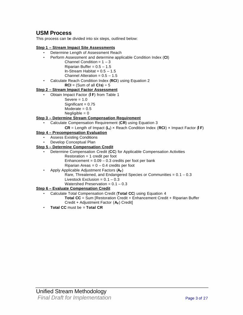
USM Process This process can be divided into six steps, outlined below: Step 1 – Stream Impact Site Assessments
• Determine Length of Assessment Reach • Perform Assessment and determine applicable Condition Index (CI)
Channel Condition = 1 – 3 Riparian Buffer = 0.5 – 1.5 In-Stream Habitat = 0.5 – 1.5 Channel Alteration = 0.5 – 1.5
• Calculate Reach Condition Index (RCI) using Equation 2 RCI = (Sum of all CIs) ÷ 5
Step 2 – Stream Impact Factor Assessment • Obtain Impact Factor (IF) from Table 1 Severe = 1.0 Significant = 0.75 Moderate = 0.5 Negligible = 0
Step 3 – Determine Stream Compensation Requirement • Calculate Compensation Requirement (CR) using Equation 3
CR = Length of Impact (LI) × Reach Condition Index (RCI) × Impact Factor (IF) Step 4 – Precompensation Evaluation
• Assess Existing Conditions • Develop Conceptual Plan
Step 5 – Determine Compensation Credit • Determine Compensation Credit (CC) for Applicable Compensation Activities
Restoration = 1 credit per foot Enhancement = 0.09 – 0.3 credits per foot per bank Riparian Areas = 0 – 0.4 credits per foot
• Apply Applicable Adjustment Factors (AF) Rare, Threatened, and Endangered Species or Communities = 0.1 – 0.3 Livestock Exclusion = 0.1 – 0.3 Watershed Preservation = 0.1 – 0.3
Step 6 – Evaluate Compensation Credit • Calculate Total Compensation Credit (Total CC) using Equation 4
Total CC = Sum [Restoration Credit + Enhancement Credit + Riparian Buffer Credit + Adjustment Factor (AF) Credit]
• Total CC must be = Total CR
Unified Stream Methodology Final Draft for Implementation Page 4 of 27
1.0 Stream Impact Site Assessment Impacts are proposed in various qualities of streams. Therefore, it is important to assess the quality of the stream reach being impacted and use that as a factor in determining the Compensation Requirements (CR). There are numerous methodologies that arrive at a numerical index to use as an indicator of stream quality. This assessment is not intended to be a substitute for more detailed stream studies that may be undertaken to determine stream quality, water chemistry, or biological conditions. Stream impact projects may need to be divided into multiple Stream Assessment Reaches (SAR). The length of the SAR is determined by significant changes in one or more of the following four parameters: 1) Channel Condition, 2) Riparian Buffer, 3) In-Stream Habitat, and 4) Channel Alteration. The Stream Assessment Form (Form 1), included in Appendix A, is used to record this information for each reach.
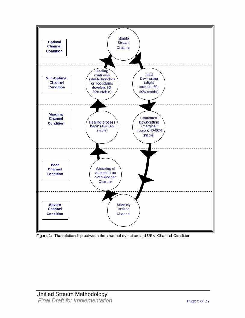
1.1 Channel Condition Parameter Under most circumstances, channels respond to disturbances or changes in flow regime in a sequential, predictable manner. The way a stream responds to changes by degrading to a lower elevation and eventually re-stabilizing at that lower elevation (Figure 1) is the basic premise behind the stream channel evolutionary process. The differing stages of this process can be directly correlated with the current state of stream stability. The purpose of evaluating Channel Condition is to determine the current condition of the channel cross-section, as it relates to this evolutionary process, and to make a correlation to the current state of stream stability. These evolutionary processes apply to the majority of stream systems and assessment reaches due to the fact that the majority of stream systems are degrading, aggrading, healing, or stable. A channel’s condition can be determined by visually assessing certain geomorphological indicators. These indicators include channel incision, access to original or recently created floodplains, channel widening, channel depositional features, rooting depth compared to streambed elevation, streambank vegetative protection, and streambank erosion. Each of the categories describes a particular combination of the state of these geomorphological indicators which generally correspond to a stream channel stability condition at some stage in the evolution process.
1.1.1 Channel Condition Categories Channel Condition is an assessment of the cross-section of the stream, along the stream reach. The channel condition of each SAR is assessed using the following five categories. A Condition Index (CI) is given for each category; however, there may be rare cases where the stream lies between the descriptions. In these cases, a CI between those provided may be used. The Evaluator needs to identify the prevailing channel condition or problem (erosion, deposition, disconnection to the floodplain) and record the associated score in the CI box for the channel condition parameter.
Unified Stream Methodology Final Draft for Implementation Page 5 of 27
Figure 1: The relationship between the channel evolution and USM Channel Condition
Optimal Channel
Condition
Sub-Optimal Channel
Condition
Marginal Channel
Condition
Poor Channel
Condition
Severe Channel
Condition
Severely Incised
Channel
Stable Stream Channel
Initial Downcutting
(slight incision; 60-80% stable)
Continued Downcutting
(marginal incision; 40-60%
stable)
Widening of Stream to an over-widened
Channel
Healing process begin (40-60%
stable)
Healing continues
(stable benches or floodplains develop; 60-80% stable)
Unified Stream Methodology Final Draft for Implementation Page 6 of 27
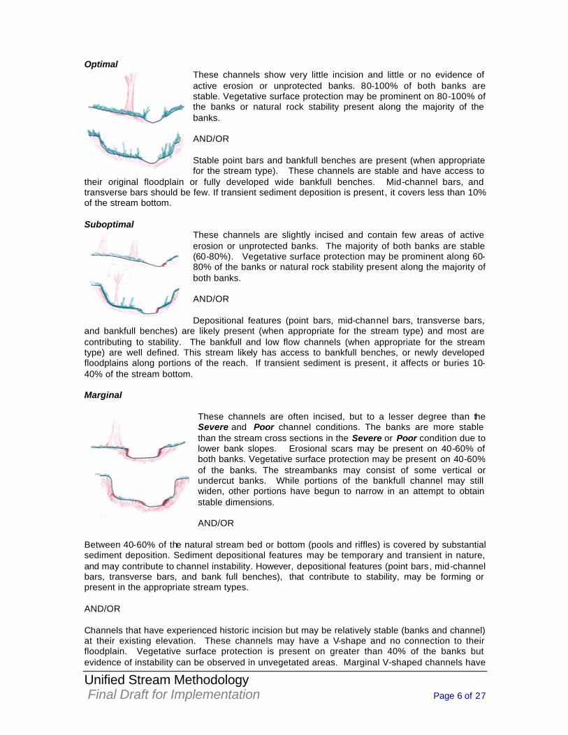
Optimal These channels show very little incision and little or no evidence of active erosion or unprotected banks. 80-100% of both banks are stable. Vegetative surface protection may be prominent on 80-100% of the banks or natural rock stability present along the majority of the banks. AND/OR Stable point bars and bankfull benches are present (when appropriate for the stream type). These channels are stable and have access to
their original floodplain or fully developed wide bankfull benches. Mid-channel bars, and transverse bars should be few. If transient sediment deposition is present, it covers less than 10% of the stream bottom. Suboptimal
These channels are slightly incised and contain few areas of active erosion or unprotected banks. The majority of both banks are stable (60-80%). Vegetative surface protection may be prominent along 60-80% of the banks or natural rock stability present along the majority of both banks. AND/OR Depositional features (point bars, mid-channel bars, transverse bars,
and bankfull benches) are likely present (when appropriate for the stream type) and most are contributing to stability. The bankfull and low flow channels (when appropriate for the stream type) are well defined. This stream likely has access to bankfull benches, or newly developed floodplains along portions of the reach. If transient sediment is present, it affects or buries 10-40% of the stream bottom. Marginal
These channels are often incised, but to a lesser degree than the Severe and Poor channel conditions. The banks are more stable than the stream cross sections in the Severe or Poor condition due to lower bank slopes. Erosional scars may be present on 40-60% of both banks. Vegetative surface protection may be present on 40-60% of the banks. The streambanks may consist of some vertical or undercut banks. While portions of the bankfull channel may still widen, other portions have begun to narrow in an attempt to obtain stable dimensions. AND/OR
Between 40-60% of the natural stream bed or bottom (pools and riffles) is covered by substantial sediment deposition. Sediment depositional features may be temporary and transient in nature, and may contribute to channel instability. However, depositional features (point bars, mid-channel bars, transverse bars, and bank full benches), that contribute to stability, may be forming or present in the appropriate stream types. AND/OR Channels that have experienced historic incision but may be relatively stable (banks and channel) at their existing elevation. These channels may have a V-shape and no connection to their floodplain. Vegetative surface protection is present on greater than 40% of the banks but evidence of instability can be observed in unvegetated areas. Marginal V-shaped channels have
Unified Stream Methodology Final Draft for Implementation Page 7 of 27
depositional features (point bars, mid-channel bars, transverse bars, and bank full benches), which contribute to stability. Poor
These channels are overwidened and are incised. These channels are vertically and/or laterally unstable. They are more likely to widen rather than incise further. The majority of both banks are near vertical with shallow to moderate root depths. Erosional scars may be present on 60-80% of the banks. Vegetative surface protection may be present on 20-40% of both banks, and is insufficient to prevent significant erosion from continuing. AND/OR
Between 60-80% of the natural stream bed or bottom (pools and riffles) is covered by substantial sediment deposition. Sediment depositional features are temporary and transient in nature, and are likely contributing to channel instability. AND/OR Channels that have experienced historic incision but may be relatively stable (banks and channel) at their existing elevation. These channels may have a V-shape and no connection to their floodplain. Vegetative surface protection is present on greater than 40% of the banks but evidence of instability can be observed in unvegetated areas. Depositional features (point bars, mid-channel bars, transverse bars, and bank full benches), which contribute to stability are absent. Severe
These channels are deeply incised (or excavated) with vertical and/or lateral instability and will likely continue to incise and widen. Incision is severe enough that flow is contained within the banks during heavy rainfall events (i.e. the stream does not have access to its floodplain). The streambed elevation may be below the average rooting depth within the banks and the majority of both banks may be vertical or undercut. Vegetative surface protection may be present on less than 20% of the banks and is not preventing erosion from continuing. Obvious bank sloughing may be present. Erosional scars or raw banks may be present on 80-100% of the banks.
AND/OR These channels are aggrading and have an excessive sediment supply that is filling the channel with alluvium, impeding its flow. Greater than 80% of the natural stream bed or bottom (pools and riffles) is covered by substantial sediment deposition that is likely contributing to channel instability. Multiple thread channels and/or subterranean flow may be present in certain aggrading channels. Note: Stable multiple thread channels naturally occur in some low-gradient streams and should not be given a Severe Parameter Condition.
Unified Stream Methodology Final Draft for Implementation Page 8 of 27
1.1.2 Channel Condition Photographs (see USM Photo File)
1.2 Riparian Buffer Parameter This Parameter is not intended to be a detailed vegetative cover survey, but instead, is a qualitative evaluation of the cover types that make up the riparian buffer. The CI for this parameter is determined by evaluating what cover type occupies what percent of the total riparian buffer area for each side of the stream channel within the SAR. The total riparian buffer assessment area (on each side of the stream channel) is calculated by multiplying the length of the SAR by 100 feet. The left bank (LB) and right bank (RB) are determined by facing downstream. The Riparian Buffer measurement is taken along the ground and is not an aerial distance from the stream bank. The ideal riparian buffer would be homogenous with a mature hardwood forest occupying 100% of the assessment area. If the buffer is heterogeneous (example: 33% forested, 33% cropland, and 34% pavement), it is possible that the buffer could contain multiple condition categories. In that case, each condition category present within the buffer is scored and weighted by the percent it occupies within the buffer. An estimate of the percent area that each cover type occupies may be made from visual estimates made on-the-ground or by measuring each different area to obtain its dimensions. Multiple intrusions of roads, parks, houses, etc., into the 100-foot zone may require more detailed measurements to determine percentages. The observed cover types should be categorized and scored accordingly, based upon the parameter category descriptions. EQUATION 1: The equation is as follows:
Left Bank CI =SUM (%Area*Score)*0.01
Right Bank CI =SUM(%Area*Score)*0.01 Riparian CI = (Left Bank CI + Right Bank CI) / 2 The following example (Example 1) provides further details on how to assess this parameter.
Unified Stream Methodology Final Draft for Implementation Page 9 of 27
For this example, the Evaluator considers each area within the 100’ buffer. On both sides of the stream an area of 100,000 square feet (sf) (100’ wide X 1,000’ long) is assessed using USM.
An area 60 feet wide and 1,000 feet long (60,000 sf) is located on the Right Bank and is assessed as Low Suboptimal. 60,000 sf is 60% of 100,000 sf. Therefore, 60 is entered into Right Bank Percent Area row of the Assessment Form and the Low Suboptimal Score (1.1) is entered below the 60 in the Score row. [60% X 1.1 X 0.01 = 0.66] An area 40’ wide and 1,000’ long (40,000 sf) is located on the Right Bank and is assessed as Low Poor. 40,000 sf is 40% of 100,000 sf. Therefore, 40 is entered into Right Bank Percent Area row of the Assessment Form and the Low Poor Score (0.5) is entered below the 40 in the Score row. [40% X 0.5 X 0.01 = 0.20] An area 50’ wide and 500’ long (25,000 sf) is located on the Left Bank and is assessed as Optimal. 25,000 is 25% of 100,000 sf. Therefore, 25 is entered into Left Bank Percent Area row of the Assessment Form and the Optimal Score (1.5) is entered below the 25 in the Score row. [25% X 1.5 X 0.01= 0.375] An area of 50’ wide and 500’ long (25,000 sf) is located on the Left Bank and is assessed as High Poor. Another area 50’ wide and 250’ long (12,500 sf) is also located on the Left Bank and is assessed as High Poor. These two areas equal 37,500 sf and comprise 37.5% of 100,000 sf. Therefore, 37.5 is entered into Left Bank Percent Area row of the Assessment Form and the High Poor Score (0.6) is entered below the 37.5 in the Score row. [37.5% X 0.6 X 0.01 = 0.225] An area 50’ wide and 750’ long (37,500 sf) is located on the Left Bank and is assessed as High Suboptimal. 37,500 sf is 37.5% of 100,000 sf. Therefore, 37.5 is entered into Left Bank Percent Area row of the Assessment Form and the High Suboptimal Score (1.2) is entered below the 37.5 in the Score row. [37.5% X 1.2 X 0.01 = 0.45]
The CI for each bank is the sum of all the Percent Area X Score products. The Right Bank CI is 0.86. The Left Bank CI is 1.05. These two bank CIs are then averaged, resulting in the Parameter CI of 0.955 or 0.96. RB % Area 60% 40% RB CI
Score 1.1 0.5 0.86 Buffer CI
LB % Area 25% 37.5% 37.5 LB CI 0.96 Score 1.5 0.6 1.2 1.05
Example 1: Riparian Buffer Assessment Example
1,000’
100’
Forested Buffer with 30% Canopy Cover and herbaceous understory (Low Suboptimal - Score of 1.1)
Forested Buffer with 30% Canopy Cover and herbaceous and shrub understory (High Suboptimal - Score of 1.2)
Forested Buffer with > 60% Canopy Cover (Optimal - Score of 1.5)
Maintained Grasses (High Poor - Score of 0.6)
Impervious Area (Low Poor - Score of 0.5)
Left Bank Stream
Right Bank
Unified Stream Methodology Final Draft for Implementation Page 10 of 27
1.2.1 Riparian Buffer Categories The SAR is assessed for the condition of the Riparian Buffer using the following four Categories. The dominance of invasive species will lowers the CI by one category. Optimal Tree stratum (dbh > 3 inches) present, with > 60% tree canopy cover. Wetlands located within the riparian areas are scored as optimal. Suboptimal High Suboptimal: Riparian areas with tree stratum (dbh > 3 inches) present, with 30% to 60% tree canopy cover and containing both herbaceous and shrub layers or a non-maintained understory. Low Suboptimal: Riparian areas with tree stratum (dbh > 3 inches) present, with 30% to 60% tree canopy cover and a maintained understory. Recent cutover (dense vegetation). Marginal High Marginal: Non-maintained, dense herbaceous vegetation with either a shrub layer or a tree layer (dbh > 3 inches) present, with <30% tree canopy cover. Low Marginal: Non-maintained, dense herbaceous vegetation, riparian areas lacking shrub and tree stratum, areas of hay production, and ponds or open water areas. If trees are present, tree stratum (dbh >3 inches) present, with <30% tree canopy cover with maintained understory. Poor High Poor: Lawns, mowed, and maintained areas, nurseries; no-till cropland; actively grazed pasture, sparsely vegetated non-maintained area, recently seeded and stabilized, or other comparable condition. Low Poor: Impervious surfaces, mine spoil lands, denuded surfaces, row crops, active feed lots, trails, or other comparable conditions.
1.2.2 Riparian Buffer Parameter Photographs (see USM Photo File)
1.3 In-stream Habitat Parameter The In-Stream Habitat assessment considers the habitat suitability for effective colonization or use by fish, amphibians, and/or macroinvertebrates. This parameter does not consider the abundance or types of organisms present, nor does it consider the water chemistry and/or quality of the stream. Other factors beyond those measured in this methodology (i.e. watershed conditions) also affect the presence and diversity of aquatic organisms. Therefore, evaluation of this parameter seeks to assess the suitability of physical elements within the stream reach to support aquatic organisms. This Parameter includes the relative quantity and variety of natural structures in the stream, such as cobble (riffles), large rocks, fallen trees, logs and branches, persistent leaf packs, and undercut banks; available as refugia, feeding, or sites for spawning and nursery functions of aquatic macrofauna. A wide variety and/or abundance of instream habitat features provide macroinvertebrates and fish with a large number of niches, thus increasing species diversity. As
Unified Stream Methodology Final Draft for Implementation Page 11 of 27
variety and abundance of cover decreases, habitat structure becomes monotonous, diversity decreases, and the potential for recovery following disturbance decreases. Riffles and runs are critical for maintaining a variety and abundance of benthic organisms and serve as spawning and feeding refugia for certain fish. The extent and quality of the riffle is an important factor in the support of a healthy biological condition. Riffl es and runs offer habitat diversity through a variety of particle sizes. Snags and submerged logs are also productive habitat structures for macroinvertebrate colonization and fish refugia. This parameter does not establish a percent slope for distinguishing between high and low gradient streams. Therefore, the Evaluator has to know whether a high or low gradient stream is being assessed. Generally speaking, low gradient streams occur in the Coastal Plain, wetland / marsh conditions, or wet meadows, and do not contain riffles. High gradient streams generally have alternating riffles and pools, with gravel or cobble present in the riffles. Typically, most streams west of the Fall Line are high gradient making the majority of streams in Virginia high gradient, with the exception of streams in the Coastal Plain and low gradient streams flowing through wetlands or wet meadows throughout the state. Headwater stream channels have intermittent hydrologic regimes and may not have the diversity of habitat features found in higher order stream channels. Hyporheic flow may comprise all of the flow in intermittent streams during dry times of the year. A high gradient stream should not be scored lower because there is not submerged aquatic vegetation. Likewise, a low gradient stream should not be scored lower because it does not contain riffles. High Gradient Streams Physical elements of high gradient stream systems that enhance a stream’s ability to support aquatic organisms and are indicative of habitat diversity include the following:
1. A varied mixture of substrate sizes (i.e., sand, gravel, cobbles, and boulders). 2. Low amount of highly mobile substrate material – While most streambed substrate
mobilizes under a particular discharge, substrate that remains immobile during the more consistent and frequent discharges provides stable habitat that fish and macroinvertebrates can utilize throughout differing stages of their lifecycles.
3. Low Embeddedness of substrate material – Embeddedness is the extent to which rocks (gravel, cobble, and boulders) and snags are covered by silt, sand, or mud on the stream bottom. As rocks and snags become embedded, there is less area available for colonization for macroinvertebrates and less fish habitat. Generally, the less embedded each particle is, the more surface area available to macroinvertebrates and fish. Additionally, less embeddedness indicates less large-scale sediment movement and deposition. (Observations of embeddedness are taken in the upstream and central portions of riffles and cobble substrate areas.)
4. A varied combination of water velocities and depths (riffles and pools) - More combinations of velocity and depth patterns provide increased habitat diversity.
5. The presence of woody and leafy debris (fallen trees, logs, branches, leaf packs, etc.), root mats, large rocks, and undercut banks (below bankfull).
6. The provision of shade protection by overhanging vegetation. 7. The Hyporheic zone is wet within 12” of ground surface.
Low Gradient Streams Physical elements of low gradient stream systems that enhance a stream’s ability to support aquatic organisms and are indicative of habitat diversity include the following:
1. A varied mixture of substrate materials (i.e., sand and gravel) in pools – Varied substrate materials support a higher diversity of organisms than mud or bedrock.
2. Submerged aquatic vegetation in pools – Will also support a higher diversity of organisms.
3. The presence of woody and leafy debris (fallen trees, logs, branches, leaf packs, etc.), root mats, and undercut banks (below bankfull).
4. The provision of shade protection by overhanging vegetation.
Unified Stream Methodology Final Draft for Implementation Page 12 of 27
5. The Hyporheic zone is wet within 12” of ground surface.
A diverse and abundant assemblage of these features promotes the potential for colonization by diverse and abundant epifaunal and fish communities.
1.3.1 In-Stream Habitat Categories The SAR is assessed for the condition of In-Stream Habitat using the following four Categories. The Evaluator selects the category most representative of the SAR. These categories are abbreviated on Form 1. Optimal Physical Elements that enhance a stream’s ability to support aquatic organisms are present in greater than 50% of the reach. Substrate is favorable for colonization by a diverse and abundant epifaunal community, and there are many suitable areas for epifaunal colonization and/or fish cover.
Suboptimal Physical Elements that enhance a stream’s ability to support aquatic organisms are present in 30-50% of the reach. Conditions are mostly desirable, and are generally suitable for full colonization by a moderately diverse and abundant epifaunal community.
Marginal Physical Elements that enhance a stream’s ability to support aquatic organisms are present in 10-30% of the reach. Conditions are generally suitable for partial colonization by epifaunal and/or fish communities.
Poor Physical Elements that enhance a stream’s ability to support aquatic organisms are present in less than 10% of the reach. Conditions are generally unsuitable for colonization by epifaunal and/or fish communities.
1.3.2 In-stream Habitat Parameter Photographs (see USM Photo File)
1.4 Channel Alteration Parameter This Parameter considers direct impacts to the stream channel from anthropogenic sources. The SAR may or may not have been altered throughout its entire length. Examples of channel alterations evaluated in this Parameter that may disrupt the natural conditions of the stream include, but are not limited to the following:
1. Straightening of channel or other channelization 2. Stream crossings (bridges and bottomless culverts) 3. Riprap along streambank or in streambed 4. Concrete, gabions, or concrete blocks along streambank 5. Manmade embankments on streambanks, including spoil piles 6. Constrictions to stream channel or immediate flood prone area 7. Livestock impacted channels (i.e., hoof tread, livestock in stream)
It is important to note that this Parameter evaluates the physical alteration, separate from the impact the alteration is having on the assessment reach. Any impact to the assessment reach resulting from the alteration (i.e. scouring, head cuts, vertical banks, etc.) is accounted for in the Channel Condition Parameter. Any revegetation or natural re-stabilization of the channel is also
Unified Stream Methodology Final Draft for Implementation Page 13 of 27
accounted for in the Channel Condition Parameter. For example, consider two assessment reaches, each with similar bridges: the first reach shows no adverse effects to the stream channel or banks; the second shows significant scouring. The alteration is the bridge, not the effects of the bridge; therefore it is the length of bridge relative to the length of the assessment reach that is evaluated. The shorter the assessment reach, the higher percentage of alteration. The presence of a structure does not necessarily result in a reduced score. For instance, a bridge that completely spans the floodplain would not be considered an alteration. Also, the Evaluator is cautioned not to make assumptions about past alterations. Incision can be mistaken for channelization.
1.4.1 Channel Alteration Categories The SAR is assessed for the extent of channel alterations using the following four Categories. The Evaluator selects the category most representative of the assessment reach. This is recorded in Section 4 of Form 1. Negligible Channelization, dredging, alteration, or hardening absent. Stream has unaltered pattern or has normalized.
Minor High Minor: Less than 20% of the stream reach is disrupted by any of the channel alterations listed above. Alteration or channelization present, usually adjacent to structures, (such as bridge abutments or culverts); evidence of past alteration, (i.e., channelization) may be present, but stream pattern and stability have recovered; recent alteration is not present. Low Minor: Between 20-40% of the stream reach is disrupted by any of the channel alterations listed above. Alteration or channelization present, usually adjacent to structures, (such as bridge abutments or culverts); evidence of past alteration, (i.e., channelization) may be present, but stream pattern and stability have recovered; recent alteration is not present.
Moderate High Moderate: Between 40 - 60% of reach is disrupted by any of the channel alterations listed above. If the stream has been channelized, normal stable stream meander pattern has not recovered.
Low Moderate: Between 60 - 80% of reach is disrupted by any of the channel alterations listed in the parameter guidelines. If the stream has been channelized, normal stable stream meander pattern has not recovered. Severe Greater than 80% of reach is disrupted by any of the channel alterations listed above. Greater than 80% of banks shored with gabion, riprap, or cement. Channels entirely lined with riprap.
1.4.2 Channel Alteration Parameter Photographs (see USM Photo File)
Unified Stream Methodology Final Draft for Implementation Page 14 of 27
1.5 Reach Condition Index (RCI) The Reach Condition Index (RCI) is a numerical value placed on the stream assessment reach using the Condition Indices (CI s) determined for each Parameter during the stream assessment. The RCI values range from 0.5-1.5 and result from a weighted average of the CIs. The average is weighted to reflect the fact that Channel Condition is valued twice that of other individual Parameters because a stream’s physical stability heavily influences its condition. The following equation is used to determine the RCI: Equation 2 RCI = (Sum of all CIs) ÷ 5 If multiple reaches are assessed the Evaluator may use the Stream Assessment Summary Form (Form 2) to record multiple RCIs and later determine the Compensation Requirement (CR).
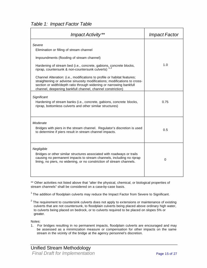
2.0 STREAM IMPACT FACTOR ASSESSMENT Permitted impacts result in varying levels of impairment to streams. Different types of impacts can therefore be classified based on the degree to which they are expected to impair the stream. Table 1 depicts a wide array of impacts categorized into four Impact Classifications (Severe, Significant, Moderate, Negligible). Each Impact Classification has a corresponding Impact Factor (IF). As depicted in Table 1, the more severe the impact, the higher the IF. Therefore, an activity considered to have a Severe impact has the highest IF of 1.0, representing an activity that is presumed to have a complete or near-complete loss of all beneficial stream functions. Conversely, an activity considered to have Negligible impacts has an IF of 0. These activities will not require stream compensation; however they are included in Table 1 to show that if impacts can be minimized to the point that the impact activity falls into the Negligible classification, then stream compensation is not required. The IF obtained from Table 1 is used on the Stream Impact Assessment Form (Form1) and the Stream Assessment Summary Form (Form 2) included in Appendix A to calculate the Total Compensation Requirement (Total CR) for the project. By using the Impact Classifications and incorporating IF’s into the equation, the impacts resulting in greater impairment require more compensation than impacts resulting in lesser impairment. Additionally, this serves as an incentive to decrease the degree of impact and ultimately the CR. If an impact is not listed, then best professional judgment must be used in determining the most applicable Impact Classification. If multiple impacts occur within the SAR, the highest applicable IF is used for that reach.
Unified Stream Methodology Final Draft for Implementation Page 15 of 27
Table 1: Impact Factor Table
Impact Activity** Impact Factor
Severe Elimination or filling of stream channel Impoundments (flooding of stream channel) Hardening of stream bed (i.e., concrete, gabions, concrete blocks, riprap, countersunk & non-countersunk culverts) 1,2 Channel Alteration: (i.e., modifications to profile or habitat features; straightening or adverse sinuosity modifications; modifications to cross-section or width/depth ratio through widening or narrowing bankfull channel, deepening bankfull channel, channel constriction)
1.0
Significant Hardening of stream banks (i.e., concrete, gabions, concrete blocks, riprap, bottomless culverts and other similar structures)
0.75
Moderate
Bridges with piers in the stream channel. Regulator’s discretion is used to determine if piers result in stream channel impacts.
0.5
Negligible
Bridges or other similar structures associated with roadways or trails causing no permanent impacts to stream channels, including no riprap lining, no piers, no widening, or no constriction of stream channels.
0
** Other activities not listed above that “alter the physical, chemical, or biological properties of stream channels” shall be considered on a case-by-case basis. 1 The addition of floodplain culverts may reduce the Impact Factor from Severe to Significant.
2 The requirement to countersink culverts does not apply to extensions or maintenance of existing culverts that are not countersunk, to floodplain culverts being placed above ordinary high water, to culverts being placed on bedrock, or to culverts required to be placed on slopes 5% or greater. Notes: 1. For bridges resulting in no permanent impacts, floodplain culverts are encouraged and may
be assessed as a minimization measure or compensation for other impacts on the same stream in the vicinity of the bridge at the agency personnel’s discretion.
Unified Stream Methodology Final Draft for Implementation Page 16 of 27
2.1 Impact Factor Photographs (see USM Photo File)
3.0 Determining Stream Compensation Requirements The stream Compensation Requirement (CR) for a project is determined after the following three steps have been performed:
1) Determine the length of impact (LI); 2) Complete Form 1 to obtain the RCI;
3) Classify the type of impact and determine the appropriate IF (Table 1).
The total Length of Impact (LI) equals the original length of stream being impacted, not the length of stream remaining after the impacts. For example, if 500 feet of stream is straightened resulting in 400' of stream, then 500' is the impact length. The CR is calculated using the following equation: EQUATION 3: Compensation Requirement (CR) = LI x RCI x IF
Where, CR = compensation credits required LI = length of impact (in linear feet) RCI = Reach Condition Index (Form 1) IF = Impact Factor (Table 1) To determine the CR, the length of impact (LI) is multiplied by the RCI obtained from Form 1 and by the appropriate IF obtained from Table 1. Form 1 is used to generate the CR for each reach evaluated. If more than one reach will be impacted, the individual LI’s and their corresponding CR’s may be summed on Form 2.
4.0 Precompensation Evaluation and Stream Conceptual Mitigation Plan In order to develop a conceptual stream mitigation plan, it is necessary to first research the stream’s watershed and its history to determine the cause and extent of its deficiencies. The following questions should be answered to help identify and document the specific deficiencies to be addressed within a stream reach.
1. What is the stream name? 2. What is the reach length to be evaluated? Provide a USGS topographic map with the
location of the stream reach clearly identified. 3. What is the stream order?
Unified Stream Methodology Final Draft for Implementation Page 17 of 27
4. What is the approximate drainage area? 5. Describe the existing watershed and the estimated proposed land use for that watershed
(ie: percent residential, percent forested, percent commercial, percent cleared/logged, percent industrial, percent agricultural, other)?
6. Describe the existing riparian buffer (ie: mature forested, herbaceous and shrub layers present in understory, utility easements present, understory maintained, lawns, impervious surfaces, active row crops, etc.)? Provide the estimated percentage of the total riparian area comprised of each cover type.
7. What is the estimated bankfull width? 8. What is the estimated bank height? 9. Is the channel high gradient or low gradient? 10. Does the channel appear to have natural sinuosity or does it appear that the channel
pattern has been altered? 11. Does the channel appear to be aggrading, degrading, or stable? 12. Describe the sediment supply (ie: extreme, very high, high, etc.) 13. Are the streambanks eroding? Over what percentage of the reach? 14. Are headcuts present within the reach? 15. Provide a general narrative overview of the existing stream deficiencies and the proposed
necessary restoration or enhancement measures to be taken to address those deficiencies.
16. What are the goals and objectives of the mitigation, and how will the mitigation plan meet those goals and objectives?
17. The Stream Impact Assessment Form can be used to further document the existing condition of the mitigation site.
4.1 Conceptual Compensatory Mitigation Plan In Section 5.0 the Compensation Credit (CC) for conceptual stream compensation plans is determined. The Evaluator needs to be familiar with the Compensation Activities and Adjustment Factors described in Sections 5.1 – 5.4 and submit the necessary information needed to determine CC. Sections 5.1 – 5.4 describe the process for crediting the Compensation Activities and Adjustment Factors and state the necessary information needed to complete the Compensation Crediting Form (Form 3). Note: Additional information may be required per COE & DEQ regulations/permits. • Section 5.1: Restoration
o The length (in linear feet) of stream channel to be restored • Section 5.2: Enhancement
o The length (in linear feet) of stream channel expected to benefit from and be influenced by instream structures
o The length (in linear feet) of each streambank expected to benefit from and be influenced by habitat structures
o The length (in linear feet) of each streambank that will have bankfull bench creation o The length (in linear feet) of each streambank that will have the banks laid back o The length (in linear feet) of each streambank that will have bioremediation techniques
used o The length (in linear feet) of each streambank that will have streambank plantings
• Section 5.3: Riparian Buffer
o The percent of the inner and outer 100’ buffers of each streambank that will be re-established
o The percent of the inner and outer 100’ buffers of each streambank that will be planted heavily
o The percent of the inner and outer 100’ buffers of each streambank that will have light or supplemental planting
Unified Stream Methodology Final Draft for Implementation Page 18 of 27
o The percent of the inner and outer 100’ buffers of each streambank that will be preserved only
• Section 5.4: Adjustment Factors
o Rare, Threatened, and Endangered Species or Communities - The name of the species being protected - The indicator status of the species - The amount the proposed activity will aid or protect that species - Whether an activity will protect habitat or known locations of a species - The connection to other wildlife corridors - The number of species to be benefited
o Livestock Exclusion
- The length of time livestock have had access to the stream The number of livestock excluded - The expected water quality improvements provided by the project
o Watershed Preservation
- The nature of the restriction - The level of preservation or protection provided - The benefit to the stream system
5.0 Determining Compensation Crediting The Total Compensation Requirement (CR) computed in Section 3.0 and on Form 2 represents the total stream compensation credits required for the project. This section describes the methods and alternatives for fulfilling the CR for both onsite and offsite compensation, and explains the crediting process. Using this process, ensures that crediting on-site and off-site compensation projects, evaluating and approving stream compensation banks through the Mitigation Bank Review Team, and in-lieu fee fund projects are all credited in the same manner. This process does not include a method for crediting out-of-kind compensation activities such as removing effluent/straight pipes, correcting acid mine drainage, or removing fish blockages. These activities may serve to fulfill the CR in certain situations, but will be credited on a case-by-case basis. The process categorizes compensation methods and utilizes a Compensation Crediting Form (Form 3), included in Appendix B, to determine the CC for various levels of stream and riparian buffer preservation, enhancement, and restoration activities. The CC is refined by applying the appropriate Adjustment Factors (AF) to the credits obtained through the various activities. The following is a step-wise summary of the procedure for calculating the CC’s obtained from a stream compensation plan:
• Enter the project number, project name, locality, Cowardin classification, HUC, date, stream compensation length, name of evaluators, stream name, and reach ID number.
• If restoration is proposed, then enter the length of stream channel to be restored in the
appropriate box on Form 3. The length is multiplied by the credit and restoration credit is calculated.
• If Enhancement with Instream Structures is proposed, determine the affected length.
Enter this length in the appropriate box on form 3. The length is multiplied by the credit for Instream Structures.
Unified Stream Methodology Final Draft for Implementation Page 19 of 27
• If other Enhancement activities are proposed, determine which techniques will be employed, and enter the corresponding length and credit, for each bank, in the appropriate boxes on Form 3. The length of each proposed activity is multiplied by the credit for each activity. The sum of credits provided by each of the activities and the credit provided by Instream Structures result in a total enhancement credit and is entered in the appropriate box of Form 3.
• Determine the riparian buffer area and enter the percent area for the inner 100 and its
corresponding credit for each bank in the appropriate box on Form 3. The percent area is multiplied by the credit. The sum of these products for each bank results in the credit for that bank. The right bank and left bank credits are then averaged to obtain an average per-foot credit for the work being done on the reach. This average credit is then multiplied by the total length of the stream reach to obtain the total riparian credit for that particular reach. This calculation is repeated for the outer 100’ (100’-200’).
• Determine which adjustment factors apply to the project and enter the corresponding
length and credit in the appropriate box on Form 3. The length is multiplied by the credit and the amount of the additional credit is calculated. The sum of additional credits provided by each is entered in the appropriate box of Form 3.
• The total credits generated under each activity are added together and result in the total
credit.
Methods employed to improve or protect streams include a wide range of activities aimed at preserving, enhancing, stabilizing, or restoring various stream functions. Some of these methods require greater efforts and provide greater benefits than others. When these methods are proposed as stream compensation, the amount of effort required and the resulting benefits from such activities must be taken into account when determining the amount of CC granted. Therefore, the amount of CC is based on the activity, the expected level of improvement to stream function and quality, and the amount of effort required and methods employed. This section demonstrates how to credit design components included in the compensation plan. Compensation Crediting is determined by using the USM Compensation Crediting Form (Form 3). The complexity of the project will dictate the number of forms required to be completed. The needed improvements should be based on an assessment of the existing stream deficiencies. This USM method does not determine whether or not a compensation proposal/plan is appropriate. Agency personnel will rely on the information provided in the Precompensation Evaluation, the conceptual compensation plan, knowledge of the site, natural stream channel design techniques, and best professional judgment to make that determination. Form 3 is utilized simply to calculate the credit provided by each activity on a given reach and any adjustment factors. It should be noted that no credit will be given for unnecessary techniques and/or structures. The following provides details on compensation practices and guidelines for using the USM Compensation Crediting Form (Form 3).
Unified Stream Methodology Final Draft for Implementation Page 20 of 27
5.1 Restoration (1 CC per foot) Restoration is the process of converting an unstable, altered, or degraded stream corridor, including flood-prone areas, to a natural stable condition considering recent and future watershed conditions. This process should be based on a reference condition/reach for the stream valley type and includes restoring the appropriate geomorphic dimension (cross-section), pattern (sinuosity), and profile (channel slope). This process supports reestablishing the streams biological and chemical integrity, including transport of the water and sediment produced by its watershed in order to achieve dynamic equilibrium. An analysis of the existing geomorphological parameters of the compensation stream is compared to those in a stable reference stream. Natural stream channel design methods and calculations are then applied to result in a stable stream dimension, pattern, and profile that maintains itself within the natural variability of the design parameters. Restoration activities utilizing the natural stream channel design approach typically address the following:
1. Deficiencies in sinuosity, radius of curvature, belt width, meander length 2. Deficiencies in spacing, lengths, and depths for riffles, runs, pools, & glides 3. Restore appropriate critical shear stress 4. Deficiencies in slopes for channel, riffles, runs, pools, & glides 5. Deficiencies in width-depth ratio and cross-sectional area
Situations that readily lend themselves to inclusion in the Restoration Category include Priority 1, 2, or 3 relocations and restorations as described in A Geomorphological Approach to Restoration of Incised Rivers, Rosgen 19971. The following provides additional information on these Priorities: Priority 1 Restoration1 Priority 1 Restoration is defined as stream channel restoration that involves the re-establishment of a channel on the original floodplain, using a relic channel or constructing a new channel. The new channel is designed and constructed with the proper dimension, pattern, and profile characteristics for a stable stream. The existing, incised channel is either backfilled or made into discontinuous oxbow lakes level with the new floodplain elevation. (Rosgen, 1997) Priority 2 Restoration1 Priority 2 Restoration is defined as stream channel restoration that involves re-establishment of a new floodplain at the existing level or higher but not at the original level. The new channel is designed and constructed with the proper dimension, pattern, and profile characteristics for a stable stream. (Rosgen, 1997) Priority 3 Restoration1 Priority 3 Restoration is defined as stream channel restoration to a channel without an active floodplain but with a flood prone area (Rosgen, 1997). However, the channel restoration must involve establishing proper dimension, pattern, and profile. Some sites may present difficulties in reestablishing a sinuous pattern when they are laterally contained or have limitations in available belt width. This is often caused by utilities, infrastructure, and other floodplain encroachments. Such physical constraints often favor the creation of a step/pool bed morphology with less sinuosity (associated with Priority 3) over a riffle/pool bed morphology with greater sinuosity (associated with Priorities 1 & 2). It is necessary to consider the available belt width and the slope of the proposed stream when designing the appropriate stream type that is suitable for that
1 Rosgen, David. 1997. A Geomorphological Approach to Restoration of Incised Rivers .
Proceedings of the Conference on Management of Landscapes Disturbed by Channel Incision. 11pp.
Unified Stream Methodology Final Draft for Implementation Page 21 of 27
situation. Information should be provided showing that the appropriate dimension, pattern, and profile are being restored for the proposed stream type in that particular situation.
The compensation plan narrative needs to describe, and the plan design sheets need to clearly demarcate, the stream channel length (in linear feet) and stream reaches to be restored, as defined above. The restoration length should be recorded in the appropriate box on Form 3 then it is multiplied by 1.0 resulting in the restoration credit.
Restoration Restrictions: 1. No enhancement activities can be coupled with restoration on the same linear
foot of stream channel. 2. The difference between projects that are credited as Restoration and projects
that are credited as Enhancement, is whether or not changes are necessary to address the current channel’s dimension, pattern, and profile, as described for each of the Priorities, to produce a stable channel. All three geomorphic variables are required to be addressed, with noted pattern limitations for Priority 3, in order to receive Restoration credit. Enhancement credit is given in all other situations when only two geomorphic variables are addressed to produce a stable channel.
5.1.1 Restoration Photographs (see USM Photo File)
5.2 Enhancement Enhancement Activities include physical alterations to the channel that do not constitute Restoration but that directly augment channel stability, water quality, and stream ecology in accordance with a reference condition, where appropriate. These activities may include in-stream and/or streambank activities, but in total fall short of restoring one or more of the geomorphic variables: dimension, pattern and profile. There are 6 activities included in this category: 1) Instream Structures (cross vanes, j hooks, etc.), 2) Habitat Structures (fish boards, root wads, etc), 3) Bankfull Bench Creation, 4) Laying Back Banks, 5) Bioremediation Techniques, and 6) Stream Bank Planting. These compensation activities directly improve the stability of, or enhance the streambanks, streambed, and in-stream habitat by physically manipulating them. Instream Structures (0.3 credit per foot of effect) This activity includes structures that are specifically designed and result in grade control and/or bank stabilization. Accepted structures include, but are not limited to, cross-vanes, j-hook vanes, native material revetments, W rock weirs, rock vortex weirs, log-vanes, constructed riffles, and step-pools. These structures may be created out of appropriate sized rock or logs, boulders or cobbles based on the size of the stream and the flow regime. Structures not listed will be considered on case-by-case basis. Normally, a pool is constructed in combination with these structures, however, if one is not constructed this does not alter the credit provided. The compensation plan needs to state, and clearly demarcate, the length (in linear feet) of stream channel and reaches of stream channel expected to benefit from and be influenced by the structures. Record this length in the appropriate box on Form 3. This length is multiplied by 0.3 and the credit is calculated.
Unified Stream Methodology Final Draft for Implementation Page 22 of 27
Habitat Structures (0.1 credit per foot per bank) This activity includes structures designed specifically for habitat creation. Although, Instream Structures typically provide habitat, they are constructed for channel stability and will not receive credit for Habitat Structures. Habitat Structures do not typically contribute to channel stability. Accepted structures include, but are not limited to, submerged shelters, fish boards or bank cover, floating log structures, root wads, and half-log cover. Riffle and pool complexes and over hanging vegetation do not qualify for credit in this activity. The compensation plan should state, and the plan sheets should clearly demarcate, the length (in linear feet) of stream channel where habitat structures are proposed. This length is recorded in the appropriate bank row on Form 3. This length is multiplied by 0.10 and the credit for that structure is calculated. Bankfull Bench Creation (0.15 credit per foot per bank) This activity involves the creation of a bankfull bench along one or both of the stream banks. This activity may result in less than the proper entrenchment ratio but does result in a stable channel. The compensation plan should state, and the plan sheets should clearly demarcate, the length (in linear feet) of stream channel where bankfull benches are proposed. This length is recorded in the appropriate bank row on Form 3. This length is multiplied by 0.15 and the credit for that length of bench is calculated. Lay Back Bank (0.1 credit per foot per bank) This activity involves the manual manipulation of the bank slope but does not create a bankfull bench or floodplain. The compensation plan should state, and the plan sheets should clearly demarcate, the length (in linear feet) of stream channel where laying back the banks is proposed. This length is recorded in the appropriate bank row on Form 3. This length is multiplied by 0.1 and the credit for that length of bank is calculated. Bioremediation Techniques (0.1 credit per foot per bank) This activity primarily relates to the use of coir logs or similar materials for bank stabilization. Techniques and materials in this category include, but are not limited to, live fascines, branch packing, brush mattresses, coir logs, and natural fiber rolls. More than one of these materials or techniques may be warranted over the same stream length. In this case, no additional credit will be applied for that length. In other words, the compensation plan should include all bioremediation techniques required over a particular length. Techniques and materials other than those listed will be considered on a case-by-case basis for approval by the agencies. The compensation plan should state, and the plan sheets should clearly demarcate, the length (in linear feet) of stream channel where bioremediation techniques are proposed. This length is recorded in the appropriate bank row on Form 3. This length is multiplied by 0.1 and the credit for that length of bank is calculated. Streambank Planting (0.09 credit per foot per bank) This activity includes the installation of plants other than seed along the immediate stream bank area. This is primarily done for streambank stabilization. This activity includes live stakes, dormant post/stakes, branch layering, and the installation of plants. The length of the bank over which this activity occurs is entered into the Form 3. If it occurs on both banks, it is entered in both rows. The compensation plan should state, and the plan sheets should clearly demarcate, the length (in linear feet) of stream channel where streambank plantings are proposed. This length is recorded in the appropriate bank row on Form 3. This length is multiplied by 0.09 and the credit for that length of bank is calculated.
Unified Stream Methodology Final Draft for Implementation Page 23 of 27
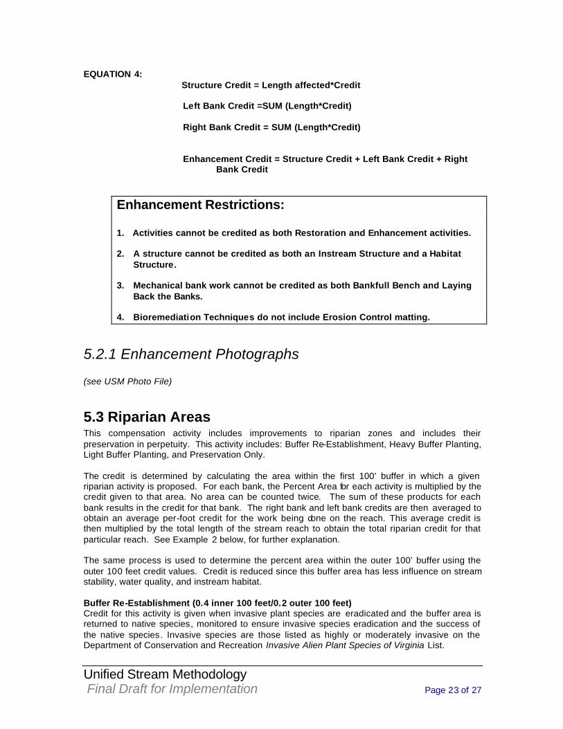
EQUATION 4: Structure Credit = Length affected*Credit
Left Bank Credit =SUM (Length*Credit)
Right Bank Credit = SUM (Length*Credit)
Enhancement Credit = Structure Credit + Left Bank Credit + Right Bank Credit
Enhancement Restrictions: 1. Activities cannot be credited as both Restoration and Enhancement activities. 2. A structure cannot be credited as both an Instream Structure and a Habitat
Structure. 3. Mechanical bank work cannot be credited as both Bankfull Bench and Laying
Back the Banks. 4. Bioremediation Techniques do not include Erosion Control matting.
5.2.1 Enhancement Photographs (see USM Photo File)
5.3 Riparian Areas This compensation activity includes improvements to riparian zones and includes their preservation in perpetuity. This activity includes: Buffer Re-Establishment, Heavy Buffer Planting, Light Buffer Planting, and Preservation Only. The credit is determined by calculating the area within the first 100’ buffer in which a given riparian activity is proposed. For each bank, the Percent Area for each activity is multiplied by the credit given to that area. No area can be counted twice. The sum of these products for each bank results in the credit for that bank. The right bank and left bank credits are then averaged to obtain an average per-foot credit for the work being done on the reach. This average credit is then multiplied by the total length of the stream reach to obtain the total riparian credit for that particular reach. See Example 2 below, for further explanation. The same process is used to determine the percent area within the outer 100’ buffer using the outer 100 feet credit values. Credit is reduced since this buffer area has less influence on stream stability, water quality, and instream habitat.
Buffer Re-Establishment (0.4 inner 100 feet/0.2 outer 100 feet) Credit for this activity is given when invasive plant species are eradicated and the buffer area is returned to native species, monitored to ensure invasive species eradication and the success of the native species. Invasive species are those listed as highly or moderately invasive on the Department of Conservation and Recreation Invasive Alien Plant Species of Virginia List.
Unified Stream Methodology Final Draft for Implementation Page 24 of 27
Heavy Buffer Planting (0.38 inner 100 feet/0.19 outer 100 feet) Credit for this activity is given when the buffer area requires extensive planting (example: 400 stems per acre or more) and may include balled and burlapped specimens and/or containerized specimens. Light Buffer Planting (0.29 inner 100 feet/0.15 outer 100 feet) Credit for this activity is given when the buffer area requires only light or supplemental planting. This activity would involve planting at less than ideal densities (example: less than 400 stems per acre), either because vegetation is already present, a seed source is present, or the project does not otherwise warrant it. Preservation Only (No Work Proposed) Credit for this activity is given when no work to a riparian buffer area is proposed but that area will be placed under perpetual protection through the implementation of appropriate legal mechanisms. Credit is given based on the quality of the stream preserved. Additional credit is given for the preservation of High Quality streams (streams with an RCI from 1.25 to 1.5). Low Quality streams are those with an RCI from 1.0 to 1.24. Preservation is rarely allowed for streams that score below an RCI of 1.0. When preservation of the buffer is conducted on streams where stream restoration/enhancement activities are proposed, the credit for High Quality streams is applied since the compensation proposal will result in an improvement. For the inner 100 feet, High Quality streams receive 0.14 credit per percent area and Low Quality streams receive 0.07 credit per percent area. For the outer 100 feet, all streams receive 0.07 credit per percent area.
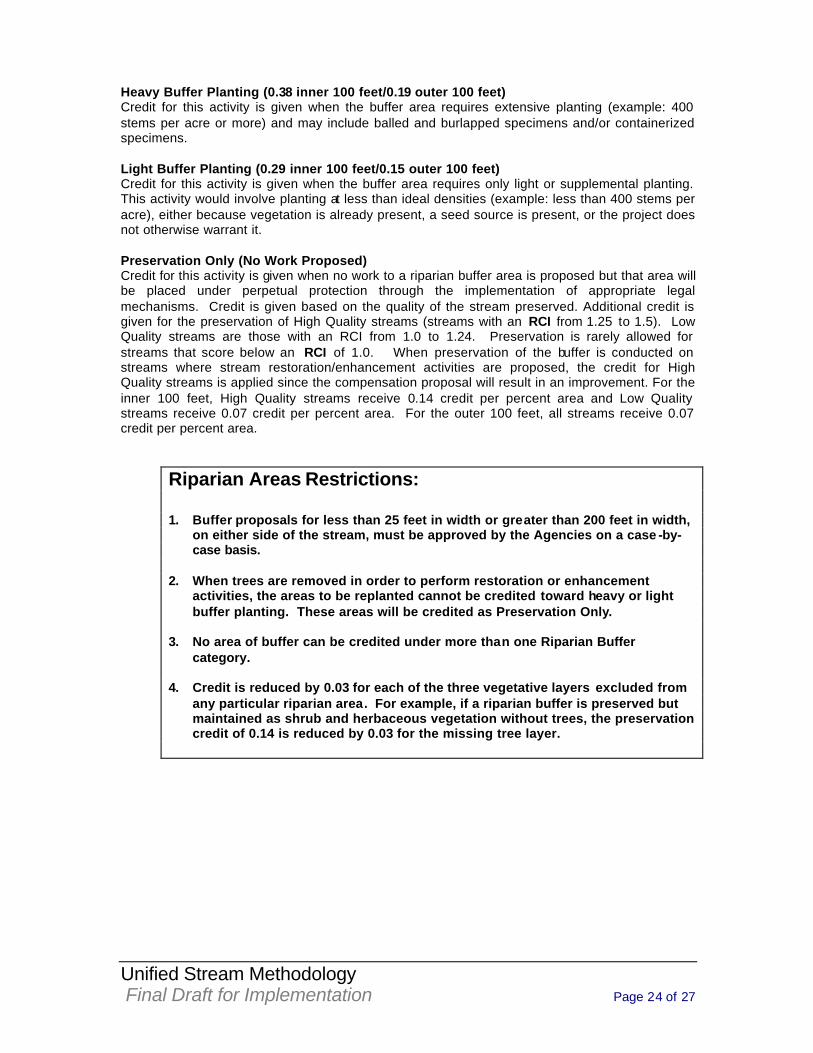
Riparian Areas Restrictions: 1. Buffer proposals for less than 25 feet in width or greater than 200 feet in width,
on either side of the stream, must be approved by the Agencies on a case -by-case basis.
2. When trees are removed in order to perform restoration or enhancement
activities, the areas to be replanted cannot be credited toward heavy or light buffer planting. These areas will be credited as Preservation Only.
3. No area of buffer can be credited under more than one Riparian Buffer
category. 4. Credit is reduced by 0.03 for each of the three vegetative layers excluded from
any particular riparian area. For example, if a riparian buffer is preserved but maintained as shrub and herbaceous vegetation without trees, the preservation credit of 0.14 is reduced by 0.03 for the missing tree layer.
Unified Stream Methodology Final Draft for Implementation Page 25 of 27
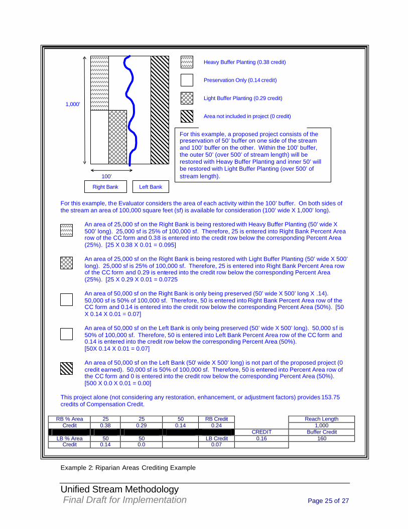
For this example, the Evaluator considers the area of each activity within the 100’ buffer. On both sides of the stream an area of 100,000 square feet (sf) is available for consideration (100’ wide X 1,000’ long).
An area of 25,000 sf on the Right Bank is being restored with Heavy Buffer Planting (50’ wide X 500’ long). 25,000 sf is 25% of 100,000 sf. Therefore, 25 is entered into Right Bank Percent Area row of the CC form and 0.38 is entered into the credit row below the corresponding Percent Area (25%). [25 X 0.38 X 0.01 = 0.095] An area of 25,000 sf on the Right Bank is being restored with Light Buffer Planting (50’ wide X 500’ long). 25,000 sf is 25% of 100,000 sf. Therefore, 25 is entered into Right Bank Percent Area row of the CC form and 0.29 is entered into the credit row below the corresponding Percent Area (25%). [25 X 0.29 X 0.01 = 0.0725 An area of 50,000 sf on the Right Bank is only being preserved (50’ wide X 500’ long X .14). 50,000 sf is 50% of 100,000 sf. Therefore, 50 is entered into Right Bank Percent Area row of the CC form and 0.14 is entered into the credit row below the corresponding Percent Area (50%). [50 X 0.14 X 0.01 = 0.07] An area of 50,000 sf on the Left Bank is only being preserved (50’ wide X 500’ long). 50,000 sf is 50% of 100,000 sf. Therefore, 50 is entered into Left Bank Percent Area row of the CC form and 0.14 is entered into the credit row below the corresponding Percent Area (50%). [50X 0.14 X 0.01 = 0.07] An area of 50,000 sf on the Left Bank (50’ wide X 500’ long) is not part of the proposed project (0 credit earned). 50,000 sf is 50% of 100,000 sf. Therefore, 50 is entered into Percent Area row of the CC form and 0 is entered into the credit row below the corresponding Percent Area (50%). [500 X 0.0 X 0.01 = 0.00]
This project alone (not considering any restoration, enhancement, or adjustment factors) provides 153.75 credits of Compensation Credit.
RB % Area 25 25 50 RB Credit Reach Length
Credit 0.38 0.29 0.14 0.24 1,000 CREDIT Buffer Credit
LB % Area 50 50 LB Credit 0.16 160 Credit 0.14 0.0 0.07
Example 2: Riparian Areas Crediting Example
1,000’
100’
Heavy Buffer Planting (0.31 credit)
Preservation Only (0.14 credit)
Light Buffer Planting (0.29 credit)
For this example, a proposed project consists of the preservation of 50’ buffer on one side of the stream and 100’ buffer on the other. Within the 100’ buffer, the outer 50’ (over 500’ of stream length) will be restored with Heavy Buffer Planting and inner 50’ will be restored with Light Buffer Planting (over 500’ of stream length).
Area not included in project (0 credit)
Heavy Buffer Planting (0.38 credit)
Right Bank Left Bank
Unified Stream Methodology Final Draft for Implementation Page 26 of 27
5.3.1 Riparian Areas Photographs (see USM Photo File)
5.4 Adjustment Factors Adjustment Factors (AF) are used to account for exceptional or site specific circumstances associated with the compensation site. These circumstances may provide ecological benefits that exceed the minimal requirements of the method presented in this Manual. The Adjustment Factors are applied only when ecological and/or water quality benefits are achieved. Each AF activity is credited within a prescribed range. The range is to account for variation in activities and conditions that warrant AF credit. Examples are given for each of the ranges. The agency representative shall make this determination on a case-by -case basis and use best professional judgment.
Rare, Threatened, and Endangered Species or Communities Increased Compensation Credit (CC) is warranted for sites that show a significant improvement in restoring, enhancing, or preserving communities or individuals of rare or threatened and endangered species (T&E). It is necessary to consider the influences of activities upstream of the compensation site before applying this AF. If upstream activities would prevent significant improvement from occurring, this AF may not be warranted. The agency representative should coordinate with State and Federal agencies such as Virginia Department of Conservation and Recreation (DCR), Virginia Department of Game and Inland Fisheries (DGIF), or U.S. Fish and Wildlife Service (FWS) prior to applying this AF. The range of credit provided by this activity is 0.1 – 0.3. The following factors are considered in determining the credit: 1) the indicator status of the species, 2) the amount the proposed activity will aid or protect that species, 3) whether an activity will protect habitat or known locations of a species, 4) the connection to other wildlife corridors, and 5) the number of species protected. This AF does not apply to projects where compensation of T&E species is required as a result of consultation with state and federal resource agencies. Livestock Exclusion Increased compensation credit is warranted for sites that exclude livestock because it has significant water quality and streambank stability benefits. Livestock exclusion is a process of placing fencing around a stream and adjacent riparian buffer so that livestock access is limited. Livestock must be excluded for a site to be accepted as compensation. Infrequent livestock crossings or watering holes may be permitted, if necessary. Sites where livestock have been recently placed for the purposes of obtaining additional credit will not be considered for this AF. This Af does not apply to sites where livestock are excluded due to land development. The range of credit provided by this activity is 0.1 – 0.3. The following factors are considered when determining the credit: 1) the number of livestock excluded, and 2) the water quality and streambank stability improvements. Watershed Preservation Increased CC may be warranted if the compensation site incorporates additional legal mechanisms that prohibit any increase in runoff rates in the watershed above pre-development rates, and the site is designed to accommodate the existing rates. These legal mechanisms may be in the form of preserving the entire watershed as is, or instituting future runoff restrictions within the watershed. This factor does not apply to sites designed to accommodate future increases in runoff rates that do not incorporate these additional legal mechanisms. This factor
Unified Stream Methodology Final Draft for Implementation Page 27 of 27
also does not apply if such restrictions are already in place or when they are otherwise required by another agency or entity. The range of credit provided by this activity is 0.1 – 0.3. The following factors are considered when determining the credit: 1) the nature of the restriction, 2) the level of preservation or protection provided, and 3) the benefit to the stream system.
6.0 Evaluating Compensation Credit The sum of all of the credits provided by all of the Compensation Activities and Adjustment Factors within the reach equals the Total Compensation Credit (Total CC) provided by the reach. This is calculated using the following equation: EQUATION 5 Total CC=SUM (Restoration Credit + Enhancement Credit + Riparian Buffer Credit + Adjustment Factor Credit) If more than one form is completed, then the results from each form are recorded on the Compensation Summary Form (Form 4), included in Appendix B, which is used to summarize each individual stretch of stream and to calculate Compensation Credits (CC).

Appendix A I
Draft
Appendix A
Stream Assessment Forms
Form 1: Stream Assessment Form
(see USM Forms File)

Appendix A II
Draft
Form 2: Stream Assessment Summary Form
(see USM Forms File)

Appendix B I
Draft
Appendix B
Compensation Crediting Forms
Form 3: Compensation Crediting Form
(see USM Forms File)

Appendix B II
Draft
Form 4: Compensation Summary Form
(see USM Forms File)
Appendix C I
Draft
Appendix C
Definitions Channel Dimension- The cross-sectional profile of a channel. Channel Pattern - The sinuosity or meander geometry of a channel. Channel Profile – The longitudinal slope of a channel. Embeddness - is measurement of the degree to which larger particles are covered with finer particles. Enhancement - physical alterations to the channel that do not constitute Restoration but that directly augment channel stability, water quality, and stream ecology in accordance with a reference condition where appropriate. Ephemeral Streams - streams that have flowing water only during and for a short duration after, precipitation events in a typical year. Ephemeral streambeds are located above the groundwater table year-round. Groundwater is not a source of water for the stream. Runoff from rainfall is the primary source of water for these streams. High Gradient Streams – is defined by EPA as streams with moderate-high gradient landscapes; substrates primarily composed of coarse sediments [gravel (2mm) or larger] or frequent coarse particulate aggregations; riffle/run prevalent. Intermittent Streams - streams that have flowing water during certain times of the year, when groundwater provides water for stream flow. During dry periods, intermittent streams may not have flowing water. Runoff from rainfall is a supplemental source of water for stream flow. Low Gradient Streams - is defined by EPA as streams with low-moderate gradient landscapes; substrates of fine sediment particles or infrequent aggregations of coarse sediment particles [gravel (2mm) or larger]; glide/pool prevalent. Macroinvertebrates - are small stream dwelling animals that do not have vertebrae and are visible with the naked eye. Natural Channel Design - proper dimension, pattern, and profile for a given stream type. (See definitions for channel dimension, channel pattern, and channel profile). Priority 1 Restoration - is defined as stream channel restoration that involves the re-establishment of a channel on the original floodplain, using either a relic channel or construction of a new channel. The new channel is designed and constructed with the proper dimension, pattern, and profile characteristics for a stable stream. The existing, incised channel is either backfilled or made into discontinuous oxbow lakes level with the new floodplain elevation. Priority 2 Restoration - is defined as stream channel restoration that involves re-establishment of a new floodplain at the existing level or higher but not at the original level. The new channel is designed and constructed with the proper dimension, pattern, and profile characteristics for a stable stream. Priority 3 Restoration - is defined as stream channel restoration to a channel without an active floodplain but with a floodprone area. However, the restoration of the channel must involve establishing proper dimension, pattern, and profile. Some sites may present difficulties in reestablishing a sinuous pattern when they are laterally contained or have limitations in available
Appendix C II
Draft
belt width. This is often caused by utilities, infrastructure, and other floodplain encroachments. Such physical constraints often favor the creation of a step/pool bed morphology with less sinuosity (associated with Priority 3) over a riffle/pool bed morphology with greater sinuosity (associated with Priorities 1 & 2). It is necessary to consider the available belt width and the slope of the proposed stream when designing the appropriate stream type that is suitable for that situation. Information should be provided showing that the appropriate dimension, pattern, and profile are being restored for the proposed stream type in that particular situation. Stream Preservation - The protection of ecologically important aquatic resources in perpetuity through the implementation of appropriate legal and physical mechanisms. Preservation will include protection of riparian areas adjacent to stream channels or other aquatic resources as necessary to ensure protection and/or enhancement of the aquatic ecosystem. Stream Relocation - Movement of a stream from one location to another, usually by filling the old channel and redirecting the stream to a separate location. Stream Restoration - Converting an unstable, altered, or degraded stream corridor, including adjacent riparian zone (buffers) and flood-prone areas, to its natural stable condition considering recent and future watershed conditions. This process should be based on a reference condition/reach for the valley type and includes restoring the appropriate geomorphic dimension (cross-section), pattern (sinuosity), and profile (channel slopes), as well as reestablishing the biological and chemical integrity, including transport of the water and sediment produced by the stream’s watershed in order to achieve dynamic equilibrium.
\
Appendix D I
Draft
Appendix D
Useful Internet Links/References
I. Corps-DEQ Guidance Corps-DEQ guidance “Off-site Mitigation Location Guidelines”: Coming soon Corps-DEQ guidance “Abbreviated Corps-DEQ Mitigation Recommendations” (June 2004): http://www.nao.usace.army.mil/technical services/Regulatory branch/Guidance/Abbreviated_Corps-DEQ_Mit_7-04.pdf Corps-DEQ deed restriction boilerplate language (updated June 2003 and in Microsoft word): http://www.nao.usace.army.mil/technical services/Regulatory branch/Guidance/DECLARATION_OF_RESTRICTIONS.doc
II. Stream Restoration References
Stream Restoration: A Natural Channel Design Handbook (North Carolina Stream Restoration Institute): http://www.bae.ncsu.edu/programs/extension/wqg/sri/stream_rest_guidebook/guidebook Wildland Hydrology (Dave Rosgen’s official website): http://www.wildlandhydrology.com/ Virginia Department of Conservation and Recreation’s The Virginia Stream Restoration and Stabilization Best Management Practices Guide: http://www.dcr.virginia.gov/sw/index.htm U.S. Fish and Wildlife Service Stream Restoration Publications: http://www.fws.gov/chesapeakebay/streampub.htm U.S. Department of Agriculture Stream Corridor Restoration: Principles, Processes, and Practices http://www.nrcs.usda.gov/technical/stream_restoration/ USGS document Development and Analysis of Regional Curves for Streams in the Non-Urban Valley and Ridge Physiographic Province, Maryland, Virginia, and West Virginia http://pubs.usgs.gov/sir/2005/5076/ Regional curves for North Carolina http://www.bae.ncsu.edu/programs/extension/wqg/sri/regional.htm
III. References for Invasive Plant Species
Virginia Department of Conservation and Recreation’s (DCR) List of Invasive Plants: www.dcr.state.va.us/dnh/pdflist.htm United States Department of Agriculture’s List of Invasive Plant Species: http://plants.usda.gov/