unit 2 - von thunen + weber
DESCRIPTION
Von Thunen and WeberTRANSCRIPT
SHAZARD MOHAMMED © - Geography
SHAZARD MOHAMMED © - Geography
CAPE GEOGRAPHY SYLLABUS – UNIT 2: MODULE 2 – ECONOMIC GEOGRAPHY
1
UNIT 2
MODULE 2: ECONOMIC ACTIVITY
On completion of this Module, students should:
1. appreciate the pattern of man’s economic activities;
2. develop appropriate skills and techniques in Geography;
3. have the ability to apply appropriate investigative and practical techniques
SPECIFIC OBJECTIVES – AGRICULTURAL EMPHASIS
Students should be able to:
1. classify economic activity
2. explain the factors influencing the types and organization of agriculture;
3. describe the factors affecting the location and development of industries;
4. evaluate the effects of agriculture, and tourism on the environment in MDC’s and
LDC’s;
5. analyze the factors contributing to the development of tourism;
6. account for economic changes in agriculture and industry;
7. use topographical maps to analyze the location of economic activities
8. apply appropriate investigative and practical techniques.
SHAZARD MOHAMMED © - Geography
SHAZARD MOHAMMED © - Geography
CAPE GEOGRAPHY SYLLABUS – UNIT 2: MODULE 2 – ECONOMIC GEOGRAPHY
2
The Geography of
griculture
Around ten to twelve thousand years ago, human began to domesticate plants and animals for
food. Before this first agricultural revolution, people relied on hunting and gathering to obtain
food supplies. While there are still groups of hunters and gatherers in the world, most societies
have switched to agriculture. The beginnings of agriculture did not just occur in one place but
appeared almost simultaneously around the world, possibly through trail and error with different
plants and animals or by long term experimentation. Between the first agricultural revolution
thousands of years ago and the 17th century, agriculture remained pretty much the same.
In the seventeenth century, a second agricultural revolution took place which increased
efficiency of production as well as distribution which allowed more people to move to the cities
as the industrial revolution got under way.
The eighteenth century's European colonies became sources of raw agricultural and mineral
products for the industrializing nations.
Now, many of the countries, which were once colonies of Europe, especially those in Central
America, are still heavily involved in the same types of agricultural production as they were
hundreds of years ago. Farming in the twentieth century has become highly technological in
more developed nations with geographical technologies like GIS, GPS, and remote sensing
while less developed nations continue with practices which are similar to those developed after
the first agricultural revolution, thousands of years ago.
About 45% of the world's population makes their living through agriculture. The proportion of
the population involved in agriculture ranges from about 2% in the United States to about 80%
in some parts of Asia and Africa. There are two types of agriculture, subsistence and
commercial.
There are millions of subsistence farmers in the world, those who produce only enough crops to
feed their families.
Many subsistence farmers use the slash and burn or swidden agricultural method. Swidden is a
technique used by about 150 to 200 million people, and is especially prevalent in Africa, Latin
America, and Southeast Asia. A portion of land is cleared and burned to provide at least one and
up to three years of good crops for that portion of land. Once the land can no longer be utilized,
a new patch of ground is slashed and burnt for another round of crops. Swidden is not a neat or
well-organized method of agricultural production by it is effective for farmers who don't know
much about irrigation, soil, and fertilization.
SHAZARD MOHAMMED © - Geography
SHAZARD MOHAMMED © - Geography
CAPE GEOGRAPHY SYLLABUS – UNIT 2: MODULE 2 – ECONOMIC GEOGRAPHY
3
The second type of agriculture is commercial agriculture, where the primary purpose is to sell
one's product at market. This takes place throughout the world and includes major fruit
plantations in Central America as well as huge agribusiness wheat farms in the Midwestern
United States.
Geographers commonly identify two major "belts" of crops in the U.S. The wheat belt is
identified as crossing the Dakotas, Nebraska, Kansas, and Oklahoma. Corn, which is primarily
grown to feed livestock, reaches from southern Minnesota, across Iowa, Illinois, Indiana, and
Ohio.
J.H. Von Thunen developed a model in 1826 (which wasn't translated into English until 1966)
for the agricultural use of land. It has been utilized by geographers since that time. His theory
stated that the more perishable and heavier products would be grown closer to urban areas. By
looking at the crops grown within metropolitan areas in the U.S., we can see that his theory still
holds true. It is very common for perishable vegetables and fruits to be grown within
metropolitan areas while less-perishable grain is predominantly produced in non-metropolitan
counties.
Agriculture uses about a third of the land on the planet and occupies the lives of about two and a
half billion people. It's important to understand where our food comes from.

SHAZARD MOHAMMED © - Geography
SHAZARD MOHAMMED © - Geography
CAPE GEOGRAPHY SYLLABUS – UNIT 2: MODULE 2 – ECONOMIC GEOGRAPHY
4
CONTENT
1. Agriculture:
(i) The characteristics of primary, secondary, tertiary, quaternary and
quinary economic activites.
Sectors of the Economy
Primary, Secondary, Tertiary, Quaternary and Quinary Industries
A nation’s economy can be divided into various sectors to define the proportion of the population
engaged in the activity sector. This categorization is seen as a continuum of distance from the natural
environment. The continuum starts with the primary sector, which concerns itself with the utilization of
raw materials from the earth such as agriculture and mining. From there, the distance from the raw
materials of the earth increases.
Primary Sector
The primary sector of the economy extracts or harvests products from the earth. The primary sector
includes the production of raw material and basic foods. Activities associated with the primary sector
include agriculture (both subsistence and commercial), mining, forestry, farming, grazing, hunting and
gathering, fishing, and quarrying.
The packaging and processing of the raw material associated with this sector is also considered to be part
of this sector.
In developed and developing countries, a decreasing proportion of workers are involved in the primary
sector. About 3% of the U.S. labour force is engaged in primary sector activity today, while more than
two-thirds of the labour force were primary sector workers in the mid-nineteenth century.

SHAZARD MOHAMMED © - Geography
SHAZARD MOHAMMED © - Geography
CAPE GEOGRAPHY SYLLABUS – UNIT 2: MODULE 2 – ECONOMIC GEOGRAPHY
5
Secondary Sector
The secondary sector of the economy manufactures finished goods. All of manufacturing, processing,
and construction lies within the secondary sector. Activities associated with the secondary sector include
metal working and smelting, automobile production, textile production, chemical and engineering
industries, aerospace manufacturing, energy utilities, engineering, breweries and bottlers, construction,
and shipbuilding.
Tertiary Sector
The tertiary sector of the economy is the service industry. This sector provides services to the general
population and to businesses. Activities associated with this sector include retail and wholesale sales,
transportation and distribution, entertainment (movies, television, radio, music, theater, etc.), restaurants,
clerical services, media, tourism, insurance, banking, healthcare, and law.
In most developed and developing countries, a growing proportion of workers are devoted to the tertiary
sector. In the U.S., more than 80% of the labor force are tertiary workers.
Quaternary Sector
The quaternary sector of the economy consists of intellectual activities. Activities associated with this
sector include government, culture, libraries, scientific research, education, and information technology.
Some consider there to be a branch of the quaternary sector called the quaternary sector, which includes
the highest levels of decision making in a society or economy. This sector would include the top
executives or officials in such fields as government, science, universities, non-profit, healthcare, culture,
and the media.
An Australian source relates that the quaternary sector in Australia refers to domestic activities such as
those performed by stay-at-home parents or homemakers. These activities are typically not measured by
monetary amounts but it is important to recognize these activities in contribution to the economy.

SHAZARD MOHAMMED © - Geography
SHAZARD MOHAMMED © - Geography
CAPE GEOGRAPHY SYLLABUS – UNIT 2: MODULE 2 – ECONOMIC GEOGRAPHY
6
The Industrial Enlightenment Theory
Towards Quinternary Industries1
We have long been told that is it not the "production of goods" that will form the core of
industry in the 21st century, as in the past, but "intellectual creativity".
Firstly, my understanding of the industrial enlightenment theory is as in Table 2. Current
management theory bundles all tertiary industries together. I divide these industries as below
into tertiary, quaternary and quinternary industries.
Table 2: The New Industrial Enlightenment Theory - From Primary to Quinternary Industries
[1] Tertiary industries are services that store products created by primary and secondary
industries for periods of time or transport the same across distance. Airline companies,
distribution companies and delivery companies fall within this category.
[2] Quaternary industries handle real data. Real data means information related to goods
handled by primary and secondary industries or information related to tangible objects in
1 http://www.lec-jp.com/speaks/info_027.html
SHAZARD MOHAMMED © - Geography
SHAZARD MOHAMMED © - Geography
CAPE GEOGRAPHY SYLLABUS – UNIT 2: MODULE 2 – ECONOMIC GEOGRAPHY
7
existence in the world. Most companies belonging to this category use computers, such as travel
companies and information searching service providers.
[3] Quinternary industries handle creative information. Creative information is a product of the
brain. That which is the province of educational institutions, scientific hypotheses and theories,
is creative information. This is the rightful central stronghold of intellectual property. Secondary
industry patent rights are no longer the pinnacle of intellectual property. As patent rights cannot
continue to exist separate from tangible property, they cannot be given pre-eminence in our
intellectual property policy as production shifts to China and elsewhere.
It is the production of absolutely 100% intellectually creative products that we should make the
core of intellectual property policy. These products are not focused on tangibles; both the direct
and indirect sections of the business are made up of intellectual information systems. This is the
essence of quinternary industries. All products for which the right hand side of the brain is
responsible, including the arts, music, painting and animation belong to this category, as do
Sony Computer Entertainment (SCE) to Nintendo!
Whilst creative information is divided in this way into the scientific and artistic fields, in both
cases it is arguable that the thing that becomes the product is not something that exists in the
outside world, but creative information from the imagination. Creative information is something
the brain has made and which has monetary value. This is the product handled by today's typical
service industry.
As tertiary, quaternary and quinternary industry categories do not yet exist [in Japan national
policy focus is indeterminate]. One must not lose sight of the fact that, no matter what, the core
of the service industry is quinternary industries. If one calls the Microsoft operating system to
mind its influence is as plain as day. The fact that Microsoft produced world-best results
precisely symbolizes that the nucleus of modern wealth has become creative products of the
brain. What our country needs to put effort into now is not steel, cars or electricity. Japan has,
until now, desired to have world pre-eminence in tangible products. However, it is no longer the
19th or 20th century; we are now in the 21st century. The core of our nation's wealth has
changed so that it is not heavy industry but the creative goods produced by our brains. It is
quinternary industry that will become the core of future industry. In the past, the Ministry of
International Trade and Industry cultivated industry as a national policy; however that method
will be focused on this area in future.
The Quinternary Service Industries of Today
The Quinternary service industries of today are those where the brain produces intellectually
creative goods, such as education, medical services, welfare and child care. There are more
within the administrative services carried out by local governments. Many are in fields where
the Council for Regulatory Reform has been doggedly battling for deregulation. If these
industries are released from regulatory controls, they will, as in the US and in the UK, become
businesses able to respond to consumer needs in accordance with the logic of capitalism.

SHAZARD MOHAMMED © - Geography
SHAZARD MOHAMMED © - Geography
CAPE GEOGRAPHY SYLLABUS – UNIT 2: MODULE 2 – ECONOMIC GEOGRAPHY
8
According to that report, if the productivity of every hospital was raised to equal that of private
sector best practice (mainly of incorporated medical institutions), there would be room for a
20.4% increase in productivity in medical services overall. In the institutionalized nursing care
sector management efficiencies including the optimization of scale would increase cost-
effectiveness by 15.5% and productivity in child care centres would rise by 33.9%. Whilst at
present the total size of the market in these fields is roughly 4.3% of GDP, it is mooted that
these productivity increases would leave room for a 0.92% of GDP increase in overall economic
productivity.
I wonder how the education sector in which our company is engaged would fare. Whilst there
are no statistics available, from my own practical experience I believe that the market is larger
than that for medical services, the reason being that education begins at birth and continues as
lifelong education. As society develops, the fields with expectations of education also increase.
The market is worth 10 trillion yen even now and will no doubt exceed 20 trillion yen in the
midterm. This is greater than current sales in the car industry.
There are other service industries, including in the field of welfare, nursing care, security, the
environment and public peace and order that local governments are currently undertaking
inefficiently as administrative duties.
These will no doubt come into the sphere of GDP, as one after another they are opened to the
private sector in formats such as Public-Private Partnership (PPP), Private Finance Initiatives
(PFI), the private management of public facilities, sub-contracting to private enterprise and
transfers to private enterprise. In this manner, the service industries are ever expanding, each
with intellectually created services as its essence. These industries will, as quinternary
industries, take the place of the current large-scale industries and having acquired citizenship,
lead to the revitalization of our nation. Thinking people call it "Japan re-born".
Quinternary Industries and International Earnings and Expenses
Cutting-edge medical treatments born of intellectual services are attracting patients from all
over the world. Numbers of patients coming to Japan will make it possible to recover from
depleted earnings from travel and tourism. Further, if we have universities training and
educating in globally cutting-edge practical technology then large numbers of foreigners will be
drawn to Japan, in the same manner as with medical treatments. Moreover, WTO negotiations
on the liberalization of occupations such as those of lawyers and patent attorneys are underway.
These are also businesses that deal in intellectually creative products or quinternary industries.
These industries will surely compensate for the deficits in the tangible goods industries.

SHAZARD MOHAMMED © - Geography
SHAZARD MOHAMMED © - Geography
CAPE GEOGRAPHY SYLLABUS – UNIT 2: MODULE 2 – ECONOMIC GEOGRAPHY
9
(iii) The:
[environmental],
[cultural] and
Political* factors
which influence the Caribbean and the EU (for example, transnational trading
blocs, government policies, changes in trading agreements)
* NB: I am only doing this part for you.
Farming is a multifaceted activity, that is not only based on the climate but more so now in a
ever globalised environment, influenced by political decisions. The European Union is one of
the world’s largest trading/economic blocs.
Key EU export products are machinery, transport equipment and chemicals. The EU imports
mainly agricultural and energy products from Latin America. Although the Latin American-
Caribbean region represents almost 10% of the world's population, it only accounts for around
3% of the global GDP. All Latin American and Caribbean countries benefit from preferential
access schemes for their exports to the EU market. The EU is also a large provider of
development assistance to the region via the European Development Fund (EDF).2
The EU is a huge investor in Latin America, which is relatively open to foreign
investment. The EU is the largest investor in many Latin American countries. EU investment
stocks in the region amount around €400bn, around 12% of total EU FDI. The EU also attracts
FDI from Latin America, mainly from Brazil, Chile and Venezuela.
Although proximity makes the US a natural export market for the region, most Latin American
countries have sought to diversify their economies away from dependence on the US market.
This means seeking new markets in Europe and strengthening trade among the countries of
Latin America via regional integration processes.
Both Chile and Mexico have concluded Free Trade Agreements with the EU which cover both
trade and investment. Since these agreements are in place, bilateral EU trade with Mexico and
Chile grew by 70% and 250% respectively.
The EU is also negotiating Free Trade Agreements with Central America (Costa Rica, El
Salvador, Guatemala, Honduras, Panama, Nicaragua) and the Andean Community (Bolivia,
Colombia, Ecuador, Peru), which are designed both to boost trade with the EU but also to create
regional markets among these countries. These negotiations were launched in 2007 and have
made good progress.
2 European Development Fund (EDF) -
http://europa.eu/legislation_summaries/development/overseas_countries_territories/r12102_en.htm

SHAZARD MOHAMMED © - Geography
SHAZARD MOHAMMED © - Geography
CAPE GEOGRAPHY SYLLABUS – UNIT 2: MODULE 2 – ECONOMIC GEOGRAPHY
10
The EU is also negotiating an FTA with Mercosur3 (Brazil, Argentina, Paraguay, Uruguay,
Venezuela). These talks are closely tied to the result of the Doha Round of WTO trade talks and
have been temporarily suspended until greater clarity on the likely outcome of those
negotiations is possible.
On December 17 2007 the European Commission initialed an Economic Partnership
Agreement with Antigua and Barbuda, Bahamas, Barbados, Belize, Dominica, the Dominican
Republic, Grenada, Guyana, Haiti, Jamaica, Saint Lucia, Saint Vincent and the Grenadines,
Saint Christopher and Nevis, Surinam, and Trinidad and Tobago (the CARIFORUM
countries). The EPA fully opens the EU market to Caribbean exports and gradually
opens the Caribbean market to new trade from the EU.
Trade in goods with the European Union is important for the 15 Caribbean ACP countries
(Antigua and Barbuda, The Bahamas, Barbados, Belize, Commonwealth of Dominica,
Dominican Republic, Grenada, Guyana, Haiti, Jamaica, St. Kitts and Nevis, Saint Lucia, St.
Vincent and the Grenadines, Suriname, and Trinidad and Tobago).Caribbean exports
to the EU have increased by more than 40% between 2004 and 2006 to over €4 billion, mainly
due to the increase in fuel exports.
EU imports from CARICOM have traditionally been dominated by oil, aluminium oxide, rum,
sugar, and bananas.
3 Mercosur was created in 1991 by the Treaty of Asuncion and encompasses four Latin American countries:
Argentina, Brazil, Paraguay and Uruguay. The European Union has favoured the strengthening of Mercosur and
supported its initiatives, notably through the Interinstitutional Agreement to provide technical and institutional
support for its newly created structures. http://ec.europa.eu/external_relations/mercosur/index_en.htm &
http://actrav.itcilo.org/actrav-english/telearn/global/ilo/blokit/mercosur.htm

SHAZARD MOHAMMED © - Geography
SHAZARD MOHAMMED © - Geography
CAPE GEOGRAPHY SYLLABUS – UNIT 2: MODULE 2 – ECONOMIC GEOGRAPHY
11
The Cotonou Agreement: A General Overview
A History of the Agreement
The European Development Fund (EDF) is the main instrument for providing Community
aid for development cooperation in the ACP (African, Caribbean and Pacific) States and OCT
(Overseas Countries and Territories). The 1957 Treaty of Rome made provision for its
creation with a view to granting technical and financial assistance, initially to African
countries which at that time were still colonised and with which some Member States had
historical links.
The EDF does not yet come under the Community's general budget. It is funded by the
Member States, is subject to its own financial rules and is managed by a specific
committee. The aid granted to ACP States and OCTs will continue to be funded by the EDF,
at least for the period 2008-2013.
Each EDF is concluded for a period of around five years. Since the conclusion of the first
partnership convention in 1964, the EDF cycles have generally followed the partnership
agreement/convention cycles. The most recent and examinable Agreements are the
following:
Fourth EDF: 1975-1980 (Lomé I Convention)
Fifth EDF: 1980-1985 (Lomé II Convention)
Sixth EDF: 1985-1990 (Lomé III Convention)
Seventh EDF: 1990-1995 (Lomé IV Convention)
Eighth EDF: 1995-2000 (Lomé IV Convention and the revised Lomé IV)
Ninth EDF: 2000-2007 (Cotonou Agreement)
Tenth EDF: 2008-2013 (Revised Cotonou Agreement)
The development aid provided by the EDF forms part of a broader European framework.
Within the European Union, the funds of the Community's general budget may be used for
certain types of aid. Moreover, in addition to managing part of the EDF's resources (loans
and risk capital), the European Investment Bank (EIB) will contribute a total of 1.7 billion
from own resources for the period covered by the ninth EDF.
The tenth EDF covers the period from 2008 to 2013 and provides an overall budget of EUR
22 682 million. Of this amount, EUR 21 966 million is allocated to the ACP countries, EUR
286 million to the OCT and EUR 430 million to the Commission as support expenditure for
programming and implementation of the EDF. The amount for the ACP countries is divided
accordingly: EUR 17 766 million to the national and regional indicative programmes, EUR 2
700 million to intra-ACP and intra-regional cooperation and EUR 1 500 million to
Investment Facilities. An increased share of the budget is devoted to regional programmes,
thereby emphasising the importance of regional economic integration as the basic
framework for national and local development. An innovation in the tenth EDF is the
creation of "incentive amounts" for each country.

SHAZARD MOHAMMED © - Geography
SHAZARD MOHAMMED © - Geography
CAPE GEOGRAPHY SYLLABUS – UNIT 2: MODULE 2 – ECONOMIC GEOGRAPHY
12
The Member States have their own bilateral agreements and implement their own
initiatives with developing countries that are not financed by the EDF or any other
Community funds.
Objectives, Principles, and Elements of the Agreement
The objectives of the Cotonou Agreement, stated in Article 1, are to reduce and eventually
eradicate poverty, promote sustainable development, and gradually integrate the ACP
countries into the world economy. The fundamental principles, stated in Article 2, include:
the equality of the partners,
definition by the ACP countries of their development strategies, and
Participation of non-state actors.
The Cotonou Agreement takes some of the Lomé Convention’s essential elements,
including the mutual obligations feature of Lomé, which called for the respect for human
rights and democratic principles. A violation of these elements under Cotonou by the ACP
states could trigger a consultation mechanism possibly leading to a suspension of the
cooperation.
Lomé vs. Cotonou: A Comparison
The first and probably most radical change in this new Cotonou Agreement is the
1. The eventual phasing-out of the ACP’s non-reciprocal trade preferences.
The trade preferences system will eventually be replaced by a set of Economic Partnership
Agreements (EPAs) that will tie nondiscriminatory trade policies with developmental aid.
As a result, the EPAs are in essence Free Trade Agreements (FTAs), with regional groupings
of ACP countries where each party undertakes to abolish restrictions on imports from the
other party.
One key difference between EPAs and FTAs, however, is that the ACPs will receive funding
from the EDF and the European Investment Bank (EIB) to facilitate their implementation of
the EPAs.
Negotiations for the EPAs started in September 2002, and these new agreements should be
completed by 2008 with periodical reviews in 2004 and 2006. Moreover, there is a
transitional period for implementation of the EPAs, which can last up to twelve years.
2. Aid Entitlements: The second difference between Lomé and Cotonou relates to
the role of performance in aid management. Under Lomé, aid was granted to the ACP
states regardless of their political and economic performance.

SHAZARD MOHAMMED © - Geography
SHAZARD MOHAMMED © - Geography
CAPE GEOGRAPHY SYLLABUS – UNIT 2: MODULE 2 – ECONOMIC GEOGRAPHY
13
However, as of 2008, the Cotonou Agreement marks the end of the “aid entitlements,” that
is, fixed allocations regardless of a country’s political and economic performance. The EU
will now give aid on the basis of two criteria:
level of development, and
regional integration projects. This implies that the EU can use the
resources for the ACP in a more selective and flexible way.
In practice, it means that more money can be channeled to “good performers” and that the
share for “bad performers” can be reduced. The programming of aid resources, therefore,
is a strategic management tool, aimed at ensuring that EU support is not wasted on a given
country or region.
3. Stronger Political Dialogue: The third major contrast with the Lomé
Convention: a stronger political dialogue for the ACP-EU partnership. Discussion will cover
a broad range of political issues that fall outside traditional development cooperation.
These issues include peace and security, the arms trade, migration, drugs and organized
crimes, and religious or racial discrimination.
4. Extending the Partnership to New Actors: Unlike Lomé, which focused on the
participation of central governments, this new feature encourages local and regional
authorities, civil society, and the private sector to participate as well. Among the new
actors, the most attention is given to the private sector. Its role “as the engine for
development” is explicitly recognized

SHAZARD MOHAMMED © - Geography
SHAZARD MOHAMMED © - Geography
CAPE GEOGRAPHY SYLLABUS – UNIT 2: MODULE 2 – ECONOMIC GEOGRAPHY
14
Problems with the Cotonou Agreement
The Effects of the Agreement on the Small Island Economies of the Caribbean
Lomé and Bananas
The Lomé Convention conceded certain trade preferences to the fifteen ACP members
located in the Caribbean, many of which are small island nations that rely on banana
production for their economic growth. Lomé essentially guaranteed these countries a
certain percentage of the EU banana market.
Certain ACP members especially benefited from this feature of Lomé. The Windward Islands
(Dominica, St. Lucia, Grenada, and St. Vincent), former colonies of the United Kingdom,
represent four small Caribbean nations that survive, in large part, by exporting bananas to
the EU under the auspices of the Lomé Convention.
In fact, some have argued that bananas are the “only legitimate year-round crop that can
viably be cultivated in the Caribbean to provide a regular weekly income to small farmers”
because over one-third of the population in the Windward Islands depends on the banana
industry for support.For example, thirty-three percent of Dominica’s labor force and
seventy percent of St. Vincent’s population are directly or indirectly involved in the
production and marketing of bananas.
Cotonou and Bananas
Specific negative ramifications for the region in the event of the eradication of the Lomé
banana trade preferences could include:
unemployment, generating social and political unrest,
a rise in drug trade,
increased illicit emigration to the United States, and
an inability to service foreign debts. For example, the World Bank claims
that any adverse change in the trading environment would have a “major
impact” on Dominica, an island in which thirty percent of the total
population already lives below the poverty line. Similarly, in reference to
the island of St. Vincent, the World Bank has predicted that a change in
the banana industry would cause unemployment, reduced foreign
investment, and other major “devastating effects.”
Removing the trade preferences may condemn thousands of people to poverty and
hardship because many farmers rely on the weekly income from bananas to pay their
household costs. This change will therefore contradict the goals of the Cotonou Agreement,
since it seeks to reduce and eventually eradicate poverty.
Moreover, higher levels of unemployment will increase the crime rates in these Caribbean
countries because people will probably resort to crime to support themselves. As a result,
the significant achievements of these islands’ governments in pursuing democracy will be
severely threatened as they will struggle to cope with rising economic deprivation and
social unrest.
SHAZARD MOHAMMED © - Geography
SHAZARD MOHAMMED © - Geography
CAPE GEOGRAPHY SYLLABUS – UNIT 2: MODULE 2 – ECONOMIC GEOGRAPHY
15
There is also a very real danger that the banana farmers will resort to the production of
illegal drugs as a viable economic alternative. For example, a few dozen marijuana plants
on a small plot of land will be sold for up to thirty times more per kilo than a farmer’s
banana crop. Furthermore, it is claimed that St. Vincent can now count marijuana as its
principal export crop, and there is an increase in the production of the crop in Grenada and
Dominica.
The Cotonou Agreement will also severely affect the Caribbean’s heavy reliance on foreign
trade in paying public debt When the banana preferences are removed, these small island
economies will have great difficulty in repaying public debts because of the lack of foreign
exchange earnings from the banana trade. This inability to repay public debts will also
cause foreign investors to hesitate before investing in these debt-ridden economies.
Potential Cotonou Reforms
The Cotonou Agreement should be reformed in two ways.
First, it must give the ACP states more time to adjust to the changes from Lomé, especially
with respect to the removal of trade preferences.
Since the Caribbean countries will eventually have to compete with the bananas produced
by U.S. owned multinational corporations in Latin America, the Cotonou Agreement should
focus on ways in which the banana producers in the Caribbean could improve the
competitiveness of their banana market, instead of focusing on ways in which the
Caribbean could diversify its exports.
Though it can be argued that the ACP should have realized that the removal of the trade
preferences was inevitable, it seems impossible that the countries that have relied on these
preferences for the past three decades can simply diversify into other industries besides
bananas.
The other alternatives, which could provide comparable employment or income, are
nonexistent for various reasons.
1. Any alternative crop would confront the disadvantages of terrain, climate, and
size of plantations.
2. In order to be profitable, any alternative product would require access to major
markets, the majority of which are already “entrenched in competition.”
3. Other products will incur higher per unit shipping costs because they will not be
able to take advantage of the large shipping discounts that the banana industry enjoys with
its high export volumes.
Competition with Latin American banana corporations, such as Dole, Chiquita, and Del
Monte, also appears inevitable to the banana producers in the Caribbean; therefore, their
hope is to improve the quality and productivity of their banana production.
SHAZARD MOHAMMED © - Geography
SHAZARD MOHAMMED © - Geography
CAPE GEOGRAPHY SYLLABUS – UNIT 2: MODULE 2 – ECONOMIC GEOGRAPHY
16
Few banana producers, however, have the resources to do so. Currently, the administration
of EU funding initiatives to these producers is cumbersome and inflexible, which means
that funds are often not deployed and do not reach intended beneficiaries. Although the
Cotonou Agreement includes reform mechanisms that hope to dramatically improve the
efficiency of EU aid, appropriate knowledge and capacity may not be readily available in
these relatively new policy areas.
Conclusion
The Caribbean islands have complied with every aspect of this long-standing regime of
trade preferences set up by Lomé. They are staunch allies of the United States and
politically stable, with literacy rates in the ninetieth percentile, and little or no human rights
abuses.
Yet, the trade preferences were called into question and deemed as illegal because U.S.
companies in Latin America objected to them. By complying with WTO rules, the EU will
have to open its market to U.S. owned companies such as Chiquita, Dole, and Del Monte,
and it is hard to imagine that the Caribbean countries will be able to compete with these
multinational corporations that already dominate the world market.
Admittedly, in an age of global market liberalization, economic dependency on one
commodity is a serious problem for small island economies. Thus, it is understandable that
the EU is pushing the Caribbean Islands towards diversification of their markets. However,
the transition period between the Lomé system to the new system under Cotonou is too
short. While it is acknowledged that “it is better to teach a man how to fish that to give him
the fish . . . he must be given a fish while he is being taught to fish.”
In other words, the EU must continue to give the Caribbean countries trade preferences
while they are taking the time to develop successful alternatives to bananas. Twelve years
is not enough time for these countries to move from an economic system that fostered
dependence to a new system that argues for interdependence.
References:
European Development Fund (EDF)
http://europa.eu/legislation_summaries/development/overseas_countries_territories/r1210
2_en.htm
Cotonou Agreement
http://europa.eu/legislation_summaries/development/african_caribbean_pacific_states/r12
101_en.htm
SHAZARD MOHAMMED © - Geography
SHAZARD MOHAMMED © - Geography
CAPE GEOGRAPHY SYLLABUS – UNIT 2: MODULE 2 – ECONOMIC GEOGRAPHY
17
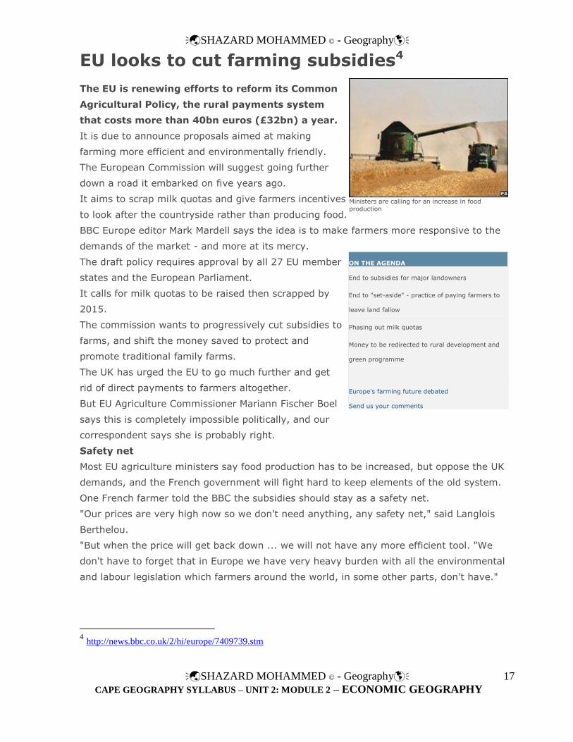
EU looks to cut farming subsidies4
The EU is renewing efforts to reform its Common
Agricultural Policy, the rural payments system
that costs more than 40bn euros (£32bn) a year.
It is due to announce proposals aimed at making
farming more efficient and environmentally friendly.
The European Commission will suggest going further
down a road it embarked on five years ago.
It aims to scrap milk quotas and give farmers incentives
to look after the countryside rather than producing food.
BBC Europe editor Mark Mardell says the idea is to make farmers more responsive to the
demands of the market - and more at its mercy.
The draft policy requires approval by all 27 EU member
states and the European Parliament.
It calls for milk quotas to be raised then scrapped by
2015.
The commission wants to progressively cut subsidies to
farms, and shift the money saved to protect and
promote traditional family farms.
The UK has urged the EU to go much further and get
rid of direct payments to farmers altogether.
But EU Agriculture Commissioner Mariann Fischer Boel
says this is completely impossible politically, and our
correspondent says she is probably right.
Safety net
Most EU agriculture ministers say food production has to be increased, but oppose the UK
demands, and the French government will fight hard to keep elements of the old system.
One French farmer told the BBC the subsidies should stay as a safety net.
"Our prices are very high now so we don't need anything, any safety net," said Langlois
Berthelou.
"But when the price will get back down ... we will not have any more efficient tool. "We
don't have to forget that in Europe we have very heavy burden with all the environmental
and labour legislation which farmers around the world, in some other parts, don't have."
Ministers are calling for an increase in food
production
ON THE AGENDA
End to subsidies for major landowners
End to "set-aside" - practice of paying farmers to
leave land fallow
Phasing out milk quotas
Money to be redirected to rural development and
green programme
Europe's farming future debated
Send us your comments
4 http://news.bbc.co.uk/2/hi/europe/7409739.stm

SHAZARD MOHAMMED © - Geography
SHAZARD MOHAMMED © - Geography
CAPE GEOGRAPHY SYLLABUS – UNIT 2: MODULE 2 – ECONOMIC GEOGRAPHY
18
In the diagram above, the combination of technologies that are faster – smaller – more
integrated – more intelligent fuels a bifurcation in production agriculture. Agricultural practices
that yield what people use in petroleum, fibre, and industrial applications take advantage of
economies of scale and promote globalization and commoditization. Meanwhile, those
agricultural practices that result in what people eat such as nutraceuticals, place-based
specialties, food with specific qualities (organic, faith-based, ethnic), and livestock, leverage
economies of place and tend toward localization and customization.
The dichotomy prompted by the bifurcation of production agriculture feeds a creative tension
along the continuum of energy—an energy that if usefully applied, has the potential to bring the
association of agriculture and civilization into a more favorable balance than at any time in
human history. As condition reports are received through different media about changing
conditions and circumstances in production agriculture they can be tied to the "strategic
framework" suggested by the diagram and organized into meaningful actions on the continuum
in response. And given the advances that are on the horizon this topic of agriculture,
civilization, and technology will provide ample fodder for future consideration!
SHAZARD MOHAMMED © - Geography
SHAZARD MOHAMMED © - Geography
CAPE GEOGRAPHY SYLLABUS – UNIT 2: MODULE 2 – ECONOMIC GEOGRAPHY
19
SHAZARD MOHAMMED © - Geography
SHAZARD MOHAMMED © - Geography
CAPE GEOGRAPHY SYLLABUS – UNIT 2: MODULE 2 – ECONOMIC GEOGRAPHY
20
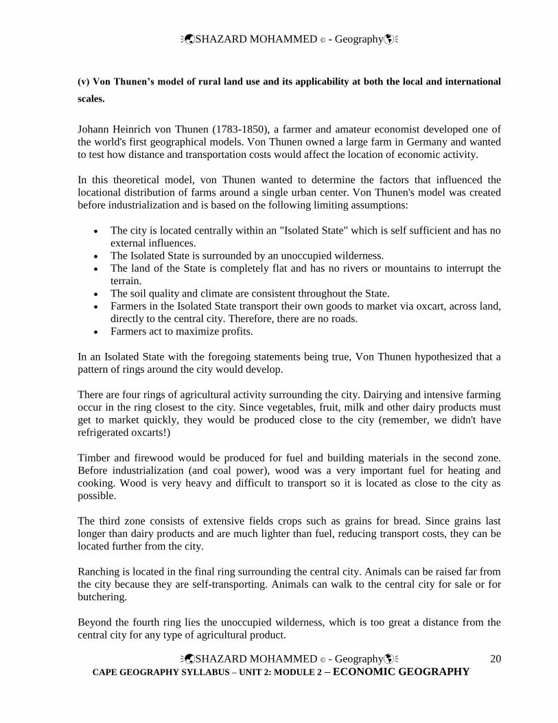
(v) Von Thunen’s model of rural land use and its applicability at both the local and international
scales.
Johann Heinrich von Thunen (1783-1850), a farmer and amateur economist developed one of
the world's first geographical models. Von Thunen owned a large farm in Germany and wanted
to test how distance and transportation costs would affect the location of economic activity.
In this theoretical model, von Thunen wanted to determine the factors that influenced the
locational distribution of farms around a single urban center. Von Thunen's model was created
before industrialization and is based on the following limiting assumptions:
The city is located centrally within an "Isolated State" which is self sufficient and has no
external influences.
The Isolated State is surrounded by an unoccupied wilderness.
The land of the State is completely flat and has no rivers or mountains to interrupt the
terrain.
The soil quality and climate are consistent throughout the State.
Farmers in the Isolated State transport their own goods to market via oxcart, across land,
directly to the central city. Therefore, there are no roads.
Farmers act to maximize profits.
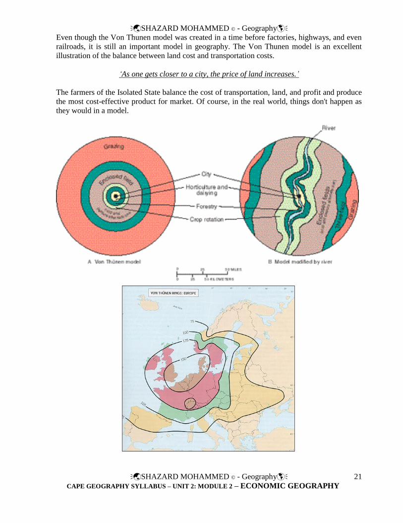
In an Isolated State with the foregoing statements being true, Von Thunen hypothesized that a
pattern of rings around the city would develop.
There are four rings of agricultural activity surrounding the city. Dairying and intensive farming
occur in the ring closest to the city. Since vegetables, fruit, milk and other dairy products must
get to market quickly, they would be produced close to the city (remember, we didn't have
refrigerated oxcarts!)
Timber and firewood would be produced for fuel and building materials in the second zone.
Before industrialization (and coal power), wood was a very important fuel for heating and
cooking. Wood is very heavy and difficult to transport so it is located as close to the city as
possible.
The third zone consists of extensive fields crops such as grains for bread. Since grains last
longer than dairy products and are much lighter than fuel, reducing transport costs, they can be
located further from the city.
Ranching is located in the final ring surrounding the central city. Animals can be raised far from
the city because they are self-transporting. Animals can walk to the central city for sale or for
butchering.
Beyond the fourth ring lies the unoccupied wilderness, which is too great a distance from the
central city for any type of agricultural product.
SHAZARD MOHAMMED © - Geography
SHAZARD MOHAMMED © - Geography
CAPE GEOGRAPHY SYLLABUS – UNIT 2: MODULE 2 – ECONOMIC GEOGRAPHY
21
Even though the Von Thunen model was created in a time before factories, highways, and even
railroads, it is still an important model in geography. The Von Thunen model is an excellent
illustration of the balance between land cost and transportation costs.
‘As one gets closer to a city, the price of land increases.’
The farmers of the Isolated State balance the cost of transportation, land, and profit and produce
the most cost-effective product for market. Of course, in the real world, things don't happen as
they would in a model.
SHAZARD MOHAMMED © - Geography
SHAZARD MOHAMMED © - Geography
CAPE GEOGRAPHY SYLLABUS – UNIT 2: MODULE 2 – ECONOMIC GEOGRAPHY
22
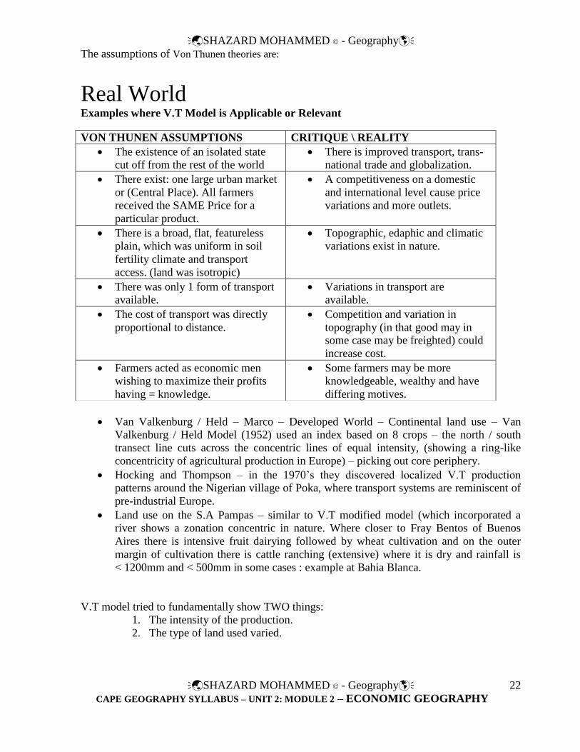
The assumptions of Von Thunen theories are:
Real World Examples where V.T Model is Applicable or Relevant
Van Valkenburg / Held – Marco – Developed World – Continental land use – Van
Valkenburg / Held Model (1952) used an index based on 8 crops – the north / south
transect line cuts across the concentric lines of equal intensity, (showing a ring-like
concentricity of agricultural production in Europe) – picking out core periphery.
Hocking and Thompson – in the 1970’s they discovered localized V.T production
patterns around the Nigerian village of Poka, where transport systems are reminiscent of
pre-industrial Europe.
Land use on the S.A Pampas – similar to V.T modified model (which incorporated a
river shows a zonation concentric in nature. Where closer to Fray Bentos of Buenos
Aires there is intensive fruit dairying followed by wheat cultivation and on the outer
margin of cultivation there is cattle ranching (extensive) where it is dry and rainfall is
< 1200mm and < 500mm in some cases : example at Bahia Blanca.
V.T model tried to fundamentally show TWO things:
1. The intensity of the production.
2. The type of land used varied.
VON THUNEN ASSUMPTIONS CRITIQUE \ REALITY
The existence of an isolated state
cut off from the rest of the world
There is improved transport, trans-
national trade and globalization.
There exist: one large urban market
or (Central Place). All farmers
received the SAME Price for a
particular product.
A competitiveness on a domestic
and international level cause price
variations and more outlets.
There is a broad, flat, featureless
plain, which was uniform in soil
fertility climate and transport
access. (land was isotropic)
Topographic, edaphic and climatic
variations exist in nature.
There was only 1 form of transport
available.
Variations in transport are
available.
The cost of transport was directly
proportional to distance.
Competition and variation in
topography (in that good may in
some case may be freighted) could
increase cost.
Farmers acted as economic men
wishing to maximize their profits
having = knowledge.
Some farmers may be more
knowledgeable, wealthy and have
differing motives.
SHAZARD MOHAMMED © - Geography
SHAZARD MOHAMMED © - Geography
CAPE GEOGRAPHY SYLLABUS – UNIT 2: MODULE 2 – ECONOMIC GEOGRAPHY
23
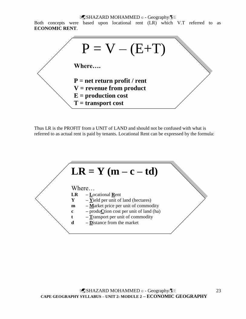
Both concepts were based upon locational rent (LR) which V.T referred to as
ECONOMIC RENT.
Thus LR is the PROFIT from a UNIT of LAND and should not be confused with what is
referred to as actual rent is paid by tenants. Locational Rent can be expressed by the formula:
LR = Y (m – c – td)
Where… LR – Locational Rent
Y – Yield per unit of land (hectares)
m – Market price per unit of commodity
c – produCtion cost per unit of land (ha)
t – Transport per unit of commodity
d – Distance from the market
P = V – (E+T)
Where….
P = net return profit / rent
V = revenue from product
E = production cost
T = transport cost

SHAZARD MOHAMMED © - Geography
SHAZARD MOHAMMED © - Geography
CAPE GEOGRAPHY SYLLABUS – UNIT 2: MODULE 2 – ECONOMIC GEOGRAPHY
24
A Model of Agricultural Location – The Nature of Demand and Distance from Markets
Distance from
market
Locational (economic) rent i.e. profits is
absorbed at X – after that cultivation
becomes unprofitable.
Locational Rent
i.e.
Profits
SHAZARD MOHAMMED © - Geography
SHAZARD MOHAMMED © - Geography
CAPE GEOGRAPHY SYLLABUS – UNIT 2: MODULE 2 – ECONOMIC GEOGRAPHY
25
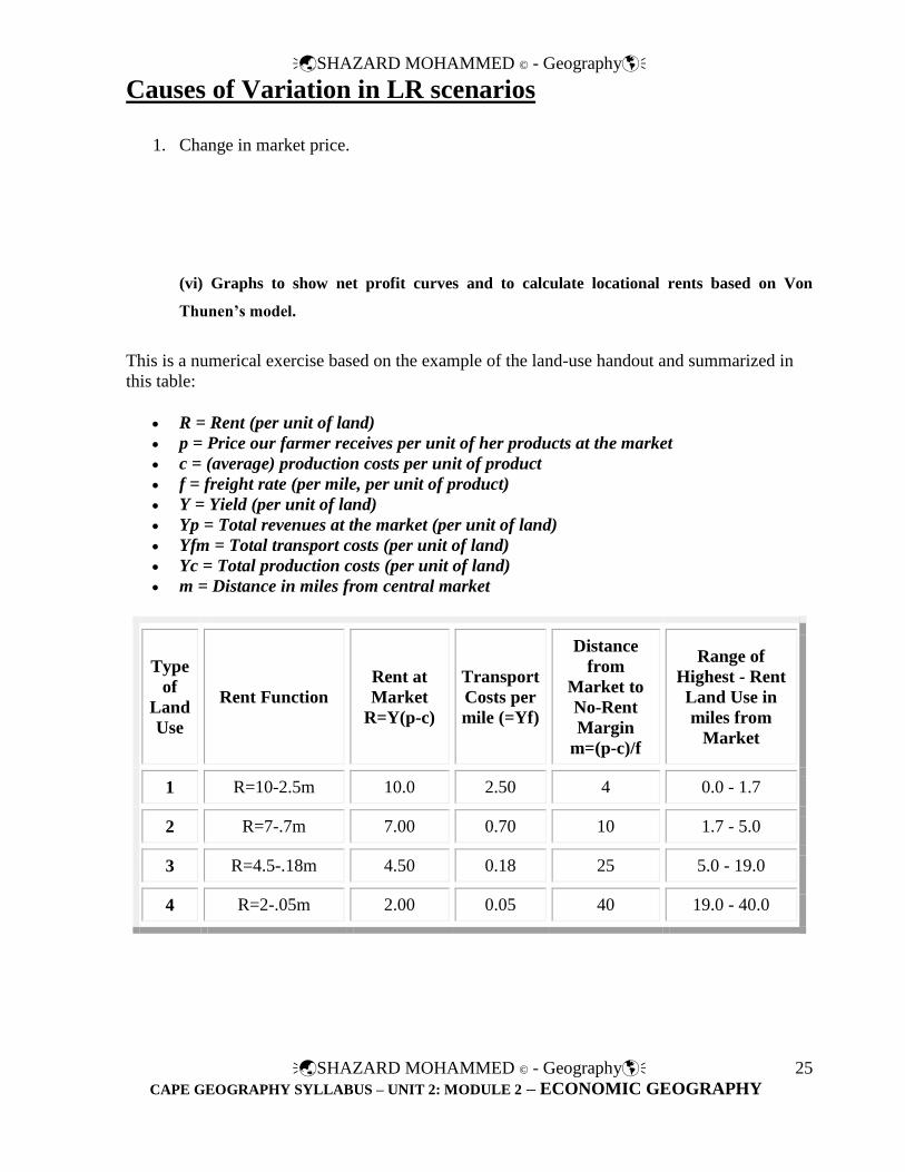
Causes of Variation in LR scenarios
1. Change in market price.
(vi) Graphs to show net profit curves and to calculate locational rents based on Von
Thunen’s model.
This is a numerical exercise based on the example of the land-use handout and summarized in
this table:
R = Rent (per unit of land) p = Price our farmer receives per unit of her products at the market
c = (average) production costs per unit of product
f = freight rate (per mile, per unit of product)
Y = Yield (per unit of land)
Yp = Total revenues at the market (per unit of land)
Yfm = Total transport costs (per unit of land)
Yc = Total production costs (per unit of land)
m = Distance in miles from central market
Type
of
Land
Use
Rent Function Rent at
Market
R=Y(p-c)
Transport
Costs per
mile (=Yf)
Distance
from
Market to
No-Rent
Margin
m=(p-c)/f
Range of
Highest - Rent
Land Use in
miles from
Market
1 R=10-2.5m 10.0 2.50 4 0.0 - 1.7
2 R=7-.7m 7.00 0.70 10 1.7 - 5.0
3 R=4.5-.18m 4.50 0.18 25 5.0 - 19.0
4 R=2-.05m 2.00 0.05 40 19.0 - 40.0

SHAZARD MOHAMMED © - Geography
SHAZARD MOHAMMED © - Geography
CAPE GEOGRAPHY SYLLABUS – UNIT 2: MODULE 2 – ECONOMIC GEOGRAPHY
26
Explanation of Exercise:
(1) The data given to you in the table refer to aggregate values for
1. Y(p-c)
2. Yf
3. (p-c)/f
Expand the example by giving specific values to Y, p, c, and f for all four land uses, initially
without changing the aggregate values. Interpret your new specific values for the different
crops. What kind of distance related regularities do you detect? Are these regularities inevitable
or could you (at least in part) eliminate them by changing your values (without, however,
changing the aggregate values provided in the table)?
Optional: ("We decided" in class to change the "optional" to "non-optional")
(2) Introduce some moderate changes in the variables (change of one variable at a time,
including changes in p and f sufficiently large to change the aggregate values of the original
example, and, as a result, of the size of the zones. Interpret the sensitivity of land use patterns
(size of zones) to such changes. (You might find it useful to remember the area of a circle...)
Further Explanation:
There are two parts to the question: for the first, you use the given aggregate values of the table
and disaggregate them into p, c, Y etc. so that you make the individual values consistent with all
the aggregate values. Ultimately, it is a matter of trial and error. I prefer it that way, so that you
actually try it out and get a feeling for the importance of different variables.
In the second question, you are asked to make some changes in the variables and observe the
effects of these changes.

SHAZARD MOHAMMED © - Geography
SHAZARD MOHAMMED © - Geography
CAPE GEOGRAPHY SYLLABUS – UNIT 2: MODULE 2 – ECONOMIC GEOGRAPHY
27
The Cultural Landscape: An Introduction to Human Geography, Eighth Edition. This website
provides both drill-based review exercises and web-based critical thinking exercises that expand
upon the content of the text.
The following link would take you to a worksheet you should attempt – feel free to browse the
other relevant chapters on the ‘chapter select’ bar above.
http://wps.prenhall.com/esm_rubenstein_humangeo_8/0,9140,1363345-content,00.utf8.html

SHAZARD MOHAMMED © - Geography
SHAZARD MOHAMMED © - Geography
CAPE GEOGRAPHY SYLLABUS – UNIT 2: MODULE 2 – ECONOMIC GEOGRAPHY
28
(vii) The potential impact of climate change on farming systems in LDC’s
Climate 'could devastate crops'5
Climate change could cause severe crop losses in South Asia and
southern Africa over the next 20 years, a study in the journal
Science says.
The findings suggest southern Africa could lose more than 30% of its
main crop, maize, by 2030.
In South Asia losses of many regional staples, such as rice, millet and
maize could top 10%, the report says.
The effects in these two regions could be catastrophic without
effective measures to adapt to climate change.
The majority of the world's one billion poor depend on agriculture for their livelihoods. Yet, said lead author
David Lobell, it is also "the human enterprise most vulnerable to climate change".
The researcher, from Stanford University in California, US, added: "Understanding where these climate
threats will be greatest, for what crops and on what timescales, will be central to our efforts at fighting
hunger and poverty over the coming decades."
'Crushing' losses
The study used computer models to assess the impact of climate change on farming in 12 world regions
where the bulk of the world's malnourished people live. This included much of Asia, sub-Saharan Africa, the
Caribbean and Central and South America.
"To identify which crops in which regions are most under threat by 2030, we combined projections of
climate change with data on what poor people eat, as well as past relationships between crop harvests and
climate variability," Dr Lobell explained.
The scale and speed of the effects on agriculture surprised the scientists.
"For poor farmers on the margin of survival, these losses could really be crushing," said co-author Marshall
Burke, also of Stanford University.
All the models agree that there will be adverse effects on maize in southern Africa and rice in South-East
Asia, but the picture is less certain in other areas such as parts of West Africa where it is unclear how global
warming will impact the local climate.
Early investment
"For these regions, you get half of the climate models telling you it's going to get wetter and the other half
giving you the opposite," said Dr Burke.
"As a result, our study raises the potential for very bad impacts in these regions but with much less certainty
than in other regions."
The work can help priorities
investment, say the authors
5 http://news.bbc.co.uk/2/hi/sci/tech/7220807.stm

SHAZARD MOHAMMED © - Geography
SHAZARD MOHAMMED © - Geography
CAPE GEOGRAPHY SYLLABUS – UNIT 2: MODULE 2 – ECONOMIC GEOGRAPHY
29
A few developing regions, such as the temperate wheat-growing areas of China, could actually benefit in the
short run from climate change, he added.
Since it typically takes 15 to 30 years for major agricultural investments to be fully realised, work must start
soon to help subsistence farmers increase their yields or switch crops, the study says. While relatively
inexpensive changes, such as switching crops or altering planting seasons, could trim the losses, "the biggest
benefits will likely result from more costly measures, including the development of new crop varieties and
expansion of irrigation," the authors wrote.
----------------------------------------------------------------------------------------------------------------------------- ------
FACTBOX - Impact of climate change on India6
A shopkeeper sits in his shop on a flooded street in Porbander, 400 km (248 miles) west of the western Indian city of Ahmedabad, July 27, 2009.
(Reuters) - India is among countries most threatened by
climate change with experts warning that rising
temperatures will lead to more floods, heatwaves, storms,
rising sea levels and unpredictable farm yields.
Here are the main potential effects of climate change on a country which is the world's
seventh largest in area and is home to 1.1 billion people, a sixth of humanity.
MONSOON
Various studies show that surface air temperatures in India are going up at the rate of 0.4
degrees Celsius every 100 years, particularly during the post-monsoon and winter seasons.
While mean winter temperatures could increase by as much as 3.2 degrees Celsius in the
2050s, summer temperatures could go up by 2.2 degrees Celsius in the 2050s, spurring
climate variability.
Extreme temperatures and heat spells could alter patterns of monsoon rains, vital for
India's agriculture and water needs. Scientists warn that India will experience a decline in
summer rainfall by 2050. The monsoon accounts for almost 70 percent of the country's
total annual rainfall. Winter rains are also predicted to fall by 10-20 percent. Higher
temperatures also mean faster melting of Himalayan glaciers and as the melting season
coincides with the monsoon season, any intensification of the monsoon is likely to
contribute to flood disasters in the Himalayan catchment.
6 http://in.reuters.com/article/topNews/idINIndia-41393820090729?sp=true
SHAZARD MOHAMMED © - Geography
SHAZARD MOHAMMED © - Geography
CAPE GEOGRAPHY SYLLABUS – UNIT 2: MODULE 2 – ECONOMIC GEOGRAPHY
30
AGRICULTURE
Agriculture will be adversely affected not only by an increase or decrease in the overall
amounts of rainfall, but also by shifts in the timing of the rainfall. Higher temperatures
reduce the total duration of a crop cycle, leading to a lower yield per unit area, especially
for India's wheat and paddy crops.
Soil erosion, increased numbers of pests and weeds brought by climate change will also
affect agriculture in India. For instance, the amount of moisture in the soil will be affected
by changes in factors such as rainfall, runoff and evaporation.
RISING SEAS
A 10-year study in and around the Bay of Bengal points to the sea rising 3.14 mm a year in
the mangrove swamps of the Sunderbans delta against a global average of 2 mm,
threatening the low-lying area which is home to about 4 million people.
A trend of sea level rise of 1 cm per decade has been recorded along the Indian coast. The
major delta area of the Ganga, Brahmaputra and Indus rivers, which have large
populations reliant on riverine resources, will be affected by changes in water regimes, salt
water intrusions and land loss.
HEALTH
Rise in temperature and change in humidity will adversely affect human health in India.
Heat stress could result in heat cramps, heat exhaustion, heat stroke and weaken immune
systems. Increased temperatures can increase the range of vector-borne diseases such as
malaria, particularly in regions where minimum temperatures currently limited the spread
of such diseases.
(Sources: Greenpeace, UNDP, Centre for Science and Environment)
http://www.climateandfarming.org/additional_resources.php
SHAZARD MOHAMMED © - Geography
SHAZARD MOHAMMED © - Geography
CAPE GEOGRAPHY SYLLABUS – UNIT 2: MODULE 2 – ECONOMIC GEOGRAPHY
31
THEORIES OF INDUSTRIAL LOCATION
Models form an integral and accepted part of present-day geographical thinking. Models, as in
many branches of geography, have been formulated in an attempt to try to explain, in a
generalized simplified way some of the complexities affecting Industrial Location (IL). The two
major models are:
1. The industrialist who seeks the lowest-cost location: Weber
2. The industrialist who seeks the area which gives the highest profit: Smith
WEBER’S LEAST COST LOCATION
Alfred Weber, a German economist, devised in 1909 the theory of IL. It was based on the
concept of LEAST –COST LOCATION that would enable profit maximization.
Weber was concerned about the relationship between the locations of
(i) Raw materials
(ii) Market and
(iii)The significance of transportation between these.
He looked at individual factories and in so doing he made a series of assumptions from which
later generalizations could be made. Weber’s assumptions include the following:
- An ISOTROPIC PLANE with ease of access in ALL directions.
- An uneven distribution of natural resources with concentrations at particular
locations.
NB: Ubiquitous materials were evenly distributed materials.
- Labor is at fixed locations with fixed wage rates and is immobile and unlimited.
- Culture, climate and political systems are uniformed.
- Markets are fixed in size and location on the plane.
- The entrepreneur will always minimize the costs of production.
- Perfect competition exists (markets and raw material were unlimited)
- There is no variation in the cost of land, structures, equipment or capital.
- There is a uniform transport system over the isotropic plane.