united states department of interior … · the pisgah test site area is within the lasin and range...
TRANSCRIPT
UNITED STATES
DEPARTMENT OF INTERIOR
GEOLOGICAL SURVEY
INFFVRED SURVEY OF THE PISGAH CRA: ER'AREA,
SAN BERNARDINO COUNTY, CALIFOEWIA
A GEOLOGIC INTERPRETATION
Stephen J. Gawarecki
October 1968
OPEN FILE REPORT
U. S. Geological SurveyCPEcI ?IL3 RE703T
7hia report in prs Urinary c-r »-'v*, ^''vT ^ iit'i ii or* rov' ov/cd ~* .*.j.''J"7r-iiIv "jritli Gcolc^icul S
- U

ILLUSTRATIONS
Figure 1 - Index map showing location of Pisgah Crater area
Figure 2 - Simshine lava field viewed from Lavic Lake. Older flow on righto
Figure 3 - Pisgah fault scarp with tumulus development. Pick is on foot wall" of fault that dips 55°SW
Figure k- - Tj'pical pahoehoe surface of first Pisgah basalt flow (Qbn), at station 66-3 near Lavic Lake. Thermistor is attached for monitorirg temperature. Note wind blown silt
Figure 5 - Fissured aa dome in first Pisgah flow (Qb-) about 2,500 feet south- southeast of crater.
Figure 6 - Typical aa surface of second Pisgah basalt flow (Qbg) at station66-3' near Lavic Lake. The extremely rough surface illustrates difficulty in placing thermistors to obtain representative temperaturas.
Figure 7 - View of collapsed lava tubes in pahoehoe basalt of third Pisgah flow (Qto). Aa of second flow in background.
Figure 8 - Interioi view of Hsgah cone. Crater is floored with typical pahoehoe. basalt.
Figure 9 - Road cut in slope of Pisgah cone showing surface and buried silty horizons.
Figure 10 - Typical moisture stripe boundary of giant dessication polygon in. Lavic Lake near center, section 27.
Figure H - Dessication cracks in Lavic playa next to Pisgah flow at station 66-2. Fote surface and subsurface placement of thermistors.
HATES
Plate 1 - Index Map of Pisgah Crater, San Bernardino County, California (showing flight lines) ^__'
Plate 2 - Geologic Map of Pisgah Crater Area, San Bernardino County, California
Plate 3 - Infrared Images along Flight Line 1, showing changes in thermal response of rock materials throughout a diurnal cycle.
Plate k- - Infrared images along Flight line 2, showing changes in thermal response of rock materials throughout a diurnal cycle.
Plate 5 - Infrared images along flight line 3 showing changes in thermal response of rock materials throu^iout a diurnal cycle.

INFRARED SURVEY OF THE PISGAH CRATER AREA, SAN BERNA3DBJO COUNTY, CALIFORNIAA GEOLOGIC INTERPRETATION
CONTENTS
Bsige
Abstract............................................................. iPreface..................... Q ...............................o o....... iiIntroduction........... 0 .......° 0 .............. o.. o...... 0 . o......... 1
General statement................................o......... <,...... 1Previous studies........................................o......... k
Geology................................ o.. o..... o..........o.......... 5Geomorphic setting................o............................... 5Lithology....................... 0 ................................. 6
General comnents......................... ...................... 6Biotite quartz monzonite........................ 0 .......... o... 7Dacite porphyry...... 0 ........................ 0 .. 0 ............. 7Andesite breccia............................................... 8Toff breccia................................................... 9Fanglomerate of granitic detritus.............................. 9Basalt.o................................... o................... 9Claystone........... 0 .... o............ o........................ 10Older fanglomerate and gravel................... ..<>............ 10Sunshine basalt flows.............................. e ........... 13"Pisgah basalt flows............... 0 ....o....................... 17Alluvium of basaltic pumice and/or detritus.................... 2kPlaya deposits................................................. 25Older alluvium.............................. 0 ......o........... 27Basaltic gravel mosaic..................... <,.o...... o.......... 27Alluvium....................o.......................... o....... 27
Structure...................................................... 0 .. 27Faults............o............................................ 27Folds.............o............................................ 30
Instrumentation......................................... 0 ............ 30Interpretation of the Infrared Imagery............ 0 .................. 33Conclusions.......................................................... ^-6References. .<,.<,..................................... 0 ................ ^8

TABLE
Table 1 - Modal analysis of Sunshine and Pisgah basalts.

INTRODUCTION
General Statement
The infrarer1 survey of the Pisgah Crater <\rea, San Bernardino
County, California was primarily undertaken to establish parameters
by which rock types, structures, and textures peculiar to this locale
could be recognized or differentiated. A secondary purpose was to
provide an adequate evaluation and calibration of airborne and ground-
based instruments used in the survey,,
Pisgah Crater and its vicinity was chosen as one of the fundamental
test sites for the NASA remote sensing program because of its relatively
fresh basaltic flows and pyroclastics. Its typical exposure of basalt
also made it a possible lunar analogue. A fundamental test site for
the purpose of the program is defined as a readily accessible area for
which the topography, geology, hydrology, soils, vegetation and other
features are relatively well known. All remote sensor instrument teams,
i»e, infrared, radar, microwave, and photography, were obligated to use
the fundamental test sites for instrument evaluation and to establish
terrain identification procedures 0
Pisgah Crater, nearby Sunshine Cone, and their associated lava
flows are in the southern Mojave Desert about 40 miles east-southeast
of Barstow, California. (See fig. 1.) U. S. Highway 66 skirts .the
northern part of the area and provides access via asphalt paved and
dirt roads to the Crater and to the perimeters of the flows.
- 1 -

' "V' l\
trrp*5 Pl4153
S £ R T
^0^ V - *K>.
. .T* :/,,u»v '\U'J
<^ *^r°^anc/
I«?^?lK"'-S;""'>0J?^^^ot*.l0 Je^^d;n
P7^,/^ .I-ud/c
^r^fol Lak
?^^^V^-.oo^0&0 ^^°K 1 ^TT-'^-^C^' <^^A\a.0^s^if'" :°;^o".f'r^/- ^«--Jfc»*5ife&^ '^Sv'^t.7°^"'vSS%s ««R
rtBe»^Vo v\ CaA^r /.- ^nV m V/nos i^
^u^^.,Wn̂ l. He^ fe^ :<
too
Scale in niles
Fig. 1 Index map shoving location of Pisgah Crater area

Pisgah Crater, which is a pumiceous cone, is owned and occasionally
quarried by the Atchison, Topeka and Santa Fe Railroad. The remaining
part of the area -o the south is within the boundary of the Marine Corps
Base, Twentynine Palms, California and is currently being used as a
gunnery and bombing range. The proximate area to east, west, and north
of Pisgah Crater is public domain.
Originally, an area totaling 10 square miles was outlined for detailed
studyo (See plats 1.) This included an 8 mile long strip extending south
east from and including Pisgah Crater to Lavic Dry Lake, and a 2 mile strip
aligned to include a portion of the Sunshine lava flow and the dry lake.
Additional aerial infrared imagery of the Sunshine and Pisgah flows along
the Pisgah fault proved so interesting and informative that this area is
included in the discussion.
Infrared surveys were flown February 11 through 13, 1965 and August
5 and 9> 1966o The initial survey was flown by the NASA personnel aboard
the NASA 926 Convair 240 aircraft. Because of technical problems with the
infrared scanners (4.5 5.5 and 8-14 micron bands) and with certain ground
instruments, most of the imagery and ground temperature data obtained
during the initial survey period was of little value. However, excellent
infrared imagery in the 8-14 micron (y) region of the spectrum was acquired
by the Geological Survey during the August 1966 survey. The scanner was
mounted in a Beech D-18 aircraft provided by the Survey's Water Resources
Division. Likewise, more reliable ground data was obtained at this time
owing to improved instrumentation and technique.
- 3 -

Ground data were taken by Geological Survey personnel including
W. A. Fischer, J. D. Friedman, W. R. Hemphill, D. L. Daniels, G.-*R.
Boynton, P 0 tf. Philbin and the author. C. R. Fross operated the
infrared scanner during the August, 1966 .survey and R. M. Turner
was responsible for photo processing of the infrared imagery. Their
assistance, is gratefully acknowledged.
: Previous Studies
The geology of the Pisgah Crater area has been previously mapped
in whole or Ypart by several geologists. Highly generalized reconnaissance
maps were me.de. by Darton (1915, sheet 23), Gardner (1940), and Kupfer
and Bassett (1962) at the respective scales of 1:500,000, 1:250,000, and
1:125,000. Dibblee (1966) and Dibbles and Bassett'(1966) mapped the
Lavic and Ccdy Mountains quadrangles respectively at a scale of 1:62,500,
covering the area of the present study. In conjunction with the present
study, W. S. Wise (1966) mapped the Pisgah and Sunshine Cone lava fields
in detail,. Plate 2 is a compilation of these sources, of personal
observations in the field, and of geology taken from large scale aerial
photographs of the area. The author assumes responsibility for the
resulting geological interpretation of the mappable units as presented
in this report.
Several NASA technical letters on the Pisgah Crater area were distrib
uted by the Geological Survey. These included reports and/or prelim
inary maps by Gawarecki (1964), Dibblee (1965), Fischer and others (1965),
Altenhofen (1965), Daniels (1966), and Friedman (1966).
- 4 -

GEOLOGY
Geomorphic Setting
The Pisgah test site area is within the Lasin and Range physio
graphic province and is one of the many centers of recent volcanic
activity which lie on broadly alluviated valleys and playas across
the central part of San Bernardino County. The area also lies within
the southern Mojave Desert, a part of the Mojave structural block,
which is characterized by generally northwest-trending fault block
mountains and intermontane basins 0
Elevations in the Pisgah area range from 1,886 feet above sea
level at Lavic Dry Lake in sec. 27, T. 7 N., R. 6 E. to 4,421 feet
at Sunshine Peak, which is 4 miles distant in NW 1/4, sec. 1 T 0 6 N.,
R» 5 E. The maximum elevation in the area of detailed study is 3,121
feet above sea level at Sunshine Cone, but the average is close to
2,100 feet.
The drainage is internal, to Lavic Lake playa on the south, and
to Troy Dry Lake on the northwest. The two areas are believed to have
been connected by northward drainage during Pleistocene time (Kerr and
Langer, 1965), prior to damming by the flood of Pisgah basalt and
subsequent development of the playas during the pluvial stages. The
lake beds have been augered to a depth of 160 feet in the northeast
part of Lavic Lake without reaching lava (Dellwig and others, 1966),
indicating that a considerable amount of deposition that has taken
place a A dry 10-foot deep bomb crater observed in the lake bed shows
that the water table is not near the surface.
- 5 -

The surface cf the playa is extremely flat and has widely de
veloped giant desiccation polygons whose sides are outlined by
moist sediments and, in many cases, by vegetation. Inside the southern
and western margins of the playa, phreatophyte mounds have been
formed by the aeolian deposition of sand and silt around the base of
brushy vegetation. The moisture for this and other vegetation is
probably derived from coarser intercalated detrital beds below the
surface related to the alluvial fans bordering the playa.
Recent deposition appears to be minor. Thi playa may contain
shallow standing water for brief periods after a rare desert cloud
burst. During the August, 1966 period of investigation, only the
eastern margin of the lake showed evidence of moisture. Rainfall in
this part of the Mojave Desert is only 1 to 2 inches annually 0
The effects of wind are especially noticeable on the north side
of the area where a long fetch enables the prevailing westerlies to
deposit sand and silt across the northern reach of the Pisgah flows
and the area immediately north of the Pisgah cone.
Lithology
General comments
The lithologic units found in the area are shown on the geologic
map (pi, 2), In addition to the sources of the geologic data described
earlier, geologic units discovered on the infrared imagery are included
on the map, A later section on the interpretation of the imagery will
treat properties of the various units insofar as they affect their
thermal behavior and contrast.
6 -

The rocks range in age from probable Mesozoic to Recent. Their
exact ages are, for the most part, unknown because there is very
little stratigraphic and no paleontologic control available for these
units of lira.ted lateral extent.
The following description of the lithologic units is necessary
for an understanding of their thermal behavior as shown on the imagery.
Biotite quartz monzonite (bgm)
The oldest rock recognized is a biotite quartz monzonite that is :
found on Peter's Mountain as a few small dnliers near the center and
in the NW 1/4 of sec. 19, T. 7 N., R. 6 E. Dibblee (1966) describes
it as a gray, massive, medium-grained, commonly porphyritic granitic
rock composad of from 10 to 30 percent quartz, 35 to 50 percent
plagioclase (andesine); 15 to 30 percent potassic feldspar, in many
places as orthoclase phenocrysts up to 2 cm. long; 3 to 20 percent
biotite,'in part altered to iron oxides; 0 to 5 percent hornblendes;
and a total of about 1 percent sphene, zircon, and magnetite. Field
relations west of the Lavic quadrangle lead Dibblee (1966) to consider
the monzonite to be of Mesozoic age.
Da-cite porphyry (Tdp)
Dacite porphyry of the Lava Bed Mountains borders the western
part of the study area. It is in intrusive contact with the biotite
quartz monzonite and has been the primary source of the gravels on
the west side of the area. It is a gray-white to light-greenish-gray
massive prophyry composed of euhedral and subhedral phenocrysts as
large as 4 mm. In a microcrystalline groundmass, the phenocrysts,
- 7 -

which make up 40 to 60 percent of the rock mass, are mostly plagioclase
(oligoclase-andesine) with minor amounts of biotite, hornblende, and
quartz (Dibblee, 1966). The gray-white groundmass is composed of
plagioclase and putassic feldspar and traces of iron oxides. Emplace
ment of the porphyry as a large intrusive mass probably occurred during
an early stage of Tertiary volcanic activity. Dibblee (1966) suggests
the dacite porphyry is most likely of Oligocene or early Miocene age
or possibly older.
Andesite breccia ]Tab)
In the Peter's Mountain area, a sequence of volcanic and sedi
mentary rocks, probably as old as middle Tertiary, overlies the
eroded biotite quartz monzonite. The descriptions of rocks within
this sequence are largely those of Dibblee (1966) with additional
comments by the author.
The oldest rock unit in this sequence is an andesite breccia,
estimated to be about 250 feet thick. Gardner (1940) tentatively
correlated it with the Red Mountain andesite. The unit is a flow
breccia, massive to very crudely bedded, composed of light-pinkish to
very dark reddish-brown unsorted angular fragments of andesite in
andesite matrix. The andesite proper has phenocrysts as large as 4 mm.
which make up from 20 to 50 percent of the rock and which are set in
a macrocrystalline to subvitreous groundmass. Most of the phenocrysts
are white plagioclase (andesine?), but some are small plates of
biotite, needles of hornblende, or rarely, quartz. The groundmass
is mostly plagioclase with little or no potassic feldspar, and minor
specks of iron oxide.
- 8 -

Tuff breccia (Tt)
Unconformably overlying the andesite breccia, in the NE 1/4,
sec0 19 T. 7 N., F. 6 E., is a pinkish-tan to gray-white tuff breccia
composed of small white fragments of devitrified pumice and small to
large angular fragments of porphyritic to felstic andesitic rocks of
Tertiary age in a matrix of fine- to coarse-grained tuff. The unit
also contains some intercalated beds of tuffaceous sandstone and
conglomerate with andesite and dacite porphyry detritus..
Fanglomerate of granitic detritus (Tfg)
A fanglomerate of granitic detritus covers the andesite and
tuff breccias on the north, in sees. 17 and 18, T. 7 N., R. 6 E.
On the eastern side of Peter ! s Mountain, the fanglomerate is medium
tannish-gray, and is composed of unsorted, subangular boulders of
quartz monzonite in an arkosic matrix. Desert varnish is common.
The age of this fanglomerate is believed to be Oligocene or Miocene.
Basalt (Tb)
Above the fanglomerate stratigraphically, and perhaps also inter
calated with and intruded into it, is a massive to thickly-layered
basalt that caps Peter's Mountain and occurs as scattered outliers
as far north as sec. 7, T. 7 N., R. 6 E, Sizeable basalt outcrops
found east of the Pisgah flow are similar lithologically and strati
graphically to those on Peter's Mountain. Dibblee (1966) considers
the eastern basalt flow to be slightly younger than those to the west,
but because of their similarities, the author believes them to be the
same unit. Basalt in both are olivine-bearing dark gray to black,
vesicular, with differences that are common to any large flow or sequence
9
of related flows* They differ from the younger Sunshine and Pisgah
flows in being finely crystalline rather than significantly glassy
in character.
The surface of basalt is generally devoid of sharp outcroppings
and is commonly mantled by large angular blocks. The outcrops east
of Lavic Lake appear to support more brushy vegetation than do those on
the xtfest e
Gardner (1940) tentatively correlated this basalt unit with the
Black Mountain Be salt of Pliocene (?) and Pleistocene age. Dibblee
(1966) believes that the western occurrences are probably either
Oligocene or Miocene. There is no definite evidence for either
opinion. However, the relationships of the later basalts with the
Lavic Lake beds, which may in part represent Pleistocene pluvial
deposits, suggest that the so-called Black Mountain Basalt correlative
is significantly older than Pleistocene, probably Pliocene in age.
Claystone (QTc)
A light-reddish-brown to greenish-gray massive to bedded clay-
stone is described by Dibblee and Bassett (1966) as outcropping about
3 miles west-northwest of Pisgah Crater. Interbedded with the clay is
a 10-foot-thick cream-white, massive limestone and associated white
bentonitic tuff. Dibblee and Bassett (1966) indicate a probable
lacustrine origin for the beds which grade upward into an older gravel
and fanglomerate unit. The age of the claystone is believed to be late
Tertiary or Pleistocene.
Older fanglomerate and gravel (Qof)
A light tannish-gray fanglomerate and gravel overlies the
fanglomerate of granitic detritus (Tfg) on the north side of Peter's
- 10 -

Mountain and also the Tertiary basalt to the south. A similar
unit is found to the north and east of the Pisgah lava-field. In
both occurrences, the unit is a mostly unstratified fanglomerate of
poorly sorted cobbles and boulders in a coarse sandy matrix. In
the western occurrence, it differs from the underlying fanglomerate
(Tfg) primarily by being lighter in color and more easily eroded.X
At the other occurrences to the north and east, the source was to the
east and the unit contains more fragments of volcanic rocks, including
felsites, also Tertiary chert and jasper and Mesozoic granitic rocks.
In all occurrences, the unit is undergoing erosion. North of
Pisgah Crater sections of the surface have been stripped of the fines
by wind, leaving behind boulders and cobbles whose surfaces are coated
with desert varnish. The varnish causes the surface to appear darker
than most of the fresh rock surfaces.
The age of this unit is considered as Pleistocene by Dibblee
(1966), but may be as old as Pliocene.
- 11 -

m
Fig. 2 Sunshine lava field "viewed from Lavlc Lake older flow on right.
Fig. 3 Pisgah fault scarp with tumulus development.Pick is on foot wall of fault that dips 55°SV.

Sunshine basalt flows (Qbsl Qbs2 and Qps)
The Sunshine lava field, a major unit in the southwestern part of
the study area, resulted from at least two periods of eruption. Flows
related to each period are distinguishable (fig. 2). An older series of
flows (Qbs-^) in the north end of the field were primarily erupted from a
vent represented by a now faulted and eroded pumice cone in the center of
sec. 30, T. 7 N., R. 6. E. The younger flows (QbS2) to the south issued
from at least two vents: a partially buried cone in the NW 1/U sec. 30 5
T. 7 N., R. 6 E. sad the other, the slightly ercied Sunshine cone, in
sec. 31 of the same township. Some fissure flows from the Pisgah fault
may also have occurred at this time. The younger Sunshine basalt is found
as far south as sec. 21, T. 6 N., R. 6 E. Much of the intervening area of
flow, as in the northeast margin, is buried deeply by recent fanglomerate.
The eastern edge of the lava field is buried under the Lavic Lake beds and
fanglomerate, and the western margin is covered by fanglomerate from the
Lava Bed Mountains. »
The older basalt, which is dark gray to black on a fresh surface, is
described by Wise (1966) as a porphyritic alkali-olivine basalt. Single
phenocrysts, as veil glomeroporphyritic clots of plagioclase and olivine
occur in a groundmass of plagioclase, titanaugite, olivine, magnetite,
ilmenite, and anorthoclase. Minor, but consistently present dark brown
phenocrysts of titanaugite set these lavas apart from all others in the
Pisgah area. Tab3e 1 shows the modal analysis cf this flow.
The original surface of the flow has been almost entirely removed by
weathering and erosion and drainage is integrated. The flow surface is
rubbly and the angular blocks of basalt have developed a smooth desert
13

varnish. A product of weathering is a ubiquitous coating of calcium
carbonate on joint planes and in local minor depressions. This appears to
account in part at least, for the relatively lighter tone of the unit on
aerial photographs.
The younger basalt is also a dark gray to black vesicular alkali-
olivine basalt. Wise (1966) states that "scattered phenocrysts (3-5 mm.)
occur in a groundmass of plagioclase, titanaugite, olivine, magnetite,
ilmenite, and anorthoclase." He notes that plagioclase phenocrysts are
very rare to absent in the area of the test str.p although they are abundant
in a later flow on the southern end of the lava field. Modes are shown in
Table 1.
The original surface features of the younger series of flows are only
partially dulled by weathering and erosion. Numerous depressions still exist
that have developed into small carbonate and silt playas as large as ICO feet
across. Calcium carbonate is also prominent along joint planes as in the
older Sunshine flows.
The difference in surface erosion between the two units that make up
the Sunshine lava field appears to. indicate that a significant amount of
time had elapsed between the two major eruptive periods.
The three recognized pumice cones associated with the Sunshine flows
are all similar in their character and are considered as one lithologic
map unit of basalt pumice (Qps). They are described by Dibble (1966) as
brownish-black scoriaceous basalt composed of basaltic glass. The faulted
cone related to the earlier flow period has been noticeably dissected by
erosion and its pumiceous materials has been carried downslope to form an
epiclastic alluvium of pebble-cobble scoria and basaltic detritus (Qpa)
in the HE 1/U sec. 30, T. 7 N., R. 6 E. The cone to the west of the fault
is partially buried by fanglcmerate from the lava Bed Mountains and by

TABLE
Table 1 - Modal Analyses of Sunshine and Pisgah basalts by: W. S. Wise
Sunshine Lavas Pisgah Lavas
Mineral
OlivineJhenocrysts Groundmass
Plagioclase Rienocrysts Groundmass
Clinopyroxene Hienocrysts Groundmass
Alkali feldspar
Opaques
Apatite
Glass
Voids
First Second Flows I/ Flows 2/
5.05.7
7.217.9
0.319.2
10.6
15.0
k.l
tr
llj-,7
M5A
1.122.7
0.0Ik.3
k.I.
lk.3
1.5
10,1
22.2
First Second Flows 3/ Flowss/ y7.0 .5-7
1.522.6
0.120.5
k.O
11.7
3.6
lf.6
18.6
6.15.2
3.016.9
0.015-2
2.3
11.6
2.1
2^.0
13.3
P-23.52.2
2.811.9
0.03.7
0.7
tr
tr
Ul. 9
3^.0
Third Flows jj/
P-l' 1-5
2.8
k.k12.2
0.20.6
12.2
tr
tr
l&.k
30.0
I/ and 2/ Both samples from flows in center of test strip near shore of Lavic Lake, ne l/^ sec. 29. Each an avg. of 7 2000 point counts.
3/ These two samples -were collected in center of main test strip also near Lavic Lake, w. side of sec. 20. Each an avg. of h 2000 point counts.
k/ These two samples are from ifk mi south of Hsgah cone. Each an avg. of 8 2000 point counts.
Note the importance of the degree of crystallization in comparing these modal analyses. The two samples from near the cinder cones are at least 75% glass and bubbles, while those collected from the end of the flows at Lavic Lake are more completely crystallized,,

a flow that possibly emanated from its vent. The Sunshine cone is cut
by drainage rills 2 to 15 feet deep, but it essentially retains its
original shape. Its topography suggests that an earlier pyroclastic
stage may hava occurred. Gardner (19^0) notes that a small playa about
80 feet in diameter occurs in the center of the crater. In this respect
it is similar to most other cones that characteristically contain
substantial aiaounts of silt and weathering products, especially calcium
carbonate, sifted clown just below their surface.
Dibble (1966) presumes a Pleistocene age for the Sunshine basalt
eruption*.
16

Hsgah basalt flows (Qfrla Q,b2 , Qbo, and Qpb)
The Pisgah lava eruption, as described by Wise (1966), took place in
at least three distinct phases. His thesis is >ased solely upon the
texture of the phenocryst minerals in each phase.
The first eruptive phase of the basalt (Qfr-,) is believed to have
begun with the building of a cinder cone in the low hill area north of
the main cone and the issuance of lava from vents near the cone. Flows
extended as far as the Lavic basin, about 1/2 miles to the north, and
7 miles to the west-north west in the present vicinity of U. S. Route
66,
The flow is cut by- the Pisgah fault at the highway, where small
tumuli are spaced quite regularly along the fault (fig. 3)« The
uniformly HTTP ted development of the tumuli suggests that their source
was from below a congealed lava crust that ruptured during fault move
ment and not from along fault conduits below the effusive. The relations
indicate that the Pisgah fault was active at this time as does the
topography, which controlled the movement of all the Pisgah flows.
There is a possibility that the younger Sunshine flow was nearly
contemporaneous with the initial Pisgah eruption since it has the same
preserved surface appearance, and its direction of flow was controlled
by the fault and the developing Lavic basin. The older Sunshine flow-
is too eroded and weathered to be considered anything but older than
the first Pisgah phase.
17

The lavas of the first eruptive phase are composed of "blocky pahoehoe
and less commonly, aa type flows (figs, k and 5). Wise (ibid) finds the
flows to be a microporphyritic alkali-olivine basalt. Mcrophenocrysts of
olivine (less than 2mm.) are scattered and rare, The groundmass minerals
are olivine plagioclase, titanaugite, magnetite, and i3iaenite. Basic glass
is also a common constituent in the groundmass. (see Table l). The surface
of the flows commonly have the slight lustre of desert varnish which form
a tan-colored material that is a noticeable coating on fractures and at the
base of spall sheets that are common on the pahoehoe. All types of flows
are highly vesicular, indicating a substantial volatile or gas content
during the magmatic stage. The vesicles, which make up to one-third of
the volume, now contain a mixture of weathered products such as clay,
carbonate, and ferrous oxides.
The second eruptive phase (Qb? ) began after a long period of
quiescence; lava issued from at least 2 separate conduits. One conduit
built a cinder cone close to the present cone and a second.conduit domed
the earlier flow unit about 2,500 feet south-southeast of the Pisgah
crater and poured. forth a voluminous amount of lava from around the dome
base, - Several, small possible conduits are found scattered to the east and
south of the Pisgah cone (pi. 2). However, they may represent breaches in
the solidified crust that allowed lava to be issued under a magraatostatic
head from a subcrustal lava passage.
Lava from the second phase reached into th^ Lavic basin and again
flowed northwestward toward the highway along drainage developed west of
the first flow. The lava first overflowed the drainage then settled as
18

Fig. 4- Typical pahoehoe surface of first Pisgah basalt flow (Qb^) flow at station 66-3 near Lavie Lake* Thermistor is attached for monitoring temperature, Note windblown silt.
Fig. 5 Fissured aa ^ome in first Pisgah flow 2,500 feet south-southeast of crater.
about
19

it continued downstream, leaving prominent ridges of solidified lava
crust along its margins <> These and other levee-like pressure ridges
formed by the pulsating flood crests of lava ai 2 accentuated by alluvial
fan detrial deposited later in the troughs. A considerable part of this
flow is believed to be buried by the alluvial fan in this area.
The lava of this phase is largely aa (fig. 6), but pahoehoe surfaces
are found on most of the long west-ward part of the flow.
Lava tubes developed near the south end of the dome conduit close
to the end of the flow period. Subsequent partial collapse of the roof
occurred after drainage of the subcrustal lava.
The second flow is a black porphyritic alaki-olivine basalt with
larger olivine (2-*3fflm) and plagioclase (2-5mm) phenocrysts than the
first flow. The groundmass minerals whose modes are shown in table 1,
are the same as those found in the earlier phase. Basic glass makes up
over kO percent of the flow near the cone and only 2k percent in the Lavic
Lake area.
The third and probably final period of basalt flow (Qbo) occurred
from two separate points. The present Pisgah cinder cone in KW 1/U sec.
32, T. 8 N., R. 6 E. formed at this time and lava issued from a vent or
vents at i:ts base on the southeast side. The lavas from the vents,
restricted by the previous flows, moved westward about k miles,
southeastward 3 miles, and northward only 2 miles*
20

Fig. 6 Typical aa surface of second Pisgah basalt flowat station 66-3 near Lavic Lake. The extremely rough surface illustrates difficulty in placing thermistors to obtain representative temperatures.
&-*& ̂ ^F&z&BT*** SedggK^^SSe^S^fcsra
Fig. 7 View of collapsed lava tubes in pahoehoe basalt of third Pisgah flow (Qb3). Aa of second flow in background.

Pahoehoe~type lava covers almost the entire surface of the flow, but
-pressure ridges and resulting blocky surfaces are quite common. The flow
is cut on the -west by the Pisgah fault, with tumuli again developed along
the fault in the same manner as in the first fj.ow. The southwest margin
has several ridges thrust up and accentuated by fan material as in the
second flow. Lava tubes developed on the margins of Pisgah Crater which
subsequently collapsed over much of their lengths (fig. 7). One tube on
the eastern side of the crater is over 2,000 feet long where exposed by
roof collapse.
The alkali-olivine basalt has plagioclase phenocrysts generally larger
than 10 mm. in length and clots of olivine crystals about 5-6 mm. across,
which serve to distinguish these flows from the earlier one. However, the
overall groundmass mineralogy is similar. Table 1 give modal analyses
respectively, for grid samples taken 1300 feet southwest of Pisgah Crater.
All Pisgah lavas on the northern and western sides of the area are
covered with substantial amounts- of windblown sand and silt carried by
prevailing westerlies from the alluvial fans and Troy Dry Lake to the east.
The smoother pahoehoe basalts are covered by greater amounts because
saltation is easier across its surface 0
The Pisgah cone (Qbp), which crowns the highest part of the lava field,
is built up of fragments and lapilli of brownish-black to dark reddish-gray
scoriaceous basaltic glass or pumice (fig. 8). Older cinder cones, probably
related to the earlier eruptions on the north side of the crater, are dark
reddish gray, have been covered in greater part by the last eruption and
are strongly eroded where exposed. However, the most recent cone has a
22

Fig. 8 Interior view of Piagah cone. with typical pahoehoe basalt,
Crater itf floored
Fig, 9 Road cut in slope of Piagah cone showing surface and buried ailty horizons.
23

relatively fresh appearance. Road cuts in the flank of the crater expose
thin silty horizons, both buried and near the surface, that may be due to
windblown material and in situ weathering (fig. 9)» The center of the
crater is floored -with typical pahoehoe-type basalt (fig. 8). There are
no indications that the basalt ever reached the rim of the crater during
eruption.
The top edge of the crater has loose scoria and pumice ranging in
size from pebbles to small boulders. The average size is about that of
small cobbles (6U mm.). The flanks of the cone are covered with larger
fragments, mostly in the small boulder size (256 mm.). Volcanic bombs
with the typical spindle shape are rare. The interior slope of the crater
has a same size and type of material as the rim, but also has occasional
small boulders and vesicular basalt.
The surface of the cone, which slopes between 25 to 30 degrees, is
free of vegetation. The pahoehoe surfaces generally have scattered sage
and other brushy vegetation.
The ages of the Pisgah flows and pyroclastics are believed by Dibblee
(1966) to be Pleistocene and/or Recent.
Alluvium of basaltic pumice and/or detritus (Qpa)
Minor erosion of the pumice cones associated with the Sunshine and
Pisgah flows caused the local transport and deposition of pyroclastics and
other basaltic detritus. Because of their similar characteristics and
continuing minor movement they are recognized as a single formation. The
age of this alluvium ranges from Pleistocene to Recent.-

KLaya deposits (Qc)
The most extensive playa deposits are those of Lavic Dry Lake, Other
deposits of limited extent are found on the surface and along the margins
of the Sunshine and Pisgah flows.
The Lavic playa surface is classified as a hard, dry, compact floor type,
composed essentially of densely-packed, fine-grained argillic materials,
that are ordinarily only slightly penetrated by precipitation (Kerr and
Langer, 1965). The same authors give the following estimates of the gross
mineralogic character: 79 percent clay, 21 per-ient granular components,
0.2 percent accessory minerals, and a trace of saline minerals. The clays
are montmorillonite and illite. The granular components are predominantly
quartz and feldspar, but also include hornblende, chlorite, epidote,
clinopyroxene, actinolite, biotite, muscovite, sericine, vermiculite (?),
zircon, magnetite, tourmaline, and rock fragments. Saline minerals,
surprisingly meager in amount, are halite, sylvite, and carbonate. Although
halite is considered dominant by Kerr and Langer (ibid.) calcium carbonate
is obvious by its effervescence when specimens of the lake surface are
treated with dilute acid.
The lake bed has a characteristic development of giant polygonal
dessication cracks over most of its surface. These cracks are measurable
in hundreds of feet. Because of infilling, the cracks show very little
depth and are not noticeable everywhere on the ground because of their
variable degree of development. Near the margins of the lake bed brushy
vegetation has taken root in the moisture afforded at depth by many of the
"cracks. However, a younger unvegetated set of cracks appears to have
25

developed that are outlined by moist stripes of sediment (fig. 10).
Typical mudcrack polygons-are ubiquitous, but are not as permanent as the
giant polygons, which owe their existence to desiccation at depth over
a long period of time.
Development of small ephemeral polygons is variable over the lake bed.
Adjacent to the south margin of the Pisgah flow the silty clay appears
more desiccated, forming major irregular polygons averaging 10 inches
across and cracks at least than 6 inches deep (fig. 11). Small subordinate
polygons are develcped within these major polygois. A flat mosaic of
weakly developed polygons up to 6 inches across whose edges were somewhat
wind eroded were found toward the center of the lake bed during one early
visit to the area. Extremely flaky crust, affecting several layers and
producing pottery-like shards was also found on the northwest margin of
the lake bed during an early visit.
Three days prior to the August 1966 survey the eastern margin of the
lake had been moistened by rainfall running off the Bullion Mountains
that produced a few small puddles in vehicle tracks and softened the playa.
The open water disappeared before the aerial survey was made, but the eastern
margin of the playa remained moist.
Lavic Lake was, in its lower part at least, contemporaneous with the
Pisgah flows. A basin toward which the lavas flowed wa.s in existence in
this area. A lava dam apparently formed at that tijne, which has continued
through present tim^ and provided a closed depositional basin. The age
of beds in this basin probably ranges from late Pleistocene through Recent.

Fig. 10 Typical moisture stripe boundary of giant dessication polygon in Lavic Lake near center, section 27.
Fig. 11 Dessication cracks in Lavic playa next to Pisgahflow at station 66-?. Rote surface and subsurface placement of thermistors.

Older alluvium (Qoa)
An earlier phase of Quaternary alluvium is exposed and has eroded and
in some places re-covered by recent detritus. It consists mostly of massive
to crudely bedded fanglomerate and gravel of unsorted fragments from pre
existing detritus and from volcanics on Peter's Mountain. It differs from
other Quaternary alluvium in the vicinity by being very weakly consolidated,
by having a light desert varnish that gives it a darker tone, and by support
ing slightly more vegetation.
Basaltic gravel mosaic (Qbg)
At the north end of the Lavic lake bed a mosaic of angular aa and
blocky basalt cobbles and pebbles is found on the lake sediments. The
limited size of the fragments and their location above a buried flow suggest
that they originated by vertical ice rafting during periods of winter
flooding in the lake. The surface of the mosaic is quite variable in
development.
The age of the mosaic is probably Recent.
Alluvium (Qa)
The most recent sediments are widespread debrital materials at lower
elevations that range in size from cobble gravel through pebbly coarse sand
to sand and silt. Its heterogeneity is a function of its multiple sources.
However, local extremes in detrital composition result in nearly distinct
alluvium sub-units.
Structure
Faults
The Pisgah fault, a major fracture zone, is the dominant structural
feature of the area. It extends along the western boundary of the area
27

oand strikes N. 22 W. near Sunshine Cone, but gradually curves to about
oN. ^0 W. near U. S. Route 66 on the northwest where it passes under
alluvium (See Plate 2). It continues south-southeast from the Sunshine
flows, where it is covered by a large alluvial fan and then reappears in
the Bullion Mountains where it becomes an echelon with the Bullion Mountain
fault before dying out. A dextral en echelon discontinuity appears also to
be developed near Route 66, with a 0.2 mile offset of the fault trace.
Near the north end of the Sunshine -lava field in the center of sec. 30,
T. 7 N., R. 6 E., the fault was observed to be essentially vertical without
any local indication of relative movement direction. To the south-southeast
where it cuts the main body of lava it is splayed and highly irregular,.
The east wall is downdropped about 250 feet and the structure appears to
be a faulted monocline. The fault at depth here is probably vertical, but
the fractures in the flows tended to splay and propagate upward in the
direction of the downthrown block (Hills, 1963) There is a possibility
that the lava flowed over the developing fault at an early stage, but the
relatively steep repose angle of the original second lava flow surface
strongly suggests, that deformation was primarily responsible for the present
topographic situation. In this vicinity an apparent right lateral dis
placement of the contact between the older and younger Sunshine flows and
of the drainage across the younger flow suggests that the same stresses
were present as in the San Andreas fault system far to the west, A post-
early Sunshine eruption dextral movement of 0.5 mile is indicated by
displacement of the faulted cone. This vector is also implied by the
fracture pattern on the younger flow. (See Plate 2).
28

At the southern end of Peter's Mountain a small graben is associated
with the fault and the southwestern side of the fault becomes relatively
displaced downward. Where the fault cuts the Pisgah flows to the
northwest the relative displacement is reversed, twice more.
The Pisgah fault was active during part of the periods of eruption,
at least, of the Sunshine and Pisgah flows. This is indicated by marked
faulting, of a cone and associated lavas of the first sequence of Sunshine
flows and by minor faulting of the first and third Pisgah flows with the
development of tuiiuli before final cooling of Troth flows. The deflection
of the first and second Pisgah flows around the base of Peter's Mountain
on the southeastern margin of the lava field indicates that most of the
deformation had occurred prior to Pisgah time.
On the east side of Peter's Mountain a topographic scarp and associated
slickensides denotes a vertical generally north-trending fault, the Peter's
Mountain fault, that probably extends from under the north margin of the
Sunshine basalt northward to beneath the Pisgah flows. Slickensideso
on the fault plunge 50 due N,, indicating both lateral and vertical com
ponents of displacement during last movement.
Between the Peter's Mountain fault and the Pisgah fault the Tertiary
volcanics and gravels are severely cut by numerous short faults of generally
high angle and limited displacement. One of these faults, which intercepts
the Pisgah fault, also cuts the older Sunshine flow. Many more faults
exist in this area than are shown on the map.
Two noticeable faults are found north of the Pisgah lavas. Theseo
strike about N. 10 W., appear to be relatively down-thrown on the east

side, and probably dip east at a moderately steep angle. Other minor
faults in this vicinity have been found in clay quarries by Dibblee (1966).
Wise (1966) has mapped a fissure-like fault, approximately one mile
in length in the southern part of the youngest Pisgah -flow, that strikes
north-north-westward and has a downthrown southwest wall (See plate 2).
Dextral en echelon offsets suggest that a weak right lateral component
of strain was present,. Movement along the fault, as expressed in the basalt,
has been negligible, and it could represent cauldron subsidence governed
in its direction :>y regional stress or, more lively, differential movement
of lava below a solidified crust.
Folds
Aside from the monoclinal fold on the Sunshine lava described in
the foregoing section tnere is little other folding present. Dibblee
(1966) has mapped dips that suggest the presence of a gentle northwest-
trending closed anticline underneath a mask of alluvium in sees. 23 and
26, T. 8 N., R. 5. E. which would be about one mile long in surface ex
pression (See Dibblee, 1966,-map). Other dips in the area suggest that
other minor fold structures are present, but incomplete outcrops and scale
considerations prevent their delineation on plate 2. This deformation in
the older Quaternary sediments is not reflected in the Pisgah flows.
INSTRUMENTATION
Aerial infrared surveys were flown using airborne scanning radio
meters which, with appropriate bandpass filters- were sensitive to the
^ 5-5<>5 micron (\i) and 8-lij- ji regions of the electromagnetic spectrum.
Both wavelength bands coincide with transmission "windows" in the atmosphere.
30
The latter band corresponds with the region of maximum earth emission for
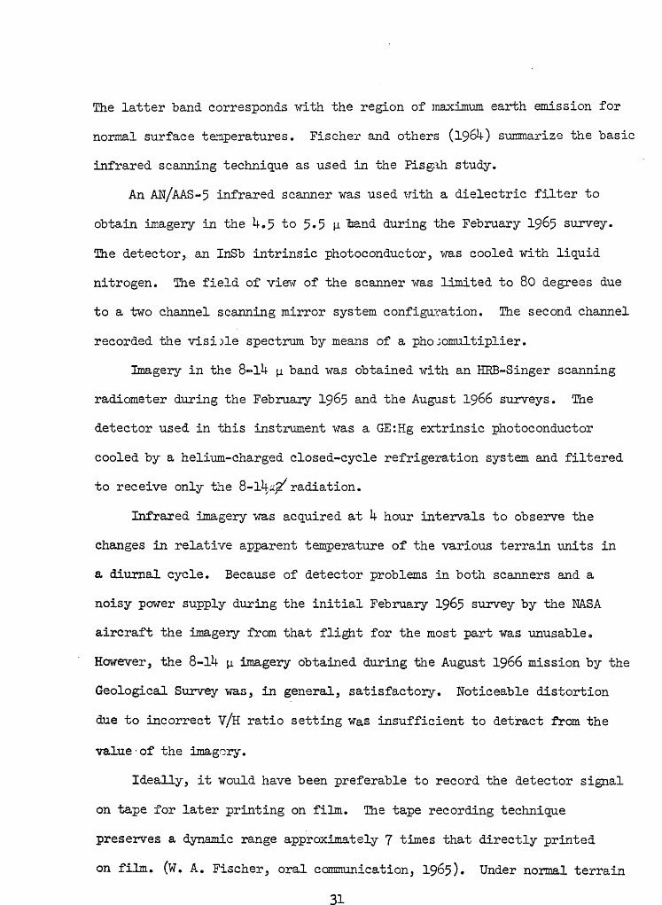
normal surface temperatures. Fischer and others (19$0 summarize the basic
infrared scanning technique as used in the Pisgah study.
An AW/AAS-5 infrared scanner was used with a dielectric filter to
obtain imagery in the U.5 to 5.5 |_i land during the February 1965 survey.
The detector, an InSb intrinsic phot©conductor, was cooled with liquid
nitrogen. The field of view of the scanner was limited to 80 degrees due
to a two channel scanning mirror system configuration. The second channel
recorded the visible spectrum by means of a phojomultiplier.
Imagery in the 8-lU jj. band was obtained with an HKB-Singer scanning
radiometer during the February 19&5 and the August 1966 surveys. The
detector used in this instrument was a GE:Hg extrinsic photoconductor
cooled by a helium-charged closed-cycle refrigeration system and filtered
to receive only the 8-lU^ radiation.
Infrared imagery was acquired at k hour intervals to observe the
changes in relative apparent temperature of the various terrain units in
a diurnal cycle. Because of detector problems in both scanners and a
noisy power supply during the initial February 19&5 survey by the NASA
aircraft the imagery from that flight for the most part was unusable.
However, the 8-lU p. imagery obtained during the August 1966 mission by the
Geological Survey was, in general, satisfactory. Noticeable distortion
due to incorrect V/H ratio setting was insufficient to detract from the
value-of the imagery.
Ideally, it would have been preferable to record the detector signal
on tape for later printing on film. The tape recording technique
preserves a dynamic range approximately 7 times that directly printed
on film. (W. A. Fischer, oral communication, 1965). Under normal terrain
31

temperature ranges, as at Pisgah all contrasts could have been recovered
through the laboratory printout of the tape signal, though the complete
range may not have been within the gray scale of the film on which the
imagery was- printed. Further, direct recording on film is susceptible :
to exposure variations during the survey, and in film processing.
32

INTERPRETATION OF THE INFRARED IMAGERY
Infrared imagery in the 8-14y band was flown August 4-5, 1966
over 3 flight lin^s (plate 1) commencing about 2000, August 4th and at
approximately 4 hour intervals thereafter, covering a complete diurnal
cycle. The v/h setting of the scanner was set too low for all flights,
but it does not significantly affect the geological interpretation.
One result is an exaggerated longitudinal scale in relation to the
lateral scale. Because of this distortion, no attempt was made to provide
a general scale. Geographical locations can be obtained by viewing the
geologic map photomosaic (pi. 2) and/or the location map (pi. 1).
An examination of the imagery shown on plates 3, 4, and 5 shows
that the midnight and pre-sunrise images are essentially the same with
slightly more contrast available on the midnight image. The midday images,
obtained under maximum solar heating conditions, show the most textural
contrast within the basaltic flows, while the post-sunset images provide
the greatest contrast between basalt bedrock and the alluvial formations.
Differential heating of eastern and western slopes due to low sun angles
is noticeable on the post-sunrise morning and pre-sunset afternoon images
respectively.
Imagery of flight line 1 which covered the main area of study,
including Pisgah crater, its flows to the south, and Lavic dry lake, is
shown on plate 3. Boundaries between the different types of basalt
surfaces, which correspond in places to the separately mapped flow units,
are noticeable to some degree on all of the flights. Examples of the
contrasts between the first, second, and third Pisgah flows are best

shown on the 2010, 0827, and 1202 flight images. These flows are labeled
1, 2, and 3 respectively on plate 3, On the 2010 image, the contrast
is due more to textural than to tonal (thermal) differences between the
flows with small playa pockets in the third flow providing the texture.
The term "texture" is used here in its photo interpretation sense, and as
defined by Colwell (1952, p. 538), is "the frequency of tone change within
the images," Flow 2 is slightly warmer than flow 3 at 2010, but the
reverse is tone at 0827 and 1202 where thermal contrast is dominant.
A probable explanation of this phenomenon is thi t solar radiation during
the day is not reflected from the aa to the extent that it is on the
pahoehoe because of its roughness and somewhat darker color, thus causing
the absorption of more solar photons and consequently greater heating,
The cavernous structure of the rough aa also makes it behave more like
a black body, but it also causes heating of the rock to a greater depth
because of its larger integral surface area. The pahoehoe, on the other
hand, has a smoother, lighter, and consequently more reflective surface
which would tend to absorb less radiation and restrict that heat absorbed
to a shallower depth. This would account for the higher radiant temper
ature of the pahoehoe during periods of illumination as shown during the
0827, 1202, and 1616 flights (plate 3).
Because the aa and pahoehoe textures are not restricted entirely
to individual flow units and blocky intergradations are common between
the two types of textures, the units cannot be entirely delineated.
Where two different flow units are adjacent and have the same surface
texture it is not possible to differentiate them on the imagery. The
minor differences in mineral composition and degree of crystallinity
between the units is alone insufficient to produce significant variations

in thermal parameters. Surface texture of the lava, which is primarily
a function of the temperature of extrusion, would cause changes that
would override or mask any changes brought about by differences in
composition. The large scale secondary texture resulting from the
presence of detrital-filled collapse structures on the dominantly pahoehoe
crust of the first flow is a strong differentiating feature, especially
on imagery that shows the greatest contrast between bedrock and detritus.
The Pisgah cone (p in plate 3), which is composed of scoriaceous
basaltic glass and pumice, shows to advantage 01 the 2010 image, soon
after sunset. The fragmented, porous pyroclastic material acts as an
insulator and cannot conduct the solar heat input much below the immediate
surface. As a consequence, the thermal input is concentrated at the sur
face and its radiant temperature is the highest of all the terrain units
as seen in the mid-day (1202) image 0 As soon as the solar illumination
is removed at sunset the high radiance disequilibrium between the pumice
and the cold sky causes the former to cool very rapidly. The insulating
property of the material and its small mass prevented it from becoming a
heat sink of any consequence in comparison with the surrounding basaltic
flows which have a decidedly higher thermal inertia* The diurnal radiant
temperature variation relationship between the scoriaceous pumice and
the pahoehoe as shown on the imagery coincides with the relationships
established with ground-based radiometers. At 1202, the radiant tempera
ture of the pumice, was recorded at 61°C and the. nearby pahoehoe of flow
3 was 54°C, a difference of 7°C. Prior to sunrise at 0418, the radiant
temperature of the pumice was 23°C and the basalt was warmer at 26°C,
a difference of only 3°C.

The thin alluvial wash of pumice immediately southeast of the Pisgah
cone (Qpa on p! 0 2 and a on pi. 3 images) reacts thermally in the same
manner as its sou; ce material. Its presence is not readily apparent on
conventional photography, but its thermal contrast is easily seen on the
imagery.
The partially collapsed lava tube located immediately east of the
Pisgah cone (t in pi. 3 and fig. 7) remains warm and is noticeable on the
imagery flown betveen sunset and sunrise, (201C, 0046, and 0418). The
depressions formed by the collapsed roof act somewhat as a black body
cavity where radiation is exchanged between the walls, retaining the heat
longer before ultimately radiating it out to the cold sky. The alignment
of the partially exposed tube is easily delineated on the infrared image,
whereas it is unnoticeable on conventional photography of the same scale.
During the daytime flights (0827, 1202, and 1616), the collapsed portions
are observable due to their "cool rim shadows. The same diurnal relationships
hold for the deeply fissured area about 0.5 mile south-southeast of the
cone (f in p! 0 3).
A roughly circular area, distorted to an oval-shape, is centered
at c on the images of plate 3. Its outline is best seen on the 2010, 0827,
and 1202 flights and it is characterized by a cooler rim on the first flight
and a warmer rim on the latter two flights. The northwest margin is
defined by several small vents and the remaining margin by pressure ridges
and surface differences in the basalt. This feature, which is not noticeable
on conventional photography, may represent a minor subsidence area over
an abnormally thick portion of the second Pisgah flow.

The effects of wind-blown sand and silt on the basalt north of
Pisgah crater is noticeable only on the nocturnal imagery (s in pi. 3;
2010, 0046, and 0^18 flights). Enough wind-blo^n material mantled the
basalt to significantly lower its albedo during the period of solar
heating. As a result, the area is much cooler than the surrounding
unmantied basalt. A wind-scoured area on the older fanglomerate and
gravel to the northwest of this area (v on the 2010 image, pi. 3) shows
up warmer on the nocturnal imagery because the residual coarser material
left behind as a result of deflation has a higher thermal inertia, that
is, a better capability to store solar heat. Its darker color, due to a
slight desert varnish in comparison to the normal fanglomerate surface,
lowered its albedo during the day which also resulted in greater heating
during the day. On the midday image (v on 1202 image, pi 3), this same
area is slightly cooler than the normal surface, presumably because of
its ability to absorb solar heat in the coarser residual fractions of the
gravel.
The tertiary basalt on the east side of the Pisgah lava field (b on
2010 image, pi. 3) reacts thermally in the same general manner as the
Pisgah basalt throughout the diurnal cycle. The original surface has been
eroded and the present surface is smoothed due to weathering rubble which
serves to distinguish this formation from the Pisgah lavas. As with
the Pisgah flows, it is best differentiated from the enclosing gravel
formation and recent alluvium on the 2010 image (pi. 3).
Lavic dry lake (L in images of pi. 3) exhibits much more detail on
the infrared imagery than on conventional photography, especially when
the latter is optimally exposed for all terrain features. All images
show evidence of crude zoning in the lake bed. There is a cool, fairly

well defined margin that extends discontinuously northward along the
basalt-fan contrast to the neck of the Pisgah lava field. A slightly
warmer interior zone, which is restricted to the lake bed proper, includes
an ill-defined area characterized by a warm reticulate pattern.
The east side of lake bed, which is especially cool, was muddy and
very moist from a recent desert rainstorm. Because of the remoteness of
the Pisgah area, no local data are available on the occurrence of pre
cipitation,, However, it appears that a heavy rain fell about 3 days
prior to the survay to the east of the Pisgah irea in the Bullion Mountains.
The moist braided channels on the fan carried the run-off to the Lavic
basin, and the lake bed margin, with its high silt and fine sand content,
appears to have absorbed this run-off before it encroached the less
permeable clay-rich interior.
The extremely cool nature of the eastern lake margin is a function
of many conditions including the recency of the rainfall that provided
the moisture, the high degree of saturation which results in a high heat
capacity and conductivity, and the dissipation of solar heat by the latent
heat of vaporization of the water. The high saturation and darker color
therefrom causes the eastern margin to become a heat sink, but the latent
heat of vaporization of the moisture prevents the surface from heating
as much as the drier parts of the playa during the period of insolation.
As a result, it remains the coolest terrain in area throughout the diurnal
cycle. The other margins of the playa are only slightly warmer than the
eastern margin, but generally cooler than the interior zone. This remain
ing portion of the perimeter zone may be thermally affected by ground

water entering the playa beds from the bordering alluvial fans« The
general absence of a cooler margin along the Pisgah flows appears to
support this hypothesis*
The slightly warm reticulate pattern (d in pi. 3) is visible against
a cooler background to a highly varying degree in all images from flight
lines 1 (pi. 3) and 2 (pi. 4). The relatively warm lines that make
up the net like pattern are very slightly moist stripes that form the
boundaries of giant desiccation polygons (fig.10). Their darker color
due to their slight moist condition provides a lower albedo for greater
heating during the day. The minor moisture, which may be in whole or
part hygroscopic and/or intermolecular, is probably insufficient and/
or too inefficient to reduce solar heating by vaporization. Its effect
of lowering the albedo therefore appears dominant in this case. Near
the southern margin (v on 1202 image, pi. 3) dry brushy vegetation and
associated dry phreatophyte mounds are aligned along many of the polygon
boundaries. The dark color of the vegetation and dryness of the underlying
mounds combine to produce a target warmer than the background at midday
(1202, pi. 3).
The cool background to the polygonal pattern appears anomalous,
but the playa in this area consists primarily of tannish-white, well-
compacted clay which would expect to be, from albedo and moisture
considerations, cooler than the stripes. The other warmer portions
of the interior zone may reflect the thermal behavior of a puffy and/
or shard-like mud-cracked surface found on much of the playa bed.
It might be expected that thermal behavior of the lake sediments
would change radically with a significant change in the amount and distrib
ution of contained moisture on the surface and with depth; and with the

mineralogy, grain size and distribution of the medium holding the
moisture, which in turn would control its albedo, the manner the moisture
is held, and its vate of release. The presence of salts concentrated
by evaporation and the retention of intermolecular water in certain clay
minerals would have a further modifying effect. With all of these possible
physical variables it is not surprising to find complex thermal patterns
on the imagery of Lavic dry lake through the diurnal cycle. It would
also hold that seasonal variations in these patterns would be commonplace
due to these factors and to the changes of the surface by the development
of mud crack plates by extreme desiccation,, The effects of moisture
require further detailed study because the degree of saturation governs
the heat capacity, thermal conductivity, and affects the albedo of porous
terrain.
On the north side of the lake bed, the basaltic gravel mosaic (g on
0046 image, pl a 3) stands out on the nocturnal images with a warm rim
surrounding a generally cooler interior. During the day, it acts thermally
in same manner as the Pisgah basalt to the north. The gravel, which
consists of angular to subangular cobbles and pebbles of vesicular basalt,
is spread unevenly on the playa surface and appears to overlie a buried
flow a few inches to several feet below the surface. The gravel is buried
in or covered slightly at the margin which coincides with the thermally
anomalous rim. The high temperature of the basaltic gravel is expected
during the day because of its low albedo, but its intimate association
with the playa sediments prevents significant development of thermal
inertia of the unit and like the cone material, whose thermal content is

limited to the surface, it cools rapidly after sunset. The -warm rim on
the night images appears to be the result of a higher thermal inertia
of that portion o:' the unit. The buried gravel at the margin presumably
would give off its heat more slowly because it has to pass through a finite
amount of playa sediment.
Flight line 2 imagery (pi. ^) which covers a short segment of the
area originally outlined for detailed study (pi. l), duplicates some of
the area previousT.y discussed and contains some features better viewed on
flight line 3 imagery (pi. 5)» However, it does offer a good comparison
of the alluvial fans on the east and west sides of the Lavic playa and a
reiteration of some features discussed under flight lines 1 and 3»
The alluvial fan on the east side of the Lavic playa (f on 1210,
pi. k) exhibits on all images of flight line 2 the braided channels that
were active during the recent precipitation in the Bullion Mountains.
The strongest contrast of the moist channels against the dry fan background
is .§een, as expected, on the 1210 image. While these channels are also
visible on conventional photography it is believed that the contrast would
remain longer on the infrared imagery as the channels slowly dried up.
The fan between the Pisgah and Sunshine flows to the west of the
playa shows no evidence of recent run-off as the eastern alluvial fan
does. However, on daytime images (0836, 1210, and l62l{-, pi. if), there
is an apparent thermal contrast between that segment of the fan that
borders the Sunshine flow and that bordering the Pisgah flow. The
southern segment of the fan,which appears slightly darker from the air,
derives most of its detritus from the nearby outcrops of basalt, andesite,

and other bedrock on the south side of Peter's Mountain (see plates 1 and 2).
The remaining nothern segment of the fan has as its predominant source the
older fanglomeratic gravels on the northeastern part of Peter's Mountain.
These gravels provided finer detrital for the northern part of the fan
than the bedrock source did for the southern part. This difference is
manifested by thermal contrast on the imagery, with the slightly coarser
southern segment of the fan appearing a little cooler during the day because
the larger average gravel size enables it to absorb the solar heat to a
slightly greater depth. That this effect is minor is shown by the lack
of reverse contrast on the nighttime images. Apparently, the slightly
darker color of the southern fan segment did not sufficiently lower its
albedo to override the thermal effect brought about by the difference in
gravel size.
Along the contact between the Pisgah lava field and the alluvial fan
a cool drainage channel is visible on the daytime images (m on 1210, pi. if).
It appears to have its origin where the foot of the fan meets the lava
field isthmus. This suggests that ground water may be dammed at this point
and that enough noisture is present just below the surface to provide a
daytime thermal contrast.
Flight line 3 is centered on the Pisgah fault, about 3 miles to the
southwest and parallel to flight line 1. (See plate l). Imagery from
flight line 3 5 shown on plate 5> covers a small part of the area on the
east flank of the Sunshine lava field that was originally chosen for
detailed study. The line was flown to obtain information on the expression
of the fault on the imagery and on the thermal behavior of rock types in
this part of the area. Withe the exception of the last flight at 1609,

which had shadows of a few scattered clouds (c on 1609, pi. 5), the imagery
is free of such natural detractions. The electronic deficiencies present on
the north ends of the 0815 and 1155 images (pi. 5) necessitated a shortening
of the interpreted portion of the flight-line.
The Sunshine lava flow sequences, shown as 1 and 2 on the flight line
3 imagery ol' plate 5 5 inay "be differentiated to some degree on most of the
images. However, the best contrast, resulting from the differences in the
degree of surface uniformity between the flows, is seen on the midday
Imagery (1155 on pi. 5)» This effect is -slightly noticeable on the 0815
image also. On the nocturnal imagery the main difference between the
first and second flow sequences appears to be that a warm veining of
drainage is noticeable on the former, but is somewhat obscured by background
in the latter.
The basait pumice of Sunshine cone (southernmost- p on 2003 image, pi.5)
and of the other cones associated with the Sunshine flows behaves thermally
in the same manner as the pumice of Pisgah Crater. The alluvial pumice
from these cones and other basaltic detrital (a on the images of pi. 5)
is easily delineated on the nocturnal imagery as similar materials was on
flight line 1 (pi. 3).
The northernmost pumice found in place in the Sunshine lava field
(p on .west side, 2003, pi. 5) was found to be the western half of the
faulted cone found displaced one-half mile to the south on the east side of
the Pisgah fault. This outcrop is very difficult to determine on aerial
photographs, but is easily discerned on the nocturnal Imagery.
The Pisgah fault (Pf on 2003, pi. 5) shows on the early morning imagery
and (A-l^-, pi. 5) as a relatively warm network of fine lines in detail

not observable on photography. The warm nature of the fault zone appears
to be due to large rubble-lined crevices and, in many places to blocky
scree whose-voids act much like black body cavities. Their cavity walls lose
their radiant heat more slowly after sundown than the surrounding basalt
because of sustained radiation interchange between the walls before ultimate
cooling to'the sky. This is the same effect that accounts for the warm
streaks shown in collapse depressions of lava tubes and fissures near
Pis gala Crater o
The best distinction between the basaltic rocks and the surrounding
alluvium is on the 2003 (pi. 5), post-sunset, image, as was the case in
flight line 1 (2010, pi. 3). The Tertiary basalt (b on 2003, pi. 5) on
top of Peter's Mountain and along its northeast flank behaves in the sane
way as its eastern correlative shown on flight line 1 (b on 2010, pl«3)>
This older basalt has a physically weathered surface whose float hides the
exact contact with the enclosing gravels. Other bedrock features on the
south end of Peter's Mountain do not show well enough'to be differentiated.
The warmer ill-defined gravel unit' on the east side of the mountain
seen in the nocturnal imagery is the fanglomerate of granitic detritus.
Being older, darker, and more compact than the gravels bordering it to the
west, it can absorb slightly more heat during the day (Cf with plate 2).
The northwestern tip of the dissected gravel of Peter's Mountain is as
warm as the older gravel unit on the east side and may be either the same
material or just a facies difference in the main mass of younger gravel
that makes up the mountain.
On the small bajada just west of Peter's Mountain a thin cool area
is noticeable along one drainage (m on 20003 and 1155 3 pi. 5). It occurs
kk

at the lower end of a long drainage from the mountain and may be either
the result of higher moisture in the immediate subsurface or its fresh,
unvegetated nature , or both factors. It shows on older photographs of
the area, but does not differ here from drainages nearby. This suggests
that moisture may be the main cause.

CONCLUSIONS
The aerial infrared survey of the Pisgah Crater area resulted in
8-lU|i band infrared imagery that provided useful geologic information to
complement data obtained from ground studies and aerial photography.
A series of thermal contrasts representative of those found through
the diurnal cycle was acquired during three of the six flight periods: at
about 2002(post-sunset) , 0^00 (pre-sunrise), and 1200 (midday). No single
imaging period provided or can provide all of the relative thermal contrasts
potentially presert in the area. However, the largest amount of information
on geologic thermal parameters from a single imaging period was obtained
from imagery flown shortly after sunset;, when optimum thermal contrast
occurred between the various terrain materials. At this time thermal con
trasts are best seen between bedrock and alluvium and between basalt flows
and pyroclastics and their derviatives»
Midnight and pre-sunrise images are very similar and one flight period
within this time period would, in most cases, satisfy the requirement for
both periods. These nocturnal images show more detail of the Pisgah fault
where it cuts the Sunshine flows than is normally seen on aerial photographs
of the area. The discovery of a faulted outcrop of pumice on imagery of
the Sunshine flow was instrumental in the determining a lateral displacement
of 0.5 mile on the Pisgah fault.
Distinction of the Pisgah flows, which depends primarily on a difference
in surface charactsr between adjacent flow units, is made on the basis of
.thermal (tonal) contrast on the daytime images and is best seen on the late
morning and midday images. The post-sunset image shows this distinction of

flows to a lesser degree with a difference in image texture, that is, the
frequency of tone change within the image.
Collapsed lava tubes and fissured areas in the Pisgah flows are
distinguished as relatively warm streaks on the nighttime images due to a
black body cavity effect, but appear as relatively cool areas during the day.
The imagery of Lavic day lake reveals crude zoning and other features
in more detail than can be found with other imaging sensors. Moisture
appears to be the primary factor that controls the thermal behavior of this
and some of the surrounding alluvial environment. The presence of moisture
outlined active drainage channels on an alluvial fan and indicated other
areas of near surface drainage. The complex role of moisture in these
environments is incompletely known at present and requires further detailed
study because the degree of saturation governs the best capacity and thermal
conductivity, and affects the albedo of porous alluvial terrain.
The empirical interpretation as presented in this report indicates that
infrared imagery should prove a very useful tool in geologic field mapping.
The data can bring the geologist's attention to anomalous features not
readily apparent in the visible spectrum and many valid conclusions can be
reached with a minimum of field verification. When the infrared scanning
technique is eventually used in conjunction with other remote sensing systems
the integration of the resulting data should greatly expand the interpreter's
capability by providing many unique property combinations for the identifica
tion of terrain.

Kerr, P. F. and Langer, A. M., 1965* Mineralogical features of Mojave Desert playa crusts in Neal, J. T. (ed.), Geology, mineralogy, and hydrology of U. S. playas: Environmental Res. Papers, No. 9&> A-, F 0 Cambridge Research Laboratories, Bedford, Mass. p 8 31-72.
Kupfer, D. H. and Hassett, A. M«, 19&2, Geologic reconnaissance map of part of the southeastern Mojave Desert, California: U. S. Geol. Survey Mineral Inv. Field Studies Map MF-205.
Wise, W. S., 1966, Geologic map of the Pisgah and Sunshine Cove lava fields: U. S. Geol. Survey Tech. Ltr» NASA-11, incl» geologic summary, U p and 5 ^ap sheets


PLATE k
FLIGHT LINE 2 U. S. GEOL. SURVEY INTERAGENCY REPORT NASA-99

PLATE 5
FLIGHT LINE 3 U. S. GEOL. SURVEY INTERAGENCY REPORT NASA- 1