university of horticultural sciences,...
TRANSCRIPT
University of Horticultural Sciences, Bagalkot
(Karnataka Watershed Development Project
Land Resource for
Markunda
University of Horticultural Sciences, BagalkotNational Bureau of Soil Survey & Land Use Planning, Bangalore
Watershed Development Department, Govt. of Karnataka, Bangalore
University of Horticultural Sciences, Bagalkot
Sujala – III Project (Karnataka Watershed Development Project-
Land Resource Inventory and Watershed Management Plan for Boral-1 Micro watershed (4E6E3L2d)
Markunda sub watershed, Tq. Bidar, Dist. Bidar, Karnataka
University of Horticultural Sciences, BagalkotNational Bureau of Soil Survey & Land Use Planning, Bangalore
Watershed Development Department, Govt. of Karnataka, Bangalore
University of Horticultural Sciences, Bagalkot
II)
and Watershed Management Plan
, Dist. Bidar, Karnataka
University of Horticultural Sciences, Bagalkot National Bureau of Soil Survey & Land Use Planning, Bangalore
Watershed Development Department, Govt. of Karnataka, Bangalore

University of Horticultural Sciences, Bagalkot an Overview:
University of Horticultural Sciences, Bagalkot came into existence through the special ordinance issued by Government of
Karnataka vide No.2 of 20018 on 22-11-2008. The institution has already dedicated for development of horticulture sector in the state and
has developed several varieties, technologies and models and offering services to farming community and other agencies of the state
government with a goal for enhancing and achieving sustainable productivity.
The Vision
University of Horticultural Sciences, Bagalkot has envisaged a vision to attain, excellence in academics by imparting
quality education to develop professional human resources with entrepreneurial skills addressing the thrust areas of research to develop
advanced technologies and to promote farmer centric technologies for further transfer to achieve holistic growth of Horticulture Sector
achieving sustainability, stability and productivity of resources, and development of farming and allied sectors. The University of
Horticultural Sciences, Bagalkot is catering the needs of farming community stretching from Bidar to Mysore in the state. Apart from its
mandate of Teaching Research and extension the university is committed in expanding its services in natural resource conservation of state
through strategic planning and providing critical technical inputs for sustainable development. University has a separate department on
natural resource management through which it is offering technical support to planning and implementing agencies of the state including
agriculture and Horticulture Department. University is sharing its expertise and infrastructure in development of soil health cards across the
state under national soil health mission. One of its flagship project in natural resource management is SUJALA-III project being
implemented in Bidar District of the state. The programme is envisaged with development and documentation of land resource inventory
of district and providing critical science based site specific inputs for integrated watershed planning and development.

CONTENTS:
Chapter Page Chapter Page
Contributors
How to read and use the atlas Soil Fertility Status:
Scientific, Physical and Cultural symbols used Soil Reaction (pH)
1.Introduction Salinity (EC)
2.General Description of Boral-1 micro watershed Organic Carbon
2.1.Location and Extent Available Nitrogen
2.2. Geology Available Phosphorous
2.3. Landform Available Potassium
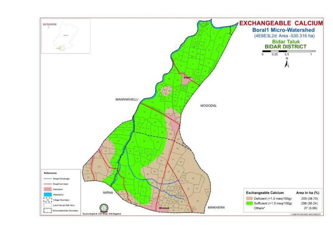
2.4. Climate Exchangeable Calcium
3. Survey Methodology Exchangeable Magnesium
4.Resorce inventory of Boral-1 micro watershed Available Sulphur
The Soils : Land Capability Classification
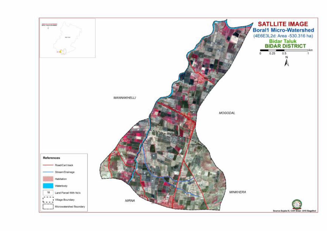
Satellite Image Land Suitability for Major Horticulture and agricultural crops
Cadastral map Proposed Crop Plan
Soil Map Suitability maps for different crops
Soil Depth Soil & Water Conservation Plan
Surface Soil Texture
Soil Gravelliness
Slope
CONTRIBUTORS
ACTIVITIES
PLANNING, REVIEW, CORRELATION AND REPORT FINALIZATION
Mr. Praveenkumar B.Naikodi, Lead Scientist, SUJALA-III Project, UHS Bagalkot.
Dr. Praveenkumar Jholgikar, Scientist, SUJALA-III Project, UHS Bagalkot.
Dr. Ganeshgouda. I.Patil, Scientist, SUJALA-III Project, UHS Bagalkot.
Dr. Ashok S. Alur, Co-ordinator,SUJALA-III Project, UHS Bagalkot.
Dr. V. Nachegowda, Director Of Research, UHS Bagalkot.
Dr. Ravindra Mulge, Dean, College of Horticulture Bidar.
SOCIO ECONOMIC SURVEY
Dr. Ganeshgouda.I. Patil , Scientist, SUJALA-III Project, UHS Bagalkot.
Mr. Gautam. M., Senior Research Fellow, SUJALA-III Project, UHS Bagalkot.
Mr. Kirankumar. S, Senior Research Fellow, SUJALA-III Project, UHS Bagalkot.
Mr. Umesh Dashyal, Graduate Assistant, SUJALA-III Project, UHS Bagalkot.
Mr. Mahesh Dandekar, Project Assistant, SUJALA-III Project, UHS Bagalkot.
Mr. Gururaj, Desktop Operator, SUJALA-III Project, UHS Bagalkot.
FIELD SURVEY AND MAPPING
Mr. Praveenkumar B.Naikodi. Lead Scientist, SUJALA-III Project, UHS Bagalkot.
Dr. Dhanurkar S. Technical Officer, NBSS & LUP Bangalore.
Dr. Niranjana, Technical Officer, NBSS & LUP Bangalore.
Mr. Gautam M., Senior Research Fellow, SUJALA-III Project, UHS Bagalkot.
Mr. Kirankumar S. Senior Research Fellow, SUJALA-III Project, UHS Bagalkot.
Mr. Ruben Ashirvadam, Senior Research Fellow, SUJALA-III Project, UHS Bagalkot.
Mr. Majappa.P, Field Assistant, SUJALA-III Project, UHS Bagalkot.

Mr. Veeresh P.H., Project Assistant, SUJALA-III Project, UHS Bagalkot.
Mr. Sunil Kishan, Project Assistant, SUJALA-III Project, UHS Bagalkot.
Mr. Nabeesab Sutar, Project Assistant, SUJALA-III Project, UHS Bagalkot.
Mr. Basavareddy S. Konda, Project Assistant, SUJALA-III Project, UHS Bagalkot.
Mr. Shivanand Elshetty, Project Assistant, SUJALA-III Project, UHS Bagalkot.
LABORATORY ANALYSIS AND CHARACTERIZATION
Mr. Praveenkumar B. Naikodi, Lead Scientist, SUJALA-III Project, UHS Bagalkot
Mr. Ruben Ashirvadam, Senior Research Fellow, SUJALA-III Project, UHS Bagalkot
Mr. Gautam. M., Senior Research Fellow, SUJALA-III Project, UHS Bagalkot
Ms. Shilparani P.K. Project Assistant, SUJALA-III Project, UHS Bagalkot
Dr. Nair, NBSS & LUP, Principal Scientist, NBSS & LUP Bangalore
GEOGRAPHIC INFORMATION SYSTEM (GIS) ANALYSIS AND INTERPRETATION
Mr. Praveenkumar B.Naikodi , Lead Scientist, SUJALA-III Project, UHS Bagalkot
Dr. Praveen Jholgikar, Scientist, SUJALA-III Project, UHS Bagalkot
Ms. Shakuntala V. M, Graduate Assistant , SUJALA-III Project, UHS Bagalkot
Ms.Sunita Pattanashetti, Graduate Assistant , SUJALA-III Project, UHS Bagalkot
Dr. Srinivas, Principal Scientist, NBSS & LUP
Mr. Gautam. M. Senior Research Fellow, SUJALA-III Project, UHS Bagalkot
LAND SUITABILITY ASSESSMENT AND CROP PLANNING
Dr. Praveen Jholgikar , Scientist, SUJALA-III Project, UHS Bagalkot
Mr. Praveenkumar B. Naikodi , Lead Scientist, SUJALA-III Project, UHS Bagalkot
Dr. Ganeshgouda.I. Patil,, Scientist, SUJALA-III Project, UHS Bagalkot

How to read and use the Atlas
The Land Resource Inventory of Boral-1 micro-watershed (Bidar taluk, Bidar district) for Watershed Planning (AESR 6.2) was
undertaken to provide comprehensive site- specific cadastral level information useful for farm level planning and integrated development
of the area under Sujala – III, Karnataka Watershed Development Project- II.
This atlas contains the basic information on kinds of soils, their geographic distribution, characteristics and classification. The soil
map and soil based thematic maps derived from soil data on soil depth, soil gravelliness, slope, land suitability for various crops and land
use maps are presented on 1:12,500 scale. The maps of fertility status (soil reaction, organic carbon, available phosphorus, available
potassium, available sulphur, available calcium, available copper, available manganese, available zinc, available iron, available boron and
salinity (EC) on 1:12,500 scale were derived from grid point sampling of the surface soils from the watershed.
The atlas illustrates 46 maps and tables that depict the soil resources of the watershed and the need for their sustainable
management.
The user, depending on his/her requirement, can refer this atlas first by identifying his/her field and survey number on the village
soil map and by referring the soil legend which is provided in tabular form after the soil map for details pertaining to his/her area of
interest.
The atlas explains in simple terms the different kinds of soils present in the watershed, their potentials and problems through a
series of thematic maps that help to develop site-specific plans as well as the need to conserve and manage this increasingly threatened
natural resource through sustainable land use management. The Land Resource Atlas contains database collected at land parcel/ survey
number level on soils, climate, water, vegetation, crops and cropping patterns, socio-economic conditions, marketing facilities etc. that
helps in identifying soil and water conservation measures required, suitability for crops and other uses and finally for preparing a viable
and sustainable land use options for each and every land parcel.
For easy map reading and understanding the information provided in different maps includes the physical, cultural and scientific
symbols used in the maps are illustrated in the form of colours, graphics and tables.


INTRODUCTION
With an objective to study, conserve and enhance productivity of various resource of Bidar district, detailed resource inventory
of Boral-1 micro watershed has been accomplished by University of Horticultural Sciences, Bagalkot in association with National Bureau
of Soil and Land Use Planning, Bangalore under SUJALA-III project financially assisted by World Bank through WDD Bangalore. The
task undertaken was aimed to provide comprehensive site specific cadastral level information for facilitating farm level planning and
implementation, Status of several resources have been studied and compiled to bring out science based site specific suitable interventions
and their effective implementation through various government departments and institutions. It is known that major part of the cultivable
land area is under rainfed cultivation in the Karnataka state. This vast stretch of rainfed area (about 10 m.ha) is affected by severe soil loss
due to erosion, low and uncertain productivity, fodder shortage, low rainwater use efficiency, rapid depletion of ground water, low level of
technological penetration and very few livelihood opportunities. The extent and severity of various forms of degradation has affected not
only the productivity but also the sustainability of the land resources in the state.
Among the various forms of land degradation, soil erosion is very widespread in all the rainfed areas. Various conservation
measures taken over a period of time is insufficient in many areas to protect the natural resource due to mismatch between the conservation
interventions implemented and actual requirements. Apart from the widespread degradation witnessed, in many areas, soil erosion, salinity
and alkalinity have become so severe that immediate sustainable and economically viable corrective measures to restore the health of the
resource was found most essential. For taking up effective conservation measures on a scientific foundation, there is an urgent need to
undertake the systematic land resources inventorization of all the existing resources like soils, climate, minerals and rocks, ground water,
vegetation, crops, land use pattern, socio-economic conditions, infrastructure, marketing facilities etc. Once site-specific farm level
database is generated and made available to all developmental departments, it will help in planning, implementing and monitoring of
various land based rural developmental projects in an effective way. Further, this will help in evolving rational, site-specific and viable
land use options for productivity enhancement and suitable resource management.

In the present study various spatial and non spatial data sets were generated through LRI on a cadastral base and other information
was compiled from different secondary sources for each micro watershed and assessed for the constraints and potentials of the area,
capability of the resources for planning and development (Land Capability Classification), suitability for irrigation (Irrigability
Classification), suitability of the resources for various horticulture crops like fruits, vegetables, flowers and agriculture crops like cereals,
pulses, commercial crops like cotton, sugarcane, etc.(Land Suitability Classification), have been described based on the land capabilities
parcel wise..
The LRI database and thematic outputs generated for each micro watershed is linked to individual survey numbers occurring in the
watershed area along with farmer details obtained from Bhoomi website has been pooled for effective implementation and watershed
management plan for the micro watersheds spread across in the Boral-1 micro watershed area of Bidar taluk, Bidar district.
Thus, availability of bench mark reference in the form of a resource atlas which includes all the resource database generated
becomes vital tool which can help for comprehensive site specific cadastral level decision supporting reference for effective planning and
implementation of programs.
The data generated through resource inventory of Boral-1 micro watershed (4E6E3L2d) has been compiled in this atlas to provide a
ready reconer for the user as reference in planning and implementation of various programmes related to effective and sustainable resource
management of Boral-1 micro watershed in particular and district in general. The resources inventory includes indept analysis of various
components like soil, land,water, livestock, crops, natural vegetation socio-economic status of in habitants and human resource.

Climate
0.00
5.00
10.00
15.00
20.00
25.00
30.00
35.00
40.00
Jan
Feb
Mar
Ap
r
May Jun
Jul
Aug
Sep
Ten
p i
n0 C
Monthly MIN_TEM and MAX_TEM of Bidar Taluka
Rai
n f
all i
n m
m
0.00
20.00
40.00
60.00
80.00
100.00
Jan
Feb
Mar
Ap
r
RH
in
%
Monthly MIN_RH and MAX_RH of Bidar Taluka
Sep Oct
No
v
Dec
Monthly MIN_TEM and MAX_TEM of Bidar Taluka-2016
MIN_TEMP
MAX_TEMP
0
10
20
30
40
50
60
70
80
90Ja
n
Feb
Mar
Ap
r
May Jun
Jul
Au
g
Sep
Oct
No
v
Dec
Monthly Rain fall of Bidar taluk -2016
Rain fall in mm
May Jun
Jul
Au
g
Sep
Oct
No
v
Dec
Monthly MIN_RH and MAX_RH of Bidar Taluka-2016
MIN_RH
MAX_RH
Rain fall in mm

Geology

Geology
Geology of the area-Laterites over Basalt parent rock
The Boral-1 micro watershed coming under Markunda sub watershed taluka Bidar, Bidar district is a part of Deccan plateau of
India and is derived from solidified lava and shows laterite developed over basalt. The northern part of the district is characterized by
expanse of level surface punctuated here and there by flat and undulating hillocks, black soils and basaltic rocks. The southern half of the
district is a high plateau of about 715 m above MSL. The average elevation of the district is between 580 to 610 m above MSL. Alluvial
deposits are normally found along the main stream banks and their tributaries. The major minerals found in the area are Bauxite, Kaoline
and Red Ocre. The district is dominated by two types of soil viz., lateritic red soils and black soils.

SURVEY METHODOLOGY Sequence of activities in generation of LRI
• Traversing the watershed using cadastral maps and imagery as base
• Identifying landforms, geology, land use and other features
• Selecting transects representing land units
• Opening profiles at suitable depth. (Up to lithic contact in shallow soils and 2cm depth in deep soils)
• Studying soil and site characteristics
• Grouping similar areas based on their soil-site characteristics into land management units
• Preparation of crop, soil and water conservation plan
• Socio-economic evaluation
The required site and soil characteristics are described and recorded on a standard proforma by following the protocols and
guidelines given in the soil survey manual and field guide. Collection of soil samples from representative pedons for laboratory
characterization and collection of surface soil samples from selected fields covering most of the management units for macro and micro-
nutrient analysis is being carried out (250m grid intervals). Further processing of data at chemical lab and GIS lab are carried out to
generate various thematic maps for each of the study area.


Description of mapping units and the extent of area identified in Boral-1 micro watershed
Soil Phases Area in ha (%)
1, BDPiB3g2 8 (1.42)
2, KBBmB2 12 (2.24)
3, KGNmB2 298 (56.16)
4, MDGiD3g2 29 (5.53)
5, MKDmB2 40 (7.53)
6, MWDiB2g1 45 (8.47)
7, MWDiB3g1 26 (4.9)
8, RPLmB2 46 (8.7)
9, Others* 27 (5.07)
m – Clayi – sandy clay
B – Very gently sloping (1-3%)D – Moderately sloping (5-10%)
1 – Slight2 – Moderate
g1 – Gravelly (15-35 %)g2 – Very Gravelly (35-60%)
BDP – Very Shallow (0-25cm)MDG.MPR–Shallow (25-50cm)MKD–Moderately shallow(50-75cm)KBB–Deep (100-150cm)KGN,RPL-Very deep (>150 cm)
Key
TEXTURE
EROSION
DEPTH
SLOPE
GRAVELLINESS
MDG i D 3 g 2
Texture
Slope ErosionSoil Series
Gravelliness


PROPOSED CROP PLAN FOR BORAL – 1 MICROWATERSHED (4E6E3L2d), MARKUNDA SUB-WATERSHED (4E6E3L), TALUK BIDAR, DISTRICT BIDAR
Mapping unit/Crop Management unit
Survey Numbers
Characters Field crops Horticulture crops (Rainfed condition)
Horticulture crops with Interventions
Suggested Interventions
BDPiB3g2
Depth: Very shallow (0-25cm) Texture: Sandy clay Slope: 1-3 % Errossion:Severe
Bajra, Navni, Phundi, Agasi Custard apple, Cashew seedling, Charolli, Ber, Marking nut
Cashew, Custard apple, Tamarind
Deep and wider pits (1m 3), Drip irrigation, Mulching, Bunding, TCB
MDGiD3g2
Depth: Shallow (25-50 cm) Texture: Sandy clay Slope: 5-10 % Errossion: Severe
SoleCrop: Redgram, Sorghum, Soyabean, Green gram, Blackgram, Castor Intercrop: Redgram+Soyabean Redgram+Greengram Redgram+Blackgram Redgram+Sesamum Redgram+Fodder sorghum
Fruit crops: Cashew seedling, Custard apple, Charolli, Ber, Bael, Tamarind, Woodapple
Fruit crops: Cashew, Custard apple, Jamun, Ber, Fig, Jackfruit Vegetables: Cluster beans, Flowers: Gaillardia, Lilly
Deep and wider pits (1m 3), Drip irrigation,
Mulching, Contour trenching,
Gully plugging, Check dams.
MKDmB2
Depth: Moderately shallow (50-75 cm) Texture: Clay Slope: 1-3 % Errossion: Moderate
SoleCrop: Khariff Redgram, Sorghum, Soyabean, Green gram, Blackgram, Rabbi Sorghum, Safflower, Wheat Bengal gram. Intercrop: Redgram+Soyabean Redgram+Greengram Redgram+Blackgram Redgram+Sesamum Redgram+Fodder sorghum
Fruit crops: Cashew , Custard apple, Mango, Ber, Tamarind, Sapota Vegetables: Clusterbean, Bhendi, Onion, Drumstick, Leafy vegetable
Fruit crops: Mango, Cashew, Guava, Lime, Fig, Sapota Jamun, Ber, Jackfruit Vegetables: Solanaceous, Cruciferous, Cucurbitaceous, Onion, Laefy vegetables, Drumstick, Curryleaf Flowers: Gaillardia, Merigold,Lilly, Aster, Rose, Tuberose
Deep and wider pits (1m 3), Drip irrigation, Mulching, Bunding, TCB. Raised bed cultivation with mulching for Vegetables
KBBmB2 KGNmB2 RPLmB2 MWDiB2g1 MWDiB3g1
Depth: Deep and very deep (100-150 and >150 cm) Texture:Sandy clay and clay Slope: 1-3% Errossion:Moderate
SoleCrop: Khariff Redgram, Sorghum, Soyabean, Green gram, Blackgram, Rabbi Sorghum, Safflower, Wheat Bengal gram. Intercrop:
Fruit crops: Sapota, Guava, Lime, Fig Vegetables: Cluster bean, Bhendi, Onion, Drumstick, Leafy vegetable
Fruit crops: Guava, Lime, Fig, Sapota Jamun, Banana, Papaya Vegetables: Solanaceous, Cruciferous, Cucurbitaceous, Onion, Laefy vegetables, Drumstick, Curryleaf
Normal pits (0.75 m3) Drip Irrigation, Mulching, Bunding, TCB. Raised bed cultivation with mulching for

Redgram+Soyabean Redgram+Greengram Redgram+Blackgram Redgram+Sesamum Redgram+Fodder sorghum
Flowers: Gaillardia, Merigold,Lilly, Aster, Rose, Tuberose Spices: Zinger, Turmeric
Vegetables
Note: Cashew should be preferred for red soils/Soils derived from laterite.
