university of pécs faculty of sciences doctoral school of
TRANSCRIPT

University of Pécs Faculty of Sciences
Doctoral School of Earth Sciences
Quantitative assessment of the anthropogenic terrain evolution in urban environment, through an example from Pécs, Hungary
PhD dissertation theses
Levente Ronczyk
Supervisor: Dr. István Fodor university profesor
Pécs, 2010

Title of the doctoral school: Doctoral School of Earth Sciences School leader: Dr. Zoltán Dövényi, Dsc university professor, Director of the doctoral school Institute of Geography Title of doctoral topic group: Physical geography and landscape ecology Program leader: Dr. Dénes Lóczy, C.Sc assoc. prof. head of institution Institute of Environmental Sciences Dissertation’s discipline: Environmental geography Supervisor: Dr. István Fodor, university professor scientific advisor HAS Transdanubian Research Institute

Introduction At the beginning of 21st century more than a half of the world population has decided to live in urbanized areas. Several billion people personal preferences have opened a new epoch in the history of mankind. Scientists have recognized the diversified consequences of the urbanization over the past few years. The growing spatial concentration of the world population supplies a new scientific research field of many disciplines, and introduces new ideas in the former scientific reasoning. New theoretical frames cover our theories about the reality and in this new semantical content nearly all discipline reinterpret itself.
To find the new identification of geography is a big challenge in the recent contextual environment. But environmental geography as the discipline of spatial aspects of interaction between human and natural agents is playing significant role in this recognition process. Theoretically and methodologically separating this recently characterize discipline depend on the development of Geographical Information System, because other natural sciences also have found their research topic related to environmental problems. Computer based data management and growing number of different GIS application effectively complete the classical type of physical geographical research method in this scientific competition. Built on the very wide data manipulation capacity of GIS geographers are able to manage the very complex problem of urban environment. GIS represents a critically important set of analytical tools for assessing the impact of human presence on the environment by measuring the result of human activity on urban land cover and land use.
It is important to emphasize, that financial background of living or sustainable urban existence was introduced an unnoticed way in the consumer society, and the last few decades the cost of the public utilities have became very significant expenditure of urban households. These costs are mediated through the invoices, and cover just a certain part of environmental effects, which occurs a particular natural environment of the town or city. The urban life style is interlocked through direct and indirect impacts with the natural landscape. The interaction of society and urban landscape has own straight inferences, like landslide, water damages, but on the other hand we can discover lots of invisible effects, which have the many influence on our health status and local environment.
Evident consequences of the transforming environmental conditions present another type of conflicts. Due to the appearing natural, social tensions in the urban space has drawn my attention to terrain analysis of the urban surfaces, as the buffer zone of different kind of geo processes.
Objectives
The main aim of my dissertation is to introduce a new GIS-based technique for the urban environmental studies. I would like to highlight the surface development of urban landscape from a geographical view point. The land surface is an active meeting sphere of different geoagents (geographical factors) – climate, water, soil, biotic. Here the effective formulation of the surface outcomes as a function of relief, landcover and landuse. The above mentioned three factors determine my research objectives, and

become the three major pillars of my study. I address the dissertation to reveal the geographical dimension of surface development in urban environment through the change of landform, landcover and landuse.
Specific objectives: The objectives of the present dissertation are the followings:
1. To develop a digital elevation model of high spatial resolution about the inner
part of Pécs. Based on digital elevation models the primary terrain parameters, the main morphometrical indexes and the pixel-based digital landform segmentation are retrieved.
2. To analyse Using GIS software for investigation of the antropogenic replenishment in the historical city center. Analysis of the loess deposits on the hillfoot of Mecsek mountains and computer-based examination connexion between the historical landuse and the loess deposit int he former grape yard.
3. To analyse historical maps to approach former landcover and landuse change in a case study area in Pécs. I try to outline the correlation between terrain surface and the historical landuse pattern. Additionally I detect the transformation of parcel size, as a significant factor of landuse change.
4. To investigate the alteration of impervious surfaces over the last few decades as a main component to describe the landcover change. Through this analysis I reveal chief tendency of inner spatial structure changes of Pécs and highlight some aspect of urban sprawl around the city. With application of satellites images I identify some urban morphological conditions of Pécs, during this investigation I utilize some demographic data as well.
In my study I focus on city of Pécs, and I exert to present the scientific background of practical application, because it could be play a very important rule in the local decision-making processes. Through some case-study I would like to demonstrate my specific research method, and its problems as well. At the same time I try to find the answer the position of geography between the other scientific disciplines from a conceptual point of view.
Methods
Today the analysis of urban environments are impossible without using GIS based methods. A quantitative assessment of natural and anthropogenical phenomena in urban environment are perfect occasion to use the effective data management capacity of PC. Using GIS techniques we can provide a more detailed and adequate description of reality. My methodology contains two systematic steps, firstly I selected the relevant data from the available databases according to an aprior theoretical frame. After it the collected data were manipulated with different GIS toolsets to follow the original objective of my dissertation.

I. Theoretical frame During the elaboration of my dissertation one of the basic step was to arrange the available data in a complex geodatabase corresponding to a comprehensive conception. It is not a spectacular task, but on the other hand it is a very important job; turning paper-based data into a digital format. This process is called digitalization, and took several years to produce the topographical, geological and archaeological digital data. The whole process took account to the scale, geometry, datum of the data integration. I set up a practically simplified model for the investigation of urban areas. Built on this conceptual background I elaborated three different types of data management method concerning to the spatial and temporal resolution of investigated subject. Three dissimilar GIS technique was introduced according to the different time and spatial scale. Each GIS procedure employs various approaching method of the urban surface development, and able to expose their own time and spatial frame: As a geographer I tend to present a complex overview of the investigation of terrain attributes in the urban space, and try to supply a logical, reasonable frame of the different examination methods. The origin of the theoretical background is based on spatial and temporal distribution of various research techniques. Spatial scale encloses from the microenvironment up to watershed level. The temporal distribution involves the earliest historical time until the present human activities. This approach is very practical as it focuses on the complexity of urban landscape evaluation and seize the organic interaction of human and natural processes.
1. Geomorphological and geoarchaeological method As a result of the application of the above mentioned techniques I was able to draw a conclusion at macro-environmental level, and date back the anthropogenic activities by several thousand years. Consequently I was able to describe surface evaluation at watershed development level, it means more than few thousand square meters could be analyzed and run back over early stages of the human intervention in the natural environment. This method focused on the human interruption of sediment cycle, anthropogenic acceleration of erosion and accumulation processes, and it was represented in GIS database, together with topographic attributes, geomorphometric data and archaeological site documentation. This joint database could identify the genetic and dynamics patterns of urban landscape evaluation. Due to this method I was able to analyze the beginning of human activities in a particular part or surroundings of urban area. From the proxy data rough delineation of past urban environment can be deduced.
2.Cartographic method The basic component of this technique is to compare historical maps. The starting point of the cartographic method was georeferencing and digitalizing formerly generated maps. The next step was exploratory spatio-temporal data analysis (ESDA), which helped the visualization and the statistical interpretation of historical maps. The perspective of the map-analyze method was several centuries in history and several hundred square meters in urban landscape. It results specially in a more detailed

surface evaluation than the geomorphological method could produce, but in time scale the maps date back only a few centuries.
3.Remote Sensing Remote sensing has opened a new perspective in urban mapping. In case of urban remote sensing few decades and very fine resolution are available for terrain analysis. Extracting data from satellite images is the most common method to analyze recent urban changes. Several new analytical techniques make urban analysis easier, like linear spectral unmixing method, which was utilized in the present work. Remote sensing provides the most accurate information to urban surface mapping, however its time scale is very limited.
II. GIS based data mangement 1.Geodatabase: The first step was to determine the scope of the required data, to
collect them and transform them into digital datasets. The next task was the retrieve the new data from the basic one and integrate them into the same database. As the investigation involved various scales, the resolution of the raster data, projection, measurement scales and error spreading had to be checked.
2. Spatial Analysis Techniques: 2.1. One of the basic techniques utilized most frequently was spatial query. I was able to gain information about the perimeter, area or generate a map and merge different type of layers and point out the spatial relationship between them. Through this method I revealed the spatial distribution of the phenomenon and simultaneously assessed them. Neighbourhood statistics compute a new output raster according to cell location and value. Out of the different filtering techniques I frequently chose the majority, mean, range, sum, variety and standard deviation circle or rectangular filters. The same filtering method was used during the computer processing of remotely sensed images. After the neighbourhood and zonal statistic reclassification further digital analyses were employed. 2.2. Through overlay procedure the information was converted from vector to raster format. In raster environment Boolean operators also improved the performance of data processing. 2.3. I constructed new models by the Model Builder function of ArcGIS. It resulted a new linear series of algorithms of different GIS techniques. 2.4. Using spatial interpolation techniques I estimated the predicted surface values for the investigated area from vector data, like point (samples) or lines (valley bottom). Corresponding to the ANUDEM (HUTCHINSON, M. F. 1989) algorithm a Digital Elevation Model (DEM) was developed. Beside the above mentioned techniques geostatistical methods (kriging) provided information on the spatial diversity of anthropogenic landfills. 2.5. The interprateted surfaces supplied additional information about the terrain. Different derivatives of the DEM were introduced as the bases of digital landform segmentation.

3.Remote Sensing: Information from remotely sensed images were obtained by computer analysis. The first step of the interpretation was the extraction of basic pixel statistics of the images. The next stage of the process was image enhancement and image transformation (PCA). Depending on the investigated area different classification procedures were applied. Supervised and spectral mixture analyses were used to separate different urban land cover classes. In the first case I classified the pixels into categories using the maximum likelihood classification method. In the secend case end member extraction techniques (VLH) improved the collection of information on the urban landscape.
4. Different mathematical statistical techniques allowed the comparison of data from the spatially analyzed datasets (cluster analysis, linear regression analysis, variance analysis).
I utilized the computation capacity of the following software packages: ArcGIS 9.3, IDRISI 32, SPSS 15v.and MS Office 2003 Excel.
Results
1. Digital Landform Analysis
The basis of digital landform segmentation was a self-constructed DEM, meeting international standards, because the available DEM had not reached the required accuracy for further investigations. Most of the terrain derivatives are presented in the commercial GIS software, but only the combination of different procedures - adjusted individually for a given morphological surface – could be supplied at the necessary reliability level. According to the DEM I selected the main morphometrical parameters for the central districts of Pécs, and identified the development type most appropriate for each urban district. Relative relief, slope and other surface parameters were summarized in respect of each city district. The morfometrical interpretation of the city districts allowed an insight into the inner character of the city and outlined future opportunities for urban development. The classification resulted in the statement that the Mecsekoldal (Mecsek Foothills) district has the highest relative relief and surface diversity. For the futher mapping of morphometrical analysis of the city cluster analysis was employed. This method statistically reduced the range of parameters, and provided an opportunity to introduce four groups according to the landform parameters (i, Dissected plains ii, Dissected hill ridges iii, Plateaus, hill ridges and foothill slopes iv, mountains with broad ridge (BALOGH J. et al. 1989). The basis of the investigation were the city districts again and the following parameters were the inputs into the cluster analysis: relief, elevation (altitude), range of elevation, mean elevation, variation of elevation, minimum and maximum slope angle and standard deviation of slope angle. In addition, different parameters from the building suitability – derived from slope conditions – were also included in the model. Altogether 16 parameters were analyzed referred into four clusters groups (Fig. 1).

Fig. 1: Landform types identified using cluster analysis (by author)
Using Hammond’s model of landform segmentation single landforms were identified from the parameters of the DEM. The application of this method improved the single pixel environment of the analysis. The digital landform mapping provided a complex picture about the city surface, and the Hammond codes characterize the different shape of the surface. The digital segmentation provided a very useful overview on the diversity of surface elements (Fig. 2).

Fig. 2: 3D representation of Makár Hill with Hammond’s landform types overlain on the original DEM (3x vertical exaggeration) (by author)
The city centre was divided into various lowland forms by Hammond’s landform analysis. The same morfometrical character is shown for the higher altitude regions of plateaus because the general indices of this landform, like relief, slope and profile, were the same like in lowlands. The plateaus invariably highlighted the subcenters of the Mecsek hill housing areas, and gave a numerical background for the former city development. Regarding this investigation the plateau of Donatus, the ridge around the Fenyves street and the ridge of Bárány street were selected, all of the three with their own historical backgrounds. A particular problem was recognized in case of slope, because the kernel size sometimes exceeded slope length. The portion of ridges, valley floors and foothills were similar. An interesting finding was the high percentage of steep ridges and steep valley floors, with 6 percent and 7 percent, resp.
One of the very important result of the Hammond-type digital landform analysis was the separation of individual landforms, which became significant factors of the historical development of Pécs. It introduced a new quantitative geomorphological mapping, which was able replace the old qualitative technique. Thanks to the new profile map, individual forms all over the city were recognized, and assessed in their surroundings. The valley floors and the ridges were obviously categorized according to the Hammond method, but in the case of slopes some problems of parameterisation occurred.
The result of the digital landform segmentation provided the fundamental data for the further analysis of the antropogenic development of the urban landscape, and provided a solid background for the explanation of surface change.

2. Geomorphological analysis Under the geomorphological analysis thousands of years of antropogenic surface transformation were investigated, and according this objective a suitable geodatabase was built. The first stage of the examination was the description of antropogenic landfill under the historical city centre. The digitalization of geological and other types of boreholes and archaeological datasets allowed the interpolation of point data above the centre. Due to the natural geomorphic evolution of city surface and major antropogenic interventions an appropriate landscape for the urban development took shape. It was improved according to the thickness of landfill, 2.8 m on average. Maximum landfill depth was found to be 12.4 m after the harmonization of the database.
Former mining sites and their deposition and replenishment were discovered. The thickness of antropogenic landfill and the historical background of given area overlapped and it confirmed the result of the interpolation. Around the ancient Roman settlement core deeper landfill was detected, and probably it denotes intentional interventions during settlement. The actively utilized surface of the ancient Pécs exhibited the thickest artificial landfill. Landfilling could have been so intensive that the original terrain surface totally lost its previous character. According to the borehole data and its interpolation it is possible to claim that the present surface of the city centre is remarkably different from the original natural surface, which existed before the ancient population settled down. Due to human activities the natural landforms perished. According to the previous geomorphological studies the original surface was a periglacially shaped mountain margin and foothill, where during the humid period of glacial epoch short erosion valleys incised in humid periods. Human action planated the landscape. The assumptions of geomorphological mapping are confirmed in the surface created by kriging, where a range in incipent valleys of N to S direction indicate ancient morphology (like in the Tettye Hill in the E and in the Krumpli Valley in the W. Accumulation is minimal on interfluvial ridges.
Fig 3: W to E profiles across Széchenyi Square (by author)

To reveal another form of human impact I set up the hypothesis that exogenic processes result in the formation of largely similar landscape features. Relief evolution proceeds within physical geographical constraints and this kind of geomorphic evolution can be reconstructed from Quaternary sedimentation in the central areas of the city studied. In order to prove my hypothesis I sought a significant relationship between topographic character obtained from the DEM and surface geological formations. To formulate it in another way, I assumed that – against the lively tectonic background – there exist geomorphological features which allow the systemization of Quaternary sedimentation related to the particular terrains. If the structure is not reflected in relief features, the geomorphic changes were induced by the economic activities of human society. I checked my assumption by various methods.
The topographic parameters and the positions of the geological boreholes across loess sequences does not show the dominance of a single feature. Consequently, no direct relationship was found between the morphology and the stratigraphy and this indicates that no physical process could transform the landscape in this way.
The surfaces reconstructed from the topographic parameters for the loess-matled areas in the covered geological map pointed to areas where morphological conditions are similar to the present areas with slope loess remains. Therefore, the previous loess mantle is assumed to occupy a similar position once (Fig. 4). Supervised classification allowed to identify as much as 60% of surfaces identified as those with slope loess mantle in the NW terrains of the city and this is a confirmation of the applicability of the method selected.
Fig. 4: Potential old loess occurrences in the NW terrains of Pécs, calculated from the distribution of presently loess-mantled surfaces (by author)

3. Analysing historical maps A GIS-based analysis revealed the relationship between the land cover category and morphometrical data. It was clearly recognized that elevation, relative relief and slope inclination play a significant role in the historical land cover in the study area, Makár Hill (Fig 5).
Fig 5: Average elevations of areas which suffered changes of land cover between 1982 and 2000 (by author)
Three time sections from the last 100 years were chosen to follow cultural landscape transformation and to provide a general overview about the urban morphological development of Pécs. On the foothills of Makár Hill new residential districts emerged and on the higher elevation the former vineyards became abandoned. Another important finding was to point out that the area and the morphological position of forests has not changed over the past 100 years. The main reasons behind it are of morphological nature (Fig. 6).
The main driving force of the aforementioned process was the reducing size of parcels as it was clearly outlined after the digitalization of historical cadastre maps. The GIS-based data analysis of parcels also showed local tendencies (Fig. 7). The resulting digital map series enabled me to quantify the structural change resulting in the urban landscape. The mathematical indices applied presented additional data on landscape change, the most important of which was decreasing plot size.
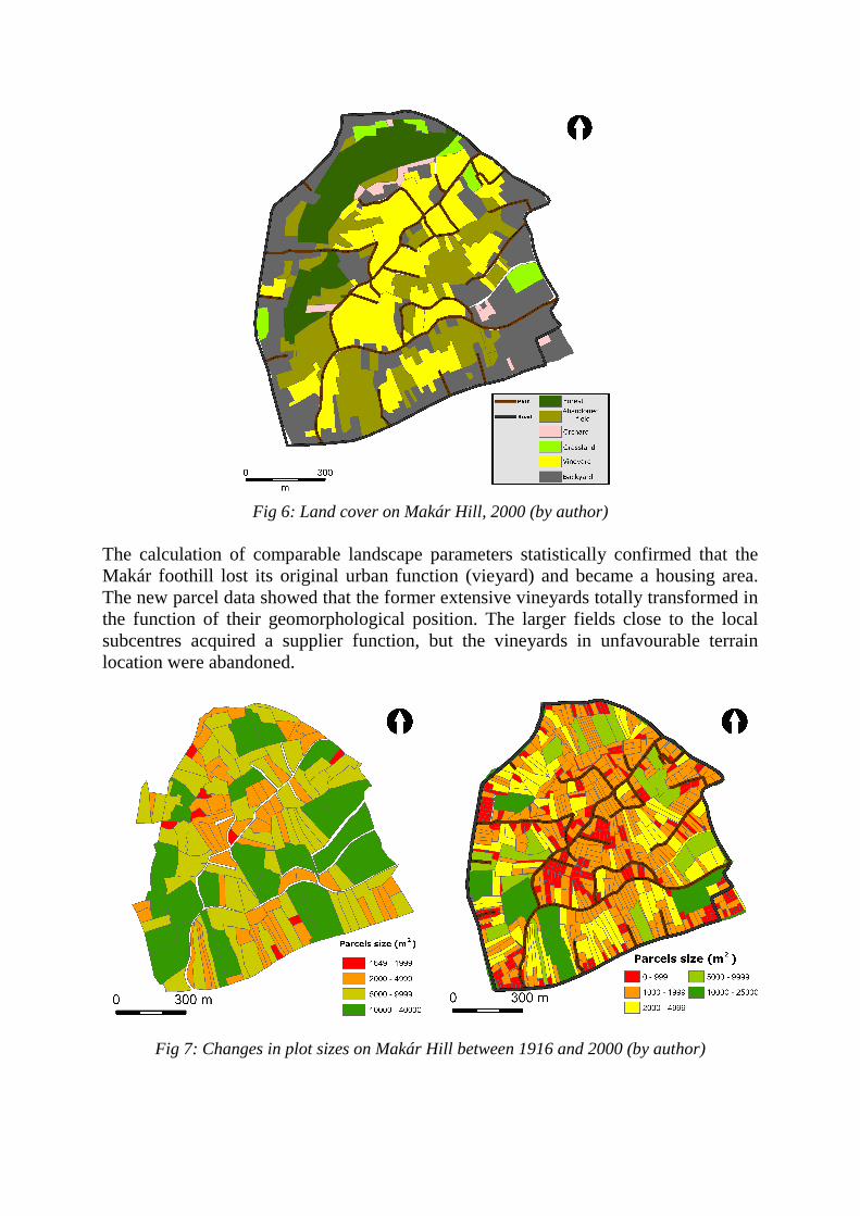
Fig 6: Land cover on Makár Hill, 2000 (by author)
The calculation of comparable landscape parameters statistically confirmed that the Makár foothill lost its original urban function (vieyard) and became a housing area. The new parcel data showed that the former extensive vineyards totally transformed in the function of their geomorphological position. The larger fields close to the local subcentres acquired a supplier function, but the vineyards in unfavourable terrain location were abandoned.
Fig 7: Changes in plot sizes on Makár Hill between 1916 and 2000 (by author)

4. Satellite Image Analysis
Satellite images analysis provided an improved picture on the land cover transformation in the agglomeration of Pécs. Despite the problem of mixed pixels, quite high an accuracy was achieved during the processing of Landsat images. Spectral mixture analysis (SMA) was able to detect the problem of increasing impervious surfaces. During the investigated 21 years these parts of the city demonstrated forest canopy level which were developed between the mid70’s and 80’s. Growing imperviousness was also detected, and some districts were identified as main area of urbanization (Fig. 8). Due to the application of additional GIS techniques the relationship between the morphological situation of the city and urban congestion could be confirmed. I was able to describe the morphological parameters of the newly built-up areas.
Different types of built-up districts were separated by the values of numerical indexes, and weighted by the density of urban population, I obtained the urban morphological type of city districts and identified urban functions as well. According to the urban morphologycal category of Central Statistical Office of Hungary reevaluated the urban morphological classification of Pécs (Fig. 9).
Fig 8: Impervious surfaces in the inner area of Pécs, between 1985 and 2006 (by author)

Fig 9: Functional differentiation in Pécs according to population density and the percentage of built-up areas (by author)
One of the main finding from the mixed picture analysis was to reclassify with numerical indexes of the urban congestion of Pécs and quantification of structural change in the urban landscape. Following the new parameters some new reasons occurred behind the urban land use change, together with determination of land use changes in specific areas (Fig. 8).
Digital image processing for the agglomeration of Pécs highlighted the direction of urban sprawl around Pécs. The urbanization around Pécs affected different land cover types in the past 20 years. Arable land and former vineyards and orchards fell victim to suburbanization. In this case I used supervised image classification (Maximum Likelihood method). According to the land cover type of occupied areas I label the suburban villages as different clusters. The links between the population and the built-up area in the agglomeration were also studied and a very strong relationship was found. This result confirmed that the main for the spreading of impervious surfaces was not industrial development (Fig. 10).
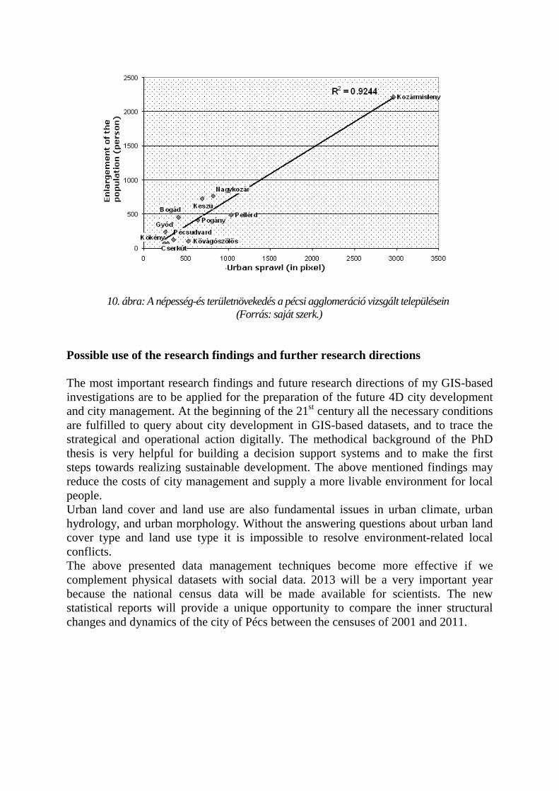
10. ábra: A népesség-és területnövekedés a pécsi agglomeráció vizsgált településein (Forrás: saját szerk.)
Possible use of the research findings and further research directions The most important research findings and future research directions of my GIS-based investigations are to be applied for the preparation of the future 4D city development and city management. At the beginning of the 21st century all the necessary conditions are fulfilled to query about city development in GIS-based datasets, and to trace the strategical and operational action digitally. The methodical background of the PhD thesis is very helpful for building a decision support systems and to make the first steps towards realizing sustainable development. The above mentioned findings may reduce the costs of city management and supply a more livable environment for local people. Urban land cover and land use are also fundamental issues in urban climate, urban hydrology, and urban morphology. Without the answering questions about urban land cover type and land use type it is impossible to resolve environment-related local conflicts. The above presented data management techniques become more effective if we complement physical datasets with social data. 2013 will be a very important year because the national census data will be made available for scientists. The new statistical reports will provide a unique opportunity to compare the inner structural changes and dynamics of the city of Pécs between the censuses of 2001 and 2011.

Publications I. Related to the topic of the dissertation: 1. FODOR, I. – RONCZYK , L. – WILHELM , Z. 2010: Sustainable Way of Stromwater
Management in Pécs, in: CARESTIATO, N. – GUARAN, A. (ed.), Water in the Euro-Mediterranean Area / L'acqua nello spazio euromediterraneo, on Cd-Rom The European Seminar on the Geography of Water - Water Resources: Application Areas of Geographic Research, Forum, Udine.
2. RONCZYK L.– SZABÓ-KOVÁCS B. 2009: A településszerkezet alakulásának környezetföldrajzi következményei Pécsett 1985 és 2006 között. In: SZABÓ-KOVÁCS B.–TÓTH J.–WILHELM Z. (szerk.): Környezetünk természeti-társadalmi dimenziói. Pécs, ID Research Kft, pp. 111-127.
3. RONCZYK L .–MILICS G. 2008: Antropogén hatások a Pécsi-víz forrásvidékén, Földrajzi Értesítı LVII évf. 3-4 sz. pp. 289-297.
4. DOLGOSNÉ KOVÁCS A.–RONCZYK L ., 2007: A Pécsi-víz vízminıségének alakulása az elmúlt tíz év folyamán, ÖKO XIV. évf. 3-4 sz. pp. 15-31.
5. RONCZYK L .–TRÓCSÁNYI A. 2006: Some Changes in the Urban Environment in Pécs. In: RONCZYK, L.–TÓTH, J.–WILHELM , Z.(ed): Sustainable Triangle. 1. Pécs–Graz–Maribor. Sciences, Municipalities, Companies for the Sustainable Future. Pécs, 2006. University of Pécs Faculty of Sciences Institute of Geography pp. 168-176
6. RONCZYK L .–LÓCZY D. 2006: Alternativ stormwater management in Pécs, Publicationes Instituti Geographici Universitatis Tartuensis 101. pp. 113-121.
7. RONCZYK L . –WILHELM Z. 2006: Benefical use of the stormwater in Pécs, Graz, Grazer Schriften der Geographie und Raumforschung, Band 40 / 2006, pp. 135–144.
8. RONCZYK , L.–WILHELM , Z. 2006: The influence of the transformation of landscape values on the touristic offer of the city of Pécs. In: AUBERT, A.–TÓTH, J. (red.): Stadt und Region Pécs. Beiträge zur angewandten Stadt- und Wirschaftgeographie. Bayreuth, Arbeitsmaterialien zur Raumordnung und Raumplanung 243. Universität Bayreuth. pp. 79–88.
9. RONCZYK L .–KOVÁCS A. 2005: The role of the floodplain in the sustainable wateruse in Pécs, Földrajzi Közlemények Vol. CXXIX (LIII), International Edition, pp. 61-66.
II. Lectures and posters related to the topic of the dissertation: 10. „Nem ússzuk meg szárazon; a csapadékvíz-elvezetés problémái Pécsett”, II.
Magyar Tájökológiai Konferencia, konferencia elıadás, Debrecen, 2006.04.08., megjelenés alatt
11. „A felszíni csapadékvíz elvezetés problémáinak vizsgálata Pécsett” X. Geomorfológus Találkozó, meghívott elıadó, Pécs, 2005.09.30. in: NAGY A.–RONCZYK L.–KONRÁD Gy.: X. Geomorfológus találkozó, Földrajzi Közlemények CXXIX. évf. IV. 3-4. sz. pp. 207-211.

III. Other publications 12. RONCZYK L. 2008: A fenntartható fejlıdés felé, egy példa Közép-Európából. In:
Fodor I. (szerk.): A fenntartható fejlıdés környezetvédelmi összefüggései a Kárpát-medencében. Pécs, MTA PAB, pp. 257–266.
13. CZIGÁNY , SZ.–KOVÁCS, A.–RONCZYK, L. 2006: Changes in the Water Quality of Pécsi-víz. In: HALASI-KUN, G.J. (ed.): Sustainable Development in Central Europe. Pécs, Pollution and Water Resources, Columbia University Seminar Proceedings V. XXXVI. 2004-2006, pp. 147–157.
14. RONCZYK L. 2005: A possible implementation of the Sustainable Development In: BUFON, M.(ed.): Slovenia After the year 2004. Koper, Univerza na Primmorsken, pp. 269-275.
15. ALAMETS, K.–JUDOVA, P.–PARNAMETS, H.–RONCZYK, L.–RÖDLOVA, S. 2004: Water Quality Changes and its Trends in Czech Republic. GEOGRAFIE (Journal of the Czech Geographical Society, Rocnik 109, pp. 181 – 189.
16. RONCZYK L. 2003: Interregional co-operation for the sustainable development, In: NURKOVICS, R.(ed.) 2003:Regionalno Razvojna Problematika Bosnie & Hercegovine, Selimpex, Tuzla pp. 101–107.