upper potomac planning district overview - … · fairfax county comprehensive plan, 2013 edition...
TRANSCRIPT

FAIRFAX COUNTY COMPREHENSIVE PLAN, 2013 Edition AREA III Upper Potomac Planning District, Amended through 4-9-2013 Overview Page 1
UPPER POTOMAC PLANNING DISTRICT OVERVIEW
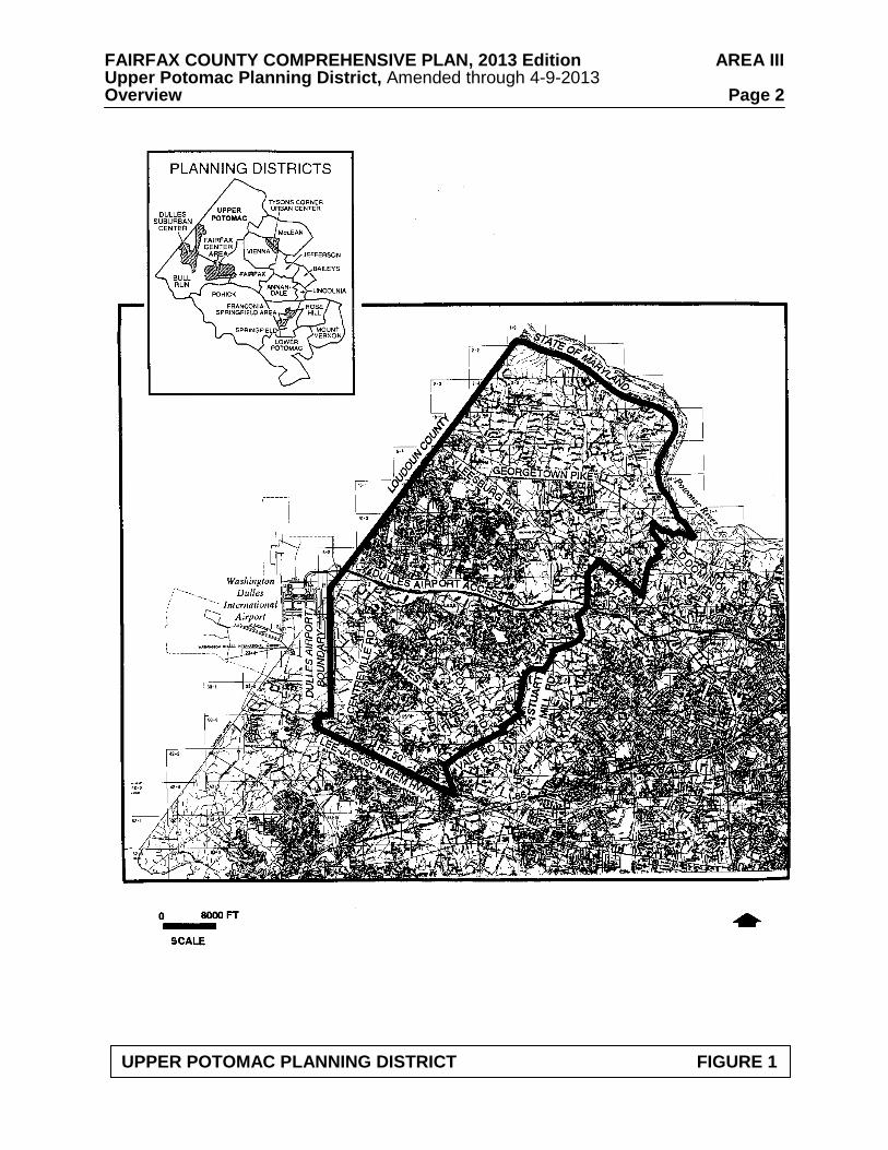
The Upper Potomac Planning District is located in the northwest portion of Fairfax County.
It is generally bounded on the north by the Potomac River, on the east by Difficult Run and Towlston Road, on the south by Lee Jackson Memorial Highway (Route 50) and on the west by Loudoun County and the Washington Dulles International Airport (see Figure 1).
The Upper Potomac Planning District encompasses approximately 47,500 acres which is
about 18 percent of the county’s land area. The character of the this planning district varies widely, from the semi-rural area of Great Falls along the Potomac River, to the urbanizing Reston-Herndon Suburban Center and Dulles Suburban Center, to the suburban neighborhoods along West Ox Road and Lee Jackson Memorial Highway. The northern area which includes the Riverfront, Springvale and Hickory Community Planning Sectors contains the Great Falls Village area, several estates and large-lot subdivisions and low density residential areas.
The Greater Herndon and Reston Community Planning Sectors contain concentrations of
office, industrial and commercial development, surrounded by residential development. The Route 28/CIT Transit Station Area is located in the Greater Herndon Community Planning Sector, and the Reston-Herndon Suburban Center and Transit Station Areas are in the Reston Community Planning Sector. The Sully Community Planning Sector is located entirely within the Dulles Suburban Center and is partially developed with office, industrial and commercial development, with large vacant areas. The West Ox and Lee-Jackson Community Planning Sectors are characterized by suburban neighborhood development in the western areas in the vicinity of Chantilly, and low density residential development in the eastern area where the headwaters of the Difficult Run Watershed are located. The Lee-Jackson Community Planning Sector includes some commercial development along Lee Jackson Memorial Highway.
The planning district is served by community and neighborhood shopping centers in the
vicinity of Reston, Herndon, Chantilly, and Great Falls. Tysons Corner Center and Fair Oaks Mall are the nearest regional shopping centers.
The Upper Potomac Planning District reflects a pattern common to the county, that of
suburban and low density neighborhoods surrounding mixed-use centers. Planning objectives in this district seek to protect stable neighborhoods while maintaining employment, shopping and recreation opportunities.
The county has adopted a sewer service area map which defines areas where public sewer
is planned to be permitted. Several planning sectors in the Upper Potomac Planning District, including Riverfront, Springvale and Hickory, Reston and West Ox, have areas that are outside the Approved Sewer Service Area. These areas are planned for uses which do not require public sewer service and may be developed with residential densities or with nonresidential uses that do not require public sewer service. CONCEPT FOR FUTURE DEVELOPMENT The planning guidance provided by the Concept for Future Development is one of the principal elements used in formulating Area Plan recommendations. The Concept and its
FAIRFAX COUNTY COMPREHENSIVE PLAN, 2013 Edition AREA III Upper Potomac Planning District, Amended through 4-9-2013 Overview Page 2
UPPER POTOMAC PLANNING DISTRICT FIGURE 1
FAIRFAX COUNTY COMPREHENSIVE PLAN, 2013 Edition AREA III Upper Potomac Planning District, Amended through 4-9-2013 Overview Page 3 associated land use guidance recommend the predominant use and character envisioned for land areas within each Planning District although within the planning districts, there may be land areas planned for a distinctly different land use than that envisioned by the Concept.
The Upper Potomac Planning District consists of areas that the Concept for Future Development recommends as Low Density Residential Areas, Suburban Neighborhoods and three Suburban Centers -- Reston-Herndon, Dulles Suburban Center, and Fairfax Center Area.
The two Suburban Centers that are located in the Upper Potomac Planning District are
being addressed in a different manner than the Reston-Herndon Suburban Center. The Dulles Suburban Center, located primarily in UP6 Sully Community Planning Sector is subject to the Route 28 Tax District legislation. A portion of the Fairfax Center Area is located in the Upper Potomac Planning District; this area is addressed in the Fairfax Center Area Plan.
The Reston-Herndon Suburban Center is recommended in the Concept for Future
Development for a mixture of office, retail and residential uses, with ancillary institutional uses in a low to moderate intensity range.
In the portion of the Upper Potomac Planning District that is north of the Dulles Airport Access Road, Suburban Neighborhoods are located in the vicinity of Reston and Sugarland Run (the area of the County surrounding the Town of Herndon.) South of the Dulles Airport Access Road, Suburban Neighborhoods border on the two Suburban Centers (Reston-Herndon and Dulles), Difficult Run, Lee-Jackson Memorial Highway and Fairfax Center. A wide range of housing types occurs in these areas.
Low Density Residential Areas are located primarily north of Leesburg Pike, along the
Potomac River shoreline. The areas around the Difficult Run stream valley and watershed in the eastern portion of the Upper Potomac Planning District are also designated as Low Density Residential Areas, due to the established low density character, the ecological significance, and environmental sensitivity of these areas. MAJOR OBJECTIVES
Planning objectives in the Upper Potomac Planning District are the following:
• Limit redevelopment of commercial, industrial and residential areas to intensities which will, upon redevelopment, result in acceptable levels of service and have minimal impact on stable residential areas, village centers, and other centers that serve villages or neighborhoods;
• Preserve stable residential areas through infill development of a character and
intensity/density that is compatible with existing residential uses; • Limit commercial encroachment into residential neighborhoods and establish a
clearly defined "edge" between commercial and residential areas; • Maintain the residential character development along the Route 7 Corridor and
prevent industrial, office, research and development (R&D) and retail commercial development in this corridor between the Dulles Airport Access Road and the Loudoun County line;

FAIRFAX COUNTY COMPREHENSIVE PLAN, 2013 Edition AREA III Upper Potomac Planning District, Amended through 4-9-2013 Overview Page 4
• Encourage pedestrian access to retail areas; • Encourage the creation of additional parks, open space and recreation areas and
acquire additional acreage in environmentally sensitive areas as part of the Environmental Quality Corridor program;
• Identify, preserve and promote awareness of heritage resources through research,
survey and community involvement; • Provide adequate facilities for the full range of human services, including child care,
senior citizen programs, health care, education, and recreational programs for all segments of the community;
• Continue active pursuit of affordable housing goals by enlarging the inventory and
maintaining and improving existing affordable units; and • Provide child care and elderly care facilities to meet the anticipated growth in needs.
DISTRICT-WIDE RECOMMENDATIONS Transportation
Travel within and through the Upper Potomac Planning District is affected by land uses and transportation facilities in adjacent districts, as well as throughout the Northern Virginia region. Therefore, the transportation network affecting the District is comprised of several elements, many of which relate to more extensive countywide facilities, services, and policies. The arterial and major collector roadways affecting the District are shown on Figure 2. Other countywide transportation elements are also depicted.
Within the discussion for each sector of the Planning District, a sector map depicting the
Transportation Plan recommendations in that sector is provided. More detail is provided on these sector maps than on the planning district map. The additional detail may relate to more local transportation issues that are difficult to present at the planning district scale. In some cases, such as interchange areas, a portion of the sector map has been enlarged so that the transportation recommendations are clearly identified. These enlargements of the sectors may also include guidance regarding the provision of access to selected land areas.
Georgetown Pike should be maintained within its existing right-of-way. Center turn lanes
and deceleration and acceleration lanes should be discouraged and curb cuts should not be allowed unless no other alternative exists. Georgetown Pike is commonly acknowledged to contain some traffic hazards. However, it is generally acceptable in its present condition to local residents. It has been designated a Virginia Byway. Major changes in alignment or widening the road would damage the scenic and historic character and the historic integrity of the Byway and have been strongly opposed by residents of adjacent areas. Planning efforts should focus on other means of dealing with traffic volume in order to maintain this Byway. Scenic and conservation easements should be sought along Georgetown Pike wherever practical for the preservation of the historic and scenic significance and beauty of the corridor.
Construction of the future westbound lanes of the four-lane Lawyers Boulevard between Cobra Drive and West Ox Road should be coordinated with the construction of Lawyers

FAIRFAX COUNTY COMPREHENSIVE PLAN, 2013 Edition AREA III Upper Potomac Planning District, Amended through 4-9-2013 Overview Page 5 Boulevard between West Ox Road and the Fairfax County Parkway in order for these segments of Lawyers Boulevard to be open to traffic simultaneously. Hunter Mill Road from Chain Bridge Road to Baron Cameron Avenue is a 7.2 mile roadway that is designated a Virginia Byway. To preserve the road’s scenic and historic character, planning efforts should focus on innovative ways of dealing with traffic volumes. The Hunter Mill Road Traffic Calming Study, sponsored by the Northern Virginia Regional Commission (NVRC) and completed in 2006, provides both a traffic calming conceptual plan for Hunter Mill Road, as well as context sensitive roadway design techniques. Housing
A list of existing, under construction, and proposed assisted housing for the Upper Potomac Planning District is shown in Figure 3. This list includes housing developments which, to the County’s knowledge, have received some type of housing assistance as defined below, but it should not be considered all inclusive.
Assisted housing includes programs which limit the amount of rent and the eligibility of
occupants based on income as a condition for the provision of financial assistance from Federal, State, or local sources. Some programs have time limits, and those units would no longer be considered “assisted” after income eligibility and rent limitations have been removed. The programs listed below are included as "assisted housing." Most programs provide assistance to privately owned housing developments. In some cases, multiple sources of financing may be used. The primary program and type of ownership is listed in the figure.
• Housing units owned or managed by the Fairfax County Redevelopment and Housing Authority (FCRHA) and operated by the Department of Housing and Community Development under the Federal Public Housing program or the local Fairfax County Rental Program;
• Housing units owned by the FCRHA and leased to the Fairfax-Falls Church
Community Services Board for use as group homes or to nonprofit groups for emergency housing;
• Federal Section 8 project based rent subsidy units, which are usually privately owned; • Units subsidized under Federal mortgage subsidy programs including Section 202
(Elderly), Section 811 (Disabled), Section 221(d)(3), Section 235 or Section 236. These units may be publicly owned but most are owned by private or nonprofit entities;
• Developments which were financed with FCRHA bonds where a portion of the units
must have reduced rents for tenants who meet income eligibility requirements;
• Tax Credit/VHDA financed projects with Low Income Housing Tax Credits and/or Virginia Housing Development Authority (VHDA) financing which establishes income eligibility requirements, many of which are privately owned;
• Nonprofit rental units and group homes serving nine or more individuals and owned
by private entities, which were assisted with loans or grants from the Community Development Block Grant (CDBG), Section 108 loans, Home Investment Partnerships Program (HOME), or Fairfax County Housing Trust Fund;

FAIRFAX COUNTY COMPREHENSIVE PLAN, 2013 Edition AREA III Upper Potomac Planning District, Amended through 4-9-2013 Overview Page 6
COUNTYWIDE TRANSPORTATION RECOMMENDATIONS FIGURE 2
UPPER POTOMAC PLANNING DISTRICT (SEE SECTOR MAPS FOR DETAILED TRANSPORTATION RECOMMENDATIONS)

FAIRFAX COUNTY COMPREHENSIVE PLAN, 2013 Edition AREA III Upper Potomac Planning District, Amended through 4-9-2013 Overview Page 7
TRANSPORTATION RECOMMENDATIONS LEGEND FIGURE 2

FAIRFAX COUNTY COMPREHENSIVE PLAN, 2013 Edition AREA III Upper Potomac Planning District, Amended through 4-9-2013 Overview Page 8
FIGURE 3 UPPER POTOMAC PLANNING DISTRICT
ASSISTED HOUSING (Occupied or Under Construction, as of October 2004)
Location
Planning Sector
Number of Assisted Units
Type of Ownership And Program
Rental Projects
Herndon Harbor House Jorss Place
UP4
120
Fairfax County Rental (Elderly)/ Adult Day Care Center/ FCRHA Bond Financing/Tax Credit
Cedar Ridge Apts, Becontree Lane
UP5
195
Fairfax County Rental/Section 221-d-3
Fellowship House (Lake Anne) North Shore Drive
UP5
240
Private/Section 202/Section 236 (Elderly)
Fellowship House (Hunter Woods) Colts Neck Road
UP5
224
Private/Section 223f (Elderly)
North Point, Northpoint Circle
UP5 48 Private Rental/Tax Credit
Reston Town Center, Bowman Towne Court
UP5
30 Public Housing
Shadowood, Castlerock Square
UP5
16*
Public Housing
Stonegate Village, Stonewheel Drive
UP5
230
Fairfax County Rental/Section 236/Tax Credit
West Glade, Glade Drive
UP5
50 26 Public Housing and 24 Fairfax County Rental
Dulles Town Center Apts. Sunrise Valley Drive
UP6
272
Private/Tax Credit/VHDA Financing
Trevors Run at Dulles Center Sunrise Valley Drive
UP6
11
Private/ADU Rental Program
Jefferson Commons Phase I, Masons Ferry Drive
UP7
152
Private/Tax Credit/VHDA Financing
Jefferson Commons Phase II, Masons Ferry Drive
UP7
134
Private/Tax Credit/VHDA Financing

FAIRFAX COUNTY COMPREHENSIVE PLAN, 2013 Edition AREA III Upper Potomac Planning District, Amended through 4-9-2013 Overview Page 9
FIGURE 3 UPPER POTOMAC PLANNING DISTRICT
ASSISTED HOUSING (Occupied or Under Construction, as of October 2004)
(Continued from previous page)
Location
Planning Sector
Number of Assisted Units
Type of Ownership And Program
Kendrick Court, Coppermine Road
UP7 139 Private/Tax Credit/VHDA Financing
Sunrise House, West Ox Road
UP7
20 beds Group Facility
Homeownership 218*
MIDS, First Time Home Buyers, or Affordable Dwelling Units
Reflection Lake Co-op, Springer Drive
UP4
84 Cooperative/Section 236
Island Walk Co-op, Torrey Pines Ct.
UP5 101 Cooperative/Section 8/Tax Credit
*Scattered Units

FAIRFAX COUNTY COMPREHENSIVE PLAN, 2013 Edition AREA III Upper Potomac Planning District, Amended through 4-9-2013 Overview Page 10
• Moderate Income Direct Sales (MIDS) program units which are for sale to income-eligible, first time home buyers with financial assistance provided in return for control of the re-sale price of the home; and
• Affordable Dwelling Units (ADU) for sale or for rent to serve households with
incomes up to 70% of Metropolitan Statistical Area (MSA) median income and which are required to be included in certain housing developments of 50 or more units pursuant to Article 2, Part 8 of the Fairfax County Zoning Ordinance. In some instances, units created under the ADU Program may be owned by the FCRHA or a nonprofit organization; if so, they would be considered in one of the other categories above.
In many cases the assisted units represent only a portion of a larger development. Only the number of assisted units is included on the figure. Also, the housing listed as part of the Section 8 program is only that where the Section 8 rent subsidy is tied to specific housing units (project based). Housing where eligible tenants are receiving assistance through the Section 8 Housing Choice Voucher Rental program or where the subsidy transfers with the tenant is not listed since the units change continuously as tenants move. Countywide, at the end of 2002, over 3,200 families living in Fairfax County were assisted with tenant-based vouchers. Finally, for some proposed developments where a zoning proffer requires the provision of low and/or moderate income housing, but no specific program (such as MIDS) is identified in the proffer, the type of program is listed as Unknown. Environment The Upper Potomac Planning District contains a portion of the Occoquan Reservoir watershed, the northern and western portions of the Difficult Run watershed, the entirety of Fairfax County’s portion of the Sugarland Run watershed, most of Fairfax County’s portion of the Horsepen Creek watershed and all of the Pond Branch and Nichols Run watersheds. The northern boundary of the planning district is the shoreline of the Potomac River, which is mostly park or preserved lands. The area near the eastern edge of Dulles International Airport contains a small amount of land impacted by aircraft noise. The northern and southeastern parts of the planning district have a semi-rural character, with a large number of stream valleys and other high quality plant and animal habitat areas meriting preservation. All such stream valleys and high quality habitat areas would qualify for designation as Environmental Quality Corridors; many, but not all, of the stream valleys have been protected as Resource Protection Areas pursuant to the Chesapeake Bay Preservation Ordinance. Like portions of the Pohick, Lower Potomac, Vienna and Bull Run Planning Districts, this area is vital to the preservation of Fairfax County's remaining natural resources. Reston and Herndon, in the central portion of the planning district, as well as other portions of the planning district, have largely been developed and are characterized by higher development densities; natural resources in these areas are not as extensive as they are in the semi-rural areas. In these more densely developed areas, a focus on pollution control and reclamation is appropriate. A major environmental stewardship objective in the Upper Potomac Planning District is the protection and restoration of streams. Watershed management plans have been, or are being, developed for all watersheds in the County; implementation of the watershed management plan recommendations for streams in this planning district is critical to the protection and restoration of these streams. Streams located in semi-rural areas, such as the Nichols Run watershed, the Pond Branch watershed and portions of the Difficult Run watershed, are some of the relatively

FAIRFAX COUNTY COMPREHENSIVE PLAN, 2013 Edition AREA III Upper Potomac Planning District, Amended through 4-9-2013 Overview Page 11 few streams in the County that remain in good condition. The high quality of these streams should be supported through the maintenance of the low density character of these semi-rural areas and the pursuit of development designs that will minimize impervious cover and maximize the replication of natural hydrologic conditions. Within this planning district, two areas have been certified by the National Wildlife Federation as “Community Wildlife Habitats.” These areas are Reston (Planning Sector UP5) and Great Falls (the Riverfront Community Planning Sector (UP1), Springvale Community Planning Sector (UP2) and Hickory Community Planning Sector (UP3) north of Leesburg Pike and west of Difficult Run). Great Falls has many large and old trees. The protection and restoration of streams and other ecological resources should be a central consideration during the land development process. Toward that end, the following guidelines are suggested for the Upper Potomac Planning District: • Retain a low density character in the Nichols Run and Pond Branch watersheds as well as
in those portions of the Difficult Run and Sugarland Run watersheds that have such a character.
• Implement the Environmental Quality Corridor policy to:
- Preserve ecologically significant habitat areas; - Protect steep slopes, problem soil areas and wetlands.
Large undeveloped areas, particularly where adjacent to already protected areas, provide ecological and water quality benefits. Protection of these areas should be encouraged. In Upper Potomac Planning Sectors UP1, UP2 and UP3, encourage the use of pervious and semi-pervious materials for paved areas (e.g. parking lots, driveways, walkways and patios). All new development and redeveloped properties in the Riverfront (UP1), Springvale (UP2), and Hickory (UP3) north and east of Leesburg Pike community planning sectors are strongly encouraged to bury all overhead utilities while protecting the valuable Heritage Trees and significant treescapes, and improving the safety and quality of life in the community.
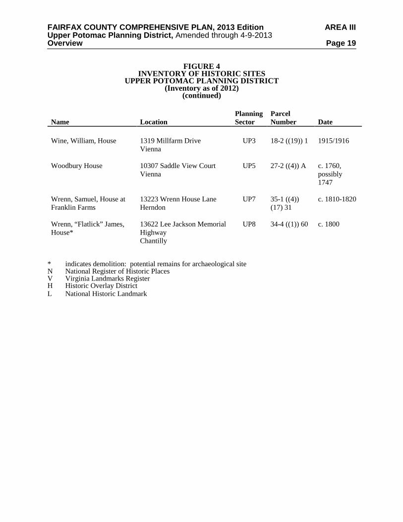
Heritage Resources The Upper Potomac Planning District contains both known and potential heritage resources. A list of those heritage resources included in Fairfax County's Inventory of Historic Sites is shown on Figure 4, and a map of those resources is shown on Figures 5 and 6. The Inventory is open-ended and continues to grow. For information about these and other historic sites, consult the Fairfax County Department of Planning and Zoning. Identified heritage resources include:
• Potomac (Patowmack) Canal Historic District – This National Register Historic District in Great Falls Park contains remains of the Potomac Canal, one of the earliest canals in the United States.
• Dranesville Tavern – This rural inn on Leesburg Pike served travelers during the 18th
and 19th centuries. It is protected by a County Historic Overlay District.

FAIRFAX COUNTY COMPREHENSIVE PLAN, 2013 Edition AREA III Upper Potomac Planning District, Amended through 4-9-2013 Overview Page 12
FIGURE 4 INVENTORY OF HISTORIC SITES
UPPER POTOMAC PLANNING DISTRICT (Inventory as of 2012)
Name Location Planning Sector
Parcel Number Date
Appledore/Poplar Vale
3000C Fox Mill Road Oakton
UP7 36-3 ((1)) 29C
c. 1806
Bailey House* 13825 Sunrise Valley Drive Herndon
UP6 15-4 ((2)) 15A
c. 1903
Bloomfield V, H
12000 Leesburg Pike Herndon
UP2 6-3 ((1)) 6 c. 1858
Bowman, A. Smith, Distillery/Wiehle Town Hall N, V
1890 Old Reston Avenue Reston
UP5 17-4 ((1)) 5B c. 1890-1892
Bowman Store* N, V 2628 Centreville Road Herndon
UP6 25-1 ((1)) 13 c. 1893
Brown’s Chapel 1525 Browns Chapel Road Reston
UP5 11-4 ((1)) 8 c. 1879
Cameron Parish Church Ruins and Cemetery*
Powells Tavern Place Herndon
UP4 5-4 ((8)) G 1773
Cartersville Baptist Church
1727 Hunter Mill Road Vienna
UP5 27-1 ((1)) 2 1903
Chantilly Plantation Stone House
13200 Lee Jackson Highway Chantilly
UP8 45-1 ((1)) 11 c. 1820
Cherok House * N, V 2633 Centreville Road Herndon
UP7 25-1 ((1)) 19 c. 1889
Cockerille House *
Mares Neck Lane Herndon
UP7 25-3 ((14)) c. 1840
Colvin Run Community Center
10201 Colvin Run Road Great Falls
UP3 12-4 ((1)) 31 1908
Colvin Run Mill N,V,H 10017 Colvin Run Road Great Falls
UP3 18-2 ((1)) 24 c. 1810
FAIRFAX COUNTY COMPREHENSIVE PLAN, 2013 Edition AREA III Upper Potomac Planning District, Amended through 4-9-2013 Overview Page 13
FIGURE 4 INVENTORY OF HISTORIC SITES
UPPER POTOMAC PLANNING DISTRICT (Inventory as of 2012)
(continued)
Name Location Planning Sector
Parcel Number Date
Colvin Run Mill Miller’s House H
10017 Colvin Run Road Great Falls
UP3 18-2 ((1)) 24 c. 1810
Cornwell Farm N,V
9414 Georgetown Pike Great Falls
UP2 13-1 ((1)) 58B
1831
Cornwell, Henry, House *
10010 Georgetown Pike Great Falls
UP2 12-2 ((1)) 20 c. 1890
Defense Mapping Agency 925 Springvale Road Great Falls
UP3 12-1 ((1)) 24 c. 1954-1962
Dranesville Methodist Church
1089 Liberty Meeting Court Herndon
UP4 6-4 ((1)) 66B 1852-1861
Dranesville Tavern N,V,H 11919 Leesburg Pike Herndon
UP4 6-3 ((1)) 19 c. 1823
Dunbarton 11554 Tralee Drive Great Falls
UP2 6-4 ((13)) (2) 13
c. 1764-1794
Eastern Shore House H 10026 Colvin Run Road Great Falls
UP3 18-2 ((1)) 19 c. 1782; moved here 1979
Feighery Store and House/ Thelma’s Ice Cream*
10200 Colvin Run Road Great Falls
UP3 12-4 ((1)) 32 c. 1931
First Baptist Church of Herndon N,V
681 Elden Street Herndon
UP4 16-2 ((2)) 198
1899
Floris Colored School, New*
2525 Squirrel Hill Road Herndon
UP6 15-4 ((1)) 32 1932
Floris Historic District N, V
Bounded by Centreville Road, West Ox Road, Monroe Street, and Frying Pan Branch, Herndon
UP7 25-1 ((1)) 3A, 3L, 9-11, 16, 17, 20-21, 29-31; 25-1 ((14)) B, C, E-G, (6)A, (7)B
c. 1785-1960

FAIRFAX COUNTY COMPREHENSIVE PLAN, 2013 Edition AREA III Upper Potomac Planning District, Amended through 4-9-2013 Overview Page 14
FIGURE 4 INVENTORY OF HISTORIC SITES
UPPER POTOMAC PLANNING DISTRICT (Inventory as of 2012)
(continued)
Name Location Planning Sector
Parcel Number Date
Floris Presbyterian Church 2472 Centreville Road
Herndon
UP6 16-3((1))7 1906
Floris United Methodist Church N, V
2629 Centreville Road Herndon
UP7 25-1 ((1)) 17 c. 1895
Follin, J.N., House 1051 Walker Mill Road Great Falls
UP3 12-4 ((1)) 13 c. 1850
Forestville Colored School*
710 Walker Road Great Falls
UP2 7-4 ((1)) 64 c. 1886
Four Stairs N, V 840 Leigh Mill Road Great Falls
UP3 13-3 ((1)) 20Z
c. 1737
Fox House N, V 2703 West Ox Road Herndon
UP7 25-1 ((1)) 20 1897/1898
Franklin Farm House/Oak Hill
3020 West Ox Road Herndon
UP7 35-2 ((8)) (25) 4
c. 1790
Frying Pan Meeting House N, V
2615 Centreville Road Herndon
UP7 25-1 ((1)) 11 c. 1783
Frying Pan Farm Park N, V
2709 West Ox Road Herndon
UP7 25-1 ((1)) 3A, 3L, 9-11, 29-31; 25-1 ((14)) B, C, E-G, (6)A, (7)B
c. 1920
Great Falls Grange N, V
9818 Georgetown Pike Great Falls
UP2 13-1 ((1)) 15 1929
Great Falls Park Historic District1 V
9200 Old Dominion Drive McLean
UP1 8-4 ((12)) 3A1, 13-2 ((1)) 35
c. 6,000 BC-1968
1Site is also located in McLean Planning District

FAIRFAX COUNTY COMPREHENSIVE PLAN, 2013 Edition AREA III Upper Potomac Planning District, Amended through 4-9-2013 Overview Page 15
FIGURE 4 INVENTORY OF HISTORIC SITES
UPPER POTOMAC PLANNING DISTRICT (Inventory as of 2012)
(continued)
Name Location Planning Sector
Parcel Number Date
Great Falls Post Office/Forestville School N, V
9812 Georgetown Pike Great Falls
UP2 13-1 ((1)) 18 1889
Greek Revival House H 10030 Colvin Run Road Great Falls
UP3 18-2 ((1)) 19A
c. 1850; moved here 1974
Gunnell, John, House N, V
489 Arnon Meadow Road Great Falls
UP2 8-3 ((1)) 3 1853
Gunnell’s Run N, V 600 Innsbruck Avenue Great Falls
UP2 8-3 ((12)) A c. 1750
Herndon Historic District N, V
Herndon UP4 16-2 ((2)) 1855-1940
Herndon Depot N, V 717 Lynn Street Herndon
UP4 16-2 ((2)) 23 - adjacent
c. 1861
Hidden Springs Farm 438B River Bend Road, Great Falls
UP2 8-4 ((1)) 33Z 1820s
Higgins, R., House N, V
2705 West Ox Road Herndon
UP7 25-1 ((1)) 21 1903/1904
Ivy Chimney 11706 Leesburg Pike Herndon
UP2 6-4 ((1)) 40 1856-1860
Jackson, Verlinda, House 700 River Bend Road Great Falls
UP2 13-2 ((1)) 11 c. 1785
Jefferson School
11105 Beach Mill Road Great Falls
UP2 3-3 ((10)) 1 pre 1930
Kalorama Springs* H
10030 Colvin Run Road Great Falls
UP3 18-2 ((1)) 19A
unknown
Keyes House* 2516 Squirrel Hill Road Herndon
UP7 15-4 ((1)) 28 1884/1885

FAIRFAX COUNTY COMPREHENSIVE PLAN, 2013 Edition AREA III Upper Potomac Planning District, Amended through 4-9-2013 Overview Page 16
FIGURE 4 INVENTORY OF HISTORIC SITES
UPPER POTOMAC PLANNING DISTRICT (Inventory as of 2012)
(continued)
Name Location Planning Sector
Parcel Number Date
King Subdivision Elizabeth Street and Jackson
Lane, Great Falls
UP1 13-2 ((2)) (1) and (2)
1910-1925
Kitchen, Kitty, Cottage N, V
681 Monroe Street UP4 16-2 ((2)) 194
c. 1861
Lake Anne Village Center H
Washington Plaza and Chimney House Road Reston
UP5 17-2 ((6)) ((7)) ((9)) ((31))
1963-1967
Lawyers Road*2 b/t Hunter Station and Hunter Mill Roads Vienna
UP5 27-3; 27-4 Pre-1800
Lee, Edward, House N, V
2625 Centreville Road Herndon
UP7 25-1 ((1)) 16 c. 1891
Leigh, Dr. Alfred, House 1148 Walker Road Great Falls
UP3 12-4 ((1)) 15A
c. 1890, 1910
Lewis-Oliver House
1032 Towlston Road McLean
UP3 19-2 ((12)) 9A
c. 1750
Manassas Gap Railroad Loudoun Branch*3
3650 Historic Sully Way Chantilly
UP6 34-2 ((1)) 14 1854-1862
Matildaville Ruins N,V 9200 Old Dominion Drive Great Falls Park, Great Falls
UP1 13-2 ((1)) 35 1790-1839
Mayfield 11700 Leesburg Pike Herndon
UP2 6-4 ((1)) 41 c. 1804
McMillen Farm 1521 Dranesville Road Herndon
UP4 10-2 ((1)) 5 1905-1908; barn pre 1850
Methodist Episcopal Church N,V
800 Elden Street Herndon
UP4 16-2 ((2)) 33 1872
2Site is also located in Fairfax and Vienna Planning Districts 3Site is also located in Annandale and Bull Run Planning Districts

FAIRFAX COUNTY COMPREHENSIVE PLAN, 2013 Edition AREA III Upper Potomac Planning District, Amended through 4-9-2013 Overview Page 17
FIGURE 4 INVENTORY OF HISTORIC SITES
UPPER POTOMAC PLANNING DISTRICT (Inventory as of 2012)
(continued)
Name Location Planning Sector
Parcel Number Date
Middle Turnpike Bridge Ruins
Difficult Run Great Falls
UP3 19-1 ((1)) 2A, 19-1 ((9)) D
1818-1838
Middleton, John, Farm * 13801 Frying Pan Road Herndon
UP6 24-2 ((1)) 1 1871
Mosby’s Rock 2525 Squirrel Hill Road Herndon
UP6 15-4 ((1)) 32 significant 1863-1865
Mount Pleasant Baptist Church, Old* and Cemetery
13614 Coppermine Road Herndon
UP6 15-4 ((1)) 18 1882
Murphy, Hazel, Farm *
13900 Frying Pan Road Herndon
UP6 15-4 ((1)) 25 1852-1854
Navy School
3510 West Ox Road Fairfax
UP8 45-2 ((1)) 6 1887-1888
Old Ox Road Trace *
Near Squirrel Hill Road Herndon
UP6 15-4 ((1)) 32 1729
Patowmack Canal at Seneca Falls
Potomac River Great Falls
UP1 3-1 ((1)) 1, 2
1785-1802
Patowmack Canal Historic District/Lock Ruins at Great Falls N,V,L
9200 Old Dominion Drive Great Falls Park, Great Falls
UP1 13-2 ((1)) 35 1785-1802
Peck House * 3106 Centreville Road Herndon
UP6 24-4 ((1)) 6C4
c. 1853
Piscataway Farm
11524-9 Seneca Farm Way Great Falls
UP2 6-2 ((16)) 2 c. 1800
Ratcliffe-Hanna House N, V
2346 Centreville Road Herndon
UP6 16-3 ((1)) 39A4
c. 1820
St. Joseph’s Church N,V 718 Pine Street Herndon
UP4 16-2 ((2)) 273
1925

FAIRFAX COUNTY COMPREHENSIVE PLAN, 2013 Edition AREA III Upper Potomac Planning District, Amended through 4-9-2013 Overview Page 18
FIGURE 4 INVENTORY OF HISTORIC SITES
UPPER POTOMAC PLANNING DISTRICT (Inventory as of 2012)
(continued)
Name Location Planning Sector
Parcel Number Date
St. Timothy’s Church N,V 820 Elden Street
Herndon
UP4 16-2 ((2)) 40A
1877-1880
Smith, Jesse, Farm 315 Seneca Road Great Falls
UP1 2-2 ((1)) 8 1854-1856
Smith’s Chapel
11321 Beach Mill Road Great Falls
UP2 2-4 ((1)) 19 1890
Summer Road Near 1319 Millfarm Drive Vienna
UP3 18-2 ((19)) 1 Early 19th century
Sunset Hills 1856 Old Reston Avenue Reston
UP5 17-4 ((1)) 1 1899
Thompson, Arthur, House
12500 Thompson Road Fairfax
UP7 35-4 ((1)) 73 c. 1898
Toll Gate House*
9404 Georgetown Pike Great Falls
UP2 13-2 ((1)) 7 c. 1920
Turley Hall * 3318 Centreville Road Chantilly
UP6 34-2 ((1)) 10A
c. 1821
Turner, Mark, Dairy Farm 10609 Georgetown Pike Great Falls
UP3 12-1 ((1)) 24C
c. 1905
Vale School/Vale Community House N, V
3124 Fox Mill Road Oakton
UP7 36-4 ((1)) 8 c. 1885
Vale United Methodist Church
11528 Vale Road Oakton
UP7 36-4 ((1)) 19 1896
White, Elijah, House* 13141A Lazy Glen Court Herndon
UP7 25-3 ((7)) 126
c. 1884
Wiehle, Robert, House 1830 Old Reston Avenue Reston
UP5 17-4 ((1)) 3 c. 1895
FAIRFAX COUNTY COMPREHENSIVE PLAN, 2013 Edition AREA III Upper Potomac Planning District, Amended through 4-9-2013 Overview Page 19
FIGURE 4 INVENTORY OF HISTORIC SITES
UPPER POTOMAC PLANNING DISTRICT (Inventory as of 2012)
(continued)
Name Location Planning Sector
Parcel Number Date
Wine, William, House
1319 Millfarm Drive Vienna
UP3 18-2 ((19)) 1 1915/1916
Woodbury House 10307 Saddle View Court Vienna
UP5 27-2 ((4)) A c. 1760, possibly 1747
Wrenn, Samuel, House at Franklin Farms
13223 Wrenn House Lane Herndon
UP7 35-1 ((4)) (17) 31
c. 1810-1820
Wrenn, “Flatlick” James, House*
13622 Lee Jackson Memorial Highway Chantilly
UP8 34-4 ((1)) 60 c. 1800
* indicates demolition: potential remains for archaeological site N National Register of Historic Places V Virginia Landmarks Register H Historic Overlay District L National Historic Landmark

FAIRFAX COUNTY COMPREHENSIVE PLAN, 2013 Edition AREA III Upper Potomac Planning District, Amended through 4-9-2013 Overview Page 20
FIGURE 5

FAIRFAX COUNTY COMPREHENSIVE PLAN, 2013 Edition AREA III Upper Potomac Planning District, Amended through 4-9-2013 Overview Page 21
FIGURE 6

FAIRFAX COUNTY COMPREHENSIVE PLAN, 2013 Edition AREA III Upper Potomac Planning District, Amended through 4-9-2013 Overview Page 22
• Colvin Run Mill and Miller’s House – This early 19th century gristmill and miller’s house built on Difficult Run are protected by a County Historic Overlay District. The mill is also a National Register site.
• Herndon Historic District – Beginning in the mid 19th and heavily influenced by the
railroad, this village was the beginning of a major residential community in Fairfax County. This National Register Historic District is comprised mostly of areas protected by local Heritage Preservation Overlay Districts administered by the Town of Herndon.
There are known and potential heritage resources located along the 7.2-mile length of Hunter Mill Road, a portion of which lies within this Planning District. Such resources include sites or structures that are evidence of Native American occupation, pre-Revolutionary and Civil War activities, and the County’s agrarian past. Actions to document these heritage resources, and to protect and preserve those that are determined by the County to be of historic or archaeological significance are underway and should be encouraged. Hunter Mill Road has been determined to be eligible for listing in the Virginia Landmarks Register and the National Register of Historic Places. The determination of eligibility is the first step in the process for being listed in the Virginia Landmarks and/or the National Register of Historic Places. Hunter Mill Road has also been designated as a Virginia Byway. Georgetown Pike has also been determined to be eligible for listing in the Virginia Landmarks Register and National Register of Historic Places. It has been designated as a Virginia Byway. The Great Falls Survey Report of Historic Properties identified historically significant sites which are now listed in the County Inventory of Historic Sites. Great Falls Grange is also listed in the Virginia Landmarks Register and National Register of Historic Places. Additional sites included in this survey are potentially significant heritage resources and should be further evaluated. Other heritage resources including those protected by Historic Overlay Districts, or listed in the National or Virginia Landmarks Register are also shown on Figure 4, and may be identified in the text and recommendations section. The Fairfax County Inventory of Historic Sites, the Virginia Landmarks Register, the National Register of Historic Places, and the County's Historic Overlay Districts promote the recognition of sites with historic, architectural and archaeological significance. Designation confers public recognition and can offer incentives for preservation to the property owner. The County Inventory of Historic Sites includes properties which meet certain eligibility criteria and are officially designated by the County's History Commission. In addition to historic, architectural or archaeological significance, property that serves as a focus of community identity and pride may also be recognized. The benefits of designation include public recognition of the structure's significance and enhanced support for preservation. Owners of properties included in the Inventory may meet with the County's Architectural Review Board on a voluntary basis to review proposed changes to their properties. Project review and approval by the County's Architectural Review Board may be required in accordance with the guidance provided by the Policy Plan under Land Use Appendix 9 Residential Development Criteria 8 Heritage Resources.

FAIRFAX COUNTY COMPREHENSIVE PLAN, 2013 Edition AREA III Upper Potomac Planning District, Amended through 4-9-2013 Overview Page 23 The Virginia Landmarks Register and the National Register of Historic Places also officially recognize properties meeting specific criteria. Like the County Inventory, benefits of designation include public recognition and enhanced support for preservation. In addition, projects that are funded or sanctioned by Federal government agencies may require review to determine if they will have any effect on properties listed in or eligible for listing in the National Register for Historic Places. Alternatives must be explored to avoid or reduce harm to the historic properties. National Historic Landmarks are properties listed in the National Register of Historic Places which “possess exceptional value or quality in illustrating and interpreting the heritage of the United States.” These properties are of importance on a national level and are considered irreplaceable. Fewer than 5% of sites listed in the National Register are granted this designation. The County's Historic Overlay District is a zoning tool used to regulate proposed new construction and changes to existing structures in areas containing heritage resources to ensure compatibility with the resources. Site design, facades, demolition, and building materials must be reviewed and approved by the County's Architectural Review Board. In those areas where significant heritage resources have been recorded, an effort should be made to preserve them for the benefit of present and future generations. If preservation is not feasible then the threatened resources should be thoroughly recorded and, in the case of archaeological resources, the data recovered in accordance with countywide policies. Prior to any zoning action, the Department of Planning and Zoning should be consulted as to what architectural surveys are necessary to document any on-site cultural resources. Staff from the Cultural Resource Management and Protection Section of the Park Authority should be consulted to develop a scope of work for any on-site archaeological surveys prior to any development or ground disturbing activity. Should architectural or archaeological resources be discovered that are potentially eligible for inclusion in the National Register, further survey and testing should occur to evaluate these resources as to their eligibility. If such resources are found to be eligible, mitigation measures should be developed that may include avoidance, documentation, data recovery excavation and interpretation. Public Facilities
Existing public facilities located within the Upper Potomac Planning District and those for which a future need has already been identified are included on Figure 7. Major expansions of existing facilities (with the exception of Federal or State facilities) or uses of land that are distinctly different than the use of the public facility must be considered by the County Planning Commission through provisions outlined in Section 15.2-2232 of the Code of Virginia. For these existing facilities minor expansions which are in keeping with the character of the facility may be considered in conformance with the Plan.
A number of public facilities have been identified as future needs in this Planning District.
These projects are included for informational purposes and in most cases will require a 2232 Review public hearing before the Planning Commission prior to being established. Those facilities for which a specific location for future construction has been identified are also listed in the sector recommendations and may be considered a feature of the Comprehensive Plan upon review by the Planning Director and concurrence by the Planning Commission. If such feature shown determination is made, these projects will not require a future 2232 Review public hearing. The following public facilities are identified as future needs in the Upper Potomac Planning District:
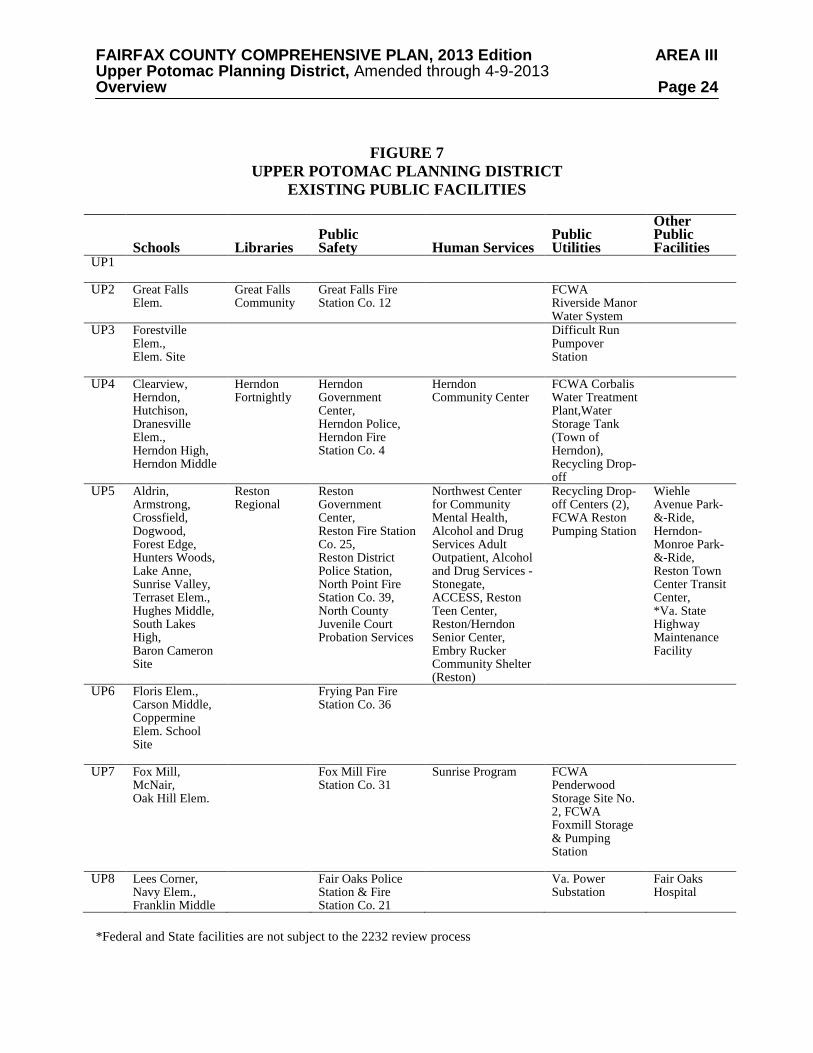
FAIRFAX COUNTY COMPREHENSIVE PLAN, 2013 Edition AREA III Upper Potomac Planning District, Amended through 4-9-2013 Overview Page 24
FIGURE 7
UPPER POTOMAC PLANNING DISTRICT EXISTING PUBLIC FACILITIES
Schools
Libraries
Public Safety
Human Services
Public Utilities
Other Public Facilities
UP1
UP2 Great Falls Elem.
Great Falls Community
Great Falls Fire Station Co. 12
FCWA Riverside Manor Water System
UP3 Forestville Elem., Elem. Site
Difficult Run Pumpover Station
UP4 Clearview, Herndon, Hutchison, Dranesville Elem., Herndon High, Herndon Middle
Herndon Fortnightly
Herndon Government Center, Herndon Police, Herndon Fire Station Co. 4
Herndon Community Center
FCWA Corbalis Water Treatment Plant,Water Storage Tank (Town of Herndon), Recycling Drop-off
UP5 Aldrin, Armstrong, Crossfield, Dogwood, Forest Edge, Hunters Woods, Lake Anne, Sunrise Valley, Terraset Elem., Hughes Middle, South Lakes High, Baron Cameron Site
Reston Regional
Reston Government Center, Reston Fire Station Co. 25, Reston District Police Station, North Point Fire Station Co. 39, North County Juvenile Court Probation Services
Northwest Center for Community Mental Health, Alcohol and Drug Services Adult Outpatient, Alcohol and Drug Services - Stonegate, ACCESS, Reston Teen Center, Reston/Herndon Senior Center, Embry Rucker Community Shelter (Reston)
Recycling Drop-off Centers (2), FCWA Reston Pumping Station
Wiehle Avenue Park-&-Ride, Herndon-Monroe Park-&-Ride, Reston Town Center Transit Center, *Va. State Highway Maintenance Facility
UP6 Floris Elem., Carson Middle, Coppermine Elem. School Site
Frying Pan Fire Station Co. 36
UP7 Fox Mill, McNair, Oak Hill Elem.
Fox Mill Fire Station Co. 31
Sunrise Program FCWA Penderwood Storage Site No. 2, FCWA Foxmill Storage & Pumping Station
UP8 Lees Corner, Navy Elem., Franklin Middle
Fair Oaks Police Station & Fire Station Co. 21
Va. Power Substation
Fair Oaks Hospital
*Federal and State facilities are not subject to the 2232 review process

FAIRFAX COUNTY COMPREHENSIVE PLAN, 2013 Edition AREA III Upper Potomac Planning District, Amended through 4-9-2013 Overview Page 25
1. If warranted, consider the development of a fire and rescue mini-station to serve the north Great Falls area. (UP1, UP2)
2. Implement the Regional Stormwater Management Plan by providing necessary
stormwater detention ponds in this district. 3. Provide the necessary improvements to the Corbalis Water Treatment Plant on land
currently owned at the Authority's plant site to meet current and future needs. (UP4) 4. Construct a new elementary school in Sector UP7.
5. Construct additional public transit facilities including park-and-ride lots at the
southeastern quadrant of the Dulles Airport Access Road and Monroe Street, at Reston East and at Lawyers Road and Reston Parkway. Construct a transit center in Reston at the Reston Town Center. In addition, preserve the potential for rail destination stations at the following locations: Dulles Toll Road just west of the Reston Parkway and Dulles Toll Road at the Center for Innovative Technology (CIT). (UP5)
6. Fire facilities and equipment at the Herndon Fire Station should be kept adequate to
meet increasing demand for fire and emergency protection. (UP4)
7. Provide an additional 2.5 million gallon ground water storage tank at the County Water Authority's Penderwood Water Storage Tanks II site on West Ox Road near Waples Mill Road. (UP7)
8. Provide two adult day health care centers, one in the Reston-Herndon vicinity and one
in Chantilly. (UP8) 9. Provide a District Public Health Center in the Centreville/Chantilly area. (UP8) 10. Provide a five-acre site for Crossroads, an intensive drug and alcohol treatment
program. In addition to treating clients, this facility will also house children of clients.
11. Expand the Reston Regional Library in Sector UP5 consistent with the Policy Plan
standards for regional libraries. 12. Provide any necessary improvements to FCWA’s Riverside Manor Water System to
meet future regulations (UP2).
13. Provide additional finished water transmission facilities between the Corbalis Water Treatment Plant and The Fox Mill Storage and Pumping Facilities (UP5, UP7).
14. Provide additional finished water transmission facilities between Lawyers Road and
Vale Road along the Fox Mill corridor (UP5, UP7). 15. Provide additional finished water transmission facilities along the Route 50 corridor
between Rugby Road and Stringfellow Road (UP8).
16. Explore possible sites for a Great Falls Community Center. (UP1, UP2, and UP3).

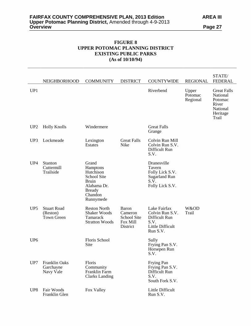
FAIRFAX COUNTY COMPREHENSIVE PLAN, 2013 Edition AREA III Upper Potomac Planning District, Amended through 4-9-2013 Overview Page 26 Parks and Recreation Public parks located within the Upper Potomac Planning District are identified on Figure 8. Additional recreational facilities are provided at county public school sites. The Upper Potomac Planning District contains many of the most significant natural and heritage resource areas in Fairfax County. The majority of the Potomac River shoreline is protected in land holdings administered by the Fairfax County Park Authority, Northern Virginia Regional Park Authority, National Park Service and The Nature Conservancy. Additionally, a permanent open space easement along the entire river shoreline has been acquired by the U. S. Department of the Interior for development of the Potomac River National Heritage Trail.
Nationally and regionally significant historic properties include Sully, Dranesville Tavern,
Frying Pan Meeting House, and Colvin Run Mill. Frying Pan Park, Floris Community Park and the Great Falls Grange preserve elements of the agricultural history of the local community. A wide diversity of recreational opportunities are available at Lake Fairfax, Fox Mill and Baron Cameron District Parks and the major stream valleys.
The Difficult Run, Little Difficult Run, and Sugarland Run stream valley system, which traverses the entire district from south to north, contains environmentally sensitive natural resources and cultural resources. A variety of resource protection mechanisms, including acquisition of conservation/open space, scenic, and historic preservation easements, land dedication and purchase by the County should be utilized to protect identified resources not currently in public ownership. The intrusion of non-recreational development should be restricted and the impacts of offsite development should be mitigated.
Current deficiencies in active recreation facilities will be exacerbated by the large population growth projected for the western part of the district. Additionally, Community Parks should be provided in the UP4, UP7 and UP8 sectors. Cooperative public/private sector strategies should be pursued to locate outdoor recreation facilities to serve the adult workforce in proximity to employment centers. The potential for, and possible location of, a future recreation center in this planning district will be determined by the Fairfax County Park Authority based on the results of the recreation demand survey and recreation feasibility study. The evaluation of recreational needs in the Centreville District being conducted by the County should be used in determining those activities to be included in an Oak Marr-type facility to be located in the Herndon-Reston area. The construction of a recreation facility in the Springfield District at Stringfellow Road and Lee-Jackson Memorial Highway is also endorsed.
FAIRFAX COUNTY COMPREHENSIVE PLAN, 2013 Edition AREA III Upper Potomac Planning District, Amended through 4-9-2013 Overview Page 27
FIGURE 8 UPPER POTOMAC PLANNING DISTRICT
EXISTING PUBLIC PARKS (As of 10/10/94)
NEIGHBORHOOD
COMMUNITY
DISTRICT
COUNTYWIDE
REGIONAL
STATE/ FEDERAL
UP1 UP2 UP3 UP4 UP5 UP6 UP7 UP8
Holly Knolls Lockmeade Stanton Cuttermill Trailside Stuart Road (Reston) Town Green Franklin Oaks Garchayne Navy Vale Fair Woods Franklin Glen
Windermere Lexington Estates Grand Hamptons Hutchison School Site Bruin Alabama Dr. Bready Chandon Runnymede Reston North Shaker Woods Tamarack Stratton Woods Floris School Site Floris Community Franklin Farm Clarks Landing Fox Valley
Great Falls Nike Baron Cameron School Site Fox Mill District
Riverbend Great Falls Grange Colvin Run Mill Colvin Run S.V. Difficult Run S.V. Dranesville Tavern Folly Lick S.V. Sugarland Run S.V. Folly Lick S.V. Lake Fairfax Colvin Run S.V. Difficult Run S.V. Little Difficult Run S.V. Sully Frying Pan S.V. Horsepen Run S.V. Frying Pan Frying Pan S.V. Difficult Run S.V. South Fork S.V. Little Difficult Run S.V.
Upper Potomac Regional W&OD Trail
Great Falls National Potomac River National Heritage Trail

FAIRFAX COUNTY COMPREHENSIVE PLAN, 2013 Edition AREA III Upper Potomac Planning District, Amended through 4-9-2013 Reston-Herndon Suburban Center and Transit Station Areas Page 28
RESTON-HERNDON SUBURBAN CENTER AND TRANSIT STATION AREAS
OVERVIEW
The Reston-Herndon Suburban Center represents one of the County's premier employment locations. The Center, which surrounds the Dulles Airport Access Road from Hunter Mill Road to Centreville Road, varies in character of development from areas almost completely developed as medium intensity office to the Reston Town Center which is planned as a high intensity mixed-use area. The proximity of the Washington Dulles International Airport and the excellent regional access make this area appropriate for a variety of residential and employment land uses.
The area surrounding the Reston-Herndon Suburban Center consists primarily of residential development, including many stable low and medium-density residential areas within the planned community of Reston. Very low density residential development occurs to the east of the Reston-Herndon Suburban Center. These communities help to form a low density residential transition between the Reston-Herndon Suburban Center and the Tysons Corner Urban Center. CONCEPT FOR FUTURE DEVELOPMENT
The Concept for Future Development identifies the Reston-Herndon Suburban Center as one of several mixed-use employment centers located in Fairfax County. The intention of the Suburban Center designation is to capitalize on the opportunity to provide future housing and employment locations, while still maintaining the integrity of existing, nearby land uses. The Suburban Center is developed primarily with office uses, although there are a few areas within the Suburban Center where industrial “flex” and research and development uses remain.
The Reston-Herndon Suburban Center also encompasses three of the four Transit Station
Areas in the Dulles Corridor. The purpose of the Transit Station Area designation is to optimize development opportunities associated with transit stations while maintaining the stability of existing, nearby land uses. In addition, these areas should allow a mixture of residential, office and retail uses and provide opportunities for joint public-private development. LOCATION AND CHARACTER
The Reston-Herndon Suburban Center is located in the northwestern quadrant of Fairfax County along the north and south sides of the Dulles Airport Access and Toll Road (DAAR) and is bounded generally by Centreville Road on the west; areas along Sunrise Valley Drive on the south; Hunter Mill Road on the east; and areas adjoining Sunset Hills Road on the north including the Town Center at Reston. The Reston-Herndon Suburban Center consists of three Transit Station Areas (TSAs) and the areas outside of the TSAs, which are divided into separate "land units" for the purpose of organizing Plan recommendations.
The Suburban Center can be characterized as a mix of older, relatively low-intensity
suburban office parks in 2- and 3-story buildings with surface parking and an increasing number of larger office buildings (6-12 story buildings) with structured parking, most of which have been developed in the past five years or are in the process of being constructed.

FAIRFAX COUNTY COMPREHENSIVE PLAN, 2013 Edition AREA III Upper Potomac Planning District, Amended through 4-9-2013 Reston-Herndon Suburban Center and Transit Station Areas Page 29
The planning objective for the Transit Station Areas is to encourage mixed-use developments with a more urban character in the areas closest to the transit station locations. It should be noted that two of the station areas (Wiehle Avenue TSA and Herndon-Monroe TSA) will have parking facilities to serve commuters using the transit system. The third station area (Reston Parkway TSA) is envisioned to be a destination station without commuter parking facilities and should be developed in a manner that is supportive of the existing Reston Town Center Core area.
Since the Reston Master Plan designates much of this area for industrial use, the recommendations for the Reston-Herndon Suburban Center will need to be reconciled with the Reston Master Plan which is incorporated into the Comprehensive Plan by reference. It should be noted that the Reston Industrial and Commercial Area Covenants, which govern the use of most of the land not zoned Planned Residential Community (PRC) in the Wiehle Avenue and Reston Parkway Transit Station Areas contain limitations on residential uses. Implementation of the residential mixed-use recommendations for these TSAs will need to include amending the covenants. SUBURBAN CENTER AREAWIDE RECOMMENDATIONS
The purpose of the planning recommendations for the Reston-Herndon Suburban Center is to guide and direct development by recognizing both future opportunities and constraints. The land use recommendations are based upon the concept of concentrating development in a limited area, and preserving the existing stable neighborhoods in the vicinity of the Reston-Herndon Suburban Center.
The following recommendations are intended to help achieve broad planning objectives for the four Transit Station Areas in the Dulles Corridor (the three in the Reston-Herndon Suburban Center and the Route 28/CIT Transit Station Area in the Dulles Suburban Center). This guidance establishes a general framework for the specific Transit Station Area land unit recommendations. Development Pattern
The planning objectives for the Transit Station Areas seek to change the pattern of development that has shaped the Suburban Center area over the last three decades. The previous plan guidance encouraged low and medium intensity office development in a suburban setting throughout most of the Suburban Center, with a more concentrated node of development at the Reston Town Center. The new plan recommendations encourage a more urban and transit-oriented development pattern. The objective is the creation at each Transit Station Area of a pedestrian-oriented core area consisting of mixed-use development that includes support services while maintaining transitional areas at the edges of the TSAs. The plan recommendations, together with the urban design guidelines seek to improve pedestrian and bicycle circulation throughout the Transit Station Areas to encourage non-vehicular trips to and within the TSAs.
• Protecting Existing Low Density Residential Areas – It is important that future
development does not negatively impact the surrounding residential communities. The majority of the existing communities are low density residential neighborhoods comprised largely of single-family detached homes. In most instances, these communities are separated from the Transit Station Areas by major roadways. However, it is important that adequate screening, buffering and other design measures be incorporated into new

FAIRFAX COUNTY COMPREHENSIVE PLAN, 2013 Edition AREA III Upper Potomac Planning District, Amended through 4-9-2013 Reston-Herndon Suburban Center and Transit Station Areas Page 30
development to mitigate any adverse impacts and to maintain an “edge” to define the limits of the Transit Station Areas.
• Housing Diversity – To ensure that housing is provided in the Transit Station Areas that
meets the needs of a wide variety of residents, affordable housing strategies should be integrated into development proposals with a residential component in order to achieve the maximum development potential under the Plan. Such housing should be provided in accordance with the Affordable Dwelling Unit Ordinance and/or other Board-adopted policies regarding affordable housing.
• Parcel Consolidation – For all development proposals involving increased intensity/density
above the baseline recommendation, substantial parcel consolidation should be encouraged. Parcel consolidations should be logical and of sufficient size to allow projects to function in a well-designed and efficient manner. In general, any unconsolidated parcels should be able to develop in conformance with the Plan or should represent stable development.
• Coordinated Development Plans – To facilitate coordination of design, pedestrian
circulation, and transit-oriented amenities, development plans should depict the proposed development’s relationship to, compatibility and integration with actual or potential development of surrounding areas through the provision of pedestrian linkages, open space, and other urban design amenities including plazas and courtyards.
• Interparcel access – Pedestrian, bicycle, and when appropriate, vehicular access among
parcels should be provided to facilitate movement throughout the Transit Station Areas and reduce the number of curb cuts required on the major streets in the Transit Station Areas.
• Retail and Hotel Uses – Free-standing retail uses are prohibited in all mixed-use projects
proposed involving increased intensity/density. Retail uses should be integrated into buildings containing other uses, such as office, hotel or residential uses. In addition, retail uses should be designed and developed in a manner such that pedestrians are encouraged to remain on-site as the retail uses found within the development provide a full range of services to both the area’s residential occupants and office tenants. By allowing residents and employees within a mixed-use node to have a number of their needs satisfied on-site, the need to travel off-site is reduced, and in-turn, the number of vehicle trips generated during the day is decreased. Support retail uses may include, but are not limited to dry cleaners, banks, delicatessens, child care facilities, and other similar support goods and services uses.
Hotel uses are encouraged as part of the mixed-use options because they have less of an impact on the road network, they generate potential pedestrian traffic and they provide a source of transit system riders.
• Child Care and Other Support Institutional Uses – Child care and other institutional uses
of a support nature are appropriate for all mixed-use areas planned within the Transit Station Areas of the Reston-Herndon Suburban Center. The incorporation of a diversity of uses in close proximity to one another is instrumental to creating vibrant, mixed-use areas. By providing needed services within a concentrated area, convenience as well as accessibility to these uses is increased, and as such, there is a greater likelihood that individuals will make the decision to use transit rather than the private automobile. Convenience and accessibility to a mix of uses will also lead to an improved quality of life.
FAIRFAX COUNTY COMPREHENSIVE PLAN, 2013 Edition AREA III Upper Potomac Planning District, Amended through 4-9-2013 Reston-Herndon Suburban Center and Transit Station Areas Page 31 • Noise Attenuation – The mixed-use options identified in the Transit Station Area
recommendations below may result in residential and associated recreational uses being located in close proximity to the Dulles Airport Access and Toll Road. As a result, appropriate measures should be taken to attenuate the noise inside residential buildings and where appropriate, provide barriers for outside recreation areas to minimize the impact of highway noise on these uses.
• Air Rights – The location of the proposed transit stations in the median of the Dulles
Airport Access Road impacts the opportunity to take full advantage of the transit system. Air rights development may, in the future, provide a means to bring people and activities in closer proximity to the transit station platform. Although no specific land use recommendations are included in this Plan for air rights development, the County and private development community should explore the appropriate level of land use planning for future air rights development.
• Joint Public/Private Development of Publicly Owned Properties – The County owns two
parcels in the Suburban Center that are used for parking facilities to support existing transit in the Dulles Corridor. Consideration should be given to future redevelopment of these sites to allow continued parking in the Transit Station Areas but also to maximize the use of the sites for transit-oriented development to take advantage of the proximity these parcels have to the proposed station platform locations.
• Educational Institution(s) – An educational institution would be an appropriate
complementary use to the other uses planned for the Transit Station Areas in the Reston-Herndon Suburban Center and should be encouraged in one or more of the Transit Station Areas. Buildings housing an educational institution should, whenever possible, include support retail and/or support service uses to encourage transit use by students and staff.
Accessibility • Pedestrian/bicycle access – Pedestrian-friendly sidewalks and paths should be provided
throughout the Transit Station Areas to facilitate non-vehicular circulation in, through, and around the Transit Station Areas. Additional guidance is provided in the Urban Design Guidelines for the Transit Station Areas. Pedestrian connections to the station platforms at Reston Parkway and Wiehle Avenue should be provided from all four quadrants of the intersections of those two roads and the DAAR.
• Feeder bus/circulator shuttle service – Development along the major streets in the Transit
Station Areas should be designed to facilitate access to the area by feeder bus service. • Station Access – In order to maximize access to station platforms, connections should be
provided from the station to all four bordering land quadrants. These connections should include pedestrian amenities and features, such as bridges and/or tunnels across major roadways and moving sidewalks, to help span the distance between existing development and the station platform.
FAIRFAX COUNTY COMPREHENSIVE PLAN, 2013 Edition AREA III Upper Potomac Planning District, Amended through 4-9-2013 Reston-Herndon Suburban Center and Transit Station Areas Page 32 DEVELOPMENT REVIEW GUIDELINES Land Use
The Transit Station Area land unit recommendations provide site-specific guidance that establish planned uses and intensity and often provide options for development allowing higher intensities based upon compliance with specified conditions. These options are designed to be transit-supportive. The transit-oriented options may be considered once a Full Funding Grant Agreement or a comparable funding agreement to design and build the Bus Rapid Transit (BRT) phase of the Dulles Corridor Rapid Transit Project, that includes funding for construction of transit stations in the median of the Dulles Airport Access Road, has been executed by all funding stakeholders. The rail-oriented mixed-use options, which allow the highest intensities in the Transit Station Areas, may be considered once a Full Funding Grant Agreement or comparable funding agreement to design and build the rail phase of the Dulles Corridor Rapid Transit Project has been executed by all funding stakeholders. Approval of all planned and optional land uses and/or intensities are based upon the fulfillment of objectives outlined in the Areawide recommendations and the specific land unit recommendations.
It is important that projects under the mixed-use options be phased to ensure the
development of both the residential and nonresidential components. This requires that the residential and nonresidential components be developed at the same time or that the different uses be phased in such a way to ensure that no one component is completed before there is substantial progress on the other components.
The mixed-use recommendations in the Plan seek to establish parameters for future
development by suggesting a minimum, a maximum, or a range of percentages for residential and nonresidential uses. These percentages are meant to be guides and they may need to be adjusted on a case by case basis in order to further other planning objectives. For example, a mixed-use project that contains an educational use recommended in the Plan may not be able to achieve the minimum percentage of residential use or may exceed the maximum for nonresidential use. Transportation
The recommendations contained in the Area Plan text and maps, the Policy Plan and Transportation Plan map, policies and requirements in the Public Facilities Manual, the Zoning Ordinance, and other standards will be used in the evaluation of development proposals. The transportation recommendations for the Reston-Herndon Suburban Center are contained in the District-Wide Recommendations for the Upper Potomac Planning District, and in the Transportation Recommendations for the Greater Herndon Community Planning Sector (UP4) and Reston Community Planning Sector (UP5). In addition, the following transportation recommendations should be addressed: • Planned Roadway improvements – The planned roadway improvements in and around the
Transit Station Areas should be completed in a timely fashion. These improvements are necessary to ensure the continued functioning of the road network in the vicinity of the transit station areas.
• Feeder Transit Service – A feeder transit system, whether it be bus, light rail, monorail or
some combination of transit types, should be provided which collects passengers from the surrounding communities and transports commuters and other riders to the transit stations.

FAIRFAX COUNTY COMPREHENSIVE PLAN, 2013 Edition AREA III Upper Potomac Planning District, Amended through 4-9-2013 Reston-Herndon Suburban Center and Transit Station Areas Page 33
A feeder service of this nature is critical to reducing vehicle trips into each Transit Station Area and decreasing the need for parking at each transit station.
• Land Use/Transportation Balance – The Comprehensive Plan recommendations for the
Transit Station Areas are designed to encourage transit-supportive development and redevelopment in the Dulles Corridor. In order for this effort to be successful, a balance between land use and transportation must be achieved at specific sites and within the corridor as a whole. This balance will be maintained and monitored in two ways: first, at such time as 50% of either or both nonresidential or residential development potential has been reached within a Transit Station Area, the land use and transportation needs of the Transit Station Area will be re-evaluated by the County. Second, to ensure transportation system adequacy as the corridor continues to develop, conditions will apply to development above the baseline Comprehensive Plan recommendation in each TSA. The conditions include: 1) provision of a detailed transportation analysis during the development review process which will determine transportation improvements needed to support the development and 2) provision of developer contributions for Transportation Demand Management (TDM) programs and/or roadway improvements above those planned for area roadways.
• “Non-degradation” Policy – Applicants requesting consideration of the rail-oriented
options, which allow the highest intensities of the optional recommendations, should demonstrate that the transportation system is not adversely affected by the application after the development is completed than it would under the baseline recommendation of the Plan. This performance based approach requires applicants to provide improvements or other guarantees to maintain certain performance levels. These levels would be measured by levels of service or critical movement volumes or other measures as deemed appropriate by the Fairfax County Department of Transportation. Projects may be phased to coincide with the achievement of specific non-SOV (single occupancy vehicle) mode split objectives.
• Transportation Demand Management (TDM) – Both individual TDM measures, as
administered through commitments that are made as part of the zoning process, as well as an areawide TDM program, are needed in the Dulles Corridor as components of a successful public transportation improvement program. A Transportation Management Association (TMA) such as the Dulles Area Transportation Association (DATA) and LINK should administer a comprehensive areawide program and coordinate the TDM actions of individual employers. Further, the County, in association with the TMA should review parking requirements of the Zoning Ordinance to consider the full range of parking management strategies and other TDM strategies.
The implementation of a successful comprehensive areawide TDM program may require adoption of an ordinance governing such actions so that all property owners will be required to participate, not just properties committing to participation through the zoning process. Ordinance requirements may include paid parking, transit subsidies, ridesharing matching services, preferential treatment of carpool/vanpools, shuttle bus services to nearby transit stations, guaranteed ride home programs, marketing of commuter assistance programs, and other related measures designed to lessen use of single-occupant vehicles and boost HOV usage during peak commuting periods. TDM measures that could be considered are shown on Figure 9.

FAIRFAX COUNTY COMPREHENSIVE PLAN, 2013 Edition AREA III Upper Potomac Planning District, Amended through 4-9-2013 Reston-Herndon Suburban Center and Transit Station Areas Page 34 FIGURE 9: EXAMPLES OF TRANSPORTATION DEMAND MANAGEMENT (TDM) MEASURES Individual Employer TDM Measures
Alternative Transportation Services • Shuttle Bus(es) • Company Vanpools • Telecommuting
Support Facilities/Programs • On-Site Transportation Coordinator • Employer Ridematching Services • Preferred HOV Parking Locations • Flexible Work Hours • Guaranteed Ride Home Program
Pricing Programs • Parking Management/Pricing Programs • Subsidies for Use of HOV Modes
Implementation • CEO Commitment • Proffers/Negotiated Agreements • Participation in TMA
Areawide TDM Measures
Alternative Transportation Options/Services • Expand Transit Services (peak hours) • Expand Transit Services (off peak & midday) • Carpools • Vanpools • Shuttle Bus(es)
Support Facilities/Programs • Transit Center • Park & Ride Lots • HOV Lanes • Preferred Parking Locations • Multi-Employer Ridematching Services • Guaranteed Ride Home Program
Mixed-Use Development • Mixed-use developments to include residential, commercial, support retail, hotel and institutional uses • Development design should maximize pedestrian convenience and accessibility to on-site services
Pricing Programs • Road/Congestion Pricing Programs • Parking Management/Pricing Programs • Transportation Allowances
Implementation • Employer Trip Reduction Ordinance • Parking Management Ordinance • Site Design Controls • Proffers/Negotiated Agreements • TMA Coordination

FAIRFAX COUNTY COMPREHENSIVE PLAN, 2013 Edition AREA III Upper Potomac Planning District, Amended through 4-9-2013 Reston-Herndon Suburban Center and Transit Station Areas Page 35 • Transportation System Monitoring Program – The County, in cooperation with a TMA,
should develop a system to monitor and analyze the relationship between development and supporting transportation facilities and services to evaluate whether the Transit Station Areas transportation objectives are being met. If it becomes clear that the road network is being overburdened and a 15% transit/HOV mode split goal is not being achieved, then existing policies and recommendations should be re-evaluated and appropriate modifications should be made to ensure that these transportation policies are implemented effectively.
• Reduced/shared parking – Mixed-use developments should provide a mix of uses that can
utilize shared parking to the maximum degree possible. Parking reductions for nonresidential uses adjacent to transit stations are desirable as a means to encourage transit usage. Projects that provide reduced parking or utilize parking controls, such as fee-based parking, are more likely to be able to satisfy the “Non-degradation” Policy and achieve the maximum intensities recommended in the Plan.
• Consolidation of Access Points – Vehicular access points should be consolidated to
minimize interference with arterial roadways. Urban Design
Providing for good urban design exemplified by high quality site design that is both pedestrian-friendly and transit-oriented is a major objective of the Transit Station Areas Plan recommendations. Through redevelopment and new development on vacant parcels, there are opportunities to implement the vision for future development of the Transit Station Areas through coordinated development incorporating high quality design. Consideration should be given to providing a better interrelationship among buildings and sites, implementing areawide open space and pedestrian circulation systems, and providing for plazas and other elements that characterize a pedestrian- and transit-friendly environment. Urban design guidelines that apply specifically to the Transit Station Areas and generally to the other areas in the Suburban Center are provided after the land unit recommendations. They should be used in evaluating all development proposals in the three Transit Station Areas in the Reston-Herndon Suburban Center (as well as the Route 28/CIT Transit Station Area), which involve new development or redevelopment that increases intensity/density above the baseline recommendation, increase height or substantially change the design of previously approved development projects.
Public art has been a component of the effort to achieve quality urban design in Reston since the community’s inception. In order to continue to realize the goal of making Reston a vibrant place to live, work and play, public art should be encouraged in future development in Reston. The Reston community under the leadership of the Initiative for Public Art in Reston (IPAR), developed a Public Art Master Plan which establishes a process for planning and commissioning public art including community roles as well as collection management. The Plan also suggests working zones on where to focus efforts. The IPAR Plan should be used as a guide for public art efforts in the establishment of public art and as a resource for the review of new development and redevelopment proposals within the Master Plan area.

FAIRFAX COUNTY COMPREHENSIVE PLAN, 2013 Edition AREA III Upper Potomac Planning District, Amended through 4-9-2013 Reston-Herndon Suburban Center and Transit Station Areas Page 36 LAND UNIT RECOMMENDATIONS
The Reston Herndon Suburban Center and Transit Station Areas are divided into land units as shown on Figure 10 for the purpose of organizing site specific recommendations. Within each land unit, the Plan describes its location and character. Generally, each land unit is further subdivided into sub-units. Within each sub-unit, the Plan provides specific recommendations that establish a planned use and intensity or density. For most land units or sub-units, particularly those that are in close proximity to planned rail stations, development options are provided that encourage uses and intensities that are above the base of the Plan. Site specific recommendations for parts of the Suburban Center may be included with the Plan text for Sector UP5. Land Unit A
This Land Unit is located on the south side of the Dulles Airport Access Road, between
Centreville Road on the west and Monroe Street on the east (see Figure 10). Sunrise Valley Drive is the southern boundary of this Land Unit. The Land Unit contains several office buildings.
A high quality living environment can be created through the provision of well-designed
residential and mixed-use projects which provide active recreation, entertainment and other site amenities. Each residential development should include on-site affordable housing that is well integrated and dispersed throughout the development.
To achieve full capacity of the roadway network in the area, Centreville Road between
Frying Pan Road and West Ox Road should be improved as soon as possible in order to maximize the benefits of the road improvements constructed to date. Development proposals in Land Unit A should dedicate needed right-of-way and/or construct or contribute toward the construction of these roadway segments on a pro rata basis unless these proposals are on properties that have previously built part of the existing roadway network. *Note: At the time the Reston-Herndon Suburban Center’s plan text was adopted in 2001, Land Unit A was located within the Town of Herndon, north of the Dulles Airport Access Road with Centreville Road on the west and Monroe Street on the east. Under an agreement reached in 1987 between Fairfax County and the Town of Herndon, this Land Unit A was annexed by the Town as part of a larger Town boundary adjustment. As part of this agreement Fairfax County retained planning and zoning responsibilities for this land unit until 2005, at which time those responsibilities reverted to the Town of Herndon. Under the Town of Herndon’s Draft 2030 Land Use Map dated January 7, 2008 the area is planned for regional corridor mixed use.
Sub-unit A-1 (west of Herndon-Monroe Transit Station Area) The area which is located west of the Herndon-Monroe Transit Station Area is planned for commercial office, hotel or mixed-use development up to .70 FAR. Mixed-use projects should be at least one-third residential in composition. This area along the Dulles Airport Access Road has high visibility and is appropriate for high quality development including corporate headquarters, hotels and office buildings. Mixed-use developments should create a viable, quality living environment with active recreational facilities and other amenities for residents. Residential development should be sited away from the Access Road and towards Sunrise Valley Drive. Support retail and service uses may be appropriate in nonresidential or mixed-use development if they are located within office, hotel or residential buildings.

FAIRFAX COUNTY COMPREHENSIVE PLAN, 2013 Edition AREA III Upper Potomac Planning District, Amended through 4-9-2013 Reston-Herndon Suburban Center and Transit Station Areas Page 37
FIG
UR
E 10

FAIRFAX COUNTY COMPREHENSIVE PLAN, 2013 Edition AREA III Upper Potomac Planning District, Amended through 4-9-2013 Reston-Herndon Suburban Center and Transit Station Areas Page 38
FIG
UR
E 11

FAIRFAX COUNTY COMPREHENSIVE PLAN, 2013 Edition AREA III Upper Potomac Planning District, Amended through 4-9-2013 Reston-Herndon Suburban Center and Transit Station Areas Page 39 Pedestrian connections throughout the area and to transit facilities should be provided. Clustering of buildings in a transit friendly design is encouraged, whereby development that is built prior to possible rail transit service can be clustered on a portion of the area so as not to preclude additional buildings and intensity in the future if rail service is extended to this area. The overall design should seek to concentrate open space, to the extent possible, into common areas such as urban parks and plazas to provide visual focus and pleasant outdoor spaces for employees. The development of this sub-unit should incorporate recreational amenities for future employees (and residents if residential development is included) such as jogging paths, exercise stations and volley ball courts that are appropriate to the mix of employees/residents and their needs. The development of this area should incorporate a vehicular circulation system that is appropriate to the type and intensity of the ultimate uses and the pattern of subdivision. The portion of the sub-unit that is adjacent to the Herndon-Monroe TSA is subject to the Pedestrian/bicycle access guidelines in the Suburban Center Areawide Recommendations shown at the beginning of the Suburban Center text. Sub-unit A-2 (part of Herndon-Monroe Transit Station Area) Sub-unit A-2 is located in the southwest quadrant of the DAAR and Monroe Street. It is a part of the Woodland Park development, a large mixed-use development. This land unit is planned for mixed-use, with any combination of office, hotel, residential and support retail uses up to .70 FAR. For development in this sub-unit, including all baseline recommendations and options, pedestrian walkways should be provided to facilitate circulation throughout the land unit and should connect to walkways in adjacent land units and existing sidewalks or trails along major streets in or around the land unit. All proposed developments should be in conformance with the Urban Design Guidelines, located after the land unit recommendations. Transit-oriented Residential Mixed-Use Option – At such time as a funding agreement for Bus Rapid Transit (BRT), as described in the Land Use section in the Suburban Center Areawide Recommendations, is reached, mixed-use development up to a 1.0 FAR may be considered for Sub-unit A-2 provided that the mix of uses includes a residential component and a nonresidential component that includes office, hotel, and support retail. The residential component should be at least 35% but no more than 50% of the total gross floor area of the development. Office use may not exceed 50% of the total gross floor area and support retail, to be located in office, hotel or residential buildings may not exceed 15% of the total gross floor area. In addition, the following condition should be met: • Retail uses located on the ground floor should have direct public access and display
windows oriented to pedestrian walkways, and where appropriate vehicular drives and/or streets.
Rail-oriented Residential Mixed-Use Option – At such time as a funding agreement for rail, as described in the Land Use section in the Suburban Center Areawide Recommendations, is reached, mixed-use development up to a 1.5 FAR may be considered for the 12 acres within Sub-unit A-2 located closest to the rail station, provided that the mix of uses includes a residential component and a nonresidential component that includes office, hotel, and support retail. The

FAIRFAX COUNTY COMPREHENSIVE PLAN, 2013 Edition AREA III Upper Potomac Planning District, Amended through 4-9-2013 Reston-Herndon Suburban Center and Transit Station Areas Page 40 residential component should be at least 40% but no more than 50% of the total gross floor area of the development. Some combination of office, hotel and support retail uses may comprise 50-60% of the total gross floor area of the development. In addition, the following conditions should be met: • Grade-separated pedestrian access (bridge or tunnel) across Monroe Street should be
provided to facilitate access to the rail station; • Transportation Demand Management measures as discussed on page 6 should be utilized to
the maximum extent possible; • Retail uses located on the ground floor should have direct public access and display
windows oriented to pedestrian walkways, and where appropriate to vehicular drives and/or streets.
Land Unit B
This Land Unit is located on the south side of Sunrise Valley Drive between Fox Mill Road and Monroe Street, north of Frying Pan Road (see figure 9). The Land Unit contains the Great Oak subdivision, a development consisting of townhomes and single-family detached houses. Previously the Great Oak subdivision was developed as the Greg Roy residential subdivision, an area that was planned at 1-2 dwelling units per acre. A high quality living environment can be created through the provision of well-designed residential and mixed-use projects which provide active recreation, entertainment and other site amenities. Each residential development should include on-site affordable housing that is well integrated and dispersed throughout the development. To achieve full capacity of the roadway network in the area, Centreville Road between Frying Pan Road and West Ox Road should be improved as soon as possible in order to maximize the benefits of the road improvements constructed to date. Development proposals in Land Unit B should dedicate needed right-of-way and/or construct or contribute toward the construction of these roadway segments on a pro rata basis unless these proposals are on properties that have previously built part of the existing roadway network. The area located south of Sunrise Valley Drive contains The Woodland Park Apartments, The Fox Mill Station Condos, and the Great Oak subdivision. Woodland Park Apartments are located north and west of the Great Oak subdivision. Tax Map parcels 16-3((1))25D1, 25D2, 25D3, 25D4, 16-4((1))32B, 16-4((16))1-44, 16-4((16))A, 16-4((17))B,C,D,F, F1, 16-4((17)) 45-49, and 16-4((17))110-204 within Woodland Park, were planned for residential use at 8-12 dwelling units per acre (du/ac) with full consolidation. Under an option for the entire area occupied by the Woodland Park Apartments, tax map parcels 16 3((1))25D1, 25D2, 25D3, 25D4, 16 4((1))32B, 16-4((16))1-44, 16-4((16))A, 16-4((17))B, C, D, F, F1, 16-4((17))45-49 and 16-4((17))110-204 were developed in multifamily, residential use, including garden apartments, at 16-20 dwelling units per acre to provide a transition from the mixed use development along the Dulles Airport Access Road to the residential development to the south. A vegetated buffer that, at a minimum, meets Zoning Ordinance requirements should be provided along the area adjacent to the Great Oak subdivision. Enhanced vegetation within this buffer is recommended. Tax Map16-3((18))1-165 located to the east of the Great Oak subdivision (Fox Mill Station Condos), are planned and developed for residential use at 8-12 dwelling units per acre. Active recreation facilities to serve the residents should be provided on-site.

FAIRFAX COUNTY COMPREHENSIVE PLAN, 2013 Edition AREA III Upper Potomac Planning District, Amended through 4-9-2013 Reston-Herndon Suburban Center and Transit Station Areas Page 41 The Great Oak subdivision and the adjacent residential parcel to the northwest (Metropolitan of Fairfax Apartments) were planned for residential use at 1-2 dwelling units per acre. Under an option, the Great Oak subdivision and the adjacent residential parcel (Metropolitan of Fairfax Apartments) were developed for residential use at 8-12 dwelling units per acre after complete parcel consolidation. Mixed-use development up to .50 FAR is appropriate for Land Unit B upon the complete consolidation of parcels in this area, including the entire Great Oak subdivision. For mixed-use projects, the residential component should be at least one-third of the total development. Residential development should provide for the active recreation needs of the community.
All development proposed for Land Unit B should provide high quality site and architectural design, an integrated pedestrian circulation system and active recreation facilities. Land Unit C
This land unit is located on the south side of the Dulles Airport Access Road with Monroe Street on the west, Sunrise Valley Drive on the south and the Fairfax County Parkway on the east (see Figure 11). This land unit is developed primarily in office use. The entire land unit is located within the Herndon-Monroe Transit Station Area.
A high quality living environment can be created through the provision of well-designed
residential and mixed-use projects which provide active recreation, entertainment and other site amenities. Each residential development should include on-site affordable housing that is well integrated and dispersed throughout the development.
For development in this land unit, including all baseline recommendations and options,
pedestrian walkways should be provided to facilitate circulation throughout the land unit and should connect to walkways in adjacent land units and existing sidewalks or trails along major streets in or around the land unit. All proposed developments should be in conformance with the Urban Design Guidelines, located after the land unit recommendations. Sub-unit C-1 (part of Herndon-Monroe Transit Station Area)
Sub-unit C-1 is located in the southeast quadrant of the DAAR and Monroe Street. The land
unit includes office uses and the Sunrise Valley Park Wildlife Habitat and Nature Preserve. It is planned for office use up to .50 FAR.
Sub-unit C-2 (part of Herndon-Monroe Transit Station Area)
Sub-unit C-2 is located along the north side of Sunrise Valley Drive and includes the
County-owned and operated Herndon-Monroe Park-and-Ride facility, which serves as a major transit transfer point for the Fairfax Connector Bus service.
This sub-unit is planned for a commuter parking facility. The Herndon-Monroe Park-and-
Ride parking structure and bus-dropoff area are presently located in this sub-unit. As of 2001, the parking structure includes approximately 1,700 parking spaces. The County-owned parcel is large enough to accommodate an expansion of the parking structure in the future if necessary to accommodate additional commuter parking facilities.
FAIRFAX COUNTY COMPREHENSIVE PLAN, 2013 Edition AREA III Upper Potomac Planning District, Amended through 4-9-2013 Reston-Herndon Suburban Center and Transit Station Areas Page 42
The County should encourage a public-private partnership that would result in the provision of support retail uses in this sub-unit, such as child care, a dry cleaners, and a newsstand. To minimize the impact of an expanded parking facility on the nearby residential areas, screening should be provided that exceeds the minimum standards required by the Zoning Ordinance.
Sub-unit C-3 (part of Herndon-Monroe Transit Station Area)
This sub-unit is planned for office use up to .50 FAR.
Transit-oriented Nonresidential Mixed-Use Option – At such time as a funding agreement for Bus Rapid Transit (BRT), as described in the Land Use section in the Suburban Center Areawide Recommendations, is reached, mixed-use development up to a .70 FAR may be considered for Sub-unit C-3 provided that the mix of uses includes office, hotel, institutional and support retail. The office use may not exceed 70% of the total gross floor area and support retail, to be located in office or hotel buildings may not exceed 15% of the total gross floor area. In addition, the following conditions should be met: • Building heights should be limited to 100 feet along the DAAR and 35 feet along
SunriseValley Drive; and
• Retail uses located on the ground floor should have direct public access and display windows oriented to pedestrian walkways, and where appropriate to vehicular drives and/or streets.
Transit-oriented Residential Mixed-Use Option – At such time as a funding agreement for
Bus Rapid Transit (BRT), as described in the Land Use section in the Suburban Center Areawide Recommendations, is reached, mixed-use development up to a 1.0 FAR may be considered for Sub-unit C-3 provided that the mix of uses includes a residential component and a nonresidential component that includes office, hotel, and support retail. The residential component should be at least 35% but no more than 50% of the total gross floor area of the development. Office use may not exceed 50% of the total gross floor area and support retail, to be located in office, hotel or residential buildings may not exceed 15% of the total gross floor area. In addition, the following conditions should be met:
• Building heights should be limited to 100 feet along the DAAR and 35 feet along Sunrise
Valley Drive; and
• Retail uses located on the ground floor should have direct public access and display windows oriented to pedestrian walkways, and where appropriate to vehicular drives and/or streets.
Rail-oriented Residential Mixed-Use Option – At such time as a funding agreement for rail,
as described in the Land Use section in the Suburban Center Areawide Recommendations, is reached, mixed-use development at up to a 1.5 FAR may be considered for the 9 acres within Sub-unit C-3 located closest to the rail station, provided that the mix of uses includes a residential component and a nonresidential component that includes office, hotel, and support retail. The residential component should be at least 55% but no more than 65% of the total gross floor area of the development. Some combination of office, hotel and support retail uses may comprise 35-45% of the total gross floor area of the development. In addition, the following conditions should be met:

FAIRFAX COUNTY COMPREHENSIVE PLAN, 2013 Edition AREA III Upper Potomac Planning District, Amended through 4-9-2013 Reston-Herndon Suburban Center and Transit Station Areas Page 43 • The site should be located within ¼ mile of the station and provide direct pedestrian access
to the station or be a part of a larger project, approved under a consolidated site plan or as concurrent applications, that provides direct pedestrian access to the station.
• Grade-separated pedestrian links to the rail station are encouraged;
• A quality site layout should be provided with consolidated vehicular access to the site,
parking structures that do not front on pedestrian areas, and shared parking to the maximum extent possible;
• Building heights should be limited to 150 feet along the DAAR and 35 feet along Sunrise
Valley Drive;
• Transportation Demand Management measures as discussed on page 6 should be utilized to the maximum extent possible; and
• Retail uses located on the ground floor should have direct public access and display
windows oriented to pedestrian walkways, and where appropriate to vehicular drives and/or streets.
Sub-unit C-4 (part of Herndon-Monroe Transit Station Area)
Sub-unit C-4 is bounded by the DAAR on the north, the Fairfax County Parkway on the east and Sunrise Valley Drive on the south. The sub-unit is currently developed as an office park, with three office buildings.
This sub-unit is planned for office use up to .50 FAR. Transit-oriented Residential Mixed-Use Option – At such time as a funding agreement for
Bus Rapid Transit (BRT), as described in the Land Use section in the Suburban Center Areawide Recommendations, is reached, mixed-use development up to a 1.0 FAR may be considered for Sub-unit C-4 provided that the mix of uses includes a residential component and a nonresidential component that includes office, hotel, and support retail. The residential component should be at least 35% but no more than 50% of the total gross floor area of the development. Office use may not exceed 50% of the total gross floor area and support retail, to be located in office, hotel or residential buildings may not exceed 15% of the total gross floor area. Hotel use is encouraged. In addition, the following conditions should be met:
• Appropriate transitions in the height and bulk of buildings should be provided to minimize
the impact on the neighboring residential area to the south. Building heights should be limited to 100 feet along the DAAR and 35 feet along Sunrise Valley Drive. In addition, appropriate buffering should be provided. Specifically, the existing berm along Sunrise Valley Drive should be preserved and extended if appropriate.
• Retail uses located on the ground floor should have direct public access and display
windows oriented to pedestrian walkways, and where appropriate to vehicular drives and/or streets.
FAIRFAX COUNTY COMPREHENSIVE PLAN, 2013 Edition AREA III Upper Potomac Planning District, Amended through 4-9-2013 Reston-Herndon Suburban Center and Transit Station Areas Page 44 Land Unit D
The general boundaries of Land Unit D are Baron Cameron Avenue on the north, the
Dulles Airport Access Road on the south, and the Bowman Distillery property on the east, as shown on Figure 12.
Land Unit D encompasses the Reston Town Center and the Bowman Distillery site. There
are presently large areas of vacant land in this land unit, but a wide variety of uses already exist as part of this planned urban mixed-use center including major retail and office uses, public housing, a regional library, a homeless shelter, a nursing home, a hospital, an emergency medical facility, medical offices, human services offices, a major hotel and conference center, the Northern County Governmental Center, and local-serving retail uses at the intersection of Sunset Hills Road and Old Reston Avenue. The southern portion of Land Unit D encompasses the northern half of the Reston Parkway Transit Station Area (TSA). A high quality living environment can be created through the provision of well-designed residential and mixed-use projects which provide active recreation, entertainment and other site amenities. Each residential development should include on-site affordable housing that is well integrated and dispersed throughout the development.
The portion of the land unit adjacent to the Reston Parkway TSA is subject to the pedestrian
access guidelines detailed in the General Transit Station Area Recommendations shown at the beginning of the Suburban Center text.
Town Center Portion of Land Unit D
The Reston Town Center is the designated higher intensity node within the
Reston-Herndon Suburban Center. The Reston Town Center represents the major focal point for the Suburban Center and integrates pedestrian-scaled mixed-use projects that have substantial retail, office, commercial and residential components. Reston Town Center portion of Land Unit D consists of sub-units D-1, D-2, part of D-3, D-4, D-5, D-6 and the most western part of D-7. The central portion of the Town Center consists of the approximately 85 acres known as the Town Center Urban Core, located in Sub-unit D-2.
The Reston Town Center should develop as planned in order to provide a viable residential and commercial mix. It is presently planned for a maximum development program of 8,415,000 square feet. Development is planned to be phased in as transportation capacity is available. The proposed composition of this development is as follows:
• Office/research and development - 7,100,000 square feet; • Retail - 315,000 square feet; and, • Hotel - 1,000,000 square feet.
The proposed Town Center development will also include hospital uses and a minimum of
1,400 dwelling units, incorporating a mixture of multifamily and single-family housing unit types at up to 50 dwelling units per acre. Additional housing units are encouraged as they would contribute to and enhance the mixed-use character planned for this area.

FAIRFAX COUNTY COMPREHENSIVE PLAN, 2013 Edition AREA III Upper Potomac Planning District, Amended through 4-9-2013 Reston-Herndon Suburban Center and Transit Station Areas Page 45
FIGURE 12

FAIRFAX COUNTY COMPREHENSIVE PLAN, 2013 Edition AREA III Upper Potomac Planning District, Amended through 4-9-2013 Reston-Herndon Suburban Center and Transit Station Areas Page 46
Development within the Reston Town Center is contingent upon the implementation of transportation improvements in the area. Projects developed under the mixed-use options should participate in satisfying transportation commitments that are linked to specific development levels in the Town Center. The intensity of development within the Reston-Herndon Suburban Center should generally taper down outside of the Town Center, in order to maintain and highlight this area as the major focal point. Sub-unit D-1 (part of Reston Parkway Transit Station Area)
Sub-unit D-1 is mostly developed with a diversity of uses including housing, retail, institutional facilities such as a county government center, police station, medical-oriented facilities, regional library and social services. It is planned and approved for a mix of uses including office, retail, residential, institutional and community-serving uses at intensities between .50 and .70 FAR. Within this sub-unit is the Reston Hospital Center and associated medical office buildings, the North County Government Complex, and a regional library, which are all excluded from the total 8.4 million square feet planned in the Reston Town Center.
As an option, the Reston Hospital Center campus (approximately 30 acres in size) located
northwest of the intersection of New Dominion Parkway and Town Center Parkway may be developed with a mix of medical office and hospital uses at up to a 1.0 FAR. This additional development will be focused in the area to the south and east of Town Center Drive, provided that the following conditions are met:
• A quality site layout should be provided, with consolidated vehicular access, appropriate
pedestrian connections linking the medical campus to existing sidewalks, transit amenities such as bus shelters, landscaped seating and picnic areas for employees and visitors to the hospital, and appropriate screening and buffering against neighboring residential uses;
• A Transportation Demand Management (TDM) program consistent with the traffic
management system for the Reston Town Center should be formulated and implemented to mitigate traffic associated with additional development on the property. The TDM program should include the following elements:
a) Installation and maintenance of on-site bus stops, bus shelters or other similar facilities
associated with bus and shuttle service to, through and from the property; b) Financial or other incentives to facilitate employee use of alternative modes of
transportation, including incentives to utilize ride sharing programs; c) Contributions for any increased bus service demand that results from additional
development on the property; d) Any other elements necessary to mitigate the traffic impact of additional development on
the property; • Expansions of or additions to the existing hospital facility should be completed within or
adjacent to the building footprint of the existing structure to the extent feasible;
• Building heights should be limited to 120 feet, and utilize architectural treatments or designs that minimize the mass and bulk of those structures located closest to existing residential uses north of the property;

FAIRFAX COUNTY COMPREHENSIVE PLAN, 2013 Edition AREA III Upper Potomac Planning District, Amended through 4-9-2013 Reston-Herndon Suburban Center and Transit Station Areas Page 47
• New above-grade parking structures should be designed and/or screened to minimize the
appearance of mass and bulk;
• Medical office use should not exceed 50 percent of the development’s total square footage, unless it can be demonstrated that the traffic impact of a higher percentage of medical office uses can be appropriately mitigated; and
• Within the Reston Hospital Center campus, individual parcels may exceed 1.0 FAR provided
the entire Reston Hospital Center campus does not exceed the 1.0 FAR intensity.
Sub-unit D-2 (part of Reston Parkway Transit Station Area) Sub-unit D-2 is the Town Center Urban Core of the Reston Town Center and consists of
approximately 85 acres. In the Town Center Urban Core, a commercial intensity of up to .95 FAR may be appropriate and is consistent with the Town Center rezonings of March 1987 and subsequently approved Proffered Condition Amendments. Individual blocks or parcels may exceed this intensity, so long as the overall intensity of .95 FAR is not exceeded. In addition, it may be appropriate to allow up to 500,000 square feet of approved nonresidential intensity from outside the Town Center Urban Core but from within the larger Reston Town Center area to be transferred to the Urban Core if it can demonstrated that such square footage is available within the Reston Town Center as a whole and appropriate amendments to the approved 1987 rezonings can be achieved. Sub-unit D-3 (part of Reston Parkway Transit Station Area)
This sub-unit is planned for office use at the intensities shown on the approved
development plan for the parcels (between .80 - .90 FAR) or residential use at up to 30 dwelling units per acre. In addition, the active recreation needs of the residents should be met either through provision of appropriate facilities on-site or a written agreement with another nearby residential development allowing use of their facilities.
For development in this sub-unit, including all baseline recommendations and options,
pedestrian walkways should be provided to facilitate circulation throughout the land unit and should connect to walkways in adjacent land units and existing sidewalks or trails along major streets in or around the land unit. All proposed developments should be in conformance with the Urban Design Guidelines, located after the land unit recommendations.
Transit-oriented Residential Mixed-Use Option – At such time as a funding agreement for
Bus Rapid Transit (BRT), as described in the Land Use section in the Suburban Center Areawide Recommendations, is reached, mixed-use development up to a 1.0 FAR may be considered within Sub-unit D-3 provided that the mix of uses includes a residential component and a nonresidential component that includes office, hotel, and support retail. The residential component should be at least 35% but no more than 50% of the total gross floor area of the development. Office use may not exceed 50% of the total gross floor area and support retail, to be located in office, hotel or residential buildings may not exceed 15% of the total gross floor area. Hotel uses are encouraged. In addition, the following condition should be met:
• Retail uses located on the ground floor should have direct public access and display
windows oriented to pedestrian walkways, and where appropriate to vehicular drives and/or streets.
FAIRFAX COUNTY COMPREHENSIVE PLAN, 2013 Edition AREA III Upper Potomac Planning District, Amended through 4-9-2013 Reston-Herndon Suburban Center and Transit Station Areas Page 48 Sub-unit D-4 (part of Reston Parkway Transit Station Area)
Sub-unit D-4 is part of the Reston Town Center and is located south of the Town Center
Urban Core. It is planned and approved for a variety of uses including office, retail, residential, and community-serving uses at intensities between .70 and 1.0 FAR. Parcels within Sub-unit D-4 may be appropriate for development as residential uses up to 30 dwelling units per acre. In addition, the active recreation needs of the residents should be met either through provision of appropriate facilities on-site or a written agreement with another nearby residential development allowing use of their facilities.
For development in this sub-unit, including all baseline recommendations and options,
pedestrian walkways should be provided to facilitate circulation throughout the land unit and should connect to walkways in adjacent land units and existing sidewalks or trails along major streets in or around the land unit. All proposed developments should be in conformance with the Urban Design Guidelines, located after the land unit recommendations.
Transit-oriented Nonresidential Mixed-Use Option – At such time as a funding agreement
for Bus Rapid Transit (BRT), as described in the Land Use section in the Suburban Center Areawide Recommendations, is reached, mixed-use development up to a 1.0 FAR may be considered within Sub-unit D-4 provided that the mix of uses includes office, hotel, institutional and support retail. The office use may not exceed 70% of the total gross floor area and support retail, to be located in office or hotel buildings may not exceed 15% of the total gross floor area. In addition, the following conditions should be met:
• Retail uses located on the ground floor should have direct public access and display
windows oriented to pedestrian walkways, and where appropriate to vehicular drives and/or streets.
• A public pedestrian link to Reston Town Center is provided.
Transit-oriented Residential Mixed-Use Option – At such time as a funding agreement for
Bus Rapid Transit (BRT), as described in the Land Use section in the Suburban Center Areawide Recommendations, is reached, mixed-use development up to a 1.5 FAR may be considered within Sub-unit D-4 provided that the mix of uses includes a residential component and a nonresidential component that includes office, hotel, and support retail. The residential component should be at least 35% but no more than 50% of the total gross floor area of the development. Office use may not exceed 50% of the total gross floor area and support retail, to be located in office, hotel or residential buildings may not exceed 15% of the total gross floor area. In addition, the following conditions should be met:
• Retail uses located on the ground floor should have direct public access and display
windows oriented to pedestrian walkways, and where appropriate to vehicular drives and/or streets.
• A public pedestrian link to Reston Town Center is provided.
Rail-oriented Residential Mixed-Use Option – At such time as a funding agreement for rail,
as described in the Land Use section in the Suburban Center Areawide Recommendations, is reached, mixed-use development up to a 2.0 FAR may be considered for the 10 acres within Sub-unit D-4 located closest to the rail station, provided that the mix of uses includes a residential component and a nonresidential component that includes office, hotel, and support retail. The
FAIRFAX COUNTY COMPREHENSIVE PLAN, 2013 Edition AREA III Upper Potomac Planning District, Amended through 4-9-2013 Reston-Herndon Suburban Center and Transit Station Areas Page 49 residential component should be at least 50% but no more than 60% of the total gross floor area of the development. Some combination of office, hotel and support retail uses may comprise 40-50% of the total gross floor area of the development. In addition, the following conditions should be met:
• The site should provide direct pedestrian access to the station or be a part of a larger
project, approved under a consolidated site plan or as concurrent applications, that provides direct pedestrian access to the station.
• Grade-separated pedestrian links to the rail station are encouraged.
• A quality site layout should be provided with consolidated vehicular access to the site,
parking structures that do not front on pedestrian areas, and shared parking to the maximum extent possible.
• Building heights should be limited to 140 feet.
• Transportation Demand Management measures as discussed on page 6 should be utilized to
the maximum extent possible.
• Retail uses located on the ground floor should have direct public access and display windows oriented to pedestrian walkways, and where appropriate to vehicular drives and/or streets.
• A public pedestrian link to Reston Town Center is provided. Sub-unit D-5 (part of Reston Parkway Transit Station Area)
Sub-unit D-5 consists of Discovery Square, a two building office development in the
northwest quadrant of Reston Parkway and Sunset Hills Road. A significant pedestrian link to the Reston Town Center Urban Core is planned from Sub-unit D-5 to Sub-unit D-2, connecting Sunset Hills Road to an overpass over the W&OD Trail and to the Town Center Core area.
The two parcels in this land unit are planned and approved for office use at .70 and 1.0
FAR. Residential use at up to 30 dwelling units per acre is also appropriate for this land unit. In addition, the active recreation needs of the residents should be met either through provision of appropriate facilities on-site or a written agreement with another nearby residential development allowing use of their facilities.
For development in this sub-unit, including all baseline recommendations and options,
pedestrian walkways should be provided to facilitate circulation throughout the land unit and should connect to walkways in adjacent land units and existing sidewalks or trails along major streets in or around the land unit. All proposed developments should be in conformance with the Urban Design Guidelines, located after the land unit recommendations.
Transit-oriented Residential Mixed-Use Option – At such time as a funding agreement for
Bus Rapid Transit (BRT), as described in the Land Use section in the Suburban Center Areawide Recommendations, is reached, mixed-use development up to a 1.0 FAR may be considered for Sub-unit D-5 provided that the mix of uses includes a residential component and a nonresidential component that includes office, hotel, and support retail. The residential component should be at least 25% but no more than 50% of the total gross floor area of the development. Office use may not exceed 70% of the total gross floor area and support retail, to be located in office, hotel or

FAIRFAX COUNTY COMPREHENSIVE PLAN, 2013 Edition AREA III Upper Potomac Planning District, Amended through 4-9-2013 Reston-Herndon Suburban Center and Transit Station Areas Page 50 residential buildings may not exceed 15% of the total gross floor area. In addition, the following conditions should be met:
• The two parcels should be consolidated to achieve the option level of development.
• Retail uses located on the ground floor should have direct public access and display
windows oriented to pedestrian walkways, and where appropriate to vehicular drives and/or streets.
Sub-unit D-6 (part of Reston Parkway Transit Station Area)
Sub-unit D-6 is the site of the Oracle development, is located in the northeast quadrant of
Reston Parkway and the DAAR and is currently approved for a four building office park. This sub-unit is planned for office use at .70 FAR. In addition, residential use at up to 30
dwelling units per acre is appropriate. The active recreation needs of the residents should be met either through provision of appropriate facilities on-site or a written agreement with another nearby residential development allowing use of their facilities.
For development in this sub-unit, including all baseline recommendations and options,
pedestrian walkways should be provided to facilitate circulation throughout the land unit and should connect to walkways in adjacent land units and existing sidewalks or trails along major streets in or around the land unit. All proposed developments should be in conformance with the Urban Design Guidelines, located after the land unit recommendations.
Transit-oriented Residential Mixed-Use Option – At such time as a funding agreement for
Bus Rapid Transit (BRT), as described in the Land Use section in the Suburban Center Areawide Recommendations, is reached, mixed-use development up to a 1.0 FAR may be considered within Sub-unit D-6 provided that the mix of uses includes a residential component and a nonresidential component that includes office, hotel, and support retail. The residential component should be at least 25% but no more than 50% of the total gross floor area of the development. Office use may not exceed 70% of the total gross floor area and support retail, to be located in office, hotel or residential buildings may not exceed 15% of the total gross floor area. In addition, the following condition should be met:
• Retail uses located on the ground floor should have direct public access and display
windows oriented to pedestrian walkways, and where appropriate to vehicular drives and/or streets.
Rail-oriented Residential Mixed-Use Option – At such time as a funding agreement for rail,
as described in the Land Use section in the Suburban Center Areawide Recommendations, is reached, mixed-use development up to a 1.5 FAR may be considered for the 5 acres within Sub-unit D-6 located closest to the rail station, provided that the mix of uses includes a residential component and a nonresidential component that includes office, hotel, and support retail. The residential component should be at least 40% but no more than 50% of the total gross floor area of the development. Some combination of office, hotel and support retail uses may comprise 50-60% of the total gross floor area of the development. In addition, the following conditions should be met:
• The site should provide direct pedestrian access to the station or be a part of a larger
project, approved under a consolidated site plan or as concurrent applications, that provides direct pedestrian access to the station.
FAIRFAX COUNTY COMPREHENSIVE PLAN, 2013 Edition AREA III Upper Potomac Planning District, Amended through 4-9-2013 Reston-Herndon Suburban Center and Transit Station Areas Page 51 • Grade-separated pedestrian links to the rail station are encouraged.
• A quality site layout should be provided with consolidated vehicular access to the site,
parking structures that do not front on pedestrian areas, and shared parking to the maximum extent possible.
• Building heights should be limited to 140 feet.
• Transportation Demand Management measures as discussed on page 6 should be utilized to
the maximum extent possible.
• Retail uses located on the ground floor should have direct public access and display windows oriented to pedestrian walkways, and where appropriate to vehicular drives and/or streets.
Sub-unit D-7 (Outside of Town Center)
1. The property at the intersection of Old Reston Avenue and Reston Parkway, Tax Map 17-2((1))20C, is planned for low-rise office use up to .50 FAR and with a maximum three story building height along Reston Parkway that achieves architecturally harmonious development with the adjacent residential houses originally known as Jonathan's Keepe. The FAR and height limit should only be achievable with substantial preservation of tree cover and excellence in site planning.
2. The approximately five acres of land not included in the Reston Planned Residential
Community located on the northwest quadrant of the intersection of Old Reston Avenue and the W&OD Regional Park (Tax Map 17-4((1))1) is planned and approved for office, conference, and training facility uses up to .64 FAR. These uses should be compatible in use and architectural style with surrounding planned and existing development in Reston. As an option, existing and approved office/training center buildings may be converted to residential use, and the historic house may be appropriate for use as a restaurant and inn, provided the following conditions are met:
• The overall development does not exceed .64 FAR;
• All residential units are to be housed within the two existing office buildings or
parking structures and generally within the approved but unbuilt third office and training center, and parking structure footprints on the site. Some flexibility in building location may be appropriate if it leads to better protection of the historic resources on the site and open space preservation;
• The height of any new residential building(s) shall not exceed 45 feet and shall
not be located any closer to the historic house than was approved for the structures in 1999 (PCA 78-C-098);
• The A. Smith Bowman house may be appropriately used as an eating
establishment of 7,500 square feet or less and as an inn with 8 rooms or less for overnight lodging of less than 30 days; and
• Any exterior modifications on the site should be of compatible architectural style
with the existing structures on the site and must be submitted to the Fairfax

FAIRFAX COUNTY COMPREHENSIVE PLAN, 2013 Edition AREA III Upper Potomac Planning District, Amended through 4-9-2013 Reston-Herndon Suburban Center and Transit Station Areas Page 52
County Architectural Review Board for review and comment as part of the development review process.
The property owner is encouraged to prepare a report documenting the history, significance and treatment of the property and to explore preservation and protection options such as listing on the National Register of Historic Places.
3. The land known as the Bowman Distillery property (Tax Map 17-4((1))35D, 36A and 36B), is planned for office use with a maximum FAR up to .50. Because of the character of committed development on adjacent properties, appropriate urban design and public facilities should be provided for any office use to make this intensity of development compatible with planned and existing development in the immediate vicinity. If this site develops in office uses, the following should be provided:
• All parcels should be developed as a single unit; • Urban design techniques should be used for development on this site. The
architecture should be cohesive and development should be related well to surrounding development. The pond should be preserved and integrated into the site design so that it becomes a pedestrian-oriented amenity. The W&OD regional trail park should be incorporated into the site design and it should be buffered from the more intense development features and pedestrian access should be provided to it. Buffering should also be provided on the northern and eastern periphery of the site to protect the adjacent residential community; and
• It is desirable to maintain the heritage and character of Old Reston Avenue and
adjacent structures (the A. Smith Bowman House, now known as the Arthur S. DeMoss House, and the Wiehle Town Hall). Prior to development of this site, an effective means of achieving this objective should be identified. Old Reston Avenue is a Virginia Byway and subject to improvements to provide enhanced safety for vehicular and pedestrian access and improved traffic flow, should retain the aesthetic elements of its present character from north of the W&OD Trail to the old location of Temporary Road.
An overall FAR of up to .70 may be appropriate if an office/residential mixed-use concept is employed and provided that a maximum ratio of office to residential use of 2:1 is maintained. In order to achieve this level of development, the conditions specified above for development must be met. Access for nonresidential uses should be provided primarily via Sunset Hills Road. Access for residential uses can be oriented to either Sunset Hills Road or Old Reston Avenue, but not both.
Office use with an overall FAR up to .65 may be appropriate if the conditions specified above for office development are met. In addition, this development should incorporate secondary uses of benefit to the employees which will reduce extra trips. Such uses might include day care, a health club, a cafeteria and the like. The following transportation conditions should also be met:
• Additional traffic generated under this option should be offset by implementation
of appropriate traffic mitigation/demand management measures; • The primary entrance to the site from Sunset Hills Road should be designed as at
least a 4-lane section. Turn lanes and other appropriate improvements should be

FAIRFAX COUNTY COMPREHENSIVE PLAN, 2013 Edition AREA III Upper Potomac Planning District, Amended through 4-9-2013 Reston-Herndon Suburban Center and Transit Station Areas Page 53
included to accommodate site-generated traffic along the Sunset Hills Road frontage;
• Secondary access to the site from Old Reston Avenue should be provided, but should be restricted to possible delivery or emergency vehicle use, executive parking lot access, carpool or visitor parking area access, with primary access to the site continuing to be provided at the Sunset Hills Road entrance;
• Pedestrian connections from the adjacent W&OD trail system and the Old Reston
Avenue scenic byway should be provided; and • Improvements to Old Reston Avenue in substantial conformance with its
proffered two-lane cross section and include a pedestrian walkway on the site on the east side of Old Reston Avenue.
4. The A. Smith Bowman House (1856 Old Reston Avenue; Tax Map 17-4((1))1) should
be preserved, its present exterior retained and new buildings should be sensitively sited in relationship to the house. Other scenic assets and natural features such as the pond and gazebo should be preserved as much as possible. Because of the A. Smith Bowman House and the need for development compatible with the adjacent Planned Residential Community uses, a preliminary site plan should be submitted for approval in the same way as Reston Planned Residential Community applications. The development and architectural plans should be reviewed by the County Architectural Review Board and be in conformance with their recommendations.
5. The portions of Land Unit D that are part of the Reston Town Center located east of
Reston Parkway and both north and south of Sunset Hills Road [Tax Map 17-3((1))parts of 5 (north and south of Sunset Hills Road), 6, 15 and 17-4((1))7] are planned for mixed-use development up to .70 FAR. The remaining parcels of this portion of Land Unit D are planned for mixed-use development up to .50 FAR.
The portions of the land unit adjacent to the Reston Parkway and Wiehle Avenue TSAs are subject to the Pedestrian/bicycle access guidelines detailed in the Suburban Center Areawide Recommendations shown at the beginning of the Suburban Center text. Land Unit E
Land Unit E is located south of the Dulles Airport Access Road between the Fairfax
County Parkway to the west and Reston Parkway to the east (see Figure 12). The southern boundary is formed by Sunrise Valley Drive, the southern lot lines of Sunrise Technical Park II and III and South Lakes Drive.
A portion of Land Unit E adjacent to the Dulles Airport Access Road, to the west of the
Reston Parkway should be dedicated for a potential rail station (no parking). The location of this station should be coordinated with the Reston Town Center transit center located in Land Unit D. There is currently a planned underpass under the Dulles Airport Access and Toll Road to connect Town Center Parkway on the north with Edmund Halley Drive on the south.
A high quality living environment can be created through the provision of well-designed
residential and mixed-use projects which provide active recreation, entertainment and other site amenities. Each residential development should include on-site affordable housing that is well integrated and dispersed throughout the development.

FAIRFAX COUNTY COMPREHENSIVE PLAN, 2013 Edition AREA III Upper Potomac Planning District, Amended through 4-9-2013 Reston-Herndon Suburban Center and Transit Station Areas Page 54
The portion of the land unit that is adjacent to the Reston Parkway TSA is subject to the
Pedestrian/bicycle access guidelines in the Suburban Center Areawide Recommendations shown at the beginning of the Suburban Center text.
Sub-unit E-1
This sub-unit is located north of Sunrise Valley Drive and is planned for office use up to
.50 FAR.
Sub-unit E-2 This sub-unit is located south of Sunrise Valley Drive and contains office and industrial
uses, as well as the offices of the U.S. Geological Survey (USGS). The area west of USGS is planned for light industrial use up to .35 FAR, while office use up to .50 FAR is appropriate for the area east of USGS.
Sub-unit E-3 (part of Reston Parkway Transit Station Area)
Sub-unit E-3 is located on the south side of the DAAR, along Sunrise Valley Drive. The
sub-unit is currently developed with office uses. This sub-unit is planned for office use at .50 FAR or residential use up to 30 dwelling units
per acre. In addition, the active recreation needs of the residents should be met either through provision of appropriate facilities on-site or a written agreement with another nearby residential development allowing use of their facilities.
For development in this sub-unit, including all baseline recommendations and options,
pedestrian walkways should be provided to facilitate circulation throughout the land unit and should connect to walkways in adjacent land units and existing sidewalks or trails along major streets in or around the land unit. All proposed developments should be in conformance with the Urban Design Guidelines, located after the land unit recommendations.
Transit-oriented Residential Mixed-Use Option – At such time as a funding agreement for
Bus Rapid Transit (BRT), as described in the Land Use section in the Suburban Center Areawide Recommendations, is reached, mixed-use development up to a 1.0 FAR may be considered within Sub-unit E-3 provided that the mix of uses includes a residential component and a nonresidential component that includes office, hotel, and support retail. The residential component should be at least 35% but no more than 50% of the total gross floor area of the development. Office use may not exceed 50% of the total gross floor area and support retail, to be located in office, hotel or residential buildings may not exceed 15% of the total gross floor area. In addition, the following condition should be met:
• Retail uses located on the ground floor should have direct public access and display
windows oriented to pedestrian walkways, and where appropriate to vehicular drives and/or streets.
Sub-unit E-4 (part of Reston Parkway Transit Station Area)
Sub-unit E-4 is located in the southwest quadrant of Reston Parkway and the DAAR, with
access from Edmund Halley Drive. The sub-unit is currently developed with office uses, including the Carr America property, currently approved for 3 office buildings up to a .70 FAR.

FAIRFAX COUNTY COMPREHENSIVE PLAN, 2013 Edition AREA III Upper Potomac Planning District, Amended through 4-9-2013 Reston-Herndon Suburban Center and Transit Station Areas Page 55
This sub-unit is planned for office use at .50 FAR or residential use up to 30 dwelling units
per acre. In addition, the active recreation needs of the residents should be met either through provision of appropriate facilities on-site or a written agreement with another nearby residential development allowing use of their facilities.
For development in this sub-unit, including all baseline recommendations and options,
pedestrian walkways should be provided to facilitate circulation throughout the land unit and should connect to walkways in adjacent land units and existing sidewalks or trails along major streets in or around the land unit. All proposed developments should be in conformance with the Urban Design Guidelines, located after the land unit recommendations.
Due to their proximity to the Reston Town Center and a potential rail station, as an option
Tax Map 17-3((8))1A, 1B and 2A may be developed with office uses up to .70 FAR, subject to the following conditions: • To the extent possible, development plans for the three parcels should provide for
coordinated vehicular and pedestrian access to and circulation among the parcels, as well as consolidated or linked open space areas;
• An acceptable detailed transportation analysis is performed that identifies transportation
improvements required to support the development; • Transportation improvements, support for transit services and/or transportation demand
management strategies, which may include but are not limited to frequent shuttle service to a transit facility, sufficient to mitigate adverse impacts on the adjacent roadway network be provided, as determined during the development review process;
• The development of these parcels should accommodate the planned underpass under the
Dulles Airport Access and Toll Road, connecting Sunrise Valley Drive and Town Center Parkway.
Transit-oriented Nonresidential Mixed-Use Option – At such time as a funding agreement
for Bus Rapid Transit (BRT), as described in the Land Use section in the Suburban Center Areawide Recommendations, is reached, mixed-use development up to a 1.0 FAR may be considered within Sub-unit E-4 provided that the mix of uses includes office, hotel, institutional and support retail. The office use may not exceed 70% of the total gross floor area and support retail, to be located in office or hotel buildings may not exceed 15% of the total gross floor area. In addition, the following condition should be met:
• Retail uses located on the ground floor should have direct public access and display
windows oriented to pedestrian walkways, and where appropriate to vehicular drives and/or streets.
Transit-oriented Residential Mixed-Use Option – At such time as a funding agreement for
Bus Rapid Transit (BRT), as described in the Land Use section in the Suburban Center Areawide Recommendations, is reached, mixed-use development up to a 1.25 FAR may be considered within Sub-unit E-4 provided that the mix of uses includes a residential component and a nonresidential component that includes office, hotel, and support retail. The residential component should be at least 35% but no more than 50% of the total gross floor area of the development. Office use may not exceed 50% of the total gross floor area and support retail, to

FAIRFAX COUNTY COMPREHENSIVE PLAN, 2013 Edition AREA III Upper Potomac Planning District, Amended through 4-9-2013 Reston-Herndon Suburban Center and Transit Station Areas Page 56 be located in office, hotel or residential buildings may not exceed 15% of the total gross floor area. In addition, the following conditions should be met: • Retail uses located on the ground floor should have direct public access and display
windows oriented to pedestrian walkways, and where appropriate to vehicular drives and/or streets.
Rail-oriented Residential Mixed-Use Option – At such time as a funding agreement for rail,
as described in the Land Use section in the Suburban Center Areawide Recommendations, is reached, mixed-use development up to a 2.0 FAR may be considered for the 8 acres within Sub-unit E-4 located closest to the rail station, provided that the mix of uses includes a residential component and a nonresidential component that includes office, hotel, and support retail. The residential component should be at least 40% but no more than 50% of the total gross floor area of the development. Some combination of office, hotel and support retail uses may comprise 50-60% of the total gross floor area of the development. In addition, the following conditions should be met: • The site should provide direct pedestrian access to the station or be a part of a larger
project, approved under a consolidated site plan or as concurrent applications, that provides direct pedestrian access to the station.
• Grade-separated pedestrian links to the rail station are encouraged.
• A quality site layout should be provided with consolidated vehicular access to the site,
parking structures that do not front on pedestrian areas, and shared parking to the maximum extent possible.
• Building heights should be limited to 140 feet.
• Transportation Demand Management measures as discussed on page 6 should be utilized to
the maximum extent possible.
• Retail uses located on the ground floor should have direct public access and display windows oriented to pedestrian walkways, and where appropriate to vehicular drives and/or streets.
Sub-unit E-5 (part of Reston Parkway Transit Station Area)
Sub-unit E-5 is located in the northwest quadrant of Reston Parkway and Sunrise Valley
Drive. It is currently developed with office uses, including the Reston Crescent office park, which is approved for 3 buildings up to a .70 FAR.
This sub-unit is planned for office use at .50 FAR or residential use at up to 30 dwelling
units per acre. In addition, the active recreation needs of the residents should be met either through provision of appropriate facilities on-site or a written agreement with another nearby residential development allowing use of their facilities.
For development in this sub-unit, including all baseline recommendations and options,
pedestrian walkways should be provided to facilitate circulation throughout the land unit and should connect to walkways in adjacent land units and existing sidewalks or trails along major streets in or around the land unit. All proposed developments should be in conformance with the Urban Design Guidelines, located after the land unit recommendations.

FAIRFAX COUNTY COMPREHENSIVE PLAN, 2013 Edition AREA III Upper Potomac Planning District, Amended through 4-9-2013 Reston-Herndon Suburban Center and Transit Station Areas Page 57
Due to their proximity to the Reston Town Center and a potential rail station, as an option Tax Map 17-3((8))1A, 1B and 2A may be developed with office uses up to .70 FAR, subject to the following conditions: • To the extent possible, development plans for the three parcels should provide for
coordinated vehicular and pedestrian access to and circulation among the parcels, as well as consolidated or linked open space areas;
• An acceptable detailed transportation analysis is performed that identifies transportation
improvements required to support the development; • Transportation improvements, support for transit services and/or transportation demand
management strategies, which may include but are not limited to frequent shuttle service to a transit facility, sufficient to mitigate adverse impacts on the adjacent roadway network be provided, as determined during the development review process;
The development of these parcels should accommodate the planned underpass under the
Dulles Airport Access and Toll Road, connecting Sunrise Valley Drive and Town Center Parkway.
Transit-oriented Residential Mixed-Use Option – At such time as a funding agreement for
Bus Rapid Transit (BRT), as described in the Land Use section in the Suburban Center Areawide Recommendations, is reached, mixed-use development up to a 1.0 FAR may be considered within Sub-unit E-5 provided that the mix of uses includes a residential component and a nonresidential component that includes office, hotel, and support retail. The residential component should be at least 35% but no more than 50% of the total gross floor area of the development. Office use combined may not exceed 50% of the total gross floor area and support retail, to be located in office, hotel or residential buildings may not exceed 15% of the total gross floor area. In addition, the following condition should be met:
• Retail uses located on the ground floor should have direct public access and display
windows oriented to pedestrian walkways, and where appropriate to vehicular drives and/or streets.
Rail-oriented Residential Mixed-Use Option – At such time as a funding agreement for rail,
as described in the Land Use section in the Suburban Center Areawide Recommendations, is reached, mixed-use development up to a 2.0 FAR may be considered for the 5 acres within Sub-unit E-5 located closest to the rail station, provided that the mix of uses includes a residential component and a nonresidential component that includes office, hotel, and support retail. The residential component should be at least 40% but no more than 50% of the total gross floor area of the development. Some combination of office, hotel and support retail uses may comprise 50-60% of the total gross floor area of the development. In addition, the following conditions should be met:
• The site should provide direct pedestrian access to the station be a part of a larger project,
approved under a consolidated site plan or as concurrent applications, that provides direct pedestrian access to the station.
• Grade-separated pedestrian links to the rail station are encouraged.

FAIRFAX COUNTY COMPREHENSIVE PLAN, 2013 Edition AREA III Upper Potomac Planning District, Amended through 4-9-2013 Reston-Herndon Suburban Center and Transit Station Areas Page 58 • A quality site layout should be provided with consolidated vehicular access to the site,
parking structures that do not front on pedestrian areas, and shared parking to the maximum extent possible.
• Building heights should be limited to 140 feet.
• Transportation Demand Management measures as discussed on page 6 should be utilized to
the maximum extent possible.
• Retail uses located on the ground floor should have direct public access and display windows oriented to pedestrian walkways, and where appropriate to vehicular drives and/or streets.
Land Unit F
This land unit is located south of the Dulles Airport Access/Toll Road between Reston Parkway on the west and Association Drive on the east (see Figure 12). Sunrise Valley forms the southern boundary of Land Unit F. The Reston International Center is a major visual feature of this land unit.
A high quality living environment can be created through the provision of well-designed
residential and mixed-use projects which provide active recreation, entertainment and other site amenities. Each residential development should include on-site affordable housing that is well integrated and dispersed throughout the development.
The portions of the land unit that are adjacent to the Reston Parkway and Wiehle Avenue
TSAs are subject to the Pedestrian/bicycle access guidelines in the Suburban Center Areawide Recommendations shown at the beginning of the Suburban Center text.
For all recommendations in this Transit Station Area, including all baseline recommendations and options, pedestrian walkways should be provided to facilitate circulation throughout the land unit and should connect to walkways in adjacent land units and existing sidewalks or trails along major streets in or around the land unit. All proposed developments should be in conformance with the Transit Station Area Urban Design Guidelines, located at the end of this section of the Plan. Sub-unit F-1
Sub-unit F-1 is located in the southeast quadrant of Reston Parkway and the DAAR.
Development in the land unit includes the landmark International Center office building, several retail uses including restaurants and a gas station, and an office condominium.
The parcels zoned Planned Residential Community are planned for the uses and intensities
(if applicable) approved for the individual parcels. The other parcels in the land unit are planned for office use at .35 FAR. All of the parcels in Sub-unit F-1 are also planned for residential use at up to 30 dwelling units per acre. In addition, the active recreation needs of the residents should be met either through provision of appropriate facilities on-site or a written agreement with another nearby residential development allowing use of their facilities.
For development in this sub-unit, including all baseline recommendations and options,
pedestrian walkways should be provided to facilitate circulation throughout the land unit and should connect to walkways in adjacent land units and existing sidewalks or trails along major

FAIRFAX COUNTY COMPREHENSIVE PLAN, 2013 Edition AREA III Upper Potomac Planning District, Amended through 4-9-2013 Reston-Herndon Suburban Center and Transit Station Areas Page 59 streets in or around the land unit. All proposed developments should be in conformance with the Urban Design Guidelines, located after the land unit recommendations.
Rail-oriented Residential Mixed-Use Option – At such time as a funding agreement for rail,
as described in the Land Use section in the Suburban Center Areawide Recommendations, is reached, mixed-use development up to a 1.0 FAR may be considered for Sub-unit F-1, provided that the mix of uses includes a residential component and a nonresidential component that includes office, hotel, and support retail. The residential component should be at least 40% but no more than 50% of the total gross floor area of the development. Some combination of office, hotel and support retail uses may comprise 50-60% of the total gross floor area of the development. In addition, the following conditions should be met:
• The site should have direct pedestrian access to an area adjacent to the station with direct
pedestrian access to the station.
• Grade-separated pedestrian links to the rail station are encouraged.
• Parcel consolidation should be substantial.
• A quality site layout should be provided with consolidated vehicular access to the site, parking structures that do not front on pedestrian areas, and shared parking to the maximum extent possible.
• Building heights should be limited to 140 feet.
• Transportation Demand Management measures as discussed on page 6 should be utilized to
the maximum extent possible.
• Appropriate transportation improvements should be provided to mitigate the impact of development, such as interparcel access between Sub-units F-1 and F-2, direct access to the DAAR ramp, right turn access to Reston Parkway, and improvements to the intersection of Sunrise Valley Drive and Colts Neck Road.
• Retail uses located on the ground floor should have direct public access and display
windows oriented to pedestrian walkways, and where appropriate to vehicular drives and/or streets.
Sub-unit F-2
Sub-unit F-2 is located in the southeast quadrant of Reston Parkway and the DAAR, along the DAAR. Development in the land unit consists of the Sheraton Reston hotel. The sub-unit is planned for Convention/Conference Center.
Option for Focal Area Within Land Unit F (15 acres): Tax Map 17-3((3))1
Within the area planned for Convention/Conference Center uses, it may be appropriate to
create a focal area of 15 acres by enhancing the existing hotel/conference center use on Tax Map 17-3((3))1 with hotel, office, residential and support retail uses. The focal area should develop under a single unified development plan that addresses the specific conditions outlined below. The focal area should be urban in character with a high-quality design that is pedestrian- and transit-oriented to complement the existing office use on parcel 1C (Reston International Center) and other developments in the vicinity. Intensities up to 1.07 FAR may be appropriate provided

FAIRFAX COUNTY COMPREHENSIVE PLAN, 2013 Edition AREA III Upper Potomac Planning District, Amended through 4-9-2013 Reston-Herndon Suburban Center and Transit Station Areas Page 60 that between 300,000 and 360,000 square feet are developed as hotel use, between 100,000 and 140,000 square feet are developed as office use, and between 10,000 and 25,000 square feet are developed as support retail use, which should be developed as an integral part of principal buildings on the site. Residential uses provided should be between 200,000 and 240,000 square feet of the total development. Total nonresidential development should not exceed a .76 FAR. While the ranges given above allow flexibility in determining the mix of uses, the total amount of development within the 15 acre focal area should not exceed 697,000 square feet.
Residential use in this focal area is an essential component and should be provided in mid-
rise to high-rise buildings, up to a maximum of 240 dwelling units. A quality living environment should be created which provides recreational facilities and other amenities for residents.
In the development proposal for the focal area, granting of the maximum FAR shall be
conditioned on achievement of the following objectives, provided:
Land Use and Design Elements
1. That support commercial and retail uses that serve the Convention/Conference Center are developed as an integral part of principal buildings on the site; freestanding retail uses are not appropriate.
2. That small scale gathering places such as an auditorium, pavilion, amphitheater, or
multipurpose meeting rooms be provided, together with unique open spaces with traditional gardens, sculptures, and monument space to be used by the public and the residents and employees in this area to hold concerts, art shows, welcoming ceremonies presentations and oratorical presentations.
3. That architectural style, scale, and building materials, as well as extensive landscaping
and coordinated signage be used to create an integrated design that complements the existing hotel development. The buildings are encouraged to be designed with pitched roofs to provide a more friendly residential character. Omnidirectional and directional antennas should be of a material or color which matches the exterior of the building on which they are mounted and satellite and microwave dish antennas should be screened so as not to be visible from the adjacent residential neighborhood.
4. That pedestrian linkages and urban design amenities such as plazas, seating areas, and
open-space be provided throughout the focal area with pedestrian connections coordinated with other parcels in the area.
5. That activities, retail, entertainment, amenities, and services in an urban space on the
site be arranged in such a manner that people will be attracted to the focal point. 6. That efforts be made to facilitate retention of some of the mature trees along the south
side of the Sheraton property. The ingress/egress and right turn lane on Sunrise Valley Drive should be located so as to minimize the removal of trees. In the event that retention is not practical, a landscape plan incorporating a substantial number of trees of a minimum caliper of 2.5 inches should be used to create an attractive view into the site from Sunrise Valley Drive. The Sheraton guest loading/unloading area should be appropriately landscaped to maintain an attractive appearance along Sunrise Valley Drive.
FAIRFAX COUNTY COMPREHENSIVE PLAN, 2013 Edition AREA III Upper Potomac Planning District, Amended through 4-9-2013 Reston-Herndon Suburban Center and Transit Station Areas Page 61
7. That building heights in the focal area not exceed 140 feet; that the tallest buildings be situated on the North boundary of the site at the maximum distance from Sunrise Valley Drive, stepping up, with the lowest buildings situated along Sunrise Valley Drive; that the structures on the East side of the site terrace up from South to North in a similar manner; and that the buildings on the South have a maximum height of no greater than 70 feet above Sunrise Valley Drive as measured from the finished grade at the existing entrance to the Sheraton Reston Hotel.
8. That the majority of the parking at full development be provided in parking structures
below grade, be screened from Sunrise Valley Drive and at no time during the development process will large areas of structured parking or at-grade parking be visible from Sunrise Valley Drive.
9. That exterior parks/plazas on the property be public spaces, accessible to and usable
by the community, with the same access rights as the tenants. 10. That all loading docks and utility elements be effectively screened so they are not
visible from Sunrise Valley Drive or the Dulles Airport Access and Toll Road. 11. That noise attenuation measures, setbacks and vegetative buffers, adjacent to the
Dulles Airport Access and Toll Road, be provided as part of the development. 12. That the project lighting be designed to minimize its impact on the neighboring
residential communities.
Transportation Elements
1. That the peak hour operating conditions at critical intersections in the vicinity of the site are at acceptable levels of service or no worse after the project is developed than they were prior to development. If any adverse impact attributable to the development is identified, provide improvements which may include but are not limited to:
• an additional westbound lane on Sunrise Valley Drive between Colts Neck Drive
and Reston Parkway, through the provision of a new dedicated right turn lane and the conversion of the existing right turn lane to a through lane, with construction of the new right turn lane to commence upon issuance of a building permit for any development other than renovation of or an expansion of up to 25,000 square feet to the existing hotel;
• a separate left turn lane at the main site entrance; • separate right turn lanes at both site entrances; • a traffic signal at the main site entrance; and • implementing improvements to reduce delays for turning movements from access
points to properties between Reston Parkway and Wiehle Avenue. 2. That convenient crossing of Sunrise Valley Drive by pedestrians to and from the site
be provided. 3. That site design accommodates future pedestrian connection to transit facilities in the
immediate vicinity of the site. 4. That the pathway system should be designed to link with existing neighborhoods.

FAIRFAX COUNTY COMPREHENSIVE PLAN, 2013 Edition AREA III Upper Potomac Planning District, Amended through 4-9-2013 Reston-Herndon Suburban Center and Transit Station Areas Page 62
5. That transportation improvements, support for transit services and/or transportation demand management strategies, which may include, but are not limited to, frequent shuttle service to a transit facility, sufficient to mitigate adverse impacts on the adjacent roadway network, be provided.
6. That facilities (i.e., bus stops, shelters, and convenient access) for bus services
(commuter, local circulation, and airport access) in the near term, before rail transit is built, be provided.
7. That pedestrian connections to a rail transit station pathway system be provided when
it is built. Sub-unit F-3 (Remainder of the Land Unit)
The portion of the land unit that is not within the Reston Planned Community, generally located east of Roland Clarke Place, is planned for and developed with office uses up to .35 FAR. Land Unit G
This land unit is generally located north of the Dulles Airport Access Road along both sides of Sunset Hills Drive between the Bowman Distillery site on the west and Lake Fairfax Business Park on the east. Figure 13 shows the boundaries of Land Unit G.
This land unit is planned for a mix of office, R&D, and industrial "flex space" uses up to .50 FAR. Any future development or redevelopment in this land unit should be consistent with these uses and intensity. A high quality living environment can be created through the provision of well-designed residential and mixed-use projects which provide active recreation, entertainment and other site amenities. Each residential development should include on-site affordable housing that is well integrated and dispersed throughout the development.
The portion of the land unit that is adjacent to the Wiehle Avenue TSA is subject to the
Pedestrian/bicycle access guidelines in the Suburban Center Areawide Recommendations shown at the beginning of the Suburban Center text. Sub-unit G-1 (part of Wiehle Avenue Transit Station Area)
Sub-unit G-1 includes Isaac Newton Square and is located in the northwest quadrant of Wiehle Avenue and Sunset Hills Road. Development in the sub-unit includes office, retail, and community-serving uses, including several day care facilities.
This sub-unit is planned for office use at .50 FAR or residential use at up to 30 dwelling
units per acre. In addition, the active recreation needs of the residents should be met either through provision of appropriate facilities on-site or a written agreement with another nearby residential development allowing use of their facilities.
For development in this sub-unit, including all baseline recommendations and options,
pedestrian walkways should be provided to facilitate circulation throughout the land unit and should connect to walkways in adjacent land units and existing sidewalks or trails along major streets in or around the land unit. All proposed developments should be in conformance with the Urban Design Guidelines, located after the land unit recommendations.
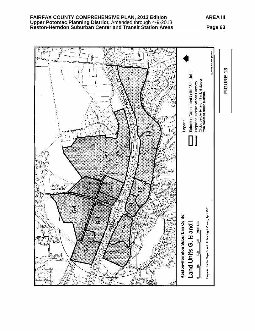
FAIRFAX COUNTY COMPREHENSIVE PLAN, 2013 Edition AREA III Upper Potomac Planning District, Amended through 4-9-2013 Reston-Herndon Suburban Center and Transit Station Areas Page 63
FIG
UR
E 13
FAIRFAX COUNTY COMPREHENSIVE PLAN, 2013 Edition AREA III Upper Potomac Planning District, Amended through 4-9-2013 Reston-Herndon Suburban Center and Transit Station Areas Page 64
Transit-oriented Residential Mixed-Use Option – At such time as a funding agreement for Bus Rapid Transit (BRT), as described in the Land Use section in the Suburban Center Areawide Recommendations, is reached, mixed-use development up to a 1.0 FAR may be considered within Sub-unit G-1 provided that the mix of uses includes a residential component and a nonresidential component that includes office, hotel, and support retail. The residential component should be at least 35% but no more than 50% of the total gross floor area of the development. Office use may not exceed 50% of the total gross floor area and support retail, to be located in office, hotel or residential buildings may not exceed 15% of the total gross floor area. In addition, the following condition should be met:
• Retail uses located on the ground floor should have direct public access and display
windows oriented to pedestrian walkways, and where appropriate to vehicular drives and/or streets.
Sub-unit G-2 (part of Wiehle Avenue Transit Station Area)
Sub-unit G-2 is located in the northeast quadrant of Wiehle Avenue and Sunset Hills Road and includes office and retail uses, including the SCS Engineers Building and a “restaurant park” with several fast food restaurants located on adjacent parcels with access from Wiehle Avenue and Roger Bacon Drive. The sub-unit also contains The Atrium, an office condominium development.
This sub-unit is planned for office use at .50 FAR or residential use at up to 30 dwelling
units per acre. In addition, the active recreation needs of the residents should be met either through provision of appropriate facilities on-site or a written agreement with another nearby residential development allowing use of their facilities.
For development in this sub-unit, including all baseline recommendations and options,
pedestrian walkways should be provided to facilitate circulation throughout the land unit and should connect to walkways in adjacent land units and existing sidewalks or trails along major streets in or around the land unit. All proposed developments should be in conformance with the Urban Design Guidelines, located after the land unit recommendations.
The 4.21 acre parcel at 1775 Wiehle Avenue (Tax Map 17-4((15))1) may be considered for
infill office use up to .70 FAR so as to have a similar intensity to that of the adjacent office development to the south, provided that the site design is compatible with existing development and it can be demonstrated that any impacts to the road network can be appropriately mitigated. Mitigation measures may include interparcel access from the south to improve traffic flow to points south of the subject property.
[A portion of this Sub-unit is located along Michael Faraday Court (Tax Map 18-3((5))6
and 7). See Sub-unit G-7 for additional Plan guidance.] Sub-unit G-3 (part of Wiehle Avenue Transit Station Area)
Sub-unit G-3 is located on the south side of Sunset Hills Road, to the east of the Plaza
America shopping center. It is currently developed primarily with office uses. This sub-unit is planned for office use at .50 FAR or residential use at up to 30 dwelling
units per acre. In addition, the active recreation needs of the residents should be met either through provision of appropriate facilities on-site or a written agreement with another nearby residential development allowing use of their facilities.

FAIRFAX COUNTY COMPREHENSIVE PLAN, 2013 Edition AREA III Upper Potomac Planning District, Amended through 4-9-2013 Reston-Herndon Suburban Center and Transit Station Areas Page 65
For development in this sub-unit, including all baseline recommendations and options,
pedestrian walkways should be provided to facilitate circulation throughout the land unit and should connect to walkways in adjacent land units and existing sidewalks or trails along major streets in or around the land unit. All proposed developments should be in conformance with the Urban Design Guidelines, located after the land unit recommendations.
Transit-oriented Residential Mixed-Use Option – At such time as a funding agreement for
Bus Rapid Transit (BRT), as described in the Land Use section in the Suburban Center Areawide Recommendations, is reached, mixed-use development up to 1.0 FAR may be considered within Sub-unit G-3 provided that the mix of uses includes a residential component and a nonresidential component that includes office, hotel, and support retail. The residential component should be at least 35% but no more than 50% of the total gross floor area of the development. Office use may not exceed 50% of the total gross floor area and support retail, to be located in office, hotel or residential buildings may not exceed 15% of the total gross floor area. In addition, the following condition should be met:
• Retail uses located on the ground floor should have direct public access and display
windows oriented to pedestrian walkways, and where appropriate to vehicular drives and/or streets.
Sub-unit G-4 (part of Wiehle Avenue Transit Station Area)
Sub-unit G-4 is bounded by Sunset Hills Road on the north, Wiehle Avenue on the east and the Dulles Airport Access and Toll Road (DAAR) on the south. It is immediately adjacent to proposed location of the transit station platform for the Wiehle Avenue Transit Station. The uses in the sub-unit include office, a self-storage facility, a bank and a County-owned and operated park-and-ride facility.
This sub-unit is planned for office use at .50 FAR or residential use at up to 30 dwelling
units per acre. In addition, the active recreation needs of the residents should be met either through provision of appropriate facilities on-site or a written agreement with another nearby residential development allowing use of their facilities.
The Department of Transportation is conducting a feasibility study (to conclude in Spring
2001) of expanding the Reston East parking lot. It is preferred that this parking be provided through a joint use arrangement with adjacent transit-oriented development, rather than as a single, stand-alone parking structure. To implement this concept, consideration may be given to development proposals that utilize the existing Reston East parking lot as well as adjacent parcels, in order to concentrate transit-oriented development in close proximity to the station, while providing additional parking in Sub-unit G-4 to meet anticipated demand.
For development in this sub-unit, including all baseline recommendations and options,
pedestrian walkways should be provided to facilitate circulation throughout the land unit and should connect to walkways in adjacent land units and existing sidewalks or trails along major streets in or around the land unit. All proposed developments should be in conformance with the Urban Design Guidelines, located after the land unit recommendations.
Transit-oriented Nonresidential Mixed-Use Option – At such time as a funding agreement
for Bus Rapid Transit (BRT), as described in the Land Use section in the Suburban Center Areawide Recommendations, is reached, mixed-use development up to a .70 FAR may be considered within Sub-unit G-4 provided that the mix of uses includes office, hotel, institutional

FAIRFAX COUNTY COMPREHENSIVE PLAN, 2013 Edition AREA III Upper Potomac Planning District, Amended through 4-9-2013 Reston-Herndon Suburban Center and Transit Station Areas Page 66 and support retail. The office use may not exceed 70% of the total gross floor area and support retail, to be located in office or hotel buildings may not exceed 15% of the total gross floor area. In addition, the following conditions should be met:
• Retail uses located on the ground floor should have direct public access and display
windows oriented to pedestrian walkways, and where appropriate to vehicular drives and/or streets.
• A second point of access (preferably to Sunset Hills Road) to this Sub-unit G-4 should be
provided. Transit-oriented Residential Mixed-Use Option – At such time as a funding agreement for
Bus Rapid Transit (BRT), as described in the Land Use section in the Suburban Center Areawide Recommendations, is reached, mixed-use development up to a 1.5 FAR may be considered within Sub-unit G-4 provided that the mix of uses includes a residential component and a nonresidential component that includes office, hotel, and support retail. The residential component should be at least 35% but no more than 50% of the total gross floor area of the development. Office use may not exceed 50% of the total gross floor area and support retail, to be located in office, hotel or residential buildings may not exceed 15% of the total gross floor area. In addition, the following condition should be met:
• Retail uses located on the ground floor should have direct public access and display
windows oriented to pedestrian walkways, and where appropriate to vehicular drives and/or streets.
• A second point of access (preferably to Sunset Hills Road) to this Sub-unit G-4 should be
provided. Rail-oriented Residential Mixed-Use Option – At such time as a funding agreement for rail,
as described in the Land Use section in the Suburban Center Areawide Recommendations, is reached, mixed-use development up to a 2.5 FAR may be considered for the 17 acres within Sub-unit G-4 located closest to the rail station, provided that the mix of uses includes a residential component and a nonresidential component that includes office, hotel, and support retail. The residential component should be at least 40% but no more than 75% of the total gross floor area of the development. Some combination of office, hotel and support retail uses may comprise 25-60% of the total gross floor area of the development with the office component comprising no more than 40% of the total. In addition, the following conditions should be met:
• Substantial parcel consolidation within the sub-unit should be achieved.
• The site should be adjacent to the rail station and provide direct pedestrian access to the
station or be a part of a larger project, approved under a consolidated site plan or as concurrent applications, that provides direct pedestrian access to the station.
• Grade-separated pedestrian links to the rail station are encouraged.
• A quality site layout should be provided with consolidated vehicular access to the site,
parking structures that do not front on pedestrian areas, and shared parking to the maximum extent possible.
• Building heights should be limited to 140 feet.

FAIRFAX COUNTY COMPREHENSIVE PLAN, 2013 Edition AREA III Upper Potomac Planning District, Amended through 4-9-2013 Reston-Herndon Suburban Center and Transit Station Areas Page 67 • Transportation Demand Management measures as discussed on page 6 should be utilized to
the maximum extent possible.
• Retail uses located on the ground floor should have direct public access and display windows oriented to pedestrian walkways, and where appropriate to vehicular drives and/or streets.
• A second point of access (preferably to Sunset Hills Road) to this Sub-unit G-4 should be
provided.
Sub-unit G-5 (part of Wiehle Avenue Transit Station Area) Sub-unit G-5 consists of a two-building office park and is bounded on the north by Sunset
Hills Road, on the west by Wiehle Avenue and on the south by the DAAR. This sub-unit is planned for office use at .50 FAR or residential use at up to 30 dwelling
units per acre. In addition, the active recreation needs of the residents should be met either through provision of appropriate facilities on-site or a written agreement with another nearby residential development allowing use of their facilities.
For development in this sub-unit, including all baseline recommendations and options,
pedestrian walkways should be provided to facilitate circulation throughout the land unit and should connect to walkways in adjacent land units and existing sidewalks or trails along major streets in or around the land unit. All proposed developments should be in conformance with the Urban Design Guidelines, located after the land unit recommendations.
Transit-oriented Residential Mixed-Use Option – At such time as a funding agreement for
Bus Rapid Transit (BRT), as described in the Land Use section in the Suburban Center Areawide Recommendations, is reached, mixed-use development up to a 1.0 FAR may be considered within Sub-unit G-5 provided that the mix of uses includes a residential component and a nonresidential component that includes office, hotel, and support retail. The residential component should be at least 35% but no more than 50% of the total gross floor area of the development. Office use may not exceed 50% of the total gross floor area and support retail, to be located in office, hotel or residential buildings may not exceed 15% of the total gross floor area. In addition, the following condition should be met: • Retail uses located on the ground floor should have direct public access and display
windows oriented to pedestrian walkways, and where appropriate to vehicular drives and/or streets.
Rail-oriented Residential Mixed-Use Option – At such time as a funding agreement for rail,
as described in the Land Use section in the Suburban Center Areawide Recommendations, is reached, mixed-use development up to a 1.5 FAR may be considered for Sub-unit G-5 provided that the mix of uses includes a residential component and a nonresidential component that includes office, hotel, and support retail. The residential component should be at least 40% but no more than 75% of the total gross floor area of the development. Some combination of office, hotel and support retail uses may comprise 25-60% of the total gross floor area of the development with the office component comprising no more than 40% of the total. In addition, the following conditions should be met:
• Both parcels in the sub-unit should be consolidated.

FAIRFAX COUNTY COMPREHENSIVE PLAN, 2013 Edition AREA III Upper Potomac Planning District, Amended through 4-9-2013 Reston-Herndon Suburban Center and Transit Station Areas Page 68 • Grade-separated pedestrian access (bridge or tunnel) across Wiehle Avenue should be
provided to facilitate access to the rail station.
• Transportation Demand Management measures as discussed on page 6 should be utilized to the maximum extent possible.
• Retail uses located on the ground floor should have direct public access and display
windows oriented to pedestrian walkways, and where appropriate to vehicular drives and/or streets.
Sub-unit G-6 (part of Wiehle Avenue Transit Station Area)
Sub-unit G-6 is located along the south side of Sunset Hills Road, east of the Wiehle
Avenue intersection. It is currently developed with office and limited support retail uses. This sub-unit is planned for office use at .50 FAR or residential use at up to 30 dwelling
units per acre. In addition, the active recreation needs of the residents should be met either through provision of appropriate facilities on-site or a written agreement with another nearby residential development allowing use of their facilities.
For development in this sub-unit, including all baseline recommendations and options,
pedestrian walkways should be provided to facilitate circulation throughout the land unit and should connect to walkways in adjacent land units and existing sidewalks or trails along major streets in or around the land unit. All proposed developments should be in conformance with the Urban Design Guidelines, located after the land unit recommendations.
Transit-oriented Residential Mixed-Use Option – At such time as a funding agreement for
Bus Rapid Transit (BRT), as described in the Land Use section in the Suburban Center Areawide Recommendations, is reached, mixed-use development up to a 1.0 FAR may be considered within Sub-unit G-6 provided that the mix of uses includes a residential component and a nonresidential component that includes office, hotel, and support retail. The residential component should be at least 35% but no more than 50% of the total gross floor area of the development. Office use may not exceed 50% of the total gross floor area and support retail, to be located in office, hotel or residential buildings may not exceed 15% of the total gross floor area. In addition, the following condition should be met: • Retail uses located on the ground floor should have direct public access and display
windows oriented to pedestrian walkways, and where appropriate to vehicular drives and/or streets.
Sub-unit G-7
Sub-unit G-7 is located along Sunset Hills Road, east of the Wiehle Avenue TSA.
Development in the sub-unit includes office uses and a US Post Office facility. This sub-unit is planned for a mix of office, R&D, and industrial “flex space” uses up to .50 FAR.
The westerly portion of the approximately 120-acre tract of land north of Sunset Hills Road
immediately east of the Reston boundary is considered appropriate for industrial uses provided that:

FAIRFAX COUNTY COMPREHENSIVE PLAN, 2013 Edition AREA III Upper Potomac Planning District, Amended through 4-9-2013 Reston-Herndon Suburban Center and Transit Station Areas Page 69
a. The industrial portion of the 120-acre tract, which is approximately 55 acres in area and located on the western portion of the tract, is planned for medium intensity industrial research and development and similar uses;
b. The approximately 65-acre residential area of the tract (Equestrian Park subdivision)
has been developed as residential use at .2-.5 dwelling unit per acre. This residential area ensures that low density residential use is maintained to the east of the industrial area located on the western portion of this tract. This line of demarcation establishes the boundary between industrial and residential use and the current development on both sides of the line is consistent with this intent;
c. The dividing line between the industrial and residential uses should accommodate and follow the swale commencing on the northerly side of the property at its boundary with Lake Fairfax Park and running southerly towards Sunset Hills Road, following the tree line as it approaches Tax Map 18-3((1))10 and continuing towards Sunset Hills Road to the northwesterly corner of Tax Map 18-3((1))10. Tax Map 18-3((1))12B and the eastern portion of 18-3((8))2 and 3 should be retained as a buffer to the low density residential area. The above line of demarcation will establish the boundary between industrial and residential uses by relating the transition and land use to physical features of the land, i.e., the tree line and swale;
d. The applicant should install approved plantings to close the gap, which is approximately 50 feet wide, between the tree line running north from Sunset Hills Road to where it most closely approaches the existing trees and tying into the treed swale running south from Lake Fairfax Park. In the event that such plantings are inconsistent with good site planning and land use as determined in the final site planning of the property, the Reston Community Association and the applicant should work out a suitable compromise;
e. Stringent environmental controls should be applied to the industrial portion of the
tract. These include extensive landscaping on Sunset Hills Road, buffering for the residentially planned area to the east, and sedimentation control measures to assure the environmental integrity of Lake Fairfax.
The area located south of Sunset Hills Road and directly east of the W&OD Regional Trail (Tax Map 18-3((1))11B and 11C) is on the outer fringe of Reston. It is the transitional property between that portion of Reston planned for nonresidential uses and the low density residential area to the east which extends to Hunter Mill Road. This site is planned for office use up to .35 FAR. However, the maximum intensity should only be achievable if the following conditions are met:
• Maximum building heights on the site should not exceed 80 feet; and,
• Effective screening and buffering is provided along Sunset Hills Road.
As an option, the parcel at 11091 Sunset Hills Road (Tax Map 18-3((6))10) may be
considered for office use up to a .70 FAR to facilitate the completion of the Sunset Corporate Plaza office complex and to achieve a similar character and intensity as other development in the complex on the adjacent parcel to the west. To achieve the optional level of development, the following conditions should be met:
• Coordinated vehicular and pedestrian access to the adjacent parcel to the west;
FAIRFAX COUNTY COMPREHENSIVE PLAN, 2013 Edition AREA III Upper Potomac Planning District, Amended through 4-9-2013 Reston-Herndon Suburban Center and Transit Station Areas Page 70
• Orientation of the office building(s) toward the existing development on the adjacent parcel to the west;
• Compatibility of building design and materials with the existing development on the
adjacent parcel to the west; and • Demonstration that any impacts to the road network can be appropriately mitigated. The northern portion of Michael Faraday Court (Tax Map 18-3((5))6, 7, 8 and 9) has older,
low-rise buildings that are prime redevelopment sites that can promote mixed-use, transit-oriented development in the Wiehle Transit Station Area. In particular, an important private community recreational facility - the Reston Ice Arena - should be preserved in any such redevelopment.
In order to provide an incentive for this facility to continue operation after redevelopment
of this area, a 1.0 FAR option is recommended provided these parcels are consolidated, pedestrian access to the W&OD trail and to a pedestrian network in the Transit Station Area are provided, and the ice rink, or a similar private recreation use, is a component of the redevelopment. Land Unit H
This land unit is located south of the Dulles Airport Access Road between Association
Drive and Wiehle Avenue, as shown in Figure 13. Sunrise Valley Road is the southern boundary of this land unit.
A high quality living environment can be created through the provision of well-designed
residential and mixed-use projects which provide active recreation, entertainment and other site amenities. Each residential development should include on-site affordable housing that is well integrated and dispersed throughout the development. Sub-unit H-1 (part of Wiehle Avenue Transit Station Area)
Sub-unit H-1 comprises the buildings along Association Drive and is located between the Sunrise Valley Drive and the DAAR. Development in the sub-unit consists primarily of one to three story office buildings.
This sub-unit is planned for office use at .35 FAR or residential use at up to 30 dwelling
units per acre. In addition, the active recreation needs of the residents should be met either through provision of appropriate facilities on-site or a written agreement with another nearby residential development allowing use of their facilities.
For development in this sub-unit, including all baseline recommendations and options,
pedestrian walkways should be provided to facilitate circulation throughout the land unit and should connect to walkways in adjacent land units and existing sidewalks or trails along major streets in or around the land unit. All proposed developments should be in conformance with the Urban Design Guidelines, located after the land unit recommendations.
Transit-oriented Residential Mixed-Use Option – At such time as a funding agreement for
Bus Rapid Transit (BRT), as described in the Land Use section in the Suburban Center Areawide

FAIRFAX COUNTY COMPREHENSIVE PLAN, 2013 Edition AREA III Upper Potomac Planning District, Amended through 4-9-2013 Reston-Herndon Suburban Center and Transit Station Areas Page 71 Recommendations, is reached, mixed-use development up to a .75 FAR may be considered within Sub-unit H-1 provided that the mix of uses includes a residential component and a nonresidential component that includes office, hotel, and support retail. The residential component should be at least 35% but no more than 50% of the total gross floor area of the development. Office use may not exceed 50% of the total gross floor area and support retail, to be located in office, hotel or residential buildings may not exceed 15% of the total gross floor area. In addition, the following condition should be met: • Retail uses located on the ground floor should have direct public access and display
windows oriented to pedestrian walkways, and where appropriate to vehicular drives and/or streets.
Sub-unit H-2 (part of Wiehle Avenue Transit Station Area)
Sub-unit H-2 consists of Commerce Executive Park and is located in the southwest quadrant of Wiehle Avenue and the DAAR. The sub-unit is developed with office and support retail uses, including three new 6-story office buildings and associated parking structures along the DAAR.
This sub-unit is planned for office use at .50 FAR or residential use at up to 30 dwelling
units per acre. In addition, the active recreation needs of the residents should be met either through provision of appropriate facilities on-site or a written agreement with another nearby residential development allowing use of their facilities.
For development in this sub-unit, including all baseline recommendations and options,
pedestrian walkways should be provided to facilitate circulation throughout the land unit and should connect to walkways in adjacent land units and existing sidewalks or trails along major streets in or around the land unit. All proposed developments should be in conformance with the Urban Design Guidelines, located after the land unit recommendations.
Transit-oriented Nonresidential Mixed-Use Option – At such time as a funding agreement for Bus Rapid Transit (BRT), as described in the Land Use section in the Suburban Center Areawide Recommendations, is reached, mixed-use development up to a .70 FAR may be considered within Sub-unit H-2 provided that the mix of uses includes office, hotel, institutional and support retail. The office use may not exceed 70% of the total gross floor area and support retail, to be located in office or hotel buildings may not exceed 15% of the total gross floor area. In addition, the following condition should be met: • Retail uses located on the ground floor should have direct public access and display
windows oriented to pedestrian walkways, and where appropriate to vehicular drives and/or streets.
Transit-oriented Residential Mixed-Use Option – At such time as a funding agreement for
Bus Rapid Transit (BRT), as described in the Land Use section in the Suburban Center Areawide Recommendations, is reached, mixed-use development up to a .75 FAR may be considered within Sub-unit H-2 provided that the mix of uses includes a residential component and a nonresidential component that includes office, hotel, and support retail. The residential component should be at least 35% but no more than 50% of the total gross floor area of the development. Office use may not exceed 50% of the total gross floor area and support retail, to be located in office, hotel or residential buildings may not exceed 15% of the total gross floor area. In addition, the following condition should be met:

FAIRFAX COUNTY COMPREHENSIVE PLAN, 2013 Edition AREA III Upper Potomac Planning District, Amended through 4-9-2013 Reston-Herndon Suburban Center and Transit Station Areas Page 72 • Retail uses located on the ground floor should have direct public access and display
windows oriented to pedestrian walkways, and where appropriate to vehicular drives and/or streets.
Rail-oriented Residential Mixed-Use Option – At such time as a funding agreement for rail,
as described in the Land Use section in the Suburban Center Areawide Recommendations, is reached, mixed-use development up to a 1.25 FAR may be considered for the 10 acres within Sub-unit H-2 located closest to the rail station, provided that the mix of uses includes a residential component and a nonresidential component that includes office, hotel, and support retail. The residential component should be at least 40% but no more than 65% of the total gross floor area of the development. Some combination of office, hotel and support retail uses may comprise 35-60% of the total gross floor area of the development. In addition, the following conditions should be met: • Substantial parcel consolidation within Land Unit H should be achieved.
• The site should be adjacent to the rail station and provide direct pedestrian access to the
station or be a part of a larger project, approved under a consolidated site plan or as concurrent applications, that provides direct pedestrian access to the station.
• Grade-separated pedestrian links to the rail station are encouraged.
• A quality site layout should be provided with consolidated vehicular access to the site,
parking structures that do not front on pedestrian areas, and shared parking to the maximum extent possible.
• Building heights should be limited to 100 feet along the DAAR and 35 feet along Sunrise
Valley Drive.
• Transportation Demand Management measures as discussed on page 6 should be utilized to the maximum extent possible.
• Retail uses located on the ground floor should have direct public access and display
windows oriented to pedestrian walkways, and where appropriate to vehicular drives and/or streets.
Land Unit I
This land unit is located south of the Dulles Airport Access Road between Hunter Mill
Road and Wiehle Avenue (see Figure 13). Sunrise Valley Road is the southern boundary of this land unit. Land Unit I is almost fully developed in office use. It is planned for office use up to .35 FAR.
A high quality living environment can be created through the provision of well-designed
residential and mixed-use projects which provide active recreation, entertainment and other site amenities. Each residential development should include on-site affordable housing that is well integrated and dispersed throughout the development.
The portion of the land unit adjacent to the Wiehle Avenue TSA is subject to the
Pedestrian/bicycle access guidelines in the Suburban Center Areawide Recommendations shown at the beginning of the Suburban Center text.

FAIRFAX COUNTY COMPREHENSIVE PLAN, 2013 Edition AREA III Upper Potomac Planning District, Amended through 4-9-2013 Reston-Herndon Suburban Center and Transit Station Areas Page 73 Sub-unit I-1 (part of Wiehle Avenue Transit Station Area)
Sub-unit I-1 is located in the southeast quadrant of Wiehle Avenue and the DAAR. The sub-unit consists of two parcels, which are currently developed with office uses.
This sub-unit is planned for office use at .35 FAR or residential use at up to 30 dwelling
units per acre. In addition, the active recreation needs of the residents should be met either through provision of appropriate facilities on-site or a written agreement with another nearby residential development allowing use of their facilities.
For development in this sub-unit, including all baseline recommendations and options,
pedestrian walkways should be provided to facilitate circulation throughout the land unit and should connect to walkways in adjacent land units and existing sidewalks or trails along major streets in or around the land unit. All proposed developments should be in conformance with the Urban Design Guidelines, located after the land unit recommendations.
Transit-oriented Residential Mixed-Use Option – At such time as a funding agreement for
Bus Rapid Transit (BRT), as described in the Land Use section in the Suburban Center Areawide Recommendations, is reached, mixed-use development up to a .75 FAR may be considered within Sub-unit I-1 provided that the mix of uses includes a residential component and a nonresidential component that includes office, hotel, and support retail. The residential component should be at least 35% but no more than 50% of the total gross floor area of the development. Office use may not exceed 50% of the total gross floor area and support retail, to be located in office, hotel or residential buildings may not exceed 15% of the total gross floor area. In addition, the following condition should be met: • Retail uses located on the ground floor should have direct public access and display
windows oriented to pedestrian walkways, and where appropriate to vehicular drives and/or streets.
Sub-unit I-2 (part of Wiehle Avenue Transit Station Area)
Sub-unit I-2 is located on the south side of the DAAR and north of Sunrise Valley Drive,
east of the intersection with Wiehle Avenue. The sub-unit is developed as an office park with low and mid-rise office buildings.
This sub-unit is planned for office use at .35 FAR or residential use at up to 30 dwelling
units per acre. In addition, the active recreation needs of the residents should be met either through provision of appropriate facilities on-site or a written agreement with another nearby residential development allowing use of their facilities.
For development in this sub-unit, including all baseline recommendations and options,
pedestrian walkways should be provided to facilitate circulation throughout the land unit and should connect to walkways in adjacent land units and existing sidewalks or trails along major streets in or around the land unit. All proposed developments should be in conformance with the Urban Design Guidelines, located after the land unit recommendations. Sub-unit I-3
Sub-unit I-3 is almost fully developed in office use. It is planned for office use up to .35 FAR.

FAIRFAX COUNTY COMPREHENSIVE PLAN, 2013 Edition AREA III Upper Potomac Planning District, Amended through 4-9-2013 Reston-Herndon Suburban Center and Transit Station Areas Page 74
URBAN DESIGN GUIDELINES FOR TRANSIT STATION AREAS Urban design applies to the entire built environment, both physical and natural, and
includes aspects such as the appearance of buildings, relationships between buildings, open spaces, roadways, pedestrian paths, vegetative plantings, and signage. In general terms, it includes anything that a person sees and uses to inform themselves about where they area, how to move about an area, and where various activities take place. These urban design guidelines apply specifically to the four Transit Station Areas located within the Dulles Corridor (the Wiehle Avenue, Reston Parkway, and Herndon-Monroe Transit Station Areas located in the Reston-Herndon Suburban Center and the Route 28/CIT Transit Station Area located in the Dulles Suburban Center and the UP 4 Greater Herndon Community Planning Sector). They encourage future projects to be designed to take advantage of the benefits associated with transit-oriented development. In addition, these guidelines apply generally to the areas within the Reston-Herndon Suburban Center that are located outside of the Transit Station Areas to encourage continuity in design between the Transit Station Areas and adjacent areas in the Suburban Center.
Urban Design Objectives
The Transit Station Area Plan recommendations for the Transit Station Areas within the
Dulles Corridor seek to encourage the creation of a land use environment which is supportive of mass transit, minimizes the need for the single-occupant automobile, and fosters a vibrant pedestrian atmosphere. They provide the foundation for the creation of transit-oriented development (TOD) centers. Transit-oriented development can be described as pedestrian-friendly, mixed-use developments within walking distance of a transit station. The design, configuration, and mix of buildings and activities emphasize pedestrian-oriented environments and encourage use of public transportation. The Plan recommendations provide opportunities for compact, mixed-use development at higher densities/intensities at locations close to transit station platforms, as well as opportunities to move safely and conveniently about the community by foot or bicycle.The intent of the following design objectives are twofold. First, to create a pedestrian-friendly environment which will complement the plan recommendations. Creating an environment at a pedestrian scale requires thoughtful consideration of the proportion of spaces that people use, and the types of features within an environment found pleasing to a pedestrian. Success in attracting people to walk depends upon the quality of the walkways, types of destinations, perceptions of safety, and obstacles encountered along the way.
The second objective is to protect the existing high-quality built environment and natural
environment which exists within the Dulles Corridor, and ensure the compatibility of future development. The age of development and the maturity of the landscaping and vegetation varies throughout the four Transit Station Areas. Generally, the eastern part of the Corridor has older development and mature landscaping, while the built and landscaped environment in the western portion is more recent, with some parts not yet developed. It is important that the quality of development that has occurred in the eastern portion of the Corridor be continued throughout the entire length of the Corridor.
The following are general urban design objectives that should be achieved throughout the
four Transit Station Areas within the Dulles Corridor.
• Create high quality development which is functionally integrated, orderly, identifiable and attractive.

FAIRFAX COUNTY COMPREHENSIVE PLAN, 2013 Edition AREA III Upper Potomac Planning District, Amended through 4-9-2013 Reston-Herndon Suburban Center and Transit Station Areas Page 75
• Create a pedestrian environment that is enjoyable and provides an experience which is
visually diverse and stimulating. • Design development to allow for public pedestrian access between the transit station
and employment and residential destinations. • Minimize conflicts between vehicular and pedestrian circulation. • Provide open space for active and passive recreation and visual relief. • Protect and enhance environmental and historic resources. • Ensure a more efficient use of the land through strategies such as allowing shared
parking for uses which have different peak demand periods. • Protect adjacent residential neighborhoods from the impact of new development
through use of landscaped buffers, berms and/or other landscaping features, maintaining a high standard for architectural quality, and minimizing noise, glare and traffic intrusion.
• Encourage parcel consolidation to realize the benefit of comprehensive urban design and circulation/access principles.
• Create highway corridors that function well, are visually appealing, and provide linkages throughout the four Transit Station Areas within the Dulles Corridor.
Urban Design Guidelines
The design guidelines outlined below have been organized into two categories: general guidelines applicable to all areas within the four Transit Station Areas, and specific guidelines which apply to those areas within one-quarter mile of the transit station platform. In addition, the general guidelines apply to those areas within the Reston-Herndon Suburban Center that are located outside of the Transit Station Areas. The guidelines developed for all areas within Transit Station Areas address the character and form of development, with specific guidelines developed for areas on the periphery of the Corridor to address key issues such as the transition between nonresidential and residential areas and maintaining the integrity of existing, nearby land uses. The guidelines developed for areas within one-quarter mile of the transit station platform focus on creating developments which are pedestrian-friendly and supportive of the transit facility.
As noted previously, the built and landscaped environment varies across the Dulles Corridor. To maintain the existing high quality built and natural environments within this corridor, which are particularly evident in the eastern portion of the corridor, it is important that consistency be achieved in the design of future development and redevelopment.
Within the four Transit Station Areas there are two distinct areas that require different types of urban design guidelines - those areas at the edge of a Transit Station Area and those areas internal to the Transit Station Area. In order to preserve the integrity of existing development adjacent to Transit Station Areas, and particularly areas of transition between nonresidential and residential areas, special consideration needs to be given to future developments on the periphery of each Transit Station Area. For example, the form of development and extensive landscaping that has occurred along Sunrise Valley Drive between the Washington & Old Dominion park cross-over to just west of the Fairfax County Parkway is a good example of the type of environment that should be created along the edge of a Transit Station Area when adjacent to an existing residential neighborhood. Design features along this stretch of road include low to mid-rise buildings, buildings constructed at grades below street level, sidewalks (for the most part) along both sides of the road, heavily landscaped yards with berms used to assist in the transition between nonresidential and residential uses, and parking
FAIRFAX COUNTY COMPREHENSIVE PLAN, 2013 Edition AREA III Upper Potomac Planning District, Amended through 4-9-2013 Reston-Herndon Suburban Center and Transit Station Areas Page 76 structures with significant landscaping either surrounding the structure or incorporated into the structure design.
Reston Town Center provides a good example of the type and form of development that is
envisioned to be found internally to the four Transit Station Areas within the Corridor. The core area of the Town Center can be described as having wide sidewalks, public open spaces, ground-floor storefront uses such as shops and cafes with multiple windows for pedestrians to view into, and buildings constructed to the sidewalk edge. It is also envisioned that this form of development be created along some of the major north-south roads within the four Transit Station Areas such as Wiehle Avenue, Reston Parkway, Centreville Road and Horse Pen Road.
There are a number of major roadways which provide east-west connections across the
Reston-Herndon Suburban Center and Transit Station Areas, such as Sunrise Valley Drive, Sunset Hills Road, Fox Mill Road, and Coppermine Road. Since some of these roads when traveled in tandem extend from one end of the corridor to the other, it is important to maintain a level of consistency in the urban design throughout the corridor. Design Guidelines for Transit Station Areas
Building Design, Height and Mass • Building heights should be greatest closest to the Dulles Airport and Access Road,
transitioning to lower heights at the outer edge of transit station areas. See specific height limitation in the land unit recommendations.
• Buildings at the outer edge of transit station areas should be sensitive to neighboring development with regard to height and mass.
• Varied building heights and roof lines are encouraged to create interest. • Building facades should be interesting and varied, with an absence of blank walls.
Buildings should be designed with features such as multiple windows, doors, and awnings. Blank walls on the side and back of buildings should be mitigated with landscaping, screening and buffering. Long expanses of blank walls along major roads should be avoided.
• To encourage a more urban environment and pedestrian scale, the bulk and mass of buildings should be minimized through the articulation of the building form, step backs from the building base, and plane changes within the building elevations.
Arrangement and Siting of Buildings • Buildings should be arranged so that they frame and define the fronting streets, and
give deliberate form to the street and sidewalk areas. • Buildings should be arranged in a manner that create a sense of enclosure and defined
space. • Buildings should not be separated from fronting streets by large parking lots. • Free-standing retail establishments are prohibited. Retail uses should be integrated into
the design of the lower floors of nonresidential and residential buildings. Design Compatibility • Development on the periphery of transit station areas adjacent to existing residential
areas should be maintain or create an effective transition to the surrounding community in terms of layout, design and appearance.

FAIRFAX COUNTY COMPREHENSIVE PLAN, 2013 Edition AREA III Upper Potomac Planning District, Amended through 4-9-2013 Reston-Herndon Suburban Center and Transit Station Areas Page 77
Open Spaces • Small plazas and/or courtyards should be incorporated into the designs of buildings
and/or building complexes to serve the daily needs of local employees and visitors. These open spaces should be appealing places to gather with seating, lighting, landscaping and other amenities. These spaces should be integrated purposefully into the overall design of the development, and not merely be residual areas left over after buildings and parking lots are sited.
• Public art/sculpture should be incorporated into all open spaces. Trees, Landscaping and Natural Environment • Existing vegetation and large specimen trees should be preserved and incorporated into
the site design when possible. • Landscaping should be provided that is attractive in all seasons, and provides shade to
seating areas and pedestrian paths/sidewalks during summer months. • Significant landscaped and/or natural streetscapes, as well as street trees should be
provided along all roadways, in particular roadways which form the periphery of the Suburban Center and Transit Station Areas (e.g. Sunrise Valley Drive, Sunset Hills Road, Fox Mill Road, and Coppermine Road).
Pedestrian and Bicycle Access and Connections • Site designs should balance the needs of both the pedestrian and the automobile;
however, the circulation systems for pedestrians and automobiles should remain separate.
• Pedestrian/bicycle access should be provided to facilitate circulation within, to, around, and between each transit station area. Pedestrian links could include sidewalks, trails, plazas, courtyards, and parks with path systems.
• Pedestrian access between buildings is essential to ensure opportunities are available for people to walk to nearby uses.
• Pedestrian/bicycle paths of any one development or site should interconnect with pedestrian/bicycle paths of any adjacent development or site, to create a highly-connected transit station area. In addition, pedestrian/bicycle access should connect to the countywide and regional trail systems, connecting local sites with the larger community.
• Safe and convenient pedestrian street crossings should be designed, and include good lighting as well as access elements (e.g. ramps for persons with disabilities).
• Secure and convenient bicycle storage should be provided as part of all nonresidential development.
Transit Access and Connections • Safe, convenient and direct pedestrian pathways should be provided between all types
of transit stops and buildings. • Pathways should be designed such that pedestrians do not cross parking lots/structures
to reach a building. • Bus shelters should be provided at transit stops that protect patrons from the weather,
are safe, easy to maintain, and relatively vandal-proof. Vehicular Access and Connections • Avoid direct access from parking structures onto major arterial roads.

FAIRFAX COUNTY COMPREHENSIVE PLAN, 2013 Edition AREA III Upper Potomac Planning District, Amended through 4-9-2013 Reston-Herndon Suburban Center and Transit Station Areas Page 78
Parking Areas • Parking should be provided in either above or underground structures, with limited
parking areas at the sides or back of buildings. If it is not possible to accommodate parking structures behind or beside buildings, minimize parking in front of buildings.
• Locate priority parking spaces for car/vanpools close to the employee entrance of the building or parking structure to encourage ride-sharing.
• Integrate the design of parking structures with that for the building served. • Parking structures, as well as adjacent areas, should be landscaped to create a visually
attractive environment. • Parking lots should be screened to control the view and visual impact from the street
right-of-way, adjacent development, and buildings being served by the lot. Plant materials, walls, fences or earth berms should be used.
• Interior parking lot landscaping should be provided. Large parking lots should be sub-divided into smaller lots by using planting areas as dividers.
Buffers • Use natural landscaping to create edges and provide a buffer to define developments. • Provide significant vegetated buffers in situations where nonresidential development on
the periphery of the Suburban Center or Transit Station Area is adjacent to existing residential neighborhoods.
• Screen from public view rooftop mechanical equipment, materials storage, utility substations and other similar items.
Lighting • Develop coordinated lighting plans for all development complexes, in order to reinforce
the complex’s identity and provide a congruent appearance. • Provide exterior lighting that enhances nighttime safety and circulation, as well as
highlights key landmark features. • Design lighting in a manner that focuses lighting directly onto parking/driving areas
and sidewalks, such that lighting for a development does not project beyond the development’s boundary. Utilization of fully shielded lighting fixtures is desirable in order to minimize the occurrence of glare, light trespass, and urban sky glow.
Signage • Coordinated signage plans for all developments are encouraged to emphasize the
complex’s identity and provide a harmonious appearance. • Signage should be appropriate for its location and purpose. • Similar types of signage should be used for developments within a Transit Station Area
to facilitate “way-finding” within the TSA. Design Guidelines for Areas Within One-Quarter Mile of Station Platforms
The design guidelines below apply to those properties within one-quarter mile of the station
platform that are the subject of new development or redevelopment. The primary purpose of these guidelines is to create compact developments which foster a lively pedestrian-friendly environment and ensure the access to various uses, in particular transit stations, is convenient, walkable, pleasant and safe.
Building Design, Height and Mass • Building facades should incorporate elements to establish a human scale and foster a
pedestrian-friendly environment. Buildings should incorporate features such as

FAIRFAX COUNTY COMPREHENSIVE PLAN, 2013 Edition AREA III Upper Potomac Planning District, Amended through 4-9-2013 Reston-Herndon Suburban Center and Transit Station Areas Page 79
multiple windows, doors, and awnings. Blank walls on the side and back of buildings should be avoided, particularly for walls along pedestrian walkways.
• Building heights should be greatest closest to the transit station platform and transition
to lower heights at the outer edge of the one-quarter mile area, particularly for areas that are adjacent to established residential neighborhoods.
Arrangement and Siting of Buildings • Buildings should be arranged so that they frame and define the fronting pedestrian
walkways, and give deliberate form to the sidewalk areas, and where appropriate vehicular drives and/or streets.
• Buildings should be arranged in a manner that create a sense of enclosure and defined space.
• Buildings should not be separated from fronting pedestrian walkways/streets by large parking lots.
• Retail uses should be incorporated into the design of the lower floors of nonresidential and residential buildings, and should have direct public access and display windows oriented toward pedestrian walkways, and where appropriate, vehicular drives and/or streets.
Design Compatibility • Within the one-quarter mile area, the design, architecture, building materials, and
landscaping should be compatible, harmonious, and adhere to a common design theme. Open Spaces • Public art should be incorporated into all open spaces, and along the primary pathways
leading to the transit stations. Pedestrian and Bicycle Access and Connections • Pedestrian/bicycle access should be provided to facilitate circulation within the ¼-mile
area. Pedestrian links could include sidewalks, trails, plazas, courtyards, and parks with path systems.
• Pedestrian connections across major roadways such as Wiehle Avenue, Reston Parkway, and Monroe Street should be provided as grade-separated connections, preferably as above-ground connections (i.e. bridges) due to their perception of being safer.
• Secure and convenient bicycle storage should be provided at points close to the pedestrian bridges which lead to the station platform.
Transit Access and Connections • Provision of support retail on pedestrian bridges which provide access to the station
platform is encouraged. • Safe, convenient and direct access should be provided between transit station pedestrian
access bridges and all buildings within the ¼-mile area Parking Areas • Parking should be provided in either above or underground structures. Above ground
parking should be integrated into the design of the building served and located preferably at the sides or back of buildings. Parking in the front of buildings should be minimized.
FAIRFAX COUNTY COMPREHENSIVE PLAN, 2013 Edition AREA III Upper Potomac Planning District, Amended through 4-9-2013 Reston-Herndon Suburban Center and Transit Station Areas Page 80
Transit Facility Parking Structures/Areas • Encourage public-private partnerships to facilitate provision of a mix of uses (i.e. retail
uses (dry cleaners), child care centers, and similar uses), in County-owned parking structures.
• Parking structures should be landscaped to create a visually attractive environment. Structures adjacent to residential uses that are outside of the Transit Station Areas should be heavily screened and/or berms should be used to minimize the visual impact of the structure on neighboring residential communities.
• Design ‘Park-n-Ride’ lots to be compatible with adjacent development. Buffers • Provide significant vegetated buffers in situations where nonresidential development on
the periphery of the ¼-mile area is adjacent to existing residential neighborhoods. Signage • Signage should be provided which illustrates walking directions to transit station access
points.

FAIRFAX COUNTY COMPREHENSIVE PLAN, 2013 Edition AREA III Upper Potomac Planning District, Amended through 4-9-2013 Page 81
COMMUNITY PLANNING SECTORS FIGURE 14 UPPER POTOMAC PLANNING DISTRICT

FAIRFAX COUNTY COMPREHENSIVE PLAN, 2013 Edition AREA III Upper Potomac Planning District, Amended through 4-9-2013 UP1-Riverfront Community Planning Sector Page 82
UP1 RIVERFRONT COMMUNITY PLANNING SECTOR CHARACTER
This planning sector is located along the Potomac River shoreline as it extends from the National Park Service's Great Falls Park to the Loudoun County line and Seneca Road. The southern border of this sector is Georgetown Pike (Route 193), River Bend Road and Beach Mill Road.
The Riverfront Planning Sector is a rural area characterized by large lot residential
development, parkland and open space. This planning sector has produced significant prehistoric heritage resources. Because of
the very low density development in the sector, there is a very high potential for both prehistoric and historic heritage resources to still remain. The Potomac floodplain and adjacent uplands are particularly sensitive. The Potomac Canal Lock ruins and the ruins of the Town of Matildaville are significant existing resources in this sector which are listed in the National Register of Historic Places under the Patowmack Canal Historic District/Lock Ruins at Great Falls. This National Register Historic District is a National Historic Landmark, and is also listed in the County Inventory of Historic Sites and the Virginia Landmarks Register. A list and map of heritage resources are included in the Upper Potomac Planning District Overview section, Figures 4, 5 and 6. Additional historic sites in this sector are also included in the inventory.
CONCEPT FOR FUTURE DEVELOPMENT
The Riverfront Community Planning Sector is designated as a Low Density Residential Area in the Concept for Future Development. RECOMMENDATIONS Land Use
The Riverfront Community Planning Sector is a very low density stable residential area. Infill development in this residential area should be of a compatible use, type and intensity in accordance with the guidance provided by the Policy Plan under Land Use Objectives 8 and 14.
Where substantial parcel consolidation is specified, it is intended that such consolidations
will provide for projects that function in a well-defined, efficient manner and provide for the development of unconsolidated parcels in conformance with the Area Plan.
Figure 15 indicates the geographic location of this sector. Due to the general nature of the land use recommendations for this sector, they were not shown on the General Locator Map. 1. Limit land uses to parkland, open space, and large-lot residential development. Residential
density of no greater than one dwelling unit per five acres is planned for this sector to protect the Potomac River Environmental Quality Corridor and Wildlife Preserve. [Not shown]

FAIRFAX COUNTY COMPREHENSIVE PLAN, 2013 Edition AREA III Upper Potomac Planning District, Amended through 4-9-2013 UP1-Riverfront Community Planning Sector Page 83
FIGURE 15

FAIRFAX COUNTY COMPREHENSIVE PLAN, 2013 Edition AREA III Upper Potomac Planning District, Amended through 4-9-2013 UP1-Riverfront Community Planning Sector Page 84 2. This sector is planned for low density, single-family residential use mostly .1-.2 du/ac
as shown on the Comprehensive Land Use Plan map. The planned density is a means to preserve the rural character of this area and to maintain the present two and five acre lots. Cluster subdivisions may be appropriate in this sector if the following criteria are met and rigorously applied: 1) Wherever possible the proposed open space should provide connections with existing or planned trails; 2) Individual lots, buildings, streets, utilities and parking areas are designed and situated to minimize the disruption of the site’s natural drainage and topography, and to promote the preservation of important view sheds, historic resources, steep slopes, stream valleys and desirable vegetation; 3) Site design and building location are done in a manner that is compatible with surrounding development; 4) Modifications to minimum district size, lot area, lot width or open space requirements of a cluster subdivision in the R-E and R-1 Districts are not appropriate, unless significant benefits can be achieved in the preservation of the natural environment, scenic view shed(s) or historic resources by permitting such modifications; and 5) Lot yield shall be limited to that which could reasonably result under conventional development. In addition, measures such as agricultural and forestal districts, conservation, open space and scenic easements should be encouraged to preserve the rural character of this environmentally sensitive area, provided that their use provides a public benefit and furthers the intent of the Plan. [Not Shown]
3. No commercial or retail uses are planned for this sector due to its very low density. Uses
requiring special permits and special exception approval should be rigorously reviewed and permitted only when the use is of a size and scale that will not adversely impact adjacent land uses and the overall low density residential character of the area. [Not shown]
4. Encourage the use of pervious and semi-pervious materials for paved areas (e.g. parking
lots, driveways, walkways and patios). [Not shown] Transportation
Transportation recommendations for this sector are shown on Figure 16. In some instances, site-specific transportation recommendations are included in the land use recommendations section. The figures show access orientation, circulation plans, interchange impact areas and generalized locations of proposed transit facilities. The recommendations contained in the Area Plan text and maps, the Policy Plan and Transportation Plan map, policies and requirements in the Public Facilities Manual, the Zoning Ordinance, and other standards will be utilized in the evaluation of development proposals.
Georgetown Pike, which has been designated a Virginia Byway and determined eligible for
listing on the Virginia Landmarks Register and the National Register of Historic Places, should be maintained within its existing right-of-way. Center turn lanes and deceleration and acceleration lanes should be discouraged and curb cuts should not be allowed unless no other alternative exists. Georgetown Pike is commonly acknowledged to contain some traffic hazards. However, it is generally acceptable in its present condition to local residents. Major changes in alignment or widening the road would damage the scenic and historic character and the historic integrity of the Byway and have been strongly opposed by residents of adjacent areas. Planning efforts should focus on other means of dealing with traffic volume in order to maintain this Byway. Scenic and conservation easements should be sought along Georgetown Pike wherever practical for the preservation of the historic and scenic significance and beauty of the corridor.

FAIRFAX COUNTY COMPREHENSIVE PLAN, 2013 Edition AREA III Upper Potomac Planning District, Amended through 4-9-2013 UP1-Riverfront Community Planning Sector Page 85
TRANSPORTATION RECOMMENDATIONS FIGURE 16

FAIRFAX COUNTY COMPREHENSIVE PLAN, 2013 Edition AREA III Upper Potomac Planning District, Amended through 4-9-2013 UP1-Riverfront Community Planning Sector Page 86 Heritage Resources
Georgetown Pike is designated as a Virginia Byway pursuant to Section 33.1-63 of the
Code of Virginia, as amended. The protection of Georgetown Pike is discussed in the Transportation section above.
Any development or ground disturbance in this sector, both on private and public land,
should be preceded by heritage resource studies, and alternatives should be explored for the avoidance, preservation or recovery of significant heritage resources that are found. In those areas where significant heritage resources have been recorded, an effort should be made to preserve them. If preservation is not feasible, then, in accordance with countywide objectives and policies as cited in the Heritage Resources section of the Policy Plan, the threatened resource should be thoroughly recorded and in the case of archaeological resources, the artifacts recovered.
Parks and Recreation
Park and recreation recommendations for this sector are shown on Figure 17. The column "Park Classification" includes existing park facilities. The "Recommendations" column includes entries for both existing and proposed facilities. Prior to developing parkland, the Fairfax County Park Authority initiates a master planning process to determine the appropriate facilities and design for that park. This process involves extensive citizen review and participation. If an existing park is listed but no recommendation appears on that line, it means the park has been developed in accordance with its master plan. Trails
Trails planned for this sector are delineated on Figure 18 and on the 1”:4,000’ Countywide
Trails Plan Map which is referenced as Figure 2 in the Transportation element of the Policy Plan and is available from the Department of Planning and Zoning. Trails in this sector are an integral part of the overall County system. While some of the segments have already been constructed, the Countywide Trails Plan Map portrays the ultimate system for the sector and the County at large. In addition, the map specifies a classification for each segment, which represents the desired ultimate function and surface type of the trail. Specific construction requirements are detailed in the Public Facilities Manual.
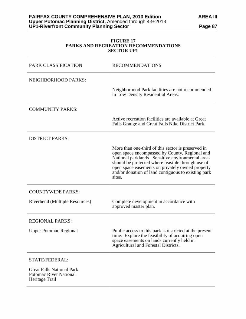
FAIRFAX COUNTY COMPREHENSIVE PLAN, 2013 Edition AREA III Upper Potomac Planning District, Amended through 4-9-2013 UP1-Riverfront Community Planning Sector Page 87
FIGURE 17 PARKS AND RECREATION RECOMMENDATIONS
SECTOR UP1 PARK CLASSIFICATION
RECOMMENDATIONS
NEIGHBORHOOD PARKS:
Neighborhood Park facilities are not recommended in Low Density Residential Areas.
COMMUNITY PARKS:
Active recreation facilities are available at Great Falls Grange and Great Falls Nike District Park.
DISTRICT PARKS:
More than one-third of this sector is preserved in open space encompassed by County, Regional and National parklands. Sensitive environmental areas should be protected where feasible through use of open space easements on privately owned property and/or donation of land contiguous to existing park sites.
COUNTYWIDE PARKS: Riverbend (Multiple Resources)
Complete development in accordance with approved master plan.
REGIONAL PARKS: Upper Potomac Regional
Public access to this park is restricted at the present time. Explore the feasibility of acquiring open space easements on lands currently held in Agricultural and Forestal Districts.
STATE/FEDERAL: Great Falls National Park Potomac River National Heritage Trail

FAIRFAX COUNTY COMPREHENSIVE PLAN, 2013 Edition AREA III Upper Potomac Planning District, Amended through 4-9-2013 UP1-Riverfront Community Planning Sector Page 88
TRAILS PLAN MAP FOR THIS SECTOR UNDER CONSTRUCTION
SEE THE 1” = 4000’ SCALE
COUNTYWIDE TRAILS PLAN MAP
PLANNED TRAIL SYSTEM FIGURE 18

FAIRFAX COUNTY COMPREHENSIVE PLAN, 2013 Edition AREA III Upper Potomac Planning District, Amended through 4-9-2013 UP2-Springvale Community Planning Sector Page 89
UP2 SPRINGVALE COMMUNITY PLANNING SECTOR CHARACTER
The Springvale Community Planning Sector is located in the northern part of the county and is bounded by Beach Mill Road and Seneca Road on the north, River Bend Road to the east, Leesburg Pike (Route 7) and Georgetown Pike (Route 193) on the south, and Loudoun County to the west.
This planning sector is rural in character and consists of residential estates and large-lot
subdivisions, undeveloped land and open space. Local-serving commercial uses are located on Leesburg Pike at Georgetown Pike, at the Great Falls Village area, at Georgetown Pike and Walker Road, and at Beach Mill and Springvale Road. This area is developed as and planned to maintain the very low density character through large-lot residential development.
This planning sector is characterized by low-density residential development and open
space. The sector has a high potential for significant heritage resources, and is rich in known historic sites. Great Falls Grange and Great Falls Post Office/Forestville School, as well as the John Gunnell House, Gunnell’s Run and Cornwell Farm, are listed in the County Inventory of Historic Sites, Virginia Landmarks Register and the National Register of Historic Places. A portion of the Dranesville Tavern Historic Overlay District lies within this sector. Georgetown Pike is designated as a Virginia Byway pursuant to Section 33.1-63 of the Code of Virginia, as amended. A list and map of heritage resources are included in the Upper Potomac Planning District Overview section, Figures 4, 5 and 6. Additional historic sites in this sector are also included in the inventory. CONCEPT FOR FUTURE DEVELOPMENT
The Springvale Community Planning Sector is designated as a Low Density Residential Area in the Concept for Future Development. RECOMMENDATIONS Land Use
The Springvale Community Planning Sector is largely developed as stable low density residential areas. Infill development in these residential areas should be of a compatible use, type and intensity in accordance with the guidance provided by the Policy Plan under Land Use Objectives 8 and 14.
Where substantial parcel consolidation is specified, it is intended that such consolidations
will provide for projects that function in a well-defined, efficient manner and provide for the development of unconsolidated parcels in conformance with the Area Plan.
Figure 19 indicates the geographic location of land use recommendations for this sector.
Where recommendations are not shown on the General Locator Map, it is so noted.
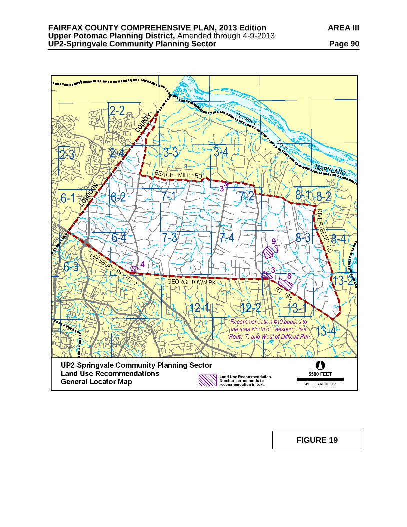
FAIRFAX COUNTY COMPREHENSIVE PLAN, 2013 Edition AREA III Upper Potomac Planning District, Amended through 4-9-2013 UP2-Springvale Community Planning Sector Page 90
FIGURE 19

FAIRFAX COUNTY COMPREHENSIVE PLAN, 2013 Edition AREA III Upper Potomac Planning District, Amended through 4-9-2013 UP2-Springvale Community Planning Sector Page 91
1. Land use in this sector should continue to reflect and support the established low density
residential character of one dwelling unit per two and five acre lots. Public parkland and low density residential uses at .1-.2 dwelling unit per acre and .2-.5 dwelling unit per acre are planned for the area as shown on the Plan map. Several older residential areas along Georgetown Pike are planned at a density of 1-2 dwelling units per acre as a reflection of the typical densities that exist in these areas. [Not shown]
2. This sector is planned for low density, single-family residential use at .2-.5 du/ac as shown
on the Comprehensive Land Use Plan map. Cluster subdivisions may be appropriate in this sector if the following criteria are met and are rigorously applied: 1) Wherever possible the proposed open space should provide connections with existing or planned trails; 2) Individual lots, buildings, streets, utilities and parking areas are designed and situated to minimize the disruption of the site’s natural drainage and topography, and to promote the preservation of important view sheds, historic resources, steep slopes, stream valleys and desirable vegetation; 3) Site design and building location are done in a manner that is compatible with surrounding development; 4) Modifications to minimum district size, lot area, lot width or open space requirements of a cluster subdivision in the R-E and R-1 Districts are not appropriate, unless significant benefits can be achieved in the preservation of the natural environment, scenic view shed(s) or historic resources by permitting such modifications; and 5) Lot yield shall be limited to that which could reasonably result under conventional development. In addition, measures such as agricultural and forestal districts, conservation, open space and scenic easements should be encouraged to preserve the rural character of this environmentally sensitive area, provided that their use provides a public benefit and furthers the intent of the Plan. [Not Shown]
3. Commercial uses should be neighborhood-serving and confined to existing commercial
areas as shown on the Plan map. This includes the area in the vicinity of Walker Road and Georgetown Pike and at Springvale Road and Beach Mill Road.
4. The area along Seneca Road, north of its intersection with Georgetown Pike is currently
planned for residential development at densities of .2-.5 and 1-2 dwelling units per acre. A small portion of this area at Seneca Road and Georgetown Pike is commercially zoned. Commercial development of these parcels should be limited to low intensity office and neighborhood retail uses, not to exceed .25 FAR, under the following conditions:
• Consolidation of commercially-zoned parcels (Tax Map 6-4((3))1, 2, 3, and 4), or the
development of a single project on Tax Map 6-4((1))60B, which represents an earlier consolidation;
• Provision of substantial landscaped and/or naturally vegetated buffers to protect
surrounding residential uses and provide a clear line of demarcation between any commercial development and the existing and planned low density residential uses to the north, east and west. Residentially zoned portions of these parcels should be used and maintained as open space buffers;
• Either office or retail development should be of high quality as demonstrated by
consistent architectural treatment of all building facades in a style that uses materials and design elements that are compatible with the low density residential community. Any office development should be residential in character, in terms of scale, bulk, material, and component detail;
FAIRFAX COUNTY COMPREHENSIVE PLAN, 2013 Edition AREA III Upper Potomac Planning District, Amended through 4-9-2013 UP2-Springvale Community Planning Sector Page 92
• Structures should not exceed 35 feet in height; and • Right-in/right-out only access to a unified commercial development on Tax Map 6-
4((1))60B may be provided from Georgetown Pike if approved by VDOT. 5. Future development and improvements to commercial establishments in the Village of
Great Falls should encourage uniformity of architecture, screening, fencing, signage and encourage the completion of trails in the village. [Not shown]
6. In this planning sector, uses requiring special permits and special exception approval
should be rigorously reviewed and permitted only when the use is of a size and scale that will not adversely impact adjacent land uses and the overall low density residential character of the area. [Not shown]
7. The Route 7 Corridor is planned for and should continue to be reserved for residential
development. Industrial, office, research and development (R&D), and retail commercial uses are not appropriate in the Route 7 Corridor. Uses requiring special permits and special exception approval should be rigorously reviewed and permitted only when the use is of a size and scale that will not adversely impact adjacent land uses and the overall low density residential character of the corridor in order to prevent commercial or quasi-commercial encroachment. [Not shown]
8. Parcel 13-1((1))37, which is located on the northeast corner of Georgetown Pike and
Innsbruck Avenue, is planned for residential use at .2 -.5 dwelling units per acre. As an option, public park use may be appropriate.
9. Parcels 8-3((1)) 45V and 45Z, located on the south side of Arnon Chapel Road across from
the intersection of Arnon Meadow Road, are planned for residential use at .2 - .5 dwelling units per acre. As an option, public park use may be appropriate.
10. Turner Farm Park, in the heart of the Great Falls area, is planned for an astronomical
observatory for educational and recreational use by County schools and residents due to having among the darkest night sky in the Washington, D.C. Metropolitan Area. The night sky in the area surrounding the planned observatory should be protected from excessive and improper lighting. New development (i.e., public and private) in planning sector UP2 and planning sector UP3, north of Leesburg Pike and west of Difficult Run, should provide energy efficient lighting that reduces glare, eliminates light trespass and reduces sky glow.
11. Encourage the use of pervious and semi-pervious materials for paved areas (e.g. parking
lots, driveways, walkways and patios). [Not shown] Transportation
Transportation recommendations for this sector are shown on Figures 20 and 21. In some instances, site-specific transportation recommendations are included in the land use recommendations section. The figures show access orientation, circulation plans, interchange impact areas and generalized locations of proposed transit facilities. The recommendations contained in the Area Plan text and maps, the Policy Plan and Transportation Plan map, policies and requirements in the Public Facilities Manual, the Zoning Ordinance, and other standards will be utilized in the evaluation of development proposals.
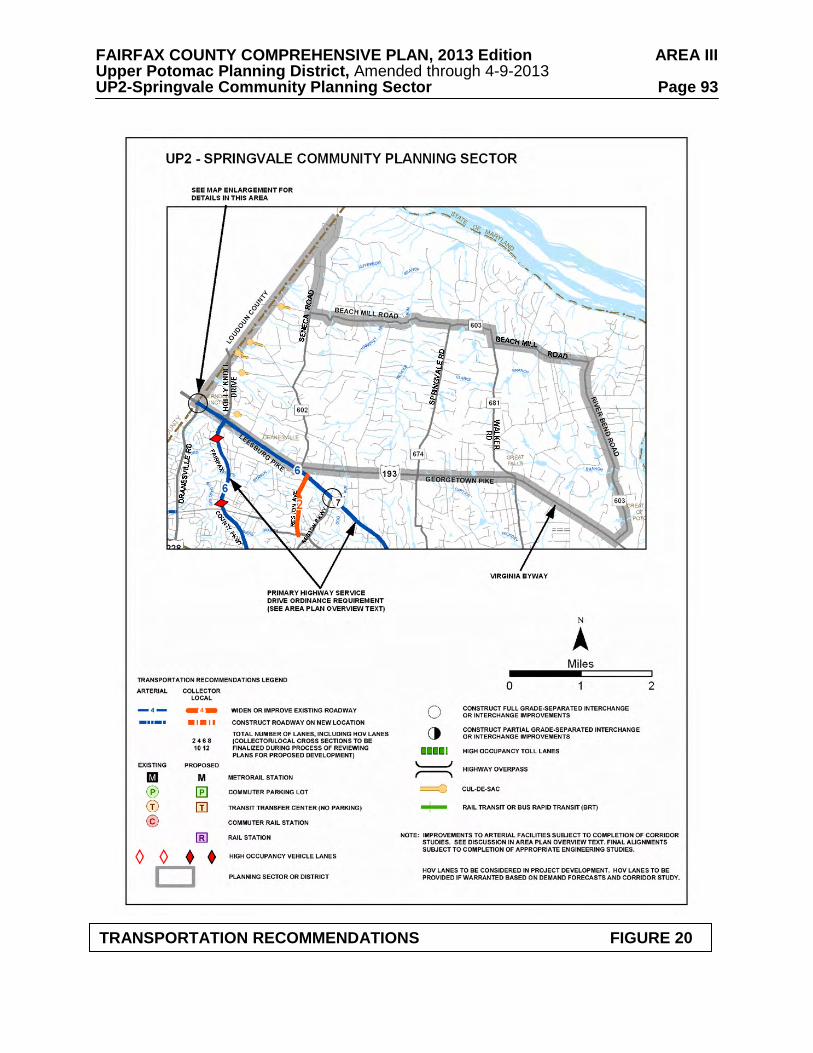
FAIRFAX COUNTY COMPREHENSIVE PLAN, 2013 Edition AREA III Upper Potomac Planning District, Amended through 4-9-2013 UP2-Springvale Community Planning Sector Page 93
TRANSPORTATION RECOMMENDATIONS FIGURE 20

FAIRFAX COUNTY COMPREHENSIVE PLAN, 2013 Edition AREA III Upper Potomac Planning District, Amended through 4-9-2013 UP2-Springvale Community Planning Sector Page 94
INTERCHANGE RECOMMENDATIONS FIGURE 21 UP2 SPRINGVALE COMMUNITY PLANNING SECTOR

FAIRFAX COUNTY COMPREHENSIVE PLAN, 2013 Edition AREA III Upper Potomac Planning District, Amended through 4-9-2013 UP2-Springvale Community Planning Sector Page 95
Georgetown Pike, which has been designated a Virginia Byway and determined eligible for listing on the Virginia Landmarks Register and the National Register of Historic Places, should be maintained within its existing right-of-way. Center turn lanes and deceleration and acceleration lanes should be discouraged and curb cuts should not be allowed unless no other alternative exists. Georgetown Pike is commonly acknowledged to contain some traffic hazards. However, it is generally acceptable in its present condition to local residents. Major changes in alignment or widening the road would damage the scenic and historic character and the historic integrity of the Byway and have been strongly opposed by residents of adjacent areas. Planning efforts should focus on other means of dealing with traffic volume in order to maintain this Byway. Scenic and conservation easements should be sought along Georgetown Pike wherever practical for the preservation of the historic and scenic significance and beauty of the corridor.
Heritage Resources
This planning sector is rich in known historic sites and has a high potential for additional significant heritage resources. The area surrounding the Great Falls Grange and Great Falls Post Office should be considered for protection by establishment of an Historic Overlay District. Dunbarton should also be considered for this type of protection. A portion of the Dranesville Tavern Historic Overlay District lies within this sector. Regulations are discussed in Sector UP4 of the Upper Potomac Planning District. Georgetown Pike is designated as a Virginia Byway pursuant to Section 33.1-63 of the Code of Virginia, as amended. The protection of Georgetown Pike is discussed in the Transportation section above.
Any development or ground disturbance in this sector, both on private and public land,
should be preceded by heritage resource studies, and alternatives should be explored for the avoidance, preservation or recovery of significant heritage resources that are found. In those areas where significant heritage resources have been recorded, an effort should be made to preserve them. If preservation is not feasible, then, in accordance with countywide objectives and policies as cited in the Heritage Resources section of the Policy Plan, the threatened resource should be thoroughly recorded and in the case of archaeological resources, the artifacts recovered. Public Facilities 1. Replace the existing mini-library on Georgetown Pike with a community library near the
intersection of Georgetown Pike and Walker Road. 2. Provide any necessary improvements to FCWA’s Riverside Manor Water System to meet
future regulations (Tax Map 8-1((4))A, D, E). Parks and Recreation
Park and recreation recommendations for this sector are shown on Figure 22. The column
"Park Classification" includes existing park facilities. The "Recommendations" column includes entries for both existing and proposed facilities. Prior to developing parkland, the Fairfax County Park Authority initiates a master planning process to determine the appropriate facilities and design for that park. This process involves extensive citizen review and participation. If an existing park is listed but no recommendation appears on that line, it means the park has been developed in accordance with its master plan.

FAIRFAX COUNTY COMPREHENSIVE PLAN, 2013 Edition AREA III Upper Potomac Planning District, Amended through 4-9-2013 UP2-Springvale Community Planning Sector Page 96
FIGURE 22 PARKS AND RECREATION RECOMMENDATIONS
SECTOR UP2 PARK CLASSIFICATION
RECOMMENDATIONS
NEIGHBORHOOD PARKS: Holly Knolls
No development is planned for the park. Additional Neighborhood Park facilities are not recommended in Low Density Residential Areas.
COMMUNITY PARKS: Windermere
No development is planned for the park.
DISTRICT PARKS:
This sector lies within the service area of Great Falls Nike District Park. The southwestern part of this sector is also served by Baron Cameron District Park.
COUNTYWIDE PARKS: Great Falls Grange (Multiple Resources)
Complete development in accordance with approved master plan. Investigate the potential for obtaining historic preservation easements on selected historic properties.

FAIRFAX COUNTY COMPREHENSIVE PLAN, 2013 Edition AREA III Upper Potomac Planning District, Amended through 4-9-2013 UP2-Springvale Community Planning Sector Page 97 Trails
Trails planned for this sector are delineated on Figure 23 and on the 1”:4,000’ Countywide
Trails Plan Map which is referenced as Figure 2 in the Transportation element of the Policy Plan and is available from the Department of Planning and Zoning. Trails in this sector are an integral part of the overall County system. While some of the segments have already been constructed, the Countywide Trails Plan Map portrays the ultimate system for the sector and the County at large. In addition, the map specifies a classification for each segment, which represents the desired ultimate function and surface type of the trail. Specific construction requirements are detailed in the Public Facilities Manual.

FAIRFAX COUNTY COMPREHENSIVE PLAN, 2013 Edition AREA III Upper Potomac Planning District, Amended through 4-9-2013 UP2-Springvale Community Planning Sector Page 98
TRAILS PLAN MAP FOR THIS SECTOR UNDER CONSTRUCTION
SEE THE 1” = 4000’ SCALE
COUNTYWIDE TRAILS PLAN MAP
PLANNED TRAIL SYSTEM FIGURE 23

FAIRFAX COUNTY COMPREHENSIVE PLAN, 2013 Edition AREA III Upper Potomac Planning District, Amended through 4-9-2013 UP3-Hickory Community Planning Sector Page 99
UP3 HICKORY COMMUNITY PLANNING SECTOR
CHARACTER
The Hickory Community Planning Sector is generally bounded on the north by Georgetown Pike (Route 193), on the east by Old Dominion Drive and Towlston Road, and on the south by Leesburg Pike (Route 7). A portion of the sector between Hunter Mill Road and the Difficult Run Stream Valley extends south of Leesburg Pike to the Dulles Airport Access Road and Dulles Toll Road (DAAR, Route 267).
This planning sector has much of the same rural character as that of the Riverfront and
Springvale planning sectors to the north, although developed at a somewhat higher residential density. There are large-lot subdivisions and a number of lots that are two acres or smaller in size. The planning sector also contains Turner Farm Park. A major land use objective for the sector is to maintain the low density character by encouraging large-lot residential development. Local-serving commercial uses are located at Great Falls Village, Colvin Run Road at Walker Road, and Georgetown Pike at Seneca Road.
Colvin Run Mill Historic Overlay District is a significant heritage resource in this planning sector. The mill is listed in the Virginia Landmarks Register and National Register of Historic Places. Individual sites within the district are listed in the Fairfax County Inventory of Historic Sites. A list and map of heritage resources are included in the Upper Potomac Planning District Overview section, Figures 4, 5 and 6. Additional historic sites in this sector are also included in the inventory.Figures 4, 5 and 6. Additional historic sites in this sector are also included in the inventory. CONCEPT FOR FUTURE DEVELOPMENT
The Hickory Community Planning Sector is designated a Low Density Residential Area in the Concept for Future Development. RECOMMENDATIONS Land Use
The Hickory Community Planning Sector is largely developed as stable low density residential neighborhoods. Infill development in these neighborhoods should be of a compatible use, type and intensity in accordance with the guidance provided by the Policy Plan under Land Use Objectives 8 and 14.
Where substantial parcel consolidation is specified, it is intended that such consolidations
will provide for projects that function in a well-defined, efficient manner and provide for the development of unconsolidated parcels in conformance with the Area Plan.
Figure 24 indicates the geographic location of land use recommendations for this sector.
Where recommendations are not shown on the General Locator Map, it is so noted.

FAIRFAX COUNTY COMPREHENSIVE PLAN, 2013 Edition AREA III Upper Potomac Planning District, Amended through 4-9-2013 UP3-Hickory Community Planning Sector Page 100
FIGURE 24

FAIRFAX COUNTY COMPREHENSIVE PLAN, 2013 Edition AREA III Upper Potomac Planning District, Amended through 4-9-2013 UP3-Hickory Community Planning Sector Page 101 1. Most land should be developed for residential use at .2-.5 dwelling units per acre in order
to preserve the existing character and support the concept of low density residential development for land in the Reston environs. [Not shown]
2. The area bounded by Leesburg Pike, Georgetown Pike, Walker Road and Piney Run is planned for residential use at .5-1 dwelling unit per acre, as shown on the Plan map, to reflect existing and committed development. New development should be generally consistent with existing zoning and should provide for ample landscaping, buffering and substantial building setbacks to ensure that the present relatively low density character of the area will be preserved when viewed from the collector and arterial roadways serving the sector.
3. Residential use at .5-1 dwelling unit per acre is planned for the area north of Leesburg Pike,
between Difficult Run and Towlston Road, as shown on the Plan map. New development should be generally consistent with existing zoning, should provide large lots along the frontage of Leesburg Pike and Towlston Road to preserve the low density, rural characteristics of Towlston Road and Leesburg Pike, and should provide substantial buffers along the frontage of Leesburg Pike.
4. The northwest quadrant of the intersection of Leesburg Pike and Towlston Road, bounded
by the Glen Haven Farms subdivision to the north and Kenmore subdivision to the west, is planned for .5-1 dwelling unit per acre to be compatible with the planned density in this vicinity along Leesburg Pike. Substantial buffering, adequate landscaping and a substantial setback of buildings along the west side of Towlston Road in the area south of Glen Haven Farms subdivision are appropriate to preserve the low density, rural character of Towlston Road.
5. Cluster subdivisions may be appropriate in this sector if the following criteria are met and
are rigorously applied: 1) Wherever possible the proposed open space should provide connections with existing or planned trails; 2) Individual lots, buildings, streets, utilities and parking areas are designed and situated to minimize the disruption of the site’s natural drainage and topography, and to promote the preservation of important view sheds, historic resources, steep slopes, stream valleys and desirable vegetation; 3) Site design and building location are done in a manner that is compatible with surrounding development; 4) Modifications to minimum district size, lot area, lot width or open space requirements of a cluster subdivision in the R-E and R-1 Districts are not appropriate, unless significant benefits can be achieved in the preservation of the natural environment, scenic view shed(s) or historic resources by permitting such modifications; and 5) Lot yield shall be limited to that which could reasonably result under conventional development. [Not Shown]
6. Commercial uses should be limited to existing commercial areas in the vicinity of Walker
Road and Georgetown Pike, and Walker Road and Colvin Run Road. Commercial uses in these areas should be neighborhood-serving in nature and should be restricted to the existing commercially-zoned parcels. However, it would be appropriate for some required commercial parking to be located on the residentially-zoned portion of Tax Map 12-4((16)), provided that the Alfred Leigh House is rehabilitated and maintained as defined in "The Secretary of the Interior's Standards for Historic Preservation Projects." The Fairfax County Architectural Review Board should provide guidance. The parking should be buffered from surrounding residential development. Such parking use should only be continued in conjunction with the continued maintenance of the Leigh House. Should the Leigh House be demolished, use of the residentially-zoned land for parking should cease

FAIRFAX COUNTY COMPREHENSIVE PLAN, 2013 Edition AREA III Upper Potomac Planning District, Amended through 4-9-2013 UP3-Hickory Community Planning Sector Page 102
and the land should be restored to its original condition or a condition appropriate for residential use.
7. The Route 7 Corridor is planned for and should continue to be reserved for residential
development. Industrial, office, research and development (R&D), and retail commercial uses are not appropriate in the Route 7 Corridor. Uses requiring special permits and special exception approval should be rigorously reviewed and permitted only when the use is of a size and scale that will not adversely impact adjacent land uses and the overall character of the corridor in order to prevent commercial or quasi-commercial encroachment. [Not shown]
8. The northwest and northeast quadrants of the intersection of Leesburg Pike and Springvale
Road are planned for residential use at .5-1 dwelling unit per acre. Consolidation of parcels and a coordinated access point to Springvale Road should be required. (See Figure 25.)
9. In this planning sector uses requiring special permits and special exception approval
should be rigorously reviewed and permitted only when the use is of a size and scale that will not adversely impact adjacent land uses and the overall low density residential character of the area. [Not shown]
10. The area south of Leesburg Pike, south of Baron Cameron Avenue and east of Hunter Mill Road is planned for residential use at .5-1 dwelling unit per acre. Development at this density is similar to existing residential development in the area and will help to maintain a low density buffer around Reston. Additional Plan guidance is included under Land Use Recommendation #12 for Sector UP5.
11. The area bounded by Hunter Mill Road, Colvin Run, Leesburg Pike, Difficult Run and the
Dulles Airport Access Road is part of the Difficult Run watershed and is planned for low density residential development at .2-.5 dwelling units per acre as shown on the Plan map. Uses requiring special permit or special exception approval should be rigorously reviewed and permitted only when the use is of a size and scale that will not adversely impact adjacent land uses and the overall low density residential character of the area. The cumulative effect of special permit and special exception uses should be considered prior to allowing additional uses or the expansion of existing uses to determine if adding new uses or expanding existing uses will change the low density residential character of the area.
12. Turner Farm Park, in the heart of the Great Falls area, is planned for an astronomical
observatory for educational and recreational use by County schools and residents due to having among the darkest night sky in the Washington, D.C. Metropolitan Area. The night sky in the area surrounding the planned observatory should be protected from excessive and improper lighting. New development (i.e., public and private) in planning sector UP2 and planning sector UP3, north of Leesburg Pike and west of Difficult Run, should provide energy efficient lighting that reduces glare, eliminates light trespass and reduces sky glow.
13. Encourage the use of pervious and semi-pervious materials for paved areas (e.g. parking
lots, driveways, walkways and patios). [Not shown].

FAIRFAX COUNTY COMPREHENSIVE PLAN, 2013 Edition AREA III Upper Potomac Planning District, Amended through 4-9-2013 UP3-Hickory Community Planning Sector Page 103 Transportation
Transportation recommendations for this sector are shown on Figures 25 and 26. In some instances, site-specific transportation recommendations are included in the land use recommendations section. The figures show access orientation, circulation plans, interchange impact areas and generalized locations of proposed transit facilities. The recommendations contained in the Area Plan text and maps, the Policy Plan and Transportation Plan map, policies and requirements in the Public Facilities Manual, the Zoning Ordinance, and other standards will be utilized in the evaluation of development proposals. Development proposals should also be evaluated against the Hunter Mill Road Traffic Calming Study (Northern Virginia Regional Commission, 2006), which provides both a traffic calming conceptual plan for Hunter Mill Road, as well as context sensitive roadway design techniques.
Georgetown Pike, which has been designated a Virginia Byway and determined eligible for
listing on the Virginia Landmarks Register and the National Register of Historic Places, should be maintained within its existing right-of-way. Center turn lanes and deceleration and acceleration lanes should be discouraged and curb cuts should not be allowed unless no other alternative exists. Georgetown Pike is commonly acknowledged to contain some traffic hazards. However, it is generally acceptable in its present condition to local residents. Major changes in alignment or widening the road would damage the scenic and historic character and the historic integrity of the Byway and have been strongly opposed by residents of adjacent areas. Planning efforts should focus on other means of dealing with traffic volume in order to maintain this Byway. Scenic and conservation easements should be sought along Georgetown Pike wherever practical for the preservation of the historic and scenic significance and beauty of the corridor. Heritage Resources Maintain the Colvin Run Mill Historic Overlay District and consider expanding the Historic Overlay District to include the Dr. Alfred Leigh House (Tax Map 12-4((1))15A). The regulations of the Colvin Run Mill Historic Overlay District (Appendix 1, A1-600 of the Zoning Ordinance) limit development to residential uses with the exception of commercial uses appropriate to the mill site itself. All improvements shall be designed to be compatible with the scale and appearance of the historic site. All development within the historic overlay district must be reviewed by the Architectural Review Board. Georgetown Pike is designated as a Virginia Byway pursuant to Section 33.1-63 of the Code of Virginia, as amended. The protection of Georgetown Pike is discussed in the Transportation section above. Any development or ground disturbance in this sector, both on private and public land, should be preceded by heritage resource studies, and alternatives should be explored for the avoidance, preservation or recovery of significant heritage resources that are found. In those areas where significant heritage resources have been recorded, an effort should be made to preserve them. If preservation is not feasible, then, in accordance with countywide objectives and policies as cited in the Heritage Resources section of the Policy Plan, the threatened resource should be thoroughly recorded and in the case of archaeological resources, the artifacts recovered.

FAIRFAX COUNTY COMPREHENSIVE PLAN, 2013 Edition AREA III Upper Potomac Planning District, Amended through 4-9-2013 UP3-Hickory Community Planning Sector Page 104
TRANSPORTATION RECOMMENDATIONS FIGURE 25

FAIRFAX COUNTY COMPREHENSIVE PLAN, 2013 Edition AREA III Upper Potomac Planning District, Amended through 4-9-2013 UP3-Hickory Community Planning Sector Page 105
INTERCHANGE AND ACCESS RECOMMENDATIONS FIGURE 26 UP3 HICKORY COMMUNITY PLANNING SECTOR

FAIRFAX COUNTY COMPREHENSIVE PLAN, 2013 Edition AREA III Upper Potomac Planning District, Amended through 4-9-2013 UP3-Hickory Community Planning Sector Page 106 Parks and Recreation
Park and recreation recommendations for this sector are shown on Figure 27. The column "Park Classification" includes existing park facilities. The "Recommendations" column includes entries for both existing and proposed facilities. Prior to developing parkland, the Fairfax County Park Authority initiates a master planning process to determine the appropriate facilities and design for that park. This process involves extensive citizen review and participation. If an existing park is listed but no recommendation appears on that line, it means the park has been developed in accordance with its master plan.
Trails
Trails planned for this sector are delineated on Figure 28 and on the 1”:4,000’ Countywide Trails Plan Map which is referenced as Figure 2 in the Transportation element of the Policy Plan and is available from the Department of Planning and Zoning. Trails in this sector are an integral part of the overall County system. While some of the segments have already been constructed, the Countywide Trails Plan Map portrays the ultimate system for the sector and the County at large. In addition, the map specifies a classification for each segment, which represents the desired ultimate function and surface type of the trail. Specific construction requirements are detailed in the Public Facilities Manual.

FAIRFAX COUNTY COMPREHENSIVE PLAN, 2013 Edition AREA III Upper Potomac Planning District, Amended through 4-9-2013 UP3-Hickory Community Planning Sector Page 107
FIGURE 27 PARKS AND RECREATION RECOMMENDATIONS
SECTOR UP3 PARK CLASSIFICATION
RECOMMENDATIONS
NEIGHBORHOOD PARKS: Lockmeade
Consider additional land acquisition to expand park uses.
COMMUNITY PARKS: Lexington Estates Fox Manor
Pursue acquisition of adjacent surplus Federal land to expand the park and provide active recreational facilities at this site. Initiate a master planning process and develop park accordingly. Seek interim use agreement on school site adjacent to southern section of park for development of active recreation facilities.
DISTRICT PARKS: Great Falls Nike
Initiate a master planning process and develop in accordance with the approved plan for active recreation. Consider future expansion if feasible. Most of the western part of this sector is also served by Baron Cameron District Park.
COUNTYWIDE PARKS: Colvin Run Mill (Heritage Resources) Colvin Run Stream Valley Difficult Run Stream Valley
Protect Difficult Run and Colvin Run EQC and their tributaries of Piney Run, Hickory Run and Dog Run through acquisition, dedication and/or donation of land and open space easements to the Fairfax County Park Authority. Complete the “Rails to River” countywide trail.
Seek historic preservation easements on selected historic properties.

FAIRFAX COUNTY COMPREHENSIVE PLAN, 2013 Edition AREA III Upper Potomac Planning District, Amended through 4-9-2013 UP3-Hickory Community Planning Sector Page 108
TRAILS PLAN MAP FOR THIS SECTOR UNDER CONSTRUCTION
SEE THE 1” = 4000’ SCALE
COUNTYWIDE TRAILS PLAN MAP
PLANNED TRAIL SYSTEM FIGURE 28

FAIRFAX COUNTY COMPREHENSIVE PLAN, 2013 Edition AREA III Upper Potomac Planning District, Amended through 4-9-2013 UP4-Greater Herndon Community Planning Sector Page 109
UP4 GREATER HERNDON COMMUNITY PLANNING SECTOR CHARACTER
This sector is generally bounded on the south by the Dulles Airport Access Road and Dulles Toll Road (DAAR, Route 267), on the east by Reston, on the north by Leesburg Pike (Route 7), and on the west by Loudoun County. This planning sector includes the Route 28/CIT Transit Station Area and the Town of Herndon.
The Town of Herndon is an incorporated town within Fairfax County. The town grew
around the railroad depot that opened in 1857, providing local dairy farmers with transportation for their products to the City of Washington. Incorporated in 1879, the town remained a rural community until recently when it began to experience rapid growth. The immediate county neighborhoods and the Washington Dulles International Airport to the west, Reston to the east and the planned mixed-use development along the DAAR and the Metrorail Silver line affects the town in terms of development pressure and environmental impacts.
Herndon has jurisdiction over its own planning. The county's planning efforts within
surrounding planning sectors should strive to advance the integrity of the town and compatibility with neighboring areas. The need to preserve and promote coordinated planning efforts in this part of the county is advanced by the existence of this sector in the county Plan. Fairfax County provides Herndon with a number of public facilities and services, including schools, libraries, health facilities, social services, fire services, and sewer service. Consult the Town of Herndon’s Comprehensive Plan for further guidance in this area.
The Sugarland Run area, the portion of the county immediately north of Herndon, is largely
developed in single-family neighborhoods. This single-family development, in combination with the variety of types of townhouses available in Herndon, gives this planning sector a diversity of housing choices. A large part of the area is dominated by the Sugarland Run stream valley and its floodplain. Local-serving commercial uses are located primarily in Herndon, Reston and Sterling in Loudoun County.
The Center for Innovative Technology (CIT), a state supported research and development
consortium of State universities and colleges, is located north of the DAAR and south of the Town of Herndon boundary.
This planning sector is rich in heritage resources. The Herndon Historic District is listed in
the Virginia Landmarks Register and the National Register of Historic Places. Local Heritage Preservation Overlay Districts are administered by the Town of Herndon. Dranesville Tavern, also in the Virginia and National Registers, is protected by a county historic overlay district. Individual sites within these districts are listed in the Fairfax County Inventory of Historic Sites. A list and map of heritage resources are included in the Upper Potomac Planning District Overview section, Figures 4, 5 and 6. Additional historic sites in this sector are also included in the inventory. CONCEPT FOR FUTURE DEVELOPMENT
The Greater Herndon Community Planning Sector, except for the Town of Herndon and the northern portion of the Route 28/CIT Transit Station Area, is recommended to develop as Suburban Neighborhoods in the Concept for Future Development. The area within the Route
FAIRFAX COUNTY COMPREHENSIVE PLAN, 2013 Edition AREA III Upper Potomac Planning District, Amended through 4-9-2013 UP4-Greater Herndon Community Planning Sector Page 110 28/CIT Transit Station area is recommended to develop as a Transit Station Area, as shown on Figure 29. RECOMMENDATIONS Land Use
The Greater Herndon Community Planning Sector is largely developed with stable residential neighborhoods. Infill development in these neighborhoods should be of a compatible use, type and intensity in accordance with the guidance provided by the Policy Plan under Land Use Objectives 8 and 14.
Where substantial parcel consolidation is specified, it is intended that such consolidations will provide for projects that function in a well-defined, efficient manner and provide for the development of unconsolidated parcels in conformance with the Area Plan.
The land use and density plans for the Town of Herndon and Fairfax County apply to this
sector. Fairfax County and the Town of Herndon should coordinate planning efforts to ensure compatible land use relationships and effective transitions and buffers between uses and intensities within this planning sector.
Figure 30 indicates the geographic location of land use recommendations for this sector.
Where recommendations are not shown on the General Locator Map, it is so indicated. 1. The area (1a) north of the Town of Herndon and west of Sugarland Run is planned for
residential development at 2-3 dwelling units per acre as shown on the Plan map. The area (1b) generally located east of Sugarland Run is planned for residential development at .5-1 dwelling unit per acre. This provides for compatible density west of Sugarland Run and a low density buffer type area adjacent to the Sugarland Run stream valley. The area in Reston should conform to the Reston Master Plan.
2. Density within the Dranesville Tavern Historic District is planned for .2-.5 dwelling unit
per acre, except for the area west of Holly Knoll Drive and south of Leesburg Pike where it is planned for .5-1 dwelling unit per acre.
3. Cluster residential development should be used to preserve open space. [Not shown]
4. The land west of Stuart Road, south of Reston (Tax Map 17-1((24))A, 1-38) is planned for
development at 3-4 dwelling units per acre. As an option, this area may be developed at 7-9 dwelling units per acre, contingent upon the following conditions: • Complete consolidation of all parcels, including the commercially-zoned parcels
immediately north of Laurel Way; • Provision of a minimum 50-foot landscaped buffer including preservation of mature
vegetation supplemented by evergreen and deciduous trees and shrubs (which includes the right-of-way located along the northern boundary) to provide substantial buffering and screening to the single-family detached residential community to the north;

FAIRFAX COUNTY COMPREHENSIVE PLAN, 2013 Edition AREA III Upper Potomac Planning District, Amended through 4-9-2013 UP4-Greater Herndon Community Planning Sector Page 111
FIGURE 29

FAIRFAX COUNTY COMPREHENSIVE PLAN, 2013 Edition AREA III Upper Potomac Planning District, Amended through 4-9-2013 UP4-Greater Herndon Community Planning Sector Page 112
FIGURE 30
FAIRFAX COUNTY COMPREHENSIVE PLAN, 2013 Edition AREA III Upper Potomac Planning District, Amended through 4-9-2013 UP4-Greater Herndon Community Planning Sector Page 113
• Provision of a substantial landscaped buffer along the Fairfax County Parkway,
maintaining mature vegetation and supplemented with at a minimum 6-foot evergreen trees;
• Provision of a minimum 35-foot landscaped buffer (supplemented with deciduous and
evergreen trees) or a minimum 7-foot barrier wall and 15-foot landscaped buffer including shade and ornamental trees with underplantings along the southern and western boundary;
• Provision of a pedestrian system that links new Laurel Way to the residential area on
the north: • Provision of recreational amenities such as a tot lot, picnic area, etc.; • Noise attenuation measures (which may include noise barriers), as may be determined
appropriate by the County. 5. Some land in this sector located adjacent to the Loudoun County line is planned for
residential development at 2-3 dwelling units per acre as shown on the Plan map. In order to protect the low density residential communities planned for this area from higher density residential and nonresidential uses planned in Loudoun County, a 25-foot evergreen buffer and barriers should be provided on all land adjacent to Loudoun County. [Not shown]
6. This area is located east of the Loudoun County boundary, north of the Dulles Airport
Access Road (DAAR), west of the Reflection Lake community and south of the Town of Herndon (see Figure 31). A portion of the area is planned for transit oriented development (TOD) focused on the planned Route 28/Center for Innovative Technology (CIT) Metro Station. Land use options in support of TOD follow the baseline recommendations. Baseline Recommendations for Land Units A, B and C Land Unit A is developed as the Center for Innovative Technology, a State-supported research and development consortium of State universities and colleges. Land Unit A at the baseline is planned for this existing institutional use. Land Units B and C are located west of Rock Hill Road and are planned at the baseline for office and research and development uses. Tax map parcels 15-2((1))3, 4, 5 and 16-1((1)) 4A contain extensive Resource Protection Areas, Environmental Quality Corridors and floodplain. The development potential of these parcels is severely constrained. The restoration, as may be needed, and dedication of these properties to the Fairfax County Park Authority or other land conservation entity as part of a zoning action would address several goals, including preservation of environmentally fragile and valuable land and habitat, and providing open space amenities. Land Unit B (Parcels 15-2((1))4, 5, 16) is planned for a maximum intensity of .50 FAR. A hotel or conference center use up to .50 FAR which would appropriately complement the CIT is also appropriate in Land Unit B. Community-serving retail use incorporated on the ground level of buildings is desirable and appropriate.

FAIRFAX COUNTY COMPREHENSIVE PLAN, 2013 Edition AREA III Upper Potomac Planning District, Amended through 4-9-2013 UP4-Greater Herndon Community Planning Sector Page 114
FIGURE 31
FAIRFAX COUNTY COMPREHENSIVE PLAN, 2013 Edition AREA III Upper Potomac Planning District, Amended through 4-9-2013 UP4-Greater Herndon Community Planning Sector Page 115
Land Unit C (Parcels 15-2((1))1, 2, 3 and 16-1((1))4, 4A) is planned for office and research and development use at a maximum intensity of .25 FAR at the baseline. Community-serving retail use on the ground level of office structures may be appropriate to serve employees. Only a portion of the parcels that make up Land Units B and C are located in Fairfax County. Consolidation of land or parcels should occur such that the development results in well-designed, high-quality uses that are functionally and visually integrated into the larger mixed use area planned in Loudoun County. Proposed development should be part of a project that incorporates a substantial and contiguous area in Loudoun County and is compatible with the uses and intensities planned by Loudoun County. All development proposals should demonstrate that any unconsolidated parcels within a land unit can be developed in a manner that complements the proposed development and is consistent with the recommendations of the Plan and at a minimum includes environmentally constrained land. Public facilities analyses, including fire, police, schools, recreation, and transportation are performed in conjunction with any development application. The results of these analyses should identify necessary improvements, the phasing of these improvements with new development, and appropriate measures to mitigate other impacts. In addition, development of these land units should result in uses that are designed to be visually compatible with the residentially developed area of Land Unit D. Finally, active recreation areas for employees and residents should be provided. Rail Transit Option for Land Units A, B and C Consistent with TOD policy, this plan provides an option for a mix of uses ranging from .50 to 2.8 FAR, based on distance from the Metrorail station. The Route 28/CIT Transit Station Area (TSA) includes Land units A, B and C. The TSA is planned for a mixture of interrelated residential and nonresidential uses. The rail transit option may be considered once the provisions pertaining to Phase 2 rail improvements contained in the “Agreement to Fund the Capital Cost of Construction of Metrorail in Fairfax County” are accepted by the Fairfax County Board of Supervisors. Specifically, the terms and conditions of the 100% preliminary engineering cost estimate for Phase 2 must be approved by the Fairfax County Board of Supervisors, and the affirmative decision to participate in financing must be transmitted to MWAA. This option is transit-supportive and includes multifamily residential, office, hotel, as well as retail uses designed to serve the TOD community. This mix of uses will allow the creation of a center of activity that is focused toward the planned Route 28/CIT Metro Station. In addition the recommendations take advantage of the proximity of the CIT complex, Dulles Airport, the Dulles Access and Toll Road, to provide future employment opportunities and housing in the vicinity of Sully Road. Within the Route 28/CIT Transit Station Area, the highest concentration of development should be closest to the planned Metro station. The mix of uses should create a critical mass of pedestrian activity as people live, work and recreate in this area. Existing residential communities in Fairfax County and the Town of Herndon create a transition to the planned higher intensity transit oriented development centered around the planned Metro station.

FAIRFAX COUNTY COMPREHENSIVE PLAN, 2013 Edition AREA III Upper Potomac Planning District, Amended through 4-9-2013 UP4-Greater Herndon Community Planning Sector Page 116
The goals for this area include the following:
• Achieve a compact, high-quality transit and pedestrian-oriented, mixed use community with the highest land use intensity focused within ¼ mile of the planned Route 28/CIT Metro Station.
• Create a safe pedestrian environment that is visually diverse and stimulating. Provide
for public pedestrian access between the transit station and employment and residential destinations within and adjacent to the area. Any potential conflicts between non-pedestrian and pedestrian circulation are to be resolved in favor of the pedestrian right of way.
• Create functional, well coordinated, visually appealing roads, paths and trails that
provide linkages within the TSA and to adjacent residential areas within Fairfax County, Loudoun County, and the Town of Herndon.
• Link future development to the provision of appropriate multi-modal transportation
improvements for all land units in this area and as indicated in the Plan text and as shown on Figures 32 through 35.
• Provide open space for active recreation (including athletic fields), passive recreation
and visual relief. • Protect and enhance environmental resources. • Encourage parcel consolidation to realize the benefit of comprehensive urban design
and circulation/access principles and environmental protection. • Link development to the provision of needed public facilities. • Protect adjacent residential neighborhoods from the visual impact of development
through use of building tapering, and/or landscaping features, maintaining a high standard for architectural quality, and minimizing noise, glare and traffic intrusion.
• Establish a mechanism for interjurisdictional collaboration to monitor and assure that
a TOD land use, transportation, and public facilities balance is achieved and maintained in all development phases.
General TOD Guidance The vision of the Route 28/CIT Transit Station Area is to create an inter-connected multi-modal place that benefits surrounding areas. The proximity of a mix of uses to one another should be combined with easy access to multiple modes of transportation, particularly transit (including bus), walking and bicycling that is part of a larger area wide network. The following urban design, transportation, noise, stormwater, and affordable and workforce housing recommendations apply to all development proposals. Urban Design The TSA guidance establishes an environment that thrives around mass transit, minimizes the need for the single-occupant automobile, and fosters a vibrant pedestrian atmosphere. Compact, mixed-use development with the highest densities/intensities closest to transit

FAIRFAX COUNTY COMPREHENSIVE PLAN, 2013 Edition AREA III Upper Potomac Planning District, Amended through 4-9-2013 UP4-Greater Herndon Community Planning Sector Page 117
station platforms, as well as opportunities to move safely, conveniently and enjoyably about the community by foot or bicycle are defining elements. The protection of environmentally valuable areas is essential. Consolidation with parcels containing environmentally sensitive areas such as streams and wetlands should be supported in order to achieve dedication and ultimate preservation. These areas can provide needed passive open space and contribute to creating a pleasing mix of hardscape elements and natural landscapes. Creating high-quality, built environments that result in a uniquely identifiable place is strongly encouraged. With respect to the CIT building, harmonious architectural and other design features to celebrate this iconic structure are encouraged throughout the TSA. Buildings Buildings should be designed at a scale that encourages pedestrian and street activity. The buildings should create an enjoyable, attractive, and safe environment to walk, bike, dine, relax and ride public transit. In order to accomplish these goals, building design placement and orientation should encourage activity both at the street level and in above-ground plazas. Architectural design features such as façade variations of window or building details are encouraged. Ground-floor retail uses are encouraged in office, hotel and residential buildings, as well as parking structures to activate the street. These uses should be designed to complement the surrounding style. Free-standing or drive-through retail establishments are discouraged. Faux windows or storefronts should be used only when necessary, and long expanses of blank walls or facades should be avoided. If retail uses cannot be integrated into the first-floor facades, these façades should be decorated with store-front windows, awnings, and/or vegetated walls. Buildings should be oriented to and frame the street or the plaza on which the building is located. Buildings should have minimal setbacks. Any building setback should be used for features that contribute to the pedestrian environment, such as plazas, or entrance features. High-rise buildings are envisioned to maximize open space and take maximum advantage of proximity to transit. However, given the proximity of Dulles International Airport, review by the Federal Aviation Administration may be required for high-rise buildings. Urban Parks and Open Space Urban parks in the form of plazas, courtyard or mini-parks should be incorporated into the designs of buildings and/or building complexes to serve the daily needs of residents, local employees, and visitors. These parks should be highly visible and easy to access from areas with most of the pedestrian traffic. Features may include trail connections, water features and short-term informal activities and programmed events intended to foster social interactions among users. These open spaces should be appealing places to gather with seating, lighting, landscaping and other amenities. These spaces should be integrated purposefully into the overall design of the development, and not merely be residual areas left over after buildings and parking lots are sited. Public art/sculpture should be incorporated into all open spaces. Opportunities for passive open space are present adjacent to streams and wetlands located throughout the area. Streetscape, Sidewalk, Trail and Road Features A coordinated streetscape design should be developed to contribute to the identity of the CIT area. In addition to the roadway elements of on-street parking, bike lanes, travel lanes,

FAIRFAX COUNTY COMPREHENSIVE PLAN, 2013 Edition AREA III Upper Potomac Planning District, Amended through 4-9-2013 UP4-Greater Herndon Community Planning Sector Page 118
and medians, the streetscape design should provide frontage of sufficient width to create a pedestrian zone to safely separate pedestrian activity from the roadway. Within the pedestrian zone, the space between the sidewalk and the building façade should be determined by the use of the adjacent building and should be used for outdoor cafés, seating, or browsing store windows. Wide sidewalks are encouraged to support the anticipated increase in pedestrian traffic and street furniture throughout the development area. The use of texture, pattern, and materials should be encouraged to make the setting interesting. Finally, a landscape amenity panel should be located next to the curb and may include streetlights, tree grates, planting beds, planters, paving, bus shelters, bicycle racks, public art, and benches. This safe and attractive pedestrian and bicycle circulation system should unify the area, provide for well integrated connections to the Metro Station, adjacent residential neighborhoods, Fairfax County, the Town of Herndon, and adjacent Loudoun County. These sidewalks and trails should be integrated with active and passive open space and promote pedestrian access to all uses. Streetscape improvements may be provided on a combination of publicly owned right-of-way and private property. When the public right-of-way is utilized to provide streetscape improvements, commitments should be made by the property owner or business organization to maintain the streetscape area. In addition, when the sidewalk is not entirely within the right-of-way, a public access easement will need to be provided for the portion of the sidewalk located on private property. Existing vegetation, especially the large specimen trees should be preserved and incorporated into the site as much as possible. Landscaping should be provided that is attractive in all seasons, and provides shade to seating areas and pedestrian paths/sidewalks during summer months. Roads should include features that create a high quality, attractive, functional and safe environment for the pedestrian, bicyclist, transit rider, or other non-motorized vehicle user. Pedestrians, bicyclists, motorists and bus riders of all ages and abilities should be able to safely move along and across streets. Safe and convenient pedestrian crossings such as raised crosswalks, mid-block crossings and sidewalks should be provided to enhance pedestrian movement, reduce pedestrian and vehicular conflicts and improve accessibility. The design should be employed continuously and contain uniform or similar elements to make a cohesive circulation network. Parking Parking should be consolidated into structures and integrated into the streetscape. Except for on-street parking, surface parking should be avoided other than as allowed and needed on an interim basis to support occurring development. Parking structures should be designed as integrated building features. The treatment of the structures, which can include retail as a ground floor use, should contribute to the visual appeal and vitality of the streetscape. Façades should be attractive and inviting from both pedestrian and vehicular perspectives and should incorporate features such as architectural elements or trees and other landscaping to provide visual interest. To encourage transit use, shared parking for uses which have different peak demand periods, instituting paid parking, or other parking reduction techniques and commitment to
FAIRFAX COUNTY COMPREHENSIVE PLAN, 2013 Edition AREA III Upper Potomac Planning District, Amended through 4-9-2013 UP4-Greater Herndon Community Planning Sector Page 119
parking maximums are recommended. This will reduce trips and more efficiently organize and utilize the area. Street Furniture, Bicycle Facilities, Lighting and Other Elements Street furniture selections, such as benches, water fountains, bus shelters, covered trash receptacles and bike racks, should be included in a streetscape plan and be consistent with the area. This may include details such as the model, size, and finish of the street furniture. Bicycle features should be covered and security should be provided. Bus shelters should be provided at transit stops that protect patrons from the weather, are safe, easy to maintain, and relatively vandal-proof. A coordinated signage plan is essential to emphasize identity and provide a harmonious appearance. Street lighting should maintain the overall character and quality of the area, providing adequate lighting levels that ensure public safety without creating glare or light spillage. Light fixtures should be full cutoff and use energy-saving technology in order to minimize the occurrence of glare, light trespass, and urban sky glow. Street lights should be located so as to not conflict with street trees at their projected maturity. Street and Median Planting Street trees and other landscaping in the planting strips should be planted in an environment that promotes healthy root growth. Vegetation within the planting strips could include ornamental shrubs, ground cover, flowering plants, and grasses. These plantings should occur in areas that are clear of vehicles parked on the street, and they should incorporate hardscaped pedestrian access points. Where medians are provided, they should be planted with attractive landscaping. Consideration should be given to the use of Low Impact Development techniques, and using native plants that are drought tolerant, low in maintenance, and resistant to disease, pollution and heat. Transportation The strategy to accomplish and maintain a transportation and land use balance is based on six components: • Partnering with other jurisdictions to identify and implement regional solutions to
multi-modal transportation issues. • Cooperating with other jurisdictions to identify and implement a coherent pattern or
grid of “walkable” streets and safe, attractive bicycle facilities throughout the areas. • Phasing transportation infrastructure, including a grid pattern of streets in the TSA in
addition to major road links to the west and north. Development should be phased in such a way that effective transportation measures will be in place or substantially completed before proceeding to future development phases.
• Providing a realistic transportation demand management (TDM) plan to reduce single
occupant vehicle trips. • Achieving vehicle trip reduction goals contained in the TDM plan. • Monitoring the TDM plan outcome to ensure an adequate multi-modal transportation
system.

FAIRFAX COUNTY COMPREHENSIVE PLAN, 2013 Edition AREA III Upper Potomac Planning District, Amended through 4-9-2013 UP4-Greater Herndon Community Planning Sector Page 120
Transportation solutions for the area are based on the timely provision of transit (including bus), pedestrian and bicycle ways, road improvements and TDM measures. Collaboration among Fairfax County, Loudoun County, the Town of Herndon, and the Metropolitan Washington Airport Authority (MWAA) can bring about the implementation of a regionally-oriented approach that will benefit residents, employees and through-travelers. This cooperative effort should involve representatives of Fairfax County, the Town of Herndon, Loudoun County, and MWAA that can share information on a timely basis and devise approaches and strategies to meet transportation needs. The recommendations contained in the Area Plan text and maps, the Policy Plan and Transportation Plan map, policies and requirements in the Public Facilities Manual, the Zoning Ordinance, and other standards will be used in the evaluation of development proposals. Specific transportation recommendations are contained in the District-Wide Recommendations for the Upper Potomac Planning District, and in the Transportation Recommendations for the Greater Herndon Community Planning Sector (UP4). In addition, the following transportation recommendations should be addressed for any development proposal: Rte. 28/CIT Metrorail Station Access Direct pedestrian access from the Rte. 28/CIT station to any proposed development is encouraged. If public facilities (fire, police, recreation) are constructed on parcel 16-1((1))11B, then separate direct pedestrian and bicycle access to them is also encouraged. Planned Roadway Improvements The planned roadway improvements in and around the Rt. 28/CIT Transit Station Area must be phased as needed to support development. Within the Rt. 28/CIT Transit Station Area, it is critical to provide a grid system of streets that achieves internal connectivity and, if feasible, links to areas beyond. Roadways in this area are congested and, in some cases, under severe strain. Increased vehicle trips to and from the TSA will compound traffic congestion within the 1/2 mile ring radius and, potentially, on vicinity roadways in Western Fairfax County and the Town of Herndon. At least four cumulative lanes will be needed from the station area north to Route 606 and at least six cumulative lanes will be needed west toward the Route 28/Innovation Avenue interchange to accommodate vehicle traffic attributable to the TSA. As addressed under the Phasing and Monitoring section, these improvements are essential to ensure continued functioning of road networks in the TSA. Studies should be performed to identify the breadth of impact on vicinity roads. Road improvements required to mitigate traffic impact on transportation facilities will extend beyond the Fairfax County Border. These improvements will be necessary to support each phase of development. To construct these roads will require multi-jurisdictional cooperation, and authorization as well as VDOT approval. The width, alignment and location of roads constructed to fulfill this requirement should complement the planned non-SOV-oriented character. Additional guidance about these major improvements is detailed next:

FAIRFAX COUNTY COMPREHENSIVE PLAN, 2013 Edition AREA III Upper Potomac Planning District, Amended through 4-9-2013 UP4-Greater Herndon Community Planning Sector Page 121
• North-South Road(s) –Four cumulative lanes are needed from the transit station area north to Route 606. They will serve as a major entrance to the area. A new four lane road should be constructed to the west of the existing Rock Hill Road. In addition, existing Rock Hill Road should be improved to a standard two-lane local access road. In its current alignment, Rock Hill Road should not serve as a primary access road to the TSA. The new four lanes to the west of Rock Hill Road should be the primary north-south access to the Route 28/CIT transit station area.
If only two lanes can be constructed at this western access point, improved Rock Hill
Road could serve as a second two lane north-south access to the transit station area. It is the intent of this Plan that the existing Rock Hill Road should not be improved to
four lanes. However, in the event that Loudoun County does not authorize other alternatives for north south access and these alternatives are determined to be infeasible, then as a last resort, existing Rock Hill Road could be improved to four lanes as a north-south access. This last alternative should only be considered provided that the neighborhood character of the existing communities along Rock Hill Road is protected. All manner of providing new access lanes to the west of Rock Hill Road should be pursued to avoid this alternative.
• East-West Road(s) – This road(s) will serve as a primary route for traffic arriving
from and going to Sully Road. Six lanes are needed to support the transit station area. The lanes should be configured to create a non-SOV-oriented environment, and divided into smaller roads, with at least two connection points on the west side of the transit station area. A feature to be considered is signalization to balance vehicular and pedestrian flows. In addition, pedestrian and bicycle safety and connectivity enhancements should be addressed through applying urban design guidelines such as narrowed travel lanes, the addition of bike lanes and providing at-grade pedestrian crossings.
• Grid of Streets – A grid of streets should be implemented in the area that connects
future and existing development in Fairfax County and if feasible, to adjacent future development in Loudoun County. The grid should create multiple points of access to Innovation Avenue to lead traffic to the west to Sully Road or north along the new north-south road(s) to Route 606. A hierarchy of streets should be delineated to lead traffic exiting and entering the transit station area to higher capacity roads intended to handle the traffic. To the extent that Innovation Avenue establishes a grid of streets across the County line, the road should be realigned.
• East-West Connector Parallel Road to the Dulles Toll Road – A road within the
existing Dulles Toll Road right-of-way that would connect Centreville Road to the transit station area should be studied for feasibility and implementation. If the road cannot be accommodated within the existing Dulles Toll Road right-of-way, other connections could be examined that would also contain other modes of transportation. Regardless, multi-modal connections should be implemented from the developments to the east of the transit station area and the Centreville Road/ Elden Street corridor to the TOD area.
• North-South Connector Bridge – Land for right-of-way should be reserved and
contributions for construction should be apportioned until a new alignment is adopted. The right-of-way that is reserved north of the Dulles Toll Road should be to the west and outside the core TOD area and could cross the County line. The bridge

FAIRFAX COUNTY COMPREHENSIVE PLAN, 2013 Edition AREA III Upper Potomac Planning District, Amended through 4-9-2013 UP4-Greater Herndon Community Planning Sector Page 122
should be coordinated with adjacent development areas so that all multi-modal connections are maintained within the TOD. Other transportation improvements should be re-evaluated if this bridge is implemented as it may impact transportation studies.
Traffic Level of Service Applicants requesting consideration of the rail-oriented options, which allow the highest intensities of the optional recommendations, shall demonstrate that the transportation system is kept in balance throughout the phasing of development. Consistent with adopted policy on Transit Oriented Development (TOD), a lower level of service may be acceptable within this TOD area. This performance-based approach requires applicants to provide improvements or other guarantees to maintain certain performance levels. These levels would be measured by levels of service or critical movement volumes or other measures as deemed appropriate by the Fairfax County Department of Transportation. Projects may be phased to coincide with the achievement of specific non-SOV (single occupancy vehicle) mode split or trip reduction objectives. Remedies should be considered at locations where an acceptable level of service cannot be attained or maintained, as described below. Circulation and Access As stated in the urban design section, an interconnected network of local streets with wide sidewalks on both sides of streets, delineated pedestrian pathways, and pedestrian crossings should be provided. Logical pathways should connect to external crossing points. Pedestrian movement and safety should be facilitated, in association with implementation of a wayfinding signage plan. A coordinated pedestrian circulation system plan should be developed that demonstrates how interior portions of the transit station area will be connected to destinations and places within and surrounding the property. Transit, Pedestrian, and Bicycle Connectivity Transit, pedestrian, and bicycle connectivity improvements are major elements of the transportation guidance supporting this Plan option. Transportation modes, other than single-occupancy vehicles, are preferred to support the increased density and mix of uses at the optional level of development. Transit, pedestrian, and bicycle connectivity will achieve the objectives of increasing transit usage, and creating a walkable and bike-able area. Pedestrian and bicycle enhancements relating to streets might include delineated crosswalks, bicycle lanes, signal re-timings, intersection sidewalk extensions (bulb-outs), mid-block crossings, street medians, reduced turning radii and other features designed into the street section with the goal of reducing conflicts with vehicles and improving safety, as allowed by VDOT. Transportation Demand Management (TDM) The establishment of a Transportation Demand Management (TDM) program to encourage the use of transit (including bus), and non single occupancy vehicle transportation, will be needed. This program should utilize a variety of measures (see below) to achieve essential reductions in automobile trips to the TSA. TDM measure originating from commitments at rezoning will be components of the overall TDM program for this TDA. TDM recommendations adopted by the interjurisdictional program will be given favorable consideration as possible components.

FAIRFAX COUNTY COMPREHENSIVE PLAN, 2013 Edition AREA III Upper Potomac Planning District, Amended through 4-9-2013 UP4-Greater Herndon Community Planning Sector Page 123
The goal of the TDM program will be to achieve specified trip reduction targets attached to various phases of development. It should ultimately be maintained and funded by residents and business owners once development is completed. The TDM program should be designed to work in conjunction with, and enhance, the transit, pedestrian and bicycle connectivity improvements. TDM measures employed should facilitate and complement these physical improvements and urban design features. The TDM program adopted should identify a full set of measures that could be implemented including alternative transportation services, support facilities and/or programs, and pricing measures. It should include enforcement, evaluation and penalty provisions in the event trip reduction thresholds are not achieved. Transit ridership, in combinations with the TDM program should result in specified trip reduction levels identified for phases of development. The following minimum levels of trip reductions should be achieved: • Within ¼ mile – minimum 30 percent trip reduction for residential and office • Within ½ mile – minimum 25 percent trip reduction for residential, 20 percent for
office • Beyond ½ mile – to be determined with a TDM study These reductions should occur in the peak hour at site build out, with lower levels of trip reduction expected in the interim phases of development. In addition to the goal of achieving the minimum trip reductions stated above, a TDM study and a parking study should be done at the time of rezoning. The intent of the parking study is to determine if parking reductions can be applied to help achieve the overall TDM trip reduction goal. Further, the County should review parking requirements of the Zoning Ordinance to consider the full range of parking management strategies and other TDM strategies. The implementation of a successful comprehensive interjurisdictional TDM program will require cooperation so that property owners in the greater RT28/CIT area also participate, not just those within the transit station area. Precautions should be taken to ensure that inappropriate use of residential parking areas, including neighborhood street parking, in the adjacent areas does not occur. An interjurisdictional program may include paid parking, transit subsidies, ridesharing matching services, preferential treatment of carpool/vanpools, shuttle bus services to nearby transit stations, guaranteed ride home programs, marketing of commuter assistance programs, and other related measures designed to lessen use of single-occupant vehicles and boost HOV usage during peak commuting periods. A fuller list of TDM measures that could be considered are shown next. EXAMPLES OF TRANSPORTATION DEMAND MANAGEMENT (TDM) MEASURES Individual Employer TDM Measures Alternative Transportation Services • Shuttle Bus(es) • Company Vanpools • Telecommuting

FAIRFAX COUNTY COMPREHENSIVE PLAN, 2013 Edition AREA III Upper Potomac Planning District, Amended through 4-9-2013 UP4-Greater Herndon Community Planning Sector Page 124
Support Facilities/Programs • On-Site Transportation Coordinator • Employer Ridematching Services • Preferred HOV Parking Locations • Flexible Work Hours • Guaranteed Ride Home Program Pricing Programs • Parking Management/Pricing Programs • Subsidies for Use of HOV Modes Implementation • CEO and Board of Directors Commitment • Proffers/Negotiated Agreements • Participation in Transportation Management Association Areawide TDM Measures Alternative Transportation Options/Services • Expand Transit Services (peak hours) • Expand Transit Services (off peak & midday) • Carpools • Vanpools • Shuttle Bus(es) Support Facilities/Programs • Transit Center • Park & Ride Lots • HOV Lanes • Preferred Parking Locations • Multi-Employer Ridematching Services • Guaranteed Ride Home Program Mixed-Use Development • Mixed-use developments to include residential, commercial, support retail, hotel and
institutional uses • Development design should maximize pedestrian convenience and accessibility to on-
site services Pricing Programs • Road/Congestion Pricing Programs • Parking Management/Pricing Programs • Transportation Allowances Implementation • Employer Trip Reduction Ordinance • Parking Management Ordinance • Site Design Controls • Proffers/Negotiated Agreements • TMA Coordination

FAIRFAX COUNTY COMPREHENSIVE PLAN, 2013 Edition AREA III Upper Potomac Planning District, Amended through 4-9-2013 UP4-Greater Herndon Community Planning Sector Page 125
Phasing and Monitoring As stated in the Transportation Strategy section, “Development should be phased in such a way that effective transportation measures will be in place or substantially completed before proceeding to future development phases.” Although phasing of the ultimate development should be flexible, a grid of local streets should be established in the initial phase of each development. The design should create a dynamic streetscape and promote pedestrian safety and activity. The initial phase should begin to substantially create multi-modal and pedestrian connections to the metro station landing. Establishing this grid pattern in the early phases of redevelopment should establish the identity of the place as a walkable, pedestrian-scaled, mixed-use area. In addition to establishing a grid of local streets, major road improvements should be phased to mitigate the impacts of each level of development To ensure the transportation impacts of proposed development are fully addressed, the satisfactory preparation of an overall transportation study by the developer as part of a rezoning application is required. The study should demonstrate that impacts to traffic could be mitigated by phasing development in such a way that effective transportation improvements will be approved and funded including TDM measures, bus, Metro rail service and road improvements before proceeding with proposed development. The study should include alignment and phasing of an internal circulation system and submission of detailed transportation studies. The transportation study should evaluate existing transportation conditions and analyze the impacts of the traffic associated with the overall development. The recommendations of this study should include a TDM program to reduce trips. The results will be taken into consideration by the County in determining the timing of construction of improvements, initiation of TDM measures and/or contributions for off-site improvements. Additional roadway improvements in Fairfax County, Loudoun County or the Town of Herndon may be required based on the findings of the development’s traffic study. These improvements may be in addition to the transportation improvements currently cited in the adopted County Transportation Plans for Loudoun County, Town of Herndon or Fairfax County. If the development is phased, detailed studies of development proposed for each subsequent phase should be provided at specified intervals (for example with each Final Development Plan) and follow the methodology described above. In any event, assurances will be expected that the transportation facilities and services assumed to be operational in the study will in fact be provided as stated. The transportation monitoring and evaluation program will be conducted at specified intervals acceptable to the Fairfax County Department of Transportation. The monitoring and evaluation program will include an analysis of the success of the transportation demand management program. Items will include evaluation of trip reduction and mode split; and secondly, an assessment of the performance of site entrances and signalized intersections, as determined by the Fairfax County Department of Transportation in cooperation with Loudoun County and the Town of Herndon. If it is determined by the County during interim review that adverse impacts have not or cannot be successfully mitigated, the amount of development should be reduced to a level that can be adequately supported by transportation infrastructure. Should development phases be delayed or halted because the impacts have not been mitigated based on the TDM program targets, the developer will be responsible for providing other necessary transportation improvements. Failing that, appropriate contributions to a fund for eventual mitigation may be requested. The total level of development may be restored upon demonstrating that adequate infrastructure capacity is available.

FAIRFAX COUNTY COMPREHENSIVE PLAN, 2013 Edition AREA III Upper Potomac Planning District, Amended through 4-9-2013 UP4-Greater Herndon Community Planning Sector Page 126
Noise Proposed residential uses, outdoor activity areas and other noise sensitive areas may be affected by proximity to the Dulles Toll Road. Portions of the area are also located within one-half mile of the DNL 69 noise contour for Washington Dulles International Airport. Furthermore some of the area may be affected by noise from the quarry located to the northwest in Loudoun County. Noise studies may be required to demonstrate that these impacts will be addressed. Provision should be made to notify future residents of the area that they may be impacted by quarry operations. The use of planted terraces, maintenance of tree canopy through the areas under consideration, the use of planted roof gardens and planted sound absorption walls have been found effective management techniques for developments near airports. Stormwater Design Environmentally-friendly stormwater design should be an integral design principle that should be part of the conceptual stage of site development for all projects, recognizing that stormwater management measures may be phased with development. The stormwater design should first seek to minimize the effect of impervious cover, followed by the application of stormwater reuse, retention, detention, extended filtration and, where soils and infrastructure allow, infiltration to improve downstream waters. Coordination of stormwater management controls among multiple development sites may also be effective in achieving stormwater management goals in an efficient manner. Stormwater management and water quality controls for development and redevelopment should be designed to return water into the ground where soils are suitable or reuse it, where allowed, to the extent practicable. Reduction of stormwater runoff volume is an important stormwater design objective. Reduction could occur through techniques that use plants and soils via landscaping measures, through techniques that reuse harvested rainwater in a variety of ways, and/or through approaches that infiltrate water into the ground to replenish aquifers and provide summer base flows to local streams, where soils and infrastructure allow. The following are recommended for all new development and redevelopment: • Stormwater quantity and quality control measures should be optimized with the goal
of reducing the total runoff volume and/or significantly delaying its entry into the stream system. The emphasis should be on Low Impact Development (LID) techniques that evapotranspire water, filter water through vegetation and/or soil, return water into the ground or reuse it.
• LID techniques of stormwater management should also be incorporated into new and
redesigned streets, as well as parking lots, where allowed and practicable. • At a minimum, stormwater management measures should be provided that are
sufficient to attain both the stormwater design-quantity control and • Stormwater design-quality control credits[1] of the most current version of the
LEED-NC or LEED-CS rating system (or the equivalent of these credits should be
1. These credits, as set forth in LEED 2009 for New Construction and Major Renovations, are as follows:

FAIRFAX COUNTY COMPREHENSIVE PLAN, 2013 Edition AREA III Upper Potomac Planning District, Amended through 4-9-2013 UP4-Greater Herndon Community Planning Sector Page 127
provided). If, on a given site, the attainment of the stormwater design LEED credits (or equivalent) is demonstrated to not be achievable, all available measures should be implemented to the extent possible in support of this goal.
Green Buildings All new buildings should receive green building certification under an established rating system such as the U.S. Green Building Council’s Leadership in Energy and Environmental Design (LEED) program. The green building rating system used should be based on individual building certification, such as LEED-NC (New Construction) or LEED-CS (Core and Shell). LEED Silver certification, or the equivalent, is the minimum expectation for nonresidential development. Residential development should be guided by the Policy Plan objectives on Resource Conservation and Green Building Practices. Affordable Housing and Universal Design All development should conform to County policies on affordable and workforce housing to encourage a diverse population of residents. Per County policy, any residential use should provide at least 12 percent of new units as affordable housing. The residential components should accommodate a variety of age groups, interests, and needs. The units should be accessible for those without cars, meet ADA requirements, and accommodate universal design. Parks and Recreation A more compact, urban style of development is planned within ½ mile of the planned Route 28/CIT Metro Station. As such, the urban parkland service level standards adopted by the Fairfax County Park Authority Board apply a service level standard of 1.5 acres of land per 1,000 new residents and 1 acre per 10,000 employees. The maximum level of redevelopment will generate the need for approximately 6 acres of publicly accessible urban parkland which should be integrated with development on this site. Urban parks within the Transit Station area support the goals of creating a critical mass of pedestrian activity centered around the planned Metro station. Urban park facilities such as pocket parks could include gathering areas, outdoor cafes, fountains or other focal points of
SS Credit 6.1: Stormwater Design-Quantity Control: • For sites that have greater than 50% impervious cover in the existing condition, the total volume of runoff released
from the site in the post-developed condition for the 2-year, 24-hour storm should be at least 25% less than the total volume of runoff released in the existing condition for the same storm. Furthermore, the peak runoff rate for the 2-year, 24-hour storm in the post-developed condition should be at least 25% less than the existing condition peak runoff rate for the same storm.
• For sites that have 50% or less impervious cover in the existing condition, the total volume of runoff released as well as the peak release rate for the 1- and 2-year, 24-hour storm in the post-developed condition should be equal to or less than the total runoff volume and peak release rate in the existing condition for the same storm. Alternately, a stormwater management plan that protects receiving stream channels from excessive erosion, including stream channel protection and quantity control strategies, may be pursued.
SS Credit 6.2: Stormwater Design-Quality Control: • Stormwater runoff associated with the development should be controlled such that the first one (1) inch of rainfall is
reused, infiltrated or treated in a manner through which 80% of the average annual post-development total suspended solids (TSS) are removed.
• Equivalent approaches may incorporate coordinated stormwater management on multiple development sites and/or off-
site controls. Additional stormwater management efforts should be encouraged.

FAIRFAX COUNTY COMPREHENSIVE PLAN, 2013 Edition AREA III Upper Potomac Planning District, Amended through 4-9-2013 UP4-Greater Herndon Community Planning Sector Page 128
interest and small performance spaces. The inclusion of other urban parks, such as off-leash dog areas, community garden plots, water features, tot lots, fitness courses and trails and plazas would allow a greater range of recreational facilities and amenities. Urban park sites should be publicly accessible and within walkable distance of most residential and mixed use areas. The Upper Potomac Planning District is highly deficient in active recreation facilities, especially athletic fields. Little public parkland is available to support active recreation facility development. To offset the impacts of development on park and recreation service levels, land development projects should contribute land, facilities and/or funds to provide active recreation facilities, preferably on-site or near the development. The area includes large sections of RPA and other natural resources, whose preservation and protection are Fairfax County goals. Dedication of these areas to the Fairfax County Park Authority or other conservation entity as part of a zoning action would address the goals of preserving environmentally valuable land and providing open space amenities. Information and Communications Technology (ICT) The Route 28/CIT TSA should include ICT infrastructure. Strategies and programs should be developed to ensure that all residential, commercial and public use structures in the TSA are designed and equipped to enable such information and communications networking. Land Use Development should be guided by the TOD guidance set forth in the Policy Plan volume of the Comprehensive Plan. Consistent with that guidance, appropriate intensity should be governed by the distance from the rail transit platform based on concentric rings:
• ¼ mile: mixed use including office, research and development, hotel, retail and
residential uses at an intensity up to 2.8 FAR • ¼ to ½ mile: mixed use including office, hotel, retail and residential uses at an
intensity up to 1.6 FAR • beyond ½ mile: 16-20 dwelling units per acre, at an overall intensity of
approximately .50 FAR. Maximum intensity within each ring will be evaluated based on the considerations that development proposals give to TOD principles, road improvements, recreational facilities, and public service facilities, such as fire and police. Intensities apply to residential and nonresidential (retail commercial, office, institutional) uses. Projects that include areas of different intensity recommendations should have an overall intensity that is based on the proportion of land area associated with each intensity recommendation. The resulting development pattern should generally conform to the goal of locating the highest intensities closest to transit. Proposed intensities should be consistent with the urban scale and character that is envisioned for the area. Tax map parcels 15-2((1))3, 4, 5 and 16-1((1))4A contain extensive Resource Protection Areas, Environmental Quality Corridors and floodplain. The development potential of these parcels is severely constrained. As an incentive to preserve open space, the planned development potential associated with these parcels may be applied as bonus intensity to a developable parcel within the TOD area as part of a zoning action, provided the entire encumbered parcel is dedicated to the Fairfax County Park Authority or another

FAIRFAX COUNTY COMPREHENSIVE PLAN, 2013 Edition AREA III Upper Potomac Planning District, Amended through 4-9-2013 UP4-Greater Herndon Community Planning Sector Page 129
conservation entity. For example, assuming a parcel has a planned development potential of 10,000 square feet, this amount of development would be the bonus to be added to the receiving parcel provided that the resulting development demonstrates that building scaling, massing and open space are in accord with underlying site specific plan guidance and TOD principles and respect Resource Protection Areas, Environmental Quality Corridors and floodplain. Ring 1: Within ¼ mile: Mixed residential and nonresidential uses at an intensity up to up to 2.8 FAR The Center for Innovative Technology, a State-supported research and development consortium of State universities and colleges, constitutes this area. The mixed-use recommendations that follow seek to establish parameters for future development by suggesting a minimum, a maximum, or a range of percentages for residential and nonresidential uses. These percentages are meant to be guides and they may need to be adjusted on a case by case basis in order to further other planning objectives. For example, a mixed-use project that contains an institutional use recommended in the Plan may not be able to achieve the minimum percentage of office use or may exceed the maximum for nonresidential use. Development under this option is subject to the following conditions: • Bus bays, the Kiss and Ride and pedestrian bridge pavilion associated with the
northern portion of the Metro station should be implemented and integrated into the development
• Public facilities analyses, including fire, police, schools, recreation, and transportation
are performed in conjunction with any development application. The results of these analyses should identify necessary improvements, the phasing of these improvements with new development, and appropriate measures to mitigate other impacts.
• Although phasing of the ultimate development should be flexible, establishment of
the pedestrian-scaled, mixed use character of the area should be established in the initial phase of development. This phase should include a grid street pattern, plazas and usable open space vertically-integrated land uses with ground-floor retail and other activity generating uses located along the street.
• A high quality living environment should be created through the provision of well-
designed mixed-use projects that provide active recreation, entertainment and other site amenities. The mixed-use development should have a residential component that is at least 35 percent but no more than 45 percent of the total gross floor area of the development Each residential development should include on-site affordable housing that is well integrated and dispersed throughout the development.
• The nonresidential component of the area within the ring should include office, hotel,
and support retail uses. The current institutional use (CIT) is planned to remain and serves as a focal point for future development. The office component, which may include space for research and development activities should be at least 40 percent of the development, but not exceed 50 percent of the total gross floor area. Support retail uses, to be located in office, hotel or residential buildings, should be at least 2 percent, but not exceed 5 percent of the total gross floor area. Retail should support the residents’ daily needs so as to minimize trips to neighboring communities. Hotel uses are encouraged and should be at least 5 percent but not exceed 15 percent of the total gross floor area.

FAIRFAX COUNTY COMPREHENSIVE PLAN, 2013 Edition AREA III Upper Potomac Planning District, Amended through 4-9-2013 UP4-Greater Herndon Community Planning Sector Page 130
• Consistent with the Transportation recommendations for the Rail Option, vehicular access is provided through Loudoun County.
• Environmental Quality Corridors should be dedicated to the Fairfax County Park
Authority or other land conservation entity. • Total parcel consolidation should be achieved. Ring 2: Within ¼ -½ mile: Mixed residential and nonresidential uses at an intensity up to 1.6 FAR Ring 3: Beyond ½ mile: Residential use at 16-20 dwelling units per acre, at an overall intensity up to .50 FAR The proposed development in Ring 2 and Ring 3 should be oriented toward the transit station area. In addition, appropriate transitions should be made to residential development in Fairfax County through tapering of building heights, substantial landscaping and other techniques as necessary. Tax map parcels 15-2((1))3, 4, 5 and 16-1((1))4A contain extensive Resource Protection Areas, Environmental Quality Corridors and floodplain. The development potential of these parcels is severely constrained. The restoration, as may be needed, and dedication of these properties to the Fairfax County Park Authority or other land conservation entity as part of a zoning action would address several goals, including preservation of environmentally fragile and valuable land and habitat, and providing open space amenities. Only a portion of the parcels in these areas are located in Fairfax County. Consolidation of land or parcels should occur such that the development results in well-designed, high-quality uses that are functionally and visually integrated into the larger mixed use area planned in Loudoun County. Proposed developments should be part of a project that incorporates a contiguous area in Loudoun County and is compatible with the uses and intensities planned by Loudoun County. All development proposals should demonstrate that any unconsolidated parcels within a land unit can be developed in a manner that complements the proposed development in Loudoun County, is consistent with the recommendations of the Plan, and at a minimum includes environmentally constrained land. The mixed-use recommendations that follow seek to establish parameters for future development by suggesting a minimum, a maximum, or a range of percentages for residential and nonresidential uses. These percentages are meant to be guides and they may need to be adjusted on a case by case basis in order to further other planning objectives. For example, a mixed-use project that contains an institutional use recommended in the Plan may not be able to achieve the minimum percentage of office use or may exceed the maximum for nonresidential use. Development under these options is subject to the following conditions: • Although phasing of the ultimate development should be flexible, establishment of
the pedestrian-scaled, mixed use character of the area should be established in the initial phase of development. This phase should include a grid street pattern, plazas and usable open space vertically-integrated land uses with ground-floor retail or other activity generating uses located along the street.

FAIRFAX COUNTY COMPREHENSIVE PLAN, 2013 Edition AREA III Upper Potomac Planning District, Amended through 4-9-2013 UP4-Greater Herndon Community Planning Sector Page 131
• A high quality living environment should be created through the provision of well-designed mixed-use projects that provide active recreation, entertainment and other site amenities. The mixed-use development should have a residential component that is at least 50 percent but no more than 60 percent of the total gross floor area in total, with residential becoming the primary use as distance from the platform increases. Each residential development should include on-site affordable housing that is well integrated and dispersed.
• The nonresidential component of the area within the ring should include office, hotel,
and support retail uses. The office component should be at least 40 percent of the development, but not exceed 50 percent of the total gross floor area. Support retail uses, to be located in office, hotel or residential buildings, should not exceed 2 percent of the total gross floor area. Retail should support the residents’ and employees daily needs so as to minimize trips to neighboring communities. Hotel uses are encouraged and may comprise between 5 to 15 percent of the total gross floor area.
• Consistent with the Transportation recommendations for the Rail Options, vehicular
access is provided through Loudoun County. • Environmental Quality Corridors should be dedicated to the Fairfax County Park
Authority or other land conservation entity • Development should result in uses that are designed to be visually compatible with
the residentially developed area east of Rock Hill Road. • Active recreation areas should be provided for employees and residents. In addition, public facilities analyses, including fire, police, schools, recreation, and transportation are performed in conjunction with any development application. The results of these analyses should identify necessary improvements, the phasing of these improvements with new development, and appropriate measures to mitigate other impacts.
Area East of Rock Hill Road (Land Unit D) The portion of the Dulles Transition Area located east of Rock Hill Road, Land Unit D, is planned for multifamily residential use. In order to meet the planning objectives of the Dulles Transition Area it is necessary that new development be responsive to site-specific conditions that are outlined below for the land unit. Land Unit D Land Unit D is planned for residential use at 16-20 dwelling units per acre. Office, retail and other uses, such as a daycare center, designed to serve the residential community are also appropriate. These nonresidential uses should total a minimum of 5,000 square feet including a daycare center. Office and retail uses should be incorporated into the ground floor of residential structures, while a daycare center may be in a free-standing structure. A mix of building types to include low-rise garden style and mid-rise structures is encouraged as a way to facilitate a visual transition. A safe, attractive pedestrian circulation system should be provided. This system of sidewalks and trails should be integrated with passive and active open space and promote pedestrian access to all uses, elements and land units of

FAIRFAX COUNTY COMPREHENSIVE PLAN, 2013 Edition AREA III Upper Potomac Planning District, Amended through 4-9-2013 UP4-Greater Herndon Community Planning Sector Page 132
the area and provide for connections to the existing residential community and to the planned Countywide Trails system. The southern portion of Land Unit D has been identified as the location for commuter facilities that would support Metrorail in the Dulles corridor. A development plan should be submitted that shows the area planned for residential use but noting that a portion of the site may be used for commuter facilities. In order to preserve the option for transit facilities in this location, development of Land Unit D should be phased to progress from north to south so that the southern portion of the land unit remains vacant for as long as possible. In no case should units proposed for the southern portion of the site be transferred to the northern portion. Once a site for a park-and-ride facility has been dedicated to the County, opportunities for joint public-private development of the site for transit parking and support retail uses should be explored. Pedestrian walkways should be provided to facilitate circulation from the transit station area and parking facility to adjacent uses and should connect to existing or planned walkways in adjacent land units and existing sidewalks or trails along major streets in or around the land unit. The development should be in conformance with the Urban Design Guidelines for the Transit Station Areas in the Dulles Corridor, located in the Reston-Herndon Suburban Center and Transit Station Areas section of the Plan, after the land unit recommendations.
Site-specific development conditions for Land Unit D include the following: • All parcels within the land unit are consolidated and developed as part of a unified
development plan. However, it is recognized that the development of a possible transit facility is consistent with this condition;
• Development of this land unit should result in well-designed, high quality uses and
should be integrated with the adjacent land units; • Visual impacts on existing low-density residential neighborhoods are minimized
through height control, building setback, and transitional screening. Garden apartment structures should be located adjacent to the Reflection Lakes community and heights of these structures should not exceed 40 feet. Any mid-rise structures should not exceed 65 feet in height and should be located to front on Rock Hill Road and will not be adjacent to the Reflection Lake community. Any structure should be controlled by a fifty (50) degree angle of bulk plane as determined from the rear lot line of the adjacent single-family homes;
• A substantial buffer, 75 feet wide as far as practicable but 50 feet wide at a minimum,
is provided next to the Reflection Lake community. This buffer should incorporate existing vegetation and be supplemented with additional landscaping as appropriate to screen the higher density residential areas from the existing single-family detached houses. If a commuter parking facility is developed on the southern portion of the site, a 75-foot buffer to the Reflection Lake community must be provided and the height of the structure should not exceed the height of any adjacent residence. Noise barrier measures should be incorporated into the garage design;
• Provision is made for affordable housing either through compliance with the
Affordable Dwelling Unit ordinance, if applicable, or an appropriate proffer of units or land for affordable housing as defined by the ordinance;

FAIRFAX COUNTY COMPREHENSIVE PLAN, 2013 Edition AREA III Upper Potomac Planning District, Amended through 4-9-2013 UP4-Greater Herndon Community Planning Sector Page 133
• Active recreation uses should be provided to adequately serve the residents of the
development; • Preservation and protection of the Environmental Quality Corridors; • All residential structures should incorporate noise attenuation measures as appropriate
to meet the Interior Noise Level Standard P3, to achieve an interior noise level not to exceed 45 dBA Ldn; and
• To prevent cut-through traffic, vehicle access to the area should be via existing and
realigned Rock Hill Road and Innovative Avenue only, as shown on Figure 34. No connection from Rock Hill Road shall be made to Farougi Court, Maleady Drive or Parcher Avenue. A vehicle turn-around should be provided at the terminus of Parcher Avenue and elsewhere as appropriate.
Upon completion of the extension of Rock Hill Road across the Dulles Airport Access and Toll Road, mixed-use development up to a 1.0 FAR may be appropriate for the area within ¼ mile of the transit station platform, subject to the following conditions: • This option may be considered at such time as a funding agreement for Bus Rapid
Transit (BRT) or rail, as described in the Land Use section in the Suburban Center Areawide Recommendations, is reached.
• A high quality living environment can be created through the provision of well-
designed residential and mixed-use projects which provide active recreation, entertainment and other site amenities. Each residential development should include on-site affordable housing that is well integrated and dispersed throughout the development.
• The mixed-use development should have a residential component that is at least 35%
but no more than 50% of the total gross floor area of the development. • In the nonresidential component of the development, office uses should not exceed
50% of the total gross floor area and support retail uses, to be located in office, hotel or residential buildings, should not exceed 15% of the total gross floor area. Hotel uses are encouraged.
• Retail uses located on the ground floor should have direct public access and display
windows oriented to pedestrian walkways and where appropriate, vehicular drives and/or streets.
• Pedestrian walkways should be provided to facilitate circulation throughout the land
unit and should connect to walkways in adjacent land units and existing sidewalks or trails along major streets in or around the land unit.
• The development should be in conformance with the Urban Design located in the
Reston-Herndon Suburban Center and Transit Station Areas section of the Plan, after the land unit recommendations.

FAIRFAX COUNTY COMPREHENSIVE PLAN, 2013 Edition AREA III Upper Potomac Planning District, Amended through 4-9-2013 UP4-Greater Herndon Community Planning Sector Page 134 7. Rock Hill Subdivision
The Rock Hill subdivision, 16-1((24)) and ((26)), is planned for residential use at 12-16 dwelling units per acre for low-rise garden style structures or at 8-10 dwelling units per acre for single-family attached structures. Residential units should be limited to low-rise garden style structures or single-family attached structures. A safe, attractive pedestrian circulation system should be provided. This system of sidewalks and trails should be integrated with usable open space and promote pedestrian access to all uses and elements of the area and provide for connections to the planned Countywide Trails system. Site-specific development conditions for the Rock Hill subdivision include the following: • Most parcels are consolidated and developed as part of a unified development plan.
All development proposals should demonstrate that any unconsolidated parcels can be developed in a manner that is consistent with the recommendations of the Plan;
• Development should result in well-designed, high quality uses and should be
integrated with the adjacent land units; • Visual impacts on existing low density residential neighborhoods are minimized
through height control, building setbacks, and transitional screening. Heights of low-rise garden style residential structures should not exceed 40 feet. Any structure should be controlled by a fifty (50) degree angle of bulk plane as determined from the rear lot line of the adjacent single-family homes;
• A substantial buffer, preferably 75 feet wide but at least 50 feet wide, should be
provided for low-rise garden style structures next to existing low density residential communities to the north and east. For single-family attached structures, the buffer may have an average width of 50 feet. This buffer should incorporate existing vegetation and be supplemented with additional landscaping as appropriate to screen the higher density residential areas from the existing single-family detached houses;
• Provision is made for affordable housing either through compliance with the
Affordable Dwelling Unit ordinance, if applicable, or an appropriate proffer of units or land for affordable housing as defined by the ordinance;
• Active recreation uses must be provided to adequately serve the residents of the
development; • Measures to preserve and protect the Environmental Quality Corridors should be
taken; • All residential structures should incorporate noise attenuation measures as appropriate
to meet the Interior Noise Level Standard P3, to achieve an interior noise level not to exceed 45 dBA Ldn; and
• To prevent cut-through traffic, vehicle access to the area should be via existing and
realigned Rock Hill Road and Innovative Avenue, as shown on Figure 34. No connection from Rock Hill Road shall be made to Bryce Court, Snowflake Court or Summerfield Drive. A vehicle turn around may be appropriate at the terminus of Bryce Court.

FAIRFAX COUNTY COMPREHENSIVE PLAN, 2013 Edition AREA III Upper Potomac Planning District, Amended through 4-9-2013 UP4-Greater Herndon Community Planning Sector Page 135 8. The Route 7 Corridor is planned for and should continue to be reserved for residential
development. Industrial, office, research and development (R&D), and retail commercial uses are not appropriate in the Route 7 Corridor. Uses requiring special permits and special exception approval should be rigorously reviewed and permitted only when the use is of a size and scale that will not adversely impact adjacent land uses and the overall low density residential character of the corridor in order to prevent commercial or quasi-commercial encroachment. [Not shown]
9. Right-of-way for the Wiehle Avenue extension from Dranesville Road to the Loudoun
County Line has been set aside during the development review process. Any construction of Wiehle Avenue west of Dranesville Road would be subject to a corridor study. This study would examine four lane, two lane, and no-build options. It would be conducted with participation from affected communities. Should only two lanes be required, the additional right-of-way could be used for non-vehicular improvements that benefit the community, for example, pedestrian paths, bike trails and landscaping). [Not shown] (See Figure 32 “Transportation Recommendations”.)
10. Parcels 6-3((1))11 and 11A are planned for single-family detached residential use at 3-4
dwelling units per acre. In order to protect this low density residential use from higher residential and nonresidential uses planned in Loudoun County, a 25-foot evergreen buffer and barrier should be provided along the Loudoun County boundary.
If housing for the elderly or an assisted living and acute care facility is proposed for this site, it should be subject to the following development conditions:
• The project should achieve a residential appearance. Building height should not
exceed 4 stories; • Hughes Branch, part of the environmentally sensitive Sugarland Run watershed,
should be protected; • A large open space buffer of evergreen and deciduous trees, should be established
adjacent to Dranesville Road; • Development of the property should include access to Woodson Drive via
Westminster Place, west of the site in Loudoun County; and • A minimum 50-foot buffer should be provided adjacent to the Loudoun County
boundary or the site should be developed in conjunction with the adjacent property in Loudoun County with uses that are compatible with housing for the elderly.
Transportation Transportation recommendations for this sector are shown on Figures 32, 33, 34, and 35. In some instances, site-specific transportation recommendations are included in the land use recommendations section. The figures show access orientation, circulation plans, interchange impact areas and generalized locations of proposed transit facilities. The recommendations contained in the Area Plan text and maps, the Policy Plan and Transportation Plan map, policies

FAIRFAX COUNTY COMPREHENSIVE PLAN, 2013 Edition AREA III Upper Potomac Planning District, Amended through 4-9-2013 UP4-Greater Herndon Community Planning Sector Page 136
TRANSPORTATION RECOMMENDATIONS FIGURE 32

FAIRFAX COUNTY COMPREHENSIVE PLAN, 2013 Edition AREA III Upper Potomac Planning District, Amended through 4-9-2013 UP4-Greater Herndon Community Planning Sector Page 137
INTERCHANGE RECOMMENDATIONS FIGURE 33
UP4 GREATER HERNDON COMMUNITY PLANNING SECTOR
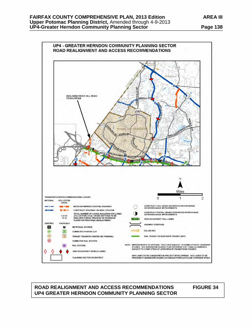
FAIRFAX COUNTY COMPREHENSIVE PLAN, 2013 Edition AREA III Upper Potomac Planning District, Amended through 4-9-2013 UP4-Greater Herndon Community Planning Sector Page 138
ROAD REALIGNMENT AND ACCESS RECOMMENDATIONS FIGURE 34 UP4 GREATER HERNDON COMMUNITY PLANNING SECTOR

FAIRFAX COUNTY COMPREHENSIVE PLAN, 2013 Edition AREA III Upper Potomac Planning District, Amended through 4-9-2013 UP4-Greater Herndon Community Planning Sector Page 139
TRANSIT FACILITY RECOMMENDATIONS FIGURE 35 UP4 GREATER HERNDON COMMUNITY PLANNING SECTOR

FAIRFAX COUNTY COMPREHENSIVE PLAN, 2013 Edition AREA III Upper Potomac Planning District, Amended through 4-9-2013 UP4-Greater Herndon Community Planning Sector Page 140 and requirements in the Public Facilities Manual, the Zoning Ordinance, and other standards will be utilized in the evaluation of development proposals. Wiehle Avenue extension is planned from Dranesville Road to Crestview Drive. Further study needs to be done to determine whether the extension should be two lanes or four lanes.
Should only two lanes be required, the additional right-of-way could be used for non-
vehicular improvements such as pedestrian paths, bike trails, or landscaping.
An East-West connector road within the existing Dulles Toll Road right-of-way that would connect Centreville Road to the Route 28/CIT Transit Station Area should be studied for feasibility and implementation. If the road cannot be accommodated within the existing Dulles Toll Road right-of-way, other connections could be examined that would also contain other modes of transportation. Regardless, multi-modal connections should be implemented from the developments to the east of the transit station area and the Centreville Road/Elden Street corridor to the TOD area.
Heritage Resources Dranesville Tavern Historic Overlay District lies within this sector. The Dranesville Tavern Historic Overlay District regulations (Appendix 1, A1-700 of the Zoning Ordinance) specify residential development with the exception of commercial development appropriate to the tavern itself. All improvements shall be designed to be compatible with the scale and appearance of the historic site. All development within the historic district must be reviewed by the Architectural Review Board. Dranesville Methodist Church should be protected. Development in the area should be sensitive to this resource. The Cameron Parish Church Ruins and Cemetery (Tax Map 5-4((8))G) should be preserved. The Herndon Historic District is in the National Register of Historic Places. Most of this area is protected by the Town of Herndon's local Heritage Preservation Overlay Districts.
Any development or ground disturbance in this sector, both on private and public land, should be preceded by heritage resource studies, and alternatives should be explored for the avoidance, preservation or recovery of significant heritage resources that are found. In those areas where significant heritage resources have been recorded, an effort should be made to preserve them. If preservation is not feasible, then, in accordance with countywide objectives and policies as cited in the Heritage Resources section of the Policy Plan, the threatened resource should be thoroughly recorded and in the case of archaeological resources, the artifacts recovered. Public Facilities 1. Provide the necessary improvements to the Corbalis Water Treatment Plant on land
currently owned at the Water Authority's plant site to meet current and future needs. 2. Fire facilities and equipment at the Herndon Fire Station should be kept adequate to meet
increasing demand for fire and emergency protection.
FAIRFAX COUNTY COMPREHENSIVE PLAN, 2013 Edition AREA III Upper Potomac Planning District, Amended through 4-9-2013 UP4-Greater Herndon Community Planning Sector Page 141 Parks and Recreation Park and recreation recommendations for this sector are shown on Figure 36. The column "Park Classification" includes existing park facilities. The "Recommendations" column includes entries for both existing and proposed facilities. Prior to developing parkland, the Fairfax County Park Authority initiates a master planning process to determine the appropriate facilities and design for that park. This process involves extensive citizen review and participation. If an existing park is listed but no recommendation appears on that line, it means the park has been developed in accordance with its master plan. Trails Trails planned for this sector are delineated on Figure 37 and on the 1”:4,000’ Countywide Trails Plan Map which is referenced as Figure 2 in the Transportation element of the Policy Plan and is available from the Department of Planning and Zoning. Trails in this sector are an integral part of the overall County system. While some of the segments have already been constructed, the Countywide Trails Plan Map portrays the ultimate system for the sector and the County at large. In addition, the map specifies a classification for each segment, which represents the desired ultimate function and surface type of the trail. Specific construction requirements are detailed in the Public Facilities Manual.

FAIRFAX COUNTY COMPREHENSIVE PLAN, 2013 Edition AREA III Upper Potomac Planning District, Amended through 4-9-2013 UP4-Greater Herndon Community Planning Sector Page 142
FIGURE 36 PARKS AND RECREATION RECOMMENDATIONS
SECTOR UP4 PARK CLASSIFICATION
RECOMMENDATIONS
NEIGHBORHOOD PARKS:
Additional Neighborhood Park facilities should be provided in conjunction with new residential development in Suburban Neighborhoods.
COMMUNITY PARKS: Grand Hamptons Hutchison School Site
Initiate a master planning process and develop in accordance with an approved plan for an athletic field complex under interim use agreement with the School Board. Seek a lease agreement with Fairfax County Water Authority to develop active recreation facilities on identified site adjacent to Offuts Branch.
DISTRICT PARKS:
This sector lies within the service areas of Baron Cameron and Great Falls Nike District Parks.
COUNTYWIDE PARKS: Dranesville Tavern (Heritage Resources) Folly Lick Stream Valley Sugarland Run Stream Valley
Pursue development of commercial use consistent with historic character of the tavern. Consider expansion of EQCs south of Runnymede Park to encompass upland hardwoods adjacent to floodplain. Resource protection should be achieved through a combination of dedication, donation of easements or purchase and/or other land preservation techniques. Develop the countywide trail to connect Sugarland Run and Folly Lick Stream Valley.

FAIRFAX COUNTY COMPREHENSIVE PLAN, 2013 Edition AREA III Upper Potomac Planning District, Amended through 4-9-2013 UP4-Greater Herndon Community Planning Sector Page 143
TRAILS PLAN MAP FOR THIS SECTOR
UNDER CONSTRUCTION
SEE THE 1” = 4000’ SCALE COUNTYWIDE TRAILS PLAN MAP
PLANNED TRAIL SYSTEM FIGURE 37

FAIRFAX COUNTY COMPREHENSIVE PLAN, 2013 Edition AREA III Upper Potomac Planning District, Amended through 4-9-2013 UP5-Reston Community Planning Sector Page 144
UP5 RESTON COMMUNITY PLANNING SECTOR CHARACTER
Reston has its own Master Plan because the community was planned and developed as one of the nation's landmark new towns, beginning in the 1960s. Reston is located between Tysons Corner and the Washington Dulles International Airport along the Dulles Airport Access Road and Dulles Toll Road (DAAR, Route 267) and extends as far north as Leesburg Pike (Route 7) and as far south as Stuart Mill Road. With its planned development almost complete, Reston is comprised of 7,100 acres and may ultimately be the home of more than 60,000 people. This new town is designed around the concept of clustering the community into five "villages," each with its own village center. These centers provide for neighborhood-serving retail, office, and social needs.
The community is focused around the town center, an urban concentration of high-density
housing, offices and cultural facilities. Substantial office development has occurred in recent years along the DAAR, increasing development pressure both within and adjacent to the community. Plan recommendations for this area can be found in a previous section of the Upper Potomac Planning District text in the Reston-Herndon Suburban Center and Transit Station Area section. An integral part of the Reston Plan is the lower density residential development located on Reston's periphery, buffering adjacent areas from the higher density development in Reston.
Reston offers a wide range of housing, including high-rise apartments, garden apartments,
townhouses, and single-family detached and semi-detached homes. The majority of dwellings in this sector were built after 1975. There are approximately 1,300 low- and moderate-income units in Reston. This housing includes units for the elderly which are found mostly in the village centers. There is scattered new and older residential development outside Reston. Generally these areas are planned to maintain a low density residential character, including areas along Leesburg Pike. The planning sector also contains Lake Fairfax Park.
Lake Anne Village Center and Bowman Distillery/Wiehle Town Hall are significant
heritage resources listed in the Fairfax County Inventory of Historic Sites. A list and map of heritage resources are included in the Upper Potomac Planning District Overview section, Figures 4, 5 and 6. Additional historic sites in this sector are also included in the inventory. Bowman Distillery/Wiehle Town Hall is also listed in the Virginia Landmarks Register and the National Register of Historic Places. Lake Anne Village Center is protected by a County Historic Overlay District. CONCEPT FOR FUTURE DEVELOPMENT
The Concept for Future Development recommends that the Reston Community Planning Sector be designated as primarily Suburban Neighborhoods. A portion of the Reston-Herndon Suburban Center is located in the sector and is discussed in a separate section of the Upper Potomac Planning District portion of the Area III Plan.
FAIRFAX COUNTY COMPREHENSIVE PLAN, 2013 Edition AREA III Upper Potomac Planning District, Amended through 4-9-2013 UP5-Reston Community Planning Sector Page 145 RECOMMENDATIONS Land Use
The Reston Community Planning Sector is largely developed as stable residential neighborhoods. Infill development in these neighborhoods should be of a compatible use, type and intensity in accordance with the guidance provided by the Policy Plan under Land Use Objectives 8 and 14.
Where substantial parcel consolidation is specified, it is intended that such consolidations will provide for projects that function in a well-defined, efficient manner and provide for the development of unconsolidated parcels in conformance with the Area Plan.
Figure 38 indicates the geographic location of land use recommendations for this sector.
Where recommendations are not shown on the General Locator Map, it is so noted. Land Within the Planned Community of Reston
1. Incorporate the Reston Master Plans (Land Use Plan, Community Facilities Plan and
Transportation Plan)*, adopted on July 18, 1962, and as subsequently amended, by reference in the Area Plan and on the composite map. (See Figures 39, 40 and 41). On the periphery where development is not committed by zoning, land should be developed at a density no greater than one dwelling unit per acre. Density should be tiered so that it decreases from the center toward the boundary (within Reston). [Not shown]
*NOTE: The Reston Master Plan has its own program of time-phased development, which shall be the guide for development in Reston. 2. In the northern section of Reston the following policies should apply:
a. The land located between the planned EQC [Environmental Quality Corridor], Reston Parkway, Wiehle Avenue and the Reston boundary is planned for medium density residential use, as shown on the Reston Master Plan Land Use Plan, with the condition that a vegetated buffer be provided adjacent to low density single-family detached residential uses along Reston Avenue.
b. It may be appropriate for Tax Map 11-2((1))46, in the northeast quadrant of
Wiehle Avenue and Reston Avenue, to be incorporated into the residential planned community of Reston if the following conditions are met:
• development on this parcel should be limited to single-family detached
units at a density range of three to four units per acre; • existing mature trees on the site should be preserved to the maximum
extent possible; • the vegetated buffer called for in (a.) above should remain between the
development located on parcel 46 and the medium density residential development to the east; and

FAIRFAX COUNTY COMPREHENSIVE PLAN, 2013 Edition AREA III Upper Potomac Planning District, Amended through 4-9-2013 UP5-Reston Community Planning Sector Page 146
FIGURE 38

FAIRFAX COUNTY COMPREHENSIVE PLAN, 2013 Edition AREA III Upper Potomac Planning District, Amended through 4-9-2013 UP5-Reston Community Planning Sector Page 147
RESTON MASTER PLAN FIGURE 39
LAND USE PLAN

FAIRFAX COUNTY COMPREHENSIVE PLAN, 2013 Edition AREA III Upper Potomac Planning District, Amended through 4-9-2013 UP5-Reston Community Planning Sector Page 148
RESTON MASTER PLAN FIGURE 40
COMMUNITY FACILITIES PLAN

FAIRFAX COUNTY COMPREHENSIVE PLAN, 2013 Edition AREA III Upper Potomac Planning District, Amended through 4-9-2013 UP5-Reston Community Planning Sector Page 149
RESTON MASTER PLAN FIGURE 41
TRANSPORTATION PLAN

FAIRFAX COUNTY COMPREHENSIVE PLAN, 2013 Edition AREA III Upper Potomac Planning District, Amended through 4-9-2013 UP5-Reston Community Planning Sector Page 150
• the utility easement that abuts parcel 46 to the north should serve as the line of demarcation between Reston and the adjacent low density development.
Finally, if this parcel is not incorporated into Reston, it remains planned for .5 to 1 dwelling unit per acre.
c. On the periphery of North Reston within the areas currently shown on the
Reston Land Use Plan for low density residential use, development should occur as single-family detached units at an overall density of one dwelling unit per acre.
3. The Village Centers in Reston should be planned and developed for neighborhood
retail use up to .25 FAR, integrated with accessory office uses, community services, and residential development. [Not shown]
4. Well-defined stable residential neighborhoods exist throughout Reston. However,
because of nearby commercial and other nonresidential uses, these neighborhoods can be threatened by development or redevelopment, and therefore are particularly in need of protection. The design of all new infill projects or redevelopment projects should be compatible with existing and planned residential neighborhoods. [Not shown]
5. Land within the immediate vicinity of future rail station sites may be suitable for joint
development in a phased manner, coordinated with plans for transit development. [Not shown]
6. Recognizing the unique nature of the Reston Association in the development of
natural and open areas and recreation amenities within the boundaries of the Reston Master Plan, the County and the Reston Association should work together in a public/private partnership in attaining the goals and objectives outlined in the Comprehensive Plan under Land Use, Goals 14 and 15; Parks and Recreation; Public Facilities; Environment, and Transportation. [Not shown]
7. Parcel 26-1((13))1 is planned and developed as an existing church on the Community
Facilities Plan component of the Reston Master Plan. Due in part to the convenient public transportation and nearby community services, as an option, the parcel may be redeveloped as elderly housing, age 62 and over, subject to the following:
• The development should be designed to functionally relate to existing
residential uses in the area; • A minimum 65 foot wide buffer should be provided from existing edge of
pavement of Reston Parkway. A substantial vegetated buffer should be provided to serve as a transition to adjacent multifamily residential uses. Existing vegetation should be preserved as deemed appropriate by the Urban Forest Management Division and Reston Association;
• Affordable housing at a minimum of 20 percent of the total number of units
should be provided;

FAIRFAX COUNTY COMPREHENSIVE PLAN, 2013 Edition AREA III Upper Potomac Planning District, Amended through 4-9-2013 UP5-Reston Community Planning Sector Page 151
• Restoration and enhancement of the impaired Snakeden Stream Valley that is located in the northern portion of the parcel should coincide with redevelopment; and
• Pedestrian access from the site to the Snakeden Stream Valley trail, the abutting
multifamily housing development to the south, the Village Center to the east, and Colts Neck Road should be provided.
8. Lake Anne Village Center - The Lake Anne Village Center is located in the
northeastern quadrant of Reston and is bounded generally by Baron Cameron on the north, Lake Anne on the south, and North Shore Drive to the west. The boundary of the Lake Anne Village Center is shown on Figure 42. The Lake Anne Village Center Commercial Revitalization Area encompasses the entire boundary of the Lake Anne Village Center.
The Village Center was the first part of Reston to be developed and is centered on Washington Plaza, which is adjacent to Lake Anne at its northern end. The area surrounding Washington Plaza was designated as the Lake Anne Village Center Historic Overlay District in 1984 in recognition of its significance in the community as Reston’s original Village Center and to ensure the preservation of this historic and architectural landmark. The Board of Supervisors designated Lake Anne as a Commercial Revitalization Area in 1998 with the intent of stimulating reinvestment in existing businesses and encouraging redevelopment as appropriate.
The goals for the Lake Anne Village Center are to create opportunities to: 1) foster residential, office and community-enhancing retail and entertainment uses that will provide a more vital village center environment; 2) support the long-term economic viability of the business community; and, 3) protect and enhance the historic and architectural quality of Washington Plaza and retain the village character of an expanded village center. Proposals for development in the Lake Anne Village Center will be evaluated based on the degree to which these goals are met.
Specific planning objectives to help achieve these goals in the Village Center include:
• Bring more residents and day-time employees to Lake Anne to promote a vibrant community where people can live, work and play;
• Encourage development that complements, rather than competes with, existing
development on Washington Plaza; • Encourage high-quality development in terms of site design, building design
and materials, and appropriately sited open space amenities; • Ensure that diverse housing options exist in Lake Anne, including senior,
workforce, and affordable housing; • Enhance pedestrian and bicycle connections throughout the Village Center as
redevelopment occurs; • Improve the visibility of the Lake Anne Village Center and Washington Plaza
from Village Road and Baron Cameron Avenue;

FAIRFAX COUNTY COMPREHENSIVE PLAN, 2013 Edition AREA III Upper Potomac Planning District, Amended through 4-9-2013 UP5-Reston Community Planning Sector Page 152
FIGURE 42

FAIRFAX COUNTY COMPREHENSIVE PLAN, 2013 Edition AREA III Upper Potomac Planning District, Amended through 4-9-2013 UP5-Reston Community Planning Sector Page 153
• Encourage the creation of expanded or additional urban open spaces, such as an extended plaza, to accommodate successful community events such as the Lake Anne Farmers’ Market;
• Preserve attractive and usable green open spaces where possible and introduce
new green spaces, including living green roofs, to provide natural and recreation areas; and
• Limit the visibility of parking throughout the Village Center.
Area-wide Recommendations The parcels comprising the Lake Anne Village Center are divided into six land units (as shown in Figure 42). For Land Units A, B, C, D, and E, a description of its location and character is given and recommendations are provided that articulate the development planned, both in terms of density and intensity, under a baseline recommendation, a redevelopment option for individual land units, and a consolidation option for Land Units A, D, and E. Land Unit F (which consists of the residential and commercial uses along Washington Plaza, including the residences along Chimney House Road) contains the majority of the Lake Anne Village Center Historic Overlay District and is not part of any redevelopment option. The balance of the Historic Overlay District is in Land Unit A. Nonresidential uses, particularly retail and other uses requiring public access, should be concentrated in Land Units A and F to help promote the viability of existing and future nonresidential uses in the core area of Lake Anne. Parcel Consolidation - The preferred approach to redevelopment in the Lake Anne Village Center is through the coordinated redevelopment of Land Units A, D, and E. This would include consolidation of the Washington Plaza surface parking lot (Land Unit A), the Crescent Apartment property and the gas station (Land Unit D), and the Fellowship House property (Land Unit E). In addition, parcels in Land Units B and C may be considered for inclusion in a consolidation effort. If complete consolidation occurs, the Full Consolidation Option level of development can be achieved as described in the Land Unit Recommendations for Land Units A, D, and E. Consolidation of these land units would allow for redevelopment to occur in a well-designed, integrated and efficient manner. Pedestrian access through and among parcels could be more easily designed and roads could be more readily realigned to improve their safety and functionality. The Full Consolidation Option would also provide an opportunity to improve the visibility of Washington Plaza and below-grade parking could more readily be constructed in strategic locations. The Land Unit Recommendations specify the desired mix of uses and levels of development intensity by individual land unit. However, under the Full Consolidation Option, flexibility may be provided in locating uses and intensity in order to achieve the goals and objectives stated above, as well as to meet the Area-wide Recommendations and the conditions in the Land Unit Recommendations.

FAIRFAX COUNTY COMPREHENSIVE PLAN, 2013 Edition AREA III Upper Potomac Planning District, Amended through 4-9-2013 UP5-Reston Community Planning Sector Page 154
Coordinated Development Plans – Coordinated development plans may be an alternative to parcel consolidation. Coordinated development plans refer to two or more concurrent and contiguous development applications that demonstrate coordinated site design, including coordination of building locations, urban design, open space amenities and signage, inter-parcel pedestrian access and vehicular access where appropriate, roadway realignment or improvements, and parking facilities. When coordinated development plans are submitted, the Full Consolidation Option recommendations may be considered. Any subsequent applications should have compatible architectural character and materials to those of the earlier approved coordinated development plans and should provide connections to established locations for inter-parcel pedestrian access and vehicular access where appropriate, and road improvements and parking facilities, if appropriate. Heritage Resources – The Lake Anne Village Center Historic Overlay District regulations are found in Appendix 1, A1-1100 of the Zoning Ordinance. All structures located in Land Units A and F are within the boundary of the Historic Overlay District. Structures within Land Unit A are contributing properties to the district while those in Land Unit F are historic properties. The Fairfax County Architectural Review Board must review all improvements and alterations in the Overlay District. Housing Affordability and Diversity – Fairfax County housing policies include promoting the development of multifamily housing in mixed-use centers in an effort to diversify the County’s housing stock and to encourage lower cost housing options near employment opportunities. In addition, Fairfax County policy encourages the use of Universal Design principles to provide housing that accommodates the needs of a full range of potential residents. Existing residential development in the Lake Anne Village Center includes age-restricted affordable housing (Senior Independent Living) at the Fellowship House (Land Unit E) and workforce housing at the Crescent Apartments (Land Unit D). To preserve the diversity of housing options within Lake Anne and ensure consistency with County policies, the following conditions should be met: • Any new residential development in Lake Anne Village Center should include
at a minimum 12 percent of the total number of units as affordable housing pursuant to the Affordable Dwelling Unit (ADU) provisions of the Fairfax County Zoning Ordinance and the County’s policy regarding workforce housing;
• Any residential redevelopment should replace any affordable housing that
currently exists but is lost in redevelopment. This should be viewed as a collective responsibility that can be addressed through parcel consolidation and property owner cooperation;
• Redevelopment within Lake Anne should include residential units designed
according to Universal Design principles; and • The maximum density specified under these guidelines is the total amount
allowed, and the total number of units specified is inclusive of density bonuses provided for affordable housing.

FAIRFAX COUNTY COMPREHENSIVE PLAN, 2013 Edition AREA III Upper Potomac Planning District, Amended through 4-9-2013 UP5-Reston Community Planning Sector Page 155
Transportation – Future redevelopment in the Lake Anne Village Center area should be balanced with supporting transportation infrastructure improvements and services. To ensure that potential transportation impacts are sufficiently mitigated, the following conditions should be met: • Transportation improvements should be appropriately phased with
development, and development proposals should only be approved following additional transportation analysis and the provision of appropriate transportation mitigation measures;
• Transportation issues associated with any development, particularly those
associated with access, will need to be adequately addressed through appropriate traffic impact analyses. Development plans should identify specific improvements needed to support the applications and should include acceptable plans for ingress/egress and vehicular circulation. Parcel and access consolidation, pedestrian circulation, safety, Transportation Demand Management measures, and transit improvements should be addressed. Dedication of right-of-way for trails and roadway improvements and associated easements may be required;
• Use of public transportation to serve travel demand should be optimized in
order to maximize the reduction in travel by private vehicles. Examples of such measures include:
1) Private subsidization of internal circulating transit services, which may
also connect to transit service outside of the Village Center; 2) Construction of bus shelters; and
3) Monetary contributions toward enhancement of existing transit service;
• Safe pedestrian circulation should be ensured through an adequate and appropriate sidewalk/trail system, and separate bicycle lanes or trails should be considered and provided where appropriate. A combination of public and private sector funding may be necessary to provide for the larger transportation improvements required to serve the general Lake Anne Village Center area;
• An acceptable Level-of-Service (LOS) should be maintained on the roadway
system. A LOS D standard should be applied, in general, to determine mitigation needed at critical approach intersections. Development applications should include analyses that demonstrate that the proposals can maintain a LOS D or better standard, and provide commitments to mitigate traffic in instances where they cannot. Future detailed traffic analyses must ensure that traffic queues at Lake Anne Village Center intersections will not adversely affect other nearby intersections;
• Adequate funding for necessary transportation improvements to maintain an
acceptable LOS should be provided. Roadway and circulation improvements should address needed improvements to the arterial roadway network, collector and local streets, and the pedestrian system. Collector and local street improvements should be provided in conjunction with development proposals;
FAIRFAX COUNTY COMPREHENSIVE PLAN, 2013 Edition AREA III Upper Potomac Planning District, Amended through 4-9-2013 UP5-Reston Community Planning Sector Page 156
• At a minimum, improvements are necessary at the current intersection of Village Road and North Shore Drive. This intersection has current operational deficiencies that need to be corrected before any density increases in the Washington Plaza area can be accommodated. Other potential improvements to mitigate traffic will need to be analyzed as well, such as additional turning lanes at intersections. For example, while additional right-of-way might be required, adding a turn lane to North Shore Drive at both west and eastbound approaches to Wiehle Avenue could measurably decrease intersection delays; and
• To facilitate improvements and traffic flow at the intersection of Village Road
and North Shore Drive, the following options should be considered:
1) The realignment of Village Road to the west to correct operational deficiencies, and to align with and provide a view into an extended Washington Plaza;
2) The slight realignment of North Shore Drive, to the east of Village Road
on Land Unit D, to smooth out the horizontal curve, enhance sight distance, and improve vehicular and pedestrian safety; and
3) The construction of a roundabout on North Shore Drive at the intersection
of a realigned Village Road and North Shore Drive pending detailed additional analysis that compares the benefits of a roundabout versus other congestion mitigation measures.
Pedestrian Network/Bicycle Facilities – Lake Anne Village Center is connected to other parts of Reston through an extensive trail system. The Village Center’s pedestrian orientation should be enhanced with numerous highly accessible pedestrian linkages within the Village Center and connections to existing trail networks at the periphery of the Village Center. Future development and redevelopment in the Village Center should address the following recommendations: • Bicycling should be encouraged as an alternative to the use of single occupancy
vehicles by providing bicycle storage facilities and bike racks. Showering and changing facilities should be provided in buildings with office uses;
• A direct pedestrian connection between Northgate Square Cluster and Land
Unit A through Land Unit D is a high priority. Site designs should ensure that no structures obstruct this direct linkage;
• Pedestrian connectivity and safety is a critical factor in designing pedestrian
links. Auto and pedestrian traffic should be separated to the greatest extent possible. In keeping with the original Master Plan concept for Reston regarding the separation of pedestrians and vehicular traffic, the addition of pedestrian bridges and/or underpasses connecting Land Units D and E with Land Unit A should be considered in order to separate pedestrians from automobile traffic on North Shore Drive;
• Pedestrians should be provided with safe and convenient access to bus stops;

FAIRFAX COUNTY COMPREHENSIVE PLAN, 2013 Edition AREA III Upper Potomac Planning District, Amended through 4-9-2013 UP5-Reston Community Planning Sector Page 157
• Adequate lighting consistent with Reston standards should be provided. Site design should ensure that landscaping does not impede visibility or create unsafe conditions; and
• Signage should contribute to easy pedestrian way-finding throughout the
Village Center. Signage should be compatible with existing signage at Washington Plaza in terms of scale, design, color, materials and placement to create a unified identity for the Village Center.
Complementary Nonresidential Uses – Lake Anne Village Center presently has a variety of complementary nonresidential uses. The existing mix of cultural, governmental and religious uses on or near Washington Plaza includes the Reston Museum, the Reston Community Center, Fairfax County Human Services offices in the Lake Anne Professional Building, and two religious institutions. These uses should be maintained and enhanced as redevelopment occurs. In addition, new complementary nonresidential uses, such as a boutique hotel, a cinema, or similar entertainment uses, which are compatible with the planned mixed-use developments in terms of character and scale, should be encouraged. Other desired uses also include the provision of performing arts space, educational and/or additional religious institutions, a library, recreation and/or park facilities. Urban Design – These urban design guidelines are intended to encourage design excellence in the redevelopment of the Lake Anne Village Center that is sensitive to the aesthetic character and visual environment of Washington Plaza while not being repetitive. The Architectural Review Board is charged with ensuring that the standards and guidelines of the Lake Anne Village Center Historic Overlay District are followed in any redevelopment proposals for the area. The Lake Anne Village Center Historic Overlay District design guidelines, adopted by the Architectural Review Board in 1992, should be reviewed and updated to address new construction. In the event updated design guidelines are developed for the land units surrounding Washington Plaza and the Historic Overlay District, Architectural Review Board review of development proposals for Land Units B, C, D, and E may be appropriate. Under Reston covenants, the Reston Association’s Design Review Board should be kept apprised of proposed redevelopment proposals. Development proposals for the Lake Anne Village Center should address the following:
• Urban Form – The urban form objective is to provide a distinctive and varied
building landscape and assist in achieving other urban design goals, including the preservation of open space. The preferred urban form for the Lake Anne Village Center is a continuation of the design concepts found at Washington Plaza, i.e. high-rise buildings like the Heron House (9-15 stories) surrounded by low-rise development (3-4 stories). Uniform building heights should be avoided to prevent the creation of massive blocks of buildings that would not complement the existing development on Washington Plaza. In no instances should pad sites be permitted within the Village Center. In order to provide design flexibility the Plan recommendations do not set minimum or maximum building heights or setbacks.

FAIRFAX COUNTY COMPREHENSIVE PLAN, 2013 Edition AREA III Upper Potomac Planning District, Amended through 4-9-2013 UP5-Reston Community Planning Sector Page 158
• Building/Site Design – In keeping with Washington Plaza’s distinctive site layout and architecture, redevelopment in Lake Anne should demonstrate excellence in design. Architectural designs should be sensitive to and supportive of the architecture in the Historic Overlay District and site design and materials should support the design concepts in the District.
• Washington Plaza and Lake Anne Vista – Currently, the views of Lake Anne
and the Heron House from the north are obstructed by the Association of School Business Officials building at the intersection of Village Road and North Shore Drive. To create a better view of this area from nearby roadways, the Association of School Business Officials building should be removed. Redevelopment should be designed in such a way as to create an unobstructed view toward Lake Anne.
• Green Buildings and Stormwater Management – In keeping with Reston’s
original vision of protecting the environment and living in harmony with nature, redevelopment proposals should meet the following conditions:
1) The incorporation of green building practices sufficient to attain
certification through the LEED program or its equivalent is required for the Lake Anne Village Center. In addition, attainment of the Silver rating or better through the LEED program or its equivalent is strongly encouraged;
2) Encourage the provision of architectural elements that will provide both
environmental and aesthetic benefits, such as vegetated roofs and/or rooftop plaza areas in locations that will experience pedestrian or other recreation activity in order to provide a high quality visual character; and
3) Incorporate Low Impact Development (LID) stormwater
management techniques where feasible.
• Parking – The visibility of parking should be limited throughout the Lake Anne Village Center. To achieve this objective, parking should be provided in below-grade or partial below-grade structures or above-grade structures that are clad by development. In instances where a portion of a structure may be visible, façade treatments and/or landscaping should be used to minimize the visual impact of the structure. Parking access should be designed in such a manner as to reduce conflicts between vehicles and pedestrians. Any surface parking should be well-landscaped, integrated into the proposed development, and utilize permeable materials to the greatest extent possible.
• Open Space – A minimum of 25 percent of the gross land area of each land unit
should be set-aside as open space that is accessible to the public, which should include urban plazas.
• Street/Plaza Furniture – Street furniture provided along the streets, on the
extended plaza, and/or in other open spaces should be of a design that is consistent with the architecture in the Village Center and use materials commonly found in Washington Plaza.

FAIRFAX COUNTY COMPREHENSIVE PLAN, 2013 Edition AREA III Upper Potomac Planning District, Amended through 4-9-2013 UP5-Reston Community Planning Sector Page 159
• Lighting – The design, style and materials used for light fixtures throughout the Village Center should be compatible with the architectural style and materials of the buildings on Washington Plaza. Lighting should be coordinated with landscaping and pedestrian circulation to ensure an appropriately lit and safe environment. Exposed lamps in light fixtures should be avoided.
• Public Art – Public art was envisioned as a key component of creating a vibrant
community gathering space at Washington Plaza in the Village Center from its inception. New public art should be included in development proposals, and consistent with guidance in the Initiative for Public Art Reston (IPAR) Public Art Master Plan. In keeping with the character of the existing sculpture on the Plaza, new public art ideally should be highly interactive and should be able to be climbed on when possible.
• Signs – Signs should complement the architecture of the building and not
obstruct architectural elements or details that define the design of the building. The placement of signs by different businesses in the same building should be coordinated. The use of freestanding signs should be prohibited.
• Utilities – To the extent possible, on-site utilities should be placed underground
or out of sight from the front of buildings, pedestrian walkways and other public entrances. Service areas and loading docks should be screened with appropriate landscaping, fences or walls. Rooftop mechanical equipment should be properly screened with materials that are compatible with and integral to the architecture.
• Retail – Reinforcing and enhancing the existing retail in Washington Plaza is a
high priority in the redevelopment of the Lake Anne Village Center. Careful consideration should be given regarding the size and types of retail establishments in the surrounding land units to avoid potentially weakening the retail environment needed to revitalize Washington Plaza.
Environmental Protection and Tree Cover – Redevelopment proposals should follow the environmental protection goals and objectives outlined in the Environmental Section of the Fairfax County Policy Plan with special emphasis on protecting and restoring the maximum amount of tree cover on developed and developing sites consistent with planned land use and good silvicultural practices. Planting of new trees should be considered on developing sites, particularly where new impervious surfaces such as parking decks, promenades and plazas are proposed. Technologies that serve to enhance the life span and size of trees and reduce stormwater runoff volumes and associated pollutant loads are recommended. Park and Recreation Facilities – Impacts on park and recreation resources should be offset through the provision of or contribution toward new or improved active recreation facilities in the vicinity, such as tot lots, trails, trail connections, an indoor recreation center, athletic fields, playgrounds, and/or multi-use courts. Recreation facilities should be provided that serve the local population and workforce. In addition, publicly accessible urban park or park features should be integrated within the Village Center, such as plazas, gathering spaces, special landscaping, street furniture, water and play features, performance and visual art exhibit spaces and pedestrian and bike amenities. Proposed pathways within the Village Center should be coordinated and connect to existing pedestrian and bicycle circulation systems.

FAIRFAX COUNTY COMPREHENSIVE PLAN, 2013 Edition AREA III Upper Potomac Planning District, Amended through 4-9-2013 UP5-Reston Community Planning Sector Page 160
Schools – A projected capacity deficit may occur at Hughes Middle School and South Lakes High School by 2013-2014. In addition, there may be a need for additional school facilities in this part of the County because of the approval of residential development that has not yet been constructed in the Reston Town Center area. The impact of Lake Anne Village Center redevelopment on schools should be mitigated. A possible boundary shift may be needed to ensure that the new residents in the Village Center would be assigned to the same schools. Land Unit Recommendations The Lake Anne Village Center is divided into land units (as shown in Figure 42) for the purpose of organizing site-specific recommendations. For each land unit, a description of its location and character is given and recommendations are provided that articulate the planned use(s) and intensity or density.
Land Unit A Land Unit A consists of the area north of Washington Plaza (as shown in Figure 42), the majority of which is located within the Lake Anne Village Center Historic Overlay District. It includes the surface parking lot north of Washington Plaza, dedicated open space owned by the Reston Association, the Association of School Building Officials (ASBO) building, and the 24-7convenience market.
Baseline Recommendation According to the Reston Master Plan Land Use Plan map, the Village Center encompasses Washington Plaza, the surface parking lot to the north of the Plaza, the gas station across North Shore Drive from the plaza parking lot and the area to the west of Washington Plaza, including the Lake Anne Professional Building (an area that includes Land Units A and B and a portion of D). The baseline Plan recommendation for the Village Center is mixed-use with a neighborhood-serving retail component up to a 0.25 FAR and office and residential components in addition to retail uses. Redevelopment Option As an option, the area of the parking lot to the north of Washington Plaza is planned for mixed-use development that will complement the uses on the existing Washington Plaza if redeveloped independently (as opposed to the Full Consolidation Option described below). The total amount of development allowed under the Redevelopment Option should be no more than 235,000 square feet. The mix of uses should include a residential component and a nonresidential component that includes retail, civic, office, and other complementary nonresidential uses. The residential component should consist of up to 150,000 square feet (up to 125 multifamily dwelling units), and the nonresidential component should consist of up to 85,000 square feet, subject to the following conditions: • An extension of Washington Plaza along its existing north-south axis
should be provided, extending northward from the existing northern entrance to the plaza to North Shore Drive. This plaza extension should

FAIRFAX COUNTY COMPREHENSIVE PLAN, 2013 Edition AREA III Upper Potomac Planning District, Amended through 4-9-2013 UP5-Reston Community Planning Sector Page 161
be designed to accommodate community events such as the existing Lake Anne Farmers’ Market and should provide an unobstructed view toward Lake Anne;
• New development should be oriented along the extended plaza with retail
uses that are primarily community-serving in nature on the first or second level and office and residential uses located above;
• New residential uses should primarily be located in one or more taller
buildings at the northern end of the extended plaza; • In addition to the extension of Washington Plaza, the provision of roof top
plazas with well-defined public access is encouraged to provide additional open space in this Land Unit;
• In no instances should pad sites be permitted within Land Unit A; and • Under this option redevelopment should include the removal of the current
Association of School Building Officials building and the convenience market.
Full Consolidation Option As an option, new development up to the following maximum levels may be achieved if Land Units A, D, and E are fully consolidated. The total amount of development allowed under the Full Consolidation Option should be no more than 315,000 square feet. The mix of uses should include a residential component and a nonresidential component that may include office, retail, civic, and other complementary nonresidential uses. The residential component should consist of up to 210,000 square feet (up to 175 multifamily dwelling units), and the nonresidential component should consist of up to 105,000 square feet, subject to the same conditions provided for the Redevelopment Option.
Land Unit B This land unit is located on the south side of North Shore Drive, immediately to the west of Washington Plaza. The land unit contains one office building (the Lake Anne Professional Building), two vacant parcels, and a large surface parking lot that provides parking for Heron House and the Quayside building.
Baseline Recommendation According to the Reston Master Plan, Land Unit B is a part of the Lake Anne Village Center and is planned for mixed-use with a neighborhood-serving retail component up to a 0.25 FAR and office and residential components in addition to retail uses. Redevelopment Option As an option, this land unit is planned for residential and office development, with a minimal amount of support retail and service uses.
FAIRFAX COUNTY COMPREHENSIVE PLAN, 2013 Edition AREA III Upper Potomac Planning District, Amended through 4-9-2013 UP5-Reston Community Planning Sector Page 162
The total amount of development allowed under the Redevelopment Option should be no more than 274,000 square feet. The residential component should consist of up to 144,000 square feet (up to 120 multifamily dwelling units), and the nonresidential component (office, support retail, and/or other complementary nonresidential uses) should consist of up to 130,000 square feet, subject to the following conditions:
• Retail and complementary nonresidential uses should be on the ground floor and limited to a maximum of 5,000 square feet;
• The full amount of office use specified above can only be achieved if the
proposal includes the redevelopment of the existing Lake Anne Professional Building; and
• Usable open space in the form of plazas, urban greens, courtyards or parks
should be provided to make attractive gathering places for residents. The provision of roof top plazas with well-defined public access is encouraged.
Land Unit C This land unit is located on the south side of North Shore Drive, immediately to the east of Washington Plaza. The land unit contains the Buddhist Compassion Relief TZU-CHI (a religious institution) and dedicated open space owned by the Reston Association.
Baseline Recommendation The baseline Plan recommendations for this Land Unit are based on the designations shown on the Reston Master Plan Land Use Plan, and include medium and high density residential uses and community facilities. Redevelopment Option The total amount of development allowed under the Redevelopment Option should be no more than 120,000 square feet. The residential component should consist up to 120,000 square feet (up to 100 multifamily dwelling units), subject to the following conditions:
• Usable open space in the form of plazas, urban greens, courtyards, rooftop plazas and/or parks should be provided to make attractive gathering places; and
• Tree preservation and/or tree cover restoration should be a key condition
of redevelopment in this Land Unit, in accordance with guidance in the Environmental section of the Fairfax County Policy Plan. The existing tree canopy in this Land Unit should be preserved to the greatest extent possible.
Land Unit D This land unit is located to the northeast of Washington Plaza and is bounded on the south by North Shore Drive, on the north by Baron Cameron Drive, and on the west by Village Drive. The land unit contains the Crescent Apartments, five garden

FAIRFAX COUNTY COMPREHENSIVE PLAN, 2013 Edition AREA III Upper Potomac Planning District, Amended through 4-9-2013 UP5-Reston Community Planning Sector Page 163
apartment-style three-story buildings containing 181 units. It also contains a gas station located along North Shore Drive.
Baseline Recommendation The baseline Plan recommendation for this Land Unit is based on the designations shown on the Reston Master Plan Land Use Plan. The area of the Crescent Apartments is designated as high and medium density residential uses. The gas station is designated as Village Center. Redevelopment Option The total amount of development allowed under the Redevelopment Option should be no more than 902,000 square feet. The residential component should consist of up to 900,000 square feet (up to 750 multifamily dwelling units), and the nonresidential component (office, ground-level support retail, civic, and/or other complementary nonresidential uses) should consist of up to 2,000 square feet (exclusive of the gas station), subject to the following conditions:
• Any redevelopment of this property should replace the loss of any of the existing 181 affordable (workforce) rental units with the same number of affordable housing units;
• Usable open space in the form of plazas, urban greens, courtyards, rooftop
plazas and/or parks should be provided to make attractive gathering places;
• Tree preservation and/or tree cover restoration should be a key condition
of redevelopment in this Land Unit, in accordance with guidance in the Environmental section of the Fairfax County Policy Plan; and
• Site designs for Land Unit D should ensure a safe, well-lighted walkway
to connect the residents in Northgate Square with existing and planned office and retail uses in Land Unit A. New structure(s) should not obstruct direct pedestrian linkages.
Full Consolidation Option As an option, new development up to the following maximum levels may be achieved if Land Units A, D, and E are fully consolidated. The total amount of development allowed under the Full Consolidation Option should be no more than 1,126,000 square feet. The residential component should consist of up to 1,122,000 square feet (up to 935 multifamily dwelling units), and the nonresidential component (office, ground-level support retail, civic, and/or other complementary nonresidential uses) should consist of up to 4,000 square feet (exclusive of the gas station), subject to the same conditions provided for the Redevelopment Option. The 0.85 acre site containing the gas station is strongly encouraged to be part of the Full Consolidation Option. However, if it is not included, development plans should show how this parcel will relate to the rest of Land Unit D.

FAIRFAX COUNTY COMPREHENSIVE PLAN, 2013 Edition AREA III Upper Potomac Planning District, Amended through 4-9-2013 UP5-Reston Community Planning Sector Page 164
Land Unit E This land unit is located to the northwest of Washington Plaza and is bounded on the south by North Shore Drive, on the north by Baron Cameron Drive and on the east by Village Road. The land unit contains the Fellowship House senior housing development, a multi-wing high-rise building containing 240 units.
Baseline Recommendation The baseline Plan recommendation for this Land Unit is based on the designation shown on the Reston Master Plan Land Use Plan. The area of the Fellowship House is designated as high-density residential use. Redevelopment Option The total amount of development allowed under the Redevelopment Option should be no more than 386,000 square feet. The residential component should consist of up to 384,000 square feet (up to 320 multifamily dwelling units), and the nonresidential component (office, ground-level support retail, civic, and/or other complementary nonresidential uses) should consist of up to 2,000 square feet, subject to the following conditions:
• Any redevelopment of this property should replace the loss of any of the
existing affordable rental units among all the Land Units; • Usable open space in the form of plazas, urban greens, courtyards or parks
should be provided to make attractive gathering places for residents. The provision of roof top plazas over structured parking with well-defined public access is encouraged where feasible; and
• Tree preservation and/or tree cover restoration should be a key condition
of redevelopment in this Land Unit, in accordance with guidance in the Environmental section of the Fairfax County Policy Plan.
Full Consolidation Option As an option, new development up to the following maximum levels may be achieved if Land Units A, D, and E are fully consolidated. • The total amount of development allowed under the Full Consolidation
Option should be no more than 514,000 square feet. The residential component should consist of up to 510,000 square feet (up to 425 multifamily dwelling units), and the nonresidential component (office, ground-level support retail, civic, and/or other complementary nonresidential uses) should consist of up to 4,000 square feet, subject to same conditions provided for the Redevelopment Option.
Land Unit F
This land unit consists of the development along Washington Plaza, which includes a mix of residential, retail, office, and civic uses, together with the residences along Chimney House Road. The uses along the plaza include the 15-story Heron House, a high-rise residential condominium; three-story “live-work” units with retail and offices uses at the ground level and residential uses on the upper levels; and a variety of community-serving retail uses, office condominiums, the Millennium
FAIRFAX COUNTY COMPREHENSIVE PLAN, 2013 Edition AREA III Upper Potomac Planning District, Amended through 4-9-2013 UP5-Reston Community Planning Sector Page 165
Bank, the Washington Baptist Church, the Reston Community Center, and a child care center. Land Unit F makes up the core of the Lake Anne Village Center Historic Overlay District. Since this land unit is not planned to be redeveloped, it is not part of any redevelopment or consolidation options.
Land on the Periphery of Reston
9. Land between Stuart Road, Leesburg Pike, and Reston should be planned for
residential use at .5-1 dwelling unit per acre as shown on the Plan map. As an option, Tax Map 11-2((1))47A may be developed at a density of 1-2 dwelling units per acre to provide an appropriate transition between the higher density residential development that exists and is planned for the area to the south and to the east and the low density development to the west. Buffering should be provided to the extent possible along the western boundary to ensure a suitable transition.
10. An area located adjacent to the Reston Planned Residential Community near Center
Harbor Road is planned for residential use at 1-2 dwelling units per acre as shown on the Plan map. Development at this density should occur if the land is developed as a functionally integral part of Reston.
11. The area north of Baron Cameron Avenue and east of the Reston boundary (including
Tax Map 12-3((1))part of 21, 21D, 22, 23 and 24) is planned for 2-3 dwelling units per acre as shown on the Plan map. Development in this area should provide substantial buffers to existing residential development and along Baron Cameron Avenue. (See Land Use Recommendation #12 for additional Plan guidance.)
12. The area south of Leesburg Pike and north of Baron Cameron Avenue is planned for
residential use at .5-1 and 2-3 dwelling units per acre. This includes the area south of the Ascot subdivision. Residential development in this area should help to maintain a low density buffer around Reston. This area is identified in Figure 43 as Land Unit A (Tax Map 12-3((1))18A , 19A, and part of 21).
Due to the different Plan density ranges assigned to this area, coordinated development under a unified development plan is encouraged as a way to provide effective transitions between the area planned 2-3 and the area planned .5-1 dwelling units per acre. The overall density will be determined by averaging the Plan ranges, by land area, over the entire site. The high end of the density range can be achieved only if the following conditions are met:
• Complete consolidation of all parcels within Land Unit A and provision of
interparcel access, coordination of lot layouts, pathways and circulation system with adjoining properties;
• No roadway connects with Bishopsgate Way; • The development incorporates substantial open space and facilities for active
recreation;

FAIRFAX COUNTY COMPREHENSIVE PLAN, 2013 Edition AREA III Upper Potomac Planning District, Amended through 4-9-2013 UP5-Reston Community Planning Sector Page 166
FIG
UR
E 43

FAIRFAX COUNTY COMPREHENSIVE PLAN, 2013 Edition AREA III Upper Potomac Planning District, Amended through 4-9-2013 UP5-Reston Community Planning Sector Page 167
• No commercial development should occur. The Reston Farm Market located on Baron Cameron Avenue is a non-conforming use;
• Substantial buffers are provided along the frontages of Leesburg Pike and Baron
Cameron Avenue; • Lots abutting the Ascot subdivision and the Reston PRC should be developed in
a similar size (a minimum of 36,000 square feet) to foster compatibility with these existing communities; and
• Satisfactory transportation improvements as determined by the County. The area south of Leesburg Pike and south of Baron Cameron Avenue is planned for residential use at .5-1 dwelling unit per acre. This includes the area east of the Reston boundary and Lake Fairfax Park and north of Colvin Run. Development at this density is similar to existing residential development in the area and will help to maintain a low density buffer around Reston. A portion of this area is identified in Figure 43 as Land Unit B (Tax Map 18-1((1))B1 and B2) and Land Unit C (Tax Map 12-3((1))15, 16, 18B, 31; and 12-4((1))58, 59 and 60). Additional Plan guidance is included under Land Use Recommendation #10 for the Hickory Community Planning Sector (UP3). Development within Land Unit B and Land Unit C is appropriate at the high end of the density range only if the following conditions are met:
• Substantial, if not complete, consolidation of all parcels within each land unit as
noted above and provision of interparcel access, coordination of lot layouts, pathways and circulation system with adjoining properties;
• Substantial buffers are provided along the frontages of Leesburg Pike, Baron
Cameron Avenue, and Hunter Mill Road; • To maintain the low density residential character of Hunter Mill Road and
Leesburg Pike, larger lots should be located near these roadway frontages; • No commercial development should occur; • Substantial buffers are provided along Lake Fairfax Drive and Lake Fairfax
subdivision, and lots abutting Lake Fairfax Drive and Lake Fairfax subdivision should be at least 25,000 square feet in size to foster compatibility with the surrounding community;
• The approximately 30 acres of the area known as the Reston Pet Farm is an area
amenity that should be preserved and incorporated into the development or else maintained as perpetual open space or public parkland, should Pet Farm operations cease; and
• Satisfactory transportation improvements as determined by the County.

FAIRFAX COUNTY COMPREHENSIVE PLAN, 2013 Edition AREA III Upper Potomac Planning District, Amended through 4-9-2013 UP5-Reston Community Planning Sector Page 168
13. The area bounded by Hunter Mill Road, Lake Fairfax Park, Sunset Hills Road, and Lake Fairfax Business Park is planned for residential development at .2-.5 dwelling units per acre as shown on the Plan map. As an option, the southeastern portion of the area may also be appropriate for institutional or public uses if all adverse impacts are satisfactorily mitigated.
Uses requiring special permit or special exception approval should be rigorously reviewed and permitted only when the use is of a size and scale that will not adversely impact adjacent land uses and the overall low density residential character of the area. The cumulative effect of special permit and special exception uses should be considered prior to allowing additional uses of this type. The expansion of existing special permit and special exception uses should be considered on a case-by-case basis to determine if expanding the existing use will be in keeping with the low density residential character of the area.
Any improvement to Sunset Hills Road must be designed so as to not adversely impact the ability of the private school located on Tax Map 18-3((2))5 (formerly the Tara Reston Christian School) to operate at its authorized capacity (February 1988). Safe and convenient access for ingress and egress should be provided. Noise engineering studies should also accompany the corridor study which will have to be conducted for Sunset Hills Road in accordance with Transportation Policy 1b.
14. Tax Map 27-2((1))2, 18-4((1))25 and 29B and 18-4((13))inclusive (approximately
167 acres) are planned for residential use at no more than .5-1 dwelling unit per acre. The site is located in the Difficult Run watershed and is bisected by several small tributaries. These tributaries and their associated Environmental Quality Corridors should be left as open space.
15. An area adjacent to the western edge of Lake Fairfax Park on Colvin Run is planned
for residential use at 4-5 dwelling units per acre. 16. It is appropriate that land in this planning sector associated with the Difficult Run
watershed be planned as public and private open space and residential use at densities of .1-.2, .2-.5, and .5-1 dwelling unit per acre as shown on the Plan map. Residential development at these densities will serve to maintain the large lot residential character of the area that has been established and afford protection of this environmentally sensitive area.
The Guidelines for Cluster Development contained in the Policy Plan should be strictly adhered to in this area, especially the guideline that no cluster development should be considered when the primary purpose of clustering is to maximize density on the site. Because of the configuration of several planned density categories on the Plan map for this area, many properties have more than one category assigned. When a site has more than one planned density range assigned, the appropriate overall density and average lot size should be determined by placing a strong emphasis on achieving compatibility with existing development in the vicinity. See the Area Overview in the Area II or Area III Plan for further guidance regarding the Difficult Run watershed. [Not shown]

FAIRFAX COUNTY COMPREHENSIVE PLAN, 2013 Edition AREA III Upper Potomac Planning District, Amended through 4-9-2013 UP5-Reston Community Planning Sector Page 169
17. The area north of Lawyers Road and south of the Glade Stream Valley that is not zoned as part of Reston is planned for residential use at .1-.2 dwelling unit per acre as shown on the Plan map. It is developed as an institutional use. Any future changes or redevelopment proposed for this area should provide or maintain a substantial buffer to protect the adjacent residential communities and should be sensitive to the environmental constraints of the property.
18. The area west of the Reston Planned Residential Community in the vicinity of
Pinecrest Road is mostly planned for residential use at 1-2 dwelling units per acre as shown on the Plan map. As an option, Parcels 25-2((5))53, 55, 56, 57, 58, and 59 may be appropriate for residential townhouse or patio-style development at 4-5 dwelling units per acre under the following conditions:
• Building heights should not exceed 35 feet; • Effective visual screening and a substantial buffer is provided to protect
adjacent single-family residential uses; and • Access should be provided from both Pinecrest and Fox Mill Roads, as far from
the intersection as possible.
Parcels 26-1((1))5A, 5B, 5C, and 6 are planned for low intensity light industrial/R&D use at a maximum of .25 FAR. This use should be limited to these parcels, designed to minimize visual impacts on adjacent residential parcels, and provide substantial screening and buffering. As an option, if consolidated, parcels 5A and 5C may also be considered for residential use at 4-5 dwelling units per acre provided that:
• Building heights do not exceed 35 feet; • Effective visual screening and a substantial buffer is provided to protect
adjacent existing and planned single-family residential uses; and • Access is provided through the residentially planned and zoned area to the south
and west. Access through the adjacent industrial/R&D use is not appropriate.
19. For the Sector UP5 area outside Reston, ample local-serving commercial facilities are either available or planned within Reston, at the Village Centers and Town Center, leaving no need for commercial development along either Route 606 or Hunter Mill Road. [Not shown]
20. The Route 7 Corridor is planned for and should continue to be reserved for residential
development. Industrial, office, research and development (R&D), and retail commercial uses are not appropriate in the Route 7 Corridor. Uses requiring special permits and special exception approval should be rigorously reviewed and permitted only when the use is of a size and scale that will not adversely impact adjacent land uses and the overall low density residential character of the corridor in order to prevent commercial or quasi-commercial encroachment. [Not shown]

FAIRFAX COUNTY COMPREHENSIVE PLAN, 2013 Edition AREA III Upper Potomac Planning District, Amended through 4-9-2013 UP5-Reston Community Planning Sector Page 170 Transportation Transportation recommendations for this sector are shown on Figures 44, 45, 46, 47, 48, 49, and 50. In some instances, site-specific transportation recommendations are included in the land use recommendations section. The figures show access orientation, circulation plans, interchange impact areas and generalized locations of proposed transit facilities. The recommendations contained in the Area Plan text and maps, the Policy Plan and Transportation Plan map, policies and requirements in the Public Facilities Manual, the Zoning Ordinance, and other standards will be utilized in the evaluation of development proposals. Development proposals should also be evaluated against the Hunter Mill Road Traffic Calming Study (Northern Virginia Regional Commission, 2006), which provides both a traffic calming conceptual plan for Hunter Mill Road, as well as context sensitive roadway design techniques. Development and redevelopment applicants shall be encouraged to establish or participate in transportation management programs to promote alternatives to single occupant vehicle use, particularly during peak commutation hours. Transportation management programs include, but are not limited to: flexible and alternative work schedules, telecommuting, transit pass programs, dedicated bus/van shuttles to designated transit centers, parking management arrangements, promotion of ridesharing, bicycling and walking. Applicants will be encouraged to coordinate with and make appropriate contributions to a Transportation Management Association (TMA) where such a TMA has been established. In addition, applicants will be encouraged to require lessee cooperation with an existing TMA or one established in the future.
Sunset Hills Road as it terminates at Hunter Mill Road provides for the primary access to the Dulles Toll Road for the residential areas and commercial office areas within the eastern periphery of Reston. This access can be provided for by either option A, B or C below. Option A is the preferred option:
• The preferred option A is to slightly modify the current Sunset Hills Road intersection by moving it opposite the Dulles Toll Road westbound off-ramp and relocate the Toll Road westbound on-ramp to begin at Sunset Hills Road west of Hunter Mill Road and east of the existing VDOT maintenance facility.
• A secondary option B, if option A is not accepted by VDOT, would be to relocate
Sunset Hills Road in a configuration that brings the intersection of Sunset Hills Road and Hunter Mill Road as close as possible to the Reston Presbyterian Church (Tax Map 18-3((1))6).
• A third option C is a roundabout as described in the Hunter Mill Road Traffic
Calming Study (Northern Virginia Regional Commission, 2006). Heritage Resources Lake Anne Village Center Historic Overlay District lies within this sector. The Lake Anne Village Center Historic Overlay District regulations are found in Appendix 1, A1-1100 of the Zoning Ordinance. The intent is that the original mixture of residential and commercial space be maintained and that the pattern of commercial frontage on the lake and restrictions to pedestrian access be strictly followed. All improvements and alterations must be reviewed by the Architectural Review Board.

FAIRFAX COUNTY COMPREHENSIVE PLAN, 2013 Edition AREA III Upper Potomac Planning District, Amended through 4-9-2013 UP5-Reston Community Planning Sector Page 171
TRANSPORTATION RECOMMENDATIONS FIGURE 44

FAIRFAX COUNTY COMPREHENSIVE PLAN, 2013 Edition AREA III Upper Potomac Planning District, Amended through 4-9-2013 UP5-Reston Community Planning Sector Page 172
TRANSIT FACILITY RECOMMENDATIONS FIGURE 45
UP5 RESTON COMMUNITY PLANNING SECTOR

FAIRFAX COUNTY COMPREHENSIVE PLAN, 2013 Edition AREA III Upper Potomac Planning District, Amended through 4-9-2013 UP5-Reston Community Planning Sector Page 173
INTERCHANGE AND ACCESS RECOMMENDATIONS FIGURE 46
UP5 RESTON COMMUNITY PLANNING SECTOR
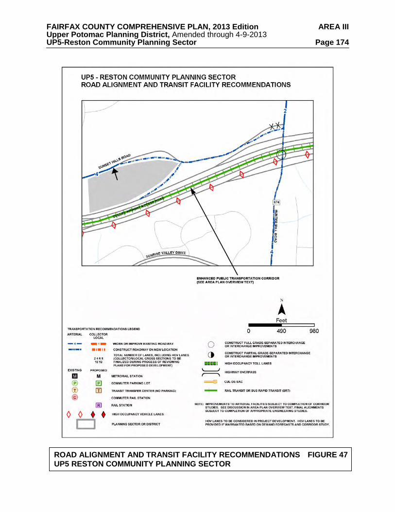
FAIRFAX COUNTY COMPREHENSIVE PLAN, 2013 Edition AREA III Upper Potomac Planning District, Amended through 4-9-2013 UP5-Reston Community Planning Sector Page 174
ROAD ALIGNMENT AND TRANSIT FACILITY RECOMMENDATIONS FIGURE 47
UP5 RESTON COMMUNITY PLANNING SECTOR

FAIRFAX COUNTY COMPREHENSIVE PLAN, 2013 Edition AREA III Upper Potomac Planning District, Amended through 4-9-2013 UP5-Reston Community Planning Sector Page 175
TRANSIT FACILITY RECOMMENDATIONS FIGURE 48
UP5 RESTON COMMUNITY PLANNING SECTOR

FAIRFAX COUNTY COMPREHENSIVE PLAN, 2013 Edition AREA III Upper Potomac Planning District, Amended through 4-9-2013 UP5-Reston Community Planning Sector Page 176
TRANSIT FACILITY FIGURE 49
UP5 RESTON COMMUNITY PLANNING SECTOR

FAIRFAX COUNTY COMPREHENSIVE PLAN, 2013 Edition AREA III Upper Potomac Planning District, Amended through 4-9-2013 UP5-Reston Community Planning Sector Page 177
TRANSIT FACILITY RECOMMENDATIONS FIGURE 50 UP5 RESTON COMMUNITY PLANNING SECTOR

FAIRFAX COUNTY COMPREHENSIVE PLAN, 2013 Edition AREA III Upper Potomac Planning District, Amended through 4-9-2013 UP5-Reston Community Planning Sector Page 178 Development in the area of the site of the Battle of Dranesville (in the vicinity of Reston Avenue and Leesburg Pike) should be sensitive to any heritage resources associated with that event. Any development or ground disturbance in this sector, both on private and public land, should be preceded by heritage resource studies, and alternatives should be explored for the avoidance, preservation or recovery of significant heritage resources that are found. In those areas where significant heritage resources have been recorded, an effort should be made to preserve them. If preservation is not feasible, then, in accordance with countywide objectives and policies as cited in the Heritage Resources section of the Policy Plan, the threatened resource should be thoroughly recorded and in the case of archaeological resources, the artifacts recovered.
Public Facilities 1. Construct a fire and rescue station at the Leesburg Pike/Reston Avenue intersection. 2. Reserve land adjacent to the Dulles Toll Road just west of the Reston Parkway for a
potential rail station (no parking). 3. Expand the Reston Regional Library consistent with the Policy Plan standards for regional
libraries. 4. Provide additional finished water transmission facilities along Fox Mill Road south of
Lawyers Road. 5. Provide additional finished water transmission facilities along the Fairfax County Parkway,
south of New Dominion Parkway. Parks and Recreation Park and recreation recommendations for this sector are shown on Figure 51. The column "Park Classification" includes existing park facilities. The "Recommendations" column includes entries for both existing and proposed facilities. Prior to developing parkland, the Fairfax County Park Authority initiates a master planning process to determine the appropriate facilities and design for that park. This process involves extensive citizen review and participation. If an existing park is listed but no recommendation appears on that line, it means the park has been developed in accordance with its master plan. Public Art Public art has been a component of the effort to achieve quality urban design in Reston since the community’s inception. In order to continue to realize the goal of making Reston a vibrant place to live, work and play, public art should be encouraged in future development in Reston. The Reston community under the leadership of the Initiative for Public Art in Reston (IPAR), developed a Public Art Master Plan which establishes a process for planning and commissioning public art including community roles as well as collection management. The Plan also suggests working zones on where to focus efforts. The IPAR Plan should be used as a guide for public art efforts in the establishment of public art and as a resource for the review of new development and redevelopment proposals within the Master Plan area.

FAIRFAX COUNTY COMPREHENSIVE PLAN, 2013 Edition AREA III Upper Potomac Planning District, Amended through 4-9-2013 UP5-Reston Community Planning Sector Page 179
FIGURE 51
PARKS AND RECREATION RECOMMENDATIONS SECTOR UP5
PARK CLASSIFICATION
RECOMMENDATIONS
NEIGHBORHOOD PARKS: Stuart Road (Reston) Town Green
Develop in accordance with the master plan prepared cooperatively by Reston Community Association and the Fairfax County Park Authority.
COMMUNITY PARKS: Reston North Shaker Woods Tamarack Stratton Woods
Complete development in accordance with approved plan. Initiate a master planning process and develop in accordance with approved plan. Initiate a master planning process and develop in accordance with an approved plan for active recreation including an athletic field complex to serve projected population for this sector. Acquire an additional Community Park site in the Reston area for development of active recreation facilities.
DISTRICT PARKS: Baron Cameron School Site Fox Mill District
Convert interim use agreement to permanent acquisition if this school site is declared surplus. Complete development in accordance with approved plan.
COUNTYWIDE PARKS: Lake Fairfax (Multiple Resources) Colvin Run Stream Valley Difficult Run Stream Valley Little Difficult Run Stream Valley
Upgrade and expand facilities at Lake Fairfax Park. Acquire land as necessary to complete development of countywide trail. Difficult Run and Little Difficult Run contain environmentally sensitive natural and cultural resources. Protection of the EQCs should be achieved through dedication, donation and/or acquisition of land and open space easements to the Fairfax County Park Authority. Intrusion of non-recreational development should be restricted and off-site impacts mitigated. Complete development of countywide trails.
REGIONAL PARKS: W&OD Trail

FAIRFAX COUNTY COMPREHENSIVE PLAN, 2013 Edition AREA III Upper Potomac Planning District, Amended through 4-9-2013 UP5-Reston Community Planning Sector Page 180 Trails
Trails planned for this sector are delineated on Figure 52 and on the 1”:4,000’ Countywide Trails Plan Map which is referenced as Figure 2 in the Transportation element of the Policy Plan and is available from the Department of Planning and Zoning. Trails in this sector are an integral part of the overall County system. While some of the segments have already been constructed, the Countywide Trails Plan Map portrays the ultimate system for the sector and the County at large. In addition, the map specifies a classification for each segment, which represents the desired ultimate function and surface type of the trail. Specific construction requirements are detailed in the Public Facilities Manual.

FAIRFAX COUNTY COMPREHENSIVE PLAN, 2013 Edition AREA III Upper Potomac Planning District, Amended through 4-9-2013 UP5-Reston Community Planning Sector Page 181
TRAILS PLAN MAP FOR THIS SECTOR UNDER CONSTRUCTION
SEE THE 1” = 4000’ SCALE
COUNTYWIDE TRAILS PLAN MAP
PLANNED TRAIL SYSTEM FIGURE 52

FAIRFAX COUNTY COMPREHENSIVE PLAN, 2013 Edition AREA III Upper Potomac Planning District, Amended through 4-9-2013 UP6-Sully Community Planning Sector Page 182
UP6 SULLY COMMUNITY PLANNING SECTOR
The Sully Community Planning Sector is located entirely within the Dulles Suburban Center. Plan guidance for this area is in the Dulles Suburban Center portion of the Area III volume of the Comprehensive Plan.
FAIRFAX COUNTY COMPREHENSIVE PLAN, 2013 Edition AREA III Upper Potomac Planning District, Amended through 4-9-2013 UP7-West Ox Community Planning Sector Page 183
UP7 WEST OX COMMUNITY PLANNING SECTOR
CHARACTER
The West Ox Community Planning Sector is generally bounded by the Dulles Airport Access Road and Dulles Toll Road (DAAR, Route 267), Fox Mill Road, Vale Road, Thompson Road and Centreville Road (Route 28) (see Figure 53).
Single-family residential development in this planning sector preserves the existing
development and prevents encroachment of higher density development from Reston or Chantilly.
This planning sector includes the environmentally sensitive Difficult Run Watershed. A
mixed-use development is located at McNair Farms (near the intersection of Frying Pan Road and Centreville Road) and a large planned residential community is located at Franklin Farm (between Centreville Road and West Ox Road along Franklin Farm Road). Kidwell Farm at Frying Pan Farm Park is a working demonstration farm located at West Ox Road near Centreville Road.
Local-serving commercial uses include retail centers located at Sunrise Valley Drive and
Corporate Park Drive, the southwest quadrant of McLearen Road and Centreville Road, and the northeast quadrant of Fairfax County Parkway (Route 286) and Franklin Farm Road. Fox Mill Shopping Center is located at Fox Mill Road, Reston Parkway and Lawyers Road, and the Village Center at Dulles is located at Centreville Road between Coppermine Road and Sunrise Valley Drive.
Parkland and recreational space is dispersed throughout the planning sector, particularly in
the subwatersheds of the Difficult Run Watershed. Neighborhoods from the early to mid-20th century are also found in this planning sector. These areas offer a high potential for significant heritage resources, especially in the southeastern half of the planning sector along Fox Mill Road. Numerous heritage resources, both known and unknown, exist in this planning sector. The Horsepen Run drainage area in the western portion of the planning sector has been occupied almost continuously since 8000 B.C. Vale United Methodist Church, Vale School/Vale Community House, and Frying Pan Farm Park are significant heritage resources listed in the Fairfax County Inventory of Historic Sites. A list and map of heritage resources are included in the Upper Potomac Planning District Overview section, Figures 4, 5 and 6. Additional historic sites in this sector are also included in the inventory.
CONCEPT FOR FUTURE DEVELOPMENT
The Concept for Future Development recommends the areas of the West Ox Community Planning Sector develop as either Suburban Neighborhoods or Low Density Residential Areas except for the area north of Fox Mill Road which is in the Reston-Herndon Suburban Center. The Suburban Neighborhood area is located in the western portion of the sector, generally west of Lawyers Road. The Low Density Residential Area is located in the eastern portion of the sector, generally east of Lawyers Road and east and south of Reston.

FAIRFAX COUNTY COMPREHENSIVE PLAN, 2013 Edition AREA III Upper Potomac Planning District, Amended through 4-9-2013 UP7-West Ox Community Planning Sector Page 184 RECOMMENDATIONS Land Use
For the area north of Fox Mill Road, between Centreville Road and Monroe Street, refer to Plan text for the Reston-Herndon Suburban Center.
The West Ox Community Planning Sector is largely developed with stable residential
neighborhoods. Infill development in these neighborhoods should be of a compatible use, type and intensity in accordance with the guidance provided by the Policy Plan under Land Use Objectives 8 and 14.
Where substantial parcel consolidation is specified, it is intended that such consolidations
will provide for projects that function in a well-defined, efficient manner and provide for the development of unconsolidated parcels in conformance with the Area Plan.
Figure 53 indicates the geographic location of land use recommendations for this sector.
Where recommendations are not shown on the General Locator Map, it is so noted.
The following land uses and densities are appropriate to provide for a low density transition between the higher densities planned in the Reston, Chantilly and Fairfax Center areas: 1. The area generally between Fox Mill Road, Lawyers Road, and West Ox Road and the
Fairfax County Parkway is planned for residential use at 1-2 dwelling units per acre.
The approximately 8-acre property on Lawyers Road (Tax Map 25-4((1))4) adjacent to the Fox Mill Estates subdivision is planned for 2-3 dwelling units per acre. In order to foster compatible residential development, the overall density should not exceed 2.5 dwelling units per acre. Lot sizes should be compatible to those of the adjacent Fox Mill Estates community (located north and south of the subject property) and the two segments of Wendell Holmes Road should not be connected. As an option, this 8-acre property (Tax Map 25-4((1))4) and adjoining land along Lawyers Road west of Calkins Road (Tax Map 25-4((1))5, 6 and 7) may be appropriate for 2-3 dwelling units per acre provided that each of the following conditions are met:
• All four parcels are consolidated and developed under a single development plan; • Lot sizes are compatible with those of the adjacent Fox Mill Estates community,
located north, south, and west of the properties; • The two segments of Wendell Holmes Road are not connected; and • All access to Lawyers Road is consolidated and occurs only at the planned median
break opposite Calkins Road.
Parcels 5, 6 and 7 along the west side of Lawyers Road can be considered for up to 2 dwelling units per acre provided that such development, including lot sizes, is compatible with the adjacent Fox Mill Estates community and access to Lawyers Road is consolidated and occurs only at the planned median break opposite Calkins Road.
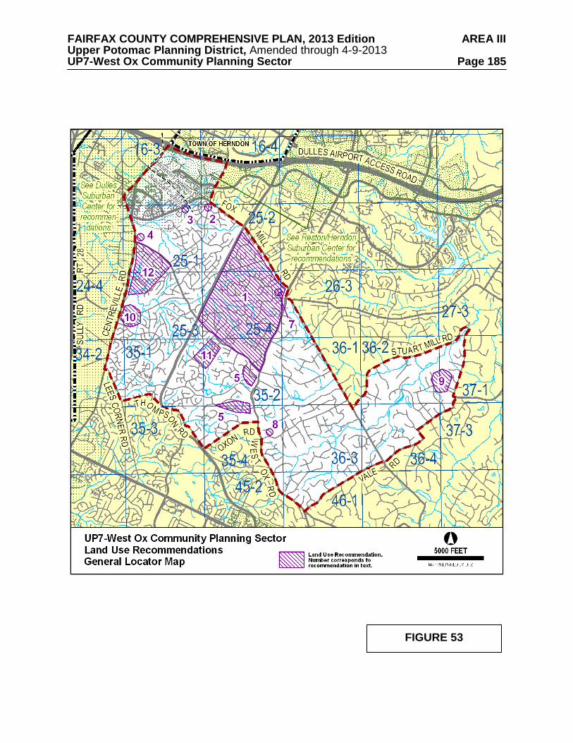
FAIRFAX COUNTY COMPREHENSIVE PLAN, 2013 Edition AREA III Upper Potomac Planning District, Amended through 4-9-2013 UP7-West Ox Community Planning Sector Page 185
FIGURE 53

FAIRFAX COUNTY COMPREHENSIVE PLAN, 2013 Edition AREA III Upper Potomac Planning District, Amended through 4-9-2013 UP7-West Ox Community Planning Sector Page 186 2. The area in the southwest quadrant of the intersection of Monroe Street and Frying Pan Road (Tax Map 16-4((1))10, 11, 12 and 13 and Tax Map 25-2((1))1) is planned for residential use at 2-3 dwelling units per acre, as shown on the Plan map. As an option, residential use at a density of 4-5 dwelling units per acre may be appropriate if the following conditions are met:
• All five parcels are consolidated and developed with single-family detached units under a unified development plan to facilitate high quality development;
• Lot sizes are compatible with the single-family detached development shown on the
approved development plan for rezoning case RZ 92-C-009 for the abutting property to the south and west;
• Access should be provided from the south and west rather than from Monroe Street or
Frying Pan Road, utilizing the interparcel access shown on the approved development plan for the rezoning case RZ 92-C-009 for the abutting property to the south and west. However, if development on the abutting property does not occur in a timely manner, consideration may be given to the provision of access from Monroe Street.
• Improvements to Monroe Street and/or Frying Pan Road should be made to mitigate
the impact of this development, as determined during the development review process.
3. The property located on the south side of Frying Pan Road at the southern terminus of Fox
Mill Road (Tax Map 25-1((1))5), is planned for residential use at 5-8 dwelling units per acre. Parcel 5 should be developed with townhouses to facilitate restoration of the Environmental Quality Corridor of the Frying Plan Branch Stream Valley that traverses the parcel. Development should address the following conditions:
• The stockpile that exists on the property should be removed; • The boundaries of the EQC should be delineated based on Policy Plan guidelines and
the topography that existed prior to the establishment of the stockpile. The topography restored to a more natural condition and the portion of the EQC outside the sewer easement should be revegetated; and
• The restored EQC area should be dedicated to the Fairfax County Park Authority or
preserved as homeowners open space. 4. The area north of West Ox Road and south of Frying Pan Park and the Frying Pan Meeting
House (zoned C-5 and R-1) is planned for residential use at 1-2 dwelling units per acre. Any enhancement of retail uses in Floris north of West Ox Road should demonstrate that these changes will be beneficial to the community and not adversely impact adjacent, stable residential communities and existing heritage resources. As an option, this area may be appropriate for the following uses: • Frying Pan Park oriented-uses. Facilities not found on the park, but used by visitors
such as eating establishments, overnight accommodations, retail focused upon the agricultural, equestrian and/or historic nature of the adjacent publicly-owned land should be considered. This would help elevate the use of the park and make it more of a draw. New uses could carry an equestrian theme and have direct access to the Park. This could be a tourism-oriented use. A small equestrian museum with

FAIRFAX COUNTY COMPREHENSIVE PLAN, 2013 Edition AREA III Upper Potomac Planning District, Amended through 4-9-2013 UP7-West Ox Community Planning Sector Page 187
meeting space, perhaps a visitor center would all be appropriate ancillary uses to lodging, food and appropriate retail. Design and architecture guidelines should be strictly adhered to with focus on quality architecture with a cohesive theme. The historic church should be retained and the new uses designed around it.
• Residential use with transition to higher density residential toward the four-lane, but
eventual six-lane Centreville Road from Frying Pan Park. Densities could be in the 8-10 dwelling units per acre range. The design should create a small, enclosed community with the church as a centerpiece. The church should be retained and moved back from the road to facilitate its use as a historic centerpiece.
• Public Park use should the Fairfax County Park Authority expand Frying Pan Park.
The historic church should be retained. 5. The area bounded by Fox Mill Road, Bennett Road, West Ox Road, Thompson Road, and
Lawyers Road is planned for residential use at .5-1 dwelling unit per acre. As an option, up to 2 dwelling units per acre may be appropriate for the portion south and southeast of the Franklin Farm community and west of West Ox Road (Tax Map 35-2((1))38, 51, 52, 53, 54 and 54A; 35-2((12))inclusive (Franklin Corner) and 35-2((17))inclusive (Still Oaks); 35-4((1))4, 4A, 4B, 4C, 4D and 10) provided that: • Substantial parcel consolidation is achieved to ensure that the property is developed
under the planned development concept; • The property is developed within a planned development concept, with substantial
open space to foster compatibility. The higher density single-family lots should be concentrated internally to the development. Larger lots should be located along the peripheries to provide the transition between densities. It is anticipated that this option area will be developed in single-family detached dwelling units; and
• Access to the northern portion of the option area south of Franklin Farm (Tax Map
35-2((12))inclusive) is provided via Pond Crest and Willow Glen Drive to Franklin Farm Road; access to the southern portion of that option area is provided from West Ox Road and Oxon Road. Access to the northernmost area adjacent to Franklin Farm (Tax Map 35-2((1))38 and 35-2((17))inclusive) is provided by an entrance at the northeast end of the property that does not interfere with traffic flow at the intersection of West Ox Road, Folkstone Road, and Lawyer's Road.
6. It is appropriate that land in this planning sector associated with the Difficult Run
watershed be planned as public and private open space and residential use at densities of .1-.2, .2-.5, and .5-1 dwelling unit per acre as shown on the Plan map. Residential development at these densities will serve to maintain the large lot residential character of the area that has been established and afford protection of this environmentally sensitive area.
The Guidelines for Cluster Development contained in the Policy Plan should be strictly adhered to in this area, especially the guideline that no cluster development should be considered when the primary purpose of clustering is to maximize density on the site. In addition, the clustering of residential lots should not be approved for subdivisions in which any lot would have direct vehicular access onto Fox Mill Road, Stuart Mill Road, Vale Road, West Ox Road, Bennett Road, Lawyers Road or Pinecrest Road. A natural buffer

FAIRFAX COUNTY COMPREHENSIVE PLAN, 2013 Edition AREA III Upper Potomac Planning District, Amended through 4-9-2013 UP7-West Ox Community Planning Sector Page 188
strip, not less than 25 feet in width, should be provided between all cluster lots and the right-of way for roads listed above with no direct vehicular access permitted.
Because of the configuration of several planned density categories on the Plan map for this area, many properties have more than one category assigned. When a site has more than one planned density range assigned, the appropriate overall density and average lot size should be determined by placing a strong emphasis on achieving compatibility with existing development in the vicinity. [Not shown]
7. Commercial use in the Fox Mill Road/Lawyers Road/Reston Parkway/Pinecrest Road
vicinity should be confined to the Fox Mill Shopping Center and should not exceed a .25 FAR. Future neighborhood-serving commercial activity, if needed, should be located near or along Centreville Road and developed in conjunction with planned residential development. Isolated commercial uses are not appropriate within this sector.
8. The site of the old Navy-Vale Fire station is appropriate for non-commercial
community-serving uses. The site has two Fairfax County public tennis courts, and the Chantilly Youth Association has a lease on the building. If the land is used for residential purposes, it is planned for residential use at .5-1 dwelling unit per acre to be compatible with adjacent properties.
9. The area bounded by Stuart Mill Road on the east, private open space and Oakton Woods
on the north, Linda Marie Drive on the west and Clarkes Landing Park on the south is planned for residential use at .2-.5 dwelling unit per acre. It is preferable that this area be developed at the lower density level to be compatible with existing development.
10. It is recommended that the areas in the northeast and southeast quadrants of the intersection
of Centreville Road and McLearen Road (Tax Map 25-3((1))14, 15, 15B, and 23B; Tax Map 25-3((10)) inclusive; Tax Map 25-3((13))4, 5 and 6; Tax Map 24-4((2))inclusive and Tax Map 24-4((5))1, 2 and 3) be comprehensively developed in a mix of employment, commercial, recreational and residential uses. Planned use of this area would include office/light industrial employment activity, related local-serving retail activity and recreation and residential uses. There should be adequate open space to provide a buffered transition to residential uses. Residential use should be at an overall density of 2-3 dwelling units per acre.
Development of this property should be phased so that the construction of residential units, development of recreational areas and the provision of landscaped open space buffers precede commercial and/or office/light industrial development.
11. The land east of Ashburton Avenue and south of West Ox Road is planned for residential
development at .5-1 dwelling unit per acre. As an option, development at 1-2 dwelling units per acre may be considered for this area which includes Parcels 35-1((1))2, 2A, 4 and 5; 35-2((1))3, 4, 5 and 31. This option may be appropriate if the following conditions are met:
• Substantial consolidation is achieved to facilitate high quality development; • The site is developed with single-family detached units on lot sizes which are
comparable with surrounding residential development; • The bridge on Ashburton Avenue is improved as soon as possible;
FAIRFAX COUNTY COMPREHENSIVE PLAN, 2013 Edition AREA III Upper Potomac Planning District, Amended through 4-9-2013 UP7-West Ox Community Planning Sector Page 189
• Necessary measures for EQC protection and preservation are taken; • Wetlands are protected in accordance with Federal policies under Section 404 of the
Clean Water Act; • Ashburton Avenue, including the bridge along the frontage of the property is
improved to a two-lane collector status; and • A regional stormwater detention facility is constructed on Parcel 31 if deemed
necessary by the Department of Public Works. 12. The area generally bounded by Centreville Road, West Ox Road, Borneham Woods and
Spring Lake Estates West is planned for residential use at 1-2 dwelling units per acre. For the area south of West Ox Road and north of the Floris Downs subdivision, new retail uses, or expansion of the area currently used for retail uses, is not recommended. Any enhancement of retail uses in Floris south of West Ox Road should demonstrate that these changes will be beneficial to the community and not adversely impact adjacent, stable residential communities.
Transportation
Transportation recommendations for this sector are shown on Figure 54. In some
instances, site-specific transportation recommendations are included in the land use recommendations section. The figures show access orientation, circulation plans, interchange impact areas and generalized locations of proposed transit facilities. The recommendations contained in the Area Plan text and maps, the Policy Plan and Transportation Plan map, policies and requirements in the Public Facilities Manual, the Zoning Ordinance, and other standards will be utilized in the evaluation of development proposals.
Extend Lawyers Boulevard (west of Reston) as a four-lane facility from Reston Avenue to
Centreville Road. The purpose of this recommendation is to provide for east-west arterial in the south Reston area, linking it with major circumferential routes and particularly the industrial development near Dulles Airport. Without this facility, these trips will be forced onto Fox Mill, West Ox, and Centreville Roads.
The design of Lawyers Boulevard between Reston Avenue and the Fairfax County
Parkway shall be coordinated with residents of Fox Mill Estates and other communities.
Construct an interchange at Sully Road and Frying Pan Road. Actual staging of intersection/interchange construction is to be determined based on traffic volumes and the extent to which commitments to complete the interchange exist.
Improvements to Centreville Road should be provided as follows:
• The alignment of Centreville Road should be located to the west (undeveloped) side of the road as currently proposed by staff and VDOT;
• Acquisition of right-of-way for six lanes should move forward;
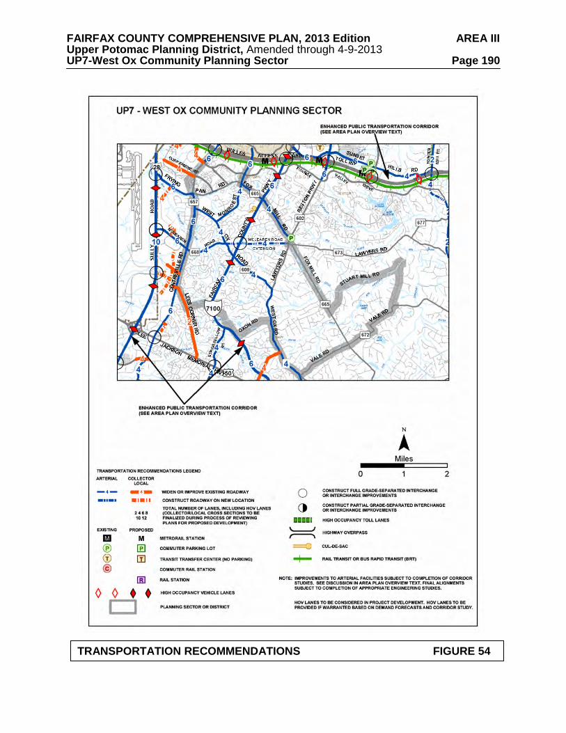
FAIRFAX COUNTY COMPREHENSIVE PLAN, 2013 Edition AREA III Upper Potomac Planning District, Amended through 4-9-2013 UP7-West Ox Community Planning Sector Page 190
TRANSPORTATION RECOMMENDATIONS FIGURE 54

FAIRFAX COUNTY COMPREHENSIVE PLAN, 2013 Edition AREA III Upper Potomac Planning District, Amended through 4-9-2013 UP7-West Ox Community Planning Sector Page 191
• Within the VDOT project from West Ox Road to Lee-Jackson Memorial Highway, construction of the VDOT proposed alternative calling for four outside lanes (permanent construction with outside curb-and-gutter and permanent drainage structures) and a 42-foot wide, graded grass median should be implemented;
• At intersections, provisions should be made consistent with the ultimate six-lane
design. The need for dual left turn lanes into or out of major residential developments along Centreville Road, such as Franklin Farm Road, should be reevaluated at such time as funds become available for construction of the segment from McLearen Road to Lee-Jackson Memorial Highway;
• The need for widening the entire Centreville Road mainline from four lanes to six
lanes should be reevaluated after improvements to Sully Road, the Fairfax County Parkway, and West Ox Road are completed. Furthermore, this decision should follow the completion of a transportation and traffic study conducted in accordance with accepted standards; and
• Priority should be given to the acquisition of right-of-way for the future six laning of
Centreville Road, with a notation that at the time of rezonings, attempts will be made to acquire right-of-way through proffers.
Heritage Resources Additional unidentified resources may yet exist in both undeveloped and developed areas of the sector. Large portions of the UP7 sector have not been surveyed to determine the presence or absence of heritage resources. The community of Floris has been designated a National Register Historic District. Development should be sensitive to the numerous recorded and unrecorded heritage resources associated with the community of Floris. The South Fork and Little Difficult Run Stream Valley areas are vulnerable to public utility and recreation development. This should not occur without prior survey and appropriate mitigation. Any development or ground disturbance in this sector, both on private and public land, should be preceded by heritage resource studies, and alternatives should be explored for the avoidance, preservation or recovery of significant heritage resources that are found. In those areas where significant heritage resources have been recorded, an effort should be made to preserve them. If preservation is not feasible, then, in accordance with countywide objectives and policies as cited in the Heritage Resources section of the Policy Plan, the threatened resource should be thoroughly recorded and in the case of archaeological resources, the artifacts recovered. Public Facilities 1. Provide an additional 2.5-million gallon ground water storage tank at the County Water
Authority's Penderwood Water Storage Tanks II site on West Ox Road, near Waples Mill Road.
2. Construct an elementary school to serve the Herndon/Chantilly area.

FAIRFAX COUNTY COMPREHENSIVE PLAN, 2013 Edition AREA III Upper Potomac Planning District, Amended through 4-9-2013 UP7-West Ox Community Planning Sector Page 192 3. Provide additional finished water transmission facilities along the Fairfax County Parkway,
north of the FCWA Fox Mill Storage and Pumping Facilities. 4. Provide additional finished water transmission facilities along Fox Mill Road to Vale
Road. Parks and Recreation
Parks and recreation recommendations for this sector are shown on Figure 55. The column "Park Classification" includes existing park facilities. The "Recommendations" column includes entries for both existing and proposed facilities. Prior to developing parkland, the Fairfax County Park Authority initiates a master planning process to determine the appropriate facilities and design for that park. This process involves extensive citizen review and participation. If an existing park is listed but no recommendation appears on that line, it means the park has been developed in accordance with its master plan. Trails
Trails planned for this sector are delineated on Figure 56 and on the 1”:4,000’ Countywide Trails Plan Map which is referenced as Figure 2 in the Transportation element of the Policy Plan and is available from the Department of Planning and Zoning. Trails in this sector are an integral part of the overall County system. While some of the segments have already been constructed, the Countywide Trails Plan Map portrays the ultimate system for the sector and the County at large. In addition, the map specifies a classification for each segment, which represents the desired ultimate function and surface type of the trail. Specific construction requirements are detailed in the Public Facilities Manual.

FAIRFAX COUNTY COMPREHENSIVE PLAN, 2013 Edition AREA III Upper Potomac Planning District, Amended through 4-9-2013 UP7-West Ox Community Planning Sector Page 193
FIGURE 55 PARKS AND RECREATION RECOMMENDATIONS
SECTOR UP7 PARK CLASSIFICATION
RECOMMENDATIONS
NEIGHBORHOOD PARKS: Franklin Oaks Garchayne Navy Vale
Initiate a master planning process and develop in accordance with the approved plan or complete development of existing Neighborhood Parks.
COMMUNITY PARKS: Franklin Farm Clarks Landing Floris Community
Complete development in accordance with approved plan. Initiate a master planning process and develop in accordance with approved plan. Complete development in accordance with approved plan. Identify a Community Park site in the northern part of the sector where land dedication may be achieved singularly, or in combination with other development or purchase by the County, to meet the aggregate needs of the service area. Identify another Community Park site in the vicinity of West Ox Road to serve the active recreation needs of the population in the southern part of this sector.
DISTRICT PARKS:
This sector lies within the service area of Fox Mill District Park.
COUNTYWIDE PARKS: Frying Pan Park and Kidwell Farm (Multiple Resources) Frying Pan Meeting House (Heritage Resource) Frying Pan Stream Valley Difficult Run Stream Valley South Fork Stream Valley Little Difficult Run Stream Valley
Protect EQCs through land dedication or donation of open space easements to the Fairfax County Park Authority. Complete development of the countywide trail in these stream valleys. Acquire land as necessary to complete development of countywide trails in South Fork and Little Difficult Run Stream Valley Parks. Acquire identified private recreation facility located adjacent to Little Difficult Run Stream Valley.

FAIRFAX COUNTY COMPREHENSIVE PLAN, 2013 Edition AREA III Upper Potomac Planning District, Amended through 4-9-2013 UP7-West Ox Community Planning Sector Page 194
TRAILS PLAN MAP FOR THIS SECTOR UNDER CONSTRUCTION
SEE THE 1” = 4000’ SCALE
COUNTYWIDE TRAILS PLAN MAP
PLANNED TRAIL SYSTEM FIGURE 56
FAIRFAX COUNTY COMPREHENSIVE PLAN, 2013 Edition AREA III Upper Potomac Planning District, Amended through 4-9-2013 UP8-Lee-Jackson Community Planning Sector Page 195
UP8 LEE-JACKSON COMMUNITY PLANNING SECTOR
CHARACTER The Lee-Jackson Community Planning Sector lies along the north side of Lee Jackson Memorial Highway (Route 50) generally between Centreville Road (Route 28) and West Ox Road (see Figure 57).
Chantilly is located in the southwestern portion of the planning sector (Centreville Road and Lee-Jackson Memorial Highway). The planning sector is characterized by a mixture of single-family detached dwellings and townhouse subdivision development. The sector is primarily residential and it is largely developed.
There are numerous single-family detached subdivisions developed at a density of 2-4
dwelling units per acre, including Armfield Estates, Franklin Glen and Foxfield. Fair Oaks Estates, a single-family detached residential subdivision is adjacent to the Fair Oaks Hospital and developed at a density of 2-3 dwelling units per acre. Century Oak is developed at a density of 1-2 dwelling units per acre and is located between Thompson Road and Ox Trail (Rugby Road). Fair Woods is an attached single-family planned unit residential development with a density of 6 dwelling units per acre located along Route 50 near the intersection of the Fairfax County Parkway (Route 286).
Office, hotel and commercial uses are located along Lee-Jackson Memorial Highway in
the portion of the Fairfax Center area located within this planning sector. The area north of Thompson Road between Oxon Road and West Ox Road, about 175 acres, is developed with older single-family houses on large lots. The Camberley East and Camberley West subdivisions are developed at a density of approximately one dwelling unit per acre. They are located near the intersection of Thompson Road and Oxon Road and on West Ox Road at Bennett Road, respectively.
The International Town and Country Club is a major open space and recreation feature in
the planning sector. It is a privately owned 237 acre facility located between Lee-Jackson Memorial Highway and the Fairfax County Parkway. Sully Plaza shopping center is located in Chantilly at the intersection of Centreville Road and Lee-Jackson Memorial Highway, to the east and north of Sully Place. Sully Plaza has frontage on both Lee-Jackson Memorial Highway and Centreville Road.
Numerous prehistoric and historic archaeological sites are located in the western part of the sector. These sites date to as far back as 11,500 years ago when the first known humans entered the area. There are numerous prehistoric and historic archaeological sites in the vicinity of Upper Cub Run and of Lee-Jackson Memorial Highway. Chantilly Plantation Stone House and Navy School are significant heritage resources listed in the Fairfax County Inventory of Historic Sites. A list and map of heritage resources are included in the Upper Potomac Planning District Overview section, Figures 4, 5 and 6. Additional historic sites in this sector are also included in the inventory. CONCEPT FOR FUTURE DEVELOPMENT
The Concept for Future Development recommends that the entire sector be developed as Suburban Neighborhoods.

FAIRFAX COUNTY COMPREHENSIVE PLAN, 2013 Edition AREA III Upper Potomac Planning District, Amended through 4-9-2013 UP8-Lee-Jackson Community Planning Sector Page 196
RECOMMENDATIONS Land Use
This sector is largely developed with stable residential neighborhoods. Infill development in these neighborhoods should be of a compatible use, type and intensity in accordance with the guidance provided by the Policy Plan under Land Use Objectives 8 and 14.
Where substantial parcel consolidation is specified, it is intended that such consolidations
will provide for projects that function in a well-designed, efficient manner and provide for the development of unconsolidated parcels in conformance with the Area Plan.
Figure 57 indicates the geographic location of land use recommendations for this sector.
Where recommendations are not shown on the General Locator Map, it is so noted. 1. Residential use at a density of .5-1 dwelling unit per acre is planned for the triangular area
formed by Oxon Road, West Ox Road and Thompson Road. This density provides an appropriate transition between the large lot development and conservation areas in the Difficult Run headwaters east of West Ox Road and the residential use planned and existing at a density of 1-2 dwelling units per acre south of Thompson Road.
2. Tax map 34-4((1)) parcel 9 is planned for retail or office use with a maximum FAR of .25.
Any nonresidential use on this parcel should be designed to be compatible with adjacent residential development. Free standing, auto-oriented, retail uses should be discouraged in order to avoid undesirable visual and traffic impacts. To establish an effective transition to adjacent single-family use, nonresidential development should be no more than two stories in height and should be set back at least 250 feet from the northern property line;
This property may also be appropriate for multifamily residential use if designed to serve as a transition to the low density residential use to the north. A density of up to 20 dwelling units per acre may be considered if the following conditions are met: • The development plan should provide high quality site and architectural design,
streetscaping, urban design and development amenities including on-site recreation. Structures should be articulated to minimize the appearance of bulk and mass;
• To establish an effective transition to adjacent single-family use, multifamily
buildings should be no more than four stories in height and should be set back at least 250 feet from the northern property line. Land on the northeast side of Skyhawk Drive extended should be retained as open space. Existing vegetation should be supplemented with trees and shrubs to help create a visual barrier when the vegetation matures.
• Parking should be provided primarily in structures and oriented toward the interior of
the development; • In order to foster high quality development and to mitigate development impacts, any
residential development proposed under this alternative should satisfy at least three-fourths of the density criteria as stated in Appendix 9 of the Land Use section of thePolicy Plan, including, Criterion 8, which, at a minimum, should be fulfilled consistent with development below the high end of the density range.

FAIRFAX COUNTY COMPREHENSIVE PLAN, 2013 Edition AREA III Upper Potomac Planning District, Amended through 4-9-2013 UP8-Lee-Jackson Community Planning Sector Page 197
FIGURE 57
FAIRFAX COUNTY COMPREHENSIVE PLAN, 2013 Edition AREA III Upper Potomac Planning District, Amended through 4-9-2013 UP8-Lee-Jackson Community Planning Sector Page 198
• A well-designed pedestrian circulation system with appropriate pedestrian links to
adjacent development should be provided to enable residents and visitors to walk easily to adjacent and nearby commercial and employment facilities.
For either alternative land use, it is desirable for Skyhawk Drive to be extended through the site and connected to Metrotech Drive. The only access to the site should be from Skyhawk Drive extended and not Centreville Road.
3. Chantilly Estates is planned for residential use at 1-2 dwelling units per acre, the current
density. Every effort should be made to protect this stable neighborhood. As an option, tax map parcel 34-4((5))B may be considered for a density of 2-3 dwelling units per acre if: • a solid fence adjacent to nonresidential uses and Lee-Jackson Memorial Highway is
provided, and • a 35 foot vegetated buffer adjacent to nonresidential uses and substantial buffering to
Lee-Jackson Memorial Highway is provided, and • a service drive is constructed along the Route 50 frontage of parcel 34-4((5))B to
provide a connection between Chantilly Road and the gas station at Downs Drive and Lee-Jackson Memorial Highway.
However, if this stable neighborhood should be consolidated in the future, then it should be planned for residential use at a density of 3-4 dwelling units per acre.
Re-development of Chantilly Estates, should not occur without substantial land consolidation and provision of a 35-foot landscaped buffer along the adjacent commercial land to protect the residential community.
4. The area between Armfield Farms and Chantilly Green, Tax Map; 34-4 ((1)) 4, 5, 6; 34-4
((2)) 1-12; 34-4 ((3)) 1-12, is planned for residential use at 3-4 dwelling units per acre. As an option, residential use at 4-5 dwelling units per acre may be considered under the following conditions:
• At a minimum, the land area found for Tax Map 34-2((1)) 18, 34-4((1)) 4, 5, 6, and
85% of the land area of the Ox Hill subdivision, Tax Map 34-4((2)) 1-12 and ((3)) 1-12) should be consolidated. Consolidation should occur in a manner that provides for the future development of any unconsolidated parcels, either to remain at 1 dwelling unit per acre as zoned, or up to the base level density of 3 dwelling units per acre;
• Single-family detached and/or other types of single-family units, such as patio or
zero-lot-line, are appropriate. It should be demonstrated that units types other than single-family detached can be effectively integrated into the community;
• High quality design is a priority in order to foster compatibility with existing adjacent
residential communities; and
• Consider removing the restrictions that allow only emergency vehicle access at the eastern end of Lowe Street, in order to improve traffic circulation. There should be no connection to Springhaven Drive.

FAIRFAX COUNTY COMPREHENSIVE PLAN, 2013 Edition AREA III Upper Potomac Planning District, Amended through 4-9-2013 UP8-Lee-Jackson Community Planning Sector Page 199 5. The area between Lee-Jackson Memorial Highway, Oxlick Branch, the Fairfax County
Parkway, the International Town and Country Club and the Murray Farms subdivision (Tax Map 45-2((1))1A, 2 and 3) is planned for residential use at 2-3 dwelling units per acre. Consolidation of parcels is desirable; at a minimum, development on parcel 3 should provide interparcel access and should not preclude development on parcel 2 in conformance with the Plan.
Development of Tax Map 45-2((1))3 should provide interparcel access to the portion of the Century Oak subdivision located south of the Fairfax County Parkway. Access should be sited to have minimal impact on the EQC.
6. The Murray Farms subdivision south of the Fairfax County parkway is planned for residential use at 1-2 dwelling units per acre. As an option, development may be appropriate at 4-5 dwelling units per acre. Redevelopment of this area should strive to create a sense of community and coordinated and attractive residential development on both sides of Rugby Road. This optional density may be considered under the following conditions:
• East of Rugby Road, full land consolidation is required, excluding church property or
land approved for institutional use. In addition, the following conditions should be met:
a) Development should be compatible with the Fair Woods subdivision to the east; b) Development should occur in a manner that permits future development of
unconsolidated parcels in conformance with the Comprehensive Plan. c) Access and circulation should be coordinated in order to limit the number of
access points to Rugby Road to the greatest extent possible; and
d) Adverse impacts from adjacent institutional uses should be mitigated, incorporating such techniques as screening and buffering.
• West of Rugby Road, an initial land consolidation of a minimum of 12 acres is
required. This initial land consolidation may be satisfied by one or more rezoning applications that are coordinated, fully integrated in terms of design, and concurrently pursued with the County. In addition, the following conditions should be met:
a) New development should mitigate impacts on any existing residential uses on
unconsolidated parcels using techniques such as screening and buffering; and b) Development should occur in a manner that permits future development of
unconsolidated parcels to be unified with the initial consolidation. Unconsolidated parcels may be considered for 4-5 dwelling units per acre if they are designed to be fully integrated with existing (or approved) adjacent development.
c) Traffic circulation should be coordinated to the greatest extent possible, in an
attempt to minimize the number of access points on Rugby Road.

FAIRFAX COUNTY COMPREHENSIVE PLAN, 2013 Edition AREA III Upper Potomac Planning District, Amended through 4-9-2013 UP8-Lee-Jackson Community Planning Sector Page 200 7. Tax Map 45-2((1))1, located north of the Fairfax County Parkway and west of Murray
Farms, is planned for residential use at 2-3 dwelling units per acre which is compatible with the single-family detached development in the immediate vicinity. The portion of Murray Farms west of Rugby Road and north of the Fairfax County Parkway is planned for residential use at a density of 1-2 dwelling units per acre with an option for 2-3 dwelling units per acre. In order for development to occur at a density of 2-3 dwelling units per acre, substantial land consolidation should be provided to ensure that the land use relationships, buffering, access and circulation patterns will be compatible with development in the surrounding area, especially residential areas to the north and west.
8. The land between the Fair Oaks Hospital and West Ox Road, land forming a narrow strip
along West Ox Road south of the Fair Oaks Hospital and land in an older, 35-acre subdivision along Avery Road is planned for residential development at 1-2 dwelling units per acre with an option for 2-3 dwelling units per acre. Development under this option will provide an appropriate transition to the Difficult Run, where the predominant character is large lot residential and conservation/open space use. It is also a density compatible with that of existing adjacent residential development in Fair Oaks Estates.
Substantial land consolidation should be provided for development under this option to ensure that the land use relationships, buffering, access and circulation patterns are compatible with development in the surrounding area. Access to West Ox Road should be minimized and coordinated with major points of access on the northern side of the road. To enhance the residential character of the portion of this area along West Ox Road, consolidation plans should include provision for planting trees and other suitable landscaping in the median of West Ox Road.
9. The Guidelines for Cluster Development contained in the Policy Plan should be strictly
adhered to in this sector. [Not shown] 10. The Fair Oaks Hospital site is approximately 73 acres, generally located north of the
Fairfax County Parkway and east of Rugby Road. Tax Map parcels 45-2((1)) 41B1 and 45-2((2)) 38, 39A, 39B, 46A1 and 51A1 are planned for hospital and related low intensity ancillary medical office, service uses and clinics provided that:
• A substantial vegetated wooded buffer is provided and maintained as undisturbed
open space between such uses and the residential neighborhoods to the north and east; • The campus achieves high-quality architectural and landscape design, and the overall
intensity on the site does not exceed .35 FAR Medical office buildings should be limited to a total of 370,000 square feet of GFA;
• The buffer to be provided and maintained along Rugby Road and Ox Trail will be
115-120 feet in width with the exception of the existing child care center and single- family dwelling where a lesser buffer is provided. In addition, the buffer may be modified to provide for a new vehicular access to Rugby Road and to accommodate related improvements (widening, turn lanes, signal equipment, etc.) to facilitate such access. The buffer will consist of existing vegetation supplemented where necessary with evergreens and other landscaping. Unless deemed essential based on final engineering, no additional storm water management ponds (wet or dry) shall be located in this buffer. Any utilities, to include stormwater pipes or channel improvements, that must be located within this buffer area shall be located and

FAIRFAX COUNTY COMPREHENSIVE PLAN, 2013 Edition AREA III Upper Potomac Planning District, Amended through 4-9-2013 UP8-Lee-Jackson Community Planning Sector Page 201
designed to minimize damage to existing vegetation and should be subject to landscaping to reduce any views into the campus. This buffer is to be measured from the eastern edge of the existing (2009) right-of-way of Rugby Road and Ox Trail;
• A maximum of one new full movement vehicular access point from the hospital
campus to Rugby Road may be provided so long as the following criteria are satisfied:
a) The new vehicular access should not align with the intersection of Misty Creek
Lane; b) Joseph Siewick Drive should not be realigned to intersect Rugby Road/Ox Trail in
a full intersection with Misty Creek Lane;
c) In the vicinity of the new vehicular access, screening should be provided and/or supplemented to minimize visual impacts on nearby residences, including landscaping and/or architectural barrier features harmonious with the surrounding residential community.
• A quality site layout should be provided, including appropriate pedestrian and bicycle
connections linking the medical campus to existing sidewalks on the periphery and within the site, walking paths with landscaped seating and picnic areas for employees and visitors to the hospital, and appropriate screening against neighboring residential uses;
• A Transportation Demand Management (TDM) program should be formulated and
implemented to mitigate traffic associated with development on the Fair Oaks Hospital site in excess of .30 FAR. One element of the program should be an ongoing commitment from the hospital to the County to support continuing bus service to the Hospital and to contribute toward the installation and maintenance of necessary bus shelters on the Hospital campus. The TDM program should include a ride sharing program and consideration should be given to programs that will facilitate employee use of public transportation;
• Due to the importance of providing public transportation to the site, it is expected that
the hospital will allow direct bus access through the site to provide convenient stops for visitors and employees;
• Building height for the main hospital buildings and additions thereto shall be limited
to a maximum of 100 feet. All other buildings shall be limited to a maximum of 60 feet in height to minimize visual impacts on the residential community;
• Parking structures will be designed to minimize visual impacts on adjacent residential
neighborhoods and the design and materials of the structures will be integrated with that of the buildings they serve. Recognizing the nuisance aspects of unfocused light emissions, efforts will be made to minimize light emissions that create sources of glare which may interfere with residents’ and travelers’ visual acuity. Landscaping will be provided on the parking structures and/or adjacent to them to make them more attractive and to soften their appearance. Opportunity for additional screening measures will be evaluated at time of rezoning. The applicant should, in consultation with the County’s Urban Forester, determine appropriate species and types of native and noninvasive vegetation;

FAIRFAX COUNTY COMPREHENSIVE PLAN, 2013 Edition AREA III Upper Potomac Planning District, Amended through 4-9-2013 UP8-Lee-Jackson Community Planning Sector Page 202
• All rooftop mechanical equipment is screened. In addition, no antennae will be located on building rooftops other than the main hospital building and additions thereto, except as may be required for public safety purposes;
• Monopoles are excluded from the hospital campus; • Visual impacts are further minimized through building setback and site design
features such as berms, fences and landscaping treatments; • No additional parking, including above or underground parking structures, other than
what existed in September, 1994 shall be located between the medical campus and Fair Oaks Estates; and
• A detailed traffic impact analysis should be done to determine any additional
improvements required to mitigate the impacts of additional development on the street network in the vicinity of the development.
The southern 7.5-acre portion (Tax Map 45-2((1))42) of this site is owned by the Fairfax County Park Authority and is planned for a public park. Tax Map 45-2((2))38, 39A and 39B and 45-2((6))A1, K2 and L1 are also planned for a public park and should be dedicated to the Fairfax County Park Authority. Density credit is appropriate for any land dedicated for right-of-way or public park use, as provided for in the Fairfax County Zoning Ordinance.
11. The International Town and Country Club land is planned for private recreation use and should be maintained through tax incentives when development pressure reduces its economic viability. Public acquisition for park purpose should be considered as an alternative preservation measure.
Transportation
Transportation recommendations for this sector are shown on Figures 58, 59 and 60. In some instances, site-specific transportation recommendations are included in the land use recommendations section. The figures show access orientation, circulation plans, interchange impact areas and generalized locations of proposed transit facilities. The recommendations contained in the Area Plan text and maps, the Policy Plan and Transportation Plan map, policies and requirements in the Public Facilities Manual, the Zoning Ordinance, and other standards will be utilized in the evaluation of development proposals. See text for Community Planning Sectors UP6 and UP7 for a description of transportation considerations for Centreville Road. Heritage Resources There are numerous prehistoric and historic archaeological sites in the vicinity of Upper Cub Run and of Lee-Jackson Memorial Highway which should be evaluated as to their need for protection. Chantilly Plantation Stone House is located on the grounds of the International Town and Country Club (Tax Map 45-1((1))11) on Route 50. It is a well-maintained site which may become subject to redevelopment pressure. Its preservation should be insured.

FAIRFAX COUNTY COMPREHENSIVE PLAN, 2013 Edition AREA III Upper Potomac Planning District, Amended through 4-9-2013 UP8-Lee-Jackson Community Planning Sector Page 203 Navy School (Tax Map 45-2((1))6) should be preserved or moved to another site. If this is not feasible, the site should be thoroughly documented for its historic value. Part of the Sully Historic Overlay District lies within this sector. Regulations for this district are discussed in section BR1 of the Bull Run Planning District Any development or ground disturbance in this sector, both on private and public land, should be preceded by heritage resource studies, and alternatives should be explored for the avoidance, preservation or recovery of significant heritage resources that are found. In those areas where significant heritage resources have been recorded, an effort should be made to preserve them. If preservation is not feasible, then, in accordance with countywide objectives and policies as cited in the Heritage Resources section of the Policy Plan the threatened resource should be thoroughly recorded and in the case of archaeological resources, the artifacts recovered. Public Facilities 1. An elementary school site, possibly in combination with an active recreation park site
should be located in the area between Armfield Farms and the intersection of Lee-Jackson Memorial Highway and Centreville Road. The school site should have a minimum of 14 acres, and include ballfields or other facilities for active recreation use for the community.
2. Provide additional finished water transmission facilities along the Route 50 corridor
between Rugby Road and Stringfellow Road. Parks and Recreation
Parks and recreation recommendations for this sector are shown on Figure 61. The column "Park Classification" includes existing park facilities. The "Recommendations" column includes entries for both existing and proposed facilities. Prior to developing parkland, the Fairfax County Park Authority initiates a master planning process to determine the appropriate facilities and design for that park. This process involves extensive citizen review and participation. If an existing park is listed but no recommendation appears on that line, it means the park has been developed in accordance with its master plan. Trails Trails planned for this sector are delineated on Figure 62 and on the 1”:4,000’ Countywide Trails Plan Map which is referenced as Figure 2 in the Transportation element of the Policy Plan and is available from the Department of Planning and Zoning. Trails in this sector are an integral part of the overall County system. While some of the segments have already been constructed, the Countywide Trails Plan Map portrays the ultimate system for the sector and the County at large. In addition, the map specifies a classification for each segment, which represents the desired ultimate function and surface type of the trail. Specific construction requirements are detailed in the Public Facilities Manual.
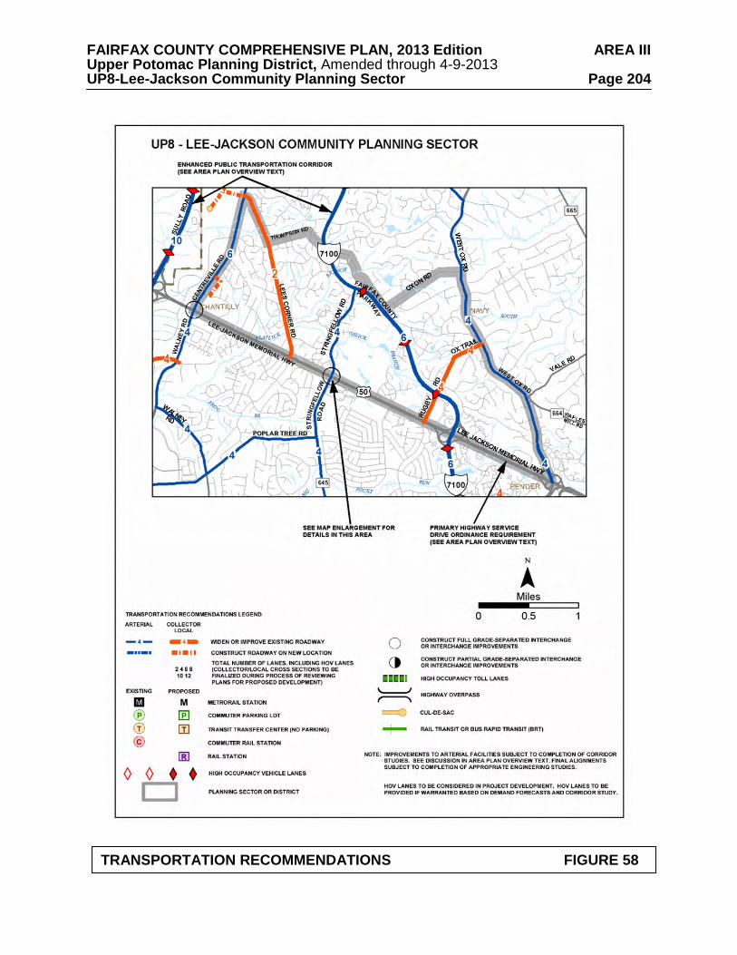
FAIRFAX COUNTY COMPREHENSIVE PLAN, 2013 Edition AREA III Upper Potomac Planning District, Amended through 4-9-2013 UP8-Lee-Jackson Community Planning Sector Page 204
TRANSPORTATION RECOMMENDATIONS FIGURE 58
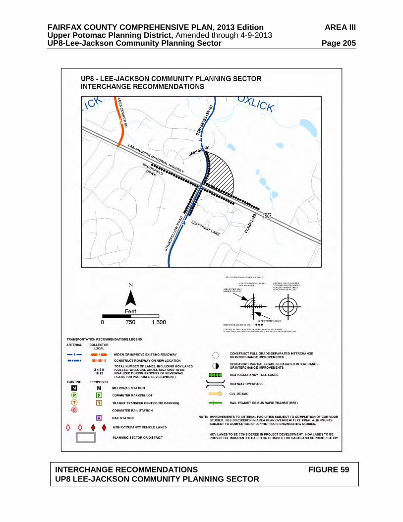
FAIRFAX COUNTY COMPREHENSIVE PLAN, 2013 Edition AREA III Upper Potomac Planning District, Amended through 4-9-2013 UP8-Lee-Jackson Community Planning Sector Page 205
INTERCHANGE RECOMMENDATIONS FIGURE 59
UP8 LEE-JACKSON COMMUNITY PLANNING SECTOR

FAIRFAX COUNTY COMPREHENSIVE PLAN, 2013 Edition AREA III Upper Potomac Planning District, Amended through 4-9-2013 UP8-Lee-Jackson Community Planning Sector Page 206
INTERCHANGE AND ACCESS RECOMMENDATIONS FIGURE 60
UP8 LEE-JACKSON COMMUNITY PLANNING SECTOR

FAIRFAX COUNTY COMPREHENSIVE PLAN, 2013 Edition AREA III Upper Potomac Planning District, Amended through 4-9-2013 UP8-Lee-Jackson Community Planning Sector Page 207
FIGURE 61 PARKS AND RECREATION RECOMMENDATIONS
SECTOR UP8 PARK CLASSIFICATION
RECOMMENDATIONS
NEIGHBORHOOD PARKS: Fair Woods Franklin Glen
Initiate a master planning process and develop in accordance with approved plan. Complete and develop in accordance with approved master plan. Seek dedication of a Neighborhood Park of six to ten acres adjacent to the proposed school facility site to serve planned residential development in the western park of the sector.
COMMUNITY PARKS: Fox Valley
Initiate a master planning process for a school/park site and develop in accordance with approved plan. Acquire a Community Park west of Rugby Road and north of the Fairfax County Parkway to include Oxlick EQC and up to 10 acres of developable land. Land dedication should be provided singularly or in combination with other development or purchase by the County.
DISTRICT PARKS:
This sector lies within the service area of Fox Mill, Oak Marr and Poplar Tree District Parks.
OTHER:
Consider acquisition of the privately owned International Town and Country Club golf course for public use if private operations cease. (Also noted in Land Use Recommendations.)

FAIRFAX COUNTY COMPREHENSIVE PLAN, 2013 Edition AREA III Upper Potomac Planning District, Amended through 4-9-2013 UP8-Lee-Jackson Community Planning Sector Page 208
TRAILS PLAN MAP FOR THIS SECTOR UNDER CONSTRUCTION
SEE THE 1” = 4000’ SCALE
COUNTYWIDE TRAILS PLAN MAP
PLANNED TRAIL SYSTEM FIGURE 62